Road-Stream Crossing Inventory Results and Action Plan
For The Grass and Rapid River Systems Antrim and Kalkaska Counties
Report written by: Kevin L. Cronk
Tip of the Mitt Watershed Council
February 6, 2013

Background
In the winter of 2011, a meeting was convened at a home along the banks of the Rapid River to
discuss sediment issues in the Rapid and Grass Rivers and develop a plan to evaluate and
address excessive sedimentation in the watersheds of these river systems. In attendance, and
involved throughout the project, were representatives from local and regional organizations in
the Elk River Chain of Lakes Watershed (ERCOL), including: The Watershed Center Grand
Traverse Bay, Three Lakes Association, Elk-Skegemog Lake Association, Friends of the Rapid
River, Friends of Clam Lake, the Kalkaska County Conservation District, the Michigan
Department of Natural Resources, the Grand Traverse Band of Ottawa and Chippewa Indians,
and Tip of the Mitt Watershed Council. Other partners who became involved with this project
at a later date include The College of Brockport: State University of New York and Michigan
State University. This collaborative partnership was formed as a sub-committee of the ERCOL
Watershed Protection Implementation Team (WPIT), which operates under the auspices of the
MDEQ and USEPA-approved Grand Traverse Bay Watershed Management Plan (Plan) with the
intent of carrying out implementation recommendations outlined in the Plan for reducing
nonpoint source pollution in the Watershed.
Following lengthy discussion at multiple meetings, this group of concerned watershed
stakeholders and water resource professionals developed a plan to assess sediment sources
throughout both watersheds and identify specific action steps to reduce sediment inputs and
address excessive sediment build-up in these river systems. The assessment consisted of: 1)
biological, physical, and chemical water quality monitoring at multiple locations throughout
both watersheds; 2) an inventory of all road-stream crossings in both watersheds to evaluate
conditions and locations needing improvement; 3) a comprehensive stream channel inventory
to identify streambank erosion and sources on all tributaries; 4) a stormwater inventory to
determine sediment inputs in runoff from urban and residential areas; and 5) a hydrological
study of both watersheds to better understand sediment inputs, transport, and deposition in
both river systems. This document presents findings of the road-stream crossings inventory and
provides recommendations in terms of specific actions that should be taken to reduce or
prevent sediment inputs into the study streams from roads.
Methods
The Grass and Rapid Rivers Road/Stream Crossings Inventory was coordinated by The
Watershed Center Grand Traverse Bay (TWC) and Tip of the Mitt Watershed Council (TOMWC).
Volunteers carried out the inventory during the summer of 2011 following a training session in
methodologies provided by TWC. The Grass River inventory was conducted by volunteers from
Three Lakes Association and Friends of Clam Lake, whereas the Rapid River inventory was

performed by volunteers from the Elk-Skegemog Lake Association. Volunteers used methods
outlined in the Great Lakes Road Stream Crossing Inventory Instructions booklet.
At each road-stream crossing, the following general information was collected: 1) site
identification number (if existed); 2) stream name; 3) names of survey crew; 4) date or survey;
5) GPS information (if GPS was employed); 6) county name; 7) township/range/section
(optional); 8) adjacent landowner information (if known); and 9) additional comments about
the site. Each crossing was documented in terms of crossing type, whether a culvert, bridge,
ford, or dam. Culverts, the most common type, were further documented in context of these
parameters: 1) shape (e.g., round, ellipse, square); 2) inlet type (e.g., projecting, mitered,
wingwall); 3) outlet type (e.g., cascade over riprap, freefall into pool); 4) structure material
(e.g., concrete, metal, plastic); 5) structure interior whether smooth or corrugated; 6) structure
length, width, and height; 7) general condition of culvert; 8) substrate material in the structure
and depth of embeddedness; 9) whether structure was plugged or crushed; 10) water depth at
inlet and outlet; 11) flow velocity at inlet ad outlet; and 12) perch height at outlet (if perched).
The stream at each site was documented with regards to: 1) flow, whether at bankfull, over, or
below; 2) scour pools downstream of structure; 3) ponding upstream of structure; and 4)
channel and flow characteristics associated with a reference riffle, which included bankfull
width, wetted width, average stream depth, average flow velocity, and dominate substrate. The
road was assessed in terms of: 1) type/ownership (e.g., county, private); 2) surface type (e.g.,
paved, gravel); 3) road surface condition; 4) width of road at culvert; 5) location of low point,
whether at stream crossing or at other location; 6) runoff path, whether along road or into
ditch; 7) embankment slope and fill depth at structure; 8) length and slope of approaches from
both directions; and 8) ditch information regarding vegetation. Any erosion at the site was
documented using the following: 1) location; 2) dimensions: length, width, and depth; 3)
whether eroding material was reaching the stream; 4) the type of eroding material (e.g., sand,
clay, gravel); 5) severity of erosion; and 6) whether corrective actions could be installed or not.
Additional information collected includes photographs of the site, a site sketch, whether it is
considered a priority site, whether a future visit is recommended, and if any invasive species
were observed at the site.
All data collected during the inventory was entered into an Access database by volunteers and
TOMWC staff. Due in part to volunteers’ unfamiliarity with data collection and also because of
lack of equipment (e.g., flow velocity meter), data were incomplete for numerous sites.
Therefore, the severity of problems at each site could not be determined using the calculator
built into the Great Lakes Road Stream Crossing Inventory database, but was instead assessed
by TOMWC staff with a simplified alternate scoring system utilizing information in the database,

as well as accompanying photographs and staff familiarity with sites. The simplified scoring
system was based on structure condition, fish passage problems, and sediment inputs.
Results
A total of 40 road-stream crossing sites were inventoried during the summer of 2011; 24 in the
Grass River system and 16 in the Rapid River (Tables 1 and 2). Bridges were in place at 13 of the
crossings and the other 27 were culverts. At two sites on Shanty Creek, dams were also present.
The inventory data show moderate to severe problems at 17 sites, at nine locations in the Rapid
River Watershed and eight in the Grass River Watershed.
Table 1. Road-stream crossing information and severity ratings for the Grass River tributaries.
ID# Stream Name Road Crossing Name Type Severity
01_SCRN Shanty Creek Road to nowhere culvert Minor
02_SCRR Shanty Creek Railroad Crossing culvert Minor
03_SCHP Shanty Creek Old hydropower site bridge/dam Severe
04_SCGRR Shanty Creek Grass River Road culvert Minor
05_SCM88 Shanty Creek M-88 culvert Minor
06_SCPBD Shanty Creek Pine Brook bridge/dam Severe
07_SCGC Shanty Creek Creekside drive bridge bridge Minor
08_SCUC Shanty Creek Dirt rd above Legend Golf Course culvert Minor
09_SCCDD Shanty Creek Creekside drive bridge Severe
10_SCCSD Shanty Creek Creekside drive bridge Severe
11_CCRR Cold Creek Railroad Crossing bridge Minor
12_CCPR Cold Creek No name culvert Moderate
13_CCCR Cold Creek Comfort Road culvert Severe
14_CCTR Cold Creek Tyler Road culvert Minor
15_CCFFR Cold Creek Fish-farm Road culvert Minor
16_CCAH Cold Creek Alden Highway culvert Minor
17_FCRR Finch Creek Railroad Crossing bridge Minor
18_FCAH Finch Creek Alden Highway culvert Moderate
19_FC9310 Finch Creek 9310 Finch Creek Road bridge Minor
20_FCFCR Finch Creek Finch Creek Road culvert Minor
21_FCERE Finch Creek Elder Road, East culvert Severe
22_FCERW Finch Creek Elder Road, West culvert Minor
23_FCBR Finch Creek Bebb Road culvert Minor
24_FCWR Finch Creek Way Road culvert Minor

Table 2. Road-stream crossing information and severity ratings for the Rapid River.
ID# Stream Name Road Crossing Name Type Severity
RR01 Little Rapid River Old M72, upstream culvert Moderate
RR02 Little Rapid River Old M72, downstream culvert Severe
RR03 Little Rapid River Seeley Rd culvert Moderate
RR04 Little Rapid River Hill Rd culvert Severe
RR05 Rapid River, North Branch Priest Rd culvert Severe
RR06 Rapid River, North Branch Day Rd culvert Minor
RR07 Rapid River, North Branch Railroad culvert Moderate
RR08 Rapid River, North Branch US131 culvert Minor
RR09 Rapid River, North Branch Wood Rd, upstream culvert Minor
RR10 Rapid River, Main Wood Rd, downstream culvert Minor
RR11 Rapid River, Main Dundas Rd bridge Moderate
RR12 Rapid River, Main Underhill Rd bridge Moderate
RR13 Rapid River, Main Kellogg Rd culvert Minor
RR14 Rapid River, Main Glade Valley Rd bridge Moderate
RR15 Rapid River, Main Rapid City Rd bridge Minor
RR16 Rapid River, Main Aarwood Rd bridge Minor
In the Rapid River system, three road-stream crossing sites were rated as severe and six as
moderate (Figure 1). Those rated as severe include two sites on the Little Rapid River at Old
M72 near Valley Road (Site ID# RR02) and Hill Road (Site ID# RR04), as well as one site on the
North Branch at Priest Road (Site ID# RR05). The six moderate sites include Old M72 near
Kalkaska (Site ID# RR01) and Seeley Road (Site ID# RR03) on the Little Rapid River, the railroad
crossing on the North Branch (Site ID# RR07), and Dundas Road (Site ID# RR11), Underhill Road
(Site ID# RR12), and Glade Valley Road (Site ID# RR14) on the main stem.
In the Grass River system, problematic road-stream crossings were most prevalent in the
Shanty Creek Watershed where four of the ten crossings were rated as severe in terms of
negative impacts to the stream ecosystem (Figure 2). These include an old hydropower site
with a dam (Site ID# 03_SCHP), another dam at Pine Brook (Site ID# 06_SCPB), and two sites on
Creekside Drive (Site ID# 09_SCCSD and 10_SCCSD). Cold Creek had one site rated as severe on
Comfort Road (Site ID# 13_CCCR) and a moderate site on an unnamed road (Site ID# 12_CCCR).
Finch Creek also had one site rated as severe on Elder Road (Site ID# 21_FCERE) and a moderate
site on Alden Highway (Site ID# 18_FCAH).
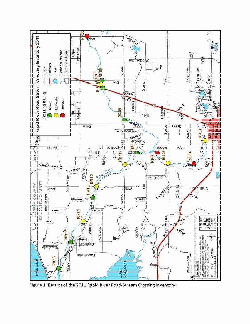
Figure 1. Results of the 2011 Rapid River Road-Stream Crossing Inventory.

Figure 2. Results of the 2011 Grass River Tributary Road-Stream Crossing Inventory.

Discussion and Recommendations
Road-stream crossings are among the greatest sources of nonpoint source pollution to
Northern Michigan’s rivers and streams. Although sediments are the most prevalent pollutant
associated with road-stream crossings, other pollutants include heavy metals, nutrients, debris
and litter. In addition, road-stream crossings can create barriers to aquatic organism passage,
increase water temperatures, disrupt sediment transport and hydrologic connectivity. The
results of the 2011 inventories provide a framework for systematically addressing the worst
road-stream crossings, which will improve water quality and protect the stream ecosystems in
the Rapid and Grass River Watersheds.
Based on the assessment of the inventory results, the following action steps are recommended.
1. Disseminate inventory information. Share results of the road-stream crossing inventory
with the ERCOL WPIT committee, local governments, road commissions, and other
relevant stakeholders.
2. Plan corrective actions for severe and moderate sites. Meet with watershed partners
and road commissions to discuss inventory results; incorporate a tour of severe and
moderate sites to view the crossings as a group and discuss possible corrective
measures to address problems.
3. Identify three top priority road-stream crossings based on severity, as well as other
factors including capacity of road commission to perform necessary work, cost,
potential for grant funding, etc.
4. Acquire funding for developing engineering plans for the three priority sites identified
above. Engineering costs will vary by site. Solicit engineering firms for bids and
estimates for more complicated sites. It is anticipated that the severe road-stream
crossing sites will require on the order of $10,000 or more for engineering alone.
5. Pursue funding to implement projects. Grant programs oftentimes support road-stream
crossing projects when the applicant can demonstrate the existing conditions pose a
serious threat to water quality and stream habitat. Necessary funds to complete
projects will also vary. Basic culvert crossings can cost approximately $40,000, while
timber bridge projects can be $300,000.
6. Implement priority projects at severe and moderate sites. Additional corrective actions
at sites, particularly moderate sites, may be simple, cost-effective solutions, such as
plantings along the streambank or diveriting road-runoff to allow for greater infiltration
of pollutants.

7. Assess dams. Two road-stream crossings over Shanty Creek include dams. Assess
condition of dams and perform feasibility studies for repair or removal. Environmental
impacts, particularly sediment releases, must be considered before taking any actions.
8. Assess the “Road to Nowhere” crossing in the lower section of Shanty Creek. If the
culvert is found to be a hazard, aquatic organism passage barrier, or significant threat to
water quality, then pursue means (engineering, if applicable, and funding) for its
removal. Although survey results did not reveal any serious problems at this site,
volunteers conducting the inventory commented that the culvert serves no purpose.
9. Repeat the road-stream crossing inventory on a regular basis, ideally every 5-10 years.
10. Work with Land Information Access Association (LIAA) to upload inventory data to
www.northernmichiganstreams.org, the central respository for road/stream crossing
information in Northern Michigan.

The following photos are from the Grass River RSX Inventory:


The following photos are from the Rapid River RSX Inventory:

Recommended