DRAFT
TIMBER NOTICE OF SALE
10/5/2021 12:22:00 PM Page 1 of 3
SALE NAME: COUG FLATS AGREEMENT NO: 30-100669
AUCTION: May 24, 2022 starting at 10:00 a.m., COUNTY: King
South Puget Sound Region Office, Enumclaw, WA
SALE LOCATION: Sale located approximately 7 miles northeast of Enumclaw.
PRODUCTS SOLD
AND SALE AREA: All timber, except trees marked with blue paint or bounded out by yellow leave tree area
tags, snags, and down timber existing more than 5 years from the day of sale, bounded by
the following: white timber sale boundary tags, and private property line marked with
white Carsonite posts in Unit #1; white timber sale boundary tags, private property line
marked with white Carsonite posts, and the South Side Mainline/5600 Road in Unit #2;
white timber sale boundary tags, and the South Side Mainline/5600 Road in Unit #3;
white timber sale boundary tags, blue special management area tags, and the 5622-H
Road in Unit #4;
All timber, except trees bounded out by yellow leave tree area tags, snags, and down
timber existing more than 5 years from the day of sale, bounded by the following: white
timber sale boundary tags, timber type change marked with pink flagging, and the 5622-
H, 5622-H3, and 5622-H3a roads in Unit #5;
All timber as described in Schedule A bounded by the following: white timber sale
boundary tags, blue special management area tags, and the 5622 Road in Unit #6;
All timber bounded with orange right of way tags, except that title to timber within the
right of way tags is not conveyed to the Purchaser unless the road segment is actually
constructed in Unit #7 R/W;
All forest products above located on part(s) of Sections 2, 3, 10 and 11 all in Township
20 North, Range 8 East, W.M., containing 131 acres, more or less.
CERTIFICATION: This sale is certified under the Sustainable Forestry Initiative® program Standard (cert
no: PwC-SFIFM-513) and FSC 100% raw materials under the Forest Stewardship
Council® Standard (cert no: BV-FM/COC-080501).
ESTIMATED SALE VOLUMES AND QUALITY:
Avg Ring Total MBF by Grade
Species DBH Count MBF 1P 2P 3P SM 1S 2S 3S 4S UT
Douglas fir 20.1 9 2,241 1,531 578 132
Hemlock 14.5 10 2,155 944 894 317
Silver fir 25.9 848 725 108 15
Red alder 13.4 131 25 35 71
Red cedar 22.8 62 57 5
Spruce 10.2 9 9
Noble fir 25 4 4
Sale Total 5,450
MINIMUM BID: $0.00 BID METHOD: Sealed Bids
All documents are draft and subjectto change without notice.

DRAFT
TIMBER NOTICE OF SALE
10/5/2021 12:22:00 PM Page 2 of 3
PERFORMANCE
SECURITY: $0.00 SALE TYPE: Lump Sum
EXPIRATION DATE: October 31, 2024 ALLOCATION: Export Restricted
BID DEPOSIT: $0.00 or Bid Bond. Said deposit shall constitute an opening bid at the appraised price.
HARVEST METHOD: Harvest activities are estimated to be 90 percent ground based harvest and 10 percent
uphill cable. Cable and ground based equipment, with cable-tethered equipment limited
to sustained slopes 75 percent or less, self-leveling equipment limited to sustained slopes
65 percent or less, and all other ground based equipment limited to sustained slopes 45
percent or less. Prior written approval must be obtained from the Contract Administrator
for areas as to where rubber tired and tracked skidders may be utilized in Units #1,#2, and
#3. Yarding may be restricted during wet weather if rutting becomes excessive, per
clause H-017.
Falling and yarding will not be permitted in Unit #6 from November 1 to April 30, unless
authority to do so is granted, in writing, by the Contract Administrator. If permission is
granted to operate from November 1 to April 30, preventative measures may be required
to protect water, soils, roads and other forest assets.
Falling, yarding, and timber haul will not be permitted on weekends or State recognized
holidays, unless approved in writing by the Contract Administrator.
ROADS: 6.92 stations of required construction. 10.40 stations of required reconstruction. 30.82
stations of optional construction. 14.40 stations of optional reconstruction. 96.41
stations of required prehaul maintenance. 6.17 stations of abandonment, if constructed.
10.25 stations of abandonment, if reconstructed. 747.67 stations of required post-haul
maintenance. Purchaser maintenance on the South Side Mainline/5600, 5621, 5622,
5622-B, 5622-C, 5622-G, 5622-F, 5622-H, 5622-H2, 5622-H3, 5622-H3a, and 5622-H3a
Ext roads. Designated maintenance on all other roads used.
Rock for this proposal can be obtained from the State owned Tadmore 2 Rock Pit at no
cost to the Purchaser or any commercial rock source at the Purchaser's expense. Rock
source development is required per Section 6 in the Road Plan and according to the Rock
Source Development Plan if rock is obtained from the Tadmore 2 Rock Pit. Purchaser is
required to manufacture a 1,200 cubic yard stockpile of 2 inch minus in the Tadmore 2
Rock Pit as required in Section 6 in the Road Plan.
ACREAGE DETERMINATION
CRUISE METHOD: Acreage for Units #1, #3, #5, #6, and #7 were determined by traversing boundaries by
GPS. Acreage for Units #2, and #5 were determined by traversing boundaries by GPS
and using the road length and width. GPS data files are available at DNR's website for
timber sale packets. See cruise narrative for cruise method.
FEES: $92,650.00 is due on day of sale. $9.00 per MBF is due upon removal. These are in
addition to the bid price.
SPECIAL REMARKS: This area is typically inaccessible due to snow from December through April. Contact
Craig Higbee at 360-918-3847 for current road conditions.
Unit #6 is riparian thinning unit. Take trees have been marked with orange paint.
Additional trees will be required to be felled and left for down wood or girdled to create

DRAFT
TIMBER NOTICE OF SALE
10/5/2021 12:22:00 PM Page 3 of 3
standing snags. These trees are marked at DBH with one band of red paint for down
wood and two bands of red paint for standing snags. See Schedule A for requirements.
The Kuzak Road, controlled by King County, has potential to be closed or have vehicle
weight restrictions during fall, winter, and spring or periods of continuous heavy
precipitation. The county enforced speed limit on the Kuzak Road is 25 MPH.
Purchaser shall cut all vine maple within the VRH harvest unit(s), leaving a stump no
more than 12 inches in height.
See map for gate locations. Gate keys may be obtained by contacting the South Puget
Sound Region Office at 360-825-1631 or by contacting Craig Higbee at 360-918-3847.

DRAFT>
>>>>>>
>
> >>
>>
>>>
>
>
>
>>
>
>
>>
>>
>>
> >>
>>
>>
>
>
>>
>>
>
> > >>>
> >>
> > > > > >
> > > >
> > > > > >
>
>> > > >
>
> >>
>
>>
>>
>
>>
>
\
\
\\
\
Ø
Ø
ØØ
~ ~ ~ ~ ~ ~ ~~ ~~ ~ ~ ~ ~~ ~ ~
~ ~~ ~ ~ ~ ~~~
~~~ ~
~ ~~~ ~~ ~ ~ ~ ~~~~~~~~~~~~~~ ~ ~ ~ ~ ~ ~ ~ ~ ~~ ~ ~~
~ ~ ~ ~~~ ~
~ ~ ~ ~ ~ ~ ~ ~~ ~ ~~~
~~~ ~
~ ~~~ ~~~ ~ ~
~ ~ ~ ~ ~ ~
~ ~~~~~
~ ~ ~~ ~~ ~ ~~~ ~~~~~~~~~~~~~~~~~~~~~~~~~~~~~~
777777
777777
7
7777
77
66
66
666
6
66
66
~~~ ~~ ~ ~~ ~
~~~ ~ ~
~ ~ ~ ~ ~ ~~~~
~~
~ ~~ ~~~~
~ ~~ ~~ ~
"
"
"
""
o*o*
1
o*
o*
#*W
k
k
k
kk
k
]
]
]
]
]
]
]
%
%
%
%
%
%
%
5
5
5
5
5
55
]
]
]]
]
]
]
%
%
%%
%
%
%
4
4
44
4
4
4
]]
]
]
%%
%
%
33
3
3
Tadmore 2 Pit
Unit 1
Unit 2
Unit 3
Unit 4Unit 5
Unit 6
Unit 7 RW
Planted in2013
72+00
PRIVATE LAND
PRIVATE LAND
56225622-H3a
5622-H
3
5622-H3a Ext
23
35
1110
34
5600
56225622-H
5622-1
5622-2
56215622-G
5620
5622-F
5622-C
5622-H
5622
5622
5600
5622-C
36
1
12121°44.5'W
121°44.5'W
121°45'W
121°45'W
121°45.5'W
121°45.5'W
121°46'W
121°46'W
47°15
.5'N
47°15
.5'N
47°15
'N
47°15
'N
47°14
.5'N
47°14
.5'N
T I M B E R S A L E M A PS A L E N A M E :A G R E E M E N T # :TO W N S H I P ( S ) :TR U S T( S ) :
R E G IO N :C O U N T Y ( S ) :E L E VAT I O N R G E :
30-100669
³Prepared By:
0 1,000 2,000 3,000500 Feet
chig490 Modification Date: nchi490 9/27/2021
Variable Retention HarvestRiparian Thinning
~ ~ ~ Sale Boundary Tags7 7 7 6 Special Mgmt Area~ ~ Right of Way TagsØ Ø Property Line
Timber Type Change
Existing RoadsRequired Pre-Haul MaintenanceRequired ConstructionRequired ReconstructionOptional Construction
\ Optional Reconstruction
> Streams]% Stream Typek Stream Type Break" Survey Monument
o* Non-Tradeable Leave Trees
1 Rock Pit
#*W Waste Area
"" """ """ """" """ """ """" """ """ """" """ """ """" """ """ """" """ """ "" ~~~~ ~
¦¦¦
¦ ¦ Leave Tree AreaRiparian Mgt Zone
ÉÉ Wetlands - Non-forested^^^
WW
W
W
WForested WetlandWetland Mgt Zone
South Puget Sound RegionCOUG FLATS
T20R8E 1320-2080King
Agricultural School (4), State Forest Transfer (1)
All State Unless Otherwise Noted
Net Unit AcreageUnit 1 - 19Unit 2 - 5Unit 3 - 23Unit 4 - 43Unit 5 - 34Unit 6 - 7Unit 7 RW- 0.5
Page 1 of 2

DRAFTW
W
W
W
W
1
!
!
!
!
^
!!
!
)
!!
)!!
11 Mark
er
13 Mark
er
14 Mark
er
16 Mark
er
17.5 M
arker
T21R08E
T21R07E
T20R08E
T20R07E
13
22
45
43
65
19 30
22
31
21
27
928
3435
3625
32
27
22
29
21
26
35
23
28 33
2320
3334
26
24
1418
8
1615
1714
20
13
8
29
1615
7
32
9
17
1
1012
1110
11
36252413 12
King
King
DR
IVIN
G
MA
PSA
LE N
AME:
AGRE
EMEN
T#:
TOW
NSHI
P(S)
:TR
UST(
S):
REG
ION:
COUN
TY(S
):EL
EVAT
ION
RGE:
COUG FLATS
³Prepared By:
South Puget Sound Region
DRIVI
NG D
IREC
TIONS
:From Enumclaw take the Enumclaw-Black Diamond RD SE (State Route 169) north to SE 400th Way. Take a right on 400thWay, and then a left on the
Veazie-Cumberland RD SE, which leads to Cumberland.
From the town of Cumberland take the Kuzak Road east for roughly 2 miles. Reaching the ‘T’ turn left onto the Southside Mainline/5600 RD to the locked
Kuzak Massey gate. Continue 3 miles to the locked Massey gate. Continue 7.5 miles on the Southside Mainline/5600 RD to the 17 mile marker. Unit 1, 2,
and 3 will be on your right. Approximately .5 mi further turn right onto the 5622 RD and continue for 1 mi to drive through the center of unit 4. Continue for
another 0.4 miles and turn right onto the 5622-H RD and drive for 0.3 miles, stay left until the second intersection to arrive at Unit 5.
chig490
Modification Date:nchi490 9/21/2021
Timber Sale Unit
Haul Route
Other Route
!Distance Indicator
1Rock Pit
^Town
WMainline Marker
30-100669
T20R8E
King
1320-2080
Agricultural School (4), State Forest Transfer (1)
Map may not be to scale
Veazie-CumberlandRDSE
Kuza
k-Mas
sey
Gate
Mass
ey G
ate
3 mi.
KuzakR
D 2mi.
5266
RD
1 mi.
.4 mi
5266
-H R
D0.3
mi
CUMB
ERLA
ND
Enumclaw7miles
southwest
South SideMain
line/5
600R
D7.5
mi.
Page 2 of 2

DRAFT
DRAFT DRAFT DRAFT
10/5/2021 1 of 30 Agreement No. 30-0100669
STATE OF WASHINGTON
DEPARTMENT OF NATURAL RESOURCES
BILL OF SALE AND CONTRACT FOR
FOREST PRODUCTS
Export Restricted Lump Sum AGREEMENT NO. 30-0100669
SALE NAME: COUG FLATS
THE STATE OF WASHINGTON DEPARTMENT OF NATURAL
RESOURCES, HEREINAFTER ACTING SOLELY, IN ITS PROPRIETARY
CAPACITY, STATE, AND PURCHASER, AGREE AS FOLLOWS:
Section G: General Terms
G-001 Definitions
The following definitions apply throughout this contract;
Bill of Sale and Contract for Forest Products: Contract between the Purchaser and the
State, which sets forth the procedures and obligations of the Purchaser in exchange for
the right to remove forest products from the sale area. The Bill of Sale and Contract for
Forest Products may include a Road Plan for any road construction or reconstruction,
where applicable.
Contract Administrator: Region Manager’s designee responsible for assuring that the
contractual obligations of the Purchaser are met.
Forest Product: Any material derived from the forest for commercial use.
Purchaser: The company or individual that has entered into a Bill of Sale and Contract
for Forest Products with the State for the right to harvest and remove forest products
from the timber sale area.
DRAFT
DRAFT DRAFT DRAFT
10/5/2021 2 of 30 Agreement No. 30-0100669
Road Construction: Includes building new and maintaining existing forest roads and
associated work that may be optional or required as described in the Road Plan.
State: The Washington State Department of Natural Resources, landowner and seller
of Forest Products from the timber sale area. The State is represented by the Region
Manager as designated on the contract signature page. Contractual obligations to the
State are enforced by the Region Manager or the designated Contract Administrator.
Subcontractor: Individual or company employed by the Purchaser to perform a portion
or all of the services required by The Bill of Sale and Contract for Forest Products. The
Purchaser is responsible for independently negotiating, procuring and paying for all
subcontracted services rendered.
G-011 Right to Remove Forest Products and Contract Area
Purchaser was the successful bidder on May 24, 2022 and the sale was confirmed on
______________________. The State, as owner, agrees to sell to Purchaser, and
Purchaser agrees to purchase as much of the following forest products as can be cut and
removed during the term of this contract: All timber, except trees marked with blue
paint or bounded out by yellow leave tree area tags, snags, and down timber existing
more than 5 years from the day of sale, bounded by the following: white timber sale
boundary tags, and private property line marked with white Carsonite posts in Unit #1;
white timber sale boundary tags, private property line marked with white Carsonite
posts, and the South Side Mainline/5600 Road in Unit #2; white timber sale boundary
tags, and the South Side Mainline/5600 Road in Unit #3; white timber sale boundary
tags, blue special management area tags, and the 5622-H Road in Unit #4;
All timber, except trees bounded out by yellow leave tree area tags, snags, and down
timber existing more than 5 years from the day of sale, bounded by the following: white
timber sale boundary tags, timber type change marked with pink flagging, and the
5622-H, 5622-H3, and 5622-H3a roads in Unit #5;
All timber as described in Schedule A bounded by the following: white timber sale
boundary tags, blue special management area tags, and the 5622 Road in Unit #6;
All timber bounded with orange right of way tags, except that title to timber within the
right of way tags is not conveyed to the Purchaser unless the road segment is actually
constructed in Unit #7 R/W;
All forest products above located on approximately 131 acres on part(s) of Sections 2,
3, 10, and 11 all in Township 20 North, Range 8 East W.M. in King County(s) as
designated on the sale area and as shown on the attached timber sale map.
All forest products described above from the bole of the tree that meet or exceed 2
inches diameter inside bark on the small end are eligible for removal. Above ground
components of a tree that remain as by-products after the manufacture of logs,
including but not limited to tree tops, branches, limbs, needles, leaves, stumps, are not
eligible for removal under the terms of this contract.

DRAFT
DRAFT DRAFT DRAFT
10/5/2021 3 of 30 Agreement No. 30-0100669
Forest products purchased under a contract that is designated as export restricted shall
not be exported until processed. Forest products purchased under a contract that is
designated as exportable may be exported prior to processing.
G-020 Inspection By Purchaser
Purchaser hereby warrants to the State that they have had an opportunity to fully
inspect the sale area and the forest products being sold. Purchaser further warrants to
the State that they enter this contract based solely upon their own judgment of the value
of the forest products, formed after their own examination and inspection of both the
timber sale area and the forest products being sold. Purchaser also warrants to the State
that they enter this contract without any reliance upon the volume estimates, acreage
estimates, appraisals, pre-bid documentation, or any other representations by the State
Department of Natural Resources.
G-025 Schedules
The following attached schedules are hereby incorporated by reference:
Schedule Title
A RMZ Thinning Prescription for Unit #6
G-031 Contract Term
Purchaser shall complete all work required by this contract prior to October 31, 2024.
G-040 Contract Term Adjustment - No Payment
Purchaser may request an adjustment in the contract term. A claim must be submitted
in writing and received by the State within 30 days after the start of interruption or
delay. The claim must also indicate the actual or anticipated length of interruption or
delay. The State may grant an adjustment without charge only if the cause for contract
term adjustment is beyond Purchaser's control. The cause must be one of the following
and the adjustment may be granted only if operations or planned operations under this
contract are actually interrupted or delayed:
a. Road and bridge failures which deny access.
b. Access road closures imposed by road owner.
c. Excessive suspensions as provided in clause G-220.
d. Regulatory actions not arising from Purchaser's failure to comply with this
contract which will prevent timber harvest for a period less than 6 months.
G-051 Contract Term Extension - Payment
Extensions of this contract term may be granted only if, in the judgment of the State,
Purchaser is acting in good faith and is endeavoring to remove the forest products
conveyed. The term of this contract may be extended for a reasonable time by the State
if all of the following conditions are satisfied:
DRAFT
DRAFT DRAFT DRAFT
10/5/2021 4 of 30 Agreement No. 30-0100669
a. A written request for extension of the contract term must be received prior to
the expiration date of the contract.
b. Completion of all required roads and compliance with all contract and
regulatory requirements.
c. For the first extension, not to exceed 1 year, payment of at least 25 percent of
the total contract price.
For the second extension, not to exceed 1 year, payment of at least 90 percent
of the total contract price.
The payments shall not include the initial deposit which shall be held
according to the provisions of RCW 79.15.100.
d. Payment of an amount based on 12 percent interest per annum on the unpaid
portion of the total contract price.
All payments, except the initial deposit, will be deducted from the total
contract price to determine the unpaid portion of the contract.
e. Payment of $824.00 per acre per annum for the acres on which an operating
release has not been issued within the VRH Units. Payment of $118.00 per
acre per annum for the acres on which an operating release has not been
issued within the RMZ Thinning Unit.
f. In no event will the extension charge be less than $200.00.
g. Extension payments are non-refundable.
G-053 Surveys - Sensitive, Threatened, Endangered Species
Whenever the State determines that a survey for sensitive, threatened, or endangered
species is prudent, or when Purchaser determines a survey is prudent and the State
agrees, Purchaser shall perform such surveys at Purchaser's expense and to the
standards required by the State. The survey information shall be supplied to the State.
G-060 Exclusion of Warranties
The PARTIES AGREE that the IMPLIED WARRANTIES OF MERCHANTABILITY
AND FITNESS FOR A PARTICULAR PURPOSE and ALL OTHER WARRANTIES
EXPRESSED OR IMPLIED ARE EXCLUDED from this transaction and shall not
apply to the goods sold. For example, THE FOLLOWING SPECIFIC MATTERS
ARE NOT WARRANTED, and are EXCLUDED from this transaction:
a. The MERCHANTABILITY of the forest products. The use of the term
"merchantable" in any document is not intended to vary the foregoing.

DRAFT
DRAFT DRAFT DRAFT
10/5/2021 5 of 30 Agreement No. 30-0100669
b. The CONDITION of the forest products. The forest products will be
conveyed "AS IS."
c. The ACREAGE contained within any sale area. Any acreage descriptions
appearing in the timber notice of sale, timber sale contract, or other documents
are estimates only, provided solely for administrative and identification
purposes.
d. The VOLUME, QUALITY, OR GRADE of the forest products. The State
neither warrants nor limits the amount of timber to be harvested. The
descriptions of the forest products to be conveyed are estimates only, made
solely for administrative and identification purposes.
e. The CORRECTNESS OF ANY SOIL OR SURFACE CONDITIONS, PRE-
SALE CONSTRUCTION APPRAISALS, INVESTIGATIONS, AND ALL
OTHER PRE-BID DOCUMENTS PREPARED BY OR FOR THE STATE.
These documents have been prepared for the State's appraisal purposes only.
f. THAT THE SALE AREA IS FREE FROM THREATENED OR
ENDANGERED SPECIES or their habitat. The State is not responsible for
any interference with forestry operations that result from the presence of any
threatened or endangered species, or the presence of their habitat, within the
sale area.
g. THAT THE FORESTRY OPERATIONS to be performed under this contract
WILL BE FREE FROM REGULATORY ACTIONS by governmental
agencies. The State is not responsible for actions to enforce regulatory laws,
such as the Washington Forest Practices Act (chapter 76.09 RCW), taken by
the Department of Natural Resources or any other agency that may affect the
operability of this timber sale.
h. Items contained in any other documents prepared for or by the State.
G-062 Habitat Conservation Plan
The State has entered into a Habitat Conservation Plan (HCP) with the U.S. Fish and
Wildlife Service and the National Marine Fisheries Service (the Services) to address
state trust land management issues relating to compliance with the Federal Endangered
Species Act. The activities to be carried out under this contract are located within the
State’s HCP area and are subject to the terms and conditions of the HCP, and the
Services’ Incidental Take Permit Nos. TE812521-1 and 1168 (collectively referred to
as ITP), or as amended hereafter by the Services. The ITP authorizes the incidental
take of certain federally listed threatened and endangered species, as specified in the
ITP conditions. All HCP materials, including the ITP, are available for review at the
State’s Regional Offices and the administrative headquarters in Olympia, Washington.
By signing this contract, Purchaser agrees to comply with the terms and conditions of
the ITP, and the HCP, which shall become terms of this contract. The State agrees to

DRAFT
DRAFT DRAFT DRAFT
10/5/2021 6 of 30 Agreement No. 30-0100669
authorize the lawful activities of the Purchaser carried out pursuant to this contract,
PROVIDED the Purchaser remains in compliance with the terms and conditions of both
the HCP and ITP. The requirements set forth in this contract are intended to comply
with the terms and conditions of the HCP and ITP. Accordingly, non-compliance with
the terms and conditions of the HCP and ITP will render the authorization provided in
this paragraph void, be deemed a breach of the contract and may subject Purchaser to
liability for violation of the Endangered Species Act.
Any modifications to the contract shall be proposed in writing by Purchaser, shall
continue to meet the terms and conditions of the HCP and ITP, and shall require the
prior written approval of the Region Manager before taking effect.
G-063 Incidental Take Permit Notification Requirements
a. Purchaser shall immediately notify the Contract Administrator of new
locations of permit species covered by the Incidental Take Permits (ITP) that
are discovered within the area covered by the State's Habitat Conservation
Plan (HCP), including, but not limited to: locations of occupied murrelet
habitat; spotted owl nest sites; wolves; grizzly bears; nests, communal roosts,
or feeding concentrations of bald eagles; peregrine falcon nests; Columbian
white-tailed deer; Aleutian Canada geese; Oregon silverspot butterflies; and
additional stream reaches found to contain bull trout. Purchaser is required to
notify the Contract Administrator upon discovery of any fish species found in
streams or bodies of water classified as non-fish bearing. In all circumstances,
notification must occur within a 24 hour time period.
b. Upon locating any live, dead, injured, or sick specimens of any permit species
covered by the ITP, Purchaser shall immediately notify the Contract
Administrator. Purchaser shall notify the Contract Administrator if there is
any doubt as to the identification of a discovered permit species. Purchaser
may be required to take certain actions to help the Contract Administrator
safeguard the well-being of any live, injured or sick specimens of any permit
species discovered, until the proper disposition of such specimens can be
determined by the Contract Administrator. Any such requirements will be
explained to Purchaser by the Contract Administrator during the Pre-Work
Conference. In all circumstances, notification must occur within a 24 hour
time period.
c. Purchaser shall refer to a specific ITP number, ITP TE812521-1 or ITP 1168
(copies which are located in the region office) in all correspondence and
reports concerning permit activities.
d. Provisions and requirements of the ITP shall be clearly presented and
explained to Purchaser by Contract Administrator during the Pre-Work
Conference as per contract clause G-330. All applicable provisions of the ITP
and this schedule must be presented and clearly explained by Purchaser to all
authorized officers, employees, contractors, or agents of Purchaser conducting

DRAFT
DRAFT DRAFT DRAFT
10/5/2021 7 of 30 Agreement No. 30-0100669
authorized activities in the timber sale area. Any questions Purchaser may
have about the ITP should be directed to the Contract Administrator.
G-064 Permits
Purchaser is responsible for obtaining any permits not already obtained by the State that
relate to Purchaser's operation. Forest Practice Application / Hydraulic Project
Approval permits obtained by the State shall be transferred to Purchaser. Purchaser is
responsible for all permits, amendments and renewals.
G-065 Regulatory Disclaimer
The State disclaims any responsibility for, or liability relating to, regulatory actions by
any government agency, including actions pursuant to the Forest Practices Act, Ch.
76.09 RCW that may affect the operability of the timber sale.
G-066 Governmental Regulatory Actions
a. Risk
Purchaser shall be responsible for any increased operational costs arising from
any applicable foreign or domestic governmental regulation or order that does
not cause contract performance to become commercially impracticable or that
does not substantially frustrate the purpose of the contract. If impracticability
or frustration results from Purchaser's failure to comply with this contract,
Purchaser shall remain responsible for payment of the total contract price
notwithstanding the impracticability or frustration.
b. Sale Area
When portions of the sale area become subject to a foreign or domestic
governmental regulation or order that will likely prevent timber harvest for a
period that will exceed the expiration date of this contract, and Purchaser has
complied with this contract, the following shall apply:
i. RCW 79.15.140 shall govern all adjustments to the contract area.
c. Adjustment of Price
The State shall adjust the total contract price by subtracting from the total
contract price an amount determined in the following manner: The State shall
cause the timber sale area subject to governmental regulation or order to be
measured. The State shall calculate the percentage of the total sale area
subject to the governmental regulation or order. The State shall reduce the
total contract price by that calculated percentage. However, variations in
species, value, costs, or other items pertaining to the affected sale area will be
analyzed and included in the adjustment if deemed appropriate by the State.
The State will further reduce the total contract price by the reasonable cost of
unamortized roads Purchaser constructed but was unable to fully use for
removing timber. A reduction in total contract price terminates all of the

DRAFT
DRAFT DRAFT DRAFT
10/5/2021 8 of 30 Agreement No. 30-0100669
Purchaser's rights to purchase and remove the timber and all other interest in
the affected sale area.
G-070 Limitation on Damage
In the event of a breach of any provision of this contract by the State, the exclusive
remedy available to Purchaser will be limited to a return of the initial deposit,
unapplied payments, and credit for unamortized improvements made by Purchaser.
The State shall not be liable for any damages, whether direct, incidental or
consequential.
G-080 Scope of State Advice
No advice by any agent, employee, or representative of the State regarding the method
or manner of performing shall constitute a representation or warranty that said method,
manner or result thereof will conform to the contract or be suitable for Purchaser's
purposes under the contract. Purchaser's reliance on any State advice regarding the
method or manner of performance shall not relieve Purchaser of any risk or obligation
under the contract. Purchaser retains the final responsibility for its operations under
this contract and State shall not be liable for any injuries resulting from Purchaser's
reliance on any State advice regarding the method or manner of performance.
G-091 Sale Area Adjustment
The Parties may agree to adjustments in the sale area boundary. The cumulative
changes to the sale area during the term of the contract shall not exceed more than four
percent of the original sale area. If the sale area is increased, the added forest products
become a part of this contract. The State shall determine the volume added and shall
calculate the increase to the total contract price using the rates set forth in clause G-101,
G-102, or G-103. If the sale area is reduced, the State shall determine the volume to be
reduced. The State shall calculate the reduction to the total contract price using the
rates set forth in clause G-101, G-102, or G-103.
G-101 Forest Products Not Designated
Any forest products not designated for removal, which must be removed in the course
of operations authorized by the State, shall be approved and designated by the Contract
Administrator. Added forest products become a part of this contract and the Scribner
log scale volume, as defined by the Northwest Log Rules Advisory Group, shall be
determined by the Contract Administrator. Added forest products shall be paid for at
the following contract payment rates per Mbf Scribner log scale.
The pricing schedule has not been set for the sale.
G-106 Adding Naturally Damaged Forest Products
Any forest products not designated for removal that are seriously damaged by disease,
insects or wind, or that may contribute seriously to the spread of insect or disease
damage may be added to this sale by the State's Contract Administrator. Additions
must be in unlogged areas of the sale and added volume shall not exceed an amount
equal to 10 percent of the original advertised volume. Added forest products become a

DRAFT
DRAFT DRAFT DRAFT
10/5/2021 9 of 30 Agreement No. 30-0100669
part of this contract and shall be paid for at the rate set forth in clause G-101, G-102 or
G-103.
G-111 Title and Risk of Loss
Title to the forest products under this contract passes to the Purchaser after they are
removed from the sale area, if adequate advance payment or payment security has been
provided to the State under this contract. Purchaser bears all risk of loss of, or damage
to, and has an insurable interest in, the forest products described in this contract from
the time the sale is confirmed under RCW 79.15.120. Breach of this contract shall have
no effect on this provision.
G-115 Forest Stewardship Council® (FSC®) Certification
Forest products purchased under this contract are FSC 100% certified as being in
conformance with the Forest Stewardship Council Standard under certificate number:
BV-FM/COC-080501.
G-116 Sustainable Forestry Initiative® (SFI) Certification
Forest products purchased under this contract are certified as being in conformance
with the Sustainable Forestry Initiative program Standard under certificate number:
PwC-SFIFM-513.
Purchaser shall have at least one person regularly on-site during active operations that
have completed training according to the requirements outlined within the SFI®
program Standard. Purchaser shall designate in writing the name(s) of the individual(s)
who will be on-site and provide proof of their successful completion of an approved
training program prior to active operations.
G-120 Responsibility for Work
All work, equipment, and materials necessary to perform this contract shall be the
responsibility of Purchaser. Any damage to improvements, except as provided in
clause G-121 or unless the State issues an operating release pursuant to clause G-280,
shall be repaired promptly to the satisfaction of the State and at Purchaser's expense.
G-121 Exceptions
Exceptions to Purchaser's responsibility in clause G-120 shall be limited exclusively to
the following. These exceptions shall not apply where road damage occurs due to
Purchaser's failure to take reasonable precautions or to exercise sound forest
engineering and construction practices.
The State will bear the cost to repair damages caused by a third party. In all other
cases, the Purchaser shall bear responsibility for the costs as described below.
Road is defined as the road bed, including but not limited to its component parts, such
as cut and fill slopes, subgrade, ditches, culverts, bridges, and cattle guards.
For the purposes of this clause, damage will be identified by the State and is defined as:

DRAFT
DRAFT DRAFT DRAFT
10/5/2021 10 of 30 Agreement No. 30-0100669
1. Failure of (a) required improvements or roads designated in clause C-050, or
(b) required or optional construction completed to the point that authorization
to haul has been issued;
2. Caused by a single event from forces beyond the control of Purchaser, its
employees, agents, or invitees, including independent contractors; and
3. Includes, but is not limited to natural disasters such as earthquakes, volcanic
eruptions, landslides, and floods.
The repair work identified by the State shall be promptly completed by Purchaser at an
agreed price. The State may elect to accomplish repairs by means of State-provided
resources.
For each event, Purchaser shall be solely responsible for the initial $5,000 in repairs.
For repairs in excess of $5,000, the parties shall share equally the portion of costs
between $5,000 and $15,000. The State shall be solely responsible for the portion of
the cost of repairs that exceed $15,000.
Nothing contained in clauses G-120 and G-121 shall be construed as relieving
Purchaser of responsibility for, or damage resulting from, Purchaser's operations or
negligence, nor shall Purchaser be relieved from full responsibility for making good
any defective work or materials. Authorization to haul does not warrant that Purchaser
built roads are free from material defect and the State may require additional work, at
Purchasers expense regardless of cost, to remedy deficiencies at any time.
G-140 Indemnity
To the fullest extent permitted by law, Purchaser shall indemnify, defend and hold
harmless State, agencies of State and all officials, agents and employees of State, from
and against all claims arising out of or resulting from the performance of the contract.
"Claim" as used in this contract means any financial loss, claim, suit, action, damage,
or expense, including but not limited to attorneys' fees, attributable for bodily injury,
sickness, disease or death, or injury to or destruction of tangible property including loss
of use resulting therefrom. Purchasers' obligations to indemnify, defend, and hold
harmless includes any claim by Purchasers' agents, employees, representatives, or any
subcontractor or its employees. Purchaser expressly agrees to indemnify, defend, and
hold harmless State for any claim arising out of or incident to Purchasers' or any
subcontractors' performance or failure to perform the contract. Purchasers' obligation
to indemnify, defend, and hold harmless State shall not be eliminated or reduced by any
actual or alleged concurrent negligence of State or its agents, agencies, employees and
officials. Purchaser waives its immunity under Title 51 RCW to the extent it is
required to indemnify, defend and hold harmless State and its agencies, officials, agents
or employees.
DRAFT
DRAFT DRAFT DRAFT
10/5/2021 11 of 30 Agreement No. 30-0100669
G-150 Insurance
Purchaser shall, at its cost and expense, buy and maintain insurance of the types and
amounts listed below. Failure to buy and maintain the required insurance may result in
a breach and/or termination of the contract at State's option. State may suspend
Purchaser operations until required insurance has been secured.
All insurance and surety bonds should be issued by companies admitted to do business
within the State of Washington and have a rating of A-, Class VII or better in the most
recently published edition of Best's Reports. If an insurer is not admitted, all insurance
policies and procedures for issuing the insurance policies must comply with Chapter
48.15 RCW and 284-15 WAC.
The State of Washington, Department of Natural Resources region office of sale origin
shall be provided written notice before cancellation or non-renewal of any insurance
referred to therein, in accord with the following specifications:
1. Insurers subject to Chapter 48.18 RCW (admitted and regulated by the
Insurance Commissioner): The insurer shall give the State 45 days advance
notice of cancellation or non-renewal. If cancellation is due to non-payment
of premium, the State shall be given 10 days advance notice of cancellation.
2. Insurers subject to Chapter 48.15 RCW (surplus lines): The State shall be
given 20 days advance notice of cancellation. If cancellation is due to non-
payment of premium, the State shall be given 10 days advance notice of
cancellation.
Before starting work, Purchaser shall furnish State of Washington, Department of
Natural Resources with a certificate(s) of insurance, executed by a duly authorized
representative of each insurer, showing compliance with the insurance requirements
specified in the contract. Insurance coverage shall be obtained by the Purchaser prior
to operations commencing and continually maintained in full force until all contract
obligations have been satisfied or an operating release has been signed by the State.
Purchaser shall include all subcontractors as insured under all required insurance
policies, or shall furnish separate certificates of insurance and endorsements for each
subcontractor. Subcontractor(s) must comply fully with all insurance requirements
stated herein. Failure of subcontractor(s) to comply with insurance requirements does
not limit Purchaser's liability or responsibility.
The State of Washington, Department of Natural Resources, its elected and appointed
officials, agents and employees shall be named as an additional insured via
endorsement on all general liability, excess, umbrella, and property insurance policies.
All insurance provided in compliance with this contract shall be primary as to any other
insurance or self-insurance programs afforded to or maintained by State. Purchaser

DRAFT
DRAFT DRAFT DRAFT
10/5/2021 12 of 30 Agreement No. 30-0100669
waives all rights against State for recovery of damages to the extent these damages are
covered by general liability or umbrella insurance maintained pursuant to this contract.
By requiring insurance herein, State does not represent that coverage and limits will be
adequate to protect Purchaser and such coverage and limits shall not limit Purchaser's
liability under the indemnities and reimbursements granted to State in this contract.
The limits of insurance, which may be increased as deemed necessary by State of
Washington, Department of Natural Resources, shall not be less than as follows:
Commercial General Liability (CGL) Insurance. Purchaser shall maintain general
liability (CGL) insurance, and, if necessary, commercial umbrella insurance with a
limit of not less than $1,000,000.00 per each occurrence. If such CGL insurance
contains aggregate limits, the General Aggregate limit shall be at least twice the "each
occurrence" limit. CGL insurance shall have products-completed operations aggregate
limit of at least two times the "each occurrence" limit. CGL coverage shall include a
Logging and Lumbering Endorsement (i.e. Logger’s Broad-Form) to cover the events
that include, but are not limited to, fire suppression expenses, accidental timber
trespasses, and wildfire property damage with limits of not less than $2,000,000.00
each occurrence.
CGL insurance shall be written on Insurance Services Office (ISO) occurrence form
CG 00 01 (or a substitute form providing equivalent coverage). All insurance shall
cover liability arising out of premises, operations, independent contractors, products
completed operations, personal injury and advertising injury, and liability assumed
under an insured contract (including the tort liability of another party assumed in a
business contract), and contain separation of insured (cross liability) condition.
Employer's Liability "Stop Gap" Insurance. Purchaser shall buy employers liability
insurance, and, if necessary, commercial umbrella liability insurance with limits not
less than $1,000,000.00 each accident for bodily injury by accident or $1,000,000.00
each employee for bodily injury by disease.
Workers' Compensation Coverage. Purchaser shall comply with all State of
Washington workers' compensation statutes and regulations. Workers' compensation
coverage shall be provided for all employees of Purchaser and employees of any
subcontractor or sub-subcontractor. Coverage shall include bodily injury (including
death) by accident or disease, which exists out of or in connection with the performance
of this contract. Except as prohibited by law, Purchaser waives all rights of subrogation
against State for recovery of damages to the extent they are covered by workers'
compensation, employer's liability, commercial general liability, or commercial
umbrella liability insurance.
If Purchaser, subcontractor or sub-subcontractor fails to comply with all State of
Washington workers' compensation statutes and regulations and State incurs fines or is
required by law to provide benefits to or obtain coverage for such employees, Purchaser
DRAFT
DRAFT DRAFT DRAFT
10/5/2021 13 of 30 Agreement No. 30-0100669
shall indemnify State. Indemnity shall include all fines, payment of benefits to
Purchaser or subcontractor employees, or their heirs or legal representatives, and the
cost of effecting coverage on behalf of such employees.
Business Auto Policy (BAP). Purchaser shall maintain business auto liability and, if
necessary, commercial umbrella liability insurance with a limit not less than
$1,000,000.00 per accident. Such insurance shall cover liability arising out of "Any
Auto". Business auto coverage shall be written on ISO form CA 00 01, or substitute
liability form providing equivalent coverage. If necessary the policy shall be endorsed
to provide contractual liability coverage and cover a "covered pollution cost or
expense" as provided in the 1990 or later editions of CA 00 01. Purchaser waives all
rights against State for the recovery of damages to the extent they are covered by
business auto liability or commercial umbrella liability insurance.
G-160 Agents
The State's rights and duties will be exercised by the Region Manager at Enumclaw,
Washington. The Region Manager will notify Purchaser in writing who is responsible
for administering the contract. The Region Manager has sole authority to waive,
modify, or amend the terms of this contract in the manner prescribed in clause G-180.
No agent, employee, or representative of the State has any authority to bind the State to
any affirmation, representation, or warranty concerning the forest products conveyed
beyond the terms of this contract.
Purchaser is required to have a person on site during all operations who is authorized to
receive instructions and notices from the State. Purchaser shall inform the State in
writing who is authorized to receive instructions and notices from the State, and any
limits to this person's authority.
G-170 Assignment and Delegation
No rights or interest in this contract shall be assigned by Purchaser without prior
written permission of the State. Any attempted assignment shall be void and
ineffective for all purposes unless made in conformity with this paragraph. Purchaser
may perform any duty through a delegate, but Purchaser is not thereby relieved of any
duty to perform or any liability. Any assignee or delegate shall be bound by the terms
of the contract in the same manner as Purchaser.
G-180 Modifications
Waivers, modifications, or amendments of the terms of this contract must be in writing
signed by Purchaser and the State.
G-190 Contract Complete
This contract is the final expression of the Parties' agreement. There are no
understandings, agreements, or representations, expressed or implied, which are not
specified in this contract.

DRAFT
DRAFT DRAFT DRAFT
10/5/2021 14 of 30 Agreement No. 30-0100669
G-200 Notice
Notices required to be given under the following clauses shall be in writing and shall be
delivered to Purchaser's authorized agent or sent by certified mail to Purchaser's
address of record:
G-210 Violation of Contract
G-220 State Suspends Operations
All other notices required to be given under this contract shall be in writing and
delivered to the authorized agent or mailed to the Party's post office address. Purchaser
agrees to notify the State of any change of address.
G-210 Violation of Contract
a. If Purchaser violates any provision of this contract, the Contract
Administrator, by written notice, may suspend those operations in violation.
If the violation is capable of being remedied, Purchaser has 30 days after
receipt of a suspension notice to remedy the violation. If the violation cannot
be remedied (such as a violation of WAC 240-15-015) or Purchaser fails to
remedy the violation within 30 days after receipt of a suspension notice, the
State may terminate the rights of Purchaser under this contract and collect
damages.
b. If the contract expires pursuant to clause G-030 or G-031 without Purchaser
having performed all its duties under this contract, Purchaser's right to operate
is terminated and Purchaser shall not have the right to remedy the breach.
This provision shall not relieve Purchaser of any payment obligations.
c. The State has the right to remedy the breach in the absence of any indicated
attempt by Purchaser or if Purchaser is unable, as determined by the State, to
remedy the breach. Any expense incurred by the State shall be charged to
Purchaser and shall be paid within 30 days of receipt of billing.
d. If Purchaser's violation is a result of a failure to make a payment when due, in
addition to a. and b. above, interest shall accrue on the unpaid balance at 12
percent per annum, beginning the date payment was due.
G-220 State Suspends Operations
The Contract Administrator may suspend any operation of Purchaser under this
contract when the State is suffering, or there is a reasonable expectation the State will
suffer environmental, monetary, or other damage if the operation is allowed to
continue.
Purchaser shall be in breach of this contract if the operation continues after the
suspension notice or if the operation resumes without prior approval and notice from
the Contract Administrator.

DRAFT
DRAFT DRAFT DRAFT
10/5/2021 15 of 30 Agreement No. 30-0100669
Purchaser may request a modification of a suspension within 30 days of the start of
suspension through the dispute resolution process in clause G-240. If this process
results in a finding that the suspension exceeded the time reasonably necessary to stop
or prevent damage to the State, Purchaser is entitled to request a contract term
adjustment under clause G-040.
If it reasonably appears that the damage that the State is suffering, or can reasonably be
expected to suffer if the operation is allowed to continue, will prevent harvest for a
period that will exceed 6 months, and Purchaser has complied with this contract, the
provisions of clause G-066 shall govern just as if the harvest was prevented by an
applicable foreign or domestic governmental regulation or order.
G-230 Unauthorized Activity
Any cutting, removal, or damage of forest products by Purchaser, its employees,
agents, or invitees, including independent contractors, in a manner inconsistent with the
terms of this contract or State law, is unauthorized. Such activity may subject
Purchaser to liability for triple the value of said forest products under RCW 79.02.320
or RCW 79.02.300 and may result in prosecution under RCW 79.02.330 or other
applicable statutes.
G-240 Dispute Resolution
The following procedures apply in the event of a dispute regarding interpretation or
administration of this contract and the parties agree that these procedures must be
followed before a lawsuit can be initiated.
a. In the event of a dispute, Purchaser must make a written request to the Region
Manager for resolution prior to seeking other relief.
b. The Region Manager will issue a written decision on Purchaser's request
within ten business days.
c. Within ten business days of receipt of the Region Manager's decision,
Purchaser may make a written request for resolution to the Deputy Supervisor
- Uplands of the Department of Natural Resources.
d. Unless otherwise agreed, a conference will be held by the Deputy Supervisor -
Uplands within 30 calendar days of the receipt of Purchaser's request for
review of the Region Manager's written decision. Purchaser and the Region
Manager will have an opportunity to present their positions. The Deputy
Supervisor - Uplands will issue a decision within a reasonable time of being
presented with both Parties' positions.
G-250 Compliance with All Laws
Purchaser shall comply with all applicable statutes, regulations and laws, including, but
not limited to; chapter 27.53 RCW, chapter 68.50 RCW, WAC 240-15 and WAC 296-
54. Failure to comply may result in forfeiture of this contract.

DRAFT
DRAFT DRAFT DRAFT
10/5/2021 16 of 30 Agreement No. 30-0100669
G-260 Venue
This contract shall be governed by the laws of the State of Washington. In the event of
a lawsuit involving this contract, venue shall be proper only in Thurston County
Superior Court.
G-270 Equipment Left on State Land
All equipment owned or in the possession of Purchaser, its employees, agents, or
invitees, including independent contractors, shall be removed from the sale area and
other State land by the termination date of this contract. Equipment remaining
unclaimed on State land 60 days after the expiration of the contract period is subject to
disposition as provided by law. Purchaser shall pay to the State all costs of moving,
storing, and disposing of such equipment. The State shall not be responsible for any
damages to or loss of the equipment or damage caused by the moving, storing or
disposal of the equipment.
G-280 Operating Release
An operating release is a written document, signed by the State and Purchaser,
indicating that Purchaser has been relieved of certain rights or responsibilities with
regard to the entire or a portion of the timber sales contract. Purchaser and State may
agree to an operating release for this sale, or portion of this sale, prior to the contract
expiration, when all contract requirements pertaining to the release area have been
satisfactorily completed. Upon issuance of a release, Purchaser's right to cut and
remove forest products on the released area will terminate.
G-310 Road Use Authorization
Purchaser is authorized to use the following State roads and roads for which the State
has acquired easements and road use permits; the South Side Mainline/5600, 5621,
5622, 5622-B, 5622-C, 5622-G, 5622-F, 5622-H, 5622-H2, 5622-H3, 5622-H3a, 5622-
H3a Ext roads. The State may authorize in writing the use of other roads subject to
fees, restrictions, and prior rights.
G-330 Pre-work Conference
Purchaser shall arrange with the Contract Administrator to review this contract and to
examine the sale area before beginning any operations. A plan of operations shall be
developed and agreed upon by the Contract Administrator and Purchaser before
beginning any operations. To the extent that the plan of operations is inconsistent with
the contract, the terms of the contract shall prevail. State's acceptance and approval of
Purchaser's plan of operations shall not be construed as any statement or warranty that
the plan of operations is adequate for Purchaser's purposes or complies with applicable
laws.
G-340 Preservation of Markers
Any legal land subdivision survey corners and witness objects are to be preserved. If
such are destroyed or disturbed, the Purchaser shall, at the Purchaser’s own expense, re-
establish them through a licensed land surveyor in accordance with U.S. General Land
Office standards. Corners and/or witness objects that must be disturbed or destroyed in
the process of road construction or logging shall be adequately referenced and/or

DRAFT
DRAFT DRAFT DRAFT
10/5/2021 17 of 30 Agreement No. 30-0100669
replaced in accordance with RCW 58.24.040(8). Such references must be approved by
the Contract Administrator prior to removal of said corners and/or witness objects.
G-360 Road Use Reservation
The State shall have the right to use, without charge, all existing roads and any road
constructed or reconstructed on State lands by Purchaser under this contract. The State
may extend such rights to others. If the State grants such rights to others, the State
shall require performance or payment, as directed by the State, for their proportionate
share of maintenance based on their use.
G-370 Blocking Roads
Purchaser shall not block the South side Mainline/5600 and 5622 roads, unless
authority is granted in writing by the Contract Administrator.
G-380 Road Easement and Road Use Permit Requirements
Purchaser agrees to comply with the terms and conditions of the attached:
Easement #55-000027 entered into between the State of Washington and Weyerhaeuser
Company, dated March 28, 1969.
Easement #55-085480 entered into between the State of Washington, and
Weyerhaeuser Company, dated June 22, 1967.
Easement #55-087891 entered into between the State of Washington, and Northern
Pacific Railway, dated June 22, 1967.
G-396 Public Hauling Permit
The hauling of forest products, rock or equipment may require a state, county, or city
hauling permit. Purchaser is responsible for obtaining any necessary permit and any
costs associated with extra maintenance or repair levied by the permitting agency.
Purchaser must provide the Contract Administrator with a copy of the executed permit.
G-400 Memorandum of Understanding Requirements
Purchaser agrees to comply with the attached terms and conditions of the Memorandum
of Understanding entered into between the State and City of Tacoma.
G-430 Open Fires
Purchaser shall not set, or allow to be set by Purchaser's employees, agents, invitees
and independent contractors, any open fire at any time of the year without first
obtaining permission, in writing, from the Contract Administrator.
G-450 Encumbrances
This contract and Purchaser's activities are subject to the following:
To be determined approximately one month prior to the day of sale.

DRAFT
DRAFT DRAFT DRAFT
10/5/2021 18 of 30 Agreement No. 30-0100669
Section P: Payments and Securities
P-011 Initial Deposit
Purchaser paid DATA MISSING initial deposit, which will be maintained pursuant to
RCW 79.15.100(3). If the operating authority on this contract expires without
Purchaser's payment of the full amount specified in Clause P-020, the initial deposit
will be immediately forfeited to the State, and will be offset against Purchaser's
remaining balance due. Any excess initial deposit funds not needed to ensure full
payment of the contract price, or not needed to complete any remaining obligations of
the Purchaser existing after contract expiration, will be refunded to the Purchaser.
P-020 Payment for Forest Products
Purchaser agrees to pay the total, lump sum contract price of $141,700.00. The total
contract price consists of a $0.00 contract bid price plus $141,700.00 in fees. Fees
collected shall be retained by the state unless the contract is adjusted via the G-066
clause. Purchaser shall be liable for the entire purchase price, and will not be entitled to
any refunds or offsets unless expressly stated in this contract.
THE PURCHASE PRICE SHALL NOT BE AFFECTED BY ANY FACTORS,
INCLUDING: the amount of forest products actually present within the contract area,
the actual acreage covered by the contract area, the amount or volume of forest
products actually cut or removed by purchaser, whether it becomes physically
impossible or uneconomic to remove the forest products, and whether the subject forest
products have been lost or damaged by fire or any other cause. The only situations
Purchaser may not be liable for the full purchase price are governed by clause G-066,
concerning governmental regulatory actions taken during the term of the contract.
P-045 Guarantee of Payment
Purchaser will pay for forest products prior to cutting or will guarantee payment by
posting an approved payment security. The amount of cash or payment security shall
be determined by the State and shall equal or exceed the value of the cutting proposed
by Purchaser.
P-050 Billing Procedure
The State will compute and forward to Purchaser statements of charges provided for in
the contract. Purchaser shall deliver payment to the State on or before the date shown
on the billing statement.
P-080 Payment Account Refund
Advance payments made under P-045 or P-045.2 remaining on account above the value
for the charges shall be returned to Purchaser within 30 days following the final report
of charges. Refunds not made within the 30 day period will accrue interest at the
interest rate, as established by WAC 332-100-030, computed on a daily basis until paid.
P-090 Performance Security
Purchaser agrees to furnish, within 30 days of the confirmation date, security
acceptable to the State in the amount of $0.00. The Security provided shall guarantee

DRAFT
DRAFT DRAFT DRAFT
10/5/2021 19 of 30 Agreement No. 30-0100669
performance of all provisions of this contract and payment of any damages caused by
operations under this contract or resulting from Purchaser's noncompliance with any
rule or law. Acceptable performance security may be in the form of a performance
bond, irrevocable letter of credit, cash, savings or certificate of deposit account
assignments, and must name the State as the obligee or beneficiary. A letter of credit
must comply with Title 62A RCW, Article 5. Performance security must remain in full
force over the duration of the contract length. Surety bonds issued shall conform to the
issuance and rating requirements in clause G-150. The State shall retain the
performance security pursuant to RCW 79.15.100. Purchaser shall not operate unless
the performance security has been accepted by the State. If at any time the State
decides that the security document or amount has become unsatisfactory, Purchaser
agrees to suspend operations and, within 30 days of notification, to replace the security
with one acceptable to the State or to supplement the amount of the existing security.
P-100 Performance Security Reduction
The State may reduce the performance security after an operating release has been
issued if the State determines that adequate security exists for any remaining
obligations of Purchaser.
Section H: Harvesting Operations
H-013 Reserve Tree Damage Definition
Reserve trees are trees required and designated for retention within the sale boundary.
Purchaser shall protect reserve trees from being cut, damaged, or removed during
operations.
Reserve tree damage exists when one or more of the following criteria occur as a result
of Purchaser's operation, as determined by the Contract Administrator:
a. A reserve tree has one or more scars on its trunk exposing the cambium
layer, which in total exceeds 144 square inches.
b. A reserve tree top is broken or the live crown ratio is reduced below 30
percent.
c. A reserve tree has more than 1/3 of the circumference of its root system
injured such that the cambium layer is exposed.
If the Contract Administrator determines that a reserve tree has been cut or damaged,
the Purchaser shall provide a replacement reserve tree of like condition, size, and
species within the sale unit containing the damaged leave tree, as approved by the
Contract Administrator. Purchaser may be required to pay liquidated damages for
Excessive Reserve Tree Damage as detailed in clause D-041.
Removal of designated reserve trees from the sale area is unauthorized, and may invoke
the use of the G-230 ‘Unauthorized Activity’ clause. Purchaser is required to leave all
cut or damaged reserve trees on site.

DRAFT
DRAFT DRAFT DRAFT
10/5/2021 20 of 30 Agreement No. 30-0100669
H-015 Skid Trail Requirements
A skid trail is defined as an area that is used for more than three passes by any
equipment.
Purchaser shall comply with the following during the yarding operation:
a. Skid trails will not exceed 18 feet in width, including rub trees.
b. Skid trails shall not cover more than 10 percent of the total acreage on one
unit.
c. Skid trail location will be pre-approved by the Contract Administrator.
d. Except for rub trees, skid trails shall be felled and yarded prior to the felling of
adjacent timber.
e. Rub trees shall be left standing until all timber tributary to the skid trail has
been removed.
f. Excessive soil damage is not permitted. Excessive soil damage is described in
clause H-017.
g. Skid trails will be water barred at the time of completion of yarding, if
required by the Contract Administrator.
Purchaser shall not deviate from the requirements set forth in this clause without prior
written approval from the Contract Administrator.
H-017 Preventing Excessive Soil Disturbance
Operations may be suspended when soil rutting exceeds 12 inches as measured from
the natural ground line. To reduce soil damage, the Contract Administrator may
require water bars to be constructed, grass seed to be placed on exposed soils, or other
mitigation measures. Suspended operations shall not resume unless approval to do so
has been given, in writing, by the Contract Administrator.
H-040 Purchaser Harvest Plan
Purchaser shall, as part of the plan of operations, prepare an acceptable harvest plan for
the timber sale. The plan shall address the harvest requirements, which are part(s) of
this contract. The harvest plan shall be approved by the Contract Administrator prior to
beginning the harvest operation. Purchaser shall not deviate from the harvest plan
without prior written approval by the Contract Administrator.

DRAFT
DRAFT DRAFT DRAFT
10/5/2021 21 of 30 Agreement No. 30-0100669
H-051 Branding and Painting
Purchaser shall provide a State of Washington registered log brand, acceptable to the
State, unless the State agrees to furnish the brand. All purchased timber shall be
branded in a manner that meets the requirements of WAC 240-15-030(2)(a)(i). All
timber purchased under a contract designated as export restricted shall also be painted
in a manner that meets the requirements of WAC 240-15-030(2)(a)(ii).
For pulp loads purchased under a contract designated as export restricted, Purchaser
shall brand at least 3 logs with legible brands at one end. Also, 10 logs shall be painted
at one end with durable red paint.
H-080 Snags Not to be Felled
Snags not required to be felled for safety reasons may be left standing. Snags felled for
safety reasons shall not be removed and must remain where felled.
H-120 Harvesting Equipment
Forest products sold under this contract shall be harvested and removed using cable and
ground based equipment, with cable-tethered equipment limited to sustained slopes 75
percent or less, self-leveling equipment limited to sustained slopes 65 percent or less,
and all other ground based equipment limited to sustained slopes 45 percent or less (see
H-141 restrictions). Authority to use other equipment or to operate outside the
equipment specifications detailed above must be approved in writing by the State.
H-125 Log Suspension Requirements
Lead-end suspension is required for all yarding activities.
H-126 Tailholds on State Land
If Purchaser tailholds on State land, methods to minimize damage to live trees outside
the sale area shall be employed and must be approved in writing by the Contract
Administrator.
H-127 Tailholds on Private Land
If Purchaser chooses to tailhold on private property, Purchaser shall obtain permit(s)
and assumes responsibility for all costs and damages associated with the permit(s).
Purchaser must provide the State with a copy of the executed permit(s) or a letter from
the landowner indicating that a satisfactory tailhold permit(s) has been consummated
between Purchaser and the landowner.
H-140 Special Harvest Requirements
Purchaser shall accomplish the following during the harvest operations:
A. Falling and yarding will not be permitted in Unit #6 from November 1 to April 30,
unless authority to do so is granted, in writing, by the Contract Administrator. If
permission is granted to operate from November 1 to April 30, preventative measures
may be required to protect water, soils, roads and other forest assets.

DRAFT
DRAFT DRAFT DRAFT
10/5/2021 22 of 30 Agreement No. 30-0100669
B. Falling, yarding, and timber haul will not be permitted on weekends or State
recognized holidays, unless approved in writing by the Contract Administrator.
C. Existing downed trees or logs dead for more than 5 years yarded to the landing
shall be returned to their original locations.
D. Equipment limitation zones are required within 30 feet of Type 5 streams.
E. Any and all operations associated with this sale may be temporarily suspended
when, in the opinion of the Contract Administrator, there is the potential for delivery to
typed water.
F. No equipment shall operate, or trees felled or damaged, outside the timber sale
boundary.
G. Cut all vine maple within the VRH harvest unit(s), leaving a stump no more than 12
inches in height.
H. Take measures throughout operations to control soil erosion, water channelization,
and prevent sediment delivery to streams or wetlands. Methods may include
construction of water bars, “sweeping” with logs, silt traps, or other measures on skid
trails, yarding corridors and haul roads.
I. Skid trail closure shall occur immediately upon completion of yarding all tributary
timber. Closure shall consist of creating plantable spots at approximately 10 foot by 10
foot spacing to facilitate reforestation and creating water bars or other methods as
directed by the Contract Administrator to prevent water accumulation and sediment
movement.
J. In the event operations become inactive for long periods of time, skid trails shall be
water barred prior to completion of yarding tributary timber to prevent water
accumulation and sediment movement, if required by the Contract Administrator.
K. Any employee or contractor planning to camp overnight in the sale area for purposes
associated with this timber sale shall request permission from the Contract
Administrator and obtain necessary permits from the City of Tacoma.
L. Bearing trees to surveyed monuments shall be high stumped to preserve bearing
tags and information.
M. Thoroughly clean all equipment prior to entry onto State land to remove
contaminated soils and noxious weed seed. If equipment is moved from one DNR
project area to another, the Contract Administrator reserves the right to require the
cleaning of equipment.
Permission to do otherwise must be granted in writing by the Contract Administrator.

DRAFT
DRAFT DRAFT DRAFT
10/5/2021 23 of 30 Agreement No. 30-0100669
H-141 Additional Harvest Requirements
Purchaser shall accomplish the following during the harvest operations:
A. Leave 2 down logs per acre. A log is defined as having a minimum diameter of 12
inches on the small end of the log and a minimum length of 20 feet or at least 100
board feet.
B. No equipment may operate within, nor logs yarded through or over, leave tree
clumps as indicated as non-tradable leave trees on timber sale map within Units #3 and
#4.
C. Purchaser must obtain prior written approval from the Contract Administrator for
areas as to where rubber tired and tracked skidders may be utilized in Units #1,#2, and
#3. If ground disturbance is causing excessive damage, as determined by the Contract
Administrator, the equipment will no longer be authorized.
Permission to do otherwise must be granted in writing by the State.
H-190 Completion of Settings
Operations begun on any setting of the sale area shall be completed before any
operation begins on subsequent settings unless authorized in writing by the Contract
Administrator.
H-220 Protection of Residual or Adjacent Trees
Unless otherwise specified by this contract, the Contract Administrator shall identify
damaged adjacent or leave trees that shall be paid for according to clause G-230.
H-230 Tops and Limbs Outside the Sale Boundary
Tops and limbs outside the sale boundary as a result of Purchaser's operation shall be
removed concurrently with the yarding operation unless otherwise directed by the
Contract Administrator.
Section C: Construction and Maintenance
C-040 Road Plan
Road construction and associated work provisions of the Road Plan for this sale, dated
6/2/2021 are hereby made a part of this contract.
C-050 Purchaser Road Maintenance and Repair
Purchaser shall perform work at their own expense on the South Side Mainline/5600,
5621, 5622, 5622-B, 5622-C, 5622-G, 5622-F, 5622-H, 5622-H2, 5622-H3, 5622-H3a,
and 5622-H3a Ext roads. All work shall be completed to the specifications detailed in
the Road Plan.
C-060 Designated Road Maintainer
If required by the State, Purchaser shall perform maintenance and replacement work as
directed by the Contract Administrator on all roads used not covered in Clause C-050.

DRAFT
DRAFT DRAFT DRAFT
10/5/2021 24 of 30 Agreement No. 30-0100669
Purchaser shall furnish a statement in a form satisfactory to the State showing the costs
incurred while performing this work. Costs shall be based on the rates set forth in the
equipment rate schedule on file at the Region office or Engineering Division in
Olympia. The State shall reimburse Purchaser for said costs within 30 days of receipt
and approval of the statement.
C-080 Landing Locations Approved Prior to Construction
Landings shall be marked by Purchaser and approved by the Contract Administrator
prior to construction.
C-140 Water Bars
Purchaser shall, as directed by the Contract Administrator, construct water bars across
haul roads, skid trails and fire trails as necessary to control soil erosion and water
pollution.
Section S: Site Preparation and Protection
S-001 Emergency Response Plan
An Emergency Response Plan (ERP) shall be provided to the Contract Administrator
containing but not limited to, valid contact numbers and procedures for medical
emergencies, fire, hazardous spills, forest practice violations and any unauthorized or
unlawful activity on or in the vicinity of the sale area. The Contract Administrator and
the State shall be promptly notified whenever an incident occurs requiring an
emergency response.
The ERP must be presented for inspection at the prework meeting and kept readily
available to all personnel, including subcontractors, on site during active operations.
S-010 Fire Hazardous Conditions
Purchaser acknowledges that operations under this Contract may increase the risk of
fire. Purchaser shall conduct all operations under this agreement following the
requirements of WAC 332-24-005 and WAC 332-24-405 and further agrees to use the
highest degree of care to prevent uncontrolled fires from starting.
In the event of an uncontrolled fire, Purchaser agrees to provide equipment and
personnel working at the site to safely and effectively engage in first response fire
suppression activity.
Purchaser’s failure to effectively engage in fire-safe operations is considered a breach
and may result in suspension of operations.
S-030 Landing Debris Clean Up
Landing debris shall be disposed of in a manner approved in writing by the Contract
Administrator.
S-035 Logging Debris Clean Up
Slash and debris created from harvest activities shall be treated in a manner approved in
writing by the Contract Administrator.

DRAFT
DRAFT DRAFT DRAFT
10/5/2021 25 of 30 Agreement No. 30-0100669
S-050 Cessation of Operations for Low Humidity
When the humidity is 30 percent or lower on the sale area, all operations must cease
unless authority to continue is granted by the State in writing.
S-060 Pump Truck or Pump Trailer
Purchaser shall provide a fully functional pump truck or pump trailer equipped to meet
the specifications of WAC 332-24-005 and WAC 332-24-405 during the "closed
season" or as extended by the State and shall provide trained personnel to operate this
equipment on the sale area during all operating periods.
S-110 Resource Protection
No equipment may operate within Riparian and Wetland Management Zones with the
exception of Unit #6 unless authority is granted in writing by the Contract
Administrator.
S-130 Hazardous Materials
a. Hazardous Materials and Waste - Regulatory Compliance
Purchaser is responsible for understanding and complying with all applicable
local, state, and federal hazardous material/waste laws and regulations for
operations conducted under this contract. Such regulations pertain to, but may
not be limited to, hazardous material storage, handling and transport,
personnel protection, release notification and emergency response, cleanup,
and waste disposal.
Purchaser shall be responsible for restoring the site in the event of a spill or
other releases of hazardous material/waste during operations conducted under
this contract.
b. Hazardous Materials Spill Prevention
All operations shall be conducted in a manner that avoids the release of
hazardous materials, including petroleum products, into the environment
(water, air or land).
c. Hazardous Materials Spill Containment, Control and Cleanup
If safe to do so, Purchaser shall take immediate action to contain and control
all hazardous material spills. Purchaser shall ensure that enough quick
response spill kits capable of absorbing 10 gallons of oil, coolant, solvent or
contaminated water are available on site to quickly address potential spills
from any piece of equipment at all times throughout active operations. If
large quantities of bulk fuel/other hazardous materials are stored on site,
Purchaser must be able to effectively control a container leak and contain &

DRAFT
DRAFT DRAFT DRAFT
10/5/2021 26 of 30 Agreement No. 30-0100669
recover a hazmat spill equal to the largest single on site storage container
volume. (HAZWOPER reg. 29CFR 1910.120 (j) (1) (vii)).
d. Hazardous Material Release Reporting
Releases of oil or hazardous materials to the environment must be reported
according to the State Department of Ecology (ECY). It is the responsibility
of the Purchaser to have all emergency contact information readily available
and a means of remote communication for purposes of quick notification. In
the event of a spill covered in part a., the Purchaser is responsible for
immediately notifying all the following:
-Department of Emergency Management (contact information below).
-National Response Center (contact information below).
-Appropriate Department of Ecology (ECY) regional office (contact
information below).
-DNR Contract Administrator
ECY - Northwest Region: 1-425-649-7000
(Island, King, Kitsap, San Juan, Skagit, Snohomish, and Whatcom counties)
ECY - Southwest Region: 1-360-407-6300
(Clallam, Clark, Cowlitz, Grays Harbor, Jefferson, Mason, Lewis, Pacific,
Pierce, Skamania, Thurston, and Wahkiakum counties)
ECY - Central Region: 1-509-575-2490
(Benton, Chelan, Douglas, Kittitas, Klickitat, Okanogan, and Yakima
counties)
ECY - Eastern Region: 1-509-329-3400
(Adams, Asotin, Columbia, Ferry, Franklin, Garfield, Grant, Lincoln, Pend
Oreille, Spokane, Stevens, Walla Walla, and Whitman counties)
Department of Emergency Management 24-hour Number: 1-800-258-5990
National Response Center: 1-800-424-8802
S-131 Refuse Disposal
As required by RCW 70.93, All Purchaser generated refuse shall be removed from state
lands for proper disposal prior to termination of this contract. No refuse shall be
burned, buried or abandoned on state forest lands. All refuse shall be transported in a
manner such that it is in compliance with RCW 70.93 and all loads or loose materials
shall be covered/secured such that these waste materials are properly contained during
transport.
DRAFT
DRAFT DRAFT DRAFT
10/5/2021 27 of 30 Agreement No. 30-0100669
Section D: Damages
D-013 Liquidated Damages or Failure to Perform
The following clauses provide for payments by Purchaser to the State for breaches of
the terms of this contract other than failure to perform. These payments are agreed to
as liquidated damages and not as penalties. They are reasonable estimates of
anticipated harm to the State, which will be caused by Purchaser's breach. These
liquidated damages provisions are agreed to by the State and Purchaser with the
understanding of the difficulty of proving loss and the inconvenience or infeasibility of
obtaining an adequate remedy. These liquidated damages provisions provide greater
certainty for the Purchaser by allowing the Purchaser to better assess its responsibilities
under the contract.
Clause P-020 governs Purchaser’s liability in the event Purchaser fails to perform any
of the contract requirements other than the below liquidated damage clauses without
written approval by the State. Purchaser’s failure to pay for all or part of the forest
products sold in this contract prior to expiration of the contract term results in
substantial injury to the State. Therefore, Purchaser agrees to pay the State the full
lump sum contract price in P-020 in the event of failure to perform.
D-041 Reserve Tree Excessive Damage
When Purchaser’s operations exceed the damage limits set forth in clause H-013,
Reserve Tree Damage Definition, and when the Contract Administrator determines that
a suitable replacement for a damaged reserve tree is not possible, the damaged trees
result in substantial injury to the State. The value of the damaged reserve trees at the
time of the breach is not readily ascertainable. Therefore, the Purchaser agrees to pay
the State as liquidated damages at the rate of $1,000.00 per tree for all damaged reserve
trees that are not replaced in all units.

DRAFT
DRAFT DRAFT DRAFT
10/5/2021 28 of 30 Agreement No. 30-0100669
SIGNATURES
This agreement may be executed in any number of counterparts (including by electronic mail in
portable document format (.pdf), or by facsimile) each of which shall be deemed an original but
all of which, when taken together, shall constitute one and the same Agreement binding on all
parties.
IN WITNESS WHEREOF, the Parties hereto have entered into this contract.
STATE OF WASHINGTON
DEPARTMENT OF NATURAL RESOURCES
______________________ ________________________
Purchaser Scott Sargent
____________________ South Puget Sound Region Manager
Print Name
Date: ________________ Date: _________________
Address:

DRAFT
DRAFT DRAFT DRAFT
10/5/2021 29 of 30 Agreement No. 30-0100669
CORPORATE ACKNOWLEDGEMENT
(Required for both LLC and Inc. Entities)
STATE OF ____________________________)
)
COUNTY OF ____________________________)
On this _____________ day of _______________________, 20___, before me personally
appeared ________________________________________________
__________________________________________________ to me known to be the
____________________________________________________________ of the corporation
that executed the within and foregoing instrument and acknowledged said instrument to be the
free and voluntary act and deed of the corporation, for the uses and purposes therein mentioned,
and on oath stated that (he/she was) (they were) authorized to execute said instrument.
IN WITNESS WHEREOF, I have hereunto set my hand and affixed my official seal the day and
year first above written.
____________________________________
Notary Public in and for the State of
____________________________________
My appointment expires _______________

DRAFT
DRAFT DRAFT DRAFT
10/5/2021 30 of 30 Agreement No. 30-0100669
Schedule A
RMZ Thinning Prescription for Unit #6
RMZ Thinning Prescription for Unit# 6
Harvest Prescription:
Take all trees that are pre-marked with painted orange band at breast height. There are
approximately 143 take trees.
Equipment Restriction:
No equipment shall operate within 50 feet of the 100 year floodplain or ordinary high water mark
of the stream.
Structure Creation:
In Unit# 6, the Purchaser shall enhance habitat by creating structure trees as part of the DNR’s
Riparian Forest Restoration Strategy (RFRS). Twenty trees are marked for down woody debris
and thirteen trees are marked for snag creation.
Down woody debris (DWD) creation
Trees designated for DWD creation are marked with 1 band of red paint at a rate of three (3)
trees per thinned RMZ acre. These trees are to be felled towards the stream or into the stream
where safe to do so.
For any tree that is marked for creation of DWD, the cutter has the authority to make the below
modifications for safety. If any modifications for safety are made, the Purchaser shall notify the
Contract Administrator.
If unsafe to fall the tree, the tree may be traded for another nearby tree of similar
species and size for falling as DWD towards stream.
If unsafe to fall the tree towards the stream, the tree may be felled in another safer
direction.
Snag creation
Trees designated for snag creation are marked with 2 bands of red paint at a rate of two (2) trees
per thinned RMZ acre. Snags may be created by either girdling or topping. If the Purchaser elects
to girdle the trees, girdling shall be exposing the cambium completely around the bole of the tree
in a manner approved by the Contract Administrator. If the Purchaser elects to top the tree, the
topping shall occur above 20 feet. Girdling is typically achieved by creating a 4 inch swath of
removed bark and cambium layer in a complete circumference around the bole of the tree. Cuts
into and or removal of the sapwood shall not exceed ½ inch depth.

DRAFT
WASHINGTON STATE DEPARTMENT OF NATURAL RESOURCES
FOREST EXCISE TAX ROAD SUMMARY SHEET
Region:
Timber Sale Name:
Application Number:
EXCISE TAX APPLICABLE ACTIVITIES
Construction: linear feet Road to be constructed (optional and required) but not abandoned
Reconstruction: linear feet Road to be reconstructed (optional and required) but not abandoned
Abandonment: linear feet Abandonment of existing roads not reconstructed under the contract
Decommission: linear feet Road to be made undriveable but not officially abandoned.
Pre-Haul Maintenance: linear feet Existing road to receive maintenance work (optional and required) prior to haul
linear feet
linear feet
EXCISE TAX EXEMPT ACTIVITIES
Temporary Construction: Roads to be constructed (optional and required) and then abandoned
Temporary Reconstruction: Roads to be reconstructed (optional and required) and then abandoned
All parties must make their own assessment of the taxable or non-taxable status of any work performed under the timber sale contact. The Department of Revenue bears responsibility for determining forest road excise taxes. The Department of Natural Resources developed this form to help estimate the impact of forest excise taxes. However, the information provided may not precisely calculate the actual amount of taxes due. The Department of Revenue is available for consultation by calling 1.800.548.8829. (Revised 9/18)

DRAFT
PRE-CRUISE NARRATIVE
UNIT ACREAGES* AND METHOD OF DETERMINATION:
Unit #
Harvest R/W or
RMZ
WMZ
Legal Description
Sec/Twp/Rng
Grant
Gross
Traversed
Acres
Deductions from Gross Acres (No harvest acres)
Net
Harvest
Acres
Acreage
Determination
(List method,
dimensions and
error of closure if
applicable)
RMZ/
WMZ
Acres
Leave Tree
Acres
Existing Road Acres
Other Acres
(describe)
1 Sec 2/ T 20N/ R 08 E 01/04 20.3 1.4 18.9 Garmin 64s/GIS
2 Sec 2/ T 20N/ R 08 E 01 6.1 0.4 0.7 5.0 Garmin 64s/GIS
3 Sec 2/ T 20N/ R 08 E 01/04 25.1 2.0 23.1 Garmin 64s/GIS
4 Sec 2/ T 20N/ R 08 E 04 46.6 2.2 1.4 43.0 Garmin 64s/GIS
5 Sec 2/ T 20N/ R 08 E 03/04 36.2 2.4 33.8 Garmin 64s/GIS
6 RMZ Thin
Sec 2/ T 20N/ R 08 E 03/04 6.6 0 6.6 Garmin 64s/GIS
7 R/W Sec 2/ T 20N/ R 08 E 01 0.5 0 0.5 Garmin 64s/GIS
TOTAL ACRES
141.4 8.4 2.1 130.9
HARVEST PLAN AND SPECIAL CONDITIONS:
Unit # Harvest Prescription: (Mark leave, take, paint color, tags, flagging etc.)
Special Management areas:
Other conditions (# leave trees, etc.) *For all marked thinnings, include a tree count by species.
1 Variable Retention Harvest: Boundaries marked with white, “Timber Sale Boundary” tags and pink flashers except northern boundary marked by property line indicated by fiberglass property markers. Leave tree groups
162 ‘Leave Trees’ total 25 individually marked trees 137 trees in groups
Sale Name: Coug Flats Region: South Puget Sound
Agreement #: 30-100669 District: Rainier
Contact Forester: Craig Higbee
Phone/ Location: (360)-918-3847 Ext: /
Alternate Contact: Tyler Traweek
Phone/ Location: (253)-350-4452 Ext: /
Type of Sale (lump sum, mbf scale, tonnage scale or contract harvest): Lump Sum Required or Optional removal of utility as pulp (for scale sales only): N/A Evaluated for RFRS Implementation?: Yes, Unit 6 is a riparian thinning Percentage cable-uphill:10 Percentage cable-downhill:0 Percentage ground based: 90 Species Onsite: RC, DF, WH, RA, BC, BLM, NF, SF, SS, Other:(Please List)
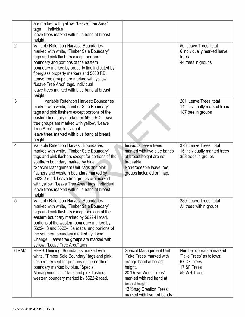
DRAFT
are marked with yellow, “Leave Tree Area” tags Individual leave trees marked with blue band at breast height.
2 Variable Retention Harvest: Boundaries marked with white, “Timber Sale Boundary” tags and pink flashers except northern boundary and portions of the eastern boundary marked by property line indicated by fiberglass property markers and 5600 RD. Leave tree groups are marked with yellow, “Leave Tree Area” tags. Individual leave trees marked with blue band at breast height.
50 ‘Leave Trees’ total 6 individually marked leave trees 44 trees in groups
3 Variable Retention Harvest: Boundaries marked with white, “Timber Sale Boundary” tags and pink flashers except portions of the eastern boundary marked by 5600 RD. Leave tree groups are marked with yellow, “Leave Tree Area” tags. Individual leave trees marked with blue band at breast height.
201 ‘Leave Trees’ total 14 individually marked trees 187 tree in groups
4 Variable Retention Harvest: Boundaries marked with white, “Timber Sale Boundary” tags and pink flashers except for portions of the southern boundary marked by blue, “Special Management Unit” tags and pink flashers and western boundary marked by 5622-2 road. Leave tree groups are marked with yellow, “Leave Tree Area” tags. Individual leave trees marked with blue band at breast height.
Individual leave trees marked with two blue bands at breast height are not tradeable. Non-tradeable leave tree groups indicated on map.
373 ‘Leave Trees’ total 15 individually marked trees 358 trees in groups
5 Variable Retention Harvest: Boundaries marked with white, “Timber Sale Boundary” tags and pink flashers except portions of the eastern boundary marked by 5622-H road, portions of the western boundary marked by 5622-H3 and 5622-H3a roads, and portions of the southern boundary marked by ‘Type Change’. Leave tree groups are marked with yellow, “Leave Tree Area” tags
289 ‘Leave Trees’ total All trees within groups
6 RMZ RFRS Thinning: Boundaries marked with white, “Timber Sale Boundary” tags and pink flashers, except for portions of the northern boundary marked by blue, “Special Management Unit” tags and pink flashers. western boundary marked by 5622-2 road.
Special Management Unit: ‘Take Trees’ marked with orange band at breast height. 20 ‘Down Wood Trees’ marked with red band at breast height. 13 ‘Snag Creation Trees’ marked with two red bands
Number of orange marked ‘Take Trees’ as follows: 67 DF Trees 17 SF Trees 59 WH Trees
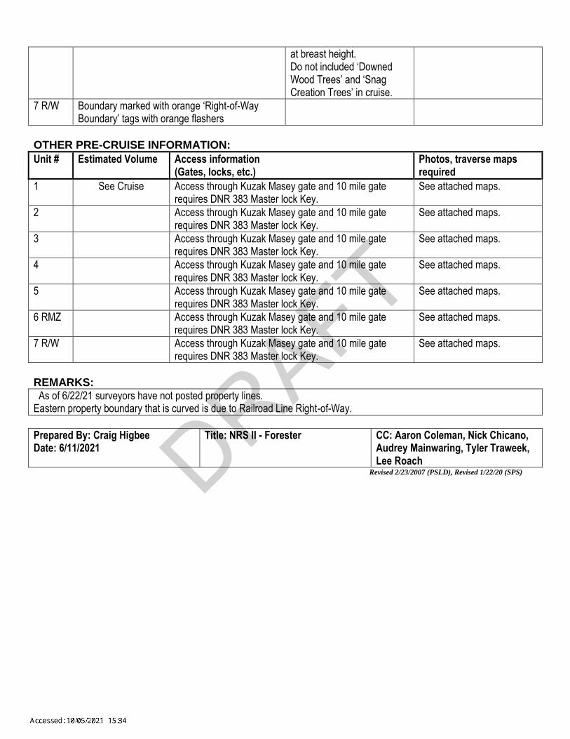
DRAFT
at breast height. Do not included ‘Downed Wood Trees’ and ‘Snag Creation Trees’ in cruise.
7 R/W Boundary marked with orange ‘Right-of-Way Boundary’ tags with orange flashers
OTHER PRE-CRUISE INFORMATION:
Unit # Estimated Volume Access information (Gates, locks, etc.)
Photos, traverse maps required
1 See Cruise Access through Kuzak Masey gate and 10 mile gate requires DNR 383 Master lock Key.
See attached maps.
2 Access through Kuzak Masey gate and 10 mile gate requires DNR 383 Master lock Key.
See attached maps.
3 Access through Kuzak Masey gate and 10 mile gate requires DNR 383 Master lock Key.
See attached maps.
4 Access through Kuzak Masey gate and 10 mile gate requires DNR 383 Master lock Key.
See attached maps.
5 Access through Kuzak Masey gate and 10 mile gate requires DNR 383 Master lock Key.
See attached maps.
6 RMZ Access through Kuzak Masey gate and 10 mile gate requires DNR 383 Master lock Key.
See attached maps.
7 R/W Access through Kuzak Masey gate and 10 mile gate requires DNR 383 Master lock Key.
See attached maps.
REMARKS:
As of 6/22/21 surveyors have not posted property lines. Eastern property boundary that is curved is due to Railroad Line Right-of-Way.
Prepared By: Craig Higbee Date: 6/11/2021
Title: NRS II - Forester
CC: Aaron Coleman, Nick Chicano, Audrey Mainwaring, Tyler Traweek, Lee Roach
Revised 2/23/2007 (PSLD), Revised 1/22/20 (SPS)

DRAFT
Timber Sale Cruise ReportCoug Flats
Sale Name: COUG FLATS
Sale Type: LUMP SUM
Region: SO PUGET
District: RAINIER
Lead Cruiser: Aaron Coleman
Other Cruisers:
Cruise Narrative:This sale consists of 5 variable retention harvest (VRH) units, 1 RFRS thinning unit, and 1 right-of-way (ROW) units located off 5600 and the 5622 roads in the Green River Watershed. A 383 key is needed to access the kuzak gate and all roads are in good condition.
The primary species for this sale is as follows:
Douglas-fir (41%) with an average diameter of 20 inches. Western hemlock (40%) with an average diameter of 14 inches. Silver Fir (15%) with an average diameter of 25 inches.
Units 1, 3, 4 & 5 contain the best mix of species. They are dominated by a DF/WH cohort mixed with larger true-fir. Unit 2 is mostly alder, with a small amount of mixed other species. Unit 6 has 100% marked take-trees.
The most commonly observed defects were broken/forked tops, spike knots, and frost check. This is mostly shovel ground with generally favorable logging conditions.
** FMA acres were used as cruise acres. Plots that fell within or next to leave tree clumps were sampled. Leave trees contribute to the overall statistics of the sale, but do not contribute to the overall sale volume. **
Timber Sale Notice Volume (MBF)
MBF Volume by GradeSp DBH Rings/In Age All 2 Saw 3 Saw 4 Saw UtilityDF 20.1 9.0 2,241 1,531 578 132WH 14.5 10.0 2,155 944 894 317SF 25.9 848 725 108 15RA 13.4 131 25 35 70 1RC 22.8 62 57 5SS 10.2 9 9NF 25.0 4 4ALL 17.2 9.5 5,450 3,226 1,674 548 1
267aea44-435b-4260-b243-d61e4cc7d9f3 August 20, 2021 13:30:23
1 of 17
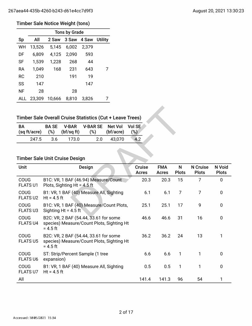
DRAFT
Timber Sale Notice Weight (tons)
Tons by GradeSp All 2 Saw 3 Saw 4 Saw UtilityWH 13,526 5,145 6,002 2,379DF 6,809 4,125 2,090 593SF 1,539 1,228 268 44RA 1,049 168 231 643 7RC 210 191 19SS 147 147NF 28 28ALL 23,309 10,666 8,810 3,826 7
Timber Sale Overall Cruise Statistics (Cut + Leave Trees)
BA(sq ft/acre)
BA SE(%)
V-BAR(bf/sq ft)
V-BAR SE(%)
Net Vol(bf/acre)
Vol SE(%)
247.5 3.6 173.0 2.0 43,070 4.2
Timber Sale Unit Cruise Design
Unit Design Cruise Acres
FMA Acres
N Plots
N Cruise Plots
N Void Plots
COUG FLATS U1
B1C: VR, 1 BAF (46.94) Measure/Count Plots, Sighting Ht = 4.5 ft
20.3 20.3 15 7 0
COUG FLATS U2
B1: VR, 1 BAF (40) Measure All, Sighting Ht = 4.5 ft
6.1 6.1 7 7 0
COUG FLATS U3
B1C: VR, 1 BAF (40) Measure/Count Plots, Sighting Ht = 4.5 ft
25.1 25.1 17 9 0
COUG FLATS U4
B2C: VR, 2 BAF (54.44, 33.61 for some species) Measure/Count Plots, Sighting Ht = 4.5 ft
46.6 46.6 31 16 0
COUG FLATS U5
B2C: VR, 2 BAF (54.44, 33.61 for some species) Measure/Count Plots, Sighting Ht = 4.5 ft
36.2 36.2 24 13 1
COUG FLATS U6
ST: Strip/Percent Sample (1 tree expansion)
6.6 6.6 1 1 0
COUG FLATS U7
B1: VR, 1 BAF (40) Measure All, Sighting Ht = 4.5 ft
0.5 0.5 1 1 0
All 141.4 141.3 96 54 1
267aea44-435b-4260-b243-d61e4cc7d9f3 August 20, 2021 13:30:23
2 of 17

DRAFT
Timber Sale Log Grade x Sort Summary
Sp Status Grade Sort Dia Len BF Gross BF Net Defect % Tons MBF NetDF LIVE 2 SAW Domestic 15.5 34 7,914 7,763 1.9 2,804.5 1,097.6DF LIVE 2 SAW HQ-B 14.4 37 3,140 3,067 2.3 1,320.9 433.7DF LIVE 3 SAW Domestic 8.8 35 2,860 2,829 1.1 1,539.6 400.0DF LIVE 3 SAW HQ-B 10.5 37 1,271 1,257 1.1 550.8 177.8DF LIVE 4 SAW Domestic 5.9 28 949 931 1.9 593.3 131.7DF LIVE CULL Cull 12.9 6 135 0 100.0 0.0 0.0NF LIVE 3 SAW Domestic 7.7 40 25 25 0.0 27.9 3.5RA LIVE 2 SAW Domestic 13.7 32 187 177 5.5 168.3 25.0RA LIVE 3 SAW Domestic 11.1 26 251 244 2.5 231.2 34.5RA LIVE 4 SAW Domestic 6.7 28 526 498 5.5 643.2 70.4RA LIVE CULL Cull 10.9 4 19 0 100.0 0.0 0.0RA LIVE UTILITY Pulp 11.0 15 9 9 0.0 6.7 1.2RC LIVE 3 SAW Domestic 12.1 36 515 403 21.7 191.2 57.0RC LIVE 4 SAW Domestic 5.5 29 38 38 1.4 19.1 5.4SF LIVE 2 SAW Domestic 17.1 40 5,500 5,130 6.7 1,227.6 725.4SF LIVE 3 SAW Domestic 9.2 35 768 760 0.9 267.6 107.5SF LIVE 4 SAW Domestic 7.0 21 104 104 0.0 43.7 14.8SS LIVE 4 SAW Domestic 5.5 35 65 63 2.7 147.0 8.9WH LIVE 2 SAW Domestic 14.3 37 6,717 6,573 2.1 5,053.4 929.4WH LIVE 2 SAW HQ-B 13.3 40 112 106 5.0 91.9 15.0WH LIVE 3 SAW Domestic 9.1 39 6,388 6,266 1.9 5,954.1 886.0WH LIVE 3 SAW HQ-B 9.6 40 54 54 0.0 47.6 7.6WH LIVE 4 SAW Domestic 5.4 30 2,280 2,244 1.6 2,379.2 317.3WH LIVE CULL Cull 12.1 3 68 0 100.0 0.0 0.0
Timber Sale Log Sort x Diameter Bin Summary
Sp Bin Status Sort Dia Len BF Net Defect % Tons MBF NetDF 5 - 8 LIVE Domestic 6.3 30 1,850 1.3 1,194.7 261.6DF 5 - 8 LIVE Cull 7.6 2 0 100.0 0.0 0.0DF 9 - 11 LIVE Cull 10.3 2 0 100.0 0.0 0.0DF 9 - 11 LIVE Domestic 10.3 34 1,876 1.3 928.1 265.3DF 9 - 11 LIVE HQ-B 10.4 37 1,257 1.1 550.8 177.8DF 12 - 14 LIVE Cull 13.0 10 0 100.0 0.0 0.0DF 12 - 14 LIVE HQ-B 13.2 37 1,494 2.7 717.6 211.3DF 12 - 14 LIVE Domestic 13.3 34 2,310 1.8 961.2 326.6DF 15 - 19 LIVE HQ-B 16.5 36 1,374 2.3 546.5 194.3
267aea44-435b-4260-b243-d61e4cc7d9f3 August 20, 2021 13:30:23
3 of 17

DRAFT
Sp Bin Status Sort Dia Len BF Net Defect % Tons MBF NetDF 15 - 19 LIVE Domestic 16.9 34 4,258 1.4 1,449.8 602.1DF 15 - 19 LIVE Cull 17.2 2 0 100.0 0.0 0.0DF 20+ LIVE HQ-B 20.6 36 199 0.0 56.8 28.1DF 20+ LIVE Domestic 21.6 35 1,229 3.8 403.7 173.7NF 5 - 8 LIVE Domestic 7.7 40 25 0.0 27.9 3.5RA 5 - 8 LIVE Domestic 6.5 28 411 4.2 537.0 58.2RA 9 - 11 LIVE Domestic 10.3 29 331 4.9 337.4 46.7RA 9 - 11 LIVE Cull 10.4 6 0 100.0 0.0 0.0RA 9 - 11 LIVE Pulp 11.0 15 9 0.0 6.7 1.2RA 12 - 14 LIVE Cull 12.6 2 0 100.0 0.0 0.0RA 12 - 14 LIVE Domestic 13.1 32 117 4.9 125.3 16.6RA 15 - 19 LIVE Domestic 15.6 30 60 6.5 43.0 8.5RC 5 - 8 LIVE Domestic 6.0 29 57 4.1 30.4 8.1RC 9 - 11 LIVE Domestic 10.3 35 130 1.3 63.7 18.3RC 12 - 14 LIVE Domestic 13.1 36 62 35.3 40.7 8.8RC 15 - 19 LIVE Domestic 17.1 36 126 16.0 50.2 17.8RC 20+ LIVE Domestic 26.6 36 66 43.2 25.4 9.3SF 5 - 8 LIVE Domestic 6.8 27 230 1.0 99.2 32.5SF 9 - 11 LIVE Domestic 10.4 34 635 0.8 212.1 89.8SF 12 - 14 LIVE Domestic 12.9 40 785 1.3 222.3 111.0SF 15 - 19 LIVE Domestic 17.1 40 2,007 6.0 494.1 283.8SF 20+ LIVE Domestic 22.6 40 2,338 9.0 511.1 330.6SS 5 - 8 LIVE Domestic 5.5 35 63 2.7 147.0 8.9WH 5 - 8 LIVE Domestic 6.0 33 4,423 1.5 4,773.9 625.4WH 9 - 11 LIVE HQ-B 9.6 40 54 0.0 47.6 7.6WH 9 - 11 LIVE Cull 10.3 4 0 100.0 0.0 0.0WH 9 - 11 LIVE Domestic 10.4 38 4,023 2.2 3,517.8 568.9WH 12 - 14 LIVE Domestic 13.3 38 4,139 2.1 3,337.8 585.2WH 12 - 14 LIVE HQ-B 13.3 40 106 5.0 91.9 15.0WH 12 - 14 LIVE Cull 13.4 3 0 100.0 0.0 0.0WH 15 - 19 LIVE Cull 15.6 2 0 100.0 0.0 0.0WH 15 - 19 LIVE Domestic 16.5 36 2,497 2.2 1,757.2 353.1
267aea44-435b-4260-b243-d61e4cc7d9f3 August 20, 2021 13:30:23
4 of 17

DRAFT
Cruise Unit ReportCOUG FLATS U1
Unit Sale Notice Volume (MBF): COUG FLATS U1
MBF Volume by GradeSp DBH Rings/In Age All 2 Saw 3 Saw 4 SawWH 15.1 462 160 255 47DF 21.4 287 211 61 15RC 21.5 36 32 4ALL 17.6 785 372 348 65
Unit Cruise Design: COUG FLATS U1
Design Cruise Acres
FMA Acres
N Plots
N Cruise Plots
N Void Plots
B1C: VR, 1 BAF (46.94) Measure/Count Plots, Sighting Ht = 4.5 ft
20.3 20.3 15 7 0
Unit Cruise Summary: COUG FLATS U1
Sp Cruised Trees All Trees Trees/Plot Ring-Count TreesWH 17 54 3.6 0DF 13 25 1.7 0RC 5 6 0.4 0ALL 35 85 5.7 0
Unit Cruise Statistics (Cut + Leave Trees): COUG FLATS U1
Sp BA(sq ft/acre)
BA CV(%)
BA SE(%)
V-BAR(bf/sq ft)
V-BAR CV(%)
V-BAR SE(%)
Net Vol(bf/acre)
Vol CV(%)
Vol SE(%)
WH 169.0 56.3 14.5 151.6 27.1 6.6 25,610 62.5 16.0DF 78.2 105.6 27.3 215.1 29.6 8.2 16,825 109.6 28.5RC 18.8 263.9 68.1 93.5 31.9 14.3 1,756 265.8 69.6ALL 266.0 36.3 9.4 166.1 38.0 6.4 44,191 52.6 11.4
Unit Summary: COUG FLATS U1
Sp Status Rx N D DBH BL THT BF Gross
BF Net
Defect %
TPA BA RD MBF Net
DF LIVE CUT 13 ALL 21.4 95 131 14,491 14,133 2.5 26.3 65.7 14.2 286.9RC LIVE CUT 5 ALL 21.5 76 114 2,348 1,756 25.2 7.4 18.8 4.0 35.6
267aea44-435b-4260-b243-d61e4cc7d9f3 August 20, 2021 13:30:23
5 of 17

DRAFT
Sp Status Rx N D DBH BL THT BF Gross
BF Net
Defect %
TPA BA RD MBF Net
WH LIVE CUT 17 ALL 15.1 75 94 23,353 22,765 2.5 120.8 150.2 38.7 462.1ALL LIVE CUT 35 ALL 16.7 78 101 40,192 38,653 3.8 154.5 234.7 56.9 784.7ALL ALL ALL 35 ALL 16.7 78 101 40,192 38,653 3.8 154.5 234.7 56.9 784.7
267aea44-435b-4260-b243-d61e4cc7d9f3 August 20, 2021 13:30:23
6 of 17

DRAFT
Cruise Unit ReportCOUG FLATS U2
Unit Sale Notice Volume (MBF): COUG FLATS U2
MBF Volume by GradeSp DBH Rings/In Age All 2 Saw 3 Saw 4 Saw UtilityRA 13.3 100 25 21 52 1DF 31.6 24 22 2WH 11.9 12 8 4SS 10.2 9 9RC 40.0 5 5ALL 13.2 149 47 36 65 1
Unit Cruise Design: COUG FLATS U2
Design Cruise Acres
FMA Acres
N Plots
N Cruise Plots
N Void Plots
B1: VR, 1 BAF (40) Measure All, Sighting Ht = 4.5 ft
6.1 6.1 7 7 0
Unit Cruise Summary: COUG FLATS U2
Sp Cruised Trees All Trees Trees/Plot Ring-Count TreesRA 26 26 3.7 0DF 3 3 0.4 0WH 3 3 0.4 0SS 4 4 0.6 0RC 1 1 0.1 0ALL 37 37 5.3 0
Unit Cruise Statistics (Cut + Leave Trees): COUG FLATS U2
Sp BA(sq ft/acre)
BA CV(%)
BA SE(%)
V-BAR(bf/sq ft)
V-BAR CV(%)
V-BAR SE(%)
Net Vol(bf/acre)
Vol CV(%)
Vol SE(%)
RA 148.6 57.6 21.8 109.9 33.4 6.6 16,334 66.6 22.7DF 17.1 264.6 100.0 226.9 3.5 2.0 3,890 264.6 100.0WH 17.1 183.6 69.4 114.0 29.2 16.8 1,954 185.9 71.4SS 22.9 170.8 64.5 64.1 21.0 10.5 1,465 172.1 65.4RC 5.7 264.6 100.0 141.3 0.0 0.0 807 264.6 100.0ALL 211.4 46.0 17.4 115.6 42.3 6.9 24,451 62.4 18.7
267aea44-435b-4260-b243-d61e4cc7d9f3 August 20, 2021 13:30:23
7 of 17

DRAFT
Unit Summary: COUG FLATS U2
Sp Status Rx N D DBH BL THT BF Gross
BF Net
Defect %
TPA BA RD MBF Net
DF LIVE CUT 3 ALL 31.6 106 135 4,136 3,890 5.9 3.1 17.1 3.0 23.7RA LIVE CUT 26 ALL 13.3 54 82 17,480 16,334 6.6 154.0 148.6 40.7 99.6RC LIVE CUT 1 ALL 40.0 94 120 1,059 807 23.8 0.7 5.7 0.9 4.9SS LIVE CUT 4 ALL 10.2 39 58 1,505 1,465 2.7 40.3 22.9 7.2 8.9WH LIVE CUT 3 ALL 11.9 59 69 1,954 1,954 0.0 22.2 17.1 5.0 11.9ALL LIVE CUT 37 ALL 13.3 53 77 26,135 24,451 6.4 220.3 211.4 56.8 149.2ALL ALL ALL 37 ALL 13.3 53 77 26,135 24,451 6.4 220.3 211.4 56.8 149.2
267aea44-435b-4260-b243-d61e4cc7d9f3 August 20, 2021 13:30:23
8 of 17

DRAFT
Cruise Unit ReportCOUG FLATS U3
Unit Sale Notice Volume (MBF): COUG FLATS U3
MBF Volume by GradeSp DBH Rings/In Age All 2 Saw 3 Saw 4 SawWH 14.2 405 178 164 64DF 16.1 390 189 158 43RA 15.2 20 13 7RC 22.0 16 15 1SF 16.0 8 7 1ALL 15.3 839 367 356 116
Unit Cruise Design: COUG FLATS U3
Design Cruise Acres
FMA Acres
N Plots
N Cruise Plots
N Void Plots
B1C: VR, 1 BAF (40) Measure/Count Plots, Sighting Ht = 4.5 ft
25.1 25.1 17 9 0
Unit Cruise Summary: COUG FLATS U3
Sp Cruised Trees All Trees Trees/Plot Ring-Count TreesWH 22 45 2.6 0DF 19 39 2.3 0RA 3 3 0.2 0RC 3 3 0.2 0SF 1 1 0.1 0ALL 48 91 5.4 0
Unit Cruise Statistics (Cut + Leave Trees): COUG FLATS U3
Sp BA(sq ft/acre)
BA CV(%)
BA SE(%)
V-BAR(bf/sq ft)
V-BAR CV(%)
V-BAR SE(%)
Net Vol(bf/acre)
Vol CV(%)
Vol SE(%)
WH 105.9 75.5 18.3 159.4 31.2 6.7 16,881 81.7 19.5DF 91.8 81.2 19.7 169.4 34.6 7.9 15,548 88.3 21.2RA 7.1 299.5 72.6 115.0 12.7 7.3 812 299.8 73.0RC 7.1 299.5 72.6 91.1 11.6 6.7 643 299.8 73.0SF 2.4 412.3 100.0 128.9 0.0 0.0 303 412.3 100.0ALL 214.1 37.3 9.1 159.7 33.8 4.9 34,187 50.3 10.3
267aea44-435b-4260-b243-d61e4cc7d9f3 August 20, 2021 13:30:23
9 of 17

DRAFT
Unit Summary: COUG FLATS U3
Sp Status Rx N D DBH BL THT BF Gross
BF Net
Defect %
TPA BA RD MBF Net
DF LIVE CUT 19 ALL 16.1 86 103 15,950 15,548 2.5 64.9 91.8 22.9 390.3RA LIVE CUT 3 ALL 15.2 76 95 894 812 9.2 5.6 7.1 1.8 20.4RC LIVE CUT 3 ALL 22.0 73 82 735 643 12.5 2.7 7.1 1.5 16.1SF LIVE CUT 1 ALL 16.0 67 84 303 303 0.0 1.7 2.4 0.6 7.6WH LIVE CUT 22 ALL 14.2 72 88 16,382 16,130 1.5 92.0 101.2 26.8 404.9ALL LIVE CUT 48 ALL 15.2 78 94 34,264 33,437 2.4 166.9 209.4 53.6 839.3ALL ALL ALL 48 ALL 15.2 78 94 34,264 33,437 2.4 166.9 209.4 53.6 839.3
267aea44-435b-4260-b243-d61e4cc7d9f3 August 20, 2021 13:30:23
10 of 17

DRAFT
Cruise Unit ReportCOUG FLATS U4
Unit Sale Notice Volume (MBF): COUG FLATS U4
MBF Volume by GradeSp DBH Rings/In Age All 2 Saw 3 Saw 4 SawWH 14.5 10.0 1,050 548 349 154DF 19.5 9.0 740 457 239 44SF 22.4 249 197 46 6RA 11.0 11 11RC 18.0 6 5 1ALL 16.1 9.5 2,056 1,201 639 216
Unit Cruise Design: COUG FLATS U4
Design Cruise Acres
FMA Acres
N Plots
N Cruise Plots
N Void Plots
B2C: VR, 2 BAF (54.44, 33.61 for some species) Measure/Count Plots, Sighting Ht = 4.5 ft
46.6 46.6 31 16 0
Unit Cruise Summary: COUG FLATS U4
Sp Cruised Trees All Trees Trees/Plot Ring-Count TreesWH 43 82 2.6 1DF 24 55 1.8 1SF 6 16 0.5 0RA 1 2 0.1 0RC 1 1 0.0 0ALL 75 156 5.0 2
Unit Cruise Statistics (Cut + Leave Trees): COUG FLATS U4
Sp BA(sq ft/acre)
BA CV(%)
BA SE(%)
V-BAR(bf/sq ft)
V-BAR CV(%)
V-BAR SE(%)
Net Vol(bf/acre)
Vol CV(%)
Vol SE(%)
WH 144.0 65.9 11.8 166.7 25.0 3.8 24,005 70.5 12.4DF 96.6 104.7 18.8 180.7 19.5 4.0 17,455 106.4 19.2SF 28.1 157.2 28.2 217.5 23.1 9.4 6,110 158.9 29.8RA 2.2 556.8 100.0 110.6 0.0 0.0 240 556.8 100.0RC 1.1 556.8 100.0 112.0 0.0 0.0 121 556.8 100.0ALL 271.9 32.5 5.8 176.3 24.4 2.8 47,932 40.6 6.5
267aea44-435b-4260-b243-d61e4cc7d9f3 August 20, 2021 13:30:23
11 of 17

DRAFT
Unit Summary: COUG FLATS U4
Sp Status Rx N D DBH BL THT BF Gross
BF Net
Defect %
TPA BA RD MBF Net
DF LIVE CUT 24 ALL 19.5 89 119 16,382 15,868 3.1 42.3 87.8 19.9 739.5RA LIVE CUT 1 ALL 11.0 55 76 240 240 0.0 3.3 2.2 0.7 11.2RC LIVE CUT 1 ALL 18.0 72 91 121 121 0.0 0.6 1.1 0.3 5.7SF LIVE CUT 6 ALL 22.4 96 123 5,499 5,347 2.8 9.0 24.6 5.2 249.2WH LIVE CUT 43 ALL 14.5 70 86 23,180 22,541 2.8 117.9 135.2 35.5 1,050.4ALL LIVE CUT 75 ALL 16.3 76 96 45,423 44,118 2.9 173.1 250.9 61.5 2,055.9ALL ALL ALL 75 ALL 16.3 76 96 45,423 44,118 2.9 173.1 250.9 61.5 2,055.9
267aea44-435b-4260-b243-d61e4cc7d9f3 August 20, 2021 13:30:23
12 of 17

DRAFT
Cruise Unit ReportCOUG FLATS U5
Unit Sale Notice Volume (MBF): COUG FLATS U5
MBF Volume by GradeSp DBH Rings/In Age All 2 Saw 3 Saw 4 SawDF 21.9 768 629 111 28SF 27.6 579 518 54 7WH 13.5 200 47 108 45NF 25.0 4 4ALL 19.8 1,550 1,195 276 80
Unit Cruise Design: COUG FLATS U5
Design Cruise Acres
FMA Acres
N Plots
N Cruise Plots
N Void Plots
B2C: VR, 2 BAF (54.44, 33.61 for some species) Measure/Count Plots, Sighting Ht = 4.5 ft
36.2 36.1 24 13 1
Unit Cruise Summary: COUG FLATS U5
Sp Cruised Trees All Trees Trees/Plot Ring-Count TreesDF 20 53 2.2 0SF 11 36 1.5 0WH 8 27 1.1 0NF 1 4 0.2 0ALL 40 120 5.0 0
Unit Cruise Statistics (Cut + Leave Trees): COUG FLATS U5
Sp BA(sq ft/acre)
BA CV(%)
BA SE(%)
V-BAR(bf/sq ft)
V-BAR CV(%)
V-BAR SE(%)
Net Vol(bf/acre)
Vol CV(%)
Vol SE(%)
DF 120.2 61.2 12.5 203.3 14.0 3.1 24,438 62.7 12.9SF 81.7 85.7 17.5 227.4 13.1 3.9 18,569 86.7 17.9WH 61.2 80.0 16.3 143.4 34.4 12.2 8,784 87.1 20.4NF 9.1 228.4 46.6 21.1 0.0 0.0 192 228.4 46.6ALL 272.2 34.4 7.0 191.0 27.2 4.3 51,983 43.9 8.2
267aea44-435b-4260-b243-d61e4cc7d9f3 August 20, 2021 13:30:23
13 of 17

DRAFT
Unit Summary: COUG FLATS U5
Sp Status Rx N D DBH BL THT BF Gross
BF Net
Defect %
TPA BA RD MBF Net
DF LIVE CUT 20 ALL 21.9 94 140 21,672 21,211 2.1 39.9 104.3 22.3 767.8NF LIVE CUT 1 ALL 25.0 44 913 96 96 0.0 1.3 4.5 0.9 3.5SF LIVE CUT 11 ALL 27.6 113 138 17,241 15,990 7.3 16.9 70.3 13.4 578.8WH LIVE CUT 8 ALL 13.5 71 86 5,661 5,531 2.3 38.8 38.6 10.5 200.2ALL LIVE CUT 40 ALL 20.3 87 128 44,669 42,827 4.1 96.9 217.8 47.1 1,550.3ALL ALL ALL 40 ALL 20.3 87 128 44,669 42,827 4.1 96.9 217.8 47.1 1,550.3
267aea44-435b-4260-b243-d61e4cc7d9f3 August 20, 2021 13:30:23
14 of 17

DRAFT
Cruise Unit ReportCOUG FLATS U6
Unit Sale Notice Volume (MBF): COUG FLATS U6
MBF Volume by GradeSp DBH Rings/In Age All 2 Saw 3 Saw 4 SawDF 18.9 24 15 7 2WH 17.4 15 8 5 1SF 24.8 12 11 1 0ALL 19.1 51 34 13 3
Unit Cruise Design: COUG FLATS U6
Design Cruise Acres
FMA Acres
N Plots
N Cruise Plots
N Void Plots
ST: Strip/Percent Sample (1 tree expansion)
6.6 6.6 1 1 0
Unit Cruise Summary: COUG FLATS U6
Sp Cruised Trees All Trees Trees/Plot Ring-Count TreesDF 15 67 67.0 0WH 12 59 59.0 0SF 9 17 17.0 0ALL 36 143 143.0 0
Unit Cruise Statistics (Cut + Leave Trees): COUG FLATS U6
Sp BA(sq ft/acre)
BA CV(%)
BA SE(%)
V-BAR(bf/sq ft)
V-BAR CV(%)
V-BAR SE(%)
Net Vol(bf/acre)
Vol CV(%)
Vol SE(%)
DF 19.9 0.0 0.0 182.3 13.1 3.4 3,623 13.1 3.4WH 14.7 0.0 0.0 149.7 12.0 3.5 2,205 12.0 3.5SF 8.7 0.0 0.0 210.5 21.1 7.0 1,821 21.1 7.0ALL 43.3 0.0 0.0 176.9 20.7 3.4 7,649 20.7 3.4
Unit Summary: COUG FLATS U6
Sp Status Rx N D DBH BL THT BF Gross BF Net Defect % TPA BA RD MBF NetDF LIVE CUT 15 ALL 18.9 92 122 3,666 3,623 1.2 10.2 19.9 4.6 23.9SF LIVE CUT 9 ALL 24.8 108 135 1,963 1,821 7.2 2.6 8.7 1.7 12.0WH LIVE CUT 12 ALL 17.4 77 99 2,274 2,205 3.0 8.9 14.7 3.5 14.6
267aea44-435b-4260-b243-d61e4cc7d9f3 August 20, 2021 13:30:23
15 of 17

DRAFT
Sp Status Rx N D DBH BL THT BF Gross BF Net Defect % TPA BA RD MBF NetALL LIVE CUT 36 ALL 19.1 88 114 7,903 7,649 3.2 21.7 43.3 9.8 50.5ALL ALL ALL 36 ALL 19.1 88 114 7,903 7,649 3.2 21.7 43.3 9.8 50.5
267aea44-435b-4260-b243-d61e4cc7d9f3 August 20, 2021 13:30:23
16 of 17

DRAFT
Cruise Unit ReportCOUG FLATS U7
Unit Sale Notice Volume (MBF): COUG FLATS U7
MBF Volume by GradeSp DBH Rings/In Age All 2 Saw 3 Saw 4 SawWH 11.5 11 3 6 3DF 27.0 9 8 1 0ALL 13.5 20 11 6 3
Unit Cruise Design: COUG FLATS U7
Design Cruise Acres
FMA Acres
N Plots
N Cruise Plots
N Void Plots
B1: VR, 1 BAF (40) Measure All, Sighting Ht = 4.5 ft
0.5 0.5 1 1 0
Unit Cruise Summary: COUG FLATS U7
Sp Cruised Trees All Trees Trees/Plot Ring-Count TreesWH 4 4 4.0 0DF 2 2 2.0 0ALL 6 6 6.0 0
Unit Cruise Statistics (Cut + Leave Trees): COUG FLATS U7
Sp BA(sq ft/acre)
BA CV(%)
BA SE(%)
V-BAR(bf/sq ft)
V-BAR CV(%)
V-BAR SE(%)
Net Vol(bf/acre)
Vol CV(%)
Vol SE(%)
WH 160.0 0.0 0.0 139.3 39.6 19.8 22,289 39.6 19.8DF 80.0 0.0 0.0 218.3 0.0 0.0 17,464 0.0 0.0ALL 240.0 0.0 0.0 165.6 35.7 14.6 39,753 35.7 14.6
Unit Summary: COUG FLATS U7
Sp Status Rx N D DBH BL THT BF Gross
BF Net
Defect %
TPA BA RD MBF Net
DF LIVE CUT 2 ALL 27.0 106 135 17,464 17,464 0.0 20.1 80.0 15.4 8.7WH LIVE CUT 4 ALL 11.5 57 69 22,289 22,289 0.0 221.8 160.0 47.2 11.1ALL LIVE CUT 6 ALL 13.5 61 74 39,753 39,753 0.0 241.9 240.0 62.6 19.9ALL ALL ALL 6 ALL 13.5 61 74 39,753 39,753 0.0 241.9 240.0 62.6 19.9
267aea44-435b-4260-b243-d61e4cc7d9f3 August 20, 2021 13:30:23
17 of 17

DRAFT
Ø
Ø
ØØ
Ø
Ø
ØØ
~ ~ ~ ~ ~ ~ ~ ~ ~ ~ ~ ~ ~ ~ ~ ~ ~ ~ ~ ~ ~ ~~ ~ ~ ~ ~ ~~ ~ ~ ~ ~ ~ ~ ~ ~~~~
~ ~~ ~ ~
~ ~ ~ ~ ~ ~ ~ ~ ~ ~ ~ ~ ~~
~~~~
~~~~
~~~~~~ ~~~~ ~ ~ ~~
~~ ~ ~ ~ ~ ~ ~ ~ ~ ~ ~ ~ ~ ~
~ ~
~~~~~~~~~~~~~~~~~~~~~~~~~~~~~~~~~~ ~ ~ ~ ~ ~ ~ ~ ~~ ~ ~ ~ ~ ~ ~ ~ ~ ~ ~ ~ ~ ~~ ~ ~ ~ ~
~ ~~ ~
~ ~ ~ ~ ~ ~ ~ ~~~ ~
~ ~ ~ ~ ~~~
~
~ ~ ~ ~ ~ ~ ~ ~ ~ ~ ~ ~ ~ ~ ~ ~ ~ ~ ~ ~~ ~ ~ ~ ~ ~~ ~
~ ~~ ~
~~~ ~
~ ~~~
~ ~ ~~ ~~ ~~~ ~~ ~ ~~~ ~ ~~ ~ ~ ~ ~ ~ ~ ~
~ ~ ~ ~ ~ ~ ~ ~ ~ ~ ~ ~ ~ ~ ~ ~ ~ ~~~ ~ ~~ ~ ~ ~~~ ~
~ ~ ~ ~ ~ ~~~~ ~ ~ ~~ ~ ~ ~ ~ ~ ~ ~~ ~ ~ ~ ~ ~~~~~~~~~~~~~~~~~~~~~~~~~~~~~~~~~~~~~~~~~~~~~~~~~~~~~~~~~~~~~~~~~~~~~~~~~~
~ ~ ~ ~~ ~ ~ ~
~ ~ ~>
>>
>>
>>
>> >
>>
>>
>>
>>
>>
>>
>>
> >>
>>
>>
>>
>>
>>
>>
>>
>>
>
>
>
>
>>
>>
>
>>
>>
>>>
>>>
>>
>>
>>
>
>>>
>>
>
]%4
]%4
]%5
k
1
Unit 1
Unit 2
Unit 3
Unit 7 R/W
Net AcresUnit 1: 18.9Unit 2; 5.2Unit 3: 23.1Unit 7 R/W: 0.5
Non-Tradeable Leave Trees
Unit 1: 25 Individual Leave TreesUnit 2: 6 Individual Leave TreesUnit 3: 14 Indiidual Leave Trees
PRIVATE LAND PRIVATE LAND
PRIVATE LAND
Tadmore 2 Pit
9
8
7
6
5
4
3
2
17
6
5
4
3
2
1
9
8
7
6
5
4
3
2
1
321
15
14
13
12
11
10
18
17
16
15
14
13
12
11
101400
16001800
1200
1800 1800
1600
1200
2
35
5621
5600
5622
5622
-C
5622-B
5600
5622
5600
5600
5622
121°44.7'W
121°44.7'W
121°45'W
121°45'W
121°45.3'W
121°45.3'W
47°15
.3'N
47°15
.3'N
47°15
'N
47°15
'N
L O G G I N G P L A N M A PS A L E N A M E :A G R E E M E N T # :T O W N S H I P ( S ) :T R U S T ( S ) :
R E G IO N :C O U N T Y ( S ) :E L E VAT I O N R G E :
³Prepared By:
South Puget Sound Region
0 1,000500 Feet
chig490 Modification Date: acol490 7/9/2021
!!
! ! DNR Managed LandsPublic Land Survey SectionsPublic Land Survey TownshipsVariable Retention Harvest
Contours 40-foot" """ """ """ "" """ """ """ "" """ """ """ "" """ """ """ "" """ """ """ "" """ """ """ " ~~~~ ~~ ¦¦¦
¦ ¦
¦ Leave Tree AreaRiparian Mgt ZoneNon-Tradable Leave Tree Area
~ ~ ~ Sale Boundary Tags~ ~ Right of Way TagsØ Ø Property Line
> StreamsOpen WaterExisting RoadsOptional Construction
]% Stream Typek Stream Type Break
King1320-2080
COUG FLATS30-100669T20R8EAgricultural School (4), State Forest Transfer (1)
All State Unless Otherwise Noted

DRAFT
~~~~~~~~~~~~~~~~~~~~~~~~~~~~~~ ~ ~ ~ ~ ~ ~ ~ ~ ~ ~ ~ ~ ~ ~ ~ ~ ~ ~ ~ ~~ ~ ~ ~ ~~ ~
~ ~ ~ ~ ~ ~ ~ ~ ~~~~ ~ ~ ~ ~
~ ~
~ ~ ~ ~ ~ ~ ~ ~ ~ ~ ~ ~ ~ ~ ~ ~ ~ ~~ ~ ~ ~ ~~~ ~
~ ~~~
~~~ ~
~ ~~ ~~ ~~ ~~~ ~ ~ ~~~~ ~~ ~ ~ ~ ~ ~ ~ ~ ~~ ~ ~ ~ ~ ~ ~ ~ ~ ~ ~ ~ ~ ~~ ~ ~~ ~ ~ ~~~ ~
~ ~ ~ ~ ~~~ ~ ~ ~ ~~ ~ ~ ~ ~ ~~ ~ ~~ ~~~~~~~~~~~~~~~~~~~~~~~~~~~~~~~~~~~~~~~~~~~~~~~~~~~~~~~~~~~~~~~~~~~
777777
777777
777777
77777777
7
7
77
777
77777
7777
66
66
66
66
666666
66
66
66
66
66
66
6
~ ~
~ ~ ~~ ~ ~ ~ ~>
>
>>
>>
> > >
>>
>>
>>
>>
>>
>>
>>
>>
>>
>>
>
>
>>
>>
>
> > >> > > >
>
> > >>
>>
> > > > > > > > >> > > >
>> >
> > > > >> > > > > > > > >
> > > > > >
>
>> >
> > > > >> > >
>>
>
>> > > >
> >
>
>>
\
\
\
\
\
\
\
\\
\\
\]%4
]%4
]%4
]%5
]%3
]%3
k
]%5k
k
]%5
]%5
o*o*
Unit 4
Unit 6 RFRS
Non-Tradeable Leave Trees
Net AcresUnit 4: 43.0Unit 6: 6.6
Unit 1: 25 Individual Leave TreesUnit 2: 6 Individual Leave TreesUnit 3: 14 Indiidual Leave Trees
9
8
7
6
5
4
3
2
1
1 31
29
28
27
26
25
24
23
22
21
20
19
18
17
16
15
14
13
12
11
10
2000
1800
22001800
180020
00
2
11
5622
5622-G
5622-1
5622-2
5622-F
5622-C
5622-H
5622-1
5622
5622
5622
5622
5622
5622
1600
1800
121°44.7'W
121°44.7'W
121°45'W
121°45'W
121°45.3'W
121°45.3'W
47°15
'N
47°15
'N
47°14
.7'N
47°14
.7'N
47°14
.5'N
L O G G I N G P L A N M A PS A L E N A M E :A G R E E M E N T # :T O W N S H I P ( S ) :T R U S T ( S ) :
R E G IO N :C O U N T Y ( S ) :E L E VAT I O N R G E :
³Prepared By:
South Puget Sound Region
0 1,000500 Feet
chig490 Modification Date: acol490 7/9/2021
!!
! ! DNR Managed LandsPublic Land Survey SectionsPublic Land Survey TownshipsVariable Retention HarvestRiparian Thinning
Contours 40-foot" """ """ """ "" """ """ """ "" """ """ """ "" """ """ """ "" """ """ """ "" """ """ """ " ~~~~ ~~ ¦¦¦
¦ ¦
¦ Leave Tree AreaÉ
ÉWetlands - Non-forested
^^
^W
WWW
WForested WetlandRiparian Mgt ZoneWetland Mgt ZoneNon-Tradable Leave Tree Area
~ ~ ~ Sale Boundary Tags7 7 7 6 Special Mgmt Area
> StreamsExisting RoadsOptional Construction
\ Optional Reconstruction]% Stream Typek Stream Type Break
King1320-2080
COUG FLATS30-100669T20R8EAgricultural School (4), State Forest Transfer (1)
All State Unless Otherwise Noted

DRAFT ~ ~ ~ ~ ~ ~ ~ ~ ~ ~ ~ ~ ~ ~ ~ ~ ~ ~ ~ ~~ ~ ~ ~ ~ ~~ ~
~ ~~ ~
~~~ ~
~ ~~ ~
~ ~ ~~ ~~ ~~~ ~~ ~ ~~~ ~~~ ~ ~ ~ ~ ~ ~ ~
~ ~ ~ ~ ~ ~ ~ ~ ~ ~ ~ ~ ~ ~ ~ ~ ~ ~~~ ~ ~~ ~~ ~~~~
~ ~ ~ ~ ~ ~~~ ~ ~ ~ ~~ ~ ~ ~ ~ ~ ~ ~~ ~ ~ ~ ~~~~~~~~~~~~~~~~~~~~~~~~~~~~~~~~~~~~~~~~~~~~~~~~~~~~~~~~~~~~~~~~~~~~~~~~~~~
777777
777777
777777777
77777777
7
777
777
777
77777
7777
6666
66
66
66
6666
6666
66
66
66
66
66
66
~~~~~~ ~ ~~~
~ ~ ~ ~ ~ ~ ~~ ~ ~ ~~
~ ~~~ ~~ ~ ~ ~ ~ ~
~ ~ ~ ~ ~ ~ ~ ~ ~ ~ ~ ~~~~
~ ~~~
~~~~
~~~~
~ ~ ~ ~~ ~ ~ ~ ~ ~~~~~~~~
>>
>>>>>>>>>>>>>>>
>
>>
>
>>
>
>>
>>
>>>>>>
>>
>
>
>
>
> >>
>>
>>
>>
>>
>>
>>
>>
>>
>
>
>
>
>>
>>
>
>>
>>
>>
> > >> > >
> >
> >
>
>> > > > > > > > > > >
> > > >
>> > >
> > > > >
>
>> > > > > > > >
>> > > > > >
>
>
> > >> > > > >
>
> >>
>>
>
> >> > >
>>
>
>
"
]%5
k
]%4
]%5
]%4
]%3
k
k
]%5
]%5
]%5
Unit 4
Unit 5
Net AcresUnit 5: 33.8
Unit 5: No Individual Leave Trees
Planted in 2013
3
2
1
9
8
7
6
5
4
3
21
2423
22
21
20
19
18
17
16
15
14
13
12
11
10
2400
2200
2600
200022
00
2200
2000
23
11
10
5622-H
5622
5622-H
3
5622-H3a Ext
5622-H
3a
5622
5622
5622-H
121°45.5'W
121°45.5'W
121°45.7'W
121°45.7'W
121°46'W
121°46'W
47°14
.7'N
47°14
.7'N
47°14
.5'N
47°14
.5'N
L O G G I N G P L A N M A PS A L E N A M E :A G R E E M E N T # :T O W N S H I P ( S ) :T R U S T ( S ) :
R E G IO N :C O U N T Y ( S ) :E L E VAT I O N R G E :
³Prepared By:
South Puget Sound Region
0 1,000500 Feet
chig490 Modification Date: acol490 7/9/2021
!!
! ! DNR Managed Lands" Survey Monument
Public Land Survey SectionsPublic Land Survey TownshipsVariable Retention HarvestRiparian Thinning
Contours 40-foot" """ """ """ "" """ """ """ "" """ """ """ "" """ """ """ "" """ """ """ "" """ """ """ " ~~~~ ~~ ¦¦¦
¦ ¦
¦ Leave Tree AreaÉ
ÉWetlands - Non-forested
^ ^W WWWW
Forested WetlandRiparian Mgt ZoneWetland Mgt Zone
~ ~ ~ Sale Boundary TagsTimber Type Change
7 7 7 6 Special Mgmt Area
> StreamsExisting RoadsRequired Construction
]% Stream Typek Stream Type Break
King1320-2080
COUG FLATS30-100669T20R8EAgricultural School (4), State Forest Transfer (1)
All State Unless Otherwise Noted

DRAFT\
\\
\\
\
\\
\
\
XY
XY
XY
Qw
1
fCfC
fC
fC
fC
fC
fC
fC
fCfC
fCfCfC
fC
fC
fCfCfC
fCfCfC
fCfC
fC
fCfC
fC
fCfC
fCfC
fC
fC
fC
fCfCfCfC
fC
South SideMainline/5600
SM
Unit 5
5622-H
Install 18"x30' culvertSta. 1+27
Install 18"x30' culvertSta. 5+00
Install 36"x50' culvertSta. 8+84
Install 18"x30' culvertSta. 9+60
Install 18"x30' culvertSta. 12+39
14+9
8
5621
8+27
5622-C5622-B
5622
5622
5622
Tadmore 2 Pit
Unit 3
Unit 1
Replace existing w/24"x40' culvertSta. 581+30
582+00=0+00 Install 18"x30' culvertSta. 1+50
Clean culvert inletSta. 4+70
Clean culvert inletSta. 6+85
Install 18"x30' culvertSta. 8+15
Install 18"x30' culvertSta.11+70
Install 18"x30' culvertSta. 21+85
Install 18"x30' culvertSta. 5+41 1+54
27+60=0+0028+65=0+00
5622
Install 18"x30' culvertSta. 12+45
Install 18"x30' culvertSta. 9+00 14+40
5622-G
5622-F
Unit 4
7+57
Install 18"x30' culvert & begin ditch reconstruction
Sta. 44+8549+
00=0+0
0
49+15=0+00 Install 18"x35' culvertSta. 2+86
Install 18"x35' culvertSta. 4+52
Install 18"x40' culvert w/ ditchoutSta. 49+25
End ditch reconstructionSta. 59+00
Construct ditchout left & rightSta. 64+90
Clean culvert inletSta. 68+40
Steepen & extend ditchout, right
Sta. 3+85
68+90=0+00
Begin ditch reconstructionSta. 68+90
End ditch reconstructionSta. 70+45
Replace existing w/30"x40' culvertSta. 72+00
5622
5622
5622-H
5622-H3
5622-H3a
5622-H3a Ext
14+70=
0+00
Clean culvert inletSta. 13+65
5622-H2
Clean culvert inlet & outletSta. 0+15
on
Clean culvert inletSta. 40+00
41+50
Clean culvert inletSta. 36+15
11+70=0+00
7+70=0
+00
rt
vert
6+92
Install 18"x30' culvertSta. 25+90
Install 18"x40' culvert &End ditch construction
Sta. 578+10
Begin ditch construction, leftSta. 576+50
Replace existing w/24"x50' culvertSta. 573+20
Replace existing w/24"x80' culvertSta. 567+70
9+00
18+20=0+00
of rock+00
Begin 8" lift of rockSta. 68+40
End 8" lift of rockSta. 14+40
4+15
Unit 2
Unit 5 (RMZ Thinning)
17 Mile
18 Mile
17.5 Mile
2
3
11
35
1
1012
3634
121°44.5'W
121°44.5'W
121°45'W
121°45'W
121°45.5'W
121°45.5'W
47°1
5.5'
N
47°1
5.5'
N
47°1
5'N
47°1
5'N
47°1
4.5'
N
47°1
4.5'
N
R O A D W O R K M A PS A L E N A M E :A G R E E M E N T # :T O W N S H I P ( S ) :T R U S T (S ) :
R E G I O N :C O U N T Y ( S ) :E L E VAT IO N R G E :
30-100669
³Prepared By:
0 1,000 2,000 3,000500Feet
gard490 Modification Date: gard490 6/16/2021
County Road
Existing Roads
Required Pre-Haul Maintenance
Required Construction
Required Reconstruction
Optional Construction
\ Optional Reconstruction
fC Culvert
1 Rock Pit
Qw Waste Area
XY Mile Marker
Timber Sale Unit
Public Land Survey Sections
Streams
Contours 10 ft
South Puget Sound RegionCOUG FLATS
T20R8E 1320-2080King
Agricultural School (4), State Forest Transfer (1)
09/29/2021 Page 1 of 55 30-100669

DRAFT\
\
\
\\
\
\
\
\
\
XY
XY
Qw
1
fCfC
fC
fC
fC
fC
fC
fC
fCfC
fCfCfC
fC
fC
fC
fC
fC
fCfC
fC
fCfC
fCfC
fC
fC
fC
fCfCfCfC
fC
South SideMainline/5600
Install 18"x35' culvertSta. 0+44
Unit 5
5622-H
Install 18"x30' culvertSta. 1+27
Install 18"x30' culvertSta. 5+00
Install 36"x50' culvertSta. 8+84
Install 18"x30' culvertSta. 9+60
Install 18"x30' culvertSta. 12+39
14+9
8
5621
8+27
5622-C5622-B
5622
Tadmore 2 Pit
Unit 3
Unit 1
Install 18"x30' culvertSta. 5+41 1+54
27+60=0+0028+65=0+00
5622
Install 18"x30' culvertSta. 12+45
Install 18"x30' culvertSta. 9+00 14+40
5622-G
5622-F
Unit 4
7+57
Inbe
49+00=
0+00
49+15=0+00
Install 18"x4S
End ditch reconSta. 59+0
Construct ditchSta. 64
Clean culvert inletSta. 68+40
Steepen & extend ditchout, right
Sta. 3+85
68+90=0+00
Begin ditch reconstructionSta. 68+90
End ditch reconstructionSta. 70+45
Replace existing w/30"x40' culvertSta. 72+00
5622
5622
5622-H
5622-H3
5622-H3a
5622-H3a Ext
14+70=
0+00
Clean culvert inletSta. 13+65
5622-H2
Clean culvert inlet & outletSta. 0+15
Begin ditch reconstructionSta. 0+25
Install 18"x30' culvertSta. 6+70
Clean culvert inletSta. 40+00
41+50
Clean culvert inletSta. 36+15
Install 24"x50' culvertSta. 11+05
Install 18"x30' culvertSta. 9+70
Install 24"x40' culvertSta. 11+65
11+70=0+00
7+70=0
+00
Install 18"x30' culvertSta. 1+15
Install 18"x30' culvertSta. 2+55
Construct ditchout rightSta. 5+30
Install 18"x30' culvertSta. 3+69
Install 18"x30' culvertSta. 5+71
6+92
Outslope Rd & Build berm on inside edge of Rd
Sta. 0+00 to 1+15
Install 18"x30' culvertSta. 25+90
R
9+00
18+20=0+00
End ditch reconstruction & end 8" lift of rock
Sta. 7+70
Begin 8" lift of rockSta. 0+00
Begin 8" lift of rockSta. 68+40
End 8" lift of rockSta. 14+40
4+15
Unit 2
Unit 5 (RMZ Thinning)
17 Mile
17.5 Mile
2
3
11
35
10
34
121°45'W
121°45'W
121°45.5'W
121°45.5'W
121°46'W
121°46'W121°46.5'W
47°1
5.5'
N
47°1
5.5'
N
47°1
5'N
47°1
5'N
47°1
4.5'
N
47°1
4.5'
N
R O A D W O R K M A PS A L E N A M E :A G R E E M E N T # :T O W N S H I P ( S ) :T R U S T (S ) :
R E G I O N :C O U N T Y ( S ) :E L E VAT IO N R G E :
30-100669
³Prepared By:
0 1,000 2,000 3,000500Feet
gard490 Modification Date: gard490 6/16/2021
County Road
Existing Roads
Required Pre-Haul Maintenance
Required Construction
Required Reconstruction
Optional Construction
\ Optional Reconstruction
fC Culvert
1 Rock Pit
Qw Waste Area
XY Mile Marker
Timber Sale Unit
Public Land Survey Sections
Streams
Contours 10 ft
South Puget Sound RegionCOUG FLATS
T20R8E 1320-2080King
Agricultural School (4), State Forest Transfer (1)
09/29/2021 Page 2 of 55 30-100669

DRAFTXY
XY
XY
XY
XY
Sidee/5600
South SideMainline/5600
InstallS
Install 18"x3Sta. 5+
Install 36"x50' culveSta. 8+84
Install 18"x30' culvertSta. 9+60
Install 18"x30' culvertSta. 12+39
14+9
8
Install 18"x30Sta. 5+
Install 18"x30' culvertSta. 12+45
Install 18"x30' culvertSta. 9+00 14+4
Steepen & extend+00
Clean culvert inletSta. 13+65
5622-H2
Clean culvert inlet & outletSta. 0+15
B i dit h t ti 18
Begin 8" lift of rockSta. 0+00
End 8" lift of rockSta. 14+40
15 Mile
16 Mile
15.5 Mile
16.5 Mile
3
34 35
2
121°45.5'W
121°45.5'W
121°46'W
121°46'W
121°46.5'W
121°46.5'W
47°1
6'N
47°1
6'N
47°1
5.5'
N
47°1
5.5'
N
47°1
5'N
47°1
5'N
R O A D W O R K M A PS A L E N A M E :A G R E E M E N T # :T O W N S H I P ( S ) :T R U S T (S ) :
R E G I O N :C O U N T Y ( S ) :E L E VAT IO N R G E :
30-100669
³Prepared By:
0 1,000 2,000 3,000500Feet
gard490 Modification Date: gard490 6/16/2021
County Road
Existing Roads
Required Pre-Haul Maintenance
Required Construction
Required Reconstruction
Optional Construction
\ Optional Reconstruction
fC Culvert
1 Rock Pit
Qw Waste Area
XY Mile Marker
Timber Sale Unit
Public Land Survey Sections
Streams
Contours 10 ft
South Puget Sound RegionCOUG FLATS
T20R8E 1320-2080King
Agricultural School (4), State Forest Transfer (1)
09/29/2021 Page 3 of 55 30-100669

DRAFT
XY
XY
XY
South SideMainline/5600
South SideMainline/5600
11 Mile
12 Mile
11.5 Mile
19
18
20
17
30 29121°49.5'W
121°49.5'W
121°50'W
121°50'W
121°50.5'W
121°50.5'W
47°1
8'N
47°1
8'N
47°1
7.5'
N
47°1
7.5'
N
R O A D W O R K M A PS A L E N A M E :A G R E E M E N T # :T O W N S H I P ( S ) :T R U S T (S ) :
R E G I O N :C O U N T Y ( S ) :E L E VAT IO N R G E :
30-100669
³Prepared By:
0 1,000 2,000 3,000500Feet
gard490 Modification Date: gard490 6/16/2021
County Road
Existing Roads
Required Pre-Haul Maintenance
Required Construction
Required Reconstruction
Optional Construction
\ Optional Reconstruction
fC Culvert
1 Rock Pit
Qw Waste Area
XY Mile Marker
Timber Sale Unit
Public Land Survey Sections
Streams
Contours 10 ft
South Puget Sound RegionCOUG FLATS
T20R8E 1320-2080King
Agricultural School (4), State Forest Transfer (1)
09/29/2021 Page 4 of 55 30-100669

DRAFT
STATE OF WASHINGTON DEPARTMENT OF NATURAL RESOURCES
COUG FLATS TIMBER SALE ROAD PLAN KING COUNTY
BLACK DIAMOND UNIT SOUTH PUGET SOUND REGION
AGREEMENT NO.: 30-100669 STAFF ENGINEER: J. GARDNER DATE: 02 JUNE 2021 DRAWN & COMPILED BY: J. GARDNER
SECTION 0 – SCOPE OF PROJECT
0-1 ROAD PLAN SCOPE Clauses in this road plan apply to all road related work, including landings and rock source development, unless otherwise noted.
0-2 REQUIRED ROADS The specified work on the following roads is required.
Road Stations Type South Side Mainline/5600 213+00 (MM 10¾) to 240+00 (MM 11¼) Pre-haul Maintenance South Side Mainline/5600 268+00 (MM 11¾) to 281+00 (MM 12) Pre-haul Maintenance South Side Mainline/5600 470+00 (MM 15½) to 497+00 (MM 16) Pre-haul Maintenance South Side Mainline/5600 567+45 to 567+95 Pre-haul Maintenance South Side Mainline/5600 572+95 to 573+45 Pre-haul Maintenance South Side Mainline/5600 576+50 to 578+30 Pre-haul Maintenance South Side Mainline/5600 581+05 to 581+55 Pre-haul Maintenance South Side Mainline/5600 0+00 to 582+00 Post-haul Maintenance
5621 0+00 to 14+98 Post-haul Maintenance
5622 1+40 to 1+60 Pre-haul Maintenance
5622 4+68 to 4+72 Pre-haul Maintenance
5622 6+83 to 6+87 Pre-haul Maintenance
5622 8+05 to 8+25 Pre-haul Maintenance
5622 11+60 to 11+80 Pre-haul Maintenance
5622 21+75 to 21+95 Pre-haul Maintenance
5622 44+75 to 59+00 Pre-haul Maintenance
5622 64+88 to 64+92 Pre-haul Maintenance
5622 68+38 to 68+42 Pre-haul Maintenance
5622 68+90 to 70+45 Pre-haul Maintenance
5622 71+90 to 72+10 Pre-haul Maintenance
5622 0+00 to 70+45 Post-haul Maintenance
5622-C 0+00 to 8+27 Post-haul Maintenance
09/29/2021 Page 5 of 55 30-100669

DRAFT
5622-F 1+40 to 7+57 Abandonment*
5622-G 4+15 to 14+40 Abandonment*
5622-G 0+00 to 4+15 Post-haul Maintenance
5622-H 3+83 to 3+87 Pre-haul Maintenance
5622-H 13+63 to 13+67 Pre-haul Maintenance
5622-H 25+80 to 26+00 Pre-haul Maintenance
5622-H 36+13 to 36+17 Pre-haul Maintenance
5622-H 39+98 to 40+02 Pre-haul Maintenance
5622-H 0+00 to 41+50 Post-haul Maintenance
5622-H2 0+13 to 0+17 Pre-haul Maintenance
5622-H3 0+25 to 9+00 Pre-haul Maintenance
5622-H3 9+00 to 11+70 Reconstruction
5622-H3 0+00 to 11+70 Post-haul Maintenance
5622-H3a 0+00 to 7+70 Reconstruction
5622-H3a 0+00 to 7+70 Post-haul Maintenance
5622-H3a Ext 0+00 to 6+92 Construction
5622-H3a Ext 0+00 to 6+92 Post-haul Maintenance
* = if constructed or reconstructed 0-3 OPTIONAL ROADS
The specified work on the following roads is not required. Any optional roads used by the Purchaser must meet all the specifications in the road plan.
Road Stations Type
5621 0+00 to 14+98 Construction
5622-C 0+00 to 8+27 Construction
5622-F 0+00 to 7+57 Construction
5622-G 0+00 to 14+40 Reconstruction
0-4 CONSTRUCTION
Construction includes, but is not limited to. • Clearing; • Grubbing; • Right-of-way debris disposal; • Excavation and/or embankment to subgrade; • Acquisition and installation of drainage structures; • Acquisition, manufacture, and application of rock.
0-5 RECONSTRUCTION
Reconstruction includes, but is not limited to. • Clearing; • Grubbing; • Right-of-way debris disposal;
09/29/2021 Page 6 of 55 30-100669
DRAFT
• Ripping road, and insloping road surface; • Excavation and/or embankment to subgrade; • Construction of drainage features; • Acquisition, manufacture, and application of rock; • Acquisition, manufacture, and application of rock.
0-6 PRE-HAUL MAINTENANCE Pre-haul maintenance includes, but is not limited to. • Cleaning culverts and catchbasins; • Acquisition and installation of drainage structures; • Acquisition, manufacture, and application of rock; • Grading road surfaces; • Reconstruction of ditch.
0-7 POST-HAUL MAINTENANCE This project includes post-haul road maintenance listed in Clause 9-5 POST-HAUL MAINTENANCE.
0-10 ABANDONMENT
This project includes abandonment listed in Clause 9-21 ROAD ABANDONMENT.
0-12 DEVELOP ROCK SOURCE Purchaser may develop a new rock source. Work for developing rock sources is listed in Section 6 ROCK AND SURFACING.
SECTION 1 – GENERAL
1-1 ROAD PLAN CHANGES If the Purchaser desires a change from this road plan including, but not limited to, relocation, extension, change in design, or adding roads; a revised road plan must be submitted in writing to the Contract Administrator for consideration. Before work begins, Purchaser shall obtain approval from the State for the submitted plan.
1-2 UNFORESEEN CONDITIONS Quantities established in this road plan are minimum acceptable values. Additional quantities required by the state due to unforeseen conditions, or Purchaser's choice of construction season or techniques will be at the Purchaser's expense. Unforeseen conditions include, but are not limited to, solid subsurface rock, subsurface springs, saturated ground, and unstable soils.
09/29/2021 Page 7 of 55 30-100669
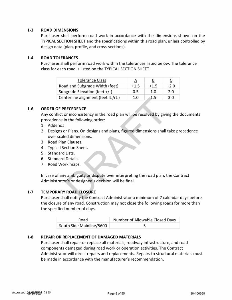
DRAFT
1-3 ROAD DIMENSIONS Purchaser shall perform road work in accordance with the dimensions shown on the TYPICAL SECTION SHEET and the specifications within this road plan, unless controlled by design data (plan, profile, and cross-sections).
1-4 ROAD TOLERANCES Purchaser shall perform road work within the tolerances listed below. The tolerance class for each road is listed on the TYPICAL SECTION SHEET.
Tolerance Class A B C
Road and Subgrade Width (feet) +1.5 +1.5 +2.0
Subgrade Elevation (feet +/-) 0.5 1.0 2.0
Centerline alignment (feet lt./rt.) 1.0 1.5 3.0
1-6 ORDER OF PRECEDENCE
Any conflict or inconsistency in the road plan will be resolved by giving the documents precedence in the following order: 1. Addenda. 2. Designs or Plans. On designs and plans, figured dimensions shall take precedence
over scaled dimensions. 3. Road Plan Clauses. 4. Typical Section Sheet. 5. Standard Lists. 6. Standard Details. 7. Road Work maps. In case of any ambiguity or dispute over interpreting the road plan, the Contract Administrator’s or designee’s decision will be final.
1-7 TEMPORARY ROAD CLOSURE Purchaser shall notify the Contract Administrator a minimum of 7 calendar days before the closure of any road. Construction may not close the following roads for more than the specified number of days.
Road Number of Allowable Closed Days
South Side Mainline/5600 5
1-8 REPAIR OR REPLACEMENT OF DAMAGED MATERIALS
Purchaser shall repair or replace all materials, roadway infrastructure, and road components damaged during road work or operation activities. The Contract Administrator will direct repairs and replacements. Repairs to structural materials must be made in accordance with the manufacturer’s recommendation.
09/29/2021 Page 8 of 55 30-100669

DRAFT
1-9 DAMAGED METALLIC COATING Any cut ends, or damaged galvanized or aluminized coating on existing or new bridge components, culverts, downspouts, and flumes must be cleaned and treated with a minimum of two coats of zinc rich paint or cold galvanizing compound.
1-15 ROAD MARKING Purchaser shall perform road work in accordance with the state’s marked location. All road work is marked as follows:
Construction: Orange ribbon tied at eye-height along centerline, with orange pin flags marking centerline.
Reconstruction: existing roads.
1-16 CONSTRUCTION STAKES SET BY STATE Purchaser shall perform work on the following road(s) in accordance with the reference points set in the field for grade and alignment. Reconstruction of existing road grades must conform to the original location.
Road Stations Type
5621 0+00 to 14+98 Reference points
5622-C 0+00 to 8+27 Reference points
5622-F 0+00 to 7+57 Reference points
5622-H3a Ext 0+00 to 6+92 Reference points
1-18 REFERENCE POINT DAMAGE
Purchaser shall reset reference points (RPs) that were moved or damaged at any time during construction to their original locations. Excavation and embankment may not proceed on road segments controlled by said RPs until Purchaser resets all moved or damaged RPs.
1-21 HAUL APPROVAL
Purchaser shall not use roads under this road plan for timber hauling other than timber cut on the right-of-way, without written approval from the Contract Administrator.
1-22 WORK NOTIFICATIONS On the following road(s), Purchaser shall notify the Contract Administrator a minimum of 7 calendar days before work begins.
Road Stations
South Side Mainline/5600 0+00 to 582+00
1-23 ROAD WORK PHASE APPROVAL
Purchaser shall obtain written approval from the Contract Administrator upon completion of each of the following phases of road work:
09/29/2021 Page 9 of 55 30-100669

DRAFT
Subgrade construction Grading of existing roads prior to rock application Haul approval
1-29 SEDIMENT RESTRICTION
Purchaser shall not allow silt-bearing runoff to enter any streams.
1-30 CLOSURE TO PREVENT DAMAGE In accordance with Contract Clause G-220 STATE SUSPENDS OPERATION, the Contract Administrator will suspend road work or hauling right-of-way timber, forest products, or rock under the following conditions:
Surface or base stability problems persist. Weather is such that satisfactory results cannot be obtained in an area of
operations. When, in the opinion of the Contract Administrator excessive road damage or
rutting may occur. Operations must stop unless authority to continue working or hauling is granted in writing by the Contract Administrator. In the event that surface or base stability problems persist, Purchaser shall cease operations, or perform corrective maintenance or repairs, subject to specifications within this road plan. Before and during any suspension, Purchaser shall protect the work from damage or deterioration.
1-31 SPEED LIMITS On the following road(s), speeds are limited to 25 mph as posted.
Road Stations
SE Kuzak Road 0+00 to 104+20
1-32 BRIDGE OR ASPHALT SURFACE RESTRICTION
The use of metal tracked equipment is not allowed on bridge or asphalt surfaces at any time. If Purchaser must run equipment on bridge or asphalt surfaces, then rubber tired equipment or other methods, approved in writing by Contract Administrator, must be used.
1-33 SNOW PLOWING RESTRICTION Snowplowing will be allowed after the execution of a SNOW PLOWING AGREEMENT, which is available from the Contact Administrator upon request. If damage occurs while plowing, further permission to plow may be revoked by the Contract Administrator.
1-40 ROAD APPROACHES TO COUNTY ROADS AND STATE HIGHWAYS Purchaser shall immediately remove any mud, dirt, rock, or other material tracked or spilled on to county roads and state highways.
09/29/2021 Page 10 of 55 30-100669

DRAFT
If additional damage to the surface, signs, guardrails, etc. occurs then the damage will be repaired, at the Purchaser’s expense, as directed by the Contract Administrator when authorized by the county or WSDOT.
SECTION 2 – MAINTENANCE
2-1 GENERAL ROAD MAINTENANCE Purchaser shall maintain all roads used under this contract in accordance with the FOREST ACCESS ROAD MAINTENANCE SPECIFICATIONS for the entire term of this contract. Maintenance is required even during periods of inactivity.
2-2 ROAD MAINTENANCE – PURCHASER MAINTENANCE Purchaser shall perform maintenance on roads listed in Contract Clause C-050 PURCHASER MAINTENANCE AND REPAIR in accordance with FOREST ACCESS ROAD MAINTENANCE SPECIFICATIONS.
2-4 PASSAGE OF LIGHT VEHICLES Purchaser shall maintain the following road(s) in a condition that will allow the passage of light administrative vehicles, except as allowed in Clause 1-7.
Road Stations
South Side Mainline/5600 0+00 to 582+00
2-5 MAINTENANCE GRADING – EXISTING ROAD On the following road(s), Purchaser shall use a grader to shape the existing surface. Purchaser shall accomplish all grading using a motor grader with a minimum of 175 horsepower.
Road Stations Requirements
South Side Mainline/5600
213+00 (MM 10¾) to 240+00 (MM 11¼)
Grade before application of rock
South Side Mainline/5600
268+00 (MM 11¾) to 281+00 (MM 12)
Grade before application of rock
South Side Mainline/5600
470+00 (MM 15½) to 497+00 (MM 16)
Grade before application of rock
South Side Mainline/5600
0+00 to 582+00 Post-haul grading
5621 0+00 to 14+98 Post-haul grading
5622 0+00 to 68+90 Grade before timber haul
5622 0+00 to 72+00 Post-haul grading
5622-C 0+00 to 8+27 Post-haul grading
56622-G 0+00 to 4+15 Grade before application of rock
09/29/2021 Page 11 of 55 30-100669

DRAFT
5622-G 0+00 to 4+15 Post-haul grading
5622-H 0+00 to 41+50 Post-haul grading
5622-H3 0+00 to 11+70 Grade before application of rock
5622-H3 0+00 to 11+70 Post-haul grading
56622-H3a 0+00 to 7+70 Grade before application of rock
5622-H3a 0+00 to 7+70 Post-haul grading
5622-H3a Ext 0+00 to 6+92 Post-haul grading
2-6 CLEANING CULVERTS
On the following road(s), Purchaser shall clean the inlets and outlets of listed culverts before timber haul.
Road Stations
5622 4+70, 6+85, & 68+40
5622-H 13+65, 36+15, & 40+00
2-7 CLEANING DITCHES, HEADWALLS, AND CATCH BASINS - POSTHAUL
On the following road(s), Purchaser shall clean ditches, headwalls, and catchbasins. Work must be completed after timber haul is finished and must be done in accordance with the TYPICAL SECTION SHEET dimensions. Pulling ditch material across the road or mixing in with the road surface is not allowed.
Road Stations
South Side Mainline/5600
567+70 to 582+00
5621 0+00 to 14+98
5622 0+00 to 1+50, 27+60 to 28+65, 48+50 to 70+45
5622-C 0+00 to 8+27
5622-G 0+00 to 4+15
5622-H 0+00 to 3+00, 18+20 to 41+50
5622-H3 0+00 to 7+85
5622-H3a 3+00 to 7+70
5622-H3a Ext 0+00 to 6+92
2-8 MAINTAINING EROSION CONTROL STRUCTURES
On the following road(s), Purchaser shall clean and maintain all erosion control structures. Work must be completed before timber haul. Excavated material must be scattered outside the grubbing limits.
Road Stations Comments
5622-H 3+85 Steepen and extend ditchout-right
09/29/2021 Page 12 of 55 30-100669
DRAFT
SECTION 3 – CLEARING, GRUBBING, AND DISPOSAL
3-3 BRUSHING ALTERNATIVE On the following road(s), pulling, digging, pushing over, and other non-cutting methods used for vegetation removal may be used for brushing. Excavator buckets, log loaders and similar equipment may be used for.
Road Stations
5622-G 0+00 to 14+40
5622-H3 0+00 to 11+70
5622-H3a 0+00 to 7+70
3-5 CLEARING
Purchaser shall fall all vegetative material larger than 2 inches DBH or over 5 feet high between the marked right-of-way boundaries and within waste and debris areas, or if not marked in the field, between the clearing limits specified on the TYPICAL SECTION SHEET. Clearing must be completed before starting excavation and embankment.
3-8 PROHIBITED DECKING AREAS
Purchaser shall not deck right-of-way timber in the following areas: Within the grubbing limits. Within 50 feet of any stream. In locations that interfere with the construction of the road prism. In locations that impede drainage. Against standing trees.
3-10 GRUBBING
Purchaser shall remove all stumps between the grubbing limits specified on the TYPICAL SECTION. Purchaser shall also remove stumps with undercut roots outside the grubbing limits. Grubbing must be completed before starting excavation and embankment.
3-20 ORGANIC DEBRIS DEFINITION
Organic debris is defined as all vegetative material not eligible for removal by Contract Clause G-010 PRODUCTS SOLD AND SALE AREA or G-011 RIGHT TO REMOVE FOREST PRODUCTS AND CONTRACT AREA, that is larger than one cubic foot in volume within the grubbing limits as shown on the TYPICAL SECTION SHEET.
3-21 DISPOSAL COMPLETION Purchaser shall remove organic debris from the road surface, ditchlines, and culvert inlets and outlets. Purchaser shall complete all disposal of organic debris, before timber haul.
3-23 PROHIBITED DISPOSAL AREAS Purchaser shall not place organic debris in the following areas:
09/29/2021 Page 13 of 55 30-100669

DRAFT
Within 50 feet of a cross drain culvert. Within 100 feet of a live stream, or wetland. On road subgrades, or excavation and embankment slopes. Within the operational area for cable landings where debris may shift or roll. On locations where brush can fall into the ditch or onto the road surface. Against standing timber.
3-24 BURYING ORGANIC DEBRIS RESTRICTED
Purchaser shall not bury organic debris unless otherwise stated in this plan.
3-25 SCATTERING ORGANIC DEBRIS Purchaser shall scatter organic debris outside of the clearing limits in natural openings. Where natural openings are unavailable or restrictive, alternate debris disposal methods are subject to the written approval of the Contract Administrator.
SECTION 4 – EXCAVATION
4-2 PIONEERING Pioneering may not extend more than 1000 feet beyond completed construction unless approved in writing by the Contract Administrator. In addition, the following actions must be taken as pioneering progresses:
Drainage must be provided on all uncompleted construction. Road pioneering operations may not undercut the final cut slope or restrict
drainage. Culverts at live stream crossings must be installed during pioneering operations
prior to embankment.
4-3 ROAD GRADE AND ALIGNMENT STANDARDS Purchaser shall follow these standards for road grade and alignment except as designed:
Grade and alignment must have smooth continuity, without abrupt changes in direction.
Maximum grades may not exceed 18 percent favorable and 12 percent adverse. Minimum curve radius is 60 feet at centerline. Maximum grade change for sag vertical curves is 5% in 100 feet. Maximum grade change for crest vertical curves is 4% in 100 feet.
4-5 CUT SLOPE RATIO
Purchaser shall construct excavation slopes no steeper than shown on the following table, unless construction staked or designed:
Material Type
Excavation Slope Ratio
Excavation Slope Percent
Common Earth (on side slopes up to 55%) 1:1 100
09/29/2021 Page 14 of 55 30-100669

DRAFT
Common Earth (56% to 70% side slopes) ¾:1 133 Common Earth (on slopes over 70%) ½:1 200 Fractured or loose rock ½:1 200 Hardpan or solid rock ¼:1 400
4-6 EMBANKMENT SLOPE RATIO
Purchaser shall construct embankment slopes no steeper than shown on the following table:
Material Type
Embankment Slope Ratio
Embankment Slope Percent
Sandy Soils 2:1 50 Common Earth and Rounded Gravel 1½:1 67 Angular Rock 1¼:1 80
4-7 SHAPING CUT AND FILL SLOPE
Purchaser shall construct excavation and embankment slopes to a uniform line and left rough for easier revegetation.
4-8 CURVE WIDENING The minimum widening placed on the inside of curves is:
6 feet for curves of 50 to 79 feet radius. 4 feet for curves of 80 to 100 feet radius.
4-9 EMBANKMENT WIDENING
The minimum embankment widening is: 2 feet for embankment heights at centerline of 2 to 6 feet. 4 feet for embankment heights at centerline of greater than 6 feet.
Purchaser shall apply embankment widening equally to both sides of the road to achieve the required width.
4-22 TURNAROUNDS
Purchaser may construct optional turnarounds as designated on the TURNOUT AND TURNAROUND LIST. Optional turnarounds must be no larger than 30 feet long and 30 feet wide. Change in locations are subject to written approval by the Contract Administrator.
4-25 DITCH CONSTRUCTION AND RECONSTRUCTION
On the following road(s), Purchaser shall construct and/or reconstruct ditches into the subgrade as specified on the TYPICAL SECTION SHEET. Ditches must be constructed concurrently with construction of the subgrade.
09/29/2021 Page 15 of 55 30-100669

DRAFT
Road Stations
5621 0+00 to 14+98
5622 44+85 to 59+00 & 68+90 to 70+45
5622-C 0+00 to 8+27
5622-F 0+00 to 7+57
5622-G 0+00 to 14+40
5622-H3 0+25 to 11+70
5622-H3a 0+00 to 7+70
5622-H3a Ext 0+00 to 6+92
4-27 DITCH WORK – MATERIAL USE PROHIBITED
Purchaser shall not pull ditch material across the road or mix in with the road surface. Excavated material must be scattered outside the grubbing limits.
4-28 DITCH DRAINAGE Ditches must drain to cross-drain culverts or ditchouts.
4-29 DITCHOUTS Purchaser shall construct ditchouts as identified in the table below and as needed. Ditchouts must be constructed in a manner that diverts ditch water onto the forest floor and must have excavation backslopes no steeper than a 1:1 ratio. L or R denotes ditchout left or ditchout right.
Road Stations L or R
5622 49+25 L
5622-H 3+85 R
5622-H3a 5+30 R
4-35 WASTE MATERIAL DEFINITION
Waste material is defined as all dirt, rock, mud, or related material that is extraneous or unsuitable for construction material. Waste material, as used in Section 4 EXCAVATION, is not organic debris.
4-36 DISPOSAL OF WASTE MATERIAL Purchaser may sidecast waste material on side slopes up to 45% if the waste material is compacted and free of organic debris. On side slopes greater than 45%, all waste material must be end hauled or pushed to the designated embankment sites and waste areas identified in Clause 4-37 WASTE AREA LOCATION.
4-37 WASTE AREA LOCATION Purchaser shall deposit waste material in the listed designated areas. Additional waste areas may also be identified or approved by the Contract Administrator.
09/29/2021 Page 16 of 55 30-100669

DRAFT
Road Waste Area Location
5621 South of stations 0+75
4-38 PROHIBITED WASTE DISPOSAL AREAS
Purchaser shall not deposit waste material in the following areas, except as otherwise specified in this plan:
Within 50 feet of a cross drain culvert. Within 100 feet of a live stream or wetland. Within a riparian management zone. Within a wetland management zone. On side slopes steeper than 45%. In locations that interfere with the construction of the road prism. In locations that impede drainage. Within the operational area for cable landings. Against standing timber.
4-55 ROAD SHAPING
Purchaser shall shape the subgrade and surface as shown on the TYPICAL SECTION SHEET. The subgrade and surface shape must ensure runoff in an even, un-concentrated manner, and must be uniform, firm, and rut-free.
4-57 EXISTING ROAD RIPPING AND BLADING
On the following road(s), Purchaser shall rip the surface to a depth of 6 inches and reshape. During the reshaping process, rocks over 4 inches in diameter must be sidecast.
Road Stations
South Side Mainline/5600 213+00 (MM 10¾) to 240+00 (MM 11¼)
South Side Mainline/5600 268+00 (MM 11¾) to 281+00 (MM 12)
South Side Mainline/5600 470+00 (MM 15½) to 497+00 (MM 16)
4-60 FILL COMPACTION
Purchaser shall compact all embankment and waste material in accordance with the COMPACTION LIST by routing equipment over the entire width of each lift. A plate compactor must be used for embankment segments too narrow to accommodate equipment. Waste material may be placed by end-dumping or sidecasting until sufficiently wide enough to support the equipment.
4-61 SUBGRADE COMPACTION Purchaser shall compact constructed and reconstructed subgrades in accordance with the COMPACTION LIST by routing equipment over the entire width except ditch. Purchaser shall obtain written approval from the Contract Administrator for subgrade compaction before application of rock.
09/29/2021 Page 17 of 55 30-100669
DRAFT
4-63 EXISTING SURFACE COMPACTION
On the following road(s), after new rock is placed and shaped, Purchaser shall compact maintained road surfaces in accordance with the COMPACTION LIST by routing equipment over the entire width.
Road Stations
South Side Mainline/5600 213+00 (MM 10¾) to 240+00 (MM 11¼)
South Side Mainline/5600 268+00 (MM 11¾) to 281+00 (MM 12)
South Side Mainline/5600 470+00 (MM 15½) to 497+00 (MM 16)
South Side Mainline/5600 567+45 to 567+95
South Side Mainline/5600 572+95 to 573+45
South Side Mainline/5600 581+05 to 581+55
SECTION 5 – DRAINAGE
5-1 REMOVAL OF SHOULDER BERMS Purchaser shall remove berms from road shoulders. The construction of ditchouts is required where ponding could result from the effects of sidecast debris.
5-5 CULVERTS Purchaser shall install culverts as part of this contract. Culverts must be installed concurrently with subgrade work and must be installed before subgrade compaction and rock application. Culvert locations and the minimum requirements for culvert length and diameter are designated on the CULVERT AND DRAINAGE LIST. Culvert, downspout, and flume lengths may be adjusted to fit as-built conditions and may not terminate directly on unprotected soil. Culverts must be new material and meet the specifications in Clauses 10-15 through 10-24, except as specified in Clause 5-7.
5-6 CULVERT TYPE
Purchaser shall install culverts made of plastic in accordance with Clauses 10-15 through 10-24. On the following road(s), culverts may be made of steel, aluminum, or plastic.
Road Stations
5622-F 0+00 to 7+57
5622-G 0+00 to 14+40
5-7 USED CULVERT MATERIAL
On the following road(s), Purchaser may install used culverts. All other roads must have new culverts installed.
09/29/2021 Page 18 of 55 30-100669
DRAFT
Road Stations
5622-F 1+40 to 7+57
5622-G 4+15 to 14+40
5-15 CULVERT INSTALLATION
Culvert installation must be in accordance with the CULVERT AND DRAINAGE SPECIFICATION DETAIL. Corrugated Polyethylene pipe must be installed in a manner consistent with the manufacturer’s recommendations. Culverts shall be banded using lengths of no less than 10 feet, and no more than one length less than 16 feet. Shorter section of banded culvert shall be installed at the inlet end.
5-17 CROSS DRAIN SKEW AND SLOPE Cross drains, on road grades in excess of 3%, must be skewed at least 30 degrees from perpendicular to the road centerline, except where the cross drain is at the low point in the road culverts will not be skewed. Cross drain culverts must be installed at a slope steeper than the incoming ditch grade, but not less than 3% or more than 10%.
5-18 CULVERT DEPTH OF COVER All culverts must be installed with a depth of cover of not less than 1 foot of compacted subgrade over the top of the culvert at the shallowest point.
5-20 ENERGY DISSIPATERS Purchaser shall install energy dissipaters in accordance with the CULVERT AND DRAINAGE SPECIFICATION DETAIL at all cross drain culverts that specify the placement of rock. The type of energy dissipater and the amount of material must be consistent with the specifications listed on the CULVERT AND DRAINAGE LIST. Energy dissipaters must extend a minimum of 1 foot to each side of the culvert at the outlet and a minimum of 2 feet beyond the outlet.
5-25 CATCH BASINS
Purchaser shall construct catch basins in accordance with CULVERT AND DRAINAGE SPECIFICATION DETAIL. Minimum dimensions of catch basins are 2 feet wide and 4 feet long.
5-26 HEADWALLS FOR CROSS DRAIN CULVERTS Purchaser shall construct headwalls in accordance with the CULVERT AND DRAINAGE SPECIFICATION DETAIL at all culverts on the CULVERT AND DRAINAGE LIST. Rock must be placed on shoulders, slopes, and around culvert inlets and outlets. Minimum specifications require that rock be placed at a width of one culvert diameter on each side of the culvert opening, and to a height of one culvert diameter above the top of the culvert. Rock may not restrict the flow of water into culvert inlets or catch basins.
09/29/2021 Page 19 of 55 30-100669

DRAFT
SECTION 6 – ROCK AND SURFACING
6-2 ROCK SOURCE ON STATE LAND Rock used in accordance with the quantities on the ROKC LIST may be obtained from the following source(s) on state land at no charge to the Purchaser. Purchaser shall obtain written approval from the Contract Administrator for the use of material from any other source. If other operators are using, or desire to use the rock source(s), a joint operating plan must be developed. All parties shall follow this plan.
Source Location Rock Type
Tadmore 2 Pit SW¼NE¼ of Sect. 02, T20R08E 2-Inch Minus, 4-Inch Jaw Run, Pit Run, Quarry Spalls
6-5 ROCK FROM COMMERCIAL SOURCE
Rock used in accordance with the quantities on the ROCK LIST may be obtained from any commercial source at the Purchaser's expense. Rock sources are subject to written approval by the Contract Administrator before their use.
6-10 ROCK SOURCE DEVELOPMENT PLAN BY STATE Purchaser shall conduct rock source development and use at the following sources, in accordance with the written TADMORE 2 PIT ROCK SOURCE DEVELOPMENT PLAN prepared by the state and included in this road plan. Upon completion of operations, the rock source must be left in the condition specified in the TADMORE 2 PIT ROCK SOURCE DEVELOPMENT PLAN, and approved in writing by the Contract Administrator.
Source Location
Tadmore 2 Pit SW¼NE¼ of Sect. 02, T20R08E
6-12 ROCK SOURCE SPECIFICATIONS
Rock sources must be in accordance with the following specifications, unless otherwise specified in the ROCK SOURCE DEVELOPMENT PLAN:
Pit walls may not be undermined or over steepened. The maximum slope of the walls must be consistent with recognized engineering standards for the type of material being excavated in accordance with the following table:
Material
Maximum Slope Ratio
(Horiz. :Vert.)
Maximum Slope Percent
Sand 2:1 50
Gravel 1.5:1 67
Common Earth 1:1 100
Fractured Rock 0.5:1 200
Solid Rock 0:1 vertical
09/29/2021 Page 20 of 55 30-100669

DRAFT
Pit walls must be maintained in a condition to minimize the possibility of the
walls sliding or failing. The width of pit benches must be a minimum of 1.5 times the maximum length
of the largest machine used. The surface of pit floors and benches must be uniform and free-draining at a
minimum 2% outslope gradient. All operations must be carried out in compliance with all regulations of the
Regulations and Standards Applicable to Metal and Nonmetal Mining and Milling Operations (30 CFR) U.S. Department of Labor, Mine Safety and Health Administration and Safety Standards for Construction Work (296-155 WAC), Washington Department of Labor and Industries.
6-14 DRILL AND SHOOT
Rock drilling and shooting must meet the following specifications: Oversize material remaining in the rock source at the conclusion of the timber
sale may not exceed 10% of the total volume mined in that source. Oversize material is defined as rock fragments larger than two feet in any
dimension. Oversized rock that exceeds the maximum allowable amount must be reduced in
size until it no longer meets Oversize material definition. Purchaser shall notify the Contract Administrator a minimum of 3 working days
before blasting operations. Purchaser shall submit an informational drilling and shooting plan to the
Contract Administrator a minimum of 1 working day before any drilling. All operations must be carried out in compliance with the Regulations and
Standards Applicable to Metal and Nonmetal Mining and Milling Operations (30 CFR) U.S. Department of Labor, Mine Safety and Health Administration and the Safety Standards for Construction Work (296-155 WAC), Washington Department of Labor and Industries.
Purchaser shall block access roads and trails before blasting operations. 6-22 FRACTURE REQUIREMENT FOR ROCK
A minimum of 50% by visual inspection of coarse aggregate must have at least one fractured face. Coarse aggregate is the material greater than 1/4-inch in size.
6-23 ROCK GRADATION TYPES Purchaser shall provide or manufacture rock in accordance with the types and amounts listed in the ROCK LIST. Rock must meet the following specifications for gradation and uniform quality when placed in hauling vehicles. Purchaser shall provide a sieve analysis upon request from the Contract Administrator.
6-30 2-INCH MINUS CRUSHED ROCK
% Passing 2” square sieve 100%
09/29/2021 Page 21 of 55 30-100669

DRAFT
% Passing 1” square sieve 50 - 85% % Passing U.S. #4 sieve 30 - 50% % Passing U.S. #40 sieve 16% maximum % Passing U.S. #200 sieve 5% maximum The portion of aggregate retained on the No. 4 sieve may not contain more than 0.2 percent organic debris and trash. All percentages are by weight.
6-37 4-INCH JAW RUN ROCK % Passing 4” square sieve 95% % Passing U.S. #40 sieve 16% maximum % Passing U.S. #200 sieve 5% maximum The portion of aggregate retained on the No. 4 sieve may not contain more than 0.2 percent organic debris and trash. All percentages are by weight.
6-41 PIT RUN ROCK
No more than 50 percent of the rock may be larger than 8 inches in any dimension and no rock may be larger than 12 inches in any dimension. Pit Run rock may not contain more than 5 percent by weight of organic debris, dirt, and trash. Rock may require processing to meet this specification.
6-43 QUARRY SPALLS % Passing 8" square sieve 100% % Passing 3" square sieve 40% maximum % Passing 3/4" square sieve 10% maximum Rock may not contain more than 5 percent vegetative debris or trash. All percentages are by weight.
6-55 ROCK APPLICATION MEASURED BY COMPACTED DEPTH Measurement of specified rock depths, are defined as the compacted depth(s) using the compaction methods required in this road plan. Estimated quantities specified in the ROCK LIST are compacted yards. Purchaser shall apply adequate amounts of rock to meet the specified rock depths. Specified rock depths are minimum requirements and are not subject to reduction, unless otherwise stated in Clause 6-75 OPTIONAL ROCK EXCEPTION.
6-65 ROCK STOCKPILE LOCATION
Purchaser shall stockpile rock as listed below. Rock stockpiles must be in accordance with Clause 6-67 ROCK STOCKPILE SPECIFICATIONS.
Rock Source Rock Type Quantity (c.y.) Stockpile Location
Tadmore 2 Pit 2-Inch Minus 1200 As shown on Tadmore 2 Pit Plan
09/29/2021 Page 22 of 55 30-100669

DRAFT
6-67 ROCK STOCKPILE SPECIFICATIONS
Rock stockpiles listed in Clause 6-65 ROCK STOCKPILE LOCATION must meet the following specifications: Before placing aggregates upon the stockpile site, the site must be cleared of vegetation, trees, stumps, brush, rocks, or other debris and the ground leveled to a smooth, firm, uniform surface. When completed, the stockpile must be neat and regular in shape.
6-70 APPROVAL BEFORE ROCK APPLICATION Purchaser shall obtain written approval from the Contract Administrator for subgrade compaction on new roads and road grading on existing roads before rock application.
6-71 ROCK APPLICATION Purchaser shall apply rock in accordance with the specifications and quantities shown on the ROCK LIST. Rock must be spread, shaped, and compacted full width concurrent with rock hauling operations. Road surfaces must be compacted in accordance with the COMPACTION LIST by routing equipment over the entire width.
6-73 ROCK FOR WIDENED PORTIONS Purchaser shall apply rock to turnarounds, turnouts, and areas with curve widening to the same depth and specifications as the traveled.
6-75 OPTIONAL ROCK EXCEPTION On the following roads, Purchaser may provide and place less rock than shown on the ROCK LIST.
Road Stations
5622-F 1+40 to 7+57
5622-G 4+15 to 14+40
6-76 MAINLINE ROCK REPLACEMENT
On the following road(s), Purchaser shall apply 2-Inch Minus spot rock in accordance with the quantities shown on the ROCK LIST as directed by Contract Administrator.
Road Location Rock Type
South Side Mainline/5600
213+00 (MM 10¾) to 240+00 (MM 11¼),
268+00 (MM 11¾) to 281+00 (MM 12),
470+00 (MM 15½) to 497+00 (MM 16)
2-Inch Minus
SECTION 7 – STRUCTURES
09/29/2021 Page 23 of 55 30-100669

DRAFT
7-5 STRUCTURE DEBRIS Purchaser shall not allow debris from the installation or removal of structures to enter any stream. Purchaser shall maintain a clean jobsite, with all materials stored away from the high water mark or other area presenting a risk of the materials entering a stream. Debris entering any stream must be removed immediately, and placed in the site(s) designated for stockpiling or disposal. Purchaser shall retrieve all material carried downstream from the jobsite.
7-57 CULVERT SHAPE CONTROL
Purchaser shall monitor the culvert shape during backfill and compaction. Special attention must be paid to maintaining the structure’s rise dimensions, concentricity, and smooth uniform curvature. If compaction methods are resulting in peaking or deflection of the culvert, Purchaser shall modify the compaction method to achieve the appropriate end result.
7-71 GATE CLOSURE On the following road(s), Purchaser shall keep gates closed and locked except for passing vehicles. If Purchaser elects to use an alternate plan for gate security, Purchaser shall submit a detailed plan to the Contract Administrator for written approval.
Road Station Gate No. Closure Period
South Side Mainline/5600
1+30 (7 MM)
717 (Kuzak-Massey Gate)
May remain open during log haul must be locked at night
South Side Mainline/5600
169+60 (10 MM)
718 (Massey Gate)
Must remain locked except for passing vehicles
SECTION 8 – EROSION CONTROL
8-15 REVEGETATION On the following road(s), Purchaser shall spread grass seed and a layer of straw on all exposed soils resulting from road work activities. Purchaser shall revegetate during the first available opportunity after road work is completed.
Road Location Qty (lbs) Seed Type
5621 8+50 to 9+00 50 lbs/acre Pasture Mix
5622 71+90 to 72+10 50 lbs/acre Pasture Mix
8-16 REVEGETATION SUPPLY
The Purchaser shall provide the Pasture Mix grass seed and straw.
SECTION 9 – POST-HAUL ROAD WORK
09/29/2021 Page 24 of 55 30-100669

DRAFT
9-1 EARTHEN BARRICADES Purchaser shall construct barricades in accordance with the BARRICADE DETAIL.
Road Stations
5622-F 1+40
5622-G 4+15
9-3 CULVERT MATERIAL REMOVED FROM STATE LAND
Culverts removed from roads become the property of the Purchaser and must be removed from state land.
9-5 POST-HAUL MAINTENANCE Purchaser shall perform post-haul maintenance in accordance with the FOREST ACCESS ROAD MAINTENANCE SPECIFICATIONS and as specified below.
Road Stations Additional Requirements
South Side Mainline/5600
0+00 to 582+00 Post-haul grading
South Side Mainline/5600
567+70 to 582+00 Ditch reconstruction
5621 0+00 to 14+98 Post-haul grading & Ditch reconstruction
5622 0+00 to 70+45 Post-haul grading
5622 0+00 to 1+50, 27+60 to 28+65, 48+50 to 70+45
Ditch reconstruction
5622-C 0+00 to 8+27 Post-haul grading & Ditch reconstruction
5622-G 0+00 to 4+15 Post-haul grading & Ditch reconstruction
5622-H 0+00 to 41+50 Post-haul grading
5622-H 0+00 to 3+00, 18+20 to 41+50 Ditch reconstruction
5622-H3 0+00 to 11+70 Post-haul grading
5622-H3 0+00 to 7+85 Ditch reconstruction
5622-H3a 0+00 to 7+70 Post-haul grading
5622-H3a 3+00 to 7+70 Ditch reconstruction
5622-H3a Ext 0+00 to 6+92 Post-haul grading & Ditch reconstruction
9-10 LANDING DRAINAGE
Purchaser shall provide for drainage of the landing surface. 9-21 ROAD ABANDONMENT
Purchaser shall abandon the following roads before the termination of this contract.
09/29/2021 Page 25 of 55 30-100669

DRAFT
Road Stations
5622-F 1+40 to 7+57
5622-G 4+15 to 14+40
9-22 ABANDONMENT
Remove road shoulder berms. Construct non-drivable waterbars according to the attached NON-DRIVABLE
WATERBAR DETAIL at a maximum spacing that will produce a vertical drop of no more than 10 feet between waterbars or between natural drainage paths and with a maximum spacing of 150 feet.
Skew waterbars at least 30 degrees from perpendicular to the road centerline on roads in excess of 3 percent grade.
Key waterbars into the cut-slope to intercept the ditch. Waterbars must be outsloped to provide positive drainage. Outlets must be on stable locations.
Block roads with earthen barricades in accordance with the attached BARRICADE DETAIL.
Remove ditch cross drain culverts and leave the resulting trench open. Slope all trench walls and approach embankments no steeper than 1.5:1.
SECTION 10 MATERIALS 10-17 CORRUGATED PLASTIC CULVERT
Polyethylene culverts must meet AASHTO M-294 specifications, or ASTM F-2648 specifications for recycled polyethylene. Culverts must be Type S – double walled with a corrugated exterior and smooth interior.
10-22 PLASTIC BAND Plastic coupling and end bands must meet the AASHTO specification designated for the culvert. Only fittings supplied or recommended by the culvert manufacturer may be used. Split coupling bands must have a minimum of four corrugations, two on each side of the pipe joint.
09/29/2021 Page 26 of 55 30-100669
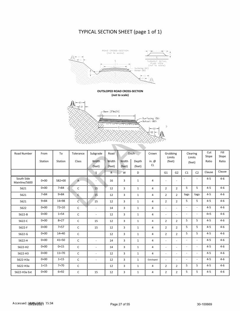
DRAFT
TYPICAL SECTION SHEET (page 1 of 1)
OUTSLOPED ROAD CROSS-SECTION
(not to scale)
Road Number
From
To
Tolerance
Subgrade
Road
Ditch
Crown
Grubbing Limits
Clearing
Limits
(feet)
Cut Slope
Fill Slope
Station Station Class Width
(feet)
Width
(feet)
Width
(feet)
Depth
(feet)
in. @ CL
(feet) Ratio Ratio
S
R
W
D
G1
G2
C1
C2 Clause Clause
South Side Mainline/5600
0+00 582+00 A - 16 3 1 4 - - - - 4-5 4-6
5621 0+00 7+84 C 15 12 3 1 4 2 2 5 5 4-5 4-6
5621 7+84 9+84 C 15 12 3 1 4 2 2 tags tags 4-5 4-6
5621 9+84 14+98 C 15 12 3 1 4 2 2 5 5 4-5 4-6
5622 0+00 72+10 C - 14 3 1 4 - - - - 4-5 4-6
5622-B 0+00 1+54 C - 12 3 1 4 - - - - 4+5 4-6
5622-C 0+00 8+27 C 15 12 3 1 4 2 2 5 5 4-5 4-6
5622-F 0+00 7+57 C 15 12 3 1 4 2 2 5 5 4-5 4-6
5622-G 0+00 14+40 C 12 3 1 4 2 2 5 5 4-5 4-6
5622-H 0+00 41+50 C - 14 3 1 4 - - - - 4-5 4-6
5622-H2 0+00 0+15 C - 14 3 1 4 - - - - 4-5 4-6
5622-H3 0+00 11+70 C - 12 3 1 4 - - - - 4-5 4-6
5622-H3a 0+00 1+15 C - 12 3 1 Outsloped - - - - 4-5 4-6
5622-H3a 1+15 7+70 C 12 3 1 4 2 2 5 5 4-5 4-6
5622-H3a Ext 0+00 6+92 C 15 12 3 1 4 2 2 5 5 4-5 4-6
09/29/2021 Page 27 of 55 30-100669

DRAFT
ROCK LIST
BALLAST
From
To
Rock
Compacted Rock
C.Y./
# of
C.Y.
Rock
Turnout
Road Number Station Station Slope Depth Station Stations Subtotal Source Length Width Taper
K2 B2 4-Inch Jaw Run L H T
5621 0+00 14+98 1 ½:1 12” 50 14.98 749
Tadmore 2 Pit
-and/or-
Commercial
5622-C 0+00 8+27 1 ½:1 12” 50 8.27 414
5622-F* 0+00 7+57 1 ½:1 8” 32 7.57 242
5622-G* 0+00 14+40 1 ½:1 8” 32 14.40 461
5622-H3 0+00 11+70 1 ½:1 8” 32 11.70 374
5622-H3a 0+00 7+70 1 ½:1 8” 32 7.70 246
5622-H3a Ext 0+00 6+92 1 ½:1 12” 50 6.92 346
PIT RUN
Landing Rock* 50 18 ea. 900
2-Inch Minus
South Side Mainline/5600 As per Clause 6-76 1 ½:1 Spot Rock as per C.A. 1100
South Side Mainline/5600 567+45 567+95 1 ½:1 6” 31 0.50 16
South Side Mainline/5600 572+95 573+45 1 ½:1 6” 31 0.50 16
South Side Mainline/5600 577+90 578+30 1 ½:1 6” 31 0.40 12
South Side Mainline/5600 581+05 581+55 1 ½:1 6” 31 0.50 16
5622 1+30 1+70 1 ½:1 6” 27 0.40 11 Tadmore 2 Pit
5622 7+95 8+35 1 ½:1 6” 27 0.40 11 -and/or-
5622 11+50 11+90 1 ½:1 6” 27 0.40 11 Commercial
5622 21+65 22+05 1 ½:1 6” 27 0.40 11
5622 44+65 45+05 1 ½:1 6” 27 0.40 11
5622 49+05 49+45 1 ½:1 6” 27 0.40 11
5622 68+80 72+20 1 ½:1 6” 27 0.40 11
5622-H 25+70 26+10 1 ½:1 6” 27 0.40 11
Stockpile 1200
Quarry Spalls
Culvert Headwalls and Dissipaters
91 Tadmore 2 Pit
-and/or-
Commercial
4-Inch Jaw Run Total _2832_Cubic Yards 2-Inch Minus Total_2448_ Cubic Yards
Pit Run Total _900_Cubic Yards Quarry Spalls Total __91__Cubic Yards
ROCK Total _6271_Cubic Yards
*Optional Rock: Purchaser is allowed the following rock depths from State owned rock sources,
but application of rock is not required.
NOTE: Yardages are estimated on a compacted (In-Place) basis. Compliance of required rock will be based on compacted depth measurement. Apply appropriate factors to determine loose amounts for estimating purposes.
09/29/2021 Page 28 of 55 30-100669

DRAFT
CULVERT AND DRAINAGE LIST (page 1 of 2)
Road Culvert Length (ft) Riprap (C.Y.) Backfill Placement Const.
Number Location Dia. (in)
Type Culvert Downspt Flume Inlet Outlet Type Material* Method* Staked* Remarks
South Side Mainline/5600
567+70 24 PD 80 2 2 QS NT
South Side Mainline/5600
573+20 24 PD 50 2 2 QS NT
South Side Mainline/5600
578+10 18 PD 40 1 1.5 QS NT
South Side Mainline/5600
581+30 24 PD 40 2 2 QS NT
5621 1+27 18 PD 30 1 1.5 QS NT
5621 5+00 18 PD 30 1 1.5 QS NT
5621 8+84 36 PD 50 3 3 QS NT T4 Stream
5621 9+60 18 PD 30 1 1.5 QS NT
5621 12+39 18 PD 30 1 1.5 QS NT
5622 1+50 18 PD 30 1 1.5 QS NT
5622 4+70 18 Clean inlet
5622 6+85 18 Clean inlet
5622 8+15 18 PD 30 1 1.5 QS NT
5622 11+70 18 PD 30 1 1.5 QS NT
5622 21+85 18 PD 30 1 1.5 QS NT
5622 44+85 18 PD 30 1 1.5 QS NT
5622 49+25 18 PD 40 1 1.5 QS NT Construct Ditchout-L
5622 68+40 18 Clean inlet
5622 72+00 30 PD 40 2.5 2.5 QS NT Replace existing
T5 Stream
5622-C 5+41 18 PD 30 1 1.5 QS NT
5622-F 2+86 18 PD 35 1 1.5 QS NT
5622-F 4+52 18 PD 35 1 1.5 QS NT
PD = Polyethylene Pipe Dual Wall AASHTO No. M294 Type S or ASTM F2648 AS10 = Aluminized Steel AASHTO No. M274, 10 Gauge TEMP = Temporary Culvert
Key: QS - Quarry Spalls NT - Native (bank run) LL - Light Loose Rip Rap
HL - Heavy Loose Riprap
09/29/2021 Page 29 of 55 30-100669
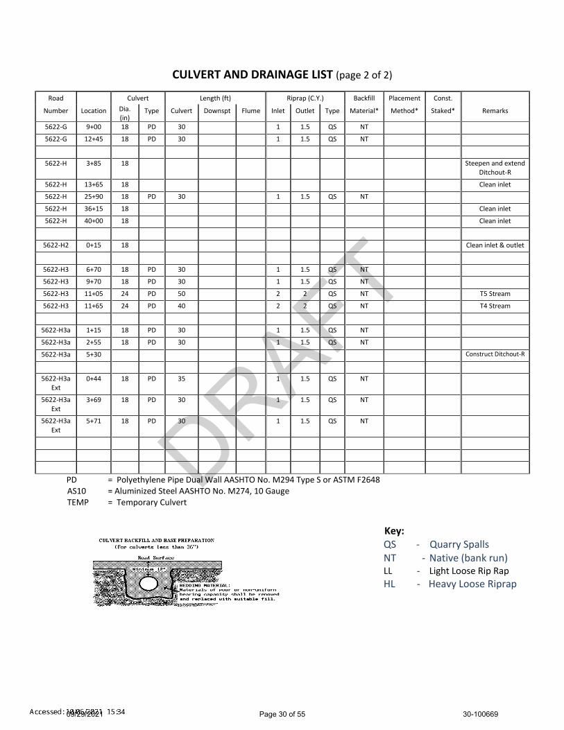
DRAFT
CULVERT AND DRAINAGE LIST (page 2 of 2)
Road Culvert Length (ft) Riprap (C.Y.) Backfill Placement Const.
Number Location Dia. (in)
Type Culvert Downspt Flume Inlet Outlet Type Material* Method* Staked* Remarks
5622-G 9+00 18 PD 30 1 1.5 QS NT
5622-G 12+45 18 PD 30 1 1.5 QS NT
5622-H 3+85 18 Steepen and extend Ditchout-R
5622-H 13+65 18 Clean inlet
5622-H 25+90 18 PD 30 1 1.5 QS NT
5622-H 36+15 18 Clean inlet
5622-H 40+00 18 Clean inlet
5622-H2 0+15 18 Clean inlet & outlet
5622-H3 6+70 18 PD 30 1 1.5 QS NT
5622-H3 9+70 18 PD 30 1 1.5 QS NT
5622-H3 11+05 24 PD 50 2 2 QS NT T5 Stream
5622-H3 11+65 24 PD 40 2 2 QS NT T4 Stream
5622-H3a 1+15 18 PD 30 1 1.5 QS NT
5622-H3a 2+55 18 PD 30 1 1.5 QS NT
5622-H3a 5+30 Construct Ditchout-R
5622-H3a Ext
0+44 18 PD 35 1 1.5 QS NT
5622-H3a Ext
3+69 18 PD 30 1 1.5 QS NT
5622-H3a Ext
5+71 18 PD 30 1 1.5 QS NT
PD = Polyethylene Pipe Dual Wall AASHTO No. M294 Type S or ASTM F2648 AS10 = Aluminized Steel AASHTO No. M274, 10 Gauge TEMP = Temporary Culvert
Key: QS - Quarry Spalls NT - Native (bank run) LL - Light Loose Rip Rap
HL - Heavy Loose Riprap
09/29/2021 Page 30 of 55 30-100669

DRAFT
TURNOUT & TURNAROUND LIST
Road Number Begin L- Station
End L- Station
Turnout Width (H)
Full Width Length (L)
Taper Length (T)
Comments
5621 30’ 30’ 15’ A maximum of 5 turnarounds
allowed.
5622-C 30 30’ 15’ A maximum of 3 turnarounds
allowed.
5622-F 30’ 30’ 15’ A maximum of 2 turnarounds
allowed.
5622-G 30’ 30’ 15’ A maximum of 5 turnarounds
allowed.
5622-H3 30’ 30’ 15’ A maximum of 4 turnarounds
allowed.
5622-H3a Ext 30’ 30’ 15’ A maximum of 3 turnarounds
allowed.
*See Typical Section Sheet for Turnout Detail
COMPACTION LIST
Road
From
Station
To
Station
Type
Max
Depth
Per Lift
(inches)
Equipment
Type
Equipm
ent
Weight
(lbs)
Minimum
Number
of Passes
Maximum
Operating
Speed
(mph)
All New Construction Subgrade 12” Smooth Drum
Vibratory Roller
12,000 3 low freq.
vibe on
3.5
All New Construction Rock 8” Smooth Drum
Vibratory Roller
12,000 3 low freq.
vibe on
3.5
All Reconstruction
-before rock is applied-
Non-rocked
Subgrade
- Smooth Drum
Vibratory Roller
12,000 3 low freq.
vibe on
3.5
All Reconstruction Surfacing 8” Smooth Drum
Vibratory Roller
12,000 3 low freq.
vibe on
3.5
All Prehaul Maintenance Surfacing 6” Smooth Drum
Vibratory Roller
12,000 3 low freq.
vibe on
3.5
09/29/2021 Page 31 of 55 30-100669

DRAFT
CULVERT AND DRAINAGE SPECIFICATION DETAIL (Page 1 of 3)
Normal Backslope
Additional cutinto backslope to
allow for culvert
2' Min.
CATCH BASIN
CULVERT - Natural Lay
Subgrade Fill Material
Undisturbed Soil
Lower ditchline to
accomodate diameter
of culvert
CULVERT - With Flume or Downspout
Subgrade
Support at 10' intervals.
Support material shall be at least
1" X 1/8" steel/iron with rust
protection coating.
Fill Material
Bolted both sides with
1/2" bolts and 2 washers
per bolt.
Energy Dissipator
Undisturbed Soil
09/29/2021 Page 32 of 55 30-100669
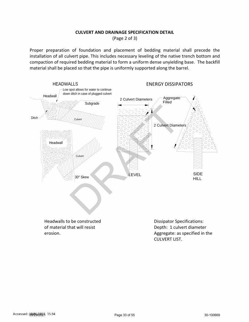
DRAFT
CULVERT AND DRAINAGE SPECIFICATION DETAIL (Page 2 of 3)
Proper preparation of foundation and placement of bedding material shall precede the installation of all culvert pipe. This includes necessary leveling of the native trench bottom and compaction of required bedding material to form a uniform dense unyielding base. The backfill material shall be placed so that the pipe is uniformly supported along the barrel.
Headwalls to be constructed Dissipator Specifications: of material that will resist Depth: 1 culvert diameter erosion. Aggregate: as specified in the
CULVERT LIST.
ENERGY DISSIPATORS
Aggregate Filled
2 Culvert Diameters
2 Culvert Diameters
LEVEL SIDE HILL
Culvert
Culvert
Headwall
HEADWALLS
Headwall
Subgrade
Ditch
30° Skew
Low spot allows for water to continue
down ditch in case of plugged culvert
09/29/2021 Page 33 of 55 30-100669

DRAFT
CULVERT AND DRAINAGE SPECIFICATION DETAIL (Page 3 of 3)
POLYETHYLENE PIPE INSTALLATION
INSTALLATION REQUIREMENTS:
1. Crushed stone, gravel, or compacted soil backfill material shall be used as the bedding and envelope material around the culvert. The aggregate size shall not exceed 1/6 pipe diameter or 4" diameter, whichever is smaller.
2. The corrugated pipe shall be laid on grade, on a layer of bedding material as shown for the
two types of installations. If native soil is used as the bedding and backfill material, it shall be well compacted in six inch layers under the haunches, around the sides and above the pipe to the recommended minimum height of cover.
3. Either crushed aggregate or flexible (asphalt) pavement may be laid as part of the minimum
cover requirements.
4. Site conditions and availability of bedding materials often dictate the type of installation method used.
5. The load bearing capability of flexible conduits is dependent on the type of backfill material
used and the degree of compaction achieved. Crushed stone and gravel backfill materials typically reach a compaction level of 90-95% AASHTO standard density without compaction. When native soils are used as backfill material, a compaction level of 85% is required. This minimum compaction can be achieved by either hand or mechanical tamping.
MINIMUM DIMENSIONS Trench or Open Ditch Installation
Nominal Diameter
Minimum Thickness
Minimum
Cover
Min. Trench
Width
D
B
C
W
18"
6"
12"
36"
24"
6"
12"
42"
30"
6"
12"
48"
6"
6"
12"
54"
Trench Installation Open Ditch Installation
Gravel or
Compacted Soil
09/29/2021 Page 34 of 55 30-100669

DRAFT
FOREST ACCESS ROAD MAINTENANCE SPECIFICATIONS Page 1 of 2
Cuts and Fills
Maintain slope lines to a stable gradient compatible with the construction materials. Remove slides up to 100 cubic yards in volume from ditches and the roadway. Repair fill-failures with selected material or material approved by the Contract Administrator. Remove overhanging material from the top of cut slopes.
Waste material from slides or other sources shall be placed and compacted in stable locations identified in the road plan or approved by the Contract Administrator, so that sediment will not deliver to any streams or wetlands.
Slide material and debris shall not be mixed into the road surface materials, unless approved by the Contract Administrator.
Surface
Grade and shape the road surface, turnouts, and shoulders to the original shape on the TYPICAL SECTION SHEET to provide a smooth, rut-free traveled surface and maintain surface water runoff in an even, unconcentrated manner.
Blading shall not undercut the backslope or cut into geotextile fabric on the road. If required by the Contract Administrator, water shall be applied as necessary to control
dust and retain fine surface rock. Surface material shall not be bladed off the roadway. Replace surface material when
lost or worn away, or as directed by the Contract Administrator. Remove shoulder berms, created by grading, to facilitate drainage, except as marked or
directed by the Contract Administrator. For roads with geotextile fabric: spread surface aggregate to fill in soft spots and wheel
ruts (barrel spread) to prevent damage to the geotextile fabric.
Drainage Prevent silt bearing road surface and ditch runoff from delivering sediment to any
streams or wetlands. Maintain rolling dips and drivable waterbars as needed to keep them functioning as
intended. Maintain headwalls to the road shoulder level with material that will resist erosion. Maintain energy dissipaters at culvert outlets with non-erodible material or rock. Keep ditches, culverts, and other drainage structures clear of obstructions and
functioning as intended. Inspect and clean culverts at least monthly, with additional inspections during storms
and periods of high runoff. This shall be done even during periods of inactivity.
09/29/2021 Page 35 of 55 30-100669

DRAFT
FOREST ACCESS ROAD MAINTENANCE SPECIFICATIONS
Page 2 of 2 Preventative Maintenance
Perform preventative maintenance work to safeguard against storm damage, such as blading to ensure correct runoff, ditch and culvert cleaning, and waterbar maintenance.
Termination of Use or End of Season
At the conclusion of logging operations, ensure all conditions of these specifications have been met.
Debris
Remove fallen timber, limbs, and stumps from the slopes, roadway, ditchlines, and culvert inlets.
Do not undercut backslope
Keep clear of obstructions
Keep ditches open and free of debris to ensure water drainage away from road.
Add stable material or flume
No berms except as directed
09/29/2021 Page 36 of 55 30-100669
DRAFT10
1
102103
104
105
106
107
108
109
110
111
112113
114
115
116
101
102
103
104
105
106
107
108
L-St
n
0
50
100
150
200
250
300
350
400
450
500
100
105
110
115
120
125
130
109
110
111
112
113
114
115
116
L-St
n
600
650
700
750
800
850
900
950
130
135
140
145
150
155
160
Cou
g Fl
ats
Tim
ber S
ale
5621
Rd
Con
tract
#: 3
0-10
0669
Prof
ile V
ert S
cale
1:1
20Pr
ofile
Hor
z Sc
ale
1:12
00
Plan
Sca
le 1
:120
0En
gine
er:
J. G
ardn
er
21/0
6/03
Page
1 o
f 2
09/29/2021 Page 37 of 55 30-100669

DRAFT
109
110
111
112113
114
115
116
117
118
119
120
121
122
109
110
111
112
113
114
115
116
L-St
n
650
700
750
800
850
900
950
1000
135
140
145
150
155
160
165
117
118
119
120
L-St
n
1100
1150
1200
1250
1300
170
175
180
185
190
195
200
120
121
122
L-St
n
1400
1450
1500
1550
1600
185
190
195
200
205
210
215
Cou
g Fl
ats
Tim
ber S
ale
5621
Rd
Con
tract
#: 3
0-10
0669
Prof
ile V
ert S
cale
1:1
20Pr
ofile
Hor
z Sc
ale
1:12
00
Plan
Sca
le 1
:120
0En
gine
er:
J. G
ardn
er
21/0
6/03
Page
2 o
f 2
09/29/2021 Page 38 of 55 30-100669

DRAFT
Softree Section P. 1J:\SHARED\TimberSales\Black Diamond\SOUTH GREEN\Coug Flats\Engineering\RoadENG\5621 Rd
Scale 1:24021/06/03
P-Stn : 0.0L-Stn : 0.0
H. Offset: 0.0V.Offset: 0.0
Cut Dp: 0.0Index: 101
0.0 -3
0
-20
-10
0 10
20
30
90
100
110
P-Stn : 39.0L-Stn : 39.0
H. Offset: 0.0V.Offset: -2.4
Cut Dp: 2.4Index: 102
39.0
-30
-20
-10
0 10
20
30
90
100
110
120
P-Stn : 68.6L-Stn : 68.6
H. Offset: 0.0V.Offset: 0.0
Cut Dp: 0.0Index: 103
68.6
-30
-20
-10
0 10
20
30 90
100
110
120
P-Stn : 126.6L-Stn : 126.6
H. Offset: 0.0V.Offset: 0.0
Cut Dp: 0.0Index: 104
126.6
-30
-20
-10
0 10
20
30
100
110
120
P-Stn : 220.6L-Stn : 220.4
H. Offset: -8.9V.Offset: -0.1
Cut Dp: 1.6Index: 105
220.4
-30
-20
-10
0 10
20
30 100
110
120
130
P-Stn : 307.0L-Stn : 306.6
H. Offset: 0.0V.Offset: 0.0
Cut Dp: 0.0Index: 106
306.6
-30
-20
-10
0 10
20
30
110
120
130
P-Stn : 404.9L-Stn : 404.5
H. Offset: 0.0V.Offset: 0.0
Cut Dp: 0.0Index: 107
404.5
-30
-20
-10
0 10
20
30
120
130
140
P-Stn : 499.9L-Stn : 499.5
H. Offset: -10.0V.Offset: 2.9
Cut Dp: -1.9Index: 108
499.5
-30
-20
-10
0 10
20
30
120
130
140
09/29/2021 Page 39 of 55 30-100669

DRAFT
Softree Section P. 2J:\SHARED\TimberSales\Black Diamond\SOUTH GREEN\Coug Flats\Engineering\RoadENG\5621 Rd
Scale 1:24021/06/03
P-Stn : 594.6L-Stn : 594.2
H. Offset: 0.0V.Offset: 0.7
Cut Dp: -0.7Index: 109
594.2 -3
0
-20
-10
0 10
20
30
130
140
150
P-Stn : 680.8L-Stn : 680.5
H. Offset: 0.0V.Offset: -1.7
Cut Dp: 1.8Index: 110
680.5
-30
-20
-10
0 10
20
30 130
140
150
160
P-Stn : 796.3L-Stn : 796.0
H. Offset: 0.1V.Offset: -2.0
Cut Dp: 2.0Index: 111
796.0
-30
-20
-10
0 10
20
30
140
150
160
P-Stn : 841.3L-Stn : 841.1
H. Offset: -1.4V.Offset: 2.7
Cut Dp: -2.1Index: 112
841.1
-30
-20
-10
0 10
20
30
140
150
160
170
P-Stn : 860.8L-Stn : 861.0
H. Offset: -4.1V.Offset: 9.3
Cut Dp: -7.5Index: 113
861.0
-30
-20
-10
0 10
20
30 140
150
160
170
P-Stn : 883.7L-Stn : 883.8
H. Offset: -7.1V.Offset: 9.0
Cut Dp: -6.7Index: 114
883.8
-30
-20
-10
0 10
20
30 140
150
160
170
P-Stn : 907.4L-Stn : 906.5
H. Offset: -8.1V.Offset: 3.2
Cut Dp: -0.7Index: 115
906.5
-30
-20
-10
0 10
20
30
150
160
170
P-Stn : 961.5L-Stn : 960.4
H. Offset: 0.0V.Offset: 0.0
Cut Dp: 0.0Index: 116
960.4
-30
-20
-10
0 10
20
30
150
160
170
09/29/2021 Page 40 of 55 30-100669
DRAFT
Softree Section P. 3J:\SHARED\TimberSales\Black Diamond\SOUTH GREEN\Coug Flats\Engineering\RoadENG\5621 Rd
Scale 1:24021/06/03
P-Stn : 1078.5L-Stn : 1077.4
H. Offset: 0.0V.Offset: 0.9
Cut Dp: -0.9Index: 117
1077.4 -3
0
-20
-10
0 10
20
30
160
170
180
P-Stn : 1150.6L-Stn : 1149.5
H. Offset: 0.0V.Offset: -1.0
Cut Dp: 1.0Index: 118
1149.5
-30
-20
-10
0 10
20
30
170
180
190
P-Stn : 1239.7L-Stn : 1238.6
H. Offset: 0.0V.Offset: 1.1
Cut Dp: -1.1Index: 119
1238.6
-30
-20
-10
0 10
20
30
180
190
200
P-Stn : 1339.9L-Stn : 1338.8
H. Offset: 0.0V.Offset: -1.0
Cut Dp: 1.0Index: 120
1338.8
-30
-20
-10
0 10
20
30
190
200
210
P-Stn : 1405.5L-Stn : 1403.9
H. Offset: -10.0V.Offset: -2.7
Cut Dp: 3.8Index: 121
1403.9
-30
-20
-10
0 10
20
30 190
200
210
220
P-Stn : 1500.2L-Stn : 1497.8
H. Offset: 0.0V.Offset: 0.0
Cut Dp: 0.0Index: 122
1497.8
-30
-20
-10
0 10
20
30 190
200
210
220
09/29/2021 Page 41 of 55 30-100669

DRAFT20
1
202
203
204
205
206
207
208
209 21
0 211
212
213
201
202
203
204
205
206
207
208
L-S
tn
-50
0
50
100
150
200
250
300
350
400
450
500
550 7
5
80
85
90
95
100
105
209
210
211
212
213
L-S
tn
650
700
750
800
850
900
50
55
60
65
70
75
80
Cou
g F
lats
Tim
ber
Sal
e56
22-C
Rd
Con
trac
t #: 3
0-10
0669
Pro
file
Ver
t S
cale
1:1
20P
rofil
e H
orz
Sca
le 1
:120
0
Pla
n S
cale
1:1
200
Eng
inee
r:
J. G
ardn
er
21/0
6/15
Pag
e 1
of 1
09/29/2021 Page 42 of 55 30-100669

DRAFT
Softree Section P. 1
J:\SHARED\TimberSales\Black Diamond\SOUTH GREEN\Coug Flats\Engineering\RoadENG\5622-C Rd
Scale 1:240
21/06/15
P-Stn : 0.0
L-Stn : 0.0
H. Offset: 0.0
V.Offset: 0.0
Cut Dp: 0.0
Index: 201
0.0 -
30
-20
-10
0 10
20
30
90
100
110
P-Stn : 61.0
L-Stn : 61.0
H. Offset: 0.0
V.Offset: -1.7
Cut Dp: 1.7
Index: 202
61.0
-30
-20
-10
0 10
20
30
100
110
120
P-Stn : 142.0
L-Stn : 142.0
H. Offset: 0.0
V.Offset: -0.7
Cut Dp: 0.7
Index: 203
142.0
-30
-20
-10
0 10
20
30
100
110
120
P-Stn : 224.5
L-Stn : 224.5
H. Offset: 0.0
V.Offset: 0.0
Cut Dp: 0.0
Index: 204
224.5
-30
-20
-10
0 10
20
30
90
100
110
120
P-Stn : 296.7
L-Stn : 296.7
H. Offset: 0.0
V.Offset: 0.0
Cut Dp: 0.0
Index: 205
296.7
-30
-20
-10
0 10
20
30
90
100
110
P-Stn : 376.9
L-Stn : 376.9
H. Offset: 0.0
V.Offset: 0.0
Cut Dp: 0.0
Index: 206
376.9
-30
-20
-10
0 10
20
30
80
90
100
P-Stn : 461.5
L-Stn : 461.6
H. Offset: 0.0
V.Offset: -0.6
Cut Dp: 0.6
Index: 207
461.6
-30
-20
-10
0 10
20
30 70
80
90
100
P-Stn : 540.8
L-Stn : 540.8
H. Offset: 0.2
V.Offset: 2.2
Cut Dp: -2.2
Index: 208
540.8
-30
-20
-10
0 10
20
30
70
80
90
09/29/2021 Page 43 of 55 30-100669

DRAFT
Softree Section P. 2
J:\SHARED\TimberSales\Black Diamond\SOUTH GREEN\Coug Flats\Engineering\RoadENG\5622-C Rd
Scale 1:240
21/06/15
P-Stn : 608.1
L-Stn : 608.0
H. Offset: 0.0
V.Offset: -1.2
Cut Dp: 1.2
Index: 209
608.0 -
30
-20
-10
0 10
20
30 60
70
80
90
P-Stn : 655.3
L-Stn : 655.3
H. Offset: 0.0
V.Offset: -0.9
Cut Dp: 0.9
Index: 210
655.3
-30
-20
-10
0 10
20
30
60
70
80
P-Stn : 712.5
L-Stn : 710.0
H. Offset: 10.1
V.Offset: -0.1
Cut Dp: 1.8
Index: 211
710.0
-30
-20
-10
0 10
20
30 50
60
70
80
P-Stn : 768.3
L-Stn : 761.8
H. Offset: 5.1
V.Offset: 2.0
Cut Dp: -0.9
Index: 212
761.8
-30
-20
-10
0 10
20
30
50
60
70
P-Stn : 834.3
L-Stn : 827.2
H. Offset: 0.0
V.Offset: 0.0
Cut Dp: 0.0
Index: 213
827.2
-30
-20
-10
0 10
20
30
50
60
70
09/29/2021 Page 44 of 55 30-100669

DRAFT30
130230
3
304
305
306
307
308
309
310311 312
313
314
315
316
317
318
319
301
302
303
304
305
306
307
308
309
L-St
n
-50
0
50
100
150
200
250
300
350
70
75
80
85
90
95
100
310
311
312313
314
315
316
317
L-St
n
400
450
500
550
600
650
700
40
45
50
55
60
65
70
318
319
L-St
n
750
800
850
900
950
20
25
30
35
40
45
50
Cou
g Fl
ats
Tim
ber S
ale
5622
-F R
dC
ontra
ct #
: 30-
1006
69Pr
ofile
Ver
t Sca
le 1
:120
Prof
ile H
orz
Scal
e 1:
1200
Plan
Sca
le 1
:120
0En
gine
er:
J. G
ardn
er
21/0
6/03
Page
1 o
f 1
09/29/2021 Page 45 of 55 30-100669

DRAFT
Softree Section P. 1J:\SHARED\TimberSales\Black Diamond\SOUTH GREEN\Coug Flats\Engineering\RoadENG\5622-F Rd
Scale 1:24021/06/03
P-Stn : 0.0L-Stn : 0.0
H. Offset: 0.0V.Offset: 0.0
Cut Dp: 0.0Index: 301
0.0 -3
0
-20
-10
0 10
20
30
90
100
110
P-Stn : 25.7L-Stn : 26.0
H. Offset: -5.2V.Offset: -1.4
Cut Dp: 1.1Index: 302
26.0
-30
-20
-10
0 10
20
30
90
100
110
P-Stn : 73.4L-Stn : 73.8
H. Offset: 0.0V.Offset: -0.4
Cut Dp: 0.4Index: 303
73.8
-30
-20
-10
0 10
20
30
90
100
110
P-Stn : 126.0L-Stn : 125.9
H. Offset: 5.7V.Offset: 0.0
Cut Dp: 0.4Index: 304
125.9
-30
-20
-10
0 10
20
30
80
90
100
P-Stn : 164.7L-Stn : 161.8
H. Offset: 7.7V.Offset: 0.0
Cut Dp: 0.6Index: 305
161.8
-30
-20
-10
0 10
20
30
80
90
100
P-Stn : 202.2L-Stn : 195.6
H. Offset: 6.0V.Offset: 0.5
Cut Dp: 0.4Index: 306
195.6
-30
-20
-10
0 10
20
30
80
90
100
P-Stn : 244.5L-Stn : 236.6
H. Offset: 0.0V.Offset: -1.2
Cut Dp: 1.2Index: 307
236.6
-30
-20
-10
0 10
20
30
70
80
90
P-Stn : 293.5L-Stn : 285.6
H. Offset: 0.0V.Offset: -0.6
Cut Dp: 0.6Index: 308
285.6
-30
-20
-10
0 10
20
30
70
80
90
09/29/2021 Page 46 of 55 30-100669
DRAFT
Softree Section P. 2J:\SHARED\TimberSales\Black Diamond\SOUTH GREEN\Coug Flats\Engineering\RoadENG\5622-F Rd
Scale 1:24021/06/03
P-Stn : 329.2L-Stn : 321.0
H. Offset: 3.5V.Offset: -0.6
Cut Dp: 1.5Index: 309
321.0 -3
0
-20
-10
0 10
20
30
70
80
90
P-Stn : 365.2L-Stn : 356.7
H. Offset: 0.0V.Offset: -3.8
Cut Dp: 3.8Index: 310
356.7
-30
-20
-10
0 10
20
30
60
70
80
P-Stn : 391.3L-Stn : 382.8
H. Offset: 0.0V.Offset: -7.0
Cut Dp: 7.0Index: 311
382.8
-30
-20
-10
0 10
20
30
60
70
80
P-Stn : 411.6L-Stn : 403.8
H. Offset: -6.4V.Offset: -1.2
Cut Dp: -2.3Index: 312
403.8
-30
-20
-10
0 10
20
30
60
70
80
P-Stn : 430.4L-Stn : 419.7
H. Offset: -9.7V.Offset: 4.1
Cut Dp: -5.3Index: 313
419.7
-30
-20
-10
0 10
20
30 50
60
70
80
P-Stn : 464.0L-Stn : 451.9
H. Offset: 0.0V.Offset: 2.0
Cut Dp: -2.0Index: 314
451.9
-30
-20
-10
0 10
20
30
50
60
70
P-Stn : 528.2L-Stn : 516.0
H. Offset: 0.0V.Offset: -1.1
Cut Dp: 1.1Index: 315
516.0
-30
-20
-10
0 10
20
30
50
60
70
P-Stn : 591.9L-Stn : 579.7
H. Offset: 0.0V.Offset: -3.0
Cut Dp: 3.0Index: 316
579.7
-30
-20
-10
0 10
20
30
40
50
60
09/29/2021 Page 47 of 55 30-100669
DRAFT
Softree Section P. 3J:\SHARED\TimberSales\Black Diamond\SOUTH GREEN\Coug Flats\Engineering\RoadENG\5622-F Rd
Scale 1:24021/06/03
P-Stn : 689.3L-Stn : 676.5
H. Offset: -3.3V.Offset: 0.3
Cut Dp: 0.7Index: 317
676.5 -3
0
-20
-10
0 10
20
30
30
40
50
P-Stn : 733.6L-Stn : 720.3
H. Offset: 0.0V.Offset: 0.0
Cut Dp: 0.0Index: 318
720.3
-30
-20
-10
0 10
20
30
30
40
50
P-Stn : 770.7L-Stn : 757.4
H. Offset: 0.0V.Offset: 0.7
Cut Dp: -0.7Index: 319
757.4
-30
-20
-10
0 10
20
30
30
40
50
09/29/2021 Page 48 of 55 30-100669

DRAFT
401
402
403
404
405
406
407
408
409
410
411
401
402
403
404
405
L-St
n
0
50
100
150
200
250
100
105
110
115
120
125
130
135
406
407
L-St
n
350
400
450
135
140
145
150
155
160
165
408
409
410
411
L-St
n
550
600
650
700
750
800
850
900
950
160
165
170
175
180
185
190
Cou
g Fl
ats
Tim
ber S
ale
5622
-H3a
Ext
Con
tract
#: 3
0-10
0669
Prof
ile V
ert S
cale
1:1
20Pr
ofile
Hor
z Sc
ale
1:12
00
Plan
Sca
le 1
:120
0En
gine
er: J
. Gar
dner
21/0
6/03
Page
1 o
f 1
09/29/2021 Page 49 of 55 30-100669

DRAFT
Softree Section P. 1J:\SHARED\TimberSales\Black Diamond\SOUTH GREEN\Coug Flats\Engineering\RoadENG\5622-H3a Ext
Scale 1:24021/06/03
P-Stn : 0.0L-Stn : 0.0
H. Offset: 0.0V.Offset: 1.4
Cut Dp: -1.4Index: 401
0.0 -3
0
-20
-10
0 10
20
30
90
100
110
P-Stn : 44.1L-Stn : 44.1
H. Offset: -0.1V.Offset: -2.2
Cut Dp: 2.2Index: 402
44.1
-30
-20
-10
0 10
20
30 90
100
110
120
P-Stn : 82.8L-Stn : 82.8
H. Offset: -0.1V.Offset: -2.4
Cut Dp: 2.4Index: 403
82.8
-30
-20
-10
0 10
20
30
100
110
120
P-Stn : 170.7L-Stn : 170.8
H. Offset: -0.1V.Offset: -1.7
Cut Dp: 1.7Index: 404
170.8
-30
-20
-10
0 10
20
30
110
120
130
P-Stn : 292.8L-Stn : 291.6
H. Offset: -9.4V.Offset: 0.0
Cut Dp: -0.9Index: 405
291.6
-30
-20
-10
0 10
20
30
120
130
140
P-Stn : 370.8L-Stn : 368.5
H. Offset: 0.0V.Offset: 0.0
Cut Dp: 0.0Index: 406
368.5
-30
-20
-10
0 10
20
30
140
150
160
P-Stn : 465.0L-Stn : 462.8
H. Offset: 0.0V.Offset: -0.6
Cut Dp: 0.6Index: 407
462.8
-30
-20
-10
0 10
20
30
150
160
170
P-Stn : 514.0L-Stn : 511.2
H. Offset: 7.5V.Offset: 0.9
Cut Dp: 1.7Index: 408
511.2
-30
-20
-10
0 10
20
30
160
170
180
09/29/2021 Page 50 of 55 30-100669

DRAFT
Softree Section P. 2J:\SHARED\TimberSales\Black Diamond\SOUTH GREEN\Coug Flats\Engineering\RoadENG\5622-H3a Ext
Scale 1:24021/06/03
P-Stn : 574.7L-Stn : 571.3
H. Offset: 0.0V.Offset: 0.0
Cut Dp: 0.0Index: 409
571.3 -3
0
-20
-10
0 10
20
30
170
180
190
P-Stn : 635.7L-Stn : 631.7
H. Offset: -8.7V.Offset: 0.0
Cut Dp: -0.7Index: 410
631.7
-30
-20
-10
0 10
20
30
170
180
190
P-Stn : 696.9L-Stn : 692.3
H. Offset: 0.0V.Offset: 0.8
Cut Dp: -0.9Index: 411
692.3
-30
-20
-10
0 10
20
30 170
180
190
200
09/29/2021 Page 51 of 55 30-100669

DRAFT
STATE OF WASHINGTON DEPARTMENT OF NATURAL RESOURCES
TADMORE 2 PIT – Page 1 of 2
ROCK SOURCE DEVELOPMENT PLAN SW¼, NE¼, Section 02, Township 20 North, Range 08 East, W.M.
1. Oversize material shall not exceed 10% of the total volume mined. Generated oversize material left in the
quarry after operations shall be placed in the location as shown on the Tadmore 2 Pit Development Plan map.
2. All vegetation including stumps shall be cleared a minimum of 10 feet beyond the top of all working faces. Surface shall be scalped of all overburden within 20 feet of working face at all times. Overburden faces shall be sloped no steeper than 1½:1.
3. Overburden shall be placed in the designated waste area as shown on the Tadmore 2 Pit Development Plan map. Minimal acceptable compaction is achieved by placing waste material in 2 foot or shallower lifts and routing excavation equipment over entire width of the lifts. End hauled overburden shall be sloped no steeper than 1.5:1.
4. Root wads and organic debris larger than one cubic foot in volume shall be separated from overburden material and piled in the organic waste area as shown on the Tadmore 2 Pit Development Plan map.
5. Quarry faces shall not exceed 30 feet in height and shall be sloped no steeper than ¼:1. 6. Working bench width shall be a minimum of 20 feet. 7. The quarry floor shall have continuity of slope be left in a smooth and neat condition, providing positive
drainage. 8. Reclamation will not be required following use. 9. All operations shall be carried out in compliance with all regulations of:
a. Regulations and Standards Applicable to Metal and Nonmetal Mining and Milling Operations (30 CFR) U.S. Department of Labor, Mine Safety and Health Administration.
b. “Safety Standards for Construction Work” (296-155 WAC), Washington Department of Labor and Industries.
10. The Purchaser shall submit an informational drilling and shooting plan to the Contract Administrator 3 working days prior to any drilling. Access roads in the area shall be blocked prior to blasting operations.
11. The Purchaser shall notify the Contract Administrator a minimum of 3 working days before blasting operations.
12. At the completion of rock source operations, Purchaser shall ask Contract Administrator for written approval of final rock source condition and compliance with the terms of this plan.
09/29/2021 Page 52 of 55 30-100669

DRAFT
OrganicWaste
Overburden
OversizeMaterial
0'
30'
60'
120'
180'
Tadmore 2 Pit - Page 2 of 2Rock Source Development Plan
SW 14 NE 1 4 Sec. 2 T20R08E
Dra
wn
By:
J. G
ardn
erM
ay 1
8, 2
021Working Area
10' Contours
5622 Rd
5622
Rd
5622-B Rd
5622-C Rd
5622-C Rd
Over grown spur
Stockpile
09/29/2021 Page 53 of 55 30-100669

DRAFT
09/29/2021 Page 54 of 55 30-100669
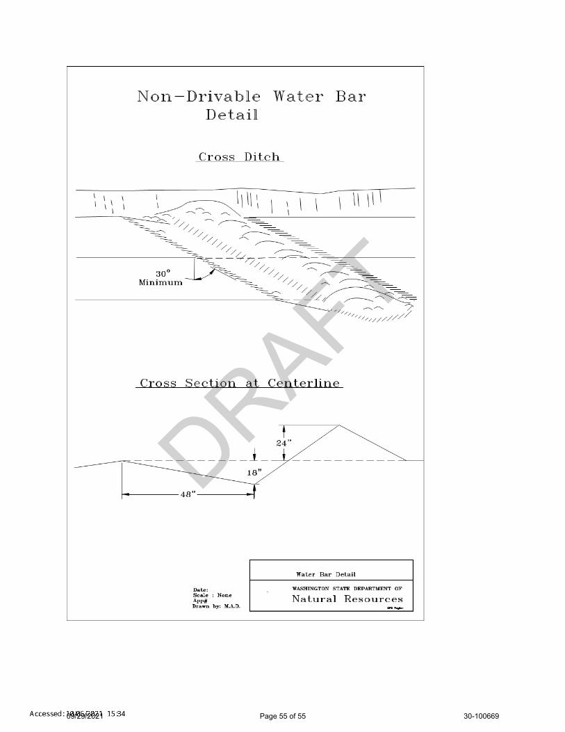
DRAFT
09/29/2021 Page 55 of 55 30-100669
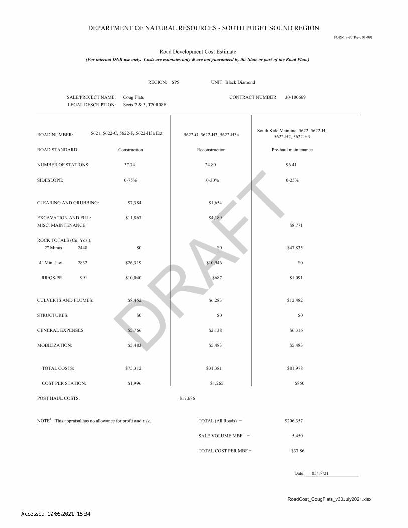
DRAFT
DEPARTMENT OF NATURAL RESOURCES - SOUTH PUGET SOUND REGIONFORM 9-87(Rev. 01-09)
RoadCost_CougFlats_v30July2021.xlsx
REGION: SPS UNIT: Black Diamond
ROAD NUMBER:
ROAD STANDARD:
NUMBER OF STATIONS: 37.74 24.80 96.41
SIDESLOPE: 0-75% 10-30% 0-25%
CLEARING AND GRUBBING: $7,384 $1,654
EXCAVATION AND FILL: $11,867 $4,189MISC. MAINTENANCE: $8,771
ROCK TOTALS (Cu. Yds.):2" Minus 2448 $0 $0 $47,835
4" Min. Jaw 2832 $26,319 $10,946 $0
RR/QS/PR 991 $10,040 $687 $1,091
CULVERTS AND FLUMES: $8,452 $6,283 $12,482
STRUCTURES: $0 $0 $0
GENERAL EXPENSES: $5,766 $2,138 $6,316
MOBILIZATION: $5,483 $5,483 $5,483
TOTAL COSTS: $75,312 $31,381 $81,978
COST PER STATION: $1,996 $1,265 $850
POST HAUL COSTS: $17,686
NOTE1: This appraisal has no allowance for profit and risk. TOTAL (All Roads) = $206,357
SALE VOLUME MBF = 5,450
TOTAL COST PER MBF = $37.86
Date:
Road Development Cost Estimate
SALE/PROJECT NAME: 30-100669
Construction Reconstruction
(For internal DNR use only. Costs are estimates only & are not guaranteed by the State or part of the Road Plan.)
Coug Flats CONTRACT NUMBER: LEGAL DESCRIPTION: Sects 2 & 3, T20R08E
South Side Mainline, 5622, 5622-H, 5622-H2, 5622-H35622-G, 5622-H3, 5622-H3a5621, 5622-C, 5622-F, 5622-H3a Ext
05/18/21
Pre-haul maintenance

DRAFTØ
Ø
Ø
Ø
Ø
ØØ
~ ~ ~ ~ ~ ~ ~ ~ ~ ~ ~ ~ ~ ~~ ~ ~ ~ ~ ~ ~ ~~~ ~ ~ ~ ~
~ ~ ~~~
~ ~~~ ~~ ~ ~ ~ ~ ~ ~ ~ ~
~~~~
~~~~
~~~ ~~~ ~ ~~ ~ ~ ~ ~ ~ ~~ ~ ~ ~ ~ ~ ~ ~ ~~~~~~~~~~~~~~~~~~~~~~~~~~~ ~ ~ ~ ~ ~ ~ ~~ ~ ~ ~ ~ ~ ~ ~ ~ ~ ~~ ~ ~ ~ ~
~~~ ~ ~ ~ ~ ~ ~~
~ ~
~ ~ ~ ~~
~ ~ ~ ~ ~ ~ ~ ~ ~ ~ ~ ~ ~~ ~ ~~ ~ ~ ~ ~~~~
~ ~~~
~ ~~~
~ ~~ ~~ ~~~~ ~ ~~ ~ ~~ ~ ~ ~ ~ ~
~ ~~ ~ ~ ~ ~ ~ ~ ~ ~ ~ ~ ~ ~~ ~~ ~ ~~~~
~ ~ ~ ~ ~~~ ~ ~ ~~ ~ ~ ~ ~ ~~ ~ ~ ~~~~~~~~~~~~~~~~~~~~~~~~~~~~~~~~~~~~~~~~~~~~~~~~~~~~~~~~
~~~~~
~ ~ ~ ~
~ ~ ~ ~
~ ~ ~>
>>
>>
>
>>
>>
>>
>>
>>
>>
>>
>> >
>>
>>
>>
>>
>>
>>
>
>
>>
>>
>>
>>
>
>
> >>
>
>
>>
>>
>>
>
>> >
>>
]%4
]%4
]%5
k
]%4
1
o*
#*W
Unit 1Unit 2
Unit 3
Unit 7 R/W
Net AcresUnit 1: 18.9Unit 2; 5.2Unit 3: 23.1Unit 7 R/W: 0.5
Non-Tradeable Leave Trees
Unit 1: 25 Individual Leave TreesUnit 2: 6 Individual Leave TreesUnit 3: 14 Individual Leave Trees
PRIVATE LAND PRIVATE LAND
PRIVATE LAND
Tadmore 2 Pit
8
1400
18001600
1200
2000
1600
1200
2
35 H o w a r d A H a n s o n R e s e r v o i r
114
65
72
44
41
24
5621
5622
5600
5622-C
5622-B5622-C
5600
5600
5600
5622
1400
121°44.7'W
121°44.7'W
121°45'W
121°45'W
121°45.3'W
121°45.3'W
47°15
.5'N
47°15
.5'N
47°15
.3'N
47°15
.3'N
47°15
'N
47°15
'N
L O G G I N G P L A N M A PS A L E N A M E :A G R E E M E N T# :TO W N S H I P ( S ) :TR U S T( S ) :
R E G IO N :C O U N T Y ( S ) :E L E VAT I O N R G E :
³Prepared By:
South Puget Sound Region
0 1,000500 Feet
chig490 Modification Date: nchi490 9/22/2021
!!
! !
DNR Managed LandsPublic Land Survey SectionsPublic Land Survey TownshipsVariable Retention Harvest
Contours 40-foot""" """ """ """" """ """ """" """ """ """" """ """ """" """ """ """" """ """ " ~~~~ ~
¦¦¦ ¦ ¦
Leave Tree AreaRiparian Mgt Zone
o* Non-Tradeable Leave Trees
1 Rock Pit
#*W Waste Area
~ ~ ~ Sale Boundary Tags~ ~ Right of Way TagsØ Ø Property Line
Ground HarvestContours 40-foot
> StreamsOpen WaterExisting RoadsRequired Pre-Haul MaintenanceOptional Construction
]% Stream Typek Stream Type Break
Railroad
King1320-2080
COUG FLATS30-100669T20R8EAgricultural School (4), State Forest Transfer (1)
All State Unless Otherwise Noted
Page 1 of 3
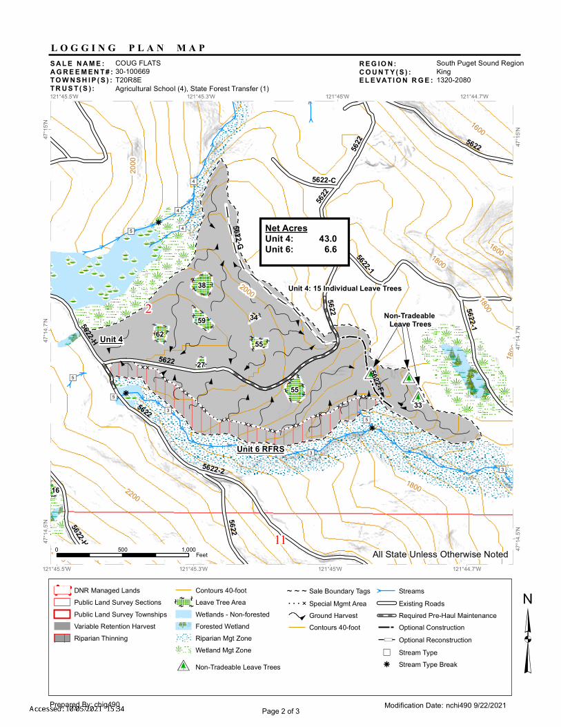
DRAFT
~~~~~~~~~~~~~~~~~~~~~~~~~~~ ~ ~ ~ ~ ~ ~ ~~ ~ ~ ~ ~ ~ ~ ~ ~ ~ ~~ ~ ~ ~ ~~~
~ ~ ~ ~ ~ ~ ~~~ ~
~ ~ ~ ~~
~ ~ ~ ~ ~ ~ ~ ~ ~ ~ ~ ~ ~~ ~ ~~ ~ ~ ~ ~~~~
~ ~~~
~ ~~~
~ ~~ ~~~~~~ ~ ~~ ~ ~~ ~ ~ ~ ~ ~
~ ~~ ~ ~ ~ ~ ~ ~ ~ ~ ~ ~ ~ ~~ ~~ ~ ~~~~
~ ~ ~ ~ ~~~ ~ ~ ~~ ~ ~ ~ ~ ~ ~ ~~ ~~~~~~~~~~~~~~~~~~~~~~~~~~~~~~~~~~~~~~~~~~~~~~~~~~~~~~~~
~~~~~
777777
777777
77777777777
7
7
77
777
777
77777
66
66
66
66
6666
66
66
66
6
6
66
66
~~~~~ ~~~
~ ~ ~ ~ ~~ ~ ~ ~~
~ ~
~ ~~ ~ ~ ~ ~>
>
>>
>>
>> >
>>
>>
>>
>>
>>
>>
>
>
>>
>>
>>
>>
>
>
> > > > > > >>
> > >>
>> > > > > > > > > > > >
>> >
> > > >
>
> > > > > > >>
> > > > >
>> >
>
> > > >> > >
>>
> >> > >
>
>
>>
\
\
\
\\
\
\
\\
\]%4
]%4
]%4
]%5
]%3
]%3
]%3
k
]%5k
k
]%5
]%5
o*o*
o*
Unit 4
Unit 6 RFRS
Non-Tradeable Leave Trees
Net AcresUnit 4: 43.0Unit 6: 6.6
Unit 4: 15 Individual Leave Trees
33
2000
1800
2200
1600
1800
1800
2000
1600
2
11
55
38
6259
55
27
16
34
5622
5622-2
5622-G
5622-15622-F
5622-H
5622-C
5622
5622-1
5622-H
56225622
5622
5622
5622
2400
1800
121°44.7'W
121°44.7'W
121°45'W
121°45'W
121°45.3'W
121°45.3'W
121°45.5'W
121°45.5'W
47°15
'N
47°15
'N
47°14
.7'N
47°14
.7'N
47°14
.5'N
47°14
.5'N
L O G G I N G P L A N M A PS A L E N A M E :A G R E E M E N T# :TO W N S H I P ( S ) :TR U S T( S ) :
R E G IO N :C O U N T Y ( S ) :E L E VAT I O N R G E :
³Prepared By:
South Puget Sound Region
0 1,000500 Feet
chig490 Modification Date: nchi490 9/22/2021
!!
! !
DNR Managed LandsPublic Land Survey SectionsPublic Land Survey TownshipsVariable Retention HarvestRiparian Thinning
Contours 40-foot""" """ """ """" """ """ """" """ """ """" """ """ """" """ """ """" """ """ " ~~~~ ~
¦¦¦ ¦ ¦
Leave Tree Area
ÉÉWetlands - Non-forested
^ ^W
WW
WW
Forested WetlandRiparian Mgt ZoneWetland Mgt Zone
o* Non-Tradeable Leave Trees
~ ~ ~ Sale Boundary Tags7 7 7 6 Special Mgmt Area
Ground HarvestContours 40-foot
> StreamsExisting RoadsRequired Pre-Haul MaintenanceOptional Construction
\ Optional Reconstruction]% Stream Typek Stream Type Break
King1320-2080
COUG FLATS30-100669T20R8EAgricultural School (4), State Forest Transfer (1)
All State Unless Otherwise Noted
Page 2 of 3

DRAFT~ ~ ~ ~ ~ ~ ~ ~ ~ ~ ~ ~ ~~ ~ ~~ ~ ~ ~ ~~
~~~ ~
~~~ ~
~~~ ~~ ~~ ~~~
~ ~ ~~ ~ ~~ ~ ~ ~ ~ ~
~ ~~ ~ ~ ~ ~ ~ ~ ~ ~ ~ ~ ~ ~~ ~~ ~ ~~~~
~ ~ ~ ~ ~~~ ~ ~ ~~ ~ ~ ~ ~ ~~ ~ ~ ~~~~~~~~~~~~~~~~~~~~~~~~~~~~~~~~~~~~~~~~~~~~~~~~~~~~~~~~
~~~~~
777777
777777
77777777777
7
7
77
777
777
77777
66
66
66
66
6666
66
66
66
6
6
66
66
~~~~~~~~
~ ~ ~ ~ ~~ ~ ~ ~~~ ~
~ ~~ ~ ~ ~ ~
~ ~ ~ ~ ~ ~ ~ ~ ~ ~~~ ~
~ ~~~
~~~~~
~ ~ ~~ ~ ~ ~ ~~~~~~ ~
>>
>>>>>>>>>>>>
>
>>
>>
>
>>
>
>>>>>>
>
>>
>
>
>
>
>> >
>>
>>
>>
>>
>>
>>
>
>
>>
>>
>>
>>
>
>
> > > > > > >>
> > >
>
>> > > > > > > > > > > >
>> >
> > > >
>
> > > > > > >>
> > > > >
>> >
>
> > > >> > >
>>
> >> > >
>
>
"
]%5
k
]%4]%5
]%4
]%3
k
k
]%5
k
]%5
]%5
Unit 4
Unit 5
Net AcresUnit 5: 33.8
Unit 5: No Individual Leave Trees
Planted in 2013
5622-H
3
5622-H
3a
2400
22002600
2000
2000
2200
2200
2000
3 2
10 11
1648
48
29
38
20
38
31 205622-H
5622
5622-H3a Ext
5622
5622
5622
5622-H
56222600121°45.5'W
121°45.5'W
121°45.7'W
121°45.7'W
121°46'W
121°46'W
47°14
.7'N
47°14
.7'N
47°14
.5'N
47°14
.5'N
L O G G I N G P L A N M A PS A L E N A M E :A G R E E M E N T# :TO W N S H I P ( S ) :TR U S T( S ) :
R E G IO N :C O U N T Y ( S ) :E L E VAT I O N R G E :
³Prepared By:
South Puget Sound Region
0 1,000500 Feet
chig490 Modification Date: nchi490 9/22/2021
!!
! !
DNR Managed Lands" Survey Monument
Public Land Survey SectionsPublic Land Survey TownshipsVariable Retention HarvestRiparian Thinning
Contours 40-foot""" """ """ """" """ """ """" """ """ """" """ """ """" """ """ """" """ """ " ~~~~ ~
¦¦¦ ¦ ¦
Leave Tree Area
ÉÉ Wetlands - Non-forested
^
^WW
WW
WForested WetlandRiparian Mgt ZoneWetland Mgt Zone
~ ~ ~ Sale Boundary TagsTimber Type Change
7 7 7 6 Special Mgmt AreaGround HarvestContours 40-foot
> StreamsExisting RoadsRequired Pre-Haul MaintenanceRequired ConstructionRequired Reconstruction
]% Stream Typek Stream Type Break
King1320-2080
COUG FLATS30-100669T20R8EAgricultural School (4), State Forest Transfer (1)
All State Unless Otherwise Noted
Page 3 of 3
Recommended