STRATIGRAPHIC AND GEOGRAPHIC DISTRIBUTION OF THE PALEOZOIC
RED BEDS IN THE EASTERN UNITED STATES
A thesis
Presented in Partial Fulfillment of the Requirements for the Degree Bachelor of Science
by
Evan B. Preston
The Ohio State University
1985
Approved by
-P-o-fl-c /{. ~ Advisor
Department of Geology and Mineralogy

ABSTRACT
Red beds are a common lithology in Cambrian through Permian rocks of the eastern United States, especially in the Appalachian basin. These red beds crop out in virtually every state in the eastern United States.
Early Paleozoic red beds occur predominantly in the Rome, Waynesboro, Juniata, Queenston, Clinton, Bloomsburg, Catskill, and Chemung Formations. Late Paleozoic red beds are commonly found in 'the Patton, Mauch Chunk, Conemaugh, Monongahela, and Dunkard Formations. However, less extensive red beds are also known from many other formations throughout the Paleozoic. The reddish pigmentation is most common in shale and mudstone, less common in siltstone and sandstone, and rare in limestone, dolomite and evaporites.
The depositional environment of many of these red beds is poorly known with many investigators assuming the red pigmentation indicates subaerial exposure •. A marine origin has been demonstrated for many of the Silurian formations and is also common in other geologic periods. These include the Tellico, Chota, Inman, Sequatchie, Crab Orchard, Clinton, Bloomsburg, Vernon. Chemung, Borden, and Greenbrier formations ~here brachiopods, bryozoans, trilobites, crinoids, conodonts, and other marine fossils have been found in the red strata. A recycled origin has been postulated for the Rose Hill, Catskill, and Mauch Chunk formations with their red pigmentation derived from erosion of older red beds uplifted in the Appalachian orogenic belt.
While the climatic significance of red beds is still controversial, it can be noted that plate tectonic reconstructions for the Paleozoic of eastern North America place it within 20° of the equator. Warm tropical temperature's with low terrestrial organic productivity may favor both the in situ and detrital origin for red beds.
i
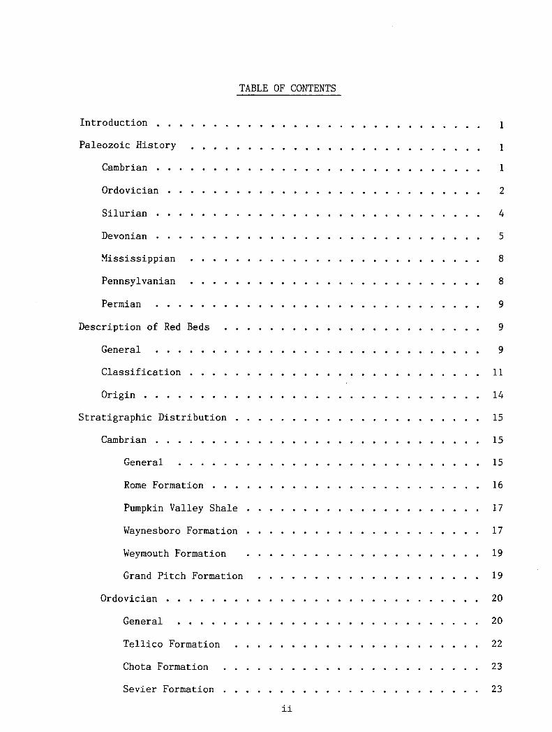
TABLE OF CONTENTS
Introduction
Paleozoic History
Cambrian
Ordovician
Silurian
Devonian
Mississippian
Pennsylvanian
Permian
Description of Red Beds
General
Classification
Origin
Stratigraphic Distribution
Cambrian
General
Rome Formation
Pumpkin Valley Shale
Waynesboro Formation
Weymouth Formation
Grand Pitch Formation
Ordovician
General
Tellico Formation
Chota Formation
Sevier Formation
ii
1
1
1
2
4
5
8
8
9
9
9
11
14
15
15
15
16
17
17
19
19
20
20
22
23
23

Bays Formation
Inman Formation .
Oswego Formation
Juniata Formation
Queenston Shale •
Sequatchie Formation
Silurian
General •
Grimsby Sandstone •
Castanea Sandstone
Crab Orchard Formation
Rose Hill Formation
Clinton Formation •
Bloomsburg Formation
High Falls Formation
Vernon Shale
Devonian
General •
Catskill Formation __
Chemung Formation .
Hampshire Formation .
Other Uni ts •
Mississippian •
General .
Patton Red Shale
Maccrady Shale
Borden Formation
Greenbrier Group
iii
24
25
25
26
27
27
28
28
31
32
32
32
33
34
34
35
36
36
37
37
38
38
40
40
40
41
42
42

Mauch Chunk Formation
Pennington Formation
Pennsylvanian
General
Conemaugh
Monogahela .
Dunkard Group
Other Units
Permain
Summary
General
Dunkard Group
iv
44
45
46
46
46
48
49
49
50
50
51
51
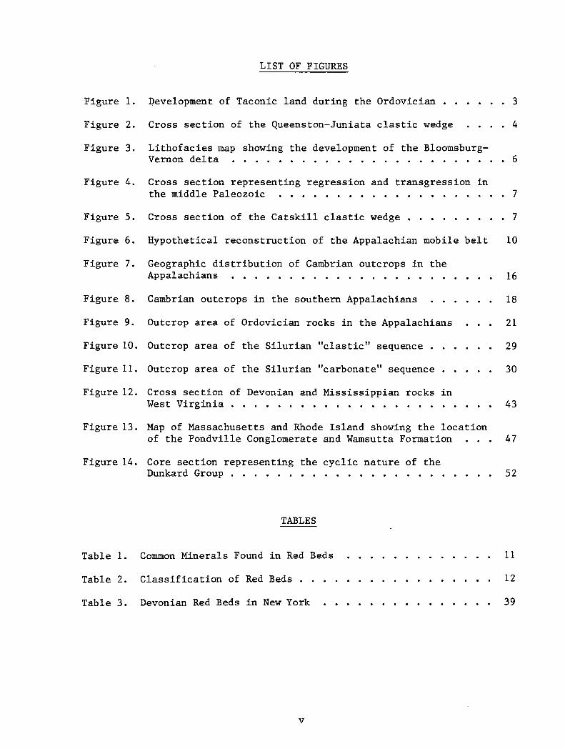
LIST OF FIGURES
Figure 1. Development of Taconic land during the Ordovician • • . . 3
Figure 2. Cross section of the Queenston-Juniata elastic wedge .• 4
Figure 3. Lithofacies map showing the development of the Bloomsburg-Vernon delta . . . . . . . . . . . . . . . . . . 6
Figure 4. Cross section representing regression and transgression in the middle Paleozoic • • . • . • • • • • • • • 7
Figure 5. Cross section of the Catskill elastic wedge • • • 7
Figure 6. Hypothetical reconstruction of the Appalachian mobile belt 10
Figure 7. Geographic distribution of Cambrian outcrops in the Appalachians . • • • • • . . • • • . 16
Figure 8. Cambrian outcrops in the southern Appalachians 18
Figure 9. Outcrop area of Ordovician rocks in the Appalachians 21
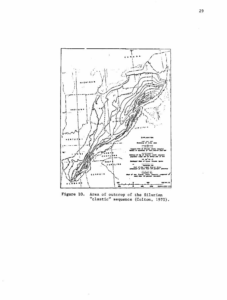
Figure 10. Outcrop area of the Silurian "elastic" sequence . 29
Figure 11. Outcrop area of the Silurian "carbonate" sequence . . . . . 30
Figure 12. Cross section of Devonian and Mississippian rocks in West Virginia . . . • • . • . • • 43
Figure 13. Map of Massachusetts and Rhode Island showing the location of the Pondville Conglomerate and Wamsutta Formation 47
Figure 14. Core section representing the cyclic nature of the Dunkard Group • • • • • . . . • • • • • . . . . 52
TABLES
Table 1. Common Minerals Found in Red Beds 11
Table 2. Classification of Red Beds • 12
Table 3. Devonian Red Beds in New York 39
v

INTRODUCTION
Red beds are a conunon lithology in Paleozoic rocks of eastern North
America. Only a few red beds are known from Precambrian deposits, while
extensive red beds are found throughout the Mesozoic and Cenozoic Systems.
This includes Holocene red beds as well. The key to understanding how and
why red beds form is in observing modern red-bed sedimentation. During the
past twenty years, significant advances have been made toward understanding
the origin of these distinctive deposits (Pye, 1983).
Paleozoic red beds cover a wide ra~ge of sedimentary environments, both
continental and marine. Most continental red beds are found in aeolian, al
luvial, and deltaic environments, while marine red beds involve unusually
high sedimentation rates in.an oxidizing atmosphere. The majority of modern
red beds are continental deposits, with the exception of reddish-brown clay
oozes in some deep ocean basins and on certain continental shelves. These
modern red-bed deposits are common in tropical areas, both humid and arid,
but are less conunon in temperate areas and are virtually nonexistent in polar
areas. One can conclude that most ancient red beds were deposited under sim
ilar geographic and climatic conditions. The one exception involves diage
netic red beds, which originate from the postdepositional alteration of iron
bearing minerals. Plate tectonic reconstructions (Bless et al., 1984) suggest
that most red beds did indeed form under tropical conditions. The red beds of
the Appalachian basin, deposited throughout Paleozoic time, reflect that North
American plate was in an equatorial position during most of the Paleozoic.
PALEOZOIC HISTORY
Cambrian
Throughout Cambrian time, the North American craton was covered by an ex
tensive epeiric sea, caused by a worldwide rise of sea level. This craton
2
was stable during the Cambrian, and was believed to lie in an equatorial
zone which bisected the plate (Datt and Batten, 1981). The gradual trans
gression of Cambrian seas onto the tropical continent resulted in the
deposition of-vast areas of shallow marine carbonate. Extremely pure
quartz sand was redeposl.ted across the sea floor as the Cambrian shore-
1 ine gradually shifted. Steady trade winds blowing across the subequatorial
craton produced currents in the epeiric ~ea which, in turn, produced cross
stratified pure quartz sandstone. At the close of the Cambrian, carbonate
sedimentation predominated with the formation of great coastal tidal flats.
Vast dolomite deposits record this accumulation in seas that could not have
been more than 90 to 180 meters deep (Dott and Batten, 1981).
Ordovician
At the beginning of the Ordovician Period, a major regression of the
epeiric sea occurred, resulting in a much shallower marine environment along
the borders of the North American continent. Thin Lower Ordovician carbonates
were deposited throughout most of the continent. In Middle Ordovician time,
a subsequent transgression occurred, which may be linked to the beginning of
subduction of the proto-Atlantic lithospheric plate. This subduction initiated
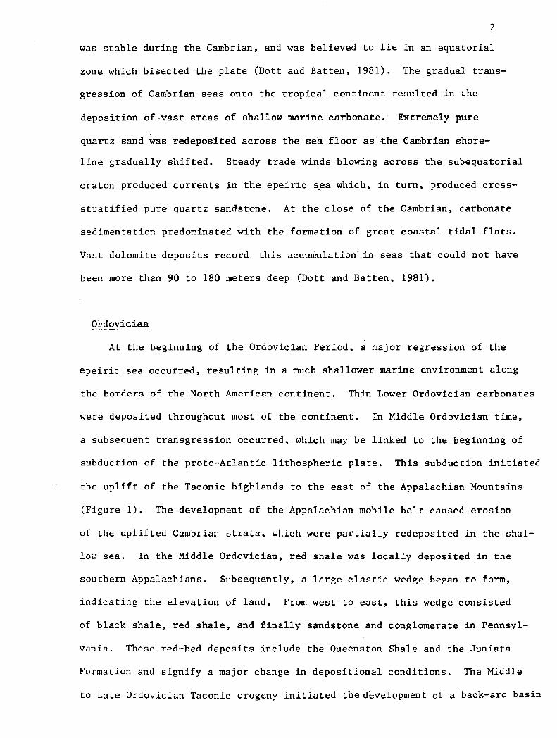
the uplift of the Taconic highlands to the east of the Appalachian Mountains
(Figure 1). The development of the Appalachian mobile belt caused erosion
of the uplifted Cambrian strata, which were partially redeposited in the shal
low sea. In the Middle Ordovician, red shale was locally deposited in the
southern Appalachians. Subsequently, a large elastic wedge began to form,
indicating the elevation of land. From west to east, this wedge consisted
of black shale, red shale, and finally sandstone and conglomerate in Pennsyl
vania. These red-bed deposits include the Queenston Shale and the Juniata
Formation and signify a major change in depositional conditions. The Middle
to Late Ordovician Taconic orogeny initiated the development of a back-arc basin

Figure 1. Diagramatic representation of the subduction of the proto-Atlantic lithospheric plate and the development of the Taconic Mountains (after Dott and Batten, 1981).
3
4
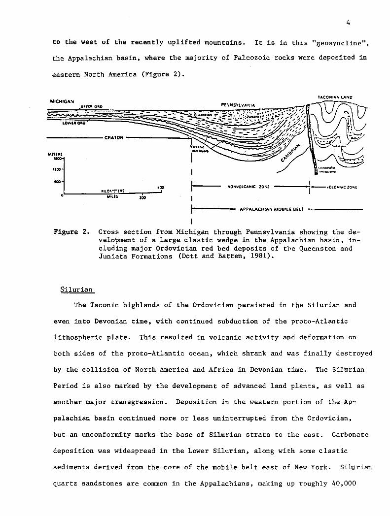
to the west of the recently uplifted mountains. It is in this "geosyncline",
the Appalachian basin, where the majority of Paleozoic rocks were deposited in
eastern North America (Figure 2).
NONVOLCANIC ZOS( ----~1-•0LCAMC ZO"l
APPALACHIAN MOBILE BELT
Figure 2. Cross section from Michigan through Pennsylvania showing the development of a large elastic wedge in the Appalachian basin, including major Ordovician red bed deposits of tbe Queenston and Juniata Formations (Dott and Batten, 1981).
S·ilurian
The Taconic highlands of the Ordovician persisted in the Silurian and
even into Devonian time, with continued subduction of the proto-Atlantic
lithospheric plate. This resulted in volcanic activity and deformation on
both sides of the proto-Atlantic ocean, which shrank and was finally destroyed
by the collision of North America and Africa in Devonian time. The Silurian
Period is also marked by the development of advanced land plants, as well as
another major transgression. Deposition in the western portion of the Ap-
palachian basin continued more or less uninterrupted from the Ordovician,
but an unconformity marks the base of Silurian strata to the east. Carbonate
deposition was widespread in the Lower Silurian, along with some elastic
sediments derived from the core of the mobile belt east of New York. Silurian
quartz sandstones are common in the Appalachians, making up roughly 40,000

5
cubic meters of sediment derived from the Taconic Mountains (Dott and
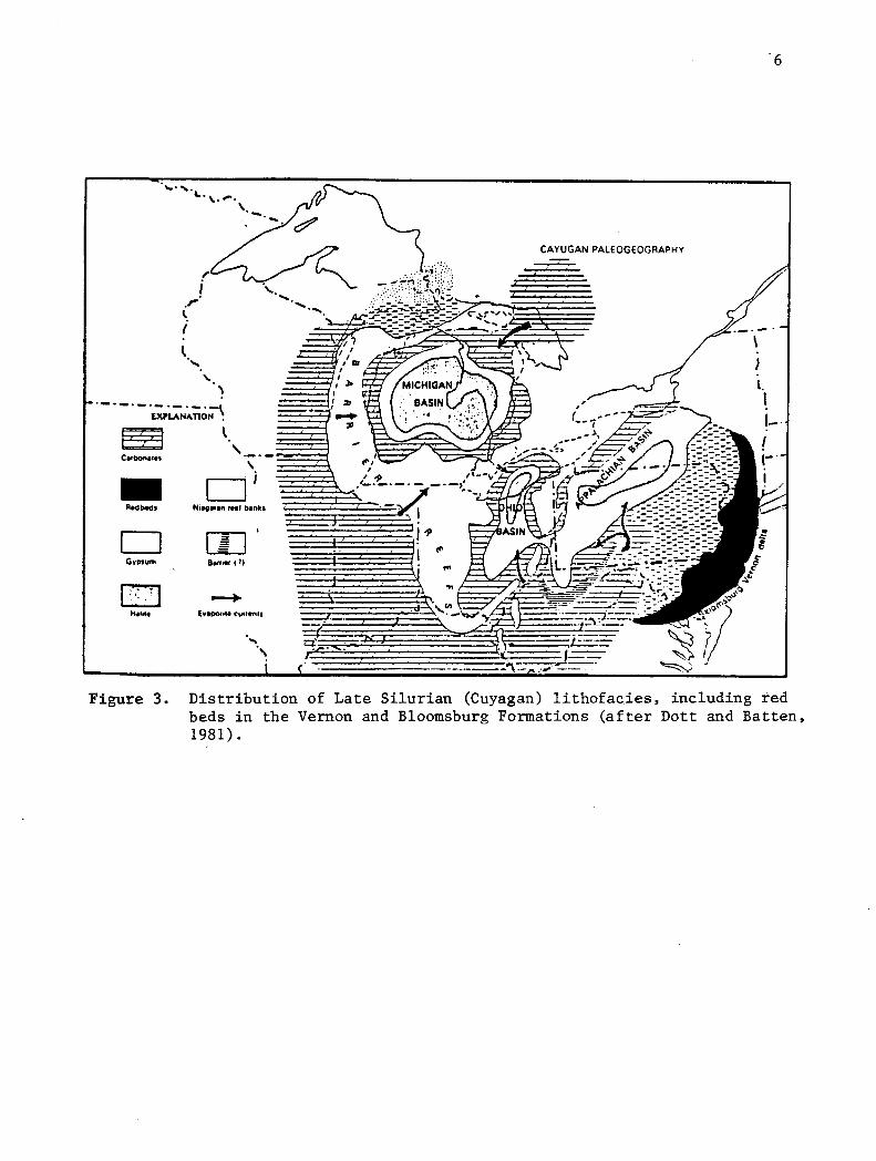
Batten, 1981). In the Late Silurian, abundant evaporite deposits began
to form, along with organic reefs and deltaic red beds (Figure 3). The
abundance of iron oxides in Silurian sediments suggests a strongly oxidiz
ing atmosphere. Also, the occurence of evaporite sediments ·Suggests that
there was a relatively high evaporation rate over most of North America.
This leads most workers to conclude that the overall Silurian climate was
warm and tropical.
Devonian
During most of Devonian time, the proto-North American plate rested
against the proto-African plate, with a single great mountain chain between
the two cratons. In Early Devonian time, a regression of the Silurian sea
limited marine deposition to a few restricted basins. Intracratonic de
formation of the North American crust was wide-spread in Early Devonian
time. Virtually all of the craton and portions of the mobile belt
were above sea level during this time. In the Middle Devonian, another
transgression occurred and marine deposition resumed in the basins which
gradually encroached upon the higher land (Figure 4). This alternation of
transgressions and regressions produced numerous minor uncomf ormities in
the Devonian section.
The Devonian Period is marked by another major orogeny. The Acadian
orogeny effected the northeastern Appalachian Mountains and is superimposed
upon the Taconic orogeny. The rejuvenated Appalachians initiated the de
velopment of another large elastic wedge, the Catskill delta (Figure 5). The
Catskill sediments coarsen to the east, as did the Queenston-Juniata wedge,
indicating elevation and erosion of an eastern source. This upland is
also the source terrain for a nearly identical and symmetrical elastic wedge,
the Old Red Sandstone, on the eastern side of the land mass.
......... &. • \. ......
, ;
.r· ... i ~ ......
' ·-·-·-·- ·-·-·-~ EXPLANATION •
"· -·-
Cartxma1e1 \'·-·-~""' ~ \ - D;
Aodbedt N11g1f1n tHf bankt
D Gwosum Bemer c 1)
sq.) I
... .,,. Ev1por111 cun•nts
6
CAYUGAN PALEOGEOGRAPHY
2?:
l. I 1-·
------"'\.--
Figure 3. Distribution of Late Silurian (Cuyagan) lithofacies, including red beds in the Vernon and Bloomsburg Formations (after Dott and Batten, 1981).

~ "' "' ... IC 0 ... c
·l
-
Figure 5.
METERS 1800
1200
..
,....Yort
KILOMETERS
MILES
Figure 4.
500
7
Diagramatic sketch showing Middle Silurian to Early Devonian regression and Middle to Late Devon
transgression in the ian Appalachian and Batten,
basin 1981).
fllt
(Dott
Cross section showing the formation of the Catskill elastic wedge in New York (Dott and Batten, 1981).

8
Mississippian
The Mississippian Period is characterized by the last widespread car
bonate-producing epeiric sea in North America. Carbonate rocks can be found
across most of the craton and in large parts of the mobile belts. By the
end of the Mississippian Period, the deposition of typical marine carbonates
had ceased. During all of the Mississippian, the North American and African
plates were still together, and beginning in the Late Mississippian time, de
position was predominantly terrigenous. During this time, heterogeneous sands
containing mostly quartz, feldspar, and mica began to appear in the Appala
chian basin. This type of sedimentation became more widespread during sub
sequent geologic periods. At the end of the Mississippian, a major regression
drained the entire craton resulting in a major disconformity between Mississi
pian and Pennsylvanian rocks.
Pennsylvanian
During most of Pennsylvanian time, sedimentation was dominantly composed
of terrigenous elastic material derived from peripheral mountains and also
the inner craton. Pennsylvanian strata contain North America's largest coal
deposits, which were. formed under climatic and topographical conditions favoring
the development of large swamps. Similar conditions existed in Europe and
North Africa, which were joined together as a large land mass. These strata
exhibit a rhythmic pattern of alternating rock types and represent another
major worldwide change in styles of sedimentation. These low-lying swamplands
were very near sea level; therefore, only a minor eustatic rise or sinking of
land would cause the swamps to be inundated. On the other hand, a small fall in sea
level or uplift would cause an enlargement of the land area, with the develop
ment of rivers, deltas, and swamps. It is precisely these oscillatory trans
gressions and regressions which may have produced the characteristic cyclic
deposition of the Pennsylvanian Period.

9
The last Paleozoic orogeny in the eastern United States began in
Pennsylvanian time and persisted into the Triassic Period. In the Appalachian
Mountains, Pennsylvanian rocks were folded and thrust westward along with older
strata.
Permian
With the onset of the Permian Period came increased elevation of the
Appalachian orogenic belt. By then, all of the continents were grouped toge
ther in one huge land mass, Pangea. Extensive red-bed deposits are'-known
from the Permian Period, but most are concentrated in the western portion of
North America. The climate during the Permian consisted of humid uplands and
somewhat drier lowlands (Bless et al., 1984). The Appalachian Mountain region
has a monsoonal climate (Bless et al., 1984) similar to that of India and
southeastern Asia today.
Thus, the Paleozoic Era ended with a huge land mass consisting of all the
present continents. In the Mesozoic Era, Pangea began to split apart and even
tually this extension resulted in the present continental distribution. From
these series of events, a hypothetical evolution of the Appalachian mobile belt
from the Precambrian into the Mesozoic can be reconstructed (Figure 6).
DESCRIPTION OF RED.~BEDS
General
The term "red bed" is a collective one meaning any soil, sediment, or sedi
mentary rock which possesses a red pigmentation. Generally speaking, red beds
are not entirely red in color and commonly include shades of yellow, light and
dark brown, orange, and maroon. Most geologists agree that sediments and rocks
with hues redder that SYR on the Munsell Soil Color Chart should be classified
as being true red beds (Pye, 1983). The Munsell values of most red beds lie be-

EOCAMBAIAN
JURASSIC
10
Figure 6. A hypothetical reconstruction of the Appalachian mobile belt (key: NA=North America, P=Piedmont microcontinent, PA= proto-Atlantic ocean, G=Gondwanaland, AO= present Atlantic Ocean, S "'° collision suture zone (Dottand Batten, 1981).
11
tween 4 (four) and 7 (seven), with corresponding chromas ranging between
4 (four) and 8 (eight).
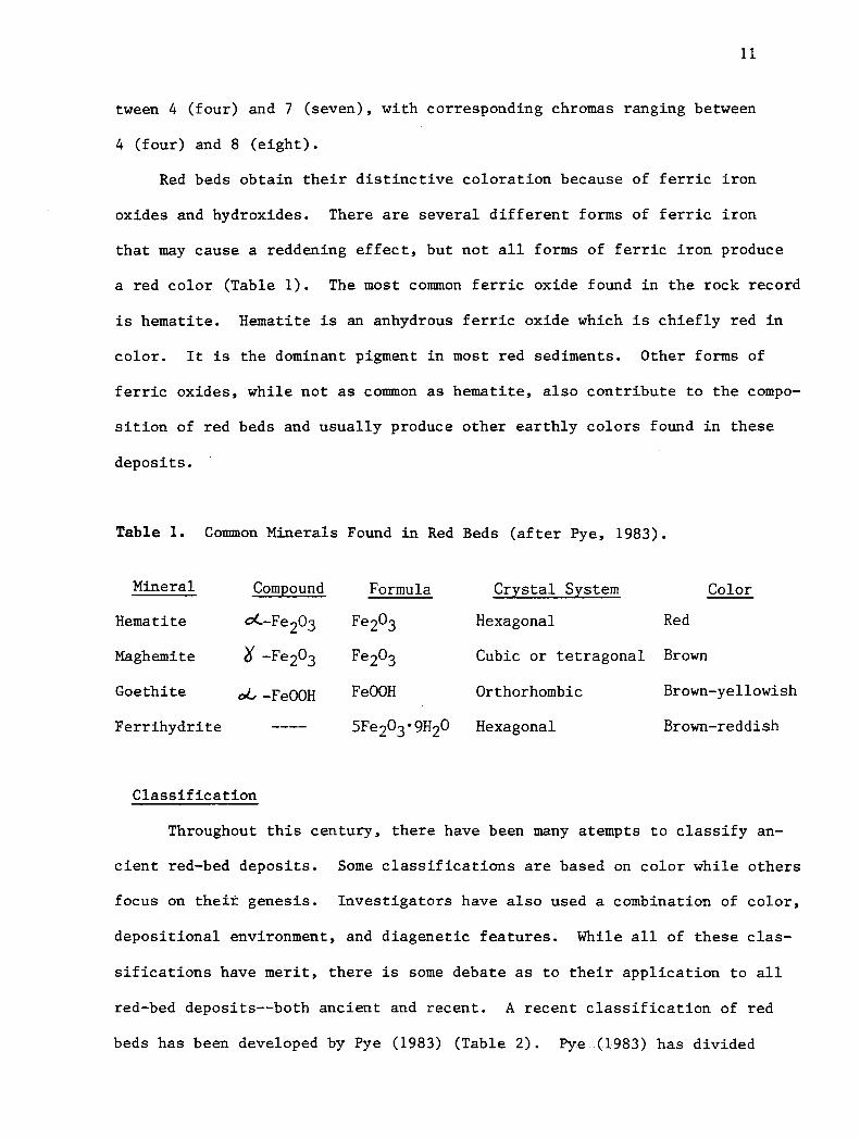
Red beds obtain their distinctive coloration because of ferric iron
oxides and hydroxides. There are several different forms of ferric iron
that may cause a reddening effect, but not all forms of ferric iron produce
a red color (Table 1). The most counnon ferric oxide found in the rock record
is hematite. Hematite is an anhydrous ferric oxide which is chiefly red in
color. It is the dominant pigment in most red sediments. Other forms of
ferric oxides, while not as common as hematite, also contribute to the compo-
sition of red beds and usually produce other earthly colors found in these
deposits.
Table 1. Connnon Minerals Found in Red Beds (after Pye, 1983).
Mineral Compound Formula Crystal System Color
Hematite ot-Fe203 Fe203 Hexagonal Red
Maghemite '(f -Fe2o3 Fe203 Cubic or tetragonal Brown
Goethite oL -FeOOH FeOOH Orthorhombic Brown-yellowish
Ferrihydrite SFe203•9H20 Hexagonal Brown-reddish
Classification
Throughout this century, there have been many atempts to classify an
cient red-bed deposits. Some classifications are based on color while others
focus on their genesis. Investigators have also used a combination of color,
depositional environment, and diagenetic features. While all of these clas-
sifications have merit, there is some debate as to their application to all
red-bed deposits--both ancient and recent. A recent classification of red
beds has been developed by Pye (1983) (Table 2). Pye -(1983) has divided

Table 2. Classification of Red Beds
"IN SITU" RED BEDS"
I. Pure Chemical Precipitates
II. Pedogenetic Red Beds
III. Diagenetic Red Beds
A. Eogenetic
B. Mesogenetic
C. Telogenetic
DETRITAL RED BEDS
I. Fluvially Transported
II. Colluvially Transported
III. Marine Transported
IV. Wind Transported
V. Ice Transported
12

13
all red-bed deposits into two basic groups. The first group, called insitu
red beds, was deposited in place by means of direct chemical precipitation,
weathering of iron-bearing rocks, soil formation, or diagenesis, and does
not involve any type of transportation of the iron-bearing material. The
second group is called detrital red beds and are formed by the erosion, trans
portation, and redeposition of pre-existing red sediments. In situ red beds
can further be subdivided into three groups pure chemical precipitates,
diagenetic red beds, and pedogenetic red beds. While all three of these groups
involve the authigenesis of iron oxide, pure chemical precipitates involve
direct precipitation of iron oxide in bog, lake, and spring deposits. In lithi
fied form, these pure chemical precipitates are mined as a source of iron ore.
The pigment in pedogenetic red beds is precipitated subaerially and usually
involves some type of soil horizon differentiation within a certain weathering
profile.
Diagenetic red beds are quite similar to pedogenetic red beds but with
the red pigment forming below the surface of the earth. Diagenetic red beds
are often associated with the alteration of iron-bearing minerals below the
groundwater table. These diagenetic red beds can be further subdivided into
eogenetic, mesogenetic, and telogenetic types. Eogenesis involves those pro
cesses which operate subaerially from the time the material is deposited until
it is buried by other sediments. Mesogenesis involves processes that occur at
elevated temperatures and pressures that are high enough to constitute a change
in mineralogy without metamorphosism. Telogenesis occurs when a sedimentary
unit is uplifted after being buried for a length of time and is exposed sub
aerially to processes at or near the surface of the earth. Often the processes
involved in pedogenetic and diagenetic reddening are quite similar and a clear
distinction between the two is difficult to make.

14
The classification of detrital red beds is much simpler than that
of in situ red beds. Five basic methods of sediment transport are in-
volved. Fluvially-transported detrital red beds involve riverine processes
which can transport sediments over great distances. In most cases, the
deposits of this type are found in deltaic environments. Colluvially-trans-
ported detrital red beds are deposited at the base of young mountain fronts
by downslope processes. Marine - wind- and ice-transported detri tal red
beds __ also occur.
Origin
The origin and significance of the distinctive coloration of red beds
has been an issue of great importance throughout the past century. Red beds
have long been presumed to indicate an oxidizing environment, which in turn
records the effect of a specific paleo-climate. Holocene red beds are com-
mom in both humid and arid parts of the tropics, less common in temperate
regions, and virtually nonexistent in polar areas. Some areas of contemporary
red-bed deposition include areas of Africa, Australia, South America, South-
east Asia, the Mediterranian region, Central America, and the southwestern
United States. These areas lie between 20° S. and 20° N. latitude. It has
been postulated that ancient red beds were deposited much in the same fashion
(Pye, 1983).
In situ red beds may develop in practically all types of sedimentary
facies, provided there is a suitable source of iron nearby. Red-bed deposits
are widespread near areas of igneous and metamorphic rock, where iron is
readily available through weathering processes. Pedogenetic and eogenetic
red beds are commonly found in areas which promote free drainage and oxidiz-
ing conditions, such as alluvial fans, river terraces, sand dunes, and beach
ridge deposits (Pye, 1983). Mesogenetic red beds form in similar geomorphic
settings, especially where large elastic wedges develop adjacent to actively

15
rising mountain fronts. Telogenetic red beds often form in areas where
erosion exposes any non-red, iron-bearing rock to oxidizing conditions.
The development of detrital red beds is based predominantly on the
erosion of preexisting red beds. The exposed red rock is eroded, trans
ported, and deposited usually in low-energy geomorphic settings_ such
as valley bottoms, shallow seas, and lake bottoms. However, in order to
preserve the red coloration, oxidizing conditions must be present in both
the source area and site of deposition. A good example of this red-bed type
is the Silurian Clinton Formation, which is thought to have been eroded from
the Late Ordovician Queenston and Juniata Formations (Ziegler and McKerrow,
1975).
Whereas most red-bed deposits are of the continental variety, they are
also known to form under marine conditions. This was especially true during
Silurian time (Ziegler and McKerrow, 1975). In order to preserve their red
color, marine red beds must be deposited very rapidly under oxidizing or
mildly reducing conditions. Most marine red beds are associated, in part,
with large, structurally complex deltaic systems (Ziegler and McKerrow, 1975).
STRATIGRAPHIC DISTRIBUTION
Cambrian
General
Camhr:ian outcrops in the eastern United States are found in a narrow,
northeasterly trending belt of exposures (Figure 7). This belt extends from
central Alabama in the southwest to Maine in the extreme northeastern United
States. Outcrops are found in central and eastern Alabama, the northwestern
corner of Georgia, eastern Tennessee, western North Carolina, throughout most

16
of western and northern Virginia, central Maryland, central and eastern New
Jersey, western Connecticut, eastern New York, and in limited areas of
Maine and Massachusetts. Most of these red beds are in the lowermost Cam-
brian and Middle Cambrian formations. Upper Cambrian red beds are practically
nonexistent in this area. Red-bed units of the Cambrian include the Rome,
Waynesboro, Wey.mouih and Grand Pitch Formations, as well as the Pumpkin Valley
Shale are described in detail below.
Figure 7. Geographic distribution of Cambrian outcrops in the eastern United States (after Palmer, 1971).
Rome Formation
The Rome Formation is a thick, laterally extensive unit found scattered
throughout most of the southern Appalachians. This formation is lowermost
Cambrian in age and varies in thickness, maximum being :600_:_meters only ::in north-
eastern Tennessee is a complete section of 350 meters recorded (Palmer, 1971).
The Rome Formation consists of a heterogeneous assortment of reddish, vari-
egated shales, with distinctive beds of sandstone, thin dolomite, and rare
conglomerate. Palmer (1971) defines the top of the Rome Formation as the high-
est sandstone bed below the Conasauga Group. The Rome Formation is conformably
underlain by the Pumpkin Valley Shale of the Conasauga Group and overlain by the
Shady Formation throughout most of the southern Appalachian basin. Relatively
few, if any, fossils have been found in the Rome Formation, and thus a determin-
17
ation of the depositional environment is difficult to make. However, paleo
geographic reconstructions indicate a shallow marine environment for this
region (Palmer, 1971).
Pumpkin Valley Shale
The Pumpkin Valley Shale is known to be the lowermost member of the Mid
dle Cambrian Conasauga Group. The Conasauga Group is found in the eastern
portions of Tennessee and in the western portion of the Virginia panhandle
(Figure 8). This group consists of light gray limestone and,gray, green and
purple shale, with scattered beds of brown sandstone. The Pumpkin Valley Shale
consists of olive and purple shale which crop out in the eastern portion of
the Conasauga outcrop belt. These shales grade into limestone further to the
west. The Pumpkin Valley Shale ranges from 65 meters to 105 meters in thick
ness with the greatest values toward the west (Palmer, 1971). It is underlain
by the Rome Formation and overlain by the Rutledge Limestone. Very few fossils
have been found in the limestone portions of the Conasauga Group; only a few
species of trilobites have been found in the Pumpkin Valley Shale. The Pump
kin Valley Shale is probably shallow marine in origin and grades westward into
deeper marine limestone (Palmer, 1971).
Waynesboro Formation
The Waynesboro Formation is the nothern Appalachian equivalent of the
Lower Cambrian Rome Formation. Outcrops of the Waynesboro Formation are found
in Pennsylvania, Maryland, and northern Virginia. Lithologically, the Waynes
boro Formation consists of interbedded red and green shale, reddish-brown sand
stone, and a few limestone and dolomite units. The similarity in lithology
and stratigraphic position of the Rome and the Waynesboro Formations has lead
some geologists to combine the two, using the name Rome-Waynesboro Formation.
The Waynesboro Formation has been estimated to be between 360 and 460 meters

. ••••••• l'Mtf"t •• ' " .......... ti.... :......-'1 . '-•-~/ .
/ ./
/
/
/.
/'-.. ..
... /· ./
./
. /··
./ Alobomu
..... '.., / .· '\ ·. ' ..
i
./ /
,'/, ..
.---··.......,
/ !;oulh
{° ''Carolina
I '/ .· ! ·~ ·""- ··-.. -··
!..!.'. ~- .. '.! ... !:'··
Figure 8. Cambrian outcrops in the southern Appalachians, showing the limits of the Conasauga Group (Palmer, 1971).
18

19
in thickness (Palmer, 1971). The Elbrook and Pleasant Hill Formations overlie
the Waynesboro, while the Tomstown Formation underlies it throughout the entire
northern Appalachians. This sparsely fossilferous formation contains only a
few fragmentary remains of olenellid trilobites found in isolated outcrops in
Pennsylvania. As with the Rome Formation, the Waynesboro has been interpreted
as a shallow marine deposit (Palmer, 1971).
Weymouth Formation
The Weymouth Formation occurs stratigraphically above the Braintree For-
mation near Boston in eastern Massachusetts, and in the extreme northeastern
corner of Rhode Island. Most of these outcrops are covered by thick Pleisto
cene sediments and thus provide little information of regional significance.
The Weymouth Formation has been assigned a Late Cambrian age and is estimated
to have a thickness of between 90 and 150 meters (Palmer, 1971). Near Boston,
the Weymouth Formation consists of red, green, and gray high-grade quartzitic
slates. In Rhode Island, the Weymouth includes a massive, white basal quart
zite that is overlain by about 90 meters of red and green slate, fine-grained
maroon silty limestone and calcareous siltstone. Fossils from the Weymouth in
clude a few ptychoparioid trilobites and the conical fossils Salterella and
Hyolithes (Palmer, 1971). As with the other Lower Cambrian Formations in the
eastern United States, the Weymouth Formation was probably deposited in a rela
tively shallow marine environment (Palmer, 1971).
Grand Pitch Formation
The Grand Pitch Formation is only f 0und in a few well-exposed outcrops
in northern Penobscot and parts of Aroostook Counties, in eastern Maine. Ac
cording to Neuman (1967), this unit is at least 4,500 meters in thickness.
This section consists of equal amounts of red, green, and gray slate and silt-

20
stone as well as some vitreous quartzite and small amounts of graywacke
and tuff. The lower contact of the Grand Pitch is not exposed, but it is
probably Precambrian basement; while it is known to be unconformably over
lain by Ordovician rocks (Palmer, 1971). On the basis of Lower Cambrian
trilobites, the Grand Pitch is correlated with the Weymouth Formation of
the Boston area (Palmer, 1971). Like the Grand Pitch, the Weymouth is in
terpreted to be marine in origin on the basis of these marine fossils (Palmer,
1971).
Ordovician
General
In the eastern United States, rocks of Ordovician age crop out in a
somewhat oval-shaped area within the Appalachian basin (Figure 9). The
states in which Ordovician rocks are exposed include central and northeast
Alabama, northwestern Georgia, eastern Tennessee, eastern Kentucky, western
Virginia, all of West Virginia, the Maryland panhandle, central and eastern
Ohio, central and western Pennsylvania, most of New York, and in scattered
outcrops in New England. The portion of Ordovician rocks that are of inter
est in this study include a few formations in the Middle Ordovician and all
of the Upper Ordovician. The Upper Ordovician consists largely of black to red
shale, gray to red siltstone and sandstone, and lesser amounts of limestone and
conglomerate. Rocks of Lower Ordovician age are dominantly massive gray lime
stone and dolomite and are devoid of distinctive red beds. The thickest ac
cumulation of the upper-Middle and Upper Ordovician rocks is in the northeastern
section of the study area, where the Oswego Formation and related sandstones
were deposited (Figure 9). This sequence is shown to thin uniformly to the
north, west, and southwest from the sandstone depocenter in the northeast.

I
Figure 9.
....... , •' ...• , .... -"_,,, __
..................... Or••tc.... ....... • ... _, ..,_., • ..... 11 • ., , .. , ' .,., ...... .
nr.:u"'1:-:1 .......... .., ... "'··· ................ ........ ........ . ,.,, . .., ..... ., ...... •' , ... ~
...... .. o ••• ,. ... ....... s ........... ._,.,, ,,,,,_,.. -"•• ,,.,_,.,., .,_..-, IOOO ,_.,
c...;.;.it • t.;. · ·"' ., ... '" ..... .., ,_,,.." ,, .... -.... .. ,,., . .., .. ,._,. ,. .. .
I II I
.... ,........... u,... o.c ... c .... ..... .,, ......... JA ... 4 Mtr .,,.,, e#I 14.tl .. Ull ._, ~ff...... •••••r _,,.._ .....,,.,,,,, .• ._.,,, • ..................... .,,..,
I I ,· I-----"'"'---IOO 100
fOO•H ft ·--,.I IOOIUlOflll t0
Outcrop area of Ordovician rocks in the Appalachian basin (after Colton, 1970).
21

22
The thickness of the red portion of Ordovician strata is considered to be
at least 3,900 meters (Colton, 1970).
Most Ordovician deposits in the Appalachian region are shallow marine
in origin (Colton, 1970). At times when sedimentation exceeded the rate of
subsidence of the Appalachian basin, accumulations of red and light and dark
brown sediments were deposited above sea level (Colton, 1970). The source
area for the majority of the siliciclastic sediments was the young Taconic
Mountains at the eastern boundary of the basin. Most of the red beds are
found along the eastern periphery of the basin. They grade westward into
marine limestone and dolomite. In the northeastern portion of the basin,
where accumulations are the thickest, the sediments were deposited in the
form of a large delta (Cotter, 1978). In the central portion of the basin,
sedimentation occurred offshore in a marine trough. Finally, in the western
portion of the basin, the sediments accumulated on the platform or shelf area
of the shallow Ordovician sea (Colton, 1970). Ordovician red beds are found
in ascending order as follows:
Tellico Formation
Outcrops of the Tellico Formation are limited to eastern and central
Tennessee, and northwestern Georgia. As a whole, the Tellico Formation is
between 800 and 1,400 meters in thickness and includes gray siltstone and
sandstone, red to gray silty calcareous shale and some thin limestone beds.
More importantly, the upper 150 meters of the formation consists of red fer
ruginous shale and sandstone with a conglomeratic base. Some light-gray lime
stone cobbles can be found in the shale. These cobbles are very fossiliferous,
containing numerous brachiopods and bryozoans (Butts and Gildersleeve, 1948).
Otherwise only fragmental fossils have been found in the shale. The Tellico
Formation lies below the Chota Formation and above the Blockhouse Shale through
out the outcrop area. Contacts are conformable in all instances. The depo-

23
sitional environment of the Tellico has been interpreted as being fluvial
deltaic, based on stratigraphic and sedimentologic evidence. An upper red
bed portion is part of this deltaic sequence. It may have accumulated above
sea level as the rate of sedimentation increased, thus allowing oxidation to
take place.
Chota Formation
The Chota Formation lies stratigraphically above the Tellico Formation
cropping out in a similar fashion to the Tellico, covering most of eastern
Tennessee and the northwest corner of Georgia. Thicknesses for the Chota
Formation range from 150 meters at the northeastern portion of a homocline in
Tennessee to 270 meters at its type locality, near Chota School, located just
off Tennessee Highway 72 in Monroe County (Neuman, 1955). Overall, the Chota
Formation is a quartzose calcarenite that is dark gray to reddish-gray in color
with small, well-rounded quartz grains found throughout (Neuman, 1955). A
few identifiable fossils have been found in the Chota, including abundant
bryozoans, some crinoids and brachiopods, and a few trilobites. The strati
graphic proximity and lithologic similarity of the Chota Formation to the Tellico
suggests that the depositional environment is very similar. The Chota ac
cumulated in shallow marine deltas and associated swamplands of the Middle
Ordovician sea. The majority of the red sediments appear to have accumulated
above sea level.
Sevier Formation
The Sevier Formation occurs above the Chota Formation in eastern Tennessee
and northwestern Georgia. It is approximately 550 meters in thickness and
is lithologically similar to both the Tellico and Chota Formations. The Sevier
can be distinguished as a separate stratigraphic unit on the basis of brachia-
24
pods and a species of gastropod (Neuman, 1955). At the top of the Sevier
Formation is a distinct unit, the Beacon Bend Member, which contains inter
bedded red and gray calcareous shale and siltstone. The Beacon Bend Member
ranges from 10 to 50 meters in thickness and contains several distinct lenses
of red calcareous mudstone. Depositional environments of the Sevier Forma-
tion include an alternating sequence of shallow marine facies and either mar
ine or non-marine red beds (Neuman, 1955).
Bays Formation
The Bays Formation of Middle Ordovician age is found in various parts of
northeastern Tennessee and southwestern Virginia. Its thickness ranges from
120 meters in the northeast to 300 meters in the southwestern portion of east
ern Tennessee (Neuman, 1955). The Bays Formation is described from the Tel-
lico-Sevier belt in eastern Tennessee and is characterized by red calcareous
mudstone and siltstone (Neuman, 1955). It is named for prominent exposures
at Bays Mountain, located in Hawkins and Green Counties, Tennessee. In ad
dition to mudstone and siltstone, the Bays Formation overlies the Ottosee
Shale and underlies the Chattanooga Shale of Late Devonian to Early Missis
sippian age. This stratigraphic relationship indicates a major disconform
ity between the Bays Formation and the Chattanooga Shale. In fact, the Bays
Chattanooga contact is perhaps the largest disconformity in the Paleozoic se
quence in the southern Appalachian Mountains (Neuman, 1955). Some of the
missing units are late-Middle Ordovician, Late Ordovician, Silurian, and
perhaps Devonian, in age.
The environment of deposition of the Bays Formation is shallow marine
based upon fossils in the Bays sandstone (Neuman, 1955). Deposition of the
Bays Formation was followed by major regression of the Ordovician sea, al
lowing extensive erosion to take place before deposition of the Chattanooga
Shale. This accounts for the large time gap between the Middle Ordovician

25
and the Late Devonian or Early Mississippian deposits in the southern Appa
lachians.
Inman Formation
The Inman Formation is a member of the Upper Ordovician Eden Group which
crops out in eastern Tennessee. Measured thicknesses of the Inman range from
10 to 20 meters in the Sequatchie Valley (Wilson, 1949). The lithology con
sists of alternating areas of red shale and greenish-gray calcareous shale.
The red sha-le includes thin interbedded greenish-gray limestone layers with
"birdseye" void fillings of clear calcite (Wilson, 1949). The Inman Forma
tion overlies the Leipers Formation of the Maysville Group and underlies the
Catheys Formation of the Eden. The Inman has not produced many fossils;
although, a few brachiopods and bryozoans can be found in the limestone
layers. Deposition of the Inman Formation can be associated with the Middle
to Late Ordovician shallow marine environment resulting in the limestone lay
ers and the calcareous content of the gray shale (Neuman, 1955).
Oswego Formation
The Oswego Formation, also known as the "Bald Eagle" Formation, is Up
per Ordovician in age and crops out in eastern West Virginia, western Mary
land, central and western Pennsylvania and throughout most of New York. The
Oswego Formation is also called the Gray Medina Sandstone in earlier reports
of the West Virginia Geological Survey (Woodward, 1951). Thicknesses of the
Oswego range from 160 to 270 meters in Pennsylvania; 60 to 120 meters in
central West Virginia; and 90 to 110 meters in the panhandle of West Virginia
(Woodward, 1951). Lithologically, the Oswego is a tough, well-cemented and
highly resistant gray to gray-brown feldspathic sandstone with prominent
interbeds of red fissile shale. Sandstones in the Oswego are fine-to medium-

26
grained and occasionally become pebbly in the finer sandstone. The Oswego
is basically unfossiliferous, with only a few brachiopods occurring near
the base of the unit. The absence of fossils makes reconstruction of the
depositional environment difficult. However, Faill and Wells (1974) inter
pret the Oswego as part of a large braided stream complex, which accounted
for thousands of meters of sediment in the northeastern Appalachians.
Juniata Formation
The Juniata Formation is a laterally extensive unit which covers most
of Pennsylvania, western Maryland, eastern Tennessee, western Virginia, and
eastern West Virginia. The Juniata is tate Ordovician in age and lies a-
bove the Oswego Formation and below the Tuscarora Formation. In West Virginia,
the Juniata is defined as being the uppermost unit of the Ordovician and is
regarded as the Red Medina Formation of Silurian age in earlier publications
of the West Virginia Geological Survey (Woodward, 1951). According to Willard
and Cleavers (1939),no true outcrops of the Oswego Formation are found in
Pennsylvania, as it is included as the basal member of the Juniata (Richmond
Age). Named for exposures along the Juniata River in Pennsylvania, the Juniata
Formation ranges from 45 to 250 meters in West Virginia to well over 300 me
ters in Pennsylvania (Woodward, 1951). In Maryland, the thickness ranges
from 60 meters along the Potomac River to 160 meters near Cumberland. Litho
logically, the Juniata consists of massive red sandstone with some soft red
shale interbeds. The sandstone unit is partially silica-cemented, and there
are some micaceous beds in between the shales. The Juniata is generally un
fossiliferous and is assumed to be a part of the large delta that was present
during most of Middle to Upper Ordovician time (Rodgers, 1953). There is no
evidence of marine deposition in the Juniata (Faill and Wells, 1974).

27
Queenston Shale
The Queenston Shale,.· a member of the Upper Ordovician Richmond Group,
is found in outcrops located in eastern Pennsylvania, western New York,
and in Ontario, Canada. It overlies the Oswego Formation and underlies
the Whirlpool Sandstone, and in some places underlies the Silurian Grimsby
San·dstone.. According to Gillette (1940), the Queenston Shale is be-
tween 260 and 330 meters in thickness and contains the Ordovician-Silurian
boundary. The Queenston is predominantly red and variegated shale, which
becomes silty in some places. This unit is basically unfossiliferous and is
entirely non-marine (Gillette, 1940).according to stratigraphic and sedi
mentologic studies. The Queenston Shale was deposited subaerially, and
possibly in flood plain deposits along the edges of the Ordovician delta,
during the regr.ession of the Late Ordovician sea (Fisher, 1954).
Sequatchie Formation
The Sequatchie Formation of Richmond age crops out throughout the south-
ern Appalachians of northeastern Alabama, northwestern Georgia, eastern Ten
nessee, and southwestern Virginia. Named for numerous outcrops in the Sequatchie
Valley, Tennessee, the Sequatchie Formation ranges from 10 to 140 meters in
thickness (Gillette, 1940). The Sequatchie is stratigraphically complex,
underlying the Clinch Formation of Silurian age and unconformably overlying
the Reedsville and Martinsburg Shale, as a result of the absence of the Os-
wego Formation in this area.
In parts of eastern Tennessee, the Sequatchie overlies the rather thin
Arnheim Formation, which is dominantly limestone. In a SO-meter measured
section in Lee County, Virginia, the Sequatchie Formation contains the follow
ing : dark brown shale; dense brown sandstone with shale partings; green
shale with thin beds of soft brown sandstone containing some marine fossils;

28
red shale containing some gray-green streaks; and some scattered occurrence
of argillaceous nodular limestone which also contains marine fossils (Bates,
1939). The overall lithology of the Sequatchie consists of brown-to-red
shale and mudstone which is calcareous in some parts, and smaller amounts of
sandstone and limestone. The marine fossils found in this formation are im
portant, because in other- areas, rocks of similar age as the Sequatchie have
been interpreted as being non-marine (Neuman, 1955). The depositional en
vironment of the Sequatchie Formation is assumed to be shallow marine, based
on the presence of marine fossils.
Silurian
General
Outcrops of Silurian age in the eastern United States occur throughout
the Appalachian basin and can be divided into two types. The first is the
Lower through Middle Silurian "elastic" sequence (Figure 10). The second is
the upper-Middle to Upper Silurian "carbonate" sequence (Figure 11). As
stated above, most Ordovician red beds are interpreted to be non-marine in
origin. During the early Paleozoic, before the Silurian development of ad
vanced land plants, a plentiful supply of oxidized iron accumulated by sub
aerial weathering. In the Middle Silurian, a major transgression occurred
in the Appalachian basin, and most Middle and Late Silurian deposits, includ
ing red beds, are thus marine in origin.
According to Ziegler and McKerrow (1975), the oxidized sediments that
are incorporated in the Silurian marine environment are second-cycle, derived
through erosion of the recently uplifted Queenston and Juniata Formations.
In order to prevent reduction by organics derived from Silurian land plants,
the sedimentation rates of the marine red beds must have been extremely high.
....
I I I
' '.
I I I ' t•N fl l\A ._ A
.... 1 .... I
J ')
I [,..I-;'-.~' }
~----·---·
T '• --· C It N1 It D A /
\
l•P\.ANATIO ..
....... , ...... , .. .. -··__ ,,_ It..-• llolet .. Sil•ti91l t•tlle ......... ~I * ,,__,.,,. _, IHl1 ._,"' IOO ,_
o.flMf ef ... ef 91 .. tf911 ClffHc ....... . ,...._ • ...., ..,· .. .,w ... ., ... u .J.J.·.u. u
......., ....... Le.., ............
·~·--l•tl Ill -.. L-.r s,,-.,..,. ho•• ....,,.,,.. ., ,. .. ,..,, ·- ,,., .. ,,, ....,..,., ,_ ... ""' "' .. $..,... , ... ,... ........ , .... ff# ... ,,,.. ,, ,.,,.., ,,....,...
Figure 10. Area of outcrop of the Silurian "elastic" sequence (Colton, 1970).
29

.... ~ ...
I . •' It• 0 I,' fit A ' , .. ,. J
Figure 11.
__.,.,..,,.. ...... ., ..... , .... _ ...... ;.,. .... _., ....... ........ . ,.,, . .., -,,.,,.,, .,,,. ,, "•• .. .._ ............... .. lllllUlll
tret .. fMdlHf tllt Atp~te , ........ --. ,._ IOO IHI
CJ ,,.. .. ......... ..... ... , ..... . ,.,....., _,. ,._ IOH IMI
Area of outcrop of the Silurian "carbonate" sequence, including the Bloomsburg Red Beds (Colton, 1970).
30
31
Fossil evidence suggests that most Silurian marine red beds were deposi
ted in quiet, offshore shelf environments and associated deeper marine areas
(Ziegler and McKerrow, 1975).
Silurian marine deposits of other colors were apparently reduced by the
presence of large amounts of organic material, and are found mostly in near
shore environments where physical and biological re-working of the sediments
aided in the reduction process (Ziegler and McKerrow, 1975). These latter
marine red-bed deposits are part of the Silurian "carbonate" sequence. The
"elastic" sequence of the Lower Silurian was deposited in a setting similar
to the rocks of the Late Ordovician; most likely in a fluvial-deltaic environ
ment (Fail! and Wells, 1974). There are many red-bed formations in the Sil
urian and are described in ascending order as follows:
Grimsby Sandstone
The Grimbsy Sandstone is the highest formation in the Lower Silurian
Series. Outcrops of the Grimsby are restricted to eastern Pennsylvania, cen
tral and western New York, and in Ontario, Canada. The apparent stratigraphic
continuity of the Medina Group with the underlying Queenston Shale suggests
that these rocks were deposited in Early Llandovery time. Named for exposures
along the east side of Niagara Gorge at Grimsby, Ontario, the thickness ranges
from one to 20 meters (Swartz, 1942). Stratigraphically, the Grimsby under
lies the Thorold Sandstone and overlies the Cabot Head Shale (of the Medina
Group) in all areas except Lockport, Pennsylvania, where the Grimsby is un
conformably below the Neagha Formation (Swartz, 1942). The Grimsby consists
of red sandstone, with local interbeds of red to greenish-gray shale. The
Grimsby Sandstone is relatively unfossiliferous and is thought to be fluvial
deltaic in origin (Ziegler and McKerrow, 1975).

32
Castanea Sandstone
The Castanea Sandstone correlates with the top of the Albion Series in
central Pennsylvania. It is between five and 15 meters in thickness and lies
at the base of the Clinton Group between the Tuscarora Sandstone and the Rose
Hill Formation (Swartz, 1942). At the type locality, near Castanea, a suburb
of Lock Haven in Clinton County, Pennsylvania, it is described as a heavy
red sandstone with intermittent gray beds containing diagnostic sericitic
mud chips (Swartz, 1942). The deltaic Castanea Sandstone correlates with
elastic rocks above the Grimsby Sandstone (Ziegler and McKerrow, 1975).
Crab Orchard Formation
The Crab Orchard Formation, or Group, as it is also known, crops out
in central and northern Kentucky and is named for Crab Orchard in Lincoln
County. The thickness of the Crab Orchard ranges from 10 to about 60 meters
in northeastern Kentucky (Colton, 1970). Lithologically, the Crab Orchard
Formation consists of gray mudstone and shale, with prominent red shale inter
beds and sparse, thin limestone beds. Biostratigraphic ostracod correlation
by Ulrich and Bassler (1923) indicates that the Crab Orchard Formation is
Late Llandovery in age. Other fossils including numerous brachiopods, cono
donts, and some graptolites, indicate that the Crab Orchard Formation is
a marine deposit (Ziegler and McKerrow, 1975).
Rose-Hill Formation (Clinton Group)
The term "Clinton" as a group encompasses many formations, including
the Rose Hill, and is found in numerous outcrops in New York and from central
Pennsylvania to northeastern Tennessee. This usage differs from "Clinton"
as a Formation in the Red Mountain Group which outcrops from southeastern
Tennessee to central Alabama (Woodward, 1941). The Rose Hill Formation, of
Late Llandovery age, can be found in numerous outcrops in Maryland, Pennsyl-

33
vania, and northern Virginia. Thickness measurements of the Rose Hill range
from 60 to 230 meters (Swartz, 1941). In central Pennsylvania, the Rose Hill
Formation overlies the Castanea Sandstone and underlies the Keefer Sandstone.
In other areas, the Rose Hill overlies the Tuscarora Sandstone and underlies
the Bloomsburg Formation. The Rose Hill Formation represents the major por
tion of the Clinton Group in Pennsylvania and Maryland and consists chiefly
of red shale with some ferruginous sandstone interbeds that contain charac
teristic sericitic mud chips (Swartz, 1941). Rose Hill shales are dominantly
argillaceous, thinnly-bedded, and fissile, while the sandstones are thin, red,
and gray to green, and are also argillaceous. Numerous marine ostracods have
been found in the Rose Hill Formation. Ziegler and McKerrow (1975) have sug
gested that the material which forms the Rose Hill Formation was derived from
the recently uplifted Late Ordovician Queenston Shale and Juniata Formation.
Clinton Formation (Red Mountain Group)
The Red Mountain Group crops out in a belt which runs southwesterly from
central Tennessee to central Alabama, where it ranges from 60 to over 150
meters in thickness. The Clinton portion of the Red Mountian Group ranges in
thickness from 45 to 120 meters near Birmingham, Alabama to 90 meters in
central Tennessee (Woodward, 1941). The Red Mountain Group is virtually non
existent in the Sequatchie Valley of Tennessee and Alabama. The Clinton Forma
tion in Alabama and northwest Georgia represents the portion of the Red Moun
tain Group above the Big Seam Iron Bed. Lithologically, the Clinton consists
of brown and red shale with thick, even beds of fine-grained, greenish-gray
sandstone. In the southern Appalachians, the Clinton Formation is interpreted
as being a rapidly deposited marine formation which was also derived from the
Late Ordovician red-bed deposits, eroded during the Llandovery transgression.
(Ziegler and McKerrow, 1975).
34
-Bloomsburg Red Beds Of Formation
The Bloomsburg Formation, Cayuga Group, is found covering central and
southern Pennsylvania, western Maryland, western Virginia; and northern West
Virginia. The Bloomsburg Formation is commonly referred to as the Blooms
burg Reds because of its characteristic red pigmentation. Named for exposure
at Bloomsburg in Columbia· County, Pennsylvania ranges from 60 meters to at
least 600 meters in thickness (Swartz, 1941). The Bloomsburg Red Beds con
sist of red fine-grained siltstone with interbedded red shale and sandstone.
In western Maryland, the Bloomsburg overlies the McKenzie Formation and
underlies the Wills Creek Shale. In all other areas, the Bloomsburg under
lies the Poxono Island Formation and overli'es either the Clinton Formation
(Rose Hill) or the Tuscarora Sandstone. Conodont and ostracod correlations
indicate that the Bloomsburg Formation is a marine unit of latest Wenlock to
earliest Pridoli age (Epstein and Epstein, 1969). Another use of the term
Bloomsburg is as a non-marine f acies of the Cayugan Williamsport Sandstone
in Pennsylvania (Woodward, 1941). This "Bloomsburg facies", also red in
color, thickens from west to east until it includes all of the Cayugan sec
tion in eastern Pennsylvania. However, this facies is not at a consistent
stratigraphic level, so Woodward (1941) does not include it as a part
of the Bloomsburg Red Beds.
High Falls Formation
The High Falls Formation crops out in a broad area in the extreme north
eastern Appalachians and is found in central New York, northern New Jersey,
and northeastern Pennsylvania. The name High Falls is synonomous with Blooms
burg (Ward, 1938) and is used locally to include the extension of Bloomsburg
rocks in the northeastern part of the Appalachian basin. The High Falls
Formation is 60 to 100 meters in thickness and lies stratigraphically above

35
The 'Shawangunk Formation and below the Caxuga Group (Ward, 19 38) • It is
predominantly shale with lesser amounts of sandstone. The pigmentation
of the High Falls is similar to that of the Bloomsburg, with red being
the dominant color. However, the High Falls Formation contains several
dull greenish zones, especially at its type locality on the lower slopes
of the north side of Kittutinny Mountain in Pennsylvania. The High Falls
Formation is relatively unfossiliferous and is assigned a Ludlow and Pri
doli age based on its stratigraphic position (Ward, 1938). In the absence
of fossil evidence, the High Falls has been interpreted as being marine
based on the juxtapostion and lithologic similarity to the Bloomsburg For
mation (Epstein and Epstein, 1969).
Vernon Shale
The Vernon Shale is recognized as part of the Salina Group from north
central Ohio to western New York. However, outcrops of the Vernon Shale
are limited to western and east-central New York. The thickness of the Ver
non Shale ranges from 45 meters in its type locality in Vernon Township,
Oneida County, New York, to 90 meters in Genessee County, New York (Fisher,
1957). It is exclusively red shale, hence the formation is often called the
Vernon Red Shale. Because of its uniformly characteristic lithology, the
Vernon Red Shale has been treated as a distinct formation or as part of
the undifferentiated Salina Group (Fisher, 1957). The Vernon Shale has not
yielded many fossils, but its stratigraphic position above the Lockport Group
and below the Bertie Group indicates it is Ludlow and Pridoli in age. The
lithology of the remainder of the Salina Group in northeastern Ohio is red
and gray shale, gray dolomite, and thick accumulations of rock salt. The
abundance of dolomite, along with sparse marine ostracods found in some of
the shale units suggests that the Salina Group, including the Vernon Shale,
was deposited in a marine environment (Ziegler and McKerrow, 1975).

36
Devonil!ln
General
Outcrops of Devonian age in the eastern United States occur in a wide
area in New York and extend southwestwardly throughout the Appalachian basin
to central Alabama. · A second outcrop belt is found in central and northwestern
Ohio which extends southward into Kentucky. Thickness of the Devonian strata
range from more than 3,300 meters in east-central Pennsylvania to less than·
300 meters in central Alabama. Devonian rocks are about 1,800 meters thick
in the Catskill Mountains in eastern New York and thin to the west, where
they are approximately 150 meters thick in central Ohio (Oliver et al.,
1967). They are virtually absent in parts of central Tennessee.
Lithologic~lly, the Devonian sequence consists of mud rock, shale, and
siltstone, with smaller amounts of san<lstone and conglomerate. Limestone
and dolomite are common in the lower part of the Devonian, but comprise only
about 5% of the total volume. The Lower Devonian, which includes the Helder
berg, Deerpark, and Onesquethaw Stages, consists of alternating units of car
bonate and elastic deposits. Most of these units are relatively thin and their
facies relationships are complex, with most deposition occurring on the rela
tively stable shelf of a medium-to-high-energy shallow marine environment
(Oliver e·t al.~, 1967). Significant subsidence began throughout the Appala
chian ·basin in Onesquethaw time and persisted into the Carboniferous. During
the Middle and Late Devonian, recently uplifted areas to the east provided
sediment to a fine-grained, mostly shallow marine environment. In the Middle
Devonian, terrestrial red beds were deposited along the eastern edge of the
basin (Oliver et al.,. 1967). By the Late Devonian and Early Mississippian,
these deposits spread westward in the northern portion of the basin in the
form of a large elastic wedge reaching a maximum thickness of 3,300 meters

37
in eastern Pennsylvania. The most complete sequence of Devonian rocks is
found here, with a section in New York comprising nearly the entire Devonian
System. This area has long been the standard reference section for North
America. The important Devonian red-bed deposits include the Catskill,
Chemung, and Hampshire Formations and are discussed below.
Catskill Formation
The Catskill Formation, of "facies", as it is often called, spans the
entire Middle and Upper Devonian and part of the Lower Mississippian. Out
crops of the Catskill occur mostly in west-central New York and in northeastern
Pennsylvania, but can also be found in various parts of Maryland and New Jersey.
THe thickness of the Catskill is believed to be well over 3,000 meters. HU.W
ever, the thic~est measured section is 1,900 meters along the Lehigh River
in Carbon County, Pennsylvania,(Willard, 1939). The overall gross lithology
of the Catskill consists of red shale and argillaceous red sandstone, with
only minor amounts of brown, green, and gr~y sandstone. The Catskill Forma
tion is relatively unfossiliferous, containing a few plant fossils and an oc
casional ostracod zone., The depositional environment of the Catskill is
based entirely upon lithology and is dominantly non-marine. The Catskill
facies was deposited in a large, complex delta, which was present in north
eastern Pennsylvania from Middle Devonian into Early Mississippian time
(Allen and Friend, 1968).
Chemung Formation
The Chemung Formation is known from outcrops in New York, Pennsylvania,
Virginia, and western Maryland, Its thickness ranges between 720 and 1,060
meters (Willard, 1939). The Chemung Formation lies stratigraphically above
the Hamilton Group and below the Hampshire Formation and is Upper Devonian in

38
age. Lithologically, the Chemung includes red and greenish-gray sandstone,
red to variegated shale, yellow to brownish-red conglomerate, and scattered
gray limestone beds. The presence of numerous marine fossils, including brachio
pods and crinoids throughout the Chemung, indicates that the unit is entirely
marine in origin. The Chemung Formation is an offshore portion of the Catskill
delta, and was probably deposited in a shallow shelf environment (Allen and
Friend, 1968).
Hampshire Formation
The Upper Devonian Hampshire Formation crops out in eastern West Virginia,
southern Pennsylvania, western Maryland, and western Virginia. Strata of the
Hampshire Formation are well exposed along the Potomac River where it reaches
a maximum thickness of 1,000 meters (Woodward, 1943). Thinning to the south
and west, the Hampshire overlies the marine Chemung Formation. As described
at its type locality in Hampshire County, West Virginia, it consists of sandy red
shale and red sandstone, with minor amounts of interbedded green shale and
sandstone (Woodward, 1943). Not many fossils have been recovered from the
Hampshire Formation. However, the Hampshire has been interpreted as being
a non-marine deposit, based upon lithologic character and stratigraphic posi
tion (Glaeser, 1974). The Hampshire Formation is a time equivalent of the
Catskill Formation and has been included as a portion of the Late Devonian
Catskill delta.
Other Units
Some additional red-bed deposits can be included in the Devonian System,
but are either of only minor importance or are stratigraphically isolated
(Table 3). All of these formations are Middle to Upper Devonian in age.

FORMATION
Plattekill
Oneonta
Walton
Hinsdale
Whitesville
Germain
Cattaraugus
Table 3. Devonian Red Beds in New York
GEOGRAPHIC LOCATION
E. New York
E. New York
E. New York
w. New York
W. New York
W. New York
W. New York
THICKNESS IN METERS
0-260m.
200-260m.
550m.
lOm.
90m.
20m.
lOOm.
AGE
Middle Devonian
Middle-Upper Devonian
Upper Devonian
Upper Devonian
Upper Devonian
Upper Devonian
Upper Devonian
red,
39
LITHOLOGIC DESCRIPTION
green shale, silt-stone, and sandstone
red shale and siltstone
sandy red shale, red sandstone
red sandstone
red and green shale, sandstone, conglomerate
red sandstone
red shale, sandstone, conglomerate

40
Mississippian
G~e~l
Mississippian rocks crop out over an extremely large area of the eastern
United States, and occupy a thick portion of the Appalachian basin. Outcrops
can be found from Maine southwest to Alabama. Most Mississippian red beds are
part of an extensive elastic wedge made up of several large complex deltas
(Edmunds et al., 1979). Black shale, evaporites, and carbonates are also
abundant in the Mississippian section. These sediments record the following:
1) A Late Devonian and Early Mississippian marine transgression; 2) An early
Mississippian delta-dominated coastline; 3) The early middle Mississippian
formation of an elongate braided alluvial-deltaic sand plain; 4) The late
middle Mississippian development of the Mauch Chunk delta; and finally, 5) The
late Mississippian progradation of the Mauch Chunk delta (Edmunds et al., 1979).
The Mississippian elastic sediments were derived from the eastern edge of the
Appalachian basin, where erosion continued on the uplift caused by the
collision of the American and African plates. Mississippian red beds include
the following formations in chronological order:
Patton Red Shale
The Patton Red Shale is part of the Pocono Group which crops out in
north-central Pennsylvania. As a whole, the Pocono Group is exposed in num
erous outcrops in eastern Ohio, Pennsylvania, western Maryland, Virginia, and
West Virginia. The Pocono consists of light gray non-marine sandstone and
conglomerate with smaller amounts of gray to red shale and some limestone.
It is well over 450 meters thick in most places (Edmunds et al., 1979).
The Patton Red Shale is a dominantly red, fissile shale which measures about
10 meters in thickness. It is a distinct lithologic unit within the Pocono.

41
The lowermost Mississippian Pocono Group overlies the Devonian Catskill
Formation and underlies the Mauch Chunk Formation. Plant fossils are com-
man, especially in the shale units, but no marine invertebrate fossils
have been found. This implies that the Pocono Group, including the Patton
Red Shale, is a non-marine deposit and probably part of a fluvial-deltaic
system (Edmunds et al• , 1979).
Maccrady Shale
The Maccrady Shale is found exclusively in northeastern Virginia and
central and western West Virginia. This Early Mississippian formation ranges
in thickness from 45 meters in Virginia to 125 meters in Monroe County, West
Virginia (Arkle et al. , 1979). The Maccrady thins toward the southwest
and is absent at Cumberland Gap, Virginia, where it pinches out beneath the
Greenbrier Limestone.
In Virginia, the Maccrady consists of distinctive grayish-red to red
shale with minor amounts of sandstone, siltstone, and dolomitic limestone.
The lithology of the Maccrady in West Virginia is somewhat different, consist
ing of red and purple arenaceous shale and siltstone with minor amounts of
green and yellow shale, yellow limestone, and calcareous limestone. Small
amounts of anhydrite have been reported from the red beds in Wayne, McDowell,
and Raleigh Counties, West Virginia.
The Maccrady Shale is relatively unfossiliferous, with only a few plant
fossils contained in the shale units and sparse invertabrate marine fossils
in the limestone beds. The Maccrady was deposited during the Early Mississip
pian transgression and is thought to be marine in origin (Dennison and Wheeler,
1975, cited in Arkle et al., 1979).

42
Borden Formation
The Lower and middle Mississippian Borden Formation is an extensive
unit found throughout the central Appalachian basin. Red beds in the Bor
den are confined to the Nada Member of east-central and northeastern Ken
tucky which is Early Mississippian in age. The Nada is 10 to 30 meters in
thickness (Arkle et al., 1979) and lies stratigraphically above the Cow
bell Member and below the Renfro Member. The Nada consists of bright red
shale with minor amounts of green shale. Very few fossils have been found
in the Nada Member, but abundant large crinoid stems have been found in the
other members of the Borden Formation. This suggests that the Nada red shale
was deposited in a marine environment and had a high sedimentation rate, thus
preserving its oxidized state (Arkle etal,, 1979)
Greenbrier Group
The Greenbrier Group, also known as the Greenbrier Limestone, crops
out in eastern Kentucky, eastern West Virginia, all of Virginia, southern
Pennsylvania, and western Maryland. The Greenbrier is Late Mississippian
in age and ranges from between 10 meters to well over 550 meters in thickness
(Arkle et al., 1979). Stratigraphically, the Greenbrier underlies the Mauch
Chunk Formation and overlies the Pocono Group or Maccrady Shale (Figure 12).
Lithologically, the Greenbrier is complex with limestone being the dominant
rock type. Numerous shale interbeds, some red, provide a basis for subdivision.
Formations which contain red beds include: the Denmar Formation which
consists of both cherty and oolitic limestone, grading into red calcareous
shale near the top. This shale is sandy in places and contains both plant
and marine fossils; The Taggard Formation which is characterized by red and
green sandy shale with occassional oolitic limestone interbeds; The Pickaway

-.., ......
" 11 11MUI I I
t--d ..... -~....,_
f:;.(::·1--
:1~ -IUl IUGGIMl•I ..
I I
Figure 12.
.. ...
Cross section showing the stratigraphic relationship of the Hampshire, Chemung, Pocono, Maccrady, Greenbrier, Mauch Chunk, and Pottsville Formations in West Virginia (Arkle et al., 1979).
43

44
Limestone which is diverse in character--sandy and micritic in some parts
and oolitic elsewhere, with occassional red shale interbeds. In various
parts of Pennsylvania, the red and green shale of the Taggard and Pickaway
Formations are considered to be tongues of the Mauch Chunk Formation within
the Greenbrier Group (Leonard, 1968, cited in Arkle et al., 1979). A marine
depositional environment for the Greenbrier is based on lithologic inter
pretations. However, the Greenbrier is the last marine red-bed deposit
before the development of the Mauch Chunk delta (Edmunds et al., 1979).
Mauch Chunk Formation
The Upper Mississippian Mauch Chunk Formation crops out in central
and eastern Pennsylvania, western Maryland, and northern West Virginia.
While the maximum thickness of the Mauch Chunk is unknown, measured thick
ness range from 1,000 meters in West Virginia and Maryland to between 2,400
and 2,700 meters in southern Pennsylvania (Edmunds et al., 1979) (Figure 12).
At the type locality in Carbon County, Pennsylvania, the Mauch Chunk is com
posed of grayish-red to red shale and siltstone, and some light gray to
yellowish-gray sandstone. Here, the Mauch Chunk is almost entirely non-marine,
containing numerous plant fossils and a few fragmentary fish fossils (Edmunds
et al., 1979). The lower part of the Mauch Chunk intertongues with the
Greenbrier and Loyalhanna Formations, while the upper part intertongues with
the Pottsville group in both east-central and northeastern Pennsylvania.
Throughout northeastern Pennsylvania and adjacent parts of New York as well
as in the extreme southwestern portion of Pennsylvania, the Mauch Chunk is
absent because of nondeposition and/or erosion (Edmunds et al., 1979). In
West Virginia and Maryland, the Mauch Chunk consists of red and variegated
shale and displays the same type of intertonging features as in Pennsylvanian
(Arkle et al., 1979).

45
The Mauch Chunk Formation has been interpreted as being non-marine
in this area, on the basis of abundant plant fossils and only a few marine
fossils throughout the entire formation (Edmunds et al., 1979). In the
subsurface, the Mauch Chunk thins westward from about 90 meters in the cen
tral part of Pennsylvania and it disappears in Ritchie and Wood Counties.
This thinning has been attributed to either the regional unconformity at
the top of the Mississippian, or the increased distance from the sediment
source, or both (Dennison and Wheeler, 1975, cited in Arkle et al.,
1979). The overall depositional environment of the Mauch Chunk Formation is
fluvial-deltaic, with both plant and some marine fossils representing coastal
plain sedimentation (Beerbower, 1969, and Arkle et al.., 1979).
Pennington Formation
The Pennington Formation is an Upper Mississippian unit which is exposed
in northern Alabama, northwestern Georgia, eastern Kentucky, eastern Tennessee,
and southwestern Virginia. The Pennington is thickest in Tennessee (30 to
180 meters), and thins to the southwest (Milici et al. , 1979). In Kentucky,
the upper part of the Pennington contains Pennsylvanian flora. Some geologists
(Rice et al., 1979) believe that the Mississippian-Pennsylvanian boundary
occurs here in a gradational sequence between the highest marine unit (Little
Stone Gap Member of the Pennington Formation) and the base of the Middles-
boro Member of the Lee Formation.
Rock types in the Pennington include dolomite, limestone, red, green,
or gray shale, fine-grained sandstone, and conglomeratic sandstone. The de
positional environment of the Pennington is complex, including littoral tidal
flats, tidal channel levee, and intertidal environments (Micili et al., 1979).
Micili has also described fine-grained sandstones within the Pennington as
representing offshore sand bars formed from fine sand and clay winnowed by
waves and longshore currents from beach sands.
46
Pennsylvanian
General
Rocks of Pennsylvanian age in the eastern United States crop out mainly
in the central and southern portion of the Appalachian basin. However, the
outcrop area of Pennsylvanian red bed deposits is limited. The first area
encompasses portions of eastern Ohio, southern Pennsylvania, West Virginia,
and Kentucky. The second area is in the Narragansett basin of Massachusetts
and Rhode Island (Figure 13). The first appearance of red pigmentation oc
curs in the Conemaugh Formation and is found in most units from the Conemaugh
through the Permian. Pennsylvanian strata in the Appalachian basin form a
elastic wedge that thickens toward the southwest. These rocks are largely
deltaic in origin, with most red beds accumulating in non-marine environments.
The Pennsylvanian rocks consist of complex, repetitive sequences of sandstone,
mudstone, shale, coal, and both marine and lacustrine limestone. Major Penn
sylvanian red beds include the Conemaugh, Monongahela, and lower Washington
Formations and are described below.
Conemaugh Formation
The Conemaugh Formation crops out in various portions of Ohio, Kentucky,
West Virginia, Maryland, and Pennsylvania. The thickness of the Conemaugh
ranges from 140 meters on the Ohio River (Rice et al., 1979) to 260 meters at
the Maryland-West Virginia border (Arkle et al.,. 1979), and is named for
numerous outcrops along the Conemaugh River, in Pennsylvania. The Conemaugh,
which lies above the Allegheny Formation, is generally a good stratigraphic
marker, because it contains the first appearance of red pigmentation in the
Pennsylvanian System.

...
71"11' nnr
• s .. Ill llOMrl!llS
ID 111 llUS
Figure 13. Location of the Narragansett basin, where the Pondville Conglomerate and Wamsutta Formation crop out (after Skehan et al., 1979).
47

48
The Conemaugh Formation consists of red to light gray shale and mudstone,
thin- to massive-bedded fine- to medium-grained subgraywacke, with interbedded
layers of marine and lacustrine limestone and thin irregular coals (Arkle, 1979).
The entire Conemaugh sequence is transitional, with red shale and mudstone
predominating in the northeast and increasing percentages of subgraywacke
to the southwest. The Conemaugh is virtually devoid of major economically
important coals, with thick sandstone, mudstone, and shale predominating through
out the section. The Conemaugh Formation is relatively unfossiliferous
except in the limestone units, where numerous brachiopods have been identified
(Sturgeon and Hoare, 1968, cited in Collins, 1979).
The depositional environment of the Conemaugh is largely terrestrial,
with the exception of several minor marine inundations in the lower part of
the formation. Deposition of the Conemaugh was most likely in the upper por
tion of a deltaic environment, with alternating deposits of oxidized continen
tal red beds, thin marine limestone, and local swampy lacustrine deposits
(Donaldson, 1969).
Monogahela Formation
The Monongahela Formation crops out in nearly the same area as the Cone
maugh, covering parts of Ohio, Kentucky, West Virginia, Maryland, and Pennsylvania.
It is named for the Monongahela River near Pittsburg, where a thickness of 120
meters is attained. On the Ohio River, the Monogahela is 75 meters thick and
it thickens to 110 meters at Allegheny Mountain, Maryland (Arkle et al., 1979).
The Monogahela lies stratigraphically above the Conemaugh Formation and below
the Dunkard Group.
Lithologically, the Monongahela consists of red to gray shale and mudstone,
thin- to massive-bedded subgraywacke, lacustrine limestone, and coal. Arkle ( 1959,
cited in Collins, 1979) described three distinct facies in the Monongahela

49
Formation. These include: 1) a gray facies consisting of many alternating
gray shale, limestone, and thick coal beds in the northern and central portion
of the outcrop area; 2) a red facies consisting of thin variegated red and
yellow mudstone, and massive sandstone in the southeastern portion of the out
crop area; and 3) a transitional facies consisting of thin impure coal, lime
stone, and variegated red and yellow mudstone in the east-central portion of
the outcrop area. No marine deposits are found in the Monongahela Formation.
A lateral transition from terrestrial red beds of the Conemaugh to lacustrine
swamp deposits has been suggested by Collins (1979) because of its geographic
distribution and the uniformity and thickness of its limestone and coal de
posits.
Dunkard Group - Lower Washington Formation
The lower portion of the Dunkard Group consists of the Washington For-
mation, which is virutally indistinguishable from the underlying Monongahela
Formation. Age assessment is based largely upon differences in flora. The
Pennsylvanian-Permian boundary is contained within the Washington Formation,
and is discussed below.
Other Units
Other Pennsylvanian red beds are found in the Narragansett basin of
Maine and Rhode Island (Figure 13). Two formations of importance are the Pond
ville Conglomerate and the Wamsutta Formation. The Pondville Conglomerate
ranges from 0 to 150 meters in thickness and is Westphalian A or B in age
(Skehan, 1979). Lithologically, the Pondville consists of interbedded red
and green slate, siltstone, arkose, and quartz-pebble conglomerate. The
Wamsutta Formation is 300 meters in thickness and is Westphalian C, D, and

50
Stephanian in age (Skehan et al., 1979). The lithology of the Wamsutta
includes red interbedded sandstone and coarse-grained conglomerate, lithic
graywacke, sandstone, and shale. These two formations contain numerous plant
fossils and lie unconformably upon a Cambrian or Precambrian basement complex.
The depositional environment for these formations is uncertain, but based on
the large amount of plant remains, they are most likely non-marine (Skehan et
al., 1979).
Permian
General
Outcrops of Permain age in the eastern United States are limited to a
small area known as the Dunkard basin which covers southeastern Ohio, south
western Pennsylvania, and northern West Virginia. The youngest rock unit in
the Dunkard basin is the Dunkard Group which consists of two formations,
the Washington Formation and the Greene Formation. Over the years, there has
been some debate as to where the Pennsylvanian-Permian boundary should be
placed. Most geologists agree that the entire Greene Formation belongs to the
Permian System based on the presence of Permian plant fossils. The Pennsylvan
ian-Permian boundary appears to lie somewhere in the Washington Formation.
Berryhill (1967) defines the lower boundary of the Permian as being the top
of the Waynesburg coal bed, which is in the middle of the Washington Forma
tion. Lowermost Permian plant fossils have been found in the Cassville Shale
bed which lies directly above the Waynesburg coal (Stauffer and Schroyer, 1920).
A description of the Dunkard Group is discussed below.

51
Dunkard Group
The Permian portion of the Dunkard Group includes the entire Greene
Formation and the upper portion of the Washington Formation. The lithology
of the Dunkard Group here is quite variable with cyclic beds of mudstone,
shale, limestone, and coal (Figure 14). Each cycle averages lZ to 15 meters
in thickness. The Dunkard, as a whole, is at least 180 meters thick (Berryhill,
1967). Shale is the most abundant rock type in the group, with red being
the dominant color. Argillaceous and calcareous gray shales are also common.
A distinctive feature in the red shales is the presence of selenite crystals,
which are especially common in the Marietta, Ohio area (Stauffer and Schroyer,
19ZO).
Fossils in the Dunkard Group are not very common; however, plant fossils
are most abundant in the shale units. In addition to the plants, other local
ities have yielded amphibians, fish scales, teeth, a few pelecypods and ostracods.
The depositional environment of the Dunkard Group includes both lacustrine
and fluvial-deltaic settings (Berryhill, 1967). Deposition probably occurred
in both fresh- and brackish-water as suggested by rock types, fossil evidence,
and sedimentary structures (Beerbower, 1969). Occasionally shallow marine
deposits are found in the form of limestone which indicates brief marine in
cursions into the basin.
Summary
Throughout the Paleozoic, the early North American continent straddled
the equator, with most of the land mass between Z0° N. and Z0° S. latitude.
The Appalachian region was located to the south of the paleo-equator during
this time span and was in a tropical environment (Bless et al., 1984). As
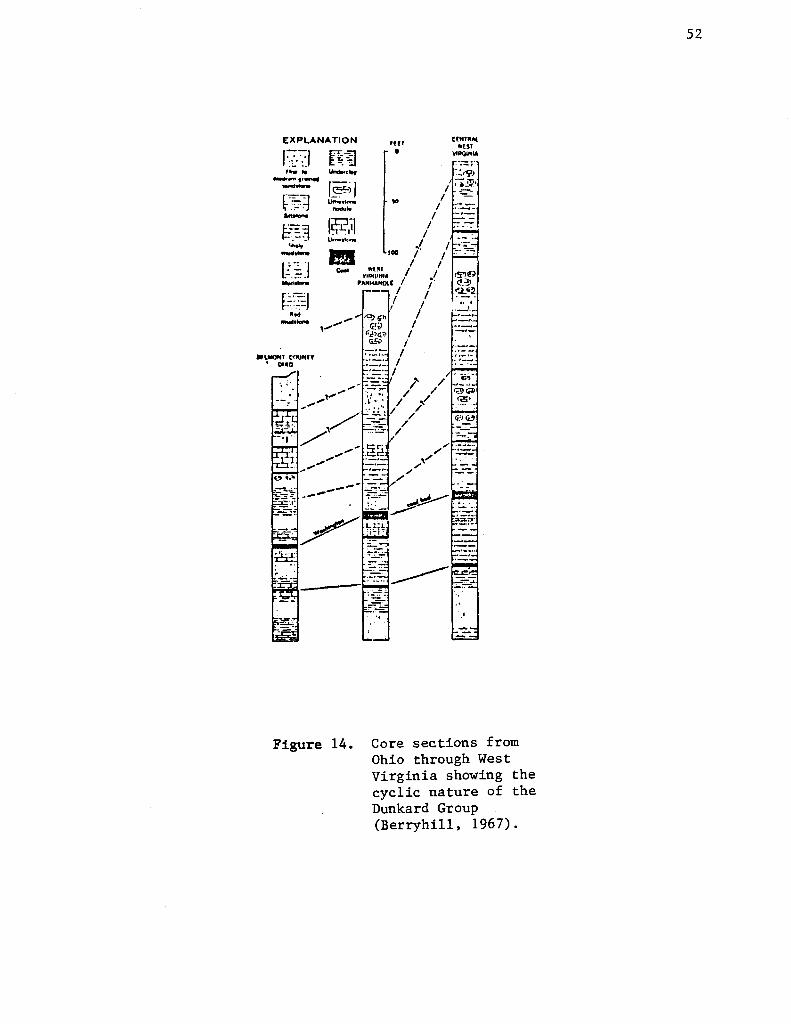
EXPLANATION
'--, .... ~:.: ~. ..... .... ""., .... -·-t51 ..,_ ~::! ...... --!~~.I --f,. _ _;J
• LMOJllf cnu"" ' OHO
-.... 1~;1 u...,,.,,. _.. ..
Figure 14.
•ur 0
"' I
I I
.I 100 /
"l" I VIAt;tNIA I
PANHAl<Ol[ I I
I
C(NlWAl •Uf
~IAQINIA
, ·-I
:.::Y> , .. ~·
I --/ -=-/ .·::..::-:
Core sections from Ohio through West Virginia showing the cyclic nature of the Dunkard Group (Berryhill, 1967).
52

53
various epei:tic seas transgressed and regressed over the Appalachian mobile belt
altenating periods of marine and terrestrial deposition occurred. The lati
tude of the Appalachians and the probable pattern of global winds indicate
that the climate was hot. Seasonally restricted rainfall occurred in the
Appalachians while in the north, rainfall was probably greater and more even
ly distributed throughout the year (Woodrow et al., 1973). The coastal
plain of the Appalachians was marked by a shifting shoreline throughout the
Paleozoic, characterized by low relief, and numerous permanent streams (Wood
row et a 1 • , 19 7 3) •
In the middle to late Paleozoic, there were well-developed lowlands ad
jacent to the coastal plains marked by meandering streams and relatively fine
grained sedimentation. The upland areas were characterized by braided streams
with a coarser sediment load (Woodrow et al., 1973). By the close of the
Paleozoic, the Appalachianswerea relatively-young mountainous landscape that
contained diverse flora and fauna.
The paleogeographic and paleoclimatic conditions which prevailed during
the Paleozoic may have been a perfect environment for the development of hema
tite-pigmented sediments (Bless et al. , 1984). Major red bed deposits occur
in the Ordovician, Silurian, and Devonian systems. In the Ordovician and De
vonian, red beds are dominantly continental in origin and result from the for
mation of large deltaic complexes (Turner, 1980). These complexes are the
Juniata-Queenston delta and Catskill delta, respectively. During the Silurian
Period, marine red beds predominated. The Late Ordovician Taconic orogeny
uplifted the Juniata-Queenston complex, which was rapidly eroded and deposited
in the transgressive Silurian sea (Ziegler and McKerrow, 1975). In the Late
Paleozoic, deposition of red beds are limited due to the cyclic nature of sed
imentation which resulted in alternate layers of thin carbonate and organic
sediments (Donaldson, 1969).

54
Without a doubt, the Paleozoic occurrence of widespread red-bed deposits
throughout the Appalachian Mountain region indicates a tropical environment,
showing a remarkable similarity to the depositional environment of
modern red beds (Woodrow et al., 1973). However, one cannot assume that
climate is the only factor. Many of these ancient red beds owe their pig
mentation to the postdepositional reddening effects of iron-bearing cements
(Pye, 1983). Thus, the tropical environment only enhanced the diagenetic
process. Nevertheless, red-pigmented rock types are indeed a common lithology
throughout the Paleozoic of the eastern United States. While some deposi
tional environments of red beds are thought to be understood, there are still
others whose depositional settings are still controversial.

REFERENCES CITED
Allen, J.R.L., and Friend, P.F., 1968, Deposition of the Catskill facies, Appalachian region -- with notes on some other Old Red Sandstone basins, in Klein, G. de V., ed., Late Paleozoic and Masozoic continental sedi;entation, northeastern North America: Geological Society of America Special Paper 106, pp. 21-74.
Arkle Jr., T., Beissell, D.R., Larese, R.E., Nuhfer, E.B., Patchen, D.C., Smonsa, R • .A., Gillespie, W.H., Lund, R., Norten, W., ;me! Pfefferkorn, H.W., 1979, Mississippian and Pennsylvanian (CarLunlfernus) Systems in the United States -- West Virginia and Maryland; U.S. Geological Survey Professional Paper 1110-D, 35p.
Bates, R.L., 1939, Geology of Powell Valley in northwestern Lee County Virginia; Virginia Geological Survey Bulletin 51-B, pp. 31-95.
Beerbower, J.R., 1969, Interpretations of cyclic Fermo-Carboniferous deposition in alluvial plain sediments in West Virginia: Geological Society of America Bulletin, v. 80, pp. ·1843-1848.
Berryhill, Jr., H.L., 1967, Paleotectonic investigations of the Permian System in the United States -- Allegheny region: U.S. Geological Survey Professional· Paper 514-A, pp. 1-13.
Bless, M.J.M., Bouchaert, J., and Paparoth, E., 1984, Migration of facies belts as a response to continental drift during the Late Devonian and Carboniferous: Bulletin van de Belgische Vereniging voor Geologie, v. 93, pp. 189-195.
Butts, C., and Gildersleeve, B., 1948, Geology and mineral resources of the Paleozoic area in northwest Georgia: Georgia Geological Survey Bulletin, no. 54, 176p.
Collins, H.R., 1979, Mississippian and Pennsylvanian (Carboniferous) Systems in the United States -- Ohio: U.S. Geological Survey Professional Paper 1110-E, 26p.
Colton, G.W., 1970, The Appalachian basin -- its depositional sequences and their geological relationships, in Fisher, G.W., ed., Studies of Appalachian geology - central and southern: New York, Interscience Publishers, pp. 5-47.
Cotter, E., 1978, The evolution of fluvial style, with special reference to the central Appalachian Paleozoic, in Miall, A.D., Fluvial sedimentology: Canadian Society of Petroleium Geologists, Memoir 5, pp. 361-383.
Donaldson, A.C., 1969, Ancient deltaic sedimentation (Pennsylvanian) and its control on the distribution, thickness, and quality of coals, in Donaldson, A.C., ed., Some Appalachian coals and carbonates -- models of ancient shallow-water deposition: West Virginia Geological and Economical Survey, pp. 93-123.

Dott Jr., R.H., and Batten, R.L., 1981, Evolution of the earth (third edition): New York, McGraw Hill Book Company, 573p.
Edmunds, 'lil.E .• , Berg, T.M., Sevon, W.D., Piotrowski;.R.C., Heyman, L., and Richard, L.V., 1979, Mississippian and Pennsylvanian (Carboniferous) Systems in the United States --Pennsylvania and New York: U.S. Geological Survey Professional Paper 1110-B, 33p.
Epstein, J.G., and Epstein, A.G., 1969, Geology of the Valley and Ridge province between Delaware Water Gap and Lehigh Gap, Pennsylvania, in Subitzky, S., ed., Geology of selected areas in New Jersey and eastern Pennsylvania and guidebook of excursions: Rutgers University Press, New Brunswick, New Jersey, pp. 132-205.
Faill, R.T., and Wells, R.B., 1974, Geology and mineral resources of the Millerstown Quadrangle, Perry, Juniata, and Snyder Counties, Pennsylvania: Pennsylvania Geological Survey Atlas 126, 276p.
Fisher, D.W., 1954, Stratigraphy of Medinan Group, New York and Ontario: American Association of Petroleum Geologists, V. 38, no. 9, pp. 1979-1996.
Fisher, D.W., 1957, Discussion of the Vernon Shale in the type area: New York State Museum Bulletin 364, pp. 3-30.
Gillette, T., 1940, Geology of the Clyde and Dodus Bay Quadrangels, New York: New York State Museum Bulletin 320, 179p.
Glaeser, J.D. , 1974, Upper Devonian stratigraphy and sedimentary environments in northeastern Pennsylvania: Pennsylvania Geological Survey Bulletin G-63, 89p.
Milici, R.C., Briggs, G., Know, L.M., Sitterly, P.D., and Statler, A.T., 1979, Mississippian and Pennsylvanian (Carboniferous) systems in the United States --Tennessee: U.S. Geological Survey Professional Paper 1110-G, 38p.
Neuman, R.B., 1955, Middle Ordovician rocks of the Tellico -Sevier belt, eastern Tennessee: U.S. Geological Survey Professional Paper 274-F, pp. 141-178.
Neuman, R.B., 1967, Bedrock geology of the Shin Pond arid Stacyville Quadrangles, Penobscot County, Maine: U.S. Geological Society Professional Paper 524-I, 37p.
Oliver Jr., W.A., Dewitt Jr., W., Dennison, J.M., Haskins, D.M., and Huddle, J.W., 1967, Devonian of the Appalachian basin, in Oswald, D.H., ed., The international symposium on the Devonian System,v. 1, pp. 1001-1040.
Palmer, A.R. , 1971, Cambrian of the new world, in Holland, CH., ed., Lower Paleozoic rocks of the world, pp. 169-218.
Pye, K., 1983, Red beds, in Goudie, A .. S., ed., Chemical sediments and residue in the near surface environment: New York, Academic Press, pp. 227-263.
Rice, C.L., Sable, E.G., Dever, Jr., G.R., and Kehn, T.M., 1979, Mississippian and Pennsylvanian (Carboniferous) Systems in the United States--Kentucky: U.S. Geological Survey Professional Paper 1110-F, 32p.
Rodgers, J., 1953, Geologic map of eastern Tennessee with explanitory text: Tennessee Division of Geology, Bulletin 58, part III, 156p.
Skehan, J.W., S.J., Murray, D.P., Hepburn, J.C., Billings, M.P., Lyons, P.L., and Doyle, R.G., 1979, The Mississippian and Pennsylvanian (Carboniferous Systems in the United States--Massachusetts, Rhode Island, and Maine: U.S. Geological Survey Professional Paper 1110-A, 30p.
Stauffer, C.R., and Schroyer, C.R., 1920, The Dunkard Series in Ohio: Ohio Geological Survey, 4th Series, Bulletin 22, 167p.
Swartz, C.K., and Swartz, F.M., 1941, Early Devonian and Late Silurian formations of southeast Pennsylvania: Geological Society of America Bulletin, v. 52, no. 8, pp. 1129-1192.
Swartz, C.K., 1942, Correlation of the Silurian formations in North America: Geological Society of America Bulletin, v. 53, no. 4, pp. 533-538.
Ulrich, E.O., and Bassler, R.S., 1923, American Silurian formations, Paleozoic ostracada; their morphology, classification, and occurence: Maryland Geological Survey, Silurian, 794p.
Ward, F., 1938, Recent geologic history of the Delaware Valley below the Water Gap: Pennsylvania Geological Survey, 4th Series, Bulletin G-10, 76p.
Willard, B., 1939, The Devonian of Pennsylvania--Middle and Upper Devonian: Pennsylvania Geological Survey, 4th Series, Bulletin G-19, 48lp.
Willard, B., and Cleaves, A.B., 1939, Ordovician-Silurian relations in Pennsylvania: Geological Society of America Bulletin, v. 50, no. 7 PP• 1165-1198.
Wilson, Jr., C.W., 1949, Pre-Chattanooga stratigraphy in eastern Tennessee: Tennessee Division of Geology Bulletin 56, 407p.
Woodrow, D.L., Fletcher, F.W., and Ahrnsbrak, W.F., 1973, Paleogeography and paleoclimate at the deposition sites of the Devonian Catskill and Old Red facies: Geologic~! Society of America Bulletin, v. 84, no. 9, pp. 3051-3063.
Woodward, H.P., 1941, Silurian system of West Virginia: West Virginia Geological Survey, v. 14 , 326p.
Woodward, H.P., 1943, Devonian of West Virginia: West Virginia Geological Survey, v. 15, 655p.
Woodward, H.P., 1951, Ordovician system of West Virginia: West Virginia Geological Survey, Vol. 21 , 627p.
Ziegler, A.M., and McKerrow, W.S., 1975, Silurian marine red beds: American Journal of Science, v. 275, pp. 31-56.
Recommended