© 2013 TGS-NOPEC GEOPHYSICAL COMPANY ASA. ALL RIGHTS RESERVED. © 2013 TGS-NOPEC GEOPHYSICAL COMPANY ASA. ALL RIGHTS RESERVED.WWW.TGS.COM WWW.TGS.COM
TGS | SUNDALAND MARGIN FEBRUARY 2013 TGS | SUNDALAND MARGIN FEBRUARY 2013
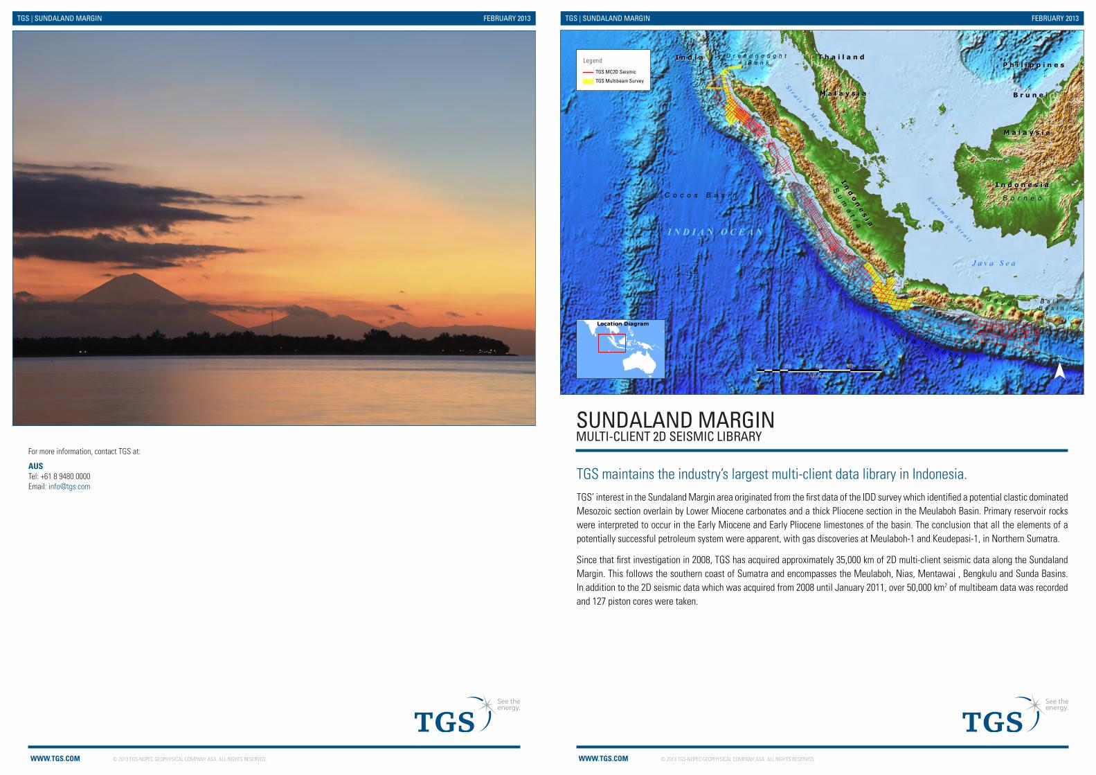
SUNDALAND MARGINMULTI-CLIENT 2D SEISMIC LIBRARY
TGS maintains the industry’s largest multi-client data library in Indonesia. TGS’ interest in the Sundaland Margin area originated from the first data of the IDD survey which identified a potential clastic dominated Mesozoic section overlain by Lower Miocene carbonates and a thick Pliocene section in the Meulaboh Basin. Primary reservoir rocks were interpreted to occur in the Early Miocene and Early Pliocene limestones of the basin. The conclusion that all the elements of a potentially successful petroleum system were apparent, with gas discoveries at Meulaboh-1 and Keudepasi-1, in Northern Sumatra.
Since that first investigation in 2008, TGS has acquired approximately 35,000 km of 2D multi-client seismic data along the Sundaland Margin. This follows the southern coast of Sumatra and encompasses the Meulaboh, Nias, Mentawai , Bengkulu and Sunda Basins. In addition to the 2D seismic data which was acquired from 2008 until January 2011, over 50,000 km2 of multibeam data was recorded and 127 piston cores were taken.
AUS Tel: +61 8 9480 0000Email: [email protected]
For more information, contact TGS at:
I n d o n e s i aI n d o n e s i a
M a l a y s i aM a l a y s i a
T h a i l a n dT h a i l a n d
B r u n e iB r u n e i
I n d i aI n d i aP h i l i p p i n e sP h i l i p p i n e s
In
do
ne
si a
In
do
ne
si a
M a l a y s i aM a l a y s i a
C o c o s B a s i n
J a v a T r e n c h
B a l i B a s i n
D r e a d n o u g h t B a n k
Su
ma
t r a
B o r n e o
J a v aS t r a i t o f M
a l a c c a
K a r a ma t a S t r a i t
J a v a S e a
I N D I A N O C E A N
Legend
TGS MC2D Seismic
TGS Multibeam Survey
¯Last Modified 11/02/2013 at 12:42 PM by mariroslW:\NEW_GIS\WORKSPACE\Asia_Pacific\2013_02_07_MARKET_Promotional_Maps_2013_MB\TGS_MARKET_A4_Sundaland_Margin_Brochure_V1_MR_20130211.mxd
Location Diagram
0 200 400 600 800
Kilometres
© 2013 TGS-NOPEC GEOPHYSICAL COMPANY ASA. ALL RIGHTS RESERVED.WWW.TGS.COM
TGS | SUNDALAND MARGIN FEBRUARY 2013
Bengkulu Basin
Northwest Sumatra Multibeam
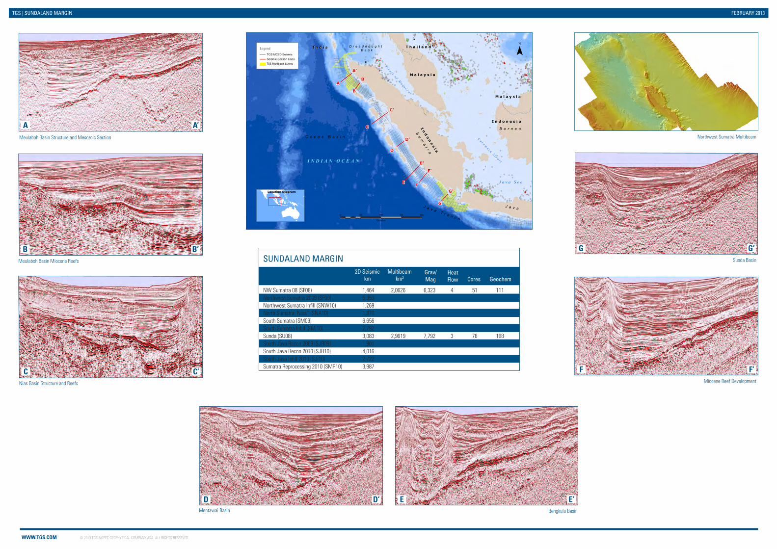
SUNDALAND MARGIN
NW Sumatra 08 (SF08) 1,464 2,0626 6,323 4 51 111 Northwest Sumatra 2009 (SF09) 5,353 Northwest Sumatra Infill (SNW10) 1,269 North Sumatra ‘Nias” (SNA10) 1,870 South Sumatra (SM09) 6,656 South Sumatra Infill (SMi10) 2,792 Sunda (SU08) 3,083 2,9619 7,792 3 76 198 South Java Recon 2009 (SJR09) 1,901 South Java Recon 2010 (SJR10) 4,016 South Java Infill 2010 (SJi10) 2,722 Sumatra Reprocessing 2010 (SMR10) 3,987
2D Seismic km
Multibeam km2
Grav/Mag
HeatFlow Cores Geochem
Mentawai Basin
ED’ E’
Miocene Reef Development
F F’
Sunda Basin
G G’Meulaboh Basin Miocene Reefs
B B’
Meulaboh Basin Structure and Mesozoic Section
A A’
Nias Basin Structure and Reefs
C C’
D
I n d o n e s i aI n d o n e s i a
M a l a y s i aM a l a y s i a
T h a i l a n dT h a i l a n d
B r u n e iB r u n e i
I n d i aI n d i aP h i l i p p i n e sP h i l i p p i n e s
In
do
ne
si a
In
do
ne
si a
M a l a y s i aM a l a y s i a
C o c o s B a s i n
J a v a T r e n c h
D r e a d n o u g h t B a n k
Su
ma
t r a
B o r n e o
J a v a
S t r a i t o f Ma l a c c a
K a r a ma t a S t r a i t
J a v a S e a
I N D I A N O C E A N
B'
B
A
A'
C
C'
D'
D
E'
EF
F'
G'
G
Legend
TGS MC2D Seismic Seismic Section LinesTGS Multibeam Survey
¯
Last Modified 13/02/2013 at 10:15 AM by mariroslW:\NEW_GIS\WORKSPACE\Asia_Pacific\2013_02_07_MARKET_Promotional_Maps_2013_MB\TGS_MARKET_A4_Sundaland_Margin_Inside_Brochure_V1_MR_20130213.mxd
Location Diagram
0 200 400 600 800
Kilometres
Recommended