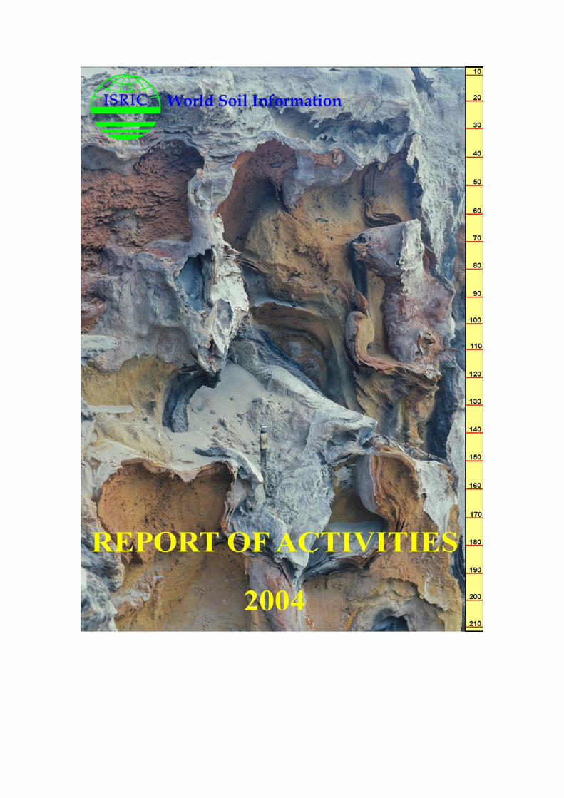
The International Soil Reference and Information Centre is an independent foundation receiving funds from the Dutch Ministry of Education, Culture and Science. ISRIC – World Soil Information is registered with the Benelux-Merkenbureau. Copyright © 2005, ISRIC – World Soil Information All rights reserved. No part of this publication may be reproduced, stored in a retrieval system, or transmitted in any form or by any means, electronic, mechanical, photocopying or otherwise, without the prior permission of the copyright owner. Applications for such permission, with a statement of the purpose and extent of the reproduction, should be addressed to the Director, ISRIC - World Soil Information, PO Box 353, 6700 AJ Wageningen, The Netherlands. Correct citation ISRIC 2005. Report of Activities 2004. ISRIC – World Soil Information, Wageningen Inquiries c/o Director, ISRIC – World Soil Information PO Box 353 6700 AJ Wageningen The Netherlands Telefax: +31-(0)317-471700 E-mail: [email protected] Front cover: Giant Podzol in Pleistocene coastal sands, northern New South Wales, Australia. During
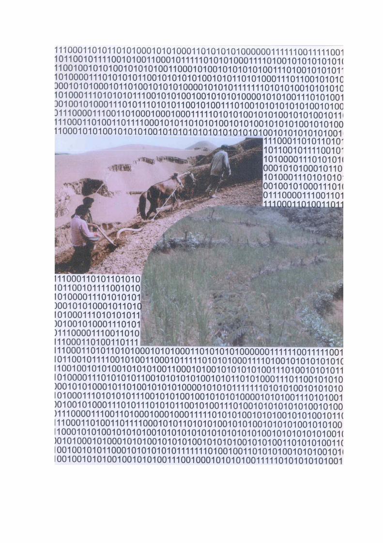
2004 reference soils were collected from Australia and Iceland Back cover: 1) Why the Yellow River is yellow! Ploughing and sowing wheat on the Loess Plateau,
China. Soil erosion is exacerbated by lack of ground cover at the onset of the rains and cultivation up-and-down slope. 2) Management to increase infiltration held in the soil and accessible to plants (green water) and recharges groundwater and stream base flow (blue water). Pilot studies for a global assessment of land degradation and improvement were undertaken during 2004 in northern China, straddling the Loess Plateau and Mu Us Desert.
Contents
INTRODUCTION ........................................................................................... 1 1 WORLD SOIL MUSEUM: INFORMATION AND EDUCATION........................... 3
• Educational program ...................................................................... 3 • Lectures and Courses ..................................................................... 3 • Conferences.................................................................................. 4 • Publications .................................................................................. 4 • Projects in 2005 ............................................................................ 4
2 WORLD DATA CENTRE FOR SOILS........................................................... 5
• Holdings of the World Data Centre for Soils ....................................... 5 • Documentation.............................................................................. 6 • World Reference Base for Soil Resources........................................... 7 • Internet ....................................................................................... 7 • Projects in 2005 ............................................................................ 8
3 APPLIED RESEARCH.............................................................................. 9 Development and use of soil and terrain databases - SOTER....................... 9 • Harmonized SOTER database .......................................................... 9 • National-scale activities ................................................................ 10
Land resources conservation and degradation......................................... 10 • World Overview of Conservation Approaches and Technologies
(WOCAT).................................................................................... 10 • Soil and Water Protection (SOWAP)................................................ 10 • Green Water ............................................................................... 11 • Assessment of soil organic carbon stocks and change at national scale
(SOC-GEF) ................................................................................. 12 • Global data set of soil parameter estimates ..................................... 12 • Bioinvasion ................................................................................. 12 • Projects 2005.............................................................................. 12
Other activities................................................................................... 13 • International Union of Soil Sciences and Dutch Society of Soil Science. 13 • Consultancies.............................................................................. 13
4 PUBLICATIONS................................................................................... 15 5 TRAVEL AND MEETINGS ...................................................................... 19 6 PERSONNEL....................................................................................... 23
• Board of Trustees ........................................................................ 23 • Staff .......................................................................................... 23 • Guest researchers........................................................................ 24 • Honorary Fellows......................................................................... 24 • Staff Development ....................................................................... 24
LIST OF ACRONYMS.................................................................................... 25

INTRODUCTION
Science should inform policy and management. But, first, the scientific information has to be carried to the point of decision. Rarely is this done by the scientists themselves; the result is confusion and frustration - on both sides. This year, we have grasped this nettle with new, policy-relevant research that is firmly grounded on physical principles and fundamental soil data and, also, direct participation in international policy-making. New research initiatives in train include: 1) Global Assessment of Land Degradation and Improvement (GLADA) and 2) Green Water Credits, to develop a global facility for paying land managers for hitherto unrecognized water management services - introducing market forces into environmental management. GLADA is a quantitative assessment and monitoring program using satellite data, approved by the Global Environment Facility as part of the Land Degradation Assessment in Drylands (LADA) program of FAO. A pilot has been completed in northern China and the project is expected to start in late 2005 in partnership with the Centre for Geo-Information in Wageningen. Green Water Credits is being developed in partnership with the International Fund for Agricultural Development (IFAD) and several national donors. Everyone knows that soils yield crops and natural vegetation but they also yield water. Most of the world’s fresh water is green water held in the soil and accessible to plants; soils also deliver blue water that can be tapped for irrigation and burgeoning cities, and that maintains the ecosystems underpinning economies and societies. So farmers and graziers are also water managers – unrecognized, unrewarded. Green Water Credits is a mechanism to pay them for specified water management activities, diversifying the income of poor rural people and enabling them to manage the resource better – for example to make use of the experience of soil and water management held within the World Overview of Conservation Approaches and Technologies. ISRIC – World soil Information and IFAD held a side event at the FAO-Netherlands Conference on Water for Food and Ecosystems out The Hague, January 2005 to mobilize political support for this program. In support of the European Union thematic soils strategy, we took part in scientific conclaves in Vienna and the advisory meeting for national heads of soil policy under the Netherlands Chairmanship of the EU, in Scheveningen in November 2004. Ways of carrying information about soils into the public arena were also discussed within the IASUS group of concerned scientists. The Intergovernmental Panel on Climate Change has demonstrated the value of authoritative, apolitical advice to inform policy and, ultimately, action. Land and water resources cry out for the same attention; still, there is only lukewarm support for an intergovernmental panel on soils - responsibilities remain parochial and there is not yet a heavyweight international champion. A different approach is being taken by the international earth sciences societies. A Draft Resolution adopted by the governing council of UNESCO invites the Director General to ‘support all efforts leading to the United Nations General Assembly declaring 2007 the International Year of Planet Earth’. This will be a world-wide
INTRODUCTION 1
program of research and, perhaps more importantly, public information and participation. Ten themes range from Environmental Hazards to Megacities. ISRIC – World Soil Information, representing the International Union of Soil Sciences, has taken the lead in the theme Soil - Earth‘s Living Skin. In our traditional fields of activity, this has been a year of re-tooling. We are making our collections better and more accessible to more people: bringing collections up-to-date and digitizing our holdings so that they may be searched and studied on-line. This work is not glorious but it is essential. Work has begun, in earnest, on the ISRIC World of Soils - an educational web site drawing upon our unique reference collections. The first step has been the conversion of the ISRIC soil profile database (ISIS) into structured query language (SQL) so that it may be queried to illustrate various themes; this will also enable web delivery of the original data as part of the services of the World Data Centre for Soils. Maybe it was inevitable that the translation of the databases proved to be more complex than anticipated; at least the rethinking and reworking has resulted in a more robust tool. In the same vein, it is good to be able to report collaboration with the European Soil Bureau in the digitization of our map holdings; all of Africa is now complete and publicly available as a set of DVDs. We were pleased to be able to add to our global micromorphology collection the Jongerius-STIBOKA collection - 14 000 large thin sections representing the soils of the Netherlands. Work is now in hand to prepare a common catalogue and facilities for microscopy have been refurbished. The micromorphology collection is a unique resource for research across a range of issues from biodiversity to climatic change, to human impacts on hydrology and water resources. It is a particular pleasure to report the election of three Honorary Fellows, all of whom have close ties with FAO: Prof. Rudy Dudal, Prof. Klaas-Jan Beek, and Dr Robert Brinkman. The Chairman of the Board of Trustees, Dr Stein Bie, made presentations to the new Fellows and to Mrs Willemijn Sombroek, widow of our first honorary fellow Dr Wim Sombroek, during the ISRIC seminar on Applications of airborne and satellite imagery to assessing land and water resources. Finally, a Memorandum of Understanding was signed with the Food and Agriculture Organization of the United Nations, reflecting our partnership since the foundation of the Institute and the scope of current work together. It is now up to us and our international partners to make the agreement a driving force of research that makes a difference. David Dent 18 March 2005
2 REPORT OF ACTIVITIES 2004
1 WORLD SOIL MUSEUM: INFORMATION AND EDUCATION
One of our goals is to set world standards in collection, maintenance and exhibition of a comprehensive reference collection of the soils of the world. More than this, the collection should be an accessible, exciting resource to inform, to educate, and to entertain. Educational activities have continued to expand, embracing visiting groups from universities and polytechnics in Western Europe, school parties from our own locality, and the general public. Few of these visitors are interested primarily in pedology but, rather, a broad school of environmental sciences, both the built and natural environment. We are following up their comments to improve our exhibition and the supporting information. The World Reference Base for Soil Resources is being introduced as the primary technical classification and, at the same time, we are providing a coherent system of common names in plain English. Educational program
In 2004, some 40 groups with students, teachers and others visited the World Soil Museum. Most took advantage of an introductory lecture and a guided tour through the exhibition; 5 groups also undertook half-day field excursions. Eight German universities visit the World Soil Museum every year, usually spending one or two days with us. Other foreign university groups came from Portsmouth (UK) and Leuven (Belgium). About one-third of our student visitors are from Wageningen; exercises in the museum are now part of at least three regular courses of Wageningen University. More than 250 visitors came from The Netherlands. These included university, college and high school students, as well as visits from PROBUS and members of the general public. Lectures and Courses
Alfred Hartemink organised two courses: Introduction to Soil Science for high school geography teachers; Trends and ethics in scientific publishing for the PE&RC research school - this course will be given twice per year; also a two-day excursion to Limburg for IHE-UNESCO, Delft, and an annual lecture at Gent University. Along with David Dent, he supervised several Wageningen University MSc and PhD students. Sjef Kauffman lectured on Green Water and demonstrated evaporation-transpiration relationships to participants of the annual ILRI Land Drainage course.
WORLD SOIL MUSEUM 3
Otto Spaargaren gave a course on soil survey to the European Summer School at Ispra, in Italy, and a two-week course on SOTER methods and applications for the University of Zagreb and the Ministry of Physical Planning in Croatia. He also lectured on Drainage Characteristics and Soil Properties to the ILRI Land Drainage course. The Netherlands Commission for UNESCO endorsed a proposal from ISRIC to host a UNESCO Chair in Land Resources to act as a focal point international training. Conferences
A seminar – Applications of airborne and satellite imagery: assessing land and water resources – was held on 26 February 2004, with some 60 participants. Papers will be included in a forthcoming special edition of Applied Earth Observation and Geoinformation. Publications
Alfred Hartemink is review editor of Geoderma with overview of discussion papers and book reviews and Co-editor in Chief of Developments in Soil Science. David Dent is an Associate Editor of Soil Use and Management. Projects in 2005
1. Exhibition: Thematic arrangement including representation of the World Reference Base for Soil Resources
2. World of Soils: Exhibition and educational material on the world-wide-web 3. Education: Visiting groups, courses, research students 4. Rwanda Agroforestry and Soil Management, MSc: In partnership with
Wageningen University 5. International Year of Planet Earth 6. Publications: policy briefs, Booker Soil Manual
4 REPORT OF ACTIVITIES 2004
2 WORLD DATA CENTRE FOR SOILS
World Data Centres operate under the International Council for Science to support the scientific community, in particular ICSU programs in global change, climate and the environment. Data from ICSU programs and related data sets are maintained and made freely available. These days, less and less new soil data and information are being produced; the older data and information being pumped around more and more. Therefore, it is vital to preserve the older data that are the foundation of most current information. The December 2004 report of the ICSU Committee on Scientific Planning and Review (CSPR) on Scientific Data and Information also makes the point: ‘Many types of data, including extant historical data, which have newly appreciated scientific importance for the analysis of changes over time, are not being used for research because they are not available in digital formats. Digitization, data rescue, transcribing, and improved management of traditional or historical data are necessary to preserve these types of data for current and future scientific research.’ All users of soil and land resources information need easy access to that source material, if only to assess the reliability of the derived information. We are responding with a major program to digitise our holdings and make them available through the world-wide web. Maintenance and completion of the data, verification, and continual acquisition of new data from international programs is the task of the Word Data Centre. Making the data work is the goal of our Applied Research Program. Holdings of the World Data Centre for Soils
• World Soil Reference Collection: since its establishment, a main task of the Institute has been to create and maintain a world soil reference collection and accompanying analytical information. The World Soil Reference Collection comprises about 950 profiles: physical representatives of the mapping units of the FAO-UNESCO Soil Map of the World. This is a unique educational and cultural resource. In 2004, seven new profiles were collected from Iceland, including the three European Reference Andosols; four from the Netherlands, including one from under a Hilversum pavement; one from Italy, which was used as an instruction profile during the European summer school on Soil Survey; one from England; and five from Queensland, Australia.
• ISIS dataset: computerised data management system holding data on the
World Soil Reference Collection. ISIS has been operational since 1986; data for some 80 reference soils were added in 2004. Some 880 reference soil profiles are currently available in an MS-Access database; conversion to SQL will be complete early in 2005.
WORLD DATA CENTRE 5
• WISE dataset: data from selected soil profiles compiled for global climatic change studies. These are continually updated. Subsets include: - Publicly accessible WISE Global Soil Profiles: a harmonized set of 4382
profiles suitable for a wide variety of environmental studies; - A working data set of more than 9500 profiles. In 2004, this dataset was
used in the development of taxotransfer functions for preparing secondary SOTER databases.
• SOTER datasets: South and Central America, Central and Eastern Europe, and
Southern Africa – comprising spatial mapping units and geo-located point data at scales from 1:1million to 1:5 million. Data for Brazil, Kenya, Southern Africa, and the Gangetic Plain of India were harmonised by filling gaps in measured data using taxotransfer and expert rules. Boundaries have been re-located according to the standards of the Digital Chart of the World.
• Reference soil samples: ISIS profiles soil samples, fully analysed by standard
methods. Full documentation and an on-line catalogue of these 5000 samples were completed in July 2004.
• Micromorphology collection: A unique collection of the major soils of the
world, comprising: - Systematic collection of large thin sections from the ISIS profiles; - Schmidt-Lorentz collection of more than 15 000 small thin sections of soils,
mainly from Europe, Africa, Asia and Australia; - Jongerius-STIBOKA collection of some 14 000 samples, mostly large thin
sections and blocks, mainly from the Netherlands, added in November 2004. A common catalogue is in preparation and facilities for the study of thin sections have been expanded.
• Kubiena collection: samples from 11 profiles from Russia in display boxes • Mohr collection: hundreds of display boxes with soil materials, mainly from
the former Dutch East Indies and Africa • Colour transparencies: 20 000 items including systematic photographic
records of sites and profiles of the ISIS data set Documentation
ISRIC maintains a systematic collection of soil maps and reports including the so-called grey literature, specialist texts, and journals that hold important contributions to soils and land resources survey, especially from tropical countries. Negotiations are in hand with UNESCO and Wageningen University Library to establish a scholarship for information specialists from developing countries to gain experience in managing scientific documentation. It is anticipated that this will be operational in 2005. We are cooperating with the European Soil Bureau at Ispra, in Italy, to make digital copies of all ISRIC map holdings. Thematic/geographic collations will be available on DVD and good quality paper copies can be printed, on request. Our collection from Africa is completed and will be launched by the UNCCD in 2005. 6 REPORT OF ACTIVITIES 2004
World Reference Base for Soil Resources
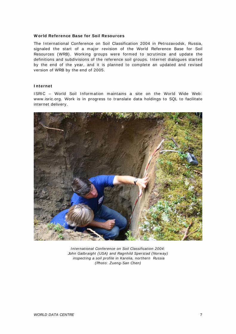
The International Conference on Soil Classification 2004 in Petrozavodsk, Russia, signaled the start of a major revision of the World Reference Base for Soil Resources (WRB). Working groups were formed to scrutinize and update the definitions and subdivisions of the reference soil groups. Internet dialogues started by the end of the year, and it is planned to complete an updated and revised version of WRB by the end of 2005. Internet
ISRIC – World Soil Information maintains a site on the World Wide Web: www.isric.org. Work is in progress to translate data holdings to SQL to facilitate internet delivery.
International Conference on Soil Classification 2004: John Galbraight (USA) and Ragnhild Sperstad (Norway)
inspecting a soil profile in Karelia, northern Russia (Photo: Zueng-San Chen)
WORLD DATA CENTRE 7
Projects in 2005
1. Geoloket – Transformation of databases, maps and documents for on-line delivery; linkage with other geo-data providers; in partnership with Wageningen UR Centre for Geo-Information
2. Map and document catalogue and search facility 3. Map collection digitisation – In partnership with the European Soil Bureau 4. Reference photo collection – Documentation and digitisation 5. Reference soil sample collection – On-line catalogue, relocation to a secure site 6. Guidelines for Soil Profile Description – Fourth edition to be published by FAO,
September 2005 7. World Reference Base for Soil Resources (WRB) – Revision and expansion as
the international soil classification for publication by FAO 2006 8. Reference monolith collection – Maintenance, acquisition to fully represent
WRB: completion of Andosols 9. ISIS database – Conversion to SQL and link to ISRIC World of Soils 10. Common digital data management system 11. Micromorphology collection – Common catalogue
8 REPORT OF ACTIVITIES 2004
3 APPLIED RESEARCH
Fundamental data are vital but they are not enough: 'Soil by itself does not fly'. Its importance lies in context and that means applications. The Applied Research program makes extensive use of our databases and compiles such data in support of land use planning and policy, assessment of food and water security, the efficient development of infrastructure, and predictive models for global climatic change. This year, SOTER databases have been used in studies of the impact of desertification on food security in Zimbabwe; in assessments of soil carbon stocks in Amazonian Brazil, Kenya, Jordan and India. The WISE database has been used in the improved version of the SOTER database of Southern Africa, and for soil parameter inputs to the RIVM IMAGE model of global environmental change. Appreciation is also being raised, world wide, of the interdependence of soils, their use and management, and water resources - in the creation of green water, held by soils and available in situ to plants, and the delivery of blue water that can be tapped for use elsewhere for irrigation, domestic and industrial supply, and environmental flows.
Development and use of soil and terrain databases - SOTER
SOTER is a long-standing program of IUSS, FAO, ISRIC and UNEP to develop a global, soil and terrain spatial database, compiled according to standard procedures. To date, about half of the world has been covered at scales between 1:1M and 1:5M; also, several larger scale national surveys have been completed. A second edition of the SOTER handbook will be published in 2005. Landform units, formerly difficult to quantify, have now been defined by four quantitative attributes derived from digital elevation models (DEMs). A case study based on the 1 km ETOPO30 grid was presented during an international conference on innovative techniques in soil survey in Thailand (van Engelen and Huting 2004); a further case study using the 90 m SRTM DEM and comparison with the coarser DEM was shown during the Eurosoil conference in Germany. The method was evaluated and a further testing program defined during a workshop in cooperation with the European Soil Bureau. Harmonized SOTER database
In the framework of a project with FAO, parameter estimates for 18 soil attributes are being generated for all existing regional and continental SOTER and similar databases using the procedure developed by Batjes (2003); parameters are generated according to the taxonomic similarity between soil profiles lacking particular data and the comprehensive set of profile data in the WISE database.
APPLIED RESEARCH 9
National-scale activities
Most activities described at continental scale actually started with a SOTER program at national scale, involving the national soil survey organisations supported by ISRIC. - Impact of Desertification on Food Security in Southern Africa: a Case Study for
Zimbabwe. Under a UNEP project, the national SOTER database at a scale of 1:1 million has been used to assess the production levels of maize under present circumstances of low inputs and simple technology. A further assessment has been made of the impact of soil erosion over a 20-year period on future maize production (van Engelen et al. 2004).
- The SOTER databases of Nepal (scale 1:250 000) and Iran (1:1M) have been
compiled by the national institutes, with some support from ISRIC.
Land resources conservation and degradation
World Overview of Conservation Approaches and Technologies (WOCAT)
WOCAT is a global network of soil and water conservation specialists that share their expertise and experience of sustainable land management and make it available for planners and decision makers. ISRIC's contribution is in coordination, development of methodology, and production of the WOCAT newsletter. Godert van Lynden continued coordinating network activities, co-organised the Annual Workshop and Steering Meeting in China (November), gave a training course in Bangladesh (March) and contributed to the regional HIMCAT meeting in Nepal (March). Soil and Water Protection (SOWAP)
SOWAP is a joint project for environmental protection in Belgium, Hungary and the UK, funded by the EU and Syngenta. Godert van Lynden was responsible for developing, coordinating and implementing the dissemination strategy and WOCAT activities within SOWAP – including a training course in Leuven (April). He attended plenary meetings in Leuven (February) and Stamford (October).
10 REPORT OF ACTIVITIES 2004
Green Water
A pilot study of the Save basin, Zimbabwe, used the regional soils and terrain database SOTERSAF, climatic data and the world soil and water conservation database (WOCAT) to analyze water flows under various soil and crop management scenarios. The WOFOST simulation model was used to calculate crop yields and components of the water balance. Soils and farmers’ use of green water management techniques such as minimum tillage, mulching, tied ridging, terracing, and crop management determine the partitioning of rainwater into runoff, green water, and groundwater recharge.
Green and blue water flow maps under various soil water management scenarios, Save basin, Zimbabwe
(Kauffman et al. 2004)
APPLIED RESEARCH 11
Assessment of soil organic carbon stocks and change at national scale (SOC-GEF)
This project is co-funded by GEF (2002-2005) and implemented by UNEP. It aims to develop tools to quantify the impact of land management and climatic scenarios on change in soil carbon stocks at national and sub-national level. Scientists from Brazil, India, Jordan, and Kenya are working with data management and modelling groups in Austria, France, the Netherlands (ISRIC), the United Kingdom, and USA. ISRIC’s input is funded by the Dutch Ministry of VROM. Niels Batjes with national partners completed the secondary SOTER databases for Kenya, Brazil and the Indo-Gangetic Plains of India. These secondary data sets were used to estimate national-scale carbon stocks. Changes in stocks of soil organic carbon according to land use and management were projected empirically using Kenya as a case study. Other groups within the consortium will use the secondary SOTER data to quantify the impact of defined land use changes on carbon stores in soils in the four countries, using dynamic models. Global data set of soil parameter estimates
Niels Batjes prepared a harmonized global set of soil parameter estimates, at a resolution of 5 by 5 arc-minutes, for use with RIVM’s IMAGE model. The data set was derived from a combination of soil geographic data from the FAO 1:5M scale digital Soil Map of the World and soil parameter estimates derived from the WISE soil profile database. A standardized procedure for filling gaps in measured data in primary SOTER databases, elaborated in the framework of the SOC-GEF project, was applied to the Soil and Terrain database for Southern Africa at 1:1 and 1:2M scale. The resulting secondary data set, comprising estimates for 18 soil parameters commonly required for environmental modelling, is available through ISRIC website. Bioinvasion
Alfred Hartemink spent three weeks at the Australian National University in Canberra to map and assess the degree of invasion of Piper aduncum in Papua New Guinea. Projects 2005
1. SOTER Procedures manual 2. Harmonized SOTER databases – Co-funded by FAO 3. DEM landforms analysis - Procedures development 4. SOTER Latin America update - Redefinition of landform units 5. Andean carbon sequestration - Partnership with CSEQ 6. Soil organic carbon stocks and change (SOC-GEF) - Funded by Dutch Ministry of
Housing, Spatial Planning and the Environment 7. Spatial WISE-based data set 8. Soil and Water Protection (SOWAP) - Funded by Syngenta
12 REPORT OF ACTIVITIES 2004
9. World Overview of Conservation Approaches and Technologies (WOCAT) Partnership with CDE, Bern, funded by Syngenta
10. Land evaluation, Cambodia - Support to Ministry of Planning and Cambodian Agricultural Research and Development Institute, funded by GTZ
11. Chittagong Hills land use planning (CHARM) – Funded by the EU 12. Green water pilot, Tugela Basin, South Africa: Testing dynamic hydrological
models with regional SOTER data 13. Green water pilot, Save Basin, Zimbabwe 14. Green Water Credits 15. Global assessment of land degradation and improvement
Other activities
International Union of Soil Sciences and Dutch Society of Soil Science
Alfred Hartemink is Deputy Secretary General of the International Union of Soil Sciences. During 2004, IUSS bulletins 104 and 105 were edited, printed and mailed, and the website was expanded; during 2004 the number of visitors was 50 000. For the Dutch Society of Soil Science (NBV), newsletters XI and XII were edited, two thematic days organised, a financial overview 2001-03 presented to the general meeting, and the website updated and expanded. Stephan Mantel has been appointed Secretary/Treasurer for NBV, as of January 2005, as successor of Alfred Hartemink. Consultancies
David Dent conducted an independent scientific review of the remediation by controlled tidal flooding of acid sulphate soils at East Trinity, near Cairns, Queensland. Also, he participated in a national forum on Land Evaluation in Phnom Penh, Cambodia, and provided expert advice for policy development through GTZ and AUSAID. Alfred Hartemink undertook an evaluation of IITA projects in Eastern and Southern Africa. Vincent van Engelen made an evaluation of the SOTER database compilation of Libya by ACSAD, Damascus.
APPLIED RESEARCH 13
14 REPORT OF ACTIVITIES 2004
4 PUBLICATIONS
Papers in primary journals
Batjes NH 2004. Estimation of soil carbon gains upon improved management within croplands and grasslands of Africa. Environment, Development and Sustainability 6, 133-143
Batjes NH 2004. Soil carbon stocks and projected changes according to land use and management: a case study for Kenya. Soil Use and Management 20, 350-356
Cresswell RG, Dent DL, Jones G and Galloway D 2004. Three-dimensional mapping of salt load in the Murray-Darling Basin, 1 Steps in calibration of airborne electromagnetic surveys. Soil Use and Management 20, 133-143
Hartemink AE 2004. Nutrient stocks of short-term fallows on high base status soils in the humid tropics of Papua New Guinea. Agroforestry Systems 63, 33-43
Hartemink AE 2004. Soils of the Tropics. Geoderma 123, 373-375 (extended book review)
Contributions to edited books
Deckers J, Spaargaren O and Dondeyne S 2004. Soil Survey as basis for land evaluation. In: Land cover and land use of the Encyclopedia of Life Support Systems (EOLSS), UNESCO/ EOLSS Publishers, Oxford [http://www.eolss.net]
Dent DL 2004. Air photography. In: McKenzie NJ, Ringrose-Voase AJ and Grundy MJ (editors) Australian soil and land survey handbook, Guidelines for conducting surveys, 2nd edition. CSIRO, Canberra, Ch22
Hartemink AE 2004. Soil fertility research in tropical and temperate regions – achievements and differences. In: Bationo A, Kimetu J and Kihara J (editors) Improving human welfare and environmental conservation by empowering farmers to combat soil fertility degradation. TSBF, Nairobi, 6-7
Contributions to conference and workshop proceedings
Deckers J, R Dudal, F Nachtergaele, O Spaargaren and Berding F 2004. Towards a revised WRB-2006: A proposal for non-exhaustive lists of qualifiers and ranking principles. In: Krasilnikov PV (editor) Soil classification 2004, Petrozadvodsk, Russia, 16-17
Dent DL 2004. Earning our salt: new techniques to assess land and water resources. In: Eswaran, H, Vijarnsorn P, Vearasilp T and Padmanabhan E (editors) Innovative techniques in soil survey: developing the foundation for a new generation of soil resource inventories and their utilization. Land Development Department, Chattuchak, Bangkok, 287-298
Dent DL, Cresswell RG, Macaulay S, Kellett J, Mullen I and Jones G 2004. Putting salt on the map. Supersoil 2004 abstracts, 3rd Australian and New Zealand Soils Conference, Sydney 71-2
Engelen VWP van and Huting JRM 2004. The use of DEMs in SOTER: a tool for delineation of landform for soil and terrain databases. In: Eswaran H, Vijarnsorn P, Vearasilp T and Padmanabhan E (editors) Innovative techniques in soil survey. Land Development Department, Chattuchak, Bangkok, 153-159
Hartemink AE 2004. Soil fertility decline on agricultural plantations in the tropics. Proceedings IFA Regional Conference for Asia and the Pacific. IFA, Paris
PUBLICATIONS 15
Kauffman J, Mantel S and Dijkshoorn JA 2004. Applications of regional soil and terrain and soil management databases for green and blue water resource scenarios. In: 14th Stockholm Water Symposium: Drainage basin management – regional approaches for food and urban security, Abstract Volume. Stockholm International Water Institute, Stockholm, 208-209
Lynden GWJ van, Jones C and Leake A 2004. A case study of soil and water protection using conservation tillage from the SOWAP project. In: Proceedings of the 4th International Congress of the ESSC. Hungarian Academy of Sciences, Geographical Research Institute, Budapest, 137-139
Lynden GWJ van and Lane M 2004. Soil and water protection using conservation tillage in Northern and Central Europe. In: Raine SR et al. (editors) Conserving Soil and Water for Society: Sharing Solutions. Proceedings 13th ISCO Conference, 4-9th July, Brisbane. ASSSI/ IECA. Paper 418, 5 p
Spaargaren OC 2004. Andosols in the World Reference Base for Soil Resources and their correlation with other classification systems. In: Óskarsson H and Arnalds Ó (editors) Volcanic soil resources in Europe. COST Action 622 final meeting. RALA Reports 214, Agricultural Research Institute, Akureyri / Egilsstadir, Iceland, 25-26
Lecture notes and readers
Hartemink AE 2004. Scientific publishing. Reader introductory course for PhD students and young authors. PE&RC Research School, Wageningen University, 147p
Spaargaren O 2004. Soil profile description. In: Michéli E et al. (editors) European Summer School on Soil Survey. Office for Official Publications of the European Communities, Luxembourg, 9-15
Spaargaren O 2004. Mineral soils conditioned by limited age - Cambisols. In: Michéli E et al. (editors) European Summer School on Soil Survey, 117-119; also in: Jones AR et al. (editors), 2nd European Summer School on Soil Survey, 89-91. Office for Official Publications of the European Communities, Luxembourg
Spaargaren O 2004. Mineral soils conditioned by wet tropical climate - Nitisols, Alisols, Acrisols, Lixisols. In: Michéli E et al. (editors) European Summer School on Soil Survey. Office for Official Publications of the European Communities, Luxembourg, 127-133
Spaargaren O 2004. Mineral soils conditioned by (semi-) arid climate - Gypsisols, Durisols, Calcisols. In: Michéli E et al. (editors), European Summer School on Soil Survey, 141-146; also in: Jones AR et al. (editors) 2nd European Summer School on Soil Survey, 113-118. Office for Official Publications of the European Communities, Luxembourg
Spaargaren O 2004. Mineral soils conditioned by parent material - Andosols, Arenosols. In Jones AR et al. (editors) 2nd European Summer School on Soil Survey. Office for Official Publications of the European Communities, Luxembourg, 93-97
Spaargaren O 2004. Mineral soils conditioned by human activity - Anthrosols. In: E Michéli et al. (editors) European Summer School on Soil Survey, 89-91; also in: Jones AR et al. (editors) 2nd European Summer School on Soil Survey, 73-76. Office for Official Publications of the European Communities, Luxembourg
Reports
Batjes NH 2004. SOTER-based soil parameter estimates for Southern Africa (ver. 1.0), Report 2004/04, ISRIC - World Soil Information, Wageningen
Batjes NH 2004. Development of a 5 by 5 arc-minutes global data set of soil parameter estimates for use with the IMAGE model (ver. 1.0). Report 2004/05, ISRIC - World Soil Information, Wageningen
16 REPORT OF ACTIVITIES 2004
Batjes NH, Bernoux M and Cerri CEP 2004. Soil data derived from SOTER for studies of carbon stocks and change in Brazil (ver. 1.0; GEFSOC Project). Report 2004/03, ISRIC - World Soil Information, Wageningen
Batjes NH and Gicheru P 2004. Soil data derived from SOTER for studies of carbon stocks and change in Kenya (ver. 1.0; GEFSOC Project). Report 2004/01, ISRIC - World Soil Information, Wageningen
Batjes NH, Bhattacharyya T, Mandal C, Dijkshoorn K, Pal DK, Milne E and Gajbhiye KS 2004. Soil data derived from SOTER for studies of carbon stocks and change in the Indo-Gangetic Plains (India) (ver. 1.0; GEFSOC Project). Report 2004/06, ISRIC - World Soil Information and NBSS&LUP (ICAR, India), Wageningen
Dent DL 2004. Preliminary science review of the East Trinity acid sulphate soil remediation activity. External review commissioned by the Queensland government, Dept Natural Resources and Mines, Indooroopilly, 8p
Dent DL 2004. Land resource assessment in Cambodia 1) Principles; 2) Guidelines frame-work. Expert consultation, Cambodia Agricultural Research Institute, Phnom Penh, 8p
Engelen VWP van, Mantel S, Dijkshoorn JA and Huting JRM 2004. The impact of desertification on food security in Southern Africa; a case study in Zimbabwe. ISRIC Report 2004/02, ISRIC - World Soil Information, Wageningen
Hartemink AE 2004. Research for Development Enabling Environment. Centre-Commissioned External Review Project D, IITA, Kampala, 9p
Kirkby M, Jones RJA, Irvine B, Gobin AGG, Cerdan O, Van Rompaey JJ, Le Bissonais Y, Daroussin J, King D, Montanarella L, Grimm M, Vieillefont V, Puidefabregas J, Boer M, Kosmas C, Yassoglou N, Tsara M, Mantel S, Lynden GWJ van and Huting JRM 2004. Pan-European Soil Erosion Risk Assessment for Europe: the PESERA map, version 1 October 2003. Explanation of Special Publication Ispra 2004 No. 73 (S.P.I.04.73). European Soils Bureau Research Report No. 16, 21176, Office for Official Publications, Luxembourg
Lynden GWJ van, Mantel S and Oostrum A van 2004. Guiding principles for the quantitative assessment of soil degradation with a focus on salinization, nutrient decline and soil pollution. FAO AGL/MISC/36/2004, International Soil Reference and Information Centre and Food and Agriculture Organization of the United Nations, Rome.
Articles in magazines and bulletins
Mantel S and Lynden GWJ van 2004. Europese landbouw en bodemerosie. Zoeken naar een basis voor beleid op pan-europees niveau. Bodem. Tijdschrift over duurzaam bodembeheer 14:2, 77-78
Contributions to e-conferences
Proceedings of the FAO E-Forum in preparation for the FAO/Netherlands conference Water for food and ecosystems: make it happen, December 2004 [http://www.fao.org/ag/wfe2005/casedb_en.asp]
Kauffman S. Farmers use and deliver water: case study in the Save catchment, Zimbabwe
Dent DL. Green Water Credits
PUBLICATIONS 17
18 REPORT OF ACTIVITIES 2004
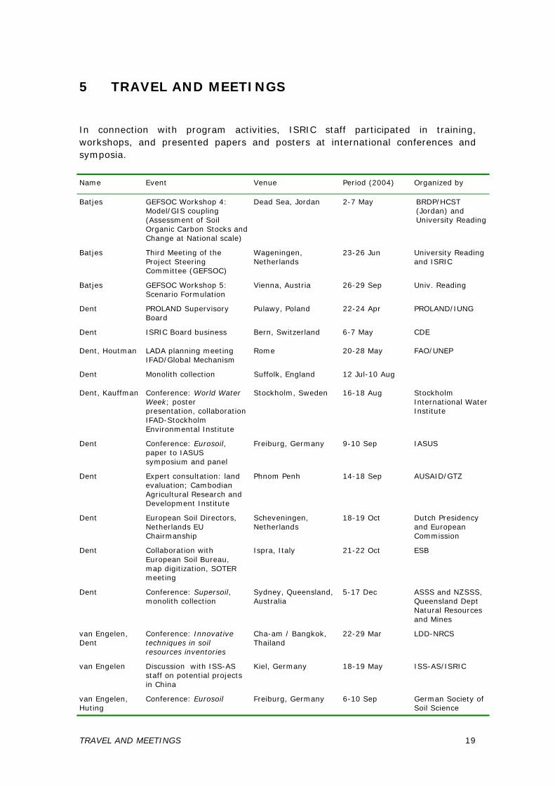
5 TRAVEL AND MEETINGS
In connection with program activities, ISRIC staff participated in training, workshops, and presented papers and posters at international conferences and symposia.
Name Event Venue Period (2004) Organized by
Batjes GEFSOC Workshop 4: Model/GIS coupling (Assessment of Soil Organic Carbon Stocks and Change at National scale)
Dead Sea, Jordan 2-7 May BRDP/HCST (Jordan) and University Reading
Batjes Third Meeting of the Project Steering Committee (GEFSOC)
Wageningen, Netherlands
23-26 Jun University Reading and ISRIC
Batjes GEFSOC Workshop 5: Scenario Formulation
Vienna, Austria 26-29 Sep Univ. Reading
Dent PROLAND Supervisory Board
Pulawy, Poland 22-24 Apr PROLAND/IUNG
Dent ISRIC Board business Bern, Switzerland 6-7 May CDE
Dent, Houtman LADA planning meeting IFAD/Global Mechanism
Rome 20-28 May FAO/UNEP
Dent Monolith collection Suffolk, England 12 Jul-10 Aug
Dent, Kauffman Conference: World Water Week; poster presentation, collaboration IFAD-Stockholm Environmental Institute
Stockholm, Sweden 16-18 Aug Stockholm International Water Institute
Dent Conference: Eurosoil, paper to IASUS symposium and panel
Freiburg, Germany 9-10 Sep IASUS
Dent Expert consultation: land evaluation; Cambodian Agricultural Research and Development Institute
Phnom Penh 14-18 Sep AUSAID/GTZ
Dent European Soil Directors, Netherlands EU Chairmanship
Scheveningen, Netherlands
18-19 Oct Dutch Presidency and European Commission
Dent Collaboration with European Soil Bureau, map digitization, SOTER meeting
Ispra, Italy 21-22 Oct ESB
Dent Conference: Supersoil, monolith collection
Sydney, Queensland, Australia
5-17 Dec ASSS and NZSSS, Queensland Dept Natural Resources and Mines
van Engelen, Dent
Conference: Innovative techniques in soil resources inventories
Cha-am / Bangkok, Thailand
22-29 Mar LDD-NRCS
van Engelen Discussion with ISS-AS staff on potential projects in China
Kiel, Germany 18-19 May ISS-AS/ISRIC
van Engelen, Huting
Conference: Eurosoil Freiburg, Germany 6-10 Sep German Society of Soil Science
TRAVEL AND MEETINGS 19
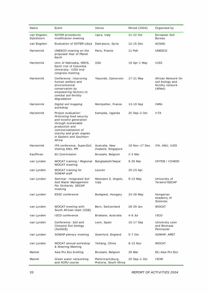
Name Event Venue Period (2004) Organized by
van Engelen, Dijkshoorn
SOTER procedures modification meeting
Ispra, Italy 21-22 Oct European Soil Bureau
van Engelen Evaluation of SOTER-Libya Damascus, Syria 12-15 Dec ACSAD
Hartemink UNESCO meeting on the proposed Year of Planet Earth
Paris, France 11 Feb UNESCO
Hartemink Univ of Nebraska, NRCS, Earth Inst of Columbia University; IUSS mid-congress meeting
USA 19 Apr-1 May IUSS
Hartemink Conference: Improving human welfare and environmental conservation by empowering farmers to combat soil fertility degradation
Yaounde, Cameroon 17-21 May African Network for soil biology and fertility network (AfNet)
Hartemink Digital soil mapping workshop
Montpellier, France 13-19 Sep INRA
Hartemink Project evaluation: Promoting food security and income generation through sustainable production and commercialisation of starchy and grain staples in Eastern and Southern Africa
Kampala, Uganda 25 Sep–2 Oct IITA
Hartemink IFA conference, SuperSoil, Visiting ANU, PPI
Australia, New Zealand, Singapore
18 Nov–17 Dec IFA, ANU, IUSS
Kauffman EU Commission Brussels, Belgium 2-3 Mar
van Lynden WOCAT training / Regional WOCAT meeting
Bangladesh/Nepal 9-26 Mar CHTDB / ICIMOD
van Lynden WOCAT training for SOWAP staff
Leuven 20-23 Apr
van Lynden Seminar: Integrated Soil And Water Management For Orchards; GECAP meeting
Mosciano S. Angelo, Italy
9-13 May University of Teramo/GECAP
van Lynden ESSC conference Budapest, Hungary 24-28 May Hungarian Academy of Sciences
van Lynden WOCAT meeting with South African team (CDE)
Bern, Switzerland 28-29 Jun WOCAT
van Lynden ISCO conference Brisbane, Australia 4-8 Jul ISCO
van Lynden Conference: Soil and Compost Eco-biology (SoilACE)
Leon, Spain 15-17 Sep University Leon and Biomasa Peninsular
van Lynden SOWAP plenary meeting Stamford, England 5-7 Oct SOWAP, ARET
van Lynden WOCAT annual workshop & Steering Meeting
Yichang, China 8-13 Nov WOCAT
Mantel Asia Pro Eco briefing Brussels, Belgium 26 Mar EC–Asia Pro Eco
Mantel Green water networking and ACRU course
Pietermaritzburg, Pretoria, South Africa
20 Sep–1 Oct ISCW
20 REPORT OF ACTIVITIES 2004
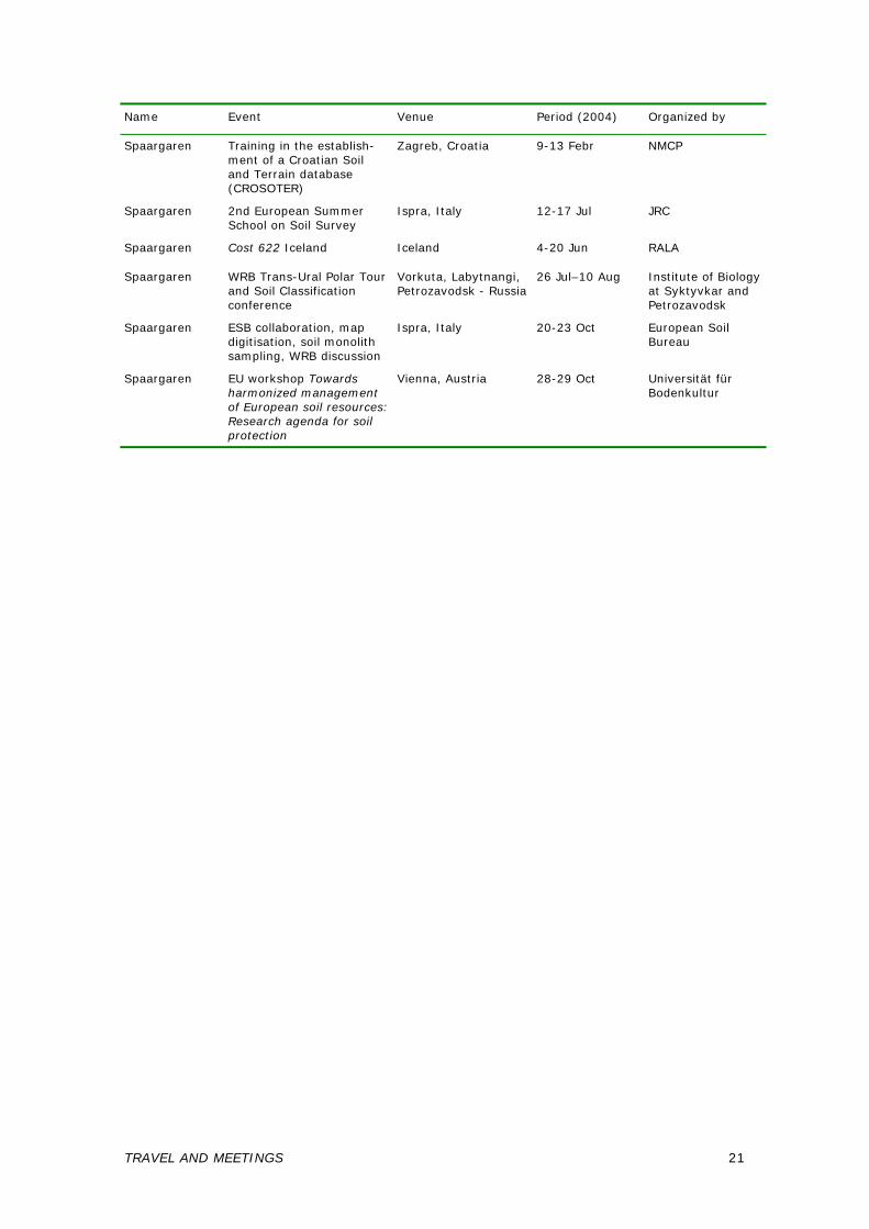
Name Event Venue Period (2004) Organized by
Spaargaren Training in the establish-ment of a Croatian Soil and Terrain database (CROSOTER)
Zagreb, Croatia 9-13 Febr NMCP
Spaargaren 2nd European Summer School on Soil Survey
Ispra, Italy 12-17 Jul JRC
Spaargaren Cost 622 Iceland Iceland 4-20 Jun RALA
Spaargaren WRB Trans-Ural Polar Tour and Soil Classification conference
Vorkuta, Labytnangi, Petrozavodsk - Russia
26 Jul–10 Aug Institute of Biology at Syktyvkar and Petrozavodsk
Spaargaren ESB collaboration, map digitisation, soil monolith sampling, WRB discussion
Ispra, Italy 20-23 Oct European Soil Bureau
Spaargaren EU workshop Towards harmonized management of European soil resources: Research agenda for soil protection
Vienna, Austria 28-29 Oct Universität für Bodenkultur
TRAVEL AND MEETINGS 21

22 REPORT OF ACTIVITIES 2004
6 PERSONNEL
(as of January 2005) Board of Trustees
• Dr SW Bie (Chairman) • Prof. Dr J Bouma (Environmental Sciences Group, on behalf of Wageningen
University) • Prof. Dr H Hurni (National Centre of Competence in Research North-South,
Berne, Switzerland, on behalf of the International Union of Soil Sciences) • Ir GJA Nieuwenhuis (Centre for Geo-Information, on behalf of Alterra BV) • Ir W van Vuure (on behalf of the Ministry of Agriculture, Nature and Food
Quality) Changes in Board Prof. Bouma will be retiring as Board member in April 2005; a replacement has been proposed by the Executive Board of Wageningen UR for approval of the ISRIC's Board meeting, April 2005. Staff (alphabetical order of last name)
• M (Mateen) Ahmad MSc – soil monolith preparation • Ir NH (Niels) Batjes – database applications, soils and global change • WCWA (Wouter) Bomer – graphic design and in-house publishing • J (Jan) Brussen – finance • Dr DL (David) Dent - Director • Ir JA (Koos) Dijkshoorn – soil and terrain databases • Drs VWP (Vincent) van Engelen - Research Team Leader • Ir IJ (Ingrid) Haas – webmaster and programmer • Dr AE (Alfred) Hartemink – Head, World Soil Museum • JRM (Jan) Huting – GIS database management and map production • YGL (Yolanda) Karpes - secretariat • Ir JH (Sjef) Kauffman – Deputy Director, databases applications,
soil and water management • Drs GWJ (Godert) van Lynden – land, water and environmental
management • S (Stephan) Mantel MSc - land evaluation and decision support • AJM (Ad) van Oostrum MSc – collections management and quality control • Dr OC (Otto) Spaargaren – Head, World Data Centre for Soils • Ir P (Piet) Tempel - systems analyst and programming
End employment contract 1 December 2004: Iraj Manuchehri, early retirement (documentation, data quality control and management of the soil sample collection). Iraj joined the ISRIC laboratory in 1992.
PERSONNEL 23
Jubilees • 1 March 2004: Niels Batjes (12.5 years) • 1 July 2004: Iraj Manuchehri (12.5 years) • 1 September 2004: Jan Brussen (25 years)
Guest researchers
• Dr Bai Zhanguo – GLADA pilot study in PR China – algorithms development • Drs JHV (Hans) van Baren - Philosophy of Science (IUSS program), library
and documentation • Dr LP (Piet) van Reeuwijk – laboratory methods and quality control • Dr V (Venant) Rutunga – feasibility study of linking QUEFTS system to
ISRIC’s data bases for quantitative evaluation of soil fertility • Dr MJ (Maja) Kooistra, as from 1 Nov 2004 – soil micromorphological thin
sections; completion of publication: Reading the Archives of Quaternary Soils and Sediments. Micromorphological contributions to the study of Quaternary soils and sediments in the series of Developments in Quaternary Science (Elsevier).
Internship 16 August 2004–15 January 2005: Gunnar Jenet, agreement ISRIC – University of Applied Sciences, Osnabrück, Germany. Activities: conversion of SOTER profile data of Brazil from FAO classification to WRB classification, completion of data to full SOTER sets from source publications. Honorary Fellows
Honorary Fellows are appointed in recognition of mutual long and fruitful relationship with ISRIC – World Soil Information:
• Dr Wim G. Sombroek (in memoriam) – First Honorary Fellow - in view of outstanding contributions to the Institute by optimising the earned recognition worldwide
• Professor Dr Rudy Dudal – as contributor to the Soil Map of the World and to the World Reference Base for Soil Resources
• Professor Dr Ir Klaas-Jaan Beek – in view of seminal work of land evaluation and through the trusteeship as Rector of the International Institute for Geo-information Science and Earth Observation (ITC)
• Dr Robert Brinkman – in view of seminal work carrying soil survey through land evaluation to land use planning; and support as Chief of FAO Land Resources.
Staff Development
Sjef Kauffman, Jan Huting and Piet Tempel participated in a course "GIS applications in Land Resource and Land Use studies" (12-23 April 2004). Knowledge acquired was used in the green water pilot study of the Save basin. Otto Spaargaren attended a two-day training workshop on the transformation "From library to modern information centre" (23, 24 November 2004), organised by the GO Foundation, The Hague.
24 REPORT OF ACTIVITIES 2004
LIST OF ACRONYMS
Abbreviation Description
ACRU Agricultural Catchments Research Unit model
ACSAD The Arab Center for the Studies of Arid Zones and Dry Lands, Damascus, Syria
ALES Automated Land Evaluation System
ANU Australian National University, Canberra
ARET Allerton Research and Education Trust, Leicestershire, United Kingdom
ASSS Australian Society of Soil Science
AUSAID Australian Agency for International Development
BFMP Berau Forest Management Project, Indonesia
BRDP Jordan Badia Research and Development Programme
CDE Centre for Development and Environment, University of Berne, Switzerland
CHARM Chittagong Hill Tracts improved natural Resources Management
CHTDB Chittagong Hill Tracts Development Board, Bangladesh
CSEQ Carbon Sequestration Project, The Netherlands
DEM Digital Elevation Model
ESB European Soils Bureau, Ispra, Italy
ESSC European Society for Soil Conservation
EU European Union
FAO Food and Agriculture Organization of the United Nations, Italy
GECAP Gramoxone Environmental Conservation Agriculture Project
GEF Global Environmental Facility
GEFSOC Global Environmental Facility project, Soil Organic Carbon
GIS geographic information system
GLADA Global Assessment of Land Degradation and Improvement
GO Stichting Gemeenschappelijke Opleidingen
GTZ Gesellschaft für Technische Zusammenarbeit, Eschborn, Germany
HCST Higher Council for Research and Technology, Jordan
IARC International Agricultural Research Centres
IASUS International Actions for the Sustainable Use of Soils, IUSS Working Group
ICARDA International Center for Agricultural Research in the Dry Areas, Syria
ICIMOD International Center for Integrated Mountain Development, Nepal
ICSU International Council for Science, Paris, France
IFA International Fertilizer Industry Association, Paris, France
IFAD International Fund for Agricultural Development, Rome, Italy
IHE International Institute for Infrastructural, Hydraulic and Environmental Engineering, Delft, The Netherlands
IITA International Institute of Tropical Agriculture, Nigeria
ILRI International Land Reclamation Institute, Wageningen, The Netherlands
IMAGE Integrated Model to Assess the Global Environment (RIVM)
IMCS Institute of Marine and Coastal Sciences, New Jersey, USA
INRA Institut National de la Recherche Agronomique / National Institute for Agricultural Research, Paris, France
ISCO International Soil Conservation Organisation
ACRONYMS 25
Abbreviation Description
ISCW-ARC Institute of Soil, Climate and Water of the Agricultural Research Council, Pretoria, South Africa
ISIS ISRIC Soil Information System
ISRIC International Soil Reference and Information Centre, Wageningen, The Netherlands
ISS-AS Institute of Soil Science-Academia Sinica, Nanjing, PR China
ITC International Institute for Geo-information Science and Earth Observation, Enschede, The Netherlands
IUNG Instytut Uprawy Nawoženia i Gleboznawstwa / Institute of Soil Science and Plant Cultivation, Pulawy, Poland
IUSS International Union of Soil Sciences
JRC Joint Research Centre of the European Union
LADA Land Degradation Assessment for Dryland Areas
LDD Land Development Department, Bangkok, Thailand
LEI Landbouw Economisch Institute / Agricultural Economics Research Institute, Wageningen UR, The Hague/Wageningen, The Netherlands
NBV Nederlandse Bodemkundige Vereniging / Dutch Soil Science Society
NMCP Netherlands Management Cooperation Program
NRCS Natural Resources Conservation Service, Lincoln, USA
NZSSS New Zealand Society of Soil Science
PPI Phosphate and Potash Institute, Singapore
PROBUS Stichting Probus Nederland Informatie Centrum, Delft, The Netherlands
PROLAND EC Centre of Excellence Protection of Land and Water Quality and sustainable Development of Rural Areas, Poland
QUEFTS Quantitative Evaluation of the Fertility of Tropical Soils
RALA Rannsóknastofnun Landbünaðarins/Agricultural Research Institute, Reykjavik, Iceland
RIVM Rijksinstituut voor Volkshuisvesting en Milieu / National Institute of Public Health and Environmental Protection, Bilthoven, The Netherlands
SOC-GEF Soil Organic Carbon, Global Environmental Facility project
SOTER Soil and Terrain Database
SOTERSAF SOTER database for Southern Africa
SOWAP Soil and Surface Water Protection Using Conservation Tillage in Northern and Central Europe
SQL Structured Query Language
SRTM, NASA Shuttle Radar Topographic Mission, National Aeronautics and Space Administration, USA
STIBOKA Stichting voor Bodemkartering / Netherlands Soil Survey Institute (now: Alterra research instituut voor de Groene Ruimte, Wageningen UR, The Netherlands)
TSBF-CIAT Tropical Soil Biology and Fertility Institute, International Center for Tropical Agriculture, Nairobi, Kenya
UN United Nations
UNCCD United Nations Convention to Combat Desertification, Bonn, Germany
UNDP United Nations Development Programme, New York, USA
UNEP United Nations Environment Programme, Nairobi, Kenya
UNESCO United Nations Educational, Scientific and Cultural Organization, Paris, France
26 REPORT OF ACTIVITIES 2004
Abbreviation Description
VROM Ministerie voor Volkshuisvesting, Ruimtelijke Ordening en Milieu / Netherlands Ministry of Housing, Spatial Planning and the Environment, The Hague, The Netherlands
Wageningen UR Wageningen University & Research Centre, The Netherlands
WATSAT Water Sufficiency Assessment Tool
WISE World Inventory of Soil Emission potentials
WOCAT World Overview of Conservation Approaches and Technologies. CDE, Berne, Switzerland
WOFOST World Food Study model
WRB World Reference Base for Soil Resources
ACRONYMS 27
Recommended