The Quarry: A Planning and Development History of the Northeast
Minneapolis Retail Center
Prepared by Richard Crockett
Research Assistant Conducted on behalf of Windom Park Citizens in Action
July, 2008
This report (NPCR 1285) is also available on the CURA website:
www.cura.umn.edu/search/index.php

July, 2008
Neighborhood Planning for Community Revitalization (NPCR) supported the
work of the author of this work, but has not reviewed it for publication. The content is
solely the responsibility of the author and is not necessarily endorsed by NPCR.
NPCR is coordinated by the Center for Urban and Regional Affairs at the University of
Minnesota. NPCR is supported by the McKnight Foundation.
Neighborhood Planning for Community Revitalization
330 Hubert H. Humphrey Center
301 - 19th Avenue South
Minneapolis, MN 55455
phone: 612/625-1020
e-mail: [email protected]
website: http://www.npcr.org

The Quarry:
A Planning and
Development History
of the Northeast
Minneapolis Retail
Center
by Richard Crockett

The Quarry: A Planning and Development History
of the Northeast Minneapolis Retail Center
By Richard Crockett
Copyright Richard Crockett, 2007
Prepared for Windom Park Citizens in Action
This project was supported by Neighborhood Planning for Community Revitalization
(NPCR), a program of the University of Minnesota’s Center for Urban and Regional
Affairs (CURA). The contents of this report are the sole responsibility of the author, and
are not necessarily endorsed by the University of Minnesota, CURA, or NPCR.

Table of Contents
Executive Summary...........................................................................2
Introduction.....................................................................................3
Players.....................................................................................................6
Task Force.............................................................................................7
Environmental History..............................................................10
Traffic...................................................................................................14
Business Types...................................................................................17
Economic Concerns.....................................................................21
Design Concerns............................................................................23
Finances...............................................................................................27
Home Depot Issues.........................................................................28
Additional Concerns and Avenues....................................31
Appendix...............................................................................................32
Bibliography......................................................................................35
1 contents

Executive Summary
This narrative attempts to capture the planning and development history of a decade old Northeast
Minneapolis retail center. It is not intended to be comprehensive in nature, but instead provide baseline
knowledge on different elements of the Quarry’s story that can be traced to facts in the public record.
Conversations with people involved with the complex’s development also led to many insights found in the
report, but also led to limitations. The result is a complex history of different levels of clarity and completeness.
The report tries to explain how the present day Quarry came to look and function the way it does. The true
intent of this report is to provide a jumping off point for people newly interested in the Quarry, who, then
informed, can proceed to actively participate in future decisions that shape this prevalent retail center in
Northeast Minneapolis.
2 Executive Summary
2003 aerial photograph of the Quarry

Introduction
On August 6, 1993, the Minneapolis City Council announced that it had received a request from Ryan
Companies Inc. for exclusive right to build a shopping center anchored by a Target and Rainbow foods store
in NE Minneapolis (Task Force, Susan Lutz, Chair ). Ryan proposed to develop a retail shopping center in
cooperation with the Minneapolis Community Development Agency (MCDA). The development proposed
replacing approximately 313,000 square feet of existing industrial, warehouse, and offi ce buildings with
approximately 400,000 square feet of retail uses constructed in a strip mall confi guration along 18th Ave NE,
with the rear of the development to the Windom Park Neighborhood. The shopping center would face south
with the parking lot also to the south, between the retail buildings and I-35W. The development resides in
Northeast Park Neighborhood and is adjacent to the Windom Park Neighborhood to the north (Task Force,
3 Introduction
Susan Lutz, Chair ).
Adjacent land uses at the time of
development
Immediately north of the site,
across 18th Ave NE a residential area
with low to medium density housing.
Across New Brighton Blvd. on the east
of the site is an industrial area and a
cemetery. On the south of the site is
Interstate 35W and a general industrial
area. Across Johnson St. NE on the
west is low-density residential and the
Northeast Park (Task Force, Susan Lutz,
Chair ). Prior Land Use
The land use on the site prior to the retail redevelopment was primarily low density commercial and
industrial businesses. Previous land use included a quarry on a portion of the site west of Arthur St. NE and
series of light industrial businesses. A great variety of fi ll material was deposited on the site in the past. The site
had been known to be contaminated for several years prior to the redevelopment(Task Force,Susan Lutz,Chair ).
Properties prior to Redevelopment
The old site comprised of eleven parcels:
Arthur St. NE:
1524 truck terminal, Transport International Pool, Inc
1600 vacant
1705 truck body repair, Region Truck Equipment Co.
The Quarry site today from the air (Google Earth)

The City’s reason for supporting the project: “It’s clear that there are several public purposes fulfilled by relocating the existing businesses, cleaning up the on-site pollution, creating jobs (650 additional full-time equivalent jobs) and new tax base, and developing a new community-level commercial center for the area” -City Planning Doc. P-988
4 Introduction
From: (Task Force, Susan Lutz, Chair )
1707 sandblasting, A1A Master Sandblasting Services,Inc.
New Brighton Blvd.:
1500-1580 multiple tenant offi ce, CSM Corp.
1600-1622 multiple tenant, CSM Corp. offi ce/warehouse
1700 truck rental, Rollins Truck Rental
1720 offi ce/industrial, Nott Co.
18th Ave NE.:
2100 ice cream distributor, Edy’s Grand Ice Cream
Why Redevelop?
The major objectives of MCDA and the City Council in establishing the Quarry are as follows:
1. Acquire and remove economically or functionally obsolete or under utilized buildings
2. Eliminate blighting infl uences which impede potential development
3. Eliminate or correct physical deterrents to the
development of the land
4. Achieve a high level of design and landscaping quality
to enhance the physical environment
5. Assist in the development of a community shopping
center, including a large grocery store, accessible to the
residents of northeast and southeast Minneapolis
6. Clean up hazardous substances in order to
improve public environmental health, and provide
developable real estate parcels
(Minneapolis Community Development Agency and
Ryan Construction Company of Minnesota, Inc. )

5 Introduction
Orignal plan drawing of the Quarry in 1994
2003 Aerial photograph of the Quarry’s eastern portion

Players
Northeast Retail Center Task Force: Created by request from the City Council, the Northeast Retail Center
Task Force gathered information on the development, held meetings and hearings and created a fi nal report. In
the report they gave mandates and recommendations regarding what the community wanted to see built.
Northwest Retail Center Oversight Committee: This committee was formed to monitor the construction of
the Quarry Shopping Center. The Committee’s fundamental purpose was to insure that the mandates of the NE
Retail Task Force Report are followed.
Ryan Companies, Inc: The original developer and owner of the site. Their related fi rm, Ryan Construction,
was responsible for the construction the development.
Inland Real Estate Group of Companies, Inc.: The private development company that bought the property
from Ryan in 1999 and is the current owner.
Minneapolis Community Development Agency (MCDA): The City of Minneapolis planning agency at the
time. Had many responsibilities in the project.
Minnesota Pollution Control Agency (MPCA): This state agency was responsible for oversight of the
environmental clean up and still provides oversight on monitoring of the site’s pollution remediation.
Peer Engineering, Inc.: Environmental engineering fi rm MCDA hired to initially assess the site’s
contamination. Peer also completed the Environmental Assessment Worksheet (EAW) and preformed the clean
up.
Leisch Companies, Inc.: Involved in the environmental clean-up and monitoring, hired by Ryan.
Barton-Aschman Associates: Transportation engineering fi rm that conducted traffi c studies on the Quarry’s
impact.
Windom Park Citizens in Action (WPCiA): Community organization for the neighborhood directly north of
the Quarry. Although Quarry is not technically in their neighborhood, residents have taken an active role.
Northeast Park Neighborhood Organization: Community organization for the neighborhood that the Quarry
is located in.
6 Players

Task Force
The development of the Quarry justifi ably required and involved much public participation. The face of
public participation on the project was the Northeast Retail Center Task Force. The Task Force was created a by
request of the City Council. Each Minneapolis eastside neighborhood organization designated a representative
to serve on the Task Force. Northeast Park and Windom Park neighborhood organizations led the Task Force
because of their proximity to the development.
The Task Force’s duties were to gather information regarding the development, create a neighborhood
forum where concerns could be voiced, report the input of neighborhood groups and hold public hearings. After
many meetings and hearings with stakeholders and offi cials involved with the project the Task Force reported its
fi ndings and recommendations to the City Council.
The principal issue the Task Force dealt with was weather the development should be endorsed by the
group. The Task Force witnessed much opposition as well as signifi cant support for the development. There
was much concern that the shopping center would lead to a lower quality of life the community.
Specifi cally, the task force addressed theses issues, (1) traffi c patterns and their impact on neighborhood
streets, (2) the environmental, economic, and aesthetic elements of the project, (3) details of pollution studies
and their impact, (4) the occupancy of the retail space and what kinds of services will be offered, (5) the details
of jobs and occupations of the anticipated stores, (6) the strategies to be followed to keep the space vibrant and
full, (7) the impact on the existing businesses on the site which must relocate, and (8) the overall impact on the
community. (East Side Shopping Center Citizen Participation Report, May 2, 1994)
The following are the fi ndings and mandates from the Task Force’s fi nal report to the City Council. It’s
noted in the report that these are minimum requirements and unless they can be met, the Task Force felt that
the adverse affects of the shopping center on the community would be too large and the Task Force could not
endorse the project. The following are the Findings and Mandates from the Task Force Report.
Findings:
1) The proposed development will increase traffi c
2) There is signifi cant pollution on the site
3) The Central Ave. business district is deteriorating and will continue to decline regardless of Quarry
development, unless a serious commitment to improve the district is undertaken
4) The shopping center can only be built with tax increment fi nancing and eminent domain
Mandates:
Based on materials available and public commentary offered at hearings the task force is OPPOSED to the
proposed development unless all of the following minimum requirements are met:
7 Task Force

Traffi c:
o Traffi c control measures, including traffi c control devices at the shopping center entrances, must be
suffi cient to minimize noise and safety hazards which will result from the increase in traffi c
o A comprehensive traffi c management plan is implemented which encourages commuter automobile
travel on Central Ave, instead of Johnson and other residential streets.
o Stinson Parkway will not be broadened
o The merchants located at the center, in conjunction with Metro Transit, provide transportation services
for area residents who don’t have automobiles
Economic and Environmental Concerns:
o The City working with neighborhood organizations and area businesses work to halt the decline of the
Northeast business corridors, especially Central Ave.
o Suitable alternatives found for neighborhoods in NE whose will lose a grocery store because of the
Quarry
o The City attempts to fi nd satisfactory locations for existing businesses which will be displaced
o The merchants located at the center enact policies to promote the hiring of area residents
o Existing pollution is cleaned up on site and no further environmental degradation results Quarry
development.
Design:
o Johnson St. south of 18th is repositioned and suffi cient berming and landscaping are installed to provide
pedestrian safety and shelter to Northeast Park and Windom Park neighborhoods from the shopping
center
o Landscaping and lighting improvements made to 18th Ave. and Johnson St. to minimize traffi c noise and
to enhance the aesthetics of these entry streets to the Northeast community
o Berms, bike paths, and walking paths are constructed on 18th Ave, east of Johnson St. for protection of
the neighborhood and to encourage safe bicycle and pedestrian usage
o The shopping center design and management provides for public transportation to the Quarry from areas
throughout the Eastside neighborhood, as well as bicycle and pedestrian access
o The developer and merchant association meet annually with neighborhood organizations to discuss
shopping center plans, problems and opportunities
o The fi nal design is accepted and approved by the neighborhood organizations that have participated
o Neighborhood organizations continue to have involvement and input throughout the development and
construction process.
o Safeguards are in place to protect the surrounding neighborhood from intrusion during construction
o Lighting in and around the shopping center should be placed and directed away from the residential area.
8 Task Force

Agreed-upon mandates from Task Force Report
The following are the agreed-upon between mandates from the Task Force that the City or Developer
must satisfy. These were drawn up from on meetings between the parties after the Task Force submitted its
report. It designates who is responsible for implementing certain mandates put forth by the Task Force.
Traffi c
City, MCDA, or Public Works to Satisfy:
o Traffi c Control Measures
o A comprehensive traffi c management plan
o Stinson Parkway will not be broadened
Developer to Satisfy:
o Center to provide transportation services, in conjunction with MTC (Metro Transit), for area residents
who do not have automobiles
Economic and Environmental Concerns
City, MCDA, or Public Works to Satisfy:
o The City to work with neighborhoods to halt decline of Northeast, and Central Ave., in particular
o MCDA attempt to fi nd relocation sites within City for existing businesses located at the project site
o Existing pollution be cleaned up
o Suitable alternative to be found to replace lost grocery store at the present Rainbow site
Developer to Satisfy:
o Merchants enact policies to promote the hiring of area residents
o No new environmental degradation
Design
City, MCDA, or Public Works to Satisfy:
o Johnson St. south of 18th Ave be repositioned, landscaping installed for pedestrian safety and shelter
from the center for Northeast Park and Windom Park neighborhoods
o Landscaping and lighting improvements supplied to 18th Ave. to minimize noise, etc.
o Berms, bike paths, walking paths, etc., to encourage bicycle and pedestrian usage
o Safeguards be put in place to protect surrounding neighborhoods from intrusion during construction.
Developer to Satisfy:
o The shopping center design and management provides for public transportation to the center from areas
throughout the eastside community, bicycle access and pedestrian access.
o The building will be attractive from all sides
o The developer and merchants association meet annually with the neighborhood organizations to discuss
center
9 Task Force

o The fi nal design of the center must meet the criteria set by the neighborhood organizations that have
participated in the Task Force.
In addition to these mandates, the Task Force made a number of other recommendations and concerns
clear in their report. These are scattered throughout the document. At different times in the past decade, issues
surrounding the development related to the Task Force’s report has centered on the difference between a
mandate and a recommendation. A mandate is absolute, it was necessary for the development to go forward in
the eyes of the community; a recommendation is simply what the neighborhood would like to see. There were
times when the two were confused and caused controversy.
Environmental history and Clean-Up
The present day site of the Quarry Shopping Center has an interesting history, especially
environmentally. The 42-acre site’s soil and groundwater became heavily contaminated with petroleum
and chlorinated solvents. Truck terminals, sandblasting operations, automotive repair shops and chemical
manufacturing all contributed to a degree to the long list of hazardous pollutants that poisoned the site and
threatened public health and the neighborhood.
The historic Arthur St. cuts the site in half. Johnson Street Quarry, a limestone quarry east of Johnson
St. with 18th Ave the northern boundary use to existed on the western portion of the site. The quarry became
active in the 1930s but by the 1950s and 1960s the quarry was fi lled in and being used as a demolition dump
(Correspondence between Rick Jolley, Minnesota Pollution Control Agency and Windom Park Neighborhood
Resident). Among the materials that were dumped in the exhausted quarry pit was woody matter from the
Gateway urban renewal demolition in downtown Minneapolis. The depth of the pit is believed to be some 60
ft. below the surface (Correspondence between Rick Jolley, Minnesota Pollution Control Agency and Windom
Park Neighborhood Resident).
Offi cials at the State and City have known about
the environmental situation of the site for years prior to
the construction of the Quarry. Starting in 1993-1994 the
Minneapolis Community Development Agency (MCDA)
initiated investigation into the environmental status and
risks of the site and its potential to be cleaned up and
revitalized. Ryan Companies Inc., (Ryan) a private developer,
was interested in the site. Peer Engineering, Inc. (Peer) was the environmental engineering fi rm MCDA
hired to perform the investigation. MCDA’s and Peer’s investigation was complete in the fall and this led to
the partnership between Ryan and MCDA. It was Ryan that showed interest in redevelopment of site as a
commercial center in the beginning which lead to MCDA’s environmental investigation. Dubbed a health
hazard by MCDA, condemnation laws were soon used to vacate the property and devaluation hearings were
10 Environmental History and Clean-Up
MCDA and Ryan were awarded the Phoenix Award for Brownfield Redevelopment at the Industrial Site Recycling Conference in Pittsburgh in 1998. Peer Engineering was also recognized for their assistance in the site clean up.
11 Environmental History and Clean-Up
held regarding property owner compensation from MCDA. Ryan Companies shared the cost of assessing
the site with the government, and the government paid for the cleanup costs with various creative methods
(Conversation between Author and Rick Jolley, Minnesota Pollution Control Agency).
Minnesota Pollution Control Agency (MPCA) split the development area into multiple Voluntary
Investigation and Cleanup (VIC) sites with different ‘packages’ of cleanup and investigation (Conversation
between Author and Rick Jolley, Minnesota Pollution Control Agency). MPCA administered a split timed with
the Land Recycling Act with the east side of the site, with Arthur St. being the divider of east and west. West of
Arthur was the primary dump (the quarry) with ‘fi ngers’ of contamination (which included coal slag) extending
on the east side where the present day Target parking lot is located. In these ‘fi ngers’ coal slag in signifi cant
amounts was found in shallow locations (Findings of Fact and Record of Decision, Environmental Assessment
Worksheet) (Conceptual Response Action Plan, Northeast Retail Development, Minneapolis, MN).
As for environmental contamination, the western part of the site was the largest dump (the quarry),
which was ‘compacted’ and ‘graded over’ by Ryan following MCDA’s investigation. A ‘groundwater plume’
of contamination was found and attributed to two sources: solvents from a tank that was removed, and a
deeper site that contained a combination of solvents, petroleum hydrocarbons, and lower levels of PCBs
(Correspondence between Rick Jolley, Minnesota Pollution Control Agency and Windom Park Neighborhood
Resident). Because of woody material dumped in the past, methane gas has been detected at high enough
levels that MCDA and Ryan engineered controls on the buildings being constructed on site (Correspondence
between Rick Jolley, Minnesota Pollution Control Agency and Windom Park Neighborhood Resident). Ryan
constructed vertical vents or pipes that let methane gas out on the northern edge of the site behind Home Depot
and Rainbow (Peer Environmental & Engineering Resources, Inc. ). Blowers were installed to pump out the
methane when the gas reaches high enough levels. Methane is monitored around the perimeter of the site. On
the western portion west of historical Arthur St. monitoring is an active system where the authorities are able to
take action if a high level is detected but they haven’t had any issues thus far where they’ve had to take action.
The system east of old Arthur St. is a passive system that has sub slab PVC ventilation. Ryan’s environmental
consultants, Leisch & Associates (Leisch) was contracted to implement these systems. MCDA encouraged Ryan
to build this venting system described above to eliminate a long-term monitoring scenario. In exchange for
Ryan implementing this system, it gets certain legal ‘protections.’ Ryan cannot be named as a responsible party
in case action related to not cleaning up the site. The environmental contamination was committed by other
businesses so a new developer such as Ryan are weary about developing site if they were legally responsible for
the clean-up preformed (Conversation between Author and Rick Jolley, Minnesota Pollution Control Agency).
Ryan’s Quarry is part of the State’s Voluntary Investigation and Cleanup (VIC) program. The site was
contaminated enough that it would have fallen under other mandatory provisions for cleanup had Ryan not
agreed to take part in the cleanup. At the time, MPCA didn’t have enough money to go into all such areas
destine for Superfund status and clean them up. The Quarry would have been given Superfund list priority
had Ryan not made the deal. The site would have been on the state Superfund list, but probably low on the list

(Conversation between Author and Rick Jolley, Minnesota Pollution Control Agency).
As for groundwater contamination, it was addressed by a system called “trenching” and pipes with
blowers that extract vapors contributing to the contamination. This method, called “soil vapor extraction” was a
fairly established method at the time and usually takes a few years to complete. Similar systems have been used
at various sites throughout the Twin Cities (Correspondence between Rick Jolley, Minnesota Pollution Control
Agency and Windom Park Neighborhood Resident).
A restrictive covenant exists on the site, it states that all development must be separated from
contamination, about 1.5 to 2 feet under the pavement of the parking lot (Conversation between Author and
Rick Jolley, Minnesota Pollution Control Agency). The cleanup at the Quarry occurred prior to set standards
for the amount of property given a land use type. Today, typically there is at least a 2 ft buffer for a parking lot
and a 4 ft. buffer for green space. The land use restriction requires the developer, or any one else doing any kind
of digging at the site for construction, maintenance, landscaping, or utility purposes must contact the MPCA
fi rst to oversee the operation as to not endanger public health (Correspondence between Rick Jolley, Minnesota
Pollution Control Agency and Windom Park Neighborhood Resident).
The MPCA didn’t have any concerns about risks associated with being around the property post-cleanup
because it’s in much better condition environmentally than much of its recent history. They felt it must be
understood that its not feasible to remove all contamination from a site to instead the risk is managed through
the cleanup and monitoring.
The long term response action elements addressed in the Operation and Maintenance Manual completed
by Peer Engineering outline remediation goals and monitoring procedures with six focuses:
1. Deep Volatile Organic Compound (VOC) and Petroleum-Impacted Soil Vapor Extraction (SVE) system
2. Deep Polychlorinated Biphenyl (PCB), VOC and Petroleum-Impacted Soil SVE system
3. Perimeter Methane Control System
4. Sub Slab Methane Ventilation Systems
5. Long Term Groundwater Monitoring Program
6. Biopile monitoring (Outlot A)
(Peer Environmental & Engineering Resources, Inc. ) (Correspondence between Liesch Environmental
Engineering and Rick Jolley, Minnesota Pollution Control Agency, the Quarry West Site (MPCA 4554)
Semi-Annual Environmental Monitoring Results for the Period of July through December 2006 and Annual
Monitoring Summary)
Met Council and Stormwater Runoff
The Metropolitan Council conducted a review of the Environmental Assessment Worksheet (EAW)
completed for the project to determine its adequacy and accuracy in addressing regional concerns. The review
included the following concern about stormwater runoff.
The Met Council commented that the proposed grit chambers in the EAW wouldn’t provide a very
12 Environmental History and Clean-Up

high level of runoff treatment and would need frequent cleaning. They suggested that a more effective way
to consider would be to treat runoff on site. They suggested wet detention ponds designed to Natural Urban
Runoff Program standards to provide runoff treatment and reduce peak runoff rates. They also expressed
concerns that there were potential problems regarding stormwater coming from upstream locations in the City
of St. Anthony because a portion of that municipalities stormwater enters the same part of the Minneapolis
storm sewer system that serves the Quarry site. The Met Council mentioned a 1991 state law that said
developments with over one acre of impervious surface must have retention ponds.
In response to the Met Council’s concern the developer, RLK Associates, and Peer Engineering decided that still
believed grit chambers were the most appropriate treatment method for the project (Findings of Fact and Record
of Decision, Environmental Assessment Worksheet).
The City of Minneapolis is the governing agency of the watershed district. Engineers from the Sewers
Division of the Minneapolis Public Works Department said that they reviewed the project and actually helped
design the grit chamber system. They believe that the system will insure that there will be no adverse impacts
for the watershed. Although the City agreed that in most cases a retention pond is preferable, a pond is not
feasible on this site. This is because the only area large enough for a retention pond is the southwest corner of
the site (Outlot A) but because it contains contaminated soils that should not be disturbed, a retention pond is
not possible in that location.
The conceptual Response Action Plan (Appendix A in the EAW) calls for in-situ soil venting and the
use of berms on site. If a pond was located on Outlot A instead, then there would have to be off site treatment
and disposal of both the contaminated soils that would be bermed and treated and the soils excavated for the
detention pond. The developer and consultants estimate that using a pond instead of a grit chamber design
would increase project cost by well over $1 million and not be fi nancial feasible. Also in light of the water
coming in from St. Anthony, it was thought that grit chambers would be preferable to a pond because the
sooner the water gets out of the system the better the storm sewer system will work for the water coming from
upstream.
The Met Council concluded that the EAW was complete and accurate and that it didn’t raise any
major issues with the policies of the Council. The Council noted that the stormwater issues of concern
were adequately addressed by the City’s fi nal EAW document (Findings of Fact and Record of Decision,
Environmental Assessment Worksheet).
13 Traffic and Transportation
Traffic and Transportation
Traffi c has been a primary concern of citizens of Northeast Minneapolis with coming of the Quarry
Shopping Center, perhaps its been the greatest issues of concern. Citizens have observed increases of traffi c
from all angles, not particularly a surprise since the Quarry is a very large automobile oriented center adjacent
to a major freeway.

14 Traffic and Transportation
Traffi c Impact Report in the Environmental Assessment Worksheet (EAW)
According the Traffi c Impact Report in the EAW there would be a total increase of 15,581 net daily
trips and 1,079 net p.m. peak hour trips post-Quarry construction compare to pre-Quarry. Barton-Aschman
Associates completed a traffi c analysis as part of the Indirect Source permit (ISP) application (in Appendix C, ‘
Traffi c Impact Report’ of the EAW). The Traffi c Impact Report notes that several roadways along the perimeter
of the development would be affected by the Quarry, including Johnson, 18th, Stinson, New Brighton and
Arthur St. Along sections of these streets that surround the site, traffi c volumes were forecasted to increase 18%
in Fall 1996 as compared to Winter 1994 levels (one year after the center was then expected to have opened),
and not by more than 12% compared to projected Fall 1996 traffi c without development (obtained by assuming
existing Winter 1994 levels increase at a rate of 3% per year). It was expected that this would affect congestion
of these streets.
o The prior on site industrial/manufacturing development generated approximately 500 trips during PM
peak hours
o The Quarry development was expected to generate approximately 1580 trips during the PM peak hour
for a net increase of 1080 PM peak hour trips over the previous land use (a 216% increase)
o Existing roadway and intersection Level of Service were rated at B to C range and it was thought that
with the increase of traffi c as a result of the Quarry the intersections would still operate at B to C service.
Level of Service (LOS) relates to traffi c rating system LOS for an intersection is based on the average stopped
delay per vehicle and refl ects such things as driver frustration, intersection saturation, lost time, and stability of
operations; rankings are A to F.
The “Traffi c Impact Report” from the EAW recommended the following:
o Traffi c signals at both east and west entrances
o The bus stop be located north of the west entrance or on site
o Left and right turn lanes will be required along I-35W ramps on Johnson St. NE
o Johnson St. should be disconnected at 18th Ave with a cul-de-sac constructed south of 18th to be used
for additional parking and residential access for house to the west. It was stated then that because the project
incorporates these recommendations and City, State and private funds, have been identifi ed and budgeted to
cover costs “no adverse traffi c impacts are anticipated on local streets or the regional transportation system.”
The report also mentioned that the developer committed to operate a circulator bus throughout the neighborhood
and to the center and to focus on service to the senior high rises in the area (Traffi c Impact Report for Northeast
Retail Center).
The following fi gures specifi cally address the increases on certain intersections and stretches of roadway.
o Increase from 14,200 to 18,200 average daily trips on Johnson St. north of 18th Ave.
o Increase from 7,600 to 9,300 average daily trips on 18th Ave. West of Johnson St.
o Increase from 17,800 to 19,900 average daily trips on Johnson St. south of 18th Ave.
o Increase from 13,400 to 16,500 on New Brighton Boulevard

15 Traffic and Transportation
o Increase from 7,000 to 8,000 on Stinson Parkway
o A constant 7,500 of average daily trips on 18th Ave.
(Task Force, Susan Lutz, Chair )
Traffi c on Stinson Parkway
The average daily trips on Stinson Parkway prior to the opening of the Quarry was the highest of any
Grand Rounds Parkway in Minneapolis. Neighborhood residents have since observed a signifi cant increase in
traffi c on their parkway and delivery trucks using it. They feel that the Quarry is responsible for the increase of
traffi c and the degradation of their parkway. As stated above, in the traffi c study done in 1993 supplied to the
Task Force, traffi c on Stinson parkway was expected to increase from 7000 to 8000 with the development of
the Quarry. But, in a traffi c study commissioned by the Minneapolis Park and Recreation Board in 1997 right
about the time the Quarry was opening, Stinson was at 9195 daily trips (BRW, Inc. & White Mountain Survey
Co.).
On-site Transit Service Issue
From the beginning of the project there was talk of having an on-site transit stop at the Quarry. This
seems to be an item of much confusion, and frankly is still not clear. The Metropolitan Council Transit
Operations (MCTO) was the primary advocater of an on-site transit stop or station. MCTO believed that
properly designed transit access would both improve economic viability of the project by attracting people
from the community that don’t have access to cars (Correspondence between Julie Johanson, Metropolitan
Council and Ron McKinley, Minneapolis Planning Commission). The City was also sympathetic to the cause
but was unable to provide funds. The MCTO promised $400,000 toward a transit station. Ryan Companies, the
developer, seemed apathetic to the addition of such a feature but the tenants of the Quarry were cold to the idea.
Ryan believed they couldn’t force their tenants into agreement, and thus felt they could go no further with the
planning of the transit facility (Correspondence between Paul Farmer, MCDA and Pat Scott, Minneapolis City
Council Zoning and Planning Committee).
There was also vague disagreement to the cost of constructing and maintaining a transit center. Ryan’s
architect estimated the costs to be about $800,000 while MCTO believed the cost of the transit facility could be
less than $600,000. Whatever the cost would have been, the $400,000 commitment from the MCTO wouldn’t
have covered it and funds would have had to come from a stretched City budget that was already spent
signifi cant public money on the project or Ryan, whose tenants wouldn’t support the construction such a facility.
Also, MCTO entered the picture rather late in the planning process and there were concerns that alterations to
the site plan to include a transit facility would delay the project many months. Every month the project would
have been delayed, it would cost MCDA $134,000 in TIF money (Quarry Project Review Committee, Minutes
of 5/1/96 Meeting).
16 Traffic and Transportation
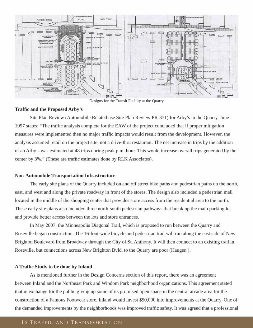
Designs for the Transit Facility at the Quarry
Traffi c and the Proposed Arby’s
Site Plan Review (Automobile Related use Site Plan Review PR-371) for Arby’s in the Quarry, June
1997 states: “The traffi c analysis complete for the EAW of the project concluded that if proper mitigation
measures were implemented then no major traffi c impacts would result from the development. However, the
analysis assumed retail on the project site, not a drive-thru restaurant. The net increase in trips by the addition
of an Arby’s was estimated at 48 trips during peak p.m. hour. This would increase overall trips generated by the
center by 3%.” (These are traffi c estimates done by RLK Associates).
Non-Automobile Transportation Infrastructure
The early site plans of the Quarry included on and off street bike paths and pedestrian paths on the north,
east, and west and along the private roadway in front of the stores. The design also included a pedestrian mall
located in the middle of the shopping center that provides store access from the residential area to the north.
These early site plans also included three north-south pedestrian pathways that break up the main parking lot
and provide better access between the lots and store entrances.
In May 2007, the Minneapolis Diagonal Trail, which is proposed to run between the Quarry and
Roseville began construction. The 16-foot-wide bicycle and pedestrian trail will run along the east side of New
Brighton Boulevard from Broadway through the City of St. Anthony. It will then connect to an existing trail in
Roseville, but connections across New Brighton Bvld. to the Quarry are poor (Haugen ).
A Traffi c Study to be done by Inland
As is mentioned further in the Design Concerns section of this report, there was an agreement
between Inland and the Northeast Park and Windom Park neighborhood organizations. This agreement stated
that in exchange for the public giving up some of its promised open space in the central arcade area for the
construction of a Famous Footwear store, Inland would invest $50,000 into improvements at the Quarry. One of
the demanded improvements by the neighborhoods was improved traffi c safety. It was agreed that a professional

17 Business Types
Business Types
At different points in the Quarry’s decade-plus history, the question of what kind of businesses should
and could be allowed to operate in the center came up. In the contractual agreement between Ryan and the
MCDA, there exists the following clause pertaining to the uses that aren’t permitted at the Quarry. This shows
the rather narrow retail only focus that the Quarry was intended for.
Uses not permitted at the Center: A. No part of the center should be uses other than retail sales, offi ces, Restaurants or other commercial purposes. B. No use should be permitted at the center which is not consistent with a fi rst-class shopping center. The following uses shall not be permitted: a. Any use that emits an obnoxious odor, noise, or sound which can be heard or smelled outside of any building in the shopping center b. No manufacturing or storage warehouse uses c. No second hand or surplus stores d. No mobile home park, trailer court, labor camp, junkyard or stockyard e. No dumping, disposing, incineration, or reduction of garbage
traffi c study would be undertaken. It was noted by Rick Plessner of Inland that the traffi c study would take at
least 4 months and that it would be wise to wait a couple of seasons to do the study. This was in responses to a
request at the February 2005 meeting between Inland and the neighborhood by a resident that wanted the study
done and implement immediately.
Traffi c on the Quarry Site
One issue that seems to be of concern to people presently is how traffi c moves on the actual Quarry site.
Very little was found on this issue from the past. Currently, with the proposed expansion of Target southward
there will be realignment of the Quarry Center Drive, the vehicular pathway in front of the stores. The drive
will now bend at the Target store instead of being straight throughout the Target stretch. There was hope
from citizens that this would calm traffi c (Olson ). Inland told the Northeaster that the way the Quarry was
designed its diffi cult to go in and fi x the traffi c issue on the site. There was talk during meetings between the
neighborhood and Inland of how traffi c may be diverted to the outer part of the parking lot to the south with
hopes of reducing congestion and pedestrian/automobile confl icts on the drive in front of the store entrances.
I-35W Bridge Collapse and the Quarry
With the tragedy of the I-35W bridge collapse on August 1st, 2007, the interstate that passes by the
Quarry will not be the same for several years. The bridge was only three exits south of the Quarry on I-35W.
Traffi c has been forced to fi nd other routes between Downtown, the University of Minnesota, and the Quarry
and northern Metro. The earliest expected opening date of the new bridge is late 2008. Obviously there’s a
considerable impact on the traffi c patterns at the Quarry site. Thus, any traffi c study done on the Quarry will
likely have to be conducted years in the future.

18 Business Types
f. No fi re sale, bankruptcy sale, or auction house operation g. No laundry, dry cleaning plant, or Laundromat h. No auto, truck, trailer, or recreational vehicle sales, leasing, display or body shop repair operations i. No bowling alley or skating rink j. No movie theater or live performance theater k. No living quarters, sleeping apartments, or lodging rooms l. No animal raising facilities or vet hospital more than 5,000 sq. ft m. No mortuary or funeral home n. No ‘adult bookstores’ night club, massage parlor, live ‘adult’ entertainment, or establishment which sells, rents, licenses, or exhibits drug paraphernalia. No ‘x-rated’ movies or bookstores with ‘adult book’ sections o. No bar, tavern, restaurant, night club or any other establishment with more that 50% of their gross revenues from the selling of alcoholic beverages p. No health spa, fi tness center, or workout facility q. No fl ea market, amusement or video arcade, pool or billiard hall, car wash, or dance hall r. No educational or training facility s. No gambling facility or operation
(Minneapolis Community Development Agency and Ryan Construction Company of Minnesota, Inc. )
Fast Food, Drive-Thrus, and Liquor
Fast-food restaurants, particularly with drive-thrus and liquor sales have been the main controversy in
the Quarry’s history related to the types of commercial uses permitted. Neither of these uses are mentioned in
the contract between Ryan and the MCDA as not permitted at the site.
A Question of Restaurant Types
On May 24, 1994 the developer sent a letter to Jim White, MCDA, subsequent to neighborhood meeting
where neighbors voiced concerns over restaurants at the Retail Center. In regards to a full service restaurant,
the developer noted that because of current leasing commitments a signifi cant restaurant in the Quarry would
not be feasible at that time. Ever since the project began neighbors have been concerned about restaurants
with liquor. The developer and the neighborhood residents agreed that liquor would not be a component in this
facility. There were also concerns about competition with existing restaurants on Central Avenue. The multi-
tenant building on the east side of Target was speculated by the developer at the time of the letter to potentially
have some service food, including a Subway and/or an Arby’s. At the time of this letter the only potential spot
for a restaurant of signifi cant sized would be next to Rainbow (where the present day Famous Footwear is) but
the space would be severely limited because of square footage and the associated parking impacts which an
agreement would have to be made with other tenants. Also it was believe that the space would not be attractive
to a national restaurant because of it not being a freestanding location.
Another issue of concern to the residents was the developer’s indication that rather than a full service
restaurant, the multi-tenant building beside Target may contain “some service food, including a Subway and/or
Arby’s,” (Correspondence between Ryan Companies and Jim White, MCDA). The retail mix portion of the
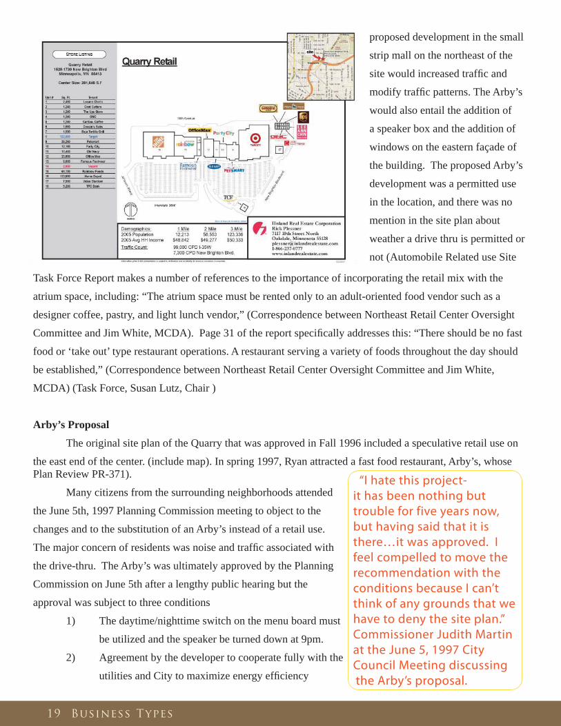
19 Business Types
proposed development in the small
strip mall on the northeast of the
site would increased traffi c and
modify traffi c patterns. The Arby’s
would also entail the addition of
a speaker box and the addition of
windows on the eastern façade of
the building. The proposed Arby’s
development was a permitted use
in the location, and there was no
mention in the site plan about
weather a drive thru is permitted or
not (Automobile Related use Site
Plan Review PR-371).
Many citizens from the surrounding neighborhoods attended
the June 5th, 1997 Planning Commission meeting to object to the
changes and to the substitution of an Arby’s instead of a retail use.
The major concern of residents was noise and traffi c associated with
the drive-thru. The Arby’s was ultimately approved by the Planning
Commission on June 5th after a lengthy public hearing but the
approval was subject to three conditions
1) The daytime/nighttime switch on the menu board must
be utilized and the speaker be turned down at 9pm.
2) Agreement by the developer to cooperate fully with the
utilities and City to maximize energy effi ciency
“I hate this project-it has been nothing but trouble for five years now, but having said that it is there…it was approved. I feel compelled to move the recommendation with the conditions because I can’t think of any grounds that we have to deny the site plan.” Commissioner Judith Martin at the June 5, 1997 City Council Meeting discussing the Arby’s proposal.
Task Force Report makes a number of references to the importance of incorporating the retail mix with the
atrium space, including: “The atrium space must be rented only to an adult-oriented food vendor such as a
designer coffee, pastry, and light lunch vendor,” (Correspondence between Northeast Retail Center Oversight
Committee and Jim White, MCDA). Page 31 of the report specifi cally addresses this: “There should be no fast
food or ‘take out’ type restaurant operations. A restaurant serving a variety of foods throughout the day should
be established,” (Correspondence between Northeast Retail Center Oversight Committee and Jim White,
MCDA) (Task Force, Susan Lutz, Chair )
Arby’s Proposal
The original site plan of the Quarry that was approved in Fall 1996 included a speculative retail use on
the east end of the center. (include map). In spring 1997, Ryan attracted a fast food restaurant, Arby’s, whose
“We would love to have a nice sit down casual family restaurant in northeast Minneapolis. Most of them are all fast food drive-thrus. We don’t need another one in our corner of town.” A resident of Windom Park Neighborhood comment during the June 4, 1997 City Council Meeting discussing the Arby’s proposal.
20 Business Types
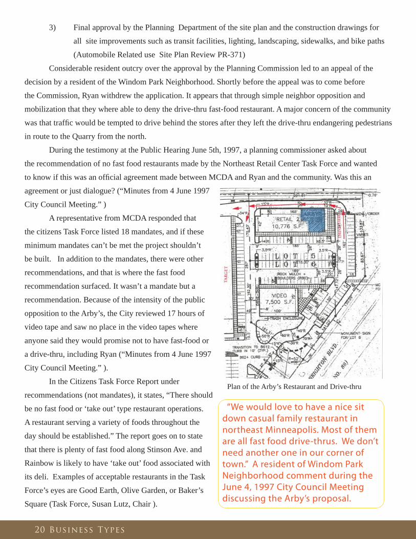
Plan of the Arby’s Restaurant and Drive-thru
3) Final approval by the Planning Department of the site plan and the construction drawings for
all site improvements such as transit facilities, lighting, landscaping, sidewalks, and bike paths
(Automobile Related use Site Plan Review PR-371)
Considerable resident outcry over the approval by the Planning Commission led to an appeal of the
decision by a resident of the Windom Park Neighborhood. Shortly before the appeal was to come before
the Commission, Ryan withdrew the application. It appears that through simple neighbor opposition and
mobilization that they where able to deny the drive-thru fast-food restaurant. A major concern of the community
was that traffi c would be tempted to drive behind the stores after they left the drive-thru endangering pedestrians
in route to the Quarry from the north.
During the testimony at the Public Hearing June 5th, 1997, a planning commissioner asked about
the recommendation of no fast food restaurants made by the Northeast Retail Center Task Force and wanted
to know if this was an offi cial agreement made between MCDA and Ryan and the community. Was this an
agreement or just dialogue? (“Minutes from 4 June 1997
City Council Meeting.” )
A representative from MCDA responded that
the citizens Task Force listed 18 mandates, and if these
minimum mandates can’t be met the project shouldn’t
be built. In addition to the mandates, there were other
recommendations, and that is where the fast food
recommendation surfaced. It wasn’t a mandate but a
recommendation. Because of the intensity of the public
opposition to the Arby’s, the City reviewed 17 hours of
video tape and saw no place in the video tapes where
anyone said they would promise not to have fast-food or
a drive-thru, including Ryan (“Minutes from 4 June 1997
City Council Meeting.” ).
In the Citizens Task Force Report under
recommendations (not mandates), it states, “There should
be no fast food or ‘take out’ type restaurant operations.
A restaurant serving a variety of foods throughout the
day should be established.” The report goes on to state
that there is plenty of fast food along Stinson Ave. and
Rainbow is likely to have ‘take out’ food associated with
its deli. Examples of acceptable restaurants in the Task
Force’s eyes are Good Earth, Olive Garden, or Baker’s
Square (Task Force, Susan Lutz, Chair ).

21 Economic Concerns
Economic Concerns
In the fi rst three years of the 1990s there were a number of ideas put forth for a much needed community
grocery store in Northeast Minneapolis. Many actions were taken to get a grocery store at 18th and Central but
ultimately failed because it was not fi nancially feasible. Rainbow foods closed their store at 18th and University
NE when they decided to relocate to the Quarry.
The task force viewed one of the shopping center’s major goals to encourage and enable Minneapolis
residents to spend their money within the city as a positive. It was also viewed it as a positive that commercial
properties such as the Quarry pay dramatically more taxes that residential and industry properties. This all
meant a larger tax base for the city.
Concern about property values from neighborhood residents was substantial. The task force was
not presented with a study titled “Property Valuation Study” by MCDA at the time of their report in 1994.
This document (if it exists) outlined the impact of the Quarry and its externalities on property values of the
community. As of 2007, the study was not able to be found at the city because the author of the document
doesn’t work there any more. It was not confi rmed that such study was ever undertaken. Increased traffi c is the
primary concern of the neighborhood, and is felt to be likely the largest factor in a decline in property values.
There was also signifi cant concern about the use of eminent domain and the relocation of past
businesses. According to Jim White, project manger from MCDA, at the time of the re-zoning application
in 1996 the agency had purchased the site for the developer and had relocated 90% of past businesses of the
site with no job loss. The focus was to relocate these businesses to industrial areas in Minneapolis if possible.
Complete information was not obtained to where all the businesses were located, but some where relocated in
Minneapolis and some relocated to the suburbs.
The MCDA responded to concerns that a project such as the Quarry in Northeast would adversely
impact Central Ave. commercial corridor and other corridors in Northeast Minneapolis. The City hired the
Economic Research Corporation to complete a market study in 1990 to examine the Central Ave. corridor. In
1995, the agency hired the company again to re-examine its original fi ndings in light of the proposed Quarry
retail center. The agency’s report of 6/20/95 to the City Council included the following: “It was the conclusion
of the Economic Research Corporation that the existing retail businesses along Central Ave. have changed to
the degree that there will be little competition between what’s there now and what will be at the Center.” In
this statement they imply that the Quarry will not take business away from Central Avenue or other business
corridors in the area because of the types of businesses don’t directly compete with one another: discounters vs.
specialty businesses (Economic Research Corporation ).
In the Tax Increment Plan, MCDA deemed it in the best interest of the City and the community to
encourage high quality development standards; the reason being that adjacent residential properties are an
important resource to the City. “The promotion of neighborhood stability and protection of property values
will be achieved through the use of buffers between the retail and residential uses,” (Minneapolis Community
Development Agency ).

22 Economic Concerns
Task Force’s fi ndings on the Economic Impact of the Quarry
The Task Force believed that the shopping center would have some positive economic impact on the
City. They viewed the availability of reasonable priced groceries in the Northeast neighborhood as helping to
stabilize the area economically. But they mentioned that the signifi cant sales tax revenue taken in by the City
would not necessarily go back into the Northeast community.
The Task Force weighed the fi nancial advantages of the project with its various costs. They saw
these costs as being the costs of the project itself for the city as well as the loss of property tax during the tax
increment fi nancing term. They also were concerned about the replacement of the high-wage jobs currently on
site with largely part-time, low-wage jobs. The task force believed that the shopping center should not be judged
only of the basis of greater economic benefi t to the area. It was believed that the shopping center would not stop
the deterioration of other business corridors in northeast such as Central Ave. and Johnson St. Based on these
factors the task force recommended that the following minimum actions be taken:
1. The City in conjunction with neighborhood organizations and area businesses must mobilize both public
and private resources to halt the decline of Northeast business corridors.
2. Businesses in the shopping center must commit to working with employment agencies to hire as many
employees as possible from the local area.
3. Businesses displaced by the shopping center must have real dollar inducements made available to
relocate and MCDA should attempt to fi nd satisfactory locations for relocation.
4. Alternatives should be sought in the Northeast community which may lose a grocery store as a result of
the Quarry (Task Force, Susan Lutz, Chair ).
Economic Impact Study by MJB Consulting
In 2005 Mike Berne of MJB Consulting conducted a study on the impact of the Quarry on the
surrounding Northeast commercial corridors, particularly Central Avenue. Berne was looking for examples
of big-box retail centers in the inner-city to better understand the impact of a retail development proposed for
central Cleveland, OH. The Quarry was seen as an example of how big box center’s economic impacts can be
mitigated in the inner-city by a burgeoning immigrant population. Minneapolis, with its large fl ux of immigrants
settling in Northeast and other neighborhoods in the past decade have created a market for businesses such as
the ones seen on Central Ave. The conclusion from the study was that although the Quarry can be blamed in
part for the loss of some ‘mom and pop” businesses in the area during the 1990s, largely immigrant serving
businesses have fi lled the gap that other businesses left. Berne has found that in cities without a large fl ux of
immigrants there’s a signifi cantly larger number of storefront vacancies in business corridors like Central Ave
near big box retail.

23 Design Concerns
Design Concerns
Design was always and still is to this day a major concern of the City and the residents who in one way
or another were involved in the Quarry project over the past decade or so. A large, suburban style retail center
like this with over 2000 parking spaces in the inner city is unique. Some people feel that the city sold out in
accepting this project that it their eyes has nothing ‘urban’ about it. Others love the fact that they don’t have
to drive to other municipalities to get the cheap essentials that they are going to purchase weather the discount
retailers are in their backyard or fi fteen minutes down the freeway. Throughout the life of the project the
neighborhood organizations, and the various committees and task forces they advocated for better design and
aesthetics of the site.
It’s felt by some that the Quarry has degraded the neighborhood; it seems that these are the same voices
that actively pursued a substantial public gathering space at the Quarry, one that was really never established to
the level of their vision. Others feel that they don’t want to the Quarry to be part of their neighborhood because
of the very nature of the development. They don’t see why the neighborhood would want a development such
as the Quarry to symbolize their community in any way. These are the people that feel that design-wise, the
neighborhood should distance themselves from the Quarry, not integrate into it. Still others point out that
aesthetically the Quarry is better than the majority of retail centers in the suburbs where land is cheaper and
more abundant and municipalities are more lenient. They cite design elements such as the central pedestrian
arcade and the establishment of an identity of the site with the usage of the name ‘Quarry’ as a reference to the
past use of the site. Although opinions vary on design, people do agree the Quarry will remain controversial.
The following is an excerpt from a letter dated May 24, 1996 from the developer, Ryan, to Jim White,
MCDA, subsequent to neighborhood meeting where neighbors voiced design concerns, primarily their desire
for a enclosed public gathering space in the middle of the shopping center. Here the developer explains why the
enclosed atrium idea is not a possibility.
The enclosed atrium: “Its been the developers position for 2 years that an enclosed atrium
is not feasible because a) the space would not be leaseable on a fi nancially feasible basis,
b) a climate controlled interior space would create a security issue because of the creation
of a safe haven for potential undesirable elements, c) the division in the middle of the
Center was always meant for convenient access for the neighbors, not the creation of an
interior mall. The developer feels that they have designed something that will facilitate
the neighbors without creating a security problem or unleasable space.” (Correspondence
between Ryan Companies and Jim White, MCDA)
In a June 10th, 1996 letter from the Northeast Retail Center Oversight Committee to Jim White,
project manger from MCDA, in response to the May 24th letter from developer (above) the letter references
the numerous mentions of the atrium in the Task Force report, “The building will be welcoming and provide
common areas and entrances for the neighborhood and visitors.” Among other strategies indicated in order to
accomplish this goal is: “The neighborhood entry will be located at the middle of the main building, and lead

24 Design Concerns
into an enclosed glass-roofed atrium which will connect to the parking lot.” An additional strategy is: “The
atrium will include seating, and may be a site for community gatherings, small ‘pushcart” boutiques, or other
amenities,” (Correspondence between Northeast Retail Center Oversight Committee and Jim White, MCDA)
This shows the citizens desire for a quality community space to be provide by the developer on the site. It also
shows how the community was able to make their collective voice heard through a central reference, the Task
Force report to the City Council.
The following is an excerpt from a July 25, 1996 Northwest Retail Center Oversight Committee letter
to Jim White, MCDA, to further express design concerns previously mentioned at neighborhood meetings and
correspondence with the developer. At the time the neighborhood’s grand vision of glassed-in atrium over the
central pedestrian arcade was just dropped by the developer and there was talk that a sculpture park in Outlot A
would be a possibility, but never came to be. These expressed design concerns and requests by the community
represent their belief that if design of the shopping center was not thought out carefully, then the blight that once
existed on the site could return in the future. Although not all of their wants were manifested by the developer,
the persistence by the community in demanding high-quality design, although not always feasible, was always
there.
o Atrium (also know as central arcade): “The much anticipated glassed-in atrium will
not be built and is seen as a set back for the neighborhood. Its felt that the proposed design
(which exists today) will not give the same sense of community that the atrium would have.
It’s felt that the proposed artwork and sculpture throughout the center and Outlot A is a great
amenity that helps make up for the loss of the atrium. The neighborhood is relying on the
developer to allow and assist in the installation of appropriate works of art.”
o Arthur St. Pedestrian Access: “Although the Committee is pleased with the existence
of pedestrian access to the center of the site they are concerned that pedestrians will be put
in danger by delivery trucks. They recommend proper infrastructure to deal with the danger
such as traffi c control devices, clearly marked pedestrians crossings, good lines of visibility
and delivery person education at a minimum.”
o Signage: “No more than two freestanding elevated signs located at the Arthur St. and
New Brighton entrances. A ground-level monument sign at the Johnson St. entrance with
appropriate plantings is acceptable.”
o Canopy Usage: “Canopies add both visual interest and shelter. The committee would
like to see extensive use of canopies at both the outbuildings and adjoining the public
walkway at Arthur St.”
o Berms: “Berms need to be high enough to block noise, light, street and sight lines
of the center from the neighborhood. Preferably the berm would be planted with hardy
evergreens; appropriately installed to enhance the pedestrian and bicycle access as well as
the life of the tree.”

25 Design Concerns
(From July 25, 1996 Northwest Retail Center Oversight Committee letter to Jim White, MCDA)
Signage
It was originally ruled by the Zoning Administrator that the center could only have two signs. The
developer was denied the installation of three more freestanding signs. There was controversy over how to
interpret the zoning code. The question was weather a very large lot with several stores should be allowed
multiple signs. The Zoning Administrator interpret the code as only allow one sign per lot. In the end, the
City sided with the developer and the Quarry was allowed 5 total signs, which turned out to be the correct
interpretation of the Zoning Code and is the maximum number of signs the developer will be allowed at the
Quarry under the current code (Minneapolis City Planning Department Report, Variance and Sign Adjustment
Request, BZZ-234).
Parking
The project includes signifi cantly more parking than the minimum required by the Zoning Code. The
planned amount of parking stalls in the beginning slightly exceeds the amount required by the tenants. Zoning
Code sets a minimum standard of 3.30 stalls per 1000 sq. ft. That would be approximately 1338 total stalls at
the Quarry. The tenants require 5.00 stalls per 1000 sq. ft. or approximately 2027 total stalls. What was built (at
the time of opening) comes out to 5.07 stalls per 1000 sq. ft. or 2056 total stalls. That’s 54% percent more than
the minimum the code requires. (Automobile Related use Site Plan Review PR-326, Minneapolis City Planning
Department Report)
The project also includes signifi cantly more handicapped accessible stalls than the minimum required by
the Americans with Disabilities Act (ADA). The ADA requires a minimum of 21 stalls. The project includes 52
stalls (at its opening), 10 of which are also van accessible. (Automobile Related use Site Plan Review PR-326,
Minneapolis City Planning Department Report)
Outlot A
The project includes a 3 acre outlot, Outlot A, that’s located on the southwest corner of the site. The
outlot contains contaminated soils that were excavated from the site during the development of the Quarry.
These polluted soils are being treated in this area by a process called phyto-remediation and through in-situ soil
venting. The area was also planted with grasses native to this region of Minnesota. At an unknown time the
area could be used for an active pedestrian-oriented area. Originally, before it was decided to treat soil there, the
developer planned to have a freestanding building on the site. There was also a motion put forth by residents
that a sculpture park should be developed on site. Currently, there are questions of weather the site could be
developed or not depending on the extent the soils have been cleaned, but its thought that a building would be
very costly because of extensive soil stabilization work that would need to be done. (Conversation between
Author and Rick Jolley, Minnesota Pollution Control Agency)

Famous Footwear and an agreement between the neighborhood and the developer
In 2005, the second developer, Inland who bought the Quarry from Ryan, applied for a conditional
use permit to expand the Quarry by approximately 8,000 sq. ft. for a Famous Footwear store. The store
was proposed to be located between Rainbow and Offi ce Max on what was then open space consisting of
two gazebos in the central arcade pedestrian mall of historical Arthur St. The store would also take 3 feet
of pedestrian pathways in addition to the gazebo open space. In return for the neighborhood giving up this
open space that was promised to them in the beginning by the developer, Inland agreed to offer $50,000 for
improvement of the Quarry’s grounds and the central arcade area. It was agreed that these funds would be used
for green space upgrades, upgrades on traffi c safety, and improvements to the central arcade area to be done
in conjunction with Northeast Park and Windom Park neighborhood organizations. (See more about the traffi c
study promised in this agreement in the traffi c section of this report). It was requested by the neighborhood
organizations that the $50,000 dollars not be dispersed through the City, but instead disbursement would be
worked out directly between the neighborhood organizations and Inland.
26 Design Concerns
Landscaping
It’s stated in the September 1996
Minneapolis City Planning Document PR-326
that 20% of the site must be landscaped minus the
building footprints and that in hardship, at least 10%
must be landscaped with enhancements. In summer
1999, prior to a Target expansion, Home Depot’s expansion of their Garden Center, and the establishment of
Famous Footwear in the central arcade space the following fi gures were given in Minneapolis the September
1996 copy of City Planning Document PR-326 outlining the use of land at the Quarry. (These numbers are
approximate).
Excluding Outlot A Including Outlot Aacres percentage acres percentage
total site 37.9 100% 41.14 100%building footprints 9.49 25% 9.49 23%net site (w/o footprints) 28.59 75% 31.65 77%landscaping 5.09 18% 7.97 25%main parking lot 16.24 43% 16.24 40%total pavement* 23.5 62% 23.5 57%
*Includes paths for pesestrians and bikes and central arcade area
According to this table only 18% of the site is landscaped excluding Outlot A, which is 2% less than
the 20% required in the Site Plan Review. Note that this was prior to the expansion of Target, Home Depot,
and Famous Footwear coming to the Quarry, all three of which would add to the building footprints and reduce
landscape space. It’s not clear if Outlot A should be included in the percentage, one, as being a ‘landscaped
‘space, or two, if its even eligible because it is owned by the City.
27 Finances
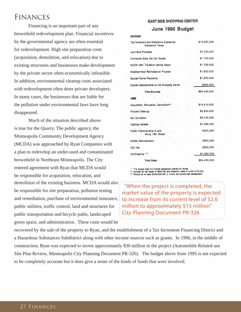
Finances
Financing is an important part of any
brownfi eld redevelopment plan. Financial incentives
by the governmental agency are often essential
for redevelopment. High site preparation costs
(acquisition, demolition, and relocation) due to
existing structures and businesses make development
by the private sector often economically infeasible.
In addition, environmental cleanup costs associated
with redevelopment often deter private developers.
In many cases, the businesses that are liable for
the pollution under environmental laws have long
disappeared.
Much of the situation described above
is true for the Quarry. The public agency, the
Minneapolis Community Development Agency
(MCDA) was approached by Ryan Companies with
a plan to redevelop an under-used and contaminated
brownfi eld in Northeast Minneapolis. The City
entered agreement with Ryan that MCDA would
be responsible for acquisition, relocation, and
“When the project is completed, the market value of the property is expected to increase from its current level of $2.6 million to approximately $15 million” City Planning Document PR-326
demolition of the existing business. MCDA would also
be responsible for site preparation, pollution testing
and remediation, purchase of environmental insurance,
public utilities, traffi c control, land and structures for
public transportation and bicycle paths, landscaped
green space, and administration. These costs would be
recovered by the sale of the property to Ryan, and the establishment of a Tax Increment Financing District and
a Hazardous Substances Subdistrict along with other income sources such as grants. In 1996, in the middle of
construction, Ryan was expected to invest approximately $30 million in the project (Automobile Related use
Site Plan Review, Minneapolis City Planning Document PR-326). The budget above from 1995 is not expected
to be completely accurate but it does give a sense of the kinds of funds that were involved.

28 Home Depot Issues
Home Depot Issues
Home Depot opened at the Quarry in 1996. In addition to offering building materials , Home Depot
sells garden supplies which are housed in an outdoor Garden Center with fenced walls and a partial roof that
covers the front (south) third of the center. According to Home Depot, the Quarry store is one of the most
profi table in their whole system, however the Garden Center at the Quarry location, at the time, was one of the
smallest of the company’s centers and is believed to still be (its common for inner-city retail centers such as
the Quarry to have slightly smaller buildings than a suburban retail center). In the past there were issues with
materials bound for the interior of the Garden Center being allowed to sit outside for extended periods of time
on all three sides of the building.
The City, neighborhood, and Home Depot resolved these issues by adopting an agreement. The Interim
Operating Agreement (IOA) clearly defi ned the ‘operating parameters’ of Home Depot. Since the execution
of the agreement in Fall 2002 the city had received no substantive complaints (as of 2005). The agreement’s
intention was to defi ne the operating protocols and to test them during the construction of the proposed
expansion of the Garden Center, which Home Depot had in the works since 1999.
The City approved the site plan review for the expansion of the Garden Center in July 2002
(Minneapolis City Planning Department Report Site Plan Review Application BZZ-732), but Home Depot never
built and the permits expired but the IOA stayed in effect. This was the second time that the City approved the
Garden Center expansion and the company failed to build. The fi rst time was in 2000, when the City approved
the proposal in September 2000 (Minneapolis City Planning Department Report, Site Plan Review Application
BZSP-190 and Conditional use Permit Application BZCU-202).
Prior to this, in November 1999, Home Depot applied for a Conditional Use Permit that would allow them to be open 24-hours. WPCiA
(Windom Park Citizens in Action,
the neighborhood organization
for the neighborhood just north
of the Quarry) was employed by
citizens angered, Home Depot,
a company that was already not
complying with city regulations
would be approved for a 24-
hour permit by the City. WPCiA
recommended denial of the
application not only because of
concerns about lack of compliance
with existing regulations but
also because the community was This aerial image shows the Home Depot at the Quarry in May 1999. Notice the materials stored outside of the Nursery to the left of the building in the image.

29 Home Depot Issues
against a 24-hour Home Depot in their neighborhood. The reasons they gave for this opposition were increased
traffi c and noise during late night hours. WPCiA also passed a resolution containing suggested conditions to
be added to the conditional use permit if it were to be approved by the Planning Commission. See Appendix
2 for a Motion drafted by WPCiA giving reasons Home Depot has been a ‘bad neighbor’ and shouldn’t be
approved the conditional use permit. Also see Appendix 3 for an opinionated fl yer circulated by residents to the
neighborhood notifying them of an upcoming meeting where issues with Home Depot will be discussed.
At the time the Planning Department recommended approval of the permit but this approval was subject
to twelve conditions, essentially the same conditions that WPCiA suggested. Later, at the December 13th, 1999
meeting, the Planning Commission denied the application. Home Depot was denied largely because they were
not in compliance with existing regulations and had not been a ‘good neighbor’ to the adjacent residential
community (Fisher ). Home Depot appealed the decision but withdrew permit application before it could go
before the City Council in January 2000. In their Letter of Withdraw Home Depot stated, “Home Depot wishes
to exhibit improved property and store management over a period of time prior to pursuing approval for a 24-
hour store,” (Correspondence between Michael Orange, MCDA, and Paul Farmer, MCDA).
For most of Home Depot’s existence at the Quarry, residents of Windom Park neighborhood to the
north have complained about the store’s management practices related to the staging and storage of materials
on the exterior of the building and Garden Center. Prior to 2002 the City cited Home Depot many citations for
violations to the Zoning and Fire Code because of their staging and storing of materials on the exterior of the
site. Home Depot challenged these citations in court in 2002. The court dismissed the City charges on the basis
that Home Depot received insuffi cient notices of the violations before the City issued the citations (Department
of Community Planning and Economic Development, Planning Division, Conditional use Permit and Site Plan
Review BZZ-2223).
Part of the confl ict with the legality of staging of materials is that (at least at the time) the City’s Zoning
Code does not contain solid defi nitions for the staging and storing of materials. In addition, the original zoning
permits for the Quarry didn’t address conditions of approval to the problems a Home Depot type store could
pose. The solutions made in 2002 to these
problems were “1) create structures that delineate
and contain staging and storage areas, and 2)
clearly defi ne operating parameters that Home
Depot can live within and the City can enforce
without ambiguity.”
In 2002, WPCiA had a Quarry Committee
meeting to discuss issues related to Home Depot
(Minneapolis City Planning Department Report
Site Plan Review Application BZZ-732). It was
expressed in this meeting that Home Depot stores Home Depot image taken my resident in 1999 showing the exterior staging andd storing of materials
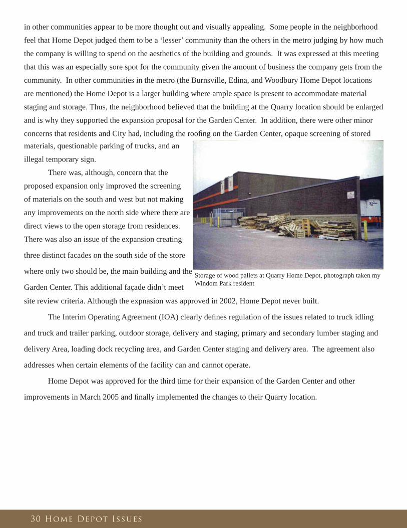
30 Home Depot Issues
in other communities appear to be more thought out and visually appealing. Some people in the neighborhood
feel that Home Depot judged them to be a ‘lesser’ community than the others in the metro judging by how much
the company is willing to spend on the aesthetics of the building and grounds. It was expressed at this meeting
that this was an especially sore spot for the community given the amount of business the company gets from the
community. In other communities in the metro (the Burnsville, Edina, and Woodbury Home Depot locations
are mentioned) the Home Depot is a larger building where ample space is present to accommodate material
staging and storage. Thus, the neighborhood believed that the building at the Quarry location should be enlarged
and is why they supported the expansion proposal for the Garden Center. In addition, there were other minor
concerns that residents and City had, including the roofi ng on the Garden Center, opaque screening of stored materials, questionable parking of trucks, and an
illegal temporary sign.
There was, although, concern that the
proposed expansion only improved the screening
of materials on the south and west but not making
any improvements on the north side where there are
direct views to the open storage from residences.
There was also an issue of the expansion creating
three distinct facades on the south side of the store
where only two should be, the main building and the
Garden Center. This additional façade didn’t meet
site review criteria. Although the expnasion was approved in 2002, Home Depot never built.
The Interim Operating Agreement (IOA) clearly defi nes regulation of the issues related to truck idling
and truck and trailer parking, outdoor storage, delivery and staging, primary and secondary lumber staging and
delivery Area, loading dock recycling area, and Garden Center staging and delivery area. The agreement also
addresses when certain elements of the facility can and cannot operate.
Home Depot was approved for the third time for their expansion of the Garden Center and other
improvements in March 2005 and fi nally implemented the changes to their Quarry location.
Storage of wood pallets at Quarry Home Depot, photograph taken my Windom Park resident

Additional Concerns, Avenues, and Notes
Union Pacifi c Liable for the Contamination?
There’s one baffl ing sentence in the 25
September 1996 Minneapolis City Planning
Document PR-326. It says “The Union Pacfi c-
Railroad, parent company of the former owners
of the site, the Chicago & Northwestern
Railroad, is responsible for site clean-up of the
soil pollution.” No where else in any document
viewed for this study was this allegation
referenced. Was it simply a mistake or is Union-
Pacifi c actually liable for some of the pollution
on the site? If so, why weren’t they pursued for
funds?
Property Valuation Study
Was the MCDA’s Property Valuation Study every
completed in 1994? Does it exist? It’s mentioned in the
Task Force as not being provided to citizens by the City,
but it does imply its existence.
“The first concern is Ryan Construction’s proposal to vent the methane gas at the Quarry site into the community air. It seems more logical to burn the methane in some way, perhaps as a remembrance of the settlers in this community and the traditions they held dear.” Windom Park resident’s statement submitted in the EAW.
“Another concern would be the accuracy of the projected increase in traffic generation on major routes along or near the perimeter of the retail center….I would think that the major north/south thoroughfares of Johnson St. and Stinson Blvd. would experience greater traffic increases than projected.” Northeast resident’s concern found in EAW
“An officer from the Northeast Business Association spoke very favorably for the project at a public meeting. This person made comment that the Hi-Lake Shopping Center improved that neighborhood” (Hi-Lake is a similar sized development with some of the same tenants of the Quarry. It’s located in south Minneapolis). Statement found in EAW
31 Additional Concerns, Avenues, and Notes
“It takes me five minutes to get to Rosedale. Why should our neighborhood be at risk?” A Northeast resident voicing their concern at an early neighborhood meeting in August 1993 when the project had just been announced (Fillmore ).
“I don’t want to spend my money in the suburbs. I want to spend it where I live.” A concern from a Northeast resident in support of the project early in the planning process. (Fillmore ).
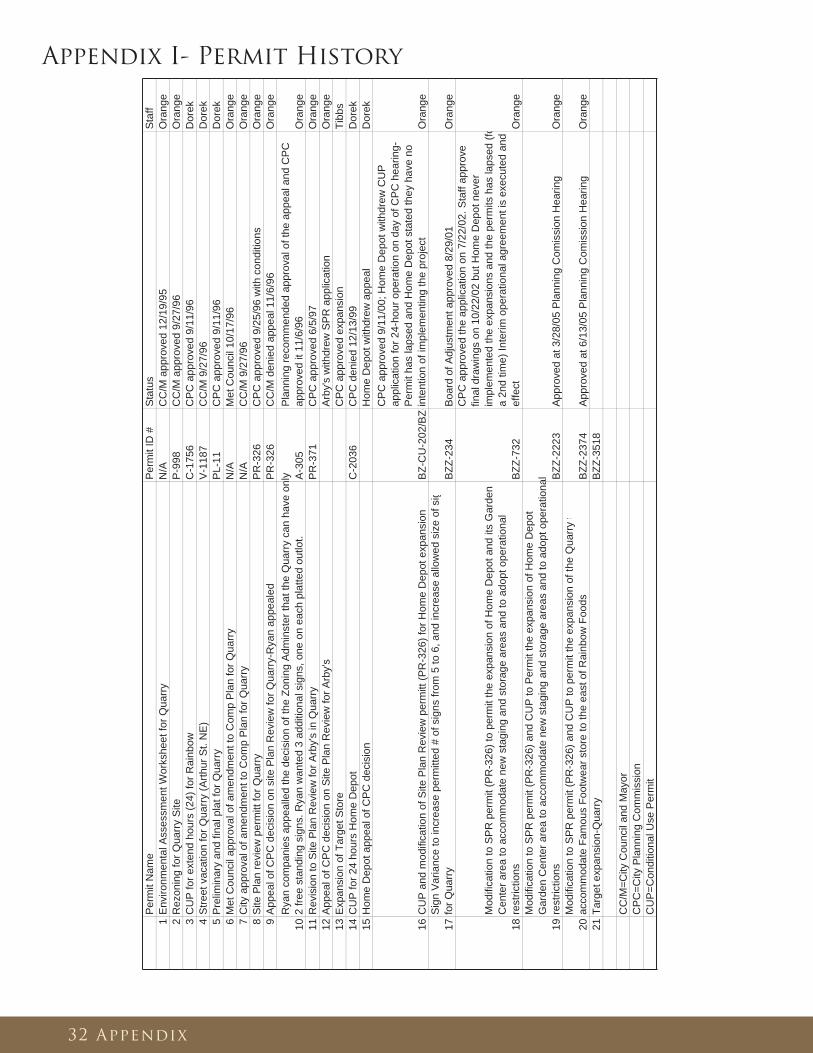
Per
mit
Nam
eP
erm
it ID
#S
tatu
sS
taff
1E
nviro
nmen
tal A
sses
smen
t Wor
kshe
et fo
r Qua
rry
N/A
CC
/M a
ppro
ved
12/1
9/95
Ora
nge
2R
ezon
ing
for Q
uarr
y S
iteP
-998
CC
/M a
ppro
ved
9/27
/96
Ora
nge
3C
UP
for e
xten
d ho
urs
(24)
for R
ainb
owC
-175
6C
PC
app
rove
d 9/
11/9
6D
orek
4S
treet
vac
atio
n fo
r Qua
rry
(Arth
ur S
t. N
E)
V-1
187
CC
/M 9
/27/
96D
orek
5P
relim
inar
y an
d fin
al p
lat f
or Q
uarr
yP
L-11
CP
C a
ppro
ved
9/11
/96
Dor
ek6
Met
Cou
ncil
appr
oval
of a
men
dmen
t to
Com
p P
lan
for Q
uarr
yN
/AM
et C
ounc
il 10
/17/
96O
rang
e7
City
app
rova
l of a
men
dmen
t to
Com
p P
lan
for Q
uarr
yN
/AC
C/M
9/2
7/96
Ora
nge
8S
ite P
lan
revi
ew p
erm
itt fo
r Qua
rry
PR
-326
CP
C a
ppro
ved
9/25
/96
with
con
ditio
nsO
rang
e9
App
eal o
f CP
C d
ecis
ion
on s
ite P
lan
Rev
iew
for Q
uarr
y-R
yan
appe
aled
PR
-326
CC
/M d
enie
d ap
peal
11/
6/96
Ora
nge
10R
yan
com
pani
es a
ppea
lled
the
deci
sion
of t
he Z
onin
g A
dmin
ster
that
the
Qua
rry
can
have
onl
y 2
free
stan
ding
sig
ns. R
yan
wan
ted
3 ad
ditio
nal s
igns
, one
on
each
pla
tted
outlo
t.A
-305
Pla
nnin
g re
com
men
ded
appr
oval
of t
he a
ppea
l and
CP
C
appr
oved
it 1
1/6/
96O
rang
e11
Rev
isio
n to
Site
Pla
n R
evie
w fo
r Arb
y's
in Q
uarr
yP
R-3
71C
PC
app
rove
d 6/
5/97
Ora
nge
12A
ppea
l of C
PC
dec
isio
n on
Site
Pla
n R
evie
w fo
r Arb
y's
Arb
y's
with
drew
SP
R a
pplic
atio
nO
rang
e13
Exp
ansi
on o
f Tar
get S
tore
CP
C a
ppro
ved
expa
nsio
nTi
bbs
14C
UP
for 2
4 ho
urs
Hom
e D
epot
C-2
036
CP
C d
enie
d 12
/13/
99D
orek
15H
ome
Dep
ot a
ppea
l of C
PC
dec
isio
nH
ome
Dep
ot w
ithdr
ew a
ppea
lD
orek
16C
UP
and
mod
ifica
tion
of S
ite P
lan
Rev
iew
per
mitt
(PR
-326
) for
Hom
e D
epot
exp
ansi
onB
Z-C
U-2
02/B
Z -
CP
C a
ppro
ved
9/11
/00;
Hom
e D
epot
with
drew
CU
P
appl
icat
ion
for 2
4-ho
ur o
pera
tion
on d
ay o
f CP
C h
earin
g-P
erm
it ha
s la
psed
and
Hom
e D
epot
sta
ted
they
hav
e no
in
tent
ion
of im
plem
entin
g th
e pr
ojec
tO
rang
e
17S
ign
Var
ianc
e to
incr
ease
per
mitt
ed #
of s
igns
from
5 to
6, a
nd in
crea
se a
llow
ed s
ize
of s
i gfo
r Qua
rry
BZZ
-234
Boa
rd o
f Adj
ustm
ent a
ppro
ved
8/29
/01
Ora
nge
18
Mod
ifica
tion
to S
PR
per
mit
(PR
-326
) to
perm
it th
e ex
pans
ion
of H
ome
Dep
ot a
nd it
s G
arde
n C
ente
r are
a to
acc
omm
odat
e ne
w s
tagi
ng a
nd s
tora
ge a
reas
and
to a
dopt
ope
ratio
nal
rest
rictio
nsB
ZZ-7
32
CP
C a
ppro
ved
the
appl
icat
ion
on 7
/22/
02. S
taff
appr
ove d
final
dra
win
gs o
n 10
/22/
02 b
ut H
ome
Dep
ot n
ever
im
plem
ente
d th
e ex
pans
ions
and
the
perm
its h
as la
psed
(fo
a 2n
d tim
e) In
terim
ope
ratio
nal a
gree
men
t is
exec
uted
and
ef
fect
Ora
nge
19
Mod
ifica
tion
to S
PR
per
mit
(PR
-326
) and
CU
P to
Per
mit
the
expa
nsio
n of
Hom
e D
epo t
Gar
den
Cen
ter a
rea
to a
ccom
mod
ate
new
sta
ging
and
sto
rage
are
as a
nd to
ado
pt o
pera
tiona
l re
stric
tions
BZZ
-222
3A
ppro
ved
at 3
/28/
05 P
lann
ing
Com
issi
on H
earin
gO
rang
e
20M
odifi
catio
n to
SP
R p
erm
it (P
R-3
26) a
nd C
UP
to p
erm
it th
e ex
pans
ion
of th
e Q
uarr
y t
acco
mm
odat
e Fa
mou
s Fo
otw
ear s
tore
to th
e ea
st o
f Rai
nbow
Foo
dsB
ZZ-2
374
App
rove
d at
6/1
3/05
Pla
nnin
g C
omis
sion
Hea
ring
Ora
nge
21Ta
rget
exp
ansi
on-Q
uarr
y B
ZZ-3
518
CC
/M=C
ity C
ounc
il an
d M
ayor
CP
C=C
ity P
lann
ing
Com
mis
sion
C
UP
=Con
ditio
nal U
se P
erm
it
Appendix I- Permit History
32 Appendix

Appendix 2- Windom Park Motion
33 Appendix

Appendix 3- Windom Park Neighborhood Flyer
34 Appendix
35 Bibliography
Bibliography
Agenda City Planning Commission., 11 September 2000.
Application to Expand the Existing Quarry Shopping Center., 24 June 2005.
Automobile Related use Site Plan Review PR-326, Minneapolis City Planning Department Report., 25
September 1996.
Automobile Related use Site Plan Review PR-371., 5 June 1997.
“Automobile Related use Site Plan Review, Minneapolis City Planning Document PR-326.” (25 Sept 1996) .
Barton-Aschman Associates, Inc. “Traffi c Impact Study, N.E. Minneapolis, MN.” (1994).
Braun Intertec Corporation prepared for Rider, Bennett, Egan & Arundel, C.C.P. Third Party Review of
Documents., 14 January 1997.
City Planning Commission Minutes., 11 September 1996.
City Planning Commission Minutes., 13 December 1999.
Conceptual Response Action Plan, Northeast Retail Development, Minneapolis, MN., March 1995.
“Conditional use Permit Application BZCU-202.” (11 September 2000) .
Conversation between Author and Rick Jolley, Minnesota Pollution Control Agency., 10 July 2007.
“Correspondence between Jim White, Minneapolis Community Development Agency, and Greg Quade,
Northeast Business Association.” NE Retail Center Task Force Appendix 18 March 1994 .
“Correspondence between Jim White, Minneapolis Community Development Agency, and Greg Quade,
Northeast Business Association.” NE Retail Center Task Force Appendix 24 February 1994 .
Correspondence between Julie Johanson, Metropolitan Council and Ron McKinley, Minneapolis Planning
Commission., 11 September 1996.
Correspondence between Liesch Environmental Engineering and Rick Jolley,Minnesota Pollution Control
Agency, the Quarry West Site (MPCA 4554) Semi-Annual Environmental Monitoring Results for the Period of
July through December 2006 and Annual Monitoring Summary., 2006.
Correspondence between Michael Orange, MCDA, and Paul Farmer, MCDA., 4 March 1997.
Correspondence between Northeast Retail Center Oversight Committee and Jim White, MCDA., 25 July 1996.
Correspondence between Northeast Retail Center Oversight Committee and Jim White, MCDA., 10 June 1996.
Correspondence between Paul Farmer, MCDA and Pat Scott, Minneapolis City Council Zoning and Planning
Committee., 24 October 1996.
Correspondence between Paul Farmer, Minneapolis Community Development Agency, and Michael Orange,
Minneapolis Community Development Agency., 16 October 1996.
Correspondence between Rick Jolley, Minnesota Pollution Control Agency and Windom Park Neighborhood
Resident., 4 August 1997.
Correspondence between Ryan Companies and Jim White, MCDA., 24 May 1996.
Correspondence from Steve Mahowald, MCTO to Michael Orange, MCDA., Sept 25 1996.

Department of Community Planning and Economic Development, Planning Division, Conditional use Permit
and Amendment to the Existing Site Plan Review Permit BZZ-2374., 13 June 2005.
Department of Community Planning and Economic Development, Planning Division, Conditional use Permit
and Site Plan Review BZZ-2223., 28 March 2005.
East Side Shopping Center Budget., June 1995.
Economic Research Corporation. Northeast Minneapolis Central Avenue Retail Development Study., 1990.
Fillmore, Gail. “Shopping Center Meetings Begin.” Northeaster, 25 August 1993.
Findings of Fact and Record of Decision, Environmental Assessment Worksheet.
Fisher, Linda. “Linda Fisher Letter to Michael Orange, MCDA.” 21 July 2000.
Google Earth., www.earth.google.com, 2007.
Haugen, Dan. “Offi cials Break Ground on Northeast “Bicycle Freeway”.” Northeast Beat, 9 May 2007.
“The Inland Real Estate Group of Companies, Inc.” 2007. <http://www.inlandgroup.com/>.
Interim Operating Agreement between the City of Minneapolis and the Home Depot Store at the Quarry
Shopping Center in Northeast Minneapolis., August 2002.
Quarry, Metropolitan Design Center Image Bank., 22 October 2003.
Quarry, Metropolitan Design Center Image Bank., May 1999.
Mike Gorman, Barton-Aschman Associates, Inc. Questions from Northeast Minneapolis Neighborhood Meeting
December 29, 1993., 12 January 1994.
Minneapolis City Planning Department Report Site Plan Review Application BZZ-732., 22 July 2002.
Minneapolis City Planning Department Report, Rezoning Application P-998., 11 September 1996.
Minneapolis City Planning Department Report, Site Plan Review Application BZSP-190 and Conditional use
Permit Application BZCU-202., 11 September 1996.
Minneapolis City Planning Department Report, Variance and Sign Adjustment Request, BZZ-234., 29 August
2001.
Minneapolis City Planning Department Report “Minneapolis Plan for the 1980s” Amendment Analysis., 11
September 1996.
Minneapolis Community Development Agency, and Ryan Construction Company of Minnesota, Inc. “Contract
for Private Development.” undated.
Minneapolis Community Development Agency. Common Development and Redevelopment Plan and Tax.,
Increment Financing Plan Modifi cation no. 30, May 2, 1994.
BRW, Inc. & White Mountain Survey Co. Minneapolis Parkway Traffi c Study., May 1998.
“East Side Shopping Center Budget.” 4 May 1994.
“East Side Shopping Center Increment Financing Plan.” 2 May 1994 .
“Modifi cation no. 1 to the Broadway/I-35W Tax Increment Financing Plan.” 2 May 1994.
“Minutes from 4 June 1997 City Council Meeting.” 5 June 1997 .
Minutes: Windom Park Citizens in Action Members Meeting., 15 February 2005.
36 Bibliography

Olson, Gail. “More Space for Quarry Target.” Northeaster 16 May 2007.
Orange, Michael. “Memorandum: Home Depot at the Quarry.” 24 October 2001 .
Peer Engineering. “Preliminary Environmental Assessment.” .
Peer Environmental & Engineering Resources, Inc. “Response Action Plan, Northwest Retail Development,
Minneapolis, MN.” Sept 1995 .
Potential Funding for the Transit Facilities for the Quarry Project., 11 October 1996.
Quarry Project Review Committee, Minutes of 5/1/96 Meeting.
“Rezoning Application P-988.” 11 September 1996 .
“Site Plan Review Application BZSP-190.” 11 September 2000 .
Status of the Quarry Project and a Related Issue regarding the Water Plan, Memorandum from Paul Farmer to
Michael Orange., 4 October 1996.
Status of the Quarry Project, Memorandum from Michael Orange to Paul Farmer., 16 October 1996.
Status of the Quarry Project, Memorandum from Michael Orange to Paul Farmer., 9 Oct 1996.
Task Force, Susan Lutz, Chair. Report to the Minneapolis City Council on the Rainbow/Target Development in
Northeast Minneapolis., May 1994.
Traffi c Impact Report for Northeast Retail Center., April 1994.
Windom Park Citizens in Action Motion., 30 November 1999.
37 Bibliography
Recommended