Styliaras. SpringerPlus (2015) 4:311 DOI 10.1186/s40064-015-1115-3
REVIEW
Towards a web-based archaeological excavation platform for smartphones: review and potentialsGeorgios Styliaras*
Abstract
The paper conducts a review questioning the usability of a web-based platform supporting archaeological excava-tions and related fields, which will execute on smartphones. Based on the thorough review and comparison of related work, the basic features of such a platform are outlined. The platform should support documenting content on an underlying XML database through a content management system, producing and exchanging notes, map interac-tion, use of a shared whiteboard, collaboration among archaeologists etc. The architecture of the platform is pre-sented along with two case studies supporting usual practices on an archaeological field, some primary evaluation results and future work.
© 2015 Styliaras. This article is distributed under the terms of the Creative Commons Attribution 4.0 International License (http://creativecommons.org/licenses/by/4.0/), which permits unrestricted use, distribution, and reproduction in any medium, provided you give appropriate credit to the original author(s) and the source, provide a link to the Creative Commons license, and indicate if changes were made.
Introduction and discussionSmartphone sales have reached outstanding numbers. According to Gartner (http://www.gartner.com), one bil-lion smartphones were sold in 2013. Furthermore, smart-phones outsold feature phones in 2013 for first time ever, whereas smartphone growth is driven by developing mar-kets. Therefore, it is obvious that smartphone penetration is a global phenomenon and applications developed for them have potentials to reach billion users worldwide. The characteristics of smartphones, such as location awareness, touch interactivity, wireless connectivity and voice com-mands make them ideal for a lot application categories.
On the other hand, web technologies provide now the interface means for a variety of applications such as social media, information delivery and business operations. The evolution of browsers, their scripting languages and their capabilities have made possible the implementation of complex functions through a uniform interface. In parallel, more and more users are accustomed to interacting with a browser. Therefore, it is ordinary for software developers to exploit this infrastructure for building applications.
In this paper, the potential of using smartphones and web technologies in a platform that assists archaeological
excavations and related fields is presented. The inspi-ration for this platform has been the involvement in working with the 3rd Ephorate of Prehistoric and Clas-sic Antiquities in Greece for supporting the relocation of the mobile exhibits of the ephorate to a new area. In this case, which took place in 2005, a content manage-ment system has been implemented, which curators of the ephorate enriched wirelessly via an application imple-mented for a Pocket PC device. Visual Basic for Applica-tions has been used for implementing the application. More than 100 fields were defined in the underlying data-base in order to record the characteristics and the resto-ration process of a single exhibit. Archaeologists could work on site and record the characteristics of mobile exhibits in the various fields with the mobile device. The application was tabbed in order to provide easy access to sibling fields. Furthermore, more and more research and actual implementations call for automation in archaeo-logical processes such as Henson (2013), Shott (2014), REVEAL (Sanders 2011) and Stanish and Levy (2013), who enumerate the stages that this automation should follow as reviewed in the following section. During the involvement in a research project with various archaeo-logical teams working in the Archaeological site of Stobi, the ancient city of Pompeipolis and Argos Orestikon, archaeologists working on these sites confirm this need.
Open Access
*Correspondence: [email protected] Department of Cultural Heritage Environment and New Technologies, University of Patras, Seferi 2, 30132 Agrinio, Greece
Page 2 of 14Styliaras. SpringerPlus (2015) 4:311
They currently tend to use smartphone technology but in an unorganized way.
Nowadays, with the advancement of smartphones and web technologies, such operations and the actual exca-vation process may be assisted even more. However, there is no complete platform that assists archaeologi-cal excavations or similar activities that has been espe-cially designed for smartphones and takes into account modern capabilities of web technologies. In most cases, as shown in the following review section, related sys-tems and applications are designed for desktop and use simplistic web interfaces. Smartphones are treated as another means for executing these applications. More sophisticated mobile applications have been used in dis-semination of cultural content, by exploiting augmented reality, social media and multimedia playback. Concern-ing web technologies, there are technologically advanced applications that, once again, are used mainly in the cul-tural heritage dissemination process. In the excavation process, existing applications seem to exploit only the content input functions of forms. The proposed platform based on the following review supports all the actions that take place in an excavation, by exploiting as many of the smartphone capabilities as possible, through a web interface that is most suitable for a mobile device with a touch screen.
The paper is organized as follows. Firstly, through the review and comparison of related work, the rationale for the selection of characteristics for a web-based plat-form assisting excavations through mobile devices is presented. “Web technologies and smartphones” summa-rizes the features of web technologies and smartphones that are useful for such a platform. “Archaeological exca-vations platform” presents the platform, whereas “Case studies” presents two case studies of its usage. “Usability evaluation of the proposed platform” presents a primary evaluation based on the cognitive walkthrough method. Finally, “Conclusions/future work” concludes the paper and presents some future work.
Review and comparisonAs little work has been done for supporting archaeo-logical excavations through information technologies and especially web technologies and mobile devices, this section presents a thorough review of the most relevant applications and systems found that support even partially the excavation process and related fields or the dissemination of cultural content as a whole and that function through web interfaces or smartphones in some parts. After the comparative presentation of simi-lar application and systems, it is shown that there is no complete system or application for mobile devices that is intended for archaeological excavations and embraces
web technologies. However, there are a lot of scattered features in these heterogeneous platforms that could be exploited in the platform proposed. In the review pre-sented, the focus is on these characteristics.
Firstly, some related work discusses generally the need for information technologies in the archaeological exca-vation process. Then the review continues with some early platforms, developed prior to the smartphone era, which supported some excavation documenting opera-tions. The use of smartphones is reviewed in projects that are applied to similar environments to excavations and in more generic cultural dissemination projects. Finally, some applications are reviewed with modern interfaces that assist in archaeological excavations.
Theoretical backgroundTheoretically speaking, Henson (2013) examines how digital media and especially web technologies could be embraced effectively for disseminating archaeological content. There are examples of web sites, but the con-clusion is that more needs to be done. A lot of examples covering the workflow of analysis of digital models of stone tools are presented in Shott (2014). The workflow includes Data acquisition, Digital Modelling, Analysis and Archiving. Lithic analysts employ geomorphometric methods in order to characterize, measure and analyze stone tools with newly invented mediums. The author states that once 3D models are completed to acceptable standards, finished models should be made web-accessi-ble. Dunleavy (2014) states that Augmented Reality can exploit smartphone features such as GPS, compass, cam-era, object recognition and tracking in order to provide the basis for the implementation of educational applica-tions for cultural settings. Ch’ng (2011) explores new ways for enriching the heritage tourism experience. This paper focuses on new media-enhanced exploration and learning of culture and heritage and proposes the Herit-age Tourist in the Web 3.0 and Pervasive Computing Era. Web technologies and smartphone capabilities are fully embraced in the scenario presented although it concerns mainly the tourist’s experience in a heritage area.
Early platformsOn some early platforms, which however have some sound design features, 3D Murale (Cosmas et al. 2001), contains tools for recording, reconstructing, visualizing and database querying for buildings and their parts, stat-ues and their parts, pottery, stratigraphy, terrain geome-try and texture and material texture. The tools are loosely linked together by a common database on which all users have the facility to store and access data. Web exploita-tion was regarded as future work. Similarly, a digital excavation data management system has been used in
Page 3 of 14Styliaras. SpringerPlus (2015) 4:311
the “Grand Ribaud F” Estruscan deep-water wreck (Drap and Long 2001). Java has been used for formalizing and manipulating archaeological data, for digital photogram-metry and a three-dimensional model generator has been used as a navigation interface for a database.
Smartphone applications for similar environmentsOn the other hand, smartphone usage is present in appli-cation such as iInteractive Tiled Display Wall (Rieko et al. 2012), where authors developed an system that allows users to explore digital heritage content with intuitive interface that operates on a smartphone. The applica-tion translates the user’s movement in the smartphone to multimedia content interaction on large displays. The application focuses on cultural content presentation in general and makes no use of web technologies. Andersen and Møbjerg (2013) describe a smartphone application designed to display prehistoric and historic finds and sites at the actual locations where events took place. An online, web-based editor tool makes it easy for museum curators to add new locations and make changes to exist-ing ones. The application exploits augmented reality and smartphone features such as GPS to display content. On a more sophisticated application, ALERT mobile (Bar-reau et al. 2013) is a web-based smartphone application that exploits their GPS feature in order to allow a user to type and transmit information about vulnerable situ-ations of coastal archaeological heritage sites to a secure server. Users may perform queries to find relevant infor-mation based on geographical and technical criteria. This application satisfies the technological criteria for smart-phones and web technologies but it is not used in pure excavation work.
Smartphone applications for cultural disseminationMobile devices and web technologies have been used extensively in disseminating cultural content, as in PEACH (Busetta et al. 2004), where museum visitors are provided with information about exhibits. Information may originate from the museum’s server or other remote servers and presented on mobile devices, info kiosks or large display areas. The devices sense approaching visi-tors and produce custom, agent produced and role-based presentations. In this case, no web technologies are engaged. Duffy et al. (2011) discuss a GPS-guided full 3D reconstruction of an ancient environment on iPhone and iPad, the Lost City of Clonmacnoise. Although smart-phones are exploited, the method focuses on reconstruc-tion and does not engage web technologies. Ardito et al. (2012) focus on the adoption of composition technolo-gies for the creation of web-based situational, sharable interactive spaces that can engage smartphones. Authors exploited a general-purpose platform for mashup
composition, and have contextualized it to respond to the needs of a community of cultural heritage opera-tors. In Ardito et al. (2013), the same team illustrates an approach to enhance the visit experience of archeologi-cal parks. It also exploits composition technologies, End-User Development and participatory design approaches, in order to allow different users to create, use and share Personal Information Spaces. Heterogeneous content can be combined and manipulated to satisfy different information needs, thus enabling personalized visits to Cultural Heritage sites. Spaces are web-based and can be accessed by smartphones. Finally, XMAR (Brondi et al. 2012) is a framework that addresses the needs of outdoor markerless applications to be used in the field of cultural heritage. LiTe has been designed and developed on top of the XMAR framework to provide an augmented view of Piazza dei Miracoli, an artistic site in Italy. The appli-cation operates on smartphones, exploits their features such as GPS and presents a web-based interface.
Excavation assisting applicationsThere are information systems assisting in excavations that make limited use of smartphone capabilities or web technologies. For example, Virtual Anthropology (Weber 2014) exploits digital technologies and brings together experts from different domains such as anthropology, biology, mathematics, computer science and engineer-ing. Six areas constitute the term Virtual Anthropology: digitization, exposition, comparison, reconstruction, materialization and share. Among them, only the last area, share, exploits web technologies for sharing content to the public. REVEAL (Sanders 2011) is an information system that coordinates all data types used at excava-tions with semi-automated tools that in turn can ease the process of documenting archaeological sites, trenches and objects, recording excavation progress, research-ing and analyzing the collected evidence, and creating 3D models and virtual worlds. It focuses on exploiting excavation data and visualizing them. Although web-based forms are employed for entering content, there is no mention for further web exploitation or use of smart-phones. Two modern approaches used in archaeological excavations are analyzed in Stanish and Levy (2013), who stress the need to engage new technologies in all stages of the archeological process, namely acquisition, analy-sis, curation and dissemination. Firstly, for acquisition, ArchField is proposed, a digital data collection tool by Neil G. Smith and Thomas E. Levy (http://www.antiq-uity.ac.uk/projgall/smith331/). ArchField is a Real-time 3D archaeological field recording system based on open-source technologies and focus on GIS capabilities. The system has been applied extensively in southern Jordan and it has been designed to meet archaeologists’ digital
Page 4 of 14Styliaras. SpringerPlus (2015) 4:311
recording needs. The system stores all recorded content in a server-based remote database and automatically renders in the field what is being excavated. It partially uses web-based form for content editing and is designed as a desktop application for laptops. However, it can be executed on smartphones. Secondly, OpenDig (Vincent et al. 2013) is a platform for recording, editing, managing and publishing archaeological data. It comprises of three related applications, one for data entry in the field using hand-held mobile devices, another as a lightweight utility to view and edit data during an expedition and finally a full web application with complete tools for research and analysis. Web interface is active only for documentation purposes, after the actual excavation.
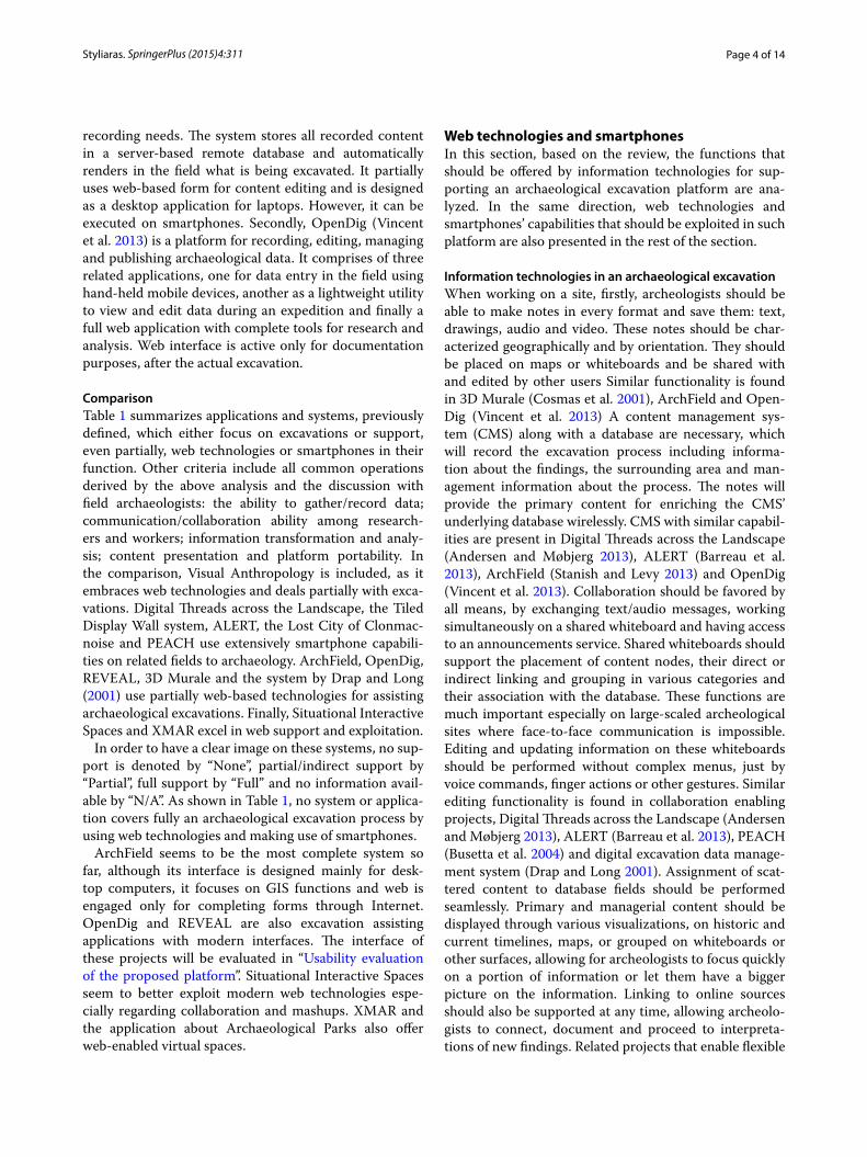
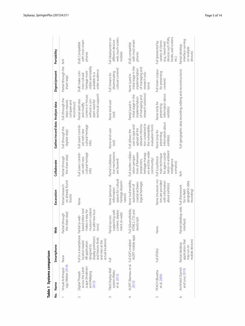
ComparisonTable 1 summarizes applications and systems, previously defined, which either focus on excavations or support, even partially, web technologies or smartphones in their function. Other criteria include all common operations derived by the above analysis and the discussion with field archaeologists: the ability to gather/record data; communication/collaboration ability among research-ers and workers; information transformation and analy-sis; content presentation and platform portability. In the comparison, Visual Anthropology is included, as it embraces web technologies and deals partially with exca-vations. Digital Threads across the Landscape, the Tiled Display Wall system, ALERT, the Lost City of Clonmac-noise and PEACH use extensively smartphone capabili-ties on related fields to archaeology. ArchField, OpenDig, REVEAL, 3D Murale and the system by Drap and Long (2001) use partially web-based technologies for assisting archaeological excavations. Finally, Situational Interactive Spaces and XMAR excel in web support and exploitation.
In order to have a clear image on these systems, no sup-port is denoted by “None”, partial/indirect support by “Partial”, full support by “Full” and no information avail-able by “N/A”. As shown in Table 1, no system or applica-tion covers fully an archaeological excavation process by using web technologies and making use of smartphones.
ArchField seems to be the most complete system so far, although its interface is designed mainly for desk-top computers, it focuses on GIS functions and web is engaged only for completing forms through Internet. OpenDig and REVEAL are also excavation assisting applications with modern interfaces. The interface of these projects will be evaluated in “Usability evaluation of the proposed platform”. Situational Interactive Spaces seem to better exploit modern web technologies espe-cially regarding collaboration and mashups. XMAR and the application about Archaeological Parks also offer web-enabled virtual spaces.
Web technologies and smartphonesIn this section, based on the review, the functions that should be offered by information technologies for sup-porting an archaeological excavation platform are ana-lyzed. In the same direction, web technologies and smartphones’ capabilities that should be exploited in such platform are also presented in the rest of the section.
Information technologies in an archaeological excavationWhen working on a site, firstly, archeologists should be able to make notes in every format and save them: text, drawings, audio and video. These notes should be char-acterized geographically and by orientation. They should be placed on maps or whiteboards and be shared with and edited by other users Similar functionality is found in 3D Murale (Cosmas et al. 2001), ArchField and Open-Dig (Vincent et al. 2013) A content management sys-tem (CMS) along with a database are necessary, which will record the excavation process including informa-tion about the findings, the surrounding area and man-agement information about the process. The notes will provide the primary content for enriching the CMS’ underlying database wirelessly. CMS with similar capabil-ities are present in Digital Threads across the Landscape (Andersen and Møbjerg 2013), ALERT (Barreau et al. 2013), ArchField (Stanish and Levy 2013) and OpenDig (Vincent et al. 2013). Collaboration should be favored by all means, by exchanging text/audio messages, working simultaneously on a shared whiteboard and having access to an announcements service. Shared whiteboards should support the placement of content nodes, their direct or indirect linking and grouping in various categories and their association with the database. These functions are much important especially on large-scaled archeological sites where face-to-face communication is impossible. Editing and updating information on these whiteboards should be performed without complex menus, just by voice commands, finger actions or other gestures. Similar editing functionality is found in collaboration enabling projects, Digital Threads across the Landscape (Andersen and Møbjerg 2013), ALERT (Barreau et al. 2013), PEACH (Busetta et al. 2004) and digital excavation data manage-ment system (Drap and Long 2001). Assignment of scat-tered content to database fields should be performed seamlessly. Primary and managerial content should be displayed through various visualizations, on historic and current timelines, maps, or grouped on whiteboards or other surfaces, allowing for archeologists to focus quickly on a portion of information or let them have a bigger picture on the information. Linking to online sources should also be supported at any time, allowing archeolo-gists to connect, document and proceed to interpreta-tions of new findings. Related projects that enable flexible
Page 5 of 14Styliaras. SpringerPlus (2015) 4:311
Tabl
e 1
Syst
ems
com
pari
son
No.
Nam
eSm
artp
hone
Web
Exca
vatio
nCo
llabo
rate
Gat
her/
reco
rd d
ata
Ana
lyze
dat
aD
iges
t/pr
esen
tPo
rtab
ility
1Vi
rtua
l Ant
hrop
ol-
ogy
(Web
er 2
014)
Non
ePa
rtia
l (th
roug
h
the
shar
e st
ep)
Part
ial (
rese
arch
on
alre
ady
foun
d fo
ssils
)
Part
ial (
thro
ugh
th
e sh
are
step
)Fu
ll (t
hrou
gh th
e di
gitiz
e st
ep)
Full
(thr
ough
the
step
s: ex
pose
, co
mpa
re a
nd
reco
nstr
uct)
Part
ial (
thro
ugh
the
shar
e st
ep)
N/A
2D
igita
l Thr
eads
ac
ross
the
Land
-sc
ape
(And
erse
n an
d M
øbje
rg
2013
)
Full
(is a
sm
artp
hone
lo
catio
n ba
sed
AR
appl
icat
ion
desi
gned
to
disp
lay
preh
isto
ric
and
hist
oric
find
s an
d si
tes
at th
e ac
tual
loca
tions
)
Part
ial (
a w
eb-
base
d ed
itor t
ool
mak
es it
eas
y fo
r m
useu
m c
urat
ors
to a
dd n
ew lo
ca-
tions
)
Non
eFu
ll (u
sers
con
trib
-ut
e w
ith n
ew
cultu
ral h
erita
ge
info
)
Full
(use
rs c
ontr
ib-
ute
with
new
cu
ltura
l her
itage
in
fo)
Part
ial (
add
site
s
and
mod
ify
cont
ent i
n-ho
use,
w
ithou
t a c
on-
stan
t nee
d fo
r te
chni
cal s
uppo
rt)
(Ful
l) m
ake
com
-m
on c
ultu
ral
herit
age
mor
e vi
sibl
e an
d re
adily
av
aila
ble
to a
w
ider
aud
ienc
e
(Ful
l) Co
mpa
tible
w
ith m
ost s
mar
t-ph
ones
3Ti
led
Dis
play
Wal
l sy
stem
(Rie
ko
et a
l. 20
12)
Full
Part
ial (
acce
ss
supp
ortin
g w
eb
cont
ent,
depl
oy-
men
t on
web
)
Non
e (p
erso
nal
info
rmat
ion
sp
aces
for c
ultu
ral
herit
age
diss
emi-
natio
n)
Part
ial (
colla
bora
-tiv
e m
echa
nism
s ar
e fa
vore
d)
Non
e (e
nd-u
ser
tool
)N
one
(end
-use
r to
ol)
Full
(mea
ns fo
r di
ssem
inat
ing
cultu
ral c
onte
nt)
Full
(dep
loym
ent o
n di
ffere
nt d
evic
es:
web
, tou
ch s
cree
n,
mob
ile)
4A
LERT
(Bar
reau
et a
l. 20
13)
Full
(GPS
ena
bled
A
LERT
mob
ile a
pp)
Full
(jQue
ryM
obile
, H
TML5
, CSS
and
Ja
vaSc
ript)
Non
e (v
ulne
rabi
lity
asse
ssm
ent o
f co
asta
l arc
haeo
-lo
gica
l her
itage
)
Full
(wid
en c
olla
bo-
ratio
n pe
rspe
c-tiv
es o
f bet
wee
n re
sear
cher
s, he
ritag
e m
anag
-er
s an
d th
e w
ider
co
mm
unity
)
Full
(allo
ws
the
user
to ty
pe a
nd
uplo
ad a
ll th
e re
leva
nt in
form
a-tio
n co
ntai
ned
in
the
vuln
erab
ility
ev
alua
tion
form
)
Part
ial (
used
in
initi
al s
tage
in th
e im
plem
enta
tion
of m
anag
ing
and
rese
arch
sol
utio
ns)
Non
e (u
sed
in
initi
al s
tage
in th
e im
plem
enta
tion
of m
anag
ing
and
rese
arch
sol
u-tio
ns)
(Ful
l) co
mpa
tible
w
ith m
ost s
mar
t-ph
ones
5PE
AC
H (B
uset
ta
et a
l. 20
04)
Full
(PD
As)
Non
eN
one
(mus
eum
vis
i-to
rs a
re p
rovi
ded
with
info
rmat
ion
abou
t exh
ibits
)
Full
(Lou
dVoi
ce:
mai
n te
chni
que
for a
gent
coo
rdi-
natio
n in
am
bien
t in
telli
genc
e sc
enar
ios)
Non
e (o
nly
for
pres
entin
g in
form
atio
n ab
out
exhi
bits
)
Non
e (o
nly
for
pres
entin
g in
form
atio
n ab
out
exhi
bits
)
Full
(mai
n sc
opus
fo
r pre
sent
ing
cont
ent)
Full
(pre
sent
ed b
y va
riety
of c
lient
s (e
.g.,
hand
-hel
d de
vice
s su
ch P
DA
s, ki
osks
, wal
l scr
eens
et
c.)
6A
rchF
ield
(Sta
nish
an
d Le
vy 2
013)
Part
ial (
desk
top
appl
icat
ion
that
m
ay ru
n on
m
obile
dev
ices
)
Part
ial (
desk
top
web
in
terf
ace)
Full
(fram
ewor
k
for i
n-fie
ld
geog
raph
ic d
ata
reco
rdin
g)
N/A
Full
(geo
grap
hic
data
reco
rdin
g, e
ditin
g an
d re
cons
truc
tions
)Pa
rtia
l (de
skto
p in
terf
ace
runn
ing
on m
ultip
le
devi
ces)
Page 6 of 14Styliaras. SpringerPlus (2015) 4:311
Tabl
e 1
cont
inue
d
No.
Nam
eSm
artp
hone
Web
Exca
vatio
nCo
llabo
rate
Gat
her/
reco
rd d
ata
Ana
lyze
dat
aD
iges
t/pr
esen
tPo
rtab
ility
7O
penD
ig (V
ince
nt
et a
l. 20
13)
Full
(iOS
ap
plic
atio
n)Pa
rtia
l (on
ly H
TTP
and
sem
antic
web
ex
ploi
tatio
n)
Full
(use
d in
exc
ava-
tion
site
s)Pa
rtia
l (si
mul
tane
-ou
s ac
cess
to
data
base
)
Full
(pla
tform
for r
ecor
ding
, edi
ting,
man
agin
g an
d pu
blis
hing
ar
chae
olog
ical
dat
a)Fu
ll (d
eskt
op a
nd
smar
tpho
nes)
8RE
VEA
L (S
ande
rs
2011
)N
one
Part
ial (
sim
plis
tic
web
inte
rfac
e)Fu
ll (c
oord
inat
es
exca
vatio
ns w
ith
sem
i-aut
omat
ed
tool
s th
at in
turn
ca
n ea
se th
e pr
o-ce
ss o
f doc
umen
t-in
g si
tes)
N/A
Full
(doc
umen
t si
tes,
tren
ches
and
ob
ject
s, of
reco
rd-
ing
exca
vatio
n pr
ogre
ss)
Full
(rese
arch
and
an
alyz
e co
llect
ed
evid
ence
)
Full
(cre
ate
3D
mod
els
and
virt
ual w
orld
s)
Non
e (s
ingl
e pi
ece
of s
oftw
are
run-
ning
on
PC)
93D
Mur
ale
(Cos
mas
et
al.
2001
)N
one
Non
eFu
ll (M
easu
re te
r-ra
in, s
trat
igra
phy,
bu
ildin
gs, b
uild
ing
bloc
ks, p
otte
ry,
pott
ery
sher
ds
and
stat
ues
on
arch
aeol
ogic
al
site
)
N/A
Full
(inco
rpor
ates
au
dio/
vide
o/im
age/
text
cap
-tu
re a
nd c
reat
ion)
Part
ial (
inde
/in
tegr
atio
n to
ols)
Full
(vis
ualis
atio
n to
ols
for v
iew
ing
the
outc
ome
of
data
base
sea
rch
proc
ess
and
for
diss
emin
atio
n,
sear
ch to
ols)
Non
e
10D
igita
l exc
avat
ion
data
man
agem
ent
syst
em (D
rap
and
Long
200
1)
Non
ePa
rtia
l (di
ffusi
on o
f kn
owle
dge
abou
t th
e ex
cava
tion
via
web
inte
rfac
e)
Full
(dat
a m
anag
e-m
ent s
yste
m fo
r ar
chae
olog
ical
ex
cava
tions
)
Full
(sim
ulta
neou
s co
ntrib
utio
n by
st
aff m
embe
rs)
Full
(tex
tual
, im
age,
ph
otog
ram
met
ry)
Full
(sto
re a
nd
man
ipul
ate
data
to
ded
icat
ed
DBM
S)
Full
(web
-bas
ed
pres
enta
tion)
N/A
11Lo
st C
ity o
f Clo
n-m
acno
ise
(Duff
y et
al.
2011
)
Full
(iOS
ap
plic
atio
n)N
one
(onl
y m
inor
H
TML
cont
ribu-
tion)
Non
eN
/AFu
ll (g
raph
ical
3D
m
odel
s of
bui
ld-
ings
)
Full
(ass
embl
e ge
o-re
fere
nced
terr
ain
surf
ace
etc.
)
Full
(pre
sent
reco
n-st
ruct
ed c
ultu
ral
herit
age
site
s)
Part
ial (
iOS
devi
ces)
12Si
tuat
iona
l int
erac
-tiv
e sp
aces
(Ard
ito
et a
l. 20
12)
Part
ial (
devi
ces
with
to
uch
scre
ens
and
mob
iles)
Full
(web
-bas
ed
plat
form
)N
one
(orie
nted
for
diss
emin
atio
n)Fu
ll (v
isito
rs c
reat
e an
d in
tera
ct w
ith
situ
atio
nal p
lace
s)
Non
e (o
rient
ed fo
r dis
sem
inat
ion)
Full
(cul
tura
l he
ritag
e co
nten
t di
ssem
inat
ion)
Full
(dep
loym
ent o
n di
ffere
nt d
evic
es
web
, tou
ch s
cree
n,
mob
ile, L
IM)
13XM
AR
(Bro
ndi e
t al.
2012
)Fu
ll (m
arke
rless
m
obile
aug
-m
ente
d re
ality
ap
plic
atio
n)
Full
(out
com
e: 3
D
web
site
of P
iazz
a de
i Mira
coli)
Non
e (O
nly
for
cultu
ral d
isse
mi-
natio
n)
Non
e (s
ingl
e-us
er
appl
icat
ion)
Non
e (e
nd-u
ser
appl
icat
ion)
Non
e (e
nd-u
ser
appl
icat
ion)
Full
(3D
real
-tim
e re
nder
ing
of
cultu
ral h
erita
ge
mon
umen
ts)
Part
ial (
acce
ss
thro
ugh
And
roid
de
vice
s an
d de
sk-
top
com
pute
rs)
Page 7 of 14Styliaras. SpringerPlus (2015) 4:311
content input are Digital Threads across the Landscape (Andersen and Møbjerg 2013), ALERT (Barreau et al. 2013), PEACH (Busetta et al. 2004) and OpenDig (Vin-cent et al. 2013).
Web technologies for archeological interfacesAs already mentioned in “Review and comparison”, there are many web-based applications focusing on editing, research and analysis of cultural content, augmented reality views of monuments and Infor-mation Spaces for archaeological parks (Ardito et al. (2013). Nowadays, web technologies offer many new features that can be employed by applications assist-ing archaeological excavations. Digital Cultural Herit-age Map (DCHM) (Mousouris and Styliaras 2013) is such an indicative application that has exploited many such features in order to implement a CMS for content experts to populate a digital map. DCHM may operate uniformly on all devices supporting HTML, without requiring installations or upgrades. Web sockets have been used for content communication, while extensive use of HTML 5 and AJAX has permitted continuous content editing and updating without requiring page reloading. Responsive design consideration has allowed the map to operate smoothly on any screen. HTML 5’s Geolocation API has been employed in order to inte-grate the web interface with map functionality. JavaS-cript is used to collect data from various components and handle errors, while OpenLayers are used to ren-der a point on a vector layer. HTML5’s localStorage API has been used to implement “My Favorites”, a list of preferred cultural locations. The video gallery uses the HTML5 video tag that makes video embedding simpler, straightforward and plug-in independent. Edit-ing of textual content is made via HTML5 forms. The Drag and Drop API allows to drag and upload files on the browser via event listeners. Files are uploaded using the xmlHttpRequest2 API.
During an excavation, these capabilities, such as stor-age APIs, continuous content communication through sockets, responsive design, multimedia tags and script-ing, are necessary for on-site specialists to be able to record findings, document them and take notes, share them on maps or other areas and attach multimedia content, ranging from simple images and video to 3D models. Management and content forms for the whole process should be made available to various devices and platforms. Last but not least, social media integra-tion and content visualization by using SVG (e.g. charts, timelines as in http://www.dipity.com) would enhance the communication and collaboration among on-site specialists and the dissemination of findings to the rest of the world. Content visualization can be based also on
spatial hypermedia (Shipman et al. 2002) that extends classic hypertext and hypermedia by allowing new ways of explicit or implicit linking and relations of multimedia nodes and also by imposing direct or indirect grouping of information.
Smartphone capabilities for archaeological excavationsMobile devices and smartphones have proved their potential in a lot of processes regarding archaeologi-cal and cultural content in general starting from content gathering until dissemination. Before smartphones, per-sonal digital assistants, wireless, GPS and touch capabili-ties have been employed in order to assist archaeologists and curators to record the location and enrich wire-lessly, the properties of mobile exhibits. Now, there are smartphone applications that can transmit information about vulnerable situations of coastal archaeological heritage, provide information about exhibits and his-toric finds, perform excavation data recording, support media-enhanced exploration and learning of culture and heritage, support 3D reconstruction of an ancient envi-ronment and share interactive spaces.
Based on the review [especially in Rieko et al. (2012), Andersen and Møbjerg (2013) and Barreau et al. (2013)], smartphone features that can be used in the proposed platform are wireless and mobile phone connectivity for exchanging content; GPS, digital compass and map soft-ware for providing location awareness; a touch screen that is ideal for interacting with and visualizing content exploiting space; microphone/speakers and text editing software for taking audio/text notes and collaboration; camera for capturing photos, panoramas and videos for supporting augmented reality; media player for playback-ing audiovisual content and animations.
Archaeological excavations platformIn this section, based on the previous discussion and especially on the functionality of related systems and applications, a platform for supporting archaeologi-cal excavations is proposed which exploits smartphone functionality and modern web interfaces. The platform is modular, so that basic functions are always present while secondary ones are instantiated on demand.
More specifically, the platform is consisted of the fol-lowing modules:
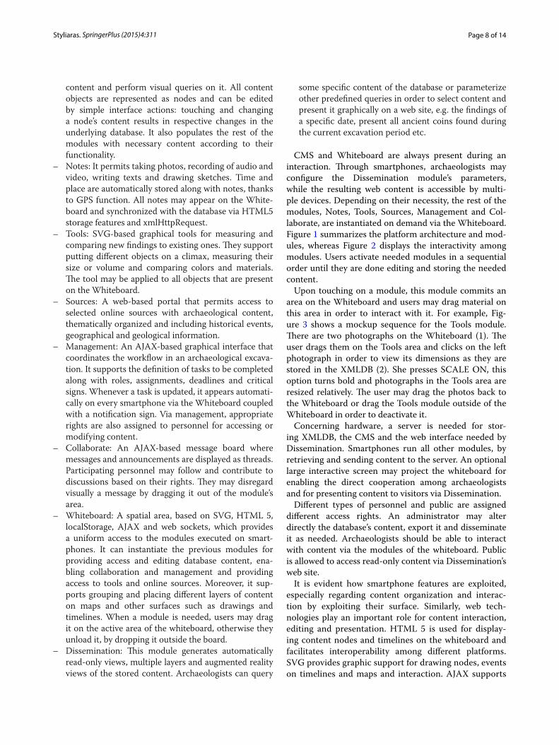
– XMLDB: A database in XML format that holds all information needed by the following modules executed on smartphones. The selection of XML for storing content ensures content integrity and portability.
– CMS: A web-based Content Management System that provides a visual interface between the database and content editors, who may load, insert, edit, update
Page 8 of 14Styliaras. SpringerPlus (2015) 4:311
content and perform visual queries on it. All content objects are represented as nodes and can be edited by simple interface actions: touching and changing a node’s content results in respective changes in the underlying database. It also populates the rest of the modules with necessary content according to their functionality.
– Notes: It permits taking photos, recording of audio and video, writing texts and drawing sketches. Time and place are automatically stored along with notes, thanks to GPS function. All notes may appear on the White-board and synchronized with the database via HTML5 storage features and xmlHttpRequest.
– Tools: SVG-based graphical tools for measuring and comparing new findings to existing ones. They support putting different objects on a climax, measuring their size or volume and comparing colors and materials. The tool may be applied to all objects that are present on the Whiteboard.
– Sources: A web-based portal that permits access to selected online sources with archaeological content, thematically organized and including historical events, geographical and geological information.
– Management: An AJAX-based graphical interface that coordinates the workflow in an archaeological excava-tion. It supports the definition of tasks to be completed along with roles, assignments, deadlines and critical signs. Whenever a task is updated, it appears automati-cally on every smartphone via the Whiteboard coupled with a notification sign. Via management, appropriate rights are also assigned to personnel for accessing or modifying content.
– Collaborate: An AJAX-based message board where messages and announcements are displayed as threads. Participating personnel may follow and contribute to discussions based on their rights. They may disregard visually a message by dragging it out of the module’s area.
– Whiteboard: A spatial area, based on SVG, HTML 5, localStorage, AJAX and web sockets, which provides a uniform access to the modules executed on smart-phones. It can instantiate the previous modules for providing access and editing database content, ena-bling collaboration and management and providing access to tools and online sources. Moreover, it sup-ports grouping and placing different layers of content on maps and other surfaces such as drawings and timelines. When a module is needed, users may drag it on the active area of the whiteboard, otherwise they unload it, by dropping it outside the board.
– Dissemination: This module generates automatically read-only views, multiple layers and augmented reality views of the stored content. Archaeologists can query
some specific content of the database or parameterize other predefined queries in order to select content and present it graphically on a web site, e.g. the findings of a specific date, present all ancient coins found during the current excavation period etc.
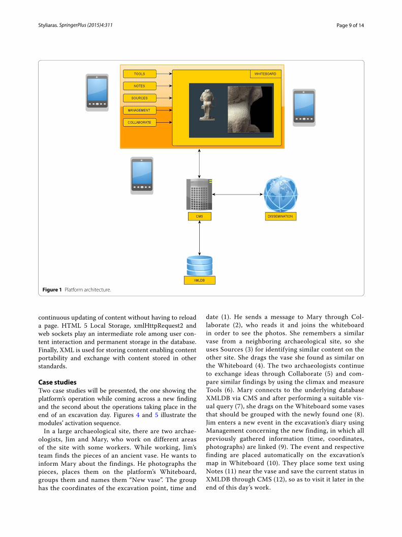
CMS and Whiteboard are always present during an interaction. Through smartphones, archaeologists may configure the Dissemination module’s parameters, while the resulting web content is accessible by multi-ple devices. Depending on their necessity, the rest of the modules, Notes, Tools, Sources, Management and Col-laborate, are instantiated on demand via the Whiteboard. Figure 1 summarizes the platform architecture and mod-ules, whereas Figure 2 displays the interactivity among modules. Users activate needed modules in a sequential order until they are done editing and storing the needed content.
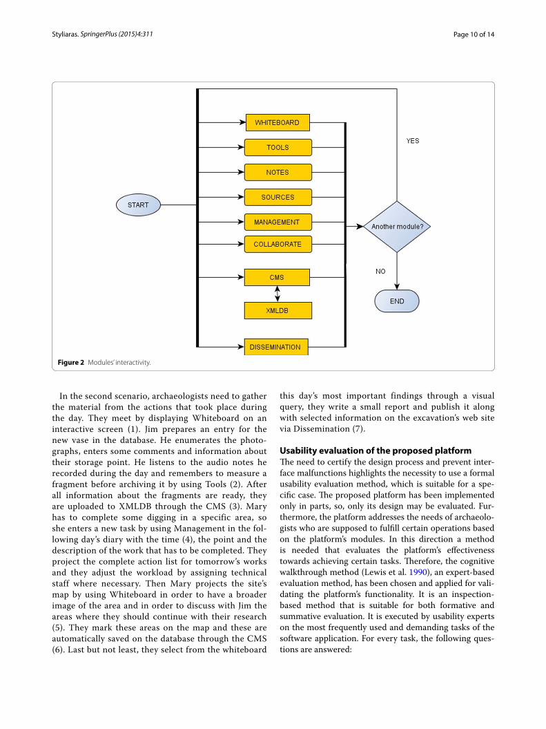
Upon touching on a module, this module commits an area on the Whiteboard and users may drag material on this area in order to interact with it. For example, Fig-ure 3 shows a mockup sequence for the Tools module. There are two photographs on the Whiteboard (1). The user drags them on the Tools area and clicks on the left photograph in order to view its dimensions as they are stored in the XMLDB (2). She presses SCALE ON, this option turns bold and photographs in the Tools area are resized relatively. The user may drag the photos back to the Whiteboard or drag the Tools module outside of the Whiteboard in order to deactivate it.
Concerning hardware, a server is needed for stor-ing XMLDB, the CMS and the web interface needed by Dissemination. Smartphones run all other modules, by retrieving and sending content to the server. An optional large interactive screen may project the whiteboard for enabling the direct cooperation among archaeologists and for presenting content to visitors via Dissemination.
Different types of personnel and public are assigned different access rights. An administrator may alter directly the database’s content, export it and disseminate it as needed. Archaeologists should be able to interact with content via the modules of the whiteboard. Public is allowed to access read-only content via Dissemination’s web site.
It is evident how smartphone features are exploited, especially regarding content organization and interac-tion by exploiting their surface. Similarly, web tech-nologies play an important role for content interaction, editing and presentation. HTML 5 is used for display-ing content nodes and timelines on the whiteboard and facilitates interoperability among different platforms. SVG provides graphic support for drawing nodes, events on timelines and maps and interaction. AJAX supports
Page 9 of 14Styliaras. SpringerPlus (2015) 4:311
continuous updating of content without having to reload a page. HTML 5 Local Storage, xmlHttpRequest2 and web sockets play an intermediate role among user con-tent interaction and permanent storage in the database. Finally, XML is used for storing content enabling content portability and exchange with content stored in other standards.
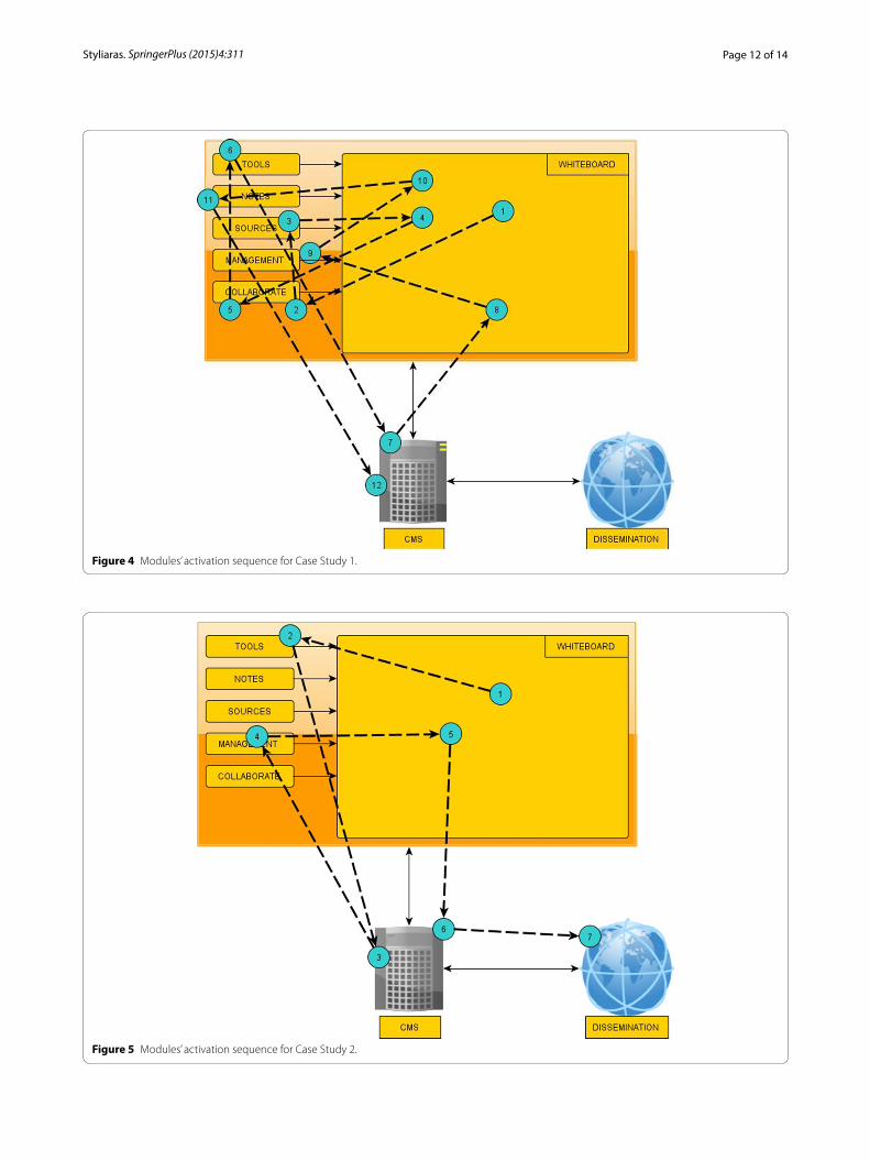
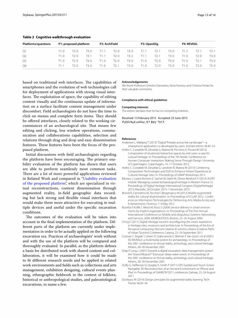
Case studiesTwo case studies will be presented, the one showing the platform’s operation while coming across a new finding and the second about the operations taking place in the end of an excavation day. Figures 4 and 5 illustrate the modules’ activation sequence.
In a large archaeological site, there are two archae-ologists, Jim and Mary, who work on different areas of the site with some workers. While working, Jim’s team finds the pieces of an ancient vase. He wants to inform Mary about the findings. He photographs the pieces, places them on the platform’s Whiteboard, groups them and names them “New vase”. The group has the coordinates of the excavation point, time and
date (1). He sends a message to Mary through Col-laborate (2), who reads it and joins the whiteboard in order to see the photos. She remembers a similar vase from a neighboring archaeological site, so she uses Sources (3) for identifying similar content on the other site. She drags the vase she found as similar on the Whiteboard (4). The two archaeologists continue to exchange ideas through Collaborate (5) and com-pare similar findings by using the climax and measure Tools (6). Mary connects to the underlying database XMLDB via CMS and after performing a suitable vis-ual query (7), she drags on the Whiteboard some vases that should be grouped with the newly found one (8). Jim enters a new event in the excavation’s diary using Management concerning the new finding, in which all previously gathered information (time, coordinates, photographs) are linked (9). The event and respective finding are placed automatically on the excavation’s map in Whiteboard (10). They place some text using Notes (11) near the vase and save the current status in XMLDB through CMS (12), so as to visit it later in the end of this day’s work.
Figure 1 Platform architecture.
Page 10 of 14Styliaras. SpringerPlus (2015) 4:311
In the second scenario, archaeologists need to gather the material from the actions that took place during the day. They meet by displaying Whiteboard on an interactive screen (1). Jim prepares an entry for the new vase in the database. He enumerates the photo-graphs, enters some comments and information about their storage point. He listens to the audio notes he recorded during the day and remembers to measure a fragment before archiving it by using Tools (2). After all information about the fragments are ready, they are uploaded to XMLDB through the CMS (3). Mary has to complete some digging in a specific area, so she enters a new task by using Management in the fol-lowing day’s diary with the time (4), the point and the description of the work that has to be completed. They project the complete action list for tomorrow’s works and they adjust the workload by assigning technical staff where necessary. Then Mary projects the site’s map by using Whiteboard in order to have a broader image of the area and in order to discuss with Jim the areas where they should continue with their research (5). They mark these areas on the map and these are automatically saved on the database through the CMS (6). Last but not least, they select from the whiteboard
this day’s most important findings through a visual query, they write a small report and publish it along with selected information on the excavation’s web site via Dissemination (7).
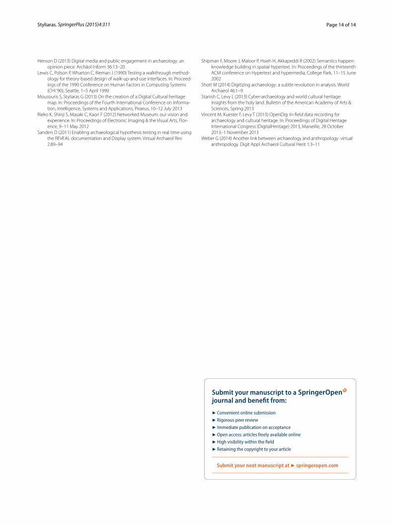
Usability evaluation of the proposed platformThe need to certify the design process and prevent inter-face malfunctions highlights the necessity to use a formal usability evaluation method, which is suitable for a spe-cific case. The proposed platform has been implemented only in parts, so, only its design may be evaluated. Fur-thermore, the platform addresses the needs of archaeolo-gists who are supposed to fulfill certain operations based on the platform’s modules. In this direction a method is needed that evaluates the platform’s effectiveness towards achieving certain tasks. Therefore, the cognitive walkthrough method (Lewis et al. 1990), an expert-based evaluation method, has been chosen and applied for vali-dating the platform’s functionality. It is an inspection-based method that is suitable for both formative and summative evaluation. It is executed by usability experts on the most frequently used and demanding tasks of the software application. For every task, the following ques-tions are answered:
Figure 2 Modules’ interactivity.
Page 11 of 14Styliaras. SpringerPlus (2015) 4:311
Q1. Will the users try to achieve the right effect?Q2. Will the user notice that the correct action is avail-able?Q3. Will the user associate the correct action with the effect trying to be achieved?Q4. If the correct action is performed, will the user see that progress is being made toward solution of the task?
If an answer to a question is negative, the usabil-ity expert should justify the answer and suggest certain improvements to solve the issue that causes the negative answer. Problems identified during the walkthrough are rated according to a discrete scale:
0 = no users would have problems;1 = some would have problems;2 = more than half would have problems;3 = most users would select the wrong action.
In order to evaluate the usability of the platform, a typi-cal task has been chosen: “Document an archaeological
finding including its photograph and technical details (dimensions and excavation point)” with the following subtasks.
T1. Gather dimensions and multimedia data about the finding collaboratively.T2. Measure and compare findings to existing ones.T3. Store and disseminate content about the finding on a database.
The cognitive walkthrough method has been applied by three usability experts, field archaeologists with expe-rience in mobile devices and information systems for excavation content. The specialists executed the method on the proposed platform’s design (P1) and the three platforms that are oriented in excavations and have even partial support for mobile devices and web technologies, namely ArchField (P2), OpenDig (P3) and REVEAL (P4). Table 2 summarizes the findings as average values of the specialists’ rates. The proposed platform appears with less usability issues. For T3, usability experts noticed that storing content was not as straightforward as using the other visual tools. They propose integrating the function-ality of the CMS in the Whiteboard, as the other mod-ules. Concerning ArchField, although it is a powerful application for gathering geographical data and measure-ments, the evaluation showed that there is some lack in collaboration ability (T1), poor visual feedback in some tools (T2) and inadequate dissemination mediums, espe-cially during fieldwork (T3). They propose that a new version is necessary designed from scratch for touch-enabled devices. OpenDig presents some minor usability problems in T1 and T2, when trying to find the right tool for the needed functionality. The specialists’ proposition is the implementation of a more straightforward visual user interface that would help improving interactivity. Finally, REVEAL presents some issues while users try to select the right tool for their tasks and in T2, they had a measuring problem. A simpler visual interface would help overcome the problems, as the specialists suggest.
Conclusions/future workThis paper presented a review towards the design of a platform that supports archaeological excavations through smartphones and web technologies. As there is little previous work in this area, an extensive compara-tive presentation of systems and applications that are related to excavations and similar fields has revealed the features that such a platform should support. This review has shown there is no complete system that is especially designed for mobile devices and is based on web technologies for this process. Some systems focus on dissemination, others on mobile operations or are
Figure 3 Interactivity scheme for the Tools’ module.
Page 12 of 14Styliaras. SpringerPlus (2015) 4:311
Figure 4 Modules’ activation sequence for Case Study 1.
Figure 5 Modules’ activation sequence for Case Study 2.
Page 13 of 14Styliaras. SpringerPlus (2015) 4:311
based on traditional web interfaces. The capabilities of smartphones and the evolution of web technologies call for deployment of applications with strong visual inter-faces. The exploitation of space, the capability of editing content visually and the continuous update of informa-tion on a surface facilitate content management under discomfort. Field archaeologists do not have the time to click on menus and complete form items. They should be offered interfaces, closely related to the working cir-cumstances of an archaeological site. That means few editing and clicking, less window operations, commu-nication and collaborations capabilities, selection and relations through drag and drop and easy dissemination features. These features have been the focus of the pro-posed platform.
Initial discussions with field archaeologists regarding the platform have been encouraging. The primary usa-bility evaluation of the platform has shown that users are able to perform seamlessly most common tasks. There are a lot of more powerful applications reviewed in Related Work and compared in “Usability evaluation of the proposed platform”, which are specialized in vir-tual reconstructions, content dissemination through augmented reality, in-field geographic data record-ing but lack strong and flexible visual interfaces that would make them more attractive for executing in mul-tiple devices and useful under the specific excavation conditions.
The outcomes of the evaluation will be taken into account in the final implementation of the platform. Dif-ferent parts of the platform are currently under imple-mentation in order to be actually applied on the following excavation era. Practices of archaeologists’ work without and with the use of the platform will be compared and thoroughly evaluated. In parallel, as the platform defines a basis for distributed work with shared content and col-laboration, it will be examined how it could be made to fit different research needs and be applied in related work environments and fields such as collections and arts management, exhibition designing, cultural events plan-ning, ethnographic fieldwork in the context of folklore, historical or anthropological studies, and paleontological excavations, to name a few.
AcknowledgementsWe thank Professors Dimitris Damaskos, Nota Pantzou and Christos Feidas for their valuable comments.
Compliance with ethical guidelines
Competing interestsThe author declares that he has no competing interests.
Received: 13 February 2015 Accepted: 23 June 2015
ReferencesAndersen L, Møbjerg T (2013) “Digital Threads across the Landscape”—a
smartphone application co-developed by users. Archäol Inform 36:45–53Ardito C, Costabile M, Desolda G, Matera M, Piccinno A, Picozzi M (2012)
Composition of situational interactive spaces by end users: a case for cultural heritage. In: Proceedings of the 7th Nordic Conference on Human-Computer Interaction: Making Sense Through Design. University of Copenhagen, Copenhagen, 14–17 October 2012
Ardito C, Costabile M, Desolda G, Lanzilotti R, Matera M (2013) Combining Composition Technologies and EUD to Enhance Visitors’ Experience at Cultural Heritage Sites. In: Proceedings of UMAP Workshops 2013
Barreau J, Lopez-Romero E, Sachet M, Daire M, Olmos-Benlloch P (2013) ALERT mobile: Managing coastal archaeological heritage in Western France. In: Proceedings of Digital Heritage International Congress (DigitalHeritage) 2013, Marseille, 28 October 2013–1 November 2013
Brondi R, Carrozzino M, Tecchia F, Bergamasco M (2012) Mobile augmented reality for cultural dissemination. In: Proceedings of ECLAP 2012 : Confer-ence on Information Technologies for Performing Arts, Media Access and Entertainment, Florence, 7–9 May 2012
Busetta P, Kuflik T, Merzi M, Rossi S (2004) Service delivery in smart environ-ments by implicit organizations. In: Proceedings of The First Annual International Conference on Mobile and Ubiquitous Systems: Networking and Services, 2004. MOBIQUITOUS, Boston, 22–26 August 2004
Ch’ng E (2011) Digital Heritage tourism: reconfiguring the visitor experience in heritage sites, museums and architecture. In Proceedings of the Era of Pervasive Computing, Percorsi creative di turismo urbano (Creative Paths of Urban Tourism) Conference, Catania, 22–24 September 2011
Cosmas C, Itegaki T, Green D, Grabczewski E, Weimer F, Van Gool L et al (2001) 3D MURALE: a multimedia system for archaeology. In: Proceedings of the 2001 conference on Virtual reality, archeology, and cultural heritage, Athens, 28–30 November 2001
Drap P, Long L (2001) Towards a digital excavation data management system: the “Grand Ribaud F” Estruscan deep-water wreck. In: Proceedings of the 2001 conference on Virtual reality, archeology, and cultural heritage, Athens, 28–30 November 2001
Duffy G, Heffernan D, Quigley E, Smith P (2011) GPS Guided and Touch Screen Navigable 3D Reconstruction of an Ancient Environment on iPhone and iPad. In: Proceedings of GAMEON’2011 conference, Galway, 22–24 August 2011
Dunleavy M (2014) Design principles for augmented reality learning. Tech-Trends 58:28–34
Table 2 Cognitive walkthrough evaluation
Platforms/questions P1: proposed platform P2: ArchField P3: OpenDig P4: REVEAL
Q1 T1: 0 T2: 0 T3: 0 T1: 1 T2: 0 T3: 0 T1: 1 T2: 1 T3: 0 T1: 2 T2: 1 T3: 1
Q2 T1: 0 T2: 0 T3: 1 T1: 1 T2: 0 T3: 2 T1: 1 T2: 1 T3: 0 T1: 0 T2: 0 T3: 0
Q3 T1: 0 T2: 0 T3: 0 T1: 0 T2: 0 T3: 0 T1: 0 T2: 0 T3: 0 T1: 0 T2: 1 T3: 0
Q4 T1: 1 T2: 0 T3: 0 T1: 0 T2: 1 T3: 0 T1: 0 T2: 0 T3: 0 T1: 0 T2: 0 T3: 0
Page 14 of 14Styliaras. SpringerPlus (2015) 4:311
Henson D (2013) Digital media and public engagement in archaeology: an opinion piece. Archäol Inform 36:13–20
Lewis C, Polson P, Wharton C, Rieman J (1990) Testing a walkthrough method-ology for theory-based design of walk-up-and-use interfaces. In: Proceed-ings of the 1990 Conference on Human Factors in Computing Systems (CHI ‘90), Seattle, 1–5 April 1990
Mousouris S, Styliaras G (2013) On the creation of a Digital Cultural heritage map. In: Proceedings of the Fourth International Conference on Informa-tion, Intelligence, Systems and Applications, Piraeus, 10–12 July 2013
Rieko K, Shinji S, Masaki C, Kaori F (2012) Networked Museum: our vision and experience. In: Proceedings of Electronic Imaging & the Visual Arts, Flor-ence, 9–11 May 2012
Sanders D (2011) Enabling archaeological hypothesis testing in real time using the REVEAL documentation and Display system. Virtual Archaeol Rev 2:89–94
Shipman F, Moore J, Maloor P, Hsieh H, Akkapeddi R (2002) Semantics happen: knowledge building in spatial hypertext. In: Proceedings of the thirteenth ACM conference on Hypertext and hypermedia, College Park, 11–15 June 2002
Shott M (2014) Digitizing archaeology: a subtle revolution in analysis. World Archaeol 46:1–9
Stanish C, Levy L (2013) Cyber-archaeology and world cultural heritage: insights from the holy land. Bulletin of the American Academy of Arts & Sciences, Spring 2013
Vincent M, Kuester F, Levy T (2013) OpenDig: In-field data recording for archaeology and cultural heritage. In: Proceedings of Digital Heritage International Congress (DigitalHeritage) 2013, Marseille, 28 October 2013–1 November 2013
Weber G (2014) Another link between archaeology and anthropology: virtual anthropology. Digit Appl Archaeol Cultural Herit 1:3–11
Recommended