!H
!H
!H
!
2
3 4
1
Coimbra
Porto
AveiroVISEU
PORTO
GUARDA
GUARDA
COIMBRA
AVEIRO
Caramulo
Data Sources
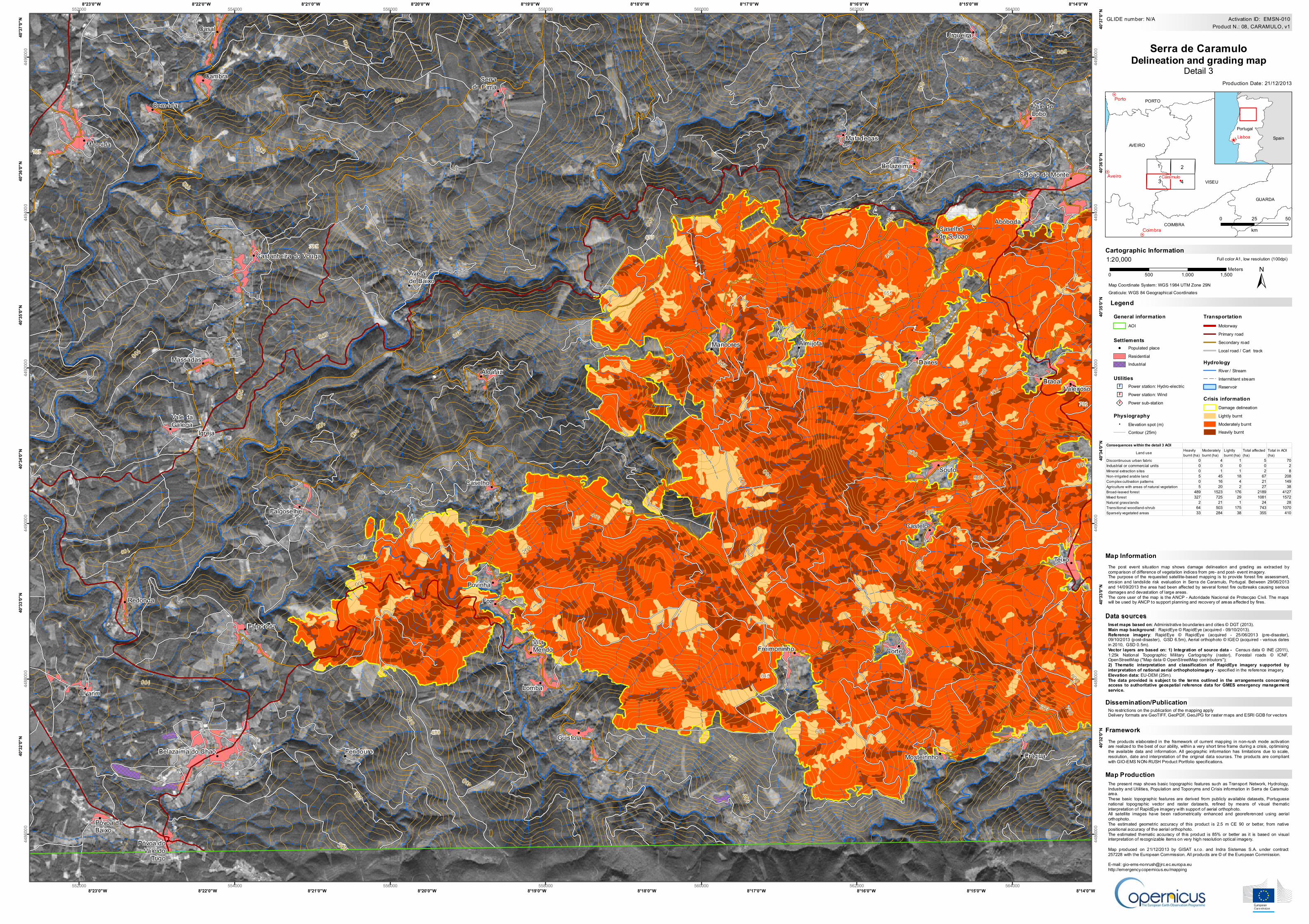
Map ProductionThe present map shows basic topographic features such as Transport Network, Hydrology,Industry and Utilities, Population and Toponyms and Crisis information in Serra de Caramuloarea.These basic topographic features are derived from publicly available datasets, Portuguesenational topographic vector and raster datasets, refined by means of visual thematicinterpretation of RapidEye imagery with support of aerial orthophoto.All satellite images have been radiometrically enhanced and georeferenced using aerialorthophoto.The estimated geometric accuracy of this product is 2.5 m CE 90 or better, from nativepositional accuracy of the aerial orthophoto.The estimated thematic accuracy of this product is 85% or better as it is based on visualinterpretation of recognizable items on very high resolution optical imagery.Map produced on 21/12/2013 by GISAT s.r.o. and Indra Sistemas S.A. under contract257228 with the European Commission. All products are © of the European Commission.E-mail: [email protected]://emergency.copernicus.eu/mapping
Cartographic Information
Map Coordinate System: WGS 1984 UTM Zone 29N
Full color A1, low resolution (100dpi)
The products elaborated in the framework of current mapping in non-rush mode activationare realized to the best of our ability, within a very short time frame during a crisis, optimisingthe available data and information. All geographic information has limitations due to scale,resolution, date and interpretation of the original data sources. The products are compliantwith GIO-EMS NON-RUSH Product Portfolio specif ications.
The post event situation map shows damage delineation and grading as extracted bycomparison of difference of vegetation indices from pre- and post- event imagery.The purpose of the requested satellite-based mapping is to provide forest fire assessment,erosion and landslide risk evaluation in Serra de Caramulo, Portugal. Between 29/06/2013and 14/09/2013 the area had been affected by several forest fire outbreaks causing seriousdamages and devastation of large areas.The core user of the map is the ANCP - Autoridade Nacional de Protecçao Civil. The mapswill be used by ANCP to support planning and recovery of areas affected by fires.
No restrictions on the publication of the mapping applyDelivery formats are GeoTIFF, GeoPDF, GeoJPG for raster maps and ESRI GDB for vectors
LegendGraticule: WGS 84 Geographical Coordinates
Inset maps based on: Administrative boundaries and cities © DGT (2013).Main map background : RapidEye © RapidEye (acquired - 09/10/2013).Reference imagery: RapidEye © RapidEye (acquired - 25/06/2013 (pre-disaster),09/10/2013 (post-disaster), GSD 6.5m), Aerial orthophoto © IGEO (acquired - various datesin 2010, GSD 0.5m).Vector layers are based on: 1) Integration of source data - Census data © INE (2011),1:25k National Topographic Military Cartography (raster), Forestal roads © ICNF,OpenStreetMap ("Map data © OpenStreetMap contributors");2) Thematic interpretation and classification of RapidEye imagery supported byinterpretation of national aerial orthophotoimagery - specified in the reference imagery.Elevation data: EU-DEM (25m).The data provided is subject to the terms outlined in the arrangements concerningaccess to authoritative geospatial reference data for GMES emergency managementservice.
Dissemination/Publication
Framework
1:20,000
.
.
.
..
.
.
.
!
!
!
!
!
!
!
!
!
!
!
!
!
!
!
!
!
!
!
!
!
!
!
!
!
!
!
!
!
!
!
!
!
!
!
!
!
!
!
!
!
!!
!
!
!
!
!
!
!
200
700
600
700
300
500
700
500
800
600
300
700
700
600
400
400
400
600
700
700
600
600
200
500
400
100
200
600
500
500
500
400
400
400
400
200
200
200
200
200
200
200
100
100
100
100
100
165
655
433385
782
645
458
Macoida
Castanheira do Vouga
Sernada
Cambra
Casal
Serrade Cima
Urgueira
Belazeima
Matadegas
Caselhode S.Joao
Abóboda
S.Joao do Monte
Vale deLobo
Vale daGalega
Massadas
Falgoselhe
Caselho
Povinha
Alcafaz
Mancores
Daires
Souto
Castelo
Teixo
ValeirosoBracal
Redonda
Alvarim
Póvoa deBaixo
Póvoa doVale do
Trigo
Belazaima do Chao
Falgorosa
VilaMendo
Lomba
Foz
Guistola
Freimoninho Corte
Mosteirinho Frágua
Avelalde Baixo
Almijofa
Igreja
Feridouro
8°14'0"W
8°14'0"W
8°15'0"W
8°15'0"W
8°16'0"W
8°16'0"W
8°17'0"W
8°17'0"W
8°18'0"W
8°18'0"W
8°19'0"W
8°19'0"W
8°20'0"W
8°20'0"W
8°21'0"W
8°21'0"W
8°22'0"W
8°22'0"W
8°23'0"W
8°23'0"W
40°37
'0"N
40°37
'0"N
40°36
'0"N
40°36
'0"N
40°35
'0"N
40°35
'0"N
40°34
'0"N
40°34
'0"N
40°33
'0"N
40°33
'0"N
40°32
'0"N
40°32
'0"N
552000
552000
554000
554000
556000
556000
558000
558000
560000
560000
562000
562000
564000
564000
4486
000
4486
000
4488
000
4488
000
4490
000
4490
000
4492
000
4492
000
4494
000
4494
000
4496
000
4496
000
!̂]
PortugalSpain
±0 500 1,000 1,500Meters
Map Information
Dissemination/Publication
Framework
Map Production
Data sources
Production Date: 21/12/2013
Utilities
! Populated placeResidentialIndustrial
Settlements
Transportation
0 25 50
km
Lisboa
Crisis information
MotorwayPrimary roadSecondary roadLocal road / Cart track
HydrologyRiver / StreamIntermittent streamReservoir
General informationAOI
d Power station: Hydro-electricd Power station: Windd Power sub-station
Damage delineationLightly burntModerately burntHeavily burnt
Serra de CaramuloDelineation and grading map
Detail 3
Physiography. Elevation spot (m)Contour (25m)
GLIDE number: N/A Product N.: 08, CARAMULO, v1
Activation ID: EMSN-010
Consequences within the detail 3 AOILand use Heavily
burnt (ha)Moderately burnt (ha)
Lightly burnt (ha)
Total affected (ha)
Total in AOI (ha)
Discontinuous urban fabric 0 4 1 5 70Industrial or commercial units 0 0 0 0 2Mineral extraction sites 0 1 1 2 8Non-irrigated arable land 5 45 18 67 208Complex cultivation patterns 0 16 4 21 149Agriculture with areas of natural vegetation 5 20 2 27 38Broad-leaved forest 489 1523 176 2189 4127Mixed forest 327 725 29 1081 1572Natural grasslands 2 21 1 24 28Transitional woodland-shrub 64 503 175 743 1070Sparsely vegetated areas 33 284 38 355 410
Recommended