The Wenas Creek Mammoth Project: 2009 Interim
Archaeology Report on Excavations at 45YA1083
Final Submission
June, 2010
By
Patrick M. Lubinski
With contributions by
Bax R. Barton, Karl Lillquist,
Patrick T. McCutcheon, Morris Uebelacker,
and Brian Whiting
Submitted by
Patrick M. Lubinski, Principal Investigator and Permittee
Department of Anthropology, Central Washington University
400 E. University Way, Ellensburg, WA 98926-7544
Submitted to
Department of Archaeology and Historic Preservation
1063 South Capitol Way, Suite 106
Olympia, WA 98501
In partial fulfillment of requirements under
Archaeological Excavation Permit No. 09-13
Table of Contents
Introduction ......................................................................................................................................1
Environmental Context ....................................................................................................................2
Cultural Context ...............................................................................................................................4
Local Archaeological Investigations ................................................................................................7
History of Site Investigation ............................................................................................................7
Project Personnel ...........................................................................................................................11
Research Questions and Design .....................................................................................................12
Field Methods ................................................................................................................................13
Laboratory Work ............................................................................................................................16
Visitation and Public Participation ................................................................................................18
2009 Results ...................................................................................................................................20
Summary of Current Findings .......................................................................................................25
Future Research .............................................................................................................................32
Acknowledgments..........................................................................................................................34
References Cited ............................................................................................................................34
Appendix A: Excavation Forms .....................................................................................................42
Appendix B: Artifact Catalog ........................................................................................................46
Appendix C: DAHP Site Form ................................................................................... separate cover
ii
iii
List of Tables
1. Summary of 2009 Formal Excavations.....................................................................................21
2. Bone Specimens Recovered In Situ in 2009 .............................................................................22
3. Bone Specimens Left In Situ in 2009 .......................................................................................23
4. Age Estimates for the Wenas Creek Mammoth Site ................................................................32
List of Figures
1. Site location in central Washington ............................................................................................3
2. Example ground-penetrating radar plan map ..............................................................................9
3. GIS map of investigations 2005-2009 ......................................................................................10
4. Field crew for 2009 ...................................................................................................................12
5. Lithic sample FS 584 (catalog #470), interpreted as possible flake .........................................26
6. Artifact FS 479 (catalog #327) .................................................................................................27
7. Artifact FS 261 (catalog #176) .................................................................................................28
8. Location of flake FS 261 in relation to mammoth bone from XU 12 in 2006 .........................29
9. Elevation backplot (modeled cross-section) of XU 12 .............................................................29
10. GIS map of bones and artifact discovered in situ 2005-2009 .................................................31
Introduction
The Wenas Creek Mammoth Project is an interdisciplinary investigation of
paleontological remains and possibly associated artifacts at Site 45YA1083 on private property
near Selah, Washington. Fieldwork at the site was undertaken in a series of five summer
university field schools, sponsored by Central Washington University, in 2005, 2006, 2007,
2008, and 2009. In the 2005 season and initial part of the 2006 field season, the site was purely a
paleontological excavation of mammoth remains, requiring no excavation permit. In July, 2006,
a single artifact was discovered in the excavations, providing the site archaeological isolate status
for the first time. Given this find, a permit was requested and granted for the 2007 and
subsequent field seasons, providing the requirement for this report.
This interim report is prepared to fulfill obligations of Archaeological Excavation Permit
No. 09-13 granted by State of Washington Department of Archaeology and Historic Preservation
(DAHP) on June 18, 2009. This report represents a work in progress on the overall project rather
than a final report. Its intent is to provide context, research design, field methods, and general
findings for the archaeology of the site. Since paleontology is not relevant to the archaeological
excavation permit, this document will discuss only general paleontological results to provide
context for the archaeology. Given the long-term research nature of the project, its primarily
paleontological rather than archaeological focus, and the academic pressures of the major
research staff, reporting will be completed on an irregular basis, some as technical reports
(Lubinski 2009; Lubinski et al. 2008), and some as peer-review publications (Lubinski et al.
2007; Lubinski et al. 2009).
Investigations through summer 2009 have yielded mammoth and other paleontological
bones, but very limited cultural material. The total of cultural materials from the site thus far is
three pieces of possible chipped stone debitage. Given the debitage find locations, the
archaeology and the mammoth bones are presumed unrelated, although they are in fairly close
proximity (as close as 15 cm) and this requires further evaluation. Based on chronometric dating
thus far, the mammoth bones are from about 16,000 calendar years ago (CALYBP) or 13,000-
14,000 uncalibrated radiocarbon years ago (RCYBP). The artifacts presumably are later, but
how much later is unknown. Details of findings to date are given in a later section.
1
Environmental Context
The Wenas Creek Mammoth Site is located in the Wenas Creek valley about six miles
north of the city of Yakima, near the town of Selah in central Washington state (Figure 1). Its
exact legal location is suppressed in this document for site protection. The site is at about 1400
feet elevation (427 m) on a bench on the south valley wall of the Wenas Creek valley, about 800
feet (244 m) from the current creek channel and 70 feet (21 m) above the valley floor. At the
time of bone deposition at the site (ca. 16,000 CALYBP), Wenas Creek would likely have been
higher and closer to the site. The site is drained by two deep ephemeral channels which pass to
the west and east of the excavation, and flow into the South Wenas Road ditch north of the site.
Prior to construction of the road ditch, the ephemerals would have passed into Wenas Creek, a
small tributary of the Yakima River. The site lies on the side of a broad interfluvial ridge
between Wenas Creek and the Naches River. The mammoth site occupies the upper edge of a
~300 m long x ~100 m wide bench dissected by several gullies, about 170 m below the crest of
the ridge. Although this bench is mapped as “Quaternary landslide deposits” by Walsh (1986),
its origin is not certain. It could be a landslide deposit, an alluvial fan remnant, or even a terrace.
The Wenas Creek Valley lies within the northwestern portion of the Yakima Fold and
Thrust Belt, with a tectonically folded ridge of basalt (Umtanum Ridge) forming the north valley
wall. However, the southern wall upon which the site sits is an erosional remnant cored with
volcaniclastic Ellensburg Formation gravels (Waters 1955; Smith 1988). The Ellensburg
formation gravels observable uphill of the site and within the excavations include a large number
of volcanogenic rocks like tuff and small amounts of cryptocrystalline materials such as a
translucent yellow or orange chert. Surface sediment on the slope in the site vicinity appears to
be dominated by loess.
The site lies within the Columbia River hydrographic basin, and near the western edge of
Columbia Basin physiographic unit, not far from its intersection with the Cascade Range. The
area is within the rain shadow of the Cascade Range, which results in a dry, continental climate
with marked seasonality. In the historic period, the nearby Yakima Valley had average
temperatures of 28 °F in January and 73 °F in July, with about 8 in (20 cm) of annual
precipitation (Miller and Highsmith 1949). Most regional precipitation falls as winter rain and
snow.
2
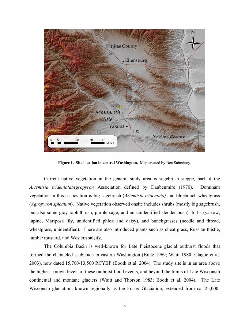
Figure 1. Site location in central Washington. Map created by Ben Sainsbury.
Current native vegetation in the general study area is sagebrush steppe, part of the
Artemisia tridentata/Agropyron Association defined by Daubenmire (1970). Dominant
vegetation in this association is big sagebrush (Artemisia tridentata) and bluebunch wheatgrass
(Agropyron spicatum). Native vegetation observed onsite includes shrubs (mostly big sagebrush,
but also some gray rabbitbrush, purple sage, and an unidentified slender bush), forbs (yarrow,
lupine, Mariposa lily, unidentified phlox and daisy), and bunchgrasses (needle and thread,
wheatgrass, unidentified). There are also introduced plants such as cheat grass, Russian thistle,
tumble mustard, and Western salsify.
The Columbia Basin is well-known for Late Pleistocene glacial outburst floods that
formed the channeled scablands in eastern Washington (Bretz 1969; Waitt 1980; Clague et al.
2003), now dated 15,700-13,500 RCYBP (Booth et al. 2004) The study site is in an area above
the highest-known levels of these outburst flood events, and beyond the limits of Late Wisconsin
continental and montane glaciers (Waitt and Thorson 1983; Booth et al. 2004). The Late
Wisconsin glaciation, known regionally as the Fraser Glaciation, extended from ca. 25,000-
3
10,000 RCYBP, with the Last Glacial Maximum (LGM) ~18,000 RCYBP or 21,000 CALYBP.
Paleoenvironmental proxy data indicate that the Late Glacial period from 18,000 to 10,000
RCYBP generally had cool, moist conditions (Whitlock et al. 2000; Blinnikov et al. 2002). This
is somewhat mismatched with general circulation models, which predict colder, drier Late
Glacial conditions (Bartlein et al. 1998). Vegetation near the study site was an Artemisia shrub
steppe at LGM, with a subsequent shift to grassland and a modeled downward movement of
shrub steppe to lower elevations in Late Glacial times, based on pollen and phytolith records
from nearby Carp Lake and KP-1 sites (Blinnikov et al. 2002). The Wenas Creek Mammoth site
is elevationally near the Late Glacial steppe/grassland ecotone proposed by Blinnikov et al.
(2002), and the mammoth bone dates are temporally near the onset of Late Glacial conditions.
Cultural Context
The site is located within the lands ceded by the Confederated Tribes and Bands of the
Yakama Nation in the Treaty of 1855. In the mid 1800s, Wenas Creek was the approximate
territorial boundary of the Upper Yakama bands (e.g., Kittitas) and the Lower Yakama bands
(Yakama proper), each composed of a number of smaller independent bands or villages
(Schuster 1998:327). These groups all are speakers of dialects of the Sahaptin language
(Schuster 1998).
The nineteenth century economy of Yakama bands was typical of hunter-fisher-gatherers,
with settled winter villages along the major watercourses and more scattered temporary camps
placed to exploit seasonal resources like spawning fish, root crops, and ripening berries (Hunn
1990; Schuster 1998). The principal foods were fish (particularly salmon, steelhead trout,
suckers, and "eels" or lampreys), wild roots (particularly bitterroot, camas, cous and desert
parsleys) and meat, particularly deer meat (Hunn 1990; Schuster 1998). The typical Yakama
annual round would begin with breakup of the winter village for fishing camps during the first
salmon run about March, then movement in May to root-digging grounds for gathering and
hunting, followed by a return to fishing camps for the June salmon run, and subsequent
movement over the summer to higher elevation mountains and/or root-digging grounds for
hunting, trout fishing, root collecting, and berry picking (Schuster 1998:331). In the fall, people
revisited the valleys for fish runs, hunting, and visiting, returning to the winter villages in about
November (Schuster 1998:331).
4
The mouth of Wenas Creek where it empties into the Yakima River, about three miles
downstream of the site, was a noted fishing location (Schuster 1998:Figure 1). Given its lowland
valley location not far from the Yakima River, the Wenas Creek valley could have been used for
winter villages, fish camps, and a variety of activities such as root digging, hunting of game,
berry picking, and placement of burials. One plant, Mariposa lily (Calochortus macrocarpus),
known to be used by local native peoples (Hunn 1990; Hunn et al. 1998), was observed on the
site in June 2006. The valley below may have formerly supported camas (Camassia quamash),
while the foothills upstream probably supported huckleberry (Vaccinium sp.) and chokecherry
(Prunus virginiana). Burials were sometimes placed in talus slopes such as found several places
at the margins of the Wenas Creek valley; several burials were formerly located at the mouth of
the creek (Warren 1968).
Given the project focus on Pleistocene bones and nearby artifacts, the relevant prehistoric
cultural context is principally Pleistocene and early Holocene archaeology, although the artifacts
found to date could be considerably later in time.
At present, the earliest well-established archaeological sites in North America date
11,500 RCYBP and later, most associated with distinctive Clovis artifacts (Anderson and Faught
2000; Holliday 2000; Meltzer 2004). Recent reanalysis of radiocarbon dates indicates that these
sites may all date 11,050 RCYBP and later (Waters and Stafford 2007). Many sites with
purported human activity dating earlier than 11,500 RCYBP are not well accepted, due to
perceived problems with dating, unconvincing evidence of human activity (e.g., artifacts or
human remains), and/or association of artifacts and dates (Haynes 1969; Dincauze 1984; Meltzer
2004). The most widely accepted pre-Clovis age site in the Americas is Monte Verde in Chile,
which has a 12,500 RCYBP component with abundant organic artifacts plus stone tools and bone
(Dillehay 1989, 1997; Meltzer et al. 1997). Other pre-Clovis sites are controversial, either for
the reasons noted above or because they are not yet published in sufficient detail for convincing
peer review (Meltzer 2004). While many archaeologists no longer doubt that humans arrived in
the Americas prior to Clovis, the nature of pre-Clovis archaeology is anything but clear (Haynes
2002; Roosevelt 2002; cf. Kelly 2003).
There is strong evidence for human hunting of mammoths at about a dozen sites in North
America, but none in the Pacific Northwest (Grayson and Meltzer 2003; Fiedel and Haynes
2004). This evidence consists of intimate associations of artifacts and mammoth remains,
5
convincing evidence of cutmarks or human-caused bone breakage, and/or unambiguous human-
caused spatial movement of bones (Grayson and Meltzer 2002). In the Pacific Northwest, there
are three sites with purported evidence for human hunting of proboscideans (mammoths and/or
mastodons): Ledgerwood, Washington (Gustafson et al. 1991); Manis, Washington (Gustafson et
al. 1979), and Owl Cave/Wasden, Idaho (Miller 1989), but all lack compelling evidence. In the
case of Ledgerwood and Owl Cave, there is insufficient stratigraphic correlation of human
artifacts and mammoth remains, and at Manis there is insufficient evidence for artifacts and
butchery marks (Carlson 1990; Gustafson et al. 1991; Grayson and Meltzer 2002). Thus, all
three sites should be considered paleontological but not archaeological based on the currently
published record.
Although the connection of mammoths with Clovis artifacts is well established, there is
still considerable uncertainty about the nature of human subsistence strategies in the period.
Examinations of the existing faunal record indicate that Clovis hunters took ungulates (e.g.,
bison, equids, camelids), lagomorphs, and other prey as well as proboscideans (Haynes
2002:Tables 5.1-5.2; Waguespack and Surovell 2003). However, current evidence is insufficient
to distinguish between a range of possible human foraging strategies from generalized foragers
to specialized big-game hunters, based on possible geographic variation and diverse
interpretations in the literature (e.g., Waguespack and Surovell 2003; Cannon and Meltzer 2004;
Byers and Ugan 2005).
Overall, there is very little published scientific evidence for humans in the Pacific
Northwest prior to 11,000 RCYBP. While a number of Clovis or Clovis-like artifacts have been
found (Ames et al. 1998), only one Clovis site has stratigraphic control and chronometric age
estimates: the Richey-Roberts (East Wenatchee) site in Washington. This site has yielded a
number of unusually large Clovis bifaces in what appears to be a cache (Gramly 1993) atop
Glacier Peak G tephra dating ca. 11,200 RCYBP (Mehringer et al. 1984). A handful of other
controversial regional sites are being evaluated that may pre-date Clovis (Gilbert et al. 2008;
Jenkins et al. 2004) or be contemporary with it but exhibit distinct technology (Davis and
Schweger 2004). In the period ~11,000-10,000 RCYBP, there are a number of well-accepted
sites such as Lind Coulee (Craven 2004; Daugherty 1956), Marmes (Hicks 2004), and Sentinel
Gap (Galm and Gough 2000) in Washington.
6
Local Archaeological Investigations
Previous archaeological investigations in the immediate site vicinity are limited. No
previously recorded sites are noted within two miles of 45YA1083. Few recorded sites or
projects have been located in the general area, mostly due to a lack of Section 106-mandated
investigation, as the vicinity is almost entirely privately owned and used for farming, ranching,
and housing. However, there are two other excavated sites within six miles of the Wenas Creek
Mammoth site: the Wenas Creek site (45YA18) and the Rosa Rockshelter (45YA301).
The Wenas Creek site is located about 3.5 miles east-southeast of the study site at the
mouth of Wenas Creek. It was recorded in an archaeological survey for a natural gas pipeline,
and salvage excavated along its right-of-way in the summer of 1956 under the direction of
University of Washington graduate student Claude Warren (Warren 1968). At that time, the site
had already been extensively damaged by informal digging, and the focus was made on
apparently undisturbed portions of the 50-foot wide right-of-way. Hand excavation of about 750
square feet to bedrock (up to 8.5' deep) revealed housepits, hearths, postholes, and talus burials,
and yielded about 1300 artifacts (Warren 1968:2). Artifacts were dominated by chipped stone,
including nearly 200 projectile points, mostly stemmed and corner-notched varieties (Warren
1968:Table 1). Other recovered artifacts included hammerstones, pestles, bone and antler tools,
Olivella and Dentalium shell, and a copper kettle. There are no chronometric dates for this site.
The Rosa Rockshelter site is located along the Yakima River in Yakima Canyon about
5.5 miles east-northeast of the study site. It was explored and mapped in Fall 1969, and partially
excavated in the summer of 1970 under the direction of William Smith of Central Washington
State College (Smith 1971), now Central Washington University. Twelve 1x1 m squares were
excavated to bedrock in the small rockshelter (6.3 x 5.5 x 1.8 m high), recovering perishable
materials including one piece of tule matting, three fragments of basketry material, three
fragments of leather, and 155 pieces of cordage (Smith 1971). Also recovered but not analyzed
were straw and stick fragments, animal bones, and some lithic debitage. The age of the site is
unknown.
History of Site Investigation
The Wenas Creek Mammoth Site (45YA1083) is located on lands owned by Haywire
Outfit, Inc (formerly Mayo Ranches, Inc.) in Township 14N, Range 18E, in Yakima County,
7
Washington (exact location suppressed in this document). The site is where construction
workers discovered a large bone during construction of a private road on Mayo Ranches property
near Selah in February, 2005. The find was made near the south edge of the road while
smoothing the grade on that side with a backhoe. Subsequent to the find, the landowner
contacted Central Washington University (CWU), provided the bone to the university, and
covered the location with backdirt, obscuring the exact location of the find. The bone was later
determined to be the left humerus of an unidentified mammoth (Mammuthus sp.). A
Memorandum of Understanding (MOU) was signed April 27, 2005 between Mayo Ranches and
CWU to allow for investigation of the mammoth find location. Since the find was strictly animal
bone with no evidence of human artifacts, it was considered a fossil locality not subject to state
archaeological law.
A CWU field school investigated the fossil locality in the summer of 2005 (June 27 -
August 5), with two principal goals: (1) placing the bone found in construction in geological
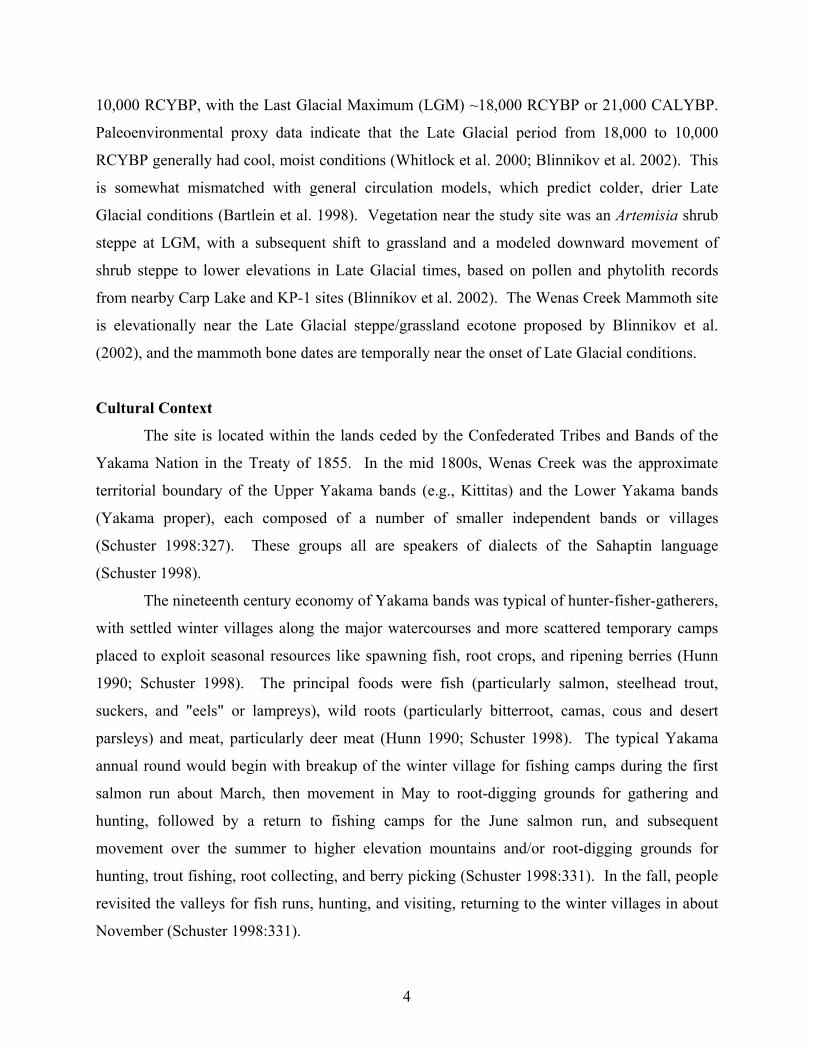
context, and (2) searching for additional mammoth bone. To begin, a ground-penetrating radar
(GPR) survey was conducted under contract by Brian Whiting of Earth Imaging Associates. The
purpose of this work was to seek geophysical evidence of additional mammoth bones and thus
avoid damaging them in a subsequent backhoe trench. Two GPR grids were investigated at 50
cm intervals: Grid 1, a 26 m N-S x 19 m E-W unit north of the gravel road, and Grid 2, a 10 m
N-S x 14.8 m E-W unit south of the road, as near as practical to the estimated find location.
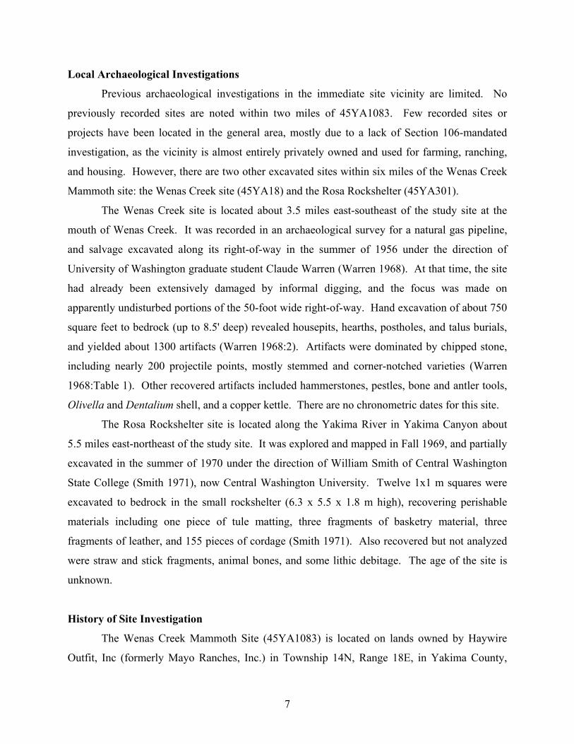
Both grids yielded a number of GPR anomalies (e.g., see Figure 2), but none appeared to be
mammoth remains. A mechanical trench was then excavated near the presumed find location
with a trackhoe to provide geological cross sections for the find. The trench was 37 m long and
L-shaped to provide a long downslope section and shorter cross-slope section. No bone or
artifacts were discovered in the trench. Hand excavated units were dug in 2x2 m units or smaller
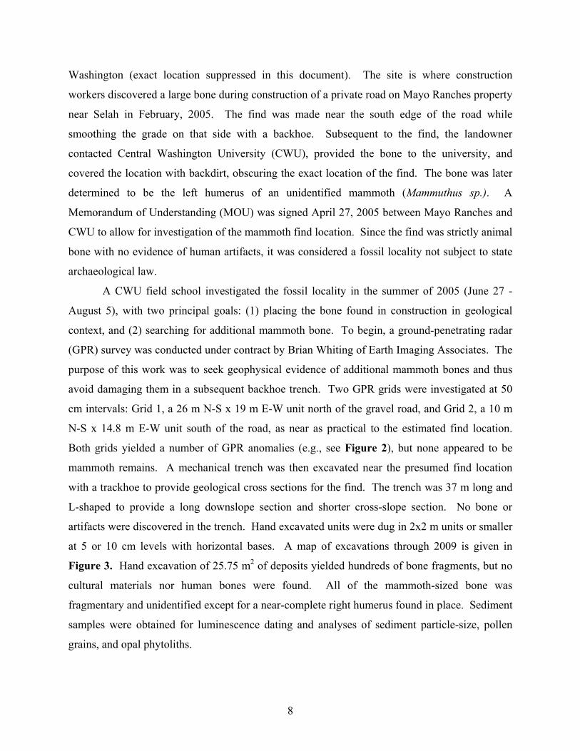
at 5 or 10 cm levels with horizontal bases. A map of excavations through 2009 is given in
Figure 3. Hand excavation of 25.75 m2 of deposits yielded hundreds of bone fragments, but no
cultural materials nor human bones were found. All of the mammoth-sized bone was
fragmentary and unidentified except for a near-complete right humerus found in place. Sediment
samples were obtained for luminescence dating and analyses of sediment particle-size, pollen
grains, and opal phytoliths.
8
Figure 2. Example ground-penetrating radar plan map. Provided by Brian Whiting. No higher-resolution image is available. This map compiles data for 42-84 cm below surface for Grid 2 south of the road. Colors represent degree of signal return, with green average, yellow to red above average, and light blue to dark blue below average returns. The top of the map is at the north edge of the GPR survey grid. See Figure 3 for grid location.
In summer 2006, CWU began a second season of field school excavations, with
fieldwork extending from June 26 to August 18, 2006. Work focused on hand excavations
adjacent to bone-bearing units from 2005, and in areas of GPR anomalies from 2005. These
exposed additional mammoth bones and bovid (probably bison) bones. On July 7, a student
exposed the first artifact, a chert flake fragment, near mammoth bones in XU 12. Assistant State
Archaeologist Stephenie Kramer was consulted, and provided permission to proceed without a
permit so long as the flake was documented as an isolate and no additional materials were found.
The Yakama Nation Cultural Resource Program was also consulted, and their representatives
visited the site July 10. No additional artifacts and no human bones were recovered for the
remainder of the season. The context of the flake find in relation to the mammoth bone has not
yet been resolved, but it appears to lie stratigraphically above the mammoth bones. An isolate
form was submitted August 25, 2006, and assigned number 45YA1083.
In summer 2007, CWU held a third season of excavation from July 2 through August 25,
following protocols set forth in the 2007 DAHP Archaeological Permit application (see Lubinski
et al. 2008). Work focused on 7.9 m3 of hand excavations adjacent to bone-bearing units from
9
2005 and 2006. In addition to numerous non-human bones, a single probable artifact was
discovered in fieldwork. This chert flake was recovered from the screen in XU 20, apparently
above the mammoth bone-bearing level. No other probable human artifacts were recovered.
Figure 3. GIS map of investigations 2005-2009. The "Edge of Disturbance" indicates the southern margin of construction disturbance, while "Backhoe cut" indicates the northern margin of intact stratigraphy. Map produced by Tom Winter.
In summer 2008, CWU held a fourth season of excavation from June 23 through August
15, following protocols set forth in the 2008 DAHP Archaeological Permit application (see
Lubinski 2009). Work focused on 17.8 m3 of hand excavations adjacent to bone-bearing units
from 2005-2007. In addition to numerous non-human bones, several chert samples were
collected for evaluation as possible artifacts. None of these chert samples were found to be
definitive human-produced artifacts, although one is considered a possible artifact that should be
considered for management purposes.
10
In summer 2009, CWU held a fifth season of excavation from June 29 through August
20, following protocols set forth in the 2009 DAHP Archaeological Permit application. Work
focused on 15.0 m3 of hand excavations adjacent to bone-bearing units from 2005-2008. In
addition to numerous non-human bones, chert samples were collected for evaluation as possible
artifacts. Analysis of the chert samples is pending.
Results of the project to date are provided below under "Summary of Current Findings."
Project Personnel
The Wenas Creek Mammoth Project is a multidisciplinary project with a research team of
professionals, students, and volunteers. Dr. Patrick Lubinski, an archaeologist and
zooarchaeologist, is the overall project director and excavation director. He is an Associate
Professor in the Department of Anthropology at CWU. Other research team leaders are: Bax
Barton, M.Sc., paleontologist (Curator, Quaternary Research Center, University of Washington);
Karl Lillquist, Ph.D., geomorphologist (Professor, Department of Geography, CWU); and Morris
Uebelacker, Ph.D., archaeologist and geographer (Professor, Department of Geography, CWU).
These four faculty have overseen all phases of work on the project. Jake Shapley, a CWU
Graduate Student in Resource Management, also played a significant role in the project, as the
principal Teaching Assistant in the field and laboratory from 2005-2008. The 2009 field school
was taught by Lubinski.
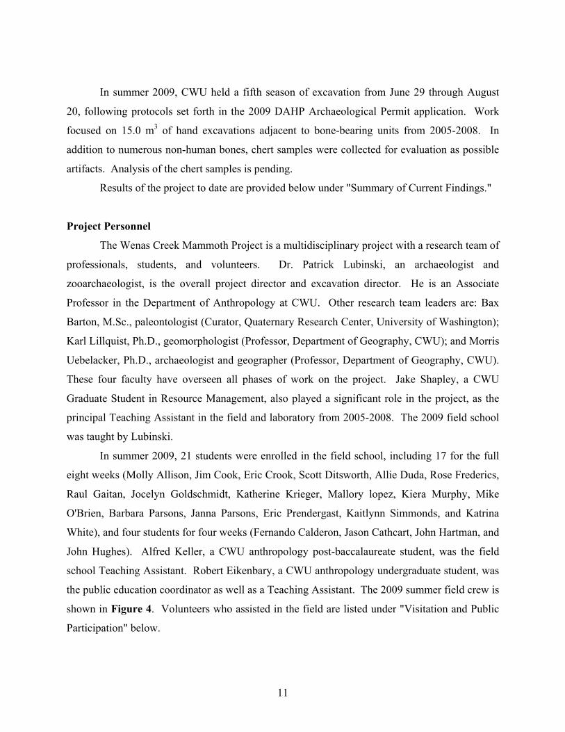
In summer 2009, 21 students were enrolled in the field school, including 17 for the full
eight weeks (Molly Allison, Jim Cook, Eric Crook, Scott Ditsworth, Allie Duda, Rose Frederics,
Raul Gaitan, Jocelyn Goldschmidt, Katherine Krieger, Mallory lopez, Kiera Murphy, Mike
O'Brien, Barbara Parsons, Janna Parsons, Eric Prendergast, Kaitlynn Simmonds, and Katrina
White), and four students for four weeks (Fernando Calderon, Jason Cathcart, John Hartman, and
John Hughes). Alfred Keller, a CWU anthropology post-baccalaureate student, was the field
school Teaching Assistant. Robert Eikenbary, a CWU anthropology undergraduate student, was
the public education coordinator as well as a Teaching Assistant. The 2009 summer field crew is
shown in Figure 4. Volunteers who assisted in the field are listed under "Visitation and Public
Participation" below.
11
Student Laboratory Assistants for the 2009-10 academic year included Rachel Arnett,
Megan Brown, Misty Defoe, Joy Ferry, Kaitlin Gallagher, Tommy Garnica, Isa Harrison, Shauna
Linn, Travis Morelli, Erica Palmaer, Katie Phillips, Kelli Poe, Joshua Pong, Tim Soderstrom,
Kevin Sweetman, and Emily Wolden. These students were supervised by Dr. Lubinski, and
Graduate Assistants Alfred Keller and Genevieve Brown. Alfred Keller was also the project
artist/sculptor who produced replica casts of selected bone finds. Laboratory assistants from the
Retired and Senior Volunteer Program (RSVP) for the 2009-10 academic year included Sharon
Balding, Linda Brown, Jim Morgan, and Sue von Jentzen.
Figure 4. Field crew for 2009. Shown left to right are (bottom row): K. Murphy, J. Parsons, K. Krieger, J. Hughes, R. Gaitan; (center row): K. White, M. Lopez, J. Goldschmidt, M. Allison, R. Fredericks, A. Duda, F. Calderon, S. Ditsworth; (back row): A. Keller, K. Simmonds, M. O'Brien, J. Cook, R. Eikenbary, B. Parsons, E. Prendergast, P. Lubinski. Photo 20090713_006. Not pictured are J. Cathcart, E. Crook, and J. Hartman.
Research Questions and Design
This investigation is multidisciplinary, with research questions in paleontology and
paleoecology, geomorphology, and archaeology. For archaeology, the overriding research
concern is whether or not the paleontological remains are associated with human activity. This is
an especially important question given the presence of bones from an extinct mammoth and the
likely age of about 13,000-14,000 RCYBP. If an association is found between the dated bones
and cultural activity, the site will clearly be of international importance and eligible to the
12
National Register of Historic Places. Our approach and methods are conservative, and no such
association is expected. On the other hand, we want to be sure to employ an approach that will
find any evidence that may exist.
Since so little is known prior to Clovis in North America, any information about human
activity at the site would be highly significant. Even an association of a mammoth and human
activity at a later date would be significant, since there are presently no compelling kill sites in
the Pacific Northwest. If no cultural materials are found associated with the mammoth bones,
the site will still yield significant paleoenvironmental information pertinent to arguments for
human arrival and/or use of the region in the Pleistocene. These data will include information on
mammoths and contemporary animals, as well as vegetation and climatic conditions if we can
obtain sufficient funding for analyses of pollen, phytoliths, and chemical isotopes.
Given these research domains, the principal goals of the 2009 field investigation were
threefold: (1) to determine the relationship (if any) of the cultural material to the mammoth bone,
(2) to place both cultural material and bone in geological context including age and depositional
history, and (3) to search for additional cultural material and faunal remains. To address goals
(1) and (2) in the excavations, methods were designed to ensure sufficiently precise locational
control to demonstrate any potential relationships between artifacts, bones, and matrix, and to
collect excavated materials and sediment samples in a way conducive to future analyses. To
address goal (3), prior excavations were expanded and units were systematically sampled for
fauna/artifacts and microfauna/microartifacts.
Field Methods
Field investigations in 2009 began on June 29 and continued weekdays through August
14 for the Wenas Creek Mammoth Field School sponsored by Central Washington University,
and under the supervision of Dr. Patrick Lubinski of CWU. After the field school was
completed, fieldwork continued on a volunteer basis under the direction of Dr. Lubinski through
August 20. Additional site covering and backfilling took place on August 27 and September 26.
Formal hand excavation units for the project (2005-2009) were placed either in areas of
GPR anomaly or adjacent to units with previously exposed bone (see Figure 3). The overall
goal for the GPR units was to test at least one positive and one negative anomaly from each of
the two GPR grids. Units 15 and 16 were placed over GPR anomalies in the grid north of the
13
road (a positive and a negative anomaly, respectively), and XU1 was placed over a GPR positive
anomaly in the grid south of the road. A final negative anomaly south of the road may be tested
in a future season. The remaining units were grouped into a main excavation block expanding
from the original bone find from road construction, and from XU1, which yielded bone in 2005.
Baulks (50 cm wide) have been left between key units in the main block to preserve stratigraphy
and provide locations for future sampling. Units excavated in 2009 were all located in the main
block, and consisted of continuations from prior seasons, new units placed adjacent to bone-
bearing units, and baulks removed between previously-excavated units. This work included
continuation of work in XU 1, 16, 21, 23, 24, 26, 27, and 28, and initiation of excavation in XU
29, 30, 31, 32, 33, 34, 35, and 36.
Excavation units and adjacent vertical control datums were laid out to correspond with
the existing grid system with a Topcon CTS-223W total station theodolite and a prism pole. The
prism poles used were the peanut (a CST 1 in. prism and mini-pole combination totaling 10 cm),
mini-prism (a SECO 25 mm prism with as few 30 cm pole extensions as practical, to minimize
leveling error), or full-size telescoping pole (Crain 8 ft) with one of the two small prisms as
needed. The grid system uses a grid north set to 0° North with a magnetic declination of 20°,
and a coordinate system with the southeast corner of XU 2 set to North 500 m, East 100 m,
Elevation 100 m. The vertical datum nails were used for approximate depth control, but all
elevation control was verified with total station shots. Excavation was in units of 2x2 m (less if a
50 cm wide baulk wall is adjacent, or if the unit is a portion of baulk wall itself) in levels of 5 or
10 cm with horizontal floors. An excavation level form was completed for every unit level (see
Appendix A). All excavated matrix was dry screened through 1/8 in hardware cloth, except for
the fine screen sample. The fine screen sample was taken from a 45 x 45 cm column of sediment
reserved in each unit to approximate 5% of the total excavated volume. The fine screen sample
was water screened with 1/16 in mesh. The fine screen residuum was dried and taken to the lab
for sorting under controlled conditions.
All encountered cultural materials and bone was left in place (as possible) and
pedestalled until spatial relationships in the unit were clearly established. Fragile materials (most
bones) were consolidated as needed with Butvar B-76 (polyvinyl butyral resin dissolved with
acetone), except for those intended for radiocarbon dating or chemical analyses. Bone
radiocarbon/chemical sample cores were removed from select larger bones with an electric hand
14
drill equipped with a 1 in diameter hole saw, which allowed the remainder of these bones to be
consolidated with B-76. After fully exposed, all finds were recorded with 3-D coordinates (e.g.,
high point, low point, horizontal outline) with the total station as possible. As a data backup,
hand-drawn plan maps were completed to indicate finds in each unit. For all in situ finds,
upside, dip (slope) and strike (compass orientation) were taken with a Brunton compass. For all
significant bone finds, 3-D coordinates, dip and strike, taphonomy, taxonomic identification,
photographic and other data were recorded on "Bone Find Record" sheets (see Appendix A).
Once these data were obtained, the materials were removed, placed in polyurethane zip bags with
their assigned field specimen number, and returned to the laboratory. Larger specimens not
conducive to safe removal in this way were encased in B-76 or plaster jackets and underlying
sediment for transport and final excavation in the laboratory. Excavation progress was photo-
documented at the base of each level with a Nikon D-70 digital SLR camera.
Because the potential for cultural association with the paleontological remains was a
central goal of the project, particular care was taken in the evaluation of possible culturally
modified stone. A sample of angular chert pieces and other stones was collected to provide
comparative context for evaluating human vs. naturally-occurring "flakes." Other rocks with
fracture morphologies similar to heat crazing were tabulated as "similar to fire-cracked rock" or
"pseudo-FCR." All collected lithic samples will be re-examined in the laboratory and evaluated
as to the probability of being produced by humans.
All collected materials were tracked through a system starting with assignment of Field
Specimen (FS) numbers for each unique collection, be it a single specimen with point
provenience or screened material from a unit/level (lot). Provenience information for all
assigned Field Specimen numbers was entered into a computerized relational database. Catalog
number was assigned in the laboratory to each lot and individual specimen of interest and tied to
provenience in the database.
Excavation proceeded in each unit until the entire floor was well within the alluvium
(geological Unit/Stratum III) underlying the bones, or the unit was too deep for student safety.
At the completion of excavation of each unit, the project geomorphologist examined and mapped
the stratigraphy. All walls were mapped with the total station. Representative walls were
photographed and mapped on graph paper by the students.
15
On August 6, 2009, the 12 dosimeters placed by Dr. Jim Feathers of the University of
Washington Luminescence Laboratory on August 2, 2008, were removed. These dosimeters
were intended to help refine luminescence age estimates from sediment at these 12 locations.
The dosimeters were placed in labeled polyurethane zip bags for return to Dr. Feathers'
laboratory. A "travel" dosimeter sent by Dr. Feathers to measure dose from time of removal to
arrival at his laboratory was prepared by heating it on a white gas camping stove until it glowed.
These 13 dosimeters were submitted to the UW lab on August 21, 2009. Final dates are
forthcoming.
At the conclusion of the field season, all active units were covered for the winter.
Covering involved lining unit floors and walls with geotextile, shoveling a thin layer of fine
sediment onto the floor, and placing a constructed plywood and 2 x 4 stud cap over the open
hole. The cap was anchored upslope with steel reinforcing bar and/or attachment to an uphill
cap, and the resulting structure was bermed to prevent water from running into the units. This
created a sort of plywood "shingled roof" over the excavation block.
Seven inactive units were backfilled by hand and/or front end loader at the end of the
field season: XU 13, 16, 22, 24, 27, 29, and 30. Additionally, XU20 was filled about halfway.
Backfilling included partial use of four truckloads (yards each) of fill dirt delivered by Chad
Galland. This new dirt was necessary because there appeared to be insufficient screened dirt to
fill our excavations (certainly some of the fine loess blew away). Chad Galland also assisted
backfilling on September 26 with a backhoe. (Note that units 2, 4, 5, 6, 7, 8, 9, 10, 11, 14, 15,
19, and 26 were backfilled in prior seasons, although XU 14 was reopened in 2009 and remains
unfilled.)
Also at the conclusion of the field season, our first permanent datum was set. This datum
consisted of a vertically-oriented steel reinforcing bar anchored in concrete near the west fence
gate. This datum (called “X” in our naming system) was placed with its top at location N
500.100, E 80.000, Elevation 101.800 in our grid coordinate system.
Laboratory Work
The Wenas Creek Mammoth Project maintains a laboratory currently in Room 227 Dean
Hall at Central Washington University. The laboratory houses the recovered specimens from the
project, the project computer data, selected field equipment, bone consolidation facilities, and
16
work space. Laboratory work is in progress for all seasons of the project, with some portions
near complete (e.g., 2005-2009 collection and photograph catalogue record) and others barely
initiated (e.g., bone identifications). It is expected to take years to complete laboratory work for
the project.
A number of laboratory assistants worked in the lab under supervision of Lubinski,
Alfred Keller and/or Genevieve Brown. Alfred Keller and Genevieve Brown were funded
Graduate Assistants in 2009-10, with some of their time assigned to the project for laboratory
supervision. Assistants since the 2009 field season have included CWU students enrolled for
Independent Study credit and volunteers from the Retired and Senior Volunteer Program
(RSVP). Assistants worked on cataloguing finds, cleaning and consolidating bone, computer
data entry, initial identifications, and sorting through fine screen matrix for bones and artifacts.
All collected materials were tracked through a system starting with assignment of Field
Specimen (FS) numbers for each unique collection, be it a single specimen with point
provenience or screened material from a unit/level (lot). Provenience information for all
assigned Field Specimen numbers were entered into a computerized relational database. Catalog
numbers were assigned in the laboratory to each lot and individual specimen of interest and tied
to provenience in the database. Catalog number, along with material type, count, and
provenience was written in pencil on a pre-printed acid-free label inserted into a polyurethane zip
bag for each specimen or lot. Large specimens (e.g., complete mammoth bones) were labeled
directly on the treated bone surface to facilitate refit attempts. All materials are stored by catalog
number for researcher access. While provenience information is with each specimen or lot, it is
anticipated that researchers will use the database to find specimens of interest during our analysis
and in the future.
Fragile bone was treated with Butvar B-76 (polyvinyl butyral resin) dissolved in acetone
for consolidation, except when untreated portions were desired for future radiocarbon or
chemical analyses. Bone treated in the field was cleaned in the laboratory with acetone for
removal of adhering dirt, and fresh consolidant was applied. Other bone was dry brushed or
cleaned with water prior to analysis. Future bone analysis will consist of recording, as possible,
element, side, portion, taxon, and taphonomic attributes (e.g., size, weathering stage, carnivore
modification, digestive corrosion, butchery cutmarks, etc.). We will attempt refits of all
potentially identifiable mammoth-sized bone fragments.
17
Project records include excavation level forms, bone find records, profile maps,
supervisor's log book, Field Specimen record, catalog records, analysis notes, total station
coordinates, and photographic files. During analysis, these will be located in the Department of
Anthropology at Central Washington University. Subsequent to analysis, these will be curated at
the same location.
Laboratory analyses are underway for a number of specific topics related to the overall
project. General archaeological analyses are being supervised by Lubinski. Analysis and
evaluation of lithic materials is underway currently by Lubinski and Patrick McCutcheon.
Identification and discussion of faunal/paleontological remains, and bone taphonomy is being
undertaken currently by Lubinski. Sediment analysis and interpretation is being undertaken
currently by Lillquist. Fine screen sample processing and analysis is being undertaken and
supervised currently by Lubinski, while Barton is supervising analysis of materials recovered
from 2005-2008. Pertinent findings of these analyses will be reported as they are completed.
Making of replica casts of key bones for public education purposes continued from the
2008-09 academic year. This work was performed by artist and student assistant Alfred Keller.
The first step is to clean and consolidate the bone to be copied, and then begin the casting
process. The casting process involves making a two-part mold with a GI-1000 silicone inner
mold surrounded by a polyisocyanate foam resin mother mold to support the silicone. The
mother mold is made in two halves by encasing the bone in clay, building walls for the mold
exterior, and pouring in foam, which expands and hardens. The inner mold is made in two
halves by removing clay from the bone and filling the void between the bone and the mother
mold with silicone. To make the casts, more of the same foam material is poured into the four-
part mold to make multiple copies of each cast. To date, casts have been made of the original
find left mammoth humerus (FS 1), mammoth atlas (FS 59), mammoth femur (FS 546) and
comparative cow humerus and human atlas. Earlier experiments were made in 2007-08 with
different materials and the left bovid metatarsal cannonbone (FS 275) and a comparative cow left
metatarsal cannonbone.
Visitation and Public Participation
The project is located on a private road on private land, but due to the interest of the
landowners, it was open to the public. Public participation in 2009 included an on-site
18

interpretive tent, guided site tours, limited volunteer opportunities, and visits by the press. The
interpretive tent was a 20 x 10' portable garage with a series of trifold panel displays describing
the site history and general information about mammoths and archaeology, as well as the
available bone replica casts. Visitors were encouraged to start in this tent, sign in on the guest
register, and also to use it as a shady resting station. We provided guided tours Tuesday through
Saturday from July 14 through August 8, 2009, every half hour from 9:00 AM through 2:00 PM.
Tour guides were principally Teaching Assistant/Public Education Coordinators Robert
Eikenbary and Alfred Keller, and volunteer docents (Sharon Balding, Jim Briggs, Merrill
Greenlee, Ray Foisy, Aimee Higdon, Nancy Kenmotsu, and Sarah Nauman). A few tours were
also provided by Dr. Lubinski and selected field school students (Molly Allison, Janna Parsons).
Over the course of the summer tour period, there were at least 2,180 guests. An unknown
number of additional guests did not sign the guest book. Guests included daycare groups (e.g.,
Apple Land, Busy Bear, Kids R Me), schoolchildren (e.g., Cub Scout Pack 161, Salvation Army
Day Camp), university students (e.g., South Puget Sound Community College's archaeology
field school), senior centers (e.g., Redmond) and members of the press.
Visits were made by professional archaeologists Dale Croes, Steve Hackenberger, Pat
McCutcheon, Larry Ross, William Schroeder, Jared Valenta, Scott Williams, and Pei-Lin Yu .
Press visits were made by the Daily Sun News (Sunnyside), KAPP-TV, and KIMA-TV. The site
was also featured in a national History Channel program "Journey to 10,000 BC," which first
aired March 9, 2008.
Volunteers helped greet visitors, lead tours, sort fine screen sediment, and screen for
excavations under supervision. There were 24 general public volunteers throughout the summer:
Becky Arnold, Jim Briggs, Genevieve Brown, Jessica Eicher, Darrell Emnott, Sharon Balding,
Mike Bogart, Ray Foisy, Merrill Greenlee, Aimee Higdon, Clint Hughes, Lisa Hurn, Nick Hurn,
Ted Hurn, Nancy Kenmotsu, Sarah Nauman, Cadi Poile, Laurie Porter, Mike Rafferty, Diane
Smith, Andrew Templeton, Austin Templeton, Jared Valenta, Pei-Lin Yu. The "volunteer" list
could also include 20 visiting students from other field schools, namely 20 visiting members of
the South Puget Sound Community College archaeology field school. Two of the Mammoth
field school participants also volunteered after the field school was over to complete fieldwork:
Pat Lubinski and Janna Parsons.
19
2009 Results
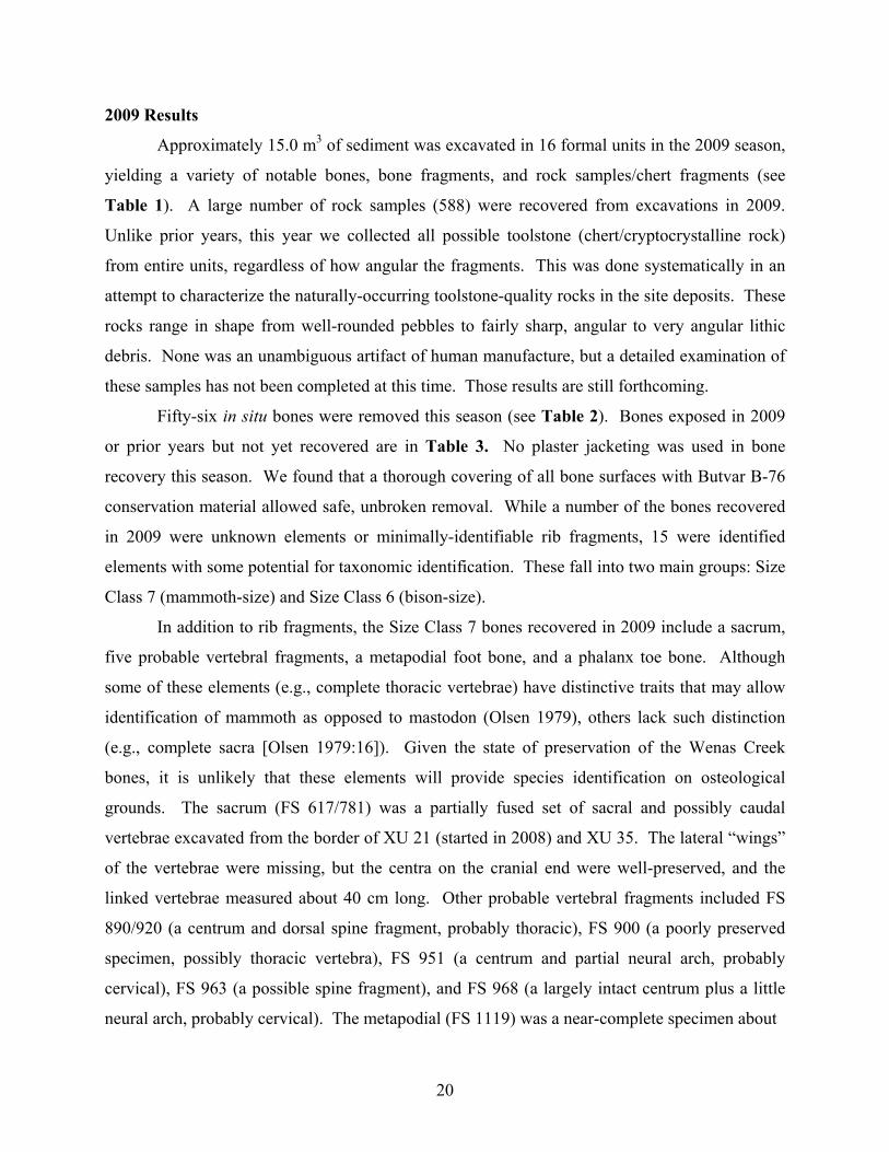
Approximately 15.0 m3 of sediment was excavated in 16 formal units in the 2009 season,
yielding a variety of notable bones, bone fragments, and rock samples/chert fragments (see
Table 1). A large number of rock samples (588) were recovered from excavations in 2009.
Unlike prior years, this year we collected all possible toolstone (chert/cryptocrystalline rock)
from entire units, regardless of how angular the fragments. This was done systematically in an
attempt to characterize the naturally-occurring toolstone-quality rocks in the site deposits. These
rocks range in shape from well-rounded pebbles to fairly sharp, angular to very angular lithic
debris. None was an unambiguous artifact of human manufacture, but a detailed examination of
these samples has not been completed at this time. Those results are still forthcoming.
Fifty-six in situ bones were removed this season (see Table 2). Bones exposed in 2009
or prior years but not yet recovered are in Table 3. No plaster jacketing was used in bone
recovery this season. We found that a thorough covering of all bone surfaces with Butvar B-76
conservation material allowed safe, unbroken removal. While a number of the bones recovered
in 2009 were unknown elements or minimally-identifiable rib fragments, 15 were identified
elements with some potential for taxonomic identification. These fall into two main groups: Size
Class 7 (mammoth-size) and Size Class 6 (bison-size).
In addition to rib fragments, the Size Class 7 bones recovered in 2009 include a sacrum,
five probable vertebral fragments, a metapodial foot bone, and a phalanx toe bone. Although
some of these elements (e.g., complete thoracic vertebrae) have distinctive traits that may allow
identification of mammoth as opposed to mastodon (Olsen 1979), others lack such distinction
(e.g., complete sacra [Olsen 1979:16]). Given the state of preservation of the Wenas Creek
bones, it is unlikely that these elements will provide species identification on osteological
grounds. The sacrum (FS 617/781) was a partially fused set of sacral and possibly caudal
vertebrae excavated from the border of XU 21 (started in 2008) and XU 35. The lateral “wings”
of the vertebrae were missing, but the centra on the cranial end were well-preserved, and the
linked vertebrae measured about 40 cm long. Other probable vertebral fragments included FS
890/920 (a centrum and dorsal spine fragment, probably thoracic), FS 900 (a poorly preserved
specimen, possibly thoracic vertebra), FS 951 (a centrum and partial neural arch, probably
cervical), FS 963 (a possible spine fragment), and FS 968 (a largely intact centrum plus a little
neural arch, probably cervical). The metapodial (FS 1119) was a near-complete specimen about
20
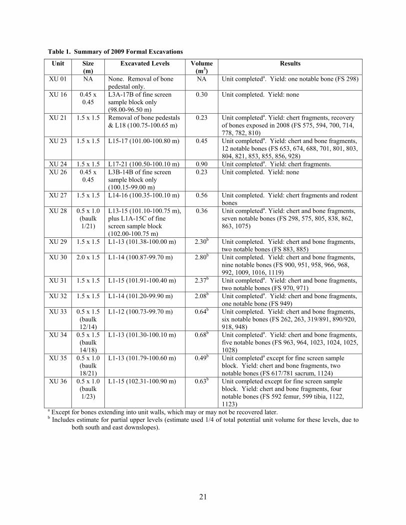
Table 1. Summary of 2009 Formal Excavations
Unit Size (m)
Excavated Levels Volume (m3)
Results
XU 01 NA None. Removal of bone pedestal only.
NA Unit completeda. Yield: one notable bone (FS 298)
XU 16 0.45 x 0.45
L3A-17B of fine screen sample block only (98.00-96.50 m)
0.30 Unit completed. Yield: none
XU 21 1.5 x 1.5 Removal of bone pedestals & L18 (100.75-100.65 m)
0.23 Unit completeda. Yield: chert fragments, recovery of bones exposed in 2008 (FS 575, 594, 700, 714, 778, 782, 810)
XU 23 1.5 x 1.5 L15-17 (101.00-100.80 m) 0.45 Unit completeda. Yield: chert and bone fragments, 12 notable bones (FS 653, 674, 688, 701, 801, 803, 804, 821, 853, 855, 856, 928)
XU 24 1.5 x 1.5 L17-21 (100.50-100.10 m) 0.90 Unit completeda. Yield: chert fragments. XU 26 0.45 x
0.45 L3B-14B of fine screen sample block only (100.15-99.00 m)
0.23 Unit completed. Yield: none
XU 27 1.5 x 1.5 L14-16 (100.35-100.10 m) 0.56 Unit completed. Yield: chert fragments and rodent bones
XU 28 0.5 x 1.0 (baulk 1/21)
L13-15 (101.10-100.75 m), plus L1A-15C of fine screen sample block (102.00-100.75 m)
0.36 Unit completeda. Yield: chert and bone fragments, seven notable bones (FS 298, 575, 805, 838, 862, 863, 1075)
XU 29 1.5 x 1.5 L1-13 (101.38-100.00 m) 2.30b Unit completed. Yield: chert and bone fragments, two notable bones (FS 883, 885)
XU 30 2.0 x 1.5 L1-14 (100.87-99.70 m) 2.80b Unit completed. Yield: chert and bone fragments, nine notable bones (FS 900, 951, 958, 966, 968, 992, 1009, 1016, 1119)
XU 31 1.5 x 1.5 L1-15 (101.91-100.40 m) 2.37b Unit completeda. Yield: chert and bone fragments, two notable bones (FS 970, 971)
XU 32 1.5 x 1.5 L1-14 (101.20-99.90 m) 2.08b Unit completeda. Yield: chert and bone fragments, one notable bone (FS 949)
XU 33 0.5 x 1.5 (baulk 12/14)
L1-12 (100.73-99.70 m) 0.64b Unit completed. Yield: chert and bone fragments, six notable bones (FS 262, 263, 319/891, 890/920, 918, 948)
XU 34 0.5 x 1.5 (baulk 14/18)
L1-13 (101.30-100.10 m) 0.68b Unit completeda. Yield: chert and bone fragments, five notable bones (FS 963, 964, 1023, 1024, 1025, 1028)
XU 35 0.5 x 1.0 (baulk 18/21)
L1-13 (101.79-100.60 m) 0.49b Unit completeda except for fine screen sample block. Yield: chert and bone fragments, two notable bones (FS 617/781 sacrum, 1124)
XU 36 0.5 x 1.0 (baulk 1/23)
L1-15 (102.31-100.90 m) 0.63b Unit completed except for fine screen sample block. Yield: chert and bone fragments, four notable bones (FS 592 femur, 599 tibia, 1122, 1123)
a Except for bones extending into unit walls, which may or may not be recovered later. b Includes estimate for partial upper levels (estimate used 1/4 of total potential unit volume for these levels, due to
both south and east downslopes).
21
Table 2. Bone Specimens Recovered In Situ in 2009
FS # Cat# Prov. Taxona Element Length (cm)
Notes
262 825 XU 12/33 6/7 unknown 10 fragment 258 XU 1/28 7 rib 98 shaft fragment 263 828 XU 12/33 Bovid phalanx, 1st 9 complete
318/891 XU 14/33 6/7 unknown 7 fragment 575 XU 21/28 7 rib 70 shaft fragment 592 841 XU 23/36 6 femur, left 48 complete 594 XU 21 7 rib 31 shaft fragment 599 840 XU 23/36 6 tibia, left 48 complete
617 + 781c
660 658 659
XU 21/35 7 7 7
vert., sacral 1-2 vert., sacral 3-5
vert, caudal frags
40+ near complete
650b XU 23 6/7 unknown 11+ fragment 653 XU 23 7 rib 68 shaft fragment 674 XU 23 6/7 rib? 13 shaft fragment 688 559 XU 23 6/7 unknown 4 fragment 700 XU 21 6/7 rib? 38 shaft fragment 701 836 XU 23 7 rib 19 proximal shaft 714 XU 21 7 rib 37 shaft fragment 778 XU 21 7 rib 30 proximal shaft 782 829 XU 21 7 rib 21 shaft fragment 801 XU 23 6/7 vertebra 14 sacral or caudal
802/804b XU 23 6/7 rib 24+ shaft fragment 803 XU 23 6/7 rib? 12 shaft fragment 805 XU 28 6/7 unknown 24 edge fragment 810 XU 21 6/7 rib? 29 shaft fragment? 821 XU 23 5/6/7 unknown 9 fragment 838 XU 28 5/6/7 unknown 4 fragment 853 667 XU 23 6/7 unknown 3 fragment 855 837 XU 23 6/7 rib 18 shaft fragment 856 669 XU 23 6/7 unknown 4 fragment 862 XU 28 6/7 rib 7 shaft fragment 863 XU 28 6/7 rib? 8 fragment 883 826 XU 29 6/7 rib? 14 shaft fragments 885 XU 29 6/7 unknown 15 fragment
890/920 838 XU 33 7 vertebra 26 fragment 900 842 XU 30 7 vertebra, thoracic 35 fragment 918 XU 33 5/6/7 unknown 7 fragment 928 XU 23 5/6/7 unknown 4 fragment 948 827 XU 33 Bovid phalanx, 1st 9 complete 949 XU 32 5/6/7 unknown 13 fragments (3 pieces) 951 665 XU 30 7 vertebra 21 fragment 958 XU 30 5/6/7 unknown 4 fragment 963 831 XU 34 6/7 vertebra? 20 fragment 964 782 XU 34 7 phalanx 6 near complete 966 830 XU 30 Bovid phalanx, 2nd 6 complete 968 664 XU 30 7 vertebra 21 fragment 970 XU 31 6/7 rib 18 shaft fragment 971 XU 31 5/6/7 unknown 7 fragment 992 832 XU 30 7 unknown 11 fragment
22
Table 2. Bone Specimens Recovered In Situ in 2009 (continued)
FS # Cat# Prov. Taxona Element Length (cm)
Notes
1009 759 XU 30 5/6/7 unknown 6 fragment 1016 XU 30 5/6/7 unknown 4 fragment 1023 XU 34 6/7 rib? 11 shaft fragment 1024 XU 34 5/6/7 unknown 8 fragment 1025 XU 34 5/6/7 unknown 8 fragment 1028 764 XU 34 5/6 tooth enamel 2 fragment 1075 XU 28 5/6/7 unknown 12 fragment 1119 728 XU 30 7 metapodial 15 near complete
1122 + 1123c
834 + 835 XU 36 6/7 rib? 12 shaft fragment
1124 657 XU 35 6/7 rib? 19 shaft fragment Note: Excludes specimens found in the screen. a Size Class 5 is about deer size, Size Class 6 is about bison size, and Size Class 7 is about mammoth size. b More of this specimen remains in situ. c These two specimens were found adjacent to each other, and are conjoining fragments. Table 3. Bone Specimens Left In Situ in 2009
FS # Exposed Prov. Taxon Element Length (cm)
Notes
153 2005 XU 1 unknown unknown 2+ into W wall 282 2006 XU 14/34 unknown unknown 8+ into W wall 333 2006 XU 12 6 or 7 unknown 5+ into E wall 475 2007 XU 18 7 unknown 18+ into E wall 495 2007 XU 18 6 or 7 rib 50+ into W wall
508/510 2007 XU 18/34 7 vertebra, thoracic 52+ into W wall 513 2007 XU 18 unknown unknown 10+ into W wall 526 2007 XU 18 unknown unknown 5+ into E wall 529 2007 XU 18 unknown unknown 2+ into W wall 614 2008 XU 21 6? rib? 13+ into W wall 650a 2008 XU 23 6 or 7 unknown 11+ into W wall 690 2008 XU 24 unknown unknown ? recorded and then lost 691 2008 XU 24 unknown unknown 4+ into S wall 720 2008 XU 24 unknown unknown 4+ into S wall 800 2008 XU 23 unknown unknown 4+ into W wall
802/804b 2008 XU 23 7 rib 40+ into E wall 813 2008 XU 28 unknown unknown 5+ into S wall 872 2009 XU 32 7 longbone? 21+ into W wall 925 2009 XU 34 7 vertebra? 18+ into W wall 950 2009 XU 32 7 longbone? 25+ into W wall 998 2009 XU 31 unknown unknown 5+ into N wall
1107 2009 XU 35 unknown unknown ? into W wall 1108 2009 XU 35 6 or 7 rib? 35+ into W wall
Note: Four specimens erroneously listed in the 2008 report (Lubinski 2009:Table 3) as left in situ, were actually removed in the 2008 field season (FS 683, 692, 716, and 717)
a Fragment 11 cm long was removed in 2009; remainder is in situ. b Fragment 24 cm long was removed in 2009; remainder is in situ.
23
15 cm long that cannot at present be identified to side, front foot, hind foot, or ray. The phalanx
(FS 964) was a near-complete specimen about 6 cm long, probably a second phalanx.
The Size Class 6 (bison size) bones included a complete left femur (FS592), left tibia (FS
599), two first phalanges (FS 263, 948), and a second phalanx (FS 966). These bones were
found in three sets, with the femur and tibia found in direct contact with each other in XU 36, the
two first phalanges found only 7 cm apart in XU 33, and the second phalanx found alone in XU
30. The tibia was sampled for future radiocarbon dating and/or chemical analysis with two cores
(FS 1111, 1112) made with a hole saw. The femur and tibia are good size matches to be derived
from the same animal, but cannot be articulated smoothly at this time, in part due to missing
distal portions of the femur. The two first phalanges are left and right sides and are excellent
matches, probably indicating that they are left and right of a pair from one leg. The second
phalanx is a right side that articulates strongly and smoothly with the right first phalanx,
probably indicating it is derived from the same leg. It is very probable that all of these bones
(femur, tibia, first phalanges, and second phalanx) make up a single left hindleg of a hoofed
mammal (artiodactyl), likely a bison. In fact, Size Class 6 bones recovered in earlier seasons
(metatarsal cannonbone, cuneiform 2+3 tarsal, fibula, astragalus, and calcaneus) also are
consistent with the left hindleg of the same animal. Species identification is in progress.
The other two identifiable specimens are a vertebra and a tooth fragment. The vertebra
(FS 801) is a centrum with partial transverse processes from a Size 6 (bison size) or Size 7
(mammoth-size) animal. It is likely a Size 7 caudal vertebra, but it needs further cleaning and
checking against Size 6 lumbar and caudal vertebrae. A 2 cm-long tooth fragment (FS 1028) is
from a Size 5 or 6 mammal (deer-size to bison-size). This specimen consists of a fragment of
tooth enamel with some attached dentine and a worn enamel edge that is probably a trace of
occlusal (biting) surface. Unlike all of the other bones discussed here, FS 1028 was found in
gravelly Stratum 3 alluvium (XU 34 Level 12) which underlies the finer-textured, bone-bearing,
Stratum 2 colluvium. Thus it presumably predates the mammoth and bison noted above.
Bone recovered in 2009 has not yet been subject to taphonomic analysis that could
potentially reveal human action, such as cut marks or hammerstone impact marks. These
analyses will be undertaken and reported as they are completed, along with more general
taphonomic information like bone weathering, root etching, breakage patterns, conjoins,
carnivore or rodent gnawing, etc.
24
Findings in 2008 continue to support the ongoing interpretation of site stratigraphy by
site geomorphologist/stratigrapher Karl Lillquist. The site has three principal strata: a basal unit
(Unit III) of stratified gravels and sand, a middle Unit II of non-stratified fines with gravels, and
an upper massive silt-dominated Unit I. Based on field characteristics these units have been
tentatively interpreted as alluvium, colluvium, and loess, respectively. The bones and artifacts
appear to derive primarily from Unit II, although it is as yet unclear if they are geologically
contemporaneous or if Unit II can be subdivided into stratified microstrata.
Summary of Current Findings
Thus far from five seasons of excavation (2005-2009) and analyses completed to date, the
archaeological findings are limited to recovery of three possible chipped stone flakes. These
three specimens were evaluated by Patrick Lubinski and Patrick McCutcheon and the two best
candidates described in detail in a Current Research in the Pleistocene article (Lubinski et al.
2009). All three are described below. Regardless of possible ambiguities for these three
specimens, all should be counted as cultural at least for the purposes of cultural resource
management. A catalog of these three possible flakes is provided in Appendix B. Additional,
more ambiguous chert fragments are being evaluated.
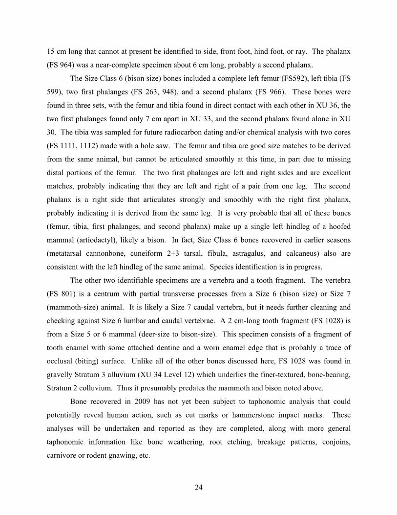
Specimen FS 584 (catalog # 470) was recovered in 2008. The specimen (Figure 5) is
composed of a waxy orange, largely opaque, petrified wood, and measures about 19 x 12 x 3
mm. It exhibits two near-flat surfaces resembling dorsal and ventral faces, and would be
characterized as a flake fragment in Sullivan and Rosen's (1985) debitage typology. About half
of the margins are thin and nearly feathered, while the other half are snapped/fractured. The
dorsal face is slightly concave, and exhibits well expressed compression rings on the entire face
except where there is some petrified wood texture. However, the ventral face, which is slightly
convex, has only three rings, each with a near-planar intervening surface. Between the third ring
and flake margin is a slight hinge before a final small feather termination. Margins exhibit
discontinuous, unifacial chipping damage with scars <0.5 mm.
Specimen FS 584 is ambiguous, not being easily dismissed as a geofact and not being
easily accepted as an artifact. It lacks attributes best expressed in human-produced flakes but
occurring rarely in geofacts, namely a bulb of percussion, fissures, and errailures (Peacock
1991). The attributes possessed by the specimen (partial expression of dorsal cortex, presence of
25
compression rings or ripples) are found in both artifacts and geofacts (Peacock 1991). The
marginal damage seen on this specimen is similar to that illustrated by Hosfield and Chambers
(2003) on flakes exposed to riverbed abrasion. The status of this specimen is uncertain. In terms
purely of cultural property management, it should probably be considered an artifact, but this is
not a scientific certainty.
Figure 5. Lithic Sample FS 584 (catalog #470), interpreted as possible flake. The dorsal aspect is shown at left and ventral aspect at right. The bars at base are 1 cm each. Photos by Alfred Keller.
Specimen FS 584 was found by a student within some loose dirt at the base of Level 11
in XU 21. It was initially observed about 40 cm northeast and vertically level with a mammoth-
size femur (FS 546) in the same unit. If taken at face value, this location would be about 15 cm
above the base of the bone and 2 cm below the top of the bone at its nearest point. Given the
slope of the geological strata, that would place it stratigraphically equivalent with the bone.
However, its exact original location when uncovered is unknown. It is reliably estimated to be
derived from the east half of the unit level, within North 494.0-455.5 m, East 92.75-93.50 m,
Elevation 101.05-101.10 m in our grid system. This provenience is 45-90 cm below the present
sloping ground surface. By comparison to the stratigraphy mapped in the east wall of the unit,
this specimen is likely derived from the geological stratum (II) from which mammoth bone was
recovered elsewhere, although it could be from the base of the overlying Stratum I, interpreted as
wind-blown sediment.
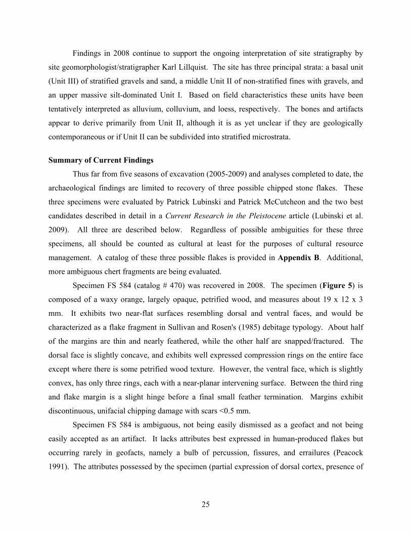
Specimen FS 479 (catalog #327; Figure 6), recovered in 2007, is classified as a broken
flake in Sullivan and Rosen’s (1985) system, due to breakage of a portion of the distal margin.
(It was erroneously identified as a complete flake in the prior reports.) This specimen can be
described as follows (Lubinski et al. 2009:86):
26
It is a broken flake exhibiting a flat platform with an angle of 55°, an éraillure scar on a diffuse bulb of percussion, 5 dorsal flake scars (including two 1-mm-long scars adjacent to the platform), feather termination, and no cortex. All intact edges exhibit discontinuous chipping damage, with scars <0.5 mm. The specimen is made of translucent tan chert visually similar to natural material in the excavation matrix. The érrailure, platform angle, and lack of cortex imply this is an artifact, while the diffuse bulb of percussion and apparently local raw material imply a geofact (Patterson 1983; Peacock 1991).
The edge damage is ambiguous, derived from either human action or geological action such as
streambed abrasion (see Hosfield and Chambers 2003). It was found in the 1/8 in. screen for XU
20 Level 10, which is North 498-499 m, East 90-91.5 m, Elevation 100.4-100.5 m in our grid
system, and 65-100 cm below the present sloping ground surface. Given the slope of the hill and
location of the Stratum II-Stratum III contact, the flake could be derived from the geological
stratum (II) from which mammoth bone was recovered elsewhere, or from the underlying,
higher-energy, apparently alluvial Stratum III.
Figure 6. Artifact FS 479 (catalog #327). This is a complete flake from the screen in XU 20, Level 10. The ventral aspect is shown. The bars at base are 1 cm each. Photo by Jake Shapley.
27
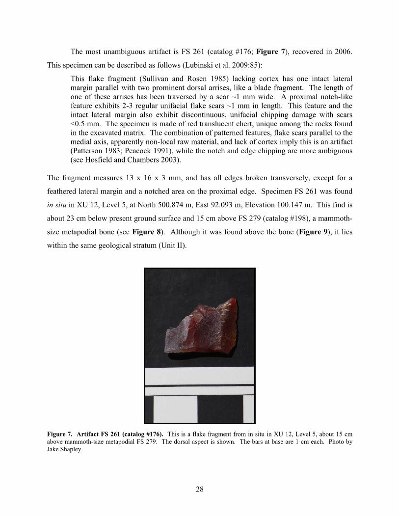
The most unambiguous artifact is FS 261 (catalog #176; Figure 7), recovered in 2006.
This specimen can be described as follows (Lubinski et al. 2009:85):
This flake fragment (Sullivan and Rosen 1985) lacking cortex has one intact lateral margin parallel with two prominent dorsal arrises, like a blade fragment. The length of one of these arrises has been traversed by a scar ~1 mm wide. A proximal notch-like feature exhibits 2-3 regular unifacial flake scars ~1 mm in length. This feature and the intact lateral margin also exhibit discontinuous, unifacial chipping damage with scars <0.5 mm. The specimen is made of red translucent chert, unique among the rocks found in the excavated matrix. The combination of patterned features, flake scars parallel to the medial axis, apparently non-local raw material, and lack of cortex imply this is an artifact (Patterson 1983; Peacock 1991), while the notch and edge chipping are more ambiguous (see Hosfield and Chambers 2003).
The fragment measures 13 x 16 x 3 mm, and has all edges broken transversely, except for a
feathered lateral margin and a notched area on the proximal edge. Specimen FS 261 was found
in situ in XU 12, Level 5, at North 500.874 m, East 92.093 m, Elevation 100.147 m. This find is
about 23 cm below present ground surface and 15 cm above FS 279 (catalog #198), a mammoth-
size metapodial bone (see Figure 8). Although it was found above the bone (Figure 9), it lies
within the same geological stratum (Unit II).
Figure 7. Artifact FS 261 (catalog #176). This is a flake fragment from in situ in XU 12, Level 5, about 15 cm above mammoth-size metapodial FS 279. The dorsal aspect is shown. The bars at base are 1 cm each. Photo by Jake Shapley.
28
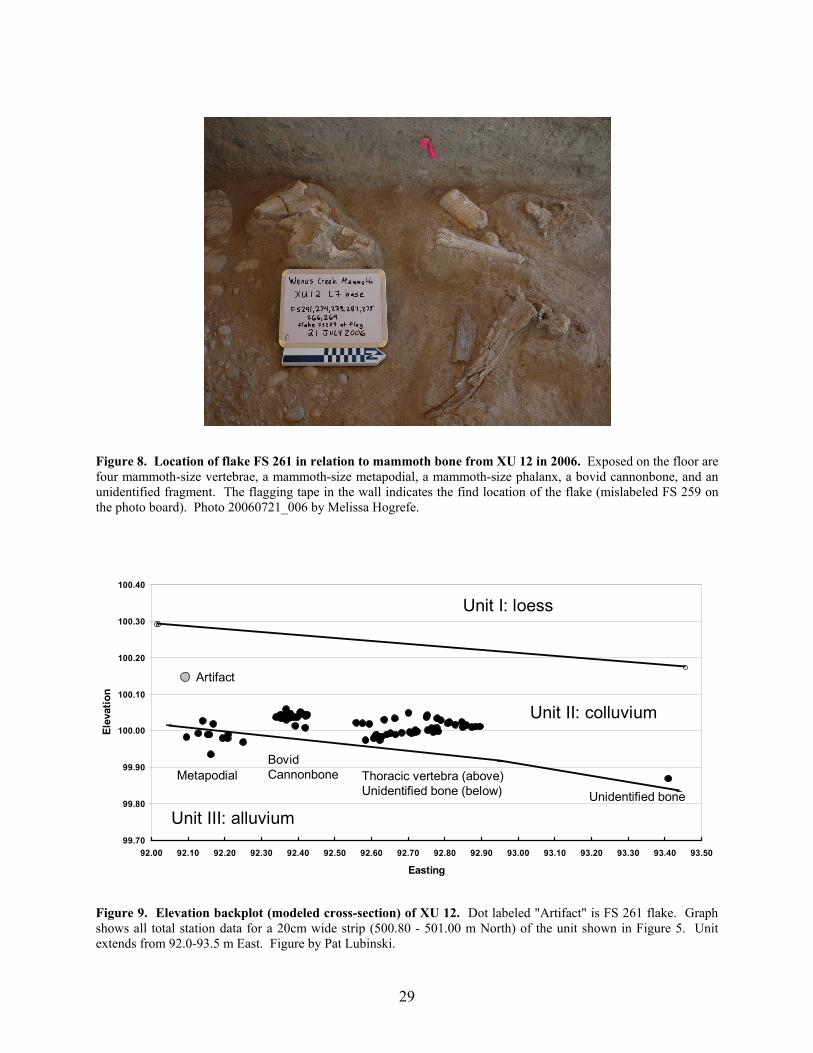
Figure 8. Location of flake FS 261 in relation to mammoth bone from XU 12 in 2006. Exposed on the floor are four mammoth-size vertebrae, a mammoth-size metapodial, a mammoth-size phalanx, a bovid cannonbone, and an unidentified fragment. The flagging tape in the wall indicates the find location of the flake (mislabeled FS 259 on the photo board). Photo 20060721_006 by Melissa Hogrefe.
99.70
99.80
99.90
100.00
100.10
100.20
100.30
100.40
92.00 92.10 92.20 92.30 92.40 92.50 92.60 92.70 92.80 92.90 93.00 93.10 93.20 93.30 93.40 93.50
Easting
Elev
atio
n
Artifact
MetapodialBovidCannonbone Thoracic vertebra (above)
Unidentified bone (below) Unidentified bone
Unit I: loess
Unit II: colluvium
Unit III: alluvium
Figure 9. Elevation backplot (modeled cross-section) of XU 12. Dot labeled "Artifact" is FS 261 flake. Graph shows all total station data for a 20cm wide strip (500.80 - 501.00 m North) of the unit shown in Figure 5. Unit extends from 92.0-93.5 m East. Figure by Pat Lubinski.
29
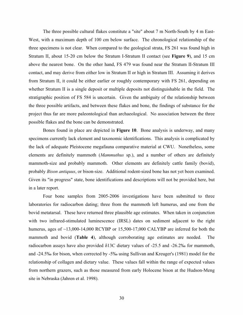
The three possible cultural flakes constitute a "site" about 7 m North-South by 4 m East-
West, with a maximum depth of 100 cm below surface. The chronological relationship of the
three specimens is not clear. When compared to the geological strata, FS 261 was found high in
Stratum II, about 15-20 cm below the Stratum I-Stratum II contact (see Figure 9), and 15 cm
above the nearest bone. On the other hand, FS 479 was found near the Stratum II-Stratum III
contact, and may derive from either low in Stratum II or high in Stratum III. Assuming it derives
from Stratum II, it could be either earlier or roughly contemporary with FS 261, depending on
whether Stratum II is a single deposit or multiple deposits not distinguishable in the field. The
stratigraphic position of FS 584 is uncertain. Given the ambiguity of the relationship between
the three possible artifacts, and between these flakes and bone, the findings of substance for the
project thus far are more paleontological than archaeological. No association between the three
possible flakes and the bone can be demonstrated.
Bones found in place are depicted in Figure 10. Bone analysis is underway, and many
specimens currently lack element and taxonomic identifications. This analysis is complicated by
the lack of adequate Pleistocene megafauna comparative material at CWU. Nonetheless, some
elements are definitely mammoth (Mammuthus sp.), and a number of others are definitely
mammoth-size and probably mammoth. Other elements are definitely cattle family (bovid),
probably Bison antiquus, or bison-size. Additional rodent-sized bone has not yet been examined.
Given its "in progress" state, bone identifications and descriptions will not be provided here, but
in a later report.
Four bone samples from 2005-2006 investigations have been submitted to three
laboratories for radiocarbon dating; three from the mammoth left humerus, and one from the
bovid metatarsal. These have returned three plausible age estimates. When taken in conjunction
with two infrared-stimulated luminescence (IRSL) dates on sediment adjacent to the right
humerus, ages of ~13,000-14,000 RCYBP or 15,500-17,000 CALYBP are inferred for both the
mammoth and bovid (Table 4), although corroborating age estimates are needed. The
radiocarbon assays have also provided δ13C dietary values of -25.5 and -26.2‰ for mammoth,
and -24.5‰ for bison, when corrected by -5‰ using Sullivan and Kreuger's (1981) model for the
relationship of collagen and dietary value. These values fall within the range of expected values
from northern grazers, such as those measured from early Holocene bison at the Hudson-Meng
site in Nebraska (Jahren et al. 1998).
30
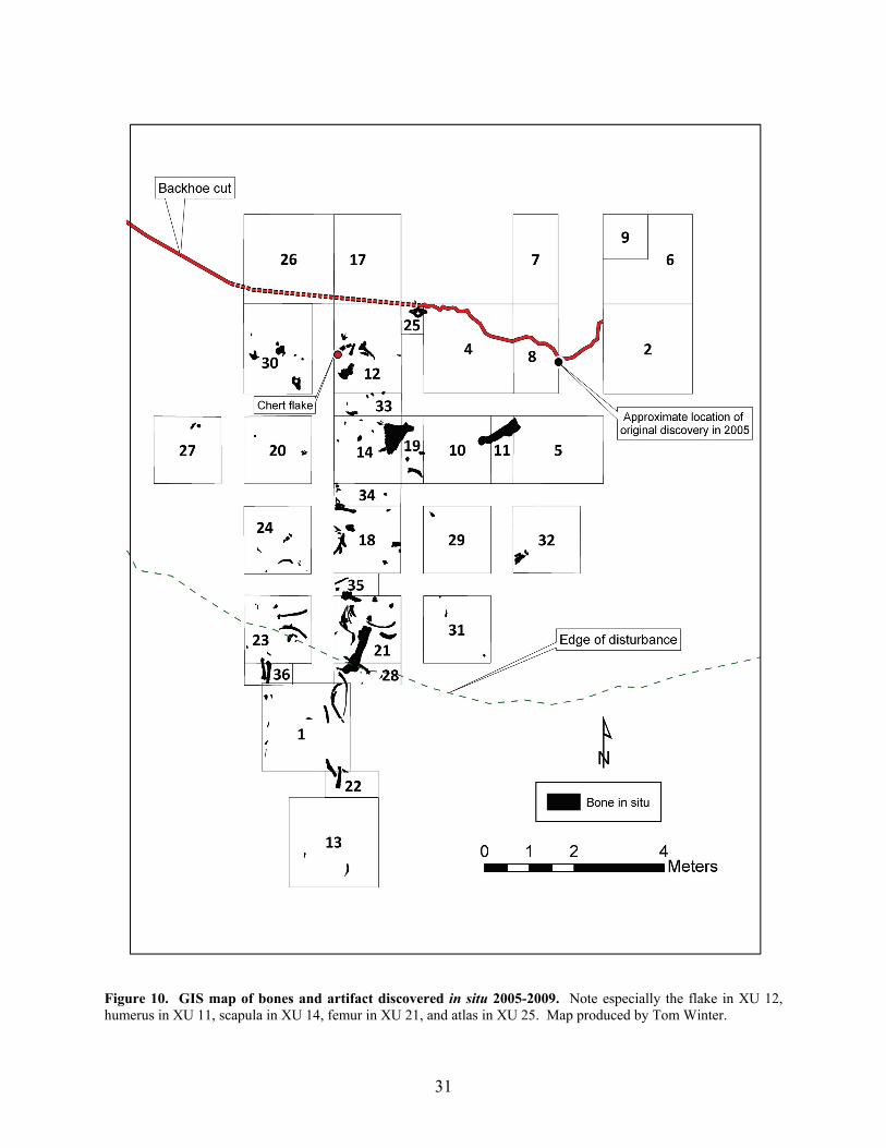
Figure 10. GIS map of bones and artifact discovered in situ 2005-2009. Note especially the flake in XU 12, humerus in XU 11, scapula in XU 14, femur in XU 21, and atlas in XU 25. Map produced by Tom Winter.
31
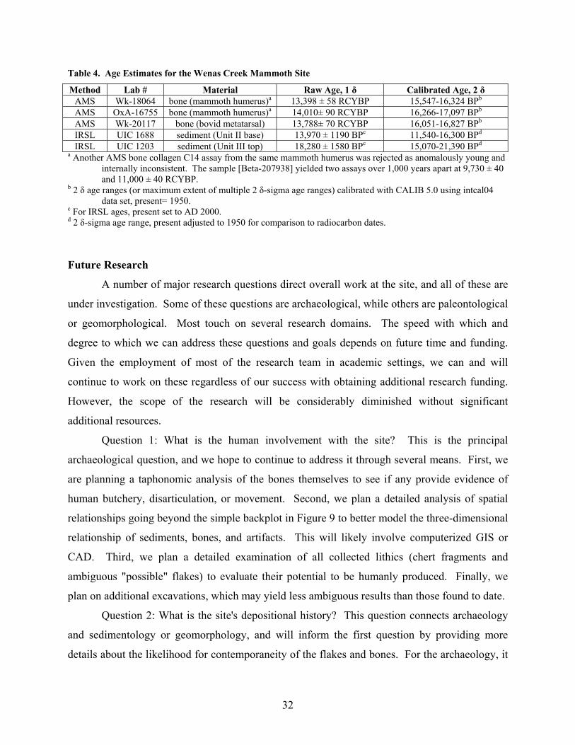
Table 4. Age Estimates for the Wenas Creek Mammoth Site
Method Lab # Material Raw Age, 1 δ Calibrated Age, 2 δ AMS Wk-18064 bone (mammoth humerus)a 13,398 ± 58 RCYBP 15,547-16,324 BPb AMS OxA-16755 bone (mammoth humerus)a 14,010± 90 RCYBP 16,266-17,097 BPb AMS Wk-20117 bone (bovid metatarsal) 13,788± 70 RCYBP 16,051-16,827 BPb IRSL UIC 1688 sediment (Unit II base) 13,970 ± 1190 BPc 11,540-16,300 BPd IRSL UIC 1203 sediment (Unit III top) 18,280 ± 1580 BPc 15,070-21,390 BPd
a Another AMS bone collagen C14 assay from the same mammoth humerus was rejected as anomalously young and internally inconsistent. The sample [Beta-207938] yielded two assays over 1,000 years apart at 9,730 ± 40 and 11,000 ± 40 RCYBP.
b 2 δ age ranges (or maximum extent of multiple 2 δ-sigma age ranges) calibrated with CALIB 5.0 using intcal04 data set, present= 1950.
c For IRSL ages, present set to AD 2000. d 2 δ-sigma age range, present adjusted to 1950 for comparison to radiocarbon dates.
Future Research
A number of major research questions direct overall work at the site, and all of these are
under investigation. Some of these questions are archaeological, while others are paleontological
or geomorphological. Most touch on several research domains. The speed with which and
degree to which we can address these questions and goals depends on future time and funding.
Given the employment of most of the research team in academic settings, we can and will
continue to work on these regardless of our success with obtaining additional research funding.
However, the scope of the research will be considerably diminished without significant
additional resources.
Question 1: What is the human involvement with the site? This is the principal
archaeological question, and we hope to continue to address it through several means. First, we
are planning a taphonomic analysis of the bones themselves to see if any provide evidence of
human butchery, disarticulation, or movement. Second, we plan a detailed analysis of spatial
relationships going beyond the simple backplot in Figure 9 to better model the three-dimensional
relationship of sediments, bones, and artifacts. This will likely involve computerized GIS or
CAD. Third, we plan a detailed examination of all collected lithics (chert fragments and
ambiguous "possible" flakes) to evaluate their potential to be humanly produced. Finally, we
plan on additional excavations, which may yield less ambiguous results than those found to date.
Question 2: What is the site's depositional history? This question connects archaeology
and sedimentology or geomorphology, and will inform the first question by providing more
details about the likelihood for contemporaneity of the flakes and bones. For the archaeology, it
32
relates to an evaluation of bone and sediment movement and alteration. We plan an analysis of
bone orientation, refits, and weathering which may intimate the mode of bone accumulation or
reveal a stratigraphic subdivision based on a weathering front on the bones. Analysis of
sediments is underway, including particle size analysis that may allow for more secure or finer
stratigraphic divisions. If significant additional funding can be secured, we hope to obtain a suite
of single-grain optically-stimulated luminescence dates on coarse sediment grains, as well as soil
micromophological analyses to evaluate the age and movement of sediment bearing the bones
and artifacts, and thus the strength of their association.
Question 3: What is the origin of the landform on which the site lies? As noted earlier,
the landform may be a landslide, alluvial fan, or terrace. These three landforms would have
different implications for depositional history of the archaeological site, as well as its
relationship to the surrounding landscape. This largely geomorphological question may be
addressed by analysis of collected sediment samples and a GIS-based map investigation of the
hillside and surrounding landforms. If additional funding is obtained, we would also plan
additional backhoe trenching.
Question 4: What animals are represented at the site? As noted above, the identification
of bones from the site is currently in its early stages. We plan on more work in this area, which
will have to involve visits to locations with comparative Pleistocene mammal materials, and will
thus require some additional funding and time. We are also exploring the possibility of using
ancient DNA from bone samples at the site.
Question 5: What were environmental conditions at the time of the mammoth? To
address this question, there are several potential sources of paleoenvironmental proxy data. We
have recovered some microfauna (e.g., rodent remains) which may address this question, and we
plan to identify these bones for this purpose. A small sample of pollen and opal phytoliths was
examined by a graduate student, and these indicate the potential for these data sources. We
would like to obtain funding for professional analysis of pollen and phytolith samples. Another
data source that would depend on funding is stable isotopic chemical analysis of the mammoth
and bovid bones.
33
Acknowledgments
The Wenas Creek Mammoth Project in summer 2009 and academic year 2009-10 was
supported in part by student tuitions and donations by Basic American Foods, the Pacific
Northwest Archaeological Society, and numerous anonymous cash donors. The landowners,
Doug and Bronwyn Mayo of Haywire Outfit, Inc., have been instrumental in initiating the
research and their unwavering support has been essential to the project. The contributions of the
field school students, lab assistants, and volunteers are gratefully acknowledged.
Illustrations were prepared by Ben Sainsbury, Tom Winter, and Brian Whiting.
Photographs were taken by Melissa Hogrefe, Alfred Keller and Jake Shapley. Sarah Campbell
and Karisa Terry provided useful comments on the lithics.
References Cited
Ames, Kenneth M., Donald E. Dumond, Jerry R. Galm, and Rick Minor
1998 Prehistory of the Southern Plateau. In Plateau, edited by Deward E. Walker, pp. 103-
119. Handbook of North American Indians, Vol. 12, William C. Sturtevant, general
editor, Smithsonian Institution, Washington, D. C.
Anderson, David G., and Michael K. Faught
2000 Paleoindian Artifact Distribution: Evidence and Implications. Antiquity 74:507-513.
Bartlein, P. J., K. H. Anderson, P. M. Anderson, M.E. Edwards, C. J. Mock, R. S. Thompson, R.
S. Webb, T. Webb, and C. Whitlock
1998 Paleoclimate Simulations for North America over the Past 21,000 Years: Features of the
Simulated Climate and Comparisons with Paleoenvironmental Data. Quaternary Science
Reviews 17:549-585.
Blinnikov, Mikhail, Alan Busacca, and Cathy Whitlock
2002 Reconstruction of the Late Pleistocene Grassland of the Columbia Basin, Washington,
USA, Based on Phytolith Records in Loess. Palaeogeography, Palaeoclimatology,
Palaeoecology 177:77-101.
Blumenshine, Richard J., and Marie Selvaggio
1988 Percussion Marks on Bone Surfaces as a New Diagnostic of Hominid Behavior. Nature
333:763-765.
34
Booth, D. B., K. G. Troost, J. J. Clague, and R. B. Waitt
2004 The Cordilleran Ice Sheet. In The Quaternary Period in the United States, edited by A.
R. Gillespie, S. C. Porter, and B. F. Atwater, pp. 17-43. Developments in Quaternary
Science No. 1. Elsevier, Amsterdam,.
Bretz, J. Harlen.
1969. The Lake Missoula Floods and the Channeled Scabland. Journal of Geology 77, 505-
543.
Bunn, Henry T.
1982 Meat Eating and Hominid Evolution: Studies on the Diet and Subsistence Patterns of
Plio-Pleistocene Hominids in East Africa. Ph.D. dissertation, University of California,
Berkeley. University Microfilms, Ann Arbor.
Byers, David A., and Andrew Ugan
2005 Should We Expect Large Game Specialization in the Late Pleistocene? An Optimal
Foraging Perspective on Early Paleoindian Prey Choice. Journal of Archaeological
Science 32(11):1624-1640.
Cannon, Michael D., and David J. Meltzer
2004 Early Paleoindian Foraging: Examining the Faunal Evidence for Large Mammal
Specialization and Regional Variability in Prey Choice. Quaternary Science Reviews
23:1955-1987.
Carlson, R.L., 1990. Cultural Antecedents. In Northwest Coast, edited by William Suttles, pp.
60-69. Handbook of North American Indians, Vol. 7, William C. Sturtevant, general
editor, Smithsonian Institution, Washington, D. C.
Clague, J.J., R. Barendregt, R. J. Enkin, and F. F. Foit, Jr.
2003 Paleomagnetic and Tephra Evidence for Tens of Missoula Floods in Southern
Washington. Geology 31:247-250.
Craven, S.L.
2004 New Dates for the Lind Coulee Site (45GR97), Washington. Current Research in the
Pleistocene 21:28-30.
Daubenmire, Rexford F.
1970 Steppe Vegetation of Washington. Washington Agricultural Experiment Station
Technical Bulletin No. 62. Washington State University, Pullman.
35
Daugherty, Richard D.
1956 Archaeology of the Lind Coulee site, Washington. Proceedings of the American
Philosophical Society 100(3):223-278.
Davis, Loren G., and Charles E. Schweger
2004 Geoarchaeological Context of Late Pleistocene and Early Holocene Occupation at the
Cooper's Ferry site, Western Idaho, USA. Geoarchaeology 19(7):685-704.
Dillehay, Thomas
1989 Monte Verde: A Late Pleistocene Settlement in Chile, Volume 1: Paleoenvironment and
Site Context. Smithsonian Institution, Washington, D. C.
1997. Monte Verde: A Late Pleistocene Settlement in Chile, Volume 2: The Archaeological
Context and Interpretation. Smithsonian Institution, Washington, D. C.
Dincauze, Dena F.
1984 An Archaeo-logical Evaluation of the Case for Pre-Clovis Occupations. Advances in
World Archaeology 3:275-323.
Fiedel, Stuart, and Gary Haynes
2004 A Premature Burial: Comments on Grayson and Meltzer's "Requiem for Overkill."
Journal of Archaeological Science 31:121-131.
Fisher, John W., Jr.
1995 Bone Surface Modifications in Archaeology. Journal of Archaeological Method and
Theory 2:7-68.
Galm, Jerry R., and Stanley Gough
2000 Site 45KT1362, A c. 10,000 yr B.P. Occupation in Central Washington. Current
Research in the Pleistocene 17:29-31.
Gilbert, M. Thomas P., Dennis L. Jenkins, Anders Götherstrom, Nuria Naveran, Juan J. Sanchez,
Michael Hofreiter, Philip Francis Thomsen, Jonas Binladen, Thomas F. G. Higham,
Robert M. Yohe, II, Robert Parr, Linda Scott Cummings, and Eske Willerslev
2008 DNA from Pre-Clovis Human Coprolites in Oregon, North America. Science 320:786-
789.
Gramly, Richard M.
1993. The Richey Clovis Cache : Earliest Americans along the Columbia River. Persimmon
Press, Buffalo, New York.
36
Grayson, Donald K., and David J. Meltzer
2002 Clovis Hunting and Large Mammal Extinction: A Critical Review of the Evidence.
Journal of World Prehistory 16(4):313-359.
2003. A Requiem for North American Overkill. Journal of Archaeological Science 30:583-593.
Gustafson, Carl, D. Gilbow, and Richard Daugherty
1979. The Manis Mastodon site: Early Man on the Olympic Peninsula. Canadian Journal of
Archaeology 3:157-164.
Gustafson, C. E., S. C. Hess, J. D. Gallison, and S. A. Stump
1991 The Ledgerwood Mammoth Site (45GA202), Garfield County, Washington. BOAS, Inc.,
Seattle.
Haynes, C. Vance
1969 The Earliest Americans. Science 166:709-715.
Haynes, Gary
2002 The Early Settlement of North America: The Clovis Era. Cambridge University Press,
Cambridge.
Hicks, Brent A. (Editor)
2004. Marmes Rockshelter: A Final Report on 11,000 Years of Cultural Uses. Washington
State University Press, Pullman.
Holen, Steven R.
2006 Taphonomy of Two Last Glacial Maximum Mammoth Sites in the Central Great Plains
of North America: A Preliminary Report on La Sena and Lovewell. Quaternary
International 142-143:30-43.
2007 The Age and Taphonomy of Mammoths at Lovewell Reservoir, Jewell County, Kansas,
USA. Quaternary International 169-170:51-63.
Holliday, Vance T.
2000 The evolution of Paleoindian geochronology and typology on the Great Plains.
Geoarchaeology 15:227-290.
Hosfield, Robert T., and Jenni C. Chambers
2003 Flake Modifications During Fluvial Transportation: Three Cautionary Tales. Lithics
24:57-65.
37

Hunn, Eugene S.
1990 Nch’i-Wána “The Big River” Mid-Columbia Indians and Their Land. University of
Washington Press, Seattle.
Hunn, Eugene S., Nancy J. Turner, and David H. French
1998 Ethnobiology and Subsistence. In Plateau, edited by Deward E. Walker, pp. 525-545.
Handbook of North American Indians, Vol. 12, William C. Sturtevant, general editor,
Smithsonian Institution, Washington, D. C.
Jahren, A. H., L. C. Todd, and R. G. Amundson
1998 Stable Isotope Dietary Analysis of Bison Bone Samples from the Hudson-Meng
Bonebed: Effects of Paleotopography. Journal of Archaeological Science 25:465-475.
Jenkins, Dennis L., T. J. Connolly, and C. Melvin Aikens
2004 Early and Middle Holocene Archaeology in the Northern Great Basin: Dynamic Natural
and Cultural Ecologies. In Early and Middle Holocene Archaeology in the Northern
Great Basin, edited by Dennis L. Jenkins, T. J. Connolly, and C. Melvin Aikens, pp. 1-
20. Anthropological Papers No. 62, University of Oregon, Eugene.
Kelly, Robert L.
2003 Maybe We Do Know When People First Came to North America; and What Does It
Mean If We Do? Quaternary International 109-110:133-145.
Lubinski, Patrick M.
2009 The Wenas Creek Mammoth Project: 2008 Interim Archaeology Report on Excavations
at 45YA1083. Central Washington University, Ellensburg.
Lubinski, Patrick M., Bax R. Barton, Karl Lillquist, Morris Uebelacker, and Jake T. Shapley
2007 The Late Glacial Wenas Creek Mammoth Site (45YA1083) in Central Washington.
Current Research in the Pleistocene 24:178-180.
Lubinski, Patrick M., Bax R. Barton, Karl Lillquist, Jake T. Shapley, and Morris Uebelacker
2008 The Wenas Creek Mammoth Project: 2007 Interim Report on Excavations at 45YA1083.
Central Washington University, Ellensburg.
Lubinski, Patrick M., Patrick T. McCutcheon, Karl Lillquist, Morris Uebelacker, Bax R. Barton,
and Jake T. Shapley
2009 Possible Lithic Artifacts from 2005-2007 Excavations at the Wenas Creek Mammoth
Site. Current Research in the Pleistocene 26:85-86.
38
Luedtke, Barbara E.
1986 An Experiment in Natural Fracture. Lithic Technology 15:55-60.
Mehringer, Peter J., Jr, J. C. Sheppard, and F. F. Foit, Jr.
1984 The Age of Glacier Peak Tephra in West-Central Montana. Quaternary Research
21(1):36-41.
Meltzer, David J, Donald K Grayson, Gerardo Ardila, Alex W. Barker, Dena F. Dincauze, C.
Vance Haynes, Francisco Mena, Lautaro Nunez, and Dennis J. Stanford
1997 On the Pleistocene Antiquity of Monte Verde, Southern Chile. American Antiquity
62:659-663.
Meltzer, David J.
2004 Peopling of North America. In The Quaternary Period in the United States, edited by A.
R. Gillespie, S. C. Porter, and B. F. Atwater, pp. 539-563. Developments in Quaternary
Science No. 1. Elsevier, Amsterdam,
Miller, E.E., and R. M. Highsmith
1949 Geography of the Fruit Industry of Yakima Valley, Washington. Economic Geography
25(4):285-295.
Miller, S.J.
1989 Characteristics of Mammoth Bone Reduction at Owl Cave, the Wasden Site, Idaho. In
Bone Modification, edited by Robson Bonnichsen and H. H. Sorg, pp. 381-394. Center
for the Study of the First Americans, Orono, Maine.
Oakley, Kenneth P.
1964 Man The Tool Maker. 3rd ed. University of Chicago.
Olsen, Stanley J.
1979 Osteology for the Archaeologist. Papers of the Peabody Museum of Archaeology and
Ethnology Vol. 56, No. 3-5. Harvard University, Cambridge, Massachusetts.
Patterson, Leland W.
1983 Criteria for Determining the Attributes of Man-Made Lithics. Journal of Field
Archaeology 10:297-307.
Peacock, Evan
1991 Distinguishing Between Artifacts and Geofacts: A Test Case from Eastern England.
Journal of Field Archaeology 18:345-361.
39
Roosevelt, Anna C.
2002 Clovis in Context: New Light on the Peopling of the Americas. Journal of Human
Evolution 17:95-112.
Schuster, Helen H., 1998. Yakima and neighboring groups. In Plateau, edited by Deward E.
Walker, pp. 327-351. Handbook of North American Indians, Vol. 12, William C.
Sturtevant, general editor. Smithsonian Institution, Washington, D. C.
Smith, G. A.
1988 Neogene Synvolcanic and Syntectonic Sedimentation in Central Washington. Geological
Society of America Bulletin 100:1479-1492.
Smith, William C.
1971 Excavations at 45YK301. Central Washington State College, Ellensburg.
Sullivan, C.H., and K. W. Kreuger
1981 Carbon Isotope Analysis of Separate Chemical Phases in Modern and Fossil Bone.
Nature 292:333-335.
Waguespack, Nicole M., and Todd A. Surovell
2003 Clovis Hunting Strategies, or How to Make Out on Plentiful Resources. American
Antiquity 68(2):333-352.
Waitt, R. B., Jr.
1980 About Forty Last-glacial Lake Missoula Jökulhlaups through Southern Washington.
Journal of Geology 88:653-679.
Waitt, R. B., Jr., and R. M. Thorson
1983 The Cordilleran Ice Sheet in Washington, Idaho, and Montana. In The Pleistocene,
edited by S. C. Porter, pp. 53-70. Late Quaternary Environments of the United States,
Vol. 1. University of Minnesota Press, Minneapolis.
Walsh, T. J.
1986 Geologic Map of the West Half of the Yakima Quadrangle, Washington. Washington
Division of Geology and Earth Resources Open File Report 86-4.
Warren, Claude N.
1968 The View from Wenas: A Study in Plateau Prehistory. Occasional Papers No. 24, of the
Idaho Museum of Natural History, Pocatello.
40
Waters, A. C.
1955 Geomorphology of South-central Washington, Illustrated by the Yakima East
Quadrangle. Bulletin of the Geological Society of America 66:663-684.
Waters, Michael R., and Thomas W. Stafford, Jr.
2007 Redefining the Age of Clovis: Implications for the Peopling of the Americas. Science
315:1122-1126.
Whitlock, Cathy, Andre M. Sarna-Wojcicki, Patrick J. Bartlein, and Rudy J. Nickmann
2000 Environmental History and Tephrostratigraphy at Carp Lake, Southwestern Columbia
Basin, Washington, USA. Palaeogeography, Palaeoclimatology, Palaeoecology 155:7-
29.
Appendices:
Appendix A: Excavation Forms
1) Excavation Record Form
2) Bone Find Record Form
(following four pages)
41
Excavation Record Project: CWU Wenas Creek Mammoth Investigation 2009 page of Site # 45YA1083
Date Page Started Excavator(s)
Excavation Unit # North East Unit Size Screen Size
Level # Elevation: Top Elevation: Bottom Level Thickness
Elevations From: ” datum ” ground surface ” control corner Datum/control corner
name or location
form revised 24 June 2009 Description of Deposits:
Color Texture (e.g., silty clay, sandy loam)
Consistence (e.g., loose)
Inclusions (e.g., many pebbles <1cm) Carbonate: (e.g., slight whitening; scattered ribbbons)
Disturbance: % of level disturbed By what? (e.g. rodent burrows, roots) Other notes on deposits (e.g., geological stratum, soil formation, cultural horizons, tephra)
Artifacts and Samples Collected: (Be sure to note material, count, in situ/in screen, # of bags for multi-bag samples)
FS#
Description N
E Elev.
Relevant Uncollected Materials: (e.g., unmodified cobbles, burned stone, non-artifact CCS, etc.)
Material
Count: Weight (g):
<3 cm 3-6 cm >6 cm TOTAL <3 cm
3-6 cm >6 cm TOTAL
Features defined in this level: (# & description) ____________________________________________________
Excavation Record (back side) Site: 45YA1083 XU#: Level#: Corner Elevations: SW NW NE SE Center
TOP actual
BOTTOM actual
BOTTOM target Elevation (m): Depth below datum (cm):
Plan Map: This map depicts excavation unit ” at top of level ” at bottom of level (On map, label grid coordinates, note limits of excavation, in situ artifacts, features, areas of staining, areas of disturbance, etc.) Scale? 1 block = ” 5 cm ” 10 cm ” other (explain):
Arrow Direction?
” Grid North ” True North ” Other (explain):
Photographs:
Date: Exp. #: Description: Date: Exp. #: Description:
Notes: (describe artifact distributions, extent of staining, and relationships between artifacts, stained areas, features & disturbances, etc.)
Bone Find Record Project: CWU Wenas Creek Mammoth Investigation 2009
Site # 45YA1083 Catalog # FS #
Excavation Unit #(s) Level(s) Date FS assigned
Recorder(s) Date removed to lab
form revised 27 August 2008 Bone Sketch: Dimensions & Orientations
N Length (cm)
Bearing (compass degrees) (Declination set at______________)
Maximum Length Not applicable
Length (long axis)
Width (perpendicular)
Thickness
Dip (degrees down) Strike (bearing to down direction)
Long axis Long axis
Perp. axis Perp. axis
Long axis dip/strike taken where? (top, bottom…)
Perp. axis dip/strike taken where?
Indicate high point, low point, any excavation damage, and important features (arrow points grid North) Total Station Shots:
High Point: Date taken North East Elevation
Low Point: Date taken North East Elevation
Outline: Date taken Shot numbers Topography: Date taken Shot numbers
Photographs: (Be sure to get at least one closeup of fully exposed bone to clearly show orientation, weathering, etc.)
Date Exposures Description
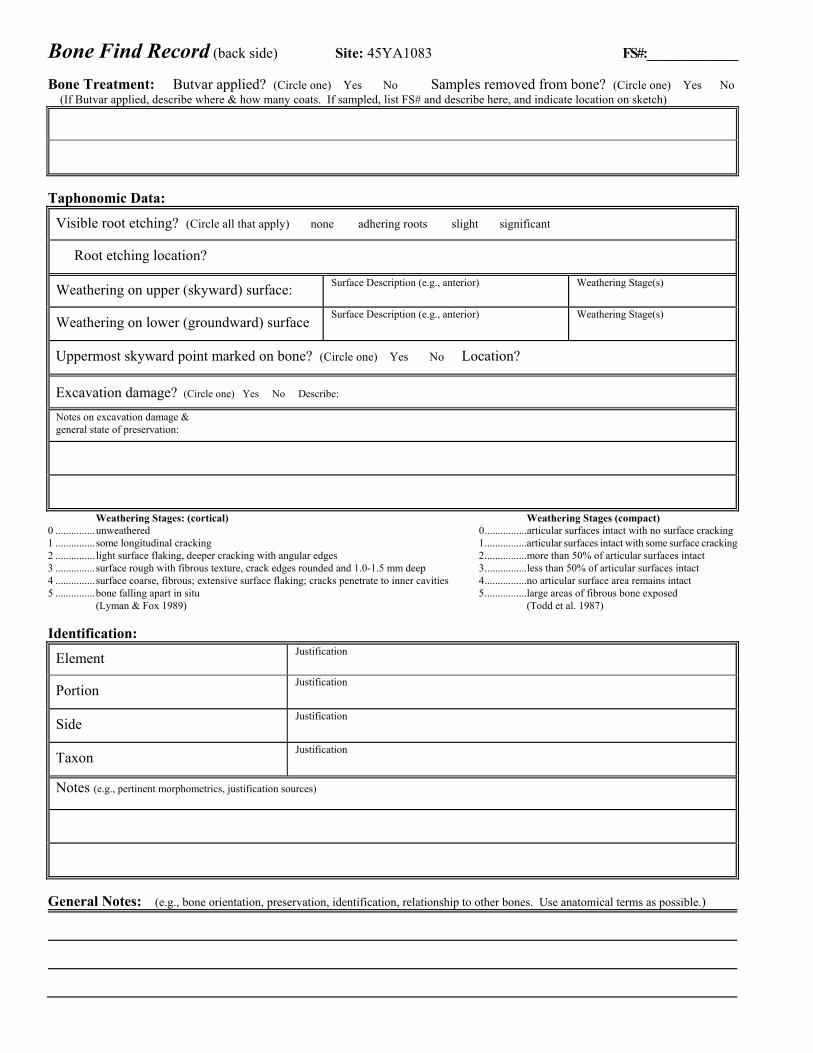
Bone Find Record (back side) Site: 45YA1083 FS#:_______________ Bone Treatment: Butvar applied? (Circle one) Yes No Samples removed from bone? (Circle one) Yes No (If Butvar applied, describe where & how many coats. If sampled, list FS# and describe here, and indicate location on sketch)
Taphonomic Data:
Visible root etching? (Circle all that apply) none adhering roots slight significant
Root etching location?
Weathering on upper (skyward) surface: Surface Description (e.g., anterior) Weathering Stage(s)
Weathering on lower (groundward) surface Surface Description (e.g., anterior) Weathering Stage(s)
Uppermost skyward point marked on bone? (Circle one) Yes No Location?
Excavation damage? (Circle one) Yes No Describe:
Notes on excavation damage & general state of preservation:
Weathering Stages: (cortical) Weathering Stages (compact) 0 ............... unweathered 0 ................articular surfaces intact with no surface cracking 1 ............... some longitudinal cracking 1 ................articular surfaces intact with some surface cracking 2 ............... light surface flaking, deeper cracking with angular edges 2 ................more than 50% of articular surfaces intact 3 ............... surface rough with fibrous texture, crack edges rounded and 1.0-1.5 mm deep 3 ................less than 50% of articular surfaces intact 4 ............... surface coarse, fibrous; extensive surface flaking; cracks penetrate to inner cavities 4 ................no articular surface area remains intact 5 ............... bone falling apart in situ 5 ................large areas of fibrous bone exposed (Lyman & Fox 1989) (Todd et al. 1987) Identification:
Element Justification
Portion Justification
Side Justification
Taxon Justification
Notes (e.g., pertinent morphometrics, justification sources)
General Notes: (e.g., bone orientation, preservation, identification, relationship to other bones. Use anatomical terms as possible.)
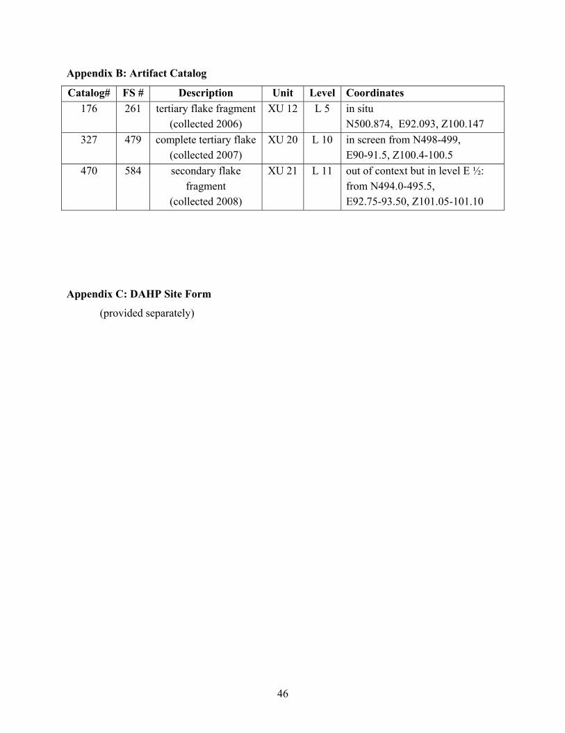
46
Appendix B: Artifact Catalog
Catalog# FS # Description Unit Level Coordinates 176 261 tertiary flake fragment
(collected 2006) XU 12 L 5 in situ
N500.874, E92.093, Z100.147 327 479 complete tertiary flake
(collected 2007) XU 20 L 10 in screen from N498-499,
E90-91.5, Z100.4-100.5 470 584 secondary flake
fragment (collected 2008)
XU 21 L 11 out of context but in level E ½: from N494.0-495.5, E92.75-93.50, Z101.05-101.10
Appendix C: DAHP Site Form
(provided separately)
Recommended