A full color version of this publication is available online at: www.weather.gov/ind
Contacts
David Tucek, NWS Indianapolis
(317) 856-0361 x726
Mike Lewis, NWS Northern Indiana
(574) 834-1104 x726
Jim Allsopp, NWS Chicago
(815) 834-0600 x726
Joe Sullivan, NWS Louisville
(502)969-8842 x726
Ricky Shanklin, NWS Paducah
(270) 744-6440 x726
Mary Jo Parker, NWS Wilmington
(937) 383-0031
IDHS
(317) 232-3980
INDOT
(866) 849-1368
Carol Greeley, American Red Cross
(317) 684-4351
Dave Bursten, Indiana State Police
(317) 502-6220
Dave Woodward, INDOE
(317) 232-6975
Inside this issue:
Winter 2012-2013 Outlook................... 2
Severe Weather during Winter ............... 3
Be Red Cross Ready .............................. 4
Preparedness for Schools ..................... 5
Winter Driving Safety............................. 6
Indiana Travel Advisory Map ................. 7
Winterizing your Vehicle ........................ 8
Save Alternate Heating……………………..9
Wind Chill Chart……………………………..10
What to Do if Stranded……………………..11
Internet Sites………………………………...12
Winter 2011/2012
Winter Weather Winter 2012/2013
Governor Mitch Daniels has proclaimed November 11-17, 2012 as Winter Weather
Preparedness Week in Indiana.
As cold and snow begin in earnest across Indiana, the National Weather Service
(NWS), Indiana Department of Homeland Security (IDHS), Indiana Department of
Transportation (INDOT), Indiana State Police (ISP), American Red Cross and the
Indiana Department of Education (IDOE) are encouraging Hoosiers to begin prepar-
ing now for what could be a long, cold winter. Preparedness Week is your reminder
that you need to be ready for the hazards winter brings.
Officials from each organization will be available for interviews to help you better
understand the outlook for this winter, what preparation plans are being made, and
how citizens can be ready.
Indiana Winter Weather Preparedness Week is
November 11-17, 2012
Winter 2011-2012 In Review
The winter of 2011-2012 was milder and less snowy than normal across the entire Hoosi-er State, complements of a La Nina pattern. In fact two thirds of the winter days were warmer than normal.
Unlike the winter of 2010-2011 with a strongly negative North Atlantic Oscillation (NAO) that produced a cold and snowy condi-tions, this past winter lacked any significant snowstorm systems. A pre-winter storm dumped 8-10 inches of snow in northeast Indi-ana.
December set the tone for the winters’ tem-peratures, averaging near 5 degrees above nor-mal. A rather rainy early and mid month result-ed in the 16th wettest December of record for Indiana. No storm systems produced any appre-ciable snows and many areas saw no snow for the month.
January produced a little more winter-like weather but was still a far cry from brutal January weather of the past. January 2012 temperatures averaged near 6 degrees above normal statewide, with 2/3 of the days above normal again. A few locations in the north saw subzero temperatures on a couple of days. Snowfall was closer to normal in the north while the south half of Indiana saw below average snowfall. Rainfall totals remained above normal, and statewide, this was the 30th wettest January of record. Uncommon, but not unprecedented for January, was the tornado outbreak that occurred January 17 near the Ohio river. Five tornadoes hit southern Indiana, part of a 12 tornado outbreak that also impacted central Kentucky.
Winter finished mild, with February the 20th warmest of record and the fourth month in a row with 2/3 of the days averaging above normal. Super Bowl crowds in Indianapolis experienced weather more typical of March. The wet string of weather ended and would become the beginning of the Drought of 2012 for southwest Indiana. Rainfall averaged 50% to 60% of normal in central and southern Indiana. Snowfall was once again below average, and was widespread across the state on only 4 days of the month. Like January, a rare win-ter tornado occurred, again not far from the Ohio river in Warrick County.
What will the 2012-2013 Winter have in store? This winter’s outlook is on Page 2!
Over 30 inches of lake effect snow fell in LaPorte County in mid December 2011. Photo provided by Lori Barrett

Page 2 Winter Weather Preparedness Week
What will this upcoming winter season bring to the Hoosier state? The offi-
cial outlook issued by the Climate Prediction Center (CPC) is calling for equal
chances of above, near and below normal temperatures and precipitation.
What does this mean exactly?
The CPC uses a combination of techniques to derive their forecasts, which
includes looking at active states of the Earth’s atmosphere and oceans as
well as statistical analysis tools and trends in the historical data. The outlook
maps provide a probability forecast based on the analysis. Equal chances
(EC) indicate that an area has a 33.3 percent chance of experiencing above
normal, near normal, or below normal temperatures or precipitation. The EC
category is often used when there is no strong signal as to what may occur.
When an area on the map is shaded as having a higher probability of above
or below normal conditions, it does not necessarily mean those conditions
will occur, but it means the probabilities are higher for its occurrence.
This winter, neutral conditions to possibly a weak El Nino (a warming of the
equatorial Pacific Ocean waters) is expected, and the atmosphere often re-
sponds in a somewhat predictable manner, which helps to guide the CPC fore-
cast. An El Nino’s impact on Indiana varies considerably depending on its
strength. Given the expectation that El Nino will be weak through the winter,
there is some uncertainty in this winter’s long range outlook for our region. Typi-
cally during an El Nino winter, the main storm track remains to the south of the
Ohio Valley, focused across the southern part of the country. It is important to
note that El Nino is not the only factor to affect our winter weather. Other factors
such as the NAO (North Atlantic Oscillation) and AO (Arctic Oscillation) are likely
to have an even greater impact due to the expected weak El Nino, but can only
be forecast a few weeks in advance with any reasonable skill. Always check for
the latest updates, which are issued near the beginning and middle of each
month. CPC outlooks are available at http://www.cpc.noaa.gov .
The December-February precipitation outlook suggests equal chances for wetter, near and drier than normal conditions for Indiana.
Winter Weather Winter 2012/2013
Winter Weather Terms...What To Listen For Hazardous Weather Outlook — will be issued to alert the public of the potential for hazardous winter weather. This
outlook will be issued daily and will provide weather information through the next 7 days. Winter Storm Watch — alerts the public to the possibility of a blizzard, heavy snow, heavy freezing rain, or
heavy sleet. Winter Storm Watches are usually issued 12 to 48 hours before the beginning of a winter storm.
Winter Storm Warning — issued when hazardous winter weather in the form of heavy snow, heavy freezing rain, or
heavy sleet is imminent or occurring. Winter Storm Warnings are usually issued 12 to 24 hours before the event is
expected to begin.
Ice Storm Warning - An Ice Storm Warning is issued when significant and damaging ice accumulations (usually one
quarter inch or more) are expected.
Advisories — issued for winter weather events that are hazardous, but not severe enough to warrant a warning. Advi-
sories may be issued for: snow and/or blowing snow, lake effect snow, freezing rain, freezing drizzle, wind chill, wind,
and dense fog.
Winter 2012-2013 Outlook
The December-February temperature outlook show equal chances of warmer, near and cooler than normal conditions for Indiana.

Page 3
Winter Weather Winter 2012/2013
Winter Weather Preparedness Week
Winter brings more than just snow. . .
EF-1 tornado touches down in Mad-
ison County, February 28, 2011. Photo courtesy of NWS Indianapolis
Record cold temperatures blast Northern Indiana on January 16, 2009. Photo courtesy NWS N. Indiana
“Chicago Blizzard” drops as much as 2 feet
of snow in the southern Great Lakes and
brings several inches of sleet to most of
Indiana February 1-2, 2011
Photo courtesy NWS Northern Indiana
High surf erodes Lake Michigan beaches at Indiana Dunes State Park December, 12, 2010 Photo courtesy of NWS Chicago
Ice and snow storm causes widespread power
outages in central Indiana on February 1-2,
2011. Photo courtesy Mike Curran
20 inches of snow and 5 foot drifts
shuts down St. Rt 168 in southern
Indiana December 22, 2004.
Photo courtesy of Charlie Kiesel

Page 4
Emergency Preparedness Kit for your home
Food and water for 3 days (1 gallon of water per person
per day)
Flashlights and extra batteries
Battery-powered or hand-crank radio (NOAA Weather
Radio, if possible)
First aid kit
Medications (7-day supply) and medical items
Multi-purpose tool
Sanitation and personal hygiene items
Copies of personal documents
Cell phone with chargers
Family and emergency contact information
Extra cash
Emergency blanket
Baby and Pet supplies
Be Red Cross Ready Get A Kit. Make A Plan. Be Informed.
Keep ahead of the storm by listening to NOAA Weather Radio for the latest winter storm watches, warnings, and advisories. In addition to routine broadcasts, the Specific Area Mes-sage Encoding (SAME) feature of NOAA Weath-er Radio activates the Emergency Alert System (EAS). EAS is used to provide notification of emergencies to the public. Blizzard and most other winter warnings will be distributed through the EAS.
NOAA All Hazards Radio
Special needs NOAA Weather Radios designed to meet the needs of the hearing impaired are available.
For more information, visit the NOAA Weather Radio Web Site at: http://www.nws.noaa.gov/nwr
For Special Needs NOAA Weather Radio information, visit: http://www.nssl.noaa.gov/edu/safety/specialneeds.html
Winter Weather Preparedness Week
Stay safe and warm at home Have extra blankets on hand. Use only portable heating equipment approved for
indoor use and monitor it closely, especially around children. Turn it off and unplug if you leave or go to bed.
Keep combustible materials (clothing, furniture, drapes, etc.) at least three feet from the heat source. Never drape clothes over a space heater to dry.
Do not use a stove or oven to heat rooms.
Don’t overload electrical circuits.
For more information, visit www.indyredcross.org/brcr/wintersafety.aspx
Winter Weather Winter 2012/2013

Page 5
Winter weather claims nearly 100
lives annually.
Winter Weather Preparedness For Schools Gathering information
Know where to get weather information: Utilize NOAA Weather Radio, local Media sources, Internet, and pag-
ing services.
Know how and where to get road information: State Highway Departments or Law Enforcement are often
your best sources for road conditions. City and county transportation or school officials, and drivers or securi-
ty teams are also excellent sources.
Alerting students and staff
Alert students and staff to take action: Use mobile communications for bus drivers, and a PA system for
school staff and students.
Activating plan
Determine when to activate plan: Gather information about the type of winter storm, expected impact, and
time of impact on the school district. The primary decision will be whether to cancel, delay, or hold classes as
usual. In Watch situations, immediate action will usually not be required. When a Warning or Advisory is is-
sued, assess the weather situation by monitoring NWS forecasts, current weather conditions, and road condi-
tions.
Canceling or Delaying Classes
Determine when to cancel or delay classes: How much time do you have before the storm impacts the area?
Not only must students be transported to school safely, but also back home via bus, car, or on foot. What
kind of an impact will the storm make? Will roads be impassable, or will road conditions just have a minimal
effect on transportation of students, causing only small delays?
School Bus Driver Actions
For heavy snow or blowing and drifting snow: Be familiar with alternate routes, stay up to date on the latest
forecast, and maintain communication with school officials.
For ice storms: Remain alert for downed trees, utility lines, and other road hazards. Be familiar with alter-
nate routes. Stay up to date on the forecast and maintain communication with school officials.
Extreme cold: Learn to recognize and treat symptoms of hypothermia and frostbite.
Safety Instruction
Educate school staff and students: Conduct drills and hold safety programs annually.
Participate in Winter Weather Preparedness Week campaigns.
Contact your local Emergency Manager or National Weather Service Office for a speaker to discuss
winter weather safety.
Winter Weather Winter 2012/2013
Winter Weather Preparedness Week
Winter Injuries
Related to exposure to cold:
50% are people over 60
years old
Over 75% are males
About 20% occur inside
the home
Related to ice and snow:
About 70% occur in automo-
biles
About 25% are people caught
out in the storm
Majority are males over 40
years old
Page 6 Winter Weather Preparedness Week
Winter Weather Winter 2012/2013
Winter-wise Driving Tips
• Pay attention to weather reports on the radio. Allow time in your schedule for bad weather and/or traffic delays.
• Become familiar with your vehicle’s winter weather operating characteristics. Front-wheel drive vehicles generally handle better than rear-wheel vehicles on slippery roads because the weight of the engine is on the drive wheels, improving traction.
• Keep your windows clear of snow and ice. Remember to clean head, tail and brake lights.
• If you need to turn on your wipers, you need to turn on your headlights.
• Bridges become slick and icy before roads. Bridge temperatures can be five to six de-grees colder than roadways, so drive with extreme caution during freezing temperatures.
• Keep your gas tank at least half full. Fill the tank before you park for lengthy periods. This will help prevent fuel line freeze-up.
• Leave ample stopping time between you and the vehicle in front of you. Braking distance can be up to nine times greater on snowy, icy surfaces than on dry roads.
• If your vehicle is equipped with an Anti-lock Braking System (ABS), be sure to: STOMP firmly – depress the brake pedal. STAY on the brakes – do not pump the brakes. STEER where you want the vehicle to go.
• Gently pump non-ABS brakes to stop the vehicle. Take any corrective action gradually. You need to maintain full control of the vehicle. Refer to the vehicle operations manual for proper methods to correct skids.
• During winter travel, it is best to supply those at your destination with the following information: your cell phone number, departure time, travel route and anticipated arrival time.
• Lock your vehicle, even in bad weather. If locks freeze, heat the key. Do not pour hot water on the locks – they will refreeze.
• Stay with your vehicle while warming it up. An unattended, running car invites theft.
Survival Tips if Stranded
The best advice is to remain with the vehicle. If nothing else, you are guaranteed shelter.
Other helpful tips include:
• Tie a bright colored cloth (handkerchief, towel, etc.) to the vehicle’s antenna, driver door handle or outside mirror.
• Keep the exhaust pipe clear of snow. Poisonous gases can filter into the vehicle if the pipe is clogged.
• Run the engine and heater no more than 10 minutes every hour, leaving a downwind window slightly open for ventilation while the engine is running.
• Light a flare or turn on a flashlight to let others know you’re stranded in the vehicle.
• Use floor mats, seat covers and blankets for added warmth. If you must leave your vehicle during a severe snow storm or blizzard, secure a line of rope or cord to yourself and the vehicle to avoid be-coming lost or disoriented.
• Keep bottled water in your emergency kit of vehicle. Never eat snow. It will chill you and lower your body temperature.
• Remain calm. Chances for rescue are better if you remain calm and in your vehicle. For more information on winter safety tips for the vehicle, visit the INDOT website at www.in.gov/indot/2439.htm, or the IDHS website at: www.getprepared.in.gov

Page 7
Winter Weather Winter 2012/2013
Winter Weather Preparedness Week
Indiana County Travel Advisories Map Indiana has updated
it's travel advisory stat-
utes to a three tiered
system statewide.
All counties in Indi-
ana will be following
the same guidelines for
travel advisories, under
state law.
The first level is a
travel advisory, which
tells drivers whether
conditions may make
travel difficult. The se-
cond level will be a
travel watch, which
permits only essential
travel on the roadways.
And the highest level is
a travel warning,
which means travel is
forbidden under most
circumstances.
This law removed
language for warning
levels which varied in
meaning from county to county and thus makes for more unified terminology this year.
www.in.gov/dhs/files/travel-advisory-map/
Example of County Travel Advisories map from February 1-2, 2011 snowstorm.
http://indot.carsprogram.org/main.jsf
Page 8 Winter Weather Preparedness Week
Winter Weather Winter 2012/2013
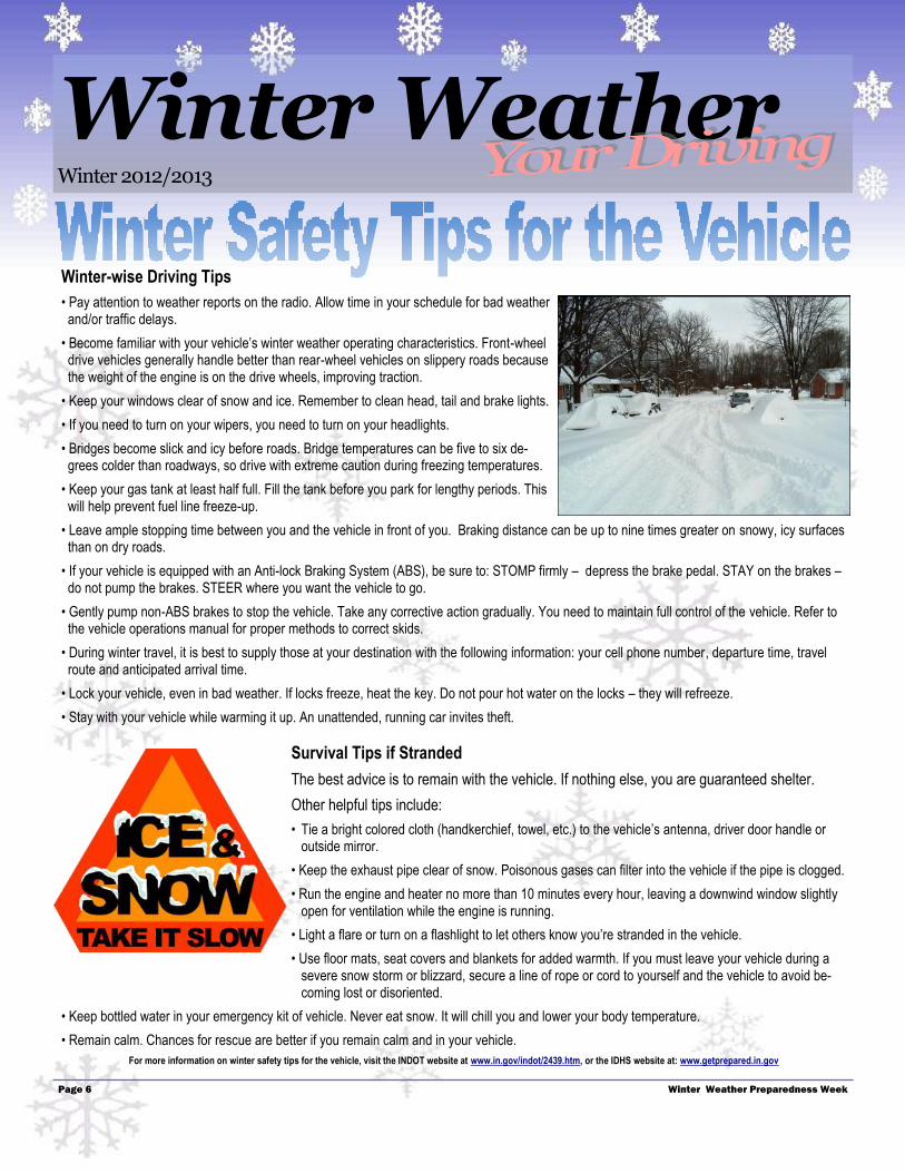
How to winterize your vehicle � Check tire pressure and tread depth. Consult your owner's manual for advice. Look for uneven wearing which can also be dangerous. Also, be sure to check the spare tire and make sure the jack is operating properly.
� Check battery, exhaust system, heater and defroster. Make sure the battery is not past its lifespan, and that the terminals are tight and free of corrosion. Hoses and belts should be inspected for cracks. Now is the time to discover if your heater is broken - not when the temperature drops.
� Check antifreeze. Make sure that a 50 percent anti-freeze, 50 percent water mixture is at the proper radiator level. If the coolant is two years old, get it flushed and refilled.
� Change oil every 3,000-5,000 miles. Consider us-ing a lighter, "winter weight" oil. Refer to your owner's manual for guidance.
� Check windshield wipers and blades: Re-place the blades twice a year and make sure extra WINTER wiper fluid is on hand.
� Ensure the four-wheel drive system and brakes are functioning properly.
It is a good idea to keep at least a half tank
of gas in your car at all times during the
winter months, to keep the fuel lines from
freezing. Even with the best maintenance
and cautious driving, snow, ice and freez-
ing temperatures can sometimes still get
the best of your vehicle. Hazardous winter
driving conditions induce crashes, which
are the leading cause of death during win-
ter storms. Being prepared to handle poten-tial slide-offs, crashes, and car trouble in winter is a simple but crucial step to take in preparing for the next few months.
Prepare an emergency kit for your vehicle
□ At least two blankets or a sleeping bag
□ Flashlight or battery-powered lantern and extra batteries
□ Booster (jumper) cables
□ Emergency flares
□ Extra clothing, particularly boots, hats and mittens
□ A steel shovel and rope to use as a lifeline
□ Bottled water or juice and nonperishable high-energy foods
(granola bars, raisins, nuts, peanut butter or cheese crackers)
□ Thermos or container that won't allow liquids to freeze
□ First-aid kit and necessary medications
□ Sand or non-clumping cat litter for tire traction if your vehicle gets
stuck in snow or ice
□ A cell phone charger which can be adapted to vehicle use
□ Ice scraper and snow brush
□ Tire repair kit and pump
□ Candle, matches, heat sticks/packs, lighters, hand-warmers, etc.
(Be sure to crack the window if you using a heat source inside

Page 9
Winter Weather Winter 2012/2013
Winter Weather Preparedness Week
Space heater safety When buying a new space heater, make sure it carries the mark of an inde-
pendent testing laboratory and is legal for use in your community.
Use the proper grade of fuel for your liquid-fueled space heater and never
use gasoline in any heater not approved for gasoline use.
Refuel space heaters only in a well ventilated area and when the equipment is cool.
Plug power cords only into outlets with sufficient capacity and never into an extension cord.
Turn off space heaters whenever the room they are in is unoccupied.
Turn off space heaters when you go to bed each night to avoid knocking them over in the dark.
Tips for safe alternative heating Keep all flammable materials at least three feet away from heating equipment.
Regular cleaning and annual inspections by a professional chimney sweep will help keep a fireplace free from
obstructions and creosote which was the leading factor contributing to home heating fires between 2004 and
2008 according to the National Fire Protection Association (NFPA).
Use only paper or kindling wood, not a flammable liquid, to start a fire.
Use only dry, seasoned wood in a fireplace or wood stove to avoid the buildup of creosote. Do not use artificial
logs in wood stoves.
If using a gas fireplace, ensure the fireplace vents properly and that there is
a functioning carbon monoxide detector in the room.
Keep fire extinguishers on hand and know how to use them.
According to the National Fire Protection Association,
in 2008, heating equipment was the second leading
cause of home fires in the United States.
Among fatal home heating fires, the leading factor contributing to the ignition of the fires was heating equipment stationed too close to flammable materials.
Tips for reducing heating costs
Make sure your home is properly insulated.
Caulk and weather strip doors and windows to keep out cold air.
Install a programmable thermostat and set it to lower the temperature at night and whenever the house is unoccu-
pied.
Keep doors and windows closed as much as possible, including overhead doors on attached garages.
Insulate the pipes around the water heater with inexpensive, easy-to-install pipe insulation.
Always unplug holiday lights before going to bed or leaving the house.
For more information about winter heating safety, visit www.getprepared.in.gov. For additional emergency efficiency and money saving tips contact your local utility company or visit: www.energysavers.gov.
Page 10
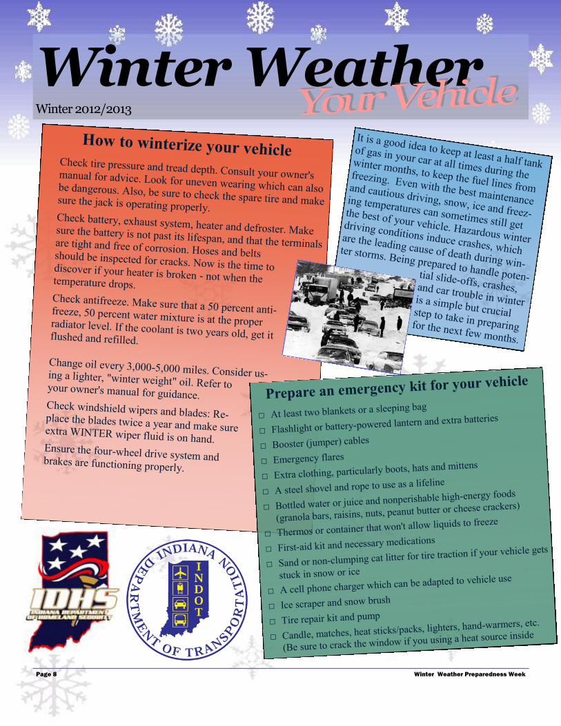
Warning Signs - Uncontrollable shivering, memory loss, disorientation, incoherence, slurred
speech, drowsiness, and apparent exhaustion.
Detection - Hypothermia occurs when the body temperature drops below 95ºF. If a person’s tem-
perature is below 95ºF, seek medical care immediately! If medical care is not available, begin
warming the person slowly. Warm the body core before the extremities (arms and legs)! Warming
the arms and legs first drives cold blood toward the heart and can lead to heart failure. If needed,
use your own body heat to help. Get the person into dry clothing and wrap them in a warm blanket,
covering the head and neck. Do not give the person alcohol, drugs, coffee, or any hot beverage or
food; warm broth is better.
Hypothermia: Low Body Temperature
With a wind chill temperature of minus 50ºF, frostbite will occur within 10 minutes. At minus 30ºF, frostbite will occur within 30 minutes.
F rostbite is damage to body tissue caused by extreme cold. Frostbite caus-
es a loss of feeling and a white or pale appearance in extremities, such as
fingers, toes, ear lobes, or the tip of the nose. If symptoms are detected, get
medical help immediately! If you must wait for help, slowly re-warm the affect-
ed areas. However, if the person is also showing signs of hypothermia, warm
the body core before the extremities.
Frostbite
Winter Weather Winter 2012/2013
Winter Weather Preparedness Week

Page 11
When Caught in a Winter Storm
January 7-8, 2011
A record breaking lake effect snow event dropped 3 feet of snow on South Bend, IN with 8 inches in one hour and 19 inches in 4 hours. A widespread area of 1-2 feet of snow occurred in the surrounding counties.
At Home or in a Building Stay inside. When using alternative heat from a fireplace, wood stove, space
heater, etc., use fire safeguards and ventilate properly.
If you have no heat:
Close off unneeded rooms.
Stuff towels or rags in cracks under doors.
Cover windows at night.
Eat and drink. Food provides the body with energy for producing its own heat.
Keep the body replenished with fluids to prevent dehydration.
Wear layers of loose-fitting, light-weight, warm clothing. Remove layers to avoid
overheating, perspiration, and subsequent chill.
In a Car or Truck Stay in your vehicle. Disorientation occurs quickly in wind-driven snow and cold.
Run the motor about ten minutes each hour for heat:
To avoid carbon monoxide poisoning, open the window a little for fresh air.
Make sure the exhaust pipe is not blocked.
Be visible to rescuers:
Turn on your dome light at night when running the engine.
Tie a colored cloth (preferably red) to your antenna or door.
After snow stops falling, raise the hood to indicate you need help.
Exercise from time to time by vigorously moving arms, legs, fingers, and toes to
keep blood circulating and to keep warm.
Outside Find shelter:
Try to stay dry.
Cover all exposed parts of the body.
If no shelter:
Prepare a lean-to, windbreak, or snow cave for protection from the wind.
Build a fire for heat and to attract attention.
Place rocks around the fire to absorb and reflect heat.
February 1-2, 2011
The “Chicago Blizzard” brought over a foot of snow to many locations in Northern Indiana, 1.5 inches of freezing rain and sleet to central Indiana, and winds greater than 50 mph across the entire state. Drivers were stranded on Lakeshore Dr. in Chicago where over 20 inches of snow fell.
January 26-28, 2009
A major storm system dumped over a foot of snow in central and southern Indiana and upwards to one inch of ice along and south of the Ohio River. The ice brought down thousands of trees and power lines, leaving thousands of homes and businesses without power.
Winter Weather Winter 2012/2013
Winter Weather Preparedness Week

National Weather Service 6900 W. Hanna Ave. Indianapolis, IN 46241
Winter Weather Preparedness Week Material
OPEN IMMEDIATELY!
Internet Sites
NOAA Weather Radio
http://www.nws.noaa.gov/nwr
Climate Prediction Center
http://www.cpc.noaa.gov
Federal Emergency Management Agency
http://www.fema.gov
Ready America
http://www.ready.gov/
Be Red Cross Ready
http://www.indyredcross.org/BRCR
Indiana Department of Homeland Security
http://www.in.gov/dhs/
Indiana Department of Transportation
http://www.in.gov/indot/
Indiana State Police
http://www.in.gov/isp/
Indiana Department of Education
http://www.doe.in.gov/
National Oceanic and Atmospheric Administration (NOAA)
http://www.noaa.gov
National Weather Service
http://www.weather.gov
National Weather Service Indianapolis
http://www.weather.gov/ind
National Weather Service Northern Indiana
http://www.weather.gov/iwx
National Weather Service Louisville
http://www.weather.gov/lmk
National Weather Service Paducah
http://www.weather.gov/pah
National Weather Service Chicago
http://www.weather.gov/lot
National Weather Service Wilmington
http://www.weather.gov/iln
NWS Office of Meteorology Winter Weather Page
http://www.nws.noaa.gov/om/winter
Recommended