Witham Partnership
Catchment Plan
September 2017
Witham Partnership Catchment Plan September 2017
Contents
An introduction to the Witham and its catchment Page 1
What is the Witham Catchment Partnership? Page 2
Catchment based approach Page 3
What is the Water Framework Directive? Pages 3-4
Water Framework Directive and the Witham Management Catchment
Pages 4-5
Setting the partnership priorities, aims and objectives
Page 6
Partnership Aim Page 6
Partnership Objectives Page 6
Priority Issues Pages 7-9
Target Areas Pages 10-14
Partnership Governance Page 15
More information Page 16
Your views and feedback Page 16
Appendices ●Catchment Summary ●Proposed Projects ●Recent, current and projects under development in the Witham Management Catchment ●Project details and Assessment against Partnership Priorities ●Glossary of terms

Witham Partnership Catchment Plan September 2017
Page 1
An introduction to the Witham and its catchment
The River Witham drains a predominantly rural catchment with the notable urban
areas of Grantham, Lincoln and Boston. In its upper reaches, the Witham is fed by
springs from the Lincolnshire Limestone and supports native crayfish and brown
trout. These headwaters gradually give way to a slower moving heavily modified
river that drains a network of water courses in the Fenland.
A healthy River Witham and its tributaries are vital to the wildlife, people and
economy of Lincolnshire. They give us a nice relaxing environment to live and work
by, walk or cycle along, fish in and boat on. The network of rivers, streams and
dykes drain the land allowing crops to grow and protecting our homes and
businesses from flooding. Not only does the water support a rich and varied range
of wildlife but it is a resource that irrigates our crops and provides the water we
drink.
This important local resource is however fragile. Some of the historic modifications
such as the remaining weirs which powered long abandoned mills can cause
sedimentation, poor habitat and barriers to the movement of fish. This can make it
more difficult for a diverse range of wildlife to thrive. Additional stresses are
created from pollutants that discharge into our rivers and groundwater. As well as
direct discharges from household and industry, diffuse pollution from both rural
The Lower Witham looking upstream near Bardney

Witham Partnership Catchment Plan September 2017
Page 2
and urban areas is reducing the quality of our water. In particular this causes
excessive levels of nutrients which reduce the recreational and ecological value of
our rivers through excessive weed growth. Invasive species such as signal crayfish
and Himalayan Balsam are another threat which if unchecked will have severe
consequences.
What is the Witham Catchment Partnership?
The Witham Partnership was formed by interested parties to identify the issues the
Witham catchment faces and how best to tackle them together. In 2013 Defra set
out the principles of the Catchment Based Approach and provided funding to
administer the formation of catchment based partnerships across the country. The
Lincolnshire Rivers Trust hosts the partnership in the Witham Catchment. Other
partners include the Environmental Agency, Canal and River Trust, Lincolnshire
Wildlife Trust, National Farmers Union, Internal Drainage Board, Anglian Water
Services, Slea Navigation Trust, the National Trust and local Angling Clubs.
The partnership covers the area set out in the plan below. This aligns with the
Witham Management catchment as set out in the Anglian River Basin Management
Plan. As well as the areas that drain into the Witham, the hydrometric catchment,
it includes additional areas of the Wolds that drain to the East and coastal
catchments. It is not however the intention of the partnership to consider areas of
the Wolds where the Lincolnshire Chalk Streams Project has an interest.
The Witham Management Catchment
Witham Partnership Catchment Plan September 2017
Page 3
Catchment based approach
The aim of the catchment based approach is to deliver positive outcomes for the
water environment by promoting a better understanding of the environment at a
local level. A key driver for this is the requirements to improve our water
environment as set out in the Water Framework Directive. These issues can be
complex and will only be mitigated against effectively by working together on a
catchment scale. More information on this can be found on the CaBa website.
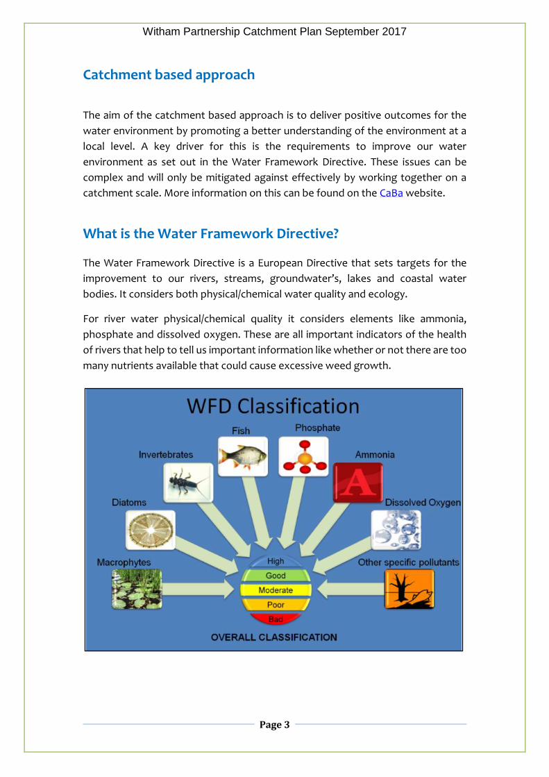
What is the Water Framework Directive? The Water Framework Directive is a European Directive that sets targets for the
improvement to our rivers, streams, groundwater’s, lakes and coastal water
bodies. It considers both physical/chemical water quality and ecology.
For river water physical/chemical quality it considers elements like ammonia,
phosphate and dissolved oxygen. These are all important indicators of the health
of rivers that help to tell us important information like whether or not there are too
many nutrients available that could cause excessive weed growth.
Witham Partnership Catchment Plan September 2017
Page 4
Ecological information considers elements including fish, invertebrates and plants. The diversity of species found and their abundance are all useful information in determining how healthy a particular river is.
Monitoring takes place regularly across the catchment and all this information
allows individual streams, rivers and drains (known as water bodies) to be given an
overall classification of either bad, poor, moderate, good or high. In general, water
bodies will take on the overall classification of the worst element recorded. For
example, if fish are recorded as being at bad, the overall classification for the water
body will be bad.
The target set under the Water Framework Directive requires all water bodies to be
at least at good status by 2027. More detail can be found in the Anglian river Basin
Management District. which sets out at a strategic level how organisations,
stakeholders and communities will work together to improve the water
environment.
Water Framework Directive and the Witham Management
Catchment
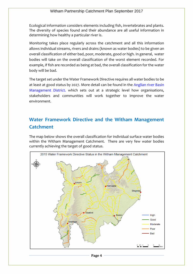
The map below shows the overall classification for individual surface water bodies within the Witham Management Catchment. There are very few water bodies currently achieving the target of good status.

Witham Partnership Catchment Plan September 2017
Page 5
Further detail on the reasons for failure and supporting data can be found in the River Basin Management Plans guide to accessing data. In summary, elevated concentrations of phosphate are the main barrier to water bodies within the catchment achieving good status. Increased levels of phosphates lead to excessive growth of aquatic plant life which can create poor oxygenation conditions for fish. The primary sources of phosphate are waste water treatment plants, diffuse agricultural run-off and septic tanks.
A lack of access to a suitably diverse range of habitats in many water bodies can make it difficult for fish and invertebrates to achieve good status. This can be exacerbated in areas of the catchment that suffer from low flows and sedimentation. Obstructions to fish passage such as weirs also impair spawning and migrations of some fish species.
Invasive, non-native species such as signal crayfish on the River Bain are beginning to impact native ecology and water quality. In particular, they can disturb banks and beds and increase the amount of fine sediment in rivers.
More details on these issues within the Witham Catchment can be found in Appendix 1 of this document.

Witham Partnership Catchment Plan September 2017
Page 6
Setting the partnership’s priorities, aims and objectives
Following the formation of the partnership consultation was carried out with key
stakeholders at partnership meetings. Groups and organisations were invited to
put forward their views on what they felt were most significant issues and priorities
in the catchment. In addition to this a short engagement film, the Wonderful
Witham was produced on behalf of the partnership. This was shown at screening
in Grantham, Lincoln, Sleaford and Boston during which opinion was gathered from
the wider public.
From this engagement we have been able to summarise what are believed to be
the most important issues that need to be addressed, what the target areas should
be as well as forming the overall aim and objectives of the partnership.
Partnership Aim
We will work jointly to protect and improve the water environment in the Witham
valley, for the benefit of its people and wildlife.
Partnership Objectives
The Witham Partnership will deliver its aim, priorities and the principles of the
Catchment Based Approach by;
●Jointly identifying and understanding the issues and priorities in the Witham
catchment through the continual sharing of information.
●Identifying interested groups, organisations, businesses and local communities
and where appropriate involving them in the partnership and its decision making.
●Being the forum for understanding relevant work and funding opportunities in
the catchment that will contribute towards WFD delivery and in particular the
priorities of the partnership.
●Developing and administering a shared list of proposed future projects that will
contribute towards WFD delivery and in particular the priorities of the partnership.
●Identifying any opportunities for organisations and groups to work together to
deliver more effective outcomes.
●Being a collective voice to represent WFD within the Witham Management
Catchment.
●Look for appropriate opportunities to link WFD benefits with flood risk
management outcomes through the use of natural processes.

Witham Partnership Catchment Plan September 2017
Page 7
Priority Issues
•Poor Habitat
At appropriate sites we would like to work with others to take opportunities to
enhance habitat, mitigate or remove barriers and return rivers to a more natural
state. This not only benefits wildlife, water quality and water management it also
creates a nicer environment for people.
•Invasive species
Non-native invasive species such as floating pennywort and signal crayfish are
already having a serious impact on wildlife and river users. Where possible we
would like to raise the profile of the issues to stop the spread and take action to
better manage invasive species. Promoting awareness of the check, clean, dry
initiative will be vital.
Volunteers Removing Himalayan Balsam on the Upper Witham at Syston

Witham Partnership Catchment Plan September 2017
Page 8
•Local involvement
We think more people should be aware of, understand and enjoy the natural
heritage of the Witham its tributaries. Not only will this promote recreational
opportunities but this local ownership will encourage its long term protection.
•Pollution
We believe that pollution incidents continue to have an impact on water courses
within the catchment with varying severity. This includes the large incidents that
have blighted the Upper Witham in recent years down to the cumulative impacts
of smaller discharges such as poorly performing septic tanks and urban
misconnections.
In channel river restoration on the Dunston Beck involving the Lincolnshire Rivers Trust, Wild Trout Trust, Environment Agency and Local Community.

Witham Partnership Catchment Plan September 2017
Page 9
•Natural Flood Risk Management
Many of the projects aimed at improving water quality and freshwater ecology in
the catchment will deliver additional benefits as well. This is particularly true for
projects that help reduce sedimentation and store or slow the flow of water in
appropriate parts of the catchment. Such projects can play a part alongside other
measures in reducing flood risk. Examples include working with landowners to
demonstrate the benefits and encourage the use of winter cover crops or on a
larger scale and at the right locations, the reconnection of rivers with their
floodplains. Such measures will play a role in making the catchment more resilient
to climate change and extreme weather events.
Reconnection of river with flood plain and the creation of a longer meandering course is possible in certain areas and where landowners are willing.
•Weed Problems
The excessive weed growth on the Lower Witham and many of its tributaries has
been highlighted as a key problem because it seriously limits their recreational
value in summer months. Weed clearance is time consuming and costly. We would
like to promote any work which aims to reduce excessive weed growth as well as
encourage innovative and catchment wide solutions.

Witham Partnership Catchment Plan September 2017
Page 10
Target areas
It is not realistic to try and target improvement on every water body within the
Witham Management Catchment. As a partnership we therefore need to decide
the locations where projects will deliver maximum benefit for people and wildlife.
From the partnership feedback we believe the areas that the partnership should try
and focus on currently are the Upper Witham, Lower Witham, Lower Bain, Slea and
Limestone Becks. It is again worth noting that as the Lincolnshire Chalk Streams are
the focus of the Lincolnshire Chalk Streams Project it is not necessary to consider
them within this partnership.
Upper Witham
This covers the River Witham from its source to Lincoln. It has been selected as a
target area because in the Upper reaches this section supports endangered native
crayfish, brown trout and grayling. In addition, the Cringle Brook is also an
important source of drinking water and an important fishery.
Lack of water is a notable problem in drier summer months as are periodic, serious
pollution incidents. Historic modifications to the river compound problems,
trapping sediment, degrading habitat and preventing fish movement. Proposed
future growth within Grantham is likely to be put additional pressure on the Upper
Witham although it could also bring opportunities for improvement.
The most significant potential is to deliver projects identified within the Grantham
Urban Rivers and Wetlands Plan from Spittelgate down to Belton. This includes
projects such as the bypassing of the historic Papermill weir, flood plain
reconnection at Queen Elizabeth Park and the introduction of gravels to the section
on the National Trust’s Belton Estate. Outside of the Grantham plan there are
several other locations where reconnection of the river with its former course and
flood plain are feasible along with smaller, in channel improvements. These include
Martson Mill and Beckingham Ranges. Invasive plant species such as Himalayan
Balsam are beginning to establish here but the hope is that eradication is still
possible if action is taken.
A number of recent improvement projects have been completed here such as the
Grange Farm reconnection project in 2015 and the Aubourn, fish bypass rock ramp
in 2016. To link these existing projects with future proposals into an overall
strategy, the Environment Agency have produced a River Corridor Habitat Plans for
the Upper Witham which they are keen for the partnership to adopt and help
evolve.
Witham Partnership Catchment Plan September 2017
Page 11
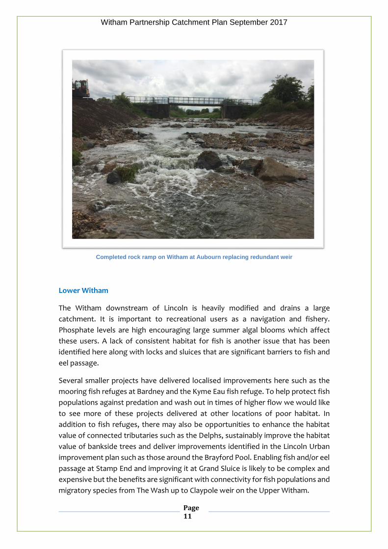
Completed rock ramp on Witham at Aubourn replacing redundant weir
Lower Witham
The Witham downstream of Lincoln is heavily modified and drains a large
catchment. It is important to recreational users as a navigation and fishery.
Phosphate levels are high encouraging large summer algal blooms which affect
these users. A lack of consistent habitat for fish is another issue that has been
identified here along with locks and sluices that are significant barriers to fish and
eel passage.
Several smaller projects have delivered localised improvements here such as the
mooring fish refuges at Bardney and the Kyme Eau fish refuge. To help protect fish
populations against predation and wash out in times of higher flow we would like
to see more of these projects delivered at other locations of poor habitat. In
addition to fish refuges, there may also be opportunities to enhance the habitat
value of connected tributaries such as the Delphs, sustainably improve the habitat
value of bankside trees and deliver improvements identified in the Lincoln Urban
improvement plan such as those around the Brayford Pool. Enabling fish and/or eel
passage at Stamp End and improving it at Grand Sluice is likely to be complex and
expensive but the benefits are significant with connectivity for fish populations and
migratory species from The Wash up to Claypole weir on the Upper Witham.

Witham Partnership Catchment Plan September 2017
Page 12
A plan for joining up habitat improvement projects along the Lower Witham has
been set out in the Lower Witham Habitat Corridor Plan which has been initiated
by the Environment Agency. The aim is for this to be adopted by the partnership
who will further develop this and use it as a tool for developing projects here.
The potential for large scale wetland creation at sites has been identified in
previous studies including the Witham Opportunities study and Lincoln Urban
Improvements Plan.
Lower Bain
The Lower Bain covers the section of river downstream of Horncastle that has been
canalised. As well as elevated nutrient levels it suffers particularly from invasive
signal crayfish and has several barriers to fish and eel passage where the now
redundant locks form impassable weirs. Connected back channels tracing the route
of the former meandering river are still in existence in places.
This part of the Bain valley contains many current, proposed and former mineral
workings, several of which have been restored to nature reserves. There are
proposals in places to rewet parts of the catchment within current nature reserves
to return it to a more natural state. Potential also exists to consider flood plain
reconnection on a larger scale but such projects are expensive and would need to
be balanced against the aspiration to restore the former navigation.
Slea
The River Slea’s source is a series of Limestone springs to the West of Sleaford.
From here it flows eastwards to its confluence with the Witham at Chappell Hill.
Although naturally ephemeral in its upper reaches, low flow problems that effects
its ecology are compounded by abstraction pressures. Flow through Sleaford is
supported by an augmentation borehole in drier periods. The River provides an
important visual amenity and in the town and its Lower reaches (Kyme Eau) a
recreational asset for boaters. There are proposals by the Slea Navigation Trust to
restore the navigation right the way up to Sleaford.
The Lincolnshire River Trust’s recent project in Sleaford has restored a section of
the river suffering from low flow and poor habitat. The Slea Navigation Trust have
completed a bank stabilization and habitat improvement project in South Kyme.
Further project work would look to continue this type of habitat improvement work
especially where it improves low flow conditions. Many such potential projects
Witham Partnership Catchment Plan September 2017
Page 13
have been identified in the Sleaford Urban opportunities study led by the
Lincolnshire Rivers Trust.
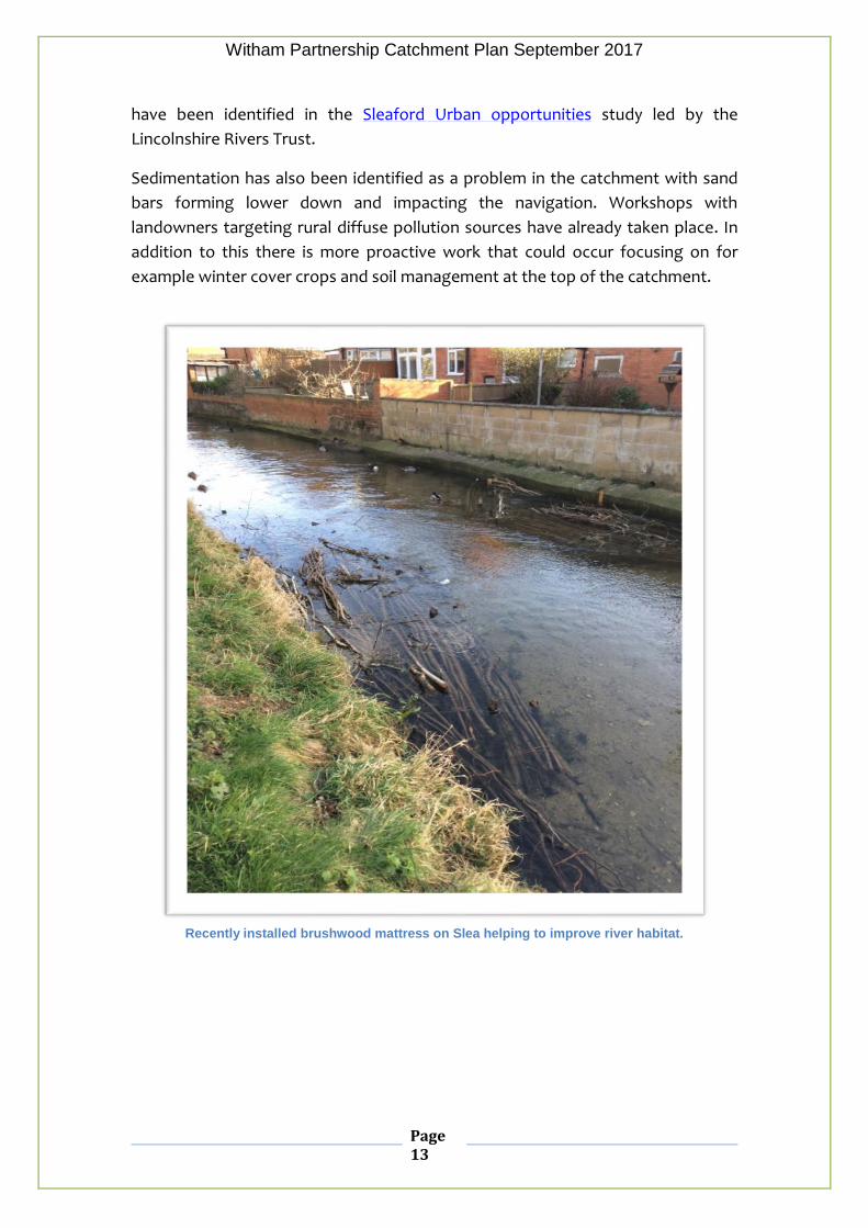
Sedimentation has also been identified as a problem in the catchment with sand
bars forming lower down and impacting the navigation. Workshops with
landowners targeting rural diffuse pollution sources have already taken place. In
addition to this there is more proactive work that could occur focusing on for
example winter cover crops and soil management at the top of the catchment.
Recently installed brushwood mattress on Slea helping to improve river habitat.

Witham Partnership Catchment Plan September 2017
Page 14
Limestone Becks
The limestone which runs up through western Lincolnshire supports a number of
important spring fed watercourses known as the Lincolnshire Limestone Becks. In
their more natural state such as can be found on the Cringle Brook, they can
support a rich aquatic fauna and flora.
Due to a variety of reasons including low flow, invasive species and poor habitat,
many are not of the quality that they should be. There are numerous potential
project ideas across the becks, particularly those focusing on habitat improvement
that could help to restore them to a more favourable condition.
A successful community pilot project on a small section of the Dusnton Becks has
shown what can be achieved on other similar limestone becks including Welton,
Nettleham, Greetwell, Branston, Scopwick and Ruskington.
The Welton Beck upstream of the village

Witham Partnership Catchment Plan September 2017
Page 15
Partnership Governance
●As hosts the Lincolnshire Rivers Trust (LRT) shall be responsible for the
administration of the partnership and the organisation of its meetings. Meeting
minutes will be made openly available.
●LRT shall be responsible for collating and sharing a list of proposed future projects
within the catchment from all partners. These projects will be measured against the
priority issues set by the partnership. This shall be updated yearly and will form annex
2 and 4 of this document.
●Meetings will be held quarterly and attended by representatives of the member
organisations.
●The structure of the meeting should include an update from all members on current
work, future plans and funding opportunities.
●A yearly summary of projects that have been completed and have helped to address
the priority issues identified by the partnership will be produced. This will be made
available and will form annex 3 of this document.
●The catchment plan setting out the priorities, aims and objectives of the partnership
shall be reviewed and where necessary amended every two years.

Witham Partnership Catchment Plan September 2017
Page 16
More information
Catchment based approach –
http://www.catchmentbasedapproach.org/
Wonderful Witham film-
http://lincsrivers.org.uk/the-wonderful-witham.html
Witham Partnership Website -
http://www.catchmentbasedapproach.org/anglian/witham
Lincolnshire Rivers Trust –
http://www.lincsrivers.org.uk/
River Basin Management Plan Guide to Accessing Data-
https://www.gov.uk/government/uploads/system/uploads/attachment_data/file/5
00463/Anglian_RBD_Part_1_river_basin_management_plan.pdf
Grantham Rivers and Wetland Plan -
http://lincsrivers.org.uk/grantham-urban-rivers-and-wetland-plan.html
Sleaford Urban Opportunities Study -
http://lincsrivers.org.uk/restoring-the-slea.html
Lincoln Urban Opportunities Study-
http://www.catchmentbasedapproach.org/anglian/witham
Your views and feedback
We value all feedback on our plan and would welcome your views and ideas as to
how we can improve it. Please contact [email protected]

Appendix 1 – A Summary of the Witham Catchment
Witham Partnership Appendices September 2016
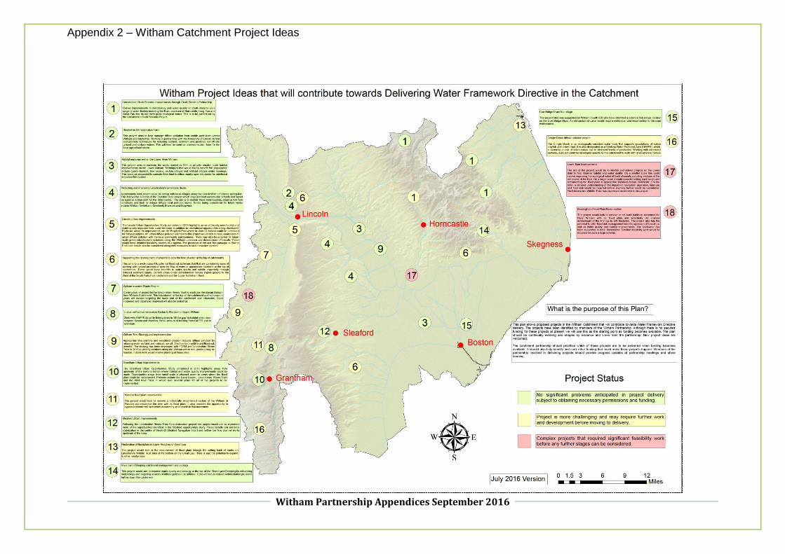
Appendix 2 – Witham Catchment Project Ideas
Witham Partnership Appendices September 2016

Appendix 3 – Recent, current and projects under development in the Witham Management Catchment
Witham Partnership Appendices September 2016

Appendix 4 – Project details and assessment against Partnership Priorities
Witham Partnership Appendices September 2016
Project Name Project Description Map Ref
(Appendix 2)
Link to Partnership Priority AREA
Estimate Cost
Lead Partner (s)
Score Against Partnership Priority Issues
Weed Problems
Poor Habitat
Invasive Species
Local involvement
Pollution
Lincolnshire Chalk Streams improvements through Chalk Streams Project
Deliver improvements to morphology and water quality on chalk streams on a range of water bodies including the Bain upstream of Horncastle, Long Eau and Great Eau that do not meet good ecological status. This is to be carried out by the Lincolnshire Chalk Streams Project.
1 N/A – Lincs
Chalk Stream Project.
TBC Lincs Chalk Streams Project
Riseholme Demonstration Farm
This project aims to help manage diffuse pollution from arable agriculture across Witham and Ancholme. Working in partnership with the University of Lincoln to trial and promote techniques for reducing nutrient, sediment and pesticide run-off into ground and surface waters. This will then be used as a demonstration farm for the local agricultural sector.
2 Lower Witham in
particular will benefit from diffuse pollution action although benefits hard to measure and likely to be longer term.
TBC Uni of Lincoln, EA
Appendix 4 – Project details and assessment against Partnership Priorities
Witham Partnership Appendices September 2016
Project Name Project Description Map Ref (Appendix 2)
Link to Partnership Priority AREA
Estimate Cost
Lead Partner (s)
Score Against Partnership Priority Issues
Weed Problems
Poor Habitat
Invasive Species
Local involvement
Pollution
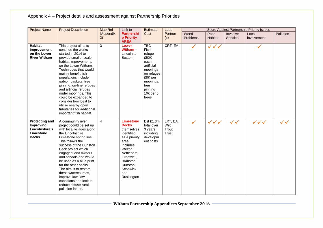
Habitat improvement on the Lower River Witham
This project aims to continue the works started in 2014 to provide smaller scale habitat improvements on the Lower Witham. Techniques that would mainly benefit fish populations include gabion baskets, tree pinning, on-line refuges and artificial refuges under moorings. This could be expanded to consider how best to utilise nearby open tributaries for additional important fish habitat.
3 Lower Witham –
Lincoln to Boston.
TBC – Fish refuge £50K each, artificial moorings on refuges £8K per moorings, tree pinning 10k per 6 trees
CRT, EA
Protecting and Improving Lincolnshire’s Limestone Becks
A community river project could be set up with local villages along the Lincolnshire Limestone spring line. This follows the success of the Dunston Beck project which engaged land owners and schools and would be used as a blue print for the other becks. The aim is to restore these watercourses, improve low flow conditions and look to reduce diffuse rural pollution inputs.
4 Limestone Becks
themselves identified as a priority area. Includes Welton, Nettleham, Greetwell, Branston, Dunston, Scopwick and Ruskington.
Est £1.3m total over 3 years including development costs
LRT, EA, Wild Trout Trust

Appendix 4 – Project details and assessment against Partnership Priorities
Witham Partnership Appendices September 2016
Project Name Project Description Map Ref (Appendix 2)
Link to Partnership Priority AREA
Estimate Cost
Lead Partner (s)
Score Against Partnership Priority Issues
Weed Problems
Poor Habitat
Invasive Species
Local involvement
Pollution
Lincoln Urban Improvements
The Lincoln Urban Opportunities Study completed in 2015 highlights areas of the city where habitat and water quality improvements could be made in addition to recreational opportunities being developed. Particular areas for improvement are the Brayford Pool where in-channel habitat could be increased. An urban diffuse pollution element to this project would look to raise awareness of urban diffuse pollution with the local community and business. There may also be potential for larger scale green infrastructure schemes along the Witham upstream and downstream of Lincoln. These would need detailed feasibility studies to progress. The provision of eel and fish passage at Stamp End Lock should also be considered along with measures to tackle invasive species.
5 Witham – Mostly Lower Witham
but potentially small section of Upper Witham.
TBC – Significant cost if fish passage included. Exact cost needs confirming
CRT, EA
Appendix 4 – Project details and assessment against Partnership Priorities
Witham Partnership Appendices September 2016
Project Name Project Description Map Ref (Appendix 2)
Link to Partnership Priority AREA
Estimate Cost
Lead Partner (s)
Score Against Partnership Priority Issues
Weed Problems
Poor Habitat
Invasive Species
Local involvement
Pollution
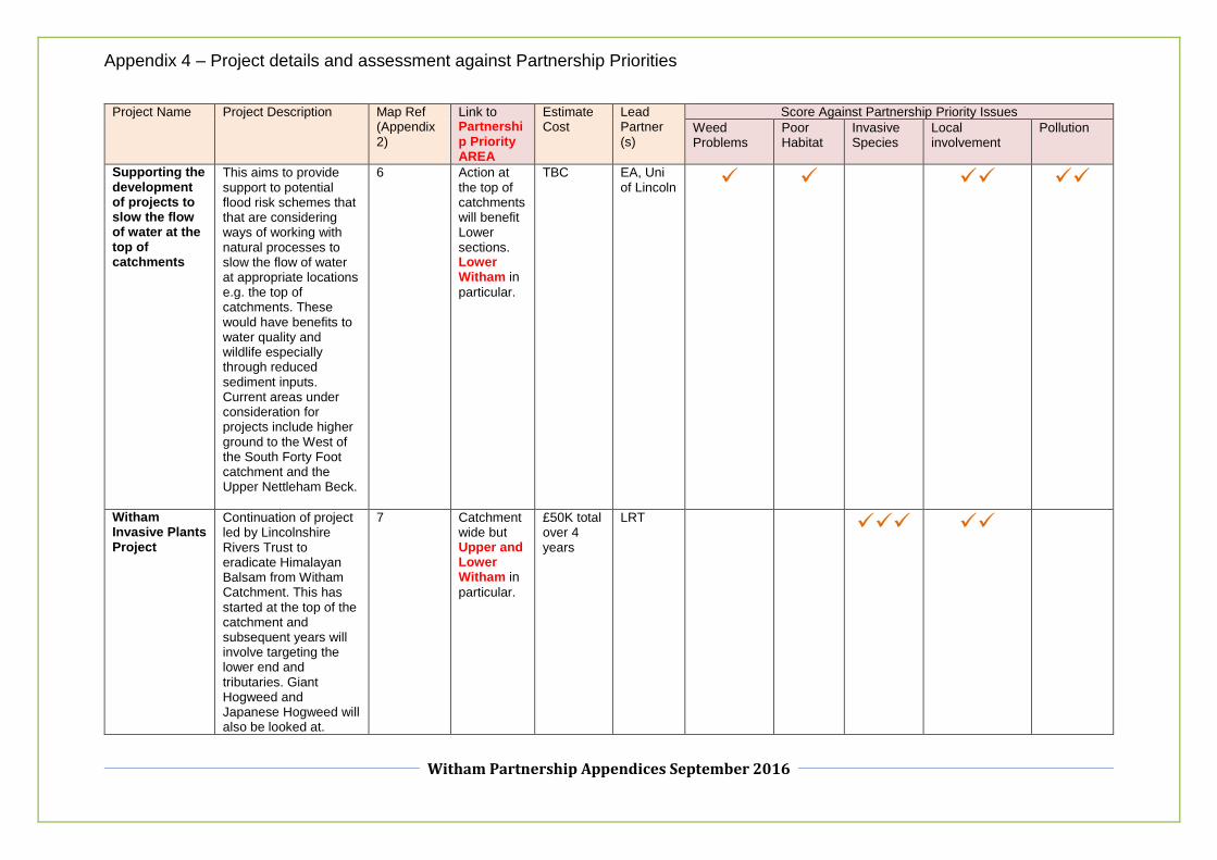
Supporting the development of projects to slow the flow of water at the top of catchments
This aims to provide support to potential flood risk schemes that that are considering ways of working with natural processes to slow the flow of water at appropriate locations e.g. the top of catchments. These would have benefits to water quality and wildlife especially through reduced sediment inputs. Current areas under consideration for projects include higher ground to the West of the South Forty Foot catchment and the Upper Nettleham Beck.
6 Action at the top of catchments will benefit Lower sections. Lower Witham in
particular.
TBC EA, Uni of Lincoln
Witham Invasive Plants Project
Continuation of project led by Lincolnshire Rivers Trust to eradicate Himalayan Balsam from Witham Catchment. This has started at the top of the catchment and subsequent years will involve targeting the lower end and tributaries. Giant Hogweed and Japanese Hogweed will also be looked at.
7 Catchment wide but Upper and Lower Witham in
particular.
£50K total over 4 years
LRT

Appendix 4 – Project details and assessment against Partnership Priorities
Witham Partnership Appendices September 2016
Project Name Project Description Map Ref (Appendix 2)
Link to Partnership Priority AREA
Estimate Cost
Lead Partner (s)
Score Against Partnership Priority Issues
Weed Problems
Poor Habitat
Invasive Species
Local involvement
Pollution
In channel habitat restoration Syston to Marston on Upper Witham
Work with GAFFS (local fly fishing club) to ‘fill the gap’ in habitat restoration between Syston and Marston. Small amount of funding from GAFFS and in kind work.
8 Upper Witham –
Syston to Marston.
£10K EA, GAFFS
Witham Tree Strategy and implementation
Appropriate tree planting and woodland creation reduces diffuse pollution by retaining water on land and reduces run off. This has both wildlife and flood risk benefits. The strategy has been developed with FCRM and Lincolnshire Rivers Trust in 2015 to identify locations along the Witham where tree planting may be feasible. Future work would involve planting at these sites.
9 Upper Witham
initial focus then may look at Lower Witham.
TBC LRT

Appendix 4 – Project details and assessment against Partnership Priorities
Witham Partnership Appendices September 2016
Project Name Project Description Map Ref (Appendix 2)
Link to Partnership Priority AREA
Estimate Cost
Lead Partner (s)
Score Against Partnership Priority Issues
Weed Problems
Poor Habitat
Invasive Species
Local involvement
Pollution
Grantham Urban Improvements
The Grantham Urban Opportunities Study completed in 2015 highlights areas from upstream of the town to Belton where habitat and water quality improvements could be made. Opportunities range from small scale in channel works to areas where the flood plain could be reconnected. Partners include the Local Council, Lincolnshire Rivers Trust, the National Trust and the Wild trout Trust. It would take several years for all of the projects to be implemented.
10 Upper Witham –
Grantham.
TBC – Range of projects on various scale. Some relatively low cost e.g in-channel. Larger flood plain schemes will have significant costs.
EA, LRT
Marston flood plain reconnection
This project would look to remove a historically straightened section of the Witham at Marston and reconnect the river with its flood plain. It also provides the opportunity to bypass a historic mill weir which is currently an obstacle to fish movement.
11 Upper Witham –
Marston.
£100K EA, Wild Trout Trust

Appendix 4 – Project details and assessment against Partnership Priorities
Witham Partnership Appendices September 2016
Project Name Project Description Map Ref (Appendix 2)
Link to Partnership Priority AREA
Estimate Cost
Lead Partner (s)
Score Against Partnership Priority Issues
Weed Problems
Poor Habitat
Invasive Species
Local involvement
Pollution
Sleaford Urban Improvements
Following the Lincolnshire Rivers Trust Slea restoration project this project would aim to implement more of the opportunities identified in the Sleaford opportunities study. These include coir roll bank stabilization in the centre of Sleaford (Sleaford Navigation Trust) and further low flow channel works upstream of the town.
12 Slea –
Sleaford. TBC – Projects on a range of scales but all likely to be relatively low cost. Need to be confirmed.
LRT, Sleaford Nav Trust
Restoration of floodplain in Lower Reaches of Great Eau
This project would look at the reconnection of flood plain through the setting back of banks on Lincolnshire Wildlife Trust sites at the bottom on the Great Eau. There is also the potential to expand to other nearby sites.
13 East Coast - not beneficial to partnership priority area at present.
TBC – Significant cost anticipate.
LWT

Appendix 4 – Project details and assessment against Partnership Priorities
Witham Partnership Appendices September 2016
Project Name Project Description Map Ref (Appendix 2)
Link to Partnership Priority AREA
Estimate Cost
Lead Partner (s)
Score Against Partnership Priority Issues
Weed Problems
Poor Habitat
Invasive Species
Local involvement
Pollution
River Lymn/Steeping catchment management and ecology
This project would aim to improve water quality and ecology at the top of the River Lymn/Steeping by enhancing morphology and targeting sources of diffuse pollution. In addition, it should help to reduce sedimentation problems further down the catchment.
14 Upper Lyme/ Steeping - not beneficial to partnership priority area at present.
TBC EA
Cow Bridge Drain Fish refuge
This project idea was suggested by Witham Fourth IDB who have identified a potential fish refuge location on the Cow Bridge Drain. An old section of Canal would require restoration and reconnection to the main watercourse.
15 Cow Bridge Drain - - not beneficial to partnership priority area at present.
£20K W4IDB

Appendix 4 – Project details and assessment against Partnership Priorities
Witham Partnership Appendices September 2016
Project Name Project Description Map Ref (Appendix 2)
Link to Partnership Priority AREA
Estimate Cost
Lead Partner (s)
Score Against Partnership Priority Issues
Weed Problems
Poor Habitat
Invasive Species
Local involvement
Pollution
Cringle Brook diffuse pollution project
The Cringle Brook is an ecologically sensitive water body that supports populations of native crayfish and brown trout. It is also designated as a Drinking Water Protected Area (DrWPA), which is currently at risk of deterioration due to elevated levels of pesticides. Working with interested partners, a project could be developed specific to this catchment to work with landowners to reduce diffuse pollution.
16 Cringle Brook is significant tributary of Upper Witham so diffuse pollution project here will benefit Upper Witham.
TBC AWS, Uni of Lincoln

Appendix 4 – Project details and assessment against Partnership Priorities
Witham Partnership Appendices September 2016
Project Name Project Description Map Ref (Appendix 2)
Link to Partnership Priority AREA
Estimate Cost
Lead Partner (s)
Score Against Partnership Priority Issues
Weed Problems
Poor Habitat
Invasive Species
Local involvement
Pollution
Lower Bain Improvements
The aim of this project would be to identify and deliver projects on the Lower Bain to help improve habitat and water quality. On a smaller scale this could involve improving the ecological value of back channels including sections of the old course of the Bain. On a larger scale it could consider setting back banks and reconnecting the flood plain at appropriate locations below Horncastle. For the latter, a detailed understanding of the impact on navigation aspiration, land use and flood risk would be required before anything further could be considered. The Lincolnshire Wildlife Trust has expressed an interest in this project.
17 Lower Bain.
TBC – Any flood plain reconnection scheme likely to have significant costs. Back channel works will be low cost.
LWT, EA

Appendix 4 – Project details and assessment against Partnership Priorities
Witham Partnership Appendices September 2016
Project Name Project Description Map Ref (Appendix 2)
Link to Partnership Priority AREA
Estimate Cost
Lead Partner (s)
Score Against Partnership Priority Issues
Weed Problems
Poor Habitat
Invasive Species
Local involvement
Pollution
Beckingham Flood Plain Reconnection
This project would look to remove or set back banks to reconnect the River Witham with its flood plain and potentially old channel downstream of the A17 (up to 200 hectares). The project also has the potential to offer flood risk management benefits upstream of Lincoln as well as water quality and habitat improvements. The landowner has been supportive in initial discussions. Detailed feasibility work would be required for such a large scheme.
18 Upper Witham –
Beckingham.
£300K EA

Glossary of Terms
Witham Partnership Catchment Plan September 2016
Glossary of Terms
Artificial habitat – Artificial habitat schemes can in certain situations help provide small scale benefits to fish on lowland rivers. Plastic
hedgehogs and floating islands are best used where there is a lack of natural habitat to offer refuge at times of higher flow and protection
against predators. Floating islands can support aquatic plants to help remove nutrients from water and provide a more attractive river
environment.
Artificial or heavily modified water body – This term refers to watercourses that have either been heavily modified or created specifically
for flood risk management, navigation or land drainage purposes.
Aquifer – Underground water bearing rock. In the Witham catchment the most important aquifers are the Lincolnshire Limestone in the
West and small areas of the chalk Wolds to the East. The main supply of drinking water in the catchment.
Barrier to fish passage – Many of the structures that have been constructed across our rivers can prevent fish from moving up and down
stream. Common examples include weirs and locks. With obstructed movement certain species of fish can have their spawning and seasonal
migrations interrupted and all fish species have limited access to a wider range of habitat making them more susceptible to problems like
predation. In some cases it may be possible to remove older structures that are no longer required. For structures that cannot be removed
fish passes are an alternative solution.
Catchment – An area of land in which water drains from before flowing into a single river and its tributaries. In the case of the Witham, the
tributaries include the Brant, Till, Barlings Eau, Bain, Slea and South Forty Foot.

Glossary of Terms
Witham Partnership Catchment Plan September 2016
Dissolved Oxygen – Is a relative measure of the amount of oxygen that is dissolved or carried in water. Without adequate levels of
dissolved oxygen a healthy range of fish and invertebrates will not be supported. Low levels of dissolved oxygen are often associated with
organic pollutants such as food water or sewage and excessive weed growth.
Habitat enhancement – Aquatic life such as invertebrates and fish rely on a diverse range of habitats to prosper. There will be locations
where we are able to enhance the in channel habitat through for example the use of flow deflectors to encourage a more natural river flow
path. As well as ecology this helps rivers to naturally mange their sediment, improves dissolved oxygen levels and makes rivers more resilient
to times of lower flow. This option will not be suitable for all our watercourses due to their nature and flood risk management and land
drainage constraints. On a larger scale where there are opportunities to reconnect watercourses with their flood plains and allow them to
follow a more meandering path there could be additional benefits for flood management and green spaces for people. This can be complex
and expensive to take forward and must be balanced against the need to retain high quality agricultural land for food production.
Invasive species - These are the non-native plants and animals that have found their way into our rivers streams and lakes. They tend to
have no natural predators or limiting factors and can become prolific. Floating Pennywort can completely cover river channels and choke
out other forms of aquatic life. Signal crayfish are a particular problem on the River Bain eating fish eggs, undermining banks and generating
sediment. Both Japanese Knotweed and Giant Hogweed are particular problems on riverbanks.
Nitrate – As well as phosphate excessive levels of nitrate can cause problems in our surface waters. Nitrate is a particular problem in waters
that are used for human drinking water where they are harmful to human health and expensive to treat. Rising nitrate levels in certain areas
of the Lincolnshire Limestone aquifer that are used for drinking water are a particular cause for concern. The Nitrate Vulnerable Zones

Glossary of Terms
Witham Partnership Catchment Plan September 2016
Regulations are in place to address this issue but there is always scope for partnership working in the catchment with the agricultural sector
to help reduce levels.
Pesticide – Pesticides are essential for food production but if they leach from agricultural land they can cause problems for our water
environment. This is especially the case for our ground water supplies where pesticides concentrations have breached drinking water
standards and are hugely expensive to treat. Metaldehyde is a particular concern in the catchment and cannot be effectively removed with
existing treatment systems.
Phosphate – Phosphate exceeds target levels for healthy rivers in most of the catchment. It is the most significant nutrient behind the
excessive weed growth on rivers such as the Brant, Barlings Eau and Lower Witham. It is present in sewerage but is expensive to remove
during the treatment process. The other significant source is from diffuse agricultural run-off under certain circumstances.
River Corridor Habitat Plans - The overall aim of these plans is to enhance the physical structure and functioning of river system in a sustainable manner, through works to the river corridor. While the focus of attention is on habitat improvement for the benefit of riverine wildlife, these plans are also intended as a basis for improving the river environment for landowners (e.g. by providing better cattle drinking access) and the public (e.g. by improving fisheries, aesthetic quality and other amenity resources). Plans exist for the Upper and Lower Witham.
Rural diffuse Pollution – Agriculture is vital to the local economy but at certain times where best practice is not followed can be a source of
sediment, pesticide and nutrients in our surface and ground waters. A lot of work had been done by the agricultural sector to address these
issues in recent years but the more we can work with and support the farming community the better the outcome will be. Another potential

Glossary of Terms
Witham Partnership Catchment Plan September 2016
source of rural pollution is the isolated properties and communities that cannot connect to the main foul sewer will rely of their own septic
tanks or package sewage treatment works. If these are not installed or maintained correctly they can cause pollution.
Urban diffuse Pollution – Urban areas often have complex drainage systems involving both surface water systems which discharge to rivers
or ground water and foul systems which discharge to water recycling centres. Over time toilets, sinks and washing machines can be wrongly
connected into the surface water system which will pollute the environment. Similarly, the surface water system is open to abuse through
deliberate action and lack of understanding when people dispose of polluting material like chemicals and oils via surface water drains.
Problems may also arise when inappropriate material is put into the foul drainage system such as fats, oils and greases that can lead to foul
systems becoming blocked and overflowing into rivers and streams. Other forms of urban diffuse pollution include general surface runoff
from roads and other surface areas that have become contaminated from day to day activities for example dog mess and oil and greases.
Urban opportunities study – This is a method of mapping known problems and areas where improvements can be implemented in urban
areas. Examples may include pollution hot spot outfalls and/or areas where habitat may be improved. It is a good way of engaging the local
community in improving their rivers and developing projects that can be implemented as part of the planning process.
Water Framework Directive – This is a European Directive that sets targets for the improvement to our rivers, streams, groundwater’s,
lakes and coastal water bodies. It considers both water quality and ecology (fish, plants and ecology).
Witham Opportunities Study – An Environment Agency lead study to identify opportunities within the Witham Catchment that have both
flood risk management and wider benefits. This has involved engaging with a wide range of interested stakeholders to form a list of projects

Glossary of Terms
Witham Partnership Catchment Plan September 2016
to take forward for further investigation. A good example of this is a large scale wetland scheme that would have flood risk benefits and
would provide good habitat for wildlife.
Recommended


![50 Years of Witham Hall[1]](https://img.pdfslide.net/doc/110x75/5571fb3a4979599169944a23/50-years-of-witham-hall1.jpg)