Working Group on
Nowcasting Mesoscale Research
WGNE Meeting
Paul Joe, Jeanette Onvlee-Hooimeijer 20150324

Outline • Background • Nowcasting-Mesoscale Merger • Projects of Interest
– Aviation RDP – Lake Victoria – Korea 2018 – Pan Am Legacy – GURME
• Other Projects • WGNE Collaborations
What do we do?
• Advance the science
• Promote the science
• Capacity Build
• Strategy documents • White Papers • Specialty Workshops • Symposium Themes • Demonstration /
Development Project • Training workshops

Nowcasts leads to a “call to action” High Impact – Forecast System
High impact weather Event
1 hour before
3-6 hours before
Nowcast (Anal) >Warning
VSRF (Anal+NWP) >Caution
Met. Information
1-2 days before
SRF(NWP) >Outlook
Local Government / Industry
Citizen
Precip. Intensity
Is the skill of our forecast fulfilling their needs?
Courtesy, Shingo Yamada JMA
Ready to take action
Action for disaster prevention
Action for recovery Stand by
Keep in mind Preparation Evacuation Recovery
Cancel warning Aviation
(Convection Avoidance)
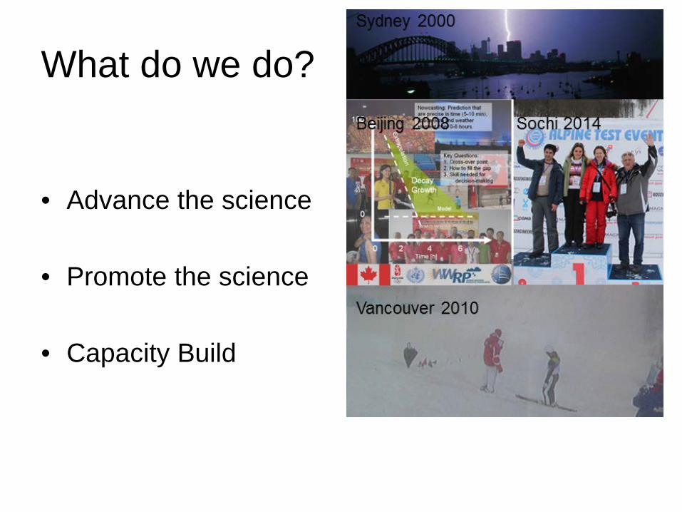
Early Notification, Watches and Warnings and Decision-making
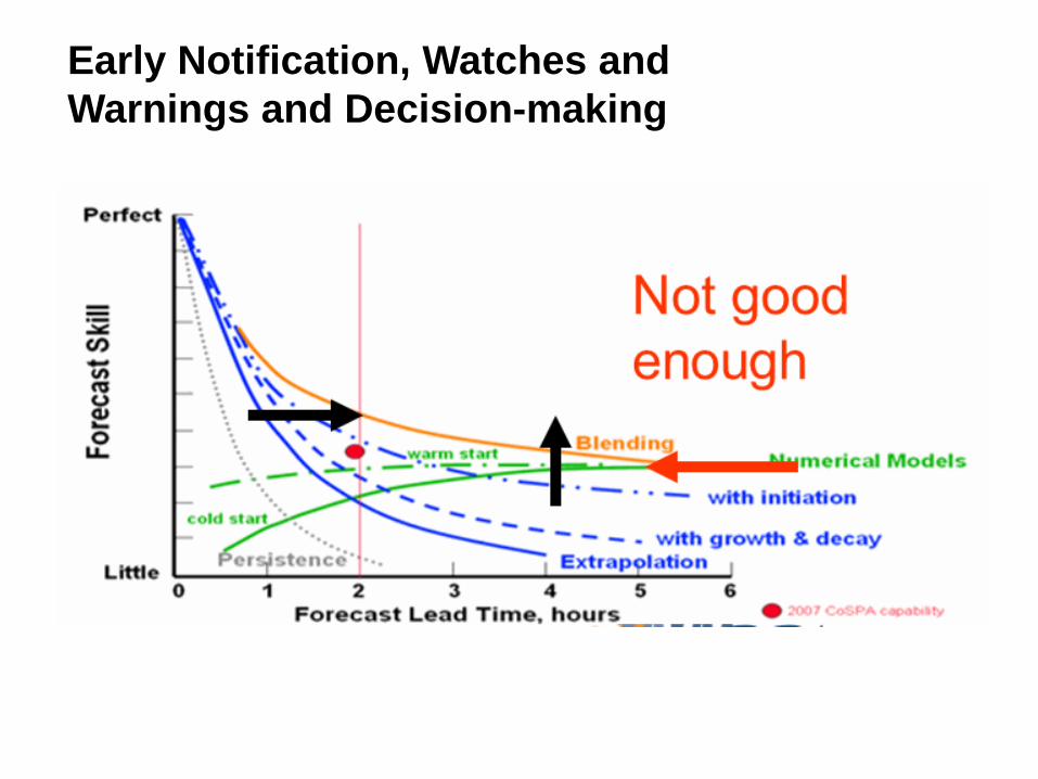
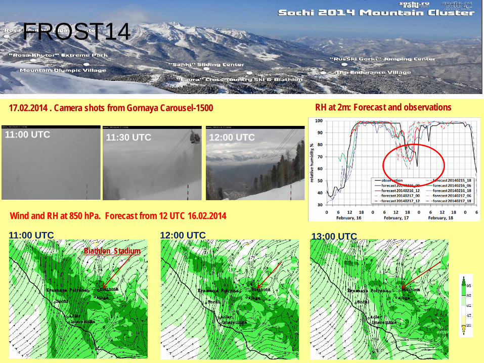
17.02.2014 . Camera shots from Gornaya Carousel-1500
FROST-2014 experience demonstrates that direct forecast of visibility is a serious challenge. However, some results were encouraging. Example: 17 February 2014, 11:00-12:00 UTC (Biathlon venue) – Forecast of time slot for competitions during the 3-days period with low visibility. Forecast of wind direction and relative humidity (as proxy of visibility) by COSMO-Ru1 (1km grid spacing)
Wind and RH at 850 hPa. Forecast from 12 UTC 16.02.2014
Biathlon Stadium
11:00 UTC 11:30 UTC 12:00 UTC
11:00 UTC 13:00 UTC 12:00 UTC
RH at 2m: Forecast and observations
FROST14
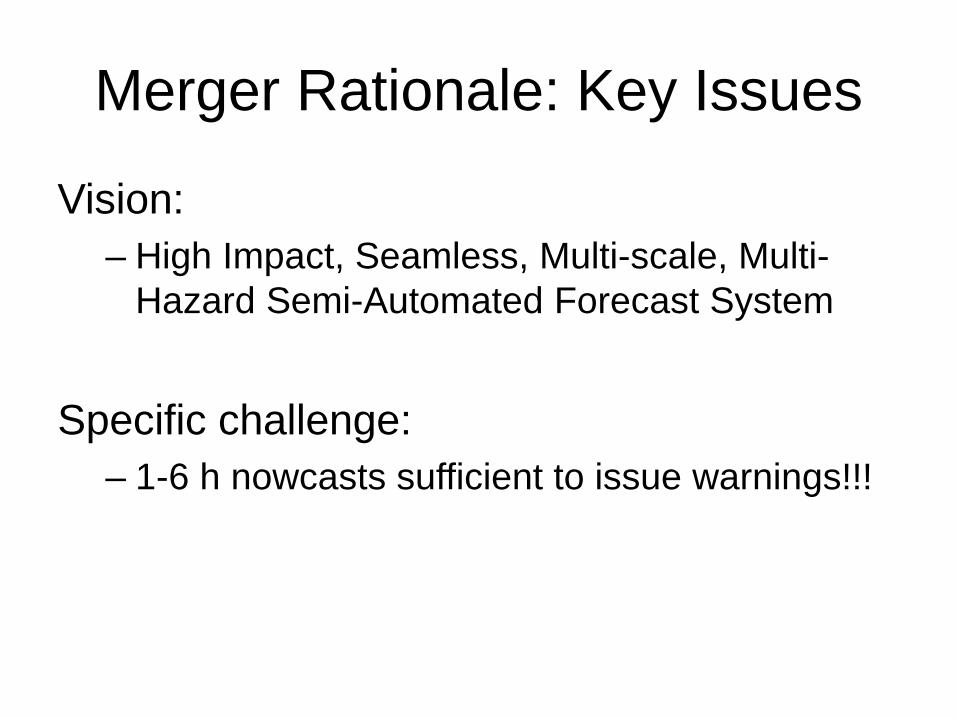
Merger Rationale: Key Issues
Vision: – High Impact, Seamless, Multi-scale, Multi-
Hazard Semi-Automated Forecast System
Specific challenge: – 1-6 h nowcasts sufficient to issue warnings!!!

Science Challenges
• High Resolution • Observations • Boundary Layer – vertical resolution • Boundary Layer and Surface Physics • Microphysics • Spin Up Time reduction
Sun et al, 2014: NWP for Nowcasting, BAMS

AVIATION RESEARCH DEVELOPMENT PROJECT
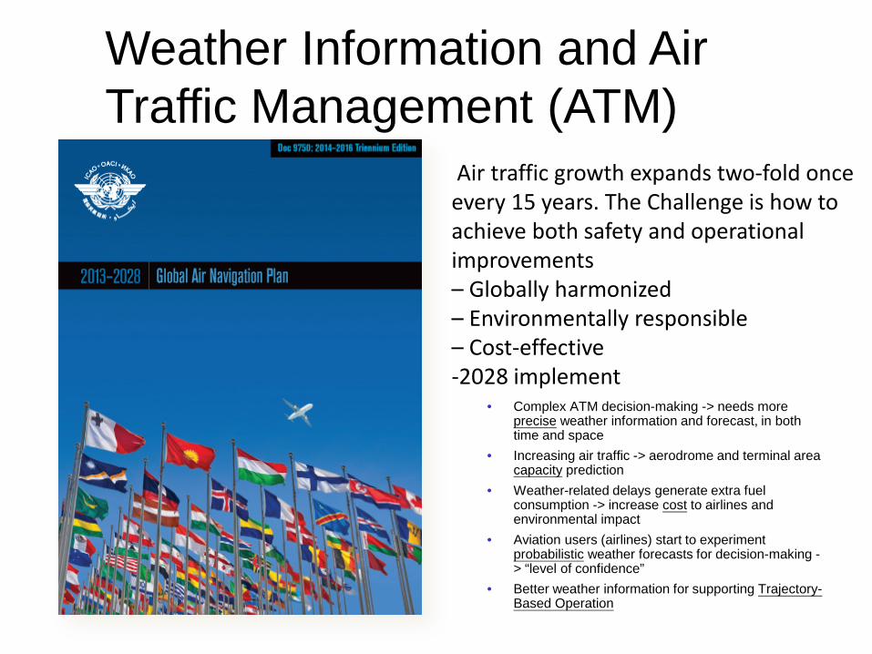
• Complex ATM decision-making -> needs more precise weather information and forecast, in both time and space
• Increasing air traffic -> aerodrome and terminal area capacity prediction
• Weather-related delays generate extra fuel consumption -> increase cost to airlines and environmental impact
• Aviation users (airlines) start to experiment probabilistic weather forecasts for decision-making -> “level of confidence”
• Better weather information for supporting Trajectory-Based Operation
Weather Information and Air Traffic Management (ATM)
Air traffic growth expands two-fold once every 15 years. The Challenge is how to achieve both safety and operational improvements – Globally harmonized – Environmentally responsible – Cost-effective -2028 implement

ICAO CAEM CONJOINT MEETING 7-18 JULY 2014, MONTREAL
MET/14-WP/64 CAeM-15/Doc.64 Report on B1-AMET
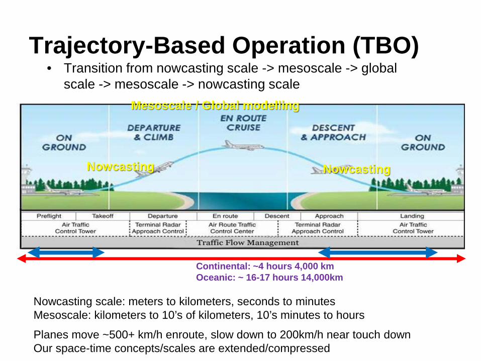
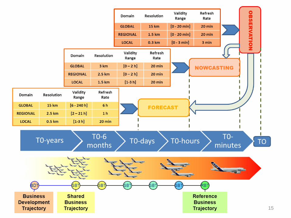
Nowcasting scale: meters to kilometers, seconds to minutes Mesoscale: kilometers to 10’s of kilometers, 10’s minutes to hours
Nowcasting Nowcasting
Mesoscale / Global modelling
Continental: ~4 hours 4,000 km Oceanic: ~ 16-17 hours 14,000km
Planes move ~500+ km/h enroute, slow down to 200km/h near touch down Our space-time concepts/scales are extended/compressed
• Transition from nowcasting scale -> mesoscale -> global scale -> mesoscale -> nowcasting scale
Trajectory-Based Operation (TBO)
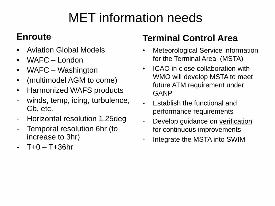
MET information needs Enroute • Aviation Global Models • WAFC – London • WAFC – Washington • (multimodel AGM to come) • Harmonized WAFS products - winds, temp, icing, turbulence,
Cb, etc. - Horizontal resolution 1.25deg - Temporal resolution 6hr (to
increase to 3hr) - T+0 – T+36hr
Terminal Control Area • Meteorological Service information
for the Terminal Area (MSTA) • ICAO in close collaboration with
WMO will develop MSTA to meet future ATM requirement under GANP
- Establish the functional and performance requirements
- Develop guidance on verification for continuous improvements
- Integrate the MSTA into SWIM
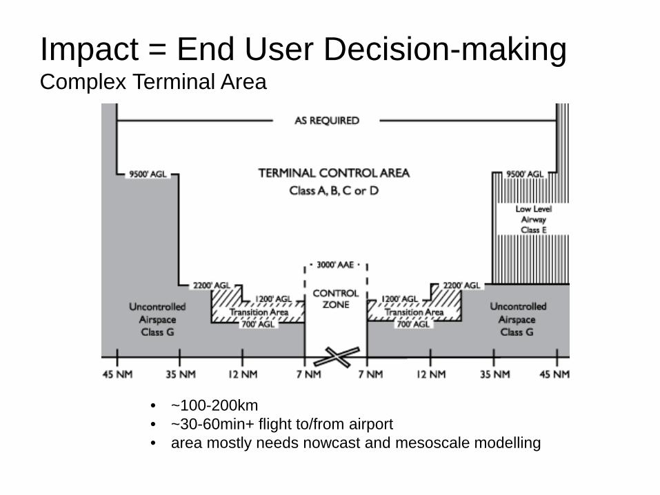
• ~100-200km • ~30-60min+ flight to/from airport • area mostly needs nowcast and mesoscale modelling
Impact = End User Decision-making Complex Terminal Area
15
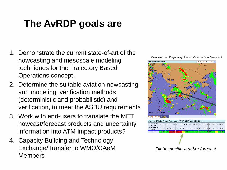
The AvRDP goals are
1. Demonstrate the current state-of-art of the
nowcasting and mesoscale modeling techniques for the Trajectory Based Operations concept;
2. Determine the suitable aviation nowcasting and modeling, verification methods (deterministic and probabilistic) and verification, to meet the ASBU requirements
3. Work with end-users to translate the MET nowcast/forecast products and uncertainty information into ATM impact products?
4. Capacity Building and Technology Exchange/Transfer to WMO/CAeM Members
Conceptual Trajectory Based Convection Nowcast
Flight specific weather forecast
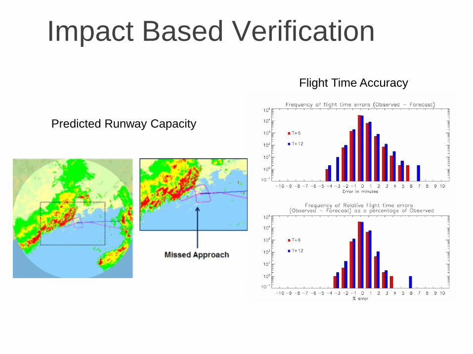
Impact Based Verification Flight Time Accuracy
Predicted Runway Capacity
LAKE VICTORIA BASIN HYDROCLIMATE TO NOWCASTING EARLY WARNING SYSTEM
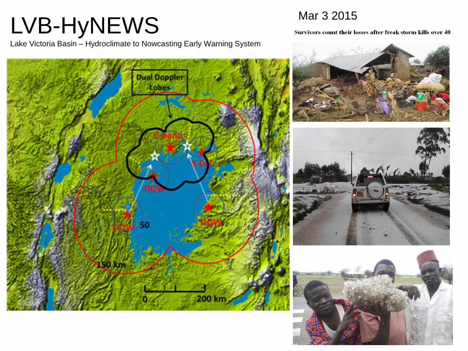
Mar 3 2015 LVB-HyNEWS Lake Victoria Basin – Hydroclimate to Nowcasting Early Warning System
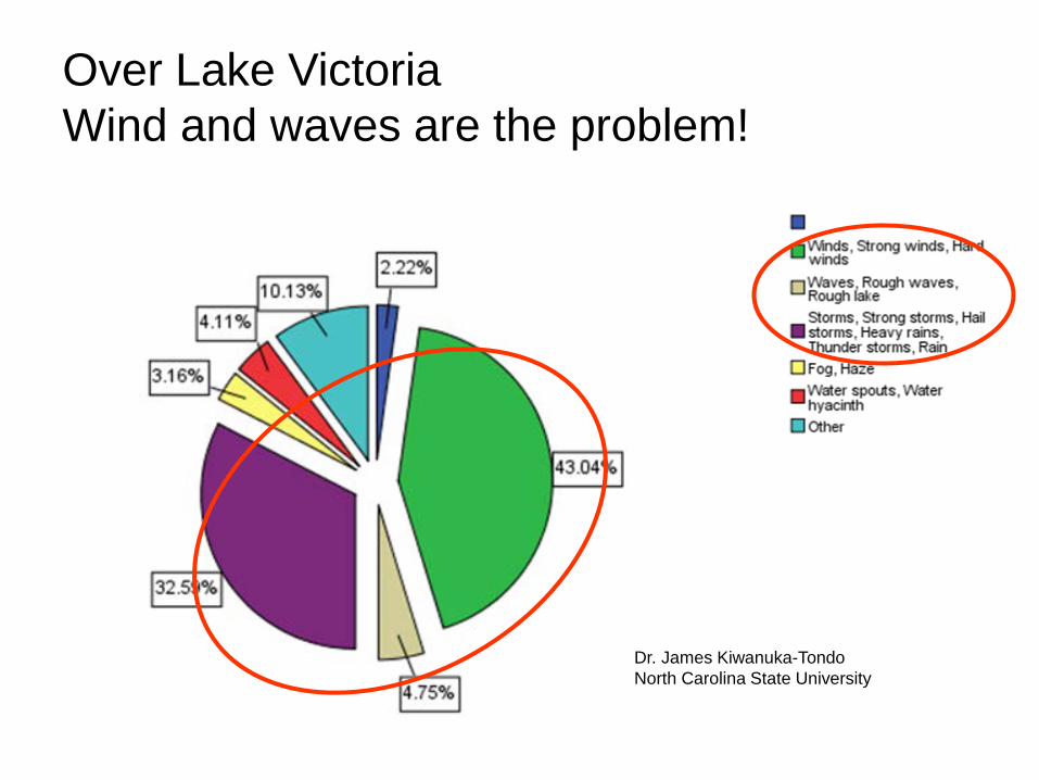
Over Lake Victoria Wind and waves are the problem!
Dr. James Kiwanuka-Tondo North Carolina State University
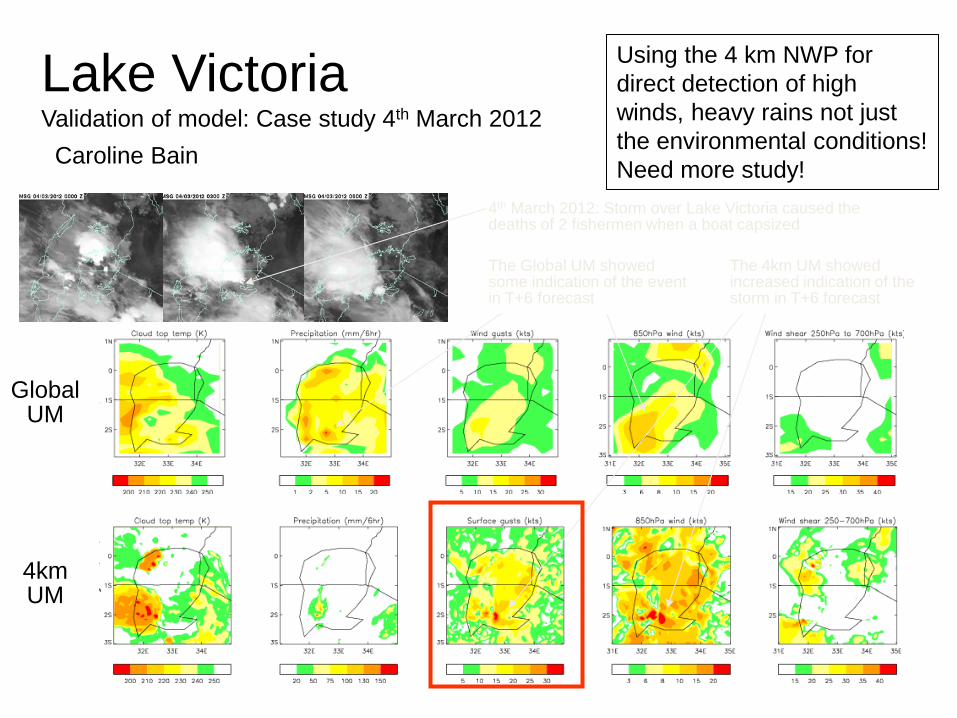
Global UM
4km UM
4th March 2012: Storm over Lake Victoria caused the deaths of 2 fishermen when a boat capsized
The Global UM showed some indication of the event in T+6 forecast
The 4km UM showed increased indication of the storm in T+6 forecast
Lake Victoria Validation of model: Case study 4th March 2012
Using the 4 km NWP for direct detection of high winds, heavy rains not just the environmental conditions! Need more study! Caroline Bain
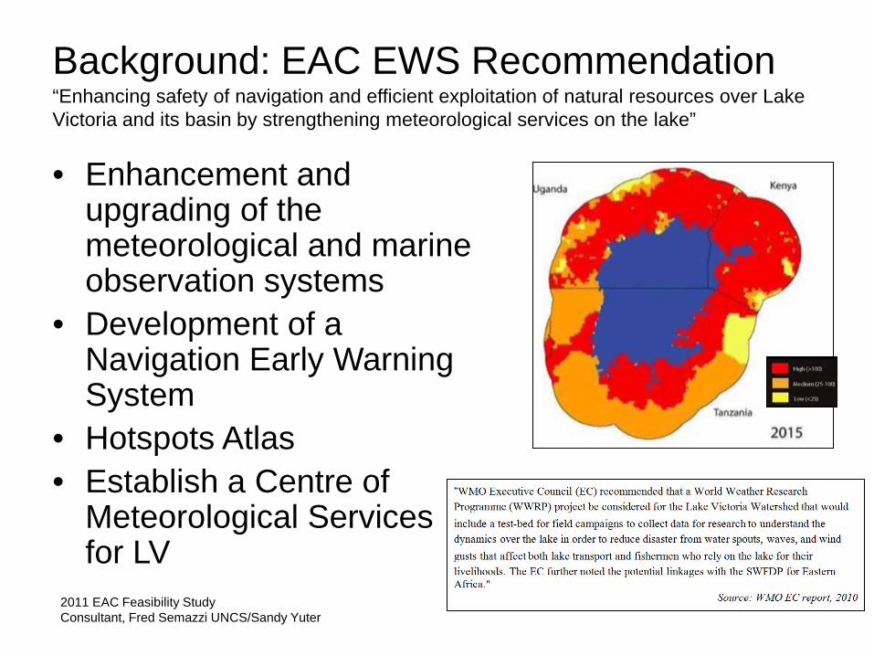
Background: EAC EWS Recommendation “Enhancing safety of navigation and efficient exploitation of natural resources over Lake Victoria and its basin by strengthening meteorological services on the lake”
• Enhancement and upgrading of the meteorological and marine observation systems
• Development of a Navigation Early Warning System
• Hotspots Atlas • Establish a Centre of
Meteorological Services for LV
2011 EAC Feasibility Study Consultant, Fred Semazzi UNCS/Sandy Yuter
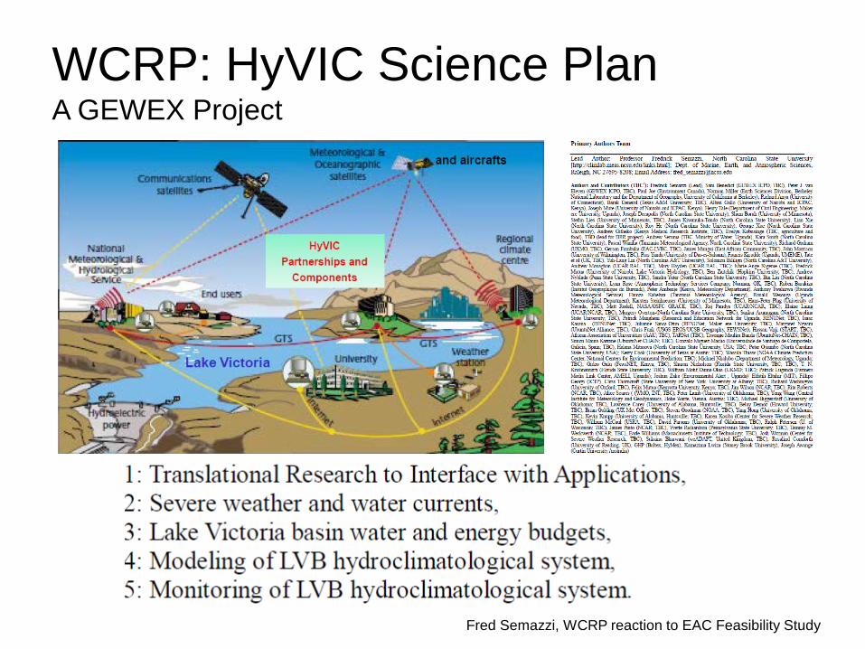
WCRP: HyVIC Science Plan A GEWEX Project
Fred Semazzi, WCRP reaction to EAC Feasibility Study
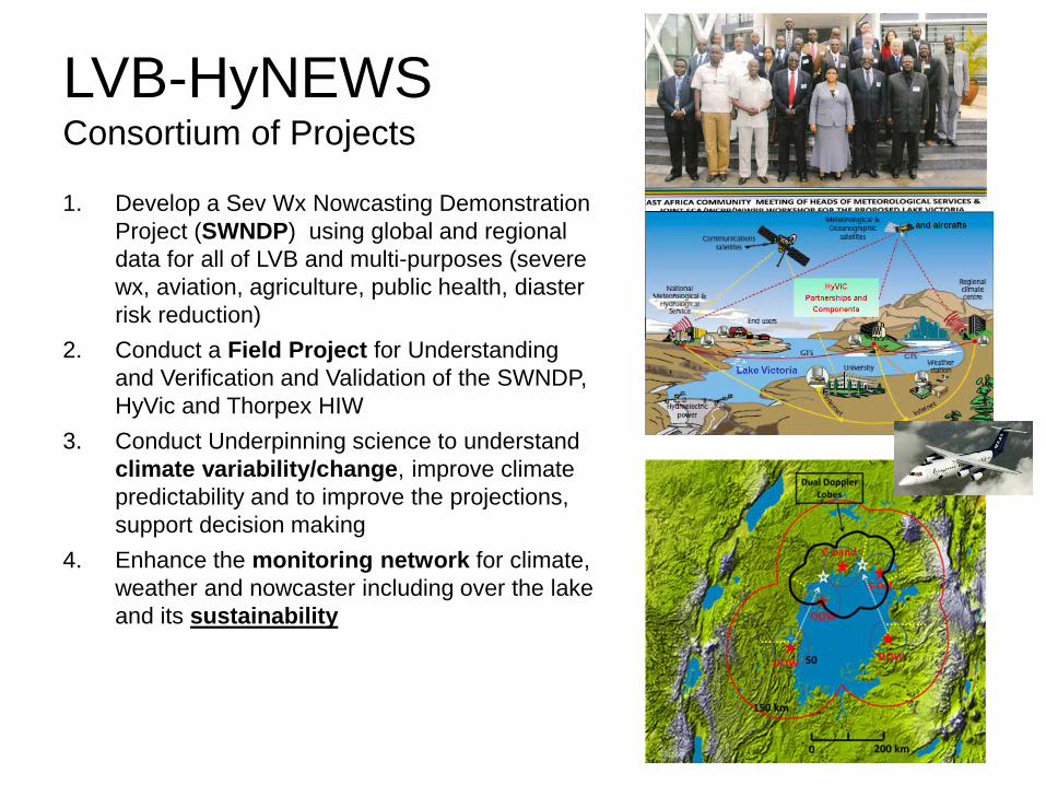
LVB-HyNEWS Consortium of Projects
1. Develop a Sev Wx Nowcasting Demonstration Project (SWNDP) using global and regional data for all of LVB and multi-purposes (severe wx, aviation, agriculture, public health, diaster risk reduction)
2. Conduct a Field Project for Understanding and Verification and Validation of the SWNDP, HyVic and Thorpex HIW
3. Conduct Underpinning science to understand climate variability/change, improve climate predictability and to improve the projections, support decision making
4. Enhance the monitoring network for climate, weather and nowcaster including over the lake and its sustainability
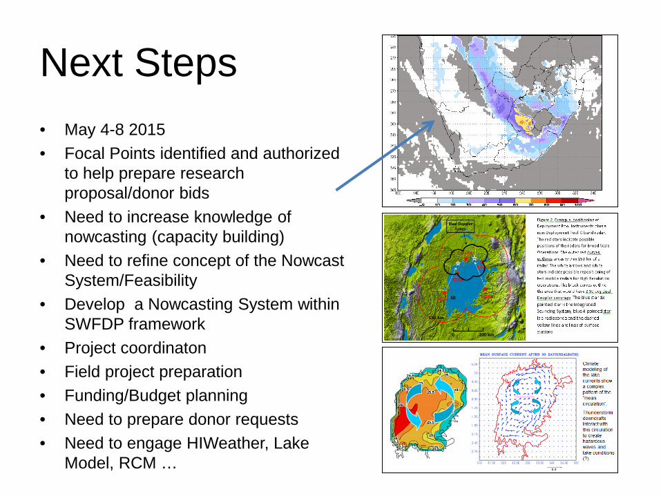
Next Steps • May 4-8 2015 • Focal Points identified and authorized
to help prepare research proposal/donor bids
• Need to increase knowledge of nowcasting (capacity building)
• Need to refine concept of the Nowcast System/Feasibility
• Develop a Nowcasting System within SWFDP framework
• Project coordinaton • Field project preparation • Funding/Budget planning • Need to prepare donor requests • Need to engage HIWeather, Lake
Model, RCM …
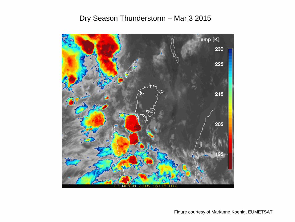
Dry Season Thunderstorm – Mar 3 2015
Figure courtesy of Marianne Koenig, EUMETSAT

KOREA 2018 Cold Season Microphysics Research Development Project
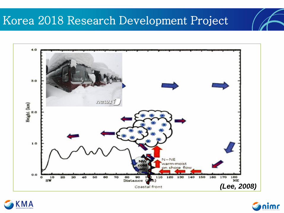
Korea 2018 Research Development Project
(Lee, 2008)
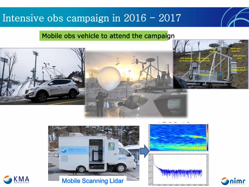
Intensive obs campaign in 2016 - 2017
Mobile obs vehicle to attend the campaign
Mobile Scanning Lidar
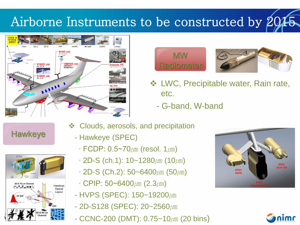
Airborne Instruments to be constructed by 2015
Hawkeye Clouds, aerosols, and precipitation - Hawkeye (SPEC) ∙ FCDP: 0.5~70㎛ (resol. 1㎛) ∙ 2D-S (ch.1): 10~1280㎛ (10㎛) ∙ 2D-S (Ch.2): 50~6400㎛ (50㎛) ∙ CPIP: 50~6400㎛ (2.3㎛) - HVPS (SPEC): 150~19200㎛ - 2D-S128 (SPEC): 20~2560㎛ - CCNC-200 (DMT): 0.75~10㎛ (20 bins)
MW Radiometer
LWC, Precipitable water, Rain rate, etc.
- G-band, W-band
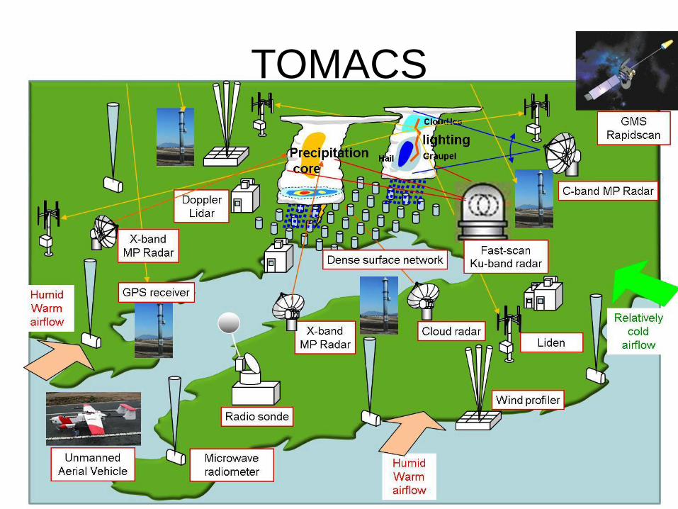
TOMACS
High Density Measurements Nowcasting – Very Short Range Forecasting Social Experiment Urban
TOMACS
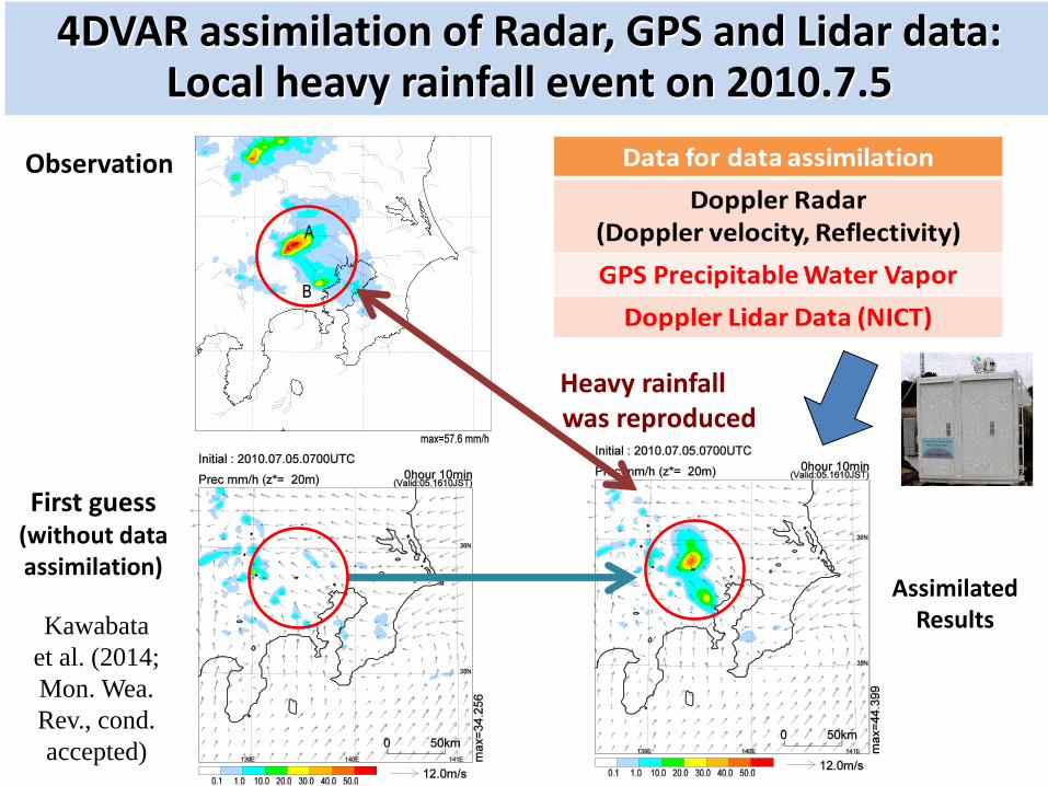
Observation
First guess (without data assimilation)
4DVAR assimilation of Radar, GPS and Lidar data: Local heavy rainfall event on 2010.7.5
Assimilated Results
Heavy rainfall was reproduced
Kawabata et al. (2014; Mon. Wea. Rev., cond. accepted)

PAN AM GAMES 2015 TORONTO
GURME RDP Proposal – Veronique Bouchet
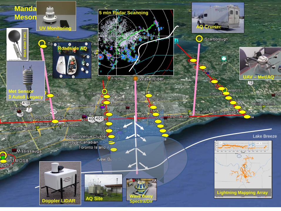
Mandated Mesonet
Lake Breeze
5 min Radar Scanning
UAV – Met/AQ
Lightning Mapping Array
Doppler LIDAR
UV Monitoring AQ Cruiser
Roadside AQ
AQ Site
Met Sensor 3 Auto8 Legacy
Bla
ck G
lobe
T (H
C)
Wave Buoy Spectra/Dir

AQ monitoring • Elements observed (hourly):
– PM2.5; PM10; Ozone; NO2; some UV – 2 additional AQ monitoring stations (at U of T Downtown & at York U)
• Two additional AQ monitoring stations
– (U of T Downtown & York U)
Miniature AQ sensors for the study of roadside air quality

SMART PHONE • Pressure • Temperature • Relative
Humidity • Signal strength • UV
1500 subscribers
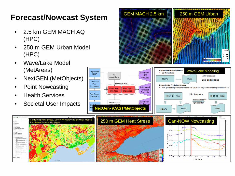
Forecast/Nowcast System
• 2.5 km GEM MACH AQ (HPC)
• 250 m GEM Urban Model (HPC)
• Wave/Lake Model (MetAreas)
• NextGEN (MetObjects) • Point Nowcasting • Health Services • Societal User Impacts
NexGen- iCAST/MetObjects
250 m GEM Heat Stress Can-NOW Nowcasting
Wave/Lake Modeling
GEM MACH 2.5 km 250 m GEM Urban
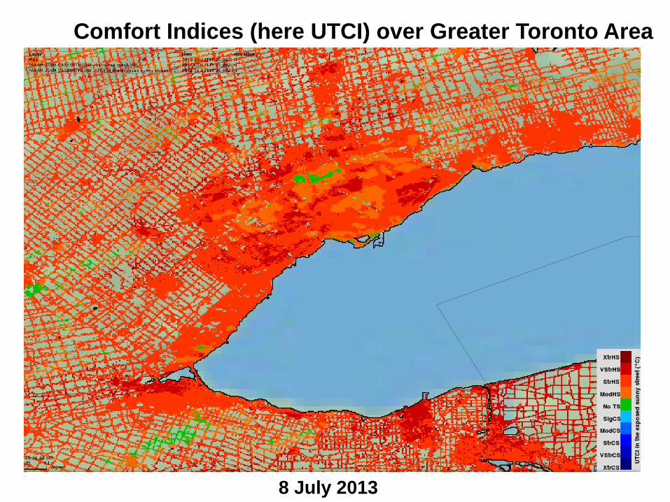
Comfort Indices (here UTCI) over Greater Toronto Area
8 July 2013

Collaboration Proposition
• Pan Am 15 proposed to be a “legacy dataset” under WWRP – Joint GURME + NMR – Aug 2015, Toronto, Kickoff
• Urban Workshop???
– TOMACS, SREP, Pam Am15, others – GURME
Veronique Bouchet, GURME Chair

Project Main Science Focus
FROST14 Winter Nowcasting; complex terrain
TOMACS Role of high density observations; urban
Grey Zone Microphysics vs convection scheme
SCMREX Precipitation physics of Monsoons
Polar Prediction Project High Impact Polar Weather
UPDRAFT Precipitation Physics of Land Fall Hurricanes
Lake Victoria Nowcasting for DC; coupled models
Aviation RDP Seamless
La Plata Basin/Relampago Predictability
Korea 2018 Microphysics
HIWeather TBD
GEOWOW Ensembles
MesoVICT Mesoscale Verification
SRNWP Nowcasting, EPS and new observation types
Observation New observation technologies

WGNE Collaborations
• Aviation RDP – enRoute requirements need collaboration
• Lake Vic – high res NWP RDP? • GURME – urban, Tokyo 2020? • Grey Zone - ongoing

THANK YOU Questions?

BACKUP
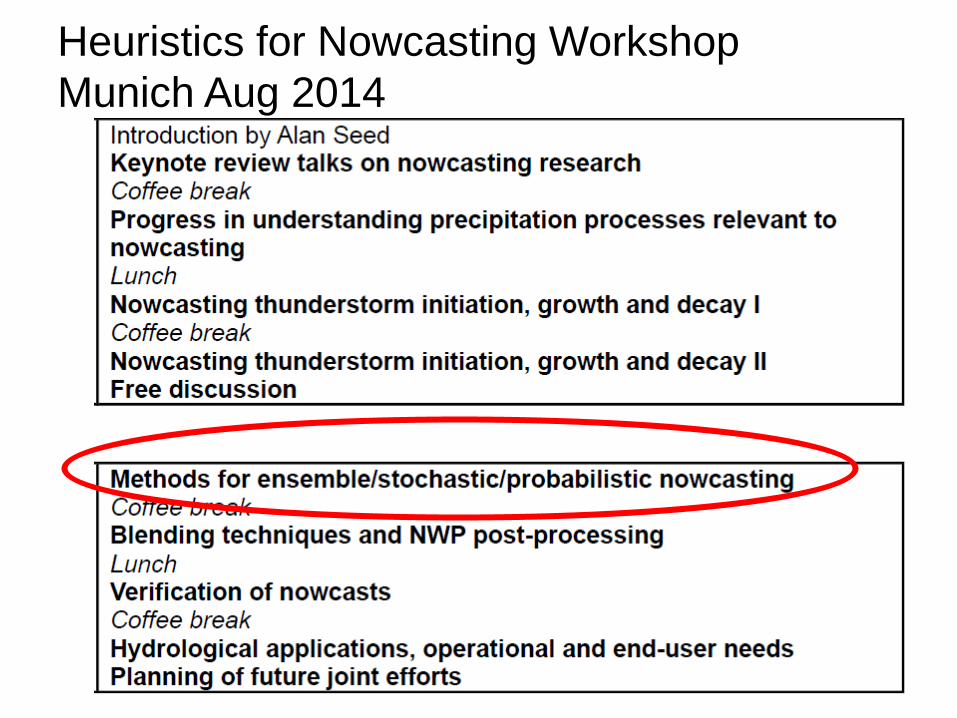
Heuristics for Nowcasting Workshop Munich Aug 2014
FROST-14
Slides provided by Dmitri Kiktev
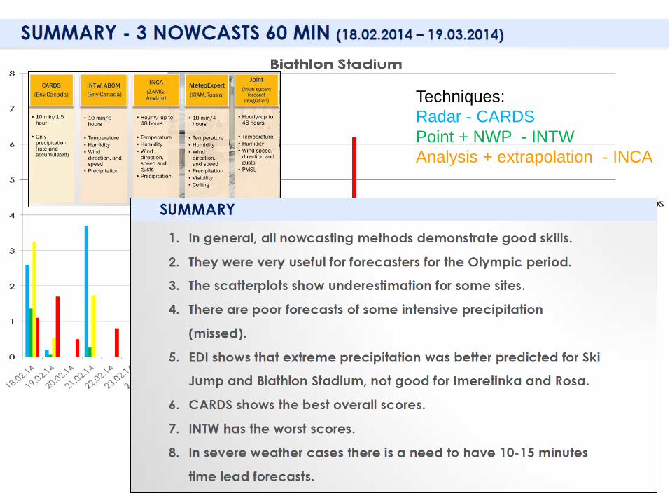
Techniques: Radar - CARDS Point + NWP - INTW Analysis + extrapolation - INCA
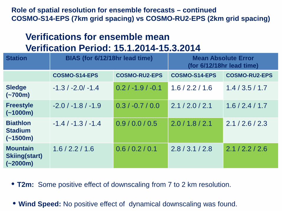
Role of spatial resolution for ensemble forecasts – continued COSMO-S14-EPS (7km grid spacing) vs COSMO-RU2-EPS (2km grid spacing)
Station BIAS (for 6/12/18hr lead time) Mean Absolute Error (for 6/12/18hr lead time)
COSMO-S14-EPS COSMO-RU2-EPS COSMO-S14-EPS COSMO-RU2-EPS
Sledge (~700m)
-1.3 / -2.0/ -1.4 0.2 / -1.9 / -0.1 1.6 / 2.2 / 1.6 1.4 / 3.5 / 1.7
Freestyle (~1000m)
-2.0 / -1.8 / -1.9 0.3 / -0.7 / 0.0 2.1 / 2.0 / 2.1 1.6 / 2.4 / 1.7
Biathlon Stadium (~1500m)
-1.4 / -1.3 / -1.4 0.9 / 0.0 / 0.5 2.0 / 1.8 / 2.1 2.1 / 2.6 / 2.3
Mountain Skiing(start) (~2000m)
1.6 / 2.2 / 1.6 0.6 / 0.2 / 0.1 2.8 / 3.1 / 2.8 2.1 / 2.2 / 2.6
• T2m: Some positive effect of downscaling from 7 to 2 km resolution. • Wind Speed: No positive effect of dynamical downscaling was found.
Verifications for ensemble mean Verification Period: 15.1.2014-15.3.2014
17.02.2014 . Camera shots from Gornaya Carousel-1500
FROST-2014 experience demonstrates that direct forecast of visibility is a serious challenge. However, some results were encouraging. Example: 17 February 2014, 11:00-12:00 UTC (Biathlon venue) – Forecast of time slot for competitions during the 3-days period with low visibility. Forecast of wind direction and relative humidity (as proxy of visibility) by COSMO-Ru1 (1km grid spacing)
Wind and RH at 850 hPa. Forecast from 12 UTC 16.02.2014
Biathlon Stadium
11:00 UTC 11:30 UTC 12:00 UTC
11:00 UTC 13:00 UTC 12:00 UTC
RH at 2m: Forecast and observations
FROST14
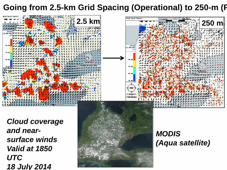
Going from 2.5-km Grid Spacing (Operational) to 250-m (P 2.5 km
MODIS (Aqua satellite)
250 m
Cloud coverage and near-surface winds Valid at 1850 UTC 18 July 2014
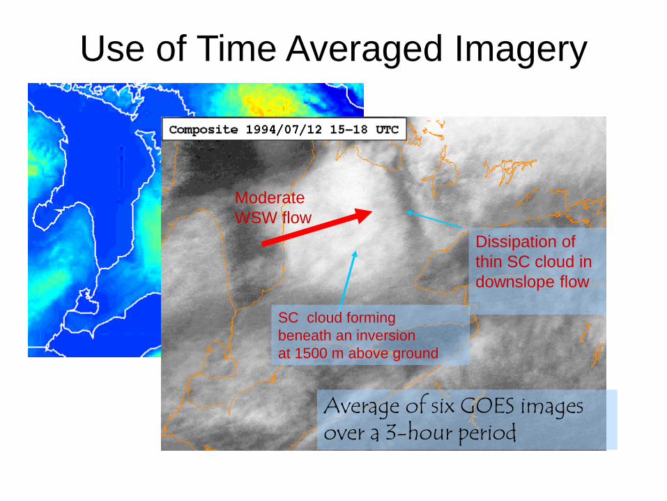
Use of Time Averaged Imagery
Topography of Southern Ontario
Average of six GOES images over a 3-hour period
Moderate WSW flow
Dissipation of thin SC cloud in downslope flow
SC cloud forming beneath an inversion at 1500 m above ground
Recommended