Embed Size (px)
Citation preview
1
Environmental Sustainable Design
(ARC1413/BLD60203)
Reflective Research Essay
Title : Land-Use Planning in Kuala Lumpur
Tutor : Mrs Tamil Salvi Mari
Name ID
Tan Hsuan Lin 0318975
Angoline Boo 0316144
Chong Yee Ching 0316102
Mark Eng Shang 0324187
2
Content
PAGE
1. Introduction
2. Land – Use Planning Principle
2.1. Introduction
2.2. Record & Evaluate
2.3. Preserve the Culture
2.4. Conserve Open Space & Environmental Features
2.5. Recognize & Calculate
2.6. Set Limits
2.7. Conclusion
3. Issue & Solutions to Land Use Planning in Kuala Lumpur
3.1. Overpopulation
3.2. Urban Character
3.3. Conservation
3.4. Architectural Character
3
Introduction
Humans alter the environment and that a growing population makes land-use planning necessary
Land is distinguished in a way it supports boundless resources. It is also classified as a non-
renewable resource. As the world advanced, human society progressed and grow, thus utilizing
and altering lands in the process to accommodate growing human “needs” and “requirements”,
Hence, it is through thorough land-use planning that we are able to utilize this limited resource to
its maximum efficiency, prioritizing both human and environmental needs and considerations.
Land Use Planning Principle
Introduction
Many problems can be solved with proper land use planning. It is a process by which a
society, through its institutions, decides where, within its territory, the different socioeconomic
activities such as agriculture, housing, industry, recreation, and commerce should take place.
Arthuro - the needs of the population - is the central driving force that requires land use decisions
to be made. Each groups have their special interests, therefore, there are several principles and
processes that guide land use decisions.
Record and evaluate
First of all, a land’s unique
geographical and geological features
have to be evaluated and its data
recorded. This is to determine the
importance of a certain area and the
collection of all data regarding the
advantages and disadvantages of the
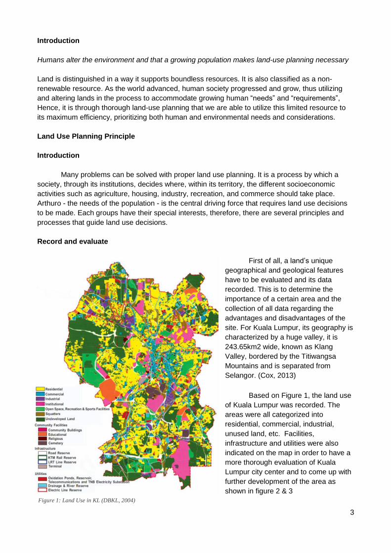
site. For Kuala Lumpur, its geography is
characterized by a huge valley, it is
243.65km2 wide, known as Klang
Valley, bordered by the Titiwangsa
Mountains and is separated from
Selangor. (Cox, 2013)
Based on Figure 1, the land use
of Kuala Lumpur was recorded. The
areas were all categorized into
residential, commercial, industrial,
unused land, etc. Facilities,
infrastructure and utilities were also
indicated on the map in order to have a
more thorough evaluation of Kuala
Lumpur city center and to come up with
further development of the area as
shown in figure 2 & 3
Figure 1: Land Use in KL (DBKL, 2004)
4
These maps show how data
recording and evaluation is critical for future
development plans - it indicates the area’s
opportunities and strengths- so the aspects
which can be improved are clear, e.g.
transportation, linkages, facilities, etc.
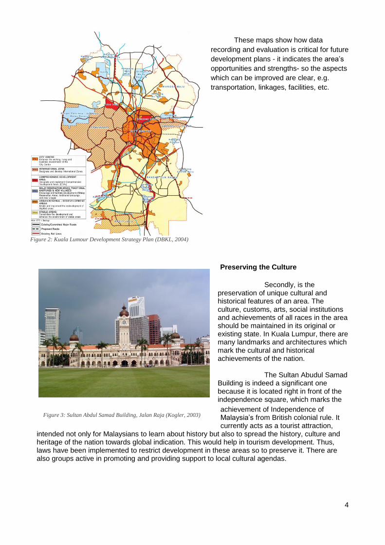
Preserving the Culture
Secondly, is the preservation of unique cultural and historical features of an area. The culture, customs, arts, social institutions and achievements of all races in the area should be maintained in its original or existing state. In Kuala Lumpur, there are many landmarks and architectures which mark the cultural and historical achievements of the nation. The Sultan Abudul Samad Building is indeed a significant one because it is located right in front of the independence square, which marks the
achievement of Independence of Malaysia’s from British colonial rule. It currently acts as a tourist attraction,
intended not only for Malaysians to learn about history but also to spread the history, culture and heritage of the nation towards global indication. This would help in tourism development. Thus, laws have been implemented to restrict development in these areas so to preserve it. There are also groups active in promoting and providing support to local cultural agendas.
Figure 2: Kuala Lumour Development Strategy Plan (DBKL, 2004)
Figure 3: Sultan Abdul Samad Building, Jalan Raja (Kogler, 2003)
5
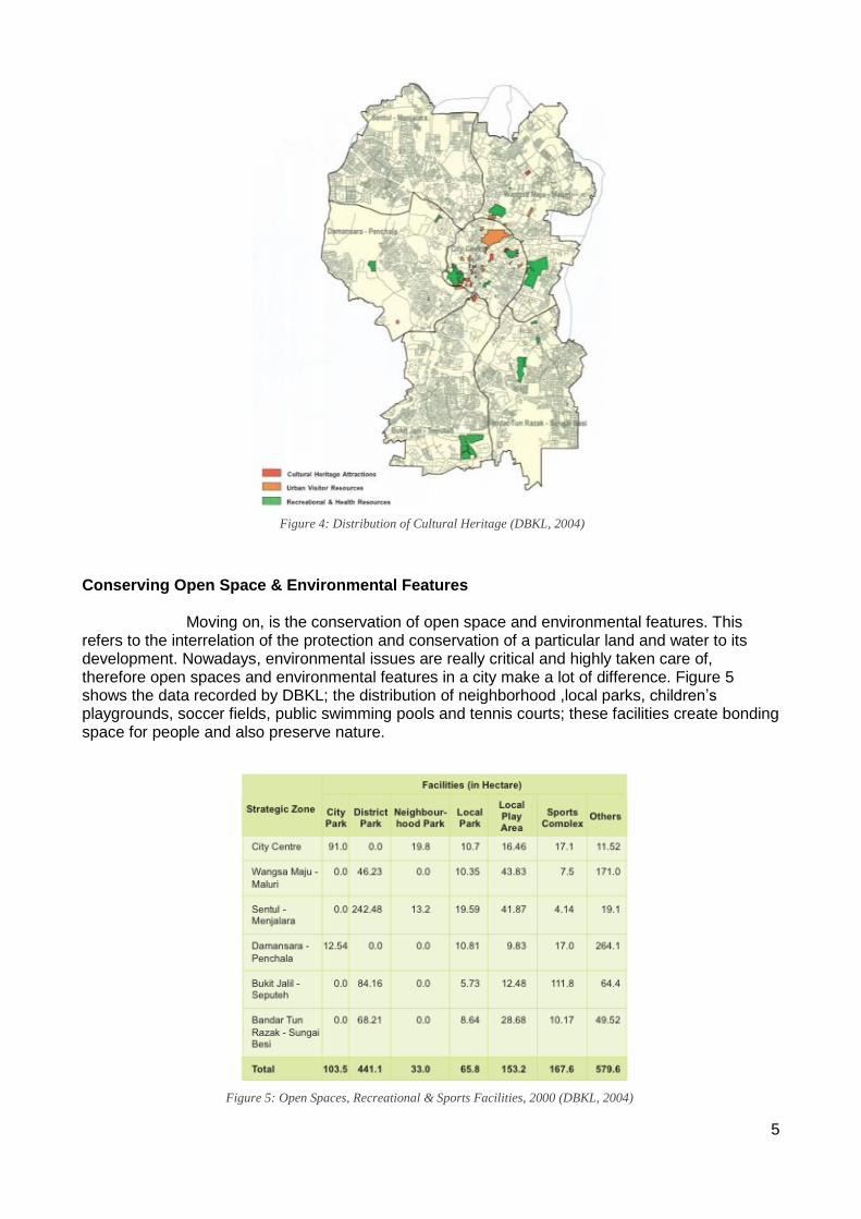
Conserving Open Space & Environmental Features Moving on, is the conservation of open space and environmental features. This refers to the interrelation of the protection and conservation of a particular land and water to its development. Nowadays, environmental issues are really critical and highly taken care of, therefore open spaces and environmental features in a city make a lot of difference. Figure 5 shows the data recorded by DBKL; the distribution of neighborhood ,local parks, children’s playgrounds, soccer fields, public swimming pools and tennis courts; these facilities create bonding space for people and also preserve nature.
Figure 4: Distribution of Cultural Heritage (DBKL, 2004)
Figure 5: Open Spaces, Recreational & Sports Facilities, 2000 (DBKL, 2004)
6
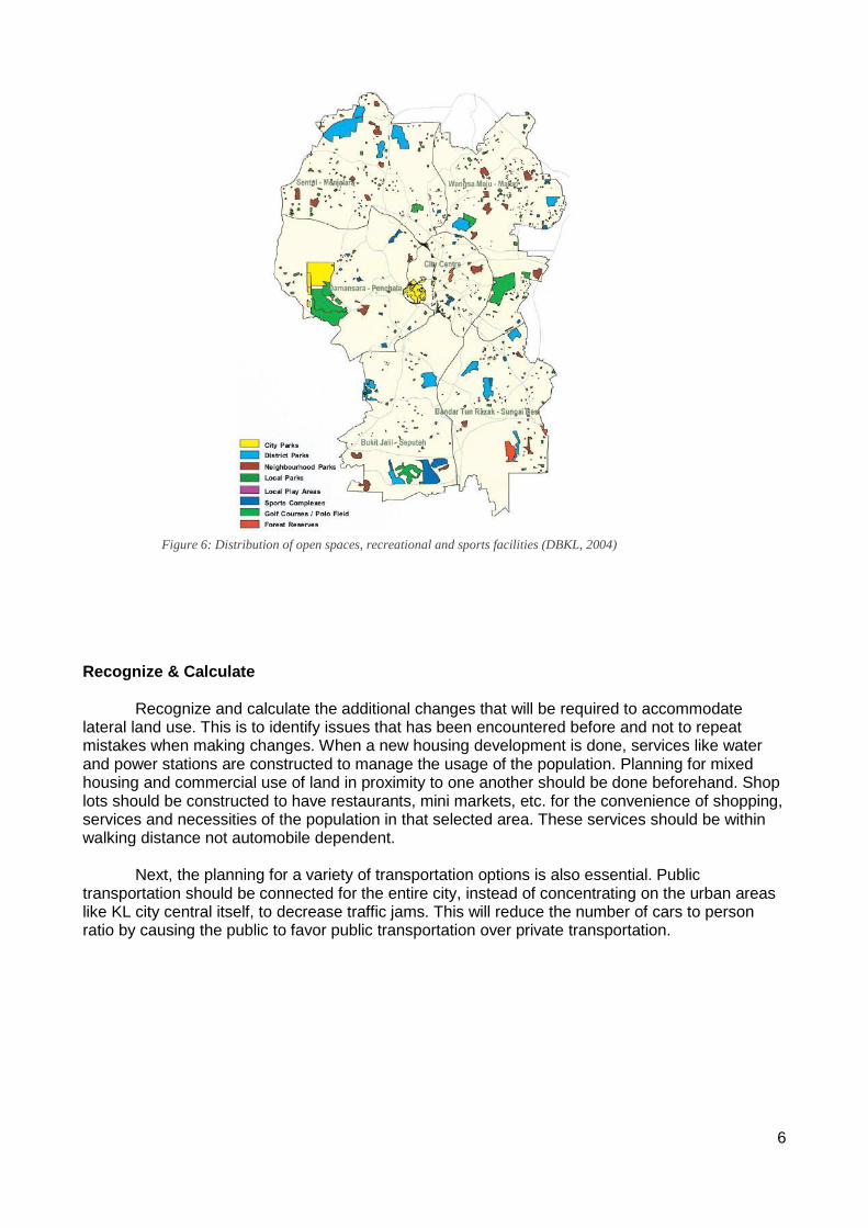
Recognize & Calculate Recognize and calculate the additional changes that will be required to accommodate lateral land use. This is to identify issues that has been encountered before and not to repeat mistakes when making changes. When a new housing development is done, services like water and power stations are constructed to manage the usage of the population. Planning for mixed housing and commercial use of land in proximity to one another should be done beforehand. Shop lots should be constructed to have restaurants, mini markets, etc. for the convenience of shopping, services and necessities of the population in that selected area. These services should be within walking distance not automobile dependent. Next, the planning for a variety of transportation options is also essential. Public transportation should be connected for the entire city, instead of concentrating on the urban areas like KL city central itself, to decrease traffic jams. This will reduce the number of cars to person ratio by causing the public to favor public transportation over private transportation.
Figure 6: Distribution of open spaces, recreational and sports facilities (DBKL, 2004)
7
Set Limits
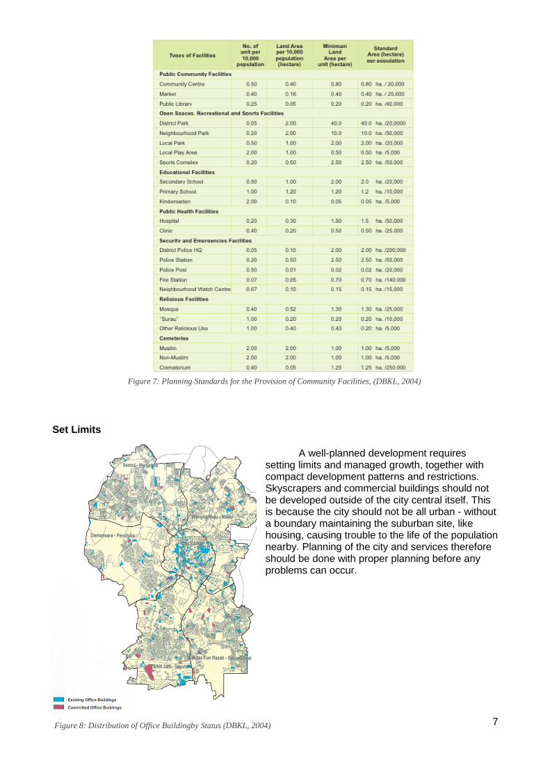
A well-planned development requires setting limits and managed growth, together with compact development patterns and restrictions. Skyscrapers and commercial buildings should not be developed outside of the city central itself. This is because the city should not be all urban - without a boundary maintaining the suburban site, like housing, causing trouble to the life of the population nearby. Planning of the city and services therefore should be done with proper planning before any problems can occur.
Figure 7: Planning Standards for the Provision of Community Facilities, (DBKL, 2004)
Figure 8: Distribution of Office Buildingby Status (DBKL, 2004)
8
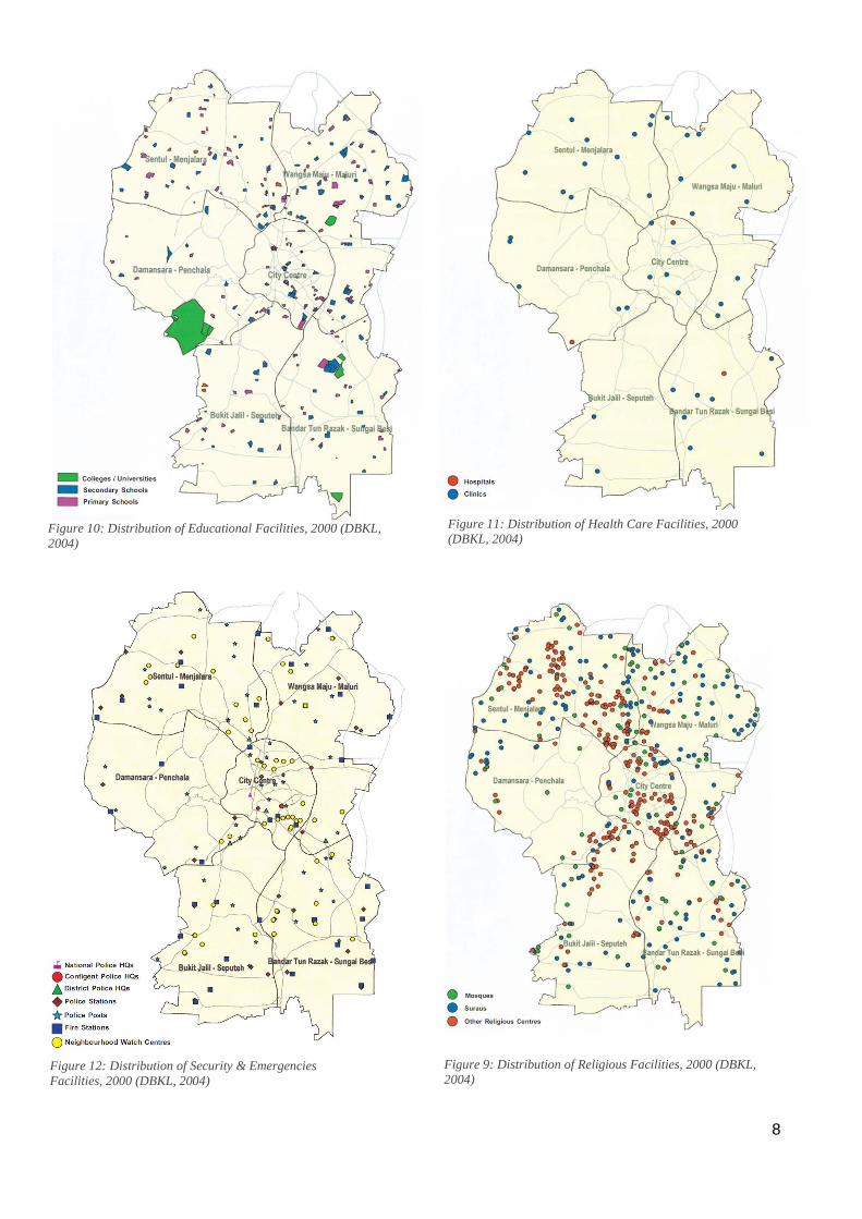
Figure 10: Distribution of Educational Facilities, 2000 (DBKL,
2004) Figure 11: Distribution of Health Care Facilities, 2000
(DBKL, 2004)
Figure 12: Distribution of Security & Emergencies
Facilities, 2000 (DBKL, 2004) Figure 9: Distribution of Religious Facilities, 2000 (DBKL,
2004)
9
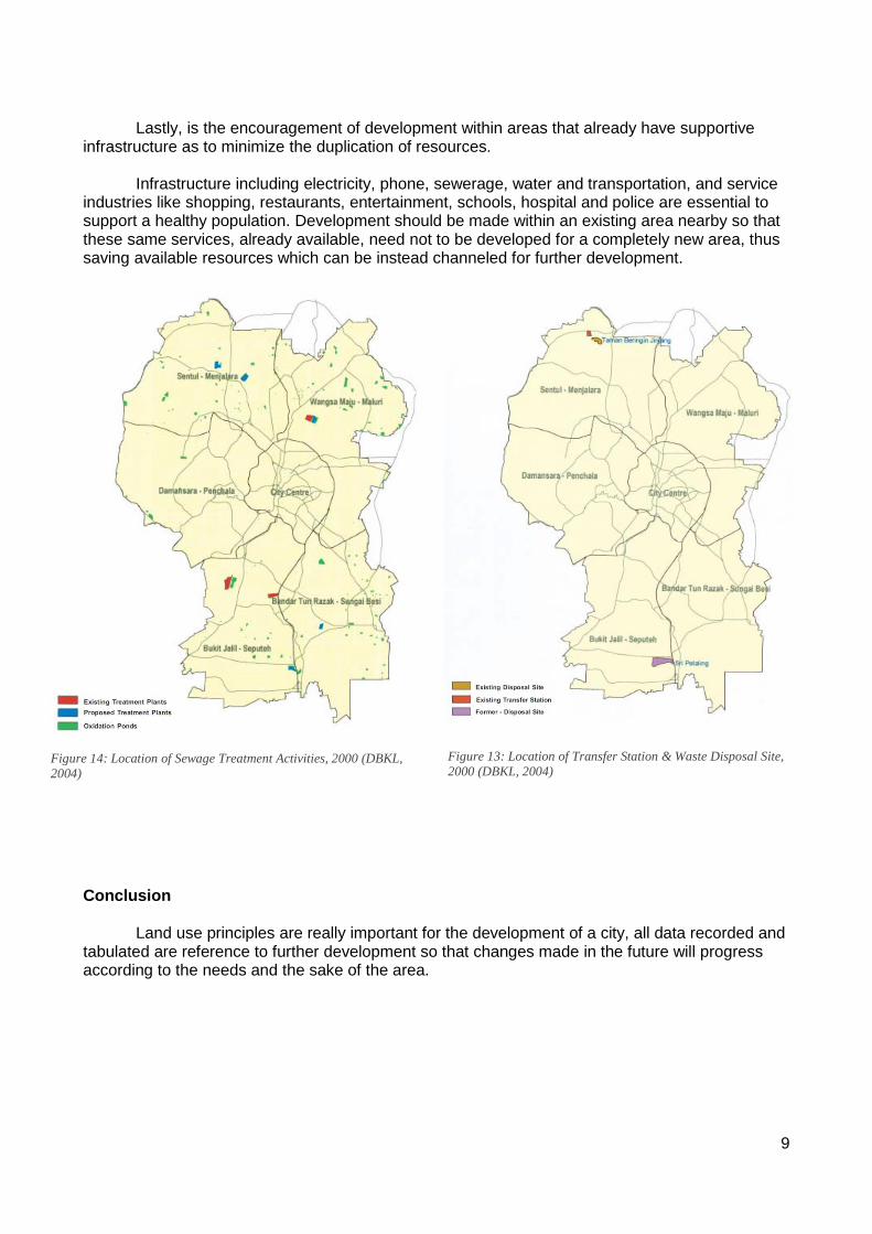
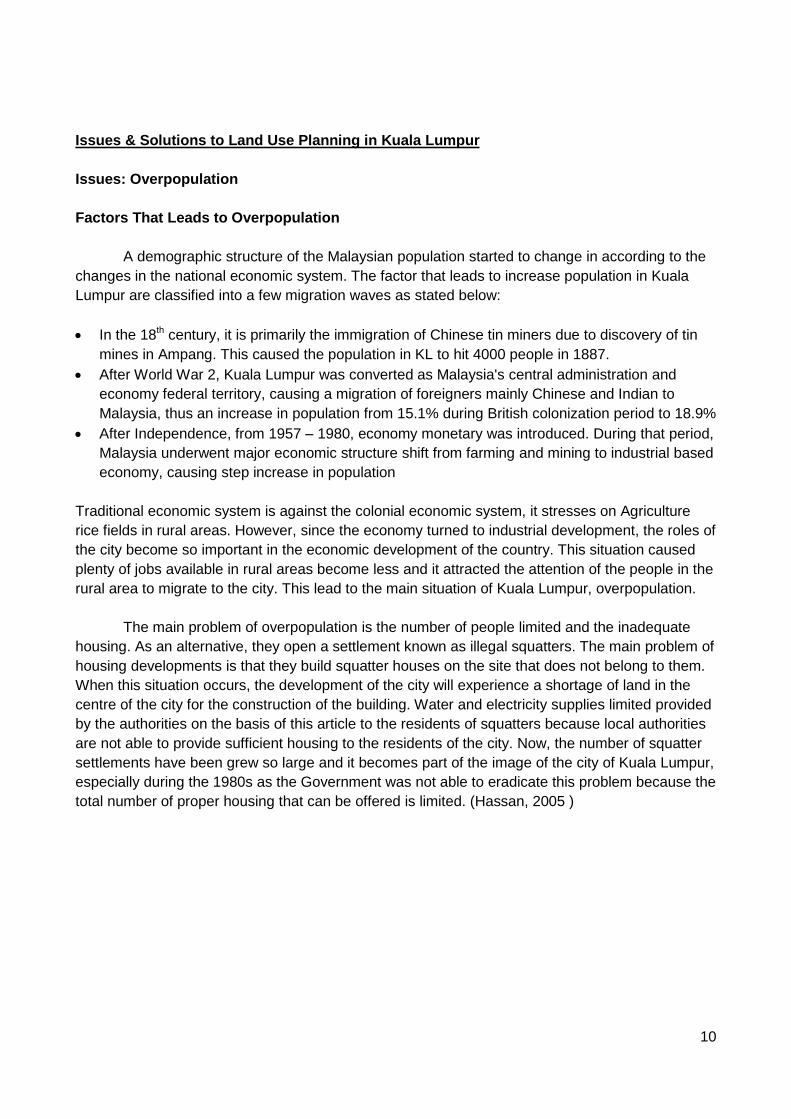
Lastly, is the encouragement of development within areas that already have supportive infrastructure as to minimize the duplication of resources. Infrastructure including electricity, phone, sewerage, water and transportation, and service industries like shopping, restaurants, entertainment, schools, hospital and police are essential to support a healthy population. Development should be made within an existing area nearby so that these same services, already available, need not to be developed for a completely new area, thus saving available resources which can be instead channeled for further development.
Conclusion Land use principles are really important for the development of a city, all data recorded and tabulated are reference to further development so that changes made in the future will progress according to the needs and the sake of the area.
Figure 14: Location of Sewage Treatment Activities, 2000 (DBKL,
2004) Figure 13: Location of Transfer Station & Waste Disposal Site,
2000 (DBKL, 2004)
10
Issues & Solutions to Land Use Planning in Kuala Lumpur
Issues: Overpopulation
Factors That Leads to Overpopulation
A demographic structure of the Malaysian population started to change in according to the
changes in the national economic system. The factor that leads to increase population in Kuala
Lumpur are classified into a few migration waves as stated below:
In the 18th century, it is primarily the immigration of Chinese tin miners due to discovery of tin
mines in Ampang. This caused the population in KL to hit 4000 people in 1887.
After World War 2, Kuala Lumpur was converted as Malaysia's central administration and
economy federal territory, causing a migration of foreigners mainly Chinese and Indian to
Malaysia, thus an increase in population from 15.1% during British colonization period to 18.9%
After Independence, from 1957 – 1980, economy monetary was introduced. During that period,
Malaysia underwent major economic structure shift from farming and mining to industrial based
economy, causing step increase in population
Traditional economic system is against the colonial economic system, it stresses on Agriculture
rice fields in rural areas. However, since the economy turned to industrial development, the roles of
the city become so important in the economic development of the country. This situation caused
plenty of jobs available in rural areas become less and it attracted the attention of the people in the
rural area to migrate to the city. This lead to the main situation of Kuala Lumpur, overpopulation.
The main problem of overpopulation is the number of people limited and the inadequate
housing. As an alternative, they open a settlement known as illegal squatters. The main problem of
housing developments is that they build squatter houses on the site that does not belong to them.
When this situation occurs, the development of the city will experience a shortage of land in the
centre of the city for the construction of the building. Water and electricity supplies limited provided
by the authorities on the basis of this article to the residents of squatters because local authorities
are not able to provide sufficient housing to the residents of the city. Now, the number of squatter
settlements have been grew so large and it becomes part of the image of the city of Kuala Lumpur,
especially during the 1980s as the Government was not able to eradicate this problem because the
total number of proper housing that can be offered is limited. (Hassan, 2005 )
11
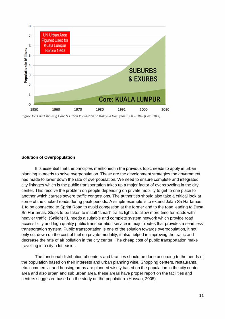
Figure 15: Chart showing Core & Urban Population of Malaysia from year 1980 – 2010 (Cox, 2013)
Solution of Overpopulation
It is essential that the principles mentioned in the previous topic needs to apply in urban
planning in needs to solve overpopulation. These are the development strategies the government
had made to lower down the rate of overpopulation. We need to ensure complete and integrated
city linkages which is the public transportation takes up a major factor of overcrowding in the city
center. This resolve the problem on people depending on private mobility to get to one place to
another which causes severe traffic congestions. The authorities should also take a critical look at
some of the choked roads during peak periods. A simple example is to extend Jalan Sri Hartamas
1 to be connected to Sprint Road to avoid congestion at the former and to the road leading to Desa
Sri Hartamas. Steps to be taken to install "smart" traffic lights to allow more time for roads with
heavier traffic. (Salleh) KL needs a suitable and complete system network which provide road
accessibility and high quality public transportation service in major routes that provides a seamless
transportation system. Public transportation is one of the solution towards overpopulation, it not
only cut down on the cost of fuel on private modality, it also helped in improving the traffic and
decrease the rate of air pollution in the city center. The cheap cost of public transportation make
travelling in a city a lot easier.
The functional distribution of centers and facilities should be done according to the needs of
the population based on their interests and urban planning wise. Shopping centers, restaurants,
etc. commercial and housing areas are planned wisely based on the population in the city center
area and also urban and sub urban area, these areas have proper report on the facilities and
centers suggested based on the study on the population. (Hassan, 2005)
12
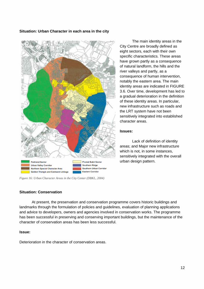
Situation: Urban Character in each area in the city
The main identity areas in the
City Centre are broadly defined as
eight sectors, each with their own
specific characteristics. These areas
have grown partly as a consequence
of natural landform, the hills and the
river valleys and partly, as a
consequence of human intervention,
notably the eastern area. The main
identity areas are indicated in FIGURE
3.6. Over time, development has led to
a gradual deterioration in the definition
of these identity areas. In particular,
new infrastructure such as roads and
the LRT system have not been
sensitively integrated into established
character areas.
Issues:
Lack of definition of identity
areas; and Major new infrastructure
which is not, in some instances,
sensitively integrated with the overall
urban design pattern.
Situation: Conservation
At present, the preservation and conservation programme covers historic buildings and
landmarks through the formulation of policies and guidelines, evaluation of planning applications
and advice to developers, owners and agencies involved in conservation works. The programme
has been successful in preserving and conserving important buildings, but the maintenance of the
character of conservation areas has been less successful.
Issue:
Deterioration in the character of conservation areas.
Figure 16: Urban Character Areas in the City Center (DBKL, 2004)
13
Solution:
The character of the older urban areas in the City Centre such as Chow Kit, Jalan Petaling, Jalan
Bukit Bintang, Bukit Ceylon and Pudu shall be preserved and the infrastructure and building quality
and general living and working environment upgraded. Conservation and preservation plans for
heritage areas will promote a pedestrian friendly ambience and maintain the rich diversity of street
pattern and building vernacular that these areas display.
Situation: Architectural Character:
The rapid recent growth of the City has resulted in many exciting new developments with a wide
range of architectural expression. However, the developments have often been insensitive to their
context and have not integrated successfully with the surroundings. This lack of harmony and
awkward juxtaposition of buildings is particularly noticeable at street level.Many of the new high-
rise buildings also pay scant regard to the tropical climate or take appropriate measures to
conserve building energy. Architectural expression is, with a few notable exceptions, neither
evocative of Malaysia’s cultural • background nor its tropical environment.
Issue:
Unsympathetic intrusion of new development into traditional character areas and the awkward
juxtaposition of new development in relation to each other and existing development; and design of
many new buildings is not sympathetic to the climate.
Solution:
To maintain and accentuate important views, building height controls shall be adopted that, as a
general principle, start at low rise from the edge of the City Centre and rising towards the centre.
14
References
Arturo, S. (N.d.). Worldbank Group Publication: Guidance Note On Tools For Pollution
Management. 1ed. Retrieved April 21, 2015, from Getting to Green—A Sourcebook of
Pollution Management:
http://siteresources.worldbank.org/INTRANETENVIRONMENT/Resources/244351-
1279901011064/GovLandUsePlanning.pdf
DBKL. (2004). Kuala Lumpur Structure Plan 2020 : a world class city. Kuala Lumpur: Kuala
Lumpur : Dewan Bandaraya Kuala Lumpur.
Get to Know Merdeka Square, Kuala Lumpur, Malaysia. (2015, May 14). Retrieved from
Microscopasia Journal: http://www.microscopasia.com/2013/04/get-to-know-merdeka-
square-kuala-lumpur.html
Hashim, M., & Hanisah, N. (2012). University of Sheffield: Factors affecting tree retention in
developing sites in Kuala Lumpur, Malaysia. Retrieved 5 9, 2015, from E-theses online
service: http://ethos.bl.uk/OrderDetails.do?uin=uk.bl.ethos.554393
Hassan, A. S. (2005). Reka bentuk bandar di Semenanjung Malaysia : Kuala Lumpur dan bandar
baru di sekitarnya. Pulau Pinang: Universiti Sains Malaysia.
Kogler, G. (2003, April). Kuala Lumpur Sultan Abdul Building. Retrieved from Wikimedia
Commons:
http://commons.wikimedia.org/wiki/File:Kuala_Lumpur_Sultan_Abdul_Building.jpg#filehi
story
Ministry of Science, T. a. (2015, 05 14). Haze. Retrieved from Official Website: Malaysian
Meteorological Department (MetMalysia):
http://www.met.gov.my/index.php?option=com_content&task=view&id=70&Itemid=160
TAN, B. (2015, May 14). Urban geology of Kuala Lumpur and Ipoh, Malaysia. Retrieved from
IAEG2006 Paper number 24: http://iaeg2006.geolsoc.org.uk/cd/PAPERS/IAEG_024.PDF


![Terjemahan Konvensi Hak Penyandang as [Compiled-proofread]-Rev 280411](https://img.pdfslide.net/doc/110x75/5572008f49795991699fa6d7/terjemahan-konvensi-hak-penyandang-as-compiled-proofread-rev-280411.jpg)