Embed Size (px)
Citation preview

Interactive Rendering and Stylization of Transportation Networks using Distance Fields
Matthias Trapp, Amir Semmo, Jürgen DöllnerHasso Plattner Institute, University of Potsdam, Germany

INTRODUCTION

Towards Cartography-oriented Stylization

Paris Street Map – 1780
P1: contour lines surround fine-textured fills or solid colors to add visual contrast and improve figure-ground perception
P2: primary streets overlap secondary or tertiary streets in hierarchical representations of street networks; wavy or fuzzy to express uncertainty
P3: names follow principal line directions and are placed within streets or outside line segments

London Street Map – 1913

London Underground Map – 1933

Modern Tourist Map of Paris
P7: yellow established as a conventional color tone for main streets, with a discrete gradation towards grey and white shading for tertiary roads
P6: streets are tinted using qualitative color schemes to represent street classes and distinguish them from the underlying terrain
P5: a hierarchy of emphasis is drawn among reference elements, such as different line weights and colors to portray different grades of roads
P4: dynamic filtering and scaling of geometric features improves perception of roads at high view distances and avoids cluttering.
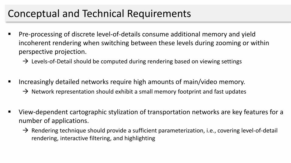
Conceptual and Technical Requirements
Pre-processing of discrete level-of-details consume additional memory and yield incoherent rendering when switching between these levels during zooming or within perspective projection.
Levels-of-Detail should be computed during rendering based on viewing settings
Increasingly detailed networks require high amounts of main/video memory.
Network representation should exhibit a small memory footprint and fast updates
View-dependent cartographic stylization of transportation networks are key features for a number of applications.
Rendering technique should provide a sufficient parameterization, i.e., covering level-of-detail rendering, interactive filtering, and highlighting

RELATED WORK

Related Work :: Overview
Street Rendering Approaches
Object-space Approaches
Geometry-based Approach
Texture-based Approach
Screen-Space Approaches
Stencil-based Approach
Discard-based Approach

Geometry-based Approach
Basic Principle:
Pre-compute geometry at different LoD
Forward rendering geometry
Most flexible approach w.r.t. stylization
Limitations:
High memory consumptions for complex networks
No transitions between static LoD
High rendering costs

Texture-based Approach
„Interactive 3D Visualization of Vector Data in GIS”O. Kersting, J. Döllner, ACM GIS 2002
Basic Principle:
Generate texture trees from geometry
Off-screen rendering at different resolutions
Use for texturing during scene rendering
Limitations:
Relies on data pre-processing
Requires intermediate representation
Suffers from texturing artifacts

Stencil-based Approach
„High-Quality Cartographic Roads on High-Resolution DEMs” M. Vaaraniemi, M. Treib, R. Westermann, WSCG Journal 2011
Basic Principle:
Generate shadow volume per street segment
Avoid cracks between segments using cap cones
Enables distance-based scaling of street segments
Rendering using shadow volume approach
Limitations:
Requires additional data structure (volumes)
Limited styling capabilities (color + outline)

Discard-based Approach
„A screen-space approach to rendering polylines on terrain”D. Ohlarik, P. Cozzi; SIGGRAPH Poster 2011
Basic Principle:
Extrude polylines to walls
Compute intersection with terrain
Discard fragments accordingly
Avoid dashing and smearing
Limitations:
Stylization with single color only
No distance-dependent segment width

Distance-fields for Stylization Parametrization
„ Real-Time Rendering of Water Surfaces with Cartography-Oriented Design” A. Semmo, J. E. Kyprianidis, M. Trapp, J. Döllner; CAe 2014

APPROACH

Overview of Approach
Forward Rendering Pass Deferred Rendering Pass

Open Street Map (OSM) Data Representation

Overview of Distance-Field Generation
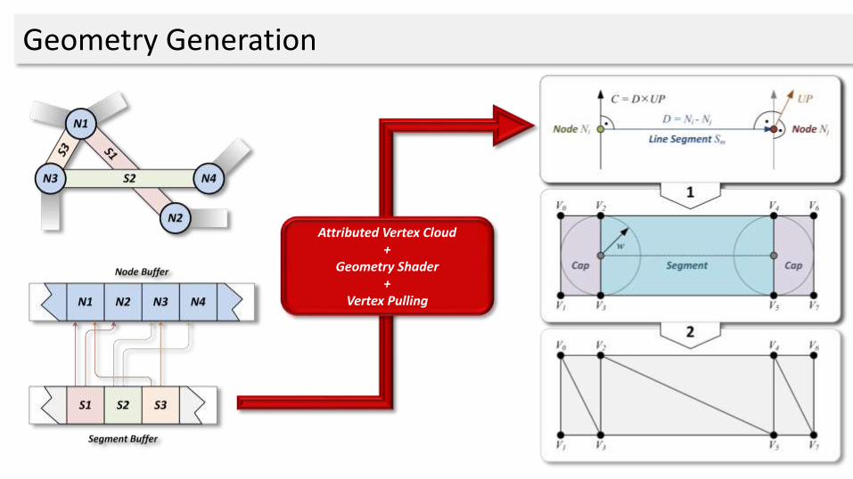
Geometry Generation
Attributed Vertex Cloud+
Geometry Shader+
Vertex Pulling
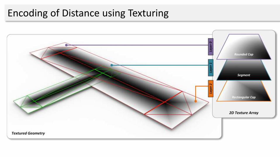
Encoding of Distance using Texturing

dresult = min(dsource , ddestination)
Blending Modes
No Blending Min-Blending
Distance Field Colored Distance Field Colored

Result: 2D Texture-Array
Memory consumptions: #layer width height precision (3 * 32 Bit = 12 Byte)

Evaluation of Distance Fields :: Procedural Textures
Procedural textures evaluated on a per-fragment basis:
Deferred texturing based on distance fields
Application of procedural and image textures possible
Bottom-up compositing based on street rank
“Improved Alpha-Tested Magnificationfor Vector Textures and Special Effects”Chris Green; SIGGRAPH 2007

Final Compositing Step
Bottom-up evaluation of each layer (street category) and blending

RESULTS & DISCUSSION

Application Examples :: Distance-based Evaluation

Application Examples :: Stylization Variants

Application Examples :: Regions-of-Interest

Application Examples :: Regions-of-Interest

Performance Evaluation
Test data sets of different complexityfrom Open Street Map (OSM) data base
Approach is fill-limited w.r.t. number ofstreet categories to render
ID Data Set # Nodes #Ways
A Berlin 1 5571 1028
B Istanbul 2004 263
C Berlin 2 9502 1766
A B C A B C A B C
390 x 260 670 x 450 1280 x 800
1 Category 3 2.9 3 3 2.9 3 25.5 25.4 25.3
2 Categories 3.2 3.3 3.4 3.2 3.3 3.4 29 29 29.2
4 Categories 4.1 4.1 4.2 4.1 4.2 4.2 36.1 26.2 36.2
8 Categories 5.5 5.4 5.5 5.7 5.6 5.8 50.1 50.1 50.2
0
10
20
30
40
50
60
Mill
ise
con
ds

Limitations
Distance-field generation:
Intrusion
Protrusion
Memory consumptions for large numbers of categories
Intrusion
Protrusion

Future Work :: Geometry Draping
Draping
Digital Elevation Model Result
Planar Network Geometry

Future Work :: Geometries
Generate alternative geometric representations
View-dependent adaptation of geometric representations

Conclusions
A concept for high-quality cartographic rendering exemplifiedfor complex street networks.
Interactive hardware-accelerated rendering technique havingminimal memory footprint for network representation.
Interactive stylization and colorization using deferred texturingbased on distance fields generated on per-frame basis
Potentials for future research

Questions & Comments ?
Contact:
Matthias Trapp / [email protected]
Amir Semmo / [email protected]
Jürgen Döllner / [email protected]
Publications: www.4dndvis.de/publikationen.html
This work was funded by the Federal Ministry of Education and Research (BMBF), Germany within the InnoProfile Transfer research group "4DnD-Vis".

Interactive Rendering and Stylization of Transportation Networks using Distance Fields
Matthias Trapp, Amir Semmo, Jürgen DöllnerHasso-Plattner-Institut, University of Potsdam, Germany


![Volume Rendering 1.1. Introductioncs880/visualization/Celebi-Volume Rendering.pdf · rendering is the process of displaying scalar fields [1]. It is a method for visualizing a three](https://img.pdfslide.net/doc/110x75/5f3f7728a6ef6e363609ed21/volume-rendering-11-cs880visualizationcelebi-volume-renderingpdf-rendering.jpg)