Embed Size (px)
Citation preview
Low carbon as a critical element in
landscape regional infrastructure
Anastasia Nikologianni, Professor Kathryn Moore and Professor Peter Larkham
This paper explores how two entries in the 2014 Wolfson Prize competition for
new garden city proposals dealt with issues of “low carbon” at the scale of a
garden city.
Originally presented at the conference “Planning for sustainable urban form”,
Swedish School of Planning, Blekinge Institute of Technology, Karlskrona, 2014
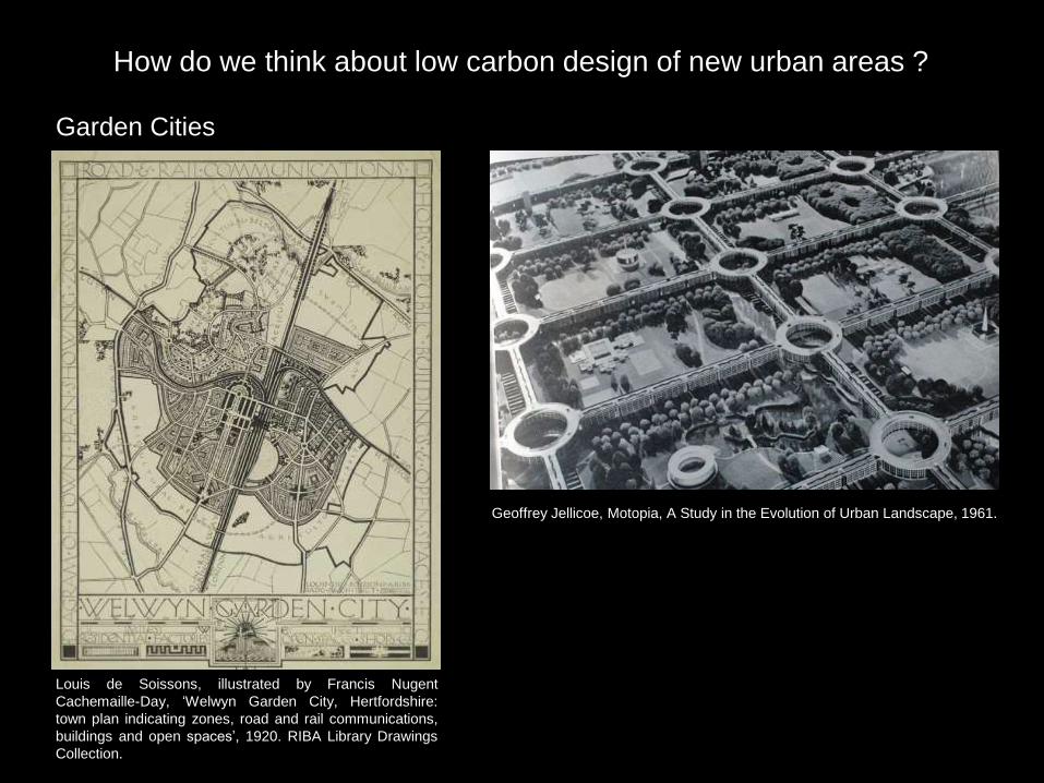
How do we think about low carbon design of new urban areas ?
Garden Cities
Louis de Soissons, illustrated by Francis Nugent
Cachemaille-Day, ‘Welwyn Garden City, Hertfordshire:
town plan indicating zones, road and rail communications,
buildings and open spaces’, 1920. RIBA Library Drawings
Collection.
Geoffrey Jellicoe, Motopia, A Study in the Evolution of Urban Landscape, 1961.
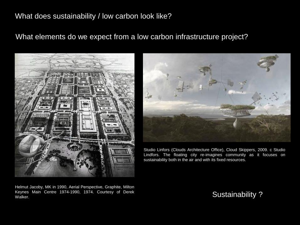
Sustainability ?
What does sustainability / low carbon look like?
What elements do we expect from a low carbon infrastructure project?
Helmut Jacoby, MK in 1990, Aerial Perspective, Graphite, Milton
Keynes Main Centre 1974-1990, 1974. Courtesy of Derek
Walker.
Studio Linfors (Clouds Architecture Office), Cloud Skippers, 2009. c Studio
Lindfors. The floating city re-imagines community as it focuses on
sustainability both in the air and with its fixed resources.

Garden Cities: The Wolfson Economics Prize 2014
Uxcester Garden City / Urbed Stoke Harbour Garden City, Hoo Peninsula,
Medway, Kent / Shelter & PRP
How would you deliver a new Garden City which is visionary, economically viable, and
popular?
‘’…Whatever is built has to be inspirational, has to inspire people to want to build it. I would
like to live there. …’’ Lord Wolfson - Wolfson’s Economics Prize 2014 Launch event
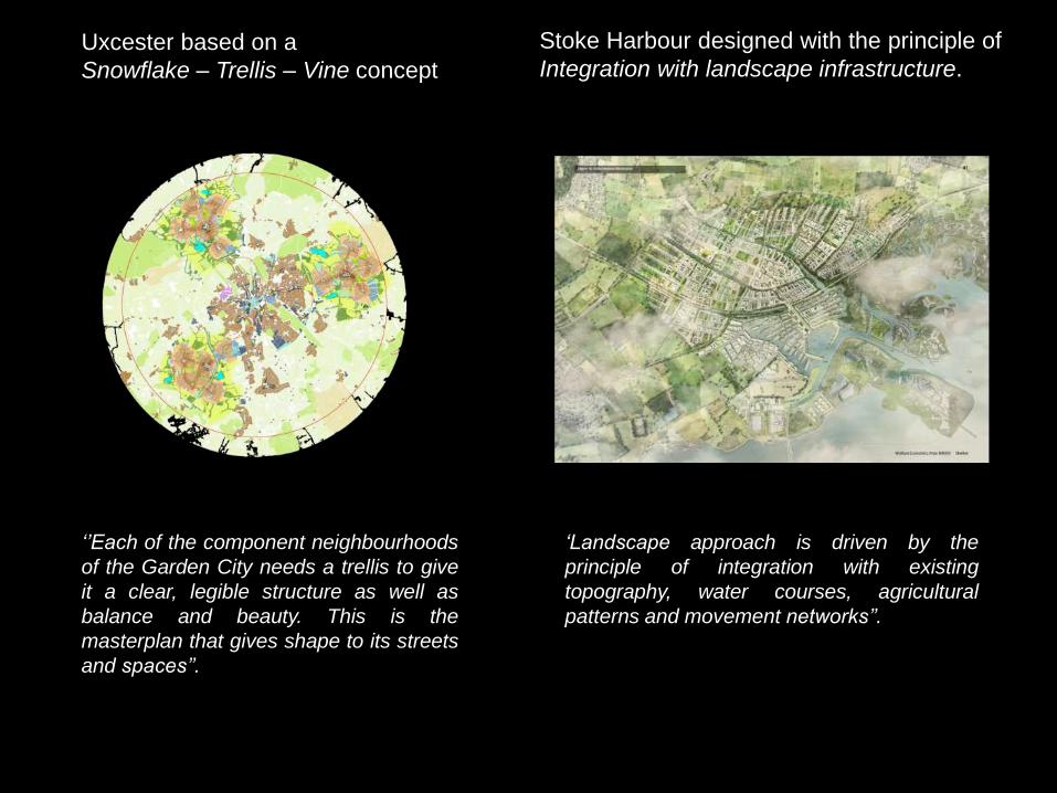
Uxcester based on a
Snowflake – Trellis – Vine concept
Stoke Harbour designed with the principle of
Integration with landscape infrastructure.
‘’Each of the component neighbourhoods
of the Garden City needs a trellis to give
it a clear, legible structure as well as
balance and beauty. This is the
masterplan that gives shape to its streets
and spaces’’.
‘Landscape approach is driven by the
principle of integration with existing
topography, water courses, agricultural
patterns and movement networks’’.

Uxcester based on a
Snowflake – Trellis – Vine concept
Stoke Harbour designed with the principle of
Integration with landscape infrastructure.
1Ha of green areas for every Ha of built infrastructure
Economically vital Access a huge area of countryside
that was private Sustainable neighbourhoods Walking/cycling routes and public
transport Avoid flood plains Self build housing Renewable energy schemes
40% green space Own economic purpose Access to green areas, parks, tree
avenues, allotments, orchards Polycentric city / neighbourhoods /
walkable distances Walking/ Cycling routes and public
transport Water a defining feature / flood defence Self build housing Grid for renewable energy

Stoke Harbour Garden City
Hoo Peninsula, Medway, Kent
Water Strategy
Swales: Sustainable urban
drainage (Low Carbon)
Swales and rain gardens/
Designed for flood defence
or drought
Valley water courses
Interaction
with the riverHarbour at low-lying
brown field land
Harbour is a buffer to sensitive
areas and flood defence
mechanism (Low Carbon)
All districts close to
water edge
Irregular water
not repetitive
Use canals to link
the heart of the city
with the harbour
Integration with the topography
Water: Defining feature
Uses together with green strategy to define districts
Water in districts. Use it
to power energy
Water links

Stoke Harbour Garden City
Hoo Peninsula, Medway, Kent
Green Strategy
Linear Parks and green network Increase O2, Decrease CO2 (Low Carbon)
Tree lined avenues
Orchards/Allotments
Local production
(Low carbon)
Irregular green (again)
Not repetitive
All districts close
to green edgeUse green routes to link the
heart of the city with the
countryside
Green links to the Countryside

Stoke Harbour Garden City
Hoo Peninsula, Medway, Kent
NeighbourhoodsWalkable districts
Less use of car, minimizing CO2
emissions (Low Carbon)
Polycentric City
Polycentric city
Divided to neighbourhoods
Each centre connected
with two more nearby
All centres around 800m
away from the main city
centre
Stoke Harbour Garden City
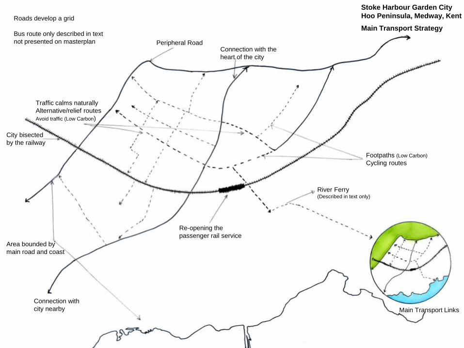
Hoo Peninsula, Medway, Kent
Main Transport Strategy
Connection with the
heart of the city
Peripheral Road
Roads develop a grid
Bus route only described in text
not presented on masterplan
Traffic calms naturally
Alternative/relief routes
Avoid traffic (Low Carbon)
City bisected
by the railway
Area bounded by
main road and coast
Connection with
city nearby
Re-opening the
passenger rail service
River Ferry (Described in text only)
Footpaths (Low Carbon)
Cycling routes
Main Transport Links

Stoke Harbour Garden City
Hoo Peninsula, Medway, Kent
Green Analysis
Public and private
green spaces
Linear parks
Link public spaces
All the areas and
buildings have access to
green space (Low Carbon)
Dense green
infrastructure
40% Green Spaces
Less dense
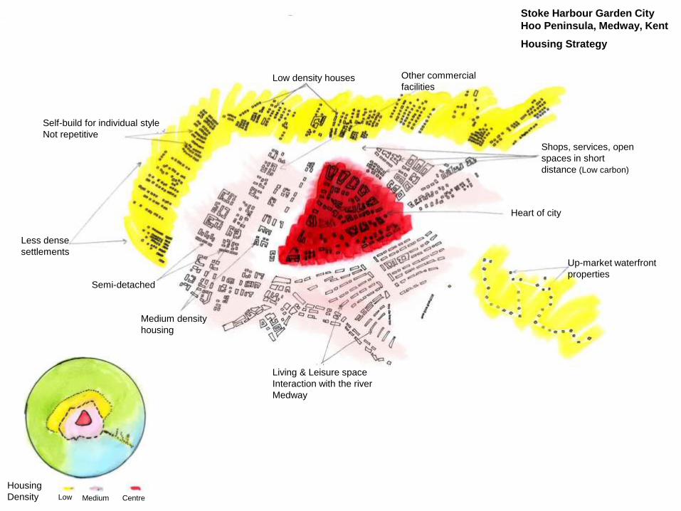
Stoke Harbour Garden City
Hoo Peninsula, Medway, Kent
Housing Strategy
Low density houses Other commercial
facilities
Self-build for individual style
Not repetitive
Less dense
settlements
Semi-detached
Medium density
housing
Living & Leisure space
Interaction with the river
Medway
Up-market waterfront
properties
Heart of city
Shops, services, open
spaces in short
distance (Low carbon)
Housing
Density Low Medium Centre

Stoke Harbour Garden City
Hoo Peninsula, Medway, Kent
Structure of the Settlement
District heating (Low carbon)
Savings in carbon emissions
Low Carbon Infrastructure for
energy suggested in text
Where is this evident in masterplan?
Why Grid?
Easier to integrate
the different grids
Power station
Movement Grid
Green Grid
Blue Grid
Energy Grid
Grid strategy

Country parks at
the edge of every
extension (Repetitive)
No green
strategy that
links with the
heart of the city
Smaller parks between the
neighbourhoods (Repetitive in all the
extensions)
However all neighbourhoods
have parks nearby (close to
nature concept)
Decrease CO2 (Low Carbon)
Green Strategy around the new extensions
Green areas
New green areas
around the extensions
Parks between the
neighbourhoods
Uxcester Garden City
Green Strategy
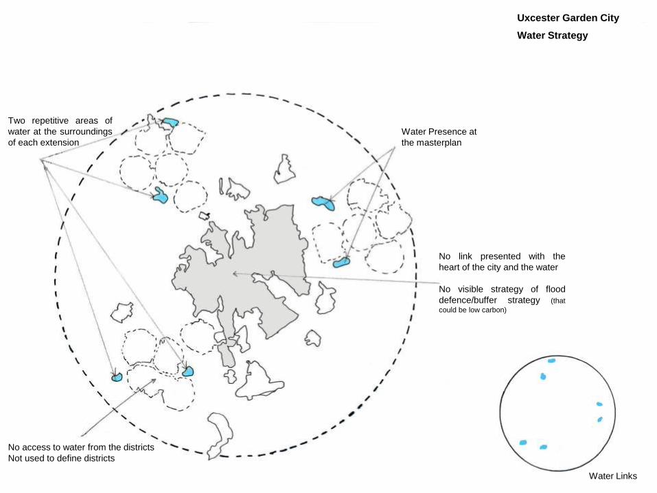
Uxcester Garden City
Water Strategy
Water Presence at
the masterplan
Two repetitive areas of
water at the surroundings
of each extension
No link presented with the
heart of the city and the water
No visible strategy of flood
defence/buffer strategy (that
could be low carbon)
No access to water from the districts
Not used to define districts
Water Links
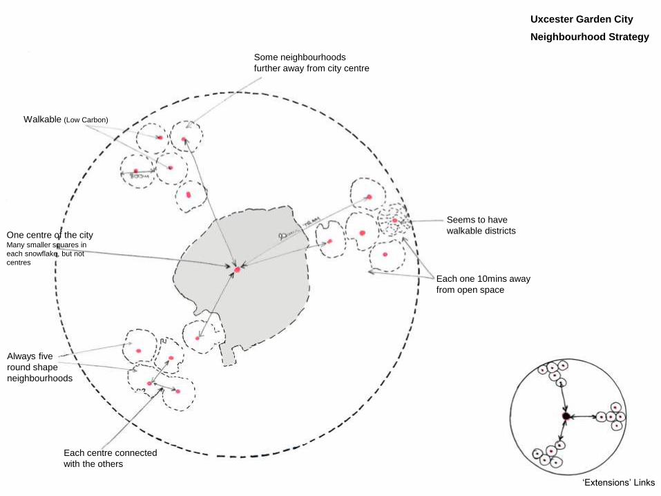
Uxcester Garden City
Neighbourhood Strategy
Some neighbourhoods
further away from city centre
Walkable (Low Carbon)
One centre of the cityMany smaller squares in
each snowflake, but not
centres
Always five
round shape
neighbourhoods
Each centre connected
with the others
Seems to have
walkable districts
Each one 10mins away
from open space
‘Extensions’ Links

Uxcester Garden City
Main Transport Strategy
All the neighbourhoods have to go through
the same road to visit city centre
Congestion/no Low Carbon
Neighbourhoods follow the
trellis for road development
One main
motorway
towards the city
Congestion ?
Links to the country parksTram is proposed not
presented. Maybe is the
red line, but it is not clear
Walking and cycling
routes are not clear
Bus route is not shown
Main Road Infrastructure
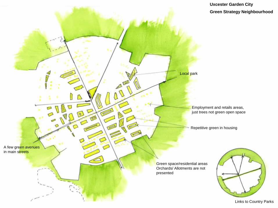
Uxcester Garden City
Green Strategy Neighbourhood
Local park
A few green avenues
in main streets
Employment and retails areas,
just trees not green open space
Repetitive green in housing
Green space/residential areas
Orchards/ Allotments are not
presented
Links to Country Parks

Drawing submitted in the final proposal
Uxcester Garden City
Housing Strategy
Is there a distinctive
difference?
No shopping. Only a
few in the periphery.
Main shops in the cityNo Low Carbon
Heart of
neighbourhood
All buildings repetitive
No employment between the
settlements
Employment on the outskirts
Housing Density
Low Medium Centre

Uxcester Garden City
Landscape Integration
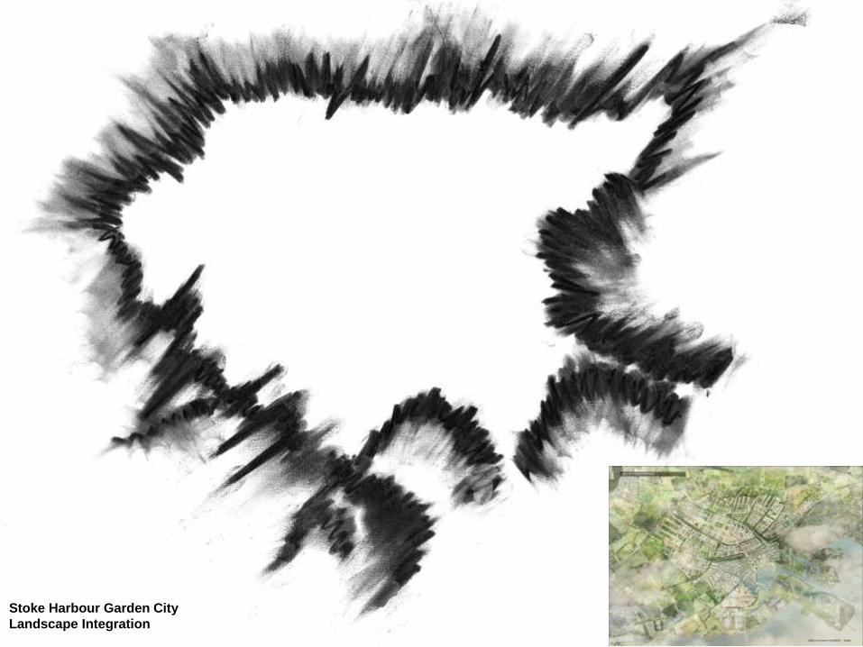
Stoke Harbour Garden City
Landscape Integration

Visualization of Uxcester
Visualization of Stoke Harbour
Modern housing
Green space on the outskirts
No water interaction
Walking and Cycling routes design, but
will they work without any motivation?
Water and green areas defining features
Allotments, orchards and open spaces as
part of the plan
Canals and swales designed for floods and
as a social attraction
Employment into the city
Motivation for low carbon life
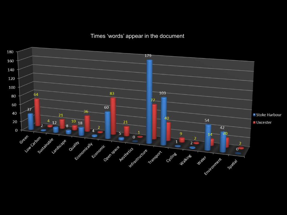
Times ‘words’ appear in the document

Next Steps
Interviews and workshops with designers
Analysis of more garden city designs upon the Wolfson Prize and
significant infrastructure projects
Exhibition as part of the methodology – two groups
Case study (visits)

Thank you for your attention