Embed Size (px)
Citation preview

Islamic Republic of Iran
Ministry of Energy
Water Consumption
(Evapo-Transpiration- ET)
Cairo, Oct. 2015
Presented by: B. Taheri, S.M. Nabavi & MousaviMr.
2
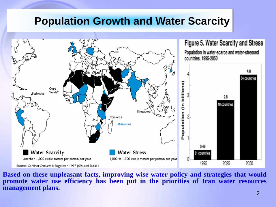
Based on these unpleasant facts, improving wise water policy and strategies that would promote water use efficiency has been put in the priorities of Iran water resources management plans.
Population Growth and Water Scarcity

3
0
2000
4000
6000
8000
10000
12000
14000
16000
1960 1990 2025
Year
Cub
ic M
eter
World
Iran
MENA
45 years ago: The available fresh water per capita in Iran was ½ of the world average in
the early years of 1960
15 years ago: The available fresh water per capital in Iran was 1/3 (one third) of the
worlds related average.
In next 20 years: The per capita of available fresh water in Iran would be ¼ (one
fourth) of the world’s related average.
Less than 10 years in the future Some parts of the country would be encountered
with somehow water crisis conditions.
The Available Fresh Water Per Capita

4
I.R. of IRAN Area: 1.648 million km2
Population: 75 million
No of provinces: 30
Average Rainfall: 250 mm
Neighboring Countries:
Afghanistan, Pakistan, Iraq Turkmenistan, Azerbaijan, Armenia,
Turkey Saudi Arabia
Oman
Kuwait
Qatar
Bahrain
U.A.Emirates
Iran Location

5
The country's population has increased about 8 times
during the last 80 years and it has got from 10 millions in
1920 to more than 78 millions in 2015. At present Iran is
the 17th most populated countries in the world and based
on the data presented in UN it will be classified as one of
the 10 most populated regions in the world by the end of
2050. Therefore the need for water has been increased
but still the quantity of water is not adequate.
Population Growth and Water Scarcity

6
The average annual precipitation is estimated to be 250 mm
and the range varies from 50 mm in some parts of the central
water basin to more than 1600 mm in some coastal areas
near the Caspian Sea. Meanwhile with respect to the average
annual precipitation in the world with average rainfall of
more than 830 mm, Iran is classified among the semi-arid
and arid countries. Still the main source of water resources
throughout the country is annual precipitation.
Precipitation

7
Precipitation Distribution

8
Water Resources Potentials and Related Issues
Six major water basins in IRAN
Major catchments Area (*103 Km2)
Caspian Sea 177
Persian Gulf 430
Oromieh Lake 53
Central 831
Hamoon 106
Sarakhs 44
Total 1641 Major catchment Basins location

9
Water Resources Potentials and Related Issues
Rate of precipitation in six major water basins
As % of total rainfall Rainfall (km³/year) Basin
32 138 Central Plateau
38 162 Persian Gulf and
Oman sea
19.5 83 Caspian Sea
3 12 Hamoun Lake
5 19 Orumie Lake
2.5 11 Serakhs
100 425 Total

Precipitation Statistics Comparison Between MOE and Meteorological Org.
A serious Reduction in Precipitation in the 7
Years, Ending on 2012

Temperature Measurement Stations

Mean Temperature Changes in Iran in Degrees Centigrade 1.1 Degrees Increase According to Records Ending in 2012

بريز كارون بزرگ تغييرات پتانسيل تجديد پذير حوضه ا

Long Term Water Cycle in Iran (BCM)
Renewable Water 130
Water Flowing towards the Country 13
Precipitation 400
Evaporation 283
Infiltration 25
Runoff 92
Remaining Water 117

Country water balance
Precipitation (400)
Evaporation (270)
)BCM)
Infiltration (13)
Consumption (44)
Evaporation (5.5)
Groundwater exploitation (61.2)
Consumption (52)
Infiltration from consumption (18.3)
Surface water (105)
Transboundry water (13)
Ground water recharge (56.5)
Average
reservoir deficit
from
groundwater (4.7)
Uncontrolled water (58)
Controlled water (31)
Environmental
water right volume (15)
Recharge of alluvial aquifers(25)
Under control water (21-22)
Release to the seas & boundaries (61.8) Rest of consumption,
ground drainage & output

16
Water Resources Potentials
400 BCM • Average annual precipitation
130 BCM • Renewable water resources
270 BCM • Average annual evaporation
92 BCM • Surface currents
38 BCM • Seepage to alluvial aquifers
According to studies carried out for formulation of the Iran Water Comprehensive Plan, the main characteristics of annual precipitation and its conversion to water resources are shown:
Annual Water Resources in Billion Cubic Meters (BCM)
Return Water from Consumption 29
Total 159

17
70
30
At present Iran is using 70% of the total renewable freshwater while due to the
international norms the upper limit should be 40% of renewable freshwater; it
means that the remaining unexploited renewable fresh water is only 30 % of
the total fresh water resources including environmental basic needs.
Fresh Water Consumption

Water Status in Iran
Access to safe and fresh water
Average Agriculture water consumption Agricultural
Land
Access to sanitation

19
Water Consumption at a Glance
0
20
40
60
80
100
1961 2005 2021
1 1.4 5
98.6 92.4
86
1.3 6.2 9
Pe
rce
nta
ge
Industry Agriculture Domestic


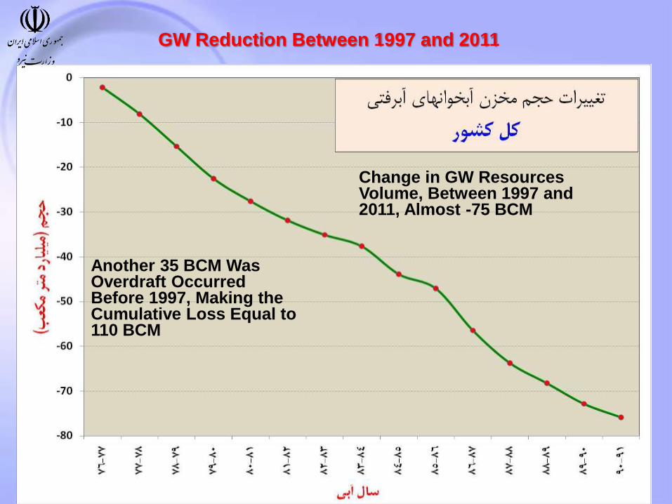
GW Reduction Between 1997 and 2011
Change in GW Resources Volume, Between 1997 and 2011, Almost -75 BCM
Another 35 BCM Was Overdraft Occurred Before 1997, Making the Cumulative Loss Equal to 110 BCM

ب زيرزميني به ذخيره تجديد شونده نسبت برداشت از ا
ماري طي دوره 1385تا 1345ا

همدان برق نیروگاه
هنگ همد ب زیر زمینی در دشت کبودرا
فروریزش زمین در اثر افت شدید سطح ا
ان

25
Storage and Diversion Dams
Irrigation and Drainage Networks
Urban Water, Wastewater and Sanitation
Hydropower
Infrastructure

Constructed
2150
Under
Construction 222
Ready for being
constructed
573
Under Study 346
Total 3291 Unit: 1000 ha.
Main Irrigation and Drainage Networks (ha.)
26

54
22 18
27
Between 50%-75%
Between 75%-100%
Between 25%-50%
Less than 25%
121 Dams
Number of Dams under construction in Iran Progress Percentage, 2014

Large Dams in Iran

29
Major Challenges and Trends in Iranian Water Resources Management
Unbalanced sequence between demand and supply of water resources
Excessive withdrawal of groundwater resources
Demand Management in accordance to priorities set in the National Water Plan
Assessment of total value and cost of water relevant to each basin
Pollution of water resources and its economic and environmental consequences
Efficiency in water irrigation systems
Risk Management of water related natural disasters ( i.e. drought and flood )
Implementation of National Integrated Water Resources Management
Efficient and equitable water price for various uses
Land use planning
Unaccounted for water (UFW)

30
Water Consumption Vision
Population
90 million
Consumption increase due to urbanization and
improved welfare
Water Demand
5.1~3.12005
2020 WD
WD
water more bcm 30 need We

31
What Should be Done for the
Fresh Water Future
Improvement of Water efficiency
Increasing the Storage Capacity
Modern Water Harvesting Methods
Water & Wastewater Recycling

32
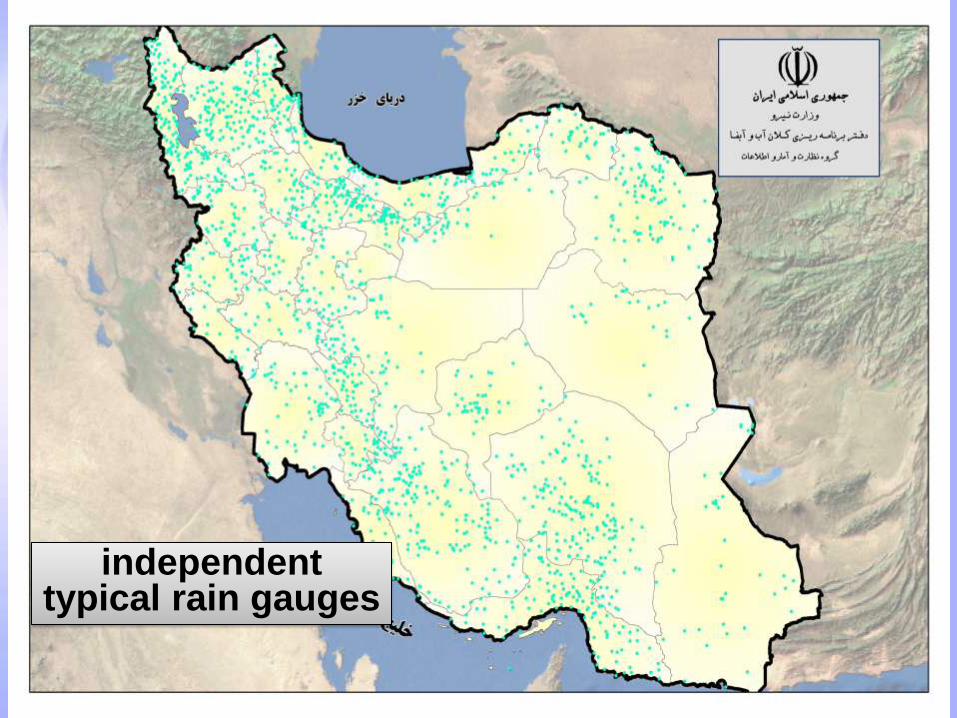
Quality and quantity of surface and groundwater monitoring stations of the Ministry of Energy
1165 hydrometric stations
679 evaporative stations
1398 independent typical rain gauges
339 rain gauge stations
314 snow survey stations
1247 water quality measurement stations
1020 measuring stations for suspended sediment load
13621 observation wells
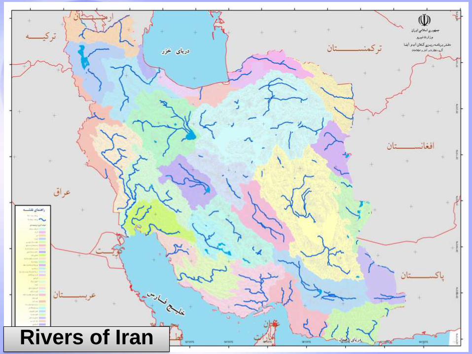
33 Rivers of Iran
34
independent typical rain gauges

35
Recorder and Storage Rain
gauges

36
Evaporation
Measurement stations

37
hydrometric stations

38
1. Which Institutions Are Responsible for the Collection of Routine Weather
Data?
I.R. of Iran Meteorological Organization and its provincial offices (weather data)
Ministry of energy and its provincial Water Management Bureaus (rainfall, evaporation , hydrometric data)

39
2. Is there a Central Processing and Publication of Reference ET in Place?
Not Exactly a Single Center! Several Organizations Do This Separately and Collaborate with Each Other!
Iran Meteorological Organization
Ministry of Agriculture, in a limited number of research pilot fields
Ministry of Energy (and Water Resources), measures Evaporation Data through Pan Evaporation in more than 700 stations nationwide

40
3. What are the Institutions (if any) in the Country that
Provide Remote Sensing (RS) Data (Particularly ET and/or Related Parameters) to the Agencies of
Agriculture, Water Resources and Environment?
Iranian Remote Sensing Center, which provides RS maps of different types including ET maps
Ministry Of I.C.T
Iranian Space Agency
However, this is a new area of activity which needs further strengthening, organizational improvements and coordination not only in the national level, but also in the regional and international levels.

41
4. What are the Major On-going Programmes/projects for RS ET(and/or related parameters) Determination?
Ministry of Energy:
An ongoing pilot project has started in Zayandehrud River’s basin in Central Province of Isfahan, for conducting “Watershed Level, Water Resources Monitoring” under the supervision of Central Water and Wastewater Management Authority of the MOE in the Water Research Institute (also a subsidiary of the MOE), using satellite images

42
5. What are the Spatial Resolutions of the RS ET maps (Pixel Size in meters) ?
MODIS Sat. with a resolution of 500-1000 m
Land Sat. with a resolution of 30 m
Covered Area: All the Country
Pilot Area: Zayandehrud Watershed

6. What are the Temporal Resolutions of
the RS ET maps (Frequency in Days) ?
MODIS Sat. twice a day
Land Sat. once every 16 days
Covered Area: All the Country
Pilot Area: Zayandehrud Watershed
43

44
7. What is the Surface Area (in ha) Covered by RS (or in % of the Total Area)
While the available maps cover the entire country, the ongoing pilot project covers the Zayandehrud Watershed
Total Area in ha: 41,503 Km2 (4,150,300 ha)
As a % of total land: 2.52% of 1,648,195 Km2 of the country’s land mass.
16,649 Km2 mountainous, 24,854 Km2 plains
Rainfall from 1400 mm to 50 mm

8. What do you think is missing to have a complete
operational RS ET I the country and how the regional
collaborative platform can help?
45

46
Thank you for your attention


![Estimation of Reference Melon Crop-Evapo- transpiration ...anale-ing.uem.ro/2015/35.pdf · o[Pan-Fao/Penman] and Cropwat Models Aiming at contributing to an adequate management of](https://img.pdfslide.net/doc/110x75/5e1960d2c4712f60c22399e6/estimation-of-reference-melon-crop-evapo-transpiration-anale-inguemro201535pdf.jpg)