Embed Size (px)
Citation preview
Akrur Singh Mahat
070MSD/352
Supervisor
Prof. Dr. Jiba Raj Pokharel
Ast. Prof. Inu Pradhan Salike
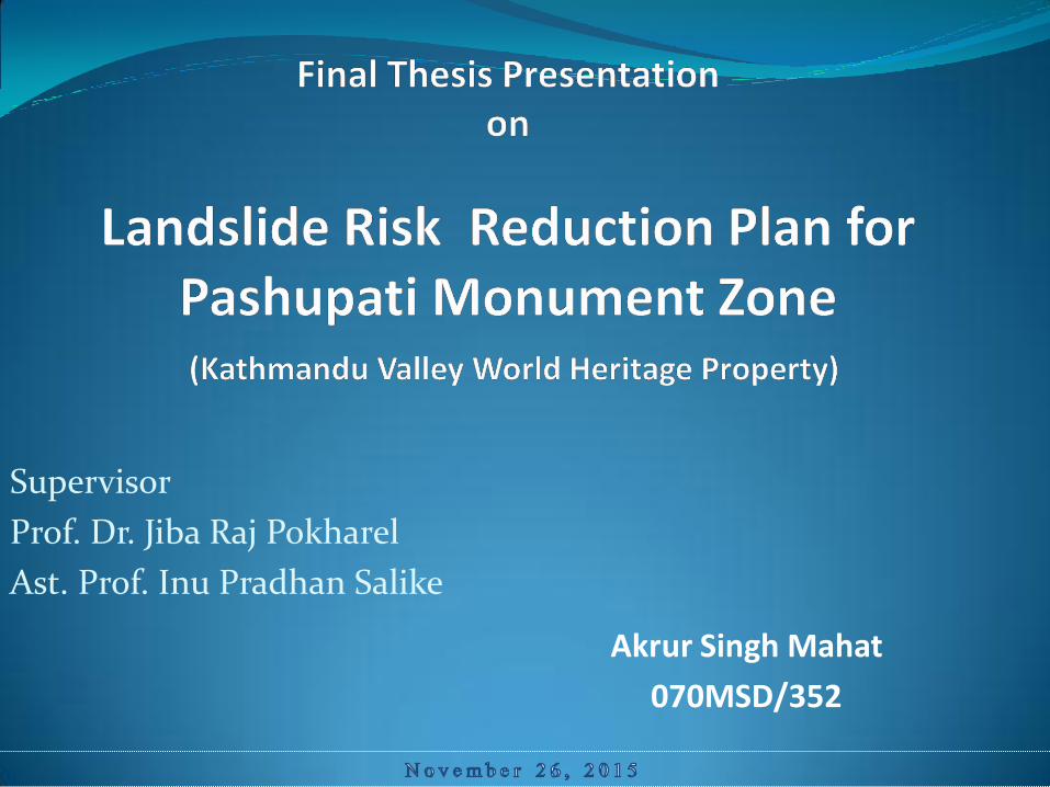
Introduction Study Area :
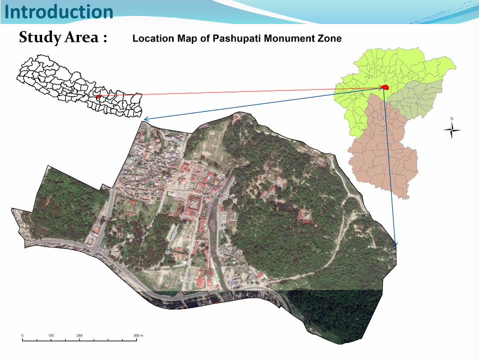
Rationale of the Study
Landslide hazard change,degrade,destroy heritage site-adverse Impact to OUV
High Frequency of landslide occurrence in PMZ.
Most of the Damage Monuments around the Landslide Area.
Human induce and Natural Cause both present
No Landslide study/Risk Reduction Plan
Risk to inscribe the Kathmandu Valley on the List of World Heritage in Danger.
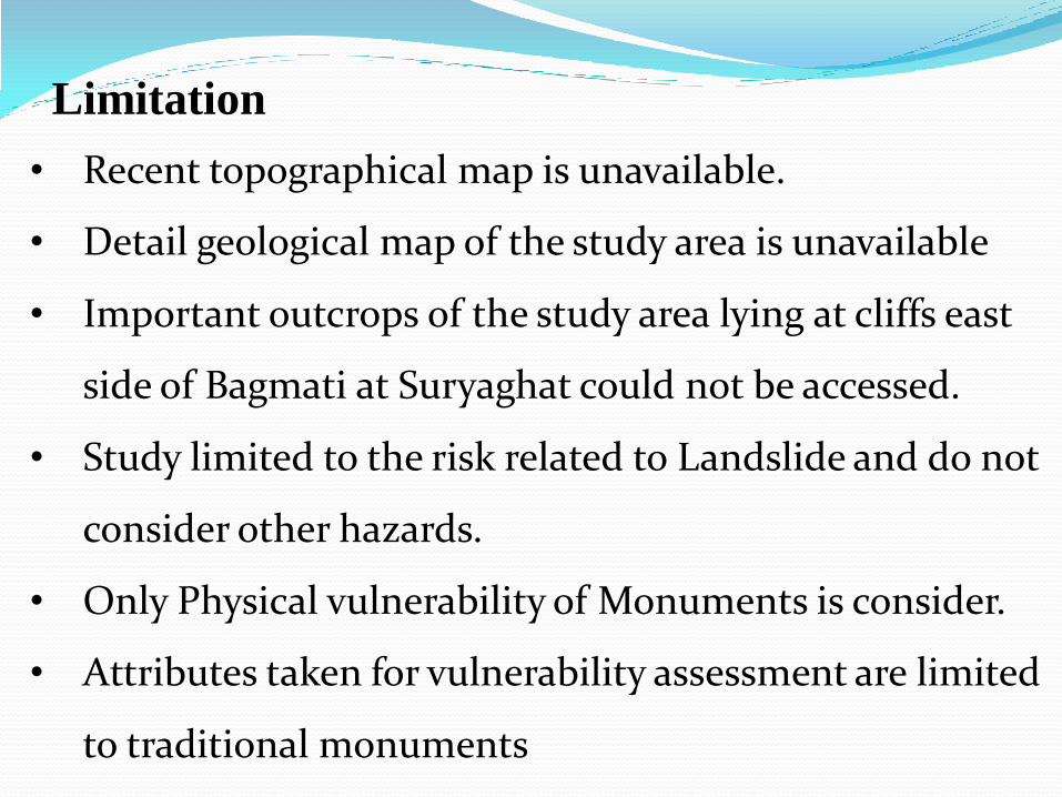
Limitation
• Recent topographical map is unavailable.
• Detail geological map of the study area is unavailable
• Important outcrops of the study area lying at cliffs east
side of Bagmati at Suryaghat could not be accessed.
• Study limited to the risk related to Landslide and do not
consider other hazards.
• Only Physical vulnerability of Monuments is consider.
• Attributes taken for vulnerability assessment are limited
to traditional monuments
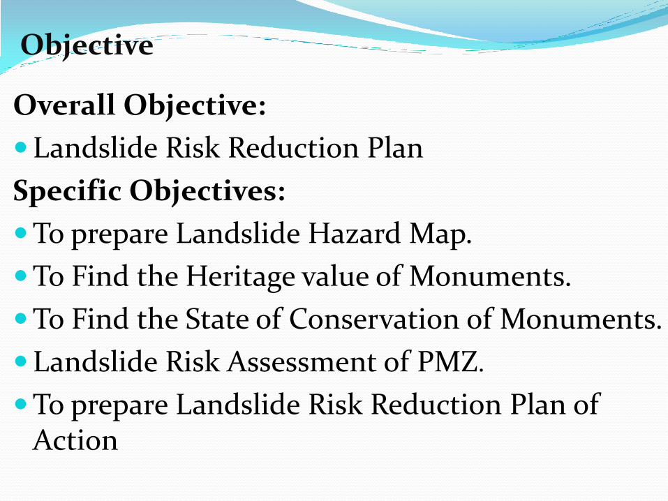
Objective
Overall Objective:
Landslide Risk Reduction Plan
Specific Objectives:
To prepare Landslide Hazard Map.
To Find the Heritage value of Monuments.
To Find the State of Conservation of Monuments.
Landslide Risk Assessment of PMZ.
To prepare Landslide Risk Reduction Plan of Action
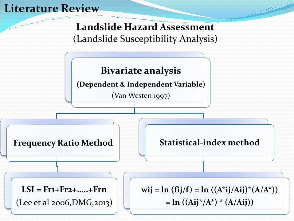
Literature Review
Landslide Hazard Assessment (Landslide Susceptibility Analysis)
Bivariate analysis
(Dependent & Independent Variable)
(Van Westen 1997)
Frequency Ratio Method
LSI = Fr1+Fr2+…..+Frn
(Lee et al 2006,DMG,2013)
Statistical-index method
wij = ln (fij/f) = ln ((A*ij/Aij)*(A/A*))
= ln ((Aij*/A*) * (A/Aij))
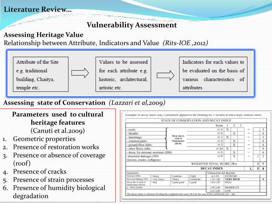
Literature Review…
Assessing state of Conservation (Lazzari et al,2009)
Assessing Heritage Value Relationship between Attribute, Indicators and Value (Rits-IOE ,2012)
Vulnerability Assessment
Parameters used to cultural heritage features (Canuti et al.2009)
1. Geometric properties 2. Presence of restoration works 3. Presence or absence of coverage
(roof) 4. Presence of cracks 5. Presence of strain processes 6. Presence of humidity biological
degradation
Literature Review…
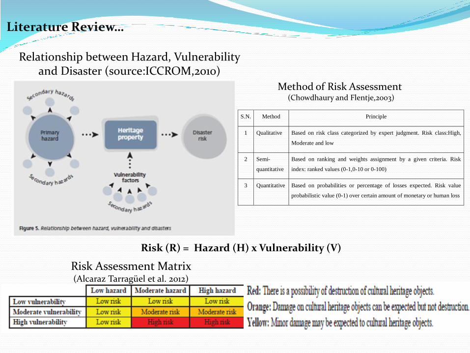
Relationship between Hazard, Vulnerability and Disaster (source:ICCROM,2010)
Risk (R) = Hazard (H) x Vulnerability (V)
S.N. Method Principle
1 Qualitative Based on risk class categorized by expert judgment. Risk class:High,
Moderate and low
2 Semi-
quantitative
Based on ranking and weights assignment by a given criteria. Risk
index: ranked values (0-1,0-10 or 0-100)
3 Quantitative Based on probabilities or percentage of losses expected. Risk value
probabilistic value (0-1) over certain amount of monetary or human loss
Method of Risk Assessment (Chowdhaury and Flentje,2003)
Risk Assessment Matrix (Alcaraz Tarragüel et al. 2012)
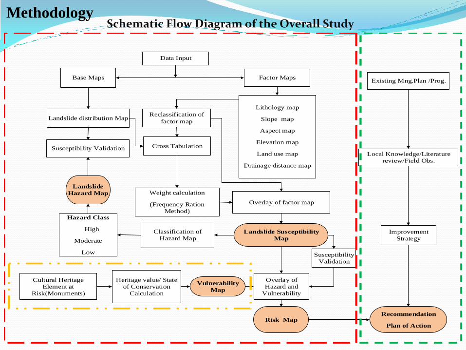
Methodology
Base Maps Factor Maps
Lithology map
Slope map
Aspect map
Elevation map
Land use map
Drainage distance map
Landslide distribution Map
Cross Tabulation
Weight calculation
(Frequency Ration
Method)
Overlay of factor map
Landslide Susceptibility
Map
Classification of
Hazard Map
Hazard Class
High
Moderate
Low
Landslide
Hazard Map
Susceptibility Validation
Data Input
Risk Map
Cultural Heritage
Element at
Risk(Monuments)
Heritage value/ State
of Conservation
Calculation
Vulnerability
Map
Recommendation
Plan of Action
Local Knowledge/Literature
review/Field Obs.
Existing Mng.Plan /Prog.
Improvement
Strategy
Overlay of
Hazard and
Vulnerability
Reclassification of
factor map
Susceptibility
Validation
Schematic Flow Diagram of the Overall Study
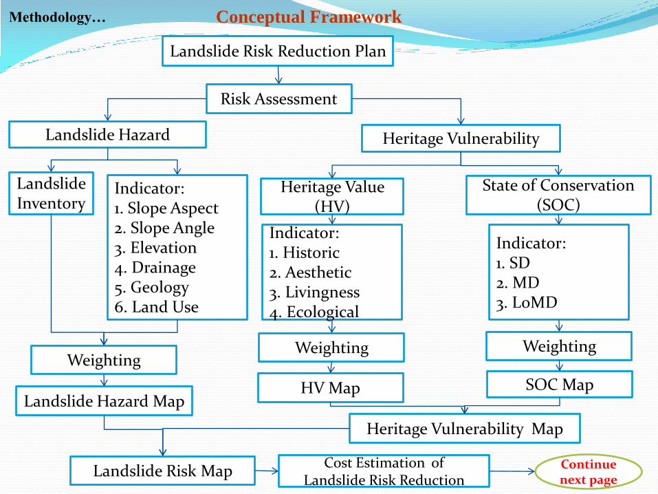
Methodology… Conceptual Framework
Landslide Risk Reduction Plan
Risk Assessment
Heritage Value (HV)
Landslide Hazard Heritage Vulnerability
State of Conservation (SOC)
Landslide Inventory
Indicator: 1. Slope Aspect 2. Slope Angle 3. Elevation 4. Drainage 5. Geology 6. Land Use
Weighting
Landslide Hazard Map
Landslide Risk Map
Indicator: 1. Historic 2. Aesthetic 3. Livingness 4. Ecological
Indicator: 1. SD 2. MD 3. LoMD
Weighting Weighting
HV Map SOC Map
Heritage Vulnerability Map
Continue next page
Cost Estimation of Landslide Risk Reduction
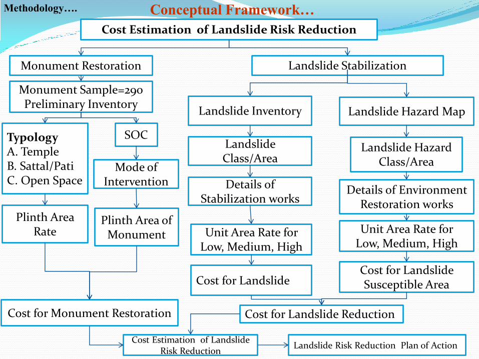
Methodology…. Conceptual Framework…
Cost Estimation of Landslide Risk Reduction
Landslide Inventory
Monument Restoration Landslide Stabilization
Landslide Hazard Map
Typology A. Temple B. Sattal/Pati C. Open Space
Plinth Area Rate
Cost for Monument Restoration
Cost Estimation of Landslide Risk Reduction
Landslide Class/Area
Landslide Hazard Class/Area
Details of Stabilization works
Details of Environment Restoration works
Unit Area Rate for Low, Medium, High
Unit Area Rate for Low, Medium, High
Monument Sample=290 Preliminary Inventory
SOC
Mode of Intervention
Plinth Area of Monument
Cost for Landslide Cost for Landslide Susceptible Area
Cost for Landslide Reduction
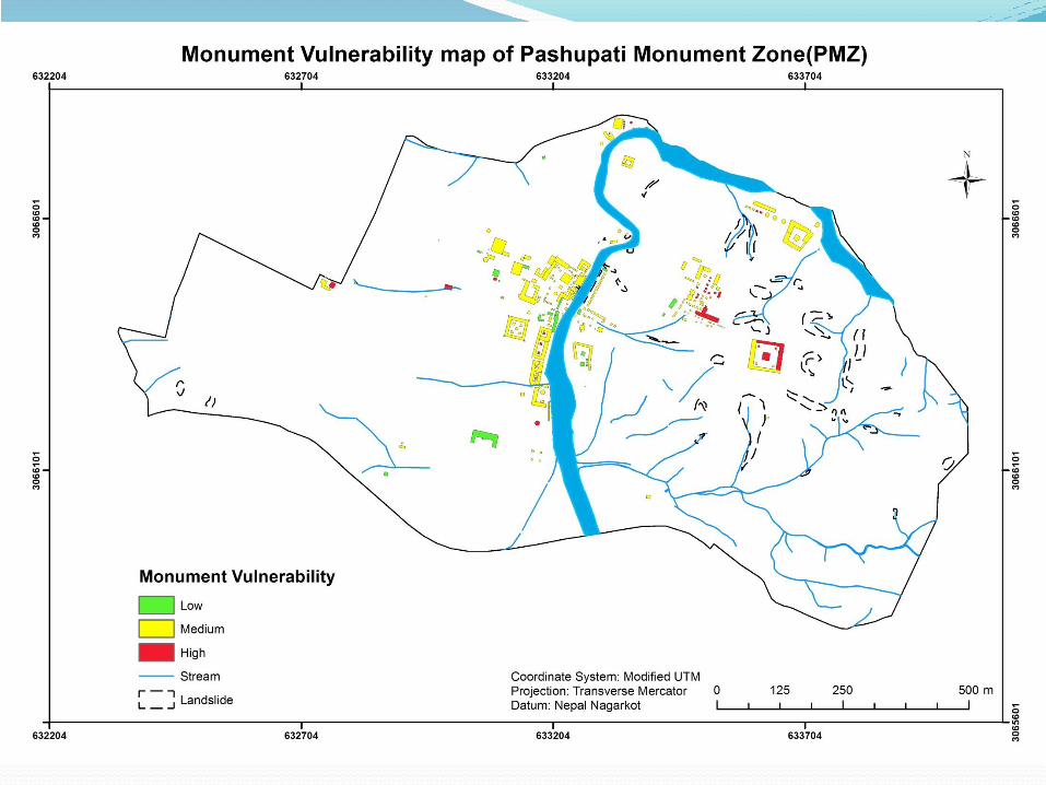
Landslide Risk Reduction Plan of Action
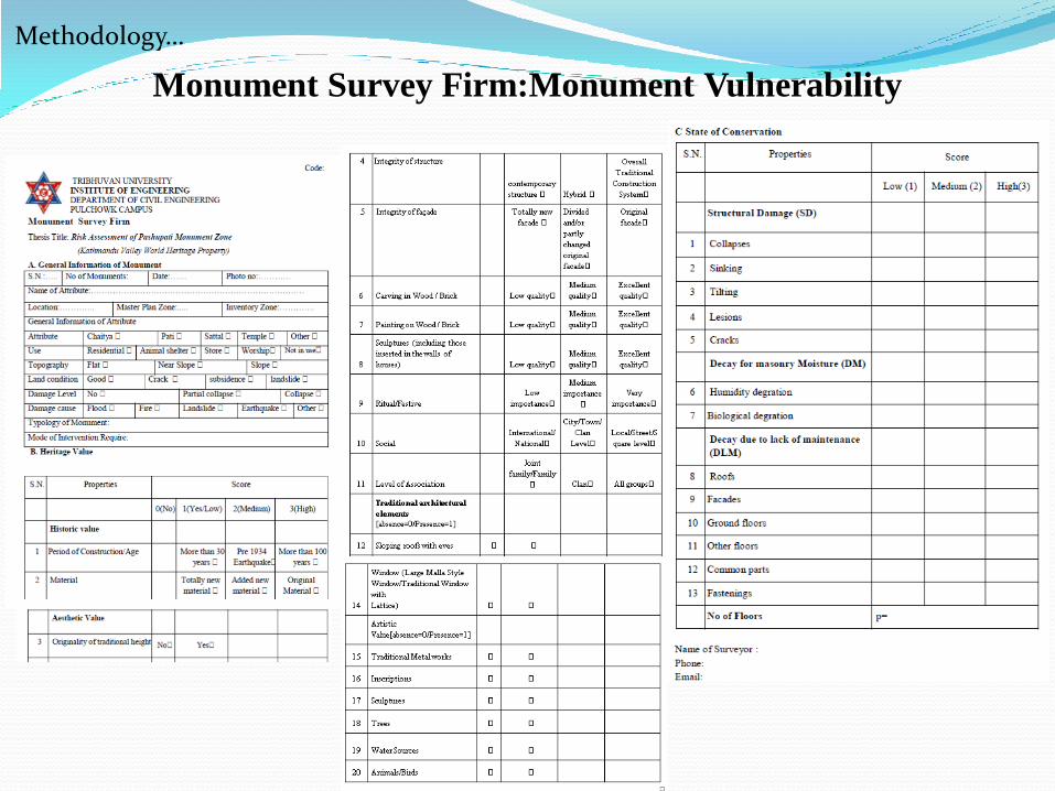
Monument Survey Firm:Monument Vulnerability
Methodology…
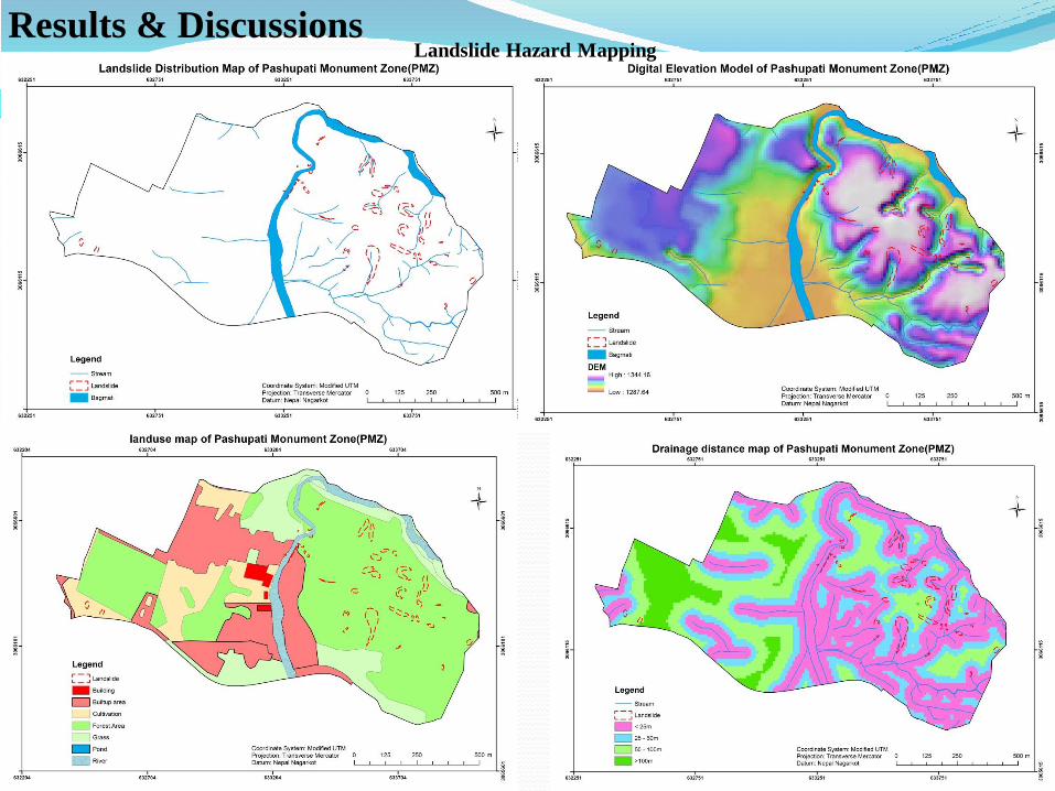
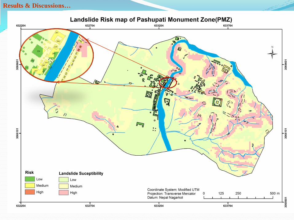
Landslide Hazard Mapping Results & Discussions
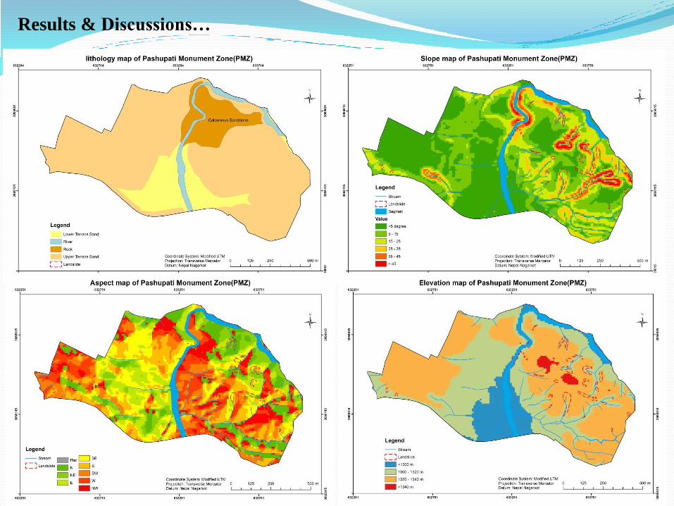
Results & Discussions…
Various Factor Maps and their frequency ratio
Sq.m. Sq.km. % Cell area Sq.Km. % Frequency
Slope
Aspect 1 N 1116 111600 0.112 11.18 1600 0.002 9.41 0.84
2 NE 1098 109800 0.110 11.00 2600 0.003 15.29 1.4
3 E 1170 117000 0.117 11.72 2300 0.002 13.53 1.16
4 SE 1453 145300 0.145 14.55 2500 0.003 14.71 1.01
5 S 1468 146800 0.147 14.70 2300 0.002 13.53 0.92
6 SW 1420 142000 0.142 14.22 1900 0.002 11.18 0.78
7 W 1263 126300 0.126 12.65 3100 0.003 18.24 1.45
8 NW 910 91000 0.091 9.11 700 0.001 4.12 0.45
0 FLAT 87 8700 0.009 0.87 0.01 0.000 0.00 0
Total 998500 0.999 17000 0.017
Slope
angle 1 > 5 3951 395100 0.395 39.57 400 0.000 2.35 0.06
2 5-15 3285 328500 0.329 32.90 5100 0.005 30.00 0.91
3 15-25 1591 159100 0.159 15.93 5100 0.005 30.00 1.91
4 25-35 726 72600 0.073 7.27 2900 0.003 17.06 2.4
5 35-45 309 30900 0.031 3.09 2100 0.002 12.35 4.21
6 >45 123 12300 0.012 1.23 1400 0.001 8.24 7.42
Total 998500 0.999 17000 0.017
Elevation 1 <1300 125 142400 0.142 14.26 200 0.000 1.18 0.08
2 1300 - 1320 4646 379000 0.379 37.96 5700 0.006 33.53 0.88
3 1320 - 1340 3790 464600 0.465 46.53 11100 0.011 65.29 1.41
4 >1340 1424 12500 0.013 1.25 0.01 0.000 0.00 0
Total 998500 0.999 17000 0.017
Drainage
Distance
1 < 25m 4441 444100 0.444 44.42 13000 0.013 76.47 1.74
2 25-50 m 2350 235000 0.235 23.50 2100 0.002 12.35 0.52
3 50-100 m 2324 232400 0.232 23.24 1900 0.002 11.18 0.48
4 > 100 m 883 88300 0.088 8.83 0.01 0.000 0.00 0
Total 999800 1.000 17000 0.017
Geology
1 Terrace Sand 7302 730200 0.730 73.12 14300 0.014 84.12 1.15
2
Lower
Terrace
Sand 1323 132300 0.132 13.25 0.01 0.000 0.00 0
3
Rock
(Calcareous
Sandstone) 997 99700 0.100 9.98 2700 0.003 15.88 1.61
4 ? (Water) 364 36400 0.036 3.65 0.01 0.000 0.00 0
Total 998600 0.999 17000 0.017
Landuse
1 Cultivation 1012 101200 0.101 10.13 600 0.001 3.53 0.34
2 Builtup area 2045 204500 0.205 20.46 0.01 0.000 0.00 0.00
3 Grass 1444 144400 0.144 14.45 0.01 0.000 0.00 0.00
4 Forest Area 5055 505500 0.506 50.58 16100 0.016 94.71 1.90
5 Building 85 8500 0.009 0.85 0.01 0.000 0.00 0.00
6 River 354 35400 0.035 3.54 300 0.000 1.76 0.49
Total 999500 1.000 17000 0.017
ClassS.N.Factor
Pixels Landslide
Cell AreaTot.no
Results & Discussions…
Various Factor Maps and their Frequency Ratio
Results & Discussions…
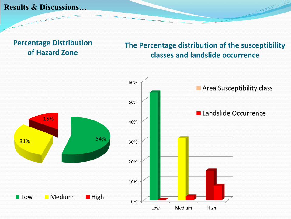
The Percentage distribution of the susceptibility classes and landslide occurrence
Percentage Distribution of Hazard Zone
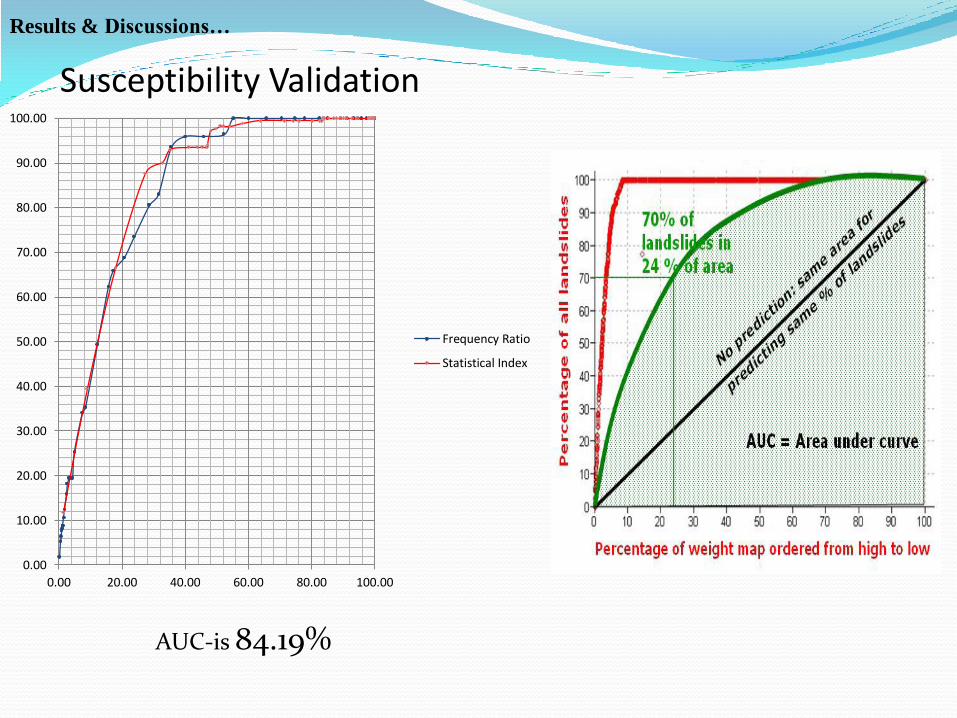
Susceptibility Validation
0.00
10.00
20.00
30.00
40.00
50.00
60.00
70.00
80.00
90.00
100.00
0.00 20.00 40.00 60.00 80.00 100.00
Frequency Ratio
Statistical Index
AUC-is 84.19%
Results & Discussions…
Result Results & Discussions…
Results & Discussions…
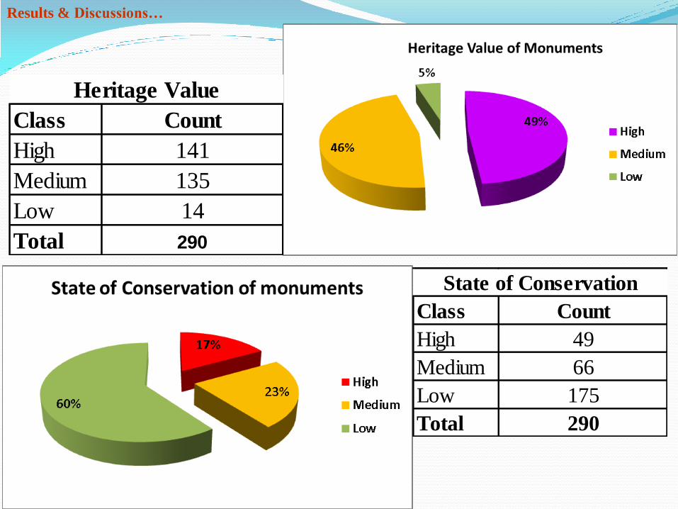
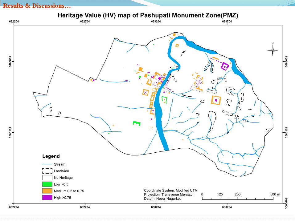
Class Count
High 141
Medium 135
Low 14
Total 290
Heritage Value
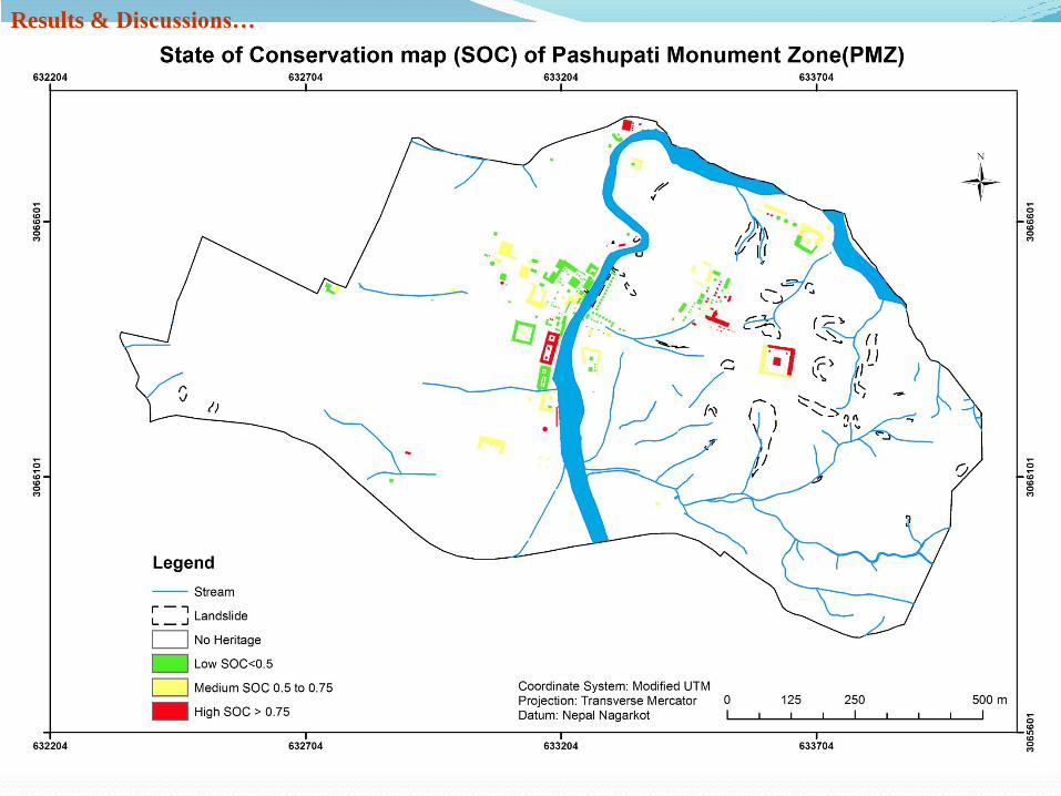
Class Count
High 49
Medium 66
Low 175
Total 290
State of Conservation
Results & Discussions…
Result
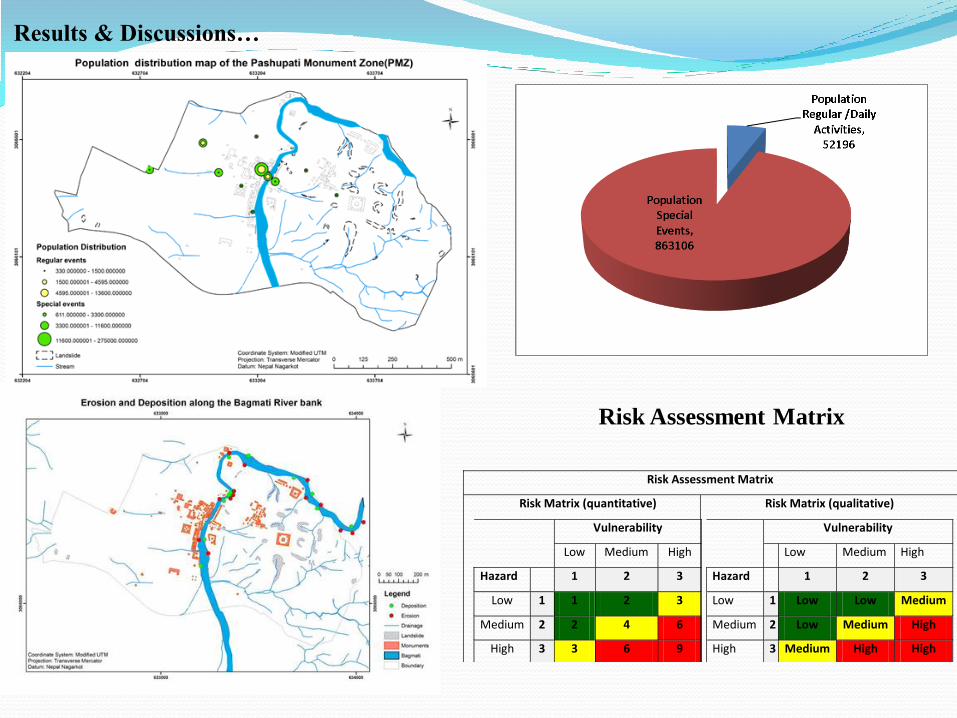
Risk Assessment Matrix
Risk Matrix (quantitative)
Vulnerability
Low Medium High
Hazard 1 2 3
Low 1 1 2 3
Medium 2 2 4 6
High 3 3 6 9
Risk Matrix (qualitative)
Vulnerability
Low Medium High
Hazard 1 2 3
Low 1 Low Low Medium
Medium 2 Low Medium High
High 3 Medium High High
Results & Discussions…
Risk Assessment Matrix
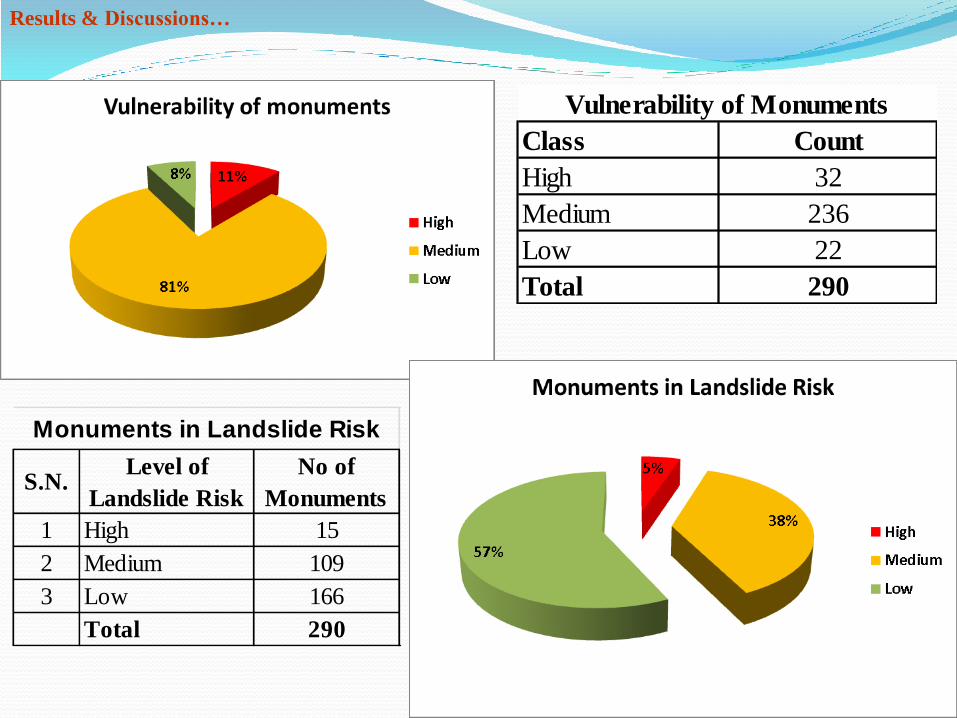
Class Count
High 32
Medium 236
Low 22
Total 290
Vulnerability of Monuments
S.N.Level of
Landslide Risk
No of
Monuments
1 High 15
2 Medium 109
3 Low 166
Total 290
Monuments in Landslide Risk
Results & Discussions…
Results & Discussions…
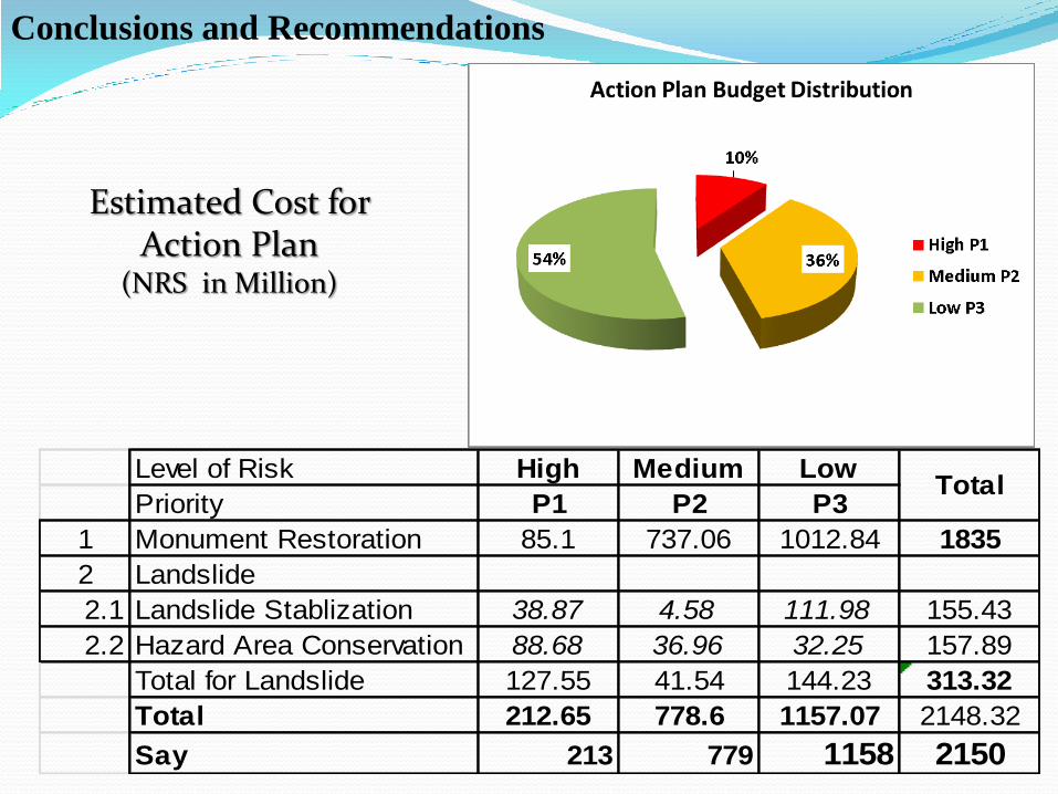
Level of Risk High Medium Low
Priority P1 P2 P3
1 Monument Restoration 85.1 737.06 1012.84 1835
2 Landslide
2.1 Landslide Stablization 38.87 4.58 111.98 155.43
2.2 Hazard Area Conservation 88.68 36.96 32.25 157.89
Total for Landslide 127.55 41.54 144.23 313.32
Total 212.65 778.6 1157.07 2148.32
Say 213 779 1158 2150
Total
Estimated Cost for Action Plan
(NRS in Million)
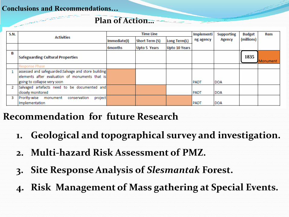
Conclusions and Recommendations
Conclusions and Recommendations…
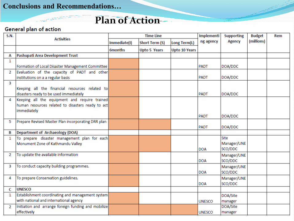
Plan of Action
Conclusions and Recommendations… 3)Plan of Action
General Plan of Action
Specific Plan of Action
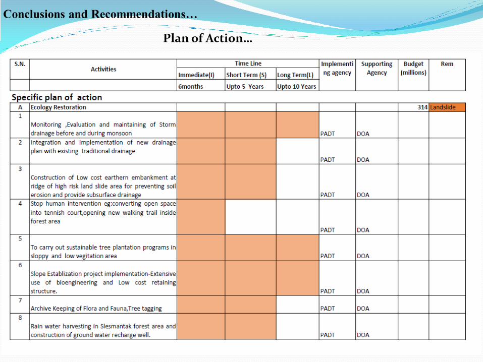
Plan of Action…
Conclusions and Recommendations…
Plan of Action…
Recommendation for future Research
1. Geological and topographical survey and investigation.
2. Multi-hazard Risk Assessment of PMZ.
3. Site Response Analysis of Slesmantak Forest.
4. Risk Management of Mass gathering at Special Events.
1835

Conclusion
• Landslide Hazard -High(15%),Medium (31%) • Out of 290 Monuments, 5% (15 nos) are in high
Landslide Risk. • Total Budget require for action plan is NRs 2150 Million,
high priorities activities NRs 213 Million should immediately manage.
• More than 50% high vulnerable monuments found in Slesmantak forest (B1 area).
• The major hazard in Slesmantak forest area is Landslide, so to protect cultural heritage attributes and Environment-immediately stabilize the landslide.
• High landslide hazard area’s monuments are in higher Risk having high Vulnerability with the poor state of conservation.

5 Citation …