Embed Size (px)
Citation preview
도시건축설계와 GIS
Ph.D, Tae wook, kang. Senior Researcher, KICTInterests – BIM, GIS, Interoperability
[email protected] www.facebook.com/laputa999
Introduce
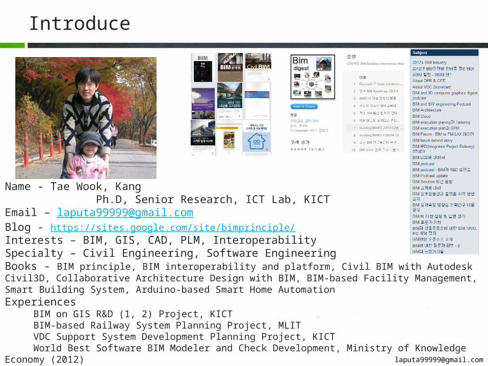
Name - Tae Wook, Kang Ph.D, Senior Research, ICT Lab, KICTEmail – [email protected] - https://sites.google.com/site/bimprinciple/Interests – BIM, GIS, CAD, PLM, Interoperability Specialty – Civil Engineering, Software EngineeringBooks - BIM principle, BIM interoperability and platform, Civil BIM with Autodesk Civil3D, Collaborative Architecture Design with BIM, BIM-based Facility Management, Smart Building System, Arduino-based Smart Home AutomationExperiences BIM on GIS R&D (1, 2) Project, KICT BIM-based Railway System Planning Project, MLIT VDC Support System Development Planning Project, KICT World Best Software BIM Modeler and Check Development, Ministry of Knowledge Economy (2012) BIM Division Head Manager, Hangil IT (2011) Adjunct Professor, Chung-Ang University (2010)
CONTENTS
3BIM on GIS
1Overview
4Lesson & Learn
2Urban design & GIS

1
Overview
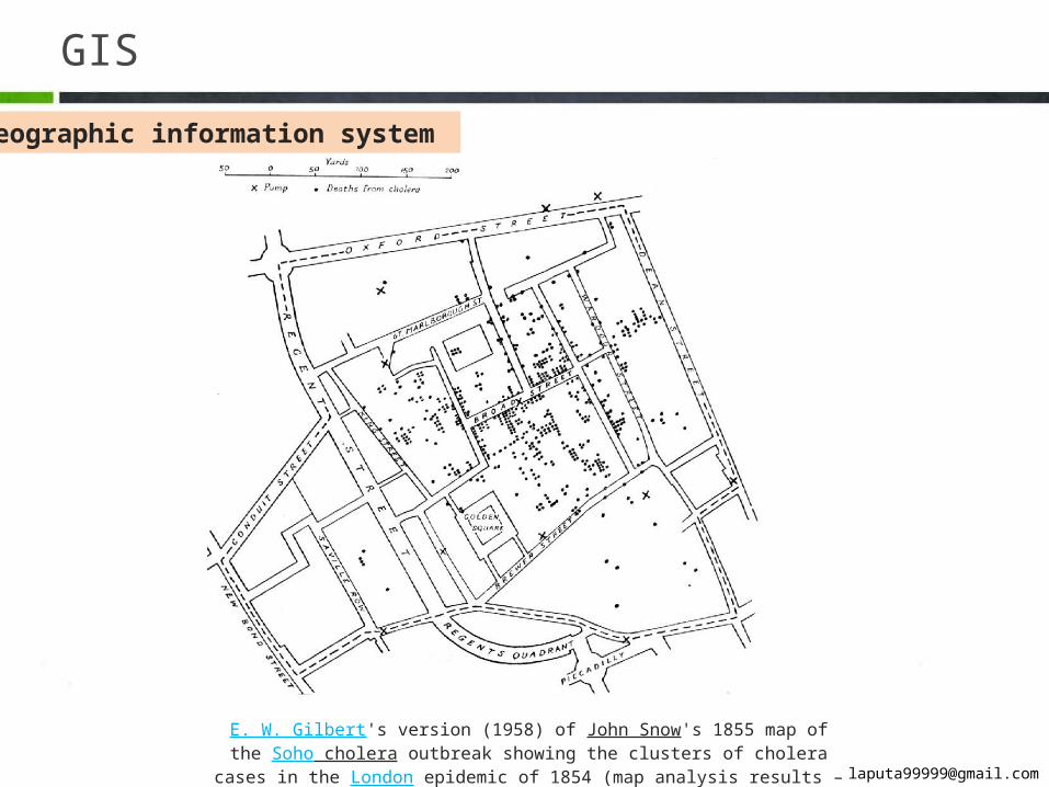
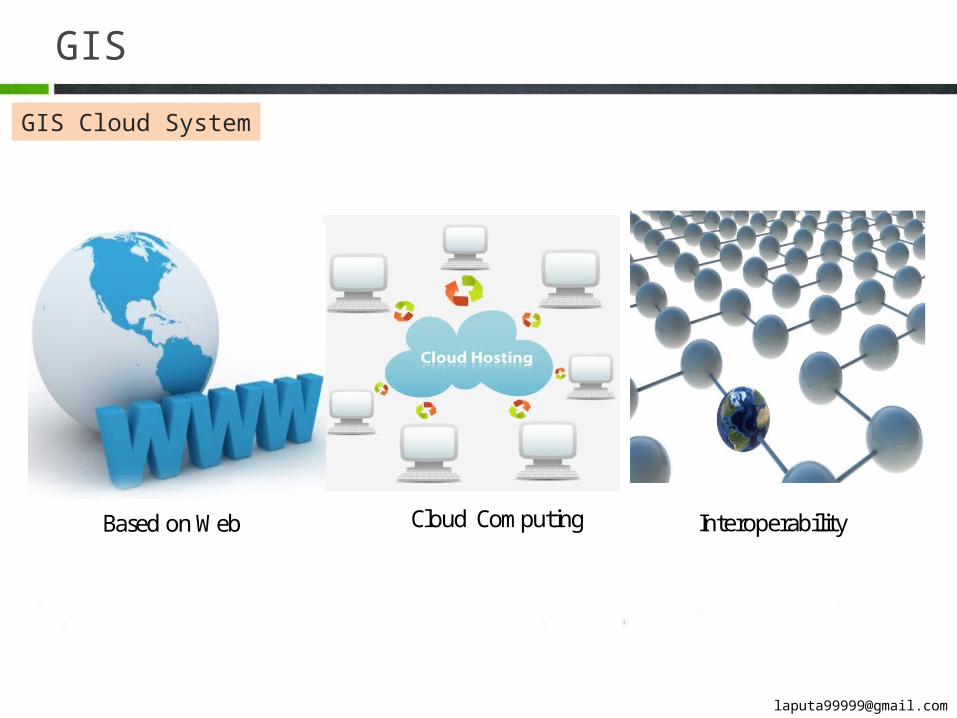
GIS
Geographic information system
E. W. Gilbert's version (1958) of John Snow's 1855 map of the Soho cholera outbreak show-ing the clusters of cholera cases in the London epidemic of 1854 (map analysis results – re-
lationship between cholera and water)
GIS
Geographic information system
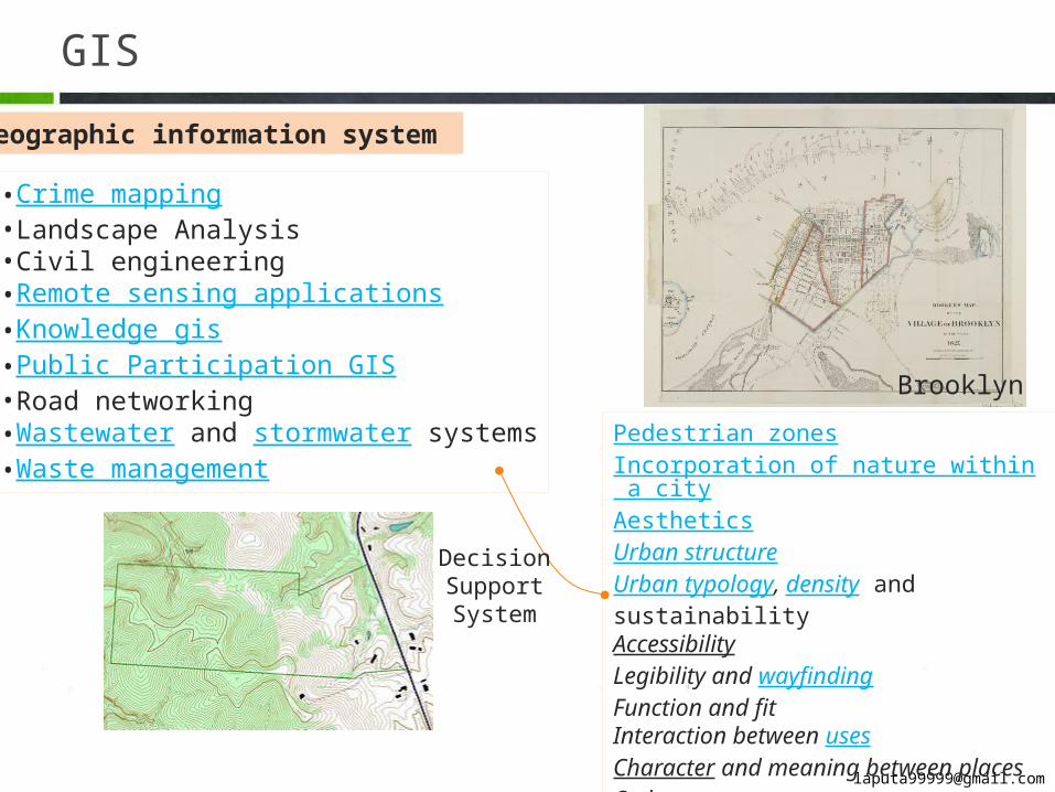
•Crime mapping•Landscape Analysis•Civil engineering •Remote sensing applications•Knowledge gis•Public Participation GIS•Road networking•Wastewater and stormwater systems•Waste management Pedestrian zones
Incorporation of nature within a cityAestheticsUrban structureUrban typology, density and sustainabilityAccessibility Legibility and wayfindingFunction and fitInteraction between uses Character and meaning between placesOrder Continuity and change considering cultureCivil society
Decision Support Sys-
tem
Brooklyn
GIS
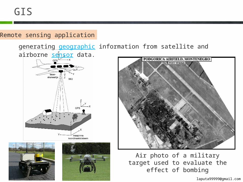
Remote sensing application
Air photo of a military target used to evaluate the effect of bombing
generating geographic information from satellite and airborne sensor data.
GIS
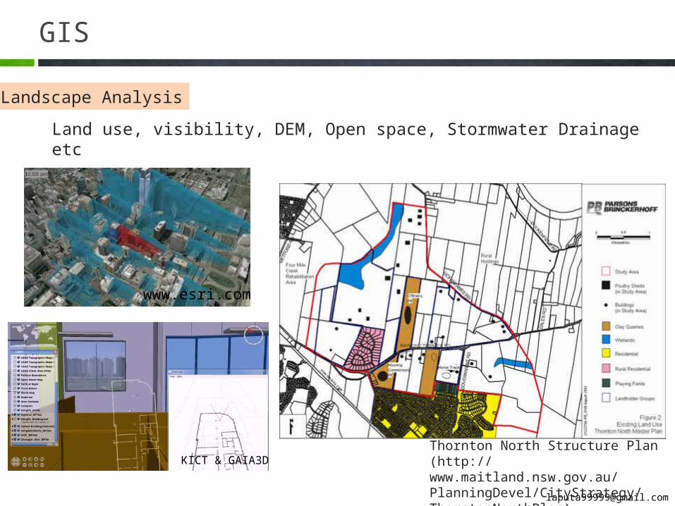
Landscape Analysis
www.esri.com
KICT & GAIA3DThornton North Structure Plan (http://www.maitland.nsw.gov.au/PlanningDevel/CityStrategy/ThorntonNorthPlan)
Land use, visibility, DEM, Open space, Stormwater Drainage etc
GIS
P 12
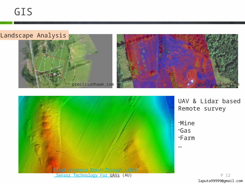
precisionhawk.com precisionhawk.com
Riegl Announce Break-Through LiDAR Sensor Technology For UAVs (AU)
UAV & Lidar based Re-mote survey
-Mine-Gas-Farm…
Landscape Analysis
GIS
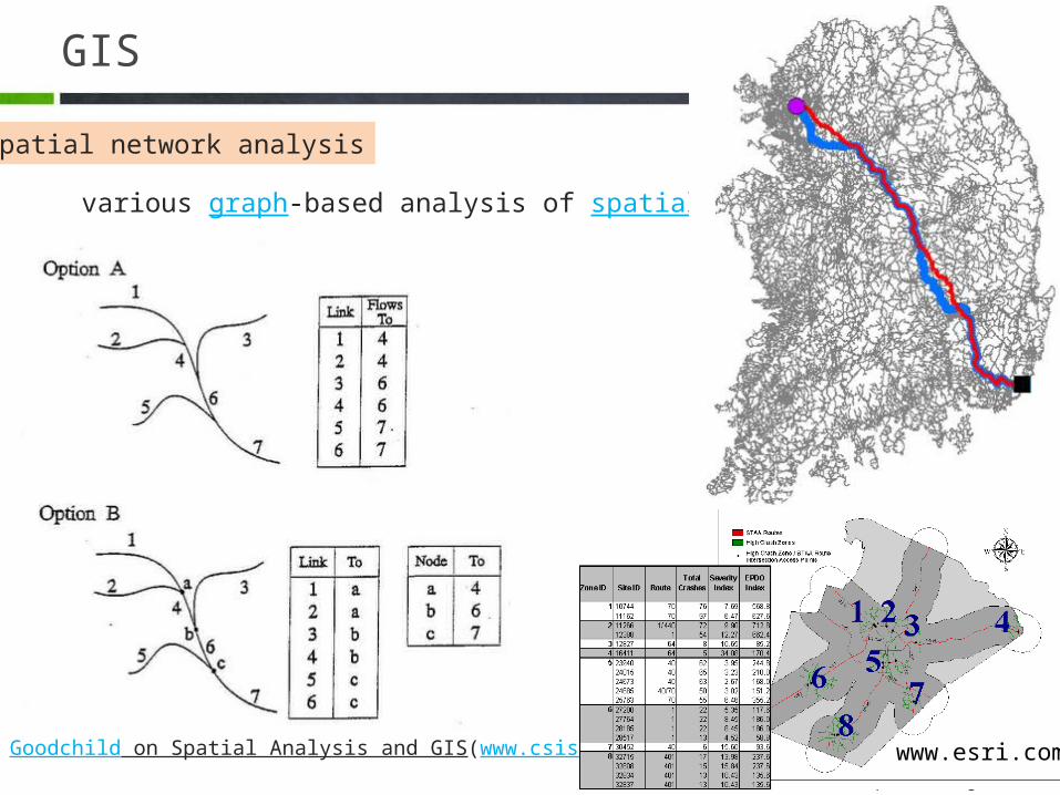
Spatial network analysis
various graph-based analysis of spatial networks
Goodchild on Spatial Analysis and GIS(www.csiss.org) www.esri.com
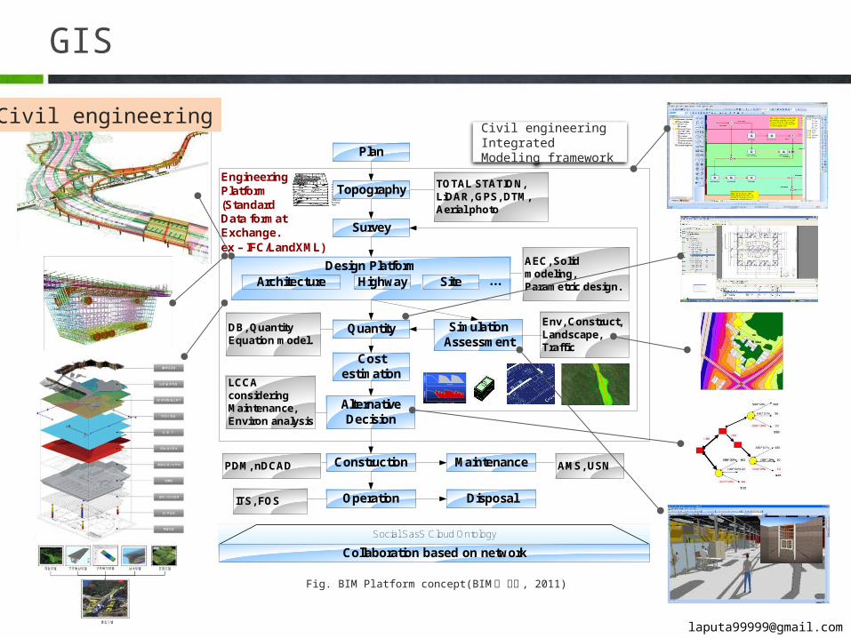
GIS
EngineeringPlatform(Standard Data formatExchange. ex – IFC/LandXML)
Survey
Design Platform ...Architecture Highway Site
Quantity
Cost estimation
AlternativeDecision
SimulationAssessment
Construction
Plan
TOTAL STATION, LiDAR, GPS, DTM, Aerial photo
DB, Quantity Equation model.
Env, Construct, Landscape, Traffic
Topography
AEC, Solid modeling, Parametric design.
LCCA considering Maintenance, Environ analysis
PDM, nDCAD Maintenance AMS, USN
Operation Disposal
Social SasS Cloud Ontology
Collaboration based on network
ITS, FOS
Fig. BIM Platform concept(BIM 의 원리 , 2011)
Civil engineering Inte-grated Modeling frame-work
Civil engineering
GIS
www.innovativegis.com
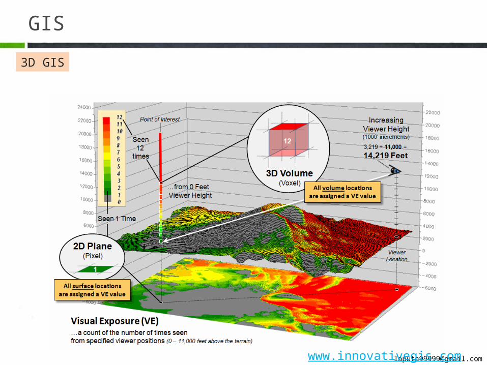
3D GIS

2
Urban design & GIS
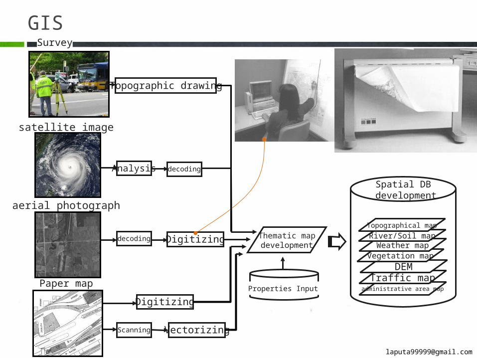
GIS
satellite image
aerial photograph
Paper map
Analysis
decoding
Scanning
decoding
Digitizing
Digitizing
Vectorizing
Thematic mapdevelopment
Properties Input administrative area mapTraffic map
Spatial DB development
DEMVegetation map
Weather mapRiver/Soil map
Topographical map
Survey
Topographic drawing
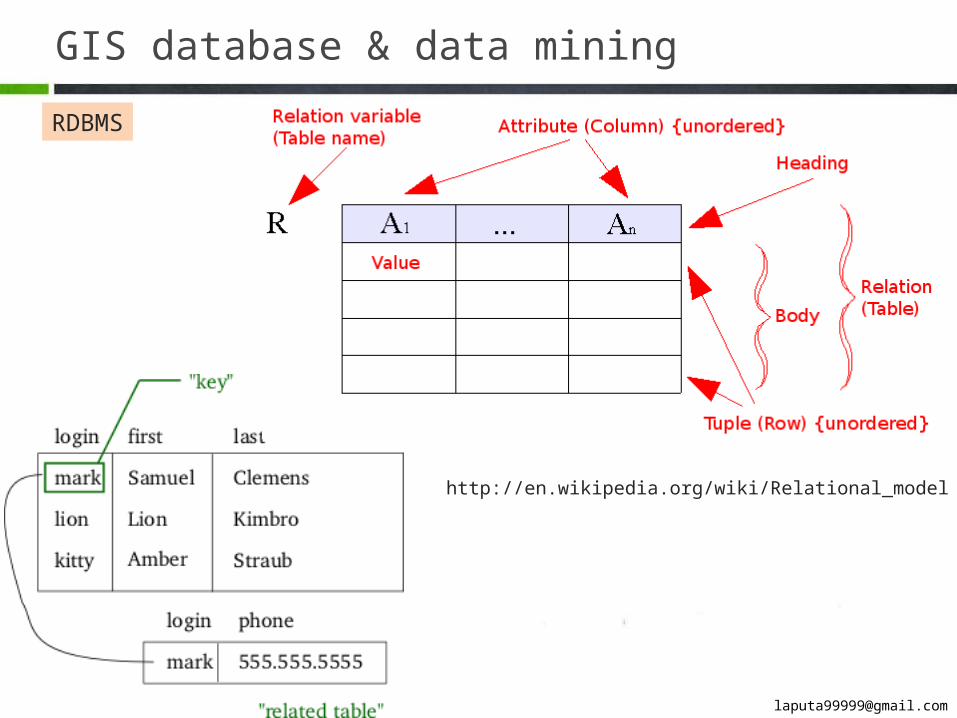
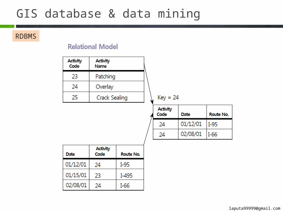
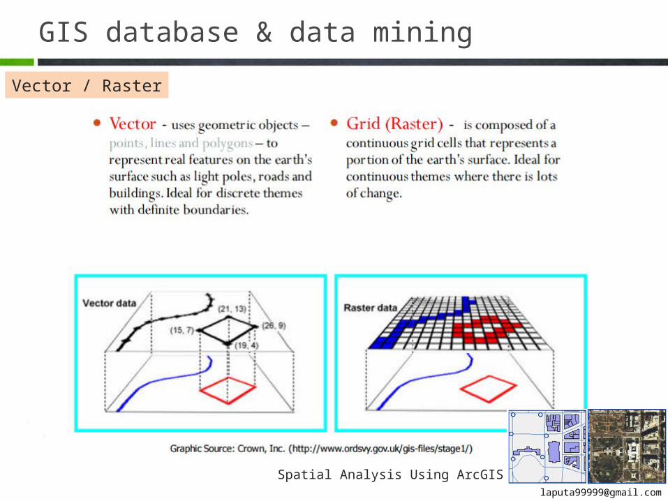
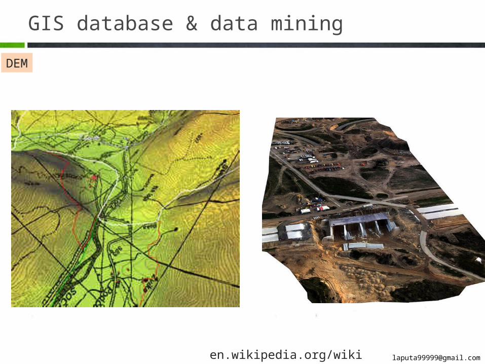
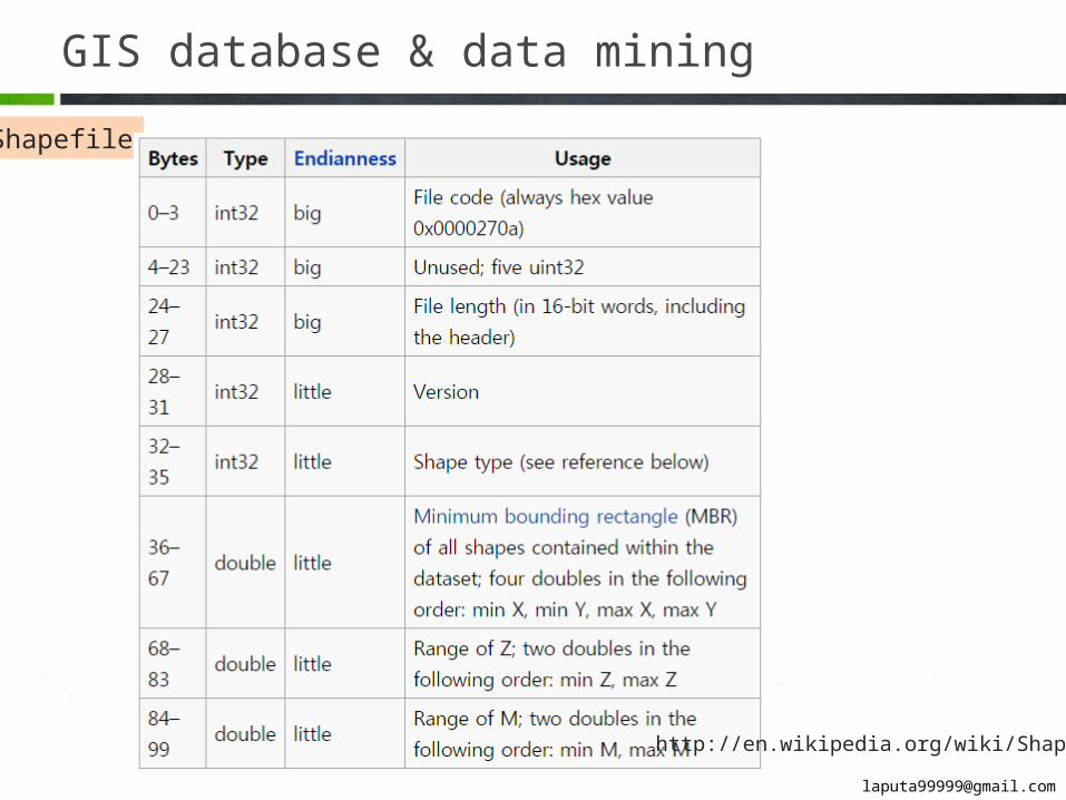
GIS database & data mining
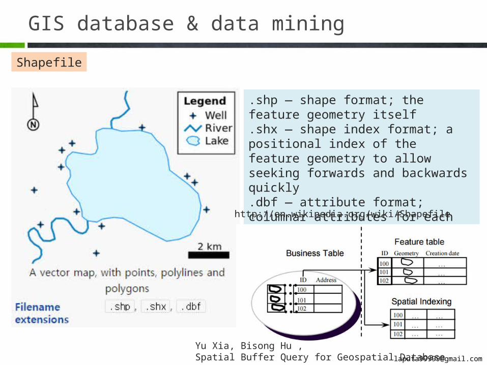
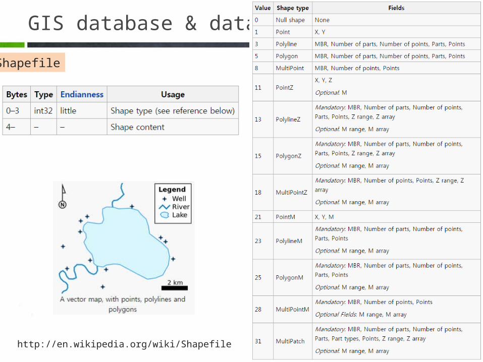
Shapefile
.shp — shape format; the feature geometry itself.shx — shape index format; a positional index of the feature geometry to allow seeking forwards and backwards quickly.dbf — attribute format; columnar attributes for each shape, in dBase IV format
http://en.wikipedia.org/wiki/Shapefile
Yu Xia, Bisong Hu , Spatial Buffer Query for Geospatial Database
GIS database & data mining
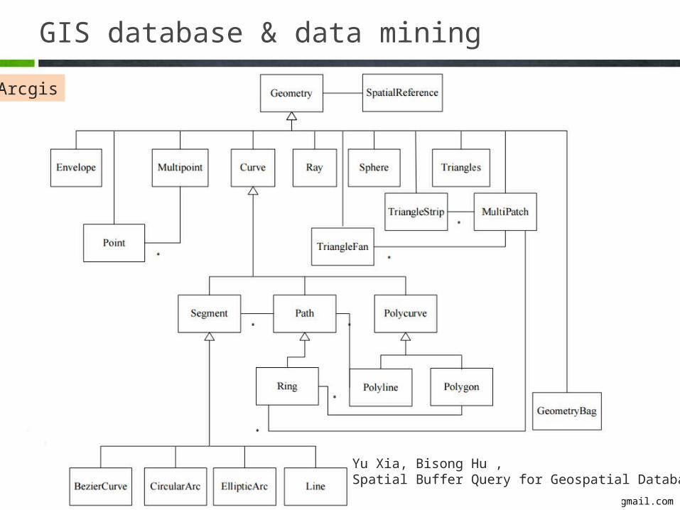
Arcgis
Yu Xia, Bisong Hu , Spatial Buffer Query for Geospatial Database
GIS database & data mining
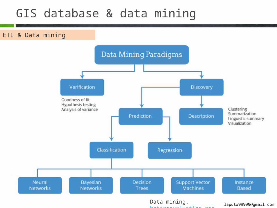
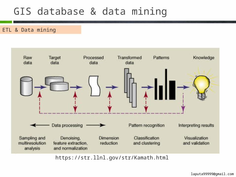
ETL & Data mining
Data mining, betterevaluation.org
GIS database & data mining
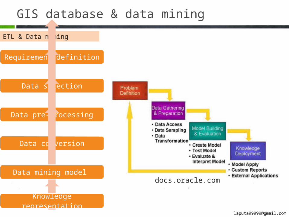
ETL & Data mining
Requirement definition
Data selection
Data pre-processing
Data conversion
Data mining model
Knowledge representation
docs.oracle.com
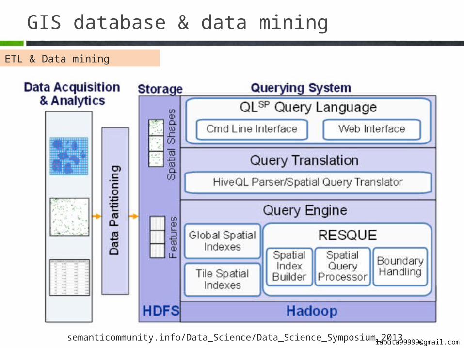
GIS database & data mining
ETL & Data mining
semanticommunity.info/Data_Science/Data_Science_Symposium_2013
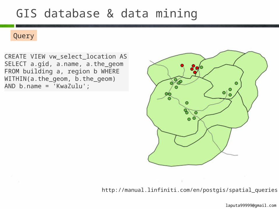
GIS database & data mining
Query
http://manual.linfiniti.com/en/postgis/spatial_queries.html
CREATE VIEW vw_select_location AS SELECT a.gid, a.name, a.the_geom FROM building a, region b WHERE WITHIN(a.the_geom, b.the_geom) AND b.name = 'KwaZulu';
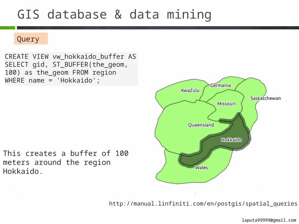
GIS database & data mining
Query
http://manual.linfiniti.com/en/postgis/spatial_queries.html
CREATE VIEW vw_hokkaido_buffer AS SELECT gid, ST_BUFFER(the_geom, 100) as the_geom FROM region WHERE name = 'Hokkaido';
This creates a buffer of 100 meters around the region Hokkaido.
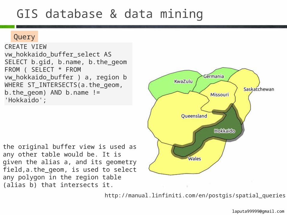
GIS database & data mining
Query
http://manual.linfiniti.com/en/postgis/spatial_queries.html
CREATE VIEW vw_hokkaido_buffer_select AS SE-LECT b.gid, b.name, b.the_geom FROM ( SELECT * FROM vw_hokkaido_buffer ) a, region b WHERE ST_INTERSECTS(a.the_geom, b.the_geom) AND b.name != 'Hokkaido';
the original buffer view is used as any other table would be. It is given the alias a, and its geometry field,a.the_geom, is used to select any polygon in the region table (alias b) that intersects it.
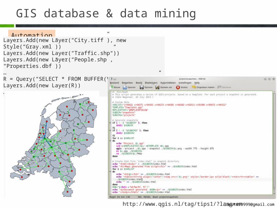
GIS database & data mining
Automation
http://www.qgis.nl/tag/tips1/?lang=en
Layers.Add(new Layer(“City.tiff”), new Style(“Gray.xml”))Layers.Add(new Layer(“Traffic.shp”))Layers.Add(new Layer(“People.shp”, “Properties.dbf”))…R = Query(“SELECT * FROM BUFFER(VIEW_GEOM, 100)”)Layers.Add(new Layer(R))…
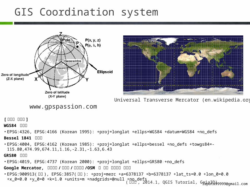
GIS Coordination system
( 박희구 , 2014.1, QGIS Tutorial, Gaia3D)
[ 전지구 좌표계 ]WGS84 경위도• EPSG:4326, EPSG:4166 (Korean 1995): +proj=longlat +ellps=WGS84 +datum=WGS84 +no_defs Bessel 1841 경위도• EPSG:4004, EPSG:4162 (Korean 1985): +proj=longlat +ellps=bessel +no_defs +towgs84=-115.80,474.99,674.11,1.16,-2.31,-
1.63,6.43GRS80 경위도• EPSG:4019, EPSG:4737 (Korean 2000): +proj=longlat +ellps=GRS80 +no_defsGoogle Mercator, 구글지도 / 빙지도 / 야후지도 /OSM 등 에서 사용중인 좌표계• EPSG:900913( 통칭 ), EPSG:3857( 공식 ): +proj=merc +a=6378137 +b=6378137 +lat_ts=0.0 +lon_0=0.0 +x_0=0.0 +y_0=0 +k=1.0
+units=m +nadgrids=@null +no_defs
www.gpspassion.comUniversal Transverse Mercator (en.wikipedia.org)
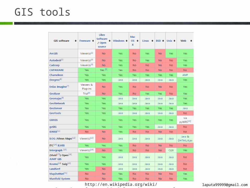
GIS tools
http://en.wikipedia.org/wiki/Comparison_of_geographic_information_systems_software
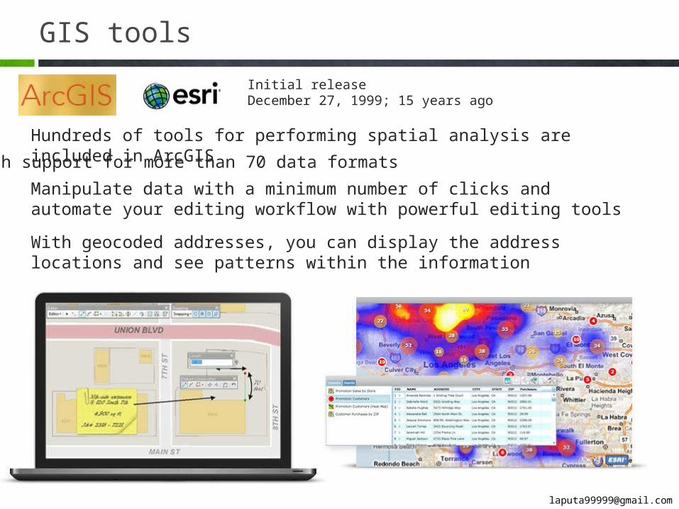
GIS tools
Hundreds of tools for performing spatial analysis are included in ArcGISWith support for more than 70 data formatsManipulate data with a minimum number of clicks and automate your editing workflow with powerful editing tools
With geocoded addresses, you can display the address locations and see patterns within the information
Initial releaseDecember 27, 1999; 15 years ago
GIS tools
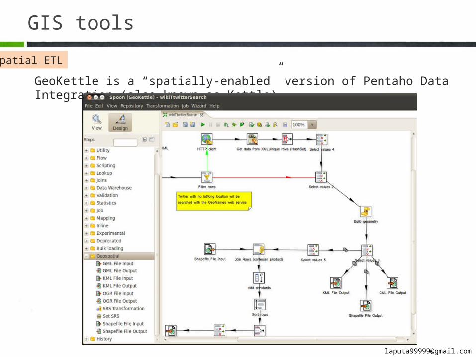
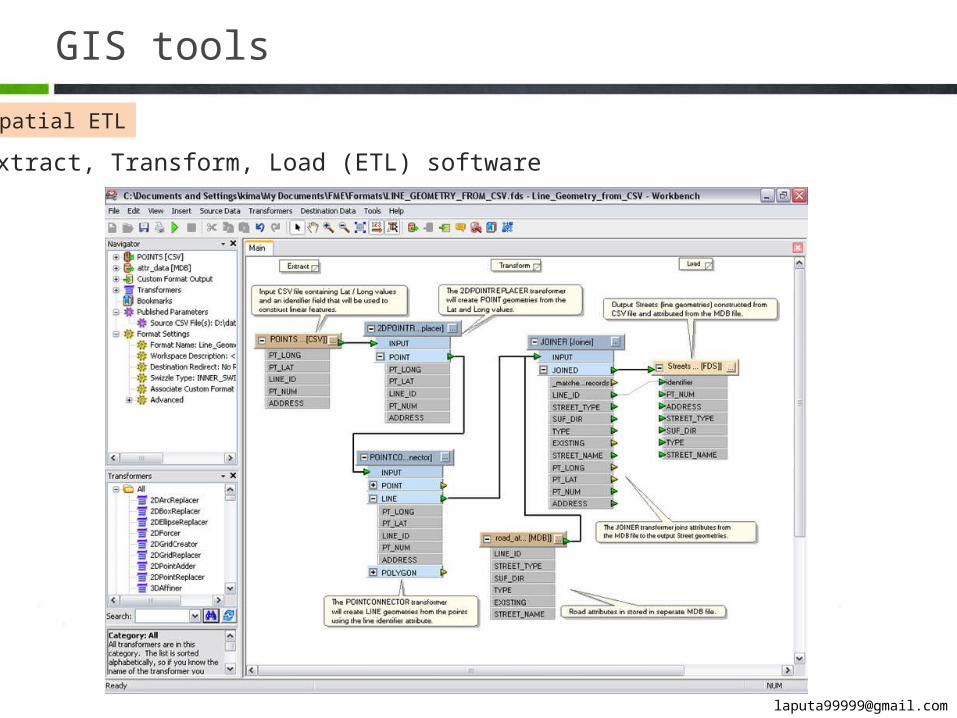
Spatial ETL
GeoKettle is a “spatially-enabled” version of Pentaho Data Integration (also known as Kettle).
GIS tools
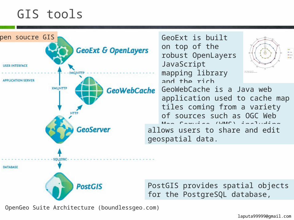
OpenGeo Suite Architecture (boundlessgeo.com)
GeoExt is built on top of the robust OpenLayers JavaScript mapping library and the rich graphical components of ExtJS.
GeoWebCache is a Java web application used to cache map tiles coming from a va-riety of sources such as OGC Web Map Service (WMS) including Google Maps KML.
allows users to share and edit geospatial data.
PostGIS provides spatial objects for the Post-greSQL database,
Open soucre GIS
GIS tools
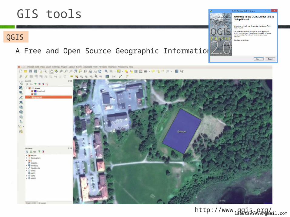
QGIS
A Free and Open Source Geographic Information System
http://www.qgis.org/
GIS tools
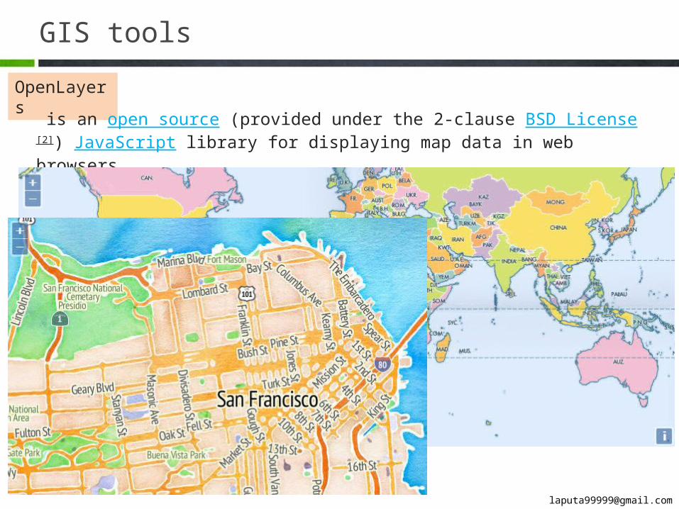
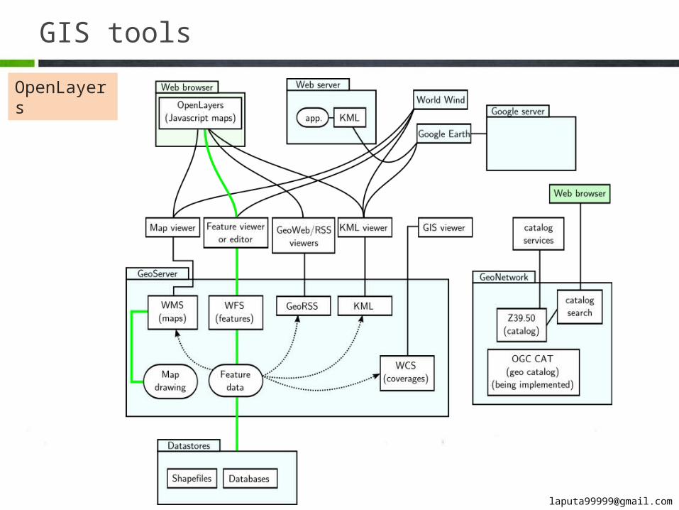
OpenLayers
is an open source (provided under the 2-clause BSD License[2]) JavaScript library for dis-playing map data in web browsers.
GIS tools
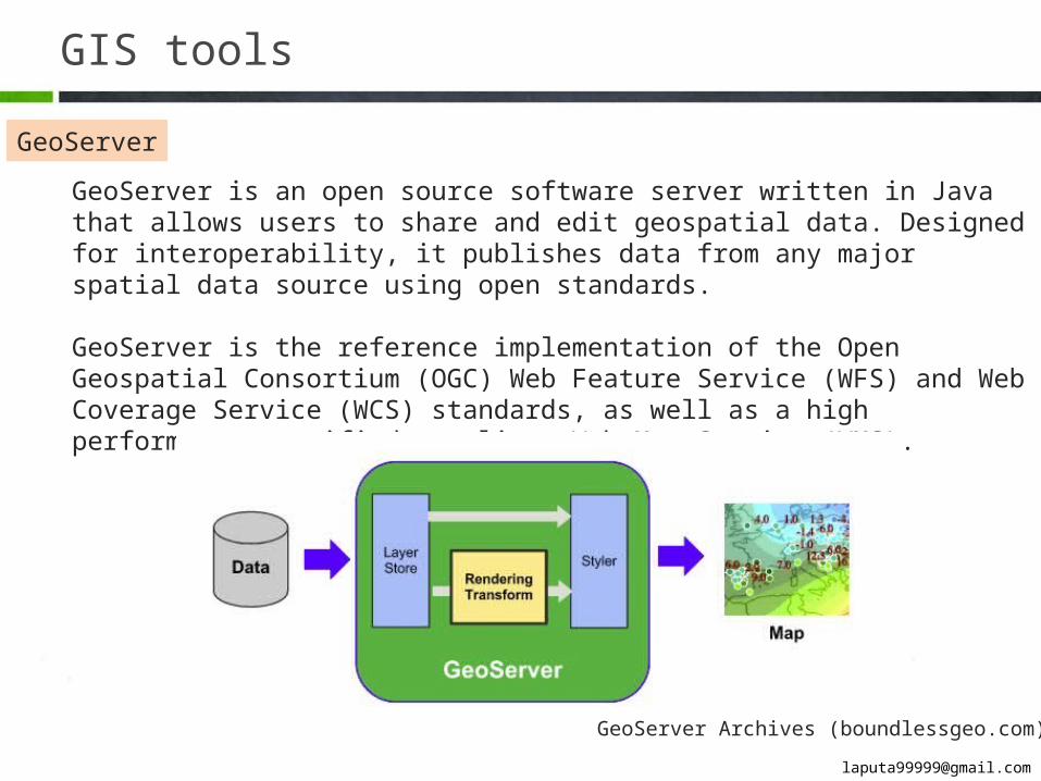
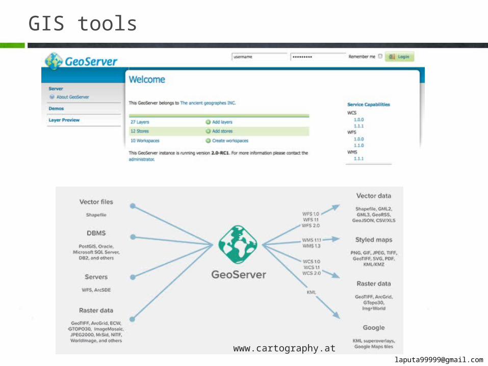
GeoServer
GeoServer is an open source software server written in Java that allows users to share and edit geospatial data. Designed for interoperability, it publishes data from any major spatial data source using open standards.
GeoServer is the reference implementation of the Open Geospatial Consortium (OGC) Web Feature Service (WFS) and Web Coverage Service (WCS) standards, as well as a high performance certified compliant Web Map Service (WMS).
GeoServer Archives (boundlessgeo.com)
GIS tools
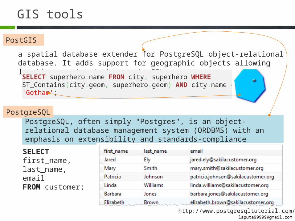
PostGIS
a spatial database extender for PostgreSQL object-relational database. It adds support for geographic objects allowing location queries to be run in SQL.
SELECT superhero.name FROM city, superhero WHERE ST_Contains(city.geom, superhero.geom) AND city.name = 'Gotham';
PostgreSQL, often simply "Postgres", is an object-relational database management system (ORDBMS) with an emphasis on extensibility and standards-compliance
SELECT first_name,last_name,emailFROM customer;
http://www.postgresqltutorial.com/
PostgreSQL
GIS tools
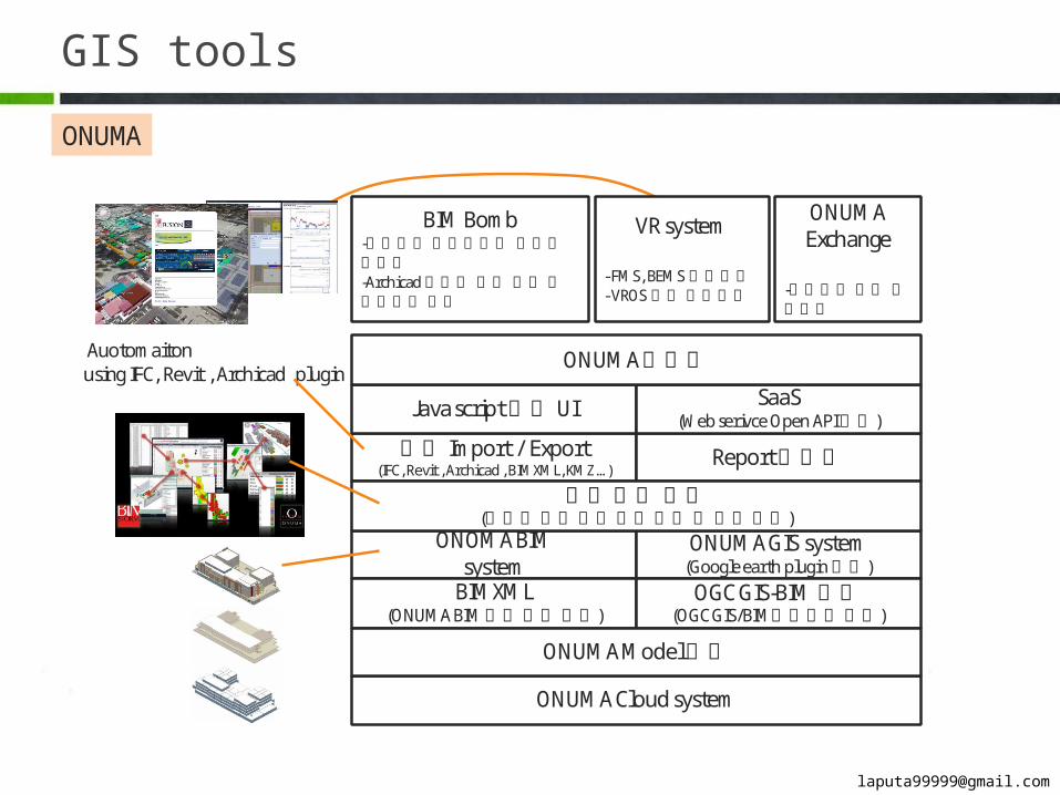
ONOMA BIMsystem
ONUMA Cloud system
ONUMA GIS system(Google earth plugin제공)
BIMXML (ONUMA BIM 표준파일포맷)
OGC GIS-BIM 포맷(OGC GIS/BIM상호운용포맷)
ONUMA Model 서버
모델 Import / Export(IFC, Revit , Archicad , BIMXML, KMZ …)
Report 생성기
Java script 기반 UI SaaS(Web serivce Open API 지원)
ONUMA 플랫폼
BIM Bomb-폭발해석시뮬레이션 응용프로그램-Archicad에너지해석 결과시뮬레이터기반
VR system
- FMS, BEMS 프로그램- VROS 기반프로그램
ONUMA Exchange
-프로젝트협업 프로그램
모델쿼리엔진(조건에의한모델정보쿼리및생성엔진)
Auotomaitonusing IFC, Revit , Archicad plugin
ONUMA
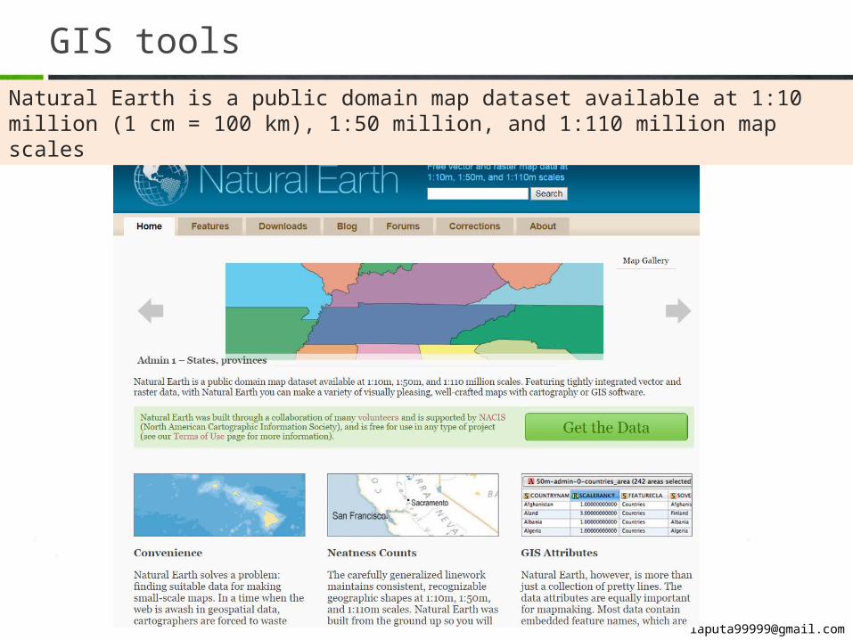
GIS toolsNatural Earth is a public domain map dataset available at 1:10 million (1 cm = 100 km), 1:50 mil-lion, and 1:110 million map scales
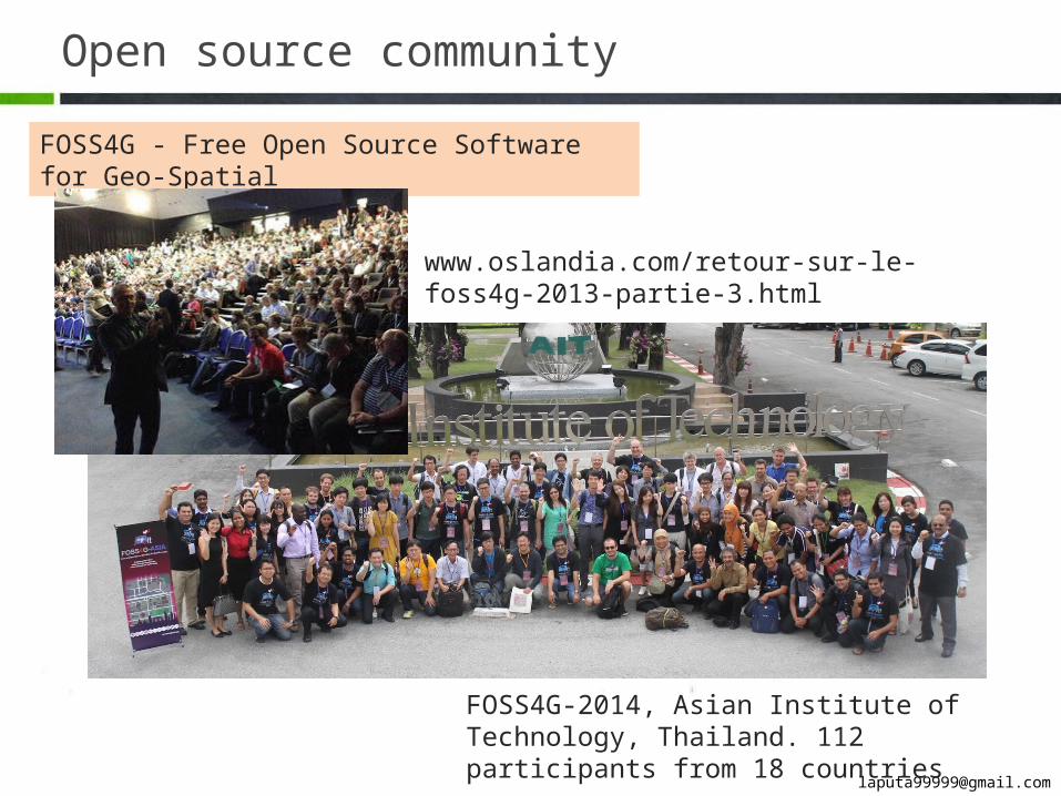
Open source community
FOSS4G - Free Open Source Software for Geo-Spatial
FOSS4G-2014, Asian Institute of Technology, Thailand. 112 participants from 18 countries
www.oslandia.com/retour-sur-le-foss4g-2013-partie-3.html
3
BIM on GIS
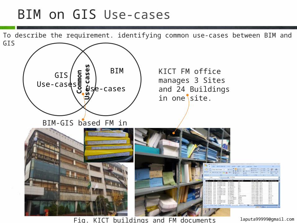
BIM on GIS Use-casesTo describe the requirement. identifying common use-cases between BIM and GIS
GISUse-cases
BIM Use-cases
Com
mon
Use
-cas
es
BIM-GIS based FM in KICT
Fig. KICT buildings and FM documents
KICT FM office manages 3 Sites and 24 Buildings in one site.
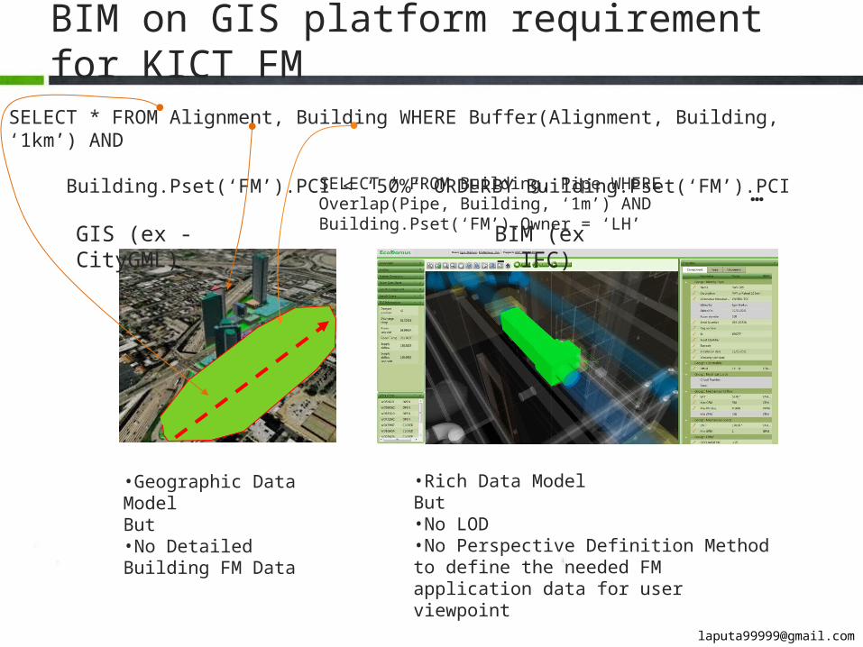
BIM on GIS platform requirement for KICT FM
SELECT * FROM Alignment, Building WHERE Buffer(Alignment, Building, ‘1km’) AND Building.Pset(‘FM’).PCI < ‘50%’ ORDERBY Building.Pset(‘FM’).PCI
BIM (ex - IFC)
GIS (ex - CityGML)
SELECT * FROM Building, Pipe WHERE Overlap(Pipe, Build-ing, ‘1m’) AND Building.Pset(‘FM’).Owner = ‘LH’ …
•Geographic Data ModelBut•No Detailed Building FM Data
•Rich Data ModelBut•No LOD•No Perspective Definition Method to define the needed FM application data for user viewpoint
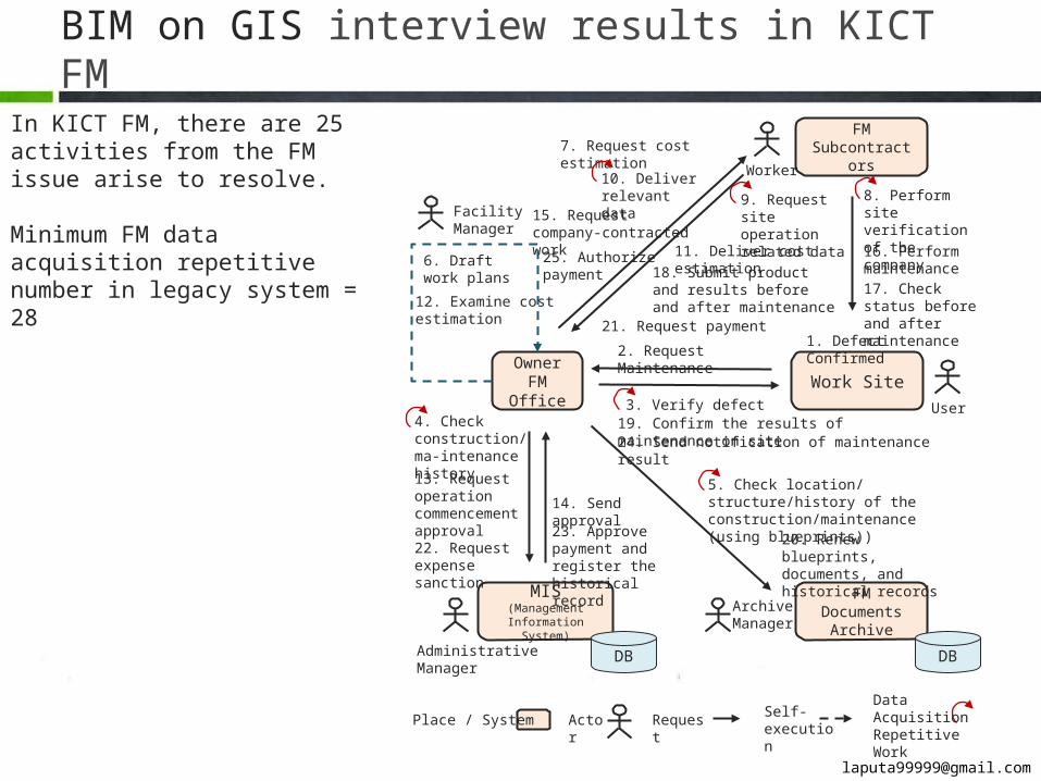
BIM on GIS interview results in KICT FM
Owner FM Office Work Site
FM Documents Archive
MIS (Management Information System)
1. Defect Confirmed2. Request Maintenance
3. Verify defect4. Check construc-tion/ma-intenance history
5. Check location/structure/history of the construction/maintenance (using blue-prints))
6. Draft work plans
FM Subcontrac-tors
7. Request cost estimation
11. Deliver cost estimation
12. Examine cost esti-mation
13. Request oper-ation commence-ment approval
14. Send approval
15. Request company-con-tracted work
8. Perform site veri-fication of the com-pany16. Perform main-tenance18. Submit product and results
before and after maintenance 17. Check status before and after maintenance
22. Request ex-pense sanction
19. Confirm the results of maintenance on site
23. Approve payment and register the histori-cal record
20. Renew blueprints, docu-ments, and historical records
DB DB
24. Send notification of maintenance result
21. Request payment
9. Request site operation related data
10. Deliver rele-vant data
25. Authorize payment
RequestPlace / SystemDataAcquisitionRepetitive Work
User
Worker
Facility Manager
Administrative Manager
Archive Manager
Actor Self-execution
In KICT FM, there are 25 activities from the FM issue arise to resolve.
Minimum FM data acquisition repet-itive number in legacy system = 28
BIM on GIS interview responses in KICT FM
BIM-based FM Work Site
MIS (Management Infor-
mation System)
1. Defect Confirmed2. Request Maintenance
3. Verify defect
4. Check construction/maintenance his-tory using BIM-based FM system
5. Check location/structure/history of the construction/maintenance6. Draft work plans
FM Subcontrac-tors7. Request cost estimation
11. Deliver cost estimation
12. Examine cost estimation
13. Request operation commencement approval 14. Send approval
15. Request company-con-tracted work
8. Perform site verification of the company16. Perform main-tenance
18. Submit product and results before and after maintenance
17. Check status before and after maintenance
22. Request expense sanction
19. Confirm the results of maintenance on site
23. Approve payment and register the histori-cal record
20. Renew blueprints, documents, and historical records
DB
24. Send notification of maintenance result
21. Request payment
9. Request site oper-ation related data
10. Deliver relevant data
25. Authorize payment
User
WorkerFacility Man-ager
Administrative Manager
FM DBMS
RequestPlace / SystemDataAcquisitionRepetitive Work
Actor Self-execution
Underlined tasks which can be re-placed as BIM-based FM work to im-prove the effectiveness
BIM DB
Item Traditional FM work scenario BIM-based FM work scenario Improvement
Minimum Repetitive Number 28 = 15+ሺ5× 2ሻ+ (1× 3) 21 = 15+ሺ5× 1ሻ+ 1 25%
Minimum FM data acquisition repetitive num-ber in legacy system = 21
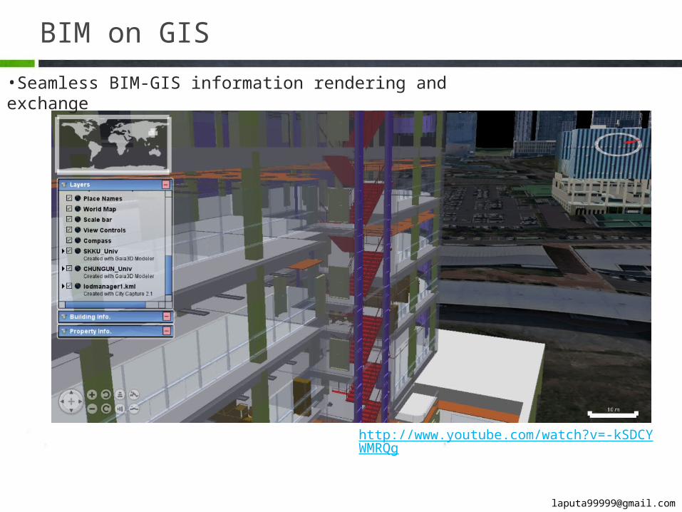
BIM on GIS•Seamless BIM-GIS information rendering and exchange
http://www.youtube.com/watch?v=-kSDCYWMRQg
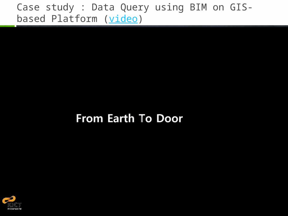
Case study : Data Query using BIM on GIS-based Platform (video)
Prototype version
GIS standard
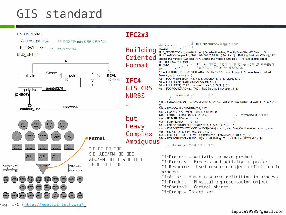
Fig. IFC (http://www.iai-tech.org/)
IfcProject – Activity to make product IfcProcess – Process and activity in projectIfcResource – Used resource object definition in processIfcActor – Human resource definition in processIfcProduct – Physical representation objectIfcControl – Control objectIfcGroup – Object set
Kernel
3 개 기본 확장 패키지5 개 AEC/FM 공통 패키지AEC/FM 도메인별 9 개의 패키지26 개의 리소스 패키지
IFC2x3
Building Ori-ented For-mat
IFC4GIS CRSNURBS…
butHeavyComplexAmbiguous
GIS standard
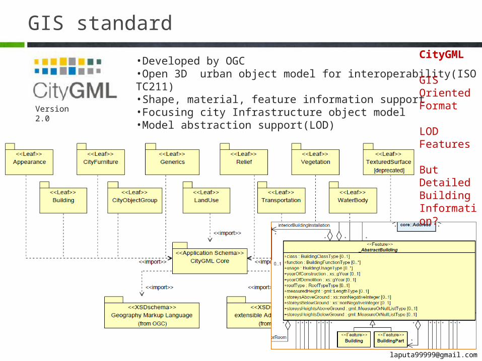
•Developed by OGC•Open 3D urban object model for interoperability(ISO TC211)•Shape, material, feature information support•Focusing city Infrastructure object model•Model abstraction support(LOD)Version 2.0
CityGML
GIS Oriented Format
LODFeatures
But Detailed BuildingInformation?
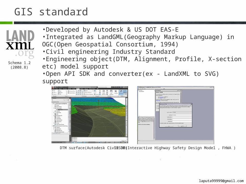
GIS standard•Developed by Autodesk & US DOT EAS-E•Integrated as LandGML(Geography Markup Language) in OGC(Open Geospatial Consortium, 1994)•Civil engineering Industry Standard•Engineering object(DTM, Alignment, Profile, X-section etc) model support•Open API SDK and converter(ex - LandXML to SVG) support
DTM surface(Autodesk Civil 3D)
Schema 1.2 (2008.8)
IHSDM(Interactive Highway Safety Design Model , FHWA )
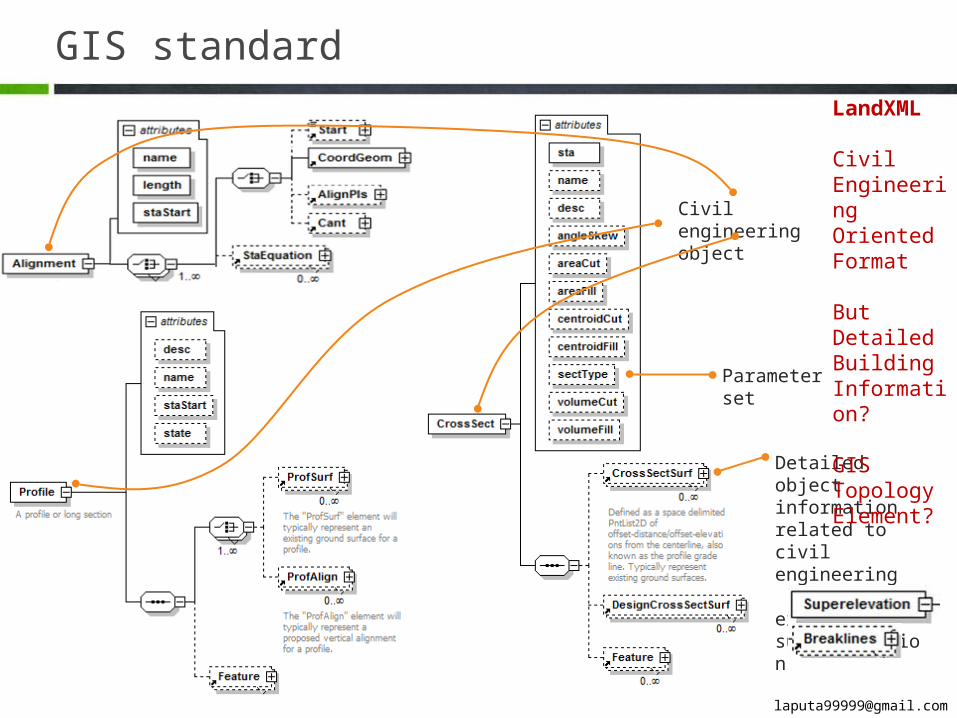
GIS standard
Parameter set
Civil engineering object
Detailed object in-formation related to civil engineering
ex - superelevation
LandXML
Civil Engi-neering Ori-ented For-mat
But Detailed BuildingInformation?
GIS Topology Element?
GIS standard
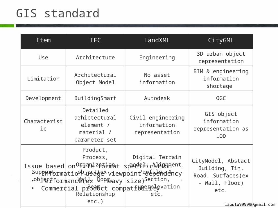
Item IFC LandXML CityGML
Use Architecture Engineering 3D urban object rep-resentation
Limitation Architectural Ob-ject Model No asset information BIM & engineering
information shortage
Development BuildingSmart Autodesk OGC
CharacteristicDetailed arhictec-
tural element / ma-terial / parameter
set
Civil engineering in-formation represen-
tation
GIS object informa-tion representation
as LOD
Support ob-ject
Product, Process, Organization ob-
ject(ex - Wall, Door, Beam, Relationship
etc.)
Digital Terrain model, Alignment, Profile, X-Section, supereleva-
tion etc.
CityModel, Abstact Building, Tin, Road, Surfaces(ex - Wall,
Floor) etc.
Format STEP, XML XML GMLIssue based on file format specification
• Information usage viewpoint dependency• Performance(ex - Heavy size)• Commercial product compatibility

4
Lesson & Learn
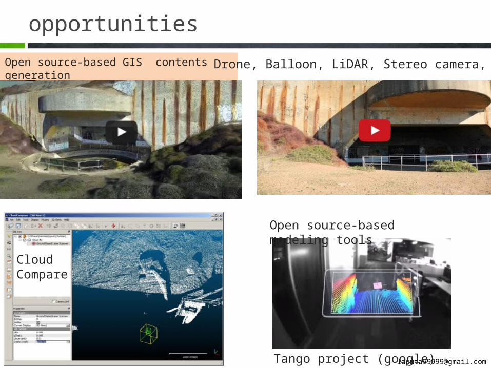
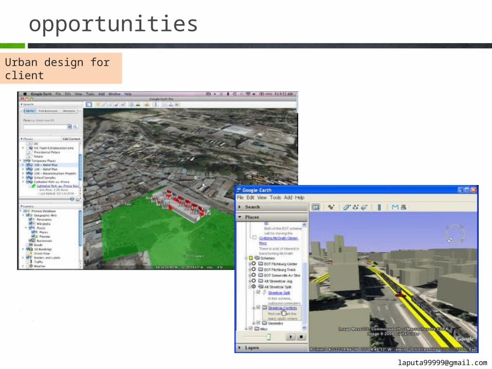
opportunitiesOpen source-based GIS contents generation Drone, Balloon, LiDAR, Stereo camera, RGB-D
Open source-based modeling tools
Tango project (google)
Cloud Compare
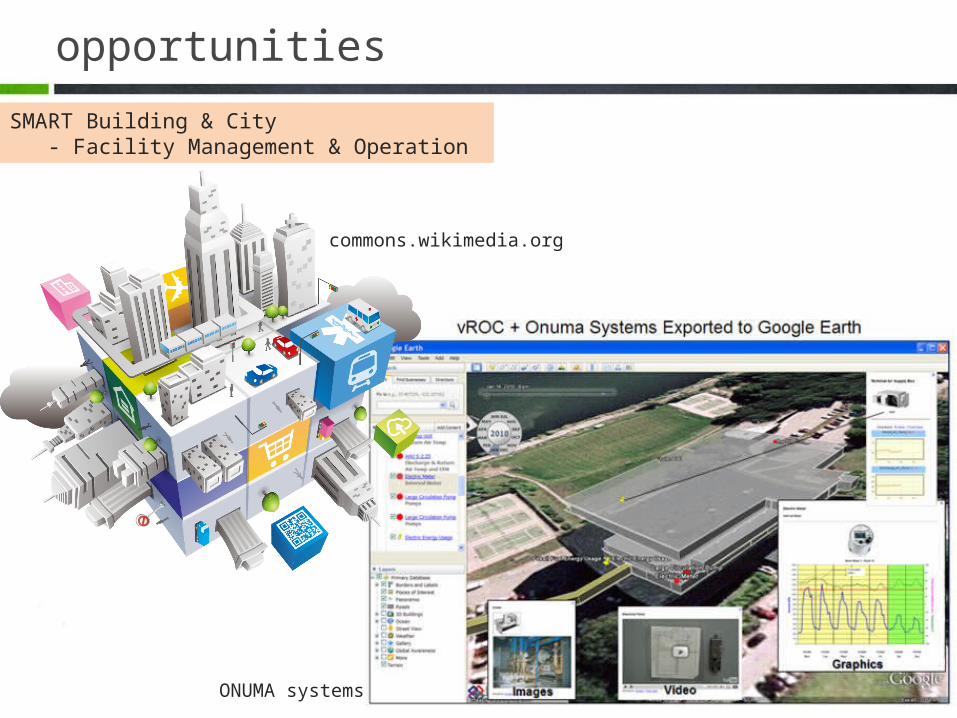
opportunitiesSMART Building & City - Facility Management & Operation
ONUMA systems
commons.wikimedia.org
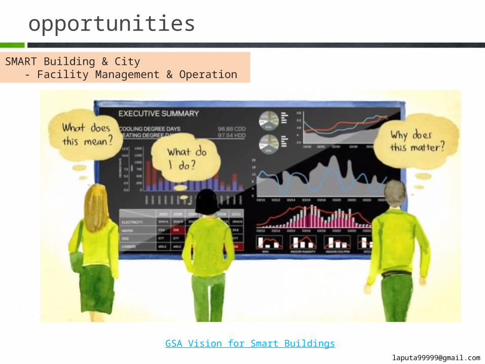
opportunitiesSMART Building & City - Facility Management & Operation
GSA Vision for Smart Buildings

프레젠테이션 주제Thanks for your interestTae Wook, Kang(www.facebook.com/laputa999)


![[새건협 도시 건축_답사]_남산-해방촌__식민지배의_흔적과_해방ㆍ분단의_산물_해방촌](https://img.pdfslide.net/doc/110x75/559230a11a28ab162f8b459a/-559230a11a28ab162f8b459a.jpg)
![변화하는 시대에 따른 도시 교통정책의 새 좌표„¸계와...121 [보고서] 변화하는 시대에 따른 도시 교통정책의 새 좌표 01 도시 이동성의](https://img.pdfslide.net/doc/110x75/5e73d89f68ad7752153adf72/ee-oeeoe-ee-eoe-e-f-oeoe-e-121.jpg)