Embed Size (px)
Citation preview

www.csiro.au
Approaches to representing and delivering geospatial data in the semantic web:Implications for EO data cubes
Computational and Simulation Sciences and eResearch, Annual Conference 2015Melbourne 10-13 FebruaryPaul Box & Simon Cox
LAND & WATER FLAGSHIP | DIGITAL PRODUCTIVITY FLAGSHIP

Overview
• Towards a Digital Earth • Vector data and the emerging semantic web• Implications for EO data cubes
Geospatial data in the semantic web: impliactions for EO - CSS & eResearch, Melbourne 2015| Box2 |

Geospatial data in the semantic web: impliactions for EO - CSS & eResearch, Melbourne 2015| Box
Multi-disciplinary perspectives
3 |
Source: - US National Science Foundation Critical Zone Observatory (CZO)
Rapidly discover, access, integrate, analyze, synthesize and present authoritative information

Geospatial data in the semantic web: impliactions for EO - CSS & eResearch, Melbourne 2015| Box
Towards Digital Earth
• Big data – 3Vs new sources - govt, industry, citizens NGO • Assimilation – extensive manual effort –time consuming GIS/RS environments
4 |
Earth System Models
GEOSS
Policy/mngt. decision
Analysis/prediction
Other Data SourcesSocio-economic data
Earth Observation・ In Situ・ Airborne・ Space-based
Assimilation
Decision Support
Source Adapted from GEO SS10 year implementation planwww.apan.net/meetings/tokyo2006/presentation/JAXA2.ppt
Discover Access Understand Extract, Transform, Load
Use
Time and effort

Towards Digital Earth – data integration• Distributed constellations of systems • Complex information governance• Integrate, analyse and report using standardised geographies• Subjective constructs - features
• River• ASGS• Climate region • Catchment management unit
O&M Rasterpixel
Vectorgeom
Decision maker
- Observed properties- Features of interest
- grid cells/systems- coordinates
shape
Geospatial data in the semantic web: impliactions for EO - CSS & eResearch, Melbourne 2015| Box5 |
Semantics?
Named features
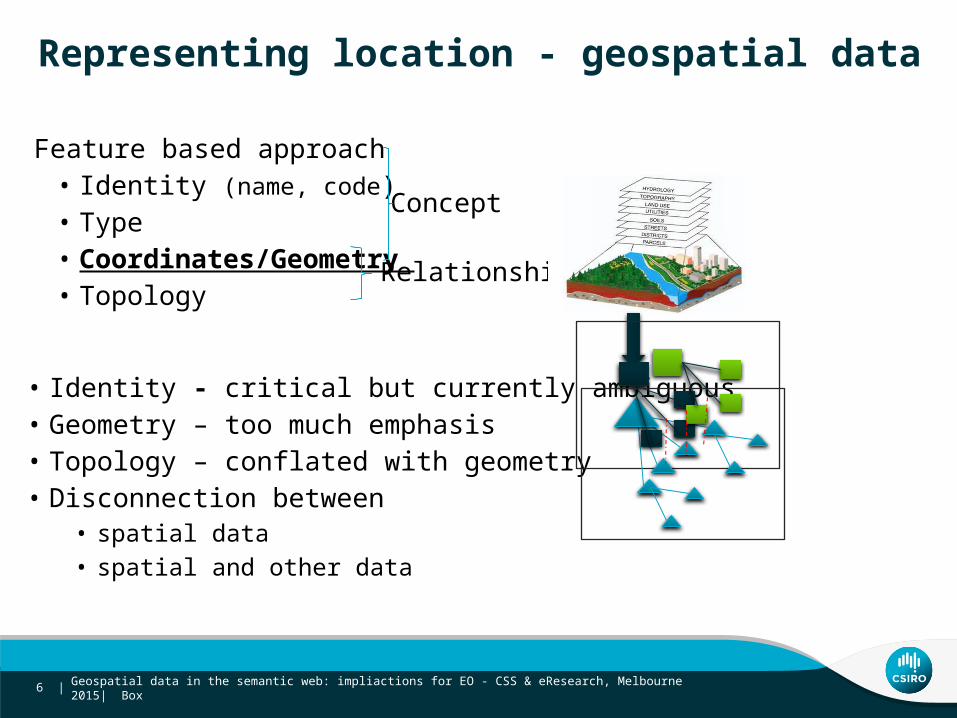
Feature based approach• Identity (name, code) • Type• Coordinates/Geometry • Topology
Representing location - geospatial data
Geospatial data in the semantic web: impliactions for EO - CSS & eResearch, Melbourne 2015| Box6 |
Concept
Relationship
• Identity - critical but currently ambiguous• Geometry – too much emphasis • Topology – conflated with geometry• Disconnection between
• spatial data • spatial and other data

What’s in a name?
Geospatial data in the semantic web: impliactions for EO - CSS & eResearch, Melbourne 2015| Box7 |
‘Leichhardt’in Australia•Australian Gazetteer - 4 (52) - NSW, QLD•ASGS - 10 (12) NSW, VIC, QLD
in NSW•NSW Place Names - 3 (9)
Leichhardt (Sub) NSW
Feature typessuburb, parish, homestead
SA2, SA3, CED, IARE, state suburb (VIC, NSW & QLD)
county, parish, suburb
• One place - many names• Australia, Australie, أستراليا• Sydney, Syd, City of Sydney
• One name – many places

One spatial object - multiple identities
Geospatial information Other information resources
NSW Gaz (GNB NSW) 32679
Spatial Data Infrastructure (SDI)
Geospatial data in the semantic web: impliactions for EO - CSS & eResearch, Melbourne 2015| Box8 |
Geonames http://sws.geonames.org/2160386/
ASGS (ABS) SSC11351
Nat Gaz (GA) NSW3267
Identity - ambiguous, unstable, poorly governed

Geometry and topology
• Unreliable, inefficient for representing topology – across data sets
Geospatial data in the semantic web: impliactions for EO - CSS & eResearch, Melbourne 2015| Box9 |
LGA boundaries

Semantic web technologies to the rescue?• Creating the web of data• Descriptions of things + links between them
• Identify spatial objects using http URIs • link multiple geometry to statistics • organise/reference other data
• Link spatial objects • multiple identities for same object• different spatial objects based on topology
Geospatial data in the semantic web: impliactions for EO - CSS & eResearch, Melbourne 2015| Box10 |
W3C

Geospatial information Statistical information (Implicitly geospatial)
GNB NSW 32679
Spatial Data Infrastructure (SDI)
Geospatial data in the semantic web: impliactions for EO - CSS & eResearch, Melbourne 2015| Box11 |
Geonames 2160386
ABS ASGS SSC11351
GA Aus Gaz NSW3267
Linked spatial data to bridge existing gaps
Spatial IdentifierReference Framework
Index Crosswalk Use

How SIRF Works
SIRFSpatial
Information
StatisticalInformation User
Linked Data Web
Index identifiers
Agency BFinance
API
Agency C Welfare
API
Agency AStatistics
API
Publish URIs
Geospatial data in the semantic web: impliactions for EO - CSS & eResearch, Melbourne 2015| Box12 |
Registering online resources to build data networks
(National) Spatial Data Infrastructure
http://demo.sirf.net/siset/CGNA/NSW81093
http://demo.sirf.net/siset/AUS-FSDF/admin/2owl:sameAs
Geospatial data in the semantic web: impliactions for EO - CSS & eResearch, Melbourne 2015| Box
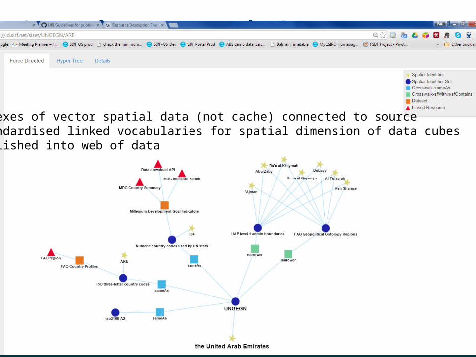
SIRF data network 2
13 |
SIRF indexes of vector spatial data (not cache) connected to source standardised linked vocabularies for spatial dimension of data cubes published into web of data
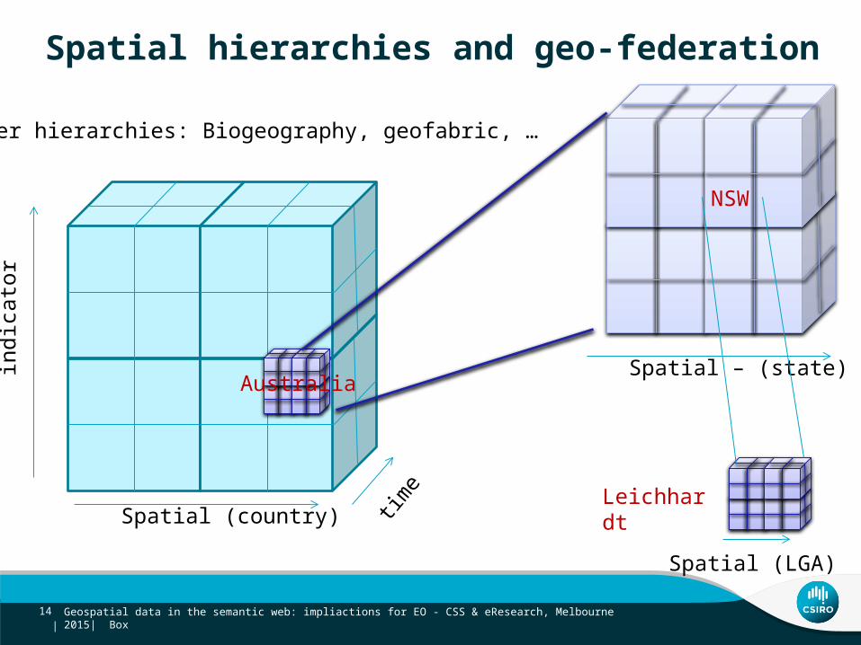
Spatial hierarchies and geo-federationin
dica
tor
Spatial (country) time
Australia
NSW
Spatial – (state)
Spatial (LGA)
Leichhardt
Geospatial data in the semantic web: impliactions for EO - CSS & eResearch, Melbourne 2015| Box14 |
Other hierarchies: Biogeography, geofabric, …
Geospatial data in the semantic web: impliactions for EO - CSS & eResearch, Melbourne 2015| Box
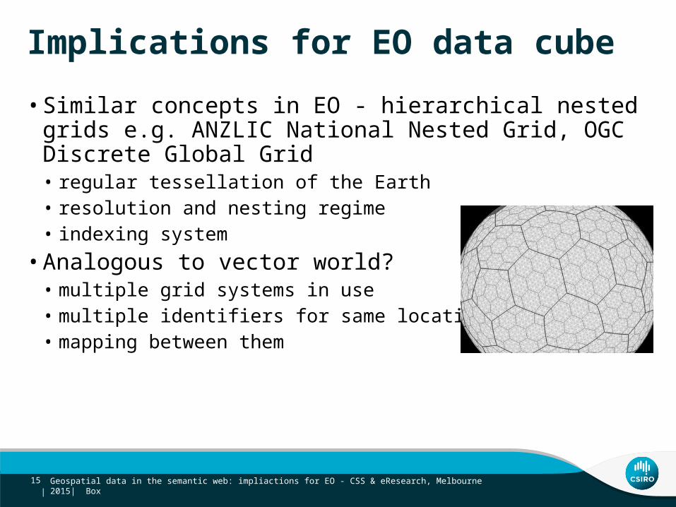
Implications for EO data cube
• Similar concepts in EO - hierarchical nested grids e.g. ANZLIC National Nested Grid, OGC Discrete Global Grid• regular tessellation of the Earth • resolution and nesting regime • indexing system
• Analogous to vector world?• multiple grid systems in use• multiple identifiers for same location• mapping between them
15 |

Geospatial data in the semantic web: impliactions for EO - CSS & eResearch, Melbourne 2015| Box
Implications for EO data cube
Scientists and decision-makers focus on named spatial objectsEO datasets are organized as indexed grids
• From regular grids to reporting geographies - pre-compute grid cells for reporting geographies
• Link between grid systems and vector data identifier schemes• User centric ways of accessing and using data• Publish as linked data
16 |

Paul Box
t: +61 2 93253122e: [email protected]: www.csiro.au
DIGITAL PRODUCTIVITY FLAGSHIP
Thank youCSIRO Land and Water FlagshipDigital Productivity Flagship
SIRF OpenSearch UI http://unsdi.csiro.au/UNSDIOpenSearch/searchSIRF API doco http://www.sirf.net


![eResearch A Max Planck Perspective - DINI · eResearch A Max Planck Perspective ... Download: Mehlhorn_1974_d_m.pdf] 1. Kurt Mehlhorn, ... Maya Ramanath, Ralf Schenkel,](https://img.pdfslide.net/doc/110x75/5aec936e7f8b9ae5318f1553/eresearch-a-max-planck-perspective-dini-a-max-planck-perspective-download.jpg)