Embed Size (px)
Citation preview

www.dewberry.co
m
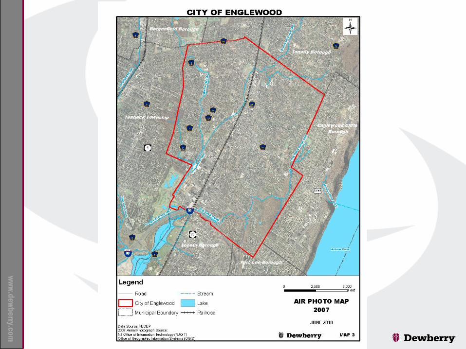
Environmental Resource Inventory
Using GIS: City of Englewood, New
Jersey, USA Presented by John Robinson, PG, CPG
and Mehmet Secilmis, MS, GISP

www.dewberry.co
m
Site/Civil
Surveying
Transportation
Wastewater Infrastructure
Wastewater Treatment
Water Supply & Distribution
Water Treatment
Water/Natural Resources
Environmental Services
Climate Change Services
Disaster Response & Recovery
Emergency Management
Federal Environmental Management
Geospatial & Program Integration
Government Transformation
Hazard Engineering Services
Hazard Mitigation
Training & Education
Commercial
Corrections
Courts
Federal Architecture
Health & Science
Higher Education
Industrial
K - 12 Schools
Libraries
Public Safety
Recreation & Wellness
Religious
Dewberry Practice Areas
INFRASTRUCTURE
ENGINEERING
SERVICES
MANAGEMENT &
CONSULTING
SERVICES
ARCHITECTURAL
BUILDING ENGINEERING
SERVICES

www.dewberry.co
m
Background
Project grant funded by Association of New Jersey
Environmental Commissions (ANJEC)
Purpose of project is to update the 1975 report entitled
“A Quality of Life Study”
by: Charles Edward Bradley, Jr. and Jay Steven Sanders as their Masters Degree
thesis at Penn State University, under the supervision of:
Professor Ian MacHarg (1920-2001) who is the Father of the “Map Overlay
Method” which is the precursor to Geographic Information Systems (GIS).
www.dewberry.co
m
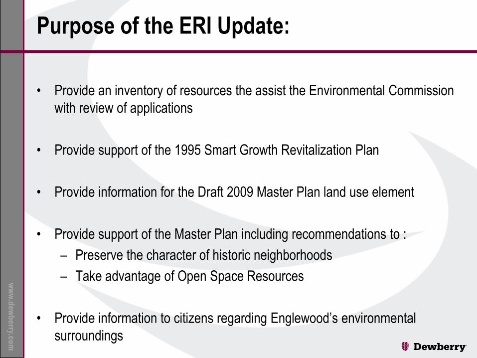
Purpose of the ERI Update:
• Provide an inventory of resources the assist the Environmental Commission
with review of applications
• Provide support of the 1995 Smart Growth Revitalization Plan
• Provide information for the Draft 2009 Master Plan land use element
• Provide support of the Master Plan including recommendations to :
– Preserve the character of historic neighborhoods
– Take advantage of Open Space Resources
• Provide information to citizens regarding Englewood’s environmental
surroundings

www.dewberry.co
m
Englewood ERI
– Introduction
– Cultural Resources
– Land Resources
– Water Resources
– Living Resources
– Air Resources
– Natural Resource Use
– Conclusions and Recommendations
www.dewberry.co
m

www.dewberry.co
m
Englewood ERI
Cultural Resources
Designating Agency No. of Sites
NJ State Historic Preservation Sites 10
NJ State Historic Preservation Districts 2
Bergen County Historic Preservation Sites 800 (approx.)
Historic Preservation Advisory Committee 1,178

www.dewberry.co
m

www.dewberry.co
m

www.dewberry.co
m
Land Resources
• Topography
• Watersheds
• Critical Slopes
• Scenic Vistas
• Soils
• Glacial Geology
• Bedrock Geology

www.dewberry.co
m

www.dewberry.co
m

www.dewberry.co
m

www.dewberry.co
m

www.dewberry.co
m

www.dewberry.co
m

www.dewberry.co
m
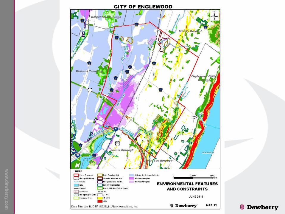
Water Resources
• Surface Water
• Wetlands
• Groundwater Recharge
• Aquifer Recharge
• Aquifer Ranks
• Groundwater Quality
• Groundwater Contaminant Threats
• Flood Plains

www.dewberry.co
m

www.dewberry.co
m

www.dewberry.co
m

www.dewberry.co
m

www.dewberry.co
m

www.dewberry.co
m

www.dewberry.co
m

www.dewberry.co
m

www.dewberry.co
m
Land Resources
• Land Use/Land Cover – Barren Land 0.1%
– Forest 8
– Urban 89.9
– Water 0.65%
– Wetlands 1.3%
• Vegetation – 37 Species Identified in Quality of Life Study
– Fragmented Forests
– Shade Trees
• Wildlife – Wood Turtle Threatened
– Eastern Box Turtle Special Concern
– Critical Wildlife Habitat Flat Rock Brook Park

www.dewberry.co
m

www.dewberry.co
m

www.dewberry.co
m
www.dewberry.co
m

The ERI and Planning

www.dewberry.co
m

www.dewberry.co
m
Recommendations
Follow recommendations from Planning Board and Planner
Continue to protect inventory of cultural resources
Continue to protect scenic vistas
Protect surface waters from non-point source pollution
Promote awareness of groundwater resources
Explore opportunities of flood mitigation
Enhance critical wildlife habitats where possible
Prepare a shade tree management plan incorporating the use of GIS
Continue to protect open space and create Greenways where possible
Conduct periodic updates of this ERI

www.dewberry.co
m
Thank You