
Remote Sensing of Environment xxx (2009) xxx–xxx
RSE-07524; No of Pages 14
Contents lists available at ScienceDirect
Remote Sensing of Environment
j ourna l homepage: www.e lsev ie r.com/ locate / rse
ARTICLE IN PRESS
Atmospheric correction of ENVISAT/MERIS data over inland waters: Validation forEuropean lakes
Luis Guanter a,f,⁎, Antonio Ruiz-Verdú b, Daniel Odermatt c, Claudia Giardino d, Stefan Simis e, Víctor Estellés f,Thomas Heege g, Jose Antonio Domínguez-Gómez h, Jose Moreno f
a GFZ German Research Centre For Geosciences, Telegrafenberg, D-14473 Potsdam, Germanyb National Institute for Aerospace Technology (INTA), Ctra Ajalvir, km 4.500, 28850 Torrejón de Ardoz, Spainc Remote Sensing Laboratories (RSL), Dept. of Geography, University of Zurich, Winterthurerstr. 190, CH-8057 Zurich, Switzerlandd CNR-IREA, Via Bassini 15, 20133 Milano, Italye Finnish Environment Institute (SYKE), Marine Research Centre, PO BOX 140, FI-00251, Helsinki, Finlandf Department of Earth Physics and Thermodynamics, University of Valencia, Dr Moliner 50, 46100 Burjassot, Valencia, Spaing EOMAP GmbH & Co. KG, Sonderflughafen Oberpfaffenhofen, D-82205 Gilching, Germanyh Centre for Hydrographic Studies, CEDEX, P° Bajo de la Virgen del Puerto, 3, 28005 Madrid, Spain
⁎ Corresponding author. Department of Earth PhUniversity of Valencia, Dr Moliner 50, 46100 Burjassot,
E-mail address: [email protected] (L. Guante
0034-4257/$ – see front matter © 2009 Elsevier Inc. Aldoi:10.1016/j.rse.2009.10.004
Please cite this article as: Guanter, L., et alakes, Remote Sensing of Environment (2009
a b s t r a c t
a r t i c l e i n f oArticle history:Received 6 May 2009Received in revised form 28 September 2009Accepted 2 October 2009Available online xxxx
Keywords:MERISAtmospheric correctionInland watersAerosol optical thicknessSCAPE-MValidation
Traditional methods for aerosol retrieval and atmospheric correction of remote sensing data over watersurfaces are based on the assumption of zero water reflectance in the near-infrared. Another type ofapproach which is becoming very popular in atmospheric correction over water is based on the simultaneousretrieval of atmospheric and water parameters through the inversion of coupled atmospheric and bio-opticalwater models. Both types of approaches may lead to substantial errors over optically-complex water bodies,such as case II waters, in which a wide range of temporal and spatial variations in the concentration of waterconstituents is expected. This causes the water reflectance in the near-infrared to be non-negligible, and thatthe water reflectance response under extreme values of the water constituents cannot be described by theassumed bio-optical models. As an alternative to these methods, the SCAPE-M atmospheric processor isproposed in this paper for the automatic atmospheric correction of ENVISAT/MERIS data over inland waters.A-priori assumptions on the water composition and its spectral response are avoided by SCAPE-M bycalculating reflectance of close-to-land water pixels through spatial extension of atmospheric parametersderived over neighboring land pixels. This approach is supported by the results obtained from the validationof SCAPE-M over a number of European inland water validation sites which is presented in this work. MERIS-derived aerosol optical thickness, water reflectance and water pigments are compared to in-situ dataacquired concurrently to MERIS images in 20 validation match-ups. SCAPE-M has also been compared tospecific processors designed for the retrieval of lake water constituents from MERIS data. The performance ofSCAPE-M to reproduce ground-based measurements under a range of water types and the ability of MERISdata to monitor chlorophyll-a and phycocyanin pigments using semiempirical algorithms after SCAPE-Mprocessing are discussed. It has been found that SCAPE-M is able to provide high accurate water reflectanceover turbid waters, outperforming models based on site-specific bio-optical models, although problems ofSCAPE-M to cope with clear waters in some cases have also been identified.
ysics and Thermodynamics,Valencia, Spain.r).
l rights reserved.
l., Atmospheric correction of ENVISAT/MERIS), doi:10.1016/j.rse.2009.10.004
© 2009 Elsevier Inc. All rights reserved.
1. Introduction
The application of remote sensing tools to ocean color monitoringandwater quality analysis has increased in the last years following thegrowing availability of instruments providing the proper radiometricand spectral configuration for water studies. The Coastal Zone Color
Scanner (CZCS) (Hovis et al., 1980) and the Sea-viewing Wide Field-of-view Sensor (SeaWiFS) (McClain et al., 2004) are examples of EarthObservation projects that have been dedicated to water monitoring inthe last two decades. The ModerateResolution Imaging Spectro-radiometer (MODIS) (Salomonson et al., 1989), on board the Terraand Aqua platforms, also presents spectral channels devoted to oceancolor monitoring. In this context, the MEdium Resolution ImagingSpectrometer (MERIS) (Rast et al., 1999)on board the ENVIronmentalSATellite (ENVISAT) platform is a multispectral instrument intendedto succeed CZCS, SeaWIFS and MODIS as a reference instrument forsatellite-based studies of ocean and continental waters.
data over inland waters: Validation for European

2 L. Guanter et al. / Remote Sensing of Environment xxx (2009) xxx–xxx
ARTICLE IN PRESS
MERIS is a pushbroom imaging spectrometer operating in thevisible and near-infrared (VNIR) spectral range from 400 to 900 nm. Ithas a field of view (FOV) of 68.5° around nadir, which leads to a swathwidth of 1150 km at a nominal altitude of 800 km. Ground samplingdistance is about 300 m for full spatial resolution (FR) data and about1.2 km for reduced spatial resolution (RR) data. MERIS is designed tomeasure with high radiometric performance (noise b2% of thedetected signal), high dynamic range (up to 100% albedo) and lowsensitivity to polarization (b0.3%) at 15 programmable bands whichare set by default to nominal center wavelengths of 412.5, 442.5, 490,510, 560, 620, 665, 681, 709, 754, 761, 779, 865, 890 and 900 nmwithtypical bandwidths of 10 nm. One of the major reasons for thiswavelength configuration is its sensitivity to the most importantoptically-active water constituents. For example, retrieval of yellowsubstances (coloured dissolved organic matter and detritus)(412.5 nm), chlorophyll absorption (442.5, 490, and 665 nm),turbidity (510, 620 nm), red tides (510 nm), and chlorophyllfluorescence (665, 681, and 709 nm) are applications foreseen forMERIS.
Most approaches to the remote sensing of water constituentsemploy water reflectance data as a starting point. Water reflectancederived from remote sensing data results from the so-calledatmospheric correction process, which converts the top-of-atmo-sphere (TOA) radiance signal into water leaving reflectance afternormalization by illumination conditions and removal of atmosphericeffects. Aerosol scattering is known to be the largest source ofuncertainty in the retrieval of water reflectance from TOA radiance inthe VNIR range (Gordon and Wang, 1978, 1994; Wang, 2007), oncethe contribution from other variables such as illumination andobservation conditions and surface elevation can be accuratelyestimated from ancillary data and radiative transfermodels. Assumingthe intrinsic temporal and spatial variability of aerosol content, themost accurate atmospheric correction requires aerosol loading overthe imaged area to be retrieved for each data acquisition. Thereflectance data calculated from atmospheric correction are then usedtogether with analytical or empirical bio-optical models to retrievewater constituents by inversion procedures (Gitelson et al., 2007,2008; Giardino et al., 2007).
Traditional algorithms for aerosol retrieval over water targets arebased on the assumption of zero reflectance in the near-infrared (NIR)spectral region (wavelengths longer than 700 nm) (Gordon andWang, 1978; Viollier et al., 1980; Gordon and Wang, 1994). However,it has been demonstrated that this approach leads to considerableerrors in the presence of absorbing aerosols (Gordon, 1997; Bailey andWerdell, 2006) or over case II waters, where suspended sediments orhigh concentrations of phytoplankton and detrital particles mayoriginate a non-negligible reflectance at NIR channels (Dekker et al.,1997; Lavender et al., 2005; Morel and Bélanger, 2006). In turn, thisNIR reflectance is unknown until an estimate of the aerosol extinctionis available, which generates a circular problem. Attempts to correctfor non-dark reflectances at NIR in aerosol retrieval over water usingsimple reflectance models have been published (Siegel et al., 2000;Ruddick et al., 2000). Gao et al. (2007) presented an approach foratmospheric correction of MODIS data over coastal waters based onaerosol retrieval from wavelengths larger than 860 nm, where thecontribution of suspended particles and bottom scattering is supposedto be aminimum. Other approaches perform simultaneous retrieval ofatmospheric and water components by a multi-parameter inversionusing the complete VNIR information and coupled atmospheric andbio-optical radiative transfer models so that aerosol and waterparameters are retrieved in a consistent way (Moore et al., 1999).This inversion is normally performed by non-linear optimization(Kuchinke et al., 2009) or neural network (Schiller and Doerffer, 2005;Schroeder et al., 2007; Kratzer et al., 2008) techniques. Thesemethodsare very adequate for the representation of the coupled water–atmosphere radiative transfer problem, and are able to provide a
Please cite this article as: Guanter, L., et al., Atmospheric correction oflakes, Remote Sensing of Environment (2009), doi:10.1016/j.rse.2009.10.
pixel-wise description of the horizontal variations in atmosphere andwater. However, these methods may be typically site-specific, as theinversion results depend on the input values applied to constrain thebio-optical model (Kuchinke et al., 2009; Odermatt et al., 2008a). Thissituation is especially problematic under extreme water turbidity orunusual concentrations of the water constituents, as the bio-opticalmodel is frequently not prepared to deal with those conditions.
A different approach for water reflectance retrieval from MERISdata over continental water bodies is proposed in this work. It is basedon amodular approach inwhich aerosol loading andwater reflectanceare retrieved sequentially. The processing is carried out by the Self-Contained Atmospheric Parameters Estimation for MERIS data(SCAPE-M) automatic atmospheric correction processor (Guanteret al., 2007, 2008). Aerosol optical thickness andwater vapormaps arederived over land surfaces, and extended to medium and small sizewater targets by spatial interpolation. Aerosol optical thickness overwater bodies is then determined from neighboring land surfaces,preferably over dark vegetation. No a-priori assumption is made onthe water composition and no bio-optical model is necessary forwater reflectance retrieval, but water reflectance is derived in parallelto land surface reflectance. Errors in aerosol retrieval due to adjacencyeffects in the NIR wavelengths, which are expected for medium andsmall continental water bodies, are also avoided by this methodology.A similar idea for the atmospheric correction of SeaWiFS and MERISdata over inland waters based on aerosol retrieval over land wasproposed by Vidot and Santer (2005) and Floricioiu and Rott (2005).The main difference of those approaches to the one presented in thispaper is that aerosol retrieval in their work is performed on a per-pixel basis using dense dark vegetation (DDV) pixels. The applicabilityof those methods is therefore determined by the presence of DDVpixels. SCAPE-M, in contrast, uses a range of land reflectance spectrato characterize a given area for aerosol retrieval. This approach isexpected to improve the spatial coverage of the aerosol product.
The main objective of this contribution is to present these “land-based”methods for aerosol and water reflectance retrieval in the caseof inland and coastal waters as a robust alternative to standard pixel-wise and “water-based” aerosol retrieval methods. The proposedmethod may have a limited application range in terms of spatialcoverage, as it can only be used with small and medium sized waterbodies, and it can fail in the case of inhomogeneous atmosphericconditions. However, its accuracy in reflectance retrieval over verycomplex water bodies (shallow waters or highly eutrotrophic lakes)may outperform that of approaches based on the inversion of site-specific bio-optical models which are not prepared to cover theseabnormal water conditions. This is demonstrated in this paper by thecomparison of SCAPE-M water reflectance data with in-situ waterreflectancemeasurements andwith results from theMERIS lakewaterprocessors implemented in the Basic ERS & Envisat (A)ATSR andMERIS (BEAM) Toolbox (Fomferra and Brockmann, 2005). Extensevalidation has thus far been lacking when dealing with the land-basedatmospheric correction of continental waters.
2. Materials and methods
2.1. SCAPE-M atmospheric correction over land and continental waters
The SCAPE-M method for the retrieval of aerosol loading, watervapor and reflectance from MERIS data and the validation of thoseproducts over land are described in detail in Guanter et al. (2007,2008). SCAPE-M performs automatic cloud screening, aerosol andwater vapor retrieval and surface reflectance retrieval sequentiallyfrom MERIS Level-1b data over land surfaces and over inland andcoastal water pixels. The atmospheric optical parameters neededalong the processing are calculated by interpolation from a look-uptable (LUT) compiled with the MODTRAN4 atmospheric radiativetransfer code (Berk et al., 2003). The Thuillier solar irradiance data
ENVISAT/MERIS data over inland waters: Validation for European004

3L. Guanter et al. / Remote Sensing of Environment xxx (2009) xxx–xxx
ARTICLE IN PRESS
base (Thuillier et al., 2003) attached to MERIS images is used as areference extraterrestrial solar constant. Elevation and topographiccorrections are carried out by the use of a digital elevation model(DEM) projected onto each MERIS image to be processed.
Aerosol retrieval is performed over spatially-integrated windowsin order to improve the spatial coverage of the aerosol product. In thedefault configuration, aerosol optical thickness at 550 nm (AOT550)retrieval is performed at macro-pixels of 30 km×30 km. For eachmacro-pixel, a maximum AOT550 threshold is estimated from darkpixels in the area, including inland water targets. Such a threshold iscalculated as themaximumAOTwhich gives non-negative reflectanceat the dark pixels after atmospheric correction. This value is refined bythe exploitation of those cells with sufficient green vegetation andbare soil pixels. The TOA radiances at 5 land pixels, mix of vegetationand bare soil and with as much spectral contrast as possible, areinverted assuming that surface reflectance can be provided by a linearcombination of two endmembers, pure vegetation and bare soilspectra. Endmember abundances and the AOT550 are retrievedconcurrently. The retrieval of the aerosol type from image data isnot attempted, as the MERIS spectral coverage and sampling werefound to be insufficient for the reliable retrieval of aerosol type overland (Santer et al., 2005; Ramon and Santer, 2005). The validity offixing the aerosol model to rural aerosols for a large proportion ofcases is probed in Béal et al. (2007). A default rural aerosol model ischosen instead. Both the number of 5-pixel clusters and the number ofvegetation endmembers to be used in the inversion are set by theuser, according to computation time criteria. The final steps are to fill-in by interpolation areas with unsuccessful AOT retrieval in themacro-pixel mosaic, and to smoothen the resulting mosaic-likeAOT550 map using a cubic convolution method. This approach forAOT retrieval overland differs from that presented in Vidot and Santer(2005), in which AOT retrieval was performed pixel-wise and one freeparameter in the AOT inversion accounted for the aerosol modelthrough the Ångström coefficient. No information about the reliabilityof this methodology for aerosol model estimation has been found inthe literature.
A validation exercise comparing SCAPE-M AOT550 retrievals frommore than 200 MERIS images with AErosol RObotic NETwork(AERONET) data (Holben et al., 1998) from stations around theworld was previously carried out (Guanter et al., 2007, 2008). A highcorrelation between MERIS-derived and AERONET-derived AOT wasgenerally found. Mean square Pearson's correlation coefficient R2
values were around 0.75, although some cases with low R2 (0.337,El Arenosillo station) or very high (0.925, Toulouse, FR data) were alsofound. A systematic underestimation of MERIS-derived AOT bySCAPE-M with respect to AERONET measurements for AOT550above 0.4 was detected in most of the sites. Root mean square errors(RMSEs) were about 0.05 in most of the tested cases.
Surface reflectance maps are calculated by SCAPE-M from MERISradiance data from the generated cloud mask, DEM, illumination andobservation angles, terrain normal vector, AOT550 nm and columnarwater vapor (CWV) maps per-pixel over land and inland water pixels.A Lambertian surface is assumed in the modelling of radiative transfereffects. This same set up has been applied to the processing of waterpixels. The AOT550 and CWV maps derived from land surfaces areextended to inland water targets by spatial inter- or extrapolation.This is implicitly performed by the smoothing of the mosaic of30 km×30 km cells in which AOT is retrieved. A spatially-continuousAOT map covering the imaged area is obtained after the smoothingprocess. Large water pixels non-compliant with the assumption ofhorizontal continuity of the atmospheric parameters are thenscreened out of the processing. In the default processing mode, inlandwater pixels are defined as those water pixels not further than 20 kmfrom a land surface, or those inside closedwater bodies with an area ofless than 1600 km2. These limits are empirically defined as themaximum distance within which the assumption of the continuity of
Please cite this article as: Guanter, L., et al., Atmospheric correction oflakes, Remote Sensing of Environment (2009), doi:10.1016/j.rse.2009.10.
AOT550 and CWV can normally be assumed. However, since thehorizontal continuity of atmospheric parameters depends on chang-ing factors, such as the atmospheric stability or the existence ofaerosol sources located close to the water bodies, the 20 km and1600 km2
figures could vary in the real case. For this reason, SCAPE-Mpresents a supervised processing mode in which the maximumwater–land distance and lake area can be set by an assay errorapproach. The visual inspection of the resulting water reflectancespectra is the main indicator for the selection of those parameters.
The impact of adjacency effects over inland and coastal waterpixels can be very strong in the NIR channels, for which water is verydark and land pixels normally present a high reflectance, and can evenbe noticed in visible channels under certain conditions (Odermattet al., 2008b). A simple adjacency correction is performed by SCAPE-Mon the final reflectance product. It consists in modelling the at-sensorradiance as a linear combination of the photons coming directly fromthe target and those coming from areas adjacent to the target andscattered into the sensor direction. This is implemented by weightingthe strength of the adjacency effect by the ratio of diffuse to directground-to-sensor transmittance (Vermote et al., 1997). The adjacen-cy-corrected surface reflectance, ρ, is then calculated as
ρ = ρu +t↑dift↑dir
ρu−ρ� �
; ð1Þ
where ρu is the target reflectance before the adjacency correction, ρ̄̄ isthe background reflectance, calculated as the distance-weightedaverage reflectance of the neighboring pixels, and tdir
↑ , tdif↑ are theatmospheric transmittance functions between the surface and thesensor for direct and diffuse radiation, respectively. The ImprovedContrast between Ocean and Land (ICOL) processor (Santer et al.,2009) is implemented in the BEAM software in order to enableadjacency correction of MERIS data at the radiance level. The ICOLprocessor, which is based on the formulation presented above, will beused as a reference for validation later in this work.
It must be clearly pointed out that SCAPE-M is not a water-oriented atmospheric processor, but a general purpose atmosphericcorrection method for MERIS data over continental surfaces. Theemphasis in SCAPE-M is put on the rigorous modelling of atmosphericeffects and the automatic estimation of atmospheric aerosol andwater vapor parameters. This is known to be a major issue for theaccurate reflectance retrieval, even in the case of water targets.However, this generic nature of SCAPE-M implies that some water-specific aspects, such as the choice of an aerosol model, which cannotbe reliably performed fromMERIS data over land but it is possible overwater, or the consideration of bidirectional reflectance effects at thesurface, which may account for about 5% of the water reflectancesignal (Park and Ruddick, 2005) are neglected.
2.2. Algorithms for the estimation of phycocyanin and chlorophyll-a fromMERIS data
The suitability of MERIS data and SCAPE-M processing for themonitoring of water pigments on eutrophic lakes has been exploredas a further validation exercise. The concentration of chlorophyll a([CHL-a]) from both MERIS- and radiometry-based reflectance datahas been calculated using the Gons semiempirical algorithm (Gons,1999), and the concentration of the cyanobacterial pigment phyco-cyanin ([PC]) has been calculated using the Simis et al. semiempiricalalgorithm (Simis et al., 2005, 2007). These algorithms will be referredto as CHL-a and PC algorithms hereafter.
Both algorithms were developed for use with turbid waters andare based on reflectance band ratios and semiempirical relationshipsusing MERIS channels at 620, 665, 709 and 778.8 nm. Water andphytoplankton pigments are assumed to dominate absorption in the
ENVISAT/MERIS data over inland waters: Validation for European004

4 L. Guanter et al. / Remote Sensing of Environment xxx (2009) xxx–xxx
ARTICLE IN PRESS
620 nm channel (PC and CHL-a) and in the 665 nm channel (CHL-a),while absorption in the 709 and 779 nm bands is assumed to bedominated by water. Following Gons et al. (2005), a spectrally neutralbackscattering coefficient bb is calculated from the normalized waterreflectance (Rw) in the 779 nm channel as
bbð779Þ =1:61 × Rwð779Þ
0:082− 0:6 × Rwð779Þ: ð2Þ
Following Gons (1999), Gons et al. (2005), Simis et al. (2005),[CHL-a] is calculated from bb(779) by
½CHL� a� = Rwð709ÞRwð665Þ
ð0:727 + bbÞ− 0:401− bb
� �= 0:015: ð3Þ
In turn, [PC] is calculated by the nested semiempirical band ratioalgorithm described in Simis et al. (2005, 2007). This model uses thesame reflectancemodel in Eq. (3) and corrects for CHL-a absorption inthe 620 nm:
½PC� = 170 ×Rwð709ÞRwð620Þ
ð0:727 + bbÞ− 0:281− bb
� �− ð0:51 × ½CHL− a�Þ
ð4Þ
These CHL-a and PC algorithms have been selected because theycan provide a reliable measure of [CHL-a] and [PC] in turbid waters bymeans of simple reflectance relationships, whichmakes them suitablefor an estimation of the impact of atmospheric correction over thesubsequent retrieval of water pigment concentrations.
2.3. Lake water processors in the BEAM software
The performance of the SCAPE-M atmospheric processor has beencompared to that of the MERIS lake algorithms (Doerffer and Schiller,2008) implemented in the BEAM software (Fomferra and Brockmann,2005). These algorithms include neural network-based enhancedatmospheric correction and specific bio-optical algorithms to deriveinherent optical properties (IOPs) and water constituents concentra-tion (CHL-a and total suspended matter) from MERIS data. Based onspecific IOP ranges (CHL-a, gelbstoff and suspended matter), threedifferent processors are available. The Case-2 Regional (C2R) waterprocessor (version 1.3) presents a bio-optical model adapted to awide range of IOP variation, while the eutrophic lakes and the boreallakes processors (version 1.0) share the same architecture, but thebio-optical models were optimized for extreme concentrations ofCHL-a and gelbstoff, respectively. The user of these processors mustdecide in advancewhich one is better suited to the data to be processed.The IOPs used for the development of the bio-optical models of theeutrophic lakes and the boreal lakes were measured in Spanish andFinnish lakes, respectively. Validation of reflectance and water con-stituents retrieval by these processors is presented in Ruiz-Verdú et al.(2008a).
2.4. In-situ validation data
A set ofMERIS FR images acquired over some European sites whereconcurrent in-situ measurements of water reflectance were availablewas selected and processed with SCAPE-M. Ground-based measure-ments were acquired during field campaigns devoted to water qualitystudies, and some of them in support of MERIS activities for algorithmdevelopment and validation.
A field campaign directed by the Centre for Hydrographic Studies(CEDEX, Spain) on 19 June 2003 yielded reflectance spectra fromseveral mountain reservoirs in the Northeast of the Iberian Peninsulafor the validation of airborne-based and MERIS Level-2 waterproducts. The measurements were made in the deep oligotrophic
Please cite this article as: Guanter, L., et al., Atmospheric correction oflakes, Remote Sensing of Environment (2009), doi:10.1016/j.rse.2009.10.
Tremp and Canelles reservoirs, in the oligotrophic Rialb reservoir andin the shallow and turbid Terradets reservoir. Radiometric measure-ments were taken with an ASD-FR spectroradiometer (AnalyticalSpectral Devices, Boulder, CO USA). The time between the measure-ments and the ENVISAT overpasses was 1 day at worst.
CEDEX was also involved in a series of 8 campaigns performed inJune and July 2007 for the validation of MERIS lake water processors.Four reservoirs and one coastal lake were chosen, covering a widegradient of environmental conditions: Albufera de Valencia, ahypereutrophic freshwater coastal lagoon, characterized by veryhigh CHL-a concentrations (N250 mg m−3) and frequent cyanobac-teria blooms; Almendra, a large, high altitude eutrophic reservoir;Cuerda del Pozo, a medium size, mesotrophic mountain reservoir;Iznájar, a medium size, low altitude, mesotrophic reservoir, andRosarito, a medium size eutrophic reservoir with high summer CHL-aconcentrations and persistence of cyanobacteria. Atmospheric mea-surements were carried out with a CIMEL 318NE sunphotometer(CIMEL Electronique, Paris, France) concurrent to MERIS acquisitionsduring those campaigns. Technical problems prevented in-situreflectance measurements during one visit to the Almendra reservoiron 27 June 2007.
Spectroradiometric measurements were also acquired at LakeIJsselmeer during MERIS acquisitions in Summer 2004 and 2005 byThe Netherlands Institute of Ecology (NIOO-KNAW). Lake IJsselmeeris a large (1200 km2), turbid (Secchi disk depth 1.0 m), shallow(average depth 4 m) and eutrophic lake system which exhibits aseasonal phytoplankton distribution with summer blooms of mainlychlorophytes and cyanobacteria. Spectroradiometric measurementswere collected in-situ using a PR-650 (Photo ResearchInc, Chatsworth,CA USA) handheld spectroradiometer to measure water leavingradiance, sky radiance, and downwelling irradiance, as described indetail elsewhere (Gons, 1999; Simis et al., 2005, 2007). Thereflectancemeasurements used here were obtained at anchor stationsas the average of three reflectance measurements, each consisting of10 recordings of each (ir)radiance component.
In the northern prealpine region, MERIS coinciding spectroradio-metric measurements of Lake Constance, Lake Leman (also known asLake Geneva) and Lake Zurichwere taken during 4 campaigns in 2007.The campaigns on Lake Constance were carried out for the MERISLakes validation project (Ruiz-Verdú et al., 2008a) by a consortium ledby EOMAP GmbH, supported by the Institute for Lake Research,Langenargen, Germany, the Limnological Institute of the University ofKonstanz, the University of Hohenheim and RSL of the University ofZurich. The data of Lake Leman and Lake Zurich were measured byRSL, the former with the support of the Lacustrian HydrobiologyStation in Thonon-les-Bains in the case of Lake Leman. In allcampaigns, RAMSES ARC and ASC instruments (TriOS GmbH, Old-enburg, Germany) provided by DLR (German Aerospace Center,Oberpfaffenhofen, Germany) were used to measure downwellingirradiance as well as upwelling radiance and irradiance below thesurface, which were subsequently converted into reflectance. LakeLeman and Lake Constance are the largest two freshwater reservoirsin Western Europe, with a total area of 580 and 535 km2, and anaverage depth of 310 and 254 m, respectively. Lake Zurich isconsiderably smaller (88 km2, 136 m). The three lakes are situatedin the Rhone, Rhine and Linth Valleys, respectively, which drain theNorthern Prealps in northern to western directions. In 2006, in-situmeasured concentrations of CHL-a in the 0–20 m zone varied from 1.5to 10.0 mg m−3 in Lake Leman and from 0.5 to 5.7 mg m−3 in LakeConstance. The variations in Lake Zurich in 2007 were between 3.2and 17.7 mg m−3. Lake Constance is thus considered oligotrophic,Lake Leman is mesotrophic and Lake Zurich is between meso- andeutrophic.
A series of field studies were conducted in summer 2008 by theInstitute for Electromagnetic Sensing of the Environment of theNational Research Council of Italy (CNR-IREA) at the Italian lakes of
ENVISAT/MERIS data over inland waters: Validation for European004

Table 2Summary of the validation campaigns with field activities concurrent to MERISacquisitions used in this study.
Campaign Date(ddmmyy)
t, MERIS(hh:mm)
Δt, In-situ(hh:mm)
Secchi(m)
CHL-a(mg m−3)
Albufera 06-06-07 10:11 10:00–11:20 0.2 379.0Almendra I 27-06-07 10:50 N/A 2.4 44.0Almendra II 10-07-07 10:42 10:10–11:20 1.8 44.0Canelles 17-06-03 a 10:20 10:30–12:05 6.0 1.0Constance I 13-04-07 10:06 8:10–10:40 3.9 2.7Constance II 20-04-07 9:46 8:20–11:05 5.4 1.7Cuerda del Pozo 28-06-07 10:19 12:10–12:30 3.2 4.0Garda 06-05-08 9:40 12:13–12:45 8.0 2.7IJsselmeer I 03-08-04 9:58 9:00–15:30 1.0 35.9IJsselmeer II 07-09-04 9:58 8:30–16:15 1.0 69.1IJsselmeer III 16-08-05 10:18 8:40–15:30 1.0 61.5Iznájar 04-07-07 10:31 9:50–11:10 4.8 1.4Leman/Geneva 10-09-07 9:52 10:40–11:07 N3.0 3.0Maggiore 03-08-08 9:43 9:00–14:22 N3.0 N/ARialb 18-06-03 a 10:20 10:00–11:10 2.0 8.7Rosarito 13-07-07 10:48 10:20 0.5 53.0Terradets 18-06-03 a 10:20 15:45–16:10 0.6 0.9Trasimeno I 06-08-08 9:49 10:41–12:06 1.0 5.0Trasimeno II 23-09-08 9:40 9:30–12:12 1.0 5.0Tremp 19-06-03 10:20 8:55–10:50 4.6 2.4Zurich 15-08-07 10:09 12:30–13:16 b3.0 10.0
Secchi disk and CHL-a values are not fully representative for lakes with high spatial andtemporal variations. Data acquisition times are given in the UTC scale.
a MERIS data were acquired on 19-06-03.
5L. Guanter et al. / Remote Sensing of Environment xxx (2009) xxx–xxx
ARTICLE IN PRESS
Trasimeno, Maggiore and Garda. Lake Garda and Lake Maggiore arethe two largest lakes of Italy, with a size of 368 km2 and of 212 km2,respectively. Both located in the northern part of the country, theybelong to the subalpine ecoregion and are part of the most importantItalian lacustrine district, which represents about 80% of the totalItalian lacustrine volume. Maggiore and Garda lakes are very deep(average depth of 178 m and 133 m, respectively) and oligotrophic,although Lake Garda shows some tendency towards mesotrophicconditions. Lake Trasimeno, the fourth largest Italian lake (124 km2),is located in central Italy. It is a shallow (average depth of 4 m) andmesotrophic lake, characterized by turbid waters (average Secchi diskdepth 1 m). A total of 10 stationsweremeasured in Lake Trasimeno on6 August and 23 September 2008, synchronous with MERIS acquisi-tions. Two stations were sampled on 6 May 2008 in southern LakeGarda in coincidence of MERIS, then 12 stations were measured on 3August 2008 in Lake Maggiore. At each station, water reflectance datawere derived by underwater downwelling irradiance and upwellingradiance ASD-FR measurements, subsequently corrected for theemersion factor.
After screening cloud and sun-glint contaminated images, a total of20 match-ups between field and MERIS measurements were availablefor water reflectance spectra validation, and 6 for AOT retrieval. Anoverview of the European validation sites used in this study is given inTable 1, and a summary of the corresponding field campaigns isprovided in Table 2. The spatial distribution of the Secchi disk andCHL-a average values given in the table may vary substantially forsome of the lakes. In particular, CHL-a values of up to 130 mg m−3
were measured in Lake IJsselmeer, and values of the Secchi diskbetween 1.5 and 7.5 m have been measured in Lake Constance. Lakesand reservoirs in Table 2 were arbitrarily considered as turbid for thepresent work when the Secchi disk was below 3 m. The geographicdistribution of the validation sites is depicted in Fig. 1. A concentrationof sites in subalpine regions and in the Iberian Peninsula can beobserved.
3. Results
3.1. Results from AOT retrieval
The comparison between CIMEL and MERIS-derived AOT550 fromthe CEDEX 2007 validation campaigns is displayed in Fig. 2. Thesame comparison is also plotted for water vapor. Error bars refer tothe a-priori estimated uncertainty of CIMEL and MERIS AOT550 andCWV retrievals. A good correlation between field data and MERIS isfound for both AOT550 and CWV. In the case of AOT, which is themostimportant atmospheric parameter to be considered for water
Table 1Summary of the validation sites used in this study.
Site Lat/Lon(°N, °E)
Institution Instruments Description
Albufera 39.4, −0.3 CEDEX ASD, CIMEL HypereutrophicAlmendra 41.2, −6.3 CEDEX ASD, CIMEL High altitude, eutrophicCanelles 42.1, 0.6 CEDEX ASD Deep, oligotrophicConstance 47.5, 9.7 RSL&EOMAP RAMSES Large, oligotrophicC. del Pozo 41.9, −2.7 CEDEX ASD, CIMEL Mountain, mesotrophicGarda 45.6, 10.5 CNR-IREA ASD Deep, oligotrophicIJsselmeer 52.7, 5.4 NIOO-KNAW PR-650 Eutrophic, summer bloomsIznájar 37.3, −4.3 CEDEX ASD, CIMEL Low altitude, mesotrophicLeman 46.4, 6.5 RSL&EOMAP RAMSES Large, mesotrophicMaggiore 45.9, 8.5 CNR-IREA ASD Deep, oligotrophicRialb 42.0, 1.2 CEDEX ASD OligotrophicRosarito 40.0, −5.1 CEDEX ASD, CIMEL Eutrophic, high CHL-aTerradets 40.1, 0.9 CEDEX ASD Turbid, shallowTrasimeno 43.1, 12.1 CNR-IREA ASD Shallow, mesotrophicTremp 42.2, 0.9 CEDEX ASD Deep, oligotrophicZurich 47.4, 8.6 RSL&EOMAP RAMSES Small, meso-/eutrophic
Please cite this article as: Guanter, L., et al., Atmospheric correction oflakes, Remote Sensing of Environment (2009), doi:10.1016/j.rse.2009.10.
reflectance retrieval, the calculated R2=0.74 and RMSE=0.07 valuesare in agreement with those derived from the validation exercisepreviously performed over AERONET sites (Guanter et al., 2008),where more points were available for statistical analysis. The worstSCAPE-M performance is found at the Iznájar site. This can beexplained by the absence of green vegetation targets in thesurroundings of the Iznájar reservoir, located in the Southern IberianPeninsula, to serve as a basis for aerosol retrieval. Only bright soils andsemi-arid areas are present around Iznájar instead. Even thoughSCAPE-M is expected to provide a better spatial coverage than DDV-based aerosol retrieval algorithms, the presence of at least a numberof dark or semi-dark surfaces in the study area is necessary for thereliable aerosol retrieval. On the other hand, the presence of aerosolparticles with optical properties different from those parameterizedby the default rural aerosol model cannot be discarded as an errorsource for this area either.
Fig. 1. Geographic distribution of validation sites.
ENVISAT/MERIS data over inland waters: Validation for European004

Fig. 2. Comparison between CIMEL- and SCAPE-M derived aerosol optical thickness at550 nm (a) and columnar water vapor (b) from CEDEX 2007 field campaigns. Error barsshow the a-priori estimated uncertainty of MERIS and CIMEL retrievals.
6 L. Guanter et al. / Remote Sensing of Environment xxx (2009) xxx–xxx
ARTICLE IN PRESS
A high accuracy in SCAPE-M CWV retrieval is confirmed. The R2
coefficient grows to 0.996 in the comparison between CIMEL andMERIS-based CWV. Even though water vapor has a lower impact onwater reflectance retrieval than AOT, the small errors found in MERIS-derive CWV confirm the proper modelling of the atmospheric effectsperformed by SCAPE-M.
3.2. Results from reflectance retrieval
Remote sensing reflectance (Rrs) spectra calculated by SCAPE-Mfrom MERIS data are compared to field measurements acquired atSpanish lakes and reservoirs during the CEDEX 2003 and 2007 fieldcampaigns in Fig. 3. Rrs(λ) is defined as the ratio between the abovewater leaving radiance and the incoming irradiance flux at wave-length λ. In the case of the MERIS-based reflectance spectra, Rrs(λ)mean values were calculated from spatial averaging of 3×3-pixelwindows in the MERIS images. In the case of in-situmeasurements, allthe reflectance spectra available for each validation site wereaveraged. Error bars correspond to the standard deviation of thesedata, and indicate the spatial variability at either MERIS or groundscales. A very good reconstruction of both overall brightness andspectral shape is achieved in all cases. The worst results in Fig. 3 werefound for the Cuerda del Pozo reservoir in Fig. 3(h), where lowreflectance in the NIR channels was not well retrieved from theSCAPE-M processing of MERIS images. This could be explained byresidual adjacency effects or a bad parameterization of the aerosolspectral extinction associated to a wrong aerosol model. The deviationof the default aerosol profile from the actual, unknown, aerosol profilehas also been proposed as a considerable error source in reflectanceretrieval over clear water (Gordon, 1997; Duforêt et al., 2007).
Please cite this article as: Guanter, L., et al., Atmospheric correction oflakes, Remote Sensing of Environment (2009), doi:10.1016/j.rse.2009.10.
Further comparison between MERIS-derived Rrs spectra and fieldradiometry for lakes in Italy (Trasimeno, Garda and Maggiore),Switzerland (Zurich and Leman), Germany (Constance) and TheNetherlands (IJsselmeer) is displayed in Fig. 4. Mean and standarddeviation from a series of pixels or measurements are again plotted asdots and error bars to indicate spatial variability. Because of the largearea and the high variability in water composition of Lake IJsselmeer,only three representative spectra from three campaigns in summer2004 and 2005 are displayed. It can be observed that the goodcomparison between MERIS and ground reflectance retrievals statedin the Spanish lakes in Fig. 3 is again obtained in the Trasimeno, Zurichand IJsselmeer turbid lakes, while neither the overall brightness northe spectral shape of the reference ground measurements can bereconstructed from the MERIS data processed with SCAPE-M over thesubalpine lakes Garda, Maggiore, Leman and Constance. The waterturbidity in the subalpine lakes has been classified as clear or veryclear. Especially in Lake Garda and Lake Maggiore, the water leavingradiance at the TOA is comparable to the instrument noise equivalentradiance (NER) which defines the instrument sensitivity and noiselevels (R. Doerffer, GKSS Research Centre, personal communication,2008). In the case of Lake IJsselmeer, MERIS-derived reflectancespectra match both the overall reflectance levels and spectral shape ofthe in-situ measurements, apart from wrong reflectance values at theblue channels resulting from undercorrected atmospheric effects,most probably aerosols or unmasked cirrus clouds.
For low water reflectance, an accurate parameterization of aerosolextinction becomes mandatory. Errors in AOT550, aerosol modelscattering and absorption characteristics or aerosol vertical profilewould lead to strong errors in the retrieved water reflectance.Simulations with MODTRAN4 were used to further research thisissue. A very dark water pixel extracted from a MERIS image acquiredon 13 April 2007 over Lake Constance was atmospherically correctedunder different combinations of AOT550 values, between 0.05 and 0.7,and the rural, maritime and urban models. The real illumination andobservation angles and surface elevation were fed into the simula-tions. It was found that there was no combination of aerosol loadingand model which could retrieve a Rrs spectrum comparable to the onemeasured in the field. Undercorrected spectra, with a maximumreflectance in the blue, or negative values were derived from most ofthe tested combinations. According to these results, the inability ofSCAPE-M to derive a correct reflectance spectrumwill not be partiallyor totally associated to aerosol retrieval, but also to other factors suchas the unavailability of a suitable aerosol model in the MODTRAN4data base should be considered. Thin cirrus clouds were detected overLake Constance on 13 April 2007, which could explain the under-correction of the reflectance spectra in Fig. 4. However, the sameundercorrection trends in the blue wavelengths are observed in datafrom 20 April 2007, when clear-sky conditions were reported, andvery similar results were found by Vidot and Santer (2005) usingSeaWiFS data acquired over Lake Constance in 2000 and 2001, and byFomferra and Brockmann (2005) over Lake Garda. This would supportthe idea that pure physically-based atmospheric correctionapproaches and standard aerosol models cannot reliably handledata acquired under certain atmospheric conditions from very darkwater. Adjacency effects, not simulated in the one-pixel analysis, or awrong aerosol vertical profile, as suggested by Gordon (1997) andDuforêt et al. (2007), could explain retrieval errors in this worst caseof very clear waters. Sun glint contamination is in principle discardedbecause of the low view zenith angle of 9° and mild wind conditions.The inability of SCAPE-M to cope with those cases in some conditionsis considered one of the limitations of the method. Site-specificprocessing methods could give better results over this kind of target(Odermatt et al., 2008a).
Potential differences in atmospheric conditions between theIberian Peninsula and the subalpine regions are in principle notconsidered to explain the different performance of SCAPE-M at those
ENVISAT/MERIS data over inland waters: Validation for European004

Fig.
3.Co
mpa
risonbe
twee
nin-situan
dSC
APE
-Mremotesens
ingreflectanc
esp
ectrafrom
lake
san
dreservoirs
oftheIberianPe
nins
ulafrom
theCE
DEX
2003
and20
07fieldcampa
igns
.Error
bars
referto
thestan
dard
deviationcalculated
from
allthe
mea
suremen
tsav
ailableforagive
nlake
.
7L. Guanter et al. / Remote Sensing of Environment xxx (2009) xxx–xxx
ARTICLE IN PRESS
Please cite this article as: Guanter, L., et al., Atmospheric correction of ENVISAT/MERIS data over inland waters: Validation for Europeanlakes, Remote Sensing of Environment (2009), doi:10.1016/j.rse.2009.10.004

Fig. 4. Comparison between in-situ and SCAPE-M remote sensing reflectance spectra from lakes in Italy (Trasimeno, Garda and Maggiore), Switzerland (Zurich and Leman), Germany (Constance) and The Netherlands (IJsselmeer). Error barsrefer to the standard deviation calculated from all the measurements available for a given lake.
8L.G
uanteret
al./Rem
oteSensing
ofEnvironm
entxxx
(2009)xxx–xxx
ARTICLE
INPRESS
Pleasecite
thisarticle
as:Guanter,L.,et
al.,Atm
osphericcorrection
ofEN
VISA
T/MERIS
dataover
inlandwaters:
Validation
forEuropean
lakes,Remote
Sensingof
Environment
(2009),doi:10.1016/j.rse.2009.10.004

9L. Guanter et al. / Remote Sensing of Environment xxx (2009) xxx–xxx
ARTICLE IN PRESS
sites. Even though clear-sky weather conditions are expected in theIberian Peninsula more often than in the subalpine areas, desert dustor maritime aerosols intrusions are also expected, which gives as aresult a high variety of aerosol concentration and type. Moreover,most of the Spanish lakes and reservoirs in Fig. 3 are located on aplateau at about 600–700 m above sea level, which is comparable tothe elevation of subalpine lakes. On the other hand, differences in theMERIS and in-situ acquisition times are in principle not considered amajor error source in reflectance retrieval. Even though optically-complex waters may change their spectral response in short timelapses, no correlation between time difference and reflectance errorscan be deduced from Figs. 3, 4 and Table 2.
3.3. Comparison of reflectance derived fromSCAPE-Mand BEAMprocessors
SCAPE-M atmospheric correction performance was also comparedto that of the MERIS lake algorithms (Doerffer and Schiller, 2008)
Fig. 5. Comparison between reflectance spectra calculated by SCAPE-M and the BEAM lake pLake Albufera and Lake Rosarito, to which the eutrophic lakes processor was applied.
Please cite this article as: Guanter, L., et al., Atmospheric correction oflakes, Remote Sensing of Environment (2009), doi:10.1016/j.rse.2009.10.
implemented in the BEAM Toolbox (Fomferra and Brockmann, 2005).Reflectance spectra derived by SCAPE-M from MERIS data over someof the validation sites in Table 1 that were considered representativefor the whole data set are plotted with in-situ measurements and theresults obtained from BEAM processors in Fig. 5. Data over LakeAlbufera and Rosarito reservoir were processed by the eutrophic lakesprocessor, and the rest was processed by the combined application ofthe Improved Contrast between Ocean and Land (ICOL) processor(Santer et al., 2009), also implemented in BEAM, and the C2Rprocessor, as suggested by Giardino et al. (2008) and Odermatt et al.(2008b). ICOL is applied to the input radiance data in order to correctfor adjacency effects at the radiance level. A different performance ofSCAPE-M and the BEAM processors as a function of the water spectralresponse can be observed. SCAPE-M provided a better agreementwiththe reference ground-based reflectance in the case of turbid waterswith high reflectance levels, while the BEAM processors performedbetter over dark waters. In the case of Lake Albufera, the reflectance
rocessors. All the data were processed by ICOL and C2R processors in BEAM, except for
ENVISAT/MERIS data over inland waters: Validation for European004

10 L. Guanter et al. / Remote Sensing of Environment xxx (2009) xxx–xxx
ARTICLE IN PRESS
spectrum derived by the BEAM processor is far from the referencemeasurement. This can be explained by the very high CHL-aconcentration in the lake, that caused the eutrophic lakes processorto be out of its application range, despite the fact that it was optimizedfor high eutrophic conditions. In the case of Lake Rosarito and LakeTrasimeno, both methods are giving a reflectance level comparable toin-situ data, but only SCAPE-M Rrs spectra can accurately reproducethe spectral shape in the 500–750 nmwindow, where the most usefulinformation about water composition is contained. However, SCAPE-M is not able to reproduce the low reflectance levels in Lake Constance(station I) and Lake Garda, as discussed in the previous section. ICOLand C2R processors are performing better in this case in terms ofoverall brightness, even though the spectral shape of the reflectancespectrum from Lake Garda is not well retrieved either. Bothalgorithms present a comparable performance over the intermediatecase of Lake Constance, station II, where the water signal is strongerthan in station I.
It can be concluded from this comparison that physically-basedalgorithms inverting surface reflectance from TOA radiance by meansof the explicit formulation of atmospheric radiative transfer processesand AOT retrieval have a wider application range than those based onmulti-parameter inversion and specific training data bases like neuralnetworks. This is clear in the case of Lake Albufera, where the extremeCHL-a concentrations render algorithms based on specific IOPsinapplicable. On the other hand, neural networks and multi-parameter inversion seem to compensate for potential errors in theatmospheric characterization over very dark water, and are then ableto provide a higher accuracy in reflectance retrieval. Those trendswere found in most of the data sets over which a similar comparisonbetween SCAPE-M and BEAM processors was performed.
Fig. 6. Comparison between (a) CHL-a and (b) PC, derived from SCAPE-M and fieldspectroradiometry data from the Lake IJsselmeer study site.
Please cite this article as: Guanter, L., et al., Atmospheric correction oflakes, Remote Sensing of Environment (2009), doi:10.1016/j.rse.2009.10.
3.4. Validation of phytoplankton pigments derived from MERIS data afterSCAPE-M processing
Results from [CHL-a] and [PC] pigment retrieval from in-situ andfrom SCAPE-M reflectance at Lake IJsselmeer using the CHL-a and PCalgorithms presented in Section 2 are plotted in Fig. 6. It must benoted that the PC algorithm was parameterized using these data aspart of a larger dataset, so they are not fully statistically independent.Input reflectance data were acquired at Lake IJsselmeer during threedifferent campaigns on August and September 2004 and August 2005,which were used to generate the mean reflectance spectra displayedin Fig. 4. The large range of pigment concentrations at Lake IJsselmeercan be observed. Apart from a systematic overestimation of CHL-a andPC from SCAPE-M with respect to field radiometry, a high correlationbetween MERIS and radiometry-based CHL-a and PC is found, withcorrelation coefficients of R2=0.75 and R2=0.83, respectively. Thisconfirms that errors in overall reflectance brightness can beminimized at the data exploitation step by band rationing-likeapproaches like that of the CHL-a and PC algorithms, at least overbright (turbid) targets. The results in Fig. 6 state that an accurateretrieval of spectral reflectance patterns can lead to a goodcharacterization of water constituents even with errors in the overallreflectance absolute values.
The comparison of the CHL-a derived from MERIS data and fieldradiometry with CHL-a values calculated in the laboratory from LakeIJsselmeer samples acquired during the same campaigns is depicted inFig. 7. Taking laboratory measurements as a reference, it can beconcluded that changes in CHL-a can be monitored by the CHL-aalgorithm using both MERIS and field radiometry measurements. Thecorrelation coefficient calculated from radiometry-based CHL-a isR2=0.59 and the RMSE of 19 mg m−3. These values become
Fig. 7. Comparison of CHL-a derived from (a) SCAPE-M data and (b) field spectro-radiometry with laboratory pigment extracts, for the Lake IJsselmeer study site.
ENVISAT/MERIS data over inland waters: Validation for European004
11L. Guanter et al. / Remote Sensing of Environment xxx (2009) xxx–xxx
ARTICLE IN PRESS
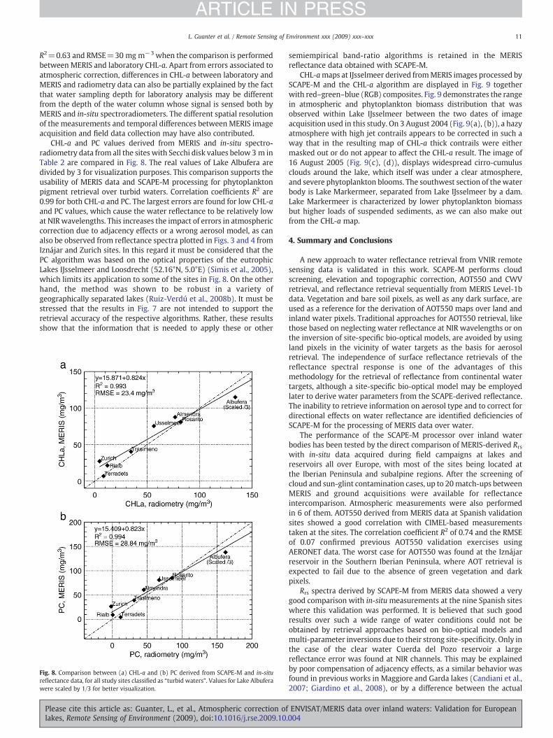
R2=0.63 and RMSE=30 mg m−3 when the comparison is performedbetween MERIS and laboratory CHL-a. Apart from errors associated toatmospheric correction, differences in CHL-a between laboratory andMERIS and radiometry data can also be partially explained by the factthat water sampling depth for laboratory analysis may be differentfrom the depth of the water column whose signal is sensed both byMERIS and in-situ spectroradiometers. The different spatial resolutionof the measurements and temporal differences between MERIS imageacquisition and field data collection may have also contributed.
CHL-a and PC values derived from MERIS and in-situ spectro-radiometry data from all the sites with Secchi disk values below 3 m inTable 2 are compared in Fig. 8. The real values of Lake Albufera aredivided by 3 for visualization purposes. This comparison supports theusability of MERIS data and SCAPE-M processing for phytoplanktonpigment retrieval over turbid waters. Correlation coefficients R2 are0.99 for both CHL-a and PC. The largest errors are found for low CHL-aand PC values, which cause the water reflectance to be relatively lowat NIRwavelengths. This increases the impact of errors in atmosphericcorrection due to adjacency effects or a wrong aerosol model, as canalso be observed from reflectance spectra plotted in Figs. 3 and 4 fromIznájar and Zurich sites. In this regard it must be considered that thePC algorithm was based on the optical properties of the eutrophicLakes IJsselmeer and Loosdrecht (52.16°N, 5.0°E) (Simis et al., 2005),which limits its application to some of the sites in Fig. 8. On the otherhand, the method was shown to be robust in a variety ofgeographically separated lakes (Ruiz-Verdú et al., 2008b). It must bestressed that the results in Fig. 7 are not intended to support theretrieval accuracy of the respective algorithms. Rather, these resultsshow that the information that is needed to apply these or other
Fig. 8. Comparison between (a) CHL-a and (b) PC derived from SCAPE-M and in-situreflectance data, for all study sites classified as “turbid waters”. Values for Lake Albuferawere scaled by 1/3 for better visualization.
Please cite this article as: Guanter, L., et al., Atmospheric correction oflakes, Remote Sensing of Environment (2009), doi:10.1016/j.rse.2009.10.
semiempirical band-ratio algorithms is retained in the MERISreflectance data obtained with SCAPE-M.
CHL-amaps at IJsselmeer derived fromMERIS images processed bySCAPE-M and the CHL-a algorithm are displayed in Fig. 9 togetherwith red–green–blue (RGB) composites. Fig. 9 demonstrates the rangein atmospheric and phytoplankton biomass distribution that wasobserved within Lake IJsselmeer between the two dates of imageacquisition used in this study. On 3 August 2004 (Fig. 9(a), (b)), a hazyatmosphere with high jet contrails appears to be corrected in such away that in the resulting map of CHL-a thick contrails were eithermasked out or do not appear to affect the CHL-a result. The image of16 August 2005 (Fig. 9(c), (d)), displays widespread cirro-cumulusclouds around the lake, which itself was under a clear atmosphere,and severe phytoplankton blooms. The southwest section of the waterbody is Lake Markermeer, separated from Lake IJsselmeer by a dam.Lake Markermeer is characterized by lower phytoplankton biomassbut higher loads of suspended sediments, as we can also make outfrom the CHL-a map.
4. Summary and Conclusions
A new approach to water reflectance retrieval from VNIR remotesensing data is validated in this work. SCAPE-M performs cloudscreening, elevation and topographic correction, AOT550 and CWVretrieval, and reflectance retrieval sequentially from MERIS Level-1bdata. Vegetation and bare soil pixels, as well as any dark surface, areused as a reference for the derivation of AOT550 maps over land andinland water pixels. Traditional approaches for AOT550 retrieval, likethose based on neglecting water reflectance at NIR wavelengths or onthe inversion of site-specific bio-optical models, are avoided by usingland pixels in the vicinity of water targets as the basis for aerosolretrieval. The independence of surface reflectance retrievals of thereflectance spectral response is one of the advantages of thismethodology for the retrieval of reflectance from continental watertargets, although a site-specific bio-optical model may be employedlater to derive water parameters from the SCAPE-derived reflectance.The inability to retrieve information on aerosol type and to correct fordirectional effects on water reflectance are identified deficiencies ofSCAPE-M for the processing of MERIS data over water.
The performance of the SCAPE-M processor over inland waterbodies has been tested by the direct comparison of MERIS-derived Rrswith in-situ data acquired during field campaigns at lakes andreservoirs all over Europe, with most of the sites being located atthe Iberian Peninsula and subalpine regions. After the screening ofcloud and sun-glint contamination cases, up to 20match-ups betweenMERIS and ground acquisitions were available for reflectanceintercomparison. Atmospheric measurements were also performedin 6 of them. AOT550 derived from MERIS data at Spanish validationsites showed a good correlation with CIMEL-based measurementstaken at the sites. The correlation coefficient R2 of 0.74 and the RMSEof 0.07 confirmed previous AOT550 validation exercises usingAERONET data. The worst case for AOT550 was found at the Iznájarreservoir in the Southern Iberian Peninsula, where AOT retrieval isexpected to fail due to the absence of green vegetation and darkpixels.
Rrs spectra derived by SCAPE-M from MERIS data showed a verygood comparison with in-situmeasurements at the nine Spanish siteswhere this validation was performed. It is believed that such goodresults over such a wide range of water conditions could not beobtained by retrieval approaches based on bio-optical models andmulti-parameter inversions due to their strong site-specificity. Only inthe case of the clear water Cuerda del Pozo reservoir a largereflectance error was found at NIR channels. This may be explainedby poor compensation of adjacency effects, as a similar behavior wasfound in previous works in Maggiore and Garda lakes (Candiani et al.,2007; Giardino et al., 2008), or by a difference between the actual
ENVISAT/MERIS data over inland waters: Validation for European004

Fig. 9. True-color composites and CHL-a maps from SCAPE-M corrected MERIS images acquired over Lake IJsselmeer in August of 2004 and 2005.
12 L. Guanter et al. / Remote Sensing of Environment xxx (2009) xxx–xxx
ARTICLE IN PRESS
aerosol type and the rural model assumed by SCAPE-M by default. Avery goodmatch betweenMERIS and ground-based reflectance spectrais also found in the turbid Trasimeno, Zurich and IJsselmeer lakes, butSCAPE-M is not able to provide realistic reflectance spectra, both inbrightness and in spectral shapes, over the subalpine clear lakes Garda,Maggiore, Leman and Constance. MODTRAN4 based simulations at theLake Constance acquisition configuration demonstrated that no combi-nation of AOT550andpure aerosolmodel (rural, urbanormaritime) canprovide reflectance spectra as those measured in the field. Residualadjacency effects, sun-glint contamination or even a bad parameteriza-tion of the aerosol vertical profile are considered possible error sourcesto explain the bad results of SCAPE-M over those sites.
SCAPE-M was also compared to the neural network-based BEAMlake processors designed for the retrieval of water composition fromMERIS data. It was found that SCAPE-M performed better over turbidand semi-turbid waters, where the BEAM processors could not
Please cite this article as: Guanter, L., et al., Atmospheric correction oflakes, Remote Sensing of Environment (2009), doi:10.1016/j.rse.2009.10.
reproduce some key spectral features of the reflectance spectra inthe 500–750 nmwindow. This can be explained by the dependence ofneural network-based algorithms on the training set applied to thederivation of the regression relationship; SCAPE-M, in turn, is notdoing any a-priori assumption on the target spectral response, whichenables its application to extreme water composition conditions.BEAM processors, however, provided better results over the darkestwater bodies, possibly due to the compensation of errors inatmospheric characterization in the multi-parameter inversion.
Finally, a test of the ability of MERIS data to track water CHL-a andPC concentrations after SCAPE-M processing has also been performedas a part of the validation exercise. Semiempirical, band-ratio-basedalgorithms have been used to transfer from Rrs to CHL-a and PCconcentrations, respectively. Results from data acquired over LakeIJsselmeer showed that MERIS data can reproduce to large extent theinformation provided by field radiometry in both CHL-a (R2=0.75)
ENVISAT/MERIS data over inland waters: Validation for European004

13L. Guanter et al. / Remote Sensing of Environment xxx (2009) xxx–xxx
ARTICLE IN PRESS
and PC (R2=0.83), at least to the degree required for these band-ratio-based algorithms. Similar good correlations were found from theapplication of the CHL-a and PC algorithms to MERIS reflectancederived by SCAPE-M from all the turbid water validation sites.
The applicability of land-based atmospheric correction methods toinland and coastal waters, as an alternative to traditional models thatmake assumptions on the shape of the water reflectance or to thosebased on site-specific bio-optical models, is confirmed by the resultspresented in this work. The good performance of SCAPE-M over turbidwaters, which are the most challenging ones in terms of atmosphericcorrection and the most important ones with respect to water qualitymonitoring, must be highlighted. However, the poor results in theretrieval of reflectance from clear waters are yet to be solved. Theformulation of different aerosol models and enhanced adjacency andsun-glint corrections are suggested to improve the SCAPE-M atmo-spheric processor.
Acknowledgments
SCAPE-M was developed by LG under the support of a PhDfellowship from the Spanish Ministry of Education and Science andthe project Development of algorithms for the exploitation of MERIS dataover land (ESRIN/Contract No 16545/02/I-LG). MERIS data of Italianlakes were made available through the ESA AO-553 MELINOS project.We are very grateful to M. Bresciani from CNR-IREA for data processingand toM.Musanti for his assistance in the field. This work would not bepossible without contributions provided by CRA-Sirmione, CNR-ISE andARPA Umbria in lakes Garda, Maggiore and Trasimeno, respec-tively. Data collection at Lake IJsselmeer was made possible throughgrant EO-053 from the User Support Programme managed by theprogrammeofficeExternalResearchof theNetherlandsOrganization forScientific Research-National Institute for Space Research (NWO-SRON).M. Jehle and O. Frey from RSL are thanked for enabling the Lake Zurichfield measurements with their private yacht and UMR CARRTELThonon-Les-Bains for providing staff and a vessel for the Lake Genevafield campaign. We further acknowledge the useful comments of fouranonymous reviewers that helped to improve the manuscript. TheSCAPE-M code is available on request from the authors.
References
Bailey, S. W., &Werdell, P. J. (2006). A multi-sensor approach for the on-orbit validationof ocean color satellite data products. Remote Sensing of Environment, 102, 12−23.
Béal, D., Baret, F., Bacour, C., & Gu, X. -F. (2007). A method for aerosol correction fromthe spectral variation in the visible and near infrared: Application to the MERISsensor. International Journal of Remote Sensing, 28, 761−779.
Berk, A., Anderson, G. P., Acharya, P. K., Hoke, M. L., Chetwynd, J. H., Bernstein, L. S.,Shettle, E. P., Matthew, M. W., Adler-Golden, S. M., 2003. MODTRAN4 version 3revision 1 user's manual. Tech. rep., Air Force Research Laboratory, Hanscom AirForce Base, MA, USA.
Candiani, G., Giardino, C., & Brando, V. E. (2007, July). Adjacency effects and bio-opticalmodel regionalisation: MERIS data to assess lake water quality in the Subalpineecoregion. In ESA/ESRIN (Ed.), Proceedings of the ENVISAT Symposium. Montreux,Switzerland.
Dekker, A. G., Hoogenboom, H. J., Goddijn, L. M., & Malthus, T. J. (1997). The relationbetween inherent optical properties and reflectance spectra in turbid inlandwaters. Remote Sensing Reviews, 15, 59−74.
Doerffer, R., Schiller, H., May 2008. MERIS regional coastal and lake case 2 water projectatmospheric correction ATBD. Tech. rep., GKSS Research Center 21502 Geesthacht.
Duforêt, L., Frouin, R., & Dubuisson, P. (2007). Importance and estimation of aerosolvertical structure in satellite ocean-color remote sensing. Applied Optics, 46,1107−1118.
Floricioiu, D., & Rott, H. (2005, September). Atmospheric correction of MERIS data overperialpine regions. In ESA/ESRIN (Ed.), Proceedings of the MERIS-(A)ATSR workshop.Frascati, Italy.
Fomferra, N., & Brockmann, C. (2005, September). Beam—The ENVISAT MERIS andAATSR toolbox. In ESA/ESRIN (Ed.), Proceedings of the MERIS-(A)ATSR workshop.Frascati, Italy. URL http://www.brockmann-consult.de/beam/
Gao, B. -C., Montes, M. J., Li, R. -R., Dierssen, H. M., & Davis, C. O. (2007). An atmosphericcorrection algorithm for remote sensing of bright coastal waters using MODIS landand ocean channels in the solar spectral region. IEEE Transactions on Geoscience andRemote Sensing, 45, 1835−1843.
Please cite this article as: Guanter, L., et al., Atmospheric correction oflakes, Remote Sensing of Environment (2009), doi:10.1016/j.rse.2009.10.
Giardino, C., Brando, V. E., Dekker, A. G., Strömbeck, N., & Candiani, G. (2007).Assessment of water quality in Lake Garda (Italy) using Hyperion. Remote Sensingof Environment, 109, 183−195.
Giardino, C., Bresciani,M., Brando, V. E., & Dekker, A. G. (2008, September). Observations ofthe largest Italian lakes fromMERIS. In ESA/ESRIN (Ed.), Proceedings of the 2ndMERIS/(A)ATSR user workshop. Frascati, Italy.
Gitelson,A. A.,Dall'Olmo,G.,Moses,W., Rundquist, D. C., Barrow, T., Fisher, T. R., Gurlin,D., &Holz, J. (2008). A simple semi-analytical model for remote estimation of chlorophyll-ain turbid waters: Validation. Remote Sensing of Environment, 112, 3582−3593.
Gitelson, A. A., Schalles, J. F., & Hladik, C. M. (2007). Remote chlorophyll-a retrieval inturbid, productive estuaries: Chesapeake Bay case study. Remote Sensing ofEnvironment, 109, 464−472.
Gons, H. J. (1999). Optical teledetection of chlorophyll a in turbid inland waters. En-vironmental Science & Technology, 33, 1127−1132.
Gons, H. J., Rijkeboer, M., & Ruddick, K. G. (2005). Effect of a waveband shift onchlorophyll retrieval from MERIS imagery of inland and coastal waters. Journal ofPlankton Research, 27(1), 125−127.
Gordon, H. R. (1997). Atmospheric correction of ocean color imagery in the EarthObservating System era. Journal of Geophysical Research, 102, 17081−17105.
Gordon, H. R., & Wang, M. (1978). Removal of atmospheric effects from satelliteimagery of the oceans. Applied Optics, 17, 1631−1636.
Gordon, H. R., & Wang, M. (1994). Retrieval of water-leaving radiance and aerosoloptical thickness over the oceans with SeaWiFS: A preliminary algorithm. AppliedOptics, 33, 443−452.
Guanter, L., Gómez-Chova, L., & Moreno, J. (2008). Coupled retrieval of aerosol opticalthickness, columnar water vapor and surface reflectance maps from ENVISAT/MERIS data over land. Remote Sensing of Environment, 112, 2898−2913.
Guanter, L., González-Sampedro,M. C., &Moreno, J. (2007). Amethod for the atmosphericcorrection of ENVISAT/MERIS data over land targets. International Journal of RemoteSensing, 28, 709−728.
Holben, B. N., Eck, T. F., Slutsker, I., Tanre, D., Buis, J. P., Setzer, A., Vermote, E., Reagan, J. A.,Kaufman, Y., Nakajima, T., Lavenu, F., Jankowiak, I., & Smirnov, A. (1998). AERONET—Afederated instrument network and data archive for aerosol characterization. RemoteSensing of Environment, 66, 1−16.
Hovis, W. A., Clark, D. K., Anderson, F., Austin, R. W., Wilson, W. H., Baker, E. T., Ball, D.,Gordon, H., Mueller, J. L., El-Sayed, S., Sturm, B., Wrigley, R. C., & Yentsch, C. (1980).Nimbus-7 coastal zone color scanner: System description and initial imagery. Nature,210, 60−63.
Kratzer, S., Brockmann, C., & Moore, G. (2008). Using MERIS full resolution data tomonitor coastal waters—A case study from Himmerfjärden, a fjord-like bay in thenorthwestern Baltic Sea. Remote Sensing of Environment, 112, 2284−2300.
Kuchinke, C. P., Gordon, H. R., & Franz, B. A. (2009). Spectral optimization for constituentretrieval in case 2 waters I: Implementation and performance. Remote Sensing ofEnvironment, 113, 571−587.
Lavender, S. J., Pinkerton, M. H., Moore, G., Aiken, J., & Blondeau-Patissier, D. (2005).Modification to the atmospheric correction of SeaWiFS ocean colour images overturbid waters. Continental Shelf Research, 25, 539−555.
McClain, C. R., Feldman, G. C., & Hooker, S. B. (2004, January–February). An overviewof theSeaWiFS project and strategies for producing a climate research quality global oceanbio-optical time series. Deep Sea Research Part II. Topical Studies in Oceanography, 51,5−42.
Moore, G. F., Aiken, J., & Lavender, S. J. (1999). The atmospheric correction of water colourand the quantitative retrieval of suspended particulate matter in case II waters:Application to MERIS. International Journal of Remote Sensing, 20, 1713−1733.
Morel, A., & Bélanger, S. (2006). Improved detection of turbid waters from ocean colorsensors information. Remote Sensing of Environment, 102, 237−249.
Odermatt, D., Heege, T., Nieke, J., Kneubühler, M., & Itten, K. (2008). Water qualitymonitoring for Lake Constance with a physically based algorithm for MERIS data.Sensors, 8, 4582−4589.
Odermatt, D., Kiselev, V., Heege, T., Kneubühler, M., & Itten, K. I. (2008, September).Adjacency effect considerations and air/water constituent retrieval for LakeConstance. In ESA/ESRIN (Ed.), Proceedings of the 2nd MERIS/(A)ATSR user workshop.Frascati, Italy.
Park, Y. -J., & Ruddick, K. (2005). Model of remote-sensing reflectance includingbidirectional effects for case 1 and case 2 waters. Applied Optics, 44, 1236−1249.
Ramon, D., & Santer, R. (2005, September). Aerosol over land with MERIS, present andfuture. In ESA/ESRIN (Ed.), Proceedings of the MERIS-(A)ATSR workshop. Frascati, Italy.
Rast, M., Bézy, J. L., & Bruzzi, S. (1999). The ESA Medium Resolution ImagingSpectrometer MERIS—A review of the instrument and its mission. InternationalJournal of Remote Sensing, 20, 1681−1702.
Ruddick, K. G., Ovidio, F., & Rijkeboer, M. (2000). Atmospheric correction of SeaWiFSimagery for turbid coastal and inland waters. Applied Optics, 39, 897−912.
Ruiz-Verdú, A., Koponen, S., Heege, T., Doerffer, R., Brockmann, C., Kallio, K., Pyhälahti,T., Peña-Martínez, R., Polvorinos, Ángel, Heblinski, J., Ylöstalo, P., Conde, L.,Odermatt, D., Estellés, V., & Pulliainen, J. (2008, September). Development of MERISlake water algorithms: Validation results from Europe. In ESA/ESRIN (Ed.), Pro-ceedings of the 2nd MERIS/(A)ATSR user workshop. Frascati, Italy.
Ruiz-Verdú, A., Simis, S. G. H., De Hoyos, C., Gons, H. J., & Peña-Martínez, R. (2008). Anevaluation of algorithms for the remote sensing of cyanobacterial biomass. RemoteSensing of Environment, 112, 4−16.
Salomonson, V. V., Barnes, W. L., Maymon, P., Montgomery, H., & Ostrow, H. (1989).MODIS: Advanced facility instrument for studies of the Earth as a system. IEEETransactions on Geoscience and Remote Sensing, 27, 145−153.
Santer, R., Vidot, J., & Aznay, O. (2005, September). Standard aerosol model families usedfor atmospheric correction: How comparable are they? How validate are they? InESA/ESRIN (Ed.), Proceedings of the MERIS-(A)ATSR workshop. Frascati, Italy.
ENVISAT/MERIS data over inland waters: Validation for European004

14 L. Guanter et al. / Remote Sensing of Environment xxx (2009) xxx–xxx
ARTICLE IN PRESS
Santer, R., Zagolski, F., Gilson, M., January 2009. Improved Contrast between Ocean andLand (ICOL) algorithm theoretical basis document. Tech. rep., ULCO, Wimereux,France.
Schiller, H., & Doerffer, R. (2005). Improved determination of coastal water constituentconcentrations from MERIS data. IEEE Transactions on Geoscience and RemoteSensing, 43, 1585−1591.
Schroeder, T., Behnert, I., Schaale, M., Fischer, J., & Doerffer, R. (2007). Atmosphericcorrection algorithm for MERIS above case-2 waters. International Journal of RemoteSensing, 28, 1469−1486.
Siegel, D., Wang, M., Maritorena, S., & Robinson, W. (2000). Atmospheric correction ofsatellite ocean color imagery: The black pixel assumption. Applied Optics, 39,3582−3591.
Simis, S. G. H., Peters, S. W. M., & Gons, H. J. (2005). Remote sensing of the cyanobacterialpigment phycocyanin in turbid inland water. Limnology and Oceanography, 50,237−245.
Simis, S. G. H., Ruiz-Verdú, A., Domínguez-Gómez, J. A., Peña-Martínez, R., Peters, S.W.M.,& Gons, H. J. (2007). Influence of phytoplankton pigment composition on remotesensing of cyanobacterial biomass. Remote Sensing of Environment, 106, 414−427.
Please cite this article as: Guanter, L., et al., Atmospheric correction oflakes, Remote Sensing of Environment (2009), doi:10.1016/j.rse.2009.10.
Thuillier, G., Herse, M., Labs, D., Foujols, T., Peetermans, M., Gillotay, D., Simon, P. C., &Mandel, H. (2003). The solar spectral irradiance from 200 to 2400 nm as measuredby the SOLSPEC spectrometer from the Atlas and Eureca missions. Solar Physics,214, 1−22.
Vermote, E. F., El-Saleous, N., Justice, C. O., Kaufman, Y. J., Privette, J. L., Remer, L., Roger, J. C.,& Tanré, D. (1997). Atmospheric correction of visible to middle infrared EOS-MODISdata over land surface: Background, operational algorithm and validation. Journal ofGeophysical Research, 102, 17131−17141.
Vidot, J., & Santer, R. (2005). Atmospheric correction for inland waters—Application toSeaWiFS. International Journal of Remote Sensing, 26, 3663−3682.
Viollier, M., Tanré, D., & Deschamps, P. Y. (1980). An algorithm for remote sensing ofwater color from space. Boundary-Layer Meteorology, 18, 247−267.
Wang, M. (2007). Remote sensing of the ocean contributions from ultraviolet to near-infrared using the shortwave infrared bands: Simulations. Applied Optics, 46,1535−1547.
ENVISAT/MERIS data over inland waters: Validation for European004
Recommended


