
« INSERT APPROPRIATE PROJECT FOOTER FROM QUICK PARTS »
PART C Impact assessment key construction infrastructure
CHAPTER C3 Assessment of borrow pits
Narromine to Narrabri Environmental Impact Statement

ii INLAND RAIL
Contents C3. ASSESSMENT OF BORROW PITS C3-1
C3.1 Overview of borrow pits C3-1 C3.1.1 Establishment C3-1 C3.1.2 Use C3-6 C3.1.3 Decommissioning and rehabilitation C3-9
C3.2 Existing environment C3-9
C3.3 Impact assessment C3-15 C3.3.1 Environmental impact screening C3-15 C3.3.2 Biodiversity C3-16 C3.3.3 Water resources (hydrology and
groundwater) C3-18 C3.3.4 Water quality C3-19 C3.3.5 Noise and vibration (construction) C3-20 C3.3.6 Air quality C3-30 C3.3.7 Traffic and transport C3-33 C3.3.8 Land use and property C3-34 C3.3.9 Visual amenity C3-35 C3.3.10 Waste management C3.41
C3.4 Specific mitigation measures C3.42
Figures Figure C3.1 Indicative layout - borrow pit A
(Tantitha Road, Narromine) C3-2 Figure C3.2 Indicative layout - borrow pit B
(Tomingley Road, Narromine) C3-3 Figure C3.3 Indicative layout - borrow pit C
(Euromedah Road, Narromine) C3-4 Figure C3.4 Indicative layout - borrow pit D
(Perimeter Road, Narrabri) C3-5 Figure C3.5 Noise impacted receivers – borrow
pit A (Tantitha Road, Narromine) C3-23 Figure C3.6 Noise impacted receivers – borrow
pit B (Tomingley Road, Narromine) C3-24 Figure C3.7 Noise impacted receivers – borrow
pit C (Euromedah Road, Narromine) C3-25
Figure C3.8 Noise impacted receivers – borrow pit D (Perimeter Road, Narrabri) C3-26
Figure C3.9 Blasting impacted receivers – borrow pit C (Euromedah Road, Narromine) C3-28
Figure C3.10 Blasting impacted receivers – borrow pit D (Perimeter Road, Narrabri) C3-29
Figure C3.11 Air quality impacted receivers – borrow pit C (Euromedah Road, Narromine) C3-32
Tables Table C3.1 Indicative volumes of materials to
be excavated from borrow pits C3-6 Table C3.2 Indicative type and composition of
material within borrow pits C3-6 Table C3.3 Existing environment for the
borrow pits C3-10 Table C3.4 Environmental impact screening—
borrow pits C3-15 Table C3.5 Direct impacts on vegetation and
habitats at borrow pits C3-17 Table C3.6 Summary of noise exceedances—
borrow pits C3-20 Table C3.7 Recommended blasting
overpressure and ground vibration maximum levels C3-27
Table C3.8 Estimated emissions during construction—borrow pits C3-30
Table C3.9 Summary of air quality impacted receivers—borrow pits C3-30
Table C3.10 Local road access to and from the proposal and borrow pits C3-33
Table C3.11 Landscape and visual context—borrow pits C3-35
Table C3.12 Summary of visual impacts—borrow pits C3.37
Table C3.13 Borrow pit specific mitigation measures C3.42

NARROMINE TO NARRABRI ENVIRONMENTAL IMPACT STATEMENT C3-1
C
C3. Assessment of borrow pits This chapter provides a summary of the potential impacts of the borrow pits on the local environment as a result of the Narromine to Narrabri project (the proposal). A full copy of the assessment results is provided in relevant technical reports.
C3.1 Overview of borrow pits Borrow pits were identified as the preferred option to supply general and structural fill material not able to be obtained from cuts within the proposal site. As described in section A8.9.1, four borrow pits are proposed to be established on private land as follows: Borrow pit A—Tantitha Road, Narromine Borrow pit B—Tomingley Road, Narromine Borrow pit C—Euromedah Road, Narromine Borrow pit D—Perimeter Road, Narrabri.
The proposed locations of the borrow pits have been selected based on preliminary geotechnical investigations, consultation with landowners and the proposal’s material (fill) requirements. The rationale for each of the borrow pits is described in section A8.9.1.
Further information on the options considered for meeting the proposal’s material requirements and the process used to select the preferred borrow pit locations is provided in section A6.3.4.
The locations of the borrow pits are shown in Figure A1.3 and on the maps in Part E. Typical site layouts for each of the borrow pits are shown in Figure C3.1 to Figure C3.4.
Access to the main proposal site from the borrow pits would be via new access tracks to connect the borrow pit to the nearest public road, then via the public road network to the proposal site. Connections to public roads would be designed in accordance with relevant standards and in consultation with the relevant road manager.
C3.1.1 Establishment Establishment of the borrow pits would involve the following activities:
Consult landowners/occupants (where required) and ensure land access is available Install site environment management and traffic controls, including drainage and erosion management
controls, in accordance with the CEMP (see chapter D5) Erect temporary site fencing to ensure construction areas and areas to be impacted are clearly delineated Vegetation clearing and removal, where required, including slashing, mulching and stockpiling for reuse Topsoil stripping (where present) and stockpiling for reuse Establish access tracks between the borrow pit and public road Install site infrastructure (site offices and amenities) Utility relocation or protection, where required Install water infrastructure, including diversion drains (for up-slope surface flow) and sedimentation basins Delivery of plant and equipment.

C3-2 INLAND RAIL
FIGURE C3.1 INDICATIVE LAYOUT - BORROW PIT A (TANTITHA ROAD, NARROMINE)

NARROMINE TO NARRABRI ENVIRONMENTAL IMPACT STATEMENT C3-3
FIGURE C3.2 INDICATIVE LAYOUT - BORROW PIT B (TOMINGLEY ROAD, NARROMINE)

C3-4 INLAND RAIL
FIGURE C3.3 INDICATIVE LAYOUT - BORROW PIT C (EUROMEDAH ROAD, NARROMINE)

NARROMINE TO NARRABRI ENVIRONMENTAL IMPACT STATEMENT C3-5
FIGURE C3.4 INDICATIVE LAYOUT - BORROW PIT D (PERIMETER ROAD, NARRABRI)

C3-6 INLAND RAIL
C3.1.2 Use
Resource to be extracted The borrow pits would supply general and structural fill for use in the rail formation. The indicative volumes of fill proposed to be excavated from each borrow pit are summarised in Table C3.1. These volumes may not be excavated from all borrow pits, with final volumes likely to be lower in some pits, subject to further geotechnical investigations during detailed design. As such, these indicative volumes represent the maximum potential size of each borrow pit. The final volumes and rate of extraction would be confirmed during detailed design and construction planning, when a contractor is appointed and a construction schedule is determined.
The proposed extents of each borrow pit have been designed with consideration given to surrounding land uses, anticipated geological conditions and the following: The slope of cut batters are not steeper than 3H:1V (3 metres (m) horizontal for each 1 m vertical) On completion, the borrow pit can be rehabilitated to a stable landform that is able to freely drain The edge of the borrow pit must not be closer than 3 m to any existing or proposed fence line, road reserve
boundary or edge of rail excavation or embankment.
TABLE C3.1 INDICATIVE VOLUMES OF MATERIALS TO BE EXCAVATED FROM BORROW PITS
Location Indicative area
and depth Total general
fill (m3) Total structural
fill (m3) Other fill
(m3) Total (m3)
Borrow pit A— Tantitha Road, Narromine
11 hectares (ha), 2 metres
(m)
85,000 200,000 25,000 310,000
Borrow pit B— Tomingley Road, Narromine
9 ha, 4.5 m 115,000 290,000 65,000 470,000
Borrow pit C— Euromedah Road, Narromine
10 ha, 13 m 45,000 340,000 280,000 665,000
Borrow pit D— Perimeter Road, Narrabri
11 ha, 10 m 135,000 600,000 220,000 955,000
Based on preliminary geotechnical investigations the type and composition of the material present at the sites are summarised in Table C3.2.
TABLE C3.2 INDICATIVE TYPE AND COMPOSITION OF MATERIAL WITHIN BORROW PITS
Location Ground conditions and laboratory analysis
Borrow pit A— Tantitha Road, Narromine
The site is located in Devonian-aged Obley Granite to the south of Narromine. Assessed ground conditions are: Topsoil, approximately 0.2 m thick, is present across the site and typically consists of fine-
to-coarse grained silty/clayey sand and low plasticity sandy clay Residual soil and extremely weathered material ranged between 1.3 and 10 m deep.
Residual soil is composed of fine-to-coarse grained gravelly sand with low plasticity fines and trace of cobbles and boulders.
Weathered high-strength granite was encountered from a depth of 1.3 m and was present as sandy gravel
Slightly weathered, very high strength granite was encountered at a depth of 6.5 m A high degree of variability was encountered in the depth to bedrock Groundwater monitoring recorded a maximum water level of about 4.3 m below ground
level. Laboratory analysis indicates: Field moisture contents at the time of the investigation range from about 2.5% to 14% Weathered granites comprise between 10% and 19% fines with about 25% finer than
425 microns Emerson class numbers are on average five, indicating the soil is non-dispersive; however,
could be dispersive when handled. There is a low risk of naturally occurring asbestos or acid sulfate rock.

NARROMINE TO NARRABRI ENVIRONMENTAL IMPACT STATEMENT C3-7
Location Ground conditions and laboratory analysis
Borrow pit B— Tomingley Road, Narromine
The encountered ground conditions consist of residual soil and highly weathered bedrock associated with Ordovician-aged metasedimentary rock of the Cotton Formation. Assessed ground conditions are: Topsoil about 0.2 m thick is present across the site and typically consists of medium
plasticity silty clay with fine-to-coarse grained sub-angular to angular gravel and rootlets Residual soil is between 1.2 and 1.6 m thick in the northern part of the site and typically
consists of fine-to-coarse grained sub-angular to angular silty gravel and clayey gravel with sand and cobbles
Colluvium between 0.8 and 2.8 m thick overlies residual soil in the southern part of the site. It typically consists of medium plasticity silty/sandy clay with trace gravel.
Highly weathered, low-to-medium strength meta siltstone from a depth of 1.4 m was encountered in the northern part of the site
Groundwater monitoring did not detect any groundwater, indicating that, if present, it is greater than 12.5 m deep.
Laboratory analysis indicates: Field moisture contents at the time of the investigation ranged from about 6% to 9% in the
weathered rock and 22% in the residual soil Grading analyses indicate 75% fines within the residual soil and 15% fines in the weathered
rock Emerson class numbers are, on average, two, indicating a moderate potential for the soil to
disperse when inundated with water. There is a low risk of naturally occurring asbestos or acid sulfate rock.
Borrow pit C— Euromedah Road, Narromine
Metasedimentary rock of the Ordovician-aged Cotton Formation was encountered from shallow depth across the site. Assessed ground conditions are: The site has previously been disturbed by shallow excavation for borrow material No topsoil of residual soil was encountered Highly weathered, very low-to-medium strength metasiltstone was encountered from the
ground surface down to between 0.8 and 1.8 m. This was underlain by moderately weathered, medium-to-high strength metasiltstone down to a depth of 10 m.
Some isolated black clays may also be present Groundwater monitoring did not detect any groundwater, indicating that, if present, it is
greater than 15.6 m deep. Laboratory analysis indicates: Field moisture contents at the time of the investigation ranged from about 6% to 8% Metasiltstones comprise between 10% and 29% fines with about 28% finer than 425 microns Emerson class numbers are, on average, two, indicating a moderate potential for the soil to
disperse when inundated with water. There is a low risk of naturally occurring asbestos or acid sulfate rock.

C3-8 INLAND RAIL
Location Ground conditions and laboratory analysis
Borrow pit D— Perimeter Road, Narrabri
The site is located on a mixture of sandy residual soils and very low-to-medium strength sandstone belonging to the Keelindi Beds. Assessed ground conditions are: Topsoil about 0.2 to 0.3 m thick is present across the site and typically consists of silty
sand/sandy silt Residual soil and extremely weathered material ranged between 0.6 and 2.2 m deep and
typically consists of silty sand Highly weathered, low-strength sandstone occurs at a depth ranging between 0.8 and 2.4 m
below ground level and is about 2 to 3 m thick From a depth of 4 to 15 m ground conditions consist of a mixture of highly weathered, low-
strength sandstone and sandy soils with low plasticity fines Highly weathered, medium-strength sandstone was encountered in the south-west of the
site at a depth of 1.6 m with a thickness of 1 m Groundwater monitoring did not detect any groundwater, indicating that, if present, it is
greater than 15.6 m deep. Laboratory analysis for the highly weathered sandstone indicates: Field moisture contents at the time of the investigation ranged from 6.8% to 8.8% Fines content is between 15% and 18% with about 46% of material finer than 425 microns Emerson class numbers range to 2.1 (moderate dispersion potential) to 6 (low dispersion
potential. There is a low risk of naturally occurring asbestos or acid sulfate rock.
Extraction and production process The material extraction and production process, including the in-flow and out-flow of materials, would be further refined during detailed design, following detailed geotechnical investigations, but is anticipated to generally involve: Excavation of materials using excavators (or similar) commencing at the lower part of the site and proceeding
in benches up to about 2 m deep Rock breaking (as required) using excavator-mounted breakers or dozers (or similar) to fracture the rock and
enable further processing of the material Blasting (as required) in borrow pits C and D if hard rock is encountered at depth. This would involve drilling of
blast holes, placement of detonators, explosives and stemming (crushed risk or similar) and initiation of the blast to fracture the in-situ rock and enable further processing of the material.
Screening (as required) of excavated material. This would involve loading the material into a mobile screen using an excavator to separate oversized material for further processing (crushing). Material that meets the required specifications would be temporarily stockpiled ready for loading and transport.
Crushing (as required) of oversized materials. This would involve loading the material into a mobile screen crusher using an excavator to break down oversized material to the required specifications. This material would be temporarily stockpiled ready for loading and transport.
Loading and transport of material to the proposal site via the public road network using standard road registered vehicles (e.g. truck and dog trailer).
The mobile screen, crushing plant and stockpiles would be located inside the borrow pit extent to minimise potential impacts on surrounding areas and minimise handling operations within the site.
Site water management Water at each site would be managed as follows: Up slope diversion drains would convey clean water around the site Sedimentation basins would collect all dirty water (including any groundwater seepage) from disturbed areas
within the site.
Water contained within sediment basins would be discharged to the nearest watercourse prior to, or immediately following, forecast rainfall events that are likely to produce basin inflows. Appropriate scour protection would be provided at the outlets. The basins would include overflow bypass structures to enable stormwater discharge during heavy storm events where the design capacity of the sediment basins may be exceeded. Alternatively, water may be reused (as a supplementary source to the primary water supply) during construction for activities such as dust suppression.

NARROMINE TO NARRABRI ENVIRONMENTAL IMPACT STATEMENT C3-9
All erosion and sediment measures would be implemented at the sites in accordance with the principles and requirements in Managing Urban Stormwater—Soils and Construction, Volume 1 (Landcom, 2004) and Managing Urban Stormwater: Soils and Construction Volume 2C Unsealed roads (DECC, 2008a).
C3.1.3 Decommissioning and rehabilitation Following extraction of required material from the borrow pits, all facilities would be removed and the pits would be stabilised and rehabilitated. Rehabilitation of the borrow pits would be undertaken in accordance with the borrow pit rehabilitation strategy (see Appendix K) and the approach described in section A7.5. It is proposed to use excess material (that does not meet design specifications or cannot be feasibly used within the rail formation) from the main construction works to assist with the reshaping of the borrow pits. Further information about the management of spoil is provided in sections A6.3.4 and D2.2.4.
The borrow pit rehabilitation strategy is an overarching framework to inform development of detailed rehabilitation plans for each borrow pit during detailed design. The strategy has been prepared with reference to relevant guidelines, including: Strategic Framework for Mine Closure (Australian and New Zealand Minerals and Energy Council and the
Minerals Council of Australia, 2000) Mine Rehabilitation—Leading Practice Sustainable Development Program for the Mining Industry (Department of
Industry, Innovation and Science, 2016a) Mine Closure—Leading Practice Sustainable Development Program for the Mining Industry (Department of
Industry, Innovation and Science, 2016b).
The borrow pits and associated access would be returned to their original condition, as far as reasonably practicable or as otherwise agreed with the landholder, in accordance with the strategy and the detailed rehabilitation plans for each borrow pit. In addition to this, the final landform would be safe, stable, non-polluting, sustainable and free draining.
The objectives of the rehabilitation strategy are to: Ensure a final landform is produced that is safe, stable and non-polluting, as well as free draining and
compatible with the post-construction phase land use Ensure topsoil and subsoil are managed to conserve the seedbank, nutrients and to encourage the
establishment of proposed revegetation Ensure that disturbed areas are to be rehabilitated as close as reasonably practicable to their pre-production
condition or otherwise as agreed with the landholder Ensure that rehabilitation works comply with, and are undertaken as per, relevant regulatory requirements Establish a set of indicators and a rehabilitation monitoring program to ensure successful rehabilitation Establish agreed criteria where rehabilitation is deemed successful by relevant authorities and key
stakeholders.
The strategy establishes a series of performance standards/indicators and indicative completion criteria to support the above objectives and outlines a monitoring program to ensure the completion criteria are met. Indicative planting plans are also provided in the strategy. The rehabilitation strategy would also be integrated with the rehabilitation strategy for the proposal as a whole and the broader Inland Rail program.
C3.2 Existing environment The existing environment at the borrow pit sites is summarised in Table C3.3. Further information on the existing environment is provided in the relevant chapters in Part B.

C3-10 INLAND RAIL
TABLE C3.3 EXISTING ENVIRONMENT FOR THE BORROW PITS
Aspect Borrow pit A Borrow pit B Borrow pit C Borrow pit D
Site description Location The site is about 23 km south-east of Narromine town centre and about 15 km south-east of the proposal site. The site is within and surrounded by open farmland.
The site is about 11 km south of Narromine town centre and about 3.5 km south of the proposal site. The site is located within an existing borrow pit and surrounded by open farmland.
The site is about 7 km north-east of Narromine town centre and about 1 km east of the proposal site. The site is located within a vegetated area generally surrounded by open farmland to the west and north, two existing borrow pits to the east and vegetated areas to the south.
The site is about 9.5 km south of Narrabri town centre and about 5 km east of the proposal site. The site is located within an area that has been cleared (despite the older aerial imagery showing this area as being heavily vegetated). Jacks Creek State Forest is located to the east and south.
LGA Narromine Narrabri
Biodiversity Threatened species and communities
No threatened flora species or threatened ecological communities are known or assumed to be present. Loose surface rock is present at this site, which may provide habitat for the pink-tailed legless lizard. Small patches of woodland may provide habitat for threatened species such as the grey-crowned babbler and microbats.
No threatened flora species or threatened ecological communities are known or assumed to be present. Woodland may provide habitat for threatened species such as the grey-crowned babbler and microbats.
No threatened ecological communities are present. Assumed habitat for the threatened flora species (Pterostylis cobarensis, Polygala linariifolia and Tylophora linearis) is present. Limited potential habitat for threatened fauna species.
Native vegetation
The site is mostly cleared for agricultural purposes. Areas of native vegetation within the site comprise about: 10.4 ha of PCT 619 (Derived
wire grass grassland) 1.4 ha of PCT 185 (Dwyer's
red gum—White cypress pine—Currawang shrubby woodland).
The site is mostly cleared for the existing borrow pit. Areas of native vegetation within the site comprise about 3.6 ha of PCT 255 (Mugga ironbark—Buloke - Pilliga box—White cypress pine shrubby woodland).
The site is partially cleared for agricultural purposes. Areas of native vegetation within the site comprise about: 0.4 ha of PCT 88 (Pilliga box—White
cypress pine—Buloke shrubby woodland)
6.7 ha of PCT 255 (Mugga ironbark—Buloke—Pilliga box – White cypress pine shrubby woodland)
The site contains limited native vegetation as follows: 1.7 ha of PCT 746 (Brown
bloodwood—Cypress—Ironbark heathy woodland)
2.4 ha of PCT 398 (Narrow-leaved ironbark— White cypress pine— Buloke tall open forest).

NARROMINE TO NARRABRI ENVIRONMENTAL IMPACT STATEMENT C3-11
Aspect Borrow pit A Borrow pit B Borrow pit C Borrow pit D
Biodiversity [continued]
Aquatic ecology The sites do not contain any threatened aquatic ecological communities. There are a number of threatened species, endangered populations and aquatic matters of national environmental significance listed under the FM Act and/or EPBC Act that may occur within watercourses in the study area, including the Macquarie River, Namoi River and Narrabri Creek.
Groundwater dependent ecosystems
There are no aquatic or terrestrial groundwater dependent ecosystems within or near any of the sites.
Protected and sensitive lands
There are no protected and sensitive lands within or near any of the sites.
Water resources (hydrology and groundwater)
Watercourses and groundwater
The site is located within the catchment of the Macquarie River. The nearest defined watercourse is Wallaby Creek about 1.7 km to the north east. Groundwater monitoring conducted for the proposal at the site indicates existing groundwater levels are about 4.8 m below ground level.
The site is located within the catchment of the Macquarie River. The nearest defined watercourse is Yellow Creek, about 1.9 km to the west. Groundwater monitoring conducted for the proposal at the site did not detect any groundwater indicating that it is greater than 12.5 m below ground level.
The site is located within the catchment of the Macquarie River. The nearest defined watercourse is Macquarie River about 1 km to the south east. Groundwater monitoring conducted for the proposal at the site did not detect any groundwater, indicating that it is greater than 12.5 m below ground level.
The site is located within the catchment of the Narrabri Creek/Namoi River. The nearest defined watercourse is Jacks Creek, about 2.5 km to the east. Groundwater monitoring conducted for the proposal at the site did not detect any groundwater, indicating that it is greater than 12.5 m below ground level.
Flooding Flooding The sites are not known to be subject to flooding in events up to the 1% AEP flood event.
Soils and contamination
Soils Geotechnical investigations undertaken for the proposal identified shallow sandy clay topsoil underlain by coarse-grained gravelly sands. There is generally a low likelihood of encountering acid sulfate soils.
Geotechnical investigations undertaken for the proposal identified shallow silty clay topsoil underlain by silty and clayey gravels. There is generally a low likelihood of encountering acid sulfate soils.
Geotechnical investigations undertaken for the proposal identified that existing shallow borrow excavations had already removed the topsoil and underlying residual soils. There is generally a low likelihood of encountering acid sulfate soils.
Geotechnical investigations undertaken for the proposal identified shallow silty-to-sandy topsoil underlain by silty sands. There is generally a low likelihood of encountering acid sulfate soils.
Contamination There are no registered contaminated sites near the borrow pit sites. There is the potential for soils to have been contaminated by existing and historical activities such as agriculture and borrow pit extraction. Contaminants could include heavy metals, hydrocarbons, herbicides and pesticides.

C3-12 INLAND RAIL
Aspect Borrow pit A Borrow pit B Borrow pit C Borrow pit D
Water quality Water quality The Macquarie River catchment generally has poor water quality, with elevated levels of electrical conductivity and nutrients and low levels of dissolved oxygen, particularly during low flows.
The Namoi River catchment generally has poor water quality, with elevated levels of electrical conductivity and nutrients, particularly during low flows.
Sensitive receiving environments
The sites do not contain any sensitive receiving environments; however, they are located within the broader catchments of watercourses that contain key fish habitat and threatened aquatic species.
Aboriginal heritage
AHIMS sites No AHIMS sites are located within or near the sites.
Aboriginal heritage potential
The sites are located within areas that are mostly cleared and have been previously disturbed. No areas of cultural sensitivity have been identified within the sites; however, there is the potential to encounter unknown Aboriginal items.
Non-Aboriginal heritage
Listed heritage items
There are no listed non-Aboriginal heritage items within or near the sites.
Identified potential heritage items
None known.
Noise and vibration
Existing noise environment
The sites are located within an agricultural landscape with low background noise levels. The main sources of noise would be agricultural activities.
Sensitive receivers
The site is located within NCA 6. There are limited sensitive receivers around the site. The nearest sensitive receiver is about 800 m to the south east. Other sensitive receivers are located along Tantitha Road and Pinedean Road, which would be used to transport material to the proposal site.
The site is located within NCA 6. There are limited sensitive receivers around the site and the transport route along Tomingley Road. The nearest sensitive receiver is about 750 m to the south west.
The site is located within NCA 6. There are a number of sensitive receivers around the site and the transport route along Euromedah Road. The nearest sensitive receiver is about 550 m to the west.
The site is located within NCA 2. There are limited sensitive receivers around the site. The nearest sensitive receiver is about 850 m to the north. There are additional receivers about 200 m from where the proposed access track meets the Newell Highway.
Air quality Existing air quality
Regional air quality is generally good and mainly influenced by agricultural activities and road vehicle emissions.
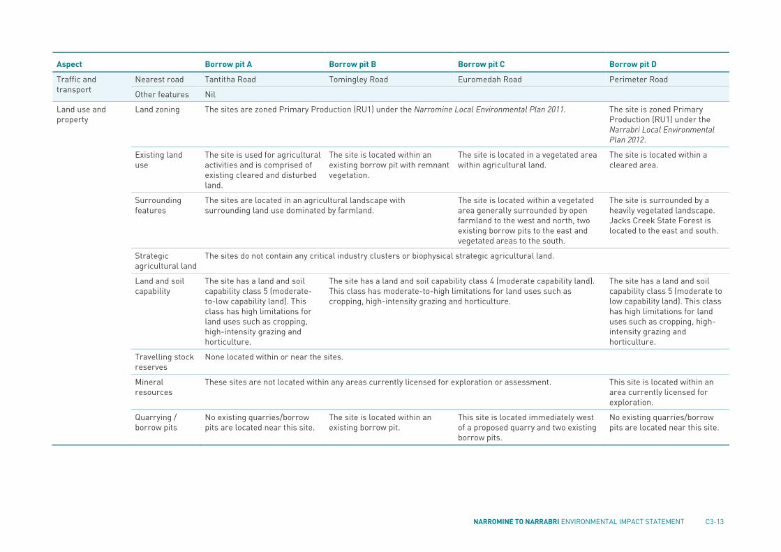
NARROMINE TO NARRABRI ENVIRONMENTAL IMPACT STATEMENT C3-13
Aspect Borrow pit A Borrow pit B Borrow pit C Borrow pit D
Traffic and transport
Nearest road Tantitha Road Tomingley Road Euromedah Road Perimeter Road
Other features Nil
Land use and property
Land zoning The sites are zoned Primary Production (RU1) under the Narromine Local Environmental Plan 2011. The site is zoned Primary Production (RU1) under the Narrabri Local Environmental Plan 2012.
Existing land use
The site is used for agricultural activities and is comprised of existing cleared and disturbed land.
The site is located within an existing borrow pit with remnant vegetation.
The site is located in a vegetated area within agricultural land.
The site is located within a cleared area.
Surrounding features
The sites are located in an agricultural landscape with surrounding land use dominated by farmland.
The site is located within a vegetated area generally surrounded by open farmland to the west and north, two existing borrow pits to the east and vegetated areas to the south.
The site is surrounded by a heavily vegetated landscape. Jacks Creek State Forest is located to the east and south.
Strategic agricultural land
The sites do not contain any critical industry clusters or biophysical strategic agricultural land.
Land and soil capability
The site has a land and soil capability class 5 (moderate-to-low capability land). This class has high limitations for land uses such as cropping, high-intensity grazing and horticulture.
The site has a land and soil capability class 4 (moderate capability land). This class has moderate-to-high limitations for land uses such as cropping, high-intensity grazing and horticulture.
The site has a land and soil capability class 5 (moderate to low capability land). This class has high limitations for land uses such as cropping, high-intensity grazing and horticulture.
Travelling stock reserves
None located within or near the sites.
Mineral resources
These sites are not located within any areas currently licensed for exploration or assessment. This site is located within an area currently licensed for exploration.
Quarrying / borrow pits
No existing quarries/borrow pits are located near this site.
The site is located within an existing borrow pit.
This site is located immediately west of a proposed quarry and two existing borrow pits.
No existing quarries/borrow pits are located near this site.

C3-14 INLAND RAIL
Aspect Borrow pit A Borrow pit B Borrow pit C Borrow pit D
Visual amenity Landscape character and views
The sites are located within landscape character zone 1—slopes and plains. Landscape character and views are defined by farmland, forming a vast expanse of open, flat agricultural mosaic that is punctuated by scattered and linear trees.
The site is located within vegetated land within landscape character zone 4—Pilliga Forest. Landscape character and views are defined by enclosed forests with linear road and utility easements.

NARROMINE TO NARRABRI ENVIRONMENTAL IMPACT STATEMENT C3-15
C3.3 Impact assessment
C3.3.1 Environmental impact screening An assessment has been carried out to compare the potential environmental impacts of the borrow pits relative to the potential environmental impacts of the proposal’s key infrastructure (described in Part B).
Table C3.4 provides a summary of the environmental screening of the potential impacts of the borrow pits. The assessment identified the potential for impacts on biodiversity, water resources (hydrology and groundwater), water quality, noise and vibration (construction), air quality, traffic and transport, land use and property, visual amenity and waste management. These potential impacts are considered further in sections C3.3.2 to C3.3.10.
The potential impacts on the other environmental aspects are minor and/or consistent with those described in Part B and, therefore, have not been considered further in this chapter.
TABLE C3.4 ENVIRONMENTAL IMPACT SCREENING—BORROW PITS
Environmental aspects Comments
Considered in Part C? Where?
Biodiversity The establishment and use of the borrow pits would require the clearing of native vegetation and habitat for threatened species.
Yes Section C3.3.2
Water resources (hydrology and groundwater)
The establishment and use of the borrow pits would require minor diversion of surface runoff and excavations that could encounter groundwater.
Yes Section C3.3.3
Flooding The sites are not subject to flooding in events up to the 1% AEP flood event. The potential flooding impacts are expected to be consistent with those identified for the proposal’s key infrastructure, as described in chapter B3. As such, they are not considered further in this chapter.
No Mitigation measures are provided in chapter B3
Soils and contamination
The establishment and use of the borrow pits would require bulk excavation of soil. The potential impacts are expected to be consistent with those described in chapter B4. As such, they are not considered further in this chapter.
No Mitigation measures are provided in chapter B4
Water quality The establishment and use of the borrow pits would require minor diversion of surface runoff and bulk excavations that could result in erosion and sedimentation.
Yes Section C3.3.4
Aboriginal heritage No AHIMS sites or culturally sensitive areas have been identified within the sites. While the borrow pits would be located in areas that have been previously disturbed and cleared, there is potential to encounter unknown Aboriginal heritage items. If unknown Aboriginal heritage items are encountered, the impacts and mitigation measures would be consistent with those described in chapter B6. As such, they are not considered further in this chapter.
No Mitigation measures are provided in chapter B6
Non-Aboriginal heritage
There are no known non-Aboriginal heritage constraints associated with any of the sites. If unknown items are encountered, the impacts and mitigation measures would be consistent with those described in chapter B7. As such, they are not considered further in this chapter.
No Mitigation measures are provided in chapter B7
Noise and vibration (construction)
There are a number of sensitive receivers located near the borrow pits, which would have the potential to be impacted by noise, vibration and blasting impacts.
Yes Section C3.3.5

C3-16 INLAND RAIL
Environmental aspects Comments
Considered in Part C? Where?
Air quality The establishment and use of the borrow pits would have the potential to impact on air quality for surrounding sensitive receivers.
Yes Section C3.3.6
Traffic and transport Access to and from borrow pits would be via new access tracks, which would connect the borrow pit to the nearest public road, then via the public road network. During establishment and use of the borrow pits there would be increased heavy vehicle movements associated with borrow pits on the local road network.
Yes Section C3.3.7
Land use and property
The establishment and use of the borrow pits would result in a change in land use. While the borrow pits are temporary, and would be rehabilitated following construction, there could be ongoing land use impacts.
Yes Section C3.3.8
Visual amenity The establishment and use of the borrow pits would have the potential to impact landscape character and visual amenity.
Yes Section C3.3.9
Socio-economic The borrow pits would require temporary leases. While they are leased, they would not be available for use or access by the property owner. The borrow pits would have the potential for temporary amenity impacts, mainly as a result of changes to noise and vibration, air quality and visual amenity. These potential impacts are considered in sections C3.3.5, C3.3.6 and C3.3.9. With implementation of the proposed mitigation measures, together with those for the proposal as a whole (see chapter D5) no significant impacts are expected. Other potential socio-economic impacts are considered to be consistent with those described in chapter B14. As such, no specific assessment of the potential socio-economic effects is included in this chapter.
No Mitigation measures are provided in chapter B14 and section C3.4
Cumulative impacts The cumulative impacts of the proposal as a whole are described in chapter D1. As such, they are not considered further in this chapter.
No Mitigation measures are provided in chapter D1
Waste management The borrow pits would generate a range of waste streams requiring management.
Yes Section C3.3.10
Sustainability The establishment and use of the borrow pits would include consideration of sustainability measures. The sustainability assessment for the proposal as a whole is provided in chapter D3. As such, it is not considered further in this chapter.
No Mitigation measures are provided in chapter D3
Climate change As the borrow pits would be temporary facilities, potential climate change impacts would be minimal and consistent with the impacts described in chapter D4. As such, they are not considered further in this chapter.
No Mitigation measures are provided in chapter D4
C3.3.2 Biodiversity The assessment approach, existing environment, potential impacts and mitigation measures for the proposal are described in chapter B1 and Technical Report 1—Biodiversity development assessment report. The findings of this assessment for the establishment and use of the borrow pits are summarised in this section.

NARROMINE TO NARRABRI ENVIRONMENTAL IMPACT STATEMENT C3-17
Establishment Clearing of vegetation would be required at all borrow pit sites. The potential impacts associated with the borrow pits are summarised in Table C3.5. Detailed design and construction planning would minimise the construction footprint and avoid impacts on native vegetation and hollow-bearing trees as far as reasonably practicable (see mitigation measures BD1 and BD2). The biodiversity management plan included in the CEMP (see mitigation measure BD7) would detail measures to minimise the potential for biodiversity impacts during construction.
The overall loss of native vegetation, and potential impacts on threatened species, have been taken into account in the impact assessment and calculation of biodiversity offsets described in chapter B1. Biodiversity offsets for the proposal (see mitigation measure BD4) would address the impacts of the borrow pits.
TABLE C3.5 DIRECT IMPACTS ON VEGETATION AND HABITATS AT BORROW PITS
Borrow pit Vegetation removal Threatened species impacts
A About 11.8 ha of native vegetation would be removed. This would include 10.4 ha of PCT 619 and 1.4 ha of PCT 185. This vegetation is part of a small patch of woodland with limited connectivity to other patches of better-quality native vegetation.
The native vegetation proposed to be removed would provide habitat for threatened species, such as the grey-crowned babbler, which occurs in many small remnants, and microbats, which may roost in hollow-bearing trees. Loose surface rock is present at this site, which may be habitat for the pink-tailed legless lizard; however, this site is on the western edge of the known distribution of this species; there are no local records; and preferred habitat characteristics are not present (sloping, well-drained hillsides). As a result, this species is unlikely to occur at this site. No threatened flora (or habitat) or threatened ecological communities would be impacted.
B The site is mostly cleared for the existing borrow pit. About 3.6 ha of native vegetation (PCT 255) would be removed. The vegetation proposed to be removed has limited connectivity with other woodland to the east. No areas would become fragmented as a result of the proposed clearing.
The vegetation proposed to be removed would provide habitat for threatened species fauna, such as the grey-crowned babbler and microbats, which may roost in hollow-bearing trees. No threatened flora (or habitat) or threatened ecological communities would be impacted.
C The site is partially cleared for agricultural purposes. About 7.1 ha of native vegetation is proposed to be removed. This would include 0.4 ha of PCT 88 and 6.7 ha of PCT 255. This vegetation is part of a larger patch of woodland. Clearing would occur on the edge of this patch, and no areas would become isolated as a result of the proposal.
The vegetation proposed to be removed would provide habitat for threatened species fauna such as the Grey-crowned Babbler, and microbats, which may roost in hollow-bearing trees. No threatened flora (or habitat) or threatened ecological communities would be impacted.
D The site contains limited native vegetation. About 4.1 ha of native vegetation is proposed to be removed. This would include 1.7 ha of PCT 746 and 2.4 ha of PCT 398. This vegetation has limited connectivity to Jacks Creek State Forest.
The narrow strip of native vegetation proposed to be removed may provide habitat for mobile threatened fauna species. No threatened ecological communities would be impacted. The native vegetation at the site provides suitable habitat for the threatened flora species Cobar greenhood (Pterostylis cobarensis), Native milkwort (Polygala linariifolia) and Tylophora linearis. This would contribute to a potentially significant impact on Tylophora linearis from the proposal as a whole, as described in chapter B1.
Use There would be no direct impacts on biodiversity during use of the borrow pits, as all clearing would be undertaken at the establishment stage. Other impacts associated with construction activities, such as vehicle strike and construction lighting, would potentially occur and are consistent with those described in chapter B1.

C3-18 INLAND RAIL
At the end of construction, all disturbed areas not required for the proposal would be rehabilitated. Finishing and rehabilitation would be undertaken progressively. Site rehabilitation would be carried out in accordance with the borrow pit rehabilitation strategy (see Appendix K); the requirements of which would be incorporated into the CEMP.
Mitigation measures The mitigation measures to address potential biodiversity impacts are provided in chapter B1. No specific mitigation measures are provided for the establishment and use of the borrow pits.
C3.3.3 Water resources (hydrology and groundwater) The assessment approach, existing environment, potential impacts and mitigation measures for the proposal are described in chapter B2 and in Technical Report 3—Flooding and hydrology assessment, and Technical Report 4— Groundwater assessment. The findings of these assessments for the establishment and use of the borrow pits are summarised in this section.
Establishment Establishment of the borrow pits would involve ground disturbance, including vegetation clearing and topsoil stripping. While no formal watercourses would be directly altered, diversion drains would be constructed to carry up-slope surface flow around the sites. Sedimentation basins and catch drains would be constructed to capture water from the area of disturbance. This work would be undertaken in accordance with the mitigation measures provided in chapter B2. As such, no impacts on hydrology are expected.
Establishment activities would not result in any groundwater impacts.
Use During use of the borrow pits, surface water flows would be managed, as described above, for establishment and, as such, no impacts on hydrology are expected.
Excavation for the borrow pits has the potential to impact on groundwater as follows: Groundwater levels: water table interception is possible at borrow pit A and unlikely at the other three borrow
pits, based on monitored groundwater levels (see Table C3.3). The maximum groundwater level change at borrow pit A is assessed to be about 3 m. Water level reduction would decrease with distance from the pit and, as a worst-case scenario, is assessed to become indistinguishable within about 100 m of the pit. Using data from the closest groundwater monitoring bore, located about 2.35 km away, the radius of influence extends to less than 5 m from the borrow pit after 10 years. This is because hydraulic conductivity at this location is negligible and the transmissivity is very low. If a higher hydraulic conductivity value (two orders of magnitude higher) is assumed, the drawdown distance from the borrow pit would still be less than 40 m after a duration of 10 years. A potential 3-m drawdown to groundwater levels is small and would not affect regional groundwater flow. Groundwater level changes, if any, would be localised to borrow pit A.
Groundwater inflows and discharge: there is the potential for minor groundwater inflow at borrow pit A (in the order of about 0.22 kilolitres per day after one year). These potential inflow rates are very low and would likely evaporate. Any intercepted groundwater that would require discharge would be managed through the sedimentation basin. The borrow pits are designed to free drain at completion of extraction; however, as far as practicable, the borrow pits would be rehabilitated to have finished ground levels above the water table to prevent ongoing interception.
Groundwater dependent ecosystems: only borrow pit A is anticipated to intersect the water table. Potential groundwater dependent ecosystems are not mapped in the region of borrow pit A. As such, the potential to impact groundwater dependent ecosystems is very low.
Groundwater bores: the nearest bore is about 2.35 km to the south. Potential groundwater drawdown at borrow pit A is expected to be indistinguishable within about 100 m of the pit. As such, no impacts on existing bores are expected.
Surface water–groundwater interactions: minimal drawdown of the water table may occur at borrow pit A and this is not expected to result in any baseflow reductions.
Groundwater take and licensing: the groundwater take that may occur at borrow pit A would be at a very low rate of less than one mega litre per year. This would need to be covered by a sufficient entitlement volume in the NSW Murray Darling Basin Fractured Rock Groundwater Sources 2011 water sharing plan.

NARROMINE TO NARRABRI ENVIRONMENTAL IMPACT STATEMENT C3-19
Soil and groundwater salinity: activities associated with the borrow pits are not anticipated to impact salinity conditions. Any groundwater inflows at borrow pit A are expected to be non-saline.
Groundwater contamination: the human health risk associated with exposure of construction workers to potentially contaminated groundwater at borrow pit A is low. Monitoring conducted at borrow pit A identified that there are no analytes present in concentrations that present a risk to human health. Groundwater systems have the potential to become contaminated if accidental spills or leaks of hazardous materials (such as fuels, lubricants and hydraulic oils) occur during excavation, and these would be managed in accordance with the measures provided in the soil and water management plan (see mitigation measure WR6).
Mitigation measures Specific mitigation measures for the establishment and use of the borrow pits are provided in section C3.4. In addition, the mitigation measures in chapter B2 would also be implemented to minimise water resource impacts.
C3.3.4 Water quality The assessment approach, existing environment, potential impacts and mitigation measures for the proposal are described in chapter B5 and in Technical Report 5—Surface water quality assessment. The findings of this assessment for the establishment and use of the borrow pits are summarised in this section.
Establishment During the establishment phase, there would be ground disturbance, including vegetation clearing and topsoil stripping. This could result in erosion and sedimentation, which has the potential to affect surface water quality. These potential impacts would be similar to the use impacts described below.
Use As outlined in Table C3.3, the sites are located within the Macquarie River catchment (borrow pits A, B and C) and the Narrabri Creek/Namoi River catchment (borrow pit D). These catchments have typically poor water quality, particularly during low flows. The nearest defined watercourses are greater than 1 km from the sites.
Potential surface water quality impacts during use of the borrow pits include:
Poor design of excavations from borrow pits may lead to ponding of water, scouring and bank erosion Elevated turbidity, nutrients and other contaminants and low dissolved oxygen levels from exposed soil
resulting in increased sedimentation Blasting and crushing produce into a fine dust that can contain contaminants, which can be transported to
downstream watercourses via wind and runoff Compaction of soil at access tracks, reducing infiltration of runoff and increased risk of this entering
watercourses.
While no formal watercourses would be directly altered, diversion drains would be constructed to carry up-slope surface flow around the site. Sedimentation basins and catch drains would be constructed to capture water from the area of disturbance.
With the implementation of these management measures, pollutant loading to the receiving watercourses is expected to be low and only likely under high-flow conditions. Due to the limited water quality data available for watercourses with the potential to be impacted, it cannot be confirmed if any discharge from the construction site that is captured, but not reused, would be similar or better than existing water quality; however, with implementation of the mitigation measures provided in chapter B5 (including a soil and water management plan prepared and implemented as part of the CEMP, no significant impacts on surface water quality are expected. As a result, it is considered unlikely that the proposal would have a material effect on the achievement of the water quality objectives for those catchments within which the proposal is located.
Mitigation measures The mitigation measures to address potential impacts on surface water quality are provided in chapter B5. No specific mitigation measures are provided for the establishment and use of the borrow pits.

C3-20 INLAND RAIL
C3.3.5 Noise and vibration (construction) The assessment approach, background noise levels, management levels/criteria, potential construction impacts and mitigation measures for the proposal are described in chapter B8 and Technical Report 8—Noise and vibration assessment—construction and other operations. The findings of this assessment for the establishment and use of the borrow pits are summarised in this section.
The establishment and use of the borrow pits would require the use of plant and equipment, which could generate high noise and vibration levels at nearby sensitive receivers. In addition, blasting may be required at borrow pits C and D if hard rock is encountered at depth. The potential impacts would vary depending on the intensity and location of the activities, the type of equipment used, existing background noise, intervening terrain, and prevailing weather conditions.
The predicted highest exceedance and number of exceedances of the construction noise management levels (see section B8.2.1) at sensitive residential receivers for the establishment and use of the borrow pits is provided in Table C3.6. The assessment has been based on the following construction scenarios: Borrow pit establishment INFR11—borrow pit use (outside standard hours) including general activities only INFR12—borrow pit use (standard hours) including general activities and rock breaking/crushing.
All sensitive receiver locations are shown in the maps in Part E.
TABLE C3.6 SUMMARY OF NOISE EXCEEDANCES—BORROW PITS
Criteria
Construction noise
management level (dB(A)) Borrow pit
Borrow pit establishment
Infr11 outside standard
hours Infr12
standard hours
Residential receivers
Highest exceedance (dB(A))
Highly affected 75 A 0 0 0
B 0 0 0
C 0 0 0
D 0 0 0
Primary proposal construction hours and out-of-hours work (all periods)
35 (451) A 9 3 15 (5)
B 13 7 19 (9)
C 15 9 21 (11)
D 8 2 14 (4)
Number of exceedances
Highly affected 75 A 0 0 0
B 0 0 0
C 0 0 0
D 0 0 0
Primary proposal construction hours and out-of-hours (all periods)
35 A 6 2 9 (2)
B 3 1 11 (2)
C 6 1 15 (3)
D 13 1 28 (4)

NARROMINE TO NARRABRI ENVIRONMENTAL IMPACT STATEMENT C3-21
Criteria
Construction noise
management level (dB(A)) Borrow pit
Borrow pit establishment
Infr11 outside standard
hours Infr12
standard hours
Non-residential receivers (when in use)
Number of exceedances
Childcare 52 All 0 0 0
Worship 52 All 0 0 0
Hospital/health 52 All 0 0 0
Educational 52 All 0 0 0
Community 52 All 0 0 0
Recreation, passive
60 All 0 0 0
Recreation, active 65 All 0 0 0
Commercial/ industrial
70 All 0 0 0
Note 1: 35 dB(A) has been adopted as the construction noise management level for residential receivers for the proposal for work during both primary proposal construction hours and out of hours. Rock breaking and crushing activities would only be undertaken during standard hours, and the appropriate construction noise management level is 45 dB(A). Exceedances against both construction noise management level values for the construction scenario INFR12 (borrow pits (standard hours)) have been included for comparison.
Establishment As shown in Table C3.6, during establishment of the borrow pits, exceedances of the construction noise management level are predicted at a number of sensitive receivers, as follows: Borrow pit A—at up to six residential receivers and no non-residential receivers. The highest level of
exceedance predicted is up to 9 dB(A). Borrow pit B—at up to three residential receivers and no non-residential receivers. The highest level of
exceedance predicted is up to 13 dB(A). Borrow pit C—at up to six residential receivers and no non-residential receivers. The highest level of
exceedance predicted is up to 15 dB(A). Borrow pit D—at up to 13 residential receivers and no non-residential receivers. The highest level of
exceedance predicted is up to 8 dB(A).
No exceedances of the highly affected noise level of 75 dB(A) are predicted. The potentially affected receivers are shown in Figure C3.5 to Figure C3.8. These potential impacts would be managed in accordance with a construction noise and vibration management plan (see mitigation measure CNV3), which would be prepared as part of the CEMP. The requirements for the noise and vibration management plan are provided in the CEMP outline in Appendix I.
No impacts on sensitive receivers were predicted as a result of vibration or ground-borne noise.
Use
General activities
As shown in Table C3.6, during the use of the borrow pits, exceedances of the construction noise management level are predicted at a number of sensitive receivers, as follows: Borrow pit A—at up to nine residential receivers during standard hours, up to two residential receivers during
out-of-hours work and no non-residential receivers. The highest level of exceedance predicted is up to 15 dB(A).
Borrow pit B—at up to 11 residential receivers during standard hours, one residential receiver during out-of-hours work and no non-residential receivers. The highest level of exceedance predicted is up to 19 dB(A).
Borrow pit C—at up to 15 residential receivers during standard hours, one residential receiver during out-of-hours work and no non-residential receivers. The highest level of exceedance predicted is up to 21 dB(A).

C3-22 INLAND RAIL
Borrow pit D—at up to 28 residential receivers during standard hours, one residential receiver during out-of-hours work and no non-residential receivers. The highest level of exceedance predicted is up to 14 dB(A).
No exceedances of the highly affected noise level of 75 dB(A) are predicted. The potentially affected receivers during use of the borrow pits are shown in Figure C3.5 to Figure C3.8. These potential impacts would be managed in accordance with a construction noise and vibration management plan (see mitigation measure CNV3), which would be prepared as part of the CEMP.
No impacts on sensitive receivers were predicted as a result of vibration or ground-borne noise.

NARROMINE TO NARRABRI ENVIRONMENTAL IMPACT STATEMENT C3-23
FIGURE C3.5 NOISE IMPACTED RECEIVERS – BORROW PIT A (TANTITHA ROAD, NARROMINE)

C3-24 INLAND RAIL
FIGURE C3.6 NOISE IMPACTED RECEIVERS – BORROW PIT B (TOMINGLEY ROAD, NARROMINE)

NARROMINE TO NARRABRI ENVIRONMENTAL IMPACT STATEMENT C3-25
FIGURE C3.7 NOISE IMPACTED RECEIVERS – BORROW PIT C (EUROMEDAH ROAD, NARROMINE)

C3-26 INLAND RAIL
FIGURE C3.8 NOISE IMPACTED RECEIVERS – BORROW PIT D (PERIMETER ROAD, NARRABRI)

NARROMINE TO NARRABRI ENVIRONMENTAL IMPACT STATEMENT C3-27
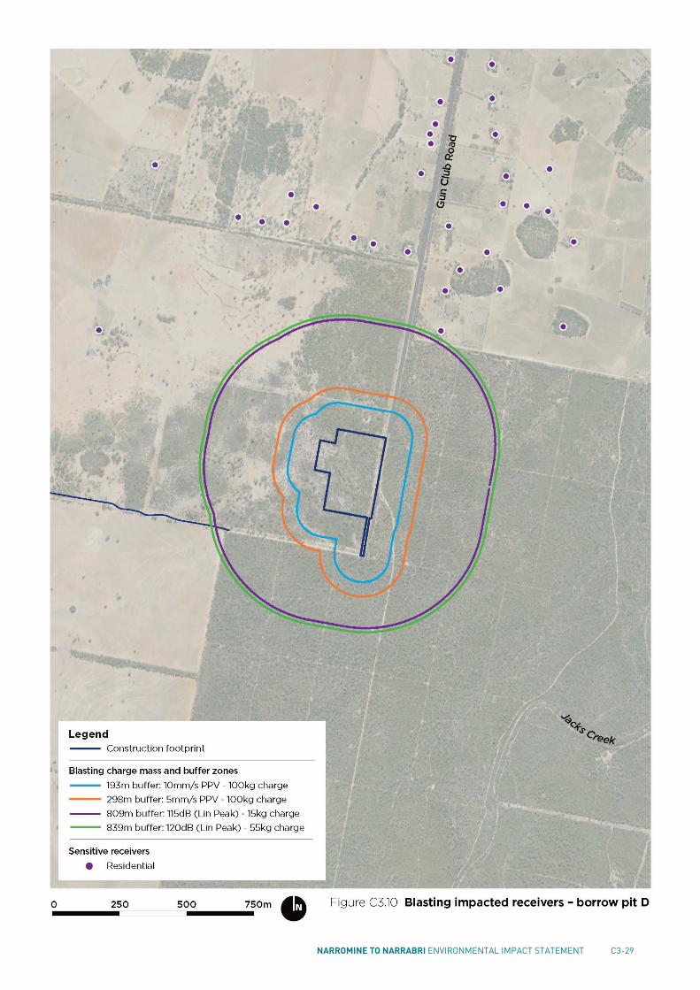
Blasting overpressure and vibration
Blasting may be required at borrow pits C and D if hard rock is encountered at depth. The blasting details, such as explosive charge mass or local ground properties, are not known at this stage. These variables can affect the magnitude and transmission characteristics of blasting.
A general blasting assessment was carried out in accordance with AS 2187.2 Explosives—storage and use (Standards Australia, 2006b), which provides site exponents for ‘average’ meteorological attenuation and ground conditions. The recommended levels for this assessment, based on the overpressure and vibration levels in the Technical Basis for Guidelines to Minimise Annoyance Due to Blasting Overpressure and Ground Vibration (ANZEC, 1990), are provided in Table C3.7. The recommended levels may be exceeded on up to 5 per cent of the total number of blasts over a period of 12 months. The maximum levels should not be exceeded at any time.
TABLE C3.7 RECOMMENDED BLASTING OVERPRESSURE AND GROUND VIBRATION MAXIMUM LEVELS
Item Recommended levels Maximum levels
Airblast overpressure 115 dB 120 dB
Ground vibration (peak particle velocity (PPV)) 5 mm/s 10 mm/s
The blasting assessment found that there is a sufficient distance from proposed blasting locations to the nearest receivers, such that ground vibration impacts are not expected; however, the recommended airblast overpressure levels in Table C3.7 may be exceeded at some sensitive receivers. The level of exceedance would be dependent on the mass of the charge used for blasting and this number would decrease with a smaller charge mass.
The potential number of receivers that may experience exceedances of the airblast overpressure levels are: Borrow pit C—five receivers for a 100-kg charge mass (three of which may exceed the maximum levels of 120
dB), decreasing to one for a 10-kg charge mass Borrow pit D—seven receivers for a 100-kg charge mass (none of which would exceed the maximum levels of
120 dB), decreasing to one for a 50-kg charge mass.
The assessment identified that airblast overpressure levels control the charge mass that may be used. To limit the risk of structural damage to buildings and annoyance to residents, blast size (charge mass) should be limited to below the following to avoid exceedances of the airblast overpressure criteria in Table C3.7: Borrow pit C—below 4 kg to result in no exceedances of the recommended levels and below 15 kg to result in
no exceedances of the maximum levels Borrow pit D—below 15 kg to result in no exceedances of the recommended levels and below 55 kg to result in
no exceedances of the maximum levels.
The potentially affected receivers are shown in Figure C3.9 and Figure C3.10.
Mitigation measures Specific mitigation measures for the establishment and use of the borrow pits are provided in section C3.4. In addition, the mitigation measures provided in chapter B8 would be implemented to minimise potential construction noise and vibration impacts.

C3-28 INLAND RAIL
FIGURE C3.9 BLASTING IMPACTED RECEIVERS – BORROW PIT C (EUROMEDAH ROAD, NARROMINE)
NARROMINE TO NARRABRI ENVIRONMENTAL IMPACT STATEMENT C3-29
FIGURE C3.10 BLASTING IMPACTED RECEIVERS – BORROW PIT D (PERIMETER ROAD, NARRABRI)
C3-30 INLAND RAIL
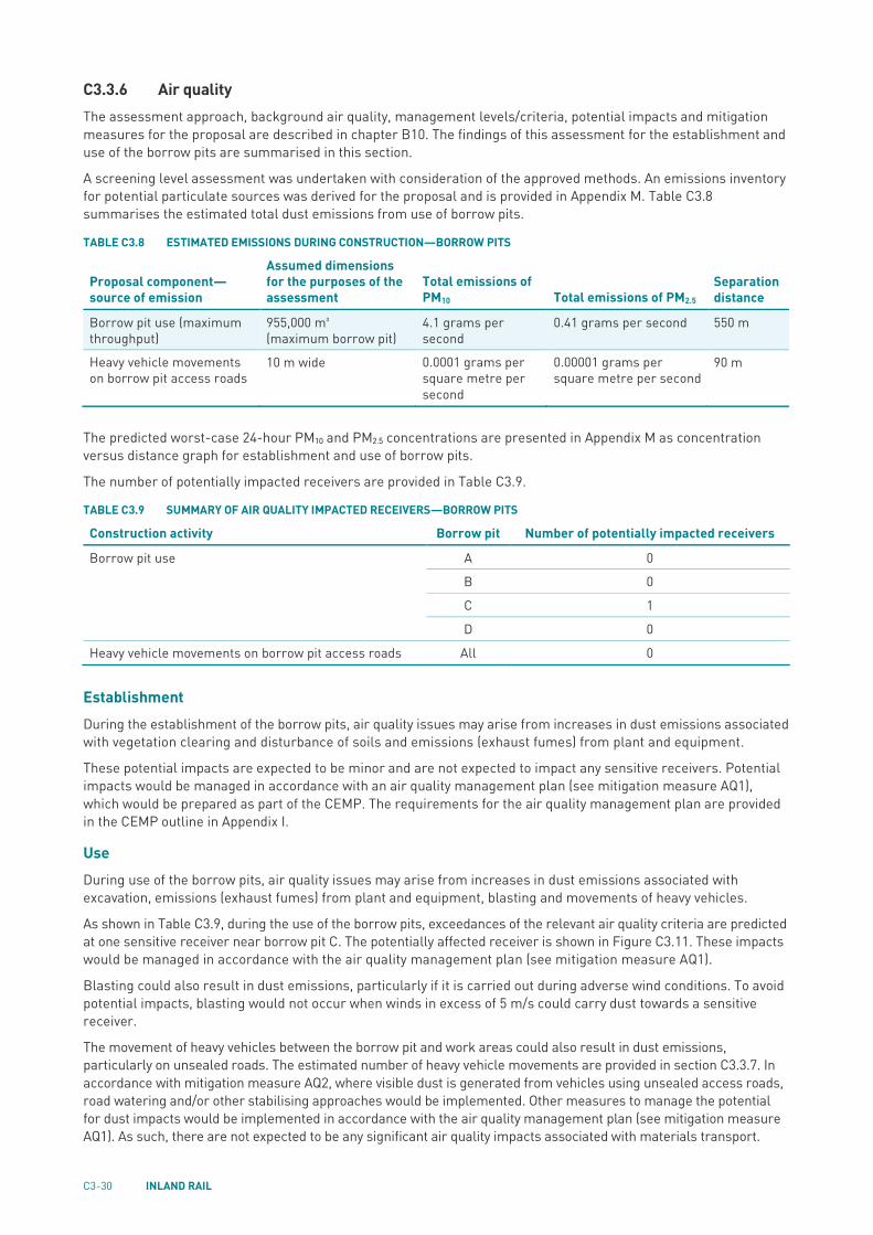
C3.3.6 Air quality The assessment approach, background air quality, management levels/criteria, potential impacts and mitigation measures for the proposal are described in chapter B10. The findings of this assessment for the establishment and use of the borrow pits are summarised in this section.
A screening level assessment was undertaken with consideration of the approved methods. An emissions inventory for potential particulate sources was derived for the proposal and is provided in Appendix M. Table C3.8 summarises the estimated total dust emissions from use of borrow pits.
TABLE C3.8 ESTIMATED EMISSIONS DURING CONSTRUCTION—BORROW PITS
Proposal component—source of emission
Assumed dimensions for the purposes of the assessment
Total emissions of PM10 Total emissions of PM2.5
Separation distance
Borrow pit use (maximum throughput)
955,000 m³ (maximum borrow pit)
4.1 grams per second
0.41 grams per second 550 m
Heavy vehicle movements on borrow pit access roads
10 m wide 0.0001 grams per square metre per second
0.00001 grams per square metre per second
90 m
The predicted worst-case 24-hour PM10 and PM2.5 concentrations are presented in Appendix M as concentration versus distance graph for establishment and use of borrow pits.
The number of potentially impacted receivers are provided in Table C3.9.
TABLE C3.9 SUMMARY OF AIR QUALITY IMPACTED RECEIVERS—BORROW PITS
Construction activity Borrow pit Number of potentially impacted receivers
Borrow pit use A 0
B 0
C 1
D 0
Heavy vehicle movements on borrow pit access roads All 0
Establishment During the establishment of the borrow pits, air quality issues may arise from increases in dust emissions associated with vegetation clearing and disturbance of soils and emissions (exhaust fumes) from plant and equipment.
These potential impacts are expected to be minor and are not expected to impact any sensitive receivers. Potential impacts would be managed in accordance with an air quality management plan (see mitigation measure AQ1), which would be prepared as part of the CEMP. The requirements for the air quality management plan are provided in the CEMP outline in Appendix I.
Use During use of the borrow pits, air quality issues may arise from increases in dust emissions associated with excavation, emissions (exhaust fumes) from plant and equipment, blasting and movements of heavy vehicles.
As shown in Table C3.9, during the use of the borrow pits, exceedances of the relevant air quality criteria are predicted at one sensitive receiver near borrow pit C. The potentially affected receiver is shown in Figure C3.11. These impacts would be managed in accordance with the air quality management plan (see mitigation measure AQ1).
Blasting could also result in dust emissions, particularly if it is carried out during adverse wind conditions. To avoid potential impacts, blasting would not occur when winds in excess of 5 m/s could carry dust towards a sensitive receiver.
The movement of heavy vehicles between the borrow pit and work areas could also result in dust emissions, particularly on unsealed roads. The estimated number of heavy vehicle movements are provided in section C3.3.7. In accordance with mitigation measure AQ2, where visible dust is generated from vehicles using unsealed access roads, road watering and/or other stabilising approaches would be implemented. Other measures to manage the potential for dust impacts would be implemented in accordance with the air quality management plan (see mitigation measure AQ1). As such, there are not expected to be any significant air quality impacts associated with materials transport.

NARROMINE TO NARRABRI ENVIRONMENTAL IMPACT STATEMENT C3-31
Mitigation measures Specific mitigation measures for the establishment and use of the borrow pits are provided in section C3.4. In addition, the mitigation measures in chapter B10 would be implemented to minimise potential construction air quality impacts.

C3-32 INLAND RAIL
FIGURE C3.11 AIR QUALITY IMPACTED RECEIVERS – BORROW PIT C (EUROMEDAH ROAD, NARROMINE)

NARROMINE TO NARRABRI ENVIRONMENTAL IMPACT STATEMENT C3-33
C3.3.7 Traffic and transport The assessment approach, existing environment, potential impacts and mitigation measures for the proposal are described in chapter B11 and Technical Report 10—Traffic and transport assessment. The findings of this assessment for the establishment and use of the borrow pits are summarised in this section.
Establishment The establishment of borrow pits would have minimal impacts on traffic and access, as most of the activities would be carried out within the site. Estimated construction traffic movements associated with the construction of the proposal as a whole (including establishment of the borrow pits) are provided in Technical Report 10 and summarised in chapter B11. The assessment identified that there is unlikely to be any significant impacts on the existing road network. As such, the movements associated with establishment of the borrow pits are not expected to impact the existing road network.
Use Access to each borrow pit would be provided by constructing a new temporary access road off the following roads: Borrow pit A—off Tantitha Road Borrow pit B—off Tomingley Road Borrow pit C—off Euromedah Road Borrow pit D—off the Newell Highway.
The design of site access roads and points would be undertaken with regard to the relevant standards and guidelines and in consultation with the road manager (i.e. council or Transport for NSW).
Access between the borrow pits and work areas would be via the public road network. Only standard road-registered vehicles (e.g. truck and dog trailer) would be used. The primary access routes for the transport of materials from borrow pits are summarised in Table C3.10. Table C3.10 also shows the estimated daily worst-case heavy vehicle movements (two way) to and from the borrow pits and the estimated duration of traffic movements.
All movements of heavy vehicles on public roads would be subject to NSW road rules and managed in accordance with a traffic, transport and access management plan included in the CEMP (see mitigation measure TT5).
TABLE C3.10 LOCAL ROAD ACCESS TO AND FROM THE PROPOSAL AND BORROW PITS
Borrow pit Primary access route Estimated daily worst-case number of movements
Estimated duration of traffic movements (months)
A Tantitha Road Pinedean Road
227 3
B Tomingley Road 270 6
C Euromedah Road Eumungerie Road
294 6
D Newell Highway Yarrie Lake Road Pilliga Forest Way
225 18
Based on an analysis of existing traffic volumes (measured and estimated), the public road network is not expected to be significantly impacted by construction traffic. This is because the roads have sufficient capacity to absorb the increased traffic, and delays at intersections would have a localised impact only, due to the low volumes on affected roads. During the peak construction activity, the existing level of service is expected to be maintained on all key roads used for the borrow pits.
No upgrades or improvements are expected to be required for any public roads. Potential pavement damage as a result of heavy vehicle movements for the proposal, would be managed by undertaking a dilapidation survey of made public roads within the proposed haulage routes (see mitigation measure TT8).
As with other traffic, public and school buses may be affected by an increase in traffic on the road network; however, given the relatively small number of bus services in the area combined with the limited traffic impact generally, this would be a minor potential impact.

C3-34 INLAND RAIL
Mitigation measures The mitigation measures to address potential traffic and transport impacts are provided in chapter B11. No specific mitigation measures are provided for establishment and use of the borrow pits.
C3.3.8 Land use and property The assessment approach, existing environment, potential impacts and mitigation measures for the proposal are described in chapter B12 and Technical Report 11—Agriculture and land use assessment. The findings of this assessment for the establishment and use of the borrow pits are summarised in this section.
Establishment During the establishment phase, there would be changes to land use. These impacts would be similar to the use impacts, as described below.
Use Use of the borrow pits would result in a modification of the existing landform, which could affect the existing land use. The sites would be rehabilitated following completion of construction in accordance with the borrow pit rehabilitation strategy (provided in Appendix K).
Borrow pit A is currently used for agricultural (primarily grazing) activities. Following rehabilitation, there would a minor loss of agricultural land associated with the cut batters; however, it is expected that grazing would be able to resume across most of the site.
Borrow pit B is located within an existing borrow pit. During use, there would be temporary loss of some surrounding grazing land. It is proposed to rehabilitate this site to match the surrounding remnant vegetation within the existing borrow pit extent, and to reinstate grazing land outside this area. There would a minor loss of agricultural land associated with the cut batters; however, it is expected that existing activities would be able to resume across most of the site. In the event the landowner wishes to retain the site as an active borrow pit, a revised rehabilitation plan would be prepared during detailed design to minimise the potential for ongoing environmental impacts.
Borrow pit C is mostly located within a vegetated area bounded by grazing land. It is proposed to rehabilitate this site to match the existing vegetation and to reinstate grazing land outside this area. There would a minor loss of agricultural land associated with the cut batters; however, it is expected that existing activities would be able to resume across most of the site.
Borrow pit D is located within a cleared area; it is proposed to rehabilitate this site to match the existing vegetation. There would a minor loss of land associated with the cut batters; however, it is expected that existing activities would be able to resume across most of the site.
None of the sites would impact any strategic agricultural land, travelling stock reserves or other protected lands.
During use, there would be the potential for some noise impacts, which may affect the grazing patterns of livestock; however, livestock generally become habituated to noise and, although grazing patterns may be altered, productivity is not affected. The generation of dust could also settle on crops and pastures. With the implementation of standard mitigation measures for other environmental aspects assessed in this chapter, as described in section C3.4, in addition to those measures provided in chapter B12, these impacts are not expected to be significant.
Borrow pit D is located within a licensed minerals exploration area. The size of this exploration area is very large relative to the borrow pit site, making the likelihood of high-value resources being discovered under the site reasonably low despite being in an exploration area. Similarly, due to the relative size, this borrow pit is unlikely to impact on the capacity to extract coal seam gas as part of the proposed Narrabri Gas Project. As such, this borrow pit is unlikely to sterilise any land from mining or future exploration activities.
Borrow pit C is located immediately west of a proposed quarry and two existing borrow pits. The proposed borrow pit would not intrude into or impede the activities of the adjacent sites and would therefore have no impact on their operations.
Mitigation measures The mitigation measures to address potential land use and property impacts are provided in chapter B12. No specific mitigation measures are provided for establishment and use of the borrow pits.

NARROMINE TO NARRABRI ENVIRONMENTAL IMPACT STATEMENT C3-35
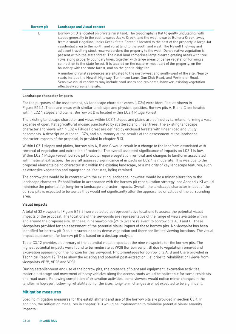
C3.3.9 Visual amenity The assessment approach, existing environment, potential impacts and mitigation measures for the proposal are described in chapter B13 and Technical Report 12—Landscape and visual assessment. The findings of this assessment for the establishment and use of the borrow pits are summarised in this section.
Establishment During the establishment of the borrow pits, there would be impacts on visual amenity from the clearing of vegetation and other activities associated with the change in land use. These impacts would be similar to the use impacts, as described below.
Use During use of the borrow pits there would be impacts on visual amenity from the presence of plant and equipment, heavy vehicle movements (within and around the sites), lighting and other activities at the site. The main potential for landscape and visual impacts would be for residences located near the borrow pits. The distances to the nearest sensitive receivers are listed in Table C3.3.
The landscape and visual context for the borrow pits is summarised in Table C3.11.
TABLE C3.11 LANDSCAPE AND VISUAL CONTEXT—BORROW PITS
Borrow pit Landscape and visual context
A Borrow pit A is located within a rural landscape setting. The topography is gently undulating, with a number of minor drainage lines present. Vegetation is primarily non-irrigated grazing land, with linear native trees present along roadside corridors, within drainage lines and to higher elevations of the landform. Local roads are typically gravel and gently undulating in nature in response to the landform. The site is located within privately owned rural land, on a higher topographic elevation, which is partially vegetated. The nearest road is Tantitha Road to the east, a gravel road from which a number of residences are situated on either side. Sensitive visual receivers would include local road users of Tantitha Road and potentially a number of residents on Tantitha Road.
B Borrow pit B is located within relatively flat rural land. Vegetation includes a mosaic of cropping and grazing fields, with linear native trees along road corridors, and on elevated rises within the landscape. Nearby roads include Tomingley Road, a sealed north–south arterial road, and local gravel roads, including Haberworth Lane and Pinedean Road. The site is located within privately owned rural land, on a slightly elevated site that has been subject to previous excavation activity, which has resulted in changes to the natural landform and vegetation removal. A number of rural residences are located nearby. Dense existing vegetation on the northern and eastern side of the site shields views to from locations beyond, such as from Pinedean Road. Linear vegetation along Tomingley Road contributes to shielding some views from the road but some gaps in vegetation are present. Sensitive visual receivers would include road users on Tomingley Road, experiencing intermittent views through gaps in roadside vegetation, and potentially a small number of residences when entering and leaving their properties at Tomingley Road.
C Borrow pit C is located on privately owned rural land. The topography is flat to gently undulating, with small vegetated rises among cleared grazing land. The Macquarie River is located nearby to the south. Nearby roads include Eumungerie Road to the north-east (a sealed arterial road) and local unsealed roads, Euromedah Road and Macquarie View Road. Dense native vegetation is present on higher landform elevation, to either side of Euromedah Road, and isolated patches within cleared paddocks. The site is located to the north-western side of a densely vegetated landform elevation. Due to the presence of intervening vegetation, only residents to the west of the site may experience views to the borrow pit. Sensitive visual receivers would include road users of Eumungerie Road and Mountain View Road travelling east, and nearby residents to the west.
C3-36 INLAND RAIL
Borrow pit Landscape and visual context
D Borrow pit D is located on private rural land. The topography is flat to gently undulating, with slopes generally to the east towards Jacks Creek, and the west towards Bohena Creek, away from a small ridgeline. Jacks Creek State Forest is located to the east of the property, a large-lot residential area to the north, and rural land to the south and west. The Newell Highway and adjacent travelling stock reserve borders the property to the west. Dense native vegetation is present within the state forest. The rural land comprises large cleared grazing areas with tree rows along property boundary lines, together with large areas of dense vegetation forming a connection to the state forest. It is located on the eastern-most part of the property, on the boundary with the state forest, and on the gentle ridgeline. A number of rural residences are situated to the north-west and south-west of the site. Nearby roads include the Newell Highway, Tomlinson Lane, Gun Club Road, and Perimeter Road. Sensitive visual receivers may include road users and residents; however, existing vegetation effectively screens the site.
Landscape character impacts
For the purposes of the assessment, six landscape character zones (LCZs) were identified, as shown in Figure B13.1. These are areas with similar landscape and physical qualities. Borrow pits A, B and C are located within LCZ 1 slopes and plains. Borrow pit D is located within LCZ 4 Pilliga Forest.
The existing landscape character and views within LCZ 1 slopes and plains are defined by farmland, forming a vast expanse of open, flat agricultural mosaic punctuated by scattered and linear trees. The existing landscape character and views within LCZ 4 Pilliga Forest are defined by enclosed forests with linear road and utility easements. A description of these LCZs, and a summary of the results of the assessment of the landscape character impacts of the proposal, is provided in chapter B13.
Within LCZ 1 slopes and plains, borrow pits A, B and C would result in a change to the landform associated with removal of vegetation and extraction of material. The overall assessed significance of impacts on LCZ 1 is low. Within LCZ 4 Pilliga Forest, borrow pit D would require vegetation removal and changes to landform associated with material extraction. The overall assessed significance of impacts on LCZ 4 is moderate. This was due to the proposal elements being characteristic within the existing landscape, or a majority of key landscape features, such as extensive vegetation and topographical features, being retained.
The borrow pits would be in contrast with the existing landscape; however, would be a minor alteration to the landscape character. Rehabilitation in accordance with the borrow pit rehabilitation strategy (see Appendix K) would minimise the potential for long-term landscape character impacts. Overall, the landscape character impact of the borrow pits is expected to be low as they would not significantly alter the appearance or values of the surrounding area.
Visual impacts
A total of 32 viewpoints (Figure B13.2) were selected as representative locations to assess the potential visual impacts of the proposal. The locations of the viewpoints are representative of the range of views available within and around the proposal site. Of these, nine viewpoints (24 to 32) are relevant to borrow pits A, B and C. These viewpoints provided for an assessment of the potential visual impact of these borrow pits. No viewpoint has been identified for borrow pit D as it is surrounded by dense vegetation and there are limited viewing locations. The visual impact assessment for borrow pit D is based on a desktop analysis.
Table C3.12 provides a summary of the potential visual impacts at the nine viewpoints for the borrow pits. The highest potential impacts were found to be moderate at VP28 (for borrow pit B) due to vegetation removal and excavation appearing on the horizon for this viewpoint. Photomontages for borrow pits A, B and C are provided in Technical Report 12. These show the existing and potential post-extraction (i.e. prior to rehabilitation) views from viewpoints VP25, VP28 and VP31.
During establishment and use of the borrow pits, the presence of plant and equipment, excavation activities, materials storage and movement of heavy vehicles along the access roads would be noticeable for some residents and road users. Following completion of excavation activities, some viewers would notice minor changes in the landform; however, following rehabilitation of the sites, long-term changes are not expected to be significant.
Mitigation measures Specific mitigation measures for the establishment and use of the borrow pits are provided in section C3.4. In addition, the mitigation measures in chapter B13 would be implemented to minimise potential visual amenity impacts.

NARROMINE TO NARRABRI ENVIRONMENTAL IMPACT STATEMENT C3.37
TABLE C3.12 SUMMARY OF VISUAL IMPACTS—BORROW PITS
Viewpoint Assessment Description Existing view
Borrow Pit A
VP24 Tantitha Road (north)
Sensitivity: moderate Magnitude of change (post-rehabilitation): negligible Significance of impact (post-rehabilitation): negligible
While nearby residents would experience this view when entering and leaving their properties, they are at a distance, and somewhat screened, from the site. Local road users may experience short-term views to the site while passing through the area. The anticipated change would be minor and small in scale within the view. Rehabilitation would minimise the potential for long-term impacts.
VP25 Tantitha Road (central)
Sensitivity: low Magnitude of change (post-rehabilitation): negligible Significance of impact (post-rehabilitation): negligible
Road users may notice minor changes to the landform associated with vegetation removal. The anticipated change would be minor and small in scale within the view. Rehabilitation would minimise the potential for long-term impacts. See Technical Report 12 for a photomontage that shows the existing and post-extraction (i.e. prior to rehabilitation) view.
VP26 Tantitha Road (south)
Sensitivity: moderate Magnitude of change (post-rehabilitation): negligible Significance of impact (post-rehabilitation): negligible
While nearby residents and road users (with short-term views) may notice a change, existing vegetation and topography would effectively limit the impact. The anticipated change would be very minor. Rehabilitation would minimise the potential for long-term impacts.
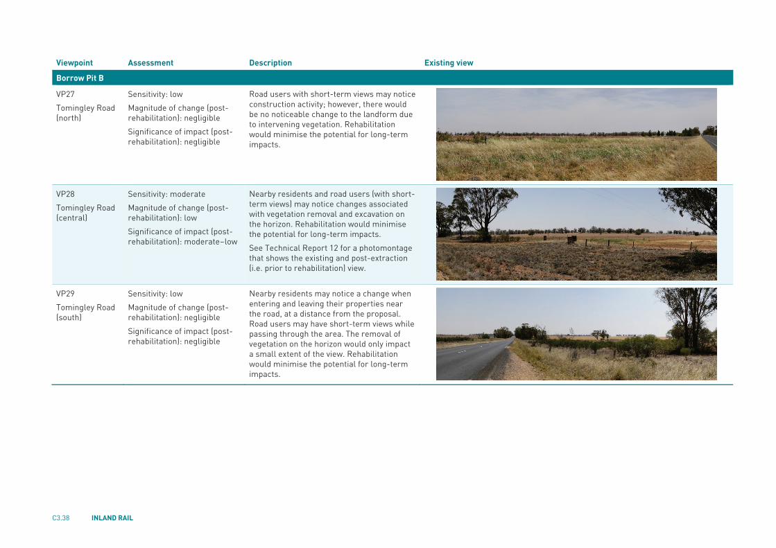
C3.38 INLAND RAIL
Viewpoint Assessment Description Existing view
Borrow Pit B
VP27 Tomingley Road (north)
Sensitivity: low Magnitude of change (post-rehabilitation): negligible Significance of impact (post-rehabilitation): negligible
Road users with short-term views may notice construction activity; however, there would be no noticeable change to the landform due to intervening vegetation. Rehabilitation would minimise the potential for long-term impacts.
VP28 Tomingley Road (central)
Sensitivity: moderate Magnitude of change (post-rehabilitation): low Significance of impact (post-rehabilitation): moderate–low
Nearby residents and road users (with short-term views) may notice changes associated with vegetation removal and excavation on the horizon. Rehabilitation would minimise the potential for long-term impacts. See Technical Report 12 for a photomontage that shows the existing and post-extraction (i.e. prior to rehabilitation) view.
VP29 Tomingley Road (south)
Sensitivity: low Magnitude of change (post-rehabilitation): negligible Significance of impact (post-rehabilitation): negligible
Nearby residents may notice a change when entering and leaving their properties near the road, at a distance from the proposal. Road users may have short-term views while passing through the area. The removal of vegetation on the horizon would only impact a small extent of the view. Rehabilitation would minimise the potential for long-term impacts.

NARROMINE TO NARRABRI ENVIRONMENTAL IMPACT STATEMENT C3.39
Viewpoint Assessment Description Existing view
Borrow Pit C
VP30 Eumungerie Road (west)
Sensitivity: moderate Magnitude of change (post-rehabilitation): negligible Significance of impact (post-rehabilitation): negligible
Nearby residents and road users (with short-term views) may notice changes associated with vegetation removal; however, viewers would be at a distance and the change would only affect a small extent of the view. Rehabilitation would minimise the potential for long-term impacts.
VP31 Eumungerie Road (east)
Sensitivity: low Magnitude of change (post-rehabilitation): negligible Significance of impact (post-rehabilitation): negligible
Road users with short-term views may notice changes associated with removal of vegetation on the front face of the hill, with trees remaining on the horizon line. The anticipated change would be minor and across a small extent of the view. Rehabilitation would minimise the potential for long-term impacts. See Technical Report 12 for a photomontage that shows the existing and post-extraction (i.e. prior to rehabilitation) view.
VP32 Macquarie View Road
Sensitivity: moderate Magnitude of change (post-rehabilitation): negligible Significance of impact (post-rehabilitation): negligible
Nearby residents and road users (with short-term views) may notice changes associated with vegetation removal; however, viewers would be at a distance and the change would only affect a small extent of the view.
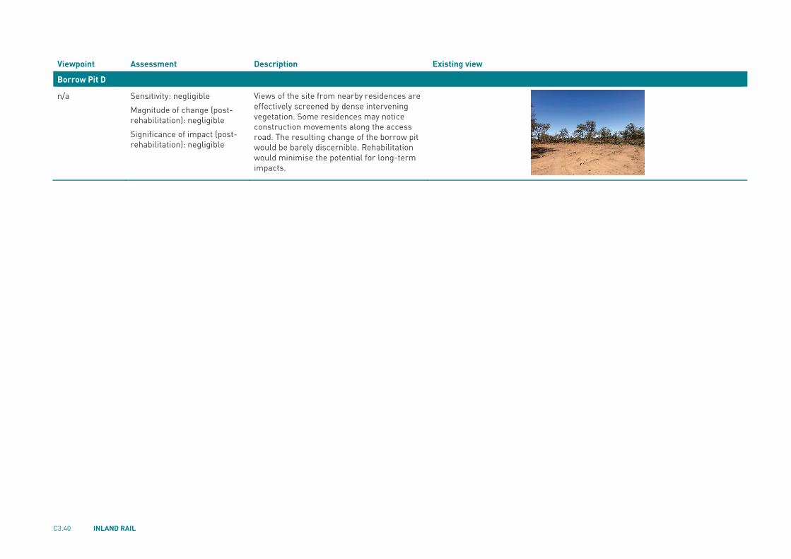
C3.40 INLAND RAIL
Viewpoint Assessment Description Existing view
Borrow Pit D
n/a Sensitivity: negligible Magnitude of change (post-rehabilitation): negligible Significance of impact (post-rehabilitation): negligible
Views of the site from nearby residences are effectively screened by dense intervening vegetation. Some residences may notice construction movements along the access road. The resulting change of the borrow pit would be barely discernible. Rehabilitation would minimise the potential for long-term impacts.

NARROMINE TO NARRABRI ENVIRONMENTAL IMPACT STATEMENT C3.41
C3.3.10 Waste management The assessment approach, potential impacts and mitigation measures for the proposal are described in chapter D2. The findings of this assessment for the establishment and use of the borrow pits are summarised in this section.
Estimated waste quantities and classifications for the proposal as a whole are provided in chapter D2. These would be confirmed during detailed design and construction planning and incorporated into the construction waste management plan (see mitigation measure WM3), which would be prepared and implemented as part of the CEMP.
Establishment The establishment of borrow pits would generate a range of waste streams, including green waste from clearing of vegetation, spoil (comprising virgin excavated natural material or excavated natural material), potentially contaminated soils and waste metal/timber posts from fencing.
Potential impacts and the proposed approach to waste management would be similar to those described below for use.
Use The use of borrow pits would generate a range of waste streams, including food and organic waste, wastewater, waste paper and cardboard, waste containers (plastics, glass and metals), other office waste, electrical and electronic waste and waste from vehicle/plant equipment maintenance (adhesives, lubricants, waste fuels and oils, engine coolant, batteries, hoses and tyres).
Inappropriate management of waste could result in a range of impacts on air quality, water quality and soils. An overall approach to classification and management of waste streams in accordance with the Waste Classification Guidelines (NSW EPA. 2014a) and waste management hierarchy (avoid, reduce, recycle, reuse, dispose), including measures to facilitate segregation and prevent cross contamination, is described in chapter D2.
Cleared vegetation (excluding any weeds) and excavated materials not taken offsite for use in the rail formation (e.g. topsoil) would be temporarily stockpiled and reused on site as part of rehabilitation of the borrow pits, in accordance with the borrow pit rehabilitation strategy (provided in Appendix K).
Waste that would be taken offsite would be stored temporarily at the site before being transferred for recycling and disposal at licensed waste management facilities. Waste segregation bins (colour coded) would be provided to facilitate segregation and prevent cross contamination).
The construction waste management plan (see mitigation measure WM3), prepared and implemented as part of the CEMP, would detail measures to manage potential waste impacts during construction. The requirements for the waste management plan are provided in the CEMP outline in Appendix I.
Mitigation measures The mitigation measures to address potential impacts are provided in chapter D2. No specific mitigation measures are provided for the establishment and use of the borrow pits.

C3.42 INLAND RAIL
C3.4 Specific mitigation measures Specific mitigation measures that will be implemented to address potential impacts from the borrow pits are listed in Table C3.13. For other environmental aspects, the mitigation measures listed in chapter D5 would be applied as relevant to the borrow pits.
TABLE C3.13 BORROW PIT SPECIFIC MITIGATION MEASURES
Stage Aspect Issue/impact Ref Mitigation measures
Detailed design/ pre-construction
Noise and vibration (construction)
Blasting management (borrow pits)
CNV-CI1 A blast management strategy would be prepared in accordance with relevant guidelines and in consultation with the NSW EPA and would include: Sequencing and review of trial blasting to
inform blasting Regularity of blasting Intensity of blasting Periods of relief Blasting program.
Visual amenity Landscape character and visual impacts associated with (borrow pits)
LV-CI1 The borrow pits would be rehabilitated in accordance with the borrow pit rehabilitation strategy provided in Appendix K of the EIS.
Construction Water resources
Unforeseen water table penetration by borrow pits
WR-CI3 If excavations at borrow pits B, C and/or borrow pit D intersect the water table, the potential impacts would be assessed by a hydrogeologist and additional management measures implemented as required.
Water resources
Groundwater inflow rate (borrow pits)
WR-CI4 If the groundwater inflow rate at borrow pit A is higher than one mega litre per year, the inflow rate and implications would be assessed by a hydrogeologist and additional management measures implemented as required.
Noise and vibration (construction)
Minimising potential for impacts of blasting at borrow pits
CNV-CI2 Blasting would be undertaken during the recommended standard hours for blasting
Management measures defined by the blasting management strategy would be implemented.
Air quality Blasting management (borrow pits)
AQ-CI1 Blasting would be avoided when winds in excess of 5 m/s could carry dust towards a sensitive receiver.
Recommended


