lable at ScienceDirect
Quaternary International 328-329 (2014) 226e243
Contents lists avai
Quaternary International
journal homepage: www.elsevier .com/locate/quaint
Palaeoenvironment and anthropogenic activity in the southeasternMediterranean since the mid-Holocene: The case of Tell es-Safi/Gath,Israel
Oren Ackermann a,b,*, Noam Greenbaum c,d, Hendrik Bruins e, Naomi Porat f,Mira Bar-Matthews f, Ahuva Almogi-Labin f, Bettina Schilman g, Avner Ayalon f,Liora Kolska Horwitz h, Ehud Weiss a, Aren M. Maeir a
a Institute of Archaeology, The Martin (Szusz) Department of Land of Israel Studies and Archaeology, Bar-Ilan University, 5290002 Ramat-Gan, Israelb The Department of Land of Israel Studies, Ashkelon Academic College, Ashkelon 78211, IsraelcDepartment of Geography and Environmental Studies, University of Haifa, Haifa 31905, IsraeldDepartment of Natural Resources and Environmental Management, University of Haifa, Haifa 31905, Israele The Jacob Blaustein Institutes for Desert Research, Bona Terra Department of Man in the Desert, Ben-Gurion University of the Negev, Sede Boker Campus,84990, IsraelfGeological Survey of Israel, 30 Malchei Israel Street, Jerusalem 95501, Israelg Environmental Secretary, Ministry of Production, Government of Tucuman, 4000, ArgentinahNational Natural History Collections, Faculty of Life Sciences, Berman Building, Givat Ram, The Hebrew University, Jerusalem 91904, Israel
a r t i c l e i n f o
Article history:Available online 20 March 2014
* Corresponding author. Institute of Archaeology, ThE-mail addresses: [email protected], oren.ackerm
http://dx.doi.org/10.1016/j.quaint.2014.02.0161040-6182/� 2014 Elsevier Ltd and INQUA. All rights
a b s t r a c t
The “younger fill” phenomenon defined by Vita-Finzi, related to sediments that were deposited in manyMediterranean valleys, has been a topic of discussion for several decades. The main challenge regardingthis issue is deciphering the origin of the fill: geomorphic processes induced by natural climatic, or byanthropogenic activity. The current research is an attempt to deal with this issue by using a concept inwhich the environmental records, i.e. climate, hydrology and sedimentology, were examined inconjunction with human history, in the area of the Bronze and Iron Age archaeological site of Tell es-Safi/Gath, in central Israel. The study investigated geomorphic structures of various scales: a single slope, 1stand 2nd order valleys, and larger drainage basins of a few tens to hundreds km2. High-resolution datingof the sediments by OSL and 14C allowed the identification of different sedimentary phases.
The sedimentary history of the Tell es-Safi/Gath environs shows that: (a) During the Chalcolithicperiod and Early Bronze Age (w4200e3050 BCE), stable conditions prevailed in the small valleys, rep-resented by soil formation; (b) During the Iron Age II and up to the Early Arab period (w800 BCEe800CE), aggradation took place in the small and the large valleys; (c) During the post-Byzantine/EarlyArab periods (after 800 CE), major incision occurred in the large valleys, whereas minor aggradationoccurred in the small valleys. Climatic and natural geomorphic processes are the major factors shapingthe landscape in the current research area.
Anthropogenic activity was expressed at localized sites and for a limited time, in two locations only.One location is the siege trench that surrounds Tell es-Safi/Gath, where sedimentation occurred shortlyafter the destruction of the site by Hazael, king of Aram Damascus (ca. late 9th century BCE), and in thesame locality during the Byzantine period. The other location is the 2nd order valley close to thearchaeological site, where enhanced sedimentation rates occurred shortly after site destruction. Inaddition, these results suggest that the small basin valleys underwent aggradation that continuouslyrecorded the local environmental history, whereas the large drainage basins underwent cut and fillprocesses related to the regional environmental history in a less continuous record.
� 2014 Elsevier Ltd and INQUA. All rights reserved.
e Martin (Szusz) Department of Land of Israel Studies and Archaeology, Bar-Ilan University, 5290002 Ramat-Gan, [email protected] (O. Ackermann).
reserved.
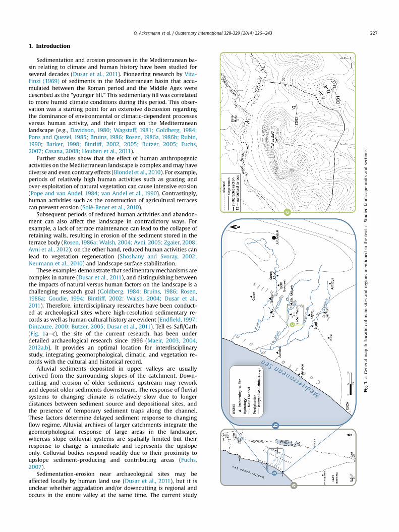
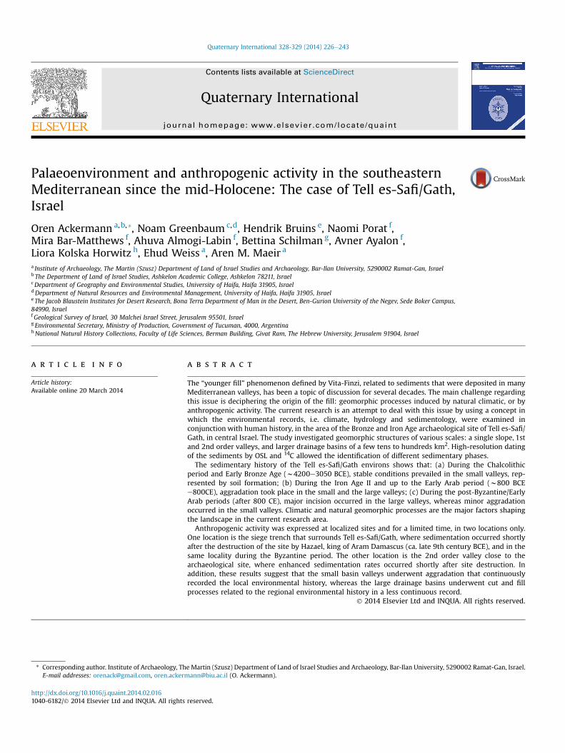
Fig.
1.a.
Gen
eral
map
.b.L
ocationof
mainsitesan
dregion
smen
tion
edin
thetext.c
.Studied
land
scap
eun
itsan
dsections
.
O. Ackermann et al. / Quaternary International 328-329 (2014) 226e243 227
1. Introduction
Sedimentation and erosion processes in the Mediterranean ba-sin relating to climate and human history have been studied forseveral decades (Dusar et al., 2011). Pioneering research by Vita-Finzi (1969) of sediments in the Mediterranean basin that accu-mulated between the Roman period and the Middle Ages weredescribed as the “younger fill.” This sedimentary fill was correlatedto more humid climate conditions during this period. This obser-vation was a starting point for an extensive discussion regardingthe dominance of environmental or climatic-dependent processesversus human activity, and their impact on the Mediterraneanlandscape (e.g., Davidson, 1980; Wagstaff, 1981; Goldberg, 1984;Pons and Quezel, 1985; Bruins, 1986; Rosen, 1986a, 1986b; Rubin,1990; Barker, 1998; Bintliff, 2002, 2005; Butzer, 2005; Fuchs,2007; Casana, 2008; Houben et al., 2011).
Further studies show that the effect of human anthropogenicactivities on theMediterranean landscape is complex andmay havediverse and even contrary effects (Blondel et al., 2010). For example,periods of relatively high human activities such as grazing andover-exploitation of natural vegetation can cause intensive erosion(Pope and van Andel, 1984; van Andel et al., 1990). Contrastingly,human activities such as the construction of agricultural terracescan prevent erosion (Solé-Benet et al., 2010).
Subsequent periods of reduced human activities and abandon-ment can also affect the landscape in contradictory ways. Forexample, a lack of terrace maintenance can lead to the collapse ofretaining walls, resulting in erosion of the sediment stored in theterrace body (Rosen, 1986a; Walsh, 2004; Avni, 2005; Zgaier, 2008;Avni et al., 2012); on the other hand, reduced human activities canlead to vegetation regeneration (Shoshany and Svoray, 2002;Neumann et al., 2010) and landscape surface stabilization.
These examples demonstrate that sedimentary mechanisms arecomplex in nature (Dusar et al., 2011), and distinguishing betweenthe impacts of natural versus human factors on the landscape is achallenging research goal (Goldberg, 1984; Bruins, 1986; Rosen,1986a; Goudie, 1994; Bintliff, 2002; Walsh, 2004; Dusar et al.,2011). Therefore, interdisciplinary researches have been conduct-ed at archeological sites where high-resolution sedimentary re-cords as well as human cultural history are evident (Endfield, 1997;Dincauze, 2000; Butzer, 2005; Dusar et al., 2011). Tell es-Safi/Gath(Fig. 1aec), the site of the current research, has been underdetailed archaeological research since 1996 (Maeir, 2003, 2004,2012a,b). It provides an optimal location for interdisciplinarystudy, integrating geomorphological, climatic, and vegetation re-cords with the cultural and historical record.
Alluvial sediments deposited in upper valleys are usuallyderived from the surrounding slopes of the catchment. Down-cutting and erosion of older sediments upstream may reworkand deposit older sediments downstream. The response of fluvialsystems to changing climate is relatively slow due to longerdistances between sediment source and depositional sites, andthe presence of temporary sediment traps along the channel.These factors determine delayed sediment response to changingflow regime. Alluvial archives of larger catchments integrate thegeomorphological response of large areas in the landscape,whereas slope colluvial systems are spatially limited but theirresponse to change is immediate and represents the upslopeonly. Colluvial bodies respond readily due to their proximity toupslope sediment-producing and contributing areas (Fuchs,2007).
Sedimentation-erosion near archaeological sites may beaffected locally by human land use (Dusar et al., 2011), but it isunclear whether aggradation and/or downcutting is regional andoccurs in the entire valley at the same time. The current study
O. Ackermann et al. / Quaternary International 328-329 (2014) 226e243228
attempts to isolate the effect of erosion and sedimentation invarious catchment scales, from an anthropogenic single slopestructure, to 1st and 2nd order basins (Figs. 1aec and 2) and tolarger catchments of 30 km2 (Nahal Luzit) and 306 km2 (NahalHa’Elah). It hypothesizes that natural mechanisms have a broadspatial impact, whereas human impact is more local in character.
One of the main constraints in reconstructing sedimentogicalrecords is the accuracy and resolution of dating methods (Dusaret al., 2011). Optically Stimulated Luminescence (OSL) enables thedating of sediments that do not contain any material for radio-carbon dating or indicative ceramic remains. This method wasapplied systematically in the current research, in particular high-resolution, in a 2nd order basin (DB2) which borders the foot-slopes of Tell es-Safi/Gath (Fig. 1c).
2. Geological and geomorphological setting
Tell es-Safi/Gath is situated at the transition between the Judeanfoothills (Shephelah) and the southern coastal plain of Israel(Fig. 1a; Ackermann and Bruins, 2012). The foothills and the site’sbedrock are primarily composed of white Eocene chalk of theMaresha Formation. The chalk bedrock on the foothills is coveredby thick, resistant calcrete crust, locally known as Nari (Wiederet al., 1994; Itkin et al., 2012), which is the main bedrock of thearea. On the Tell, the chalk is covered by a calcareous, marine,gravelly sandstone of the Pliocene Pleshet Formation (Buchbinder,1969).
The research site is also located at the transition between theshallow, Rendzina soils of the Judean foothills and the deep, mixedaeolian-alluvial Grumusol soils (Vertisol) of the Quaternary coastalplain and the valleys between the hills (Dan et al., 1972, 1976;Bruins and Yaalon, 1979). Brown Rendzina soils usually cover Naricrust, whereas carbonate-rich Pale Rendzina soil occurs on thesofter chalk devoid of Nari. Dark brown soils and heavy Grumusolare formed in alluvial deposits, eroded from the Judean hills, and inaeolian clayey loess sediments, derived from dust originatingmainly in the deserts of North Africa (Yaalon and Dan, 1974; Danand Bruins, 1981; Bruins and Yaalon, 1992).
The climate of the area is semi-arid Mediterranean (Kafle andBruins, 2009), characterised by a hot, dry summer and a cool,rainy winter. The mean annual temperature is 20 �C. The meantemperature in January and August are 12 �C and 26 �C, respec-tively. The rainy season generally lasts fromOctober toMay, and themean annual rainfall is 450 mm (Fig. 1b). The vegetation belongs to
Fig. 2. General view of the small geomorphologal structures: The trench and the berm; 1stCalcrete on the northern side; slope with Calcrete on the southern side; 2nd order drainag
the xeric Mediterranean phytogeographic region, characterised bydwarf shrubs including Rhamnus (Palestine buckthorn) and Sarco-poterium spinosum (Thorny burnet).
3. Archaeological background
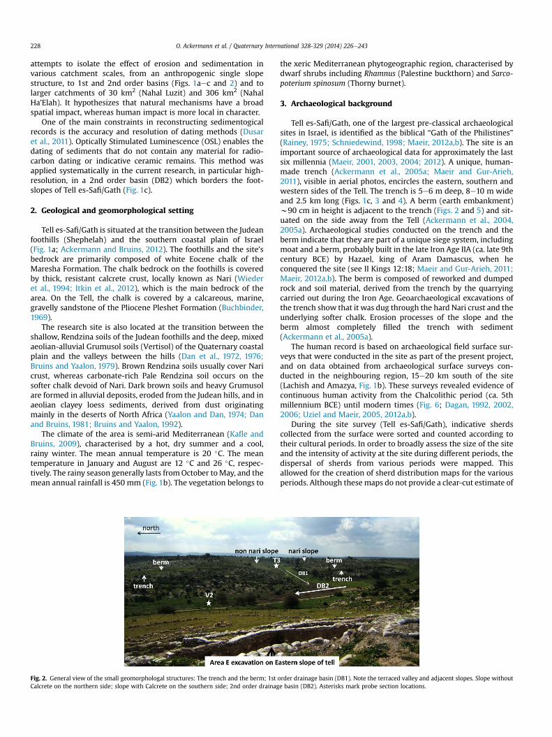
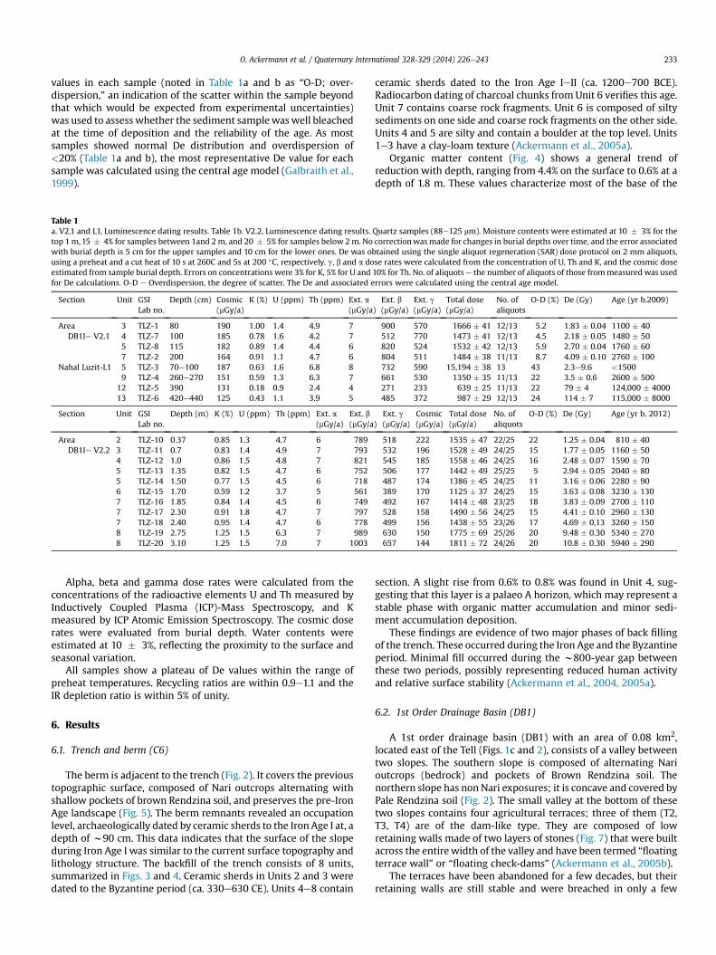
Tell es-Safi/Gath, one of the largest pre-classical archaeologicalsites in Israel, is identified as the biblical “Gath of the Philistines”(Rainey, 1975; Schniedewind, 1998; Maeir, 2012a,b). The site is animportant source of archaeological data for approximately the lastsix millennia (Maeir, 2001, 2003, 2004; 2012). A unique, human-made trench (Ackermann et al., 2005a; Maeir and Gur-Arieh,2011), visible in aerial photos, encircles the eastern, southern andwestern sides of the Tell. The trench is 5e6 m deep, 8e10 m wideand 2.5 km long (Figs. 1c, 3 and 4). A berm (earth embankment)w90 cm in height is adjacent to the trench (Figs. 2 and 5) and sit-uated on the side away from the Tell (Ackermann et al., 2004,2005a). Archaeological studies conducted on the trench and theberm indicate that they are part of a unique siege system, includingmoat and a berm, probably built in the late Iron Age IIA (ca. late 9thcentury BCE) by Hazael, king of Aram Damascus, when heconquered the site (see II Kings 12:18; Maeir and Gur-Arieh, 2011;Maeir, 2012a,b). The berm is composed of reworked and dumpedrock and soil material, derived from the trench by the quarryingcarried out during the Iron Age. Geoarchaeological excavations ofthe trench show that it was dug through the hard Nari crust and theunderlying softer chalk. Erosion processes of the slope and theberm almost completely filled the trench with sediment(Ackermann et al., 2005a).
The human record is based on archaeological field surface sur-veys that were conducted in the site as part of the present project,and on data obtained from archaeological surface surveys con-ducted in the neighbouring region, 15e20 km south of the site(Lachish and Amazya, Fig. 1b). These surveys revealed evidence ofcontinuous human activity from the Chalcolithic period (ca. 5thmillennium BCE) until modern times (Fig. 6; Dagan, 1992, 2002,2006; Uziel and Maeir, 2005, 2012a,b).
During the site survey (Tell es-Safi/Gath), indicative sherdscollected from the surface were sorted and counted according totheir cultural periods. In order to broadly assess the size of the siteand the intensity of activity at the site during different periods, thedispersal of sherds from various periods were mapped. Thisallowed for the creation of sherd distribution maps for the variousperiods. Although these maps do not provide a clear-cut estimate of
order drainage basin (DB1). Note the terraced valley and adjacent slopes. Slope withoute basin (DB2). Asterisks mark probe section locations.
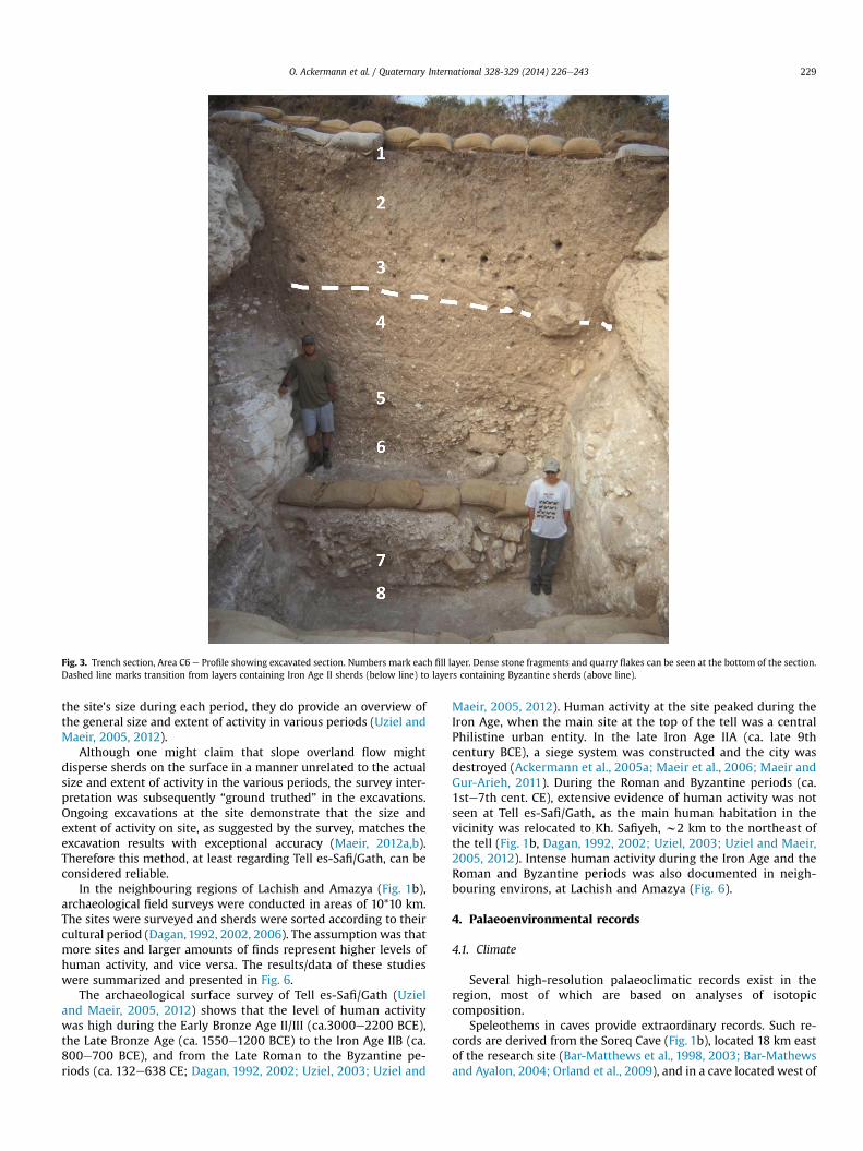
Fig. 3. Trench section, Area C6 e Profile showing excavated section. Numbers mark each fill layer. Dense stone fragments and quarry flakes can be seen at the bottom of the section.Dashed line marks transition from layers containing Iron Age II sherds (below line) to layers containing Byzantine sherds (above line).
O. Ackermann et al. / Quaternary International 328-329 (2014) 226e243 229
the site’s size during each period, they do provide an overview ofthe general size and extent of activity in various periods (Uziel andMaeir, 2005, 2012).
Although one might claim that slope overland flow mightdisperse sherds on the surface in a manner unrelated to the actualsize and extent of activity in the various periods, the survey inter-pretation was subsequently “ground truthed” in the excavations.Ongoing excavations at the site demonstrate that the size andextent of activity on site, as suggested by the survey, matches theexcavation results with exceptional accuracy (Maeir, 2012a,b).Therefore this method, at least regarding Tell es-Safi/Gath, can beconsidered reliable.
In the neighbouring regions of Lachish and Amazya (Fig. 1b),archaeological field surveys were conducted in areas of 10*10 km.The sites were surveyed and sherds were sorted according to theircultural period (Dagan,1992, 2002, 2006). The assumptionwas thatmore sites and larger amounts of finds represent higher levels ofhuman activity, and vice versa. The results/data of these studieswere summarized and presented in Fig. 6.
The archaeological surface survey of Tell es-Safi/Gath (Uzieland Maeir, 2005, 2012) shows that the level of human activitywas high during the Early Bronze Age II/III (ca.3000e2200 BCE),the Late Bronze Age (ca. 1550e1200 BCE) to the Iron Age IIB (ca.800e700 BCE), and from the Late Roman to the Byzantine pe-riods (ca. 132e638 CE; Dagan, 1992, 2002; Uziel, 2003; Uziel and
Maeir, 2005, 2012). Human activity at the site peaked during theIron Age, when the main site at the top of the tell was a centralPhilistine urban entity. In the late Iron Age IIA (ca. late 9thcentury BCE), a siege system was constructed and the city wasdestroyed (Ackermann et al., 2005a; Maeir et al., 2006; Maeir andGur-Arieh, 2011). During the Roman and Byzantine periods (ca.1ste7th cent. CE), extensive evidence of human activity was notseen at Tell es-Safi/Gath, as the main human habitation in thevicinity was relocated to Kh. Safiyeh, w2 km to the northeast ofthe tell (Fig. 1b, Dagan, 1992, 2002; Uziel, 2003; Uziel and Maeir,2005, 2012). Intense human activity during the Iron Age and theRoman and Byzantine periods was also documented in neigh-bouring environs, at Lachish and Amazya (Fig. 6).
4. Palaeoenvironmental records
4.1. Climate
Several high-resolution palaeoclimatic records exist in theregion, most of which are based on analyses of isotopiccomposition.
Speleothems in caves provide extraordinary records. Such re-cords are derived from the Soreq Cave (Fig. 1b), located 18 km eastof the research site (Bar-Matthews et al., 1998, 2003; Bar-Mathewsand Ayalon, 2004; Orland et al., 2009), and in a cave located west of
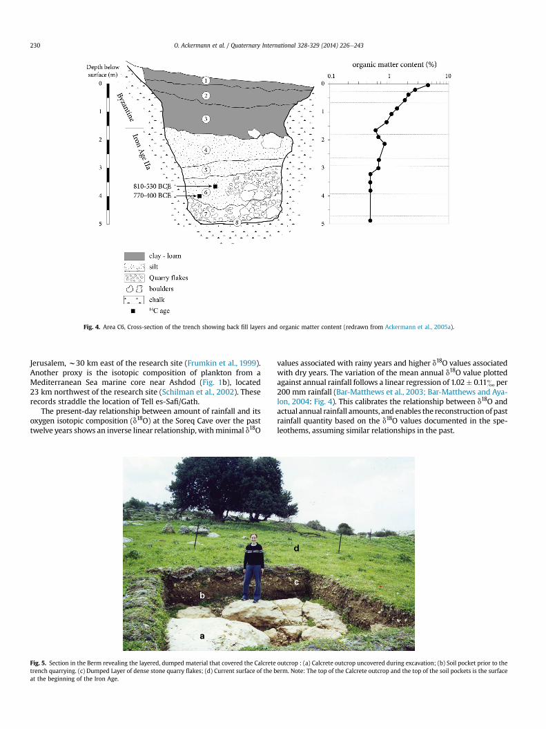
Fig. 4. Area C6, Cross-section of the trench showing back fill layers and organic matter content (redrawn from Ackermann et al., 2005a).
O. Ackermann et al. / Quaternary International 328-329 (2014) 226e243230
Jerusalem, w30 km east of the research site (Frumkin et al., 1999).Another proxy is the isotopic composition of plankton from aMediterranean Sea marine core near Ashdod (Fig. 1b), located23 km northwest of the research site (Schilman et al., 2002). Theserecords straddle the location of Tell es-Safi/Gath.
The present-day relationship between amount of rainfall and itsoxygen isotopic composition (d18O) at the Soreq Cave over the pasttwelve years shows an inverse linear relationship, withminimal d18O
Fig. 5. Section in the Berm revealing the layered, dumped material that covered the Calcretetrench quarrying. (c) Dumped Layer of dense stone quarry flakes; (d) Current surface of the bat the beginning of the Iron Age.
values associated with rainy years and higher d18O values associatedwith dry years. The variation of the mean annual d18O value plottedagainst annual rainfall follows a linear regression of 1.02� 0.11& per200 mm rainfall (Bar-Matthews et al., 2003; Bar-Matthews and Aya-lon, 2004: Fig. 4). This calibrates the relationship between d18O andactual annual rainfall amounts, and enables the reconstructionof pastrainfall quantity based on the d18O values documented in the spe-leothems, assuming similar relationships in the past.
outcrop : (a) Calcrete outcrop uncovered during excavation; (b) Soil pocket prior to theerm. Note: The top of the Calcrete outcrop and the top of the soil pockets is the surface
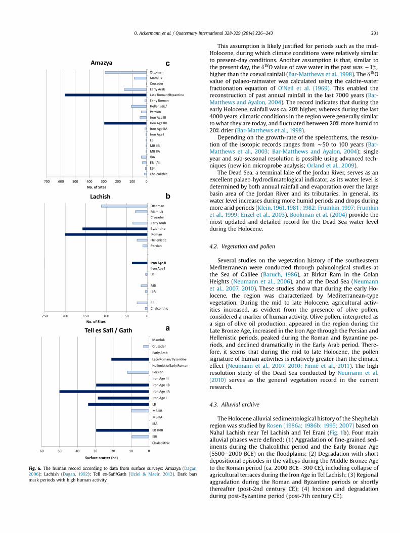
Fig. 6. The human record according to data from surface surveys: Amazya (Dagan,2006); Lachish (Dagan, 1992); Tell es-Safi/Gath (Uziel & Maeir, 2012). Dark barsmark periods with high human activity.
O. Ackermann et al. / Quaternary International 328-329 (2014) 226e243 231
This assumption is likely justified for periods such as the mid-Holocene, during which climate conditions were relatively similarto present-day conditions. Another assumption is that, similar tothe present day, the d18O value of cave water in the past was w1&higher than the coeval rainfall (Bar-Matthews et al., 1998). The d18Ovalue of palaeo-rainwater was calculated using the calcite-waterfractionation equation of O’Neil et al. (1969). This enabled thereconstruction of past annual rainfall in the last 7000 years (Bar-Matthews and Ayalon, 2004). The record indicates that during theearly Holocene, rainfall was ca. 20% higher, whereas during the last4000 years, climatic conditions in the regionwere generally similarto what they are today, and fluctuated between 20% more humid to20% drier (Bar-Matthews et al., 1998).
Depending on the growth-rate of the speleothems, the resolu-tion of the isotopic records ranges from w50 to 100 years (Bar-Matthews et al., 2003; Bar-Matthews and Ayalon, 2004); singleyear and sub-seasonal resolution is possible using advanced tech-niques (new ion microprobe analysis; Orland et al., 2009).
The Dead Sea, a terminal lake of the Jordan River, serves as anexcellent palaeo-hydroclimatological indicator, as its water level isdetermined by both annual rainfall and evaporation over the largebasin area of the Jordan River and its tributaries. In general, itswater level increases during more humid periods and drops duringmore arid periods (Klein, 1961, 1981; 1982; Frumkin, 1997; Frumkinet al., 1999; Enzel et al., 2003). Bookman et al. (2004) provide themost updated and detailed record for the Dead Sea water levelduring the Holocene.
4.2. Vegetation and pollen
Several studies on the vegetation history of the southeasternMediterranean were conducted through palynological studies atthe Sea of Galilee (Baruch, 1986), at Birkat Ram in the GolanHeights (Neumann et al., 2006), and at the Dead Sea (Neumannet al., 2007, 2010). These studies show that during the early Ho-locene, the region was characterized by Mediterranean-typevegetation. During the mid to late Holocene, agricultural activ-ities increased, as evident from the presence of olive pollen,considered a marker of human activity. Olive pollen, interpreted asa sign of olive oil production, appeared in the region during theLate Bronze Age, increased in the Iron Age through the Persian andHellenistic periods, peaked during the Roman and Byzantine pe-riods, and declined dramatically in the Early Arab period. There-fore, it seems that during the mid to late Holocene, the pollensignature of human activities is relatively greater than the climaticeffect (Neumann et al., 2007, 2010; Finné et al., 2011). The highresolution study of the Dead Sea conducted by Neumann et al.(2010) serves as the general vegetation record in the currentresearch.
4.3. Alluvial archive
The Holocene alluvial sedimentological history of the Shephelahregion was studied by Rosen (1986a; 1986b; 1995; 2007) based onNahal Lachish near Tel Lachish and Tel Erani (Fig. 1b). Four mainalluvial phases were defined: (1) Aggradation of fine-grained sed-iments during the Chalcolithic period and the Early Bronze Age(5500e2000 BCE) on the floodplains; (2) Degradation with shortdepositional episodes in the valleys during the Middle Bronze Ageto the Roman period (ca. 2000 BCEe300 CE), including collapse ofagricultural terraces during the Iron Age in Tel Lachish; (3) Regionalaggradation during the Roman and Byzantine periods or shortlythereafter (post-2nd century CE); (4) Incision and degradationduring post-Byzantine period (post-7th century CE).
O. Ackermann et al. / Quaternary International 328-329 (2014) 226e243232
5. Materials and methods
This research examines the landscape evolution in the environsof Tell es-Safi/Gath, studying five geomorphic contexts in variousscales (Figs. 1c and 2):
(1) On a slope, a human-made ancient trench and berm (earthembankment).
(2) A valley of a 1st order drainage basin (DB1), ca. 0.08 km2.(3) A valley of a 2nd order drainage basin (DB2), ca. 0.5 km2.(4) The Nahal Luzit basin valley (L1), ca. 30 km2.(5) The Nahal Ha’Elah basin valley (E2), ca. 306 km2.
The environmental signals of the sedimentary and palae-opedological records were compared to:
(1) Climatic records of the Soreq Cave speleothems of Bar-Mathews and Ayalon (2004) and Orland et al. (2009), andof the Dead Sea levels (Enzel et al., 2003; Bookman et al.,2004).
(2) Vegetation records derived from the pollen record of theDead Sea (Neumann et al., 2007, 2010) and from 13C isotopiccompositions in DB2.
(3) Cultural records as indicated by an archeological surfacesurvey and excavations at the site (Uziel, 2003; Uziel andMaeir, 2005, 2012), and from previous archaeological sur-veys conducted in neighboring areas of the Shephelah region(Dagan, 1992, 2002, 2006).
5.1. Fieldwork
Four probe sections in the valleys were dug using a mechanicalbackhoe and a mechanical driller. In site E2, a natural exposure onthe northern bank of Nahal Ha’Elah was investigated (Fig. 1c). Thesediments were described in the field for their structure, texture,color, pedological characteristics, and unit boundaries, and sampledfor various laboratory analyses and dating.
5.2. Laboratory analyses
Grain Size Analysis of fine material (<2 mm) distribution wasmeasured by sedimentation using the hydrometer sedimentationcolumn method. The samples were dispersed using calgon(powdered sodium hexametaphosphate) solutions (Wright, 1939;Klute, 1986).
Organic matter content was measured by the wet combustiondichromate method (Rowell, 1994) in several sections in order tocharacterize ancient surfaces (Huckleberry, 2001). Laboratory an-alyses were conducted in the Geomorphology and Soil Laboratoryat Bar-Ilan University, Ramat Gan, and in the Field Service Labora-tory at the Regional Agriculture Research Center at Zemach, JordanValley.
d13C analysis of soils and sediments was conducted in order toobtain vegetation history. d13C values of soil/sediment organiccarbon are used in this study as a proxy of past C3eC4 vegetationproportions. Plants fractionate carbon isotopes along two majordistinct metabolic photosynthetic pathways e C3 and C4. C3 plantsinclude all trees and almost all shrubs and cool season grasses. C3vegetation d13C values range between �34 and �22&, averagevalue �27 � 2& (e.g., Bender, 1968; Smith and Epstein, 1971;Deines, 1980; O’Leary, 1995). C4 vegetation is more adapted towarm dry climates and is mainly composed of grasses favoringwarm dry climates and a few shrubs. C4 grasses have d13C valuesranging between �18 and �9&, average value w �12& (e.g.,
Bender, 1968; Deines, 1980; Cai et al., 1988; Ehleringer et al., 1991;Connin et al., 1997). Thus, this reconstruction is based on the factthat lower d13C values reflect wetter conditions, favoring higherdistribution of C3 vegetation (mainly trees) while higher d13Cvalues reflect drier conditions. Higher d13C values may indicate anincreased distribution of C4 vegetation (shrubs and grass) duringthe dry periods, or that C3 vegetation was under stress conditions(dry conditions, high temperatures and CO2 deficiency) resulting inrelatively higher d13C values. Measurements were performed at theGeological Survey of Israel, using a Thermo Finnigan ElementalAnalyzer (EA).
5.3. Dating methods
Dating of the sedimentary units was conducted primarily on thebasis of identifiable ceramic finds in the relevant strata whichprovide a general age, primarily terminus post quem. Selected unitswere dated using 14C (Centre for Isotope Research at the Universityof Groningen, The Netherlands) and Optically Stimulated Lumi-nescence (OSL; Luminescence dating laboratory, Geological Surveyof Israel, Jerusalem). In DB2, systematic sediment samples for OSLdating were collected at a high resolution of 15e30 cm intervalswhich enables calculation of the sedimentation rate.
5.3.1. Optical stimulation luminescence (OSL)The OSL method reveals the amount of time that has passed
since minerals such as quartz and feldspar were last exposed tosunlight, by using electrons that accumulate in crystal traps due tonatural ionizing radiation and which are de-trapped by exposure tosunlight. After burial, the electrons re-populate traps at a constantrate due to environmental ionizing radiation and can therefore beused to estimate the elapsed time since the mineral underwenttransport and burial (e.g., Aitken, 1998; Wintle, 2008).
The magnitude of the OSL signal is related to the total radiationdose that the sample received and hence to the sample’s age.Because the OSL signal is sensitive to sunlight, if the sediment isexposed, any previously acquired OSL signal will be reset to zero (or“bleached”). To prevent any exposure to light, samples werecollected under a lightproof cover and immediately encased inblack, light-tight sample bags. Laboratory procedures were carriedout under subdued orange light.
OSL dating was used to date sediments in DB2 and in the NahalLuzit sections; 17 samples were collected. Quartz in the size rangeof 88e125 mm was extracted using routine laboratory procedures(Porat, 2007). After wet sieving to the desired grain size, carbonateswere dissolved with 10% hydrochloric acid (HCl). The rinsed anddried sample was passed through a Frantz magnetic separator(Porat, 2006) to remove undissolved carbonates, heavy minerals,and most feldspars. A 40-min rinse in hydrofluoric acid (42%) wasused to dissolve any remaining feldspars and etch the quartz grains,followed by rinsing in 16% HCl to remove any fluorides that mayhave precipitated.
OSL measurements were carried out on a refurbished Risø DA-12 or a DA-15 TL/OSL reader (Bøtter-Jensen et al., 2003), equippedwith an integral 90Sr beta source with dose rates of w3.0 andw2.5 Gy/min, respectively. Stimulation was with blue LEDs anddetection was through 7-mm U-340 filters. The SAR protocol(Murray andWintle, 2000) was used to determine the De on 11e13(in V2.1 and L1) aliquots (subsamples) and on 25e26 (in V2.2) al-iquots from each sample, and aliquot size was usually 2 mm. Pre-heats of 10 s ranged from 220 to 260C. Each aliquot was irradiatedstepwise and normalized until the natural signal was regenerated.Dose response curves were constructed from five dose points, twoof whichwere repeats (a regular recycling point and an IR depletionratio point), and with two zero-dose points. The scatter in the De
O. Ackermann et al. / Quaternary International 328-329 (2014) 226e243 233
values in each sample (noted in Table 1a and b as “O-D; over-dispersion,” an indication of the scatter within the sample beyondthat which would be expected from experimental uncertainties)was used to assess whether the sediment samplewaswell bleachedat the time of deposition and the reliability of the age. As mostsamples showed normal De distribution and overdispersion of<20% (Table 1a and b), the most representative De value for eachsample was calculated using the central age model (Galbraith et al.,1999).
Table 1a. V2.1 and L1, Luminescence dating results. Table 1b. V2.2, Luminescence dating results. Quartz samples (88e125 mm). Moisture contents were estimated at 10 � 3% for thetop 1m,15 � 4% for samples between 1and 2m, and 20 � 5% for samples below 2m. No correctionwasmade for changes in burial depths over time, and the error associatedwith burial depth is 5 cm for the upper samples and 10 cm for the lower ones. De was obtained using the single aliquot regeneration (SAR) dose protocol on 2 mm aliquots,using a preheat and a cut heat of 10 s at 260C and 5s at 200 �C, respectively. g, b and a dose rates were calculated from the concentration of U, Th and K, and the cosmic doseestimated from sample burial depth. Errors on concentrations were 3% for K, 5% for U and 10% for Th. No. of aliquotse the number of aliquots of those frommeasured was usedfor De calculations. O-D e Overdispersion, the degree of scatter. The De and associated errors were calculated using the central age model.
Section Unit GSILab no.
Depth (cm) Cosmic(mGy/a)
K (%) U (ppm) Th (ppm) Ext. a(mGy/a)
Ext. b(mGy/a)
Ext. g(mGy/a)
Total dose(mGy/a)
No. ofaliquots
O-D (%) De (Gy) Age (yr b.2009)
AreaDB1Ie V2.1
3 TLZ-1 80 190 1.00 1.4 4.9 7 900 570 1666 � 41 12/13 5.2 1.83 � 0.04 1100 � 404 TLZ-7 100 185 0.78 1.6 4.2 7 512 770 1473 � 41 12/13 4.5 2.18 � 0.05 1480 � 505 TLZ-8 115 182 0.89 1.4 4.4 6 820 524 1532 � 42 12/13 5.9 2.70 � 0.04 1760 � 607 TLZ-2 200 164 0.91 1.1 4.7 6 804 511 1484 � 38 11/13 8.7 4.09 � 0.10 2760 � 100
Nahal Luzit-L1 5 TLZ-3 70e100 187 0.63 1.6 6.8 8 732 590 15,194 � 38 13 43 2.3e9.6 <15009 TLZ-4 260e270 151 0.59 1.3 6.3 7 661 530 1350 � 35 11/13 22 3.5 � 0.6 2600 � 500
12 TLZ-5 390 131 0.18 0.9 2.4 4 271 233 639 � 25 11/13 22 79 � 4 124,000 � 400013 TLZ-6 420e440 125 0.43 1.1 3.9 5 485 372 987 � 29 12/13 24 114 � 7 115,000 � 8000
Section Unit GSILab no.
Depth (m) K (%) U (ppm) Th (ppm) Ext. a(mGy/a)
Ext. b(mGy/a)
Ext. g(mGy/a)
Cosmic(mGy/a)
Total dose(mGy/a)
No. ofaliquots
O-D (%) De (Gy) Age (yr b. 2012)
AreaDB1Ie V2.2
2 TLZ-10 0.37 0.85 1.3 4.7 6 789 518 222 1535 � 47 22/25 22 1.25 � 0.04 810 � 403 TLZ-11 0.7 0.83 1.4 4.9 7 793 532 196 1528 � 49 24/25 15 1.77 � 0.05 1160 � 504 TLZ-12 1.0 0.86 1.5 4.8 7 821 545 185 1558 � 46 24/25 16 2.48 � 0.07 1590 � 705 TLZ-13 1.35 0.82 1.5 4.7 6 752 506 177 1442 � 49 25/25 5 2.94 � 0.05 2040 � 805 TLZ-14 1.50 0.77 1.5 4.5 6 718 487 174 1386 � 45 24/25 11 3.16 � 0.06 2280 � 906 TLZ-15 1.70 0.59 1.2 3.7 5 561 389 170 1125 � 37 24/25 15 3.63 � 0.08 3230 � 1307 TLZ-16 1.85 0.84 1.4 4.5 6 749 492 167 1414 � 48 23/25 18 3.83 � 0.09 2700 � 1107 TLZ-17 2.30 0.91 1.8 4.7 7 797 528 158 1490 � 56 24/25 15 4.41 � 0.10 2960 � 1307 TLZ-18 2.40 0.95 1.4 4.7 6 778 499 156 1438 � 55 23/26 17 4.69 � 0.13 3260 � 1508 TLZ-19 2.75 1.25 1.5 6.3 7 989 630 150 1775 � 69 25/26 20 9.48 � 0.30 5340 � 2708 TLZ-20 3.10 1.25 1.5 7.0 7 1003 657 144 1811 � 72 24/26 20 10.8 � 0.30 5940 � 290
Alpha, beta and gamma dose rates were calculated from theconcentrations of the radioactive elements U and Th measured byInductively Coupled Plasma (ICP)-Mass Spectroscopy, and Kmeasured by ICP Atomic Emission Spectroscopy. The cosmic doserates were evaluated from burial depth. Water contents wereestimated at 10 � 3%, reflecting the proximity to the surface andseasonal variation.
All samples show a plateau of De values within the range ofpreheat temperatures. Recycling ratios are within 0.9e1.1 and theIR depletion ratio is within 5% of unity.
6. Results
6.1. Trench and berm (C6)
The berm is adjacent to the trench (Fig. 2). It covers the previoustopographic surface, composed of Nari outcrops alternating withshallow pockets of brown Rendzina soil, and preserves the pre-IronAge landscape (Fig. 5). The berm remnants revealed an occupationlevel, archaeologically dated by ceramic sherds to the Iron Age I at, adepth of w90 cm. This data indicates that the surface of the slopeduring Iron Age I was similar to the current surface topography andlithology structure. The backfill of the trench consists of 8 units,summarized in Figs. 3 and 4. Ceramic sherds in Units 2 and 3 weredated to the Byzantine period (ca. 330e630 CE). Units 4e8 contain
ceramic sherds dated to the Iron Age IeII (ca. 1200e700 BCE).Radiocarbon dating of charcoal chunks from Unit 6 verifies this age.Unit 7 contains coarse rock fragments. Unit 6 is composed of siltysediments on one side and coarse rock fragments on the other side.Units 4 and 5 are silty and contain a boulder at the top level. Units1e3 have a clay-loam texture (Ackermann et al., 2005a).
Organic matter content (Fig. 4) shows a general trend ofreduction with depth, ranging from 4.4% on the surface to 0.6% at adepth of 1.8 m. These values characterize most of the base of the
section. A slight rise from 0.6% to 0.8% was found in Unit 4, sug-gesting that this layer is a palaeo A horizon, which may represent astable phase with organic matter accumulation and minor sedi-ment accumulation deposition.
These findings are evidence of two major phases of back fillingof the trench. These occurred during the Iron Age and the Byzantineperiod. Minimal fill occurred during the w800-year gap betweenthese two periods, possibly representing reduced human activityand relative surface stability (Ackermann et al., 2004, 2005a).
6.2. 1st Order Drainage Basin (DB1)
A 1st order drainage basin (DB1) with an area of 0.08 km2,located east of the Tell (Figs. 1c and 2), consists of a valley betweentwo slopes. The southern slope is composed of alternating Narioutcrops (bedrock) and pockets of Brown Rendzina soil. Thenorthern slope has non Nari exposures; it is concave and covered byPale Rendzina soil (Fig. 2). The small valley at the bottom of thesetwo slopes contains four agricultural terraces; three of them (T2,T3, T4) are of the dam-like type. They are composed of lowretaining walls made of two layers of stones (Fig. 7) that were builtacross the entirewidth of the valley and have been termed “floatingterrace wall” or “floating check-dams” (Ackermann et al., 2005b).
The terraces have been abandoned for a few decades, but theirretaining walls are still stable and were breached in only a few
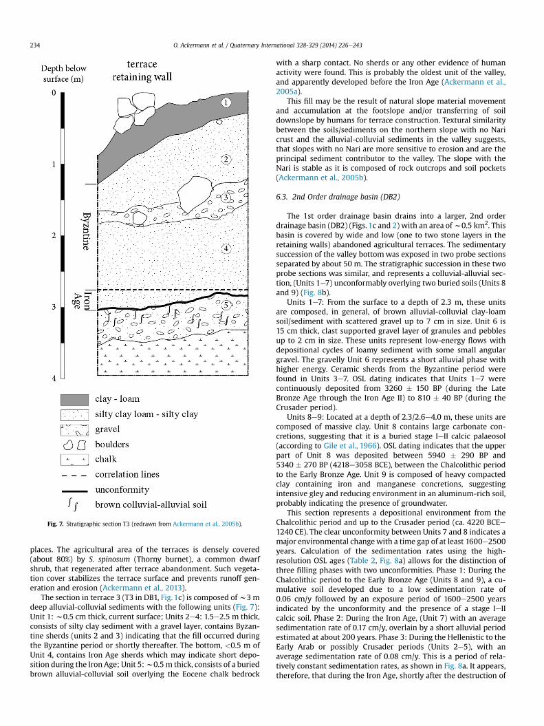
Fig. 7. Stratigraphic section T3 (redrawn from Ackermann et al., 2005b).
O. Ackermann et al. / Quaternary International 328-329 (2014) 226e243234
places. The agricultural area of the terraces is densely covered(about 80%) by S. spinosum (Thorny burnet), a common dwarfshrub, that regenerated after terrace abandonment. Such vegeta-tion cover stabilizes the terrace surface and prevents runoff gen-eration and erosion (Ackermann et al., 2013).
The section in terrace 3 (T3 in DB1, Fig. 1c) is composed ofw3 mdeep alluvial-colluvial sediments with the following units (Fig. 7):Unit 1: w0.5 cm thick, current surface; Units 2e4: 1.5e2.5 m thick,consists of silty clay sediment with a gravel layer, contains Byzan-tine sherds (units 2 and 3) indicating that the fill occurred duringthe Byzantine period or shortly thereafter. The bottom, <0.5 m ofUnit 4, contains Iron Age sherds which may indicate short depo-sition during the Iron Age; Unit 5:w0.5m thick, consists of a buriedbrown alluvial-colluvial soil overlying the Eocene chalk bedrock
with a sharp contact. No sherds or any other evidence of humanactivity were found. This is probably the oldest unit of the valley,and apparently developed before the Iron Age (Ackermann et al.,2005a).
This fill may be the result of natural slope material movementand accumulation at the footslope and/or transferring of soildownslope by humans for terrace construction. Textural similaritybetween the soils/sediments on the northern slope with no Naricrust and the alluvial-colluvial sediments in the valley suggests,that slopes with no Nari are more sensitive to erosion and are theprincipal sediment contributor to the valley. The slope with theNari is stable as it is composed of rock outcrops and soil pockets(Ackermann et al., 2005b).
6.3. 2nd Order drainage basin (DB2)
The 1st order drainage basin drains into a larger, 2nd orderdrainage basin (DB2) (Figs. 1c and 2) with an area ofw0.5 km2. Thisbasin is covered by wide and low (one to two stone layers in theretaining walls) abandoned agricultural terraces. The sedimentarysuccession of the valley bottomwas exposed in two probe sectionsseparated by about 50 m. The stratigraphic succession in these twoprobe sections was similar, and represents a colluvial-alluvial sec-tion, (Units 1e7) unconformably overlying two buried soils (Units 8and 9) (Fig. 8b).
Units 1e7: From the surface to a depth of 2.3 m, these unitsare composed, in general, of brown alluvial-colluvial clay-loamsoil/sediment with scattered gravel up to 7 cm in size. Unit 6 is15 cm thick, clast supported gravel layer of granules and pebblesup to 2 cm in size. These units represent low-energy flows withdepositional cycles of loamy sediment with some small angulargravel. The gravelly Unit 6 represents a short alluvial phase withhigher energy. Ceramic sherds from the Byzantine period werefound in Units 3e7. OSL dating indicates that Units 1e7 werecontinuously deposited from 3260 � 150 BP (during the LateBronze Age through the Iron Age II) to 810 � 40 BP (during theCrusader period).
Units 8e9: Located at a depth of 2.3/2.6e4.0 m, these units arecomposed of massive clay. Unit 8 contains large carbonate con-cretions, suggesting that it is a buried stage IeII calcic palaeosol(according to Gile et al., 1966). OSL dating indicates that the upperpart of Unit 8 was deposited between 5940 � 290 BP and5340 � 270 BP (4218e3058 BCE), between the Chalcolithic periodto the Early Bronze Age. Unit 9 is composed of heavy compactedclay containing iron and manganese concretions, suggestingintensive gley and reducing environment in an aluminum-rich soil,probably indicating the presence of groundwater.
This section represents a depositional environment from theChalcolithic period and up to the Crusader period (ca. 4220 BCEe1240 CE). The clear unconformity between Units 7 and 8 indicates amajor environmental changewith a time gap of at least 1600e2500years. Calculation of the sedimentation rates using the high-resolution OSL ages (Table 2, Fig. 8a) allows for the distinction ofthree filling phases with two unconformities. Phase 1: During theChalcolithic period to the Early Bronze Age (Units 8 and 9), a cu-mulative soil developed due to a low sedimentation rate of0.06 cm/y followed by an exposure period of 1600e2500 yearsindicated by the unconformity and the presence of a stage IeIIcalcic soil. Phase 2: During the Iron Age, (Unit 7) with an averagesedimentation rate of 0.17 cm/y, overlain by a short alluvial periodestimated at about 200 years. Phase 3: During the Hellenistic to theEarly Arab or possibly Crusader periods (Units 2e5), with anaverage sedimentation rate of 0.08 cm/y. This is a period of rela-tively constant sedimentation rates, as shown in Fig. 8a. It appears,therefore, that during the Iron Age, shortly after the destruction of
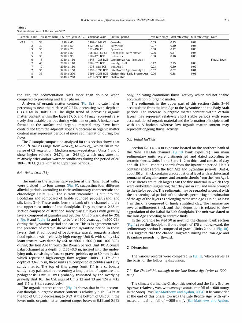
Table 2Sedimentation rate of the section V2.2
Section Unit Thickness (cm) OSL age (yr b. 2012) Calendar years Cultural period Ave rate cm/y Max rate cm/y Min rate cm/y Note
V2.2 1 33 810 � 40 1162e1242 CE Crusader 0.09 0.13 0.082 30 1160 � 50 802e902 CE Early Arab 0.07 0.10 0.053 35 1590 � 70 352e492 CE Byzantine 0.08 0.12 0.064 15 2040 � 80 108 BCEe52 CE HellenisticeEarly Roman 0.06 0.21 0.045 35 2280 � 90 358e178 BCE Hellenistic 0.08 0.16 0.066 15 3230 � 130 1348e1088 BCE Late Bronze AgeeIron Age I Fluvial Level7 45 2700 � 110 798e578 BCE Iron Age II-III 0.17 2.25 0.097 10 2960 � 130 1078e818 BCE Iron Age II 0.03 0.50 0.027 35 3260 � 150 1398e1098 BCE Late Bronze AgeeIron Age I 0.02 0.02 0.018 35 5340 � 270 3598e3058 BCE ChalcolithiceEarly Bronze Age 0.06 0.88 0.038 5940 � 290 4218e3638 BCE Chalcolithic
O. Ackermann et al. / Quaternary International 328-329 (2014) 226e243 235
the site, the sedimentation rates more than doubled whencompared to preceding and later phases.
Analyses of organic matter content (Fig. 8c) indicate higherpercentages near the surface of 2.24%, decreasing with depth to0.33e0.6% in Units 3e9. The slight trend of increasing organicmatter content within the layers (7, 5, and 4) may represent rela-tively short, stable periods during which an organic A horizon wasformed at the surface and organic material may have beencontributed from the adjacent slopes. A decrease in organic mattercontent may represent periods of more sedimentation during lowflows.
The C isotopic composition analyzed for this section shows thatthe d 13C values range from �24.7& to �26.2&, which fall in therange of C3 vegetation (Mediterranean-vegetation). Units 4 and 5show higher values (�24.7& to �24.3&), which may attest torelatively drier and/or warmer conditions during the period of ca.180e570 CE (Late Roman to Byzantine periods).
6.4. Nahal Luzit (L1)
The units in the sedimentary section at the Nahal Luzit valleywere divided into four groups (Fig. 9), suggesting four differentalluvial periods, according to their sedimentary characteristic andchronology. Units 1e2: The current streambed is cut into thefloodplain and composed of friable rounded pebbles, sand, andsilt. Units 3e9: These units form the bank of the channel and arethe uppermost units of the floodplain. They expose a 2.65 msection composed of stratified sandy clay silt layers with gravellylayers composed of granules and pebbles. Unit 5 was dated by OSL(, Fig. 9 and Table 1a and b) to before 1500 years ago (<500 CE),during the Byzantine period and earlier. This is in agreement withthe presence of ceramic sherds of the Byzantine period in theselayers. Unit 8, composed of pebble-size gravel, suggests a shortflood episode with relatively high energy. Unit 9, with sandy clayloam texture, was dated by OSL to 2600 � 500 (1100e100 BCE),during the Iron Age through the Roman period. Unit 10: A coarsepalaeochannel at a depth of 2.65e3.6 m, incised into the under-lying unit, consisting of coarse gravel-pebbles up to 80 mm in sizewhich represent high-energy flow regime. Units 11e17: At adepth of 3.6e5.5 m, these units are composed of pebbles and siltysandy matrix. The top of this group (unit 11) is a carbonatesandyeclay palaeosol, representing a long period of exposure andpedogenesis. Unit 11, was probably truncated by the overlyinggravelly Unit 10. The OSL ages of Units 12 and 13 are 124 � 4 kaand 115 � 8 ka, respectively.
The organic matter content (Fig. 9) shows that in the present-day floodplain, organic matter content is relatively high; 3.43% atthe top of Unit 3, decreasing to 0.8% at the bottom of Unit 3. In thelower units, organic matter content ranges between 0.1% and 0.67%
only, indicating continuous fluvial activity which did not enableaccumulation of organic matter.
The sediments in the upper part of this section (Units 3e9)accumulated from the Iron Age to the Byzantine and the Early Arabperiods. The increase in organic matter content within certainlayers may represent relatively short stable periods with someaccumulation of organicmaterial and the formation of incipient soilwith an A horizon, whereas low organic matter content mayrepresent ongoing fluvial activity.
6.5. Nahal Ha’Elah
Section E2 is a w4 m exposure located on the northern bank ofthe Nahal Ha’Elah channel (Fig 10, bank exposure). Four mainsedimentary units were distinguished and dated according toceramic sherds. Units 1 and 3 are 1e2 m thick, and consist of clayand silt. Unit 1 contains sherds from the Byzantine period. Unit 3contains sherds from the Iron Age and Byzantine periods. Unit 4,about 90 cm thick, contains an occupational level with architecturalremnants of angular stones and ceramic sherds from the Iron Age I.These sherds are much larger than the fine material in which theywere embedded, suggesting that they are in situ and were broughtto the site by people. The sediments may be regarded as coeval withthe archaeological periods of the sherds, permitting an estimationof the age of the layers as belonging to the Iron Age I. Unit 5, at least1 m thick, is composed of finely stratified clay. The laminae areseveral millimeters thick and their deposition is related to slowaggradation of the Nahal Ha’Elah floodplain. The unit was dated tothe Iron Age according to ceramic finds.
In the borehole located 50 m north of the channel bank section(Fig. 1c) on the floodplain, from a depth of 170 cm downward, thesedimentary section is composed of gravel (Units 2 and 4, Fig. 10).This suggests that the channel migrated during the Iron Age andByzantine periods northward.
7. Discussion
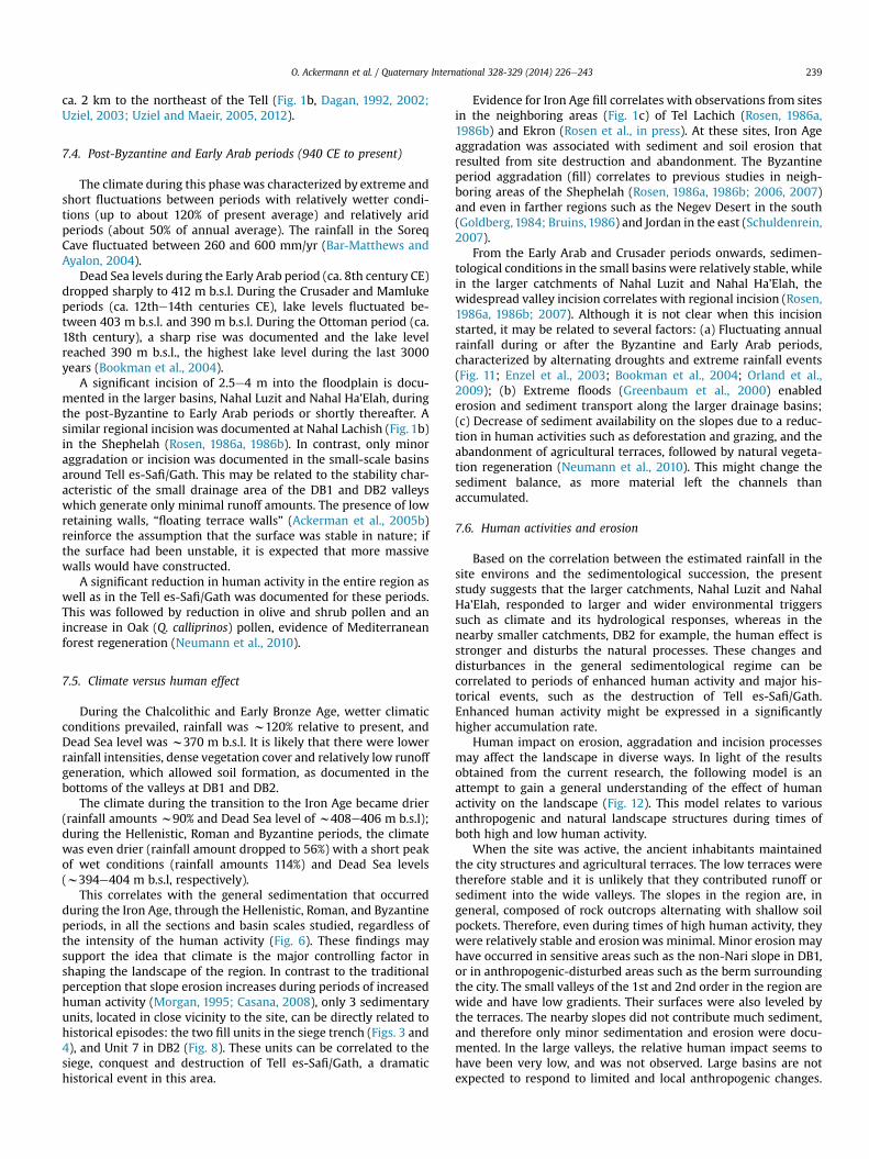
The various records were compared in Fig. 11, which serves asthe basis for the following discussion.
7.1. The Chalcolithic through to the Late Bronze Age (prior to 1200BCE)
The climate during the Chalcolithic period and the Early BronzeAge was relatively wet, with average annual rainfall ofw600 mm/yin the Soreq Cave (Bar-Matthews and Ayalon, 2004). It became drierat the end of this phase, towards the Late Bronze Age, with esti-mated annual rainfall of w500 mm/y (Bar-Matthews and Ayalon,
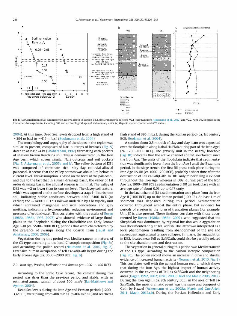
Fig. 8. (a) Compilation of all luminescence ages vs. depth in section V2.2. (b) Stratigraphic sections V2.1 (redrawn from Ackermann et al., 2012) and V2.2, Area DB2 located in the2nd order drainage basin, including OSL and archaeological ages of sedimentary units, (c) Organic matter content and d13C values.
O. Ackermann et al. / Quaternary International 328-329 (2014) 226e243236
2004). At this time, Dead Sea levels dropped from a high stand ofw394 m b.s.l to w415 m b.s.l (Bookmann et al., 2004).
The morphology and topography of the slopes in the regionwassimilar to present, composed of Nari outcrops of bedrock (Fig. 5)dated to at least 24 ka (Shaharabani, 1992) alternating with pocketsof shallow brown Rendzina soil. This is demonstrated in the IronAge berm which covers similar Nari outcrops and soil pockets(Fig. 5, Ackermann et al., 2005a and b). The valley bottom of DB1was composed of carbonate rich, silty-clay colluvial-alluvialpalaeosol. It seems that the valley bottomwas about 3 m below itscurrent level. This assumption is based on the level of the palaeosol,and due to the fact that in a small drainage basin, the valley of 1storder drainage basin, the alluvial erosion is minimal. The valley ofDB2 wasw2 m lower than its current level. The clayey soil texture,whichwas exposed on the surface, developed a stage IeII carbonatesoil, indicating stable conditions between 4200e3100 BCE (orearlier) andw1400 BCE. This soil was underlain by a heavy clay unitwhich contained manganese and iron concretions and gleymottling, indicating a hydromorphic, reducing environment andpresence of groundwater. This correlates with the results of Rosen(1986a, 1986b, 1995, 2007) who showed evidence of large flood-plains in the Shephelah during the Chalcolithic and Early BronzeAge IeIII (ca. 5500e2000 BCE), periods that were characterized bythe presence of swamps along the Coastal Plain (Faust andAshkenazy, 2007, 2009).
Vegetation during this period was Mediterranean in nature, ofthe C3 type according to the local C isotopic composition (Fig. 8c)and according the pollen record (Neumann et al., 2010, Fig. 2).Extensive human occupation of Tell es-Safi/Gath began during theEarly Bronze Age (ca. 3500e2000 BCE; Fig. 6).
7.2. Iron Age, Persian, Hellenistic and Roman (ca. 1200ew100 BCE)
According to the Soreq Cave record, the climate during thisperiod was drier than the previous period and stable, with anestimated annual rainfall of about 500 mm/y (Bar-Matthews andAyalon, 2004).
Dead Sea levels during the Iron Age and Persian periods (1200e332 BCE) were rising, from 408m b.s.l. to 406m b.s.l., and reached a
high stand of 395 m b.s.l. during the Roman period (ca. 1st centuryBCE; Bookman et al., 2004).
A section about 2.5 m thick of clay and clay loamwas depositedover the floodplain along Nahal Ha’Elah during part of the Iron Age I(ca. 1200e1000 BCE). The gravelly unit in the nearby borehole(Fig. 10) indicates that the active channel shifted southward sincethe Iron Age. The units of the floodplain indicate that sedimenta-tion was significantly lower from the Iron Age I until the Byzantineperiod. In the siege trench, the first fill phase took place during theIron Age IIA-IIB (ca. 1000e700 BCE), probably a short time after thedestruction of Tell es-Safi/Gath. In DB1, only minor filling is evidentthroughout the Iron Age, whereas in DB2, during part of the IronAge (ca.1000e580 BCE), sedimentation of 90 cm took place with anaverage rate of about 0.03 up to 0.17 cm/y.
In the Luzit channel (L1), sedimentation took place from the IronAge II (1100 BCE) up to the Roman period (100 CE). At least 1 m ofsediment was deposited during this period. Sedimentationoccurred throughout almost the entire phase, but evidence forperiods of erosion in the form of truncation planes (for example,Unit 8) is also present. These findings correlate with those docu-mented by Rosen (1986a; 1986b; 2007), who suggested that theShephelah was dominated by regional incision while aggradationwas documented only at Tel Lachish. The latter was interpreted as alocal phenomenon resulting from abandonment of the site andsubsequent agricultural terrace collapse. Similarly, the aggradationin DB2, located near Tell es-Safi/Gath, could also be partially relatedto the site abandonment and destruction.
The vegetation in general during this period was Mediterraneanof the C3 type, according to the carbon isotopic composition(Fig. 8c). The pollen record shows an increase in olive and shrubs,evidence of increased human activity (Neuman et al., 2010, Fig. 2).This correlates well with the general human record, which showsthat during the Iron Age, the highest impact of human activityoccurred in the environs of Tell es-Safi/Gath and the neighboringareas (Dagan,1992, 2002; Uziel, 2003; Uziel andMaeir, 2005, 2012).During the Iron Age II (ca. 9th century BCE), in the area of Tell es-Safi/Gath, the most dramatic event was the siege and conquest ofGath by Hazael (Ackermann et al., 2005a; Maeir and Gur-Arieh,2011; Maeir, 2012a,b). During the Persian, Hellenistic and Early
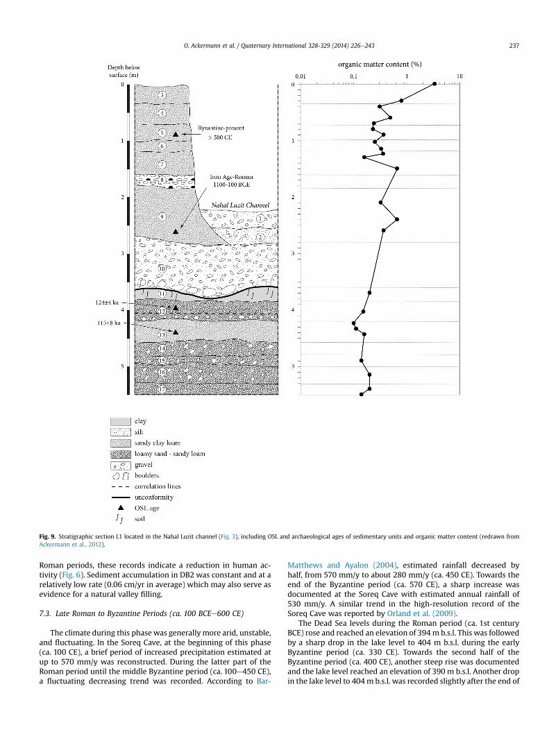
Fig. 9. Stratigraphic section L1 located in the Nahal Luzit channel (Fig. 3), including OSL and archaeological ages of sedimentary units and organic matter content (redrawn fromAckermann et al., 2012).
O. Ackermann et al. / Quaternary International 328-329 (2014) 226e243 237
Roman periods, these records indicate a reduction in human ac-tivity (Fig. 6). Sediment accumulation in DB2 was constant and at arelatively low rate (0.06 cm/yr in average) which may also serve asevidence for a natural valley filling.
7.3. Late Roman to Byzantine Periods (ca. 100 BCEe600 CE)
The climate during this phasewas generally more arid, unstable,and fluctuating. In the Soreq Cave, at the beginning of this phase(ca. 100 CE), a brief period of increased precipitation estimated atup to 570 mm/y was reconstructed. During the latter part of theRoman period until the middle Byzantine period (ca. 100e450 CE),a fluctuating decreasing trend was recorded. According to Bar-
Matthews and Ayalon (2004), estimated rainfall decreased byhalf, from 570 mm/y to about 280 mm/y (ca. 450 CE). Towards theend of the Byzantine period (ca. 570 CE), a sharp increase wasdocumented at the Soreq Cave with estimated annual rainfall of530 mm/y. A similar trend in the high-resolution record of theSoreq Cave was reported by Orland et al. (2009).
The Dead Sea levels during the Roman period (ca. 1st centuryBCE) rose and reached an elevation of 394m b.s.l. This was followedby a sharp drop in the lake level to 404 m b.s.l. during the earlyByzantine period (ca. 330 CE). Towards the second half of theByzantine period (ca. 400 CE), another steep rise was documentedand the lake level reached an elevation of 390 m b.s.l. Another dropin the lake level to 404m b.s.l. was recorded slightly after the end of
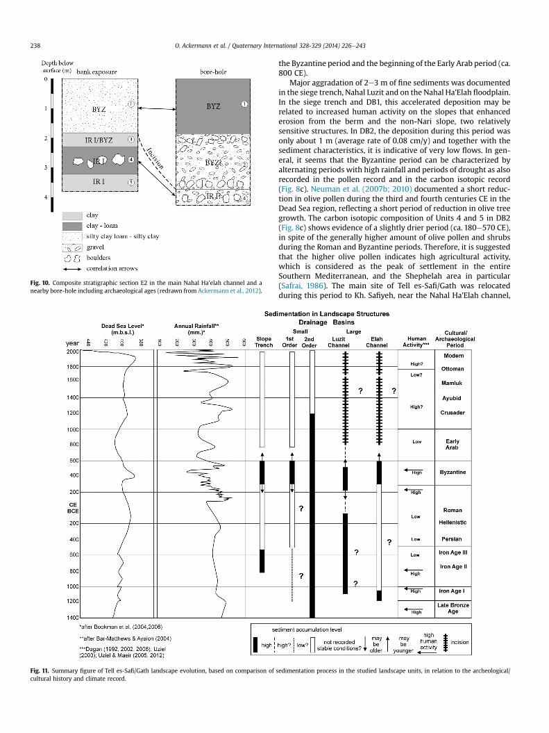
Fig. 10. Composite stratigraphic section E2 in the main Nahal Ha’elah channel and anearby bore-hole including archaeological ages (redrawn from Ackermann et al., 2012).
Fig. 11. Summary figure of Tell es-Safi/Gath landscape evolution, based on comparison of scultural history and climate record.
O. Ackermann et al. / Quaternary International 328-329 (2014) 226e243238
the Byzantine period and the beginning of the Early Arab period (ca.800 CE).
Major aggradation of 2e3 m of fine sediments was documentedin the siege trench, Nahal Luzit and on the Nahal Ha’Elah floodplain.In the siege trench and DB1, this accelerated deposition may berelated to increased human activity on the slopes that enhancederosion from the berm and the non-Nari slope, two relativelysensitive structures. In DB2, the deposition during this period wasonly about 1 m (average rate of 0.08 cm/y) and together with thesediment characteristics, it is indicative of very low flows. In gen-eral, it seems that the Byzantine period can be characterized byalternating periods with high rainfall and periods of drought as alsorecorded in the pollen record and in the carbon isotopic record(Fig. 8c). Neuman et al. (2007b; 2010) documented a short reduc-tion in olive pollen during the third and fourth centuries CE in theDead Sea region, reflecting a short period of reduction in olive treegrowth. The carbon isotopic composition of Units 4 and 5 in DB2(Fig. 8c) shows evidence of a slightly drier period (ca. 180e570 CE),in spite of the generally higher amount of olive pollen and shrubsduring the Roman and Byzantine periods. Therefore, it is suggestedthat the higher olive pollen indicates high agricultural activity,which is considered as the peak of settlement in the entireSouthern Mediterranean, and the Shephelah area in particular(Safrai, 1986). The main site of Tell es-Safi/Gath was relocatedduring this period to Kh. Safiyeh, near the Nahal Ha’Elah channel,
edimentation process in the studied landscape units, in relation to the archeological/
O. Ackermann et al. / Quaternary International 328-329 (2014) 226e243 239
ca. 2 km to the northeast of the Tell (Fig. 1b, Dagan, 1992, 2002;Uziel, 2003; Uziel and Maeir, 2005, 2012).
7.4. Post-Byzantine and Early Arab periods (940 CE to present)
The climate during this phase was characterized by extreme andshort fluctuations between periods with relatively wetter condi-tions (up to about 120% of present average) and relatively aridperiods (about 50% of annual average). The rainfall in the SoreqCave fluctuated between 260 and 600 mm/yr (Bar-Matthews andAyalon, 2004).
Dead Sea levels during the Early Arab period (ca. 8th century CE)dropped sharply to 412 m b.s.l. During the Crusader and Mamlukeperiods (ca. 12the14th centuries CE), lake levels fluctuated be-tween 403 m b.s.l. and 390 m b.s.l. During the Ottoman period (ca.18th century), a sharp rise was documented and the lake levelreached 390 m b.s.l., the highest lake level during the last 3000years (Bookman et al., 2004).
A significant incision of 2.5e4 m into the floodplain is docu-mented in the larger basins, Nahal Luzit and Nahal Ha’Elah, duringthe post-Byzantine to Early Arab periods or shortly thereafter. Asimilar regional incisionwas documented at Nahal Lachish (Fig. 1b)in the Shephelah (Rosen, 1986a, 1986b). In contrast, only minoraggradation or incision was documented in the small-scale basinsaround Tell es-Safi/Gath. This may be related to the stability char-acteristic of the small drainage area of the DB1 and DB2 valleyswhich generate only minimal runoff amounts. The presence of lowretaining walls, “floating terrace walls” (Ackerman et al., 2005b)reinforce the assumption that the surface was stable in nature; ifthe surface had been unstable, it is expected that more massivewalls would have constructed.
A significant reduction in human activity in the entire region aswell as in the Tell es-Safi/Gath was documented for these periods.This was followed by reduction in olive and shrub pollen and anincrease in Oak (Q. calliprinos) pollen, evidence of Mediterraneanforest regeneration (Neumann et al., 2010).
7.5. Climate versus human effect
During the Chalcolithic and Early Bronze Age, wetter climaticconditions prevailed, rainfall was w120% relative to present, andDead Sea level was w370 m b.s.l. It is likely that there were lowerrainfall intensities, dense vegetation cover and relatively low runoffgeneration, which allowed soil formation, as documented in thebottoms of the valleys at DB1 and DB2.
The climate during the transition to the Iron Age became drier(rainfall amounts w90% and Dead Sea level of w408e406 m b.s.l);during the Hellenistic, Roman and Byzantine periods, the climatewas even drier (rainfall amount dropped to 56%) with a short peakof wet conditions (rainfall amounts 114%) and Dead Sea levels(w394e404 m b.s.l, respectively).
This correlates with the general sedimentation that occurredduring the Iron Age, through the Hellenistic, Roman, and Byzantineperiods, in all the sections and basin scales studied, regardless ofthe intensity of the human activity (Fig. 6). These findings maysupport the idea that climate is the major controlling factor inshaping the landscape of the region. In contrast to the traditionalperception that slope erosion increases during periods of increasedhuman activity (Morgan, 1995; Casana, 2008), only 3 sedimentaryunits, located in close vicinity to the site, can be directly related tohistorical episodes: the two fill units in the siege trench (Figs. 3 and4), and Unit 7 in DB2 (Fig. 8). These units can be correlated to thesiege, conquest and destruction of Tell es-Safi/Gath, a dramatichistorical event in this area.
Evidence for Iron Age fill correlates with observations from sitesin the neighboring areas (Fig. 1c) of Tel Lachich (Rosen, 1986a,1986b) and Ekron (Rosen et al., in press). At these sites, Iron Ageaggradation was associated with sediment and soil erosion thatresulted from site destruction and abandonment. The Byzantineperiod aggradation (fill) correlates to previous studies in neigh-boring areas of the Shephelah (Rosen, 1986a, 1986b; 2006, 2007)and even in farther regions such as the Negev Desert in the south(Goldberg,1984; Bruins,1986) and Jordan in the east (Schuldenrein,2007).
From the Early Arab and Crusader periods onwards, sedimen-tological conditions in the small basins were relatively stable, whilein the larger catchments of Nahal Luzit and Nahal Ha’Elah, thewidespread valley incision correlates with regional incision (Rosen,1986a, 1986b; 2007). Although it is not clear when this incisionstarted, it may be related to several factors: (a) Fluctuating annualrainfall during or after the Byzantine and Early Arab periods,characterized by alternating droughts and extreme rainfall events(Fig. 11; Enzel et al., 2003; Bookman et al., 2004; Orland et al.,2009); (b) Extreme floods (Greenbaum et al., 2000) enablederosion and sediment transport along the larger drainage basins;(c) Decrease of sediment availability on the slopes due to a reduc-tion in human activities such as deforestation and grazing, and theabandonment of agricultural terraces, followed by natural vegeta-tion regeneration (Neumann et al., 2010). This might change thesediment balance, as more material left the channels thanaccumulated.
7.6. Human activities and erosion
Based on the correlation between the estimated rainfall in thesite environs and the sedimentological succession, the presentstudy suggests that the larger catchments, Nahal Luzit and NahalHa’Elah, responded to larger and wider environmental triggerssuch as climate and its hydrological responses, whereas in thenearby smaller catchments, DB2 for example, the human effect isstronger and disturbs the natural processes. These changes anddisturbances in the general sedimentological regime can becorrelated to periods of enhanced human activity and major his-torical events, such as the destruction of Tell es-Safi/Gath.Enhanced human activity might be expressed in a significantlyhigher accumulation rate.
Human impact on erosion, aggradation and incision processesmay affect the landscape in diverse ways. In light of the resultsobtained from the current research, the following model is anattempt to gain a general understanding of the effect of humanactivity on the landscape (Fig. 12). This model relates to variousanthropogenic and natural landscape structures during times ofboth high and low human activity.
When the site was active, the ancient inhabitants maintainedthe city structures and agricultural terraces. The low terraces weretherefore stable and it is unlikely that they contributed runoff orsediment into the wide valleys. The slopes in the region are, ingeneral, composed of rock outcrops alternating with shallow soilpockets. Therefore, even during times of high human activity, theywere relatively stable and erosionwas minimal. Minor erosion mayhave occurred in sensitive areas such as the non-Nari slope in DB1,or in anthropogenic-disturbed areas such as the berm surroundingthe city. The small valleys of the 1st and 2nd order in the region arewide and have low gradients. Their surfaces were also leveled bythe terraces. The nearby slopes did not contribute much sediment,and therefore only minor sedimentation and erosion were docu-mented. In the large valleys, the relative human impact seems tohave been very low, and was not observed. Large basins are notexpected to respond to limited and local anthropogenic changes.
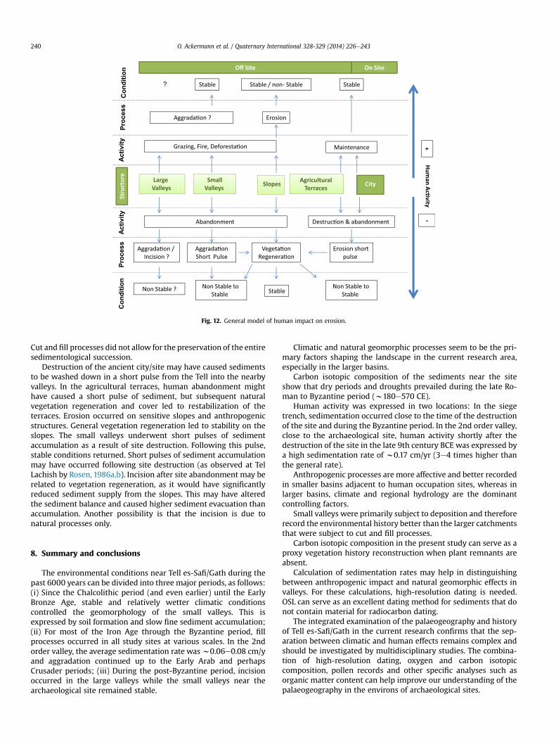
Fig. 12. General model of human impact on erosion.
O. Ackermann et al. / Quaternary International 328-329 (2014) 226e243240
Cut and fill processes did not allow for the preservation of the entiresedimentological succession.
Destruction of the ancient city/site may have caused sedimentsto be washed down in a short pulse from the Tell into the nearbyvalleys. In the agricultural terraces, human abandonment mighthave caused a short pulse of sediment, but subsequent naturalvegetation regeneration and cover led to restabilization of theterraces. Erosion occurred on sensitive slopes and anthropogenicstructures. General vegetation regeneration led to stability on theslopes. The small valleys underwent short pulses of sedimentaccumulation as a result of site destruction. Following this pulse,stable conditions returned. Short pulses of sediment accumulationmay have occurred following site destruction (as observed at TelLachish by Rosen, 1986a,b). Incision after site abandonment may berelated to vegetation regeneration, as it would have significantlyreduced sediment supply from the slopes. This may have alteredthe sediment balance and caused higher sediment evacuation thanaccumulation. Another possibility is that the incision is due tonatural processes only.
8. Summary and conclusions
The environmental conditions near Tell es-Safi/Gath during thepast 6000 years can be divided into three major periods, as follows:(i) Since the Chalcolithic period (and even earlier) until the EarlyBronze Age, stable and relatively wetter climatic conditionscontrolled the geomorphology of the small valleys. This isexpressed by soil formation and slow fine sediment accumulation;(ii) For most of the Iron Age through the Byzantine period, fillprocesses occurred in all study sites at various scales. In the 2ndorder valley, the average sedimentation rate wasw0.06e0.08 cm/yand aggradation continued up to the Early Arab and perhapsCrusader periods; (iii) During the post-Byzantine period, incisionoccurred in the large valleys while the small valleys near thearchaeological site remained stable.
Climatic and natural geomorphic processes seem to be the pri-mary factors shaping the landscape in the current research area,especially in the larger basins.
Carbon isotopic composition of the sediments near the siteshow that dry periods and droughts prevailed during the late Ro-man to Byzantine period (w180e570 CE).
Human activity was expressed in two locations: In the siegetrench, sedimentation occurred close to the time of the destructionof the site and during the Byzantine period. In the 2nd order valley,close to the archaeological site, human activity shortly after thedestruction of the site in the late 9th century BCE was expressed bya high sedimentation rate of w0.17 cm/yr (3e4 times higher thanthe general rate).
Anthropogenic processes are more affective and better recordedin smaller basins adjacent to human occupation sites, whereas inlarger basins, climate and regional hydrology are the dominantcontrolling factors.
Small valleys were primarily subject to deposition and thereforerecord the environmental history better than the larger catchmentsthat were subject to cut and fill processes.
Carbon isotopic composition in the present study can serve as aproxy vegetation history reconstruction when plant remnants areabsent.
Calculation of sedimentation rates may help in distinguishingbetween anthropogenic impact and natural geomorphic effects invalleys. For these calculations, high-resolution dating is needed.OSL can serve as an excellent dating method for sediments that donot contain material for radiocarbon dating.
The integrated examination of the palaeogeography and historyof Tell es-Safi/Gath in the current research confirms that the sep-aration between climatic and human effects remains complex andshould be investigated by multidisciplinary studies. The combina-tion of high-resolution dating, oxygen and carbon isotopiccomposition, pollen records and other specific analyses such asorganic matter content can help improve our understanding of thepalaeogeography in the environs of archaeological sites.
O. Ackermann et al. / Quaternary International 328-329 (2014) 226e243 241
Acknowledgments
This article is a comprehensive summary and discussion of anongoing environmental project within the framework of the Tell es-Safi/Gath Archaeological Project, directed by A. M. M. The researchwas carried out under the auspices of the Institute of Archaeology,The Martin (Szusz) Department of Land of Israel Studies andArchaeology, Bar-Ilan University, Ramat-Gan, Israel.
This research was supported by following: The Israeli Envi-ronment Protection Ministry (Grant 5-012 to A. M.M, ,O.A., H.B.,M.B.R., A.A.L., A.A. and B.S.) and the F.I.R.S.T. (Bikura) track of theIsrael Science Foundation (ISF) (Grant (#32/11 to AMM, UW andLKH); The Dr. Simon Krauthammer Chair in Archaeology; TheKuschitzky Family Foundation (both of Bar-Ilan University); TheAshkelon Academic College. The authors wish to acknowledge thefollowing for drawing the figures: Noga Yoselevich of theDepartment of Geography of the University of Haifa, Roni Blustein-Livnon from the Cartography Laboratory at Ben-Gurion Universityof the Negev, and Jay Rosenberg. The authors also thank Tzlil Labinfrom the Martin (Szusz) Department of Land of Israel Studies andArchaeology at Bar-Ilan University for assistance in the field, Prof.Hanoch Lavee, Prof. Sarah Pariente, Dr. Lena Zhevelev, and Dr.Natan Fragin from the Laboratory of Geomorphology and Soil ofthe Department of Geography at Bar Ilan University, for theiradvice and assistance in the field and in the laboratory. Thanksalso to Pierluigi Pieruccini and the two anonymous referees fortheir constructive suggestions and additions that improved anearlier version of this manuscript.
References
Ackermann, O., Bruins, H.J., 2012. General Environmental Background of Tell es-Safi/Gath”. In: A.M, Maeir (Ed.), Tell es-Safi/Gath I: the 1996e2005 Seasons,Ägypten und Altes Testament, vol. 69. Harrassowitz Verlag, Wiesbaden,pp. 123e132.
Ackermann, O., Maeir, A.M., Bruins, H.J., 2004. Unique human-made catenarychanges and their effect on soil and vegetation in the semi-arid Mediterraneanzone: a case study on Sarcopoterium spinosum distribution near Tell es-Safi/Gath, Israel. Catena 57, 309e330.
Ackermann, O., Bruins, H.J., Maeir, A.M., 2005a. A unique human-made trench atTell es-Safi/Gath e Israel: anthropogenic, impact and landscape response.Geoarchaeology 20 (3), 303e327.
Ackermann, O., Bruins, H.J., Sarah, P., Zhevelev, H., Maeir, A.M., 2005b. Land-scape archaeology in a dry stream valley near Tell es-Safi/Gath (Israel):agricultural terraces and the origin of fill deposits. Environmental Archae-ology 10, 199e215.
Ackermann, O., Greenbaum, N., Bruins, H.J., Bar-Matthews, M., Ayalon, A., Almogi-Labin, A., Schilman, B., Davis, M., Maeir, A.M., 2012. The environmental andpaleogeographical history of the Tell es-Safi/Gath during the last eightmillennia. In: A.M, Maeir (Ed.), Tell es-Safi/Gath I: the 1996e2005 Seasons,Ägypten und Altes Testament, vol. 69. Harrassowitz Verlag, Wiesbaden,pp. 531e556.
Ackermann, O., Zhevelev, H.M., Svoray, T., 2013. Sarcopoterium spinosum frommosaic structure to matrix structure: impact of calcrete (Nari) on vegetation ina Mediterranean semi-arid landscape. Catena 101, 79e91.
Aitken, M.J., 1998. An Introduction to Optical Dating. Oxford University Press, NewYork.
Avni, Y., 2005. Gully incision as a key factor in desertification in an arid environ-ment, the Negev Highlands, Israel. Catena 63, 185e220.
Avni, Y., Porat, N., Avni, G., 2012. Pre-farming environment and OSL chronology inthe Negev Highlands, Israel. Journal of Arid Environments 86, 12e27.
Bar Matthews, M., Ayalon, A., Kaufman, A., 1998. Middle to late Holocene (6,500 yr.period) paleoclimate in the Eastern Mediterranean region from stable isotopiccomposition of speleothems from Soreq Cave, Israel. In: Issar, A.S., Brown, N.(Eds.), Water, Environment and Society in Times of Climatic Change. Kluwer,Dordrecht, pp. 203e214.
Bar-Matthews, M., Ayalon, A., 2004. Speleothems as paleoclimate indicators, a casestudy from soreq cave located in the eastern mediterranean region, Israel. In:Battarbee, R.W., Gasse, F., Stickley, C.E. (Eds.), Past Climate Variability throughEurope and Africa. Kluwer, Dordrecht, pp. 363e391.
Bar-Matthews, M., Ayalon, A., Gilmour, M., Matthews, M., Hawkesworth, C., 2003.Sea-land isotopic relationships from Planktonic Foraminifera and speleo-thems in the eastern mediterranean region and their implications for pale-orainfall during interglacial intervals. Geochimica et Cosmochimica Acta 67,3181e3199.
Barker, G., 1998. Mediterranean Valley. Leicester University Press, London.Baruch, U., 1986. The Late Holocene vegetational history of Lake Kinneret (Sea of
Galilee), Israel. Paléorient 12, 37e47.Bender, M.M., 1968. Mass spectrometric studies of Carbon 13 variations in corn and
other grasses. American Journal Science Radiocarbon (Supplementary) 10, 468e472.
Bintliff, J., 2002. Time, process and catastrophism in the study of Mediterraneanalluvial history: a review source. World Archaeology 33 (3), 417e435.
Bintliff, J., 2005. Human impact, land-use history, and the surface archaeologicalrecord: a case study from Greece. Geoarchaeology 20 (2), 135e147.
Blondel, J., Aronson, J., Bodiou, J.Y., Boeuf, G., 2010. The Mediterranean Region:Biological Diversity through Time and Space. Oxford University Press,Oxford.
Bookman (Ken-Tor), R., Enzel, Y., Agnon, A., Stein, M., 2004. Late holocene Lakelevels of the Dead Sea. Bulletin of the Geological Society of America 116, 555e571.
Bøtter-Jensen, L., McKeever, S.W., Wintle, A.G., 2003. Optically Stimulated Lumi-nescence Dosimetry. Elsevier, Amsterdam.
Bruins, H.J., 1986. Desert Environment and Agriculture in the Central Negev andKadesh-Barnea during Historical Times. Stichting Midbar Foundation, Nijkerk,The Netherlands.
Bruins, H.J., Yaalon, D.H., 1979. Stratigraphy of the Netivot section in the desert loessof the Negev (Israel). Acta Geologica Academiae Scientarium Hungaricae 22 (1e4), 161e169.
Bruins, H.J., Yaalon, D.H., 1992. Parallel advance of slopes in aeolian loess deposits ofthe northern Negev, Israel. Israel Journal of Earth Sciences 41, 189e199.
Buchbinder, B., 1969. Geological Map of Hashephela Region, Israel, ExplanatoryNotes. The Geological Survey of Israel, Jerusalem.
Butzer, K., 2005. Environmental history in the Mediterranean world: cross-disciplinary investigation of cause-and-effect for degradation and soil erosion.Journal of Archaeological Science 32 (12), 1773e1800.
Cai, D.-L., Tan, F.C., Edmond, J.M., 1988. Sources and transport of particulate organiccarbon in the Amazon river and estuary. Estuarine, Coastal and Shelf Science 26,1e14.
Casana, J., 2008. Mediterranean valleys revisited: linking soil erosion, land useand climate variability in the Northern Levant. Geomorphology 101 (3), 429e442.
Connin, S.L., Virginia, R.A., Chamberlain, C.P., 1997. Carbon isotopes reveal soilorganic matter dynamics following arid land shrub expansion. Oecologia 110,374e386.
Dagan, Y., 1992. Archaeological Survey of Israel. Map of Lakhish (98). Israel Antiq-uities Authority, Jerusalem.
Dagan, Y., 2002. Survey of Tel Zafit region. Excavations and Surveys in Israel 114,83e85 (English section).
Dagan, Y., 2006. Map of Amazya (109). Archaeological Survey of Israel. Israel An-tiquities Authority, Jerusalem.
Dan, J., Bruins, H.J., 1981. Soils of the southern coastal plain. In: Dan, J., Gerson, R.,Koyumdjisky, H., Yaalon, D.H. (Eds.), Aridic Soils of Israel. The Volcani Center,Israel, pp. 143e187.
Dan, J., Yaalon, D.H., Koyumdjisky, H., Raz, Z., 1972. The soil association map ofIsrael. Israel Journal of Earth Sciences 21, 29e49.
Dan, J., Yaalon, D.H., Koyumdjisky, H., Raz, Z., 1976. The Soils of Israel. Pamphlet 159.The Volcani Center, Bet Dagan, Israel. Ministry of Agriculture, AgriculturalResearch Organization Institute of Soils and Water, Soil Conservation andDrainage Department.
Davidson, A.D., 1980. Erosion in Greece during the first and second millennia BC. In:Cuilingford, R.A., Davidson, R.A., Levin, J. (Eds.), Timescales in Geomorphology.John Wiley and Sons, New York, pp. 143e158.
Deines, P., 1980. The isotopic composition of reduced organic carbon. In: Fritz, P.,Fontes, J.C. (Eds.), Handbook of Environmental Isotope Geochemistry 1. Elsevier,Amsterdam, pp. 329e406.
Dincauze, D.F., 2000. Environmental Archaeology: Principals and Practice. Cam-bridge University, Cambridge.
Dusar, B., Verstraeten, G., Notebaert, B., Bakker, J., 2011. Holocene environmentalchange and its impact on sediment dynamics in the eastern Mediterranean.Earth-Science Reviews 108 (3e4), 137e157.
Ehleringer, J.R., Sage, R.F., Flanagan, L.B., Pearcy, R.W., 1991. Climate change and theevolution of C4 photosynthesis. Tree 6, 95e99.
Endfield, G.H., 1997. Myth, manipulation and myopia in the study of Mediter-ranean soil erosion. In: Sinclair, A., Slater, E., Gowlett, J. (Eds.), Archaeo-logical Sciences 1995, Oxbow Monograph, vol. 64. Oxbow Books, Oxford,pp. 241e248.
Enzel, Y., Bookman, R., Sharon, D., Gvirtzman, H., Dayan, U., Ziv, B., Stein, M.,2003. Late Holocene climates of the Near-East deduced from Dead Sea-levelvariations and modern regional Winter rainfall. Quaternary Research 60,263e273.
Faust, A., Ashkenazy, Y., 2007. Excess in precipitation as a cause for settlementdecline along the Israeli coastal plain during the third millennium BC. Qua-ternary Research 68 (1), 37e44.
Faust, A., Ashkenazy, Y., 2009. Settlement fluctuations and environmentalchanges in Israel’s coastal Plain during the Early Bronze Age. Levant 41 (1),19e39.
Finné, M., Holmgren, K., Sundqvist, H.S., Weiberg, E., Lindblom, M., 2011. Climate inthe eastern Mediterranean, and adjacent regions, during the past 6000 years ea review. Journal of Archaeological Science 38 (12), 3153e3173.
O. Ackermann et al. / Quaternary International 328-329 (2014) 226e243242
Frumkin, A., 1997. The holocene history of dead sea levels. In: Niemi, T.M., Ben-Avraham, Z., Gat, J.R. (Eds.), The Dead Sea, the Lake and its Setting. OxfordUniversity, Oxford, pp. 237e248.
Frumkin, A., Ford, D.C., Schwarcz, H.P., 1999. Continental oxygen isotopic re-cord of the last 170,000 Years in jerusalem. Quaternary Research 51 (3),317e327.
Fuchs, M., 2007. An assessment of human versus climatic impacts on Holocene soilerosion in NE Peloponnese, Greece. Quaternary Research 67, 349e356.
Galbraith, R.F., Roberts, R.G., Laslett, G.M., Yoshida, H., Olley, J.M., 1999. Opticaldating of single and multiple grains of quartz from Jinmium rock Shelter,northern Australia: part I, experimental design and statistical models.Archaeometry 41 (2), 339e364.
Gile, L.H., Peterson, F.F., Grossman, R.B., 1966. Morphological and genetic sequencesof carbonate accumulation in desert soils. Soil Science 101 (5), 347e360.
Goldberg, P., 1984. Late quaternary history of Qadesh Barnea, Northeastern Sinai.Zeitschrift für Geomorphologie N.F 28 (2), 193e217.
Goudie, A., 1994. The Human Impact on the Natural Environment. MIT Press,Cambridge.
Greenbaum, N., Schick, A.P., Baker, V.R., 2000. The palaeoflood record of a hyperaridcatchment, Nahal Zin, Negev Desert, Israel. Earth Surface Processes and Land-forms 25 (9), 951e971.
Houben, P., Hoinkis, R., Santisteban, J.I., Salat, C., Mediavilla, R., 2011. Combiningallostratigraphic and lithostratigraphic perspectives to compile subregionalrecords of fluvial responsiveness: the case of the sustainably entrenching Pal-ancia River watershed (Mediterranean coast, NE Spain). Geomorphology 129(3), 342e360.
Huckleberry, G., 2001. Archaeological sediments in Dryland alluvial environments.In: Stein, J.K., Farrand, W.R. (Eds.), Sediments in Archaeological Context. TheUniversity of Utah, Utah, pp. 67e92.
Itkin, D., Geva-Kleinberger, A., Yaalon, D.H., Shaanan, U., Goldfus, H., 2012. N�ari inthe Levant: historical and etymological aspects of a specific calcrete formation.Earth Sciences History 31 (2), 210e228.
Kafle, H.K., Bruins, H.J., 2009. Climatic trends in Israel 1970e2002: warmer andincreasing aridity inland. Climatic Change 96, 63e77.
Klein, C., 1961. On Fluctuations of the Level of the Dead Sea since the Beginning ofthe 19th Century. Hydrological Paper 7. Israel Hydrological Service, Jerusalem.
Klein, C., 1981. The influence of rainfall over the catchment area on the fluctuationsof the level of the Dead Sea since the 12th Century. Israel MeteorologicalResearch Papers 3, 29e57.
Klein, C., 1982. Morphological evidence of Lake level changes, western shore of thedead sea. Israel Journal of Earth Sciences 31, 67e94.
Klute, A. (Ed.), 1986. Methods of Soil Analysis, second ed.Monograph No. 9, Part 1American Society of Agronomy, Madison, WI.
Maeir, A.M., 2001. The Philistine culture in transformation: a current perspectivebased on the results of the first seasons of excavations at Tell es-Safi/Gath. In:Maeir, A.M., Baruch, E. (Eds.), Settlement, Civilization and Culture: Proceedingsof the Conference in Memory of David Alon. Bar-Ilan University (in Hebrew),Ramat-Gan, pp. 111e131.
Maeir, A.M., 2003. Notes and news: Tell es-Safi/Gath, 1996e2002. Israel ExplorationJournal 53, 237e246.
Maeir, A.M., 2004. The historical background and dating of Amos 6, 2: anarchaeological perspective from Tell es-Safi/Gath. Vetus Testamentum 54,319e334.
Maeir, A.M. (Ed.), 2012a. Tell es-Safi/Gath I: the 1996e2005 Seasons. Ägypten undAltes Testament, vol. 69. Harrassowitz Verlag, Wiesbaden.
Maeir, A.M., 2012b. The Tell es-Safi/Gath archaeological project 1996e2010: intro-duction, overview and synopsis of results. In: A.M, Maeir (Ed.), Tell es-Safi/GathI: the 1996e2005 Seasons, Ägypten und Altes Testament, vol. 69. HarrassowitzVerlag, Wiesbaden, pp. 1e89.
Maeir, A.M., Gur-Arieh, S., 2011. Comparative Aspects of the Aramean Siege Systemat Tell es-S�afi/Gath. In: The Fire Signals of Lachish: Studies in the Archaeologyand History of Israel in the Late Bronze Age, Iron Age and Persian Period inHonor of David Ussishkin, pp. 227e244.
Maeir, A.M., Ackermann, O., Bruins, H.J., 2006. The ecological consequences of asiege: a marginal note on Deuteronomy 20: 19e20. In: Gitin, S., Wright, J.E.,Desselb, P. (Eds.), Confronting the Past Archaeological and Historical Essays onAncient Israel in Honor of William G. Dever. Eisenbrauns, Winona Lake,pp. 239e243.
Morgan, R.P.C., 1995. Soil Erosion and Conservation. Longman, Essex, U.K.Murray, A.S., Wintle, A.G., 2000. Luminescence dating of quartz using an
improved single-aliquot regenerative-dose protocol. Radiation Measure-ments 32, 57e73.
Neumann, F., Schölzel, C., Litt, T., Hense, A., Stein, M., 2006. Holocene vegetation andclimate history of the northern Golan heights (Near East). Vegetation Historyand Archaeobotany 16 (4), 329e346.
Neumann, F.H., Kagan, E.J., Leroy, S.A.G., Baruch, U., 2010. Vegetation history andclimate fluctuations on a transect along the Dead Sea west shore and theirimpact on past societies over the last 3500 years. Journal of Arid Environments74 (7), 756e764.
Neumann Harald, F., Kagan, E.J., Schwab, M.J., Stein, M., 2007. Palynology, sedi-mentology and palaeoecology of the late Holocene Dead Sea. Quaternary Sci-ence Reviews 26, 1476e1498.
O’Neil, J.R., Clayton, R.N., Mayeda, T.K., 1969. Oxygen isotope fractionation of diva-lent metal carbonates. The Journal of Chemical Physics 30, 5547e5558.
Orland, I., Barmatthews, M., Kita, N., Ayalon, A., Matthews, A., Valley, J., 2009.Climate deterioration in the eastern Mediterranean as revealed by ion micro-probe analysis of a speleothem that grew from 2.2 to 0.9 ka in Soreq Cave, Israel.Quaternary Research 71 (1), 27e35.
O’Leary, M.H., 1995. Environmental effects on carbon fractionation in terrestrialplants. In: Wada, E., Yoneyama, T., Minigawa, M., Ando, T., Fry, B.D. (Eds.), StableIsotopes in the Biosphere. Kyoto University, Kyoto, pp. 78e91.
Pons, A., Quezel, P., 1985. The history of the flora and vegetation and past andpresent human disturbance in the Mediterranean region. In: Gomez-Campo, C.(Ed.), Plant Conservation in the Mediterranean Area. Dr. W. Junk, Dordrecht,pp. 25e43.
Pope, K.O., van Andel, T.H., 1984. Late Quaternary alluviation and soil formation inthe southern Argolid: its history, causes and archaeological implications. Jour-nal of Archaeological Science 11, 281e306.
Porat, N., 2006. Use of magnetic separation for purifying quartz for luminescencedating. Ancient TL 24 (2), 33e36.
Porat, N., 2007. Analytical Procedures in the Luminescence Dating Laboratory. IsraelGeological Survey of Israel, Jerusalem. Technical Report TR-GSI/2/2007 (inHebrew).
Rainey, A.F., 1975. The identification of Philistine Gath e a problem in sourceanalysis for historical geography. Eretz Israel 12, 63e76 (English section).
Rosen, M.A., 1986a. Environmental change and settlement at Tel Lachish, Israel.Bulletin of the American Schools of Oriental Research 263, 55e60.
Rosen, M.A., 1986b. Cities of Clay: the Geoarcheology of Tells. University of ChicagoPress, Chicago.
Rosen, M.A., 1995. The social response to environmental change in Early Bronze AgeCanaan. Journal of Anthropological Archaeology 14, 26e44.
Rosen, A., 2006. Climate change, landscape and shifting agricultural potential. In:Finkelstein, I., Ussishkin, D., Halpern, B. (Eds.), The 1998e2002 Seasons. Emeryand Claire Yass Publications in Archaeology, Institute of Archaeology, Tel AvivUniversity, Tel Aviv, pp. 463e470. Megiddo IV.
Rosen, A.M., 2007. Civilizing Climate: Social Responses to Climate Change in theAncient Near East. Altamira Press, Lanham, MD.
Rosen, A.M., Wachs, D., Ackermann, O., 2014. Geoarchaeological report: the resultsof the 1984e1987 seasons. In: Gitin, S. (Ed.), Tel Miqne-ekron Final Object andMaterial Cultural Reports. Albright Institute and Hebrew University, Jerusalem(Chapter 11) (in press).
Rowell, D.L., 1994. Soil Science Methods and Applications. Longman Group,London.
Rubin, R., 1990. Was the negev climate more comfortable during the byzantineperiod? In: Lavee, H., Schick, A.P., Yair, A. (Eds.), Ran Gerson Memorial Volume:Facets of the Geomorphology of the Negev Horizons in Geography 31, 209e217.Haifa: University of Haifa (Hebrew with English abstract).
Safrai, Z., 1986. The influence of the demographic stratification on the agriculturaland economic structure during the Mishnaic and Talmudic periods. In:Kasher, A., Oppenheimer, A., Rappaport, U. (Eds.), Man and Land in Eretz-Israelin Antiquity. Yad Izhak Ben Zvi, Jerusalem, pp. 20e48 (Hebrew with Englishabstract).
Schilman, B., Ayalon, A., Bar-Matthews, M., Kagan, E.J., Almogi-Labin, A., 2002. Sea-land paleoclimate correlation in the Eastern Mediterranean region during theLate Holocene. Israel Journal of Earth Science 51, 181e190.
Schniedewind, W.M., 1998. The geo-political history of Philistine Gath. Bulletin ofthe American Schools of Oriental Research 309, 69e77.
Schuldenrein, J., 2007. A reassessment of the Holocene stratigraphy of theWadi Hasa Terrace and Hasa formation, Jordan. Geoarchaeology 22 (6),559e588.
Shaharabani, M., 1992. The Influence of the Environmental Conditions on NariFormation in Israel. Unpublished Master’s. Bar-Ilan University, Ramat-Gan.
Shoshany, M., Svoray, T., 2002. Multidate adaptive unmixing and its application toanalysis of ecosystem transitions along a climatic gradient. Remote Sensing ofEnvironment 82 (1), 5e20.
Smith, B.N., Epstein, S., 1971. Two categories of 13C/12C ratios for plants. PlantPhysiology 47, 380e384.
Solé-Benet, A., Lázaro, R., Domingo, F., Cantón, Y., Puigdefábregas, J., 2010.Why most agricultural terraces in steep slopes in semiarid SE Spainremain well preserved since their abandonment 50 years ago? Pirineos165, 215e235.
Uziel, J., 2003. The Tell es-Safi Archaeological Survey. Unpublished Master’sdissertation. Bar Ilan University, Ramat-Gan.
Uziel, J., Maeir, A.M., 2005. Scratching the surface at Gath: implications of the Telles-Safi/Gath surface survey. Tel Aviv 32 (1), 50e75.
Uziel, J., Maeir, A.M., 2012. The location, size and periods of settlement at Tell es-Safi/Gath: the surface survey results. In: A.M, Maeir (Ed.), Tell es-Safi/Gath I:the 1996e2005 Seasons, Ägypten und Altes Testament, vol. 69. HarrassowitzVerlag, Wiesbaden, pp. 173e181.
Van Andel, T.H., Zanger, E., Demitrack, A., 1990. Land use and soil erosion inprehistoric and historical Greece. Journal of Field Archaeology 17, 379e396.
Vita-Finzi, C., 1969. The Mediterranean Valleys. Cambridge University Press,Cambridge.
Wagstaff, J.M., 1981. Buried assumptions: some problems in the interpretation ofthe “Younger Fill” raised by recent data from Greece. Journal of ArchaeologicalScience 8, 247e264.

O. Ackermann et al. / Quaternary International 328-329 (2014) 226e243 243
Walsh, K., 2004. Caring about sediments: the role of cultural geoarchaeology inMediterranean landscapes. Journal of Mediterranean Archaeology 17, 223e245.
Wieder,M., Shaharabani,M., Singer, A.,1994. Phases of calcrete (Nari) development asindicated by micromorphology. In: Ringrose-Voase, A.J., Humphreys, G.S. (Eds.),SoilMicromorphology: Studies inManagement andGenesis. Proceedingsof the IXInternational Working Meeting on Soil Micromorphology, Townsville, Australia,July 1992. Developments in Soil Science 22, 37e49. Amsterdam: Elsevier.
Wintle, A.G., 2008. Luminescence dating: where it has been and where it is going.Boreas 37, 471e482.
Wright, C.H., 1939. Soil Analysis. Thomas Murby, London.Yaalon, D.H., Dan, J., 1974. Accumulation and distribution of loess-derived deposits
in the semi-arid and desert fringe areas of Israel. Zeitschrift für Geo-morphologie N.F 20, 91e105.
Zgaier, A., 2008. Landslides on agricultural hillslope terraces under Mediterraneanclimatic conditions. Israel Journal of Earth Sciences 57 (3), 249e261.
Recommended


