1
Sustainability Appraisal Interim Scoping Report Worksop Central Development Plan Document Main Report and Appendices
June 2021
2
Non-Technical Summary
Introduction In order to guide and promote the sustainable regeneration of Worksop Central area (known as
Worksop Central), Bassetlaw District Council (BDC) has recently adopted a masterplan vision for the
area. The emerging Bassetlaw Local Plan will set out the overarching strategic policy framework for
the planning and development of the area, whilst the detailed spatial and planning policy framework
will be taken forward within a Development Plan Document (DPD).
In order to successfully produce a DPD for Worksop Central, a combined Sustainability Appraisal (SA)
and Strategic Environmental Assessment (SEA) must be undertaken. These documents are created in
accordance with processes outlined under both European Directive and UK regulations. The SA and
SEA ensure that potential social, environmental and economic effects of the DPD are identified,
described and appraised. This results in probable negative effects being identified, and enables
measures are proposed which avoid, minimise or mitigate these effects. Similarly, where positive
effects are identified, measures will be considered that can enhance such effects.
The Bassetlaw Local Plan The emerging draft Bassetlaw Local Plan is due to progress to Regulation 19 Publication stage in the
summer of 2021. On adoption, this document will replace the Council’s current Development Plan,
the Bassetlaw Core Strategy and Development Management Polices Development Plan Document
(December 2011). The new Local Plan will be a single document setting out the vision and objectives
for the District out to 2037. It will provide the spatial strategy for the plan period, and identify how
much new development will be accommodated and where it will be located in the area. The vision,
objectives and spatial strategy will be delivered through the Local Plan’s planning policies and land
allocations.
The Local Plan will be supported by additional Local Development Documents. These will consist of
statutory Development Plan Documents (DPDs) and non-statutory Supplementary Planning
Documents (SPDs).
The Worksop Central Area is identified by the draft Local Plan as a priority regeneration area within
the District. In order to successfully coordinate the delivery of regeneration, the Local Plan states that
a Worksop Central Development Plan Document will be produced.
Methodology In accordance with government guidance contained within Planning Practice Guidance (PPG), the
SEA/SA consists of the following predefined stages of production. The methodology is as follows:
• Stage A: Setting the context and objectives, establishing the baseline and deciding on the scope
• Stage B: Developing and refining options
• Stage C: Appraising the effects of the plan
• Stage D: Consulting on the plan and the SEA/SA report
• Stage E: Monitoring Implementation of the Plan

3
Stage A: Setting the context and objectives, establishing the baseline and deciding on
the scope. Initially a Scoping Report must be produced to outline the proposed approach for conducting the SA
of the Worksop Central DPD. With reference the diagram above, this involves the completion of Stage
A of the SA process, which is further divided into 5 key requirements, as outlined below.
A1. Identify other relevant policies, plans and programmes, and sustainability objectives that will
influence the Worksop Central DPD
A2. Collect and develop relevant social, environmental and economic baseline information and
define the character of the area
A3. Identify key sustainability issues for the DPD to address
A4. Develop the sustainability appraisal framework, consisting of the SA objectives, indicators and
targets
A5. Consult the consultation bodies on the scope of the sustainability appraisal report
As the SA is an iterative process, some stages may need to be undertaken more than once. This Scoping
Report includes some of the required elements of the final “Environmental Report” which is required
by the SEA regulations.
4
Scope of the SA/SEA To adhere to the SEA Directive and the conditions outlined in the PPG, the baseline data and SEA/SA
framework have been organised accordingly. The scope of the baseline review has been broadened
to cover a wider spectrum of sustainability issues to reflect the combination of both SEA and SA
assessments.
Setting the context and objectives, establishing the baseline and deciding on the scope
Stage A1: Identify other relevant policies, plans and programmes, and sustainability objectives In line with SEA Directive Annex 1a (e), during DPD development consideration must be made of the
influence of relevant, already published plans, policies and programmes. These relationships have to
be outlined and form part of the baseline review. This review includes a description of the most
relevant policy context and enables potential synergies to be exploited and any potential
inconsistencies and constraints to be identified.
Stage A2: Collect baseline information As a requirement of the SEA Directive and the PPG, baseline information is collected to identify
environmental, social and economic issues within the Worksop Central Area. This baseline information
provides the foundations for predicting and monitoring the full spectrum of sustainability issues.
Therefore, the likely effects of options for policies and site allocations are highlighted and as a result,
alternative ways of dealing with any adverse effects can be identified.
Stage A3: Identify sustainability issues and problems As mentioned previously, the key sustainability issues are divided between three categories;
environmental, economic and social. Within the specific locality of the Worksop Central Area, certain
sustainability issues will be of more prevalent than others, and will be highlighted in the Sustainability
Appraisal as potential areas of concern.
Stage A4: Develop the Sustainability Appraisal Framework To test the performance of the DPD, a sustainability framework with decision making criteria will be
produced. This will allow the comparison of the various policies, options and proposals for the overall
area and in relation to specific identified sites. This will include relation to their spatial location,
proposed scale of growth and mix of land uses.
Stage A5: Consult the consultation bodies on the scope of the Sustainability Appraisal report Once complete, the Scoping Report will be issued to the statutory consultees. This will be
accompanied with a covering letter explaining the input and requirements of the consultees over the
five week consultation period.
To assist the consultees with their responses, consultation questions have been included throughout
the document. A list of these can be found in Appendix 5.
After the consultation period, the representations received will be considered and analysed. If it then
deemed appropriate, the Scoping Report and/or SA Framework will be amended. Following these
amendments, the final revised Scoping Report will be issued.
5
Sustainability Appraisal Scoping Report
Table of Contents Contents
Section Page
Non-technical summary 2
1. Introduction 7
2. Stage A: Task 1: Identify Other Relevant Policies, Plans and Programmes, and Sustainability Objectives
9
3. Stage A: Task 2: Collecting Baseline Information Population Housing Deprivation and Crime Health and Wellbeing Education, Skills and Training Employment Retail, Community Facilities and Services Cultural Heritage and Townscape Urban Green Environment Transport Climatic Factors/ Climate Change
19
4. Stage A: Task 3: Identifying Sustainability Issues 63
5. Stage A: Task 4: Developing the Sustainability Appraisal 80
6. Stage A: Task 5: Consult the consultation bodies on the scope of the Sustainability Appraisal report
101
Appendices
Appendix Page
Appendix 1: Consultation Questions 102
Appendix 2: Policies, Plans and Programmes 103
List of Tables
Table Title
1 Identifying the 5 Stages to producing a Sustainability Appraisal
2 Breaking down the 5 Stages to producing a Sustainability Appraisal Scoping Report
3 Population Estimates for the UK, East Midlands and Bassetlaw:
4 Population figures win Worksop, Bassetlaw and East Midlands 2011-2018
5 Population Density per Hectare in Worksop, Bassetlaw, East Midlands
6 Age structure in Worksop and Bassetlaw
7 Ethnicity groups of Worksop, Bassetlaw, East Midlands and England
8 Country of birth for Worksop, Bassetlaw and East Midlands
9 Religious diversity within Worksop, Bassetlaw and East Midlands
10 Annual Housing Completions in Worksop 2005-2020
11 Households with dependent children
12 Household composition for Worksop, Bassetlaw and England
13 Housing Tenure figures for Worksop, Bassetlaw and England
14 Housing transactions by Type February 2018-2019, Worksop
15 All Bassetlaw properties by price band from January-June 2020
16 Index of Multiple Deprivation Rank and Deciles for Worksop Central Area
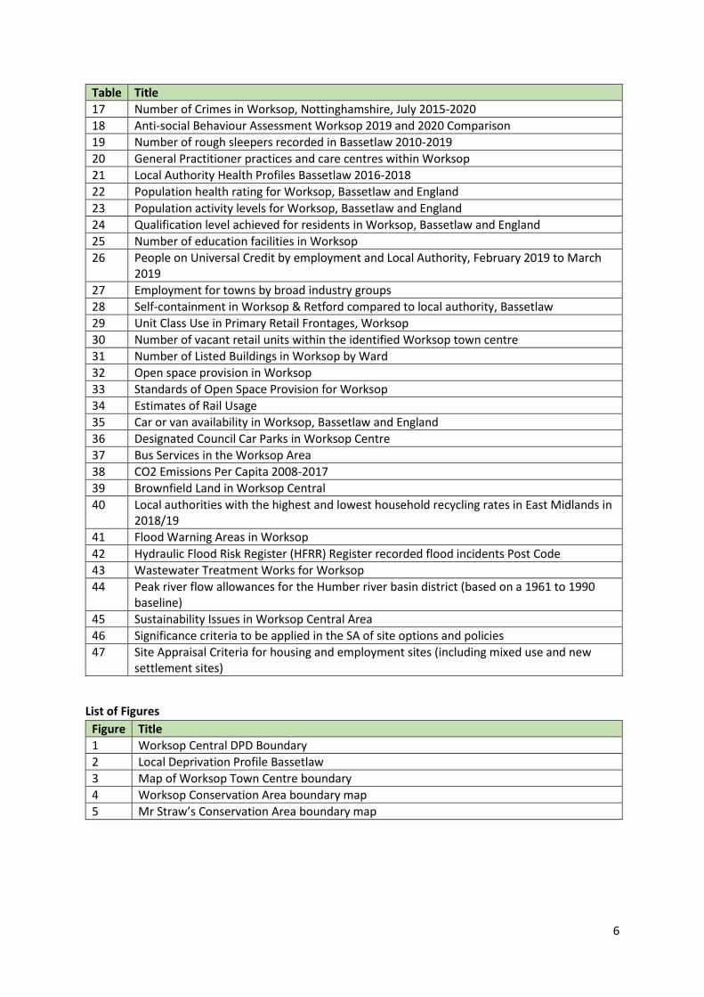
6
Table Title
17 Number of Crimes in Worksop, Nottinghamshire, July 2015-2020
18 Anti-social Behaviour Assessment Worksop 2019 and 2020 Comparison
19 Number of rough sleepers recorded in Bassetlaw 2010-2019
20 General Practitioner practices and care centres within Worksop
21 Local Authority Health Profiles Bassetlaw 2016-2018
22 Population health rating for Worksop, Bassetlaw and England
23 Population activity levels for Worksop, Bassetlaw and England
24 Qualification level achieved for residents in Worksop, Bassetlaw and England
25 Number of education facilities in Worksop
26 People on Universal Credit by employment and Local Authority, February 2019 to March 2019
27 Employment for towns by broad industry groups
28 Self-containment in Worksop & Retford compared to local authority, Bassetlaw
29 Unit Class Use in Primary Retail Frontages, Worksop
30 Number of vacant retail units within the identified Worksop town centre
31 Number of Listed Buildings in Worksop by Ward
32 Open space provision in Worksop
33 Standards of Open Space Provision for Worksop
34 Estimates of Rail Usage
35 Car or van availability in Worksop, Bassetlaw and England
36 Designated Council Car Parks in Worksop Centre
37 Bus Services in the Worksop Area
38 CO2 Emissions Per Capita 2008-2017
39 Brownfield Land in Worksop Central
40 Local authorities with the highest and lowest household recycling rates in East Midlands in 2018/19
41 Flood Warning Areas in Worksop
42 Hydraulic Flood Risk Register (HFRR) Register recorded flood incidents Post Code
43 Wastewater Treatment Works for Worksop
44 Peak river flow allowances for the Humber river basin district (based on a 1961 to 1990 baseline)
45 Sustainability Issues in Worksop Central Area
46 Significance criteria to be applied in the SA of site options and policies
47 Site Appraisal Criteria for housing and employment sites (including mixed use and new settlement sites)
List of Figures
Figure Title
1 Worksop Central DPD Boundary
2 Local Deprivation Profile Bassetlaw
3 Map of Worksop Town Centre boundary
4 Worksop Conservation Area boundary map
5 Mr Straw’s Conservation Area boundary map
7
1. Introduction
Strategic Environmental Assessment & Sustainability Appraisal 1.1 Sustainability Appraisal is a statutory requirement of Section 39(2) of the Planning and
Compulsory Purchase Act 20041. The purpose of the SA is to identify, describe and appraise the
likely social and economic effects of the policies and proposals within the Worksop Central DPD
from the outset of its development. This is supported by an additional statutory assessment
process, a Strategic Environmental Assessment (SEA), required under the SEA Directive2
(European Directive 2001/42/EC), to conduct a formal assessment of the plans and programmes
which are likely to have significant effects on the environment. In both cases where negative
effects are identified, measures will be proposed to avoid, minimise or mitigate such effects.
1.2 National Planning Practice Guidance demonstrates it is possible to satisfy both assessment
requirements by undertaking a joint SA/SEA, by presenting an SA report that incorporates the
requirements of the SEA Regulations.
Sustainability Appraisal 1.3 The Sustainability Appraisal for the Worksop Central Area DPD will be used to ensure that the
likely social, economic and environmental effects of the DPD are identified, described and
appraised. To enable this to happen, the SA will:
- Provide a long-term view of how the area covered by the DPD is expected to develop, by accounting for various social, environmental and economic effects of the proposed plan;
- Provide a mechanism for ensuring that sustainability objectives are translated into sustainable planning policies;
- Reflect not only local, but national and global concerns too; - Supply an audit trail of how the plan has been revised to take account the findings of the SA; - Form an integral part of all stages of plan preparation and incorporate the requirements of
the European Directive 2001/42/EC.
Scoping Report 1.4 The Scoping Report provides the initial formal output of the SA for the Worksop Central Area
DPD. The report seeks to gathering sufficient information to enable consultees to comment on the proposed scope of the SA. The role of the Scoping Report is to:
- Provide an overview of the Worksop Central Area DPD area; - Conduct a review of international, national, regional, sub-regional and local plans, policies and
programmes that are relevant to the DPD; - Through analysis of key sustainability topics, outline the baseline information for the DPD
area; - Identify key economic, social and environmental issues relevant to the appraisal of the
Worksop Central DPD; - Set out the appropriate objectives & targets for draft policies and options and present the
proposed approach to undertaking the appraisal of the Worksop Central Area DPD through a draft SA Framework;
- Provide an overview of the next steps in the SA process, including the proposed structure of future SA Reports.
1 https://www.legislation.gov.uk/ukpga/2004/5/pdfs/ukpga_20040005_en.pdf 2 https://ec.europa.eu/environment/eia/sea-legalcontext.htm
8
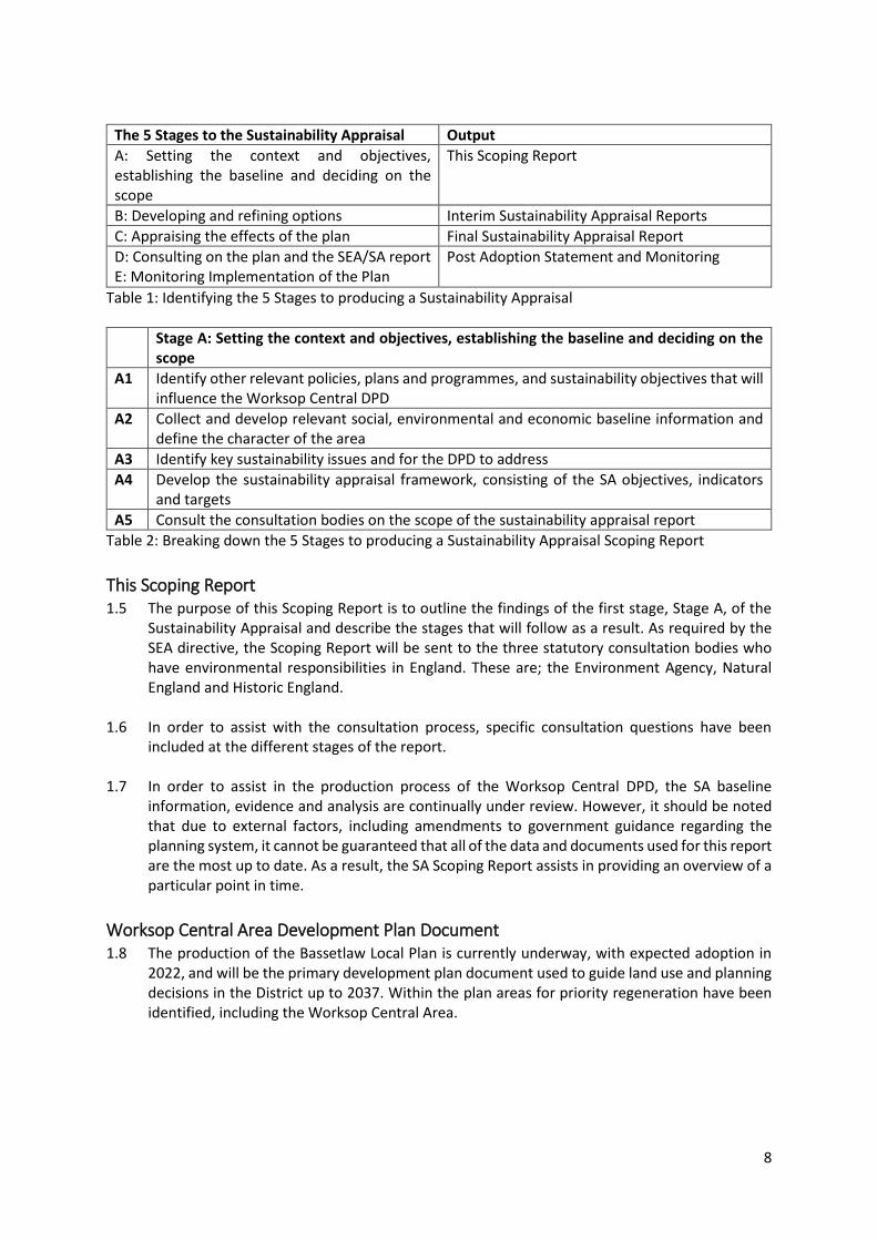
The 5 Stages to the Sustainability Appraisal Output
A: Setting the context and objectives, establishing the baseline and deciding on the scope
This Scoping Report
B: Developing and refining options Interim Sustainability Appraisal Reports
C: Appraising the effects of the plan Final Sustainability Appraisal Report
D: Consulting on the plan and the SEA/SA report E: Monitoring Implementation of the Plan
Post Adoption Statement and Monitoring
Table 1: Identifying the 5 Stages to producing a Sustainability Appraisal
Stage A: Setting the context and objectives, establishing the baseline and deciding on the scope
A1 Identify other relevant policies, plans and programmes, and sustainability objectives that will influence the Worksop Central DPD
A2 Collect and develop relevant social, environmental and economic baseline information and define the character of the area
A3 Identify key sustainability issues and for the DPD to address
A4 Develop the sustainability appraisal framework, consisting of the SA objectives, indicators and targets
A5 Consult the consultation bodies on the scope of the sustainability appraisal report
Table 2: Breaking down the 5 Stages to producing a Sustainability Appraisal Scoping Report
This Scoping Report 1.5 The purpose of this Scoping Report is to outline the findings of the first stage, Stage A, of the
Sustainability Appraisal and describe the stages that will follow as a result. As required by the SEA directive, the Scoping Report will be sent to the three statutory consultation bodies who have environmental responsibilities in England. These are; the Environment Agency, Natural England and Historic England.
1.6 In order to assist with the consultation process, specific consultation questions have been
included at the different stages of the report. 1.7 In order to assist in the production process of the Worksop Central DPD, the SA baseline
information, evidence and analysis are continually under review. However, it should be noted that due to external factors, including amendments to government guidance regarding the planning system, it cannot be guaranteed that all of the data and documents used for this report are the most up to date. As a result, the SA Scoping Report assists in providing an overview of a particular point in time.
Worksop Central Area Development Plan Document 1.8 The production of the Bassetlaw Local Plan is currently underway, with expected adoption in
2022, and will be the primary development plan document used to guide land use and planning decisions in the District up to 2037. Within the plan areas for priority regeneration have been identified, including the Worksop Central Area.
9
1.9 As the Draft Local Plan November 20203 is an emerging document, the evidence base used to inform its policies will be up to date and also account for recent changes that have occurred at higher levels, such as modifications to the NPPF. This is important as the Draft Local Plan provides the overarching strategic policy framework for Worksop Central, which along with this Scoping Report will highly influence the appraisal of policies and proposals outlined for the Worksop Central Area DPD.
1.10 The Worksop Central Area DPD will be produced to support the Bassetlaw Local Plan. With the
aim of providing a vision, strategy, and objectives to assist in the delivery of investment and regeneration in the area. This will be through the enhancement of both the built environment and green and blue infrastructure.
2. Stage A: Task 1: Identify other relevant policies, plans and
programmes, and sustainability objectives
Strategic Environmental Assessment & Sustainability Appraisal 2.1 Sustainability Appraisal is a statutory requirement of Section 39(2) of the Planning and
Compulsory Purchase Act 2004. The purpose of the SA is to ensure that throughout its
production, The Worksop Central DPD, is fully consistent with and helps to implement the
principles of sustainable development. This is supported by an additional statutory assessment
process, a Strategic Environmental Assessment (SEA), required under the SEA Directive
(European Directive 2001/42/EC), to conduct a formal assessment of the plans and programmes
which are likely to have significant effects on the environment.
Plans, Policies and Programmes 2.2 As identified in the introduction, one of the first stages in undertaking the SA is to identify and
review other relevant plans and programmes that could influence the Worksop Central Area DPD. This review process is to assist in identifying the environmental and wider sustainability objectives relevant to the plan being assessed. This is outlined in the SEA Regulations; which states that an ‘Environmental Report’ should include:
“An outline of the contents, main objectives of the plan or programme and relationship with other relevant plans and programmes” to determine “the environmental protection objectives, established at international (European) community or national level, which are relevant to the plan or programme…and the way those objectives and any environmental considerations have been taken into account during its preparation” (Schedule 2 (a), (e)). 2.3 The geographic scale at which the identified plans and programmes are written varies, and in
the instance of the Worksop Central, they range from, international/ European, UK, national, regional to sub-regional or local level publications.
2.4 The aim of reviewing the publications containing relevant plans, programmes and policies is to
determine their relationships with the Worksop Central DPD. For instance, how the Worksop Central Area DPD could be affected by the other plans’ and programmes’ aims, objectives and/or targets, or how it could contribute to the achievement of their sustainability objectives. Furthermore, the review ensures that the relevant environmental protection and sustainability objectives are integrated into the SA, which will inform the development of the SA Framework.
3 https://www.bassetlaw.gov.uk/planning-and-building/the-draft-bassetlaw-local-plan/draft-bassetlaw-local-plan-november-2020/draft-bassetlaw-local-plan-november-2020/
10
As the SA is a living document, this review will be updated as the process of producing the report continues.
2.5 The review also benefits other aspects of the report, as examination of plans and programmes
assists in collating appropriate baseline information for the plan area. This is turn can help identify any key sustainability issues.
2.6 To produce the scoping report international/European, national, regional/sub-regional and
local level plans and programmes have been reviewed. These are listed below. 2.7 It should be noted that the list of plans, policies and programmes will be kept under review
throughout the SA process and updated as required, as any additional plans, policies and programmes become relevant. Additionally, UK’s withdrawal from the EU may have impacts on the identified European-level legislation which will need to be reviewed throughout the SA process.
Plans and Programmes Reviewed for the SA Scoping Report of the Worksop Central
Area DPD
Level: International/European Plan/Programme • The Cancun Agreement- UNFCCC (2011)
• The Convention for the Protection of the Architectural Heritage of Europe (Granada Convention
1985)
• The European Convention on the Protection of Archaeological Heritage (Valetta Convention 1992)
• Council Directive 91/271/EEC for Urban Waste-Water Treatment
• European Commission (EC) (2011) A Resource- Efficient Europe- Flagship Initiative Under the Europe
2020 Strategy, Communication from the Commission to the European Parliament, the Council, the
European Economic and Social Committee and the Committee of the Regions (COM 2011/21)
• European Landscape Convention 2000 (became binding March 2007)
• EU Directive on the Conservation of Natural Habitats and of Wild Fauna and Flora (92/43/EEC) &
Subsequent Amendments
• EU Packaging and Packaging Waste Directive (94/62/EC)
• EU Drinking Water Directive (98/83/EC)
• EU Directive on the Landfill of Waste (99/31/EC)
• EU Water Framework Directive (2000/60/EC)
• EU on the Assessment of the Effects of Certain Plans and Programmes on the Environment (SEA
Directive) (2001/42/EC)
• EU Directive 2010/31/EU (2010) on the Energy Performance of Buildings
• EU Environmental Noise Directive (Directive 2002/49/EC)
• EU Bathing Waters Directive 2006/7/EC
• EU (2006) European Employment Strategy
• EU (2009) Renewed EU Sustainable Development Strategy
• EU Floods Directive 2007/60/EC
• EU Air Quality Directive (2008/50/EC) and previous directives (96/62/EC; 99/30/EC; 2000/69/EC &
2002/3/EC)
• EU Directive on Waste (Directive 75/442/EEC, 2006/12/EC 2008/98/EC as amended)
• EU Directive on the Conservation of Wild Birds (09/147/EC) (codified version of Council Directive
79/409/EEC as amended)
• EU Renewable Energy Directive (2009/28/EC)
11
• EU (2011) EU Biodiversity Strategy to 2020 – towards implementation
• United Nations (2015) United Nations Climate Change Conference (COP 21) Paris Agreement
• United Nations (2015) Sustainable Development Goals
• UNESCO World Heritage Convention (1972)
• UNFCCC (1997) The Kyoto Protocol to the UNFCCC
• World Commission on Environment and Development (1987) Our Common Future (The Brundtland
Report)
• The World Summit on Sustainable Development (WSSD), Johannesburg, September 2002
Level: National • Department for Culture, Media and Sport (DCMS) (2001) The Historic Environment: A Force for our
Future
• DCMS (2008) Heritage Protection for the 21st Century - White Paper
• DCMS (2008) Play Strategy for England
• Department for Communities and Local Government (DCLG) (2011) Planning for Schools
Development
• MHCLG (2019) National Planning Policy Framework
• MHCLG (2019) Planning Practice Guidance
• DCLG (2014) National Planning Policy for Waste
• DCLG (2014) House of Commons: Written Statement on Sustainable Drainage Systems
• Department for Education (2014) Home to School Travel and Transport Guidance
• Department of Energy and Climate Change (DECC) (2009) The UK Low Carbon Transition Plan:
National Strategy for Climate and Energy
• Defra (2018) A Green Future: Our 25 Year Plan to Improve the Environment
• Defra (2011) Biodiversity 2020: A Strategy for England’s Wildlife and Ecosystem Services
• Defra (2011) Natural Environment White Paper: The Natural Choice: Securing the Value of Nature
• Defra (2020) UK Biodiversity Indicators 2020
• Defra (2012) UK post 2010 Biodiversity Framework
• Defra (2018) The National Adaptation Programme and the Third Strategy for Climate Adaptation
Reporting – Making the Country Resilient to a Changing Climate
• Defra (2013) Waste Management Plan for England
• Defra (2019) Clean Growth Strategy
• Defra (2019) Clean Air Strategy
• Defra (2020) Nature Recovery Network
• Defra (2020) England Tree Strategy- Consultation
• BEIS (2019) Industrial Strategy- Building a Britain fit for the future
• Department of Health (2011) Healthy Lives, Healthy People: Our Strategy for Public Health in England
• Department for Transport (DfT) (2011) Strategic Framework for Road Safety
• Department for Transport (DfT) (2017) Cycling and walking investment strategy
• Environment Agency (2016) Managing Water Abstraction
• Environment Agency (2013) Water Stress Areas – Final Classifications
• Historic England (2015) Historic Environment Good Practice Advice in Planning: 1, The Historic
Environment in Local Plans
• Historic England (2015) Historic Environment Good Practice Advice in Planning: 2, Managing
Significance in Decision-Taking in the Historic Environment
• Historic England (2017) Historic Environment Good Practice Advice in Planning: 3 (2nd Edition), The
Setting of Heritage Assets
12
• Historic England (2020) Historic Environment Good Practice Advice in Planning: 4, Enabling
Development and Heritage Assets
• Historic England (2019) Historic England Advice Note 1 (second edition) - Conservation Area
Appraisal, Designation and Management
• Historic England (2016) Historic England Advice Note 2 - Making Changes to Heritage Assets
• Historic England (2015) Historic England Advice Note 3 - The Historic Environment and Site
Allocations in Local Plans
• Historic England (2021) Historic England Advice Note 7 (second edition) - Local Heritage Listing:
Identifying and Conserving Local Heritage
• Historic England (2016) Historic England Advice Note 8 - Sustainability Appraisal and Strategic
Environmental Assessment
• Historic England (2018) Historic England Advice Note 10 - Listed Buildings and Curtilage
• Historic England (2019) Historic England Advice Note 12 - Statements of Heritage Significance:
Analysing Significance in Heritage Assets
• Historic England (2018) Wellbeing and the Historic Environment
• Historic England (2019) There’s No Place Like Old Homes; Re-use and Recycle to Reduce Carbon
• HM Government (1979) Ancient Monuments and Archaeological Areas Act
• The Wildlife and Countryside Act 1981
• HM Government (1990 Planning (Listed Building and Conservation Areas) Act 1990 (as amended)
• HM Government (2000) Countryside and Rights of Way Act 2000
• HM Government (2006) The Natural Environment and Rural Communities (NERC) Act 2006 (as
amended)
• HM Government (2008) The Climate Change Act 2008 (as amended)
• HM Government (2009) The UK Renewable Energy Strategy
• HM Government (2010) The Conservation of Habitats and Species Regulations 2010
• HM Government (2010) Flood and Water Management Act 2010 (as amended)
• HM Government (2011) Carbon Plan: Delivering our Low Carbon Future
• HM Government (2011) UK Marine Policy Statement
• HM Government (2011) Water for Life, White Paper
• HM Government (2013) The Community Infrastructure Levy (Amendment) Regulations 2013
• HM Government (2018) Reducing Emissions from Road Transport: Road to Zero Strategy
• Department for Transport (DfT) (2020) Decarbonising transport: setting the challenge • NHS England (2014) Five Year Forward View
• Sensory Trust (2017) By All Reasonable Means, Least Restrictive Access to the Outdoors
Regional • Anglian Water (2015) Water Resources Management Plan
• Natural England (2009) East Midlands Landscape Character Assessment
• Natural England (2020) Natural Capital Atlas
• Network Rail (2010) East Midlands Route Utilisation Strategy
• Severn Trent Water (2019) Water Resources Management Plan
• Environment Agency (2015) Part 1: Humber river basin district River basin management plan
Sub-Regional • D2N2 Local Economic Partnership (2013) Strategy for Growth 2013-2023
• Environment Agency (2010) River Trent Catchment Flood Management Plan
• Nottinghamshire Biodiversity Action Group (1998) Nottinghamshire Local Biodiversity Action Plan
13
• Nottinghamshire County Council (2020) A Strategy for Improving Educational Opportunities for All
• Nottinghamshire County Council (2010) Sustainable Community Strategy 2010 – 2020
• Nottinghamshire County Council (2011) A Cultural Strategy for Nottinghamshire County Council
2011 – 2021
• Nottinghamshire County Council (2011) Local Transport Plan 2011-2026
• Nottinghamshire County Council (2011) Mobility Strategy for Nottinghamshire (as amended)
• Nottinghamshire County Council (2013) Economic Development Strategy 2014 – 2018
• Nottinghamshire County Council (2013) Green Estate Development Strategy and Plan 2013-2023
•Nottinghamshire County Council and Nottingham City Council (2013) Nottinghamshire and
Nottingham Replacement Waste Local Plan – Part 1: Waste Core Strategy
• Nottinghamshire County Council (2018) Joint Health and Wellbeing Strategy 2018 – 2022
• Nottinghamshire County Council and Nottinghamshire Health and Wellbeing Board (2018) Strategic
Plan 2018-2022
• Nottinghamshire County Council (2015) Integrated Passenger Transport Strategy
• Nottinghamshire County Council (2018) Minerals Local Plan (Draft Plan consultation)
• Nottinghamshire County Council (2020) Joint Strategic Needs Assessment
• River Idle Catchment Partnership Action Plan (undated)
• Sheffield City Region Local Enterprise Partnership (2020) Strategic Economic Plan 2021-2041
• Sheffield City Region (2017) Sheffield City Region Transport Strategy 2018 – 2040
Local • Bassetlaw Clinical Commissioning Group (2016) Primary Care Strategy 2016-2020
• Bassetlaw District Council (2009) Landscape Character Assessment
• Bassetlaw District Council (2010) Sustainable Community Strategy 2010 – 2020
• Bassetlaw District Council (2011) Core Strategy and Development Management Policies
Development Plan Document
• Bassetlaw District Council (2012) Contaminated Land Inspection Strategy
• Bassetlaw District Council (2017) Homelessness Prevention Strategy 2017-2022
• Bassetlaw District Council (2012) Residential Parking Standards Supplementary Planning Document
• Bassetlaw District Council (2012) Sports Development Strategy
• Bassetlaw District Council (2016) The Canch Management Plan 2016 - 2019
• Bassetlaw District Council (2013) Climate Change Strategy 2013
• Bassetlaw District Council (2013) Successful Places Supplementary Planning Document
• Bassetlaw District Council (2013) Sustainability Strategy
• Bassetlaw District Council (2014) Affordable Housing Supplementary Planning Document.
• Bassetlaw District Council (2019) Council Plan 2019-2023
• Bassetlaw District Council (2014) A Guide to Good Shopfronts and Signage Supplementary Planning
Document
• Bassetlaw District Council (2014) Night Time Economy Strategy
• Bassetlaw District Council (2014) Regeneration and Growth Strategy 2014 - 2028
• Bassetlaw District Council (2017) Housing Strategy 2017 – 2020 (due update late spring)
• Bassetlaw District Council (2020) Draft Bassetlaw Local Plan November 2020
• Bassetlaw District Council (2011) Worksop Conservation Area Appraisal and Management Plan
• Bassetlaw District Council (2011) Mr Straw’s Conservation Area Appraisal
• Bassetlaw District Council (2016) Worksop Intervention Strategy
• Bassetlaw District Council (2021) Worksop Masterplan
• Bassetlaw District Council (2020) Bassetlaw Local Plan Habitats Regulations Assessment
• Bassetlaw District Council (Due 2021) Recreational Impact Assessment

14
• Woodland Trust Hannah Park Woodland Management Plan 2017 – 2022
• JBA Consulting (2020) Bassetlaw Strategic Flood Risk Assessment Progress Update
• JBA Consulting (2021) Bassetlaw Strategic Flood Risk Assessment: Level 2
2.8 The table containing the results of the relationship analysis with the plans, policies and
programmes is located in Appendix 1. It can be noted that the lower-tier plans, policies and
programmes are often reflective of higher-tiers requirements and objectives, but are aimed at
a more localised level. This is likely to make them more relevant to the Worksop Central DPD.
2.9 By conducting the review, it ensures that that the objectives to be identified in the Scoping
Report do not conflict with those in other plans, policies or programmes. If conflict does occur,
the ability to highlight this enables the opportunity for it to be addressed. For instance, meeting
development needs whilst protecting biodiversity and heritage.
Key Findings from the Plans, Policies and Programmes analysis 2.10 The review of the plans, policies and programmes identified numerous key messages that need
to be taken into account during the development of the Worksop Central Area DPD. These key
messages are important as they will assist in the identification of relevant key sustainability
issues which will be the focus of the SA. The key messages from the review have been divided
into specific topic areas. These are outlined below along with a brief look at the implications for
the SA Framework.
Sustainable Development 2.11 In order to provide the suitable spatial vision and objectives to deliver the Worksop Central
DPD, consideration must be made for the main principles of sustainable development. The
three main dimensions to sustainable development surround environmental, social and
economic principles. Which used together can provide economic growth, social cohesion and
environmental protection to ensure sustainable development is delivered.
2.12 Within the planning system, the National Planning Policy Framework4 (NPPF) is the essential
National level document which identifies the importance of sustainability, in both plan making
and decision making. With relevance to the Worksop Central DPD, the document encompasses
ways to ensure delivery of sustainable development in town centres. This includes; ensuring the
vitality of town centres, building a strong and competitive economy, promoting sustainable
transport, promoting healthy communities, mitigating and adapting to climate change,
protecting and enhancing the natural, built and historic environment, ensuring social cohesion
and inclusion, and managing natural resources more prudently and responsibly.
Social
The use of sustainable transport methods is a core principle of the NPPF. Therefore, the
community need to have access to a range of local services that both reflect their needs and
are accessible via walking, cycling and public transport. This involves the enhancement of
Green and Blue infrastructure within the DPD boundary and receives local coverage in the
4 https://assets.publishing.service.gov.uk/government/uploads/system/uploads/attachment_data/file/810197/NPPF_Feb_2019_revised.pdf
15
BDC’s ‘Canch Management Plan’. There will also be a Green Infrastructure Strategy produced
specifically for Worksop Central.
There is a recognition to reduce deprivation and inequality, locally this is addressed through
the Council Plan 2019-2023- Investing in Bassetlaw. At a sub-regional level this is
demonstrated with the Nottinghamshire County Council and Nottinghamshire Health and
Wellbeing Board’s publication of their ‘Strategic Plan 2018-2022’, which seeks to improve the
health and wellbeing of the people of Nottinghamshire.
The Bassetlaw CCG Primary Care Strategy5 sets out how primary health care will be delivered
and improved in Bassetlaw over a five year period; currently 2016 to 2021.
Improve skills to reduce unemployment and deprivation. This is highlighted though
partnerships which have influence in the Worksop DPD area, such as D2N2’s N2 Town Centres
Programme. Funding of £1.8 million has been provided by D2N2 and Midlands Engine through
the ‘Unlocking Growth in N2 Town Centres’ programme for the Middleton’s Project. This is
transforming a number of derelict and underused buildings in Worksop Town Centre into a
modern and multipurpose business hub that will create employment opportunities, offer new
start-ups and small businesses with a place to grow and thrive, and bring increased footfall
into the town centre the Sheffield City Regions ‘Strategic Economic Plan’ that seeks to develop
the SCR skills base, labour mobility and education performance.
At a Sub regional level, there is a move to improve educational attainment and upskilling
residents, as identified in Nottinghamshire County Council’s Strategy for improving
educational opportunities for all6
Environmental
In 2018, JBA Consultants prepared a Level 1 Strategic Flood Risk Assessment (SFRA) to inform
the emerging Bassetlaw Local Plan, which covered Worksop. The Level 1 SFRA brought
together the latest information on all sources of flooding from a range of stakeholders
including the District Council, County Council, Environment Agency, Severn Trent Water,
Internal Drainage Boards and the Canal and River Trust. The report can be accessed on the
District Council website7. Although the Level 1 SFRA strategically covers the flooding issues for
Worksop Central, the Bassetlaw Level 2 assessment does not. This is due to ongoing flow
modelling work to the River Ryton catchment by the Environment Agency. The release of this
data should be available in August 2021.
A separate Level 2 SFRA will be produced for the Worksop Central DPD later this year once
the River Ryton Modelling becomes available. This assessment will provide the necessary
information and, where appropriate, flood mitigation measures that are needed for sites with
a risk of flooding to be considered appropriate for development. In addition, the Council is
working closely with the Environment Agency on a potential Flood Management Scheme for
the River Ryton catchment.
The Bassetlaw Local Plan and the Worksop Central DPD have included policies and proposals
to support and capture any future scheme. When the information on a scheme becomes
5 http://www.bassetlawccg.nhs.uk/publication/10866-primary-care-strategy-2016-2020 6 https://www.nottinghamshire.gov.uk/media/2326866/a-strategy-for-improving-educational-opportunities-for-all.pdf 7 https://www.bassetlaw.gov.uk/planning-and-building/the-draft-bassetlaw-local-plan/draft-bassetlaw-local-plan-evidence-base/greening-bassetlaw/
16
available, this will be included within the Worksop Central SFRA Level 2 and within future
versions of the DPD.
Since the UK became the first major economy to pass law requiring greenhouse gas emissions
to be net zero by 20508, focus on the environment and climate change mitigation has become
increasingly prevalent across all levels of plans, policies and programmes. From national
legislation down to the local level publications such as; Bassetlaw District Councils ‘Climate
Change Strategy’. There is an increased focus on the use of renewable energy resources,
energy efficiency and the protection and management of natural resources, including water
resource management.
On 30 January 2020, the Government reintroduced the Environment Bill, which is currently
making its way through Parliament. The progress of the Bill will be monitored throughout the
production of the SA.
Trees and woodlands deliver benefits for all of us by capturing carbon and creating space for
nature. The government recognised this in its A Green Future: Our 25 Year Plan to Improve
the Environment9, and committed to increase woodland cover in England from 10% to 12%
by 2060, this was supported through Defra’s publication of the England Tree Strategy-
Consultation10.
Following on from the 25 year plan, a number of additional Governmental environmental
initiatives have been published. These include the mandatory Biodiversity Net Gain, the
Nature Recovery Network11 and the overarching concept of enhancing Natural Capital. The
Biodiversity net gain aim as set out in the Environment Bill, requires development to deliver
at least a 10% improvement in biodiversity value. An example of Biodiversity improvements
include the addition of a sedum roof on a building or an on-site nature reserve adjacent to a
new housing development. The Nature Recovery Network (NRN) aims to bring together
partners, legislation and funding, in order to restore and enhance the natural environment.
The Nature Recovery Network seeks to address challenges associated with: biodiversity loss,
climate change and wellbeing, through initiatives including improving the landscape’s
resilience to climate change, providing natural solutions to reduce carbon and manage flood
risk, and sustaining vital ecosystems such as improved soil, clean water and clean air. Finally
the Natural Capital approach seeks to incorporate the wider benefits of the environment into
decision making at all levels, from local to national. To help with applying the approach, Defra
has provided the Enabling a Natural Capital Approach12 (ENCA) resource. It contains guidance,
data, tools and case studies help with understanding natural capital and to know how to take
natural capital into account.
Natural England has produced a Natural Capital Atlas13 which identifies Indicators to explore
the distribution and condition of natural assets in Nottinghamshire and the benefits they
provide to society.
Historic England’s publication ‘There’s No Place Like Old Homes’ highlights Heritage Counts
research and examines the opportunities associated with the reuse and repurposing of
8 https://www.legislation.gov.uk/ukdsi/2019/9780111187654/pdfs/ukdsi_9780111187654_en.pdf 9 https://assets.publishing.service.gov.uk/government/uploads/system/uploads/attachment_data/file/693158/25-year-environment-plan.pdf 10 https://consult.defra.gov.uk/forestry/england-tree-strategy/supporting_documents/englandtreestrategyconsultationdocument%20%20correctedv1.pdf 11 https://www.gov.uk/government/publications/nature-recovery-network/nature-recovery-network 12 https://www.gov.uk/guidance/enabling-a-natural-capital-approach-enca 13 http://publications.naturalengland.org.uk/publication/6672365834731520
17
existing buildings and making use of embodied carbon in contrast to increasing carbon
footprint through new builds. This will also help achieve wider Governmental targets such as
Net Zero Emissions by 2050. Additionally, the reuse and recycling of historic buildings can
reduce other negative environmental impacts such as waste production, resource depletion,
water pollution, land-take, erosion and health impacts. There are also important social and
economic impacts – historic buildings form a vital part of the nation’s infrastructure providing
homes, amenities, utilities and premises for businesses. They add to the unique character of
places and play an important part in society, enhancing our wellbeing and quality of life.
However, in order to achieve the level of benefit reported in the Heritage Counts research
findings, retrofit measures must be sympathetically and responsibly implemented.
Inappropriate retrofit measures can lead to unintended consequences and actually damage
buildings.
The review highlighted the efforts being made to reduce air, water and noise pollution. These
are namely covered in European legislation including the EU Environmental Noise Directive
and EU Air Quality Directive.
Reducing waste and the promotion of recycling.
The use of open spaces to encourage healthy and active lifestyles. Increasing the accessibility
to quality open space and diversity of current open spaces at the local level, including ‘The
Canch Management Plan 2016-2019’.
Water resource and management is a key message across different publication levels.
Regionally, the Environment Agency ‘Water Stress Areas - Final Classifications’ identifies the
Anglian Water area, in which Worksop Central would apply, as a “serious stress classification”.
Where current or future household demand for water is a high proportion of the current
effective rainfall which is available to meet that demand.
The review examined the implications of flood zones and how appropriate water management
can be used. This includes European legislation, with the ‘Water Framework Directive’ (2000),
which examines how protection and enhancement of water courses can come about through
physical modification. Lower down the hierarchy, there is an increased understanding of the
locality and situation surrounding water courses on local areas. This is demonstrated through
sub-regional documents such as the, ‘Idle Catchment Partnership Action Plan’. Which
identifies priority areas for improvement to the water environment, including community use
and water resource management.
As a main water supplier for the district Anglian Water recognises the impact a growing
population will have on resources and infrastructure and produces its Water Resources
Management Plan which sets out how they will manage the water supplies in the region to
meet current and future needs over a minimum of 25 years. The current Plan, published in
2019, covers the period from 2020-2045.
Similarly to the above Severn Trent Water produces a ‘Strategic Water Resources
Management Plan’ which outlines out how much water is available for use now and how this
may change in the future. They also consider the impact of climate change and potential
reductions in the volume of water that will be available to take from rivers and groundwater.
Local research was identified which has been undertaken across the district to understand
the flooding issues and to identify areas which are at higher risk. This data is presented in
the Strategic Flood Risk Assessment 2019 (SFRA). The Level 2 SFRA is currently being
updated for Worksop and is due in April 2021.
Historic England has published a number of Advice Notes which assist with implementing;
historic environment legislation, policy in the National Planning Policy Framework (NPPF) and
18
related guidance given in the Planning Practice Guidance (PPG). For example, Advice Note 2:
Making Changes to Heritage Assets14 illustrates the application of policies set out in the NPPF
in determining applications for planning permission and listed building consent, as well as
other non-planning heritage consents, including scheduled monument consent.
Historic Environment has produced a number of Good Practice Advice (GPA) documents which
set out guidance, against the background of the National Planning Policy Framework (NPPF)
and the related guidance given in the Planning Practice Guide (PPG). They include Good
Practice Advice in Planning: 3 (2nd Edition)15 on managing change within the settings of
heritage assets, including archaeological remains and historic buildings, sites, areas, and
landscapes. It gives general advice on understanding setting, and how it may contribute to the
significance of heritage assets and allow that significance to be appreciated, as well as advice
on how views contribute to setting. The suggested staged approach to taking decisions on
setting can also be used to assess the contribution of views to the significance of heritage
assets. The guidance has been written for local planning authorities and those proposing
change to heritage assets. Additionally, GPA: 4 Enabling Development and Heritage Assets16
looks at the process of enabling development that would not be in compliance with local
and/or national planning policies, and not normally be given planning permission, except for
the fact that it would secure the future conservation of a heritage asset. Whilst only applicable
in certain circumstances, enabling development can be a useful tool. The advice in the
document is intended to help all those involved in enabling development proposals, including
local authorities, to work through the possible options in relation to the asset in question, and
to understand whether they are acceptable. Through analysis of the process, the likely
alternatives to and the potential impacts of enabling development, it sets out a model against
which to consider proposals.
Locally, Bassetlaw District Council’s Local Plan Habitat Regulations Assessment17 examined the
proposed site allocations and polices in the most recent draft of the Bassetlaw Local Plan,
including the Worksop Central proposal. The screening of this policy considered the provision
for at least 660 new dwellings, associated infrastructure and commercial development.
Central Worksop is located approximately 2km away from the Sherwood Forest potential
proposed Special Protection Area (ppSPA) and Clumber Park SSSI at the nearest point. Whilst
details will be set out in the DPD to follow the Local Plan, this policy sets the framework for
such development. The provision of new homes and economic development is likely to relate
to an increase in population and therefore result in an increase in traffic flows on roads
throughout the District. The increase in population at this location as a result of future
development could potentially contribute to an increase in visitors to Clumber Park SSSI and
could result in effects arising from increased recreation on Clumber Park SSSI. Therefore this
should be considered further at the Appropriate Assessment stage. Additionally, as Central
Worksop is located around 13.5km from Sherwood Forest Visitor Centre. The Sherwood
Forest Visitor Centre is within 150m of the Birklands and Bilhaugh SAC, and is likely to attract
visitors from within the district, this should also be considered further at the Appropriate
Assessment stage. The Council is producing, with Natural England and neighbouring
authorities, a Recreational Impact Assessment which will assess in detail the potential impacts
14 https://historicengland.org.uk/images-books/publications/making-changes-heritage-assets-advice-note-2/ 15 https://historicengland.org.uk/images-books/publications/gpa3-setting-of-heritage-assets/ 16 https://historicengland.org.uk/images-books/publications/gpa4-enabling-development-heritage-assets/heag294-gpa4-enabling-development-and-heritage-assets/ 17 https://www.bassetlaw.gov.uk/media/5991/hra-report-for-further-reg-18-consutlation_autumn-2020.pdf
19
from recreation from sites within the District as well as cumulatively with development from
authorities within Clumber Park SSSI’s impact zone.
Economic
There is a need to develop and sustain a vibrant economy. The NPPF states that that planning
policies and decisions should support the role that town centres play at the heart of local
communities. This includes the ability for diversification within town centres, and where
appropriate to expand beyond their traditional operating times and uses to include increased
leisure and housing provision. This is demonstrated with local level documents such as the
Worksop Town Centre Masterplan and BDC’s ‘Night Time Economy Strategy’.
The local level recognition of the need to change and redevelop areas is demonstrated
through the Worksop Masterplan, Bassetlaw District’s ‘Regeneration and Growth Strategy
2014 – 2028’, and through the Bassetlaw Council Plan 2019-2023. This outlines possible ways
to strengthen the area’s economic competitiveness by neighbourhood, in order to retain
current business and attract new investment, while ensuring the promotion of sustainable
growth. These documents align with D2N2’s Recovery and Growth Strategy. Therefore, the
Worksop Central DPD should focus on diversifying the range of employment opportunities,
including for retail, leisure, cultural, business and service sectors, encouraging greater footfall
and expenditure in the town.
Strong place design is highlighted within the document review. This includes ensuring town
centres and their public realm, public spaces, green infrastructure and movement network
are aesthetically pleasing, distinctive, attractive and easy to use. Locally this is shown in
BDC’s Worksop Central Characterisation Study and Design Codes as well as ‘A Guide to Good
Shopfronts and Signage SPD’.
Consultation question: 1. Do you agree that these are the most relevant policies, plans, programmes or sustainable
development objectives that will affect or influence the Worksop Central Development Plan
Document?
3. Stage A: Task 2: Collect and develop relevant social, environmental
and economic baseline information and define the character of the
area
Introduction 3.1 The collection and interpretation of baseline information is a requirement of the SA/SEA. This
entails gathering social, environmental and economic information on the study area, to identify
its existing characteristics. This baseline knowledge can then be used to examine how the
existing conditions of the study area are likely to be affected by the proposals within Worksop
Central, and how this evolution would compare if it was left with no new policy intervention.
The process of producing comprehensive baseline knowledge helps to:
Identify the existing situation and trends;
Compare with any established thresholds or targets;
Establish whether particularly sensitive or important elements are affected e.g. rare habitats,
non-renewable resources etc.
20
Establish whether problems are permanent or temporary, reversible or irreversible;
Establish how difficult it would be to mitigate against any damage; and
Identify significant cumulative or synergistic effects over time, and future expectations
3.2 Therefore, for the SA, this section of the scoping report will collate information from a range of
sources to determine the current situation within the area. The information presented for the
baseline data is structured to align with Sustainability Objectives following the themes of
Economic, Social and Environmental characteristics.
Worksop: An Overview 3.3 Worksop is the largest settlement in the District of Bassetlaw, in 2018 the estimated population
was 46,01218.
3.4 The town’s location and infrastructure provision means it benefits from good rail links to the
surrounding areas of Nottingham, Sheffield and Lincoln and the A57 provides excellent links to
the surrounding strategic road network. These factors along with its size, make it the principle
town and main retail and employment centre for the District.
3.5 Worksop has a number of assets including the provision of leisure and recreation facilities, as
well as secondary and further education facilities. The location of Bassetlaw Hospital within the
area is an important strategic asset. It should be noted that despite this, access to a variety of
facilities, pockets of severe deprivation exist in the town.
3.6 Environmental assets are also present, with a number of SSSIs and Local Wildlife sites being in
close proximity to the town to the north, south and west. Geographically, the town is bisected
east to west by the Chesterfield Canal and River Ryton, which provides access to blue and green
infrastructure. However, this poses a risk as it places areas in Flood Zones 2, 3a and 3b. With
regard to heritage, Worksop Conservation Area contains a number of assets and listed buildings.
However, the conservation areas itself is considered as being ‘at risk’.
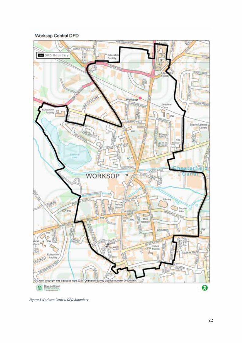
Worksop Central Area: An Overview 3.7 Worksop Town Centre is located at the heart of Worksop, which itself sits in the South West of
Bassetlaw. Worksop Centre has been identified as having a key role in the continued economic
and cultural regeneration of the District. This is in part due to Worksop being the largest retail,
leisure and employment centre within the District. The Central areas includes a number of
assets, including:
The train station for accessibility, and connections to surrounding areas in and out of the
District.
Worksop Bus Station
Worksop Library
Worksop Registry Office
Acorn Theatre
Middleton’s Business Hub
Savoy Cinema
Heritage assets including the Worksop Castle SAM
18 https://www.bassetlaw.gov.uk/media/6017/bassetlaw-hedna-nov-2020.pdf

21
The Canch Park, provides green infrastructure and access to outdoor recreational space.
Chesterfield Canal and the River Ryton both run through the centre and provide access to
blue infrastructure.
Priory Shopping Centre and adjacent pedestrianised shopping streets dominate the
character of the Town Centre.
22
Figure 1Worksop Central DPD Boundary
23
Worksop- A Thematic Overview
Population 3.8 The largest settlements within Bassetlaw are Worksop (39.4%), Retford (20.2%) and Harworth
(9.0%) which are home to around 70% of the districts population19. The town is made up of six
wards, five of which have some area within the Worksop Centre boundary.
3.9 It is worth noting that since the 2011 census Worksop has experienced significant growth,
through large housing developments, such as those in the Gateford area, which will not be
reflected in these figures.
Population Worksop Bassetlaw East Midlands United Kingdom
All Ages 43,252 117,459 4,835,928 66,796,807
Males 22,175 58,144 2,391,957 32,978,229
Females 22,077 59,315 2,443,971 33,818,578
Table 3: Population Estimates for the UK, East Midlands and Bassetlaw: Mid-2019(ONS 2019),
Worksop (ONS 2011)
Population Change
Population Worksop Bassetlaw
2011 44,458 113,003
2018 46,012 117,459
Table 4: Population figures for Worksop, Bassetlaw and East Midlands 2011-2018 (ONS Mid-Year
population estimates)
3.10 Natural change in the district has been variable with population growth of 3.4% between 2011
and 2018. This growth has largely been driven by net in-migration, and in particular internal
(domestic) migration. Analysis shows over this period that the population of Bassetlaw rose at
a lower rate in comparison with other locations (the region and nationally). In 2018, it was
estimated that the population of the District had risen by 11% from 1991 levels, this is in
contrast with a 12% increase across the County, a 20% rise across the region and a 17% increase
nationally. The ONS 201120 and 2018 Mid -Year Population Estimates show an increase in
Worksop of 1,554 people between 2011 and 2018.
Location Population Density per Hectare
Worksop 35.4
Bassetlaw 1.8
East Midlands 2.9 Table 5: Population Density per Hectare in Worksop, Bassetlaw, East Midlands (Census, ONS 2011)
3.11 It can be seen that the population density within Worksop (35.4 persons per hectare) is
significantly higher than the District average, this is due to the more urban characteristics of the
area.
Age Structure
19 https://www.bassetlaw.gov.uk/media/6017/bassetlaw-hedna-nov-2020.pdf 20 https://www.nomisweb.co.uk/reports/localarea?compare=E07000171
Worksop Bassetlaw
Count % Count %
All usual residents 43,252 100.0 112,863 100.0
24
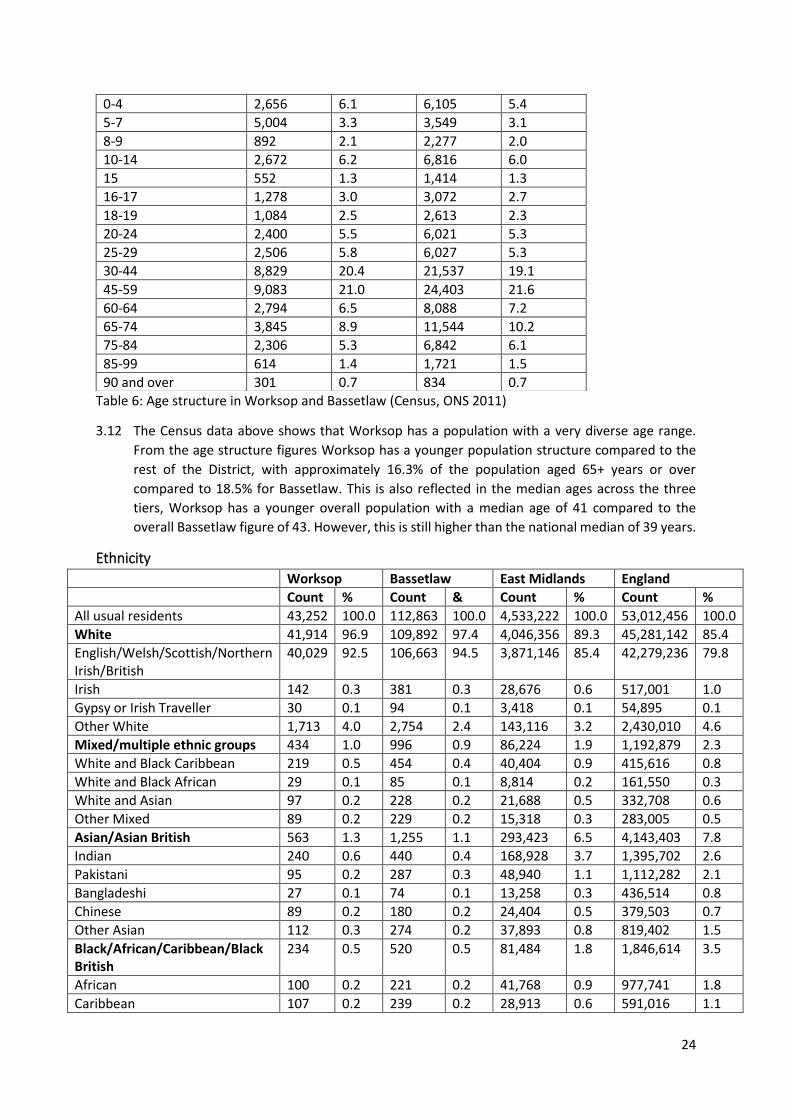
Table 6: Age structure in Worksop and Bassetlaw (Census, ONS 2011)
3.12 The Census data above shows that Worksop has a population with a very diverse age range.
From the age structure figures Worksop has a younger population structure compared to the
rest of the District, with approximately 16.3% of the population aged 65+ years or over
compared to 18.5% for Bassetlaw. This is also reflected in the median ages across the three
tiers, Worksop has a younger overall population with a median age of 41 compared to the
overall Bassetlaw figure of 43. However, this is still higher than the national median of 39 years.
Ethnicity
Worksop Bassetlaw East Midlands England
Count % Count & Count % Count %
All usual residents 43,252 100.0 112,863 100.0 4,533,222 100.0 53,012,456 100.0
White 41,914 96.9 109,892 97.4 4,046,356 89.3 45,281,142 85.4
English/Welsh/Scottish/Northern Irish/British
40,029 92.5 106,663 94.5 3,871,146 85.4 42,279,236 79.8
Irish 142 0.3 381 0.3 28,676 0.6 517,001 1.0
Gypsy or Irish Traveller 30 0.1 94 0.1 3,418 0.1 54,895 0.1
Other White 1,713 4.0 2,754 2.4 143,116 3.2 2,430,010 4.6
Mixed/multiple ethnic groups 434 1.0 996 0.9 86,224 1.9 1,192,879 2.3
White and Black Caribbean 219 0.5 454 0.4 40,404 0.9 415,616 0.8
White and Black African 29 0.1 85 0.1 8,814 0.2 161,550 0.3
White and Asian 97 0.2 228 0.2 21,688 0.5 332,708 0.6
Other Mixed 89 0.2 229 0.2 15,318 0.3 283,005 0.5
Asian/Asian British 563 1.3 1,255 1.1 293,423 6.5 4,143,403 7.8
Indian 240 0.6 440 0.4 168,928 3.7 1,395,702 2.6
Pakistani 95 0.2 287 0.3 48,940 1.1 1,112,282 2.1
Bangladeshi 27 0.1 74 0.1 13,258 0.3 436,514 0.8
Chinese 89 0.2 180 0.2 24,404 0.5 379,503 0.7
Other Asian 112 0.3 274 0.2 37,893 0.8 819,402 1.5
Black/African/Caribbean/Black British
234 0.5 520 0.5 81,484 1.8 1,846,614 3.5
African 100 0.2 221 0.2 41,768 0.9 977,741 1.8
Caribbean 107 0.2 239 0.2 28,913 0.6 591,016 1.1
0-4 2,656 6.1 6,105 5.4
5-7 5,004 3.3 3,549 3.1
8-9 892 2.1 2,277 2.0
10-14 2,672 6.2 6,816 6.0
15 552 1.3 1,414 1.3
16-17 1,278 3.0 3,072 2.7
18-19 1,084 2.5 2,613 2.3
20-24 2,400 5.5 6,021 5.3
25-29 2,506 5.8 6,027 5.3
30-44 8,829 20.4 21,537 19.1
45-59 9,083 21.0 24,403 21.6
60-64 2,794 6.5 8,088 7.2
65-74 3,845 8.9 11,544 10.2
75-84 2,306 5.3 6,842 6.1
85-99 614 1.4 1,721 1.5
90 and over 301 0.7 834 0.7
25
Worksop Bassetlaw East Midlands England
Count % Count & Count % Count %
Other Black 27 0.1 60 0.1 10,803 0.2 277,857 0.5
Other Ethnic Group 107 0.2 200 0.2 25,735 0.6 548,418 1.0
Arab 24 0.1 52 0.0 9,746 0.2 220,985 0.4
Any other ethnic group 83 0.2 148 0.1 15,989 0.4 327,433 0.6
Table 7: Ethnicity groups of Worksop, Bassetlaw, East Midlands and England (Census ONS, 2011)
3.13 When compared to the rest of the England, Worksop is less ethnically diverse, with 92.5% of
the population identifying as White British compared with 79.8% nationally. However, this is
less than the figures for Bassetlaw, where 94.5% identify as White British. This is likely to be due
to the more urban nature of towns such as Worksop, which are traditionally more diverse than
their predominately surrounding rural areas.
3.14 After White British the largest ethnic group present in Worksop is ‘Other White’, which makes
up 4% of the total population. This is higher than the 2.4% in Bassetlaw and 3.2% in the East
Midlands. This figure helps to demonstrate the number of people who have settled in Worksop
from European, namely Eastern European countries. This migration pattern is supported by the
table below, which uses Census data to identify the country of birth of residents in Worksop.
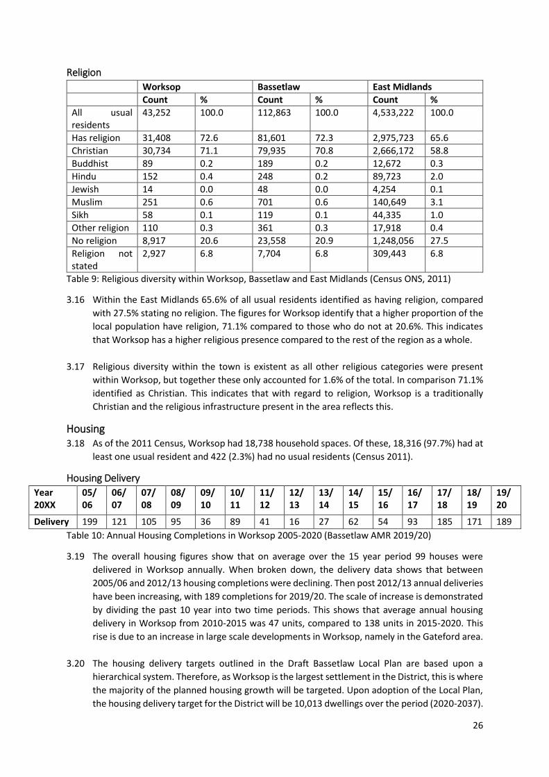
Worksop Bassetlaw East Midlands
Count % Count % Count %
All usual residents 43,252 100.0 112,863 100.0 4,533,222 100.0
United Kingdom 40,558 93.8 107,572 95.3 4,085,011 90.1
England 39,738 91.9 105,066 93.1 3,969,176 87.6
Northern Ireland 69 0.2 220 0.2 15,619 0.3
Scotland 519 1.2 1,551 1.4 66,507 1.5
Wales 230 0.5 732 0.6 33,337 0.7
UK not otherwise specified
2 0.0 3 0.0 372 0.0
Ireland 112 0.3 309 0.3 22,202 0.5
Other EU 1,652 3.8 2,779 2.5 140,372 3.1
Member countries in March 2001
281 0.6 792 0.7 48,647 1.1
Accession countries April 2001 to March 2011
1,371 3.2 1,987 1.8 91,725 2.0
Other countries 930 2.2 2,203 2.0 285,637 6.3
Table 8: Country of birth for Worksop, Bassetlaw and East Midlands (Census ONS, 2011)
3.15 The data shows that the main source of people that live in Worksop and not born in the UK are
from Europe. Immigration levels have increased in the area since the inclusion of the accession
countries to the EU, which total 3.2% of the Worksop population compared to 0.6% from the
rest of Europe. This will account for the large wave of Eastern European migration which
occurred in 2004, when citizens from countries such as Poland and Slovakia were able to move,
live and work in other EU countries. Further expansion occurred in 2007, as countries including
Bulgaria and Romania became EU accession countries. The 2011 census data does not account
for EU figures for countries which have joined since 2011, such as Croatia. A future migration
trend, will include the impact of Brexit on people’s ability to access and work in the UK.
26
Religion
Worksop Bassetlaw East Midlands
Count % Count % Count %
All usual residents
43,252 100.0 112,863 100.0 4,533,222 100.0
Has religion 31,408 72.6 81,601 72.3 2,975,723 65.6
Christian 30,734 71.1 79,935 70.8 2,666,172 58.8
Buddhist 89 0.2 189 0.2 12,672 0.3
Hindu 152 0.4 248 0.2 89,723 2.0
Jewish 14 0.0 48 0.0 4,254 0.1
Muslim 251 0.6 701 0.6 140,649 3.1
Sikh 58 0.1 119 0.1 44,335 1.0
Other religion 110 0.3 361 0.3 17,918 0.4
No religion 8,917 20.6 23,558 20.9 1,248,056 27.5
Religion not stated
2,927 6.8 7,704 6.8 309,443 6.8
Table 9: Religious diversity within Worksop, Bassetlaw and East Midlands (Census ONS, 2011)
3.16 Within the East Midlands 65.6% of all usual residents identified as having religion, compared
with 27.5% stating no religion. The figures for Worksop identify that a higher proportion of the
local population have religion, 71.1% compared to those who do not at 20.6%. This indicates
that Worksop has a higher religious presence compared to the rest of the region as a whole.
3.17 Religious diversity within the town is existent as all other religious categories were present
within Worksop, but together these only accounted for 1.6% of the total. In comparison 71.1%
identified as Christian. This indicates that with regard to religion, Worksop is a traditionally
Christian and the religious infrastructure present in the area reflects this.
Housing 3.18 As of the 2011 Census, Worksop had 18,738 household spaces. Of these, 18,316 (97.7%) had at
least one usual resident and 422 (2.3%) had no usual residents (Census 2011).
Housing Delivery
Year 20XX
05/ 06
06/ 07
07/ 08
08/ 09
09/ 10
10/ 11
11/ 12
12/ 13
13/ 14
14/ 15
15/ 16
16/ 17
17/ 18
18/ 19
19/ 20
Delivery 199 121 105 95 36 89 41 16 27 62 54 93 185 171 189
Table 10: Annual Housing Completions in Worksop 2005-2020 (Bassetlaw AMR 2019/20)
3.19 The overall housing figures show that on average over the 15 year period 99 houses were
delivered in Worksop annually. When broken down, the delivery data shows that between
2005/06 and 2012/13 housing completions were declining. Then post 2012/13 annual deliveries
have been increasing, with 189 completions for 2019/20. The scale of increase is demonstrated
by dividing the past 10 year into two time periods. This shows that average annual housing
delivery in Worksop from 2010-2015 was 47 units, compared to 138 units in 2015-2020. This
rise is due to an increase in large scale developments in Worksop, namely in the Gateford area.
3.20 The housing delivery targets outlined in the Draft Bassetlaw Local Plan are based upon a
hierarchical system. Therefore, as Worksop is the largest settlement in the District, this is where
the majority of the planned housing growth will be targeted. Upon adoption of the Local Plan,
the housing delivery target for the District will be 10,013 dwellings over the period (2020-2037).
27
With Worksop delivering a total of 3,104 dwellings, of which the Local Plan proposes to allocate
land for 1,959 homes.
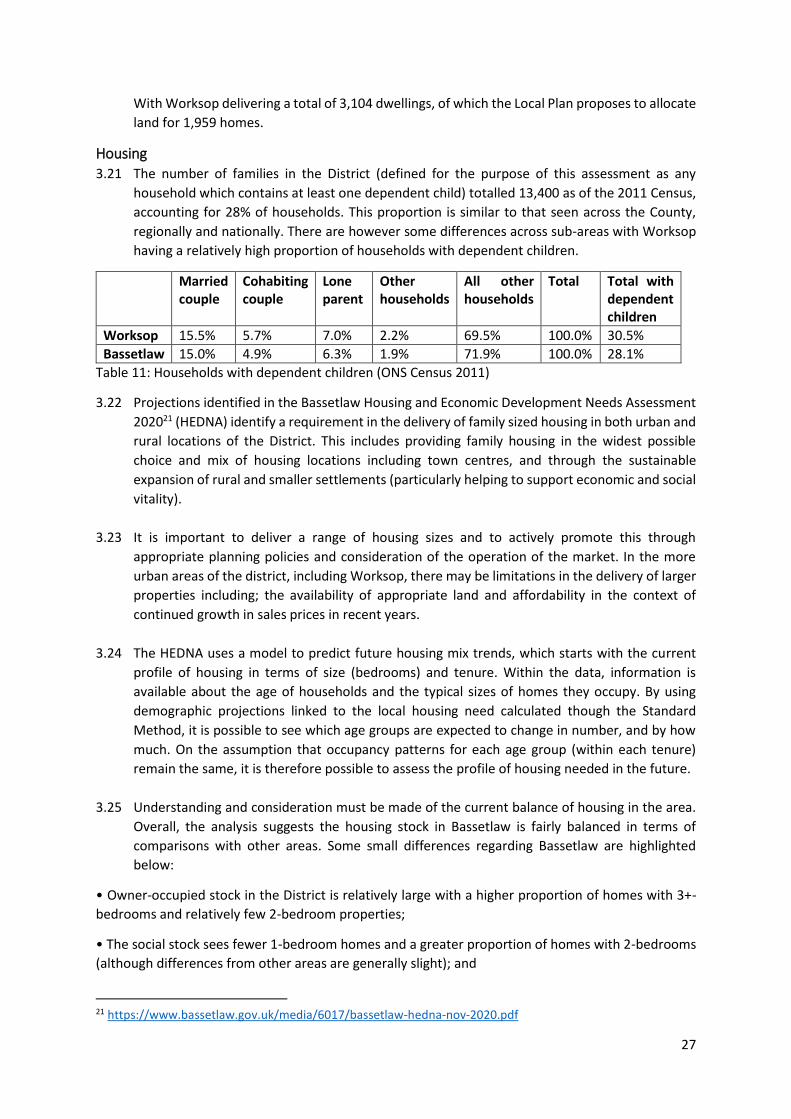
Housing 3.21 The number of families in the District (defined for the purpose of this assessment as any
household which contains at least one dependent child) totalled 13,400 as of the 2011 Census,
accounting for 28% of households. This proportion is similar to that seen across the County,
regionally and nationally. There are however some differences across sub-areas with Worksop
having a relatively high proportion of households with dependent children.
Married couple
Cohabiting couple
Lone parent
Other households
All other households
Total Total with dependent children
Worksop 15.5% 5.7% 7.0% 2.2% 69.5% 100.0% 30.5%
Bassetlaw 15.0% 4.9% 6.3% 1.9% 71.9% 100.0% 28.1%
Table 11: Households with dependent children (ONS Census 2011)
3.22 Projections identified in the Bassetlaw Housing and Economic Development Needs Assessment
202021 (HEDNA) identify a requirement in the delivery of family sized housing in both urban and
rural locations of the District. This includes providing family housing in the widest possible
choice and mix of housing locations including town centres, and through the sustainable
expansion of rural and smaller settlements (particularly helping to support economic and social
vitality).
3.23 It is important to deliver a range of housing sizes and to actively promote this through
appropriate planning policies and consideration of the operation of the market. In the more
urban areas of the district, including Worksop, there may be limitations in the delivery of larger
properties including; the availability of appropriate land and affordability in the context of
continued growth in sales prices in recent years.
3.24 The HEDNA uses a model to predict future housing mix trends, which starts with the current
profile of housing in terms of size (bedrooms) and tenure. Within the data, information is
available about the age of households and the typical sizes of homes they occupy. By using
demographic projections linked to the local housing need calculated though the Standard
Method, it is possible to see which age groups are expected to change in number, and by how
much. On the assumption that occupancy patterns for each age group (within each tenure)
remain the same, it is therefore possible to assess the profile of housing needed in the future.
3.25 Understanding and consideration must be made of the current balance of housing in the area.
Overall, the analysis suggests the housing stock in Bassetlaw is fairly balanced in terms of
comparisons with other areas. Some small differences regarding Bassetlaw are highlighted
below:
• Owner-occupied stock in the District is relatively large with a higher proportion of homes with 3+-
bedrooms and relatively few 2-bedroom properties;
• The social stock sees fewer 1-bedroom homes and a greater proportion of homes with 2-bedrooms
(although differences from other areas are generally slight); and
21 https://www.bassetlaw.gov.uk/media/6017/bassetlaw-hedna-nov-2020.pdf
28
• The private rented sector is relatively large with a higher proportion of homes with 3+-bedrooms;
whilst the proportion of 1-bedroom homes looks to be low in a national context it should be noted
that the figures for England are to some degree influenced by the stock profile of London.
3.26 The finding of a low proportion of a particular size of home in a particular tenure does not
necessarily point towards a shortage of that type of housing. To some extent the profile of stock
will reflect the role and function of different areas. For example, the extent to which Bassetlaw
has traditionally been an area that is attractive to family households may partly explain the
larger stock in the owner-occupied sector.
3.27 In Worksop between 1st April 2019 and 31st March 2020 a high proportion of larger, family sized
houses/bungalows with three or more bedroom units were delivered, with smaller one and two
bedroom units predominantly being delivered though apartments and flats. This continues a
trend from previous years and aligns with policies proposed in the Draft Local Plan which
attempt to ensure that a mix of housing types and tenures will be delivered across the District
and within Worksop. While taking into consideration various site characteristics, development
viability and the Council’s Housing Strategy (HLAPS 2019/20).
3.28 With regard to current housing stock in Worksop, on June 3rd 2020, an Article 4(1) Direction was
confirmed to withdraw permitted development rights for changing properties to Houses in
Multiple Occupation (HMOs) within the Worksop Central Area. As a result, planning permission
is required to change a house to a House in Multiple Occupation. This was done to protect the
housing mix and the number of larger properties in the affected area and to protect the
character of buildings and the local environment in central Worksop. Currently there are 42
HMOs within Worksop, with 31 being located within the Central Area DPD boundary22.
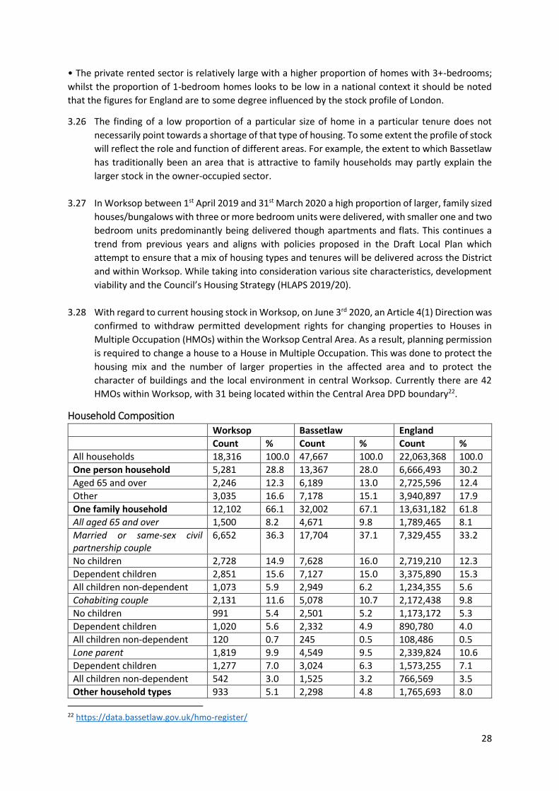
Household Composition
Worksop Bassetlaw England
Count % Count % Count %
All households 18,316 100.0 47,667 100.0 22,063,368 100.0
One person household 5,281 28.8 13,367 28.0 6,666,493 30.2
Aged 65 and over 2,246 12.3 6,189 13.0 2,725,596 12.4
Other 3,035 16.6 7,178 15.1 3,940,897 17.9
One family household 12,102 66.1 32,002 67.1 13,631,182 61.8
All aged 65 and over 1,500 8.2 4,671 9.8 1,789,465 8.1
Married or same-sex civil partnership couple
6,652 36.3 17,704 37.1 7,329,455 33.2
No children 2,728 14.9 7,628 16.0 2,719,210 12.3
Dependent children 2,851 15.6 7,127 15.0 3,375,890 15.3
All children non-dependent 1,073 5.9 2,949 6.2 1,234,355 5.6
Cohabiting couple 2,131 11.6 5,078 10.7 2,172,438 9.8
No children 991 5.4 2,501 5.2 1,173,172 5.3
Dependent children 1,020 5.6 2,332 4.9 890,780 4.0
All children non-dependent 120 0.7 245 0.5 108,486 0.5
Lone parent 1,819 9.9 4,549 9.5 2,339,824 10.6
Dependent children 1,277 7.0 3,024 6.3 1,573,255 7.1
All children non-dependent 542 3.0 1,525 3.2 766,569 3.5
Other household types 933 5.1 2,298 4.8 1,765,693 8.0
22 https://data.bassetlaw.gov.uk/hmo-register/
29
Worksop Bassetlaw England
Count % Count % Count %
With dependent children 395 2.2 923 1.9 584,016 2.6
All full-time students 0 0.0 1 0.0 124,285 0.6
All aged 65 and over 37 0.2 124 0.3 61,715 0.3
Other 501 2.7 1250 2.6 995,677 4.5
Table 12: Household composition for Worksop, Bassetlaw and England (ONS Census 2011)
3.29 Household composition in Worksop is predominantly one family households (66.1%), of which
36.3% consist of married or same-sex civil partnership couple households. Across all variables,
the figures align closely with national trends.
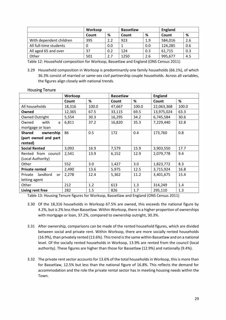
Housing Tenure
Worksop Bassetlaw England
Count % Count % Count %
All households 18,316 100.0 47,667 100.0 22,063,368 100.0
Owned 12,365 67.5 33,115 69.5 13,975,024 63.3
Owned Outright 5,554 30.3 16,295 34.2 6,745,584 30.6
Owned with a mortgage or loan
6,811 37.2 16,820 35.3 7,229,440 32.8
Shared ownership (part owned and part rented)
86 0.5 172 0.4 173,760 0.8
Social Rented 3,093 16.9 7,579 15.9 3,903,550 17.7
Rented from council (Local Authority)
2,541 13.9 6,152 12.9 2,079,778 9.4
Other 552 3.0 1,427 3.0 1,823,772 8.3
Private rented 2,490 13.6 5,975 12.5 3,715,924 16.8
Private landlord or letting agent
2,278 12.4 5,362 11.2 3,401,675 15.4
Other 212 1.2 613 1.3 314,249 1.4
Living rent free 282 1.5 826 1.7 295,110 1.3 Table 13: Housing Tenure figures for Worksop, Bassetlaw and England (ONS Census 2011)
3.30 Of the 18,316 households in Worksop 67.5% are owned, this exceeds the national figure by
4.2%, but is 2% less than Bassetlaw. Within Worksop, there is a higher proportion of ownerships
with mortgage or loan, 37.2%, compared to ownership outright, 30.3%.
3.31 After ownership, comparisons can be made of the rented household figures, which are divided
between social and private rent. Within Worksop, there are more socially rented households
(16.9%), than privately rented (13.6%). This trend is the same within Bassetlaw and on a national
level. Of the socially rented households in Worksop, 13.9% are rented from the council (local
authority). These figures are higher than those for Bassetlaw (12.9%) and nationally (9.4%).
3.32 The private rent sector accounts for 13.6% of the total households in Worksop, this is more than
for Bassetlaw, 12.5% but less than the national figure of 16.8%. This reflects the demand for
accommodation and the role the private rental sector has in meeting housing needs within the
Town.
30
Housing Market 3.33 In the 12 months to March 2020, house prices in Bassetlaw grew by 3.9%. In comparison over
the same period, house prices grew 1.2% nationally and by 1.7% in the East Midlands23. This
demonstrates that house prices in Bassetlaw are following national trends by increasing
Annual Average (2015-2020)
12 months to February 2018
12 months to February 2019
New Flats 7 0 0
New Houses 55 93 78
Second Hand Flats 19 15 12
Second Hound Houses 635 642 521
Table 14: Housing transactions by Type February 2018-2019, Worksop (Built Place, Cities, Towns and
Villages Housing Market Reports, 2020)
3.34 When examining housing transactions for Worksop from February 2018-2019 it is clear that the
most common property type transacted was second hand houses. Which when examined from
2015-2020, totals 635 sales per year on average, making up 89% of the typical annual total over
this period24.
Under £100k
£100-£200K
£200-£300k
£300-£400k
£400-£500k
£500k- £1m
£1m+
Jan-June 2020
21% 48% 19% 8% 2% 1% 0%
Table 15: All Bassetlaw properties by price band from January-June 2020 (Detailed Price Paid Report:
Bassetlaw, Built Place June 2020)
3.35 The median price for a second hand house in Worksop is £129,265. This cost is much lower than
the median price for a new build house which is £232,000. In Bassetlaw, 48% of all properties
fall within the £100,000-£200,000 price band25. From the data sets above it can be deduced that
the majority of homes sold within Worksop also fall within the £100,000-£200,000 price band.
This is supported by Zoopla which calculates the average price for property in Worksop stood
at £172,526 in September 202026.
Deprivation and Crime 3.36 The Indices of Multiple Deprivation (IMD) measures relative levels of deprivation in 32,844 small
areas or neighbourhoods. In England, these are known as Lower-layer Super Output Areas
(LSOA), and have populations between 1,000 to 1,500 people. The data enables pattern analysis
and comparisons to be made between areas. The Indices of Depravation 201927 is based on
seven domains of deprivation, which are given different weight and combined to produce the
overall Index of Multiple Deprivation. The seven domains include education and health. The
seven domains and weights are: income deprivation (22.5%), employment deprivation (22.5%),
Education, skills and training deprivation (13.5%), health deprivation and disability (13.5%),
crime (9.3%), barriers to housing and services (9.3%), living environment deprivation (9.3%).
23 https://builtplace.com/subscribers/local-markets/la-reports/ 24 https://builtplace.com/wp-content/uploads/reports/Market-BUA/2020-06/E35001286.pdf 25 https://builtplace.com/wp-content/uploads/reports/Market-BUA/2020-06/E35001286.pdf 26 https://www.zoopla.co.uk/house-prices/worksop/ 27 https://www.gov.uk/government/statistics/english-indices-of-deprivation-2019
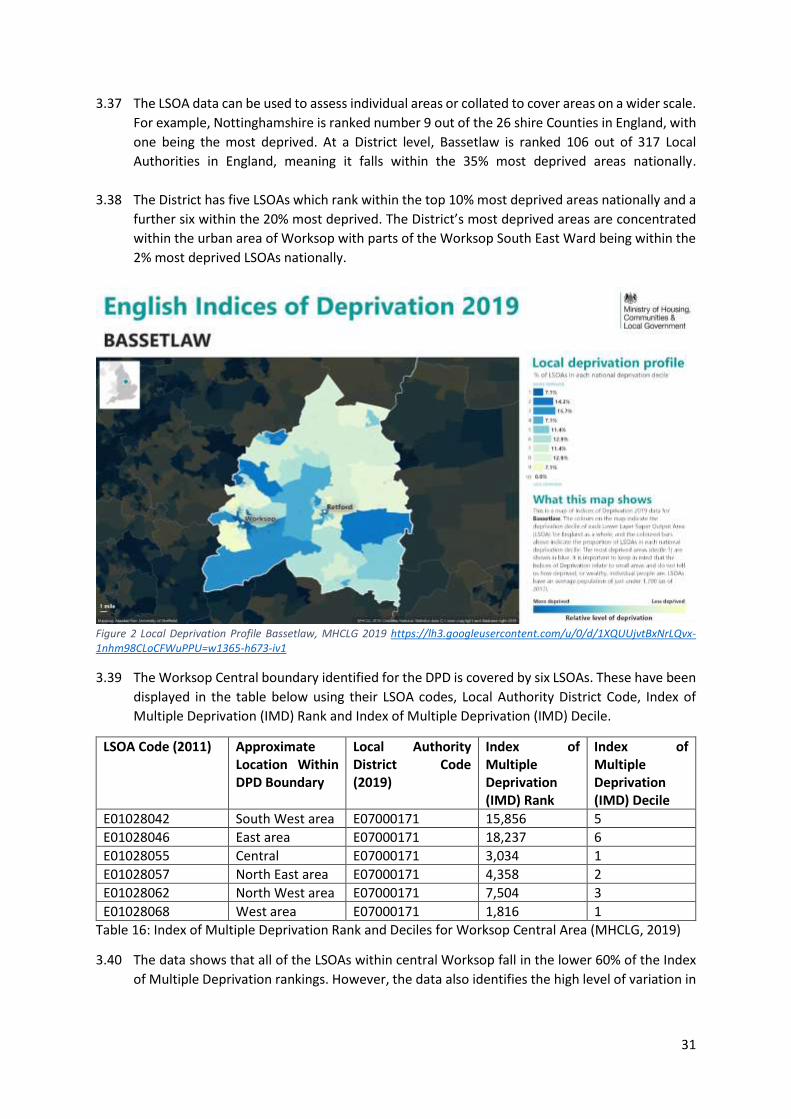
31
3.37 The LSOA data can be used to assess individual areas or collated to cover areas on a wider scale.
For example, Nottinghamshire is ranked number 9 out of the 26 shire Counties in England, with
one being the most deprived. At a District level, Bassetlaw is ranked 106 out of 317 Local
Authorities in England, meaning it falls within the 35% most deprived areas nationally.
3.38 The District has five LSOAs which rank within the top 10% most deprived areas nationally and a
further six within the 20% most deprived. The District’s most deprived areas are concentrated
within the urban area of Worksop with parts of the Worksop South East Ward being within the
2% most deprived LSOAs nationally.
Figure 2 Local Deprivation Profile Bassetlaw, MHCLG 2019 https://lh3.googleusercontent.com/u/0/d/1XQUUjvtBxNrLQvx-1nhm98CLoCFWuPPU=w1365-h673-iv1
3.39 The Worksop Central boundary identified for the DPD is covered by six LSOAs. These have been
displayed in the table below using their LSOA codes, Local Authority District Code, Index of
Multiple Deprivation (IMD) Rank and Index of Multiple Deprivation (IMD) Decile.
LSOA Code (2011) Approximate Location Within DPD Boundary
Local Authority District Code (2019)
Index of Multiple Deprivation (IMD) Rank
Index of Multiple Deprivation (IMD) Decile
E01028042 South West area E07000171 15,856 5
E01028046 East area E07000171 18,237 6
E01028055 Central E07000171 3,034 1
E01028057 North East area E07000171 4,358 2
E01028062 North West area E07000171 7,504 3
E01028068 West area E07000171 1,816 1 Table 16: Index of Multiple Deprivation Rank and Deciles for Worksop Central Area (MHCLG, 2019)
3.40 The data shows that all of the LSOAs within central Worksop fall in the lower 60% of the Index
of Multiple Deprivation rankings. However, the data also identifies the high level of variation in
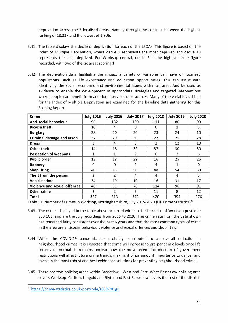
32
deprivation across the 6 localised areas. Namely through the contrast between the highest
ranking of 18,237 and the lowest of 1,806.
3.41 The table displays the decile of deprivation for each of the LSOAs. This figure is based on the
Index of Multiple Deprivation, where decile 1 represents the most deprived and decile 10
represents the least deprived. For Worksop central, decile 6 is the highest decile figure
recorded, with two of the six areas scoring 1.
3.42 The deprivation data highlights the impact a variety of variables can have on localised
populations, such as life expectancy and education opportunities. This can assist with
identifying the social, economic and environmental issues within an area. And be used as
evidence to enable the development of appropriate strategies and targeted interventions
where people can benefit from additional services or resources. Many of the variables utilised
for the Index of Multiple Deprivation are examined for the baseline data gathering for this
Scoping Report.
Crime July 2015 July 2016 July 2017 July 2018 July 2019 July 2020
Anti-social behaviour 96 132 100 111 80 99
Bicycle theft 10 4 0 6 1 5
Burglary 28 20 20 23 24 10
Criminal damage and arson 37 29 30 27 25 28
Drugs 3 4 3 3 12 10
Other theft 14 18 39 37 30 30
Possession of weapons 1 1 2 0 3 6
Public order 12 18 29 16 25 26
Robbery 0 0 4 4 1 0
Shoplifting 40 13 50 48 54 39
Theft from the person 2 2 4 4 4 3
Vehicle crime 34 19 10 16 31 17
Violence and sexual offences 48 51 78 114 96 91
Other crime 2 2 3 11 8 12
Total 327 313 372 420 394 376 Table 17: Number of Crimes in Worksop, Nottinghamshire, July 2015-2020 (UK Crime Statistics)28
3.43 The crimes displayed in the table above occurred within a 1 mile radius of Worksop postcode
S80 1GS, and are the July recordings from 2015 to 2020. The crime rate from the data shown
has remained fairly consistent over the past 6 years and that the most common types of crime
in the area are antisocial behaviour, violence and sexual offences and shoplifting.
3.44 While the COVID-19 pandemic has probably contributed to an overall reduction in
neighbourhood crimes, it is expected that crime will increase to pre-pandemic levels once life
returns to normal. It remains unclear how the most recent introduction of government
restrictions will affect future crime trends, making it of paramount importance to deliver and
invest in the most robust and best evidenced solutions for preventing neighbourhood crime.
3.45 There are two policing areas within Bassetlaw - West and East. West Bassetlaw policing area
covers Worksop, Carlton, Langold and Blyth, and East Bassetlaw covers the rest of the district.
28 https://crime-statistics.co.uk/postcode/s80%201gs
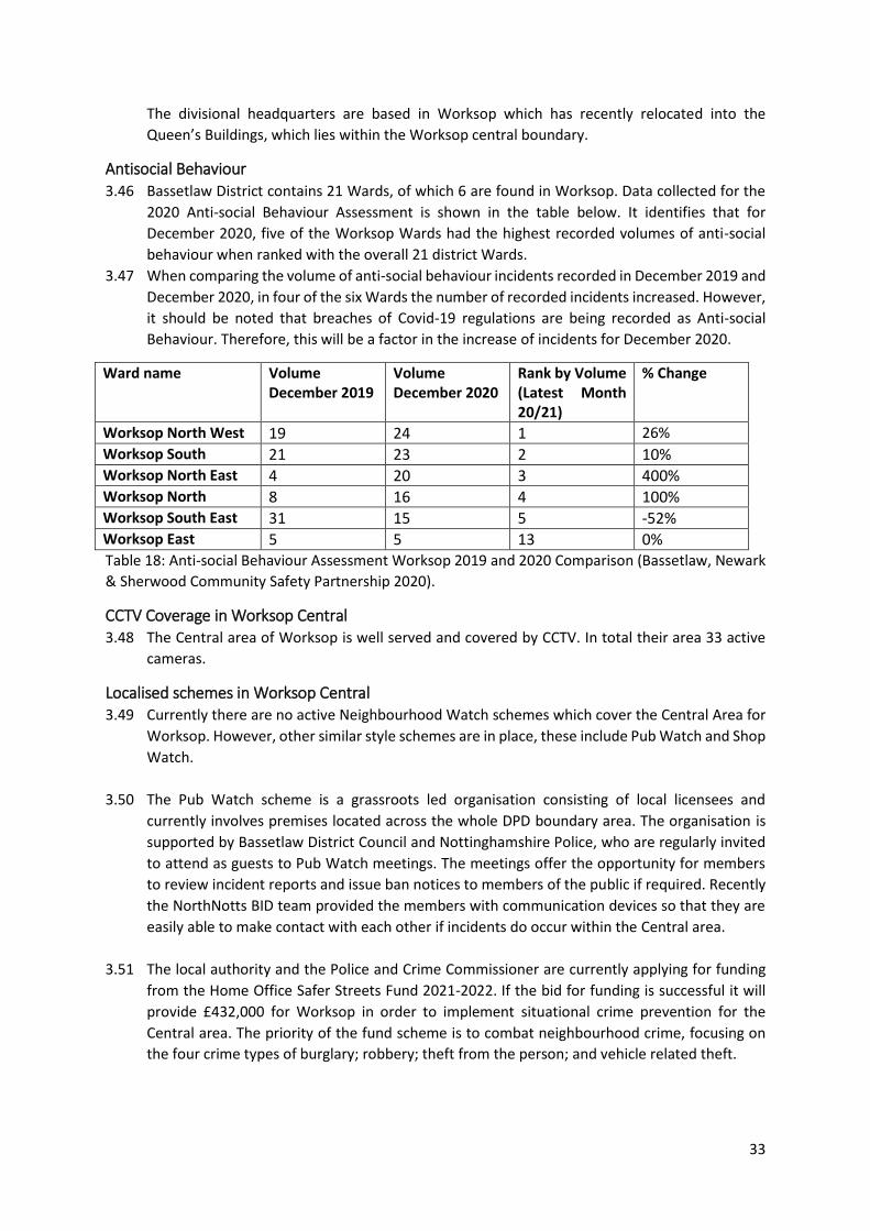
33
The divisional headquarters are based in Worksop which has recently relocated into the
Queen’s Buildings, which lies within the Worksop central boundary.
Antisocial Behaviour 3.46 Bassetlaw District contains 21 Wards, of which 6 are found in Worksop. Data collected for the
2020 Anti-social Behaviour Assessment is shown in the table below. It identifies that for
December 2020, five of the Worksop Wards had the highest recorded volumes of anti-social
behaviour when ranked with the overall 21 district Wards.
3.47 When comparing the volume of anti-social behaviour incidents recorded in December 2019 and
December 2020, in four of the six Wards the number of recorded incidents increased. However,
it should be noted that breaches of Covid-19 regulations are being recorded as Anti-social
Behaviour. Therefore, this will be a factor in the increase of incidents for December 2020.
Ward name Volume December 2019
Volume December 2020
Rank by Volume (Latest Month 20/21)
% Change
Worksop North West 19 24 1 26%
Worksop South 21 23 2 10% Worksop North East 4 20 3 400% Worksop North 8 16 4 100% Worksop South East 31 15 5 -52% Worksop East 5 5 13 0% Table 18: Anti-social Behaviour Assessment Worksop 2019 and 2020 Comparison (Bassetlaw, Newark
& Sherwood Community Safety Partnership 2020).
CCTV Coverage in Worksop Central 3.48 The Central area of Worksop is well served and covered by CCTV. In total their area 33 active
cameras.
Localised schemes in Worksop Central 3.49 Currently there are no active Neighbourhood Watch schemes which cover the Central Area for
Worksop. However, other similar style schemes are in place, these include Pub Watch and Shop
Watch.
3.50 The Pub Watch scheme is a grassroots led organisation consisting of local licensees and
currently involves premises located across the whole DPD boundary area. The organisation is
supported by Bassetlaw District Council and Nottinghamshire Police, who are regularly invited
to attend as guests to Pub Watch meetings. The meetings offer the opportunity for members
to review incident reports and issue ban notices to members of the public if required. Recently
the NorthNotts BID team provided the members with communication devices so that they are
easily able to make contact with each other if incidents do occur within the Central area.
3.51 The local authority and the Police and Crime Commissioner are currently applying for funding
from the Home Office Safer Streets Fund 2021-2022. If the bid for funding is successful it will
provide £432,000 for Worksop in order to implement situational crime prevention for the
Central area. The priority of the fund scheme is to combat neighbourhood crime, focusing on
the four crime types of burglary; robbery; theft from the person; and vehicle related theft.
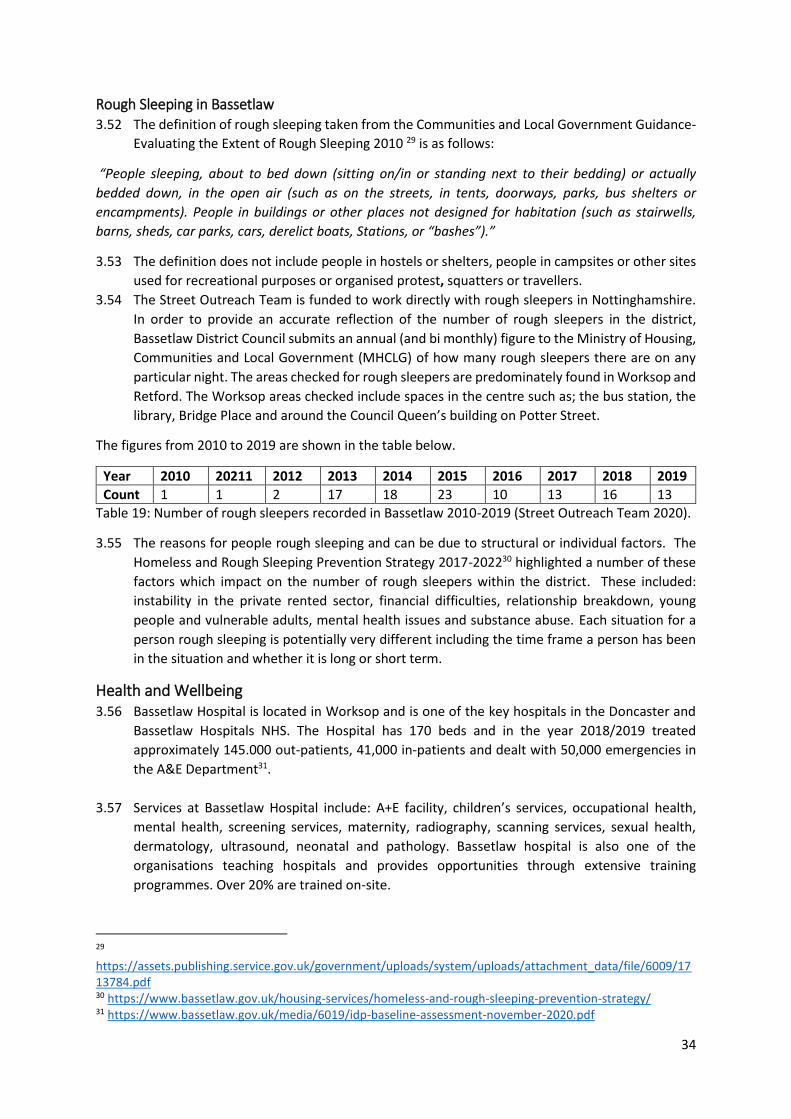
34
Rough Sleeping in Bassetlaw 3.52 The definition of rough sleeping taken from the Communities and Local Government Guidance-
Evaluating the Extent of Rough Sleeping 2010 29 is as follows:
“People sleeping, about to bed down (sitting on/in or standing next to their bedding) or actually
bedded down, in the open air (such as on the streets, in tents, doorways, parks, bus shelters or
encampments). People in buildings or other places not designed for habitation (such as stairwells,
barns, sheds, car parks, cars, derelict boats, Stations, or “bashes”).”
3.53 The definition does not include people in hostels or shelters, people in campsites or other sites
used for recreational purposes or organised protest, squatters or travellers.
3.54 The Street Outreach Team is funded to work directly with rough sleepers in Nottinghamshire.
In order to provide an accurate reflection of the number of rough sleepers in the district,
Bassetlaw District Council submits an annual (and bi monthly) figure to the Ministry of Housing,
Communities and Local Government (MHCLG) of how many rough sleepers there are on any
particular night. The areas checked for rough sleepers are predominately found in Worksop and
Retford. The Worksop areas checked include spaces in the centre such as; the bus station, the
library, Bridge Place and around the Council Queen’s building on Potter Street.
The figures from 2010 to 2019 are shown in the table below.
Year 2010 20211 2012 2013 2014 2015 2016 2017 2018 2019
Count 1 1 2 17 18 23 10 13 16 13 Table 19: Number of rough sleepers recorded in Bassetlaw 2010-2019 (Street Outreach Team 2020).
3.55 The reasons for people rough sleeping and can be due to structural or individual factors. The
Homeless and Rough Sleeping Prevention Strategy 2017-202230 highlighted a number of these
factors which impact on the number of rough sleepers within the district. These included:
instability in the private rented sector, financial difficulties, relationship breakdown, young
people and vulnerable adults, mental health issues and substance abuse. Each situation for a
person rough sleeping is potentially very different including the time frame a person has been
in the situation and whether it is long or short term.
Health and Wellbeing 3.56 Bassetlaw Hospital is located in Worksop and is one of the key hospitals in the Doncaster and
Bassetlaw Hospitals NHS. The Hospital has 170 beds and in the year 2018/2019 treated
approximately 145.000 out-patients, 41,000 in-patients and dealt with 50,000 emergencies in
the A&E Department31.
3.57 Services at Bassetlaw Hospital include: A+E facility, children’s services, occupational health,
mental health, screening services, maternity, radiography, scanning services, sexual health,
dermatology, ultrasound, neonatal and pathology. Bassetlaw hospital is also one of the
organisations teaching hospitals and provides opportunities through extensive training
programmes. Over 20% are trained on-site.
29 https://assets.publishing.service.gov.uk/government/uploads/system/uploads/attachment_data/file/6009/1713784.pdf 30 https://www.bassetlaw.gov.uk/housing-services/homeless-and-rough-sleeping-prevention-strategy/ 31 https://www.bassetlaw.gov.uk/media/6019/idp-baseline-assessment-november-2020.pdf
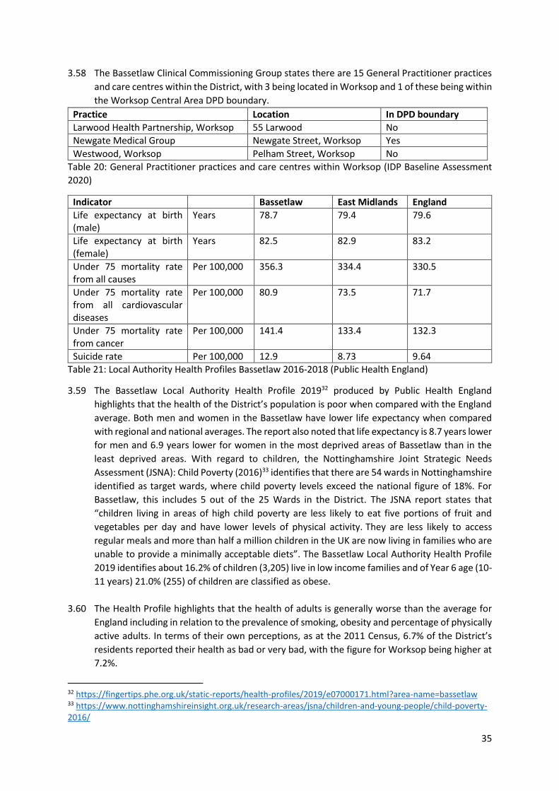
35
3.58 The Bassetlaw Clinical Commissioning Group states there are 15 General Practitioner practices
and care centres within the District, with 3 being located in Worksop and 1 of these being within
the Worksop Central Area DPD boundary.
Practice Location In DPD boundary
Larwood Health Partnership, Worksop 55 Larwood No
Newgate Medical Group Newgate Street, Worksop Yes
Westwood, Worksop Pelham Street, Worksop No
Table 20: General Practitioner practices and care centres within Worksop (IDP Baseline Assessment
2020)
Indicator Bassetlaw East Midlands England
Life expectancy at birth (male)
Years 78.7 79.4 79.6
Life expectancy at birth (female)
Years 82.5 82.9 83.2
Under 75 mortality rate from all causes
Per 100,000 356.3 334.4 330.5
Under 75 mortality rate from all cardiovascular diseases
Per 100,000 80.9 73.5 71.7
Under 75 mortality rate from cancer
Per 100,000 141.4 133.4 132.3
Suicide rate Per 100,000 12.9 8.73 9.64 Table 21: Local Authority Health Profiles Bassetlaw 2016-2018 (Public Health England)
3.59 The Bassetlaw Local Authority Health Profile 201932 produced by Public Health England
highlights that the health of the District’s population is poor when compared with the England
average. Both men and women in the Bassetlaw have lower life expectancy when compared
with regional and national averages. The report also noted that life expectancy is 8.7 years lower
for men and 6.9 years lower for women in the most deprived areas of Bassetlaw than in the
least deprived areas. With regard to children, the Nottinghamshire Joint Strategic Needs
Assessment (JSNA): Child Poverty (2016)33 identifies that there are 54 wards in Nottinghamshire
identified as target wards, where child poverty levels exceed the national figure of 18%. For
Bassetlaw, this includes 5 out of the 25 Wards in the District. The JSNA report states that
“children living in areas of high child poverty are less likely to eat five portions of fruit and
vegetables per day and have lower levels of physical activity. They are less likely to access
regular meals and more than half a million children in the UK are now living in families who are
unable to provide a minimally acceptable diets”. The Bassetlaw Local Authority Health Profile
2019 identifies about 16.2% of children (3,205) live in low income families and of Year 6 age (10-
11 years) 21.0% (255) of children are classified as obese.
3.60 The Health Profile highlights that the health of adults is generally worse than the average for
England including in relation to the prevalence of smoking, obesity and percentage of physically
active adults. In terms of their own perceptions, as at the 2011 Census, 6.7% of the District’s
residents reported their health as bad or very bad, with the figure for Worksop being higher at
7.2%.
32 https://fingertips.phe.org.uk/static-reports/health-profiles/2019/e07000171.html?area-name=bassetlaw 33 https://www.nottinghamshireinsight.org.uk/research-areas/jsna/children-and-young-people/child-poverty-2016/
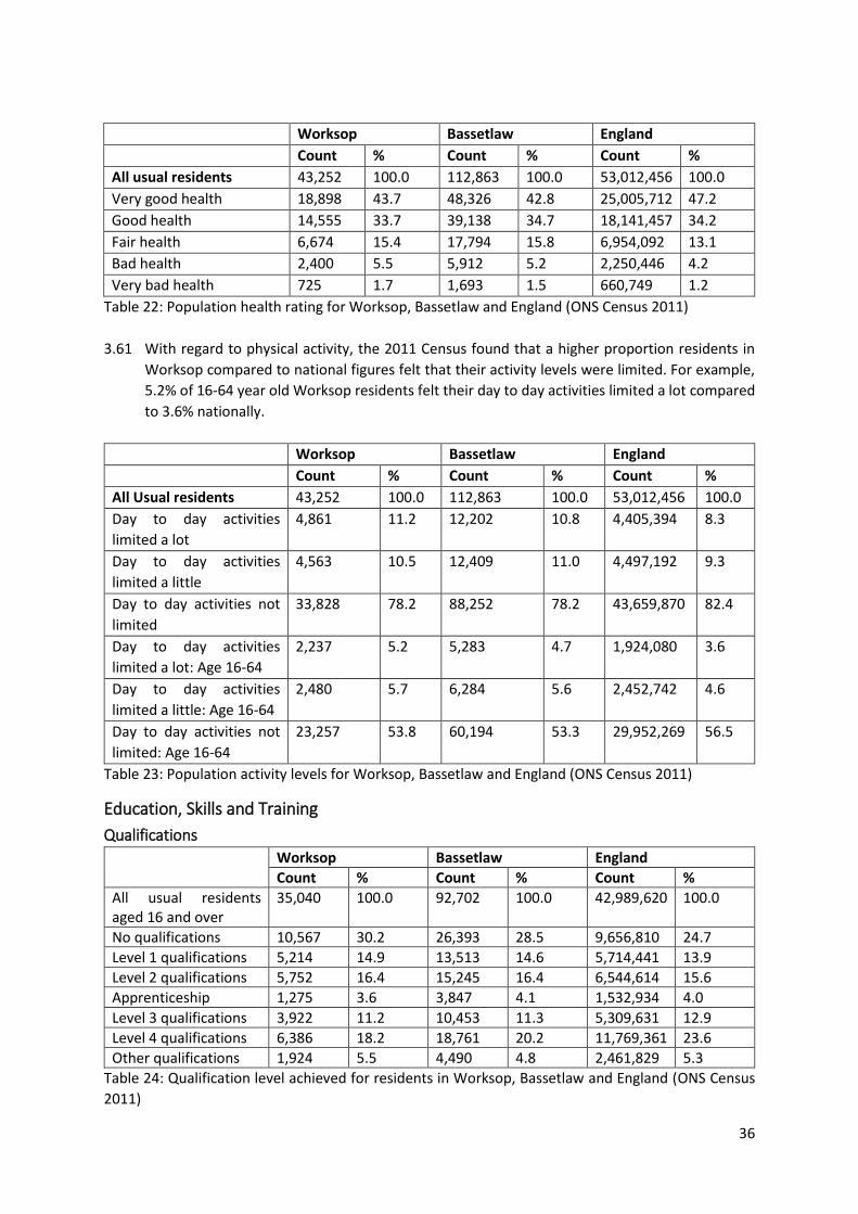
36
Worksop Bassetlaw England
Count % Count % Count %
All usual residents 43,252 100.0 112,863 100.0 53,012,456 100.0
Very good health 18,898 43.7 48,326 42.8 25,005,712 47.2
Good health 14,555 33.7 39,138 34.7 18,141,457 34.2
Fair health 6,674 15.4 17,794 15.8 6,954,092 13.1
Bad health 2,400 5.5 5,912 5.2 2,250,446 4.2
Very bad health 725 1.7 1,693 1.5 660,749 1.2
Table 22: Population health rating for Worksop, Bassetlaw and England (ONS Census 2011)
3.61 With regard to physical activity, the 2011 Census found that a higher proportion residents in
Worksop compared to national figures felt that their activity levels were limited. For example,
5.2% of 16-64 year old Worksop residents felt their day to day activities limited a lot compared
to 3.6% nationally.
Worksop Bassetlaw England
Count % Count % Count %
All Usual residents 43,252 100.0 112,863 100.0 53,012,456 100.0
Day to day activities
limited a lot
4,861 11.2 12,202 10.8 4,405,394 8.3
Day to day activities
limited a little
4,563 10.5 12,409 11.0 4,497,192 9.3
Day to day activities not
limited
33,828 78.2 88,252 78.2 43,659,870 82.4
Day to day activities
limited a lot: Age 16-64
2,237 5.2 5,283 4.7 1,924,080 3.6
Day to day activities
limited a little: Age 16-64
2,480 5.7 6,284 5.6 2,452,742 4.6
Day to day activities not
limited: Age 16-64
23,257 53.8 60,194 53.3 29,952,269 56.5
Table 23: Population activity levels for Worksop, Bassetlaw and England (ONS Census 2011)
Education, Skills and Training
Qualifications
Worksop Bassetlaw England
Count % Count % Count %
All usual residents aged 16 and over
35,040 100.0 92,702 100.0 42,989,620 100.0
No qualifications 10,567 30.2 26,393 28.5 9,656,810 24.7
Level 1 qualifications 5,214 14.9 13,513 14.6 5,714,441 13.9
Level 2 qualifications 5,752 16.4 15,245 16.4 6,544,614 15.6
Apprenticeship 1,275 3.6 3,847 4.1 1,532,934 4.0
Level 3 qualifications 3,922 11.2 10,453 11.3 5,309,631 12.9
Level 4 qualifications 6,386 18.2 18,761 20.2 11,769,361 23.6
Other qualifications 1,924 5.5 4,490 4.8 2,461,829 5.3
Table 24: Qualification level achieved for residents in Worksop, Bassetlaw and England (ONS Census
2011)
37
3.62 At the time this data was collected for the 2011 census, it was under previous Governmental
legislation where it was compulsory for young people to remain in education until the age of
16. A change in the law in 2013 now requires that young people continue in education until the
age of 18. The implications of this include; an increase in the number of full-time students, an
increase in the number of people able to access education and higher level qualifications and a
reduction in unemployment levels within the 16-18 age bracket.
3.63 With regard to the 2011 census data, it shows that 30.2% of residents in Worksop had no
qualifications, which exceeds the no qualification rate for both Bassetlaw (28.5%) and England
(24.7%).
3.64 The data shows that the number of residents in Worksop with Level 1 and 2 qualifications
exceeded national percentages. Whereas, the apprenticeship, Level 3 and Level 4 qualifications
for Worksop all fall below the national rate.
Education
Education Level Number of facilities in Worksop
Primary 12
Secondary 2
16-18 2
Table 25: Number of education facilities in Worksop (Bassetlaw IDP Baseline Assessment 2020)
3.65 The table above shows that Worksop has a number of education facilities which are spread
across Worksop.
3.66 To the North of Worksop Central area and within the Masterplan boundary is North Notts
College, which is part of the wider RNN Group. The College provides courses and
Apprenticeships for school leavers and adults including Higher Education and skills and
specialises in a technical and career focused training and education. The college offers study
opportunities from entry level through to level 3 (Equivalent level to A-Levels) as well as Higher
Education level courses. The site also houses the National Fluid Power Centre.
3.67 Worksop does not have a University, but it was announced in February 2021, that due to
Bassetlaw District Council securing a £3.5 million share of the D2N2 Get Building Fund; a new
educational facility – the Worksop Access to Skills Hub (WASH) - will be created though the refurbishment of a long-term vacant building in Worksop Centre. The development will create
50 jobs and support 300 learners34. The project will be delivered in partnership with the RNN
Group (of Colleges) and the University of Derby, who will provide skills and training along with
access to University-level education for communities and businesses. Courses will be available
in a range of subjects including health and social care; digital and digital transformation; green
technologies and low carbon and construction. The planned location for the site is on Bridge
Court, in the centre of the town and the Masterplan boundary.
34 https://www.d2n2growthhub.co.uk/news/latest-news/d2n2-funding-of-3-5m-awarded-to-create-worksop-access-to-skills-hub/
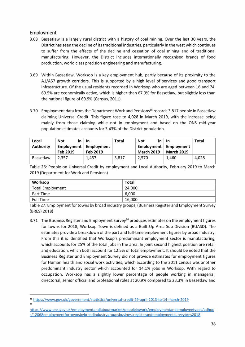
38
Employment 3.68 Bassetlaw is a largely rural district with a history of coal mining. Over the last 30 years, the
District has seen the decline of its traditional industries, particularly in the west which continues
to suffer from the effects of the decline and cessation of coal mining and of traditional
manufacturing. However, the District includes internationally recognised brands of food
production, world class precision engineering and manufacturing.
3.69 Within Bassetlaw, Worksop is a key employment hub, partly because of its proximity to the
A1/A57 growth corridors. This is supported by a high level of services and good transport
infrastructure. Of the usual residents recorded in Worksop who are aged between 16 and 74,
69.5% are economically active, which is higher than 67.9% for Bassetlaw, but slightly less than
the national figure of 69.9% (Census, 2011).
3.70 Employment data from the Department Work and Pensions35 records 3,817 people in Bassetlaw
claiming Universal Credit. This figure rose to 4,028 in March 2019, with the increase being
mainly from those claiming while not in employment and based on the ONS mid-year
population estimates accounts for 3.43% of the District population.
Local Authority
Not in Employment Feb 2019
In Employment Feb 2019
Total Not in Employment March 2019
In Employment March 2019
Total
Bassetlaw 2,357 1,457 3,817 2,570 1,460 4,028
Table 26: People on Universal Credit by employment and Local Authority, February 2019 to March
2019 (Department for Work and Pensions)
Worksop Total
Total Employment 24,000
Part Time 6,000
Full Time 16,000
Table 27: Employment for towns by broad industry groups, (Business Register and Employment Survey
(BRES) 2018)
3.71 The Business Register and Employment Survey36 produces estimates on the employment figures
for towns for 2018; Worksop Town is defined as a Built Up Area Sub Division (BUASD). The
estimates provide a breakdown of the part and full-time employment figures by broad industry.
From this it is identified that Worksop’s predominant employment sector is manufacturing,
which accounts for 25% of the total jobs in the area. In joint second highest position are retail
and education, which both account for 12.5% of total employment. It should be noted that the
Business Register and Employment Survey did not provide estimates for employment figures
for Human health and social work activities, which according to the 2011 census was another
predominant industry sector which accounted for 14.1% jobs in Worksop. With regard to
occupation, Worksop has a slightly lower percentage of people working in managerial,
directorial, senior official and professional roles at 20.9% compared to 23.3% in Bassetlaw and
35 https://www.gov.uk/government/statistics/universal-credit-29-april-2013-to-14-march-2019 36 https://www.ons.gov.uk/employmentandlabourmarket/peopleinwork/employmentandemployeetypes/adhocs/12068employmentfortownsbybroadindustrygroupsbusinessregisterandemploymentsurveybres2018
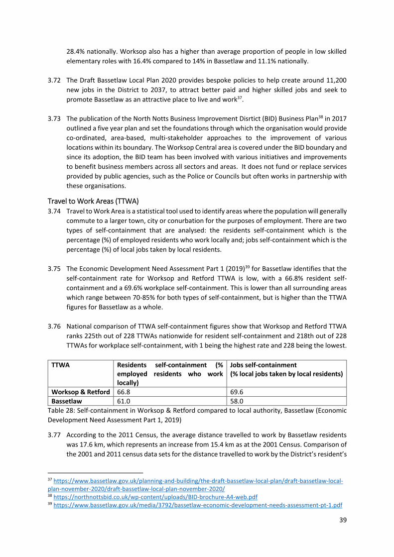
39
28.4% nationally. Worksop also has a higher than average proportion of people in low skilled
elementary roles with 16.4% compared to 14% in Bassetlaw and 11.1% nationally.
3.72 The Draft Bassetlaw Local Plan 2020 provides bespoke policies to help create around 11,200
new jobs in the District to 2037, to attract better paid and higher skilled jobs and seek to
promote Bassetlaw as an attractive place to live and work37.
3.73 The publication of the North Notts Business Improvement Disrtict (BID) Business Plan38 in 2017
outlined a five year plan and set the foundations through which the organisation would provide
co-ordinated, area-based, multi-stakeholder approaches to the improvement of various
locations within its boundary. The Worksop Central area is covered under the BID boundary and
since its adoption, the BID team has been involved with various initiatives and improvements
to benefit business members across all sectors and areas. It does not fund or replace services
provided by public agencies, such as the Police or Councils but often works in partnership with
these organisations.
Travel to Work Areas (TTWA) 3.74 Travel to Work Area is a statistical tool used to identify areas where the population will generally
commute to a larger town, city or conurbation for the purposes of employment. There are two
types of self-containment that are analysed: the residents self-containment which is the
percentage (%) of employed residents who work locally and; jobs self-containment which is the
percentage (%) of local jobs taken by local residents.
3.75 The Economic Development Need Assessment Part 1 (2019)39 for Bassetlaw identifies that the
self-containment rate for Worksop and Retford TTWA is low, with a 66.8% resident self-
containment and a 69.6% workplace self-containment. This is lower than all surrounding areas
which range between 70-85% for both types of self-containment, but is higher than the TTWA
figures for Bassetlaw as a whole.
3.76 National comparison of TTWA self-containment figures show that Worksop and Retford TTWA
ranks 225th out of 228 TTWAs nationwide for resident self-containment and 218th out of 228
TTWAs for workplace self-containment, with 1 being the highest rate and 228 being the lowest.
TTWA Residents self-containment (% employed residents who work locally)
Jobs self-containment (% local jobs taken by local residents)
Worksop & Retford 66.8 69.6
Bassetlaw 61.0 58.0
Table 28: Self-containment in Worksop & Retford compared to local authority, Bassetlaw (Economic
Development Need Assessment Part 1, 2019)
3.77 According to the 2011 Census, the average distance travelled to work by Bassetlaw residents
was 17.6 km, which represents an increase from 15.4 km as at the 2001 Census. Comparison of
the 2001 and 2011 census data sets for the distance travelled to work by the District’s resident’s
37 https://www.bassetlaw.gov.uk/planning-and-building/the-draft-bassetlaw-local-plan/draft-bassetlaw-local-plan-november-2020/draft-bassetlaw-local-plan-november-2020/ 38 https://northnottsbid.co.uk/wp-content/uploads/BID-brochure-A4-web.pdf 39 https://www.bassetlaw.gov.uk/media/3792/bassetlaw-economic-development-needs-assessment-pt-1.pdf
40
highlights that the proportion of people travelling less than 10 km has decreased whilst the
proportion travelling over 10 km has increased. The 2011 Census also illustrates that the
primary mode of travelling to work for residents in the District is by car or van (44.2%), however
the Census data also identifies that 24.1% of Worksop residents do not have access to a car.
3.78 Commuting flows indicate that in 2011, a total of 16,220 workers commuted into Bassetlaw
from other local authorities whilst 17,164 residents commuted out of the District. Therefore,
commuting results in a population decrease of 944 all persons in Bassetlaw40. Further to this,
the location of usual residence and place of work 2011 Census data also indicates that the
majority of the District’s residents commuted to Doncaster, Sheffield and Rotherham (6,945
people). Doncaster and Rotherham were also the origin of most in-commuters into the local
authority area (4,395 people).
Employment Land and Sites 3.79 Industrial activity in Bassetlaw is largely focussed around the three main towns of Worksop,
Retford and Harworth & Bircotes, and the A1/A77 growth corridors where there are several
industrial areas, many of which have experienced continued industrial take-up in recent years.
However, these sites are usually located on the edge of the town with recent developments
such as those in Worksop at Manton Wood and Vesuvius Way, with the land within the Worksop
Central area predominantly consisting of retail and office use employment land.
3.80 The employment for towns by broad industry groups, Business Register and Employment
Survey41 (BRES) 2018 estimates that retail in Worksop accounts for approximately 3,000 jobs,
which places it within the top three employment industries for the area. However, the retail
sector is characterised by rapid change and changing consumer needs and as a result, the town
centre will need to adapt to new shopping and micro-economic patterns. This may have
implications on the level of retail employment in Worksop in the future.
Retail, Community Facilities and Services 3.81 The District’s main towns of Worksop, Retford and Harworth and Bircotes are where the larger
shops, community facilities and services such as schools and health care facilities are
predominantly focused. These provide a range of facilities and services for their own
communities whilst providing a service focus and employment opportunities for the
surrounding hinterlands.
3.82 Major retail facilities in Worksop are focussed in the town centre including the Priory Shopping
Centre and also at the out of town Sandy Lane Retail Park. In addition, there are four large out-
of-centre superstores. Worksop draws most of its trade from the town itself and the former
mining communities to the north and west including Carlton, Whitwell and Creswell particularly
for convenience goods. However, the catchment area for comparison goods is curtailed by the
proximity of competing centres, as people are prepared to travel further albeit on less frequent
trips. These include Sheffield and Meadowhall which are the main destinations for leakage, and
Doncaster and the Lakeside Outlet Centre to a lesser extent. The retail park at Sandy Lane in
40 https://www.nomisweb.co.uk/census/2011/WU01UK/chart/1132462277 41 https://www.ons.gov.uk/employmentandlabourmarket/peopleinwork/employmentandemployeetypes/bulletins/businessregisterandemploymentsurveybresprovisionalresults/2018#regional-estimates
41
Worksop is the largest bulky goods facility for some distance and draws some trade from further
afield including Retford where there are few comparable outlets.
Convenience and Comparison Goods 3.83 The Bassetlaw Retail and Leisure Study 201742 found that Worksop is well served by
convenience units, and the underrepresentation of town centre convenience floorspace is supported by a number of large out-of-centre foodstores, which are each set over large floorplates. The study also concluded that the level of comparison representation in Worksop, including some multiple large format comparison retailers, is aligned with Worksop’s position at the top of the District’s retail hierarchy and its function as the District’s main retail destination.
Town Centre Uses 3.84 A town centre is an area defined on a local authority’s policies map and includes the primary
shopping area and areas predominantly occupied by main town centre uses within or adjacent to the primary shopping area. The National Planning Policy Framework43 defines main town centre uses as including “retail development (including warehouse clubs and factory outlet centres); leisure, entertainment and more intensive sport and recreation uses (including cinemas, restaurants, drive-through restaurants, bars and pubs, nightclubs, casinos, health and fitness centres, indoor bowling centres and bingo halls); offices; and arts, culture and tourism development (including theatres, museums, galleries and concert halls, hotels and conference facilities)” Worksop centre offers a mix of commercial, office, retail and residential uses. The boundary for Worksop town centre is defined in the Draft Bassetlaw Local Plan and is shown in the map below.
42 https://www.bassetlaw.gov.uk/media/3799/bassetlaw-retail-and-leisure-study.pdf 43 https://assets.publishing.service.gov.uk/government/uploads/system/uploads/attachment_data/file/810197/NPPF_Feb_2019_revised.pdf
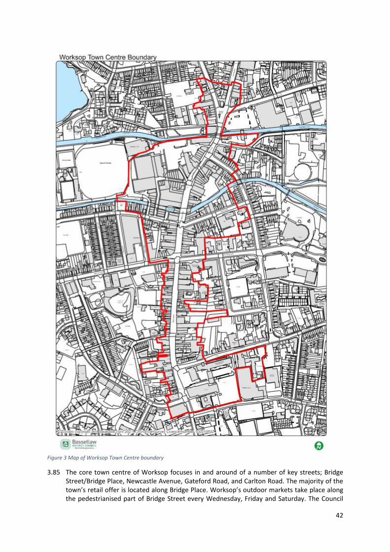
42
Figure 3 Map of Worksop Town Centre boundary
3.85 The core town centre of Worksop focuses in and around of a number of key streets; Bridge Street/Bridge Place, Newcastle Avenue, Gateford Road, and Carlton Road. The majority of the town’s retail offer is located along Bridge Place. Worksop’s outdoor markets take place along the pedestrianised part of Bridge Street every Wednesday, Friday and Saturday. The Council
43
provides stalls and canopies and it attracts a significant draw each day it is hosted. The centre is also bisected from east-west by the River Ryton and the Chesterfield canal. This gives the centre a unique selling point, with easy access to the towns blue infrastructure. However, the proximity to the water has also proved problematic. As the centre lies within flood zone 2 and 3, flooding can be an issue for businesses and properties.
3.86 Investments have previously been made into Worksop town centre. Within the town centre is
the Priory Shopping Centre, which offers a range of local, independent and national retailers and in 2009 received a £7 million investment. This enabled a 30,000sqft retail space expansion and the addition of a roof to the previously outdoor centre. At the rear of the centre is ample parking which also increases accessibility. Another example of recent investment was the opening of the Savoy cinema which has added to the accessibility of leisure activities. The cinema was built to represent a new landmark for the town, while complimenting existing building and reflecting the historic setting.
Street/Use Class A1 A2 A3 A4 A5 D1 D2 SUI Vacant
Bridge Place 18 3 1 0 1 0 0 1 3
Bridge Street 14 4 0 0 1 0 0 2 4
The Priory Shopping Centre 18 2 3 0 0 1 0 0 12
Total units in each class 50 9 4 0 2 1 0 3 19
Table 29: Unit Class Use in Primary Retail Frontages, Worksop (Bassetlaw AMR, 2020) 3.87 The Primary Retail Frontage area is outlined in the Core Strategy 201144, is the focus of retail in
the town centre and includes sections of three streets within Worksop town centre and totals 88 units. The predominant use in this area is A1 retail which accounts for 57% of the total units. The data from the 2019/20 Authority Monitoring Report, highlights that 22% of the primary retail frontages are vacant, with 63% of these being concentrated within the Priory Centre.
Retail 3.88 The Bassetlaw Retail and Leisure Study 2017 recorded a total of 57 retail service units located
in the town centre, which cover over 5,390sqm of floorspace. In comparison to national averages, Worksop’s provision of retail service units at 15.2% is above the UK town centre average of 13.9%. The study identified that the most common retail services offered in the town centre are hairdressers/barbers and beauty salons, and currently there are 23 hairdressers and/or barbers in the town centre, 8 beauty salons, and 3 tattooists. As such, health and beauty services represent 9.0% of total town centre units.
Leisure 3.89 The Bassetlaw Retail and Leisure Study 2017 identified that the percentage of leisure services
units in Worksop sits below the national average of 23.3%, with 17.4% of units (65 units) in the
town centre being occupied by leisure service providers. The leading leisure service offer in
Worksop is provided by cafes and coffee shops. Additionally, there is a high proportion of take-
away outlets and public houses. There are only a small number of eat-in style restaurants within
the town centre.
3.90 Responses to the NEMS Household Survey, which was completed in May 2016 and cited in the
Bassetlaw Retail and Leisure Study 2017, specifies that 4.4% of respondents identified the
choice of leisure facilities (restaurants, pubs etc.) as the principal reason they would visit
44 https://www.bassetlaw.gov.uk/media/1543/cs1adoptedcorestrategy.pdf

44
Worksop. This is much lower than the response rate received for Retford, as 10.3% of
respondents identified the leisure facilities in Retford as one of the main reasons they would
visit the centre. As such, the response for Worksop is reflective of the underrepresentation of
such facilities in the town.
3.91 The opening of the Savoy Cinema has helped to improve the leisure offer in the town, and has
helped to bring visitors to the southern part of the DPD area.
Financial and Business Services 3.92 The Bassetlaw Retail and Leisure Study 2017 found that 8.3% (31 units) of Worksop town centre
units were occupied by financial and business services, a figure which falls below the national
average figure of 10.6%. This trend was also reflected in the proportion of financial and business
floorspace, which in Worksop was 7.5% compared to the national average of 8%. Within the
town centre estate agents occupy the highest majority of this type of units, followed by
banks/buildings societies.
Town Centre Vacancy Rates
Year 2011/12 2012/13 2013/14 2014/15 2015/16 2016/17 2017/18 2018/19 2019/20
Worksop 39 39 34 51 40 44 38 46 65
Table 30: Number of vacant retail units within the identified Worksop town centre (Bassetlaw AMR,
2020)
3.93 The number of vacant units in Worksop Town Centre has been rising since 2017, with a 41%
increase in vacancies between 2018/19 and 2019/20. These figures will in part reflect the
changing habits of shoppers who increasingly use online services, leading to a reduction of
footfall onto highstreets. These rates will also have been impacted by more sudden and
localised impacts including the floods of late 2019 and the impacts of Covid-19. A recent site
visit to the town found it difficult to assess the impact of Covid-19 on vacancy rates as many
units were closed due to the current national and local restrictions.
Cultural Heritage and Townscape 3.94 Worksop has a vast and multilayered history, with the Domesday Book of 1086 providing
evidence that Worksop existed before the Norman Conquest of England in 1066 and record of
the castle and priory being constructed around 1103. Some of this history is still visible today,
such as the site of the Castle (a SAM), and the nave, western front and twin towers of the Priory.
3.95 The development and completion of the Chesterfield Canal in 1777, moved the town away from
being an agricultural centre, by attracting trade, commerce and people into the area. This was
further enhanced by the arrival of the Great Central Railway in 1849, and by industries,
particularly coal mining. The canals use has changed over the years, with it now mainly being
used for recreational activities, by both people visiting the area and by the local community.
Likewise the closure of the coal mines in and around Worksop have led to a move away from
heavy industry, with the railway also following this trend and now providing a key link for
commuters and people visiting Worksop or reaching the surrounding areas.
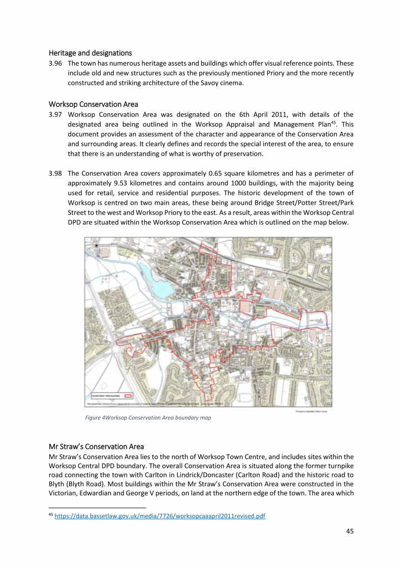
45
Heritage and designations
3.96 The town has numerous heritage assets and buildings which offer visual reference points. These
include old and new structures such as the previously mentioned Priory and the more recently
constructed and striking architecture of the Savoy cinema.
Worksop Conservation Area 3.97 Worksop Conservation Area was designated on the 6th April 2011, with details of the
designated area being outlined in the Worksop Appraisal and Management Plan45. This
document provides an assessment of the character and appearance of the Conservation Area
and surrounding areas. It clearly defines and records the special interest of the area, to ensure
that there is an understanding of what is worthy of preservation.
3.98 The Conservation Area covers approximately 0.65 square kilometres and has a perimeter of
approximately 9.53 kilometres and contains around 1000 buildings, with the majority being
used for retail, service and residential purposes. The historic development of the town of
Worksop is centred on two main areas, these being around Bridge Street/Potter Street/Park
Street to the west and Worksop Priory to the east. As a result, areas within the Worksop Central
DPD are situated within the Worksop Conservation Area which is outlined on the map below.
Mr Straw’s Conservation Area Mr Straw’s Conservation Area lies to the north of Worksop Town Centre, and includes sites within the Worksop Central DPD boundary. The overall Conservation Area is situated along the former turnpike road connecting the town with Carlton in Lindrick/Doncaster (Carlton Road) and the historic road to Blyth (Blyth Road). Most buildings within the Mr Straw’s Conservation Area were constructed in the Victorian, Edwardian and George V periods, on land at the northern edge of the town. The area which
45 https://data.bassetlaw.gov.uk/media/7726/worksopcaaapril2011revised.pdf
Figure 4Worksop Conservation Area boundary map
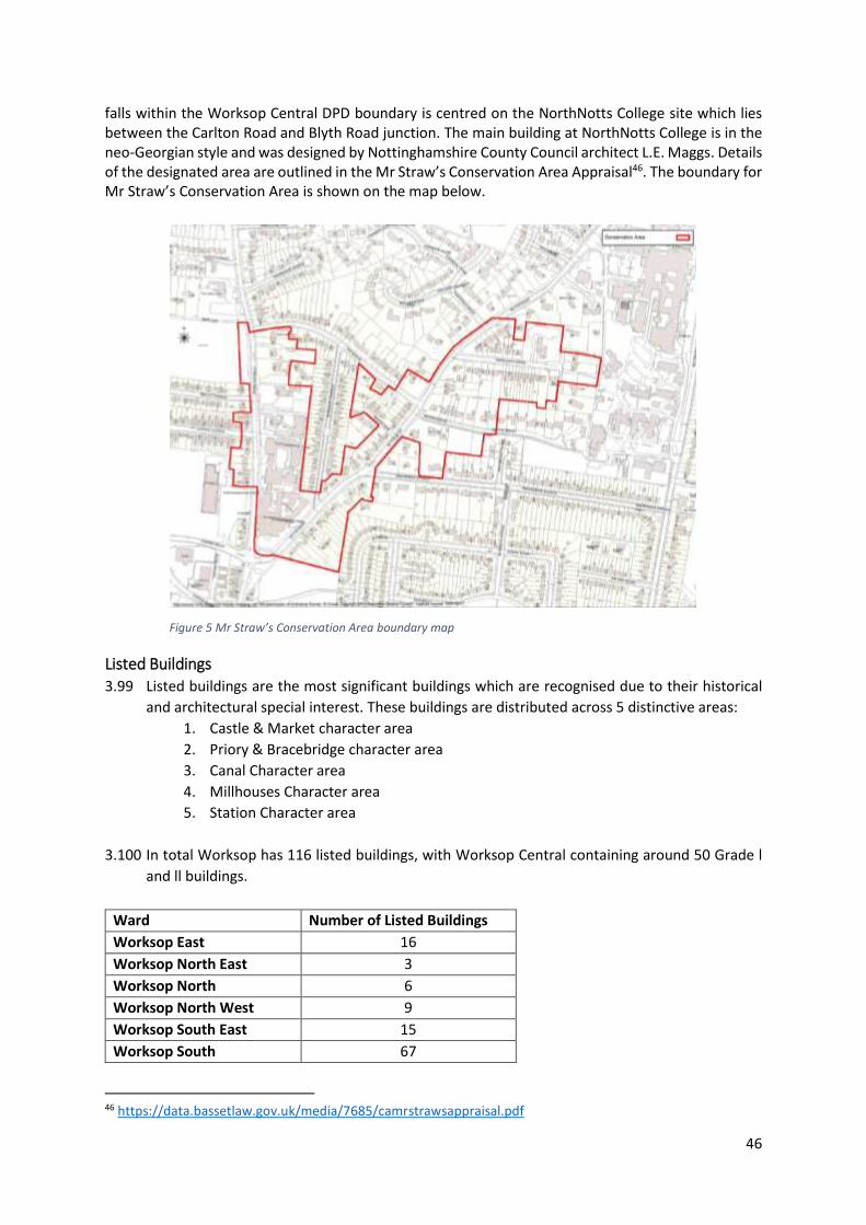
46
falls within the Worksop Central DPD boundary is centred on the NorthNotts College site which lies between the Carlton Road and Blyth Road junction. The main building at NorthNotts College is in the neo-Georgian style and was designed by Nottinghamshire County Council architect L.E. Maggs. Details of the designated area are outlined in the Mr Straw’s Conservation Area Appraisal46. The boundary for Mr Straw’s Conservation Area is shown on the map below.
Listed Buildings
3.99 Listed buildings are the most significant buildings which are recognised due to their historical
and architectural special interest. These buildings are distributed across 5 distinctive areas:
1. Castle & Market character area
2. Priory & Bracebridge character area
3. Canal Character area
4. Millhouses Character area
5. Station Character area
3.100 In total Worksop has 116 listed buildings, with Worksop Central containing around 50 Grade l
and ll buildings.
46 https://data.bassetlaw.gov.uk/media/7685/camrstrawsappraisal.pdf
Ward Number of Listed Buildings
Worksop East 16
Worksop North East 3
Worksop North 6
Worksop North West 9
Worksop South East 15
Worksop South 67
Figure 5 Mr Straw’s Conservation Area boundary map
47
Table 31: Number of Listed Buildings in Worksop by Ward (British Listed Buildings47)
Scheduled Ancient Monument 3.101 Castle Hill comprises a ‘motte’ or castle mound, surrounded by a ditch on all sides. A smaller hill
exists to the west, which is possibly the site of a guard tower. The hill contains a natural outcrop
of sandstone, which has been artificially increased in height, this extra material being visible
due to erosion on the north side. The castle may have had either a timber palisade or shell keep
(stone enclosure) around the top, although there are no above-ground remains to confirm this.
A bailey or outer enclosure may have extended to the south although this is not included in the
scheduled area. In addition, the majority of the likely bailey site is covered in development,
including buildings and hard surfacing.
Unlisted buildings and structures 3.102 Worksop also has a number of buildings and structures which are unlisted but are considered
to have special architectural or historic significance locally (non-designated heritage asset). For
example, if a building is the work of a particular noteworthy local architect or builder, it may
carry historic significance.
3.103 The identification of positive buildings (as discussed above) is by no means exhaustive and the
‘list’ of buildings identified may change at a later date. The absence of any building on this list
does not necessarily mean that it is of no interest or that it makes no positive contribution to
the character and appearance of the Conservation Area. The identification of buildings listed by
association comes within Section 1 (5) of the Planning (Listed Buildings and Conservation Areas)
Act (1990). Advice should always be sought from the Conservation Team at the District Council.
Unscheduled archaeological remains 3.104 Throughout the Worksop Conservation Area, an abundance of archaeological remains have
been identified by Nottinghamshire County Council and recorded on the Historic Environment
Record (HER). The HER should be consulted prior to the submission of any application that may
impact upon archaeological deposits.
Heritage at Risk 3.105 The English Heritage 2019/2020 Indicator Data Local Authority Profiles48 identified 24 Heritage
at Risk entries for Bassetlaw.
3.106 Worksop has one identified structure on the Heritage at Risk Register49. This is the Worksop
Priory gatehouse, Cheapside, which is also a Grade l listed building. The gatehouse, dates back
to early C14, with a slightly later south porch containing what is believed to be the only surviving
English medieval 'walk through' shrine. The gatehouse requires comprehensive repair, as
demonstrated by a condition survey funded by grant aid from Historic England. An initial body
of repairs focusing on the shrine, funded by a Repair Grant for Places of Worship, was completed
summer 2016. Further repairs are needed to the interior, exterior stonework, rainwater goods
and statues.
47 https://britishlistedbuildings.co.uk/england/nottinghamshire#.X4QnuuRYaNM 48 https://historicengland.org.uk/research/heritage-counts/indicator-data/#Section7Text 49 https://historicengland.org.uk/images-books/publications/har-2020-registers/mid-har-register2020/
48
3.107 The Worksop Conservation area also appears on the Heritage at Risk Register, and is identified
by Historic England as being in very bad condition but with low vulnerability. The area contains
60 listed buildings and a scheduled monument.
3.108 As a part of the Mr Straw’s Conservation Area also falls within the DPD boundary, it is important
to ensure that any special architectural or historic interest regarding the character or
appearance of the area and associated buildings should be preserved or enhanced.
Urban Green Infrastructure 3.109 The Bassetlaw Open Space Assessment Update November 202050 states the district has an
extensive open space network totalling 488.41ha. This includes a series of multi-functional
spaces such as; parks and gardens, amenity green spaces, children’s play areas, semi/natural
green spaces, civic spaces, churchyards and allotments of differing sizes.
Settlement No of Open Spaces Total Area (ha) Provision per 1000 people (ha)
Worksop 90 170.2 4.46 Table 32: Open space provision in Worksop (Open Space Strategy, 2020)
3.110 Open spaces in Worksop provide numerous benefits for local communities, including improving
health and wellbeing with access to leisure and recreational activities. With 170.2 ha of Open
Space, Worksop holds around 35% of the Districts total provision across 90 sites.
Analysis Area
Parks & Gardens
Amenity Greenspace
Children’s Play areas
Allotments Semi/Natural
Current Provision Standard ha/1000 population
0.61 1.03 0.14 0.28 2.4
Current provision
+/- Current provision
+/- Current provision
+/- Current provision
+/- Current provision
+/-
Worksop 0.10 -0.51 1.63 0.60 0.10 -0.04 0.35 0.07 1.98 -0.41 Table 33: Standards of Open Space Provision for Worksop (Open Space Study, 2020)
3.111 Standards for Open Space are used to analyse the adequacy of, and gaps in the provision within
the locality of Worksop. The data shows gaps in provision for access to Parks and gardens,
children’s play areas and semi/natural open space within Worksop.
3.112 Open Space in Worksop Central is limited, with no community woodland, gardens or allotments
being located within the DPD boundary. Outdoor sports facilities are also limited with only two
sites being located in the Central area, both are private which may create limitations in
accessibility for public use. Amenity green space is located in the Central area, however it is
currently underutilised and not of a high quality.
3.113 The most prominent Open Space feature with the DPD boundary is The Canch, which is a five
minute walk from the town’s main shopping area of Bridge Street. The area provides access to
4.8ha of public open space with both the River Ryton and Chesterfield Canal run through it,
enabling access to both blue and green infrastructure. The site is owned and managed by
50 https://www.bassetlaw.gov.uk/media/6008/open-space-assessment-update-2020.pdf
49
Bassetlaw District Council, and retained the Green Flag Award for 2019/20. Overall, the area
holds ecological value as well as providing multifunctional uses for leisure, heritage and a
number of community assets including:
Children’s Water Fountain Splash Park
Plaza-style skate park
Adizone Outdoor Gym Area (with performance area)
Junior and Toddler Play Equipment
Multi-Use Games Area
Formal Gardens
Sensory Garden
Aurora Wellbeing Centre (former Library)
Public Conveniences
The public can also request to hold activities and events in The Canch
Biodiversity 3.114 Biodiversity is defined as the variety of plants (flora) and animals (fauna) in an area, and their
associated habitats. Biodiversity is important in its own right and has value with regard to
quality of life and amenity. The importance to preserve it is acknowledged from local to
international level. Bassetlaw has a rich and varied natural environment including a range of
sites designated for their habitat and conservation value.
3.115 Bassetlaw has in excess of 290 Local Wildlife Sites, a number of these sites are in close proximity
to Worksop town to the north, south and west. Within the Worksop Central boundary, they
include the Chesterfield Canal and Sandhill Lake. There are 19 Sites of special scientific interest
(SSSI) across the district, none of which fall within the Worksop Central boundary.
3.116 The Impact Risk Zones (IRZs)51 are a GIS tool developed by Natural England to make a rapid
initial assessment of the potential risks posed by development proposals to: Sites of Special
Scientific Interest (SSSIs), Special Areas of Conservation (SACs), Special Protection Areas (SPAs)
and Ramsar sites. The tool has identified that the Worksop Central area is within the Impact
Risk Zone for Clumber Park SSSI. The Council has commissioned a Recreational Impact
Assessment for the Clumber Park SSSI and Birklands and Bilhaugh SAC, both of which overlap
with the Sherwood Forest ppSPA. This will establish a zone of influence for the site. The Draft
Local Plan also states that this study will identify potential management and mitigation
measures, which will feed into future iterations of the Local Plan and the Habitats Regulations
Assessment.
3.117 The northern part of Sherwood Forest extends into Bassetlaw and contain an area which is
identified as a potential proposed Special Protection Area (ppSPA). Natural England has indicated that the site will be considered for future designation as a SPA on account of supporting populations of breeding nightjar and woodlark. The populations found in the Sherwood Forest region are believed to represent more than 1% of their total breeding populations in the UK. While referred to as a ‘site’ the site comprises a number of small areas which appear to provide optimal breeding habitats, these factors also contribute to part of the site being recognised as an Important Bird Area.
51 https://data.gov.uk/dataset/5ae2af0c-1363-4d40-9d1a-e5a1381449f8/sssi-impact-risk-zones-england

50
3.118 As Sherwood Forest ppSPA is not located within the Worksop Central area none of the policies
within the Development Plan Document would result in development within the likely boundary
of Sherwood Forest ppSPA itself, therefore impacts from physical damage or loss of onsite
habitat can be screened out.
3.119 The area of Central Worksop is located approximately 2km away from the ppSPA at the nearest
point, therefore, development could result in likely significant effects if the habitat supports
qualifying species from within the European site, for example a habitat that is used for foraging
by birds (usually referred to as ‘functionally linked’ habitat). Therefore a precautionary
approach should be taken with any plans or projects that could affect the site and it should also
be considered an important area in terms of biodiversity.
3.120 There are no European Sites within Bassetlaw District, however the Bassetlaw Local Plan
Habitats Regulations Assessment (HRA)52 identifies four sites that lie within 15km of the
boundary. These are:
Birklands and Bilhaugh SAC.
Hatfield Moor SAC.
Thorne Moor SAC.
Thorne and Hatfield Moors SPA.
The HRA notes that Central Worksop is located around 13.5km from Sherwood Forest Visitor
Centre and that The Sherwood Forest Visitor Centre is within 150m of the Birklands and
Bilhaugh SAC.
3.121 Biodiversity within Worksop has benefited from numerous planting initiatives. These have
namely occurred in The Canch and have involved local schools, community groups and
organisations, including Bassetlaw District Councils Open Spaces Team. This has led to the
creation or improvement of habitat areas in order to benefit wildlife. These initiatives have
included the planting of bulbs, native hedgerows and woodland plants.
3.122 Grant funding has also helped to increase local biodiversity, such as the funding awarded by the
Environment Agency through Nottinghamshire Wildlife Trust to improve wildlife habitats
alongside the River Ryton. This led to projects including; the installation of various bird nesting
and bat boxes, the introduction of pre-planted coir rolls of native water marginal plants
alongside the banks of the river and tree planting on the adjacent Jubilee Field.
Blue Infrastructure 3.123 Worksop provides access to ample blue infrastructure as Worksop is bisected east to west by
the River Ryton, which for the most part flows adjacent to the Chesterfield Canal and passes
Sandhill Lake.
3.124 While the watercourses around Worksop are physical constraints in themselves, access to the
Cuckoo Way Canal towpath, Sandhill Lake and other surrounding areas of open space, enable
the river corridor and canal to offer recreational value and provide an off-road link between one
end of the town and the other. However, the presence of the waterways is more noticeable in
some areas than others. For example, where the River Ryton runs directly through the centre
52 https://www.bassetlaw.gov.uk/media/5991/hra-report-for-further-reg-18-consutlation_autumn-2020.pdf
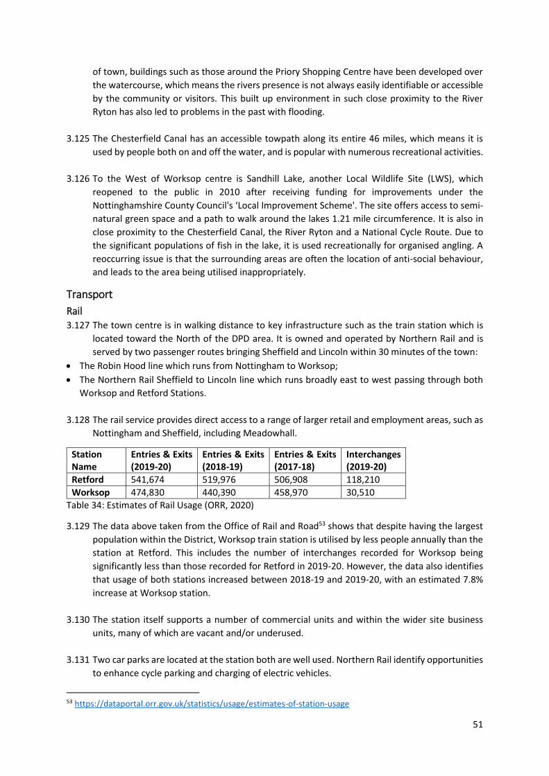
51
of town, buildings such as those around the Priory Shopping Centre have been developed over
the watercourse, which means the rivers presence is not always easily identifiable or accessible
by the community or visitors. This built up environment in such close proximity to the River
Ryton has also led to problems in the past with flooding.
3.125 The Chesterfield Canal has an accessible towpath along its entire 46 miles, which means it is
used by people both on and off the water, and is popular with numerous recreational activities.
3.126 To the West of Worksop centre is Sandhill Lake, another Local Wildlife Site (LWS), which
reopened to the public in 2010 after receiving funding for improvements under the
Nottinghamshire County Council's ‘Local Improvement Scheme'. The site offers access to semi-
natural green space and a path to walk around the lakes 1.21 mile circumference. It is also in
close proximity to the Chesterfield Canal, the River Ryton and a National Cycle Route. Due to
the significant populations of fish in the lake, it is used recreationally for organised angling. A
reoccurring issue is that the surrounding areas are often the location of anti-social behaviour,
and leads to the area being utilised inappropriately.
Transport
Rail 3.127 The town centre is in walking distance to key infrastructure such as the train station which is
located toward the North of the DPD area. It is owned and operated by Northern Rail and is
served by two passenger routes bringing Sheffield and Lincoln within 30 minutes of the town:
The Robin Hood line which runs from Nottingham to Worksop;
The Northern Rail Sheffield to Lincoln line which runs broadly east to west passing through both
Worksop and Retford Stations.
3.128 The rail service provides direct access to a range of larger retail and employment areas, such as
Nottingham and Sheffield, including Meadowhall.
Station Name
Entries & Exits (2019-20)
Entries & Exits (2018-19)
Entries & Exits (2017-18)
Interchanges (2019-20)
Retford 541,674 519,976 506,908 118,210
Worksop 474,830 440,390 458,970 30,510 Table 34: Estimates of Rail Usage (ORR, 2020)
3.129 The data above taken from the Office of Rail and Road53 shows that despite having the largest
population within the District, Worksop train station is utilised by less people annually than the
station at Retford. This includes the number of interchanges recorded for Worksop being
significantly less than those recorded for Retford in 2019-20. However, the data also identifies
that usage of both stations increased between 2018-19 and 2019-20, with an estimated 7.8%
increase at Worksop station.
3.130 The station itself supports a number of commercial units and within the wider site business
units, many of which are vacant and/or underused.
3.131 Two car parks are located at the station both are well used. Northern Rail identify opportunities
to enhance cycle parking and charging of electric vehicles.
53 https://dataportal.orr.gov.uk/statistics/usage/estimates-of-station-usage

52
Car
3.132 The Infrastructure Delivery Report- Baseline Assessment54, published in November 2020 states
that Bassetlaw District has an extensive road network with road connectivity being considered
good, particularly within the west of the District and from the two major towns of Worksop and
Retford. Worksop itself lies at the junction of several important regional roads including the A57
between the M1/Sheffield and the A1/Lincoln; the A60 between Nottingham/Mansfield and
Doncaster; and the A619 from the M1/Chesterfield.
3.133 Car ownership levels follow closely with District and National trends, with the majority of
households, 43.8%, in Worksop having access to one car or van.
Worksop Bassetlaw England
Count % Count % Count %
All Households 18,316 100.0 47,667 100.0 22,063,368 100.0
No cars or vans in household
4,414 24.1 9,571 20.1 5,691,251 25.8
1 car or van in household
8,017 43.8 20,543 43.1 9,301,776 42.2
2 car or van in household
4,688 25.6 13,372 28.1 5,441,593 24.7
3 car or van in household
913 5.0 3,072 6.4 1,203,865 5.5
4 car or van in household
284 1.6 1,109 2.3 424,883 1.9
Sum of all cars or vans in the area
21,339 - 61,483 - 25,696,833 -
Table 35: Car or van availability in Worksop, Bassetlaw and England (Census, 2011)
3.134 The previous Transport Assessment55 was published in 2010. Since then Bassetlaw District
Council and Nottinghamshire County Council have made successful funding bid applications to
the D2N2 and Sheffield City Region LEPs for highway improvement schemes to be delivered,
this has included several locations in Worksop. A revised Bassetlaw Local Plan Transport Study
Update56 has since been published which provides an update on road capacity issues and
identifies transport infrastructure improvements for the future. Again, many of the
improvement sites are located in Worksop.
3.135 Parking and accessibility to town centres is vital. These can either be council or privately owned.
There are 11 designated council car parks in the Worksop central area providing a total of 969
spaces, with an additional 91 disabled spaces. There are two short-stay car parks and 10 long-
stay car parks currently in use. These car parks are displayed on the table below. Private parking
is also available, notably for the town centre this includes parking at the rear of the Priory
Centre.
Location Short Stay Long Stay Ordinary Spaces Disabled Spaces
Town Hall Central * 94 6
54 https://www.bassetlaw.gov.uk/media/6019/idp-baseline-assessment-november-2020.pdf 55 https://www.bassetlaw.gov.uk/media/1656/bstransportstudy.pdf 56 https://www.bassetlaw.gov.uk/media/3814/bassetlaw-district-transport-study-update-jan-2019_complete.pdf
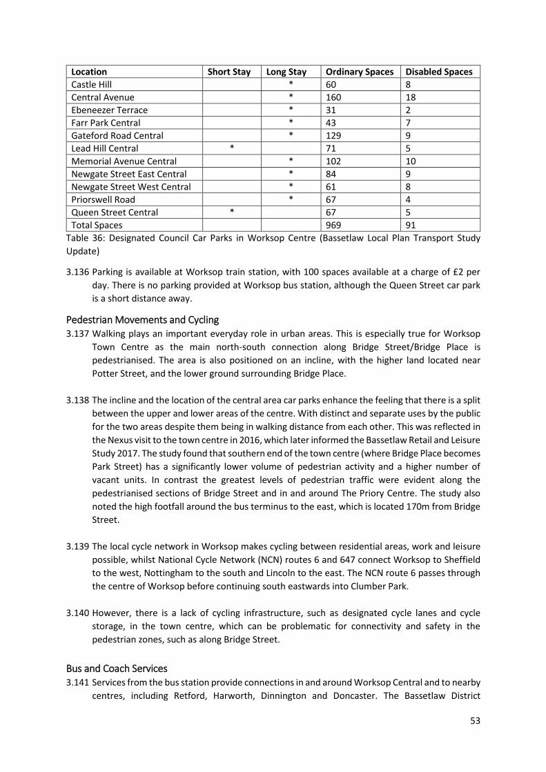
53
Location Short Stay Long Stay Ordinary Spaces Disabled Spaces
Castle Hill * 60 8
Central Avenue * 160 18
Ebeneezer Terrace * 31 2
Farr Park Central * 43 7
Gateford Road Central * 129 9
Lead Hill Central * 71 5
Memorial Avenue Central * 102 10
Newgate Street East Central * 84 9
Newgate Street West Central * 61 8
Priorswell Road * 67 4
Queen Street Central * 67 5
Total Spaces 969 91
Table 36: Designated Council Car Parks in Worksop Centre (Bassetlaw Local Plan Transport Study
Update)
3.136 Parking is available at Worksop train station, with 100 spaces available at a charge of £2 per
day. There is no parking provided at Worksop bus station, although the Queen Street car park
is a short distance away.
Pedestrian Movements and Cycling 3.137 Walking plays an important everyday role in urban areas. This is especially true for Worksop
Town Centre as the main north-south connection along Bridge Street/Bridge Place is
pedestrianised. The area is also positioned on an incline, with the higher land located near
Potter Street, and the lower ground surrounding Bridge Place.
3.138 The incline and the location of the central area car parks enhance the feeling that there is a split
between the upper and lower areas of the centre. With distinct and separate uses by the public
for the two areas despite them being in walking distance from each other. This was reflected in
the Nexus visit to the town centre in 2016, which later informed the Bassetlaw Retail and Leisure
Study 2017. The study found that southern end of the town centre (where Bridge Place becomes
Park Street) has a significantly lower volume of pedestrian activity and a higher number of
vacant units. In contrast the greatest levels of pedestrian traffic were evident along the
pedestrianised sections of Bridge Street and in and around The Priory Centre. The study also
noted the high footfall around the bus terminus to the east, which is located 170m from Bridge
Street.
3.139 The local cycle network in Worksop makes cycling between residential areas, work and leisure
possible, whilst National Cycle Network (NCN) routes 6 and 647 connect Worksop to Sheffield
to the west, Nottingham to the south and Lincoln to the east. The NCN route 6 passes through
the centre of Worksop before continuing south eastwards into Clumber Park.
3.140 However, there is a lack of cycling infrastructure, such as designated cycle lanes and cycle
storage, in the town centre, which can be problematic for connectivity and safety in the
pedestrian zones, such as along Bridge Street.
Bus and Coach Services 3.141 Services from the bus station provide connections in and around Worksop Central and to nearby
centres, including Retford, Harworth, Dinnington and Doncaster. The Bassetlaw District
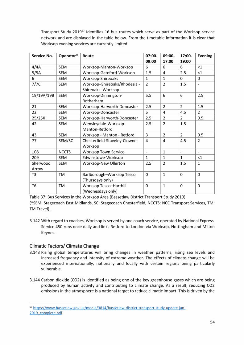
54
Transport Study 201957 Identifies 16 bus routes which serve as part of the Worksop service
network and are displayed in the table below. From the timetable information it is clear that
Worksop evening services are currently limited.
Service No. Operator* Route 07:00-09:00
09:00-17:00
17:00-19:00
Evening
4/4A SEM Worksop-Manton-Worksop 6 6 6 <1
5/5A SEM Worksop-Gateford-Worksop 1.5 4 2.5 <1
6 SEM Worksop-Shireoaks 1 1 0 0
7/7C SEM Worksop–Shireoaks/Rhodesia -Shireoaks- Worksop
2 2 1.5 -
19/19A/19B SEM Worksop-Dinnington-Rotherham
5.5 6 6 2.5
21 SEM Worksop-Harworth-Doncaster 2.5 2 2 1.5
22 SEM Worksop-Doncaster 5 4 4.5 2
25/25X SEM Worksop-Harworth-Doncaster 2.5 2 2 0.5
42 SEM Wensleydale-Worksop-Manton-Retford
2.5 2 1.5 -
43 SEM Worksop - Manton - Retford 3 2 2 0.5
77 SEM/SC Chesterfield-Staveley-Clowne-Worksop
4 4 4.5 2
108 NCCTS Worksop Town Service - 1 - -
209 SEM Edwinstowe-Worksop 1 1 1 <1
Sherwood Arrow
SEM Worksop-New Ollerton 2.5 2 1.5 1
T3 TM Barlborough–Worksop Tesco (Thursdays only)
0 1 0 0
T6 TM Worksop Tesco–Harthill (Wednesdays only)
0 1 0 0
Table 37: Bus Services in the Worksop Area (Bassetlaw District Transport Study 2019)
(*SEM: Stagecoach East Midlands, SC: Stagecoach Chesterfield, NCCTS: NCC Transport Services, TM:
TM Travel).
3.142 With regard to coaches, Worksop is served by one coach service, operated by National Express.
Service 450 runs once daily and links Retford to London via Worksop, Nottingham and Milton
Keynes.
Climatic Factors/ Climate Change 3.143 Rising global temperatures will bring changes in weather patterns, rising sea levels and
increased frequency and intensity of extreme weather. The effects of climate change will be experienced internationally, nationally and locally with certain regions being particularly vulnerable.
3.144 Carbon dioxide (CO2) is identified as being one of the key greenhouse gases which are being
produced by human activity and contributing to climate change. As a result, reducing CO2 emissions in the atmosphere is a national target to reduce climatic impact. This is driven by the
57 https://www.bassetlaw.gov.uk/media/3814/bassetlaw-district-transport-study-update-jan-2019_complete.pdf
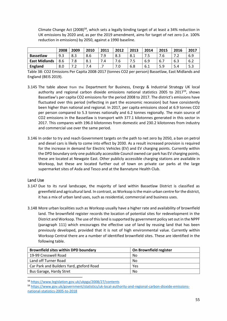
55
Climate Change Act (2008)58, which sets a legally binding target of at least a 34% reduction in UK emissions by 2020 and, as per the 2019 amendment, aims for target of net zero (i.e. 100% reduction in emissions) by 2050, against a 1990 baseline.
2008 2009 2010 2011 2012 2013 2014 2015 2016 2017
Bassetlaw 9.3 8.3 8.6 7.9 8.3 8.1 7.5 7.6 7.2 6.9
East Midlands 8.6 7.8 8.1 7.4 7.6 7.5 6.9 6.7 6.3 6.2
England 8.0 7.2 7.4 .7 7.0 6.8 6.1 5.9 5.4 5.3
Table 38: CO2 Emissions Per Capita 2008-2017 (tonnes CO2 per person) Bassetlaw, East Midlands and England (BEIS 2019). 3.145 The table above from the Department for Business, Energy & Industrial Strategy UK local
authority and regional carbon dioxide emissions national statistics 2005 to 201759, shows Bassetlaw’s per capita CO2 emissions for the period 2008 to 2017. The district’s emissions have fluctuated over this period (reflecting in part the economic recession) but have consistently been higher than national and regional. In 2017, per capita emissions stood at 6.9 tonnes CO2 per person compared to 5.3 tonnes nationally and 6.2 tonnes regionally. The main source of CO2 emissions in the Bassetlaw is transport with 377.1 kilotonnes generated in this sector in 2017. This compares with 196.0 kilotonnes from domestic and 230.2 kilotonnes from industry and commercial use over the same period.
3.146 In order to try and reach Government targets on the path to net zero by 2050, a ban on petrol and diesel cars is likely to come into effect by 2030. As a result increased provision is required for the increase in demand for Electric Vehicles (EV) and EV charging points. Currently within the DPD boundary only one publically accessible Council owned car park has EV charging points, these are located at Newgate East. Other publicly accessible charging stations are available in Worksop, but these are located further out of town on private car parks at the large supermarket sites of Asda and Tesco and at the Bannatyne Health Club.
Land Use 3.147 Due to its rural landscape, the majority of land within Bassetlaw District is classified as
greenfield and agricultural land. In contrast, as Worksop is the main urban centre for the district,
it has a mix of urban land uses, such as residential, commercial and business uses.
3.148 More urban localities such as Worksop usually have a higher rate and availability of brownfield
land. The brownfield register records the location of potential sites for redevelopment in the
District and Worksop. The use of this land is supported by government policy set out in the NPPF
(paragraph 111) which encourages the effective use of land by reusing land that has been
previously developed, provided that it is not of high environmental value. Currently within
Worksop Central there are a number of identified brownfield sites. These are identified in the
following table.
Brownfield sites within DPD boundary On Brownfield register
19-99 Cresswell Road No
Land off Turner Road No
Car Park and Builders Yard, gteford Road Yes
Bus Garage, Hardy Stret No
58 https://www.legislation.gov.uk/ukpga/2008/27/contents 59 https://www.gov.uk/government/statistics/uk-local-authority-and-regional-carbon-dioxide-emissions-national-statistics-2005-to-2018
56
Brownfield sites within DPD boundary On Brownfield register
Former gas works, Beaver Street No Table 39: Brownfield Land in Worksop Central
Landscape 3.149 National Character Areas (NCA) are natural subdivisions of England and are based on a
combination of landscape, biodiversity, geodiversity and economic activity. In total there are
159 National Character Areas which follow natural, rather than administrative boundaries.
3.150 The Sherwood NCA60 contains the settlements of Mansfield, Worksop, Retford and Ollerton
around its peripheries and sits on an aquifer that provides water to the area. The NCA extends
north from Nottingham, principally coinciding with an outcrop of sandstone which forms a belt
of gently rolling hills. Historically it was managed as woodland and remains a well wooded area.
The oak and birch wood pasture in the heartland of Sherwood Forest and more recent pine
plantations, contribute strongly to the sense of place. Large estate parklands, heathland, open
arable land and a strong mining heritage also characterise the area.
Contaminated Land 3.151 Land contamination can impact on health and cause damage to the wider environment
including: watercourses, aquifers and buildings. Contaminated land means land that has been
affected by increased levels of hazardous substances such as heavy metals, non-metals, organic
compounds e.g. Petroleum Hydrocarbons and radioactive materials. Local Authorities have a
statutory duty to deal with contaminated land within their area. The Town and Country Planning
Act 199061 also gives powers to Local Authorities to ensure that land that is contaminated is
cleaned up so that it is suitable for its proposed use. Other bodies, such as the Environment
Agency, are also involved in bringing sites back into beneficial use through land contamination
work.
3.152 As the current government and local authority are actively promoting the redevelopment of
brownfield sites, it is important to ensure that elevated levels of contamination identified on
any sites is reduced to levels which no longer pose a significant risk to human health or the
wider environment.
3.153 There are multiple potential contaminated land sites distributed throughout the Worksop
Central Area, the approach taken to their reuse and remediation would need to be assessed on
an individual basis. The causes of potential land contamination include previously industrial
sites, former gas works, former landfills and the presence of underground tanks.
Air Quality 3.154 In fulfilment of Part IV of the Environment Act 1995 Local Air Quality Management62, local
authorities have an obligation to review and assess the air quality within their regions. In
Bassetlaw this is address through the Air Quality Annual Status Report 63(ASR). In the 2019 status
report Bassetlaw District Council compared the monitoring data obtained during the twelve
60 http://publications.naturalengland.org.uk/publication/1401066?category=587130 61 https://www.legislation.gov.uk/ukpga/1990/8/contents 62 https://assets.publishing.service.gov.uk/government/uploads/system/uploads/attachment_data/file/69348/pb13566-laqm-policy-guidance-part4-090302.pdf 63 https://data.bassetlaw.gov.uk/media/6786/air-quality-report-2019-pdf.pdf
57
months from January 2018 to December 2018, with the annual air quality objectives as defined
in the Air Quality Regulations. The report concluded that there were no exceedances of the air
quality objectives.
3.155 The Government set out its plans for dealing with all sources of air pollution, making air
healthier to breathe, protecting nature and boosting the economy in the Clean Air Strategy
201964. It complements three other UK government strategies, the Industrial Strategy, Clean
Growth Strategy and the 25 Year Environment Plan. Historically, air quality within Bassetlaw has
consistently complied with the UK Air Quality Strategy (AQS) objectives. The District in general
benefits from a very good standard of air quality. However, there are hotspots where pollution
has been shown over a number of years to be close to the legal limits. This includes in Worksop,
in locations where standing traffic during busy periods causes air quality to be impacted. These
areas are kept under close review to ensure that traffic related pollution is not above the health-
based objectives.
Waste and Recycling 3.156 While Bassetlaw District Council is the waste collection authority for the area it is
Nottinghamshire County Council who is responsible for waste management. The Statistics on
waste managed by local authorities in England in 2018/19 report by the Department for
Environment Food and Rural Affairs (DEFRA) identified that within the East Midlands region,
Bassetlaw had the lowest household recycling rates at 25%65. This is compared to a 60%
recycling rate in Derbyshire Dales which is the best performing local authority in the region.
Region Position Authority Recycling Rate Percent of Total Recycling that is Organic
East Midlands Lowest Bassetlaw District Council
25% 31%
East Midlands Highest Derbyshire Dales District Council
60% 55%
Table 40: Local authorities with the highest and lowest household recycling rates in East Midlands in
2018/19 (DEFRA 2019)
Noise 3.157 Due to the mix of uses in Worksop DPD area, there is potential for noise pollution from some
activities, particularly relating to industrial uses or from commercial uses in the evening e.g. late
night clubs and bars. Currently if complaints are made from the public surrounding noise they
are submitted to the Environmental Health department at Bassetlaw District Council, who keep
a record of the incidents and their locations. Areas which have higher rates of recorded noise
incidents within the Central area are around Victoria Square, Cuckoo Wharf and Church Walk.
These complaints are often from residential properties and relate to the late night usage
64 https://assets.publishing.service.gov.uk/government/uploads/system/uploads/attachment_data/file/770715/clean-air-strategy-2019.pdf 65 https://assets.publishing.service.gov.uk/government/uploads/system/uploads/attachment_data/file/918853/201819_Stats_Notice_FINAL_accessible.pdf#:~:text=%EF%82%B7%2010.8%20per%20cent%20of%20all%20local%20authority,per%20cent%29%20from%202017%2F18.%20%EF%82%B7%20Waste%20sent%20for
58
associated with licensed premises in the area such as pubs. Other sources of noise in and around
the Central area are from industrial processes at the flour mill and the train station.
3.158 Noise complaints usually come as a result of newly licensed premises if they are located within
a more residential area, so less likely to receive noise complaints if proposals would be an
extension to the existing night time economy area of the town
Water 3.159 The most important watercourse that runs through Worksop is the River Ryton, which is a
tributary of the River Idle.
Flood Risk 3.160 Following the statutory duties set out in the Flood and Water Management Act 201066, the
Council is legally required to take a leading role in local flood risk management. Local research
has been undertaken across the district to understand the flooding issues and to identify areas
which are at higher risk. This data is presented in the Strategic Flood Risk Assessment 2019 67(SFRA). The Level 2 SFRA is currently being updated for Worksop and is due in March 2021.
3.161 The 2019 report identifies that Worksop has susceptibility to flooding, especially from fluvial,
surface water and sewer flooding.
Summary of flood risk in Worksop 3.162 Flood history shows that Bassetlaw has been subject to flooding from several sources of flood
risk, with the principal risk being fluvial from watercourses within the district. Additionally, there
are recorded incidents of surface water flooding, particularly in the main urban areas of the
district. The most recent severe flooding incident in Worksop Central occurred in November
2019, with 308 reported incidents of internal flooding, 128 properties and 180 businesses68. The
flooding also affected the public highways in the town and many gardens and curtilages. This
was the third time the area had been affected by flooding in 12 years.
3.163 The fluvial flooding risk in Worksop Central area is attributed to its proximity to the River Ryton,
which means areas of the centre lie in flood zones 2 and 3a and 3b. Whereby, flood zone 2
represents the 1 in a 1000 year probability of flooding, and flood zone 3 represents the 1 in a
100 year probability of fluvial flooding.
3.164 Following recent flooding events, the Environment Agency are now undertaking work to review
and update the modelling data for the River Ryton through Worksop. This, once complete, will
provide the most up-to-date data for the Ryton and help inform future decision about flood
management and investment in flood defences in the future. It will also form the starting point
for identifying required flood risk mitigation measures within new development.
3.165 Flood warnings, along with evacuation plans, can inform emergency flood plans or flood
response plans. The Environment Agency is the lead organisation for providing warnings of
fluvial flooding (for watercourses classed as Main Rivers) and coastal flooding in England. Flood
Warnings are supplied via the Flood Warning System (FWS) service, to homes and business
within Flood Zones 2 and 3.
66 https://www.legislation.gov.uk/ukpga/2010/29/contents 67 https://www.bassetlaw.gov.uk/media/3802/bassetlaw-strategic-flood-risk-assessment.pdf 68 https://www.nottinghamshire.gov.uk/media/2885328/section19reportworksopnovember2019.pdf
59
3.166 There are currently seven Flood Alert Areas (FAA) and twenty Flood Warning Areas (FWAs)
covering significant parts of the Bassetlaw area. The table below identifies the Flood Alert Areas
relevant to Worksop Centre.
Flood Warning Code Flood Warning Name Watercourse Coverage
034FWFRYWORKSP River Ryton at Worksop Town Centre including Shireoaks
River Ryton Flood warning from Shireoaks to Worksop (city centre) (approx.6km long)
034FWFRYSHELLY River Ryton at Worksop, Shelley Street
River Ryton Flood warning within Worksop city centre
Table 41: Flood Warning Areas in Worksop (Bassetlaw Strategic Flood Risk Assessment 2019)
3.167 Bassetlaw has experienced a number of historic surface water flooding incidents. The risk of
flooding from surface water occurs at a number of prominent overland flow routes in the
district; these predominantly follow topographical flow paths of existing watercourses or road
networks in urban areas, with some isolated flow-routes through properties by virtue of run-
off. The Risk of Flooding from Surface Water (RoFSW) provided by Bassetlaw District Council
shows that several communities are at risk of surface water flooding in the District, including
Worksop, which has areas in the centre which have a 1 in 30, 1 in 100 and 1 in 1,000 chance of
surface flooding occurring in a given year. Areas of particular concern include Central Avenue,
King Street, Hardy Street and Priorswell Road.
3.168 The Severn Trent Water HFRR register indicates a total of 208 recorded incidents of sewer
flooding in Bassetlaw District administrative area. Anglian water had no recorded incidents in
Bassetlaw. The settlements with the most recorded incidents include Retford, Worksop and
Costhorpe. Historical incidents of flooding are detailed by Severn Trent Water through their
HFRR registers, details of these incidents relating to Worksop shown in the table below. This
database records incidents of flooding relating to public foul, combined or surface water sewers
and displays which properties suffered flooding.
Post Code Locality Recorded Flood Incidents
S80 1 Worksop 8
S80 2 Worksop 6
S80 2LY Worksop 1
S81 0 Worksop 2
S81 7 Worksop 21
Table 42: Hydraulic Flood Risk Register (HFRR) Register recorded flood incidents Post Code (Bassetlaw
SFRA 2019)
3.169 Another significant water course that runs through the centre of Worksop is the Chesterfield
canal. Canals do not generally pose a direct flood risk as they are a regulated waterbody. There
is however a rare but residual risk from canals from overtopping and embankment failure
(breach and sudden escape of the water retained in the canal channel) and the 2011
Nottinghamshire Preliminary Flood Risk Assessment69 identifies that the Chesterfield canal has
experienced historical flooding incidents. For future planning, specific breaches in the Canal at
Retford and Worksop were modelled for the 2009 SFRA, using a strategic 2D modelling
approach. The 2009 SFRA noted that a “breach could occur at any location where the canal is
69 https://www.nottinghamshire.gov.uk/media/1598/pfra-1.pdf
60
higher than the surrounding land; these results should be taken as examples of the flood risk if
breaches should occur”. The results therefore do not provide a complete picture of areas that
could be affected by a breach in the Chesterfield Canal across the District.
Water Resource 3.170 Bassetlaw is served by two water companies, Severn Trent and Anglian Water.
3.171 The IDP Baseline Assessment 202070 states that discussions with relevant bodies in the
Bassetlaw Water Cycle Study 2010 are up to date. The Bassetlaw Water Cycle Study 201071
identified that both companies serving the district are in water surplus, with resources
exceeding demands. The report also identified potential risks to water supplies within
Bassetlaw. These included; deteriorating groundwater quality within aquifers, the effects of
climate change on water resources and demand, water supply resilience issues and the
Environment Agencies Review of Consent process which may reduce licensed abstractions.
Water Quality 3.172 In general, water quality within Bassetlaw is of good quality and has complied with current
water objectives over the latest Environment Agency reporting periods. However, the Bassetlaw
Water Cycle Study 2010, found that none of the watercourses are currently achieving ‘good
ecological statuses or ‘good ecological potential’ under the Water Framework Directive72 (WFD).
The River Ryton currently has high levels of nitrates and phosphates which need to be
monitored as it is currently rated poor under the WFD for phosphates, and moderate ecological
status.
3.173 Large parts of Bassetlaw are underlain by aquifers covered by Source Protection Zones. These
zones are designed to protect the groundwater from contamination. It is important that these
zones are protected from development. As one of the key water suppliers to Worksop Severn
Trent adopts a strict “no development” policy in SPZ1 areas. Therefore, land within an SPZ 1
owned by Severn Trent is subject to strict control measures on land use.
3.174 Severn Trent advise that limitations are extended to SPZ 2 areas as well. However, if this is not
possible, then they strongly advise that developers are required to adopt suitable control
measures and best industry practice when locating and designing SUDS in the SPZ 2 areas. A
suitable train of treatment should be implemented where infiltration SUDS are designed in SPZ
2. Where development is located within SPZ3 it is recommended that the EA pollution
prevention guidance is followed to ensure that development does not result in contamination
of water. Especially where infiltration SuDS are proposed.
3.175 The Worksop Central DPD boundary is covered by 3 areas. An area to the north is located in
Zone 2- Outer Protection Zone, an area to the South West which is not covered by a SPZ and
finally the remaining area is under Zone 3- Total Catchment73.
70 https://www.bassetlaw.gov.uk/media/6019/idp-baseline-assessment-november-2020.pdf 71 https://www.bassetlaw.gov.uk/media/2028/bswcssummary.pdf 72 https://eur-lex.europa.eu/legal-content/EN/TXT/?uri=CELEX:02000L0060-20141120 73 https://environment.data.gov.uk/DefraDataDownload/?mapService=EA/SourceProtectionZonesMerged&Mode=spatial
61
Waste Water 3.176 There are 24 wastewater treatment works located within and serving the Bassetlaw study area
under the responsibility of Severn Trent.
Wastewater Treatment Works Receiving watercourse Development Areas Draining to Works
Worksop (Manton) River Ryton Worksop
Table 43: Wastewater Treatment Works for Worksop (IDP Baseline Assessment 2020).
3.177 The Bassetlaw Water Cycle Study 2010 found that four of the assessed waste water treatment
works, including Worksop are already exceeding their volumetric consents and, therefore, have
no capacity to treat further flows from new development in the area unless they apply for, and
are granted, an increase to their flow consent by the Environment Agency.
Water and Climate Change Allowance 3.178 The European Environmental Agency74 states that climate change consequences relating to
water resources include; increases in temperature, shifts in precipitation patterns and snow
cover, and a likely increase in the frequency of flooding and droughts. As a result, climate
change has the potential to impact flood risk. To increase resilience to flooding, potential
impacts can be considered through Climate Change Allowances which provide predictions of
anticipated changes for; peak river flow, peak rainfall intensity, sea level rise and offshore wind
speed and extreme wave height. Allowances for different climate scenarios over different
epochs, or periods of time, over the coming century are used by the Environment Agency to
provide advice on flood risk assessments and strategic flood risk assessments.
3.179 Worksop is within the Humber river basin district and table 44 identifies the Environment
Agency’s anticipated changes to peak river flow for the area through peak river flow allowances.
Allowance Category
Total potential change anticipated for the ‘2020s’ (2015 to 2039)
Total potential change anticipated for the ‘2050s’ (2040 to 2069)
Total potential change anticipated for the ‘2080s’ (2070 to 2115)
H++ 20% 35% 65%
Upper end 20% 30% 50%
Higher central 15% 20% 35%
Central 10% 15% 20%
Table 44: peak river flow allowances for the Humber river basin district (based on a 1961 to 1990
baseline) 75
3.180 The ranges identified in the table above are based on percentiles, with a percentile describing
the proportion of possible scenarios that fall below an allowance level. The 50th percentile is
the point at which half of the possible scenarios for peak flows fall below it, and half fall above
it. In order to decide which allowance range applies to a development or plan, additional
information is needed, for example the flood risk vulnerability classification76. This information
is then used to produce flood risk assessments. It should be noted that the Humber river basin
covers a wide catchment area, therefore, the impact of climate change on peak river flow may
not be the same in all river catchments in a river basin district.
74 https://www.eea.europa.eu/archived/archived-content-water-topic/water-resources/climate-impacts-on-water-resources 75 https://www.gov.uk/guidance/flood-risk-assessments-climate-change-allowances#table-1 76 https://www.gov.uk/guidance/flood-risk-and-coastal-change#Table-2-Flood-Risk-Vulnerability-Classification
62
Consultation questions: 2. Do you agree that the baseline data collected is appropriate to the plan?
3. Do you have, or know of, any additional relevant baseline data which should be added to that
already listed?
4. As far as you are aware, are there any inaccuracies or anomalies in the data presented?
Trends that are likely to occur without Sustainability Appraisal intervention 3.181 The Baseline information from the previous section of the report identifies the current situation
within Worksop Central area. This has been informed by trend data where it has been available.
Analysis of this data also enables prediction of the likely future trends within the DPD area,
should policies and proposals in the Worksop Central DPD not be implemented.
Future trends 3.182 The Draft Bassetlaw Local Plan proposes significant change in Worksop to 2037, including the
provision of at least 2,400 new dwellings in Worksop Outer Area and a minimum of 660 new
dwellings in Worksop Central Area.
3.183 It is very difficult to predict the nature of future trends, as they depend on a wide range of
factors including the global and national economic climate, and decisions made at regional and
county level. From the baseline assessment the following trends are likely to continue:
Social 3.184 The District’s population is projected to increase by 17.8 % by 2037 equating to more than
20,700 additional residents compared with 2018. This increase in population will impact on the
districts main town of Worksop. The increased population will require more services (health,
education, recreation, shopping), access to parks and open space, public transport, waste
management etc. as well as placing more demand on existing services. Although the DPD area
currently has a younger age structure compared to the rest of the district, the HEDNA shows
significant increases are expected in the elderly and retirement age population which could lead
to demand for specific facilities.
3.185 Deprivation is likely to continue to be widespread within Worksop Central Area. This could
potentially put pressure on existing services and facilities, such as healthcare provision. Planned
investments in the DPD area, such as with the Bridgecourt educational centre may lead to
improvements and accessibility to education achievement within the Worksop area as might
improvements to green infrastructure provision and better walking and cycling infrastructure.
Environmental 3.186 Crime or the perception of crime continues to be a problem within the Worksop Central area
and the DPD will need to facilitate improvements to create safe and attractive environments.
3.187 All new development will need to be designed and built within the context of a changing
climate. The presence of the river in the Worksop Central has meant that it has always been at
higher risk to flooding. However, changes to climate in recent years have seen the instance of
flooding in the town centre increase. Without appropriate flood mitigation or appropriate site
allocations, flooding will likely occur more regularly and be a problem in the future.
3.188 Overall for water quality within Bassetlaw none of the watercourses are currently achieving
‘good ecological status’ or ‘good ecological potential’ under the Water Framework Directive
63
(WFD). The River Ryton currently has high levels of nitrates and phosphates which need to be
monitored as it is currently rated poor under the WFD for phosphates, and moderate ecological
status. Without appropriate monitoring and mitigation, this may become worse in the future.
3.189 Increase in population and housing in and around the Central area will likely result in more
vehicles, which may present problems of congestion, especially during peak times. An increase
in vehicular traffic may also impact on the air quality within the DPD which already contains
hot-spots which are already close to legal limits. The DPD must ensure that all new development
is supported by appropriate infrastructure to mitigate any adverse impacts on the town’s
infrastructure.
3.190 It is reasonable to assume that the majority of the heritage assets located in Worksop centre
would be protected without the DPD (since works to them invariably require consent).
However, elements which contribute to their significance could be harmed through
inappropriate development in their vicinity. Opportunities to enhance assets may also be
missed.
3.191 As the population of the district and Worksop is expected to increase, waste generation is
expected to commensurate with this increase as well. This could place pressure on existing
waste management facilities. However, it is envisaged that recycling/reuse rates would
increase.
Economic Trends 3.192 It will be important for Worksop Central area to safeguard and enhance its town centre offer,
as failure to attract indigenous and inward investment may result in a weakening of the local
economy in Worksop.
3.193 The DPD area contains some of the most deprived communities in the District, with the
population increases expected, economic growth and concentrated regeneration efforts will be
essential to facilitate new employment opportunities. A lack of economic growth is likely to be
felt most within these deprived areas, where wages and average household income is low.
3.194 There is a need for the economy to diversity into higher value sectors such as creative and
digital, low carbon and green energy, healthcare and technological sectors as failure to do so
may result in continuing low average wage levels and low skilled jobs.
4. Stage A: Task 3: Identifying key sustainability issues for the SA and
Worksop Central DPD to address
4.1 Identifying the sustainability issues and problems is an opportunity to define some of the key
issues that the Worksop Central DPD will be able to address. It should be noted that there are
many possible sustainability issues but not all of these will be significant on the Central area.
Therefore, the issues recorded are those acknowledged as a priority for Worksop central area.
4.2 The sustainability issues confronting Worksop Central Area have been identified from the
following sources:
64
Issues identified in review of Plans, Policies and Programmes (see Stage A: Task 1)
Analysis of baseline data and trends (see Stage A: Task 2 and Appendix 1)
4.3 A number of the headings used to display the baseline information in the previous section
have been divided between the three main aspects of sustainability; environmental, social
and economic factors and displayed in Table 45 below. The table sets out the sustainability
issues that have been identified for each heading and outlines possible opportunities and
policy considerations that could be taken forward for preparing the Worksop Central DPD. The
final column of the table identifies the relevant SEA topic(s), taken from the SEA Directive77,
which are addressed by each heading. It is important to highlight that the possible policy
options or proposals for sites put forward are an initial view only and that the policy options
and alternatives and options for sites will be amended as the Worksop Central Area DPD
progresses and information from the evidence base becomes available. The findings from this
consultation will also help to shape the policy direction.
Consultation questions 5. Do you agree that these are the key sustainability issues for Worksop central area?
6. Are you aware of any issues which, in your opinion, should be added, or any that should be
removed?
77 https://eur-lex.europa.eu/legal-content/EN/TXT/?uri=CELEX:32001L0042
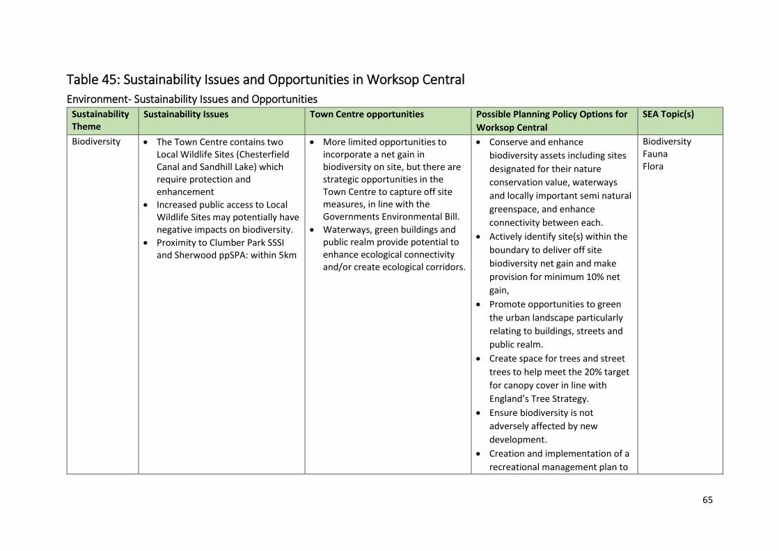
65
Table 45: Sustainability Issues and Opportunities in Worksop Central
Environment- Sustainability Issues and Opportunities Sustainability Theme
Sustainability Issues Town Centre opportunities Possible Planning Policy Options for
Worksop Central
SEA Topic(s)
Biodiversity The Town Centre contains two Local Wildlife Sites (Chesterfield Canal and Sandhill Lake) which require protection and enhancement
Increased public access to Local Wildlife Sites may potentially have negative impacts on biodiversity.
Proximity to Clumber Park SSSI and Sherwood ppSPA: within 5km
More limited opportunities to incorporate a net gain in biodiversity on site, but there are strategic opportunities in the Town Centre to capture off site measures, in line with the Governments Environmental Bill.
Waterways, green buildings and public realm provide potential to enhance ecological connectivity and/or create ecological corridors.
Conserve and enhance
biodiversity assets including sites
designated for their nature
conservation value, waterways
and locally important semi natural
greenspace, and enhance
connectivity between each.
Actively identify site(s) within the
boundary to deliver off site
biodiversity net gain and make
provision for minimum 10% net
gain,
Promote opportunities to green
the urban landscape particularly
relating to buildings, streets and
public realm.
Create space for trees and street
trees to help meet the 20% target
for canopy cover in line with
England’s Tree Strategy.
Ensure biodiversity is not
adversely affected by new
development.
Creation and implementation of a
recreational management plan to
Biodiversity Fauna Flora
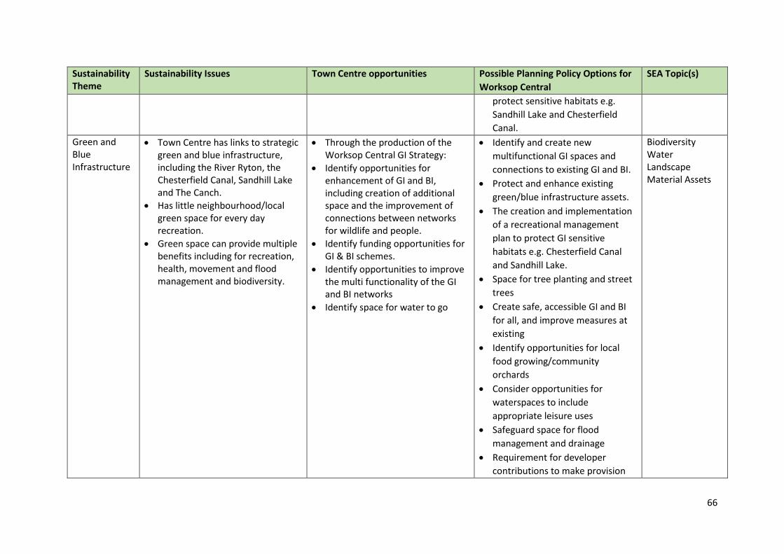
66
Sustainability Theme
Sustainability Issues Town Centre opportunities Possible Planning Policy Options for
Worksop Central
SEA Topic(s)
protect sensitive habitats e.g.
Sandhill Lake and Chesterfield
Canal.
Green and Blue Infrastructure
Town Centre has links to strategic green and blue infrastructure, including the River Ryton, the Chesterfield Canal, Sandhill Lake and The Canch.
Has little neighbourhood/local green space for every day recreation.
Green space can provide multiple benefits including for recreation, health, movement and flood management and biodiversity.
Through the production of the Worksop Central GI Strategy:
Identify opportunities for enhancement of GI and BI, including creation of additional space and the improvement of connections between networks for wildlife and people.
Identify funding opportunities for GI & BI schemes.
Identify opportunities to improve the multi functionality of the GI and BI networks
Identify space for water to go
Identify and create new
multifunctional GI spaces and
connections to existing GI and BI.
Protect and enhance existing
green/blue infrastructure assets.
The creation and implementation
of a recreational management
plan to protect GI sensitive
habitats e.g. Chesterfield Canal
and Sandhill Lake.
Space for tree planting and street
trees
Create safe, accessible GI and BI
for all, and improve measures at
existing
Identify opportunities for local
food growing/community
orchards
Consider opportunities for
waterspaces to include
appropriate leisure uses
Safeguard space for flood
management and drainage
Requirement for developer
contributions to make provision
Biodiversity Water Landscape Material Assets
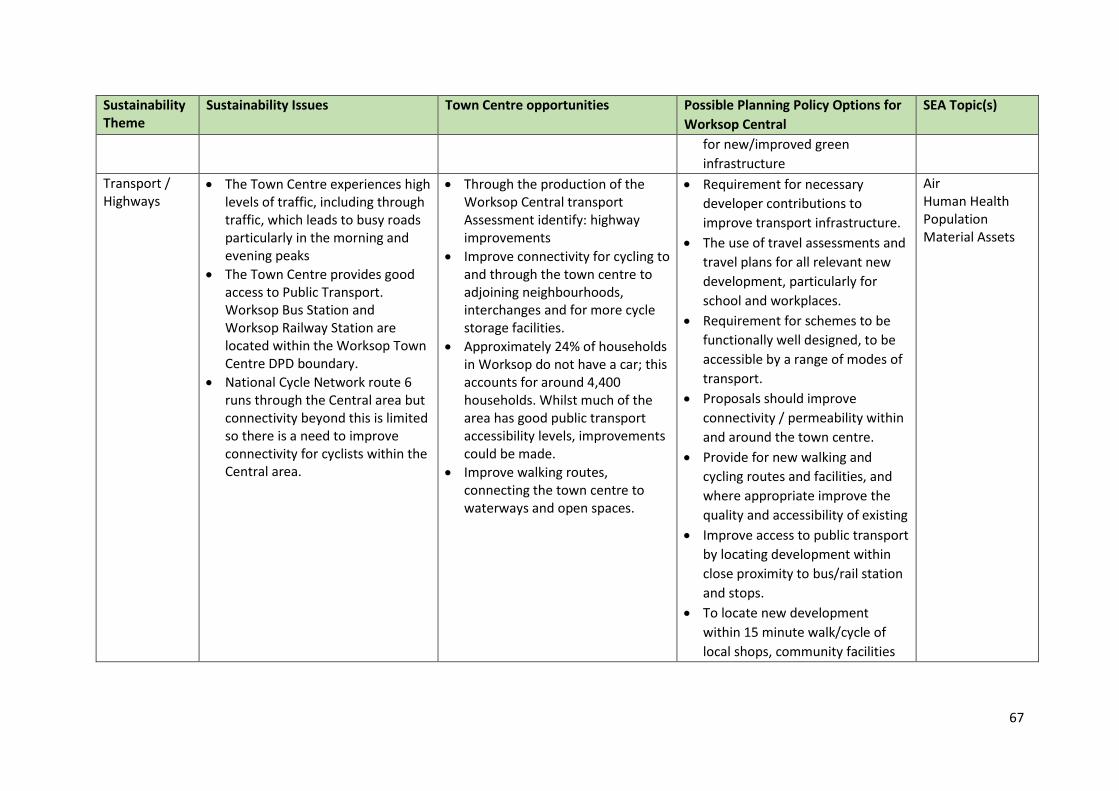
67
Sustainability Theme
Sustainability Issues Town Centre opportunities Possible Planning Policy Options for
Worksop Central
SEA Topic(s)
for new/improved green
infrastructure
Transport / Highways
The Town Centre experiences high levels of traffic, including through traffic, which leads to busy roads particularly in the morning and evening peaks
The Town Centre provides good access to Public Transport. Worksop Bus Station and Worksop Railway Station are located within the Worksop Town Centre DPD boundary.
National Cycle Network route 6 runs through the Central area but connectivity beyond this is limited so there is a need to improve connectivity for cyclists within the Central area.
Through the production of the Worksop Central transport Assessment identify: highway improvements
Improve connectivity for cycling to and through the town centre to adjoining neighbourhoods, interchanges and for more cycle storage facilities.
Approximately 24% of households in Worksop do not have a car; this accounts for around 4,400 households. Whilst much of the area has good public transport accessibility levels, improvements could be made.
Improve walking routes, connecting the town centre to waterways and open spaces.
Requirement for necessary
developer contributions to
improve transport infrastructure.
The use of travel assessments and
travel plans for all relevant new
development, particularly for
school and workplaces.
Requirement for schemes to be
functionally well designed, to be
accessible by a range of modes of
transport.
Proposals should improve
connectivity / permeability within
and around the town centre.
Provide for new walking and
cycling routes and facilities, and
where appropriate improve the
quality and accessibility of existing
Improve access to public transport
by locating development within
close proximity to bus/rail station
and stops.
To locate new development
within 15 minute walk/cycle of
local shops, community facilities
Air Human Health Population Material Assets
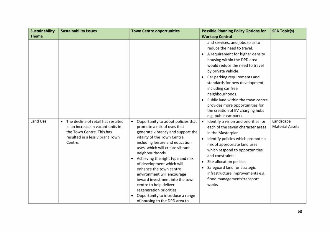
68
Sustainability Theme
Sustainability Issues Town Centre opportunities Possible Planning Policy Options for
Worksop Central
SEA Topic(s)
and services, and jobs so as to
reduce the need to travel.
A requirement for higher density
housing within the DPD area
would reduce the need to travel
by private vehicle.
Car parking requirements and
standards for new development,
including car free
neighbourhoods.
Public land within the town centre provides more opportunities for the creation of EV charging hubs e.g. public car parks.
Land Use The decline of retail has resulted in an increase in vacant units in the Town Centre. This has resulted in a less vibrant Town Centre.
Opportunity to adopt policies that promote a mix of uses that generate vibrancy and support the vitality of the Town Centre including leisure and education uses, which will create vibrant neighbourhoods.
Achieving the right type and mix of development which will enhance the town centre environment will encourage inward investment into the town centre to help deliver regeneration priorities.
Opportunity to introduce a range of housing to the DPD area to
Identify a vision and priorities for
each of the seven character areas
in the Masterplan
Identify policies which promote a
mix of appropriate land uses
which respond to opportunities
and constraints
Site allocation policies
Safeguard land for strategic
infrastructure improvements e.g.
flood management/transport
works
Landscape Material Assets
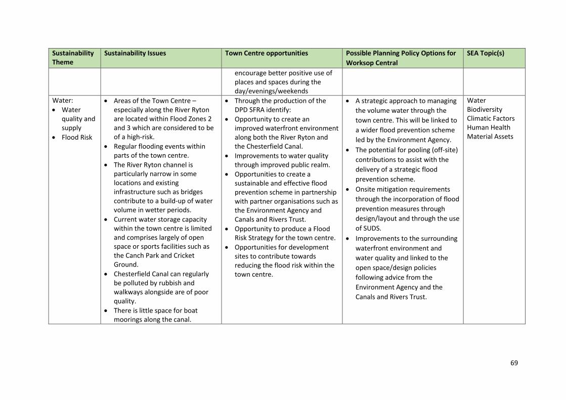
69
Sustainability Theme
Sustainability Issues Town Centre opportunities Possible Planning Policy Options for
Worksop Central
SEA Topic(s)
encourage better positive use of places and spaces during the day/evenings/weekends
Water:
Water quality and supply
Flood Risk
Areas of the Town Centre – especially along the River Ryton are located within Flood Zones 2 and 3 which are considered to be of a high-risk.
Regular flooding events within parts of the town centre.
The River Ryton channel is particularly narrow in some locations and existing infrastructure such as bridges contribute to a build-up of water volume in wetter periods.
Current water storage capacity within the town centre is limited and comprises largely of open space or sports facilities such as the Canch Park and Cricket Ground.
Chesterfield Canal can regularly be polluted by rubbish and walkways alongside are of poor quality.
There is little space for boat moorings along the canal.
Through the production of the DPD SFRA identify:
Opportunity to create an improved waterfront environment along both the River Ryton and the Chesterfield Canal.
Improvements to water quality through improved public realm.
Opportunities to create a sustainable and effective flood prevention scheme in partnership with partner organisations such as the Environment Agency and Canals and Rivers Trust.
Opportunity to produce a Flood Risk Strategy for the town centre.
Opportunities for development sites to contribute towards reducing the flood risk within the town centre.
A strategic approach to managing
the volume water through the
town centre. This will be linked to
a wider flood prevention scheme
led by the Environment Agency.
The potential for pooling (off-site)
contributions to assist with the
delivery of a strategic flood
prevention scheme.
Onsite mitigation requirements
through the incorporation of flood
prevention measures through
design/layout and through the use
of SUDS.
Improvements to the surrounding
waterfront environment and
water quality and linked to the
open space/design policies
following advice from the
Environment Agency and the
Canals and Rivers Trust.
Water Biodiversity Climatic Factors Human Health Material Assets
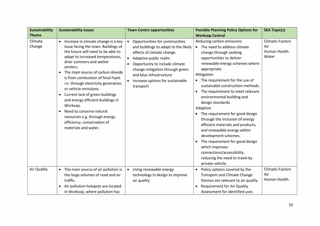
70
Sustainability Theme
Sustainability Issues Town Centre opportunities Possible Planning Policy Options for
Worksop Central
SEA Topic(s)
Climate Change
Increase in climate change is a key issue facing the town. Buildings of the future will need to be able to adapt to increased temperatures, drier summers and wetter winters.
The main source of carbon dioxide
is from combustion of fossil fuels
i.e. through electricity generation,
or vehicle emissions.
Current lack of green buildings
and energy efficient buildings in
Worksop.
Need to conserve natural
resources e.g. through energy
efficiency, conservation of
materials and water.
Opportunities for communities
and buildings to adapt to the likely
effects of climate change.
Adaptive public realm
Opportunity to include climate
change mitigation through green
and blue infrastructure
Increase options for sustainable
transport
Reducing carbon emissions
The need to address climate
change through seeking
opportunities to deliver
renewable energy schemes where
appropriate.
Mitigation
The requirement for the use of
sustainable construction methods.
The requirement to meet relevant
environmental building and
design standards.
Adaption
The requirement for good design
through the inclusion of energy
efficient materials and products,
and renewable energy within
development schemes.
The requirement for good design
which improves
connections/accessibility,
reducing the need to travel by
private vehicle.
Climatic Factors Air Human Health Water
Air Quality The main source of air pollution is
the large volumes of road and air
traffic.
Air pollution hotspots are located
in Worksop, where pollution has
Using renewable energy
technology in design to improve
air quality
Policy options covered by the
Transport and Climate Change
themes are relevant to air quality
Requirement for Air Quality
Assessment for identified uses
Climatic Factors Air Human Health
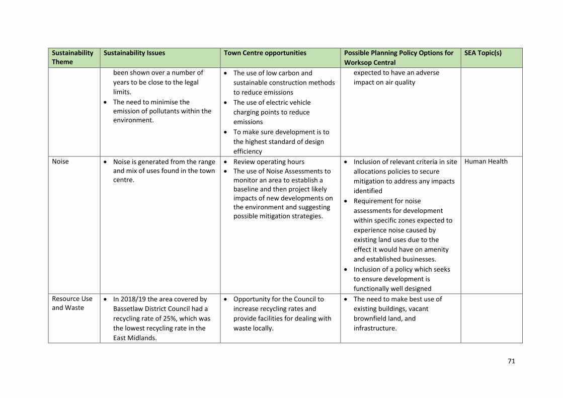
71
Sustainability Theme
Sustainability Issues Town Centre opportunities Possible Planning Policy Options for
Worksop Central
SEA Topic(s)
been shown over a number of
years to be close to the legal
limits.
The need to minimise the emission of pollutants within the environment.
The use of low carbon and
sustainable construction methods
to reduce emissions
The use of electric vehicle
charging points to reduce
emissions
To make sure development is to
the highest standard of design
efficiency
expected to have an adverse
impact on air quality
Noise Noise is generated from the range and mix of uses found in the town centre.
Review operating hours
The use of Noise Assessments to monitor an area to establish a baseline and then project likely impacts of new developments on the environment and suggesting possible mitigation strategies.
Inclusion of relevant criteria in site
allocations policies to secure
mitigation to address any impacts
identified
Requirement for noise
assessments for development
within specific zones expected to
experience noise caused by
existing land uses due to the
effect it would have on amenity
and established businesses.
Inclusion of a policy which seeks
to ensure development is
functionally well designed
Human Health
Resource Use and Waste
In 2018/19 the area covered by
Bassetlaw District Council had a
recycling rate of 25%, which was
the lowest recycling rate in the
East Midlands.
Opportunity for the Council to
increase recycling rates and
provide facilities for dealing with
waste locally.
The need to make best use of
existing buildings, vacant
brownfield land, and
infrastructure.
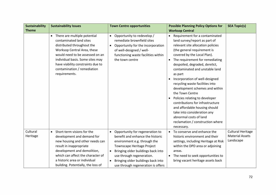
72
Sustainability Theme
Sustainability Issues Town Centre opportunities Possible Planning Policy Options for
Worksop Central
SEA Topic(s)
There are multiple potential
contaminated land sites
distributed throughout the
Worksop Central Area, these
would need to be assessed on an
individual basis. Some sites may
have viability constraints due to
contamination / remediation
requirements.
Opportunity to redevelop /
remediate brownfield sites
Opportunity for the incorporation
of well-designed / well-
functioning waste facilities within
the town centre
Requirement for a contaminated
land survey/report as part of
relevant site allocation policies
(the general requirement is
covered by the Local Plan).
The requirement for remediating
despoiled, degraded, derelict,
contaminated and unstable land
as part
Incorporation of well-designed
recycling waste facilities into
development schemes and within
the Town Centre
Policies relating to developer
contributions for infrastructure
and affordable housing should
take into consideration any
abnormal costs of land
reclamation / construction where
necessary.
Cultural Heritage
Short-term visions for the
development and demand for
new housing and other needs can
result in inappropriate
development and demolition,
which can affect the character of
a historic area or individual
building. Potentially, the loss of
Opportunity for regeneration to
benefit and enhance the historic
environment e.g. through the
Townscape Heritage Project
Bringing older buildings back into
use through regeneration.
Bringing older buildings back into
use through regeneration is offers
To conserve and enhance the
historic environment and their
settings, including Heritage at Risk
within the DPD area or adjoining
areas.
The need to seek opportunities to
bring vacant heritage assets back
Cultural Heritage Material Assets Landscape
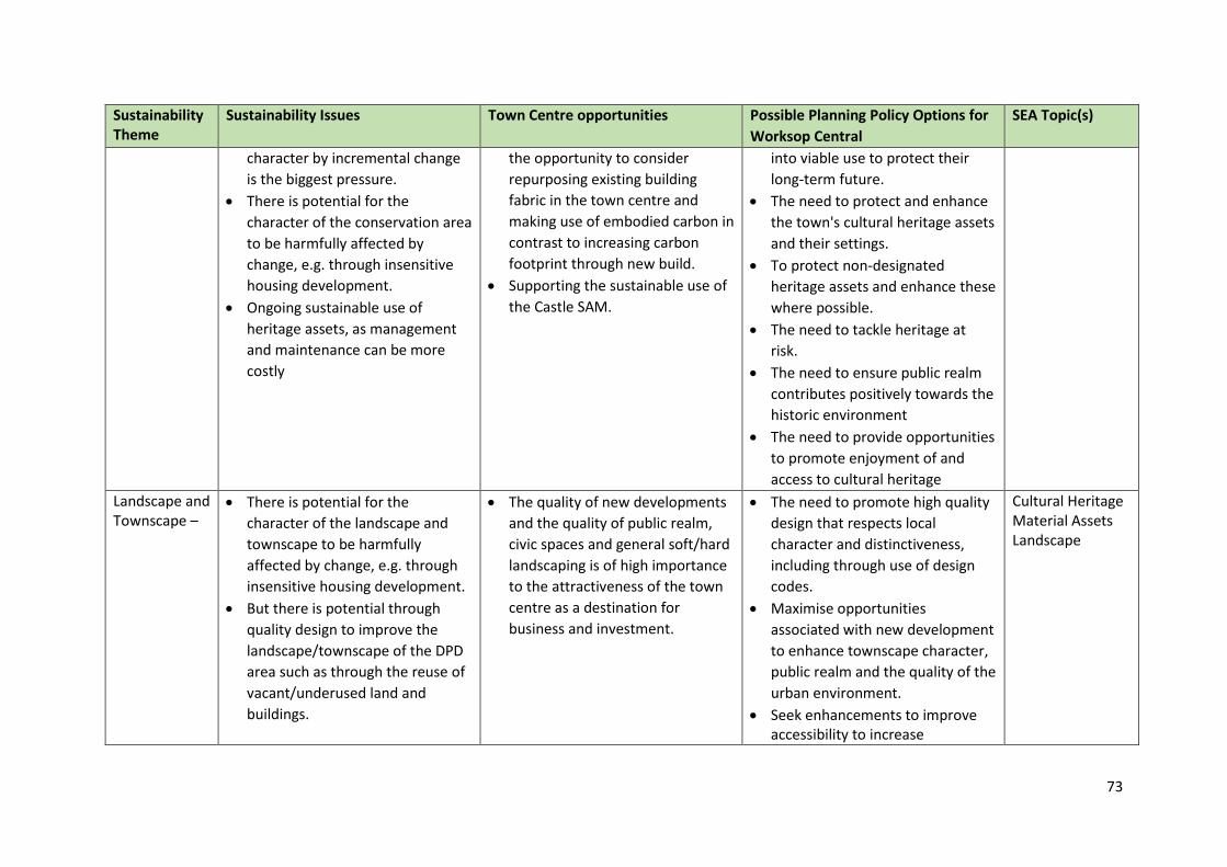
73
Sustainability Theme
Sustainability Issues Town Centre opportunities Possible Planning Policy Options for
Worksop Central
SEA Topic(s)
character by incremental change
is the biggest pressure.
There is potential for the
character of the conservation area
to be harmfully affected by
change, e.g. through insensitive
housing development.
Ongoing sustainable use of
heritage assets, as management
and maintenance can be more
costly
the opportunity to consider
repurposing existing building
fabric in the town centre and
making use of embodied carbon in
contrast to increasing carbon
footprint through new build.
Supporting the sustainable use of
the Castle SAM.
into viable use to protect their
long-term future.
The need to protect and enhance
the town's cultural heritage assets
and their settings.
To protect non-designated
heritage assets and enhance these
where possible.
The need to tackle heritage at
risk.
The need to ensure public realm
contributes positively towards the
historic environment
The need to provide opportunities
to promote enjoyment of and
access to cultural heritage
Landscape and Townscape –
There is potential for the
character of the landscape and
townscape to be harmfully
affected by change, e.g. through
insensitive housing development.
But there is potential through
quality design to improve the
landscape/townscape of the DPD
area such as through the reuse of
vacant/underused land and
buildings.
The quality of new developments
and the quality of public realm,
civic spaces and general soft/hard
landscaping is of high importance
to the attractiveness of the town
centre as a destination for
business and investment.
The need to promote high quality
design that respects local
character and distinctiveness,
including through use of design
codes.
Maximise opportunities
associated with new development
to enhance townscape character,
public realm and the quality of the
urban environment.
Seek enhancements to improve accessibility to increase
Cultural Heritage Material Assets Landscape
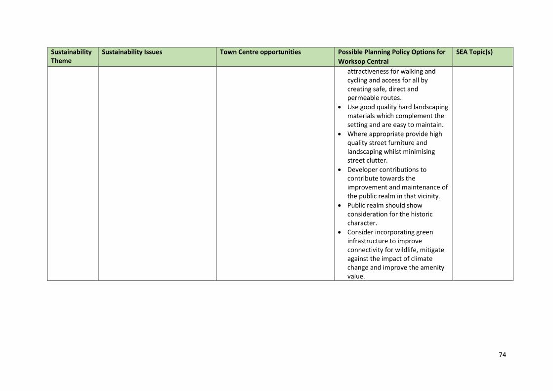
74
Sustainability Theme
Sustainability Issues Town Centre opportunities Possible Planning Policy Options for
Worksop Central
SEA Topic(s)
attractiveness for walking and cycling and access for all by creating safe, direct and permeable routes.
Use good quality hard landscaping materials which complement the setting and are easy to maintain.
Where appropriate provide high quality street furniture and landscaping whilst minimising street clutter.
Developer contributions to contribute towards the improvement and maintenance of the public realm in that vicinity.
Public realm should show consideration for the historic character.
Consider incorporating green infrastructure to improve connectivity for wildlife, mitigate against the impact of climate change and improve the amenity value.
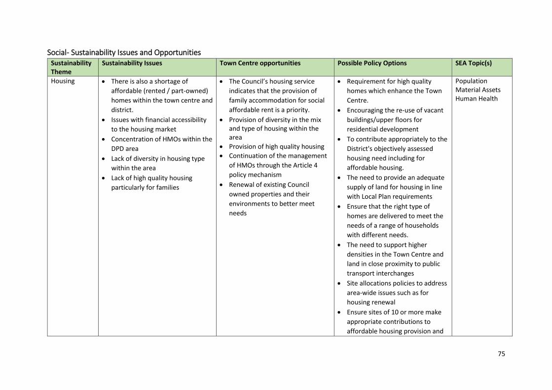
75
Social- Sustainability Issues and Opportunities Sustainability Theme
Sustainability Issues Town Centre opportunities Possible Policy Options SEA Topic(s)
Housing There is also a shortage of
affordable (rented / part-owned)
homes within the town centre and
district.
Issues with financial accessibility
to the housing market
Concentration of HMOs within the
DPD area
Lack of diversity in housing type
within the area
Lack of high quality housing
particularly for families
The Council’s housing service
indicates that the provision of
family accommodation for social
affordable rent is a priority.
Provision of diversity in the mix and type of housing within the area
Provision of high quality housing
Continuation of the management
of HMOs through the Article 4
policy mechanism
Renewal of existing Council
owned properties and their
environments to better meet
needs
Requirement for high quality
homes which enhance the Town
Centre.
Encouraging the re-use of vacant
buildings/upper floors for
residential development
To contribute appropriately to the
District's objectively assessed
housing need including for
affordable housing.
The need to provide an adequate
supply of land for housing in line
with Local Plan requirements
Ensure that the right type of
homes are delivered to meet the
needs of a range of households
with different needs.
The need to support higher
densities in the Town Centre and
land in close proximity to public
transport interchanges
Site allocations policies to address
area-wide issues such as for
housing renewal
Ensure sites of 10 or more make
appropriate contributions to
affordable housing provision and
Population Material Assets Human Health
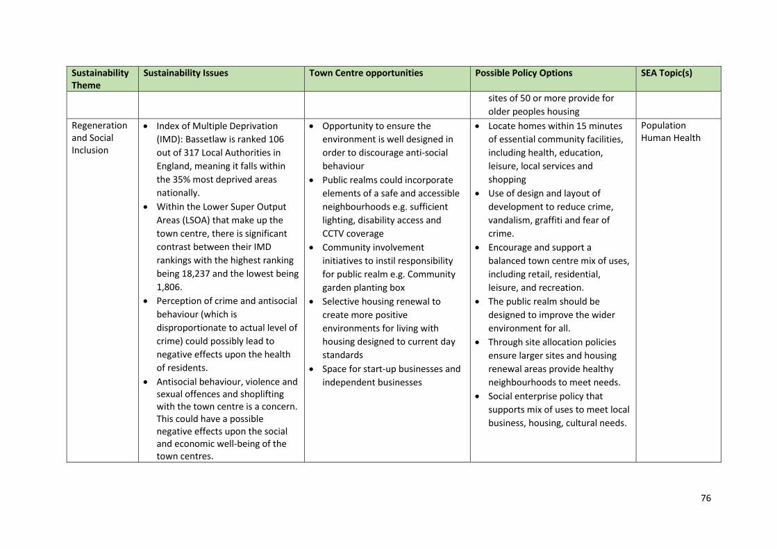
76
Sustainability Theme
Sustainability Issues Town Centre opportunities Possible Policy Options SEA Topic(s)
sites of 50 or more provide for
older peoples housing
Regeneration and Social Inclusion
Index of Multiple Deprivation
(IMD): Bassetlaw is ranked 106
out of 317 Local Authorities in
England, meaning it falls within
the 35% most deprived areas
nationally.
Within the Lower Super Output
Areas (LSOA) that make up the
town centre, there is significant
contrast between their IMD
rankings with the highest ranking
being 18,237 and the lowest being
1,806.
Perception of crime and antisocial
behaviour (which is
disproportionate to actual level of
crime) could possibly lead to
negative effects upon the health
of residents.
Antisocial behaviour, violence and sexual offences and shoplifting with the town centre is a concern. This could have a possible negative effects upon the social and economic well-being of the town centres.
Opportunity to ensure the
environment is well designed in
order to discourage anti-social
behaviour
Public realms could incorporate
elements of a safe and accessible
neighbourhoods e.g. sufficient
lighting, disability access and
CCTV coverage
Community involvement
initiatives to instil responsibility
for public realm e.g. Community
garden planting box
Selective housing renewal to
create more positive
environments for living with
housing designed to current day
standards
Space for start-up businesses and
independent businesses
Locate homes within 15 minutes
of essential community facilities,
including health, education,
leisure, local services and
shopping
Use of design and layout of
development to reduce crime,
vandalism, graffiti and fear of
crime.
Encourage and support a
balanced town centre mix of uses,
including retail, residential,
leisure, and recreation.
The public realm should be
designed to improve the wider
environment for all.
Through site allocation policies
ensure larger sites and housing
renewal areas provide healthy
neighbourhoods to meet needs.
Social enterprise policy that
supports mix of uses to meet local
business, housing, cultural needs.
Population Human Health
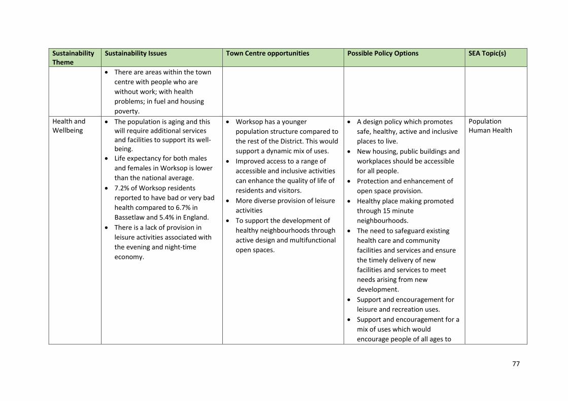
77
Sustainability Theme
Sustainability Issues Town Centre opportunities Possible Policy Options SEA Topic(s)
There are areas within the town
centre with people who are
without work; with health
problems; in fuel and housing
poverty.
Health and Wellbeing
The population is aging and this will require additional services and facilities to support its well-being.
Life expectancy for both males
and females in Worksop is lower
than the national average.
7.2% of Worksop residents
reported to have bad or very bad
health compared to 6.7% in
Bassetlaw and 5.4% in England.
There is a lack of provision in
leisure activities associated with
the evening and night-time
economy.
Worksop has a younger
population structure compared to
the rest of the District. This would
support a dynamic mix of uses.
Improved access to a range of
accessible and inclusive activities
can enhance the quality of life of
residents and visitors.
More diverse provision of leisure
activities
To support the development of
healthy neighbourhoods through
active design and multifunctional
open spaces.
A design policy which promotes
safe, healthy, active and inclusive
places to live.
New housing, public buildings and
workplaces should be accessible
for all people.
Protection and enhancement of
open space provision.
Healthy place making promoted
through 15 minute
neighbourhoods.
The need to safeguard existing
health care and community
facilities and services and ensure
the timely delivery of new
facilities and services to meet
needs arising from new
development.
Support and encouragement for
leisure and recreation uses.
Support and encouragement for a
mix of uses which would
encourage people of all ages to
Population Human Health
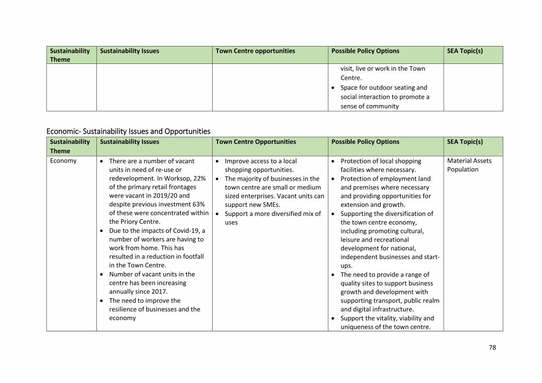
78
Sustainability Theme
Sustainability Issues Town Centre opportunities Possible Policy Options SEA Topic(s)
visit, live or work in the Town
Centre.
Space for outdoor seating and
social interaction to promote a
sense of community
Economic- Sustainability Issues and Opportunities Sustainability
Theme
Sustainability Issues Town Centre Opportunities Possible Policy Options SEA Topic(s)
Economy There are a number of vacant units in need of re-use or redevelopment. In Worksop, 22% of the primary retail frontages were vacant in 2019/20 and despite previous investment 63% of these were concentrated within the Priory Centre.
Due to the impacts of Covid-19, a number of workers are having to work from home. This has resulted in a reduction in footfall in the Town Centre.
Number of vacant units in the centre has been increasing annually since 2017.
The need to improve the resilience of businesses and the economy
Improve access to a local shopping opportunities.
The majority of businesses in the town centre are small or medium sized enterprises. Vacant units can support new SMEs.
Support a more diversified mix of uses
Protection of local shopping facilities where necessary.
Protection of employment land and premises where necessary and providing opportunities for extension and growth.
Supporting the diversification of the town centre economy, including promoting cultural, leisure and recreational development for national, independent businesses and start-ups.
The need to provide a range of quality sites to support business growth and development with supporting transport, public realm and digital infrastructure.
Support the vitality, viability and uniqueness of the town centre.
Material Assets Population
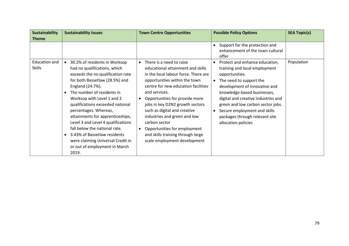
79
Sustainability
Theme
Sustainability Issues Town Centre Opportunities Possible Policy Options SEA Topic(s)
Support for the protection and enhancement of the town cultural offer
Education and
Skills 30.2% of residents in Worksop
had no qualifications, which
exceeds the no qualification rate
for both Bassetlaw (28.5%) and
England (24.7%).
The number of residents in
Worksop with Level 1 and 2
qualifications exceeded national
percentages. Whereas,
attainments for apprenticeships,
Level 3 and Level 4 qualifications
fall below the national rate.
3.43% of Bassetlaw residents
were claiming Universal Credit in
or out of employment in March
2019.
There is a need to raise
educational attainment and skills
in the local labour force. There are
opportunities within the town
centre for new education facilities
and services.
Opportunities for provide more
jobs in key D2N2 growth sectors
such as digital and creative
industries and green and low
carbon sector
Opportunities for employment
and skills training through large
scale employment development
Protect and enhance education,
training and local employment
opportunities.
The need to support the
development of innovative and
knowledge-based businesses,
digital and creative industries and
green and low carbon sector jobs.
Secure employment and skills
packages through relevant site
allocation policies
Population
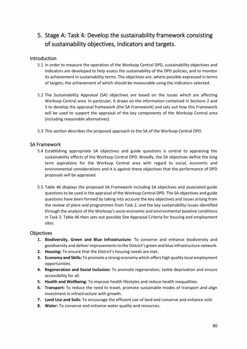
80
5. Stage A: Task 4: Develop the sustainability framework consisting
of sustainability objectives, indicators and targets.
Introduction 5.1 In order to measure the operation of the Worksop Central DPD, sustainability objectives and
indicators are developed to help assess the sustainability of the DPD policies, and to monitor
its achievement in sustainability terms. The objectives are, where possible expressed in terms
of targets, the achievement of which should be measurable using the indicators selected.
5.2 The Sustainability Appraisal (SA) objectives are based on the issues which are affecting
Worksop Central area. In particular, it draws on the information contained in Sections 2 and
3 to develop the appraisal framework (the SA Framework) and sets out how this Framework
will be used to support the appraisal of the key components of the Worksop Central area
(including reasonable alternatives).
5.3 This section describes the proposed approach to the SA of the Worksop Central DPD.
SA Framework 5.4 Establishing appropriate SA objectives and guide questions is central to appraising the
sustainability effects of the Worksop Central DPD. Broadly, the SA objectives define the long
term aspirations for the Worksop Central area with regard to social, economic and
environmental considerations and it is against these objectives that the performance of DPD
proposals will be appraised.
5.5 Table 46 displays the proposed SA Framework including SA objectives and associated guide
questions to be used in the appraisal of the Worksop Central DPD. The SA objectives and guide
questions have been formed by taking into account the key objectives and issues arising from
the review of plans and programmes from Task 2, and the key sustainability issues identified
through the analysis of the Worksop’s socio-economic and environmental baseline conditions
in Task 3. Table 46 then sets out possible Site Appraisal Criteria for housing and employment
sites.
Objectives 1. Biodiversity, Green and Blue Infrastructure: To conserve and enhance biodiversity and
geodiversity and deliver improvements to the District’s green and blue infrastructure network.
2. Housing: To ensure that the District’s housing needs are met.
3. Economy and Skills: To promote a strong economy which offers high quality local employment
opportunities.
4. Regeneration and Social Inclusion: To promote regeneration, tackle deprivation and ensure
accessibility for all.
5. Health and Wellbeing: To improve health lifestyles and reduce health inequalities.
6. Transport: To reduce the need to travel, promote sustainable modes of transport and align
investment in infrastructure with growth.
7. Land Use and Soils: To encourage the efficient use of land and conserve and enhance soils
8. Water: To conserve and enhance water quality and resources.
81
9. Flood Risk: To minimise flood risk and reduce the impact of flooding to people and property
in the District, taking into account the effects of climate change
10. Air Quality: To improve air quality.
11. Climate Change: To minimise greenhouse gas emissions and adapt to the effects of climate
change.
12. Resource Use and Waste: To encourage sustainable resource use and promote the waste
hierarchy (reduce, reuse, recycle, recover).
13. Cultural Heritage: To conserve and enhance the District’s historic environment, cultural
heritage, character and setting
14. Landscape and Townscape: To conserve and enhance the District’s landscape character and
townscapes.
Consultation questions: 7. Do you agree with the objectives? And if not, should any objectives be re-worded or removed?
8. Are there any particular indicators that we should be including for measurement and monitoring?
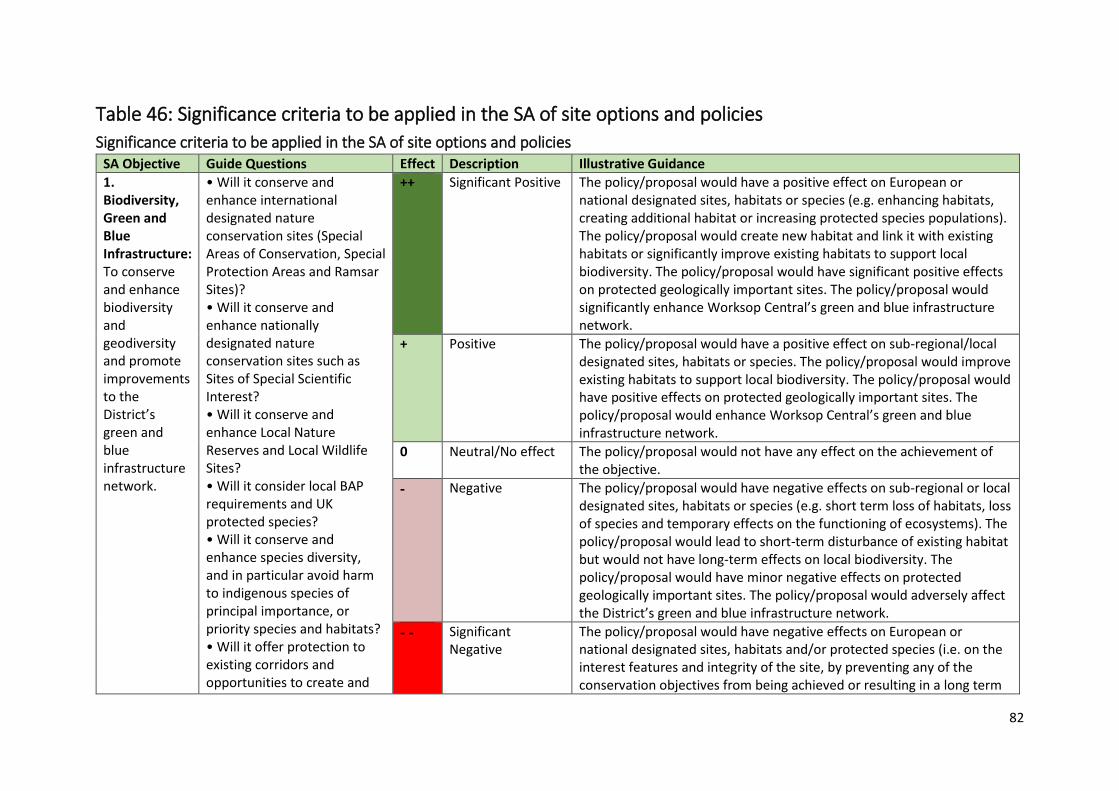
82
Table 46: Significance criteria to be applied in the SA of site options and policies
Significance criteria to be applied in the SA of site options and policies SA Objective Guide Questions Effect Description Illustrative Guidance
1. Biodiversity, Green and Blue Infrastructure: To conserve and enhance biodiversity and geodiversity and promote improvements to the District’s green and blue infrastructure network.
• Will it conserve and enhance international designated nature conservation sites (Special Areas of Conservation, Special Protection Areas and Ramsar Sites)? • Will it conserve and enhance nationally designated nature conservation sites such as Sites of Special Scientific Interest? • Will it conserve and enhance Local Nature Reserves and Local Wildlife Sites? • Will it consider local BAP requirements and UK protected species? • Will it conserve and enhance species diversity, and in particular avoid harm to indigenous species of principal importance, or priority species and habitats? • Will it offer protection to existing corridors and opportunities to create and
++ Significant Positive The policy/proposal would have a positive effect on European or national designated sites, habitats or species (e.g. enhancing habitats, creating additional habitat or increasing protected species populations). The policy/proposal would create new habitat and link it with existing habitats or significantly improve existing habitats to support local biodiversity. The policy/proposal would have significant positive effects on protected geologically important sites. The policy/proposal would significantly enhance Worksop Central’s green and blue infrastructure network.
+ Positive The policy/proposal would have a positive effect on sub-regional/local designated sites, habitats or species. The policy/proposal would improve existing habitats to support local biodiversity. The policy/proposal would have positive effects on protected geologically important sites. The policy/proposal would enhance Worksop Central’s green and blue infrastructure network.
0 Neutral/No effect The policy/proposal would not have any effect on the achievement of the objective.
- Negative The policy/proposal would have negative effects on sub-regional or local designated sites, habitats or species (e.g. short term loss of habitats, loss of species and temporary effects on the functioning of ecosystems). The policy/proposal would lead to short-term disturbance of existing habitat but would not have long-term effects on local biodiversity. The policy/proposal would have minor negative effects on protected geologically important sites. The policy/proposal would adversely affect the District’s green and blue infrastructure network.
- - Significant Negative
The policy/proposal would have negative effects on European or national designated sites, habitats and/or protected species (i.e. on the interest features and integrity of the site, by preventing any of the conservation objectives from being achieved or resulting in a long term
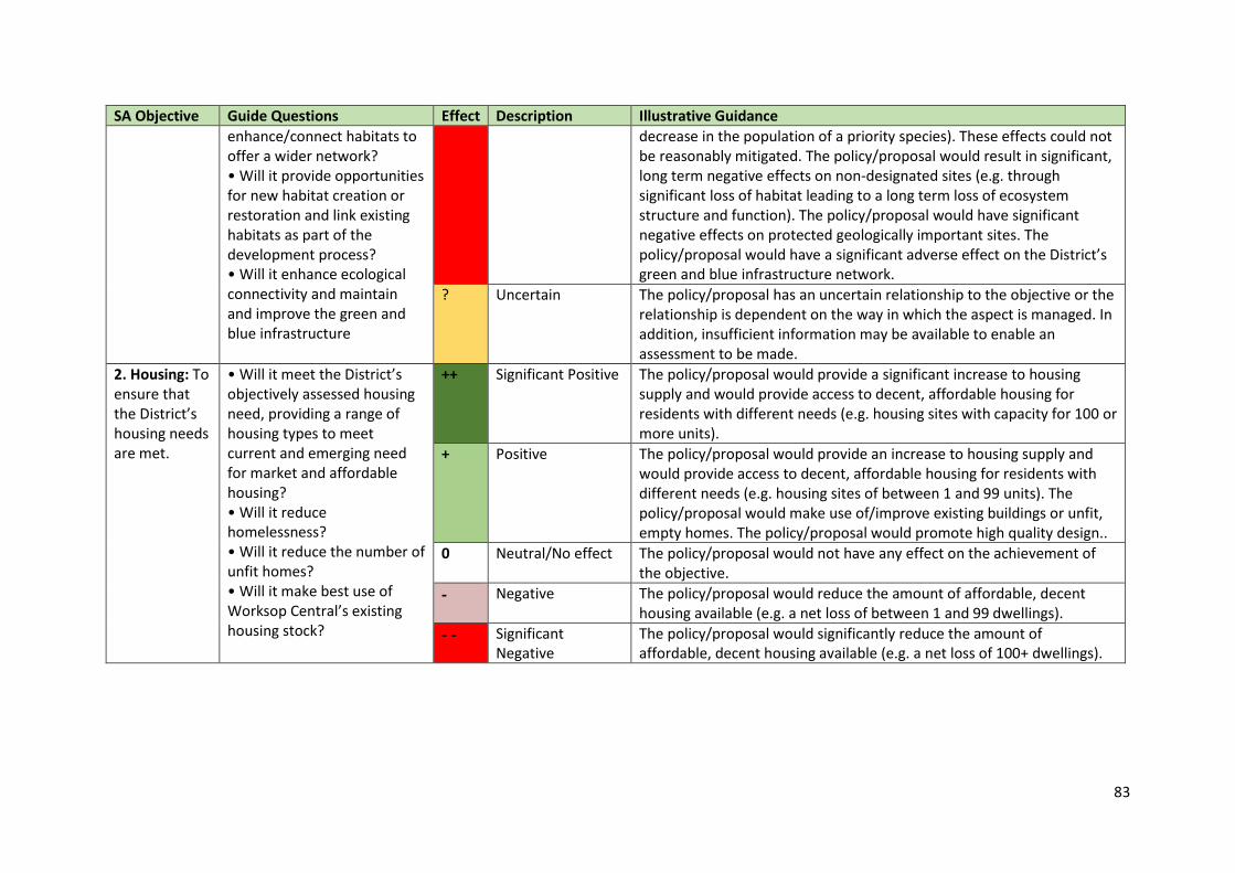
83
SA Objective Guide Questions Effect Description Illustrative Guidance
enhance/connect habitats to offer a wider network? • Will it provide opportunities for new habitat creation or restoration and link existing habitats as part of the development process? • Will it enhance ecological connectivity and maintain and improve the green and blue infrastructure
decrease in the population of a priority species). These effects could not be reasonably mitigated. The policy/proposal would result in significant, long term negative effects on non-designated sites (e.g. through significant loss of habitat leading to a long term loss of ecosystem structure and function). The policy/proposal would have significant negative effects on protected geologically important sites. The policy/proposal would have a significant adverse effect on the District’s green and blue infrastructure network.
? Uncertain The policy/proposal has an uncertain relationship to the objective or the relationship is dependent on the way in which the aspect is managed. In addition, insufficient information may be available to enable an assessment to be made.
2. Housing: To ensure that the District’s housing needs are met.
• Will it meet the District’s objectively assessed housing need, providing a range of housing types to meet current and emerging need for market and affordable housing? • Will it reduce homelessness? • Will it reduce the number of unfit homes? • Will it make best use of Worksop Central’s existing housing stock?
++ Significant Positive The policy/proposal would provide a significant increase to housing supply and would provide access to decent, affordable housing for residents with different needs (e.g. housing sites with capacity for 100 or more units).
+ Positive The policy/proposal would provide an increase to housing supply and would provide access to decent, affordable housing for residents with different needs (e.g. housing sites of between 1 and 99 units). The policy/proposal would make use of/improve existing buildings or unfit, empty homes. The policy/proposal would promote high quality design..
0 Neutral/No effect The policy/proposal would not have any effect on the achievement of the objective.
- Negative The policy/proposal would reduce the amount of affordable, decent housing available (e.g. a net loss of between 1 and 99 dwellings).
- - Significant Negative
The policy/proposal would significantly reduce the amount of affordable, decent housing available (e.g. a net loss of 100+ dwellings).

84
SA Objective Guide Questions Effect Description Illustrative Guidance
• Will it help to ensure the provision of good quality, well designed homes? • Will it deliver housing to meet the needs of the elderly and those with special needs?
? Uncertain The policy/proposal has an uncertain relationship to the objective or the relationship is dependent on the way in which the aspect is managed. In addition, insufficient information may be available to enable an assessment to be made.
3. Economy and Skills: To promote a strong economy which offers high quality local employment opportunities.
• Will it deliver local economic growth? • Will it provide a supply of flexible, good quality employment land to meet the needs of the Worksop Central’s existing businesses and attract inward investment? • Will it help to diversify the local economy and support the delivery of the District's Regeneration and Growth Strategy, Nottinghamshire Growth Plan, Sheffield City Region and the D2N2 Local Enterprise Partnership Strategic Economic Plan? • Will it provide good quality, well paid employment opportunities that meet the needs of local people? • Will it increase average income levels? • Will it improve the physical accessibility of jobs?
++ Significant Positive The policy/proposal would significantly encourage investment in businesses, people and infrastructure which would lead to a more diversified economy, maximising viability of the local economy and reducing out-commuting. Is it located within an area that would support economic growth, this would include town centre locations or a major/existing employment area The policy would support a mix of employment and commercial uses e.g. relating to retail, leisure and recreation, education, tourism or financial and professional services, offices.
+ Positive The policy/proposal would encourage investment in businesses, people and infrastructure. The policy/proposal would provide accessible employment opportunities. Is it located within close proximity to a town centre or a major/existing employment area. The policy would support a mix of employment and commercial uses e.g. relating to retail, leisure and recreation, education, tourism or financial and professional services, offices.
0 Neutral/No effect The policy/proposal would not have any effect on the achievement of the objective.
- Negative The policy/proposal would have negative effects on businesses, the local economy and local employment (e.g. it would result in the loss of jobs).
- - Significant Negative
The policy/proposal would have significant negative effects on business, the local economy and local employment (e.g. policy/proposal would lead to the closure or relocation of existing significant local businesses). The policy/proposal would result in the loss of existing educational
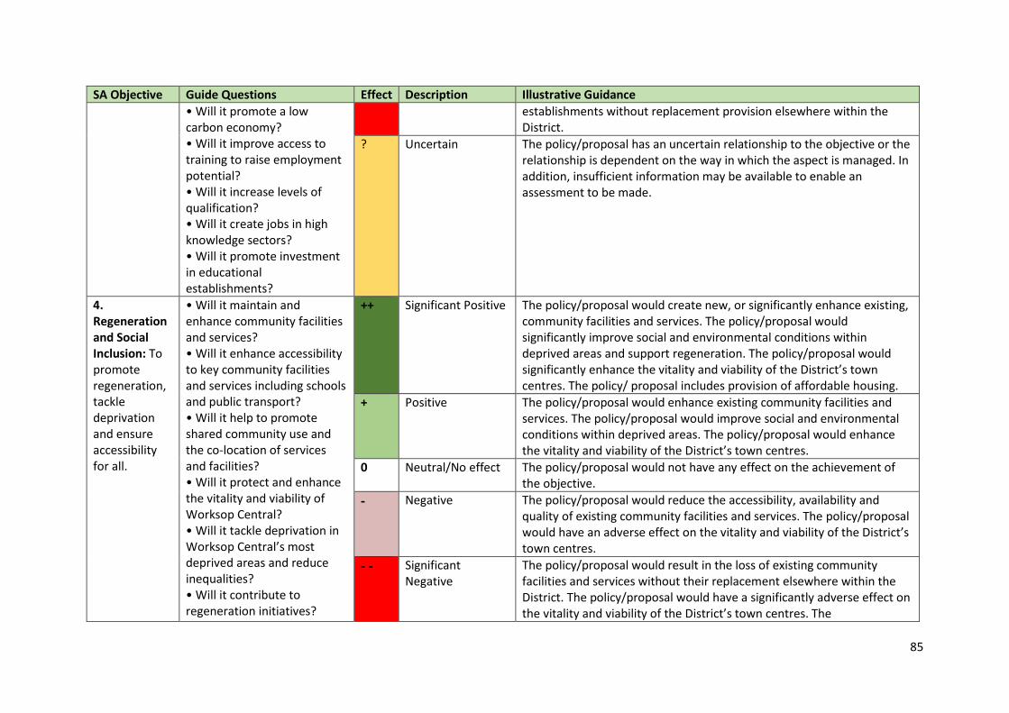
85
SA Objective Guide Questions Effect Description Illustrative Guidance
• Will it promote a low carbon economy? • Will it improve access to training to raise employment potential? • Will it increase levels of qualification? • Will it create jobs in high knowledge sectors? • Will it promote investment in educational establishments?
establishments without replacement provision elsewhere within the District.
? Uncertain The policy/proposal has an uncertain relationship to the objective or the relationship is dependent on the way in which the aspect is managed. In addition, insufficient information may be available to enable an assessment to be made.
4. Regeneration and Social Inclusion: To promote regeneration, tackle deprivation and ensure accessibility for all.
• Will it maintain and enhance community facilities and services? • Will it enhance accessibility to key community facilities and services including schools and public transport? • Will it help to promote shared community use and the co-location of services and facilities? • Will it protect and enhance the vitality and viability of Worksop Central? • Will it tackle deprivation in Worksop Central’s most deprived areas and reduce inequalities? • Will it contribute to regeneration initiatives?
++ Significant Positive The policy/proposal would create new, or significantly enhance existing, community facilities and services. The policy/proposal would significantly improve social and environmental conditions within deprived areas and support regeneration. The policy/proposal would significantly enhance the vitality and viability of the District’s town centres. The policy/ proposal includes provision of affordable housing.
+ Positive The policy/proposal would enhance existing community facilities and services. The policy/proposal would improve social and environmental conditions within deprived areas. The policy/proposal would enhance the vitality and viability of the District’s town centres.
0 Neutral/No effect The policy/proposal would not have any effect on the achievement of the objective.
- Negative The policy/proposal would reduce the accessibility, availability and quality of existing community facilities and services. The policy/proposal would have an adverse effect on the vitality and viability of the District’s town centres.
- - Significant Negative
The policy/proposal would result in the loss of existing community facilities and services without their replacement elsewhere within the District. The policy/proposal would have a significantly adverse effect on the vitality and viability of the District’s town centres. The

86
SA Objective Guide Questions Effect Description Illustrative Guidance
• Will it encourage engagement in community activities? • Will it promote participation in cultural activities? • Will it enhance the public realm? • Will it align investment in services, facilities and infrastructure with growth? • Will it enhance social inclusion by providing increased opportunities for people to access housing e.g. affordable housing provision?
policy/proposal would result in new residential development being inaccessible to existing services and facilities.
? Uncertain The policy/proposal has an uncertain relationship to the objective or the relationship is dependent on the way in which the aspect is managed. In addition, insufficient information may be available to enable an assessment to be made.
5. Health and Wellbeing: To improve health and reduce health inequalities.
• Will it avoid locating development in locations that could adversely affect people’s health? • Will it maintain and improve access to green and blue infrastructure, open space, leisure and recreational facilities for all? • Will it maintain and improve access to children’s play areas? • Will it increase the opportunities for physical activity and accessibility of
++ Significant Positive The policy/proposal would have strong and sustained impacts on healthy lifestyles and improve well-being through physical activity, recreational activity, improved environmental quality, etc. Different groups within the society are taken into consideration and policy/proposal would deliver new healthcare facilities and open space; and the policy/proposal would support the reduction of crime and the fear of crime through design and other safety measures. The policy/ proposal includes provision of affordable housing.
+ Positive The policy/proposal would have strong and sustained impacts on healthy lifestyles and improve well-being through physical activity, recreational activity, improved environmental quality, etc. Different groups within the society are taken into consideration and/or policy/proposal would deliver new healthcare facilities and/or open space; and the policy/proposal would support the reduction of crime and/or the fear of crime through design and other safety measures.
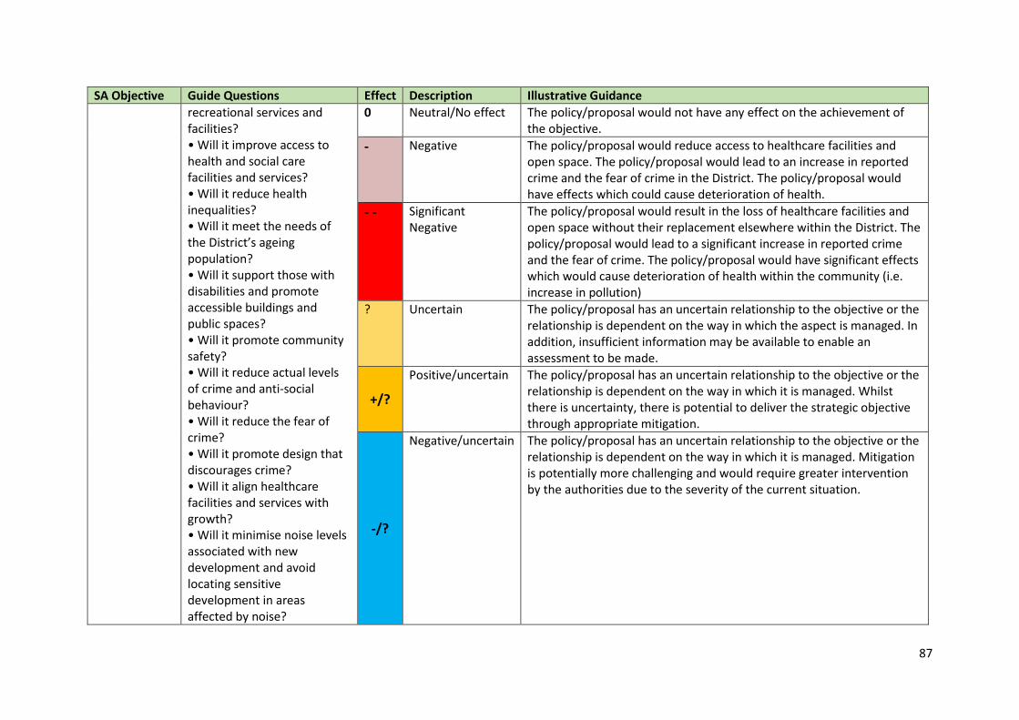
87
SA Objective Guide Questions Effect Description Illustrative Guidance
recreational services and facilities? • Will it improve access to health and social care facilities and services? • Will it reduce health inequalities? • Will it meet the needs of the District’s ageing population? • Will it support those with disabilities and promote accessible buildings and public spaces? • Will it promote community safety? • Will it reduce actual levels of crime and anti-social behaviour? • Will it reduce the fear of crime? • Will it promote design that discourages crime? • Will it align healthcare facilities and services with growth? • Will it minimise noise levels associated with new development and avoid locating sensitive development in areas affected by noise?
0 Neutral/No effect The policy/proposal would not have any effect on the achievement of the objective.
- Negative The policy/proposal would reduce access to healthcare facilities and open space. The policy/proposal would lead to an increase in reported crime and the fear of crime in the District. The policy/proposal would have effects which could cause deterioration of health.
- - Significant Negative
The policy/proposal would result in the loss of healthcare facilities and open space without their replacement elsewhere within the District. The policy/proposal would lead to a significant increase in reported crime and the fear of crime. The policy/proposal would have significant effects which would cause deterioration of health within the community (i.e. increase in pollution)
? Uncertain The policy/proposal has an uncertain relationship to the objective or the relationship is dependent on the way in which the aspect is managed. In addition, insufficient information may be available to enable an assessment to be made.
+/?
Positive/uncertain The policy/proposal has an uncertain relationship to the objective or the relationship is dependent on the way in which it is managed. Whilst there is uncertainty, there is potential to deliver the strategic objective through appropriate mitigation.
-/?
Negative/uncertain The policy/proposal has an uncertain relationship to the objective or the relationship is dependent on the way in which it is managed. Mitigation is potentially more challenging and would require greater intervention by the authorities due to the severity of the current situation.
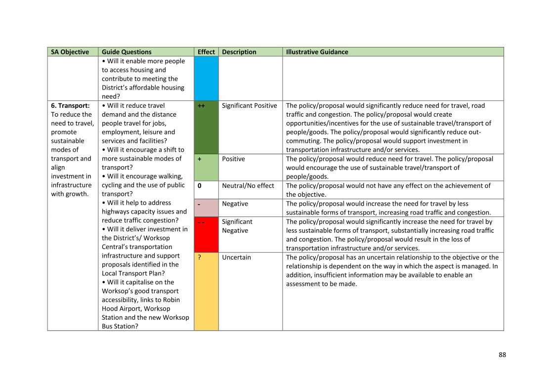
88
SA Objective Guide Questions Effect Description Illustrative Guidance
• Will it enable more people to access housing and contribute to meeting the District’s affordable housing need?
6. Transport: To reduce the need to travel, promote sustainable modes of transport and align investment in infrastructure with growth.
• Will it reduce travel demand and the distance people travel for jobs, employment, leisure and services and facilities? • Will it encourage a shift to more sustainable modes of transport? • Will it encourage walking, cycling and the use of public transport? • Will it help to address highways capacity issues and reduce traffic congestion? • Will it deliver investment in the District’s/ Worksop Central’s transportation infrastructure and support proposals identified in the Local Transport Plan? • Will it capitalise on the Worksop’s good transport accessibility, links to Robin Hood Airport, Worksop Station and the new Worksop Bus Station?
++ Significant Positive The policy/proposal would significantly reduce need for travel, road traffic and congestion. The policy/proposal would create opportunities/incentives for the use of sustainable travel/transport of people/goods. The policy/proposal would significantly reduce out-commuting. The policy/proposal would support investment in transportation infrastructure and/or services.
+ Positive The policy/proposal would reduce need for travel. The policy/proposal would encourage the use of sustainable travel/transport of people/goods.
0 Neutral/No effect The policy/proposal would not have any effect on the achievement of the objective.
- Negative The policy/proposal would increase the need for travel by less sustainable forms of transport, increasing road traffic and congestion.
- - Significant Negative
The policy/proposal would significantly increase the need for travel by less sustainable forms of transport, substantially increasing road traffic and congestion. The policy/proposal would result in the loss of transportation infrastructure and/or services.
? Uncertain The policy/proposal has an uncertain relationship to the objective or the relationship is dependent on the way in which the aspect is managed. In addition, insufficient information may be available to enable an assessment to be made.
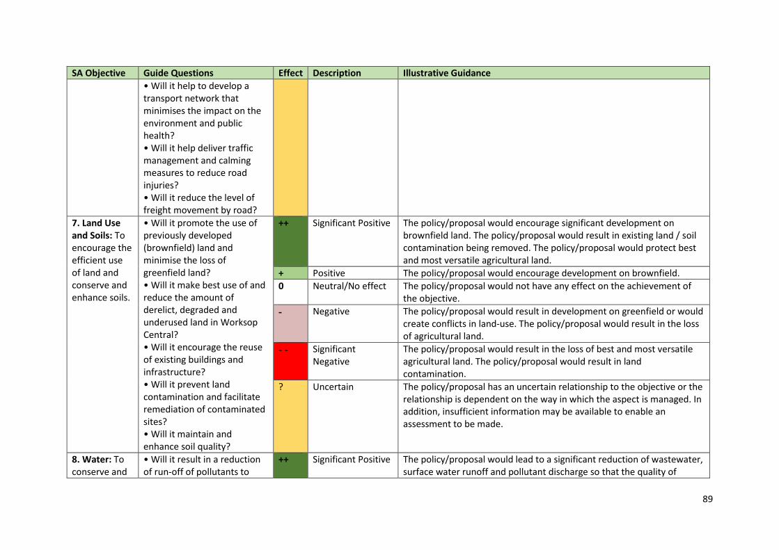
89
SA Objective Guide Questions Effect Description Illustrative Guidance
• Will it help to develop a transport network that minimises the impact on the environment and public health? • Will it help deliver traffic management and calming measures to reduce road injuries? • Will it reduce the level of freight movement by road?
7. Land Use and Soils: To encourage the efficient use of land and conserve and enhance soils.
• Will it promote the use of previously developed (brownfield) land and minimise the loss of greenfield land? • Will it make best use of and reduce the amount of derelict, degraded and underused land in Worksop Central? • Will it encourage the reuse of existing buildings and infrastructure? • Will it prevent land contamination and facilitate remediation of contaminated sites? • Will it maintain and enhance soil quality?
++ Significant Positive The policy/proposal would encourage significant development on brownfield land. The policy/proposal would result in existing land / soil contamination being removed. The policy/proposal would protect best and most versatile agricultural land.
+ Positive The policy/proposal would encourage development on brownfield.
0 Neutral/No effect The policy/proposal would not have any effect on the achievement of the objective.
- Negative The policy/proposal would result in development on greenfield or would create conflicts in land-use. The policy/proposal would result in the loss of agricultural land.
- - Significant Negative
The policy/proposal would result in the loss of best and most versatile agricultural land. The policy/proposal would result in land contamination.
? Uncertain The policy/proposal has an uncertain relationship to the objective or the relationship is dependent on the way in which the aspect is managed. In addition, insufficient information may be available to enable an assessment to be made.
8. Water: To conserve and
• Will it result in a reduction of run-off of pollutants to
++ Significant Positive The policy/proposal would lead to a significant reduction of wastewater, surface water runoff and pollutant discharge so that the quality of
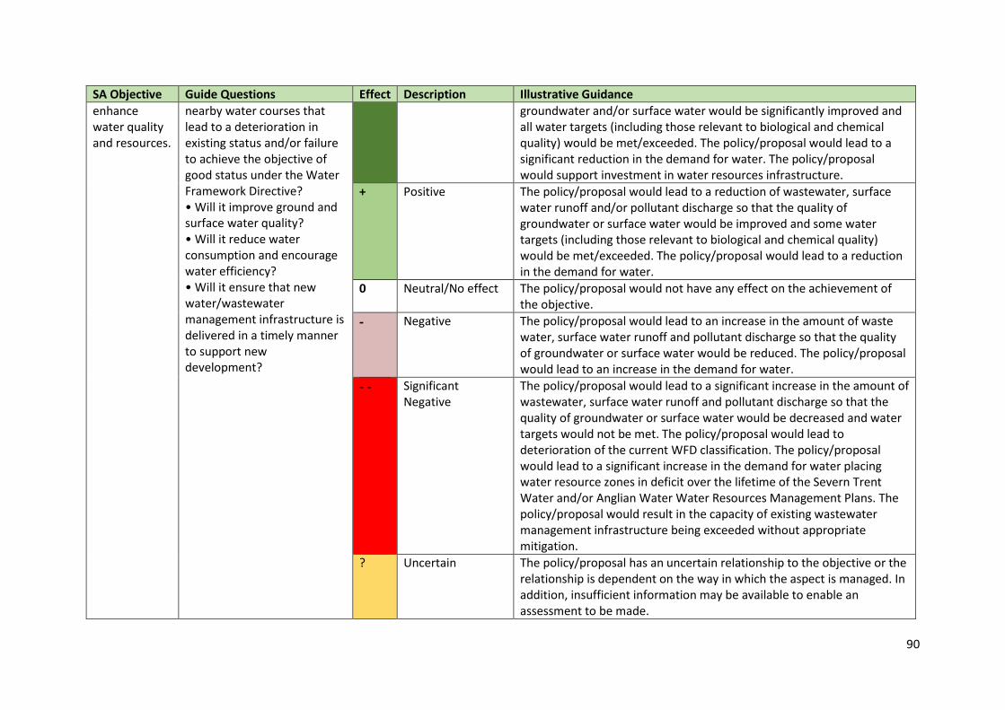
90
SA Objective Guide Questions Effect Description Illustrative Guidance
enhance water quality and resources.
nearby water courses that lead to a deterioration in existing status and/or failure to achieve the objective of good status under the Water Framework Directive? • Will it improve ground and surface water quality? • Will it reduce water consumption and encourage water efficiency? • Will it ensure that new water/wastewater management infrastructure is delivered in a timely manner to support new development?
groundwater and/or surface water would be significantly improved and all water targets (including those relevant to biological and chemical quality) would be met/exceeded. The policy/proposal would lead to a significant reduction in the demand for water. The policy/proposal would support investment in water resources infrastructure.
+ Positive The policy/proposal would lead to a reduction of wastewater, surface water runoff and/or pollutant discharge so that the quality of groundwater or surface water would be improved and some water targets (including those relevant to biological and chemical quality) would be met/exceeded. The policy/proposal would lead to a reduction in the demand for water.
0 Neutral/No effect The policy/proposal would not have any effect on the achievement of the objective.
- Negative The policy/proposal would lead to an increase in the amount of waste water, surface water runoff and pollutant discharge so that the quality of groundwater or surface water would be reduced. The policy/proposal would lead to an increase in the demand for water.
- - Significant Negative
The policy/proposal would lead to a significant increase in the amount of wastewater, surface water runoff and pollutant discharge so that the quality of groundwater or surface water would be decreased and water targets would not be met. The policy/proposal would lead to deterioration of the current WFD classification. The policy/proposal would lead to a significant increase in the demand for water placing water resource zones in deficit over the lifetime of the Severn Trent Water and/or Anglian Water Water Resources Management Plans. The policy/proposal would result in the capacity of existing wastewater management infrastructure being exceeded without appropriate mitigation.
? Uncertain The policy/proposal has an uncertain relationship to the objective or the relationship is dependent on the way in which the aspect is managed. In addition, insufficient information may be available to enable an assessment to be made.
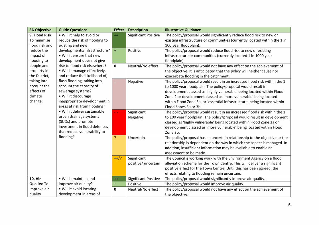
91
SA Objective Guide Questions Effect Description Illustrative Guidance
9. Flood Risk: To minimise flood risk and reduce the impact of flooding to people and property in the District, taking into account the effects of climate change.
• Will it help to avoid or reduce the risk of flooding to existing and new developments/infrastructure? • Will it ensure that new development does not give rise to flood risk elsewhere? • Will it manage effectively, and reduce the likelihood of, flash flooding, taking into account the capacity of sewerage systems? • Will it discourage inappropriate development in areas at risk from flooding? • Will it deliver sustainable urban drainage systems (SUDs) and promote investment in flood defences that reduce vulnerability to flooding?
++ Significant Positive The policy/proposal would significantly reduce flood risk to new or existing infrastructure or communities (currently located within the 1 in 100 year floodplain).
+ Positive The policy/proposal would reduce flood risk to new or existing infrastructure or communities (currently located 1 in 1000 year floodplain).
0 Neutral/No effect The policy/proposal would not have any effect on the achievement of the objective. It is anticipated that the policy will neither cause nor exacerbate flooding in the catchment.
- Negative The policy/proposal would result in an increased flood risk within the 1 to 1000 year floodplain. The policy/proposal would result in development classed as ‘highly vulnerable’ being located within Flood Zone 2 or development classed as ‘more vulnerable’ being located within Flood Zone 3a. or ‘essential infrastructure’ being located within Flood Zones 3a or 3b.
- - Significant Negative
The policy/proposal would result in an increased flood risk within the 1 to 100 year floodplain. The policy/proposal would result in development classed as ‘highly vulnerable’ being located within Flood Zone 3a or development classed as ‘more vulnerable’ being located within Flood Zone 3b.
? Uncertain The policy/proposal has an uncertain relationship to the objective or the relationship is dependent on the way in which the aspect is managed. In addition, insufficient information may be available to enable an assessment to be made.
++/? Significant positive/ uncertain
The Council is working work with the Environment Agency on a flood alleviation scheme for the Town Centre. This will deliver a significant positive effect for the Town Centre, Until this has been agreed, the effects relating to flooding remain uncertain.
10. Air Quality: To improve air quality
• Will it maintain and improve air quality? • Will it avoid locating development in areas of
++ Significant Positive The policy/proposal would significantly improve air quality.
+ Positive The policy/proposal would improve air quality.
0 Neutral/No effect The policy/proposal would not have any effect on the achievement of the objective.
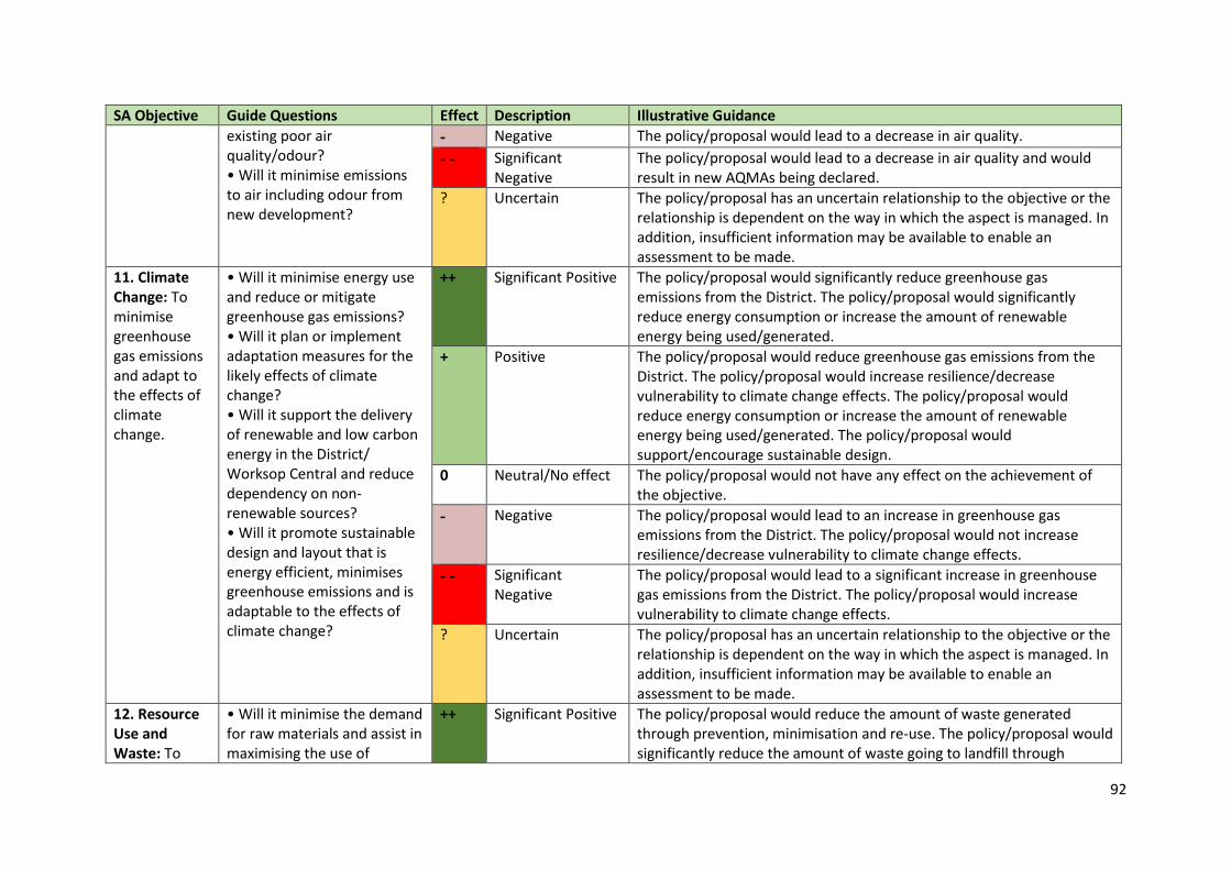
92
SA Objective Guide Questions Effect Description Illustrative Guidance
existing poor air quality/odour? • Will it minimise emissions to air including odour from new development?
- Negative The policy/proposal would lead to a decrease in air quality.
- - Significant Negative
The policy/proposal would lead to a decrease in air quality and would result in new AQMAs being declared.
? Uncertain The policy/proposal has an uncertain relationship to the objective or the relationship is dependent on the way in which the aspect is managed. In addition, insufficient information may be available to enable an assessment to be made.
11. Climate Change: To minimise greenhouse gas emissions and adapt to the effects of climate change.
• Will it minimise energy use and reduce or mitigate greenhouse gas emissions? • Will it plan or implement adaptation measures for the likely effects of climate change? • Will it support the delivery of renewable and low carbon energy in the District/ Worksop Central and reduce dependency on non-renewable sources? • Will it promote sustainable design and layout that is energy efficient, minimises greenhouse emissions and is adaptable to the effects of climate change?
++ Significant Positive The policy/proposal would significantly reduce greenhouse gas emissions from the District. The policy/proposal would significantly reduce energy consumption or increase the amount of renewable energy being used/generated.
+ Positive The policy/proposal would reduce greenhouse gas emissions from the District. The policy/proposal would increase resilience/decrease vulnerability to climate change effects. The policy/proposal would reduce energy consumption or increase the amount of renewable energy being used/generated. The policy/proposal would support/encourage sustainable design.
0 Neutral/No effect The policy/proposal would not have any effect on the achievement of the objective.
- Negative The policy/proposal would lead to an increase in greenhouse gas emissions from the District. The policy/proposal would not increase resilience/decrease vulnerability to climate change effects.
- - Significant Negative
The policy/proposal would lead to a significant increase in greenhouse gas emissions from the District. The policy/proposal would increase vulnerability to climate change effects.
? Uncertain The policy/proposal has an uncertain relationship to the objective or the relationship is dependent on the way in which the aspect is managed. In addition, insufficient information may be available to enable an assessment to be made.
12. Resource Use and Waste: To
• Will it minimise the demand for raw materials and assist in maximising the use of
++ Significant Positive The policy/proposal would reduce the amount of waste generated through prevention, minimisation and re-use. The policy/proposal would significantly reduce the amount of waste going to landfill through
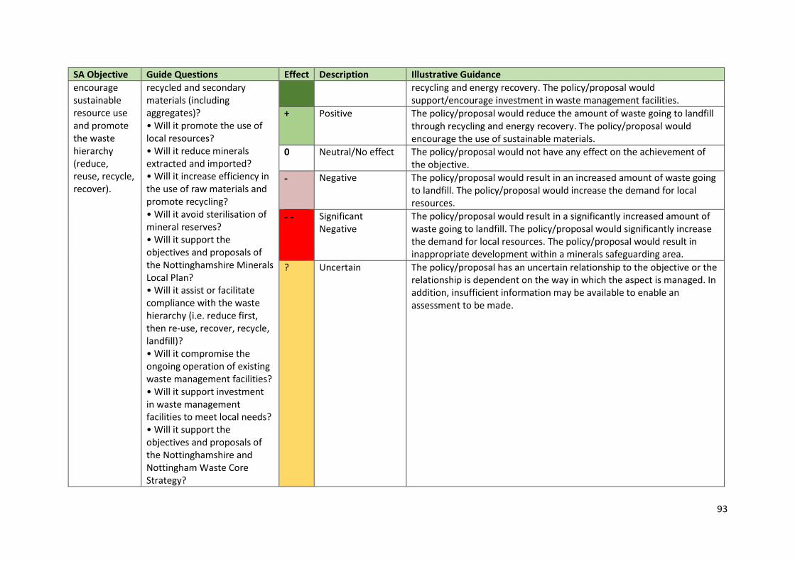
93
SA Objective Guide Questions Effect Description Illustrative Guidance
encourage sustainable resource use and promote the waste hierarchy (reduce, reuse, recycle, recover).
recycled and secondary materials (including aggregates)? • Will it promote the use of local resources? • Will it reduce minerals extracted and imported? • Will it increase efficiency in the use of raw materials and promote recycling? • Will it avoid sterilisation of mineral reserves? • Will it support the objectives and proposals of the Nottinghamshire Minerals Local Plan? • Will it assist or facilitate compliance with the waste hierarchy (i.e. reduce first, then re-use, recover, recycle, landfill)? • Will it compromise the ongoing operation of existing waste management facilities? • Will it support investment in waste management facilities to meet local needs? • Will it support the objectives and proposals of the Nottinghamshire and Nottingham Waste Core Strategy?
recycling and energy recovery. The policy/proposal would support/encourage investment in waste management facilities.
+ Positive The policy/proposal would reduce the amount of waste going to landfill through recycling and energy recovery. The policy/proposal would encourage the use of sustainable materials.
0 Neutral/No effect The policy/proposal would not have any effect on the achievement of the objective.
- Negative The policy/proposal would result in an increased amount of waste going to landfill. The policy/proposal would increase the demand for local resources.
- - Significant Negative
The policy/proposal would result in a significantly increased amount of waste going to landfill. The policy/proposal would significantly increase the demand for local resources. The policy/proposal would result in inappropriate development within a minerals safeguarding area.
? Uncertain The policy/proposal has an uncertain relationship to the objective or the relationship is dependent on the way in which the aspect is managed. In addition, insufficient information may be available to enable an assessment to be made.

94
SA Objective Guide Questions Effect Description Illustrative Guidance
13. Cultural Heritage: To conserve and enhance the District’s historic environment, cultural heritage, character and setting.
• Will it help to conserve and enhance existing features of the historic built environment and their settings, including archaeological assets? • Will it reduce the instances and circumstances where heritage assets are identified as being ‘at risk’? • Will it promote sustainable repair and reuse of heritage assets? • Will it protect or enhance the significance of designated heritage assets and their settings? • Will it protect or enhance the significance of non-designated heritage assets and their settings? • Will it promote local cultural distinctiveness? • Will it improve the quality of the built environment, and maintain local distinctiveness and historic townscape character in Worksop Central? • Will it help to conserve historic buildings, places and spaces that enhance local distinctiveness, character and
++ Significant Positive The policy/proposal would protect and enhance the sites, areas and features of historic, cultural, archaeological and architectural interest with national designations (including their setting). The policy/proposal will make use of historic buildings, spaces and places through sensitive adaption and re-use allowing these distinctive assets to be accessed. The policy/proposal would result in an assets(s) being removed from the At Risk Register.
+ Positive The policy/proposal would protect and enhance the sites, areas and features of historic, cultural, archaeological and architectural interest with local designations (including their setting). The policy/proposal will increase access to historical/cultural/archaeological/architectural buildings/spaces/places.
0 Neutral/No effect The policy/proposal would not have any effect on the achievement of the objective.
- Negative The policy/proposal would lead to the deterioration of and/or harm to sites, areas and features of historic, cultural, archaeological and architectural interest with local designations. The policy/proposal would temporarily restrict access to historical/cultural/archaeological/architectural buildings/spaces/places.
- - Significant Negative
The policy/proposal would lead to the deterioration of and/or harm to sites, areas and features of historic, cultural, archaeological and architectural interest with national designation or result in the destruction of heritage assets (national or local). The policy/proposal would permanently restrict access to historical/cultural/archaeological/architectural buildings/spaces/places. The policy/proposal would result in an asset being placed on the At Risk Register.
? Uncertain The policy/proposal has an uncertain relationship to the objective or the relationship is dependent on the way in which the aspect is managed. In addition, insufficient information may be available to enable an assessment to be made.
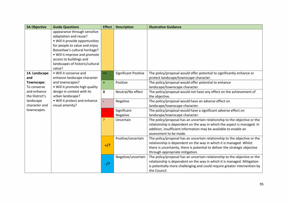
95
SA Objective Guide Questions Effect Description Illustrative Guidance
appearance through sensitive adaptation and reuse? • Will it provide opportunities for people to value and enjoy Bassetlaw’s cultural heritage? • Will it improve and promote access to buildings and landscapes of historic/cultural value?
14. Landscape and Townscape: To conserve and enhance the District’s landscape character and townscapes.
• Will it conserve and enhance landscape character and townscapes? • Will it promote high quality design in context with its urban landscape? • Will it protect and enhance visual amenity?
++ Significant Positive The policy/proposal would offer potential to significantly enhance or protect landscape/townscape character.
+ Positive The policy/proposal would offer potential to enhance landscape/townscape character.
0 Neutral/No effect The policy/proposal would not have any effect on the achievement of the objective.
- Negative The policy/proposal would have an adverse effect on landscape/townscape character.
- - Significant Negative
The policy/proposal would have a significant adverse effect on landscape/townscape character.
? Uncertain The policy/proposal has an uncertain relationship to the objective or the relationship is dependent on the way in which the aspect is managed. In addition, insufficient information may be available to enable an assessment to be made.
+/?
Positive/uncertain The policy/proposal has an uncertain relationship to the objective or the relationship is dependent on the way in which it is managed. Whilst there is uncertainty, there is potential to deliver the strategic objective through appropriate mitigation.
-/?
Negative/uncertain The policy/proposal has an uncertain relationship to the objective or the relationship is dependent on the way in which it is managed. Mitigation is potentially more challenging and could require greater intervention by the Council.
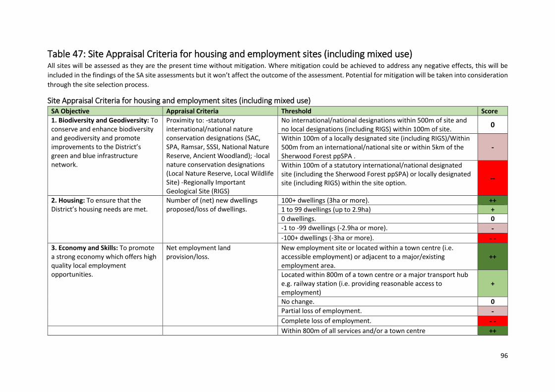
96
Table 47: Site Appraisal Criteria for housing and employment sites (including mixed use) All sites will be assessed as they are the present time without mitigation. Where mitigation could be achieved to address any negative effects, this will be
included in the findings of the SA site assessments but it won’t affect the outcome of the assessment. Potential for mitigation will be taken into consideration
through the site selection process.
Site Appraisal Criteria for housing and employment sites (including mixed use) SA Objective Appraisal Criteria Threshold Score
1. Biodiversity and Geodiversity: To conserve and enhance biodiversity and geodiversity and promote improvements to the District’s green and blue infrastructure network.
Proximity to: -statutory international/national nature conservation designations (SAC, SPA, Ramsar, SSSI, National Nature Reserve, Ancient Woodland); -local nature conservation designations (Local Nature Reserve, Local Wildlife Site) -Regionally Important Geological Site (RIGS)
No international/national designations within 500m of site and no local designations (including RIGS) within 100m of site.
0
Within 100m of a locally designated site (including RIGS)/Within 500m from an international/national site or within 5km of the Sherwood Forest ppSPA .
-
Within 100m of a statutory international/national designated site (including the Sherwood Forest ppSPA) or locally designated site (including RIGS) within the site option.
--
2. Housing: To ensure that the District’s housing needs are met.
Number of (net) new dwellings proposed/loss of dwellings.
100+ dwellings (3ha or more). ++
1 to 99 dwellings (up to 2.9ha) +
0 dwellings. 0
-1 to -99 dwellings (-2.9ha or more). - -100+ dwellings (-3ha or more). - -
3. Economy and Skills: To promote a strong economy which offers high quality local employment opportunities.
Net employment land provision/loss.
New employment site or located within a town centre (i.e. accessible employment) or adjacent to a major/existing employment area.
++
Located within 800m of a town centre or a major transport hub e.g. railway station (i.e. providing reasonable access to employment)
+
No change. 0
Partial loss of employment. - Complete loss of employment. - - Within 800m of all services and/or a town centre ++
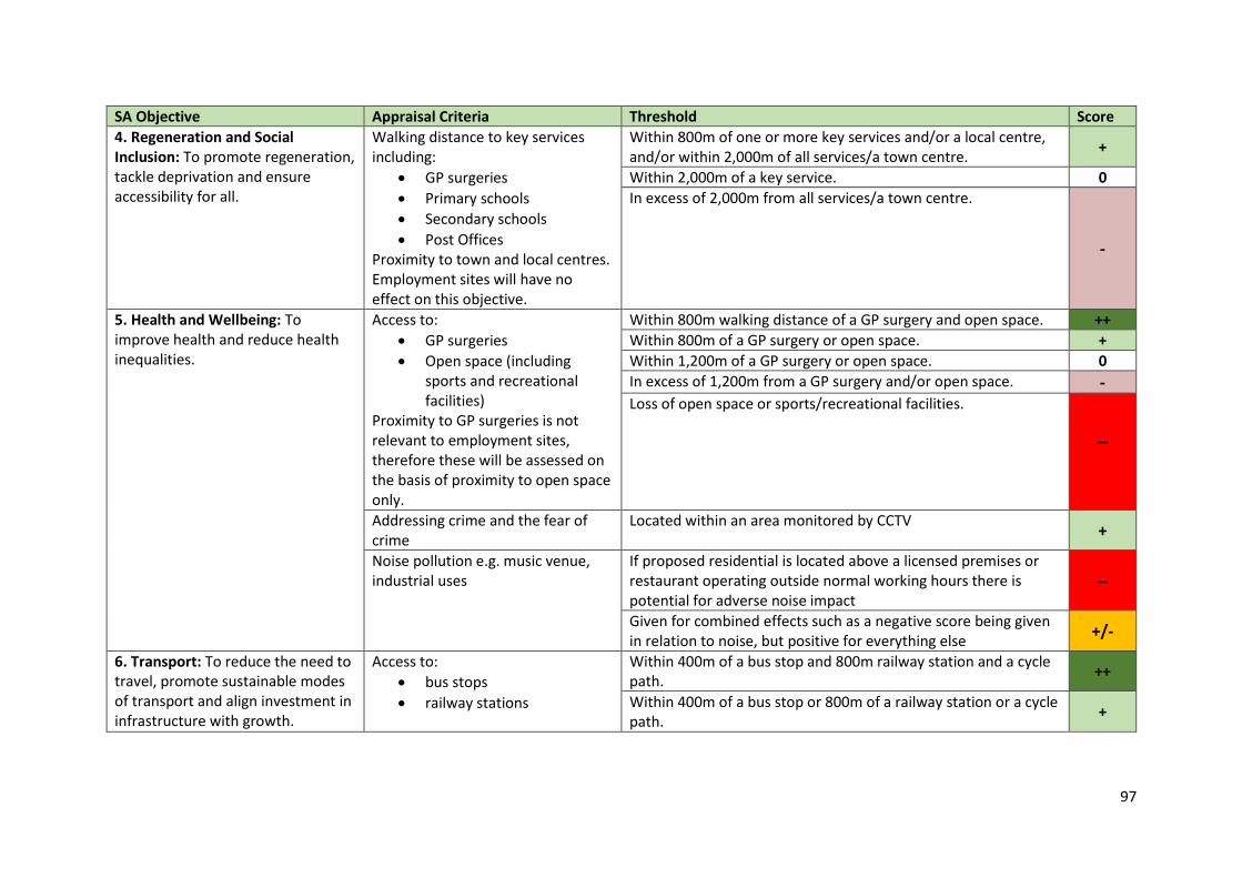
97
SA Objective Appraisal Criteria Threshold Score
4. Regeneration and Social Inclusion: To promote regeneration, tackle deprivation and ensure accessibility for all.
Walking distance to key services including:
GP surgeries
Primary schools
Secondary schools
Post Offices Proximity to town and local centres. Employment sites will have no effect on this objective.
Within 800m of one or more key services and/or a local centre, and/or within 2,000m of all services/a town centre.
+
Within 2,000m of a key service. 0
In excess of 2,000m from all services/a town centre.
-
5. Health and Wellbeing: To improve health and reduce health inequalities.
Access to:
GP surgeries
Open space (including sports and recreational facilities)
Proximity to GP surgeries is not relevant to employment sites, therefore these will be assessed on the basis of proximity to open space only.
Within 800m walking distance of a GP surgery and open space. ++
Within 800m of a GP surgery or open space. +
Within 1,200m of a GP surgery or open space. 0
In excess of 1,200m from a GP surgery and/or open space. - Loss of open space or sports/recreational facilities.
--
Addressing crime and the fear of crime
Located within an area monitored by CCTV +
Noise pollution e.g. music venue, industrial uses
If proposed residential is located above a licensed premises or restaurant operating outside normal working hours there is potential for adverse noise impact
--
Given for combined effects such as a negative score being given in relation to noise, but positive for everything else
+/-
6. Transport: To reduce the need to travel, promote sustainable modes of transport and align investment in infrastructure with growth.
Access to:
bus stops
railway stations
Within 400m of a bus stop and 800m railway station and a cycle path.
++
Within 400m of a bus stop or 800m of a railway station or a cycle path.
+
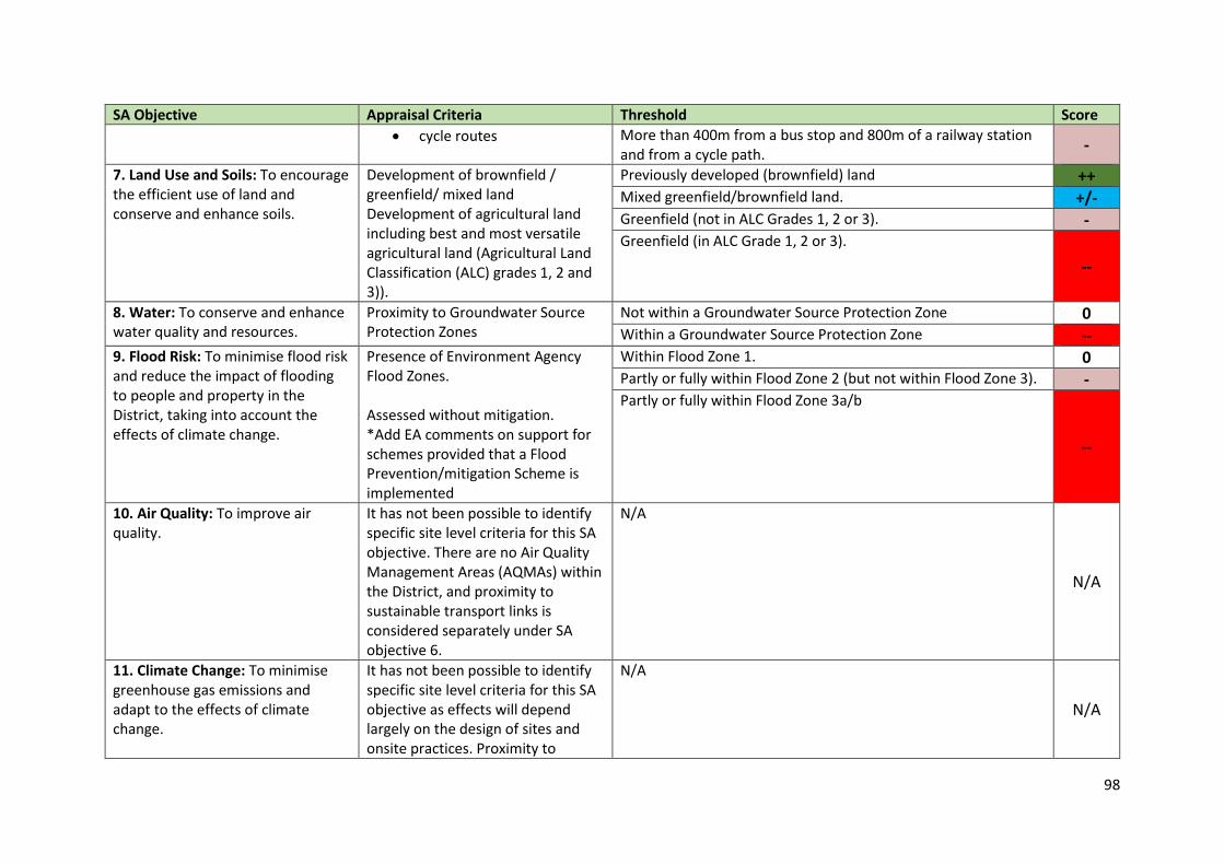
98
SA Objective Appraisal Criteria Threshold Score
cycle routes More than 400m from a bus stop and 800m of a railway station and from a cycle path.
-
7. Land Use and Soils: To encourage the efficient use of land and conserve and enhance soils.
Development of brownfield / greenfield/ mixed land Development of agricultural land including best and most versatile agricultural land (Agricultural Land Classification (ALC) grades 1, 2 and 3)).
Previously developed (brownfield) land ++ Mixed greenfield/brownfield land. +/- Greenfield (not in ALC Grades 1, 2 or 3). - Greenfield (in ALC Grade 1, 2 or 3).
--
8. Water: To conserve and enhance water quality and resources.
Proximity to Groundwater Source Protection Zones
Not within a Groundwater Source Protection Zone 0 Within a Groundwater Source Protection Zone --
9. Flood Risk: To minimise flood risk and reduce the impact of flooding to people and property in the District, taking into account the effects of climate change.
Presence of Environment Agency Flood Zones. Assessed without mitigation. *Add EA comments on support for schemes provided that a Flood Prevention/mitigation Scheme is implemented
Within Flood Zone 1. 0 Partly or fully within Flood Zone 2 (but not within Flood Zone 3). - Partly or fully within Flood Zone 3a/b
--
10. Air Quality: To improve air quality.
It has not been possible to identify specific site level criteria for this SA objective. There are no Air Quality Management Areas (AQMAs) within the District, and proximity to sustainable transport links is considered separately under SA objective 6.
N/A
N/A
11. Climate Change: To minimise greenhouse gas emissions and adapt to the effects of climate change.
It has not been possible to identify specific site level criteria for this SA objective as effects will depend largely on the design of sites and onsite practices. Proximity to
N/A
N/A
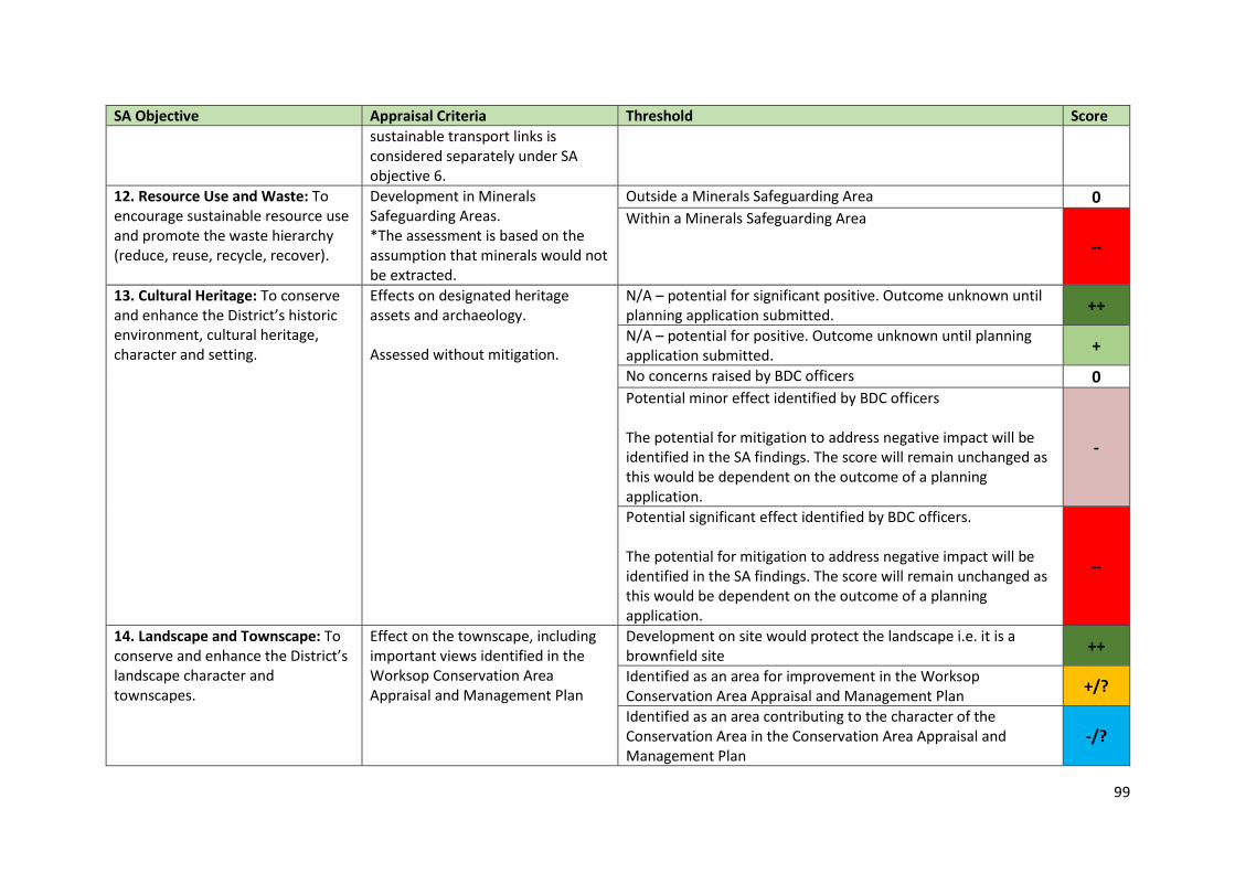
99
SA Objective Appraisal Criteria Threshold Score
sustainable transport links is considered separately under SA objective 6.
12. Resource Use and Waste: To encourage sustainable resource use and promote the waste hierarchy (reduce, reuse, recycle, recover).
Development in Minerals Safeguarding Areas. *The assessment is based on the assumption that minerals would not be extracted.
Outside a Minerals Safeguarding Area 0 Within a Minerals Safeguarding Area
--
13. Cultural Heritage: To conserve and enhance the District’s historic environment, cultural heritage, character and setting.
Effects on designated heritage assets and archaeology. Assessed without mitigation.
N/A – potential for significant positive. Outcome unknown until planning application submitted.
++
N/A – potential for positive. Outcome unknown until planning application submitted.
+
No concerns raised by BDC officers 0 Potential minor effect identified by BDC officers The potential for mitigation to address negative impact will be identified in the SA findings. The score will remain unchanged as this would be dependent on the outcome of a planning application.
-
Potential significant effect identified by BDC officers. The potential for mitigation to address negative impact will be identified in the SA findings. The score will remain unchanged as this would be dependent on the outcome of a planning application.
--
14. Landscape and Townscape: To conserve and enhance the District’s landscape character and townscapes.
Effect on the townscape, including important views identified in the Worksop Conservation Area Appraisal and Management Plan
Development on site would protect the landscape i.e. it is a brownfield site
++
Identified as an area for improvement in the Worksop Conservation Area Appraisal and Management Plan
+/?
Identified as an area contributing to the character of the Conservation Area in the Conservation Area Appraisal and Management Plan
-/?
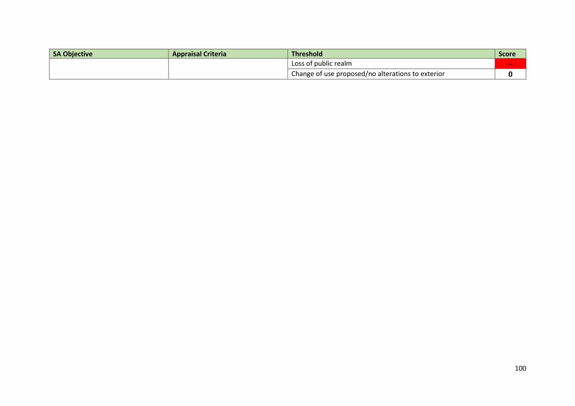
100
SA Objective Appraisal Criteria Threshold Score
Loss of public realm -- Change of use proposed/no alterations to exterior 0
101
6. Stage A: Task 5: Consult the consultation bodies
Stage A: Task 5: Consult the consultation bodies on the scope of the sustainability
appraisal report. 6.1 To meet the requirements of the SEA Regulations, the three statutory bodies must be
contacted in order to provide their views on the scope and level of detail to be included in the
SEA report. The three bodies are; Natural England, Historic England and the Environment
Agency.
6.2 This SEA Scoping Report is being made available for comments for a five-week period from
11th March 2021. In order to meet the regulations and the requirements of the Duty to Co-
operate the Council is seeking in particular the views from the three statutory bodies.
Following Stages 6.3 Once comments are submitted and reviewed regarding this draft Scoping Report, any
necessary changes will be made to the document. A final revised SA Scoping Report will then
be published. The Worksop Central DPD will be subject to the later stages of the SEA using
the SEA framework presented in Chapter 5. A full Sustainability Appraisal report
(incorporating the later stages of the SEA process) will then be produced and made available
to other stakeholders and the general public.
6.4 The following stages in the SA process are completed alongside the preparation of the
Worksop Central DPD. The emerging policies and options for specific sites to be included in
the DPD will be tested against the SA framework.
6.5 After consideration of the options, the Worksop Central DPD will be subject to a further
sustainability appraisal, the findings of which will be set out in the final SA Report for the DPD,
incorporating an Environmental Report as required by the SEA Regulations.
6.6 The third stage will be the SA / SEA Statement, which will be produced following adoption of
the DPD, setting out the difference the process has made.
Consultation questions: 9. Does your organisation collect any data/information that would be useful to the monitoring of the
Development Plan Document, which you would be happy to supply?
10. Do you have any other comments on the draft SA Scoping Report?
102
Appendix 1
Consultation questions: 1. Do you agree that these are the most relevant policies, plans, programmes or sustainable
development objectives that will affect or influence the Worksop Central Development Plan
Document?
2. Do you agree that the baseline data collected is appropriate to the plan?
3. Do you have, or know of, any additional relevant baseline data which should be added to
that already listed?
4. As far as you are aware, are there any inaccuracies or anomalies in the data presented?
5. Do you agree that these are the key sustainability issues for Worksop central area?
6. Are you aware of any issues which, in your opinion, should be added, or any that should be
removed?
7. Do you agree with the revised objectives? And if not, should any objectives be re-worded or
removed?
8. Are there any particular indicators that we should be including for measurement and
monitoring?
9. Does your organisation collect any data/information that would be useful to the monitoring
of the Development Plan Document, which you would be happy to supply?
10. Do you have any other comments on the draft SA Scoping Report?

103
Appendix 2: Policies, Plans and Programmes
International/ European Plans and Programmes Policy, Plan or Programme Objectives or requirements for the
Policy, Plan or Programme Key Targets and indicators relevant to the Worksop Central DPD
Commentary (how the SA Framework should incorporate the documents required)
The Cancun Agreement- UNFCCC (2011)
Shared vision to keep global temperature rise to below two degrees Celsius, with objectives to be reviewed as to whether it needs to be strengthened in future on the basis of the best scientific knowledge available.
No targets or indicators. • The Worksop Central DPD should aim to reduce emissions. • The SA assessment framework should include greenhouse gas emissions.
The Convention for the Protection of the Architectural Heritage of Europe (Granada Convention 1985)
The main purpose of the convention is to reinforce and promote policies for the conservation and enhancement of Europe’s heritage and to foster closer European cooperation in defence of heritage. Recognition that conservation of heritage is a cultural purpose and integrated conservation of heritage is an important factor in the improvement of quality of life.
No measurable targets or indicators. The SA Framework should include an objective on the conservation and enhancement of heritage and decision making criteria on architectural heritage.
The European Convention on the Protection of Archaeological Heritage (Valetta Convention 1992)
Agreement that the conservation and enhancement of an archaeological heritage is one of the goals of urban and regional planning policy. It is concerned in particular with the need for co-operation between archaeologists and planers to ensure optimum conservation of archaeological heritage.
No measurable targets or indicators. The SA Framework should include an objective on the conservation and enhancement of heritage and decision making criteria on archaeological heritage.
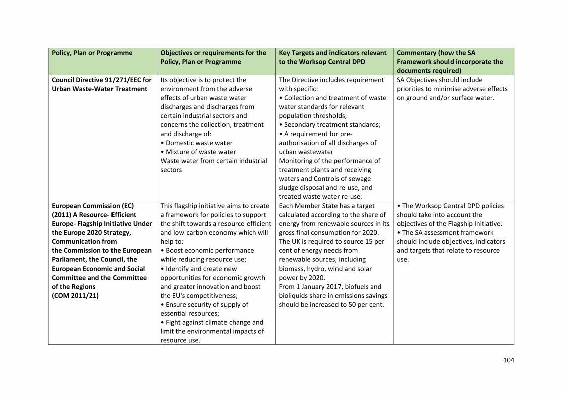
104
Policy, Plan or Programme Objectives or requirements for the Policy, Plan or Programme
Key Targets and indicators relevant to the Worksop Central DPD
Commentary (how the SA Framework should incorporate the documents required)
Council Directive 91/271/EEC for Urban Waste-Water Treatment
Its objective is to protect the environment from the adverse effects of urban waste water discharges and discharges from certain industrial sectors and concerns the collection, treatment and discharge of: • Domestic waste water • Mixture of waste water Waste water from certain industrial sectors
The Directive includes requirement with specific: • Collection and treatment of waste water standards for relevant population thresholds; • Secondary treatment standards; • A requirement for pre-authorisation of all discharges of urban wastewater Monitoring of the performance of treatment plants and receiving waters and Controls of sewage sludge disposal and re-use, and treated waste water re-use.
SA Objectives should include priorities to minimise adverse effects on ground and/or surface water.
European Commission (EC) (2011) A Resource- Efficient Europe- Flagship Initiative Under the Europe 2020 Strategy, Communication from the Commission to the European Parliament, the Council, the European Economic and Social Committee and the Committee of the Regions (COM 2011/21)
This flagship initiative aims to create a framework for policies to support the shift towards a resource-efficient and low-carbon economy which will help to: • Boost economic performance while reducing resource use; • Identify and create new opportunities for economic growth and greater innovation and boost the EU's competitiveness; • Ensure security of supply of essential resources; • Fight against climate change and limit the environmental impacts of resource use.
Each Member State has a target calculated according to the share of energy from renewable sources in its gross final consumption for 2020. The UK is required to source 15 per cent of energy needs from renewable sources, including biomass, hydro, wind and solar power by 2020. From 1 January 2017, biofuels and bioliquids share in emissions savings should be increased to 50 per cent.
• The Worksop Central DPD policies should take into account the objectives of the Flagship Initiative. • The SA assessment framework should include objectives, indicators and targets that relate to resource use.
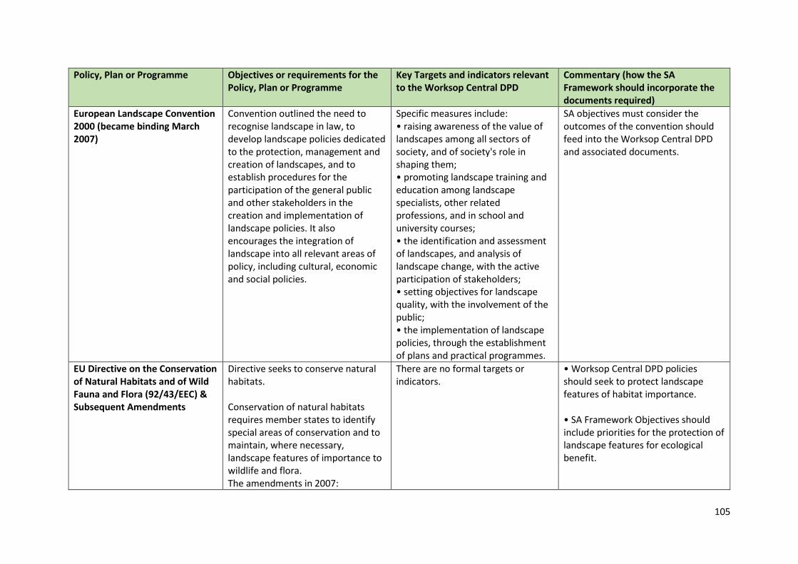
105
Policy, Plan or Programme Objectives or requirements for the Policy, Plan or Programme
Key Targets and indicators relevant to the Worksop Central DPD
Commentary (how the SA Framework should incorporate the documents required)
European Landscape Convention 2000 (became binding March 2007)
Convention outlined the need to recognise landscape in law, to develop landscape policies dedicated to the protection, management and creation of landscapes, and to establish procedures for the participation of the general public and other stakeholders in the creation and implementation of landscape policies. It also encourages the integration of landscape into all relevant areas of policy, including cultural, economic and social policies.
Specific measures include: • raising awareness of the value of landscapes among all sectors of society, and of society's role in shaping them; • promoting landscape training and education among landscape specialists, other related professions, and in school and university courses; • the identification and assessment of landscapes, and analysis of landscape change, with the active participation of stakeholders; • setting objectives for landscape quality, with the involvement of the public; • the implementation of landscape policies, through the establishment of plans and practical programmes.
SA objectives must consider the outcomes of the convention should feed into the Worksop Central DPD and associated documents.
EU Directive on the Conservation of Natural Habitats and of Wild Fauna and Flora (92/43/EEC) & Subsequent Amendments
Directive seeks to conserve natural habitats. Conservation of natural habitats requires member states to identify special areas of conservation and to maintain, where necessary, landscape features of importance to wildlife and flora. The amendments in 2007:
There are no formal targets or indicators.
• Worksop Central DPD policies should seek to protect landscape features of habitat importance. • SA Framework Objectives should include priorities for the protection of landscape features for ecological benefit.
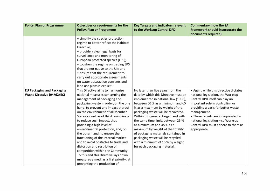
106
Policy, Plan or Programme Objectives or requirements for the Policy, Plan or Programme
Key Targets and indicators relevant to the Worksop Central DPD
Commentary (how the SA Framework should incorporate the documents required)
• simplify the species protection regime to better reflect the Habitats Directive; • provide a clear legal basis for surveillance and monitoring of European protected species (EPS); • toughen the regime on trading EPS that are not native to the UK; and • ensure that the requirement to carry out appropriate assessments on water abstraction consents and land use plans is explicit.
EU Packaging and Packaging Waste Directive (94/62/EC)
This Directive aims to harmonize national measures concerning the management of packaging and packaging waste in order, on the one hand, to prevent any impact thereof on the environment of all Member States as well as of third countries or to reduce such impact, thus providing a high level of environmental protection, and, on the other hand, to ensure the functioning of the internal market and to avoid obstacles to trade and distortion and restriction of competition within the Community. To this end this Directive lays down measures aimed, as a first priority, at preventing the production of
No later than five years from the date by which this Directive must be implemented in national law (1996), between 50 % as a minimum and 65 % as a maximum by weight of the packaging waste will be recovered. Within this general target, and with the same time limit, between 25 % as a minimum and 45 % as a maximum by weight of the totality of packaging materials contained in packaging waste will be recycled with a minimum of 15 % by weight for each packaging material.
• Again, while this directive dictates national legislation, the Worksop Central DPD itself can play an important role in controlling or providing a basis for better waste management. • These targets are incorporated in national legislation – so Worksop Central DPD must adhere to them as appropriate.
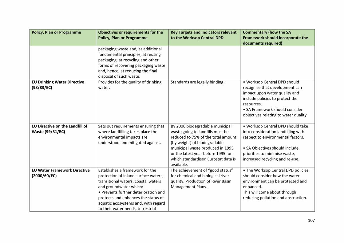
107
Policy, Plan or Programme Objectives or requirements for the Policy, Plan or Programme
Key Targets and indicators relevant to the Worksop Central DPD
Commentary (how the SA Framework should incorporate the documents required)
packaging waste and, as additional fundamental principles, at reusing packaging, at recycling and other forms of recovering packaging waste and, hence, at reducing the final disposal of such waste.
EU Drinking Water Directive (98/83/EC)
Provides for the quality of drinking water.
Standards are legally binding. • Worksop Central DPD should recognise that development can impact upon water quality and include policies to protect the resources. • SA Framework should consider objectives relating to water quality
EU Directive on the Landfill of Waste (99/31/EC)
Sets out requirements ensuring that where landfilling takes place the environmental impacts are understood and mitigated against.
By 2006 biodegradable municipal waste going to landfills must be reduced to 75% of the total amount (by weight) of biodegradable municipal waste produced in 1995 or the latest year before 1995 for which standardised Eurostat data is available.
• Worksop Central DPD should take into consideration landfilling with respect to environmental factors. • SA Objectives should include priorities to minimise waste, increased recycling and re-use.
EU Water Framework Directive (2000/60/EC)
Establishes a framework for the protection of inland surface waters, transitional waters, coastal waters and groundwater which: • Prevents further deterioration and protects and enhances the status of aquatic ecosystems and, with regard to their water needs, terrestrial
The achievement of “good status” for chemical and biological river quality. Production of River Basin Management Plans.
• The Worksop Central DPD policies should consider how the water environment can be protected and enhanced. This will come about through reducing pollution and abstraction.
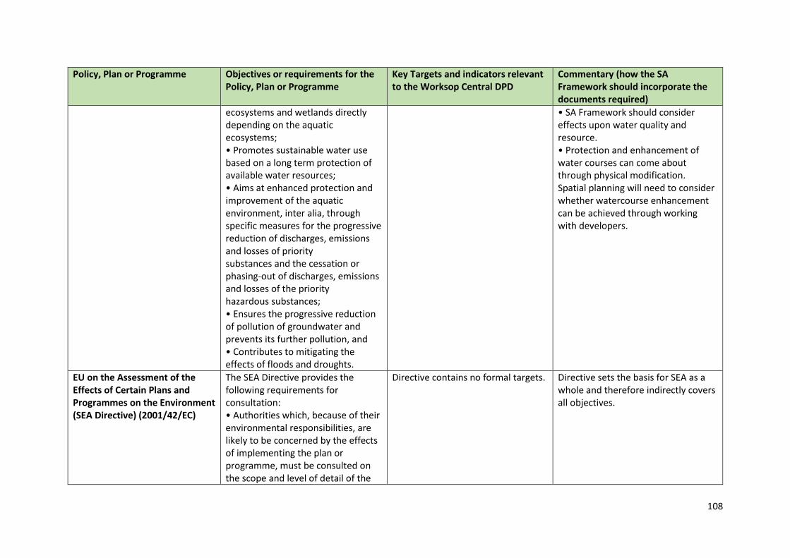
108
Policy, Plan or Programme Objectives or requirements for the Policy, Plan or Programme
Key Targets and indicators relevant to the Worksop Central DPD
Commentary (how the SA Framework should incorporate the documents required)
ecosystems and wetlands directly depending on the aquatic ecosystems; • Promotes sustainable water use based on a long term protection of available water resources; • Aims at enhanced protection and improvement of the aquatic environment, inter alia, through specific measures for the progressive reduction of discharges, emissions and losses of priority substances and the cessation or phasing-out of discharges, emissions and losses of the priority hazardous substances; • Ensures the progressive reduction of pollution of groundwater and prevents its further pollution, and • Contributes to mitigating the effects of floods and droughts.
• SA Framework should consider effects upon water quality and resource. • Protection and enhancement of water courses can come about through physical modification. Spatial planning will need to consider whether watercourse enhancement can be achieved through working with developers.
EU on the Assessment of the Effects of Certain Plans and Programmes on the Environment (SEA Directive) (2001/42/EC)
The SEA Directive provides the following requirements for consultation: • Authorities which, because of their environmental responsibilities, are likely to be concerned by the effects of implementing the plan or programme, must be consulted on the scope and level of detail of the
Directive contains no formal targets. Directive sets the basis for SEA as a whole and therefore indirectly covers all objectives.
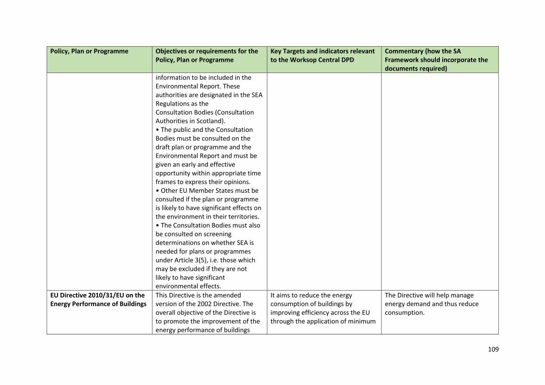
109
Policy, Plan or Programme Objectives or requirements for the Policy, Plan or Programme
Key Targets and indicators relevant to the Worksop Central DPD
Commentary (how the SA Framework should incorporate the documents required)
information to be included in the Environmental Report. These authorities are designated in the SEA Regulations as the Consultation Bodies (Consultation Authorities in Scotland). • The public and the Consultation Bodies must be consulted on the draft plan or programme and the Environmental Report and must be given an early and effective opportunity within appropriate time frames to express their opinions. • Other EU Member States must be consulted if the plan or programme is likely to have significant effects on the environment in their territories. • The Consultation Bodies must also be consulted on screening determinations on whether SEA is needed for plans or programmes under Article 3(5), i.e. those which may be excluded if they are not likely to have significant environmental effects.
EU Directive 2010/31/EU on the Energy Performance of Buildings
This Directive is the amended version of the 2002 Directive. The overall objective of the Directive is to promote the improvement of the energy performance of buildings
It aims to reduce the energy consumption of buildings by improving efficiency across the EU through the application of minimum
The Directive will help manage energy demand and thus reduce consumption.
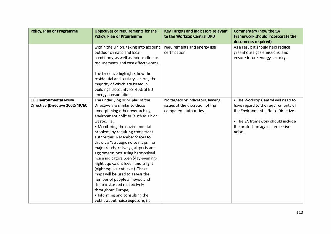
110
Policy, Plan or Programme Objectives or requirements for the Policy, Plan or Programme
Key Targets and indicators relevant to the Worksop Central DPD
Commentary (how the SA Framework should incorporate the documents required)
within the Union, taking into account outdoor climatic and local conditions, as well as indoor climate requirements and cost effectiveness. The Directive highlights how the residential and tertiary sectors, the majority of which are based in buildings, accounts for 40% of EU energy consumption.
requirements and energy use certification.
As a result it should help reduce greenhouse gas emissions, and ensure future energy security.
EU Environmental Noise Directive (Directive 2002/49/EC)
The underlying principles of the Directive are similar to those underpinning other overarching environment policies (such as air or waste), i.e.: • Monitoring the environmental problem; by requiring competent authorities in Member States to draw up "strategic noise maps" for major roads, railways, airports and agglomerations, using harmonised noise indicators Lden (day-evening-night equivalent level) and Lnight (night equivalent level). These maps will be used to assess the number of people annoyed and sleep-disturbed respectively throughout Europe; • Informing and consulting the public about noise exposure, its
No targets or indicators, leaving issues at the discretion of the competent authorities.
• The Worksop Central will need to have regard to the requirements of the Environmental Noise Directive. • The SA framework should include the protection against excessive noise.
111
Policy, Plan or Programme Objectives or requirements for the Policy, Plan or Programme
Key Targets and indicators relevant to the Worksop Central DPD
Commentary (how the SA Framework should incorporate the documents required)
effects, and the measures considered to address noise, in line with the principles of the Aarhus Convention; • Addressing local noise issues by requiring competent authorities to draw up action plans to reduce noise where necessary and maintain environmental noise quality where it is good. The directive does not set any limit value, nor does it prescribe the measures to be used in the action plans, which remain at the discretion of the competent authorities; Developing a long-term EU strategy, which includes objectives to reduce the number of people affected by noise in the longer term, and provides a framework for developing existing Community policy on noise reduction from source. With this respect, the Commission has made a declaration concerning the provisions laid down in Article 1.2 with regard to the preparation of legislation relating to sources of noise.
EU Bathing Waters Directive 2006/7/EC
Sets standards for the quality of bathing waters in terms of:
Standards are legally binding. • Worksop Central DPD should recognise that development can
112
Policy, Plan or Programme Objectives or requirements for the Policy, Plan or Programme
Key Targets and indicators relevant to the Worksop Central DPD
Commentary (how the SA Framework should incorporate the documents required)
• the physical, chemical and microbiological parameters; • the mandatory limit values and indicative values for such parameters; • the minimum sampling frequency and method of analysis or inspection of such water.
impact upon water quality and include policies to protect the resources. • SA Framework should consider objectives relating to water quality.
EU (2006) European Employment Strategy
The European Employment Strategy dates back to 1997, when the EU Member States undertook to establish a set of common objectives and targets for employment policy. It seeks to engender full employment, quality of work and increased productivity as well as the promotion of inclusion by addressing disparities in access to labour markets.
No formal targets. • The Worksop Central DPD should deliver policies which support these aims. • The SA assessment framework should assess employment levels, quality of work and social inclusion.
EU (2009) Renewed EU Sustainable Development Strategy
In June 2001, the first European sustainable development strategy was agreed by EU Heads of State. The Strategy sets out how the EU can meet the needs of present generations without compromising the ability of future generations to meet their needs. The Strategy proposes headline objectives and lists seven key challenges: • Climate change and clean energy;
The overall objectives in the Strategy are to: • Safeguard the earth's capacity to support life in all its diversity, respect the limits of the planet's natural resources and ensure a high level of protection and improvement of the quality of the environment. Prevent and reduce environmental
The Worksop Central DPD should aim to create a pattern of development consistent with the objectives of the Strategy and in turn promote sustainable development.
113
Policy, Plan or Programme Objectives or requirements for the Policy, Plan or Programme
Key Targets and indicators relevant to the Worksop Central DPD
Commentary (how the SA Framework should incorporate the documents required)
• Sustainable transport; • Sustainable consumption and production; • Conservation and management of natural resources; • Public health; • Social inclusion, demography and migration; • Global poverty.
pollution and promote sustainable consumption and production to break the link between economic growth and environmental degradation; • Promote a democratic, socially inclusive, cohesive, healthy, safe and just society with respect for fundamental rights and cultural diversity that creates equal opportunities and combats discrimination in all its forms; • Promote a prosperous, innovative, knowledge-rich, competitive and eco-efficient economy which provides high living standards and full and high quality employment throughout the European Union; • Encourage the establishment and defend the stability of democratic institutions across the world, based on peace, security and freedom. Actively promote sustainable development worldwide and ensure that the European Union’s internal and external policies are consistent with global sustainable development and its international commitments.
114
Policy, Plan or Programme Objectives or requirements for the Policy, Plan or Programme
Key Targets and indicators relevant to the Worksop Central DPD
Commentary (how the SA Framework should incorporate the documents required)
EU Floods Directive 2007/60/EC Aims to provide a consistent approach to managing flood risk across Europe.
The approach is based on a 6 year cycle of planning which includes the publication of Preliminary Flood Risk Assessments, hazard and risk maps and flood risk management plans. The Directive is transposed into English law by the Flood Risk Regulations 2009.
• Worksop Central DPD should recognise that development can impact vulnerability to flooding and increase risk due to climate change. • SA Framework should consider objectives relating to flood risk.
EU Air Quality Directive (2008/50/EC) and previous directives (96/62/EC; 99/30/EC; 2000/69/EC & 2002/3/EC)
New Directive provided that most of existing legislation be merged into a single directive (except for the fourth daughter directive) with no change to existing air quality objectives. Relevant objectives include: • Maintain ambient air quality where it is good and improve it in other cases; and • Maintain ambient-air quality where it is good and improve it in other cases with respect to sulphur dioxide, nitrogen dioxide and oxides of nitrogen, particulate matter and lead.
• No targets or indicators. • Includes thresholds for pollutants.
• Worksop Central DPD policies should consider the maintenance of good air quality and the measures that can be taken to improve it through, for example, an encouragement to reduce vehicle movements. • SA Framework should include objectives relating to air quality.
EU Directive on Waste (Directive 75/442/EEC, 2006/12/EC 2008/98/EC as amended)
Seeks to prevent and reduce the production of waste and its impacts. Where necessary waste should be disposed of without creating environmental problems. Seeks to protect the environment and human health by preventing or
Promotes the development of clean technology to process waste, promoting recycling and re-use. The Directive contains a range of provision including: • The setting up of separate collections of waste where
• Worksop Central DPD policies should seek to minimise waste, and the environmental effects caused by it. Policies should promote recycling and re-use.
115
Policy, Plan or Programme Objectives or requirements for the Policy, Plan or Programme
Key Targets and indicators relevant to the Worksop Central DPD
Commentary (how the SA Framework should incorporate the documents required)
reducing the adverse impacts of the generation and management of waste and by reducing overall impacts of resource use and improving the efficiency of such use.
technically, environmentally and economically practicable and appropriate to meet the necessary quality standards for the relevant recycling sectors – including by 2015 separate collection for at least paper, metal, plastic and glass. • Household waste recycling target – the preparing for re-use and the recycling of waste materials such as at least paper, metal, plastic and glass from households and possibly other origins as far as these waste streams are similar to waste from households, must be increased to a minimum of 50% by weight by 2020. • Construction and demolition waste recovery target – the preparing for re-use, recycling and other material recovery of non-hazardous construction and demolition waste must be increased to a minimum of 70% by weight by 2020.
• SA Objectives should include priorities to minimise waste, increased recycling and re-use.
EU Directive on the Conservation of Wild Birds (09/147/EC) (codified version of Council Directive 79/409/EEC as amended)
Identifies 181 endangered species and sub-species for which the Member States are required to designate Special Protection Areas. Makes it a legal requirement that EU countries make provision for the protection of birds. This includes the
Target Actions include: • Creation of protected areas; • Upkeep and management; and • Re-establishment of destroyed biotopes.
• Worksop Central DPD should include policies to protect and enhance wild bird populations, including the protection of SPAs. • SA Framework should consider objectives to protect and enhance biodiversity including wild birds.
116
Policy, Plan or Programme Objectives or requirements for the Policy, Plan or Programme
Key Targets and indicators relevant to the Worksop Central DPD
Commentary (how the SA Framework should incorporate the documents required)
selection and designation of Special Protection Areas.
EU Renewable Energy Directive (2009/28/EC)
This Directive establishes a common framework for the use of energy from renewable sources in order to limit greenhouse gas emissions and to promote cleaner transport. It encourages energy efficiency, energy consumption from renewable sources and the improvement of energy supply.
Each Member State to achieve a 10% minimum target for the share of energy from renewable sources by 2020.
• The Worksop Central DPD should contribute towards increasing the proportion of energy from renewable energy sources where appropriate. • The SA assessment framework should include consideration of use of energy from renewable energy sources.
EU (2011) EU Biodiversity Strategy to 2020 – towards implementation
The European Commission has adopted an ambitious new strategy to halt the loss of biodiversity and ecosystem services in the EU by 2020. The strategy provides a framework for action over the next decade and covers the following key areas: • Conserving and restoring nature; • Maintaining and enhancing ecosystems and their services; • Ensuring the sustainability of agriculture, forestry and fisheries; • Combating invasive alien species; • Addressing the global biodiversity crisis.
There are six main targets, and 20 actions to help Europe reach its goal. The six targets cover: 1. Full implementation of EU nature legislation to protect biodiversity 2. Better protection for ecosystems, and more use of green infrastructure 3. More sustainable agriculture and forestry 4. Better management of fish stocks 5. Tighter controls on invasive alien species 6. A bigger EU contribution to averting global biodiversity loss
The Worksop Central DPD should seek to protect and enhance biodiversity.
United Nations (2015) United Nations Climate Change
The agreement’s main aim is to keep a global temperature rise this century well below 2 degrees Celsius
Each Member State to ensure temperature rise this century is below 2 degrees Celsius.
• The Worksop Central DPD should positively contribute to a low carbon economy.
117
Policy, Plan or Programme Objectives or requirements for the Policy, Plan or Programme
Key Targets and indicators relevant to the Worksop Central DPD
Commentary (how the SA Framework should incorporate the documents required)
Conference (COP 21) Paris Agreement
and to drive efforts to limit the temperature increase even further to 1.5 degrees Celsius above preindustrial levels. The 1.5 degree Celsius limit is a significantly safer defence line against the worst impacts of a changing climate. Additionally, the agreement aims to strengthen the ability to deal with the impacts of climate change.
• The SA Framework should include an objective on climatic factors.
United Nations (2015) Sustainable Development Goals
The Sustainable Development Goals are the blueprint to achieve a better and more sustainable future for all. They address global challenges, including those related to poverty, inequality, climate change, environmental degradation, peace and justice. The 17 Goals are all interconnected, and are aimed to be achieved by 2030.
The UK Government has yet to localise the SDGs and determine a UK level plan for their implementation.
Through the SA and consultations, the Council should ensure the Worksop Central DPD is mindful of all the goals. Namely; SDG 16: Promote peaceful and inclusive societies for sustainable development, provide access to justice for all and build effective, accountable and inclusive institutions at all levels. And also place particular focus on SDG 11: Make cities and human settlements inclusive, safe, resilient and sustainable.
UNESCO World Heritage Convention (1972)
Countries are required to: • Ensure that measures are taken for the protection, conservation and presentation of cultural and natural heritage
Designation of UNESCO World Heritage Sites.
The SA Framework should include an objective on heritage and archaeological issues.

118
Policy, Plan or Programme Objectives or requirements for the Policy, Plan or Programme
Key Targets and indicators relevant to the Worksop Central DPD
Commentary (how the SA Framework should incorporate the documents required)
• Adopt a general policy that gives cultural and natural heritage a function in the life of the community Integrate the protection of heritage into comprehensive planning programmes.
UNFCCC (1997) The Kyoto Protocol to the UNFCCC
The Kyoto Protocol to the UNFCCC established the first policy that actively aims to reduce greenhouse gas emissions by industrialised countries.
Construction is a significant source of greenhouse gas emissions due to the consumption of materials and use of energy. The Kyoto Protocol aims to reduce greenhouse gas emissions of the UK by 12.5%, compared to 1990 levels, by 2008 – 2012.
The Kyoto Protocol is influential to achieving sustainable development as it encourages transition to a low carbon economy. Therefore it is an integral factor in planning documents.
World Commission on Environment and Development (1987) Our Common Future (The Brundtland Report)
The Brundtland Report is concerned with the world's economy and its environment. The objective is to provide an expanding and sustainable economy while protecting a sustainable environment. The Report was a call by the United Nations: • to propose long-term environmental strategies for achieving sustainable development by the year 2000 and beyond; • to recommend ways concern for the environment may be translated into greater co-operation among
The report issued a multitude of recommendations with the aim of attaining sustainable development and addressing the problems posed by a global economy that is intertwined with the environment.
The Brundtland Report provided the original definition of sustainable development. The accumulated effects of the SA objectives seek to achieve sustainable development.
119
Policy, Plan or Programme Objectives or requirements for the Policy, Plan or Programme
Key Targets and indicators relevant to the Worksop Central DPD
Commentary (how the SA Framework should incorporate the documents required)
countries of the global South and between countries at different stages of economic and social development and lead to the achievement of common and mutually supportive objectives that take account of the interrelationships between people, resources, environment, and development; • to consider ways and means by which the international community can deal more effectively with environment concerns; and • to help define shared perceptions of long-term environmental issues and the appropriate efforts needed to deal successfully with the problems of protecting and enhancing the environment, a long term agenda for action during the coming decades, and aspirational goals for the world community.
The World Summit on Sustainable Development (WSSD), Johannesburg, September 2002
Commitments arising from Johannesburg Summit: • Sustainable consumption and production patterns; • Accelerate the shift towards sustainable consumption and
No targets or indicators, however actions include: • Greater resource efficiency; • Support business innovation and take-up of best practice in technology and management;
• The Worksop Central DPD can encourage greater efficiency of resources. Ensure policies cover the action areas.
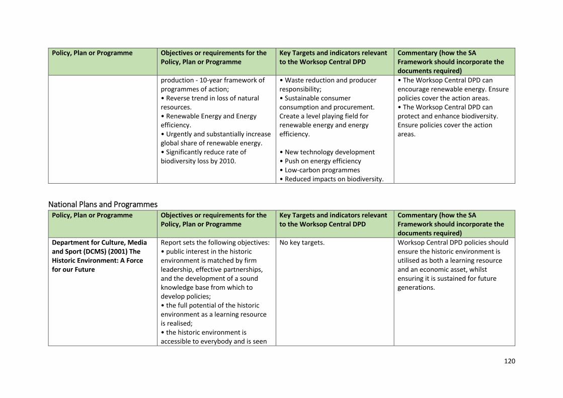
120
Policy, Plan or Programme Objectives or requirements for the Policy, Plan or Programme
Key Targets and indicators relevant to the Worksop Central DPD
Commentary (how the SA Framework should incorporate the documents required)
production - 10-year framework of programmes of action; • Reverse trend in loss of natural resources. • Renewable Energy and Energy efficiency. • Urgently and substantially increase global share of renewable energy. • Significantly reduce rate of biodiversity loss by 2010.
• Waste reduction and producer responsibility; • Sustainable consumer consumption and procurement. Create a level playing field for renewable energy and energy efficiency. • New technology development • Push on energy efficiency • Low-carbon programmes • Reduced impacts on biodiversity.
• The Worksop Central DPD can encourage renewable energy. Ensure policies cover the action areas. • The Worksop Central DPD can protect and enhance biodiversity. Ensure policies cover the action areas.
National Plans and Programmes Policy, Plan or Programme Objectives or requirements for the
Policy, Plan or Programme Key Targets and indicators relevant to the Worksop Central DPD
Commentary (how the SA Framework should incorporate the documents required)
Department for Culture, Media and Sport (DCMS) (2001) The Historic Environment: A Force for our Future
Report sets the following objectives: • public interest in the historic environment is matched by firm leadership, effective partnerships, and the development of a sound knowledge base from which to develop policies; • the full potential of the historic environment as a learning resource is realised; • the historic environment is accessible to everybody and is seen
No key targets. Worksop Central DPD policies should ensure the historic environment is utilised as both a learning resource and an economic asset, whilst ensuring it is sustained for future generations.
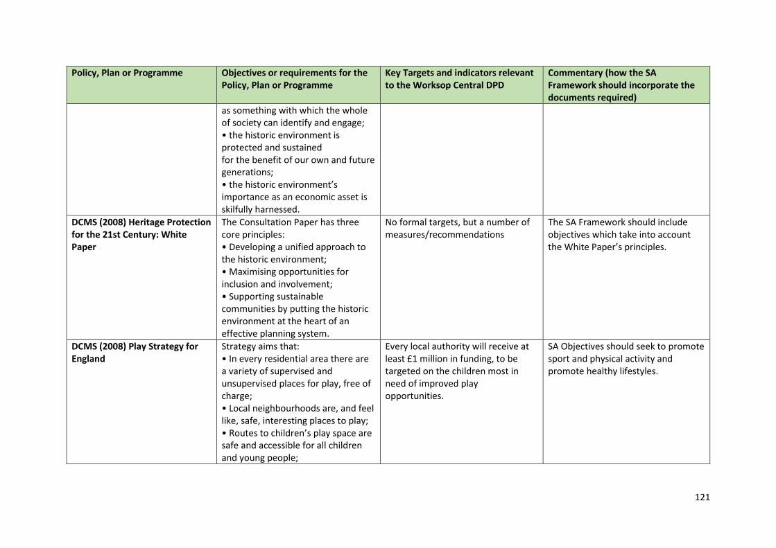
121
Policy, Plan or Programme Objectives or requirements for the Policy, Plan or Programme
Key Targets and indicators relevant to the Worksop Central DPD
Commentary (how the SA Framework should incorporate the documents required)
as something with which the whole of society can identify and engage; • the historic environment is protected and sustained for the benefit of our own and future generations; • the historic environment’s importance as an economic asset is skilfully harnessed.
DCMS (2008) Heritage Protection for the 21st Century: White Paper
The Consultation Paper has three core principles: • Developing a unified approach to the historic environment; • Maximising opportunities for inclusion and involvement; • Supporting sustainable communities by putting the historic environment at the heart of an effective planning system.
No formal targets, but a number of measures/recommendations
The SA Framework should include objectives which take into account the White Paper’s principles.
DCMS (2008) Play Strategy for England
Strategy aims that: • In every residential area there are a variety of supervised and unsupervised places for play, free of charge; • Local neighbourhoods are, and feel like, safe, interesting places to play; • Routes to children’s play space are safe and accessible for all children and young people;
Every local authority will receive at least £1 million in funding, to be targeted on the children most in need of improved play opportunities.
SA Objectives should seek to promote sport and physical activity and promote healthy lifestyles.
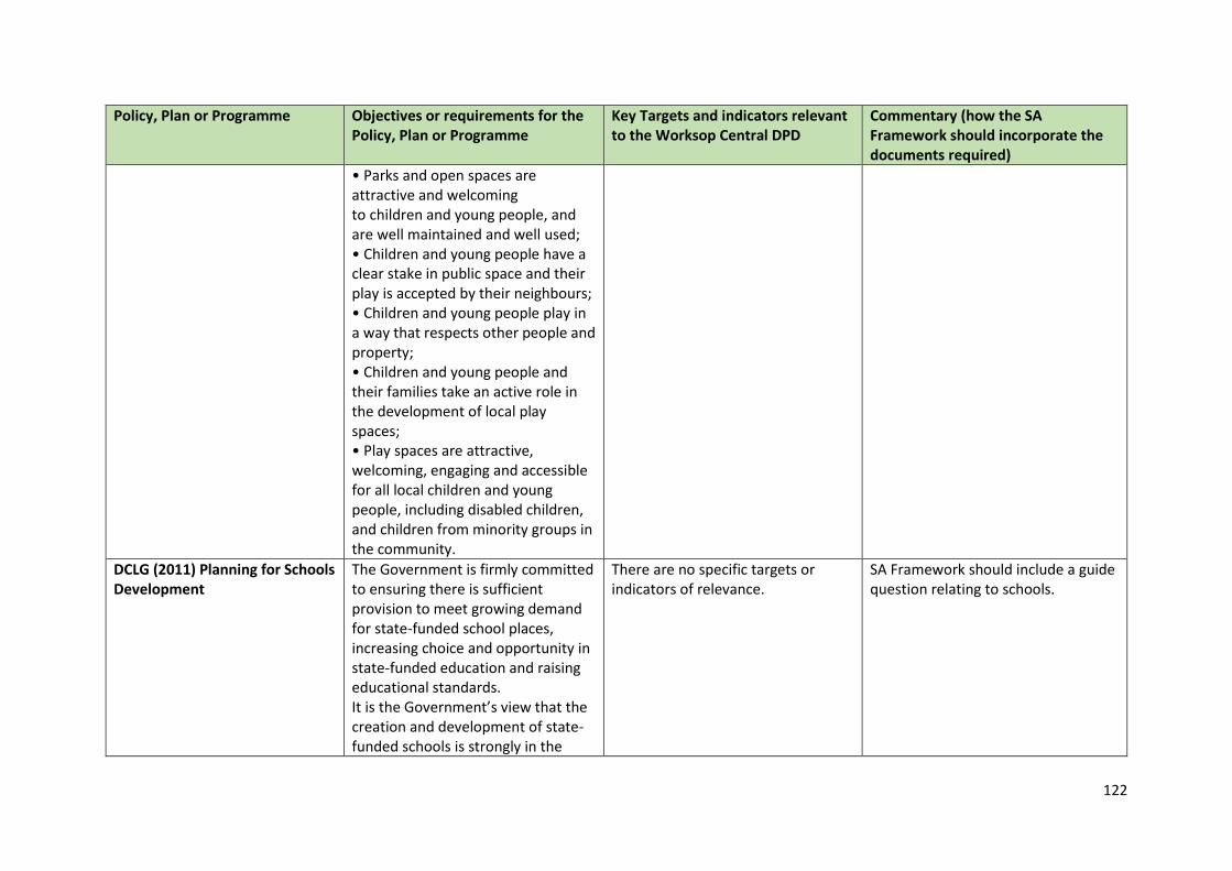
122
Policy, Plan or Programme Objectives or requirements for the Policy, Plan or Programme
Key Targets and indicators relevant to the Worksop Central DPD
Commentary (how the SA Framework should incorporate the documents required)
• Parks and open spaces are attractive and welcoming to children and young people, and are well maintained and well used; • Children and young people have a clear stake in public space and their play is accepted by their neighbours; • Children and young people play in a way that respects other people and property; • Children and young people and their families take an active role in the development of local play spaces; • Play spaces are attractive, welcoming, engaging and accessible for all local children and young people, including disabled children, and children from minority groups in the community.
DCLG (2011) Planning for Schools Development
The Government is firmly committed to ensuring there is sufficient provision to meet growing demand for state-funded school places, increasing choice and opportunity in state-funded education and raising educational standards. It is the Government’s view that the creation and development of state-funded schools is strongly in the
There are no specific targets or indicators of relevance.
SA Framework should include a guide question relating to schools.
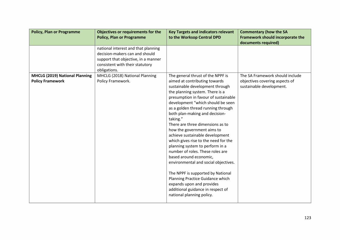
123
Policy, Plan or Programme Objectives or requirements for the Policy, Plan or Programme
Key Targets and indicators relevant to the Worksop Central DPD
Commentary (how the SA Framework should incorporate the documents required)
national interest and that planning decision-makers can and should support that objective, in a manner consistent with their statutory obligations.
MHCLG (2019) National Planning Policy Framework
MHCLG (2018) National Planning Policy Framework.
The general thrust of the NPPF is aimed at contributing towards sustainable development through the planning system. There is a presumption in favour of sustainable development “which should be seen as a golden thread running through both plan-making and decision-taking.” There are three dimensions as to how the government aims to achieve sustainable development which gives rise to the need for the planning system to perform in a number of roles. These roles are based around economic, environmental and social objectives. The NPPF is supported by National Planning Practice Guidance which expands upon and provides additional guidance in respect of national planning policy.
The SA Framework should include objectives covering aspects of sustainable development.
124
Policy, Plan or Programme Objectives or requirements for the Policy, Plan or Programme
Key Targets and indicators relevant to the Worksop Central DPD
Commentary (how the SA Framework should incorporate the documents required)
MHCLG (2019) Planning Practice Guidance
Planning Practice Guidance is designed to support the NPPF. It reflects the objectives of the NPPF which are not repeated here.
No formal targets identified. • The Worksop Central DPD should reflect the Planning Practice Guidance. • The SA Framework should reflect the principles of the NPPF and the Planning Practice Guidance.
DCLG (2014) National Planning Policy for Waste
Sets out detailed waste planning policies for local authorities. States that planning authorities need to: • Use a proportionate evidence base in preparing planning documents • Identify sufficient opportunities to meet the needs of their area for the management of waste streams • Identifying suitable sites and areas.
The overall objective of the policy is to deliver sustainable development by protecting the environment and human health by producing less waste and by using it as a resource wherever possible.
• Worksop Central DPD should consider opportunities to reduce waste and encourage recycling and composting e.g. integration of recycling and composting facilities into new development and use of recycled materials in new buildings. • SA Framework should consider objectives which relate to re-use, recycle and reduce.
DCLG (2014) House of Commons: Witten Statement on Sustainable Drainage Systems
Under these arrangements, in considering planning applications, local planning authorities should consult the relevant lead local flood authority on the management of surface water; satisfy themselves that the proposed minimum standards of operation are appropriate and ensure through the use of planning conditions or planning obligations that there are clear arrangements in place for ongoing maintenance over the lifetime of the development.
There are no specific targets or indicators of relevance
SA Framework should include a guide question relating to Sustainable Drainage Systems.
125
Policy, Plan or Programme Objectives or requirements for the Policy, Plan or Programme
Key Targets and indicators relevant to the Worksop Central DPD
Commentary (how the SA Framework should incorporate the documents required)
The sustainable drainage system should be designed to ensure that the maintenance and operation requirements are economically proportionate.
Department for Education (2014) Home to School Travel and Transport Guidance
There are five main elements to the duty which local authorities must undertake: • an assessment of the travel and transport needs of children, and young people within the authority’s area; • an audit of the sustainable travel and transport infrastructure within the authority’s area that may be used when travelling to and from, or between schools/institutions; • a strategy to develop the sustainable travel and transport infrastructure within the authority so that the travel and transport needs of children and young people are best catered for; • the promotion of sustainable travel and transport modes on the journey to, from, and between schools and other institutions; • the publication of Sustainable Modes of Travel Strategy.
There are no specific targets or indicators of relevance.
SA Framework should include a guide question relating to accessibility to Schools and Transport.
126
Policy, Plan or Programme Objectives or requirements for the Policy, Plan or Programme
Key Targets and indicators relevant to the Worksop Central DPD
Commentary (how the SA Framework should incorporate the documents required)
Department of Energy and Climate Change (DECC) (2009) The UK Low Carbon Transition Plan: National Strategy for Climate and Energy
This Paper plots out how the UK will meet the cut in emissions set out in the budget of 34% on 1990 levels by 2020. The Plan includes: • New money for a ‘smart grid’, and to help regions and local authorities prepare for and speed up planning decisions on renewable and low carbon energy whilst protecting legitimate environmental and local concerns; • Funding to significantly advance the offshore wind industry in the UK; • Funding to cement the UK’s position as a global leader in wave and tidal energy; • Funding to explore areas of potential “hot rocks” to be used for geothermal energy; • Challenging 15 villages, towns or cities to be testbeds for piloting future green initiatives; • Support for anaerobic digestion; • Encouraging private funding for woodland creation; • Reducing the amount of waste sent to landfill and better capture of landfill emissions etc.
Sets out a vision that by 2020: • More than 1.2 million people will be in green jobs; • 7 million homes will have benefited from whole house makeovers, and more than 1.5 million households will be supported to produce their own clean energy; • Around 40 percent of electricity will be from low-carbon sources, from renewables, nuclear and clean coal; • We will be importing half the amount of gas that we otherwise would; • The average new car will emit 40% less carbon than now.
• Strategy covers a number of SA objectives including climate change, energy and air quality; landscape; geology and biodiversity; and waste. • SA must recognise the importance to cut emissions in line with national targets.
127
Policy, Plan or Programme Objectives or requirements for the Policy, Plan or Programme
Key Targets and indicators relevant to the Worksop Central DPD
Commentary (how the SA Framework should incorporate the documents required)
Defra (2018) A Green Future: Our 25 Year Plan to Improve the Environment
Sets out goals for improving the environment within the next 25 years. It details how the Government will work with communities and businesses to leave the environment in a better state than it is presently.
To develop policies that encourages the protection and enhancement of the natural environment.
Include sustainability objective/appraisal question that relates to the protection and enhancement of the natural environment.
Defra (2011) Biodiversity 2020: A Strategy for England’s Wildlife and Ecosystem Services
The Strategy is designed to help to deliver the objectives set out in the Natural Environment White Paper.
The strategy includes the following priorities: • Creating 200,000 hectares of new wildlife habitats by 2020; • Securing 50% of SSSIs in favourable condition, while maintaining at least 95% in favourable or recovering condition; • Encouraging more people to get involved in conservation by supporting wildlife gardening and outdoor learning programmes; and • Introducing a new designation for local green spaces to enable communities to protect places that are important to them.
Develop policies that support the vision emphasising biodiversity.
Defra (2011) Natural Environment White Paper: The Natural Choice: Securing the Value of Nature
The Natural Environment White paper sets out the Government’s plans to ensure the natural environment is protected and fully integrated into society and economic growth.
The White Paper sets out four key aims: • protecting and improving our natural environment; • growing a green economy; • reconnecting people and nature; • international and EU leadership, specifically to achieve
Develop policies that support the vision emphasising biodiversity.
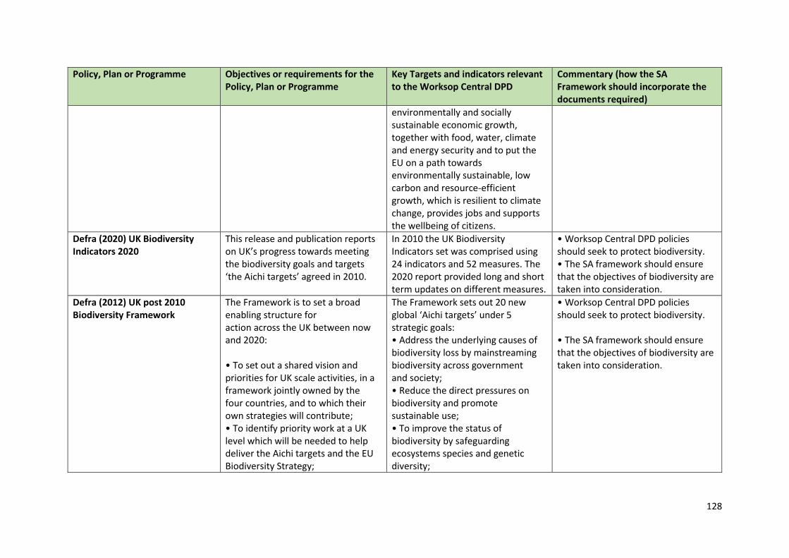
128
Policy, Plan or Programme Objectives or requirements for the Policy, Plan or Programme
Key Targets and indicators relevant to the Worksop Central DPD
Commentary (how the SA Framework should incorporate the documents required)
environmentally and socially sustainable economic growth, together with food, water, climate and energy security and to put the EU on a path towards environmentally sustainable, low carbon and resource-efficient growth, which is resilient to climate change, provides jobs and supports the wellbeing of citizens.
Defra (2020) UK Biodiversity Indicators 2020
This release and publication reports on UK’s progress towards meeting the biodiversity goals and targets ‘the Aichi targets’ agreed in 2010.
In 2010 the UK Biodiversity Indicators set was comprised using 24 indicators and 52 measures. The 2020 report provided long and short term updates on different measures.
• Worksop Central DPD policies should seek to protect biodiversity. • The SA framework should ensure that the objectives of biodiversity are taken into consideration.
Defra (2012) UK post 2010 Biodiversity Framework
The Framework is to set a broad enabling structure for action across the UK between now and 2020: • To set out a shared vision and priorities for UK scale activities, in a framework jointly owned by the four countries, and to which their own strategies will contribute; • To identify priority work at a UK level which will be needed to help deliver the Aichi targets and the EU Biodiversity Strategy;
The Framework sets out 20 new global ‘Aichi targets’ under 5 strategic goals: • Address the underlying causes of biodiversity loss by mainstreaming biodiversity across government and society; • Reduce the direct pressures on biodiversity and promote sustainable use; • To improve the status of biodiversity by safeguarding ecosystems species and genetic diversity;
• Worksop Central DPD policies should seek to protect biodiversity. • The SA framework should ensure that the objectives of biodiversity are taken into consideration.
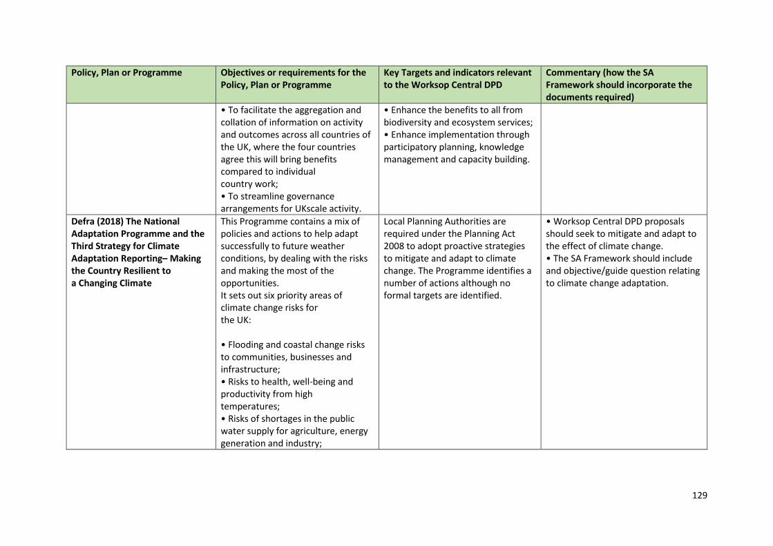
129
Policy, Plan or Programme Objectives or requirements for the Policy, Plan or Programme
Key Targets and indicators relevant to the Worksop Central DPD
Commentary (how the SA Framework should incorporate the documents required)
• To facilitate the aggregation and collation of information on activity and outcomes across all countries of the UK, where the four countries agree this will bring benefits compared to individual country work; • To streamline governance arrangements for UKscale activity.
• Enhance the benefits to all from biodiversity and ecosystem services; • Enhance implementation through participatory planning, knowledge management and capacity building.
Defra (2018) The National Adaptation Programme and the Third Strategy for Climate Adaptation Reporting– Making the Country Resilient to a Changing Climate
This Programme contains a mix of policies and actions to help adapt successfully to future weather conditions, by dealing with the risks and making the most of the opportunities. It sets out six priority areas of climate change risks for the UK: • Flooding and coastal change risks to communities, businesses and infrastructure; • Risks to health, well-being and productivity from high temperatures; • Risks of shortages in the public water supply for agriculture, energy generation and industry;
Local Planning Authorities are required under the Planning Act 2008 to adopt proactive strategies to mitigate and adapt to climate change. The Programme identifies a number of actions although no formal targets are identified.
• Worksop Central DPD proposals should seek to mitigate and adapt to the effect of climate change. • The SA Framework should include and objective/guide question relating to climate change adaptation.
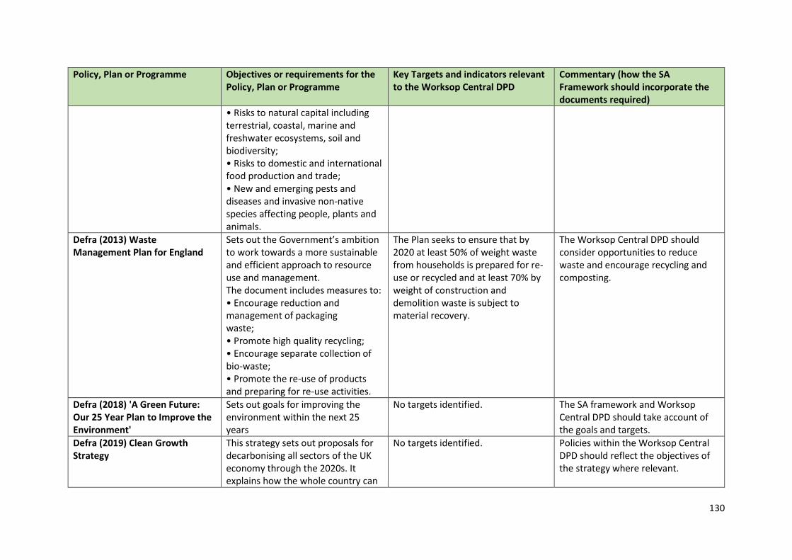
130
Policy, Plan or Programme Objectives or requirements for the Policy, Plan or Programme
Key Targets and indicators relevant to the Worksop Central DPD
Commentary (how the SA Framework should incorporate the documents required)
• Risks to natural capital including terrestrial, coastal, marine and freshwater ecosystems, soil and biodiversity; • Risks to domestic and international food production and trade; • New and emerging pests and diseases and invasive non-native species affecting people, plants and animals.
Defra (2013) Waste Management Plan for England
Sets out the Government’s ambition to work towards a more sustainable and efficient approach to resource use and management. The document includes measures to: • Encourage reduction and management of packaging waste; • Promote high quality recycling; • Encourage separate collection of bio-waste; • Promote the re-use of products and preparing for re-use activities.
The Plan seeks to ensure that by 2020 at least 50% of weight waste from households is prepared for re-use or recycled and at least 70% by weight of construction and demolition waste is subject to material recovery.
The Worksop Central DPD should consider opportunities to reduce waste and encourage recycling and composting.
Defra (2018) 'A Green Future: Our 25 Year Plan to Improve the Environment'
Sets out goals for improving the environment within the next 25 years
No targets identified. The SA framework and Worksop Central DPD should take account of the goals and targets.
Defra (2019) Clean Growth Strategy
This strategy sets out proposals for decarbonising all sectors of the UK economy through the 2020s. It explains how the whole country can
No targets identified. Policies within the Worksop Central DPD should reflect the objectives of the strategy where relevant.
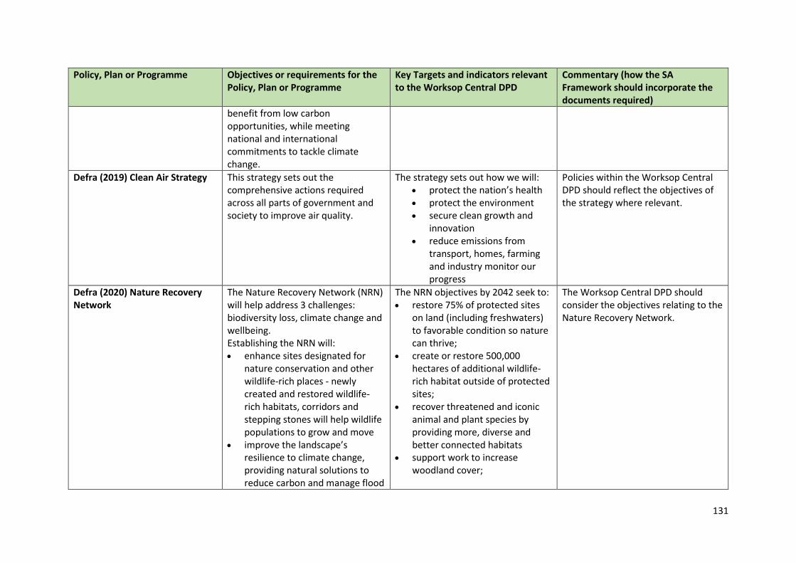
131
Policy, Plan or Programme Objectives or requirements for the Policy, Plan or Programme
Key Targets and indicators relevant to the Worksop Central DPD
Commentary (how the SA Framework should incorporate the documents required)
benefit from low carbon opportunities, while meeting national and international commitments to tackle climate change.
Defra (2019) Clean Air Strategy This strategy sets out the comprehensive actions required across all parts of government and society to improve air quality.
The strategy sets out how we will: protect the nation’s health protect the environment secure clean growth and
innovation reduce emissions from
transport, homes, farming and industry monitor our progress
Policies within the Worksop Central DPD should reflect the objectives of the strategy where relevant.
Defra (2020) Nature Recovery Network
The Nature Recovery Network (NRN) will help address 3 challenges: biodiversity loss, climate change and wellbeing. Establishing the NRN will: enhance sites designated for
nature conservation and other wildlife-rich places - newly created and restored wildlife-rich habitats, corridors and stepping stones will help wildlife populations to grow and move
improve the landscape’s resilience to climate change, providing natural solutions to reduce carbon and manage flood
The NRN objectives by 2042 seek to: restore 75% of protected sites
on land (including freshwaters) to favorable condition so nature can thrive;
create or restore 500,000 hectares of additional wildlife-rich habitat outside of protected sites;
recover threatened and iconic animal and plant species by providing more, diverse and better connected habitats
support work to increase woodland cover;
The Worksop Central DPD should consider the objectives relating to the Nature Recovery Network.
132
Policy, Plan or Programme Objectives or requirements for the Policy, Plan or Programme
Key Targets and indicators relevant to the Worksop Central DPD
Commentary (how the SA Framework should incorporate the documents required)
risk, and sustaining vital ecosystems such as improved soil, clean water and clean air
reinforce the natural and cultural diversity of our landscapes, and protect our historic natural environment
enable us to enjoy and connect with nature where we live, work and play - benefiting our health and wellbeing
Achieve a range of environmental, economic and social benefits, such as carbon capture, flood management, clean water, pollination and recreation.
Defra (2020) England Tree Strategy- Consultation
The consultation was used to inform a new England Tree Strategy. The document will set out forestry policy through to 2050, and replace the Government 2013 Forestry Policy Statement. The strategy will set out policy priorities to deliver an ambitious tree planting programme. It will focus on expanding, protecting and improving woodlands, and how trees and woodlands can connect people to nature, support the economy, combat climate change and recover biodiversity. This will ensure that trees are established and managed for the many benefits they provide for people, the economy, the climate and nature itself.
The final published document will seek to: increase tree planting and
woodland creation; increase protection for trees and
woodland; bring more woodland into
management; maximize trees’ role in
supporting the economy; engage more people with trees
and woodlands.
Policies within the Worksop Central DPD should reflect the objectives of the strategy where relevant.
133
Policy, Plan or Programme Objectives or requirements for the Policy, Plan or Programme
Key Targets and indicators relevant to the Worksop Central DPD
Commentary (how the SA Framework should incorporate the documents required)
BEIS (2019) Industrial Strategy- Building a Britain fit for the future
The Industrial Strategy sets out how we will boost productivity across the UK through five foundations – ideas, people, infrastructure, business, environment, and places.
No targets identified. Policies within the Worksop Central DPD should reflect the objectives of the strategy where relevant.
Department of Health (2011) Healthy Lives, Healthy People: Our Strategy for Public Health in England
This report aims to identify how to protect the population from serious health threats, enabling them to live longer and have healthier more fulfilling lives and improving the health of the poorest. This will prioritise public health funding from within the overall NHS budget.
No targets identified. Policies within the Worksop Central DPD should reflect the objectives of the strategy where relevant.
Department for Transport (2011) Strategic framework for Road Safety
This document includes a range of key themes including: • Making it easier for road users to do the right thing and going with the grain of human behaviour • More local and community decision making from decentralisation and providing local information to citizens to enable them to challenge priorities.
No targets identified. Ensure that the Worksop Central DPD includes policies to influence human behaviour in respect of road design and use and reflects local road safety priorities.
Department for Transport (2017) Cycling and walking investment strategy
Following a public consultation, the ‘Cycling and walking investment strategy’: • outlines the government’s ambition to make cycling and walking a natural choice for shorter
No targets identified. The Worksop Central DPD should consider the objectives relating to the Cycling and Walking Investment Strategy.
134
Policy, Plan or Programme Objectives or requirements for the Policy, Plan or Programme
Key Targets and indicators relevant to the Worksop Central DPD
Commentary (how the SA Framework should incorporate the documents required)
journeys, or as part of longer journeys by 2040 • sets out the objectives and the aims and target that we will work towards in the shorter term • details the financial resources available • includes a number of indicators that will help us understand how we are performing • sets out the governance arrangements that will be put in place and outlines actions that have already been taken, as well as actions planned for the future
Environment Agency (2016) Managing Water Abstraction
Managing Water Abstraction (2016) sets out how the Environment Agency will manage water resources in England and Wales. It is the overarching document that links together its abstraction licensing strategies. The availability of water resources for abstraction is assessed through the Catchment Abstraction Management Strategy (CAMS) approach.
No targets identified. The Worksop Central DPD should consider the objectives relating to water abstraction.
Environment Agency (2013) Water Stress Areas - Final Classifications
This report sets out the revised methodology developed by the Environment Agency and Natural Resources Wales for the
No targets identified. The Worksop Central DPD and SA should consider the impacts of proposals on water resources.

135
Policy, Plan or Programme Objectives or requirements for the Policy, Plan or Programme
Key Targets and indicators relevant to the Worksop Central DPD
Commentary (how the SA Framework should incorporate the documents required)
classification of areas of water stress in England and Wales. The Anglian Water area is designated as being in ‘serious water stress.’
Historic England (2015) Historic Environment Good Practice Advice in Planning: 1, The Historic Environment in Local Plans
The purpose of this Historic England Good Practice Advice note is to provide information on good practice to assist local authorities, planning and other consultants, owners, applicants and other interested parties in implementing historic environment policy in the National Planning Policy Framework (NPPF) and the related guidance given in the National Planning Practice Guide (PPG).
There are no specific targets or indicators of relevance.
SA Framework should include an objective relating to the historic environment.
Historic England (2015) Historic Environment Good Practice Advice in Planning: 2, Managing Significance in Decision-Taking in the Historic Environment
The purpose of this Good Practice Advice note is to provide information on good practice to assist local authorities, planning and other consultants, owners, applicants and other interested parties in implementing historic environment policy in the National Planning Policy Framework (NPPF) and the related guidance given in the National Planning Practice Guide (PPG).
There are no specific targets or indicators of relevance.
SA Framework should include an objective relating to the historic environment.
136
Policy, Plan or Programme Objectives or requirements for the Policy, Plan or Programme
Key Targets and indicators relevant to the Worksop Central DPD
Commentary (how the SA Framework should incorporate the documents required)
Historic England (2017) Historic Environment Good Practice Advice in Planning: 3 (2nd Edition), The Setting of Heritage Assets
This document sets out guidance, against the background of the National Planning Policy Framework (NPPF) and the related guidance given in the Planning Practice Guide (PPG), on managing change within the settings of heritage assets, including archaeological remains and historic buildings, sites, areas, and landscapes.
There are no specific targets or indicators of relevance.
SA Framework should include an objective relating to the historic environment.
Historic England (2020) Historic Environment Good Practice Advice in Planning: 4, Enabling Development and Heritage Assets
This document sets out advice on enabling development, against the background of the National Planning Policy Framework (NPPF) and the related guidance given in the Planning Practice Guide (PPG).
There are no specific targets or indicators of relevance.
Historic England (2019) Historic England Advice Note 1 (second edition) - Conservation Area Appraisal, Designation and Management
This 2nd edition updates the advice in light of the publication of the 2018 National Planning Policy Framework and gives more information on the relationship with local and neighbourhood plans and policies. The advice note supports the management of change in a way that conserves and enhances the character and appearance of historic areas through conservation area appraisal, designation and management.
There are no specific targets or indicators of relevance.
SA Framework should include an objective relating to the historic environment.
137
Policy, Plan or Programme Objectives or requirements for the Policy, Plan or Programme
Key Targets and indicators relevant to the Worksop Central DPD
Commentary (how the SA Framework should incorporate the documents required)
Historic England (2016) Historic England Advice Note 2 - Making Changes to Heritage Assets
This advice note illustrates the application of the policies set out in the NPPF in determining applications for planning permission and listed building consent, as well as other non-planning heritage consents, including scheduled monument consent. It provides general advice according to different categories of intervention in heritage assets, including repair, restoration, addition and alteration, as well as on works for research alone
There are no specific targets or indicators of relevance.
SA Framework should include an objective relating to the historic environment.
Historic England (2015) Historic England Advice Note 3 - The Historic Environment and Site Allocations in Local Plans
The identification of potential sites for development within a Local Plan is an important step in establishing where change and growth will happen across local authority areas, as well as the type of development and when it should occur. This document is intended to offer advice to all those involved in the process, to help ensure that the historic environment plays a positive role in allocating sites for development. It offers advice on evidence gathering and site allocation policies, as well as setting out in detail a number of steps to make sure that heritage
There are no specific targets or indicators of relevance.
SA Framework should include an objective relating to the historic environment.
138
Policy, Plan or Programme Objectives or requirements for the Policy, Plan or Programme
Key Targets and indicators relevant to the Worksop Central DPD
Commentary (how the SA Framework should incorporate the documents required)
considerations are fully integrated in any site selection methodology.
Historic England (2021) Historic England Advice Note 7 (second edition) - Local Heritage Listing: Identifying and Conserving Local Heritage
This advice supports communities and local authorities in introducing a local heritage list in their area or making changes to an existing list. It encourages a consistent and accountable approach to the identification and management of local heritage assets when selected by uniform criteria. Such a list will help all, including community groups, owners and developers, and local planning authorities to understand local development opportunities and constraints.
There are no specific targets or indicators of relevance.
SA Framework should include an objective relating to the historic environment.
Historic England (2016) Historic England Advice Note 8 - Sustainability Appraisal and Strategic Environmental Assessment
This Historic England Advice Note seeks to provide advice on historic environment considerations as part of the Sustainability Appraisal/Strategic Environmental Assessment process. It is aimed at all relevant local planning authorities, neighbourhood groups, developers, consultants, landowners and other interested parties.
There are no specific targets or indicators of relevance.
SA Framework should include an objective relating to the historic environment.
Historic England (2018) Historic England Advice Note 10 - Listed Buildings and Curtilage
The law provides that buildings and other structures that pre-date July 1948 and are within the curtilage of a listed building are to be treated as
There are no specific targets or indicators of relevance.
SA Framework should include an objective relating to the historic environment.
139
Policy, Plan or Programme Objectives or requirements for the Policy, Plan or Programme
Key Targets and indicators relevant to the Worksop Central DPD
Commentary (how the SA Framework should incorporate the documents required)
part of the listed building. This advice note gives hypothetical examples to assist in that assessment. It is based on the current legislative provision in the Planning (Listed Buildings and Conservation Areas) Act 1990 (S. 1[5]) and consideration of listed buildings and curtilage in legal cases.
Historic England (2019) Historic England Advice Note 12 - Statements of Heritage Significance: Analysing Significance in Heritage Assets
This Historic England advice note covers the National Planning Policy Framework requirement for applicants for heritage and other consents to describe heritage significance to help local planning authorities to make decisions on the impact of proposals for change to heritage assets. Understanding the significance of heritage assets, in advance of developing proposals for their buildings and sites, enables owners and applicants to receive effective, consistent and timely decisions.
There are no specific targets or indicators of relevance.
SA Framework should include an objective relating to the historic environment.
Historic England (2018) Wellbeing and the Historic Environment
This document provides: A framework for considering
wellbeing and heritage evidence, designed to help Historic England develop a contribution to the agenda
There are no specific targets or indicators of relevance.
SA Framework should include an objective relating to the historic environment.
140
Policy, Plan or Programme Objectives or requirements for the Policy, Plan or Programme
Key Targets and indicators relevant to the Worksop Central DPD
Commentary (how the SA Framework should incorporate the documents required)
Strategic objectives for wellbeing and the historic environment formulated through the New Economics Forum Five Ways to Wellbeing: Give, Be Active, Keep Learning, Take Notice, & Connect
A logic model summarising a proposed wellbeing strategy
Historic England (2019) There’s No Place Like Old Homes; Re-use and Recycle to Reduce Carbon
To meet the government’s target of being carbon neutral by 2050, increased emphasis must be placed in recycling, reusing and responsibly adapting existing historic buildings.
There are no specific targets or indicators of relevance.
SA Framework should include an objectives relating to the historic environment and climate change.
HM Government (1979) Ancient Monuments and Archaeological Areas Act
This is the main legislation concerning archaeology in the UK. This Act, building on legislation dating back to 1882, provides for nationally important archaeological sites to be statutorily protected as Scheduled Ancient Monuments. Section 61(12) defines sites that warrant protection due to their being of national importance as 'ancient monuments'. These can be either Scheduled Ancient Monuments or "any other monument which in the opinion of the Secretary of State is of public
There are no specific targets or indicators of relevance.
The SA framework should aim to: • Include objectives relating to the protection of the historic environment. • Assess how the NPS should seek to avoid adverse impacts on Ancient Monuments and Areas of Archaeological Importance
141
Policy, Plan or Programme Objectives or requirements for the Policy, Plan or Programme
Key Targets and indicators relevant to the Worksop Central DPD
Commentary (how the SA Framework should incorporate the documents required)
interest by reason of the historic, architectural, traditional, artistic or archaeological interest attaching to it".
The Wildlife and Countryside Act 1981 (JNCC, 1981)
The main UK legislation relating to the protection of named animal and plant species includes legislation relating to the UK network of nationally protected wildlife areas: Site of Special Scientific Interest (SSSIs). Various amendments have occurred since the original enactment.
Under this Act, Natural England has responsibility for identifying and protecting SSSIs in England.
• Develop policies that identify and continue the protection of SSSIs within the identified Worksop Central Boundary. • Consider targets that require 95% of SSSI’s within region to be of a favourable condition.
HM Government (1990) Planning (Listed Building and Conservation Areas) Act 1990 (as amended)
This Act was passed to better regulate the way in which large and small scale developments were approved by local authorities in England and Wales. It provides local planning authorities the power to take steps requiring land to be cleaned up when conditions adversely affect the amenity of an area.
There are no specific targets or indicators of relevance.
The SA should aim to: • Consider the impacts of network improvements on towns/cities where relevant
HM Government (2000) Countryside and Rights of Way Act 2000
This Act: • gives people greater freedom to explore open country on foot; • creates a duty for Highway Authorities and National Park Authorities to establish Local Access Forums;
Act seeks to protect sites of landscape and wildlife importance.
SA objectives should seek to protect areas of landscape and wildlife importance.
142
Policy, Plan or Programme Objectives or requirements for the Policy, Plan or Programme
Key Targets and indicators relevant to the Worksop Central DPD
Commentary (how the SA Framework should incorporate the documents required)
• provides a cut-off date of 1 January 2026 for the recording of certain rights of way on definitive maps and the extinguishment of those not so recorded by that date; • offers greater protection to wildlife and natural features, better protection for Sites of Special Scientific Interest (SSSIs) and more effective enforcement of wildlife legislation; • protects Areas of Outstanding Natural Beauty with legislation similar to that for National Parks.
HM Government (2006) The Natural Environment and Rural Communities (NERC) Act 2006 (as amended)
The Act: • makes provision about bodies concerned with the natural environment and rural communities; • makes provision in connection with wildlife, sites of special scientific interest, National Parks and the Broads; • amends the law relating to rights of way; • makes provision as to the Inland Waterways Amenity Advisory Council; • provides for flexible administrative arrangements in connection with
Act contains no formal targets SA objectives must consider the importance of conserving biodiversity and landscape features as set out in the Act.
143
Policy, Plan or Programme Objectives or requirements for the Policy, Plan or Programme
Key Targets and indicators relevant to the Worksop Central DPD
Commentary (how the SA Framework should incorporate the documents required)
functions relating to the environment and rural affairs and certain other functions; and for connected purposes.
HM Government (2008) The Climate Change Act 2008 (as amended)
This Act aims: • to improve carbon management and help the transition towards a low carbon economy in the UK; • to demonstrate strong UK leadership internationally, signalling that the UK is committed to taking its share of responsibility for reducing global emissions in the context of developing negotiations on a post-2012 global agreement at Copenhagen next year.
The Act sets legally binding targets - Greenhouse gas emission reductions through action in the UK and abroad of at net zero by 2050, and reductions in CO2 emissions of at least 26% by 2020, against a 1990 baseline. Further the Act provides for a carbon budgeting system which caps emissions over five year periods, with three budgets set at a time, to set out our trajectory to 2050. The first three carbon budgets will run from 2008-12, 2013-17 and 2018-22, and must be set by 1 June 2009.
Act sets out a clear precedent for the UK to lead in responding to the threats climate change provides. The Worksop Central DPD and associated documents must ensure that greenhouse gases are reduced or minimised and that energy use comes increasingly from renewable sources.
HM Government (2009) The UK Renewable Energy Strategy
Strategy sets out to: • Put in place the mechanisms to provide financial support for renewable electricity and heat worth around £30 billion between now and 2020; • Drive delivery and clear away barriers;
A vision is set out in the document whereby by 2020: • More than 30% of our electricity generated from renewables; • 12% of our heat generated from renewables; • 10% of transport energy from renewables.
The SA Framework should include objectives which seek to provide support for renewable energy.
144
Policy, Plan or Programme Objectives or requirements for the Policy, Plan or Programme
Key Targets and indicators relevant to the Worksop Central DPD
Commentary (how the SA Framework should incorporate the documents required)
• Increase investment in emerging technologies and pursue new sources of supply; • Create new opportunities for individuals, communities and business to harness renewable energy.
HM Government (2010) The Conservation of Habitats and Species Regulations 2010
This is the UK transposition of EC Directive 92/43/EC on the conservation of natural habitats and of wild fauna and flora.
The Regulations provide for the designation and protection of 'European sites', the protection of 'European protected species', and the adaptation of planning and other controls for the protection of European Sites.
The SA Framework should include objectives which seek to conserve the natural environment.
HM Government (2010) Flood and Water Management Act 2010 (as amended)
The Flood and Water Management Act 2010 makes provisions about water, including provision about the management of risks in connection with flooding and coastal erosion.
Those related to water resources, include: • To widen the list of uses of water that water companies can control during periods of water shortage, and enable Government to add to and remove uses from the list. • To encourage the uptake of sustainable drainage systems by removing the automatic right to connect to sewers and providing for unitary and county Councils to adopt SUDS for new developments and redevelopments. • To reduce ‘bad debt’ in the water industry by amending the Water
The SA Framework should include an objective and/or guide questions relating to flood risk.
145
Policy, Plan or Programme Objectives or requirements for the Policy, Plan or Programme
Key Targets and indicators relevant to the Worksop Central DPD
Commentary (how the SA Framework should incorporate the documents required)
Industry Act 1991 to provide a named customer and clarify who is responsible for paying the water bill. • To make it easier for water and sewerage companies to develop and implement social tariffs where companies consider there is a good cause to do so, and in light of guidance that will be issued by the Secretary of State following a full public consultation.
HM Government (2011) Carbon Plan: Delivering our Low Carbon Future
This sets out how the UK will achieve decarbonisation within the framework of energy policy: • To make the transition to a low carbon economy while maintaining energy security, and minimising costs to consumers, particularly those in poorer households.
No key targets • The Worksop Central DPD should consider policies in term of access by low carbon means and also the capacity for sites to use low carbon sources of energy. • The SA needs to ensure that the plan is embracing the low carbon agenda and appropriate sustainability objectives are utilised to assess the plan’s credentials in terms of a low carbon future and the impact it could have on climate change.
HM Government (2011) UK Marine Policy Statement
This document provides the framework for marine planning and taking decisions affecting the UK marine area. It outlines the UK Administrations’ vision for the UK marine area, general principles for decision making and the high
No specific indicators or targets. The SA should aim to: • Include objectives for the protection of water resources; • Include objectives relating to access to employment and regeneration areas and access to services.
146
Policy, Plan or Programme Objectives or requirements for the Policy, Plan or Programme
Key Targets and indicators relevant to the Worksop Central DPD
Commentary (how the SA Framework should incorporate the documents required)
level approach to marine planning that will contribute to delivering this vision and so achievement of sustainable development. It sets out the environmental, social and economic considerations that need to be taken into account.
HM Government (2011) Water for Life, White Paper
Water for Life describes a vision for future water management in which the water sector is resilient, in which water companies are more efficient and customer focused and in which water is valued as the precious and finite resource it is.
There are no formal targets or indicators.
Worksop Central DPD should take into account the vision of this document as a means of protecting existing water resources.
HM Government (2013) The Community Infrastructure Levy (Amendment) Regulations 2013
The Community Infrastructure Level (CIL) is a charge which may be applied to new developments by local authorities. The money can be used to support development by funding infrastructure that the Council, local community and neighbourhoods want.
No key targets. • The Worksop Central DPD should make some reference to the possibility of a Charging Schedule, as per the regulations. • The SA should make some reference to how proposed development will improve the social, economic and environmental issues that exist in areas that will accommodate housing.
HM Government (2018) Reducing Emissions from Road Transport: Road to Zero Strategy
Sets out new measures to clean up road transport and lead the world in the developing, manufacturing and using zero emission road vehicles.
The strategy is long term in scope and ambition, considering the drivers of change, opportunities and risks out to 2050 and beyond. Its
The SA and Worksop Central DPD should consider the possible implications of the strategy and how
147
Policy, Plan or Programme Objectives or requirements for the Policy, Plan or Programme
Key Targets and indicators relevant to the Worksop Central DPD
Commentary (how the SA Framework should incorporate the documents required)
focus, however, is on what the UK will do now to lay the foundations for the transition.
it can be applied to Worksop moving forward.
Department for Transport (2020) Decarbonising transport: setting the challenge
This document identifies: how the Government/ Dft
intend to work with others to develop a transport decarbonisation plan
the challenges that need to be met to reduce transport emissions and ensure net zero transport emissions is reached by 2050
reviews of existing climate policy in transport
reviews of existing forecasts of future transport emissions from each mode of transport, plus as a whole
No targets identified. HM Government (2020) The Transport Decarbonisation Plan is due published in Spring 2021 and will be reviewed at this point.
NHS England (2014) Five Year Forward View
The NHS Five Year Forward View was published on 23 October 2014 and sets out a new shared vision for the future of the NHS based around the new models of care. It has been developed by the partner organisations that deliver and oversee health and care
No specific indicators or targets. SA Framework should include a question relating to health.
148
Policy, Plan or Programme Objectives or requirements for the Policy, Plan or Programme
Key Targets and indicators relevant to the Worksop Central DPD
Commentary (how the SA Framework should incorporate the documents required)
services including Care Quality Commission, Public Health England and NHS Improvement (previously Monitor and National Trust Development Authority). Patient groups, clinicians and independent experts have also provided their advice to create a collective view of how the health service needs to change over the next five years if it is to close the widening gaps in the health of the population, quality of care and the funding of services.
Sensory Trust (2017) By All Reasonable Means, Least Restrictive Access to the Outdoors
The document contains advice and standards to help countryside and urban greenspace managers improve accessibility of their sites, routes and facilitates for visitors. This is intended to improve access for people with mental, sensory and intellectual impairments.
Consideration of the guide and an inclusive approach can help deliver a number of benefits including:
New and expanded audiences
Enriched ideas from the involvement of a wider diversity of people
Increased visitor satisfaction and engagement, and more repeat visits
Greater employment and volunteer satisfaction
Delivery of political and legal requirements
The Worksop Central DPD should consider opportunities to increase inclusivity and accessibility to Green Spaces.
149
Policy, Plan or Programme Objectives or requirements for the Policy, Plan or Programme
Key Targets and indicators relevant to the Worksop Central DPD
Commentary (how the SA Framework should incorporate the documents required)
Positive relationships with local communities and expanded outreach programme
More effective use of resources by avoiding short-term ad-hoc measures
Regional Plans and Programmes Policy, Plan or Programme Objectives or requirements for the
Policy, Plan or Programme Key Targets and indicators relevant to the Worksop Central DPD
Commentary (how the SA Framework should incorporate the documents required)
Anglian Water (2015) Water Resources Management Plan
The 2015 Water Resource Management Plan (WRMP) describes how Anglian Water will manage the balance between supply and demand over the 25 year period from 2015 to 2040. This includes: • Using cost-effective demand management, transfer, trading and resource development schemes to meet growth in demand from new development and to restore abstraction to sustainable levels ('sustainability reductions'), and • In the medium to long term, ensuring that sufficient water continues to be available for growth
Government policy for the water sector is described in the water white paper “Water for Life”. This paper makes clear that the goal of the water industry is to deliver a reliable, affordable and sustainable system of supply, which is resilient to the possible future effects of climate change and population growth. The outcomes that are desired include: • High quality drinking water; • Secure supplies to households and business; • Effective removal of wastewater; • A flourishing water environment.
• The Worksop Central DPD should consider opportunities to reduce water use and increase water efficiency and take account of infrastructure requirements arising from new development. • SA Framework should consider objectives which seek to minimise the use of water and ensure the delivery of appropriate infrastructure to accommodate new development.
150
Policy, Plan or Programme Objectives or requirements for the Policy, Plan or Programme
Key Targets and indicators relevant to the Worksop Central DPD
Commentary (how the SA Framework should incorporate the documents required)
and that our supply systems are flexible enough to adapt to climate change.
Natural England (2009) East Midlands Landscape Character Assessment
The Landscape Character Assessment presents a comprehensive analysis of the character of the East Midlands landscape and draws together information about the natural, historic and built environment to facilitate the protection, management and planning of the East Midlands Region.
No formal targets identified. • The Worksop Central DPD should promote the conservation and enhancement of landscape character and respond to aims identified in the Landscape Character Assessment. • The SA Framework should include a specific objective relating to landscape.
Natural England (2020) Natural Capital Atlas
The document identifies the Natural Capital Indicators to explore the distribution and condition of natural assets in Nottinghamshire and the benefits they provide to society.
No formal targets identified. The Worksop Central DPD should consider the indicators identified in the Natural Capital Atlas.
Network Rail (2010) East Midlands Route Utilisation Strategy
The strategy seeks to address the following; • network capacity and railway service performance • train and station capacity including crowding issues • the trade-offs between different uses of the Network • rolling stock issues • how maintenance and renewals work can be carried out while minimizing disruption to the network
The plan sets out actions to cope with the implications and levels of growth over 30 years.
The Worksop Central DPD should consider the Objectives set out in the Route Utilisation Strategy.
151
Policy, Plan or Programme Objectives or requirements for the Policy, Plan or Programme
Key Targets and indicators relevant to the Worksop Central DPD
Commentary (how the SA Framework should incorporate the documents required)
• opportunities from using new technology • opportunities to improve safety
Severn Trent Water (2019) Water Resources Management Plan
Water companies in England and Wales are required to produce a Water Resources Management Plan that sets out how they aim to maintain water supplies over a 25-year period. The current Water Resources Management Plan was published in 2019. The plan recognises the major future challenges associated with expected deficit between water demand and supply. One key difference from their previous plans is the need to prevent the risk of future environmental deterioration. The Severn Trent WRMP demonstrates how they plan to use a two-fold long-term strategy to respond to these challenges, through the use of demand management measures and making the best use of sustainable sources of supply.
The overall objective is to ensure sufficient water supplies for future generations especially in the face of climate change, housing growth and an increase in individual water use.
• The Worksop Central DPD should consider opportunities to reduce water use and increase water efficiency and take account of infrastructure requirements arising from new development. • SA Framework should consider objectives which seek to minimise the use of water and ensure the delivery of appropriate infrastructure to accommodate new development.
Environment Agency (2015) Part 1: Humber river basin district River basin management plan
The purpose of a river basin management plan is to provide a framework for protecting and enhancing the benefits provided by the water environment. To achieve
This document sets out the: current state of the water
environment pressures affecting the water
environment
The Worksop Central DPD should consider the guidance set out in the plan.

152
Policy, Plan or Programme Objectives or requirements for the Policy, Plan or Programme
Key Targets and indicators relevant to the Worksop Central DPD
Commentary (how the SA Framework should incorporate the documents required)
this, and because water and land resources are closely linked, it also informs decisions on land-use planning.
environmental objectives for protecting and improving the waters
programme of measures, actions needed to achieve the objectives
progress since the 2009 plan
Sub-Regional Plans and Programmes Policy, Plan or Programme Objectives or requirements for the
Policy, Plan or Programme Key Targets and indicators relevant to the Worksop Central DPD
Commentary (how the SA Framework should incorporate the documents required)
D2N2 Local Enterprise Partnership (2013) Strategy for Growth 2013-2023
The vision is to create a more prosperous, better connected and increasingly resilient and competitive economy.
Sets the target to support the creation of 55,000 jobs in D2N2 by 2023, with the majority of jobs to be in the private section.
• The Worksop Central DPD will need to contribute towards enabling business development within the District. • The SA Framework should include specific objectives relating to economic growth.
Environment Agency (2010) River Trent Catchment Flood Management Plan
This Catchment Flood Management Plan (CFMP) identifies flood risk management policies to assist all key decision makers in the catchment. It is only the first step towards an integrated approach to Flood Risk Management. The Plan divides the River Trent catchment into ten distinct sub areas which have similar physical
No formal targets identified but the objective of the CFMP is to reduce the scale and extent of flooding both now and in the future.
The Worksop Central DPD should consider the policies set out in the Plan.
153
Policy, Plan or Programme Objectives or requirements for the Policy, Plan or Programme
Key Targets and indicators relevant to the Worksop Central DPD
Commentary (how the SA Framework should incorporate the documents required)
characteristics, sources of flooding and levels of risk. The Plan identifies the most appropriate approach to managing flood risk for each of the sub areas and allocated on of six generic flood risk management policies.
Nottinghamshire Biodiversity Action Group (1998) Nottinghamshire Local Biodiversity Action Plan
The ultimate goal of the Nottinghamshire Local Biodiversity Action Plan is to conserve and enhance the County’s unique variety of wild species and natural habitats, and hence to contribute to the conservation of both UK and global biodiversity.
• To conserve and where appropriate to enhance Nottinghamshire’s unique variety of wild species and natural habitats, in particular: • Internationally and nationally important species and habitats; • Species and habitats that are characteristic of Nottinghamshire and its distinctive Regional Character Areas • Species and habitats that are rare or threatened in the County • To increase public awareness of, and involvement in, conserving biodiversity. • To contribute to biodiversity conservation on a national, European and global scale.
• The Worksop Plan DPD should consider the objectives set out in the LBAP. • The SA Framework should include specific objectives relating to biodiversity.
Nottinghamshire County Council (2020) A Strategy for Improving Educational Opportunities for All
The strategy focuses on: • Improving outcomes in Early Years Foundation Stage, speech and
The strategy provides a number of measurers which will be monitored
The Worksop DPD will have a responsibility to help meet the needs of all children and young people,
154
Policy, Plan or Programme Objectives or requirements for the Policy, Plan or Programme
Key Targets and indicators relevant to the Worksop Central DPD
Commentary (how the SA Framework should incorporate the documents required)
language, phonics and reading to ensure the best possible start in life for all Nottinghamshire children and young people • Developing emotional health and well-being, independence, self-esteem as well as the desire to learn • Maximising partnership working across the secondary and Post 16 sectors to improve pathways into adulthood and employment.
over time to attain how successful the strategy has been.
including the most vulnerable and disadvantaged.
Nottinghamshire County Council (2010) Sustainable Community Strategy 2010 – 2020
The priorities of the strategy were identified from wide ranging research and consultation. They are: • A greener Nottinghamshire • A place where Nottinghamshire’s children achieve their full potential • A safer Nottinghamshire • Health and well-being for all • A more prosperous Nottinghamshire • Making Nottinghamshire’s communities stronger
Whilst targets for 2015 have been identified under each of the priorities, there have been no updated targets.
The Worksop Plan DPD should consider the priorities set out in the Strategy.
Nottinghamshire County Council (2011) A Cultural Strategy for Nottinghamshire County Council 2011 – 2021
The aims of the strategy are to: • work throughout Nottinghamshire to promote, deliver and support cultural services that are high quality and accessible to all. • be guided by our communities and visitors to create, nurture and
No formal targets identified. • The Worksop Plan DPD should promote the aims set out in the Strategy. • The SA Framework should include specific objectives relating to Cultural Heritage.
155
Policy, Plan or Programme Objectives or requirements for the Policy, Plan or Programme
Key Targets and indicators relevant to the Worksop Central DPD
Commentary (how the SA Framework should incorporate the documents required)
deliver a wide range of inspiring, fun and quality cultural experiences that will excite and engage them. • show pride in Nottinghamshire’s rich cultural heritage, and we will be ambitious in our aims to protect, enhance and build on our current service provision for the future.
Nottinghamshire County Council (2011) Local Transport Plan 2011-2026
The Nottinghamshire Local Transport Plan (LTP3) sets the framework for improvements to the transport infrastructure network in the District and wider County. The LTP sets out three goals: • provide a reliable, resilient transport system which supports a thriving economy and growth whilst encouraging sustainable and healthy travel; • improve access to key services, particularly enabling employment and training opportunities; • minimise the impacts of transport on people’s lives, maximise opportunities to improve the environment and help tackle carbon emissions. A further 12 transport objectives are also identified:
The LTP Implementation Plan (2015/16 to 2017/18) identifies a number of priorities for transport investment in the District including major funding in respect of improvements to A57/A60/B6024/St Anne’s, Worksop roundabout and Harworth junction and for a new bus station in Worksop), as well as improvements at key pressure points on the road network around Worksop to accommodate future development.
• The Worksop Central DPD should promote the objectives and vision set out in the Plan. • The SA Framework should include specific objectives relating to transport.

156
Policy, Plan or Programme Objectives or requirements for the Policy, Plan or Programme
Key Targets and indicators relevant to the Worksop Central DPD
Commentary (how the SA Framework should incorporate the documents required)
1. Tackle congestion and make journey times more reliable. 2. Improve connectivity to inter-urban, regional and international networks, primarily by public transport. 3. Address the transport impacts of planned housing and employment growth. 4. Encourage people to walk, cycle and use public transport through promotion and provision of facilities. 5. Support regeneration. 6. Reduce transport’s impact on the environment (air quality, buildings, landscape, noise etc.). 7. Adapt to climate change and the development of a low-carbon transport system. 8. Improve levels of health and activity by encouraging active travel (walking or cycling) instead of short car journeys. 9. Address and improve personal safety (and the perceptions of safety) when walking, cycling or using public transport. 10. Improve access to employment and other key services particularly from rural areas.
157
Policy, Plan or Programme Objectives or requirements for the Policy, Plan or Programme
Key Targets and indicators relevant to the Worksop Central DPD
Commentary (how the SA Framework should incorporate the documents required)
11. Provision of an affordable, reliable, and convenient public transport network. 12. Maintain the existing transport infrastructure (roads, footways, public transport services etc.).
Nottinghamshire County Council (2011) Mobility Strategy for Nottinghamshire (as amended)
This Strategy sets out a new framework for transport services for people in mobility need, which will allow residents, whether disabled, frail, elderly, young or rurally isolated people, to: • Access those services and facilities which they need to, in order to play a full role in the community. • Travel, within reason, when they need to travel. • Access transport services which are reasonably priced. • Be provided with appropriate transport services to allow them to access the nearest town / transport hub from which they can travel onwards to their final destination. • Enjoy a range of quality accessible, flexible and efficient transport services. • Use transport services to access employment, education and training opportunities.
No formal targets identified. The Worksop Central DPD should promote the objectives set out in the strategy.
158
Policy, Plan or Programme Objectives or requirements for the Policy, Plan or Programme
Key Targets and indicators relevant to the Worksop Central DPD
Commentary (how the SA Framework should incorporate the documents required)
Nottinghamshire County Council (2013) Economic Development Strategy 2014-2018
This Economic Development Strategy has been written to reflect the ambitions as outlined in the Council’s Strategic Plan and also to enable alignment with the key objectives of the D2N2 LEP. The Economic Development Strategy is split into the themes of ‘Jobs, Skills and Training’; ‘Business Growth’; and ‘Infrastructure and Assets’. This strategy outlines the Council’s ambitions in each of these themes and the main drivers for action.
No formal targets identified. • The Worksop Central DPD should consider the ambitions set out in the Strategy. • The SA Framework should include specific objectives relating to Economic Development.
Nottinghamshire County Council (2013) Green Estate Development Strategy and Plan 2013-2023
The vision of the Green Estate Development Strategy and Plan is “to manage and promote the Green Estate for the benefit of the people of Nottinghamshire, aiming to improve the quality of the environment through sustainable management practices which enhance biodiversity and protect our cultural heritage for future generations.”
No formal targets identified. The Worksop Central DPD should consider the vision set out in the Strategy and Plan.
Nottinghamshire County Council and Nottingham City Council (2013) Nottinghamshire and Nottingham Replacement Waste
The strategy sets out their goals for delivering sustainable waste management over the next 20 years,
Seeks to achieve 70% recycling or composting of all waste by 2025. The national targets are:
• The Worksop Central DPD should support the delivery of the Waste Core Strategy.
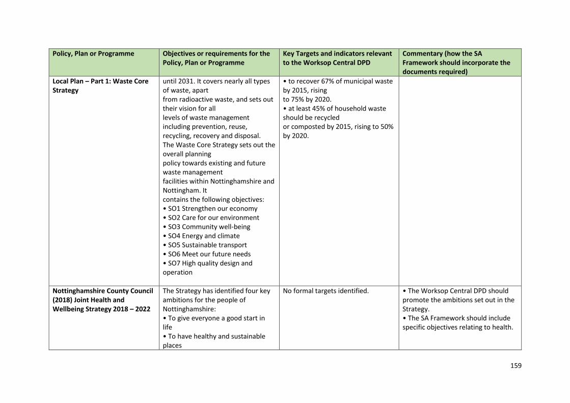
159
Policy, Plan or Programme Objectives or requirements for the Policy, Plan or Programme
Key Targets and indicators relevant to the Worksop Central DPD
Commentary (how the SA Framework should incorporate the documents required)
Local Plan – Part 1: Waste Core Strategy
until 2031. It covers nearly all types of waste, apart from radioactive waste, and sets out their vision for all levels of waste management including prevention, reuse, recycling, recovery and disposal. The Waste Core Strategy sets out the overall planning policy towards existing and future waste management facilities within Nottinghamshire and Nottingham. It contains the following objectives: • SO1 Strengthen our economy • SO2 Care for our environment • SO3 Community well-being • SO4 Energy and climate • SO5 Sustainable transport • SO6 Meet our future needs • SO7 High quality design and operation
• to recover 67% of municipal waste by 2015, rising to 75% by 2020. • at least 45% of household waste should be recycled or composted by 2015, rising to 50% by 2020.
Nottinghamshire County Council (2018) Joint Health and Wellbeing Strategy 2018 – 2022
The Strategy has identified four key ambitions for the people of Nottinghamshire: • To give everyone a good start in life • To have healthy and sustainable places
No formal targets identified. • The Worksop Central DPD should promote the ambitions set out in the Strategy. • The SA Framework should include specific objectives relating to health.
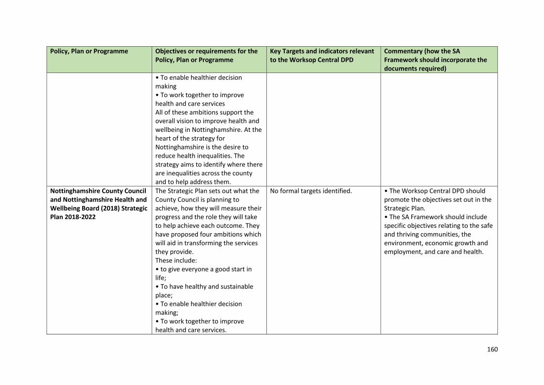
160
Policy, Plan or Programme Objectives or requirements for the Policy, Plan or Programme
Key Targets and indicators relevant to the Worksop Central DPD
Commentary (how the SA Framework should incorporate the documents required)
• To enable healthier decision making • To work together to improve health and care services All of these ambitions support the overall vision to improve health and wellbeing in Nottinghamshire. At the heart of the strategy for Nottinghamshire is the desire to reduce health inequalities. The strategy aims to identify where there are inequalities across the county and to help address them.
Nottinghamshire County Council and Nottinghamshire Health and Wellbeing Board (2018) Strategic Plan 2018-2022
The Strategic Plan sets out what the County Council is planning to achieve, how they will measure their progress and the role they will take to help achieve each outcome. They have proposed four ambitions which will aid in transforming the services they provide. These include: • to give everyone a good start in life; • To have healthy and sustainable place; • To enable healthier decision making; • To work together to improve health and care services.
No formal targets identified. • The Worksop Central DPD should promote the objectives set out in the Strategic Plan. • The SA Framework should include specific objectives relating to the safe and thriving communities, the environment, economic growth and employment, and care and health.
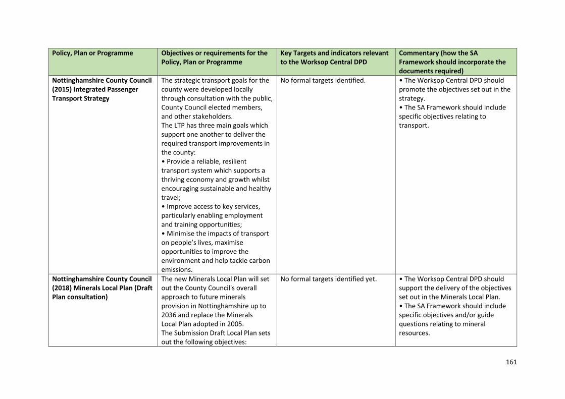
161
Policy, Plan or Programme Objectives or requirements for the Policy, Plan or Programme
Key Targets and indicators relevant to the Worksop Central DPD
Commentary (how the SA Framework should incorporate the documents required)
Nottinghamshire County Council (2015) Integrated Passenger Transport Strategy
The strategic transport goals for the county were developed locally through consultation with the public, County Council elected members, and other stakeholders. The LTP has three main goals which support one another to deliver the required transport improvements in the county: • Provide a reliable, resilient transport system which supports a thriving economy and growth whilst encouraging sustainable and healthy travel; • Improve access to key services, particularly enabling employment and training opportunities; • Minimise the impacts of transport on people’s lives, maximise opportunities to improve the environment and help tackle carbon emissions.
No formal targets identified. • The Worksop Central DPD should promote the objectives set out in the strategy. • The SA Framework should include specific objectives relating to transport.
Nottinghamshire County Council (2018) Minerals Local Plan (Draft Plan consultation)
The new Minerals Local Plan will set out the County Council's overall approach to future minerals provision in Nottinghamshire up to 2036 and replace the Minerals Local Plan adopted in 2005. The Submission Draft Local Plan sets out the following objectives:
No formal targets identified yet. • The Worksop Central DPD should support the delivery of the objectives set out in the Minerals Local Plan. • The SA Framework should include specific objectives and/or guide questions relating to mineral resources.
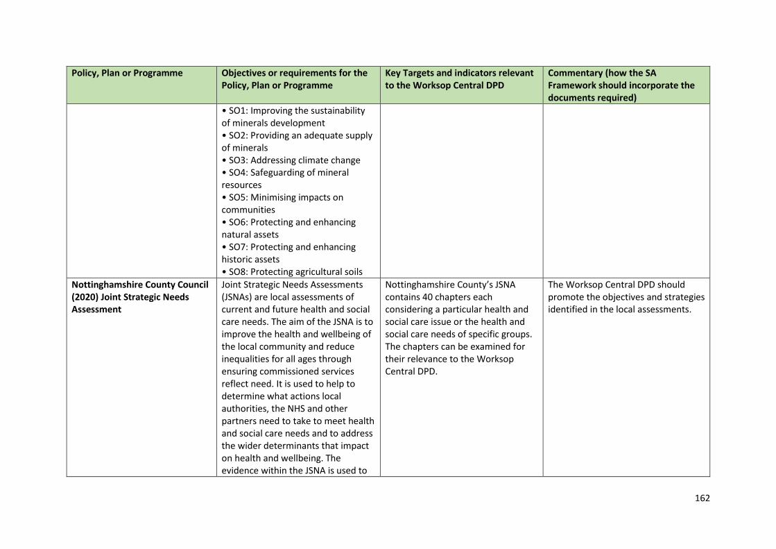
162
Policy, Plan or Programme Objectives or requirements for the Policy, Plan or Programme
Key Targets and indicators relevant to the Worksop Central DPD
Commentary (how the SA Framework should incorporate the documents required)
• SO1: Improving the sustainability of minerals development • SO2: Providing an adequate supply of minerals • SO3: Addressing climate change • SO4: Safeguarding of mineral resources • SO5: Minimising impacts on communities • SO6: Protecting and enhancing natural assets • SO7: Protecting and enhancing historic assets • SO8: Protecting agricultural soils
Nottinghamshire County Council (2020) Joint Strategic Needs Assessment
Joint Strategic Needs Assessments (JSNAs) are local assessments of current and future health and social care needs. The aim of the JSNA is to improve the health and wellbeing of the local community and reduce inequalities for all ages through ensuring commissioned services reflect need. It is used to help to determine what actions local authorities, the NHS and other partners need to take to meet health and social care needs and to address the wider determinants that impact on health and wellbeing. The evidence within the JSNA is used to
Nottinghamshire County’s JSNA contains 40 chapters each considering a particular health and social care issue or the health and social care needs of specific groups. The chapters can be examined for their relevance to the Worksop Central DPD.
The Worksop Central DPD should promote the objectives and strategies identified in the local assessments.
163
Policy, Plan or Programme Objectives or requirements for the Policy, Plan or Programme
Key Targets and indicators relevant to the Worksop Central DPD
Commentary (how the SA Framework should incorporate the documents required)
inform the priorities within the Health and Wellbeing Strategy for Nottinghamshire.
Idle Catchment Partnership Action Plan (undated)
The Action Plan identifies priority areas for improvement to the water environment. These include: • Farming • Nature • Community • Industrial and Urban • Water Management
The Plan contains a range of actions but no formal targets.
• The Worksop Central DPD should support the delivery of the Action Plan where appropriate. • The SA Framework should include specific guide questions relating to water quality and resources.
Sheffield City Region Local Enterprise Partnership (2020) Strategic Economic Plan 2021-2041
The Strategic Economic Plan sets out a 20 year plan (2021-2041) for growth in the Sheffield City Region (SCR).
The Plan identifies overarching policy objectives: • Growth: Growing the economy and enhancing its strength and resilience. • Inclusion: Ensuring that everyone has a fair opportunity to contribute to and benefit from economic growth, that people have a greater stake in their economy, and that work is more closely linked to wellbeing and a decent life. • Sustainability: Driving low carbon, green and circular economy opportunities within the economy and delivering net-zero emissions and lower overall environmental impact.
• The Worksop Central DPD should support the economic growth in the context of the SCR. • The SA Framework should include specific objectives relating to economic growth.
164
Policy, Plan or Programme Objectives or requirements for the Policy, Plan or Programme
Key Targets and indicators relevant to the Worksop Central DPD
Commentary (how the SA Framework should incorporate the documents required)
South Yorkshire Local Transport Plan Partnership Sheffield City Region (2017) Sheffield City Region Transport Strategy 2018 – 2040
The strategy sets out the following goals: • support inclusive economic growth • Create healthy streets where people feel safe • Improve the quality of our outdoors • Promote, enable and adopt different technologies
The plan sets out a number of actions including creating more sustainable and integrated transport links, enhancing air quality and investing in integrated packages of infrastructure to help achieve the policies.
• The Worksop Central DPD should reflect key actions and targets set out in the Strategy. • The SA Framework should include specific objectives relating to economic growth, social inclusion and health, carbon emissions and transport.
Local Plans and Programmes Policy, Plan or Programme Objectives or requirements for the
Policy, Plan or Programme Key Targets and indicators relevant to the Worksop Central DPD
Commentary (how the SA Framework should incorporate the documents required)
Bassetlaw Clinical Commissioning Group (2016) Primary Care Strategy 2016-2020
The document outlines the Primary Care Strategy over the 5 year period, 2016-2020, for Bassetlaw.
The Common themes emerging from the 5 year view, as identified by Healthwatch Nottinghamshire and which underpin this strategy are as follows; • Place Based Commissioning, community needs driven and data driven • Upstreaming toward community and self-care (The preventative agenda) • Empowerment – the re-education of service users • Innovation, new models of care and service configuration
The Worksop Central DPD should consider the key aims and themes which are presented in the strategy.
165
Policy, Plan or Programme Objectives or requirements for the Policy, Plan or Programme
Key Targets and indicators relevant to the Worksop Central DPD
Commentary (how the SA Framework should incorporate the documents required)
• Scaling up- hubs and communities of practices • Multidisciplinary working and integration • Technology to enable practice care and provision
Bassetlaw District Council (2009) Landscape Character Assessment
The Bassetlaw Landscape Character Assessment has defined the landscape character of the administrative area of Bassetlaw District Council [BDC] and will form part of the evidence base for the Local Development Framework [LDF]. It will be used by BDC to aid development control decisions on planning applications. The document provides an objective methodology for assessing the varied landscape within Bassetlaw and contains information about the character, condition and sensitivity of the landscape to provide a greater understanding of what makes the landscape within Bassetlaw locally distinctive. The study has recognised this by the identification of Policy Zones across
No specific targets or indicators identified.
The Worksop Central DPD should consider the objectives set out in the assessment as well as including reference to the assessment and its findings.
166
Policy, Plan or Programme Objectives or requirements for the Policy, Plan or Programme
Key Targets and indicators relevant to the Worksop Central DPD
Commentary (how the SA Framework should incorporate the documents required)
the 5 Landscape Character Types represented in Bassetlaw.
Bassetlaw District Council (2010) Sustainable Community Strategy 2010 – 2020
• By 2020 Bassetlaw will have a national reputation as a place to live and work and as a tourist destination. • Our residents will have pride in the District and reach their full potential. • Educational attainment will exceed the national average. • Bassetlaw will have a clear identity with strong sub-regional links to South Yorkshire/North East Derbyshire/North Nottinghamshire. • We will understand the needs of our communities, young and old and shape services to meet these needs.
The performance of the BLSP is managed by its Board on a quarterly basis. Each of its thematic groups are expected to report on the implementation of projects and progress in meeting targets. Progress reports will also go to Bassetlaw District Council’s Cabinet and to partners Boards and Executives.
• The Worksop Central DPD should support the delivery of the Community Strategy. • The aims of the strategy need to be compatible with the SA objectives.
Bassetlaw District Council (2011) Core Strategy and Development Management Policies Development Plan Document
This Core Strategy is the key LDF document and provides the overarching framework for all other documents that may be produced. It sets out a vision for change in Bassetlaw to 2028, along with the place-specific policy approaches to be taken in order to achieve this vision. A small number of more detailed development management policies, on key issues that will need to be addressed when delivering new development, are also included.
Monitoring is carried out through the Annual Monitoring Report.
The Local Plan under preparation will replace the adopted Plan, with expected adoption in 2022.
167
Policy, Plan or Programme Objectives or requirements for the Policy, Plan or Programme
Key Targets and indicators relevant to the Worksop Central DPD
Commentary (how the SA Framework should incorporate the documents required)
Finally, the document incorporates a Monitoring and Implementation scheme, to enable the Council to assess whether the policies are delivering the vision.
Bassetlaw District Council (2012) Contaminated Land Inspection Strategy
The quality of our land in Bassetlaw District is important to all of us, in terms of public health, ensuring continuing economic prosperity and enabling residents to enjoy our public spaces safely. One of the Council’s overall objectives is to control threats to public health and the environment that could arise from contaminated land. This strategy sets out how we aim to achieve that.
• To protect human health • To protect controlled waters • To protect designated ecosystems • To prevent damage to specified property uses • To prevent any further land contamination • To encourage voluntary remediation • To encourage re-use of brownfield sites
The Worksop Central DPD should consider the vision set out in the Contaminated Land Inspection Strategy.
Bassetlaw District Council (2017) Homelessness Prevention Strategy 2017-2022
The Bassetlaw Homelessness Strategy aims to review the homelessness situation in Bassetlaw and, support the delivery of a wide variety of homes across all sectors (town & rural areas); work with the private rented sector to improve the quality of homes; use our full range of powers to protect local people and the place they live; and support the health & wellbeing of local people through early intervention and initiatives.
Increase the housing stock of the District and provide for specialist needs.
• The Worksop Central DPD should consider the vision set out in the Homelessness Strategy. • To provide an adequate supply of land for both market and affordable housing. • Ensure housing needs across the District are considered in the SA Framework objectives.
168
Policy, Plan or Programme Objectives or requirements for the Policy, Plan or Programme
Key Targets and indicators relevant to the Worksop Central DPD
Commentary (how the SA Framework should incorporate the documents required)
The vision for the strategy is:” to offer early help, support and intervention to ensure people in Bassetlaw do not become homeless. We want to eradicate rough sleeping by helping to enable the life-skills needed for individuals to access stable accommodation.” The Council is currently consulting on its draft strategy.
Bassetlaw District Council (2012) Residential Parking Standards Supplementary Planning Document
This Supplementary Planning Document (SPD) forms part of the Bassetlaw Local Development Framework. It has been produced to expand upon Policy DM13: Sustainable Transport in the Core Strategy & Development Management Policies DPD, setting out the approach that the Council expects developers to take when establishing parking requirements for new residential development proposals.
No specific targets or indicators identified.
The Worksop Central DPD should consider the objectives set out in the SPD.
Bassetlaw District Council (2012) Sports Development Strategy
Bassetlaw District Council’s Sports Development Service aims to: “Deliver an excellent standard of service that will create opportunities through sport and physical activity to improve the health and well-being of all residents in Bassetlaw.”
No specific targets or indicators identified.
The Worksop Central DPD should consider the vision set out in the Sports Development Strategy.
169
Policy, Plan or Programme Objectives or requirements for the Policy, Plan or Programme
Key Targets and indicators relevant to the Worksop Central DPD
Commentary (how the SA Framework should incorporate the documents required)
Bassetlaw District Council (2016) The Canch Management Plan: 2016-2019
The Management Plan will be used to: • Assess and evaluate the current value of the park as a community facility; • Establish opportunities for future improvements to its facilities and features and formulate actions accordingly; • Monitor the management of the park in respect of its on-going maintenance and future development potential.
No specific targets or indicators identified.
The Worksop Central DPD should be aware of the objectives set out in the management plan.
Bassetlaw District Council (2013) Climate Change Strategy 2013
This strategy highlights the work planned, showing that Bassetlaw is addressing its local and global responsibilities to tackle climate change. The strategy intends to show that climate change is correlated to a number of different issues, transport, waste and energy generation and use are but a few and massive change is needed if Bassetlaw is to reduce its contribution to global climate change.
• To increase the % of household waste sent for reuse, recycling and composting. • To reduce the % of people receiving income based benefits living in homes with a low energy efficiency rating. • To reduce the per capita CO2 emissions in the local authority area.
The Worksop Central DPD should consider the vision set out in the Climate Change Strategy.
Bassetlaw District Council (2013) Successful Places Supplementary Planning Document
The purpose of this guide is about creating sustainable places that deliver a good quality of life for the
The purpose of this guide is about creating sustainable places that deliver a good quality of life for the
• The Worksop Central DPD policies should seek to work in conjunction with the design guidance.
170
Policy, Plan or Programme Objectives or requirements for the Policy, Plan or Programme
Key Targets and indicators relevant to the Worksop Central DPD
Commentary (how the SA Framework should incorporate the documents required)
people that will live there and preventing costly poor design. This demands that our neighbourhoods are designed around the linked concepts of good place making and sustainability.
people that will live there and preventing costly poor design. This demands that our neighbourhoods are designed around the linked concepts of good place making and sustainability.
• The SA framework should include objectives and/or guidance questions relating to high quality design.
Bassetlaw District Council (2013) Sustainability Strategy
The Bassetlaw District Council Sustainability Strategy provides a framework for good practice that is applicable to every service, and every decision made must consider the sustainability impact, be it carbon emissions, household or trade waste, or the natural environment.
The strategy builds upon the work already identified in the Carbon Management Plan and the Climate Change Strategy and complements and informs other Council strategies. The strategy addresses the need to work with the Councils partners to reduce its impact on the environment and to progress delivery through the Councils partnerships.
The Worksop Central DPD should consider the vision set out in the Sustainability Strategy.
Bassetlaw District Council (2014) Affordable Housing Supplementary Planning Document
This SPD has been produced to expand upon policy set out in the Core Strategy in relation to affordable housing. In particular this SPD gives guidance on: • The amount of affordable housing contribution being sought from housing developments; • Affordable Housing Providers; • Occupancy and management arrangement;
No specific targets or indicators identified.
• The Worksop Central DPD should seek to provide policies capable of contributing towards the provision of affordable housing • The SA framework should include a specific objective relating to housing delivery to meet local needs.
171
Policy, Plan or Programme Objectives or requirements for the Policy, Plan or Programme
Key Targets and indicators relevant to the Worksop Central DPD
Commentary (how the SA Framework should incorporate the documents required)
• Providing affordable housing contributions through on-site or off-site contributions; • Development viability impacts; • Rural exception sites; and • Section 106 agreements for affordable housing provision. This SPD also provides a summary and links to other sources of information that relate to the delivery of affordable housing such as the Strategic Housing Market Assessment.
Bassetlaw District Council, Council Plan 2019 – 2023
The Council plan establishes the framework within which the Council operates and establishes goals and priorities for the four year plan period. The plan sets out priorities in the three key themes of: • Investing in Place • Investing in Housing • Investing in Communities
He 10 key priorities over the plan period can be summarised as: • Maximise Bassetlaw’s local offer for the 400th Anniversary of the Mayflower Pilgrims’ sailing to America. • Produce a Local Industrial Strategy for Bassetlaw, which will not only map out what we want to achieve but also support Bassetlaw’s future bids for external funding. • Introduce a car parking strategy for our towns to maximise asset usage and support our local economies.
• The Worksop Central DPD should include policies and proposals that help deliver the Corporate Plan. • The Worksop Central DPD should help deliver the main priorities of the Corporate Plan. • The SA framework should consider the aims of the Corporate Plan.
172
Policy, Plan or Programme Objectives or requirements for the Policy, Plan or Programme
Key Targets and indicators relevant to the Worksop Central DPD
Commentary (how the SA Framework should incorporate the documents required)
• Work with owners of the two coal fired power station sites to maximise their potential and create positive local opportunities. • Work proactively with partners and landowners in agreeing an approach to redeveloping large- scale sites. • Provide continued support to our local high streets. • Develop a land and property database to improve the Council’s asset management to generate more local income. • Develop a business plan for a local investment company which using the Council’s balance sheet assets would enable the Council to intervene on stalled development sites whilst also generating a financial return. • Deliver on the master plan for the Canch – including developing new physical activity facilities and new public toilets. There will also be a plan for Langold Country Park. • Encourage local tree planting by developing a long-term strategy on trees and their maintenance. Through the use of the planning
173
Policy, Plan or Programme Objectives or requirements for the Policy, Plan or Programme
Key Targets and indicators relevant to the Worksop Central DPD
Commentary (how the SA Framework should incorporate the documents required)
system and by encouraging others to plant more trees in the district, we will seek to rejuvenate the Sherwood Forest area.
Bassetlaw District Council (2014) A Guide to Good Shopfront Design and Signage Supplementary Planning Document
This supplementary planning document (SPD) is intended to provide guidance to anyone proposing new, repairing or replacing shopfronts. The SPD supports policy DM4 and DM8 of the Bassetlaw Core Strategy and Development Management Policies DPD.
No specific targets or indicators identified.
The Worksop Central DPD should consider the guidance set out in the SPD.
Bassetlaw District Council (2014) Night Time Economy Strategy
The vision for the Bassetlaw Night Time Economy is to “support a thriving and safe evening and night time economy in our towns”. The Strategy aims to see an increase in the choice and availability of services for visitors and residents alike, create a feeling of safety within the town centres and encourage greater diversity and vibrancy within them.
No specific targets or indicators identified.
The Worksop Central DPD should be aware of the objectives set out in the strategy.
Bassetlaw District Council (2014) Regeneration and Growth Strategy 2014 – 2028
This strategy sets out realistic ambitions that builds on the Council’s past successes in the economic development arena, along with current and emerging strategies.
No specific targets or indicators identified.
The Worksop Central DPD should support the objectives set out in the regeneration and growth strategy.
174
Policy, Plan or Programme Objectives or requirements for the Policy, Plan or Programme
Key Targets and indicators relevant to the Worksop Central DPD
Commentary (how the SA Framework should incorporate the documents required)
In undertaking this task it is acknowledged that the District is not an isolated economy, and that other economic factors whether sub-national, national and international will impact on the productivity and competitiveness of the District Building a competitive vision for North Nottinghamshire looks to create a sustainable and prosperous future that will: • Strengthen the area’s economic competitiveness, which will underpin development of sustainable growth; • Develop an appropriately educated and skilled workforce; • Support the innovation of enterprise that will help diversify the business base; • Recognise the importance of strategic and sustainable areas of economic growth and investment.
Bassetlaw District Council (2017) Housing Strategy 2017-2020
The objective of this strategy is to set-out how the Council will support the availability of good quality homes which best meet the needs of the current and future residents of Bassetlaw. The priorities set out are:
In accordance with the new Council Plan (2017-2020) the Housing strategy supports the ambition: Enhancing Home and Place. This strategy will be delivered in collaboration with key services across the Council. This holistic
The Worksop Central DPD should consider the vision set out in the Housing Strategy. An update of this is due in late Spring 2021.
175
Policy, Plan or Programme Objectives or requirements for the Policy, Plan or Programme
Key Targets and indicators relevant to the Worksop Central DPD
Commentary (how the SA Framework should incorporate the documents required)
1. Providing affordable and social rented homes 2. Improve the quality of private rented accommodation 3. independent living for out ageing and vulnerable population
approach ensures the skills and experience of services across the Council are coordinated to deliver the key priorities of the housing strategy.
Bassetlaw District Council (2020) Draft Bassetlaw Local Plan
The Draft Local Plan sets out the Council’s development strategy, policies and proposals, including site allocations, to guide land use planning in the District up to 2037.
A key Policy of relevance is Policy ST6: Worksop Central. However, as the Draft local Plan covers a range of issues and topics, it is likely that several policies will be relevant to any proposed development. Therefore, the plan should be read as a whole rather than considering policies in isolation.
The Worksop Central DPD should consider the vision, policies and objectives set out in the Draft Local Plan.
Bassetlaw District Council (2011) Worksop Conservation Area Appraisal and Management Plan
The Conservation Area Appraisal document gives an overview of the history and development of each area and defines what it is that makes them special. They also identify specific features which contribute towards their character, for example historic buildings and buildings which are locally significant, important green and open spaces, significant views, and natural elements such as trees and features which help make an area locally distinct. The documents also
The conservation area for Worksop is divided between 5 key areas. The designation of the area brings certain duties and controls to the local planning authority: • Proposals will need to be formulated from time to time for the preservation and enhancement of conservation areas in the form of a management plan; • In exercising their planning powers, the local planning authority must pay special attention to the desirability of preserving or
The Worksop Central DPD should consider the objectives set out in the management plan.
176
Policy, Plan or Programme Objectives or requirements for the Policy, Plan or Programme
Key Targets and indicators relevant to the Worksop Central DPD
Commentary (how the SA Framework should incorporate the documents required)
identify elements that could be enhanced.
enhancing the character or appearance of conservation areas; • The local planning authority is able to carry out urgent works to preserve unoccupied unlisted buildings in a conservation area.
Bassetlaw District Council (2011) Mr Straw’s Conservation Area Appraisal
The Conservation Area Appraisal document gives an overview of the history and development of each area and defines what it is that makes them special. They also identify specific features which contribute towards their character, for example historic buildings and buildings which are locally significant, important green and open spaces, significant views, and natural elements such as trees and features which help make an area locally distinct. The documents also identify elements that could be enhanced.
The designation of the area brings certain duties and controls to the local planning authority: • Proposals will need to be formulated from time to time for the preservation and enhancement of conservation areas in the form of a management plan; • In exercising their planning powers, the local planning authority must pay special attention to the desirability of preserving or enhancing the character or appearance of conservation areas; • The local planning authority is able to carry out urgent works to preserve unoccupied unlisted buildings in a conservation area
The Worksop Central DPD should consider the objectives set out in the management plan.
Bassetlaw District Council (2016) Worksop Intervention Strategy
This intervention strategy seeks to identify the opportunities for the Council to guide, or where necessary, intervene on sites and
The objectives of the Intervention Strategy included: •Strengthen the town centre as a vibrant retail, leisure, entertainment, cultural business and
The Worksop Central DPD should reflect on the objectives set out in the previous intervention strategy.
177
Policy, Plan or Programme Objectives or requirements for the Policy, Plan or Programme
Key Targets and indicators relevant to the Worksop Central DPD
Commentary (how the SA Framework should incorporate the documents required)
projects within the wider Worksop town centre area.
tourism destination for residents and visitors •Grow the town centre as a place to do business by creating a creative industries hub and provide better quality and quantity of business parks •Create a choice of high quality homes in and around the town centre •Improve the quality of buildings (especially the focal buildings), streets and spaces, including their maintenance and management •Provide convenient access to the town centre by all modes of travel and enable easier pedestrian movement from the train and bus stations •To enhance the town’s historic assets and the conservation area •To improve the perception of Worksop as a service, retail and visitor destination
Bassetlaw District Council (2021) Worksop Masterplan
This Masterplan for Worksop Town Centre seeks to bond together a range of existing and new initiatives into one holistic vision for the future that honours the built, natural and cultural heritage of the town.
The masterplan identifies a series of Project Clusters to focus priorities for investment and catalyse change, providing certainty and helping to realise public goods.
The Worksop Central DPD should reflect the vision and objectives outlined in the Masterplan.
178
Policy, Plan or Programme Objectives or requirements for the Policy, Plan or Programme
Key Targets and indicators relevant to the Worksop Central DPD
Commentary (how the SA Framework should incorporate the documents required)
Bassetlaw District Council (2020) Bassetlaw Local Plan Habitats Regulations Assessment
The HRA report relates to the latest iteration of the Local Plan, the Draft Local Plan (November 2020). The HRA of the Bassetlaw Plan considers whether the plan could have a significant effect on the integrity of internationally important wildlife sites, either alone or in-combination with other plans.
The document identifies the likely activities and effects which would impact the; Birklands and Bilhaugh SAC and the Sherwood Forest ppSPA, as a result of the Worksop Central Policy, as outlined in the Draft Bassetlaw Local Plan.
The Worksop Central DPD should consider the findings of the Habitats Regulations Assessment.
Bassetlaw District Council (2021) Recreational Impact Assessment
The assessment expected to be published in Autumn 2021. The Key Milestones are as follows:
Stage A Visitor and Habitat Baseline
Stage B Visitor and Habitat Surveys
Stage C Establishing Zones of Influence
Stage D Assessment Documents
The commission is split into a baseline report and two RIAs as follows:
Baseline Report (now produced and subject to amendments following comments)
Recreational Impact Assessment for the Clumber Park SSSI
Recreational Impact Assessment for the Birklands & Bilhaugh SAC/Sherwood NNR.
The Worksop Central DPD should consider the findings of the Recreational Impact Assessments.
Woodland Trust Hannah Park Woodland Management Plan 2017-2022
The Trust’s corporate aims and management approach guide the management of all the Trust’s properties. These determine basic management policies and methods, which apply to all sites unless specifically stated otherwise. Such policies include free public access; keeping local people
No specific targets or indicators ` identified.
The Worksop Central DPD should consider the objectives set out in the management plan.
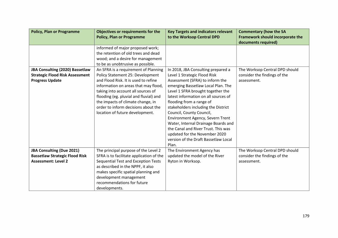
179
Policy, Plan or Programme Objectives or requirements for the Policy, Plan or Programme
Key Targets and indicators relevant to the Worksop Central DPD
Commentary (how the SA Framework should incorporate the documents required)
informed of major proposed work; the retention of old trees and dead wood; and a desire for management to be as unobtrusive as possible.
JBA Consulting (2020) Bassetlaw Strategic Flood Risk Assessment Progress Update
An SFRA is a requirement of Planning Policy Statement 25: Development and Flood Risk. It is used to refine information on areas that may flood, taking into account all sources of flooding (eg. pluvial and fluvial) and the impacts of climate change, in order to inform decisions about the location of future development.
In 2018, JBA Consulting prepared a Level 1 Strategic Flood Risk Assessment (SFRA) to inform the emerging Bassetlaw Local Plan. The Level 1 SFRA brought together the latest information on all sources of flooding from a range of stakeholders including the District Council, County Council, Environment Agency, Severn Trent Water, Internal Drainage Boards and the Canal and River Trust. This was updated for the November 2020 version of the Draft Bassetlaw Local Plan.
The Worksop Central DPD should consider the findings of the assessment.
JBA Consulting (Due 2021) Bassetlaw Strategic Flood Risk Assessment: Level 2
The principal purpose of the Level 2 SFRA is to facilitate application of the Sequential Test and Exception Tests as described in the NPPF, it also makes specific spatial planning and development management recommendations for future developments.
The Environment Agency has updated the model of the River Ryton in Worksop.
The Worksop Central DPD should consider the findings of the assessment.
Recommended


