EXECUTIVE SUMMARY
TMT.A. SAFANA PARVEEN ROUGH STONE QUARRY
S.F. Nos: 425/2,3,4,5,6A & 425/6B – Extent: 1.54.5 ha
Kothapulli Village, Dindigul (West) Taluk, Dindigul District
Tamil Nadu State
“B1” CATEGORY – MINOR MINERAL – CLUSTER – PATTA LAND/
NEW QUARRY
* CLUSTER EXTENT = 9.14.0 ha
Complied as per ToR Obtained vide
Lr No. SEIAA-TN/F.No.7834/SEAC/ToR-875/2020 Dated: 12.03.2021
Project Proponent
Environmental Consultant
GEO EXPLORATION AND MINING SOLUTIONS
Old No. 260-B, New No. 17,
Advaitha Ashram Road, Alagapuram,
Salem – 636 004, Tamil Nadu, India
Accredited for sector 1, 28 & 38 Category ‘A’
Certificate No : NABET/EIA/1821/RA0123
Phone: 0427-2431989,
Email: [email protected], [email protected]
Web: www.gemssalem.com
* Calculated as per MoEF & CC Notification – S.O. 2269(E) Dated: 01.07.2016
Tmt.Safana parveen Rough Stone Quarry(Extent 1.54.5 ha) Executive Summary
Rough Stone Quarry Page 2
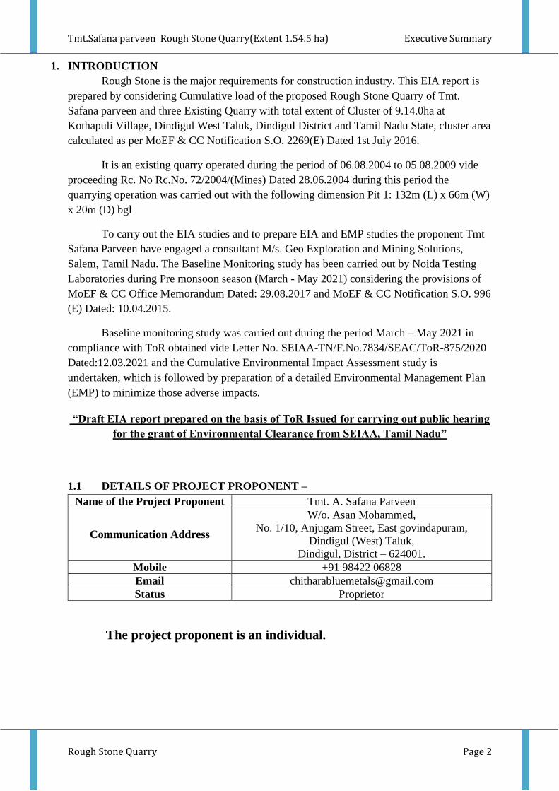
1. INTRODUCTION
Rough Stone is the major requirements for construction industry. This EIA report is
prepared by considering Cumulative load of the proposed Rough Stone Quarry of Tmt.
Safana parveen and three Existing Quarry with total extent of Cluster of 9.14.0ha at
Kothapuli Village, Dindigul West Taluk, Dindigul District and Tamil Nadu State, cluster area
calculated as per MoEF & CC Notification S.O. 2269(E) Dated 1st July 2016.
It is an existing quarry operated during the period of 06.08.2004 to 05.08.2009 vide
proceeding Rc. No Rc.No. 72/2004/(Mines) Dated 28.06.2004 during this period the
quarrying operation was carried out with the following dimension Pit 1: 132m (L) x 66m (W)
x 20m (D) bgl
To carry out the EIA studies and to prepare EIA and EMP studies the proponent Tmt
Safana Parveen have engaged a consultant M/s. Geo Exploration and Mining Solutions,
Salem, Tamil Nadu. The Baseline Monitoring study has been carried out by Noida Testing
Laboratories during Pre monsoon season (March - May 2021) considering the provisions of
MoEF & CC Office Memorandum Dated: 29.08.2017 and MoEF & CC Notification S.O. 996
(E) Dated: 10.04.2015.
Baseline monitoring study was carried out during the period March – May 2021 in
compliance with ToR obtained vide Letter No. SEIAA-TN/F.No.7834/SEAC/ToR-875/2020
Dated:12.03.2021 and the Cumulative Environmental Impact Assessment study is
undertaken, which is followed by preparation of a detailed Environmental Management Plan
(EMP) to minimize those adverse impacts.
“Draft EIA report prepared on the basis of ToR Issued for carrying out public hearing
for the grant of Environmental Clearance from SEIAA, Tamil Nadu”
1.1 DETAILS OF PROJECT PROPONENT –
Name of the Project Proponent Tmt. A. Safana Parveen
Communication Address
W/o. Asan Mohammed,
No. 1/10, Anjugam Street, East govindapuram,
Dindigul (West) Taluk,
Dindigul, District – 624001.
Mobile +91 98422 06828
Email [email protected]
Status Proprietor
The project proponent is an individual.
Tmt.Safana parveen Rough Stone Quarry(Extent 1.54.5 ha) Executive Summary
Rough Stone Quarry Page 3
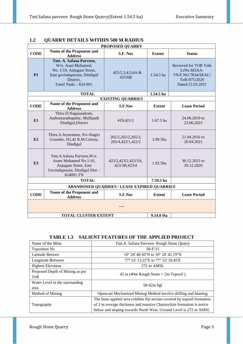
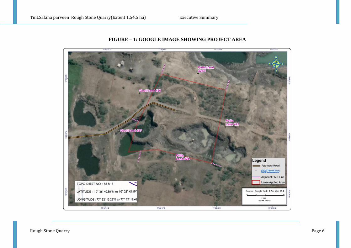
1.2 QUARRY DETAILS WITHIN 500 M RADIUS
PROPOSED QUARRY
CODE Name of the Proponent and
Address S.F. Nos Extent Status
P1
Tmt. A. Safana Parveen,
W/o. Asan Mohamed,
No. 1/10, Anjugam Street,
East govindapuram, Dindigul
District,
Tamil Nadu – 624 001.
425/2,3,4,5,6A &
425/6B 1.54.5 ha
Received for TOR Vide
LrNo.SEIAA-
TN/F.NO.7834/SEAC/
ToR-875/2020
Dated:12.03.2021
TOTAL 1.54.5 ha
EXISTING QUARRIES
CODE Name of the Proponent and
Address S.F.Nos Extent Lease Period
E1
Thiru.D.Nagasundram,
Aathumarathupatty, Mullipadi
Dindigul,District
419,421/1 1.67.5 ha 24.06.2019 to
23.06.2023
E2
Thiru.A.Jeyaraman, S/o.Alagiri
Gounder, H2,42 R.M.Colony,
Dindigul
265/2,265/2,265/3,
265/4,422/1,422/2 3.99.5ha
21.04.2016 to
20.04.2021
E3
Tmt.A.Safana Parveen,W/o.
Asam Mohamed No.1/10,
Anjugam Street, East
Govindapuram, Dindigul Dist –
624001.TN
423/2,423/2,423/3A,
423/3B,423/4 1.92.5ha
30.12.2015 to
29.12.2020
TOTAL 7.59.5 ha
ABANDONED QUARRIES / LEASE EXPIRED QUARRIES
CODE Name of the Proponent and
Address S.F.Nos Extent Lease Period
----
TOTAL CLUSTER EXTENT 9.14.0 Ha
TABLE 1.3 SALIENT FEATURES OF THE APPLIED PROJECT
Name of the Mine Tmt.A. Safana Parveen- Rough Stone Quarry
Toposheet No 58-F/15
Latitude Betwen 10° 26' 40.50''N to 10° 26' 45.19''N
Longitude Between 77° 52' 13.22''E to 77° 52' 18.45'E
Highest Elevation 272 m AMSL
Proposed Depth of Mining as per
ToR 42 m (40m Rough Stone + 2m Topsoil )
Water Level in the surrounding
area 58-62m bgl
Method of Mining Opencast Mechanized Mining Method involve drilling and blasting
Topography
The lease applied area exhibits flat terrain covered by topsoil formation
of 2 m average thickness and massive Charnockite formation is notice
below and sloping towards North West. Ground Level is 272 m AMSL
Tmt.Safana parveen Rough Stone Quarry(Extent 1.54.5 ha) Executive Summary
Rough Stone Quarry Page 4
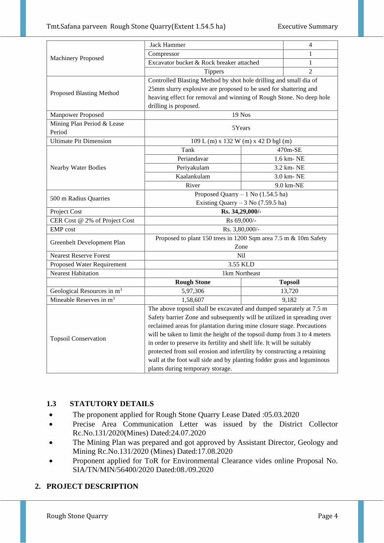
Machinery Proposed
Jack Hammer 4
Compressor 1
Excavator bucket & Rock breaker attached 1
Tippers 2
Proposed Blasting Method
Controlled Blasting Method by shot hole drilling and small dia of
25mm slurry explosive are proposed to be used for shattering and
heaving effect for removal and winning of Rough Stone. No deep hole
drilling is proposed.
Manpower Proposed 19 Nos
Mining Plan Period & Lease
Period 5Years
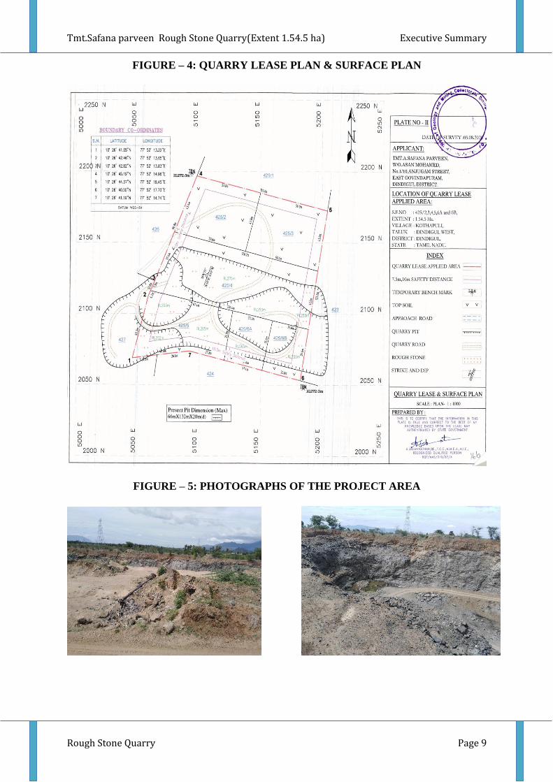
Ultimate Pit Dimension 109 L (m) x 132 W (m) x 42 D bgl (m)
Nearby Water Bodies
Tank 470m-SE
Periandavar 1.6 km- NE
Periyakulam 3.2 km- NE
Kaalankulam 3.0 km- NE
River 9.0 km-NE
500 m Radius Quarries Proposed Quarry – 1 No (1.54.5 ha)
Existing Quarry – 3 No (7.59.5 ha)
Project Cost Rs. 34,29,000/-
CER Cost @ 2% of Project Cost Rs 69,000/-
EMP cost Rs. 3,80,000/-
Greenbelt Development Plan Proposed to plant 150 trees in 1200 Sqm area 7.5 m & 10m Safety
Zone
Nearest Reserve Forest Nil
Proposed Water Requirement 3.55 KLD
Nearest Habitation 1km Northeast
Rough Stone Topsoil
Geological Resources in m3 5,97,306 13,720
Mineable Reserves in m3 1,58,607 9,182
Topsoil Conservation
The above topsoil shall be excavated and dumped separately at 7.5 m
Safety barrier Zone and subsequently will be utilized in spreading over
reclaimed areas for plantation during mine closure stage. Precautions
will be taken to limit the height of the topsoil dump from 3 to 4 meters
in order to preserve its fertility and shelf life. It will be suitably
protected from soil erosion and infertility by constructing a retaining
wall at the foot wall side and by planting fodder grass and leguminous
plants during temporary storage.
1.3 STATUTORY DETAILS
• The proponent applied for Rough Stone Quarry Lease Dated :05.03.2020
• Precise Area Communication Letter was issued by the District Collector
Rc.No.131/2020(Mines) Dated:24.07.2020
• The Mining Plan was prepared and got approved by Assistant Director, Geology and
Mining Rc.No.131/2020 (Mines) Dated:17.08.2020
• Proponent applied for ToR for Environmental Clearance vides online Proposal No.
SIA/TN/MIN/56400/2020 Dated:08./09.2020
2. PROJECT DESCRIPTION
Tmt.Safana parveen Rough Stone Quarry(Extent 1.54.5 ha) Executive Summary
Rough Stone Quarry Page 5
The proposed project is site specific and there is no additional area required for this
project. There is no effluent generation/discharge from this proposed quarry.
The quarrying operation is proposed to be carried out by Opencast Mechanized
Mining Method by deploying Heavy Earth Moving Machineries without deep hole drilling
and blasting by Jack Hammer Drilling & Slurry Explosive during blasting by forming 5.0 m
bench height and 5.0 m bench width. Excavator are proposed for Loading and tippers for
transportation of Rough Stone from pithead to the needy crushers. Rock Breakers are
proposed to be deployed to avoid secondary blasting.
2.1 SITE CONNECTIVITY TO THE PROJECT AREA
Nearest Roadway NH – 83- Dindigul - Coimbatore – 2km – South
SH -193 - Aravakurichi - Thadikombu Road – 6km – NE
Nearest Village K.Pudukkottai 1.0Km – North
Nearest Town Dindigul – 15Km –SE
Nearest Railway
Station Dindigul – 15Km –SE
Nearest Airport Madurai - 65 km – SE
Seaport Thoothukudi– 190 km – SE
2.2 LAND USE PATTERN OF THE PROPOSED PROJECTS
Description Present area in
(ha)
Area at the end of life of
quarry (Ha)
Area under quarry 0.85.2 1.29.7
Infrastructure Nil 0.01.0
Roads 0.01.0 0.01.0
Green Belt Nil 0.12.0
Un – utilized area 0.68.3 0.10.8
Grand Total 1.54.5 1.54.5
2.3 OPERATIONAL DETAILS OF LEASE APPLIED AREA
PARTICULARS DETAILS
Rough Stone Topsoil
Geological Resources in m3 5,83,586 13,720
Mineable Reserves in m3 1,58,607 9,182
Yearwise Production for five years
in m3 as per the ToR
1,58,607 9,182
Mining Plan Period 5 Years 1 Year
Number of Working Days 300 Days 300 Days
Production per day in m3 106 -
No of Lorry loads (12 m3 per load) 9 -
Total Depth of Mining 42 m bgl (2 m Top soil + 40 m Rough Stone)
Tmt.Safana parveen Rough Stone Quarry(Extent 1.54.5 ha) Executive Summary
Rough Stone Quarry Page 6
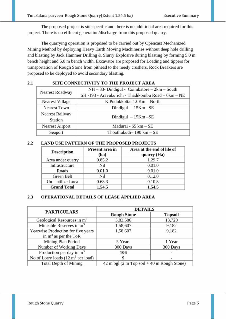
FIGURE – 1: GOOGLE IMAGE SHOWING PROJECT AREA
Tmt.Safana parveen Rough Stone Quarry(Extent 1.54.5 ha) Executive Summary
Rough Stone Quarry Page 7
FIGURE – 2: GOOGLE IMAGE SHOWING CLUSTER (500 m QUARRIES)
Tmt.Safana parveen Rough Stone Quarry(Extent 1.54.5 ha) Executive Summary
Rough Stone Quarry Page 8
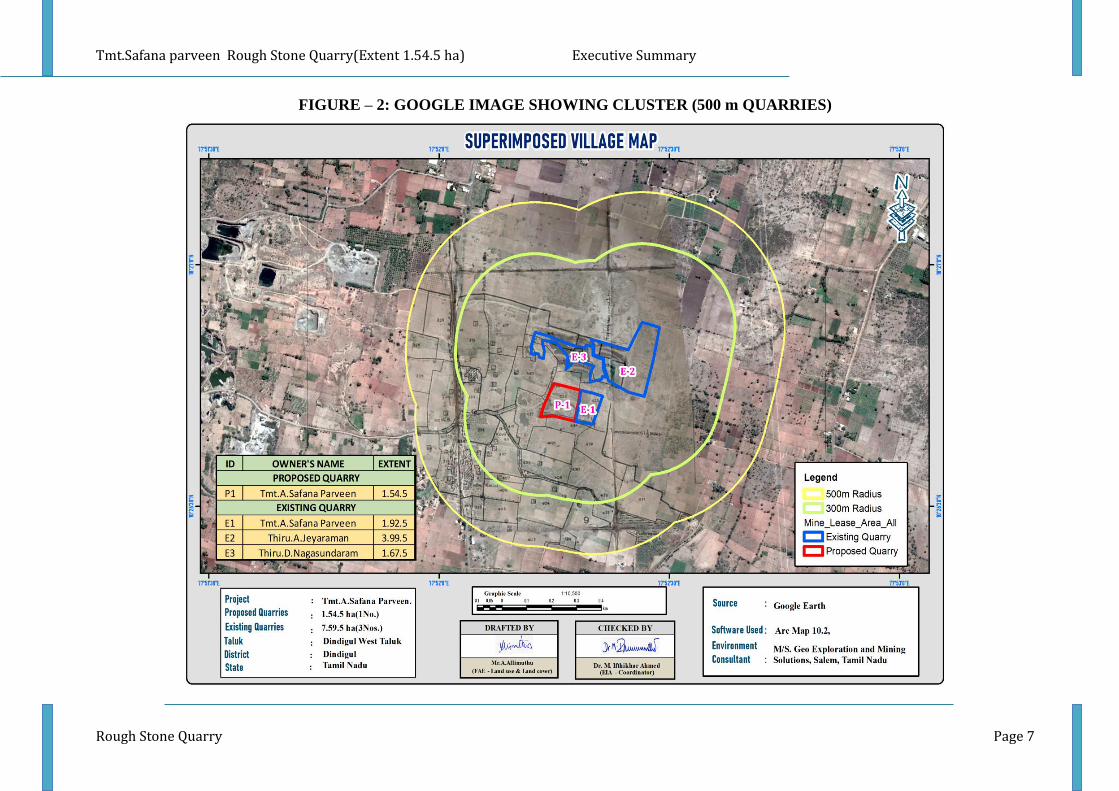
FIGURE – 3: TOPOSHEET MAP COVERING 10 KM RADIUS
Tmt.Safana parveen Rough Stone Quarry(Extent 1.54.5 ha) Executive Summary
Rough Stone Quarry Page 9
FIGURE – 4: QUARRY LEASE PLAN & SURFACE PLAN
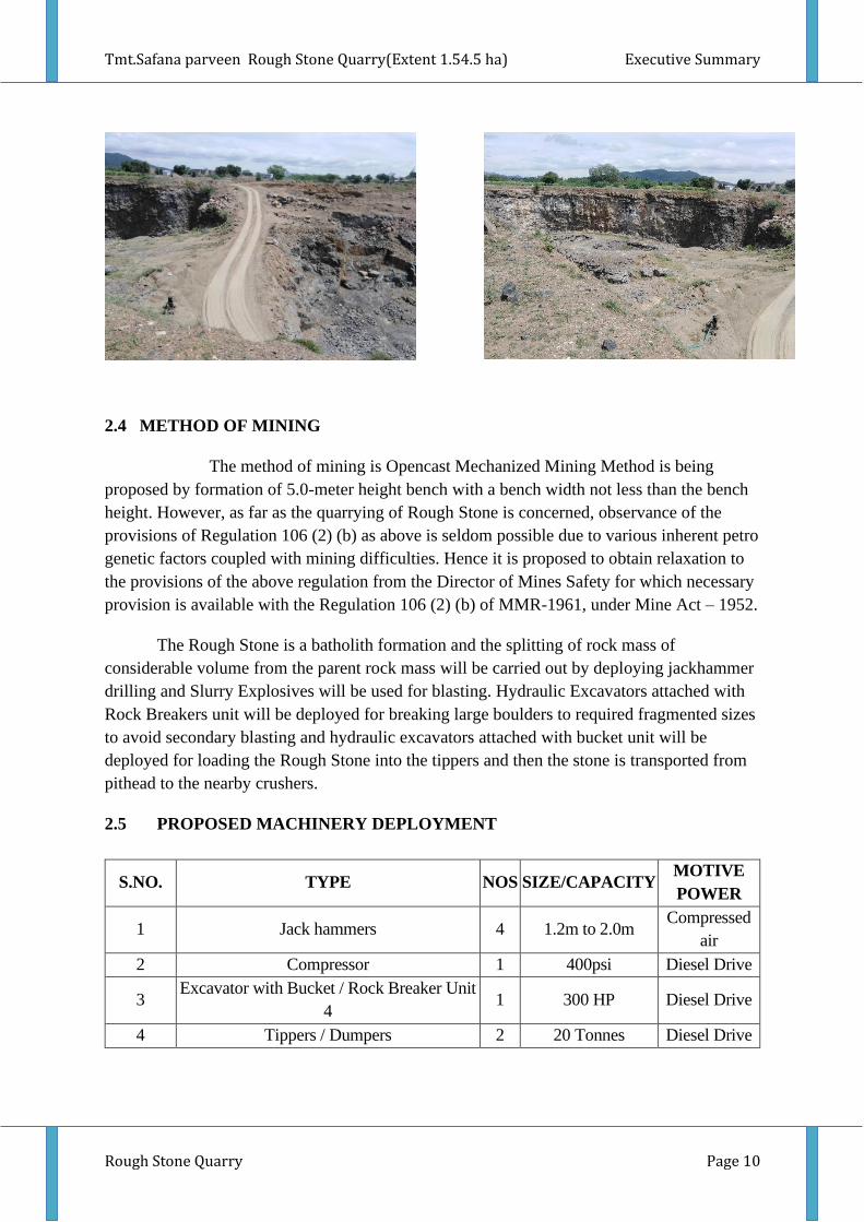
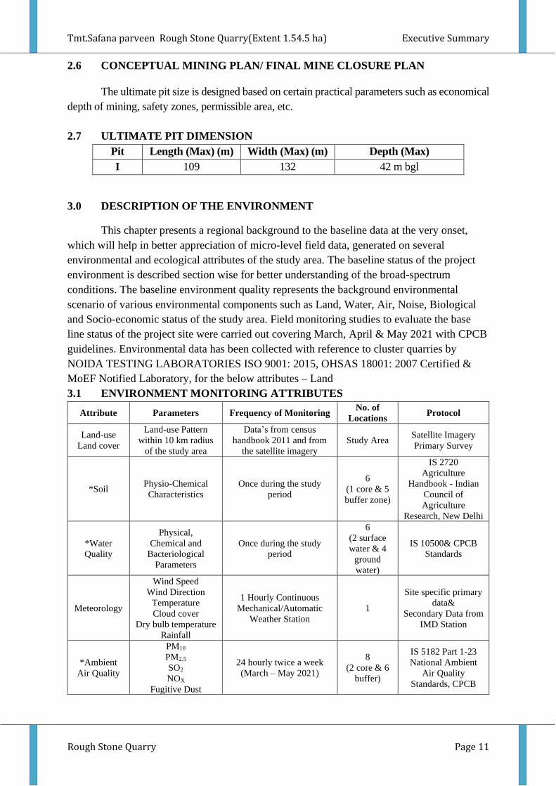
FIGURE – 5: PHOTOGRAPHS OF THE PROJECT AREA
Tmt.Safana parveen Rough Stone Quarry(Extent 1.54.5 ha) Executive Summary
Rough Stone Quarry Page 10
2.4 METHOD OF MINING
The method of mining is Opencast Mechanized Mining Method is being
proposed by formation of 5.0-meter height bench with a bench width not less than the bench
height. However, as far as the quarrying of Rough Stone is concerned, observance of the
provisions of Regulation 106 (2) (b) as above is seldom possible due to various inherent petro
genetic factors coupled with mining difficulties. Hence it is proposed to obtain relaxation to
the provisions of the above regulation from the Director of Mines Safety for which necessary
provision is available with the Regulation 106 (2) (b) of MMR-1961, under Mine Act – 1952.
The Rough Stone is a batholith formation and the splitting of rock mass of
considerable volume from the parent rock mass will be carried out by deploying jackhammer
drilling and Slurry Explosives will be used for blasting. Hydraulic Excavators attached with
Rock Breakers unit will be deployed for breaking large boulders to required fragmented sizes
to avoid secondary blasting and hydraulic excavators attached with bucket unit will be
deployed for loading the Rough Stone into the tippers and then the stone is transported from
pithead to the nearby crushers.
2.5 PROPOSED MACHINERY DEPLOYMENT
S.NO. TYPE NOS SIZE/CAPACITY MOTIVE
POWER
1 Jack hammers 4 1.2m to 2.0m Compressed
air
2 Compressor 1 400psi Diesel Drive
3 Excavator with Bucket / Rock Breaker Unit
4 1 300 HP Diesel Drive
4 Tippers / Dumpers 2 20 Tonnes Diesel Drive
Tmt.Safana parveen Rough Stone Quarry(Extent 1.54.5 ha) Executive Summary
Rough Stone Quarry Page 11
2.6 CONCEPTUAL MINING PLAN/ FINAL MINE CLOSURE PLAN
The ultimate pit size is designed based on certain practical parameters such as economical
depth of mining, safety zones, permissible area, etc.
2.7 ULTIMATE PIT DIMENSION
Pit Length (Max) (m) Width (Max) (m) Depth (Max)
I 109 132 42 m bgl
3.0 DESCRIPTION OF THE ENVIRONMENT
This chapter presents a regional background to the baseline data at the very onset,
which will help in better appreciation of micro-level field data, generated on several
environmental and ecological attributes of the study area. The baseline status of the project
environment is described section wise for better understanding of the broad-spectrum
conditions. The baseline environment quality represents the background environmental
scenario of various environmental components such as Land, Water, Air, Noise, Biological
and Socio-economic status of the study area. Field monitoring studies to evaluate the base
line status of the project site were carried out covering March, April & May 2021 with CPCB
guidelines. Environmental data has been collected with reference to cluster quarries by
NOIDA TESTING LABORATORIES ISO 9001: 2015, OHSAS 18001: 2007 Certified &
MoEF Notified Laboratory, for the below attributes – Land
3.1 ENVIRONMENT MONITORING ATTRIBUTES
Attribute Parameters Frequency of Monitoring No. of
Locations Protocol
Land-use
Land cover
Land-use Pattern
within 10 km radius
of the study area
Data’s from census
handbook 2011 and from
the satellite imagery
Study Area Satellite Imagery
Primary Survey
*Soil Physio-Chemical
Characteristics
Once during the study
period
6
(1 core & 5
buffer zone)
IS 2720
Agriculture
Handbook - Indian
Council of
Agriculture
Research, New Delhi
*Water
Quality
Physical,
Chemical and
Bacteriological
Parameters
Once during the study
period
6
(2 surface
water & 4
ground
water)
IS 10500& CPCB
Standards
Meteorology
Wind Speed
Wind Direction
Temperature
Cloud cover
Dry bulb temperature
Rainfall
1 Hourly Continuous
Mechanical/Automatic
Weather Station
1
Site specific primary
data&
Secondary Data from
IMD Station
*Ambient
Air Quality
PM10
PM2.5
SO2
NOX
Fugitive Dust
24 hourly twice a week
(March – May 2021)
8
(2 core & 6
buffer)
IS 5182 Part 1-23
National Ambient
Air Quality
Standards, CPCB
Tmt.Safana parveen Rough Stone Quarry(Extent 1.54.5 ha) Executive Summary
Rough Stone Quarry Page 12
*Noise
Levels Ambient Noise
Hourly observation for 24
Hours per location
8
(2 core & 6
buffer zone)
IS 9989
As per CPCB
Guidelines
Ecology Existing Flora and
Fauna
Through field visit during
the study period Study Area
Primary Survey by
Quadrate & Transect
Study
Secondary Data –
Forest Working Plan
Socio
Economic
Aspects
Socio–Economic
Characteristics,
Population Statistics
and Existing
Infrastructure in the
study area
Site Visit & Census
Handbook, 2011 Study Area
Primary Survey,
census handbook &
need based
assessments.
3.2 LAND ENVIRONMENT
A visual interpretation technique has been adopted for land use classification based on
the keys suggested in the chapter – V of the guidelines issued by NNRMS Bangalore & Level
III classification with 1:50,000 scale for the preparation of land use mapping. Land use pattern
of the area was studied through LISS III imagery of Bhuvan (ISRO). The 10 km radius map of
study area was taken for analysis of Land use cover
TABLE 3.1: LAND USE / LAND COVER TABLE 10 KM RADIUS
S.No CLASSIFICATION AREA_ha AREA_%
BUILTUP
1 Builtup-Urban 159.571 0.48
2 Builtup-Rural 424.42 1.28
3 Mining Area 192.623 0.58
AGRICULTURAL
4 Fallow Land 7397.46 22.4
5 Crop Land 13808.2 41.8
6 Agricultural Land 146.284 0.44
FOREST
7 Evergreen Forest 104.74 0.31
BARREN/WASTE LANDS
8 Scrub Land 1337.58 4.05
WATER BODIES
9 Water Bodies 543.739 1.64
10 River 8902.65 26.9
33017.267 100
From the above Land Use Map, Pie Diagram and land Use Table; it is inferred that the
majority of the land in the study area is Agriculture land (includes, crop land, fallow land)
64.64 % followed by Built-up area (Rural & Urban) 1.76%, Mining area 0.58%, scrub land
4.5% and water bodies (Rivers Stream Canals) is around 28.54%. The total built up mining
area within the study area is 192.623 ha i.e. 0.58 %. The cluster area of 9.14.0 ha contributes
about 1.42.2 % of the total mining area within the study area and this proposed project area of
1.54.5 ha contributes about 0.85.2 % of the total mining area within the study area. This small
percentage of Mining Activities shall not have any significant impact on the environment.
Tmt.Safana parveen Rough Stone Quarry(Extent 1.54.5 ha) Executive Summary
Rough Stone Quarry Page 13
3.3 SOIL ENVIRONMENT
The samples were analysed as per the standard methods prescribed in “Soil Chemical
Analysis (M.L. Jackson, 1967) & Department of Agriculture, Cooperation & Farmers Welfare,
Ministry of Agriculture & Farmers Welfare, Government of India”. The important properties
analysed for soil are bulk density, porosity, infiltration rate, pH and Organic matter, kjeldahi
Nitrogen, Phosphorous and Potassium
Interpretation & Conclusion
• Variation in pH of the soil in the study area was found to be 7.15 to 8.51
• Mostly the soils collected from different location in the study area are Clay loam in
texture.
• The bulk density of the soil in the study area ranged between 0.53 – 1.21 g/cc.
• Organic carbon of the soil in the study area ranged between 0.86 - 1.60 %.
• Available Nitrogen, available phosphorous and potassium content is low.
3.4 WATER ENVIRONMENT
The study area is studded with few tanks that serve as the source of drinking water
and also their surplus feeds adjoining tanks. The rainfall over the area is moderate, the
rainwater storage in open wells and trenches are in practice over the area and the stored water
acts as source of freshwater for couple of months after rainy season.
Surface Water
Ph:
The pH varied from 7.15 to7.86 while turbidity found within the standards (Optimal
pH range for sustainable aquatic life is 6.5 to 8.5 pH).
Total Dissolved Solids:
Total Dissolved Solids range from 429 - 520 mg/l, the TDS mainly composed of
carbonates, bicarbonates, Chlorides, phosphates and nitrates of calcium, magnesium,
sodium and other organic matter.
Other parameters:
Chloride content is 132.3 to 160 mg/l. Nitrates is around 7.7-14 mg/l, while
sulphates content is 12.5 – 13.4 mg/l.
Ground Water
Tmt.Safana parveen Rough Stone Quarry(Extent 1.54.5 ha) Executive Summary
Rough Stone Quarry Page 14
The pH of the water samples collected ranged from 6.59 to 8.56 and within the
acceptable limit of 6.5 to 8.5. pH, Sulphates and Chlorides of water samples from all the
sources are within the limits as per the Standard. On Turbidity, the water samples meet the
requirement. The Total Dissolved Solids were found in the range of 432 - 525 mg/l in all
samples. The Total hardness varied between 132.2 – 194.2 mg/l for all samples.
On Microbiological parameters, the water samples from all the locations meet the
requirement. The parameters thus analysed were compared with IS 10500:2012 and are
well within the prescribed limits.
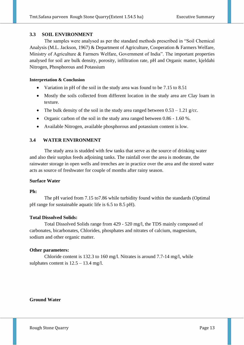
3.5 AIR ENVIRONMENT
The baseline studies on air environment include identification of specific air pollution
parameters and their existing levels in ambient air. The ambient air quality with respect to the
study zone of 10 km radius around the proposed quarry forms the baseline information.
FIGURE – 6: WIND ROSE DIAGRAM
3.6 SUMMARY OF AMBIENT AIR QUALITY
As per monitoring data, PM10 ranges from 33.8 µg/m3 to 44.9 µg/m3, PM2.5 data
ranges from 16.8 µg/m3 to 25.9 µg/m3, SO2 ranges from 4.0 µg/m3 to 15.3 µg/m3 and NO2
data ranges from 12.1 µg/m3 to 23.6 µg/m3. The concentration levels of the above criteria
pollutants were observed to be well within the limits of NAAQS prescribed by CPCB.
3.7 NOISE ENVIRONMENT

Tmt.Safana parveen Rough Stone Quarry(Extent 1.54.5 ha) Executive Summary
Rough Stone Quarry Page 15
Ambient noise levels were measured at 8 (Eight) locations around the proposed
project area. Noise levels recorded in core zone during day time were from 47.4 to 50.9 dB
(A) Leq and during night time were from 37.0 to 43.8 dB (A) Leq. Noise levels recorded in
buffer zone during day time were from 46.7 to 48.8 dB (A) Leq and during night time were
from 37.9 to 42.5 dB (A) Leq.
Thus, the noise level for Industrial and Residential area meets the requirements of
CPCB.
3.8 ECOLOGICAL ENVIRONMENT
The study involved assessment of general habitat type, vegetation pattern, preparation
of inventory of flora and fauna of terrestrial ecosystem within 10 km radius from the boundary
of all the Proposed Mine site. Biological assessment of the site was done to identify
ecologically sensitive areas and whether there are any rare, endangered, endemic or threatened
(REET) species of flora & fauna in the core area as well its buffer zone to be impacted. The
study also designed to suggest suitable mitigation measures if necessary, for protection of
wildlife habitats and conservation of REET species if any.
In this project, the total area of Cluster with in 10km radius from the periphery of this
quarry is reported as 9.04.0 Ha with 4 No of quarries. In such Cluster situation a common
Ecology and Biodiversity study for the entire cluster of quarries is enough to capture all the
possible externalities. The common EIA/EMP data can be used for all quarries fall under this
cluster. The Core mining area is more vegetation whereas in buffer zone agricultural land is
dominated. The following methods were applied during the baseline study of flora, fauna and
diversity assessment.
3.9 SOCIO ECONOMIC ENVIRONMENT
Socio-economic study is an essential part of environmental study. It includes
demographic structure of the area, provision of basic amenities viz., housing, education, health
and medical services, occupation, water supply, sanitation, communication, transportation,
prevailing diseases pattern as well as feature like temples, historical monuments etc., at the
baseline level. This will help in visualizing and predicting the possible impact depending upon
the nature and magnitude of the project.
It is expected that the Socio-Economic Status of the area will substantially improve
because of this proposed project. As the proposed project will provide direct and indirect
employment and improve the infrastructural facilities in that area and, thus, improve their
standard of living.
4. ANTICIPATED ENVIRONMENTAL IMPACTS AND MITIGATION MEASURES
In order to maintain the environmental commensuration with the mining operation, it
is essential to undertake studies on the existing environmental scenario and assess the impact
on different environmental components. This would help in formulating suitable management
plans sustainable resource extraction.
Tmt.Safana parveen Rough Stone Quarry(Extent 1.54.5 ha) Executive Summary
Rough Stone Quarry Page 16
4.1 LAND ENVIRONMENT:
ANTICIPATED IMPACT
• Permanent or temporary change on land use and land cover.
• Change in Topography: Topography of the ML area will change at the end of the life
of the mine.
• Movement of heavy vehicles sometimes cause problems to agricultural land, human
habitations due to dust, noise and it also causes traffic hazards.
• Due to degradation of land by pitting the aesthetic environment of the core zone may
be affected.
• Earthworks during the rainy season increase the potential for soil erosion and
sediment laden water entering the water ways.
• If no due care is taken wash off from the exposed working area may choke the water
course & can also causes the siltation of water course
MITIGATION MEASURES
• The mining activity will be gradual confined in blocks and excavation will be undertaken
progressively along with other mitigative measures like phase wise development of
greenbelt etc.
• Construction of garland drains all around the quarry pits and construction of check dam at
strategic location in lower elevations to prevent erosion due to surface runoff during
rainfall and also to collect the storm water for various uses within the proposed area
• Green belt development along the boundary within safety zone. The small quantity of
water stored in the mined-out pit will be used for greenbelt
• Thick plantation will be carried out on unutilized area, top benches of mined out pits, on
safety barrier, etc.,
• At conceptual stage, the land use pattern of the quarry will be changed into Greenbelt area
and temporary reservoir
• In terms of aesthetics, natural vegetation surrounding the quarry will be retained (such as
in a buffer area i.e., 7.5 m safety barrier and other safety provided) so as to help minimise
dust emissions.
• Proper fencing will be carried out at the conceptual stage, Security will be posted round
the clock, to prevent inherent entry of the public and cattle
4.2 SOIL ENVIRONMENT
IMPACT ON SOIL ENVIRONMENT
Erosion and Sedimentation (Removal of protective vegetation cover; Exposure of
underlying soil horizons that may be less pervious, or more erodible than the surface layers;
Reduced capacity of soils to absorb rainfall; Increased energy in storm-water runoff due to
concentration and velocity; and Exposure of subsurface materials which are unsuitable for
vegetation establishment).
MITIGATION MEASURES FOR SOIL CONSERVATION
Tmt.Safana parveen Rough Stone Quarry(Extent 1.54.5 ha) Executive Summary
Rough Stone Quarry Page 17
▪ Run-off diversion – Garland drains will be constructed all around the project boundary
to prevent surface flows from entering the quarry works areas. And will be discharged
into vegetated natural drainage lines, or as distributed flow across an area stabilised
against erosion.
▪ Sedimentation ponds - Run-off from working areas will be routed towards
sedimentation ponds. These trap sediment and reduce suspended sediment loads before
runoff is discharged from the quarry site. Sedimentation ponds should be designed
based on runoff, retention times, and soil characteristics. There may be a need to
provide a series of sedimentation ponds to achieve the desired outcome.
▪ Retain vegetation – Retain existing or re-plant the vegetation at the site wherever
possible.
▪ Monitoring and maintenance – Weekly monitoring and daily maintenance of erosion
control systems so that they perform as specified specially during rainy season
4.2 WATER ENVIRONMENT
ANTICIPATED IMPACT ON SURFACE AND GROUND WATER
▪ The major sources of water pollution normally associated due to mining and allied
operations are:
o Generation of waste water from vehicle washing.
o Washouts from surface exposure or working areas
o Domestic sewage
o Disturbance to drainage course in the project area
o Mine Pit water discharge
▪ Increase in sediment load during monsoon in downstream of lease area
▪ This being a mining project, there will be no process effluent. Waste from washing of
machinery may result in discharge of Oil & grease, suspended solids.
▪ The sewage from soak pit may percolate to the ground water table and contaminate it.
▪ Surface drainage may be affected due to Mining
▪ Abstraction of water may lead to depletion of water table
MITIGATION MEASURES
• Garland drains, settling tank will be constructed along the individual mining leases. The
Garland drains of the individual leases will be connected to settling tank and after
settling the water will be discharged out to the natural drainage
▪• Rainwater will be collected in sump in the mining pits and will be allowed to store and
pumped out to surface setting tank of 15 m x 10m x 3m to remove suspended solids if
any. This collected water will be judiciously used for dust suppression onwards and
such sites where dust likely to be generated and for developing green belt. The
proponent will collect and judicially utilize the rainwater as part of rainwater harvesting
• Providing benches with inner slopes and through a system of drains and channels,
allowing rain water to descent into surrounding drains, so as to minimize the effects of
erosion & water logging arising out of uncontrolled descent of water.
Tmt.Safana parveen Rough Stone Quarry(Extent 1.54.5 ha) Executive Summary
Rough Stone Quarry Page 18
• Reuse the water collected during storm for dust suppression and greenbelt development
within the mines
• Installing interceptor traps/oil separators to remove oils and greases. Water from the
tipper wash-down facility and machinery maintenance yard will pass through
interceptor traps/oil separators prior to its reuse;
• Using flocculating or coagulating agents to assist in the settling of suspended solids
during monsoon seasons;
1.• Periodic analysis of quarry pit water and ground water quality in nearby villages.
2.• Domestic sewage from site office & urinals/latrines provided in ML is discharged in
septic tank followed by soak pits.
3.• Waste water discharge from mine will be treated in settling tanks before using for dust
suppression and tree plantation purposes.
4.• De-silting will be carried out before and immediately after the monsoon season.
• Regular monitoring and analysing the quality of water in open well, bore wells and
surface water
4.3 AIR ENVIRONMENT
ANTICIPATED IMPACT
▪ During mining, at various stages activities such as excavation, drilling, blasting, and
transportation of materials, particular matter (PM), gases such as Sulphur dioxide,
oxides of Nitrogen from vehicular exhaust are the main air pollutants.
▪ Emissions of noxious gases due to incomplete detonation of explosive may sometimes
pollute the air.
▪ The fugitive dust released from the mining operations may cause effect on the mine
workers who are directly exposed to the fugitive dust.
▪ Simultaneously, the air-borne dust may travel to longer distances and settle in the
villages located near the mine lease area.
MITIGATION MEASURES
Drilling – To control dust at source, wet drilling will be practiced. Where there is a scarcity
of water, suitably designed dust extractor will be provided for dry drilling along with dust
hood at the mouth of the drill-hole collar.
Advantages of Wet Drilling:-
• In this system dust gets suppressed close to its formation. Dust suppression become
very effective and the work environment will be improved from the point of
occupational comfort and health.
• Due to dust free atmosphere, the life of engine, compressor etc., will be increased.
• The life of drill bit will be increased.
• The rate of penetration of drill will be increased.
• Due to the dust free atmosphere visibility will be improved resulting in safer working
conditions.
Tmt.Safana parveen Rough Stone Quarry(Extent 1.54.5 ha) Executive Summary
Rough Stone Quarry Page 19
Blasting –
• Establish time of blasting to suit the local conditions and water sprinkling on blasting
face
• Avoid blasting i.e., when temperature inversion is likely to occur and strong wind blows
towards residential areas
• Controlled blasting include Adoption of suitable explosive charge and short delay
detonators, adequate stemming of holes at collar zone and restricting blasting to a
particular time of the day i.e. at the time lunch hours, controlled charge per hole as well
as charge per round of hole
• Before loading of material water will be sprayed on blasted material
• Dust mask will be provided to the workers and their use will be strictly monitored
Haul Road & Transportation –
• Water will be sprinkled on haul roads twice a day to avoid dust generation during
transportation
• Transportation of material will be carried out during day time and material will be
covered with taurpaulin
• The speed of tippers plying on the haul road will be limited below 20 km/hr to avoid
generation of dust.
• Water sprinkling on haul roads & loading points will be carried out twice a day
• Main source of gaseous pollution will be from vehicle used for transportation of
mineral; therefore weekly maintenance of machines improves combustion process &
makes reduction in the pollution.
• The un-metalled haul roads will be compacted weekly before being put into use.
• Over loading of tippers will be avoided to prevent spillage.
• It will be ensured that all transportation vehicles carry a valid PUC certificate
• Grading of haul roads and service roads to clear accumulation of loose materials
Green Belt –
• Planting of trees all along main mine haul roads and regular grading of haul roads will
be practiced to prevent the generation of dust due to movement of dumpers/trucks
• Green belt of adequate width will be developed around the project areas
Occupational Health –
• Dust mask will be provided to the workers and their use will be strictly monitored
• Annual medical check-ups, trainings and campaigns will be arranged to ensure
awareness about importance of wearing dust masks among all mine workers & tipper
drivers
• Ambient Air Quality Monitoring will be conducted six month once to assess
effectiveness of mitigation measures proposed
4.4 NOISE ENVIRONMENT
ANTICIPATED IMPACT
Tmt.Safana parveen Rough Stone Quarry(Extent 1.54.5 ha) Executive Summary
Rough Stone Quarry Page 20
Noise pollution is mainly due to operation like drilling & blasting and plying of trucks
& HEMM. These activities will not cause any problem to the inhabitants of this area because
there is no human settlement in close proximity to the project area. Noise modelling has been
carried out considering blasting and compressor operation (drilling) and transportation
activities.
MITIGATION MEASURES
• Usage of sharp drill bits while drilling which will help in reducing noise;
• Secondary blasting will be totally avoided and hydraulic rock breaker will be used for
breaking boulders;
• Controlled blasting with proper spacing, burden, stemming and optimum charge/delay
will be maintained;
• The blasting will be carried out during favourable atmospheric condition and less
human activity timings by using nonelectrical initiation system;
• Proper maintenance, oiling and greasing of machines will be done every week to reduce
generation of noise;
• Provision of sound insulated chambers for the workers working on machines (HEMM)
producing higher levels of noise;
• Silencers / mufflers will be installed in all machineries;
• Green Belt/Plantation will be developed around the project area and along the haul
roads. The plantation minimizes propagation of noise;
• Personal Protective Equipment (PPE) like ear muffs/ear plugs will be provided to the
operators of HEMM and persons working near HEMM and their use will be ensured
though training and awareness.
• Regular medical check–up and proper training to personnel to create awareness about
adverse noise level effects.
4.5 BIOLOGICAL ENVIRONMENT
ANTICIPATED IMPACT
The proposed mining activities include removal of some scattered bushes and other
thorny species. Although impacts on key habitat elements will occur on a local scale, but on a
regional scale they would not be critical for the life cycle needs of the species observed or
expected. Moreover, during conceptual stage, the mined-out areas on the top bench will be re-
vegetated by planting local /native species and lower benches will be converted into rainwater
harvesting structure following completion of mining activities, which will replace habitat
resources for fauna species in this locality over a longer time. Existing roads will be used; new
roads will not be constructed to reduce impact on flora.
Wild life is not commonly found in the project area and its immediate environs because of lack
of vegetal cover and surface water. Except few domestic animals, reptiles, hares and some
common birds are observed in the study area.
I. None of the plants will be cut during operational phase of the mine.
Tmt.Safana parveen Rough Stone Quarry(Extent 1.54.5 ha) Executive Summary
Rough Stone Quarry Page 21
II. There shall be negligible air emissions or effluents from the project site. During loading
the truck, dust generation will be likely. This shall be a temporary effect and not
anticipated to affect the surrounding vegetation significantly.
III. Most of the land in the buffer area is undulating terrain with crop lands, grass patches and
small shrubs. Hence, there will be no effect on flora of the region
MITIGATION MEASURES
Keeping all this in mind the mitigations have been suggested under environmental
management plan. With the understanding of the role of plant species as bio-filter to control air
pollution, appropriate plant species (mainly tree species) have been suggested conceding the
area/site requirements and needed performance of specific species. The details of year wise
proposed plantation program are given in Table 4.13.
The main objective of the green belt is to provide a barrier between the source of
pollution and the surrounding areas
In order to compensate the loss of vegetation cover, it is suggested to carry out
afforestation program mainly in proposed areas falls in the cluster earmarked for plantation
program as per Approved Mining Plan in different phases. This habitat improvement program
would ensure the faunal species to re-colonize and improve the abundance status in the core
zone.
The objectives of the green belt cover will cover the following:
▪ Noise abatement
▪ Ecological restoration
▪ Aesthetic, biological and visual improvement of area due to improved vegetative and
plantations cover.
4.6 SOCIO ECONOMIC ENVIRONMENT
ANTICIPATED IMPACT
▪ Dust generation from mining activity can have negative impact on the health of the
workers and people in the nearby area.
▪ Approach roads can be damaged by the movement of tippers
▪ Increase in Employment opportunities both direct and indirect thereby increasing
economic status of people of the region
MITIGATION MEASURES
• Good maintenance practices will be adopted for plant machinery and equipment, which
will help to avert potential noise problems.
• Green belt will be developed in and around the project site as per Central Pollution
Control Board (CPCB) guidelines.
• Appropriate air pollution control measure will be taken to minimize the environmental
impact within the core zone.
Tmt.Safana parveen Rough Stone Quarry(Extent 1.54.5 ha) Executive Summary
Rough Stone Quarry Page 22
• For the safety of workers, personal protective appliances like hand gloves, helmets,
safety shoes, goggles, aprons, nose masks and ear protecting devices will be provided
as per mines act and rules.
• Benefit to the State and the Central governments through financial revenues by way of
royalty, tax, DMF, NMET etc, from this project directly and indirectly.
• From above details, the quarry operations will have highly beneficial positive impact in
the area
5. ANALYSIS OF ALTERNATIVES (TECHNOLOGY AND SITE)
No alternatives are suggested as all the mine sites are mineral specific
6. ENVIRONMENT MONITORING PROGRAM
The main objective of environmental monitoring is to ensure that the obtained results
in respect of environmental attributes and prevailing conditions during operation stage are in
conformity with the prediction during the planning stage. In case of substantial deviation from
the earlier prediction of results, this forms as base data to identify the cause and suggest
remedial measures. Environmental monitoring is mandatory to meet compliance of statutory
provisions under the Environment (Protection) Act, 1986, relevant conditions regarding
monitoring covered under EC orders issued by the SEIAA as well as the conditions set forth
under the order issued by Tamil Nadu Pollution Control Board while granting CTE/CTO.
6.1 ENVIRONMENTAL MONITORING CELL
Tmt.Safana parveen Rough Stone Quarry(Extent 1.54.5 ha) Executive Summary
Rough Stone Quarry Page 23
6.2 POST ENVIRONMENTAL CLEARANCE MONITORING SCHEDULE
S.
No.
Environment
Attributes Location
Monitoring Parameters
Duration Frequency
1 Air Quality 2 Locations (1 Core
& 1 Buffer) 24 hours
Once in 6
months
Fugitive Dust,
PM2.5, PM10, SO2
and NOx.
2 Meteorology
At mine site before
start of Air Quality
Monitoring & IMD
Secondary Data
Hourly /
Daily
Continuous
online
monitoring
Wind speed, Wind
direction,
Temperature,
Relative humidity
and Rainfall
3
Water
Quality
Monitoring
2 Locations (1SW &
1 GW) -
Once in 6
months
Parameters
specified under
IS:10500, 1993 &
CPCB Norms
4 Hydrology
Water level in open
wells in buffer zone
around 1 km at
specific wells
- Once in 6
months Depth in bgl
5 Noise 2 Locations (1 Core
& 1 Buffer)
Hourly –
1 Day
Once in 6
months
Leq, Lmax, Lmin,
Leq Day & Leq
Night
Mine Owner
Tmt. Safana Parveen
HEAD OF ORGANIZATION
MINE MANAGEMENT LEVEL
Mines Manager
Mine Foreman Mining Mate Site Supervisor
Empanelled Consultant /
External Laboratory Approved
by NABL / MoEF
AREA LEVEL
Environment Officer
Assistant Gardner Water Sprinkler Operator
Tmt.Safana parveen Rough Stone Quarry(Extent 1.54.5 ha) Executive Summary
Rough Stone Quarry Page 24
6 Vibration
At the nearest
habitation (in case of
reporting)
–
During
blasting
Operation
Peak Particle
Velocity
7 Soil 2 Locations (1 Core
& 1 Buffer) –
Once in six
months
Physical and
Chemical
Characteristics
8 Greenbelt Within the Project
Area Daily Monthly Maintenance
7. ADDITIONAL STUDIES
7.1 RISK ASSESSMENT
The methodology for the risk assessment has been based on the specific risk assessment
guidance issued by the Directorate General of Mine Safety (DGMS), Dhanbad, vide Circular
No.13 of 2002, dated 31st December, 2002. The DGMS risk assessment process is intended to
identify existing and probable hazards in the work environment and all operations and assess
the risk levels of those hazards in order to prioritize those that need immediate attention.
Further, mechanisms responsible for these hazards are identified and their control measures,
set to timetable are recorded along with pinpointed responsibilities.
The whole quarry operation will be carried out under the direction of a Qualified
Competent Mine Manager holding certificate of competency to manage a metalliferous mine
granted by the DGMS, Dhanbad. Risk Assessment is all about prevention of accidents and to
take necessary steps to prevent it from happening.
7.2 DISASTER MANAGEMENT PLAN
The objective of the Disaster Management Plan is to make use of the combined
resources of the mine and the outside services to achieve the following:
Rescue and medical treatment of casualties;
Safeguard other people;
Minimize damage to property and the environment;
Initially contain and ultimately bring the incident under control;
Secure the safe rehabilitation of affected area; and
Preserve relevant records and equipment for the subsequent inquiry into the cause and
circumstances of the emergency
Tmt.Safana parveen Rough Stone Quarry(Extent 1.54.5 ha) Executive Summary
Rough Stone Quarry Page 25
7.3 CUMULATIVE IMPACT STUDY
CUMULATIVE PRODUCTION LOAD OF ROUGH STONE
PROPOSED PRODUCTION DETAILS
Quarry 5 Years in
m3
Per Year in
m3
Per Day in
m3
Number of Lorry Load Per
Day
P1 1,58,607 31,724 106 9
E1 1,93,440 38,688 129 11
E2 1,73,325 34,665 115 10
E3 1,61,740 32,348 108 9
Grand
Total 6,87,112 1,37,425 458 39
8. PROJECT BENEFITS
This Proposed Project for Quarrying Rough Stone at Kothapulli Village aims to
produce 1,58,607 m3 Rough Stone & 9,182 m3 of Top soil over a period of 5 Years. This will
enhance the socio-economic activities in the adjoining areas and will result in the following
benefits
Increase in Employment Potential
Improvement in Socio-Economic Welfare
Improvement in Physical Infrastructure
Improvement in Social infrastructure
9. ENVIRONMENT MANAGEMENT PLAN
The Environment Monitoring Cell discussed formed by the mine management will
ensure effective implementation of environment management plan and to ensure compliance
of environmental statutory guidelines through Mine Management Level.
The said team will be responsible for:
Monitoring of the water/ waste water quality, air quality and solid waste generated
Analysis of the water and air samples collected through external laboratory
Implementation and monitoring of the pollution control and protective measures/
devices which shall include financial estimation, ordering, installation of air pollution
control equipment, waste water treatment plant, etc.
Co-ordination of the environment related activities within the project as well as with
outside agencies
Collection of health statistics of the workers and population of the surrounding villages
Green belt development
Tmt.Safana parveen Rough Stone Quarry(Extent 1.54.5 ha) Executive Summary
Rough Stone Quarry Page 26
Monitoring the progress of implementation of the environmental monitoring
programme
Compliance to statutory provisions, norms of State Pollution Control Board, Ministry
of Environment and Forests and the conditions of the environmental clearance as well
as the consents to establish and consents to operate.
10. CONCLUSION
It can be concluded from overall assessment of the impacts, in terms of positive and
negative effects on various environmental components, that the mining activities will not have
any adverse effect on the surrounding environment.
To mitigate any impacts due to the mining activities, a well-planned EMP and a detailed
post project monitoring system is provided for regular monitoring and immediate rectification
at site. Due to the cluster quarrying activities, socio economic conditions in and around the
project site will be improved substantially. Hence, the Prior Environmental Clearance shall be
granted at the earliest.
Recommended


