Embed Size (px)
Citation preview
This presentation summarizes the work of the GTA Geospatial Information Task Force empanelled in October 2013.
1
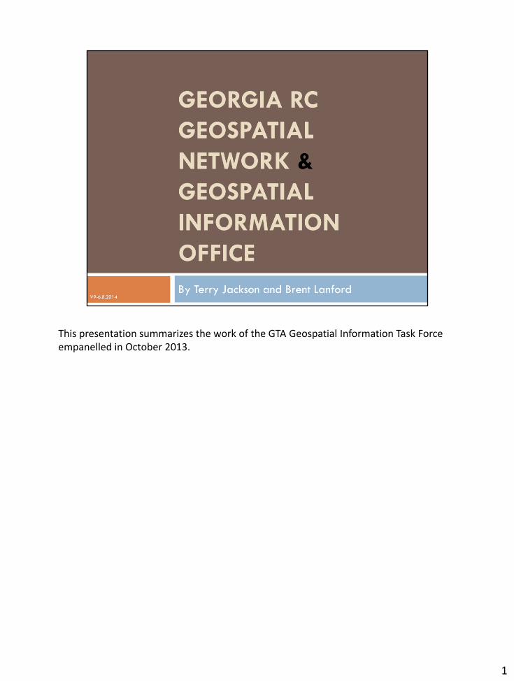
The Task Force began its work by reviewing the five recommendations of the Georgia Geospatial Advisory Council. As we will see the GIO Task Force has addressed recommendations 2 and 4, to innovatively create a Geospatial information Office with a supporting Georgia Regional Commission Geospatial Network. One of their principal map products will be a compilation of statewide parcel maps and database. GGAC Recommendation 1 was not discussed because we took a different approach: to building partnerships with local governments rather than a course that would impose by rule geospatial standards or products. The Georgia Geospatial Network or GGN will compile maps based on current standard local maps and products, encouraging enhanced standards and maps where we can demonstrate by practice that it will lead to better information for the local partners. It is an approach to lead by the implementation of best practices rather than by rule. GGAC Recommendation 3 was not discussed because the State of Georgia procurement rules now allows for multi-year contracts with vendors for GIS software and services. The Georgia Regional Commissions already have an Enterprise License Agreement with their GIS software provider. Furthermore, the State of Georgia now has a contract with ESRI based on a master purchase agreement that permits agencies to procure from them without the sole source justification process. GGAC Recommendation 5 was discussed by the Task Force. It was advised in the Task Force recommendations to delay any planning with respect to this base map until state investments became available to use as match toward federal grant programs for enhanced elevation.
2
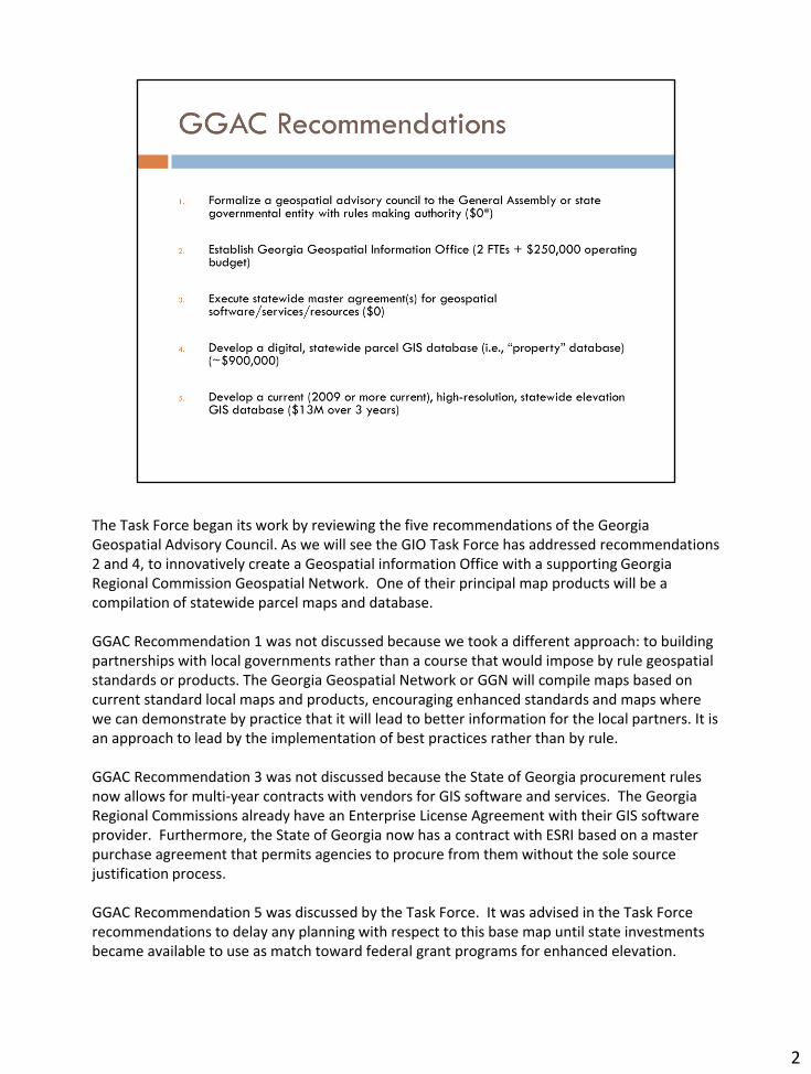
The GTA GIO Task Force was originally assigned to Ernie Smith, Newton County GIS, the current chair of the GTA-GISCC. Due to a family illness Ernie asked Terry Jackson to chair this Task Force. Christian Carlson, ESRI, was invited by GTA to speak at the first meeting due to his extensive experience in working with GIOs in other states. This task force met once in person and thereafter held several telephone conferences.
3
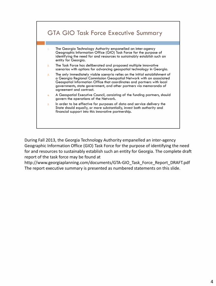
During Fall 2013, the Georgia Technology Authority empanelled an inter-agency Geographic Information Office (GIO) Task Force for the purpose of identifying the need for and resources to sustainably establish such an entity for Georgia. The complete draft report of the task force may be found at http://www.georgiaplanning.com/documents/GTA-GIO_Task_Force_Report_DRAFT.pdf The report executive summary is presented as numbered statements on this slide.
4
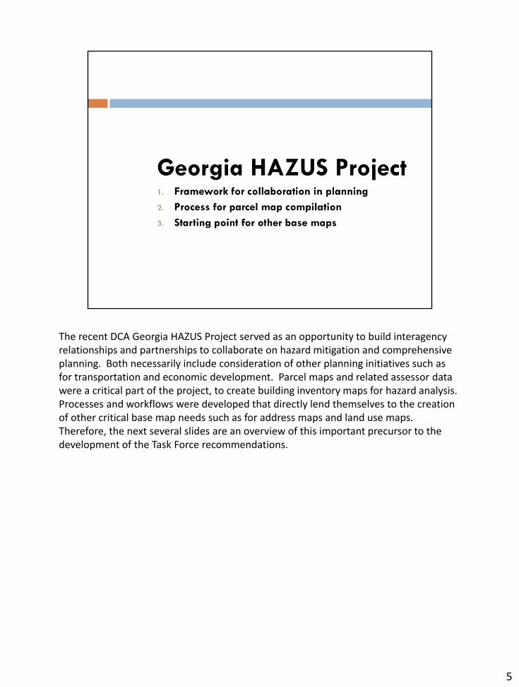
The recent DCA Georgia HAZUS Project served as an opportunity to build interagency relationships and partnerships to collaborate on hazard mitigation and comprehensive planning. Both necessarily include consideration of other planning initiatives such as for transportation and economic development. Parcel maps and related assessor data were a critical part of the project, to create building inventory maps for hazard analysis. Processes and workflows were developed that directly lend themselves to the creation of other critical base map needs such as for address maps and land use maps. Therefore, the next several slides are an overview of this important precursor to the development of the Task Force recommendations.
5
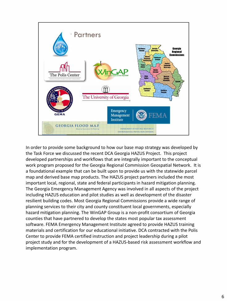
In order to provide some background to how our base map strategy was developed by the Task Force we discussed the recent DCA Georgia HAZUS Project. This project developed partnerships and workflows that are integrally important to the conceptual work program proposed for the Georgia Regional Commission Geospatial Network. It is a foundational example that can be built upon to provide us with the statewide parcel map and derived base map products. The HAZUS project partners included the most important local, regional, state and federal participants in hazard mitigation planning. The Georgia Emergency Management Agency was involved in all aspects of the project including HAZUS education and pilot studies as well as development of the disaster resilient building codes. Most Georgia Regional Commissions provide a wide range of planning services to their city and county constituent local governments, especially hazard mitigation planning. The WinGAP Group is a non-profit consortium of Georgia counties that have partnered to develop the states most popular tax assessment software. FEMA Emergency Management Institute agreed to provide HAZUS training materials and certification for our educational initiative. DCA contracted with the Polis Center to provide FEMA certified instruction and project leadership during a pilot project study and for the development of a HAZUS-based risk assessment workflow and implementation program.
6
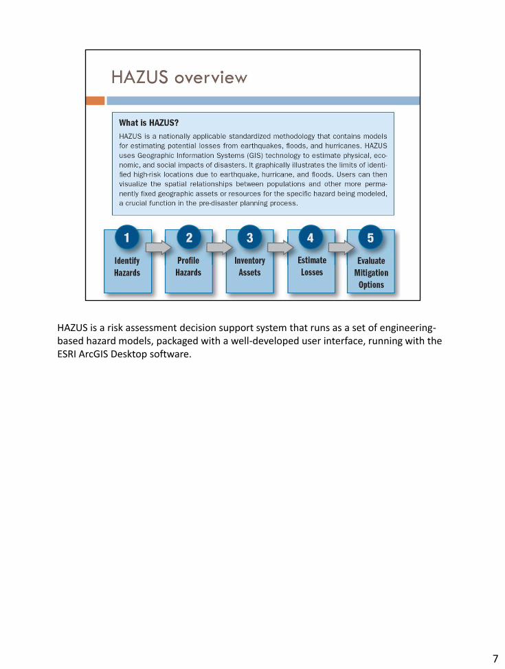
HAZUS is a risk assessment decision support system that runs as a set of engineering-based hazard models, packaged with a well-developed user interface, running with the ESRI ArcGIS Desktop software.
7
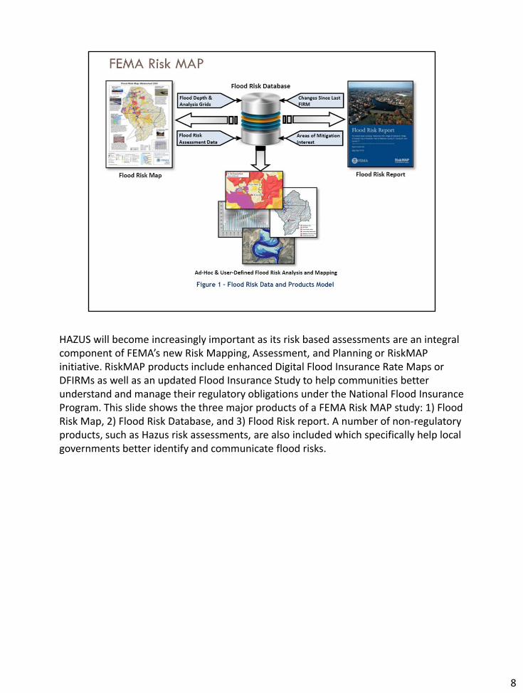
HAZUS will become increasingly important as its risk based assessments are an integral component of FEMA’s new Risk Mapping, Assessment, and Planning or RiskMAP initiative. RiskMAP products include enhanced Digital Flood Insurance Rate Maps or DFIRMs as well as an updated Flood Insurance Study to help communities better understand and manage their regulatory obligations under the National Flood Insurance Program. This slide shows the three major products of a FEMA Risk MAP study: 1) Flood Risk Map, 2) Flood Risk Database, and 3) Flood Risk report. A number of non-regulatory products, such as Hazus risk assessments, are also included which specifically help local governments better identify and communicate flood risks.
8
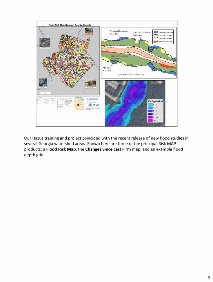
Our Hazus training and project coincided with the recent release of new flood studies in several Georgia watershed areas. Shown here are three of the principal Risk MAP products: a Flood Risk Map, the Changes Since Last Firm map, and an example flood depth grid.
9
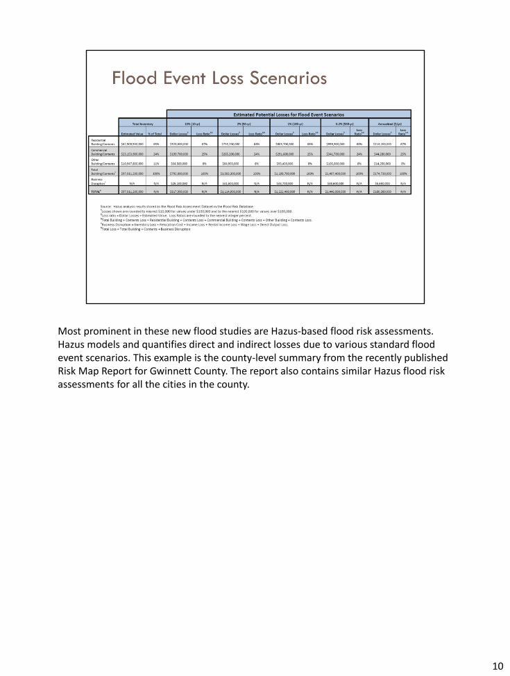
Most prominent in these new flood studies are Hazus-based flood risk assessments. Hazus models and quantifies direct and indirect losses due to various standard flood event scenarios. This example is the county-level summary from the recently published Risk Map Report for Gwinnett County. The report also contains similar Hazus flood risk assessments for all the cities in the county.
10
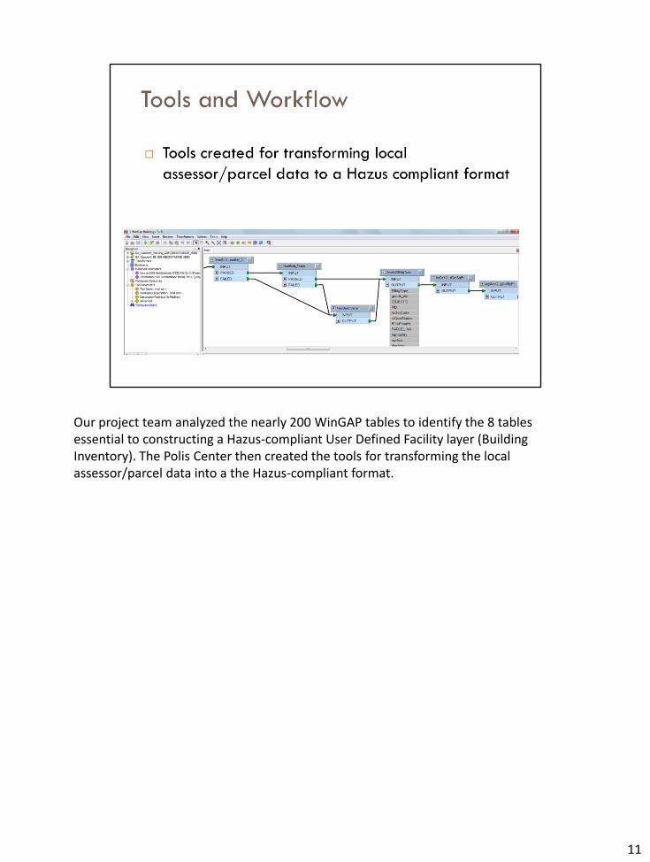
Our project team analyzed the nearly 200 WinGAP tables to identify the 8 tables essential to constructing a Hazus-compliant User Defined Facility layer (Building Inventory). The Polis Center then created the tools for transforming the local assessor/parcel data into a the Hazus-compliant format.
11

The high quality of most local data maintained in the WinGAP system has allowed for the easy creation of the Building Inventory maps needed to enhance our Hazus analyses. The example shown here is Camden County our first pilot project in the southeastern corner of the state.
12
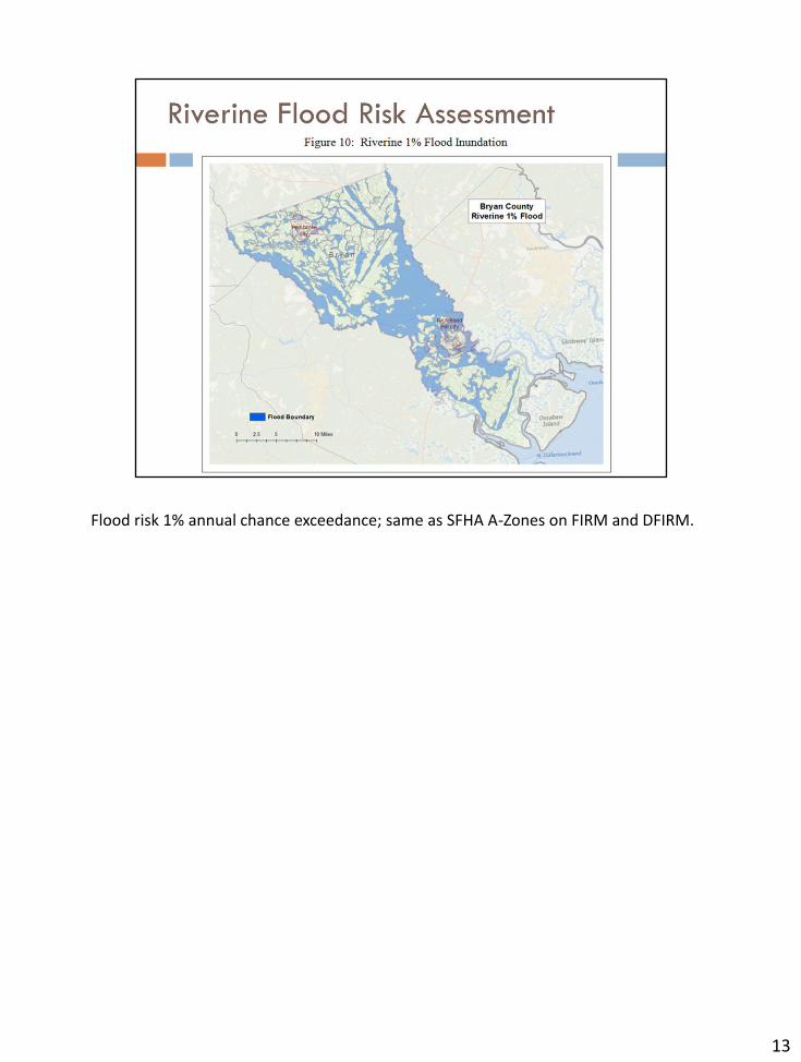
Flood risk 1% annual chance exceedance; same as SFHA A-Zones on FIRM and DFIRM.
13
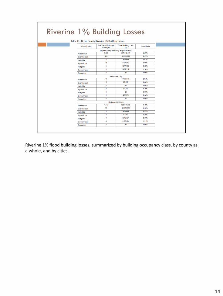
Riverine 1% flood building losses, summarized by building occupancy class, by county as a whole, and by cities.
14
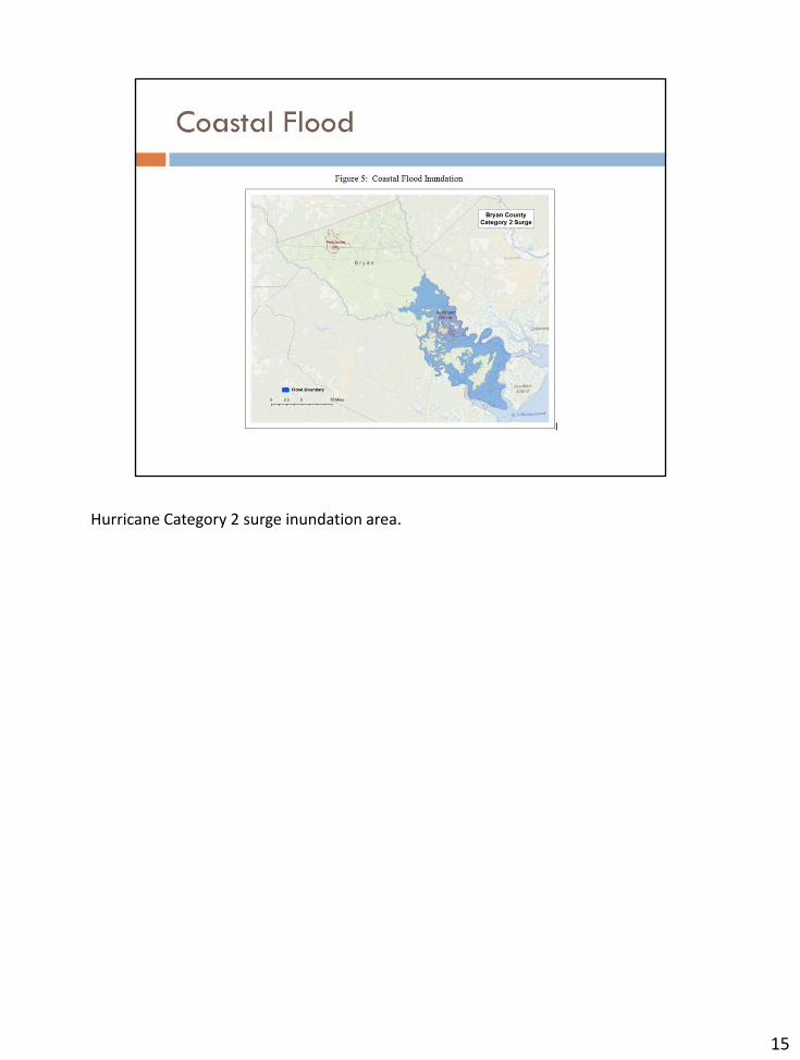
Hurricane Category 2 surge inundation area.
15
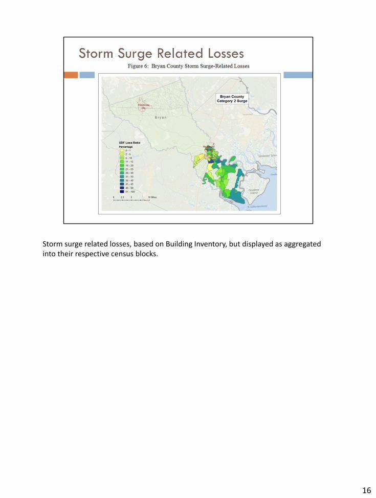
Storm surge related losses, based on Building Inventory, but displayed as aggregated into their respective census blocks.
16
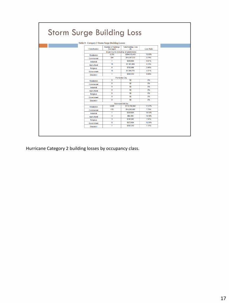
Hurricane Category 2 building losses by occupancy class.
17
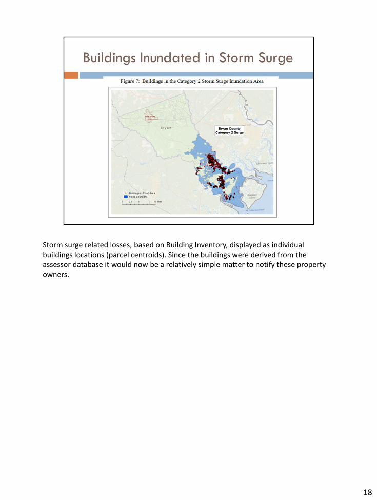
Storm surge related losses, based on Building Inventory, displayed as individual buildings locations (parcel centroids). Since the buildings were derived from the assessor database it would now be a relatively simple matter to notify these property owners.
18

Currently the HAZUS PDM methodology created during the Georgia HAZUS project will translate the parcel maps and assessor data from the 138 counties now using the WinGAP system to create a Building Inventory (BI) map. Our goal is to help every Regional Commission and every county to create HAZUS-based risk assessments for their hazard mitigation plans, and to create BI derivative maps for a host of other critical local government requirements such as Address Maps and Land Use Maps.
19
The next section summarizes GIO Task Force findings and recommendations. It also explores state partnership options, the actions taken by the Regional Commissions, and the next steps we need to work on toward a successful implementation and startup of the Georgia Geospatial Network and Geospatial Information Office.
20
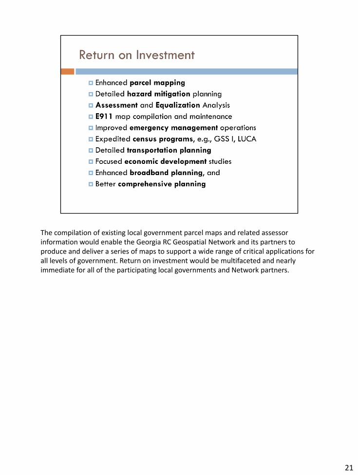
The compilation of existing local government parcel maps and related assessor information would enable the Georgia RC Geospatial Network and its partners to produce and deliver a series of maps to support a wide range of critical applications for all levels of government. Return on investment would be multifaceted and nearly immediate for all of the participating local governments and Network partners.
21

The Task Force in its review of the history of geospatial programs and current activity made five general findings.
22
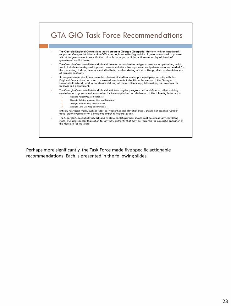
Perhaps more significantly, the Task Force made five specific actionable recommendations. Each is presented in the following slides.
23
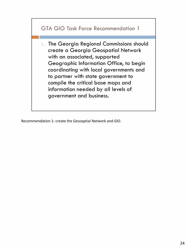
Recommendation 1: create the Gesoaptial Network and GIO.
24

Recommendation 2: Sustainable budgeting.
25
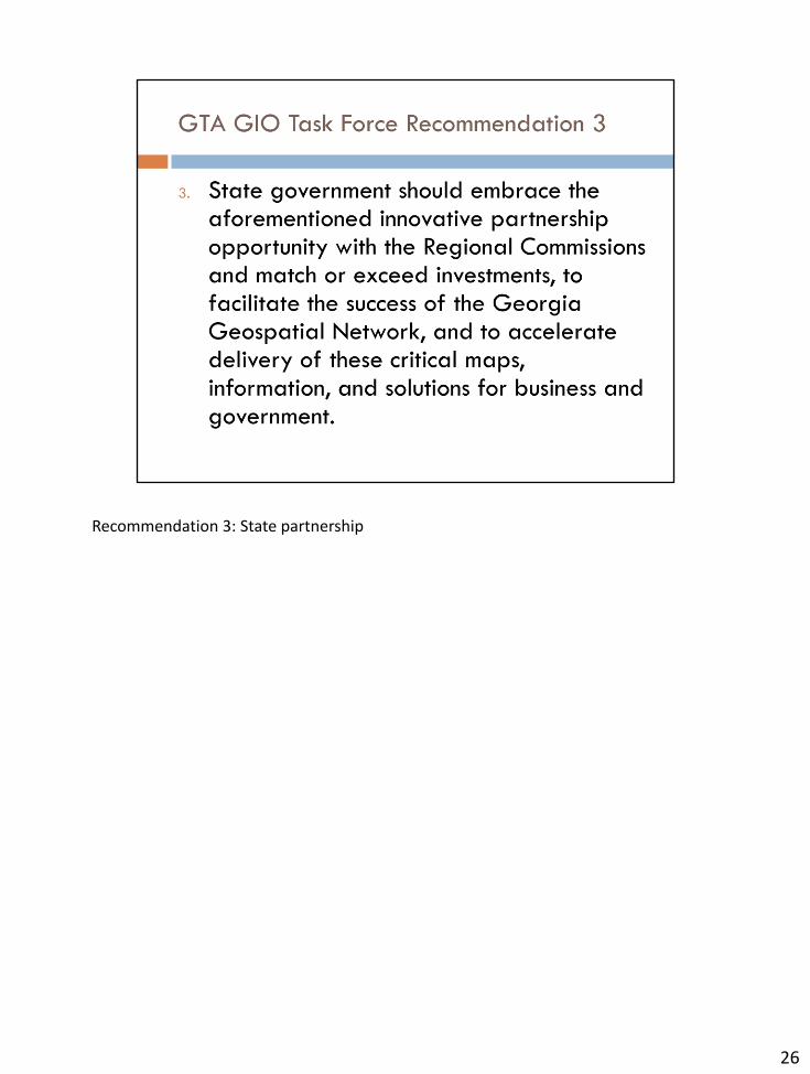
Recommendation 3: State partnership
26

Recommendation 4: Initial Base Map work program
27
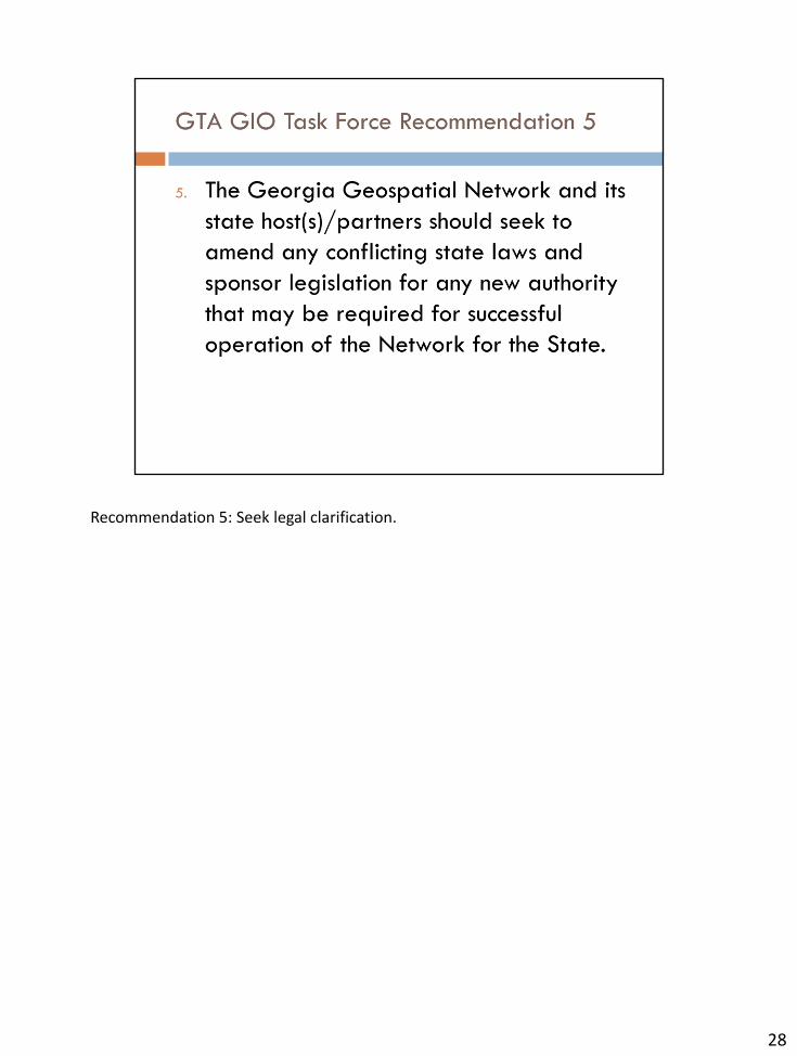
Recommendation 5: Seek legal clarification.
28
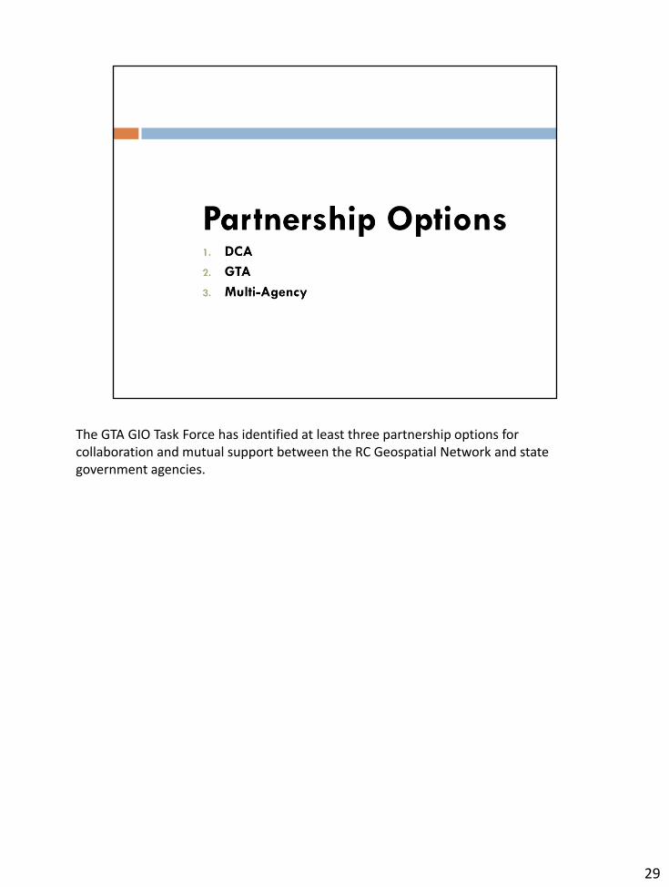
The GTA GIO Task Force has identified at least three partnership options for collaboration and mutual support between the RC Geospatial Network and state government agencies.
29
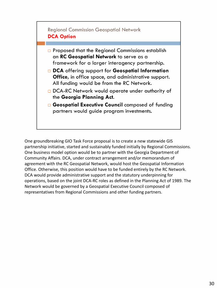
One groundbreaking GIO Task Force proposal is to create a new statewide GIS partnership initiative, started and sustainably funded initially by Regional Commissions. One business model option would be to partner with the Georgia Department of Community Affairs. DCA, under contract arrangement and/or memorandum of agreement with the RC Geospatial Network, would host the Geospatial Information Office. Otherwise, this position would have to be funded entirely by the RC Network. DCA would provide administrative support and the statutory underpinning for operations, based on the joint DCA-RC roles as defined in the Planning Act of 1989. The Network would be governed by a Geospatial Executive Council composed of representatives from Regional Commissions and other funding partners.
30
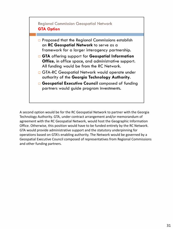
A second option would be for the RC Geospatial Network to partner with the Georgia Technology Authority. GTA, under contract arrangement and/or memorandum of agreement with the RC Geospatial Network, would host the Geographic Information Office. Otherwise, this position would have to be funded entirely by the RC Network. GTA would provide administrative support and the statutory underpinning for operations based on GTA’s enabling authority. The Network would be governed by a Geospatial Executive Council composed of representatives from Regional Commissions and other funding partners.
31
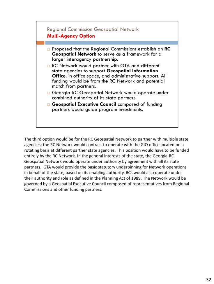
The third option would be for the RC Geospatial Network to partner with multiple state agencies; the RC Network would contract to operate with the GIO office located on a rotating basis at different partner state agencies. This position would have to be funded entirely by the RC Network. In the general interests of the state, the Georgia-RC Geospatial Network would operate under authority by agreement with all its state partners. GTA would provide the basic statutory underpinning for Network operations in behalf of the state, based on its enabling authority. RCs would also operate under their authority and role as defined in the Planning Act of 1989. The Network would be governed by a Geospatial Executive Council composed of representatives from Regional Commissions and other funding partners.
32
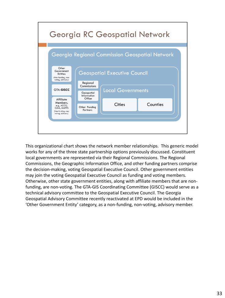
This organizational chart shows the network member relationships. This generic model works for any of the three state partnership options previously discussed. Constituent local governments are represented via their Regional Commissions. The Regional Commissions, the Geographic Information Office, and other funding partners comprise the decision-making, voting Geospatial Executive Council. Other government entities may join the voting Geospatial Executive Council as funding and voting members. Otherwise, other state government entities, along with affiliate members that are non-funding, are non-voting. The GTA-GIS Coordinating Committee (GISCC) would serve as a technical advisory committee to the Geospatial Executive Council. The Georgia Geospatial Advisory Committee recently reactivated at EPD would be included in the ‘Other Government Entity’ category, as a non-funding, non-voting, advisory member.
33
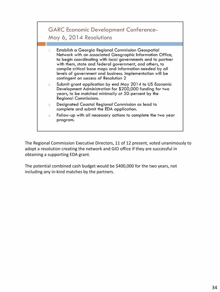
The Regional Commission Executive Directors, 11 of 12 present, voted unanimously to adopt a resolution creating the network and GIO office if they are successful in obtaining a supporting EDA grant. The potential combined cash budget would be $400,000 for the two years, not including any in-kind matches by the partners.
34
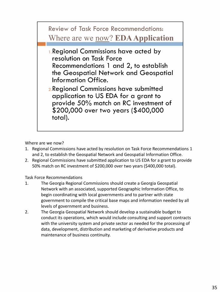
Where are we now? 1. Regional Commissions have acted by resolution on Task Force Recommendations 1
and 2, to establish the Geospatial Network and Geospatial Information Office. 2. Regional Commissions have submitted application to US EDA for a grant to provide
50% match on RC investment of $200,000 over two years ($400,000 total).
Task Force Recommendations 1. The Georgia Regional Commissions should create a Georgia Geospatial
Network with an associated, supported Geographic Information Office, to begin coordinating with local governments and to partner with state government to compile the critical base maps and information needed by all levels of government and business.
2. The Georgia Geospatial Network should develop a sustainable budget to conduct its operations, which would include consulting and support contracts with the university system and private sector as needed for the processing of data, development, distribution and marketing of derivative products and maintenance of business continuity.
35
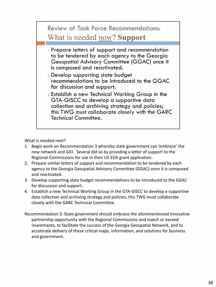
What is needed next? 1. Begin work on Recommendation 3 whereby state government can ‘embrace’ the
new network and GIO. Several did so by providing a letter of support to the Regional Commissions for use in their US EDA grant application.
2. Prepare similar letters of support and recommendation to be tendered by each agency to the Georgia Geospatial Advisory Committee (GGAC) once it is composed and reactivated.
3. Develop supporting state budget recommendations to be introduced to the GGAC for discussion and support.
4. Establish a new Technical Working Group in the GTA-GISCC to develop a supportive data collection and archiving strategy and policies; this TWG must collaborate closely with the GARC Technical Committee.
Recommendation 3: State government should embrace the aforementioned innovative partnership opportunity with the Regional Commissions and match or exceed investments, to facilitate the success of the Georgia Geospatial Network, and to accelerate delivery of these critical maps, information, and solutions for business and government.
36
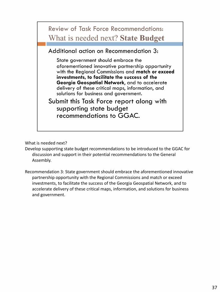
What is needed next? Develop supporting state budget recommendations to be introduced to the GGAC for
discussion and support in their potential recommendations to the General Assembly.
Recommendation 3: State government should embrace the aforementioned innovative
partnership opportunity with the Regional Commissions and match or exceed investments, to facilitate the success of the Georgia Geospatial Network, and to accelerate delivery of these critical maps, information, and solutions for business and government.
37
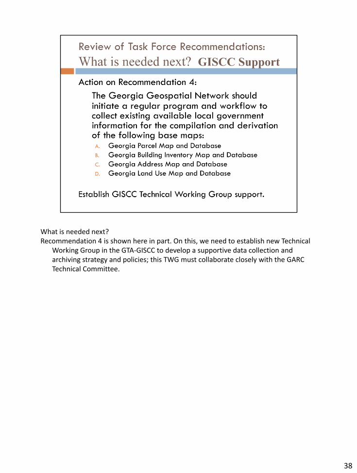
What is needed next? Recommendation 4 is shown here in part. On this, we need to establish new Technical
Working Group in the GTA-GISCC to develop a supportive data collection and archiving strategy and policies; this TWG must collaborate closely with the GARC Technical Committee.
38
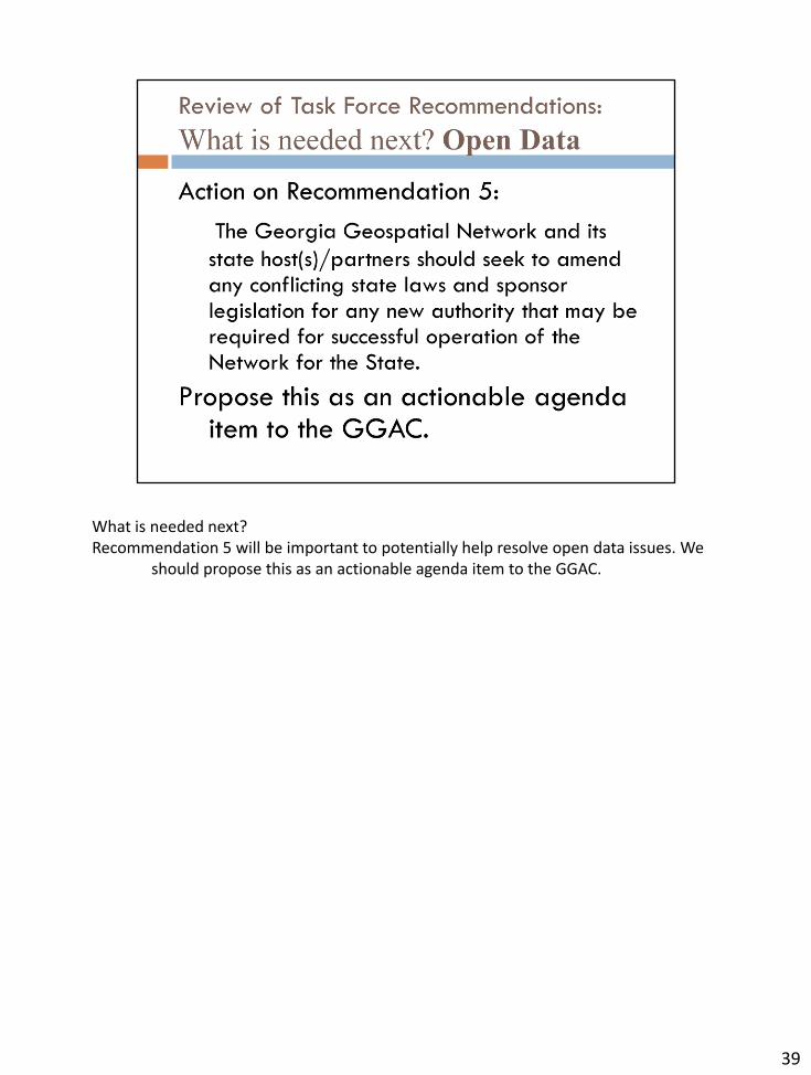
What is needed next? Recommendation 5 will be important to potentially help resolve open data issues. We
should propose this as an actionable agenda item to the GGAC.
39
Please contact us if you have questions and/or recommendations.
40


![Comparativa GIO Classic y GIO Intelligent [Gestión Integrada para Ópticas]](https://img.pdfslide.net/doc/110x75/568c53b91a28ab4916bbf820/comparativa-gio-classic-y-gio-intelligent-gestion-integrada-para-opticas.jpg)