Embed Size (px)
Citation preview

GI2014 – GI/GIS/GDI – Forum
Open GeoData Movement in Europe of Regions 14. Grenzüberschreitendes Sächsisches GIS – Forum am 29./30. April 2014 in Dresden
Sustainability & Interoperability of Open GEODATA Movement – Open Data & License Policy for Europe of Regions
NNR-Special-Edition-2014 PROCEEDINGS – “GI2014-X-border-GI/GIS/GDI-FORUM” – DRESDEN ISSN 1801-6480
1
GGII22001144 (( 1144.. SSääcchhssiisscchheess GGII//GGIISS//GGDDII –– FFOORRUUMM ))
PROGRAMME & PROCEEDINGS
EUROPEAN BORDER REGIONS - MAP © COURTESY BY AEBR, 2011 ( Compiled 2007 at IfL )
30. APRIL 2014
DRESDEN
GI2014 © IGN e.V.

GI2014 – GI/GIS/GDI – Forum
Open GeoData Movement in Europe of Regions 14. Grenzüberschreitendes Sächsisches GIS – Forum am 29./30. April 2014 in Dresden
Sustainability & Interoperability of Open GEODATA Movement – Open Data & License Policy for Europe of Regions
NNR-Special-Edition-2014 PROCEEDINGS – “GI2014-X-border-GI/GIS/GDI-FORUM” – DRESDEN ISSN 1801-6480
2
SUSTAINABILITY OF INTER-REGIONAL COLLABORATION EU Support Programme for “Inter-Regional and Cross-border Collaboration” – Free State of Saxony
GI2014 – INTERREGIONAL SCIENTIFIC PROGRAMME – COMMITTEE
SCIENTIFIC PROGRAMME MEMBERS: Chairs: Doz. Dr. F. HOFFMANN (IGN/DE) & Dr. K. CHARVAT (CCSS/CZ) Members: Prof. BEHR (HFT/DE), Dr. FURDIK (STUBA/SK), Dr. K. JANECKA (WBU/CZ), Prof. M. KONECNY (MUNI/CZ), Dir. W. MAYER (PROGIS/AT), Dipl.Ing. P. VOHNOUT (CCSS/CZ) ORG-COM-Members: Dr. G. HOFFMANN (IGN), Prof. S. KLOSS (IGN), Dr. K.-D. MICHAEL (IGN).
ORGANIZER’S INFORMATION & INTERNET REFERENCE URL’S
GI2014-Contact-Address [ [email protected] | [email protected] ]
IGN-Dresden [ http://GDI-SN.blogspot.com ]
CCSS-Praha [ http://www.CCSS.cz ]
SOCIAL NETWORKS [ INSPIRE-FORUM ] + [ FACEBOOK ] + [ LINKEDIN ] + [ TWITTER ]
IMPRESSUM:
Herausgegeben von / Published by
( Founding Members of IGN e.V. )
Doz. Dr. Frank HOFFMANN, CSc IGN – Vorstandsvorsitzender, Dresden INNOVATION. Grenzüberschreitendes Netzwerk e.V.
Dr. Karel CHARVAT, EU-Project Manager Past President of CCSS, Praha CCSS (Czech Center for Science and Society e.V.)
INNOVATION. Grenzüberschreitendes Netzwerk
( Gemeinnütziger e.V. / Non-profit Organization ) c/o IGN-Vorstand, Martin-Andersen-Nexö-Str. 4 D – 01217 DRESDEN / Saxony / Germany
EMAIL: [ [email protected] | [email protected] ]
SKYPE: [ fh_ign ]
INTERNET: [ http://www.IGN-SN.de ]
WEBLOG: [ http://GDI-SN.blogspot.com ]
TEL/FAX: [ +49-351-403.2729 # FAX: +49-351-401.4260 ]
Copyright © 2014 by CCSS-Praha & IGN-Dresden – All rights reserved.

GI2014 – GI/GIS/GDI – Forum
Open GeoData Movement in Europe of Regions 14. Grenzüberschreitendes Sächsisches GIS – Forum am 29./30. April 2014 in Dresden
Sustainability & Interoperability of Open GEODATA Movement – Open Data & License Policy for Europe of Regions
NNR-Special-Edition-2014 PROCEEDINGS – “GI2014-X-border-GI/GIS/GDI-FORUM” – DRESDEN ISSN 1801-6480
3
GGII22001144 -- OOPPEENN DDAATTAA MMOOVVEEMMEENNTT IINN EEUURROOPPEE OOFF RREEGGIIOONNSS
30. April 2014 / 9-17 Uhr – 01069 Dresden, Konrad-ZUSE-Haus, Liebigstraße 3
GI2014 < INHALT / CONTENT > FORUM
AALLPPHHAABBEETTIISSCCHHEE AAUUTTOORREENNLLIISSTTEE <<>> AALLPPHHAABBEETTIICCAALL AAUUTTHHOORRSS LLIISSTT
AUTOREN / THEMA <> AUTHORS / THEME Seite/Page
Schiller:
GI2014 – Welcome Address by Host Company at “Konrad-ZUSE-Haus”…………………………
Hoffmann:
GI2014 - Welcome Address & Seminar Intro by IGN e.V………………………………………….
Charvat & Mayer: The FOODIE Project – Open Data for Agriculture …………………………………………………
Charvat & Mildorf:
From Plan4all to Plan4business and back – The Future for European Planning Data ………………
Faugnerova:
INSPIRE as a business case for european geo-ICT SMEs and its Strategy…………………………
Fryml, Charvat & Cesko Jede (Czechia Go):
Linked Open Data for Cyclo tourism – The CESKOJEDE-Project…………………………………
Furdik, Loredana & Bindzárová:
Bratislava small brownfields in Nodal areas of Danuba riverbanks ………………………………..
Furdik & Meciar
Examples of Brownfields connected to Danuba in Bratislava city area ……………………………
Hoffmann:
Introduction to Open Data Movement in Europe of Regions ………………………………………
Kozuch, Berzins & Charvat: Map Composition of Plan4business Project ………………………………………………………..
Mayer & Charvat:
The OISSACH Club – The bridge for ICT in Agriculture between Developed
and Developing Countries ………………………………………………………………………….
Schiller WEB-basierte integrierte Daten für BIM Level 3 ………………………………………………….
Sredl & Charvat:
Layman – Publish your Data yourself (Layman - ein Werkzeug für die Veröffentlichung
und Bereitstellung von Geodaten) ………………………………………………………………….
Vohnout, Kafka, Sredl, Bojko, Kepka, Charvat & Hilbert:
ERRA PRD EAST – Electronic Regional Risk Atlas Solution for Environmental Risk Management
in Eastern Partnership (including Armenia, Azerbaijan, Belarus, Georgia, Moldova and Ukraine)..............
Zscheile:
Die freie Lizenzierung von Geodaten ……………………………………………………………….
5
6
11
15
17
18
22
24
26
29
34
38
43
46
47
Imprimatur at: 25. April 2014
GI2014 – GI/GIS/GDI – Forum
Open GeoData Movement in Europe of Regions 14. Grenzüberschreitendes Sächsisches GIS – Forum am 29./30. April 2014 in Dresden
Sustainability & Interoperability of Open GEODATA Movement – Open Data & License Policy for Europe of Regions
NNR-Special-Edition-2014 PROCEEDINGS – “GI2014-X-border-GI/GIS/GDI-FORUM” – DRESDEN ISSN 1801-6480
4
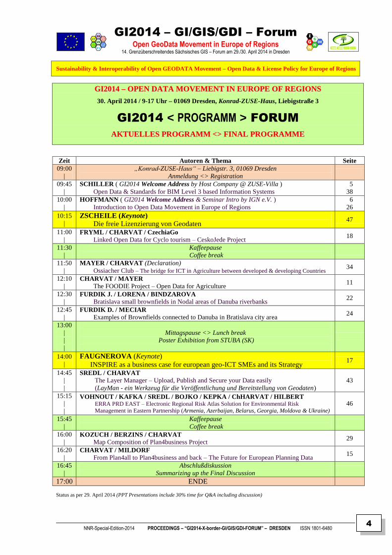
GGII22001144 –– OOPPEENN DDAATTAA MMOOVVEEMMEENNTT IINN EEUURROOPPEE OOFF RREEGGIIOONNSS
30. April 2014 / 9-17 Uhr – 01069 Dresden, Konrad-ZUSE-Haus, Liebigstraße 3
GI2014 < PROGRAMM > FORUM
AAKKTTUUEELLLLEESS PPRROOGGRRAAMMMM <<>> FFIINNAALL PPRROOGGRRAAMMMMEE
Zeit Autoren & Thema Seite
09:00
|
„Konrad-ZUSE-Haus“ – Liebigstr. 3, 01069 Dresden
Anmeldung <> Registration
09:45
|
SCHILLER ( GI2014 Welcome Address by Host Company @ ZUSE-Villa )
Open Data & Standards for BIM Level 3 based Information Systems
5
38
10:00
|
HOFFMANN ( GI2014 Welcome Address & Seminar Intro by IGN e.V. )
Introduction to Open Data Movement in Europe of Regions
6
26
10:15
|
ZSCHEILE (Keynote)
Die freie Lizenzierung von Geodaten 47
11:00
| FRYML / CHARVAT / CzechiaGo
Linked Open Data for Cyclo tourism – CeskoJede Project 18
11:30
|
Kaffeepause
Coffee break
11:50
|
MAYER / CHARVAT (Declaration)
Ossiacher Club – The bridge for ICT in Agriculture between developed & developing Countries 34
12:10
| CHARVAT / MAYER
The FOODIE Project – Open Data for Agriculture 11
12:30
| FURDIK J. / LORENA / BINDZAROVA
Bratislava small brownfields in Nodal areas of Danuba riverbanks 22
12:45
| FURDIK D. / MECIAR
Examples of Brownfields connected to Danuba in Bratislava city area 24
13:00
|
|
|
Mittagspause <> Lunch break
Poster Exhibition from STUBA (SK)
14:00
|
FAUGNEROVA (Keynote)
INSPIRE as a business case for european geo-ICT SMEs and its Strategy 17
14:45
|
|
SREDL / CHARVAT
The Layer Manager – Upload, Publish and Secure your Data easily
(LayMan - ein Werkzeug für die Veröffentlichung und Bereitstellung von Geodaten)
43
15:15
|
|
VOHNOUT / KAFKA / SREDL / BOJKO / KEPKA / ChHARVAT / HILBERT ERRA PRD EAST – Electronic Regional Risk Atlas Solution for Environmental Risk
Management in Eastern Partnership (Armenia, Azerbaijan, Belarus, Georgia, Moldova & Ukraine) 46
15:45
|
Kaffeepause
Coffee break
16:00
| KOZUCH / BERZINS / CHARVAT
Map Composition of Plan4business Project 29
16:20
| CHARVAT / MILDORF
From Plan4all to Plan4business and back – The Future for European Planning Data 15
16:45
|
Abschlußdiskussion
Summarizing up the Final Discussion
17:00 ENDE
Status as per 29. April 2014 (PPT Presentations include 30% time for Q&A including discussion)
GI2014 – GI/GIS/GDI – Forum
Open GeoData Movement in Europe of Regions 14. Grenzüberschreitendes Sächsisches GIS – Forum am 29./30. April 2014 in Dresden
Sustainability & Interoperability of Open GEODATA Movement – Open Data & License Policy for Europe of Regions
NNR-Special-Edition-2014 PROCEEDINGS – “GI2014-X-border-GI/GIS/GDI-FORUM” – DRESDEN ISSN 1801-6480
5
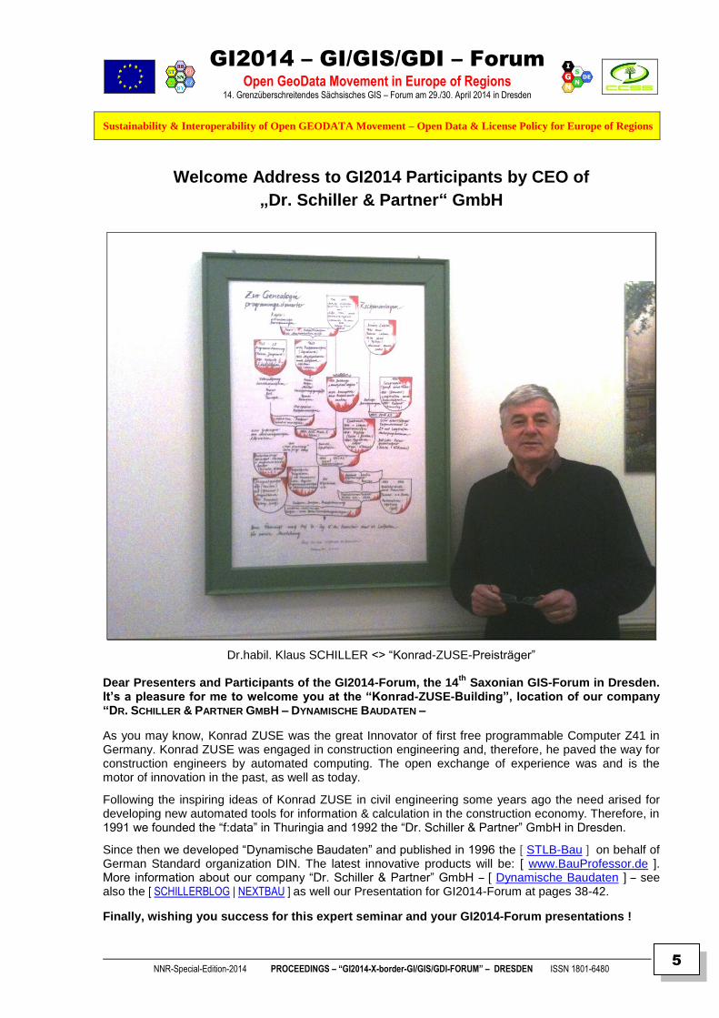
Welcome Address to GI2014 Participants by CEO of
„Dr. Schiller & Partner“ GmbH
Dr.habil. Klaus SCHILLER <> “Konrad-ZUSE-Preisträger” Dear Presenters and Participants of the GI2014-Forum, the 14
th Saxonian GIS-Forum in Dresden.
It’s a pleasure for me to welcome you at the “Konrad-ZUSE-Building”, location of our company
“DR. SCHILLER & PARTNER GMBH – DYNAMISCHE BAUDATEN –
As you may know, Konrad ZUSE was the great Innovator of first free programmable Computer Z41 in Germany. Konrad ZUSE was engaged in construction engineering and, therefore, he paved the way for construction engineers by automated computing. The open exchange of experience was and is the motor of innovation in the past, as well as today.
Following the inspiring ideas of Konrad ZUSE in civil engineering some years ago the need arised for developing new automated tools for information & calculation in the construction economy. Therefore, in 1991 we founded the “f:data” in Thuringia and 1992 the “Dr. Schiller & Partner” GmbH in Dresden.
Since then we developed “Dynamische Baudaten” and published in 1996 the [ STLB-Bau ] on behalf of German Standard organization DIN. The latest innovative products will be: [ www.BauProfessor.de ]. More information about our company “Dr. Schiller & Partner” GmbH – [ Dynamische Baudaten ] – see also the [ SCHILLERBLOG | NEXTBAU ] as well our Presentation for GI2014-Forum at pages 38-42.
Finally, wishing you success for this expert seminar and your GI2014-Forum presentations !

GI2014 – GI/GIS/GDI – Forum
Open GeoData Movement in Europe of Regions 14. Grenzüberschreitendes Sächsisches GIS – Forum am 29./30. April 2014 in Dresden
Sustainability & Interoperability of Open GEODATA Movement – Open Data & License Policy for Europe of Regions
NNR-Special-Edition-2014 PROCEEDINGS – “GI2014-X-border-GI/GIS/GDI-FORUM” – DRESDEN ISSN 1801-6480
6
The “Konrad-ZUSE-Haus”
“Dr. Schiller & Partner” GmbH – Dynamische Baudaten – DRESDEN

GI2014 – GI/GIS/GDI – Forum
Open GeoData Movement in Europe of Regions 14. Grenzüberschreitendes Sächsisches GIS – Forum am 29./30. April 2014 in Dresden
Sustainability & Interoperability of Open GEODATA Movement – Open Data & License Policy for Europe of Regions
NNR-Special-Edition-2014 PROCEEDINGS – “GI2014-X-border-GI/GIS/GDI-FORUM” – DRESDEN ISSN 1801-6480
7
GI2014 – GI/GIS/GDI – FORUM
Doz. Dr. Frank HOFFMANN, CSc – Vorstandsvorsitzender IGN e.V. Academician of International Eurasian Academy of Sciences (IEAS)
GI2014 – WELCOME & INTRODUCTION
THE GI2014 CONCEPTION & MOTIVATION
– INTRODUCTION TO OPEN DATA MOVEMENT IN EUROPE OF REGIONS –
ABSTRACT <> SUMMARY
The European Commission has positioned itself as an innovative player in the field of multi-purpose use of OPEN GEO DATA (OGD) and PUBLIC SECTOR INFORMATION (PSI). The goal is to develop an open, dynamic Media industry that refine public data into valuable information and knowledge not only for ICT experts and Public Administrations, but also allowing transparency and participation for User communities and Citizens.
With the EU DIRECTIVES PSI (2003/98/EC / updated 2013/XX/EC), INSPIRE (2007/02/EC) legal requirements were provided enabling new developments and opportunities for funding of projects until 2013 and beyond 2014 – 2020 in EUROPE OF REGIONS. However, there is a need for more & better knowledge about new EU policies and strategies like "DIGITAL EUROPE & HORIZON 2020". Therefore, these awareness needs require more and comprehensive information and knowledge as well creative, innovative actions for education and training. The European Commission presented in 2011 the „Strategy of Open Data in Europe“ to push the growth of EU economy to nearly 40 Billions Euro per year:
[ http://europa.eu/rapid/pressReleasesAction.do?reference=IP/11/1524&format=HTML&aged=0&language=EN&guiLanguage=en ]
Therefore, sustainable decision making requires greater Awareness of intellectual property rights (IPR) and Knowledge exchange of copyrights, open licensing rules and creative commons bylaws for economic, ecological and social applications in Europe of Regions, as well as for governance, tourism, civil protection and security-related infrastructures. Finally, there is still yet a need for comprehensive information, education and training actions, particularly at local, regional, cross-border and inter-regional levels.
However, the most problematic field is the CROSS-BORDER ADAPTATION and SEMANTIC
INTEROPERATION of IPR, Copyrights and Licensing to OPEN Data, Services and Applications for an effective governance, transparency and participation creating
OPEN APPS for population, infrastructure and environment !
Therefore, the GI2014 Forum is intenting for inter-regional exchange of experience and information for integration of Open PSI & GEO Data mainly at local, regional and, especially, cross-border levels.
SUSTAINABILITY & INTEROPERABILITY OF OPEN DATA & LICENSE POLICY
OPEN GEODATA MOVEMENT IN EUROPE OF REGIONS

GI2014 – GI/GIS/GDI – Forum
Open GeoData Movement in Europe of Regions 14. Grenzüberschreitendes Sächsisches GIS – Forum am 29./30. April 2014 in Dresden
Sustainability & Interoperability of Open GEODATA Movement – Open Data & License Policy for Europe of Regions
NNR-Special-Edition-2014 PROCEEDINGS – “GI2014-X-border-GI/GIS/GDI-FORUM” – DRESDEN ISSN 1801-6480
8
Proposals for presentation / poster (title+abstract, max. 250-300 words in German or English or Russian) had to be submitted by 31.03.2014 to allow composing of the actual programme framework draft, while extented Summary texts were due until 15.04.2014 using the DOC templates (available for downloading from Weblog at [ http://GDI-SN.blogspot.com ] website) !
GI2014 – Call For Presentations – Proposed for Seminar TOPICS
History of Geospatial Open Standards,
Political Open Data Support,
Cross-border Open PSI,
Cross-border GeoData & OSM,
Open Data Resources,
Open Linked Data,
Open Data Technologies,
Open Data Interoperability,
Open Database Protection,
Open Data Commons,
Licensing Policies,
IPR & Copyright, ODbL,
Open Data Best Practices
GI2014 – SEMINAR SCHEDULES
01.02.2014: OPEN Call For Presentations (CFP) on weblog site [ http://GDI-SN.blogspot.com ]
01.03.2014: GI2014 Framework Programme and Abstract-/Summary-Templates to be used
31.03.2014: Deadline for submitting presentation/poster title+abstract (max. 250 words, see Template)
15.04.2014: Deadline for submitting presentation/poster summary (max. 1 or 3 pages, see Template)
25.04.2014: Deadline for submission presention slides (PPT / duration+discussion: 10+5’ short / 20+10’ long)
29.04. 2014 GI2014 Invitation for arrived Keynote speakers & VIP’s (by Invitation only)
30.04. 2014 GI2014 Open Seminar Forum (09:00 - 17:00 at “Konrad-Zuse-Haus”, Liebigstr. 3, 01069 Dresden)
GI2014 – Contacts & Logistics
GI2014 Contact [ [email protected] | [email protected] | [email protected] ] GI2014 Participation is FFRREEEE OOFF CCHHAARRGGEE ( ! )
Participants and target groups: Developers, Providers, Integrators and Users of Open Public Sector Information and Open GeoData, GeoService and GeoApplications for integrated PSI & INSPIRE Portals used in local / regional Governments, Administrations, Enterprises and for private Applications & Business (Openstreetmap, Enviro protection, agriculture, forestry, tourism, emergency services, security, police, rescue, insurance, utilities, civil protection & crisis management, etc.).
Registration deadline setup at: 25.04.2013 !
The FINAL PROGRAMME & PROCEEDINGS can be downloaded later on via links from IGN’s weblog.
FFuurrtthheerr llooggiissttiiccss iinnffoorrmmaattiioonn aanndd uuppddaatteess ppuubblliisshheedd aatt WWeebblloogg [[ hhttttpp::////GGDDII--SSNN..bbllooggssppoott..ccoomm ]] !!

GI2014 – GI/GIS/GDI – Forum
Open GeoData Movement in Europe of Regions 14. Grenzüberschreitendes Sächsisches GIS – Forum am 29./30. April 2014 in Dresden
Sustainability & Interoperability of Open GEODATA Movement – Open Data & License Policy for Europe of Regions
NNR-Special-Edition-2014 PROCEEDINGS – “GI2014-X-border-GI/GIS/GDI-FORUM” – DRESDEN ISSN 1801-6480
9
ABOUT IGN (DE) & CCSS (CZ) – THE CROSS-BORDER ORGANIZERS
IGN e.V. – INNOVATION.Grenzüberschreitendes Netzwerk (X-border Network) – is a non-profit Association ( NGO / gemeinnütziger Verein ) for Education, Development and Knowledge Transfer – founded in 2002 as “GDI-Sachsen” (i.G.) – the final outcome of the “OpenGIS Strategy Seminar” series in GI2000 & GI2002 at “Bildungswerk Ost-West” (BOW), but later on was re-founded as the follow-up “IGN” e.V. at September 2nd, 2003, by Czechia and Saxonia experts of Cartomatics, Cyberlaw, Cybernetics, Geomatics, Economics, Mediamatics, Pedagogics, Regional Development and Spatial Sciences. Its main goals: supporting GEO – ENVIRO – SPATIO – oriented Awareness, Business and Openness in Training, Education and Research on GeoINSPIRE’d Interoperability, Sustainability, and Usability of spatial Data, Services and Applications for X-border-Infrastructures of Spatial Information in EUROPE of REGIONS.
IIGGNN hhaass bbeeeenn rreeggiisstteerreedd bbyy DDrreessddeenn CCiittyy CCoouurrtt ooffffiicciiaallllyy aass aa NNoonn--pprrooffiitt AAssssoocciiaattiioonn,, OOccttoobbeerr 1166tthh
,, 22000033
[[ hhttttpp::////wwwwww..IIGGNN--SSNN..ddee//RReeggiissttrraattiioonn..ppddff ]] –– [[ MMaaiillttoo::VVoorrssttaanndd@@IIGGNN--SSNN..ddee ]] [[ CCooppyyrriigghhtt ©© 22000033--22001144 bbyy IIGGNN ee..VV..,, DDrreessddeenn –– AAllll rriigghhttss rreesseerrvveedd.. ]]
IGN’s „GEOSPATIAL SAXONY“ WEBLOG STATISTICS AS PER 20. APRIL 2014
Statistics updated 21. April 2014 @ 13:05 GMT 18.480 visits / 27.005 views shown above as from 30 December 2009 until 31. March 2013
Pageviews total since 2007: today = 19 / yesterday = 53 / last month = 1.935 / all time history = 85.710 CLUSTERMAPS © 2014 Access Statistics for IGN’s Weblog URL [ http://GDI-SN.blogspot.com ]
The CCSS – Czech Center for Science and Society – is an Association of high tech SMEs, the public administration and research organizations. It is an independent, non-profit and non-governmental organisation. It is a type of virtual centre of excellence with the focus on the implementation of new communication and navigation technologies which have potential for sustainable development. The CCSS co-operates with a wide range of institutions and individuals, home and foreign ones. It is focused on research & development activities in the field of international research projects and utilization of modern technologies. CCSS supports co-operation networks of the small and medium business within the framework of regional economies and helds intensive contacts, particularly in Europe, Asia, Africa and South America. The CCSS is focused on transfer, analyses and development of the most advanced GI & ICT technologies which are contributing to the growth of productivity not only in industrial enterprises but in the branch of small and medium business as well. CCSS is active in the agriculture, industry, trade and services, predominantly in agricultural regions. The priority of activities of CCSS is Environment protection and Crisis management. In this field CCSS is active in European FP7 research and “best practice” excellence & social networks.
[[ CCooppyyrriigghhtt ©© 22000033--22001144 bbyy CCCCSSSS,, PPrraahhaa –– AAllll rriigghhttss rreesseerrvveedd.. ]]
distance in which individuals are clustered: Dot sizes: = 1,000+ = 100 – 999 = 10 – 99 = 1 – 9 visits

GI2014 – GI/GIS/GDI – Forum
Open GeoData Movement in Europe of Regions 14. Grenzüberschreitendes Sächsisches GIS – Forum am 29./30. April 2014 in Dresden
Sustainability & Interoperability of Open GEODATA Movement – Open Data & License Policy for Europe of Regions
NNR-Special-Edition-2014 PROCEEDINGS – “GI2014-X-border-GI/GIS/GDI-FORUM” – DRESDEN ISSN 1801-6480
10
GGII22001144 PPRROOCCEEEEDDIINNGGSS
Abstracts & Summaries & Posters
DRESDEN 30. April 2013
Edited by IGN e.V.
Doz. Dr. Frank HOFFMANN, CSc – IGN Dr. Karel CHARVAT – CCSS (Praha)
Dr. Klaus-Dieter MICHAEL – VSBI
Dr. Gudrun HOFFMANN – IGN
Prof. Dr. Siegmar KLOSS – IGN
IMPRIMATUR TO PRINT
25. April 2014
Copyright © 2013 – CCSS-Praha & IGN-Dresden – All rights reserved.

GI2014 – GI/GIS/GDI – Forum
Open GeoData Movement in Europe of Regions 14. Grenzüberschreitendes Sächsisches GIS – Forum am 29./30. April 2014 in Dresden
Sustainability & Interoperability of Open GEODATA Movement – Open Data & License Policy for Europe of Regions
NNR-Special-Edition-2014 PROCEEDINGS – “GI2014-X-border-GI/GIS/GDI-FORUM” – DRESDEN ISSN 1801-6480
11
THE FOODIE – PROJECT
OPEN DATA FOR AGRICULTURE
Karel CHARVAT & Walter MAYER Wirelessinfo (CZ) & PROGIS (AT)
ABSTRACT
Keywords: Agriculture, Open Data, precision farming, cloud computing
Content: The agriculture sector is a unique sector due to its strategic importance for both European citizens
(consumers) and European economy (regional and global) which, ideally, should make the whole sector a network
of interacting organizations. Rural areas are of particular importance with respect to the agro-food sector and
should be specifically addressed within this scope.
There is an increasing tension, the like of which is not experienced in any other sector, between the
requirements to assure full safety and keep costs under control, but also assure the long-term strategic interests of
Europe and worldwide. In that sense, agricultural production influences, and is influenced by water quality and
quantity, ecosystems, biodiversity, the economy, and energy use and supply. The seasonality and ubiquity of
agriculture make agricultural practices and production amenable to efficient synoptic monitoring. ^ Besides,
food supplies depend on trends in the natural environment, including weather and climate, freshwater supplies, soil
moisture and other variables. At the same time, modern agriculture has a major impact on the environment while
damaging biodiversity. Unless they are sustainably managed, farms and pastures can cause erosion, desertification,
chemical pollution and water shortages. These risks need to be monitored and managed by devising in effect.
Therefore, from this it can be concluded that the balance between food safety and food security will be important
task for future farming worldwide, but also for farming knowledge management.
The different groups of stakeholders involved in the agricultural activities have to manage many different
and heterogeneous sources of information that need to be combined in order to make economically and
environmentally sound decisions, which include (among others) the definition of policies (subsidies,
standardisation and regulation, national strategies for rural development, climate change), valuation of ecological
performances, development of sustainable agriculture, crop recollection timing and pricing, plagues detection, etc.
Such processes are very labour intensive because most parts have to be executed manually and the
necessary information is not always available or easily accessible. Thus, for instance, typical farm activities
carried out by farmers include the monitoring field operations, managing the finances and applying for subsidies,
depending on different software applications. Farmers need to use different tools to manage monitoring and data
acquisition on‐line in the field. They need to analyse information related to subsidies, and to communicate with tax
offices, product resellers etc.
In this context, future agriculture knowledge management systems have to support not only direct
profitability of agriculture or environment protection, but also activities of individuals and groups allowing
effective collaboration among groups in agri-food industry, consumers, public administrations and wider
stakeholders communities, especially in rural domain.
Authors
Dr. Karel Charvat (Project manager of WirelessInfo / CZ)
Dipl.Ing. Walter Mayer (Owner and President of PROGIS / AT)
Contact
Karel Charvat, Cholinská 1048/19, 784 01 Litovel, Czech Republic
Mobile: +420-605033596
EMail: [ mailto:[email protected] ]

GI2014 – GI/GIS/GDI – Forum
Open GeoData Movement in Europe of Regions 14. Grenzüberschreitendes Sächsisches GIS – Forum am 29./30. April 2014 in Dresden
Sustainability & Interoperability of Open GEODATA Movement – Open Data & License Policy for Europe of Regions
NNR-Special-Edition-2014 PROCEEDINGS – “GI2014-X-border-GI/GIS/GDI-FORUM” – DRESDEN ISSN 1801-6480
12
SUMMARY
Besides, knowledge management the agriculture domain is usually divided into three interrelated levels:
Macro level, which includes management of external information (for example about market, subsidies
system, weather prediction, global market and traceability systems);
Farm level, which includes for example economical systems, crop rotation, decision supporting system;
Field (micro) level including precision farming, collection of information about traceability and in the future
also robotics.
But to exploit all these data, converted into information and finally distilled as knowledge, it is necessary to
contextualize and manage this knowledge with adequate software services that assists the flow of information and
synchronizes all resources and activities within a farm, making them part of farm business processes. Inventory,
manufacturing, distribution, logistic, shipping, construction, and accounting processes must benefit from
agriculture knowledge management to realize a new generation of ERP Software Services for modern farms,
rather than using any standalone software application or any combination of them.
To that end FOODIE project aims at building an open and interoperable agricultural specialized platform hub
on the cloud (which is conceptualized in Figure 1) for the management of spatial and non-spatial data relevant
for farming production; for discovery of spatial and non-spatial agriculture related data from heterogeneous
sources; integration of existing and valuable European open datasets related to agriculture; data publication
and data linking of external agriculture data sources contributed by different public and private
stakeholders allowing to provide specific and high-value applications and services for the support in the
planning and decision-making processes of different stakeholders groups related to the agricultural and
environmental domains.
1. The FOODIE project approach
Figure 1: FOODIE service platform hub in cloud
In order to realize FOODIE concept and the associated service platform hub (Figure 1), the project will aim at
accomplishing the following technological objectives:

GI2014 – GI/GIS/GDI – Forum
Open GeoData Movement in Europe of Regions 14. Grenzüberschreitendes Sächsisches GIS – Forum am 29./30. April 2014 in Dresden
Sustainability & Interoperability of Open GEODATA Movement – Open Data & License Policy for Europe of Regions
NNR-Special-Edition-2014 PROCEEDINGS – “GI2014-X-border-GI/GIS/GDI-FORUM” – DRESDEN ISSN 1801-6480
13
- To make use of existing spatial information resources and services for various domains –coming from
different initiatives like INSPIRE,SISE, GMES/Copernicus, GNSS, GALILEO, GEOSS , GBIF, EUNIS,
EEA, EUROSTAT, etc. - where the EC and the member states have invested heavily over the past decade,
- To design and provide an open and interoperable geospatial platform hub on the cloud based on existing
software components from research results and available solutions in the market (mostly open-source) that
includes:
- integration of external agriculture production and food market data using principles of Open Linked Data
- an open and flexible lightweight Application Programming Interface (API), that allows private and public
stakeholders in the agricultural and environmental area to publish their own datasets (e.g., datasets provided
by local sensor networks deployed in situ in farms, knowledge from farm communities, agricultural services
companies, etc.) and make it available in the platform hub as open linked data (and enabling it to further
processing and reasoning over it)
- specific and high-value applications and services for the support in the planning and decision-making
processes of the different stakeholders groups
- provision of security mechanisms to prevent the unauthorised access and use of the platform users’ personal
information as well as the data published by them
- a marketplace where data can be discovered and exchanged but also external companies can publish their own
agricultural applications based on the data, services and applications provided by FOODIE.
Besides, to facilitate integrating and deploying services over FOODIE, and trying to assure FOODIE success in
the mid-term, it will be taken into account state of the art and expected evolution of management services and data
marketplaces for the next years. In that sense, FOODIE will seek and provide the following innovative aspects:
Cloud deploying of basic and standardized services, which will decrease not only deploying costs but also
production and maintenance costs. Cloud deployment will also make easier integration and realize the vision
of a “network of data-hubs”, sharing data and services to provide a new data exploitation ecosystem where
data is enriched by composition. Collaboration among hubs will enable a market for data brokerage, kind of
data hub which do not store data but locates, summarizes, enrich and disaggregate data to provide vertical
services of high added value.
Easily discoverability and composability of services. Not only data and services published and deployed by
FOODIE will follow (de facto) standards as far as possible, but guides to build and deploy services over
FOODIE will be publicly available so any service can not only be easily found by end users or third party
companies but also can, with the adequate access management, be reused alone or by composition with other
services to provide a richer or a particular solution. This approach will also enable a personalization market
realized by third-party, specialized companies in vertical markets.
“Pay as you go” paradigm. Services or data published by FOODIE can be free or non-free. For instance,
FOODIE will provide for free a global agriculture sector balanced scorecard and a non-free repository where
key indicators for the agriculture sector may be obtained and combined by all stakeholders to make their own
balanced scorecard. FOODIE may also go a step further providing analysis based on free indicators to provide
free, white papers or sample reports and non-free, only for subscription members, reports. This paradigm will
enable third parties as for instance consultancy companies to sell consultancy services (reports, etc.) on top of
FOODIE information.
Reward mechanisms for data sharing. Open data are the key value of FOODIE, but also volunteered data
and knowledge shared among user’s communities. FOODIE will promote participation of stakeholders and
end users (high value data owners) in terms of “the more information you provide to the hub, the more data
and services for free you will enjoy”. Also, this approach will help to build virtual communities and exploit
social knowledge.
Clear Return of Investment (ROI) for the end user. The current economic situation makes reduction of
costs a strategic pillar of a large number of companies. FOODIE must develop a business model which,
during the marketing process, clearly demonstrate the value of services in ROI terms (i.e. FOODIE may
include a simulator which calculates, asking a few questions about a crop, reduction of costs by rationalizing
the use of fertilizers, water… thus quickly amortizing the cost of the service)
Multi-device/multiplatform/multipurpose front-ends. FOODIE will include mechanisms allowing users to
exploit information and services by means of graphical and intuitive interfaces. Standards as HTML5 widgets
for visualization will be preferred to assure compliance with mobility devices, as they provide automatic
means to perform interface adaptation according to specific hardware and software capabilities.

GI2014 – GI/GIS/GDI – Forum
Open GeoData Movement in Europe of Regions 14. Grenzüberschreitendes Sächsisches GIS – Forum am 29./30. April 2014 in Dresden
Sustainability & Interoperability of Open GEODATA Movement – Open Data & License Policy for Europe of Regions
NNR-Special-Edition-2014 PROCEEDINGS – “GI2014-X-border-GI/GIS/GDI-FORUM” – DRESDEN ISSN 1801-6480
14
2. Pilot scenarios FOODIE concepts and objectives will be realized by means of the resulting service platform hub, which will be
demonstrated in three different pilot scenarios across Europe (Spain, Czech Republic and Germany), providing
each of them thus a set of common and specific requirements (from their stakeholders) in terms of data and
services that will be fulfilled by the platform.
More concretely,
- Pilot 1: Precision Viticulture (Spain) will focus on the appropriate management of the inherent variability of
crops, an increase in economic benefits and a reduction of environmental impact.
- Pilot 2: Open Data for Strategic and Tactical planning (Czech Republic) will focus on improving future
management of agricultural companies (farms), introducing new tools and management methods, which will
follow the cost optimization path, reduction of environmental burden, improving the energy balance while
maintaining production level.
- Pilot 3: Technology allows integration of logistics via service providers and farm management including
traceability (Germany). This pilot will focus on integrating the German Machine Cooperatives systems with
existing farm management systems and logistic systems as well as to develop and enlarge existing org-
cooperation models and business models with the different chain partners to create win-win situations for all
of them with the help of IT solutions.
References
Karel Charvat, Sarka Horakova, Sjaak Wolfert, Henri Holster, Otto Schmid, Liisa Pesonen, Daniel
Martini, Esther Mietzsch, Tomas Mildorf: Final Strategic Research Agenda (SRA): Common Basis for policy making for the introduction of innovative
approaches to data exchange in the agri-food industry, agriXchange, Wirelessinfo, LEI Wageningen UR,2012
Karel Charvat, Pavel Gnip:
Future Farm for Farm of Future, IST Africa 2011, Gabarone Botswana
Sørensen, C, Bildsøe, P. Fountas, S., Pesonen, L.,Pedersen, S., Basso, B. Nash, E:
Deliverable 3.1, System analysis and definition of system boundaries, Work package 3: “Analysis and
specification of knowledge based farm management”, FutureFarm
Frederik Teye, Henro Holster, Liisa Pesonen, Sarka Horokova:
Current situation on data exchange in agriculture in the EU27 and Switzerland, MTT Agrifood research Finland,
Wageningen UR Livestock Research, Wirelessinfo, 2011.
Agricultural Engineering and Technologies: Vision 2020 and Strategic Research Agenda of the European Agricultural Machinery Industry and Research
Community for the 7th Framework Programme for Research of the European Community, Brussels, October
2006.
Scenar 2020: Scenario study on agricultura and the rural world, Luxembourg: Office for Official Publications of the European
Communities, 2007.
J. Arnó, J. A. Martínez-Casasnovas, M. Ribes-Dasi and J. R. Rosell:
Review. Precision Viticulture. Research topics, challenges and opportunities in site-specific vineyard
management, Spanish Journal of Agricultural Research, 7(4), 779-790, 2009.
GI2014 – GI/GIS/GDI – Forum
Open GeoData Movement in Europe of Regions 14. Grenzüberschreitendes Sächsisches GIS – Forum am 29./30. April 2014 in Dresden
Sustainability & Interoperability of Open GEODATA Movement – Open Data & License Policy for Europe of Regions
NNR-Special-Edition-2014 PROCEEDINGS – “GI2014-X-border-GI/GIS/GDI-FORUM” – DRESDEN ISSN 1801-6480
15
FROM PLAN4ALL TO PLAN4BUSINESS AND BACK –
THE FUTURE FOR EUROPEAN PLANNING DATA
Karel CHARVAT & Tomas Mildorf
Help Service Remote Sensing, Benesov & University of West Bohemia, Plzen
ABSTRACT
Keywords: Real Estate, Spatial Planning, Open Data, Open Platform
Content:
The Plan4all project contributed to the standardization in the field of spatial data from spatial
planning point of view. Its activities and results will become a reference material for INSPIRE initiative;
especially for data specification. Plan4all is focused on the following 7 spatial data themes as outlined in
Annex II and III of the INSPIRE Directive:
• Land cover
• Land use
• Utility and Governmental services
• Production and industrial facilities
• Agricultural and aquaculture facilities
• Area management/restriction/regulation zones and reporting units
• Natural risk zones
The Plan4business project was follow up project focusing to transfer Plan4all experiences
towards business. Plan4business is a European project running from April 2012 until March 2014 and
is co-financed by the 7th Framework Programme of the European Commission. The full title is
plan4business – a Service Platform for Aggregation, Processing and Analysing of Urban and Regional
Planning Data.
The Plan4business project develops a service platform for aggregation, processing and
analyses of urban and regional planning data in Europe. Harmonised data will be integrated into
seamless, homogenous, constantly growing and updated trans-border dataset. The platform will enable
spatial analyses across European datasets. The platform should serve not only as a catalogue of planning
data but also as their integrator enabling users to search, view, analyse and download spatial planning
data on European and regional levels. The main project objectives are the automation of harmonisation
processes and possibilities of complex analyses.
The plan4business project is a comprehensive and complex system, built on flexible and
scalable layers, interacting through a set of defined services, ensuring performance and security.
The plan4business project was focused on the development of a service platform for
aggregation, processing and analysis of urban and regional planning data. In respect to the assumptions
of the project an iterative market analysis was made in order to define target customer groups and a
scope of the platform functionality, which builds its offer. The plan4business platform was expected to
fulfil the needs of a wide spectrum of customers. The first approach for the identification of potential
clients of the platform is described already in the Description of Work. Several clients’ groups are
pointed there: real estate companies, spatial planners, researchers, business developers, insurance and
banking related companies and finally surveyors.

GI2014 – GI/GIS/GDI – Forum
Open GeoData Movement in Europe of Regions 14. Grenzüberschreitendes Sächsisches GIS – Forum am 29./30. April 2014 in Dresden
Sustainability & Interoperability of Open GEODATA Movement – Open Data & License Policy for Europe of Regions
NNR-Special-Edition-2014 PROCEEDINGS – “GI2014-X-border-GI/GIS/GDI-FORUM” – DRESDEN ISSN 1801-6480
16
Identification of potential users / customers has been done in WP3 and is documented in the
report D3.1 Requirements and System Specification. Potential customers listed in this document are
divided into two sectors: private sector and public entities. Private sector is represented by: Spatial
Planners, Banks and Insurance industry, Energy and Environmental Services, Health Services,
Commercial Services, Real Estate, Telecommunication, Tourism & Travel, Transport and Logistics as
well as Security Services. From the public sector following groups were identified: spatial planning
authorities, fiscal authorities, regional development agencies, other services and public researchers and
universities.
These wide and varied scope of the platform’s end users are granted with the opportunity of
taking advantage of simplified and easier access to a comprehensive open data pool in order to increase
their effectiveness in everyday practise. Constantly growing, thanks to unique co-operators network,
resource of freely accessible data, equipped with a powerful set of discovery, access, edition and
analysis tools is called: the Open Data Platform (ODP). All the data in the hub are published as open
data. All the tools provided by the ODP are available for free. Any party can access the data pool and
make commercial or non-commercial apps based on these data. The use of the data must be in line with
data licences provided in line with the conditions given by the data owners or data providers. Particular
resources of ODP are accessible only for registered users, but still on non-profit rules. The core features
set of ODP is as follows:
Open Data Hub
Management and harmonising tools:
HALE, LayMan, HSRS Geoportal, Metadata Catalogue Micka
Open Apps: Open Land Use Map, Thematic Map Viewer
The Open Data Platform is expected to become an important part of future R&D projects, and
that’s why its maintenance and development financing is planned to be based on national and European
funds. Existence of this kind of platform is in line with the European policy of opening access to public
registers, but also is expected to stimulate the European companies competitiveness. It is obvious that
this kind of initiatives requires a log-term planning and constant development. That’s why the idea of
the Open Data Platform was decided to be initiated during the plan4business project and to be continued
with a long time perspective. As a consequence to this approach and the necessity to harmonise non-
profit operation with commercial one, it was decided to include the Open Data Platform in the business
plan. In parallel particular steps are taken to establish an organisation, which will be more proper for
operating non-profit Open Data Platform. This organisation will be the Plan4all Association.
The Commercial Platform described below will benefit from the technological development
of the Open Data Platform, assuring this way an even stronger connection between the non-profit and
commercial wings of the plan4business operational successor.
Authors
Karel Charvat & Tomas Mildorf
References
[ www.whatstheplan.eu ]
Contact Dr. Karel Charvat, Help Service Remote Sensing,
Husova 2117, 25601 Benešov, Czech Republic
Mobile: +420-605033598
EMail: [ mailto:[email protected] ]

GI2014 – GI/GIS/GDI – Forum
Open GeoData Movement in Europe of Regions 14. Grenzüberschreitendes Sächsisches GIS – Forum am 29./30. April 2014 in Dresden
Sustainability & Interoperability of Open GEODATA Movement – Open Data & License Policy for Europe of Regions
NNR-Special-Edition-2014 PROCEEDINGS – “GI2014-X-border-GI/GIS/GDI-FORUM” – DRESDEN ISSN 1801-6480
17
INSPIRE AS A BUSINESS CASE FOR
EUROPEAN GEO-ICT SMES…?
Jitka FAUGNEROVA CENIA, Czech Environmental Information Agency, Prague (CZ)
ABSTRACT <> KEYNOTE
Keywords: INSPIRE, SME (Small and medium entreprises), Business, Implementation, Strategy
Content:
For the last two years (May 2012 – May 2014) CENIA, Czech Environmental Information
Agency participated in an European project focused on geo-ICT small and medium enterprises and their
possible business coming in parallel with implementation of the INSPIRE Directive.
CENIA’s participation in the project has been evaluated positively, because in relation with
private companies CENIA acts also as a National Contact Point for INSPIRE and knows well all the
groups of Czech INSPIRE stakeholders (public authorities, geoinformation association, academic sector
and private companies).
Two main issues were to be resolved by the project – a report to the European Commission on
how much the geo-ICT business has been stimulated since the INSPIRE Directive entered into force and
the preparation of a set of tools supporting the SMEs in their involvement into the INSPIRE
implementation. Both results of the project will be presented; while the most interesting findings from
the report in detail, web tools only shortly.
While interviewing Czech SMEs one critical point not only for INSPIRE implementation but
also for the Czech geoinformatics in general was mentioned very often. It was a missing Strategy for
INSPIRE implementation, which is quite critical 7 years after the INSPIRE Directive, and also a
Strategy for the National Spatial Data Infrastructure (NSDI).
Actually, both strategies are in the process of preparation and their content and interrelations
will be presented as well.
Author
Jitka FAUGNEROVA
INSPIRE National Contact Point of the Czech Republic
Member of the INSPIRE Committee under European Commission
References
[ http://www.cenia.cz ]
[ http://inspire.gov.cz/ ]
[ http://geoportal.gov.cz/ ]
Contact Email [ [email protected] ]
CENIA, česká informační agentura životního prostředí
Vršovická 1442/65, 100 10 Praha 10
Mobile: +420 724 549 970

GI2014 – GI/GIS/GDI – Forum
Open GeoData Movement in Europe of Regions 14. Grenzüberschreitendes Sächsisches GIS – Forum am 29./30. April 2014 in Dresden
Sustainability & Interoperability of Open GEODATA Movement – Open Data & License Policy for Europe of Regions
NNR-Special-Edition-2014 PROCEEDINGS – “GI2014-X-border-GI/GIS/GDI-FORUM” – DRESDEN ISSN 1801-6480
18
LINKED OPEN DATA FOR CYCLO TOURISM
THE CESKOJEDE – PROJECT
Josef FRYML, Karel CHARVAT Czech Centre for Science and Society
ABSTRACT
Keywords: Linked Open Data, Tourism
Content:
Tourism represents very old activity that is connected mainly with spending of free and
leisure time. The first forms of tourism began in ancient Greek and Rome in connection with
sport event (Olympic games) or religious places and events. The next progress of tourism was
mentioned during times of Renaissance (visits of social events) and later (first visits of spas).
The rapid growth of tourism and tourist industry in the 20th century is related to changes in
social structure of society and rights of labours. They contributed to the introduction (in
developed countries) of weekends, eight-hours working days and holiday that strongly support
tourism activities.Authors.
Authors
Josef FRYML, Karel Charvat
Czech Centre for Science and Society
References
Charvat, K., S. Kafka, and T. Travnicek. "Why interoperability for agriculture and tourism." ZEMEDELSKA
EKONOMIKA-PRAHA- 49.9 (2003): 407-411.
Horak, P., Charvat, K., Horakova, S., & Vlk, M. (2010). A Living Lab For Spatial Data Management
Innovation in the Czech Republic. Living Labs for Rural Development, 125.
Archer, P., Charvat, K., Navarro, M., Iglesias, C. A., O'Flaherty, J., Robles, T., & Roman, D. (2013). Linked
Open Data for Environment Protection in Smart Regions–The SmartOpenData Project.
Charvát, K., Čerba, O., Kafka, Š., Mildorf, T., & Vohnout, P. (2013). The HABITATS Approach to Build the
INSPIRE Infrastructure. In Environmental Software Systems. Fostering Information Sharing (pp. 1-10). Springer
Berlin Heidelberg.
Charvat, Karel. "ReGeo–an effective on line rural tourism information system." (2003) EC-Projekt
Charvat, K., & Mildorf, T. NaturNet Plus Solution for Sustainable Tourism, Education and Environment
Protection. Competence Modelling for Vocational Education and Training, 34.
Cepicky, J., Gnip, P., Kafka, S., Koskova, I., Charvat, K., Nagatsuka, T., & Ninomiya, S. (2008). Geospatial
data management and integration of geospatial web services. IAALD AFITA WCCA2008, Tokyo
Contact
Josef FRYML Czech Centre for Science and Society, Prague, Czech Republic
President of CCSS
| Mobile: +420/602532201
EMail: [ mailto:[email protected] ]

GI2014 – GI/GIS/GDI – Forum
Open GeoData Movement in Europe of Regions 14. Grenzüberschreitendes Sächsisches GIS – Forum am 29./30. April 2014 in Dresden
Sustainability & Interoperability of Open GEODATA Movement – Open Data & License Policy for Europe of Regions
NNR-Special-Edition-2014 PROCEEDINGS – “GI2014-X-border-GI/GIS/GDI-FORUM” – DRESDEN ISSN 1801-6480
19
SUMMARY
Active tourism (as the contrary of passive tourism) is a special way to spend leisure
time. It is a new life philosophy that combines adventure, sports, experience, discovering,
events, relations to nature, history, culture, habits or traditions. Active tourism is rapidly
growing in popularity due to unusual experience, that are totally different from the typical in
sea resorts. Elements of active tourism (such as excursions or offer of sport activities) are added
to the traditional form of tourism. The new forms of tourism cover for example sport activities
(e.g. rafting), nature tourism (e.g. trekking or hiking), rural tourism, congress tourism,
adventure tourism (e.g. rock climbing) or experience tourism (e.g. mountaineering
expeditions).
Another shift of paradigm of tourist industry was mentioned in connection with
collecting, sharing, spreading and propagation of information. Previous forms (personal
recommendations, printed catalogues, reservation letters or phone calls) are in remission and
they are replaced by electronic forms. But electronic forms are changing also. They are moving
from centralized databases and big global providers to more personalized information created
by local subjects of tourist industry. The main objective of this project is to support these local
or regional subjects and their information management, because we believe that combination of
local and global information and systems represents the best added value for all participant of
tourist industry.
Data and information represents the keyword of current society as well as contemporary
tourism and tourist industry. Both main subjects of tourist industry (participants and providers)
deal with data and information and need them mainly for communication in each group and
also between both groups of tourism subjects. Data and information mean a huge number of
various items related to selection of destination or offer of services of tourist industry. Data and
information do not mean just spatial data sets, maps, web cameras, handouts or catalogues, but
also personal information such as recommendations, comments on social media channels,
published private photos or stories.
Previous paragraph shows that current global tourist industry and tourism cannot be
built on any centralised database. Existing solutions for tourist industry based on information
technologies (IT) are focused mainly on one component of information such as global
information, local or regional data or social media and crowd-sourcing. Main problem of this
approach is, that various types of information are collected and managed in different levels.
For example there is possible to have central database of roads on the level of Europe, but it is
not possible to collect and above all update uniform information about accommodation,
services, events, etc. in global scale.
On the other hand, there are local systems, which are collecting above-mentioned local
information. These systems covers usually small regions or a groups of service providers with
up-to-date data, but the problem of such local information system is their heterogeneity and
usability of this local tourist information systems. All users (including SMEs participating on
tourist industry and being not focused on information technologies) or such data and
information are limited by their heterogeneities that cover various data models, data formats,
types of information, level of detail, semantics (terminology), portrayal rules, geometry,
coordinates and coordinate systems and above all the frequency of updating. The
heterogeneities limit sharing, re-using of existing data sets as well as their integration to
external applications and data sets.

GI2014 – GI/GIS/GDI – Forum
Open GeoData Movement in Europe of Regions 14. Grenzüberschreitendes Sächsisches GIS – Forum am 29./30. April 2014 in Dresden
Sustainability & Interoperability of Open GEODATA Movement – Open Data & License Policy for Europe of Regions
NNR-Special-Edition-2014 PROCEEDINGS – “GI2014-X-border-GI/GIS/GDI-FORUM” – DRESDEN ISSN 1801-6480
20
The heterogeneity means also very important questions related to reliability and quality
of provided information. In past two 5th Framework program projects ReGeo and EMIRES
suggest technologies to build future information systems on the base of shared information
from local levels. Due technological constrains this idea was till now not realised. ReGeo
introduced concept of virtual tourist information system and EMIRES introduced concept of
Single European Tourist Market Place. Both this concepts are now modified by
SmartTouristData using new technological possibilities and with number of European data
providers.
The new component of data of tourist industry constitutes volunteered geographic data
and information related to crowd-sourcing, e.g. Wikitravel (free, complete, up-to-date and
reliable world-wide travel guide; shared repository for images and other media)
OpenStreetMap, Open Weather Map or Open Event Map. There are also data designed for local
purposes, such as AddisMap (Addis Ababa (Ethiopia) City Map with POI locator). These data
sets could be used freely for building information system, sharing and moreover they provide a
feedback from real users.
There are many local or regional data sets relevant to tourist industry in the form of
Open Linked Data (method of publishing structured open data so that it can be interlinked and
become more useful). They could be combined with OpenStreetMap data and used also as part
of information systems utilizing local data.

GI2014 – GI/GIS/GDI – Forum
Open GeoData Movement in Europe of Regions 14. Grenzüberschreitendes Sächsisches GIS – Forum am 29./30. April 2014 in Dresden
Sustainability & Interoperability of Open GEODATA Movement – Open Data & License Policy for Europe of Regions
NNR-Special-Edition-2014 PROCEEDINGS – “GI2014-X-border-GI/GIS/GDI-FORUM” – DRESDEN ISSN 1801-6480
21
Open Linked Data Strategy is becoming a source of unprecedented visibility for any
data that will enable the generation of new businesses, as well as a significant advance for
research. Nevertheless, in order for this envisioned strategy to become a reality, it is necessary
to advance the publication of existing data, usually owned by public bodies.
CeskoJede (CeskoGO) is current practical realisation of principles of
SmartTouristData for cycle tourism. There were prepared contact between regions supplying
data, CDV, Association of cycle tourist cities, Czech Centre for Science and Society and Help
Service Remote Sensing (HSRS) of realization of national cycle tourist system based on shared
data using principles of Linked Open Data. Regions will offer local data as RDF file and this
will be integrated with global cycle routes.

GI2014 – GI/GIS/GDI – Forum
Open GeoData Movement in Europe of Regions 14. Grenzüberschreitendes Sächsisches GIS – Forum am 29./30. April 2014 in Dresden
Sustainability & Interoperability of Open GEODATA Movement – Open Data & License Policy for Europe of Regions
NNR-Special-Edition-2014 PROCEEDINGS – “GI2014-X-border-GI/GIS/GDI-FORUM” – DRESDEN ISSN 1801-6480
22
BRATISLAVA SMALL BROWNFIELDS
IN NODAL AREAS OF DANUBE
RIVERBANKS
Juraj FURDÍK, Micu LOREDANA, Alena BINDZÁROVÁ Faculty of Architecture, Slovak University of Technology in Bratislava
ABSTRACT
Keywords: water and city, brownfields, Bratislava, SNP Bridge, urban structure, urban planning
Content: Besides typically neglected areas, that meet the full definition of brownfields, very neglected areas exist
in the cities, their extent is not large, but on the other hand, its importance and key role in the structure
of the city have the greater impact on the overall quality of the environment city and especially their
immediate surroundings. The graphic part of poster is addressed to this key area, foreland of the SNP
Bridge, in which it looks for functional and spatial solution, which would be the proposal for
a comprehensive architectural and urban design.
Solving of functional relationships presented on the poster (Concept and Solution Ideas):
1. Automobile traffic on the upper floor appears to be collision-free, but public transport links with
pedestrian movement in relation to citywide facilities, citywide recreational facilities and
waterfront is inconvenient. Solution is in flyover links above or over communications with
direct connection to Aupark and Incheba. Another solution is a direct continuation of the two-
sided walking route bridge with subsequent connections to bus stops and continuing up to the
flyover crossings Einstein Street (see 3rd level on poster).
2. Highlighting of induction level to the pylon with extension of the view over the waterfront and
ensure of flyover above Vienna Road and accessible links to the waterfront.
3. Along Vienna Road, to minimize pedestrian movement in favor of international cycling route,
for which at this point to create a decent place which satisfies all the requirements of
international cycling stop.
Presented solution on the poster is a functional and operational idea, that isa suitable architectural and
urban solution to ensure adequate quality of this important area and node of Bratislava.
Author
Dr. Juraj FURDÍK
Faculty of Architecture, Slovak University of Technology in Bratislava
References
http://mobex2013.weebly.com
http://www.a-atc.sk/MobEx2011/index.html
http://www.fa.stuba.sk/
Contact
Juraj Furdík, Faculty of Architecture, STU in Bratislava
Namestie slobody 19
812 45 Bratislava

GI2014 – GI/GIS/GDI – Forum
Open GeoData Movement in Europe of Regions 14. Grenzüberschreitendes Sächsisches GIS – Forum am 29./30. April 2014 in Dresden
Sustainability & Interoperability of Open GEODATA Movement – Open Data & License Policy for Europe of Regions
NNR-Special-Edition-2014 PROCEEDINGS – “GI2014-X-border-GI/GIS/GDI-FORUM” – DRESDEN ISSN 1801-6480
23

GI2014 – GI/GIS/GDI – Forum
Open GeoData Movement in Europe of Regions 14. Grenzüberschreitendes Sächsisches GIS – Forum am 29./30. April 2014 in Dresden
Sustainability & Interoperability of Open GEODATA Movement – Open Data & License Policy for Europe of Regions
NNR-Special-Edition-2014 PROCEEDINGS – “GI2014-X-border-GI/GIS/GDI-FORUM” – DRESDEN ISSN 1801-6480
24
EXAMPLES OF BROWNFIELDS CONNECTED
TO DANUBE IN BRATISLAVA CITY AREA
Daniel FURDÍK, Ivor MEČIAR
Faculty of Architecture, Slovak University of Technology in Bratislava
ABSTRACT
Keywords: water and city, brownfields, Bratislava, GIS, urban structure, urban area, digital
technologies
Content:
The researched zone is situated in an intravilan of the Bratislava city. We document the
comparison with the help of 2D offline tools and interactive Fusion tables from the Google
maps application and we document the comparison of analysis of locations.
The advantage of Google Fusion Tables is the possibility of interactive cooperation and editing
with no regard to the colleagues site of employment. These files are consisting a graphical and
database part. Graphical part is being composed the easiest way in cloud based program
GmapGIS application [ http://www.gmapgis.com ] and the data output is in KML format which
is compatible with online applications Google Earth and Google Maps. Database data can be
processed and summarized in any table like editor, the most common is Microsoft Excel.
As the subject of our research we took brownfields in Bratislava urban area which are
connected with the river Danube. Criterias for choosing browfields into our analysis was their
location in an intravilan of Bratislava, their size (minimum 27000 sq. meters), and their
straight connection to the river Danube.
We analyzed them in terms of location, size, connection to the Danube, history, functional
utilization and extent of contamination. The results were gradated on a scale of 0 to 20,
alternatively in the case of historical analyses and position as input data we choose dates from
the city archives, available resources and geographical coordinates.
Author
Dr. Daniel Furdík, Dr. Ivor Mečiar Faculty of Architecture, Slovak University of Technology in Bratislava
References
http://mobex2013.weebly.com
http://www.a-atc.sk/MobEx2011/index.html
http://www.fa.stuba.sk/
Contact
Daniel Furdík, Ivor Mečiar, Facfulty of Architecture, STU in Bratislava
Namestie slobody 19
812 45 Bratislava

GI2014 – GI/GIS/GDI – Forum
Open GeoData Movement in Europe of Regions 14. Grenzüberschreitendes Sächsisches GIS – Forum am 29./30. April 2014 in Dresden
Sustainability & Interoperability of Open GEODATA Movement – Open Data & License Policy for Europe of Regions
NNR-Special-Edition-2014 PROCEEDINGS – “GI2014-X-border-GI/GIS/GDI-FORUM” – DRESDEN ISSN 1801-6480
25

GI2014 – GI/GIS/GDI – Forum
Open GeoData Movement in Europe of Regions 14. Grenzüberschreitendes Sächsisches GIS – Forum am 29./30. April 2014 in Dresden
Sustainability & Interoperability of Open GEODATA Movement – Open Data & License Policy for Europe of Regions
NNR-Special-Edition-2014 PROCEEDINGS – “GI2014-X-border-GI/GIS/GDI-FORUM” – DRESDEN ISSN 1801-6480
26
INTRODUCTION TO OPEN DATA MOVEMENT IN
EUROPE OF REGIONS
FRANK HOFFMANN
IGN – INNOVATION. Grenzüberschreitendes Netzwerk e.V. – Dresden
ABSTRACT
Keywords: CORINE, data policy, data portal, europe, geodata, geoinformation, geoSME, GI2010, GI2012,
govdata, INSPIRE, knowledge, licences, network, OKFN, open data, open knowledge, OSM, OpenStreetMap, PSI,
public sector information, web services
Die Europäische Kommission hatte bereits 2011 eine „Strategie Nachhaltigkeit und Offenheit der Datenpolitik
im Europa der Regionen vorgestellt, die der EU-Wirtschaft einen Wachstumsschub und Nutzen von insgesamt
über 32-Milliarden Euro pro Jahr bescheren soll:
[ http://europa.eu/rapid/pressReleasesAction.do?reference=IP/11/1524&format=HTML&aged=0&language=EN&guiLanguage=en ]
Ziel war die Förderung einer dynamischen GEO-Branche, die Erfassungsdaten in wertvolle Information und
Wissen veredelt, beispielsweise zur Programmierung von nachhaltigen APPS für GeoManagement-Applikationen,
z.B. die aktuelle Wettbewerbsausschreibung APPS For EUROPE
[ http://www.appsforeurope.eu/about-us ] sowie [ http://www.appsforeurope.eu/competition ]
[ http://okfn.de/2014/04/die-gewinner-von-apps-for-europe-2014/ ]
So wurde u.a. im Social Network LINKEDIN nachfolgendes festgestellt:
K. Charvat: We've recognised an important problem with geospatial (open) data licencing. There exist different
licences and it is not easy to combine data from various sources with different licences, especially then in the open
data domain when data can be re-used. As an example, how to handle licences of a combination of
OpenStreetMap and Corine CLC data? Both licences are open, however, there are some differences.
[ http://www.linkedin.com/e/mm3hn8-hnutvjev-3e/vaq/5797927541876486144/61515/-1/view_disc/?hs=false&tok=3g3tOg2mka0601 ]
And what if there will be another input from other ten open data sources ???
In der bundesdeutschen GEOINFORMATIONSWIRTSCHAFT existieren allein 9 (!) verschiedene juristische
Vorschriften und Lizenzierungsmodelle [ http://www.geolizenz.org ] bis 2016 zunächst als Modellprojekt zur
Bereitstellung von Public Sector Informationen (PSI), unter denen Geodaten jedoch eine besondere Stellung
einnehmen.
Allerdings wendete sich das deutsche „OpenKnowledgeFoundation“ Netzwerk (OKFN) gegen diese Geolizenz:
11. Januar 2013: Wikimedia Urheberrecht:
[ Zwei neue Open Data-Lizenzen aus dem Innenministerium ]
12. Januar 2013: E-Demokratie.org:
[ Open Data Lizenzmodell des BMI führt zur “inhaltlichen Entwertung des Begriffes Open Data” ]
2. Februar 2013: openeverything.eu:
[ Weiter Unklarheiten beim GovData Portal Deutschland ]
5. Februar 2013: Netzpolitik.org:
[ Kein Open Data-Portal im Bund ]
6. Februar 2013: Offenes Köln Blog:
[ Zur GovData Plattform von Bund und Ländern ]
7. Februar 2013: Gemeinsame Erklärung: Den Standard endlich auf “Offen” setzen!
[ http://not-your-govdata.de ]

GI2014 – GI/GIS/GDI – Forum
Open GeoData Movement in Europe of Regions 14. Grenzüberschreitendes Sächsisches GIS – Forum am 29./30. April 2014 in Dresden
Sustainability & Interoperability of Open GEODATA Movement – Open Data & License Policy for Europe of Regions
NNR-Special-Edition-2014 PROCEEDINGS – “GI2014-X-border-GI/GIS/GDI-FORUM” – DRESDEN ISSN 1801-6480
27
NNeebbeenn eeiinneerr eeiinnhheeiittlliicchheenn nnaattiioonnaalleenn LLöössuunngg iisstt jjeeddoocchh ddiiee ggrreennzzüübbeerrsscchhrreeiitteennddee AAnnppaassssuunngg uunndd
OOnnlliinnee--IInntteerrooppeerraabbiilliittyy vvoonn ööffffeennttlliicchheenn DDaatteenn,, DDiieennsstteenn uunndd AAnnwweenndduunnggeenn iinn EEuurrooppaa,, ddiiee zzuuddeemm nnoocchh
dduurrcchh uunntteerrsscchhiieeddlliicchhee uunndd lläännddeerrssppeezziiffiisscchhee ggeesseettzzlliicchhee VVoorrsscchhrriifftteenn bbeezziieehhuunnggsswweeiissee rreessttrriikkttiivvee
LLiizzeennzzbbeeddiinngguunnggeenn eerrsscchhwweerrtt bbzzww.. ddeemmzzuuffoollggee nnaahheezzuu uunnmmöögglliicchh ggeemmaacchhtt wweerrddeenn……
Die Europäische Kommission veröffentlichte schließlich am 2. Dezember 2013 einen erneuten Aufruf zur
Konsultation über die Umsetzung der Richtlinie 2007/2/EG zur Schaffung einer Geodateninfrastruktur in der
Europäischen Gemeinschaft (INSPIRE)
[ http://inspire.jrc.ec.europa.eu/index.cfm/newsid/11281 ], d.h. zum Realisierungsstand von INSPIRE
[ http://ec.europa.eu/yourvoice/ipm/forms/dispatch?form=INSPIRE7&lang=en ]
sowie am 5. Dezember 2013 zur europaweiten Befragung über Datenschutz und Urheberrecht (Copyright):
[ http://www.slideshare.net/fullscreen/inspireeu/european-spatial-data-infrastructure-inspire-and-
beyond/15 ]
EU Commissioner Michel Barnier said: "My vision of copyright is of a modern and effective tool that
supports creation and innovation, enables access to quality content, including across borders,
encourages investment and strengthens cultural diversity. Our EU copyright policy must keep up with
the times." [ http://ec.europa.eu/internal_market/consultations/2013/copyright-rules/index_en.htm ]
Der gemeinnützige Verein IGN - „INNOVATION.Grenzüberschreitendes Netzwerk e.V.“ – widmete seine
bisherigen GIS-Weiterbildungskurse sowie GI/GIS/GDI-Symposien seit GI2000 langfristig der Zielstellung einer
nachhaltigen und offenen Infrastruktur für GEO-UMWELT-RAUM – Informationen, deren Schwerpunkte auf
grenzüberschreitende GeoDaten & interoperable GeoDienste orientierten.
Folgerichtig standen bisher Public Sector Information ( GI2010 ) sowie auch Open Data ( GI2012 ) bereits im
Fokus der inter-regionalen Zusammenarbeit und des Erfahrungsaustausches mit Sachsen‘s Partner-Regionen,
insbesondere grenzüberschreitend mit Tschechien & Polen.
Demzufolge soll in diesem Jahr das 14. Sächsische GI/GIS/GDI-Forum (GI2014) den inter-regionalen
Erfahrungsaustausch zum OPEN DATA MOVEMENT IM EUROPA DER REGIONEN nachhaltig befördern !
Autor Doz. Dr. Frank HOFFMANN, CSc
Vorstandsvorsitzender – IGN e.V.
Referenzen [ http://de.SLIDESHARE.net/IGN_Vorstand/presentations ]
[ Effizienter Staat 2014 – Offene Daten und transparentes Regierungshandeln in der Verwaltungsrealität ]
[ http://GDI-SN.blogspot.com ]
[ https://TWITTER.com/#!/IGN_Vorstand ]
[ http://wiki.OPENSTREETMAP.org/wiki/User:Vorstand ]
[ http://de.LINKEDIN.com/pub/IGN-Vorstand/21/a66/64a ]
[ http://en-gb.FACEBOOK.com/people/IGN-Vorstand/100001648951366 ]
Kontakt
IGN-Vorstand
c/o Martin-Andersen-Nexö-Str. 4
D – 01217 DRESDEN
[ Mailto:[email protected] ]
[ Skype: fh_ign (office) ]
[ Latitude: +51,019696269676°E | [ Longitude: +13,7347078736682°N ]
[ Mobile: +49-170-410.9611| Tel: +49-351-403.2729 | Fax: +49-351-401.4260 ]

GI2014 – GI/GIS/GDI – Forum
Open GeoData Movement in Europe of Regions 14. Grenzüberschreitendes Sächsisches GIS – Forum am 29./30. April 2014 in Dresden
Sustainability & Interoperability of Open GEODATA Movement – Open Data & License Policy for Europe of Regions
NNR-Special-Edition-2014 PROCEEDINGS – “GI2014-X-border-GI/GIS/GDI-FORUM” – DRESDEN ISSN 1801-6480
28
[ Principles of Open GOV Data © by DémocratieOuverte.org ]
Open Government InfoGraphic © by A.L.Coz & C. Lage – Source via: [ http://not-your-govdata.de ]
[ 1999 ] > IGN's Interoperability Vision >> GI2000 >>> [ GI2014 ]
X-border OPENDATA Movement: Sustainability & Interoperability of Open Data & Open Licence Policy for Europe of Regions [ GI2014-FORUM ] + 14. "Sächsisches GI/GIS/GDI-Forum" in DRESDEN + [ [email protected] ] Dresden: 30. April 2014
PROPOSED GI2014 OPEN SEMINAR TOPICS History of Geospatial Open Standards , Open Database Protection, Open Data Resources,
Open Data Commons, Linked Open Data, Open Data Technologies, Open Data Interoperability, Cross-border Open PSI, GeoData & OSM, Political Open Data Support, Open Licensing Policies,
IPR & Copyright, ODbL, OpenData Best Practices.

GI2014 – GI/GIS/GDI – Forum
Open GeoData Movement in Europe of Regions 14. Grenzüberschreitendes Sächsisches GIS – Forum am 29./30. April 2014 in Dresden
Sustainability & Interoperability of Open GEODATA Movement – Open Data & License Policy for Europe of Regions
NNR-Special-Edition-2014 PROCEEDINGS – “GI2014-X-border-GI/GIS/GDI-FORUM” – DRESDEN ISSN 1801-6480
29
MAP COMPOSITION OF PLAN4BUSINESS
PROJECT
Dmitrij KOZUCH, Raitis BERZINS, Karel CHARVAT Help Service Remote Sensing, Czech Republic
ABSTRACT
Keywords: Urban Planning, cartograph, Open data, map visualisation, map composition
Content: One of the major plan4business outcomes is the Thematic Map Viewer. The main objective of this
application is to visualise data stored in our database in a user friendly way. Due to the fact that the database
contains many data-layers, a grouping of these layers took place - into thematic compositions. By now, we have
created about 30 compositions. Most of them are related to socio-economic and demographic indicators such as
GDP, average monthly salary, unemployment rate, employment structure (by sectors), local human development
index (LHDI), population size and density, net migration and natural growth and age dependency ratio. Not all of
the compositions are related to human development. Some of them, like structure of agricultural lands, structure of
livestock, environment pollution by gases and particulates, are from other areas.
When entering the application you can see bounding boxes of available compositions in the map and also
a list of the available compositions on the right. When the user points at a composition in the list on the right, its
bounding box is highlighted in the map.
Bounding boxes of map compositions
There are three main data sources for the map compositions. Firstly, it is a public database of Eurostat
(compositions covering the entire Europe). Secondly, it is the Czech Statistical Office and thirdly, it is the Polish
Statistical Office. All of the three bounding boxes are shown in the map. Also in our database we have data from
German Statistical Department and some cities (mostly from Ireland and Poland) spatial and development plans,
that we are preparing to visualize in course of next weeks.
What distinguishes us from another applications that are also visualising statistical data and producing
thematic maps is that we use many more techniques of thematic cartography and also that we don’t use any
commercial software that one needs to pay for.
GI2014 – GI/GIS/GDI – Forum
Open GeoData Movement in Europe of Regions 14. Grenzüberschreitendes Sächsisches GIS – Forum am 29./30. April 2014 in Dresden
Sustainability & Interoperability of Open GEODATA Movement – Open Data & License Policy for Europe of Regions
NNR-Special-Edition-2014 PROCEEDINGS – “GI2014-X-border-GI/GIS/GDI-FORUM” – DRESDEN ISSN 1801-6480
30
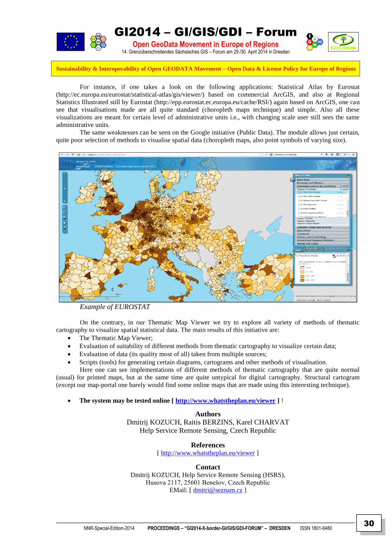
For instance, if one takes a look on the following applications: Statistical Atlas by Eurostat
(http://ec.europa.eu/eurostat/statistical-atlas/gis/viewer/) based on commercial ArcGIS, and also at Regional
Statistics Illustrated still by Eurostat (http://epp.eurostat.ec.europa.eu/cache/RSI/) again based on ArcGIS, one can
see that visualisations made are all quite standard (choropleth maps technique) and simple. Also all these
visualizations are meant for certain level of administrative units i.e., with changing scale user still sees the same
administrative units.
The same weaknesses can be seen on the Google initiative (Public Data). The module allows just certain,
quite poor selection of methods to visualise spatial data (choropleth maps, also point symbols of varying size).
Example of EUROSTAT
On the contrary, in our Thematic Map Viewer we try to explore all variety of methods of thematic
cartography to visualize spatial statistical data. The main results of this initiative are:
The Thematic Map Viewer;
Evaluation of suitability of different methods from thematic cartography to visualize certain data;
Evaluation of data (its quality most of all) taken from multiple sources;
Scripts (tools) for generating certain diagrams, cartograms and other methods of visualisation.
Here one can see implementations of different methods of thematic cartography that are quite normal
(usual) for printed maps, but at the same time are quite untypical for digital cartography. Structural cartogram
(except our map-portal one barely would find some online maps that are made using this interesting technique).
The system may be tested online [ http://www.whatstheplan.eu/viewer ] !
Authors
Dmitrij KOZUCH, Raitis BERZINS, Karel CHARVAT
Help Service Remote Sensing, Czech Republic
References
[ http://www.whatstheplan.eu/viewer ]
Contact Dmitrij KOZUCH, Help Service Remote Sensing (HSRS),
Husova 2117, 25601 Benešov, Czech Republic
EMail: [ [email protected] ]

GI2014 – GI/GIS/GDI – Forum
Open GeoData Movement in Europe of Regions 14. Grenzüberschreitendes Sächsisches GIS – Forum am 29./30. April 2014 in Dresden
Sustainability & Interoperability of Open GEODATA Movement – Open Data & License Policy for Europe of Regions
NNR-Special-Edition-2014 PROCEEDINGS – “GI2014-X-border-GI/GIS/GDI-FORUM” – DRESDEN ISSN 1801-6480
31
Example of EUROSTAT
Example of Google
Plan4business maps

GI2014 – GI/GIS/GDI – Forum
Open GeoData Movement in Europe of Regions 14. Grenzüberschreitendes Sächsisches GIS – Forum am 29./30. April 2014 in Dresden
Sustainability & Interoperability of Open GEODATA Movement – Open Data & License Policy for Europe of Regions
NNR-Special-Edition-2014 PROCEEDINGS – “GI2014-X-border-GI/GIS/GDI-FORUM” – DRESDEN ISSN 1801-6480
32
Plan4business maps
3D symbols
Segmented diagram

GI2014 – GI/GIS/GDI – Forum
Open GeoData Movement in Europe of Regions 14. Grenzüberschreitendes Sächsisches GIS – Forum am 29./30. April 2014 in Dresden
Sustainability & Interoperability of Open GEODATA Movement – Open Data & License Policy for Europe of Regions
NNR-Special-Edition-2014 PROCEEDINGS – “GI2014-X-border-GI/GIS/GDI-FORUM” – DRESDEN ISSN 1801-6480
33
Segmented diagram Structural diagram
Structural diagram
Structural diagram

GI2014 – GI/GIS/GDI – Forum
Open GeoData Movement in Europe of Regions 14. Grenzüberschreitendes Sächsisches GIS – Forum am 29./30. April 2014 in Dresden
Sustainability & Interoperability of Open GEODATA Movement – Open Data & License Policy for Europe of Regions
NNR-Special-Edition-2014 PROCEEDINGS – “GI2014-X-border-GI/GIS/GDI-FORUM” – DRESDEN ISSN 1801-6480
34
THE OISSACH CLUB
THE BRIDGE FOR ICT IN AGRICULTURE BETWEEN DEVELOPED AND
DEVELOPING COUNTRIES
WALTER H. MAYER & KAREL CHARVAT
PROGIS, VILLACH (AT) & CCSS, PRAHA (CZ)
ABSTRACT
The “Club of Ossiach”, a group of agriculturists, agribusiness managers, agriculture technologists and
agricultural ICT specialists from around the world, met at Ossiach between 17-19 June 2013 at the
“AgriFuture Days” Conference. They reviewed current trends and possible discontinuities resulting
from political, social, environmental and technological changes, potentially impacting on the future of
agriculture, farming, rural viability, food and nutrition worldwide.
This Presentation describes:
The Recognition of the “OISSACH” Club
The Focus on ICT and Keypoints of its Adoption in Agriculture
The Technologies recognized by the “OISSACH” Club
The Priorities of ICT Adoption for Future Agriculture Communities
The Business Model
The Charter Members
Authors Dipl.-Ing. Walter H. MAYER
CEO of ROGIS GmbH, Villach (AT)
Dr. Karel CHARVAT
EU Project Manager of HSRS, Benesov (CZ)
Contact Club of Ossiach”, Postgasse 6,
A-9500 Villach
Email [ [email protected] | [email protected] ]

GI2014 – GI/GIS/GDI – Forum
Open GeoData Movement in Europe of Regions 14. Grenzüberschreitendes Sächsisches GIS – Forum am 29./30. April 2014 in Dresden
Sustainability & Interoperability of Open GEODATA Movement – Open Data & License Policy for Europe of Regions
NNR-Special-Edition-2014 PROCEEDINGS – “GI2014-X-border-GI/GIS/GDI-FORUM” – DRESDEN ISSN 1801-6480
35
SUMMARY
OSSIACH – DECLARATION ON THE UPTAKE OF ICT FOR
AGRICULTURE, FORESTRY, RURAL VIABILITY AND ENVIRONMENTAL
MANAGEMENT
Dipl.Ing. Walter H. MAYER
CEO of PROGIS GmbH, Italienerstr. 3, A-9500 VILLACH
The “Club of Ossiach”, a group of agriculturists, agribusiness managers, agriculture technologists and
agricultural ICT specialists from around the world, met at Ossiach between 17-19 June 2013 at the
“AgriFuture Days” Conference. They reviewed current trends and possible discontinuities resulting
from political, social, environmental and technological changes, potentially impacting on the future of
agriculture, farming, rural viability, food and nutrition worldwide.
1. The Club of Ossiach recognized that:
Almost a third of the world’s population is vulnerable to poverty and malnutrition, respectively is
marginal in its current food and nutritional security, has concerns of its food safety and reliability
of its supply.
The resource poor small holder farmers of the world are the poorest and the bottom of the heap of
the hungry.
The world today faces severe environmental changes and damages. In addition it cannot continue
to exploit natural resources in the current unsustainable manner.
Information and Communication Technologies (ICTs), nanotechnology, biotechnology, materials
and space technology among many other technological innovations, individually and jointly, are
essentially unsynchronized. This negatively influences human progress and development including
agriculture, food security and rural viability. We have to create a bio-based economy (accepting the
sustainability rules of nature) transforming industry, business and services.
The potential to feed the world, to use natural resources and safeguard the environment depends on
judicious change and use of technology.
However, the poorest of the world not only suffer the most but may miss from benefitting from this
economic and technological transformation.
2. The Club of Ossiach focus on ICTs identified the following key points in adoption of ICT in
agriculture
• Agricultural contribution to rural communities is not limited to agrotechnology and production
efficiencies. To a large extent it is the result of ICT innovations and their implementation.
• ICT adoption for agriculture impacts on rural community sustainability and an unlimited variety of
roducts, economic benefits, technical improvements and social enhancement. ICT will be most
effective as an incentive and agent of change when used at points of stakeholder cooperation.
Stakeholders can be expected to be a major motivating factor for adopting ICT supported
agricultural production and rural sustainability.
• Stakeholders participation in ICT development and implementation of innovative initiatives must
include farmers, extension, scientists, agricultural and social services, students, rural residents and
sector supporting entities. This “Bottom-Up” inclusion complements the now conventional “Top-
Down” model.

GI2014 – GI/GIS/GDI – Forum
Open GeoData Movement in Europe of Regions 14. Grenzüberschreitendes Sächsisches GIS – Forum am 29./30. April 2014 in Dresden
Sustainability & Interoperability of Open GEODATA Movement – Open Data & License Policy for Europe of Regions
NNR-Special-Edition-2014 PROCEEDINGS – “GI2014-X-border-GI/GIS/GDI-FORUM” – DRESDEN ISSN 1801-6480
36
3. The Club of Ossiach, recognized that these technologies:
Create promising choices including the change of the nature of information. This will make it
easier to distribute, share and utilize data, information and knowledge.
Contribute to implementation of opportunities, addressing discontinuities and new options;
Are most effectual as a means of change when effectively integrated at the points of collaboration
between the various stakeholders. They enhance development by introducing new elements of
flexibility in production, development of innovations and facilitating their implementation.
Dictate caution and care in access and use of ICT supported knowledge especially during
introductory stages. The knowledge must be focused on people, sustainability, equity, welfare and
“happiness”. “Sustainability” in this context must be understood as furthering economical
development, lifelong learning, social justice and environmental integrity.
ICT produces ruptures through creative technological breakthroughs: from “constructive
destruction to destructive construction”. It enables the transformation of concurrent practices driven
by tradition, ulterior external interests and obsolete technologies. ICT can support individuals in
motivating, integrating and sustaining change in communities. With this understanding ICT will
contribute to create choices and processes of change especially through partnerships and co-
leadership.
The Club of Ossiach recognized further that by creative cooperation sustainable and responsible
agriculture can be attained. This will demonstrate the feasibility of future evolution of Earth’s
ecosystems. They will enhance health and well-being globally inaddition to attaining more
effective distribution of the food produced and minimizing food waste.
The Club of Ossiach considered it as a responsibility to pursue technological change within
agriculture.
4. Recommended/expected ICT Adoption priorities and their potential benefits for
future agricultural communities:
• Innovation adoption
• Know-how transfer
• Technology integration
• New business models
• Stimulating innovations – technical, environmental, social and more.....
• Cooperation at the various production and social levels
• Universal benefit for all chain members
• Support a “European Innovation Partnership (EIP): Agricultural Productivity and
• Sustainability” initiative.
The Club of Ossiach will meet regularly, to jointly consider the future of agriculture, farming, food and
nutrition and rural viability. The meetings will include documenting the process, its progress and regular
publication of its findings.
5. A possible business-model
A new business model for a country-wide Agro-ICT-adoption was introduced and reviewed at the
conference. The model was titled an “Agro-ICT-Infrastructure concept”. It is designed to be initiated by
the government or a public-private consortium within a country. It will collate and integrate basic data
like ortho-images, agro-meteorological data and ICT-technologies accessible to the country’s agro-
community. This community will include farmers, smallholders, their suppliers, customers, advisors,
supporting science, education bodies and other public authorities. They all represent the food-, feed-,
biomass- or log-production chain and are linked together with applications supporting their information
needs.
GI2014 – GI/GIS/GDI – Forum
Open GeoData Movement in Europe of Regions 14. Grenzüberschreitendes Sächsisches GIS – Forum am 29./30. April 2014 in Dresden
Sustainability & Interoperability of Open GEODATA Movement – Open Data & License Policy for Europe of Regions
NNR-Special-Edition-2014 PROCEEDINGS – “GI2014-X-border-GI/GIS/GDI-FORUM” – DRESDEN ISSN 1801-6480
37
For more information and comments please contact
“Club of Ossiach”, Postgasse 6, A-9500 Villach
Charter Members
Robin Bourgeois Senior Foresight and Development Policies Expert, Secretariat
of the Global Forum on Agricultural Research (GFAR c/o FAO- #RD),Italy;
Ajit Maru Senior Officer Secretariat of the Global Forum on Agricultural
Research (GFAR c/o FAO) Italy,
Karel Charvat, Project Manager of Help Service Remote Sensing s.r.o.,
WirelessInfo Czech Centre for Science and Society, Czech Republic and CEO
of Baltic Open Solution Centre Latvia and former EFITA president;
Ehud Gelb Samuel Neaman Institute for National Policy Research,Hebrew
University, Center for Agricultural Economic Research, Israel;
Dieter Ott, Bundesverband der Deutschen Maschinenringe (BMR), Germany;
Markus F. Hofreither, University of Natural Resources and Life Sciences,
Institute for Sustainable Economic Development, Austria;
Kyandoghere Kyamakya,Smart System Technologies-Transportation Informatics,
Alpen Adria University, Austria;
Alphons Claessens, NIT Holding – Limited, Netherland;
Alfred Pitterle, University of Natural Resources and Life Sciences Institute of
Silviculture and CEO of ForCert GmbH, Vienna, Austria;
Walter Mayer,Chief Executive Officer, PROGIS Software GmbH, Villach, Austria

GI2014 – GI/GIS/GDI – Forum
Open GeoData Movement in Europe of Regions 14. Grenzüberschreitendes Sächsisches GIS – Forum am 29./30. April 2014 in Dresden
Sustainability & Interoperability of Open GEODATA Movement – Open Data & License Policy for Europe of Regions
NNR-Special-Edition-2014 PROCEEDINGS – “GI2014-X-border-GI/GIS/GDI-FORUM” – DRESDEN ISSN 1801-6480
38
WEBBASIERTE INTEGRIERTE DATEN FÜR
BIM-LEVEL 3
Klaus SCHILLER
Konrad-ZUSE-Preisträger
CEO – Dynamische Baudaten – Dresden (DBD)
ABSTRACT
Keywords: Bauteilgefüge, BIM-Klassifikation, BIM-Level3, Daten, DIN 91400, IFC-Datenaustausch,
Integration, Semantic web, Standard Leistungsbuch Bau (STLB)
Content:
Webbasierte integrierte Daten für BIM-Level 3
Das Wesen von BIM ist das räumliche Bauteilgefüge. Es wird über den IFC Datenaustausch
transportiert. Sein Mehrwert aber steigt in dem Maße, wie die Bauteileigenschaften vom Inhalt
her gleichgesinnt klassifiziert sind. Die BIM-Klassifikation nach STLB-Bau - DIN SPEC
91400 und ihre semantische Verknüpfung mit webbasierten, integrierten Daten ist der Weg zu
BIM-Level 3.
Author
Dr. habil. Klaus Schiller Vorsitzender der Geschäftsführung der Dr. Schiller & Partner GmbH
Dynamische Baudaten (DBD)
References
[ http://www.DBD-Online.de ]
[ http://www.KostenKalkuel.de ]
Contact
Dr. Schiller & Partner GmbH
Liebigstr. 3, D – 01069 Dresden
Tel. +49-351-436.5960
Email: [ mailto:[email protected] ]

GI2014 – GI/GIS/GDI – Forum
Open GeoData Movement in Europe of Regions 14. Grenzüberschreitendes Sächsisches GIS – Forum am 29./30. April 2014 in Dresden
Sustainability & Interoperability of Open GEODATA Movement – Open Data & License Policy for Europe of Regions
NNR-Special-Edition-2014 PROCEEDINGS – “GI2014-X-border-GI/GIS/GDI-FORUM” – DRESDEN ISSN 1801-6480
39
The Open BIM Standard Landscape

GI2014 – GI/GIS/GDI – Forum
Open GeoData Movement in Europe of Regions 14. Grenzüberschreitendes Sächsisches GIS – Forum am 29./30. April 2014 in Dresden
Sustainability & Interoperability of Open GEODATA Movement – Open Data & License Policy for Europe of Regions
NNR-Special-Edition-2014 PROCEEDINGS – “GI2014-X-border-GI/GIS/GDI-FORUM” – DRESDEN ISSN 1801-6480
40
DIN SPEC 91400 – From 3D BIM to 7D BIM

GI2014 – GI/GIS/GDI – Forum
Open GeoData Movement in Europe of Regions 14. Grenzüberschreitendes Sächsisches GIS – Forum am 29./30. April 2014 in Dresden
Sustainability & Interoperability of Open GEODATA Movement – Open Data & License Policy for Europe of Regions
NNR-Special-Edition-2014 PROCEEDINGS – “GI2014-X-border-GI/GIS/GDI-FORUM” – DRESDEN ISSN 1801-6480
41
SUMMARY
BIM – Building Information Management – LEVELS (1)
Translated by Dr. G. Faschingbauer – BIM-Produktmanager @ f:data GmbH
Level 0
CAD ohne Management, 2D, papierbasierter (auch „elektronisches Papier“) Datenaustausch
Level 1
CAD mit Management, 2D oder 3D mit Einsatz eines Kollaborationswerkzeugs (gemeinsame Datenumgebung),
„standardisierter“ Ansatz bzgl. Datenstruktur und Format. Kostendaten werden durch separate Software behandelt
- ohne Integration.
Level 2
3D-Umgebung mit Management. Datenhaltung in fachspezifischen BIM Tools mit angehängten Daten (z.B.
COBIE). Kostendaten werden mit ERP (Enterprise resource planning) Software bearbeitet und über proprietäre
Schnittstellen oder abgestimmte Middleware integriert. Dieser BIM Level kann 4D Bauprozesse und/oder 5D
Kosteninformation behandeln.
Level 3
Voll integrierter und kollaborativer Prozess, realisiert durch Webservices und konform mit den IFC Standards.
Dieser BIM Level macht Informationen zu 4D Bauprozessen, 5D Kosteninformationen und 6D Projekt-
Lebenszyklus-Management nutzbar.
(1)
Quelle (BEW & RICHARDS, 2008): [ http://www.out-law.com/en/topics/projects--construction/projects-and-procurement/building-information-modelling/ ]

GI2014 – GI/GIS/GDI – Forum
Open GeoData Movement in Europe of Regions 14. Grenzüberschreitendes Sächsisches GIS – Forum am 29./30. April 2014 in Dresden
Sustainability & Interoperability of Open GEODATA Movement – Open Data & License Policy for Europe of Regions
NNR-Special-Edition-2014 PROCEEDINGS – “GI2014-X-border-GI/GIS/GDI-FORUM” – DRESDEN ISSN 1801-6480
42
About the „Dr. Schiller & Partner GmbH“ Company and its integrated Information & Calculation Products
Dynamische Bau Daten (DBD)
Die Dr. Schiller & Partner GmbH liefert DATEN für das Bauwesen von der Kostenschätzung bis zur betrieblichen Kalkulation. Dies nennen wir die durchgängige Informationsvernetzung für das Bauwesen.
Über offene Schnittstellen, zur Zeit für Windows und über XML, bieten wir allen Interessierten, vor allem Softwarehäusern, die Programme für Kostenermittlung, AVA oder baubetriebliche Kalkulation entwickeln, die Möglichkeit, den Zugriff auf unsere Datenprodukte in deren Software zu integrieren und damit Gesamtlösungen von Programm und Daten anbieten zu können.
Wir verfolgen damit das Ziel, den Standard für BauDaten im deutschen Bauwesen zu etablieren. Standard heißt nicht Eintönigkeit. Über die spezielle Technologie der Codierung von Daten, die wir Dynamische BauDaten nennen, ist es uns möglich, die ganze Vielfalt der im Bauwesen verlangten Daten mit einem darstellbaren Aufwand abzubilden.
Ziel aller Aktivitäten ist eine verbesserte Kommunikation unter den am Bau Beteiligten:
Vollständige und eindeutige Leistungsbeschreibungen zur Vermeidung unerwünschter Missverständnisse, die Zeit und Geld kosten.
Aussagekräftige und vergleichbare Kostendaten für Bauherren und Architekten.
Unterstützung in der Angebotskalkulation durch automatische Ermittlung der Einzelkosten der Teilleistungen.
Vernetzung aller Inhalte mit anderen Informationsanbietern, wie dem DIN und Fachverlagen für das Bauwesen.
Alle Produkte firmieren unter dem Markennamen [ Dynamische BauDaten ] (DBD).
Gegründet wurde das Unternehmen im Jahre 1991. Es gehört zu 100 % den vier Gesellschaftern und Geschäftsführern Dr. Klaus Schiller (Vorsitzender der GF), Dipl. Ing. Martin Hubert, Dipl.-Ing. Hans-Peter Finke und Dipl.-Ing. Maik Wachter.
Als Meilenstein in der Unternehmensgeschichte wurde im Jahr 1995 das damalige Produkt DBD-Texte in der Ausschreibung des GAEB zum fachlichen Sieger bestimmt. In der Folge entsteht hieraus das Produkt [ STLB-Bau ], dessen Inhalte vom GAEB aufgestellt werden, das vom DIN herausgegeben wird und von Dr. Schiller & Partner GmbH datentechnisch realisiert wird.
In den Jahren 1996-1998 entstehen die neuen Produkte [ DBD-Baupreise | DBD-Bauteile und DBD-Kalkulationsansätze ] die alle über die DBD-Codierung mit dem [ STLB-Bau ] verknüpft sind und welche die Idee der durchgängigen Informationsvernetzung zur Realität machen.
Die nächste Innovation wurde im Herbst 2000 präsentiert: Die ersten online - fähigen [ Daten für das Bauwesen ].
Seit 2005 werden alle Produkte ausschließlich auf Basis modernster XML Technologie erstellt. Damit wird die Oberflächengestaltung und die Bedienbarkeit der Produkte auf eine neue, langfristig zukunftsweisende Qualitätsstufe angehoben.
Die rund 20 Mitarbeiter von Dr. Schiller & Partner GmbH arbeiten hauptsächlich in den Bereichen Textredaktion und Produktentwicklung/Produktpflege an den Standorten Dresden und Clingen (Thüringen). Darüber hinaus gibt es einen Vertriebsstützpunkt als Verbindungsstelle zu den Softwarehäusern im Raum Düsseldorf.
Firmensitz: Dr. Schiller & Partner GmbH, Liebigstraße 3, D - 01069 Dresden Tel.: 0351-436 59 60 | Fax.: 0351-436 59 61

GI2014 – GI/GIS/GDI – Forum
Open GeoData Movement in Europe of Regions 14. Grenzüberschreitendes Sächsisches GIS – Forum am 29./30. April 2014 in Dresden
Sustainability & Interoperability of Open GEODATA Movement – Open Data & License Policy for Europe of Regions
NNR-Special-Edition-2014 PROCEEDINGS – “GI2014-X-border-GI/GIS/GDI-FORUM” – DRESDEN ISSN 1801-6480
43
LAYMAN – THE LAYER MANAGER
UPLOAD, PUBLISH AND SECURE YOUR
GEODATA EASILY
Michal SREDL, Karel CHARVAT
Czech Centre for Science and Society, Prague, Czech Republic
ABSTRACT
Keywords: Geodata publishing, INSPIRE, GEOSS
Content:
When geodata goes public, several steps are needed: Upload the data to the server, import the data into
the database, publish the data through some kind of map server, and, if needed, configure the access
rights so only the users with the proper priviliies can display the data. LayMan - the Layer Manager -
sorts it out for you.
LayMan offers a single entry point into the Filesystem, PostGIS database and GeoServer:
Fig.1: LayMan Web GUI
On the left side, files in the user directory are shown. In the middle, there are tables and views with data
that has been already imported into the database. On the right side are the layers that have been already
published with GeoServer.
The files belong solely to the user that is logged-in. Data and layers are common for the whole group
they have been published to and can be manipulated by any member of the group. The user sees the data
and layers of every group he/she is a member of.
Data can be published either from the uploaded files, or from the tables or views already present in the
database. Various parameters of a layer can be set, with access control being of a special interest:

GI2014 – GI/GIS/GDI – Forum
Open GeoData Movement in Europe of Regions 14. Grenzüberschreitendes Sächsisches GIS – Forum am 29./30. April 2014 in Dresden
Sustainability & Interoperability of Open GEODATA Movement – Open Data & License Policy for Europe of Regions
NNR-Special-Edition-2014 PROCEEDINGS – “GI2014-X-border-GI/GIS/GDI-FORUM” – DRESDEN ISSN 1801-6480
44
While manipulation with the published layer (write access) is limited to the members of the group that
layer is published to, the read access (showing the layer in a map) can be granted to any other group.
Users and groups are managed within the Liferay portal which encapsulates the whole system.
Once published, the layers can be styled with OpenGeo Styler:
Fig.2: Publishing with Layman
Fig.3: Styler

GI2014 – GI/GIS/GDI – Forum
Open GeoData Movement in Europe of Regions 14. Grenzüberschreitendes Sächsisches GIS – Forum am 29./30. April 2014 in Dresden
Sustainability & Interoperability of Open GEODATA Movement – Open Data & License Policy for Europe of Regions
NNR-Special-Edition-2014 PROCEEDINGS – “GI2014-X-border-GI/GIS/GDI-FORUM” – DRESDEN ISSN 1801-6480
45
And, of course, finally the layers can be shown on the map:
Fig. 4: Map visualization
Authors
Michal SREDL & Karel CHARVAT
Czech Centre for Science and Society
References
http://erra.ccss.cz/
www.whatstheplan.eu
Contact
Michal SREDL, Czech Centre for Science and Socity,
Radlicka 28, 150 00 Pragha 5, Czech Republic

GI2014 – GI/GIS/GDI – Forum
Open GeoData Movement in Europe of Regions 14. Grenzüberschreitendes Sächsisches GIS – Forum am 29./30. April 2014 in Dresden
Sustainability & Interoperability of Open GEODATA Movement – Open Data & License Policy for Europe of Regions
NNR-Special-Edition-2014 PROCEEDINGS – “GI2014-X-border-GI/GIS/GDI-FORUM” – DRESDEN ISSN 1801-6480
46
ERRA PPRD EAST
ELECTRONIC REGIONAL RISK ATLAS SOLUTION FOR ENVIRONMENTAL RISK MANAGEMENT IN EASTERN PARTNERSHIP
Premysl Vohnout CCSS – Czech Centre for Science and Society, Prague
ABSTRACT
Keywords: civil protection, geoportal, geodata, geospatial services, east europe
Content: CCSS develops and put into operation Electronic Regional Risk Atlas (ERRA). The ERRA is
one of the main outputs of the PPRD East project in the ENPI* East Region.
PPRD East is an EU-funded project aiming to support countries in the ENPI East Region,
including Armenia, Azerbaijan, Belarus, Georgia, Moldova and Ukraine.
The overall objectives of the PPRD East Programme are to contribute to the development of the
Partner Countries Civil protection capacities for disaster prevention, preparedness and response and to
bring the Partner Countries progressively closer to the EU Civil Protection Mechanism and improve
cooperation among them.
The ERRA is geoportal based on open standards, enabling the user to search, view, download
and analyse risk maps and other geodata from the ENPI East Region. It will serve as a tool for disaster
managers, operators of crisis management centres, risk assessment specialists, researchers and others.
ERRA system is based on six regional and one central portal. Every regional portal is running directly in
civil protection departments of relevant ministry. Operators create, prepare and publish geodata using
portal and ERRA external modules.
ERRA consists of:
Web interface – web based portal created using modern technologies (html5, responsive design). This interface is mainly used for publishing geodata to OGC OWS (WMS, WFS) using LayMan.
LayMan - Geospatial data are often published using MapServer or GeoServer. Vector data are often imported into PostGIS before being published. LayMan (Layer Manager) does it both for you and offers a web GUI. Meanwhile, the published layers can be secured, so only the users with appropriate rights can display them.
Mobile client - Android based client for mobile devices (smart phones, tablets) can collect point data directly in terrain. Desired attributes together with taken picture of object are sent over internet connections (GSM, WiFi, etc.) to server receiver. The collected points are added to map on the portal.
Compotte (Offline client) – qgis (python based open source desktop GIS application) external module for downloading map compositions created using web based portal through WFS API.. Downloaded layers are styled like on the portal and can be used for further analyses without internet connection.
Analysis engine – javascript based tool used for selecting features according to position or attribute
Flood module – application used for modelling flood model for specific areas.
Authors
Dipl. Ing. Premysl VOHNOUT, Dr. Stepan KAFKA, M.S. Michal SREDL,
M.S. Jan BOJKO, Dipl. Ing. Michal KEPKA, Dr. Karel CHARVAT [ all CCSS ]
Radovan HILBERT [ Eptisa ]
References
[ http://erra.pprd-east.eu | http://euroeastcp.eu ]
Contact Premysl Vohnout, Radlicka 28, 150 00 Prague. Czech republic
EMail: [ vohnout (æ) ccss.cz ]

GI2014 – GI/GIS/GDI – Forum
Open GeoData Movement in Europe of Regions 14. Grenzüberschreitendes Sächsisches GIS – Forum am 29./30. April 2014 in Dresden
Sustainability & Interoperability of Open GEODATA Movement – Open Data & License Policy for Europe of Regions
NNR-Special-Edition-2014 PROCEEDINGS – “GI2014-X-border-GI/GIS/GDI-FORUM” – DRESDEN ISSN 1801-6480
47
DIE FREIE LIZENZIERUNG VON
GEODATEN
Falk ZSCHEILE Chemnitz/Grüna
ABSTRACT <> KEYNOTE
Keywords: Datenbank, Datenbanklizenz, Datennutzung,, Lizenz, Metadata, ODBL, OpenStreetMap,
OSM, Open Data, Open Government Data, E-Government, Datenlizenz Deutschland, Geolizenz,
GeoNutzV
Content: Durch die preiswerte Verfügbarkeit der Satellitennavigation (z. B. GPS), auch für den Verbraucher,
haben Geodaten in den letzten 10 Jahren eine beeindruckende Erfolgsgeschichte geschrieben. Sie sind
aus dem alltäglichen Leben nicht mehr wegzudenken. Der wirtschaftliche Wert ist enorm und die Verwendungsmöglichkeiten solcher Daten besonders
vielseitig. Diese Entwicklung wurde flankiert durch Richtlinien der Europäischen Union (INSPIRE,
PSI), den Erfolg des Open Source Gedankens, der Informationsfreiheitsgesetzgebung und schließlich
der Umgestaltung der Verwaltung im Sinne von Open Government. Im Bereich der Geodaten zeigen sich die Bemühungen um mehr freie Geodaten anhand von
verschiedenen (mehr oder weniger) offenen Lizenzen. Der Bund bietet nach der Novelle des
Geodatenzugangsgesetzes die Möglichkeit, Geodaten unter der Geodatennutzungsverordnung
(GeoNutzV) bereitzustellen. Es gibt die „Geolizenz“ der GIW-Kommission in acht Varianten, die vom
Bundesinnenministerium entwickelte „Datenlizenz Deutschland“ (kommerziell/nicht kommerziell) und
schließlich die „Open Database License“ von Open Data Commons. Wer mit Geodaten arbeiten möchte, kommt nicht umhin, sich mit den zugrundeliegenden
Nutzungsbedingungen auseinanderzusetzen. Die Motive der verschiedenen Lizenzen wirken sich auf die Freiheit zur Benutzung der (Geo-)Daten
aus. Die hierbei besonders wichtigen Regelungen (im Sinne freier Daten) werden abschließend
hervorgehoben und bewertet.
Author
Falk ZSCHEILE
OpenStreetMap
References
[ http://www.pirschkarte.de]
Contact
FALK ZSCHEILE, AUGUST-BEBEL-STRAßE 4, 09224 GRÜNA. GERMANY
MOBILE: +49-178-1662674
EMAIL: [FALK.ZSCHEILE (AT) GMAIL.COM]

GI2014 – GI/GIS/GDI – Forum
Open GeoData Movement in Europe of Regions 14. Grenzüberschreitendes Sächsisches GIS – Forum am 29./30. April 2014 in Dresden
Sustainability & Interoperability of Open GEODATA Movement – Open Data & License Policy for Europe of Regions
NNR-Special-Edition-2014 PROCEEDINGS – “GI2014-X-border-GI/GIS/GDI-FORUM” – DRESDEN ISSN 1801-6480
48
SUMMARY
1 Einleitung
Geodaten sind für eine Vielzahl von Anwendungen nützlich, wenn nicht sogar notwendig. Mit
der preiswerten Verfügbarkeit von GPS-Chips in Mobiltelefonen und anderen Geräten ist auch
der Bedarf nach Geodaten kontinuierlich gestiegen. Zu Beginn dieser Entwicklung hatten die
Landesvermessungsämter und einige große international operierende Firmen ein Monopol in
diesem Bereich. Doch der „Open Source“-Gedanke hat auch bei den Geodaten Anhänger
gefunden. Hinzu kam in jüngster Zeit die Hinwendung des Staates zum Gedanken von Open
Government und in dessen Fahrwasser auch die Verfügbarkeit von Open Government Data. So
finden sich heute nicht nur staatliche und private Geodaten, die gekauft werden müssen,
sondern auch in zunehmendem Maße freie bzw. offene Geodaten, die jedermann nutzen kann.
Aufgrund rechtlicher und gesellschaftlicher Rahmenbedingungen gibt es aber nicht die freien
oder offenen Geodaten, sondern viele verschiedene Versionen davon. Damit soll sich der
Beitrag im Folgenden näher auseinandersetzen.
2 Immaterialgüterrecht und freie Lizenzierung
Um die Vielzahl unterschiedlich lizenzierter offener Geodaten zu verstehen, ist zunächst ein
kurzer Blick auf die rechtlichen Grundlagen notwendig.
Wie die Begriffe Immaterialgüterrecht oder Geistiges Eigentum schon andeuten, bewegt man
sich bei Geodaten im Bereich der nicht greifbaren „Gegenstände“. Anders als ein Grundstück
oder ein Auto lassen sich Geodaten nur sehr schwer dinglich begreifen. Entsprechend spät hat
die Rechtsordnung in diesem Bereich angefangen, einzelnen Personen Rechte an diesen
virtuellen Gütern zuzuordnen. Es handelt sich hier um die Zuordnung eines Ausschließlich-
keitsrechts zu einer Person, die sich um das immaterielle Gut besonders „verdient“ gemacht
hat. Im Urheberrecht ist es der Werkschöpfer, im Patentrecht der Erfinder. Dieser
Rechtezuordnung können Gerechtigkeits-, aber auch ökonomische Gesichtspunkte zugrunde
liegen. Sie werden nicht allgemein geregelt, sondern für jedes als schützenswert angesehene
Immaterialgut gesondert geregelt – anders als im Bürgerlichen Gesetzbuch, das für alle
körperlichen Dinge (Sachen) Regelungen trifft (Sachenrecht).
Bei Geodaten hat man es mit der Verknüpfung einer Sachinformation mit einer geografischen
Position zu tun. Dieser Fall der einzelnen geografischen Information wird von der
Rechtsordnung als nicht besonders schützenswert angesehen. Dies gilt ebenso für die meisten
anderen Informationen. Informationen werden ohne besonderen Grund von der Rechts-ordnung
nicht geschützt. Entsprechend fehlt es an einer gesonderten Regelung für den Schutz von
einzelnen Geodaten. Demgegenüber besteht für die Sammlung von von Informationen als
Daten in einer Datenbank, also auch für geografische Daten, ein Schutzrecht zu Gunsten des
Datenbankherstellers, vgl. §§ 87a ff. UrhG. Der Datenbankhersteller wird vom Recht mit dieser
Rechtsposition ausgestattet, weil die zur Erstellung von Datenbanken notwendigen
Investitionen als schutzwürdig angesehen werden. Der Datenbankhersteller kann andere in
einem gewissen Rahmen von der Nutzung ausschließen oder die Nutzung von seinen
Bedingungen, also in der Regel von der Entrichtung einer Lizenzgebühr, abhängig machen.
Dieses Prinzip würde im virtuellen Bereich in vielen Fällen aber auch ohne gesetzliche
Regelung funktionieren.

GI2014 – GI/GIS/GDI – Forum
Open GeoData Movement in Europe of Regions 14. Grenzüberschreitendes Sächsisches GIS – Forum am 29./30. April 2014 in Dresden
Sustainability & Interoperability of Open GEODATA Movement – Open Data & License Policy for Europe of Regions
NNR-Special-Edition-2014 PROCEEDINGS – “GI2014-X-border-GI/GIS/GDI-FORUM” – DRESDEN ISSN 1801-6480
49
Die Informationstechnologie hält Möglichkeiten bereit, anderen nur Zugang zum virtuellen Gut
zu gewähren, wenn diese vorher die entsprechenden Vertrags- bzw. Lizenzbedingungen
akzeptieren. Entsprechende der Vielzahl von Anbietern können die Lizenzbedingungen jeweils
unterschiedlich ausgestaltet sein.
Bei den freien Daten trifft man nun auf ein entgegengesetztes Phänomen. Die Rechtsordnung
erlaubt den Ausschluss anderer von der Nutzung (Datenbankschutz). Im Bereich der freien
Daten möchte man aber gerade, dass alle Zugriff auf die Daten haben und diese nutzen können.
Darüber hinaus kann aber weiter das Ziel sein, dass man verhindern möchte, dass sich irgend
jemand anderes die Daten aneignet und nur noch unter seinen Bedingungen abgibt.
Entsprechend müssen also auch für freie Daten Regelungen (Lizenzvereinbarungen) getroffen
werden, die diese Freiheit der Daten auch bei der Weitergabe sichern. Auch hier sind eine
Vielzahl von Gestaltungsmöglichkeiten denkbar.
Besondere Relevanz gewinnt diese Frage bei der Weiterverarbeitung von freien Daten
beziehungsweise bei der Verbindung der freien Daten mit Daten, die einer proprietären Lizenz,
unterliegen. Wie ist das daraus resultierende Ergebnis zu lizenzieren? Gleiches gilt für die
Frage, falls die Lizenz eine Namensnennung der Datenquelle (Attribution) verlangt. Ist die
Namensnennung bei Verarbeitung und Verbindung fortzusetzen oder nicht?
Das alles sind keine rein akademischen Fragen, denn auch der Verstoß gegen freie Lizenzen
bedeutet in der Regel nicht, dass man mit den so lizenzierten Daten tun und lassen kann, was
man möchte. Lizenzverstöße können Abmahnungen, Unterlassungs- und unter Umständen
sogar Schadensersatzansprüche nach sich ziehen. Die Folgen für ein unter Lizenzverstoß
entstandenes Produkt können also weitreichend sein und den Verkauf des Produkts unmöglich
machen.
3 Freie Lizenzen für Geodaten
3.1 Geodaten nach dem GeoZG und der GeoNutzV
Keine echte Lizenz ist die Abgabe von Geodaten unter den Bedingungen des
Geodatenzugangsgesetzes (des Bundes), GeoZG, in Verbindung mit der Geodatennutzungs-
verordnung, GeoNutzV. Hierbei handelt es sich um die Freigabe von Geodaten als ein
öffentliches Gut. Diesem Regelungsregime unterfallen nur Geodaten des Bundes im Anwen-
dungsbereich des GeoZG. Der Zugang zu den Geodaten der einzelnen Ländern wird von diesen
durch eigene Gesetze geregelt. Die wenigsten Länder haben sich bisher für eine Freigabe als
Open Geo Data entschieden.
3.2 Lizenzen von Open Data Commons
Open Data Commons ist eine Arbeitsgruppe der Open Knowledge Foundation. Während sich
die Lizenzen von Creative Commons mit der freien Lizenzierung geistiger Schöpfungen,
insbesondere Urheberrecht, beschäftigen, haben die Lizenzen von Open Data Commons die
freie Lizenzierung von Daten im Allgemeinen zum Gegenstand.
Die Lizenzen sind also nicht auf Geodaten beschränkt, auch wenn die Open Database License
(ODbL) ihren derzeit prominentesten Anwendungsbereich in der Lizenzierung der Daten des

GI2014 – GI/GIS/GDI – Forum
Open GeoData Movement in Europe of Regions 14. Grenzüberschreitendes Sächsisches GIS – Forum am 29./30. April 2014 in Dresden
Sustainability & Interoperability of Open GEODATA Movement – Open Data & License Policy for Europe of Regions
NNR-Special-Edition-2014 PROCEEDINGS – “GI2014-X-border-GI/GIS/GDI-FORUM” – DRESDEN ISSN 1801-6480
50
OpenStreetMap-Projektes hat. Neben der ODbL mit den am weitesten gehenden
Anforderungen werden weitere Lizenzen zur Verfügung gestellt: die Attribution License (ODC-
By) und die Public Domain Dedication and License (PDDL).
3.3 Geolizenzen der GIW-Kommission
Die GIW-Kommission ist eine Kooperation zwischen dem Bundeswirtschaftsministerium und
Vertretern von Spitzenverbänden aus der Geoinformationswirtschaft. Ein wichtiges Ziel ist die
marktgerechte Bereitstellung von Geodaten. Eine Voraussetzung hierfür ist die möglichst
einheitliche und damit zueinander kompatible Lizenzierung von Geodaten. Dementsprechend
hat die GIW-Kommission ein Lizenzmodell entwickelt, dass in acht Varianten sowie einer
Open Data Variante (GeoLizenz V1.2.1 – Open) alle Anwendungsfälle im Marktbereich der
Geoinformationen abdecken soll.
3.4 GovData – Datenlizenz Deutschland
Bei GovData handelt es sich um das Open Government Data Portal, bei dem das
Bundesinnenministerium federführend ist. Ziel des Portals ist die Bereitstellung von
Verwaltungsdaten für Bürger und Wirtschaft. Die Lizenzierung der Daten erfolgt in zwei
Varianten:
„Datenlizenz Deutschland – Namensnennung – Version 1.0“ und
„Datenlizenz Deutschland – Namensnennung – nicht kommerziell – Version 1.0“.
Beide Lizenzen beziehen sich allgemein auf Daten, sind also keine spezifischen
Geodatenlizenzen. Dies schließt die Lizenzierung von Geodaten unter dieser Lizenz jedoch
nicht aus.
Die „Datenlizenz Deutschland – Namensnennung“ war, beziehungsweise ist starker Kritik von
Seiten der Open Knowledge Foundation ausgesetzt, wobei die Kritik insbesondere auf zwei
Punkte zielt. Zum einen wird die Verknüpfung von Daten mit Zunahme der Vielfalt bei den
Lizenzen immer schwieriger. Zum anderen gibt es Unklarheiten in der zulässigen
Weiterverarbeitung der Daten. Während die erstgenannte Kritik für alle Lizenzen
gleichermaßen gilt, also kein Problem der Datenlizenz Deutschland ist, so ist die zweite Kritik
ein Problem der Lizenz selbst, an dessen klarstellender Behebung gearbeitet wird.
3.5 Lizenzen von Creative Commons
Als die Open Data Bewegung an Bedeutung gewann, sah man bei Creative Commons kein
Bedürfnis für eine eigene Open Data Lizenz. Mittlerweile hat sich diese Auffassung etwas
gewandelt.
Die Creative Commons Attribution-ShareAlike Lizenz International (CC-BY-SA 4.0) enthält ab
Version 4.0 auch Regelungen für Open Data.
3.6 Public Domain
Public Domain ist die einzige freie Lizenzierung von (Geo-)Daten, die lizenzrechtlich
unproblematisch ist. Eine Bereitstellung von Daten unter Public Domain heißt
umgangssprachlich nichts anderes als: „Nimm die Daten und mache damit, was du willst.“ Es
sind also keine besonderen Regelungen bei Nutzung, Verarbeitung und Namensnennung zu
beachten.

GI2014 – GI/GIS/GDI – Forum
Open GeoData Movement in Europe of Regions 14. Grenzüberschreitendes Sächsisches GIS – Forum am 29./30. April 2014 in Dresden
Sustainability & Interoperability of Open GEODATA Movement – Open Data & License Policy for Europe of Regions
NNR-Special-Edition-2014 PROCEEDINGS – “GI2014-X-border-GI/GIS/GDI-FORUM” – DRESDEN ISSN 1801-6480
51
GGII22001133
AACCTTUUAALL
PPRREESSSS IINNFFOORRMMAATTIIOONN
(( AATTTTAACCHHMMEENNTTSS ))
Dresden 30. April 2014
IMPRIMATUR TO PRINT 25. April 2014
Copyright © 2014 – CCSS-Praha & IGN-Dresden – All rights reserved.

GI2014 – GI/GIS/GDI – Forum
Open GeoData Movement in Europe of Regions 14. Grenzüberschreitendes Sächsisches GIS – Forum am 29./30. April 2014 in Dresden
Sustainability & Interoperability of Open GEODATA Movement – Open Data & License Policy for Europe of Regions
NNR-Special-Edition-2014 PROCEEDINGS – “GI2014-X-border-GI/GIS/GDI-FORUM” – DRESDEN ISSN 1801-6480
52
RELATED PRESS & WEB INFORMATION ATTACHMENTS
TABLE OF CONTENTS
SEITE # PAGE:
53: The Budapest Open Science Access Initiative (14.02.2002)
55: Berlin Declaration on Open Access to Knowledge (22.10.2003)
58: EC COM (2011) 882 on Open DATA (12.12.2011)
59: GovData.de und not-your-govdata.de feiern Geburtstag (19.02.2014)
61: Gemeinsame Erklärung: Den Standard endlich auf “Offen” setzen ! (07.02.2013)
64: Interview: Kick the Data Secrecy Habit and Every One wins ((18.11.2013)
65: Report: Big and Open Data in Europe (29.01.2014)
66: A Chance to help shape the global Open Data Movement / The Open Data 500 (25.10.2013)
68: Big Data and Open Data – What’s what and why does it matter? (15.04.2014)
70: DECLARATION – A Citizens‘ Call to Action on Open Data (08.11.2013)
73: The Smart Open Data Project (17.03.2014)
75: Bundesrat verabschiedet Open Government Data-Strategie Schweiz (2014 – 2018)
76: EC Statement - Global Conference delivers Momentum for Reform of INTERNET (25.04.2014)
77: OPEN DATA COMMONS – Open Database License (ODbL) – ODC Attribution License
78: OPEN DATA COMMONS – Public Domain Dedication and Licence (PPDL)
82: ArcGIS OpenData.beta – Sharing,Using and Growing Data
UPDATE STATUS: 4/29/2014 PRINTED: 29 APRIL 2014

GI2014 – GI/GIS/GDI – Forum
Open GeoData Movement in Europe of Regions 14. Grenzüberschreitendes Sächsisches GIS – Forum am 29./30. April 2014 in Dresden
Sustainability & Interoperability of Open GEODATA Movement – Open Data & License Policy for Europe of Regions
NNR-Special-Edition-2014 PROCEEDINGS – “GI2014-X-border-GI/GIS/GDI-FORUM” – DRESDEN ISSN 1801-6480
53
WEB – INFORMATION – EU
The Budapest Open Science Access Initiative
[ http://www.budapestopenaccessinitiative.org/ ]
An old tradition and a new technology have converged to make possible an unprecedented
public good. The old tradition is the willingness of scientists and scholars to publish the
fruits of their research in scholarly journals without payment, for the sake of inquiry and
knowledge. The new technology is the internet. The public good they make possible is the
world-wide electronic distribution of the peer-reviewed journal literature and completely
free and unrestricted access to it by all scientists, scholars, teachers, students, and other
curious minds. Removing access barriers to this literature will accelerate research, enrich
education, share the learning of the rich with the poor and the poor with the rich, make
this literature as useful as it can be, and lay the foundation for uniting humanity in a
common intellectual conversation and quest for knowledge.
For various reasons, this kind of free and unrestricted online availability, which we will
call open access, has so far been limited to small portions of the journal literature. But
even in these limited collections, many different initiatives have shown that open access is
economically feasible, that it gives readers extraordinary power to find and make use of
relevant literature, and that it gives authors and their works vast and
measurable new visibility,readership, and impact. To secure these benefits for all, we call
on all interested institutions and individuals to help open up access to the rest of this
literature and remove the barriers, especially the price barriers, that stand in the way. The
more who join the effort to advance this cause, the sooner we will all enjoy the benefits of
open access.
The literature that should be freely accessible online is that which scholars give to the
world without expectation of payment. Primarily, this category encompasses their peer-
reviewed journal articles, but it also includes any unreviewed preprints that they might
wish to put online for comment or to alert colleagues to important research findings. There
are many degrees and kinds of wider and easier access to this literature. By "open access"
to this literature, we mean its free availability on the public internet, permitting any users
to read, download, copy, distribute, print, search, or link to the full texts of these articles,
crawl them for indexing, pass them as data to software, or use them for any other lawful
purpose, without financial, legal, or technical barriers other than those inseparable from
gaining access to the internet itself. The only constraint on reproduction and distribution,
and the only role for copyright in this domain, should be to give authors control over the
integrity of their work and the right to be properly acknowledged and cited.
While the peer-reviewed journal literature should be accessible online without cost to
readers, it is not costless to produce. However, experiments show that the overall costs of
providing open access to this literature are far lower than the costs of traditional forms of
dissemination. With such an opportunity to save money and expand the scope of
dissemination at the same time, there is today a strong incentive for professional
associations, universities, libraries, foundations, and others to embrace open access as a
means of advancing their missions. Achieving open access will require new cost recovery
models and financing mechanisms, but the significantly lower overall cost of dissemination
is a reason to be confident that the goal is attainable and not merely preferable or utopian.
To achieve open access to scholarly journal literature, we recommend two complementary
strategies:
GI2014 – GI/GIS/GDI – Forum
Open GeoData Movement in Europe of Regions 14. Grenzüberschreitendes Sächsisches GIS – Forum am 29./30. April 2014 in Dresden
Sustainability & Interoperability of Open GEODATA Movement – Open Data & License Policy for Europe of Regions
NNR-Special-Edition-2014 PROCEEDINGS – “GI2014-X-border-GI/GIS/GDI-FORUM” – DRESDEN ISSN 1801-6480
54
I. Self-Archiving: First, scholars need the tools and assistance to deposit their refereed
journal articles in open electronic archives, a practice commonly called, self-
archiving. When these archives conform to standards created by the Open Archives
Initiative, then search engines and other tools can treat the separate archives as one.
Users then need not know which archives exist or where they are located in order to find
and make use of their contents.
II. Open-access Journals: Second, scholars need the means to launch a new generation of
journals committed to open access, and to help existing journals that elect to make the
transition to open access. Because journal articles should be disseminated as widely as
possible, these new journals will no longer invoke copyright to restrict access to and use of
the material they publish. Instead they will use copyright and other tools to ensure
permanent open access to all the articles they publish. Because price is a barrier to access,
these new journals will not charge subscription or access fees, and will turn to other
methods for covering their expenses. There are many alternative sources of funds for this
purpose, including the foundations and governments that fund research, the universities
and laboratories that employ researchers, endowments set up by discipline or institution,
friends of the cause of open access, profits from the sale of add-ons to the basic texts,
funds freed up by the demise or cancellation of journals charging traditional subscription
or access fees, or even contributions from the researchers themselves. There is no need to
favor one of these solutions over the others for all disciplines or nations, and no need to
stop looking for other, creative alternatives.
Open access to peer-reviewed journal literature is the goal. Self-archiving (I.) and a new
generation of open-access journals (II.) are the ways to attain this goal. They are not
only direct and effective means to this end, they are within the reach of scholars
themselves, immediately, and need not wait on changes brought about by markets or
legislation. While we endorse the two strategies just outlined, we also encourage
experimentation with further ways to make the transition from the present methods of
dissemination to open access. Flexibility, experimentation, and adaptation to local
circumstances are the best ways to assure that progress in diverse settings will be rapid,
secure, and long-lived.
The Open Society Institute, the foundation network founded by philanthropist George
Soros, is committed to providing initial help and funding to realize this goal. It will use its
resources and influence to extend and promote institutional self-archiving, to launch new
open-access journals, and to help an open-access journal system become economically
self-sustaining. While the Open Society Institute's commitment and resources are
substantial, this initiative is very much in need of other organizations to lend their effort
and resources.
We invite governments, universities, libraries, journal editors, publishers, foundations,
learned societies, professional associations, and individual scholars who share our vision to
join us in the task of removing the barriers to open access and building a future in which
research and education in every part of the world are that much more free to flourish.
February 14, 2002
Budapest, Hungary
This work is licensed under a Creative Commons Attribution 3.0 License.

GI2014 – GI/GIS/GDI – Forum
Open GeoData Movement in Europe of Regions 14. Grenzüberschreitendes Sächsisches GIS – Forum am 29./30. April 2014 in Dresden
Sustainability & Interoperability of Open GEODATA Movement – Open Data & License Policy for Europe of Regions
NNR-Special-Edition-2014 PROCEEDINGS – “GI2014-X-border-GI/GIS/GDI-FORUM” – DRESDEN ISSN 1801-6480
55
WEB – INFORMATION – EU
Berlin Declaration on Open Access to
Knowledge in the Sciences and Humanities
SOURCE [ http://openaccess.mpg.de/3515/Berliner_Erklaerung/ ]
BERLINER ERKLÄRUNG
Die Berliner Erklärung über den offenen Zugang zu wissenschaftlichem
Wissen vom 22. Oktober 2003 wurde in englischer Sprache verfasst. Sie ist einer der Meilensteine der Open Access-Bewegung.
Der Wortlaut der englischen Version ist maßgebend.
Preface
The Internet has fundamentally changed the practical and economic realities of distributing scientific knowledge and cultural heritage. For the first time ever, the Internet now offers the chance to constitute a global
and interactive representation of human knowledge, including cultural heritage and the guarantee of worldwide access.
We, the undersigned, feel obliged to address the challenges of the Internet
as an emerging functional medium for distributing knowledge. Obviously, these developments will be able to significantly modify the nature of
scientific publishing as well as the existing system of quality assurance.
In accordance with the spirit of the Declaration of the Budapest Open Acess
Initiative, the ECHO Charter and the Bethesda Statement on Open Access Publishing, we have drafted the Berlin Declaration to promote the Internet
as a functional instrument for a global scientific knowledge base and human reflection and to specify measures which research policy makers, research
institutions, funding agencies, libraries, archives and museums need to consider.

GI2014 – GI/GIS/GDI – Forum
Open GeoData Movement in Europe of Regions 14. Grenzüberschreitendes Sächsisches GIS – Forum am 29./30. April 2014 in Dresden
Sustainability & Interoperability of Open GEODATA Movement – Open Data & License Policy for Europe of Regions
NNR-Special-Edition-2014 PROCEEDINGS – “GI2014-X-border-GI/GIS/GDI-FORUM” – DRESDEN ISSN 1801-6480
56
Goals
Our mission of disseminating knowledge is only half complete if the
information is not made widely and readily available to society. New possibilities of knowledge dissemination not only through the classical form
but also and increasingly through the open access paradigm via the Internet have to be supported. We define open access as a comprehensive
source of human knowledge and cultural heritage that has been approved by the scientific community.
In order to realize the vision of a global and accessible representation of
knowledge, the future Web has to be sustainable, interactive, and transparent. Content and software tools must be openly accessible and
compatible.
Definition of an Open Access Contribution
Establishing open access as a worthwhile procedure ideally requires the active commitment of each and every individual producer of scientific knowledge and holder of cultural heritage. Open access contributions
include original scientific research results, raw data and metadata, source materials, digital representations of pictorial and graphical materials and
scholarly multimedia material.
1. Open access contributions must satisfy two conditions:The author(s)
and right holder(s) of such contributions grant(s) to all users a free,
irrevocable, worldwide, right of access to, and a license to copy, use,
distribute, transmit and display the work publicly and to make and
distribute derivative works, in any digital medium for any responsible
purpose, subject to proper attribution of authorship (community
standards, will continue to provide the mechanism for enforcement of
proper attribution and responsible use of the published work, as they do
now), as well as the right to make small numbers of printed copies for
their personal use.
2. A complete version of the work and all supplemental materials,
including a copy of the permission as stated above, in an appropriate
standard electronic format is deposited (and thus published) in at least
one online repository using suitable technical standards (such as the
Open Archive definitions) that is supported and maintained by an
academic institution, scholarly society, government agency, or other
well-established organization that seeks to enable open access,
unrestricted distribution, inter operability, and long-term archiving.

GI2014 – GI/GIS/GDI – Forum
Open GeoData Movement in Europe of Regions 14. Grenzüberschreitendes Sächsisches GIS – Forum am 29./30. April 2014 in Dresden
Sustainability & Interoperability of Open GEODATA Movement – Open Data & License Policy for Europe of Regions
NNR-Special-Edition-2014 PROCEEDINGS – “GI2014-X-border-GI/GIS/GDI-FORUM” – DRESDEN ISSN 1801-6480
57
Supporting the Transition to the Electronic Open Access Paradigm
Our organizations are interested in the further promotion of the new open access paradigm to gain the most benefit for science and society. Therefore, we intend to make progress by
encouraging our researchers/grant recipients to publish their work
according to the principles of the open access paradigm.
encouraging the holders of cultural heritage to support open access
by providing their resources on the Internet.
developing means and ways to evaluate open access contributions
and online-journals in order to maintain the standards of quality
assurance and good scientific practice.
advocating that open access publication be recognized in promotion
and tenure evaluation.
advocating the intrinsic merit of contributions to an open access
infrastructure by software tool development, content provision,
metadata creation, or the publication of individual articles.
We realize that the process of moving to open access changes the
dissemination of knowledge with respect to legal and financial aspects. Our organizations aim to find solutions that support further development of the
existing legal and financial frameworks in order to facilitate optimal use and access.
Signing Instructions
Governments, universities, research institutions, funding agencies, foundations, libraries, museums, archives, learned societies and
professional associations who share the vision expressed in the Berlin Declaration on Open Access to Knowledge in the Sciences and Humanities
are therefore invited to join the signatories that have already signed the Declaration.
Contact
Prof. Dr. Peter Gruss
Präsident der Max Planck Gesellschaft Hofgartenstraße 8
D-80539 München Deutschland
Email: President or Open Access Contact
GI2014 – GI/GIS/GDI – Forum
Open GeoData Movement in Europe of Regions 14. Grenzüberschreitendes Sächsisches GIS – Forum am 29./30. April 2014 in Dresden
Sustainability & Interoperability of Open GEODATA Movement – Open Data & License Policy for Europe of Regions
NNR-Special-Edition-2014 PROCEEDINGS – “GI2014-X-border-GI/GIS/GDI-FORUM” – DRESDEN ISSN 1801-6480
58
WEB – INFORMATION – EU
Brussels, 12.12.2011 – COM(2011) 882 final
COMMUNICATION FROM THE COMMISSION TO THE EUROPEAN PARLIAMENT, THE
COUNCIL, THE EUROPEAN ECONOMIC AND SOCIAL COMMITTEE AND THE
COMMITTEE OF THE REGIONS
OPEN DATA
An engine for innovation, growth and transparent governance
COORDINATING MEASURES AT MEMBER STATE AND EU LEVEL
The Commission will continue facilitating coordination and experience sharing across the Member States, in
particular through:
• The PSI group, a Member States’ expert group for the exchange of good practices and initiatives
supporting public-sector information re-use,
• The Public Sector Information platform. This web portal provides news on European developments, good
practices, examples of new products and services, and legal cases concerning PSI re-use,
• The LAPSI network, which analyses legal issues related to public sector information and fosters debate
among researchers and stakeholders. It will produce a set of guidelines for access and re-use policies and
practices,
• The ISA action on semantic interoperability.
The Commission will continue to support and participate in policy advisory groups such as the e-Infrastructures
Policy Forum and the e-Infrastructures Reflection Group, important for coordination between Member States on
scientific data infrastructures.
CONCLUSION
Information produced, collected or paid for by public organisations across the European Union is a key resource in
the information economy. At the moment, its full potential is far from being realised. In this Communication, the
Commission proposes concrete steps to unlock the potential of Europe's public sector resources, ranging from a
review of the Directive on the re-use of public sector information to the creation of a pan-European portal.
Member States can contribute to making open data a reality through the rapid adoption, transposition and
implementation of the revised Directive on the re-use of public sector information. This will create the conditions
for economic activity based on open data, and will stimulate cross-border applications.
In addition, Member States should formulate and implement open data policies, taking up good-practice examples
from across the EU. Support should for example be given to open data pilots and open data competition, in
particular those targeting the development of cross-border products and services.
Finally, the Commission calls on the Member States to contribute to the development of the pan-European data
portal. The Commission will engage in discussions with experts from the Member States in order to ensure that the
portal has a solid foundation. During the deployment phase, Member States will have to make a wide range of
datasets available through the portal to turn it into a successful service and a basis for economic activity.
The Commission invites the European Parliament and the Council, within their respective responsibilities, to
create the right framework conditions for the re-use of public sector information across the European Union, and
to support the projects and infrastructures that can turn Europe’s public data into a motor for innovation, growth
and transparency.

GI2014 – GI/GIS/GDI – Forum
Open GeoData Movement in Europe of Regions 14. Grenzüberschreitendes Sächsisches GIS – Forum am 29./30. April 2014 in Dresden
Sustainability & Interoperability of Open GEODATA Movement – Open Data & License Policy for Europe of Regions
NNR-Special-Edition-2014 PROCEEDINGS – “GI2014-X-border-GI/GIS/GDI-FORUM” – DRESDEN ISSN 1801-6480
59
WEB – INFORMATION – DE
Weit über 800 Unterzeichner!
[ govdata.de ] und [ not-your-govdata.de ] feiern ein Jahr Geburtstag
Vor einem Jahr wurde in einem offenen Brief darauf hingewiesen, dass der Erfolg der
Plattform govdata.de und der Open-Government-(Data)-Strategie von Bund und Ländern
maßgeblich davon abhängt, dass Datensätze zugänglich gemacht werden, die für potentielle
Nachnutzer interessant und relevant sind/gemacht werden.
Die IT-Beauftragte der Bundesregierung, Staatssekretärin Cornelia Rogall-Grothe erklärt
zum ersten Geburtstag der deutschen Datenplattform:
Mit GovData wollen wir gemeinsam mit Ländern und Kommunen die Datenschätze der
Verwaltung besser, einfacher und transparenter nutzbar machen. Ich bin sehr
zuversichtlich, dass sich auf dieser Grundlage die Potentiale offener Verwaltungsdaten
weiter entfalten werden.
Faktisch muss das Fazit nach einem Jahr aber lauten: Auch wenn es einige wenige
Fortschritte gab, sind bis heute in Deutschland noch immer viele relevante Datensätze gar nicht
oder nicht als offene Daten zugänglich. Nach einem offenen Dialog mit der Zivilgesellschaft
sucht man weiterhin vergeblich und die im offenen Brief geforderten Punkte sind noch immer
unzureichend oder überhaupt nicht berücksichtigt worden:
1. Datensätze als offene Daten (im Sinne der 10 Prinzipen für offene Daten) zugänglich zu
machen, die für potentielle Nachnutzer interessant, relevant und tatsächlich nachnutzbar
sind (hier eine Beispieliste solcher Datensätze);
2. Bekenntnis und Verpflichtung zu echtem Open Government (Data) und offenen
Lizenzen (gemäß Open Definition) sowie Vermeidung von Datenveröffentlichungen
ohne dokumentierte Nutzungsbedingungen;
3. Vorgabe und Verpflichtung der Behörden, Daten standardmäßig offen zu lizenzieren
und nicht-offene Daten nur in öffentlich begründeten Ausnahmefällen zuzulassen;
4. Verzicht auf verwaltungsrechtliche Nutzungsgewährungen zugunsten zivilrechtlicher
Standardlizenzen und damit zugleich Verzicht auf rechtliche Kontrolle bis hinunter zur
einzelnen Dateneinheit;
5. Erkennbare Ausrichtung darauf, die wertvollsten und nützlichsten Daten prioritär zu
veröffentlichen und von der pro-forma-Veröffentlichung von “Schnarchdaten”
abzusehen;
6. Investitionen in Marketing und Kommunikation der Plattform als zentrale Anlaufstelle
für öffentliche Daten;
7. Einrichtung einer unabhängigen Clearingstelle als Anlauf- und Beschwerdestelle, die
Weisungen und Rügen zur Veröffentlichung von Daten erteilen kann.

GI2014 – GI/GIS/GDI – Forum
Open GeoData Movement in Europe of Regions 14. Grenzüberschreitendes Sächsisches GIS – Forum am 29./30. April 2014 in Dresden
Sustainability & Interoperability of Open GEODATA Movement – Open Data & License Policy for Europe of Regions
NNR-Special-Edition-2014 PROCEEDINGS – “GI2014-X-border-GI/GIS/GDI-FORUM” – DRESDEN ISSN 1801-6480
60
Verzichtet das BMI und die Bundesregierung auf die Einbeziehung der Zivilgesellschaft und
die Berücksichtigung der Empfehlungen, wird Deutschland auch weiterhin ein Open Data
Schwellenland bleiben.
Verwaltungsdaten heißen nicht so, weil sie der Verwaltung gehören, sondern weil diese sie
verwaltet!
SOURCE: [ http://not-your-govdata.de/2014/02/19/govdata-de-und-not-your-govdata-de-feiern-ein-jahr-geburtstag/ ]
Weblog SOURCE: [ https://twitter.com/OpenGovFr ]
SOURCE: Open Government Diagram (c) by A.L.Coz & C. Lage (via: [ http://not-your-govdata.de ] )

GI2014 – GI/GIS/GDI – Forum
Open GeoData Movement in Europe of Regions 14. Grenzüberschreitendes Sächsisches GIS – Forum am 29./30. April 2014 in Dresden
Sustainability & Interoperability of Open GEODATA Movement – Open Data & License Policy for Europe of Regions
NNR-Special-Edition-2014 PROCEEDINGS – “GI2014-X-border-GI/GIS/GDI-FORUM” – DRESDEN ISSN 1801-6480
61
WEB – INFORMATION – DE
[ English Version | Kurz, worum geht es? | Unterzeichne auch du! | Kontakt ] Aktuelles:
19. Februar 2014: govdata.de und not-your-govdata.de feiern ein Jahr Geburtstag ...
22. Januar 2014: Die Bundesregierung mahnt Open Knowledge Foundation wegen der Veröffentlichung eines staatlichen Dokuments ab ...
Gemeinsame Erklärung:
Den Standard endlich auf “Offen” setzen!
(Stand: 7.2.2013)
Zugängliche Plattformen und offene Lizenzen für unsere Daten!
Die vom Bundesministerium des Innern (BMI) geplante Government-Data-Plattform (govdata.de bzw. daten-deutschland.de) trat an, “für Deutschland ein nachhaltiges Angebot an frei zugänglichen Verwaltungsdaten für Bürgerinnen und Bürger, die Wirtschaft und andere Verwaltungseinheiten” bereitzustellen (ehemalige Ankündigung auf daten-deutschland.de). Der Erfolg der Plattform und der Open-Government-(Data)-Strategie von Bund und Ländern hängt maßgeblich davon ab, dass Datensätze zugänglich gemacht werden, die für potentielle Nachnutzer interessant und relevant sind. Bis heute sind in Deutschland viele relevante Datensätze gar nicht oder nicht als offene Daten zugänglich. Eine Liste davon haben wir hier zusammengefasst. Diese Daten müssen im Sinne der 10 Prinzipen für offene Daten technisch und rechtlich offen sein um die Nachnutzung auch zu kommerziellen Zwecken zu ermöglichen.
In dieser gemeinsamen Erklärung begründen Vertreter der deutschen Open-Data-Community, warum die Plattform [ GovData.de ] in der jetzt vorgesehen Form nicht akzeptabel ist.
Die vor kurzem veröffentlichten Rechtemodelle für das Portal und die bisherigen Einblicke in die Plattform zeigen einen Ansatz, der weder offen im Sinne der weltweit anerkannten Standards ist noch zeitgemäß oder effektiv im Hinblick auf Umsetzung, Usability und Sicherheit. Auch ist bisher nicht ersichtlich, wie man gedenkt, eine Nachnutzung der Daten aktiv zu fördern und so eine Community rund um das Datenangebot zur Nachnutzung zu motivieren. Es besteht noch enormer Handlungsbedarf auf verschiedenen Ebenen.
Das vorgeschlagene Lizenzmodell ist eine Insellösung!
Auch wenn das vorgeschlagene Lizenzmodell in seiner Einfachheit besser als das völlig unbrauchbare GeoLizenzen-Modell ist, erschwert es dennoch über die Maßen die Verbreitung, Weiternutzung und Verschränkung der Daten. Anstatt auf international etablierte offene Lizenzmodelle zurückzugreifen wird ein neues Modell “Marke Eigenbau” als Insellösung geschaffen, das für erhebliche Rechtsunsicherheit sorgt. Dass entscheidende Begriffe wie “Quellenangabe” nicht bzw. nicht ausreichend definiert sind, hilft der Nachnutzung ebenfalls nicht. Eine rechtliche Insellösung wie die hier gewählte bewirkt, dass für die betroffenen Daten andere rechtliche Vorgaben beachtet werden müssen als für zahllose andere Datensammlungen weltweit, die sich an internationale Standards halten. Will man sich als Nachnutzer nicht bewusst in eine rechtliche Grauzone begeben, müssen also zusätzliche Vorgaben rechtlich analysiert werden, was die sogenannten “Transaktionskosten” erhöht und damit zahlreichen Nachnutzungsideen die Realisierbarkeit nimmt. Eine freie und offene Nutzung der mit Steuergeldern finanzierten Daten ist so nicht möglich, da die Daten gerade nicht einfach und ohne rechtlichen Abgleich mit

GI2014 – GI/GIS/GDI – Forum
Open GeoData Movement in Europe of Regions 14. Grenzüberschreitendes Sächsisches GIS – Forum am 29./30. April 2014 in Dresden
Sustainability & Interoperability of Open GEODATA Movement – Open Data & License Policy for Europe of Regions
NNR-Special-Edition-2014 PROCEEDINGS – “GI2014-X-border-GI/GIS/GDI-FORUM” – DRESDEN ISSN 1801-6480
62
anderen kombiniert werden können. Zwar wird “Big Data” gerne als Innovationsmotor im Munde geführt, Deutschland geht mit dem neuen Portal aber in Richtung Daten-Kleinstaaterei. Es wird ein nationaler, getrennter Datenpool geschaffen, dessen Nutzungsbedingungen nicht mit internationalen Standardlösungen kompatibel sind.
Den Standard auf “Offen” setzen und Ausnahmen öffentlich begründen!
Geschlossene Daten mögen in sensiblen Bereichen zu rechtfertigen sein, sie müssen aber die Ausnahme und nicht die Regel darstellen. Deshalb grenzt es an Irreführung, wenn der Begriff “Open Data” sowohl in der Fraunhofer-FOKUS-Studie als auch in den Ankündigungen des BMI hervorgehoben wird, solange es teilnehmenden datenhaltenden Stellen völlig freisteht, durch Wahl der nicht-kommerziellen Variante der Lizenzdie kommerzielle Nachnutzung zu verbieten. Es steht zu befürchten, dass viele Behörden aus Bequemlichkeit diese Variante einer “Freigabe” wählen werden, womit alle betroffenen Daten gerade nicht offen lizenziert wären und somit eine Kombination mit offenen Daten rechtlich blockiert würde. Das Gegenteil sollte gelten: Staatliche Organe sollten begründen müssen, warum durch Steuergelder finanzierte Daten nicht für alle uneingeschränkt zur Nachnutzung bereitstehen. Das öffentliche Interesse an freiem Zugang zu staatlichen Informationen wiegt höher als das Gutdünken einzelner Behörden. Warum ist das so wichtig? Nur wirklich offene Daten können neben ihrem gesellschaftlichen Mehrwert auch gefahrlos in solchen Bereichen genutzt werden, bei denen nicht vollständig klar ist, ob es sich um kommerzielle Verwendungen handelt oder nicht. Gerade in den weltweiten Datennetzen ist diese Grauzone größer als die deutsche Politik wohl wahrhaben möchte. Freie Daten können denn auch als Wirtschaftsförderung verstanden werden, da sie ohne einen einzigen Euro an Subventionen einen enormen Schub an wirtschaftlichen Impulsen und Innovationen bedeuten können.
Was muss geschehen?
Der Erfolg der Plattform und der gesamten Open-Government-(Data)-Strategie des Bundes hängt maßgeblich von einer echten offenen Freigabe der Verwaltungsdaten ab. Bisher droht die Umsetzung dagegen vor allem zu einer inhaltlichen Entwertung des Begriffes “Open Government” zu führen und damit auch die Entwicklung zu offenem Regieren in Deutschland nachhaltig zu bremsen. Deshalb fordern wir im Rahmen der weiteren Entwicklung von daten-deutschland.de und govdata.de:
1. Datensätze als offene Daten (im Sinne der 10 Prinzipen für offene Daten) zugänglich zu machen, die für potentielle Nachnutzer interessant, relevant und tatsächlich nachnutzbar sind (hier eine Beispieliste solcher Datensätze);
2. Bekenntnis und Verpflichtung zu echtem Open Government (Data) und offenen Lizenzen (gemäß Open Definition) sowie Vermeidung von Datenveröffentlichungen ohne dokumentierte Nutzungsbedingungen;
3. Vorgabe und Verpflichtung der Behörden, Daten standardmäßig offen zu lizenzieren und nicht-offene Daten nur in öffentlich begründeten Ausnahmefällen zuzulassen;
4. Verzicht auf verwaltungsrechtliche Nutzungsgewährungen zugunsten zivilrechtlicher Standardlizenzen und damit zugleich Verzicht auf rechtliche Kontrolle bis hinunter zur einzelnen Dateneinheit;
5. Erkennbare Ausrichtung darauf, die wertvollsten und nützlichsten Daten prioritär zu veröffentlichen und von der pro-forma-Veröffentlichung von “Schnarchdaten” abzusehen;
6. Investitionen in Marketing und Kommunikation der Plattform als zentrale Anlaufstelle für öffentliche Daten; 7. Einrichtung einer unabhängigen Clearingstelle als Anlauf- und Beschwerdestelle, die Weisungen und
Rügen zur Veröffentlichung von Daten erteilen kann.
Verwaltungsdaten heißen nicht so, weil sie der Verwaltung gehören, sondern weil diese sie verwaltet.
Verwaltungsdaten zu öffnen ist nur dann überhaupt von Nutzen, wenn eine Nachnutzung uneingeschränkt möglich ist und aktiv gefördert wird. Entsprechend sollte die Plattform eine Vorbildfunktion haben, indem sie die Unterstützung all jener, auf deren Nachnutzung gebaut wird, auch gewinnt. Das wird sie nur, wenn sie sich mit

GI2014 – GI/GIS/GDI – Forum
Open GeoData Movement in Europe of Regions 14. Grenzüberschreitendes Sächsisches GIS – Forum am 29./30. April 2014 in Dresden
Sustainability & Interoperability of Open GEODATA Movement – Open Data & License Policy for Europe of Regions
NNR-Special-Edition-2014 PROCEEDINGS – “GI2014-X-border-GI/GIS/GDI-FORUM” – DRESDEN ISSN 1801-6480
63
anderen Portalen in Bezug auf Bedienung, Schnittstellen, Sicherheit, Barrierefreiheit und eben auch hinsichtlich Offenheit messen lassen kann. Noch sind wir weit von diesem Zustand entfernt, weshalb der derzeitige Ansatz nicht die Unterstützung der “Community” findet.
Mit freundlichen Grüßen, Vertreter der “Open-Data-Community Deutschland”
Weitere unbedingt lesenswerte Beitrage: 11. Januar 2013: Wikimedia - Urheberrecht: Zwei neue Open Data-Lizenzen aus dem Innenministerium 12. Januar 2013: E-Demokratie.org: Open Data Lizenzmodell des BMI führt zur “inhaltlichen Entwertung des Begriffes Open Data” 2. Februar 2013: openeverything.eu: Weiter Unklarheiten beim GovData Portal Deutschland 5. Februar 2013: Netzpolitik.org: Kein Open Data-Portal im Bund 6. Februar 2013: Offenes Köln Blog: Zur GovData Plattform von Bund und Ländern
Was du tun kannst? Klicke hier und unterzeichne auch du die Erklärung und/oder verbreiten sie:
via [ Facebook | Twitter | Google+ ]
Die 12 Erstunterzeichner und Autoren: Daniel Dietrich, Open Knowledge Foudation Deutschland e.V., Vorstandsvorsitzender
Daniel Lentfer, Mitinitiator des Hamburgischen Transparenzgesetzes
Mathias Schindler, Wikimedia Deutschland e. V.
John Weitzmann, Creative Commons Deutschland, Legal Project Lead
Boris Hekele, abgeordnetenwatch.de/Parlamentwatch e.V., Mitgründer
Lavinia Steiner, Digitale Gesellschaft e. V., stellvertretende Vorstandsvorsitzende
Markus Beckedahl, netzpolitik.org
Christian Heise, Open Knowledge Foundation Deutschland e.V., Initiative E-Demokratie.org
Christian Horchert, Open Data Network e.V., stellvertretender Vorstandsvorsitzender
Sören Auer, Koordinator des EU-Forschungsprojektes zu Linked Open Data LOD2
Michael Hirdes, Chaos Computer Club e.V.
Holger Drewes, opendata-showroom.org
Weitere Unterzeichner ( 834 Unterzeichner bisher – auch du kannst hier unterzeichnen! Jens Best, Wikimedia Deutschland e.V.
… / ……………………………………………………………
Frank Hoffmann, IGN e.V. / Intern. Eurasian Academy of Sciences
Patrick Blume, Mitglied Die Grünen/Bündnis 90
André König
Arne Westphal
Andreas Malek, St. Pauli Nationalpark
Knorr
Marcel Ernst, Mitglied bei Bündnis 90/Die Grünen
Jörn Pohl, Bündnis 90/Die Grünen
Markus Stürmer
Mark Tümpfel
Marek Strassenburg-Kleciak
André Riedel
Malte Spitz, Parteirat, BÜNDNIS 90/DIE GRÜNEN ( # 834 as per 25.04.2014 )
Unterzeichne auch du mit deinem Namen | | Impressum & Datenschutz

GI2014 – GI/GIS/GDI – Forum
Open GeoData Movement in Europe of Regions 14. Grenzüberschreitendes Sächsisches GIS – Forum am 29./30. April 2014 in Dresden
Sustainability & Interoperability of Open GEODATA Movement – Open Data & License Policy for Europe of Regions
NNR-Special-Edition-2014 PROCEEDINGS – “GI2014-X-border-GI/GIS/GDI-FORUM” – DRESDEN ISSN 1801-6480
64
WEB – INFORMATION – UK
KICK THE DATA SECRECY HABIT AND EVERYONE WINS
Interview © 18 November 2013 by Jeremy Webb in NEW SCIENTIST
[ http://www.newscientist.com/article/mg22029435.100-kick-the-data-secrecy-habit-and-everyone-wins.html#.U1kIm_l_vTo ]
Freely available information has the power to make and save money and enhance our daily life, says
Nigel Shadbolt of the Open Data Institute
Editorial: "Don't let internet firms hoard the wealth of big data"
Organisations making their data available to all seems "nice", but does it have real value?
It has real social and economic value. Big firms are realising they don't employ all the world's smart people, and small, agile companies are using open data to create services that people really want.
Why did you set up the Open Data Institute? Tim Berners-Lee and I wanted to support, encourage and build the demand for open data, to show people the potential for innovating with it.
The institute is a year old. How is it doing? We're leading the world. We are launching 10 international nodes – the idea is to franchise institutes that sign up to a set of principles and standards. We also develop training and data standards, help organisations publish better open data and have launched a data-quality certificate. And we are incubating 10 start-up companies.
What kind of things do these start-ups do? Our first success was with data analytics company Mastadon C, which used public information to look at doctors' prescribing habits for cholesterol-lowering drugs. They found that by switching from brand names to generic drugs, doctors could save the NHS more than £200 million a year.
Have you looked at other public resources? Another start-up, Placr, is unifying timetables and live departure and disruption information for UK bus, rail, underground, ferry and tram services. It uses feeds from many organisations to provide an app for travellers and services for local authorities. A recent review in London – where Transport for London has made lots of its data open – showed that millions of journeys are being altered to avoid disruptions on the basis of this information. Time savings alone add up to £58 million a year.
Is there a danger of creating more big companies that will turn into monopolies? We want companies that use open data to make money, and they will try to defend their patches. But if we leave the data open, others can exploit it too. Nobody can own or monopolise the data. I think we can make more money and create more benefit by making data open, and I'm sure we will even dislodge a few monopolies along the way.
How would that work? For example, Dun & Bradstreet is a world leader in selling corporate intelligence. The information mostly comes from public databases. Our start-up OpenCorporates has created an open database of 49 million companies and the links between them. It is an amazing resource, and it's free.
How much impact can open data have?
We're at an inflection point. Data once guarded for assumed but untested reasons is now open, and we're seeing benefits. We know where peer-to-peer lenders are putting their money, and from police data we are learning which crimes happen where. Organisations get efficiency gains and more innovation, and transparency builds trust. Open data represents a major change, but in many areas it could become the new default.
• This article appeared in print under the headline "Time to let it all out"
Read more: "Open data projects are life-savers in developing countries"
Profile: [ Nigel Shadbolt ] is professor of Artificial Iintelligence at the University of Southampton, UK, and chairman of the non-profit [ Open Data Institute ] in London, which he launched a year ago with web inventor Tim Berners-Lee

GI2014 – GI/GIS/GDI – Forum
Open GeoData Movement in Europe of Regions 14. Grenzüberschreitendes Sächsisches GIS – Forum am 29./30. April 2014 in Dresden
Sustainability & Interoperability of Open GEODATA Movement – Open Data & License Policy for Europe of Regions
NNR-Special-Edition-2014 PROCEEDINGS – “GI2014-X-border-GI/GIS/GDI-FORUM” – DRESDEN ISSN 1801-6480
65
PRESS – INFORMATION – UK
Report “Big and open data in Europe – A growth engine or a missed opportunity?”
Weblog Posted on January 29, 2014 © by Stefaan Verhulst in GovLab Digest
[ http://thegovlab.org/report-big-and-open-data-in-europe-a-growth-engine-or-a-missed-opportunity/ ]
Press Release: “Big data and open data“ are not just trendy issues, they are the concern of the government institutions at the highest level.
On January 29th, 2014 a Conference concerning Big & Open Data in Europe 2020 was held in the European Parliament. Questions were asked and discussed like: Is Big & Open Data a truly transformative phenomena or just a ‘hot air’? Does it matter for Europe? How big is the economic potential of Big and Open Data for Europe till 2020? How each of the 28 Member States may benefit from it?…
The conference complemented a research project by demosEUROPA – Centre for European Strategy on Big and Open Data in Europe that aims at fostering and facilitating policy debate on the socioeconomic impact of data. The key outcome of the project, a pan-European macroeconomic study titled
• “Big and open data In Europe: A growth engine or a missed opportunity?”
carried out by the Warsaw Institute for Economic Studies (WISE) was presented.
We have the pleasure to be one of the first to present some of the findings of the report and offer the report for download.
The report analyses how technologies have the potential to influence various aspects of the European society, about their substantial, long term impact on our wealth and quality of life, but also about the new developmental challenges for the EU as a whole – as well as for its member states and their regions.
You will learn from the report:
- the resulting economic gains of business applications of big data - how to structure big data to move from Big Trouble to Big Value - the costs and benefits of opening data to holders - 3 challenges that Europeans face with respect to big and open data - key areas, growth opportunities and challenges for big and open data in Europe per particular
regions.
The study also elaborates on the key principle of open data philosophy, which is open by default.
Europe by 2020. What will happen?
The report contains a prognosis for the 28 countries from the EU about the impact of big and open data from 2020 and its additional output and how it will affect trade, health, manufacturing, information and communication, finance & insurance and public administration in different regions. It foresees that the EU economy will grow by 1.9% by 2020 thanks to big and open data and describes the increase of the general GDP level by countries and sectors.
One of the many interesting findings of the report is that the positive impact of the data revolution will be felt more acutely in Northern Europe, while most of the New Member States and Southern European economies will benefit significantly less, with two notable exceptions being the Czech Republic and Poland. If you would like to have first-hand up-to-date information about the impact of big and open data on the future of Europe – download the report.”
• [ http://www.opennessatcee.com/post/74928619325/free-report-about-big-and-open-data-in-europe-till ]
• REPORT [ http://www.bigopendata.eu/full-report/ ]
• Copyright © 2014 demos EUROPA – Centre for European Strategy Foundation, Warsaw (PL).

GI2014 – GI/GIS/GDI – Forum
Open GeoData Movement in Europe of Regions 14. Grenzüberschreitendes Sächsisches GIS – Forum am 29./30. April 2014 in Dresden
Sustainability & Interoperability of Open GEODATA Movement – Open Data & License Policy for Europe of Regions
NNR-Special-Edition-2014 PROCEEDINGS – “GI2014-X-border-GI/GIS/GDI-FORUM” – DRESDEN ISSN 1801-6480
66
WEB – INFORMATION – US
A chance to help shape the global Open Data Movement
© October 25, 2013 by [ Joel Gurin ] in [ GovLab Blog ]
Open Data is one of the most powerful tools that governments have to engage their citizens. Data about government operations can increase transparency and accountability; regulatory data helps make markets more efficient; and Open Data of many kinds can be a resource for business development, a trend we’re studying through the Open Data 500. Next week, several of us from The GovLab will be in London for conferences held by the Open Data Institute and the Open Government Partnership, and other meetings on Open Government and Open Data.
In the run-up to this week of international meetings, a new group called the Global Open Data Initiative has released an “open data declaration” and asked for public comment by November 8. The GODI is run by a number of civil society organizations that hope to help shape Open Data policy worldwide. By commenting on the declaration, you can also have an impact on the future of Open Data work.
The declaration has seven key statements about how Open Data should be run:
Make data open by default
Put the users first
Provide no-cost access
Put accountability at the core
Invest in capacity
Improve the quality of official data
Enact legal and political reforms to create more open, transparent and participatory government
These are all significant recommendations, coming at a critical time in the development of Open Data policy. Check out the declaration, add your comments, and help develop the Open Data movement worldwide.
The Open Data 500: Putting Research Into Action
© April 10, 2014 by[ Joel Gurin ] in [ GovLab Blog | Open Data 500 ]
Reactions
On April 8, the GovLab made two significant announcements. At an open data event in Washington, DC, I was pleased to announce the official launch of the Open Data 500, our study of 500 companies that use open government data as a key business resource. We also announced that the GovLab is now planning a series of Open Data Roundtables to bring together government agencies with the businesses that use their data – and that five federal agencies have agreed to participate. Video of the event, which was hosted by the Center for Data Innovation, is available here.
The Open Data 500, funded by the John S. and James L. Knight Foundation, is the first comprehensive study of U.S.-based companies that rely on open government data. Our website at OpenData500.comincludes searchable, sortable information on 500 of these

GI2014 – GI/GIS/GDI – Forum
Open GeoData Movement in Europe of Regions 14. Grenzüberschreitendes Sächsisches GIS – Forum am 29./30. April 2014 in Dresden
Sustainability & Interoperability of Open GEODATA Movement – Open Data & License Policy for Europe of Regions
NNR-Special-Edition-2014 PROCEEDINGS – “GI2014-X-border-GI/GIS/GDI-FORUM” – DRESDEN ISSN 1801-6480
67
companies. Our data about them comes fromresponses to a survey we’ve sent to all the companies (190 have responded) and what we’ve been able to learn from research using public information. Anyone can now explore this website, read about specific companies or groups of companies, or download our data to analyze it. The website features an interactive tool on the home page, the Open Data Compass, that shows the connections between government agencies and different categories of companies visually.
We began work on the Open Data 500 study last fall with three goals. First, we wanted to collect information that will ultimately help calculate the economic value of open data – an important question for policymakers and others. Second, we wanted to present examples of open data companies to inspire others to use this important government resource in new ways. And third – and perhaps most important – we’ve hoped that our work will be a first step in creating a dialogue between the government agencies that provide open data and the companies that use it.
That dialogue is critically important to make government open data more accessible and useful. While open government data is a huge potential resource, and federal agencies are working to make it more available, it’s too often trapped in legacy systems that make the data difficult to find and to use. To solve this problem, we plan to connect agencies to their clients in the business community and help them work together to find and liberate the most valuable datasets.
We now plan to convene and facilitate a series of Open Data Roundtables – a new approach to bringing businesses and government agencies together. In these Roundtables, which will be informed by the Open Data 500 study, companies and the agencies that provide their data will come together in structured, results-oriented meetings that we will facilitate. We hope to help figure out what can be done to make the most valuable datasets more available and usable quickly.
We’ve been gratified by the immediate positive response to our plan from several federal agencies. The Department of Commerce has committed to help plan and participate in the first of our Roundtables, now being scheduled for May. By the time we announced our launch on April 8, the Departments of Labor, Transportation, and Treasury had also signed up. And at the end of the launch event, the Deputy Chief Information Officer of the USDA publicly committed her agency to participate as well.
Mark Doms, Under Secretary of Commerce, led off our launch event and expressed his Department’s commitment to this process. “The Department of Commerce is very excited by the Open Data 500 study and we see it as confirmation of something we have believed all along: that improving our ability to package and disseminate our enormous data assets can enable America’s businesses to be more innovative, our governments smarter, and our citizens more informed,” he said in a statement. “We are thrilled to be working with the GovLab on the upcoming Roundtables and to learn firsthand what we can do to make our data more valuable and accessible.”
This week has brought a lot of positive attention for our work, which you can read here, and companies have contacted us to ask how they can participate. The Open Data 500 is a living resource; the GovLab will update, extend, and deepen its findings continually, and will build the list to include more companies as needed. Businesses that wish to be included in the study can fill out the information found on hereOpenData500.com. We look forward to working with companies and government agencies alike to continue to make open government data a more powerful resource for business and society.
© Joel Gurin, senior advisor, the GovLab, and project director, the Open Data 500

GI2014 – GI/GIS/GDI – Forum
Open GeoData Movement in Europe of Regions 14. Grenzüberschreitendes Sächsisches GIS – Forum am 29./30. April 2014 in Dresden
Sustainability & Interoperability of Open GEODATA Movement – Open Data & License Policy for Europe of Regions
NNR-Special-Edition-2014 PROCEEDINGS – “GI2014-X-border-GI/GIS/GDI-FORUM” – DRESDEN ISSN 1801-6480
68
WEB – INFORMATION – UK
BIG DATA AND OPEN DATA: WHAT'S WHAT AND WHY DOES IT MATTER? Both types of data can transform the world, but when government turns big data into open data
it's especially powerful
15 April 2014 © by Joel Gurin, New York University
Big data and the new phenomenon open data are closely related but they're not the same. Open data brings a perspective that can make big data more useful, more democratic, and less threatening. While big data is defined by size, open data is defined by its use. Big data is the term used to describe very large, complex, rapidly-changing datasets. But those judgments are subjective and dependent on technology: today's big data may not seem so big in a few years when data analysis and computing technology improve. Open data is accessible public data that people, companies, and organisations can use to launch new ventures, analyse patterns and trends, make data-driven decisions, and solve complex problems. All definitions of open data include two basic features: the data must be publicly available for anyone to use, and it must be licensed in a way that allows for its reuse. Open data should also be relatively easy to use, although there are gradations of "openness". And there's general agreement that open data should be available free of charge or at minimal cost.
The relationship between big data and open data
InfoGraphic Source © 2014 by Joel Gurin
This Venn diagram maps the relationship between big data and open data, and how they relate to the broad concept of open government. There are a few important points to note:

GI2014 – GI/GIS/GDI – Forum
Open GeoData Movement in Europe of Regions 14. Grenzüberschreitendes Sächsisches GIS – Forum am 29./30. April 2014 in Dresden
Sustainability & Interoperability of Open GEODATA Movement – Open Data & License Policy for Europe of Regions
NNR-Special-Edition-2014 PROCEEDINGS – “GI2014-X-border-GI/GIS/GDI-FORUM” – DRESDEN ISSN 1801-6480
69
Big data that's not open is not democratic: Section one of the diagram includes all kinds of big data that is kept from the public – like the data that large retailers hold on their customers, or national security data like that collected by the NSA. This kind of big data gives an advantage to the people who control it but may disempower the rest of us. It's this kind of big data that has become most controversial. Open data doesn't have to be big data to matter: Modest amounts of data, as shown in section four, can have a big impact when it is made public. Data from local governments, for example, can help citizens participate in local budgeting, choose healthcare, analyse the quality of local services, or build apps that help people navigate public transport. Big, open data doesn't have to come from government: This is shown in section three. More and more scientists are sharing their research in astronomy, genomics, and other areas in a new, collaborative research model. Other researchers are using big data collected from social media – most of which is open to the public – to analyse public opinion and market trends. But, when the government turns big data into open data, it's especially powerful: Government agencies have the capacity and funds to gather very large amounts of data (such as the US examples in section six), and opening up those datasets can have major economic benefits. I now direct the [ Open Data 500 study ] at the [ GovLab ] at New York University. We've found 500 examples of US-based companies that are building their businesses on open government data, and much of that data is big data as well. We're now planning to work with [ Open Data Institute ] to replicate our study in the UK, and I expect to find the same pattern. Applying open data principles to big data can help solve some of the difficult issues that big data has raised. The biggest threat to public wellbeing is the risk that private, personal data can be collected and used as big data in ways the subjects of the data – namely, all of us – may not want or approve of. Paradoxically, opening up this sensitive data, in a specific and controlled way, may actually make it more secure. The problem now is not only that government agencies and some businesses are collecting personal data about all of us; it's also that we as individuals don't know what's being collected and don't have access to the information about ourselves. If we knew more, we could control more. The UK government's [ midata initiative ] which has encouraged businesses to share customer records with customers themselves, is part of the solution. Similar US programmes, such as Blue Button for health records and Green Button for energy usage data, are also having a positive effect. Both - big data and open data - can transform business, government, and society – and a combination of the two is especially potent. Big data gives us unprecedented power to understand, analyse, and ultimately change the world we live in. Open data ensures that power will be shared – and that the world we change will, with luck, become a fairer and more democratic one.
© Joel Gurin is senior advisor at GovLab at New York University, where he directs the
[ Open Data 500 study ] He is author of
[ Open Data Now ]

GI2014 – GI/GIS/GDI – Forum
Open GeoData Movement in Europe of Regions 14. Grenzüberschreitendes Sächsisches GIS – Forum am 29./30. April 2014 in Dresden
Sustainability & Interoperability of Open GEODATA Movement – Open Data & License Policy for Europe of Regions
NNR-Special-Edition-2014 PROCEEDINGS – “GI2014-X-border-GI/GIS/GDI-FORUM” – DRESDEN ISSN 1801-6480
70
DECLARATION
A Citizens’ Call to Action on Open Data SOURCE [ http://globalopendatainitiative.org/declaration/ ]
NOTE: We invite the public to comment on this declaration in this commentable version of the text below, please add your thoughts… See also the Declaration announcement blog post.
Preamble
Governments exist “by and for the people”. The data they collect (or fund others to collect) in the course of carrying out their statutory duties also belongs to the people, and in the 21st century it is fast becoming one of the most valuable public goods we have – yet it often remains inaccessible or unaffordable to the vast majority. The Global Open Data Initiative aims to make Government data openly available to all – available for anyone, anywhere to download, use, re-use and redistribute without charge for any purpose.
We welcome government and multi-stakeholder efforts to advance open government data, and we seek to contribute to their success. However, to ensure that such efforts deliver real and sustained benefits for citizens, it is essential that civil society comes to the table with its own strong vision, ideals and demands. The Global Open Data Initiative seeks to engage and unite as broad a civil society constituency in a shared vision of the role of open data in accountable, inclusive and participatory governance.
In a well-functioning democratic society, citizens need to know what their government is doing. To do that, they must be able freely to access government data and information and to share that information with other citizens. Citizens’ core right to open government data arises from its increasingly critical role in enabling us to hold our governments accountable for fulfilling their obligations, and to play an informed and active role in decisions that affect us.
In addition, opening up government data creates new opportunities for SMEs and entrepreneurs, drives improved efficiency within government, and advances scientific progress. The initial costs (including any lost revenue from licenses and access charges) will be repaid many times over by the growth of knowledge and innovative data-driven businesses and services that create jobs, deliver social value and boost GDP.
We call on governments everywhere to take measurable, time-bound steps to:
1) Make data open by default: Government data should be open by default, and this principle should ultimately be entrenched in law. Open means that data should be freely available for use, reuse and redistribution by anyone for any purpose and should be provided in a machine-readable form (specifically it should be open data as defined by the Open Definition and in line with the 10 Open Data Principles).
Government information management (including procurement requirements and research funding, IT management, and the design of new laws, policies and procedures) should be reformed as necessary to ensure that such systems have built-in features enusuring that open data can be released without additional effort.
Non-compliance, or poor data quality, should not be used as an excuse for non-publication of existing data.
Governments should adopt intellectual property and copyright policies that encourage unrestricted public reuse and analysis of government data.
GI2014 – GI/GIS/GDI – Forum
Open GeoData Movement in Europe of Regions 14. Grenzüberschreitendes Sächsisches GIS – Forum am 29./30. April 2014 in Dresden
Sustainability & Interoperability of Open GEODATA Movement – Open Data & License Policy for Europe of Regions
NNR-Special-Edition-2014 PROCEEDINGS – “GI2014-X-border-GI/GIS/GDI-FORUM” – DRESDEN ISSN 1801-6480
71
2) Make the process people-centered (or “put the users first”): Experience shows that open data flounders without a strong user community, and the best way to build such a community is by involving users from the very start in designing and developing open data systems.
Within government: The different branches of government themselves (including the legislature and judiciary, as well as different agencies and line ministries within the executive) stand to gain important benefits from sharing and combining their data. Successful open data initiatives create buy-in and cultural change within government by establishing cross-departmental working groups or other structures that allow officials the space they need to create reliable, permanent, ambitious open data policies.
Beyond government: Civil society groups and businesses should be considered equal stakeholders alongside internal government actors. Agencies leading on open data should involve and consult these stakeholders – including technologists, journalists, NGOs, legislators, other governments, academics and researchers, private industry, and independent members of the public – at every stage in the process.
Stakeholders both inside and outside government should be fully involved in identifying priority datasets and designing related initiatives that can help to address key social or economic problems, foster entrepreneurship and create jobs. Government should support and facilitate the critical role of both private sector and public service intermediaries in making data useful.
3) Provide no-cost access: One of the greatest barriers to access to ostensibly publicly-available information is the cost imposed on the public for access–even when the cost is minimal. Most government information is collected for governmental purposes, and the existence of user fees has little to no effect on whether the government gathers the data in the first place.
Governments should remove fees for access, which skew the pool of who is willing (or able) to access information and preclude transformative uses of the data that in turn generates business growth and tax revenues.
Governments should also minimise the indirect cost of using and re-using data by adopting commonly owned, non-proprietary (or “open”) formats that allow potential users to access the data without the need to pay for a proprietary software license.
Such open formats and standards should be commonly adopted across departments and agencies to harmonise the way information is published, reducing the transaction costs of accessing, using and combining data.
4) Put accountability at the core: Open Data needs to mean more than selective release of the datasets that are easiest or most comfortable for governments to open. It should empower citizens to hold government accountable for the performance of its core functions and obligations.
At a minimum, governments should release datasets that are fundamental to citizen-state accountability and underlie key policy debates and decisions, including: (TBD list of data priorities goes here)
Governments should create comprehensive indices of existing government data sets, whether published or not, as a foundation for new transparency policies, to empower public scrutiny of information management, and to enable policymakers to identify gaps in existing data creation and collection.

GI2014 – GI/GIS/GDI – Forum
Open GeoData Movement in Europe of Regions 14. Grenzüberschreitendes Sächsisches GIS – Forum am 29./30. April 2014 in Dresden
Sustainability & Interoperability of Open GEODATA Movement – Open Data & License Policy for Europe of Regions
NNR-Special-Edition-2014 PROCEEDINGS – “GI2014-X-border-GI/GIS/GDI-FORUM” – DRESDEN ISSN 1801-6480
72
5) Invest in capacity: Governments should start with initiatives and requirements that are appropriate to their own current capacity to create and release credible data, and that complement the current capacity of key stakeholders to analyze and reuse it. At the same time, in order to unlock the full social, political and economic benefits of open data, all stakeholders should invest in rapidly broadening and deepening capacity.
Governments and their development partners need to invest in making data simple to navigate and understand, available in all national languages, and accessible through appropriate channels such as mobile phone platforms where appropriate.
Governments and their development partners should support training for officials, SMEs and CSOs to tackle lack of data and web skills, and should make complementary investments in improving the quality and timeliness of government statistics.
6) Improve the quality of official data: Poor quality, coverage and timeliness of government information – including administrative and sectoral data, geospatial data, and survey data – is a major barrier to unlocking the full value of open data.
Governments should develop plans to implement the Paris21 2011 Busan Action Plan, which calls for increased resources for statistical and information systems, tackling important gaps and weaknesses (including the lack of gender disaggregation in key datasets), and fully integrating statistics into decision-making.
Governments should bring their statistical efforts into line with international data standards and schemas, to facilitate reuse and analysis across various jurisdictions.
Private firms and NGOs that collect data which could be used alongside government statistics to solve public problems in areas such as disease control, disaster relief, urban planning, etc. should enter into partnerships to make this data available to government agencies and the public without charge, in fully anonymized form and subject to robust privacy protections.
7) Enact legal and political reforms to create more open, transparent and participatory governance: Open government data cannot do its job in an environment of secrecy, fear and repression. Creating and defending open and participatory forms of governance is an ongoing challenge that requires constant work, scrutiny and engagement and there is no country that can claim to have perfected it.
Governments should uphold basic rights to freedom of expression, information and association, and implement robust safeguards for personal privacy, as outlined in the UN Covenant on Civil and Political Rights.
In addition, in line with their commitments in the UN Millennium Declaration (2000) and the Declaration of the Open Government Partnership (2011), they should take concrete steps to tackle gaps in participation, inclusion, integrity and transparency in governance, creating momentum and legitimacy for reform through public dialogue and consensus.
We invite the public to comment on this declaration in this commentable version of the text above,
please add your thoughts…

GI2014 – GI/GIS/GDI – Forum
Open GeoData Movement in Europe of Regions 14. Grenzüberschreitendes Sächsisches GIS – Forum am 29./30. April 2014 in Dresden
Sustainability & Interoperability of Open GEODATA Movement – Open Data & License Policy for Europe of Regions
NNR-Special-Edition-2014 PROCEEDINGS – “GI2014-X-border-GI/GIS/GDI-FORUM” – DRESDEN ISSN 1801-6480
73
WEB – INFORMATION – EU
THE SMARTOPENDATA PROJECT Concept and objectives
17.03.2014: More info: [ http://www.smartopendata.eu/sites/default/files/SmartOpenData%20Leaflet_0.pdf ]
SmartOpenData will create a Linked Open Data infrastructure (including software tools and data) fed by public and freely available data resources, existing sources for biodiversity and environment protection and research in rural and European protected areas and its National Parks.
This will provide opportunities for SMEs to generate new innovative products and services that can lead to new businesses in the environmental, regional decision-making and policy areas among others. The value of the data will be greatly enhanced by making it available through a common query language that gives access to related datasets available in the linked open data cloud.
The commonality of data structure and query language will overcome the monolingual nature of typical datasets, making them available in multiple languages.
Background and motivation
Linked Open Data is becoming a source of unprecedented visibility for environmental data that will enable the generation of new businesses as well as a significant advance for research in the environmental area. Nevertheless, in order for this envisioned strategy to become a reality, it is necessary to advance the publication of existing environmental data, most of which is owned by public bodies.
This project is focused on how Linked Open Data can be applied generally to spatial data resource and specifically to public open data portals, GEOSS Data-CORE, GMES, INSPIRE and voluntary data (OpenStreetMap, GEPWIKI, etc.), and how it can impact on the economic and sustainability progress in European Environment research and Biodiversity Protection.
There exist many different information sources for protecting biodiversity and environmental research in Europe -in coastal zones, agricultural areas, forestry, etc.-, mainly focused on the Natura 2000 network, and areas where environmental protection and activities like agriculture, forestry or tourism need to be balanced with the Habitats Directive and the European Charter for Sustainable Tourism in Protected Areas. Nevertheless, the economic value of these areas is still largely unknown.

GI2014 – GI/GIS/GDI – Forum
Open GeoData Movement in Europe of Regions 14. Grenzüberschreitendes Sächsisches GIS – Forum am 29./30. April 2014 in Dresden
Sustainability & Interoperability of Open GEODATA Movement – Open Data & License Policy for Europe of Regions
NNR-Special-Edition-2014 PROCEEDINGS – “GI2014-X-border-GI/GIS/GDI-FORUM” – DRESDEN ISSN 1801-6480
74
SmartOpenData will define mechanisms for acquiring, adapting and using Open Data provided by existing sources directly involved in the project for biodiversity and environment protection in rural and European protected areas and its National Parks.
Through target pilots in these areas, the project will (i) harmonise geospatial metadata (ISO19115/19119 based) with principles of Semantic Web, (ii) provide spatial data fusion introducing principles of Linked Open Data, (iii) improve spatial data visualisation of Geospatial Linked Open Data and (iv) publish the resulting information according to user requirements and Linked Open Data principles to provide new opportunities for SMEs.
The project will reuse existing European Spatial Data Infrastructures (SDI), based on INSPIRE, GMES and GEOSS (Free Pan European Data Sets like CLC, Natura 2000, Habitats, Plan4all, Plan4bussines, EnviroGRIDS, Brisedie, GEOSS registries, national INSPIRE portals, thematic portals like National Forestry portals together with local and regional data) and will extend it using Linked Open Data. Research and Development Partners will provide extension of current INPIRE/GMES/GEOS based Spatial Data Infrastructure.
The SMEs involved will develop new services based on this data and research on biodiversity. Environmental Agencies and National Parks will benefit by improving their knowledge of their biodiversity, maintenance and protection. Public bodies, researchers, companies and European citizens will take a central role in user-driven pilots developed to enhance the potential of protected areas. Innovation by third party SMEs will be encouraged by the promotion of royalty-free open standards and best practices generated, initiated or simply highlighted by SmartOpenData.
Open public data resources for re-use is one of the key priorities of the Digital Agenda for Europe. Data available in public European organisations have an enormous potential economic growth. Nevertheless, finding and accessing environmental information isnÔÇÖt always straightforward1. The project will make spatial data easier to discover and use, having a positive impact on the public and standard availability of data according to the Linked Open Data Strategy for the purpose of environmental information.
The target pilots will involve SMEs focusing on human activities (forestry, tourism, agriculture) in rural and protected areas such as National Parks and coastal zones. This availability will allow the addressing of globally environmental issues that are not affordable at this moment in terms of costs, efficiency and sustainability.
Vision and goal
The vision of the SmartOpenData project is that environmental and geospatial data concerning rural and protected areas can be more readily available and re-usable, better linked with data without direct geospatial reference so different distributed data sources could be easily combined together. SmartOpenData will use the power of Linked Open Data to foster innovation within the rural economy and increase efficiency in the management of the countryside. The project will prove this in a variety of pilot programmes in different parts of Europe.
The SmartOpenData goal is making INSPIRE/GMES/GEOSS infrastructure better available for citizens, but also mainly for SME developers. On one hand, Europe and EU invest hundreds of millions of Euros in building the INSPIRE infrastructure. On the other hand, most of European SMEs and citizens use for their applications Google maps. National and regional SDIs offer information which is not available on Google, but this potential is not used. One of the main goals of SmartOpenData is making European Spatial Data easily re-usable not only by GIS experts but also by SMEs.
In order to support Open Data Strategy for Europe and increase re-use of open public data from the European Commission, SmartOpenData will use where possible data and services from EC Open Data Portal2. In addition, any application built on this data source will be registered on this portal3. Same initiative is ongoing on national level, where SmartOpenData participants will try to disseminate the project outcomes in the same way.
This Project has been funded by European Commission’s 7th Framework Programme unter Nr. 603824
Czech Project partners in the EU Consortium [ CCSS ] & [ HSRS ] & [ UHUL ] SOURCE [ http://www.SmartOpenData.eu/ ]

GI2014 – GI/GIS/GDI – Forum
Open GeoData Movement in Europe of Regions 14. Grenzüberschreitendes Sächsisches GIS – Forum am 29./30. April 2014 in Dresden
Sustainability & Interoperability of Open GEODATA Movement – Open Data & License Policy for Europe of Regions
NNR-Special-Edition-2014 PROCEEDINGS – “GI2014-X-border-GI/GIS/GDI-FORUM” – DRESDEN ISSN 1801-6480
75
PRESSE – INFORMATION – SCHWEIZ
Bundesrat verabschiedet Open Government Data-Strategie Schweiz (2014 – 2018)
Bern, 16.04.2014 - Der Bundesrat hat an seiner heutigen Sitzung die Open Government Data-Strategie Schweiz 2014 – 2018 verabschiedet. Mit der Bereitstellung von Behördendaten zur freien Wiederverwendung können der Wirtschaft Rohdaten zu innovativen Geschäftsmodellen zur Verfügung gestellt sowie die Transparenz der Verwaltungstätigkeiten gefördert und die verwaltungsinterne Effizienz gesteigert werden.
Das Informatiksteuerungsorgan des Bundes (ISB) hat am 13. September 2013 vom Bundesrat den Auftrag erhalten, zusammen mit dem Bundesarchiv und der Bundeskanzlei eine schweizerische OGD-Strategie zu erarbeiten und die Weiterentwicklung von Open Government Data (OGD) zu koordinieren. Diesem Auftrag wurde gemeinsam mit dem Bundesarchiv in Zusammenarbeit mit weiteren Bundesstellen, Kantonen, Gemeinden sowie Vertretern der Wirtschaft und der Wissenschaft Folge geleistet. Die vorliegende OGD-Strategie zeigt den Nutzen der freien Bereitstellung von Behördendaten auf und bestimmt die Ausrichtung der Tätigkeiten der Bundesverwaltung zur Umsetzung von OGD bis 2018.
Nutzen von OGD und Ziele der OGD-Strategie Schweiz
Der Bundesrat will mit der Etablierung von OGD die Entwicklung der Informationsgesellschaft vorantreiben und die Schweiz in der globalen Informationswirtschaft positionieren. Offene Behördendaten erlauben es innovativen Unternehmen, neue Informationsdienstleistungen zu entwickeln. Sie liefern der wissenschaftlichen Forschung Grundlagen und erlauben Bürgerinnen und Bürger, Parteien und Medien dank OGD einen transparenteren Einblick in die Tätigkeit von Regierung und Verwaltung.
Ziel der OGD-Strategie Schweiz ist, die Behördendaten der Öffentlichkeit in maschinenlesbaren und offenen Formaten zur freien Wiederverwendung zur Verfügung zu stellen. Im Vordergrund stehen zum Beispiel Daten aus den Bereichen Wetter, Geoinformation, Statistiken, Verkehr, Kriminalität, Umwelt und Energie der Schweiz. Die rechtlichen, organisatorischen, finanziellen und technischen Rahmenbedingungen der Datenproduktion in den einzelnen Verwaltungseinheiten sollen überprüft und wo nötig angepasst werden. Die Bereitstellung und Publikation ist über eine zentrale Infrastruktur, über ein nationales OGD-Portal, abzuwickeln. Die Verwendung der Daten soll durch freie, einheitliche und verständliche Nutzungsbedingungen sowie Zusatzinformationen zu den einzelnen Datensätzen, die das inhaltliche und technische Verständnis der Daten erleichtern, unterstützt werden.
Umsetzung der OGD-Strategie Schweiz
Die Umsetzung der OGD-Strategie wird in den zuständigen Departementen und Bundesstellen sichergestellt. Unter der Federführung des Informatiksteuerungsorgan des Bundes (ISB) werden bis Ende 2014 die Arbeiten am Detailkonzept und die Vorbereitung der Strategieumsetzung abgeschlossen. Die Massnahmen zur Umsetzung von OGD werden ab 2015 durch das Bundesarchiv zentral koordiniert. Sowohl die Kantone und Gemeinden als auch die OGD-Community und die Wirtschaft werden in den Umsetzungsprozess einbezogen. Die Zusammenarbeit zwischen den föderalen Ebenen wird in einem Kooperationsmodell definiert. Die Veröffentlichung der verschiedenen Datensammlungen soll etappenweise und in Abstimmung mit den Daten-Eignern und den potentiellen OGD-Anwendern angegangen werden. Die Zusammenarbeit mit weiteren Institutionen aus dem öffentlichen Sektor wird geprüft. Das OGD-Pilotportal opendata.admin.ch wird mit dem Ziel weiterentwickelt, dass es zukünftig als nationale Infrastruktur für die Veröffentlichung von Behördendaten eingesetzt werden kann.
Adresse für Rückfragen:
Stephan Röthlisberger, Geschäftsstelle E-Government Schweiz, Informatiksteuerungsorgan des Bundes ISB Tel. +41 31 324 79 21, [email protected]
Herausgeber:
Der Bundesrat - Internet: http://www.bundesrat.admin.ch/
Eidgenössisches Finanzdepartement - Internet: http://www.efd.admin.ch
QUELLE: https://www.news.admin.ch/dokumentation/00002/00015/?lang=de&msg-id=52688

GI2014 – GI/GIS/GDI – Forum
Open GeoData Movement in Europe of Regions 14. Grenzüberschreitendes Sächsisches GIS – Forum am 29./30. April 2014 in Dresden
Sustainability & Interoperability of Open GEODATA Movement – Open Data & License Policy for Europe of Regions
NNR-Special-Edition-2014 PROCEEDINGS – “GI2014-X-border-GI/GIS/GDI-FORUM” – DRESDEN ISSN 1801-6480
76
PRESSE – INFORMATION – EC
Global conference delivers momentum for reform of how INTERNET is run
European Commission - STATEMENT/14/138 25/04/2014
EUROPEAN COMMISSION
STATEMENT
Global conference delivers momentum for reform of how INTERNET is run On behalf of the European Commission, Vice-President Neelie Kroes welcomes the outcome of the NETmundial conference on Internet Governance in Sao Paulo, Brazil. Speaking on her return, Neelie Kroes said: "Netmundial has put us on the right track. The concluding declaration adopted by acclamation proves that a global multistakeholder approach can produce concrete outcomes. I will continue to push all parties in the coming months, based on the Sao Paulo Multistakeholder Declaration, to deliver on the concrete actions identified. We now have a clear set of issues that must be addressed to strengthen and refine models for internet governance.
All stakeholders have important contributions to make to the future of the internet." Vice-President Kroes also warmly congratulated the Government of Brazil, and especially President Dilma Rousseff for their successful initiative, as well as those who worked hard for this success: the Brazilian Internet Steering Committee (CGI) and the One-Net Initiative; the Chairs, Co-Chairs, committees and all those who have contributed their time and energy to the success of NETmundial.
The outcome document of NETmundial is an important step for internet governance reform. It sets out a clear set of principles to be worked on and refined as the basis for Internet Governance. They must underpin human rights and ensure transparent and accountable structures that are globalised to ensure all communities are included. The Declaration also sets out a roadmap of actions that need further development through 2014-2015 which is a particularly welcome outcome from this conference from the perspective of the European Commission.
European stakeholders will spend the coming months elaborating recommendations, commitments and proposals that will contribute to concrete reforms of how the internet is run.
Vice-President Kroes concluded: "These two days have been a learning experience for all who are committed to globalising internet governance. Global multi-stakeholder discussions are not easy but they are important for fostering the open internet. The internet is now a global resource demanding global governance. We congratulate all parties who contributed to that objective."
Contacts :
Email: [email protected] Tel: +32.229.57361 Twitter: @RyanHeathEU

GI2014 – GI/GIS/GDI – Forum
Open GeoData Movement in Europe of Regions 14. Grenzüberschreitendes Sächsisches GIS – Forum am 29./30. April 2014 in Dresden
Sustainability & Interoperability of Open GEODATA Movement – Open Data & License Policy for Europe of Regions
NNR-Special-Edition-2014 PROCEEDINGS – “GI2014-X-border-GI/GIS/GDI-FORUM” – DRESDEN ISSN 1801-6480
77
Open Data Commons (ODC) is the home of a set of legal tools to help you provide and use Open Data
SOURCE: [ http://opendatacommons.org/ ] Licenses and Dedications » 2-minute Guide to Making Your Data Open » Find Out More About the Project »
If you’re wondering about things like: why open data matters? or why do I need this legal stuff, can’t I just post my data online? we suggest you check out the FAQ. If you want to know what we mean by open data visit the Open Definition which defines open in relation to data and content. You may also like to join the discussion list at http://lists.okfn.org/cgi-bin/mailman/listinfo/odc-discuss You should also read our full legal disclaimer.
Open Data Commons – Open Database License (ODbL) Attribution and Share-Alike for Data/Databases Human-readable summary Full legal text of current version (v1.0)
How to Apply Insert prominently in all relevant locations a statement such as (replacing {DATA(BASE)-NAME} with the name of your data/database):
This {DATA(BASE)-NAME} is made available under the Open Database License: http://opendatacommons.org/licenses/odbl/1.0/. Any rights in individual contents of the database are licensed under the Database Contents License: http://opendatacommons.org/licenses/dbcl/1.0/
Notes 1. Local copy of the license: An alternative to using the url link is to keep a local copy of the license text in
your project. In that case you should update the above notice to point to your local copy of the license within the project files.
2. Use your own license for the Contents. You are welcome to apply your own specific license to the contents of the database instead of the Database Contents License. To do this just replace the second sentence with information about the license you wish to use.
3. Why a separate license for the contents? See the relevant FAQ.
Open Data Commons – Attribution License “Attribution for Data/Databases”
Human-readable summary Full legal text of current version (v1.0)
How to Apply Insert prominently in all relevant locations a statement such as (replacing {DATA(BASE)-NAME} with the name of your data/database):
This {DATA(BASE)-NAME} is made available under the Open Data Commons Attribution License: http://opendatacommons.org/licenses/by/{version}.
Notes 1. Local copy of the license: An alternative to using the url link is to keep a local copy of the license text in
your project. In that case you should update the above notice to point to your local copy of the license within the project files.
2. Use your own license for the Contents. You are welcome to apply your own specific license to the contents of the database. To do this just add a the second sentence with information about the license you wish to use.
3. Why a separate license for the contents? See the relevant FAQ.

GI2014 – GI/GIS/GDI – Forum
Open GeoData Movement in Europe of Regions 14. Grenzüberschreitendes Sächsisches GIS – Forum am 29./30. April 2014 in Dresden
Sustainability & Interoperability of Open GEODATA Movement – Open Data & License Policy for Europe of Regions
NNR-Special-Edition-2014 PROCEEDINGS – “GI2014-X-border-GI/GIS/GDI-FORUM” – DRESDEN ISSN 1801-6480
78
ODC PUBLIC DOMAIN DEDICATION AND LICENCE
(PDDL) [ http://opendatacommons.org/licenses/pddl/1.0/ ]
Disclaimer PLEASE READ:
Open Data Commons is not a law firm and does not provide legal services of any kind. Open Data Commons has no formal relationship with you. Your receipt of this document does not create any kind of agent-client relationship. Please seek the advice of a suitably qualified legal professional licensed to practice in your jurisdiction before using this document. No warranties and disclaimer of any damages. This information is provided ‘as is‘, and this site makes no warranties on the information provided. Any damages resulting from its use are disclaimed. READ the full disclaimer here.
The LicenCe
Preamble The Open Data Commons – Public Domain Dedication & Licence is a document intended to allow you to freely share, modify, and use this work for any purpose and without any restrictions. This licence is intended for use on databases or their contents (“data”), either together or individually. Many databases are covered by copyright. Some jurisdictions, mainly in Europe, have specific special rights that cover databases called the “sui generis” database right. Both of these sets of rights, as well as other legal rights used to protect databases and data, can create uncertainty or practical difficulty for those wishing to share databases and their underlying data but retain a limited amount of rights under a “some rights reserved” approach to licensing as outlined in the Science Commons Protocol for Implementing Open Access Data. As a result, this waiver and licence tries to the fullest extent possible to eliminate or fully license any rights that cover this database and data. Any Community Norms or similar statements of use of the database or data do not form a part of this document, and do not act as a contract for access or other terms of use for the database or data.
The position of the recipient of the work Because this document places the database and its contents in or as close as possible within the public domain, there are no restrictions or requirements placed on the recipient by this document. Recipients may use this work commercially, use technical protection measures, combine this data or database with other databases or data, and share their changes and additions or keep them secret. It is not a requirement that recipients provide further users with a copy of this licence or attribute the original creator of the data or database as a source. The goal is to eliminate restrictions held by the original creator of the data and database on the use of it by others.
The position of the dedicator of the work Copyright law, as with most other law under the banner of “intellectual property”, is inherently national law. This means that there exists several differences in how copyright and other IP rights can be relinquished, waived or licensed in the many legal jurisdictions of the world. This is despite much harmonisation of minimum levels of protection. The internet and other communication technologies span these many disparate legal jurisdictions and thus pose special difficulties for a document relinquishing and waiving intellectual property rights, including copyright and database rights, for use by the global community. Because of this feature of intellectual property law, this document first relinquishes the rights and waives the relevant rights and claims. It then goes on to license these same rights for jurisdictions or areas of law that may make it difficult to relinquish or waive rights or claims. The purpose of this document is to enable rightsholders to place their work into the public domain. Unlike licences for free and open source software, free cultural works, or open content licences, rightsholders will not be able to “dual license” their work by releasing the same work under different licences. This is because they have allowed anyone to use the work in whatever way they choose. Rightsholders therefore can’t re-license it under copyright or database rights on different terms because they have nothing left to license. Doing so creates truly accessible data to build rich applications and advance the progress of science and the arts.

GI2014 – GI/GIS/GDI – Forum
Open GeoData Movement in Europe of Regions 14. Grenzüberschreitendes Sächsisches GIS – Forum am 29./30. April 2014 in Dresden
Sustainability & Interoperability of Open GEODATA Movement – Open Data & License Policy for Europe of Regions
NNR-Special-Edition-2014 PROCEEDINGS – “GI2014-X-border-GI/GIS/GDI-FORUM” – DRESDEN ISSN 1801-6480
79
This document can cover either or both of the database and its contents (the data). Because databases can have a wide variety of content – not just factual data – rightsholders should use the Open Data Commons – Public Domain Dedication & Licence for an entire database and its contents only if everything can be placed under the terms of this document. Because even factual data can sometimes have intellectual property rights, rightsholders should use this licence to cover both the database and its factual data when making material available under this document; even if it is likely that the data would not be covered by copyright or database rights. Rightsholders can also use this document to cover any copyright or database rights claims over only a database, and leave the contents to be covered by other licences or documents. They can do this because this document refers to the “Work”, which can be either – or both – the database and its contents. As a result, rightsholders need to clearly state what they are dedicating under this document when they dedicate it. Just like any licence or other document dealing with intellectual property, rightsholders should be aware that one can only license what one owns. Please ensure that the rights have been cleared to make this material available under this document. This document permanently and irrevocably makes the Work available to the public for any use of any kind, and it should not be used unless the rightsholder is prepared for this to happen.
Part I: Introduction The Rightsholder (the Person holding rights or claims over the Work) agrees as follows: 1.0 Definitions of Capitalised Words “Copyright” – Includes rights under copyright and under neighbouring rights and similarly related sets of rights under the law of the relevant jurisdiction under Section 6.4. “Data” – The contents of the Database, which includes the information, independent works, or other material collected into the Database offered under the terms of this Document. “Database” – A collection of Data arranged in a systematic or methodical way and individually accessible by electronic or other means offered under the terms of this Document. “Database Right” – Means rights over Data resulting from the Chapter III (“sui generis”) rights in the Database Directive (Directive 96/9/EC of the European Parliament and of the Council of 11 March 1996 on the legal protection of databases) and any future updates as well as any similar rights available in the relevant jurisdiction under Section 6.4. “Document” – means this relinquishment and waiver of rights and claims and back up licence agreement. “Person” – Means a natural or legal person or a body of persons corporate or incorporate. “Use” – As a verb, means doing any act that is restricted by Copyright or Database Rights whether in the original medium or any other; and includes modifying the Work as may be technically necessary to use it in a different mode or format. This includes the right to sublicense the Work. “Work” – Means either or both of the Database and Data offered under the terms of this Document. “You” – the Person acquiring rights under the licence elements of this Document. Words in the singular include the plural and vice versa.
2.0 What this document covers 2.1. Legal effect of this Document. This Document is: a. A dedication to the public domain and waiver of Copyright and Database Rights over the Work; and b. A licence of Copyright and Database Rights over the Work in jurisdictions that do not allow for relinquishment or waiver. 2.2. Legal rights covered. a. Copyright. Any copyright or neighbouring rights in the Work. Copyright law varies between jurisdictions, but is likely to cover: the Database model or schema, which is the structure, arrangement, and organisation of the Database, and can also include the Database tables and table indexes; the data entry and output sheets; and the Field names of Data stored in the Database. Copyright may also cover the Data depending on the jurisdiction and type of Data; and b. Database Rights. Database Rights only extend to the extraction and re-utilisation of the whole or a substantial part of the Data. Database Rights can apply even when there is no copyright over the Database. Database Rights

GI2014 – GI/GIS/GDI – Forum
Open GeoData Movement in Europe of Regions 14. Grenzüberschreitendes Sächsisches GIS – Forum am 29./30. April 2014 in Dresden
Sustainability & Interoperability of Open GEODATA Movement – Open Data & License Policy for Europe of Regions
NNR-Special-Edition-2014 PROCEEDINGS – “GI2014-X-border-GI/GIS/GDI-FORUM” – DRESDEN ISSN 1801-6480
80
can also apply when the Data is removed from the Database and is selected and arranged in a way that would not infringe any applicable copyright. 2.3 Rights not covered. a. This Document does not apply to computer programs used in the making or operation of the Database; b. This Document does not cover any patents over the Data or the Database. Please see Section 4.2 later in this Document for further details; and c. This Document does not cover any trade marks associated with the Database. Please see Section 4.3 later in this Document for further details. Users of this Database are cautioned that they may have to clear other rights or consult other licences. 2.4 Facts are free. The Rightsholder takes the position that factual information is not covered by Copyright. This Document however covers the Work in jurisdictions that may protect the factual information in the Work by Copyright, and to cover any information protected by Copyright that is contained in the Work.
Part II: Dedication to the public domain 3.0 Dedication, waiver, and licence of Copyright and Database Rights 3.1 Dedication of Copyright and Database Rights to the public domain. The Rightsholder by using this Document, dedicates the Work to the public domain for the benefit of the public and relinquishes all rights in Copyright and Database Rights over the Work. a. The Rightsholder realises that once these rights are relinquished, that the Rightsholder has no further rights in Copyright and Database Rights over the Work, and that the Work is free and open for others to Use. b. The Rightsholder intends for their relinquishment to cover all present and future rights in the Work under Copyright and Database Rights, whether they are vested or contingent rights, and that this relinquishment of rights covers all their heirs and successors. The above relinquishment of rights applies worldwide and includes media and formats now known or created in the future. 3.2 Waiver of rights and claims in Copyright and Database Rights when Section 3.1 dedication inapplicable. If the dedication in Section 3.1 does not apply in the relevant jurisdiction under Section 6.4, the Rightsholder waives any rights and claims that the Rightsholder may have or acquire in the future over the Work in: a. Copyright; and b. Database Rights. To the extent possible in the relevant jurisdiction, the above waiver of rights and claims applies worldwide and includes media and formats now known or created in the future. The Rightsholder agrees not to assert the above rights and waives the right to enforce them over the Work. 3.3 Licence of Copyright and Database Rights when Sections 3.1 and 3.2 inapplicable. If the dedication and waiver in Sections 3.1 and 3.2 does not apply in the relevant jurisdiction under Section 6.4, the Rightsholder and You agree as follows: a. The Licensor grants to You a worldwide, royalty-free, non-exclusive, licence to Use the Work for the duration of any applicable Copyright and Database Rights. These rights explicitly include commercial use, and do not exclude any field of endeavour. To the extent possible in the relevant jurisdiction, these rights may be exercised in all media and formats whether now known or created in the future. 3.4 Moral rights. This section covers moral rights, including the right to be identified as the author of the Work or to object to treatment that would otherwise prejudice the author’s honour and reputation, or any other derogatory treatment: a. For jurisdictions allowing waiver of moral rights, Licensor waives all moral rights that Licensor may have in the Work to the fullest extent possible by the law of the relevant jurisdiction under Section 6.4; b. If waiver of moral rights under Section 3.4 a in the relevant jurisdiction is not possible, Licensor agrees not to assert any moral rights over the Work and waives all claims in moral rights to the fullest extent possible by the law of the relevant jurisdiction under Section 6.4; and c. For jurisdictions not allowing waiver or an agreement not to assert moral rights under Section 3.4 a and b, the author may retain their moral rights over the copyrighted aspects of the Work.

GI2014 – GI/GIS/GDI – Forum
Open GeoData Movement in Europe of Regions 14. Grenzüberschreitendes Sächsisches GIS – Forum am 29./30. April 2014 in Dresden
Sustainability & Interoperability of Open GEODATA Movement – Open Data & License Policy for Europe of Regions
NNR-Special-Edition-2014 PROCEEDINGS – “GI2014-X-border-GI/GIS/GDI-FORUM” – DRESDEN ISSN 1801-6480
81
Please note that some jurisdictions do not allow for the waiver of moral rights, and so moral rights may still subsist over the work in some jurisdictions.
4.0 Relationship to other rights
4.1 No other contractual conditions. The Rightsholder makes this Work available to You without any other contractual obligations, either express or implied. Any Community Norms statement associated with the Work is not a contract and does not form part of this Document. 4.2 Relationship to patents. This Document does not grant You a licence for any patents that the Rightsholder may own. Users of this Database are cautioned that they may have to clear other rights or consult other licences. 4.3 Relationship to trade marks. This Document does not grant You a licence for any trade marks that the Rightsholder may own or that the Rightsholder may use to cover the Work. Users of this Database are cautioned that they may have to clear other rights or consult other licences. Part III: General provisions
5.0 Warranties, disclaimer, and limitation of liability
5.1 The Work is provided by the Rightsholder “as is” and without any warranty of any kind, either express or implied, whether of title, of accuracy or completeness, of the presence of absence of errors, of fitness for purpose, or otherwise. Some jurisdictions do not allow the exclusion of implied warranties, so this exclusion may not apply to You. 5.2 Subject to any liability that may not be excluded or limited by law, the Rightsholder is not liable for, and expressly excludes, all liability for loss or damage however and whenever caused to anyone by any use under this Document, whether by You or by anyone else, and whether caused by any fault on the part of the Rightsholder or not. This exclusion of liability includes, but is not limited to, any special, incidental, consequential, punitive, or exemplary damages. This exclusion applies even if the Rightsholder has been advised of the possibility of such damages. 5.3 If liability may not be excluded by law, it is limited to actual and direct financial loss to the extent it is caused by proved negligence on the part of the Rightsholder.
6.0 General
6.1 If any provision of this Document is held to be invalid or unenforceable, that must not affect the cvalidity or enforceability of the remainder of the terms of this Document. 6.2 This Document is the entire agreement between the parties with respect to the Work covered here. It replaces any earlier understandings, agreements or representations with respect to the Work not specified here. 6.3 This Document does not affect any rights that You or anyone else may independently have under any applicable law to make any use of this Work, including (for jurisdictions where this Document is a licence) fair dealing, fair use, database exceptions, or any other legally recognised limitation or exception to infringement of copyright or other applicable laws. 6.4 This Document takes effect in the relevant jurisdiction in which the Document terms are sought to be enforced. If the rights waived or granted under applicable law in the relevant jurisdiction includes additional rights not waived or granted under this Document, these additional rights are included in this Document in order to meet the intent of this Document. - See more at: http://opendatacommons.org/licenses/pddl/1.0/#sthash.aM9LqB4G.dpuf

GI2014 – GI/GIS/GDI – Forum
Open GeoData Movement in Europe of Regions 14. Grenzüberschreitendes Sächsisches GIS – Forum am 29./30. April 2014 in Dresden
Sustainability & Interoperability of Open GEODATA Movement – Open Data & License Policy for Europe of Regions
NNR-Special-Edition-2014 PROCEEDINGS – “GI2014-X-border-GI/GIS/GDI-FORUM” – DRESDEN ISSN 1801-6480
82
WEBLOG – INFORMATION – US
ArcGIS OpenData.beta © by Andrew Turner on April 24, 2014
TWITTER [ https://twitter.com/OpenDataZurich/status/459443158058008576/photo/1 ]
ESRI [ http://blogs.esri.com/esri/arcgis/2014/04/24/arcgis-open-data-beta/ ]
We are excited to share ArcGIS Open Data to the public. Starting today
any ArcGIS Online organization can enable open data, specify open data
groups and create and publicize their open data through a simple, hosted
and best practices web application. Originally previewed at FedGIS
ArcGIS Open Data is now public beta where we will be working with
the community on feedback, ideas, improvements and integrations to
ensure that it exemplifies the opportunity of true open sharing of data.
There are two sides to open data, sharing and using, and something we continuously considered in
designing and developing capabilities.
Sharing Open Data
For you Data Providers, you can participate in open data in a few ways. Foremost you can specify open
data groups and items in your organization. By doing so, you indicate to the community that this data is
open to be shared, downloaded, and reused in other open data sites and applications. You don’t need to
actually host your own site for your data to be valuable to others.

GI2014 – GI/GIS/GDI – Forum
Open GeoData Movement in Europe of Regions 14. Grenzüberschreitendes Sächsisches GIS – Forum am 29./30. April 2014 in Dresden
Sustainability & Interoperability of Open GEODATA Movement – Open Data & License Policy for Europe of Regions
NNR-Special-Edition-2014 PROCEEDINGS – “GI2014-X-border-GI/GIS/GDI-FORUM” – DRESDEN ISSN 1801-6480
83
Secondly, for Data Providers that want to have branded and specific view to your open data,
you can configure one or multiple sites and make them public for anyone to discover and
explore. And because you can include groups from other organizations, it means that you can
leverage the global community of open data that may be relevant to your users.
Read the docs on how to get started. You really can do this in a few minutes. This new
application leverages your ArcGIS Online organization subscription and can also connect in
with the open-source GeoPortal Server if you have more metadata needs. Try it yourself or talk
with your account manager.
Using Open Data
On the other side, Data Consumers such as citizens, businesses and developers can begin using
their local open data sites to quickly access and download data in a variety of common formats:
KML, Spreadsheet (CSV), Shapefile, GeoJSON and GeoServices. As the US Open Data
Institute recently noted suggested the impact to opening government data if software had
‘Export as JSON’ by default. That’s what you now have. Users can also subscribe to the RSS
feed of updates and comments about any dataset in order to keep up with new releases or
relevant supporting information.
As many of you are likely aware, the reality of these two perspectives are not far apart. It is
often easiest for organizations to collaborate with one another by sharing data to the public. In
government, making data openly available means departments within the organization can also
easily find and access this data just as much as public users can.
Data Driven Detroit a great example of organizations sharing data. They were able to leverage
their existing data to quickly publish open data such as census, education or housing. As

GI2014 – GI/GIS/GDI – Forum
Open GeoData Movement in Europe of Regions 14. Grenzüberschreitendes Sächsisches GIS – Forum am 29./30. April 2014 in Dresden
Sustainability & Interoperability of Open GEODATA Movement – Open Data & License Policy for Europe of Regions
NNR-Special-Edition-2014 PROCEEDINGS – “GI2014-X-border-GI/GIS/GDI-FORUM” – DRESDEN ISSN 1801-6480
84
someone who lived near Detroit, I can attest to the particular local love and passion the people
have for their city and state – and how open data empowers citizens and businesses to be part of
the solution to local issues.
You can also explore Open Data from Esri to see the application in action and get some data to
use in your applications. A number of government agencies are already configuring their sites
and will be public soon. And if you want data from your local government, make sure to tell
them to checkout ArcGIS Open Data – it’s by far the easiest way for them to share it with you.
Growing.beta
As we mentioned, this is just the beginning. We are sure that as you start exploring sharing
open data in your groups, publicizing open data sites, and exploring and downloading data that
you will have a lot of ideas for what could be better. Please join our forums to share your
thoughts and feedback.
There are also a lot of other features under the hood that we’ll be highlighting in some follow
on articles.
This entry was posted in „Open Data Zürich and is © by ArcGIS Online, Open Data.
Bookmark the permalink.

GI2014 – GI/GIS/GDI – Forum
Open GeoData Movement in Europe of Regions 14. Grenzüberschreitendes Sächsisches GIS – Forum am 29./30. April 2014 in Dresden
Sustainability & Interoperability of Open GEODATA Movement – Open Data & License Policy for Europe of Regions
NNR-Special-Edition-2014 PROCEEDINGS – “GI2014-X-border-GI/GIS/GDI-FORUM” – DRESDEN ISSN 1801-6480
85
GGII22001144
AACCKKNNOOWWLLEEDDGGEEMMEENNTTSS
TTHHAANNKKSS TTOO OORRGGAANNIIZZAATTIIOONNSS PPRROOVVIIDDIINNGG SSUUPPPPOORRTT WWIITTHH
TTHHEEMMAATTIICCAALL BBRROOCCHHUURREESS,, FFLLYYEERRSS AANNDD JJOOUURRNNAALLSS
Dresden 30. April 2014
IMPRIMATUR TO PRINT 25. April 2014
Copyright © 2014 – CCSS-Praha & IGN-Dresden – All rights reserved.

GI2014 – GI/GIS/GDI – Forum
Open GeoData Movement in Europe of Regions 14. Grenzüberschreitendes Sächsisches GIS – Forum am 29./30. April 2014 in Dresden
Sustainability & Interoperability of Open GEODATA Movement – Open Data & License Policy for Europe of Regions
NNR-Special-Edition-2014 PROCEEDINGS – “GI2014-X-border-GI/GIS/GDI-FORUM” – DRESDEN ISSN 1801-6480
86
CCSS – Czech Center of Science and Society, Praha X-border Co-Organizer
CZ
Dr. Schiller & Partner GmbH – Dynamische Baudaten – Dresden (SN) Technical Support, Catering & Service-Management
Broschüre „Dynamische Baudaten“ DE
EU – Support Programme (2007-2014) “Inter-Regional Collaboration” – Free State of Saxony (SN)
EU
GEOSN – Staatsbetrieb Geoinformation und Vermessung (SN) Karten Freistaat Sachsen (topographisch, politisch, historisch) 1:500 000, 2011
Flyer „Geodaten – Sachsen digital“, 5 / 2012 Flyer „Geoportal – Sachsenatlas“, 6 / 2013
Katalog „Leistungsangebote des GDI-Servicezentrums“, 1 / 2014 Katalog „Karten, Luftbilder, Katasterauszüge“ 2 / 2014
DE
IGN – INNOVATION. Grenzüberschreitendes Netzwerk e.V., Dresden (SN) X-border-Organizer
DE
Geofabrik GmbH, Karlsruhe (BW) Flyer „OpenStreetMap“
DE
PROGIS SOFTWARE GMBH, Villach PRODUCTINFO „Farm- & Land-Management“
AT
SMI – Staatsministerium für Inneres (SN) Cross X Data – Raumplanung im Freistaat Sachsen und in der Tschechischen Republik, 2013
Flyer „Ergebnisse zum Zensus 2011“, 7 /2013 Flyer „Tourismus in Sachsen“, 8 / 2013
DE
SMJ – Staatsministerium für Justiz und für Europa (SN) Flyer „Informationssicherheit“, 8 / 2013
DE
SMUL – Staatsministerium für Umwelt und Landwirtschaft (SN) Flyer „Daten zur Land- und Ernährungswirtschaft“, 9 / 2013
Nachhaltige Landwirtschaft, 12 / 2013
DE
SMF – Sächsische Staatsmisterium für Finanzen (SN) Broschüre „Das SACHSEN-Verbindungsbüro“ in Brüssel, 11 / 2005
DE
SMWA – Staatsministerium für Wirtschaft, Arbeit und Verkehr (SN) Broschüre: “Innovationsstrategie des Freistaates Sachsen,” 9 / 2013
DE
SIG – Media GmbH & Co. KG, Köln (NRW) Zeitschrift „Business Geomatics“ – Ausgabe 2/14 – 17. März 2014
DE
Status as per: 25.04.2014 Printed : 29.04.2014

GI2014 – GI/GIS/GDI – Forum
Open GeoData Movement in Europe of Regions 14. Grenzüberschreitendes Sächsisches GIS – Forum am 29./30. April 2014 in Dresden
Sustainability & Interoperability of Open GEODATA Movement – Open Data & License Policy for Europe of Regions
NNR-Special-Edition-2014 PROCEEDINGS – “GI2014-X-border-GI/GIS/GDI-FORUM” – DRESDEN ISSN 1801-6480
87
PROGIS Software GmbH – Villach (AT)

GI2014 – GI/GIS/GDI – Forum
Open GeoData Movement in Europe of Regions 14. Grenzüberschreitendes Sächsisches GIS – Forum am 29./30. April 2014 in Dresden
Sustainability & Interoperability of Open GEODATA Movement – Open Data & License Policy for Europe of Regions
NNR-Special-Edition-2014 PROCEEDINGS – “GI2014-X-border-GI/GIS/GDI-FORUM” – DRESDEN ISSN 1801-6480
88
Dr. Schiller & Partner GmbH
Dynamische Baudaten (DBD)

GI2014 – GI/GIS/GDI – Forum
Open GeoData Movement in Europe of Regions 14. Grenzüberschreitendes Sächsisches GIS – Forum am 29./30. April 2014 in Dresden
Sustainability & Interoperability of Open GEODATA Movement – Open Data & License Policy for Europe of Regions
NNR-Special-Edition-2014 PROCEEDINGS – “GI2014-X-border-GI/GIS/GDI-FORUM” – DRESDEN ISSN 1801-6480
89
TABLE OF CONTENTS <> INHALTSVERZEICHNIS
GI2014 – PROGRAMME & PROCEEDINGS & WEB NEWS Seite / Page*)
GI2014 – IMPRESSUM 2
GI2014 – THEME LIST of AUTHORS 3
GI2014 – FINAL PROGRAMME / 30. April 2014 4
GI2014 – Welcome Address by CEO of “Dr. Schiller & Partner” GmbH 5
GI2014 – The “Konrad-ZUSE-Haus” – “Dr. Schiller & Partner” GmbH 6
GI2014 – Welcome Address & Introduction to GI2014 by IGN e.V. 7
GI2014 – About IGN (DE) and CCSS (CZ) – Cross-border Organizers 9
GI2014 – PROCEEDINGS of Abstracts, Summaries & Posters 10
GI2014 – PRESS & WEB related Public Sector and Geo Information 51
GI2014 – Acknowledgements to supporting Organizations 85
GI2014 – PROGIS Software GmbH – Portfolio 87
GI2014 – Dr. Schiller und Partner GmbH – Portfolie 88
GI2014 – TABLE OF CONTENTS <> Inhaltsverzeichnis 89
**)) TThhee eexxtteennddeedd PPRROOCCEEEEDDIINNGGSS ooff AAbbssttrraacctt,, SSuummmmaarriieess,, PPoosstteerrss aanndd rreellaatteedd PPrreessss && WWeebb NNeewwss bbeeiinngg ppuubblliisshheedd iinn ddiiggiittaall FFoorrmmaatt oonnllyy !!
TThhee GGII22001144 OOrrggaanniizzeerrss –– IIGGNN (( DDrreessddeenn )) && CCCCSSSS (( PPrraahhaa )) –– aarree aacckknnoowwlleeddggiinngg ......
the Support from the EU Programme for “Inter-regional Collaboration” (2007-2013) the Authors contributing keynotes, presentations, and posters
the Organizations supplying complimentary documents distributed to participants
the Dr. Schiller & Partner GmbH hosting GI2014 at “KONRAD-ZUSE-HAUS” IN DRESDEN
......ttoo mmaakkee tthhee GGII22001144 –– IInntteerrrreeggiioonnaall GGII // GGIISS // GGDDII –– FFOORRUUMM aa SSuucccceessss !!