Embed Size (px)
Citation preview

TECHNICAL MEMORANDUM
Date: February 1, 2017
To: Beau Breeden, President CSCIA, and CSCIA Board Members
From: Joe Berg/ Ed Morgereth, Biohabitats, Inc.
RE: Cape St. Claire Capital Improvement Projects for Beaches and Parks
Biohabitats Project No. 16013.01
Subject: Shoreline Enhancement and Restoration Planning for Seven Sites
Introduction
Cape St. Claire is an unincorporated community in Anne Arundel County, Maryland. The population of the community was approximately 7,000 people in the 2010 census. Cape St. Claire is bounded to the east by the Little Magothy River, to the north by the Magothy River, to the west by Deep Creek, and to the south by College Parkway. U.S. Route 50 runs to the south of the community, leading west 7 miles (11 km) to Annapolis and east 3 miles (5 km) to the Chesapeake Bay Bridge. The community has a total area of 2.5 square miles (6.5 km2), of which 2.0 square miles (5.2 km2) is land and 0.54 square miles (1.4 km2) or 20.72%, is water.
The area that was to become Cape St. Claire was mostly farmland until the 1940s. The River Bay Company platted the community of Cape St. Claire on June 14, 1949. The community was envisioned and sold as a summer retreat for residents of Washington, D.C. and Baltimore. In April 1989 the Anne Arundel County Council approved the formation of the Cape St. Claire Special Community Benefits District (SCBD). The SCBD allows the community to establish a taxing district. The taxes are collected by the county government (as part of property tax) and are then turned over to the Cape St. Claire Improvement Association (CSCIA) to administer as voted on by the property owners in the community. This special benefits district has allowed the community to purchase additional common property, build a specially‐designated fishing/crabbing pier, make improvements to community assets, and hire off‐duty county police for additional security.
Statement of purpose:
Reduce the degradation of the beach, improve ecological conditions at Lake Claire, and
improve conditions in significant natural areas around the community
Summary of what was completed:
Biohabitats evaluated 7 sites and developed generalized action plans for each.
Biohabitats then presented this information to the community in a public meeting,
revised the approach for Site 1 (Public Beach) based on feedback, and then scheduled
and participated in a pre‐application site visit with the Maryland Department of the
Environment, Tidal Wetlands Division, and Maryland Department of Natural Resources
support staff.
Approach
The Cape St Claire Board proposed seven sites for consideration as potential ecological restoration and
enhancement sites (Figure 1 – Overview Map). The following provides descriptions of these sites.
Site 1. The initial concept for Main Beach was a hybrid beach protection design developed by
community members. This included a 4‐6 acre area of floating oyster cages intended to attenuate waves
before the waves reached the beach. In addition, an array of oyster Reef Balls™ beachward of the
floating oyster wave attenuator would further work to reduce wave energy before it reaches the beach.
In addition to the physical barriers to wave energy, both the floating oyster cages and the submerged
oyster Reef Balls™ have additional benefits, including:
oyster production with potential financial benefit to the community,
oyster filtering which provides improved water quality,
growth of aquatic life on the submerged oyster Reef Balls™,
increased aquatic resources, and
increased sedimentation off the main beach which would further reduce wave energy
and increase beach protection year after year, assuming these measures stayed in place.
After the public presentation of this approach and based on community feedback, the Board decided to
go in another direction. The feedback included a concern that the suggested approach did not have the
engineering certainty of a rock breakwater and groin approach. No one had been identified to manage
maintenance of the floating oyster system, and there were concerns the anchoring system would fail
during large storms for which maintenance and repair are beyond the community’s capacity. It was
noted that a breakwater would be more attractive to homeowners facing the beachfront, with concerns
that the oyster structures and oyster cages would be an attractive nuisance (e.g. a potential hazard to
swimmers). As a result Biohabitats developed an alternative concept (Figure 2 – Site 1 Main Beach)
which incorporates a rock breakwater and groins. This is the approach the community plans to move
forward with.
Site 2. Lake Claire is located along a stretch of beach, as well as a riparian area and marsh near the Lake Claire outlet at the Magothy River. It is an area that has experienced erosion and beach changes, with depositional shoaling beyond the outlet. The site also hosts invasive species along the riparian area, including common reed or ‘phragmites’ (Phragmites australis). This is not an area that would benefit
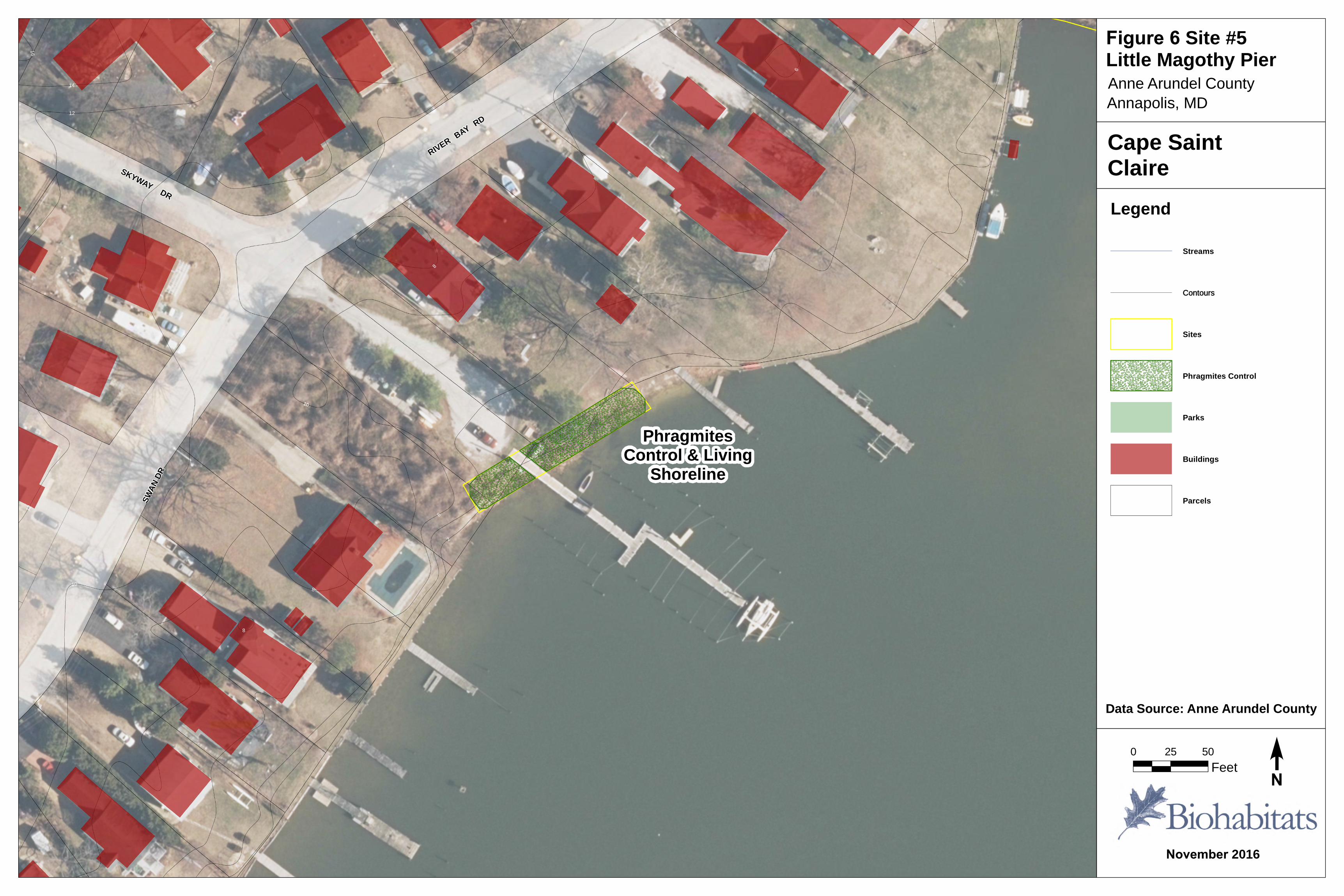
ecologically or recreationally from a large sill or breakwater structures. Any interventions need to work with dynamic beach change and shoaling processes; dredging is not a valid solution either. Treatments that work with the natural shoaling, sand accumulation processes and the establishment of patterns of native marsh islands or spits are highly desirable from a shoreline protection, habitat, water quality and resiliency perspective. This site may best benefit from being managed as a smaller beach access area that transitions to a marsh and shoal/ living shoreline complex. The area to remain as beach will require beach replenishment by sand placement. Additionally, ongoing phragmites management along the riparian/marsh zone and Lake Claire shoreline should continue (Figure 3 – Site 2 Lake Claire). Site 3. Deep Creek was initially evaluated for ravine channel restoration. That feature, however, is relatively stable. The shoreline edge would benefit from a living shoreline treatment for approximately 100 linear feet. This living shoreline project is a low priority compared to Main Beach and Lake Claire. Additionally, due to impervious surface (roadway) run‐off from Rolling View Drive that is causing severe slope gully erosion, a future stormwater best management practice (BMP) is recommended (Figure 4 – Site 3 Deep Creek). Site 4. Little Magothy Park already has a stormwater treatment swale BMP project proposed and is being developed. It would benefit from the addition of a regenerative conveyance wetland BMP towards the shoreline, in conjunction with treatment to remove existing phragmites and replace with native tidal marsh species as a living shoreline stabilization planting (Figure 5 – Site 4 Little Magothy Park). Site 5. The Little Magothy Pier location is a candidate for phragmites control and a new living shoreline marsh fringe, for an approximately 225 linear feet. The phragmites present at this location requires pre‐treatment and follow‐up spot treatment. The living shoreline approach utilizes a limited sand amendment, the placement of coir fiber logs on the edge, and new native tidal marsh plantings. This project may be done by volunteers, if designed and permitted with other shoreline projects being completed around the community. This site is a relatively low priority project from a stabilization standpoint, with moderate priority due to its visibility. It is also a great opportunity for community stewardship and educational activities (Figure 6 – Site 5 Little Magothy Pier). Site 6. The cove adjacent to the Little Magothy Pumping Station (sewer) is a site that also lends itself to phragmites control and a living shoreline treatment. In this case the living shoreline encompasses approximately 400 linear feet of shoreline. This effort would include both an initial and then follow‐up phragmites management (spraying), along with a native tidal marsh planting (the need for sand placement needs to be further evaluated during engineering design and permitting). This is a moderate priority project from a stabilization need, ecological and visibility perspective, relative to the other projects (Figure 5 – Site 6 Little Magothy Pump Station). Site 7. Park Circle is a 6‐ac area in the vicinity of Cape St. Claire Road, Park Circle Drive, and Swan Drive. This site is recommended for stream restoration and living shoreline treatments. The stream restoration recommendation is for a natural channel design (stabilization, habitat, and water quality objectives). The living shoreline treatment recommended includes shoreline grading, sand fill, toe stabilization, and native tidal marsh plantings to be specified during engineering design and permitting. This is a low priority project but requires advanced coordination with the County since this is potential project they may be interested in funding towards their WIP implementation, the timing of which could accelerate the importance and scheduling of this project (Figure 7 – Site 7 Park Circle).

Biohabitats staff visited each of the sites, assessed observed needs, and developed plans based on
recommendations from the Cape St Claire Board and our professional experience.
Results
Main Beach
The two design concepts were presented to the regulators at the pre‐application site visit held on
November 15, 2016. In general, their stated conclusion was that the rock revetment with groins (Figure
2 and Figure 8) was the easier design approach for them to permit. The next step for the community is
to initiate the design of this project. Based on this pre‐application meeting in the community, it was
recommended by MDE Tidal Wetlands that the Cape St. Claire Community develop a relationship with
the Little Magothy Community, who are responsible for the triannual dredging of the shoal in front of
the bulk‐headed channel to the Little Magothy. The Cape St. Claire Community could then use this
dredged sand as beneficial‐reuse‐material to rebuild/reinforce the Main Beach. If a permit to place sand
on the beach is requested in advance of the proposed action, the permit will likely be much easier to
renew, so every three years you can cost‐effectively obtain beach material. Projects that fall in the Tidal
Wetlands License category take longer, a minimum of 240 days, plus a 30‐day public notice period,
followed by response time. As with every project, there is the possibility that a public hearing could be
requested. The agencies recommended that when the projects are advanced at least two Joint
Evaluation agency meetings (usually held in Annapolis) should be attended by the project team.
The approximate construction cost for a breakwater and groin assembly for a project of this scale is
estimated to be $1.2 ‐ $1.5 million, based on $1200‐$1500 per foot and approximately 1000 feet of
breakwater, including shorter sections of protective breakwater built waterward of the openings of the
main breakwater openings (See example in Google Earth image below). All cost range estimates in this
report do not include costs for engineering feasibility/modeling, design plans, permitting or monitoring.
Google Earth image of shoreline stabilization at North Beach, MD

Lake Claire
The proposed solution for the area (Figure 3) from the outlet of Lake Claire west to the edge of the
community (a distance of approximately 400 ft.) is a living shoreline in the vicinity of the outlet from
Lake Claire and a groin along, or plank skirt on, the existing fishing pier. This would trap sand before it
enters the adjacent marina. The breakwater is anticipated to be an array of small oyster Reef Balls™ to
maintain connection between Lake Claire and the open water. The approximate construction cost for
this effort is estimated to be $13,000 to $15,000 for materials (only) delivered to the site. It does not
include professional installation. This cost estimate is based on an array of 100 oyster Reef Balls™ in
three offset rows of 33 balls over a 200‐ft long by 20‐ft wide area. If larger oyster Reef Balls™ are used
(e.g., Reef Balls™ greater than 375 lbs, and 1300 lbs+ each are ultimately deployed by marine vessel,
barge deployment can run $6000‐$8000 per day, or $300‐$500 per hour for a pontoon work boat
delivery. Manual deployment of smaller Reef Balls™ (e.g., 230 lbs or less) may be deployed by volunteer
labor from the beach, for the ‘cost’ of volunteer time and effort.
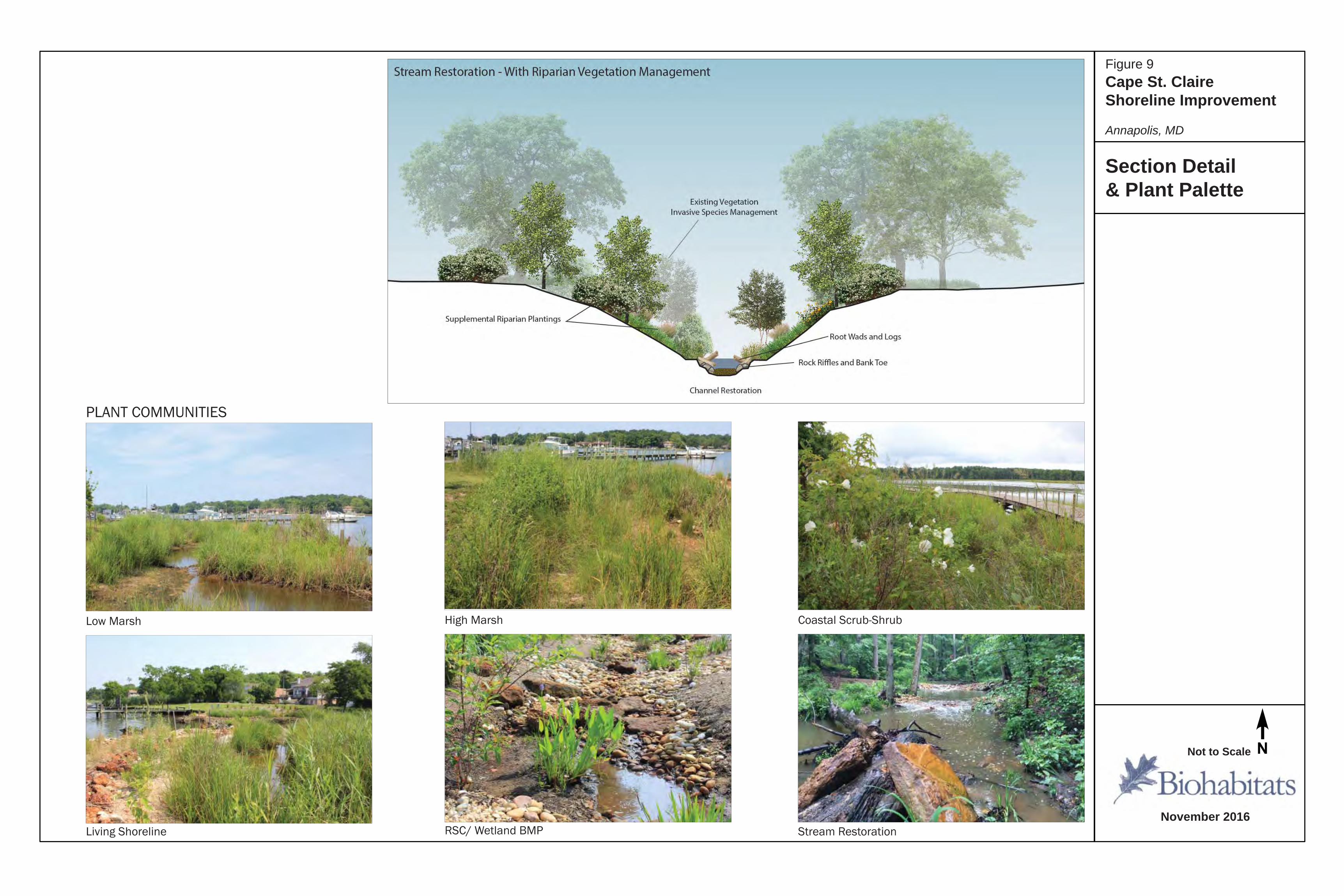
Other Locations The Deep Creek, Little Magothy Park, Little Magothy Pier, the cove adjacent to the Little Magothy Sewer Pumping Station, and Park Circle sites are all low to moderate priorities behind Main Beach and Lake Claire, which are ranked as the first and second priorities. These other five sites are best implemented contingent on funding availability and Anne Arundel County’s interest and resources to complete them as a part of their WIP process. If the County is not interested, several of these projects may be packaged for future grant applications. The range of shoreline and stream treatments are shown in Figure 9.
Project Scheduling
The CSCIA Board has been clear that Sites 1 and 2 are the priority for the Cape St. Claire Community.
We anticipate these two projects be designed, permitted, and constructed as a single and complete
project. This would provide the community with cost and schedule benefits. Detailed planning for these
projects is anticipated to begin in 2017; ready for installation in the 2018 to early 2019 timeframe,
depending on permitting. Construction implementation would require approximately three to four
months. Due to time‐of‐year restrictions associated with working in Use II waters, the project would
need to be constructed during the October 1 to December 15, 2018 or March 15 through May 31, 2019
periods, assuming design, permitting, and funding efforts proceed without unanticipated problems or
delays.
Others (sites 3, 6 and 7) may be sites that Anne Arundel County is interested in executing for their
County‐wide Watershed Implementation Plan (WIP) and permitting requirements. As a result, if the
County is interested in adopting these projects, they would be expected to be on a two to five year
timeline before any progress would be anticipated.
The Little Magothy Park (Site 4) already has a stormwater treatment concept in development, which
would integrate well with the additional techniques we propose for this site. These two currently‐
separate elements should be coordinated to occur at the same time to respect cost, site disturbance
reduction and schedule advantages.
The work proposed for Site 5, Little Magothy Pier, could be contracted out or executed by volunteers.
This relatively small scale project could be implemented in 2017 if the community desired.

Site #3Deep Creek
Site #2LakeClaire
Site #1Main Beach
Site #5LittleMagothy Pier
Site #7ParkCircle
Site #4Little
Magothy Park
Site #6Little MagothyPumping Station
MASHIE CT
COLLEGE PKWY
PINE VALLEY DR HAMP
TON
RD
CAPE
SAIN
TCLA
IRE R
D
HARBOR VIEW TER
FOXPAW TRL
CRANES ROOSTCT
MOUNT ALBAN DR
DEEP CREEK VW
DIETRICH WAY
BAY H
EAD R
D
HAZEL NUT CT
STONEHURST DR
FAIRWINDS DR
FAWNS WALK
PENN
INGT
ONLN
SKYVIEW DR
CORAL CT
PENNINGTONLN S
BROADNECK RD
BLUE RIDGE DR
SUNW
OOD T
ER
RIDGEWAY DR
WOODS LANDING DR
HILLTOP DR
COLONIAL MANOR CT
COLLEGE PKWY
WHARF RD
HILL
TOP D
RDARL
OWPL
BROADVIEWDR
MOUNTAIN TOP DR
SKYWAY DR
CRESTVIEW DR
SUN VALLEY DR
SPOON CT
WESTWAY
MAN O WAR CT
SNOW GOOSE LN
SOUT
HVIE
W DR
GLENWOODDL
BAYV
IEWVIS
SEABRIGHT DR
GREENWAY DR
PEACH CT
LAKEVIEW LN
AQUA CT
FOREST TER
SKYVIEW DR
SWAN DR
VAN CAMP CT
SKYWAY DR
LONG POINT TER
SAINT
CATH
ERINE
DR
CHESTNUT TREE DR
HARMONY LN
BREE
ZEWA
YDR
ROUND TOP DR
BARRACUDA COVE CT
MORGAN DR
PINTAILL N
MAGO
THY CIR
WALNUT RIDGE DR
PARK CIRCLE DR
TANOOK
CT
BLUE
RIDG
EPL
SEAHORSE CT
PINE TR
EE DR
LOCU
ST TR
EE D
R
BENNETTRD
IDYLEWILD DR
SPRU
CE TR
EE LN
MASTER
DER B
YCT
FAIRWAY DR
HILLCREST DR
BROADMOOR DR
SUNWOOD LN
LANDON LN
SAINT
CHAR
LES D
R
MOUNT HOLLY DR
DOGWOOD TREE DR
HIGHPOINT DR
SAINT JOHNS DR
MIDDLETOWNRD
POPLAR TREE DR
WOOD DUCK
LN
PINE
HILL
DR
DEEP CREEK AVE
PLAT
EAU
PL
SHADYSIDE CT
RIVER
VIEW DR
OAK TREE LN
SAMANTHA CT
HILLTOP RD
BAY HEAD RD
LINDEN TREE DR
LIDO DR
CHESTNUT TREE DR
MAGOTHY PARK LN
BENSON LN
SHORE ACRES RD
HARM
ONY
LN
HOPKINS RD
BELLERIVE RD
BELL
ERIVE
RD
ROLLING VIEW DR
WOODLAND CIR
HIGH
V IEW
DR
SECR
ETAR
IATDR
GRE ENH OLLY
DR
SAINT MARGARETS DR
SAIN
T GEO
RGE D
R
WINTERGU LL
L N
DARLOW DR
ARUNDEL DR
SUMMIT DR
SUMM
ITDR
ALMOND DR
NEPT
UNE
PL
MARINE
DR
MARINE DR
BROADNECK PARK RD
PHILLIPS DR
MERMA IDDR
GATEWAYDR
RAMBLEWOOD DR
LATR
OBE D
R
LATR
O BE
DR
SUM M
ITDR
POPLA RH IL L
D R
LAKE CLAIRE DR
HILLENDALE DR
LITTL
EMA
GOTH
YVW
LITTLE MAGOTHY VW
WINDGATE DR
WINDGATE DR
RIVER
BAYRD
RIVER BAY RD
ROSE
BAY CT
QUAKER RIDGE CT
MOU N
T PLE
A SAN
T DR
TREMONT
CIR
OLD
CAPE
SAIN
T CLA
IRERD
BAYSTONECT
STON
EHURST
CT
WIND
SOR
RIDG
E LN
DESTINY CIR
DESTINYCIR
\F
November 2016
Cape St.ClaireLegend
Streams
Sites
Open Water
Cape St. ClaireBoundary
Parks
Buildings
Parcels
Data Source: Anne Arundel County
0 400 800
Feet
Figure 1 Cape St. Claire Shoreline Improvement Plan LocationsAnnapolis, MD

Rock/ReefStructures Breakwater
Beach Replenishment
Repaired orRelocated Groins
PotentialNew Groin
PotentialNew Groin
BAY HEAD RD
BROADVIEW DR
SAINT CATHERINE DR
RIVERBA
YRD
RIVER BAY RD
20
18
16
14
1210
8 6 4 2
6
42
4
2
18
18
16
16
16
8
6
6
6
2
4
2
2
16
122
2
\F
November 2016
Cape St.ClaireLegend
Potential New Groin
Repaired Jetty Structures
Streams
Contours
Breakwater
Phragmites Control
Sites
Parks
Buildings
Data Source: Anne Arundel County 2014 Aerial Imagery
0 50 100
Feet
Annapolis, MDAnne Arundel County
Figure 2 Site #1 Main Beach

PhragmitesControl
LivingShoreline
BeachReplenishment
LATR
OBE D
R
RIVER BAY RD
LAKE CLAIRE DR
24
22
20
18
16
14
1210
86
4
2
1412
10
18
16
86
121086
22
20
42
1614
6
4
42
2424
20
18
16
14
12
4
4 4
44
4
2
4
2
2
2
2
\F
November 2016
Cape St.ClaireLegend
Streams
Contours
Sites
Beach Replenishment
Phragmites Control
Living Shoreline
Parks
Buildings
Parcels
Data Source: Anne Arundel County 2014 Aerial Imagery
0 50 100
Feet
Annapolis, MDAnne Arundel County
Figure 3 Site #2 Lake Claire

Future RoadStormwaterRunoff BMP
HARBOR VIEW TER
GREEN HOLLY CT
RAMBLEWOOD DR
ANGLERS WAY
IDYLEWILD DR
GREE
NHO
LLY
DR
GREEN HOLLY DR
ROLLING VIEW DR
ROLLING VIEW DR
MA
RINERS CIR
GATE
WAY
DR
GATEWAY DR
807674
6866646260585654525048464442
403836343230282624
22
96949290
8684
8278
42
7270
28262422201816
12
1410864
40 38 36 34 32 30 28 26
24 22 20
20
18
16 14 6
12
8 2
7472706866646260
52
50
48
4644
4240
100
98
102100
42
40
88
20
18
16
14
12
10
8
6
18
10
4
54
102
102
56
54
54
48
4640
40
38
32
30
16
\F
November 2016
Cape St.ClaireLegend
Streams
Contours
Sites
Future BMP
Living Shoreline
Parks
Buildings
Parcels
Data Source: Anne Arundel County 2014 Aerial Imagery
0 50 100
Feet
Annapolis, MD
Anne Arundel County
Figure 4 Site #3 Deep Creek

%% %% %% %% %% %% %% %% %% %% %% %% %% %% %% %% %% %% %% %% %% %% %% %% %% %% %% %% %% %% %% %% %% %% %% %% %% %% %% %% %% %% %% %% %% %% %% %% %% %% %% %% %% %% %% %% %% %% %% %% %% %% %% %% %% %% %% %% %% %% %% %% %% %% %% %% %% %% %% %% %% %% %% %% %% %% %% %% %% %% %% %% %% %% %% %% %% %% %% %% %% %% %% %% %% %% %% %% %% %% %% %% %% %% %% %% %% %% %% %% %% %% %% %% %% %% %% %% %% %% %% %% %%%% %% %% %% %% %% %% %% %% %% %% %% %% %% %% %% %% %% %% %% %% %% %% %% %% %% %% %% %% %% %% %% %% %% %% %% %% %% %% %% %% %% %% %% %% %% %% %% %% %% %% %% %% %% %% %% %% %% %% %% %% %% %% %% %% %% %% %% %% %% %% %% %% %% %% %% %% %% %% %% %% %% %% %% %% %% %% %% %% %% %% %% %% %% %% %% %% %% %% %% %% %% %% %% %% %% %% %% %% %% %% %% %% %% %% %% %% %% %% %% %% %% %% %% %% %% %% %% %% %% %% %% %% %% %% %% %% %% %%%%
Phragmites Suppression &
Living Shoreline
County RSCPhragmites Suppression
Living ShorelineMAGOTHY CIR
MAGOTHY PARK LN
LITTL
EMA
GOTH
YVW
LITTLE MAGOTHY VW
Site #4Little Magothy
Park
Site #6Little MagothyPump Station
18
16
642
1412
10
26
24
22
20
22
20
1816
14
1210 8
30
28
18
16
16
1442
8
26
28
20
18
18
18
18
18
16
16
16
14
14
14
14
14
14
14
12
2
\F
November 2016
Cape St.ClaireLegend
Streams
Contours
%% %% %% %% %% %% %% %% %% %% %% %% %% %% %% %% %% %% %% %% %% %% %% %% %% %% %% %% %% %% %% %% %% %% %% %% %% %% %% %% %% %% %% %% %% %% %% %% %% %% %% %% %% %% %% %% %% %% %% %% %% %% %% %% %% % StormwaterSwale by others
Sites
Living Shoreline& BeachReplenishment
PhragmitesControl & LivingShoreline
RegenerativeConveyance -Wetland BMP
Parks
Buildings
Parcels
Data Source: Anne Arundel County 2014 Aerial Imagery
0 50 100
Feet
Annapolis, MD
Figure 5 Site #4 & #6Little Magothy Park & Little Magothy Pump Station
PhragmitesControl & Living
Shoreline
SKYWAY DR
RIVER BAY RD
SWAN
DR
14
12
10
16
4
6
2
10
8
12
8
8
6
\F
November 2016
Cape SaintClaireLegend
Streams
Contours
Sites
Phragmites Control
Parks
Buildings
Parcels
Data Source: Anne Arundel County
0 25 50
Feet
Annapolis, MDAnne Arundel County
Figure 6 Site #5Little Magothy Pier

LivingShoreline
StreamRestoration
CAPE
SAIN
T CLA
IRE R
D
SWAN DR
DIETRICH WAY
SKYVIEW DR
BRICE TER
MOUNTAIN TOP DR
SAINT
CHAR
LES D
R
PARK CIRCLE DR
BAYV
IEW VI
S
LITTLE MAGOTHY VW
\F
November 2016
Cape SaintClaireLegend
Streams
Sites
Phragmites Control
Stream Restoration
Living Shoreline
Parks
Buildings
Parcels
Data Source: Anne Arundel County
0 50 100
Feet
Figure 7 Site #7 Park CircleAnnapolis, MDAnne Arundel County

\F
July 2016
Cape St.Claire
Legend
Data Source: Anne Arundel County
0 400 800
Feet
Cape St. ClaireShoreline Improvement Plan LocationsAnnapolis, MD
Section Details
November 2016
Not to Scale
Figure 8
Cape St. Claire Shoreline Improvement
Annapolis, MD
\F
July 2016
Cape St.Claire
Legend
Data Source: Anne Arundel County
0 400 800
Feet
Cape St. ClaireShoreline Improvement Plan LocationsAnnapolis, MD
PLANT COMMUNITIES
Low Marsh High Marsh Coastal Scrub-Shrub
RSC/ Wetland BMP Stream Restoration
Section Detail& Plant Palette
Living Shoreline November 2016
Not to Scale
Figure 9
Cape St. Claire Shoreline Improvement
Annapolis, MD