Embed Size (px)
Citation preview
1
Full Environmental Assessment Form Supplement to Part 3 - Evaluation of the Magnitude and Importance of
Project Impacts and
Determination of Significance
POSITIVE DECLARATION Pilgrim Pipeline
September 14, 2016
Pilgrim Transportation of New York, Inc. (Pilgrim) submitted a preliminary Draft Environmental Impact Statement (DEIS) with their application to the New York State Thruway Authority (NYSTA) for an Occupancy Permit in August 2015. Pursuant to 6 NYCRR §617.6, Pilgrim subsequently submitted Part 1 of the Full Environmental Assessment Form (EAF), which the New York State Department of Environmental Conservation (NYSDEC) and the NYSTA, as co-lead agencies, used together with the preliminary DEIS to complete parts 2 and 3 of the Full EAF and make a determination of environmental significance pursuant to 6 NYCRR §617.7.
When completing Part 2 of the EAF, the co-lead agencies (LAs) identified potential project impacts and characterized each impact as a small impact or a moderate to large impact. Then, in completing Part 3 of the EAF, the LAs evaluated the magnitude, duration, likelihood and importance of the project’s potential impacts.
The following is a description of the proposed action and a list of impacts that the LAs have determined to have a potentially significant impact on the environment.
Description of Proposed Action:
The application submitted by Pilgrim to the NYSTA seeks an unprecedented use of New York highway ROW to transport crude oil and refined petroleum products, in addition to proposing an extensive longitudinal occupancy of approximately 90 miles of the New York State Thruway.
The proposed action includes the construction of 2 new, buried, parallel pipelines (mainline pipelines) from Albany, New York to Linden, New Jersey; it would traverse the counties of Albany, Rensselaer, Greene, Ulster, Orange and Rockland Counties in New York State. One of the mainline pipelines would carry crude oil southbound from Albany and the second parallel mainline would carry refined petroleum products (gasoline, diesel, heating oil, and kerosene) northbound from Linden.
Pilgrim states that each mainline pipeline would be approximately 169.89 miles long, each having 116.4 miles in New York State. Approximately 79 percent of the mainline pipelines in New York would be installed within the New York State Thruway (NYS Thruway) right-of-way (ROW); 7.5 percent would be co-located with other roads, utilities
2
or railroads; and the remaining 13.5 percent would be newly acquired ROW. The mainline pipelines would each be up to 20 inches in diameter and would be capable of transporting the equivalent of 200,000 barrels of oil per day. In addition to the mainline pipelines, five single pipe product lateral pipelines would be constructed in New York to intermediate delivery points (existing terminals), and four pump stations and 10 meter stations would also be constructed.
In New York State, the proposed action would disturb approximately 1,360 acres (1,250 acres for mainline pipelines, laterals, ancillary stations and temporary pipeyards and approximately 110 acres for access roads), including 296 acres that will be permanently maintained as ROW. The proposed action would cross 257 steams and waterbodies (232 along mainline pipelines and 25 along laterals), including the Hudson River and multiple major and minor tributaries of the Hudson. There are also 296 (9.2 linear miles) crossings of wetlands; including 25 crossings of NYSDEC protected freshwater wetlands (approximately 19 along mainline pipelines and 6 along laterals).
Identification of Impacts
Based upon a review of the application submitted by Pilgrim, the LAs have determined that there is a potential for multiple significant adverse environmental impacts from the construction, operation and maintenance of the pipeline including the following:
1) Impacts on Land
The proposed action entails construction on steep slopes, exposed bedrock, and on land where the depth to water table is less than 3 feet. The proposed action will also involve a significant physical disturbance of more than 1,360 acres of land. As a result, the proposed pipeline construction would likely result in increased erosion of soils which may contain pollutants that could be discharged to waterbodies and significantly impact water quality and aquatic species habitat (e.g. spawning, propagation, and survival).
2) Impacts on Geological Features
The NYS Unique Geologic Landforms project has identified unique geological features along the proposed pipeline route. The proposed action may result in the modification or destruction of unique geological features which could have a significant adverse impact on these features.
3) Impacts on Surface Water
The proposed action will traverse surface water at 257 locations, including two crossings of the Hudson River, and more than 9.2 linear miles of wetlands which would temporarily impact more than 80 acres of wetlands, including 25 freshwater wetlands under the jurisdiction of NYSDEC. The proposed project has the potential to impact water quality standards at these crossings and wetlands, including significant increases in turbidity. Construction and operations within and adjacent to surface waterbodies and
3
wetlands and hydrostatic testing of pipeline sections, as well as temporary and long term maintenance roads, may cause erosion and water quality related impacts. The potential for extensive lateral and vertical movements of streams over the proposed years of operation could result in additional impacts from pipe exposure and subsequent corrective actions which could impact the stability and ecology of the streams. Additional long term impacts from ROW maintenance and vegetation management activities may also occur.
4) Impacts on Groundwater
The proposed action involves the conveyance of petroleum products across several groundwater and drinking water resources including the Ramapo River Basin Aquifer Systems Sole Source Aquifer, and the crossing of two New York City public water supply system aqueducts, the Catskill Aqueduct and the Delaware Aqueduct. The proposed action increases the potential for contamination of unconfined aquifers and shallow groundwater areas if surface spills of hazardous materials occur during construction, operation or maintenance of the project ROW.
5) Impacts on Flooding
The proposed action traverses several floodplains and floodways along the proposed route. While the installation of the pipelines would result in temporary impacts to floodplains and floodways, there are several above ground structures that would be located within 100-year floodplains including pump stations, meter stations and access roads that could result in the increased potential for future flooding impacts.
6) Impacts on Air
The proposed action has the potential to result in direct and indirect air quality impacts, including the generation of fugitive dust during construction and emissions from construction equipment. Moreover, the electricity used to power pump stations has the potential to result in additional air quality impacts.
The proposed action has the potential to exacerbate climate change due to emissions of greenhouse gas. This includes, but not limited to, fugitive emissions and leakage from the operation of the pipelines and emissions from construction and maintenance activities. The proposed action could also have potential impacts associated with lifecycle greenhouse gas emissions.
7) Impacts on Plants and Animals
Several federally and state listed threatened and endangered species and their habitats are located along the proposed pipeline route and may be indirectly or directly impacted by the proposed action. Additionally, the proposed action involves the removal or destruction of large quantities of vegetation or fauna, including approximately 611 acres of forest that would be impacted, 132 acres of which would be permanently converted to
4
non-forested, maintained pipeline ROW which has the potential to increase surface water runoff and erosion, among other things.
8) Impacts on Agricultural Resources
The proposed action traverses more than 20 acres of agricultural land including approximately 5.82 miles of prime farmland and 7.63 miles of farmland of statewide importance. During construction, there may be significant impacts from the disruption of crop production compaction as well as potential loss of crop land along the permanently maintained portions of the ROW.
9) Impacts on Aesthetic Resources
The proposed action passes through or is in close proximity to at least eight public parks, including the Sterling Forest State Park and Schunnemunk Mountain State Park and two privately owned golf courses. Additionally, the clearing of new ROW within existing forested areas may be visible from several scenic vistas and important areas.
10) Impacts on Historic and Archeological Resources
The proposed action will cross 45 archeological resources and three properties listed on the National Register of Historic Places, and may have a potentially significant impact on these properties. In addition, the proposed project may transect and disturb Native American archeological sites belonging to the Delaware Tribe of Indians, Delaware Nation, Stockbridge-Munsee Band, and the St. Regis Mohawk Tribe.
11) Impacts on Open Space and Recreation
The proposed action may result in a loss of recreational opportunities or a reduction of an open space resource within local communities. As mentioned previously, the pipelines will traverse several public parks and may result in short term impacts during construction and potentially long term impacts associated with the operational and maintenance needs for the pipelines.
12) Impacts on Critical Environmental Areas
The proposed action is located within 670 feet of a designated Critical Environmental Area (CEA), namely the Chadwick Lake Reservoir CEA. More information is needed to determine if the proposed action will result in a significant adverse impact to the environmental characteristics of the CEA.
13) Impacts on Transportation
The unprecedented use of the NYS Thruway ROW for a crude oil pipeline has the potential to significantly impact the traveling public and commerce that this important transportation corridor services. The proposed action could disrupt a major
5
transportation corridor that spans from Albany County to Rockland County and result in a substantial and possibly permanent change in the use, or intensity of use, of land including Thruway Authority property and NYS Thruway ROW for construction and long-term operations and maintenance of the pipelines. Additionally, traffic impacts may occur associated with construction and operation of the pipelines, including blasting and possible spill response. The potential transportation impacts implicate the consistency of the proposed action with applicable State and federal laws and policies regulating highway use. A spill from the pipeline could also disrupt a major transportation corridor and divert a large volume of traffic to local and county roads. Such disruptions have the potential to significantly impact safety, commerce, emergency services, and the mobility of the traveling public including on the Thruway, which has an average annual daily traffic number of more than 40,000 vehicles for this section.
The proposed action may alter the present pattern of movement of goods by transporting crude oil to refineries in New Jersey via pipeline as opposed to barge down the Hudson River and may impact how crude oil is transported through New York State.
14) Impacts on Energy
The proposed action may utilize more than 2,500 Mwh per year of electricity to run the pump stations.
15) Impacts on Noise, Odor, and Light
The proposed action may result in construction related traffic and noise impacts during the duration of the proposed action, which is estimated at 10 months, and will include the blasting of bedrock along the NYS Thruway ROW.
16) Impacts on Human Health
The proposed action potentially risks creating a hazard to human health and the environment in the event of a pipeline rupture, possibly due to malfunction, natural disaster or security breach. The longitudinal occupation of the NYS Thruway ROW for more than 90 miles by an oil pipeline carrying a flammable gases or liquids under pressure within limited access highway ROW has the potential to adversely affect the safety and security of the traveling public.
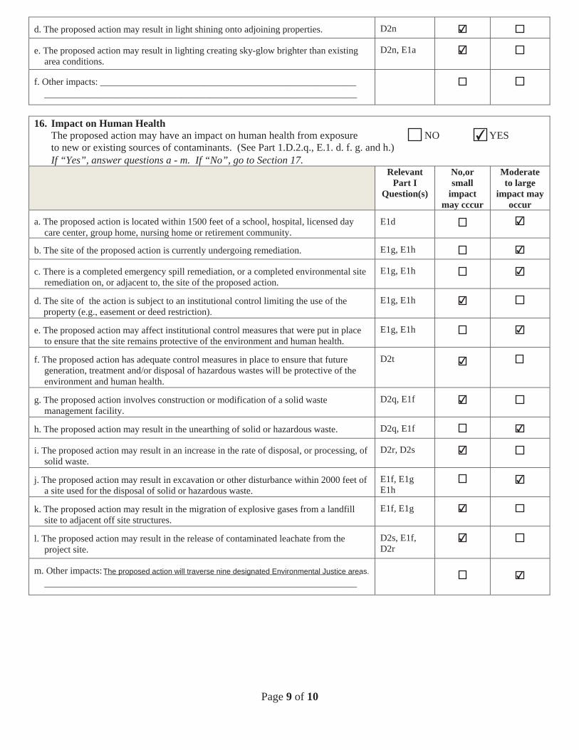
In addition, excavation and disturbance associated with construction may occur within contaminated soils and prior remediation sites, including the BASF manufacturing facility which has soil and groundwater contamination concerns and 10 other potential sites of concern for soil contamination. Importantly, the proposed action may result in potential adverse impacts to and within nine potential Environmental Justice (EJ) areas that the proposed construction, operation and maintenance of the mainline pipelines will traverse, including an EJ community near the Port of Albany where the pipeline is proposed to originate.
6
17) Consistency with Community Plans
The proposed action may result in the creation of a material conflict with the current plans or goals as officially approved or adopted of the 29 municipalities traversed by the proposed action and may be inconsistent with those officially adopted community plans.
18) Consistency with Community Character
The proposed action may interfere with the use or enjoyment of officially recognized or designated public resources, including several public parks and recreational areas that are located along the pipeline route. Additionally, there may be areas where the clearing of forested area for a maintained ROW is in stark contrast to the character of the existing landscape.
19.) Cumulative Impacts
The installation of a pipeline that spans nearly 170 miles in New York State and New Jersey; occupies more than 90 miles of the New York State Thruway; traverses dozens of communities; and disrupts approximately 9.2 linear miles of wetlands and 257 surface waterbodies along the entire route; can result in extensive impacts to water quality and natural resources. A cumulative assessment of impacts is necessary to determine whether the proposed action can designed and constructed in a manner to avoid, minimize or mitigate potential impacts.
In addition, the proposed longitudinal occupation of the pipeline within the Thruway corridor has the potential to interfere with the future growth and expansion of the Thruway. The current ROW may not be sufficient to accommodate both longitudinal utilities and necessary future improvements of the highway infrastructure including work to bridges, culverts, and future expansions.
20.) Coastal Consistency
As part of the EIS process, the LAs will also need to consider if the proposed action is consistent with State Coastal Policies that promote the beneficial use of coastal resources, prevent their impairment, and evaluate major activities that substantially affect numerous resources. As a first step, the LAs have completed a Coastal Assessment Form (CAF) and will forward this form to the New York State Department of State (DOS) and the three Local Waterfront Revitalization Programs (LWRPs) that will be traversed by the proposed action including the City of Albany, City of Rensselaer and City of Newburgh. The DOS is responsible for administering the New York State Coastal Management Program and any federal coastal consistency determination. The Department and NYSTA are responsible for determining whether the proposed action is consistent with State coastal polices. The following State coastal polices may be applicable to the proposed action and will be considered in more detail: significant fish and wildlife habitats (19 NYCRR 600.5(b), flooding and erosion (19 NYCRR 600.5(g)), general policy for major actions in coastal areas (19 NYCRR 600.5(i)) historic and
7
cultural resources (19 NYCRR 600.5(i)), scenic areas (19 NYCRR 600.5(d)), agricultural lands (19 NCYRR 600.5(c)), water (19 NYCRR 600.5(h)).
Statement of Significance
As demonstrated in this document, the proposed action may result in one or more significant adverse impacts to the environment, and therefore an EIS must be prepared. Accordingly, the LAs hereby issue this Positive Declaration, which has been prepared in accordance with Article 8 of the Environmental Conservation Law. The LAs will be conducting public scoping, which will include a public comment period. Pilgrim is responsible for preparing a draft scope and the LAs will announce a public review of the draft scope in the Department’s Environmental Notice Bulletin (http://www.dec.ny.gov/enb/enb.html). Following the public comment period on the draft scope, the LAs will prepare a final scope pursuant to which Pilgrim will develop the DEIS. The LAs will publish the availability of the DEIS for public comment in the Environmental Notice Bulletin.
Full Environmental Assessment Form Part 1 - Project and Setting
Instructions for Completing Part 1
Part I is to be completed by the applicant or project sponsor. Responses become part of the application for approval or funding, are subject to public review, and may be subject to further verification.
Complete Part 1 based on infonnation currently available. If additional research or investigation would be needed to fully respond to any item, please answer as thoroughly as possible based on current information; indicate whether missing information does not exist, or is not reasonably available to the sponsor; and, when possible, generally describe work or studies which would be necessary to update or fully develop that information.
Applicants/sponsors must complete all items in Sections A & B. In Sections C, D & E, most items contain an initial question that must be answered either "Yes" or "No". If the answer to the initial question is "Yes", complete the sub-questions that follow. If the answer to the initial question is "No", proceed to the next question. Section Fallows the project sponsor to identify and attach any additional information. Section G requires the name and signature of the project sponsor to verify that the information contained in Part I is accurate and complete.
A. Project and Sponsor Information.
Name of Action or Project: Pilgrim Pipeline
Project Location (describe, and attach a general location map):
Port of Albany NY to NJ border at Hillburn NY
Brief Description of Proposed Action (include purpose or need):
New York portion of interstate pipeline, see Pilgrim Pipeline Draft Environmental Impact Statement (herein "DEIS"), dated August 2015
Name of Applicant/Sponsor: Telephone:
Pilgrim Transportation of New York, Inc. E-Mail:
Address: 220 Albany Ave 1039 Suite 315
City/PO: Canton State: CT I _lip Code: 06019
Project Contact (if not same as sponsor; give name and title/role): Telephone: 860-693-6967
E-Mail: [email protected]
Address:
City/PO: State: I Zip Code:
Property Owner (if not same as sponsor): Telephone:
E-Mail:
Address:
City/PO: State: I Zip Code:
Page 1 of 13
B. Government Approvals
B. Government Approvals, Funding, or Sponsorship. ("Funding" include.s grants, loans, tax relief, and any other fonns of financial assistance.)
Government Entity If Yes: Identify Agency a nd Approval(s) Application Date Required (Actual or projected)
a. City Council, Town Board, 0 Yes0No projected Summer 2016, to the extent or Village Board of Trustees See DEIS, able ES·1 pg. ES·6 applicable
b. City, Town or Village 0Yes0No projected Summer 201 6, to the extent Planning Board or Commission See DEIS, Table ES-1 pg. ES-6 applicable
c. City Counci l, Town or 0Yes0No projected Summer 2016, to the extent Village Zoning Board of Appeals See DEIS Table ES·1 pg. ES-6 applicable
d. Other local agencies 0 Yes0No projected Summer 2016, to the extent See DEIS, Table ES-1 pQ. ES·6 applicable
e. County agencies O YesONo projected Summer 2016, to the extent See DEIS, Table ES-1 pg. ES-6 applicable
f. Regional agencies 0Yes0No projected Summer 2016, to the extent See DEIS, Table ES-1 pg. ES-6 applicable
g. State agencies 0Yes0No See DEIS, Table ES·1 pg. ES-6
NYSTA (actual) August 2015 Others- Summer 2016
h. Federal agencies OYesONo projected Summer 2016, to the extent See DEIS, Table ES-1 pg. ES-6 annlicable
i. Coastal Resources. i. Is the project site within a Coastal Area, or the waterfront area of a Designated Inland Waterway?
See DEIS Section 3.2.2.6, & Tables 3.2.2-6, -7, & -8 and DEIS Appendix J bZJYesONo
ii. Is the project site located in a commun ity with an approved Local Waterfront Revitalization Program? IZI YesDNo iii. ls the project site within a Coastal Erosion Hazard Area? OYesbZJNo
C. Planning and Zoning
C.1. Planning and zoning actions.
Will administrative or legislative adoption, or amendment ofa plan, local law, ordinance, rule or regulation be the DYesbZJNo only approval(s) which must be granted to enable the proposed action to proceed?
• [f Yes, complete sections C, F and G .
• If No, proceed to question C.2 and complete all remaining sections and questions in Part I
C.2. Adopted land use plans.
a. Do any municipally- adopted (city, town, village or county) comprehensive land use plan(s) include the site 0Yes0No where the proposed action would be located? Varies, see DEIS Section 3.2.2.3
If Yes, does the comprehensive plan include specific recommendations for the site where the proposed action OYesDNo would be located?
b. ls the site of the proposed action within any local or regional special planning district (for example: Greenway bZJYesONo Brownfield Opportunity Area (BOA); designated State or Federal heritage area; watershed management plan; or other?)
If Yes, identify the plan(s): See DEIS, discussed throughout
c. ls the proposed action located wholly or partially within an area listed in an adopted municipal open space plan, OYesONo or an adopted municipal farmland protection plan?
If Yes, identify the plan(s): Varies, see DEIS Section 3.2.2
Page 2of13
C.3. Zoning
a. ls the site of the proposed action located in a municipality with an adopted zoning law or ordinance. 0Yes0 No If Yes, what is the zoning classification(s) including any applicable overlay district?
Varies, see DEi Sec t ion 3.2.2.3
b. Is the use pennitted or allowed ~ya special or conditional use pem1it? Varies 0 Yes0No
c. Is a zoning change requested as part of the proposed action? DYes!llNo If Yes, i. What is the proposed new zoning for the site?
C.4. Existing community ser vices.
a. In what school district is the project site located? See Table ES-1 for list of juris dic tions
b. What police or other public protection forces serve the project site? See DEIS Section 3.2.3
c. Which fire protection and emergency medical services serve the project site? See DEIS S e ction 3.2.3
d. What parks serve the project site? See DEIS Section 3.2.2.5
D. Project Details
D. l. Proposed and Potential Development
a. What is the general nature of the proposed action (e.g., residential, industrial, commercial, recreational; if mixed, include all components)?
Transportation of energy products
b. a. Total acreage of the site of the proposed action? acres b. Total acreage to be physically.disturbed? acres See Section 2.2.1 -4, and c. Total acreage (project site and any contiguous properties) owned Table 2.2-3
or controlled by the applicant or project sponsor? acres
c. Is the proposed action an expansion of an existing project or use? DYesQ]No i. If Yes, what is the approximate percentage of the proposed expansion and identify the units (e.g., acres, miles, housing units,
square feet)? % Units:
d. Is the proposed action a subdivision, or does it include a subdivision? O Yes lllNo If Yes,
i. Purpose or type of subdivision? (e.g., residential, industrial, commercial; if mixed, specify types)
ii. Is a cluster/conservation layout proposed? O YesQ]No iii. Number of lots proposed? iv. Minimum and maximum proposed lot sizes? Minimum Maximum
e. Will proposed action be constructed in multiple phases? DYesQ]No i. If No, anticipated period of construction: - - months
ii. If Yes:
• Total number of phases anticipated -- · • Anticipated commencement date of phase I (including demolition) month __ year - -• Anticipated completion date of final phase month ___year - -• Generally describe connections or relationships among phases, including any contingencies where progress of one phase may
determine timing or duration of future phases:
Page 3of 13
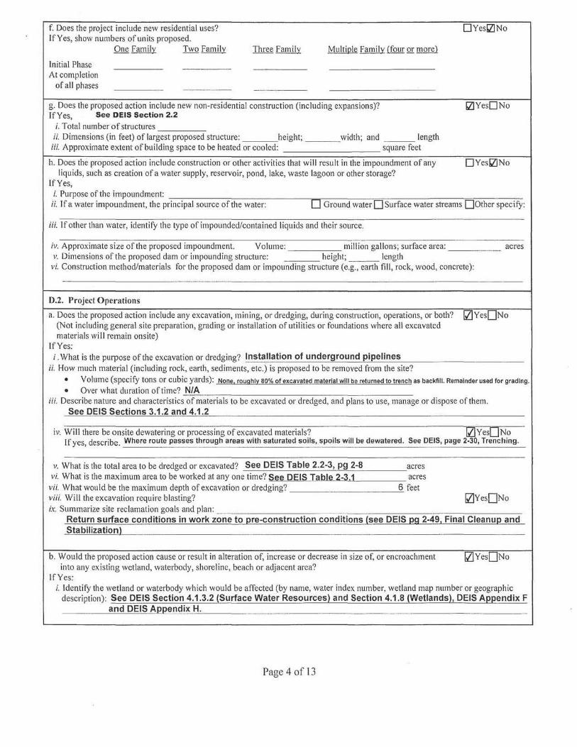
f. Does the project include new residential uses? 0Yesll!No If Yes, show numbers of units proposed.
One Family Two Fami ly Three Family Multiple Family (four or more)
Initial Phase At completion
of all phases
g. Does the proposed action include new non-residential construction (including expansions)? ll!YesONo If Yes, See DEIS Section 2.2
i. Total number of structures ii. Dimensions (in feet) of largest proposed structure: height; width; and length iii. Approximate extent of building space to be heated or cooled: square feet
h. Does the proposed action include construction or other activities that will result in the impoundment of any 0Yesll!No liquids, such as creation of a water supply, reservoir, pond, lake, waste lagoon or other storage?
If Yes, i. Purpose of the impoundment:
ii. If a water impoundment, the principal source of the water: D Ground water D Surface water streams 00ther specify:
iii. If other than water, identify the type of impounded/contained liquids and their source.
iv. Approximate size of the proposed impoundment. Volume: million gallons; surface area: acres v. Dimensions of the proposed dam or impounding structure: height; length
vi. Construction method/materials for the proposed dam or impounding structure (e.g., earth fill, rock, wood, concrete):
0.2. Project Operations
a. Does the proposed action include any excavation, mining, or dredging, during construction, operations, or both? !ZIYesONo (Not including general site preparation, grading or installation of utilities or foundations where all excavated materials will remain onsite)
If Yes: i. What is the purpose of the excavation or dredging? Installation of underground pipelines
ii. How much material (including rock, earth, sediments, etc.) is proposed to be removed !Tom the site? • Volume (specif Y tons or cubic yards): None, roughly 80% of excavated material will be returned to trench as backfill. Remainder used for grading .
• Over what duration of time? N/A iii. Describe nature and characteristics of materials to be excavated or dredged, and plans to use, manage or dispose of them.
See DEIS Sections 3.1.2 and 4.1 .2
iv. Will there be onsite dewatering or processing of excavated materials? !ZlvesONo [f yes, describe. Where route passes through areas with saturated soils, spoils will be dewatered. See DEIS, page 2-30, Trenching.
v. What is the total area to be dredged or excavated? See DEIS Table 2.2-3, pg 2-8 acres vi. What is the maximum area to be worked at any one time? See DEIS Table 2-3.1 acres
vii. What would be the maximum depth of excavation or dredging? 6 teet viii. Will the excavation require blasting? !ZIYesONo ix. Summarize site reclamation goals and plan:
Return surface conditions in work zone to J;1re-construction conditions (see DEIS ~g 2-49, Final Cleanu~ and Stabilization)
b. Would the proposed action cause or result in alteration of, increase or decrease in size of, or encroachment !ZIYesONo into any existing wetland, waterbody, shoreline, beach or adjacent area?
If Yes: i. Identify the wetland or waterbody which would be affected (by name, water index number, wetland map number or geographic
description): See DEIS Section 4.1.3.2 (Surface Water Resources} and Section 4.1 .8 {Wetlands}, DEIS Aeeendix F and DEIS A~~endix H.
Page 4 of l3
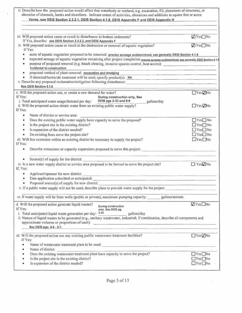
ii. Describe how the proposed action would affect that waterbody or wetland, e.g. excavation, fill, placement of structures, or alteration of channels, banks and shorelines. Indicate extent of activities, alterations and additions in square feet or acres:
V~rie~. !2!:1~ DEIS Section 2.J.2.1, DEIS SectiQn 4.1.8, DEIS Am;iendix F and DEIS A1mendix H
iii. Will proposed action cause or result in disturbance to bottom sediments? bZ]YesONo If Yes, describe: see DEIS Section 2.3.2.2, and DEIS Appendix F
iv. Will proposed action cause or result in the destruction or removal of aquatic vegetation? bZ]YesONo If Yes:
• acres of aquatic vegetation proposed to be removed: erecise acreage undetermined, see genera II~ DEIS Section 4.1.6
• expected acreage of aquatic vegetation remaining after project completion: precise acreage undetermined. see generally DEIS section 4.1.l
• purpose of proposed removal (e.g. beach clearing, invasive species control, boat access): Incidental to construction
• proposed method of plant removal: excavation and dredging
• if chemical/herbicide treatment will be used, specify product(s): NA v. Describe any proposed reclamation/mitigation following disturbance:
See DEIS Section 5.1.6
c. Will the proposed action use, or create a new demand for water? OYesbZ]No If Yes: During construction only, See
i. Total anticipated water usage/demand per day: DEIS pgs 2-33 and 5·6 gallons/day ii. Will the proposed action obtain water from an existing public water supply? OYesbZ]No
lfYes:
• Name of district or service area:
• Does the existing public water supply have capacity to serve the proposal? 0Yes0No
• Is the project site in the existing district? 0Yes0No
• ls expansion of the district needed? 0Yes0No
• Do existing lines serve the project site? 0Yes0No iii. Will line extension within an existing district be necessary to supply the project? 0Yes0No If Yes:
• Describe extensions or capacity expansions proposed to serve this project:
• Source(s) of supply for the district:
iv. Is a new water supply district or service area proposed to be formed to serve the project site? 0 YesbZINo If, Yes:
• Applicant/sponsor for new district:
• Date application submitted or anticipated:
• Proposed source(s) of supply for new district: v. If a public water supply will not be used, describe plans to provide water supply for the project:
vi. If water supply will be from wells (public or private), maximum pumping capacity: gallons/minute.
d. Will the proposed action generate liquid wastes? During construction bZIYesONo If Yes: only. See DEIS pg.
i. Total anticipated liquid waste generation per day: 2-33 gallons/day ii. Nature of liquid wastes to be generated (e.g., sanitary wastewater, industrial; if combination, describe all components and
approximate volumes or proportions of each): See DEIS ~gs. 5·6 - 5-7.
iii. Will the proposed action use any existing public wastewater treatment facilities? OYesbZ]No If Yes:
• Name of wastewater treatment plant to be used:
• Name of district:
• Does the existing wastewater treatment plant have capacity to serve the project? 0Yes0No
• ls the project site in the existing district? 0Yes0No
• ls expansion of the district needed? 0Yes0No
Page 5of13
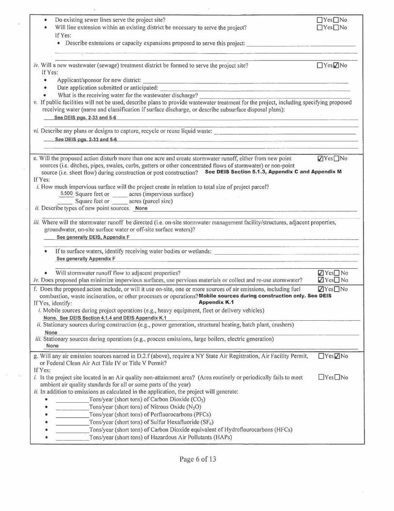
• Do existing sewer lines serve the project site? 0Yes0No • Will line extension within an existing district be necessary to serve the project? 0Yes0No
If Yes: • Describe extensions or capacity expansions proposed to serve this project:
iv. Will a new wastewater (sewage) treatment district be fo1med to serve the project site? OYesll!No If Yes:
• Applicant/sponsor for new district: • Date application submitted or anticipated:
• What is the receiving water for the wastewater discharge? v. If public facilities will not be used, describe plans to provide wastewater treatment for the project, including specifying proposed
receiving water (name and classification if surface discharge, or describe subsurface disposal plans): l2ee QfilS.J2.9§ 2-33 and 5-6
vi. Describe any plans or designs to capture, recycle or reuse liquid waste: See OEIS pgs 2-33 aod 5-6
e. Will the proposed action disturb more than one acre and create storrnwater runoff, either from new point ll!YesONo sources (i.e. ditches, pipes, swales, curbs, gutters or other concentrated flows of stormwater) or non-point source (i.e. sheet flow) during construction or post construction? See DEIS Section 5.1 .3, Appendix C and Appendix M
If Yes: i. How much impervious surface will the project create in relation to total size of project parcel?
5,500 Square feet or _ _ acres (impervious surface) __ Square feet or __ acres (parcel size)
ii. Describe types of new point sources. None
iii. Where will the stom1water runoff be directed (i.e. on-site stonnwater management facility/structures, adjacent properties, groundwater, on-site surface water or off-site surface waters)?
See generall:i'. DEIS, Ai:rnendix F
• If to surface waters, identify receiving water bodies or wetlands: See general!~ AQQendix F
• Will stormwater rnnoff flow to adjacent properties? ll!YesONo iv. Does proposed plan minimize impervious surfaces, use pervious materials or collect and re-use stonnwater? ll!YesONo f. Does the proposed action include, or will it use on-site, one or more sources of air emissions, including fuel ll!YesONo
combustion, waste incineration, or other processes or operations? Mobile sources during construct ion only. See DEIS lfYes, identify: Appendix K.1
i. Mobile sources during project operations (e.g., heavy equipment, fleet or delivery vehicles) None. See DEIS Section 4.1.4 and DEIS A1mendix K.1
ii. Stationary sources during construction (e.g., power generation, structural heating, batch plant, crushers) None
iii. Stationary sources during operations (e.g., process emissions, large boilers, electric generation) None
g. Will any air emission sources named in D.2.f(above), require a NY State Air Registration, Air Facility Permit, DYesi;zJNo or Federal Clean Air Act Title IV or Title V Permit?
If Yes: i. Is the project site located in an Air quality non-attainment area? (Area routinely or periodically fails to meet 0Yes0No
ambient air quality standards for all or some parts of the year) ii. In addition to emissions as calculated in the application, the project will generate:
• Tons/year (short tons) of Carbon Dioxide (C02)
• Tons/year (short tons) of Nitrous Oxide (N20) • Tons/year (short tons) of Perfluorocarbons (PFCs) • Tons/year (short tons) of Sulfur Hexafluoride (SF6)
• Tons/year (short tons) of Carbon Dioxide equivalent of Hydroflourocarbons (HFCs) • Tons/year (sho1t tons) of Hazardous Air Pollutants (HAPs)
Page 6of13
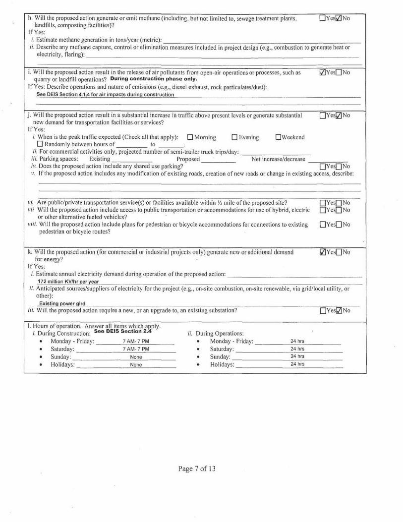
h. Will the proposed action generate or emit methane (including, but not limited to, sewage treatment plants, UYeslZINo landfills, composting facilities)?
If Yes: i. Estimate methane generation in tons/year (metric):
ii. Describe any methane capture, control or elimination measures included in project design (e.g., combustion to generate heat or electricity, flaring):
i. Will the proposed action result in the release of air pollutants fi·om open-air operations or processes, such as quarry or landfill operations? During construction phase only.
lZIYesONo
If Yes: Describe operations and nature of emissions (e.g., diesel exhaust, rock particulates/dust): See DEIS Section 4.1.4 for air imeacts during construction
j. Will the proposed action result in a substantial jncrease iii traffic above present levels or generate substantial OYeslZ!No new demand for transportation facilities.or services?
If Yes: i. When is the peak traffic expected (Check all that apply): 0Morning D Evening DWeekend 0 Randomly between hours of to
ii. For commercial activities only, projected number of semi-trailer truck trips/day: iii. Parking spaces: Existing Proposed Net increase/decrease iv. Does the proposed action include any shared use parking? 0YesONo v. If the proposed action includes any modification of existing roads, creation of new roads or change in existing access, describe:
v1: Are public/private transpottation service(s) or facilities available within Yi mile of the proposed site? OYesONo vii Will the proposed action include access to public transpottation or accommodations for use of hybrid, electric 0YesONo
or other alternative fueled vehicles? viii. Will the proposed action include plans for pedestrian or bicycle accommodations for connections to existing 0Yes0No
pedestrian or bicycle routes?
k. Will the proposed action (for commercial or industrial projects only) generate new or additional demand ll!Yes0No for energy?
If Yes: i. Estimate annual electricity demand during operation of the proposed action:
172 million KV/hr eer )!ear ii. Anticipated sources/suppliers of electricity for the project (e.g., on-site combustion, on-site renewable, via grid/local utility, or
other): Existing 12ower gird
iii. Will the proposed action require a new, or an upgrade to, an existing substation? 0YeslZJNo
I. Hours of operation. Answer all items wt1ich aP.ply. i. During Construction: See DEIS Section 2.4' ii. During Operations:
• Monday - Friday: 7 AM- 7 PM • Monday - Friday: 24 hrs
• Saturday: 7 AM· 7 PM • Saturday: 24 hrs
• Sunday: None • Sunday: 24 hrs
• Holidays: None • Holidays: 24 hrs
Page 7of13
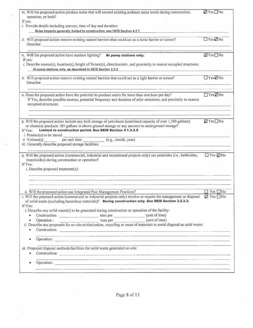
m. Will the proposed action produce noise that will exceed existing ambient noise levels during construction, '2'.! Yes O No operation, or both?
If yes: i. Provide details including sources, time of day and duration:
Noise im11acts generall'l limited to construction, see DEIS Section 4.2. 7
ii. Will proposed action remove existing natural barriers that could act as a noise barrier or screen? 0 Yes'2'.!No Describe:
n .. Will the proposed action have outdoor lighting? At pump stations only. IZ) Yes0No If yes: i. Describe source(s), location(s), height of fixture(s), direction/aim, and proximity to nearest occupied structures:
---8.t_Qum11 stations onl'l, as described in DEIS Section 2.2.2
ii. Will proposed action remove existing natural barriers that could act as a light barrier or screen? 0Yes'2'.!No Describe:
o. Does the proposed action have the potential to produce odors for more than one hour per day? OYeslZINo If Yes, describe possible sources, potential frequency and duration of odor emissions, and proximity to nearest occupied structures:
p. Will the proposed action include any bulk storage of petroleum (combined capacity ofover I, l 00 gallons) IZ) YesONo or chemical products I 85 gallons in above ground storage or any amount in underground storage?
If Yes: Limited to construction period. See DEIS Section 4.1.3.2.5
i. Product(s) to be stored ii. Volume(s) ___ per unit time (e.g., month, year)
iii. Generally describe proposed storage faci li ties:
q. Will the proposed action (commercial, industrial and recreational projects only) use pesticides (i.e., herbicides, D Yes IZ)No insecticides) during construction or operation?
If Yes: i. Describe proposed treatment(s):
ii. Will the proposed action use Integrated Pest Management Practices? 0 Yes 0 No r. Will the proposed action (commercial or industrial projects only) involve or require the management or disposal Ill Yes 0No
of solid waste (excluding hazardous materials)? During construction only. See DEIS Section 3.2.3.3.
If Yes: i. Describe any solid waste(s) to be generated during construction or operation of the facility:
• Construction: tons per (unit of time) • Operation: tons per (unit of time)
ii. Describe any proposals for on-site minimization, recycling or reuse of materials to avoid disposal as solid waste:
• Construction:
• Operation:
iii. Proposed disposal methods/facilities for solid waste generated on-site: • ConslTuction:
• Operation:
Page 8of13
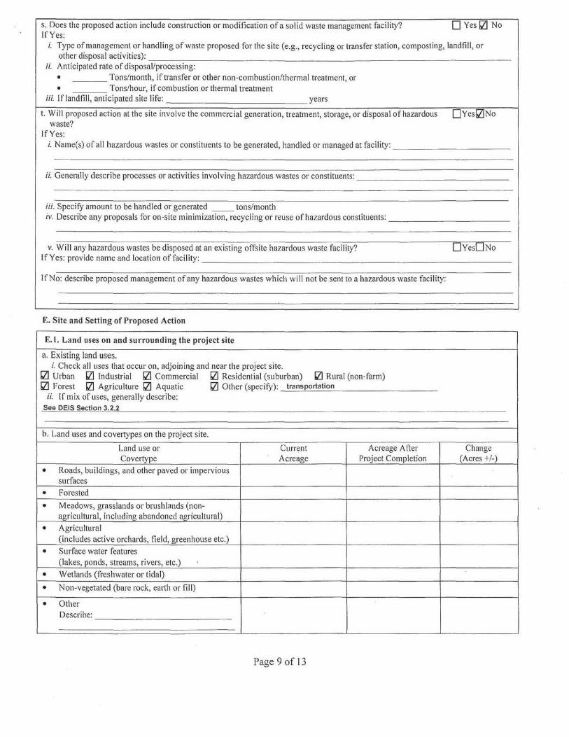
s. Does the proposed action include construction or modification of a solid waste management facility? If Yes:
D Yes Ill No
i. Type of management or handling of waste proposed for the site (e.g., recycling or transfer station, composting, landfill, or
other disposal activities):------- - - - - - --- --- ------- --- -------ii. Anticipated rate of disposal/processing:
• Tons/month, if transfer or other non-combustion/thermal treatment, or • Tons/hour, if combustion or thermal treatment
iii. If landfill, anticipated site life: years
t. Will proposed action at the site involve the commercial generation, treatment, storage, or disposal of hazardous waste?
If Yes:
0Yes!l1No
i. Name(s) of all hazardous wastes or constituents to be generated, handled or managed at facility: --- ---- - ----
ii. Generally describe processes or activities involving hazardous wastes or constituents: - - - ---- - ----- ---
iii. Specify amount to be handled or generated __ tons/month iv. Describe any proposals for on-site minimization, recycling or reuse of hazardous constituents:------ --- ---
v. Will any hazardous wastes be disposed at an existing offsite hazardous waste facility? 0YesDNo If Yes: provide name and location of facility:---------------------------- ----
If No: describe proposed management of any hazardous wastes which will not be sent to a hazardous waste facility:
E. Site and Setting of Proposed Action
E. l. Land uses on and surrounding the project site
a. Existing land uses. i. Check all uses that occur on, adjoining and near the project site.
Ill Urban bZl Industrial bZl Commercial bZl Residential (suburban) bZl Rural (non-fam1) bZl Forest bZl Agriculture bZl Aquatic bZl Other (specify): transportation
ii. If mix of uses, generally describe: See DEIS Section 3.2.2
b. Land uses and covertypes on the project site.
Land use or Current Acreage After Change Covertype Acreage Project Completion (Acres +/-)
• Roads, buildings, and other paved or impervious su1faces
• Forested
• Meadows, grasslands or brush lands (non-agricultural, including abandoned agricultural)
• Agricultural (includes active orchards, field, greenhouse etc.)
• Surface water features (lakes, ponds, streams, rivers, etc.)
• Wetlands (freshwater or tidal)
• Non-vegetated (bare rock, eai1h or fill)
• Other Describe:
Page 9of13
c. Is the project site presently used by members of the community for public recreation? bZJYesONo i. If Yes: explain:
d. Are there any facilities serving children, the elderly, people with disabilities (e.g., schools, hospitals, licensed bZ]YesONo day care centers, or group homes) within 1500 feet of the project site?
If Yes, i. Identify Facilities:
e. Does the project site contain an existing dam? OYesbZJNo If Yes:
i. Dimensions of the dam and impoundmcnt:
• Dam height: feet
• Dam length: feet • Surface area: acres • Volume impounded: gallons OR acre-feet
ii. Dam's existing hazard classification: iii. Provide date and summarize results of last inspection:
f. Has the project site ever been used as a municipal, commercial or industrial solid waste management facility, OYesbZJNo or does the project site adjoin property which is now, or was at one time, used as a solid waste management facility?
If Yes: i. Has the facility been fonnally closed? 0Yes0 No
• If yes, cite sources/documentation:
ii. Describe the location of the project site relative to the boundaries of the solid waste management facility:
iii. Describe any development constraints due to the prior solid waste activities:
g. Have hazardous wastes been generated, treated and/or disposed of at the site, or does the project site adjoin OYesbZJNo property which is now or was at one time used to commercially treat, store and/or dispose of hazardous waste?
If Yes: i. Describe waste(s) handled and waste management activities, including approximate time when activities occurred:
·----·····-··---- ··--- .. h. Potential contamination history. Has there been a reported spill at the proposed project site, or have any OYesD No
remedial actions been conducted at or adjacent to the proposed site? See Section 3.1.2.6 If Yes:
i. Is any portion of the site listed on the NYSDEC Spills Incidents database or Environmental Site 0Yes0No Remediation database? Check all that apply:
0 Yes - Spills lncidents database Provide DEC ID number(s): 0 Yes - Environmental Site Remediation database Provide DEC ID number(s): 0 Neither database
ii. If site has been subject of RCRA corrective activities, describe control measures:
iii. ls the project within 2000 feet of any site in the NYSD.EC Environmental Site Remediation database? 0 Yes0No If yes, provide DEC ID number(s):
iv. If yes to (i), (ii) or (iii) above, describe current status ofsite(s):
Page 10of13
-v. Is the project site subject to an institutional control limiting property uses? !ZIYesONo
• If yes, DEC site ID number:
• Describ(Hhe type of institutional control (e.g., deed restriction or easement):
• Describe any use limitations:
• Describe any engineering controls:
• Will the project affect the institutional or engineering controls in place? OYeslZJNo
• Explain:
E.2. Natural Resources On or Near Project Site
a. What is the average depth to bedrock on the project site? vanes, see uc.1;:, :section I 3.1.1
b. Are there bedrock outcroppings on the project site? See DEIS Section 3.1.1, IZJYesONo If Yes, what proportion of the site is comprised of bedrock outcroppings? Table 3.1 .1-1
c. Predominant soil type(s) present on project site: % Varies, see DEIS Section 3.1.2 %
%
d. What is the average depth to the water table on the project site? Average: Varies, see DEIS Section 3.1.3.1
e. Drainage status of project site soils:D Well Drained: % of site D Moderately Well Drained: --o/c f .t Varies, See DEIS Section 3.1.2 and
o 0 SI e . - - f Section 3.2.2.4 D Poorly Drained %0 site
f. Approximate propo11ion of proposed action site with slopes: D 0- l 0%: % of site Va ries, see DEIS D 10-15%: % of site Section 3.1.1.3 D 15% or greater: % of site
g. Are there any unique geologic features on the project site? IZIYesONo If Yes, describe: See DEIS Section 3.1.1.4
h. Surface water features. i. Does any portion of the project site contain wetlands or other waterbodies (including streams, rivers, !ZIYesONo
ponds or lakes)? ii. Do any wetlands or other waterbodies adjoin the project site? !ZIYesONo If Yes to either i or ii, continue. If No, skip to E.2. i.
iii. Are any of the wetlands or waterbodies within or adjoining the project site regulated by any federal, bZIYesONo state or local agency?
iv. For each identified regulated wetland and waterbody on the project site, provide the following information:
• Streams: Name See DEIS Section 3.1.3.2, and DEIS Appendix F Classification
• Lakes or Ponds: Name See DEIS Section 3.1.3.2, and DEIS Appendix F Classification • Wetlands: Name See DEIS Section 3.1.8, and DEIS Appendix H Approximate Size • Wetland No. (if regulated by DEC) See DEIS Section 3.1.8, and DEIS Appendix H
v. Are any of the above water bodies listed in the most recent compilation ofNYS water quali ty-impaired bZIYesONo waterbodies?
lfyes, name of impaired water body/bodies and basis for listing as impaired: See DEIS Appendix F, Table F-2
i. Is the project s ite in a designated Floodway? !ZIYesONo
j. Is the project site in the I 00 year Floodplain? IZJYes DNo
k. Is the project site in the 500 year Floodplain? !ZIYesONo
I. Is the project site located over, or immediately adjoining, a primary, principal or sole source aquifer? !ZIYesONo If Yes:
i. Name of aquifer: See DEIS Section 3.1.3.1.2
Page L 1 of 13
m. Identify the predominant wildlife species that occupy or use the project site: See DEIS Section 3.1.5.2
n. Does the project site contain a designated significant natural community? IZ]Yes[]No If Yes:
i. Describe the habitaUcommunity (composition, function, and basis for designation): See DEIS Section 3.1.5.1
ii. Source(s) of description or evaluation: See DEIS Section 3.1.5.1 iii. Extent of community/habitat:
• Cu1Tently: acres • Following completion of project as proposed: See DEIS Section 3 .1 .5.1
acres • Gain or loss (indicate+ or-): acres
o. Does project site contain any species of plant or animal that is listed by the federal government or NYS as i;zJ YesONo endangered or threatened, or does it contain any areas identified as habitat for an endangered or threatened species?
See DEIS Section 3.1.7
p. Does the project site contain any species of plant or animal that is listed by NYS as rare, or as a species of IZJYesONo special concern?
See DEIS Section 3 .1. 7
q. Is the project site or adjoining area cun-ently used for hunting, trapping, fishing or shell fishing? Q]YesONo If yes, give a brief description of how the proposed action may affect that use:
No significant negative im[!acts
E.3. Designated Public Resources On or Near Project Site
a. Is the project site, or any portion of it, located in a designated agricultural district certified pursuant to IZ]Yes0No Agriculture and Markets Law, Article 25-AA, Section 303 and 304?
If Yes, provide county plus district name/number: See DEIS Section 3.2.2.4
b. Are agricultural lands consisting of highly productive soils present? i;zJYesONo i. If Yes: acreage(s) on project site? See DEIS Section 3.2.2.4
ii. Source(s) of soil rating(s):
c. Does the project site contain all or part of, or is it substantially contiguous to, a registered National 0Yesll]No Natural Landmark?
If Yes: i. Nature of the natural landmark: D Biological Community D Geological Feature ii. Provide brief description of landmark, including values behind designation and approximate size/extent:
d. Is the project site located in or does it adjoin a state listed Critical Environmental Area? 0Yesll]No If Yes:
i. CEA name: ii. Basis for designation:
iii. Designating agency and date:
Page 12of13
e. Does the project site contain, or is it substantially contiguous to, a building, archaeological site, or district li]YesONo which is listed on, or has been nominated by the NYS Board of Historic Preservation for inclusion on, the State or National Register of Historic Places?
ff Yes: i. Nature of historic/archaeological resource: 0 Archaeological Site Ill Historic Building or District
ii. Name: See DEIS Section 3.2.5 iii. Brief description of ath·ibutes on which I isling is based:
See DEIS Section 3.2.5
f. ls the project site, or any portion of it, located in or adjacent to an area designated as sensitive for i;z]YesONo archaeological sites on the NY State Historic Preservation Office (SHPO) archaeological site invento1y?
g. Have additional archaeological or histor:ic site(s) or resources been identified on the project site? i;z]Yes0No If Yes:
i. Describe possible resource(s): See DEIS Section 3.2.5.2, 3.2.5.3 ii. Basis for identification:
h. Is the project site within fives miles of any officially designated and publicly accessible federal, state, or local 0Yes0No scenic or aesthetic resource? See DEIS Section 3 .2.6
rfYes: i. Identify resource:
ii. Nature of, or basis for, designation (e.g., established highway overlook, state or local park, state historic trail or scenic byway, etc.):
iii. Distance between project and resource: miles.
I. Is the project site located within a designated river corridor under the Wild, Scenic and Recreational Rivers 0Yesi;z]No Program 6 NYCRR 666? See DEIS pgs 3-78 -3-79
If Yes: i. Identify the name of the river and its designation:
ii. Is the activi ty consistent with development restrictions contained in 6NYCRR Part 666? 0Yes0No
F. Additional Information Attach any additional info1mation which may be needed to clarify your project.
l f you have identified any adverse impacts which could be associated with your proposal, please describe those impacts plus any measures which you propose to avoid or minimize them.
G. Verification I certify that the information provided is true to the best of my knowledge.
Applicant/Sponsor Name PILGRIM TRANSPORTATION OF NEW YORK, INC Date_J_U_N_E_27~,_2_01_6 ___________ _
s;gnatuce E~ rnle_P_R_E_S_ID_EN_T __________ _
PRINT FORM Page l3of13
Page 1 of 10
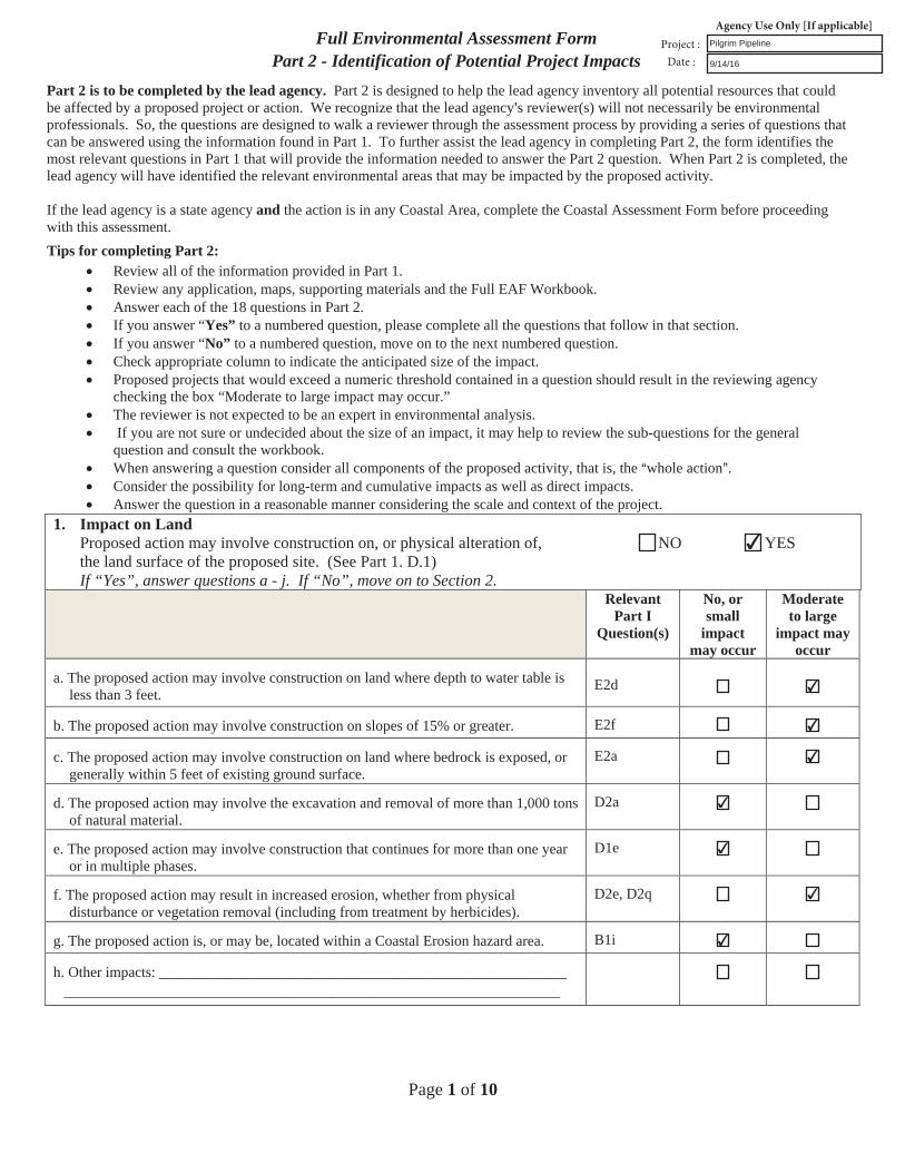
Full Environmental Assessment FormPart 2 - Identification of Potential Project Impacts
Part 2 is to be completed by the lead agency. Part 2 is designed to help the lead agency inventory all potential resources that could be affected by a proposed project or action. We recognize that the lead agency=s reviewer(s) will not necessarily be environmental professionals. So, the questions are designed to walk a reviewer through the assessment process by providing a series of questions that can be answered using the information found in Part 1. To further assist the lead agency in completing Part 2, the form identifies the most relevant questions in Part 1 that will provide the information needed to answer the Part 2 question. When Part 2 is completed, the lead agency will have identified the relevant environmental areas that may be impacted by the proposed activity.
If the lead agency is a state agency and the action is in any Coastal Area, complete the Coastal Assessment Form before proceeding with this assessment. Tips for completing Part 2:
Review all of the information provided in Part 1.Review any application, maps, supporting materials and the Full EAF Workbook.Answer each of the 18 questions in Part 2.If you answer “Yes” to a numbered question, please complete all the questions that follow in that section.If you answer “No” to a numbered question, move on to the next numbered question.Check appropriate column to indicate the anticipated size of the impact.Proposed projects that would exceed a numeric threshold contained in a question should result in the reviewing agencychecking the box “Moderate to large impact may occur.”The reviewer is not expected to be an expert in environmental analysis.If you are not sure or undecided about the size of an impact, it may help to review the sub-questions for the general
question and consult the workbook.When answering a question consider all components of the proposed activity, that is, the Awhole [email protected] the possibility for long-term and cumulative impacts as well as direct impacts.Answer the question in a reasonable manner considering the scale and context of the project.
1. Impact on LandProposed action may involve construction on, or physical alteration of, NO YES the land surface of the proposed site. (See Part 1. D.1)If “Yes”, answer questions a - j. If “No”, move on to Section 2.
Relevant Part I
Question(s)
No, or small
impact may occur
Moderate to large
impact may occur
a. The proposed action may involve construction on land where depth to water table isless than 3 feet.
E2d
b. The proposed action may involve construction on slopes of 15% or greater. E2f
c. The proposed action may involve construction on land where bedrock is exposed, orgenerally within 5 feet of existing ground surface.
E2a
d. The proposed action may involve the excavation and removal of more than 1,000 tonsof natural material.
D2a
e. The proposed action may involve construction that continues for more than one yearor in multiple phases.
D1e
f. The proposed action may result in increased erosion, whether from physicaldisturbance or vegetation removal (including from treatment by herbicides).
D2e, D2q
g. The proposed action is, or may be, located within a Coastal Erosion hazard area. B1i
h. Other impacts: __________________________________________________________________________________________________________________________
Pilgrim Pipeline
9/14/16
✔
✔
✔
✔
✔
✔
✔
✔
Page 2 of 10
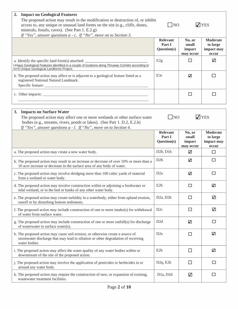
2. Impact on Geological FeaturesThe proposed action may result in the modification or destruction of, or inhibit access to, any unique or unusual land forms on the site (e.g., cliffs, dunes, NO YES minerals, fossils, caves). (See Part 1. E.2.g) If “Yes”, answer questions a - c. If “No”, move on to Section 3.
Relevant Part I
Question(s)
No, or small
impact may occur
Moderate to large
impact may occur
a. Identify the specific land form(s) attached: ________________________________ ___________________________________________________________________
E2g
b. The proposed action may affect or is adjacent to a geological feature listed as a registered National Natural Landmark. Specific feature: _____________________________________________________
E3c
c. Other impacts: ______________________________________________________ ___________________________________________________________________
3. Impacts on Surface WaterThe proposed action may affect one or more wetlands or other surface water NO YES bodies (e.g., streams, rivers, ponds or lakes). (See Part 1. D.2, E.2.h) If “Yes”, answer questions a - l. If “No”, move on to Section 4.
Relevant Part I
Question(s)
No, or small
impact may occur
Moderate to large
impact may occur
a. The proposed action may create a new water body. D2b, D1h
b. The proposed action may result in an increase or decrease of over 10% or more than a 10 acre increase or decrease in the surface area of any body of water.
D2b
c. The proposed action may involve dredging more than 100 cubic yards of material from a wetland or water body.
D2a
d. The proposed action may involve construction within or adjoining a freshwater or tidal wetland, or in the bed or banks of any other water body.
E2h
e. The proposed action may create turbidity in a waterbody, either from upland erosion, runoff or by disturbing bottom sediments.
D2a, D2h
f. The proposed action may include construction of one or more intake(s) for withdrawal of water from surface water.
D2c
g. The proposed action may include construction of one or more outfall(s) for discharge of wastewater to surface water(s).
D2d
h. The proposed action may cause soil erosion, or otherwise create a source of stormwater discharge that may lead to siltation or other degradation of receiving water bodies.
D2e
i. The proposed action may affect the water quality of any water bodies within or downstream of the site of the proposed action.
E2h
j. The proposed action may involve the application of pesticides or herbicides in or around any water body.
D2q, E2h
k. The proposed action may require the construction of new, or expansion of existing, wastewater treatment facilities.
D1a, D2d
✔
✔
Unique Geological Features identified in a couple of locations along Thruway Corridor according toNYS Unique Geological Landforms Project.
✔
✔
✔
✔
✔
✔
✔
✔
✔
✔
✔
✔

Page 3 of 10
l. Other impacts: __________________________________________________________________________________________________________________________
4. Impact on groundwaterThe proposed action may result in new or additional use of ground water, or NO YES may have the potential to introduce contaminants to ground water or an aquifer. (See Part 1. D.2.a, D.2.c, D.2.d, D.2.p, D.2.q, D.2.t) If “Yes”, answer questions a - h. If “No”, move on to Section 5.
Relevant Part I
Question(s)
No, or small
impact may occur
Moderate to large
impact may occur
a. The proposed action may require new water supply wells, or create additional demandon supplies from existing water supply wells.
D2c
b. Water supply demand from the proposed action may exceed safe and sustainablewithdrawal capacity rate of the local supply or aquifer.Cite Source: ________________________________________________________
D2c
c. The proposed action may allow or result in residential uses in areas without water andsewer services.
D1a, D2c
d. The proposed action may include or require wastewater discharged to groundwater. D2d, E2l
e. The proposed action may result in the construction of water supply wells in locationswhere groundwater is, or is suspected to be, contaminated.
D2c, E1f, E1g, E1h
f. The proposed action may require the bulk storage of petroleum or chemical productsover ground water or an aquifer.
D2p, E2l
g. The proposed action may involve the commercial application of pesticides within 100feet of potable drinking water or irrigation sources.
E2h, D2q, E2l, D2c
h. Other impacts: ________________________________________________________________________________________________________________________
5. Impact on FloodingThe proposed action may result in development on lands subject to flooding. NO YES (See Part 1. E.2)If “Yes”, answer questions a - g. If “No”, move on to Section 6.
Relevant Part I
Question(s)
No, or small
impact may occur
Moderate to large
impact may occur
a. The proposed action may result in development in a designated floodway. E2i
b. The proposed action may result in development within a 100 year floodplain. E2j
c. The proposed action may result in development within a 500 year floodplain. E2k
d. The proposed action may result in, or require, modification of existing drainagepatterns.
D2b, D2e
e. The proposed action may change flood water flows that contribute to flooding. D2b, E2i, E2j, E2k
f. If there is a dam located on the site of the proposed action, dam E1e
✔
✔
✔
✔
✔
✔
✔
✔
Potential for leaks with the conveyance of petroleum products across severalgroundwater and drinking water resources
✔
✔
✔
✔
✔
✔
✔
✔
Page 4 of 10
g. Other impacts: _________________________________________________________________________________________________________________________
6. Impacts on AirThe proposed action may include a state regulated air emission source. NO YES (See Part 1. D.2.f., D,2,h, D.2.g) If “Yes”, answer questions a - f. If “No”, move on to Section 7.
Relevant Part I
Question(s)
No, or small
impact may occur
Moderate to large
impact may occur
a. If the proposed action requires federal or state air emission permits, the action mayalso emit one or more greenhouse gases at or above the following levels:
i. More than 1000 tons/year of carbon dioxide (CO2)ii. More than 3.5 tons/year of nitrous oxide (N2 )iii. More than 1000 tons/year of carbon equivalent of perfluorocarbons (PFCs)iv. More than .045 tons/year of sulfur hexafluoride (SF6)v. More than 1000 tons/year of carbon dioxide equivalent of
hydrochlorofl urocarbons (HFCs) emissionsvi. 43 tons/year or more of methane
D2g D2g D2gD2g D2g
D2h
b. The proposed action may generate 10 tons/year or more of any one designatedhazardous air pollutant, or 25 tons/year or more of any combination of such hazardousair pollutants.
D2g
c. The proposed action may require a state air registration, or may produce an emissionsrate of total contaminants that may exceed 5 lbs. per hour, or may include a heatsource capable of producing more than 10 million BTU=s per hour.
D2f, D2g
d. The proposed action may reach 50% of any of the thresholds in “a” through “c”, above.
D
e. The proposed action may result in the combustion or thermal treatment of more than 1ton of refuse per hour.
D2s
f. Other impacts: ________________________________________________________________________________________________________________________
7. Impact on Plants and AnimalsThe proposed action may result in a loss of flora or fauna. (See Part 1. E.2. m.-q.) NO YES If “Yes”, answer questions a - j. If “No”, move on to Section 8.
Relevant Part I
Question(s)
No, or small
impact may occur
Moderate to large
impact may occur
a. The proposed action may cause reduction in population or loss of individuals of anythreatened or endangered species, as listed by New York State or the Federalgovernment, that use the site, or are found on, over, or near the site.
E2o
b. The proposed action may result in a reduction or degradation of any habitat used byany rare, threatened or endangered species, as listed by New York State or the federalgovernment.
E2o
c. The proposed action may cause reduction in population, or loss of individuals, of anyspecies of special concern or conservation need, as listed by New York State or theFederal government, that use the site, or are found on, over, or near the site.
E2p
d. The proposed action may result in a reduction or degradation of any habitat used byany species of special concern and conservation need, as listed by New York State orthe Federal government.
E2p
✔
✔✔✔✔✔
✔
✔
✔
✔
✔
✔Temporary air quality impacts during construction, including the generation offugitive dust and emissions from construction equipment.
✔
✔
✔
✔
✔
Page 5 of 10
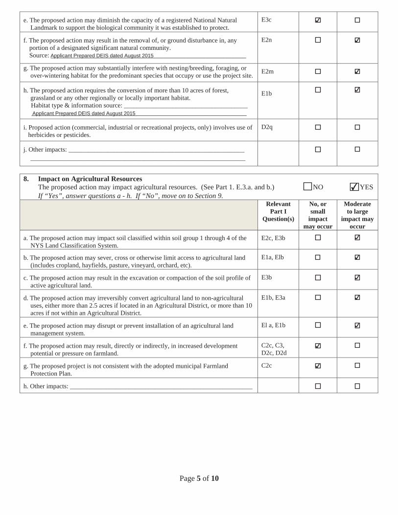
e. The proposed action may diminish the capacity of a registered National Natural Landmark to support the biological community it was established to protect.
E3c
f. The proposed action may result in the removal of, or ground disturbance in, any portion of a designated significant natural community.
Source: ____________________________________________________________
E2n
g. The proposed action may substantially interfere with nesting/breeding, foraging, or over-wintering habitat for the predominant species that occupy or use the project site. E2m
h. The proposed action requires the conversion of more than 10 acres of forest, grassland or any other regionally or locally important habitat.
Habitat type & information source: ______________________________________ __________________________________________________________________
E1b
i. Proposed action (commercial, industrial or recreational projects, only) involves use of herbicides or pesticides.
D2q
j. Other impacts: ______________________________________________________ __________________________________________________________________
8. Impact on Agricultural Resources The proposed action may impact agricultural resources. (See Part 1. E.3.a. and b.) NO YES If “Yes”, answer questions a - h. If “No”, move on to Section 9.
Relevant Part I
Question(s)
No, or small
impact may occur
Moderate to large
impact may occur
a. The proposed action may impact soil classified within soil group 1 through 4 of the NYS Land Classification System.
E2c, E3b
b. The proposed action may sever, cross or otherwise limit access to agricultural land (includes cropland, hayfields, pasture, vineyard, orchard, etc).
E1a, Elb
c. The proposed action may result in the excavation or compaction of the soil profile of active agricultural land.
E3b
d. The proposed action may irreversibly convert agricultural land to non-agricultural uses, either more than 2.5 acres if located in an Agricultural District, or more than 10 acres if not within an Agricultural District.
E1b, E3a
e. The proposed action may disrupt or prevent installation of an agricultural land management system.
El a, E1b
f. The proposed action may result, directly or indirectly, in increased development potential or pressure on farmland.
C2c, C3, D2c, D2d
g. The proposed project is not consistent with the adopted municipal Farmland Protection Plan.
C2c
h. Other impacts: ________________________________________________________
✔
✔
Applicant Prepared DEIS dated August 2015
✔
✔
Applicant Prepared DEIS dated August 2015
✔
✔
✔
✔
✔
✔
✔
✔
Page 6 of 10
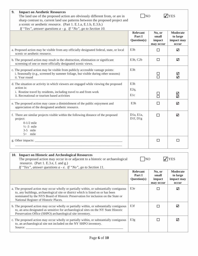
9. Impact on Aesthetic Resources The land use of the proposed action are obviously different from, or are in NO YES sharp contrast to, current land use patterns between the proposed project and a scenic or aesthetic resource. (Part 1. E.1.a, E.1.b, E.3.h.)
If “Yes”, answer questions a - g. If “No”, go to Section 10.Relevant
Part I Question(s)
No, or small
impact may occur
Moderate to large
impact may occur
a. Proposed action may be visible from any officially designated federal, state, or local scenic or aesthetic resource.
E3h
b. The proposed action may result in the obstruction, elimination or significant screening of one or more officially designated scenic views.
E3h, C2b
c. The proposed action may be visible from publicly accessible vantage points: i. Seasonally (e.g., screened by summer foliage, but visible during other seasons) ii. Year round
E3h
d. The situation or activity in which viewers are engaged while viewing the proposed action is: i. Routine travel by residents, including travel to and from work ii. Recreational or tourism based activities
E3h
E2q,
E1c
e. The proposed action may cause a diminishment of the public enjoyment and appreciation of the designated aesthetic resource.
E3h
f. There are similar projects visible within the following distance of the proposed project:
0-1/2 mile ½ -3 mile 3-5 mile 5+ mile
D1a, E1a, D1f, D1g
g. Other impacts: ______________________________________________________ __________________________________________________________________
10. Impact on Historic and Archeological Resources The proposed action may occur in or adjacent to a historic or archaeological NO YES resource. (Part 1. E.3.e, f. and g.)
If “Yes”, answer questions a - e. If “No”, go to Section 11.Relevant
Part I Question(s)
No, or small
impact may occur
Moderate to large
impact may occur
a. The proposed action may occur wholly or partially within, or substantially contiguous to, any buildings, archaeological site or district which is listed on or has been nominated by the NYS Board of Historic Preservation for inclusion on the State or National Register of Historic Places.
E3e
b. The proposed action may occur wholly or partially within, or substantially contiguous to, an area designated as sensitive for archaeological sites on the NY State Historic Preservation Office (SHPO) archaeological site inventory.
E3f
c. The proposed action may occur wholly or partially within, or substantially contiguous to, an archaeological site not included on the NY SHPO inventory. Source: ____________________________________________________________
E3g
✔
✔
✔
✔✔
✔✔
✔
✔
✔
✔
✔
✔

Page 7 of 10
d. Other impacts: ________________________________________________________________________________________________________________________
e. If any of the above (a-d) are answered “Yes”, continue with the following questionsto help support conclusions in Part 3:
i. The proposed action may result in the destruction or alteration of all or partof the site or property.
ii. The proposed action may result in the alteration of the property’s setting orintegrity.
iii. The proposed action may result in the introduction of visual elements whichare out of character with the site or property, or may alter its setting.
E3e, E3g, E3f
E3e, E3f, E3g, E1a, E1bE3e, E3f, E3g, E3h, C2, C3
11. Impact on Open Space and RecreationThe proposed action may result in a loss of recreational opportunities or a NO YES reduction of an open space resource as designated in any adoptedmunicipal open space plan.(See Part 1. C.2.c, E.1.c., E.2.q.)If “Yes”, answer questions a - e. If “No”, go to Section 12.
Relevant Part I
Question(s)
No, or small
impact may occur
Moderate to large
impact may occur
a. The proposed action may result in an impairment of natural functions, or “ecosystemservices”, provided by an undeveloped area, including but not limited to stormwaterstorage, nutrient cycling, wildlife habitat.
D2e, E1b E2h,E2m, E2o, E2n, E2p
b. The proposed action may result in the loss of a current or future recreational resource. C2a, E1c, C2c, E2q
c. The proposed action may eliminate open space or recreational resource in an areawith few such resources.
C2a, C2c E1c, E2q
d. The proposed action may result in loss of an area now used informally by thecommunity as an open space resource.
C2c, E1c
e. Other impacts: ______________________________________________________________________________________________________________________
12. Impact on Critical Environmental AreasThe proposed action may be located within or adjacent to a critical NO YES environmental area (CEA). (See Part 1. E.3.d)If “Yes”, answer questions a - c. If “No”, go to Section 13.
Relevant Part I
Question(s)
No, or small
impact may occur
Moderate to large
impact may occur
a. The proposed action may result in a reduction in the quantity of the resource orcharacteristic which was the basis for designation of the CEA.
E3d
b. The proposed action may result in a reduction in the quality of the resource orcharacteristic which was the basis for designation of the CEA.
E3d
c. Other impacts: ________________________________________________________________________________________________________________________
✔
✔
✔
✔
✔
✔
✔
✔
✔
✔
✔
Page 8 of 10
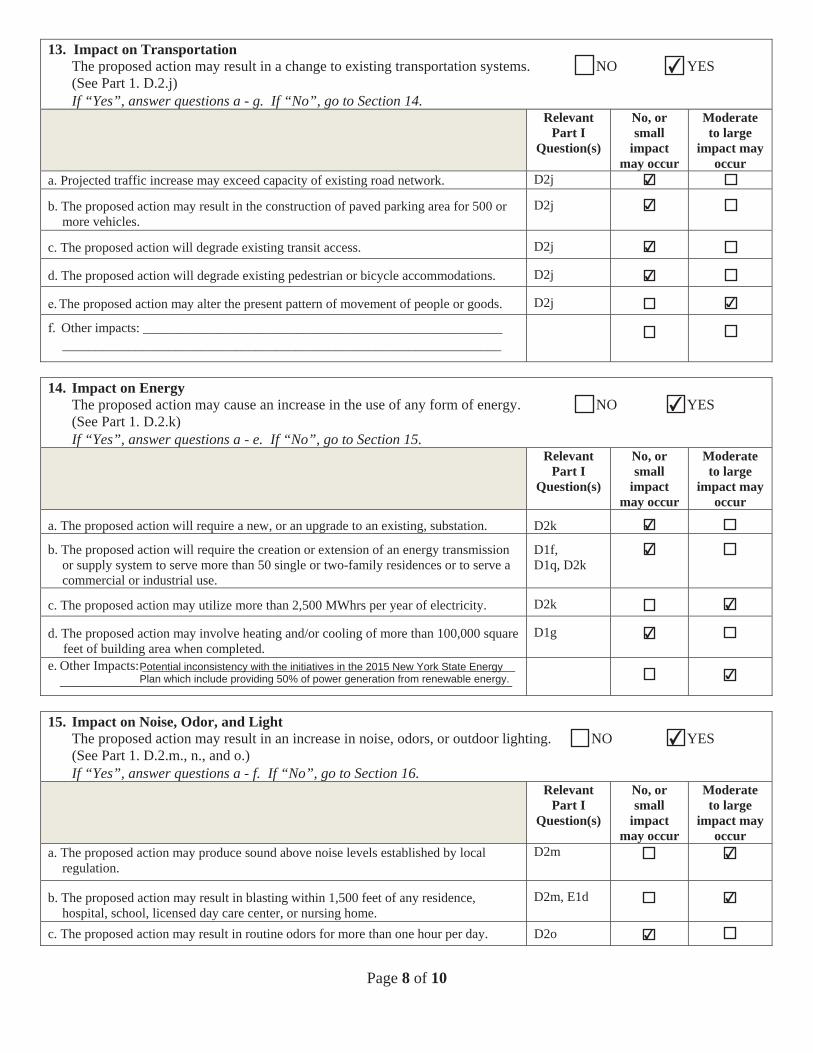
13. Impact on TransportationThe proposed action may result in a change to existing transportation systems. NO YES (See Part 1. D.2.j)If “Yes”, answer questions a - g. If “No”, go to Section 14.
Relevant Part I
Question(s)
No, or small
impact may occur
Moderate to large
impact may occur
a. Projected traffic increase may exceed capacity of existing road network. D2j
b. The proposed action may result in the construction of paved parking area for 500 ormore vehicles.
D2j
c. The proposed action will degrade existing transit access. D2j
d. The proposed action will degrade existing pedestrian or bicycle accommodations. D2j
. The proposed action may alter the present pattern of movement of people or goods. D2j
. Other impacts: ________________________________________________________________________________________________________________________
14. Impact on EnergyThe proposed action may cause an increase in the use of any form of energy. NO YES (See Part 1. D.2.k)If “Yes”, answer questions a - e. If “No”, go to Section 15.
Relevant Part I
Question(s)
No, or small
impact may occur
Moderate to large
impact may occur
a. The proposed action will require a new, or an upgrade to an existing, substation. D2k
b. The proposed action will require the creation or extension of an energy transmissionor supply system to serve more than 50 single or two-family residences or to serve acommercial or industrial use.
D1f, D1q, D2k
c. The proposed action may utilize more than 2,500 MWhrs per year of electricity. D2k
d. The proposed action may involve heating and/or cooling of more than 100,000 squarefeet of building area when completed.
D1g
e. Other Impacts: ____________________________________________________________________________________________________________________________
15. Impact on Noise, Odor, and LightThe proposed action may result in an increase in noise, odors, or outdoor lighting. NO YES (See Part 1. D.2.m., n., and o.)If “Yes”, answer questions a - f. If “No”, go to Section 16.
Relevant Part I
Question(s)
No, or small
impact may occur
Moderate to large
impact may occur
a. The proposed action may produce sound above noise levels established by localregulation.
D2m
b. The proposed action may result in blasting within 1,500 feet of any residence,hospital, school, licensed day care center, or nursing home.
D2m, E1d
c. The proposed action may result in routine odors for more than one hour per day. D2o
✔
✔
✔
✔
✔
✔
✔
✔
✔
✔
✔
Potential inconsistency with the initiatives in the 2015 New York State EnergyPlan which include providing 50% of power generation from renewable energy.
✔
✔
✔
✔
✔
Page 9 of 10
d. The proposed action may result in light shining onto adjoining properties. D2n
e. The proposed action may result in lighting creating sky-glow brighter than existingarea conditions.
D2n, E1a
f. Other impacts: ________________________________________________________________________________________________________________________
16. Impact on Human HealthThe proposed action may have an impact on human health from exposure NO YES to new or existing sources of contaminants. (See Part 1.D.2.q., E.1. d. f. g. and h.)If “Yes”, answer questions a - m. If “No”, go to Section 17.
Relevant Part I
Question(s)
No,or small
impact may cccur
Moderate to large
impact may occur
a. The proposed action is located within 1500 feet of a school, hospital, licensed daycare center, group home, nursing home or retirement community.
E1d
b. The site of the proposed action is currently undergoing remediation. E1g, E1h
c. There is a completed emergency spill remediation, or a completed environmental siteremediation on, or adjacent to, the site of the proposed action.
E1g, E1h
d. The site of the action is subject to an institutional control limiting the use of theproperty (e.g. easement deed restriction)
E1g, E1h
e. The proposed action may affect institutional control measures that were put in placeto ensure that the site remains protective of the environment and human health.
E1g, E1h
f. The proposed action has adequate control measures in place to ensure that futuregeneration, treatment and/or disposal of hazardous wastes will be protective of theenvironment and human health.
D2t
g. The proposed action involves construction or modification of a solid wastemanagement facility.
D2q, E1f
h. The proposed action may result in the unearthing of solid or hazardous waste. D2q, E1f
i. The proposed action may result in an increase in the rate of disposal, or processing, ofsolid waste.
D2r, D2s
j. The proposed action may result in excavation or other disturbance within 2000 feet ofa site used for the disposal of solid or hazardous waste.
E1f, E1g E1h
k. The proposed action may result in the migration of explosive gases from a landfillsite to adjacent off site structures.
E1f, E1g
l. The proposed action may result in the release of contaminated leachate from theproject site.
D2s, E1f, D2r
m. Other impacts: ________________________________________________________________________________________________________________________
✔
✔
✔
✔
✔
✔
✔
✔
✔
✔
✔
✔
✔
✔
✔
The proposed action will traverse nine designated Environmental Justice areas. ✔

Page 10 of 10
17. Consistency with Community Plans The proposed action is not consistent with adopted land use plans. NO YES (See Part 1. C.1, C.2. and C.3.) If “Yes”, answer questions a - h. If “No”, go to Section 18.
Relevant Part I
Question(s)
No, or small
impact may occur
Moderate to large
impact may occur
a. The proposed action’s land use components may be different from, or in sharp contrast to, current surrounding land use pattern(s).
C2, C3, D1a E1a, E1b
b. The proposed action will cause the permanent population of the city, town or village in which the project is located to grow by more than 5%.
C2
c. The proposed action is inconsistent with local land use plans or zoning regulations. C2, C2, C3
d. The proposed action is inconsistent with any County plans, or other regional land use plans.
C2, C2
e. The proposed action may cause a change in the density of development that is not supported by existing infrastructure or is distant from existing infrastructure.
C3, D1c, D1d, D1f, D1d, Elb
f. The proposed action is located in an area characterized by low density development that will require new or expanded public infrastructure.
C4, D2c, D2d D2j
g. The proposed action may induce secondary development impacts (e.g., residential or commercial development not included in the proposed action)
C2a
h. Other: _____________________________________________________________ __________________________________________________________________
18. Consistency with Community Character The proposed project is inconsistent with the existing community character. NO YES (See Part 1. C.2, C.3, D.2, E.3)
If “Yes”, answer questions a - g. If “No”, proceed to Part 3.Relevant
Part I Question(s)
No, or small
impact may occur
Moderate to large
impact may occur
a. The proposed action may replace or eliminate existing facilities, structures, or areas of historic importance to the community.
E3e, E3f, E3g
b. The proposed action may create a demand for additional community services (e.g. schools, police and fire)
C4
c. The proposed action may displace affordable or low-income housing in an area where there is a shortage of such housing.
C2, C3, D1f D1g, E1a
d. The proposed action may interfere with the use or enjoyment of officially recognized or designated public resources.
C2, E3
e. The proposed action is inconsistent with the predominant architectural scale and character.
C2, C3
f. Proposed action is inconsistent with the character of the existing natural landscape. C2, C3 E1a, E1b E2g, E2h
g. Other impacts: ______________________________________________________ __________________________________________________________________
✔
✔
✔
✔
✔
✔
✔
✔
✔
✔
✔
✔
✔
✔
✔
PRINT FULL FORM
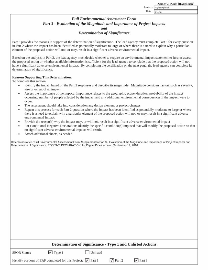
Full Environmental Assessment Form Part 3 - Evaluation of the Magnitude and Importance of Project Impacts
andDetermination of Significance
Part 3 provides the reasons in support of the determination of significance. The lead agency must complete Part 3 for every question in Part 2 where the impact has been identified as potentially moderate to large or where there is a need to explain why a particular element of the proposed action will not, or may, result in a significant adverse environmental impact.
Based on the analysis in Part 3, the lead agency must decide whether to require an environmental impact statement to further assessthe proposed action or whether available information is sufficient for the lead agency to conclude that the proposed action will not have a significant adverse environmental impact. By completing the certification on the next page, the lead agency can complete its determination of significance.
Reasons Supporting This Determination: To complete this section:
Identify the impact based on the Part 2 responses and describe its magnitude. Magnitude considers factors such as severity,size or extent of an impact. Assess the importance of the impact. Importance relates to the geographic scope, duration, probability of the impactoccurring, number of people affected by the impact and any additional environmental consequences if the impact were to occur.The assessment should take into consideration any design element or project changes.Repeat this process for each Part 2 question where the impact has been identified as potentially moderate to large or wherethere is a need to explain why a particular element of the proposed action will not, or may, result in a significant adverseenvironmental impact.Provide the reason(s) why the impact may, or will not, result in a significant adverse environmental impactFor Conditional Negative Declarations identify the specific condition(s) imposed that will modify the proposed action so thatno significant adverse environmental impacts will result.Attach additional sheets, as needed.
Determination of Significance - Type 1 and Unlisted Actions
SEQR Status: Type 1 Unlisted
Identify portions of EAF completed for this Project: Part 1 Part 2 Part 3
✔
✔✔ ✔
Refer to narrative, "Full Environmental Assessment Form, Supplement to Part 3 - Evaluation of the Magnitude and Importance of Project Impacts andDetermination of Significance, POSITIVE DECLARATION" for Pilgrim Pipeline dated September 14, 2016.
Pilgrim Pipeline
9/14/16
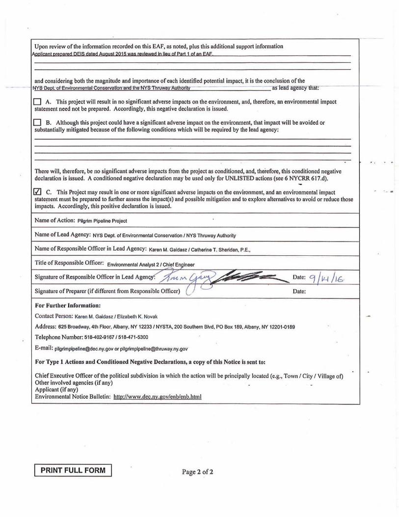
Upon review of the information recorded on this EAF, as noted, plus this additional support information Allllli!lilDl llWlliiCIUl QEIS diillld Augu:il 2Ql:i Wil:i llll£illWlld ID lillU g( ear:l l g( aa EAE
and considering both the magnitude and importance of each identified potential impact, it is the conclusion of the NYS-EleQt:-of-EnYironmental·Conservation-and the·NYS"'ThruwarAuth~rlt:x: - - trSlemi ·a~ncy-that: --
D A. This project will result in no significant adverse impacts on the environment, and, therefore, an environmental impact statement need not be prepared. Accordingly, this negative declaration is issued.
D B. Although this project could have a significant adverse impact on the environment, that impact will be avoided or substantially mitigated because of the following conditions which will be required by the lead agency:
There will, therefore, be no significant adverse impacts from the project as conditioned, and, therefore, this conditioned negative declaration is issued. A conditioned negative declaration may be used only for UNLISTED actions (see 6 NYCRR 617.d). -!ZI C. This Project may result in one or more significant adverse impacts on the environment, and an environmental impact -- .. statefllent must be prepared to further assess the impact(s) and possible mitigation and to explore alternatives to avoid or reduce those impacts. Accordingly, this positive declaration is issued.
Name of Action: Piigrim Pipeline Project
Name of Lead Agency: NYS Dept. of Environmental Conservation I NYS Thruway Authority
Name of Responsible Officer in Lead Agency: Karen M. Galdasz / Catherine T. Sheridan, P.E.,
Title of Responsible Officer: Environmental Analyst 2 / C~i~ Eni;ilneer
Signature of Responsible Officer in Lead Agen~~M ~ ~ ~ Date: '11~ /J(;. . ,~ .... ,_ -~ ~
Signature of Preparer (if different from Responsible Officer) CJ {___:) Date:
For Further Information:
Contact Person: Karen M. Galdasz I Elizabeth K. Novak
Address: 625 Broadway, 4th Floor, Albany, NY 12233 / NYSTA, 200 Southern Blvd. PO Box 189, Albany, NY 12201-0189
Telephone Number: 518-402-91671518-471-5300
E-mail: [email protected] or [email protected]
For Type 1 Actions and Conditioned Negative Declarations, a copy of this Notice is sent to:
Chief Executive Officer of the political subdivision in which the action will be principally located (e.g., Town I City I Village of) Other involved agencies (if any) .. Applicant (if any) Environmental Notice Bulletin: httg://www.dec.n:x:.gov/enb/enb.html
PRINT FULL FORM Page 2 of2
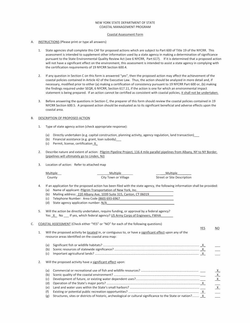
NEW YORK STATE DEPARTMENT OF STATECOASTAL MANAGEMENT PROGRAM
Coastal Assessment Form
A. INSTRUCTIONS (Please print or type all answers)
1. State agencies shall complete this CAF for proposed actions which are subject to Part 600 of Title 19 of the NYCRR. Thisassessment is intended to supplement other information used by a state agency in making a determination of significancepursuant to the State Environmental Quality Review Act (see 6 NYCRR, Part 617). If it is determined that a proposed actionwill not have a significant effect on the environment, this assessment is intended to assist a state agency in complying withthe certification requirements of 19 NYCRR Section 600.4.
2. If any question in Section C on this form is answered “yes”, then the proposed action may affect the achievement of thecoastal policies contained in Article 42 of the Executive Law. Thus, the action should be analyzed in more detail and, ifnecessary, modified prior to either (a) making a certification of consistency pursuant to 19 NYCRR Part 600 or, (b) makingthe findings required under SEQR, 6 NYCRR, Section 617.11, if the action is one for which an environmental impactstatement is being prepared. If an action cannot be certified as consistent with coastal policies, it shall not be undertaken.
3. Before answering the questions in Section C, the preparer of this form should review the coastal policies contained in 19NYCRR Section 600.5. A proposed action should be evaluated as to its significant beneficial and adverse effects upon thecoastal area.
B. DESCRIPTION OF PROPOSED ACTION
1. Type of state agency action (check appropriate response):
(a) Directly undertaken (e.g. capital construction, planning activity, agency regulation, land transaction)___(b) Financial assistance (e.g. grant, loan subsidy)___(c) Permit, license, certification X_
2. Describe nature and extent of action: Pilgrim Pipeline Project, 116.4 mile parallel pipelines from Albany, NY to NY Border.(pipelines will ultimately go to Linden, NJ)
3. Location of action: Refer to attached map
Multiple _______Multiple __ ___Multiple________County City Town or Village Street or Site Description
4. If an application for the proposed action has been filed with the state agency, the following information shall be provided:(a) Name of applicant: Pilgrim Transportation of New York, Inc._____________________(b) Mailing address: 220 Albany Ave, 1039 Suite 315, Canton, CT 06019______________(c) Telephone Number: Area Code (860) 693 6967_______________________________(d) State agency application number: N/A_______________________________________
5. Will the action be directly undertaken, require funding, or approval by a federal agency?Yes _X_ No ___ If yes, which federal agency? US Army Corps of Engineers, FWHA_______
C. COASTAL ASSESSMENT (Check either “YES” or “NO” for each of the following questions)YES NO
1. Will the proposed activity be located in, or contiguous to, or have a significant effect upon any of theresource areas identified on the coastal area map:
(a) Significant fish or wildlife habitats? .............................................................................................................. _X_ ___(b) Scenic resources of statewide significance? ................................................................................................. _X_ ___(c) Important agricultural lands? …………………………………………………………………………………………………………………. _X_ ___
2. Will the proposed activity have a significant effect upon:
(a) Commercial or recreational use of fish and wildlife resources? ……………………………………………………………… ___ _X_(b) Scenic quality of the coastal environment? ……………………………………………………………………………………...........___ _X_(c) Development of future, or existing water dependent uses?......................................................................... ___ _X_(d) Operation of the State’s major ports? ………………………………………………………………………………………………………_X_ ___(e) Land and water uses within the State’s small harbors? …………………………………………………………………………… ___ _X_(f) Existing or potential public recreation opportunities? ……………………………………………………………………………. _X_ ___(g) Structures, sites or districts of historic, archeological or cultural significance to the State or nation?........ _X_ ___
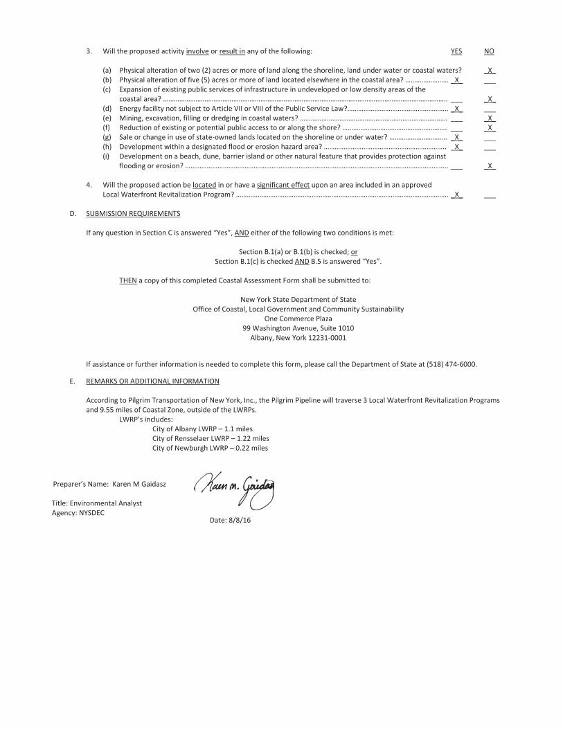
3. Will the proposed activity involve or result in any of the following: YES NO
(a) Physical alteration of two (2) acres or more of land along the shoreline, land under water or coastal waters? _X_(b) Physical alteration of five (5) acres or more of land located elsewhere in the coastal area? …………………… _X_ ___(c) Expansion of existing public services of infrastructure in undeveloped or low density areas of the
coastal area? ………………………………………………………………………………………………………………………………………….. ___ _X_(d) Energy facility not subject to Article VII or VIII of the Public Service Law?……………………………………………….. _X_ ___(e) Mining, excavation, filling or dredging in coastal waters? ………………………………………………………………………. ___ _X_(f) Reduction of existing or potential public access to or along the shore? …………………………………………………. ___ _X_(g) Sale or change in use of state owned lands located on the shoreline or under water? ………………………….. _X_ ___(h) Development within a designated flood or erosion hazard area? ………………………………………………………….. _X_ ___(i) Development on a beach, dune, barrier island or other natural feature that provides protection against
flooding or erosion? ……………………………………………………………………………………………………………………………….. ___ _X_
4. Will the proposed action be located in or have a significant effect upon an area included in an approvedLocal Waterfront Revitalization Program? ………………………………………………………………………………………………………. _X_ ___
D. SUBMISSION REQUIREMENTS
If any question in Section C is answered “Yes”, AND either of the following two conditions is met:
Section B.1(a) or B.1(b) is checked; orSection B.1(c) is checked AND B.5 is answered “Yes”.
THEN a copy of this completed Coastal Assessment Form shall be submitted to:
New York State Department of StateOffice of Coastal, Local Government and Community Sustainability
One Commerce Plaza99 Washington Avenue, Suite 1010Albany, New York 12231 0001
If assistance or further information is needed to complete this form, please call the Department of State at (518) 474 6000.
E. REMARKS OR ADDITIONAL INFORMATION
According to Pilgrim Transportation of New York, Inc., the Pilgrim Pipeline will traverse 3 Local Waterfront Revitalization Programsand 9.55 miles of Coastal Zone, outside of the LWRPs.
LWRP’s includes:City of Albany LWRP – 1.1 milesCity of Rensselaer LWRP – 1.22 milesCity of Newburgh LWRP – 0.22 miles
Preparer’s Name:
Title:gency:
Date:
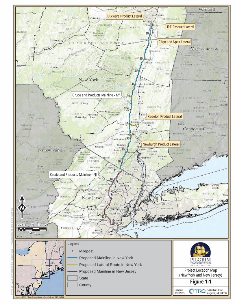
14 Gabriel DriveAugusta, ME 04330
Project Location Map(New York and New Jersey)
Figure 1-1Created: 3/13/2015 V:
\PRO
JECT
S\AU
GUST
A\Pi
lgrim
\V35
1_Fi
gure
s\Figu
re 1-
1 Pro
ject L
ocati
on M
ap (N
Y an
d NJ)
8x11
.mxd
!!
!!
!!
!!
!!
!!
!!
!!
!!
!!
!!
!!
!!
!!
!!
!!
!!
!!
!!
Crude and Products Mainline - NY
Roseton Product Lateral
Newburgh Product Lateral
Buckeye Product Lateral
IPT Product Lateral
Citgo and Apex Lateral
Crude and Products Mainline - NJ
0
10
20
30
40
50
60
70
80
90
100
110
116.4
20
4050
30
54.1
10
Connecticut
Massachusetts
New Jersey
New York
Pennsylvania
Vermont
NY
PA
VT
NJ
NH
MA
MD
CT
ME
VA
K0 5 10 15 202.5
Miles
Legend
!! Milepost
Proposed Mainline in New York
Proposed Lateral Route in New York
Proposed Mainline in New Jersey
State
County
Sources: ESRI, Pilgrim Transportation of New York, Inc, TRC, NYGIS
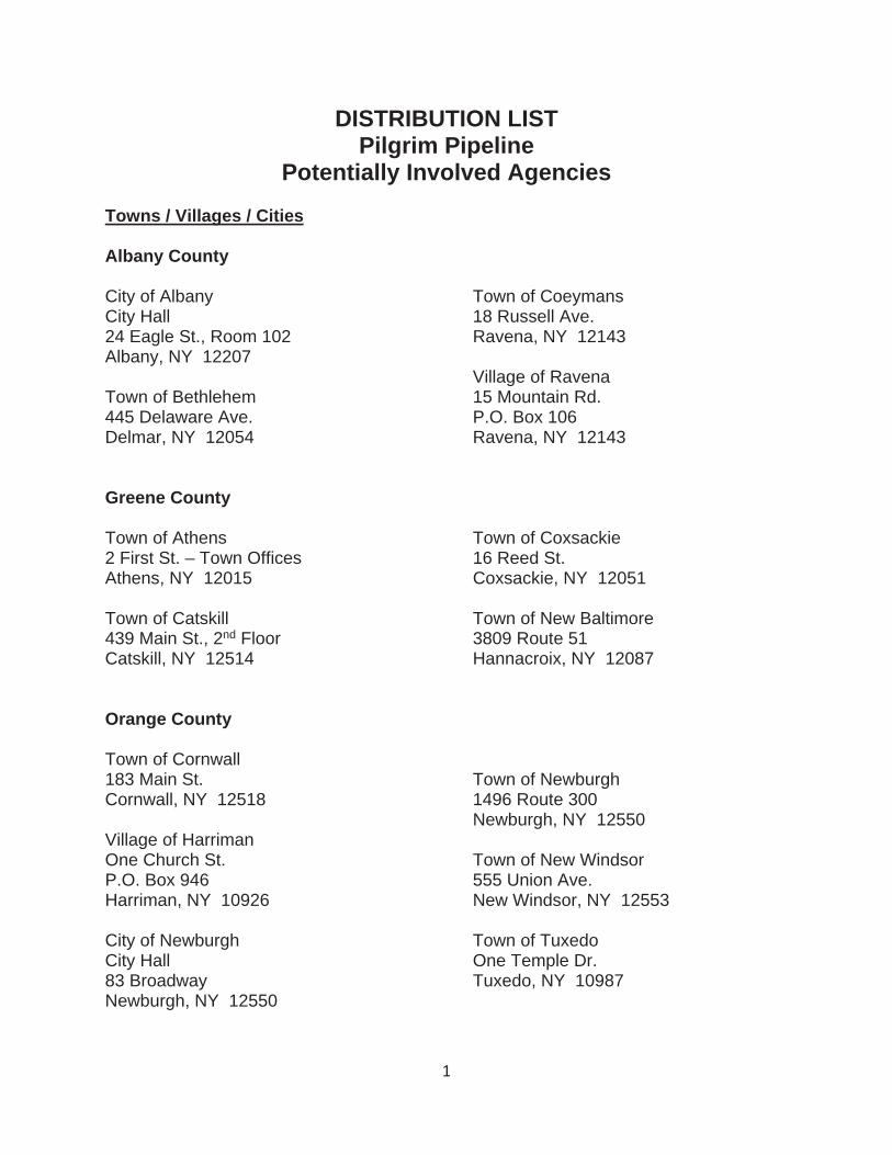
1
DISTRIBUTION LIST Pilgrim Pipeline
Potentially Involved Agencies
Towns / Villages / Cities
Albany County
City of Albany City Hall 24 Eagle St., Room 102 Albany, NY 12207
Town of Bethlehem 445 Delaware Ave. Delmar, NY 12054
Town of Coeymans 18 Russell Ave. Ravena, NY 12143
Village of Ravena 15 Mountain Rd. P.O. Box 106 Ravena, NY 12143
Greene County
Town of Athens 2 First St. – Town Offices Athens, NY 12015
Town of Catskill 439 Main St., 2nd Floor Catskill, NY 12514
Town of Coxsackie 16 Reed St. Coxsackie, NY 12051
Town of New Baltimore 3809 Route 51 Hannacroix, NY 12087
Orange County
Town of Cornwall 183 Main St. Cornwall, NY 12518
Village of Harriman One Church St. P.O. Box 946 Harriman, NY 10926
City of Newburgh City Hall 83 Broadway Newburgh, NY 12550
Town of Newburgh 1496 Route 300 Newburgh, NY 12550
Town of New Windsor 555 Union Ave. New Windsor, NY 12553
Town of Tuxedo One Temple Dr. Tuxedo, NY 10987

2
Village of Tuxedo Park 80 Lorillard Rd. Tuxedo Park, NY 10987 Village of Woodbury P.O. Box 546 Central Valley, NY 10917
Town of Woodbury 511 Route 32 P.O. Box 1004 Highland Mills, NY 10930
Rensselaer County
Town of East Greenbush 225 Columbia Turnpike Town Hall Rensselaer, NY 12144
City of Rensselaer City Hall 62 Washington St. Rensselaer, NY 12144
Rockland County
Town of Ramapo 237 Route 59 Suffern, NY 10901
Village of Hillburn 31 Mountain Ave. Hillburn, NY 10931
Ulster County
Town of Esopus Town Hall 284 Broadway Ulster Park, NY 12487
City of Kingston City Hall 420 Broadway Kingston, NY 12401
Town of Lloyd 12 Church St. Highland, NY 12528
Town of Marlborough 1650 Route 9W Town Hall Milton, NY 12547
Town of New Paltz 52 Clearwater Rd. P.O. Box 550 New Paltz, NY 12561
Town of Plattekill 1915 Route 44-55 Town Hall Modena, NY 12548
Town of Rosendale 1915 Lucas Ave. Cottekill, NY 12419
Town of Saugerties 4 High St. Saugerties, NY 12477
Town of Ulster One Town Hall Drive Lake Katrine, NY 12449
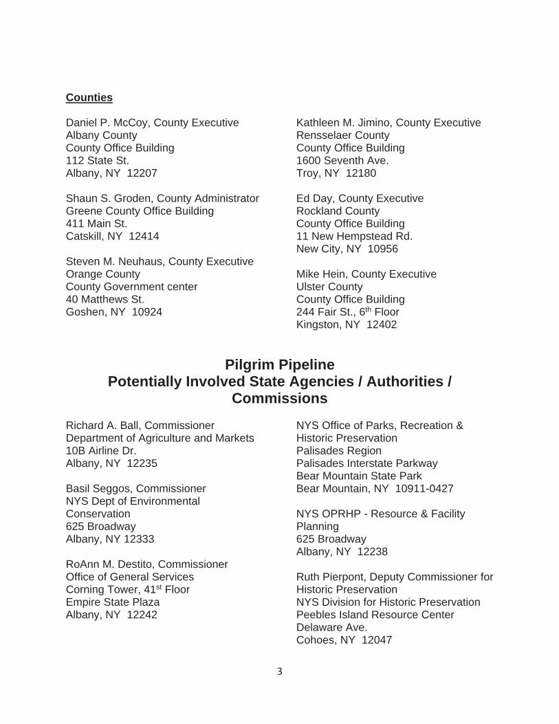
3
Counties
Daniel P. McCoy, County Executive Albany County County Office Building 112 State St. Albany, NY 12207
Shaun S. Groden, County Administrator Greene County Office Building 411 Main St. Catskill, NY 12414
Steven M. Neuhaus, County Executive Orange County County Government center 40 Matthews St. Goshen, NY 10924
Kathleen M. Jimino, County Executive Rensselaer County County Office Building 1600 Seventh Ave. Troy, NY 12180
Ed Day, County Executive Rockland County County Office Building 11 New Hempstead Rd. New City, NY 10956
Mike Hein, County Executive Ulster County County Office Building 244 Fair St., 6th Floor Kingston, NY 12402
Pilgrim Pipeline Potentially Involved State Agencies / Authorities /
Commissions
Richard A. Ball, Commissioner Department of Agriculture and Markets 10B Airline Dr. Albany, NY 12235
Basil Seggos, Commissioner NYS Dept of Environmental Conservation625 Broadway Albany, NY 12333
RoAnn M. Destito, Commissioner Office of General Services Corning Tower, 41st Floor Empire State Plaza Albany, NY 12242
NYS Office of Parks, Recreation & Historic Preservation Palisades Region Palisades Interstate Parkway Bear Mountain State Park Bear Mountain, NY 10911-0427
NYS OPRHP - Resource & Facility Planning625 Broadway Albany, NY 12238
Ruth Pierpont, Deputy Commissioner for Historic Preservation NYS Division for Historic Preservation Peebles Island Resource Center Delaware Ave. Cohoes, NY 12047
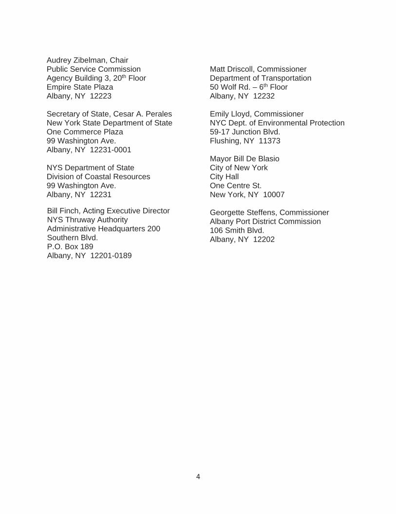
4
Audrey Zibelman, Chair Public Service Commission Agency Building 3, 20th Floor Empire State Plaza Albany, NY 12223
Secretary of State, Cesar A. Perales New York State Department of State One Commerce Plaza 99 Washington Ave. Albany, NY 12231-0001
NYS Department of State Division of Coastal Resources 99 Washington Ave. Albany, NY 12231
Bill Finch, Executive Director NYS Thruway AuthorityAdministrative Headquarters 200 Southern Blvd. P.O. Box 189Albany, NY 12201-0189
Matt Driscoll, Commissioner Department of Transportation 50 Wolf Rd. – 6th Floor Albany, NY 12232
Emily Lloyd, Commissioner NYC Dept. of Environmental Protection 59-17 Junction Blvd. Flushing, NY 11373
Mayor Bill De Blasio City of New York City Hall One Centre St. New York, NY 10007
Georgette Steffens, Commissioner Albany Port District Commission 106 Smith Blvd. Albany, NY 12202
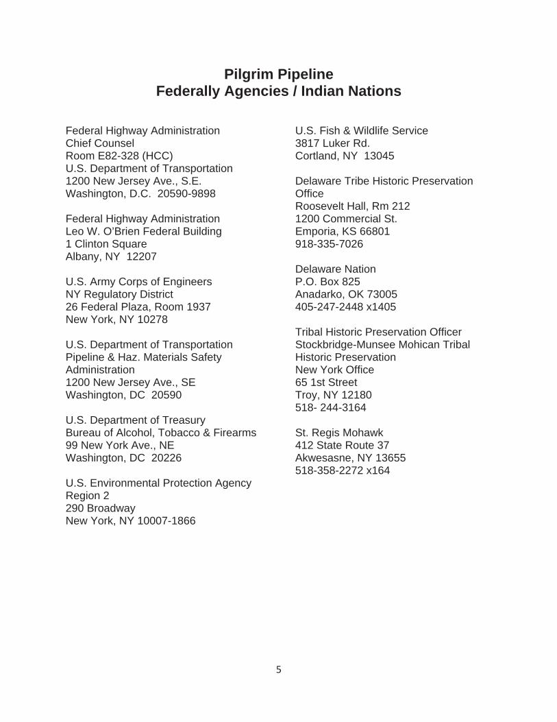
5
Pilgrim Pipeline Federally Agencies / Indian Nations
Federal Highway Administration Chief Counsel Room E82-328 (HCC) U.S. Department of Transportation 1200 New Jersey Ave., S.E. Washington, D.C. 20590-9898
Federal Highway Administration Leo W. O’Brien Federal Building 1 Clinton Square Albany, NY 12207
U.S. Army Corps of Engineers NY Regulatory District 26 Federal Plaza, Room 1937 New York, NY 10278
U.S. Department of Transportation Pipeline & Haz. Materials Safety Administration1200 New Jersey Ave., SE Washington, DC 20590
U.S. Department of Treasury Bureau of Alcohol, Tobacco & Firearms 99 New York Ave., NE Washington, DC 20226
U.S. Environmental Protection Agency Region 2 290 Broadway New York, NY 10007-1866
U.S. Fish & Wildlife Service 3817 Luker Rd. Cortland, NY 13045
Delaware Tribe Historic Preservation OfficeRoosevelt Hall, Rm 212 1200 Commercial St. Emporia, KS 66801 918-335-7026
Delaware Nation P.O. Box 825 Anadarko, OK 73005 405-247-2448 x1405
Tribal Historic Preservation OfficerStockbridge-Munsee Mohican Tribal Historic Preservation New York Office 65 1st Street Troy, NY 12180 518- 244-3164
St. Regis Mohawk 412 State Route 37 Akwesasne, NY 13655 518-358-2272 x164

6
Pilgrim Pipeline Interested Governmental Organizations
New Jersey Department of Environmental Protection Office of Permit Coordination & Environmental Review Mail Code 401-07J 401 E. State St. / PO Box 420 Trenton, NJ 08625
New Jersey Department of TransportationP.O. Box 600 Trenton, NJ 08625
New Jersey Highlands Council 100 North Rd. Chester, NJ 07930
Village of Catskill 422 Main Street, 2nd Floor Catskill, NY 12414
Town of Marbletown 1925 Lucas Avenue Cottekill, NY 12419
Town of Montgomery 110 Bracken Rd. Montgomery, NY 12549
Village of New Paltz 25 Plattekill Avenue New Paltz, NY 12561
Village of Sloatsburg 5 Allen Place Sloatsburg, NY 10974
Hudson River Valley Greenway 625 Broadway, 4th Floor Albany, NY 12224
Ravena-Coeymans-Selkirk Central School District RCS District Office P.O. Box 100 15 Mountain Road Ravena, NY 12143