Embed Size (px)
Citation preview

Annual World Bank Conference on Land and Poverty 2015: Linking Land Tenure and Use for Shared Prosperity, Washington, DC, 23-27 March 2015 Ahmed M. SOLIMAN
Breaking with the past to unleash urban informality potential:
Illegal/legal approach for land readjustment in Egypt
Annual World Bank Conference on Land and Poverty 2015: Linking Land Tenure and Use for Shared Prosperity, Washington, DC, 23-27 March 2015 Ahmed M. SOLIMAN
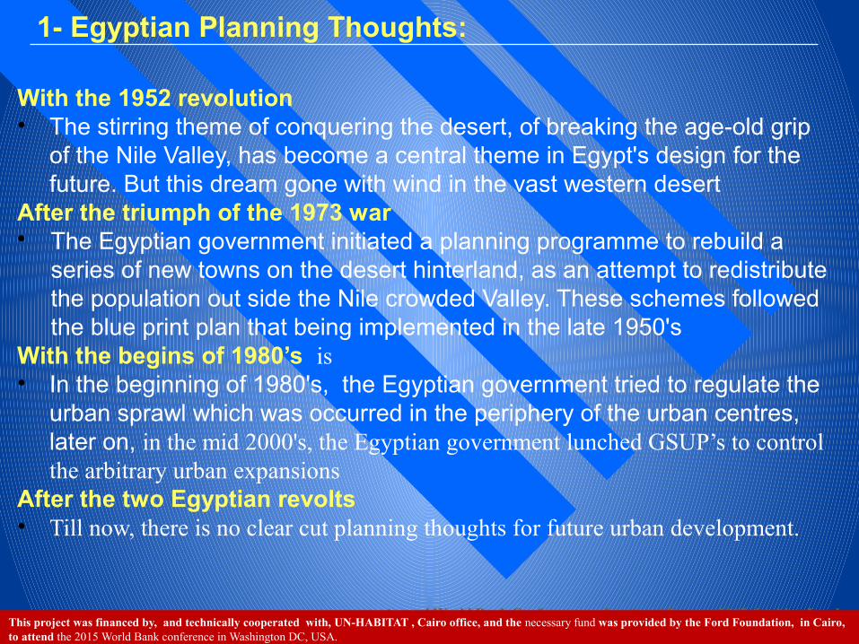
1- Egyptian Planning Thoughts:
With the 1952 revolution • The stirring theme of conquering the desert, of breaking the age-old grip
of the Nile Valley, has become a central theme in Egypt's design for the future. But this dream gone with wind in the vast western desert
After the triumph of the 1973 war• The Egyptian government initiated a planning programme to rebuild a
series of new towns on the desert hinterland, as an attempt to redistribute the population out side the Nile crowded Valley. These schemes followed the blue print plan that being implemented in the late 1950's
With the begins of 1980’s is • In the beginning of 1980's, the Egyptian government tried to regulate the
urban sprawl which was occurred in the periphery of the urban centres, later on, in the mid 2000's, the Egyptian government lunched GSUP’s to control the arbitrary urban expansions
After the two Egyptian revolts• Till now, there is no clear cut planning thoughts for future urban development.
This project was financed by, and technically cooperated with, UN-HABITAT , Cairo office, and the necessary fund was provided by the Ford Foundation, in Cairo, to attend the 2015 World Bank conference in Washington DC, USA.

Annual World Bank Conference on Land and Poverty 2015: Linking Land Tenure and Use for Shared Prosperity, Washington, DC, 23-27 March 2015 Ahmed M. SOLIMAN
Between 1982 and 2004, an estimated 1.2 million feddan (one feddan is equal 0.4 hectare) of agricultural land has been destroyed through urban informality, with an average of 6.22 faddan per an hour.
With the implementation of the General Strategic Urban Plans (GSUP) for 226 cities, 4632 villages and 27000 hamlets, Egypt will lose formally around 0.33 million feddan of agricultural areas to the year 2027.
As of 2007, there were an estimated 8.5 million informal housing units with at least 21.2 million Egyptians live in urban areas.
Four years after the January & June Revolts, Egypt has lost between 120000-150000 feddan of agricultural land to housing informality..
If this trend continues, Egypt will lose all its agricultural land, around three million feddan in Delta, within nearly 200 years' time.
92% of Egyptians hold their property without registered titles. In 2013, the total population of Egypt approaches the figure of 91
million, and it is expected to reach 151 million by 2050, where 62.4 percent will be urbanized.
In the year 2050, Egypt will need two thirds of its current built-up areas to accommodate the rapid population growth.
Important Facts مهمة حقائق

Annual World Bank Conference on Land and Poverty 2015: Linking Land Tenure and Use for Shared Prosperity, Washington, DC, 23-27 March 2015 Ahmed M. SOLIMAN
What if ؟ لو ماذاThe current circumstances continue?
Sprawling of informality ?
Rapid population growth ?
Eaten the agricultural land ?
The spreading of informal housing construction
?
Insecurity of land tenure ?
The complexity of linkages between the “informal” economy and informal land market
?
A growing divergence in cities ?
Deterioration of rural areas ?
Immigration from rural to urban areas ?
Inappropriate of urban services

Annual World Bank Conference on Land and Poverty 2015: Linking Land Tenure and Use for Shared Prosperity, Washington, DC, 23-27 March 2015 Ahmed M. SOLIMAN
2- Key Concepts
The main objectives of the research are: To what extent do the Detailed Plan for New Urban
Expansions (DPNUE) within the scope of GSUP, legally or illegally, facilitate the implementation process on the ground for preparing concrete Action Plans (i.e. land readjustment, land subdivision).
To what extent do landlords and other actors are working as social networks to participate, through collective process , on the DPNUE in order to improve land delivery system
The research assumes that:• DPNUE can be formulated through formal/informal
process at the local level with ‘technical enablement’ that facilitates land readjustment if the main obstacles could be solved.
In the mid 2000’s the GOPP introduced a project for setting up the General Strategic Urban Plans (GSUP) for 226 Egyptian Cities, based on participatory approach, to meet the future requirements of its citizens till the year 2027 Detailed Plan for New Urban Expansions (DPNUE) is the main outcome of the GSUP

Annual World Bank Conference on Land and Poverty 2015: Linking Land Tenure and Use for Shared Prosperity, Washington, DC, 23-27 March 2015 Ahmed M. SOLIMAN
3- General Strategic Urban Plan (GSUP): Does it prevent or accelerate informality?
Allocated period
Revision Phases Stages
Phases of the GSUP
4 months Review of Data Collection and Analysis
Start-up Phase
Milestone one
Data Collection Phase
Data analysis Phase
3 months Review of Strategic Urban Plan for the city
City Consultation
Milestone Two
Strategy Formulation
2 months Review GSUP for city and GSUP approval
Approval and final submittal of the GSUP
Milestone Three
The GSUP was divided into three phases; a Milestone one, Milestone two; and milestone three covers.
The GSUP adopted an integrated approach to address four main substantive areas, i.e. shelter, social services (SS), basic urban services (BUS) and local economic development (LED).
The GSUP did not succeed in its objectives nor did preserve the agricultural areas. It could be said that two types of urban informality have flourished, one inside, and the other outside, the official approved Hayez, by which more agricultural lands were converted into urban informality (Soliman, 2014).
The main impediments were: Dense evaluation processes must be fulfilled in all
stages of the GSUP which resulted in long complicated procedures,
The Operations Department in the Ministry of Defense (ODMD) has to approve the GSUP.
Restrictions that imposed on the land subdivision project
The approval of the GSUP might take between 2-4 years
The failure was due to mismatch between what to be done on the ground, and what can be theoretically gained out of the PBL119 of 2008,

Annual World Bank Conference on Land and Poverty 2015: Linking Land Tenure and Use for Shared Prosperity, Washington, DC, 23-27 March 2015 Ahmed M. SOLIMAN
4- Planning process
The city of Banha is located north of Egypt’s capital, Cairo, approximately 45 kilometers away. The current built up of the city is around 621.4 hectares with a total population of 158,389 (2006).
In the year 2007 the GSUP for Banha was introduced and approved in 2011 with a total area of 944 hectares , total population of 211,200 and a projected gross density of 224 person/ hectare
El Rezqa area was chosen as a pilot project to prepare and implement the DPNUE on the ground. The site is rectangular in shape, located in the northeastern part of the city with an area of 4.5 hectares.
It is surrounded by four main streets ranging between 10- 28 meters. A gas company, with an area of 0.42 hectares subdivides the site into two parts; the southern part with an area of 2.8 hectares, and the northern part with an area of 1.28 hectares.
4-1 RESEARCH SETTINGS

Annual World Bank Conference on Land and Poverty 2015: Linking Land Tenure and Use for Shared Prosperity, Washington, DC, 23-27 March 2015 Ahmed M. SOLIMAN
0 10 20 30 405Meters
Landlords' Initiative Plan
Official Land Subdivision area
Landlords' Proposed Road Network
Huts
Residential Buildings
Total study Area
Non Residential Buildings
Gas Station
Surroundings Areas
Vacant Land
´
Hoaad El Shaael No 5
Riv
er N
ile
Dam
iett
a B
ranc
h
Hoaad El Rezqa No 8
Hoaad El Ramel No 9
Villa Subdivision
Hoaad El Roada No 6Ring Road Cairo- Alexandria
Kaf
r Saa
d R
oad
Road No 8
El F
atah
Roa
d
Official Land Subdivision area
Gas Station
`
To Cairo
`
To Alexandria
`
To C
ity c
ente
r
Public Buildings
The study Area
325300.000000
325300.000000
325400.000000
325400.000000
325500.000000
325500.000000
325600 .000000
325600 .000000
325700.000000
325700.000000
3373
30
0.00
00
00
3373
300
.000
000
3373
40
0.00
00
00
3373
400
.000
000
3373
50
0.00
00
00
3373
500
.000
000
3373
60
0.00
00
00
3373
600
.000
000
0 10 20 30 405Meters
Landlords' Initiative Plan
Official Land Subdivision area
Landlords' Proposed Road Network
Huts
Residential Buildings
Total study Area
Non Residential Buildings
Gas Station
Surroundings Areas
Vacant Land
´
4-2 THE FIELD SURVEYThe team work had three tools presenting different information:• Land parcel mapping out of physical land
survey effort• Land parcel histories as per information
at the Real Estate Publicity Authority (REPA).
• Informal land parcel map from the Land Survey Authority (LSA).
• All data transferred into GIS format.

Annual World Bank Conference on Land and Poverty 2015: Linking Land Tenure and Use for Shared Prosperity, Washington, DC, 23-27 March 2015 Ahmed M. SOLIMAN
4-3 PLANNING PRINCIPLESA set of basic principles has prioritized the following five values; transparency; equity; trust; credibility; and efficiency
It was through these values that the team was able to establish a sort of social network, and building bridge of trust between landlords that would enhance participation to reach a sort of compromise among them.
Accordingly, a communal principles among all landlords was emerged as follows:• All landlords would give up the same percentage of their land for roads and services according to the BPL 119. • In reassigning a plot of land to a landlord, the team would do its best to make sure it would be at the closest physical proximity as that of the landlord’s original site.• The team would also respect any specific advantages that a parcel had and make sure the “new parcel” provided for those advantages. • The minimum street's width will be 10 meter.• The minimum land parcel's size will be 120 square meter. • In the case that land parcel's size is less than 120 square meter, the landlord will reimburse his exact land size in another land plot to be shared with other.

Annual World Bank Conference on Land and Poverty 2015: Linking Land Tenure and Use for Shared Prosperity, Washington, DC, 23-27 March 2015 Ahmed M. SOLIMAN
4-4 THE ROLE OF STAKEHOLDERS First, social network was formulated on the ground
through positive participation and negotiations among the landlords themselves as well as, with the technical team
Second, the stakeholders were convinced to identify a range of options that would give landlords the flexibility to choose their setting or the size of the land plots,
Third, stakeholders introduced arrangements among themselves that accelerated illegal/semi legal land subdivision.
Fourth, the stakeholders’ participation present an important entry point to the political decision-making needed for exploring differing viewpoints.
Fifth, the stakeholders have relied on a great autonomy in their environment through positive participation in understanding the land readjustment process
Sixth, the stakeholders have relied on their culture and their talent and symbolic aspects of their lifestyle by which land readjustment , and settlement form was formulated within the site.

Annual World Bank Conference on Land and Poverty 2015: Linking Land Tenure and Use for Shared Prosperity, Washington, DC, 23-27 March 2015 Ahmed M. SOLIMAN
5- COLLECTIVE PLANNING PROCESS
The project set out to develop the following five scenarios;• Government sponsored detailed
plan; • Landlords initiated land subdivision; • Comprehensive land to land
readjustment; • Integrated land to value exchanges;
and• Privately initiated land subdivision
to capital exchange
5-1 PLANNING SCENARIOS
One of the key objectives for the project is to understand the process of land tenure to reach a proper land readjustment as a possible approach for creating DPUEA
Registeredownershipp
1500.000000
1500.000000
2300.000000
2300.000000
3100.000000
3100.000000
20
0.000000
20
0.000000
10
00.000000
10
00.000000
18
00.000000
18
00.000000
p Registeredownership
without tenure
1500.000000
1500.000000
2300.000000
2300.000000
3100.000000
3100.000000
20
0.000000
20
0.000000
10
00.000000
10
00.000000
18
00.000000
18
00.000000Wad El Yad(Squatting)
1500.000000
1500.000000
2300.000000
2300.000000
3100.000000
3100.000000
20
0.000000
20
0.000000
10
00.000000
10
00.000000
18
00.000000
18
00.000000
pDe Jure tenure
recognition
1500.000000
1500.000000
2300.000000
2300.000000
3100.000000
3100.000000
20
0.000000
20
0.000000
10
00.000000
10
00.000000
18
00.000000
18
00.000000
pDe facto tenure
recognition
1500.000000
1500.000000
2300.000000
2300.000000
3100.000000
3100.000000
20
0.000000
20
0.000000
10
00.000000
10
00.000000
18
00.000000
18
00.000000
عالية الامانHigh security
امتوسطة الامانMedium security
امنخفض الامانLow security
حقوق التعاقدRights of Holding
املكية امسجلةRegisteredownership
املكية امسجلة بدون حيازةRegisteredOwnership without tenure
العتراف القانونى للحيازةDe Jure tenure recognition
حيازة الامر الواقعDe facto tenurerecognition
وضع يدWaad Yaad(Squatting)
كاامل الملكيةFull Ownership ● ●
حقوق الملكيةRights of
ownership● ●
حيازة الاراضىLand tenure ● ● ●

Annual World Bank Conference on Land and Poverty 2015: Linking Land Tenure and Use for Shared Prosperity, Washington, DC, 23-27 March 2015 Ahmed M. SOLIMAN
• Government sponsored detailed plan scenario;
• Landlords initiated land subdivision scenario;
A sample of government sponsored detailed plan shows that a consultant divided the urban expansion into “superblocks”, without taking into consideration the exact boundaries of existing landownership.
The main issue here is that these superblocks do not lead to buildable lots, nor conserve the landownership, thus leaving landowners with few options other than building illegally
Landlords' plan did not include the whole site between the public premises till the gas station,
The street that served as an entry way for the entire site and specifically for this group on landlords’ plot was owned by a one figure who’s solution was to offer his piece of land for sale. Yet, the landlords could not afford the asking price.
The proposed three streets were with dead ends and that would not allow for vehicle movements.
The proposed entrance area is less than 10 meter, and this is not applicable with the BPL119.
The plan does not meet the requirement of the BPL119, as the road network is less than 33% as well as, there are some land parcels less than 120 square meters.

Annual World Bank Conference on Land and Poverty 2015: Linking Land Tenure and Use for Shared Prosperity, Washington, DC, 23-27 March 2015 Ahmed M. SOLIMAN
• Comprehensive land to land readjustment scenario;
The street that served as an entry way for the entire site and specifically for this group on landlords’ plot was owned by a one figure who’s solution was to offer his land to serviced swap land. Yet, the landlords could not asking for extra money to be paid.
The plan did include the whole site between the public premises till the gas station,
The proposed road network depended on loop pattern that could allow for vehicle movements.
The proposed entrance area is 10 meter, and this is matching with the BPL119.
The plan does meet the requirements of the BPL119, as the road network and social amenities is within a range of 33%,.
The minimum land size, 120 square meters, is within the specification of the BPL119
0 10 20 30 405Meters
Landlords' Initiative Plan
Official Land Subdivision area
Landlords' Proposed Road Network
Huts
Residential Buildings
Total study Area
Non Residential Buildings
Gas Station
Surroundings Areas
Vacant Land
´
Landlords' Area
Hoaad El Shaael No 5
Riv
er N
ile
Dom
mya
t Bra
nch
Hoaad El Rezqa No 8
Hoaad El Ramel No 9
Villa Subdivision
Hoaad El Roada No 6
Ring Road Cairo- Alexandria
Kafr
Saa
d R
oad
Road No 8
El F
atah
Roa
d
Official Land Subdivision area
Gas Station
325400.000000
325400.000000
325500.000000
325500.000000
325600.000000
325600.000000
325700.000000
325700.000000
3373
200
.000
000
3373
200.0
0000
0
3373
300
.000
000
3373
300.0
0000
0
3373
400
.000
000
3373
400.0
0000
0
3373
500
.000
000
3373
500.0
0000
0
3373
600
.000
000
3373
600.0
0000
0
0 10 20 30 405Meters
Landlords' Initiative Plan
Official Land Subdivision area
Landlords' Proposed Road Network
Huts
Residential Buildings
Total study Area
Non Residential Buildings
Gas Station
Surroundings Areas
Vacant Land
´
Landlords' Area
0 10 20 30 405Meters
Landlords' Initiative Plan
Official Land Subdivision area
Landlords' Proposed Road Network
Huts
Residential Buildings
Total study Area
Non Residential Buildings
Gas Station
Surroundings Areas
Vacant Land
´
Landlords' Area
Hoaad El Shaael No 5
Riv
er N
ile
Dom
mya
t Bra
nch
Hoaad El Rezqa No 8
Hoaad El Ramel No 9
Villa Subdivision
Hoaad El Roada No 6
Ring Road Cairo- Alexandria
Kafr
Saa
d R
oad
Road No 8
El F
atah
Roa
d
Official Land Subdivision area
Gas Station
325400.000000
325400.000000
325500.000000
325500.000000
325600.000000
325600.000000
325700.000000
325700.000000
337
3200
.00
0000
3373
200.
000
000
337
3300
.00
0000
3373
300.
000
000
337
3400
.00
0000
3373
400.
000
000
337
3500
.00
0000
3373
500.
000
000
337
3600
.00
0000
3373
600.
000
000
0 10 20 30 405Meters
Landlords' Initiative Plan
Official Land Subdivision area
Landlords' Proposed Road Network
Huts
Residential Buildings
Total study Area
Non Residential Buildings
Gas Station
Surroundings Areas
Vacant Land
´
Landlords' Area
0 10 20 30 405Meters
Landlords' Initiative Plan
Official Land Subdivision area
Landlords' Proposed Road Network
Huts
Residential Buildings
Total study Area
Non Residential Buildings
Gas Station
Surroundings Areas
Vacant Land
´
Landlords' Area
Hoaad El Shaael No 5
Riv
er N
ile
Dom
mya
t Bra
nch
Hoaad El Rezqa No 8
Hoaad El Ramel No 9
Villa Subdivision
Hoaad El Roada No 6
Ring Road Cairo- Alexandria
Kafr
Saa
d R
oad
Road No 8
El F
atah
Roa
d
Official Land Subdivision area
Gas Station
325400.000000
325400.000000
325500.000000
325500.000000
325600.000000
325600.000000
325700.000000
325700.000000
3373
200
.000
000
3373
200.0
0000
0
3373
300
.000
000
3373
300.0
0000
0
3373
400
.000
000
3373
400.0
0000
0
3373
500
.000
000
3373
500.0
0000
0
3373
600
.000
000
3373
600.0
0000
0
0 10 20 30 405Meters
Landlords' Initiative Plan
Official Land Subdivision area
Landlords' Proposed Road Network
Huts
Residential Buildings
Total study Area
Non Residential Buildings
Gas Station
Surroundings Areas
Vacant Land
´
Landlords' Area
Within those main guidelines; and intensive negotiations with landlords, various proposals were reached to fulfill the requirements of all landlords and to match the BPL 119
Annual World Bank Conference on Land and Poverty 2015: Linking Land Tenure and Use for Shared Prosperity, Washington, DC, 23-27 March 2015 Ahmed M. SOLIMAN
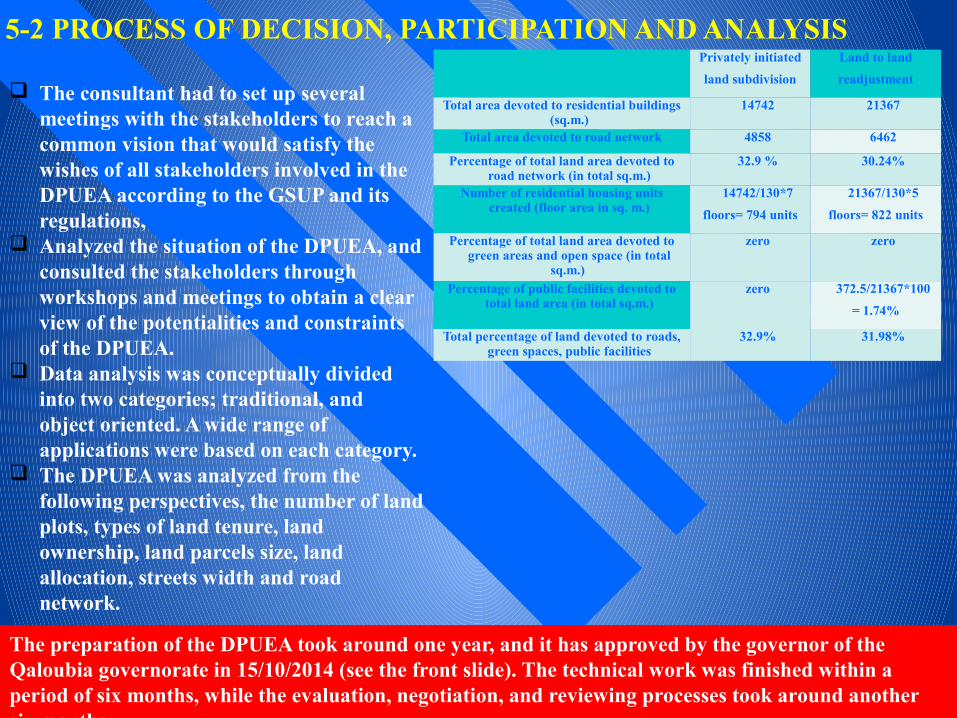
5-2 PROCESS OF DECISION, PARTICIPATION AND ANALYSIS
The consultant had to set up several meetings with the stakeholders to reach a common vision that would satisfy the wishes of all stakeholders involved in the DPUEA according to the GSUP and its regulations,
Analyzed the situation of the DPUEA, and consulted the stakeholders through workshops and meetings to obtain a clear view of the potentialities and constraints of the DPUEA.
Data analysis was conceptually divided into two categories; traditional, and object oriented. A wide range of applications were based on each category.
The DPUEA was analyzed from the following perspectives, the number of land plots, types of land tenure, land ownership, land parcels size, land allocation, streets width and road network.
Privately initiated
land subdivision
Land to land
readjustment
Total area devoted to residential buildings (sq.m.)
14742 21367
Total area devoted to road network 4858 6462
Percentage of total land area devoted to road network (in total sq.m.)
32.9 % 30.24%
Number of residential housing units created (floor area in sq. m.)
14742/130*7
floors= 794 units
21367/130*5
floors= 822 units
Percentage of total land area devoted to green areas and open space (in total
sq.m.)
zero zero
Percentage of public facilities devoted to total land area (in total sq.m.)
zero 372.5/21367*100
= 1.74%
Total percentage of land devoted to roads, green spaces, public facilities
32.9% 31.98%
The preparation of the DPUEA took around one year, and it has approved by the governor of the Qaloubia governorate in 15/10/2014 (see the front slide). The technical work was finished within a period of six months, while the evaluation, negotiation, and reviewing processes took around another six months

Annual World Bank Conference on Land and Poverty 2015: Linking Land Tenure and Use for Shared Prosperity, Washington, DC, 23-27 March 2015 Ahmed M. SOLIMAN
6- CONCLUSION
The collective process should be encouraged, and the role of the government should be changed from that of provider or facilitator or enabler into that of an agent for compatibility and sustainability in order to magnify political goal of saving and rescuing agricultural land and to encourage the sustainability of urban development in Egypt
Social networks have created collective process, between individuals or between a group of a community, by which exploring the complex relations between stakeholders, planning interventions, land and property development processes in which distributive outcomes are robustly grounded;
During the process of the project; land readjustment process was flourished and resulted in:• Scaling up the development process on affordable basis at a faster rate than the government can
achieved.; • Land transaction was operating outside the official building and planning regulation, by which
had offered freedom to the landlords to act in, and formulate land readjustment processes according to their needs and requirements.
The technical team has learned a number of lessons; • Firstly, the involvement of governorate institutions in land readjustment can not successfully
built without pressure from organized groups at the grassroots, as well as, technical support from knowledgeable staff.
• Secondly, the governorate can response positively if project findings are supported by large scale on site work, positive community involvement, and meeting the privileging laws.
• Thirdly, there is an urgent need to reform legislative process in order to match with current situation that most of peri-urban areas have not official documentation for land tenure.

Annual World Bank Conference on Land and Poverty 2015: Linking Land Tenure and Use for Shared Prosperity, Washington, DC, 23-27 March 2015 Ahmed M. SOLIMAN
Thank you for your attention
Development is not a sprint. It is a marathon. We are all aware of this. Egypt needs an environment in which the private sector can thrive to create the jobs Egyptians need to build better lives for themselves. The country cannot afford to slow the reform progress. So patience and perseverance are important.
“World Bank Managing Director Sri Mulyani Indrawati, Sharm El Shekh, Egypt,13/3/2015”


![1[1].land readjustment mongolia](https://img.pdfslide.net/doc/110x75/55a70d171a28abe74a8b465b/11land-readjustment-mongolia.jpg)