Embed Size (px)
Citation preview

DETAILED AERIAL MAPPING AND FLOOD IMPACT MONITORING IN THE V4 REGION
Jakub Miřijovský
Monika Šulc Michalková
Palacký University Olomouc
Department of Geoinformatics
Faculty of Science, Masaryk University, Brno, Czech Republic
Faculty of Natural Sciences, Comenius University, Bratislava, Slovakia

Short description
• Main aim is: Detailed aerial and terrestrial mapping and flood impact monitoring in the Morava River region (Litovelské Pomoraví Protected area, Osypané Břehy)
• Main target area are lowland regions and region of floodplains near active rivers.
Visegrad konference 11. – 12. 5. 2015, Budkovice
Source: Český úřad zeměměřický a katastrální
1. Meander in the Osypané břehy locality
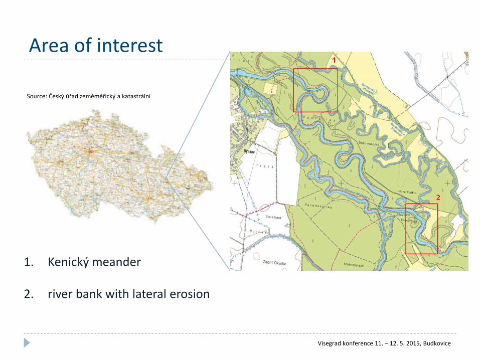
Area of interest
Source: Český úřad zeměměřický a katastrální
1. Kenický meander
2. river bank with lateral erosion
Visegrad konference 11. – 12. 5. 2015, Budkovice
Why?

Floodplain lake• A floodplain lake is an area of fluvial hydrosystem spatial delimited by an axis
of ancient active channel.
• It is composed from two parts: humid perifluvial (aquatic perifluvial zone with ecoton zone) and terestric zone presented by an alluvial plug (Rollet, Citterio, Piégay, 2004).
Visegrad konference 11. – 12. 5. 2015, Budkovice

Floodplain lake
• Floodplain lake is most of the year without water
Visegrad konference 11. – 12. 5. 2015, Budkovice
Methodology• From methodological point of view, we use the methodology of sediment
survey established recently by Citterio & Piégay, 2008. •Two steps are considered:
•The measurement of the sedimentation rates based on the ratio between the mean sediment thickness and the date of the revitalisation; •The statistical analysis of the relationships and inter-lake analysis (the characterisation of connection frequency and to define the life expectancy of former channels).
• For a UAV and aerial imaging we use methodology established by Miřijovský, 2013
• Additional measuring• Terrestrial photogrammetry• Geodetic measuring of the transverse profiles
• Collaboration with Komenského University in Bratislava and Masaryk University in Brno
Visegrad konference 11. – 12. 5. 2015, Budkovice

Dataset
Visegrad konference 11. – 12. 5. 2015, Budkovice
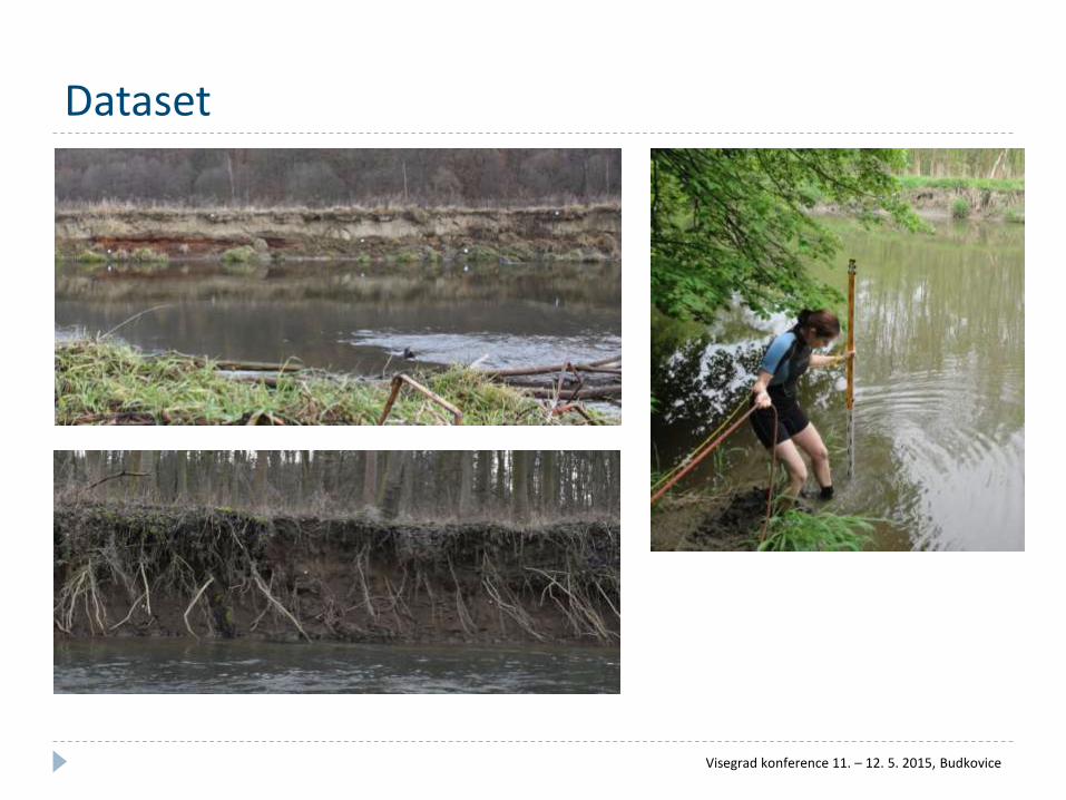
Dataset
Visegrad konference 11. – 12. 5. 2015, Budkovice

Dataset
3900 m AGL
360 m AGL
80 m AGL
Visegrad konference 11. – 12. 5. 2015, Budkovice

Technical equipment• Hexacopter XL, Cessna 172
• RPAS with six propellers
• Canon EOS 500D
• 20 mm lens
• Cessna 172
• Used to spatially extensive area imaging.
Visegrad konference 11. – 12. 5. 2015, Budkovice

Technical equipment• Camera, hydrologic and geodetic
devices
• DSLR camera with a prime lens.
• Rain gauge
• Levelogger, Barologger
• Total station Topcon
• Levelling instrument
Visegrad konference 11. – 12. 5. 2015, Budkovice

Field work• Installation of the levelogger
• Geodetic measuring – two setsof measuring (cooperation withstudents of Palacký University).
• Aerial imaging
• Four flights above the Kenickýmeander
• Three flights above the meander in Osypané břehy locality.

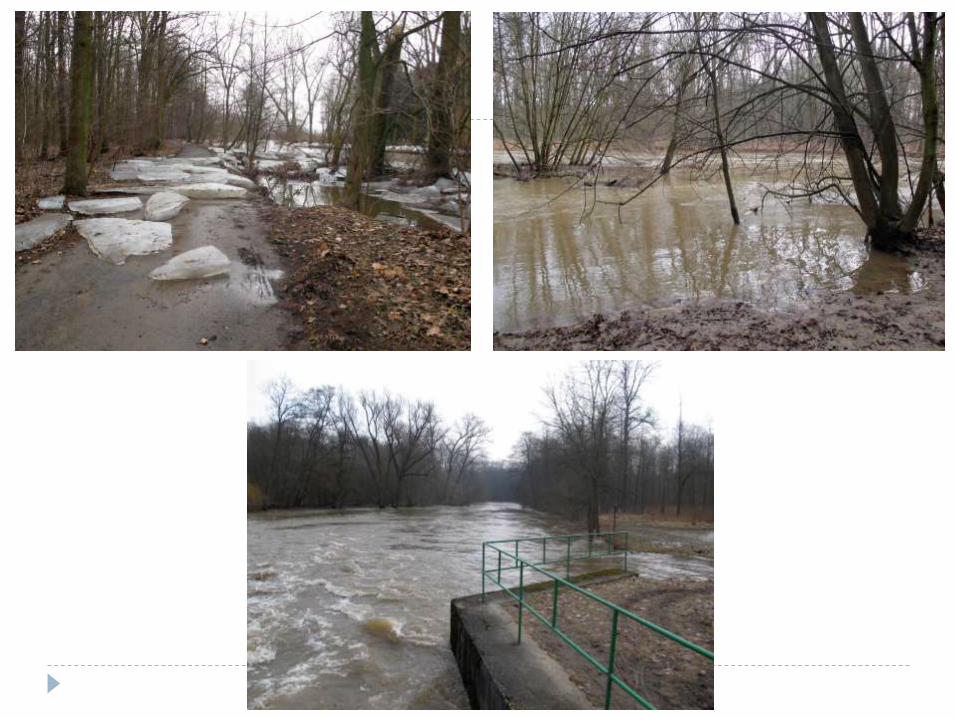
Precipitations, water level• Speed of the lateral erosion and sediments accumulation.
Rain high water level
• Maximal erosion if there is riverbeds-forming flow

Precipitations, water level

RAW data from an aerial imaging
• Overlay 70 % – 90 %

Very high detail

GCPs

Methods• Interior and Exterior orientation
• Surveying methods
• Very accurate measuring of the Ground Control Points (GCPs), often in a difficult terrain morphology.
Workshop RPAS (Remotely Piloted Aircraft Systems), Telč, 11. 11. 2014.

Methods• Photogrammetry processing
• Structure from Motion
• Stereophotogrammetry
Visegrad konference 11. – 12. 5. 2015, Budkovice

Results
Visegrad konference 11. – 12. 5. 2015, Budkovice

Results
Visegrad konference 11. – 12. 5. 2015, Budkovice

Results
Max. difference: 2 m

Results

Results

Future work• Continuation in terrestrial monitoring
• Hydrological data (precipitations, height of a water level, water flow).• Aerial data (RPAS and aerial imaging).• Terestrial measuring (transverse profiles)
• Obtaining of a new data• Data for granulometry
Courbe granulométrique
sur la fraction
0.040 mm - 2000 mm
0
10
20
30
40
50
60
70
80
90
100
0,01 0,10 1,00 10,00 100,00 1000,00 10000,00diamètre en microns
%
CERISIER N°1 - 24/11/05 - Monika MICHALKOVA
argile silt sable
• Modeling• prediction of sedimentation. It is a functionof overflowing discharge upstream and downstream
y = 37,253e-0,0013x
R2
= 0,9915
0
5
10
15
20
25
30
35
0 500 1000 1500
Annual sed. rate (cm/year)
Number of days
0
20
40
60
80
100
120
2005 2010 2015 2020
Tendency 12 cm/year
Tendency 7 cm/year
Exponential mode l
Mean water level (cm)
Year

Jakub Miřijovský, Monika Šulc Michalková[email protected]


![Template for high-resolution river landscape …...2017/12/01 · submerged topography [6,25,31,32]. In addition, Miřijovský and Lan-ghammer [26] have described a legislative process](https://img.pdfslide.net/doc/110x75/5f6d5b6a8fd63a12d6243bf3/template-for-high-resolution-river-landscape-20171201-submerged-topography.jpg)