Embed Size (px)
Citation preview

® © 2013 Open Geospatial Consortium OGC
® ®
Evolution of System Architectures: Where Do We Need to Fail Next?
Luis Bermudez, Nadine Alameh, and George Percivall
April 10, 2013 EGU General Assembly 2013 - ESSI2.5
Vienna, Austria

® © 2013 Open Geospatial Consortium OGC
Innovation
I have not failed, I’ve just found 10,000 ways that won’t work. Thomas Edison

® © 2013 Open Geospatial Consortium OGC
Innovation about what?
3
® © 2013 Open Geospatial Consortium OGC
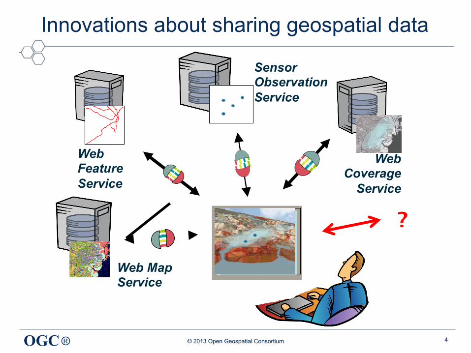
Innovations about sharing geospatial data
4
Web Map Service
Web Coverage
Service
Web Feature Service
Sensor Observation Service
?
® © 2013 Open Geospatial Consortium OGC
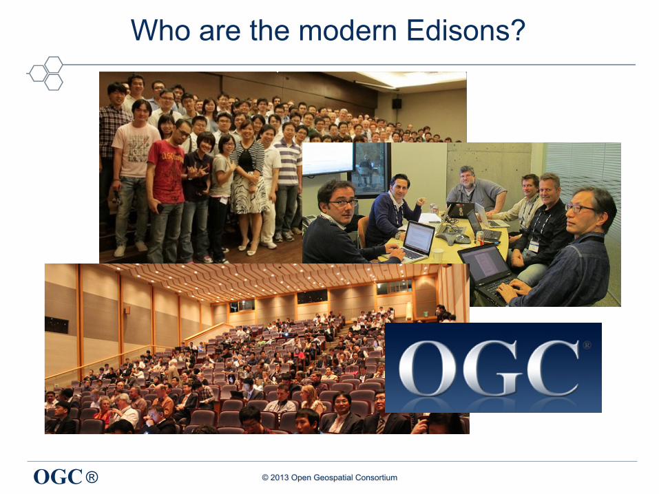
Who are the modern Edisons?

® © 2013 Open Geospatial Consortium OGC
OGC Process based on consensus
"Never get angry. Never make a threat. Reason with people."
Don Vito Corleone (The Godfather)

® © 2013 Open Geospatial Consortium OGC
Proven process
• 39 published standards • 41 sucesfull interoperability program intitiatives since 1999 • 740 implementing products in the market
7

® © 2013 Open Geospatial Consortium OGC
Proven process
8

® © 2013 Open Geospatial Consortium OGC
Evolution of Technologies
2003 2013
A story of OGC Web Services (OWS) Testbeds
® © 2013 Open Geospatial Consortium OGC
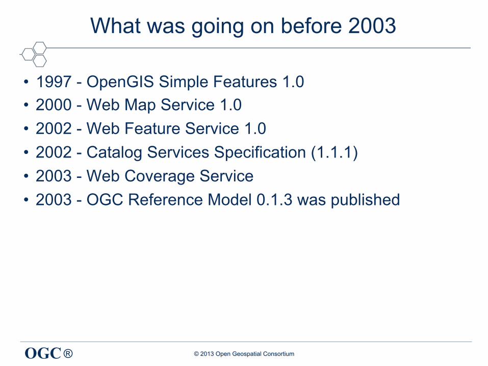
What was going on before 2003
• 1997 - OpenGIS Simple Features 1.0 • 2000 - Web Map Service 1.0 • 2002 - Web Feature Service 1.0 • 2002 - Catalog Services Specification (1.1.1) • 2003 - Web Coverage Service • 2003 - OGC Reference Model 0.1.3 was published

® © 2013 Open Geospatial Consortium OGC 11
® © 2013 Open Geospatial Consortium OGC
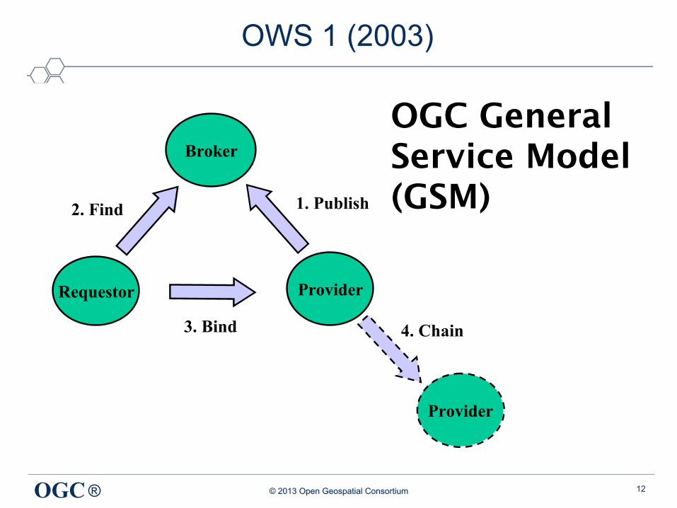
OWS 1 (2003)
12
Broker
ProviderRequestor
1. Publish2. Find
3. Bind
Provider
4. Chain
OGC General Service Model (GSM)

® © 2013 Open Geospatial Consortium OGC
OWS 1 (2003)
13
Map Viewer Client
WMS WFS WCS
Catalog Service
Imagery Client
Discovery Client
Sensor Collection
Client
Data Type Registry
Service Type
Registry
Sensor Type
Registry
Coord. Transf. Service
Imagery Generator
Web Viewer Generator
Sensor Collection
Service
Client Services
Server Side Client Applications
Application Services
Data Services
Registries

® © 2013 Open Geospatial Consortium OGC
OWS 2 (2004)
• SOAP/WSDL implementations of WMS, WFS, WCS, CS-W • UDDI Registry • UML to XML tool (UGAS) – Automation !
– Application profiles NGA and USGS
• Image Handling and Decision Support – WCS 1.0 Server and Client
14

® © 2013 Open Geospatial Consortium OGC
OWS 3 (2005)
15
• Sensor Web Enablement • GeoDRM (Digital Rights Management) • Common Architecture • Gespatial Decision Support • Open Location Services
® © 2013 Open Geospatial Consortium OGC
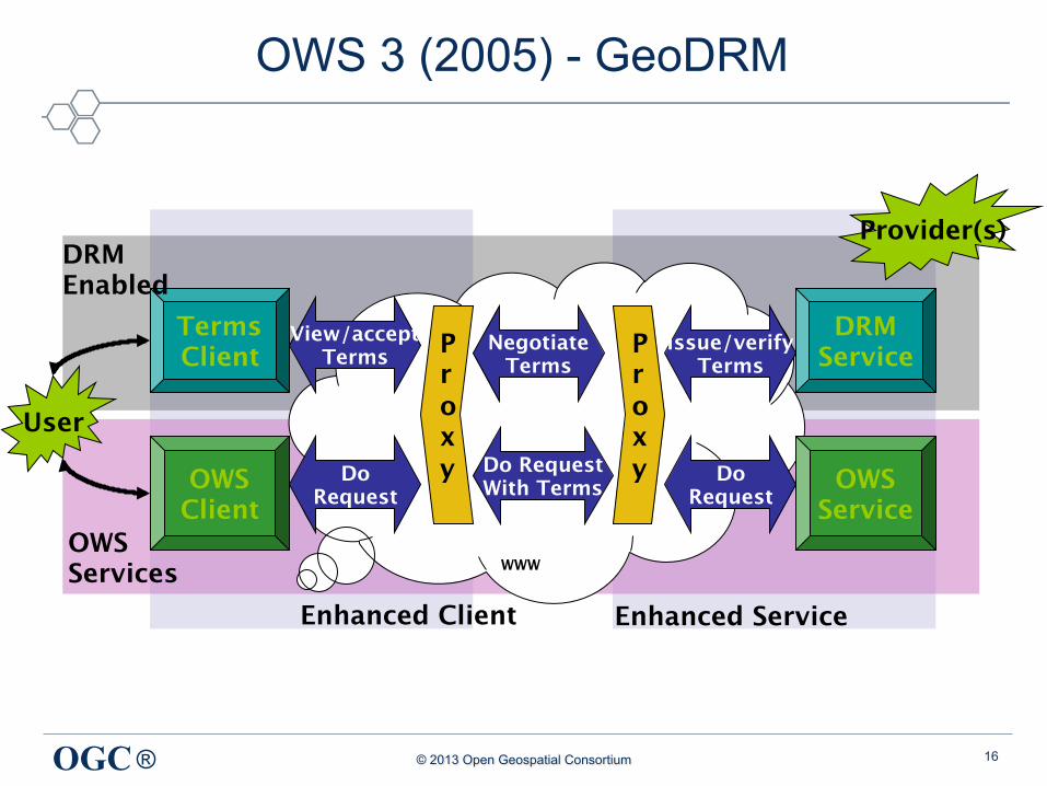
OWS 3 (2005) - GeoDRM
16
OWS Client
Terms Client
User
WWW
Proxy
Proxy
Negotiate Terms
Do Request With Terms
View/accept Terms
Do Request
Issue/verify Terms
Do Request
OWS Services
DRM Enabled
OWS Service
DRM Service
Enhanced Client Enhanced Service
Provider(s)
® © 2013 Open Geospatial Consortium OGC
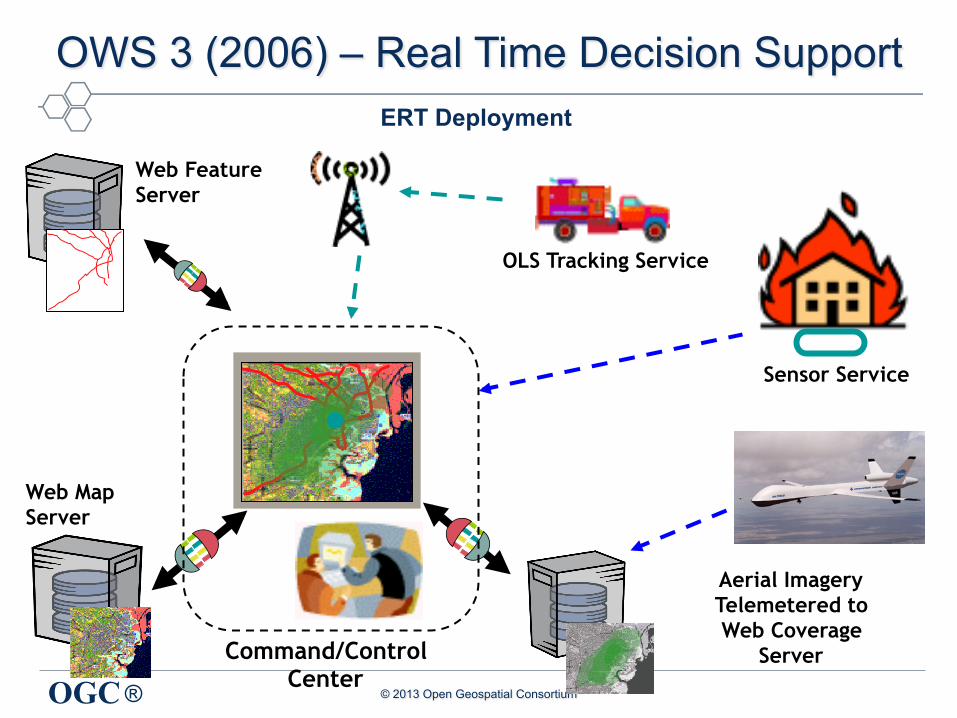
Web Map Server
Aerial Imagery Telemetered to Web Coverage
Server
Web Feature Server
OLS Tracking Service
Command/Control Center
Sensor Service
OWS 3 (2006) – Real Time Decision Support ERT Deployment

® © 2013 Open Geospatial Consortium OGC
OWS 4 (2007)
• Sensor Web Enablement (SWE) • Geo Processing Workflow (GPW) • Geo-Decision Support (GeoDSS) • Geo-Digital Rights Management (GeoDRM) • UML to GML Schema • CAD / GIS / BIM (CGB) • OGC Location Services (OpenLS) • Compliance Testing (CITE)
18

® © 2013 Open Geospatial Consortium OGC
OWS 4 (2007) – CityGML + BIM
19

® © 2013 Open Geospatial Consortium OGC
OWS 4 (2007) – Specialized Services
20

® © 2013 Open Geospatial Consortium OGC
OWS 4 (2007) - Videos for Demonstrations
21

® © 2013 Open Geospatial Consortium OGC
OWS 5 (2008)
• Sensor Web Enablement • KML in WMS • Agile SLD to KML • UML to GML Schema • Workflow Architecture and Conflation • SOA Worflow for Sensor data (IEEE 1451)
22

® © 2013 Open Geospatial Consortium OGC
OWS 5 (2008) - Agile KML
23
Styled Layer Descriptor SLD
© 2008, Open Geospatial Consortium, Inc.
GoogleEarth Client
Feature Portrayal Service (FPS)
GetMap
GML
GML
GML
KML
HTML
WFS AML 2.1 and DAFIF 7 data on Oracle Spatial
Galdos Cartalinea
WFS Population data on PostGIS
TOPP GeoServer
WFS VMAP0 data on ArcSDE
Galdos Cartalinea
WRS AML, DAFIF and FACC Feature Data Dictionaries
Galdos Indicio
GetRecord
GetFeature
GetFeature
GetFeature

® © 2013 Open Geospatial Consortium OGC
OWS 5 - Geoprocessing Workflow Architecture
24

® © 2013 Open Geospatial Consortium OGC
OWS 5 (2008) – SOA for Sensor Data
25

® © 2013 Open Geospatial Consortium OGC
OWS 6 (2009)
• Aeronautical Information Management (AIM) • Sensor Web Enablement (SWE) • Geo Processing Workflow (GPW) • Decision Support Services (DSS) • Compliance Testing (CITE)
26

® © 2013 Open Geospatial Consortium OGC
OWS 7 (2010)
• More domain focus: e.g. Aviation • Sensor and Decision Fusion • Sensor Fusion Enablement
27
® © 2013 Open Geospatial Consortium OGC
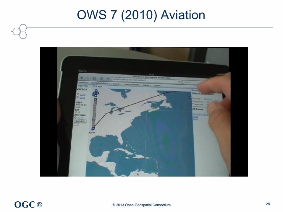
OWS 7 (2010) Aviation
28

® © 2013 Open Geospatial Consortium OGC 29 Access Tier
WXXM 1.1 WF AIXM 5.1 WFS
Business Process Tier
Client Tier
Other Client Applications
Request
Portrayal
Subscribe to Events
Request data or
updates to data
R
equest data For portrayal O
r validation
Post Events U
pdate data
AIXM 5.1 WFS –T WXXM 1.1 WFS
SWIM
Snowflake
AIXM 5.1 WFS -T
Comsoft
4D Weather Cube WFS/WCS
& WFS Pub/Sub
NNEW & MIT LL
Volcanic Ash WXXM 1.1
WFS
Meteo France
Registry
Galdos
AIXM Portrayal
Envitia
WXXM Portrayal
Alticode & Envitia
Event Alert
52 North
iGSI; UM-IfGI; Galdos
AIXM Handling Tools
LISAsoft
WXXM Client
Atmosphere
Flight Dispatch
Luciad & Frequentis
EFB/Handheld
Luciad & Frequentis Planet 9
GMU, Luciad
Receive
Events

® © 2013 Open Geospatial Consortium OGC
OWS 8 (2011)
• More domain focus: e.g. Aviation • Brokering, Mediation • Observation Fusion (Coverages and Mobile Tracking) • Geosynchronization and bulk data transfer
30

® © 2013 Open Geospatial Consortium OGC 31
Access Tier
Business Process
Tier
Client Tier

® © 2013 Open Geospatial Consortium OGC
OWS 9 (2012)
• More domain focus : e.g. Aviation • Brokering, Mediation, Conflation, Security • Mobile • New Formats: OWS Context, GeoPackage
32

® © 2013 Open Geospatial Consortium OGC
OWS 9 (2012) – OWS Context
OGC
WPS Service
GML
<href> <href> <href> <embbed>
<href>
<href> <href>
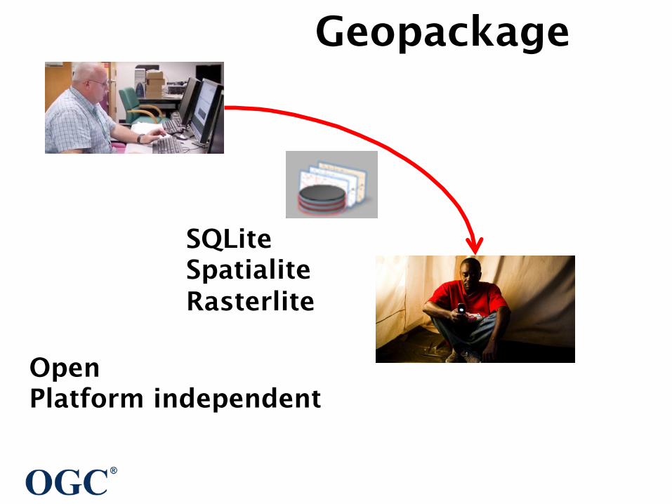
Geopackage
Open Platform independent
SQLite Spatialite Rasterlite

® © 2013 Open Geospatial Consortium OGC
Summary
35
OWS 1 (2003)
OWS 9 (2012)
SOA
Conflation & Semantics
Conflation Digital Rights
Security
UML to XML
CAT BIM
OWS 6 (2009)
Aviation
Sensor Web
Sensor Fusion Observation Fusion
GeoPackage OWS COntext
Mobile

® © 2013 Open Geospatial Consortium OGC
What’s next
36
® © 2013 Open Geospatial Consortium OGC
OWS 10 (2013)
• January 2013: Call for sponsors/1st Sponsor Meeting • January-April: 2013 Concept development • June 2013: RFQ (responses due in July) • September 2013: Kickoff meeting • March 2014: Demonstrations and final deliverables
http://www.opengeospatial.org/projects/initiatives/ows-10
37

® © 2013 Open Geospatial Consortium OGC
Cloud and BIG Data
38

® © 2013 Open Geospatial Consortium OGC
More Advance Conflation and Semantics
39

® © 2013 Open Geospatial Consortium OGC
Augmented Reality
40

® © 2013 Open Geospatial Consortium OGC
Internet of Things
41
® © 2013 Open Geospatial Consortium OGC
Privacy
42
® © 2013 Open Geospatial Consortium OGC
Questions?
43
Luis Bermudez, Ph.D. [email protected]
@berdez on Twi<er h<p://www.linkedin.com/in/bermudez
You are cordially invited to become the Geo Edisons of the future

![Learning to Fail: Predicting Fracture Evolution in Brittle ...Learning to Fail: Predicting Fracture Evolution in Brittle Material Models using Recurrent Graph Convolutional ... [17]](https://img.pdfslide.net/doc/110x75/60bccc96a57f414ca64f06d9/learning-to-fail-predicting-fracture-evolution-in-brittle-learning-to-fail.jpg)