Embed Size (px)
Citation preview
Product & Technology
Portfolio of Gridworld
2015.2
Beijing GridWorld Software Technology Co.,
Ltd

Outline
I. Basic Information
II. Technical Features
III. Products
IV. Case Study
V. Development History
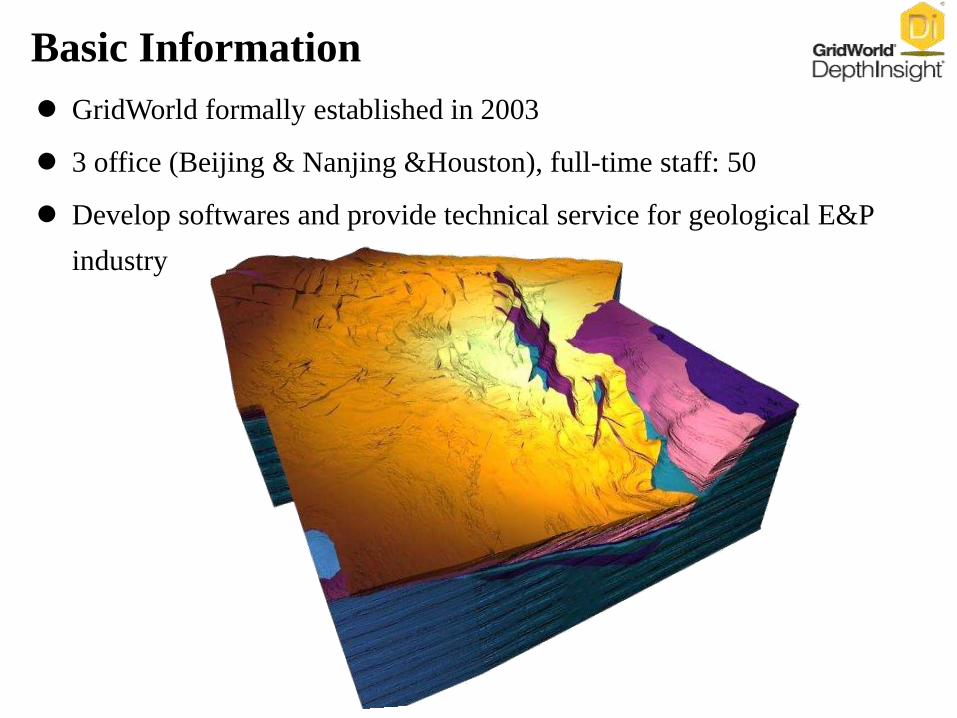
GridWorld formally established in 2003
3 office (Beijing & Nanjing &Houston), full-time staff: 50
Develop softwares and provide technical service for geological E&P
industry
Basic Information
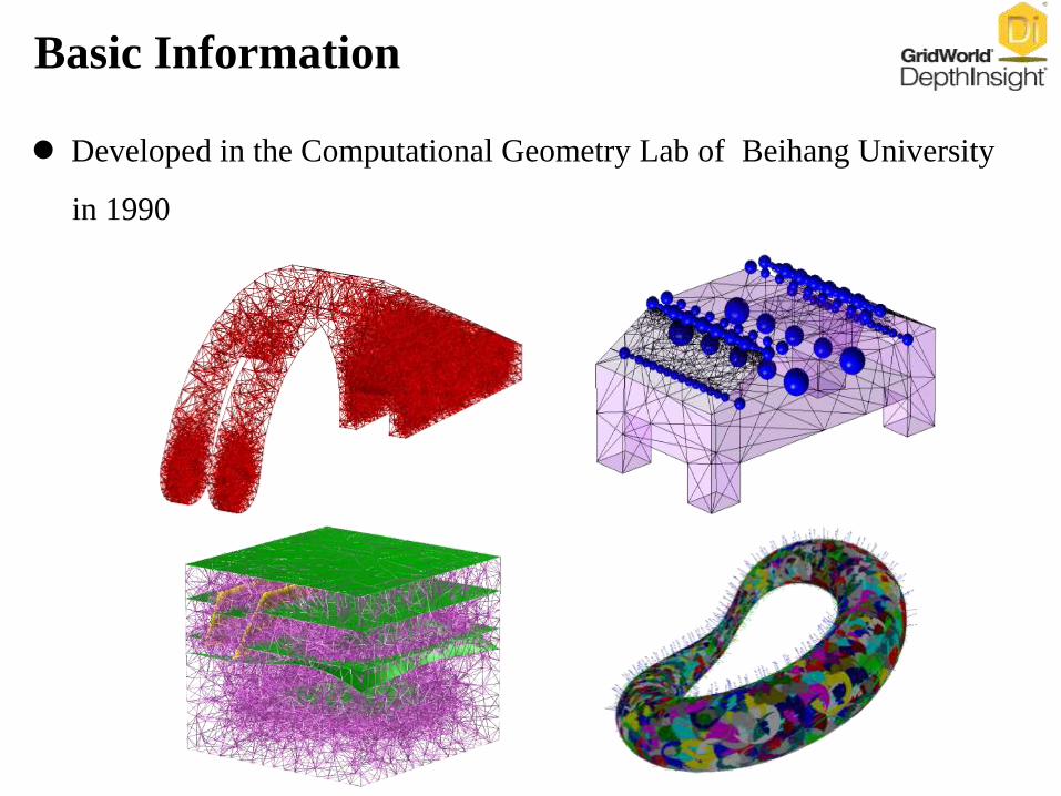
Developed in the Computational Geometry Lab of Beihang University
in 1990
Basic Information
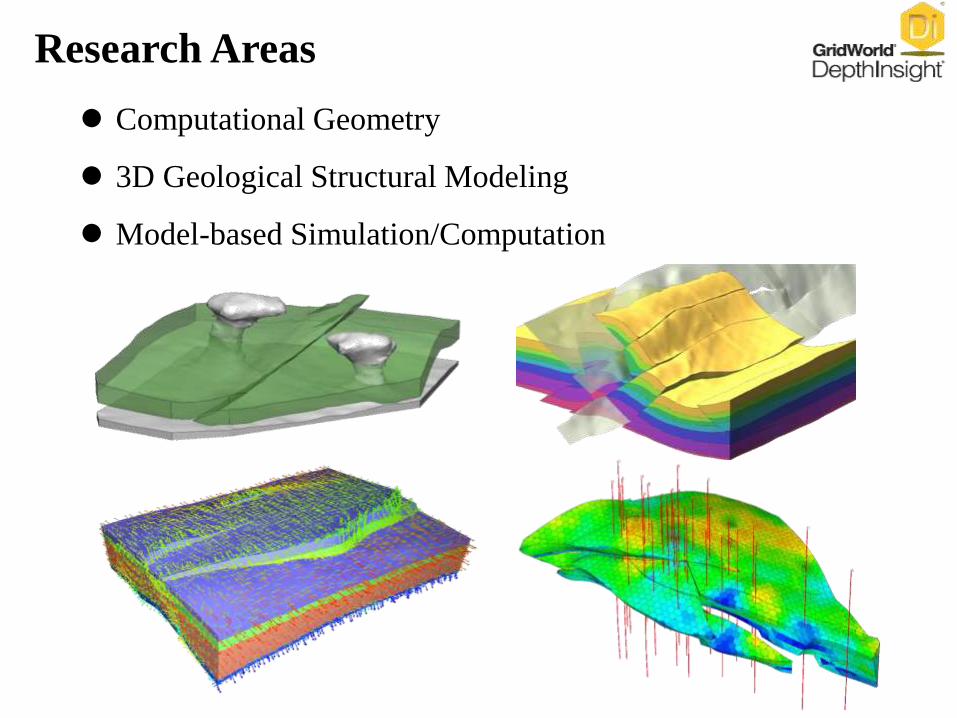
Computational Geometry
3D Geological Structural Modeling
Model-based Simulation/Computation
Research Areas
Outline
I. Basic Information
II. Technical Features
III. Products
IV. Case Study
V. Development History
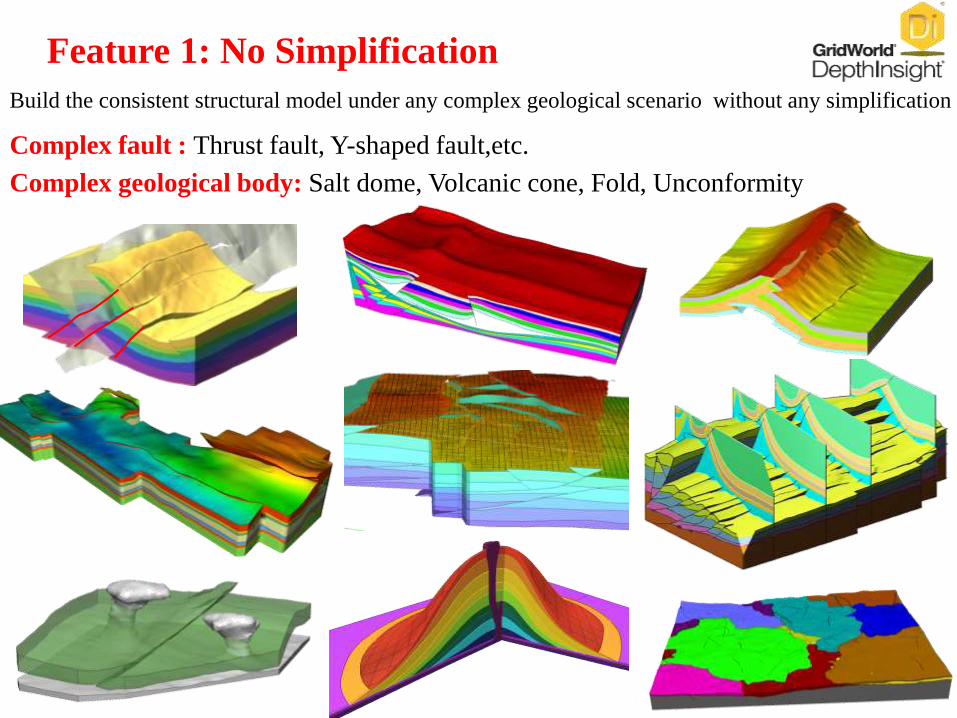
Feature 1: No Simplification
Build the consistent structural model under any complex geological scenario without any simplification
Complex fault : Thrust fault, Y-shaped fault,etc.
Complex geological body: Salt dome, Volcanic cone, Fold, Unconformity
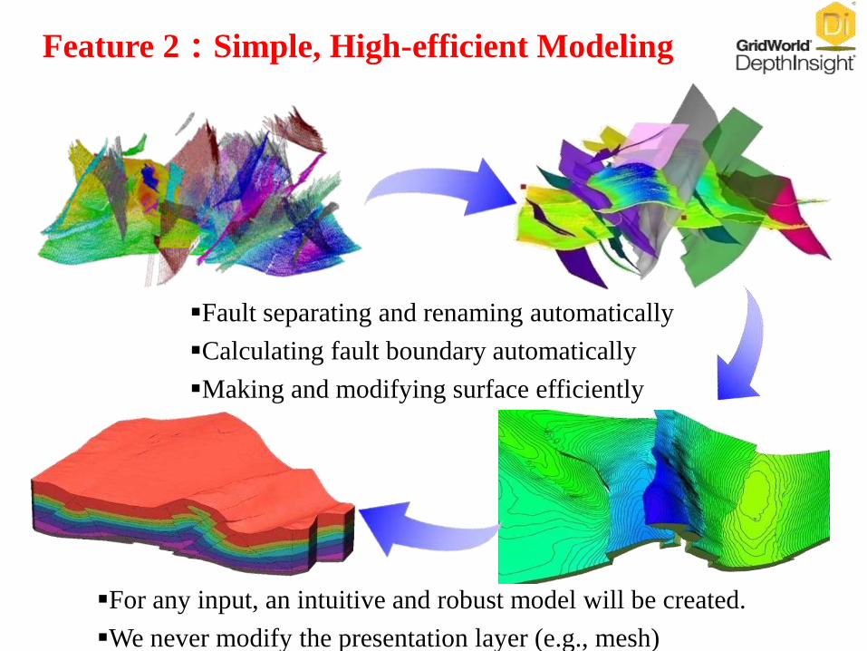
Feature 2:Simple, High-efficient Modeling
Fault separating and renaming automatically
Calculating fault boundary automatically
Making and modifying surface efficiently
For any input, an intuitive and robust model will be created.
We never modify the presentation layer (e.g., mesh)
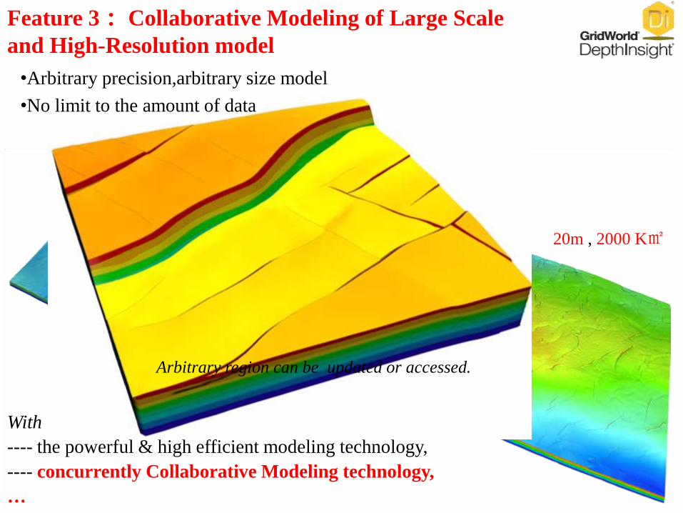
With
---- the powerful & high efficient modeling technology,
---- concurrently Collaborative Modeling technology,
…
20m , 2000 K㎡
Arbitrary region can be updated or accessed.
Feature 3: Collaborative Modeling of Large Scale
and High-Resolution model
•Arbitrary precision,arbitrary size model
•No limit to the amount of data
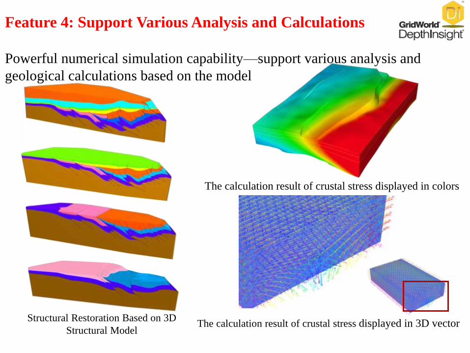
Powerful numerical simulation capability—support various analysis and
geological calculations based on the model
The calculation result of crustal stress displayed in colors
The calculation result of crustal stress displayed in 3D vectorStructural Restoration Based on 3D
Structural Model
Feature 4: Support Various Analysis and Calculations
Outline
I. Basic Information
II. Technical Features
III. Products
IV. Case Study
V. Development History
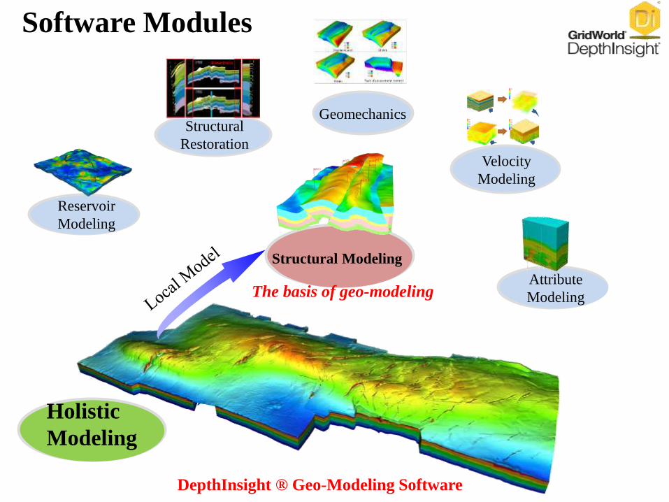
Software Modules
Velocity
Modeling
GeomechanicsStructural
Restoration
Reservoir
Modeling
Attribute
Modeling
Holistic
Modeling
Structural Modeling
DepthInsight ® Geo-Modeling Software
The basis of geo-modeling
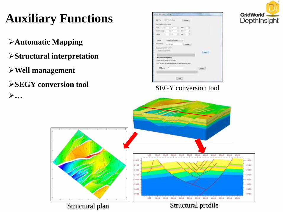
Automatic Mapping
Structural interpretation
Well management
SEGY conversion tool
…
Auxiliary Functions
SEGY conversion tool
Structural plan Structural profile
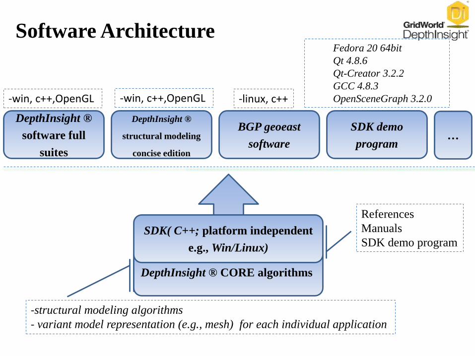
Software Architecture
DepthInsight ® CORE algorithms
SDK( C++; platform independent
e.g., Win/Linux)
DepthInsight ®
software full
suites
DepthInsight ®
structural modeling
concise edition
BGP geoeast
software
SDK demo
program
-linux, c++-win, c++,OpenGL-win, c++,OpenGL
-structural modeling algorithms
- variant model representation (e.g., mesh) for each individual application
Fedora 20 64bit
Qt 4.8.6
Qt-Creator 3.2.2
GCC 4.8.3
OpenSceneGraph 3.2.0
References
Manuals
SDK demo program
…
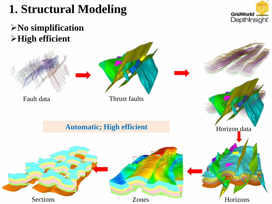
Horizons
Horizon data
Sections Zones
Automatic; High efficient
Fault data Thrust faults
1. Structural Modeling
No simplification
High efficient
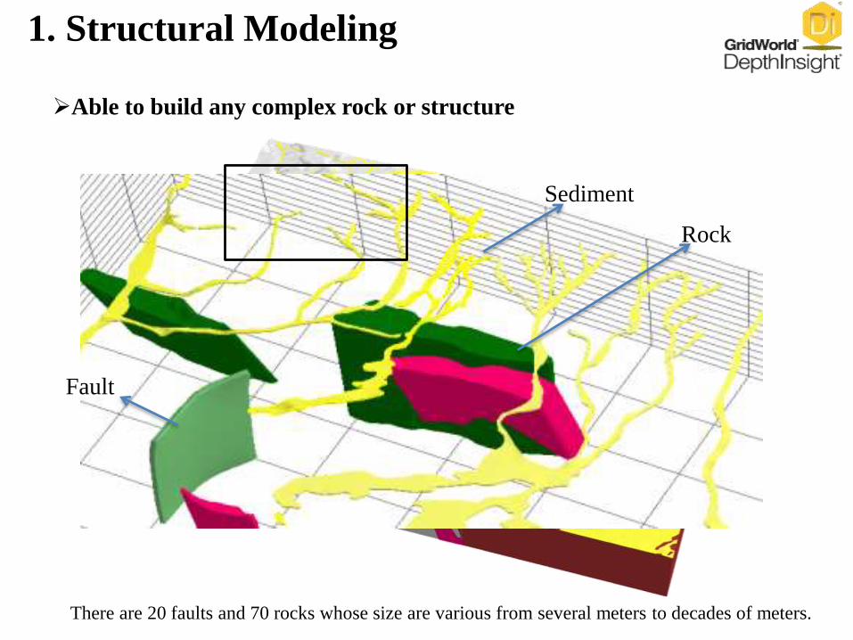
There are 20 faults and 70 rocks whose size are various from several meters to decades of meters.
Fault
Sediment
Rock
Able to build any complex rock or structure
1. Structural Modeling
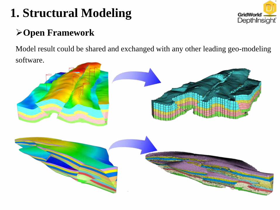
Model result could be shared and exchanged with any other leading geo-modeling
software.
Open Framework
1. Structural Modeling
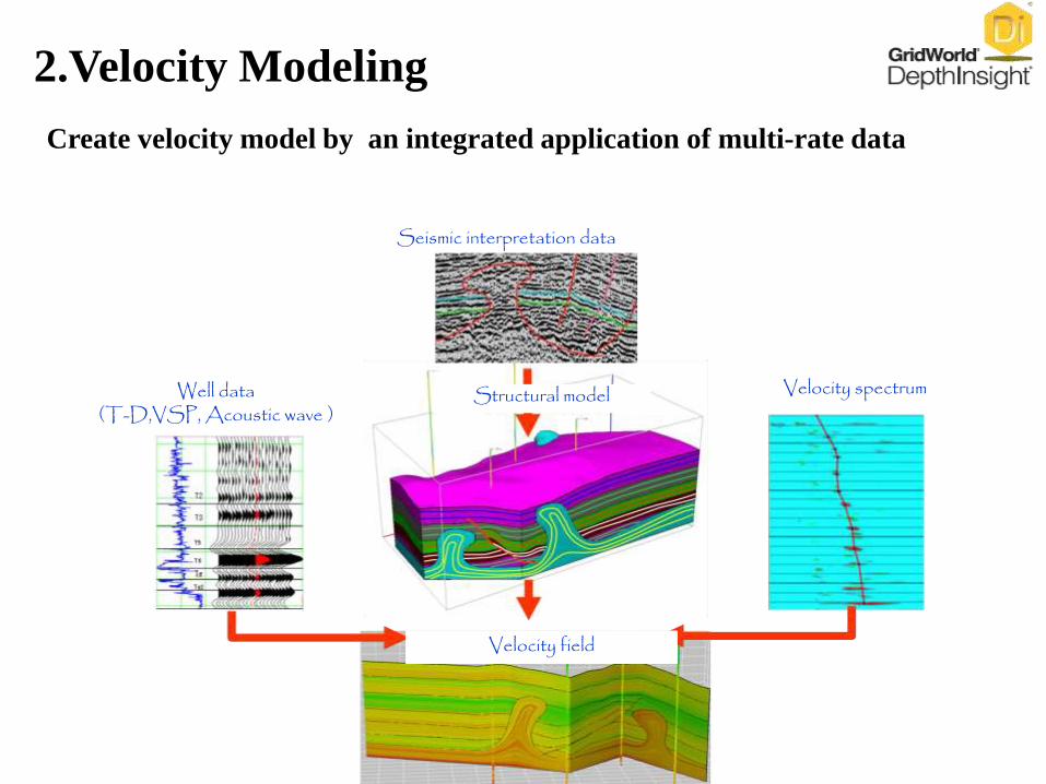
Create velocity model by an integrated application of multi-rate data
Seismic interpretation data
Well data (T-D,VSP, Acoustic wave )
Velocity spectrum
Velocity field
Structural model
2.Velocity Modeling
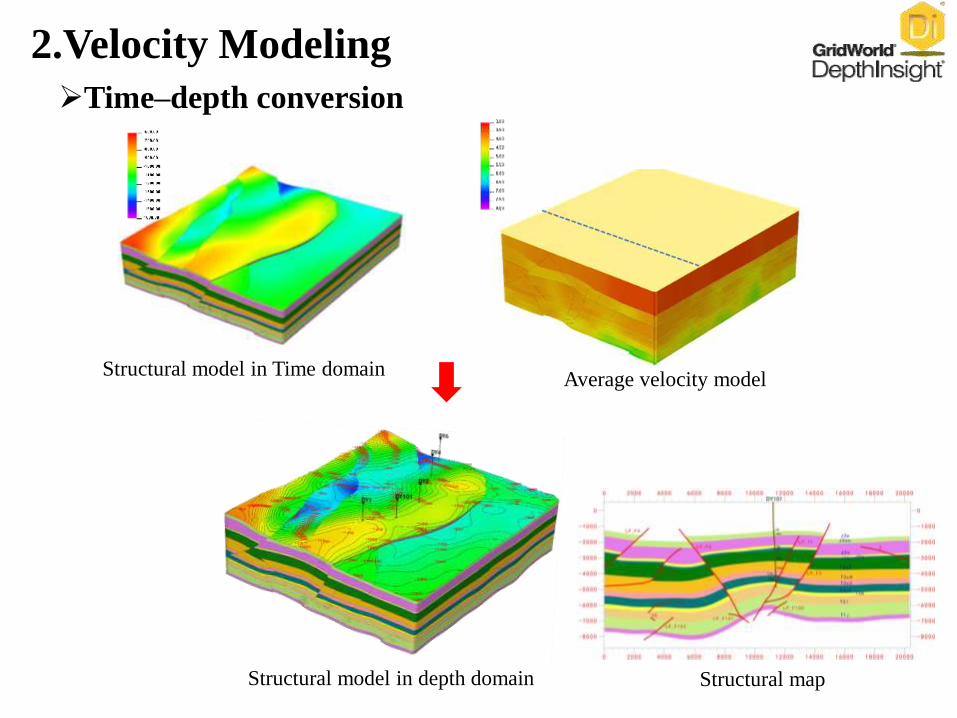
Structural model in depth domain
Structural model in Time domain
Structural map
Average velocity model
2.Velocity Modeling
Time–depth conversion
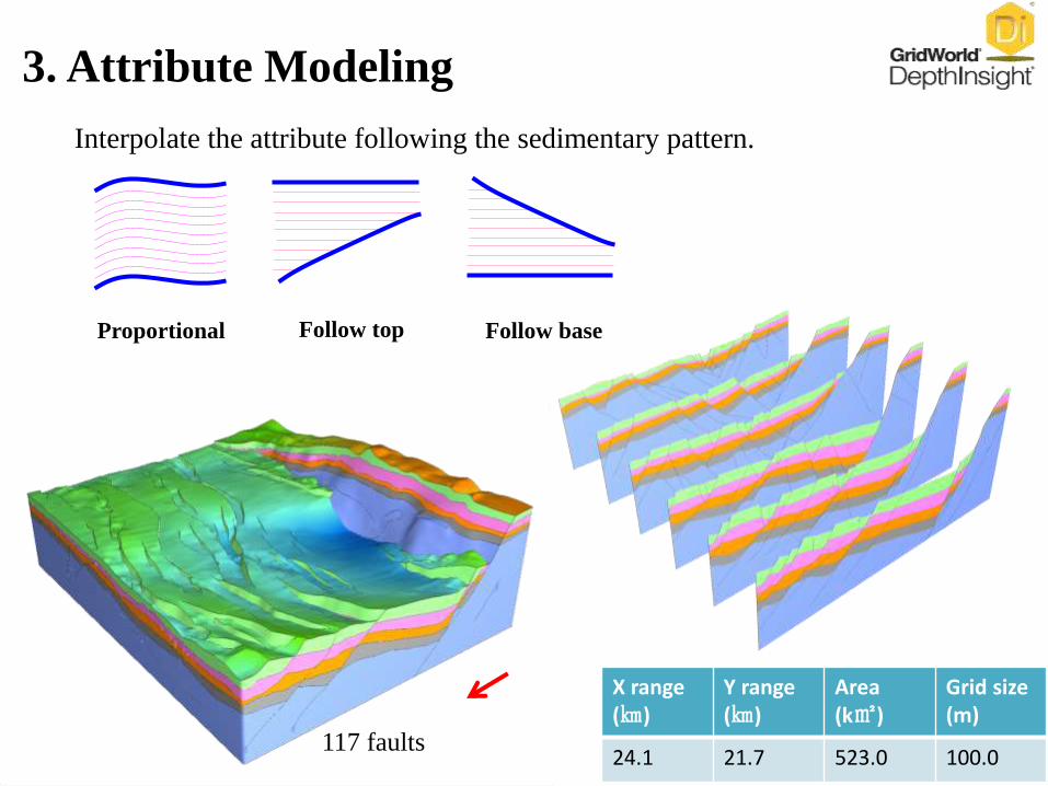
Interpolate the attribute following the sedimentary pattern.
X range(㎞)
Y range(㎞)
Area(k㎡)
Grid size(m)
24.1 21.7 523.0 100.0
3. Attribute Modeling
117 faults
Proportional Follow top Follow base
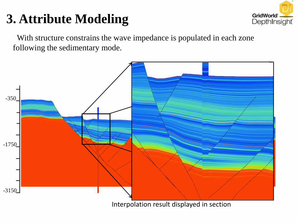
With structure constrains the wave impedance is populated in each zone
following the sedimentary mode.
Interpolation result displayed in section
-350
-1750
-3150
3. Attribute Modeling
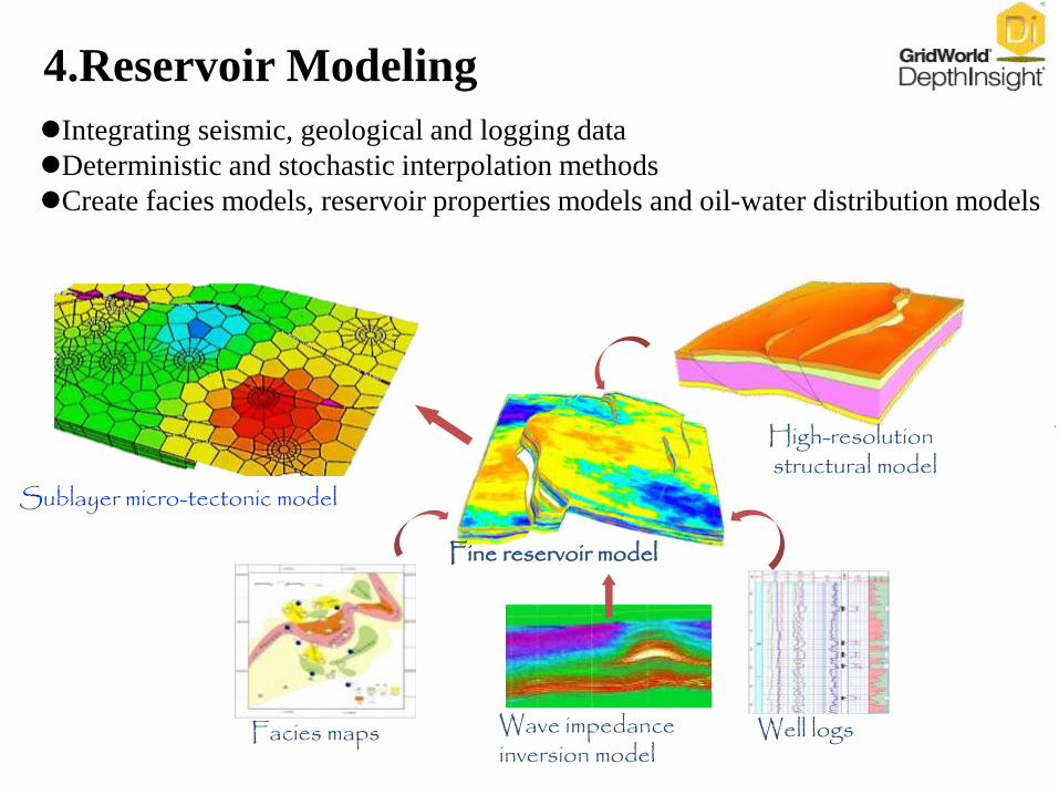
Sublayer micro-tectonic model
Well logsWave impedance inversion model
Fine reservoir model
High-resolutionstructural model
Facies maps
Integrating seismic, geological and logging data
Deterministic and stochastic interpolation methods
Create facies models, reservoir properties models and oil-water distribution models
4.Reservoir Modeling
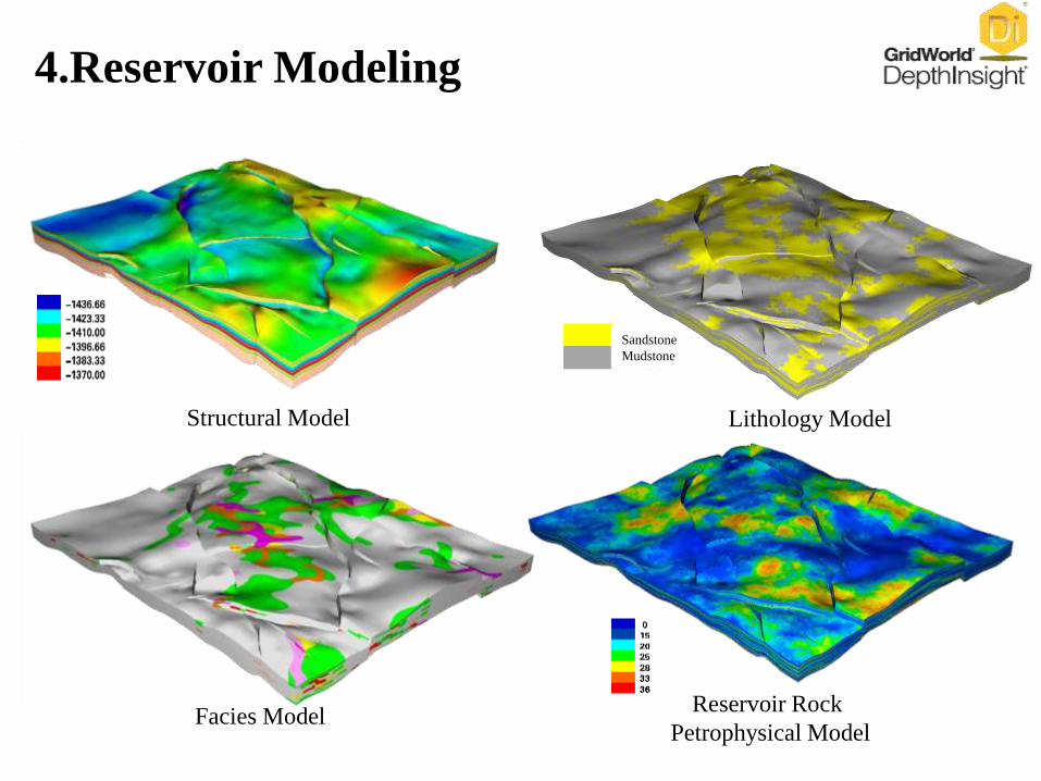
Structural Model
Facies Model
Lithology Model
Sandstone
Mudstone
Reservoir Rock
Petrophysical Model
4.Reservoir Modeling
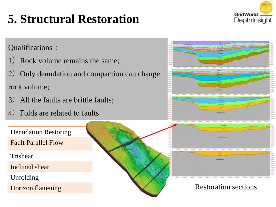
Denudation Restoring
Fault Parallel Flow
Trishear
Inclined shear
Unfolding
Horizon flattening
Qualifications:
1)Rock volume remains the same;
2)Only denudation and compaction can change
rock volume;
3)All the faults are brittle faults;
4)Folds are related to faults
Restoration sections
5. Structural Restoration
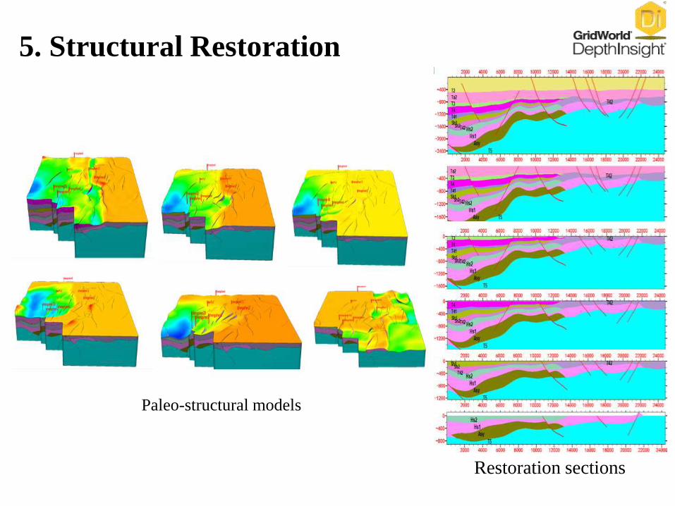
Paleo-structural models
5. Structural Restoration
Restoration sections
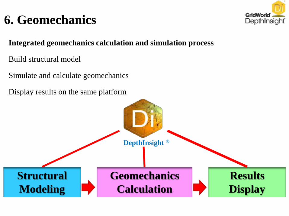
Integrated geomechanics calculation and simulation process
Build structural model
Simulate and calculate geomechanics
Display results on the same platform
DepthInsight ®
Structural
Modeling
Geomechanics
Calculation
Results
Display
6. Geomechanics
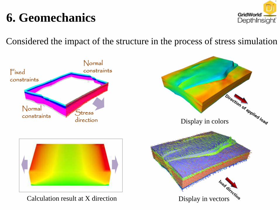
Considered the impact of the structure in the process of stress simulation
Normal constraints
Normal constraintsFixed
constraints
Stress direction
Calculation result at X direction
Display in colors
Display in vectors
6. Geomechanics
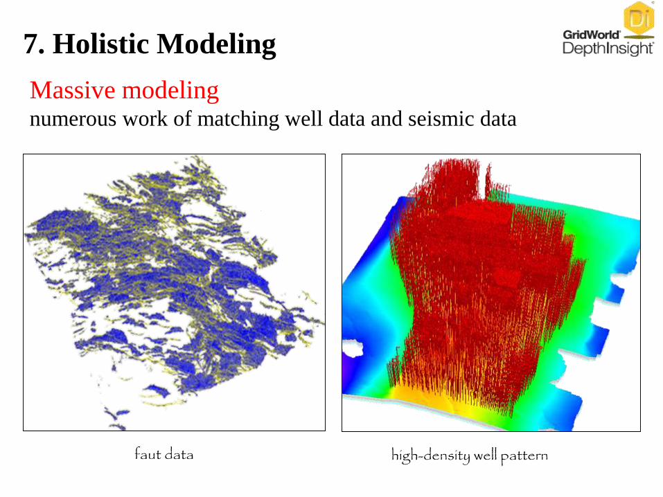
high-density well patternfaut data
Massive modelingnumerous work of matching well data and seismic data
7. Holistic Modeling
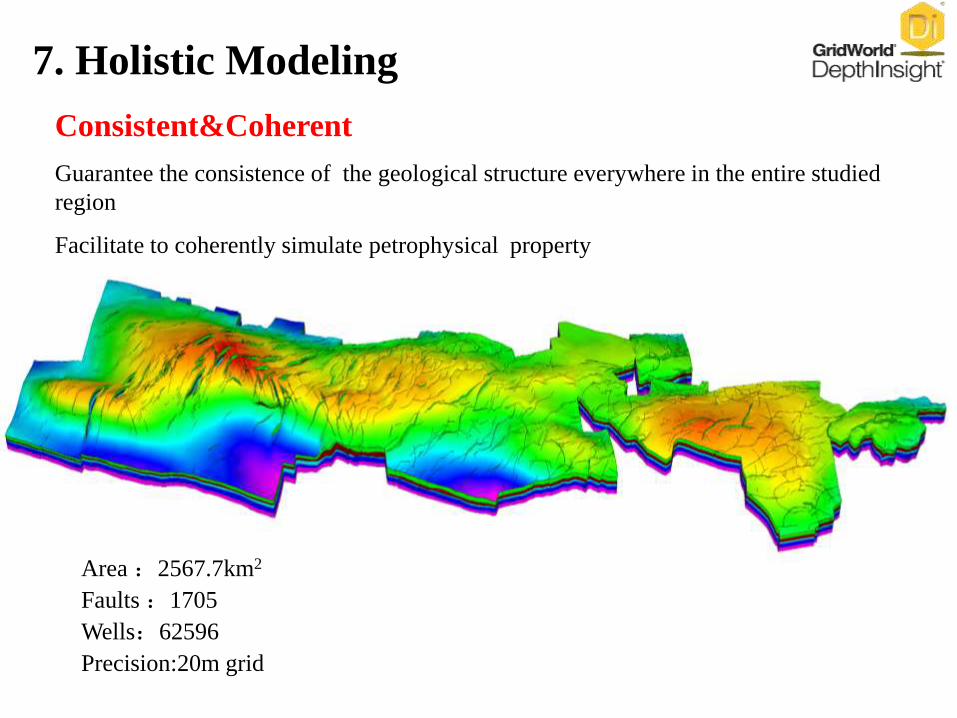
Consistent&Coherent
Guarantee the consistence of the geological structure everywhere in the entire studied
region
Facilitate to coherently simulate petrophysical property
Area :2567.7km2
Faults :1705
Wells:62596
Precision:20m grid
7. Holistic Modeling
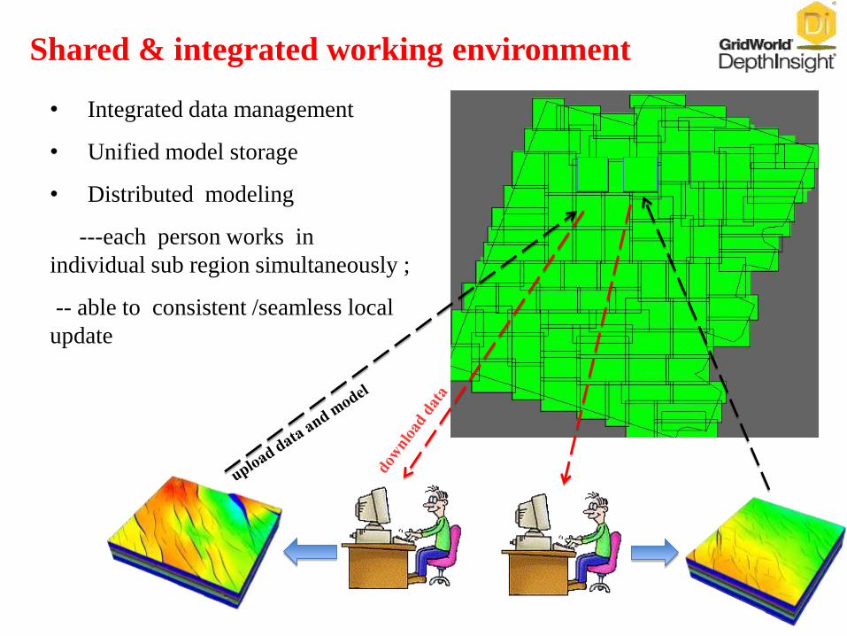
Shared & integrated working environment
• Integrated data management
• Unified model storage
• Distributed modeling
---each person works in
individual sub region simultaneously ;
-- able to consistent /seamless local
update

A B
C
A B
Innovative Seamless structural Model building
technologies enable to build a large-scale ,
high-resolution and consistent model.
7. Holistic Modeling

Holistic modeling is not
A simply collecting of sub models.
Holistic modeling means
That arbitrary region could be updated and seamlessly
embedded back into the entire model ,
and the entire evolutional model always keeps consistence.
7. Holistic Modeling
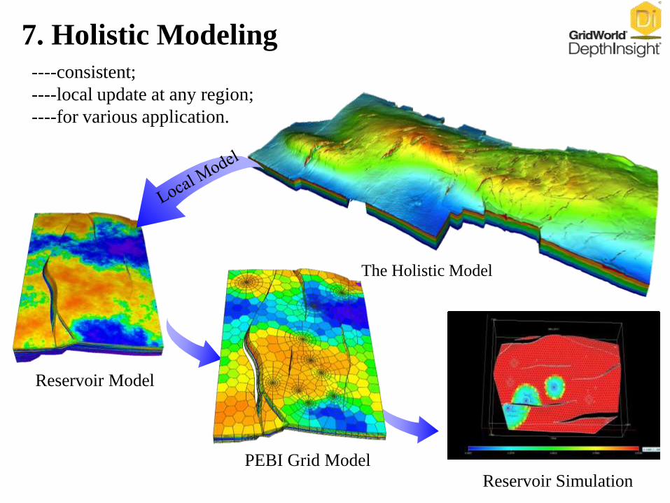
Reservoir Model
Reservoir Simulation
The Holistic Model
PEBI Grid Model
----consistent;
----local update at any region;
----for various application.
7. Holistic Modeling
Outline
I. Basic Information
II. Technical Features
III. Products
IV. Case Study
V. Development History
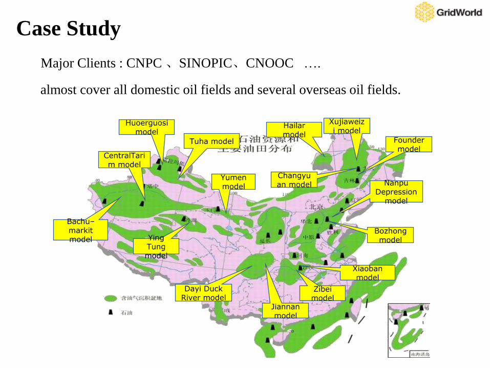
Major Clients : CNPC 、SINOPIC、CNOOC ….
Bachu–markitmodel
Zibeimodel
Dayi Duck River model
Founder model
Jiannanmodel
Xujiaweizi model
Bozhongmodel
Nanpu Depression
model
Hailar model
Xiaobanmodel
Yumen model
Tuha model
Huoerguosi model
CentralTarim model
Ying Tung model
Changyuan model
Case Study
almost cover all domestic oil fields and several overseas oil fields.
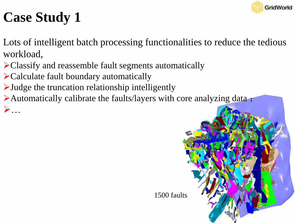
Lots of intelligent batch processing functionalities to reduce the tedious
workload,Classify and reassemble fault segments automatically
Calculate fault boundary automatically
Judge the truncation relationship intelligently
Automatically calibrate the faults/layers with core analyzing data ;
…
1500 faults
Case Study 1
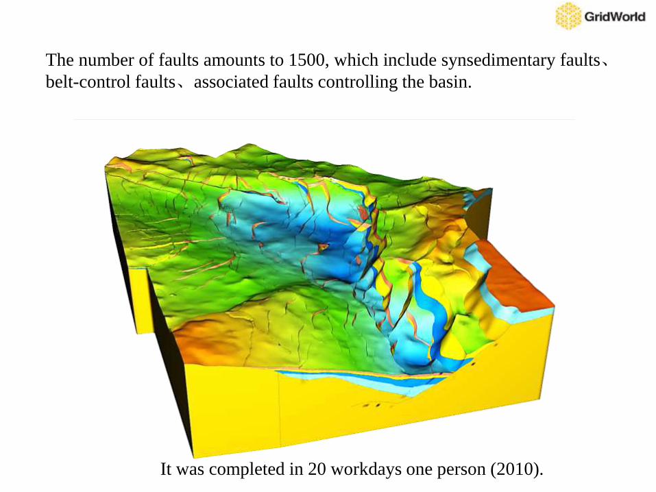
It was completed in 20 workdays one person (2010).
The number of faults amounts to 1500, which include synsedimentary faults、belt-control faults、associated faults controlling the basin.
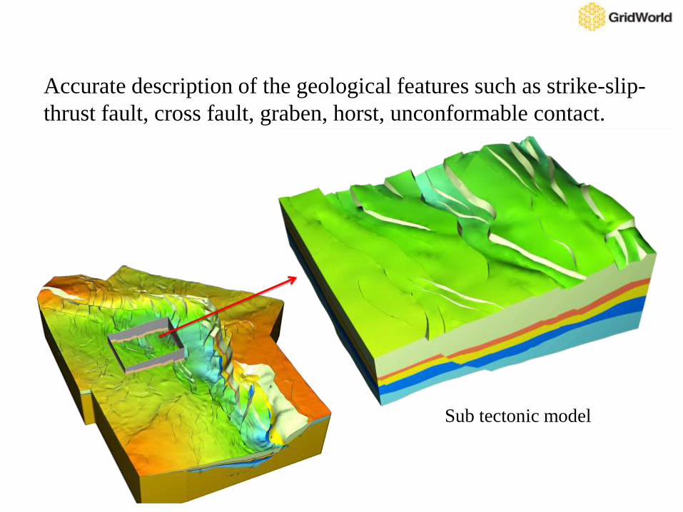
Sub tectonic model
Accurate description of the geological features such as strike-slip-
thrust fault, cross fault, graben, horst, unconformable contact.
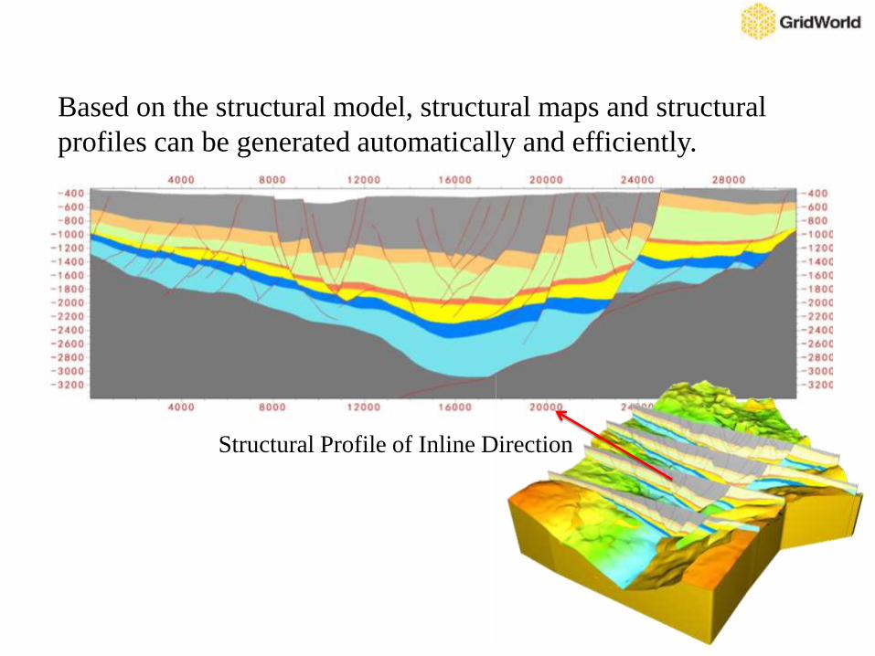
Structural Profile of Inline Direction
Based on the structural model, structural maps and structural
profiles can be generated automatically and efficiently.
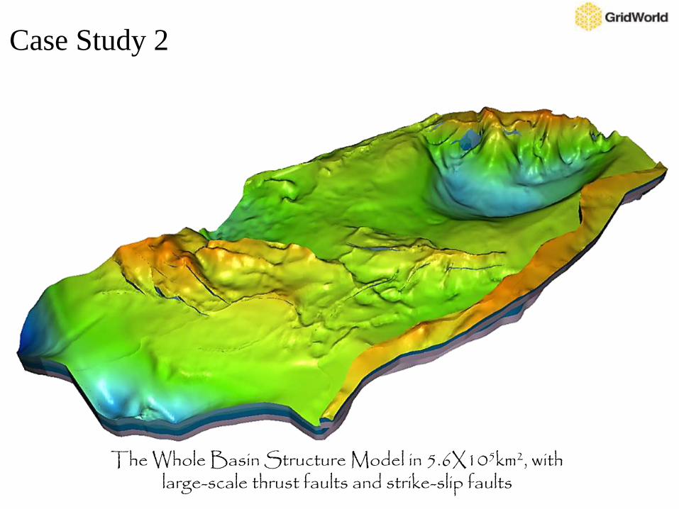
The Whole Basin Structure Model in 5.6X10⁵km2, with large-scale thrust faults and strike-slip faults
Case Study 2
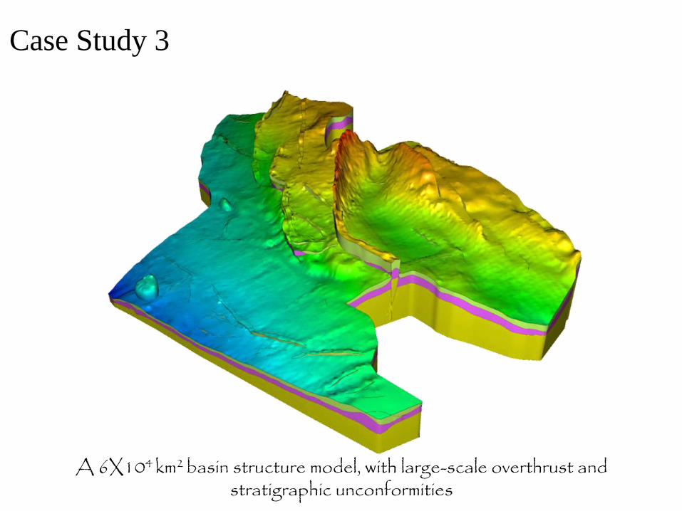
A 6X10⁴ km2 basin structure model, with large-scale overthrust and stratigraphic unconformities
Case Study 3
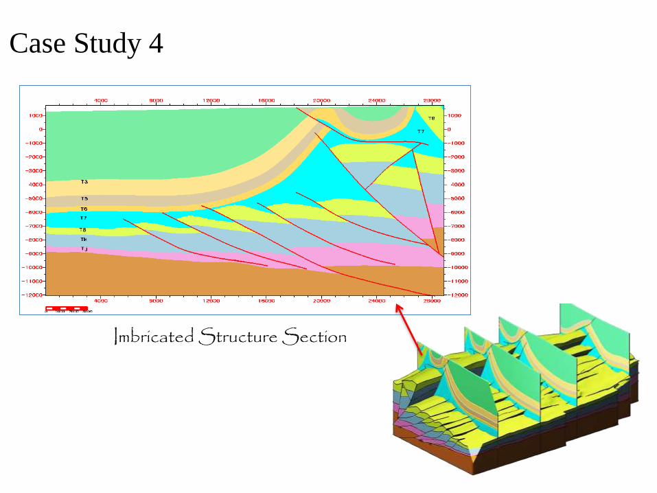
Imbricated Structure Section
Case Study 4
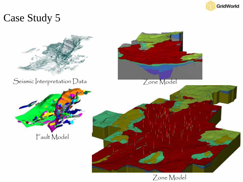
Seismic Interpretation Data
Fault Model
Zone Model
Zone Model
Case Study 5
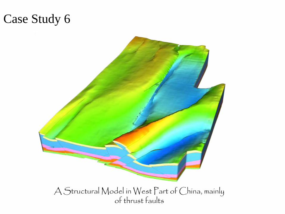
A Structural Model in West Part of China, mainly of thrust faults
Case Study 6
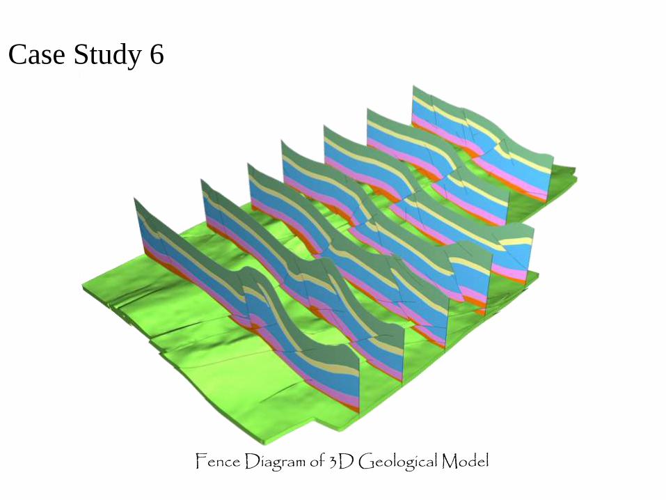
Fence Diagram of 3D Geological Model
Case Study 6
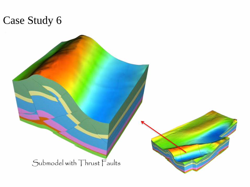
Submodel with Thrust Faults
Case Study 6
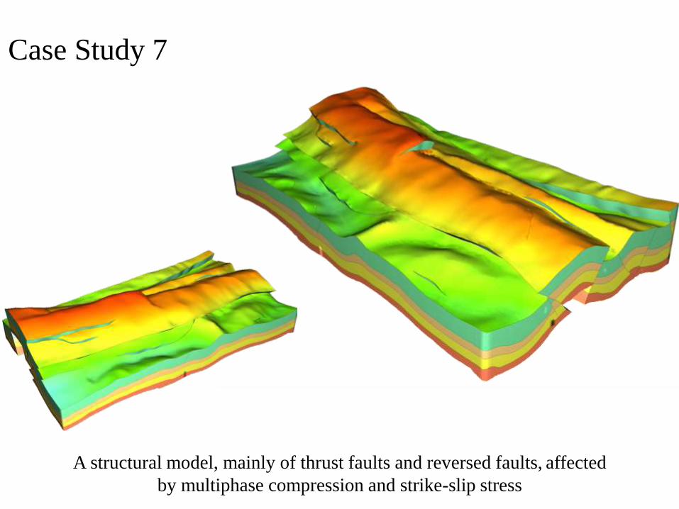
A structural model, mainly of thrust faults and reversed faults, affected
by multiphase compression and strike-slip stress
Case Study 7
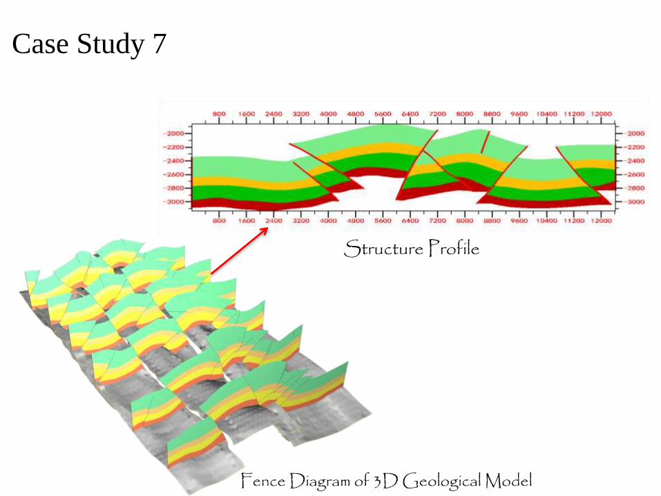
Structure Profile
Fence Diagram of 3D Geological Model
Case Study 7
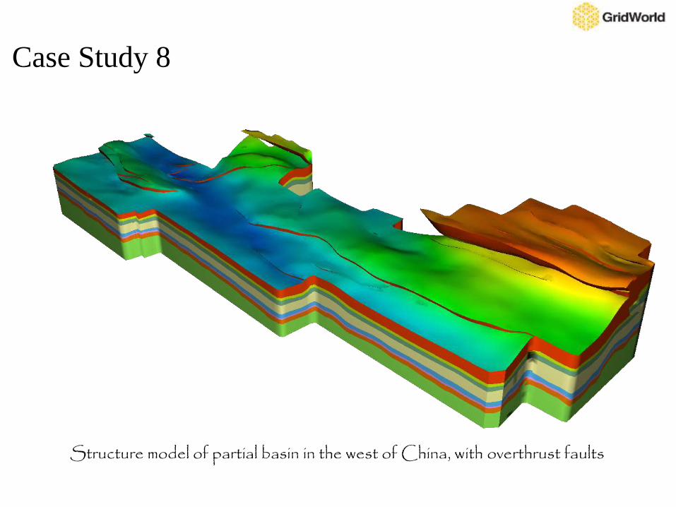
Structure model of partial basin in the west of China, with overthrust faults
Case Study 8
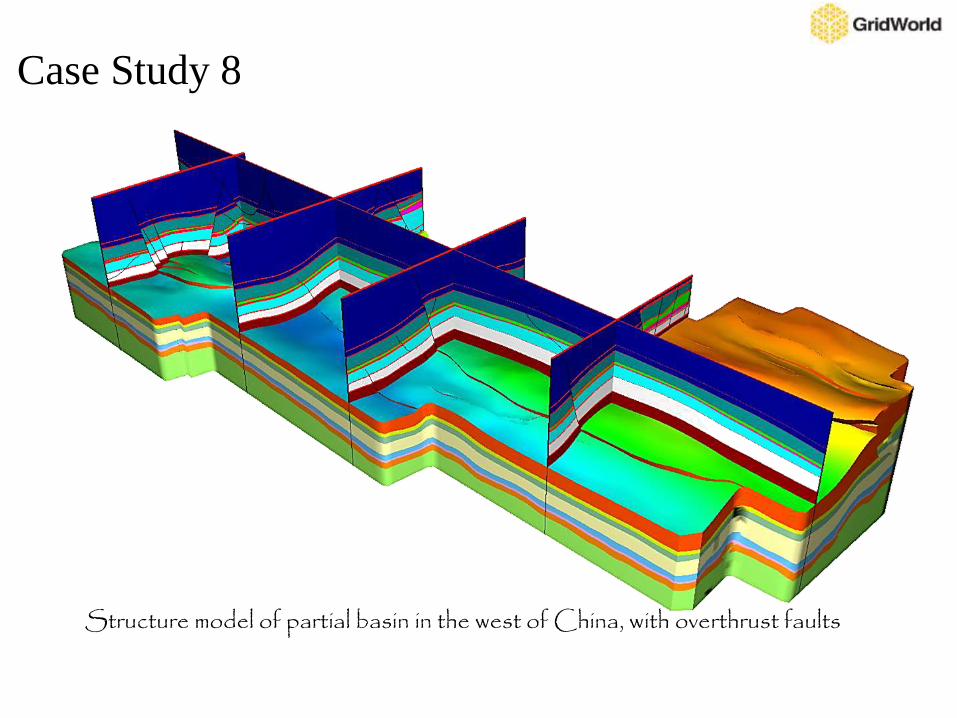
Structure model of partial basin in the west of China, with overthrust faults
Case Study 8
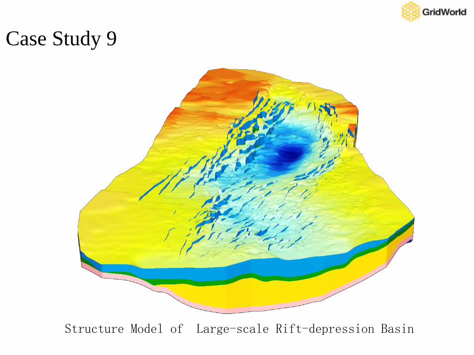
Structure Model of Large-scale Rift-depression Basin
Case Study 9
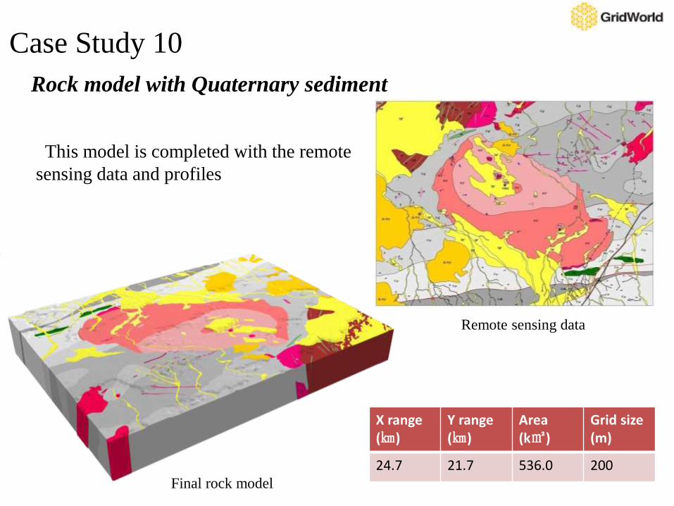
Remote sensing data
Final rock model
Rock model with Quaternary sediment
This model is completed with the remote
sensing data and profiles
X range(㎞)
Y range(㎞)
Area(k㎡)
Grid size(m)
24.7 21.7 536.0 200
Case Study 10
Outline
I. Basic Information
II. Technical Features
III. Products
IV. Case Study
V. Development History
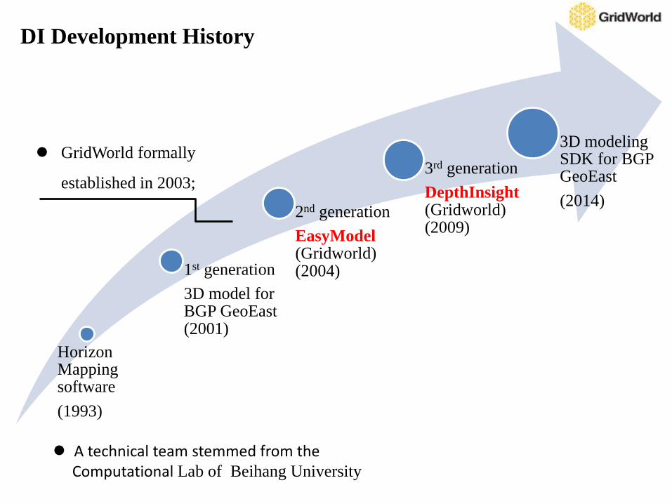
Horizon Mapping software
(1993)
1st generation
3D model for BGP GeoEast(2001)
2nd generation
EasyModel(Gridworld) (2004)
3rd generation
DepthInsight(Gridworld) (2009)
3D modeling SDK for BGP GeoEast
(2014)
GridWorld formally
established in 2003;
DI Development History
A technical team stemmed from the Computational Lab of Beihang University
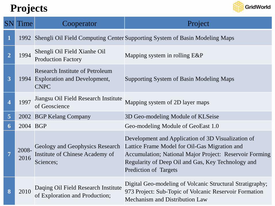
SN Time Cooperator Project
1 1992 Shengli Oil Field Computing Center Supporting System of Basin Modeling Maps
2 1994Shengli Oil Field Xianhe Oil
Production FactoryMapping system in rolling E&P
3 1994
Research Institute of Petroleum
Exploration and Development,
CNPC
Supporting System of Basin Modeling Maps
4 1997Jiangsu Oil Field Research Institute
of GeoscienceMapping system of 2D layer maps
5 2002 BGP Kelang Company 3D Geo-modeling Module of KLSeise
6 2004 BGP Geo-modeling Module of GeoEast 1.0
72008-
2016
Geology and Geophysics Research
Institute of Chinese Academy of
Sciences;
Development and Application of 3D Visualization of
Lattice Frame Model for Oil-Gas Migration and
Accumulation; National Major Project: Reservoir Forming
Regularity of Deep Oil and Gas, Key Technology and
Prediction of Targets
8 2010Daqing Oil Field Research Institute
of Exploration and Production;
Digital Geo-modeling of Volcanic Structural Stratigraphy;
973 Project: Sub-Topic of Volcanic Reservoir Formation
Mechanism and Distribution Law
Projects
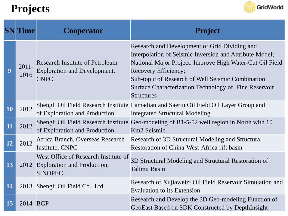
SN Time Cooperator Project
92011-
2016
Research Institute of Petroleum
Exploration and Development,
CNPC
Research and Development of Grid Dividing and
Interpolation of Seismic Inversion and Attribute Model;
National Major Project: Improve High Water-Cut Oil Field
Recovery Efficiency;
Sub-topic of Research of Well Seismic Combination
Surface Characterization Technology of Fine Reservoir
Structures
10 2012Shengli Oil Field Research Institute
of Exploration and Production
Lamadian and Saertu Oil Field Oil Layer Group and
Integrated Structural Modeling
11 2012Shengli Oil Field Research Institute
of Exploration and Production
Geo-modeling of B1-5-52 well region in North with 10
Km2 Seismic
12 2012Africa Branch, Overseas Research
Institute, CNPC
Research of 3D Structural Modeling and Structural
Restoration of China-West-Africa rift basin
13 2012
West Office of Research Institute of
Exploration and Production,
SINOPEC
3D Structural Modeling and Structural Restoration of
Talimu Basin
14 2013 Shengli Oil Field Co., LtdResearch of Xujiaweizi Oil Field Reservoir Simulation and
Evaluation to its Extension
15 2014 BGPResearch and Develop the 3D Geo-modeling Function of
GeoEast Based on SDK Constructed by DepthInsight
Projects
Cooperator: Geology and Geophysics Research Institute of Chinese Academy of
Sciences
Time: 2008
National Major Project: reservoir forming regularity of deep oil and gas,
prediction for key technology and targets
Sub-topic: development and application of 3D visualization of lattice frame model
for Oil-Gas migration and accumulation
Key E&P Projects in China
Cooperator: Geology and Geophysics Research Institute of Chinese Academy of
Sciences
Time: 2011
National Major Project: Improve High Water-Cut Oil Field Recovery Efficiency
Sub-topic: Well Seismic Combination Surface Characterization Technology of Fine
Reservoir Structures
Brief Description: the above two projects are all at the national level and consisted
by leading reservoir engineering researchers. Their main purpose is to overcome the
technical difficulty of predicting reservoir forming law and targets and improving
high water-cut oil field recovery. In these projects, GridWorld is responsible for geo-
modeling.
Key E&P Projects in China
Cooperator: Daqing Oil Field Research Institute of Exploration and Production;
Time: 2013
Project: Lamadian and Saertu Oil Field Oil Layer Group and Integrated Structural
Modeling
Brief Description: build a holistic and 20 meter grid structural model of Daqing Oil
Field which is 2000 k㎡with 2000 faults and 50000 wells. As so far, this is an unique
high-resolution and basin-scale model which is highly praised and built with
functions of concurrent working by multi-users, downloading and updating any local
model and seamlessly merging.
Key E&P Projects in China
Cooperator: BGP
Time: 2014
Project: Research and Develop the 3D Geo-modeling Function of GeoEast Based on
SDK Constructed by DepthInsight
Brief Description: BGP has inserted our SDK into its self-developed software
GeoEast, which enables it possess capability of 3D Geo-modeling and could meet
the modeling requirement for forward modeling, inversion and reservoir
characterization. This project has entered into the final phase of testing and a new
version will be released soon. BGP will pay GridWorld for every user of GeoEast
and it will make GridWorld have stable income. In addition, the same cooperation
model has been discussed with other large oil service companies and software
companies.
Key E&P Projects in China
Open and welcome any form of international cooperation
Provide you the best technical service for geological E&P industry