Embed Size (px)
Citation preview

Progress of Land Ecosystem Studies with Geo-Information and Space
Technology in Great Mekong Subregion(GMS)
Prof. Liu ChuangInternational Cooperation Program of Institute of Remote Sensing Applications
Data Center on Natural Resources and Environment of Institute of Geography and Natural Resources
Chinese Academy of Sciences
China-Thailand Geo-Information Workshop Series 1: Agricultural Applications30 June 2010, Pattaya, Thailand

Outlines
1. Background and Objectives
2. Progress of Land Ecosystem Studies on GMS
3. Further Actions
4. conclusion

1.1 Background: Six
Countries Share One
River –Mekong
River

Country Area of the Country
(km2)
Area of the Mekong
River Base (km2)
Percentage
(%)
China 9,597,000 165,000 1.7
Myanmar 678,030 24,000 3.5
Lao 236,725 202,400 85.5
Thailand 513,115 184,240 35.9
Cambodia 181,100 154,730 19.6
Vietnam 331,700 65,170 19.6

GMS, from ADB in 1992, includes six countries, Cambodia, People’s Republic of China (two provinces), the Lao People’s Democratic Republic, Myanmar, Thailand and Vietnam, covers 2.57 Millions KM2 and 325 Millions people
1.1 Background: Great Mekong Subregion

If you want to rich, you have to be reached firstthen business follows
81 priority projects was funded by ADB from 1992-2011. The estimated total investment for these projects within the 20 years is USD 14,056 Millions. Transportation, energy, economic corridors, communication, tourism, agriculture, environment, public health, capacity building, trade facilities are major fields of the joint activities. Three economic corridors are on the way to be established based on the traffic corridors

UN GAID e-SDDC Phase II: 2010-2012
Focus: Scientific data for support UN MDGs in regional level (cross countries), with the progress assessment methodology (in time serious)
IRSA is the data and information achieve and service center for the UN GAID e-SDDC
Joint Project of Science Council of Asia on Open and Application Scientific Data for Poverty Reduction and Ecosystem Protection in Asia
Co-chaired by Liu Chuang from CAS and Parkon (Chairman of WGISS/CEOS) from GISTDA
1.2 Background: On-going Cooperation Projects

Joint International Workshop in September 2009 in Ulaanbaatar, Mongolian
• Joint together with APN, WGISS/CEOS, CODATA and UN GAID e-SDDC
• More than 40 participates from Mongolia, Japan, China, Thailand, as well as USA and ESA jointed the workshop
• A new and practical methodology how to use the updated space science and technology for climate change and ecosystem monitoring analysis was discussed

1.3 Objectives
• Land Ecosystem Map of GMS in 1: 1million scale and validated samples in 20-30 meters pixels
• Provide online application services for GMS studies
• Show case how to use geo-information and space technology to support the cross boundary research and decision making

2. Progress of Land Ecosystem Studies on GMS
• CBERS, HJ, TM/ETM, MODIS Remote Sensing Data • Fundamental geo-informatics
(BND, rivers, road, rroad, pplacesp, pplacesg)• DEM and Landforms (landform types, slopes)• Climate (temperature, rainfall, regionalization)• Socio-economics (BND, investment from ADB
projects, UN statistics)• Cases of Land Cover classification with support
from CBERS integrating with TM/ETM and MODIS
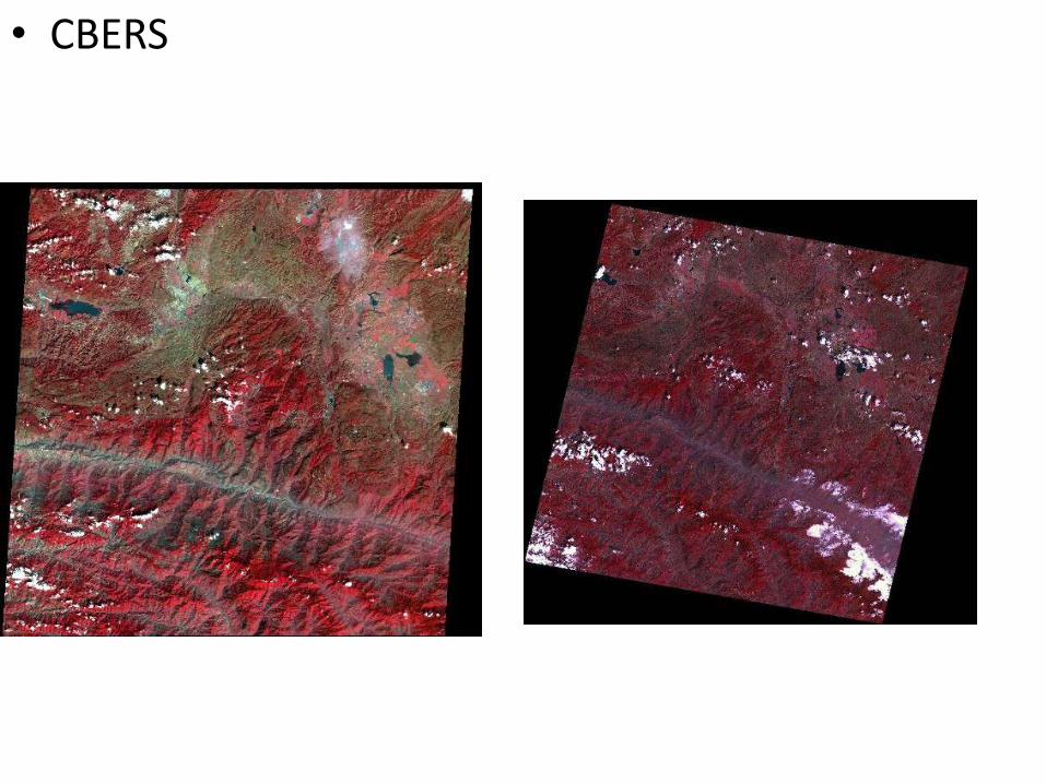
• CBERS

LandSat TM/ETM+MODIS

DEM and Landform

Land Slope Map

Landform Classification Map

• Climate data Example: data from 15 stations

Climate (tmp)

ClimateRainfall

ClimateRegionali-
zation

Climate regionali-zation of Thailand

Administrative Boundary GIS data

泰国一级水系 泰国二级水系


Land Cover

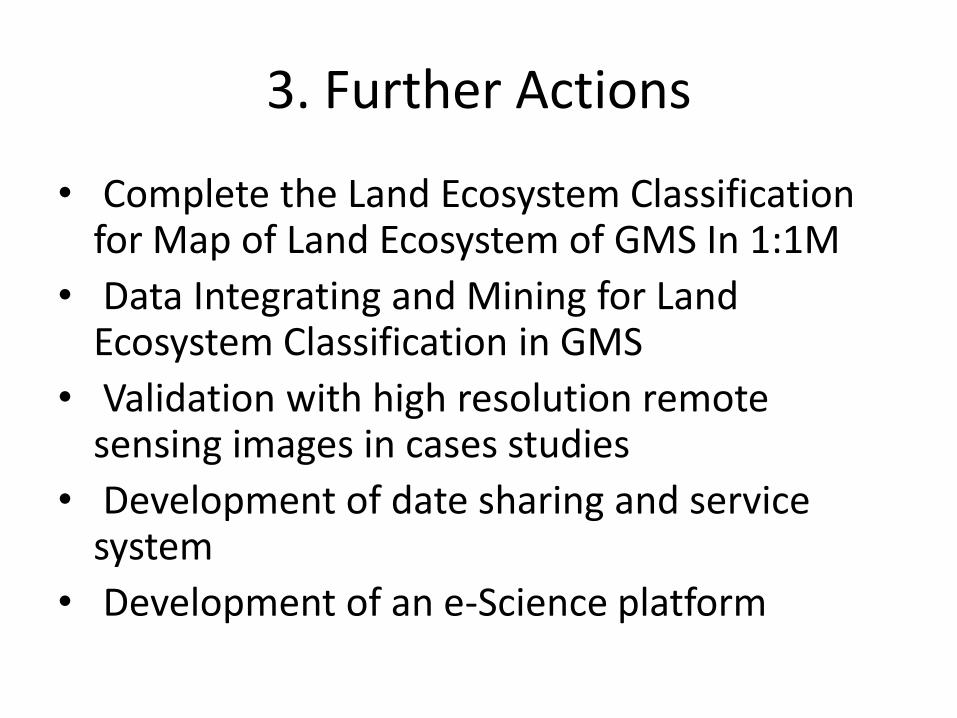
3. Further Actions
• Complete the Land Ecosystem Classification for Map of Land Ecosystem of GMS In 1:1M
• Data Integrating and Mining for Land Ecosystem Classification in GMS
• Validation with high resolution remote sensing images in cases studies
• Development of date sharing and service system
• Development of an e-Science platform

3. Further Actions
• Provide suggestions and recommendations to decision makers
• Development of international cooperation

4. Conclusion
• From our experiences on geo-information and space science application for land ecosystem analysis in GMS, land ecosystem mapping is the fundamental data and information for agriculture and environment
• Making science benefit society, it may be a special case or examples for UN MDGs and e-SCIENCES
• It may be good start for the cooperation between IRSA and GISTDA

Thank You !