Embed Size (px)
Citation preview

Commercial Geography
Lesson Objectives
At the end of today’s lesson we should be able to
• Understand various geographical & climatic aspects
• Explain its importance for shipping

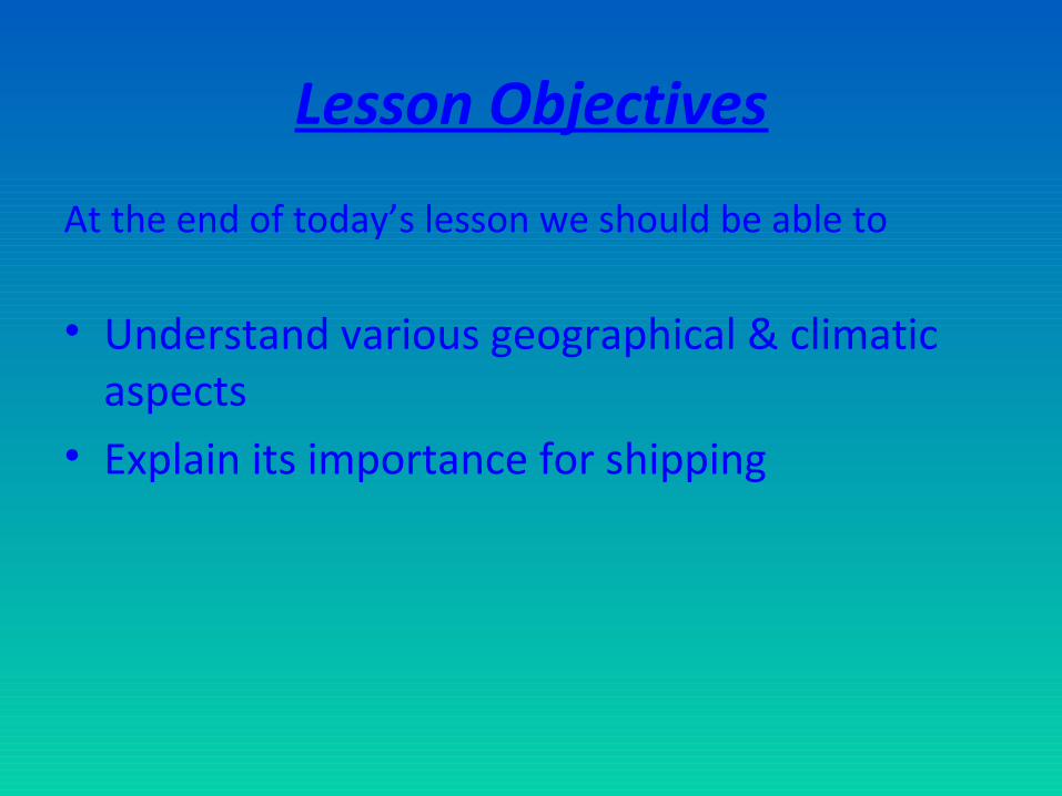
Seven Oceans
• NORTH ATLANTIC OCEAN• SOUTH ATLANTIC OCEAN• NORTH PACIFIC OCEAN• SOUTH PACIFIC OCEAN• INDIAN OCEAN• ARCTIC OCEAN• ANTARCTIC OR SOUTHERN OCEAN


Continents
• ASIA • AFRICA• NORTH AMERICA• SOUTH AMERICA• EUROPE• ANTARCTICA• AUSTRALIA


Geographical Regions
• Scandinavia• Far East• South East Asia• Indian Sub-con• Middle East• Mediterranean
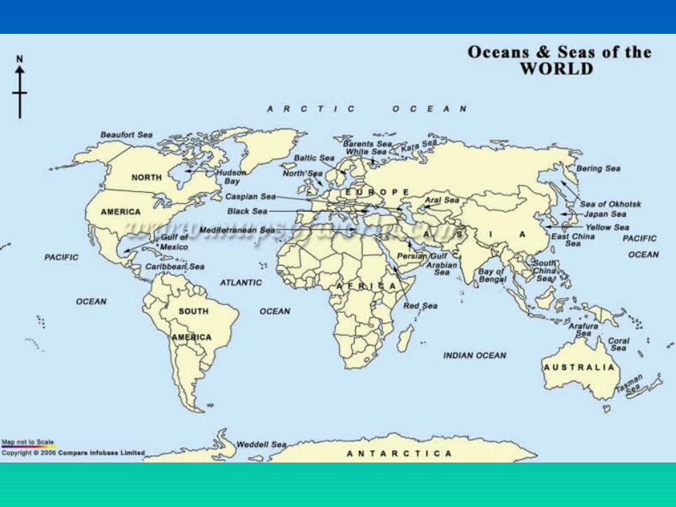
Canals & Waterways• Natural Waterways
> Thames River> River Elbe> Hooghly River
• Man made waterways• Canals are man-made channels for water. There are two types of
canal:• Waterways: navigable transportation canals used for carrying ships and
boats shipping goods and conveying people, further subdivided into two kinds:
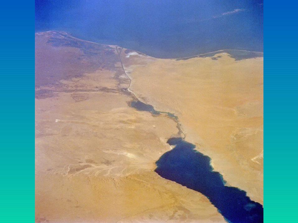
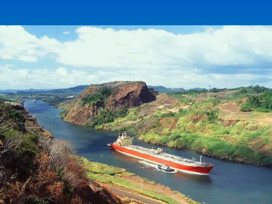
– Those connected to existing lakes, rivers, or oceans. Included are inter-basin canals, such as the Suez Canal, Erie Canal, and the Panama Canal.
– Those connected in a city network: such as the Canal Grande and others of Venice Italy; the gracht of Amsterdam, and the waterways of Bangkok.

• Thames River • The Thames in London• Country England Counties Gloucestershire, Wiltshire, Oxfordshire,
Berkshire, Buckinghamshire, Surrey, Essex, Kent Metropolitan County Greater London
• Length 346 km (215 mi) Basin 12,935 km2 (4,994 sq mi) Discharge for London - average 65.8 m3/s (2,324 cu ft/s) Discharge elsewhere (average) - entering Oxford 17.6 m3/s (622 cu ft/s) - leaving Oxford 24.8 m3/s (876 cu ft/s) - Reading 39.7 m3/s (1,402 cu ft/s) - Windsor 59.3 m3/s (2,094 cu ft/s)
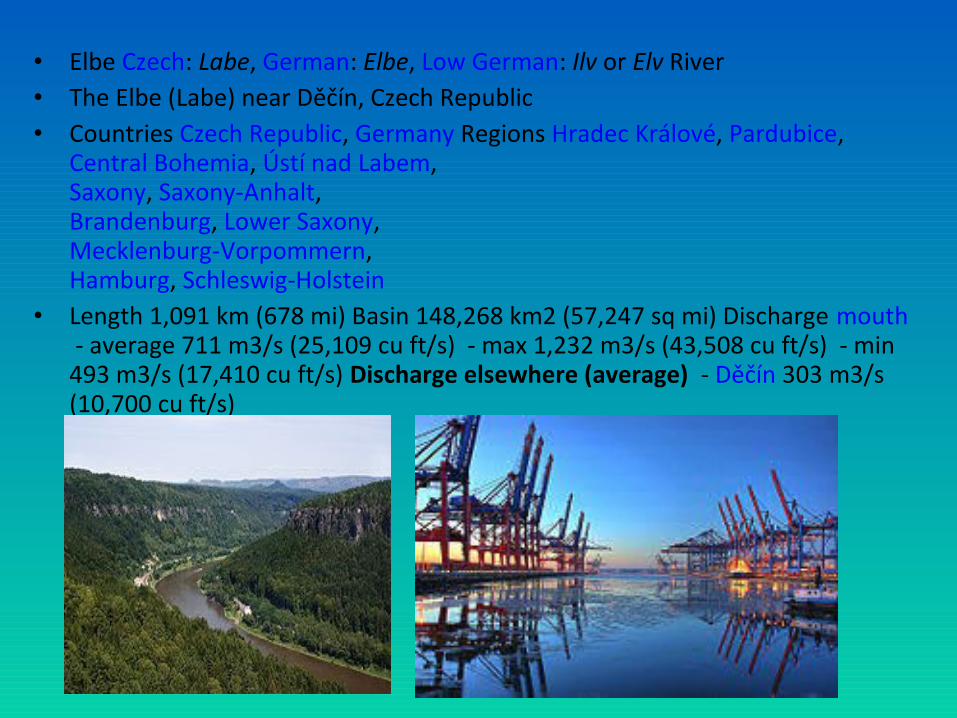
• Elbe Czech: Labe, German: Elbe, Low German: Ilv or Elv River • The Elbe (Labe) near Děčín, Czech Republic• Countries Czech Republic, Germany Regions Hradec Králové, Pardubice,
Central Bohemia, Ústí nad Labem, Saxony, Saxony-Anhalt, Brandenburg, Lower Saxony, Mecklenburg-Vorpommern, Hamburg, Schleswig-Holstein
• Length 1,091 km (678 mi) Basin 148,268 km2 (57,247 sq mi) Discharge mouth - average 711 m3/s (25,109 cu ft/s) - max 1,232 m3/s (43,508 cu ft/s) - min 493 m3/s (17,410 cu ft/s) Discharge elsewhere (average) - Děčín 303 m3/s (10,700 cu ft/s)
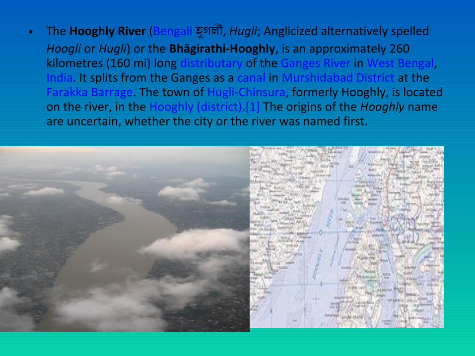
• The Hooghly River (Bengali হুগলী, Hugli; Anglicized alternatively spelled Hoogli or Hugli) or the Bhāgirathi-Hooghly, is an approximately 260 kilometres (160 mi) long distributary of the Ganges River in West Bengal, India. It splits from the Ganges as a canal in Murshidabad District at the Farakka Barrage. The town of Hugli-Chinsura, formerly Hooghly, is located on the river, in the Hooghly (district).[1] The origins of the Hooghly name are uncertain, whether the city or the river was named first.

• The Port of Shanghai (Chinese: 上海港 ; pinyin: Shàngh i g ngǎ ǎ ), located in the vicinity of Shanghai, comprises a deep-sea port and a river port.
• In 2010, Shanghai port overtook Singapore port to become the world's busiest container port. Shanghai's port handled 29.05 million TEUs, whereas Singapore port was a half million TEU's behind.[1]
• In 2012, Shanghai port set a historic record by handling over 32 million TEUs.[2]
• Port of Shanghai
• Yangshan Deep-water Port Location Country People's Republic of China Location Shanghai Coordinates 31°21 32 N 121°37 08 E′ ″ ′ ″ / 31.3589°N
121.619°E Details Opened 1842 (As treaty port) Operated by Shanghai International Port Company Ltd. Owned by Public Type of harbor Deep-water seaport/Riverport Statistics Annual cargo tonnage 736 million (2012) Annual container volume 32.529 million TEU (2012)


CANALS & WATERWAYS
Panama Canal
Suez Canal
Saint Lawrence River Kiel Canal

Suez Canal


CANALS & WATERWAYS


CANALS & WATERWAYS

Kiel Canal
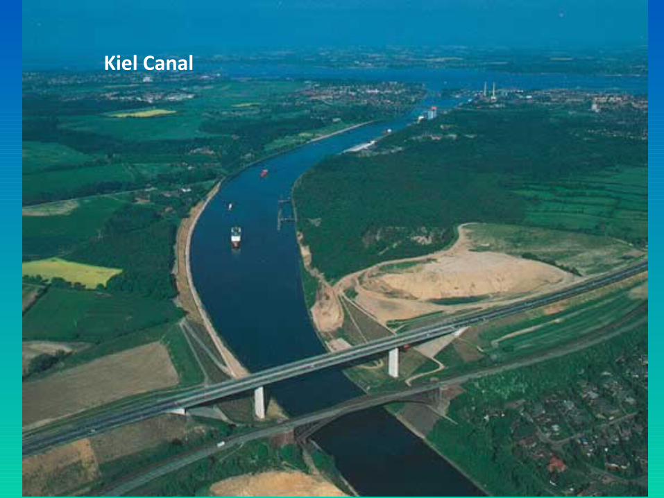
Kiel Canal


CANALS & WATERWAYS


Bays & Headlands

Capes (Headlands)
Cape of Good Hope
Cape Horn

Palk Strait

Malacca strait
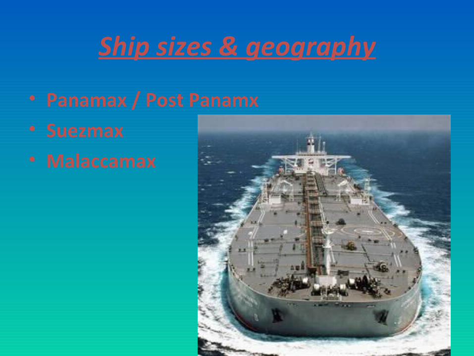
Ship sizes & geography
• Panamax / Post Panamx• Suezmax• Malaccamax

PORTS

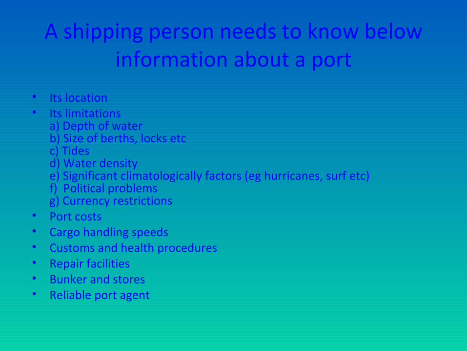
A shipping person needs to know below information about a port
• Its location• Its limitations
a) Depth of waterb) Size of berths, locks etcc) Tidesd) Water density e) Significant climatologically factors (eg hurricanes, surf etc)f) Political problems g) Currency restrictions
• Port costs• Cargo handling speeds• Customs and health procedures• Repair facilities• Bunker and stores • Reliable port agent

LATITUDE AND LONGITUDEand their uses
• PLOTTING THE POSITION OF A SHIP AT SEA
• LOCATION OF PORTS
• TIMECHARTER DELIVERY AND REDELIVERY


6° 54 0 N, 79° 54 0 E′ ″ ′ ″

Time Zones

IDL

Climatic Phenomena
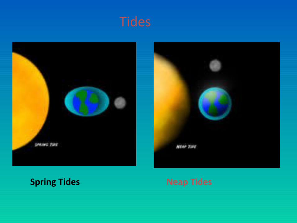
Tides
Spring Tides Neap Tides


Effects of Tides to ports


• ENCLOSED DOCKS
• LOCKS
SOLUTIONS TO TIDAL PROBLEMS
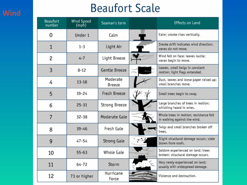
Wind

Hurricane Katerina forming in the South Atlantic ocean
Tropical Storms

HurricanesTyphoonsCyclones
Willy-Willies
Global Tropical Storms Tracks 1985 to 2005
Hurricanes – June to Nov
Typhoons – May to Jan
Cyclones – Middle & End of the year

Ocean Currents
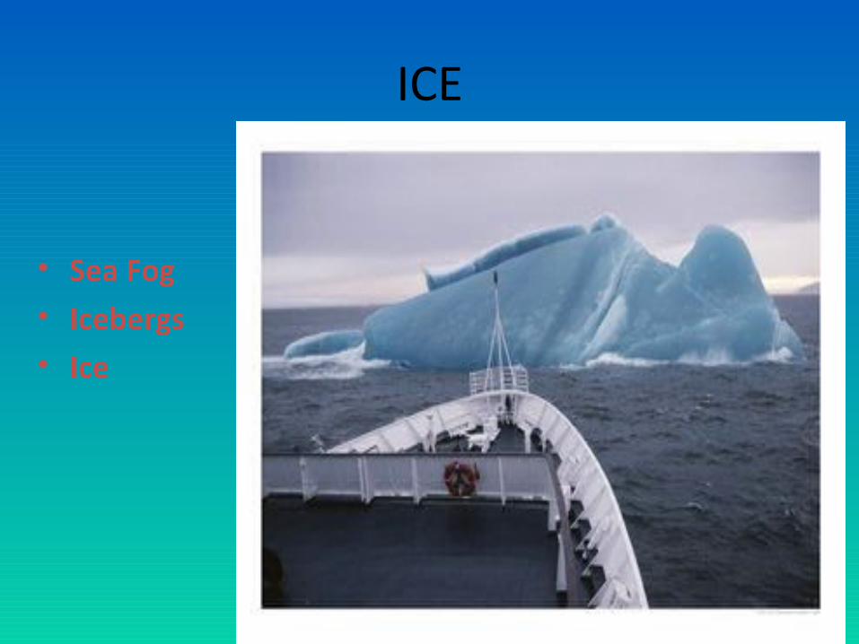
ICE
• Sea Fog• Icebergs• Ice

Effects on Shipping
• Delays & Damages at Sea • Delays & Damages during loading &
discharging operations• Safety at Sea• Ships have to be both Proactive & Reactive
Other Factors that have effects on shipping
• Political• Navigational (Loadline Zones)

Load Line Zones

Plimsoll LineTF – Tropical Fresh Water
F – Fresh Water
T – Tropical Seawater
S – Summer Temperate SeawaterW – Winter Temperate Seawater
WNA – Winter North Atlantic


Cargoes & Trade Routes
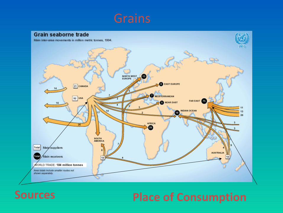
Grains
Sources Place of Consumption


Coal Trade


Trans Pacific Trans Atlantic Europe Far East
Containerized Trade - Main Routes

Thank you
Lahiru Silva – Sri LAnka +94777570697


![[NCERT] Economic & Commercial Geography of India X(Old Edition).pdf](https://img.pdfslide.net/doc/110x75/563db9d8550346aa9aa07963/ncert-economic-commercial-geography-of-india-xold-editionpdf.jpg)