Embed Size (px)
Citation preview
AD-AIOL L1S CO PS OF N IEERS CHICAGO ILl. CHICAGO DISTRICT F ,16 13/C jFINAL ENVIRONMENTAL IMPACT STATEMENT RELATING TO THlE OPIATION -ETCr 7
UNCLASSIFIED N.
I/IIlIII/IiI11111K 111111ON111111II ElIIIIIII III.I.Iion NONE NONE////I// I////100-
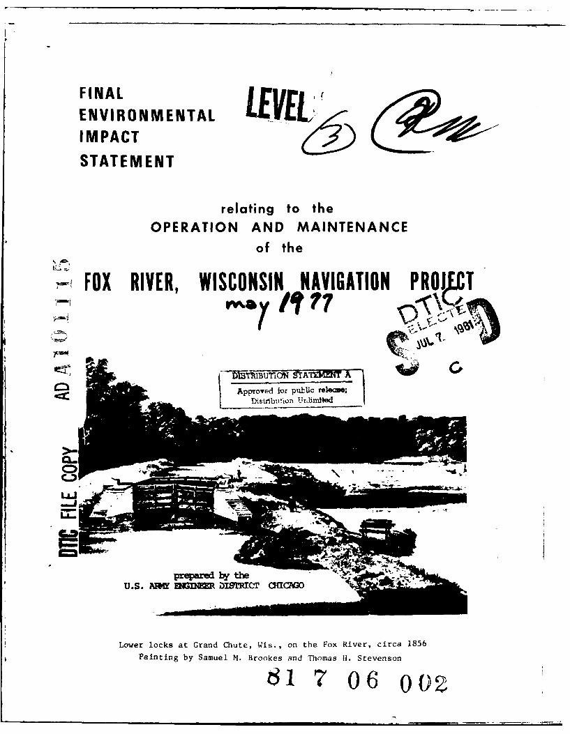
FINALENVIRONMENTALIMPACT
STATEMENT
relating to theOPERATION AND MAINTENANCE
of the
FOX RIVER, WISCONSIN NAVIGATION PROJ Tr m -a 77
Lowe lock ata GadC ute Wi.n the Fo River cicA15
Approved for public StlevesoDistrbu7tion 0r6i0tUedCA.
U.S. AM MGM DIrRICr MCAo
Lower locks at Grand Chute, Wis., on the Fox River, circa 1856
Painting by Samuel M. Brookes and Thomas U. Stevenson
61 17 06 00)2
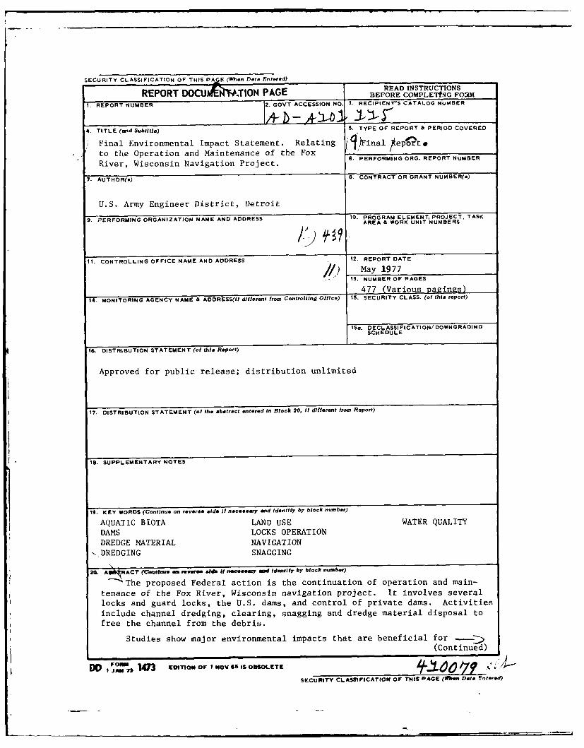
SECURITY CLASSIFICATION OF THIS PA E (When Dat Entered)RPRDOU .TION PAEREAD INSTRUCTIONS
REPORT D0C 10ON PAGE BEFORE COMPLETNG FOM1. REPORT NUMBER 2. GOVT ACCESSION NO. 3. RECIPIENT'S CATALOG NUMBER
4. TITLE (and Subtitle) S. TYPE OF REPORT & PERIOD COVERED
Final Environmental Impact Statement. Relating (1 Final eotto the Operation and Maintenance of the Fox
River, Wisconsin Navigation Project.
7. AUTHOR(&) S. CONTRACT OR GRANT NUMBER(&)
U.S. Army Engineer District, Detroit9. PERFORMING ORGANIZATION NAME AND ADDRESS 10. PROGRAM ELEMENT, PROJECT, TASK
AREA & WORK UNIT NUMBERS
It. CONTROLLING OFFICE NAME AND ADDRESS 12. REPORT DATE
/) May 19771S. NUMBER OF PAGES
477 (Various Pagings)
14. MONITORING AGENCY NAME & ADDRESS(If different from Controlling Office) 15. SECURITY CLASS. (of this report)
iSa. DECL ASSI FICATION/DOWNGRADINGSCHEDULE
16. DISTRIBUTION STATEMENT (of this Report)
Approved for public release; distribution unlimited
17. DISTRIBUTION STATEMENT (of the abstract entered In Block 20, If different from Report)
I. SUPPLEMENTARY NOTES
19. KEY WORDS (Continue on reverse side if necessary nd identify by block number)
AQUATIC BIOTA LAND USE WATER QUALITY
DAMS LOCKS OPERATIONDREDGE MATERIAL NAVIGATION
-,DREDGING SNAGGING
20. A!!!ACT (Cm~rtee n revere lm Itf neser mo Identilfy by block number)
-The proposed Federal action is the continuation of operation and main-
tenance of the Fox River, Wisconsin navigation project. It involves several
locks and guard locks, the U.S. dams, and control of private dams. Activities
include channel dredging, clearing, snagging and dredge material disposal to
free the channel from the debris.
Studies show major environmental impacts that are beneficial for(Continued)
, , ,j.. 143 now OF NO40V GS IS OSOLETE 7 . /SECURITY CLASSIFICATION oF ThIS PAGE (PI~enr Dai Entered)
SECURITY CLASSIFICATION OF THIS PAGE(Vhei Date Entered)
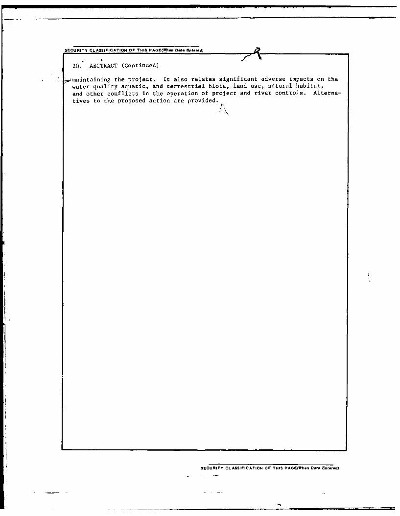
20. ABCTRACT (Continued)
_,maintaining the project. It also relates significant adverse impacts on the
water quality aquatic, and terrestrial biota, land use, natural habitat,
and other conflicts in the operation of project and river controls. Alterna-
tives to the proposed action are provided.
SECURITY CLASSIFICATION OF THIS PAGE(Ien Data Entered)
FINAL
ENVIRONMENTAL STATEMENT
relating to the
OPERATION AND MAINTENANCE
OF THE FOX RIVER, WISCONSIN NAVIGATION PROJECT
prepared by the
US ARMY ENGINEER DISTRICT
CHICAGO, ILLINOIS
May 1977
ub '-n
. .. P
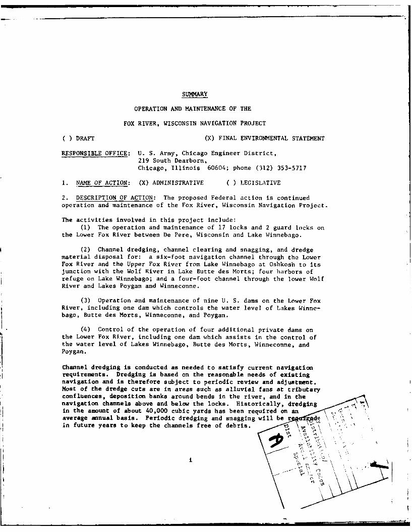
SUMMARY
OPERATION AND MAINTENANCE OF THE
FOX RIVER, WISCONSIN NAVIGATION PROJECT
( ) DRAFT (X) FINAL ENVIRONMENTAL STATEMENT
RESPONSIBLE OFFICE: U. S. Army, Chicago Engineer District,219 South Dearborn,Chicago, Illinois 60604; phone (312) 353-5717
1. NAME OF ACTION: (X) ADMINISTRATIVE ( ) LEGISLATIVE
2. DESCRIPTION OF ACTION: The proposed Federal action is continuedoperation and maintenance of the Fox River, Wisconsin Navigation Project.
The activities involved in this project include:(1) The operation and maintenance of 17 locks and 2 guard locks on
the Lower Fox River between De Pere, Wisconsin and Lake Winnebago.
(2) Channel dredging, channel clearing and snagging, and dredgematerial disposal for: a six-foot navigation channel through the LowerFox River and the Upper Fox River from Lake Winnebago at Oshkosh to itsjunction with the Wolf River in Lake Butte des Morts; four harbors ofrefuge on Lake Winnebago; and a four-foot channel through the lower WolfRiver and Lakes Poygan and Winneconne.
(3) Operation and maintenance of nine U. S. dams on the Lower FoxRiver, including one dam which controls the water level of Lakes Winne-bago, Butte des Morts, Winneconne, and Poygan.
(4) Control of the operation of four additional private dams on
the Lower Fox River, including one dam which assists in the control ofthe water level of Lakes Winnebago, Butte des Morts, Winneconne, andPoygan.
Channel dredging is conducted as needed to satisfy current navigationrequirements. Dredging is based on the reasonable needs of existingnavigation and is therefore subject to periodic review and adjustment.Most of the dredge cuts are in areas such as alluvial fans at tributaryconfluences, deposition banks around bends in the river, and in thenavigation channels above and below the locks. Historically, dredgingin the amount of about 40,000 cubic yards has been required on anaverage annual basis. Periodic dredging and snagging will be r din future years to keep the channels free of debris.
0,
ii
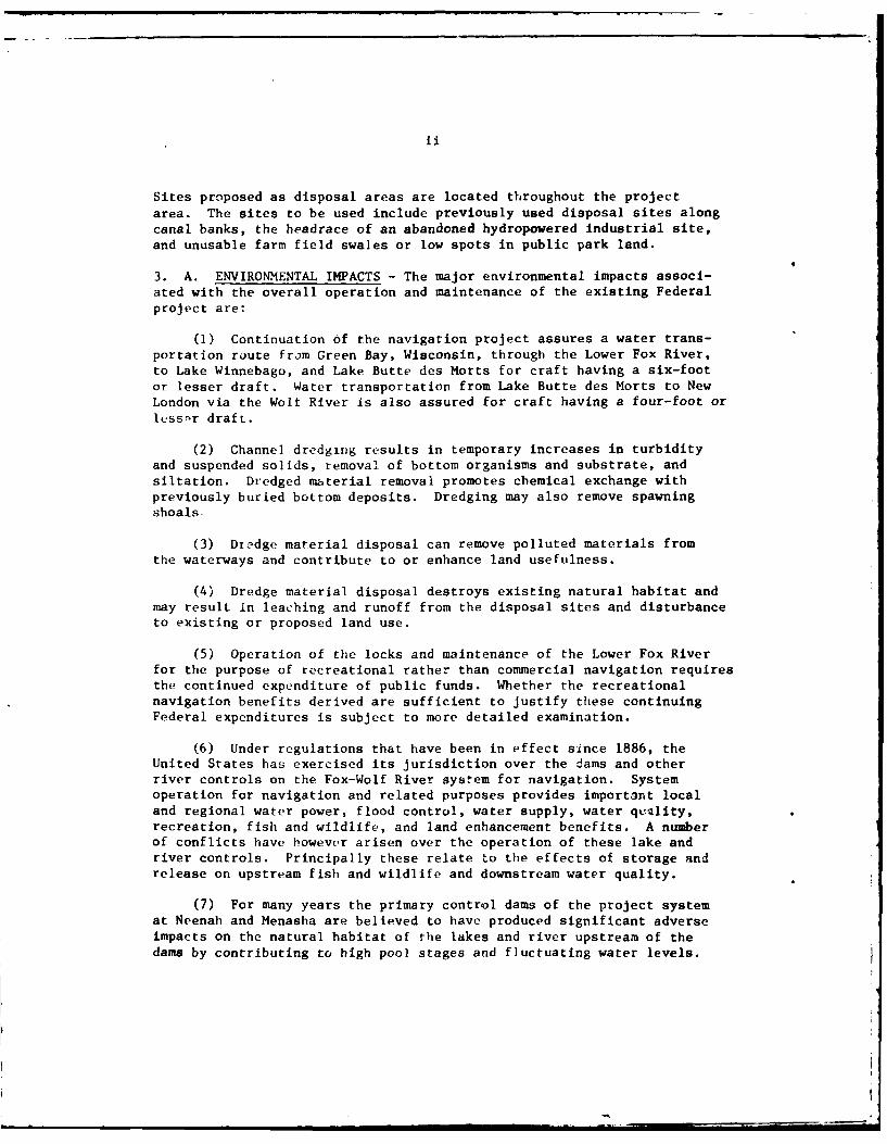
Sites proposed as disposal areas are located throughout the projectarea. The sites to be used include previously used disposal sites alongcanal banks, the headrace of an abandoned hydropowered industrial site,and unusable farm field swales or low spots in public park land.
3. A. ENVIRONMENTAL IMPACTS - The major environmental impacts associ-ated with the overall operation and maintenance of the existing Federalproject are:
(1) Continuation of the navigation project assures a water trans-portation route from Green Bay, Wisconsin, through the Lower Fox River,to Lake Winnebago, and Lake Butte des Morts for craft having a six-footor lesser draft. Water transportation from Lake Butte des Morts to NewLondon via the Wolt River is also assured for craft having a four-foot orless-r draft.
(2) Channel dredging results in temporary increases in turbidityand suspended solids, removal of bottom organisms and substrate, andsiltation. Dredged material removal promotes chemical exchange withpreviously buried bottom deposits. Dredging may also remove spawningshoals
(3) Dr edge material disposal can remove polluted materials fromthe waterways and contribute to or enhance land usefulness.
(4) Dredge material disposal destroys existing natural habitat andmay result in leaching and runoff from the disposal sites and disturbanceto existing or proposed land use.
(5) Operation of the locks and maintenance of the Lower Fox Riverfor the purpose of recreational rather than commercial navigation requiresthe continued expenditure of public funds. Whether the recreationalnavigation benefits derived are sufficient to justify these continuingFederal expenditures is subject to more detailed examination.
(6) Under regulations that have been in effect since 1886, theUnited States has exercised its jurisdiction over the dams and otherriver controls on the Fox-Wolf River system for navigation. Systemoperation for navigation and related purposes provides important localand regional water power, flood control, water supply, water quelity,recreation, fish and wildlife, and land enhancement benefits. A numberof conflicts have however arisen over the operation of these lake andriver controls. Principally these relate to the effects of storage andrelease on upstream fish and wildlife and downstream water quality.
(7) For many years the primary control dams of the project systemat Neenah and Menasha are believed to have produced significant adverseimpacts on the natural habitat of the lakes and river upstream of thedams by contributing to high pool stages and fluctuating water levels.
(8) Under the basic plan for operation and use of water stored inLake Winnebago, the rights of non-navigational interests are subservientto the prior rights of navigation. Under these circumstances, only aportion of the allowable range of lake level, and the allowable releaseof waters which might assist downstream water quality in the Lower FoxRiver has ever occurred.
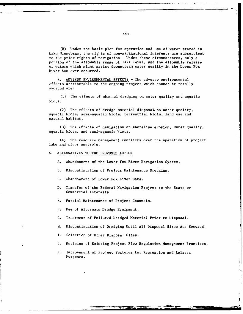
B. ADVERSE ENVIRONMENTAL EFFECTS - The adverse environmentaleffects attributable to the ongoing project which cannot be totallyavoided are:
(1) The effects of channel dredging on water quality and aquaticbiota.
(2) The effects of dredge material disposaon water quality,aquatic biota, semi-aquatic biota, terrestrial biota, land use andnatural habitat.
(3) The effects of navigation on shoreline erosion, water quality,aquatic biota, and semi-aquatic biota.
(4) The resource management conflicts over the operation of projectlake and river controls.
4. ALTERNATIVES TO THE PROPOSED ACTION
A. Abandonment of the Lower Fox River Navigation System.
B. Discontinuation of Project Maintenance Dredging.
C. Abandonment of Lower Fox River Dams.
D. Transfer of the Federal Navigation Project to the State orCommercial Interests.
E. Partial Maintenance of Project Channels.
F. Use of Alternate Dredge Equipment.
G. Treatment of Polluted Dredged Material Prior to Disposal.
H. Discontinuation of Dredging Until All Disposal Sites Are Secured.
I. Selection of Other Disposal Sites.
J. Revision of Existing Project Flow Regulation Management Practices.
K. Improvement of Project Features for Recreation and Related
Purposes.
-~ -. .~ .
iv
5. COKMENTS RECEIVED: Comments on the draft environmental impact
statement were received from the following:
The State Historical Society of Wisconsin
City of Neenah Wisconsin
Wisconsin Department of Lcal Affairs and DevelopmentCalumet County Planning Department
United States Department of CommerceTown of Menasha Wisconsin
United States Department of AgricultureUnited States Department of Interior
The Institute of Paper Chemistry
United States Department of TransportationBrothertown Wisconsin Town ChairmanAdvisory Council On Historic Preservation
City of Menasha Wisconsin
United States Environmental Protection AgencyEast Central Wisconsin Regional Planning CommissionCity of Oshkosh WisconsinWisconsin Department of Natural Resources
6. Draft Statement to CEQ 6 January 1976Final Statement to CEQ
V
RECIPIENTS OF THE DRAFT STATEMENT
Advisory Council on Historic Interstate Commerce Commission
Preservation 12th and Constitution Avenue, N. W.
1522 K Street, N. W. Washington, D. C. 20423
Washington, D. C. 20005Great Lakes Basin Commission
Department of Agriculture City Center Building
Office of the Secretary 220 East Huron Street
ATTN: Coordinator Environmental Ann Arbor, Michigan 48108
ActivitiesDepartment of Agriculture U. S. Department of Health,Washington, D. C. 20250 Education and Welfare
330 Independence Avenue, S. W.
Deputy Assistant Secretary for Washington, D. C. 20201
Environmental AffairsU. S. D~partment of Commerce Water Resources CouncilWashington, D. C. 20230 2120 L Street, N. W.
V'ashington, D. C. 20037
Regional Director
U. S. Department of Housing Office of the Gtvernorand Urban Development Capital Office Building
744 North 4th Street State of WisconsinMilwaukee, Wisconsin 53203 Madison, Wisconsin 53702
Assistant Secretary Wisconsin Department of Natural
Program Policy ResourcesDepartment of Interior Box 450Washington, D. C. 20240 Madison, Wisconsin 53702
Commander DirectorNinth Coast Guard District State Historical SocietyU. S. Department of Transportation of Wisconsin
Federal Building 816 State Street1240 East Ninth Street Madison, Wisconsin 53706Cleveland, Ohio 44199
State A-95 ClearinghouseChief, lederal Activities Bureau of Planning and BudgetCoordination Branch Department of AdministrationEnvironmental Protection Agency State Office, Room B-130230 South Dearborn Street 1 West Wilson StreetChicago, Illinois 60604 Madison, Wisconsin 53702
Administrator Secretary
Federal Energy Office Wisconsin Department of LocalWashington, D. C. 20461 Affairs and Development
123 West Washington Avenue
Federal Power Commission Madison, Wisconsin 53702
1051 U. S. Custom House
610 South Canal StreetChicago, Illinois 60607
vi
Natural Areas Preservation, Inc. George C. Becker
Gordon A. Bubolz CitLzens Natural Resources Assoc) t
P. 0. Box 740 tion of Wisconsin, Inc.
Appleton, Wisconsin 54911 2617 Prais StreetStevens Point, Wisconsin 54481
Wolf River Preservation Association
Route 3 Dr. George Becker
New London, Wisconsin 54961 Department of BiologyUniversity of Wisconsin-Stevens Pfi,'
Dennis P. Madigan Stevens Point, Wisconsin 54481
Executive DirectorWisconsin Wildlife Federation Executive Director
P. 0. Box 231 Wisconsin Federation of Conservatio-i
Reedsburg, Wisconsin 53959 Clubs411 East Lincoln Avnue
Ed Casper Stevens Point, Wisconsin 54481
Save Winnebago, Inc.R #2, Box 236 College of Environmental Sciences
Chilton, Wisconsin 53014 University of Wisconsin-Green Bay
Green Bay, Wisconsin 54302
Brown County Conservation Alliancec/o Dr. Robert Cook Aiuminae Research Foundation
College of Envir. Science University of Wisconsin-Madison
U.W. - Green Bay Madison, Wisconsin 53706ES-307Green Bay, Wisconsin 54301 Department of Biology
University of Wisconsin-Oshkosh
Johnathon P. Ela Oshkosh, Wisconsin 54901Sierra Club, Midwest Office444 West Main, Rm 10 Water Resource Management Program
Madison, Wisconsin 53703 University of Wisconsin-MadisonMadison, Wisconsin 53706
Tyrus Baumann, President
Northeastern Wisconsin Audubon Geological and Natural History Survey
Society University Extension1660 E. Shore Drive University of WisconsinGreen Bay, Wisconsin 54302 1815 University Avenue
Madison, Wisconsin 53706Neenah-Menasha LWVMrs. Edward Buchman Milwaukee Journal
1085 Reed Street 33 Vest State StreetNeenah, Wisconsin 54956 Milwaukee, Wisconsin 53201
G. L. McCormick Milwaukee SentinelWisconsin Resource Conservation 918 North 4th Street
Council Milwaukee, Wisconsin 53201Mellon, Wisconsin 54546
izaak Walton League of AmericaWisconsin State DivisionP. 0. Box 488GLeen Bay, Wisconsin 54305
vii
Bay Lake Regional Planning County Executive, Winnebago County
Commission CourthouseSuite 450 - SE Building - WTB Oshkosh, Wisconsin 54901
University of WisconsinGreen Bay, Wisconsin 54302 Mayor City of De Pere
City HallEast Central Wisconsin Regional De Pere, Wisconsin 54115Planning Commission
1919 American Court Mayor, City of KaukaunaNeenah, Wisconsin 54956 City Hall
Kaukauna, Wisconsin 54130
Chairman, Brown County Boardof Supervisors Mayor, City of Little Chute
Courthouse City HallGreen Bay, Wisconsin 54301 Little Chute, Wisconsin 54140
County Executive, Brown County Mayor, City of Combined LocksBoard of Supervisors City Hall
Courthouse Combined Locks, Wisconsin 54113Green Bay. Wisconsin 54301
Mayor, City of KimberlyChairman, Calumet County City HallBoard of Supervisors Kimberly, Wisconsin 54136
CourthouseChilton, Wisconsin 53014 Mayor, City of Appleton
City Hall
Chairman, Fond du Lac County Appleton, Wisconsin 54911Board of Supervisors
Courthouse Mayor, City of NeenahFond du Lac, Wisconsin 54935 City Hall
Neenah, Wisconsin 54956Chairman, Outagamie CountyBoard of Supervisors Mayor, City of Menasha
Courthouse City HallAppleton, Wisconsin 54911 Menasha, Wisconsin 54952
County Executive Mayor, City of Fond du LacOutagamie County City HallCourthouse Fond du Lac, Wisconsin 54935Appleton, Wisconsin 54911
Mayor, City of OshkoshChairman, Waupaca County City HallBoard of Supervisors Oshkosh, Wisconsin 54901
CourthouseWaupaca, Wisconsin 54981 Mayor, City of Butte des Morts
City HallChairman, Winnebago County Butte des Morts, Wisconsin 54927Board of Supervisors
Courthouse Mayor, City of WinneconneOshkosh, Wisconsin 54901 City Hall
Winneconne, Wisconsin 54986
vj ii
Mayor, City of Fremont H{onorable Gaylord NelsonCity Hail United Statej SenateFremont, Wisconsin 54940 WJashington, D. C. 20510
Mayor, City of Wrightstown Honorable Gaylord NelsonCitv Hil United States SenatorWrightstown, Wisconsin 541.80 Suite 570 Federal Court Bldg.
517 E. Wisconsin Avenue
Mayor, City ,f Stockbridge Milwaukee, Wisconsin 53202City HallStockbridge, Wisconsin 53088 Honorable William Albert Steig-v
House of Representatives
Mayor, City of L rothertown 4ashington, D. C. 20515City HailBrothertown, Wisconsin 53014 Honorable William Albert Steig, r
iRepresentative in CongressDavid L. Rades -05 Old Post Office Bldg.
Divison of Industrial Fond du Lac, Wisconsin 54935and Environmental SystemsInstitute of Paper Chemistry Honorable Robert J. CorneliAppleton, Wisconsin 54911 House of Representatives
Washington, D. C. 20515Kaukauna Electric andWater Department Fonorable Robert J. Cornell
P. 0. Box 30 Representatives in CongressKaukauna, Wisconsin 54130 Federal Building, Rm 207
Green Bay, Wisconsin 54305
David F. Overstreet, DirectorGreat Lakes Archeological Honorable Thomas E. PetriREscarch Cnter, Inc. Wisconsin State Senator
University of Wisconsin Center 43 S. Main Street1500 University Drive Fond du Lac, Wisconsin 54935Waukesha, Wisconsin 53186
I Honorable William RogersRalph Sitzberger Wisconsin State Assembly
4626 North Sandy Beach Lane 1800 Peters RoadOshkosh, Wisconsin 54901 Kaukauna, Wisconsin 54130
Dieter Kutscha Honoraole John C. GowerJ1,ard of Harbor Coiniissioners Wisconsin State Assembly510 East Dotv Street 312 Terraview DriveNunah, Wisconsin 54956 Green Bay, Wisconsin 54301
Honorable William Proxmire Honorable Gervase A. HephnerUnited States Senate Wisconsin State AssemblyWashington, D. il. 20510 Route 4, Box 287
Chilton, Wisconsin 53014Honorable Wil liiam ProxmireIniLed States Senate Honorable Gerald D. Lorge30 ',W. Mifflin, Rm 612 Wi6consin State Senatoradison, Wisconsin 53703 Route 1, P. 0. Box 147
Bear CLeek, Wisconsin 54922
ix
kaiph Sitzberger G. Philip Grundy
u- hkosh Glass Company Oshkosb Town Chairman
i' Oregon Street 1556 Sunnyview Road
i~k,.:i,, Wisconsin 54901 Oshkosh, Wisconsin 54901
Vaiiev Water Quality Thomas Herbst
, llinifl 5 Agency Poygen Town Chairman
i,') American Court 6206 Highway F
cl,. L, .isconsin 54956 Winneconne, Wisconsin 54986
.1ickcrt Marlyn Hahn
.nnobagoland Waterways, Inc. Wolf River Town Chairman
!9 :2raska Route 2
, Wisconsin 54901 Fremont, Wisconsin 54940
,,. en Laschober, Sr. Joe T. Olson
1()w2(i S. Kilpatrick Winchester Town Chairman
CA,. Lawn, Illinois 60453 6302 County Trunk MMLarsen, Wisconsin 54986
.:,irrv LopasCo miss ioner Kenneth Krings
:,<naa Town Board Winneconne Town Chairman
1297 Piank Road Route 1
1kn.,;a, Wisconsin 54952 Winneconne, Wisconsin 54986
>. t Crescent Wilber Gehrke
'i6 West ashington Street Rushford Town Chairman
., )ntui, Wisconsin 54911 Route 1Omro, Wisconsin 54963
' eenah-Menasha Daily Northwestern14 North Commercial Street Harold Mulreyc;huiah, Wisconsin 54956 Neenah Town Chairman
119 Plummer CourtW.jconsin Michigan Power Company Neenah, Wisconsin 54956
8f)7 S'outh Oneida Street
A7;11L,t'Tn, Wisconsin 54911 Don ApellBlack Wolf Town Chairman
Raymond Zelhofer 4193 Fond du Lac Road
AiAoma Town Chairman Oshkosh, Wisconsin 54901
272) (imro RoadO-libosh, Wisconsin 54901 David L. Wendtland
Acting City Managerttuorge W. Strohmeyer City Hall
.2cn.-sha Town Chairman 215 Church Ave.
1638 Winchester Road P. 0. Box 1130
Nounah, Wisconsin 54956 Oshkosh, Wisconsin 54901
;4i hurt Ketch
iiro To"l Chairman5430 East keighmoor Roadt'ftro, Wi sconsin 54963
x.
Honorable Ervin N. Conradt Peter ParkerWisconslin State Assembly !nstitutc of Paper ChemistrNY.oure 2 P. 0. Bx 1039Shiucton. Wisconsin 54170 Appleton, Wisconsin S4911
lonorable Tobias A. Roth K. 1-'. O'Hare
Wisconsin State Assembly Oshkosh Paper Company417 'Z. Longview Drive P. 0. Box 527.ppleon, Wisconsin 54911 Oshkosh, Wisconsin 54901
Honorable Waiter G. Hollander William Steffen, Jr.1.'Pconsin State Senator 311 E. i1th StreetRoute 1 Fond du Lac, Wisconsin 5493K! ,sendale, Wisconsin 54974
Louis MichelinHonorable Earl T. McE.,sy Oshkosh Area Chamber of Commci fiNisconsin State Assembly 27A Washington Avenue36(i:,e;tt Aveitu- Oshkosh, Wisconsin 54901!",. nd du Lac, Wisconsin 54935
Bonorable Jack ). Steinhilber Wisconsin Dept. of Transportat,s:isonsin State Senator P. 0. Box 1487
302 N. Main Street Madison, Wisconsin 5370.1Oshkosh, Wisconsin 54901
William C. FellowshzioraDle Michael G Ellis 2460 Viking Ct.Nisconsin State Assembly Oshkosh, Wisconsin 54901315-1/2 N. CommercialNeenah, Wisconsin 54956 William R. Castle
Castle 1 Pierce Printing Company1Honorable Richard A. Flintrap P. 0. Box 2247
c:. consin State Assembly Oshkosh, Wisconsin 54901629 *. Irving0'dikosh, Wisconsin 54901 Edgar W. Salisbary
CommodoreHonorable Gordon R. Bradley Berdin Boat ClubWis,.nqin State Assembly Berlin, Wisconsin 5492326'54 Flo Road3shAWuh, ;iscoasin 949,51 Theo hasse
PresidentNi tii M.,yneaux Oshkos' Tanaing CompanyNat iuno]l P'arks & Conservation P. 0. Box 157Ascociution Oshkosh, Wisconsin 54901
17M1 Fighteenth St., N. W.vj I:ngton, D. C. 20009 William R. Castle, Jr.
Oshkosh Power Boat Clul,C. Zil.s P. 0. Box 86F,)rt Howard Paper Curnpany Butte des Morts, Wisconsin 549271'. 0. B ,:: 1 30te1e i), 'Y , W.i sonsin 54305
X1
Tom Peters Dr. G. Fred Lee
c/o CH2M Center for Environmental Studies
200 S.W. Market University of Texas at Dallas12th Street P. 0. Box 688
Portland, Oregon 97201 Richardson, Texas 75080
Wisconsin Department of Transportation Carol J. Groeschel
Division of Highways Research Center Executive Vice President819 North 6th Street New London Area Chamber of CommerceMilwaukee, Wisconsin 53203 301 E. Beacon Ave.
New London, Wisconsin 54961Robert Duchek899 Skokie Blvd. Gene Devine
Northbrook, Illinois 60062 Boating EditorMilwaukee Sentinel
Nick Dunten Box 531BOAT/US Route 1
5261 Port Royal Rd Sheboygan, Wisconsin 53081Springfield, Virginia 22151
xii
CONTENTS
1. PROJECT DESCRIPTIONIntroduction 4-1Project Authorization 1-1The Federal Project i-
Early History 1-1Authorized Federal Project 1-4Status of the Authorized Plan 1-7Improvements Desired 1-7Condition of the Project 1-7Local Cooperation on Existing and Prior Projects 1-7
Improvements By Local Interests 1-8Project Operations and Maintenance Description 1-9
General 1-9Navigation 1-9
Lock and Dam Operation 1-10Channel Maintenance 1-10Dredged Material Disposal 1-14Canal Banks 1-16Harbors of Refuge 1-33Lands 1-33
Flow Regulation on Fox River System 1-33Annual Operations and Maintenance Costs 1-35
2. ENVIRONMENTAL SETTINGNatural Environmental Elements 2-1
Physiographic Features 2-1Surface Water Features 2-9
Wolf River Region 2-10Central or Lake Region 2-10Lower Fox River Region 2-10
Surface Water Quality 2-10Wolf River Region 2-12Central or Lake Region 2-13Lower Fox River Region 2-1
Suitability for Specific Uses 2-2.3Domes tic-Municipal 2-2Industrial 2-2Recreation 2-21
Groundwater 2-2 1Geology 2-2b
Physiography and Topography 2-28Bedrock Geology and Stratigraphy 2-31Surficial Geology 2-3,Seismicity 2-32
xiii
CONTENTS
Page
Soils 2-32
The Human Element 2-35Population Features 2-35Land Use 2-35
Wolf River Region of the Project Study Area 2-35The Central or Lake Region of the Project
Study Area 2-39The Fox River Region of the Project Study Area 2-40
Water Use 2-41Navigation 2-41
Recreation 2-41Hydroelectriac Power 2-42Domestic and Industrial Water Supplies 2-42Waste Dilution and Removal 2-44
Development and Economy 2-44Agriculture 2-44
Manufacturing 2-44Retailing 2-45Mining 2-47
Transportation 2-47Highway 2-47
Railroads 2-47Air 2-48Water 2-48
Recreation Features 2-48Boating 2-48Boating, Harbor Facilities 2-48Boating, Seasonal Usage Pattern 2-50Peak Day Boating Use-Lake Winnebago; Launched
Boats 2-50Permanently Based Boats 2-52Peak Day Boating Use-Upper Fox and Wolf Rivers 2-52Peak Day Boating Usage-Lower Fox River 2-52Canoeing 2-55Fishing 2-57Swimming 2-59Hunting 2-59Camping and Picnicking 2-60Sightseeing 2-61Winter Sports 2-61Growing Demand for Water-Based Recreation 2-63Protection of Project Water Recreational Resource 2-63
Historical and Archeological 2-64Historical Develooment of th. Region 2-64
xiv
CONTENTS
Page
Indian Tribes and Colonial Trade 2-64Settlement 2-64Transportation 2-65Agricultural Development 2-66Lumber Era 2-66Industrial Growth 2-67
Historical Places, Archeological Sites and NaturalLandmarks 2-67
Hydrologic and Hydraulic Elements 2-70Fox River and Lake Winnebago 2-72Wolf River Region 2-78Flood Damage Reduction Measures 2-80
Botanical Elements 2-82Forest Features 2-82Marshes 2-85
Zoological Element ?-92Terrestrial Fauna 2-92
Mammals 2-92Amphibians and Reptiles 2-93Birds 2-93Aquatic Fauna 2-96Aquatic Hibitats 2-96Phytoplankton 2-99Zooplankton 2-99Benthos 2-100Fish 2-105
3. RELATIONSHIP OF THE PROPOSED ACTION TO LAND-USE PLANSIntroduction 3-1Types of Effects 3-1Existing Relationships 3-2Coordination with Existing Plans 3-3
4. PROBABLE IMPACTS OF THE PROPOSED ACTION ON THE DEVELOPMENTIntroduction 4-1Dredging and Snagging 4-1
Dredge Operations 4-1Energy-Consumrptions 4-3Noise and Air Emissions 4-3Oil and Grease, Heavy Metals-Aquatic Biota 4-3Navigational Safety 4-3Suspended Solids, Substrate-Aquatic Biota 4-3
Material Removal 4-4Substrate-Aquatic Biota 4-4Suspended Solids 4-5Material Removal, Water Quality 4-6
xv
CONTENTS
Page
Water Quality, Aesthetic Characteristics 4-6
Water Quality, Water Intake Structures 4-7
Chemical Exchange Between Water and Sediments 4-7Nutrients 4-7
Oils and Grease 4-8
Toxic Materials 4-8Oxygen Concentration 4-8Aquatic Biota-General 4-9
Aquatic Biota-Turbidity 4-10Aquatic Biota-Resuspension of Pollutants 4-12Aquatic Biota-Siltation and Loss of Habitat 4-13
Channel Dimensions 4-15Flow 4-15Oxygen Concentration-Aquatic Biota 4-15Sedimentation-Substrate-Aquatic Biota 4-15Aesthetics 4-16Navigation 4-16Recreation 4-16Water Surface Elevations 4-16Shoreline Configuration-Semi-Aquatic Habitat 4-16Flooding 4-16
Dredged Material Disposal 4-16Chemical Aspects of Deposited Sediments 4-17General Plan Aspects 4-18Site Specific Features 4-20Deposition of Material 4-22
Shoreline Configuration 4-22
Aesthetics 4-22Vegetation-Wildlife Habitat 4-24Shoreline Vegetation, Floodplain 4-24
Land Use 4-24
Health and Safety 4-25Tax Base 4-25
Historical and Archeological Sites 4-26Leaching and Runoff 4-27
Aquatic Biota 4-28Lock Operation and Maintenance Impacts 4-28
Lock Operation Impact 4-28
Flow-Suspended Solids, Sedimentation-Aquatic Biota 4-28Energy Consumption 4-28Water Surface Elevation 4-28Navigation and Recreation 4-30Economics 4-30
Lock Maintenance Impacts 4-30
xvi
CONTENTS
Navigation and Recreation 4-31Economics 4-3t
Navigation Impacts 4-32Recreation 4-.32Air Emissions 4-34Noise 4-34Aesthetics 4-34Heavy Metals, Suspended Solids, Oil and Grease-
Aquatic Biota 4-34Shoreline Erosion 4-35Semi-Aquatic Habitat, Shoreline Vegetation-Wildlife Habitat 4-35
Economics 4-36Population 4-36
Dam Operation 4-37General 4-37Neenah-Menasha Dam Operation Impacts 4-40Neenah-Menasha Dam Operation-High Water Stage 4-40
Floodplain Vegetation, Shoreline Vegetation-Wildlife Habitat 4-40
Flooding 4-40Navigation 4-42Industry 4-43
Neenah-Menasha Dam Operation-Low Water Stage 4-43Lake Property 4-43Floodplain Vegetation, Shoreline Vegetation-Habitat 4-43
Industry 4-44Recreation 4-44
Neenah-Menasha Dam Operation-Fluctuating Water Levels 4-45Shoreline Configuration-Semi-Aquatic Habitat 4-45Fluctuating Water Levels-Aquatic and Semi-Aquatic Habitat 4-46
Stream Sanitation 4-53Impacts of Lower Fox River Dams (Excluding the Neenah
and Menasha Dams) 4-54Lower Fox River Dams-High Water Stage 4-54
Navigation 4-54Flooding 4--)
Lower Fox River Dams-Low Water Stage 4Flow 4--, -
General 4-)'Power Generation 4Oxygen ConcentrationAquatic Biota 4-56
Dam Maintenance Impacts
xvii
CONTENTS
Page
Water Power Benefits 4-57
Fish Migration 4-58
Remedial, Protective, and Mitigative Measures 4-58
Dredging 4-59
Material Removal 4-59
Research 4-59Channel Dimensions 4-59
Channel Depths 4-59
Dredging Requirements 4-59Dredge Plant 4-60Wolf River 4-60
Scheduling 4-60
Spills 4-60
Monitoring 4-60
Dredged Material Disposal 4-61
Sediment Samples 4-61
Disposal Site Location and Design 4-61
Dam Operations 4-62
Lock Operation 4-64
Lock and Dam Maintenance 4-64Navigation 4-64
5. PROBABLE ADVERSE ENVIRONMENTAL EFFECTS WHICH CANNOT BEAVOIDEDNavigation System Operation and Maintenance 5-1
Dam Operation and Maintenance 5-2
The Proposed Action 5-2
6. ALTERNATIVE TO THE PROPOSED ACTIONIntroduction 6-1Alternative to the Project 6-1
Abandonment of the Lower Fox River Navigation System 6-1Discontinue Project Maintenance Dredging 6-4Abandonment of the Lower Fox River Dams 6-4Transfer of the Federal Navigation Project to the
State or Commercial Interests 6-4Alternatives within the Present Project 6-7
Dredging 6-7Partial Maintenance of Project Channels 6-7Alternative Dredge Operation 6-9
Alternative Dredged Material Disposal 6-12Treat Polluted Dredged Material Prior to Disposal 6-12Discontinue Dredging Until All Disposal Sites are
Secured 6-13Alternative Confined Sites 6-13Land Disposal of Dredged Materials 6-13Water Disposal of Dredged Materials Policy
Considerations 6-14In Lake Disposal 6-15
xvil
CONTENTS
Lock-Operation ,Number of Locks 6-f.Currer.ts Hindering NavigationLimited Navigation Season 6-2.Power Operation of Lock Gates aiod Valves 6- ".Boat Lifts 6-2
Dam Operation I ).,Lake Vegetation Management oLow Flow Augmentation
7. RELATIONSHIP BETJEEN THE LOCAL SHORT-TERM USE OF MAN SENVIRONMENT AND THE MAINTENANCE AND ENHANCEMENT CFLONG-TERM PRODUCTIVITYGeneral 7-IWater quality 7- 1.Aquatic Habitat 7-
Semi-Aquatic and Terrestrial Habitat---B..-ca 7-2Economic--I and Use / 2Waterway Use 7
8. IRREVERSIBLE AND IRRETRIEVA3LE COMMITMENTS OF RESOURCFSGeneral 8-1 Sediment and Benthos 8-iAquatic Habitat and Biota 8-1Semi-Aquatic Habitat 8-ITerrestrial Habitat 8-2Land-Use Commitments and Restrictions 8-2Energy Consumption Commitments 8-2Energy Commitm-n"ts 8-2
9. COORDINATION AND COMMENT AND RESPONSEPublic Participation 9-1
Agency and Community Contacts 9-1Agency ReviewUnresolved Issues
Comments and Responses 9-2General Remarks 4-2
Need for Dredging 9 _Flow Augmentation 9-.'Water Level Management -,
Comment/Responses '-
APPENDIX A: FOX RIVER, WISCONSIN PROJECTMAPS AND ,\:I,1,
CHARTS
APPENDIX B: SEDIMENT AND WATER QUALITY
xix
CONTENTS
Page
APPENDIX C: BACKGROUND AND HISTORY CONCERNING REGULATION OFLAKE WINNEBAGO
APPENDIX D: UPRIVER LAKES HABITAT
APPENDIX E: SOILS AND GEOLOGY
APPENDIX F: STREAM DATA
APPENDIX G: GLOSSARY
xx
LIST OF FIGURES
Figure 1.1 Location of the Fox River Project
Figure 1.2 Lower Fox Waterway Profile
Figure 1.3 Wolf River Locations most FrequentlyRequiring Channel Maintenance I-I'.
Figure 1.4 Vicinity Map of Project Dredge Disposal Sttes
Figure 1.5 Wells Coal and Dock ProTerty Disposal Area 1_2
Figure 1.6 Little Kaukauna Headrace Disposal Area 1-12
Figure 1.7 Rapide Croche Canal Bank D'.sposal Atea 1-.
Figure 1.8 Kaukauna Canal Bank Disposal Area
Figure 1.9 Disposal Area Below Combined Locks Dam
Figure 1.10 Disposal Area Adjacent Little Chute and Lock i,2f'
Figure 1.11 Cedars Lock Canal Bank Disposal Area L
Figure 1.12 Doty Park Storage Site
Figure 1.13 Stockbridge Harbor Storage Site
Figure 1.14 Brothertown Harbor Storage Site 1 30
Figure 1.15 Columbia Park Disposal Area 1-3:
Figure 1.16 Fond du Lac Disposal Area ]-:
Figure 2.1 Location of the Wolf-Fox River Drainage basin
Figure 2.2 The Wolf-Fox River B.sin Showing the ProjectStudy Area
Figure 2.3 The Fox River, ,isconsin, Project Study ArLe J-:
Figure 2.4 Floods of the Wolf River, Wisconsin
Figure 2.5 Flow and D. 0. Interdependency on the Pox Ri,erAbove Appleton-July, 1973
xxi
PageFigure 2.6 Flow and D. 0. Interdependency on the Fox River
at Rapide Croche-July 1973 2-16
Figure 2.7 Distribution of Sludge Beds in the Lower Fox River 2-22
Figure 2.8 Monthly Mean Discharge at Lake Winnebago Outlet 2-24
Figure 2.9 General Piezometric Surface of the Wolf-FoxDrainage Basin 2-27
Figure 2.10 Area of Controlled Discharge in the Wolf-FoxDrainage Basin 2-29
Figure 2.11 Geomorphic Regions of the Fox River, WisconsinStudy Area 2-30
Figure 2.12 Glacial Deposits in the Project Study Area 2-33
Figure 2.13 Location of National Registry of Natural Land-marks and Historic Places 2-69
Figure 2.14 Letter from the State Historical Society ofWisconsin 2-71
Figure 2.15 Flow Duration of Major Streams 2-73
Figure 2.16 Floodflow Recurrence of Major Streams 2-74
Figure 2.17 Low-Flow Recurrence of Major Streams 2-75
Figure,2.18 Wind Effect on Lake Winnebago Water Levels 2-77
Figure 2.19 Distribution of Forest Communities in the Fox-
Wolf Rivers Drainage Basin 2-84
Figure 2.20 Location of Lakes Vegetation Study Area 2-87
Figure 4.1 Dredging Impacts 4-2
Figure 4.2 Dike Construction 4-19
Figure 4.3 Dredge Material Disposal Impacts 4-23
Figure 4.4 Lock Operation and Maintenance Impacts 4-29
Figure 4.5 Navigation Impacts 4-33
Figure 4.6 Dam Operation and Maintenance Impacts 4-38
Fi'-urQ 4.7 Comparfs,)u of Mesi,', ydric and A.:ki,ti\Hahi tats
U ,ure 4.8 Historic Perspective o- Wet Iand I.: - f i .
Poygan and But' e j, u Mo-t- ,
.igure 0 .i Clamsh 11 Dreuge
Figurc 6 2 ipeiine Dredge
Fi niir. 6 .3 Boom Bay Restoratinn Pl,,n
"igurt, 6.4 Use of Dredged Mat-ti,] L Crti- Wir.i , r' 6-
Fi.gurc 6.5 Use of Dredged Mal erial.- to Cr. e M r> -
Figure 6.6 Useful Dredged Mat eL i Dispos.31 .T' i.,i! 1-.
Figure 6.7 Lake Winnebago at O hkosh Lake Level s-
APPENDTX A
Index Map
De Pere Lock and Dam -
Little Kaukauna Lock ind Dam
Rapide Croche Lock and Dam A-.5
Kaukauna Locks and Dam -
Kaukauna Depot and Fox Project Office
Little Chute Locks and Dam A-S
Cedars Lock and Dai A-1)
Appleton Locks and Dams
Grignon Rapids Channel . I
Menasha Lock and Dam .'-
Neenah Channel -- "-
Wolf River .-
xxiii
Page
River Mile/Elevation Chart A-15
De Pere A-16
Little Kaukauna A-17
Rapide Croche A-18
Kaukauna A-19
Little Chute and Cedars A-20
Appleton A-21
Little Lake Butte des Morts A-22
Menasha A-2 3
Lake Winnebago Harbors A-24
APPENDIX E
Gengral Soil Associations in Project Study Area E-1
Bedrock Geology of the Project Study Area E-6
XXIV
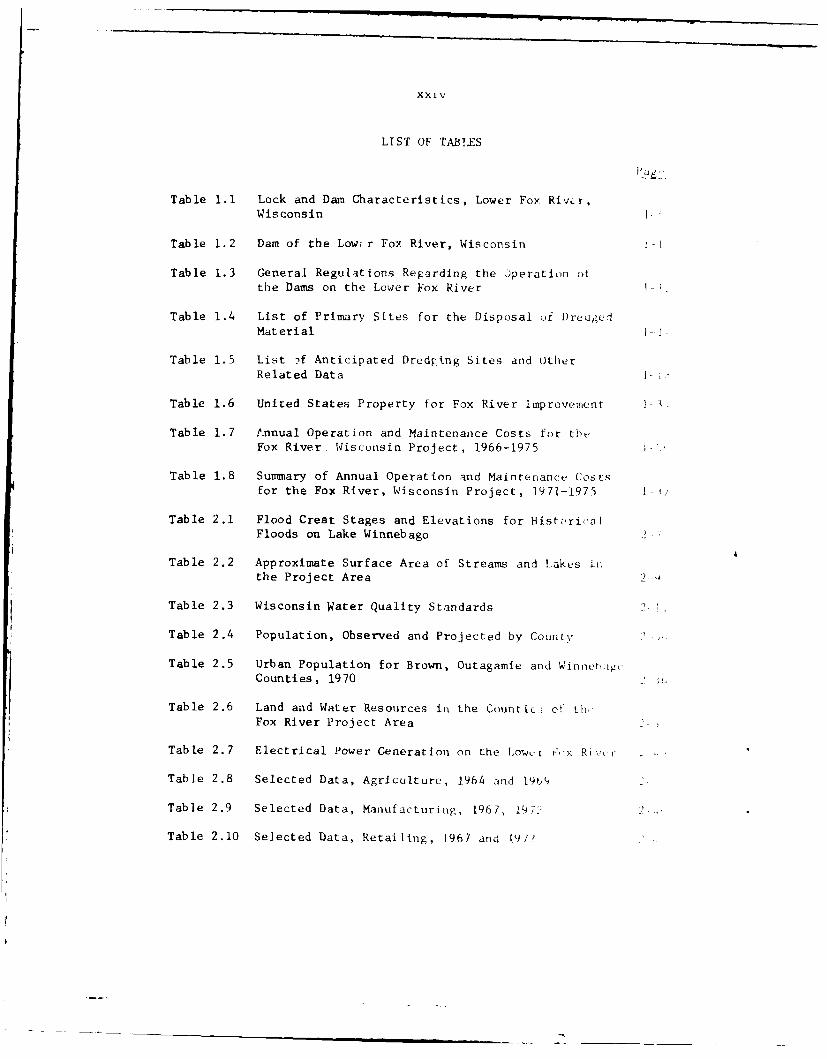
LIST OF TABLES
Table 1.1 Lock and Dam Characteristics, Lower Fox River,Wisconsin
Table 1.2 Dam of the Lowir Fox River, Wisconsin
Table 1.3 General Regulations Regarding the )peration otthe Dams on the Lower Fox River 1-
Table 1.4 List of Primary Sites for the Disposal of Dredged
Material i--;
Table 1.5 List . f Anticipated Dred tng Sites and OtherRelated Data
Table 1.6 United States Property for Fox River Improvement
Table 1.7 Annual Operation and Maintenance Costs for thbFox River, Wisconsin Project, 1966-1975
Table 1.8 Summary of Annual Operation and Maintenanc'u Costsfor the Fox River, Wisconsin Project, 1971-1975
Table 2.1 Flood Crest Stages and Elevations for HistoricalFloods on Lake Winnebago
Table 2.2 Approximate Surface Area of Streams and Lakes iiithe Project Area
Table 2.3 Wisconsin Water Quality Standards
Table 2.4 Population, Observed and Projected by County
Table 2.5 Urban Population for Brown, Outagamle and Winntig ,Counties, 1970
Table 2.6 Land and Water Resources iii the Countic.; ot thFox River Project Area
Table 2.7 Electrical Power Generation on the Lower -i&,x Ri!,ir
Table 2.8 Selected Data, Agriculture, 1964 a-nd 1949 2
Table 2.9 Selected Data, Manufacturing, 1967, 197. 2
Table 2.10 Selected Data, Retailing, 967 and [9/2
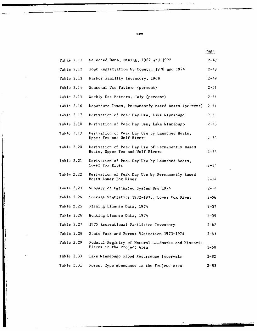
xxv
Page
Table 2.11 Selected Data, Mining, 1967 and 1972 2-47
Table 2.12 Boat Registration by County, 1970 and 1974 2-49
'Fable 2.13 Harbor Facility Inventory, 1968 2-49
rable 2.14 Seasonal Use Pattern (percent) 2-51
Table 2.15 Weekly Use Pattern, July (percent) 2-51
Table 2.16 Departure Times, Permanently Based Boats (percent) 2 51
'able 2.17 Derivation of Peak Day Use, Lake Winnebago .5-
'Fable 2.18 Derivation of Peak Day Use, Lake Winnebago 2-53
Table 2.19 Derivation of Peak Day Use by Launched Boats,Upper Fox and Wolf Rivers 2-5"
Table 2.20 Derivation of Peak Day Use of Permanently BasedBoats, Upper Fox and Wolf Rivers 2-53
Table 2.21 Derivation of Peak Day Use by Launched Boats,Lower Fox River 2-54
Table 2.22 Derivation of Peak Day Use by Permanently BasedBoats Lower Fox River 2-5L
Table 2.23 Summary of Estimated System Use 1974 2--4
Table 2.24 Lockage Statistics 1972-1975, Lower Fox River 2-56
Table 2.25 Fishing License Data, 1974 2-57
Table 2.26 Hunting License Data, 1974 2-59
'Fable 2.27 1975 Recreational Facilities Inventory 2-62
Table 2.28 State Park and Forest Visitation 1973-1974 2-63
Table 2.29 Federal Registry of Natural .,LLdmarks and Historic
Places in the Project Area 2-68
'Fable 2.30 Lake Winnebago Flood Recurrence Intervals 2-82
Table 2.31 Forest Type Abundance in the Project Area 2-83
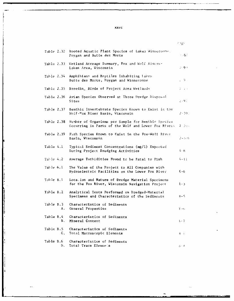
xxvi
Table 2.32 Rooted Aquatic Plant Species of Lakes Winnecorn-Poygan and Butte des Morts -81
Table 2.33 Wetland Acreage Summary, Fox and Wolf Rivers-Lakes Area, Wisconsin :9
Table 2.34 Amphibians and Reptiles Inhabiting TakesButte des Morts, Poygan and Winneconne 9
Table 2.35 Breeding, Birds of Project Area Wetlands 2-
Table 2.36 Avian Species Observed at Three Dredge DisposalSites 2--
Table 2.37 Benthic Invertebrate Species Known to Exist in theWolf-rox River Basin, Wisconsin 2-!01
Table 2.38 Numnber of Organisma per Sample for Benthic SpeciesOccurring in Parts of the Wolf and Lower Fox RIvei>, 2-
Table 2.39 Fish Species Known to Exist in the Fox-Wolf Riv.rBasin, Wisconsin 2- f
Table 4.1 Typical Sediment Concentrations (mg/l) ExpectedDuring Project Dredging Activities 4-6
Table 4.2 Average Turbidities Found to be Fatal to Fish 4-Li
Table 6.1 The Value of the Project to All Companies withHydroelectric Facilities on the Lower Fox River 6-6
Table B.1 Loca-lon and Nature of Dredge Material Specimensfor the Fox River, Wisconsin Navigation Project L--3
Table B.2 Analytical Tests Performed on Dredged-MaterialSpecimens and Characteristics of the Sediments B-5
Table B.3 Characteristics of SedimentsA. General Properties -
Table B.4 Characteristics of SedimentsB. Mineral Content 1_7
Table B.5 Characteristics of SedimentsC. Total Macroscopic Elements I-
Table B.6 Characteristics of SedimentsD. Total Trace Elemeps B- a
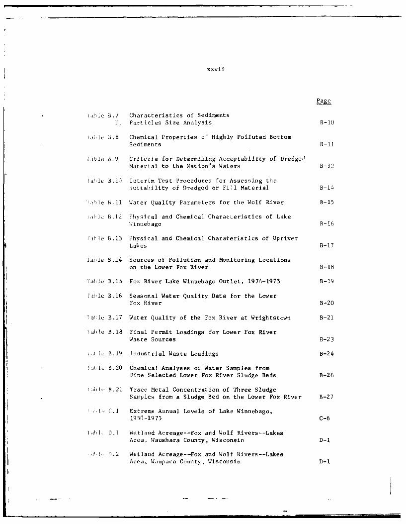
xxvii
Page
'able B.1 Characteristics of SedimentsE. Particles Size Analysis B-IO
Lable B.8 Chemical Properties o' Highly Polluted BottomSediments B-i
j13ble B.9 Criteria for Determining Acceptability of DredgedMaterial to the Nation's Waters B-12
Sable B.i0 Interim Test Procedures for Assessing theSuitability of Dredged or Fill Material B-14
Ahle 1._11 Water Quality Parameters for the Wolf River B-15
ialu B.12 Physical and Chemical CharacLeristics of LakeW innebago B-16
aible B.13 Physical and Chemical Charateristics of UpriverLakes B-17
Lible B.14 Sources of Pollution and Monitoring Locationson the Lower Fox River B-18
Table B.15 Fox River Lake Winnebago Outlet, 1974-1975 B-19
[able B.16 Seasonal Water Quality Data for the LowerFox River B-20
'[ahtle B.17 Water Quality of the Fox River at Wrightstown B-21
Table B.18 Final Permit Loadings for Lower Fox RiverWaste Sources B-23
i. B 1.19 Industrial Waste Loadings B-24
F'cle B.20 Chemical Analyses of Water Samples fromFine Selected Lower Fox River Sludge Beds B-26
iahle B.21 Trace Metal Concentration of Three SludgeSamples from a Sludge Bed on the Lower Fox River B-27
-If_. C.1 Extreme Annual Levels of Lake Winnebago,1950-1975 C-6
i 'lat]b D.1 Wetland Acreage--Fox and Wolf Rivers--LakesArea, Waushara County, Wisconsin D-1
!).2 Wetland Acreage--Fox and Wolf Rivers--Lakes
Area, Waupaca County, Wisconsin D-I
xxviii
Page
Table D.3 Wetland Acreage-Fox and Wolf Rivers--LakesArea, Winnebago County, Wisconsin D-2
Table D.4 Lake Surface Acreage Sumary, Fox and WolfRivers-Lake Area, Wisconsin P-2
Table E.1 Generalised Stratigraphic Column of the Wolf-Fox Drainage Basin E-7
FINAL ENVIRONMENTAL IMPACT STATEMENT
RELATING TO OPERATION AND MAINTENANCE
OF THE FOX RIVER, WISCONSIN NAVIGATION PROJECT
Prepared in Accordance with Section l02(2)(C) of the
National Environmental Policy Act of 1969Public Law 91-190
SECTION I
PROJECT DESCRIPTION
INTRODUCTION
1.01The Fox River is located in east-central Wisconsin (see insert on Fig. 1.1).
The existing project includes operation and maintenance work on the Lower
Fox River from De Pere to Menasha; Lake Winnebago; the Upper Fox River
from Lake Winnebago at Oshkosh to its junction with the Wolf River in
Lake Butte des Morts; and the Wolf River from its mouth in Lake Butte des
Morts to New London, Wisconsin. The Lower Fox River from its mouth to
De Pere is part of the United States improvement of the Green Bay Harbor
for duup-draft lake vessels. The Upper Fox River from Portage to its
junction with the Wolf River, formerly part of the Fox River Federal
Navigation Project, is now maintained by the State of Wisconsin for'
conservation and recreation purposes.
PROJECT AUTHORIZATION
1.02Basic authorities for the operation and maintenance of the Fox River
Project are contained in authorizing legislation of the U. S. Congress
for construction of its various elements. Specifically, these are the
River and Harbor Acts of 5 August 1886, 19 September 1890, 3 June 1896,
13 June 1902, 2 March 1907, 3 March 1925, and 26 June 1934. Section 108
of the River and Harbor Act approved 3 July 1958 transfer of the Federal
project structures, appurtenances, and real property pertaining to the
Upper Fox River portion of the project to the State of Wisconsin. This
transfer was made by deeds dated 27 June 19-2.
THE FEDERAL PROJECT
Early History
1.03Considered from the standpoint of .historical associations, the Fox River
system has played a major role in the history and economic development
I
1-2
LAKE supEftIOA -OCONTO Co
.. - z 0. '
WAUPACA CO. "
1_± ,- V v INIT Y M AP - _ _ *_ " C
,gw L000 OTAIGAMJE CO. 9 RO N CO
• l --_00S ...
'A" Wl-,., '!y,1 1" "lA N I T 0*'' C
WAUS4ARA, __
"0 o 0.
" lt.oI*. 4 " _______0," 00
* oo. *oogo ~CALUMET CO,
1 TRANSFERRED C.
wSCO,N - .-
ILc "10. kOOOCC' Co
GN
LAo CO O
12.
' l ,o~loe o I N O oorCO
. AC
Fig.ANFERE i.I.YA LoaioO.,h o RvrPrjc
-- ~ ~ ~ ~ ~~T STT OF . . .l i x
1-3
of Wisconsin. It was the route that the first white men used to pene-trate into Wisconsin, and later was the earliest artery of commerce intothe interior of the state.
1.04The first survey to determine the best practical plan for improving theFox-Wisconsin River route for navigation resulted from instruction issuedby the U. S. War Department in April 1837, the year following Wisconsin'sorganization as a territory. A report by Captain T. J. Cram, datedJanuary 1840, was published as a Senate Document of the 26th Congress.The first attempt by the United States to improve the river was throughthe Congressional Act of August 1846, authorizing a grant of land to theState of Wisconsin for which the State was to improve the Fox and Wis-consin rivers and provide a canal at Portage to connect them. The grantwas accepted by the State on 29 June 1848, and by its Act of 8 August1848, the State placed the work of improvement under a State board ofPublic Works. After some initial work, the State vested further improve-ment of these rivers in the Fox and Wisconsin Improvement Company, a pri-vate corporation, by an Act of 6 July 1853. The plan of this company pro-vided for free passage of boats drawing less than 4 feet on the Lower FoxRiver and 2 feet on the Upper Fox River at ordinary low water, with locks 160feet long, 35 feet wide, having a depth of 5 feet over the miter sills.This company, having failed to accomplish the improvements required bythe State legislation, lost control of the project. The entire improve-ment was sold by the trustees for the Improvement Company on 15 August1866 to the Green Bay and Mississippi Canal Company, another privatecorporation. This company remained in charge of the improvement until 1872.Through provisions of the Acts of Congress of July 1870 and June 1872,the United States bought out the Green Bay and Mississippi Canal Companyand took charge of works of improvement pertaining to navigation, thecompany retaining the rights with respect to water power. The deed oftransfer from the company to the United States, dated 18 September 1872,gave the United States title to all:
locks, dams, canals, and franchises, saving and exceptingtherefrom and reserving" to the company 'the water powercreated by the dams and by the use of surplus water not re-quired for the purpose of navigation, with the rights of pro-tection and preservation appurtenant thereto, and the lots,pieces, or parcels of land necessary to the enjoyment of the*same and those acquired with reference to the same, all sub-ject to the right to use the water for all purposes of navi-gation."
In accordance with the deed of transfer, therefore, water power users onthe Lower 1,.x River are entitled to all surplus water not needed fornavigation. Conversely, the rights of these users are expressly sub-servient to the prior requirements of navigation.
1.05The first general plan for the improvement of the Fox and Wisconsinrivers by the Federal Government was contained in the River and HarborAct of 3 March 1873. The plan of improvement adopted under this Act
1-4
provided for repair and replacement of the then existing works on theFox River, construction of additional locks and dams to complete thesystem of slack water navigation on the Upper Fox River, and the improve-ment of the channels and the replacement of all existing locks and damsby permanent structures on the Wisconsin River. However, the impractica-bility of maintaining navigation on the Wisconsin River was realizedrather early and the Wisconsin River improvement was abandoned by theFederal Government in the year of 1887 on the report and recommendationof the Board of Engineers. In 1886 the general plan was modified toinclude various improvements in harbors on Lake Winnebago. Finally,according to the Congressional Act of 3 June 1896, the general plan wasalso modified to provide for navigation improvements in the Wolf Riverabove Fremont to New London.
Authorized Federal Project
1.06The authorized Federal project provides for deepening and widening thechannel of the Fox River from De Pere, 7 miles above the mouth, to theconfluence of the Wolf River, a total length of 59 miles at a depth of6 feet in soft materials, 9.6 feet in the rock cut below De Pere lock and 7feet in other rock cuts on the lower river below the Menasha lock; for theconstruction and reconstruction of 17 locks, 2 guard locks, and 9 dams; fora concrete retaining wall at Kaukauna; for construction and maintenanceof harbors having depths of 6 feet at Fond du Lac, Stockbridge, Calumet,and Brothertown Harbors on Lake Winnebago; for widening the Neenah Channelto 100 feet, with a 6-foot depth for about one mile; and for dredging,snagging, and otherwise improving the Wolf River from its mouth toNew London, a distance of 47 miles, to a depth of 4 feet. All depths arereferred to standard low water which is 576.8 feet MSL. Project mapsshowing the extent and status of the authorized project are included inAppendix A of this report.
1.07The controlling dimensions of the existing Fox River locks are generally 144feet long, 35 feet wide, with a minimum depth of 6 feet over the miter sillsand breast walls when the navigation pools are at standard low water level.Since flash boards are used on most of the dams during the low water seasonadditional depths of 6 inches to 1.5 feet are quite generally available,except above the Appleton upper dam and the Menasha dam. The lift at thelocks varies from 7.2 feet at Little Kaukauna to 13.8 feet at LittleChute second lock at normal pool levels. The locks on the Lower FoxRiver are equipped with manually operated gate and valve operating mecha-nisms. The dams are of a fixed type, consisting of both spillway andsluiceway sections., The overall dimensions and number of sluice gatesvary at each site to fit local conditions, such as width of stream, prob-able flood stage, variation of flow, head of water involved and dischargecapacity of adjoining hydroelectric power plants or mills. Table 1.1summarizes the physical characteristics of the existing locks and damson the Lower Fox River. See the project maps provided in Appendix A for moredetailed information. A profile of the Lower Fox River is shown in figure 1.2.
1-5
C 00 0 C aC 0 1 0 0 0 e~,f o0~ 0
0 o4 o' o*0 o 1 0 . 00 1 *. C0 410 0 O e , , 0 0 C
61 0
t t 'a 6 "6 64o.
sE ~ 1 -0 0 0 u 0 4o E 4
0 ~ ~ ~ ~ ~ ~ c z 000 0 C C4
0.4 0 ~~~~~~~0 0 0 0 0 0 0 4 0 0 0 0 0 0-,~ ~~~~ C 4 4 0 0 04 . 0 0
0404 .-60 01.4 .. l OU~e'IN0.6 . 0 04 4 0 04 1 0 01 4 0 Is
1-6
1.08The Federal project approved by the Secretary of War on 10 December 18b:,, -in,modified 14 May 1886 by authority of the Chief of Engineers, also providedfor improving the Upper Fox River channel from its mouth to Portage,Wisconsin. The project provided for a channel having a depth of 6 feetand a width of 100 feet for a length of 66 miles to Montello; a depth of4 feet from Montello to Portage, an additional 28 miles; with 9 locks an,!7 dams, and a canal at Portage connecting the Fox a:id Wisconsin Rivers.The title to the Upper Fox River navigation improvement was transfeirrtto the State of Wisconsin by quit claim deed dated 27 June 1962, asauthorized by Section 108 of the 1958 River and Harbor Act (PL 85-500;72 Stat. 301), and is no longer part of the existing project.
0
750 -3
Menasha Lock
730 Appleton First Lock
/J Appleton Second Lock
> 710 Appleton Third Lock_J LAppleton Fourth Lock
690 Cedars Lock
Little Chute Second Lock
u 670 Upper Combined Lock
<.Lower Combined Lock650 -65 Kaukauna First Lock
LKaukauna Second Lock- 630-SKaukauna Third LockRKaukauna Fourth Lock
" 610- < Kaukauna Fifth LockIRapide Croche Lock
590- Little Kaukaukana Lock
De Pere Lock
570 _ _ _ _ _ _ _ _
40 35 30 25 20 15 10MILES FROM MOUTH
Fig. 1.2. Lower Fox Waterway Profile
1-7
Status of the Authorized Plan
1.09The authorized project is complete except for portions now classifiedinactive. These inactive portions consist of deepening the Wolf Riverbetween Lake Poygan and New London to a depth of 6 feet, deepening theNeenah Channel to a depth of 6 feet, and rock removal at five locationsin the lower Fox River to a depth of 7 feet. The work remaining tototally complete the authorized project is no longer required toaccommodate commercial navigation traffic.
Improvements Desired
1.10Commercial navigation on the rivers and connecting lakes was discontin-ued in 1959, except for an occasional movement of a contractor's float-ing construction or dredging equipment, a commercial fishing boat, or ahouseboat, barge, or other water-craft built in the area for deliveryto customers on the Great Lakes. However, local interests are generallystrongly opposed to any change in the operation or care of the waterway,mainly because of the heavy use by recreational boating traffic whichis increasing rapidly in the area. Frequent requests have been receivedfor the removal of shoals, snags, or other impediments to recreationalboating. Local municipalities and water power interests also are vi-tally interested in the maintenance and operation of the government-owneddams because of their effect on water power development, sanitary con-ditions, shorelands, etc. Frequent requests from various boating groupsand other local interests have been made to have the natural Neenah Har-bor of refuge activated.
Condition of the Project
1.11Except for the Menasha lock, the existing locks and dams are in generallyfair to good condition. They should continue to give reliable servicewith normal maintenance. The Menasha lock is in poor condition and isscheduled for major rehabilitation during calendar years 1978 and 1979.
Local Cooperation on Existing and Prior Projects
1.12No local cooperation is specifically required by acts authorizing theproject. The original Federal authorization for improvement of the FoxRiver is the U. S. Congressional Act of 8 August 1846. Improvementswere started under various State acts and contracts, and under pro-visions of a State act dated 3 October 1856 the entire improvement workwas sold by the State on 15 August 1866 to the Green Bay and MississippiCanal Company. Under the provisions of Congressional Act of 10 June 1872 the
1-8
United States paid the Canal uompa:iy $145,000 and took title to all ti,
navigation improvements owned by that company.
1.13Records indicate that the Neenah dam was originally built by privateinterests without cost to the State, "in consideration of tile use of thewater power." This dam was not 4i,cluded in the property acquired fromthe Green Bay and Mississippi Canal Company as it was not owned by thatcompany. It has always been maintained by private interests subservientto the requirements of navigation and laws relative to regulation 4 I Ik,,Winnebago. The present owner of all the water rights at Menasha andNeenah is the Neenah and Menasha Water Power Company, and that company isresponsible for maintenance of Neenah dam under State laws. Althoughthis dam is an essential part of the navigation project to maintain LktWinnebago water levels, ts construction and maintenance have not beenspecified itams of local cooperation required by the project authoriza-tions. A portion of the DePere dam also is privately owned and main-tained and, although required to maintain the pool level above the DPerc,lock, it is not specified as an item of local cooperation in the project.
IMPROVEMENTS BY LOCAL INTERESTS
1.14Many boat landings, piers, mooring basins, boat launchways or hoists,storage sheds, and other facilities to serve the hundreds of non-commercial or recreational boat owners operating their boats on thewaters of the Fox and Wolf Rivers and connecting lakes have been devil-oped by the State, counties and local municipalities, and by privateAlthough these facilities are provided by local interests, the valne ofsuch improvements is largely dependent on the accessibility of a widerange of cruising water possible because of maintenance and operation (4the Federal project. Expansion of such facilities as the number of boatin use increase is continuing. Motor fuel and other needed supplies ar,available at most of these marinas, and at numerous other service stationIsalong the waterways. Most of the marina improvements include parkingspaces for visitors' automobiles and boat trailers and have launchwaysor hoists for launching trailer-hauled boats. Many of the operatorsprovide rental boats and motors and other equipment for water-basedrecreational activities. Winter storage space for boats is availablealthough most of the larger cruisers leave the area for storage, winteroverhaul, and maintenance service at shipyards or boat repair facilitiesat Lake Michigan harbors. Many public and private launchways are avail-able to give owners of trailer-hauled boats access to the public watersand are widely used by people from the eastern half of the state, withmany visitors from northern Illinois and Indiana and more distant are,a.Access points are fairly well distributed around the various lakes andpools and provide convenient access points for the using boatmen. Mostof the launching 'acilities are available to the public without launch-ing charges.
1-9
PROJECT OPERATIONS AND MAINTENANCE DESCRIPTION
General
1.15The activities conducted by the Chicago District in maintaining the
navigable channel include operation and maintenance of nine U. S. dams,
seventeen locks and two guard locks, channel clearing and snagging,
channel dredging, and dredge material disposal. Dams are operated to
maintain sufficient pool elevations for navigation. Repairs to the
existing locks and dams are performed when needed to insure safe and
effective operation. A clamshell dredge is used to remove channel
obstructions and deposited sediments, as necessary, and to maintain
authorized channel depth in conjunction with pool elevations. Dredge
materials are placed on preselected disposal sites.
Navigation
1.16The existing Federal project was designed primarily to accommodate com-mercial barge transportation of coal and other bulk commodities. There
is no regular commercial traffic on the Fox or Wolf Rivers or Lake Winne-bago at the present time. Except for intermittent usage by Coast Guard
and commercial fishing vessels, navigation is almost entirely recrea-tional in character. Contractors also make occasional use of the water-way for the movement of dredging or construction equipment and materials,
for work on the many bridges and waterfront structures, or for improve-
ment of marinas and small craft mooring areas. An example of the inter-mittent use by contractors' equipment was the movement during the 1968season of a 157-ton paper mill dryer from Green Bay to Kaukauna. Govern-ment owned and operated dredging and construction equipment used for
maintaining locks and dams, removing shoals, and clearing snags also
makes use of the waterway.
1.17The most recent regular freight traffic was the barge hauling of coal
from docks at Green Bay to various paper mills and public utilities along
the Lower Fox River. This service was discontinued at the close of the1959 navigation season. The principal factors causing the decrease andfinal suspension of the traffic in coal were the introduction of oil and
gas fuels, transmission of electric power into the area from other areas,the rising costs of operating tugs and barges, and the railroad and
improved highways along the river which made land transportation moreeconomic than waterborne movement. There appears no economic advantagein, and no prospect of resumption of, barge traffic.
1.18Today the project is primarily used only by recreational craft, the peaktraffic being in the summer and fall. The Lower Fox River is the con-necting waterway between the G;reen Bay arm of Lake Michigan and the popu-lar recreational boating area of Lake Winnebago and the Wolf River to
1-10
New London. Lake Winnebatle and the Wolf River are connected by LakesButte des Morts, Winneconne, and Poygan, which together have a total areaof about 265 square miles. These waters are a very popular recreationalboating area attracting boateos from a wide midwestern area, as well asserving thv local residents and the large summer vacation population.During the 4-year period 1972-1975, the average annual number of lockagesat the 16 Lower Fox River locksites was 11,919. The number of boatspassed through the locks averaged 18,528 per year, an average of 1.56boats per lock-ge. fhi triffic is handled during a navigation seasonof about 185 cay,, nor-'illv extending from about 1 May to I November.The average annual nur,:er of lockages and boats passed during the 4-yearperiod at Menas a lock, where there Is a heavy demand for access toLake Winnebago by boatmen from the Appleton and Neenah-Menasha urban areas,was 2,532 and 4,112 , resptctively. At DePere, where there is considerabledt:nand :or passage ;o t;e pools above the DePere and Little Kaukauna damsI;y boatmen !rom the Cr.reen Ba; metropolitan area, the average annual numberof lockages was 1,7_2 on. the mverage number of boats passed was 2,629.Between the Little Kaukaiso 1;c_'k and Menasha lock, the average annualnumber of lockages per Io, k v.ii i,:d from 434 to 520, and the averagenumber of boats passed ranged frm 709 to 774. Many of these craft madeth,. complitte trip from Green Bay to lake Winnebago or returned. Theheaviest traffic at all the lokks us,ually occurs in July at the height ofthe vacation s,.-tn. Further inforrmation on traffic at the various locksI-I included in Section 2.
1.i9lhe waterway tratt i, . nsist.: primarily of recreational vessels such aseutboard. , inboards, crui . (outboard and inboard) , houseboats, sail-boats, auxi I 1rv ,ai lboats, rowlbats, and canoes. The vessels usingthe waterw. vary in sizes from 12.0 to 65.0 feet in length, 4.0 to17.0 feet in tineadIh ;ind require 6 inches to 6 feet of water depth.
1.20lock ,iod Dam (peran-, - P1, Fox River navigatiOn system is operated bypersonnel wh, .erV, c1:1 lo'kirsc;tLer or lockman in their duties in super-vising the- movenints o! navig,.ation and regulating river flows in thevio:initV of the to, ks ,ind/er dams inder their jurisdiction. The locks
are operated daily Jhiring thee 185-dy recreational boating season from1 May to 1 N ovember. Two locks operate 16 hours per day, 7 days perweek; the re linin 15 locIs operate one 8-hour shift per day, 7 daysper week during a I 85-d,' recrati,,nal boating season. Lockages areprov' i.d du:ring certain othir hours at the 15 locks but only by priorrequest. Additional dit.iiled information on lock operation and lockrogulation procedures i contained in Appendix A of the draft environ-mental stt-tement. Table 1.2 lists each of the existing dams along thelower Fox Ri e . Table I. I gives th' general regulation regarding theoperation of tihese dams. Detailed regulatinn information for each damcan bE tn,d in At'pendi:,. A o)f Lhe draft environmental statement.
1-ii
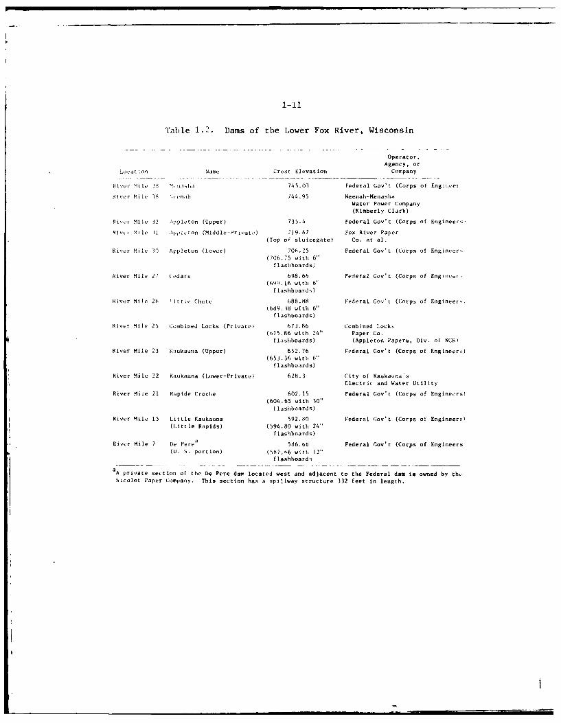
Table 1.2. Dams of the Lower Fox River, Wisconsin
Operator,Agency, or
Location Name Crest Elevation Company
River Mile 38 'I.nasha 745.03 Federal Gov't (Corps of Engiin.ei
River Mile I8 ",vvn,ah 744.95 Neenah-Menasha
Water Power Company
(Kimberly Clark)
River Mile 12 Appleton (Upper) 735.4 Federal Gov't (Corps of Engineers,
Riv- Mile I .\pplcton (Middle-Private) 719.67 Fox River Paper
(Top of sluicegate) Co. et al.
River Mile 30 Appleton (Lower) 706.25 Federal Gov't (Corps of Engineer-,
(706.75 with 6"flashboards)
River Mile 27 (vdars 698.66 Federal Gov't (Corps of Enginr-
(69'.16 with 6"flashboards)
River Mile 26 Little Chute 688.88 Federal Gov't (Corps of Engineer,)i689.18 with 6"
flashboards)
River Mile 25 Combined Locks (Private) 673.86 Combined locks
(b75.86 with 24" Paper Co.
flashboards) (Appleton Papers, Div. of NCR)
River Mile 23 Kaukauna (Upper) 652.76 Federal Gov't (Corps of Engineer)
(653.36 with 6"flashboards)
River Mile 22 Kaukauna (Lower-Private) 628.3 City of Kauka,,na's
Electric and Water Utility
River Mile 21 Rapide Croche 602.15 Federal Gov't (Corps of Engineers)
(604.65 with 30"
flashboards)
River Mile 15 Little Kaukauna 592.80 Federal Gov't (Corps of Engineers)(Little Rapids) (594.80 with 24"
flashboards)
River Mile 7 De Perea
586.6b Federal Gov't (Corps of Engineers(U. S. portion) (587,h6 with 12"
flashboards
aA private section of the De Pere dam located west and adjacent to the Federal dam is owned by the
Nicolet Paper lompany. This section has a spillway structure 332 feet in length.
1-12
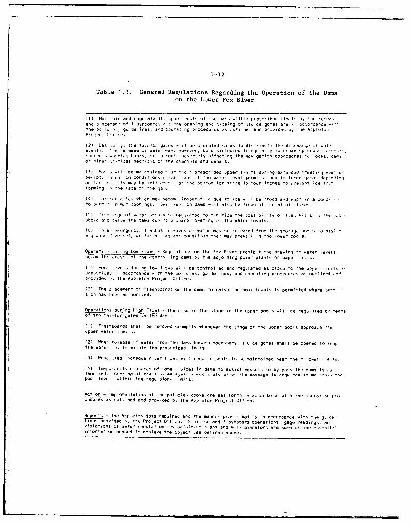
Table 1.3. General Regulations Regarding the Operation of the Damson the Lower Fox River
(I) Mirtain and regulate the upper pools of the dams within prescribed I imits by the rem<ovoeand piacement of flashboards a the opening and closing of sluice gates are - accordance wItthe po ic',, guidelines, and operating procedures as outlined and provided by the AppletonPro'ect O
4tice.
(2) Basic ilj, the taintor gats wi I be :perated so as to distribute the discharge of watereveni/. The release of water may, however, be distributed irregularly to break up cross currei,currents w.3,hing banks, or ,urrent, jdversely affecting the navigation approaches tc loCkS, dams.or other _yitical sections of the channuls and cana~s.
(3) P-, Is will be maintaired 'ar their prescribed upper limits during extended freezing wea'erperiod. Nten ice conditions rr,.val and if the water evel permits, one to three gates depellingon fth oc. ,ty may be left c-e-ruc a+ the bottom for thr.'e to four inches to ,revent ice fr-nforming .n the face of the gate.
(4) "ai nTr gites which $nay becom, inoper,,ti.o due to ice will be freed and kept in a condi'--to p. rmn I r,,t openings, Spillay, on dams will also be freed of ice at all times.
(5) Dtsc'.,je of water shou d bt.. regii ated to minimize the possibility of fisr. kills ;r the Poo sabove arid t!low the dams due to i -harp lowering of the water levels.
(h) In ar mergericy, flashes ;r waves of water may be released from the storag, pools to assi,'a groind. vess.vI, or for a tagnant condition that may prevail in the lower pools.
Operati r ;urng Low Flows - Regulations on the Fox River prohibit the drawing of water levelsbelow the .rest. of the controlling dams by the adjoining power plants or paper mills.
(I) Pool lvvels during low flows will be controlled and regulated as close to the upper limits IprescriLed r. accordance with the policies, guidelines, and operating procedures as outlined ,ndprovided by the Appleton Project Office.
(2) The placement of flashboards on the dams to raise the pool levels is permitted where permi -sion has been authorized.
Operations during High Flows - The rise in the stage in the upper pools will be regulated by meansof the taintor gates in the dams.
(I) Flashboards shall be removed promptly whenever the stage of the upper pools approach theupper water limts.
(2) When rlease of water from the dams become necessary, sluice gates shall be opened to keepthe waer lewls within the prescribed limils.
(3) Predi ted increase river flOws will require pools to be maintained near their lower limits.
(4) Temporjrily c'osurus of some sluices In dams to assist vessels to by-pass the dams is au-thorized. Ctening of the slu.,es again i mmed:eely after the passage is required to maintain thepool level within the regulatory limits.
Action - Implementation of the policies above are set forth in accordance with the operating pro-cedures as outlined and provded by the Appleton Project Office.
R - The Apileton data required and the manner prescribed is In accordance with flne guioe-provided ny t.,_ Project Office. Sluicing and flashboard operations, gage readings, and
violations of water regulat ons by id inir, plant and mrnl operators are some of the essentialinformation needed to achieve the object Yes defined above.
1-13
1.21Channel Maintenance - Maintenance dredging is required at various timesto maintain adequate channel depths based on the reasonable needs ofexisting navigation. Dredging is performed by clamshell dredge. Aux-iliary equipment, consisting of scows and tugboats, is required to trans-port the dredged materials to approved disposal sites. The existingchannels are adequate for all current navigational requirements. Dredg-ing is normally accomplished between May and October. Scheduling ofdredging operations is determined by a number of factors such as needfor dredging, availability of equipment, and weather conditions. Indetermining the time wheu, dredging will take place, environmental fac-tors are given as much consideration as possible in scheduling work.
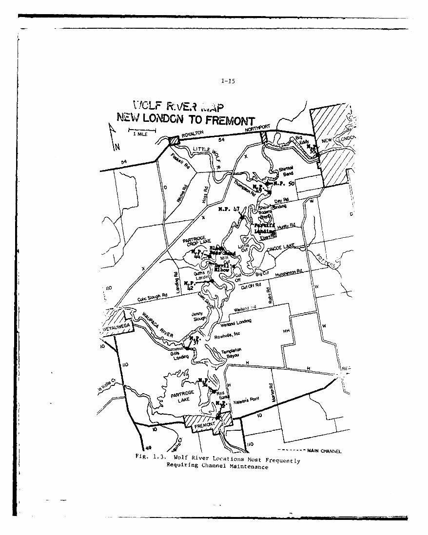
L .22Dredging i : tqui re: in the rarrow restricted channels above and belowthe locks and it rc Sti, L tei r i ver seCt i0onS betwern locks on the Lower FoxRiver, and at 1a ,f the ncd, r,-l harbors of refuge on Lake Winnebago (Seemaps and charts \npndi:. A).
1. ' 3The authorized project for channel improvement on the Wolf River providesfor dredging and snagging as necessary from its mouth in Lake Butte desMorts to New TLindon to maintain a 4-foot depth in the navigation channel.To maintain navigability on the Wolf River, it is necessary to performsnagging and dredging operations approximately every four years. One ofthe problem areas where frequent maintenance dredging is required is inthe cut-off -hnnnel at Boom Cut through the shoal waters of Lake Poygan.This channel extends I !-m the north shore of Lake Poygan to a point about1.1 miles south of th, Wolf River entrance into the lake. Boom Cut isabout 15 miles above the mouth of the Wolf River in Lake Butte des Morts.It is located in a veri low area of Lake Poygan where it is exposed toconsiderabl dr'fting sediments, dislodged bog material, and sedimentscarried down from the river by flood currents. Extensive recreationalbo~i ing use of much At the Wolf River segment of the project has beenmade possible primarily by the improvement and maintenance of this channelThe natural depth of the river below Freemont, except for Boom Cut atthe head of Lake Poygan and for 10 miles above Fremont, is in excess of4 feet and onlv occasional dredging and snagging is required to keep thechannel clear for navigation. In the remainder of the river to New London,shoaling, occurs more frequently. In addition, many fallen trees, snags,and submrged logs are also found in this section of the river and areremc ed to improve, safety for the navigation of recreational boating.The snagging operations consist of removing fallen trees, stumps, andother debris. No trees are cut unless they are completely fallen overand are either obstructing or have the potential to obstruct the navi-gable channel. Materials dredged from the Wolf River, consist mainlyof sand, silt and clay. Specific dredging locations within the projectand quantities to be dredgod vary from year to year depending upon localrunoff from tributaries that discharge into the Wolf River. Areas ofshoaling in the river may vary but for the most part have occurred mostfrequently at the locations listed below and shown in Fig. 1.3
1-14
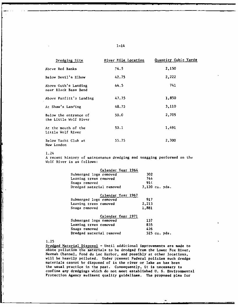
Dredging Site River File Location Quantity Cubic Yards
Abcve Red Banks ?4.5 2,150
Below Devil's Elbow 42.75 2,222
Above Guth's Landing 44,5 741near Black Bass Bend
Above Parfitt'3 Landing 47.75 1,850
At Shaw's Landing 48.75 3,110
Below the entrance of 50.0 2,705
the Little Wolf River
At the mouth of the 50.1 1,491
Little Wolf River
Below Yacht Club at 55.75 2,300New London
1.24A recent history of maintenance dredging and snagging performed on theWolf River is as follows:
Calendar Year 1964Submerged logs removed 302Leaning trees removed 744Snags removed 914Dredged material removed 7,120 cu. yds.
Calendar Year 1967Submerged logs removed 917Leaning trees removed 2,213Snags removed 1,881
Calendar Year 1971Submerged logs removed 137Leaning trees removed 835Snags removed 426Dredged material removed 525 cu. yds.
1.25Dredged Material Disposal - Until additional improvements are made toabate pollution the materials to be dredged from the Lower Fox River,Neenah Channel, Fond du Lac Harbor, and possibly at other locations,will be heavily polluted. Under present Federal policies such dredgematerials cannot be disposed of in the river or lake as has beenthe usual practice in the past. Consequently, it is necessary toconfine any dredgings which do not meet established U. S. Environmental
Protection Agency sediment quality guidelines. The proposed plan for
1-15
NWLNO TOE. FREMON
I-IV 10N0
LITTLE -- AN ~wE
Fi . 135o f R v rL4a i n o t F e u n lRequrin Chnne Manteanc
1-16
future maintenance is to provide disposal areas on shore, or withincompletely confined areas, for dredged materials which are polluted orwould increase pollution if deposited in navigable waters.
1.26Dredged material disposal of about 0,000 cubic yards is required on ;'naverage annual basis. Table 1.4 lists the primary land sit(, used !'ordisposal of dredged materials during the last ten years. Table 1.5 pro-sents a list of antiLipated dredging sites and the probable most ;avidn-
tageous disposal sites for each area. Figures 1.4-1.16 show thelocation of Federally and State approved disposal sites listed inthis table.
1.27Generally these sites are small containment areas along shore inclosed bydikes prepared in cooperation wiLh local interests. 1V;ually riprap orother protection of the river or lake side of the dike will be providedto prevent excessive erosion due to flooding or wave action. TlP somtcases the acquisition of additional property rights will be required.In other cases the approval of local public officials will be needed,with an agreement for local assistance in distribution of dredgedmaterials deposited on the stream or canal banks. In the single instancewhere it is proposed to deposit dredged materials in shoal waters, asubstantial dike to inclose that area and prevent the escape of pollutedmaterial to the river will be required. Dredged materials at someproject area locations have also been identified for agricultural orcommercial fill use. In these instances dredged materials are stockpiledand/or rehandled and transported by local interests for disposal on an asneeded basis. Specific locations for eventual disposal are determined bylocal interests but are subject to Federal and State regulatory require-ments, reviews, and approvals.
1.28Dredged material disposal will initially be limited to the plan describedin Table 1.5. Sites will be developed in accordance with actual dredging anddisposal needs. Selected sites will be filled at the earliest pos-sible time after its use begins. When a site is used, every effort willbe made to develop it to i,. fullest potential and thereby reduce thetotal number of sites impacted. As the need for additional disposalsites arises, maintenance dredging will continue to be performed, subjectto the disposal of dredged materials at approved disposal sites.
1.29Canal Banks - The canal banks (see Appendix A) that have been constructedto maintain pool levels for navigation and power are generally clay fillwith masonry retaining walls, and stone riprap in areas subjected tostrong currents or erosion from boat wave wash. The canal banks aregenerally of adequate height and in good condition, but require somemaintenance annually due to settling, storm water erosion other deteri-oration.
1-17
044. 0 u 444 0 4-a 4.o co mw 0 >1 0)C >U1
wO 'i r-. 0D 0) r 0) 0 0) 00In'
,4 -4
En m 0414
0 0 CDUC 00-co 04 -. 0 0a
m w-4. Ln 0 ) f( c'J 0 0 C 0.14i- 44 4 C4 -4 C14 en$4 aEn x "C 0 20 (U 0 0( X )< x x )(X
4.1 it-4c Ai 0 -,q CU~~ -M 40 WC
0 0 r 0*0 W 0 c aC d4
0 40 0a mO 4) CO 4) W CO c0)- 0V- -W u. 41 4. 4. . 4-i
Z ,(U'-. co oco 0)0 " -AuO coco po I. 0n :C a4J 4-0
0 O 0 000 0 0 0)0 0~ >
r4 -40 0
0 ) ).0 r- C: co 0)M 0 to
4- C0 .4 .- 4 C: -4 0 d-, 2 4ww 000 0 0 0) w0)
-4 * *o 0 .0 * .0 r. r.0 0 0CC 4-9 CO .4 (d (4 0 mO COa
> c 0 Id 0)2 X4. 0 40. = -0 4 X 0 40m w.9 U-4 0) 44 0 00 40) a )0 V )0 V ) zpaW - 0 0 000L c 0 r. v 4 0 0)t )4 0H 400M00- 4 '-4 w. 0 w0 . 0. 0 4w w 0 0 0 4.0
0 0) 0 4.00 00 w to4.4 >1 .- I V0 .00-A000 00 .).0 to vt.t0u000 '-4 . 0 : C 0 vi00 0- 0,-40 C0 0 OU H0.C 0 v w.~- -H. 0H - " w 41 -H M H0 ) n4(A U '41 bo 00) " 4-i 00' 4 ) Q 4.0 '1 -4 ) 4 4104-) -4 (90 4.. 4.A. 01 A 04-4 0)(j 04.4. 0 w- 041 -(
0cc m. r9.. - -H' x 0).c' md' 4 x ) 0 )-(42 0) P4 4) 0) 'C 0)0 3.
4 0 0)' bd02 412 .024 4J-C .CO 41J .4C
co-4 4
E-4 44.1 W 4 v ( 3.0 0 0.4 4 o -
0 - 4i P-4 0 0 0. 0 ;>0 0 3i00 4m '-4 1-4 0 0m ~0 00 0 00) 93 3w 4) 4) 0 -4
00 .- W C Cm 0418 UJ 0 .0 .4 V0c.r-4 -H >- -' 4 02 0 0d
00 o0) Do g "0 -0 4 0 ) 00-4 *4. 0) 00 00)
4)_ 4 cOO- r .44 41N :c 4 10 0 000 > " " o0. 1 00 00 0. cc 0 M 0). 0 w C00 .0 = 00t- (J'c i'Z0- 0 J J
C,,
IS V C L C a0 4 0 C
- -
4'4
0 OL - C
V ,-.o C0 V -,-
-. 01 .u
I I .0 -0 o. L
C~~~i CU -Cc CU -r~b U~ .CC
-3-W
40a
60 c c4 c 0-5, -fe a I IdM
0,C r ~ ~ 4 r- C -40C (mFb0 1 I .0 A.
31 v. 0 4'1C . ~0. > -' C 1 -UCg J- . 0
u m a) 0 mC-. 40vc C
AC- J. CL -0 0WuIL m0C a-
1 .19
41'c 0 0 'C' , 0 C'.11t t% * 0 0'N
41I.Z FN- It 0 CN
'C C C Ci C - C C -C
In .c C
a,1 z" 0 W, 0 .0 00 C
* ~ ~ ~ . V0 --1 7: .tf N 0 /t.14 m 0
0~ .0 w 41 41'
0.0 .1 -0 w4.- 0 -a L.
00 cI - 0 'c 1 -C W
0.14 cc. '-I 00 01 .... r _1
c1 .t 1. .0 v..4. U C .0 Q 1 0.~
Q .20t41 -C1 .S = m 40m44 .0 0 - 0 -61 a.44 -Wv2 60 w - w- m -4 w .4 w. 0 w 0 0
0.1 V6C 004 0 4, ' 0 .l 0 . 00 Cl- -- 0 t1,,-
-COT .1 4 UC 41.1I 11 1.41 .. 1 4.10 c 0 1..4 r:W, ba4 C/1' 41w0 . - -4 . 41 1..I
-C V 1. C .( Q u 1.) 'C L.. -0 wC u. V w . < -
o -3
0 11C. 21 41 - C
u . L; 11 CL. 0 > U
*~~W -C1 41C 4 01
0 v2W1.1 0. .. 4. c. L) ~ w ~0 a14 CC w ~ 10 . 0 1
0 01 11- v. 0.. CL t>> 1.
0~C 00
41 0
41 .0 a~ 41 0
LI 0 c41 0 o a0.41~- 0 1 -0 1
041 4 ~ 1.4 ~ 4 C C -
1.1. ~~~ ~ ~ I .1 0 4 U11 * 41 - 4 1 1
.0~~ 41 .o-o11
- .6 .0 4 144. 0 - c . C 0 '
CU~~4 v1 0-1 > >1. 1. C1 1
0 14 Ad 0 0.0 4 44 1 141 0 0v4 C .00
U1 - 0 1. 41 04 1 4 5 144 0) -. 14C~ ~~ ~ .. >4 1 1 0 1 1 . 14 1 .C.0 - 41 C
.J 0. 4. 14 .0."1. U 11 0 m '.0 0 4 .4111 m Uw _03 m0.2 .~ 1
1-20
GreenBay
Apoleton X%
Lak
40
p9
Oshkosh
. II
Fond du Lac
*-DREDGE DISPOSAL SITES
10 0 10 20 30 40 50
MILES
Fig. 1.4. Vicinity Map of Pioject Dredge Disposal Sites
1-r2l
NJ-
co
I VV
ok-,
u-
wZ
w
0L
1-22
...... ......
maa
Iaa
Ix
LWCJJ
4PPLECREE
1-23
LLL
w'
C'L
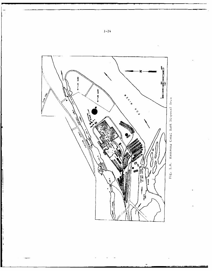
1-24
to
i-o
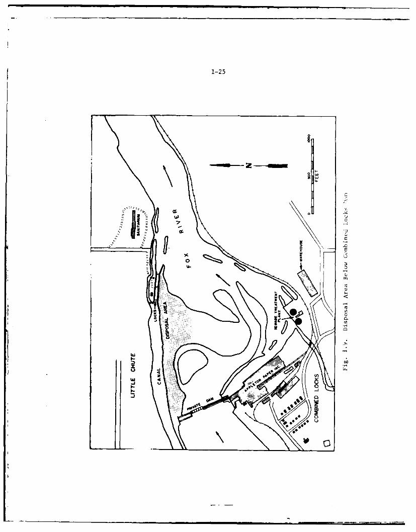
1-25
~
4-0 w2w
.r.
7 0
II)''a-
0
IaU
4 6-4 -4
a
0~
~II H
Ut,
-4
I-
2w
UI-.
0
0
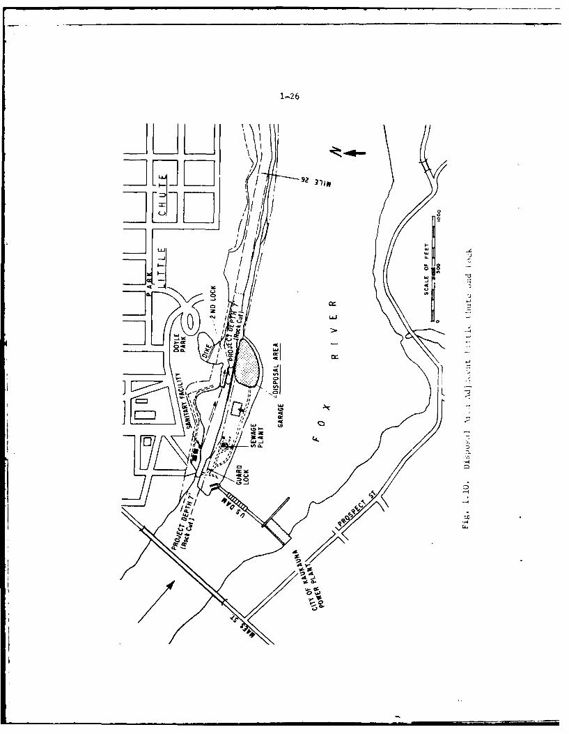
1-2 6
JL~1Li
-1 LI
-LJ w/
3g 0
Lii
W. CD 0r
I .Ii LLJ00 ~ ~ % CL -
C3I0:3
~ -~-~---/'U4
~ /Co.
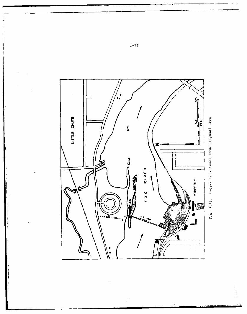
1-27
/<zL
U 0D
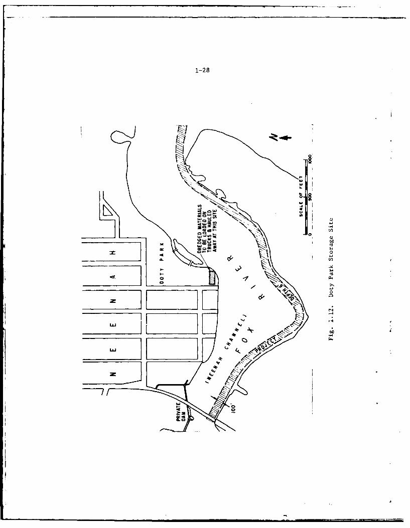
1-28
10
a:.
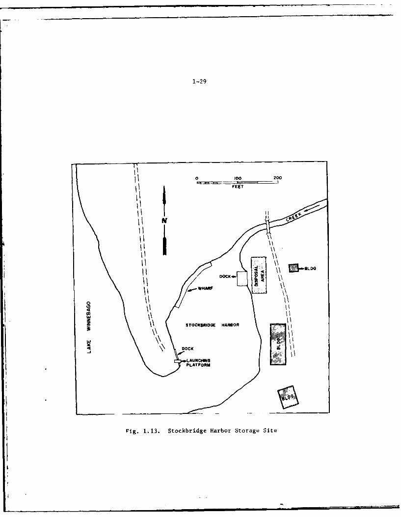
1-29
0 100 200
A FEET
I'ii
II
I'\'I
3 SOCIROGK N A O
-5 / \\
D1.3-OCK
PLATFO~a
Ig.1.13 StckbrdgeHARbotraeSt
. ... * ••• | i I0
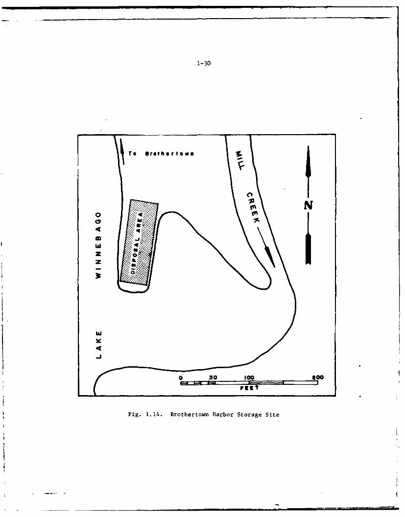
1-30
w
Fig. 1.14. Brothertown Harbor Storage Site
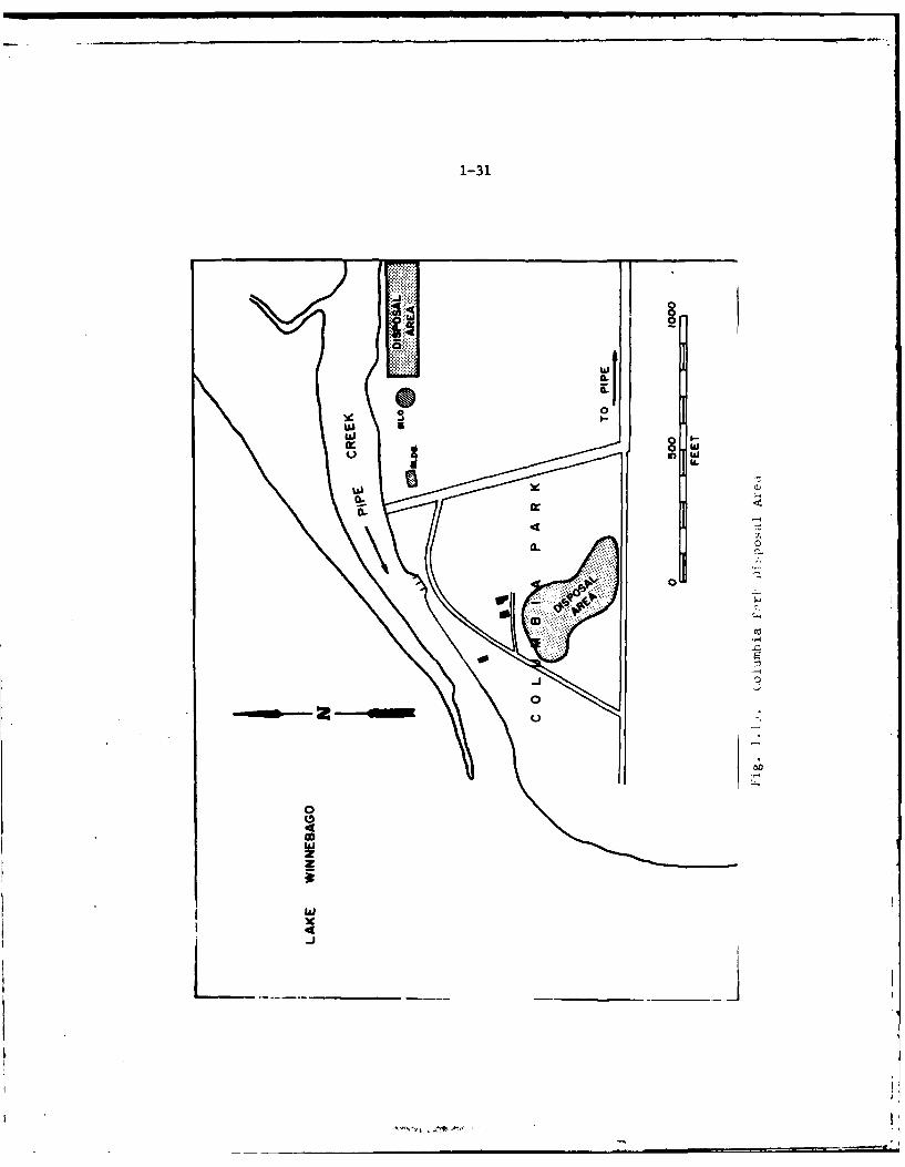
1-31
CLC
103
wx
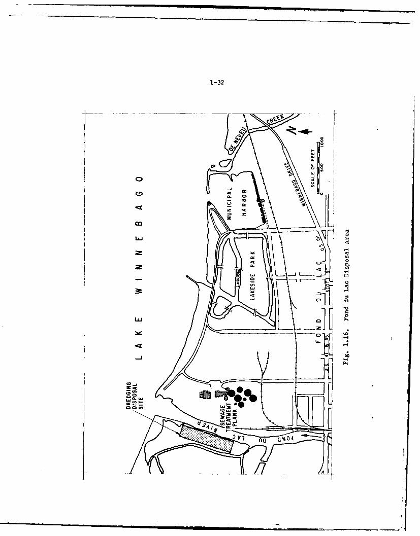
1-32
14 al
cx w0 c0
.to
-J0~ 0
Wn 1- IIG LM41 a
IAJ _j
cn wu)Lii s-
na a%
17d
1-33
1.30Harbors of Refuge - Federally improved harbors of refuge on Lake Winne-bago are located at Stockbridge, Brothertown, Calumet, and Fond du Lac(see Appendix A). There are also several non-Federal harbors onLake Winnebago, including High Cliff State Park, Millers Bay, and amunicipal harbor at Fond du Lac. Several natural harbors for shallowdraft craft are also available, such as in the outlet channels at Menashaand Neenah and in the inlet channel of Millers Bay at Oshkosh. Largenumbers of recreational craft using Lake Winnebago need protective harborsduring sudden bad weather and these harbors on the lake offer such refugebenefits. Continued maintenance of small harbors on Lake Winnebago willprovide for the safety of the hundreds of small boats using that lake forrecreation, including boating, sport fishing, water skiing and swimming.These small harbors also provide safe launching sites and harborsof refuge for the large numbers of trailer-hauled boats brought to andused on these waters from a wide tributary area covering the easternhalf of Wisconsin, as well is northern Illinois and Indiana. AlthoughU. S. Coast Guard statistics are not available for recreational boatingaccidents on Lake Winnebago, it is presumed that many storm-inducedswamping accidents have been prevented by the presence of these harbors.
1.31Lands - The United States owns land at each of the lock sites and Federalimprovements along the Fox River, as well as at two harbors on LakeWinnebago. These lands, totaling about 94 acres (see Table 1.6), exclu-sive of water areas involved in canals and harbor basins, are needed topermit access to the structures for necessary construction and maintenanceoperations. 1n general, the lands owned are adequate for project main-tenance and operation, with the exception of adequate land disposal sitesfor dredged materials.
Flow Regulation on Fox River System
1.32The flow of the Lower Fox River is affected by the control of storage inthe Lake Winnebago Pool, as authorized by the existing project and variousspecial acts. This regulation is of such importance to municipal, in-dustrial, hydropower, navigation, and general riparian interests alongthe river, and around the lake, that Congress has enacted several specialacts to require and set limits for regulation.
1.33A brief history and background concerning regulation of Lake Winnebagois contained in Appendix C. A detailed history of this subject is con-tained in Appendix B, House Document No. 146, 67th Congress, 2d session,on Fox River, Wisconsin. The water level of the Lake Winnebago pool isregulated to the extent possible in accordance with these laws and re-lated directives in the interest of navigation on the Lower Fox River,to preserve the private rights to the use of water not needed fornavigation for power development, and to reduce flood damages. TheWinnebago pool includes Lake Winnebago, Lake Poygan, Lake Butte des Mortsand several smaller lakes. The total surface area of the bodies of water
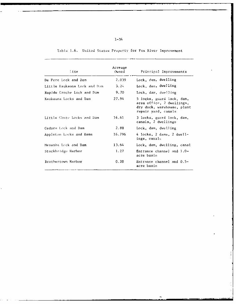
1-34
Table 1.6. United States Property for Fox River Improvement
Acreageite Owned Principal Improvements
De Pere Lock and Dam 2.039 Lock, dam, dwelling
Little Kaukauna Lock and Dam 3.24 Lock, dam, dwelling
Rapide Croche Lock and Dam 9.70 Lock, dam, dwelling
Kaukauna Locks and Dam 27.94 5 locks, guard lock, dam,area office, 2 dwellings,dry dock, warehouse, plantrepair yard, canals
Little Chute Locks and Dam 16.61 3 locks, guard lock, dam,canals, 2 dwellings
Cedars Lock and Dam 2.88 Lock, dam, dwelling
Appleton Locks and Dams 16.796 4 locks, 2 dams, 2 dwell-ings, canals
Menasha Lock and Dam 13.64 Lock, dam, dwelling, canal
Stockbridge Harbor 1.27 Entrance channel and 1.0-acre basin
Brothertown Harbor 0.20 Entrance channel and 0.5-acre basin
1-35
is about 265 square miles. The water level of this large reservoirsystem is controlled by the Neenah and Menasha Dams. Except forextremes of very high or very low water, the level of the lake has beenoperated so that the range of fluctuations between high and low water israrely more than about 30 inches. The operational range on Lake Winnebagois restricted during the navigation season from 21-1/4 inches above thecrest )f Menasha dam down to the crest of the dam. During the closedseason from about 1 November to 1 May the lake level may be drawn downto 18 inches below the crest of the Menasha dam with provision, as notedabove, that the level be back at dam crest by opening of the navigationseason. These limitations are established by law and are not administrativedeterminations by the Corps of Engineers.
1.34The drawdown schedule of the pool begins about 1 November of each yearwhen the water level at the Menasha Dam normally stands at a few inchesabove crest. Drawdown starts with a gradual lowering of the lake levelwhich continues into February. The rate of drawdown is related to precipita-tion and other conditions. In late February to early March, water levelsare again raised. Sluicing is heavy during the early spring. By springice break-up time, the water level of the Winnebago pool is usually severalinches below the crest at Menasha dam, thus allowing for floodwaterstorage. The lowered water levels at ice break-up time prevents extensivedamage from ice build-up and its associated damage to the shorelineproperties. The spring runoff normally restores the pool level to severalinches above the crest of the Menasha dam. During late spring and summermonths, releases are made to provide a steady flow for power generation,stream sanitation, and recreation craft.
ANNUAL OPERATIONS AND MAINTENANCE COSTS
1.35All completed features of the existing project were constructed between50 to 90 years ago and the investment in such improvements is considered
to have been fully amortized by past benefits. The cost of the Fox Riverwaterway improvement to 30 June 1976 was $24,064,600, of which $3,753,000was for new work and $20,311,600 was for operation and maintenance.
1.35Table 1.7 gives the cost of the project by year for the last ten years.The chief costs are those associated with operation of the locks and dams.The most costly single item in the operation of the locks and dams is thesalary of the lockmasters who operate the many locks and dams along thelower waterway. There are 13 lockmasters, three of which are seasonalworking only during the six-month navigation season.
1.37A cost summarization is presented in Table 1.8. The average annualoperation and maintenance cost over the five year period, 1971 - 1975,inclusive, was $742,400. The major portion, $301,100 or 40 percent wasspent for dam operation and maintenance, while $243,500 or 33 percent,was used for operation and maintenance of the lock system. On the
1-36
average, $15,300 or 2 percent was spent for dredging the Wolf Riverincluding Boom Bay, and $15,000 or 2 percent was required for engineeringstudies, supervision, and other miscellaneous project activities.
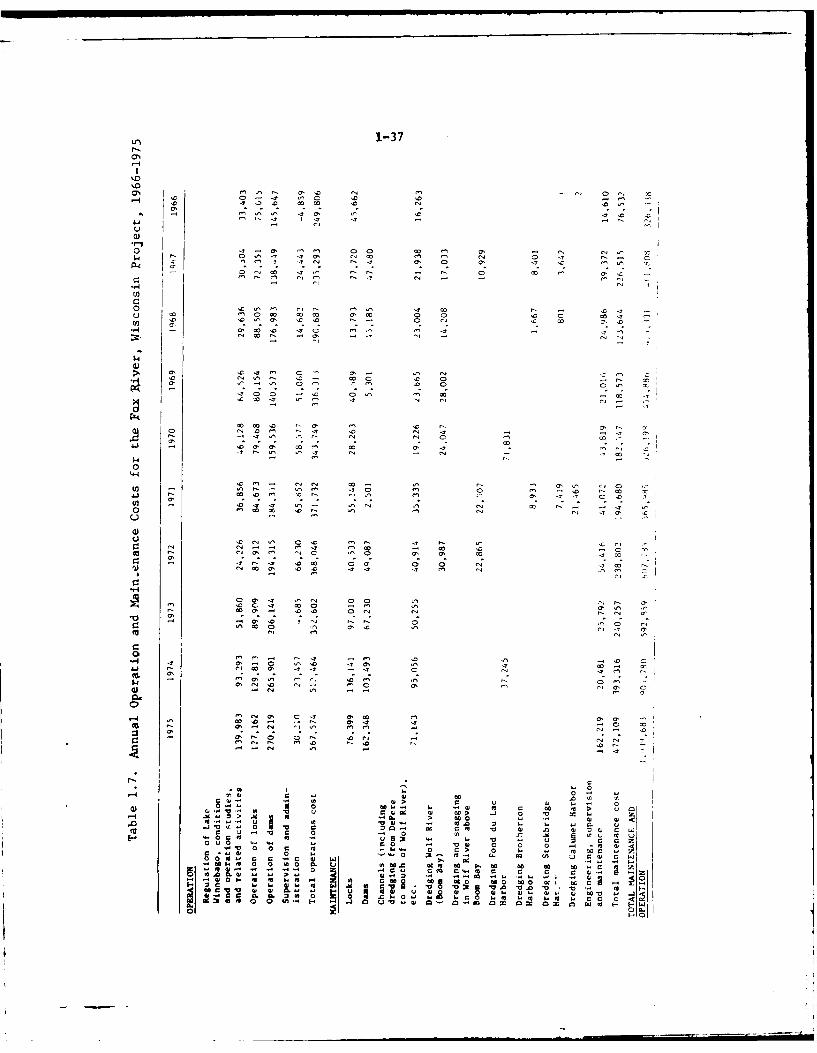
1-37
P4
'.r
C' 0 .
co 04
I .4 - ~0' C r C ' C '- 'a C C '
C',0
04 '4. C '- ' -CC rC C
C 'CC 0 "- C
0 as, .C C C' . Cr- (- 7 ' 4
00
(0 - 0 0.0 C' C .Y C C .0. '
C'(3 . . -
U~ ~~~ C0 _4 0. C r0 4 0. C
0 0. r ' Cr V- C 0 Cm' C CC
-0 r C' C .4 0 c4 Cr Cr O rr C a C
0C- a 4 wf to 00 'a Cr C Co ' w4 0.C C . C C - Cr v ' v' 'a .0
CL CL 0 0 C w 04 w. Cr c 'Z01 mIF 0' . 0' 0' H, -' U" "oZ0I* . C
In so C 7 a- 0M 0. M C C
04 r C C
0 r C . . rCC
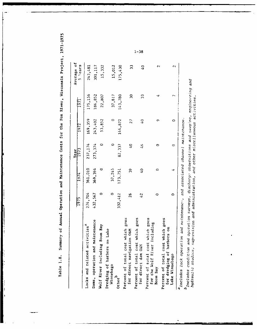
U,
P-
0%
0% 1-38
w U
OU t -4 r- C14 r D 0 cl cl0 0 -4 m) -4 en~ .44 .T -4 Cn 0.
0.4 OCW-4.T 0 -4 -4 r,
0u
:3 c . r- e 4n u~U-i 0 -4 00 re) m V
>4 -4 00C4 n'
44-
0 '
Lfn 0 U-) N- J 4
C14 en , 1 00 0
4-C4
0. .4 -7 . cN4 N- -. .
Ai Q
w0 "- r-l -4'
u >4 e-i C1
0~~ ~~ 110 n1- .u44 (7111 VJOrn cli r-
'0 41
C1'0 '44 Q
N-4 en en r
C- 4 (N (
14 l
0 u 0 0~ 0 1..s- 0-44 i-C: 3 w W w c 0
0~ 0 p. u '
SECTION 2
ENVIRONMENTAL SETTING
NATURAL ENVIRONMENTAL ELEMENTS
Physiographic Features
2.01The Wolf-Fox River Basin, located in east central Wisconsin (see Fig. 2.1),includes 4,086,451 acres (6,385 square miles) and is a subsection of theGreat Lakes-St. Lawrence River continental. drainage basin.' Although thebasin contains all or part of 20 W4isconsin counties, all but eight draininto watersheds which enter the project area upstream of the Fox RiverNavigation Project and/or have drainage inputs which enter the projectarea as point source inputs (see Fig. 2.2). The description and dis-cussion of the Fox River, Wisconsin Navigation Project area in thisdocument is, therefore, limited to the area of the basin shown inFigure 2.2. This portion of the basin forms the immediate environs ofthe project area (see Fig. 2.3). By limiting the discussion anddescription to this smaller area, the amount of extraneous detailscontained in this statement has been greatly reduced without sacrificingimportant details or overlooking any impacts and effects of the project.
2. n2For descriptive purposes, the project area can be considered to be threeconnected but quite distinct physiographic regions (see Fig. 2.3). TLeseare: (1) the region containing the Wolf River between New London and LakePoygan (the river's mouth is at Lake Butte des Morts); (2) the regioncontaining Lakes Poygan, Winneconne, Butte des Morts, and Winnebagofrom the mouth of the Wolf River in Lake Poygan to the Neenah andMenasha dams, collectively known as the Winnebago Pool; and (3) theregion containing the Lower Fox River from the Neenah and menasha damsto immediately downstream of the navigation lock at De Pere.
2.03The Wolf River region of the project area has smooth, marshy plainssurrounded by agricultural land and is located within the Wisconsincounties of Waupaca, Waushara, and Winnebago. 2 At New London, 56.5 milesabove Oshkosh, the Wolf River has a standard low water elevation of747.6 ft (MSL) and serves as the drainage stream for eight counties whichdrain into the upper Wolf River and the Embarrass River. 1 These tworivers join just east of the U. S. Highway 45 bridge at New London, whichis the upstream limit of the project., 3 From New London to Lake Poyganabout 25 miles in length measured along the river, the meandering WolfRiver intercepts its tributaries Cedar (Crew) Creek, Little Wolf River,and the Waupaca River, in that order.4 Below New London the normal slopeis very flat, averaging about 0.04 foot per mile. Along this reach of
2-1
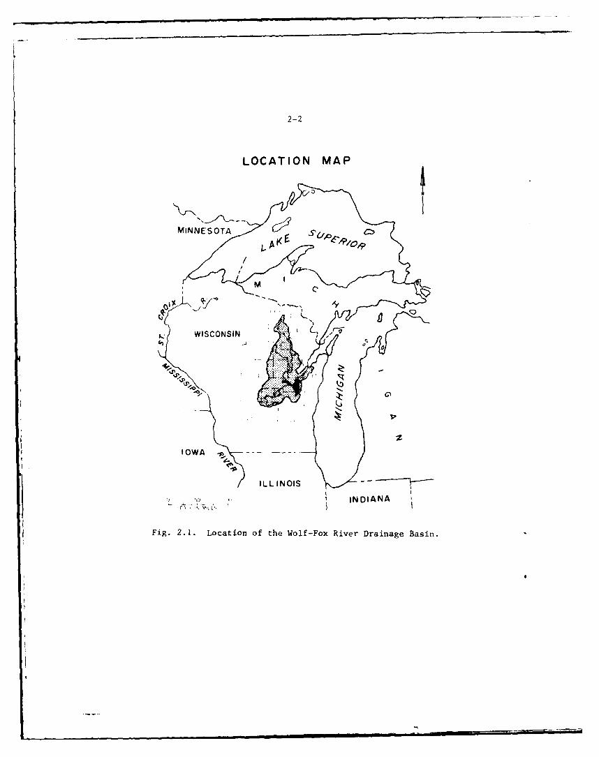
2-2
LOCATION MAP
WISCONSIN ~/
IOWA ----
ILL INOIS
U - IN DIANA
Fig. 2.1. Location of the Wolf-Fox River Drainage Basin.
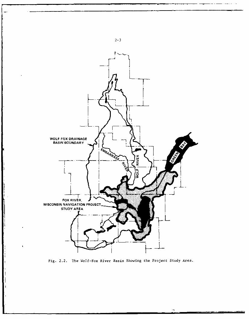
2-3
..J
WOLF-FOX DRAINAGELBASIN BOUNDARY
l ..
K1 L
FOX RIVER,
WISCONSIN NAVIGATION PROJECTSTUDY AREA
Fig. 2.2. The Wolf-Fox River Basin Showing the Project Study Area.
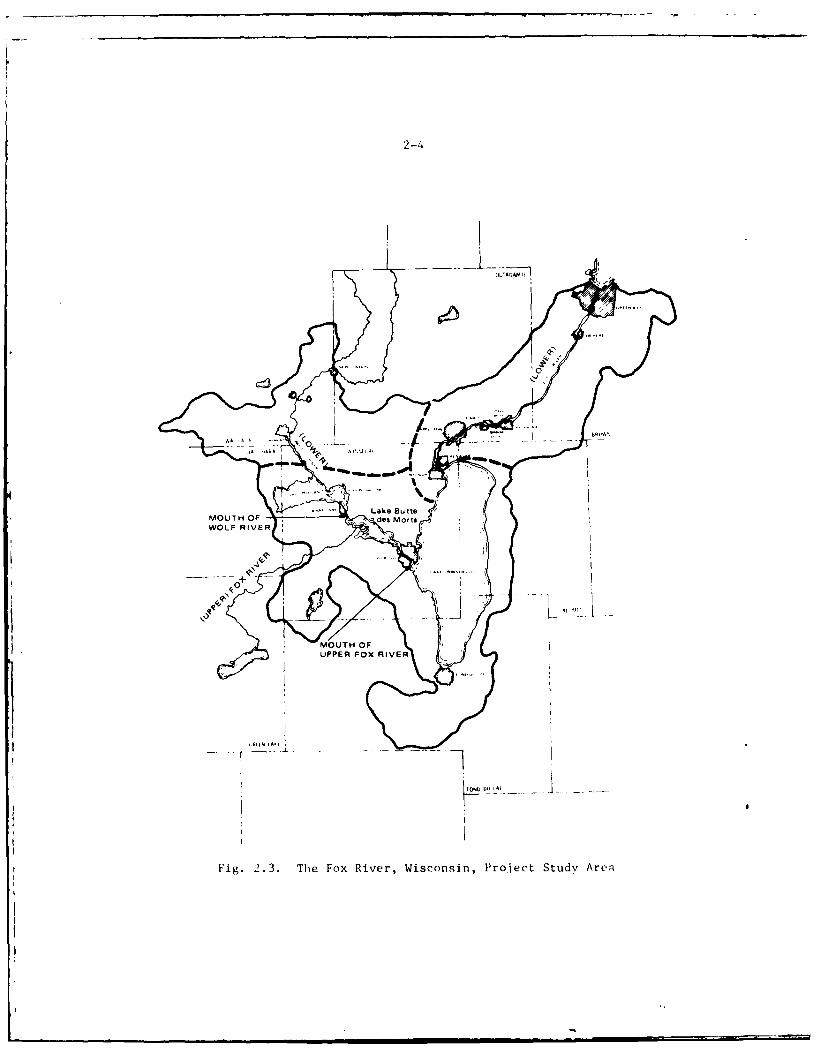
2-4
MOUTH OF -des Mo IsWOLF RIVER
Fig. 2.3. The Fox River, Wisconsin, Project Study Area
2- 5
about 47 miles the river flows through large marshy areas with generallylow banks and varies in width from 200 to about 1,000 feet. BetweenNew London and its mouth, the Wolf River enlarges into five lakes withcombined low water areas of about 38 square miles and high water areaof about 63 square miles. These small lakes rise and fall with theriver and become part of the Lake Winnebago pool at high water stages.
2.04The drainage area of the Wolf River at New London, Wisconsin, is 2,240square miles.4 At its outlet into Lake Butte des Morts, the drainage
area is 3,750 square miles. The Wolf River environs are subject tofrequent and repeated flooding. A total of 146 floods occurred duringthe 73-year period of streamflow records discussed in Reference 4.Figure 2.4 (from Ref. 4) is a chart showing floods above bankfull stage.When exceptionally heavy rainfalls with rising temperatures cause rapidsnow melt, the combination produces severe flooding. Thus, the floodsof most severe magnitude are spring floods.
2.05The central region of the project area is one of large lakes which arecontrolled impoundments formed by the dams in the two channels leadingto the Lower Fox River at Neenah and Menasha (see Fig. 2.3). Thisregion is contained in six watersheds,' one contains Lake Poygan (10,992acres) and Lake Winneconne (3,264 acres), two drain into Lake Buttedes Morts (8,857 acres) and three surround Lake Winnebago (137,708 acres).The Lake Poygan and Lake Winneconne watershed contains parts of Wau-shara and Winnebago Counties. The two Lake Butte des Morts watershedscontain parts of Winnebago, Fond du Lac and Green Lake Counties. TheLake Winnebago watershed contains parts of Winnebago, Fond du Lac andCalumet Counties. In addition to the 3,278 square mile drainage areaof the Wolf River at Lake Poygan, the Rat River, Pine River, and LakePoygan and Lake Winneconne watershed add an additional 453 square milesof drainage area. The additional drainage area of the upper Fox Riverand the tributaries to Lake Butte des Morts increases the total drainagearea of the project stream at Oshkosh to about 5,610 square miles. 6 The
addition of the Lake Winnebago watersheds increase the drainage area atthe Neenah and Menasha dam entrances to the Lower Fox River to 6,030square miles.
7
2.06Lake Winnebago is the largest inland lake in Wisconsin. It has a maximumlength of 28 miles, a maximum width of 10.5 miles, a maximum depth of
approximately 21 feet, and an average depth of 15.5 feet. The lake islocated in a flat clay region except along the east and northeast shoreswhere the area is bounded by the Niagara limestone escarpment whichextends southwesterly from Door County along the easterly shore ofGreen Bay, the easterly boundary of the Fox River basin, and the eastshore of Lake Winnebago. Most of the area surrounding the lake isdevoted to agriculture, except for urban developments in the Fond duLac, Oshkosh, and Neenah-Menasha areas. Most of the immediate lakeshore, except where too low for housing development, is occupied bysummer cottages and permanent homes.
2-6
T OL61961
,rr , , 9961- 'i 0961
t_- " 9610961
2961
I " 0S61 . 1.,OKI
-,.___ _ ,__ _ '_ 9t6l
906
t ~61 "..___ - .0 .
0- t6I
,, ' _I ' bE ,. - ..
L 161
,, 0iH61
" ' ' " '- 9S .61 -
, ' ~~9261 r.. "
... 9 6I U . .
+, OZ~061 o ¢
__•___,_-4 0 (
91261
S91 1 > ci .
Zi6I Z .,
01619161 > cI *C
0161 1 0 a).
9061 M
m 9061 0 a)
-0 w, . o o I -- 061
~ 0 0 .. Z6u _ 0061 0: z 86 1
- 9691I- m 90691 " (
-I6 1 .I
99819 91
...... l... ..h .. i ,. ,,. . ,,,,,,I,.. , ,,.., ,, , I ......... .... ,,,, . I.81
133A MI MI39V9
2-7
2.07Lake Winnebago, with its tributary lakes and marsh areas, is the naturalretarding basin to reduce flood peaks on the Lower Fox River. Itserves as a storage reservoir for the drainage from the Upper Fox River,the Wolf River, and about 600 square miles of local drainage around thelake. Lake Winnebago, together with the six smaller lakes within thelower portions of the Upper Fox and the Wolf Rivers basins, forms what isknown as the Lake Winnebago pool with a total low-water area of 265square miles at ordinary low water elevation. At maximum high water ofrecord with prevailing backwater slopes in the connecting channels, thepool area is increased to about 320 square miles. During maximum floodsabout 80 percent of the stream discharge overflows the banks and fillsthe extensive marshy areas along the river to widths of 2 to 5 miles.
2.08The central region of the project area, like the Wolf River region notedpieviously, is also subject to flooding. Table 2.1 shows flood data onthis section of the project area. The intermediate regional flood (100-year flood) elevation at the outlet of the Upper Fox River into LakeWinnebago is about 749 feet (MSL).
Table 2.1. Flood Crest Stages and Elevations forHistorical Floods on Lake Winnebago
Date of Stage ElevationYear Crest (Oshkosh gage) (MSL-1929)
1881 8 November 5.61a 749.51 c
1886 1 May 4.33 748.23
1888 21 April 4.42 a 748.32 c
1922 23 April 4.75 b 748.81 c
1929 16 April 4.17 b 748.23 c
1960 17 May 4.32 b 748.381969 29 June 3.86 b 747.92
1973 25 March 3 .8 9b 747.95
aZero gage datum is equal to 743.90 MSL-1929.
bZero gage datum is equal to 744.06 MSL-1929.NOTE: Oshkosh gage datum raised 0.16 feet on March 23, 1898.
CFlood levels prior to 1937 would have been lower under current
conditions because of the increased sluicing capacities of theMenasha and Neenah Dams.
2-8
2.09The project region containing the Lower Fox River consists of a bedrock-bottomed river cut between mildly to sharply rising clay bluffs.The river bottom has several small shoreline floodplains and a fewislands in the stream bed itself. Along the route from the Neenah andMenasha dams to the De Pere locks, the width of the river varies fromabout 500 to 1,000 feet. Most of the land along the immediate riverbanks is highly developed industrial area occupied by several cities,paper mills, power plants, and other improvements. The remainder ofthe drainage area below Lake Winnebago is well developed agriculturalland. The Lower Fox River passes throigh the cities of Neenah andMenasha; into Little Lake Butte des Morts; through the city of Appleton;adjacent to the communities of Kimberlv, Combined Locks, and LittleChute; through the city of Kaukauna; aid through the city of Do Pere.
2.10The Lower Fox River is 39 miles long from Lake Winnebago to its mouth.The portion of the river within the project area falls about 166 feetfrom Lake Winnebago to just below DePcre darm which is 7 miles above themouth, for an average slope of 5.2 feet per mile. To provide for navi-gation, locks and dams with canalq alcig the rapids sections were con-structed, thereby converting the free-Flowing channel into a series ofslack water pools.
2.11The drainage area of the lower river below Lake Winnebago is only 400square miles. The principal tributaries are the East River, DutchmansCreek, and Ashwaubenan Creek, all entering below De Pere, and Apple,Plum, Mud, and Neenah Creeks, entering between 16 and 35 miles above themouth of the river. The total for the entire Fox River system abovethe river mouth is 6,430 square miles.
2.12The climate in the Wolf-Fox project study area is typically continentalwith cold winters and hot summers. The recorded maximum temperaturerange at Green Bay has been from -31°F to +990F.
8 The -1 -ate is moresevere at the higher elevation and land locked parts ot valley sincethe climate at Green Bay (city) is modified by the .,e , Green Bay andLake Michigan. New London has a mean value of 14' rust-t.ie dayscompared with 161 for Green Bay and 151 for Fond du Lac. 9 The averagetemperature of New London is 45.7' compared with 43.60 for Green Bay and47.00 at Fond 9du Lac reflecting a more constant although colder climateat Green Bay. Precipitation averages 30.6 inches at New London, 29.2 atFond du Lac and 26.5 at Green Bay. Approximately 60 percent of theannual precipitation falls during the months of May through September.June is generally the rainiest month of the year. Severe drought isquite rare.
9
2.13Most of the Wisconsin landscape is snow covered and the streams are icecovered from late November to early March. In spring, rains and meltingsnow usually cause some flooding in the area. During the spring icebreakup, damage to shorelands and property along the shorelines can occurIn the lakes of the Winnebago pool due to wind-driven ice flows.
2-9
2.14Prevailing winds in the Fox-Wolf Basin are from the west and northwestfrom late fall through mid-spring and southerly the remainder of theyear. April and November are the windiest months with averages of about12 miles per hour. Wind speeds have been under 15 miles per hour three-fourths of the time, between 15 and 30 miles per hour one-fourth of thetime, and greater than 30 miles per hour less than one percent of thetime. The strongest winds usually blow from a westerly direction.
2.15Annual lake evaporation is estimated at approximately 28 inches in thesouthern portion of the basin and about 25 inches in the north. About80 percent of the year's total evaporation occurs in the warm seasonperiod of May through October.
Surface Water Features
2.16The majority of surface water features in the project study area are partof, or tributary to, the Wolf-Fox River drainage system which emptiesinto Green Bay. Table 2.2 indicates the area of the water surfaceexpected to directly affected by the proposed project activities. Thesurface water features in each portion are detailed below.
Table 2.2. Approximate Surface Area of Streamsand Lakes in the Project Area
Lakes
Partridge Crop 263 acres
Partridge 990
Cincoe 115
Poygan 10,992
Winneconne 3,264
Butte des Morts 9,235
Winnebago 137,708
Little Lake Butte des Morts 1,150
Streams
Lower Wolf (47 miles) 1,424(New London - Lake Butte des Morts)
Lower Fox (33 miles) 3,000(Appleton to De Pere Dam)
Total 168,131 acres
2-10
2.17Wolf River Region - The region consists of the lower Wolf River fromNew London to its mouth at Lake Poygan, and several off-channel lakes:including Partridge Lake, Partridge Crop Lake, Cincoe Lake, and theWaupaca River confluence.
2.18Central or Lake Region - The middle portion consists of the Winnebagopool at standard low water (elevation 746.01 MSL). It should be notedhere that at high water stages the lower Wolf and associated off-channellakes become part of the Winnebago pool. At ordinary low water eleva-tions the area of the Winnebago pool is 265 square miles (169,600 acres),at ordinary high water (21-1/4 inches above crest at Menasha dam) thepool area increases to 320 square miles (204,800 acres). 1 0
2.19Fox River Region - This region consists of the Lower Fox River andincludes the Little Lake Butte des Morts and several small tributariesto the Fox: including Apple Creek, MTud Creek, Plum Creek, and KankapotCreek.
Surface Water Quality
2.20The water quality standards for the State of Wisconsin are based onthree use categories and are summarized in Table 2.3. In addition,unauthorized concentrations of substances are not permitted that aloneor in combination with other materials present are toxic to fish or otheraquatic life.
2.21With the exception of the segment of the Lower Fox River below Wrightstown,project area waters are designated to meet the standards for fish andaquatic life and recreational use. Lake Winnebago and the Fox Riverfrom Lake Winnebago downstream to the upper dam in the City of Appletonare designated to meet public water supply use standards. Those waterswhich, because of natural conditions or pollutional inputs not reason-
ably removed, cannot meet these high quality standards are allowedspecific variances from that standard. In all cases the variance isfor an alteration from the dissolved oxygcn and/or the fecal coliformcriteria only. The variance does not preclude a waste source fromproviding a high level of treatment for the wastewater nor does it allowexisting polluted conditions to continue.
2.22The water-quality data presented in this document are derived fromdifferent published documents and uniformity of reported data was notpossible. In addition, the data presented can only be used to formgeneral judgments since water-qualitv conditions are changing rapidlyin the basin due to increased pollution control, urbanization, and thediverse development trends in riparian areas. A discussion of waterquality in the Wolf-Fox project area is also best divided into separatediscussions of the three physiographir regions. The nature, problemsand levels of information are quite different for each region.
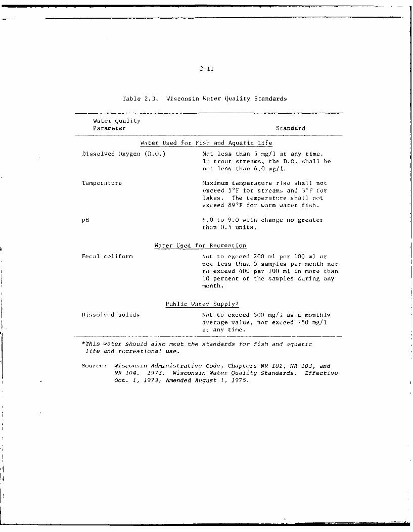
2-11
Table 2.3. Wisconsin Water Quality Standards
Water QualityParameter Standard
Water Used for Fish and Aquatic Life
Dissolved Oxygen (D.O.) Not less than 5 mg/l at any time.
In trout streams, the D.O. shall benot less than 6.0 mg/l.
Temperature Maximum temperature rise shall notexceed 5'F for stream,; and 3°F forlakes. The temperature shall notexceed 89*F for warm water fish.
pH 6.0 to 9.0 with change no greaterthan 0.5 units.
Water Used for Recreation
Fecal coliform Not to exceed 200 ml per 100 ml ornot less than 5 samples per month norto exceed 400 per 100 ml in more than
10 percent of the samples during anymonth.
Public Water Supply*
Dissolved solids Not to exceed 500 mg/l as a monthly
average value, nor exceed 750 mg/lat any time.
*This water should also meet the standards for fish and aquaticlife and recreational use.
Source: Wisconsin Administrative Code, Chapters NR 102, NR 103, andNR 104. 1973. Wisconsin Water Quality Standards. EffectiveOct. 1, 1973; Amended Auaust 1, 1975.
2-12
2.23Wolf River Reg.2n - The surface waters of the Wolf River basin generallydo not experience significant pollution problems. Due to the low popu-lation density and the rural nature of the area, domestic and industrialwaste discharges are relatively small :ompared to the flow in basinstreams. 11 There are, however, localized areas where discharges affectthe quality of surface waters. The primary source of pollution in theWolf River basin is that generated from sewage wastes. Industrialwaste is noted from small industries t'iroughout the basin. The foodprocessing industry is the largest generator of industrial wastes in thebasin. Land disposal techniques are tie methods most often employed fortreating these wastes. Agricultural rnoff is also a contributor to thesiltation and eutrophication of surface waters in the basin.
2.24The Wolf River in its upper reaches wel.l above the project limit at NewLondon, is largely a natural stream with few substantial sources of urbanor industrial pollution on either the iain stream or tributaries.1 1 Ingeneral, pollutants are assimilated in a few miles or less with no permanentdamage to the water quality of the str. ams other than the addition ofsmall increments of nutrient enrichen: , e.g., nitrogen and phosphoruscompounds."' Also, the gradient (stre,,m elevation change) is high, thus
promoting a high degree of aeration an, oxidation of organic materials.11
2.25In the lower hundred miles of the Wolf River, conditions are substantiallydifferent. The gradient is very low (56 feet in 114 miles), and farmrunoff and siltation become significant. 1 1 At New London and downstream,towns in the Wolf River drainage area begin to contribute substantialamounts of organics, which increase biological oxygen demand, as wellas inorganic nutrients. 11 In addition, sewage treatment plants in thecities of Waupaca and Weyauwega on the Waupaca River contribute sizablequantities of wastes. Smaller communities and homes with individualseptic tank-tile field sewage systems also contribute substantiallysince soil permeability is low and much of the runoff goes directly intothe streams.
2.26Tabular information on the Wolf River water quality is given in AppendixB, Table B.11. Although fluctuations within water quality parameters are
normally very large on the Wolf River, it can still be seen that pollu-tion levels do increase on passing downstream through the cities. Alarge increase in turbidity was noted at Winneconne probably from thehigh turbidity of Lake Poygan.
2.27Although the dissolved oxygen level drops as low as 4.2 ppm at Fremont, alevel that is restrictive to some fish species, in general it can beconsidered adequate for the resident biologic populations. At times,photosynthezing algae in the lower part of the river cause supersatura-tion of oxygen. Average nitrate levels at Keshena are borderline with
2-13
respect to triggering extensive algal growths; however, below New London,both the levels of nitrogen and phosphorus are sufficient to feed exten-sive algal blooms.
2.28The bottom of the Wolf River throughout the project area is mostly sandwith some areas of red clay. In general, bottom pollution from humansources seemed to be localized near the sewage outfalls.
1 1
2.29It is unlikely that the Wolf River basin as a whole will experiencegreat increases in industrial and manufacturing activities of a typewhich will cause heavy pollutional loadings in the foreseeable future.
2.30Central or Lake Region - Appendix B, Table B.12, shows that LakeWinnebago is a very eutrophic lake. The drainage basin of LakeWinnebago is largely comprised of agricultural areas. The fertilizerrun-off from these areas is rich in nutrient nitrogen and phosphorusproviding ideal conditions for the growth of algae in the Lake.
As a result, high nutrient levels are present in the lake and heavyalgal blooms do occur. Dissolved oxygen is generally sufficient tosupport biological activity at all times, although the oxygen levelsdo decrease under the ice in winter and in the warmer shallow areasin summer. The extensive algal growths create a serious esthetic andwater treatment (for municipal supplies) problems in summer.
2.31Over the past %ears, BOD measurements taken on the Lower Fox near LakeWinnebago, have shown that considerable natural pollution may existin the river above the Neenah-Menasha dams. The term "natural pollution"is used because investigations have shown that there are no significantsources of either human or industrial pollution in the area of influenceabove N h-'Tenasha. The cities of Oshkosh and Fond du Lac dischargesecondar eated sewage.
2.32The bottom of lake Winnebago is mostly silt and red clay. In the lakeregion of the study area, particularly in the marshy areas of LakesPoygan and Butte des 'orts, areas of highly organic natural detritus(gvttja) containing high nutrient levels, comprise much of the substrate.
2.33Survey data (Appendix B, Table B.13) indicate that Lakes Poygan,Winneconne, and Butte des "orts are also eutrophic. Lake Butte desMorts is shallow and very eutrophic and historically has always beeneutrophic, although since 1966 it has changed from a clear-water lakedominated by macrophytes and bog-like areas to a rather turbid waterbody from whlrh aquatic plants and bog areas are disappearing.6 9
2-14
2.34Lower Fox River Region - The Fox River in the 40 mile-reach between theWinnebago pool and Creen Bay has on its banks one of the major industrialcomplexes in the Midwest. This concei tration of industry and munici-palities imposes a pollutional load or the river which requires control.There are only a few small tributarie- below Lake Winnebago. The majorchanges in the water quality in this section of the Fox River are createdby the 18 paper and pulp mills and 11 municipal sewage systems emptyingwastes into the river.1
2. 35In 1971 an automatic monitoring svstep was established by the State ofWisconsin to provide a continuous water quality record for the Lower FoxRiver. The Lower Fox River receives 13rge amounts of organic wastes fromthe pulp and paper industry resulting in marked changes in water quality.Each day the Lower Fox River between Like Winnebago and Green Bay, wherethe flow averages 4,139 cfs, receives an estimated BOD loading of 26,000pounds from municipal sources and 191,000 pounds from pulp and papermills as shown in Table B.14, Appendix B. Continuous monitoring of thestreams is necessary to document improvements in water quality which areexpected to occur as pollution abatement programs are implemented and toidentify locations where further abatement action will be required. Thesystem consists of five stations that monitor dissolved oxygen, temper-ature, p-i, conductivity, and turbidity. The monitors are unattended andmeasure the values of each of the parameters by means of probes placed inthe water flow.
2.36Dissolved oxygen levels in segments of the monitored sections of the FoxRiver are subject to marked fluctuation and are insufficient to supportmany forms of aquatic life during the low flow, warm water conditions ofsummer and during the winter period of ice cover. The Department ofNatural Resources has worked with the municipalities and the pulp andpaper mills to reduce discharges of BOD and other wastes to the rivers.Wastewater treatment facilities have been improved and are being ex-panded. Before this task is finished many millions of dollars will bespent in construction and maintenance costs for pollution abatement.Continuous monitoring of the Lower Fox River is an essential part of thewater pollution abatement program.
2.37The effects of flows on the dissolved oxygen can be seen in severalexamples given in Figures 2.5 and 2.6. Other factors also affect dis-solved oxygen fluctuations on a daily basis. These factors includeconcentrations of algae in the summer, aeration by the wind, the turningon and shutting off of auxiliary turbines at hydroelectric power facilitydams housing the monitors and other factors.
2.38The lower dissolved oxygen values occur duriig the warmest months ofsummer in those stretches of the rivers most affected by the oxygendemand of the organic wastes dischargeC to the river. The lowest daily
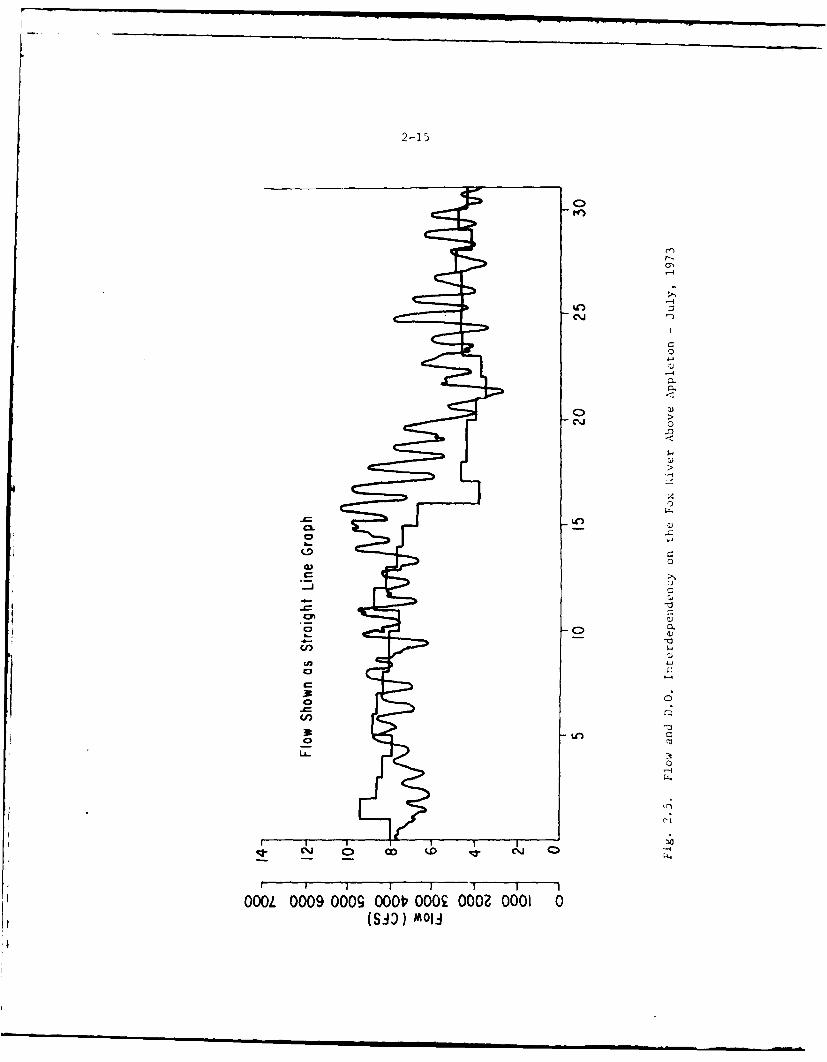
2-15
C.
C~C
CLC
CD C.
00LA-o
coC
OOL00 00 0. 02 0200(S)) aI
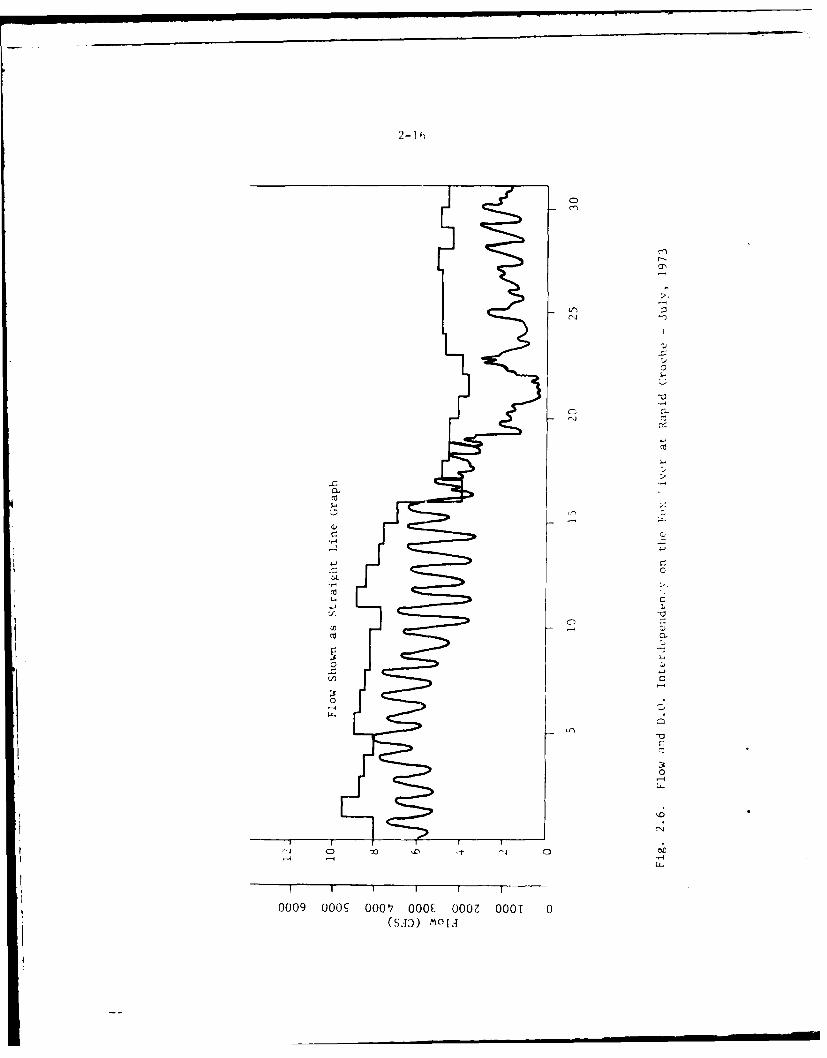
2-1
cca
CD 0
000 ______ OO OOZ NO
(SA ) .I
2-17
average dissolved oxygen values occur at Rapid Croche and Green Bay.In winter the oxygen demand of the organic wastes can be most pronouncedbelow the monitoring systems in Green Bay several miles from the mouth ofthe Fox River.
2.39The temperature of the Lower Fox ranges from a low of 32 F to a high of800 F. Closely associated with the temperature is the dissolved oxygen.The oxygen demand of the water and temperature are the primary factorsgoverning the waters' ability to hold dissolved oxygen. Yearly dissolvedoxygen concentrations range from a low near zero mg/l in some locationsin the late summer to a high of about 15 mg/l in the early spring andlate fall. Low dissolved oxygen concentrations also occur in winterduring freeze-over due to the lack of natural aeration which takesplace as a result of variations in river flow rates, wave action, andspillways over dams.
2.40The average pH of the Lower Fox River falls in the range of 7.0-9.0.
2.41The conductivity of the Lower Fox River gives a general feeling for theamount of dissolved solids present in each of the streaims. The con-ductivitv range in micromhos of the Fox River is 250-400. Conductivityvaries with the season and the location along the stream. The highestconcentrations occur during the low flow periods of fall and winter.Conductivities are also higher in the downstream monitoring stations ofthe river.
2.42The initial water quality of the Lower Fox River is largely determined byLake Winnebago water quality which has a relatively high nutrient con-tent, high organic content, and a moderate dissolved oxygen level. TableB.15, Appendix B, gives the average concentrations for a number of riverwater quality parameters at the Lake Winnebago outlet.
2.43Lake Winnebago waters contain abundant algae populations and algal bloomswhich are carried into the lower Fox and can be found throughout theriver and Green Bay. BOD measurements during the various months exhibita constant degree of variation as shown by relatively constant standarddeviations. BOD values generally follow the algal cycle, increasingfrom a minimum in June to an August maximum. This indicates that someof the measured BOD may be due to algal respiration. Comparison ofautoclaved and normal BOD's performed during various stream surveysindicates that the algae may also contribute an actual BOD, as well asa respiration oxygen demand. The decay of dead algae apparently,however, does not create a serious oxygen demand either in the lake ordownstream in the Lower Fox River.
2.44Seasonal variations in discharge of nutrients and organic matter from theFox River to Green Bay are related to the quality of Lake Winnebagodischarges and to processes of assimilation, sedimentation and release in
2-18
the river. Lake Winnebago's effects on the river include increased
levels of ammonia-nitrogen in spring, total phosphate In summer andorthophosphate in fall. Table B.16, Appendix B, shows the seasonalaverage for a number of parameters in terms of the total flow of thesubstance in pounds per day.1 6 Since many of the parameters are involvedin the chemical and biological processes of the river, the differences Invalue between the upper and lower sitEs noted do not necessarily reflectthe amount of the substance added alorg the river. The spring (March-May) loadings of nutrients to Green Bry are highest of all seasons and formost parameters represent amounts grevtly in excess of that which can beattributed to Lake Winnebago and muni(ipal treatment plants. Surfacerunoff from the drainage basin and release from the river system arelikely sources of the increased loadirgs observed in the spring. 16 As asource of nutrients for lower Green Bgy, Lake Winnebago contributesamounts of nitrogen and phosphorus con pounds to the Lower Fox River inexcess of or approximatelv equil to tiat contributed by municipal treat-ment plants. Annual average loadings of orthophosphate and total phos-phate from municipal treatment plants were 4400 and 6670 lb/day, respec-ti'.,ly. Discharges from Lake Winnebafo inicluded annual average loadings< 070 and 6620 lb/day of orthophospl~aL, and total phosphate, respectively.Anaual average loading of ammonia-nitrogen from treatment plants was 4440Ibiday and from Lake Winnebago 5200 lb/day.16 Anoxic conditioni; inportions of the river indicate excessive organic loading and are significantin ammonia-nitrogen releases. Phosphate assimilation in the river isevident from decreaseq in loadings between Lake Winnebago and Green Bayin summer and fall. Maximum loadings of phosphates and organics duringwinter and spring reflect high flows, reduced assimilation and releases
from the drainage system.16
2.45The Lower Fox River, because of its size and the degree of contami-nation, has been one of the greatest contributors to Lake Michigan'spollution problems.16,17 Partly for this reason, the river has beenextensively studied with respect to the pollution sources and waterquality, although most studies are restricted to analysis of the oxygenbalance and are based on water quality models. Models of rivtr waterquality h e2 8een developed in order to understand the nature of thepollution Y and to provide a means of improving water quality at aminimum economic cost. Designs for equipment and processes for theimprovement of industrial and urban waste cleanup efficiencies willbe determined by Wisconsin DlR from the model calculations. The modelspredict dissolved oxygen levels as a function of time and river locationusing a number of inputs (e.g., meteorological data, flow rates, andwaste inputs). The models consider carbonaceous and nitrogenous BOD,photosynthesis and respiration, and sludge oxygen uptake to be theimportant sources and sinks of dissolved oxygen. Verification runsshow very good agreement with observed data from three surveys conductedby the Wisconsin Department of Natural Resources. Prediction runsmade with projected river loadings were developed and used to evaluatethe effect of the final limits for the present discharge permits atall point source discharges on the water quality of the Lower Fox River
and Green Bay, specifically dissolved )xygen. The most critical dis-
2-19
dissolved oxygen case was determined by the model to be the summer lowflow, high temperature, nightime conditions in the river.
2.46Inadequate treatment of waste water by industries and municipalitiesover prolonged periods of time has seriously degraded the water qualityof the Lower Fox River, to the extent that river water-contact sportsand fishing activities are severely limited over a large portion of theriver (see Table B.17, Appendix B, for current overall physical andchemical data for the Lower Fox River at Wrightstown). To improvethe situation the State of Wisconsin Department of Natural Resourceshas issued regulatory orders to the industries and municipalities onthe Lower Fox River for the construction of adequate treatment facilities,in keeping with the state water quality standards and the recommendationsof the Lake Michigan Enforcement Conference.
2.47Urban and industrial wastes create a very high oxygen demand so that inthe middle and lower reaches of the Lower Fox River, frequent periodsof very low dissolved oxygen levels are experienced in the summer.15,16
However, in seasons of high river flow such as spring, there is usuallyenough water for dilution and a moderate oxygen level is providedthroughout the length of the river. On the basis of the model calcula-tions, the State of Wisconsin authorities propose to regulate wasteinputs so that the minimum dissolved oxygen level from Appleton toWrightstown will be 3 mg/l for not more than eight hours per day and5 mg/l for the remainder of the day. From Wrightstown to De Pere aminimum of 2 mg/l for eight hours will be tolerated. Prior to 1973,a 2.0 mg/l standard applied from the upper dam at Appleton to theconfluence with Lake Michigan at Green Bay.
2.48In order to meet these standards, a number of industries and munici-palities are presently upgrading their treatment systems. A listingof the major pollution sources to be expected in 1977 is given inTable B.18, Appendix B. Nevertheless, with all dischargers limited to"Best Practical Treatment" (BPT) serious oxygen problems will still bepresent in the Lower Fox River. BPT is used in this report to refer tothe discharge levels to be attained by the end of 1977. In some casesthe permits are slightly lower than BPT but in general they representBest Practical Treatment. Dissolved oxygen modelling of the Lower FoxRiver indicates that an average reduction of the 37% below BPT will berequired to maintain 5.0 mg/l of dissolved oxygen at all points alongthe river during the low flow and high temperature period. The wasteload allocation developed by the model takes into account the suspendedsolids reductions at each discharge location. A critical assessmentof the actual total feasibility of requiring still higher levels oftreatment beyond the present level of practical effluent treatmenttechnology has yet to be completed.
2-20
2.49River deoxvgenation occurs when oxygen is a reactant in a physical,chemical or biochemical reaction. In the Lower Fox, physical deoxygena-tion can occur by gas stripping in hyCro-station forebays during periods
of intense sludge gasification. Chemical deoxygenation can occur byreaction with spent sulfite liquor waste to the River. Major amounts
of untreated sulfite liquor ace no longer discharged directly to the
River. Biochemical deoxvgenation is (aused by assimilation of suspended
and dissclved BOD and bv bottom depos't metabolism.
2.50The three primary factors contributin to low oxygen levels on the LowerFox River ire first the BOD levels of the effluent discharges to theriver, which directly affect the oxygen levels, and sucoid the oxygendemand of the bottom sediments or 'slidge', which is potentially
affected by the reduction in suspendee solids discharges. A thirdfactor is the flow rate of water whicl is allowed through the dam atNeenah into the Lower Fox River.
2.51All major sources of BOD loading c,)nt-ibuted to the river have beenidentified and the state has is>:ued oiders applying to each individualeffluent source, the major source beiig the paper and pulp mills in thevalley. Actually, oxygen demand is centributed preferentially frompulping operations, and solids turbid:ty from paper making. Fibermay be contributed by either process. Although the mills do treat theirwastes and/or discharge them through municipal systems, much of thewaste material still does reach the river. In Table B.19, Appendix B,the waste loadings from 17 pulp and paper mills discharging intoheLower Fox River are summarized for a ninety-day period in 1972. Twoother mills, the Wisconsin Tissue Mills and the U.S. Paper Mills, arealso listed to show their contribution to paper and pulp production,even though they have no direct discharge into the river. In general,
only primary clarification was available at the time the data wereassembled. This situation is changing as individual mills eitherimprove treatment capabilities or direct their wastes into combinedmunicipal-industrial facilities.
2.52Deposition of paper mill and sewage solids, discharged to the Lower Foxover a period of many years, has also resulted In the formation ofoxygen demanding biological deposits. The oxygen demand from sediments
on the Lower Fox River is a very significant factor in its overalloxygen budget. The actual demand exerted by the biodegradation processoccurs only in the uppermost layer of the accumulated sludge. Con-sequently, the oxygen-demand of a relatively shallow sludge depositis potentially as great as the demand of a deposit several feet deep.
2.53In 1970 the fibrous organic sludges from paper mill sources wereestimated to cover about half the river bottom area to depths of from
2-21
6 inches to several feet. 2 3 Locations of these beds are shown inFigure 2.7. The locations of these beds are not permanent but changedue to river currents removing and re5positing the beds and biologicaldecomposition. It has been estimated that about 5/6 of the riverbedis subject to shifting sludge beds while about 1/6 of the riverbed iseither total1 -, frtev of such sludge beds or contains permanent sludgebeds.
2.54If the 1972 Wisconsin Department of Natural Resources standards are metfor paper mill effluents, the yearly addition of sludge is expected to bebalanced by th, yearly decomposition.23 If no additional sludgebuildup occurs, the time of total decomposition of the existing sludgeis estimated to be one to two years. Table B.20, Appendix B, givesanalyses of the river's water associated with sludge beds, and TableB.21, Appendix B, gives the results of trace metal analyses for threespecific beds. Except for mercury, which was not reported, and zincthe concentrations of metals should not be deleterious. Solids contentof other sludge beds ranged from 22 to 44%, Kjeldahl nitrogen rangedfrom 0.45 to 0.947, and free ammonia ranged from 0.008 to 0.06%.23Prediction of future sludge bed chemical constituents at this point intime is not possible since significant improvements to the effluentcontrol systems of the dischargers are presently in process. The datacited above is historic and, therefore, does not reflect these ongoingimprovements.
2.55Analysis for toxic metals were made in the sewage effluents of Neenah-Menasha and Kaukauna. 2 1 No significant toxic metal discharges werefound. In another study conducted in 1971 of both water and sediments,mercury concentrations In the water was found to be 0.0008 ppm atAppleton and 0.0045 ppm at Mason Street in the City of Green Bay.22Neither of these levels in water is considered to be toxic. Sedimentcontents ranged from 0.34 ppm 9 Appleton to 3.3 ppm in Kaukauna, and3.6 ppm above the De Pere dam. High mercury levels are probably dueto the use of mercury-containing slimicides in the paper mills; however,the State of Wisconsin ordered this practice stopped in 1970. Forcomparative purposes, it should be noted that Lake Michigan mercurylevels are less than 0.0002 ppm.
22
2.56River flow is the final primary factor affecting dissolved oxygen levelson the Lower Fox River. The actual volumetric flow rate of water isimportant because it determines the initial bulk input of oxygen to theLower Fox River. In longer streams the initial flow input is not verysignificant, since over many stream miles the accumulated reaerationcapacity of the stream overshadows the initial input. For a shortriver like the Lower Fox, and especially because of the decreasedreaeration capacity of the impoundments, the initial oxygen input ispeculiarly significant.
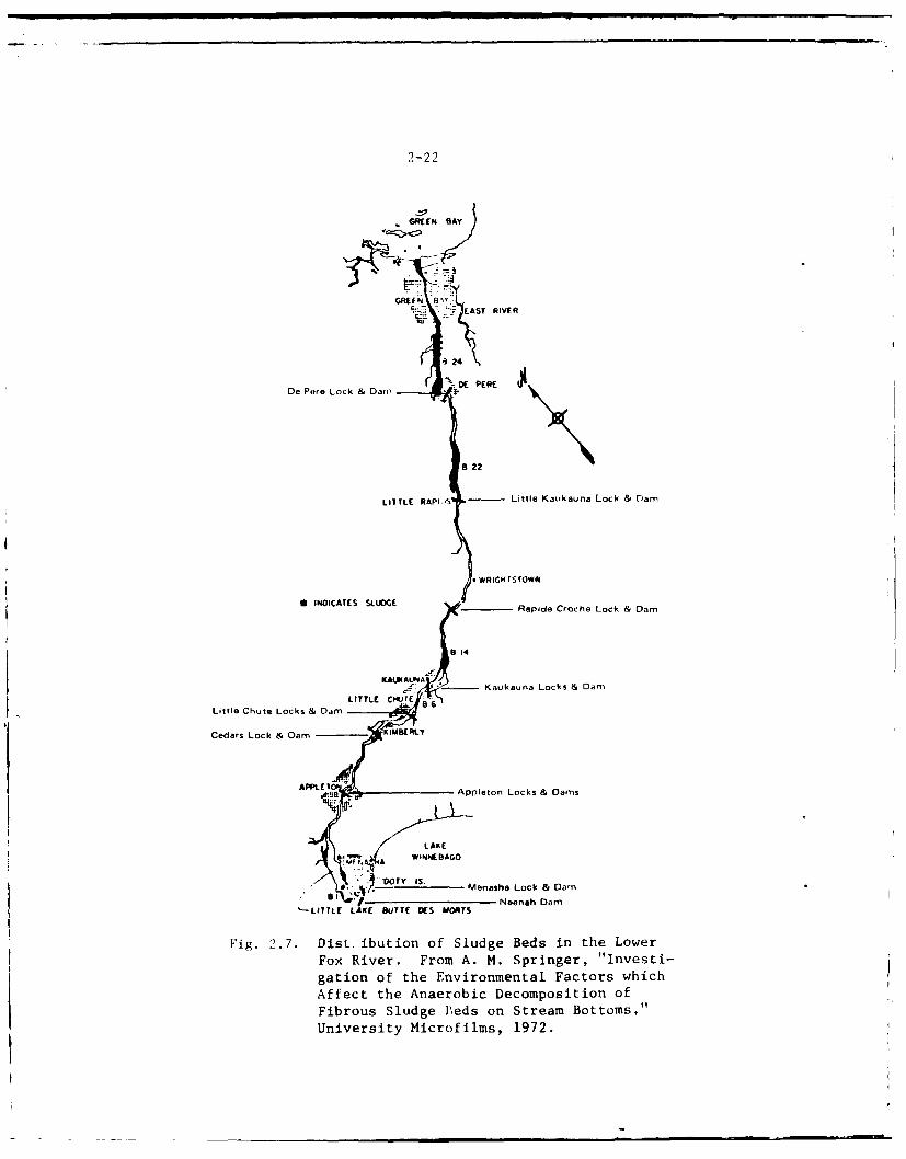
2-22
GREEN IAY
GREEN 8-. EAST RIVER
.3 24
% DE PERE I$De Pere Lock & Dan,
8 22
LITTLE RAPS Little Kaukauna Lock & Dam
1WRIGH rs row*
6 INDICATES SLUDGE - Rapide Croche Lock & Dam
8 14
KAUKAUNdAU -- Kaukauna Locks & Dam
LITTLE CIHUTE 86Little Chute Locks & Dam
Cedars Lock & Dam KIMBERLY
APPLE Appleton Locks & Dams
LAKEf WINI BAGO
Wf0 A
, D Menasha Lock & Dam~- I VNeenah Darn
LITTLE LKE BUTTE DES MORTS
Fig. 2.7. DisLtibution of Sludge Beds in the Lower
Fox River. From A. M. Springer, "Investi-
gation of the Environmental Factors whichAffect the Anaerobic Decomposition of
Fibrous Sludge Peds on Stream Bottoms,"
University Microfilms, 1972.
2-23
2.57Under the present operating rules, the flow in the Lower Fox River isa minor consideration. According to existing law, the primary con-sideration is to maintain high lake levels for navigation purposes.Although attempts are made to reconcile conflicting pressures to main-
tain high lake levels for recreation while releasing as much water aspossible for power generation and waste assimilation in the Lower FoxRiver, under the system of regulation adopted the level on Lake Winnebago
is seldom allowed to fluctuate more than a fraction of the legallyallowable range. Under these operating rules, the flow in the LowerFox fluctuates widely and can be swiftly reduced to quite low valuesduring dry periods to maintain the level in Winnebago, and this furtherreduces the amount of dissolved oxygen being supplied to the Lower Fo:.Records from a IT. S. Geological Survey stream flow gauging station atRapids Croche Dam show the variability of the flow. The monthly meanflow ranges from a maximum of 7,000 cis in April to a minimum of 2,300cfs in September. A more complete range of the monthly mean flows canbe seen in Figure 2.8, which includes reservoir releases data from1896-1970. The maximum recorded flow of 24,000 cfs was observed onApril 18, 1952, and the absolutp minimum of 138 cfs was recorded onAugust 2, 1936.
2.58Attainment of the objectives prescribed by the 1972 Federal WaterQuality Act will require a total regional and cooperative effort aIdit is possible that the current programs of industry and municipalitiesmay have to be supplemented by low flow augmentation ;t times of lowflow. To illustrate the potential value of project storage for low flow
augmentation purposes, a depth of one foot on the Winnebago pool atnormal levels equals a continuous, uniform flow of 1,000 cubic feet persecond for 85 days, or a total volume of 7,355,000 cubic feet.
Suitability for Specific Uses
2.59Domestic - Municipal - The waters of the Wolf region are generallysuitable for domestic use. Hardness, high iron content, high sulfate,and coliform bacteria present management problems. The water of LakeWinnebago and the Lower Fox River require very extensive treatmentbefore they are suitable for domesti ,ise.
2.60Industrial - The waters of the Wolf and central lakes region arereasonably well-suited for industrial uses. The surface water qualityof the Fox River is somewhat comparable to other parts of the industrialmidwest. For most industrial uses at the present site of use, treatmentincluding filtration to remove suspended solids and floating objects;aeration to remove iron; softening to reduce hardness; and clorinationto prohibit slime formation is required.
2.61Recreation - There is no general consensus of opinion on the suitabilityof water for recreation. For example, boating does not necessarily
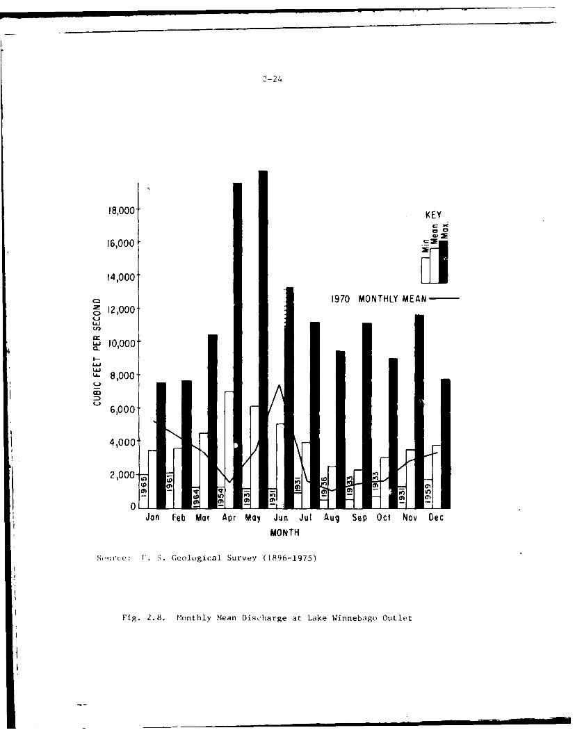
2-24
18,000 KEY
14)000
16,0001
141000']1970 MONTHLY MEAN
0 12,000
Cl)
U" 10,000a-
_ 8,000C.)
6,000
4,000
2,000- n \
Jan Feb Mar Apr May Jun Jul Aug Sep Oct Nov Dec
MONTH
Sorce: 1'. S. Geological Survey (1896-1975)
Fig. 2.8. Monthly Mean Discharge at Lake Winnebago Outlet
2-25
demand aerated, clean water; swimming, however, requires good waterquality and sport fisheries can tolerate only certain limits of oxygendeficiency.
Groundwater
2.62Groundwater in the project study area occurs under both water-table(unconfined) and artesian (confined) conditions. The available ground-water under water-table conditions is found in the glacial drift andnear surface bedrock aquifers.
2.63In the study area the glacial drift deposits generally are thin and havelow permeability due to high clay content. Yields from these aquifersrange from 5 to 100 gpm, 24
2.64The bedrock aquifers occur throughout the study area. The sandstones ofthe Cambrian and Ordovician systems form the principal (and artesian)bedrock aquifer. These units are hydraulically connected, act as oneaquifer, and can yield up to 1,000 gpm.2 4 In the Plattville-Galena forma-tions water occurs in fractures, joints and bedding planes. Yields aregenerally less than 50 gpm. The Niagara Dolomite is an important aquiferin the region (yields up to 100 gpm) 24 but it lies to the east of, andoutside of the studv area.
2.65Groindwater in the project study area is a renewable resource replenished(recharged) by precipitation. The near surface aquifers that containwater under water-table conditions receive recharge by direct percolationof water from the surface to the zone of saturation. The deeper forma-tions that contain water under artesian conditions receive recharge bywater moving down dip from areas of outcrop to deeper parts of the sameformation. Normally, recharge to the groundwater reservoirs is greater inspring when the ground thaws and snow melt and rainwater percolates intothe soil.
2.66Groundwater is discharged naturally from an aquifer by seepage intostreams and lakes, by evapotranspiration, and by springs. Artificialdischarge results from pumping or flowing wells. The project study areastreams and lakes are areas of discharge to which groundwater contributesmost of the flow approximately 90 percent of the time. 24
2.67The movement of groundwater is controlled by discharge, recharge, topog-raphy, and the structure and permeability of the rocks. The movement islocally altered by pumping and recharge or discharge from man-made res-ervcirs. Groundwater moves through an aquifer from areas of recharge
2-26
to areas of discharge. The direction of movement in an aquifer is down
the hydraulic gradient, from areas of high head to areas of low head. The
direction of groundwater movement in the project study area can be deter-
mined using the piezometric map (Fig. 2.9). Groundwater movement is
perpendicular to the contours on the map. Locally, groundwater moves
toward nearby rivers, streams and cones of depression created by heavyindustrial and municipal pumpage as at Fond du Lac, Oshkosh and Neenah-Menasha.
2.68Groundwater levels generally rise In the region in the spring, owing to
thawing of the frost zone which permits recharge from melting snow and iceand from rainfall. The levels then gradually decline during the growingseason because the natural discharge exceeds the recharge. Soil moisturemust be replenished by precipitation before water can recharge the zone of
saturation. Small amounts of precipitation cause little, if any, rechargeto groundwater. Larger amounts of precipitation may cause a rise in waterlevel or temporarily interrupt the normal seasonal decline. Water levelsoften rise in the fall after vegetation has been killed by the frost.They then decline until the following spring, because natural dischargecontinues while recharge is retarded or prevented by the frost zone in thesoil.
2.69Short-term fluctuations reflect intermittent pumping or local day-to-dayvariations in recharge and natural discharge. The fluctuations occurwithin minutes or, at most, within a few days and have only a local effectupon water levels and groundwater's storage.
2.70Seasonal fluctuations reflect variations in recharge and natural dis-charge. The greatest rise in water levels occurs in the spring owing tosnow melt and precipitation. The levels decline during the summer whenthere is little recharge from precipitation, and when natural discharge byspring flow, evaporation, and transpiration is large. In general, )nlyheavy rains contribute significant recharge with a resultant rise iA waterlevel. Water levels continue to decline during the winter, becuse springflow continues and recharge is negligible when frost is in the ground
2.71Fluctuations over a long term reflect differences between recharge andnatural discharge from ye_, to year. The largest declines in water lovelhave occurred in the heavily-pumped areas along Lake Winnebago and theLower Fox River and smaller declines have been recorded in a few otherareas of municipal and industrial pumpage.
2.72Groundwater quality in the project study ir, i varies 'e,:,.drift aquifers and the bedrock aquifers. (,'nerfllv .,Tglacial drift aquifers has d4soived zolids th,it I ,,.,'and seme as high as 400 ppI.' ' Thes, hi,' , .
solids are generally in .i, whet. ,
AD-AIOI 115 CORPS OF ENSINERS CHICASO ILL CHICAGO DISTRICT F/S 13/2'
MAY 77FINAL ENVIROENTAL IMPACT STATEMENT RELATING TO THE OPERATION -ETC""
UNCLASSIFIED NL
MENM
''"I;o"nIIIIII Elnlllllllllllln l 0 rlllIIonll
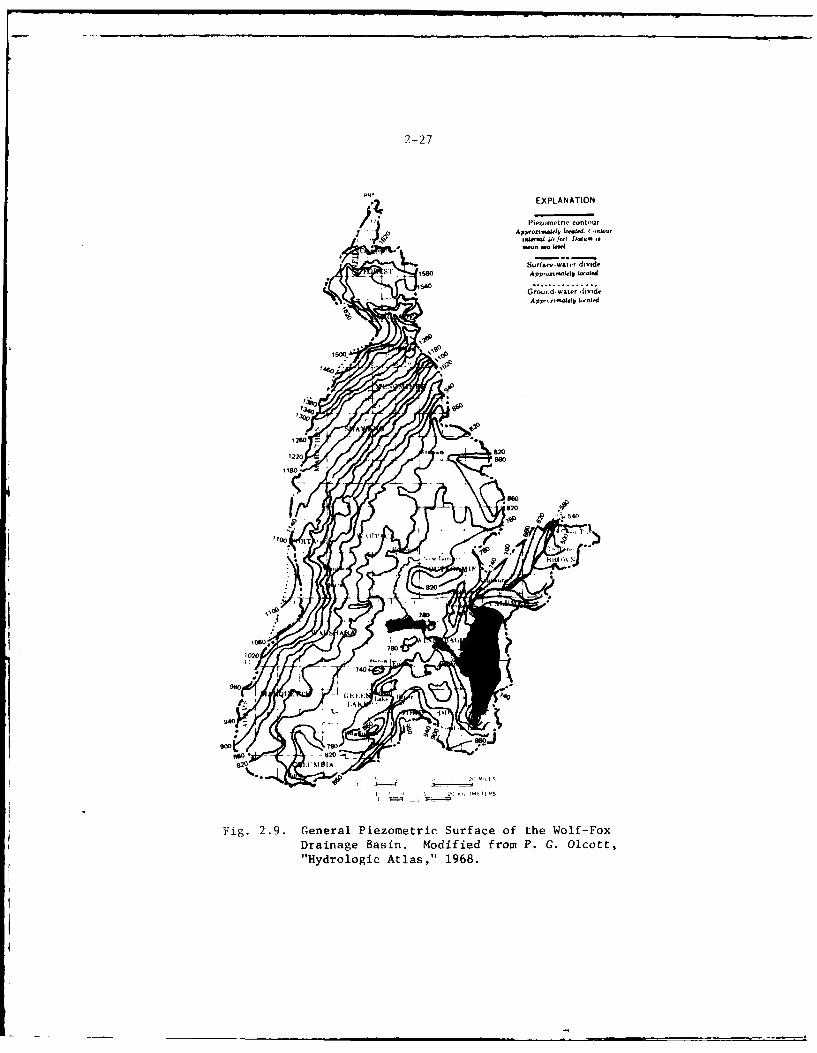
1-2 7
4' EXPLANATION
I'iezurme fr contour
Si 1580 App-oc-Wyd totaWe
Appe-e.a..1 Scaed
0
I 0 stp
'30
Z A
1260
1220 .,820860
1180
8200
1 Hyrolgi Ata t"16.
2-28
moraine predominate. Most glacial-drift water is of the calcium magne-sium bicarbonate type, moderately hard, and high in iron, but generallysuitable for most domestic uses.
2.73The mineral content of water in bedrock aquifers generally increases tothe southeast. Near Lake Winnebago dissolved solids in the water rangefrom 600 to more than 2,000 ppm, increasing toward the east. 2 5 Thewater is of the calcium magnesium bicarbonate type in most of the area,but contains high concentrations of sulfate, chloride, and sodium. Thewater is hard, and in some places contains high iron concentrations.The quality of water from the bedrock aquifers generally is suitable formost domestic, municipal, and industrial usage.
24
2.74Heavy pumpage in the Neenah-Menasha and Oshkosh areas has locally re-versed the natural groundwater movement. This may result in movinghighly mineralized water from the saline-water zone to the pumpingcenters and thereby contaminate the sandstone aquifer, at least locally.Indications of this may be apparent through observed increases in sulfatecontent of groundwater from wells in Neenah.2 5 The project study areahas generally good quality groundwater available in more than adequatesupply for present and projected future development, particularly fromthe bedrock aquifers.
Geology
2.75Physiography and Topography - The Wolf-Fox River Basin in east centraland northeastern Wisconsin is a sub-basin of the Great Lakes - St.Lawrence Seaway drainage system. The upper portion of the Fox-Wolf RiverBasin is within the Superior Uplands province. The lower portion of thissub-basin contains the project study area and is located within theEastern Lakes section of the Central Lowlands physiographic province.
26
Lakes, large and small, are dominant features of this section, includingfour of the Great Lakes and thousands of lesser ones. This physiographicsection is generally blanketed with glacial drift of late Wisconsinsubstages and displays a freshness of glacial topography typifying theCentral Lowlands Province. Prominant end moraines, outwash plains,closed basins (sites of lakes or swamps), eskers, and drumlins areabundant. Till plain topography is rare but areas of gently rollingground moraine are found between end moraines. The lake basins havevaried origins. Some are glacially modified preglacial lowlands, othersare the result of irregular deposition of glacial materials (Lake Winne-bago), still others are kettles in pitted outwash plains. 26
2.76The central and southeastern portion of this basin, the area of con-trolled discharge (Fig. 2.10), is the area of primary concern relative tothis project and its potential impacts. Locally this portion of the Fox-Wolf River Basin extends across two geomorphic subdivisions, the CentralLowlands and the Eastern Ridges and Lowiands (Fig. 2.11).27 In general,
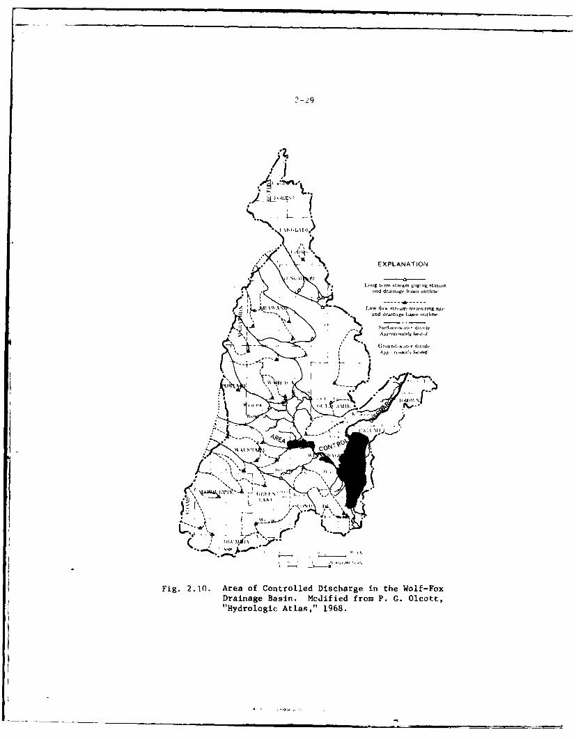
2-Z9
kA . L -
F - EXLNTO
-4 pp ... -1 1-0
4 itd dr..ag ,:tsi o t
'I u.sad rJraifn:,g,. IIihl -tIhne
;r-j .k Er-" -'S r - - ,ra~lIlw,
I' *\, 0 .,, . -I % -
.a&/... ,. I S . "
.UK..,5', ,
4 14 K-.
Fig. 2.10. Area of Controlled Discharge in the Wolf-FoxDrainage Basin. Mcdified from P. G. Olcott,"Hydrologic Atlas," 1968.
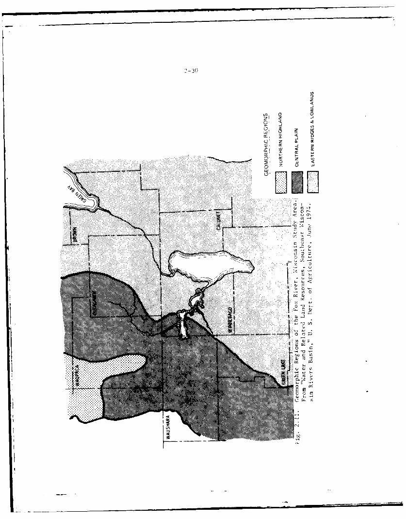
'2 - 0
z
0~ 0
-
cr z U 0C) Z a-
.. .. .. ... ..... .. ... . . . . . . . . . IL. . . . . . ......
u- CN. . . . . . . . . . ... .... ..-...
. . . . . . . . . .
....-4
... ..
...... .....
..... ..... . .
2-31
the topographic features are controlled by the bedrock surface as modi-
fled by glaciation.
2.77Tile Central Plain is characterized by a generally flat to gently rollingsurface. Relief is low except for oucasional resistant bedrock pinnaclesand hills. Elevations range from 750 to 1000 feet MSL. 28
2.78The Eastern Ridges and Lowlands portion of the basin contains numerous
natural lakes and varies from gentle slopes of flat lake plains torolling and hilly ridges with a relief of 100-250 feet. Elevations rangefrom 580 to over 1000 feet MSL.
2.79Bedrock Geology and Stratigraphy - The bedrock geology and stratigraphyin the project area is relatively uncomplicated. The bedrock formations(Fig. E.2), Appendix E, in the project region are mainly 'aleozoic inage, but included at the northwestern boundary of the Fox-Wolf RiverBasin are some Precambrian crystalline rocks. A generalized stratigraphiccolumn, including lithologies and water-yielding characteristics, ispresented in Table E.1, Appendix E.
2.80The Precambrian crystalline basement rocks are exposed at the surface in
a dome-like extension of the Canadian shield that is commonly called theWisconsin dome or arch. The crystalline rocks are predominantly granitebut other types of igneous or metamorphic rock may be present. Thecrystalline rock surface in the project region generally dips about 15 to20 feet/mile to the southeast.
2.81Outcropping around the flanks of this uplift are Paleozoic sedimentaryformations consisting of Cambrian sandstones; Ordovician dolomites,sandstones and shale; and Silurian dolomite. This sedimentary-rocksequence conforms to the slope of the crystalline rock surface andthickens toward the southeast where successively younger rock units formthe bedrock surface.
2.82The subsequent erosion and glaciation of the edges of these strata pro-duced a series of lowlands and northwestward facing escarpments (cuestas).The more resistant strata formed the ridge-like cuestas. Four cuestasmay be recognized in going from the northwest to the southeast in theproject region. These are: (i) the Cambrian sandstone cuesta, (2) thePrairie du Chien cuesta, (3) the Galena-Platteville cuesta, and (4) theNiagara cuesta. The Niagara cuesta, which forms the locally well-knowncliffs (High Cliff State Park) that rise above the eastern rim of LakeWinnebago, extends into Brown and Door Counties.
-.- 32
2.83Surficial Geology - Quaternary deposits include all glacial and alluvialdeposits between the bedrock surface and the land surface. These uncon-solidated deposits consist of clay, silt, sand, gravel, boulders, neat,marl and loess. They occur sorted or unsorted and stratified or un-
* stratified. A map showing Wisconsin glacial deposits is presented asFigure 2.12.
2.84Evidence of four major states of glaciation arc recognized in Wiscon-sin. 29 Deposits laid down during the Cary and Valders substages of theWisconsin (;ia.:iation blanket the region and fill buried bedrock valleys.Cary deposits at- gray to brown and consist of morainal, glaciolacustrire,qome outwash and ice-contact deposits. Valders deposits overlie theCary and are predominantly reddish-brown clay and !;ilt in ground moraineand glaciolacustrine Oeposits laid down in this glacial lake blend with(.ther glacial deposits and in many areas the boundary between them isindistinct. The take deposits generally consist of stratified sandinterbedded with rvd clay and silt.
2.85Alluvium in the project region is generally thin. It consists of sandand gravel deposits in stream channels, peat and marl formed in marshesand lakes, ai'd sand dunes. Thickness of the alluvium ranges from zero toover 90 feet.
2 4
2.86Seismicity - The Fox-Wolf River Basin is located in a region of rela-tively quiet seismic activity. It lies wholly within a zone or minorexpected earthquake damage as plotted on a seismic risk map of the con-terminous United States.1
0
2.uiThere have been six known earthquakes having epicenters in Wisconsin,
four of which were within the Lake Michigan Drainage Basin.1 I The near-est ones to the project area occurred on February 9, 1943, near ThunderMountain, Marinette County, Wisconsin, Modified Me.cali Intensity II (Mr*-1II, and July 18, 1956, near Ootsbirg, Wisconsin (MM-IV). The nearestLtichigan event occurred on March 13, 1905, near Menominee, 'fichigan (MM-V), north of Green Bay.
Soils
2.88The nature of the soils in northeastern Winconsin results from the inter-action of parent materials, relief, climate, plants, animals, and time.Soil differences are caused mainly by parent material and topography. 2'3
The principal soil series occurring in the study area are: Kewaunee,Manawa, Houghton, Poygan, Oshkosh, Rimer, Pella, Allendale and organicsoils. The soils descriptions for these soils 34 are contained in Ap-pendix E.
2-33
uJ w
z
i n T- m
2 0 x < <,~z '0 )z
uj z cc <-J w J ..1 0 0
F-
............ cr -
2-34
2.89Brown County's various soil types are closely related and not easily
differentiated. They are mostly derived from glacial till and outwash
deposits. These are basically rich heavy soils common to gently rolling
countryside. The heavy soils of Brown County are not conducive to in-
filtration and do not allow a large amount of water to seep into thewater table. This is reflected by the general lack of springs as a watersource for the county's small streams. The small streams carry heavy
flows seasonally, during peak runoff periods and during heavy precipi-
tation, but may be dry or contain stagnant water at other times.
2.90Southern Outagamie County's soil types consist of relatively rich soilsderived for the most part from glacial and silt deposits. These fertilesoils are common to the gently rolling landscape, and are the reason overthree-fourths of the land area is used for agricultural endeavors.Outagamie ujunty's soils, particularly those derived from glacial drift,
allow significant amounts of infiltration and as a result influence theamount of recharge to areas drained by the Fox River and local wells usedby industries and municipalities. There is some spring action alsorecharged by this method.
2.91For the most part, the Calumet County's soils are quite heavy, are fer-tile, and are will drained, making them highly desirable agriculturalsoils. These soils generally adversely affect the county's surface waterresources. Precipitation does not readily percolate into the heavy soilsand more runs off than in lighter soils. As a result there is a highrunoff during periods of peak rainfall and during periods of peak snowmelt and little base flow at other periods from ground water seepage.This condition leads to drastic seasonal fluctuations in stream flow andto a large number of intermittent or seasonal streams. Soil erosion isalso accelerated under high flow conditions.
2.92About 68 percent of Fond du Lac County is covered with moderately well-
drained soils, predominantly silt loam, silty clay foams, and clay soils.Soils having poor drainage characteristics constitute approximately 20percent of the total area of the county. The balance of the soils in-cludes a variety of loamy and sandy soils.
2.93Waushara County soils are derived primarily from the weathering ofglacial drift deposits. Since these deposits are products of glacialaction on the cambrian sandstones of the area the resultant soils ofWaushara County are rather sandy. The county's most extensive soils arethe rolling to level sands. The texture of these soils range from a sandto a sandy loam which is generally light brown in color. The easternportion of Waushara County contains red clay soils. These have a char-
acteristic silt loam to clay surface soil, medium brown in color. Thesesoils are moderately well-drained and are by far the best agriculturalsoils found in the county.
II I I .. . . . _ - -I
2-35
2.94Soils found in Waupaca County have been derived primarily from the weath-ering of various glacial deposits that cover the county. The most pre-dominant soils are the red loams of eastern Waupaca County. These aremoderately heavy soils ranging in color from gray-brown to red-brown.Clay substrata can be found anywhere from the surface to two feet belowthe surface. Natural drainage is fair. Wet, peat-muck soils are foundin a band from New London to Fremont.
2.95Small pockets of peat and muck soils are present in lowl.nd areasthroughout the project region. These soils are not well drained natu-rally and are not good agricultural soils.
THE HUMAN ELEMENT
Population Features
2.96The study area includes portions of 8 counties in the upper centralregion of the State of Wisconsin. As shown in Table 2.4, these counties,in aggregate, experienced population growth greater than the statewideaverage for the period 1960-1970. Consistent with this, the regionthrough the year 1990 is expected to increase in population at a ratefaster than that projected for the state as a whole. No projections areavailable for years subsequent to 1990.
2.97Generally those counties projected to grow the fastest are also thosethat are both the largest in terms of present population and decidedlyurban in character. Included are Brown, Outagamie and Winnebago Coun-ties. fable 2.5 lists the population centers for each of these countic.,and the overall urban - non-urban relationship, which ranges from 69percent tt, 79 percent of the total countywide population. This comparesto less than 50 percent for the other counties in the study area. Pre-sumably the highly optimistic population projections in part reflect thiscondition, out of the realization that urban areas typically have rela-tively broad based economies, and are therefore better able to generateand sustain high leveis of growth.
Land Use
2.98Wolf River Region of the Project Study Area - Parts of three countiescomprise the Wolf River region of the project study area; Waupaca County,Waushara County, and Winnebago County. Table 2.6 gives a tabulation ofthe total area, land area and use, and surface water area of the coun-ties. It should be noted that the sources of data for this table arediverse, and that measurements are from different years. Thus, onlyapproximations could be made using the data available.
2
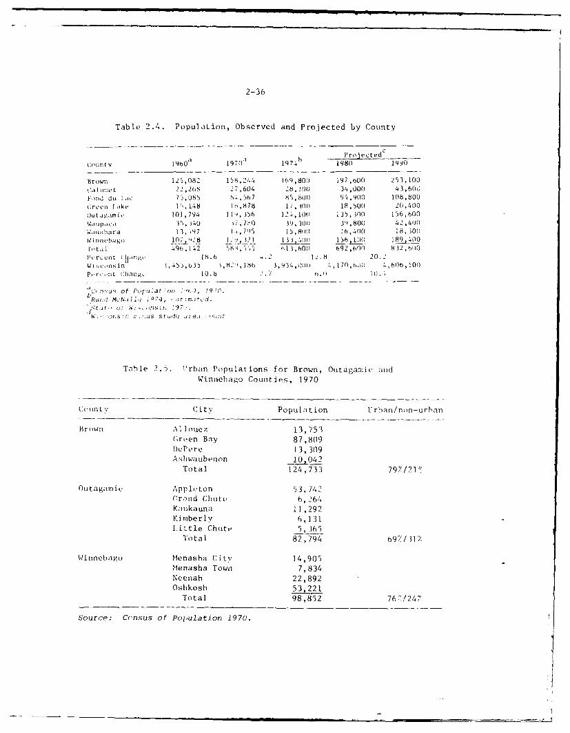
2-36
Table 2.4. Population, Observed and Projected by County
ProjectedcCounty 1960 19701 1974 b 1980 1990
Brown 125,082 158,244 169,800 197,bO 253,100caltunet 22,268 27,604 28, IO) 34,000 43,600
Fond du l..ic 75,085 84,567 85,800 94,900 108,800
Cren lI ake I ) , 148 l t, 878 1, 10)o 18,50() 20,400Outagam i 101,794 P)1, 356 124, 0) i35, 300 156,600
Waupaca I", 140 3 7 7A0 3, )30) 39,80(0 42,400
Wiushara 13, .97 I 705 15,80 16,400 18,300(.0 Imebago j~'1O 028 1 91 13 ,40 156, 100( 18 914 00lota) 4(9, 142 580,5,5 b13,600 692,600 8 12,60Pe rcent ,n., 16.6 -. 2 12.8 20.2Wisconsin $,45),b35 ,82,1 6 3,934, 1(j 4, 170,6o11 4,606,0)P,.r,.-tt C1hange 10.6 .7 .01.
b ' ' : u o f P i, ' IJ a t o n ! " b d , 1 9 " ," .
Pand MLNia) i9 74, s r2matcd.
W. ' or:! [1 2 2 , St u 9 i7 f -11. t
Table 2.5. Urban Populations for Brown, Outagamic andWinnebago Counties, 1970
(Count C ity Population U rhan/non-urban
Brown A lIouez 13,753Green Bay 87,809
D)ePere 13,309
A shwa ubenon 10042
Total 124,733 79%/21
OutagamiL Applt.ton 53, 742Crnd Chute 6,264
Kaukauna 11 ,292Kimberly 6,131Little Chute 5,365
Total 82,794 69,/31/
Winnebago Menasha City 14,905Menasha Town 7,834Neenah 22,892
Oshkosh 53,221Total 98,852 76'/247
Source: Crensus of Polulation 1970.
9-37
• 4 . . .4-0 a .. .40t 0
. .. . . . v. . 0oL4 . .. L4. 14- .- 0o o o n
or , . . .. . ..0 S La,
ao ;oo, o o oo -
-'. La 54. ":
. S , .. . . . i '1 C
0a ILI I 4
02 - ,- - ++ It) 0 0.4.j o g a, 0 -. 0
Dr
E E
0) .'UN"'a"-. OI+ N 4 ..
AG) A ' . ... 3,,<.,,. G
o Ill l l • OI I 0-. . . . .. . . . .
2-38
2.99Waupaca (;ouintv is prirnarilv an agricultural county. F Recreation and
industry are, making inroads into the economic structure of this igri -cultural stronghold, however.36 Primary industries are dairy farming andcropping hut manufactured products include trucks, trailers, campers,foundry products, and plywood products. 37 Numerous canning plants, milk
and chieese processinug plants;, and lumbier mills are aliso 1loca ted in thlecounlt v .
2. 100iiofthle '340 mile,-s of streams in l- aupaca County are lse strn
streams. ' I hie Wo I f Ni 'icr in 1Waupaca County , par ti cularlyv around Fre-mont , is well1 known for i t.- spring runs of Wal leye and Vhitt 13Bass.'ihe c oun ty is aliso popular a,, a vacation area and Lists, heat ing , I ishing,snoiiil hucbnt ing , and , nuring as its rccreational ittrcacti ons,Iii promotional literature, tilte coun ty is des cc Thed as laii lg a ''c leanLnV i r 'ume1n t, a snial 11 own way of- Iif e.* ''
* I0 1The farms- ina tilie caunty are generalv -; mall , fatmily-owned and ,oerat ed,and prov ide work and housing f- r abotut 6000) peoplet (aboutt one(-s-i :.t IiOfthle count v p~opu I at ionl) .3 Seas., na, I "'second homies'' ownersli i p i .5 comm onlwit hin thle , un1t y.
2.10)2on lv threet cit ics. in the county (Clintonville, New London, and Wapici)luave poplpnIat ioni of grea ter than 2500 people and none of thet thre ccc hapojiUlatt-i0[n; inl eXcis ol 0 5000 people.
2 .103
Wauitshara Cotiiit , I ike Waupaca County, is primarily an agr 1 ultucaloun LV. I t li.is thle smalIle ,t pepuliat-i on and smalIlest p)OpI at ion dens it y
if Lile eight countivs in the pro ject study area. No cit its inl the countyhiav.e a popl it ion of as manyv as 2500 people. Therefore, onlly thoseres ident.,a o: thle c i ty of Be c I (Green Lake Cain 1tVy) who are situnated inWauisba ra Loan tv are listed as Uirban residents.
.104Total area, la1nd area and1 la~o, aid waiter airea are shown inl Table .2.()fit cIIS os if Lihe dominant rurail ii Lii r fI tile county and tho ctilnpa rat iye iysmall population (14,795 in l970"') to support such activity, nil c011ij'ce-
hensive county plan or current descriptive literature abtout the count';has been produced . The Coutnt,,' act ivi ties, pl1anning , li fe S tV Ie, e tL care pr imar ii'. oriented toward agriculIture. Recreat iotn and I ouri 511 are
import ant soice s of revenue.
2.1(05Nne Of the project act iv ities occur in Watisia ra Count v itself and allwatersheds of tilt. county ire upst ream of thle proj ect a ct ivMt ies . Tlhcre-fore, tile I ;ind use impacts of thiis county have not becen Consi~dered inldepth.
2-39
2.106
Winnebago County forms the connecting link between the Wolf River region,
the the central or lake region, and the Fox River region of the project
study area. The total area land area and uses, and water area of the
county are shown in Table 2.6. Surface water is generally the prime
factor in the success of recreation in the project study area. Winnebago
County with its several very large to large lakes (Lakes Winnebago,
Poygan, Butte des Morts, Winneconne, Rush, and Little Butte des Morts) is
a prime area for water-related activities such as boating, water skiing,
fishing and swimming.
2.107
The major Winnebago County population centers (and their respective
populations 3 9 ) are: Oshkosh (53,221), Neenah (22,892), and Menasha
(14,905) and the towns of Menasha (7,834), Oshkosh (4,943), Neenah
(3,719) and Algoma--the town which contains part of the city of Oshkosh--
(3,158). All of these places are urbanized, industrial areas.
2.108
Winnebago County is primarily an urbanized county dominated by the activi-
ties of the Oshkosh and Neenah-Menasha areas. Secondarily, the county is
a recreation and tourist area dominated by the water related activities
of Lake Winnebago and the connected Lakes 3utte des Morts, WinTLconne,
and Poygan. However, away from the urban areas and the lakes, the county
possesses a strong agricultural character. Close to the lakes, but awav
from the urban areas, seasonal "second homes" ownership is common and
recreational activities predominate.
2.109
The Central or Lake Region of the Project Study Area - The central or
lake region of the project study area consists of parts of the followingcounties: Waushara, Green Lake, Winnebago, Fond du Lac, and Calumet.
Both Waushara and Winnebago Counties are described above.
2.110
Green Lake County is primarily an agricultural county. Its inclusion as
a county in the study area is required because an estimated 1862 acres is
contained in the Lake Butte des Morts watershed."0 However, this county,
like Waushara County, contains no areas where project activities are
proposed and it lies totally upstream of all such activities. Total
area, land area and use, and water area data have been included for Green
Lake County in Table 2.6. Land-use impact consideration of this county
was not made because of its postulated freedom from project impacts.
2.111
Fond du Lac County has two distinct characters: a local urban setting is
found along the south shoreline of Lake Winnebago while the remainder of
the county is agricultural in character. The area adjacent to Lake
Winnebago contains the City of Fond du Lac and two towns. The 45,389
inhabitants of these political subdivisions comprise about 53.7% of the
entire Fond du Lac County population. Although this area has some in-
dustry, it Is less industrialized than the Oshkosh area and the Neenah-
2-40
Menas1a area noted above, or the Lower Fox River Vallev region which is
discussed subsequently. Table 2.6 shows the total area, land area anduse, and water area data for this county.
2.112Calumet County is primarily agricultural in character, although foursma il urban communities are found in the count.. The urban areas (aindtheir respective populations" ) are: the relatively small Calumet County
area of the City of Appleton (3401), Brillion (2588), Chilton (3030), andNew Holstein (1012). The fact that these four small but separated citi :;contain about t,4.; of the tota i population of the county, attests to the
rural natt;r,.. oI the county. In 1970 the crop and pasture Iods o ci ipied7, of the countv's land area, land developed for nonagricultural pur-
poSt S occuupied onIv 5/., and tIorestcd land and wetlands n;ade up 13-7. '
\ I thoughli much of tile land use Lil Calufe t County along Lake Wiinebago isto a permanunt rather than seasonal nature, recreation is a land use with
a great deal of potential."'
2.113
The Fox River Re ion of the Project Study Area - Portions of Brown andOutacamie Counties comprise tile Fox River Region of the pro! ct -tud"
area. From a land-use standpo int the majority (65/) of Out. gamie ('oIntvis agricultural land (see Tible 2.6). From a population standpoi it
however, the majority of the population (69'') is urban and the arealargcly industrial in character. 'Fle industrial area of the county is
located aloig the Fox River and includes the cities of Appleton, Kimhrlv,Combined L,,c ks, Little Chute, and Kaukauna. 1.ittle industrial act ivitvis iound along the lox River in the area downstream of K.ukaina Lto the.
(tutagamie-Brown Countv line, Outside of the urbanized areas borderingthe Fox River, little industrial activitv is found in fluta ,aamie Count v
and the county is agricultural in character.
2.114WAter-related recreational activitv in I lutagamie County is largely I imit ed
to the Wolf River and Embarras River areas lip:;tream from New london inthe northwest section of the county even though boaters have relativ'elyeasy access to the Fox River from urbanized areas. This is due in partto the poor water quality of the Lower Fox River. From the launchingsites on the Fox River the boaters can move upstream to Lake Wiunn.ahgo ordownstream to Green Bay by using the project's lock system. ofse 0 thelock system from Appleton, particularly in the dowrnstream (Green Bay)direction, is time consuming, however, because of the large number oflocks.
2.115Brown County is the northern-most county in the project study area andtogether with Outagamie County comprises the majority of the shoreline ofthe Lower Fox River between Lake Winnebago and Green Bay. Brown County,like Outagamie County, is primarily agricultural (727) from the rlaud-use
point of view (set, Table 2.6), and also a majority (82/) ot its popula-tion is urban, This urban population resides primarily in and around theCity of Green Bay, whose industrial activity is the dominant force inesablishing t-he character of the county.
2-4 1
2.116Historically, the Green Bay area of Brown County developed in support ofthe Great Lakes-to-interior Wisconsin supply route along the Fox River.Both the industrial rail-shipping spine 4 ,1 and the commercial barge traf-
fic on the Lower Fox River were key elements in this development. With
the advent of modern commercial highway transportation the commercialbarge traffic became obsolete due to the small barge size and tonnage.Green Bay, however, remains a prime industrial city and commercial port
on Lake Michigan and serves the central region of Wisconsin.
2.117
Except for the Green Bay urban industrial area, the remainder of BrownCounty is rural and the primary land use is devoted to small, family-owned farms. Water-related recreational activities are primarily cen-tered in the bay which is a popular resource for all water-relatedactivities. Commercial port facilities in the city of Green Bay make thecity a freshwater seaport. These facilities are largely responsible for
the city of Green Bay's local prominence in industry, commerce, and
transportation.
Water Use
2.118The water resources of the Fox-Wolf region are used extensively through-out the project region. Major flow uses include navigation, hydro-
electric power generation, waste water dilution, and certain types ofrecreation. More important withdrawal uses of the water resource include
domestic and industrial uses. Each of these uses affects the quantityand/or quality of the water resource.
2.119
Navigation - The locks of the Lower Fox River system, which were origi-nally designed for commercial navigation, are now used almost entirely
for movement of recreation craft into Lake Winnebago and Green Bay.Principal avenues of recreational navigation are: the Lower Fox River,
the Winnebago Pool and the Wolf River channel from Lake Winnebago to NewLondon. The generally upward trend of this use is apparent from usagestatistics which show that traffic of craft between the Menasha Locks and
Lake Winnebago nearly doubled during the period 1960 to 1975. It isanticipated that non-commercial traffic on the waterways will continue to
increase.
2.120
Recreation - The regions water resources have assumed rapidly increasingimportance as a major focus for recreational activities, particularlyfishing, hunting, and boating. These activities are making increasingclaims to the use of the region's lakes, streams, and wetlands. Not onlyhave there been numerous conflicts between recreation and other potentialwater uses, but there have also been conflicts between various types ofrecreational activities, such as fishing and power boating. The inten-
sity of boating use primarily for fishing, pleasure cruising, and water
skiing in the project area is concentrated around the larger lakes having
adequate launching facilities and access. Because of its size and
I. I I I U I i
2- 2
,ha ra, o.r, 1,ak, Winnebago provides the widest rangt, of boating opportuni-t i Minor, shiort-term congestion occurs occasionally at the locks
a long,, the I-ox River. Crowded conditions are evident along the WolfRiver, cspct i illy during the spring walleye runs. The intensity ofboating will continue to increase at a rapid rate in the region, bringing
iicrt.ased demands Jor mooring facilities and associated services. Itwill also give rise to further conflicts in water use. Major conflicts
havt also arisen over the preservation of wetlands for fish and wildlife
habitat, and their development for agricultural purposes.
2.121Hydroelectriac Power - The Fox, as a primary source of power, is much
less important today than it was in the past. Historically, the opera-
tion of hydroturbines at dam sites along the Lower Fox River was animportant factor in the development of the region and is summarized inTable 2.7. However, because of the present marginal value of powergenerated, a large percentage of existing hydropower generating capacityis used to serve for peaking power purposes. Also, the number of elec-trical power generation stations in operation on the Lower Fox River hasbeen decreasing over the years. The comon situation has been that whena turbine-generator unit breaks down it is not repaired since power can
be purchased elsewhere at less than the repair cost. There are presentlybetween 12 and 15 separate generating stations in operation. Table 2.7summarizes the information obtained on these stations. The installedflow capacities reflect both electrical power generation and mechanicaldrives for other purposes. The owners of the power stations can bedivided into three classes: industrial, publicly owned utility, andprivately owned utility. They produce electricity for commercial, resi-dential, and industrial use. In some cases power is produced exclusivelyfor an individual company while in other cases it is sold to varioususers.
2.122Domestic and Industrial Water Supplies - Demands for domestic and in-dustrial water supplies in the region are growing steadily, and althoughthe region as a whole has ample resources to meet these demands, short-ages may arise in some parts of the region. The growth in municipalwater demands has been especially great in the larger cities, notablyOshkosh and Appleton. Most of the water used by industry in the regionis accounted for by pulp and paper manufacturers. It is not possible onthe basis of data currently available to estimate present and futureoverall municipal and industrial water use requirements for the region.
Much more penetrating studies would be required.
2.123About 20 percent of all the water withdrawn in the region is withdrawn bypublic water utilities and by local government bodies for domestic watersupplies, commercial uses, and certain industrial uses, and for suchpurposes as fire-fighting, street-washing, and so on.4 0 Four communities(Appleton, Oshkosh, Neenah, and Menasha) depend on surface water supplies;others depend primarily on groundwater. In most cases some treatment isrequired, particularly where water for drinking purposes is involved.
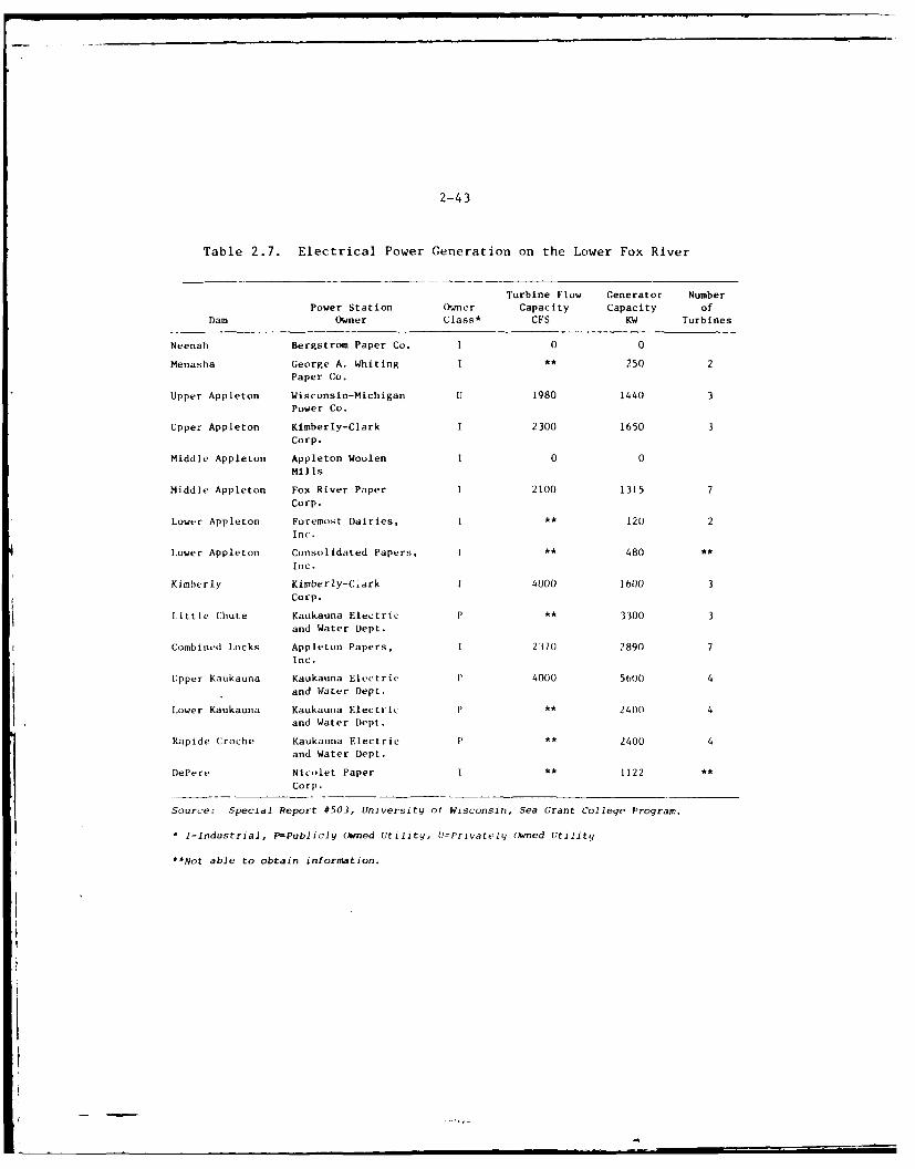
2-43
Table 2.7. Electrical Power Generation on the Lower Fox River
Turbine Flow Generator Number
Power Station Owner Capacity Capacity ofDam Owner Class* CFS KW Turbines
Neenah Bergstrom Paper Co. 1 0 0
Menasha George A. Whiting I ,4 250 2Paper Co.
Upper Appleton Wisconsin-Michigan U 1980 1440 3Power Co.
Upper Appleton Kimberly-Clark I 2300 1650 3Corp.
Middle Appleton Appleton Woolen 1 0 0Mills
Middle Appleton Fox River Paper 1 2100 1315 7
Corp.
Lower Appleton Foremost Dairies, I 44 120 2Inc.
Lower Appleton Consolidated Papers, 1 .4 480 44
Inc.
Kimberly Kimberly-Clark 1 4000) 160 3Corp.
Little Chute Kaukauna Electric P .4 3300 3and Water Dept.
Combined Locks Appleton Papers, I 2370 2890 7Inc.
Upper Kaukauna Kaukauna Electric 11 4000 56O0 4and Water Dept.
Lower Kaukauna Kaukauna Electric 14 2400 4and Water Dept.
Rapide Croche Kaukauna Electric P ** 2400 4and Water Dept.
DePere Nicolet Paper I ** 1122 4.
Corp.
Source: Special Report #503, University ot Wisconsin, Sea Grant College Program.
I=Industrial, P=Publicly Owned Utility, VJPrivately Owned Utility
"Not able to obtain information.
2-44
Less than 10 percent of Lhe water withdrawn for public water supplies isconsumed; the remainder returns to streamflow after use.4
0
2.124The Lower Fox River area is the most industrialized region in the projectarea. There is a heavy development of paper mills resulting in thegreatest concentration of pulp and paper industry in the state. Con-siderable use is made of the stream for industrial and cooling watersupply.
2.125Waste Dilution and Removal - The rivers and lakes of the region are alsoused for diluting and removing wastes from municipalities and industries.The most intensive use of the region's water resources for these purposesis along the shores of Lake Winnebago and the Lower Fox River. As a
general rule, one cubic foot per second (I cfs) of river water willsatisfy a waste loading of 26 lbs BOD. The mean flow of the Lower FoxRiver is 4139 cfs, implying a capacity to satisfy a BOD loading of about98,000 lbs. Sometimes the BOD loading is in excess of this amount.Moreover, flows considerably less than 4139 cfs are experienced on theLower Fox River at times. Accordingly, serious problems of waste dis-posal are experienced. Other streams in the region are also used for
waste dilution and disposal, notably the Wolf River. Waste loadings,however, have been relatively minor in comparison with those in LakeWinnebag,, and along the Lower Fox River.
Development and Economy
2.126Agriculture - In the period 1964-1969, the number of farms and total farmacreage in the region decreased slightly. However, the average acreageper farm increased. This trend has been noted on a national level.
Table 2.8 displays selected agriculture statistics for the 8-countyregion. With the exception of Waukesha County, the vast majority of thefarm based revenues were generated by livestock, poultry and alliedproducts. Within this general category, dairy products were the prime
revenue producers. Of the cash crops, corn, hay and oats were the mainsources of revenue.
2.127Manufacturing - During the period 1967-1972, the number of manufacturingfirms in the region decreased slightly as did the level of sectoral
employment. However, individually several counties experienced sizeableincreases in manufacturing employment, the most notable being the 8
percent increase in Brown County. At the same time, the number ofworkers in this sector decreased by about 9 percent in Winnebago County.The stability of manufacturing employment for the region relative to thestate as a whole is evidenced by the increase in share attributed to theregion over the period of measure. This is also reflected in the regions
increasing share of statewide value added in manufacturing. In absoluteterms, the largest contributor to this category was Brown County($383,600,000). The major manufacturers in the county produce paperproducts, construction machinery and cheese. Fond du Lac County recorded
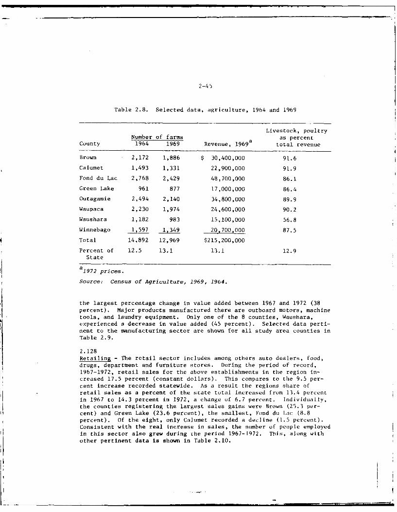
2-45
Table 2.8. Selected data, agriculture, 1964 and 1969
Livestock, poultryNumber of farms as percent
County 1964 1969 Revenue, 1969 total revenue
Brown 2,172 1,886 $ 30,400,000 91.6
Calumet 1,493 1,331 22,900,000 91.9
Fond du Lac 2,768 2,429 48,700,000 86.1
Green Lake 961 877 17,000,000 86.4
Outagamie 2,494 2,140 34,800,000 89.9
Waupaca 2,230 1,974 24,600,000 90.2
Waushara 1,182 983 15,100,000 56.8
Winnebago 1,597 1,349 20,700,000 87.5
Total 14.892 12,969 $215,200,000
Percent of 12.5 13.1 13.1 12.9State
a19 72 prices.
Source: Census of Agriculture, 1969, 1964.
the largest percentage change in value added between 1967 and 1972 (38percent). Major products manufactured there are outboard motors, machinetools, and laundry equipment. Only one of the 8 counties, Waushara,experienced a decrease in value added (45 percent). Selected data perti-nent to the manufacturing sector are shown for all study area counties inTable 2.9.
2.128Retailing - The retail sector includes among others auto dealers, food,drugs, department and furniture stores. During the period of record,1967-1972, retail sales for the above establishments in the region in-creased 17.5 percent (constant dollars). This compares to the 9.5 per-cent increase recorded statewide. As a result the regions share ofretail sales as a percent of the state total increased from 13.4 percentin 1967 to 14.3 percent in 1972, a change of 6.7 percent. Individually,the counties registering the largest sales gains were Brown (25.3 per-cent) and Green Lake (23.6 percent), the smallest, Fond du Iac (8.8percent). Of the eight, only Calumet recorded a decline (1.5 percent).Consistent with the real increase in sales, the number of people employedin this sector also grew during the period 1967-1972. This, along withother pertinent data is shown in Table 2.10.
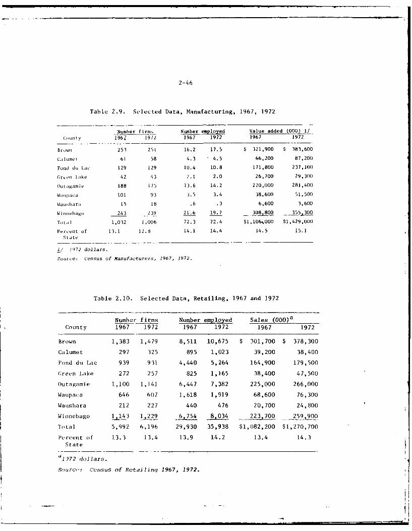
2-46
Table 2.9. Selected Data, Manufacturing, 1967, 1972
Number firms Number employed Value added (000) 1/_County 196Z 1972 1967 1972 1967 1972
Brown 253 251 16.2 17.5 $ 321,900 $ 383,600
CaIumet 61 58 4.3 4.5 66,200 87,200
Fond du Lac 129 129 10.4 10.8 171,800 237,100
Green lake 42 43 2.1 2.0 26,700 29,300
Outagamie 188 175 13.6 14.2 220,000 281,400
Waupaca 101 93 3.5 3.4 38,600 51,500
Waushara 15 18 .6 .3 6,600 3,600
Winnebago 243 239 21.6 19.7 308,800 355,300
Total 1,032 1,006 72.3 72.4 $1,106%000 $1,429,000
Percent of 13.1 12.8 14.1 14.4 14.5 15.1
State
l/ 1972 dollars.
Source: Census of Manufacturers, 1967, 1972.
Table 2.10. Selected Data, Retailing, 1967 and 1972
Number firms Number employed Sales (0 0 0 )aCounty 1967 1972 1967 1972 1967 1972
Brown 1,383 1,479 8,511 10,675 $ 301,700 $ 378,300
Calumet 297 325 895 1,023 39,200 38,400
Fond du Lac 939 931 4,440 5,264 164,900 179,500
Green Lake 272 257 825 1,165 38,400 47,500
Outagamie 1,100 1,141 6,447 7,382 225,000 266,000
Waupaca 646 607 1,618 1,919 68,600 76,300
Waushara 212 227 440 476 20,700 24,800
Winnebago 143 229 6,754 8,034 223,700 259,900
Total 5,992 6,196 29,930 35,938 $1,082,200 $1,270,700
Percent of 13.3 13.4 13.9 14.2 13.4 14.3State
1972 dollars.
Sourco: Census of Retailinq 1967, 1972.
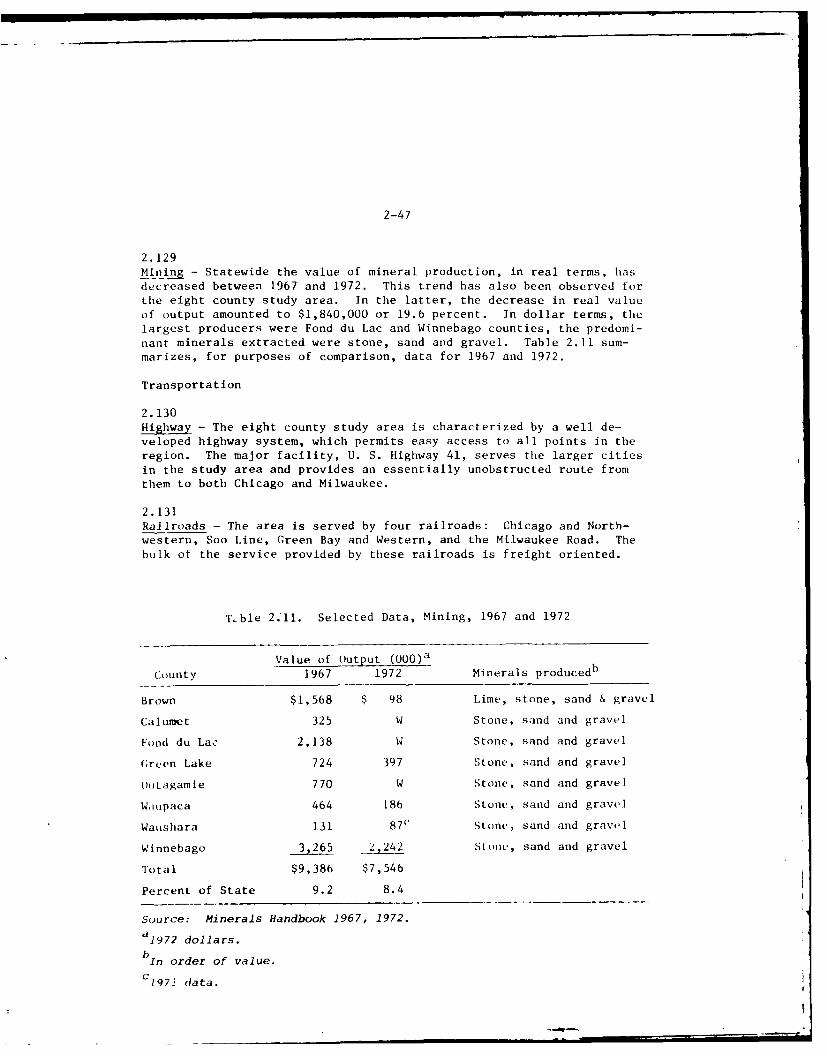
2-47
2.129Mining - Statewide the value of mineral production, in real terms, has
decreased between 1967 and 1972. This trend has also been observed fortile eight county study area. In the latter, the decrease in real valueof output amounted to $1,840,000 or 19.6 percent. In dollar terms, the
largest producers were Fond du Lac and Winnebago counties, the predomi-nant minerals extracted were stone, sand and gravel. Table 2.11 sum-marizes, for purposes of comparison, data for 1967 and 1972.
Transportation
2.130Highway - The eight county study area is characterized by a well de-veloped highway system, which permits easy access to all points in theregion. The major facility, U. S. Highway 41, serves the larger citiesin the study area and provides an essentially unobstructed route fromthem to both Chicago and Milwaukee.
2.131Railroads - The area is served by four railroads: Chicago and North-western, Soo Line, Green Bay and Western, and the Milwaukee Road. Thebulk of the service provided by these railroads is freight oriented.
Thble 2.'11. Selected Data, Mining, 1967 and 1972
Value of Output (000 )a
County 1967 1972 Minerals producedb
Brown $1,568 $ 98 Lime, stone, sand & gravel
Calumet 325 W Stone, sand and gravel
Fond do Lac 2,138 W Stone, sand and gravel
Green Lake 724 397 Stone, sand and gravel
Outagamle 770 W Stone, sand and gravel
W.itpaca 464 186 Stone, sand and gravel
Waushara 131 87" Stone, sand and gravel
Winnebago 3,265 2,242 Stone, sand and gravel
Total $9,386 $7,546
Percent of State 9.2 8.4
Source: Minerals Handbook 1967, 1972.a19 72 dollars.
bIn order of value.
C1 9 7 1 data.
2-48
2. 132Air - Three commercial airports are within the eight county study area.These are located at Green Bay, Oshkosh and Appleton. North CentralAirlines maintains regularly scheduled flights to Green Bay and Oshkosh,Air Wisconsin to Appleton.
2.133Water - Water transportation is possible from Green Bay to Lake Winnebagovia the Lower Fox River and from Lake Winnebago to New London and beyondvia the Upper Fox River and Wolf River. From Green Bay to Lake Winnebago,water transportation is generally limited by the channel depth (six feetbelow standard low water level but 5.5 feet in the locks), the small locksizes (144 feet long by 35 feet wide usable space), and the large numberof locks (17). The latter results in a minimum lockage time of about4.25 hours for a one-way trip. 0 From 'le Menasha lock to the mouth ofthe Wolf River in Lake Butte des Morts, navigation channels are alsomaintained to a channel depth of 6 feet below standard low water level.The navigation channel in the Wolf River from its mouth at Big Lake Buttedes Morts to New London, a distance of 47 miles, is generally maintainedto a channel depth of 4 feet below standard low water.
Recreation Features
2.134The forms of recreation that fall within the perview of this report areboating, canoeing, fishing, hunting, swimming, camping, picnicking,sightsecing, nature study, and several winter sports. Accordingly, thefollowing discussion will concentrate on the above, from both a facilitysupply and usage standpoint. Since boating and fishing are the recrea-tional activities most directly affected by project operation and mainte-nance, these activities have been given the most attention.
2.135Boating - Recreational boating is use of the more popular form of outdoorrecreation in the 8-county area. This is evidenced by the dramatic in-crease in boat registrations recorded in the period 1970-1974 which isshown in Table 2.12. Comparison of this table with Table 2.4, whichshows the observed and estimated population for the region, indicatesthat boat registrations have increased more than in proportion to popu-lation changes. Whereas in 1970 one boat was registered per 14.6 per-sons, in 1974 one boat was registered for each 12.2 persons. In bothinstances the density of boat ownership is slightly greater than thatrecorded for the state as a whole.
2.136Boating, Harbor Facilities - Table 2.13 summarizes the harbor facilitiesavailable to boaters on Lake Winnebago, the Lower Fox River and the UpperFox and Wolf Rivers. This data, published in 1968, represents the lastcomprehensive survey of facilities in tile region. 10 However, in view ofthe marked increase in regional boat ownership, it is reasonable tobelieve that the number of recreational navigation facilities has grownthrough time.
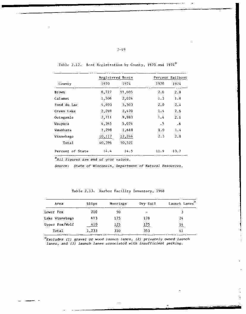
2-49
Table 2.12. Boat Registration by County, 1970 and 19 74a
Registered Boats Percent Sailboat
County 1970 1974 1970 1974
Brown 8,727 11,605 2.0 2.8
Calumet 1,506 2,024 1.3 1.8
Fond du Lac 4,403 5,503 2.0 2.4
Green Lake 2,269 2,470 1.4 2.6
Outagamie 7,711 9,983 1.4 2.1
Waupaca 4,365 5,074 .5 .6
Waushara 1,298 1,618 1.0 1.4
Winnebago 10,117 12,244 2.3 2.8
Total 40,396 50,521
Percent of State 14.4 14.5 11.9 13.7
aAll figures are end of year values.
Source: State of Wisconsin, Department of Natural Resources.
Table 2.13. Harbor Facility Inventory, 1968
Area Slips Moorings Dry Sail Launch Lanesa
Lower Fox 210 50 - 3
Lake Winnebago 613 175 178 24
Upper Fox/Wolf 410 125 175 14
Total 1,233 350 353 41
aExcludes (1) gravel or wood launch lanes, (2) privately owned launchlanes, and (3) launch lanes associated with insufficient parking.
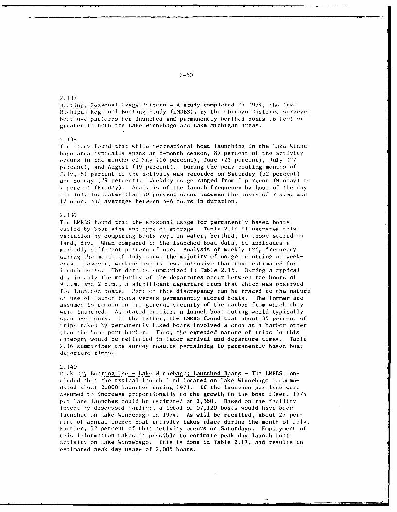
2-50
2.137B-oat iing, Seasonal Usage Pattern - A study completed in 1974, the LAkeMichigan Regional Boating Study (LMRBS), by tile Chicago District surveyt.dboat use patterns for launched and permanently berthed boats 16 feet orgreater in both the Lake Winnebago and Lake Michigan areas.
2. 138The study found that while recreational boat launching in the Lake Winne-bago area typically spans an 8-month season, 87 percent of the activityoccurs in the months of May (16 percent), June (25 percent), July (27percent), and August (19 percent). During the peak boating months ofJuly, 81 percent of the activity was recorded on Saturday (52 percent)and Sunday (29 percent). Weekday usage ranged from 1 percent (Monday) to7 perc-nt (Friday). Analysis of the launch frequency by hour of the dayfor July indicates that 60 percent occur between the hours of 7 a.m. and12 noon, and averages between 5-6 hours in duration.
2. 139The LMRBS found that the seasonal usage for permanently based boatsvaried by boat size and type of storage. Table 2.14 illustrates thisvariation by comparing boats kept in water, berthed, to those stored onland, dry. When compared to the launched boat data, it indicates amarkedly different pattern of use. Analysis of weekly trip frequencyduring the month of July shows the majority of usage occurring on week-ends. However, weekend use is less intensive than that estimated forlaunch boats. The data is summarized in Table 2.15. During a typicalday in July the majority of the departures occur between the hours of9 a.m. aiid 2 p.m., a significant departure from that which was observedfor launched boats. Part of this discrepancy can be traced to the natureof use of launch boats versus permanently stored boats. The former areassumed to remain in the general vicinity of the harbor from which theywere launched. As stated earlier, a launch boat outing would typicallyspan 5-6 hours. In the latter, the LMRBS found that about 35 percent oftrips taken by permanently based boats involved a stop at a harbor otherthan the home port harbor. Thus, the extended nature of trips in thiscateogry would be reflected in later arrival and departure times. Table2. 16 summarizes the survey results pertaining to permanently based boatdeparture times.
2.140Peak Day Boating Use - Lake Winnebago; Launched Boats - The LMRBS con-eluded that the typical launch 1;tnd located on Lake Winnebago accommo-dated about 2,000 launches during 1971. If the launches per lane wereassumed to increase proportionally to the growth in the boat fleet, 1974per lane launches could be estimated at 2,380. Based on the facilityinventory discussed earlier, a total of 57,120 boats would have beenlaunched on Lake Winnebago in 1974. As will be recalled, about 27 per-cent of annual launch boat activity takes place during the month of July.Further, 52 percent of that activity occurs on Saturdays. Employment ofthis information makes it possible to estimate peak day launch boatactivity on L.ake Winnebago. This is done in Table 2.17, and results inestimated peak day usage of 2,005 boats.
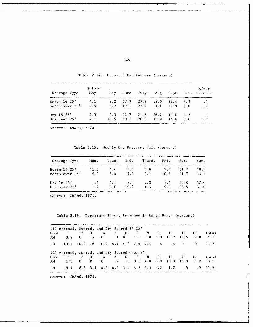
2-51
Table 2.14. Seasonal Use Pattern (percent)
Before Aft erStorage Type May May June July Aug. Sept. Oct. October
Berth 16-25' 4.1 8.2 17.2 22.8 23.9 i6.4 6.5 .9Berth over 25' 2.5 8.2 19.1 22.4 21.1 17.9 7.6 1.2
Dry 16-25' 4.3 8.3 14.7 21.8 26.4 16.0 8.3 .3Dry over 25' 7.1 10.6 19.2 20.5 18.9 14.6 7.6 1.6
Source: IMRBS, 1974.
Table 2.15. Weekly Use Pattern, July (percent)
Storage Type Mon. Tues. Wed. Thurs. Fri. Sat. Sun.
Berth 16-25' 11.3 4.6 3.5 2.0 8.0 31.7 38.9Berth over 25' 5.9 5.4 7.1 3.1 10.5 31.7 30.1
Dry 16-25' .6 1.1 7.3 2.8 3.4 52.8 32.0Dry over 25' 5.7 3.0 10.7 4.5 9.6 35.5 31.0
Source: LMRBS, 1974.
Table 2.16. Departure Times, Permanently Based Boats (percent)
(1) Berthed, Moored, and Dry Stored 16-25'Hour 1 2 3 4 5 6 7 8 9 10 11 12 TotalAM 3.8 0 .7 0 .1 0 1.1 2.0 7.0 13.7 12.5 8.8 54.7
PM 13.1 10.9 .6 10.4 4.1 4.2 2.4 2.4 .4 .4 0 0 45.3
(2) Berthed, Moored, and Dry Stored over 25'Hour 1 2 3 4 5 6 7 8 9 10 11 12 TotalAM 1.3 0 0 0 .2 .8 3.3 4.0 8.9 10.3 15.3 6.0 50.1
PM 9.1 8.8 5.1 4.3 4.2 5.9 4.7 3.5 2.2 1.2 .5 .3 49.9
Source: LMRBS, 1974.
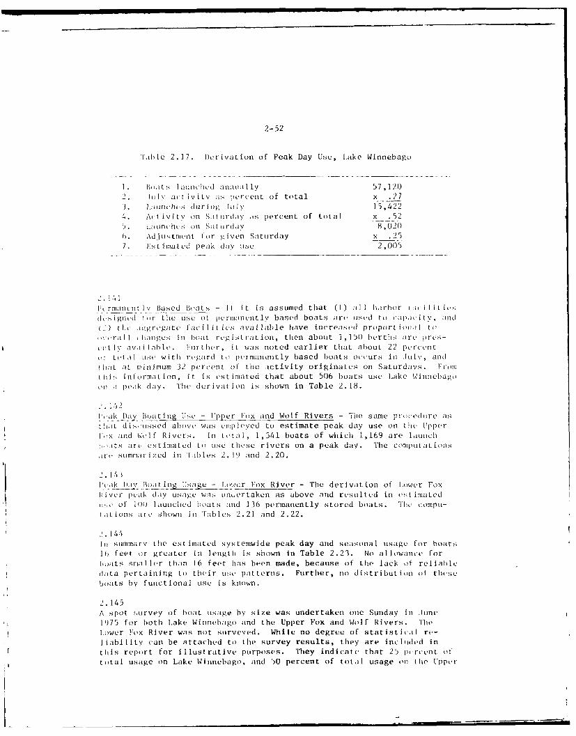
2-52
Table 2.17. Derivation of Peak Day Use, lake Winnebago
. oIts laonchLd antnua lly 57,120i. i Il activity ,as lercent of total x .27
3. launc'hes during July 15,4224. Activitv on Slt irday as percent of total x .52
. Launches on Sat urdav 8,020. Adjustment -or given Saturday x .257. Estimated peak dav use 2,005
2.14111,rmanent lv Based Boats - If it is assumed that (I) all h arbor I A(i Ii Litsdels igned o r the use o1 permalnenitly based boats are uIISed to capapacitv, and
H ) thie aggregate facilitis available have increased proportiof l toxc ,rail li;nges in boat regi t ration, then about 1,15(0 berths are pres-
L1t lv av1 i laIbe. Further, it was noted earlier that about 22 percentOf total elt, with regard to permanently based boats occurs in lINuy, andtlhat at minimum 32 percent of the activity originates on Saturdays. Fromtii s information, it is estimated that about 506 boats use Lake Winnebago(,ii ;i peak day. The derivation is shown in Table 2.18.
u.142I',iak Day Boating Use - l'ple-r Frox and Wolf Rivers - The same procedure asth),it disuissed above was emplvyed to estimate peak day use on tie UpperI,,x and Wolf Rivers. In total, 1,541 boats of which 1,169 are launch
its are estimated to use these rivers on a peak day. The computat ionsire summrized in tFables 2.19 and 2.20.
2 . 1 43
Plyak D),iv BoatijT2 ijsae - Lower Fox River - The derivation of Lower Foxkiver peak dly usage was nuertaken as above and resulted in estimatedti ,e of 1)0 launcihed boats and 136 permanently stored boats. 'lie compil-
at ions are, shown in Tables 2.21 and 2.22.
144In summary the estimated systemwide peak day and seasonal usage for boatslb feet or greater in length is shown in Table 2.23. No allowance forIboats smaller than 16 feet has been made, because of the lack of reliabledaLta pertaining to their use patterns. Further, no distribution of theseboats by functional use is known.
2.145A spot survey of boat tsage by size was undertaken one Sunday in fune1H75 for both Lake Winnebago and the Upper Fox and Wolf Rivers. TheLower lox River was not surveyed. While no degree of statistical re-liability can be attached to the survey results, they are included inthis report for illustrative purposes. They indicate that 25 percent oftotal usage on Lake Winnebago, and 50 percent of total usage on tie Upper
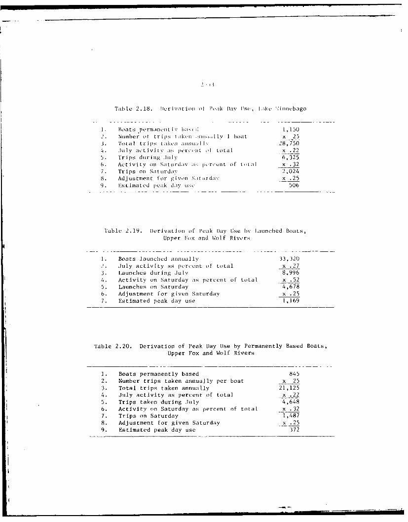
2- 1
Table 2.18. Derivation oif Peak Day Use, l..ik ',innebago
I Boats permanent Iv lai L , 150
2. Number ot trips t aken ., ,.n 1ly I boat x 25
3. Total trips t;aken allon Iv 28,7504. July act ivity as pero.nt of total x .225. Trips during July 6,3256. Activity on Saturdav ,; porcent of ttlI x .327. Trips on Sat urdav 2,024
8. Adjustment for givn Sitordav x .25
9. Estimated peak day u;c 506
Table 2. 19. Derivation of Peak Day Use b Launched Boats,
Upper lox and Wolf Rivers
1. Boats launched annually 33,320
2. July activity as percent of total x .27
3. Launches during July 8,9964. Activity on Saturday as percent of total x .525. Launches on Saturday 4,678
6. Adjustment for given Saturday x .25
7. Estimated peak day use 1,169
Table 2.20. Derivation of Peak Day Use by Permanently Based Boats,
Upper Fox and Wolf Rivers
1. Boats permanently based 845
2. Number trips taken annually per boat x 253. Total trips taken annually 21,125
4. July activity as percent of total x .22
5. Trips taken during July 4,648
6. Activity on Saturday as percent of total x .32
7. Trips on Saturday 1,4878. Adjustment for given Saturday x .259. Estimated peak day use 372
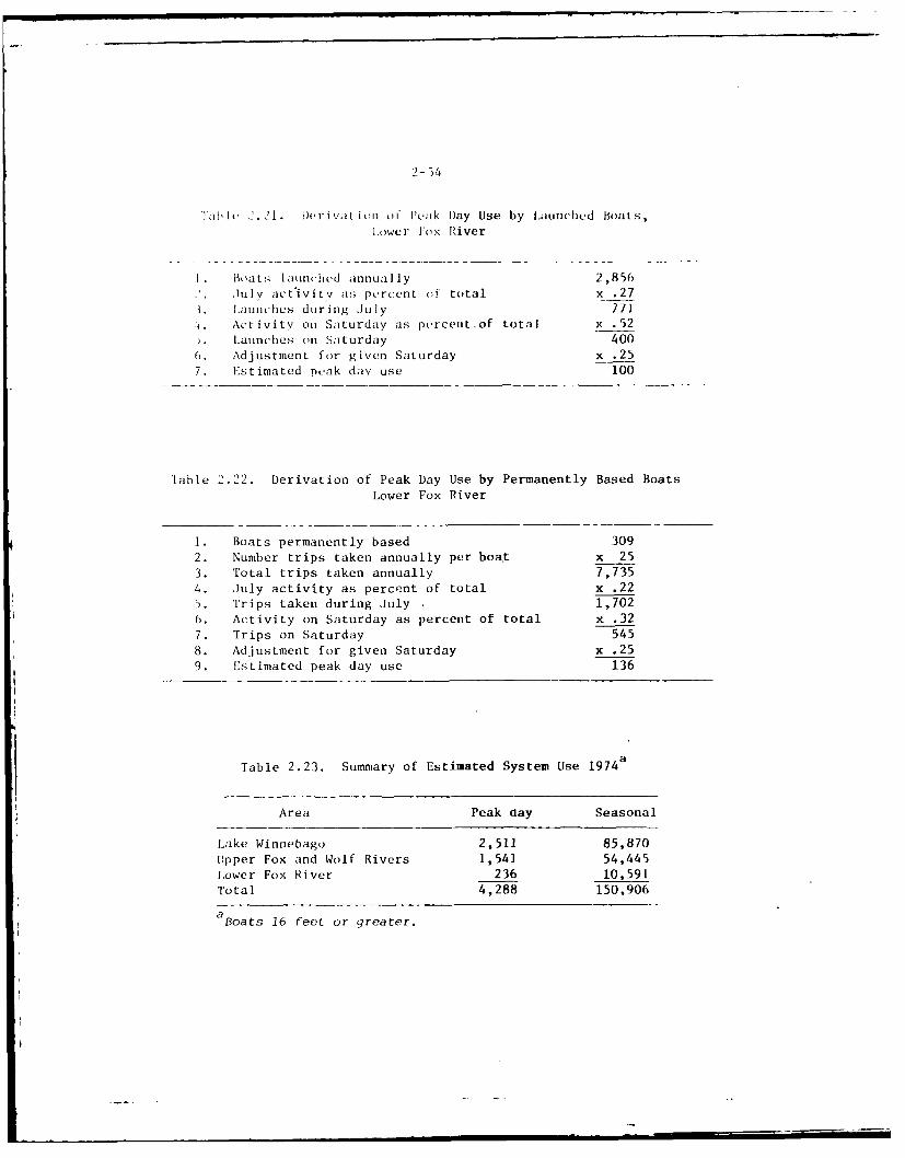
2-54
l abIl 2.21. I)erivation of leak Day Use by Launched Boats,
l,ower I'ox River
I. Boats launchtcd annually 2,856
lllv act ivitv as percent of total x .273. L1aunthes during July 7714 Activity on Saturday as percent. of total x . 52
. Launches on Saturday 400
0. Adjustment for given Saturday x .257. Estimated peak day use 100
Table 2.22. Derivation of Peak Day Use by Permanently Based Boats
Lower Fox River
1. Boats permanently based 3092. Number trips taken annually per boat x 253. Total trips taken annually 7,735
4. July activity as percent of total x .22
5. Trips taken during July 1,702
6. Activity on Saturday as percent of total x .32
7. Trips on Saturday 545
8. Adjustment for given Saturday x .25
9. Estimated peak day use 136
Table 2.23. Summary of Estimated System Use 1974a
Area Peak day Seasonal
Lake Winnebago 2,511 85,870
Upper Fox and Wolf Rivers 1,541 54,445Lower Fox River 236 10,591
Total 4,288 150,906
aBoats 16 feet or greater.
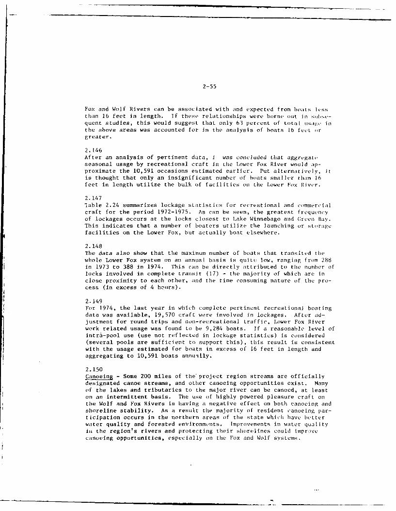
2-55
Fox and Wolf Rivers can be associated with and expected from boats lessthan 16 feet in length. If these relationships were borne out in subse-quent studies, this would suggest that only 63 percent of total usage inthe above areas was accounted for in the analysis of boats lb fect )rgreater.
2.146After an analysis of pertinent data, i was concluded that aggregateseasonal usage by recreational craft in the Lower Fox River would ap-proximate the 10,591 occasions estimated earlier. Put alternatively, itis thought that only an insignificant number of boats smaller than 16feet in length utilize the bulk of facilities on the Lower Fox River.
2.147!able 2.24 summarizes lockage statistics for recreational and commercialcraft for the period 1972-1975. As can be seen, the greatest frequencyof lockages occurs at the locks closest to Lake Winnebago and Creen Bay.This indicates that a number of boaters utilize the launching or storagefacilities on the Lower Fox, but actually boat elsewhere.
2.148The data also show that the maximum number of boats that transited thewhole Lower Fox system on an annual basis is quite low, ranging from 288in 1973 to 388 in 1974. This can be directly attributed to the number oflocks involved in complete transit (17) - the majority of which are inclose proximity to each other, and the time consuming nature of the pro-cess (in excess of 4 hours).
2.149For 1974, the last year in which complete pertinent recreational boatingdata was available, 19,570 craft were involved in lockages. After ad-justment for round trips and non-recreational traffic, Lower Fox Riverwork related usage was found to be 9,284 boats. If a reasonable level ofintra-pool use (use not reflected in lockage statistics) is considered(several pools are sufficient to support this), this result is consistentwith the usage estimated for boats in excess of 16 feet in length andaggregating to 10,591 boats annually.
2.150Canoeing - Some 200 miles of the project region streams are officiallydesignated canoe streams, and other canoeing opportunities exist. Manyof the lakes and tributaries to the major river can be canoed, at leaston an intermittent basis. The use of highly powered pleasure craft onthe Wolf and Fox Rivers is having a negative effect on both canoeing andshoreline stability. As a result the majority of resident canoeing par-ticipation occurs in the northern areas of the state which have betterwater quality and forested environments. Improvements in water qualityii the region's rivers and protecting their shorelines could imprvecanoeing opportunities, especially on the Fox and Wolf systems.
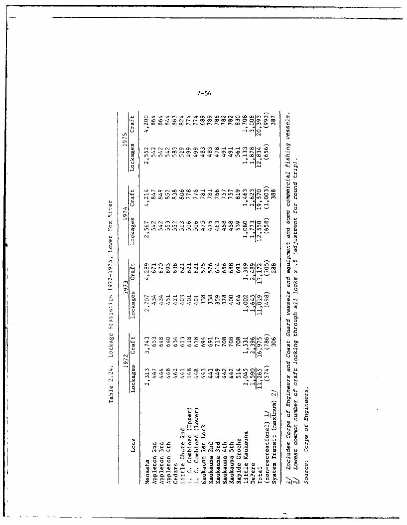
2-56
4 ClQ
U n u)U)L L 1 1- C'J '-4 r4Ic'J 1 r
0 *4 Q
4(U u - Ca- $-4.
-4Q I'-4--4
w4 r-) -'l InI04.1 r I O0 M' * oq
to En
~-.tuOr--L$'.ca, 14- 00 r-'UMU A 4"r -- 4V OO $Dc -00
W 0 -4
u. 4.' 0 a' l) c 0-4 C)L -tOr - 4aa(~~ C)I 0 - N
-4 a' 0 nww r4r ww- 0t aI
(N I
"-4 0-: It - - 1 - C4-4
a) 0 I-4Q
4-i4
O~ co4(~
*4 -0'044a ?
4d 4) 4) :3 -HQ 0 1- 0 3)00 0'1 w*'-i 4 ~ N A 0
r. u' o13)0
W~ 0 C'0'-H'- W 0'- 0
- I I I I _ ,
2- 57
2.151Fishing- As with boating, i islhing has achieVL,i ,reater popularitv as aform of recreation. The number of licensed 1A:.ermen in Wisconsin grewmore than 20 percent between 1968-1974. Table 2.25 shows 1974 fishinglicense data for the 8-county area, with a substantial number being non-resident licenses.
2. 152Water quality problems are a serious deterrent to fishing in a large por-tion of the project area. The rivers and the lakes suffer from varioustypes and degrees of pollution, and the effects of the contaminants arealmost always detrimental to sport fish populations. Some recovery ofthe usefulness of these waters as a recreation resource is being made be-cause of new sewage and industrial treatment facilities, and even greaterpotential exists for increasing fishing opportunities if water qualityand utilization of the bodies of water, which presently exist in theregion but are lacking one or more components necessary to satisfy fish-ing demands, are improved.
2.153The problem of poor water quality is especially apparent in the Lower FoxRiver. At present, the water quality of the Fox River (especially dis-solved oxygen) is so poor that a sport fishery of any importance cannotbe established. The Lower Fox River, the largest stream in the Foxvalley corridor, contains a very marginal fishery consisting primarily ofrough fish, walleyes, bass, northern pike, and panfish. In many streamreaches the pollution load of the Fox is so great that there is notsufficient dissolved oxygen to support a fishery much of the year."7
Table 2.25. Fishing License Data, 1974
Resident Non-residentaCounty licenses licenses
Brown 27,312 679Calumet 5,987 204Fond du Lac 19,619 2,920Green Lake 7,585 632Outagamie 23,759 569Waupaca 15,860 18,200Waushara 7,535 2,394Winnebago 30,035 8,990Total 137,692 34,588Percent of State 14.5 9.8
a Effective number of fishing licenses.
Source: Wisconsin Department of Natural Resources, 1974.
U III I I Ui .
_- 58
i . . I I s of fish ar, ,,i i n. These kills can I. iii ,I tL, oXyg,.ipl, i,.ii due to algae (ii -offs and to industrial p,,; i i io . Du)ring tho
p r ii in several recent Vears, local et.sidents we-r, .iioitrag,ed Lo seewhitt hass and perch in tle Fox River it, far upstre.in a: the RapideCrocile dam. These fish could survive o; long as surficc, runoff wasproviding a large volume of water and the dam was aerit ing the waterspil ing' over it, and good fishing was supplied to area youngsters.lhlowevtr, as-4 surface waters reached normal levels, the dissolved oxygenlevel downstream reached zero. The result was a summerkill among thefish trying to return to Green Bay; onLy those fish remaining near hedam survived. Erosion of clayey upland soils has also created veryturbid conditions in the river. Factors such as crosion of shorelands,siltation of pools, excess rates of eutrophication, and destruction ofwetlands have contributed to habitat decline.
2.154Without question, Lake Winnebago is the most popular and heavily fishedarea in the central project region. The water in 1lae Winnebago isfertile and very productive and as such the lake supports a very diversefishery. i lleye, sauger, perch, white bass, and northern pikte provid.excellent fishing opportunities. Ice fishing for walleve and sauger isvery popular during the winter months, as is the spearing of the largelake sturgi'on during the open season.
2.155The Wolf River supports the region's most important fishery and supportstie most fishing activity of any water in the region. The Wi,] and adja-cent wetlands prov ide excellent spawning habitat and feeding :reas formany species of wonm w;itvr game fish. The spring spawning migrations ofwalleye and white biss annually attract thousands of anglers. The walleyerun occurs shortlv after the ice leaves and therefore the walleye runoffers fishermen tie first major open water fishing in Wisconsin.
2. 156Many other lakes and streams of the project area provide a variety of fishand fishing. The larger lakes contain the best fisheries and the bestpublic access facilities support the heaviest lake oriented fishing pres-sure. Many smal lcr lakes in the project region have frequent or annualwinterkills of fi:dh due to their shallow, fertile nature. The otherlakes are classified primarily as "bass-panfish" lakes, and due to thissame fertility produce large poundages of fish. Unfortunately, thepoundage in some is made up of many small, slow-growing panfish, ratherthan desirabile sized Iish. Smaller streams are generally lightly fished,and offer onlv minima l fisheries. Lack of sufficient base flow in streams,aLong wi ti erosion, s;iltation, excess fertility, and high turbidity havecombined to make many waters uninhabitable for most game fish. St ream.rosion has destroyed some spawning habitat for game fish. Cover, otherthan aquatic vegetation, is scarce on most streams. Wetland drainage isanother problem which has destroyed fish spswning areas and wildlifeareas in the project region. This problem affects many lakes and streamsincluding Lake Winnehago and other lakes along the Wolf River system inWinnebago and Waupaca Counties. Walleyes from Lake Winnebago spawn in
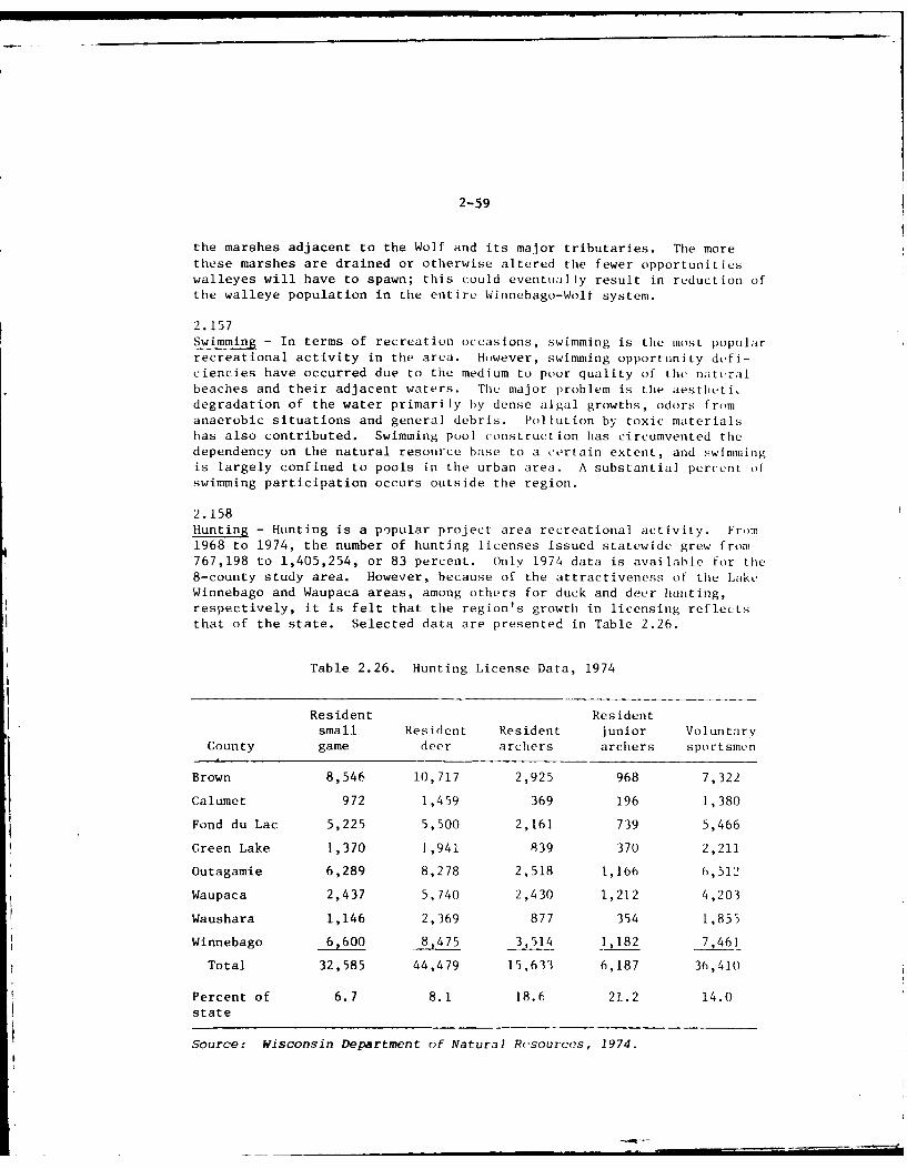
2-59
the marshes adjacent to the Wolf and its major tributaries. The morethese marshes are drained or otherwise altered the fewer opportunitieswalleyes will have to spawn; this could eventually result in reduction ofthe walleye population in the entire Winnebago-Wolf system.
2.157Swimming - In terms of recreation occasions, swimming is the most popularrecreational activity in the area. However, swimming opportunity defi-ciencies have occurred due to the medium to poor quality of the natiralbeaches and their adjacent waters. The major problem is the aesthliti.degradation of the water primarily hy dense algal growths, odors fromanaerobic situations and general debris. Pollution by toxic materialshas also contributed. Swimming pool construction has circumvented thedependency on the natural resource base to a certain extent, and swimmingis largely confined to pools in the urban area. A substantial percent ofswimming participation occurs outside the region.
2.158Hunting - Hunting is a popular project area recreational activity. From1968 to 1974, the number of hunting licenses issued statewide grew from767,198 to 1,405,254, or 83 percent. Only 1974 data is available for the8-county study area. However, because of the attractiveness of the LakeWinnebago and Waupaca areas, among others for duck and deer hunting,respectively, it is felt that the region's growth in licensing reflectsthat of the state. Selected data are presented in Table 2.26.
Table 2.26. Hunting License Data, 1974
Resident Residentsmall Resident Resident junior Voluntary
County game deer archers archers sportsmen
Brown 8,546 10,717 2,925 968 7,322
Calumet 972 1,459 369 196 1,380
Fond du Lac 5,225 5,500 2,161 739 5,466
Green Lake 1,370 1,941 839 370 2,211
Outagamie 6,289 8,278 2,518 1,166 6,512
Waupaca 2,437 5,740 2,430 1,212 4,203
Waushara 1,146 2,369 877 354 1,855
Winnebago 6,600 8,475 3,514 j_,182 7,461
Total 32,585 44,479 15,633 6,187 36,410
Percent of 6.7 8.1 18.6 21.2 14.0state
Source: Wisconsin Department of Natural Rosources, 1974.
2-60
.159ile Wi oinsin lcpLzrtiicnt ol Naiturll Resources ad nijistiers the I,tilk of thtland listed as opit lor hunting. As in most regions of the st att,, how-,ver, private plepcrtv owlleRl accommodate a major portion of hulnting
dmniand. otptin, t rivite lkid against trespass limits hunting opper-t(initie . in soinm parts ,, the project area. Additiinal huntillgi oppor-tnlitie's 0l0 a pav-as-vo-go basis are provided by private shootingprescrve.. 'amc >iecivs (omlllon to the project area include niuskrats,Mink, 111id deer. I'Wtaver and titter are present but much less common.Upland spe, nits in ludc deer, grouse, Hungarian partridge, squirrels,rabbits, plieasants, ftox, and racoon. Waterfowl are among the most im-portant . onmlon and inmport;ant of wildlife users of the project's watersur face.
2. 160Several large marshes and the project region's shalow lakes are majorsources of waterlowl habitat. Concentrations of 50,OOO-100,000 water-fowl, mainlv diving duck species including scaup and canvasback, gatheron Lake Winnebago each autumn, lesser numbers of puddle ducks may alsobe found here but arc more common on the southern end in the Supple Marsharea and along tile Wolf and Embarrass Rivers. The west shore of lakeWinnebago and its associated islands in Fond du Lac County offer some ofthe finest duck hunting opptrtunities in the entire state, and many birdsire harvested annually. l'rygan Marsh provides public hunting grounds for
waterfowl and small game and the wetlands along the Wolf often provideexcellent duck hunting.
2.161Hunting opportunity (in both quantity and quality) have decreased duringthe past decade in the project region. Waterfowl are not nearly as abun-dant as they were a few years ago. This can be explained in part by thegeneral decrease in waterfowl populations in North America. Oteir fac-tors such as destruction of marshes, destruction of aquatic vegetationsuch as wild rice, and declines in water quality further limit waterfowland other wilflife populations. Agricultural practices such as intensivecultivation, streamii bank pasturing, and roadside brush cutting are direct-ly responsible for much habitat destruction and subsiquent wildlifedeclines. More subtle factors such as the spread of carp, and the in-crease in boat traffic may also have an effect. Quality of the huntingexperience has also declined as rapidly as the quality of availableresources. An increasing population, intensification of land use, andloss of wildlife habitat suggest a decline of hunting as a major recrea-tion activity. However, recent attempts at habitat improvement, betterwater quality, and reducing cultivation of marginal crop lands could spuran increase in game animal populations.
2. 162camping and Picnicking - Private enterprise provides the bulk of the
campground capacity in the region. Facility quality is variable butcongestion is not common. Crowding does occur in popular areas. Out-of-state lise greatly exceeds local participation. Estahlishing primitivecanoe campsites along the Fox and Wolf Rivers would contribute to theelimination of primitive campsite deficiencies.
2-61
2.163
Local units of government are followed by private enterprise as the majorproviders of picnicking facilities in the project region. Parks offeringpicnic facilities generally maintain good levels of site quality.
2.164
Table 2.27 presents the kinds and numbers of recreation facilities recog-nized by the Department of Transportation for seven counties (excluding
Green Lake) in the project area. Camping and picnicking are consideredtogether since both usually require public recreational facilities.
A total of 110 separate recreational facilities are recorded with aboutone-half of these sites having established picnicking and camping areas.AdditiOnal sites without facilities are maintained as public hunting and
fishing grounds. The counties of Brown, Fond du Lac, and Waupaca havethe most recreational facilities in the eight county area. A census of
people using these facilities is available only for the State parks andforests. A total of 1,322,259 visitors and 189,767 campers were recorded
at High Cliff, Hartman Creek, and Kettle Moraine-Northern Unit (NU) StateParks in 1974 (Table 2.28). From 1973 to 1974 the number of visitorsdecreased by 1.8 percent, whereas the number of campers increased by 12.2
percent.
2.165Sightseeing - Some of the more scenic recreation resources in the project
area and vicinity include the Kettle Moraine and Lake Winnebago areas,
the Fox and Wolf Rivers and their tributaries and impoundments, and
scattered small undeveloped lakes. Continued land use changes in theregion may reduce its desirability for sightseeing purposes and result in
reduced participation or a shift of demand to other regions. More spe-cifically, intensive agricultural practices, shoreline development and
wetland drainage and filling is reducing opportunities for enjoyablesightseeing. Continuation of this type of development will result inreduced sightseeing participation in the region.
2.166Winter Sports - Snowmobiling and ice fishing are popular winter sports in
the study area. Snowmobile records are available for Wisconsin countiesfor 15 March 1975, from the Wisconsin Department of Natural Resources.
The eight counties in the project area and their numbers of snowmobilesare listed below. When compared with other counties in the State, some
of the project study areas are among the highest in registered snowmo-
biles. The list summarizes study area snowmobile registration. Icefishing on Lake Winnebago, especially sturgeon spearing, is also a major
form of winter recreation In the project area.
Count Snowmobiles County Snowmobiles
Brown 10,541 Outagamie 8,042
Calumet 2,869 Waupaca 4,509Fond du Lac 6.992 Waushara 2,154
Green Lake 2,170 Winnebago 7,798
Total 45,075
Source: Wisconsin Dept. of Natural Resources, 1975.
2-62
'4C)
a) 0 00..
r w 00 ~ 4 Ln W a JU
V4 00wM qco
0 W 0 W0
. -4 4.. r
cao co w
Uj 0-
l-4 0 m 4
'.41
.x
0CL.
I 4
4.U
4J.4C-
.4W4
~~44o U)'
:1. 0. c 0 m
o. '.4 m t - oL) 0 4t - t
2-63
Table 2.28. State Park and Forest Visitation 1973-1974
1972 1974
Name Visitors Campers Visitors Campers
High Cliff 526,108 22,772 434,650 23,248
Hartman Creek 140,196 26,229 99,265 37,162
Kettle Moraine l/ 679,546 120,108 788,344 129,357
Total 1,345,850 169,109 1,322,259 189,767
I/ Northern limit.
Source: Wisconsin Department of Natural Resources, 1974.
2.167Growing Demand for Water-Based Recreation - The region's water resourcesprovide the basis for a wide variety of recreational activities, par-ticularly fishing, hunting, boating and swimming. These activities aremaking increasing claims to the use of the region's lakes, streams andwetlands. Not only have there been numerous conflicts between recreationand other potential water uses, but there have also been conflicts be-tween various types of recreational activities, such as fishing and powerboating. The need for a rational basis for allocating water resourcesamong competing users has become increasingly urgent.
2.168The number of sport fishermen has grown steadily over the past fewdecades. Fishermen and hunters, attracted by the region's trout, bass,and.pike, and various wildlife species, come from far and wide to fish inthe region. Fear that increasing industrialization and agriculturaldevelopment will harm fish and wildlife habitat has encouraged fishermen,hunters, and conservationists to petition for preservation of variouspa2rts of the region for recreational purposes. Programs of purchasingwetland area are one result. Regulations on water use are another.
2.169Boating, and particularly power boating, has increased rapidly in theregion in recent years. Not only do local residents own a large numberof boats, but the region has become an increasing attraction for boatsmenfrom the surrounding area. Demand for pleasure boating will continue toincrease at a rapid rate in the region, bringing increased demands formooring facilities and associated services. It will also give rise tocertain conflicts in water use, both between different types of recrea-tional activities and between recreation and other water uses.
2.170Protection of Project Water Recreational Resource - Although the projectregion possesses many valuable recreation resources, it has severalserious problems related to the quality of its surface water, and the
- - .m
2-64
current patterns of land use and development. Silt, agricultural chomi-cals, domestic sanitary wastes, and industrial byproducts are the majordeleterious substance,, contaminating tile region's surface waters.
2.171Control of municipal and industrial effluents is being effected, butsiltation, agricultural chemicals and fertilizers, and individual sani-tary systems located on lake and river shorelines are not as readilydealt with. If good water quality is to be maintained and poor waterquality improved, attention must be focused on these more dispersedsources of pollution.
2.172The primary water recreational resources include the Fox and Wolf Riversand Lake Winnebago. The quality of these resources varies but in gen-eral, if their potentials are to be realized improvements will be needed.
HISTORICAL AND ARCHEOLOGICAL FEATURES
Historical Development of the Region
2.173The Fox and Wolf Rivers have had many historic associations during thelast three centuries, some of these having a rather close connection tothe early settlement and economic development of the State of Wisconsin.
2. 174Indian Tribes and Colonial Trade - The Winnebago and Menoninee tribeswere apparently tile major Indian nations inhabiting the region priorto the settlement of the white man. The Winnebagos met the French ex-plorer Jean Nicolet when lie landed near Green Bay in 1634. Nicolet wasthe first white man to view the Lower Fox Valley and the "Lion of theFox", the Indian name for the roaring rapids of the river. Subsequently,explorers, traders, and missionaries found the river to be a naturaltrade route between the Great Lakes and the Mississippi River. Fur wastile main attraction to the French traders.
2.175Domination in this part of the state was assumed by the British after theFrench and Indian War in 1763. Fur trade continued to be the primeattraction. In 1815, the English relinquished control in the area. In1854, after a series of concessions to the white settlers, and duringwhich time their tribal holdings were greatly diminished, the UnitedStates government ceded to the Menominee tribe, in trust, a reservationin parts of Shawano and Oconto counties (now Menominee County).
2.176Settlement - The first permanent settler was Augustin de Langlade, whowith his family of eight, moved to the area between 1744 and 1746. Fortyyears later the Bay colony settled by Langlade had a total population of56. This grew to 252 by 1812 and to 500 by 1824 (not including the 600troops stationed at Fort Howard).
2-h i
2.177In 1816, the first water powered grist mill in Wisconsin was built by
Augustin Grignon in the area now called Kaukauna. Kimberly, first calledSmithfield, was settled in 1822 by Christian Indians from New York. The
Little Chute area was settled by tile Rev. T. J. Vanden Brock in 1835.Amos Lawrence established an institute of higher learning at Appleton in1847; the community was named after Lawrence's father-in-law SamuelAppleton. Early development of the Neenah-Menasha area came in the late1840's. In 1873 the first paper mill in the area was established at
Kaukauna.
2.178Surface water resources have always played an important role in the
history and development of the region. The first explorers and settlers
were brought to the valley over waterways. These same watercoursesserved as highways over which first furs, then agricultural products andlater industrial products moved to markets in the east. Appleton, Kim-
berly, Little Chute, Combined Locks, and Kaukauna developed and grewaround sites suitable for waterpower development. Waterpower and easy
access to markets and raw materials attracted the paper industry.
2.179Fond du Lac, meaning Bottom of Lake, derived its name from a Menomonie
Indian Village named Wanikamiu. Although explorers came to the areaearlier, records indicate that the first home was built in 1836. In1847, the area which is now known as Fond du Lac became incorporated as a
village. The following years brought the railroads which with the lumber
industry was responsible for the rapid growth of the area.
2.180
The City of Oshkosh, Wisconsin, was settled in about 1827 as a tradingpost along the route between the Great Lakes and the Mississippi River.In 1840, the city received its name and in 1853, became incorporated as acity. Because of its ideal location, it continued to grow, with the FoxRiver continuing to serve as a principal source of transportation for thesubsequent logging era and agricultural developments.
2.181
Transportation - The unique river system formed by the Fox and Wisconsinrivers made it possible to travel across the state by water from theGreen Bay to the Mississippi River with only a minor interruption atPortage. This was a favorite route of early explorers and pioneers. In1855, a series of locks was installed on the Fox River between Appleton
and Green Bay which made the river system navigable for commerce. Thetwo rivers provided a major transportation route during the middle of thenineteenth century, and before the prominence of railroads. The riverroute contributed significantly to the early development of southerncounties of the region--mainly Winnebago and Outagamie counties.
2.182
Wisconsin first received rail service in 1851 (to the Milwaukee-Waukeshaarea). By 1860, service had been extended as far north as Oshkosh. In
2-66
186 i t was ext ended to Appleton. During the hext two dtuL'( dts ra Il
S'ervicC reached most of the northern and western sect:ors of the regi 0.
Th i hicago and Northwestern Railway Company reached New London in 1870.It then extended service northwest to Eland and then north by way ofAntiLo, Monico, and Eagle River, reaching the northern Michigan stateline in 1883. Th'e Wisconsin Central and Soo Line Railroad extendedservice from Menasha to Stevens Point and on to Ashland between 1871-77.In 1918, the company completed a line from Argonne in Forest County toAppleton by way of Shawano for the purpose of bringing wood co the pulpand paper mills of the southern cities. The Green Bay and Western,another major firm operating in the region, extended service from GreenBay to the Mississippi River between 1866-1873.
2. 183Agricultural Development - Between the period 1835-1850, most of the landin southern Wisconsin was made into farms; although it generally tookseveral years before all the land of a farm was improved. In 1850, thenorthern boundary of this farm belt was fixed quite firmly along the Fox-Wisconsin water route. The raising of wheat was the basis of the agri-cultural economy. By 1860, the farm line extended north and west toinclude most of Outagamie, Waupaca, and Waushara counties. As railservice was extended to the northern counties in the 1870's, agriculturewas brought into these areas. Agricultural development was stimulated byexisting lumber and sawmill towns. Towns and lumber camps provided aready maiket for farm crops and during the winter months the lumber campsserved as a source of employment for the farmers. It was a mutuallyadvantageous situation. Excess crops were shipped south to market viathe railroads. Wheat remained the major crop for several decades, butgradually gave way to dairying and animal feed crops during the latterpart of the nineteenth century.
2. 184Lumber Era - In the early 1840's, a new era of economic activity began inthe Wolf River Basin with the advent of pine lumbering. For severaldecades the only merchantable timber in Wisconsin was pine. White pinetimber was considered the choice of the pines and the Wolf River Basinarea contained some of the finest white pine forests in the state.
2.185Although logs were cut in the Basin in 1835 for the erection of govern-ment buildings at Neenali, the first coimercial lumbering operations didnot begin until 1842. The lumbering operations tended to fix the loca-tion of several cities and villages ii, the region. Shawano and Winne-conne became the chief sawmill towns oi the Wolf River. It was at Osh-Ikosh and Fond du lac, however, where most of the logs were made intolumber. lhe slow current that characterizes the Wolf from the City ofShawano south made the river an excellent logging stream. Lake Poyganprevid(Id a good reservoir for the temporary storing of logs. Sawni 11perOt ions begai in Oshkosh in 1847 and Oshkosh was later to become known
as "Sawdust City". The Cities of Neenah, Menasha, and Appleton alsoreceived logs from the Wolf Basin and each had sevral sawmills; however,they nevr appr,,ached the operations in Oshkosh or Fond du Lac.
2-67
2. 186In 1854, forty million feet of lumber was manufactured out of logs trom
the Wolf River district. Tle production peak was reached twenty years
later when the eighty lumber camps in the woods of the upper Wolf Basin
cut a total of 205,000,000 feet. Soon after reaching this peak, produc-tion began to steadily decline, and by 1890, the pine was all but de-
pleted.
2. 187
Industrial Growth - The region's industrial developments tended to con-centrate in the Oshkosh to Kaukauna corridor along the shores of the FoxRiver. The abrupt descent of the Lower Fox in this area made its pu-
tential very attractive to industries dependent on water power.
2.188
The first major industrial activity started in the 1840's and focused onsawmill operations from lumber floated down the Woif-Fo.. waterways. Thegrowth of agriculture in the hinterlands during the 185U's provided thebasis for'another important operation--the development of flour millingindustries to process the area's wheat crop.
2.189
The industry that was to become the most important economic activity in
the Fox City's area, paper manufacturing, appeared as early as 1853 inthe Appleton area. However, most of the major paper firms did not get afirm start until the 1870's and early 1880's. Today the paper and allied
products industry is the largest manufacturing employment group in theregion.
Historical Places, Archeological Sites and Natural Landmarks
2.190
The State Historical Society and the National Park Service have beencontacted and the National Register of Historic Places consulted inregard to historical or archeological resources which might be located inthe project area. No known historical or archeological sites will beaffected by the proposed action. Table 2.29 lists the historic places
and natural landmarks in the eight counties of the project study area.Only one listed natural landmark exists in the area, the Spruce Lake Bog-
Kettle Moraine State Forest.4 8 The remaining 15 of the 16 items shownare historic places. 4 9 No other registered historic places or naturallandmarks are known to exist in the project study area. Figure 2.13shows the location of each of the items identified In Table 2.29. All of
the historic places are buildings with the exception of one which is acemetery. All listed historic places are remnants of the historic set-
tlement period. The archeological sites (pre-historic settlement period)are not publicly listed to prevent their disruption or destruction byuntrained persons. This entire area, however, has been occupied since
prehistory by aboriginals and is very rich in sites having archeologicalsignificance. Some of these sites are known and are listed in the State
of Wisconsin, Archeological Office, and with the State ArcheologicalSociety. Other undiscovered sites probably exist.
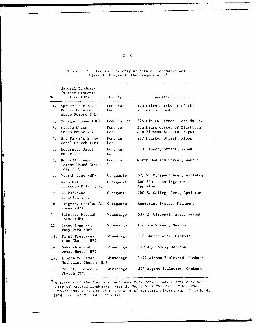
2-68
Table 2.29. Federal Registry of Natural Landmarks andHistoric Places in the Project Areaa
Natural Landmark(NL) or Historic
No. Place (HP) County Specific Location
1. Spruce Lake Bog- Fond du Two miles northwest of theKettle Moraine Lac Village of DundeeState Forest (NL)
2. Octagon House (HP) Fond du Lac 276 Linden Street, Fond du Lac
3. Little White Fond du Southeast corner of BlackburnSchoolhouse (HP) Lac and Blossom Streets, Ripon
4. St. Peter's Epis- Fond du 217 Houston Street, Riponcopal Church (HP) Lac
5. Woodruff, Jacob Fond du 610 Liberty Street, RiponHouse (HP) Lac
6. Recording Angel, Fond du North Madison Street, WaupunForest Mound Ceme- Lactery (HP)
7. Hearthstone (HP) Otagamie 625 W. Prospect Ave., Appleton
8. Main Hall, Outagamie 400-500 E. College Ave.,Lawrence Univ. (HP) Appleton
9. Volksfreund Outagamie 200 E. College Ave., Appleton
Building (HP)
10. Grignon, Charles A. Outagamie Augustine Street, KaukaunaHouse (HP)
11. Babcock, Havilah Winnebago 537 E. Wisconsin Ave., NeenahHouse (HP)
12. Grand Loggery, Winnebago Lincoln Street, NeenahDoty Park (HP)
13. First Presbyte- Winnebago 110 Church Ave., Oshkoshrian Church (HP)
14. Oshkosh Grand Winnebago 100 High Ave., OshkoshOpera House (HP)
15. Algoma Boulevard Winnebago 1174 Alhoma Boulevard, OshkoshMethodist Church (HP)
16. Trinity Episcopal Winnebago 203 Algoma Boulevard, OshkoshChurch (HP)
D Department of the Interior, Natinal Park Service No. 1 (National Req-
istry of Natural Landmarks, Part 1, Sept. 5, 1975, Vol. 38 No. 208:
20505); Nos. 2-16 (National Reqister of Historic Placos, Part 2, lb. 4,
1974, Vol. 40 No. 24:5339-5341).
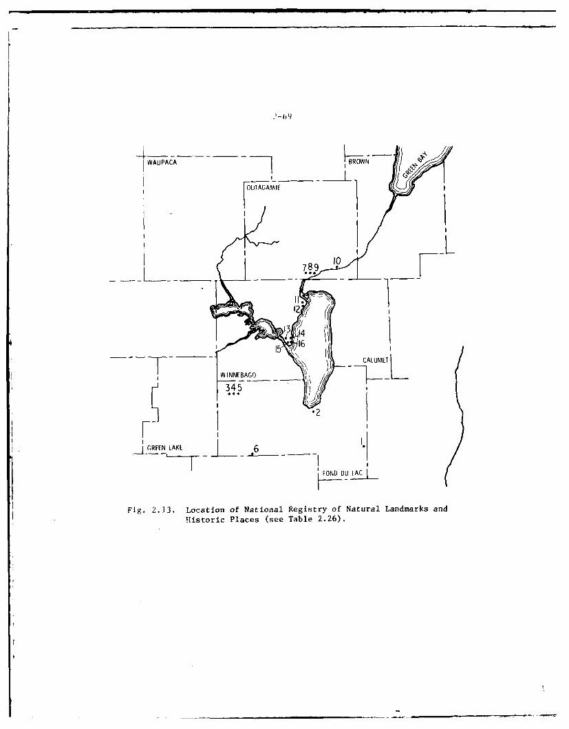
2-09
WAUPAA BROW
OUTAGAM if -
789 10
II
2
13
l WINNE BAGO345I "
4IGREENL LAKE 6
FOND DU LAC
Fig. 2.13. Location of National Registry of Natural Landmarks andHistoric Places (see Table 2.26).
2-70
2.191At the request of the State Historical Preservation Officer, a profes-sional archeological assessment sufvey of proposed dredged materialdisposal sites was undertaken in order to locate and evaluate culturalresource sites for possible inclusion in the National Register of His-toric Places. The Summary and Recommendations section of the surveyreport states that no adverse effects upon cultural resources shouldresult from proposed dredged material disposal terrain modifications.Figure 2.14 is a reproduction of a 19 November 1976 letter from theState Historic Preservation Officer concurring with this determination.It should be pointed out that the specific references in this letter tothe nature and location of an archeological site in the vicinity of adisposal site no longer proposed for use have been withheld from publi-cation. This was done in order to protect the site from possiblevandalism.
HYDROLOGIC AND HYDRAULIC ELEMENTS
2.192The hydrology of the entire Wolf-Fox River Basin (of which the projectstudy area is a large part) reflects the geology, topography, size andclimate of the basin complicated by man-made changes, such as dams andland use. Where permeable, thick, and extensive near-surface aquifersunderlie the basin, base runoff to streams is large and the stream has aconsistently high sustained flow. Floods from overland runoff are re-duced because water from precipitation and snow-melt easily entersgroundwater storage. Conversely, where aquifers are relatively imperme-able, thin, or areally small, base runoff is low and streamflow is highlyvariable and diminishes greatly during the late summer. Such streams aregenerally subject to flash floods since most of the water from largerainstorms or sudden spring thaws flows overland, and only a small partenters groundwater storage. Thus, the water yield per square mile in thepoorly permeable glacial-lake and grouna moraine areas in the central,eastern, and southern parts of the basin (study area) is lower than thatof the permeable glacial outwash areas in the western and northern parts.This can be demonstrated through use of flow-duration curves which re-
flect natural streamflow. The shape of a flow-duration curve can alsoreflect the geohydrology of the drainage basin. Curves with a steepslope denote highly variable streams whose flows are largely from directrunoff, whereas curves with flat slopes indicate the presence of surfaceor groundwater basin storage, which tends to equalize flow. Figure 2.15exhibits flow duration curves for several streams in the project vicinity.
2.193The major streams (point source inflow) contributing directly to the
study area, their average, maximum and minimum flows are tabulated on thenext page.
2.194Flood flow and low flow recurrence curves of major streams in the vicini-
ty of the study area are shown in Figures 2.16 and 2.17. Additionalstream discharge data is contained in Appendix F.
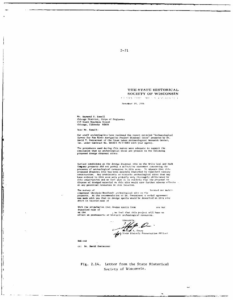
2-71
THE STATE IIISTORICAL
SOCIETY OF WISCONSIN
November 19, 1976
Mr. Raymond P. Essell
Chicago District, Corps of Engineers219 South Dearborn StreetChicago, Illinois 60604
Dear Mr. Essell:
Our staff archeologists have reviewed the report entitled "ArchaeologicalSurvey for Fox River Navigation Project Disposal Sites" prepared by Dr.
David F. Overstreet of the Great Lakes Archaeological Research Center,
inc. under Contract No. DACW23-76-C-0082 with your agency.
The procedures used during this survey were adequate to support the
conclusion that no archeological sites are present in the following
proposed dredge disposal sites:
Surface conditions at the dredge disposal site on the Wells Coal and Dock
Company property did not permit a definitive statement concerning the
presence of archeological resources in this area. It appears that this
proposed disposal site has been severely disturbed by twentieth century
construction. Any prehistoric or historic archeological sites that mayhave existed in this area were probably very thoroughly obliterated bythis construction and we feel that it is unlikely that the proposal to
dispose of dredged material on this site would lave further adverse effects
on any potential resources in this location.
The survey of located one multi-component (Archaic-Woodland) archeological site on theproperty. At the recommendation ot Dr. Overstreet a verbal agreement
was made with you that no dredge spoils would be deposited on this sitewhich is located east of
With the stipulation that dredge spoils from are notdeposited east of
on the , we feel that this project will have no
effect on prehistoric or historic archeological resources.
Sincerely,
State Historic Preservation Officer
RAE:rdd
cc: Dr. David Overatreet
Fig. 2.14. Letter from the State Historical
Society of Wisconsin.
2-72
Area Stream Discharges (point source inflows, cfs)
Avg. Max. Min.
Wolf River 1,729 15,500 150(New London)l
Little Wolf R. 423 6,950 38(Royalton)b
Wauppca R. 238 2,520 50(Waupaca)b
Fox R. 1,089 6,900 248(Berlin)aFond du Lac R. 64 - -
(Fond du Lac)
a Water Resourceo Data for Wisconsin 1973, USDOI, USGS and State
of Wisc.bGroundwater resources of Waupaca County USGS WSP ......
2.195Fox River and Lake Winnebago - The flood plain cf the Fox River is highlydeveloped with industry and commercial establishments in urban areas andwith residential establishments in the suburban areas. The flood plainof the Fox River from the Brown County-Outagamie County line upstream tothe Kaukauna city limits is narrow and there is no significant develop-ment in this area. A few cottages have sprung up on the narrow benchesnext to the river but most of the more recent development has been on topof the bluffs, well above potential flood hazard areas. Within thecorporate limits of Kaukauna there has been cv:isiderable industrial,commercial and residential development of the flood plain. New develop-ment and redevelopment is currently underway in this area. In LittleChute and Combined Locks, the narrow flood plains are almost entirelyutilized by industrial development and municipal utilities. Flood plainareas in the City of Kimberly are utilized by industry and recreationaldevelopment. Recreational facilities such as ball parks are a compatible
usage of flood plain areas. Within the corporate limits of Appleton, theflood plain lands are nearly completely developed. Industry is the majorusage with a smaller area being utilized for a waste treatment plant.Almost all of the residential development has been on top of the bluffs,well above any potential flood hazard. Around Little Lake Butte desMorts there is considerable residential development. Some of tile housesare constructed close to the lakeathore and are subject to damage duringtimes of high water. Kesidences on Stroebe Island will be isolatedduring higher frequency floods due to flooding of Stroebe Road. TheNeenah-Menasha wastewater treatment plant is located on the lake andwould be subject to flooding from floods greater than the IntermediateRegional. In Neenah and Menasha, industrial development along the FoxRiver is very intense and in some areas buildings are constructed onpiling over the stream channel. In othei areas, the only floodway
100,000 )T I 1
10.000 -.
z0U.N.
1000 ---N- \,."
\ \ -'\-
M- < a L'tl, . .... "- . / e ---.a " -to.. ..-... . n ve t .........
,1el . O lf Rove' r ......to
".-.
100
10-
0 00--\1L 04 0Y 0,'0 0 r0-0 0 C) 'n 00 0"MC) 0"
PERCENT OF TIME INDICATED DISCHARGEWAS EQUALED OR EXCEEDED
Fig. 2.15. Flow Duration of Major Streams. From
P. G. O1cott, "Hydrologic Atlas," 1968.
-'74
14 1 . ,- 1 i13 1
1?2*
L
00 +
o 0
0'0
Z/ (
4~~- . i- - I
6-~ -- 1
10'0v0450"0
2. C. Ol ot , H o o n ......... 19....
2-75
-- - 001
CIS
-~ -~ 09
- 4 -- - - -
g I I I'U0 Z. P
__~01m j~
I LU 0Cc m -,
iici 1~zP0_-3: - _ Oz
-I - _o
W ~ __ __ . -
I -- - -8 -
1 0U
-
2-76
il iiiu, i> t hat ',tv t I, dini s which are const ruited right on theriver lj :. Along tlj.. ),it- oit L;jke Winnebago, tILt , d ve lopninlt I1l;1s klen.a :1Iost .lti ' i (-:id IIt i,11 With -;mall areas d..votted to par<;. 'llic 197(i,pl in ,,! tlie ar ,, ,.I, h. ie Lower Fox River w,,s llpliOxit,.itCfv1.47,01016 ' Ic' . Iilw. pio.j, , .d 199)0 population for thi:; area, [ase-d Ol
tIle iiaio i, t. <1 , il ,, onal Planning COmmissioi ,omprehens.ive1) 1,11, . ,p r ,.: tl t, v ,/, l ( people.
'. 190Iike' thle it ic if- N'(, nab ;ind lninasha, tle cit ies of )shkosh and I-nd duI ac ark I, Itld ol r Lit ivIv low land tround the lakeshore. hlie floodplaiin within the (ity tf (slkosh includt-s residential, commrcial, indius-trial and r,''reational developments. F'lood plain developments along LakeWiiineba g north of 0Ishki-sh are institUtional and res idential. Res idenLialdv, vlopnMeLIl. , ailolg the lakt, Winnebago f lood plain are extensive in theimniediatc 1shkosh area and less extensive farther to the north. Ra i I-roads, hignways, streets, utility lines, industries, and the Oshkoshsewage treatment plant and water filtration plant are subject to flood-ing. The flood plain of Oshkosh is almost fully developed. The presentpopulation of the city, as determined in the 1970 census, is 53,104. Itspopuilation is projected to be 61,087 by 1980. The flood plain of theFond du Lac River is highly industrialized, particularly near the junc-tion of the East and West Branches. Parks and open areas are predominantnorth of Scott Street near Lake Winnebago. Residential developments arepredominant sooth of tile industrial arta. The Fond du Lac River floodplain within the City of Fond du Lac i.c'ludes residential, commercial andindostri.il developments. Railroads, highways, streets, utility lines,product ion t ci li t iS, and lift statioa:i are all located within the areasthat would be subject to f looding. Due to the extremely flat topographythe City of Fond ILI liC hils coostructed 19 lift stations for removal ofr'unloff .itel throughout the city. The [970 population of the City was
, 515, whidch is approximatelv an 8.5 1 ,rcent increase over 1960. Theprojected population for the City base. on an average increase is ap-proximately 40,000 people by 1990.
2.197Floods have occurred in the study react ,s of the Fox River and along theLake Winnebago shore during all seasons- of the year with the more exten-sive floods in the spring. Although tl,.- rate of stream rise from generalrains over the basin is moderated by L, e Winnebago, intense rainfalldownstream front Lake Winnebago may res. it in a fast rate of rise, orflash flood condition there. Flood sto.,es in Lake Winnebago rise slowlywith extremely low velocities occurring in the general direction o flowf rom Oslikosh to Neenah.
2. 198The floods Can cO'r ent i rely from aitlfall, frotm snwmelt, or from acoibinat ion of both. I'looding alon) ti., Lake Winnebago shoreline ran,ilso occur with any t these situation- and, in addition, from extensivewind action sweeping onto the shore from easterly or southerly direc-t ions. 'This wind act ion causes the water surface to ti It upward (windsetup) and also creat Cs wave act ion (wave runup) whiCh can Caluse floodingand severe erosion. ligurc 2.18 illustrates this condition.
ac
3cn
or Q)
§ 1 0
44V4
I I 8
2-78
2. 199Flooding is not a serious problem on the Lower Fox, although high watersometimes disrupts industries located ii' low-lying portions of the floodplain. Also, open spaces in the flood plains which may come under fordevelopment are limited.
2.200The temporary storage of floodwaters in Lake Winnebago reduces the peakflows on the Lower Fox River; however, the duration of high water canextend over several weeks as it did during the spring of 1973. Strongwinds blowing onto the shore will produce high water due to wind setupand also wave runup. These have damaging effects on structures and alsocause considerable erosion of the shorelands. During the "breakup" ofthe ice, strong winds will blow ice onto the shorelands and cause damages.
2.201Damaging floods are reported to have occurred in the Fox Valley area asearly as 1881. More recent floods causing significant damages in thestudy reach occurred in 1922, 1929, 1943, 1946, 1951, 1952, 1960, and1973. Of these, the 1922 flood caused the most severe damages, par-ticularly in the lower areas of the river. In this flood the FederalGovernment suffered $100,000 in damage to navigation improvement works inthe 1922 flood. Damage to private ownurs of property was estimated at$20,000.
2.202The City of Oshkosh is subject to flooding from the Fox River and LakeWinnebago. The properties along this stream and lake have been moder-
ately damaged by the floods of 1922 and 1960. The open spaces in theflood plains which are now, or may come, under pressure for future de-velopment are limited.
2.203The City of Fond du Lac is subject to flooding from the East and Westbranches of the Fond du Lac River and DiL Neveu Creek. The propertiesalong these streams have been severely damaged by the flood of 1924. Theopen spaces in the flood plains which may come under pressure for develop-ment are extensive. Spring flooding recurs almost every year. Flooding
normally consists of seepage and sewer backup water entering buildings.Usually little damage is caused by these conditions.
2.204Wolf River Region - The Wolf River contributes practically 70 percent ofthe Lake Winnebago inflow during flood periods. Flooding of the lakesbelow Freemont begins almost as soon as Lake Winnebago rises one-halffoot above the crest of Menasha Dam and becomes extensive at the stage of1.25 feet above the crest. Menasha Dam at no time backs up flood watersfarther than Fremont. Above Fremont the entire depth of water is due tothe volume of water, the condition of the natural channel, and the nearbyflat slope of the river.
2-79
12 . 20)
lhe greatest flood known to have (,ccurred (il the IV(,It Riv r ((Urr( i, 1the V. ar 1888, and since that til]L_ other floods have oCc(Utll-reLd whi %L werewithin one-half foot of tie high w. Itr leve I recorded in I 1888. 'Hlo(history of this river, since records have been kept, hi.s shiown iin ;ivrag(occurrence of more than two floods per year. Al though thcre hiive, ,numerous f loods along the Wolf River, ;ivai lable info-nmt ion tind dat aindicate that the floods of 1888, 1912, 1922, 1952, and 196() wrt, l,)d,(,I the most serious magnitude.
2.20'The main flood season for the Wolf Riwvr is in the spring months, par-ticularly in March and April. ttowever, floods have occurred in everymonth of the year under various circumstances. The severe floods haveoccurred in March and April as a result of a combination of fast snowmelt and rather intense rainfalls, plus the presence of ground frostwhich increases the runoff. Some of the summer floods have occurred fromprolonged rare-occurring rainfalls, sometimes exceeding seven inches intwo days, thereby resulting in a high rate of runoff in a short period of
time.
2. 207Duration of floods along the Wolf River has varied from a few days to two
or three weeks. This, of course, depends on the circumstances causingthe floods. Generally, because of prolonged melting of heavy snows ac-companied by continuing rains, longer duration floods occur in the
spring.
2. 208Several parts of the region suffer from periodic inundation by the WolfRiver and its tributaries. Often such inundation reaches damaging pro-
portions and results in losses of property and income. During the past70 years, there has been at least 50 damaging floods in the region. Few
of t'hese have been serious floods. While spring floods reach the great-
est volume and highest stage and do the greatest damage to municipal
properties, it is the May and lone floods which do the most damage toagricultural lands.
2.209Most of the Wolf Basin's flooding is between the Winnebago Pool andleeman. About 39,000 acres next to the river between leeman and New
London are subject to frequent overflow. Most of this is low, marshyriver bottom not used for agricultural purposes. About half of tileflooding is in Outagamie County. Below New London, abut 35,000 ruralacres are subject to frequent flooding. This land is primarily marshland.
2.210There are three communities located along the Wolf River from Lake Poyganto Shawano. They are Fremont, New London and Shiocton. All three olthese communities have experienced floods in the past. In general, themore serious flooding in the past has occurred in New london, which issituated on the downstream side of the confluence of the Embarrass River
2-80
,ind Woll River; the Flwbrr., River flows along the northeasterly side of
NXw london into the W1,1 t River and the Wolf River I lows :-outhwcstit, lvthrough the hisink-ss district of New Lotdon.
2. 211'Vic region's most ding in' I lood occurred in March and April of 1922. Itinindated over 73,000I) acrei and caused damages estimated at over $52,000
it the New london i ra a i(nec . Large sections of the north side of thecity, between the Woll and tie Embarrass Rivers, were covered with fromone to two feet of water. Basements in homes and commercial buildingswere flooded for several days and the streets were undermined and dam-aged. Ra il traffic was discontinued for a period of eleven days. TheWolf River was above flood stige (7.0 leet) at New London for 53 days.Its peak flow reached 15,500 CIs. 'The maximum inflow into Lake Winne-bago, exclusive ol precipitation directly into the lake, was about 33,500cubic feet per second. The inflow exceeded the outflow for 42 days.
2.212'Typically, however, losses have been small and confined to losses ofagricultural income resulting from inundation of pasture and cultivatedland. Agricultural losses in Outagamie County occur fairly frequently.Some areas experience inundation about three out of every five years.Losses of fish and wildlife habitat also occur as a result of inundation,especially in the marshlands of the Lower Wolf River.
2.213]:_ood Damage Reduct ion Measures - Lake Winnebago acts as a natural reser-voir to store flood waters. A 1. S. Government dam at Menasha and aprivately owned dam at Neenah control the outlets which discharge thewater from Lake Winnebago into Little lake Butte des Morts and the LowerFox River.
2.214'he Neenah and Mena ha dams were constructed by private interests in themid-1800's. In 1872, the United States was grant~d the title to theMenasha lock and dam. The Neenah dam remained under private ownership.The sluicing capacities of these dams increased in 1886, 1887, 1922 and1937. 'The present sluicing conditions were completed at Neenah in 1922aind at Menasha in 1937. Because of these alterations, the record of lakelevels prior to 1937 is not representative of present conditions.
2.215In accordance with the River and Harbor Act of August 2, 1882, as far asthe capacity of the, Fox River below Menasha and the security and capacityof the structures will allow, the enasha and Neenah dams are operated toprevent Lake Winnebago from rising higher than 21 1/4 inches above thecrest of the Menasha Dam. This is equivalent to a gauge height of 3.45feet on the Osh osh gauge.
2.216The plan of regulation for flood c,,ntrol is described below. The lakelevels given in fect refer to the shkosh gauge height.
>IJli i i~g I- lcI o l- lit Nciveiici'c o, silt i I., i.ivi ,it ia i . ~ d
at.l~ i NILc la I cclic~ M IIi i iiiilo iic Ikd dcl i-i iic! ii ilitr I ,-Ic
I It I i il t i I 5Ii ,ii! i c l c ( p .r i it s ;I stf t j Ii -Ii t flIow L (I
Ic t1 t mv , .r i m .,is t )I i 1Id1n1) it11t 11 Ie lower I- I- t anII d ConISC(I lhit I VV~ kI-t tlk' I 'Iicilt. icci1 t c i CC jia- . Mi1i iCC gte ,s i ar( regulated i iI
iv" l ilig Ici Ic e o t IeI, t vl I IceL I; lke_ I C e IliI tile crest oi-t I, dam it Mcccadshi duir jlug t h t, I i r t icetk ot .cr i I ind to a level ccJ
i ~~_IcX1MTijteL'V i.1 (I tek.t IV NIcV I . Al I llic ilts ad needles areccpcncid WhIten1IVer1 t lit.- lakc ilIi Ices, ld i CatI' t clA tIhe Ilke IlevelI mayL ex1ced j . - ' fel leVgIccI t I- V Il i t .
SMcin. I I I .... (, ,ck I ii tit, p I i Ic I t locws rcede- (I.,, idi cated by thehkIIill .iid Ni.I loiic! cit 1-1ll i F, Icc.crccrapics,) t ic gates and needles arc
rtego Iat. ed duIIi cog, t lit' 11.1Vx i V, Iti I'l cc S ic (May I t L cc 't ciher 31 ) to~ii[It Ai ic LIit' . eI I V'IAt 1i1c4ct Ic teet - prccviding inf lows are
i.iiiitct' tcc IIA ilit i[I tili s LcVC I . tWitciflever precipitation occurs,.1 likcL gateS ireC 01)Icend as r. I i rCd kic l 1i Mi t the1 lake level to 3.451 Ltt.
2 .2 1'Vh lii t e r rea ches t IeI I i Mci t it tlit- Nt[ casiua ). im , s ome l and !I fea r t heW, i iicago PoocoI i s IlIccccded . i( cai icita I IV , WaIte Cr-Iises above the 2 1 1/ 4i iti Ii I i illi t and f Iccid s agr iciu I t irai I lands and ;uc-eI tories alIong Lake
W i icclciago, Causing sewers I .1 ii t (Ao Fond ki [cc' and ()Islikosh to b~ack iii).liii s i s uinderstandabl Icwhenl ccne realIi Zes thaIt flooccd Waters may be enlter-iii), Lake Winnebago at a rate c 41),0(110 (AfS, WhiereaS tile maximum safe
WSi cinebago P0ol discharge rate is 20,1000 cfs . Wi tlIout the regulatedS I crage ava ilabl1e inl the ,Lake, Winnebago PcooI and tlie controlling dams atthle otlet, tile liatura I peaK cotflow from the lake would at times exceedtie cc Cin t -o lied maximum outfo oi i0- 2(1,0010 c fs. Stich uncont rolled Out flow,if occeurr ing at the time Of heavy local runoff, icould have cauised exien-
sive, downstream damage.
2.2 18Floods due to high releases from Lake Winnebago maintain their peaks fora number of days because of the vast storage capacity of Lake Winnebago,while flood peaks from local rainfallis pass through tile Lower Fox Riversystem in a few hours. A summary of- major Lower Fox V'al ley floods whtich
have occurred are listed below:
Major Floods in the Lower lox V'alley
Estimated Peak Discharge FEstimated Peak DischargeYear atRapide Croche D1am (cfs) Year at Rapide Crocie Dam (i fs)
1922 a20,100 1951 20,40019225,500 1952 24,400
1929 20,600 1960 23,6001943 21,300 1969 16,0001946 21,300 1973 17,000a Flood caused by local rainfall. (Base flow of 4100 cfs from Lake
Winnebago.)
k r ot f low on ilt' 1ox Ivw r since 1898 and on tlit Wolf River sinck,i A. i nd i cat e that lake Winnebago floods have recurrence intervals about
as indicated below in Table 2.30.
BOTANICAL ELEMENT&
Forest Features
2.220Curtis 5 6 and Stearns and Klobriger 5 7 classify the main forests of theWolf-Fox porject study area as oak-savanna, southern xeric (oak or oak-hickory) forest, southern mesic (beech-maple) forest, southern lowland(elm, cottonwood, ash, silver maple) forest, and northern mesi, (northernhardwood) forest (Table 2.31 and Fig. 2.19). The project area in generalcontains far less forested land than areas of northeastern Wisconsin andMichigan's upper peninsula, reflecting the emphasis on agriculture in thearea. The project area around Lake Winnebago and the Lower Fox Rivercontains less than 12 percent forest cover. 5 8 The percentage of landcovered by forests ranges from 7% in Winnebago County to 34% in WaupacaCounty.
2.221Curtis 56 lists the following major trees as characteristic of floodplainforests in the project area: box elder (Acer Nequndo), silver maple(A,-er socoharium), green ash (Fraxinus pennsyZvanica), cottonwood(Fopulzs deZtoides), black willow (3,ali," nigra), and american elm (1/1/mu.amrPie(ana). Harriman (1975) 59 concurs with this description with theexception that crack-willow (Salix fragiZis) occurs in the project area
Table 2.30. Lake Winnebago FloodRecurrence Intervals
Recurrence Estimated inflowinterval, to Lake Winnebagoonce in years c.f.s.
50 35,300
40 34,600
30 33,400
20 31,700
10 28,400
5 24,400
3 21,700
2.5 19,900
2-83
Ii41 .0 U)
01.u 4 .4 ,.4 1-4 .4 1-4 c.- nQ) a) 0
0 0
Q)
0 m D* 1 " .
w. 00 00) 0~ CD 0' --T r, 0-I U Q
0 u0 C D ( - 4 ( m0 ON - (N m- 4
4.
Q) 41 uC.4 -H 1 4U ) 0 C
In ) 9 ~ .11 ONO t N - C)
m WOW, .1 V N 1r 4t
u4~ u) ' Q
1.4 U)C * 14) H -4 ON
0 CN
1 0
44EA A I U)
1 -4 0 M 0)r 0.0 a4. ON - -I ( H 0
'41U
4)4Q)~~~' 10)r-I rIc) f
4-o .004 A - 4 M -T m
44-
'0140 Nn En r ' ) (N
%6.4 " - M I " 1 1r % r
44 L t2 4)
0 0- CI v-I c:I =' -. C)
u* Uo 0 q
1.4Q m' U4) m0 .C: ~~ 4 -4 o v-0 41) '0 '0 010u
d p 10410 4)a~C bo to 4 U
0~~W -40 0 z :
w 1 to 0 C aq :: u
2-84
00
0 0
00
U))
-~4-4
U) 00........... . . . . . . . . ...........
".4 0
C4-40 )Q
04 A0
0 $-4 Z
-mp 4 0Z-
2-85
instead of the black willow (S. nigra). In some parts of the projectarea these species are more or less equally abundant as dominant specieswhile other areas, such as along the Wolf River north of Fremont, thefloodplain forests are composed almost entirely of silver maple (Ace6acchatinum). The understory of these forests contains large numbers ofgreen ash (F. pennbytvavca) and silver maple seedlings. Shrub speciescom mon in lowland forests are silky dogwood (CohLnu6 Pwtpwb&), red-osierdogwood (C. StotonifeAa), gray-stemmed dogwood (C. Pkacemo6a), commonelder (Sambucuz canadensPs) ard the red-berried elder (S. pubeS). Vinespecies common in lowland forests are the forest grapes (VitZ6 ripaia)and (Vitis vklprna), bittersweet (Solanum Vufcamara), and virginiacreeper (Pa henocis6u,5 vitacea). If allowed to attain their naturalclimax, upland forests of the project area would become sugar maple-basswood forests, whereas oak-hickory and ash-northern red oak-elm i'redominant in most Wisconsin upland forests. The shrub understory of 1hesewoods includes the shrubs mentioned for lowland forests plus the pricklyash (Xanthoxylum ameAicanwu), gooseberry (Ribe6 amenicanw), pricklygooseberry (R. cynosbat), and poplar (Popu6 tA em&uoides). Some sandyareas along the Wolf River upstream from the Winnebago-Waupaca Countyline support a substantial white pine (Pinm 6 tobu6) forest. Groves ofJack pine (Pinu 6 bankfiana) also occur along the banks of the Wolf Riverin the New London area.
Marshes
2.222Extensive marshes are found at various locations along the Fox-Wolf RiverBasin. A cattail (Typha) marsh along the Lower Fox River between Wrights-town and the Little Kaukauna Dam is the largest marsh between De Pere andLake Winnebago. There are approximately sixty acres of high qualitymarsh associated with Lake Winnebago in Fond du Lac County. Better knownas Supples' Marsh, this tract of wetland is located on the lakefronti nediately north of the City of Fond du Lac. The marsh once containedabout 425 acres (based on planimetric measurements from 1955 U.S.G.S. 15minute series map) but has been reduced to its present size as a resultof previous municipal sanitary landfill activities. The remainder ofwetland areas along Lake Winnebago are relatively small and scattered.Finally, there are several major large marsh complexes in Winnebago,Waushara and Waupaca Counties.
2.223There are no reliable statistics available showing how much wetlands havechanged over the past several decades in the Fox-Wolf Basin, but a mea-surable decline is evident. The farmer, in his search for increasedfarm production, has been responsible for much of these losses throughwetland drainage. Past government supported drainage programs have alsobeen partially responsible. Land developers and real estate agents havecontributed significantly to the loss of wetlands in order to createvaluable land areas for development. Municipal government has alsohelped contribute to wetland losses by allowing lowlands to be used asfor refuge and industrial waste disposal purposes. Residential andrecreational land developments and project manipulated water levels havealso contributed.
2-86
2.224Wetlands are important in providing food, cover, and nesting areas forwaterfowl and shore birds; habitat for aquatic furbearers; and spawningareas for fish. In addition, wetlands help reduce runoff, soil erosion,control floods, and improve water quality. A living wetland is viewed asa very valuable natural resource. Decline in regional wetlands is animportant matter of concern.
2.225Probably the most critical wetlands with respect to impacts by the pro-ject's maintenance and operation activities are located around the pe-riphery of Lakes Butte des Morts, Poygan and Winneconne. First it seemsreasonable, on the face of it, that the construction of dams at Neenah-Menasha in the mid-1800's placed a stress on the marsh by raising thelevel of water upstream of the dam. Increased amounts of open waterresulting from the construction of the first dam on the outlet of LakeWinnebago in 1847 permitted heavy wave action to occur on the lakes.Vegetation was torn loose by waves in the summer, ice heaves in thewinter, and the lift of ice and high water in the spring. Since thattime, high water has continued to adversely affect the vegetation inthese marshes. An old 1916 Corps of Engineer survey of the upriver lakesregion indicates that major portions of area lakes were once covered withfloating bog. Gradually, this bog area began to lift up and to float du:to prevailing high water conditions. Losses began to become quite ap-parent in the late 1920's. With the disintegration and Loss of bog inthis area, the underlying peat and muck eroded by wave action moved intodeeper areas downstream, thus leaving former marsh areas deeper than whenthey were covered by aquatic vegetation. Wbile it seems that suddenperiods of spring and summer floods have done the most damage to thevegetation by breaking up and flushing out the floating mat but graduallyincreasing summer pool levels on Lake Winnebago have accelerated overalllosses.
2.226The depth limit at which rooted plants can occur in Lakes Butte desMorts, Poygan, and Winneconne is approximately 4 feet. Autecologicalstudies of rooted vascular aquatic.s show that the three likes are flo-ristically and ecologically similar. Rooted aquatics are 1far more abun-dant in Lake Butte des Morts than the other two lakes. Lake Poygan ischaracterized by vast stretches of open water, with relatively few bedof rooted aquatics. Since many suitable habitats (with respect to waterdepth and bottom type) are available there, bottom fertility, wave actionor generally deeper waters may account for the lack of rroted aquaticsin Poygan. The most abundant and important rooted aquatic species inthese lakes 59 are wild celery (Vai'Zisneria arneriana), the sago pondweed(Potcanogeton pectinatus) coontail (Cer,ophyl~m demersum), naiads (Na asapp.), variegated pond-lily (Nu'nhar oariegatum), reed grass (Phragnrntcsaustralis), stiff arrowhead (Sajittaria rigid-), and bulbrush (Soirpusacutus). No endangered plant species are found in the project area.American lotus (Nelumbo Zutea) is protected under Wisconsin. Statrites Sec.29.546. This species occurs at a very limited number of sites in theproject area, occupying substrates consisting mostly of gyttja (finesediment consisting of organic matter) in 2.6-2.9 feet of water. An area
2-87
near Fremont (one mile upstream) contains the only known population oftile rooted aquatic, Butomus unbl'/, in Wisconsin. This speciesis an exotic species which was introduced into the U. S. from Europe, andprior to 7 July 1975 was unknown for Wisconsin." Table 2.32 is a listof the rooted aquatic plant species f ound in Lakes Poygan, Win IcolLt.,and Butte des Morts. Chief swamp types are hardwood swamps (black ashand elm) and conifer swamps (tamarack). Many swamps have black spruce,and this area marks the southern boundary of its range. Sedge, tagalder, and grass are the most common types of marsh vegetation. Someleatherleaf bog and cattail marsh are also present.
Table 2.32. Rooted Aquatic Plant Species of Lakes Winneconne,
Poygan and Butte des Mortsa
Lake Where DepthFoundb Range c Substrated
Ceratophyllum demersum B, P, W 1.2-3.2 tEiodea canadensis B, P 1.2-2.2 c, g, pMyriophyllum spicatum B ......
Najas fiexilis B, P 1.6-2.2 gNelumbo lutea B, P 2.6-2.9 g
Nuphar variegatwn B, P, W 2.0-4.2 c, g, p, sNymphaes odorata B, P, W 1.4-3.4 c, g, p, sPhragmites australis B, W 1.8-4.8 g, sPo Zygonum coccineum P ......
Pontederia cordata B, P, W 2.0-3.4 g, s
Potanogeton natans B, P, W 1.7-3.4 g, sPotanogeton nodosus B, P, W 1.4-3.8 tPotanogeton pectinatus B, P, W 1.9-3.9 tPotanogeton Richardsonii B, P, W 2.4-4.0 g, s, pPotamogeton zosteriformis B, P, W 1.0-3.7 t
Sagittaria latifolia PSagittaria rigida B, P, W 1.0-3.5 tScirpus acutus B, P, W 1.0-4.1 g, sScirpus fiuviatilis B, P, W 1.0-3.3 c, g, sTypha angustifolia B, P 1.2-2.3 c, s
Vallisneria americana B, P, W 1.3-3.8 tZizania aquatica B, P, W 1.5-4.0 t
aN. A. Harriman, "Autecology of Rooted Aquatic Plants in Lakes
Butte des Morts, Winneconne and Poygan," Wisconsin Dept. of NaturalResources, Bureau of Research Project Report. 1970.bB = Butte des Morts, P = Poygan, W = Winneconne
CDepth tolerance values given are in tenths of feet.
dSubstrate types are c = clay, g = gyttja, p = peat, s = sand, t = all
bottom types except gravel.
2-88
2.227As previously stated, it is possible that for many years the regulationof Lake Winnebago has produced significant adverse impacts on the naturalhbib itat of the lakes and river upstream of the Neenah and Menasha darnls.Operation of these primary control dams are believed to impact on naturalhabitats within the Lake Winnebago pool by contributing to high summerpool stages and fluctuating water levels in the lakes and river upstreamof these dams.
2.228Because marshes are a primary problem area which may be associated withCorps project management's activities, the Chicago District has conducteda study to identify the location and extent of existing wetland areas andthe rate of vegetational change presently occurring in a 180,000 acrestudy area which includes the portion of the Upper Fox River and the WolfRiver Region between Lake Poygan and Partridge Lake that contains lakesButte des Morts, Winneconne, and Poygan. The study area, shown in Figure2.20, includes parts of Winnebago, Waushara, and Waupaca counties.
2.229The primary objective of this study was to determine from photographicrecords the general changes in vegetation and land use patterns that haveoccurred over time in the study area. The study has produced a set ofnaps and data suitable for assessment of the present (1971) condition ofthe wetlands through comparison with two previous years (1937 and 1957).'he resulting information is useful in defining wetland problems, identi-fying areas of concern, and determining the quantity and rate of vegeta-tional chniige occurring in the study area. An inventory of existingwetlands and evaluation of any losses and rates of loss are also a pre-requisite to effective management programs.
2.230Study inventory data is discussed in the following paragraphs. An evalu-ation of the relationship of fluctuating water levels and an aquatichabitat deterioration in the project area is contained in Section 4.
2.231Table 2.33 displays the computed gross acreage of the wetlands classi-fication for the Fox and Wolf Rivers-Lakes region of Wisconsin for theyears 1937, 1957 and 1971. Of the years investigated, the greatest lossof wetland acreage occurred between 1937 and 1957. This loss was com-puted to be approximately 24 percent. Using 1937 as the base year theov%,rall loss between 1937 and 1971 was approximately 34 percent.
2.232These data equate to a yearly rate loss of 606 acres/year for the periodbetween 1937 and 1957 and 372 acres/year for the period between 1957 andI(71. The remaining wetlands would completely vanish in 91 years at ayearly rate of loss of 372 acres/year.
2.233The gross wetland data compiled for the entire study area mask the situn-tions in the three individual counties that comprise this study arca.
2-89
OUTAGAMIE-
Lra
rig. 2.20. Location of Lakes Vegetation Study Area
2-90
Table 2.33. Wetland Acreage Summary, Fox andWolf Rivers-Lakes Area, Wisconsin
Year
Wetland Classification 1937 1957 1971
Pothole 12 1 107
Fresh Meadow 22,315 14,541 11,075
Shallow Marsh 14,536 12,911 11,890
Deep Marsh 4,236 2,679 2,207
Shrub Marsh 1,405 1,294 1,508
Timber Swamp 8,576 7,544
Total 51,080 38,970 33,762
Summary of Gross Percentage of Wetland Acreage Losses
Years Acreage Losses Percentage
1937 1971 17,318 34
1937 - 1957 12,110 24
1957 - L971 5,208 13
Tables D.1, D.2, and D.3, Appendix D, list the acreages computed for eachcategory of wetland for each county area of the three study years anddefine the problem areas.
2.234Table D.1 indicates that the wetlands parts of the special study area in'Waushara County have remained relatively stable. Wetlands acreage lessfrom 1937 to 1971 was 8 percent; the loss from 1957 to 1971 was 3 per-cent. Almost half of the total wetlands acreage mapped in the WausharaCounty portion is fresh meadow, which has shown a continuous decrease intotal acreage; losses from 1957 to 1971 were twice those between 1937 and1957. While the fresh meadow acreage was decreasing, the acreage ofshallow marsh increased over the same time period.
2.235Table D.2 indicates that the wetland acreage in the special study portion(f Waupaca County decreased in total acreage, except for the shrub marsh,which increased in the shallow marsh and timber swamp transition areasurrounding Partridge Lake.
2.236The wetland loss for the Winnebago County portion of the special studyarea between 1937 and 1971 was 48 percent of the base acreage. Table D.3
2-91
indicates a loss of 14,839 acres during this period. The present (1971)
wetland acreage is 16,225 acres. Although the loss between 1957 and 1971
was only 20 percent, it still amounted to 3,965 acres. The Waupaca and
Winnebago County areas experienced substantial wetland changes and pre-sent a management problem.
2.237Of interest are the shallow area 3 of Lake Poygan and Partridge Lake,which were exposed in 1957 and show an increase in deep marsh acreage(Tables D.1 and D.2).
2.238The results of this study indicate that the lakes of the Winnebago Chain(Poygan, Winneconne and Butte des Morts) have increased in area resultingin a loss of wetlands, particularly in Winnebago County. Table D.4provides an estimate of surface water acreage computed directly from theoverlays. Although this method does not correlate directly with totalwater acreage, it does provide an estimate of wetland losses that direct-ly contribute to the increase in lake area. These data indicate thatbetween 1937 and 1971, Lake Poygan increased in area by 1,020 surfaceacres. The increase can be attributed mainly to wetland losses in theWolf River deltaic area (Boom Bay), although unstable wetland areas dooccur along the shore line of this lake. The area where Willow Creek andPumpkinseed Creek enter the lake appears to be relatively stable, exceptfor the mixing area of the two creeks. Mixing can result in considerable
erosion during certain periods of the year.
2.239Lake Winneconne shows a net gain of 402 surface acres (Table D.4); wet-land losses have occurred on the northern shore and at Clark's Point.Lake Butte des Morts increased by 417 surface acres between 1937 and1971, due to wetlands losses in the Fox River deltaic area.
2.240The total increase in lake surface area of 1,814 acres between 1937 and1971 is the result of wetland losses primarily in the Wolf River and FoxRiver deltaic areas. The primary reason for the losses are the floatingmats that separate from the main body and float out into the lake.
2.241The most unstable and therefore most critical wetland areas include boththe Wolf and Fox River deltaic areas, the marsh areas along the northshoreline of Lake Winneconne that include Clark's Point, and the areasouth of Lone Willow Island (Lake Poygan). Wetland losses in WaupacaCounty are associated with Partridge Lake and the Wolf River. Wetlandlosses do occur in Waushara County, but there are no large rivers to com-plicate the problem and the wetlands are relatively stable in comparison.
2.242Approaches to the wetland loss problem in deltaic areas may be to reclaimsome marshes in these areas using appropriate fill material and plantingnative marsh vegetation or by maintaining optimum lake water levels
supplemented with native vegetation plantings and erosion control measures.
2-92
ZOOLOGICAL ELYENTT
Terrestrial Fauna
2.243MarnLals - Thirty-eight mammalian species are listed as inhabiting varioushabitats within the Fox-Wolf River project area.62 No endangered speciesare expected to occur within the project area although two species, thewhite-tailed jackrabbit (Lepu6 townzendii) and the bobcat (Lynx ltuf.6),are considered mammals of changing status by the Wisconsin Department ofNatural Resources.6 1 Long62 lists several species of the area which areuncommon or threatened largely due to habitat loss.
2.244The white-tailed jackrabbit is a species of open, grassy areas.63-
6 5
In northwestern Illinois and southwestern Wisconsin, sand prairie areas.support substantial jackrabbit populations.6 3 The summer diet consists
primarily of grasses clover, and grain. Buds, bark and small twigs areeaten in winter.63,64 This species was once an important game animal forits meat but is now protected.6 2 Records of L. town endii within theprrJjct agy are from Brown, Calumet, Fond du Lac, Outagamie, and WaupacaCounties.
2.245The bo'bcat (Lynx .tc~jis a carnivore of wooded river floodplains, oftenwandering 40-50 miles. o2 63 Dens are found in hollow logs or rock cre-vices.64 The diet consists mainly of small mammals (rabbits and mice)and birds. Bobcats are rather uncommon over all of Wisconsin but havebeen reported from Brown, Calumet Fond du Lac, Outagamie, and WaupacaCounties within the project area.
.2.246The following game mammals occur in various habitats within the projectarea: eastern cottontail (Sytvi&guw ftotidanuh), red squirrel(TancLaci&w hudonicus), gray squirrel (ScUWw C0AOUne6), foxsquirrel (Scu,)Lu n-igeA), muskrat (Ondatt a zibeti=6c), red fox (Vutpe66utva). raccoon (Procyon totor), black bear (Uuu.6 ameAicanU6), mink(Mwsuteta vison), and white-tailed deer (Odccoiteuz vibiniu4u). Thewhite-tailed deer is the most important game species from an economicstandpoint. Many people augment their winter meat requirements withvenison. The Wisconsin DNR reported approximately 70,000 deer killed inWisconsin during the one-month long bow and arrow and one-week gun hunt-ing seajon in 1972. The highest densities of deer in the basin are inWaupaca County in the New London-Fremont area.
2.247Few data are available on the abundance of furbearing mammals of marsheswithin the project area. The Wiscdnsin DNR has gathered data on therelative abundance of muskrats from 1953-1970 on the Rat River, LakesWinneconne, Little Butte des Morts, and Winnebago.6 6 Although muskratsare the most abundant and economically important game mammal of marshes,mink are still found in considerable numbers in certain marshes of theproject area.
6 2
2-93
2.248Common species inhabiting upland mesic hardwood forests are: fox squir-rels (SC. i t nige), gray squirrel (ScZiWL6 caAotinen.6Z), red squirrel(Tamna ciuuwS hudonicut), the white-footed mouse (PeAomyAcU6 tewcopua),eastern chipmunk (Tfam i6 stv~atu5), opossum (VideZph" maA/up~iaU6), andshort-tailed shrew (Btatina brevicauda).
2.249Common inhabitants of wooded floodplain forests are the white-footedmouse and raccoon.
2.250Oak savannahs and old fields support such common species as the thirteen-lined ground squirrel (Spe~mopit" t'idecimtnecatu), meadow vole(MicAotuz penn6 yvaniu), prairie 'vole (M. ocdtogazteA), eastern cotton-tail (SuviZg& 6 fZo)LdanoA), and woodchuck (Mtmota monax).
2.251Ampihibians and Reptiles - A total qf 16 amphibian and 13 reptilian spe-cies inhabit a variety of habitats within the Wolf-Fox project studyarea.6 7 No endangered species occur within the drainage basin. However,the burns leopard frog (Rana pipiem batn6L) is classified as a"threatened" species and the blandings turtle (Emydoidea bZandingh) thecrkcket frog (AcJL4 C epitan6), and the bullfrog ( na catebeiana)have been placed In a watch status category. Vogtfi reports on the amphibiansand reptiles expected to occur in Lakes Butte des Morts, Poygan, andWinneconne. The species expected to use these lakes and their associatedmarshes for reproduction, foraging, and in some cases, hibernation, arelisted in Table 2.34.
2.252Some amphibian and reptilian species can be classified as characteristicof the various vegetation types found in the basin. Upland mesic hard-wood forests (beech-maple, beech-maple-oak) provide habitat for the redbacked salamander (Ptethodon cinmau), spotted salamander (Amby~tomamacutaum), gray tree frog (Hyt veL6cotot), and the milk snake(LampxopettA t. DtoAngutum).
2.253Lowland floodplain forests (silver maple-cottonwood) provide habitat forthe blue-spotted salamander (Amby4toma W&Lte.L), the american toad (Sa6oaMeA.ZCan6), and Blanchard's cricket frog (ACA" cAepitAn btancha d ),
2.254Oak savannahs and abandoned fields provide habitat for the bullsnake(PituophiA me noleuw 6a i), fox snake (Etdphe uvupina), eastern gar~ersnake (ThamopW a. Aitt&), eastern hognose snake (HeteAodon fpLt4AhintO), american toad (Su o awmecACanu), and the tree frog (HytaleMhPgOheCLUA).
2.255, tr - A total of 289 species representing 54 families of birds inhabitor migraite thr6ug-lh-thi- -Wlf-Ie ect area 1 0 0- - Thee eee es
2-94
Table 2.34. Amphibians and Reptiles Inhabiting LakesButte des Morts, Poygan and Winneconnea
Scientific Name Common Name
Bufo americanus American toadAeris crepitans blanchardi Blanchard's cricket frogPseudacris t. triseriata Western chorus frogHyZa crucifer Spring peeperHUya versicolor Eastern gray tree frogHyla chrysoscelis Southern gray tree frogRana p. pipiens Leopard frogRana clamitans melanota Green frogRana catesbeiana BullfrogNotophythalmus viridescens iouisianensis Eastern newtAmbystoma tigrinum Tiger salamanderNecturus maculosas MudpuppyChrysemUs picta marginata Western painted turtleEmydoidea blandingi Blanding's turtleChelyd'a serpentina Snapping turtleTrionyx spinifer Spiny softshell turtleGraptemys geographica True map turtleThamnophis sirtalis Eastern garter snakeNatrix sipedon Northern water snake
a From R. Vogt, "Long Term Effects of Riprapping on Amphibians and
Reptiles," Wisconsin Dept. of Natural Resources, Unpublished report(Memo to files, May 20, 1975).
occupy a variety of habitats in various seral (successional) stages ofold fields, forests, marshes, and urban areas. Many of these species aretransients or winter visitors in the project area. Summer residentsrepresent breeding birds of the project area and would be greatly influ-enced by any habitat changes resulting from the project's operation andmaintenance activities. A total of 29 species are likely to breed in oldfields (grasslands), 58 in upland and lowland forests and 44 in wet-lands. 1 00 Table 2.35 provides a listing of bird species which breed inwetland areas.
2.256The following species, occurring mostly as transients, were recorded fromthe project area and are included on the 1973 Wisconsin DNR list ofendangered species in Wisconsin. 6 1 Double-crested cormorant (Phala-crocorax auritus), Cooper's hawk (Accipiter cooperii), red-shoulderedhawk (Buteo lineatus), bald eagle (Haliaeetus leucocephalus), osprey(Pandion haliaetus), peregrine falcon (Falco peregrinus), and the yellowrail (Coturnicops noveboracensis). One other species, the little gull(Larus minutus), may be considered in a "threatened position" since ithas only recently become established in the United States. Little gulls
2-95
Table 2.35. Breeding Birds of Project Area Wetlandsa
Common Name Wetlands
Blue-winged teal DMb
Marsh hawk DMShort-billed marsh wren FMc dRed-winged blackbird FM, SM, SSBrown-headed cowbird SSAmerican goldfinch SsBlack-crowned night heron DMCommon grackle SMSandhill crane FMCommon snipe FMWilson's phalarope FMCommon yellowthroat FMSwamp sparrow FM, SMLeast bittern SMAmerican bittern SMMallard SM, DMPintail SMKing rail SMVirginia rail SMSora SMCommon gallinule SM, DMLong-billed marsh wren SMRed-necked grebe DMPied-billed grebe DMBlack duck DMRedhead DMRing-necked duck DMRuddy duck DMAmerican coot DMHerring gull DMForster's tern DMCommon tern DMBlack tern DMBelted kingfisher DMYellow-headed blackbird DMWillow flycatcher SSAlder flycatcher SSGray catbird SSBrewer's blackbird SS
2-96
table 2.35. Continued
R,4port submirtd for teb r)roje,-t by br. John A. Kaspar,
DLept. of Biology, University Wisconsin-Oshkosh.
PA! r flep marsh; here water levt ! is 1 to 3 feet and is permanent
throuoh the summer; both submergrnt and emergent vegetation.
CFM = Fresh meadow; shallow basins usually lacking surface water but
with groundwater just bolow surface :ailed sedge meadows by many.
Sedges anu ;rasses are dominant.dSM = Shallow marsh; contains up to a foot of water until midsummer;
dominated .D; Z[po, and a variety of grasses.
e5 = Shrub swamp; shallow basins with waterlogged soils covered with
a variety of grassos, sedges, alders, dogwvood and willow.
breed in marshy areas. "he known population in Wisconsin in 1975 is 16birds, including three nesting pairs and six sub-adults, inhabiting the
(;re.n Bay area. The type of nesting habitat commonly found throughoutthe Weif-Fox area is suitable for tht little gull. Among the endangeredbird species in the area only two, the double-crested cormorant and red-
shouldered hawk, are expected to nest in the vicinity or within the Wolf-Fox project study area. Three breeding colonies of the double-crestedcormorant are known in Wisconsin. 'The colony closest to the pzoject
study area is on an island in Green Bay harbor. Although extremely rare,
the red-shouldered hawk is expectel to nest in lowland forested areas ofthe project study area.
2.257To determine the effects of dredge material disposal on bird speciescomposition, birds were censused directly at three previously used dis-posal sites during late June, 1975. In general, the species found wererepresentative of the stuccessional stage habitat that existed. Thespecies observed are shown in Table 2.36.
Aquatic Fauna
2.258Aquatic Habitats - The project study area is comprised of essentially twodistinct types of aquatic ecosystems, lentic and lotic. The Wolf and
Lower Fox River are lotic, while Lake Winnebago and the Upper Fox betweenOshkosh and the Wolf River are lentic.
2.259While the Lower Fox and the Wolf are both rivers, they represent dif-ferent types of ecosystems. The Wolf River between New London andFremont meanders, drops about 0.04 feet pei mile and is relatively
clean."1 The Lower Fox River, on the other hand, follows fairly straightcourses, drops about 4.3 feet per mile and is highly polluted. 1 4
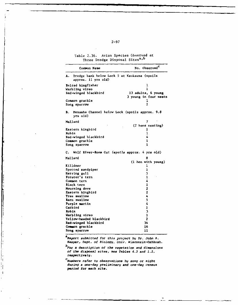
2-97
Table 2.36. Avian Species Observed at
Three Dredge Disposal Sitesab
Common Name No. Observedc
A. Dredge bank below Lock 5 at Kaukauna (spoilsapprox. 11 yrs old)
Belted kingfisher 1Warbling vireo 1Red-winged blackbird 13 adults, 6 young
3 young in four nestsCommon grackle ISong sparrow 2
B. Menasha Channel below Lock (spoils approx. 9.8yrs old)
Mallard 7(2 hens nesting)
Eastern kingbird 1Robin 1Red-winged blackbird 4Common grackle 1Song sparrow 1
C. Wolf River-Boom Cut (spoils approx. 4 yrs old)
Mallard 8(I hen with young)
Killdeer 1Spotted sandpiper 1Herring gull 5Forster's tern ICommon tern 4Black tern IMourning dove 2Eastern kingbird 2Tree swallow 4Barn swallow 5Purple martin 4Catbird 1Robin 3Warbling vireo IYellow-headed blackbird 2
Red-wined blackbird 34Common grackle 16Song sparrow 11
aReport submitted for this project by Dr. John A.Kaspar, Dept. of Biology, Univ. Wisconsin-Oshkosh.
bFor a description of the vegetation and dimensions
of the disposal sites, see Tables 4.3 and 1.2,respectively.
CNumbers refer to observations by song or sight
during a one-day preliminary and one-day census
period for each site.
260The Wc,,f R'*'.(, Llt '.lm.i' Pool, Lad the Tower Fox River differ intheir watcr (:di't, tCr>'I- I5ta -.l: *'rd nutrient sources. The WolfRivt.t thhe bes,' ; r r ,., in the project area,1 1 while the LowerFo:.: Rivt.- has the p',cr-';r water quality. 1 4 The highest level of primaryproductivitv occurs w !!,!i- th 'nnebago Pool, while the Wolf Riverprobably has che Ioweit 1', 1 .6 The sources of nutrie-its for the Wolf
River are the extensivc &Yras of wvtlands, runoff (natural and agricul-tural) and small amouMts oS effluupts from various small municipalities
and industries. I It the Winv,'bao Pool the sources of nutriento are theWolf Rivet, whiuh supplios 7' percent of the flow to this pool, largeareas of wetlands bucderi: > ile lakes, runoff (natural and agricultural)and effluents from modeurte sized municipalities (principally Fond du Lacand Oshkosh) and their i duLtries. The Lower Fox River receives its nu-trients from the Poonlctugn P,.l, wiich supplies i.ost of the flow in thisriver, from runff (natural and some agricultural) and larger amounts ofeffluents from industr4e3: and mTunicipaiities. 14 About 90 percent of thepoint source-; of nutrierc iiput (industrial and municipal) in the LowerFox River is fiom ind,.strv, ,' The nutrient and organic input is so
great at times that disso'ved oxygen concentrations decrease to nearlyzero over 10--20 miles cf the tiver, especially during the summer months,making this water unfit for most organisms.
14 ,7 1
2.261It is difficult to compare each of the three ecosystems mentioned abovein terms of their species diversity because little data exists forsimilar species groups in each ecosysLem. It is apparent, however, thatthe Wolf River and the 1.7innebago Pool have much richer biotic communitiesthan does the Lower lox River. Thougl, dota limitations do exist, thespecies composition and relative abundance or densJ.ty for phytoplankton,zooplankton, benthos and fish in each ecosystem will be compared as muchas possible. The subseqL ent discussions concerning most of these groups
will be primairily qualitative. Better quantitative data do exist on fishspecies and these will be used where appropriate. The data that are
available on the other troohic levels have been collected from onl, alimited number cC sampling stations or orly over a short period of time.It is, therefore, difficult to determine if these are repiesentativedata. This is particularly true for primary producers such as Chloro-phyta, Cchrysophyta, and Cyanophyta, and invertebrates such as clado-cerans, Copepoda, and insects. The populations of these organisms mayfluctuate erratically over very short periods of time. Therefore, timingfor sample collection Is critical.
2.262Reasons, other than the availability of data, for discussing Che fish inmore detail in this and other sections are their economic importance apdtheir great susceptibility to environmental perturbations. Primaryproducers, zooplankton, and iaost benthic invertebrates have relativelyshort generation times (a capacity for rapid reproduction and largepopulation sizes). Consequently, they usually recover faster fromenvironmental vagaries than fish which have longer generation times, alower capacity for rapid reproduton, and smaller population sizeq. 72
2-99
Since fish are usually unable to adapt to environmental changes asrapidly as these other (lower) species, they are more likely to beadversely affected by the maintenance and operation activities of theproject.
2.263Phytoplankton - Over one hundred phytoplankton species are known to occurin the Fox-Wolf River Basin. 7 3 The dominant species in this pool are thecentric diatoms Melosira ambigia (summer), M. granulata (summer),stephanodiscus niagarae (autumn), and S. Hantzschii (winter). During thesummer there are large populations of the blue-green alga Anabaena sp.,while the pennate diatoms AsterionelLa formosa formosa and Synedrasp. are common during the spring and autumn. 73 The present speciescomposition is not well known for the Wolf and Lower Fox Rivers. Un-doubtedly there is some similarity since the Winnebago Pool receives agreat deal of water from the Wolf River and supplies the bulk of thewater for the Lower Fox River.
2.264Primary productivity data (mg carbon/m 2/day) are available for Lake Buttedes Morts and may be characteristic of the Winnebago Pool. 69 Thesefigures ranged from 33.3-5200 with an annual average of 806 and an openwater average of 1277 for 1968. Based on data from Epstein et al. 70 thisannual primary productivity figure is indicative of polluted waters (350-700 mg carbon/m 2/day compared to 75-250 mg carbon/m2 /day for naturaleutrophic water). It is likely that the Wolf River has lower primaryproduction levels because of its lower nutrient levels. The unpublishedstudies mentioned in the preceding paragraph should be available laterthis year and should supply these data for the Lower Fox River.
2.265Sloey 75 indicated that an increase in the volume of phytoplankton in theWinnebago Pool has occurred during the past 60 years (1908-1968). Thisdoes not necessarily mean that a change in levels of primary productionhas occurred since it is really the rate of carbon fixation, rather thanstanding crop, which is indicative of primary productivity. He didindicate, however, that the numbers of "eutrophic indicator" species hasincreased, a fact which may indicate a change in the nutrient status inthis pool.
2.266A large amount of emergent and submergent vegetation contributes to theprimary productivity in at least two of these aquatic systems (the WolfRiver and the Winnebago Pool). These types of vegetation were previouslydiscussed in the botanical section.
2.267Zooplankton - The dominant zooplankton genera known to exist in theWinnebago Pool during 1971 and 1972 were the cladocerans Bosmina,Chydorue, Daphnia, and Eurycercue and the copepods Cyclops and Diaptous. 76
During 1971 the cladocera averaged 82% of the total zooplankton, while in1972 they averaged 58%. Bosmina, Daphnia and Eurycercus were the domi-nant Cladocera in 1971 and Chydorus and Daphnia were dominant in 1972.
2-100
CyctopZ and Viaptomu 6 were the only copepoda noted In both years. The
three cladocera and two copepoda averaged 93% of the zooplankton in 1971
aud the two cladocera and two copepoda genera 96% in 1972. The dominant
genus both years was Daphnia averaging 49% and 34% of the zooplankton in1971 and 1972, respectively.
2.268The total average numbers and range of zooplankton/liter for 1971 and
1972 were 481 (203-1117/liter) and 379 (136-934), respectively. If thesedensities are representative, they are indicative of the eutrophicnature of the Winnebago Pool. Such densities should provide abundantfood for fish such as freshwater drum, white bass and yellow perch, whichare known to feed on zooplankton.
2.269The species composition and density of zooplankton in the Wolf and LowerFox Rivers are unknown at present. There undoubtedly is some similarityin species composition since the Winnegabo Pool is the recipient of Wolf
River waters and the major water supply for the Lower Fox River.
2.270Benthos - Table 2.37 lists the benthic invertebrate species that areknown to exist in the Winnebago Pool and the Lower Fox River. Data ofthese waters are difficult to compare because they are incomplete. Thedata for the Lower Fox River are based on a 1957 study 71with updated 1975data from the Institute of Paper Chemistry. Those for the Winnebago
Pool are based on a study of Ch'onomow6 ptum0ou by Hilsenhgfg7 and onstud~s8~jnShe food habih of freshwater dru 6
78 '79 sauger, - wall-eye, ' white bass, and yellow perch.
2.271Of the 48 benthic invertebrate species identified in the 1957 study ofthe Lower Fox River, 10 species (21%) were pollution intolerant and theremaining 38 species (79%) were either pollution tolerant or very toler-ant. Table 2.38 indicates that all of the intolerant species identifiedin the 1957 study occurred only in the upper part of the Lower Fox Riverand that, generally, greater numbers of the tolerant and very tolarant
species occurred in the upper part than in either the middle or lowerparts. Th? lower part of the Lower Fox River had the lowest speciescomposition (2 species) and abundance (1-10 organisms/sample). Pollutioneffects were (and continue to be) much greater in this part of the riverthan in the rest of the river. This depauperate benthic community wasconsistent with the poorer water quality found in the lower part of theLower Fox River. The more recent 1971-1975 studies performed by theInstitute have documented the existence of sensitive or intoleratemacroinvertebrate forms in virtually all areas of the Lower Fox Riverunder high and moderate flow conditions. Low flow and high temperatureperiods reduce and in some cases eliminate these sensitive and intolerantforms from much of the river.
2.272Based on the very limited benthic data from Lake Winnebago,7 7 about 3 dutof 25 species (12%) are intolerant,' Vhch Is-roughly comparable to the
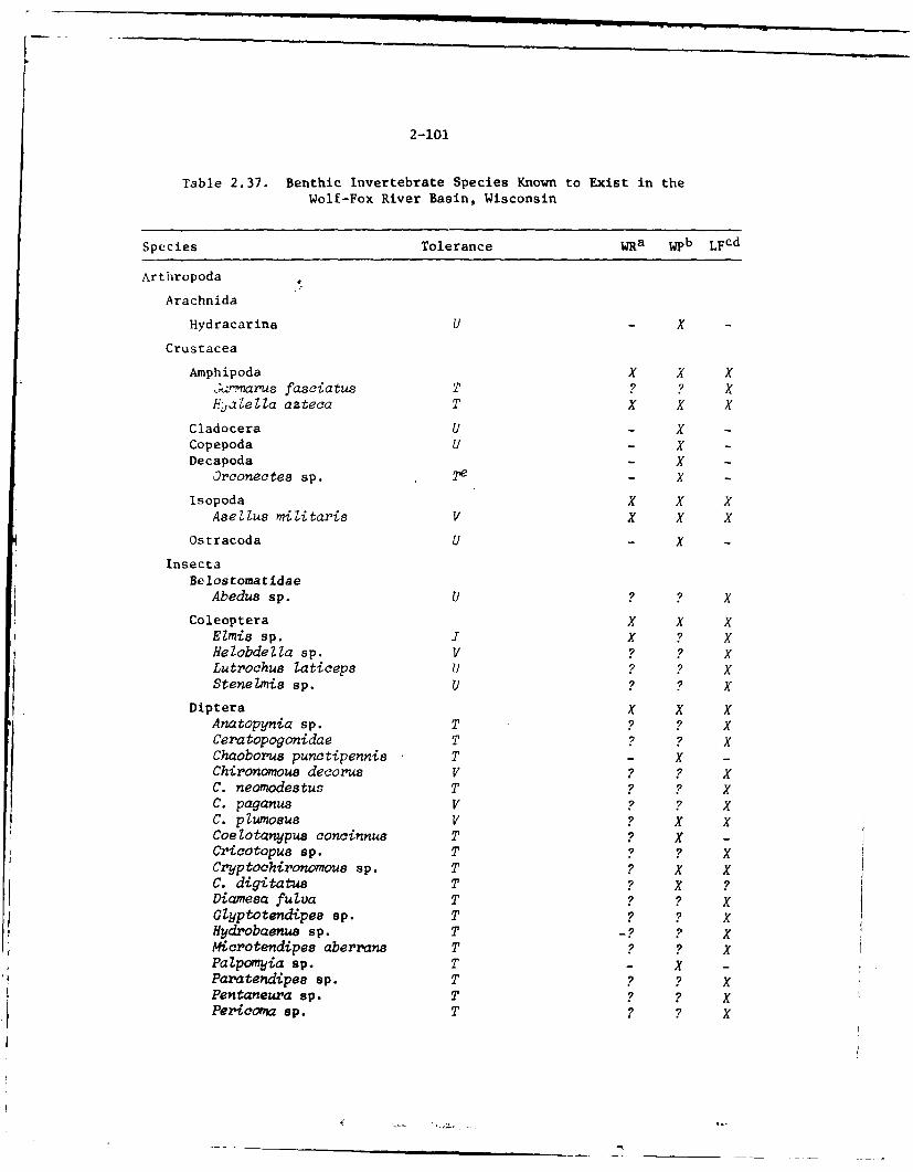
2-101
Table 2.37. Benthic Invertebrate Species Known to Exist in theWolf-Fox River Basin, Wisconsin
Species Tolerance WRa. Wpb LFcd
Arthropoda
Arachnida
Hydracarina U - x -
Crustacea
Amph ipoda X X X;.z-marus fasciatus T ? ? X
Hjae Ua azteca T' X X X
Cladocera U - X -
Copepoda U - x -Decapoda. - X -
Orconectee sp. 2'e - X -
Isopoda X X XAseilus miiitaris V X X x
Ostracoda U - X -
InsectaBelostomatidae
Abedus sp. U ? ? xCo leop tera X X X
Elmis sp. IX ? XHelc'bdelia sp. V ? ? XLutrochus taticeps U? ? XStenelxnis sp. U? ? X
Diptera X X XKAn: topynia sp. T 9Ceratopogonidae T' XChaoborua ucieni
C. neornodestus T ? ? XC. paganus V ? ? XC. plUmnOSUS ? X XCoelotcrnypus conciznnue T ? XCricotopus sp. T ? ? XCry~ptohironomous sp. T ? X XC. digitatus T ? X ?Diamesa fuivz T ? ? XGlyptotendipes sp. T' ? ? xRydr'obaenu8 sp. T _?? XMicrotendipeo aberrans T2?' XPalpomyia sp. T' - X -
Paratendipee sp. T ? ? XPentaneura sp. T2?' XPericova sp. T ? X
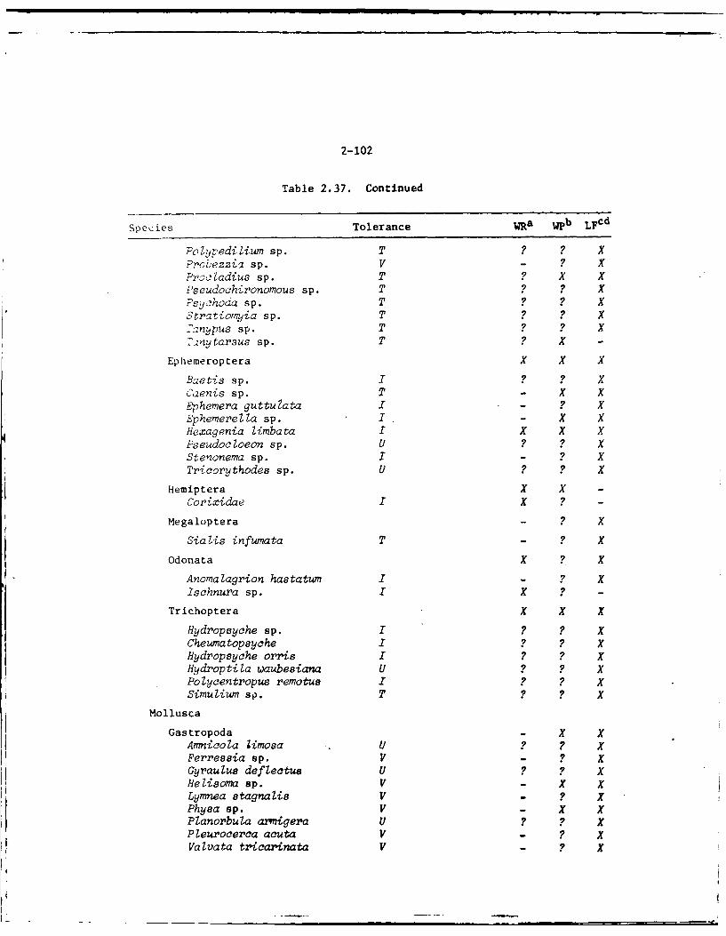
2-102
Table 2.37. Continued
Species Tolerance W~a. Wpb LFCd
Polypedilium sp. T ? ? XProbezzia sp. V - ? XProcladius sp. T ? xPseudochironomous sp. T' ? ? XPSLI~hoda sp. T' ? KStratiotmiia sp. T' ? ? x-zMpus sp. T ? KT',nytarsus sp. T' ? -
Ephemeroptera x x x
B.2etis sp. ? ?Caenis sp. T - X xEphemera guttuZata I- ? KEphemnerella sp. I- K KHexagenia limbata I X KPseudocloeon sp. u ? KStenonema sp. I - ?Tricorythodes sp. U ?K
Hemiptera x x -
,.Orixidae I ? -
Megaloptera - ? X
Sialis infumata T' - ? K
Odonata K ?I
Anomalagrion hastatwn I - ?Ischnura sp. I K -
Trichoptera x X x
Hydropsyche sp. ? ?Cheumatopsyche ? ? KHydropsyche orris ? ?Hydroptila waubesiana u ? K
Mollusca
Gastropoda - X KAmnicola iimosa U ? KFerressia sp. V - ? KGyraulus defiectue U ?Klielisoma sp. V - K KLyrnnea stagnalis V - ? XPhyea sp. V - x xPlanorbula axrigera U ? ? XPleurocerca acuta V - ? KVaivata ttricarinata V - ? X
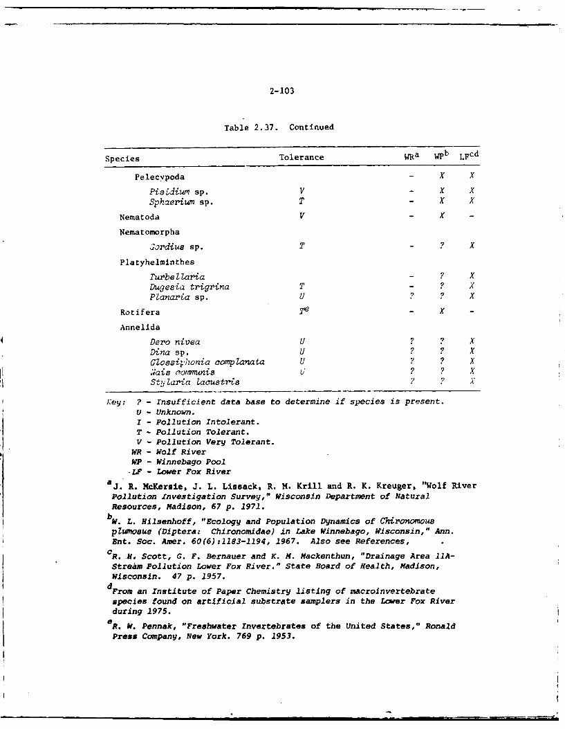
2-103
Table 2.37. Continued
Species Tolerance Wa w4pb LFCd
Pelecypoda - X
Piszdium sp. V - X XSphaeriwn sp. T - x x
Nematoda V - X -
Nematomorpha
;ordius sp. T - ? X
Platyhelminthes
Turbellaria - ? XDugyesia trigrina T - ? XPlanaria sp. U ? ? X
Ratifera - X -X
Annelida
Dero nivea U ? ? XDina sp. U ? ? XGiosaithonia complanata U ? ? X7~ais cormnis U ? ? XSt,1 lania Zacustris ?X A
Key: ? - Insufficient data base to determine if species is present.U - Unknown.I - Pollution Intolerant.T - Pollution Tolerant.V - Pollution Very Tolerant.
WR - Wolf RiverWP - Winnebago Pool-LF - Lower Fox River
a J. R. McKersie, J. L. Lissack, R. M. Krill and R. K. Kreuger, "Wolf River
Pollution Xnvestigation Survey," Wisconsin Departme'nt of NaturalResources, Madison, 67 p. 1971.
W. L. Hilsenhoff, "Ecology and Population Dynamics of Chironomous
p luu (Di ptera: Chironomida.) in Lake Winnebago, Wisconsin," Ann.Ent. Soc. Amer. 60 (6) :1183-1194, 1967. Also see References,
c R .H,~ Scott, G. F. Bernauer and K. M. Macken thun, "Drainage Area llA-Stream Pollution Lower Fox River." State Board of Health, Madison,Wisconsin. 47 p. 1957.d From an Institute of Paper Chemistry listing of macroinvertebrate
species found on artificial substrate samplers in the Lower Fox Riverduring 1975.
e R. W. Pennak, "Freshwater Invertebrates of the United States," Ronald
Press Company, New York. 769 p. 1953.
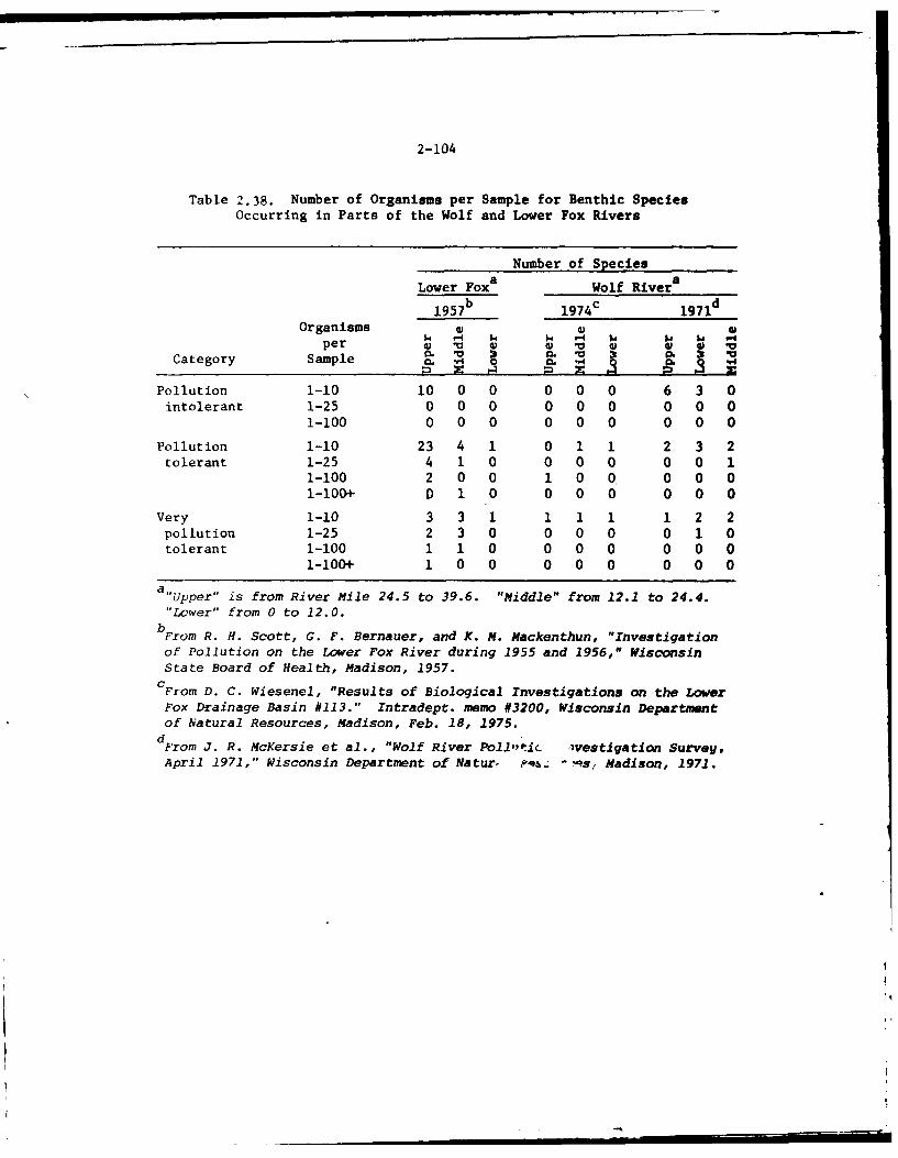
2-104
Table 2.38. Number of Organisms per Sample for Benthic SpeciesOccurring in Parts of the Wolf and Lower Fox Rivers
Number of Species
Lower Foxa Wolf River a
1957 b 1974 c 1971d
Organisms W oper 41 W W V 4) 0 V
Category Sample
Pollution 1-10 10 0 0 0 0 0 6 3 0intolerant 1-25 0 0 0 0 0 0 0 0 0
1-100 0 0 0 0 0 0 0 0 0
Pollution 1-10 23 4 1 0 1 1 2 3 2tolerant 1-25 4 1 0 0 0 0 0 0 1
1-100 2 0 0 1 0 0 0 0 0i-100+ D 1 0 0 0 0 0 0 0
Very 1-10 3 3 1 1 1 1 1 2 2pollution 1-25 2 3 0 0 0 0 0 1 0tolerant 1-100 1 1 0 0 0 0 0 0 0
1-100+ 1 0 0 0 0 0 0 0 0
a"Upper" is from River Mile 24.5 to 39.6. "Middle" from 12.1 to 24.4."Lower" from 0 to 12.0.
bFrom R. H. Scott, G. F. Bernauer, and K. M. Mackenthun, "Investigationof Pollution on the Lower Fox River during 1955 and 1956," WisconsinState Board of Health, Madison, 1957.CFrom D. C. Wiesenel, "Results of Biological Investigations on the LowerFox Drainage Basin #113." Intradept. memo #3200, Wisconsin Departmentof Natural Resources, Madison, Feb. 18, 1975.dFrom J. R. McKersie et al., "Wolf River Pollti -vestigation Survey,April 1971," Wisconsin Department of Naturf ?q4- "s, Madison, 1971.
U I I U l-
2-105
upper part of the Lower Fox River. In this study Hilsenhoff recorded
several benthic species and their densities at four stations in LakeWinnebago over a four-year period (1961-1964). The overall averagedensity of benthic organisms for this period was about 9800 organisms persquare foot. Of this, roughly 93% (9140/sq ft) were Crustaceans includ-ing Cladocera, Ostracoda, and Copepoda in ascending order of abundance.Chironomid larvae, consisting of at least six species, were second inabundance and represented about 4.6% (455/sq ft) of the total density.Clams from the family Sphaeriida( were third in abundance and representedabout 01.6% (104/sq ft) of the total density. Three species of leecheswere fourth in abundance, and represented about 0.6% (61/sq ft) of the
total density.
2.273If these numbers are representative of the entire Winnebago Pool, theyindicate a substantial source of food for fish sp75ies known to feed onthese organisms, including lake sturgeon,8 5 carp, and freshwater drum.The high numbers of these organisms are also indicative of enrichedwaters.
2.274Fish - As exemplified in Table 2.38, a rich fish fauna exists within theproject waters. Of the 82 species that are known to exist, 22 are sportfish and three are of major commercial importance. The remaining 57species are either forage fish or are rough (undesirable) fish of lessercommercial importance. Five of these species are of possible legalimportance since they are either on the National Endangered SpeciesList 8 6 or the Wisconsin Endangered Animal List.8 7 The lake sturgeon ison the national list while the greater redhorse (endangered), pugnoseshiner (endangered), and river redhorse (changing status) are on theWisconsin list. The list of species for the Lower Fox and Wolf Riversare sketchy since no surveys have been made of the Wolf and only a pre-liminary survey has been made in the Lower Fox.8 8 As shown in Table 2.39the meager data that are available for the Wolf have been extracted froma number of reports as anecdotal information.
2.275Low water quality has resulted in annual fish mortalities as far back as1925 for the Fox River. During the months of late June to early Septem-ber, high temperatures and low flow can cause very low levels of dis-solved oxygen over 10 to 20 miles of the Lower Fox River. Levels of DObelow 1 mg/l are not uncommon. This level of dissolved oxygen virtuallyexcludes the possibility of residemt fish populations in these stretchesof the river. However, fish populations in the Fox River and SouthGreen Bay (with emphasis on the two and one-half mile section of the FoxRiver downstream from the DePere Dam) sampled in a recent survey indicatethat the Fox River fishery is far more diverse than is generally thought.
2.276Data collected by the Wisconsin Department of Natural Resources in apreliminary 1973-1974 survey investigation recorded 45 fish species withbullhead spp., carp, white bass, a*d white sucker accounting for approxi-
2-106
Table 2.39. Fish Species Known to Existin the Fox-Wolf River Basin, Wisconsin
Sta- SystemSpecies tus WR ULa LF
PetromyzontidaeChestnut lamprey Ichthyoinyzon castaneus - KSilver lamprey I. unicuspus X K
Ac ipens erid a e~ X XLake sturgeon A. fulvescens EN ~i
Lepi soste idaeLongnose gar Lepisosteus osseus X KShortnose gar L. platostomtus X K K
Arni i heBowf in Amia calva X K X
ClupeidaeAlewife Alosa pseudoharengus -
Cizz-ard shad Dorosoma cepedianum K K K
SalmonidaeRainbow trout Salmo gairdneri - KBrown trout S. trutta - XBrook trout Salve linus frontina lie - KLake trout S. namaycush - K
Hiodont idaeMooneye Hiodon tergisus K K
UmbridaeCentral mudminnow Umbra limi K K
Esocidae ~Northern pike Esox lucius XMuskellunge E. masquinony Ke K
CyprinidaeStoneroller Cwnpostoma anomalum - KNorthern redhelly
dace Phoxinus ecs - XCarp Cyprinus carpio K9 K KHornyhead chub Nocomis biguttatus - KGolden shiner Notemigonus crysoleucas K K
Pugnose shiner Notropis anogenue EW XEmerald shiner N. atherinoides K KRiver shiner N. blennius X
2-107
Table 2.39. Continued
Sta- SystemSpecies tus WR UL a Lb LF C
Blackchin shiner N. heterodon - XBlacknose shiner N. heterolepis - XSpottail shiner N. hudsonicus X KRosyface shiner N. r-ubeZIus - KSpotfin shiner N. spilopterus x xSand shiner N. strconineus - xMimic shiner N. volucellus - xPugnose minnow N. emiliae - KBluntnose minnow Pimepha les notatus K xFathead minnow P. promelas - XLongnose dace Rhinichthys cataractae - KCreek chub Semotilus atromaculatus - X
CatostomidaeQuiliback Carpi odes cyprinus X xWhite sucker Catostomus conmersoni x K XLake chubsucker Erimyzon sucetta x xBigmouth buffalo Ictiobus c~prineZIus - XSpotted sucker Minytrena metanops K KSilver redhorse Moxoatoia anisurum x -Golden redhorse M. erythrur'n X -Shorthead redhorse M. macroliepidotwn x XGreater redhorse M. valenciennesi EW K XNor thern hogsucker Hypenteliwn nigricans K -
Ic taluridaeBlack bullhead Ictalurus melas X X XBrown bullhead I. nebulosus K XYellow bullhead I. natalis K XChannel catfish I. punctatus x X XFlathead catfish Pylodictis olivaris X XStonecat Noturue flavu6 - KTadpole mad torn N. qyri nus - X
CyprinodontidaeBanded killifish Fundulus diaphanus K x
Gad idaeBurbot Lota Iota K X X
GasterosteidaeBrook stickleback Culaea inconstans K X
Percops idaeTrout-perch Percopsia oflfl-comaycua K K
2-108
Table 2.39. Continued
Sta- System
Species tus WR ULa LWb LFc
PercichthyidaeWhite bass Morone chry8ops X, X X XYellow bass M. mississippiensis X X
CentrarchidaeBlack crappie Pomoxis nigromaculatus X X X
Bluegill Lepomis macrochirus X X XLargemouth bass Micropterus salmoides e X X XPumpkinseed L. gibbosus X X XRockbass Ambloplites rupestri8 X X XSmallmouth bass M. dolomieui X, X XWhite crappie P. annularis X X
PercidaeBanded darter Etheostoma zonale - XBlackside darter Percina maculata - XFantail darter E. flabellare - XIowa darter E. exile - XJohnny darter E. higrwn - XRiver darter P. shumardi - XLog perch P. caprodes - XSauger Stizostedion canadense - XWalleye S. vitreum vitreum L X X XYellow perch Perca flavescens X X X
SciaenidaeFreshwater drum Aplodinotus grunniens X X X
CichlidaeMozambique
mouthbrooder Tilapia mossambica - X
CottidaeMottled sculpin Cottus bairdi - X
Key: EW = Wisconsin Endangered SpeciesEN = National Endangered SpeciesCSW = Wisconsin Changing Status SpeciesUL = Upper Lake including Butte des Morts, Poygan and WinneconneWR = Wolf RiverLW = Lake WinnebagoLF = Lower Fox River to De Pere DamX = Present- = Absent
a From personal communication with John J. Weber, Regional Fish Biolo-gist, Wisconsin Department of Natural Resources, Oshkosh, Wiscon in.
2- 109
Table 2.39. Continued
bFrom G. R. Priegel, "A List of the Fishes of Laku Winnebago," Research
Report No. 27 (Fisheries), Wisconsin Dep t. of Natural Resources,Madison, 1967.
CFrom Lee T. Kerner, "Fishery Investigations on the Lower Fox River and
Green Bay in 1973-1974," Wiscor.sin Department of Natural Resources,Green Bay.
dFrom G. R. Priegel and T. L. Wirth, "The Lake Sturgeon--Its Life
History, Ecology and Management," Publication 4-3600(74), WisconsinDept. of Natural Resources, Madison, 1974.
eFrom H. C. Jordahl, "A Preliminary Report in Recreational Values of
the Wolf River Basin, Wisconsin,"'Wisconsin Dept. of Natural Resources,Madison, 1960.
fFrom G. R. Priegel, "Movement and Harvest of Tagged Northern PikeReleased in Lake Poygan and Big Lqke Butte des Morts," Research Report#29 (Fisheries), Wisconsin Dept. of Natural Resources, Madison, 1968.
gFrom G. R. Priegel and D. W. Morrissette, "Carp Migration in the LakeWinnebago Area." Bureau of Fish Management Report No. 42, WisconsinDepc. of Natural Resources, Madison, 1971.
hFrom G. R. Priegel, "Reproduction and Early Life History of theWalleye in the Lake Winnebago Region," Technical Bulletin No. 45,Wisconsin Dept. of Natural Resources, Madison, 1970.
I I I I -
2-110
mately 80 percent by number of 23,202 fish examined over the two yearperiod. 88 Other common species included the black crappie, perch, wall-eye, and channel catfish. Still other less abundant species werereported in increasing numbers and chinook salmon were observed clearingthe DePere Dam and foraging upriver during the fall spawning run.
2.277It is an encouraging sign that the fishery in the upper and lowermostpools of the Fox River has improveo during the last few years. Despitecontinuing improvements in stream Water quality, the Fox River neverthe-less contains a very marginal fishery at the present time. Fed from thefish rich Great Lakes downstream, As well as the receiving immigrantsfrom the Winnebago Chain, this fishery survives as long as surface runoffprovides a sufficiently large volume of water in the stream.
2.278Seventy-six species belonging to 2 families are now present or have beenreported in the past in Lake Winnebago.9 2 The families Cyprinidae (min-nows), with 21 species, and Percidge (perch) with a total of 10 species,contribute the largest number of species to the lake. The Ictaluridae(catfishes) and Centrarchidae (Sunfishes), each with 7 species, Ind theCatostomidae (suckers) with 6 species are also well represented.9 2 Somespecies, like the members of the trout family Salmonidae, do not exist inthe lake on a yearly basis but are migrants from Big Green Lake or troutstreams flowing into the Wolf or FOx Rivers.9 2 The more important andabundant game fish species are wal~eye, saugee, yellow perch, lake stur-geon, and white bass. The most important commercial species is thefreshwater drum. Based on commercial data, substantial carp populationsexist in the Winnebago Pool and the Wolf River.
References
1. J. H. M1arter and R. N. Cheetham, "Areal Measurement and Nomen-clature of Watersheds in the Southeast Wisconsin Rivers Basin,"[1. S. Dept. of Agriculture, 78 pp., September 1971.
2. "The National Atlas of the United States," U. S. Dept. of Interior,Geologicai Survey, 417 pp., 1970.
3. "Wisconsin Highway Map 74," State of Wisconsin, Dept. of Trans-portation, Division of Highways, 1974.
4. "Flood Plain Information - Wolf River - Lake Poygan to Shawano,Wisconsin," U. S. Army Corps of Engineers, 48 pp. plus 18 plates,August 1969.
5. "Wisconsin Lakes," Wisconsin Dept. of Natural Resources, 79 pp.,1972
6. "Flood Plain Information - City of Oshkosh, Wisconsin," U. S. ArmyCorps of Engineers, 31 pp. p us 17 plates, July 1973.
2-111
7. "Flood Plain Information - Fox River - Winnebago and Outagamie
Counties, Wisconsin," U. S. Army Corps of Engineers, 33 pp. plus 34plates, May 1974.
8. "Local Climatological Data Annual Summary with Comparative Data,Green Bay Wisconsin," National Climatic Center, Asheville, N. C.,1974.
9. "Climates of the States, Vol. I, Water," Information Center, Inc.,Port Washington, N. Y., 1974.
10. A. R. Striegl, "Engineering and Economic Study of the Lower FoxRiver, Wisconsin," Prepared for the Chicago District, Corps ofEngineers, U. S. Dept. of the Army, 1969.
11. J. R. McKersie et al., "Wolf River Pollution Investigation Survey,April 1971," Wisconsin Dept. of Natural Resources, Madison, 1971.
12. "Water Quality and Flow of Streams in Northeastern Wisconsin,"Northeastern Wisconsin Regional Planning Commission, Appleton,February 1970.
13. F. H. Schraufnagel et al., "Report on an Investigation of thePollution in the Upper Fox River Basin Made during 1966 and Early1967," Wisconsin Dept. of Natural Resources, Madison, 1967.
14. F. H. Schraufnagel et al., "Report on an Investigation of thePollution in the Lower Fox River and Green Bay during 1966 and1967," Wisconsin Dept. of Natural Resources, Madison, January 1968.
15. J. H. Wiersma et al., "Contribution of Nutrients to the Lower FoxRiver by Municipal Treatment Plants," College of EnvironmentalSciences, Univ. of Wisconsin-Green Bay.
16. P. E. Sager and J. H. Wiersma, "Nutrient Discharges to Green Bay,Lake Michigdn, from the Lower Fox River," Proc. 15th Conf. GreatLakes Research, 1972.
I?. P. E. Sager and J. H. Wiersma, "Phosphorus Sources for Lower GreenBay, Lake Michigan," Water Pollution Control Federation, March1975.
18. "Physical and Chemical Quality Conditions, Lake Michigan Basin,"FWPCA, Great Lakes Region, Chicago, January 1968.
19. D. Crevensten, A. Stoddard and G. Vajda, "Water Quality Model ofthe Lower Fox River, Wisconsin," EPS Document 90573001, NTS
No. PB230, 260, August 1973.
20. D. Pattersen, "Results of a Mathematical Model of the Lower FoxRiver, Wisconsin," Wisconsin Dept. of Natural Resources, Madison,1973.
2-112
21. "Surveys of Toxic Metals in Wisconsin," Tech. Bull. No. 74,Wisconsin Dept. of Natural Resources, Madison, 1974.
22. J. G. Konrad, "Mercury Content of Various Bottom Sediments, SewageTreatment Effluents, and Water Supplies in Wisconsin," PreliminaryReport. Research Report No. 74, Wisconsin Dept. of NaturalResources, Madison, 1971.
23. A. M. Springer, "Investigacion of the Environmental Factors whichAffect the Anaerobic Decomposition of Fibrous Sludge Beds on StreamBottoms," Ph.D. thesis, Institute of Paper Chemistry, LawrenceUniversity, Appleton, Wis., 1972.
24. P. G. Olcott, "Water Resources of Wisconsin, Fox-Wolf River Basin,"Hiydrologic Atlas, HA321, 1968.
25. P. G. Olcott, "Geology and Water Resources of Winnebago County,Wisconsin," Water Supply Paper 1814, U. S. Geological Survey,U. S. Dept. of Commerce, 1966.
26. D. Thornbury, "Regional Geomorphology of the United States,"John Wiley and Sons, Inc., New York, 1965.
27. "W;iter and Related Land Resources, Southeast Wisconsin RiversB ,sin, Wisconsin, Illinois, and Michigan," Soil ConservationService, U. S. Dept. of Agriculture, 279 pp., 1974.
28. R. F. Black, "The Physical Geography of Wisconsin," Univ. ofWisconsin Geological and Natural History Survey, 7 pp., 1964.
29. "Suils of the Fox Valley Region," East-Central Wisconsin RegionalPlanning Commission, 1967.
30. S. T. Algermissen, "Seismic Risk Studies in the United States,"Proc. Fourth World Conf. on Earthquake Engineering, Santiago,Chile, January 1969.
31. R. B. Keener, Vol. 7, "Earthquake History with Application to theLake Michigan Drainage Basin," of Report Series ANL/ES-40,"Environmental Status of the Lake Michigan Region," ArgonneNational Laboratory, Argonne, Ill., 1974.
32. G. N. Broderick, "The Mineral Industry of Wisconsin," Preprint fromthe 1972 Minerals Yearbook, Bureau of Mines, U. S. Dept. of theInterior, Washington, D. C., 12 pp., 1973.
33. Cumulative data obtained by the staff from the Office of TechnicalData Service, Bureau of Mines, U. S. Dept. of the Interior,Washington, D. C.
34. "Soil Survey of Fond du Lac County, Wisconsin," U. S. Dept. ofAgriculture, Soil Conservation Service, April 1973.
2-113
35. "Wisconsin Statistical Abstract," 3rd Ed., Doc. No. BSP-IS-74-6,Dept. of Administration, State Bureau of Planning and Budget,
Information System Unit, June 1974.
36. R. Fassbender, J. Weber and C. W. Threinen, "Surface WaterResources of Waupaca County," Wisconsin Dept. of Natural Resources,Madison, 84 pp., 1971.
37. "Waupaca County, Wisconsin," Waupaca County Chamber of Commerce,Waupaca, Wisconsin, 1 p. map uith descriptive text.
38. "Waupaca County Story," Waupaca County Chamber of Commerce,W.upaca, Wisconsin, 64 pp., 1975.
39. "1970 Census of Population--Number of Inhabitants--Wisconsin,"U. S. Bureau of the Census, U. S. Dept. of Commerce, Washington,D. C., 46 pp., June 1971.
40. "Wolf River Region, Comprehensive Planning Program," WisconsinDepartment of Natural Resources, Feb. 1966.
41. "Preliminary Planning Report No. 3," Calumet County, Dept. ofPlanning, Chilton, Wisconsin, 78 pp., December 1970.
42. "Brown County Regional Planning Program--A Summary of Plan Recom-mendations," Brown County Board of Supervisors, Green Bay, Wiscon-sin, 1 p. map with supporting text, May 21, 1968.
43. "United States Census of Agriculture, Wisconsin County Summaries,"U. S. Dept. of Agriculture Statistical Reporting Service, 12 pp.,1969.
44. "Fox Valley Area Transportation Study--Report of Existing Condi-tions," Wisconsin Dept. of Transportation, Div. of Planning,Madison, Wisconsin, 163 pp., July 1972.
45. "Road Atlas," 51st Edition, Rand McNalley & Company, pp. 100 and101, 1975.
46. "Official Airline Guide," North American Edition, R. H. DonnelleyPublications, Chicago, June 15, 1975.
47. House Document No. 146, 67th Congress, 2nd Session, 1920.
48. "National Registry of Natural Landmarks," Federal Register,38:23982-5, Sept. 5, 1973 and supplements 39:20405, June 10, 1974
and 39:37226, Oct. 18, 1974.
49. "National Register of Historic Places, Part 2," Federal Register40:5241-5345, Feb. 4, 1975, and numerous supplements.
50. J. Prinsen, Dept. of Natural Resources, New London, Wis., Telephone
conversation, 1975.
2-114
' " . f,:ut Streams," Wisconsin Department of Natural Re-'ubi caLion No. 6-3600(74).
. V )74 Fishing Licenses sold by County," Wisconsin Dept.Resources, MadiEson, 1975.
S: . o;.t of Liceiise Sales," Wisconsin Dept. of Natural. ii on, 1975.
! ! i.ecreat cnal Values of the Wolf River Basin, Wiscon-* 1im ,i r.ay Report, Wisconsin Conservation Department, 1960.
.Ttdocr Rtcreation Plan," Department of Natural Re-7 .2.
i L '"T',O Vegetation of Wisconsin," Univ. of WisconsinXM:,, 057 pp,, 1959.
N. Kbriger, Vol. 10, "Vegetation of the Lake,g. ;'.:,n," of Report Series ANL/ES-40, "Environ-
t- ct. Lake Michigan Region," Argonne National,, e. Iii., April 1975.
Jr. aic! H. W. Thorne, "Wisconsin's 1968 TimbertS rv:ce Resource Bulletin NC-15, U. S. Dept. of
- _ 0 p., 1972.
.i "Aitauiogy of Rooted Aquatic Plants in Lakesnut. C' s Poygan, and Winneconne," 32 pp., (Unpublished
iu.: td to Wisconsin Dept. of Natural Resources, BureauM dison) .970.
z i. ,Ln, 1 n;pblished report submitted to Argonne National
,, rv ~chractcizing the forest and marsh vegetation of the
K -, ,r project area, 1975.
"W ' .,re. imai, In Wisconsin," with supplementary lists of-1.s a it; hneing status, extirpated animals, uncommon plants
v J c~- ct,.1rcuditles, Wisconsin Dept. of Natural Resources, 28 pp.,i. 7 ..
L j, A, Vol. 15. "Mammals of the Lake Michigan Drainage Basin,"S. tSries ANL/ES-40, "Environmental Status of the Lake
! M7,: ,ign Region," Argonne National Laboratory, Argonne, Ill.,I O f-p. , M'ay 1974.
h-7 f3 f-. m, ,i r ad C. 0, Mohr, "Fieldbook of Illinois Mammals,".. 2< 2'3 pp.'-, i972.
k ci rt and H, P. Grossenheider, "A Field Guide to the Mammals,"& tigtoo MiffLin Co., 284 pp., 1964.
2-115
65. E. R. Hall, "Handbook of Mammals of Kansas," Univ. of Kansas Museumof Natural History, Misc. publ. 7:1-1303, 1955.
66. Letter to file May 20, 1975. Wisconsin Dept. of Natural Resourcesmeeting.
67. E. D. Pentecost and R. Vogt, Vol. 14. "Amphibians and Reptiles of
the Lake Michigan Drainage Basin," In Report Series ANL/ES-40,"Environmental Status of the Lake Michigan Region," Argonne
National Laboratory, Argonne, Ill. (in preparation).
68. R. Vogt (memo to file May 20, 1975), Minutes of Wisconsin Dept.of Natural Resources meeting.
69. W. E. Sloey, "The Limnology of Hypereutrophic Lake Butte des Morts,Wisconsin," Proc. 13th Conf. Great Lakes Research, pp. 951-968,1970.
70. E. Epstein et al., "Lower Great Bay: An Evaluation of Existing andHistorical Conditions," Report EPA-905/9-74-006. EnvironmentalProtection Agency, Chicago, 281 pp., 1974.
71. R. H. Scott, G. F. Bernauer and K. M. Mackenthun, "Investigationsof Pollution on the Lower Fox River during 1955 and 1956,"Wisconsin State Board of Health, Madison, 47 pp., 1957.
72. E. 0. Wilson and W. H. Bossert, "A Prioner of Population Biology,"Sinauer Associates, Inc., Stanford, Conn., 192 pp., 1971.
73. W. E. Sloey and J. L. Blum, "The Algae of the Winnebago Pool andSome Tributary Waters," Wisconsin Acad. Sci., Arts and Letters,
60:125-145, 1972.
74. Personal communication with Dr. William E. Sloey, Biology Depart-ment, Univ. of Wisconsin, Oshkosh.
75. W. E. Sloey, "Phytoplankton Dynamics and Productivity in a Shallow,Highly Eutrophic Lake: With Special Reference to Melosira ambigua(Grun.) 0. mull. and M. granuZata (Ehr.) Ralfs. Ph.D. Dissertation,Univ. of Wisconsin-Milwaukee, 144 pp., 1969.
76. Personal communication with John J. Weber, Fish Biologist, WisconsinDept. of Natural Resources, Oshkosh.
77. W. L. Hilsenhoff, "Ecology and Population Dynamics of Chironomou8plumoeuS (Diptera: Chironomidae) in Lake Winnebago, Wisconsin,"Ann. Ent. Soc. Amer. 60:1183-1194, 1967.
78. G. R. Priegel, "Food of the Freshwater Drum, Aplodinotus grunniena,in Lake Winnebago, Wisconsin," Trans. Amer. Fish. Soc. 96:218-220,1967.
2-116
79. G. R. pl~iegel, "The Freshwater Drum: Its Life History, Ecologyand !tM agcment," Publication No. 236, Wisconsin Dept. of Natural
~** '. . E, rison, 15 pp., 1967.
80. G.F rL2e,"Food of Walleye and Sauger in Lake Winnebago,W~,.si-, Tr, nc. Amer. Fish. Soc. 92:312-313, 1963.
El. . v riEgel, "Food of Walleye and Wauger in Lake Winnebago,"Lise. -1s Report No. 6 (Fisheries), Wisconsin Dept. of Natural
;c~c~s, adison, 10 pp., 1962.
C. 0. " :~gl The Lake Winnebago Sauger: Age, Growth, Reproduc-ti,-n, i'cxl FT.bits and Early Life History," Tech. Bull. No. 43,
Wisx -' De-,(. of Natural Resources, Madison, 63 pp., 1969.
i. C. R. Iriegel, "Reproduction and Early Life History of the Walleyeii th.L 1,ikc Vinnebago Region," Tech. Bull. No. 45, Wisconsin Dept.
o. \c':a oscurces, Madison, 105 pp., 1970.
-2.1<.. P-ieg2 I, "Food of the White Bass, Roccus chrysops, in LakeWi'.r1ba29o, Wisconsin," Trans. Amer. Fish. Soc. 99:440-4.43, 1970.
5.C.VP:-:i-gaIl and f. 1U. Wirth, "The Lake Sturgeon. Its Life-is~ory, Ecclogy and Managemen~t," Publication 4-3600(74), Wisconsin
iatural Resources, Madison, 20 pp., 1974.
86 "U,'. sLit of Endangered Fauna," Fish and Wildlife Service,bec.t. of Irntc!rior, Washington, D. C., Federal Register,
Vol.. 43 -- Ao. 138, 22 pp., Sept. 1975.
eii. V i Ir arid K.. Fassbender, "Surface Water Resources of Brown'2c~nt,"Wisconsin Dept. of Natural Resources, Madison, 1972.
6?' . 2-r-.raI' :cmmunication with Lee T. Kernen, Fish Biologist, Wiscon-i.n U--;t. Of Natural Resources, Green Bay, Wisconsin.
13'. G. R. P-ec,"Evaluation of Intensive Freshwater Drum Removal inLake Virirnehago, Wisconsin, 1955-1966," Tech.* Bull. No. 47, Wiscon-Siui Dept. of Natural Resources, Madison, 28 pp., 1971.
90. C. R. Priegel and D. W. Morrissette, "Carp Migration in the LakeWinneb~igo Area," Bureau of Fish Management Report No. 42, WisconsinDept. of Natura. Resources, Madison, 8 pp., 1971.
91 C. R. ?riogel, "Age and Rate of Growth of the Freshwater Drum inLake Winnebago, Wisconsin," Trans. Amer. Fish. Soc. 98:116-118,
1969.
92. G. R. Priegel, "A List of the Fishes of Lake Winnebago," Report No.27, Wisconsin Department of Natural Resources, 1967.
93. G. R. Priegel, "Age and Growth of the Walleye in Lake Winnebago,"Wisconsin Acad. Sci., Arts and Letters 57:121-133, 1969.
2-117
94. N. E. Hairston, F. E. Smith and L. B. Slobodkin, "CommunityStructure, Population Control, and Competition," Amer. Nat.94:421-425, 1960.
95. G. R. Priegel, "The Movement, Rate of Exploitation and HomingBehavior of Walleyes in Lake Winnebago and Connecting Waters,Wisconsin, as Determined by Tagging," Wisconsin Acad. Sci., Artsand Letters 56:207-223, 1967.
96. N. A. Harriman, "Vascular Plant Flora of Lake Butte des Morts,"Department of Biology, Wisconsin State University - Oshkosh,Wisconsin, 32 pp., 1968.
97. G. R. Priegel, "Plentiful but Unknown," Wisconsin ConservationBulletin, May-June 1962.
98. C. R. Priegel, "Movement and Harvest of Tagged Northern PikeReleased in Lake Poygan and Big Lake Butte des Morts," ResearchReport No. 29 (Fisheries), Wisconsin Dept. of Natural Resources,Madison, 7 pp., 1968.
99. D. C. Krohn, "Summary of Northern Pike Stocking Investigations inWisconsin," Research Report No. 44, Wisconsin Dept. of NaturalResources, Madison, 35 pp., 1969.
100. Listing submitted for this project by Dr. John A. Kaspar, Depart-ment of Biology, University of Wisconsin-Oshkosh.
101. "Aerial Photo Interpretation Study on Fox and Wolf Rivers - LakesVegetation," Texas Instruments, Incorporated, Division of Eco-logical Services, November 1976.
102. H. A. Weckwerth et al, "Automatic Water Quality Monitoring Systemfor the Fox and Wisconsin Rivers," International Water ResourcesAssociation Paper, Chicago, June 4-6, 1974.
103. E. F. Joeres, Y. J. Litwin and J. T. Quigley, "A Guide to Water and
Related Land Use in the Lower Fox River Watershed; SelectedReferences and Commentary," Special Report No. 503, University ofWisconsin Sea Grant College Program.
104. R. Fassbender, J. Weber and C. W. Threiven, "Surface Water Re-sources of Waushara County," Wisconsin Department of Natural
Resources, 97 pp., 1970.
105. R. Fassbender and L. M. Nelson, "Surface Water Resources of Winne-bago County," Wisconsin Department of Natural Resources, 49 pp.,1975.
106. D. Patterson, E. Epstein and J. McEvoy, "Water Pollution Investiga-tion: Lower Green Bay and Lower Fox River," Wisconsin Department ofNatural Resources, Report No. EPA-90519-74-017, June 1975.
SECTION 3
RELATIONSHIP OF THE PROPOSED ACTION TO LAND-USE PLANS
INTRODUCTION
3.01In order to determine the Federal Project's relationship to area landuse plans and policies, the various types of land use adjacent to theproject streams and lakes were investigated, and discussions with thelocal and regional land-use planning and policy-making agencies wereundertaken.
TYPES OF EFFECTS
3.02The existence of a navigable waterway affects land use in direct andindirect fashions. Direct effects resulting from proposed operationand maintenance programs are: 1) the disposal of dredged materialsremoved during maintenance of the navigation channels, and 2) thefluctuation of water levels and water flows, both upstream and downstream,due to operation of the dams. The direct effects of disposal of dredgedmaterials are covering of existing land or the creation of new land ifopen water disposal or marsh filling is done. The direct effects ofadjustment of flows and changing of water levels are the variableexposure of land areas, changes in hydroelectric power generation, andshoreline movement.
3.03In addition, indirect effects of the project on land use can occur dueto three project related activities: 1) commercial navigation, 2) recrea-tional navigation, and 3) water-flow control. Since commercial navigationhas almost totally ceased on the Lower Fox River, Wolf River, or thelakes between the two rivers, this type of indirect effect can beignored.
3.04Recreational boating activity, which is prominent on the project areastreams, tends to support many businesses such as marinas, motels,fishing and bait shops, boat equipment sales, rental and repair shops,
etc. Also, the area tends to become developed for recreational use dueto the existence of vacation homes, lakeshore suburbs, and commercialestablishments that cater to the needs of permanent and transient popu-lations. Water-quality degradation, increased recreational activity,and loosely controlled waterfront development may in the long run dis-courage other types of land use that would otherwise make use of thewater resourceL
3-1
3-2
The flow of the Lower Fox River is affected by the control of storage inthe Lake Winnebago pool as authorized by various Congressional acts.This regulation is of such importance to municipal, water power, navi-gation, and general riparian interests along the river, ano around thelake, that Congress has enacted several special acts to require and setlimits for regulation. In the absence of this regulation there islittle doubt that much of the present intensive development along thelower river and around the lake would not have occurred.
EXISTING RELATIONSHIPS
3.06The limited, but continuous, requirement for dredged material disposalsites can, in some cases, compromise the land use of an area, while inothjer cases it can complement existing or newly proposed land use. Ifthe disposal of dredge materials constitutes the filling of floodplains,t natural areas, both physical and ecological damage may result. Onthe other hand, if a proper selection of disposal sites is made, thefilled sites can become more useful for man while at the same timeavoiding significant adverse impacts to ecosystems. Much of the shore-
4 line of the Wolf River is not suitable for human habitation and develop-ment because of frequent and oftensevere flooding. These areas are,however, prime natural marsh areas and as such are essential spawningand feeding habitat for fish, waterfowl, and other components of thenatural ecosystem. Thus, any disposal sites in this region must becarefully selected to minimize impacts to the natural system.
3.07The shoreline of the central or lake region contains natural areas(marshes frequented by waterfowl); developed areas including city andstate park lands, vacation homes, year-round homes, and industrialsites; and undeveloped land. Disposal sites for dredged materials inthis area must be selected to avoid conflict with both human andnatural utility and, if possible, used to increase the utility of thedisposal site itself.
3.08Disposal of dredged material in the Lower Fox River region is a diffi-
cult and sensitive problem because of the close proximity of urban andindustrial zones along the river from the Neenah and Menasha dams tothe area beyond Kaukauna and through the city of De Pere. In theseregions, disposal is generally predicated on increasing human utilityof the disposal sites while avoiding conflicts with the existing andproposed plans of the riparian landowners and communities.
3.09In meetings with the public planning and policy making agencies, aswell as with representatives of industrial concerns, it was evidentthat the riparian rights and water user interests are many and varied,!and that some of these rights and interests are in direct conflict.
3-3
3.10In additio;. to its primary navigation function, control of the waterlevels in Lake Winnebago and its upstream connected lakes providesimportant flood control benefits to riparian property interests.During .jinter, the impounded lakes are normally lowered below dam crestheight to provide storage capacity for snow melt and spring rains. Thisaction has the added advantage of reducing the damage potential to thenatural shoreline features and shoreline properties (houses, dock, etc.)of wind-drlven ice during the spring breakup. The water which isreleased but which is in excess of the steam flow required for hydro-power is a lost resource.
3.11
Low summer flow through the Fox River Valley below the Neenah andMenasha dams can be disadvantageous to the industrial interests of thevalley bv reducing process water availability and effluent dischargedilution capacity, often required for compliance with water qualitystandards. While some operating techniques of the dams on the LowerFox River satisfy some interests, these same techniques can adverselyaffect the utility, plans and policies of other interests. It isimportant to note that the present method of operation is not withoutits impacts, but the potential impacts are widely recognized and under-stood features of the present method of operation. They are, therefore,armtb:ipated by the local planners and normally considered in presentplanning and policy making activities.
3.12There is no demand for commercial navigation. Therefore the continuedoperation and maintenance of the project navigation channels is directedto recreational navigation. Since no significant increases in associ-ated types of economic development (marinas, commercial facilities, etc.)above and beyond the normal growth patterns already established areexpected, no changes in land-use plans policies regarding location ordegree of such development should be required.
3.13The cumulative effects of waterway operations and maintenance, naviga-tion, and waterfront development on water quality are not expected tochange from present conditions as the project does not include anychanges in existing causative factors.
COORDINATION WITH EXISTING PLANS
3.14Different types of effects on land use adjacent to the Fox River havebeen investigated and coordinated with land use planning agencies inpreparation of this EIS to identify and resolve conflicts with formalland use plans. From discussions with local planning agencies, it isconcluded that all current planning activity in the project study areais predicated on the assumption that the Corps of Engineers will continueto operate and maintain the Fox River project in accordance with projectauthorization. Since no changes in the methods and techniques of
3-4
operation are proposed by the Corps at this time, no adverse impacts tothe existing public land-use plans and policies in the study area areanticipated.
3.15While there are no known conflicts between the proposed action andcurrently established land use plans in the project area, this report
has identified various conflicts and problems of water resource manage-ment in the region. These have often been found to be highly complex Iand interrelated. Furthermore, thq demand on the water resource isintensifying and as use demands increase, conflicts of interest willbecome greater and more widespread.
3.16It is clear that an optimal solutio to these problems can only be foundby adopting a broad, comprehensive approach to water management andthat adoption of an overall approacih to water management focuses atten-tion on the need for greater cooperation and coordination-of developmentand management efforts within and between various levels of Federal,State and local government. As previously indicated, certain majorresource management planning studies are currently in progress. TheChicago District is participating in these studies. It is possiblethat the resulting future management plan, policies and objectives ofthese studies may lead to some important recommended modifications tothe authorized purposes, features, and operational management of theexisting Federal project in the future. It must be noted, however,that while an alternative method of. apportioning water use could berecommended, resource conflicts will inevitably continue to occur as long asproject area water resources continue to provide multiple use benetitsto such a wide range of diversified activities. Such modifications mayalso require authorization by the Congress.
SECTION 4
PROBABLE IMPACTS OF THE PROPOSED ACTION ON THE ENVIRONMENT
INTRODUCTION
4.01The proposed action will affect both the natural and the man-madeenvironment. In general, this project will be beneficial to the humanenvironment without creating serious adverse effects on the naturalenvironment. Little or no changes are expected to occur in project landand water uses due to the project.
4.02The impacts of the proposed and ongoing activities will depend on thetype of action and location where each is carried out. For example,dredging is conducted in all three regions of the project area (i.e.,
the Wolf River region, the Central or Lake region, and the Lower FoxRiver region). Since the site characteristics are different in eachregion, the expected impacts will also be different. In addition todredging, flow regulation is carried out on the Lower Fox River byadjusting gates in the dams, particularly those at Neenah and Menasha.On the Lower Fox River, locks are operated for navigational purposes.Maintenance operations are carried out on the dams and locks. The pos-sible impacts of these and other operations are noted in the followingsections, and a discussion of the possible effects, both adverse andbeneficial, is presented with each impact cited. The impacts associatedwith each major project components are summarized in a series of environ-mental impact trees, Figures 4.1 through 4.6. These diagrams show, fromleft to right, the cause and effect relationships between project com-ponents and the physical, biological and human environmental elements.By following the cause and effect pathway, environmental impacts areidentified and insight is afforded as to the degree of individualimpacts. The impact trees presented cover project dredging, dredgematerial disposal, lock operation and maintenance, and dam operationand maintenance. An additional impact tree is presented to addressthe secondary impacts attributable to the navigation ma..de possible by theoperation and maintenance of the waterway.
DREDGING AND SNAGGING
Dredge Operations
4.03The impacts associated with the actual operation of dredgl:,c .' -are identified in the major branch of thE tret- labeled "r,in Figure 4.1. The smaller branches on the righ, ,i 1..discussed individually below aq repre'ent,.d -v i, in,.'
AD-AIOI 115 CORPS OF EN GINEERS CHICAGO ILL CHICAGO DISTRICT FfT 13/2 )
MAY 77FINAL ENVIROMENTAL IMPACT STATEMENT RELATIN TO THE OPERATION -- (ic
UNCLASSIFIED 'AmllIIIiimll...llllI~llll'
IIIIIIIIIIIIIlIIuuumuuuuuuuu////I/l/l/hl
mhhhhhMENMmhhhmh01mhhmhM
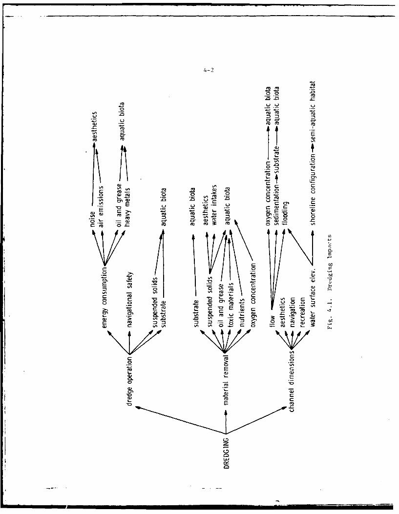
U | II t .
4-2
7u
€- -4 "--
.0o0
2u f
n .W u .0 U
E .2. _
0.- - - - -
EE
C L L
E .- "-" LA ,-
-rD 0
CP
L I I u I -ui .. .. .. 0
4-3
4.04Energy-Consumption - The one relatively small dredge, a tug, and twoself-propelled flat scows proposed for use, will require a total of about400 horsepower. This energy use is considered inconsequential.
4.05Noise and Air Emissions - Dredging equipment generates noise and airemissions while in operation. Data are not available which wouldindicate the exact noise levels produced. However, it is consideredthat the noise generated by dredging is not great relative to normalbackground noise levels in the vicinity of most dredging sites. Thediesel engines which drive the projects clamshell dredge produce smallquantities of air emissions. Considering the intermittent nature of thesource and the small quantities involved, this does not amount to a sig-nificant air pollution problem. The presence of the dredging equipmentand the noise and air emissions generated by its operation causes tempo-rary impairment of riverside aesthetics in localized areas. However,the duration of dredge equipment is generally short. The dredging isnot expected to exceed noise and air pollution standards establishedby the State of Wisconsin.
4.06Oil and Grease, Heavy Metals - Aquatic Biota - Like any vessel, thedredge engaged in channel maintenance releases small quantities of oil,grease, and most probably heavy metals which enter the water. There isno definite measure of these discharges. But, it is likely that the con-tributions of the dredging vessel is minor compared to all sources ofthese pollutants along the Waterway. It is not expected that the oil,grease and heavy metals discharged from these vessels have any signifi-cant effect on aquatic biota except as they contribute to overall ambientlevels.
4.07Navigational Safety - Proposed maintenance dredging will allow continuedsafe navigation throughout the waterway. The presence of the dredge anddisposal equipment within the confines of the project areas may lend tomore congestion in the harbor and channel areas and may represent anunavoidable hazard for navigation. Appropriate navigation markers willbe used, however, and these hazards are temporary in nature and will lastonly for the maintenance dredging duration. With reasonable care duringdredging operations, neither safety nor navigation within the area shouldbe adversely affected by dredging operations.
4.08Suspended Solids, Substrate - Aquatic Biota - During dredging operationsthe dredge and scows create turbulence by their movements which causesresuspension of solids in the water column. In addition, the dredgeextends supports called spuds to the river bottom while dredging. Thesespuds disrupt the bottom substrate and stir loose bottom sediment intosuspension. These effects on suspended solids and substrate are local-ized, temporary and produce very minor impacts on aquatic biota.
4-4
Material Removal
4.09The impacts associated with the removal of material as accomplished bydredging and snagging are identified in the major branch of the tree
labeled "material removal" in Figure 4.1. The smaller branches on theright side of the tree are discussed individually below as represented by
the underlined subheadings.
4.10Substrate - Aquatic Biota - Maintenance of the Fox River Navigationsystem entails the periodic dredging of project river and harbor chan-nels. An unavoidable consequence of this action will be the occasionaldisturbance of channel areas where sedimentation and shoaling have oc-curred. In conjunction with the sediment-water interface are a number oforganisms that constitute the benLhic community. The action of removingsediments from channel and harbor bottoms inevitably removes or destroysmajor portions of this biotic community. The overall amount of distur-bance to benthic organisms is quite limited. The action of removingsediments over a ten year period within the project area will eliminateonly about a total of 400,000 cubic yards of bottom sediments. Less thantwo percent of the existing 107 miles of navigable channel will be affected.
4.11An immediate, short-term impact of excavating sediments from channel andharbor areas is the destruction of benthic organisms contained in thedredged material in the waterway. Certain aquatic organisms, such asplankton, fish eggs, larvae, fry, and other bottom dwellers will suffer atemporary loss of habitat. Some will likely perish as a result of thedredging activity itself or because of increased turbidity. Organisms
living in the area adjacent to dredging operations can be smothered byturbidity increases and subsequent precipitation of suspended solids.The benthic organisms most affected are filter feeders and organisms oflimited mobility in or near the areas to be dredged. Those more capableof locomotion, however, may simply be displaced from the area untilstability recurs. The removal of the organisms should be short-term andlocal because organisms from adjacent areas should begin to repopulatethe dredge area as soon as dredging ceases. Repopulation will increasetoward the carrying capacity of the habitat but the rate of repopulationwill be dependent on such factors as: the population levels and mobilityof organisms in adjacent areas, duration of turbidity and substratedisturbance, current patterns, seasonal conditions, and predation.
4.12The removal of material from the channel bed by dredging may also have adirect impact on the type of substrate available for benthic organisms.Dredging removes surface sediments from the channel bottom, exposing anold strata to the overlying water, and causing a period of instability.The physical alteration of the interface is expected to generally haveonly a short-term local impact during the time period that chemicalequilibrium is being established. The removal of polluted sediments mayeven enhance the quality of the aquatic environment by removal of apotential reservoir of pollutants.
4-5
4.13The nature of the newly exposed sediments will not represent a completealteration of bottom type since those sediments being removed have beendeposited upon former river or lake bottom, which was previously exposedto the water interface. The effects of a change in substrate type may beexperienced in some areas as a result of material removal. Such changesare dependent upon the type of substrate being removed and the type ofsubstrates in nearby river reaches. Temporary changes may result inareas where sandy or granular material is removed, and the area iscovered soon afterwards with silty material.
4.14Substrate type varies considerably between different segments of thewaterway. Coarser materials would be expected downstream of locks.Finer materials usually compose deposit banks at bends in the river. Thealluvial fans vary in composition dependent upon the gradient of thetributary prior to its confluence with the Fox River. Tn general, thereshould be few permanent alterations of substrate type to the extent thatthe aquatic worms and insect larval forms which comprise much of thebenthic fauna would not be effected other than in very localized areas.
4.15A final, indirect, short-term impact associated with the removal of ma-terial from project channels is the alteration of the aquatic food web nthe vicinity of dredging as a result of benthic losses. The temporaryreduction in bottom organisms is not critical for the functioning of pro-ject area food chains and will not have a serious effect upon fish life.
4.16Suspended Solids - During material removal processes, considerableturbulence is generated by the dredging equipment. When a clamshelldredge is used to remove bottom sediments from the channel, the amountof suspended silt, sand, and detritus is increased in the vicinity of thedredge. As the bucket is drawn to the surface, water laden with sedimentsflows through and out from the bucket. The resulting sediment plume isconfined to the waters around the dredge, but can be distributed overlarger areas, depending upon such factors as wind, wave generated turbulence,and currents. However, the maximum area occupied by the plume is relativel\ysmall. The area subjected to sedimentation is likewise small. Theincreased turbidity has localized effects on substrate and benthos. Themagnitude of this increase will vary with the characteristics of thematerial being dredged.
4.17Although dredging-caused concentrations of suspended material have notbeen monitored in the project area, the suspended solids concentration
resulting from project dredging activities can be approximated. Table 4.1provides what may be considered as a "worst case" resultant suspendedsediment concentrations due to project dredging activity based on anestimate of the mass of bottom material disturbed and its approximateparticle size, distribution, the percent of dredged material that becomessuspended during the dredging operation, and the average water currentvelocity and water depth within a typical area to be dredged.
• m w m " -- ' -
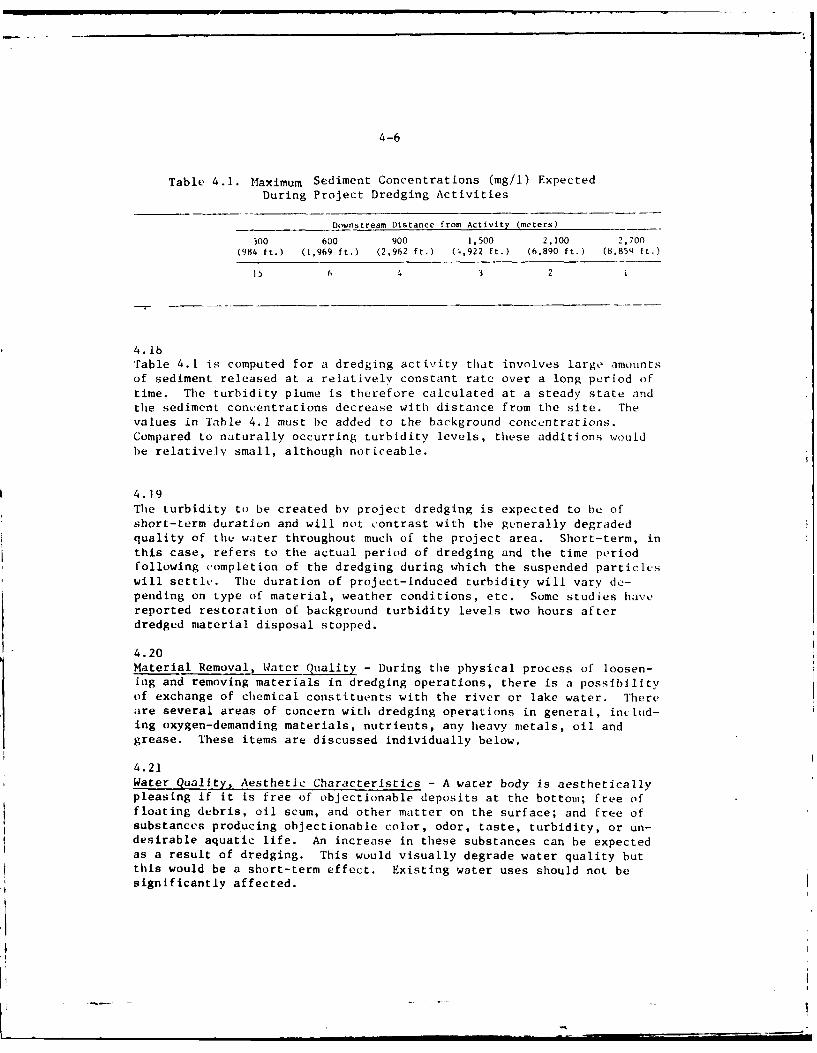
4-6
Table 4.1. Maximum Sediment Concentrations (mg/i) ExpectedDuring Project Dredging Activities
Downstream Distance from Activity (meters)
300 600 900 1,500 2,100 2,700(984 ft.) (1,969 ft.) (2,962 ft.) (0,922 ft.) (6.890 ft.) (8.854 ft.)
15 6 3 2 i
4. lbTable 4.1 is computed for a dredging activity that involves large amountsof sediment released at a relatively constant rate over a long period oftime. The turbidity plume is therefore calculated at a steady state andthe sediment concentrations decrease with distance from the site. Thevalues in Table 4.1 must be added to the background concentrations.Compared to naturally occurring turbidity levels, these additions wouldbe relatively small, although noticeable.
4.19The turbidity to be created bv project dredging is expected to be ofshort-term duration and will not contrast with the generally degradedquality of the water throughout much of the project area. Short-term, inthis case, refers to the actual period of dredging and the time periodfollowing completion of the dredging during which the suspended particleswill settle. The duration of project-induced turbidity will vary de-pending on type of material, weather conditions, etc. Some studies havereported restoration of background turbidity levels two hours afterdredged material disposal stopped.
4.20Material Removal, Water Quality - During the physical process of loosen-ing and removing materials in dredging operations, there is a possibilityof exchange of chemical constituents with the river or lake water. Thereare several areas of concern with dredging operations in general, inetlud-ing oxygen-demanding materials, nutrients, any heavy metals, oil andgrease. These items are discussed individually below.
4.21Water Quality, Aesthetic Characteristics - A water body is aestheticallypleasing if it is free of objectionable deposits at the bottom; free offloating debris, oil scum, and other matter on the surface; and free of
substances producing objectionable color, odor, taste, turbidity, or un-desirable aquatic life. An increase in these substances can be expected
as a result of dredging. This wuuld visually degrade water quality butthis would be a short-term effect. Existing water uses should not besignificantly affected.
4-7
4.22Water Quality, Water Intake Structures - It is possible that dredgingoperation in urban areas along the Lower Fox River could impact on in-dustries using river water in the vicinity of project dredging. In-creased short-term turbidity and re-suspended solids would present astate of water different than would normally be expected by the userwhen dredging is not taking place. Such unexpected conditions couldvary the quality of etfluent from the industrial process. Although theChicago District is not aware of any problems associated with pastcrredging operations in this regard, the owners or operators of the in-take facility will be notified when dredging is to be performed neartheir facilities, in order to minimize the possible impact.
Chemical Exchange Between Water and Sediments - The disruption of sedi-ments may generally be expected to enhance the exchange of chemicalconstituents. The turbulence increases the surface area of solidsexposed to the water and transports interstitial waters to the sediment-water interface. The rate of exchange of material would be expected toincrease under these circumstances.
4.24There may be chemical changes in the microenvironment as the material isalsturbed. Changes in oxidation potential, plf, and electrolytic strengthmay occur. These factors are known to influence adsorption, chelation,and cl~emical bondiag forces, which may be acting to bind chemiCa1l con-stituents to soil particles (Weber, 1972). The specifics of the inter-change between sediments and the water environment are not completelyunderstood. Due to this lack of knowledge, Lee (1970) reported that itwas almost impossible to predict exchange rates or magnitudes in a systemthat has not been investigated. Accordingly, the following discussionconsiders the chemical characteristics of the dredged material, recog-nizing chat m possibility of chemical exchange exists. In the absenceof detailed studies and data on the Fox River, it must be pointed outthat much of the material which tollows is unavoidably theoretical innature.
4.25Nutrients - The agitation of bmttom solids during material removal mayrelease nutrients from these sediments. McKee et al, (1970) observedgreater concentrations of phosphorous associated with increase in waterturbulence and turbidity. The turbulence in the stream under study wasassociated with a change in river gradient. Turbulence generated bymaterial removal would be expected to produce similar result,. Thechemical analyses of the deposited dredged material samples indicatequantities of nitrogen and phosphorous which could presumably be re-leased during material removal. As discussed in Section 2 and indicatedby the water chemistry data in Appendix B, ambient nutrient levels arealready excessive throughout much of the project area. Any additionalinput of nutrients resulting from material removal may increase aqueousnutrient concentrations.
4-8
4.26Oils and Grease - Small quantities of oils and grease may be releasedfrom deposits during material removal. The amount of oil and greasewhich was detected is not great; as such, no substantial problems areindicated.
4.27Toxic Materials - The resuspension of sediments can cause adsorbed toxicmetals, such as mercury, lead, and zinc to be reintroduced into theaquatic environment. The effects of this condition are dependent uponthe levels of toxic materials in the sediments to be dredged.
4.28Some toxic materials were found in the samples of sediments to bedredged (see discussion of sediment tests later in this section). Amoderately high level of mercury was found in one sample and lead wasdetected in another sample. Several samples have high organic contentsand nutrient levels. Dredging of these sites will result in release ofthese materials to the aquatic environment. The exact degree of pollutedreintroduction and the nature of the associated impacts are not suffi-ciently understood at this time.
4.29It is known that biological transformations may convert elemental mercuryinto methyl-mercury (Rissanen, et al., 1972) which is believed to be theform accumulated by aquatic organisms. Methyl-mercury is also moresoluble than elemental mercury. If the anaerobic bacteria which mediatethis reaction are present in the river sediments, it is conceivable thatmethylation of the mercury might occur in the sediments. Thus, a moresoluble form of mercury may be produced in the sediments at a depthsufficient to maintain anaerobic conditions. Material removal operationsmay release any mercury present in this form.
4.30The concentrations of lead and zinc are a cause for more concern than thequantities which were observed for mercury. There is a potential toxicityproblem which may result during material removal if these metals arereleased at that time. The zinc appears to pose the greatest source ofconcern. The duration of these impacts will be short, however, and nosignificant long-term effects are expected.
4.31Oxygen Concentration - The dredged sediments may contain substantialquantities of oxygen-demanding materials, as indicated in the data con-cerning COD. Anaerobic conditions may be present at small depths belowthe sediment-water interface. In light of Fox River ambient DO levels,the impacts of material removal may present severe localized problems.The amount of oxygen demanding material contained in the sediment willdetermine the extent of dissolved oxygen depletion resulting from theoperation. Jeane and Pine (1975) report that DO could be depressed by 40to 50 percent near the dredge site. As phosphorous (P), potassium (K),and nitrogen (N) are liberated during dredging, an increased BOD wouldalso be expected.
4-9
4.32At many locations along the Lower Fox Waterway dissolved oxygen is in-
sufficient to support selected sensitive benthic and fish species. Low
oxygen concentrations have contributed to the extirpation of several fish
species as discussed in Section 2. The oxygen demand of the dredgedmaterials would place an additional stress on the oxygen resources. Theelimination or further reduction in DO may have severe temporary effectson organisms in the immediate area of the dredge cut.
4.33Aquatic Biota - General - Material removal by dredging usually results indirect or indirect alterations of the physical and/or chemical character-istics of a river ecosystem. These alterations may or may not adverselyaffect the biological components of the system. The degree of effect isa function of many interrelated factors. The biological diversity of thesystem is one of the most important of these factors, i.e., the morediverse the community, the more stable the system. Stable aquatic eco-systems are better able to resist physical or chemical stresses. Thus,if material removal causes changes in biological abundance and diversity,this will also result in disruption of the population interactions withinthe aquatic community.
4.34Some of the major problems resulting from dredged material removal areincreased turbidity, actual removal of organisms and substrate, andsiltation. Saila, et al. (1968) discussed the potential effects of thesechanges upon the aquatic ecosystem. The primary direct effect on bio-logical organisms is either mortality or an unfavorable response due toimpeded respiratory exchange. Indirect effects include:
1. reduction of light penetration which results in reduced photosyn-thesis.
2. reduction of visibility of sight-feeding organisms.3. destruction of fish spawning areas.4. reduction in some fish food organisms.5. reduction of vegetation cover.6. increased organic deposits which result in anaerobic conditions.7. flocculation of planktonic algae.
4.35Most of the above impacts will be temporary and local in character butwill vary upon the conditions at the time of dredging. Specific eco-logical impacts will depend on the type of bottom and biota present atthe dredge site, the level of previous dredging disturbance, and thevolume, area and duration of dredging operations but are believed minorbecause of the following general project area conditions:
.infrequent requirement for dredging activities
.sparse benthic community
.minimum change in substrate
.short-term chemical and silt changes
4-10
.land disposal of polluted dredged material
.little disturbance to feeding areas
.previous dredging history
.reestablishment within one year
4.36Some problems do exist, however, which could cause temporary ecological
imbalances. This would be due to potential toxins such as metals,PCB's and pesticides which may be present in sediments. In addition,there would be negative impacts for a short time because of sedimentdeposition, low oxygen, and higher turbidity. In other dredgingoperations, the effects of sediment deposition, turbidity, and chemicaldisequilibria have been known to affect aquatic life within a half mileof the dredged site (EPA, 1971; Odom, 1970). Oleszkiewicz and Krenkel(1972) have stated that the physical, chemical and biological charac-teristics of the Ohio River were not significantly altered by dredging inthe areas studied. Bardarik et al. (no date) found essentially the sameresults on the upper Allegheny River. Ketchum (1972) considers initialturbidity, smothering and oxygen depletion after dredging to be brief,generally insignificant disturbances.
4.37Aquatic Biota - Turbidity - Some of the details of influences of in-organic sediment on aquatic life in streams were reported by Cordone andKelley (1961). Their studies on fish involved primarily Trout and Salmonbut the physiological effects involved are applicable to many species.
4.38Fish gills may become clogged with silt and particles which usuallyresult in death due to impeded gas exchange efficiency. However, in mostinstances, indirect damage to fish populations occurs long before fishare directly harmed. Eggs in spawning areas may be smothered by over-lying silt. The severity of this effect depends to a large extent on theriver flow rates, substrate type and silt particle size. Bottom faunadiversity and abundance may be reduced in several ways. Heavy siltationmay smother bottom organisms which in turn reduces the availability offish food. Siltation may fill in and cover the substrate in intersticeswhich act as surfaces for periphyton attachment and sites for benthoccolonization. Also, increases in turbidity can inhibit certain fishspecies, especially those that are sight feeders (northern pike andwalleye). The potential reduction in food intake could result in lessenergy for reproduction and could therefore reduce reproductive output.How this reduction in reproductive output would affect recruitment de-pends on the types of factors limiting the offspring.
4.39The average turbidities found to be fatal to several freshwater fishspecies are shown in Table 4.2.
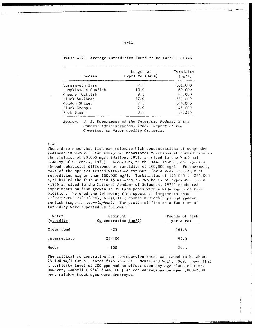
4-11
Table 4.2. Average Turbidities Found to be Fatal to Fish
Length of Turbidit%'Species Exposure (days) (mg/I)
Largemouth Bass 7.6 101,000Pumpkinseed Sunfish 13.0 69,000Channel Catfish 9.3 85,000Black Bullhead 17.0 222,000Golden Shiner 7.1 166,000Black Crappie 2.0 145,000Rock Bass 3.5 i6,,250
Source: U. S. Department of the Interior, Federal W.teorControl Administration, 1i068. Report of the
Committee on Water Quality Criteria.
4.40These data show that fish can tolerate high concentrations of suspOndedsediment in water. Fish exhibited behavioral reactions at turbidities iithe vicinity of 20,000 mg/l (Wallen, 1951, as cited in the NationalAcademy of ScLences, 1973). According to the same source, one speciesshowed behavioral difference at turbidity of 100,000 mg/l. Furthermore,most of the species tested withstood exposure for a week or longer atturbidities higher than 100,000 mg/i. Turbidities of 175,000 to 225,000mg/l killed the fish within 15 minutes to two houis of exposure. Buck(1956 as cited in the National Academy of Sciences, 1973) conductedexperiments on fish growth in 39 farm ponds with a wide range of tur-bidities. He used the following fish species: largemouth bass.'." m,, .: , i, :) , bluegill (e?,om *,: hijrus) and redear
sunf ish (Lei . i"iz ,rolophs) . The yields of fish as a function ofturbidity were reported as follows:
Water Sediment Pounds of fishTurbidity Concentration (rag/1) per acre:
Clear pond <25 161.5
Intermediate 25-100 94.0
Muddy -.100 29.3
The critical concentration for reproduction rates was found to be about75-100 mg/l tor all three fish species. McKee and Wolf, 1969, found thata turhidity level of 200 ppm had no effect upon any age class of fish.However, Cambell (1954) found that at concentrations between 1000-2500
ppm, rainbow trout eggs were destroyed.
4-12
4.41Mobile species of fish migrate or avoid areas being dredged and escapeinjury. From the preceeding discussion, however, it can be seen thatfish species, especially fishes through the fry and fingerling stages,can be adversely affected by dredging caused turbi(ity if the intensityand duration of the turbidity exceeds the species tolerance limits. Thedegree of adverse response to turbidity also varies for different overaliaquatic conditions.
4.42Turbidity may also affect temperature relations (Bartsch, 1960). Tur-bidity changes the water environment by rapidly absorbing radiant energyin the upper la.vcrs of the water which reduces the depth of effectivephotosynthesis and inhibits algae growth. Algae and plankton recoverquickly, however, once turbidity levels subside. Submergent vegetationis also inhibited by reduced sunlight. In the spring these rooted plantspecies initiate growth; and are hindered from continued growth if enoughlight does not reach the bottom of the bay. In the early stages ofvegetative development it is critical that enough radiant energy isavailable at the bottom so that plants can grow taLl enoughl to he in theareas of effective photosythesis. Some losses will occur and plant lifewill be displaced for a time.
4.43"me following maximum concentratiuns of suspended sediments are recom-mended by the National Academy of Sciences, National Academy of Eng-neering (1973), for protection of aquatic communities.
High level protection 25 mg/I sediment
Moderate protection 80 mg/1 sediment
Low protection 400 mg/1 sediment
Very low protection over 400 mg/i sediment
Aquatic communities in the project area will therefore be afforded amoderate level of protection under "with project" turbidity conditions.
4.44Aquatic Biota - Resuspension of Pollutants - Increases in suspendedsolids will have a number of adverse affects upon the aquatic onviron-ment. Nutrients such as phosphorous and nitrogen are released into theaquatic system and tend to accelerate excessive growths of algae andother aquatic plants (Biggs, 1968). Zooplankton are also stimulated byorganic nutrients in the suspended sediments but may be adversely af-fected by toxic compounds present in the sediments. Increased algacgrowth can ultimately lead to low dissolved oxygen levels which are verydetrimental to fish and other biota.
f" • m l| " a.. ..
4-13
.45
other adverse effects will result from a reduction of oxygen due tochemical demands. During the dredging process and for a time afterward,organic material at the new sediment-water interface and within theunsuspended sediments, will tend to oxidize and incruase the biologicaloxygen demand over previous background levels. This decreased level (odissolved oxygen can affect b-th those species that reside within thedredged area and those adjacent to the area.
4.46
Aquatic biota need certain concentrations of dissolved oxygen to nmintaintheir metabolic processes. The reduction of available dissolved oxygenwill temporarily disrupt the existing ecological community (Brown, C.L.;lark, R. 1968). Even a temporary lowering of the dissolved oxygen may
he critical for some organisms. Dissolved oxygen would he most seriousalong the Lower Fox River during the late summer period. The riverbottom is especially high in oxygen demanding substances and as thesematerials are dredged, dissolved oxygen could be reduced to near zero inlocalized areas.
4.47In areas with polluted sediments, such as the L.ower Fox River, dredgingcan also increase the amount of toxic substances within the water col-umn.' Heavy metals and pesticides that have been dormant in deep sedi-ments may become available for uptake and could pass up the food chain,affecting the viability of the organisms at all levels of the food chain.Although the consequence of releasing toxic metals during dredging opcra-tions is not well understood, it would be expected that a higher level ofheavy metal concentrations would be suspended in the water followingdredging in an area of high metal sediment concentrations (and thus moretoxicity to aquatic life) than in an area with lower heavy metal concen-trations similarly dredged. Metals are also known to act synergisticallvor antagonistically on aquatic biota. As metals are stirred up by thedredging process, omnivorous food chains would be negatively affectedmore than carnivorous.
4.48Most of the impacts associated with resuspension of pollutants will betemporary and local in character but will vary upon the conditions at thetime of dredging. Studies have shown that adverse increases in turbidity,solids, nutrients, COD, heavy metals and decreases in dissolved oxygenare almost totally reduced to pre-dredging levels within 24 hours (Richiuand Speakman, 1973).
4.49Aquatic Biota - Siltation and Loss of Habitat - Dredging and snaggingoperations in the project waters will cause loss of habitat and increasethe amount of suspended solids within the water column.' While dredgingactivities may cause some temporary loss of habitat for benthic organisms,no evidence exists to suggest that any major fish spawning grounds willbe affected in Lake Winnebago and the Lower Fox River. The water flow isquite slow in Lake Winnebago and resuspended material should settle out
II I I -.- I I l I i ..- _ -_
4-14
rapidly within a small area. The Lower Fox River is apparently toopolluted to support spawning populations of many fish species. The WolfRiver, on the other hand, has extensivc areas of spawning habitat forfish and because of this a greater chance of impact exists in this river.
4.50Dredging and snagging in the Wolf River will cause loss of spawninghabitat, such as sand bars, submerged logs and branches, etc., which areutilized by white bass, walleye, and many other species. This loss ofspawning habitat would either result in too many fish spawning per unitarea of remaining habitat or some fish may be forced to spawn in lessdesirable habitats. The effect of either of these on recruitment isdifficult to assess, since all of the variables that regulate the successof the offspring and juvenile populations are not precisely known. Ifdensity-dependent factors, such as competition and predation, are in-volved, recruitment may actually be increased, providing that a sizableportion of the spawning population is not affected. However, if density-independent factors, such as water temperature, current velocities orwater levels, are the main limiting factors, then recruitment willprobably be reduced by the loss of spawning habitat. In the absence offirm data it would be safe to assume that destruction of spawning habitatwould have at least some adverse effect on recruitment. For yellow perch,at least, there does not appear to be an relationship between survivor-ship of offspring and water temperature, which is not to say, however,that density-dependent factors may be involved.
4.51In time the dredged material removed would be replaced by the river andlost fish spawning habitats would be restored. Any aquatic biota lostwould also replace itself once this material returns. Refuges for smallfish and the offspring of larger fish species created by the shallowwater over the sand bars would also redevelop, thus affording protectionto these small fish from predation by larger fish. Therefore, any lossesdue to dredging would probably be short-term ones.
4.52Increases in turbidity could also affect hatching success if the dredgingwere done during spawning periods. As the resuspended materials settleout they could cover eggs lying on the bottom and prevent proper oxygenuptake by these eggs. This would be particularly true if dredging ofareas with silty bottoms occurs upriver from spawning grounds havingsandy bottoms. By elimination of these eggs fewer offspring would beavailable for recruitment. Records indicate that dredging has beenaccomplished during those periods when fish spawning, hatching, and larvaldevelopment would be unaffected.
4.53Because the amount of dredged material anticipated from the Wolf River isrelatively small it is unlikely that any great loss of fish spawninghabitat would occur or that the increase in suspended solids would besufficient to cause major impacts to the various fish populations.However, in order to reduce the impact to the various fish populations,especially those that breed in the Wolf River, dredging should be doneduring the latter part of the summer when spawning, hatching, and larval
4-15
development has ceased for most of the fish species. For these reasonsdredging will continue to be performed during those periods when impactson fish populations are relatively minor.
Channel Dimensions
4.54The impacts associated with the channel dimensions which result fromdredging and material removal are identified in the major branch of thetree labeled "channel dimensions" in Figure 4.1. The smaller branches onthe right side of the tree are discussed individually below as repre-sented by the underlined subheadings.
4.55Flow - Modification of channel dimensions has ramifications for dischargecharacteristics of the channel. Two changes are apparent: there is aregion of increased channel depth, and a small increase in cross-sectin;ilarea is available for flow at original river stages. The increasedchannel depth will support an increased flow rate for the same river sLay,,as well as supply the necessary draft for navigation vessels. In combini-tion with an increased flow cross-section, these larger velocities willresult in greater discharges at original river stages.
4.56No perceptible changes in flow rates of the project waters are antici-pated. The fall of the river above the Winnebago Pool preclude suchaction in the Wolf River region. The controlled flow of the Iower FoxRiver precludes any perceptible flow changes during normal stage flows,while during high stage (flood) flow conditions the slight change whichmight result from the depth increases of dredging would be imperceptiblecompared to the high flow conditions that are present.
4.57Oxygen Concentration - Aquatic Biota - Inasmuch as river velocities arereduced by channel modification, stream reaeration rates will also de-crease. The reduced atmospheric reaeration results from decreasedturbulence at the water surface when velocities decrease. The actualdissolved oxygen will not be influenced significantly by channel modi-fication. Therefore, the effects on aquatic biota will be minimal.
4.58Sedimentation - Substrate - Aquatic Biota - The maintenance of sufficientriver depth for navigation purposes has contributed to a general increasein sedimentation rates. As dams are constructed and pool elevations areraised and as dredged material is removed from the channel, the cross-sectional area of the river flow is correspondingly increased. As adirect result, the river velocity decreases as does the river competence.Hence, more of the suspended solids are able to settle to the riverbottom. High flow conditions will also tend to scour and deposit ad-ditional sediments in the area previously dredged.
4-16
4.59Aesthetics - The maintenance dredging of a navigation channel such asthat in the Fox Waterway restores the design channel dimensions in thereach of river dredged. However, there is no actual realignment of thechannel. Unlike an original or initial channelization project, theappearance of the river channel from the surface is unchanged bymaintenance dredging. Thus, there is no effect on riverside aestheticsfrom dredging to restore channel dimensions.
4.60Navigation - The maintenance of channel dimensions is a requisite to thecontinuance of recreational navigation on the Fox Waterway. To maintaindepth clearance for craft using a navigation channel, occasional dredgingof the channel is required to remove excess sediments that accumulatewherever the water velocity slows sufficiently to allow suspended solidsto settle. Snagging is required to remove accumulated debris. As pre-viously stated, the act of physically relocating these materials can pro-duce several impacts on the water bodies from which they are removed andon the areas where the dredged materials are deposited.
4.61Recreation - Channel maintenance affects forms of recreation other thanboating. Picnicking, hiking, camping, fishing, etc. sometimes becomeclustered about areas suitable for recreational boating.
4.62Water Surface Elevation - The channel modification activities will notsignificantly lower the water surface elevation. These effects will notbe significant during periods of high flow, because flood flow rates aremuch greater than normal discharges. Modification is not expected tosupply substantial flood control benefits.
4.63Shoreline Configuration - Semi-Aquatic Habitat - As noted above, channelmodification has only minimal effect on water surface elevation. Hencethe effects on shoreline configuration and semi-aquatic habitats fromthis source are insignificant.
4.64Flooding - Since channel modification results in increased channel cross-section, larger flows can be accommodated at original river stages. Thiswill result in very small increases in river stage at flood conditions.These effects, however, are very localized.
DREDGE MATERIAL DISPOSAL
4.65Assessment of the impacts of dredged material disposal and determinationof the most suitable methods of disposal is the result of a systematicreview and evaluation program in cooperation with the Wisconsin Depart-ment of Natural Resources, the U.S. Fish and Wildlife Service, and theFederal Environmental Protection Agency. Table 1.4 provides a list of
4-17
mutually agreed upon disposal sites which were reviewed and selected
after a June 1976 field evaluation. The locations of listed sites areshown in Figure 1.4 through 1.16.
4.66Many aspects were considered in the selection and evaluation of potentialdisposal sites. The sites proposed herein were considered to be themost desirable for use based in proximity to areas being dredged, capa-qitv of the site, site ownership and accessibility, views of state ondlocal officials, other potential uses of the site, and environmental
considerations.
Chemical Aspects of Deposited Sediments
4.67To evaluate the possible undesirable environmental characteristics ofdredged materials and determine the suitability of the dredged materialsfor various beneficial uses, bottom sediment samples were collected atselected project area locations and tested for a number of physical andchemical characteristics.
4.68The choice of sampling sites was made on the basis of actual projectmaintenance dredging requirements. The site locations are the numberedlocations shown in the charts of Appendix A. Table B.l (Appendix B) is ilist of the sampling sites, which is keyed to the numbers shown in thesecharts, and contains a description of the nature of the specimens ob-tained. The 27 samples tested were taken as dredge grab samples. A hardbottom (absence of sediments) prevented collertion at three other sites.The samples were placed in plastic bags and refrigerated immediatelyfollowing collection and during delivery to the analytical laboratories.
4.69The analyses were performed by the Soils Analysis Laboratory of theUniversity of Wisconsin and by the Wisconsin Alumnae Research FoundationLaboratories. The methods used in these tests are described in Reference21.
4.70The particular set of analyses performed on the Fox River project sedi-ments were selected in consideration of the present and past EPA regula-tions on the basis of expected problems and in consultation with thelaboratory personnel directing the analyses. A list of these tests isshown in Table B.2, Appendix B.
4.71From the test data noted in Table B.3 to B.7, it is expected that sedi-ments taken from the Wolf River (Nos. 25 through 30) will produce no
adverse impacts at the anticipated disposal sites. Since these sedimentsare largely sand, drainage would be rapid and adverse effects minimal.The materials are low in agricultural nutrients.
4-18
4.72With some exceptions, samples taken from the Lake Winnebago harbors andthe Lower Fox River contain large amounts of volatile solids (wt. losson ignition). One sample (De Pere dam) has a high lead content andseveral others appear borderline. Several samples have high zinc con-tents and sample No. 20 (downstream of Kaukauna) has a high mercury level.A number of samples exceed the Kjeldahl nitrogen criteria and sampleNo. I (Fond du Lac River) exceeds the oil and grease specification.While the clay content found is not especially high, the high level oforganic matter inclusion plus the clay, indicates that sediments frommany anticipated dredging sites would be slow to drain and would requireextended periods of time before thick beds could be used for agricul-tural, commercial, or industrial purposes.
4.73A perspective of the concentration of the metals Hg, Zn, Pb found in somesamples may be gained by a comparison with the concentrations found insewage sludges which'are being used to enrich agricultural lands. 2 2 Thesewage sludge samples used to enrich agricultural lands were found tocontain 3.89 ppm of Hg, 110 ppm lead and 320 ppm Zn. With the exceptionof the lead concentration in one sediment sample, no sediment tested forthis project contained more than a fraction of these levels and con-sequently, disposal. of the anticipated dredge materials onto agriculturallands is probably acceptable. At the location where disposal in aconfined lagoon is anticipated, runoff water from the dredge materialswill be monitored. The high oil and grease sample should not bedeposited at disposal sites which directly contact or drain into waterbodies. These dredgings should be acceptable for agricultural or filluse, however.
4.74Although thick layers of many of the sediments tested would be slow todry out, the high organic content and nutrient levels would make thesematerials generally useful for agricultural purposes or enhancing re-vegetation of disposal sites.
General Plan Aspects
4.75Generally, disposal sites are to be enclosed by dikes using materialborrowed from within the dispoasl area (see containment area exampleFigure 4.2). Enclosure of the areas by dikes in advance of disposal andprompt protection of the dikes by riprapping where exposed to high flowsor wave action will be required to maintain the effectiveness of thedikes and prevent erosion. The dikes will be well constructed and willmeet the other qualifications in References 17 and 23.
4.76The purpose of dike containment is to prevent ervsion and movement ofdeposited materials, as well as to confine and control runoff water.Controlled permeation througl these dikes is expected to minimize, if
4-19
CONSTRUCTION INCREMENT
DIKE CONFINED DREDGED MATERIAL
b. Incremental Dike Construction
a. Example Containment Area
Fig. 4.2. Dike Construction
4-20
not eliminate, any significant reintroduction of suspended or dissolvedsolids to the waterway. Generally only a few hundred cubic yards of
dredging in one area is required, making the cost of providing specialdisposal areas relatively high on a unit quantity basis.
Site Specific Features
4.77The recommended disposal site at De Pere is located along the right canalbank adjacent the De Pere Lock. Although the site is currently owned bythe Wells Coal and Dock Company, the City of De Pere is in the process of
the obtaining thts site for development as a public park. Dredged ma-terial disposal at this site is proposed to be undertaken in such amanner so as to create aesthetically pleasing landforms which will en-hance future park development.
4.78The recommended Little Kaukauna site is the headrace above the abandonedpapermill next to the Little Kaukauna lock and dam. The potential lossis the approximately 1950 kW (peak) of hydropower which could be obtainedat the site. This loss represents an estimated annual energy loss ofabout 10,600,000 kWh for the approximately 9-ft static head (using theauthorized 24-in flashboards) available at this location. This propertywas abandoned by its former owner, the Kaukauna Water and Electric De-partment. This location was not considered by the company to be a desirablegenerating site because it is located outside the company's area ofgenerating activity, and the capital cost to develop the facility is toolarge for the benefits to be gained. 16 Disposal of dredged material atthis location would return the site to a terrestrial habitat somewhatlike that which originally existed, while at the same time providing adisposal area which could be used for many years. Filling of the proposedsite would have minimum environmental impact. The disposal site would becompletely diked or enclosed. The dike would be designed to permanentlycontain the solid pollutants. Dissolved solids will not be removed; theycan only be removed by extensive physical and chemical treatment whichis not feasible within the scope of this project. Some soluble pollutantswill therefore pass through the dike. The area will be monitored duringdisposal to insure the effectiveness of the system. A channel to theenclosed area, an unloading berth deep enough to moor the loaded bargescarrying the dredged material, and a means of transferring the dredgedmaterial from the barges to the dispoasl area are needed.
4.79Dredged material disposal along the right canal bank at Rapid Croche willbe strictly controlled and confined within State of Wisconsin approvedsite boundaries. The disposal plan will leave undisturbed lowlandforested areas as wildlife habitat. Certain large trees within thedisposal site will also be retained for bird nesting and cover purposes.
4.80The Kaukauna site involves the filling of the existing overflow ditchlandward of the canal and diverting the existing overflow to the canal
4-21
below the 4th lock. Filling of the selected area will not reduce the ef-fective flood flow capacity of the Lower Fox River or have significantenvironmental impact on fish or wildlife habitat. Existing bank vege-tation adjacent to the canal will not be disturbed.
4.81Disposal activities on the right canal bank at Combined Locks will bestrictly controlled and confined within State of Wisconsin approved siteboundaries so that lowland forest and marsh areas will not be impactedupon. Special erosion control provisions will be incorporated intodisposal site development specifications to prevent adverse impact to anearby wetland area.
4.82The proposed disposal site at Little Chute is located along the rightcanal bank adjacent the Little Chute 2nd lock. The disposal area in-cludes a portion of a previously used municipal landfill site. The dis-posal plan will have minimal environmental impact due to the presentlydisturbed nature of the site.
4.83Because of possible wildlife values associated with the originally pro-posed site at Cedars lock, dredged material disposal will generally beconfined to the lawn area adjacent to the right canal bank. Disturbanceof vegetated areas on the northern edge of this site will be limited.
4.84Attempts to date to locate a State approved disposal site within thevicinity of Appleton have been unsuccessful. A continuing effort will bemade to identify satisfactory local sites. In the event that an accept-able local site cannot be secured, it would be necessary to haul dredgedmaterials from this area to a more distant downstream location. Inaccordance with Corps of Engineers' policy and project authorities, if itis evident during the initial planning of such a disposal operation thatsubstantial additional costs would be incurred, Appleton area dredgingoperations may be suspended unless local interests agreed to finance theadditional costs.
4.85Dredgings from the Menasha and Neenah channels are to be loaded on trucksand transferred to state approved municipal landfill sites.
4.86At Calumet Harbor, the Fond du Lac Planning Commission has requested thatit be permitted to use dredged materials and has provided a disposal sitein an open lawn area of the adjoining County owned Columbia Park. Low
lying agricultural land adjacent to the left bank of Pipe Creek, east ofColumbia Park and north of the east-west road to the Village of Pipe Creek,is proposed as a future disposal site after the initial, one-time use ofColumbia Park.
4.87Dredged materials at Brothertown and Stockbridge Harbors are to be stock-piled on existing Federal properties for later agricultural or fill use.Ultimate disposal is the responsibility of local interests.
4-22
4.88Dredged materials at Fond du Lac Harbor are to be accepted and distri-buted by the City of Fond du Lac. An area adjacent the left channel bankis the receiving land site for dredgings from this harbor. The area isbordered by a line of trees on its western edge. The fresh water marshto the west of these trees will not be impacted upon.
4.89.Disposal of materials from dredging and snagging operations on the WolfRiver will be accomplished by transporting the material from scows intotrucks located on-shore for disposal elsewhere at specified land areas.It is anticipated that the trucks will be provided by the Waupaca CountyHighway Commission. Disposal sites for the dredged and snagging mater-ials for the most part will be deposited on agricultural lands. Disposalwill not be undertaken in wetland or marshy portions of farm property.Since dredging and snagging requirements to maintain the navigability ofthe Wolf River vary from year to year, and the plan of disposal is depen-dent on reaching agreements with private individuals, the Chicago District
will undertake advance coordination and field inspection of proposeddredging, snagging, and disposal sites with Federal and State fish andwildlife interests on a case-by-case basis. The Chicago District will alsowork with the Wisconsin DNR and the U. S. Fish and Wildlife Service inan effort to further examine and develop alternatives and/or means ofminimizing anticipated long-term losses to Wolf River fish and wildliferesources. This will require an examination of the recreational navigationand related benefits vs. fish and wildlife losses associated with continuedFederal operation and maintenance of the Wolf River navigation system.
Deposition of Material
4.90The impacts associated with the actual deposition of dredged materials atdisposal sites are identified in the major branch of the tree labeled"deposition of material" in Figure 4.3. The smaller branches on theright side of the tree are discussed individually below as represented bvthe underlined subheadings.
4.91Shoreline Configuration - Due to the limitations of access of somedredging equipment, material is usually deposited on or near the rivershoreline. Consequently, many disposal sites encroach on shorelineareas.
4.92Aesthetics - Disposal sites near the river shoreline which are in activeuse will be visible from both river and off-river vantage points in theimmediate vicinity. Depending upon the quantity and frequency of ma-terial deposited, this can amount to a noticeable impairment of riversideaesthetics. This will especially be so during the period of time whichdredged materials consolidate and the disposal site develops a vegetativecover. Based on past experience with similar disposal sites, expenditureof funds to accelerate the natural revegetation process is not consideredwarranted.
4-23
00
Lin
0' C:
_ C)
C: L9V) a)C: E
C-
0-0
OLAJ UP
(D C
4-24
4.93Shoreline Vegetation, Floodplain Vegetation - Wildlife Habitat - Theeffect of the deposition of dredged material on the flora of the dispnsal
sites depends upon the floral composition of the sites. Some sites havevegetative cover while others do not.
4.94The major effect of deposition upon small woody plants, as well as mo,'t'herbaceous plants, is the force and weight of the deposition processwhich can knock the plants down and subsequently cover them with mater-ial. In most instances, this type of action kills the plants. Someplant species have the ability to regenerate stems and grow through the
deposited material to attain the original growth form of the plant.
4.95Large woody plants such as trees, are affected in a different manner thansmaller woody plants or herbaceous plants. The effect of deposition in anarea that is presently Inhabitated with trees is the possible killing of
the trees by covering of the root systems. This covering Is toleratedin different ways by different tree species. For example, Eastern Cottonwood(Poputu.w def-toirdes) can tolerate a great deal of root system coverage,while Silver Maple (ACeL 6acca~inu) cannot. Willows (Sa2ocx) and otherwet-site shrub species may be eliminated when the impounded area is
completely filled.
4.96The deposition of dredged materials at the anticipated land disposal siteswill not result in destruction of any environmentally valuable wetlandsor marshes. Proposed lowland areas to be filled are presently unusablefarm field swales and filling as planned should result in an improve-ment to the area without creating significant adverse environmentaleffects.
4.97The destruction of habitat by deposition of dredged materials, though notextensive, will eliminate a portion of the habitat that would be used bythe local fauna. The loss of the small woody and herbaceous plants willreduce cover and food sources that might be used by reptiles, amphibians,mammals and birds that nest on the ground. The loss of large trees fromsome disposal sites will reduce available den trees for mammals andnesting sites for some birds. Disposal of dredged materials at severallocations will be accomplished with the intent to protect tree cover.Filled containment areas should achieve vegetative ground cover in ashort period of time. Every effort will be made to fill the selectedsites at the earliest possible time after its use commences. The floraand fauna of existing disposal areas are evidence that disposal siteswill support future biota.
4.98Land Use - Selected disposal sites are, for the most part, vacant Federalproperty in the vicinity of dredging sites. Ilse of these sites is not
4-25
expected to inhibit existing or potential uses of surrounding privatelands. However, due to the physical limitations associated with existingFederal properties, increased use of private properties for dredgedmaterial disposal purposes will become necessary in the future.
4.99Dredged materials from several project locations will be used for agri-cultural or comercial fill use. Because the actual fill areas are6nknown in some cases, the precise impacts associated with this form ofdredged material disposal cannot-be determined. Disposal sites and useswill be subject to state and local approvals.
4.100In the past, some project area dredged materials have been given tolocal farmers to fill low areas of their fields. Filled areas are known
to have generally produced poorer than average corn yields during thefirst two or three years after filling. Information on the specificimpacts of the previous deposition of dredged materials on agriculturalcrop land, however, is not available since no records were kept on theindividual recipients or the amounts used for fill purposes.
4.101Previous experience 4 indicates that disposal areas can be used for agri-culture, industrial, and commercial use within a period of two to fiveyears. Highly enriched or high organic-content materials spread thinlyover agricultural lands would not be subject to this time limitation.
4.102
Disposal of dredged materials is not expected to produce any significant
odors. Odor problems have not been encountered at any of the previousdisposal sites in the project area. Should a problem arise, an environ-mentally compatible method of keeping the odor to a minimum will bedeveloped and coordinated. Possible operational procedures to minimizeodor emission include applications of chemical oxidents and/or coveringwith a layer of earth.
4.103Since the quantities to be dredged in any one area usually are small, anddredging may be required only at intervals of two to five years or more,the complete filling of an area and its conversion to useful land usuallywill require many years. The disposal program will provide for complete
filling of the used port 4ons of an area as quickly as possible with theavailable dredge material.
4.104Health and Safety - The transfer of polluted sediments to proposed dis-posal areas will not create any spray so that aerosol dispersal of
pollutants will not be a problem.
4.105Tax Base - The use of proposed sites for dredged material disposal pur-poses will not affect local tax bases.
4-i b
4.106Historical and Archeological Sites - Onsite archeological surveys indicatedthat there will be no adverse effects on archeological or historical sitesas a result of proposed dredged material disposal. A determination hasbeen made of the State Historic Preservation Officer thot th( proposedaction will not impact on any sites now included on or eligible forlisting in the National Register of Historic Places.
4.107One potential adverse effect has been foreseen and resolved. In thisinstance the Chicago District has agreed that no dredged material willbe disposed of at a site known to encroach upon an area underlain byarcheological relics. More information on this site and other aspectsof the overall archeological survey performed by Dr. David Overstrcetof the Great Lakes Archeological Research Center for this report iscontained in a report filed with the State Historical Society entitled,"Archeological Survey for the Fox River Navigation Project DisposalSites." As previously stated, the specific details of the nature andlocation of archeological sites must be withheld from general publicationin order to protect the sites from vandalism.
4.108Potential project impact on historical ind archeological resources islimited to future currently unspecified Corps of Engineers' dredged materialdisposal activities. The probability of archeological sites withinpossible future disposal areas is considered to be high because theriverine-lacustrine setting along the Fox and Wolf Rivers and the easternand southern shores of Lake Winnebago have been demonstrated as optimalhabitation sites for several prehistoric and historic populations.Future disposal operations beyond those presented herein cannot bestated with any degree of reliability, nor can any recommendations formitigation of adverse effects be offered until an intensive archeologicalsurvey and evaluation of potential disposal sites is accomplished.
4.109Future proposed disposal sites will be investigated for the presence ofcultural resources and survey results will be coordinated with theState Historical Preservation Officer and the Midwest ArcheologicalCenter of the National Park Service prior to their final selection anduse. Also, if any given proposed disposal activity is found to adverselyimpact on any significant cultural resource, the Corps of Engineers willeither select a suitable alternative site or prepare a detailed mitigationplan for preservation of the threatened resource. In the event thathistoric or archeological properties listed in or eligible for listingin the National Register of Historic Places would be affected, theChicago District will comply with established Advisory Council onHistoric Preservation procedures For the protection of historic andcultural properties (36 CFR Part 800). If archeological remains arerevealed by project dredging activities, operations will be suspendedand the State Archeologist immediately notified.
4-27
select a suitable alternative site or prepare a detailed mitigationplan for preservation of the threatened resource. In the event thathistoric or archeological properties listed in or eligible for listingin the National Register of Historic Places would be affected, theChicago District will comply with established Advisory Council onHistoric Preservation procedures for the protection of historic andcultural properties (36 CFR Part 800). If archeological remains arerevealed by project dredgirg activities, operations will be suspended*and the State Archeologist imnediately notified.
Leaching and Runoff
4.110The impacts associated with leaching and runoff from dredged materialdisposal sites are identified in the major branch of the tree labeled"leaching and runoff" in Figure 4.3. The smaller branches on the rightside of the tree are discussed below.
4.111The earlier discussion in conjunction with impacts of material removalis generally applicable to the considerations associated with leachingand runoff. The lack of understanding of the factors influencing ex-change of chemical parameters between sediments and water also appliesto leaching processes. To the extent that materials are released fromthe particulates, leachates and runoff from the disposal sites may con-tain heavy metals, nutrients, oils and grease, and oxygen-demandingsubstances. A general discussion on the subject of leaching and runoffis provided in the following paragraphs.
4.112Where dredged materials are to be deposited along a shore or bay, dikeswill be constructed to control runoff and reduce seepage of materialsinto the river or lake. No permanent change in water quality is envi-sioned as a result of disposing of dredged materials in this manner.
4.113Substances may be leached from materials even where dikes are employedto retain polluted solids. Clamshell dredging operations produce mate-rial which typically have a solids content of approximately 80-90 percent.Some water is therefore deposited on the disposal sites with the solids.Most of this water will be lost to the atmosphere by evaporation but
the possibility of leaching and runoff from disposal sites, as well asfrom other land uses represents a potential source of water pollutants.
4.114Although it is difficult to predict the magnitude of the exchange ofmaterials considering the nature of toxic materials which are presentin the sediments, potential toxicity problems are indicated. However,sediments underlying the proposed disposal sites are, for the most part,fairly impermeable. Slow movement, low permeability, high porosity,ion exchange, dilution, and normal chemical reactions should preventany serious adverse impact on surface water or groundwater resources.A clay liner would virtually eliminate this impact but the use of such
4-28
a system is not authorized. In any event, disposal sites are generallynot in an area in which the groundwater is susceptible to pollutionthe geologic substrate of the basin is such that chemicals from theanticipated dredged spoils will be unable to contaminate deep, heavilyused aquifers. The general flow of the leachate is also toward theFox River.
4.115Diked construction or structural containment will control, buit noteliminate loss of solids by erosion, runoff, and seepage through dikes.Suspended solids will be effectively contained behind dikes but releaseof minor amounts of absorbed chemicals may affect water quality.
4.116Auatic Biota - The biotic impacts resulting from nutrients, oils andgrease, heavy metals, and oxygen concentrations which are generated byleaching and runoff may be expected to be similar in nature to the sameeffects generated by material removal. However, the effects fromleaching and runoff should be more localized and much less environmentallysignificant.
LOCK OPERATION AND MAINTENANCE IMPACTS
4.117The impacts associated with the operation and maintenance of the existinglock structures along the Lower Fox River are identified in the treediagram presented as Figure 4.4. The individual branches of the treeare discussed below as represented by the underlined subheadings.
Lock Operation Impact
4.118Flow - Suspended Solids, Sedimentation - Aquatic Biota - The operationof the lock structures causes localized hydraulic effects in the vicinityof the lock. Water flowing through the locks generates a venturileffect on the downstream side. This means that the velocity of thewater is greatly reduced just after passing through the lock and somesuspended solid material may be settled out of the water column.Several of the frequently dredged areas are immediately downstreamof locks. This type of sedimentation is very minor and is experiencedonly near the locks. It is considered that this aspect of lock operationdoes not have any significant effect on the movements or habitats ofaquatic biota.
4.119Energy Consumption - The 17 locks of the Lower Fox River navigationsystem are all manually operated mechanically driven devices. Thus, noexpenditures of electrical o- other energy except human muscle power isrequired for their operation and energy requirements need not be considered.
4.120Water Surface Elevation - The purpose of the locks is to permit thepassage of navigation vessels by the dams. Since the locks are operated
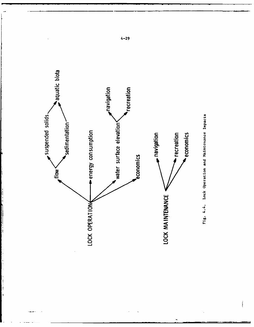
4-29
._0
4- .- _. cc
ch w
u
C
cc E
8) -
M. E E w) 0 Co Cgob 0
C L- CDV U, Ew 0
u0 0
_2 -=)01Cz
u-t
Lo
0
4-30
emptying device rather than continuous-flow device, their normaloperation has an inconsequential effect on the surface elevationseither above or below the locks or on the river flow past the locks.However, there can be flow-through if the locks leak badly. Waterwill seek this route to equalize head and thus reduce the pool levelbehind the lock and dam thereby increasing downstream flow.Fortunately, the locks are set off from the main river channel bycanal banks, thus minimizing the rate of water loss through an openlock. This potential condition is unlikely since there are at leasttwo sets of gates at each lock and the probability that both wouldbe opened concurrently is quite low (in some areas there are multiple locks).
4.121Navigation and Recreation - The operation of locks to pass vessels bythe dams is essential to the maintenance of through recreational naviga-tion on the Fox Waterway. Lock operation does not directly affectother forms of recreation besides boating. Maintenance and operationcf the locks makes it possible for increasing numbers of the largerboats in recreational use on the Great Lakes to cruise to, and in manycases make prolonged stops on, the attractive boating waters of theLake Winnebago Pool and the Wolf River.
4.122Economics - In past times, the Fox River lock system provided a fre-quently used water passage from Green Bay to Lake Winnebago for thecommercial transportation of goods and materials both into and out ofthe region. It is evident, though, that the original congressionalintent of providing a waterway system for the movement of goods andmaterials into and out of the project area via water is ceased to bea valid reason for continuation of the navigation project. Presentusage revolves almost entirely around recreational traffic.
4.123The value of recreational navigation to the economy of project areacommunities is undoubtedly significant because boating and relatedrecreational activities by individuals using project waters involveexpenditures in the local communities affected.
4.124An economic study of the Fox River project was undertaken in 1969.This study concluded that operation #.d maintenance of the overallFederal project was economically justi ed. A reanalysis of the econo-mics of continued project operation and maintenance will be completedin Fiscal Year 1978. Among other items this analysis will specifi-cally evaluate the economic feasibility of future channel maintenanceand lock operation and maintenance required to support recreationalboating. The results of this analysis will be summarized in a futureaddendum to this impact statement.
Lock Maintenance Impacts
4.125The locks require preventative maintenance (sandblasting, painting,lubrication, etc.), repair, and occasional rebuilding of both thestructures and component parts. None of these impacts are known to
4-31
produce significant adverse effects on the navigational activities. Inall of these operations, some noise generation, energy consumption, andcommitments of physical resources, money and labor are required.Because the lock components are simple, nonautomated, mechanical devices,only infrequent and minor impacts are experienced from failure ofequipment.
4.126Nivigation and Recreation - The maintenance activities pertaining tothe locks produce very minor effects except for the necessity of suchactivities to sustain navigation. Since the locks are not used on ayear-round basis, navigation-disrupting maintenance can usually be doneduring the non-navigation periods.
4.127Economics - Except for Menasha and Kaukauna 5th locks, the existinglocks and dams are in generally fair to good condition. They shouldcontinue to give good service with normal maintenance. Menasha andKaukauna 5th locks are in poor condition and should be replaced in thenear future.
4.128Menasha lock is considered the most important lock on the river since itis an essential part of the controlling works at the outlet of LakeWinnebago. This lock is the busiest of the Fox River locks with anaverage activity level of 2,608 lock operations and boat traffic levelof 4,234 craft locked through during the last three seasons, 1973 to1975.
4.129Menasha lock was built in 1890 and is of composite construction. Ithas drywall stone masonry walls faced with plank attached to backingtimbers anchored to the stone wall. The lock gates are timber. Althoughthe walls have been repaired and replanked from time to time therestill is evidence of considerable leakage. Despite nine major repairjobs undertaken in the last 50 years to reduce or stop theleakage, there is evidence of continued heavy leakage through the lockwalls and through or around the cutoff walls, with frequent bulging ofplank facing due to back pressure when the water level in lock islowered.
4.130Menasha lock was last extensively repaired in 1973-1974 at a costof about $94,000. For the past 50 years the average cost of lockmaintenance, emergency and major repairs has averaged over $8,000 peryear. The condition of the lock remains such that as a safety precautionit is necessary to empty the lock at a slow rate to avoid possibledisplacement of plank wall facing or excessive scour around and throughwalls due to pressure from water that leaks into the walls and backfillwhen the lock is filled. Such slow operation is especially annoying torecreational boaters during the heavy summer weekend traffic. It hasbeen necessary to suspend operations completely for several days duringthe navigation season to permit emergency repair work.
4-32
4.131The continuing deterioration of the Menasha lock structure indicatesthat reconstruction rather than continuing partial and expensiverepairs is warranted. Present plans call for the replacement ofthis lock within the next two years at an estimate cost of about$750,000 (1977 price levels).
4.132Although the length and width of Menasha lock is somewhat greater
than would be considered essential for the type of recreational trafficnow using the river and expected in the future, it is proposed to main-tain the currently prevailing usable lock width of 35 feet when thislock is reconstr4cted. This will permit use of the waterway by con-struction and dredging equipment and barges of types generally in useon these waters, with resultant maximum benefits from the improvement.Most of the barges used by contractors working in this area are 30 to34 feet in width and under 100 feet in length. That size is adequatefor hauling the types of equipment needed for any prospective work inthe area. The barges used by the Corps of Engineers for project mainte-nance operations are under 32 feet in width and 100 feet in length. Theadvantages of accessibility to the various channels and harbors byfloating equipment outweigh any savings that could be made in thereconstruction of Menasha lock with a width less than the controlling35 feet width at the other existing locks. There is no prospectivedemand for use of the waterway for the transport of materials withbarges over 100 feet in length, and such length is adequate for thepassage of prospective recreational boats even when several desirelockage at one time. Therefore, a saving in construction costs byreducing the usable length to about 105 feet is justified when newlocks are required.
NAVIGATION IMPACTS
4.133The operation and maintenance of project channels is a necessary pre-requisite for the continued use of the river for navigation. Becauseof this very direct relationship, the impact of navigation is consideredin this section in detail. These impacts are illustrated in Figure 4.5.Each branch of the tree diagram is discussed below as represented bythe subheadings.
4.134Recreation - As stated in other sections, the opportunity for recrea-tional boating along the waterway serves as an incentive to other typesof land-based recreation along the course of the river. Boating facili-ties such as marinas, docking and mooring facilities, and boat landingsare deveioped at numerous points along the river. Major access routesto recreation facilities are often subjected to various types ofcommercial development. These forms of recreational development haveassociated effects on terrestrial and aquatic ecosystems which can be
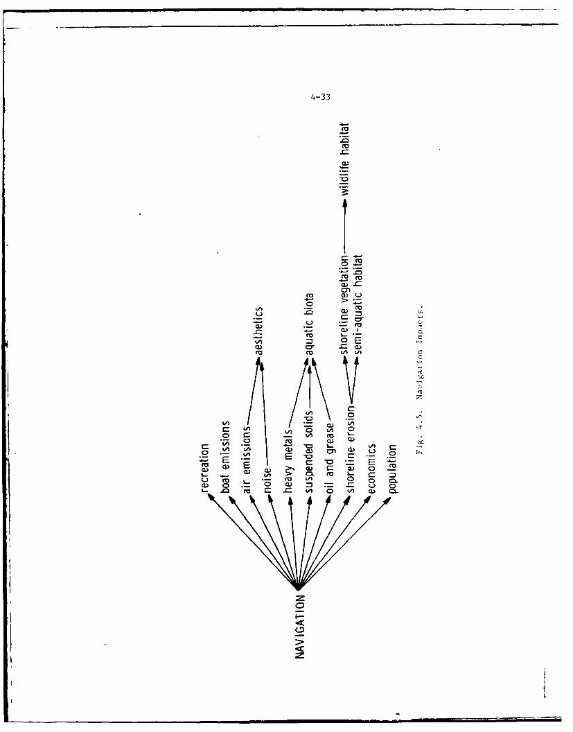
4-33
(0Cc u
4-
co
0 4-
cr a
C-
S0-
a) CC
cuC3 CCA 0 en.C
4- A o. Cu n w. ca.
I-
-- i L l T ' I r : " -z '
'4-34
significant when there are no zoning or land use controls. While thecontinued operation and maintenance of the Fox River, Wisconsin, Naviga-tion Project provides for no increase over existing capacity for recre-ational navigation, the waterway is not presently used to full capacity.Traffic is expected to grow in the future. It is likely, therefore,that the incentive for secondary recreational land developments will besustained. Review of the land use plans and policies of planningagencies along the waterway indicates that these agencies are equippedto regulate such development. The impact of this secondary developmentand its relationship to land use plans will be totally determined bythe efforts of local planning agencies in controlling the tvpe, -',ount
and location of development.
4.135Air Emissions - The fuel consumed by navigation is responsible for someair emissions. No measure of the exact quantities is available. N~ivi-gation sources probably make a small but detectable contribution tobackground levels of air pollutants along the waterway.
4.136Noise - Recreational vessels generate noise while in operation. Exactnoise levels vary considerably with power application and proximity tonoise sensitive areas, such as residences, varies throughout the water-way. Most of the waterway is not adjacent to noise sensitive areas.
4.137Aesthetics - There are many facets of navigation which could be aestheti-cally pleasing to some people while constituting an aesthetic impairmentto oth-. .
4.138Heavy Metals, Suspended Solids, Oil and Grease - Aquatic Biota - Litterproblems associated with recreational navigation uses may be significant.Current and projected increases in recreational boating will tend toincrease suspension of sediments. Oils and gT-ease--residues and byproductsfrom combustion will enter the waterway, deteriorating the water quality
to some degree. Heavy metals also may enter the waterway.
4. 139The motion of vessels along the waterway creates surface and subsurface
turbulence which produces an increase in turbidity and suspended solids.Boating wakes erode unprotected shorelines, providing an additionalsource of solids to the waterway. Owing to the soft and unconsolidatednature of some of the bottom substrate, the passage of boats will resus-Pend silt-size particles which have been deposited.
4.140
The discharge of exhaust emissions from boats into the water can havenegative effects upon water quality. The cumulative contribution of anyheavy metals, suspended solids, and oil and grease can be expected to bea factor In the overall ambient levels of these constituents in the
4-35
.aterway river. It is the nature of the emissions, rather than theirquantity, that is of greatest concern regarding water pollution. Whileraw fuel, oil, and phenols are persistent or exotic pollutants, lead is aconservative one. Gasoline contains over 100 compounds, mainly hydro-carbons from C6 to C1 0 , including straight chain and branched alkanes,
Cycloalkanes, and alkylbenzenes. These compounds, found in raw or manu-factured fuels, are toxic t, various aquatic organisms. Some compoundscvaporate from the water surface and thus contribute to air pollution,others are soluble in water, and still others form oil slicks or settleto the bottom. Thin surface films of oil cause interference with thereaeration of water by stopping oxygen diffusion into the surface watcrand subsequently to deeper layers. Additionally, an oil film can inter-fere with the oxygen uptake by surface breathing organisms. Most of thewaste oil discharged into the water accumulates in the surface laver.Little is known about the rate of degradation of hydrocarbons, althoughthey are known to be degraded slowly by marine microorganisms. As withraw fuel, phenols are very resistant to microbial degradation and aretransported over long distances. Concentrations exceeding 0.1 mg/I archazardous to aquatic life (National Academy of Sciences, 1973). It ishigh ambient levels of this and other pollutant constituents in thewaterway which would most affect the species composition and populationsize of aquatic biota.
4.141Shoreline Erosion - Bank erosion has become a serious problem in severalparts of the region. It is especially severe in Waupaca County but itoccurs in many places along the Wolf River. Tn Winnebago County, bankerosion has been especially severe at the mouth of the Wolf River.Various reasons have been advanced for the increasing erosion in theregion but the passage of recreational traffic through areas where shore-lines are unprotected from wakes has been responsible for some erosion.Navigation traffic can cause great fluctuations in the inundation ofshoreline areas. This washing action can result in the removal of sub-stantial quantities of material.
4.142Semi-aquatic Habitat, Shoreline Vegetation - Wildlife Habitat - In someareas, the shoreline and banks of the Fox Waterway do not support vegeta-tion or semi-aquatic habitat. Although this condition is largely due tofluctuations in water surface elevation, the wakes from navigation traf-
fic contribute to this problem. Prop-wash from large boats also tear upsubmergent vegetation in the channels and bays. Large horsepower motors
seem to be increasing in popularity, thus the problem compounds.
4.143Maintenance of a rour-foot channel in the Wolf River encourages the useof this river by larger and more powerful vessels. Smaller draft,
lightly powered boats, such as those typically used by fishermen, canusually navigate shallow waters over sandbars and, therefore, do not need
the four-foot water depth produced by dredging. This is not true for the
4-3 6
larger boats, however. The larger boats often "push" water, creatinglarge wakes that erode away the banks and vegetation. Therefore, mainte-namce of the four-foot channel to allow access by large boats is com-pounding the problem of erosion of banks and wetland.
4.144The maintenance of the waterway from Lake Poygan to New London has in-creased boat traffic in this area. The influx of people and boatingnoise in this area can potentially impact wildlife species inhabitingfloodplain forests. One mammal of concern is the bobcat (Lynx t. Jw mL).This species of changing status in Wisconsin 13 requires extensive for-ested areas aind is generally quite wary of people, but insufficient data;ire available to assess the effect (if any) of increased boating trafficon this species in the Wolf River area.
4.145Economics - In addition to the direct recreational value to the personsseeking recreation there are important economic benefits to the communityproviding boating, picnicking, and camping opportunities such as resultfrom maintenance of the Fox River waterway. Recreational activities byindividuals involve expenditures in the local community affected.
4.146State and local interests have provided extensive facilities to serverecreational boating needs. In several instances, major expansions ofthese facilities are planned. In addition to serving as small craftharbors of refuge and bases for launching hundreds of trailer-hauledboats used for recreational boating and fishing in project waters, theproject improvements at Fond du Lac, Calumet Harbor, Brothertown, andStockbridge will provide the main access channels for further privatemarina developments as the recreational boating demands of the areaincrease. However, the continued maintenance of the navigation improve-ments will not materially alter the projected regional economic growth.The principal reason for this is that the existing navigation facilitiesand their contributions to historic economic growth are incorporated intothe projections themselves. The projections are extensions into thefuture of historic trends in regional comparative advantages. Accord-ingly, the continued maintenance of the project will not stimulate growthabove that which is projected. Rather the maintenance will remove aconstraint to growth.
4.147Popula'ion - It is not expected that continued maintenance will have anymeasurable effect on natural population growth rates or on any aspect ofpopulation structure. Any impact on the number of permanent residents in
4-37
t sLtady ara would result from changes in the level of economic ac-itV induced by the project. As stated above, the economic projections
c cons;idered "with project" conditions.
P\E (wl.RA'rl ON
-,.I _l
Tic impacts associaLed with toe navigation dams of the Fox Project are,1 otified in th e tree diagram which is presented as Figure 4.6. Thei:id vidual branches of the tree are discussed below as represented by the,ndorlined subiheadings.
o-neral
ake Winnebao is pirt of the l. ,x River Navigaition Project and regulationof its stagL is undertaken in the interest of navigation and i7 requiredii acordaiciC ','i tlh Federal law, ,.nd to prot ect the private rights ofater-po,,er and vi ijarisn int erests.
[I,, regular i n u. L.ke Winnebago, depends on forecasts of precipi tation;ail ,ni the aiuontinL of snow mel L which u5an be anticipated in thE latespring months. This is not an exact science but the object is to regu-lat, the lake in anticipation of all probable increases in level whichmight exceed the upper limit. It is lor this reason that the lake isloitered below Lhe crest of the dams in the early spring in order thatsufficient capacity in the lake basin will be provided to store largespring inflow from the drainage area of the lake. This must he donebecause the means of control to pass water into the Lower Fox River arenot equal to th,- flows of water coming into the lake. Furthermore, if itwere possible to pass the total inflows as they occur, serious damag.downstream would most likely result.
4.151Reports are received daily in the Chicago District Office on variousgages in the Fox-Wolf River watershed to assist in the regulation of LakeWinnebago. Durin, critical. periods up-to-the-minute reports are obtainedh\ telephone. Close contact is made with the U. S. National Weather Ser-vice to have the benefit of the most recent weather reports, includingforecas ts.
4.152Just as extreme high and low levels have been experienced on Lake Michi-gan within the pa:st few years, so have the conditions on Lake Winnebagobeen near both extremes. As recent as 1960, the third highest stage ofrecord occurred on Lake Winnebago. In May of that year, the peak was 32inches abov( the crest, or about I inches above the upper limit ofregulation. Such an extreme is estimated to have an expectancy, on theaver.ge, of once in 31 years. t'he reason was due to exceptionally heavyprecipitation over the watershed; the amounts exceeding the advanceprecipitati.'T forecasts by the National Weather Service.
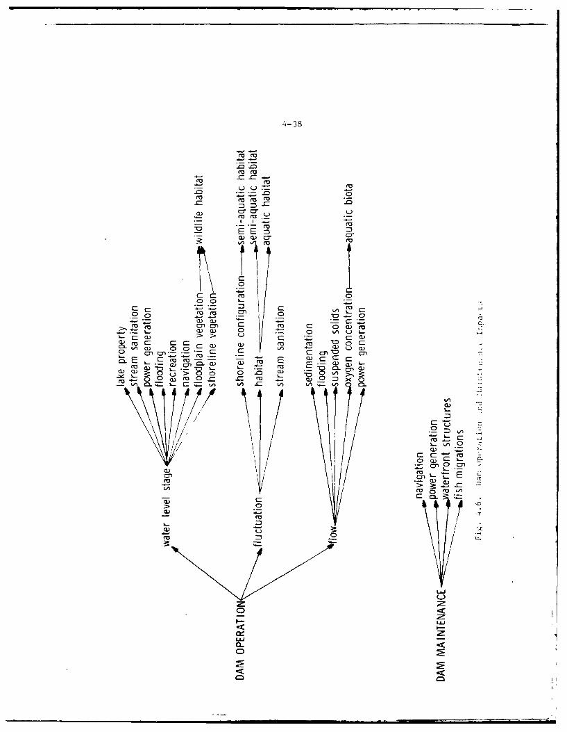
4-38
m m
ar cv
cvE E :3
M 4-
000
0 0 L..
Ev co D
.9) -l %- CQ tL..-V C
0)0)~c 0 CC :c
~ 0 ~ LL)
0 ) cvC C -<
cv cv Ao0
-u~) 0 ~W 0 -~ ) Lz
0 ~ C C
~'~ c-- < -
4-39
4.153During some low water periods, the water supply to the lake is less
than the loss by evaporation, plus the small amount needed to maintainnavigation. Unless a certain amount of stored water is available tosupply the deficiency, navigation on the Lower Fox River and LakeWinnebago is handicapped and the pools behind the dams on the LowerFox River can become stagnant, thus creating unsanitary and obnoxiousconditions, causing losses of fish life, and creating water supplyproblems for some industrial plants and communities.
4.154There are two outlets from Lake Winnebago, one known as the MenashaChannel and the other as the Neenah Channel. The Menasha Channel hasbeen improved by the United States for navigation purposes, the outletbeing controlled by the Federal dam in the city of Menasha. A privatedam in the city of Neenah controls the Neenah outlet. Both outlet chan-nels converge into Little Lake Butte des Morts below the cities of Neenahand Menasha and are part of the Lower Fox River. The elevations of thespillways (crest height) of the Neenah and Menasha dams are 745.85 feetabove mean sea level (MSL) and 745.94 feet (MSL), respectively.
4.155The water level of Lake Winnebago, and consequently the levels of LakesButte des Morts, Winneconne, and Poygan are controlled by the Corps ofEngineers under regulations that have been in effect since 1886 and werelast modified in 1920. These limitations are established by law and arenot administrative determinations by the Corps of Engineers.
4.156The limits of regulation under existing laws, orders and permits are from21-1/4 inches above the crest of Menasha dam to the crest level during
the navigation season, plus an additional drawdown of 18 to 24 inchesduring the winter. The water level of the Lake Winnebago Pool is re-gulated in accordance within these limits to preserve the privaterights to use the water not needed for navigation for power developmentand to reduce flood damages.
4.157The storage available in the Lake Winnebago Pool normally is substantial-ly filled during the months of high inflow, thus reducing flood flows ofthe Lower Fox River. This storage provides supplemental flow for navi-gation, water power, water supply and sanitation during the dry monthsof the year. The availability of the Lake Winnebago storage and itsproper utilization by regulation of the outflow is of major importanceto navigation and various other regional and local interests.
4.158The principal interests affected by the regulation of Lake Winnebagoare: recreational boaters, water power developments, municipal and
industrial water users, riparian property owners, and fish and wildlifeinterests. Due to the limited tolerances (inches, not feet) of
m m w | - .. .. ..
o-40
operation, and because the rights of non-navigational interests are
subservient to the prior rights of navigation, there are necessarilytimes when all interests cannot be satisfied. Also, the requirementsof each of these interests frequently are at variance with those ofthe others. This creates a problem which must be resolved with theminimum of adverse effect on all interests concerned.
4.159The regulation of Lake Winnebago cannot be changed without violating the
'rights of water power users and navigation interests. Any change in pres-
ent flow regulation limits and procedures in order to more fully meetthe desires of other interests is dependent upon Congressional authori-zation.
Neenah-Menasha Dam Operation Impacts
4.160The Neenah-Menasha dam operation impacts aie variable and depend to alarge extent on the level of the water upstream (high or low water stage)and the stability of the water level (stable or fluctuating).
Neenah-Menasha Dam Operation - High Water Stage
4.161Floodplain Vegetation, Shoreline Vegetation - Wildlife Habitat - Thecrest elevation of the Menasha dam is about 745.9 feet (MSL). The stan-dard low water level at New London, approximately 75 miles upstream ofthis dam, is 748.1 feet. Thus, only 2.2 feet (26.4 inches) of drop existbetween these upstream and downstream points. By controlling the flowof water past the Neenah and Menasha dams, the Corps of Engineers regulatesthe water level of the Lake Winnebago Pool for navigation, powergeneration purposes, and flood control. During the navigation season(May 1 to November 1) this level can be as high as 21-1/4 inches abovecrest and is usually controlled to maintain a level between 15 inchesto 18 inches above crest. Such action increases the water levelsthroughout the Winnebago Pool but with no backwater effect aboveFremont. When the water level is at or above the upper limits of regu-lation (21-1/4 inches), many adverse environmental changes occur, suchas the inundation and destruction of marshes and loss of bottom materials,and an increased depth and surface area of the lakes and streams.
4.162Water levels on Lake Winnebago are of primary importance in the ecologyof both aquatic and shoreline vegetation. High water levels, particu-larly at or above the upper limits of regulation, are believed to beadversely affecting marsh and floodplain vegetation areas.
4.163High water levels above the range which plants will tolerate is one wayby which Winnebago Pool vegetation may be adversely affected. Extendedperiods of high water levels, whether within the upper limit of regula-tion or not, can also retard or eliminate the growth of aquatics by
4-41
reducing or excluding sunlight because rooted aquatics are apparentlyunable to store sufficient food reserves in these perennating organsto sustain growth of photosynthetic organs up to the light in thespring in turbid waters more than four feet deep.
4.164Uuless measures can be found to reduce turbidity, then it is imperativethat from a vegetative managerent point of view that water levels becarefully held down in spring and early summer when green growth beginsand develops from the bottom. On the other hand, storage operations itthis time reduce downstream flooding and provide needed water to augmentlow flows in late summer.
4.165Since the seasons of the year when high water levels are maintained aregenerally periods when the vegetation is growing and reproducing, thecontrolled high water levels will also foster growth of submergent andemergent aquatic vegetation in other areas where these species would notnormally exist. In some areas it may also foster displacement of terres-trial biota by both the water and aquatic vegetation.
4.166Annual high water at the time of the spring ice breakup is another way inwhich high water levels may contribute to vegetative losses. Ice frozeninto the vegetation is lifted by the rising water levels and tears loosethe roots of the vegetation producing a floating bog mat. With continu-ing high water and wave action this floating bog mat gradually breaks upand floats away or disintegrates. Once the vegetation is lost the soilbeneath is quickly eroded by wave action and moves downstream, leavingthe area deeper than it was before the vegetation was lost. This makesconditions uasuitable for revegetation of the area and ino reases the sizeof open water area.
4.167Any action which decreases the flow of streams and increases the open-water areas of both streams and lakes generally promotes the displacementof desirable fish species, such as bass, pike and walleye by such unde-sirable species as freshwater drum, burbot and carp.
4.168Under the existing project these impacts are anticipated to continue asthey have since 1886 when the 21-1/4 inch above crest height level con-trol point for the Menasha dam was originally authorized.
4.169Flooding - Although the Neenah and Menasha dams have limited capabilityfor routing flood flows, they were not originally designed for flood con-trol. In the past, the Neenah and Menasha dams have been modified sever-al times to provide more discharge capacity. Flood flows at these loca-tions are regulated in such a manner as to minimize flood damages bothabove and below the dams to the greatest extent possible.
.4 ....,
4.170During the l~ist 50 years there have beet, several floods causing theinflow t o Lal,. Winnebago to exceed the safe outflow by several thousand
cubic feet p,.r second. In the absence of storage capacity in Lake Winne-
bago and contrclled outflow these floods con ld have caused extensive
damage alon F the Lower Fox River.
4.171Controlled use of the stoerage' volme available in the Lake Winnebago Pool
also results in suthstai,,ti i] reduction in flood damages to low lands sur-
rounding thie pool. The improvement of the Neenah and Menasha channelsand the addition of sluicwiv.s to the two dams has made it possible to
lower the level ,f the lake to 18 to ?-4 inches below the creo;t of M4enashadam in advance. f the expected annual spring flood periods. The stor'irevolume thus gained is available to hold flood water during the floodperiod and thus reduce the upper 1imit reached by the lake as a result ofthe excess of inflow over outflow during the flood peak. The volume ofstorage available in the pool between the level of the crest of Menasha
dam and a level 18 inches below th crest is equal to 123,912 day seconlfeet, or 245,840 ire feet. This is equal to the volume available be-tween about 4-1/2 and 21-1/4 inches above the cresL. At the upper limit
of regulation, one inch of depth is equal to about 7,600 lay second feet or15,100 acre feet, and increases the area flooded by tho pool by about 293acres. Assuming that at leas4t one-half )f the storage available in th'pool to a level 18 inches below tihe crest might be lost if the sluiceswere not avail able, and used to reduce the pool level, about 62,000 J.s.f.of storage would be lost which wiould require an additional eight inchesof depth at the upper limit of regulation to compensate for thu storacelost. Witlh thC increase in th, upper level the pool would flood about2,350 acres nort, of the low Land.
4.172Properly rc go, i , 1 'adirg ir: the project area will continue to be
controlled oxcrt t for t ),-e ocasions when extreme meteo:ological condi-tions prevail anid oi:;flow at th, a,,ms cannot keep up with the inflow tothe Winne! a , -1 -. ig h of tht present flood damages occurring
adjacent to th, I i , i a r,.--iI ,f encroachment within Federal flowage
easement s.
4.1;3Navig int.- Fr m , i -=odpoint, high water levels increase
lake depths in I. ,is produces larger and more usablerecve;atiorial w .. btcrs of the area, making recreation-al navi , 'at i, z, i' I' t ie. However, the increased depthsare not ne'ss, .ctivitv ecau;e draft requirements
of tile t,)lt 11. 7 I from less than 2 feet to about4 feet.
4.174
Since no ''inner ,iil ba ri f.vi it ion e : ists, r-) direct commercial eco-nomic imp;actq eithi-r beni.f i, l ,r adverse will result.
4-43
4.175Industry - Industrial and municipal users of river water are unable toutilize the maximum flow of the river during floods. The maints:uance (ihigh water levels in Lake Winnebago following the heavy spring fl.ws hasthe beneficial effect of assuring adequate water impoundment duing therelatively dry summer months. This impounded water is essentp1 tc In-dustry downstream of the Neenah-Menasha dams. It also provides lnc;-dental water quality benefits to the Lower Fox River region.
Neenah-Menasha Dam Operation - Low Water Stage
4.176During the winter and early spring months the water levels -n Lak Winne-bago may be reduced to a minimum level of 18 inches below the croi;, ofthe Menasha dam. Present water level management calls foi a grmd,-!reduction in water levels from October or November through the tt"vpart of February or the first part of March. Exact timing of thi: *raw-down depends on weather conditions and the volume of inflow. This actionis taken to provide storage capacity for the heavy sprnrg runoff q,.stream. It decreases the water level throughout the Winnebago Po.r,!.increases flow velocity in the Wolf River near its mouth, deereanes depthof the lakes and streams upstream of the Neenah-Menasha dams, ad rc-creases the surface area of these lakes and streams above The Nien:atMenasha Dams.
4.177Lake Property - Winter drawdown reduces the volume of water in t!r Winne-bago Pool and makes room for the expected heavy flows in the spri g. Lowpool levels in the spring increase the gradient and permir a fester in-flow of water from streams emptying into the pool. This reducee thechances for backups and floods along these streams and resultl.ng damtneto adjacent residential developments and municipalities.
4 178An added beneficial impact of the low water levels during wintor in thereduction in the potential for formation of property-deo-iroving sloorl- ieeduring the winter freeze and particularly in late wintei or -rl"pringwhen wind-driven breakup ice can cause serious damage to boil, iato,,al andman-made shoreline features. Low water provides some Insuranl'e ai rinsfspvere ice damage to natural shoreline features and propertieq (houses.docks, piers, etc.) along the lakeshores because when water pve1.- Pro :ttheir extreme low In the more shallow edge waters, tht ic will b. ;o-st-In& on the bottom. When the breakup occurs, this Ice, because :'t i- 't
floating, acts as a barrier against ice shoves. The icr builds ir liftshore rather than on the shore. In areas which have deeper contoitr.,the drawdown may not be severe enough to lower ice levels to thebottom. Complete protection then does not exist, but, if wpter jee.,- arllow, the damage will be less.
4.179Floodplain Vegetation, Shoreline Vegetation - Habitat - Winter t rewd.iwreduces the volume of water in the Winnebago Pool. This derreasen th-
chances for spring flooding and accompanying hog losses. Since the sea--sons of the year when low water levels are maintained are generally the
seasons when vegetation is dormant, direct adverse effects upon the vep.e-
tationa are minimal, and replacement of an,tatic vegetation in the de--watered areas by terrestrial vegetation dcoq not. normally occur.
4.180Decreasing the water-covered areas could, however, have ,;eriou3 adverse
effects upon the early spring spawning fish if low water lcvels were
maintained into the spawning season. To preclude this potential impact,the Corps of Engineers, by agreement with the Wisconsin Department of,Natural Resources, presently controls flows at the Neenah-Menasha dams ina manner which raises water levels in Lake Winnebago to crest elevation
by the first week of April. This action was requested by the Departmenthi 1959 to secure higher water levels in early soring to benefit fish
life and early commerical fishing navigation. This change of operationfrom previous years could also adversely affect the still-frozen
vegetation resultin in its loosening and displacenent, which has been
observed.
4.181The requirement of having the basin pool level at the crest of the dam by
this time, shortly after the spring runoff occurs, has apparentlycaused greater loosening and displacement of snme areas of floating bogthan which occurred. prior to the operational change due to the effect ofrapidly using spring water levels lifting the still frozen vegetationfrom its rooted moorings. A modification of this policy should thereforebe considered and the Department of Natural Resou-ces has indicated a
desire to study the effect of abandoning the eprlier higher water level
concept.
4.182Industry - Winter drawdown provides an adequate flow of water through thewinter months to the stream below when pool inflows are reduced. Thisgives the paper industries and the power plants water needed throughthe winter period. Flows are augmented in thp downstream river, reducingthe possibilities of fish kills during the critical winter period. The
winter and early spring sluicing also is desirable as it gradually wearsaway the ice on the lower river and avoids quick ice break-ups and ice
jams in the spring.
4.183
Recreation - Under low flow conditions, the regulation of water surfaceelevation affects recreption in two ways. Recreational boating is sus-
tained by the provision of adequate channel depth. Water oriented rec-reition, such as fishing, which takes place on the shoreline is affectedby the degree of variation in the location of the land-water interface.
4.184
The maintenance of project depths of proper dam operation at low-flow isa requisite for the continuance of current and projected levels of boat-
ing activities. Low water levels can mqke some permanent docks, marinaslp,4, and launching Janes unusable. Low water levels can negate certain
4-45
benefits associated with past recreational investments, including somepublic facilities which were constructed with Federal Land and WaterConservation funds.
4.185In addition to pleasure boating and sailing, the waters of Lake Winnebagoare used extensively for fishing, water skiing, swimming, and canoeing,in addition to other water based activities. Hunting of water fowl isalso a seasonal attractive activity. Although most of these activities'would be possible without the Federal navigation improvement, the regu-lation of Lake Winnebago to maintain a fairly constant level during thesummer season helps to maintain swimming beaches and full access and useto shoreline installations. Lake regulation also enhances combinationboating and picnicking at the various public parks and scenic areas alongthe waterway. It is also estimated that about 10 percent of the regionalcamping use is in excess of the use that might be expected without themore favorable water levels and conditions resulting from the regulationof the lake level and the maintenance of the navigation project.
Neenah-Menasha Dam Operation - Fluctuating Water Levels
4.186Shoreline Configuration - Semi-Aquatic Habitat - Regulation of the waterelevation on Lake Winnebago has great effects on the amount and extent onshoreline and floodplain vegetation.
4.187The greatest effect is generally found in the lower and middle segmentsof the pool, due to the gradually sloping floodplains. The rise and fallof water levels may cover or expose several hundred feet of potentialshoreline. For example, areas that are normally dry and have mesic vege-tation at normal pool level (Figure 4.7A, sections 1, 2, & 3) may bechanged to a hydric habitat with a slight elevation of the water level(Figure 4.7B, section 2). Similarly, further increases in water eleva-tion may render this situation to one of strictly an aquatic nature,leaving all flora that are capable of growth in shallow water eliminatedand only those species which grow entirely submerged present (Figure4.7C, sections 2 and 3).
4.188As may be noted in Figure 4.7, the potential shoreline has several posi-tions at which the water and shore interface may occur, depending uponthe water level.
4.189Fluctuating Water Levels - Aquatic and Semi-Aquatic Habitat - A glacialdam lake in its origin, the water level of Lake Winnebago is now con-trolled to a considerable degree at two artificial dams in Neenah-Menashaoperated by the Corps. Although flows and water levels show considerablevariation between years, the controlled water levels of the project areaupstream of the Neenah-Menasha dam follow a yearly pattern of change dueto human intervention. This pattern of regulation is accentuated or
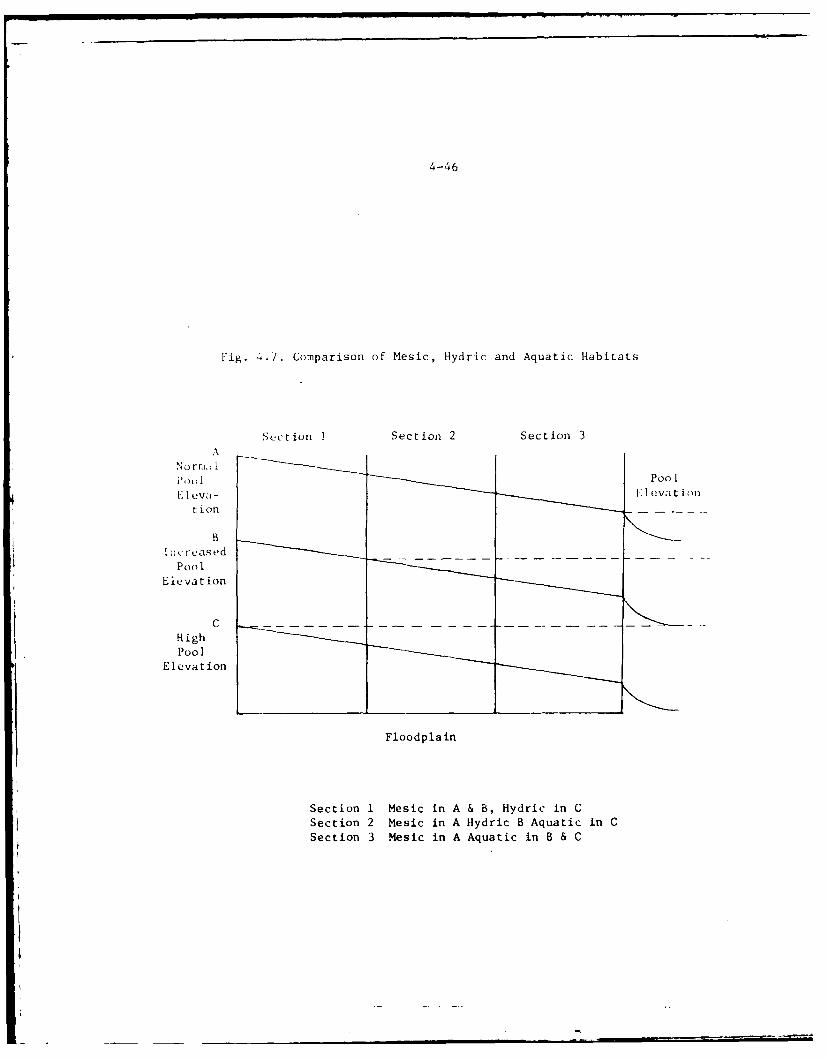
4-46
Fig. 4.7. Comparison of Mesic, Hydric and Aquatic Habitats
Section I Section 2 Section 3A
i ) I Pool-
ti on
BIii ruVased
Poo01
Elevation
CHighPool
Elevation
Floodplain
Section 1 Mesic in A & B, Hydric in C
Section 2 Mesic in A Hydric B Aquatic in CSection 3 Mesic in A Aquatic in B & C
4-47
dampened by the variations due to meteorological conditions (precipita-tion or draught) with extreme flood conditions in spring and/or draughtin late summer. Natural water level fluctuations have become severelyaggravated because of intensive farming and its accompanying drainage ofwetlands.6
4.190Deforestation and the construction of ditches for the benefit of agri-culture has accelerated runoff and altered drainage patterns, increasedthe intensity and volume of recent floods, and altered the erosion/sedi-ment characteristics of the natural stream system. These conditions makeit more difficult to control water levels and lead to the destruction ofaquatic and semi-aquatic habitats.
4.191From historic times to the present there has been a gradual, yet persis-tent decline in the quantity and quality of the vegetation in the upriverlakes and marshes. These lakes include Lakes Butte des Morts, Winneconeand Poygan. At times the changes have been imperceptible and at othertimes they have been quite obvious, but it is known that they are oc-curring. For example, prior to the construction of the Neenah-Menashadams, Lake Butte des Morts had such extensive wetlands that only canoepassage was possible, yet by 1914 there were 4,505 acres of open water,
8
and 8,857 acres in 1974.2 This tncrease in open water has been at the
expense of the naturil emergent and submergent vegetation. Between 1916and 1961 more than 6 square miles of emergent cover disappeared in LakeButte des Morts alone.
4.192Although there are no records available of the submergent vegetationoriginally present in the upriver lakes area there is a general unanimityamongst those who have a knowledge of the area that the submergents are
decreasing. Turbidity and rough fish activities are the chief factorslisted for this decline. It also seems that there is a strong possi-bility that the loss of submergents is closely associated with the lossof emergent cover. When large areas of emergent cover are lost it opensup the area formerly occupied by emergents to bottom erosion due to waveaction. Waves churn this material into suspension and produce highlyturbid water conditions which may have a deleterious effect on adjacentareas of submergent vegetation. This situation may be further compoundedas greater and greater expanses of open water are exposed to wind andwave action.
4.193While the cause or causes of marsh loss have been the subject of muchspeculation and some controversy, it appears likely that the construction
of dams at Neenah-Menasha in the mid-1800's placed a stress on the marsh
by raising the level of the water.6
4.194When the Menasha dam was otiginally built in 1850 (prior to the date on
which the U. S. acquired the facility), the low water level in Lake
Winnebago increased approximately two feet, which caused water to back up
4-48
tpto Lakes Rutte des Morts, Poygan, and Winneconne, and the Wolf River.This increased water depth is believed to have inundated large expansesof wetlands that previously existed within these bodies of water. Thewater depth became too great for some of the submergent and emergentv'gecation, causing it to die off and decompose. 6
4.195While some attribute continuing area marsh losses to the initial poollevel increase brought about by these dams, they have probably had lesseffect on marsh wetlands than is commonly supposed. There is strong evi-dence that marshes in the upriver lake region were firmly establishedlong before the dams, and for many years afterward.
6
4.196Among other explanations which have been offered to explain marsh lossare the effects of boating, wind and wave action, pollution, rough fishactivity, turbidity, and ice, which floats upward with rising waters inearly spring, lifting and tearing loose the marsh which is frozen intoit. 6 While it may well be that all of these factors are contributing to
Loss of marsh area, the relative importance of any single factor isunknown.
4.197The ice explanation is really one of water level fluctuation. Duringwinte!r drawdown standing water on the wetlands as well as within the rootsystems freezes. When the water levels rise again in the early springbefore the ice has melted, the frozen mat-like systems also rise and aretorn from their substrate. This creatrq floating mats of vegetationwhich are subject to wind and wave ac In time these floating matsbreak up and wash downstream.
4.198Explanations based on water level fluctuation appear strong. It seemsthat the heavy forests, lush bluestem prairies and savannas, and exten-sive expanses of wetlands which existed in the area before disturbance bywhite men sufficiently buffered surface water and groundwater response toprecipitation that the total range of fluctuation of water level in theupriver lakes and marshes was very small. The massive-scale cutting offorests, plowing of lands, and draining of wetlands would be expected tocause greater and more rapid water level changes--changes which would bedisastrous to floating and semi-floating mats of plants which had beenable to grow thus only becau;e of comparatively stable water levels.
6
4.199The timing of the major breakup of the marsh is also more nearly support-ive of "range of fluctuation" hypotheses than of the "raised lake level"
hypothesis. It appears that if loss were attributable to a sudden changeof level dating from the mid-1800's, the marsh loss would have been moresudden and dramatic, and little would have been left by the early yearsof the twentieth century.6 But the marsh seems to have remained pretty
well established until the 1920's. The episode of tree cutting, plowing,and wetland drainage was not fully under way until after the constructionof the dams, and the process was proceeding at great pace well into this
4-49
century. In fact, wetlands are still being drained. Given a degree oflag between the time of Jand disturbance and the loss of marsh, thetiming fits rather well into the "range of fluctuation" hypothesis. Of
course, the fluctuations are governed to some extent by the dams, but the
range they permit may well be greater than the range p~rior to extensive
settlement of this area. This, coupled with the watershed changes
described above, has led to higher water levels over longer periods
of time on a morb frequent b sis than that which existed prior to
original dam constructior.
4.200The aquatic plant species (both emergents and submergents) which inhabitLakes Butte des Morts, Winneconne, and Poygan today are noted in Table
2.32. As was determined by Harriman, 9 the tolerance for water depth and
bottom types is quite variable between species. Some rooted aquaticssuch as bushy pondweed (Naja6 feexLi) and American lotus (Netumbceutea) have a very narrow water depth tolerance range and are likely to
be impacted greatly by fluctuating water levels. 7 Other species such as
hardstem bulrush (ScKtp actwu,), arrowhead (Sagttatia rigida), pick-
erel weed (Poiitedokta covdata), and reed grass (Phtaqmtet6 auttaaUZ)have the ability to tolerate relatively deep waters and withstand wave
4 action. 7 ,9 Reed grass, however, is decreasing at the present time be-cause of increasing water depths and detachment after freezing, high
spring water levels and high winds. In some areas of Lake Butte des
Morts floating vegetation mats covering several acres have been washed
downstream. Floating vegetation mats are in many instances over deepwaters and do not become rooted to the bottom.
4.201The vegetation mat which is floating in many places is extremely sus-ceptible to breaking up and disintegration. Floating bog is a very un-
stable condition in marshes of this part of the state. In the northern
areas of the state, sphagnum bogs form around the edges of lakes andponds and gradually grow outward forming a dense floating mat over the
open water. This mat continues to increase in thickness and coverage.This is not the same process which forms the southern and central
marshes. Vegetation in these marshes develops mostly under conditions of
low water and mud flats during the growing season. The vegetation is
firmly rooted in the bottom soils and no vegetation will be produced ifwater levels are deeper than the plants can tolerate. The mat of vegeta-
tion usually dies if water levels become excessive after it is estab-lished. However, if ice action in the spring of the year should tear the
mat loose, it will then float up and may persist for long periods even
though the water beneath the mat has become excessively deep. This
presumes that the mat remains intact and Is not washed downstream. Thisis an extremely unstable condition since there is constant danger from
wind and wave action. Paradoxically, however, it is also the only con-
dition under which vegetation can exist in the area when water levels
become excessive.
4-50
4. 2 0Ft,'ating and emergent vegetation were once predominant in the shallowlalies of this system and the water was normally clear. This is no longertruC. Fl. , lakes and river channel are now open and consistently veryL Irbld.
:iji~to~c records indicate that the open water surface area of Lakes.B,t'u Jcs Norts, Poygan, and Winneconne have increased since the U. S.assumed1 control of the waterway in 1872.6,7 A historical perspective ofth,)se losses in Lakes Butte des Morts, Winneconne, and Poygan is shown inFigure 4.8. Undoubtedly the same story is true for Lake Winnebago andpurhaps the lower reaches of the Wolf River. With this increased surfaceirca and the fluctuation of water levels along the rapidly rising floodwaters has come the destruction of considerable acreages of marsh andjoss of habitat for many wildlife species.
2., 7.04'This loss of vegetation has affected the fish fauna in these waters inseve ral ways. Walleye and yellow perch are known to spawn in wetlands;theict ore a reduction in these wetlands has caused a reduction in spawn-iun; habitat. The reduction in spawning habitat for the wetland spawning§-pecies becomes an increase in preferred open-water spawning habitat forspecies such .s freshwater drum and carp. The Wisconsin Department ofN8 t',ral Resources has had to institute a Rough Fish Removal Program torecuc these latter populations in order to increase the quality of,portf ishing.
4.205Loss of vegetation has also reduced the amount of food available, par-Licularly since invertebrates require it. Since vegetation also providesrefuge as well as food for the offspring of various fish species, theseoffspring are subject to higher levels of predation. All of these fac-tors have probably led to undesirable changes in the fish fauna and maybe gradually reducing the quality of recreational fishing within thesewaters, although no known reports have been issued that specificallyprove these contentions.
4.206The loss of marsh vegetation around lakes also decreases the availablebreeding and foraging habitat for many amphibians and reptiles.1
0
Breeding habitat for many frog species along much of the shorelines ofLakes Butte des Morts, Poygan, and Winneconne has. been eliminated. Thegreen frog (Rana clamitans), bullfrog (R. catcsbeiana), and American toad(Bufo americanus) all lay eggs on the surface of the water. The eggs ofthese species may not be as seriously affected by habitat loss as wouldeggs of the leopard frog (R. pipiens), which are generally deposited inglobular masses in emergent vegetation. Any loss of breeding habitat,although seemingly insignificant, will add to the decline"1 in abundanceof this species in Wisconsin.
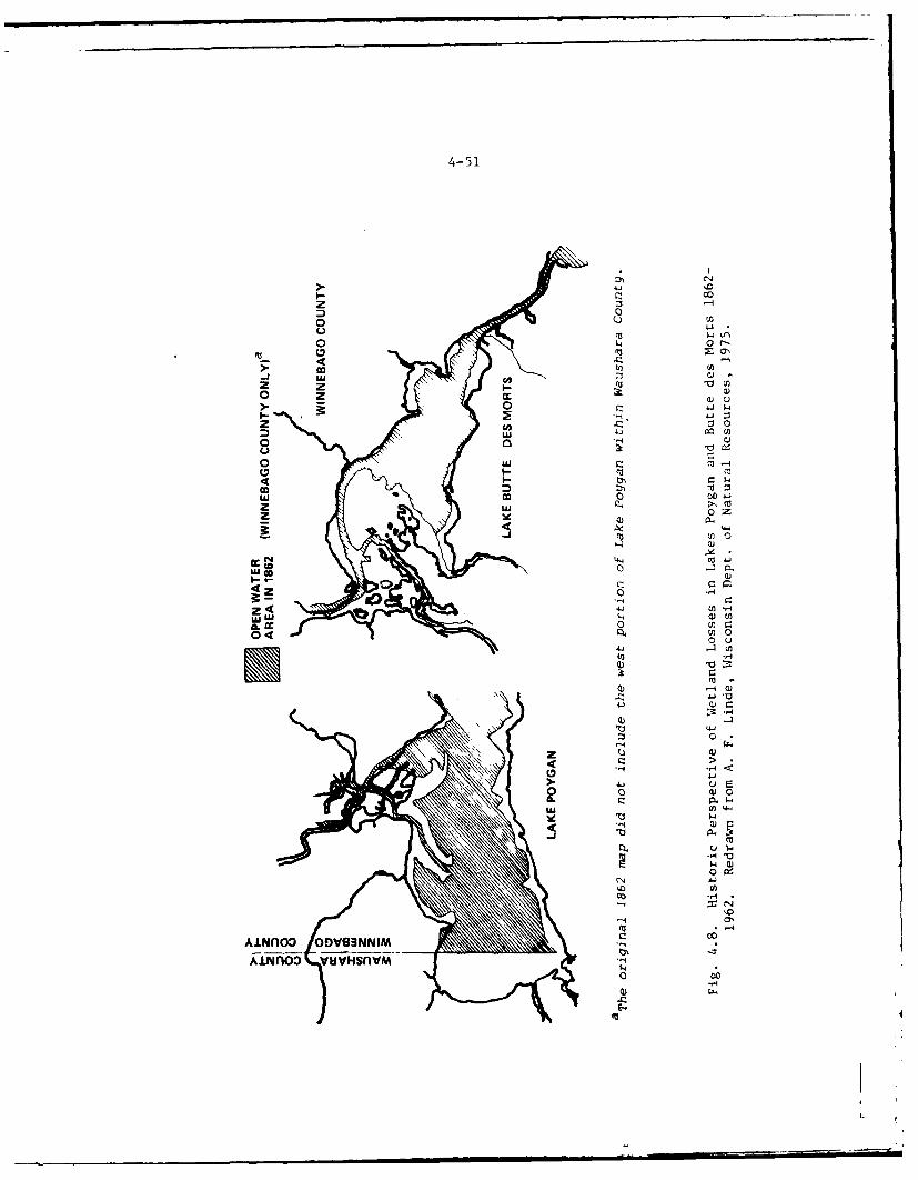
4-51
co
000 0
> co-z o'
0j w
0 (
co D
0 If04
04 0k44
Qii
cc~- N -4C1la4
Z~ 4
0
4.34
71
0jm
'44
uj fn o
4-52
With the cxception of the central newt (Notophthalmus viridescensz;'nc:nac) and the tiger salamander (Ambystoma tigrinum), all sala-
sander sp,,cies breeding in the lakes (see Table 2.34) are dependent uponna:-- v;etator fcr egg attachment and larval development and conse-
qltliLy hive probably declined in abundance in these lakes. 1 0
4. 2G8Furagfng ,s for some reptiles decrease with the elimination of marshvegetation. Yuung turtles forage in marsh areas, spending most of theirLime in de:ise stands of emergent vegetation. Forage species for suchcommon snake species as the eastern garter snake (Thamnophis sirtalis)and northern water snake (Natrix sipedon) will also decrease with theloss of w~tl.ands.
,.20ot
,he State :,t ,41'zconsin and private individuals have riprapped some areasof Lakes Poygan -ind Butte des Morts with stone to prevent further lossesof ,-irsh 'eetation. The stone riprap will provide more breeding andf,,rcging habitat for mudpuppies (Necturus maculosus), increasing theaaiiidance of these amphibians in riprapped areas. Clay dikes and rip-r=ipped areas m;,y increase the available nest sites for many aquatic
,.2[0,:,; endangered amphibian or reptile species are known to inhabit theproject irt-a. Thus, the habitat losses mentioned above are not expectedto el iminate any endangered amphibian or reptile species from the project
4.211lh loss of marsh vegetation may result in a local decline in muskratsbu~t will have little impact on the status of the species in the project<rea. Ihe least weasel (.MusteZa nivalis) is very uncommon 12 throughoutWisconsin and will probably be reduced in number in portions of the WolfRiver-Lake Winnebago area with a decline in marsh habitat.
4.212No other mammalian species of old fields, lowland and upland forests areexpected to be adversely affected by the fluctuating water levels of theWolf River-Lake Winnebago drainage basin.
4.213The loss of wetlands in the Wolf River-Lake Winnebago area is the mostserious threat to the avifauna of the project area. The loss of marsh-lands reduces habitat for nesting, foraging, and cover for many speciesof waterfowl and marsh songbirds (see Table 2.35).
4.214Although no recent data1 4 exist on breeding-bird densities for this area,some information is available for similar habitat in Rush Lake, a 3,000-acre lake in the southwest corner of Winnebago and adjacent Fond du Lac I.
4-53
Counties. With caution one can apply these data to the above mentionedlakes to gain some idea of the importance of marshes as nesting habitatfor birds. Waterfowl species nesting at Rush Lake in 1972 and theirestimated densities (pairs/100 acres) are: coot (6.7), blue-winged teal(0.8), ruddy duck (1.0), redhead (0.2), shoveler (0.03), mallard (0.2),and gadwall (0.03). The most abundant breeding aggregations were repre-sented by the red-winged blackbirds (8.3) and yellow-headed blackbirds(30.0). Other species nesting at Rush Lake were the red-necked grebe,pied-billed grebe, black-crowned night heron, herring gull, Forster'stern, and black tern.
4.215In the area, black tern and Forster's tern populations will suffer a re-duction in available nesting habitat with a loss in reed grass (Phtagmitcauttata) beds around the lakes, since their nests are built on floatingvegetation mats. Although the Rush Lake marshlands are not identical tothose of the project area, these data suggest that many species are prob-ably present in the area and could be strongly impacted by a loss ofmarshes.
4.216A reduction in marsh acreage has, In p.it, produced a decrease in thenumber of migrating waterfowl which use the area in fall for resting andforaging. The Wisconsin Department of Natural Resources reports thatthe estimated total number of waterfowl stopping in the Wolf River lakeshas decreased from approximately 200,000 ten years ago to 2000 in 1974.The loss of habitat in the project area has also, in part, increasedthe number of waterfowl using the Horicon Wildlife Refuge as a stop-overarea. The large number of waterfowl in the Horicon area has forcedsome birds into adjacent farmlands resulting in a greater loss ofagricultural crops.15
4.217The red-shouldered hawk, the only threatened species (State list) likelyto breed in the project area, could be affected indirectly by a loss ofmarshlands. A loss of marsh could reduce habitat for garter snakes,ribbon snakes (Thamnop&i), and water snakes (Nit~x 6ipedon), which areimportant food items of the red-shouldered hawk. The fluctuating waterlevels are not expected to directly affect any of the remaining threaten-ed or endangered bird species, some of which are possible spring andfall transients.
4.218Stream Sanitation - In order to maintain authorized project depths fornavigation it is necessary at times to restrict the outflow from LakeWinnebago to such an extent that the lake becomes stagnant and the LowerFox River becomes a series of still pools containing increasing concen-
trations of pollutants. Increased water flow from Lake Winnebago duringthe late summer and early fall would freshen that water body and alle-viate polluted conditions downstream. The reduction of the unsanitaryconditions which accompany low water can be achieved by a more uniformflow through Lake Winnebago and the Lower Fox River.
4-54
1. Lowcr Fox River Dams (Excluding the Neenah and Menasha Dams)
2 19
As preiic,ly ncted there are 11 dams downstream of the Neenah and
Mena.h. dam . Unlike the Neenah and Menasha dams, which are the prime
fow-:oiitrol ;tructures in the Lower Fox River, the other 11 dams areused airost oxclusively for hydropower head, process water, navigationpoo! impoundment, and water quality improvement purposes. Except for
pe.rinods droupht or peak upstream runoff, the flow through the river andconsequentially the river water levels are maintained fairly constant.Thus, only two water-level conditions (water flows) are commonly exper-
ienced, namely, high water stage and low water stage.
Lower Fox River Dams - High Water Stage
4.220NaviLz, gt n Navigation in the Lower Fox River during high water stagecan varv from -iskv to very dangerous; floating debris is in abundance,currents aind turbilence are high, and changes of running aground on newlysubmerged areas are increased. Since these high water periods usuallyoccur in spring prior to the opening of the boating season, channelT'arlirs', which are removed at the end of the previous boating season,ha~ ~vint-ally not been replaced. The absence of these channel markerssig:nifics that navigation is not to be attempted. Thus, boating seldom, u.cos it, wiver because of icing nor in early spring because of high
watcr sta'gt,.
L.221
Ftocd11g - The most critical structures for dam operation are the Neenah-Menisha darr.s. All government dams on the Lower Fox River have been re-built to safely discharge the maximum estimated flow resulting from adischarge of 16,000 cfs at Neenah and Menasha, plus the industrial dis-charge from hydropower and process water and the probable maximumlocal runoff below the lake. None of the downstream project dams is aflood control structure as such, and the total effect of these dams onfloo11s is negligible.
1.. 222Flooding does not seem to be a problem below Neenah-Menasha as downstreamdams can hmudle the full capacity flow from the Neenah-Menasha dams. 5
4.223Although flooding is not generally a problem along the lower reaches ofthe Fox River, it does occur occasionally in Little Lake Butte des Mortband in the industrial areas along the Neenah Channel at extreme highflows. At normal high flows, flooding in these areas is not a problem.
Lower Fox River Dams - Low Water Stage
4. 224During periods of severe drought, regulation of the Menasha dam is criti-cal in maintaining flow through the Lower Fox River and assuring impound-ments behind each of the downstream dams for navigation, hydropower,process water and water-quality control. These impoundments, however,
4-55
tend to stagnate, become highly enriched, and highly productive of algaeand other nuisance growths. As a consequence, dissolved oxygen levelsbecome severely depressed and biological activity becomes limited tothose pollution tolerant life forms which are generally considered to beundesirable. Although additional water release from upstream would alle-viate these undesirable conditions, regulations and other interests pro-hibit such activities except in extreme situations. For navigation pur-poses a minimum flow of 1,000 cfs as measured at the Rapide Croche dam isconsidered adequate. Excess flows are considered to be the vested waterrights of the Neenah-Menasha Water Power Company and are, therefore,beyond the Corps of Engineers' authority to unilaterally produce byopening gates in the control dam (Menasha). At extreme low flows powergeneration may be curtailed if release of upstream water is not possibleor navigation flow cannot be maintained. Thus, the priorities under lowflow conditions require satisfaction of navigation requirements first,maintenance of hydro capacity second, 16 and riparian rights third.
Flow
4.225General - One beneficial impact of high stage and flows is the increasedcapacity for power generation. Other benefits are that dissolved oxygenconcentrations in the river are increased, while sedimentation rates inchannels are reduced and scouring of some accumulated sediments occurs.However, turbidity is increased.
4.226During low stage and normal flow conditions on the Lower Fox River, rela-tively little turbulence occurs at some locations on the river and sedi-mentation rates are increased. The next large spring flow, however,generally removes the sediment accumulations. But this action does notoccur in backwater areas such as those found upstream and downstream ofthe locks. Thus, periodic dredging is required in the Lower Fox River toassure adequate depths for the craft using the lock system.
4.227Power Generation - Fox River flow characteristics are modified by im-poundments and power plants. Water is stored at times of peak runoff tobe discharged later when flows would normally be minimal. The purpose ofthis activity is to augment natural streamflows to make hydro-powerplants more efficient. This tends to minimize normal seasonal variationsin streamflow. There also may be daily discharge peaks as power com-panies meet their peak electrical loads.
4.228Oxygen Concentration - It has already been explained that the establish-ment of navigation pools reduced stream velocities. Another obviousdirect result was an increase in average river depth. The rate of atmos-pheric reaeration is reduced because of both these factors.
4-56
4. 221)1' :'il :n{' it tt!W water surface-atmosphere interface would increase thernte f ,x'ycn trnsfer from the atmosphere into solution. The turbu-Ici.e ii i JIted to velocity, so that a decrease in velocities wouldprod.,C le,,: turbulent conditions.
4. 2 3o!I, 1eoral quantity of oxygen which would be transferred increases as the-irf ic, area c vailable for the mass transfer operation increases. TheD."I. i:i the river would be related to the surface area to pool volumerotlo. Pools with large volumes, i.e., deep pools, have a small surfacearea/volume ratio so that oxygen concentrations will be low. As poolelevations ir cease, the surface area/volume ratio generally decreases,iitoce dam operation may influence dissolved oxygen values in pools. Itrho:i,,- be r,-agnized that many other factors are involved in the oxygenecnomav k'f t o:P qiver. These factors were identified previously inthe discus-ion lo water quality (Section 2).
it $h:Tul3 . riat.,d that under some conditions improvements in dissolvedoxygen .,e reflized downstream from dams. The turbulence associatedwith water prv;sage over the dam or through associated power turbinesa?,'ratle tia,, !low increasing the dissolved oxygen level. However, under
draught '.ritiors practically all flow passes through the hydropowertur'i.incs, vt- rv little, if any, water flows through the gates orver -pi Ilc.:vs. This the dam aeration which may occur at moderate flow
cat.cs miv b? tca.l!v absent at very low flow rates.
r'he geuerfl 'Ase of the river for disposal of waste treatment plant efflu-ents creates ;a demand that the low water flow of the river be kept asiuigh cir! uniform as practical, principally by the most effective use ofthe st-:aI't capacity available in Lake Winnebago. Maintenance of thisl,' at the nighest practical level is also generally desirable for effi-
cient develnpment of water power, except that there is some inclinationon the part of p'arties using water for power to reduce the flow on week-en-Is and cther non-work days to conserve the water for later power peaks.This 's likelv to create a temporary stagnant condition in the downstreampools and is undesirable from a sanitary standpoint. Such temporary re-ductions in flow also are undesirable for their effect on maintenance ofwater levels for navigation in pools that have little storage capacityand hence are affected immediately by flow reductions.
4.23 3Aquatic Bicita - The most direct and most noticeable effect of dam opera-tion on dissolved oxygen is the substantial reaeration which occurs,sometimes over large distances in the reach downstream of the dam. Acorrespoding improvement in habitat conditions for aquatic biota, how-ever, is not realized in these reaches. Despite the dissolved oxygenenhancement, the pollution loading on the stream remains the primarylimiting factor on aquatic organisms in the Lower Fox River.
4-57
DAM MAINTENANCE IMPACTS
4.234The physical structures and the mechanical and electrical components of
the dams require preventative maintenance (sandblasting, painting, con-crete repair, etc.). This work is performed during times when access tothe structures is convenient and safe (generally low-water periods).During such times, the interference of the repair work with normal damoperation is minimal. No aspect of the dam repair or maintenance is
"known to produce pollution or to adversely affect the natural or humancommunity. In all of these operations, some noise generation, energyconsumption and commitments of physical resources, money and labor arerequired.
4.235As noted previously, the maintenance of the Fox River project, in parti-cular the regulation of the storage in and discharge from Lake Winnebago,has a major impact on navigation, water power development, flood control,water supply and sewage treatment, and other water uses. Continued main-tenance of the dams on the Lower Fox River is essential in sustainingthese benefits.
4.236Preventative maintenance is necessary to protect the structural integrityof project dams. Failure at any one dam would tend to increase thedanger at all downstream structures. Any major failure probably alsowould result in the loss of all power production at one or more dams.Such power losses might continue for several months while repairs weremade, and would be critical for some of the major industries and utili-ties using water power. Continued maintenance of the dams on the LowerFox River is also necessary to protect the structural integrity of water-front structures through the several cities and major industrial develop-ments along the river. Major buildings and bridges have been designed
in relation to present pools and many foundations and river front wallswould be endangered by major changes in pool or ground water levels andby uncontrolled currents through the channel over the natural rapidsformations.
4.237Water Power Benefits - The Fox River navigation improvement has had, andstill has, a major economic effect on the economic and industrial de-velopment of the whole Fox River valley. The conditions favorable towater power development resulting from, or greatly improved by, theFederal construction and maintenance of dams to maintain slack waterpools to serve navigation have been a principal factor in the intensive
urban development along the Lower Fox River and the west shore of LakeWinnebago.
4.238It has been noted previously that when the United States purchased thenavigation improvements along the Fox River in 1872, the right to use forwater power all surplus water not needed for navigation was reserved by
4 -. 5 8
4-58
S',te owners of power developments and water rights. At that
thsa th, developed water power and the water lots pertaining thereto were
estimated hy ti,- appraisers as worth $140,000, while the appraised value
and amomt paid for the navigation improvements was .145,000. The agree-
roo T OIittinec the use of surplus water for power development did not
'tar:nto.e that ;tructures needed to maintain pool levels necessary for
,o.,-r developiment would be maintained or replaced at the expiration of
thei~r useful 1 ife.
4. 2 ';
ri.d!istries t~f tht, area have become less dependent on water power and the
t .. ,tt eOn of c,.oal on the river since the introduction of natural gas
to the i.eih obit 15 years ago and the conL:truction of large thermal1,e, trio pant,; on the west shore of Lake "!ichigan making it feasible to
t r .mit l,,w ost electric energy to this area. Some of the older andlens .fficitnt electric generating plants have been abandoned or are held
in ;tand')v (,).iition to serve in an emergency. However, the water rights, r.t lied Ikv all the principal owners and in many cases the watervc, , by tht, rights is used in processing of manufactured products.
Ti, ,:.o, r-( nt hydro-elcctric power installation is that made in 1948 bytht' Vaukuna Fletric and Water Department at the government dam atlit IC Chlint :ith In installed capacity of 3,300 kilowatts at a head of
11 feet.
'240
Mt-b g;tion - The prime environmental disadvantage of dam maintenance
i; the Continued presence of the dams themselves. The presence of the,ocks ;ind daiis has resulted in a blockage of normal migration movementsof- ' :h TIhe long-term effect of the existence of the locks and dams
has ne, Ot bten determined. However, there seems to be a sustained pro-diction of irost fish species affected. Even though the locks and damsinterfere with normal fish migrations, some fish are able to negotiate
the locks during routine locking procedures up the Lower Fox River, throughLake ".;innebago, to spawning on the Wolf River. These Wolf River spawning
sites represent one of the few prime spawning grounds left in the Lake
Michigaii drainage basin. It should be noted, however, that in all like-lihood the strotc:h of river between mile 23 to 33 must have acted as anatural barrier to fish migration up the Lower Fox River from Green Bayand Lake ichigan to the Wolf River due to the gradient. Currently,
the polluted condition of the Lower Fox River is believed to be theprimary factor limiting fish migration at the present time but the
barrier effect of the existing lock and dam system is expected tobecome the limiting factor as water quality conditions improve.
REMEDIAL, PROTFCTIVE, AND MITIGATIVE MEASURES
4.241
Some of the impa'ts associated with past operation and maintenance ac-
tivities of the Fox River, Wisconsin Navigation System have been mini-
inized. Remedial, protective and mitigative measures are discussed below
4-59
with respect to each of the various project elements. Additional opera-
tional management alternatives are still under investigation and consid-
eration. They are discussed in detail in Sections 6 and 9.
Dredging
4.242Material Removal - The impacts resulting from the removal of dredged ma-terials from the channels are difficult to mitigate. Thus, the temporaryincrease of turbidity, destruction of bottom fauna, and exchange ofchemicals between the sediments and the water column will inevitablyoccur. Some energy consumption, monetary costs and labor will also berequired. Noise generation and air pollution created by the engines ofthe dredging equipment can be reduced by mechanical improvements to theequipment but neither of these impacts is presently considered to besevere enough to justify the cost of the required modifications or equip-ment replacement.
4.243Research - The detailed effects of dredging activities on the aquatic en-vironment are not known at this time. There are a multitude of factor-which can, together or singularly, modify the effects of dredging.Within the scientific community there are differences of opinion regard-ing the effects of dredging. Research is now being performed in thisfield to enable a more exacting assessment of the impacts.
4.244Testing and research into the relationship of levels of turbidity andother water quality parameters on aquatic organisms as they relate todredging activities is being undertaken by the U. S. Army WaterwaysExperiment Station (WES). Upon completion of these and other relatedstudies, the potential effects of dredging on aquatic organisms will bebetter known. As the evaluations of data compiled in this researcheffort become available, it may also be possible to identify the mostenvironmentally compatible dredging equipment, policies, and procedures.
4.245Channel Dimensions - Dredging is to take place entirely within existingchannels. Given the current usuage of the navigation channel system,there is little, if any, allowed flexibility for reduction of channelsize and consequently the amount of dredging required.
4.246Channel Depths - Prior to the performance of any dredging, soundings aretaken to determine dredging requirements. Only those portions of projectchannels which fail to meet navigation requirements and which have adepth of less than that authorized will be scheduled for dredging.
4.247Dredzing Requirements - Maintenance dredging is intended to provide forthe reasonable needs of navigational traffic and be economically justi-fied. While additional study on optimum depths to be dredged is neededperiodic maintenance dredging and disposal would still be required tomaintain less than authorized channel depths.
4-60
r2 l - To date, the Chicago District has used clamshell dredgingt , "-mintain navigable channels throughout the Fox waterway system. How-e,:Pr, if the area to be dredged is relatively near a project disposalsite, the use of a hydraulic type dredge with a pipeline to the point ofAisposal is possible. In order to maximize the Corps of Engineersflexib;lity in responding to continuing dredge material disposal require-ments for the project, the Chicago District intends to investigate the"cl 'dition of a hydraulic pipeline dredge to the dredge plant for the Fox
4(oi River - In fulfilling Federal maintenance responsibility on the', i, the Corps of Engineers is seeking a greater balance between recrea-tioiial boating needs and fish and wildlife interests in order to insuremaximum benefits to all users of the river. In order to accomplish thisobjective, the Chicago District will coordinate all future proposeddredging and snagging sites with the Wisconsin Department of NaturalRtsources. Dredging and snagging operations will be limited to Unlythose reaches of the Wolf River which are approved for maintenance afterconsultation with the State.
4.2)0Scheduling - The proposed action will be coordinated and scheduled sothat it will be as environmentally compatible as possible within overalloperational limitations. Every attempt will be made to avoid dredgingduring critical times of environmental stress such as fish spawning runsarnd periods of critical low dissolved oxygen content of project waters.As other environmental concerns become identifiable they will also be in-c lued in the scheduling process.
4.251Spills - Special care is routinely taken to avoid spills of oils, fuels,and other pollutants during the dredging process in order to minimize theadverse impact of the project. When scows are used to transport veryloose, soft dredgings the scow doors are packed with burlap bags.
4.252Monitoring - Monitoring has not been done to determine the impact ofdredging on water quality in the project area. A monitoring program isproposed to be set up in conjunction with actual dredging operations atselected locations to more precisely determine dredging effects on waterquality. Monitoring at these locations will be conducted prior to,during, and after dredging operations to detect any potential undesirableeffects such as dangerous buildup of toxic levels and excessive decreasein dissolved oxygen levels. Prior to initiation of the program, a spe-cific monitoring plan will be coordinated with appropriate agencies suchas the Wisconsin Department of Natural Resources.
4-61
Dredged Material Disposal
4.253Sediment Samples - Representative bottom sediment samples were collectedthroughout the portions of the project area requiring maintenance dredg-ing for the purposes of determining the physical and chemical character-istics of the materials to be dredged and suitable means of disposal.
4.254-The analysis performed measured the concentration of the several toxicelements in the dry material. While these tests do not determine quanti-ties that may be eluted, they do set upper limits for the quantities.Since disposal is to be on dry land with essentially unknown chemicalreactions and unknown release, the type of analyses used are conservative.
4.255Also tests to determine the presence of materials which might cause odorswere made. These include organic carbon content, as well as sulfate andorganic nitrogen content. Oil and grease could be deleterious to watersand lands that receive the runoff waters from the sediment deposits.Therefore, tests to determine the presence of these materials were alsomade.
4.256Particle size analysis determines the degree of turbidity to be expected,as well as the physical suitability of the materials for many beneficialpurposes. A high fraction of small particle size material (clay) indi-cates high turbidity, as well as poor water drainage from the depositedmaterial. Such material would dry and aerate slowly, making these mater-ials detrimental to agricultural productivity for 2-5 years if depositedin thick layers and generally unsuitable as construction fill.
4.257Finally, a number of tests to indicate the general suitability of thematerial for agricultural use were performed. These tests identify theavailable mineral levels, nutrient levels, and organic matter content,all of which are generally beneficial. Also indicated is the total saltcontent, which could be deleterious in agricultural soils.
4.258Disposal Site Location and Design - The adverse effects of dredged ma-terial disposal have been mitigated considerably by judicious selectionof disposal sites and containment of polluted dredge material. Siteselection criteria were established for the purpose of reducing adverseeffects to the natural environment, human utility, groundwater quality,and valuable historic sites or artifacts. Dikes will be built so as toprevent erosion and movement of deposited materials, as well as to confineand control runoff water. The recommended disposal plan has been coordi-nated with, and approved by, Federal and State environmental agencies.
4-62
4.259Dikes WiLi be protected against erosion by seeding or the use of stoneriprnip. Stone riprap will be used in those instances where diked con-s-ruction might be subject to possible flooding during high river flows.Riprap will seive to provide a suitable habitat for a number of animalorganirms.
4.260Post-treatment of the disposal site to reduce the period of time thatexposed, unvegetated dredged material piles are visible is possible.This cao oe accomplished by occasionally turning over the material topromote weathering and/or by seeding the deposits. Such techniques,however, hove the cisadvantage of increasing the area impacted and thecost and time allocations involved.
4 i-31In me "past, most dredged material disposal sites have been allowed toreveg.2tate naturally. The vegetation of such dredged spoils were ana-lyzed Lt 4olF River (Boom Cut), Menasha Channel, and below the Kaukauna5tkt iock, Little Kaukauna lock and the Little Chute-Combined Locks site.The plant species inhabiting these sites represent typical early succes-sionral species of floodplain and riparian communities. On the basis ofvegetative analyses of known dredge disposal sites, new sites would bee:xpected to support many of the same successional species.
4,2h2For reasons of the above, seeding of dredged material deposits is notcontemplated by the proposed action. However, should a situation developwhere it OEc)Ttes necessary to mitigate a serious erosional problem orenhance tne -atural recolonization process, the Chicago District willundertake a revegetation program appropriate for the area involved.
Dam Operations
4.263Under existing laws, orders, rules and permits, the present limits forregulation of Lake Winnebago water levels are from 21-1/4 inches above
the crest of the Menasha Dam down to the crest during the navigationseason. During the closed navigation season a drop to 18 inches belowthe crest is allowed. These regulations were issued 15 October 1920 andare still in effect. The 1920 regulations were a modification of the so-called Marshall Order issued 9 October 1886 and made no changes in theupper limit of regulation originally established by the earlier regula-tions. The Corps of Engineers Fox River Regulation No. 13 still pro-hibits drawing the water level below the crest at any time except underspecial orders of the Fox River Project Office or during the closed seasonfor navigation. A further closed-season lowering of the water level bysix inches (from 18 inches to 24 inches) in case of anticipated excep-tional spr 4 ng floods may be authorized, but the impounded water is tempo-rarily regulated so that the water level reaches the dam crest during thefirst week of April, as requested by the Wisconsin Department of NaturalResources.
4-63
4.264The Rivers and Harbors Act of 1894, which contains rules and regulationsfor navigation on the Fox River, includes the regulation that no pool ofthe Fox River shall be lowered below the crest of its retaining dam.This regulation defines the lower dividing line between the rights ofnavigation and those of water power. Under present regulations all damsdownstream of the Neenah and Menasha dams are controlled to assure poollevels above the crest. Flashboards have been authorized for many of thedams by the water power users during low flows. The table below showsthe pool levels maintained by the existing operating regulations.
Dam Minimum Pool Level Maximum Pool Level
Appleton (upper) 6" above crest 12" above crestAppleton (middle) Private dam Private damAppleton (lower) 6" above crest 12" above crestCedars 6" above crest 12" above crestLittle Chute 6" above crest 12" above crestCombined Locks 18" above crest 24" above crest
(Private dam) (Private dam)Kaukauna (upper) 6" above crest 12" above crestKaukauna (lower) Private dam Private damRapide Croche 30" above crest 36" above crestLittle Kaukauna 15" above crest 24" above crest
(Little Rapids)De Pere 6" above crest 18" above crest
*Maintained during the navigation season only.
4.265The existing laws and orders pertaining to operation of the Menasha damin conjunction with the precipitation and weather patterns upstream de-termine the flow through the Lower Fox River. Since present proceduresare predicated on obtaining the best balance between varying water-useinterests within these laws while attempting to insure navigation and topredict upstream weather, no meaningful alternative for the presentoperation appears to be feasible. Thus, present plans must be continuedand will preserve the existing conditions downstream. The impacts as-sociated with high flows downstream of the Menasha dam cannot be miti-gated by alternative dam operating procedures because upstream floodflows are generally larger than the existing pool storage of the Winne-bago Pool. The remedial measure of lowering the nonflood-period waterlevels of the Winnebago Pool is discussed in detail in Section 6 (Alter-natives) of this statement. No other remedial, protective or mitigativemeasures for present dam operating procedures are known to exist.
- -
4-64
Lock Cpc:-attiom
4.266Under ife existing laws which require a navigation system on the LowerFox River, no alternative to the present procedures for the operation oftie locks are known. Any attempt to reduce the hours of operation of thelocks and thus reduce cost would result in restricting the use of theexisting system to only one way passage per day because of the total timenec*essa-y fIr transit through the locks on a round trip basis (approxi-llt(jiy 8 hours for a round trip).
Lock nd )1am Maintenance
4.267No alternatives to the present lock and dam maintenance procedures areknown which will assure the continued safe and reliable operation ofthese facilities.
Navigation
4.268Due ta the small volume of traffic through the navigation system of theLower Fo: River, no significant impacts of navigation on this section ofthe system have been found. Therefore, no meaningful improvements ofnavigational impacts in this section of the project are known to exist.Navi',ational impacts due to boat wakes in the Wolf River section of theriver have been observed. The effect of these wakes is increased erosionano -ndercutting of the shoreline. Boat wakes appear to be a combinedfuncticn of both boat design and power. Thus, high speed is not alwaysresponsible for increased wake. Partial relief from damaging wakes causedby vessels could be achieved by the strict enforcement of the WisconsinBoat Safety and Registration Act of 1959. No other remedial action forthese effects are known, short of limiting travel in the streams orinitiating an extensive program of shoreline protection by the additionof riprap to the riverbanks. This modification, however, could proveto be environmentally more adverse than the present wake action.
Re ferences
1. "Report on Channel Modifications," Vol. 1, Arthur D. Little, Inc.,Council on Environmental Quality, Washington, D. C., 394 pp. 1973.
2. Personal communication with John J. Weber, Fish Biologist, WisconsinDept. of Natural Resources, Oshkosh.
3. J. Cairns, Jr., "Suspended Solids Standards for the Protection ofAquatIc Organisms," Purdue Eng. Bull. 129:16-27, 1968.
4. "Long Range Spoil Disposal Study," U. S. Army Engineer District,Philadelphia, Corps of Engineers, Philadelphia, Pa. June, 1969.
4-65
5. A. R. Striegl, "Engineering and Economic Study of the Lower Fox
River, Wisconsin," Prepared for the Chicago District, Corps of
Engineers, U. S. Dept. of the Army, 1969.
6. J. W. McKee and T. W. Laudon, "The Sediments and History of Lake
Butte des Morts, Wisconsin," Report of Investigations Number 3, the
University of Wisconsin-Oshkosh Limnology Laboratory, 52 pp. 1972.
7. A. F. Linde "Preliminary Fox and Wolf River-Lakes VegetationStudies," Unpublished report, Wisconsin Dept. of Natural Resources,
Bureau of Research, 15 pp. (Memo to file; May 20, 1975)
8. E. A. Birge and C. Juday, "The Inland Lakes of Wisconsin," WisconsinGeological and Natural History Survey, Madison, 137 pp. 1914.
9. N. A. Harriman, "Autecological Studies of Rooted Vascular Aquaticsin Lakes Butte des Morts, Poygan, and Winneconne--Winnebago andWaushara Counties, Wisconsin," Unpublished report prepared forWisconsin Dept. of Natural Resources, 32 pp. 1970.
10. R. Vogt, "Long-term Effects of Shoreline Riprapping on Amphibians
and Reptiles," Unpublished report, Wisconsin Dept. of NaturalResources, 2 pp. (Memo to file; May 20, 1975)
11. R. L. Hine et al., "Preliminary Report on Leopard Frog (Rand pipienz)Populations in Wisconsin," Wisconsin Dept. of Natural Resources,
Research Report 81, 31 pp. 1975.
12. C. A. Long, Vol. 15, "Mammals of the Lake Michigan Drainage Basin,"
of Report Series ANL/ES-40, "Environmental Status of the LakeMichigan Region," Argonne National Laboratory, Argonne, Ill., 108 pp.May 1974.
13. "Endangered Animals in Wisconsin with Supplementary Lists of Animalswith Changing Status, Extirpated Animals, Uncommon Plants and PlantCommunities," Wisconsin Dept. of Natural Resources, 28 pp. 1973.
14. L. R. Jahn and R. A. Hunt, "Duck and Coot Ecology and Management inWisconsin," Tech. Bull. No. 33, Wisconsin Dept. of Natural Resources.1964.
15. R. A. Hunt and J. G. Bell, "Crop Depredations by Waterfowl inWisconsin," Proc. Sixth Bird Control Seminar, Bowling Green StateUniv., pp. 85-101.
16. Information obtained by the staff from Mr. E. Mullen, GeneralManager of the Kaukauna Water and Electric Department.
17. W. L. Murphy and T. W. Zeigler, "Practice and Problems in theConfinement of Dredged Material in Corps of Engineers Projects,"Technical Report D-74-2. May 1974.
1.
4-66
18. "Navigble Waters, Discharge of Dredged or Fill Material," U. S.Environmental Protection Agency, Federal Register 40(88):19794-19798, 1975.
19. J. W. Keelcv and R. M. Engler, "Discussion of Regulatory Criteria('r Ocean Disposal of Dredged Materials: Elutriate Test Rationale
and Implemcntation Guidelines," Misc. Paper P-74-14, U. S. ArmyCorps of Engineers Waterways Experiment Station, Vicksburg, M,1iss.March 1974.
20. "Ocean Dumping Final Regulations and Criteria," U. S. EnvironmentalProtection Agency, Federal Register, 38(198):28610-28621. 1973.
21. F. F. Schulte, C. C. Olsen and J. J. Genson, "Wisconsin Soil Testingand Plant Analysis Procedures," Soils Department, University ofWisco,,ni, Madison.
22. B. T. Lyman et al., "The Prairie Plan: Resource Recovery at Work,"Metropolitan Sanitary District of Greater Chicago, paper presentedat 2nd National Conference on Complete Water Reuse, Chicago, 1975.
23. .. E. Harrison and L. C. Chisholm, "Identification of ObjectionableEnvironmental Conditions and Issues Associated with Confined Dis-posal Areas," Contract Report T)-74-4. 11. S. Army Corps of EngineersaterwaysExperiment Station, Vicksburg, Miss. September 1974.
24. House Document No. 146, 67th Congress, 2nd Session (particularlyparagraphs 24-26), 1920.
25. A. F. Bartsch, "Settleable Solids, Turbidity, and Light Penetrationas Factors affecting Water Quality," Biological Problems in WaterPollution, USPAS. Pub. -W60-3. pp. 118-127. 1960.
26. R. B. Biggs, "Environmental Effects of Overboard Spoil Disposal,"Journal of the Sanitary Engineering Division, Vol. 94, June 1968.
27. J. F. Gustafson, "Ecological Effects of Dredged Borrow Pits",World Dredging and Marine Construction, San Pedro, California,Sept. 1972.
28. C. M. Tarzwell and A. R. Gaufin, "Some Important Biological Effectsof Pollution Often Disregarded in Stream Surveys," Purdue Univ.Eng. Bull., Proceedings of the 8th Industrial Waste Conference,May 4-6, 1953.
29. G. A. Ritchie and J. N. Speakman, "Effects of Settling Time onQuality of Supernatent from Upland Dredge Disposal Facilities,"Proc. 16th Conf., Great Lakes Research, 1973.
U - ._
4-67
30. J. E. Harrison and L. C. Chrisholm, "Identification of ObjectionableEnvironmental Conditions and Issues Associated with ConfinedDisposal Areas," A. D. Little, Inc., Contract No. D -74-4,Environmental Effects Laboratory, 17. S. Army Corps of EngineersWaterways Experiment Station, Vicksburg, Miss., 1974.
31. E. E. Wallen, "The Direct Effect of Turbidity on Fishes," Bull.Okl. Agr. and Mich. College, Stillwater, Okl. Biol. Serv. 49(2).
32. "Disposal of Dredge Spoil, Problem Identification and Assessmentand Research Program Development," Technical Report H-72-8, U. S.Army Engineers Waterways Experiment Station, Nov. 1972.
33. J. E. McKee and J. W. Wolf, "Water Quality Criteria," WisconsinState Water Resources Control Board, Second Edition, 1969.
34. D. G. Bardarik et al., "The Effects of In-Stream Sand and GravelDredging on the Aquatic Life of the Upper Allegheny River,"Environmental Sciences, Iuic., Pittsburgh, Pa., No date.
35. A. J. Cordone and D. W. Kelley, "The Influences of InorganicSediment on the Aquatic Life of Streams," Calif. Fish Game 47(2):pp. 189-228. 1961.
36. G. F. Lee, "Factors Affecting the Transfer of Material BetweenWater and Sediments," The Univ. Wisc. Water Res. Center,Eutrophication Info. Program, Madison, Wisc., 1970.
37. J. H. Oleszkiewicz and P. A. Krenkel, "Effects of Sand and GravelDredging Operations on Water Quality in the Ohio River,"Vanderbilt Univ. Env. Water Res. Eng. Tech. Rep. 29., 1971.
38. K. Rissanen et al., "Experiments on Microbiological Methylation of
Mercury (a+) Ion by Mud and Sludge Under Aerobic and AnaerobicConditions," Marine Pollution and Sea Life, Mario Ruivo, ed.,1972.
SECTION 5
PROBABLE ADVERSE ENVIRONMENTAL EFFECTS WHICH CANNOT BE AVOIDED
5.01Virtually all of the adverse effects identified in the preceding sectionwhioh are attributable to channel maintenance and many of the adverseeffects associated with dredged material disposal and dam and lock oper-ation are unavoidable. Certain of the adverse effects associated withdredged material disposal and project flow regulation can be mitigatedto some extent but not totally avoided.
NAVIGATION SYSTEM OPERATION AND MAINTENANCE
5.02Continued operation of the project navigation system will result inoccasional disturbances of the sediments of the channels due to dredging,removal of organisms and substrate, temporary increases in turbidity andchemical exchange in the streams at times of dredging, siltation, andassociated ecological disturbances. Because of the short duration andinfrequent requirement for dredging activities and the general physical,chemical and biological conditions of areas to be dredged, these impactsare expected to be relatively minor.
5.03Some runoff from dredge materials deposited on land is unavoidable.Localized areas of high turbidity, siltation and increased chemicalloads may occur in waters adjacent to the disposal sites. The use ofstone rip-rapping or clay dikes will reduce but not eliminate erosion,particularly at times of high rainfall or during spring snow melts.There are a number of means by which the adverse effects of dredgedmaterial disposal have been partially avoided. These include suchmeasures as structural containment of polluted sediment, and judiciousdisposal site selection.
5.04In the aquatic disposal area to be diked and filled with dredgedmaterials, a small lossof aquatic organisms and habitat is inevitable.When dredged materials are deposited on top of existing dredge materialdeposits or on new terrestrial sites, herbaceous plants, tree seedlings,and low shrubs will be covered and will suffer mechanical damage ormortality. Some insects, birds, amphibians, reptiles, and mammalsinhabiting these areas will be destroyed or displaced to adjacent areas.The loss of habitat is not expected to impact any endangered plant oranimal species inhabiting the project area.
5.05Maintaining the required channel dimensions allows easy access forpleasure craft to and through the Lower Wolf River. Their use of the
5-1
5-2
e :-motes the secondary adverse effects, such as shorelinei.r., -tion of fishing activities, and destruction of the sub-
a1 ,Wrgv .id :'krgent natural vegetation of the river and of Lakes Poygan,W anc unn -, an Butte des Morts.
OPERATTON ND MAINTENANCE
oporation o the dams in the manner presently prescribed by law will
result in the continued annual fluctuation of water levels and shoreline
,9-aticn arcve the control dams at Neenah and Menasha. The controlled'-urtua i. of flow, water levels, and shoreline locations, however,will b rr're advantageous to human interests than the fluctuations which, 0 exist under uncontrolled conditions. In this sense then, controlc-,n L: c.nsidered beneficial. Such control requires the expenditure of
j 'or both operation and maintenance of the dams. This expenditurepr--s-, iy estimated to involve a direct cost of about $433,000 per
-?a u t is necessary to assure the benefits of navigationflood control,.ou, conroi, hydropower capability, process water availability, and
uater ctaLity control.
9 0.
('O tht oto r hand, the authorized annual adjustment of water levelsb4hibld 'IK, Neenah and Menasha dams have contributed to the destruction
't~rfl aquatic vegetation, which was formerly found in abundance in'oygan, Winneconne, and Butte des Morts. This loss of vegetation
significant factor in the reduction of aquatic habitat for fishand %;arerfowl. It is thought also to be a significant factor in thelong-verm dagradation of fish spawning, waterfowl visitations, and losso' waLerfowl habitat and food items such as wild rice, marsh hay, and
he bhr nwural vegetation.
TFE PRilPOSED ACTION
5.08Efforts to minimize or avoid certain adverse effects due to disposal ofdredged materials and project flow regulation, and to maximize potentialproject benefits in the overall public interested, are limited by existingoperaticnal and maintenance activity authorizations.
SECTION 6
ALTERNATIVES TO THE PROPOSED ACTION
INTRODUCTION
6.01The proposed Federal action is continued operation and maintenance ofthe Fox River, Wisconsin Navigation Project. As noted previously, theFox River, Wisconsin Navigation Project involves two distinct and tech-nically separable functions:
1. The operation and maintenance of the locks of the Lower FoxRiver, plus the dredging and snagging of navigation channelsand harbors of refuge in the Lower Fox River, Lakes Winnebago,Butte des Morts, Winneconne, and Poygan, and the Wolf River.
2. Control of the 13 dams (9 U. S. and 4 private) on the LowerFox River from Lake Winnebago to De Pere, plus maintenance andoperation of the nine U. S. dams.
The following alternatives are discussed in terms of each of these majorfunctions, but it should be remembered that the requirement to operatethe navigation system places certain a priori restrictions on dam opera-tion, namely, a guaranteed minimum depth of water through the Lower FoxRiver from 1 May to 1 November.
6.02In addition to engineering, legal, and operational considerations, eachof the alternatives was evaluated in regard to economic, social, andenvironmental aspects. In the process of selecting the proposed courseof action, each of the following alternatives was fully considered andevaluated within the context of available data and existing land useplans and policies. There were no alternatives eliminated from con-sideration solely on economic grounds. On the balance, the variousalternatives (either to or within the present project framework) werefound to be less desirable than the selected plan.
ALTERNATIVES TO THE PROJECT
Abandonment of the Lower Fox Rivet Navigation System
6.03Cessation of all operation and maintenance activities on the Lower FoxRiver, including dredging and operation of the locks and dams, wouldabruptly halt through navigation; severely reduce pool surface eleva-tions with consequent impact on water power, municipal and industrialwater supply, stream sanitation and aquatic biota, ar4 contribute toincreased flood hazards throughout the Waterway. The annual expense to
6-1
I _I U !
6-2
operate and maintain the Lower Fox River portion of the system would besaved but additional costs would be incurred to remove or modify thestructures, and there would be lost investments in the project struc-tures and other facilities associated with operation and maintenance of
the project. Implementation of this alternative would require a majorchange in the primary objectives of the project and would have such agreat impact on the present socio-economic and environmental settingthat it is considered a highly undesirable alternative.
6.04Another course of action is to discontinue maintenance dredging and lock
operation on the Lower Fox River while dams continue in operation. Sincethe cessation of commercial barge traffic (1959) on the Lower Fox River,the original Congressional intent of providing a practical system forthe transportation of goods and materials into and out of the projectarea via water has ceased to be the primary reason for continuation ofthe navigation project. Today, virtually all waterway traffic is forrecreational purposes. Furthermore, the number of recreational pleasurecraft presently using the lock system for the primary purpose of throughpassage between Green Bay and Lake Winnebago is small. Viewed in thismanner, the utility of the seventeen-lock Lower Fox River navigationsystem is in a sense limited to the provision of a slightly used butvery expensive recreational passage from Green Bay to Lake Winnebago.
6.05Cessation of dredging and lock operation while dams continue in oper-ation would reduce or eliminate the non-navigational, adverse impactscited in paragraph 6.03 above. There are also positive environmentaleffects associated with this alternative. This action would eliminatethe detrimental effects on the natural environment caused by dredging,such as turbidity, loss of aquatic organisms and temporary decrease inwater quality. These benefits must be compared in turn to the detri-mental effects this action would cause on the man-made environment.
6.06The Federal lock system abandonment alternative could either be carriedout by totally removing the existing system or by securing the locks andreducing system maintenance to only that required to keep the locksavailable for future reactivation. Total removal of all of the lockswould be very costly and would foreclose the possibility of futurereactivation of the existing navigation system. Selection of the lateroption is considered to be the more desirable of these two possiblecourses of action because suspension of commercial navigation is nottermination. The possibility of resumption of commercial navigation,though exceedingly remote, still remains until terminated by an Act ofthe U. S. Congress.
6.07Abandonment of the Federal lock system need not completely eliminaterecreational navigation on the Lower Fox River. While navigation be-
tween pools would for the most part be prohibited, canoeists couldportage around the lock and dam sites. Powerboats would, however, onlybe able to travel within pools between dams, boat owners using the
6-3
system would be unable to navigate freely between Green Bay and Lake
Winnebago, and a waterway access route to Lake Winnebago by the existing
large number of river-based boats would be prohibited. Also, the pools
between dams would become increasingly shallower and the volume of flow
and storage capacities would be reduced due to undredged channels. This
effect would further degrade the river environment and eliminate any
movement upstream between pools by fish and other aquatic organisms.Presently the locks themselves offer avenues of fish movement when the
locks are in operation. Although substitution of lock transport by
lifts or other transfer apparatus could permit passage between pools for
smaller recreational craft, the present waterway capability to handlelarger craft and occasional water-land cargoes of dredging or construc-
tion equipment would cease. Furthermore, these alternatives were studiedin detail and were found unsafe and inadequate to handle present andprospective traffic. It was concluded that abandonment of locks andcessation of dredging would greatly reduce the recreational benefitsafforded by the existing lock operation.
6.08Local interests are known to be strongly opposed to changes in theoperation or care of the waterway because of the increasingly heavy
boating traffic in the area. Locks are a crucial part of the waterway.Within the existing pattern of development local interests have con-structed a number of small marinas and harbors to service the recrea-tional traffic on the waterway. In addition to these developments,there are several hundred private boat piers, boat houses, landingplatforms and berths for small craft around Lake Winnebago and theconnecting lakes and channels. Many public and Drivate launchings andboat lifts provide for access to the waterway. Other facilities areavailable in the area, such as picnic areas, restaurants, motels,taverns, etc. Abandonment of the lock system would adversely affecteach of these public and private interests.
6.09Abandonment of the locks would cause two other primary adverse effects.First, access to some dam structures for maintenance operations would bequite difficult if floating equipment could not be used. Presently,maintenance is accomplished by barges reaching the dams through thelocks. Secondly, deactivation would require the one-time expenditure of
time and money.
6.10In conclusion, although the environmental effects of lock system aban-donment would be primarily beneficial (cessation of dredging and dredgedmaterial disposal with their attendant aquatic and terrestrial impacts),the social impacts would be severe. Economically, the impact associatedwith abandonment of the lock system is less clear. As stated in Section1 (Project Description), approximately one-third of the annual Federalexpenditures for the Fox River Navigation Project are directly attribu-table to lock operation and maintenance. As the impact analysis dis-cussion in Section 4 points out the economic justification of continuedFederal expenditures for lock operation and channel maintenance will
6-4
be studied in FY 19/8. And, although a detailed benefit/cost studyof these expenditures is beyond the scope of this impact evaluation,the benefits and costs associated with operation and maintenance of the
Federal lock system will neverthyless be examined, in detail, in this
upcoming economic study.
Discontinue Project Maintenance Dredging
6.11A variation of the preceding alternative would be continue Federal lockand dam operation but cease all maintenance dredging activities. Thisaction would result in continued harbor and channel shoaling, therebyresulting in reduction in depths iquired to provide safe navigation forexisting recreational and other traffic. Loose sedimentation after someaccumulation would also be drawn into the locks when the valves of thelocks are open. Such an accumulation of sedimentation would result inearly operational problems in the opening and closing of the lock gates.Continuing sediment buildup in the lock chambers would lead to furtheroperational problems and an eventual closing of the locks. As a result,this action would have serious adverse impacts on the social and eco-nomic human environments. The type of social and economic effectsassociated with cessation of dredging would be similar to those dis-cussed in the preceeding abandonment alternative. The overall magnitudeand extent of these impacts would, however, be greater due to the largerarea and numbers of people adversely affected.
6.12The natural environment also derives some benefit from the removal ofpolluted material from project channels. The dredgings will not removeall the polluted sediments, nor will their removal alone contributesignificantly to the overall improvement in project area water quality.It would, however, represent a positive course of action toward improv-ing conditions in these bodies of water.
Abandonment of the Lower Fox River Dams
6.13The total abandonment of the Lower Fox River dams is not considered tobe a viable alternative. The Neenah and Menasha dams continue to per-form the valuable functions of flood control and flow control for theLower Fox River, the lakes of the Winnebago Pool, the Upper Fox Riverand the Wolf River. The dams below Neenah and Menasha, while lessessential for flow control and flood control, are important for estab-lishing river pools for navigation, hydropower, and industrial processwater.
6.14Abandonment of the Menasha dam with the gates left in the open positionwould yield the following environmental advantages: a reduction of thepresent high water levels of the Winnebago Pool, possible decreasedflood potential in the lower reaches of the Upper Fox River and WolfRiver, a significant contraction of the lakes of the Winnebago Pool, andan increase in the amount of marshlands around the lakes. This action,
6-5
however, would cause the social disadvantages of loss of direct wateraccess to the lake by the towns, marinas, and individual property ownerspresently located along the lakefronts; severely low flows through theLower Fox River with consequent loss of hydropower, process water, andwater quality control. If the Men-ha Dam were abandoned with the gatL.9
left in the closed position, water levels in the Winnebago Pool wouldfrequently rise to flood levels, flooding of the lower reaches of theUpper Fox River and Wolf River would be frequent and severe, and verylow flows through the Lower Fox River in winter would be experienced.
6.15Under the terms of the deed by which the United States acquired the FoxRiver navigation improvements, the water power owners are entitled ti)use all surplus water not needed for navigation under the approved planfor the regulation of Lake Winnebago. Continued maintenance of Govern-ment dams is essential for the development of the water power available.The construction of the dams and maintenance of these structures accrieito the power interests a benefit. The rights to use the surplus waterwould be of little value if it were not for the maintenance performed bythe Federal Government. The energy replacement cost to companies withhydroelectric facilities (see Table 6.1) on the Lower Fox River is :itleast $1,462,724 for lost hydropower capacity on an annual basis. TheKaukauna Water and Electric Department would incur the largest loss.Since operation and maintenance of the dams cost $432,567 in 1975, overthree times as much money (in the form of electrical energy) as ispresently spent operating the dams would be lost by abandoning them.
Transfer of the Federal Navigation Project to the State or Commercial
Interests
6.16The navigation system on the Lower Fox is presently unused for commercialbarge transportation and prospects for its future use for this purpost,seem unlikely. Because the primary value of the system is a recrea-tional one, transfer of control of the navigation system to the Stateand/or local municipalities can be considered a viable alternative. Therecreational values afforded by the project may well be more properly aState or local function than a national one, since no Federal recre-ational lands are located adjacent to any of the project waters and therecreational benefits derived accrue (for the most part) to a somewhatlimited geographical area located entirely within the State of Wisconsin.As a sub-alternative to previously discussed abandonment alternatives,one or more of the most frequently used upstream locks could be left inoperating condition but turned over to the State of Wisconsin, a localpublic agency, or private operator for control and operation. In thismanner, Federal control (and expenditures) for the project would cease.A precedent for this alternative was established in the 1962 transferof the former Upper Fox River portion of this project to the State ofWisconsin for the purposes of conservation and recreation.
6.17In a similar manner, responsibility for operational control and main-tenance of existing dam structures could also be transferred to the
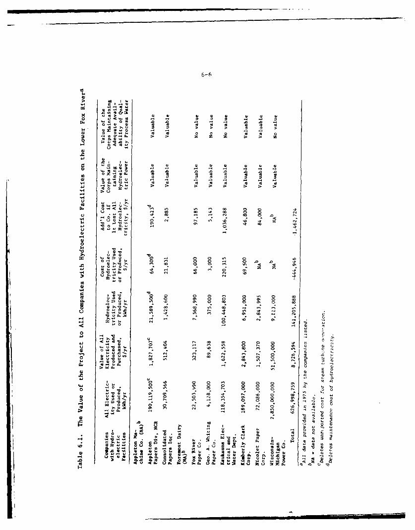
6-6
1: 1. -4O 0)
di 0j <0 2rz. 1. 04L 01 1 0 00 04 0
0 00.01.- 0
1 " 00. to 0 0 1 0 1 0
0 . C-T 4 w0 V0 .0 . . 004 0 01
C -4 0 0 0 0). (L m I
'--4
c~41
U 0- W4 l - c041 0 >1 ut -E-4 .
140o- :N~. v >1 el 13 4C' -~0 0- z%0 " S ~'4.w -4 ff.- 0-
00
S ' 10 0 In4 0a 0 C00- La 0 a,4 0 -4 0 . 0 '2 .'>1 a,4 0 co ~ 0
,a~ 0 u 9L -4
;.. -. 4 .
.0
-C 440' a It 0% 0 0 0(n
01~ r-.0- 0% Q ,4j
0
.4 0 00 0) en ("4 W' '. 00k0 0
0) 0Ow to -4 '.4 A. ~- '- i8
1 ~ ~~ 0 0044~* 0 0 s 0I
*r Nr 0 0
v 1 C % C C C 0% 0% 0v10- P4 !. 4 .0 0 0N 00 a, Ch
' 0 C;Uc
00 C)
01) 01 U4 IA -4 0L
014, 2 ; - 01 ga -0 0. z.11 0 '0
'-4 0,001 Q4 a 0 0). do4 Q0 00. u 0). 01UQ . .. 4 A. CL 01m2$ 1 CLb. Q)1O * 04 0M. C 0U 00 'oA ~ 0C 0. 0 0 0 .0 U '
u Z - 3A L
6-7
State. This would provide the State with overall direct control of Lake
Winnebago lake levels and downstream flow regulation on the Lower Fox
River. The environmental and social impacts which would result depend
upon the precise management actions, if any, the State elected to take.
6.18It is important to note, however, that while the project as it presently
exists offers many direct and indirect benefits to the State, the proj-
ect is expensive to operate and maintain. Whether in the final analysis
the State would have the willingness and capability of resuming this
large financial and operational management responsibility is currently
unknown.
6.19Transfer of the authority and responsibility for the navigation systemto a private agency is also possible; however, this alternative is notconsidered to be a viable one since it is unlikely that the venture
would be sufficiently profitable.
ALTERNATIVES WITHIN THE PRESENT PROJECT
Dredging
6.20Partial Maintenance of Project Channels - Every several years, thecanals between the locks and the channels approaching the locks requirefrequent maintenance dredging and even more so than in other reaches ofthe river to maintain project depths. This is usually the shortestperiod required for maintenance dredging. A good portion of the riverchannels retain their depth naturally and do not require dredging forlong periods of time.
6.21The possibility that currently authorized project depths are not nowrequired was considered. Although authorized channel limits are set bylaw, dredging to less than authorized depths is permitted.
6.22On some waterways the needs of navigation can be met adequately bydredging to less than the authorized project depth. This is not be-lieved to be the case in connection with the Fox Project, however.
6.23Present authorized channel dimensions on the Lower Fox River are a widthof 100 feet and a depth of 6 feet below standard low water, which is thelow stage with pool levels maintained at the crests of the controllingdams, and is the stage below which water users may not draw water fromthe pools during the navigation season. The minimum safe depth on theLower Fox River is considered to be 6 feet. This depth is based on avessel draft of 3 feet, a normal squat of one foot, allowance for wave
fluctuations of one-half to one foot, and a minimum clearance under keelof one foot. An additional depth of 1 foot in rock cuts above De Pere
is required to permit safe use of the controlling depth of 6 feet,
6-8
since small boulders frequently are loosened by the current of the river,ice action, or propellor wash and deposited on the channel bottom. Addeddepth of 3.6 feet in the channel below De Pere lock is required becauseof the aforementioned loose rock hazard, and the fluctuation of the waterlevel due to seiches and storms on Green Bay to about 2 to 3 feet belowthe prevailing lake level. While the drafts of many of the recreationalpower craft using the Lower Fox River is 3 feet, it should be noted thatthe largest of the recreational boats recently reported using the FoxRiver and Lake Winnebago waters was a boat 74 feet 10 inches by 15 feet6 inches with draft of 5 feet and the prevailing trend toward the useof larger boat motors is expected to increase the proportion of boatswith drafts over four feet. Finally, sailboats and the Corps vesselsand barges which are used to maintain the canals, channels, locks anddams also need the full project depth to traverse the waterway.
6.24Channels normally require widtls of five (5) times the beam of the largestcraft using the waterway. Many recreational craft using the Fox Waterwayhave beams of 17 feet or more in breath and since the government bargeswhich maintain the waterway have beams of 30 feet, the present projectwidth of 100 feet is considered reasonable. Operating hazards andexposures to strong river currents also justified maintaining the pre-sent width of 100 feet.
6.25Lake Winnebago is a large shallow body of water 28.25 miles long with amaximum width of 10.75 miles and a maximum charted depth of 21 feet.The normal low water area is about 206 square miles. Because of itsshallow depth and large open surface the lake is subject to violent waveaction developing quickly during summer storms. Several hundred smallboats may be in use on the lake for fishing and recreation at one time.Many of these boats are small outboard motor boats, but cruisers up to50 feet in length and with draft of 5 feet often are included. Forsafety, these boats should not be farther from an adequate harbor ofrefuge than the distance they can cruise in about 30 minutes in roughwaters. This indicates that a safe refuge should be available at Inter-vals of about 10 miles along the lake shore, and at about 5 miles fromany point in the lake. The existing Federal harbor improvements on LakeWinnebago, with bays along the west shore affording some natural shelter,meet the requirements for shelter needed. Although the small harbor atBrothertown is only about 3.5 miles north of Calumet Harbor, the elimi-nation of the former harbor would leave areas in the widest part of thelake 6.5 miles or more from an adequate refuge. Maintenance of 6 feetchannel depths at the Lake Winnebago harbors is needed to provide safeoperating conditions for recreational craft with vessel drafts of about3 feet after making appropriate allowances for wave fluctuations, squatand minimum clearance.
6.26If dredging for harbors of refuge were reduced or abandoned in LakeWinnebago, large pleasure boats would not be able to take refuge in the
6-9
harbors during bad weather. Since only two percent of the annual proj-
ect budget (an average of $15,012 per year over the last five years) has
gone for dredging the harbors, large economic savings are not antici-
pated. The purpose of this dredging is to save lives and the only
reason for abandoning the dredging would be to avoid the adverse impacts
of dredging and dredged material disposal. These impacts are not con-
sidered to be great. No less costly alternative to the dredging of
harbors of refuge on Lake Winnebago are known which would be impact-free
but which would provide the same measure of safety for boaters during
stormy weather.
6.27The draft of many of the recreational power craft using the Wolf River
is 2 feet. Shoals and snags in the channel upstream from Freemont prevent
even some of these boats from proceeding upstream as far as New London
at times. The minimum safe depth on the Wolf River is considered to be
4 feet. This depth is based on a vessel draft of 2 feet, a minimum
allowance for squat and wave fluctuation of one foot, and a clearance
of one foot above the soft bottom. Undoubtedly, many more boaters would
enjoy trips through this scenic portion of river channel if a clear
channel with greater depths were made available.
6.28If present regulations were changed, it would be possible to reduce oreliminate dredging activities in Boom Bay and the Wolf River and limituse of the channel to small powerboats only. This would lessen erosiondue to the wakes of larger, more powerful craft, enhance the fishery,and improve the marshlands for wildlife. A significant economic savingis not anticipated if dredging activities were stopped. The costs havebeen about two percent of the project budget and averaged $15,332 peryear over the last five years.
6.29Partial maintenance would result in a reduction in the amount of mate-rial to be dredged and disposed of and a resultant decrease in mainte-nance costs. However, it would have similar negative economic effectsto "no action" alternative. The extent of the economic effects would bedetermined by the depth to which dredging is done which influences thenumber and type of vessels which can be accommodated on any given por-tion of the waterway system. Because dredging and disposal would stillbe required by dredging to a lesser depth, there would generally be nosignificant environmental advantage to this alternative.
6.30Alternative Dredge Operation - At present the type of dredge plant used
on a project is based on the amount and type of work to be accomplished,the availability of dredge equipment and the economics of the project.The environmental compatibility of one dredge type over another has notyet been well enough documented to make environmental compatibilitythe primary basis for selecting dredge type. Continued use of aclamshell dredge is proposed for maintenance of project channels because
of its practicality and effectiveness. Alternative methods of dredgingwere considered in selecting the proposed action.
6-10
6.31All methods of dredging increase the levels of turbidity by nature of the
dredge operation. Because of this practice, the suspended solids and
dissolved solids in the work area of the dredge are increased, creating a
sediment plume.
6.32Equipment for dredging operations falls into two classes: mechanical andhydraulic. The dipper and clamshell dredges are mechanically-operateddredges while the pipeline and hopper dredges are hydraulically operated.When excavation is by mechanically operated dredges, auxiliary equipmentconsisting of scows and tugs is required to receive the dredged materialand transport it to the disposal site. Hydraulic dredges combine the
digging and disposal operations in one piece of equipment. The principaltypes of dredging eqiupment are as follows:
•Clamshell or Dipper Dredge
-Pipeline (Suction/Cutterhead) Dredge
-Hopper (Suction) Dredge
6.33Clamshell or dipper dredge type of equipment is used to excavate thesediments and place them in a scow located alongside the dredge. The
dipper dredge is especially useful for new work dredging and breaking uphard, compacted material, including some types of ledge rock. Theclamshell dredge is used, for the most part, to excavate soft or co-hesive underwater materials, and is exceptionally useful for deep diggingand for dredging to close quarters alongside structures.
6.34A pipeline dredge type has a pumping unit that sucks up material at theintake end of a section pipe located at the forward end of the dredgeand discharges the material to a trailing pipeline to the disposal site.
Pipeline dredges are used most frequently for 0-4 ging sandy, clayey, orsilty bottoms which have sufficient depths of .or economical opera-tion.
6.35A hopper dredge utilizes a pump to suck the sediments through a pipeinto hoppers onboard the ship where they settle. The fines and excesswater overflow at the top of the hoppers. When the hoppers are filledwith sediment, the dredge itself transports the load to the disposalsite. The hoppers are normally imptied by bottom dumping or by pumpinginto the disposal site.
6.36Clamshell and hydraulic are the two types of dredges which may be usedon the Fox Waterway. These dredges are pictured in Figures 6.1 and 6.2,respectively. Water depths in the project area are too shallow forhopper dredges to operate.
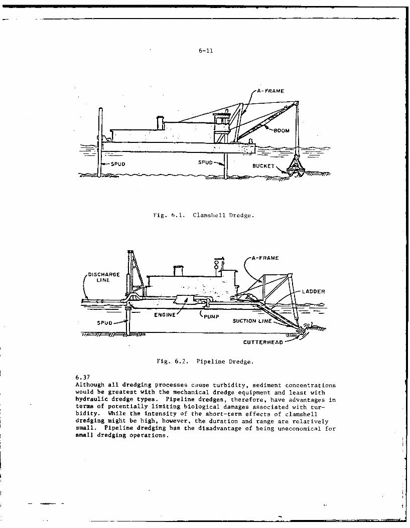
6-11
• : " 'BOOM
•~ ZP_'
- -- SPUD S PUD " UCKET
Fig. 6.1. Clamshell Dredge.
A-FRAME
. .DISCHARGE .. ,_
CUTTERHEAD
Fig. 6.2. Pipeline Dredge.
6.37Although all dredging processes cause turbidity, sediment concentrationswould be greatest with the mechanical dredge equipment and least withhydraulic dredge types. Pipeline dredges, therefore, have advantages interms of potentially limiting biological damages associated with tur-bidity. While the intensity of the short-term effects of clamshelldredging might be high, however, the duration and range are relativelysmall. Pipeline dredging has the disadvantage of being uneconomical forsmall dredging operations.
6-12
6.38The choice between the two methods also makes a difference in the impactof material disposal. Materials dredged by conventional bucket dredgegenerally cannot be deposited on shore without one or two rehandlings,which materially increases the cost of the work. If the area to bedredged is near the disposal area, the use of a hydraulic type dredgewith pipeline to the point of disposal may be a more economical alter-native in some instances. Hydraulic pumping, however, has the disadvan-tage of bringing large amounts of water to disposal areas. At projectlocations where polluted dredgings are to be confined, this would sig-nificantly increase the size of areas needed for disposal. Special dikedesign and disposal site operational features would also be required,thereby greatly increasing disposal costs. Assuming that suitable dikedor on-shore disposal areas can be arranged, hydraulic dredging could beemployed advantageously at the ha-bors on Lake Winnebago, and probablyat certain lower Fox River areas such as the channel below Menasha Lock.In the event that the Wolf River segment of the project is to be com-pleted to full project depth the use of a hydraulic dredge with dredged-material disposal on the lowlands bordering the river undoubtedly wouldbe most advantagEpous.
6.39Considering the present limited knowledge concerning exact impacts anddegraded aquatic conditions in the project area, little difference canbe shown between the environmental impacts as well as the social andeconomic effects of the different types of dredging equipment. Based oncurrent knowledge, the type of materials to be dredged and the degree ofcontamination of the sediments have a greater influence on environmentalimpact than does the type of equipment. Research presently beingconducted by Waterways Experiment Station at Vicksburg, Mississippishould aid to clarify which dredging types are the most compatible withthe environment.
Alternative Dredged Material Disposal
6.40There are number of methods by which dredged materials may be disposed.These methods were evaluated for their applicability at each of theproposed dredging locations.
6.41Treat Polluted Dr.dged Material Prior to Disposal - In previous studiesthe Corps has investigated the possibility of treating dredged materialsin existing waste-treatment plants, in separate special plants, inmobile units, and onboard dredges. Even the least costly treatmentprocess was found to involve many times the cost of most other alterna-tive conventional disposal practices, including disposal in diked areas.An added disadvantage of the method is the need for a disposal site forthe dredgings after they are treated and, in certain processes, the needfor a temporary storage site before treatment. Since the treatment ofthe material appears to be much more expensive and possibly no moreeffective than the proposed method and because the social and environ-mental considerations would be similar to those of the selected project,this course of action was rejected.
6-13
6.42Discontinue Dredging Until All Disposal Sites Are Securcd- Dredging hasbecome critical at several project locations and the responsibility formaintaining the project lies with the Corps. The Chicago District doesnot feel that it is necessary or appropriate to discontinue all projectdredging and disposal until formal disposal plans are approved at allproject dredging locations. Because future maintenance dredging issubject to the disposal of dredged materials at approved sites, therewould be no environmental advantage to discontinuing project maintenanceactivities at locations where dredging and disposal impacts are minorand have already been full coordinated and approved by other Federal andState agencies.
6.43Alternative Confined Sites - For the canals and channels along the LowerFox River, through a densely settled and highly developed industrialarea, the only practical way to dispose of polluted dredge materialswithout adding to the suspended sediment and pollution load of the riverappears to be containment within areas enclosed by dikes. Confinementof polluted dredged material will eliminate the potential adverse impactsassociated with previous disposal practices.
6.44The possibility of utilizing other disposal areas in the vicinity of theproject was considered. Prior to the final selection of proposed con-fined disposal sites, investigations were undertaken to examine potentialalternative land and water sites. These initial sites were then evalu-ated in greater detail and those that were determined less suited foruse as disposal sites were eliminated from further consideration. Apreliminary plan for the Fox Project was subsequently presented in thedraft environmental statement. Since the release of the draft statement,certain proposed disposal sites were deleted from the final plan on thebasis of comments resulting from agency and public review of the draftstatement and coordinated Federal/State agency field inspections ofdisposal sites.
6.45Land Disposal of Dredged Materials - The Chicago District is not autho-rized to purchase any additional lands for dredged material disposalunder the present operation and maintenance project authorization forthe Fox River, Wisconsin Navigation Project. This proved to be animportant consideration in the evaluation of alternative land sites.Only those lands which are Federally owned or made available by localinterests can be developed as disposal sites. Local interests, whichreceive the most benefit from the project, were not always able orwilling to furnish needed disposal sites. Fortunately, existing Federalproperties were, for the most part, adequate to meet current short-termdisposal site needs in an environmentally acceptable manner. Becausethe available supply of suitable sites is so limited, however, long-termdredging and confined disposal will likely depend almost entirely on thecooperation of local municipalities, etc., in offering suitable siteswhich meet both operational and environmentally acceptable criteria.
coprtino lclmncpitet., inofrngsial sites
6-14
6.46!dater Disposal - PolicS considerations - Present Federal policiesrequire the containment of polluted dredgings. In accordance withFederal EPA riteria and guidelines, polluted dredgings may be disposedof on shore or within completely confined lake or river areas. Un-polluted dredgings are considered to be generally suitable for un-restricted disposal. Current State policy with regard to dredgedmaterial disposal, however, requires that essentially all materialdredged from lake or river waters must be disposed of on suitableland sites. It is the State's position that disposal of dredgingson the bed of a navigable lake or river would be contrary to thePublic Trust Dottrine to preserve navigable waters within Wisconsin.The trust doctrine maintains that all navigable waters are held bythe state in custody for ali citizens and the state has the. authorityto control anything 1.hich affects the natural character and use ofnavigable waters. Public rights to surfact. weters consist of not onlynavigation but of incidental uses such as hunting, fishing, swimming,wading, skating, and the enjoyment of scenic beauty. It is the positionof the Wisconsin DNR that th- deposition of dredged material uponthe bed of a navigable waterway is contrary to these rights. TheWisconsin DNR does not make a distinction between private filling withina natural water body and Federal disposal of dredged materials on thebed of a lake or stream in connection with Federal maintenance of anavigable waterway.
6.47The Wisconsin Department of Natural Resources also holds that depositsof dredged materials in navigable waters, regardless of the physical orchemical character of the sediments, is contrary to state responsi-bilities to prevent pollution and to protect waters of the state fromdegradation.
6.48Irrespective of the above and pursuant to state legislative statute, theDepartment may permit limited fill encroachment on navigable waters byriparian owners provided such encroachment does not materially obstructnavigation and is not detrimental to the public interest. At the tilaeof this writing, however, the Department has net elected to approve anyoffshore project-related discharge of dredged materials.
6.49In keeping with the wishes of the State DNR, the Chicago District hasdeleted certain otherwise suitable confined water disposal sites fromthe final disposal plan. Several such sites were described in the draftenvironmental statement for the Fox Project. Two such sites are unusedturning basins no longer required for the navigation system. Sinceneither of these sites is a natural feature and each, if filled, wouldreturn some of the stream bed to a more natural condition, no signifi-cant adverse impacts from the proposed filling of these sites was anti-cipated.
6-15
6.50In Lake Disposal - Open water or in lake disposal of unpolluted
dredged materirls within Lakes Poygan and Butte des Morts has been a
common practice of the Chicago District for years. Suitable offshore
disposal areas have been fairly accessible and, until recently, beenreadily acceptable. The District disposktl plan for these locations
recommends continuation of "open water" disposal in a manner which is
intended to mitigate wetland and marshland habitat losses experienced in
the associated upriver lakes region. The disposal plan concept for thisregion features diking to protect existing marsh in the Wolf River (BoomCut) from destructive wind and wave action and diking and filling todevelop additional marsh area through regulated dredge material disposaland plant recolonization in the Lake Butte des Morts area (see Figs.6.3 - 6.6). However, for the reasons previously stated in paragraphs6.46 - 6.47, the Wisconsin Department of National Resources favorssome type of land disposal alternative.
6.51The District proposal to continue the current practice of in lake dis-posal (with modification for environmental enhancement purposes) isbased on three primary factors. These factors are comparatively lowcost, conformance with established Corps policy, and relatively minoradverse environmental impact.
6.52The fi.rst factor involves the cost considerations that must be consid-ered in programming Federal monies for project operation and maictenance.This is important because the removal of large volumes of bottom mate-rial and relocation of this dredged material to more distant disposalsites greatly increases disposal costs. Materials removed from theupriver lake area could be deposited on land sites. Land disposal couldbe accomplished by either pumping dredgings via a pipeline from thetransporting scow to the disposal site, or truck transport. However,based on a preliminary examination the cost of land disposal for thispor - n of the waterway system, the land disposal alternative increasesdis. Ui costs several fold and is considered to be proh!'itive. Inaddition to normal dredging expenses, scows must transport the dredgedmaterial to a site in close proximity to the fill area. A pipelinesystem, with auxiliary pumps, must be installed between the scow'sdocking site and the fill area. Costs for construction of this systemincrease markedly with an increase in the pumping distance. Transfer ofdredging to trucks requires a suitable docking area assessible to loadedscows. Trucking involves substantial additional cost.
6.53The second factor is related to both general Federal and specific Corpspolicy considerations. Federal policy allows the discharge orplacement of unpolluted dredged fill materials in navigable waters andCorps policy provides that where local authorities disapprove of thispractice, that state or local interests must assume the additional costsassociated with an alternative agreed upon disposal plan. Theonly alternative is to suspend dredging operations.
.MAP.$NH
OF 3
PA-;E 5'
SLOUGH
0~
7 -
R-4U
>\"C~i .
Ia( a
~~Al
6-18
Fig. 6.S. Use of Dredged Materials to Create Marsh
MoP.THALE 1.:2-o,ooo
R4A772i LA-•u t T pI6I_______ 10

6-19
ExnDerimental construction of breaK-waters and dikes to protect formermarsh areas from wave action and!elp rer-enerate vevetative cover
in these areas.
.4- F:perimental construction of sur-f'ace an i sub-ufcsrbrsa:islan, s which can Ie us(ei for tLepurpose of establis, inr' aquaticcovc." and regeneratiiK- -,.arc!. con-d t.1 on.
Experimertal construction of' beIr,." " ' alon, the eAt-es of' likes and Lrea.-
waters to estaLlish aqua' ic coverplants and to nrovile protectionfrom possible .:usmrat !amaie to ps-tablish dii.es.
Invstigation of the possibili ties
of consturctinu water tirht dikedareas which would permit water
level control via pz:ping.
Construction of dikes to confine
dredgings at suitable depths forestablishing and maintainingaquatic cover.
Fig. 6.6. Useful Dredged Material Disposal Applications
6-20
6.54The third factor involved in the question of in lake disposal for marshconstruction and/or enhancement purposes is the Chicago District's beliefthat disposal along the suggested lines would have significant, overallbeneficial environmental impact.
6.55For these reasons, the Chicago District is unable to dispose of dredgedmaterials taken from Lakes Poygan and Butte des Morts in the manner (up-land disposal) currently proposed by the state. Rather, the District hasrequested further state consideration of alternative in-lake disposalconcepts designed to artificially create or maintain marshlands and wet-lands. Dredging operations at these locations will be suspended untilthis matter is resolved. Additional information on some of the environ-mental impacts, values, and considerations involved in this type ofundertaking are provided in the following paragraphs.
6.56Dredging has been associated with ecological degradation in the pastprimarily because of the concomitant practice of disposing of polluteddredge material in open water. Open water disposal of polluted dredgematerial is considered presumptively undesirable because of its possi-ble long-term adverse effects on the ecology of aquatic environments.Guidelines for determining the acceptability of disposal of dredgingsin a waterway have been established by the Federal EnvironmentalProtection Agency (EPA). Adherence to these guidelines will gener-ally preclude adverse impact but the actual impact experienced willbe determined by the local chemistry of the receiving site.
6.57Bulk sediment tests performed on dredge material specimens from the up-river lakes region indicate that dredgings from this area are unpollutedand suitable for unrestricted disposal (see Table B.9, Appendix B).Prior to the implementation of any possible marsh construction or en-
hancement program the Corps and State DNR might agree upon in the future,however, testing in accordance with new EPA interim guidelines for sedi-ment evaluation would be required. These procedures (Table B.10,Appendix B) are based on the water extraction of sediment materialunder prescribed conditions. As such, it is believed that theseanalyses would have a higher correlation with actual disposal siteenvironment effects than previous guidelines based on the oldertest procedures. This additional precaution should insure no long-termadverse impact on the aquatic environment as a result of inlake disposal.
6.58The potential short-term impacts of inlake disposal are similar whetherfor the purpose of island raising, island or shoreline building, break-water or jetty windbreak development, or for the purpose of creating morefavorable lake depths for the establishment of marsh plants. These im-pacts include excessive turbidity and siltation, possible release oftoxicants, and dissolved oxygen reductions due to release of organics.Wave action and high flow conditions would also constantly cut away atthe deposits.
I I I l I U
6-21
6.59Filling would not only have a significant physical impact on the area butwould have a substantial biological impact as well. Biological abundance
and diversity in affected areas would be essentially destroyed by thefilling process. This would in turn place a stress upon the balance ofthe surrounding aquatic ecosystem. It must also be noted that there isno guarantee that the resulting terrestrial and aquatic habitat producedwould be as, or more, productive and useful as the aquatic habitatreplaced.
6.60In contrast, the potential benefits of wetland re-establishment, protec-tion, and enhancement to improve wetland habitat for wildlife, fish andrecreation are great (See 2.224). Furthermore, in the absence of somesort of successful marsh restoration program, a continued decline inthe aquatic habitat of the upriver lakes region will occur. For reasonspreviously discussed, continued loss of floating marsh seems inevitabl'.Once the floating marsh is gone from an area, waves and currents rcmovebottom materials, thereby making the water deeper than most marsh plantspecies are able to tolerate. Additional vegetative losses are likelyto follow as adjacent areas of emergent and submergent vegetation aresubjected to increased turbidity and wind and wave exposure.
6.61The above suggests that dredged fill material disposal should be directedtowards providing suitable substrate for development of vegetative cover,establishment of physical barriers to reduce wave action in criticalareas, and dike construction for the purpose of water level control.
6.62Since lake depth and wave energy appear to be the major factors con-trolling marsh growth on the upriver lakes area, no marsh restorationproject is likely to be successful unless it provides for shallowerwater, as by filling. Natural filling can probably also be induced bybreakwaters oriented so as to reduce the size of wind-generated waves(i.e., oriented perpendicular to the direction of prevailing wind), butthere is no data to indicate the rate at which natural filling wouldoccur.
6.63Emergent aquatic cover can be established on surface and subsurface sandbars constructed with dredged fill material if the substrate and optimumwater depth requirements of the plant species to be developed are met.To assure that the area affected is minimized during the establishedperiod, shifting and washout of filled materials can be prevented byconstruction of a riprapped dike around the disposal site in some cases.If it is desired to increase the abundance of these species by managementpractices, direct planting of their perennating organs (rhizomes) isprobably possible.
6-22
6.64Breakwaters and diking can be designed and constructed in a manner so asto either protect existing marsh areas or protect former marsh areas fromwave action and help regenerate vegetative cover. Since waves do notstir up as much sediment in the deeper portions of the lakes, efforts toreduce wave action should be concentrated in the more shallow portions ofthe lakes. Perhaps with a series of breakwaters strategically placed inrelation to the prevailing winds it would be possible to break up some ofthe large expanses of open water and reduce the intensity of wave action.The reduction of wave action and the physical aspect of the barrierscould also have the following additional beneficial effects:
-Water turbidity could be expected to decrease.
-Properly located barriers could provide smoother water for smallcraft on windy days.
•Further bog losses should be reduced.
-Barriers could provide cover for waterfowl and their broods.
-They could provide concealment for waterfowl hunters and spread outthe hunting pressure over areas which are presently covered withopen water and unsuitable for hunting.
-They could provide cover for fish in areas presently devoid of
aquatic vegetation.
6.65Finally, dredged fill can be uscd to strengthen and extend existing dikesand dredge banks. Water tight diked enclosures can be constructed forthe purpose of establishing vegetative aquatic cover under controlledwater conditions.
6.66The primary objective in each of the above approaches is the productiveand economically efficient use of dredged fill material resources. Therecommended plan to experiment with the use of dredged material in thismanner has the advantage of potentially providing a means of dredged ma-terial disposal which is both operationally and environmentally acceptable.
6.67It is the Chicago District's intention therefore to continue to pursuethis idea through appropriate Federal and State agency channels. To thisend, the Chicago District is ready to work with State and Federal fishand wildlife agencies in the research, development, and evaluation of thefeasibility, methods and criteria for implementing an in-lake disposalprogram along the lines suggested above. The District is further pre-pared to partially fund the research and development of such a program.It is our belief that this type of productive use of dredged materialresources is in the best overall public interest.
6-23
Lock Operation
6.68Pre, itly the project has some navigation problems such as total lockagetime and the number of locks involved. The Fox River also has a limitednavigation season and there are high velocity currents during flood flowstages. The miter type gates of the present locks are operated by meansof a hand powered capstan applying power to a small pinion which mesheswith a gear rack on the gate spar. This is a slow operation with onelockman on duty. To modernize Lhe existing system, electrically powertidwo'eration could be provided at the existing locks.
6.69The locks could be operated on a toll basis by charging each user a fee,which would help pay for the operation and maintenance of the locks. Anyattempt to assess a toll (especially one based on actual cost per craftlocked) would probably result in a severe reduction in system usage byrecreational boaters. Furthermore, operation of the locks on a tollbasis is not possible under present authorities.
b.70Number of Locks - One navigational difficulty is the number of lockagesthat are necossary to move traffic through the Lower Fox River. Seven-teen lockages are required for movement from Green Bay to Lake Winnobago.The time consumed by each lockage is approximately 10 minutes, so aminimum of about 4.33 hours of lockage time would be involved in each oi,way trip through the waterway, or 8.5 hours for a round trip. Suchdelays discourage trips between Lake Winnebago and Green Bay or LakeMichigan, such movements often being limited to single seasonal tripsb, tween operating bases. Some reduction in the time required for lock-ages would be possible if equipment for power operation of the gates andvalves was installed, but renovation of the entire system would b, verycostly.
6.71Under present regulations limiting lockage service without prior noticegenerally from 10:00 A.M. to 6:00 P.M., except at DePere and Menasha,where hours are 8:00 A.M. to 12 midnight, trips through the Lower FoxRiver must be carefully planned to be completed in one day. With advan(.notice additional lockage time from 8:00 A.M. to 10:00 A.M., and from6:00 P.M. to midnight, is allowed at Little Kaukauna, Rapide Croche, andAppleton locks, and for a similar evening period at the other locks.These restrictions cause some inconvenience to recreational boaters andrequire advance planning but are necessary to keep project operationalcosts to a minimum.
6.72Currents Hindering Navigation - The Lower Fox River is the outlet fromLake Winnebago, which is the natural reservoir regulating the flood flowfrom the large drainage area of the Fox and Wolf Rivers above the lake.At times of maximum flood peaks the inflow may reach about 35,000 cubicfeet per second, while the maximum outflow that can be released to the
6-24
Lower Fox River safely is about 23,000 cubic feet per second. To regu-late Lake Winnebago within prescribed limits and avoid extensive flooddamages, it may be necessary to release flows near the maximum capacityof the lower river for periods of a week or more. The average period ofsluicing required to regulate Lake Winnebago within the prescribed limitsis about 2.5 months per year. When the discharge from Lake Winnebagoexceeds about 5,000 cubic feet per second the strong current in the LowerFox River makes navigation difficult. The strong currents also arehazardous to recreational boating and there have been several pastinstances of small boats being carried through the sluiceways, in somecases with loss of lives. To prevent recurrence of this situation, it isnecessary to almost wholly suspend boating on the Lower Fox River duringflood periods.
6.73Limited Navigation Season - The short navigation season on the Fox Riveris a limiting factor for recreational traffic. Ice conditions during thewinter and early spring make it impractical to operate the locks, andalso increase the costs of regulating the various pools and Lake Winne-bago by operation of the sluice gates. The usual navigation season isfrom about 1 May to 1 November, or 185 days, and periods of heavy floodflows frequently shorten this by two to three weeks.
6.74Powr Optration of Lock Gates and Valves - The miter type gatps of theprese.nt locks are operated by means of a hand powered capstan applyingpower to a small pinion which meshes with a gear rack on the gate spar.This is a slow operation, and with one lockman on duty If both mitergates must be opened requires that the lockman, after opening one mit.rgate, must walk to the opposite end of the lock to cross on the lockgatus and return to open the second miter gate. The reverse procedure isnecessary to close the gates. A similar operation must be repeated toopen the gates at the opposite end of the lock. For safety it is notdesirable to permit assistance by persons from the passing boats. Fill-ing the locks is accomplished by operating butterfly valves in the valveplatforms or upper locks walls by hand-powered handwheels operating agear train to turn the valve. Fast filling requires opening each of sixvalves by a separate operation and this is a slow procedure with one manon duty. Valves for emptying the locks are located in the lower gatesand each of the six butterfly valves is operated by a lever and pinionarrangement meshing with a gear rack on a vertical valve rod. Using thismanually operated equipment the average time per lockage now is about 10minutes and to pass boats in this time usually requires that the gates atthe approach end of the lock be open in advance, and that the size ofboats passing require only opening one gate for leaving the lock.
6.75To expedite lockages and increase the capacity of the locks to handleexpected traffic, it would be possible to provide for electricallypowered operation of the gate and valve operating mechanisms. However,due to the sizable costs involved it is necessary to forego power operationof the locks until such time as it may become necessary to replacingexisting locks with new ones.
6-25
6.76Boat Lifts - Maintenance and operation of the locks will make it possiblefor increasing numbers of the larger boats in recreational use on theGreat Lakes to cruise to, and in many cases make prolonged stays on, theattractive boating waters of the Lake Winnebago Pool and the Wolf River.Possible alternatives to permit the passage of recreational boats withoutthe maintenance and operation of the locks were considered but were foundto be generally unsafe and inadequate to handle the current and prospec-tive traffic. Manual boat lifts operated by the users would be too slowfor expected traffic and unsafe for handling of the larger boats byinexperienced personnel. Power lifts operated by trained employees wouldbe slower and probably more costly to maintain and operate than thelocks, and would require multiple units to handle the traffic at thebusier l cks. Replacement of existing locks with any type of marinerailway would not be justified by any saving in costs, and would be lesssafe nd slower. Substitution of lifts, railways, or other transferfacilities for the locks would destroy the desirable capability to handleoccasional nassaives of dredging or construction equipment, barges withbulk cargoes or heavy machinery, or other waterborne commerce.
Dan Operation
6.77A number of conflicts have arisen over the operation of the WinnebagoPool. Principally these relate to the effects of storage and release onupstroam lish and wildlife and riparian interests and downstreamindustrial, municipal and hydropower uses. While change in the regula-tions of the Menasha Dam control to reduce the fluctuations of theWinnebago Pool water levels andreduce the mean level could improve thenatural conditions in Lakes Poygan, Winneconne, and Butte des Morts,such changes could have severe adverse effects at times on downstreamwater quality and stream uses for industrial, municipal and hydropoweruses. And in the case of hydroelectric power, the surplus water createdby the dams and not needed for navigation is legally reserved by thepower interests.
6.78Lake Vegetation Management - Over the past several decades, high waterand fluctuating water levels have been a primary factor in the continuingextensive losses of aquatic and semi-aquatic vegetation which hasoccurred in the upriver lakes region. The effects of high waters indestruction of marshes and floating bog have been readily and widelypublicized during periods of major flooding. It seems to be the suddenperiods of spring and summer flooding that have done the most damage tothe vegetation by breaking up and flushing out the floating mat. Thedestructive effects of seasonally high water on the true aquatics areless obvious but may be equally severe.
6-26
6.79In an effort to hold the line against further losses in vegetation, ArlynLinde, aquatic resources specialist for the Wisconsin Department ofNatural Resources, (Oshkosh Area Office), has suggested to the Corps thatmean early and mid-summer water levels should be reduced about 6 inches.This would mean holding an average gage level of 2.3 feet (747.349 on theOshkosh gage) for the summer months. Of course, since flow conditionsfluctuate during the course of the summer, water levels would vary some-what above and below this level. According to this proposal, levelsshould be maintained as closely as control capabilities will permit andevery effort should be made to keep high summer flows from producing deepflooding, regardless of how temporary it is. Linde further proposes toincrease the average spring drawdown by about 6 inches in hopes that itmight reduce the amount of spring loss due to flood conditions by in-creasing the capacity of the pool to receive high flows without an exces-sive buildup in water levels. A copy of Mr. Linde's water level manage-ment recommendations is included in Appendix D of this statement.
6.80The recommended 6-inch reduction in Winnebago Pool levels was developedon the basis of DNR examination of historical stage and flow rates forthe lake over the period of record. Six inches represents the approxi-mate mean summer water level increase that has occurred in Lake Winnebagoover the past several decades.
6.81Monthly water level averages have been used to construct a graph thatillustrates long-term changes in Lake Winnebago water levels (Figure6.1). From this figure it can be seen that the monthly mean levelsduring the April through October period have risen 4 to 7 inches in acomparison between the time periods 1896 - 1937 versus 1938 - 1976. Towhat extent this project-controlled lake level increase has promotedwetland losses in the upriver lake area is unknown. An increase of thissize certainly could be expected, however, to bring about changes invegetative cover.
6.82A six inch drop in summer water levels would reduce the chance for float-ing bog to break loose and float out, and make protected marsh areasmore secure by reducing the chance for high water and waves to topexisting riprap installations. An additional winter drawdown of sixinches is generally consistent with the present policy of gradualdrawdown in the fall and winter months to provide full drawdown beforethe spring runoff occurs.
6.83Low Flow Augmentation - The problems of water pollution control and dis-
solved oxygen in the Lower Fox River are very complex. Factors affectingthe streams dissolved oxygen content are its volumetric flow rate, area,and depth; the initial quality of the water which enters it; the effluentloads which are placed upon it; the modifications due to existing dams or
6-27
cn I-
-r -MC-,-')
LU.
C.0 co ZC a
C3 c
C, ~ -td
C) C.m
CL
C, C,EDm39V HSU S
133N 133 NI U4
6-28
other man-made facilities which exist; and the type and character ofthe sediments in the stream. These physical and chemical factors of theriver in turn affect the entire biological system which obtains theriver's suitability for private and public uses.
6.84the Lower Fox River has been designated as a top priority stream requir-ing improvement in Water Quality by both the EPA and Wisconsin DNR.Solutions to the water pollution control problems on the Lower Fox Riverare very complex and will likely involve the development of a compre-hensive regional water quality program for the river including, but notlimited to, improved waste treatment, additional monitoring and enforce-ment actions, and possibly additional flow regulation.
6.85Historically the water quality of the Lower Fox has been a problem sinctthe installation of the lock and dam canal system constructed in the1860's. During the low controlled flow of the warm summer months, lowdissolved oxygen is a special problem. The dams are significant to dis-solved oxygen because they produce wide, less, turbulent pools and oppor-tunity for the settling of suspended solids in the pools upstream of eachdam. Thus the river now exists, throughout practically its entirelength, as a series of comparatively slow-moving ponds rather than itsformer rushing rapids.
6.86Water Quality is not as yet included as a major criterion in the opera-tion of river and lake controls although the potential benefits of flowcontrol on pollution were recognized by the Corps as far back as 1921.(House of Representatives Document 146). A possible alternative to thepresent operation, therefore, would be modification ot the present damoperating rules which would include water quality as a criterion in addi-tion to the long existent criteria of flood control and navigation estab-lished by the Marshall Order.
6.87The process of organic degradation is common to all rivers. The deathand decay of underwater plant and animal life constituLes stream pollu-tion which is eliminated by the oxygen content of the water. Domesticand industrial wastes are eliminated bv the same natural processes. Thewaste load becomes unduly burdensome on the Lower Fox River during thelate summer and early fall. The problem will remain exceptionally diffi-cult, if not insoluble, as long as the amount of ivailable dissolvedoxygen is limited by the reduction in water low from Lake Winnebagoduring the late summer and early fall of each year.
6.88In order to prevent stagnation and degradation of th, w,t~t qii.
the Lower Fox River, it may be nect ,.ary r,, cigment :tleases from the project control d.imn at N,.ri cn!
of the latest stream standard i. , r iona.as recognized by thc Stat, DN: L. " a

AD-A1OI 115 CORPS OF ENGINEERS CHICAGO ILL CHICAGO DISTRICT F/6 13/,
MAY 77FINAL ENVIRONENTAL IMPACT STATEMENT RELATING TO THE OPERATION -- ETCE
UNCLASSIFIED"
Ehhomommohhmhmollllllllllll
_ummmmmmmmmI uumuuuuuuuumoonhhhhhh
6-29
consensus among water quality experts that in addition to current pollu-tion control efforts by industry and municipalities, it may be necessary
to update the basic plan for operation and use of the water available in
the Winnebago Pool to include the maximum storage and use of the avail-able water for the purposes of low flow augmentation.
6.89Any program for maximizing use of Lake Winnebago waters for best publicbenefit must take into consideration the total volume available in thwFox-Wolf watershed. The total drainage area served by the Fox, Wolf andLake Winnebago encompasses 6,150 square miles with the Lake WinnebagoPool covering 265 square miles. Of major significance is the fact thatone inch of depth on the Winnebago Pool is equal to 7,125 cubic feet per
second per day. The capacity of the Lake Winnebago Pool, within thelegal limits of the Marshall Order which range from a high limit of -'I-1/4" to a low of minus 18", a 39-1/4" permissible differential, is equivi-lent to 280,000 c.f.s./day flow, excluding any part of the normal inflowfrom the Wolf and Upper Fox. For example, the reservoir's capacity,exclusive of variables such as evaporation, etc. could theoreticallyprovide low flow augmentation to the extent of 3,000 c.f.s. for a periodof 90 days, which, when added to the selected low flow of 912 c.f.s. orthe annual average flow of 4,000 c.f.s would have a major effect onDissolved Oxygen in the Lower Fox during the historical low flow summermonths. One half of this amount would have significant influence. Tht,beneficial net effect of flow volume has been readily evidenced by re-sults obtained from Federal and State stream modelling studies.
6.90Such use of storage at Federal projects is contemplated by the FederalWater Pollution Control Act, as amended in 1961 by Public Law 87-88Section 2b of the amended act provides that "in the survey or planning ofany reservoir by the Corps of Engineers, ***consideration shall be givento inclusion of storage for regulation of streamflow for the purpose ofwater quality control, except that any such storage and water releasesshall not be provided as a substitute for adequate treatment or othermethods of controlling waste at the source." The need, value and impactof storage for water quality control is determined by the Administratorof EPA. The act does not authorize modification of completed projects toinclude water quality control, but does indicate that water qualitycontrol is to be considered a legitimate purpose of a project alongwith other beneficial uses of the water. Since measures that affectpublic health and welfare are subject to regulation by appropriate publicagencies, the procedures for regulation and use of the storage capacityof Lake Winnebago could be changed if required to improve water qualityand reduce health hazards. The indirect benefits to public health fromimproved water quality cannot be evaluated. Public Law 92-500, 18 October1972, relating to Comprehensive Programs for Water Quality Improvement,specifically describes how the Corps, or other federal agency, can par-ticipate in projects of this nature.
6-30
6.91Other water quality improvement alternatives to be considered as means ofhelping to aclieve regional water quality goals and standards are:
-More stringent effluent treatment requirements for industry andmunicipalities.
•Hydro-turbine air venting to replace dissolved oxygen generationlost by lock and dam construction.
•In-stream mechanical aeration at dissolved oxygen sag points in theriver.
-Release of flow over spillways, rather than through dam gates,valves and turbines to extent practicable.
-Control of algae production in the Lake Winnebago pondage.
-Reduced hydro-power generation to allow more flow to pass over thedam spillways.
-New treatment plant site selection based on optimum discharge pointlocations in relation to river assimilative capacity.
Enhancing Project Recreational and Conservation Features
6.92Completion of the Neenah and Wolf River channels, full maintenance of allchannels, and improvement of the locks to expedite the movement of boatsand avoid interruption of boating by lock failures would likely increasethe amount of recreational boating in project waters. By physically im-proving the project for recreational navigation, sport fishing and otheractivities would also benefit.
6.93The Project has a recreation potential of somewhat unique character inthat the river provides opportunities for a continuous recreationalwaterway with satisfactorily spaced access and development sites. Whilethis potential does not appear to have national or regional significance,it is of sectional and local importance.
6.94While none of the existing tracts of Federally-owned land in the projectare suited for conversion to public recreational development and use,development of recreational facilities on newly acquired lands throughoutthe project area and the creation and/or expansion of small craft harborsand mooring areas within the municipalities along the Lower Fox would bepossible. Improvements could be planned and designed to enhance theexisting recreational resource potential in the project area and providincreased accessibility to scenic areas along the waterway. Improvementscould also be designed to correct other present waterway deficiencies andenhance environmental values (such as creation of marshland).
6-31
6.95The impacts of any of the above actions, including the bank erosion andwater turbidity caused by increased boating, would have to be thoroughlystudied prior to the implementation of any project modification.
SECTION 7
RELATIONSHIP BETWEEN THE LOCAL SHORT-TERM USE OF MAN'S ENVIRONMENTAND THt MAINTENANCE AND ENHANCEMENT OF LONG-TERM PRODUCTIVITY
GENERAL
7.01Relationships between operation and maintenance activities are consideredin the short run, and their long-term effects have been identified inseveral areas. The direct effects of dredging are not expected to sub-stantially alter aquatic, terrestrial, and semi-aquatic habitats or togreatly change the distribution of species or lead to their extinction.The short-term use of the Lower Fox River and Wolf River (including theWinnebago Pool) as a recreational waterway will continue to provideeconomic benefits to the area on a seasonal basis.
WATER QUALITY
7.02In the process of dredging sediments from the project area certain water-quality effects will be evident. During dredging, the turbidity createdwill detract from the general water quality. Pollutants adsorbed on thesediments could potentially be reintroduced into the aquatic systemduring the dredging operation. The exact degree of pollutant reintro-duction and the nature of the associated impacts are not sufficientlyunderstood at this time. As the dredging is completed and the sediment-water interface stabilizes, the waters associated with the project willimprove. This will be accomplished by the removal of polluted materialswithin the bottom sediments.
AQUATIC HABITAT
7.03Operation of the Neenah and Menasha dams and maintenance of the naviga-tion channel from Lake Winnebago to the Wolf and Upper Fox Rivers overthe past century have, in part, led to wetland losses and an increase inopen-water habitat in the Winnebago Pool and the Wolf River. The lakesin the lower Wolf River area include White Lake, Partridge, PartridgeCrop, Poygan, Winneconne and Butte des Morts. These lakes, along withthe Wolf River and its tributaries in this area, serve as spawninggrounds for numerous fish species and are a subflyway of the Mississippiflyway. Conflicts between boating activities and fish and game interestsare common in this area, particularly on the lakes and rivers south ofNew London.
7.04The adverse effects of dredging upon the total biota are generallytemporary in nature. The benthic community, even though destroyed by
7-1
7-2
d&ecging, wi1 gradually become recolonized and grow until such time asadditional diedging is performed. The short-term effects of occasionalturbiditv aso are temporary in nature.
Many aqtatiL ;pecie3 are no longer present in the Lower Fox River. Tothe extct that water quality has been degraded by navigation and byopetaton and maintenance activities on the waterway, project activitiesmay serve to continue to limit the distribution of these species.
7. 06Because f wetlands losses in the Winnebago Pool and the Wolf River, theproductivity of important game fish and panfish species has probably beenreduced within the project waters. The exact nature and the extent ofthis imca-t and the relevant importance of each of the possible con-trihutin6 causes suumarized in this report require more detailed study.To the ex: nt that current flow regulation practices contribute to thesecnviror,'t.a1 problems, this productivity will probably continue todecrcas.. RLemoval of material during dredging operations physicallydisplac iuenthic organisms and their immediate habitat.
SEMI-AQNT?IC AND)TERRESTRIAL HABITAT--BIOTA
7.07The dep. tion of dredged materials in any area reduces, at least ini-tially, the carrying capacity of the flora and fauna of the area. Adversebictic effects on the semi-aquatic sector will persist due to the fluc-tuating water levels that result from dam operation. The periodicdredging in the Wolf River and Winnebago Pool will repeatedly destroyccme submergent and emergent vegetation. Erosion from waves generated bythe various types of powerboats will adversely affect shorelines andtheir associated emergent vegetation.
ECONOMICS--LAND USE
7.08Since toe abandonment of the Lower Fox River as a commercial shippingwaterway in 1959, the waterway has served almost exclusively as a navi-gation route for recreational craft. Consequently, land-use changesalong the waterway are little influenced by the presence of the existingnavigation system.
7.09Dredging activities may eventually have an effect on local crop produc-tion. Farmers in the vicinity of Brothertown, Stockbridge, and CalumetHarbors have used dredged materials as fill in low-lying areas of agri-cultural fields in order to increase productivity. Once normal soilstratification and porosity are attained, these fill areas are expectedto become more productive.
7-3
7.10The adverse effects of fluctuating water levels on the marsh vegetationin Lakes Butte des Morts, Poygan, and Winneconne could continue to removemarsh habitat and thereby reduce the conservation and use values of theexisting marshes.
WATERWAY USE
7.11It is clear that discontinuance of maintenance of the existing navigationsystem would result in serious short- and long-term economic and socialimpacts. Nevertheless, in the long run, the best use of the river canonly be deLermined by more thorough evaluation of the costs and benefits(environmental, economic and social) of alternative project futureswithin the context of basin land and water resource management problemsand needs. In this regard, there are certain comprehensive investi-gations now underway which may be expected to have great bearing onfuture project purposes, features, and management. Notwithstanding theoutcome of these studies, it is our view that, for the present, the FoxRiver Navigation Project should be operated and maintained in the mannerproposed herein.
SECTION 8
IRREVERSIBLE AND IRRETRIEVABLE COMITMENTS OF RESOURCES
GENERAL
8.01Several areas of resource commitment have been identified in precedingsections. Major concerns include aquatic habitat losses and associatedfishery decline, and allocation of Federal funds for a lock systemcurrently used almost exclusively for recreational navigation purposesand the costs of which might be more appropriately assigned to the Stateof Wisconsin or users of the facilities.
SEDIMENT AND BENTHOS
8.02Dredging will remove sediment obstructing the waterway and eliminate someorganisms inhabiting the waterway. It is estimated that the action willirrevocably remove about 400,000 cubic yards of dredge materials fromriver and lake environments within the project over the next ten years.The restrictions on the growth of benthic organisms caused by the pol-luted sediments, along with the expected new population of the dredgedarea, diminishes the severity of this adverse effect.
AQUATIC HABITAT AND BIOTA
8.03It is possible that lock and dam structures have acted as a physicalbarrier to the movement of some aquatic organisms between pools, thusaffecting their distribution. Continued regulation of the WinnebagoPool water levels under present operating procedures could also, viapossible additional wetland losses, promote further loss of spawninghabitat, refuges, and food resources for the adults and young of variousfish species, such aswalleye and yellow perch. This in turn couldadversely impact upon the recreational and economic fishery resourcesof the State of Wisconsin.
8.04As a result of the increased rough fish productivity on the Wolf andother rivers throughout the state, the State of Wisconsin is expendingmoney to control rough fish populations and improve the productivity ofthe more desirable game fish and panfish species. This commitment ofresources is attributable in part to those project activities which arebelieved to promote rough fish productivity.
SEMI-AQUATIC HABITAT
8.05Fluctuating water levels in Lakes Butte des Horts, Winneconne, and Poygancaused by operation of the Neenah and Menasha dams have promoted loss of
8-1
8-2
marshian :.'- :L ese lakes. , larshes serve as areas for breeding, foraging,and tuvr fur many wildlife species. Consequently, the reduction inmarsh vegeLation has significantly reduced the carrying capacity of thearea fer various wildlife species.
TERRESThiAL HABITAT
8.06The depcsition of highly polluted dredged materials can eliminate varyingam(,unts of aerrestrial habitat. The amount eliminated will depend uponthe quanutLy ane qualicy of dredged materials deposited. If the chemicaland phVsical nature of these materials is similar to the existing sub-strate, and no significant topographical changes are created as a resultof the depositior, succession will likely restore the vegetative com-munity to its original state after three to five years. Otherwise,vegetative re,-stablishment would occur more slowly and long-term per-manent alteratio-s could occur. The magnitude and direction of suchchanges will depend upon the specifics of the given situation.
LXND-USE COI11YMENTS AND RESTRICTIONS
8.07The deposi'_ion of dtedged materials on a given site may alter its poten-tial future uses. Disposal of sand and gravel could alter the futuresubstrate in such a manner as to make it unsuitable for certain agri-CAul-ral and other uses.
8.08Landsh cnuiumitted to serve waterway and navigation functions are notavailable for alternative uses.
ENERGY CONSUMPTION COMMITMENTS
8.09The e nergy expended for the operation and maintenance activities of theproject is lust and cannot be regained. These losses are considered tobe very small, however.
ENERGV COMM1TAENTS
Labor and materials which would be committed to the project represent anirretrievable action. Continuation of the project will result in the short-term annual expenditure of about $1 million. The dollar value of this com-mitment is expected to grow over time with the annual inflation rate.The amount used is offset by the benefits that would be derived by bothcurrent and future generations.
-2-----
SECTION 9
COORDINATION A'ND CC IMENT AND RESPONSE
PUBLIC PARTICIPATION
Agency and Community Contacts
9.01
This statement reflects extensive coordination and contact with1personnel of other Federal, State, and local agencies and the generalpublic. No public meetings were held for the specific purpose ofsecuring for this report from local interests as their opinionsand desires are generally well known through operation of the existingproject and comments on previous reports pertaining to the project andits operaition.
Agency" Review
9.(I2
A draft environmental impact statement was submitted to Federal, State,and local agencies, other interested organizations, and made availableto the public for review and coment on 15 December 1975. A listingof the recipients of the draft statement is presented in the forwardsectio:i of this document immediately following the Summary statement.A list of those responding is included in paragraph 5 of the Siuary.Copies of the letters commenting on the draft statement, and responsesto those comments, are reproduced in comment/response portion of thissection.
Unresolved Issues
9.03
State objections concerning inlake disposal of unpolluted dredgedmaterials still remain unresolved. The Wisconsin DNR has requestedthat the dredged material taken from the Boom Cut, Wolf River, entryto Lake Poygan and the Big Lake Butte des Morts channel below thejunction of the Upper Fox and Wolf Rivers be disposed of on surroundingupland areas. In lieu of land disposal, the Chicago District hasrecommended that unpolluted dredgings from these locations be used toreestablish, protect, and enhance local wetland and marsh habitat.
9.04
It is the policy of the Corps to secure the maximum practicablebenefits through the utilization of materials dredged from authorizednavigation channels and harbors, provided extra cost to the Governmentis not incurred. Such use of dredged materials includes nourishmentof beaches, erosion control of river banks, land reclamation and marshconstruction. If it is evident during the initial planning of dredgingoperations that additional costs would be incurred, local interests
9-1
9-2
are given reasonable opportunity to finance the additional costs.In the specific case of the design and construction of diked disposalfacilities for the confinement of polluted dredgings, local costparticipation is usually not required.
9.)5
With the cooperation and assistance of the U. S. Fish and WildlifeService, the Wisconsin DNR and the U. S. Environmental ProtectionAgency, a dredged material disposal plan has been developed. Thisplan, with the notable exception of dredging and disposal at Boom Cut,meets the short-term disposal requirements for the project. In theabsence of any indication by the State of a willingness to assume theadditional costs of Luland disposal at this location, the ChicagoDistrict %-ill suspend Boom-Cut dredging operations indefinitely.lxtensive recreational boating use of much of the Wolf River segment ofthe project is made po-ssible by maintenance of this cut-off channel.The dredging of Boom Cut eliminated a tortuous route in the upperreaches of Lake Poygan for recreational boating. This short cutreduced the cruising distance about 5 miles in this reach of river.It has been reported that sedimentation in the shoal water of LakePoyg:n hais reduced navigation depths to two feet or less along muchof the Boom Cut reach.
9.06
Due to the nature of the present, unresolved conflict with theWisconsin Department of Natural Resources concerning inlake disposalactivities in the upriver lakes region, the Chicago District hasreconunended special investigation and research into the development andevaluation of the feasibility, methods and criteria for protecting andestablishing wetland and marsh habitat. It is hoped that this type ofresearch effort will lead to the development of an operational andenvirormwentally satisfactory plan of inlake disposal which is accept-able to the Stato of Wisconsin.
CO( MlXfS AND RESPONSES
General Remarks
9.07
In December 1975 the Chicago District issued a Draft EnvironmentalImpact Statement (DEIS) relating to the operation and maintenance ofthe Fox River, Wisconsin Navigation Project. The statement providedan objective assessment of the environmental impacts associated withthe operation and maintenance of the existing Federal project. Prepa-ration and subsequent coordination of the DEIS with other agencies,organizations and the general public identified several areas of majorregional resource management concerns in the Fox River Basin whichincluded: aquatic habitat losses and associated fish and wildlifedeclines; continued allocation of Federal funds for a lock system now
9-3
used almost exclusively for recreational rather than commercial navi-gation, the authorized project purpose; the impact, need, and justifi-cation for periodic dredging and dredged material disposal requirements;and water quality degradation along the Lower Fox River. In addition,questions were raised as to whether or not there was a continuingFederal interest in the operation and maintenance of the existingproject, including whether the project was responsive to currentregional and local water resource needs, or if a change in Congress-ionally authorized purposes and project features would be in theoverall public interest.
9.08
While continued project operation and maintenance is related to each ofthese issues to some degree, resolution of these resource managementissues is in many instances beyond either the ability or the authorityof the District to resolve within the scope of this environmentalassessment. Some of the basic factors relating to this problem arethat the project is being operated consistent with existing Congress-ional authorizations although the needs and concerns within the basinare changing; that hydropower rights in law and existing lock and damfeatures impose constraints on project operational management; thatsubstantive changes to present project purposes features and/oroperational procedures would require Congressional authorization andapproval; that a comprehensive, detailed benefit-cost evaluation ofthe project and a full range of alternatives would be needed to deter-mine whether the existing project and operation are optimized; andthat, based on present knowledge, it is impossible to ascertain theextent to which non-project induced interactions and interrelation-ships also contribute to identified regional resource managementproblems. 'he proposed action described in this final statement doesriot recommend any major change in the purposes, features, or operationof the Fox project at this time. Any such proposal would require con-siderably more detailed research and investigation and Congressionalauthori zation.
9.09
The basic project-related resource questions, relationships and con-ditions which should be further studied, are summarized in the follow-ing paragraphs.
9.10
Need for Dredging - Dredging is periodically accomplished at varioustimes to maintain adequate channel depths. Additional study andanalysis is required to evaluate the economic feasibility of the con-tinuing channel maintenance required to support recreational boating,however. An analysis of the economics of continued project operationand maintenance will be completed in FY 1978. The results of thisanalysis will be summarized in a future addendum to this impact state-men t.
9-4
9.11
Flow Augmentation - The existing operational procedure relating to flows
regulated within the authorized project should be reevaluated. Periods
of inadequate flows accentuate water quality problems on the Lower Fox
River. It is recognized that flow augmentation for water quality pur-
poses is not a suitable substitute for compliance with Federal and
state water quality standards and adequate treatment or other methodsof controlling waste at the source. However, Federal and state waterquality studies have shown that maintenance of a higher minimum baseflow may be desirable. An enhanced base flow may also benefit instreamrecreation and fishery enhancement. Since the current operation of theFox River project has a substantial effect on the hydrology of the FoxRiver system and hence its water quality, more information and detailedstudies are needed to assess the effects of project operation, including
power generation, on water quality. Proposals for changes to currentflow regulation procedures should reflect studies and recommendationsmade by the Wisconsin Department of Natural Resources and the Fox ValleyWater Quality Planning Agency (Section 208, PL 92-500, planning agency).
9.12
Water Level Management - The data presented in this FEIS suggests thatwater level control is the most important resource management issueassociated with the current project operation. Regulation of theWinnebago Pool is believed to affect natural habitats within LakeWinnebago and upriver lakes by contributing to high sumner pool levelsand fluctuating water stage and contrihuting to floating bog and rootedemergent cover losses. Water level management also affects aspectsother than vegetation, such as fish and wildlife resource values,shore and erosion and aesthetics, public access and lake utility andrecreational boating. The interrelationships are complex and oftenconflicting and the management problems are great. Current water levelmanagement procedures tend to benefit the recreational boater andshore property owner, as well as the power companies possibly at theexpense of fish and wildlife habitat and other conservation values.There will continue to he conflicts between water use and users alongthe Fox River system. Submergent vegetation is desirable for waterfowlfeeding areas and with some restrictions it is of value to fish, butit is not welcomed by boaters, water skiers and swimmers. Emergentcover plants are essential for all forms of wildlife, but boaters wouldlike to see more acres of open water and cottage owners generally donot approve of emergent vegetation growing in front of their cottages.Industry, which is dependent on water for power and for stream sani-tation, would like to see ever increasing pool levels.
9.13
\n equitable halance of these resource management needs and conflicts canonly be developed by adopting a much broader approach to water manage-
9-5
ment than has occurred in the past. It will be necessary to fully takeinto account the effects of each water use on other water uses, and ofupstream water uses on downstream uses. Long-term needs, as i ell a.sshort-term requirements will have to be considered in the deci'ioi-making. Adoption of such an approach may require some important modi-fications to existing project features, policies, laws, and admini-strative arrangements, and the adoption of new criteria in the deicison-making process. Adoption of an overall approach to water managementalso focuses attention on the need for greater coordination of resourcedevelopment and management efforts within and between the various levelsof government. Because responsibilities relating to the management ofthe region's water resources are divided among many agencies at variousgovernmental levels, there is a need for increased cooperation andcoordination in,dealing with water matters. The management techniquethat would be in the best interest of the most concerned is not nowknown. The unknown factors involved are so numerous that no singleagency could provide the best answers.
'Me various conflicts and problems of water management in the regionare neither simple nor isolated. Although the region has a greatx ariety and abundance of water resources, the demand for these resoturcc.,is very substantial and continuously increasing. Some of the presentand future demands for water are compatible, but others conflict. As idemand on the water resource continues to increase, conflicts ofinterest will be come greater and more widespread. Given the multipleuise demands placed on a finite water resource, some conflicts are in-evitable. The maximum advantage to any interest must be compromisedfor the achievement of an overall management plan.
9.15
While a number of water resource management problems exist in the FoxRiver region which require solution, it is not the purpose of this ISto "resolve" these and other regional water use management problems.It is also not the purpose of this statement to determine whether or notproject features and operation and maintenance activities are optimizedin an economic sense. Rather, the purpose of this statement is toidentify the nature and extent of the environmental impacts attributableto the operation and maintenance of the Fox Project.
9.16
Comprehensive land and water use management questions for the Fox-WolfRiver Basin system , however, will be studied under the authorityof the Fox-Wolf River Level B Study and the Section 208 regional waterquality planning program. The Level B study will result in the formu-lation of a coordinated plan and alternatives for solving the majorproblems and issues of water and related land resources planning. Itwill provide for full consideration in planning for the optimimi use,conservation, and/or development of these resources. The Section 208
9-6
Study will prepare an area-wide water quality management plan.
9.17
It is the view of the Chicago District that the resource managementproblems and conflicts relating to the Fox River project should beexamined within the context of the ongoing Section 208 and Level Bstudies, and that further detailed investigation of the Fox Riverproject not be undertaken until after completion of these studies.Proper water management involves the detailed analysis of the wholerange of alternative use possibilities and the consequent effectsassociated with any given management plan. The Section 208 and Level Bstudies will provide the formal machinery needed to properly weighcompeting claims between various water uses, to assess the relativevalues involved,, and to insure equitable utilization of the waterresource. The Section 208 and Level B studies should give directionto a management program that will realize the maximum capabilities ofthe region in all phases of water and related land use. The ChicagoDistrict will then be in a better position to reevaluate the Fox Riverproject within the context of current regional needs, goals, priorities,and the overall public interest after the completion of these studies.The approach has the advantage of allowing the District to deferresolution of those issues which are beyond the scope of the existingFederal project operation and this environmental statement. TheFederal EPA, the U. S. Fish and Wildlife Service and the WisconsinDNR have indicated support for this appioach.
9-7
C
0
M
M
E
NT
I
FtESP0N
H S
E
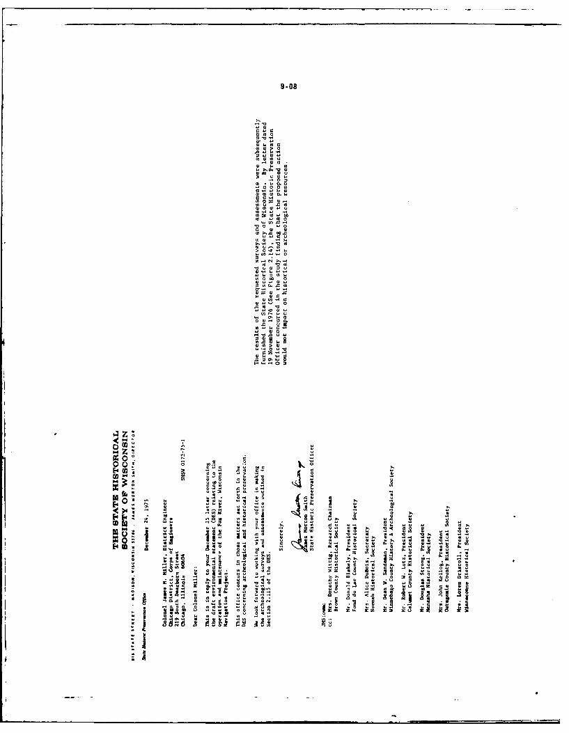
9-08
0 0
0 00
000w. h
m 4-0
44 w
00
aZE.0
0)-4
z4340
E-o4 E-4o4
o- A
-4 .4 4
o0 0
r~@ .4 4.. 2a a.Atv S a uo ,* l o9 4I ~ ~ ~ ~ 4 0 * Iav
o. ~ ~ ~ ~ . 4o o -hIIo aoo 40
cc ~ 0 .0l nx: , z '44o0
9-09
'00.~~ r 4> .. 3
4)004)0-4 0-4
'40 o .. -40 00 >. 4
004I I0 j"040. I
-- 0 w00.) 0
0.4 0) )04 40 7 0
0.0~~ 0 00 . 4
44 440 0 0 0
44ow w0.0 X04) WS .0 v m
00 000C
Zi~ii~ir o4 '9BIn .)U40 >1)4.4'
AC.40 0 " )1 44 00. 0 0 0 ) 0 41 .
000~ 00 0 0)0.70 0 1 0 04
2 4 0 0..0 0 404~~~~~~~ t0 P0.0 40aA)
E li 04J 440'04
.. 4) .00~ 00.0 4.44 00.
a l 00 40 . 0i 'F0. A
gag I)044 4~
9-10
v 0Ea W
.400
9 40*03-
al
w0 u
41 c
0 r4
00x
qj4
004.4
o 0
19. v I
9-11
O/
00-
Ia sl-
ee
9-12
'41 0 4
w'- 41 01
r *0
w4 01 0 41.41 0
u 10
>041
01 0 0
>1 c41 r v
0414
x11 410
4104 04
411 0
v1 0 v4
.041.a4 00
1 414ll1 0SII -AAq
9-13r44 .4 .0 004 .44
r 0 ) . 9. '0A 4.0444u4 .4 .0
00 >4- r 0 w In4 u -
4~0 c43 '4r4ao
m444 v w4 44440' . w -v ~ 44 44.0A 0 .. 44v -
4 4. '0 204 >xl 44444.44 o
X..4 o40 0 x4.4o .4404 m40044' w.4 r4 A o o w
w44 IA 440> 4404 w.4 o4 I4 w44.34 o0O~~~ a4- "40 44. 444.44 "4 u v o.440444 w4004.4-'4--..4 I0. >. 4 Z4 cO - ;44 4 0. 4 oN 4 ~ 4 4 4 4 ' .~4404. 00 04-' w.00 r444.4 44 44' .44 - ,I 04 0wm44 r44. o44 u4 r4' 44 0.404 34 4 4 0 4 ...
004.44b4 44 '> w..0 w404. o4 o4.3.. 0 30
c4 , 0. .4440 co w ww m o 9 f o4.444
w4-3 404 .4 0> w. w0. .. ~ m44~. Z 4 0 004434m
u m o0 440 c 04 .04 Q44440 m000 4 4 404-044.~ ~~ ~~~~ ~~~~~ A 444 0 4'-4. 0 0 0 ~ 44 ~ . 4 04- 040.
4-..-44-..a w w3.4 .0. I, 4 4 0En4 4 . 0 ' 40 4 4 ,
'.al 344 r.0. .4.43440. ~ ~ ~ ~ .4. a. x4. w4 4. V044.00 .0.4 -
44004 4w o44 .404 '444404 4c4,444.4.I4r w04 0 r.40 .40 4 .4w4 0. .44 to
344344t, .4 o' 1 04 03..4 3v o.4
4 4 4 m 44w ,4o 4 04 0 4. 4 44 u4 c4 m44ww44Co43 v4 00z4~ 4 ~ 4 .. 4~444 '0444
44 0 0 00 o-.'4 -a44- 404404.0444.44.;~~~~~~~~.4~c c- wo 04 4 0444. 0 440.J4 4404440 4w 4 4444w M4-4 x 4 v44.. k4.4
r444 4 o0 4 4 4-4 44 v.00 4 I 4 0 m x4 .4.o44,0, 04. .44 " 44. 4 4 a040 o 44.
0044 w 4 :3 444,4 44 . 4 400 " 0 4.. 4-40 cI ou 0 0 o4 44 0r 44o4.0 .440444 V4444 "m 44 .4.,-,.044. 444 w0 o4 0 4 44 4.0 0 4 444 0 .0 0
Do0, 4444 W04 W4 44444 o4444 44 44 '44.40 4 44444 . 44 0 . 0 . 40 4 0 4 f. 4 x'0 04. 00w4
44 0c 44 . 4 0 44 0 0 444 44. 44.44
o.44 4.4 u 444 0 4 4 14 44. 0, 4 . '40. 0 4 004'A0 Q4. "3 0r 4 4 4 4 4 4 4 . . ~ . O4 ~ 4 4
4443 .44'434 0 .40444'044 .0444400 00-44 4~ 0 0.oo.4.4 44 o 4 00 w4.444 004 0 C:4.0.44 w4 c44 44 .4o0
04444~ ~~~~~~~ ~~~~~~~ ... o. 4..40 444044 .4 4 034.444 4440
000- 04 04 m4 .4, 0., u,0.. . '44 .440400440. z444.. 43 44 .44 ' 0 .4 ' 4 0 444 Iv4 0444w 44
0,400~ ~~~~~~~ m44 z4 04.40 4 4-0 40. 04044044443.4~t .04 bd0. m04 .44,' 44440~34.44Q. .4400 4344 4 0
.4 Q0 -o 44 .0 >444 4 444. 00o.4 4... 4.444344~~~ w '0 o0 .x444.4 o4...4 r4 0 444 4. 4444
00.0.4 044.40 440 440~~~~~~c0.44 4 4444 .>.0 04.4 .0 .0440
0.0 4 .44Q4 -. 4 04.44.44 44404440 4440.4 .444444 .04444444.4
L 0j .41 0 04
0 -00 1'E
Vo *A" 9.No I
1. li44 V 0v . O -
I- tag
9-14
9-15
0 0 ' .
0 04. 004 1 0 .)
1 04' ." 0 0
1 0 0.00 0 1' 1-
4 40 a 0. 0 0 F UO
30 .4 0 0w k J v l 0
'..f0 .'41 1 .C . o. .- '
".004-' A.- X-. 000'
040 0' 4 . . . 00 m0 0 m
m4.44 0 0 c
o a004.. 0'
00 0. 0 00 p
0X '.. S
0 0' 0 000
44.4"' 00 00 4 W A
amC*4 ! o0 tII - os 0 c
0.0 1.4.0 A. 4 9,-'134 a."4 0000.'o'w Q 0 W444.
ai ;o .o o 0.444 0004 4) 01.0a
0 0 No0 1W 0 . .000<w 0 .0 w44.
36 44 t0-'00Z -, o r000V . -
wV a0 0 A-. 0.-'0
4..44 > U O~ I. " 1 1
'0 .4 004 0 001 0 0
0 0.- .j000 0 4- ...0 a04. UC0, 4 1.1 'A 0 o 00 W.
440 a.00 0 a 000. a0.00 4.4.< .000
w45.0.40 00 000 4
00 000 COt a " 14N0o00.040 No.0- w wU0&.0
os.4um0 0. 0 c0 >0...
"I4. all0 0
4.0 tfl0N.~1 0 *0
£~~ A a0 - I0
-~~~ ~ 90 -" 00"m "I0 M04 . 40.'0r.
9-16
0
0 0
0 >.
.0 0.
0 W 0
.0 4)
.C . 0
Z.00F.
M 's- 1 .14e
I~ I. iI.'.-)4) 0
IolaoI .4ho) A.
0 a l ~ C
A 0 .40
2-.0 . 4 0 A4 1.CA 0 OO a00 0 00 1 0 0 . .0
4..0 110 OW 00 01 a0. 1 0 - V 0- 000 0~ 04 .00:. ~ ~ ~ ~ I t.. 00. 0 0.1 4. 0. C 0 "00.-,10 04,0.. 1'C CC0
.0 '4 40 C C : No 1P 0C )
. .2 . .0 4 .. Cg. . .0 .4 .0,04 04 0 .
o o.00 0.4 0.1 ) 0 U1
0 0 x
I. -. .0)0 00 0 3 > 0 . .' 1 00 U 0
7S f 01 0 .10 t 4 4..0 0. 4,0 .001 0 000lr. .. .1 0
03 00 0 A0 0 .. <. 01 . 0 0 00 0 1 w 0- 000 0. - 0 .00( 00.0U 0 0 00 0.0 0 C)0 .0 0
I co400.. 01 .1 0000 X1O.. 0 40 .0 0 4,0 UM
0.75 04 0 U -0 0 C1 X. 04 w- 1 0- 0 4,0 0 00
04,0008 000.4,C0C 0 4, .-4 > 4 0 0.0C 10 0 .
4,w 004 4 0 om0 0 10040000 T0 .1 0 Uo 4, .0v 0 0
000.4 0 .1 .O U4, 0 . . 0 "a4 tI<0-I I-.001 " 4 0 "> I4"3 '.r 0 000C1U 1~4 '0M> '0O 0~11 C)0
'0 10 4. 0. 0 C)U OU3O 0 0 0 , . . 0 , AO, 000 0- -M040 4; 4,01 0. 000- 0 A 0.0, 0,A)
00.400.00.001- .00.00 0 .4 .- C-. U1- 41-4, 0 C)0.,001 4
CO.-A0000 C.-4A..'4)0.C)03 0 4,0 0.0103 1 0.O 40 .r'5t "V00 00. .0.4 Its404 4, 0-404 .. 0 3 . 0
"08 10 ~ )~. C) . t o C)V00.20 0 0 4 0
0.'~~~ ~ ~ A.4 00 0 0 0 0 0-..0 0 -04 0 00- ZOO.
00 0 4, . 0 00 ... 00 . .U04 .. 04 0 40
001000.A 4, 001. -00 .- .00 . 0 0.4 04 4 01 1 4 0 .4,4, ~ ~~~~~ 0 1,.00 'OAU 00 0 .0 0 .AO 'z 0U 0
1f .-A fs o ve..00044010I. 14 001 A 1 0 UO.00001A
44~~ ~ .0 RUA.U. 00.0 I00 It, .41-4,0. -0. U 10 40
5 9-18
a w0 0 -4
0 t0 >10 m~
-00>000
.j0 0
0000 0
0 0 0
w - 0
04 0 0
00 00 00 0. 0
0 w u
~00 0C
.40 .0.
Sw 04
WO t 0
3 0.0.0 0
0 44 0
0 4 40 0
> 4 00 .-
o04 0
.4 w44
0000.0- to
9.19
* .0 0 4 4I1
1 00 0aC
40 0
I . 1 0 1 a h I.
.. 40 0. SWt.>. .0 00.. 04. 0 0 4 00.41
V0. Z 00 100
~*N*1> O 40-
000.4 >0 V004.
00 c 34, 04 .
.1.1v 00 00In40 v0 64-.
0,
1fl 0 a0i4
-" 0 04 0 0 .
0 0 > 0. i 4
0-II
4,.0 > 0 00 42 1 - 0.1 4 0 . 0
I 444 00 .50v03440 04, 00 04
4mu -. 010.4, !z.444.I 1 4 I4-.40o
:,,0 .4 0I4t
~~00.0 "U44 .04
34 .0 -1.40
a s 1. 00 0 i F
34 4
IS'4, 4 0U 0,
9.20
* 0*
V WSa CC
OI~ I aCSV- w
t1 0
M I is -. 8- ..4-~~J a. IJ- a~-
9-21
. Qt 2 v
-SO w0 04. 0
.0 ,.04 0 0
40~~ t0.0 vU. 0 4..3S
-. 00 0 4.
0 0 40 94 -t -110 4LAow 140 443 0 09 0.u uo to
000 .1 0 t.. t6 0 00 ..
44~lO 4.4 . ' 0 0 c 0 406 4 0: a 1-2 0 .0 - 00JO* 15.
O 04040 1 4= 4 0.4 400 x -,
IJ V" 204 .3 u4. -
40. .4. 0.0 4M 4,0 t 3 00.0. 0 04 4 0
044 00 V2 3.0
04094 0 .. 04s. u~40O U
ocotam. 0 .04 0 ,L 90 0 00tgo
O ~ O t40 4 .4 . 0 0.0 0... O
.30~ ~ 0A3 u Olt , ,
44~~~~U 00-44 uu - .4.4.AO04 4 040,4 I $4 44 49 .
0. 4 4 000.40 0 0 4-00 t
. 0 0I i - E 0 0 4 0 00
0
5.~0. .0 93.4 .4-34.
0 4 0 0 00. 04 0. 9.
00 44 - I S ?. t O - .
. 10.1;J0. 0 4!4-4s004.00 0044W, 0 a . U U S
V400.4 4
of.3 0 2489 0 10
070 944'.3
SO 040 0 0 .9 A -l 4400S
9-22
09 0
00 0. 0414 44 0. 0 ow
v.o6 v 1. 00 I . - . -. 1 0 "
* .
9
10,10~It1
0~~~~ 446~ ~i~
mu 61.069 90 S. 1 0 Z -
.911l66 . 1 "1.610 4661z44 1.or
v v....6 0 ad a04,.9 0 1 -
04 .44v 9.1 y494 0.6
~.- .... ~ ~ 2 0 .
2 9. 0910um.9 013
!U .9 I6B0
3441 00 6 4 .0 0 9 44
.00 06 9"9
9.23
10.0
doo to.
all~- 9 51
0.0
10 30
It.0 -12
10.
-ft M- 0
A 2 o.o.
0 9-240 0
00 0r_
0 -00
0 0i
0 0 0
a 0 .04 0'V 01 0 0
00
4) 40 0. 0. w.0 04 0-a w cc *1 0
003 a1 .00.0
0 0 0 '0'0 0 V 0
40 05
0 11 0 .4x %0 to
.4 a0 .5
4A 01
-100
0.o CLW
an 10 0 t0 - ;
0 0.0~' V400 0
9-25
0 .0
004
*0 0
0 vJ
.000 >w
CL0:
to m
404
00..0%41 0.
00 N
4
1 1 1 .. 4
a
4Is14140*.4
.I U
9-26
0 0
IA
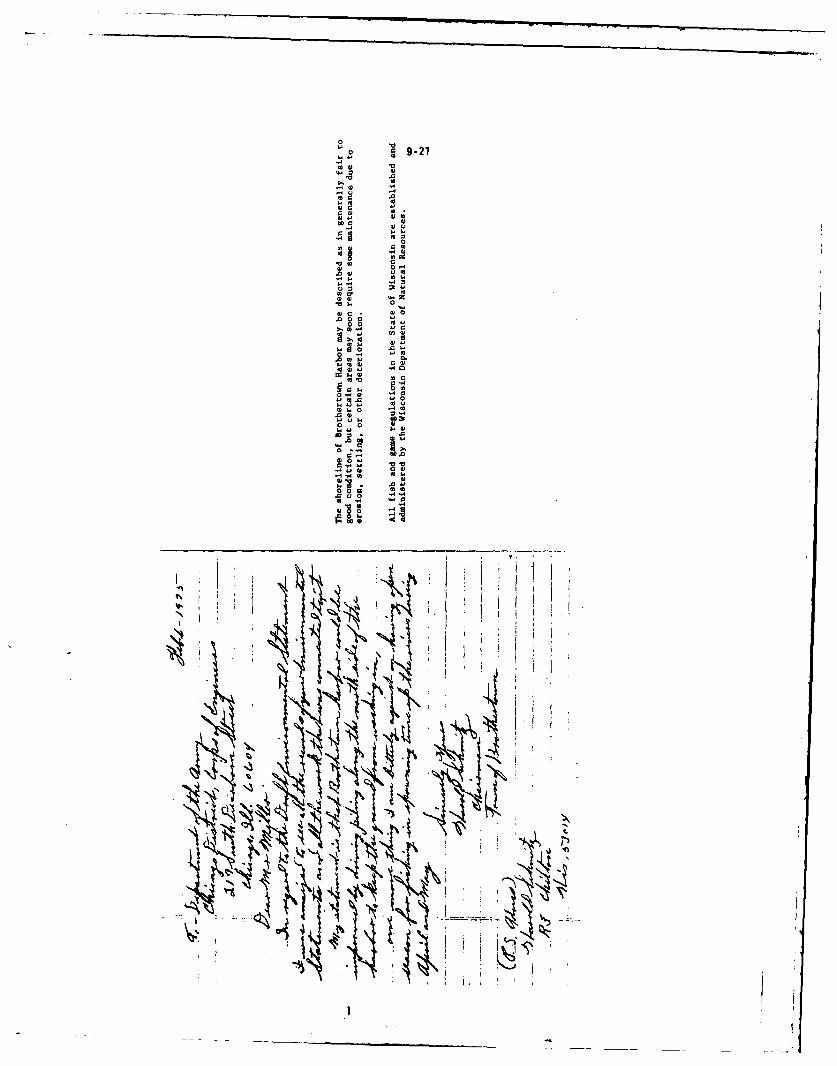
0
0 9-27
0)
.
04)
o--0 0
w 00*0w 0) l
.0 w
-0
4)0 .4
000
00
.04,.04
to
-434
9-28
,u0
C:
00.
,a 0.
0w .0
0 x
0
010
0w 0
0 a.0
0100
-or I-7
0 o.
Rot -. 9 1 .-3
9-290
0 -
-. 4 -4
-A .4
32o
0 ac
o o
a u.A -a
0 A
6~~~ *0 to . rA 6 A .
00 U00
O A
A O A0
0.4oe o
c,0n u
9-30
w l 0 1 4.
o 0 >~
40~~~ 24. t ~ 1
o 34 .00 "Q1'l
.00a0 0 40
v00~ 4 0 0 0 .0
m 4o ,00 g00 00w04 0,0-0
41 it- 0
00"000 00 414 'a 1'2004.r Ts4104 .
.. s1. 0,54400c . . >0 O -6.2,41 1" 0 80RO Wm O 0oc OH . > 8r0_
0 0 0 00 a0 I 0.0" u i 1Ix 0 '
0 o x o q _10 W) m 0..P 414 4 0 =0.0 .. gc' . 0
001w 0
o0 4D 0 - .0' 00
-,. 0 . A0" c r A OR 0x0 0.0 gI
Ol0 0 2P04 .0. c w Z" w
*0040 4.04)001.1
> 0 0 Z o00O0o
00- 00.
0.0 E 0 w 4 c 1 - . 0 to 0 4
OLIO!5lO r 0 0814, 0 0 14-
4400. Nv000 wzs.j10 w v 4 0 E 041 Cj20 . ,.44000. e0. 5LL > 00..l... E1. 908 41a1 50014 Am.E4V 0 o4 to
0.000 w0100 Ea '-StI
0 6 LI 4 0 > ,1) 00 m r
.4, Cc 1, 0, 0100,400 .v 0 S. 0U
&-a1 04 0 0 41 0 4
A44 .0 Z. ,.0 -. 12 zi4 -u M"
O up : 0 04 o04 4 41 0.. 40
04 1 I1. I0 4 " £ 0 '. E
L4.o .- 00 0
0>0 0000Vz"41 wu0.04 *40-00.U.'4> )404 1 0 01
9.31
40 , 00 a'
10 00 0490
M _0.4oJ t 02 0404 a04.40 0 9 . 0404
.404~~ 0.40 w 4Z- 0 44 0 9 4NO.4Q4a
004 " 44 o 040 . 4 a4000 4 0"
01 1- " 5
000 00 wo 00 ._ "a9.
-4 04 .49
A4400044.49 c- 0... . 0 0 4
904.4to4 0. 04 u 4 . .9 0 . %0A 'v q0 44 04.0
41 to -
404 .
W-,0.0 E t-.54.94.9 'ac C L
0y44 40 UP ~ . ~ s'"
I~I 044.
-4 .504 .9.9go0
SW -4 4 . 0
1.64 4L0
- v a- 41 Q 44.0 E9409 'Zo U r. 6 404:
40.0 w r .0 ; ,2
113 04.44 0 -
S I~ B:I t g =D.;z 0 a
g~~~ T 4
U~4u4 Su V09 43 . v
-4 AIN] 15 v " 0 ~ 4
'pg. io e
lu d '61 . s2%
9-32
G0r u
01 0) r .1w 0 -. 'd w
0 4u 0 040 M w
*0 w
w0 0- 0 0 v 04 0
w0 D.? 0- 0
>000 004 0m4. to 4 00 014
c0 m~ 4 0>
a . - 0 0 u
m.0> 0 0
0- 0 m . a
:3 0.4 w00c4 o
0 0.-m 0m.0 4
r w !, , - 4 0 0
0 0 m1 . 0
.0 0 .. >0-0 04-.
0 4.4 0 >0004.. 0 0n 40 4 0.
w 0 r .0 0 1 40
0 0 r 0 .40w)>IV >-
w r 0 v40. 0 oo~0 m 44040 . 0 -
0 ~ 0 m - 14 W0 0 'A
z0 0 00 w '0 w m0c.w
0 04000.044.x0 m
0~ 00 . 001 40441 8 - -4I C-4 '-4
E -'0- w ro4 01 '00w> -00 0 0 - 4 4.0 0
.4C0 0,0 2-4.40 E.z4-
v 0000 o 0 - ' ,v 0
um 0M. ;; m0.00 00 00.00-4- .
r00
u0 o ~ .
A~ 0 E
~~~ 0.O.
- Z c.~' -0 ;N 0.
0 m
twat4 m -~' 0 -a .~.0 *- *-400 o 0
4-*..G44.0' 0.0
~~.,V OEB00 O0W0ca
0,r : j~ ,, 'C' $.44
- .2~ a.Z O Q> 0
r 0 T 4 .5 B 0
-x 4. >1 00 0
9-33
* EA ST C H.V'RA Z WISCOATSJV
MOO Regional Planning CommissioniOE
1919 4MERKAN COURT * NEENAH, WISCONSIN 54956 * PHONE (414) 739-6156
March 12, 1976
James M. Miller, District EngineerChicago District, Corps of Engineers219 South Dearborn StreetChicago, ILL 60604
Dear Col. Miller: EC Review No. EIS 75-248
RE: Clearinghouse Review Comments - Draft Environmental Statement Relating tothe Operation and Maintenance of the Fox River, Wisconsin Navigation Pro-ject
The East Central Wisconsin Regional Planning Commission has reviewed the "DraftEnvironmental Statement Relating to the Operation and Maintenance of the FoxRiver, Wisconsin Navigation Project" In response to your request of 12/15/75.The comments are made relative to the environmental considerations containedin the Draft Statement in accordance with the National Environmental PolicyAct of 1969.
The enclosed statement strictly relates to the contents, analysis and formatof the Draft Statement doicument and does not reflect East Central's formalposition on alternative follow-up courses of action. However, East Centralreserves the right to submit a Commission position on alternative actionsaffecting the Corps future management of the Fox-Wolf project area at theappropriate time and place.
East Central wishes to congratulate the Corps of Engineers on the quality ofthe Draft Statement as it Is one of the most complete compendiums of environ-mental Information for the Fox-Wolf project area. East Central's comments areIntended to help Improve portions of the document and clarify certain Issuescritical to the Fox Valley area. We wish to thank the Corps for the oppor-tunity to conwent on the Statement.
Sincerely,
Roy C. Wiley, Jr.Executive Director
RCW/HPK/blcc: Ross Plaines, Corps of Engineers, Appleton
Anthony Earl, Secretary, CNR, MadisonStanley DeBaor, District Director, Green Bay DNRWalter Naab, Area Director, Oshkosh DNR
9.34
to 5 0 1, 0 z i. 'I
'04'4040, .. 04
44~ .'4'-t'4 I
..4,2.4 0.4,11, - .! -004..04 to -
Q4 04.,4, ,.
04~4.0'0 4. ,
o 4 ao tojo a74
00.. 0 04 0 ,4
'.,0444 0.00- 4
000 3; m 0 ,
000 0 a..4 0 M .0 0 04, . '0 , '.'. 0. 4, '4,4,a0c . y - "C 2 - z' -4
V00. 00 04 < &-- EI4, 0 04 ,. 0 4c,4 4 0 "'0 0 01 u0 4
44c '00.>4 4,4,
00.4.,040.M 4.I4,4 0 4,4 04:,I.04a4444. 0. 40. ,00 E
I , 0 CM 0 .0 ' 0 >
M-00,4 v44 x~ 44.2 ,
t'. C444'0 0 M. w 44.
0 04. 0.,. nW4M
' 0 m 40 4, 0.omO 4
c044, o o v-4 0 0.4 0 0 .0 4,4 004 0
4, 0',' x4 M, IV44,4, 400mo' 4,4 0m0
z'44'4 a ,4,ma.04 004,
0404.0 0.044
v444 4 '00 x00. 0m. Z44;.:2,, o-'0 4 . 4 '0 > 4.44 4,.4.
W 4 . 4, V 4, 4, M4 00w<'.4. a 04 z04 0I
A 02 044 ' . .- -0.c 0-- so.
I44, w 4 0 4 . 4 4 0 ' 0 -. 4 4 4 . , 0 . C tc, .4,4 0- 04, -0 4, 4,u E 4 .. '0 . ' 0 0 0
0 0.00>4v 03L 0 0 4 t- >~44,4,4,4 ~ ~ ~ 1 0' 4,,c4 3.. '4 4
0400 L - 0 ,o Q 0 4 *W4 L4 - 4 I
0 4 40 0 29 2" - 4 0 , 0 4 2 0 44 v0 ' 0 0 4 4 4 4 ' " - 0 .-00 0 0 0 4 a 0 3 0 4 0 , ,4 4 4 4 . 4 - 4 44 0 4
0 c 0 0 0 0 40, '400 4 4. 0 4 - 0 o C c
0 0 , 0 -1- , >.t 4'4 0 2 . 4 4 4 4- 2 , -
44~ ~~ ~ 4',44 4,,4 V4o00 4,,40,,0Ea0 -. 0 *z-;8 0 .444t40,4,. I, - . '- . v40-v 40 0..0 0, 40 0404 10 .0 ., 2 S, 0 4
4,4 0 , . 44 0 ' 0 > - La S',* 040.' . 4 4 404044 4, 4 4,4,0 4,44t .L'.' - L00 ,.'.. .. ,- , CL00'-4.
9-35
0. 4 0
4 ~ ~~~ w 04 4 4 0 4 1 4
0.' 0. r. 4).mo44-. 0
4. 0400 4440..441 0 E,v'a 04 000141441a
01 1 .4 004. u1 g. D
.. 41 4140,41 4 4 404
414 1 Q' 4.0 44 4 4 4 4 4 4 w
0 41444 Mw v = V40 M441 .4 4 1 a .
v4 .4.440 .4444 4 4141.0.. 4.0 44 41 . .4 0
4 4144 41 04 4M1 00 .. a4 '- 1 4
--1.'4 V a4 4,4 a,444. m4 1 c 4) m
4 4.11'4-44 C44 0 0 o
414 M E' .4I3" C'o 0 M 441 44 iL4I1c1 044 .4 C10 V -am >w .014
*0 0>44, m2 c v0 0 Z4.%1 4 01 w >4 -- 14. *. 4 1 40 o
.! 8 4c1c 1a0v .m a1 -. x
44 44414 3,. In ~u. 444441 4 0 41w.-
04 0 .4144 4 !4 44.
c. . 0 4 40 0 4 04 m, o40,
2 4 440v.1, 0 0 v 144 0 o c
u C9 z410 0 4 4 1.4.3- E1140 4444. 01 414 >0 u1 M4
4,4.4~~ .1-. 4440111 -X4 0,. .4w u1.4 o. 0'44 ~ 4
-.v M, 04Ka.4.44 0 . 4
>4 .4 .4 4 14 1 444 1 0414 41 1 '411.44.0. .0 4
4,-'.4 -1 M244 24 4 0 , 1 0
214 .04 -04 . 1 14 m4 a-4401414v404 4v1m41
4 0 1 4 0444 1 4 ' ' 4 0 4 4 4 1 4 1 4 4 4 40.4 4 1.4 44044114, 44 11 0
0& A44 44,4 o1 .44040411 44 4 44
9-36
0 04 4 444 444.04. 4 0 - .4.
- 40 ~ ~~4 44.. 4 4 41 404-..
41 4 51 4. 444 VW.4 0 4404Q044 ,
n o.. 4 . 04.. 4I 04 4 I444 44
1 4 .404 4 04~t 44040* ~ ~~ 4444 41 4 4.04 4 0
a. 044 -1 00 41 >0 44
40 00 00 41 4 4 0 4. 4 044 .4 40'0 44 0. m~ E4 04 14.1 0. .. u 00
060 4 4 4w4 04 41 41 040 410 4444 .4
. 1 0 .1 0.10
.40" 444 40v
=0144 10 "0414.4 w
* ~ ~ No41 4.4 4 4 0. 444 44A0444.4. ~ l 04 &1 4 .0 4 04 0 0
6 ~~ 0400 40141 40c a4 .0 4
4144001 -a-44 044 0 44 1 .4444.0 4
0M64 4 0 41 .0 0 v 4 1 04 .
0 go0 A-404, V. 0 A404 4 0400
40~~~ 14 41 01 04 410 4 .0 4 4 4 0 a0 1k
1 ~ ~ ~ .4.0 .44 04 ,- 4 44 4 c.4 E1 4. 40 04 4IV 04 O0 .44 4 444 0 ov 4 0
4.? .44. 44 4444-0
-4 0 a e 0.0 0 C V0 , V4 40 . 0 o -.0C . 0 0-
4 .40. 41M .244 004
00c 44 44 40 > 44.
41 41 c 444 c4 M 1444444446~~~ 0 .41 4'm1 8. 6.4 -
-~ - 1 m2 ,. 43 41 044400. 44
E4 C 1 0 0 44 4 4 4 4 0 4
0 14 .-L 0 00404$4j4- 04A 40104Al ~ ~ ~ ~ ~ ~ C -.0..04 0 . 0. 0 4 .
c . V1 % -0 W w oI '--v 0 4440 - 40 00..u :U40 -4.) 0 -c I1
4144444~ ~~~~~~~ 41 44.&0.44 4.4 1440
44. 4 0 0 404~0 4 414444 C44 W .4* 0 =44 0E4 I4. c z
.0 VC .4 0444 2-- 1 - - to. o.-oV . 00 4m04-44
4 -0 Z'1 404 a4 414 4. 34 .1 I. ; 04.44.0 .00 1 w3 14 0 04 444 41 0 Iv
u&; 44O 40 Lm - 0 ' E 01 44 .u m x -51.0 44 4444 44. .E5 .- 1.4 a1£ 4. .a c E 04 t 2- . 2
04 04 . 4 0 -00 0440. c4 0 - 044 .4 MV4. 44 14 :0.4 0 M- .01 '14 0,A-0~~0444 42 41 0044404 " -
004 40 0 40-0 04. 44- 40.014 .04 0 ---4 0 '3444 4 00 0040-0 i1 04 -w
Uf -10 40 z'440 0040 4 440 44 0444
44 40f 40.0.-
9-31
I00 c 0 IC 1.'44
0 0 £ .0440c 0 -40 0 ..0 0'444 44) 0004.4 00
c4.4. C 1. a4 44
0 m.0 1 40 00 1.. 0000- 4a000 0 wm A
0, -444 0 0 000 0 a w000 4:.'44. .40 C'Q"44 0 x0400
00 0
a 0000 - .0001
>4- c' o404> 0.4 - 44 0 0 0 04.. . 0 4 O
04 0000 0' a a40 ~ ~ . 1* 0000 4 40 ~ ~~~~~~ 4 44 a .0>4440 0 C 440 C
.4 00004 a...0 000 C 4000 444
00.u 00 a 04 C 0Do04...4444 .4..4. 0..0 4 0 0 0.44 9' C
0 ~ ~~~~~ 0>0.04 0 ... 40.. 0 44004 0 0 444 .4 CC4E
4 0 '0.0x .4 0. 4 4 =4 0
0 . D, 40 0 .4 40 0 . 0 0 0' 0 . 40 '0 m. Cc 0.2. CI o0 a 0v1 C4 -
044 0 00 0 0 0 0 44 > 4 . 0440.c 00 u444 0' 5004 440 0.4 I.4 .
44 0 0.0 04 . 0 0 . . .'0
0 0.4 24000 00 044 0 04 '0 14 . ' '4 0 ' 0
4 2 0 W 00 W4. 4 . 4 00 0 0 0 . 0
0 <0 040 -- 0.4. 444 044 > 4 >424 E 044-
0~~ 0 00 0 0 . . 0 04 4-0
M0 044 0 0 ' 0 m. 0444.4,4w4 0 v 44 0 4. 4 0
0 - 00a c MO u4'o 0 0 00 3 .0 c0 0000 0.0.4 04 00 40 0 00S 4 44..
00 V. .0 44 m40 a w0
0.-2 0004 -u > 4 00
80 s o d 1. 0 4 0M .f0o0'.00.0 .
'-0 0- 0-4
00 204 o0' 500 ..1OMC I0~~~. I44 - 0 0 c44 0 0 0 0 0000 £ C 4
'00~~C4 -2 g4 4 " C 00 0 0 - 440 0a44 0--. .00 00 .0 44 4 r6 F4 ' 0 444 0 00
030 4.. 44 000c10 m 0 ~ c 0 0.0 0
I - - C 0- -o 4'0 0>0 c V M00 cLI 45 -.. I 440 W VC>- 440 0 ~ ifVv2 00 0 .00 L E z a cL
0 Va £ 0-CO 'C-4404 0. 0 0- V444-a 44m 40 04 m-.1 0 £0 0. 0 44a
EL -C a 06L - 010 0-0k 0 4 0 . 4 ... 0-0 L444 00 000 *M- M..- .0. 6c C44- - 5
44. 0 > 0 0 0 - rC .24.> 0 640.40c6- 0 .4000 00. n 060 Q 0E 0 0 -- 044 .00 4 4 " 0 0 1 .C 4 C0 0 * . 044-C 4 C - 04 0440'4
al - 4 4 0 0 4 - cC C . 0 2.0 4 s--0 0 0 4 0 c
a0.00 4 o u- 0-- 0 V4 040 v--~ 4 >0 . 5 0 0c4 440. 0 all - 00 3 .-
00 00 - 44 904 0440>Q
0.4 X0 I1 001 -. 0 -00000044V40044 04L0L03 .00 0. . - 04 44 =00 -fl 00 "40 a0£64 0
00-4400 .000 0
9-38
4)w t. 0 o ) t
4, . -t 000 0 Vt
'0.0 4.0 V v 0,V. u' ' 0,
.0,,." 044.)44 0 a M44.4
c ~ >oic 4-O 4,,0400 0
4.4 04 0-4 41 - ~4 0 w 004> ) 4' l - .
ci ~ '0)0 4'. T44L'41a
0.. 0~1 0 , 4 4 o
v to-004 00 2 0 .-- o .1 440 ao -44.4~~OC0 0 04 44
4--040-..4044t to 10 IV.c.. a 0 0 -
44to0 4,Oci 0.Z ;4- 0440a4..
;to0~44 woo 0 ' v acs -. 00
044Cto to
x40 o OOt 40 0'. o-404 - ci ,004 ) 0
L'OI.-.04.> 4)0.4 4 000 15,> 40040BI
4.4, 0.4 44 m c-.q 04. 0,44 u.ci 0
M~i 00 ci, C.4400.72 .0 0O4 W- tom44
44 L',O 44 w4 .4 10> 44' 0 400044 .044 004 L '.4 0 20 .4 A 0 ~ 4 . 4
040.0>40 0 04 0co 04, 444.t4V44471 -. 0 44 >.. ,'t 0t 00 4, 0 .
o) r>O O 04 04 > , , 0 4 ' 0 4
0 040 *-' .. V z !!00 01
~~404,044>0 '0 3. 4 -40 0 0 04 4 . O 0
V 1 L M.'44 0.440V 004 '.4>0 04..4c '4Z4V
.0 4, WE
4 c4
44'L'4to4.0 4 - - 04 w .,444, 10 ol 0t-: m 9 0
44 06 044JL4t - -aO ) 0.. 0 L.- E4,
444,404" 44 00 ,4444 o .>. .24 Ac2
0 440 00 0 440 '400 V to0 440. 1 4. 0 v'u0L
- 0 6004 0004 44..00 0m44 Io~c v01 4444 toO4 4440t.
.4 0 .0 4 . 1 0 4 0 4 V o
44004 ifr;' 004,S004m
>I V 0- 444 4 0
00- 44 -044, M 0 M4 04 0
404 04. 00 4 0C4~4 00~44
uw~ 0a" C, ?7It C 3 0o ' ' 0
k, toF V - 0, 44 044 9-0 4.' m0,'- .O >' 040 ' 0
4-C 04.4 4-40 0'0 '-'0' 4400 '4"' 044 ' 0- - 4
9.39
.00ttoL0O.5040 0 .
*040~ 00. 0O >Ot .
1..000' t 0 0 0 . .0 0 0 .
11.44 0 >00 .-z~ ~ o m,~.'- 0- o
.400.~~~ 0 v00 0 Ito0 0
.4 0 .5 !t4
1 000.0 C. 0.
01 . c04.0 1 .4 0.
A" 0 0.0 40
00~1 f0000 0000
a 0 0 'd >00.
1.00. ~ 0 A '0,6.00
0. 0>0 04 0
.r 41t 00 00!t .. 0
0' w t
40 u0t. toO -U.. 0000
>00 00000 ,
O4to. 0 0 "0 -1 0 iS0.4 O4 0 0 F. ..40. A 0.- to0 00 000a0v 0 0 S., 0 .0.c n 41
4-4Q 0 0 -00 0 0 40 =00 003 N~ 0
V w 0 -4b0-4010t0C 0 0 40.0.
40 CCC
40 + t t >, >, '. ov.4 "100v 600. .0 c v 0 a 6 0) 0 >0.00 A 46i- .A V 0.0 A .0 S. > X
A 44C 401 +1 CM 2- U 02.t.04. 445.. o00 0 00 >0 OC00 6 .
IU :S ft
+,0 0 V. X4 4 0.. .0 c
> . 0 0 * u .0 1 . 0 3 v X 5 " j, <
4 C4 9 44 '040 06 0 0 0'. 144.4 1* 4O00 0. 0U 000.00 C 6 .0 040 0 ox 0.440.6 '0.6~~ 'a Oa4 0 0. .4. *.0040 ? -0
046- IM ~040 ~ .02~0 44 Om40.4 -~0 C '044 01.04 'a.- 0'o 0 m.~-400, ~ 0 Uq 0 0 c >0g 0- 0. o000~ 41 Xr0.40 14 400 .0 *0-.4000
Ito 0 +18. .o .. +, . 2t . 8
004 ~.'4 I"0 f.4& 4. 00 440 4~+ 0 4J 044 0.0.04
9-40
(44 '- 4/44 0 0 -
4.~ 00 o 4 40 4 0 v~. I.
In44 2 /4. 04 0*40.m04 a004440 ~ u w44. 09 1 04-
0l w4 0. m
0~~~ ~~~~~ 0 44 m 44.4.444 4*044404
u 04 04 a0444 0', - 0.4
.0.44 W, l C 1
44.04m 04..444 E4 9 404.
0~~~~~~ ow0 0 4 4 .0 4/ 4440 . 4. 9 0. - V
0 4..4 0 4~40.4 0..4 '
0004.u 1.44.44 04 00.0 al40444
~440.40 440 .4444404 .- ' 44/w 0 0.0
SO. 4 (4..
44.0>. 449~ 044 44 '0.4 .4044444. 0
49 40.404.0 . 0 44.....-.0 4 . 4.4>49 .4
IL4444. -4 400 *44u 40 4
0 ~~0. ~~~ 0 4)440 4.499 4 "4 4
9-41
4, 0
0 0 41 V44440 0o 4' 41Z
-. 4 414 - 0 a o 4 4 41W 1O 4.04
W Cc 1 .2 0 w 1.-0.-40 oooo~co.w .. 14 041 0 W 4. 0
x Ow .m 04141 01 w 41
oe oo 4100 114 *0 10ZI- 0
~4100 a 0 01
0g~4v 00 0 w4. I444 114 04-44
0 04 4o V" o401w 0 04 0 04140A c4.1 01404*1 4400 04
E AA.44 a44 040
0 0
"U W10 11
410o 00. 000Z '
0 004441 0.00LooC 44 . 0 . . ... 1 a- 0. 4
V '.o 41. 00$I 000 a x4 * 044 0441 V
041 o1 '44. V 4r
41~~ %-14444 0-0 . 00V 004041 0
QW.sU O~ A4044 0 0414411 004 4144 "M a w4
00 04 14 1 ooow z &404
o ~ ~ ~ ~ ..40 '4' 00 04Al44a~a 010 4 1
4041.4 0.
W0. 0 04.0.p0 44.0 44
A 4 ji 0000 a 0 . 00 'w0441 *0 00>44440104 14001 00 4
9-42
t L
1. -1 R 6. .6 06
o-4 4 6 . 0 A "004. 1 4 0 t O 0 0 6 .0
00 O. .1 NM . 00
0. 64. 64.6. .1 146 0
1020 040 0 .#0 .C. . 4 6 .0 ~ C .4
4 0' VC . , - 15 0 0 .0
0-.oo 0.4"04 0. ttoe
-,~~~~~~ 0~. 00 0. 6 6 4 . . 4 4
a 0 0 0, .6s. .600 0
- 0. 046 21. J U
w4..6 4 644 go 060
o~~' w ' .~ 4 0
4-~~1 A04 4 4 0
00 "1 w0.. 5-2 .
w40 .4- =0 S a 0 1 A
0 0 40 0
31.044 0- P ~ 0460, 0.
4. 006606...4 044.0 .0 4.
.6004044.~ ~ ~ 1.0 04. 06 6 4 o 0
ot 1 . C 0.
06 0 004i . 0 *1!00 .0 1 0 4. .4 -. 4 .
.0 0 a!
04 0004. .
9-43
4, 0 0 0 0
0.0 0 m 4 .0 0
0400 0 0. 04 .4 3 ..
'0~~~~ 4.4 >0 >0 00 . 4 4 040 4
o~~ 0. 0 . 0 u4 . .0 4 U 0 0 . 0 4 .
O 44 -4 00 4 05 444 . 0 0 " 4 0 44 4. t..
.0 7E0
- ... 0 ) 4 , 04
u.o 0 . .0 4 41 4 M 44 I 440 0040 ,.
44.4 44 44444 440.044 00 04 0
0 0 440~ ~ ~~~ 0 4.4004 4> .40-.'40 '4. 4444 44 0 '44 0 a4
44 40 4 4 4. 41 4. 0 44.4 00 .00000
00 0044 44 ... ~ 4444 r 00. 34 40 . 40
440 a4 .r. 04 00 004 0> .0 0
4.4~3 44. .. 0 a00 44004
0~~~~1 444 .044 0'00..
'04 0 m 4g 4.0444 4 00444 4
'0 4 0 4 0 sa's .44 30 0 .0 0 0 0 ' 4. 440
44 . 40 '0 000.0 4 04, 0 44)04 i'4s
9.44
0 v, 00.v 00
I S 0 x
00 0
0 00
u 0 0
V. 0 V.0 -
4 0> 0 0
a, c 0.. A 0 0
CV M1 r0
2. 12 1. 00
1 1400 0, .0 0. 0
0 0
0, two.1. ."0
.0 '38 a 0
to J.'s0 0II
It0 0, .0.
9-45
x40 cm
04 000w o c o 44000 o 4
504&,...4.£0. 0'v0.~~ 4 ,0> -o
4,0 000 00044, ooo~..0 o..0-cm
4,-54 0.4~~ 0 040400 40 4
.0 a0.- 1 0.Oo.4 0 0
W i 0 1 .0 0 0 0 W..0. 1
00 00404. 04 40 440400 400 0404
& ~ ~ ~ ~ ~ ~ 0 0.4 m £ 0.. 4 0000, 0
000...4 00.4 000 , -0 0 o,- c
4 Me IQ "NJ~ 0. t0. V 4, 04 0 4, 4, 0 .0 0 ,.0 0 .40 0 40 44.4 0000 0.04 0 .000
4,,4 4 4 0 400 . ..0 0 0 0 4j-- 0
04.0444,. .04 "U 0> . . 0,0000 0 . .00 . . 0..
0040. 0 Po 04 . 0 '0 0 04 0004 040- 40 0
o0 04 0o 0440 40 , 00 0 0 00 .
.0.40 400.04 V 0.0 4.4,4,40000 40£ . 040
9-46
x v.
t 4'o o ; 3 .4,4 4, , .30, .8 C '., 0 >4. 4I
4 . 0- , '4 4
oc St' -4 1 lo . C0,'.
7EC~44 02~ 1. >CC>~O4014C o~ a~3'40C 0 CO~l30.4,...3l
C o o40. :.. uo14 . 0 C0f C.C -'
m.40 =444 , .04>00.0. 4 u'4- .0-
00444'T~4 04 .4) C C. ~ * 03
t4041,0 '14 . 04.4 1 44C ~40C
o 0 v~ , &444 *C4 04 E Cl T. 33
.j 41441143 .441440
COCCO40'w 14.40 C CC.4 0 144 .>4,34,.1 00a .9..4,4, 0. 40,4, C C C.,.,04440 C
.4144... 1430...So C4CCO '2 4140- 44 40Z 0.4 3 0 a
14~W .C no, x..., 304 V 0 .4 1 4 4 110 C 0
C1~~14'C3 0CO 0 .1 .x 0.9C '4 C 4441. 0 - 4'
4, '.4 '4.44. 140*40 1 0. va Co C0 u -4 Ito1 0
4,C1400'CC ~ ~ ~ ~ ~ ~ I- .. 4.4. A40. 0 4 4)C1.00,4 4 -14.14 Z -3 I440.. -. 41 0.a4 1 4 C -~4.' 314 0 4
C,444.4 44 0.3. C4' 040. leiCC14 4 0 a1. a- .4 0-1 01 .4> C.1C-
O.4403014.41 C 4, .34 4 V 0 0C CC C 0 C .C04-00.4 ~ ~ ~ ~ ~ ~ ~ ~ C Ca044.04 W 4 C .4 ~
4144~~~~~~~~~ -'u9) 4,4 '03 34 C C 440V .
-a 404140.4144, C 4,000, CC 0.0*'.0''04410'C 0 -
143 .C 444.4 014m4. .-. 00 1 4 O .01-4 0
-. 44.40 , ~ 414 4~ 04 0 0- 1414 C0243C ~ ~I A4 a41044 4' 040 0 '0 40 , 4 4040 -4 C 3-
410040 0404 0 C C-I044--I 1 00 .0 1400 40.0 .4u
.431.404 I0 a.- A44 04 4 . 4.4 .1 0..0.. . .14.4.0040444> 14 a .4 44,41 3 40 , 041 3030,4,0 4 0.-. u
14,C~114~410 .1 C 0."440 0433 0. 4 4
4,04104-c 014414.4 .41.4441340 .4'4 0, 2-3
9.47
wji 0 w4
I 1' 04 0 .
0~~ t .- 4
40>0 00>j~, 04 u" w0 04 4
0l4~44 ~4.Z40"'~ 0 4104> 0
00-47.0 ~ ~ ~~~ -47 'O W 40-4
>0 -) >
A- . f >0 .0. 004 000 0.
0P 0 0 4 0 0
-c0
40
4
'-a 9 40 40044.0~~~ o4. w v40 0 >0 04 0
.47 ~ ~ ~ ~ ~ ~ - I4.0 ~ g 0 >4>
0' '4 4070 410 A70
"10 >. 0 - P '
g4 t0 ao~ 0a . I0II0034170 a
0>4. 14 0. .4 0. . '04
I A I D1 W '> >4 '.5c0 4 '
AIR0. f44 > 7 > 4'001> 04t4
9-48
0 >, 00.
0 .001 6 000 0000 .0 .0
0. .0.0 0400 .400 0.00 .. 0 00.0 0. 00
.0 0 .400.4013 .00400- 0.0 0. 00 00.0.0 00 00
00000 4 0.000)40 .4: -0. o 00.0.0.o ~ -n
00 0 04 .00 .4 0000
00 0.0 0.000040 04000.0*0000 -0 000000.00.000.0. .00. 00.... .000 004)
00 .000 4.0 00 40000.00
0 00.. -. 00 00004..00... 0 0.." -0.4 0.00 130 00 .0 013 040.0
00.00 .00 00 00.0000.......13 0000000 .0 0 00 00..000000000 0 0000.00-.. 0 13 04.044000.000 00 0~*0 0 - 0040.0 S 0 0000.000 .00 0000 00 000.0 0000.:..00
.06000.00 00 0.00400.0.4 000000004 00.0 00.000 00. 4000
0000013 0.0 -0004 500 00.44000 00.. 0 00000000.000 000000.400 000.00.0000 0130 00.000000 oo .404 00 .00> 0000.000,,5 0000
000 00 0 - 00 0 000.13 0130.
06 0.0000.00000 '.00 .0 0
0 0000.01304 4000 00.4000.0.4.400.00 0 0000400000 0. .0 .00000 40 000 00~000L400 00 0..?
04.00000000 000.000000...0 00 2 000-. 0 . 0.04 000000000, 0.44000000 0~.4 .00 00. OS 040 04000.00
O 000 00. .40.4 00000050 0004 0000044 .00 0 40 00000 .0 0 0.40
0000 .0.0 0.44 .000.0900.0 0...0 00
000 000 000.0130~0 0000004.00 00 0.4 000 000000040 0000 0
.00 0 0.0 "0 0040...o0o0.0~00.00
.000 00 40 5o 000 00 000 0.000 00.4 0 00000 .0.4 0 000.0
4000 00 000 .40.00000 0 .0.00000 000000.0000 .004000
000... 0.0 4000 0.000-00 000 0.00 00 00.0
00540 0000 00 0.00.000.400 0000. 0.00~0 .0 0000 .. 40 00004 .0 0.000
0.40 0 0 . 0.000 000.0.00.4000 0.00000000 .0 0 .000 005400.00 00 4.00 0.0.0
~ 000 0000 000. 000.00 00000-0 00 00000 00000.00 0 004
.. o.0o 0 04. 0.40 0100000000 0 0.0050 13.00 000 000 00.0.0 40 4 000000000 013000. 00000001300 0000 00
.00.000 000 0.00 04 40 00.0000000.00. 0 0.0 00 .0 00 500.00 400 0.00 .00 .0 500
4000 00 o~ 000 0.00 000006 004000000 0. MOO O~.400000000 0000.400 0. too.000000 0.40 0 004 4 .000 6 00016 00 00404 OZ0.OoOO 0 000ooe.g to 4.00 0.0>00 Lo 0 00 4 0 4004000
"~W
00
0.40
000 004040400
.4000 .400
00 .4
0. 04 0 40 0.00.00.0000 0 00 4 00040 06 0.000000000000000 000. 0 0.0
000. 00 0 0.04 >000004 04 0 0000 0. 00.0
00000 000 JO 0~0 0 00.0 0 1300000000 00 000.4010 .40 .400 000 0000000.000000
0 0000 3 00000>00
151St .. ~ a 0 ~ ~4000061 00000000000
0 0 0 00
* o 0000 .400 564 00000 *5~ .0
06 000. 00~0 1~11~~ .00> .06 .0600.~
o0.0S
~ 000004
40> 000
0000 55 .0004 .W. 64431000 0 6000 5 01006 464 60.0 0 00000 00.0 U
00 6000 01 06000 6000 600.0 0.40 .0 6
00 000 3 004 ~ 6~~00 060 0~~-4 .o 6 *~ .50. ~I 0601 0~6 0 i
* 0.3 0000 060 003 ~6.4 ~50 000.3 o.5~ Ut0 5 4 0
.0 5A ~i .43 1~.j ~0A~I ~00. ~
.0 600 .4.006 000 .0000600 ~ 14
0.3 60 60 --- 6.0.4 3 000.06 *.. 00 1 2 3~
.40 woo *00 00 60000600
6 000 o0~ ~ 06000 00 0.000 5
0 ~ .006 = .406 0~00* 00~.0 0060 0 ~oo ~o.o 006004 .0 0- 0066000000 606.~3 ~ 00 606 0 0004 .400 000 0.00000 00,~ I '~' 2z~!~uI0~ 000~~;1jj j; ~ 4
q ~I I IA :133. UO~ 1t0i
'A~'i ~ j4
0~ P~'~ 000Ii ~ ~ dZ J~6~ ~21'1 C o~~oj0 *~
401
I*O.~B
~
40
Ii If 00.0060 00000. ~
a W d~
00 e 04 00 000
Jo 8 S 00 00 00 0004
00 ,0 0 00 0 00 00 00
9-49
4,0~ >4030~ 1-
4,,0 1
00 4
4,30~ '4 ' 4.
U400 4 - a '
UiZ,0 0
vj,4 014 S0
a,,4 0' ts '4a
0. ,04 000.0,
4,vz u, W04 4,1 4,.044
off '4L .. ,0 t I
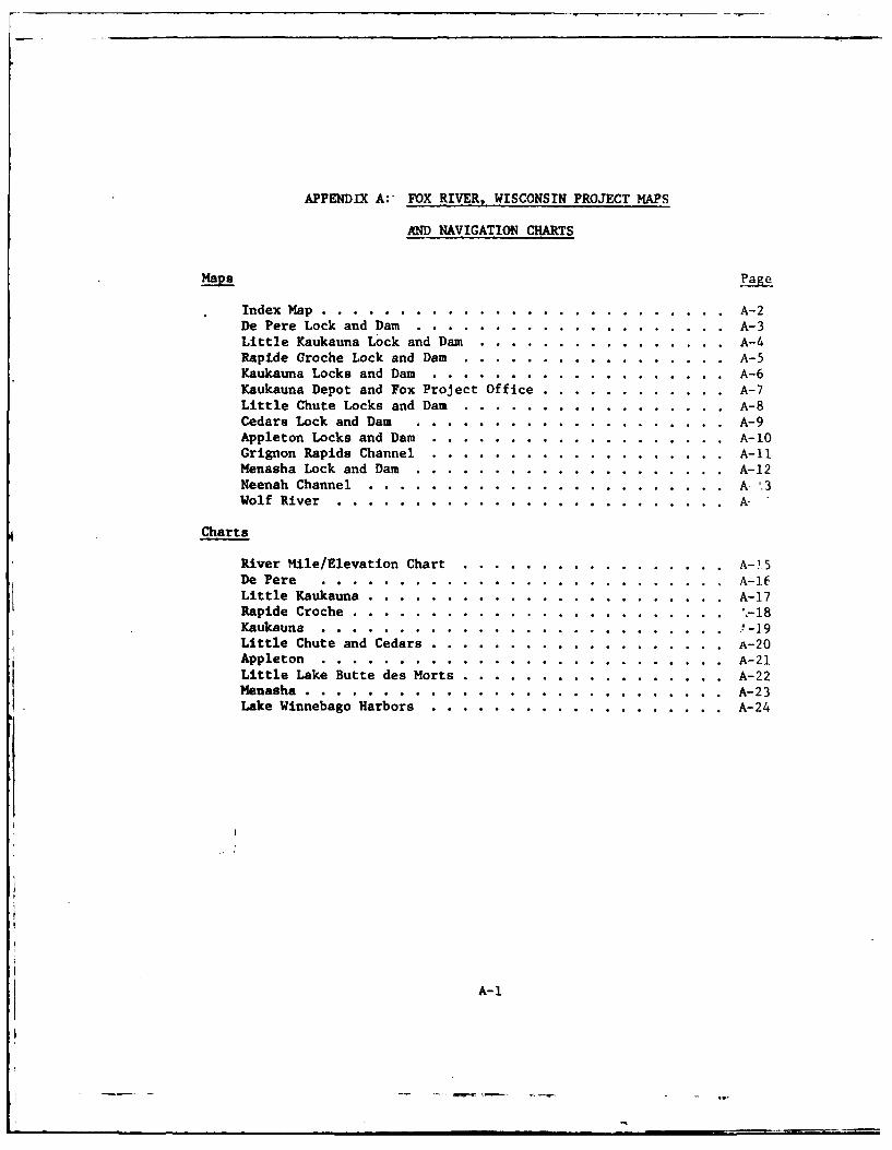
APPENDIX A:- FOX RIVER, WISCONSIN PROJECT MAPS
AND NAVIGATION CHARTS
Maps Pae
Index Map ........... .......................... ... A-2De Pere Lock and Dam ........ .................... . A-3Little Kaukauna Lock and Dam ...... ................ . A-4Rapide Groche Lock and Dam ........ ................. A-5Kaukauna Locks and Dam ....... ................... ... A-6Kaukauna Depot and Fox Project Office .... ............ . A-7Little Chute Locks and Dam ........ ................. A-8Cedars Lock and Dam ........ .................... . A-9Appleton Locks and Dam ....... ................... ... A-10Grignon Rapids Channel ......... ................... A-ilMenasha Lock and Dam ........ .................... . A-12Neenah Channel ............ ....................... A 3Wolf River ............ ......................... A-
Charts
River Mile/Elevation Chart ....... ................. .. A-1 5
De Pere .......... .......................... .. A-.ELittle Kaukauna ......... ....................... ... A-17
Rapide Croche ......... ........................... -18Kaukauna ............ ........................... -19Little Chute and Cedars ......... ................... A-20Appleton ........... .......................... .. A-21Little Lake Butte des Morts ...... ................. .. A-22Menasha .... ........................... A-23Lake Winnebago Harbors .. .. ................. A-24
A-1
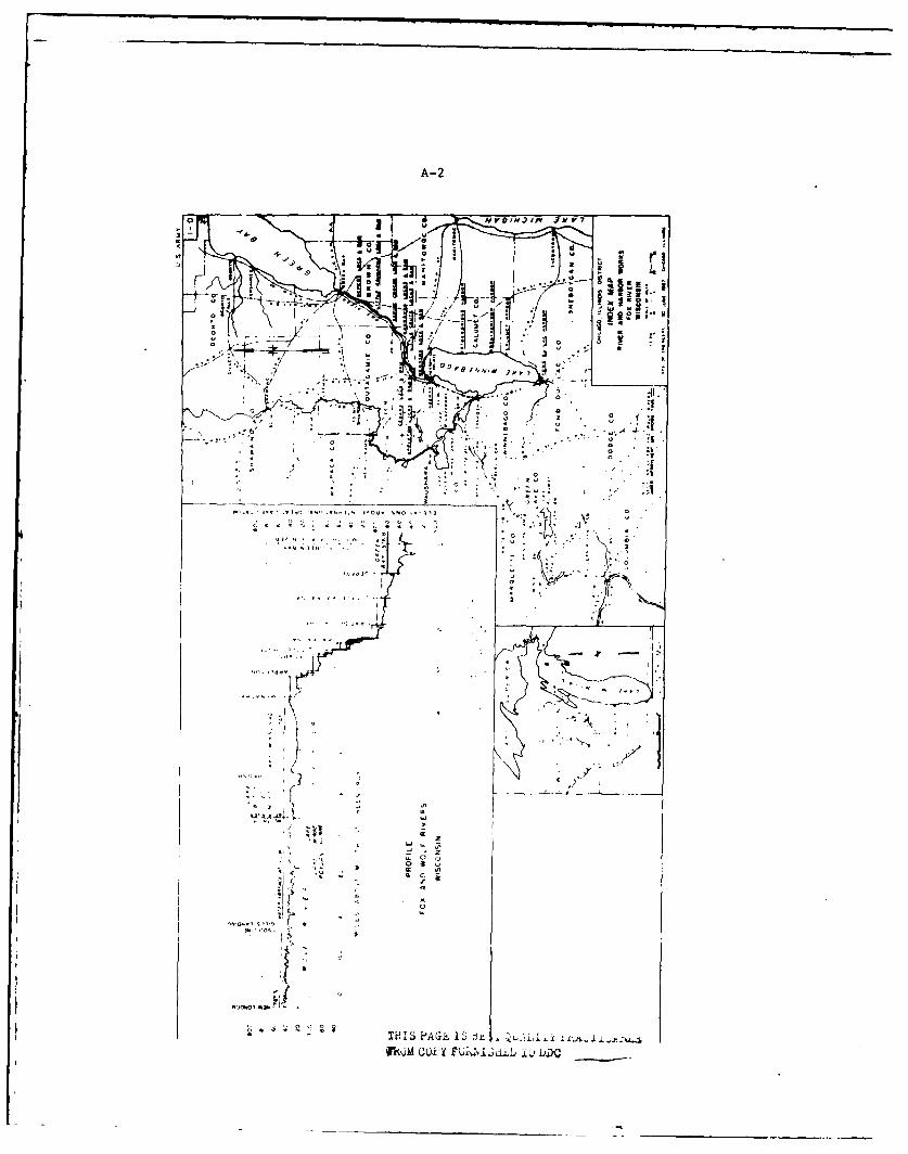
A-2
0
v o
-0 -A S
IH4 0AYI r
fhjgGi F N 3i~jY)D
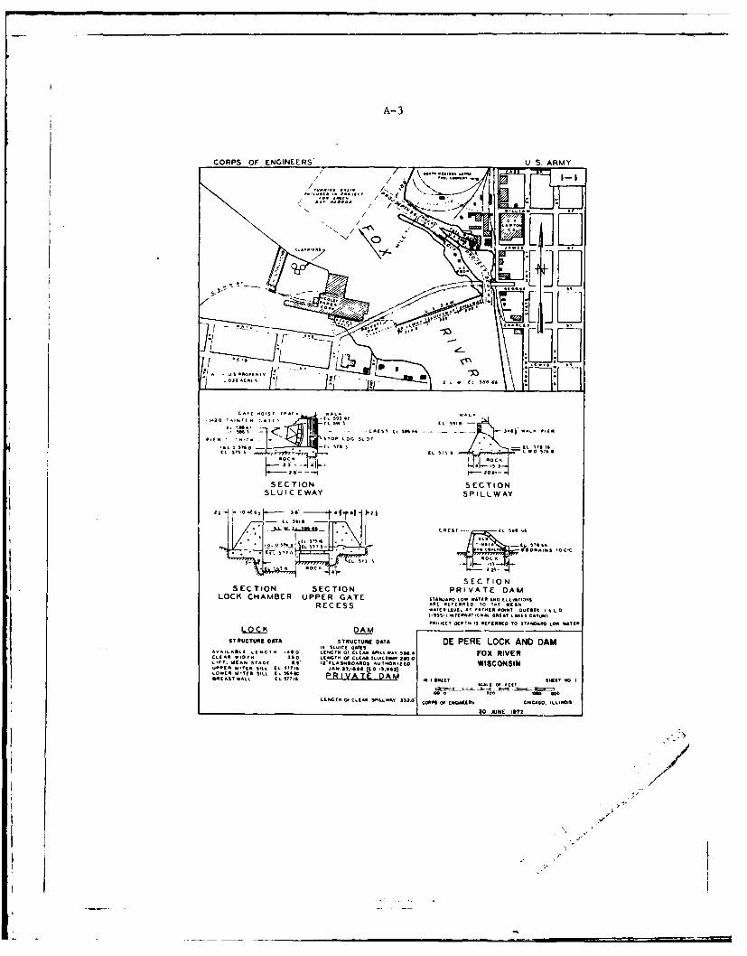
A-3
CORPS OF ENGINEERS* U S. ARMY
/ / / \ ..... .0 I' ,.
x~~~~~ ~~~ ISo:ii' .<L r _, I
.... i c*c. . I
. . . IN . .,,
SCI N / SECATNa
LLIL
....,'. .5943 ¢L 5t -91
,A I
L
SECTIONSECTION SECTION PRIVATE DAM
LOCK CHAMBER UPPER GATESTRAOLWAERNDlkIAOSAT AR LWWDTIRO (L EVAIN$
RECESS w( R . orot. tiSAI 1P tPOILL INT I LI..", ISkTt94 y CAL REA T LikES O.tUIPROjOCT DEPTH T E R RR3ED TO STANDARD LOW WATER
LSEC PION
ST IUMMUE ONTA sT1u""u E OATA DE PERE LOCK AND DAM
AV&LAIL L[~~ LENGTH -48o OF CL EA SPILLWAV 56&4 FOX RIVERCLE4 A- 7il". 360 LNT OF c t AR ¢£ SLU-Cl-4 200 0L-11, ,MEAN STAGE t 2' F , Af SMloAAD3 A.ut.Q.Ij WISCONSINU P P EL I T AEE R S ILU P RL T A T E A T R OD LW AO)
LOWR C SSTf S TL O PR IVA T DATT Ea. 'AST W1k1 A 577TA I T ' WE SWET No I
PAfEOOT AFNCO t' T O OGR AE
t~~~l~~mP,.L OP 1111msu m izo
. .. . . .. .... .AGO
LEGH I ALA SPL.- 312.0'CRS EAGINFEERS So jUE j.2CAG O. ILLINOIS
CLEA W*NN SS LAST 0 CEARSLUEVTflv
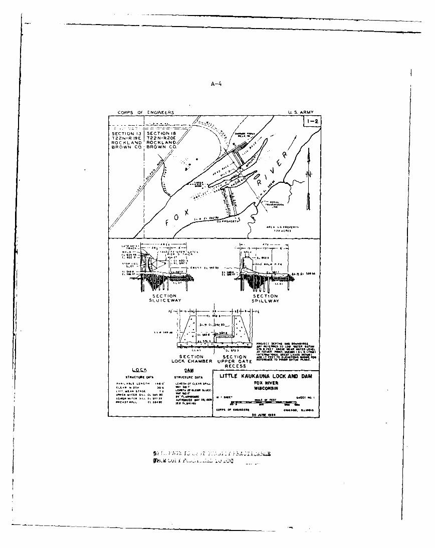
A-4
CORPS OF ENGINEERS U. S. ARMY
SECTION . E9 iN8<T22N-R I E T22N-R2O 7-LS
O7/ROCTLANDROCKLANDBROWN CO BROWN Ca
- 90
I IS
$LOT~,? 1.11 1141
L 0
I ,SEC TIONSETO
SLU IC EWAY SPiL.W AY
1L. IAA
NM0 AMC 5E(SSI 0 LOW MISOR OATROSI 67 fi *T 050WC MAR MIAt LEVEL.
LLA ~ IAT4 FAT"*R "WIT OuhetA IL a101416
SECTION SECTION IIARA? LA.2LOCK~ CHAMBER UPPER GATE otAN oA
REC ESS
LOC QSTRUCTURE DATA STRUCTURE ATA LITTLE KAUKAUNA LOCK AND DAM
AVAL &SttLENGTT 146 0' ,Ctm Of CIE AM 305- fox "Iva*
G~t A F7 6 A, 11 W KA~I&SCJN31
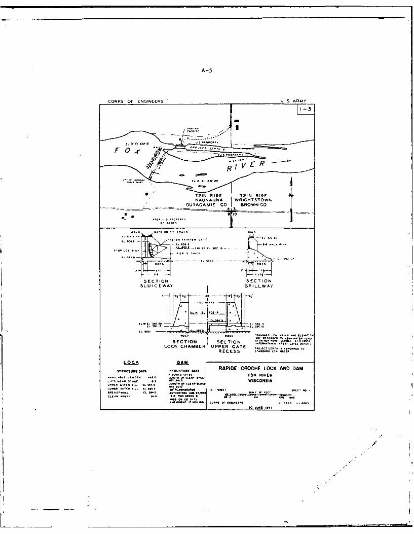
A-5
CORPS OF ENGINEERS U S ARMY
R'I' V E R i
,'T21N R19E T21N R19E
AS UAKANAJ R.HT - -REA S UIATER GAI O RWC 640
(,5935- so. 9- . .'TO LOG -1..LQ.u -,., " r, 6o02.5 .....
PIT I1 I~
I- L 5 -~ - -ROC ,1 a
SECTION SECTIONSLU IC EWAY SPILLW AY
mOC I STARA LOW ATER AND ILE TIOWj . [ARE E TO t.. ATE w l t vL
SECTION S C IN A TI ORIORE -,1IIATIOATINL GREAT LAPI I AII5
LOCK CHAMBER UPPER GATE KKOA(CT 3 AtKCRCO TO
RO DAM$S s+*o* .w,€
STRUCTURE DATA STRUCTURE DATA RAPIDE CROCHE LOCK AND DAM4 SLUICE GATES FOX RIVER
A~I ILOll LENGTH 1*l + LENGTH OF CLEAR SPILL-L,, ,u. CAN = o$' AGE 3 WY ,31' WISCONSINu..tll .'It*N S_ EL P qi4 5 0KTK OP CLIL g.LOWER ITITER SILL EL S 5 SIS W LAOROM IK IT S1.CT KND60EASTWALL IL 505 A OUR,0IEEK 'U IT, -ECLEA. 01 .o It D 710 ltK[I 9 - m= K . . -3KK A
AItI o SIT IA.REOEC ' , "o I CORPS m0 EKGINEERS L+-IlAo ILLINOIS
30 JUNE I97I
A-6
VN
-I "'
tt\ N. -~
r
;c~ / ~
I "J~
- . 0
- V
/ .Q ,,
K ~;.. /
N>
~X7] [~1Li
* t~A~ ~II11WLiD777Thfl
/ (I
11 1.~0~..
-. ..
A- 7
CORPS Of EN4GINEERS U~A4
U.S. CORPS of ENGINS /FOX RIVER AREA OFFiCE
I? r
/q/
COP of ImmtsCIAO I.mi30SE.19'
A~8
j4. I
t. +,
1 41
1.1
26Ny R JJj
THIS &G I9 BE-, ( AL
A..9
0a* zj x
cr--
CL a
tJto-r zoz
I-
0 ,v3,
w If V
3 4A iu )D
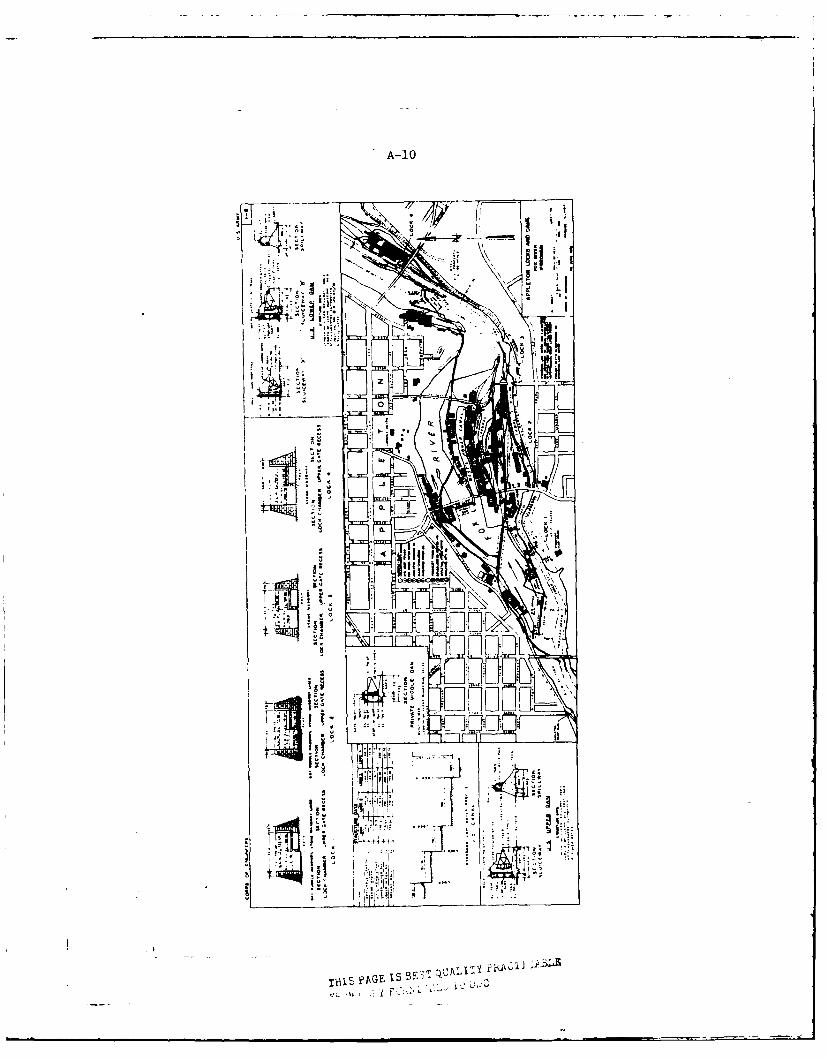
A-10
ilzI
~4i r
IVIS FAGE IS E~
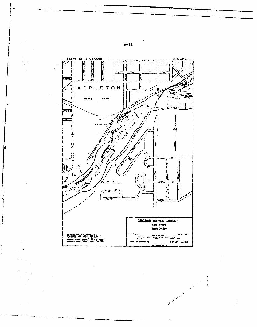
A-II
CORPS Of ENGINEERS U. S ARMY- ,oo~rn _-t
A PP LE TO0N Cow{iIPIERCE PARK ". '
I .....---. 1
S , / / .
/ /
,AO,
1S-/ '___
75',
GRIGNON RAPIDS CHANNELFOX RIVER
of oWtat To1 No I
MYN ON T .A *KKC.VI 1 . LV11111 9 aI~ "a1PI O1 1I II(NIC;e M %I101
II
SUMMATIONAL ~ *MA /~lDYM OP F(GNtl co ILNI
)Q AM 1117
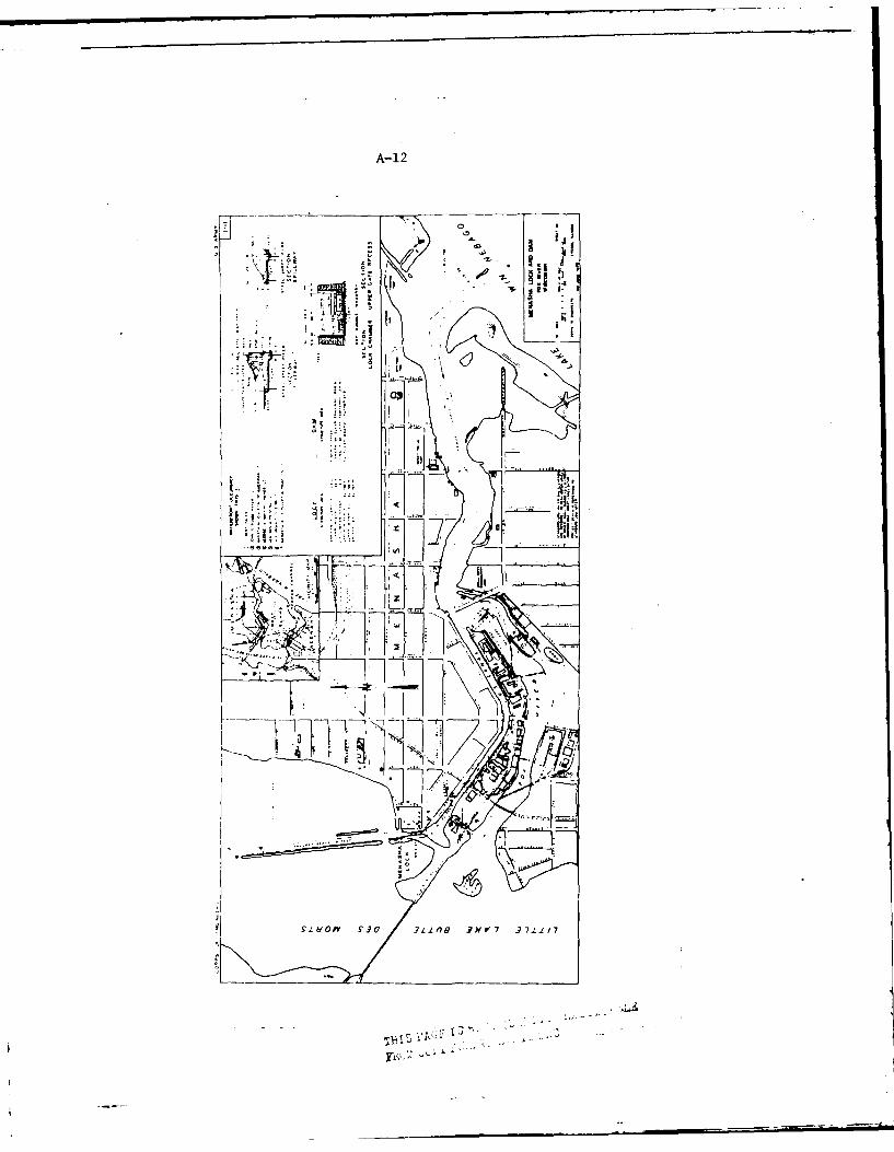
A-1 2
01
IN j 4I
g.,e m v ~ -,i.,n -?M 7 3 11
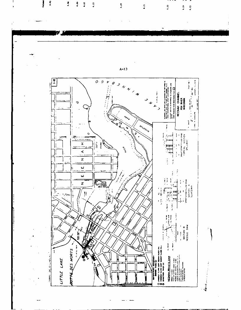
A-1 3
4,
-A
2z
-*
j.j1I 1-7-7
A- 14
WOLF RIVER MAPNEW LONDON TO FREMONT
I MILE
,2 GE
1,IOU
70
A9- -MAN CHANNEL
A-15
wnfivO S3)6VI 1V3UV IVNOIiVNH31NI 3AOSV SNOIIVA313
__________ &3AINXOJ v
D 0
oxo-
I 0 3 ..
o 0-
0--
00~
z x z
WSHSNI
ox x
"I . I -
2.21
z
0. I-0.
ONINVIVIM
~3AW j0A
~0 HilO~ ____ !alai_
UN, B
A- 16
I a
I LU k iA!7
'NI
'4
Ilei
AI I I
'A ':
i,-~, N "-
- -I
2 *N
° ; -\ \:/ "I
~ N
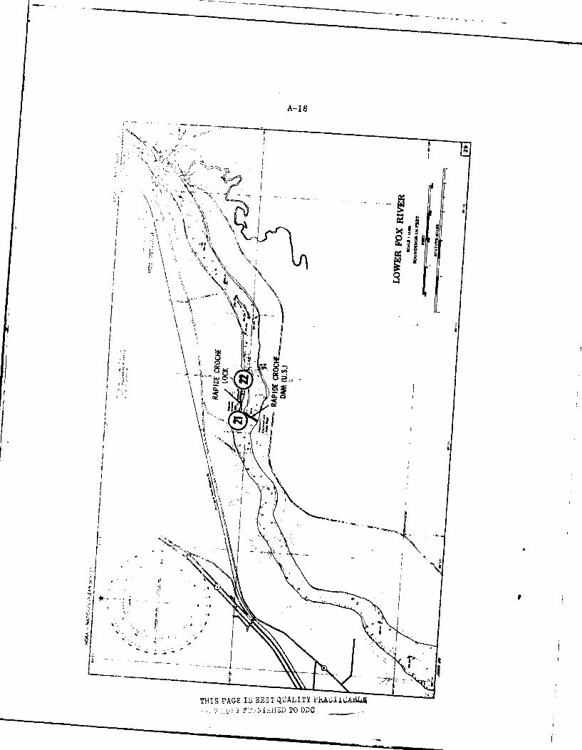
A-18
1'71
ej
/w
T141SrAGE S BES qUII EIiA6I - DT C
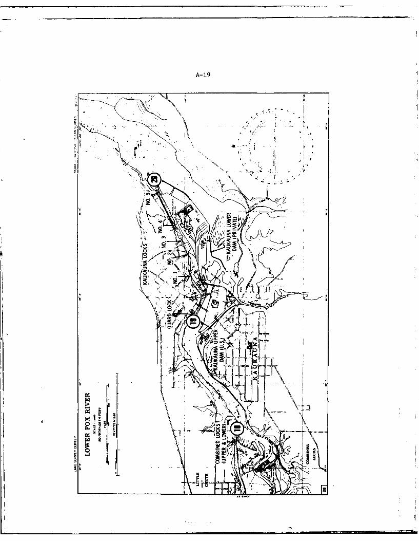
A-19
k kill
imle
beU
IM
L4 _N
0 1ru In g af
rN
CL
FA
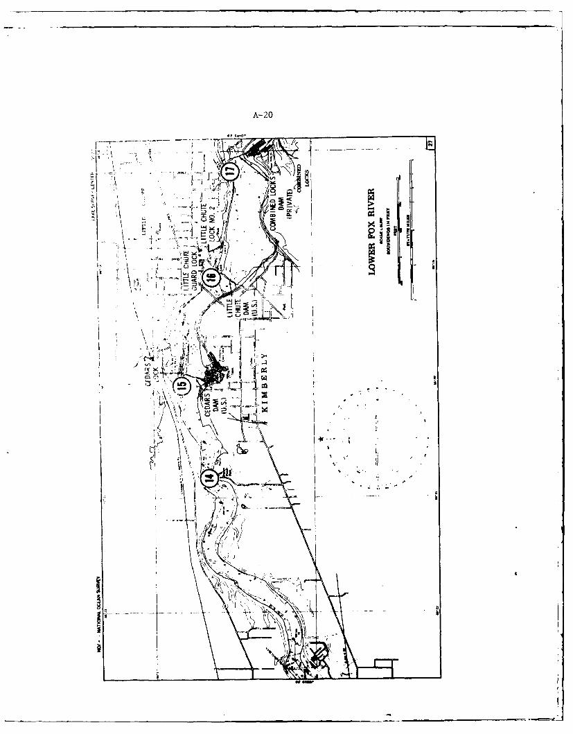
A- 20
Ior'II
.r 4AI-
I! ~ ~ -of
..... .
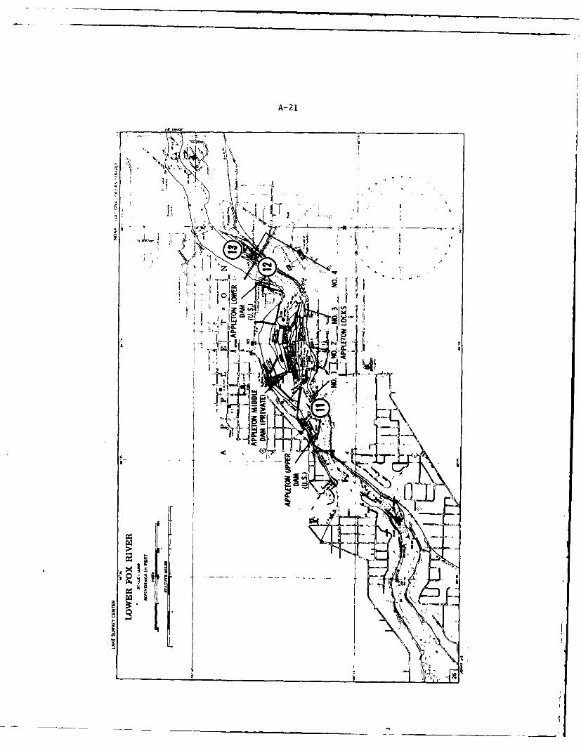
A-2 1
JJL
4 94
rL -
4,L
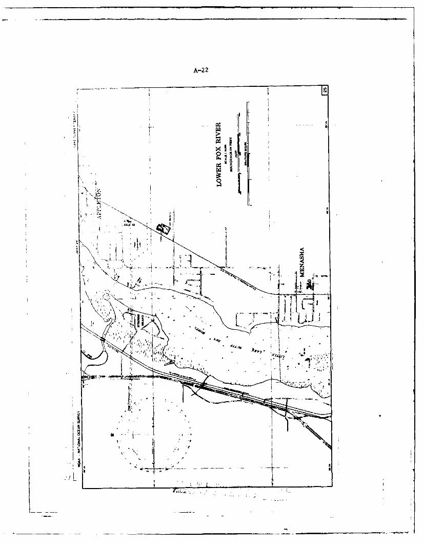
A-2 2
r4- I
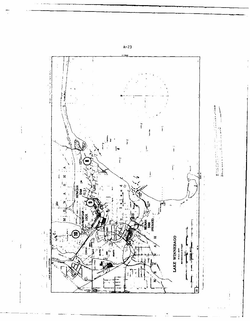
A- 23
q,;/
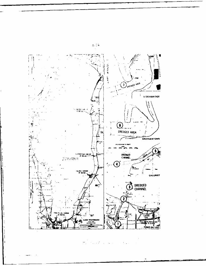
A 4
//
b!OCKBAIDGE
' IDG ) ARE'
: IMNDINUIf -NM"-
'ol,. '-. "" ,
*._-i r DREDGED A A
I.-' ..-.., BROTHERTOW N4
". \' - -
! ,-.... NI LCHANNNE
CAL W"
* CALUMET
- I. . DREDGEDA~ ~CHANNEL
'I . .m mm- -- "
I FON *t L('K~gOFI dee.
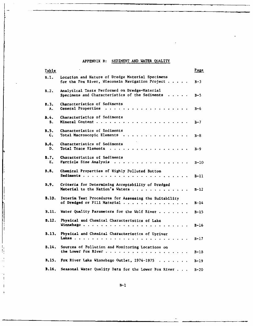
APPENDIX B: SEDIMENT AND WATER QUALITY
Table Page
B.I. Location and Nature of Dredge Material Specimensfor the Fox River, Wisconsin Navigation Project .. ..... B-3
B.2. Analytical Tests Performed on Dredge-MaterialSpecimens and Characteristics of the Sediments ..... . B-5
B.3. Characteristics of SedimentsA. General Properties ....... ..................... B-6
B.4. Characteristics of SedimentsB. Mineral Content ........ ..................... ... B-7
B.5. Characteristics of SedimentsC. Total Macroscopic Elements ..... ............... ... B-8
B.6. Characteristics of SedimentsD. Total Trace Elements ....... .................. ... B-9
B.7. Characteristics of SedimentsE. Particle Size Analysis ....... ................ ... B-10
B.8. Chemical Properties of Highly Polluted BottomSediments ......... ........................ ... B-i1
B.9. Criteria for Determining Acceptability of DredgedMaterial to the Nation's Waters .... ............. ... B-12
B.10. Interim Test Procedures for Assessing the Suitability
of Dredged or Fill Material .... ............... .... B-14
B.11. Water Quality Parameters for the Wolf River ......... ... B-15
B.12. Physical and Chemical Characteristics of LakeWinnebago .......... ........................ ... B-16
B.13. Physical and Chemical Characteristics of UpriverLakes .......... .......................... ... B-17
B.14. Sources of Pollution and Monitoring Locations on
the Lower Fox River ....... ................... ... B-1
B.15. Fox River Lake Winnebago Outlet, 1974-1975 . ....... . B-19
B.16. Seasonal Water Quality Data for the Lower Fox River . . . B-20
B-i
B-2
Table Page
B.17. Water Quality of the Fox River at Wrightstown ........ ... B-21
3.18. Final Permit Loadings for Lower Fox River WasteSources .......... ......................... ... B-23
B.19; Industrial Waste Loadings ...... ................ ... B-24
3.20. Chemical Analyses of Water Samples from Five SelectedLower Fox River Sludge Beds ..... ............... ... B-26
B.21. Trace Metal Concentration of Three Sludge Samples Froma Sludge Bed on the Lower For River ... ........... ... B-27
B-3
Table B.I. Location and Nature of Dredge Material Specimens
for the Fox River, Wisconsin Navigation Project
SpecimenNo.a Location Nature of Sample
1 Fond du Lac River, 500 ft Black silt
downstream from U.S. 45,channel center
2 Fond du Lac River, channel Sand, silt leaves, organic
mouth and center matter, blackish color
3 Fond du Lac River channel Black silt with about 2 cm
about 1600 ft into lake oxidized layer on top.Strong sulfide odor
4 Calumet Harbor channel, Medium sand with pieces of
600 ft offshore organic debris
5 Calumet Harbor channel Dark brown to blackopposite boat dock organic silt
6 Brothertown Harbor-Lake Silt, clay, sticks andWinnebago between buoys leavesoutside of harbor
7 Stockbridge Harbor-Lake Sand, silt, some organicWinnebago, 20 yds out material and gravelfrom entrance
8 Lower Fox River Menasha Hard bottom - no samplechannel between buoys93-94 and 95-96
9 Menasha channel, above Rocks, sand and pebblesStrang Paper6Co.
10 Little Lake Butte des Morts Organic silt, gas re-between two islands, about leases, fibers present1000 ft below lock
11 Fox River, 100 ft above Black organic silt and#1 lock at Appleton sand. Bloodworm present
12 Fox River, 600ft above Sand, large and smallCollege Ave. bridie, gravelAppleton
13 Fox River, 600 ft below Sand pebbles and gravel,#4 lock some organic
14 Fox River, Mid Channel No sample - hard bottom
off Sunset Point
15 Fox River, 400 ft above Black silt, high organic,
Cedars lock, Kimberly sulfide odor
16 Fox River, 150 ft above Black silt, high organic,guard lock, Little Chute fibrous material
B-4
Table B.I. Continued
SpecimenNo. a Location Nature of Sample
17 Fox River, foot of Buchanan Black silt and organicSt., Little Chute material
18 Fox River, Exit channel No sample - hard bottomof Combined Locks
19 Fox River, 100 ft above Blackish silt, sticks andguard lock, Kaukauna leaves
20 Fox River, 600 ft below lock Black silt, high organic,#5, Kaukauna. Below outfall paper scraps and gas re-from Thimony Paper Co. lease and sulfide odorsettling pond from bottom
21 Fox River, 500 ft above Black silt and highRapid Croche lock organic
22 Fox River, 800 ft below Very fine organic silt,Rapid Croche lock fibers and sticks.
Sulfide odor
23 Fox River, 400 ft above Black silt, very fine organ-Little Kaukauna lock ic material, gas release
24 Fox River, 150 ft below Sand, gravel and stickslock at 8 St.-De Pere
25 North intersection of Fine sand with small amount
Boom Cut and Wolf River of organic debris
26 Wolf River MP 34 above Clean sand with a fewReu Banks shells and detritus
27 Wolf River below Devils Clean sand
Elbow, ca. milepost 43
28 Wolf River, Shaw Landing Coarse sand
29 Wolf River, below entrance Coarse sand and gravel,of Little Wolf River sticks and bark
30 Wolf River below New London Medium to fine sand, someYacht Club ca. milepost 53 detritus
aThe specimen number is shown on the maps in Appendix A of thisreport at the location where the specimen was taken.
B-5
Table B.2. Analytical Tests Performed onDredge-Material Specimens and
Characteristics of the Sediments
TESTS PERFORMED
A. General Properties
1. Percent solids2. pH3. Conductivity (total salt content)4. Weight loss on ignition (500*C)
5. Organic carbon (COD)6. Organic nitrogen7. Nitrate nitrogen8. Ammonium nitrogen9. Oil and grease
B. Mineral Content
10. Exchangeable Ca, Mg, Na11. Available P, K, B, Mn, Zn, Cu, SO4-S
C. Total Macroscopic Elements
12. P, K, Ca, Mg, Na, Al, Fe
D. Total Trace Elements
13. B, Sr, B, Cu, Zn, Mn, Cr, Hg, Pb
E. Particle Size Analysis
14. Sand, silt, clay, and sieve analyses
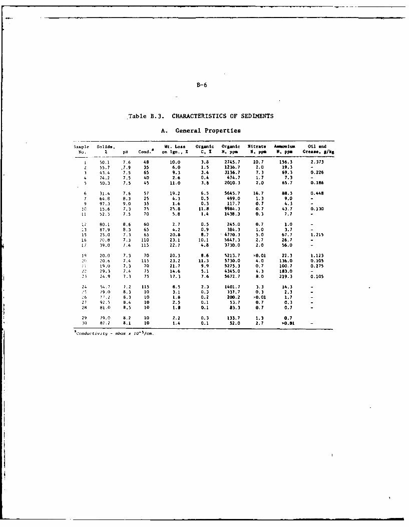
B-6
Table B.3. CHARACTERISTICS OF SEDIMENTS
A. General Properties
San,ple Solids, Wt. Loss Organic Organic Nitrate Amonium Oil andNo. % pH Cond.a on Ign., Z C, 2 N, ppm N, ppm N, pp. Grease, s/kg
1 50.1 7.6 48 10.0 3.8 2745.7 10.7 156.3 2.373
2 55.7 .7.9 35 6.0 1.5 1236.7 2.0 19.3 -
3 43.4 7.5 65 9.3 3.4 3136.7 7.3 69.3 0.226
4 74.2 7.5 40 2.6 0.4 474.7 1.7 7.3 -
5 50.3 7.5 45 11.0 3.6 2010.3 2.0 65.7 0.186
6 31.4 7.6 57 19.2 6.5 5645.7 16.7 88.3 0.4487 64.8 8.3 25 4.3 0.5 499.0 1.3 9.0 -
9 97.3 9.0 35 1.6 0.3 117.7 0.7 4.3 -
10 15.6 7.3 75 25.8 11.8 9984.3 0.7 43.7 0.13011 52.3 7.5 70 5.8 1.4 1438.3 0.3 7.7 -
12 80.1 8.6 60 2.7 0.5 245.0 0.7 1.0 -
13 87.9 8.3 65 4.2 0.9 384.3 1.0 3.7 -
15 25.0 7.3 65 20.8 8.7 4770.3 5.0 67.7 1.21516 20.8 7.3 110 23.1 10.1 5647.3 2.7 26.7 -
11 39.0 7.4 115 22.7 4.8 3730.0 2.0 56.0 -
lq 20.0 7.3 70 20.3 8.6 5213.7 >0.01 22.3 1.1232( 20.6 7.4 115 23.2 11.3 5730.0 4.0 136.0 0.105
i1 19.0 7.3 70 21.7 9.9 5275.3 0.7 100.7 0.27522 29.3 7.4 75 14.6 5.1 4345.0 4.3 183.0 -
21 24.9 7.3 75 17.3 7.6 5672.7 8.0 219.3 0.105
24 54.7 7,2 115 8.5 2.3 1401.7 3.3 14.3 -
25 79.0 8.3 10 3.1 0.3 337.7 0.3 2.3 -
:6 77.2 8.3 10 1.8 0.2 200.2 0.01 1.7 -
27 92.5 8.4 10 2.5 0.1 53.7 0.7 0.3 -
28 81.0 8.5 10 1.8 0.1 83.3 0.7 0.7 -
29 79.0 8.2 10 2.2 0.3 133.7 1.3 0.730 82.2 8.1 10 1.4 0.1 52.0 2.7 0.01 -
Conductivityg - mhos x 1O-5/cm.
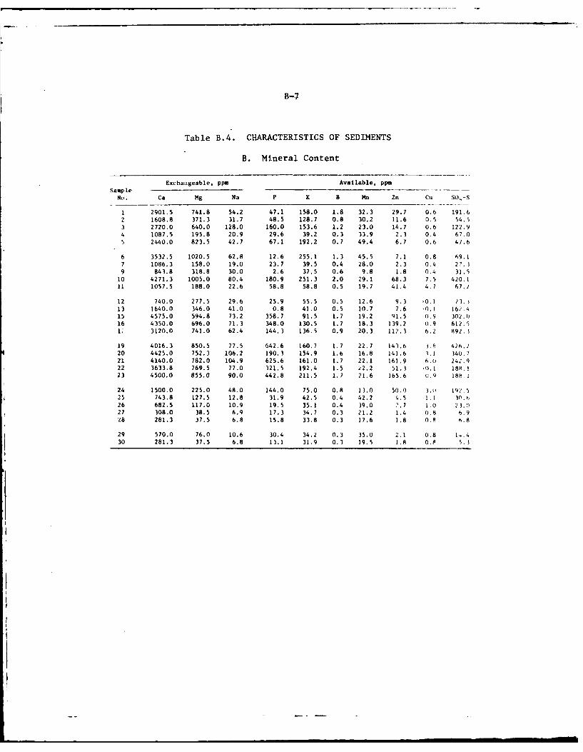
B-7
Table B.4. CHARACTERISTICS OF SEDIMENTS
B. Mineral Content
Exchatigeable. ppm Available, ppmSample
No. Ca Mg Na P K B Mn Zn Cu S0-S
1 2901.5 741.8 54.2 47.1 158.0 1.8 32.3 29.7 0.6 191.6
2 1608.8 371.3 31.7 48.5 128.7 0.8 30.2 11.6 0.5 54.5
3 2720.0 640.0 128.0 160.0 153.6 1.2 23.0 14.7 0.6 122.9
4 1087.5 195.8 20.9 29.6 39.2 0.3 33.9 2.3 0.4 67.05 2440.0 823.5 42.7 67.1 192.2 0.7 49.4 6.7 0.6 47.6
6 3532.5 1020.5 62.8 12.6 255.1 1.3 45.5 7.1 0.8 69.1
7 1086.3 158.0 19.0 23.7 39.5 0.4 28.0 2.3 0.4 27.
9 843.8 318.8 30.0 2.6 37.5 0.6 9.8 1.8 0.4 31.510 4271.3 1005.0 80.4 180.9 251.3 2.0 29.1 68.3 7.5 420.1
11 1057.5 188.0 22.6 58.8 58.8 0.5 19.7 41.4 4.7 67.2
12 740.0 277.5 29.6 25.9 55.5 0.5 12.6 9.3 0.1 13.j13 1640.0 346.0 41.0 0.8 41.0 0.5 10.7 7.6 .0.! 162.415 4575.0 594.8 73.2 358.7 91.5 1.7 19.2 91.5 0.9 302.0
16 4350.0 696.0 71.3 348.0 130.5 1.7 18.3 139.2 0.9 612.5
U 3120.0 741.0 62.4 144.3 136.5 0.9 20.3 112.3 6.2 892.1
19 4016.3 850.5 77.5 642.6 160.7 1.7 22.7 143.6 3.8 426.2
20 4425.0 752.3 106.2 190.3 154.9 1.6 16.8 141.6 1.1 340.721 4140.0 782.0 104.9 625.6 161.0 1.7 22.1 161.9 6.( 242.9
22 3633.8 769.5 77.0 321.5 192.4 1.5 22.2 51.1 '0.1 188.!
23 4500.0 855.0 90.0 442.8 211.5 1.2 21.6 165.6 o.9 188 1
24 1500.0 225.0 48.0 144.0 75.0 0.8 13.0 50.0 3.o 191.525 743.8 127.5 12.8 31.9 42.5 0.4 42.2 4.5 1.1 30.6
26 682.5 117.0 10.9 19.5 35.1 0.4 39.0 2.7 1.0 23.0
27 308.0 38.5 6.9 17.3 34.7 0.3 21.2 1.4 0.8 6.928 281.3 37.5 6.8 15.8 33.8 0.3 17.6 1.8 0.8 6.8
29 570.0 76.0 10.6 30.4 34.2 0.3 35.0 2.1 0.8 14.430 281.3 37.5 6.8 13.1 31.9 0.3 19.5 1.8 0.8 5.3
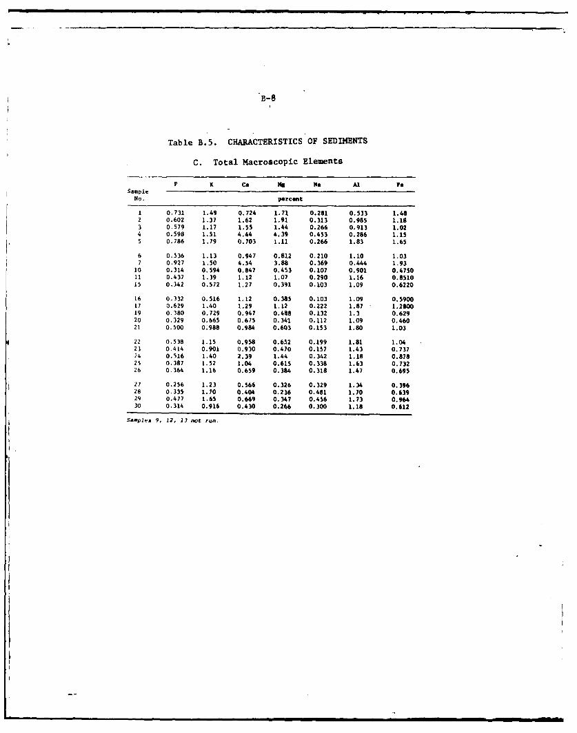
B-8
Table B.5. CHARACTERISTICS OF SEDIMENTS
C. Total Macroscopic Elements
P K Ca ,s Na Al yeSample
No. Parcent
1 0.731 1.49 0.724 1.71 0.281 0.533 1.482 0.602 1.37 1.62 1.91 0.313 0.985 1.183 0.579 1.17 1.55 1.44 0.266 0.913 1.024 0.598 1.51 4.44 4.39 0.453 0.286 1.155 0.786 1.79 0.703 1.11 0.266 1.83 1.65
6 0.536 1.13 0.947 0.812 0.210 1.10 1.037 0.927 1.50 4.54 3.88 0.369 0.444 1.93
10 0.314 0.594 0.847 0.453 0.107 0.901 0.475011 0.437 1.39 1.12 1.07 0.290 1.16 0.851015 0.342 0.572 1.27 0.391 0.103 1.09 0.6220
16 0.332 0.516 1.12 0.385 0.103 1.09 0.590017 0.629 1.40 1.29 1.12 0.222 1.87 1.280019 0.380 0.729 0.947 0.488 0.132 1.3 0.62920 0.329 0.665 0.675 0.341 0.112 1.09 0.46021 0.500 0.988 0.984 0.603 0.153 1.80 1.03
22 0.538 1.15 0.958 0.652 0.199 1.81 1.0423 0.414 0.901 0.930 0.470 0.157 1.43 0.73724 0.516 1.40 2.39 1.44 0.342 1.18 0.87825 0.387 1.52 1.04 0.615 0.338 1.63 0.73226 0.364 1.16 0.659 0.384 0.318 1.47 0.695
27 0.256 1.23 0.566 0.326 0.329 1.34 0.39628 0.335 1.70 0.404 0.236 0.481 1.70 0.63929 0.477 1.65 0.669 0.347 0.456 1.73 0.96430 0.314 0.916 0.430 0.266 0.300 1.18 0.612
Samples 9, 12, 13 not run.
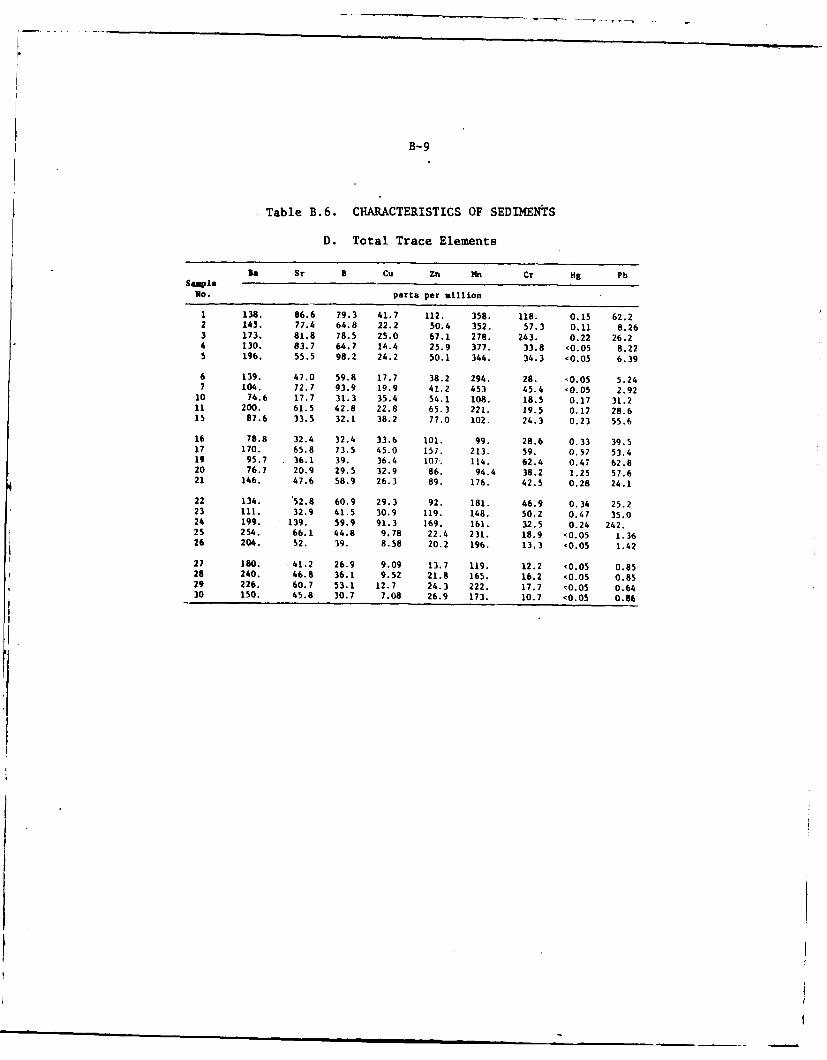
B-9
Table B.6. CHARACTERISTICS OF SEDIMENTS
D. Total Trace Elements
S l Sr B Cu Zn YM Cr Hg PbSampleNo. parts per million
1 138. 86.6 79.3 41.7 112. 358. 118. 0.15 62.22 145. 77.4 64.8 22.2 50.4 352. 57.3 0.11 8.263 173. 81.8 78.5 25.0 67.1 278. 243. 0.22 26.24 130, 83.7 64.7 14.4 25.9 377. 33.8 <0.05 8.225 196. 55.5 98.2 24.2 50.1 344. 34.3 <0.05 6.39
6 139. 47.0 59.8 17.7 38.2 294. 28. <0.05 5.247 104. 72.7 93.9 19.9 41.2 453 45.4 <0.05 2.92
10 74.6 17.7 31.3 35.4 54.1 108. 18.5 0.17 31.211 200. 61.5 42.8 22.8 65.3 221. 19.5 0.17 28.615 87.6 33.5 32.1 38.2 77.0 102. 24.3 0.23 55.6
16 78.8 32.4 32.4 33.6 101. 99. 28.6 0.33 39.517 170. 65.8 73.5 45.0 157. 213. 59. 0.57 53.419 95.7 36.1 39. 36.4 107. 114. 62.4 0.47 62.820 76.7 20.9 29.5 32.9 86. 94.4 38.2 1.25 57.621 146. 47.6 58.9 26.3 89, 176. 42.5 0.28 24.1
22 134. 52.8 60.9 29.3 92. 181. 46.9 0.34 25.223 111. 32.9 41.5 30.9 119. 148. 50.2 0.47 35.024 199. 139. 59.9 91.3 169. 161. 32.5 0.24 242.25 254. 66.1 44.8 9.78 22.4 231. 18.9 '0.05 1.3626 204. 52. 39. 8.58 20.2 196. 13.3 '0.05 1.42
27 180. 41.2 26.9 9.09 13.7 119. 12.2 <0.05 0.8528 240. 46.8 36.1 9.52 21.8 165. 16.2 <0.05 0.8529 226. 60.7 53.1 12.7 24.3 222. 17.7 <0.05 0.6430 150. 45.8 30.7 7.08 26.9 173. 10.7 <0.05 0.86
I I
B-1O
Tab ie B.7. CHARACTERISTICS OF SEDIMENTS
E. Particle Size Analysis
Sample Sand, % Silt, % Clay, ZNo. (0.05-2 ,m) (0.002-0.05 m) (<0.002 mm)
1 20 48 32
2 67 21 123 35 44 204 53 44 35 34 36 30
b 8 66 267 91 6 39 * * *
10 23 63 14
11 87 8 5
12 * * *13 * * *15 43 44 1316 47 41 1217 23 58 19
19 36 46 1820 31 55 1421 37 48 1522 1 63 3623 28 46 26
24 92 6 225 93 5 226 94 4 227 99 1 028 100 0 0
29 96 2 2
30 100 0 0
Sieve Analyses of Samples 9, 12 and 13a
Percent Passing
Sample >2380v 2380p 840u 250ji 149p
No. sieve, % sieve sieve sieve sieve
9 98.6 1.4 0.7 0.3 0.112 68.7 31.3 11.0 2.0 0.913 92.1 7.9 3.1 0.9 0.5
aBecause of the stoniness of these samples, sieve analyses wereperformed.
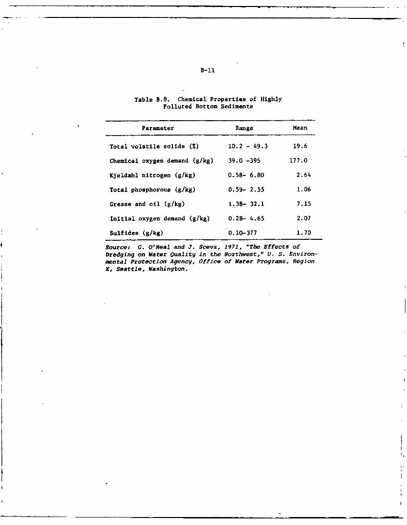
B-I
Table B.8. Chemical Properties of HighlyPolluted Bottom Sediments
Parameter Range Mean
Total volatile solids MX) 10.2 - 49.3 19.6
Chemical oxygen demand (g/kg) 39.0 -395 177.0
Kjeldahl nitrogen (g/kg) 0.58- 6.80 2.64
Total phosphorous (g/kg) 0.59- 2.55 1.06
Grease and oil (g/kg) 1.38- 32.1 7.15
Initial oxygen demand (g/kg) 0.28- 4.65 2.07
Sulfides (g/kg) 0.10-377 1.70
Source: G. ONeal and J. Sceva, 1971, "The Effects ofDredging on Water Quality in the Northwest," U. S. Environ-mental Protection Agency, Office of Water Programs, RegionX, Seattle, Washington.
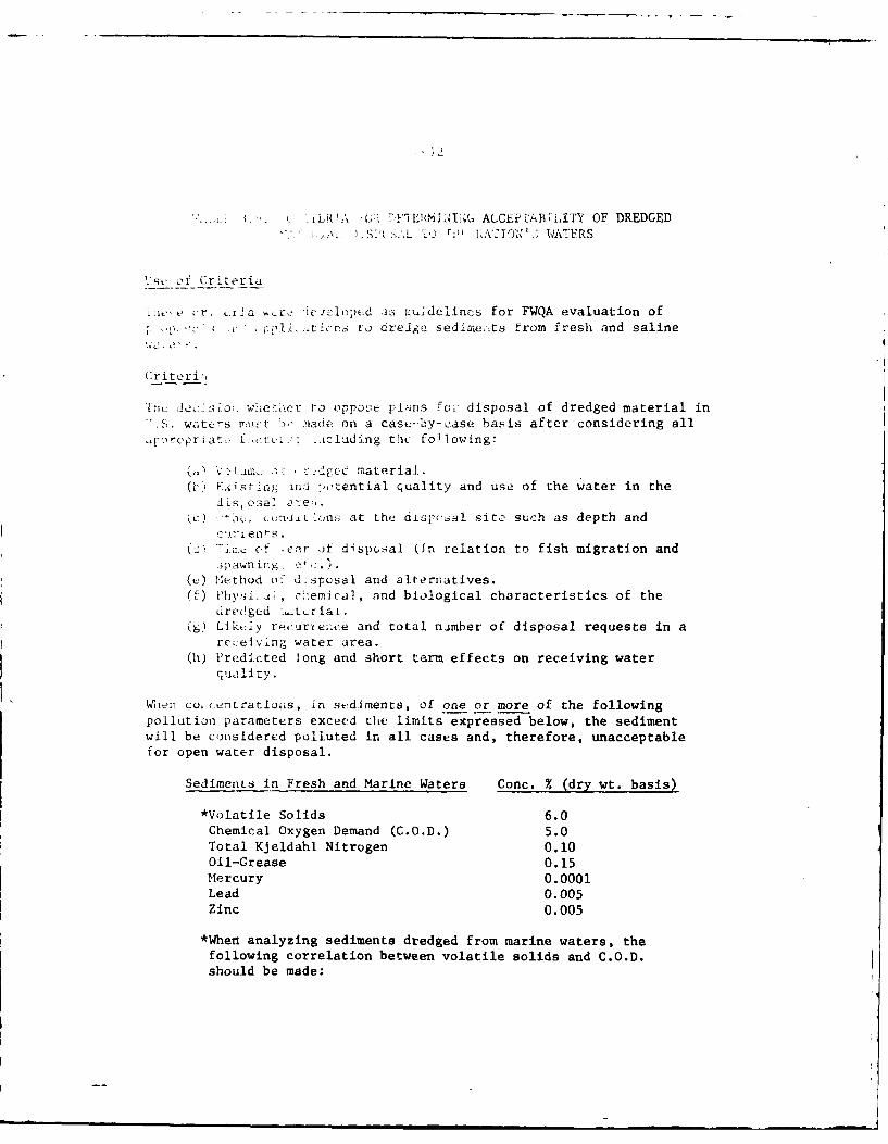
,,: .L\ . 'TEN I ACCEPTAB~IITY OF DREDGED1' •,,,\L . JO WATFRS
1'se -of Criteria
iice.r. L-i 'a m Ic-oped ;as - dclincs for FWQA evaluation of2.Lp 'li,,tIcrs to dreJg, sedime;-ts from fresh and saline
Criteri-,
'Iis. da~fio;: waet'r to oppose plPns fu, disposal of dredged material in2 .. waters rtust. >t .!iade on a case--by-case basis after considering all,fprcpriat: r,.~:: .acluding the fo~lowing:
(. V 2 c1 c i a c material.(') F.intr: ma ".-. ential quality and use of the water in the
3dts, osa] are;..
) . ck uni *onu at the diispoal site such as depth andc 'i- ien~s
(V> ".', , f .ear it disposal kn relation to fish migration and.3pawnir. ' :.)
( ) Method o d-sposal and alternatives.(f) Phy,3i_..t, c emical, and biological characteristics of the
uredged -.-_tria-L.
() Likt iy recurei.ce and total nimber of disposal requests in arc .efving water area.
(h) Predicted long and short term effects on receiving waterquality.
Wien c,, centratio,s, in sediments, of one or more of the followingpollution parameters exceed the limits expressed below, the sedimentwill be considered polluted in all cases and, therefore, unacceptablefor open water disposal.
Sediments in Fresh and Marine Waters Conc. % (dry wt. basis)
*Volatile Solids 6.0Chemical Oxygen Demand (C.O.D.) 5.0
Total KJeldahl Nitrogen 0.10Oil-Grease 0.15
Mercury 0.0001Lead 0.005Zinc 0.005
*When analyzing sediments dredged from marine waters, the
following correlation between volatile solids and C.O.D.should be made:
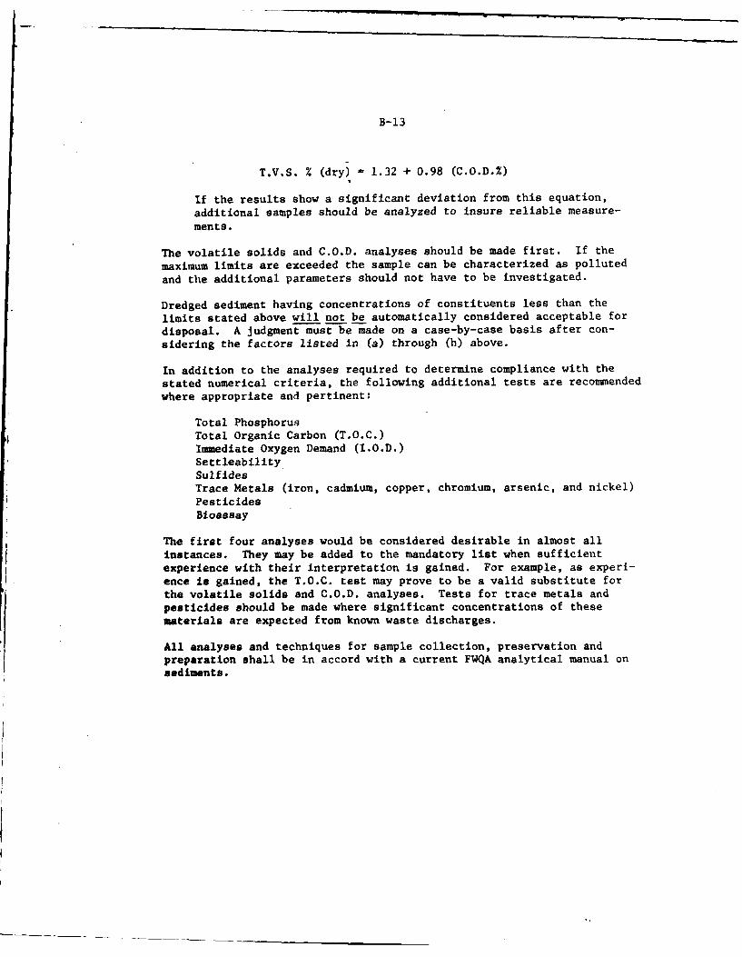
B-13
T.V.S. % (dry) 1.32 + 0.98 (C.O.D.%)
If the results show a significant deviation from this equation,
additional samples should be analyzed to insure reliable measure-
ments.
The volatile solids and C.O.D. analyses should be made first. If the
maximum limits are exceeded the sample can be characterized as polluted
and the additional parameters should not have to be investigated.
Dredged sediment having concentrations of constituents less than the
limits stated above will not be automatically considered acceptable for
disposal. A judgment must be made on a case-by-case basis after con-
sidering the factors listed in (a) through (h) above.
In addition to the analyses required to determine compliance with the
stated numerical criteria, the following additional tests are recommended
where appropriate and pertinent:
Total Phosphorus
Total Organic Carbon (T.O.C.)Immediate Oxygen Demand (I.O.D.)Settleability
SulfidesTrace Metals (iron, cadmium, copper, chromium, arsenic, and nickel)PesticidesBioassay
The first four analyses would be considered desirable in almost all
instances. They may be added to the mandatory list when sufficient
experience with their interpretation is gained. For example, as experi-
ence is gained, the T.O.C. test may prove to be a valid substitute for
the volatile solids and C.O.D. analyses. Tests for trace metals andpesticides should be made where significant concentrations of thesematerials are expected from known waste discharges.
All analyses and techniques for sample collection, preservation and
preparation shall be in accord with a current FWQA analytical manual onsediments.
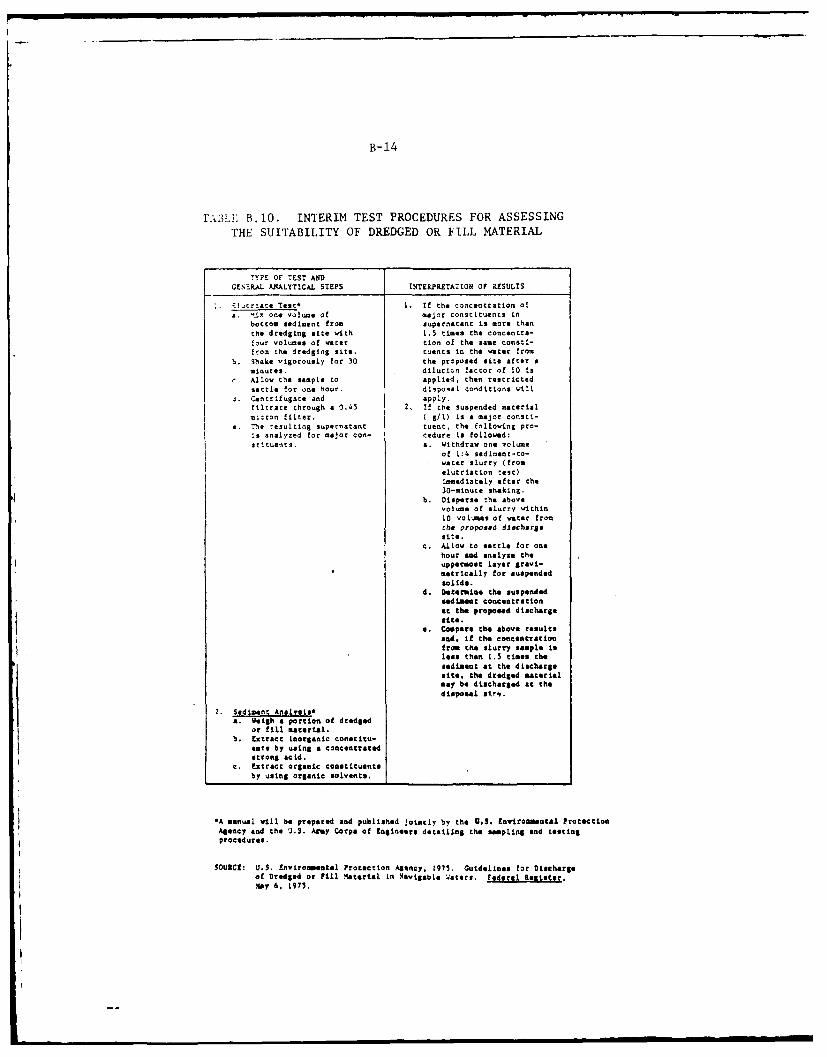
B- 14
BhLE1.10. INTERIM TEST PROCEDURES FOR ASSESSING
THE SUITABILITY OF DREDGED OR FILL MATERIAL
7YPE OF TST ANDGENERAL. AN4ALYTICAL STEPS 14TELPILETATION4 Or RESULTS
1~t~t et . If the concentration o!
a. 'tiX Oo volume of major constituents inbottom sediment from supernatant is nore thanthe dredging site with 1.5 times the concentr*-four volumes of water tion of the same consti-from the dredging site. tuents in Cho water from
h. Shake vigorously for 30 the proposed site after aminutes. dilution factor of 10 is
C. Allow the sample to applied, then restrictedsettle for one hour. disposal conditions ill
3. Cantrifugate and apply.filtrate through a 0.45 2. If the suspended materialmi:ron filter. ( g/1) is a major consti-
e. The resulting supernatant tuent, the following pro-is analyzed for major con- cedure is followed:stituents. a. Withdraw one violume
of L!4 sediment-to-water slurry (fromslutriation tae)immediately after the30-minute shaking.
4b. lisperse t he abovevolume of slurry within10 volumes of water fromthe proposed dlacharas
sits.c.Allow to settle for onehour andtanalyze theuppermost layer gravi-metrically for suspendedsolids.
d. Determine the suspendedsediment concentrationat the propoeed discharge
.Compare the above results&ad, if the concentrationfrom the slurry sample isless than 1.5 times thesedimeot at the dischargesite, the dredged materialmay be discharged at thedispo"sal r-p.
2. Sediment Analysis*a.Weigh a portion of dredged
or fill material.b. Extract inorganic constitu-
etby using a concentratedstrong acid.
c. Extract organic constituentsby using organic solvents.
*A manual will be prepared and published jointly by the U.S. Environsmental ProtectionAgency and the U.S. Army Corps of Engineers detailing the sampling end testingprocedures.
SOURCE: U.S. Environmental Protection Agency, 1975. Guidelins for Dischargeof Dredged or Pill Plttrial in Navigable 'Waters. Federal Register.lay 6, 1975.
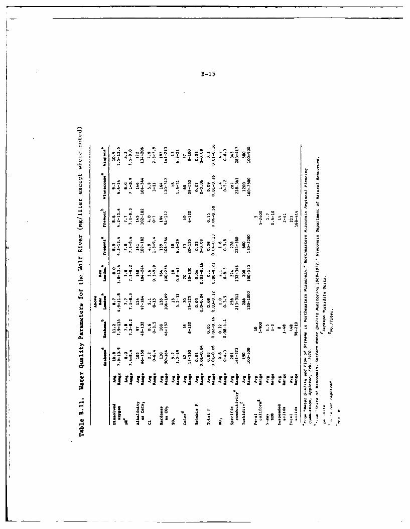
B-15
01
" 0 0 * 0 N - 0U ~ ~ ~ ~ ~ 4 1N .0 - 6 06 N 09 6 . 4
U N - .0 0 N -
44 ID4 NNSC N @40 4
w U N .0 0
0. 00
0 fA 00 N o a
p~ ~ 69 A 6 N N 0 PN
460
AD-AlOl 115 CONP OF ENGINEERS CHICAGO ILL CHICAGO DISTRICT F/6 13/2'FINAL ENVIRONMENTAL IMPACT STATEMENT RELATING To THE OPERATION -Eci? ,MAY 77
UNCLASSIFIE 1(
5. 5 mhhhh
IMENOMONEE[:]hLmhhuahhh
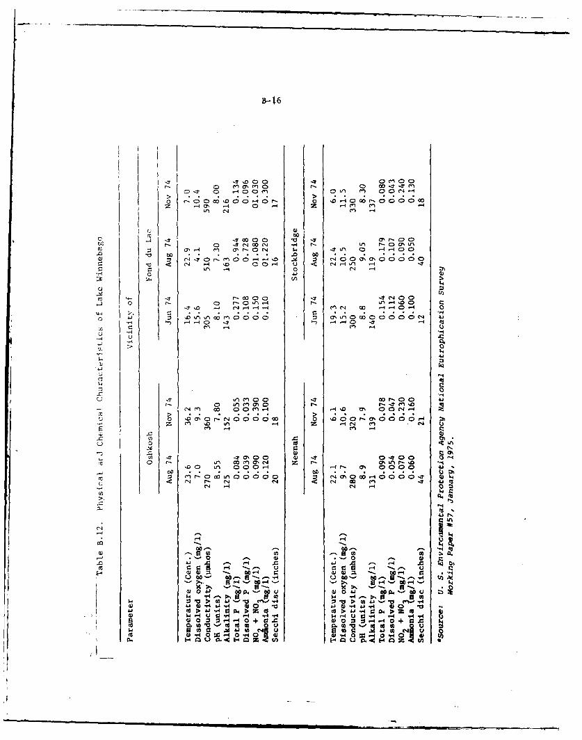
B- 16
m ON 0n .- 0 0 0110 1-0' 0-4 O- 0 a m 40 e 0OOO"O-
Z -4 11 -4 0D -4 In Cn-U-I C14fn -
'U0
0 . 4coC' .,i 4 t- Ln r-CO N Ifncu d-CJ -$Lf a -4 -4OCD
~~~) CO 8 .CCC *
v 4c C1J -I 00 -4 q Ln J'--'
tn--
UI)m-:T r- 00 -Ce40
0.A. r- 0 Ull-4 L - 00 r-,T 0 -4 14-4 -~' cn cl 00 -4O -4 0
; C* LA o o ; C- * W
~ -- ~ I-t _q - -4 0 - 4J) cn -4 C-1 C
4J
4--I
CIS~
Cq ~ ~ ~ ~ o-o en0 D n-41 D 0 4
-4n10 L -4 0 e
-- LM opena,D 4 N C 0IA4 l 0 - -4 0 0 4.)
UJ0 i 00 tj- ZU~ - 0.I; A' 8- o C14- a%' 0- o - 0 a 0 0 1-4
rji4- 00 '-0 (N4- eq co r to
UG qr&.A'4 QSO 1-.QJJy4 W
Q-w4'U 0
(U 40~~~-40,14O i4,4 ~ Q.
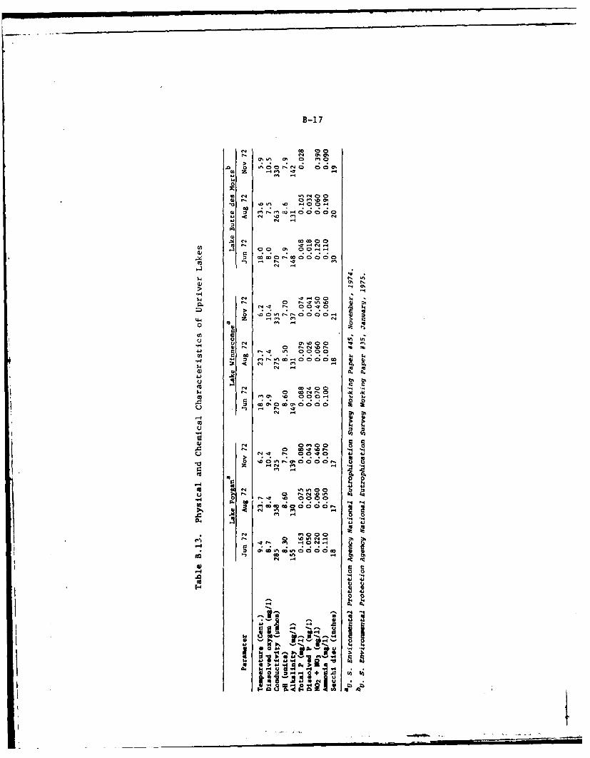
B-i 7
o CD 0In a, 0 ri 9
0 N ;809 o o0mC z DU -4 m 4
00
'm 0 en (C tt 1. 0 m
44 cN '0 en444o N -4
10
11, 3' -t 4 -4
00 0' 0 o o-o
0 I 0 1
N o 0 r- ', 0 1=0Nt? z 00-
0 to Q'C
-H U Nl 100 1-1
14 0 4 Uc 0 000C>c
w .0
u -0 tb bh
r4 ND1 0 N 0 .1~.a~0 '0 00-4 0 4 1
Ue a, %DN
0 D- - r
1-
vN 0 .10N -O Nt 00~0 41 4
r4c N4 2r
Nen 00
Q44
-44.0 a4 0 44
10.a.* Ou C,4:Z
Alt
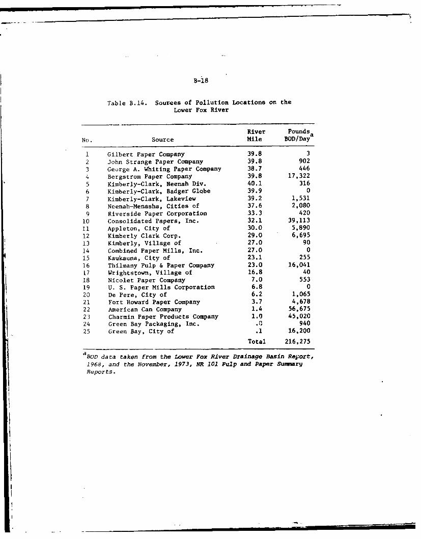
B-18
Table B.14. Sources of Pollution Locations on the
Lower Fox River
River Pounds
No. Source Mile BOD/Daya
I Gilbert Paper Company 39.8 3
2 John Strange Paper Company 39.8 902
3 George A. Whiting Paper Company 38.7 446
4 Bergstrom Paper Company 39.8 17,322
5 Kimberly-Clark, Neenah Div. 40.1 316
6 Kimberly-Clark, Badger Globe 39.9 0
7 Kimberly-Clark, Lakeview 39.2 1,531
8 Neenah-Menasha, Cities of 37.6 2,080
9 Riverside Paper Corporation 33.3 420
10 Consolidated Papers, Inc. 32.1 39,113
11 Appleton, City of 30.0 5,890
12 Kimberly Clark Corp. 29.0 6,69513 Kimberly, Village of 27.0 90
14 Combined Paper Mills, Inc. 27.0 0
15 Kaukauna, City of 23.1 25516 Thilmany Pulp & Paper Company 23.0 16,041
17 Wrightstown, Village of 16.8 40
18 Nicolet Paper Company 7.0 55319 U. S. Paper Mills Corporation 6.8 020 De Pere, City of 6.2 1,06521 Fort Howard Paper Company 3.7 4,67822 American Can Company 1.4 56,67523 Charmin Paper Products Company 1.0 45,02024 Green Bay Packaging, Inc. .2 94025 Green Bay, City of .1 16,200
Total 216,275
aBOD data taken from the Lower Fox River Drainage Basin Report,
1968, and the November, 1973, NR 101 Pulp and Paper SummaryReports.
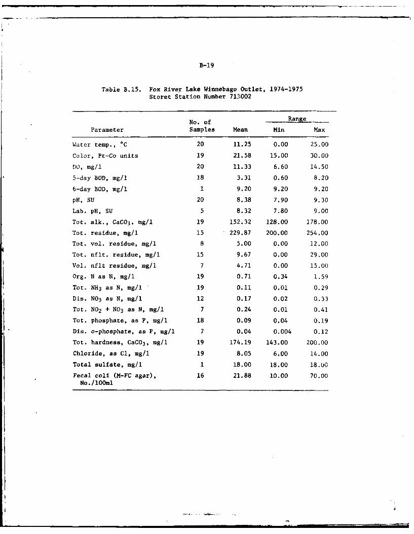
B-19
Table B.15. Fox River Lake Winnebago Outlet, 1974-1975Storet Station Number 713002
No. of Range
Parameter Samples Mean Min Max
Water temp., *C 20 11.25 0.00 25.00
Color, Pt-Co units 19 21.58 15.00 30.00
DO, mg/i 20 11.33 6.60 14.50
5-day BOD, mg/i 18 3.31 0.60 8.20
6-day BOD, mg/i 1 9.20 9.20 9.20
pH, SU 20 8.38 7.90 9.30
Lab. pH, SU 5 8.32 7.80 9.00
Tot. alk., CaCO 3, mg/l 19 152.32 128.00 178.00
Tot. residue, mg/i 15 229.87 200.00 254.00
Tot. vol. residue, mg/l 8 5.00 0.00 12.00
Tot. nflt. residue, mg/i 15 9.67 0.00 29.00
Vol. nflt residue, mg/l 7 4.71 0.00 15.00
Org. N as N, mg/1 19 0.71 0.34 1.59
Tot. NH3 as N, mg/i 19 0.11 0.01 0.29
Dis. NO3 as N, mg/1 12 0.17 0.02 0.33
Tot. NO2 + NO3 as N, mg/i 7 0.24 0.01 0.41
Tot. phosphate, as P, mg/i 18 0.09 0.04 0.19
Dis. o-phosphate, as P, mg/l 7 0.04 0.004 0.12
Tot. hardness, CaC0 3 , mg/l 19 174.19 143.00 200.00
Chloride, as Cl, mg/i 19 8.05 6.00 14.00
Total sulfate, mg/i 1 18.00 18.00 18.0
Fecal coli (M-FC agar), 16 21.88 10.00 70.00No. /lOOml
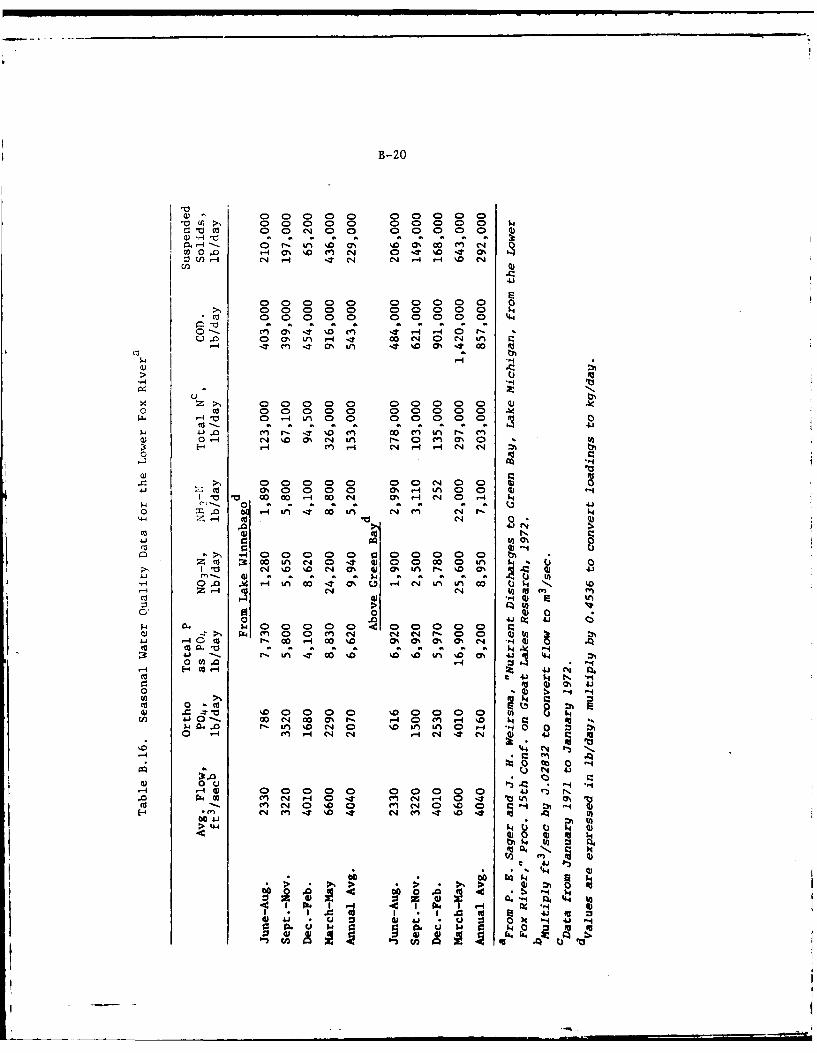
B-20
CO. H Oca C,4 (~ 0 0
Nb00 - H7 *.) N T %D IT as0CN -i IT C4 cq 4 q %D e
0 0Y 0n 0- 0T 0 0 0
0 c 0 0 0 0 0 0 0 0 0 0 kN0000-4n0 0 0 0 000 4.4
) 0' -4 N. o m4 HA r- 4 0 M M
0O O 0 Lf' H -0 m 0 0 Qt )w w4 Iq 4 C% Ui C4'. 0 -4 k
'o~~~~. berEVU- 0 L c;c;-'&4 ..C1
o~~t 0 0 0C00 0 hOH 0 C 0 0 930000 0
4. a a a .J .JJ1(4 0; -.? ' 0 % Oc l r C;) IA %0~.
1- -i C'4 H4 m '
o EU 0
0'I 000 0% H L 04J ~ ~ ~ H4 0 ca r D - D % N 0% H m O H I
0 " 0A a a aaa0 3LH m. H- U1 N4 QA N N
co ~4J Ll K -0)
JJ 0)' .0dr0)- 4 C.) 6
e4 A.0 '0r- Ln NO' o 0 IA Ln 00 1- . 0 4J
0 1H m - N N N 43U~ r, )
C) 0 )
ccm 0 D0 q -4 2 4 )I-.~ ~~ ~~ W. . 0 0 0 - 0 0
H E-4c0H; 4 JN 0
4 wa 14 N '
10 0m 2C A
C40'
B-21
Table B.17. Water Quality of the Fox River at Wrightstown,STORET Station Number 04085000
No. of RangeParameter Samples Mean Min. Max.
Water temp., *C* 8 5.56 0.50 19.00Inst. stream flow, cfs 7 3711.42 1735.00 7689.89Turbidity, JTU 6 7.50 3.00 10.00Conductivity, 25*C, pmho* 8 401.63 303.00 469.99DO, mgil* 4 12.33 7.70 15.40pH, SU* 8 7.47 7.09 7.79C02 , mg/l 6 12.23 5.50 25.00Tot. alk. as CaCO 3, mg/l* 7 160.29 130.00 177.00HCO 3 ion, mg/l* 7 195.43 158.00 216.00C03 ion, mg/l* 4 0.00 0.00 0.00Periphyton biomass, g/m2 1 2.30 2.30 2.30Total nitrogen, mg/l 5 1.20 1.00 1.40Total kjeldahl N, mg/l 5 0.95 0.77 1.30Total NO2 + NO3 as N, mg/l 6 0.26 0.10 0.31T. tal phosphorus, mg/l 6 0.08 0.01 0.11Totai org. carbon, mg/il 2 18.00 14.00 22.00Total hardness as CaCO 3, mg/l* 7 187.00 149.00 210.00NC hardness as CaCO 3, mg/l* 7 26.14 20.00 33.00Dis. calcium, mg/l* 7 41.86 35.00 46.00Dis. magnesium, mg/l* 7 19.86 15.00 23.00Dis. sodium, mg/l* 7 10.71 4.40 16.00Sodium adsorption ratio* 7 0.34 0.20 0.50Percent sodium* 7 10.71 6.00 15.00Dis. potassium, mg/l* 7 2.34 2.00 2.80Chloride, mg/l* 7 13.57 700 18.00Total sulfate, mg/l* 7 28.00 22.00 34.00Dis. fluoride, mg/l* 7 0.29 0.10 0.50Dis. silica, mg/l* 7 6.49 1.30 9.00Dis. arsenic, pg/l 2 0.50 0.00 1.00Susp. arsenic, pg/i 1 1.00 1.00 1.00Total arsenic, pg/i 1 2.00 2.00 2.00Dis. cadmium, pg/l 2 0.00 0.00 0.00Susp. cadmium, pg/i 2 1.50 1.00 2.00Total cadmium, pg/I 2 1.50 1.00 2.00Dis. chromium, pg/l 2 2.50 2.00 3.00Susp. chromium, wg/l 2 7.50 7.00 8.00Total chromium, pg/l 2 10.00 10.00 I0.00Dis. cobalt, pg/i 2 0.50 0.00 1.00Susp. cobalt, ug/i 2 0.50 0.00 1.00Total cobalt, pg/I 2 1.00 1.00 1.00Dis. copper, pg/l 2 1.50 1.00 2.00Susp. copper, ug/1 2 8.50 7.00 10.00Total copper, pg/l 2 10.00 8.00 12.00Total iron, ug/l 2 255.00 180.00 330.00Dis. iron, pg/i 2 90.00 20.00 160,00Dis. lead, pg/1 2 5.00 2.00 8.00
B-22
Table B.17. Continued
No. of RangeParameter Samples Mean Min. Max.
Susp. lead, pg/l 2 6.50 3.00 10.00Total lead, ug/l 2 11.50 11.00 12.00Susp. manganese, ug/l 2 11.50 0.00 23.00Manganese, pg/l 2 30.00 0.00 60.00Dis. manganese, pg/l 2 23.50 10.00 37.00Dis. zinc, Pg/l 2 7.00 4.00 10.00Susp. zinc, pg/l 2 35.00 20.00 50.00Total zinc, wg/l 2 40.00 20.00 60.00Dis. selenium, pg/l 2 0.00 0.00 0.00Susp. selenium, wg/l 2 0.00 0.00 0.00Tot. selenium, pg/l 2 0.00 0.00 0.00Fecal coli. MF M-FC Br., No./100 ml 7 198.14 56.99 320.00Fecal strep. MF M-Ent., No./100 ml 7 83.43 0.00 170.00Chlor. B, periphtn, mg/m 2 1 0.30 0.30 0.30Chlor. A, periphtn, mg/m 2 1 2.00 2.00 2.00Total algae, No./ml 6 3241.67 750.00 8000.00Dis. residue 180*C, mg/l* 7 235.14 180.00 261.00Dis. solids SUM, mg/l* 7 219.57 165.00 238.00Dis. solids, tons/day 6 2008.33 1120.00 2880.00Dis. solids, tons/acre-ft* 7 0.32 0.24 0.36Total N as NO3, mg/l 5 5.32 4.60 6.20Dis. mercury, wg/l 2 0.05 0.00 0.10Susp. mercury, ug/l 2 0.10 0.00 0.20Total mercury, vg/l 2 0.15 0.10 0.20
*1960-1975 sampling period for parameter.
1974-1975 sampling period for all other parameters.
B-23
Table B.18. Final Permit (1977) Loadings forLower Fox River Waste Sources
BOD5 Suspended SolidsSource Name kg/day (lbs/day) kg/day (lbs/day)
K. C. Neenah & Badger Globe 498.9 (1100) 464.8 (1025)
Bergstrom Paper 1077.1 (2375) 1645.3 (3628)
K. C. Lakeview 816.3 (1800) 498.9 (1100)
Neenah Menasha STP 2043.5 (4506) 2043.5 (4506)
Wisconsin Tissue 536.9 (1184) 726.5 (1602)
Menasha Sanit. Dist. E. & W. 359.6 (793) 359.6 (793)
Riverside Paper 394.5 (870) 376.4 (830)
Formost Dairy 49.0 (108) NA
Consolidated Appleton 1133.8 (2500) 680.3 (1500)
Appleton STP 1859.4 (4100) 1859.4 (4100)
K. C. Kimberly 907.0 (2000) 1360.5 (3000)
Appleton Papers 1655.3 (3650) 1873.0 (4130)
Heart of the Valley STP 601.8 (1327) 601.8 (1327)
Thilmany Paper 2675.7 (5900) 2675.7 (5900)
Wrightstovn STP 73.5 (162) 73.5 (162)
Nicolet Paper 589.6 (1300) 440.8 (972)
De Pere STP 1614.0 (3559) 1614.0 (3559)
Fort Howard Paper 3945.5 (8700) 5850.0 (12900)
Charmin Paper 3460.2 (7630) 3854.8 (8500)
Green Bay Packaging 725.6 (1600) 544.2 (1200)
American Can 839.0 (1850) 571.4 (1260)
Green Bay STP 5940.9 (13100) 5940.9 (13100)
George A. Whiting Paper Co. 272.1 (600) 725.6 (1600)
Total 32,069.4 (70715) 34,807.7 (76753)
From D. J. Patterson et al., "Water Pollution Investigation: Lower
Green Bay and Lower Fox River," Wisconsin Division of Natural Resources,June 1975.
B-24
0 c 0 c. 0 0 r -0 -4 .31 10
-a N 0 Cl co 0 00 0 I co .
~ -V0~0 00. -n ) C 0 0 7 4) 0 I C ) 1 4 0
- Go CO 0 a, N C
.rl 0
lua
a41 .q
C.w F.4 Ca I.U
.41 w C.'I
00 rI 0
1 - (1)- 0
I.. 00 0 0 0 0 0
CI 0 co 1 0
*r . -4.4 a-o
0V 0 0 Gi Va
r' 0 C:4l~a 0 0 4)0 0 0 4 ,-CO.0. 'LC.I~aI.I)
u 413
41~~~4 41 0 a C
*0 00e404 4
0 ma .44 . 0.
CL a 0 0 0 '46 C74 C.
0 0 -110. 0-, 4 6 I ca4.4 4
'g 0
U) 44
4-Cw
I 0 0 440 . 4 0 '. ') 0-
It -. C Nl a4 N P. 44.)'II 4 0 0 N4 1 p
~O~ asNO a~I~cc
I1 CL 0 'Cl w v II C.i. i. 0 N aa.4 CO0
-. a 0 0 0 0 0- 01 0U0
on u ,U 6w mxad u b u9 39
Ia 0PI
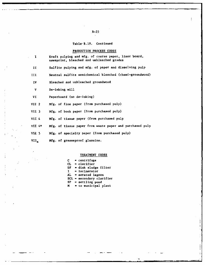
B-25
Table-B.19. Continued
PRODUCTION PROCESS CODES
I Kraft pulping and mfg. of coarse paper, liner board,newsprint, bleached and unbleached grades
II Sulfite pulping and mfg. of paper and dissolving pulp
III Neutral sulfite semichemical bleached (chemi-groundwood)
IV Bleached and unbleached groundwood
V De-inking mill
VI Paperboard (no de-inking)
VII 2 Mfg. of fine paper (from purchased pulp)
VII 3 Mfg. of book paper (from purchased pulp)
VII 4 Mfg. of tissue paper (from purchased pulp
VII 4* Mfg. of tissue paper from waste paper and purchased pulp
VII 5 Mfg. of specialty paper (from purchased pulp)
VIIx Mfg. of greaseproof glassine.
TREATMENT CODES
C centrifugeCL - clarifierDF - disk sludge filterI - incineratorAL - aerated lagoon
SCL - secondary clarifierSP - settling pondM - to municipal plant
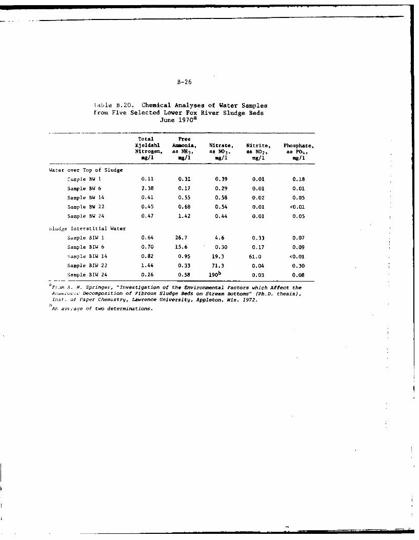
B-26
[able B.20. Chemical Analyses of Water Samplesfrom Five Selected Lower Fox River Sludge Beds
June 1 970 a
Total FreeKjeldahl Amonia, Nitrate, Nitrite, Phosphate,Nitrogen, as NH3, as NO3, as NO2, as PO,
mg/l Mg/i mg/1 mg/1 mg/i
Water over Top of Sludge
Sample BW 1 0.11 0.31 0.39 0.01 0.18
Sample BW 6 2.38 0.17 0.29 0.01 0.01
Sample BW 14 0.41 0.55 0.58 0.02 0.05
Sample BW 22 0.45 0.68 0.54 0.01 <0.01
Sample BW 24 0.47 1.42 0.44 0.01 0.05
Sludge Interstitial Water
Sample BIW 1 0.64 26.7 4.6 0.33 0.07
Sample BIW 6 0.70 15.6 0.30 0.17 0.09
Sample BIW 14 0.82 0.95 19.3 61.0 <0.01
Sample BIW 22 1.44 0.33 71.3 0.04 0.30
Sample BIW 24 0.26 0.58 b 0.03 0.08
F~ror A. M. Springer, "Investigation of the Environmental Factors which Affect theAnia;roiac Decomposition of Fibrous Sludge Beds on Stream Bottoms" (Ph.D. thesis),Inst. of Paper Chemistry, Lawrence University, Appleton, Wis. 1972.
An average of two determinations.
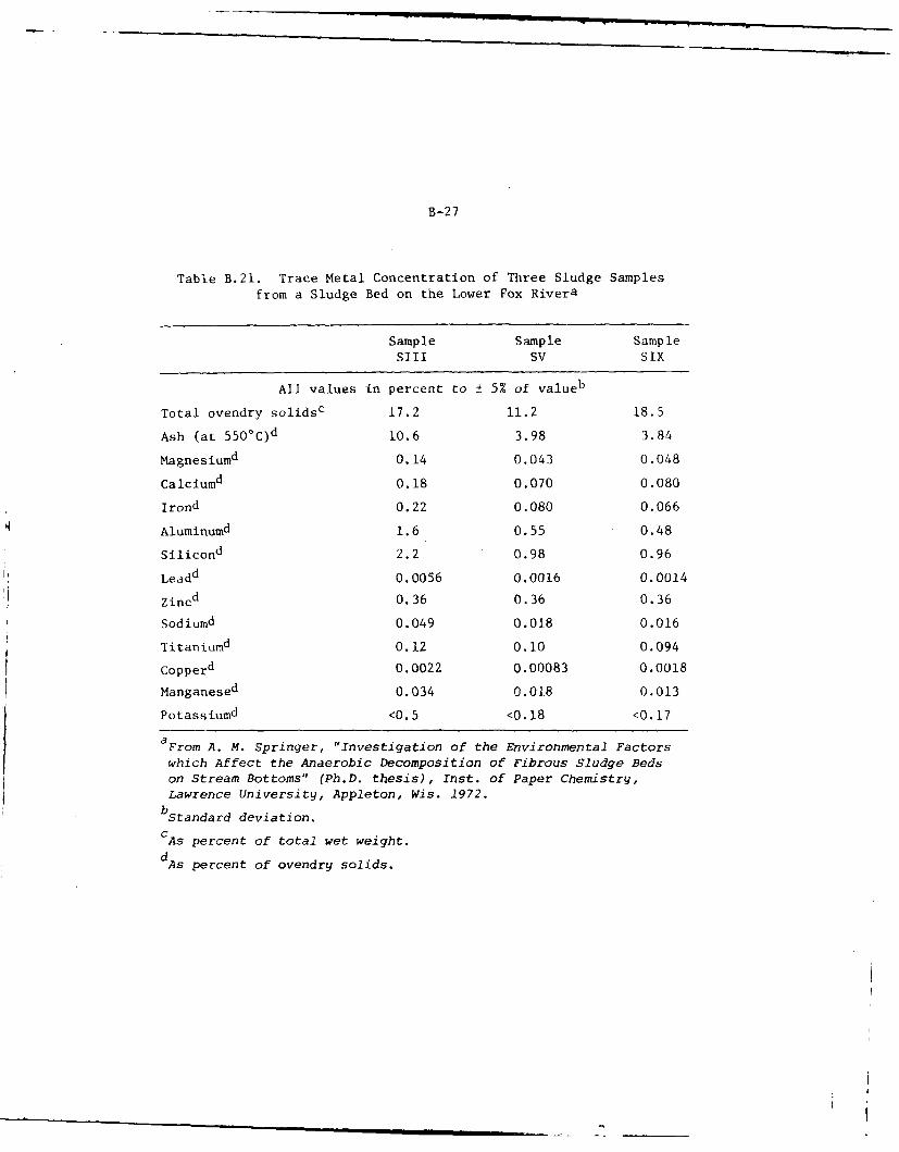
B-27
Table B.21. Trace Metal Concentration of Three Sludge Samples
from a Sludge Bed on the Lower Fox Rivera
Sample Sample SampleSill SV SIX
All values in percent to ± 5% of valueb
Total ovendry solids c 17.2 11.2 18.5
Ash (at 5500C)d 10.6 3.98 3.84
Magnesiumd 0.14 0.043 0.048
Calciumd 0.18 0.070 0.080
Irond 0.22 0.080 0.066
Aluminumd 1.6 0.55 0.48
Silicond 2.2 0.98 0.96
Leadd 0.0056 0.0016 0.0014
Zincd 0.36 0.36 0.36
Sodiumd 0.049 0.018 0.016
Titaniumd 0.12 0.10 0.094
Copperd 0.0022 0.00083 0.0018
Manganesed 0.034 0.018 0.013
Potassiumd <0.5 <0.18 <0.17
aFrom A. M. Springer, "Investigation of the Environmental Factors
which Affect the Anaerobic Decomposition of Fibrous Sludge Bedson Stream Bottoms" (Ph.D. thesis), Inst. of Paper Chemistry,
Lawrence University, Appleton, Wis. 1972.bStandard deviation.
CAs percent of total wet weight.
dAs percent of ovendry solids.
APPENDIX C: BACKGROUND AND HISTORY CONCERNING
REGULATION OF LAKE WINNEBAGO
Lake Winnebago is part of the Fox River Navigation Project and regulationof its stage is necessary in the interest of navigation and is requiredin accordance with Federal laws and to protect the private rights ofwater-power and riparian interests. The lake is a natural retarding andstorage reservoir for water from the Upper Fox River and Wolf River.The lake has a normal low water area of 206 square miles and a surroundinglocal drainage area of 600 square miles, including 200 square miles ofthe Fond du Lac River basin at the south end of the lake. The totaldrainage area above the lake outlets at Neenah and Menasha is 6030square miles: The Lake Winnebago Pool, which includes six smaller lakesat substantially the same low-water level within the lower parts of theUpper Fox and Wolf River drainage areas, has a total low-water area of265 square miles. The area of this pool at the highest level of record,with the backwater slopes prevailing, was about 320 square miles. Thelimits of regulation under existing laws, orders and permits are from21-1/4 inches above the crest of Menasha dam to the crest level duringthe navigation season, plus an additional drawdown of 18 to 24 inchesduring the winter. The storage available in this pool normally issubstantially filled during the months of high inflow, thus reducingflood flows of the Lower Fox River; and provides supplemental flow fornavigation, water power, water supply and sanitation during the drymonths of the year. As the inflow into the Lake Winnebago Pool at floodpeaks may be approximately double the safe discharge capacity of thelower river channel, and as during extremely dry periods the evaporationand seepage from the lake may equal or exceed the inflow, the availabilityof the lake storage and its proper utilization by regulation of theoutflow is of major importance to navigation, as well as to the citiesand industries along the Lower Fox River utilizing the water supply ofthe river. in the interest of navigation on the Lower Fox River, topreserve the private rights to the use of water not needed for navigationfor power development, and to reduce flood damages, the water level ofthe Lake Winnebago Pool is regulated to the extent possible in accordancewith Acts of Congress and related directives.
The original dam at Menasha was completed in 1850 and the original damat Neenah was completed in 1854. The deed of transfer of the Fox RiverImprovements from the Green Bay and Mississippi Canal Company to theUnited States is dated September 18, 1872, and gives the United Statestitle to all "locks, dams, canals, and franchises savings and exceptingtherefrom and reserving" to the Green Bay & Mississippi Canal Company"1water power created by the dams and by the use of surplus water notrequired for the purpose of navigation, with the rights of protectionand preservation appurtenant thereto, and the lots, pieces, or parcelsof land necessary to the enjoyment of the same, and those acquired withreference to the same, all subject to the right to use the water for allpurposes of navigation." Later the Congressional Acts of 2 August 1882and 5 July 1884 provided that the waters of Lake Winnebago shall be
C-1
C-2
reduced to and maintained at their natural height. The laws do notprescribe exact limits or methods for regulation, but such limits arefixed indirectly by the words "natural and established heights without
interfering with private rights."*
The initial construction of dams in the Neenah and Menasha outlet channelsby the State and succeeding private corporations affected both the lowwater level and average high water level of Lake Winnebago and flowagedamages were caused which were not paid by the agencies. After theUnited States took possession of the navigation project works flowagedamages amounting to $592,375.09 were paid under authorization by aCongressional Act of 3 March 1875 which provided that payments be madefor any lands or property which are "now or shall be flowed or injured"by any of the works of improvement on the Fox River. Funds were providedunder six appropriation acts and payments were made during the 1886 to1896 decade. As far as is known no surveys were made to establish thelimits to which payments were made, but statements by persons directlyconnected with the matter indicate that the settlements covered alllands damaged by flowage around Lake Winnebago, up the Fox River toabove Omro or to Eureka Lock, and up the Wolf River through the marsh-lands above Lake Poygan and Boom Cut. The form of judgment rendered inall cases contained the clause "which damages are assessed from andafter the 18th day of September, 1872, and for all time thereafter andallowing the United States to perpetually maintain the dam (at Menasha)mentioned in the petition filed herein at its present height."
The Marshall Order, dated 9 October 1886, was issued shortly after theappropriation act of 4 August 1886, which was the first act in connectionwith damages.
The following paragraphs are quoted from H. D. No. 146-67th Congress,
2nd session entitled "Fox River, Wisconsin." In order to define moredefinitely the upper limit of flowage rights acquired by the UnitedStates, Capt. W. L. Marshall, then district engineer in charge, wrote toC. A. Fuller, assistant engineer in local charge of the Fox River improve-ment on October 9, 1886, as follows:
"The sluiceways in the Menasha Dam are placed by theGovernment to prevent damage by floods on Lake Winnebago. Theterm "flood" is to be considered to refer to all stages ofwater above ordinary high-water stage. The ordinary high-waterstage for the past 28 years (1859-1886) as shown by the readings
*The height of Menasha Dam is the same now as it was when the flowage
damages were paid, but it has been lengthened and sluices have beenadded increasing the discharge capacity about 60 percent. The dam atMenasha was partially rebuilt in 1937 to comply with provisions of theRiver and Harbor Act of 2 August 1882 which required alterations to theMenasha Dam and channel "not inconsistent with security to navigation,... to reduce and to maintain the water of Lake Winnegage ... at their
natural height." The laws do not prescribe exact limits or methods forregulation, but such limits are fixed indirectly by the words "naturaland established heights without interfering with private rights."
C-3
of Deuchman's gauge at the foot of lake Winnebago, rejecting1860 when the stage was abnormally low, and 1881, when the waterwas excessively high. This mean annual high water for 28 yearsequals 42 inches on Deuchman's gauge, or 3 feet 6 inches. Youwill therefore begin to open the sluiceways in the Menasha Damwhen the water approaches within 2 inches of this height, or at3 feet 4 inches on Deucliman's gauge, and, as far as the capacityof the Fox River below Menasha and the security of Governmentworks will allow, you will maintain the level of Lake Winnebagoat or below the ordinary high-water level of 3 feet 6 incheson the Deuchman gauge by opening and closing the sluiceways inthe Menasha Dam."
This long-standing order is commonly known as the Marshall Order. The 3feet 6 inches upper limit specified is 21-1/4 inches above the crestof Menasha Dam. Adoption of average high water for the years 1859-1886as the upper limit of regulation was not exceeding the flowage rightsacquired by the United States, but, on the contrary, was some concessionto riparian interests. As nearly as can be determined by computationsbased on available data, the limit specified in the order was about thenatural flood height before dams were built at Menasha and Neenah andbefore these natural outlets were widened and deepened. As this limitwas established in 1886, it is considered as the established heightprescribed by the act of 1896, as wel3 as the natural height providedfor by the act of 1882, which latter act was passed immediately fol-lowing the severe flood in the late fall of 1881. Observance of thisupper limit, without unnecessary waste of water, gives water-powerinterests on the lower river all the water to which they are entitledunder the laws and the deed of transfer to the United States withoutinterfering with private rights.
Under authority of River and Harbor Act of 1894 the Secretary of War on5 February 1895 issued rules and regulations for navigation on FoxRiver, which includes the regulation that no pool shall be lowered belowthe crest of the dam which retains that pool. This therefore plainlydefines the lower dividing line between the rights of navigation andthose of water power.
The River and Harbor of 1896 directed the Secretary of War, by use offlashboards or otherwise, to make avail of all the natural flow ofwater, and present waste thereof, to the height to which !he right ofthe United States to hold the same has been established anld withoutinterfering with private rights. The use of flashboards 8 inches highwas permitted from 1899 to 1906, but the permit was revoked 17 July 1906because the use of flashboards was considered as interference withprivate rights and therefore illegal.
The Marshall Order was modified in 1920 by Colonel Judson. In thisconnection the following paragraphs are quoted from H. D. No. 146-67thCongress, 2nd session.
"On account of repeated objections made by riparianinterests to the 19-inch sluicing point specified in the oldorder of October 9, 1886, and because that portion of the
C-4
order has been practically obsolete for many years, thefollowing modified order was issued October 15, 1920,by Col. W. V. Judson, district engineer, to Earl M. Nisen,assistant engineer in charge of the regulation of this lakeand to others concerned;
Existing instructions for the regulation of LakeWinnebago, originally adopted by the district engineer onOctober 9, 1886, as modified June 25, 1920 are herebyfurther modified so that they shall read as follows:
"(1) The sluiceways in the Menasha Dam are placed bythe Government to prevent damage by floods in Lake Winnebago.The term 'flood' is to be considered to refer to all stagesof water above an ordinary high-water stage. The ordinaryhigh-water stage will be taken as the mean high-water stagefor the 28-year period from 1859 to 1886, as shown by thereadings of Deuchman's gauge at the foot of Lake Winnebago,rejecting 1860 when the stage of water was abnormally lowand 1884 when the water was excessively high. This meanannual high water for those 28 years is 42 inches on Deuch-man's gauge, or 21-1/4 inches above the crest of Menasha Dam.
"(2) The manipulation of the sluices shall, as far aspracticable, be such that, with minimum waste of water, highwater shall not exceed 21-1/4 inches above the crest ofMenasha Dam.
"(3) A continuous hydrograph shall be kept which willserve to indicate at all times what success is being had incomplying with paragraph 2 of this order and whether modifi-cations in the details of manipulation are necessary in orto bring about a more perfect compliance with it.
"(4) The Federal laws relating especially to theregulation of Lake Winnebago are as follows: Acts approvedAugust 2, 1882; July 5, 1884; August 18, 1894; and June 3,1896."
Accordingly the present limits of regulation for LakeWinnebago under existing laws, orders, rules, and permitsare from 21-1/4 inches above the crest of Menasha Dam downto the crest during the navigation season, plus an addi-tional 18 inches below the crest during the winter."
Later under authority of Section 7 of the River and Harbor Act of8 August 1912, the Secretary of the Army on 17 July 1968 approvednavigation regulations for the Fox River, rule 13 of which provides thatwater shall not be drawn from any pool to such extent as to lower thesurface of the pool below the crest of the dam which retains that pool.As this rule applies at Menasha Dam it limits the draft of water fromLake Winnebago to the level of the crest of the dam during the naviga-tion season. The Secretary of the Army has regularly issued annualpermits to the Neenah and Menasha Water Power Company to draw the lakedown not to exceed 18 to 24 inches below the crest of Menasha Dam during
C-5
the closed season of navigation, with the proviso that the water levelshall be back to the crest of the dam upon the opening of navigationeach spring. These permits allow the water-power interests to use allsurplus water not needed for navigation to which they are entitled underthe existing project. The limits within which the lake level has beenregulated since 1950 are shown in Table C.l.
Records of the lake level available from 1859 to date show that sincethe issuance of the Marshall Order in 1886 the level of the lake gen-.erally has been regulated within the specified limits, the upper limitbeing exceeded in only 15 cases and then usually by only a few inchesfor a short period, the maximum excess being about 10-1/2 inches in 1960after a period of unusually large inflow. Several of these high waterstages were in April at a season when the overflow of the low lands doeslittle damage by flooding pasture and cultivated lands, hay marshes orforested lands. Damage to lakeshore resort and recreational areas alsois relatively small since most summer homes or cottages are built inanticipation of occasional high water. Ice breakups and windblown icejams may cause considerable shoreline damage if the lake stage is excep-tionally high. Conservation interests have observed there is extensivedamage to wildlife in the form of nesting ducks, muskrats, etc., whenexcessively high flood levels occur. Fish spawning beds may be left drywhen flood waters recede. Considerable damage also occurs by theloosening and displacement of some areas of floating bog and depositionof the resulting debris in the lake waters. The sluicing capacity atMenasha and Neenah Dams, and at all the other Lower Fox River dams, hasbeen substantial increased since the limits of regulation for LakeWinnebago were established, making it possible to prevent more frequentflooding above the desired limit.
The report in House Document No. 146, 67th Congress, 2nd session, in-cluded the findings of a detailed study of the backwater effects of theLake Winnebago stage. It is shown that with regulation of the lakewithin ordinary limits the backwater effect above the mouth of the WolfRiver due to the higher lake level is only about 0.5 foot and decreasesupstream with no backwater effect above Fremont due to the Lake Winnebagostage. The land flooded when the lake level is at the upper limit forregulation 21-1/4 inches above the crest of Menasha Dam outside of thepool area with lake level at the crest of the dam is estimated to beabout 13,760 acres. The flooded area probably would be increased about650 acres at the peak stage of 26.2 inches above the crest reachedduring the extended high water period in 1960. Most of the flooded areais marshy bottom land.
Major factors affecting lake regulation and flood control are substantially
the same now as they were in 1922 when the results of this study werepublished with the following principal exceptions. The urban and industrial
C-6
Table C.I. Extreme Annual Levels of Lake Winnebago, 1950-1975
Minimum Level Maximum Level
Oshkosh In. below Oshkosh In. aboveGage, Crest Men- Gage, Crest Men-
Year Date ft. asha Dam Date ft. asha Dam
1950 Mar. 5-6-9 0.50 14.2 Apr. 30
May 4 3.31 19.5
1951 Feb. 24 0.46 14.6 Apr. 26 3.48 21.6
1952 Mar. 18 0.69 11.9 Apr. 13 3.42 20.9Apr. 15
1953 Mar. 11-13 0.82 10.3 May 5-7-8-10 3.29 19.3
1954 Mar. 12-13 0.71 11.6 Oct. 4 3.35 20.0
1955 Feb. 19 0.98 8.4 June 11 3.25 18.8
1956 Mar. 31 0.78 10.8 May 10 3.30 19.4May 30
1957 Mar. 17 0.79 10.7 June 5 3.30 19.4
1958 Feb. 28 0.91 9.2 July 15 2.54 10.3Mar. 3
1959 Mar. 30 0.78 10.8 May 29 3.38 20.4
1960 Mar. 28 1.12 6.7 May 17 4.32 31.7 a
1961 Feb. 17 1.32 4.3 Oct. 29 3.35 20.0
1962 Mar. 20 0.80 10.6 June 18 3.20 18.2
1963 Mar. 22 1.03 7.8 May 29 2.98 15.6
1964 Mar. 6-8 1.19 5.9 May 25 3.18 18.0
1965 Mar. 1 1.23 5.4 Apr. 29 3.23 18.6
1966 Feb. 7 1.49 2.3 May 27 3.00 15.8
1967 Mar. 17 0.77 10.9 May 19 3.22 18.5
1968 Mar. 17-18 1.28 4.8 Aug. 7 3.42 20.9
1969 Mar. 17 0.97 8.5 June 29 3.86 26.2
1970 Mar. 19 1.06 7.5 June 3 3.22 18.5
1971 Mar. 13-14 1.01 8.06 June 13 3.30 19.37
1972 Mar. 19-20 .94 8.87 June 3 3.23 8.62
1973 Mar. 5 1.35 4.00 May 19 3.68 24.00
1974 Mar. 2-3 0.84 10.12 June 18 3.37 20.25
1975 Mar. 19-20 0.70 11.75 May 6 3.30 19.37
aTotal of 32 days above 3.45 feet at Oshkosh gage, or more than 21-1/4
inches above crest.bTotal of 21 days above 3.45 feet at Oshkosh gage, or more than 21-1/4
inches above crest.
C-7
developments along the Lower Fox River and the shores of Lake Winnebagohave been greatly expanded. The residential developments along theshores of the Lake Winnebago Pool has greatly expanded, so that many
sections subject to flooding now are used for residential purposes. Thesluicing capacity at all dams on the Lower Fox River has been increased
so that the outflow from Lak- Winnebago can be increased from about15,000 cfs to 20,000 cfs without serious flood damages along the Lower
Fox River. However, the large excess of inflow over outflow at times
still makes it physically impossible to regulate the lake level below the
prescribed flood limit and still avoid excessive waste of water to whichwater-power interests have established legal rights. Flowage damagesamounting to $592,375.09 were paid by the United States through thecourts under special appropriation acts In 1886 to 1894. The dam is stillat the same height as when th. flowage damages were awarded but has beenlengthened and sluices hav. been added. Most of the damages resultingin the few instances when the level of the pool cannot be kept below the21-1/4 inch limit are within "'i arei for which these flowage damageswere paid, to properties dew.loped with insufficient regard for theflood hazard, and onsequ.: t lv the F. deral government is not liable tothe owners.
D-1
APPENDIX D. UPRIVER LAKES HABITAT
Table D.l. Wetland Acreage--Fox and Wolf Rivers--Lakes Area, Waushara County, Wisconsin
Wetland Year
Classification 1937 1957 1971
Pothole 4 -- 16
Fresh meadow 7,822 7,022 5,681
Shallow marsh 1,975 2,356 3,404
Deep marsh 79 ill 50
Shrub swamp 241 182 149
Timber swamp 4,591 4,278 4,184
Total 14,712 13,949 13,484
Percentage Wetland Losses
1937 - 1957 = 763 (5%)
1937 - 1971 = 1,228 (8%)
1957 - 1971 = 465 (3%)
Table D.2. Wetland Acreage--Fox and Wolf Rivers--
Lakes Area, Waupaca County, Wisconsin
Wetland Year
Classification 1937 1957 1971
Pothole .... 21
Fresh meadow 1,669 1,405 972
Shallow marsh 1,793 1,547 1,152
Deep marsh 669 775 582
Shrub swamp 33 22 279
Timber swamp 1,140 8 1I047
Total 5,304 4,831 4,053
Percentage Wetland Losses
1937 - 1957 - 473 (9%)
1937 - 1971 - 1,251 (242)
1957 - 1971 - 778 (162)
D-2
Table D.3. Wetland Acreage--Fox and Wolf Rivers--
Lakes Area, Winnebago County, Wisconsin
Wetland Year
Classification 1937 1957 1971
Pothole 8 1 70
Fresh meadow 12,824 6,114 4,422
Shallow marsh 10,768 9,008 7,334
Deep marsh 3,488 1,793 1,575
Shrub swamp 1,131 1,090 1,080
Timber swamp 2,845 2,182 1,744
Total 31,064 20,190 16,225
Percentage Wetland Losses
1937 - 1957 - 10,874 (35%)
1937 - 1971 - 14,839 (48%)
1957 - 1971 - 3,965 (20%)
Table D.4. Lake Surface Acreage Summary, Fox andWolf Rivers-Lakes Area, Wisconsin
Year
Lakes 1937 1957 1971
Partridge 574 553 554
Poygan 13,178 13,646 14,198
Winneconne 5,214 5,399 5,616
Buttes des Morts 6 7 7,160
Total 25,709 26,749 27,528
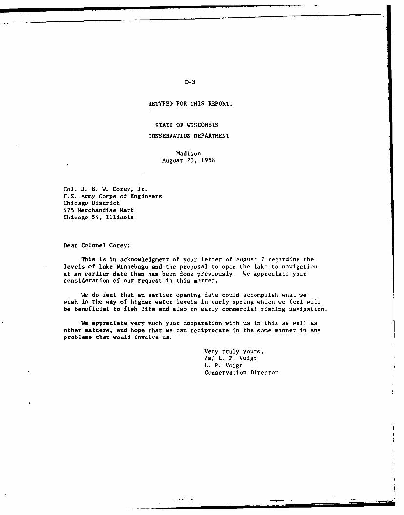
D-3
RETYPED FOR THIS REPORT.
STATE OF WISCONSIN
CONSERVATION DEPARTMENT
Madison
August 20, 1958
Col. J. B. W. Corey, Jr.U.S. Army Corps of EngineersChicago District475 Merchandise MartChicago 54, Illinois
Dear Colonel Corey;
This is in acknowledgment of your letter of August 7 regarding thelevels of Lake Winnebago and the proposal to open the lake to navigationat an earlier date than has been done previously. We appreciate yourconsideration of our request in this matter.
We do feel that an earlier opening date could accomplish what wewish in the way of higher water levels in early spring which we feel willbe beneficial to fish life and also to early commercial fishing navigation.
We appreciate very much your cooperation with us in this as well asother matters, and hope that we can reciprocate in the same manner in anyproblems that would involve us.
Very truly yours,
/s/ L. P. VoigtL. P. VoigtConservation Director
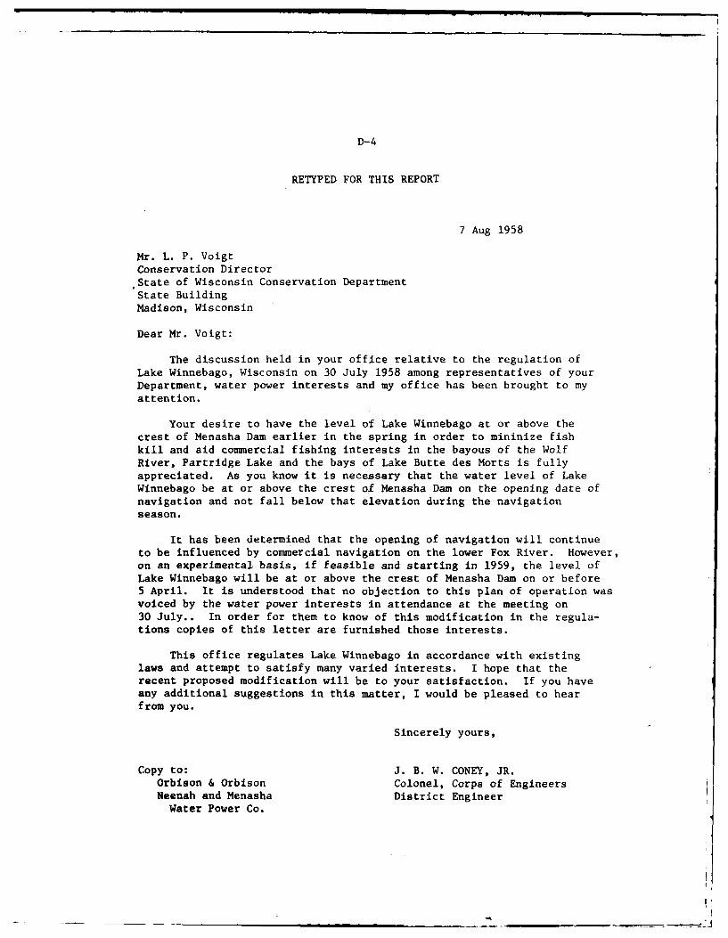
U II
D-4
RETYPED FOR THIS REPORT
7 Aug 1958
Mr. L. P. VoigtConservation DirectorState of Wisconsin Conservation DepartmentState BuildingMadison, Wisconsin
Dear Mr. Voigt:
The discussion held in your office relative to the regulation ofLake Winnebago, Wisconsin on 30 July 1958 among representatives of yourDepartment, water power interests and my office has been brought to myattention.
Your desire to have the level of Lake Winnebago at or above thecrest of Menasha Dam earlier in the spring in order to mininize fishkill and aid commercial fishing interests in the bayous of the WolfRiver, Partridge Lake and the bays of Lake Butte des Morts is fullyappreciated. As you know it is necessary that the water level of LakeWinnebago be at or above the crest of Menasha Dam on the opening date ofnavigation and not fall below that elevation during the navigationseason.
It has been determined that the opening of navigation will continueto be influenced by commercial navigation on the lower Fox River. However,on an experimental basis, if feasible and starting in 1959, the level ofLake Winnebago will be at or above the crest of Menasha Dam on or before5 April. It is understood that no objection to this plan of operation wasvoiced by the water power interests in attendance at the meeting on30 July.. In order for them to know of this modification in the regula-tions copies of this letter are furnished those interests.
This office regulates Lake Winnebago in accordance with existinglaws and attempt to satisfy many varied interests. I hope that therecent proposed modification will be to your satisfaction. If you haveany additional suggestions in this matter, I would be pleased to hear
from you.
Sincerely yours,
Copy to: J. B. W. CONEY, JR.Orbison & Orbison Colonel, Corps of EngineersNeenah and Menasha District EngineerWater Power Co.
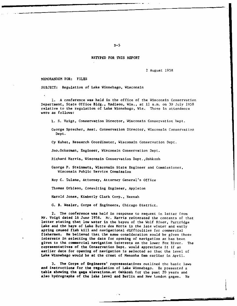
D-5
RETYPED FOR THIS REPORT
2 August 1958
MEMORANDUM FOR: FILES
SUBJECT: Regulation of Lake Winnebago, Wisconsin
1. A conference was held in the office of the Wisconsin ConservationDepartment, State Office Bldg., Madison, Wis., at 11 a.m. on 30 July 1958relative to the regulation of Lake Winnebago, Wis. Those in attendancewere as follows:
L. S. Voigt, Conservation Director, Wisconsin Conservation Dept.
George Sprecher, Asst. Conservation Director, Wisconsin ConservationDept.
Cy Kubat, Research Coordinator, Wisconsin Conservation Dept.
Jno.Ockerman, Engineer, Wisconsin Conservation Dept.
Richard Harris, Wisconsin Conservation Dept.,Oshkosh
George P. Steinmetz, Wisconsin State Engineer and Commissioner,
Wisconsin Public Service Commission
Roy C. Tulane, Attorney, Attorney General's Office
Thomas Orbison, Consulting Engineer, Appleton
Harold Jones, Kimberly Clark Corp., Neenah
G. B. Wesler, Corps of Engineers, Chicago District.
2. The conference was held in response to request in letter fromMr. Voigt dated 16 June 1958. Mr. Harris reiterated the contents of thatletter stating that low water in the bayou of the Wolf River, PartridgeLake and the bays of Lake Butte des Morts in the late winter and earlyspring caused fish kill and navigational difficulties for commercialfishermen. He believed that the same consideration sould be given thoseinterests in selecting the date for opening of navigation as has beengiven to the commercial navigation interests on the lower Fox River. Therepresentatives of the Conservation Dept. would appreciate it if anearlier date for opening of navigation is selected so that the level ofLake Winnebago would be at the crest of Menasha Dam earlier in April.
3. The Corps of Engineers' representatives outlined the basic lawsand instructions for the regulation of Lake Winnebago. He presented atable showing the gage elevations.at Oshkosh for the past 20 years andalso hydrographs of the lake level and Berlin and New London gages. He
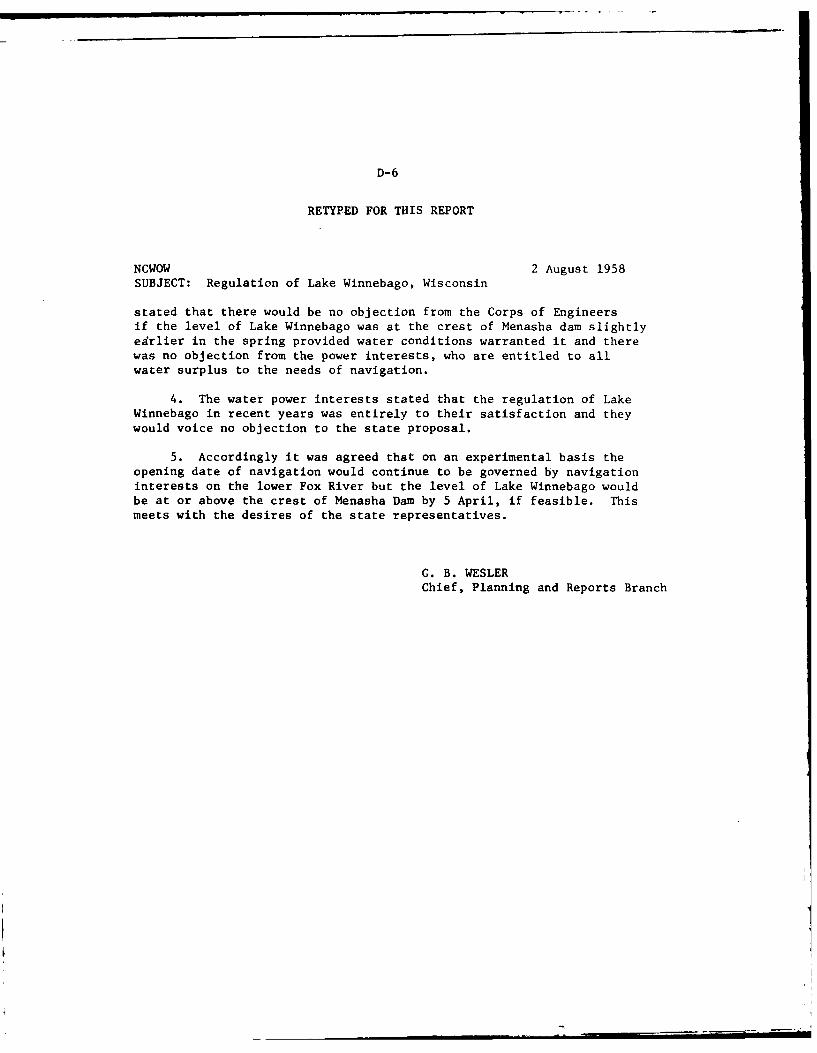
D-6
RETYPED FOR THIS REPORT
NCWOW 2 August 1958SUBJECT: Regulation of Lake Winnebago, Wisconsin
stated that there would be no objection from the Corps of Engineersif the level of Lake Winnebago was at the crest of Menasha dam slightlyedrlier in the spring provided water conditions warranted it and therewas no objection from the power interests, who are entitled to allwater surplus to the needs of navigation.
4. The water power interests stated that the regulation of LakeWinnebago in recent years was entirely to their satisfaction and they
would voice no objection to the state proposal.
5. Accordingly it was agreed that on an experimental basis theopening date of navigation would continue to be governed by navigationinterests on the lower Fox River but the level of Lake Winnebago wouldbe at or above the crest of Menasha Dam by 5 April, if feasible. Thismeets with the desires of the state representatives.
G. B. WESLERChief, Planning and Reports Branch
D-7
Dep., n, of Natural Resourcm
INTRA-DEPARTMENT
MEMORANDUM
DS, ....... ..p..?j j".................. IN REPLY REFER TO:
70: Flncd Stauts
FRM S. 0. DeBoer
SUBJECT: Water level Control Lake Winnebago, Winnebago County
Pursuant to IL C. 1462.4., the Lake )dchgain District requests your officecontact the Army Corps of Engineers and suggest implementation of amodified schedule of operation of the Lake Winnebago pool as follows:
1. Reduce water levels to spillway level by December 31.
Reason: This will reduce the amount of Ice forming in the marshes.
2. Gradually draw down in February to a low in 1hrch to make room for springrmn-off. Oradul reduction in February would have a minimal impacton ice fiahing.
3. The low in 1arch should be at least 1.0 feet below the crest of the)hnasha dan in order to provide sufficient storage for spring flows.
Reason: Water level rises in April due to spring run-off canthen be tapered off to allow submergent vegetation tostart growing earlier before peak water levels areattained. This i based on the assumption that lightIs a limiting factor in deep water which preventsvegetation growths from starting. Once the vegetationhas started growing and if the water level rise isgradual, vegetation growth will keep pace with it.
4. Water levels should be up to spillway level by April 30, rather thanApril lst., as is the present case.
Reason: Water levels close to spillway level in April willreduce the detrimental effects of ice action duringthe break-up period. Lifting action of large massesof ice in the bog areas would therefore not be a factorduring the break-up. Ice in the bog would be minimaland should quickly melt out since the black bottomsoils, which would be partially exposed, would absorbheat and cause faster malting.
5. Allow gradual rices in water level during MaLy to peak summer levelIn June.
Reason: This will allow submergent vegetation growths to keeppae with water level increases. The latter part of
D-8
TO: Flc-d 8tauts 2
April, iky and the firt part of Jwe is probably themet Important period for plant growth. Sufficientlight Is essential If plants are to begin growth. Deepturbid water does not provide conditions required forgrowth. If we can hold water low during the early periodin April when plants ar very short end Just begining togrow we may obtain a response which will result inincreased areas of aubmergents. By the and ot )by plant.are sufficiently tall so that deep water wil no longerbe Inhibiting factor.
6. After sumsar water levels peak in June there should be no furtherrise from June Into August If desirable subuargente are to havemm fruit production. A long slow decline in water levels duringthis period would be desirable.
Reason: Plants seem to set seeds better under conditions ofdeclining water levels. Wild celery does not floweruntil the end of July. If the water should suddenlyrise at this time celery plants might not be fertilized.Since flowers rise above the surface for pollination, ifthey were inundated pollination might not occur. Wildrice begins to erect the first part of July and anysudden rise in water levels during this period couldtear the plants loose. By the end of August growth ismore or less completed for all forms of vegetation andplants are going into senescence.
7. A rise in water levels in September and October brought about by fall
rains would provide better conditions for waterfowl hunting andboating.
8. Sudden or abrupt rises in water level should be avoided at all timsbecause of its damaging effect or, vegetation. Water levels shoulddecline from the fall high beginning in the latter part of October orthe first part of November and be at spilway level by December 31.
S. G. Deboer
cc: Arlyn LindeWalter NaabRoss Plains.John Weber
NOTZD:
late,
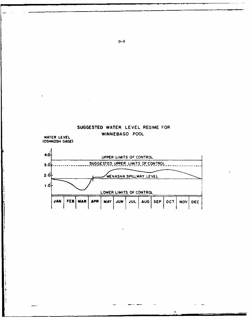
D-9
SUGGESTED WATER LEVEL REGIME FORWINNEBAGO POOL
WATER LEVEL(OSHKOSH GAGE)
4.6 UPPER LIMITS OF CONTROL. ....... ... .. . S~U~oG.STED- UPPER _LIM_,ITS_ OF C ONT_'ROL----------------.
2.0- ~MENSSILAY JUNE.ELOWER LIMITS OF CONTROL ..
JAN FESBIMARI APR I MAY tJUN I JUL I AUG1 SEPt OCT I NOVI DEC
APPENDIX E: SOILS AND GEOLOGY
The various soil types in the project study area are described below.
Figure E.l provides a graphic presentation of these general soil
associations.
Kewaunee Series - The Kewaunee series consists of deep, nearly level to very steep, well-drained soils on uplands. These soils developed in a thin silt mantle and calcareous, flne-
textured, reddish-brown glacial till. The original vegetation wa% hardwoods.
In a representative profile the surface layer is very dark gray silt iam about three inchesthick. The subsurface layer is grayish-brown silt loam four inches thtk. The subsoil extendsto a depth of about 28 inches. It is reddish-brown silty clav loam in th. upper three inchesand dark reddish-brown and reddish-brown lay in the lower part. rhe lowc-r part "t the subsoilis neutral to mildy alkaline. The underlying material is redc,:sh br,,wn clav tc i depth of 36inches and silty clay below. Spots of lime occur in this layer.
Permeability is moderately slow in the subsoil and slow in the underlving material. Tht. ivailable water capacity is high. The subsoil is medium acid to mildy alkaline. These soils are-moderately fertile. The organic-matter content of the surface layer is medium.
Kewaunee soils are important to the economy of the cotinty. With related soils, th.ov -clpy2- to 6-mile-wide strip of land adjacent to Lake Winnebago. Nearly all the acretia:( has htc-cleared and is osed for crops. These soils are easily puddLed if they are worked or gra.,.dwhen too wet.
to n series - The Houghton ser{es consists of organic soils that formed in the remains ofsuch fibrous plants as grasses, sedges. reeds, and other uonwoody plants. These soils 0'ups'small depressions a few acres in size or entire valley hottoms that cover several hundr-ed acr-.
In a representative profile the surface layer is black mucky peat 16 inches thick. Be low this,to a depth of about 6n inches, is dark reddish-brown and dark-hrowo distintegrated and finelydivided sedge peat.
The Houghton soils are neutral to mildly alkaline. The available water capa( ity is verv high,and the water table is high. Natural fertility is moderately low.
Soils of the Houghton series, the most extensive of the organic soils in this region, ,c"rthroughout the area. They are primarily under a cover of nat ve vegetation. Some aleas Ireused for permanent pasture, but scattered areas have been drained and are used for crop-. Thesesoils are subject to ponding. Where they have been drained, subsidence and soil blowing ireserious hazards. Many areas that are not cropped at present represent an important farm potential.
Oshkosh Series - The Oshkosh series consists of deep, nearly level and gently sloping, moderatelywell-drained and well-drained soils. Those soils formed in a very shallow silt mantlh andcalcareous, fine-textured, lake-laid sediments that are reddish brown in color. The originalvegetation was hardwood forest.
In a representative profile the surface layer is very dark grayish-brown silt loam seven inchesthick. he subsurface layer is grayish-brown silt loam five in,-hts thick. The subsoil isdark-brown, dark reddish-brown, and reddish-brown silty clay an.. clay about 13 inches thick.The underlying material is moderately alkaline, reddish-brown clay.
Oshkosh soils have high available water capacity and are moderately fertile. Permeability ismoderately slow in the subsoil and slow in the substratum. These soils are neutral to moder-
ately alkaline.
Nanews Series - The Manawa series consists of deep, nearly level and gently sloping, somewhatpoorly drained soils on uplands. These soils developed in a thin silt mant , and calcareous.fine-textured, reddish-brown glacial till or lacustrine sediments. They are adjacent to wet-lands, shallow drainageways, and small depressions. The original vegetation was hardwood forest.
E-1
E-2
2 4
z z x c
he 0 0 C.2
A- U
E-3
In a representative profile the surface layer is black silt loam five inches thick. The sub-surface layer is dark-gray silt loam four inches thick. The subsoil is mottled, reddish-brownsilty clay that extends to a depth of 28 inches. The underlying material is reddish-brownsilty clay that contains segregated lime between the cleavage planes.
Manawa soils have nigh available water capacity. They are moderately slowly permeable in thesubsoil and slowly permeable in the substratum. The surface layer is neutral, the subsoil is
slighly acid to neutral, and the substratum is alkaline. These soils are moderately fertile,and the surface layer is medium in organic-matter content.
Manawa soils are important, especially in the Lake Winnebago Valley. They occur In a 2- to 6-mile-wide strip adjacent to the lake. Most areas have been cleared and are used for crops, butafew areas are in woodlots or wooded pasture. Wetness is the main limitation to farming.These soils are easily puddled if worked or grazed when wet.
Mznasi slty clau Zoo, 0 to 2 percent slorps - This soil occupies shallow drainageways, smalldepressions, and areas adjacent to wetlands. The surface layer generally is less than nineinches thick, and the combined surface layer and subsoil is less than 24 inches thick. Thesurface layer has a higher percentage of clay than that of the representative profile. This ia result of mixing some of the clayey subsoil material with the surface layer thro.gh tillage.
This soil occupies a position on the landscape between the gently sloping Kewaunee soils andthe poorly drained Polygan soils. Small areas of associated Kewaunee and Oshkosh soils wereincluded in mapping.
The infiltration rate is slow, and water is held in the upper part of the soil in spring andduring extremely wet periods.
Alina. s: i~ty .'a,,, la to 6 rer-ent jiopes - This soil occupies drainageways that dissectKewaunee soils as well as broad areas adjacent to the poorly drained Poygan soils. The surfacelayer generally is less than nine inches thick and the combined surface layer and subsoil isless than 24 inches thick. The texture of the surface layer is a result of mixing the originalsurface layer with some of the subsoil through tillage. Small areas of eroded Manawa soilswere included in mapping.
'zn.I -it lov , 0 t. * a,.n' -.. ,, - This soil occupies shallow drainageways and smalldepre.slons adjacent to wetlands. It has the profile described as representative to the series.This soil is generally between the gently sloping Kewaunee soils and the poorly drained Poygansoils. Areas of associated Oshkosh and Kewaunee soils were included with this soil.
The main limitation to use of this soil is excessive wetness. The infiltration rate is slow,
and in spring or during rainy seasons, water Is held in the upper part of the soil.
1i',cnz otit 'oin, 2 to d ;6,eront .C';.8 - This soil occupies drainageways that disse t thewell-drained Kewaunee soils and slopes adjacent to wide areas of poorly drained Povgan soils.The surface layer is 7 to 10 inches thick, and the underlying glacial till is generally at adepth of less than 24 inches. The mottling in the upper part of the subsoil is somewhat lessconspicuous than that in the representative profile. Small areas of eroded Manawa silt loamwere included in mapping.
Excessive wetness is the main limitation to use of this soil. The rate of infiltration isslow, and water is held in the upper part of the soil in spring and after heavy rains. Runofffroe adjoining slopes adds to the wetness.
Poysan Series - The Poygan series consists of deep, nearly level to gently sloping, poorly
drained soils on uplands. These soils developed in very shallow silt over calcareous, fine-textured, reddish-brown glacial till or lacustrine sediments. The soils that formed in sedi-ments occupy wide areas of lacustrine material; those that formed in glacial till occupy broaddepressions and a few drainageways and seepage spots. The original vegetation Uas water-tolerant trees, shrubs, and grass.
In a representative profile the surface layer is black silty clay loam seven inches thick. Thesubsoil extads to a depth of 27 inches. It is gray and very dark gray silty clay and clay inthe upper part and reddish-brown clay in the lower part. The underlying material is reddish-brown silty clay.
E-4
Poygan soils have high available water capacity. They are slowly permeable and mildly alkalinein the surface layer and subsoil. Natural fertility is high, and the organic-matter content ofthe surface layer is high.
These soils occur extensively in the red clay area of the Lake Winnebago Valley. They are usedmostly for crops. Drained areas are suited to all crops commonly grown on dairy farms; inundrained areas alfalfa winterkills and other crops often drown out after heavy rains. Wetnessis the main limitation to use of these soils, but it is also difficult to maintain good tilth.These soils puddle if worked or grazed when wet.
Pojg, silty cZa4 loan 0 to 2 percent sZopes - This soil occupies wide depressions and, insome places, nearly level wet drainageways. It has the profile described as representative ofthe series. In most areas this soil has been plowed, and the original surface layer has beenmixed with some of the silty clay subsoil.
This soil is associated with the well-drained Kewaunee soils, the moderately well-drained towell-drained Oshkosh polls, the moderately well-drained Peebles soils, and the somewhat poorlydrained Manawa soils. Small areas of Manawa silt loam and silty clay loam were included inmapping. Also included were small areas of Poygan soil where the surface layer is silt loam.
Except for alfalfa, this soil is suited to all crops generally grown in a dairy farming area.Excessive wetness is the main limitation to use of this soil. Water moves through the soilrather slowly and results in the formation of a perched water table, especially in spring andafter heavy rains. The surface layer tends to puddle after rains and then dries into hardclods that make the preparation of a good seedbed difficult.
Harsh - Harsh consists of wet, periodically flooded areas covered mainly by sedges, cattails,rushes, and water-tolerant trees. Marsh areas that lie adjacent to lakes or ponds are ma!nlyorganic or a mixture of organic and mineral material. Other areas of Marsh occur along streams.They consist of alluvial material that is covered by water most of the year.
Where Harsh consists of organic material, it has a black to very dark brown surface layer.Scams or layers of marl are comnon. This material has very high available water capacity andis low in natural fertility. It ranges from neutral to moderately alkaline. Where alluvialmarshes consist of mineral soil, they have a black to very dark brown surface layer and a dark-gray subsurface layer. This kind of marsh is moderately fertile and has high available watercapacity. It is neutral to moderately alkaline.
The largest acreage of Marsh is adjacent to Lake Winnebago. This land type is suited to wild-life habitat. It is not suited to cultivation and provides very poor pasture. Drainagegenerally is not feasiblc.
Rimer Series - The Rimer series consists of deep, somewhat poorly drained soils in shallowdrainageways and small depressions. These soils formed in sandy lacustrine sediments underlainby calcareous, fine-textured, reddish glacial till. The original vegetation was hardwoodforest.
In a representative profile the surface layer is very dark gray loam 10 inches thick. Thesubsurface layer is yellowish-brown fine sandy loam and grayish-brown fine sand 12 inchesthick. The subsoil is reddish-brown silty clay about eight inches thick, and the underlyingmaterial is reddish-brown silty clay.
Rimer soils have high available water capacity in the rooting zone to a depth of 60 inches.Permeability is moderate to rapid in the surface layer and moderately slow in the subsoil andsubstratum. These soils are neutral to moderately alkaline. The surface layer is medium inorganic-matter content.
Rimer soils are generally within two miles of Lake Winnebago. They are used mainly for crops.Wetness and the moderately slow permeability of the lower part of the subsoil are the principallimitations to use.
Allendale Series - The Allendale series consists of deep, somewhat poorly drained soils onlacustrine plains. These soils formed in sand and in the underlying clayey lacustrine sedimentor glacial till. Slopes range from 0 to 3 percent.
E-5
in a representative profile the surface layer is dark grayish-brown loamy fine sand aboult tight
Inches thick, The subsurface layer, about seven inches thick, is reddish-yellow and stroug-brown fine sand mottled with yellowish red and light brownish gray. The subsoil is about 25inches thick. It is dark-brown to brown fine sand mottled with reddish-yellow in the upp.Tpart. brown loamy fine sand mottled with reddish-yellow and gray In the middle part, andreddish-brown silty clay mottled with strong brawn and reddish-yellow in tile lower Part. Ita.substratum Is reddish-brown silty clay that extends to a depth of 60 Inches.
Allendale soils have medium available water capacity. The sandy part of the profile is rapidi>permeable, and the clayey lower part and the substratum is slowly permeable. In wet seasonswater remains above the slowly permeable substratum. Reaction is neutral to moderately Alkalito.
Pella Series - The Pella series consists of deep, nearly level, poorly drained soills thiatdeveloped in silt. In most places these soils are underlain by calcareous loam glacial t II,and they occupy depressions and valleys in the uplands. In some places Pella soils arc utta. r-lain by fine-textured-lacustrine sediments and occupy broad plains and valley bottoms. Theoriginal vegetation was water-tolerant trees, shrubs, and grasses.
In a represRentative profile the surface layer is black silt loam 12 inches thick. Fhe sub~oil
is about 301 inches thick, It it; olive-gray and yellowish-brown light sIlty cla ' itno atnd siltloam mottled with brownisht-yellow. Tile underlying material is, brown silty clay loam.
Ptcla~ soils otccur In nearly all townships in Pond do l~ac County and are important for tartsiat!
Unidrained areas of these- soils are mainly in permanent pasture or woodland; drained areas artsuited to molst of the comsmon crops5. Wtness Is the main ]imitation to farming these soilIs.E.xcess water is at or near the -irf act- dur ing moat of the y'ear.
Brookston Series - Tite Brookston veries, consists of deep, nearly level and gtttlv I~iiing,poorly drained soils that developted in moderately Jeep silt and' calcareous loam gi .o a I t 111Tit-se soilIs occtpv deprensional areas antd drainageways In tite uplands.
In a representativye profile tite sutrface la.yer Is mildly alkaline, black silIt loam abouitt 12Inches thick, itel subsurface latyer is dark grayish-brown clay loam abouit two inch,-. thick. IIs mott led with yellowish-brown. The subsoil , which ext ends to a depth oif about .30 in~,'s, imildly alkaline, dark gravltth-brown and grayish-brown city loam mottled with vtellowiqh-br,wn.lTe underlytinst material is olive-gray gravelly loam mutt led with vel lowi st-brown to a depth ,fabout 60 .. It is moderately alkaline.
Brontkston soils are moderately slow in perme-al. ity, and they have ihigh. tv. I leI wate-r -viia-city. Wetness is thit malitt Ilimitat ion to farmiatg. Water may ibe at or ntear the surf, w illspriltg or after heavy ra.ins.
Tust in Serievs - rite excessive to vt.11-drained, nearly level to sloping soi ils tt the lutst. inseriles have developed in water laid qandy material over calcareous reddish-brown clayey sub-stratum. Thety occupy old glacial take basitns.
The following proffle description of 254-iH-1. Tust in sandy !oam, 2 to 6ft per ct-nt sltopes , isr,.presetntatLie (if the series.
Surface soil - it to 11) incites, dark vtellowish-brown, loose when dry, singlv gratin sandy loam;l1t to 20 Isiches, dark brown to brown, loo..se whten drv, single- grain loamy fitne sand.
Subsoil - 20t to -13 inches, reddish-brown, hard when dry, subangular blocky satndy tl-tv loam; 23
to 14 itc lt-s, diark r,.ddimlt-brown to reddisth-brown, firm, subattg.lar blocky silty (lay.
Subst ratto - V# to 46t ttcites, reddish-brown, firm, massive, lacustrine silty cay
Surface textures are sandy loam atnd loamy sand. Depth to the clayey' substratum ranites from 203to 40 incites.
J2V
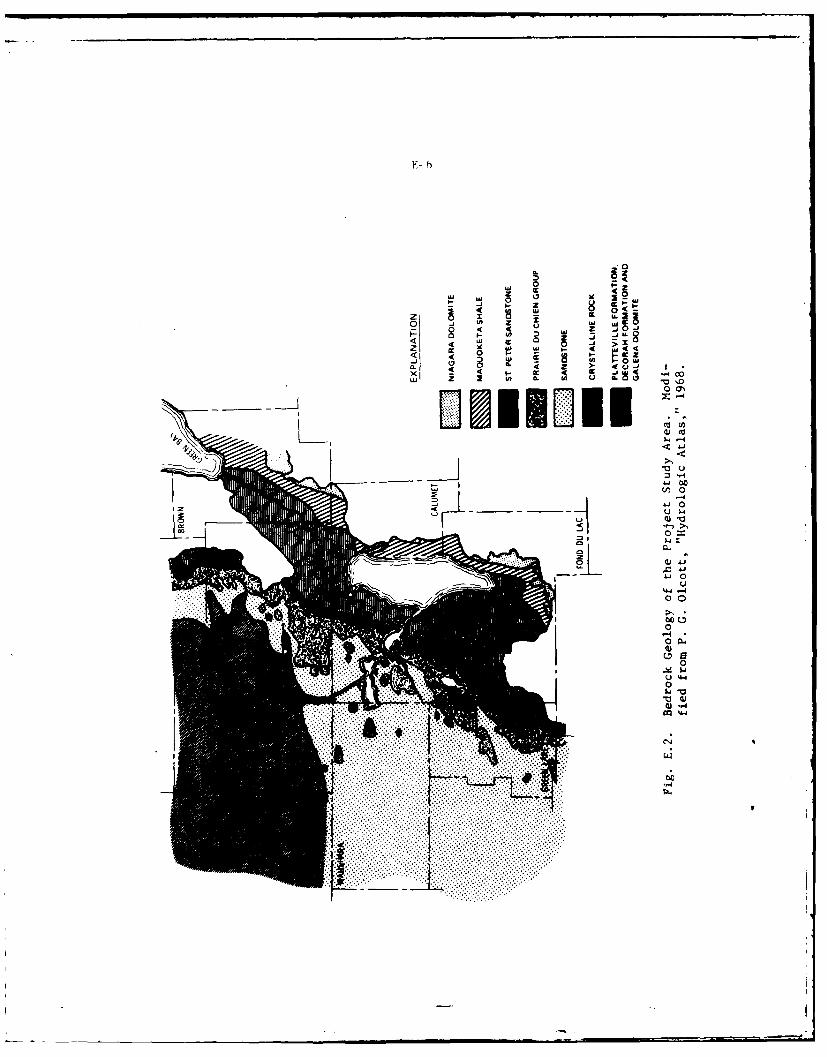
F- 6
0 z0
I- C z
z~~U 9 8Ow M
4 2 j > EU '
000
46(i 0
00
-4
00
0
Q-4
U 4-4
. . .. . .. . .. . .
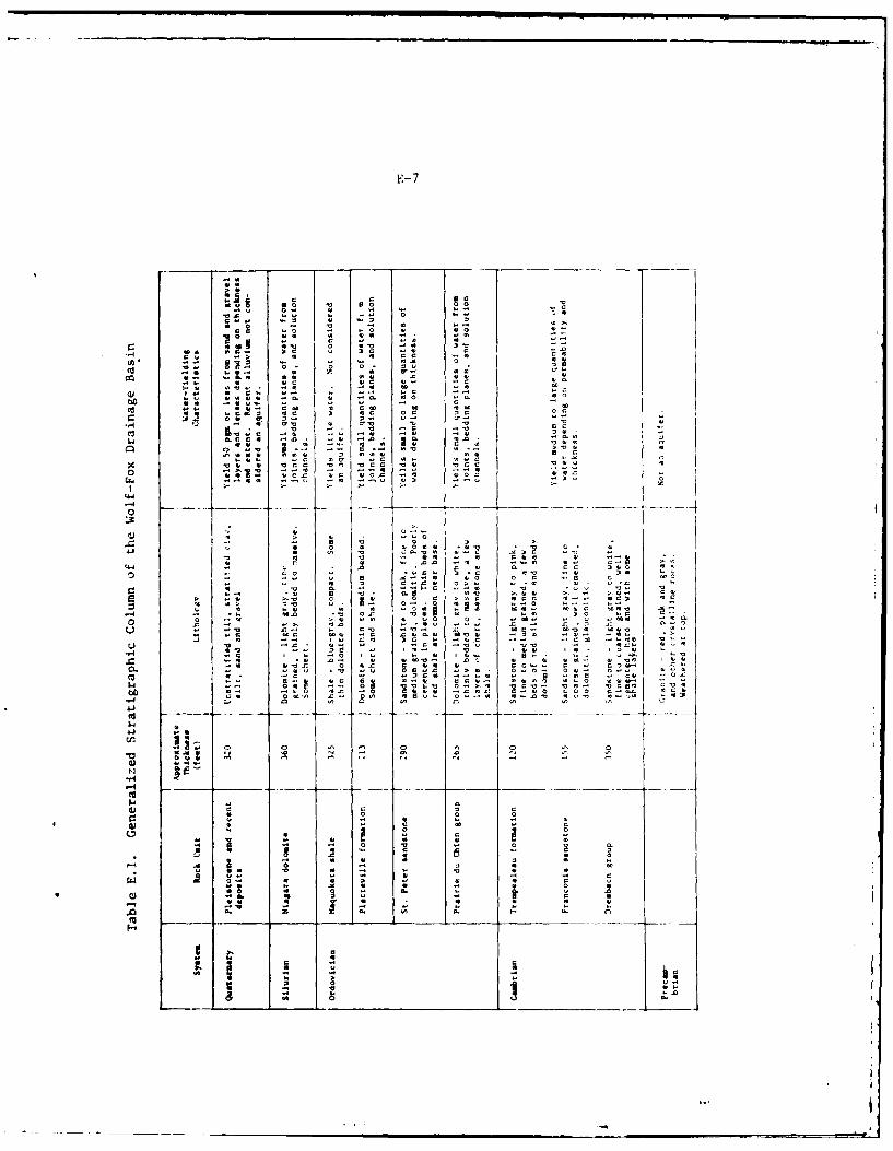
E- 7
000 0
001 I
50 0 0
.4.4 N -" 0 c~
w". "0 9 '.4 v 0
*z 0 c c0 r q0
9 ~ N - 0 1 90*0~~ w00 9 4 -
1-v 0 21 .40 I 3
00 r4. 1 0. 00-~ 0 . .
1. . -0 0. 0 1 000
A .60 0 0 0 9
.41. 9 SC90 9 C V~9 > . .4 ~ 0 4 a,
Cc* l. .. 4 44 N
NV 9 99 40. 9 .0. 0 V
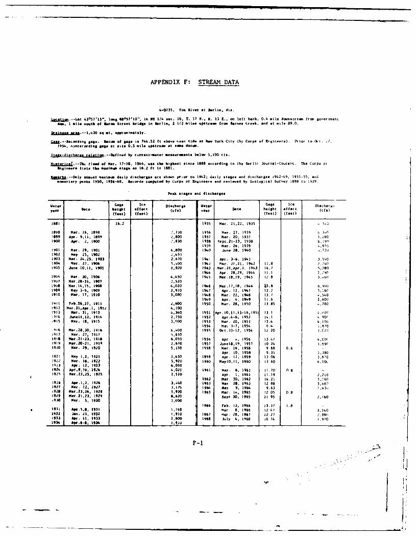
APPENDIX F: STREAM DATA
4-0735. Fox River at Berlin, Was.
ocAtion.-L4t 4357l15"0 lonsg U05?'10" in ME 1/4 sec. 16, T. 17 M., R. 13 1.. on left bank, 0.4 mile do.nstream fro goverti.entdim. I mile south of 11uron Street bridge in Berlin, 2 112 miles upetrel fro Barnes Creek, and at mile 89.0.
Din&& oaii.--1.430 eq m. epproximetely.
[8.U.--RtcordigE age. Datum of gage is 744.52 ft above uean tide at Now York City (by Corps of Engineers). Prior to Oct. 27,1954, no nreordin 8 Base at site 0.3 mile upstream at swie datum.
Stcee-dilcharae relation.--Deflnad by current-moter measurements belou 5,100 ca.
tjLs Lcss.--Tc flood of Mar. 17-18, 1946, was the highest since 1888 according to the Berlin Journal-Courent. The Corps otringineere t.to the maximum stage as 16.2 ft in 1881.
RIseake.-Only annual maliu daily discharges are shoun prior to 19421 daily stages and discharges 1942-49, 1951-55, andmonentary peaks 1950, 1956-68. Records computed by Corps of Engineers end revt wed by Geological Survey 1898 to 1939.
peak stages one discharges
Water Gage Ice Discharge Water Gage Ice Dlisc har n
year Date height effect (cf)) Data height effect(fet) (feet) (feet) (feet)
1881 16.2 1935 Mar. 21,22, 1935 -...
1898 Mar. 16, 1898 '..O 1936 Mar. 27. 1939 4..3899 Apr. 9.11, 1899 2.600 1937 Mar. 20, 1937 3.260
1900 Apr. 2, 1900 2,830 1938 sepc.21-23 1938 6, 1901939 Mar. 26. 1939 4,9,(.
1901 Mar. 29, 1901 4,800 1940 June 28, 1940 ,7,11902 May 25. 1902 2,4501903 Mar. 24,25. 1903 2,670 194: Apr. 3-6, 1941 3.,501904 ar. 27, 1906 5,.400 1942 M4r. 210,21, 1942 11.8 2.7401905 June 10,11, 1905 5,920 1943 Mar.3,Apr.). 1943 14.7 S,080
1944 Apr. 28,29, 194. 11.1 2.2"01906 Mar. 30. 1906 4,450 1945 ar.18.9. 19,45 12.8 1,67
197 Mar.2S-33, 1907 2,5201908 Hor,14.l5, 390 4,020 946 Mar.i7,18, 1946 L5.6 6,9001909 May 3-6, 1909 2.910 1947 Apr. 12, 1947 1212 3.1601910 Mar. 17. 1910 3.080 1948 Mar. 22, 1948 13.7 4,540
1949 Apr. 4, 1949 11.6 2,6001911 Feb.26.27, 1911 2,600 10Is Mar. 28. 1950 13.85 .:7801912 Mar.3lApr.1, 1914 4,1001913 Na. 31, 191) 4,340 1951 Apr.10,I.13-16,1951 13.194 Junelk,12, 1914 2,750 1952 Apr.4-6. 1952 14.1 . 90('915 Mar. Bs, 1915 3,000 1953 Mar. 20. 1953 13.4 4.100,
1954 Mas 3-7, 1954 0.4 1.970Q16 mar.26,30, 1916 0,400 1955 Det.i0*12, 1954 12.20 1(20
1917 Mar. 27, 1917 5,6501916 Nar.21-23, 1918 6.050 1956 Apr. 4, 1956 13.47 4.00(1919 Mar.20-21, 1919 2,670 1957 June18,1
9, 1957 10.24 1.690
1920 Mar. 29, 1920 5,150 1958 Her. 16, 1958 9.68 0.6
Apr. 10, 1958 9.31 1,3801921 Hay 1.2. 1921 2,450 1959 Apr. 12, 1959 13.06 ),670!92" Mar. 16, 1922 5,920 1960 MayIO,11, 1960 13 60 4,1(Xl9. Apr. 12, 1923 6,0503924 Apr.9,I0, 194 4,020 1961 Mar. 6, 1961 11.70 0 8192 Mar.23,5. 192S 2.520 Apr. 1, 1961 11.19 2.210
1962 Mar. 30, 1962 14.21 5,160!926 Apr.l,2. 1926 3,1440 1963 Mar. 28. 1963 12 88 3,4801927 Mar. 12, 1927 ),170 1964 May 9. 1964 9.63 7.43"
'926 Mar.2.24, 1926 5.920 1965 Mar. 14. 1965 12 05 0.81929 Mer.21,, 7929 6,620 Sept.30. 1965 11 95 2,)6019)0 Mar. 5, 1930 3,000
1966 Feb. 3, 1966 13.37 1.81931 Apr.58, 1931 1,140 Mar. 8, 966 12 47 3,140
1932 Jan. 23, 1932 1,910 196? Mqr 28, 1967 12.27 -.9961933 Apr. It, 1933 2.600 1968 July 4, 1968 10.74 1,9701934 Apr.6 -, 1936 1.910 9 1 1 1 1
F-1
rii
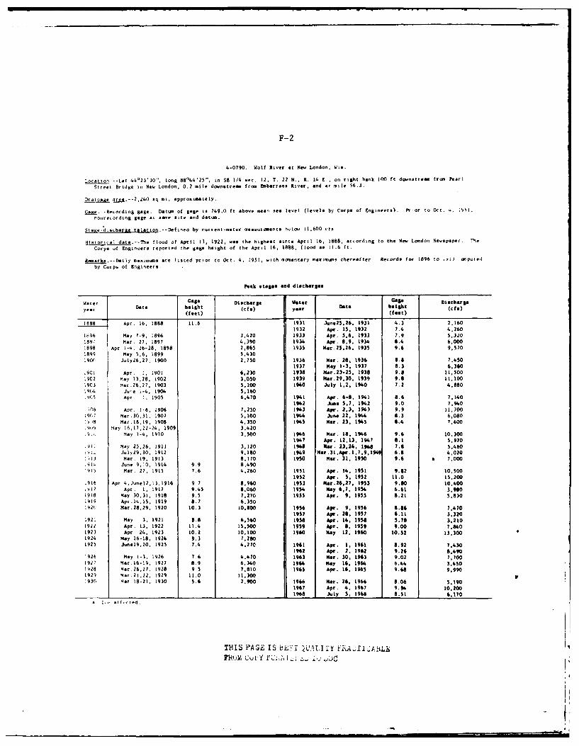
F-2
4-0790. Wolf River at New London, Wis.
Location -- Let 44023'10, long 88'44'25", in SE 1/4 sec. 12, T. 22 N., R. 14 E., on right bank 100 ft downstream from Pearl
Street Bridge in New London. 0.2 mile downstream from Embarrass River, and at nile 56.3.
Draae area.--2,240 sq at, approximately.
G.g.--Recording gage. Datum of gage is 749.0 ft above mean sea level (levels by Corps of Engineers). Pr or to Oct. -. ;51.
nonrecording gage at sate site and datum.
Store-discharae relation.--Defined by current-meter measurments bvlow 11,600 cts
Htstorical data-The flood of April 13, 1922. was the highest since April 16, 1888, according to the New London Newspaper, The
Corps of Engineers reported the gage height of the April 16. 1888, flood as 11.6 ft.
Remarka.--Daily meximims are listed prior to Oct. 4, 1951, with momentary maximums thereafter Records for 1896 to ,-iJ .wt.ptned
by Corps of Engineers.
Peak stages and discharges
water Goe Ditcharge Wster Gage Dlaharga
year Date height (cfe) year Date beaiht ( )(feet) (feet)(fe
1888 Apr. 16. 1888 11.6 1931 June25.26. 1931 4.3 2.160
1932 Apr. 15, 1932 7.4 4,2601696 May 7-9, 1896 3,420 1933 Apr. 5.6, 1931 7.9 5,320189" Mar. 27, 1897 4.390 1934 Apr. 8.9, 1934 8.4 6,0001898 Apr.1-4, 26-28, 1898 2,865 1935 Mar.25,26, 1935 9.6 9,570
1899 May 5,6, 1899 5,430190r July
26,2
7, 1900 2,750 1936 HMr. 28. 1936 8.8 7,450
1937 May 1-3. 1937 8.3 6,360.901 Apr. 1, 1901 6,230 1938 Nar.23-25, 1938 9.8 11,500,902 May 13,28, 1902 3,050 1939 Mar.29.30. 1939 9.8 11.1001903 Mar.
26,27, 1903 5,100 1940 July 1.2. 1940 7.2 4,880
19C4 June i-4, 1904 5,180.965 Apr. i. 1905 6,470 1941 Apr. 6-8. 1941 8.6 7.140
1942 June 5.7. 1942 9.0 7.940.6 Apr. 1-6, 1906 7.250 1943 Apr. 2.3. 193 9.9 11.700
19111 Mar.30,31, 1907 5,100 194I June 22, 1944 6.3 6,080.,!9 Mar.18,19, 1908 4,350 1945 Mar. 23. 1945 6.4 7,600.9109 May 16,17,22-24. 1909 3,42091, May 1-4, 1910 3,500 1946 Mar. 18, 1946 9.6 0.300
1947 Apr. 12,13, 1947 8.1 5,970
.91. May 25,26, 1911 3,120 1968 Nar. 23,24, 1948 7.8 5,460.Y L Uly29,30, 1912 9.180 1949 Nar.31l.Apr.1,7,9,194 6.8 4.020
i13 Mar. 19. 1913 8.170 1950 Mar. 31, 1950 9.6 a 7,000.914 June 9,10. 1914 9.9 8,490i915 Mar. 27, 1915 7.6 4,260 1951 Apr. 14. 1951 9.82 10,500
1952 Apr. 5, 1952 11.0 15,200,916 Apr 4,Junel2,13.1916 9 7 8,960 1953 Her.26.27, 1953 9.60 10,400IVl Apr. 1, 1917 9.45 8,060 1954 May 6,7, 1954 6.61 3,9"01918 May 30,31. 1918 9.5 7,270 1955 Apr. 9, 1955 8.21 5,8301919 Apn.14,15, 1919 8.7 6.350
19211 Mr.28,29, 1920 10.3 10,800 1956 Apr. 9, 1956 8.86 7,6701957 Apr. 28, 1957 6.11 3,320
192i May 3. 1921 8.8 6,560 1956 Apr. 14, 1958 3.78 3,2101922 Apr. 13. 1922 11.4 is,.OO 1959 Apr. 8, 1959 9.00 7, "01923 Apr 24, 1923 10.2 10,100 1960 May 12, 1960 10.52 13.3001924 May 16-18, 1924 9.3 7,20
1925 June19,20, 1925 7.4 4.270 1961 Apt. 1, 1961 8.92 7,4301962 Apr. 2, 1962 9.26 8.490
1926 Nay 1-3. 1926 7.6 4.470 1963 Mar. 30, 1963 9.02 7,7001927 Mar.l6-19, 1927 8.9 6.340 19" May 16, 1964 6.44 3,8501928 Mar.26,2?, 1928 9 5 7,810 1965 Apr. 16. 1965 9.68 9,9901929 Mar.21,22, 1929 11.0 11.3001930 Mar 18-21. 1930 5.6 2,900 1966 Mar. 26, 1966 8.06 5.180
1967 Apr. 4. 1967 9.94 10.2001 1 1 1968 July 5, 1968 0.51 6.170
a ,i alt-,tied.
THIS PAGE IS HL', 'UL1TY FRA i.Aj..
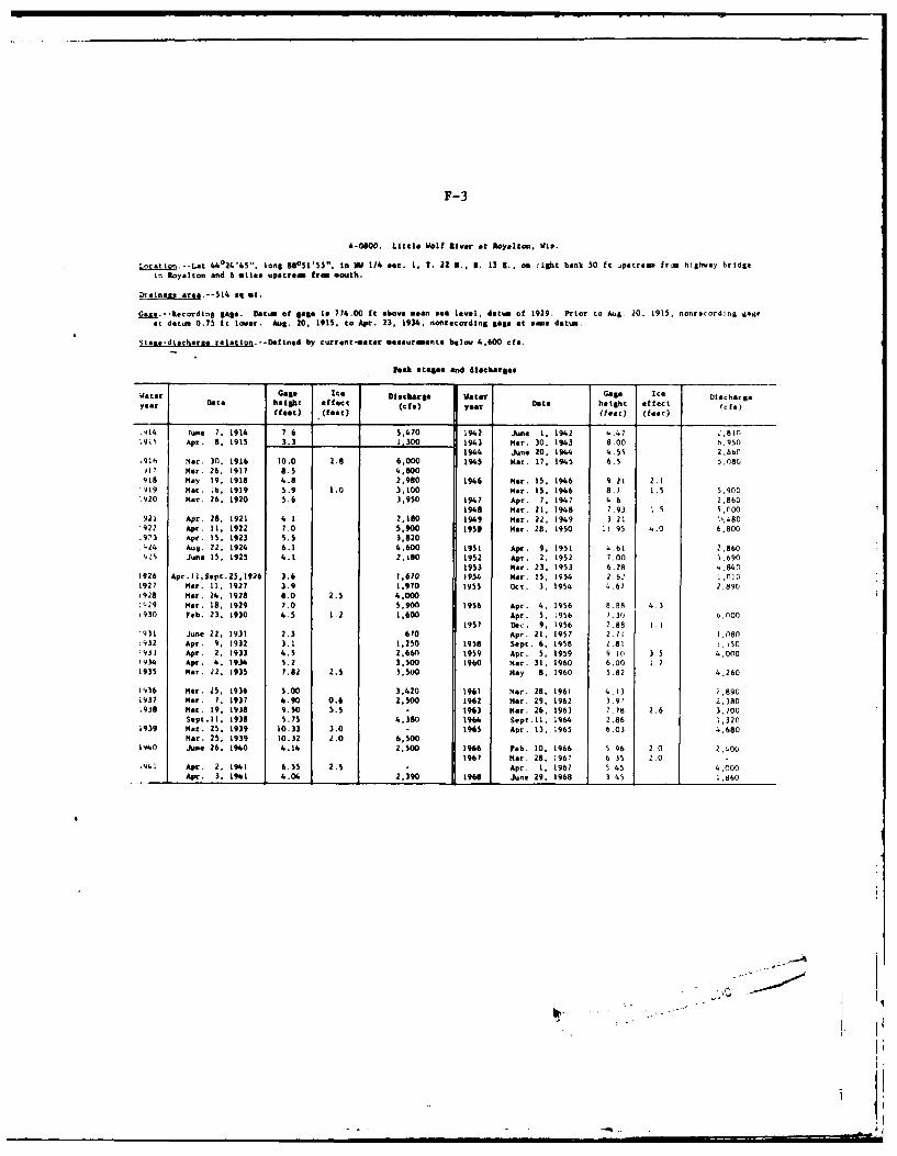
F-3
4-000. Little Iolt liver at Royalton, dle.
Loc.ion--Lat 44024'45", lone 88051'55", in Id 1/4 sec. 1. T. 22 N.. Bt. 13 1., on right bank 50 It upetrem from high.ay bridge
In Royalton and 6 oiles upetrem free mouth.
Drainage ar .*-514 sq ml.
Gaze.--Recordln 8 gale. Datum of gae ti 774.00 ft above mno 0ea level, datum of 1929. Prior to Aug 20. 1915, nonrecord:ng saeat detw 0.75 ft lower. Aug. 20, 1915. to Apr. 23, 1934. nonrecordlng gage at ome datum.
Stame-diecharge relotion. --Defined by current-ueter *eeeursiments below 4,600 cfe.
Peak stelae mnd dtlocargee
Water Gaga Ice Disloarg8e Vate Gage Ice Dschergeyear Date height effect (CfI) year Dot. height effect (fc)(feet) (feec) (feet) (feet)
.414 Tune 7. 1914 7.6 5,470 1942 June 1, 1942 '.47 ",810;9, Apr. 8, 1915 3.3 .1300 1943 Her. 30. 1943 8.00 4.950
194 June 20, 194 4.55 2,86C,916 Mar. 30, 1916 10.0 2.8 6,000 1945 Mer. 17, 1945 6.5 5.080.17 Mar. 26. 1917 6.5 6.800918 may 19, 1918 4.8 2,980 1946 Mar. 15, 1946 9.21 2.1P019 Mar. '6, 1919 5.9 1.0 3,100 Mar. 15. 1946 8.7 1.5 5,900"920 Mar. 26, 1920 5.6 3,950 1947 Apr. 7, 1947 4 6 2.860
1948 Mar. 21. 1948 7.93 1.5 5,00921 Apr. 28, 1921 4.1 2,180 1949 Mar. 22, 1949 3 21 1.4801922 Apr. 11, 1922 7.0 5,900 1950 Mar. 28, 1950 11.95 4.0 6.800:973 Apr. 15. 1923 5.5 3,820J.24 Aug. 22, 1924 6.1 4,600 1951 Apr. 9, 1951 4.61 2,860,,'s June 15, 1925 4.1 2.80 1952 Apr. 2, 1952 7.00 5,690
1953 Mar. 23. 1953 6.28 4.8401926 Apr.ll,Sept.25,1926 3.6 1,670 1954 Mar. 15. 1954 2 62 1,0101927 Mar. 11. 1927 3.9 1.970 1955 Oct. 3, 1954 4.67 2.890928 Mar. 24. 1928 6.0 2.5 4.000'.29 Mar. 18. 1929 7.0 5,900 1956 Apr. 4, 1956 8.B 4.3,930 Feb. 23. 1930 4.5 1.2 1,600 Apr. 5, 1956 7.30 ,nOO
1957 Dec. 9, 1956 2.88 1.1'931 June 22, 1931 2.3 670 Apr. 21: 1957 2.71 1.080.932 Apr. 9, 1932 3.1 1,250 1958 Sept. 6, 1958 2.81 1.1501931 Apr. 2. 1933 4.5 2.660 1959 Apr. 5, 1959 9 10 3.5 4.000.934 Apr. 4. 1934 5.2 3.500 1960 Mar. 31. 1960 6.00 I 71935 Her. 12, 1935 7.82 2.5 3.50 May 8, 1960 5.82 4.260
1936 Mar. 25. 1936 5.00 3,420 1961 Mar. 28, 1961 4.13 2,8901937 Mar. 7, 1937 6.90 0.6 2.500 1962 Mer. 29, 1962 3.9) 2.380193@ Mar. 19. 1938 9.50 5.5 1963 Mer. 26, 1963 .78 2.6 3.700
Sept.11, 1938 5.75 4.380 1964 Sept.11, 1964 2.86 1,3201939 Mar. 25. 1939 10.33 3.0 - 1965 Apr. 13, 1965 6.03 4,680
Mr. 25. 1939 10.32 2.0 6,500140 June 26. 1940 4.14 2,500 1966 Feb. 10, 1966 5.96 2 0 2,400
1967 Mat. 28. 1967 6 35 2.09P41 Apr. 2, 1%1 6.55 2.5 Apr. 1, 1967 545 4.000
Apr. 3, 1941 4.04 2,390 1968 June 29. 1968 45 1,860
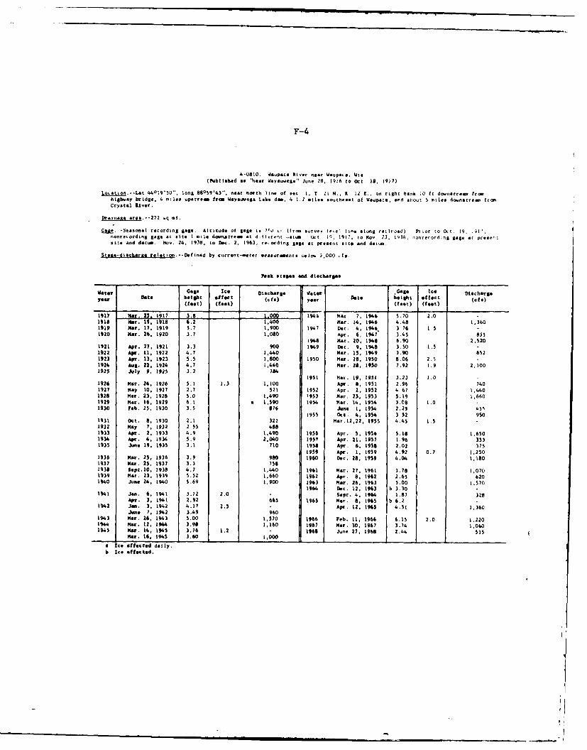
F-4
4-0810. idupaca River near Waupaca, Wie(Published to 'near eyauwega" June 28, 1916 to Oct. 18, 1917)
Location--Let 44019'50" ,
long 88059'43'", near north line of e. 1, T. 2k N.. R 12 C., on right bank .0 ft downetream fromhighway bridge, 4 mie upstrem from Weyouwega Lake dim, 4 1;2 silts southeast of Waupa:., and about 5 miles downstrear fromCrystal iver.
Drainait area.--272 bq mt.
Gag..--Seasonal recording gage. Altitude ot gage is 7.0 I- Orom survey le-e1 line along railroad) Prior to Oct 19, .91?,nonrecording gage at site I alle downstrem at difitron .atA Oct IQ, 1917, to Nov. 23, 1938. nonrecord;ng gage at presentsite and dati Nov. 24, 1938, to Dec. 2, 1963, reording gage at present site and datum.
$tace-diecbrwa relation--Del nod by currant-seter meaeurmente t,*a3 2,000 cfa.
Peak stages and diacbarSa.
Vater Goae Ice Olachargo Wter 'Gage Ice Dischargeyear Date height effect (cf) year Date height effect (cfe)
(feet) (feet) (feet) (feet)
1917 Na. 25. 19171944 at 7, 1946 5.70 2.0 -Isis 1 6.2 1,400 Mar. 14. 196 4.48 1,3601919 Mar. 17, 1919 5.7 1,900 1947 Dec. 4, 1946 3 76 1.5 -
1920 Her. 26, 1920 3.7 1,080 Apr. 65 1947 3.5 851948 Her. 20, 1948 6.90 2,520
1921 Apr. 27, 1921 3.3 900 1949 Dec. 9. 198 3.50 1.5 -
1922 Aplr. 11, 1922 4.7 1.440 Mar. 15: 199 3.90 6521923 Apr. 13, 1923 5.5 1.800 1950 Mar. 28, 1950 8.06 2.5 -1924 Aug. 22, 1924 4.7 1,440 Mar. 28, 1950 7.92 1.9 2,1001925 July 9. 1923 3.2 784
1951 Nar. 19, 1951 3.2J 1.0 -1926 Mar. 24, 1926 5.1 1.3 1,100 Apr. 8, 1951 2.96 7401927 May 10, 1927 2.7 521 1952 Apr. 2, 1952 4.67 1,4101928 Mar. 23. 1929 5.0 1,490 1953 Mer. 23, 1953 5.19 1,6601929 Not. 16, 1929 6.1 A 1,590 1954 Mar. 14, 1954 3.06 1.01930 Fob. 25, 1930 3.5 876 And 1, 1954 2.25 45
1955 Oct. 4 1954 3.52 9501931 Oct. 8, 1930 2.1 322 Nar.L2,22, 1955 4.45 1.51932 May 7, 1932 2.55 4801933 Apr. 2, 1933 4.9 1,490 1956 Apr. 5, 1956 5.18 1,650
1934 Apr. 4, 1934 5.9 2,040 1957 Apr. 21, 1957 1.96 3531935 June 19, 1935 3.1 710 1958 Apr. 6, 1956 2.02 375
1959 Apr. 1, 1959 4.92 0.7 1.2501936 Mr. 25, 1936 3.9 980 1960 Dec. 28, 1959 4.04 1.1801937 Mar. 25, 1937 3.3 7581938 Sept.10, 1938 4.7 1,440 1961 Har. 27, 1961 3.78 1,0701939 Naet. 23, 1939 5.52 1.660 1962 Apr. 8, 1962 2.65 6201940 June 24, L940 5.69 1,900 1963 Nar. 26, 1963 5.00 1,570
19641 Dec. 12, 1963 b 3.301%41 Jan. 6, 1941 3.72 2.0 - Sept. 4, 1964 1.87 328
Apr. 3, 1941 2.92 665 1965 Mar. a, 1965 b 6.21)42 Jan. 3, 1942 4.17 2.5 Apr. 12, 1965 4.51 1,360
June 7, 1942 3.49 9601943 Mor. 26, 1943 5.00 1.570 1966 Feb. 11, 1966 6.15 2.0 1.2201944 Ka". 12, 1962 3.98 1,160 1967 Mar. 30, 1967 3.74 1,0bo1%45 Har. 14, 1945 3.76 1.2 1968 June 27, 1968 2.44 535
Naet. 16, 1945 3,60 OO0w
a Ice effected daily.
b Ice affacted.
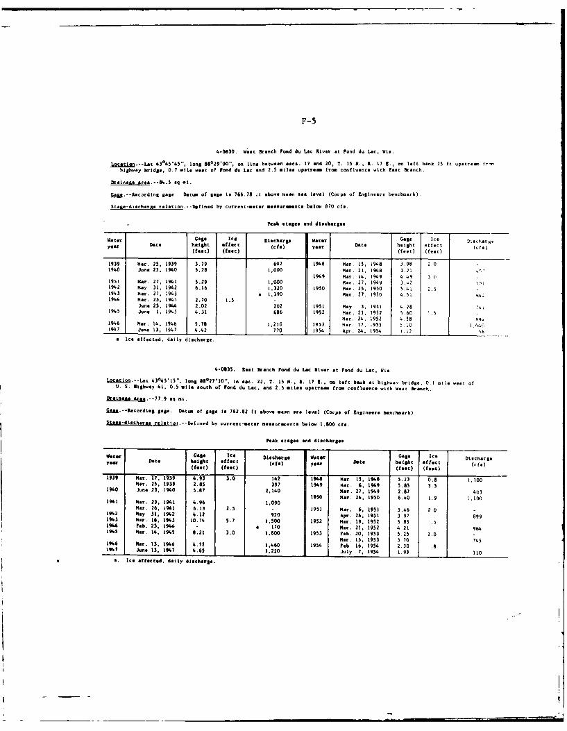
F-5
4-0830. West Brench Pond du Lec River at Fond du Lac, Wis.
Location.--Lat 43045'45", long 88029'00". on line becveen eecs. 17 end 20, T. 15 N., R. 17 E., on left bank 25 ft upstrea fr-
highway bridge, 0.7 mile veast of Fond du Lac and 2.5 miles upstream from confluence with East branch.
Drainage area--/.5 eq mi.
gagM.--Recording Sage. Datum of gage Is 766.78 Lt above mean see level (Corps of EngiRneers benchmark)
Staue-discharas relation.--DefIned by current-mater measuremente below 870 cfe.
Peak stages and discharges
Water Gage Ice Discharge Water Gage Ice Dlsch-gyear Date height effect (cf) yer Date height effect (cfs)
(feet) (feat) f (feet) (feet)
1939 Mar. 25, 1939 3.79 602 1948 Mar. IS. i948 3.98 201940 June 22. 1940 5.28 1,000 Mar. 21, 1948 3.21 '
1949 Mar. 14, 1949 4.49 3 019'-l Mar. 27. 1941 5.29 1,000 Mar. 27, 1949 342 42194 2 Nay 31, 1942 6.16 1.320 1950 Mar. 25, 1950 5.41 2.51943 Mar. 27, 1943 a 1,390 Mar. 27. 1950 4.51 94.1944 Mar. 23, 194'. 2.70 1.5 -
June 23, 1944 2.02 202 1951 May 3, 1951 4.281945 June 1, 19431 4.31 686 1952 Mar. 21. 1952 560 .5
Mar. 24, 1952 4.58 991946 Mar. 14. 1946 5.78 1,210 1953 Mar. 17, 1953 5 10 1.04 C1947 June 13, 1947 4.42 770 1954 Apr. 24, 1954 1.12 S6
a Ice affected, daily discharge.
4-0835. East Branch Fond du Lac River at Fond du Lac, Wis.
Location--Lat 43o45'15", long 88027110'1. In sec. 22, T. 15 N., A. 17 E.. on left bank at highwav bridge, 0.1 mile wes of
U. S. Highwey 41. 0.5 mile south of Pond du Lac, and 2.5 miles upstrem fro. confluence with West Branch.
Drernate area.--77.9 sq mi.
GM.-Recording gage. Datum of gage Is 762.82 ft above sean sea level (Corps of Engineer@ benchmark).
Stage-dlscharee reletiga.-.Defined by current-meter measurements below 1,800 cfe.
Peak stages and discharges
Water Gage Ice Discharge Water Gage Ice Dischargeyear Date height effect (cfe) year Date height effect (cfs)(feet) (feet) (fast) (feet)
1939 Mar. 17, 1939 4.93 3.0 142 1948 Mar. 15, 1948 5.23 0.8 1,100Mar. 25. 1939 2.85 397 1949 Mar. 6, 1949 5.85 3.5
1940 June 23, 1940 5.87 2,140 Mar. 27, 1949 2.87 4031950 Mar. 26, 1950 6.40 1.9 1,1001941 Mar. 23, 1941 4*.96 1,090
Mar. 26, 1941 6.13 2.5 - 1951 Mar. 6, 1951 5.46 2.03942 May 31. 1942 4.12 920 Apr. 26, 1951 3.97 8991943 Mar. 16, 1943 10.74 5.7 1.500 1952 Mar. 19, 1952 5.85 .51944 Feb. 23. 1944 - a 170 Mar. 21, 1952 4.21 964195 Mar. 14, 1945 8.21 3.0 1.600 1953 Feb. 20. 1953 5.25 2.0
Mar. 15, 1953 3.70 7451946 Mar. 13, 1946 4.72 1,460 1954 Feb. 16, 1954 2.30 .81947 June 13. 1947 '4.65 1.220 July 7, 1954 1.93 110
a. Ice affected, daily discharge.
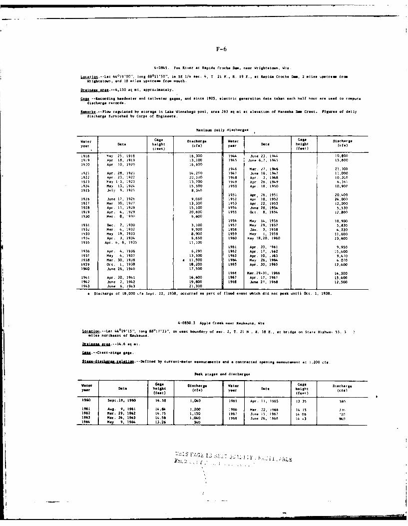
F-6
4-0945. Fox River at Rapide Croche Dom, near Wrightercn, Wis
Locatjo.--LIt 44019'00", long 88011'50". in SE 1/4 sec. 4, T 21 P., R. 19 E., at Rapids Croch Dan, 2 mile upstream (roi
WrLghtstown, and 18 miles upstream from mouth.
Drainage sre.--6.150 eq mi. eppro.AlMeteiy.
as* --Recording he dwater and taillater gages, and since 1925. electric generation date taken each half hour are used to co=putedischarge records.
Remark.--Flou regulated by storage In Lake Winnebago pool, area 263 eq mi at elevation of Meneeha Dom Crest. Figures of daily
discharge furnished by Corps of Engineer@.
Maxiemu daily discharges
Water Gaee Discharge Water Gage Diecharge
year Data helsht (cfa) year Date height (cf*)treat) (feet)
1918 May 25, 1918 16,300 1944 June 23, 1944 10,8001919 Apr 18, 1919 13,100 1945 June 6.7, 1945 15.800
1920 Apr 10, 1920 16.600
1946 Mar. 27, 1946 21,3001921 Apr. 28, 1921 14,200 1947 June 16. 1947 11.0001922 Apr. 23. 1922 20.100 1948 Apr. 3, 1948 10.3(,01923 May 1-3. 1923 13.700 1949 Apr. 26, 1949 6,361924 May 13. 1924 15.500 1950 Apr 18. 1950 10.9001925 July 9, 1925 8.340
1951 Apr; 26. 1951 20,4001926 June 17, 192k 9,060 1952 Apr 18, 1952 24.000
1927 Mar. 30, 1927 13,300 1953 Apr. 22. 1953 12,000
1928 Apr. II, 1928 15,100 1954 June 28, 1954 5,5301929 Apr. 4, 1929 20,600 1955 Oct 8, 1954 12,8001930 Mar. 8, 1930 6,600
1956 May 14., 1956 10.9001931 Dec. 2, 1930 3,100 1957 May 29. 1957 5.8301932 Mar. 4, 1932 9,900 1958 Ian, 3, 1958 4.2201933 May 19, 1933 8,900 1959 May 1, 1959 11,600193 Apr. 3, 1934 6,650 1960 May !8.20, 1960 23,600
1935 Apr. 4, 6, 1935 11,1001961 Apr. 20, '961 9.950
1936 Apr. 4, 1936 6,290 1962 Apr. 17, .962 15,400
1937 May 4, 1937 13,500 1963 Apr. 10, .063 9,4701938 Mar. 30, 1938 a 11,500 1964 May 26. 1964 4.0701939 Oct. 1, 1938 16,200 1965 Apr. 30, 1965 12,4001940 lotne 26, 1940 17,500
1964 1Kar.29-31, 1966 14,200
1941 Apr. 20, 1941 16,600 1967 Apr. 17. 1967 15,4001942 June 2, 1942 19,800 1968 June 27, 1968 12,5001943 June b, 1943 21,300 1
a Discharge of 18,000 cf. Sept. 22, 1938, occurred as part of flood event which did not peak until Ot. 1, 1938.
4-0850.3 Apple Crek near Kaukeuna, Wis.
19caion.--Lat 44019'15,
long 88°17'33, on vest boundary of sec. 2, T. 21 N.. R. 18 E.. at bridge on State Hlhwa, 55. 3 2
tlle northeast of Kaukauna.
D*janaze ore.--e4.6 sq mi.
ion. -- Creet-etage lge.
.ta*e-discha relation-Defined by current-enter mesaurnente and a contracted opening measurient at 1.200 cfs.
Peak stages and discharges
Water Gage Diecharge Water Gage Dischargeyear Date height (cfe) year Date height (ca)
(fat) (feet)
1960 SepL.19, 1960 14.38 1,040 1965 Apr. I1, 1965 13 35 580
1961 Aug. 9, 1961 14.84 1,200 1966 Mar. 22, 1966 14 15 77(l1962 Mar. 29, 1962 14.75 1,150 1967 June ;5, 1967 14 06 201963 Mar. 24, 1963 14.58 1,040 1968 June 26. 1968 14 .3 9401964 May 9, 1964 13.26 1 340 1 1
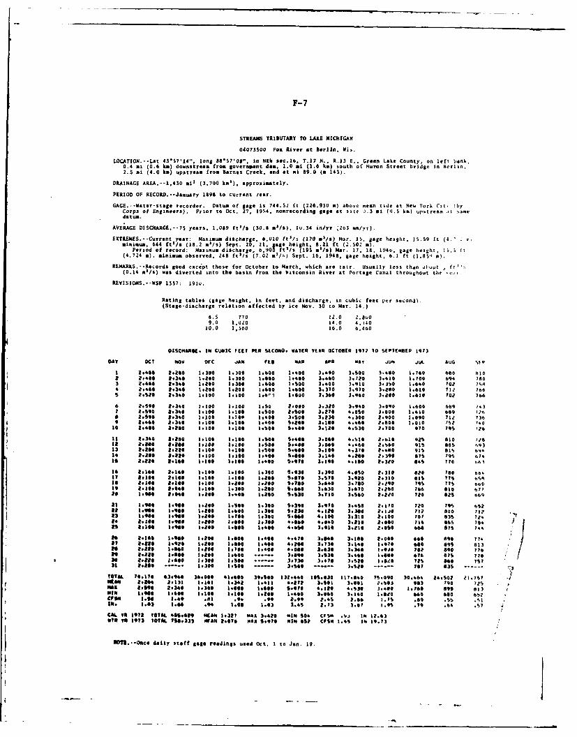
F-7
STREAMS TRIBUTARY TO LAKE NICHIGAN
040735OO Fox River at Berlin. Wis.
LOCATION.--Lat 4357'14", long 88*57'08". In NE sec.lb, T.17 N., R.13 E., Green Lake County, on left bank.0.4 mi (0.6 ki) downstream from government don, 1.0 ai (1.6 ki) south of Huron Street bridge in Kerlin,2.5 mi (4.0 kx) upstream from Barnes Creek, and at ml 89.0 (a 143).
DRAINAGE AREA.--1,430 mi (3.700 kma), Approximately.
PERIOD OF RECORD.--January 1898 to current Yeer.
GAGE.--Water-stage recorder. Datum of gage is 744.SZ ft (226.930 m) above mean tide at New York Cit, rbyCorps of Engineers). Prior to Oct. 27, 1954. nonrecording gage at site 0.3 mi (0J.5 kn) uptstream it >amedatum.
AVERAGE DISCHARGE.--7S years. 1.089 ftfs (30.8 m5/$). 1u.34 in/yr Zo3 mm/yr).
EXTREJMS.--Current year: Maximum discharge. 6,O10 ftl/s (170 m/&) Flar. IS. gage height. 3S.59 ft (A.'minimum, 644 ft /s (18.2 ml/s) Sept. 20, 21, gage height, 8.21 ft (2.02 a).
Period of record: Mazimum discharge, 6,900 ftl/s (19i5 G/s) Mar. 17, 1S. 194., gage height, 15.S ft(4.724 a) minimum observed, 248 ft'/s (7.02 a /s) Sept. 16, 1948, gage height, 0.1 ft (1.85,1 ).
REMARKS.--Records good except those for October to March, which are tair. Usually less than d.'out , f!"'.(0.14 m'/s) was diverted into the basin from the Wisconsin River at Portage Canal throughout the 'v.
REVISIONS.--WSP 1337; 1910.
Rating tables (gage height, in feet. and discharge, in cubic feet per second).(Stage-discharge relation affected by ice Nov. 30 to HAr. 14.)
8.S 770 12.0 2'8U09.0 1,020 14.0 4.14010.0 1,560 16.0 6,400
OISCNAO. IN CUBIC FEET PER SLCONO. WATER viE OCTOBR 1972 10 SEPTEMBE 1973
DAY OCt Nov OC JAN Ftg MAP APe May JUN JUL AUG %f 0
3 2.608 2.28 1:300 1:300 1:60 1.600 3,690 3.500 3.,80 1.760 680 8102 2O0 1,369 1.240 1,300 3.600 1a608 3.60 3.30 3.63 ? 1.700 694 1903 2.460 2.340 1.oO0 1.300 1.600 l.00 3.40 3.9 0 3.360 1.640 702 7SA4 2.460 2.340 1.200 1.200 1.600 1600 3.370 3.070 3.2e0 3.630 ?1 ? 66s 2.2o 2.340 1.100 3.300 1.6,1 1.600 3.360 3.960 3.200 1.610 702 766
6 2.590 R.340 3.300 1.300 3.50 2.000 3.3Z0 3,940 3.090 1.600 669 1.37 2.590 2.340 1.100 1.100 I.oO0 2.50 3.210 4.050 3.000 .4o 09 7?2h0 2.590 2.340 1.100 3.190 1#600 3.s00 3.230 4.300 2.900 1.090 711? 7369 2.460 2.340 1.100 1h100 1.400 5e20 3.100 4.460 2.000 3.030 '32 7.030 2,400 8.200 1.100 1.100 3,5O0 S.600 3.120 4.s3O 2.700 970 795 726
3 2,340 2.260 1,100 1.100 1.500 S9,46 3.060 4.S10 2.610 92% 810 ??832 2.200 z.o 3.1300 3.300 3i,00 5,400 3.0e60 6,460 2.360 9s G05 69313 t.2oe 1.224 1.1000 1.190 3.500 S.600 3.100 4.10 ?,060 915 01 by"14 2.200 2.220 1.100 1.100 3.400 5.l00 3,340 4.00 2.390 sys 79 674is 21.20 2.160 1.100 hi300 1,400 5,970 3.190 4.10 2.320 65 770 be,
16 2,360 2.160 1.300 1.100 1,300 6.930 3.390 4.050 Z.310 8z0 780 bb-17 2,300 2i.e0 3.100 1.100 3.200 S.600 3.50 3,920 2.330 035 775 65Ai0 2.109 2.100 3.100 3.200 IZO0 S.700 3.640 3.700 2.290 19 775 6bOI9 2.100 2,040 1.100 1.300 1.200 S.660 3.630 3.60 1.260 764 00 67?29 3,90 2, 4 00 .200 1.g00 3,200 S.,30 3.110 3.560 2.2io ?o 02S 669
23 .90 1.010 1.200 3.500 1.300 S,390 3.970 3.08 2.10 720 79S 6S22 .140 3.944 3.2o 3,600 1.300 S.830 4.310 3,300 Z.310 7I I 00 72
23 1.900 3.004 3,200 k.106 1.300 S.0o 4.100 3.310 2.100 701 63s 72.24 2.100 1.980 I-RO00 .00 1.300 4,000 4.040 3.230 .060 16 65 7042 .300 1.900 .200 .i00 3.400 '.650 3.910 3.110 2.050 660 015 P4
26 Z.160 .0110 3.200 1.000 3,40 6,470 3.040 3.390 2.000 660 090 712? 2.29 1,920 1.290 1.00 1,400 4.90e 3.720 3,140 1.90 00 89S 813 /to 2.20 1.060 1.200 1.100 1.400 6.000 3.630 3.340 3.10j F02 090 7762 iia 1.2.O 2.2.0 3 o200 ...... 3.009 3.530 3.460 3.000 676 a? 77030 W.a0 1,600 3.300 3.s0 ...... 3 3,47 3.51 0 3.00 t2 b0 7S?31 2,200 ...... 1.300 3.500 ...... 3.560 ...... 3,S20 ------ To9 835 ------
TOTAL 10.170 63.940 36.000 41,600 3$.S00 313.440 0o.030 37.040 "s.090 30.64 14.SO2 Z1.7s yMRANI 2.1"k 2,131 1-161 k.342 1.411 0.17? 3,00l 3.901 ?.S03 0 ?900 72SNIARl Ro.4s 2.340 1.300 1.600 1.600 S.q70 4.111 G.S30 3.48O 1.7001 895 813"IN I.944 1.600 IlooD 1.10 1.2O0 i100 3.060 3.160 1.64t0 "0 600 652eFSi 3.0J4 3.o9 . .0 .99 2.0 .45 2.66 3.75 .09 .55 .33Io. .03 3.61 .9 3.00 1.03 3.45 A .73 3.07 3.95 .7S .1 .S7
CAL TR 1972 TOTAL 4S9629 4EAN 1.327 WAR 3.420 "IN 50 CFSN .Vj IN 32.63oTO YR 3973 TOTAl 50S333 Nr&N 2,070 oHs S.970 oil 65? CPS14 1.4S IN 19.13
NUM.--OncO daily staff gage readings used Oct. 1 to Jan. 19.
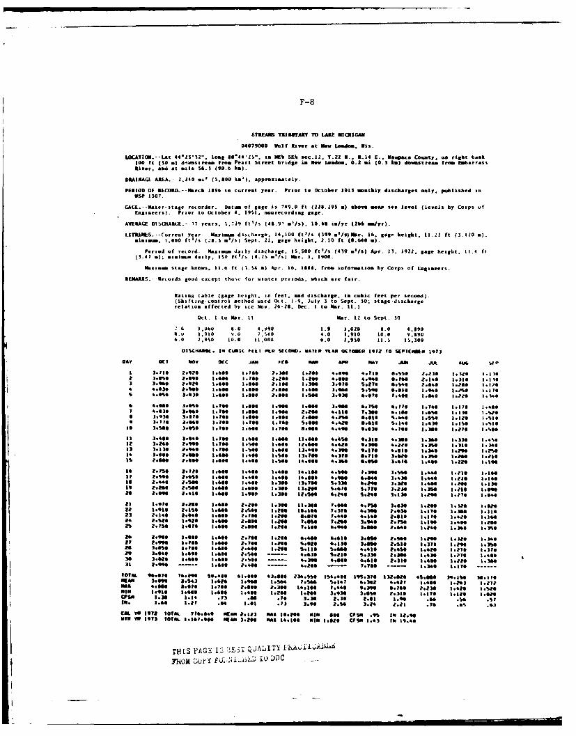
F-8
STREAM li IJYAKY Mit)AKE NZIIICAN
04079000 Wolf River at New Loadlo. Wis.
LOCATION.-Lat 44'1332". long 56*44'" to inEU& SE% sec.li, T.22 H.. R.14 E., V aupaca Couinty, on right bank300 ft (30 a) dl~vast ream from Pearl Street bridge in New London. 0.2 vii (0.3 Its) downstream fro EmarrassRiver, ad at sile $9.3 (90.6 Em).
ORAINAGI AREA. - -2.340 air (500 lim'). approximately.
PERIOD OF RECORD.- March 1896 to current year. Prior to October 1913 moothly dascitarges only. published inWSP 1307.
GAGE.- -ater-stage recorder. Datum of gage is 749.0 ft (228.29S a) above meam sea level (levels by Corps oifEngineers). Prior to October 4. 39S3, nonrecording gage.
AVERAGE DISF33ARGE.- -77 years. 1.-,29 fitlls (48.9' sij5 ). 10.46 ialyr (266 mi/yr).
EXTRAPIES. -- Current year, Maximium discharge. 14,300 flts (399 *'Is)Ibr. 36. gage height. 31.-Z ft (3.410 a..mimimum, 1.000 fti/s (281.3 *'/S) Sept. 21. gage heighit, 2.10 ft (0.6400a.)
Period of record: Maximum daily discharge. 13.s00 ft'Is (439 a~'/s) Apr. 13. 3922, gage height. 11.4 it(3.47 a); mimimum daily, ISO ftl/s ( 4.23 */%) War. 1. 3900,
Maximum stage known. 13.6 It (1.$4 a) Apr. 16. 38384. from informatios by Corps of Engineer's.
REMARKS. --Rencords good except thoss for winter periods, which are fair.
Rating table (gage height, in feet. ad discharge. in cubic feet per second).(Shifting-niral method uscd Oct. 1-9. Icily 3 to Sept. 30; stage-dnschartCrelation affected by ice iNew. 26-28. Dec. I to Mar. 11.)
Oct. t to H~ar. It War. It to Sept. S0
1 G ,064U 8.0 4.990 3.8 3,020 8.0 4.6904.0 1,910 9.0 7,S40 4.0 3,930 30.43 9.69U6.0 2,930 10.0 11000 6.0 2,930 11.31 33.300
035(9*9g. IN CUBIC FEET PILO SECON. WATER YEAR OCTOBER 3912 TO SEPICIMP 3913
DAY OCT tic, Of C jah Fie MAR APO MAT JUN JUL AUG %1
1 3.16 2.920 3.640 3.160 P.304 1.?$$ 6.090 4.018 0.5s0 Z.230 16 i.3?9 162 3:."9 2:696 ':966 ':.60 216 1:26 1.0:- -.04- --. 1.16f 1.310 1.1303 1.4 : .1 ? .6 I .6 I .0 ? 3I3I96 3.976 S pt1 6.946 2146 l.?00 3.324 4.030 Z.900 3.60 3.0 .00 3.ee 1,4041 3.999 9.99 6.030 3.960 3.20 1.3709 *.@so 3.030 1.900 3.80 ?.so@ 3.S96 3.939 6.610 7.466 3.049 3. 1 .4-O
6 4.000 3.0%0 1.110 1.600 a3.9006 3.410 3.406 6.9 .1 16 3oIt .140 k.176 3.4007 4.036 3.090 1.700 3.600 1.906 2.164 4.116 7. 39 4.366 3.6s9 3.36 3.w6a 3.93 3.10 3 .76 3.00 3.40 2600 4.2"9 6.036 S.406 3.996 I.3?0 3.1i3030 3.110 3.09 .160 3.40 3.P9 0.4416 Goats 9.630 S.160 1.430 &.Is@ 3.%0
33 .46 304 3.96 3.40 .96 1 .60 4.9:36 4390 1.3994 1.330 1..912 3.296 P.999 3.704 3.S00 3.999 32.96 4.4,16 9.3100 4.&229 3.399 3.319 1.346
33~,: 3.31:4 .10 390 396 3.40 4.396 30 4.636 3.340 3.9 1.2"0
39 2.6f P.6 S .O 6 3.6 . T00 340 IT$0 39 I.WO 1.496 1ZG I.2 .,?Is3S 2.496 Z.29* 3.69 1.460 3.400 34.409 4.96 B.oom 3.619 3.4490 toile t.119
360 Z.440 a.:%0 390 3:.406 3.300 33.160 S.339 6.200 3.3126 1.4114 3.29 9.&303 R a." 2.6 s .ee 1.400 1.3S 133209 S.476 9.116 3.219 1.39 3.230 3.09111
a6 2.090 2.4436 a3.60a 1.948 3.390 32.990 9.246 S.&40 3.13 1.&00 1..??* 3.640
23 3.9off 2.200 1.460 2.260 1.300 11.340 1.0414 4.1"0 3.636 1.2"* l.3e* 3.020
23 2.349 1-.040 .60 2.769 ..Zoo 1.@" 1.260 4.3460 2to1M4 3lot" 3.420 oo3e*25 2.790 1.976 1.640 2.806 1.290 136 4.940 3.844 2.640 3.246 3.360 3.3no
29 a~90 3.069 3.6416 Z.70 1.266 0.440 9.610 3.090 2.1;60 3.290 3. 319 3.34627 2.990 3.700 3.446 Z.700 3.&6$ 9.910 9.330 3,990 P.sts 3.376 3.90 1.3%6as 3.9 3.* 9 3.0 .640 ?.660 1.206 9.336 SAO99 4.430 2.490 3.429 3.210 3.37629 3. 046 1 3.96 3.900 2.966 4.936 9.236 S.330 2.3114 1.430 1.??$ 1.4030 3.020 1.406 1.609 Z.560 4.390 4.9669 9.630 P.330 49 .2 3*B I ~ .3963. 2.990 6.&90 --06.0 1.700 -- 3.346 3.370 ----
T0OT8L 96.070 926 9.0 306 4.6 34,996@ 394.460 3915:370 32.026 4S.0 1%.9 is. 19;MAR A.69 11.6 3o .706 Z.96 .9 14.30 7.41.9 .9 .3 .2 .%&0
CIF90 3.39 3.34 .73 .411 NO0 3.39 2.36 2.63 3.90 9 9 93m 1.96 3.27 .64 3.63 .73 3.90 2.996 3.24 2.23 .1-Al 4
CALO. 1 972 T0OTAL T19.049 "Elm 2.323 608 0o.266 MIN a0* CPSN .99 IN 3t."WIN T 1 913 TOTAL 1.167.960 WE AN 3.&009* MA 34.100 MIN I.020 CISX 1.43 3N 19.46
THIS F'AGF 13 *L-EST Q~jALIT) R . Ii
TWjd CUj.. _U L ji.7D 1t) DDC
-p'j
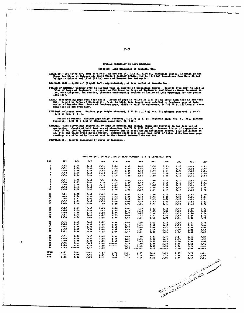
F-9
S1TUM TIUWARY TO LAU NIOIOAN
040S10S0 Lake Ulaasohos at Oksask. Vis.
LOCATION.--Lat 44'00'41" long 0132101". in SlO% soc.24. T.R V 1. 163.. innebao County in mutrh of theUpper Poz River at Chicago and North W stern Railway bridge. .2 n1 (0.3 a) dounatrom from Main streetbridge in Oshkosh ead 1 Ai (29 ka) south of Nemnha Dam 41d outlet.
ODLIUAGI ARA.--.,0l0 ljs (15,600 kie). approximtely. at lake outlet at Ne aks a.
P31103 0P R3031.-October 1938 to current year Is reports of Geological Survey. Records from 1557 to 1938 infiles of, Corps of Salnors. A report on Pox River by Corps pf Sakineers, publiehd as Mos Docoeet No.146. 67th Colress. 24 sesien, contains somi-ssmtkly records of Inflow of Lake Winmebago for the porled1896-1917.
GAGE.--Nonrocording gage rend once daily. Datum of gage Is 745.05 ft (227.091 a) above a&& tide at how YorkCity (levols by Corps of Begineors). Prior to 182. inke levels worereforred to bouchmna g t Lakeoutlet of Menasha fee. Datum of Deuchnen sage. which is sti11 i* esisteco. is 745.00 ft (217.076 .l abovean tide at Nw York City.
1ZTRAU.-Curent year: Nauimum gale height observed, 3.92 ft (1.19 a) Nar. 2S; m1iim observed. 1.36 It(0.41 n) iar. 2. S. S.
Period of record: Maium go height observed. 5.33 ft (1.62 a) (Douchnae Sage) Nov. 6, 111, minimmobserved. -2.00 ft (-0.61 a) (0ckma gags) Nov. a8, 1611.
RlMJ=.-- Lake elevations controlleg by das at Mosaska and Neemah. which are operated in the interest ofsavigation. Crests of both dams are at olovatien 746.73 ft (227.603 a). Present lmlits of rulotion arefrom 21 in. (S40 a) above the crest of Menaha 3m to crest during navigation season. p.s a al 1'in. (457 am) below crest during winter. Oshkosh staff gage gives true level of lake. w.3si Demucba Sagereadings are affected by loss of head is the channel between lake and dam.
COOP3RATIOU --Records furnished by Corps of Engineers.
GAGE "IG"T . II FtI. WATER YEAR nCTOE 197?l To SEPrtuE£1 1973
08Y OCT NOV DEC JAN Ftd . 0 APO 0-4A Y JUN JUL AUG SEP
1 2.84 2.""1 ?.43 7.44 2.00 I -6. 3.0,6 3.3m 3.33 3.2* a.88 ?.9?2 2.91 2.A 2.46 P..3 2.00 I. 6 3.60 3.48 3.32 3.16 2.82 ?.063 Z.',4 2.90 2.44 2.44 2.10 1. to 3.60 3.49 3.e. 3.24 2.80 2.844 .90 2.90 2.42 2.43 2.07 1.37 3.57 3.3O 3.26 3.21 Z.0 Z.90S 2.94 2.fe 2.44 2.39 2.04 -. 36 3.51 3.S0 3.20 1.19 2.75 2.3
6 2.91 2.80, 2.40 .3 ;- 2.04 1 .40 3.41 1.46 3.2') 3.10 2.67 2.907 2.94 2.79 2..0 .3 .04 I .4 3.47 3.44 3.16 3.12 2.77 2.068 2.96 2.46 2.4) .1 z.0! 1.63 3.42 1.48 3.16 1.10 2.94 2.8:?1 2.94 2.6 2.40 9. .99 1.72 3.90 1.94 S .24 3.07 2.90 2.76
10 2.9 2.43 ?.eS 1.96 1.6? 3.16 3.4. j. 14 1.. :.5 2. 78
11 3.01 2.78 2.42 2.2? 1.14 4.00 3.1A 3.S0 3.1Z 3.06 Z.86 2.7812 3.00 2.76 2.46 2.20 1.2 2.24 3.18 3.%b 3."t4 1.07 2.05 2.8413 2.4- Z.7 2.50 Z.16 1.6? e.4? 3.16 3.65 JO.20 .90 2.84 ? .81 2.92 2.71 2:47 ?.0 1.0 .68 3.16 1.63 3.20 ?.:4 2.03 2.62Is 2.46 2.66 2.46 -.0 .. .01 3.16 3 61 1 .1 2.90 2.03 2.76
16 2.62 2.64 2.47 7.09 1.80 3.0n 3.?0 3.6z J.16 2.94 2.00 2.71I 2.0 2.%a 2.44 2.07 1.7d 3.16 3.?2 1.01 2e.46 2.80 2.80 2.601A 2.6 2.S 2.49 2.00 1.?% 3.2A 3.20 0.6? 1.?' 2.74 2.78 2.7819 2.81 2.04 2.44 2.2? 10,3 1.44 3.27 1.63 1.23 ?.83 2.05 2.7320 2.76 e.q2 2.44 Z.2. 1.69 3.5h 3.31 1.56 3.210 ?.94 2.96 2.?S
21 2.76 2.50 2.63 ?.22 1.4 ):.64 3.36 3.52 . 4 2.9? 2.97 2.772 2.00 2.47 7.1 2.24 1.40 1.74 3.36 3. !2 .17 2.3 2 go 2.64
23 2.92 Z. ?.,0 2.?6 1.50 0.78 3.4,s 1.44 j.eO P.83 2.86 ?.664 2.q2 2.45 2.34 2.24 1.S2 1.d4 3.S4 1.44 3.10 2-.79 2.81 2.6?2S 2.91 2.44 1.34 2.22 1." 3..? 3.51 3.34 J.U0 ?.82 2.60 2.62
24 2.91 2.14 7.12 2.20 1.30 3:o6 3.46 3.33 3. ?:.8 " .,7 2.0427 .90 2.?1 30 1 14 1.46 3..% 3.46 3. 36 3 17 .9 2.56 2.9228 2.0 2.18 k.10 P.16 1.4? 3.02 3.43 3.3# 3.24 2.76 2*.4 2.92to 2.90 2.44 ?.'9 ?.I -....... 1.1 3.48 3.16 3.20 P.76 2.S1 2.430 2.90 2.40 ?.34 ?.10 ------ 1.7% 3.%6 3.36 3.30 ?.76 2.71 2.9131 2.92............24 ..08..............71..........02-........2A--- .74 2.9......ofa Aft 2.91 2.43 2. 1 2.23 1 .4A 2.7. J.JQ 3.49 3.1v ?.95 2.79 2.01WAX 3.01 2.0 ?.% 2.44 2.10 1.92 3.h6 3.6% J.33 3.28 2.97 2.94434t 2.76 2.3. 2.29 2.07 1.6a 1.36 3.36 3.2b 2.0 P.74 2.47 2.64
I II| I| II II II . al .. . .. . .-. N
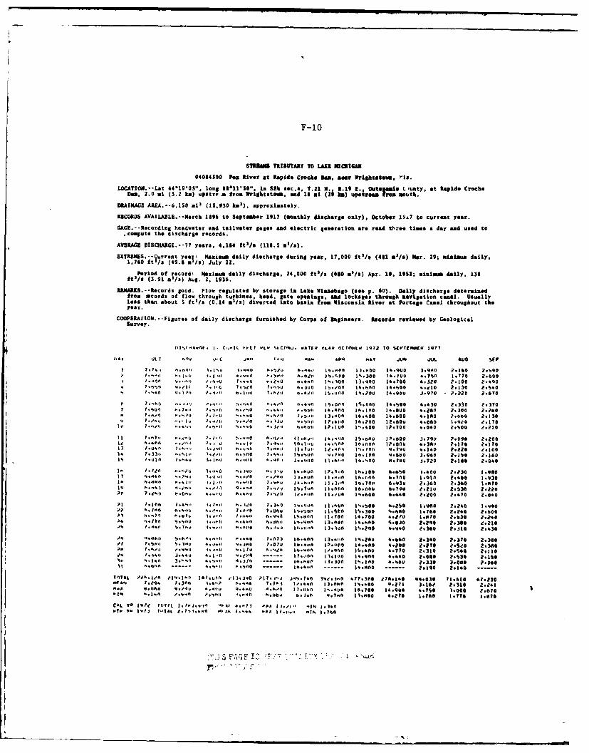
F-10
S1T 8 TRIBUTARtY TO LAz OICIQi4
04064500 Poz River at Rapids Crock* &ae . near Wrigtatem. "is.
LOCATION.--Lat 44*1gO03", iong 18 11SO', in SEb sec.4. T.21 N.. 1.19 a., Outaflale Cunty. at Rapids CrecheDam. 2.0 al (3.2 ka) upstre.m from Vrightstown, end 18 a3 (29 ke) upstream from mouth.
DRAINAGE AREA.--6,ISO oil (15.930 ko3), approxistely.
RECORDS AVAILAJBL.--li4rch 1896 to September 1917 (monthly dlscharge only), October l9.7 to current year.
GAG--Recording headwater and tailwater gales and electric generation are read 0 re times a day and used to.compute the discharge records.
AVIAGE DISCARG.--77 years. 4,184 ftl/a (115.5 m'/s).
IXTROIS.--Current year: Maximum daily discharge during year. 17,000 ftl/s (481 ms/a) 1ear. 29; minimum daily.1,760 ftl/s (49.8 mi/s) July 22.
Period of record: Naxzium daily discharge. 24,000 fts/s (680 in/2) Apr. 19. 1952; minimum daily. 135ft'/s (3.91 m'/s) Aug. 2. 1936.
UNARS.--tecords good. Flow regulated by storage in Lake Winnebago (see p. 60). Daily discharge determinedfrom cords of flow through turbines, head. late openings, sad lockages through navigation canal. Usuallyless than about S ftl/s (0.14 a'/s) diverted into basin from Wisconsin River at Portage Canal throughout theyear.
COOPEIRATION.--Figures of daily discharge furnished by Corps of Engineers. Records reviewed by GeologicalSurvey.
DIS I. A.df. I'+ C-.13l. I.L "t I 1tCD *If. WY570 EllVc OCTOhL.IQ lr2 70 TO Sfl'O4ER 1973
1.4 y 0( 10 P C JAN I 4. Apo AT7 Ju6 JUL hUG SFP
I 1, hJ k. IS * ...4 1
-. 0,'u b*.o, 1.0 1 3.oflO 14.900 3.900 2.160 2.'90I.0..It ,..,..U 1.'j 0.o oO . '.'sd 16,00 131.300 147000 6.750 1.*0 2.00
* 1. -In .11-1I ?.. 4 ?...1, .. 0 0.400 3.100 13.400 14.700 -4b.20 2300 2.40V.. - e I >. j*lJ 7-en 7.07l h.100 l6.00n 3S.000 14.000 ..e30 2.130 2.S&0
4 ?.-.1 . I .-1. bo ,,. 7.LS(, 1 / 0 %..'Oo |S.UU J.970 P.220 2.670
p. 7.-1)0 .* ,... ".'-o.n ,."a ".ow'on 15.00n ' . (nol 1 4.6OO 4.430 2.330 2.3707 7.01)1 .. ' ,).•*,' ,1 he 101 ..46sr* )lfl 34*.600 111+0 14.ll00 1w.250 2.300 2.2eo:hl', 1 .J' ?+ 1.0 .* s .0.'I 1.'I1 33,001 16.400 34.600 I.360 s.o00 2.330
'0 P°~ I. i %',+I 6 ) . Jlu u 1,1 |7.4I0 1.240 12.60V 4.060 31.9i0 e.1700 7 .0or' ... ,,, e. 6 h.0.j.a. , .0o0, 1?. 101 11'.400 1P.T0O 4.040 2.100 *.210
7 .h7. A .I. * W., 1 33.oo 34..'101 36.00 P'.600 3.79P 7.090 2.2000 040 .. ,,) ?..t. u h..U 7.., 0. I.. I n 3. 3V .00O *. 36l 0 ?.Zz0 e.10II 7.00 7.0:.l+, *. j's I0. o 7.0,4 l 31,1 I0. (,'; t%. 70(, 0. 7'I wl. 0 2.2aI0 II300I* 7.3',s .,.6I, 1.0.., o.*flO 7'3el 1'.'0o0.o '"0*"0 10.00 0.4 .0 3.960 1.l0 2.3601I
) I1.1310 7,..,.U .3.. ir 0 ..I .l, +,I i +I 0 3..0 3lA" 30I.11 600 4. 730 0.720 2.100 2.0e0
3J. I..Pl +~0 l./0 i7..0,~) 6*,( .,, u 30.00 3.1; ,0+ 30.,0 66S,0 3:400 2.30 1.0037 0.0440 0.7'..o "Ioll .,,,. "l . 1 * . ," MSS I | 30,01+ 3 1. 6.10(0 I.930 2.00 I.30
3. If"" V..ll . '..."0 7 1.' 14.0-t 0 ]3 13, b .3a.70l 6.,3. 2.4110 2.360 3.0034 0.. 1 .0b:. .oIl 0...l 7...,' I.7..n 11.000 16.001, 6. 1.210 2.S30 2.2207Ie ?(a ,'.0.,, 4..'.,, i lellfl I ./o0 P..600 6.040 ?.i00 2. 10 2.040
73I 7.30.1+i 1.41,, tl 0.l + 1 1 3.0 I'..l0o 33 0 o "."00 '4.260 3.940 2a0 3.V900,' 0i~l0h -11 11, 4..'l 1.11' 0 1 f3.5410 36.300 . 40 3ate0 ".240 2.60001I h.,7'l * 0 . i 3n',0 tlno4I
l 0.,. 36 .00,7 13.704 34.700 4.210 3 .I70 2.630 2.2410
04 ... I70 6 .6 110.) 1.* ,,1 ".41 * dtl 1'.1:l 3 0 34.
I110 5.030 2.9 0 11380 0.230>4 h /I .a101 1)T °' , . .O1*
u n. n~ l~l I".) I.1 |I.f1 ai42 3,8JI 2 0 ie.307% 1a0? .. .7..,. . aii 0011 6..111. 13. 104 36.200 4.v90 1.360 ?.330 2.436
04 I . ', , 1 073 10:404 3 3:-f 6. s04 : 1.f 4:;60 2.360 ?.70 2.30.q 76.. ...7 I..* '..jn ?:.07I0 00 3719 340.40 0 4.0 To27 2.2 .3:0P. 7.o,'. j ,,Uo1,, .IS o00 14711 |.10 36.l00 41770 2:310 ?.S0 Z.110
OwU I. 4,0 3.440 4.3-0 '70 . . .70 13I1 34.100 4.440 2.060 a PS30 ?.1503l. 0.3h 3.0,) "" 4,1* l.00 1 *1 %.140 4.60 ?.330 3.000 P.0601t 0 -- -! Z O- --:..: 4.ft --- 41110 --- --- ?.IQ@ 2.I. ------
111TlL Pfh0: 1+ .'l
9 -0 Ift ' 1 3 ,0 .06.7.0 3?0.1. j;9 4?7.00 Y0 7 141 vm403o0 3.610 67.23000as. 7,u04 1.300 3." 0,004 1.703 I.*... 33,1.0 36,400 0.713 3.160 2.330 2.43".1 l."A.) . 0 - ll 1 . .*I.o0 36.400 16.70 34.000 4.10 3.000 2.670
CAL 75 310 YO 0(7. 3,Io 7.5L'. 4~ *'10 At *-) J.Il -IN I,14V0
. V2. 0 ..... If
GLOSSARY OF TECHNICAL TERMS
adsorption - to hold (liquid or gas) on the surface of a solid.
aerobic - living, active, or occurring only in the presence of oxygen orair.
alluvial deposit - sediment and other suspended solids deposited at themouth of a tributary.
ammonia nitrogen - is one of the early products of microbiologic activityin the nitrogen cycle; it is considered to be chemical evidence ofrecent sewage contamination.
anaerobic - able to live and grow where there is no air or free oxygen.
aquatic habitat - a habitat located in water.
aquatic vegetation - plants that grow in or very near water; for thisreport aquatic vegetation was categorized as follows-
submergent - plants commonly found growing beneath the surface(pondweeds, coontail, algae, etc.).
floating - plants, at least portions of which float on the water'ssurface (lily, water shield, duckweed).
emergent - plant species growing in marshes in which there is highorganic matter, nutrients, and dense algal growth.
aquifier - a water-bearing stratum of permeable rock, sand, or gravel.
artesian - referring to a well in an area having sufficient pressure tocontinually force water upward.
backwater - the resulting high water surface in a given stream due to adownstream obstruction or high stages in an intersecting stream.
benthic - refers to the bottom of any body of water.
benthos - those organisms that live on the bottom of a body of water.
biochemical oxygen demand - the amount of oxygen required to decompose(oxidize) a given amount of organic compounds to simple, stablesubstances.
biota - all the species of plants and animals occurring within a certainarea or region.
G-1
G-2
bulkhead - a structure separating land and water areas, primarily designedto resist earth pressure.
chemical oxygen demand - the COD test is used to measure the organicmatter content of wastewater and natural waters; a test used tomeasure the organic matter in industrial and municipal wastes thatcontain compounds that are toxic to biological life.
cold water fishery - a fish population composed of species generallyrequiring water temperatures of 75°F or less to survive for morethan a few days (trout-cisco).
crest - top of a dam; also refers to maximum water level during a flood.
dissolved oxygen - the amount of oxygen dissolved in water; a key testin water pollution and control activities and waste treatmentprocess control.
discharge - the quantity of flow in a stream at any given time, usuallymeasured in cubic feet per second (cfs).
draft - the depth of water that a ship or boat draws or displaces whenloaded.
dredging - the removal of bottom sediments from a stream or river todeepen a channel needed for navigational purposes.
effluent - any wastewater discharged, directly or indirectly, intowaters and the runoff from land used for the disposition of waste-water or sludges, but not otherwise including land runoff.
electrofishing - a process of collecting fish through the use of thenarcotic effects of electric shock generated by either AC or DCequipment.
endangered species - species that are in danger of becoming extinct.
eutrophic - a condition of a water body in which there is high organicmatter, nutrients and dense algal growth.
fecal coliform - the fecal coliform test measures bacteria which arecommonly found in the intestines and fecal discharges of warm-blooded animals.
flashboards - a board or boards placed at the top of the spillway of thedam to increase the water depth in the pool upstream of the dam.
flatscow - a large flat-bottomed boat with broad square ends that is
used chiefly for transporting sand, gravel, or refuse.
head - height difference in water surface elevation.
G-3
head gates - gates which control water surface elevations at dams.
head race - the upstream water channel leading to the entrance of ahydropowered device.
impoundment - a body of water, usually artificially made; water that hasbeen collected and confined as a reservoir.
interface - a surface forming a common boundary between adjacent regions.
leaching - the removal of various soluble materials from surface soillayers by the passage of water through (around) the layers.
marsh - a tract of low-lying, soft, wet land, commonly covered (some-times seasonally) entirely or partially with water; a swamp domi-nated by grasses or grass-like vegetation.
microbial - referring to microscopic life such as bacteria and viruses.
navigational traffic - commercial and recreational traffic on a waterway.
outfall - (1) the vent of a river, draii,, etc. (2) structure extcndinginto a body of water for the purpose of discharging sewage, stormrunoff, or cooling water.
pH - the pH scale ranges from 0 to 14 and is a measure of whether aliquid is acid, neutral or alkaline. 7.0 is neutral.
phytopiankton - minute free floating plant-like species inhabiting mostwater bodies.
pollutant - a residue (usually of human activity) which has an unde-sirable effect upon the environment; particularly of concern whenin excess of the natural capacity of the environment to render itinnocuous.
pool - the water contained behind a dam.
primary productivity - mg carbon/unit area/unit time; refers to the net
production of biomass from organisms carrying on photosynthesis.
primary waste treatment - a primary waste treatment facility providesfor sedimentation of incoming sewage prior to discharge.
recruitment - the process of adding new individuals to an existingpopulation.
revetment - a facing of stone, concrete, etc., built to protect a scarp,embankment, or shore structure against erosion by wave action orcurrents.
G-4
riparian - refers to vegetative community types or land along a streamor river.
riprap - a layer, facing, or protective mount of stones randomly placedto prevent erosion, scour or sloughing of a structure or embankment;also the stone so used.
secondary waste treatment - a secondary waste treatment process involvessome method for biological oxidation of organic material in thewasteflow; a secondary waste treatment facility provides this
biological treatment in addition to primary treatment (commonmethods of secondary treatment are activated sludge, tricklingfilters, and lagoons).
shoal - a shallow place in a river, a sand bar or piece of rising groundforming a shallow place that is dangerous to navigation.
sluice gates - devices to regulate flow through a dam.
snagging - the act of removing large branches, logs, stumps or otherorganic debris from a stream.
spawning - egg laying.
succession - the replacement of one generalized vegetation type byanother through time.
tail race - the discharge from mill or hydroelectric plant to a stillingpool.
terrestrial - of land, the continents, and/or dry ground; contrasted toaquatic.
thalweg - deepest point in a transverse section of a river; fluctuates
based on the amount of silt in the river.
total volatile solids - measures the material which is vaporized at a
rather high temperature; analysis applied to sewage sludge tomeasure biological stability (the solids content of a strong sewageis 275 mg/l, medium - 150 mg/l, and weak - 70 mg/l).
turbidity - turbidity is a measure of the suspended and colloidal matterin water.
warm water fishery - a fish population composed of species able to
tolerate extended periods when water temperatures exceed 75°F.
wetlands - any area where the ground is too wet to raise an agriculturalcrop without major drainage; wetlands in this report are classifiedas follows:
G-5
deep marsh - water from six inches to three feet deep during growingseasons; cattails, reeds, bulrushes, spike rushes, and pond-weeds are common.
shallow marsh - water present during the growing season; cattails,river rush, spike rush, and bulrush are typical vegetativetypes.
fresh meadow - soggy ground, often seasonally flooded; vegetationof smartweed, grass, sedge, bur reed.
shrub swamp - water logged soil with occasional standing water;tamarack, black spruce, black ash, and elm are common trees.
winterkill - death of fish resulting from inadequate dissolved oxygenconditions under ice.
xeric - a dry condition often used to describe the moisture condition ofa vegetative community type.
zooplankton - minute, free floating animal species inhabiting most waterbodies.
LMEI


