Embed Size (px)
Citation preview

Zoning Public Hearing WjlW AGENDA ITEM NO.: Z-23CITY OF AUSTIN ^^ AGENDA DATE: Thu 01/12/2006RECOMMENDATION FOR COUNCIL ACTION PAGE: 1 of 1
SUBJECT: C14-05-0005 - Gables/Park Plaza - Conduct a public hearing and approve an ordinanceamending Chapter 25-2 of the Austin City Code by rezoning property locally known as 910 West CesarChavez Street (Tracts 1 and 2) (Town Lake and Shoal Creek Watersheds) from downtown-mixed use(DMU) district zoning to downtown-mixed use-central urban redevelopment-conditional overlay (DMU-CURE-CO) combining district zoning with conditions. Zoning and Platting CommissionRecommendation: To grant downtown-mixed use-central urban redevelopment-conditional overlay(DMU-CURE-CO) combining district zoning with conditions. Applicant: LG Lamar LimitedPartnership and LG Park Plaza Limited Partnership (Ben Pisklak). Agent: Drenner, Stuart, Wolff,Metcalfe (Michele R. Allen). City Staff: Jorge E. Rousselin, 974-2975.
REQUESTING Neighborhood Planning DIRECTOR'SDEPARTMENT: and Zoning AUTHORIZATION: Greg Guernsey
RCA Serial*: 10698 Date: 01/12/06 Original: Yes published: Fri 12/09/2005
Disposition: Postponed-THU 01/12/2006 Adjusted version published:

C14-05-0005
ZONING REVIEW SHEET
CASE; C14-OS-OOQS Z.A.P. DATE; October 4,2005November 1,2005
ADDRESS: 910 West Cesar Chavez Street (Tracts 1 and 2)
OWNER: Lumberman's Investment Corporation AGENT; Drenner Stuart(Wayne McDonald) Wolff Metcalfe von Kreisler
(Michele Allen)ZONING FROM; DMU (Downtown Mixed Use)
TO; DMU-CURE (Downtown Mixed Use - Central Urban Redevelopment CombiningDistrict)
AREA: 4.524 Acres
SUMMARY ZAP RECOMMENDATION:November 1, 2005:APPROVED DMU-CURE-CO DISTRICT ZONING WITH STAFF CONDTIONS;ADDED CONDITIONS OF:
• SUBJECT TO PARTICIPATION IN GREAT STREETS PROGRAM;• MAXIMUM HEIGHT OF 195-FEET , WITHIN AN ENVELOPE FROM THE
WESTERN EDGE OF THE CAPITOL VIEW CORRIOR MOVING WESTTO THE EASTERN EDGE OF A THROUHWAY EASEMENT TO BEPROVIDED;
• EVERYTHING RECOMMENDED BY THE STAFF AND AGREED TO BYTHE APPLICANT.
[K.J, T.R 2*°] (7-1-1) M.H - ABSTAINED; J.M - NAY
SUMMARY STAFF RECOMMENDATION:
Staff recommends DMU-CURE (Downtown Mixed Use - Central Urban RedevelopmentCombining District) based on the following considerations:
1.) The proposed use is compatible with existing multifamily residential, commercial,and mixed-use development along West 3rd Street and west of Lamar Boulevard;
2.) The proposed development lies within the downtown CURE district;3.) The proposed development will not be subject to compatibility standards;4.) The proposed development will be near future transit station / hub; and5.) The Seaholm Master Plan recommends the revitalization of this section of downtown
with a mixture of retail, office and high density residential; and6.) The proposed project will lie within the designated Core Downtown District as
identified by the Downtown Austin Design Guidelines.
Page 1 of 10

C14-05-0005
ISSUES?
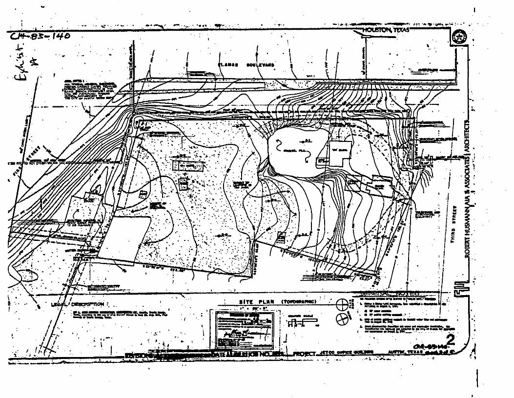
There is an existing approved zoning site plan, which was approved October 18,1984 undercase No. C14-83-140, to construct a 15 story office tower and a parking garage on Tract 1(see Exhibit A). This site plan does not have an expiration date and may be used for theconstruction of a new project. Should the subject rezoning be approved, it will delete theexisting JETCO zoning site plan (C14-83-140) which allows a 15 story, 220-foot officestructure.
On January 8.2001 the City of Austin entered into a Settlement Agreement (see exhibit B)with the Lumberman *s Investment Corporation (LIC). The settlement was a result of alawsuit between the City and LIC, in regards to a boundary dispute. As a condition of thesettlement, if the City of Austin granted approval of the previously proposed project (C14-01-0070), the approved zoning site plan will be terminated. However, the owner of theproperty must adhere to certain "Project Characteristics " as noted in section 8 and 9 of thesettlement agreement which states:
• The project must adhere to DMU development regulations, as well as provisions inthe Waterfront Overlay Combining District and Northshore Central Sub-district.
• It shall be a mixed-use project with a floor area of 400,000 and 500,000 square feetand a parking structure for at least 600 automobiles.
• The gross floor area shall contain at least 60% of residential with the balance forcommercial uses allowed in the DMU zoning district.
• The proposed project shall conform to all Land Development Code regulationsgoverning zoning, subdivision, and site plans, aside from the exceptions within thisagreement. Also the owner will work with City Staff, should conflicts arise betweenthis project and the Seaholm Master Plan.
• One building on the northwest corner shall be 180', with the remaining buildings inthe Capitol View Corridor averaging a height (including the 180 foot building) of 120feet.
The property lies within the Seaholm District Master Plan Boundaries (SDMP). The SDMPis attempting to revitalize this section of downtown with a mixture of retail, office and highdensity residential. The SDMP illustrative plan suggests a residential, mixed-usedevelopment for the property (see Exhibit C).
At this time a site plan for the new project has not been submitted to the City of Austin forformal review. The proposed project is located within the Waterfront Overlay CombiningDistrict, and as per the settlement agreement must adhere to the provisions set forth in theLand Development Code (a copy of the overlay has been included).
As requested by the Planning Commission at the time, case No. C14-01-0070 was heard bythe Parks Board on August 14,2001. By a vote of 5-2, the Parks Board voted to not support
Page 2 of 10

C14-05-0005
the proposed zoning change. The concern was the precedent this would set for developmentalong Town Lake,
Furthermore, on September 27,2001, a motion to approve case No. C14-01-0070 to grantDMU-CURE failed at City Council on a vote of 3-4.
DEPARTMENT COMMENTS;
The subject area is a 4.524 acre site zoned DMU accessed from West Cesar Chavez Street.The applicant proposes to rezone a portion of the property to DMU-CURE district to allowfor a mixed-use development including a structure exceeding 120' but under 200* in height.The modification to the base zoning district sought is the height limitation exceeding 120'.The proposed development will be subject to the regulations of the North Shore Subdistrictof the Waterfront Overlay District. Furthermore, a master agreement for a proposedpedestrian through-way easement from the extension of the Pfluger Bridge to Bowie Streetaddressing issues relevant to water quality and transportation improvements is underdevelopment and if approved, would supersede the existing settlement agreement. The CityCouncil will address issues relevant to a Chapter 26 application on existing parkland adjacentto the subject property regarding potential realignment of Sandra Muraida Way.
The Land and Facilities Committee of the Parks Board, the Parks Board, and theEnvironmental Board have recommended approval of the Chapter 26 application andproposed center alignment of the Pfluger Bridge.
Furthermore, a portion of this site lies within the Capitol View Corridor (CVC). Anyproposed development within the CVC will be subject to the provisions of 25-2-642.
Current site development regulations for DMU are as follows:
DMUMaximum Height:Maximum Building Coverage:Maximum Impervious Cover:Maximum Floor Area Ratio:
120*100%100%5:1
Source: The Code of the City of Austin, Volume III, Chapter 25-2-492
Staff recommends Downtown Mixed Use - Central Urban Redevelopment CombiningDistrict (DMU-CURE) based on the following considerations:
1.) The proposed use is compatible with existing multifamily residential, commercial,and mixed-use development along West 3rt Street and west of Lamar Boulevard;
2.) The proposed development lies within the downtown CURE district;3.) The proposed development will not be subject to compatibility standards;4.) The proposed development will be near future transit station / hub; and5.) The Seaholm Master Plan recommends the revitalization of this section of downtown
with a mixture of retail, office and high density residential; and6.) The proposed project will lie within the designated Core Downtown District as
identified by the Downtown Austin Design Guidelines.
Page 3 of 10

C14-05-0005
EXISTING ZONING AND LAND USES:
SiteNorthSouthEastWest
ZONINGDMUDMU/DMU-COPPLI-CO-NP
LAND USESUndeveloped landLounge / Studio / Apartments - CondominiumsNorth Town Lake ShoreCity of Austin Power PlantYMCA
AREA STUDY: Seaholm Master Plan, Downtown Austin Design Guidelines
TIAt Waived, see attached comments under transportation
WATERSHED; Shoal Creek: Town Lake DESIRED DEVELOPMENT ZONE; Yes
CAPITOL VIEW CORRIDOR: Yes HILL COUNTRY ROADWAY: N/A
NEIGHBORHOOD ORGANIZATIONS;57-Old Austin Neighborhood402-Downtown Austin Neighborhood Assn. (DANA)511-Austin Neighborhoods Council623—City of Austin Downtown Commission742-Austin Independent School Districts744--Sentral Plus East Austin Koalition (SPEAK)998--West End Austin Alliance
SCHOOLS:Austin Independent School District
• Mathews Elementary School• O. Henry Middle School• Austin High School
RELATED CASES:
NUMBERC14-83-140
C14-01-0070
REQUESTDtoC
DMUtoDMU-CURE
COMMISSION07/24/83: Approved zoning and asite plan for office building andparking garage.(7-1)
08/21/01: Approved Staffsrecommendation of DMU-CURE.(7-l.JM-NO).
CITY COUNCIL10/18/84 APVD C, 3RD H&A;3RD RDG, EMERG. PASS.
09/27/01: Motion to approveDMU-CURE failed on a voteof 3^ vote. (JG/BG/DS/DT-NO).
Page 4 of 10

C14-05-0005
CASE HISTORIES:
NUMBER REQUEST COMMISSION CITY COUNCILC14-05-0093 ROWtoDMU Pending Pending
C14-02-OH2 Old West AustinNeighborhoodPlan CombiningDistrict
08/14/02: PC APPROVED: (6-0,DS-RECUSED) SF-2-NP, SF-2-H-NP. SF-3-NP, SF-3-H-NP. SF-4A-NP, SF-6-NP, MF-2-NP, MF-3-NP,MF-3-H-NP, MF-4-NP, MF-4-H-NP, NO-NP, NO-CO-NP, NO-MU-H-CO-NP. P-NP, P-H-NP, LO-NP,LO-CO-NP, LO-H-NP, LO-MU-NPGO-NP, GO-CO-NP, LR-NP, GR-NP, GR-MU-CO-NP, CS-MU-CO-NP, CS-H-MU-CO-NP, CS-l-MU-CO-NP. 1J-CO-NP, PUD-NP.
09/26/02: APVD SF-2-NP, SF-2H-NP, SF-3-NP. SF-3-H-NP, SF4 A-NP, SF-6-NP, MF-2-NP,MF-3-NP, MF-3-H-NP, MF-4-NP, MF-4-H-NP, NO-NP, NO-CO-NP, NO-MU-H-CO^NP, P-NP. P-H-NP, LO-NP, L0-CO-NP, LO-H-NP, LO-MU-NP, GONP, GO-CO-NP, LR-NP, GR-NP, GR-MU-CO-NP. CS-MU-CO-NP, CS-H-MU-CO-NP, CS-1-MU-CO-NP, 1J-CO-NP, PUDNP AND DIRECTED STAFFTO INITIATE REZONING OF1706 & 1708 W 6TH FROM SF2-NP TO NO-MU-CO-NP
C14-05-0025 SF-2-NPTONO-MU-CO-NP
05/24/05: PC; APPROVESTAFF RECOMMENDATION,INCLUDING ALLCONDITIONS. BUT REQUIREINGRESS AND EGRESS ONLYFROM THE ALLEY ANDDIRECT STAFF TO PREPARE APLAN TO ALLOW ON-STREETPARKING ON WEST 6™STREET TO ADDRESS THEPARKING CONCERNS FORSITE.VOTE: (JR-1*. MM-2nd;CM-OPPOSED. CO- ABSENT)
Pending
C14-03-0168 DMU-CUREtoDMU-CURE(ground floorrezoned for officeand pedestrianoriented uses)
01/06/04 : ZAP - Pulled, sent toCity Council withoutrecommendation.
01/29/04: APVD STAFF RECOF DMU-CO-CURE (NOCOCKTAIL LOUNGE), (5-0);1STRDG;
02/12/04: APVD DMU-CO-CURE (7-0); 2ND/3RD RDGS
C14-00-2132 DMUtoCBD 08/22/00: PC - APVD STAFFREC W/COND OWNERRECONNECT HIKE/BIKE
09/28/00: APVD CBD-COW/CONDS (7-0) ALL 3RDGS
Page 5 of 10

C14-05-0005
TRAIL (8-0); SA-ABSENT)Conditional Overlay:- Vehicle trip limitation to
2,000
C14-00-2127 DMUtoCBD 08/22/00: PC - APVD STAFFREC W/COND OWNERRECONNECT fflKE/BIKETRAIL (8-0); SA-ABSENT)
09/28/00: APVD CBD-COW/CONDS(7-0)ALL3 :
RDGS
Conditional Overlay:- Height limitation of 170
feet;- FAR of 5:1.
C14-99-0002 PtoDMU-CO 02/09/99: PC - APVD STAFFRECOFDMU-COBYCONSENT (9-0).
04/15/99: APVD DMU-COW/CONDITIONS (7-0)2ND/3RDRDGS
Conditional Overlay:- Vehicle trip limitation to
2,000
ABUTTING STREETS;
NAME -Lamar Boulevard
Sandra Muraida WayCesar Chavez
ROW200*90'
Varies
PAVEMENTVariesVariesVaries
CLASSIFICATIONArterialArterialArterial
CITY COUNCIL DATE: December 15,2005; January 12,2006
ACTION:
ORDINANCE READINGS; lrt 2nd 3rd
ORDINANCE NUMBER:
CASE MANAGER: Jorge E. Rousselin, NPZD
E-MAIL: [email protected]
PHONE: 974-2975
Page 6 of 10
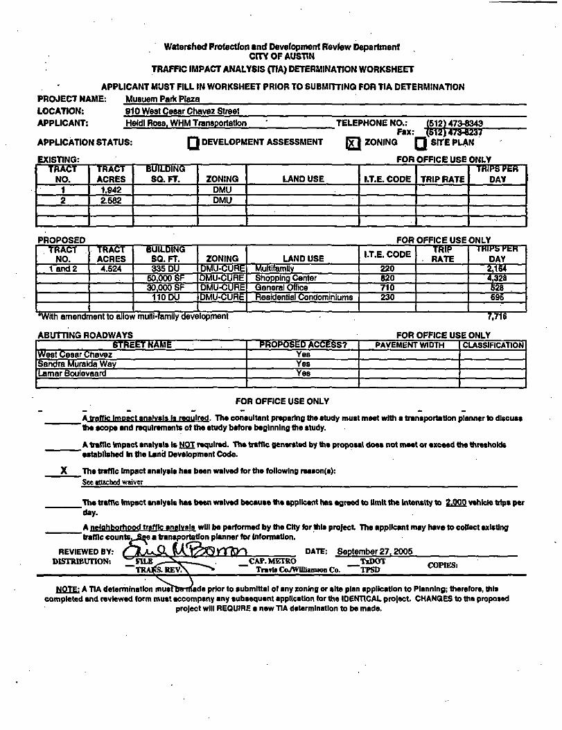
Watershed Protection and Development Review DepartmentCfTY OF AUSTIN
TRAFFIC IMPACT ANALYSIS (TIA) DETERMINATION WORKSHEET
APPLICANT MUST FILL IN WORKSHEET PRIOR TO SUBMITTING FOR TIA DETERMINATIONPROJECT NAME:
LOCATION:APPLICANT:
Musuem Park Pteza
910 West Cesar Chavez StreetHeidi Ross. WHM Transportation
APPLICATION STATUS:
EXISTING:
QDEVELOPMENT ASSESSMENT
TELEPHONE NO.:Fax:
171 ZONING
473-8343473-8237
Q SITE PLAN
FOR OFFICE USE ONLYTRACT
NO.12
TRACTACRES1.9422.682
BUILDINGSQ.FT. ZONING
DMUDMU
LAND USE I.T.E. CODE TRIP RATETRIPS PER
DAY
PROPOSED FOR OFFICE USE ONLYTRACT
NO.land 2
TRACTACRES4.524
BUILDINGSQ.FT.335 DU
50,000 SF30,000 SF
110 DU
ZONINGDMU-CUREDMU-CUREDMU-CUREDMU-CURE
LAND USEMuttifamUyShopping CenterGeneral OfficeResidential Condominiums
I.T.E. CODE
220820710230
TRIP- RATE
1 MIPS KtH
DAY2,1644.328528696
*wrth amendment to allow multi-family development
ABUTTING ROADWAYS
7.TT6
FOR OFFICE USE ONLYSTREET NAME
West Cesar ChavezSandra Muralda WayLamar Boulevaard
PROPOSED ACCESS?YesYesYes
PAVEMENT WIDTH CLASSIFICATION
FOR OFFICE USE ONLY
A traffic Impact analysis Ja required. The consultant preparing the study must meet with a transportation planner to dlscuaa'ttia scope and requirements of the study before beginning the study.
A traffic Impact analysis Is NOT required. The traffic generated by the proposal does not meet or exceed the thresholds"established In the Land Development Code.
The traffic Impact analysis has been waived for the following reason(a):See attached[waiver
_The traffic Impact analysis has been waived because tte applicant has agreed to limit the Intensity to 2.000 vehicle trips perday.
A neighborhood traffic analvala will be performed by the Ctty for thla project The applicant may have) to collect existing"traffic counts fi£e a transportation planner for Information.
REVIEWED BY;DISTRIBUTION:
DATE: September 27,2005CAP. METRO
Trarte Co/Williamson Co.TiDOT
"TPSD COPIES]
NOTE: A TIA determination musftn-made prior to submlttal of any zoning or site plan application to Planning; therefore, thiscompleted end reviewed form must accompany any aubaequent application for the IDENTICAL prelect. CHANGES to the proposed
project will REQUIRE a new TIA determination to be made.

M
r-40or
Rl JR. IFfT TpAPT P^^^J
CASE MGR: J. ROUSSELIN
-:- ZONING
CASE #: C14-05-0006ADDRESS: 610 W.CESAR CHAVEZ ST. °ATE: 0B-10
SUBJECT AREA (acres^: 4.624 INTLS: TRC
CITY GRIDREFERENCENUMBER
H22 r
// /

C14-05-0005 L«8£S&


>;.
• ,v- I
^:.IW
•*«*-'
.:::'?X v
• : ' - ' }
/
S H-5

C14-05-0005
STAFF RECOMMENDATION
Staff recommends Downtown Mixed Use - Central Urban Redevelopment CombiningDistrict (DMU-CURE) based on the following considerations:
1.) The proposed use is compatible with existing multifamily residential, commercial,and mixed-use development along West 3rd Street and west of Lamar Boulevard;
2.) Hie proposed development lies within the downtown CURE district;3.) The proposed development will not be subject to compatibility standards;4.) The proposed development will be near future transit station / hub; and5.) The Seaholm Master Plan recommends the revitalization of this section of downtown
with a mixture of retail, office and high density residential; and6.) The proposed project will lie within the designated Core Downtown District as
identified by the Downtown Austin Design Guidelines.
Downtown Mixed-Use zoning district is intended for areas on the periphery of CBD, CentralBusiness District designations. DMU may be applied to a development that includes anycombination of office retail, commercial, and residential uses compatible with the downtownarea. A DMU district may be used as a transition between the downtown area andsurrounding districts and where it is suitable for an area to which the Central BusinessDistrict may expand.
The CURE combining district is intended for a combination with all base districts withinspecific centra] urban areas, in order to modify base district provisions as necessary to allowfor appropriate uses. The proposed CURE is appropriate at this location in order to allow theproposed mixed use development exceeding 120* as specified in the settlement agreement.As per the settlement agreement, the project will be a mixed-use project combining retail,office and at least 60% residential. It is this type of development that should be encouragedwithin the downtown core.
BASIS FOR RECOMMENDATION
1. The proposed zoning should be consistent with the purpose statement of the districtsought.
The property is located on the periphery of the Central Business District, within therecognized downtown area boundaries.
(A) The purpose of a central urban redevelopment (CURE) combining district is to promotethe stability of neighborhoods in the central urban area.
(B) A CURE combining district may be used:(1) for sustainable redevelopment of homes, multifamily housing, and small businesses;(2) to accommodate high priority projects that enhance the stability of urban
neighborhoods including the development of affordable housing and smallbusinesses along principal transportation routes that serve a neighborhood;
(3) to improve the natural environment; and
Page 7 of JO

C14-05-0005
(4) to encourage high quality development with architectural design affcl proportioncompatible with the neighborhood.
The proposed rezoning meets the purpose statement set forth in the Land Development Code.The subject property is the current location of a lounge and studio and is across fromresidential multifamily development zoned DMU-CO on Bowie Street
2. Zoning changes should promote compatibility with adjacent and nearby uses
Hie proposed change is compatible with the surrounding area where there exists a variety ofland uses conducive to promoting a variety of residential, commercial, industrial, and civicuses.
EXISTING CONDITIONS
Site Characteristics
The subject area is a 4.524 acre site zoned DMU accessed from West Cesar Chavez Streetand West 3rd Street. The site is undeveloped land and lies within the CURE District.Furthermore, the site lies within the Seaholm Master Plan Study Area which specifies amixed-use development for this site. The subject property also lies within the designatedCore Downtown District as identified by the Downtown Austin Design Guidelines.
Impervious Cover
Maximum impervious cover allowed under DMU is 100%.
Transportation
The trip generation under the requested zoning is estimated to be 7,716 trips per day,assuming that the site develops with the proposed uses of multi family, retail, office andresidential condominiums. The traffic impact analysis for this site was waived because:
1. The following improvements will be done in accordance with the masteragreement for this site:
a. Reconstruction of Sandra Muraida Way with pavement dimensions,right-of-way widths, and traffic circle as shown in the attached figure.
b. Construction of a signalized intersection on Cesar Chavez just east ofthe Missouri Pacific Railroad. Cesar Chavez is proposed to be stripedto provide a five lane cross section with the eastbound left turns beingthe only signalized movement at the intersection with no southboundleft turns permitted.
c. Construction of an east-west street to connect the proposed trafficcircle and the Seaholm property, which is located just east of thesubject site.
Page 8 of 10

C14-05-OOOS
2. The improvements listed above have been approved by the CCA PublicWorks Department in a concurrence letter dated December 21, 2004 andsigned by Cordon Den. These Improvements are subject to change based onfuture negotiations between the developer of this property, the City of Austinand the Seaholm property. The improvements approved by the Department ofPublic Works or any future proposed improvements for the site shouldprovide similar access and capacity characteristics.- Any changes to the agreedimprovements will require approval from the City of Austin Department ofPublic Works and Watershed Protection and Development ReviewDepartment.
3. No additional right-of-way is needed at this time.
4. Capita] Metro bus service is available along Lamar Boulevard, SandraMuraida Way, and Cesar Chavez.
5. There are existing sidewalks along Lamar Boulevard and Sandra MuraidaWay.
RIght-of-Wav Management
1. The scope of this review is limited to the identification of needs for dedication and/orreservation of right-of-way for funded Capital Improvement Program (C.I.P.)Roadway Construction Projects and Transportation Systems Management CT-S.M.)Projects planned for implementation by the City of Austin. No aspect of the proposedproject is being considered or approved with this review other than the need for right-of-way for City projects. There are separate right-of-way dedication and reservationrequirements enforced by other Departments and other jurisdictions to secure right-of-way for roadway improvements contained in the Austin Metropolitan AreaRoadway Plan, roadway projects funded by County and State agencies, and fordedication in accordance with the functional classification of the roadway.
2. We have reviewed the proposed subdivision, site plan, or zoning case and anticipateno additional requirement for right-of-way dedication or reservation for funded C.I.P.orT.S.M. projects at this location.
Environmental
1. The site is located within 1500 ft of the Edwards Aquifer Recharge Zone. Ageologist will need to verify whether or not the site lies within the recharge zone.
2. The site is located in the Town Lake Watershed of the Colorado River Basin, which isclassified as an Urban Watershed by Chapter 25-8 of the City's Land DevelopmentCode. It is in the Desired Development Zone.
3. Impervious cover is not limited in this watershed class; therefore the zoning districtimpervious cover limits will apply.
Page 9 oflO
CI4-05-0005
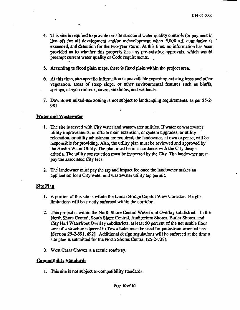
4. This site is required to provide on-site structural water quality controls (or payment inlieu of) for all development and/or redevelopment when 5,000 s.f cumulative isexceeded, and detention for the two-year storm. At this time, no information has beenprovided as to whether this property has any pre-existing approvals, which wouldpreempt current water quality or Code requirements.
5. According to flood plain maps, there is flood plain within the project area.
6. At this time, site-specific information is unavailable regarding existing trees and othervegetation, areas of steep slope, or other environmental features such as bluffs,springs, canyon rimrock, caves, sinkholes, and wetlands.
7. Downtown mixed-use zoning is not subject to landscaping requirements, as per 25-2-981.
Water arid Wastewater
1. The site is served with City water and wastewater utilities. If water or wastewaterutility improvements, or offsite main extension, or system upgrades, or utilityrelocation, or utility adjustment are required, the landowner, at own expense, will beresponsible for providing. Also, the utility plan must be reviewed and approved bythe Austin Water Utility. The plan must be in accordance with the City designcriteria. The utility construction must be inspected by the City. The landowner mustpay the associated City fees.
2. The landowner must pay the tap and impact fee once the landowner makes anapplication for a City water and wastewater utility tap permit.
Site Flan
1. A portion of this site is within the Lamar Bridge Capitol View Corridor. Heightlimitations will be strictly enforced within the corridor.
2. This project is within the North Shore Central Waterfront Overlay subdistrict. In theNorth Shore Central, South Shore Central, Auditorium Shores, Butler Shores, andCity Hall Waterfront Overlay subdistricts, at least 50 percent of the net usable floorarea of a structure adjacent to Town Lake must be used for pedestrian-oriented uses.[Section 25-2-691,692]. Additional design regulations will be enforced at the time asite plan is submitted for the North Shores Central (25-2-738).
3. West Cesar Chavez is a scenic roadway.
Compatibility Standards
1. This site is not subject to compatibility standards.
FagelOoflQ

80 Austin • Land Development
(1) subject to t settlement agreementadopted by council before December tf»2009 that prescribes developmentregulations;
>(2) coned as t planned unh development
before December 6,2003; or
(3) cubject to a aite plan approved as •condition of zoning before December6.2003.
(C) In this section, RETAIL USE means:
~(1) agricultural aales and services use;
(2) art gallery use;
(3) art workshop use;
(4) automotive repair services use;
(5) automotive sales use;
(6) construction sates and services use;
(7) equipment sales use;
(8) food sales use;
f/ (9) general retail services (convenience)use;
(10) general retail sales (general) use;
(11) liquor sales use;
(12) monument retail sales use;
(13) pawn shop services use;
(14) pet services use;
(15) plant nursery use;
(16) recreational equipment sales use;
07) restaurant (drive-lit, last food) use;
(18) restaurant (general) use;
(19) restaurant (limited) use; >
(20) service station use;
(21) special use historic use; or
(22) veterinary services use.
(D) Except as provided in Subsections (E) and(F), a principal retail use and its accessoryuses may not exceed 5(?$00 square'feel ofgross floor area.
(E) Except as provided in Subsection (F), aprincipal food sales use and its accessoryuses may not exceed 100,000 square feet ofgross floor area.
(F) A principal retail use that exceeded thelimitations of Subsection (D) or (E) onDecember 16, 2003 may be changed toanother retail use if the existing imperviouscover and gross floor area are not increased.
(G) Subsections (CK2) and (3) of Section25-2-947 (Nonconjbnrung Use RegulationGroups) do not apply to a use mat exceedsthe limitations in Subsections (D) or (E) onthe effective date of the ordinance.
Source: Ord. 031204-57; Ord. 031211-11; Ord.040617-Z-L
Division 6. Waterfront OverlayDistrict Requirementsfor Town Lake Park.
ft 25-2-671 TOWN LAKE PARK TERMS.
In Section 25-2-672 (Town Lake ParkRegulations}:
2004 S-1

Zoning
(1) COMMUNTTY PARK means t portion ofTown Like Park that Is intended for citywide use and designed to accommodatelarge numbers of people involved to •variety of activities. The following areas faTown Lake Park are community parks:
fe) tracts 8-1. S-2, S-3A, S-4, S-6, S*7.S-*. S-9. N-l. N-2, N-3, N-4. N-5A.
N-WV.and N-17A on the parkclassification map;
(b) park land in the area bounded on thenorth by the Colorado River, on the.west by Pleasant Valley Road, on thecouth by the proposed extension ofLakeshore Boulevard, and on the eastby the crest of the bluff of CountryClub Creek;
(c) park land in the area bounded on thenorth by Lake Austin Boulevard, onthe south by Town Lake, on the castby the MoPac Freeway, and on thewest by the extension of the westernboundary of Filers Park;
(d) the Holly Street Power Plant, when itscurrent use ceases and it is dedicatedas park land; and
(e) park land within 50 feet of theshoreline of Town Lake.
(2) CULTURAL PARK means a portion ofTown Lake Park that is intended forcultural facilities, including museums,botanical gardens, and performance areas.The following areas in Town Lake Park arecultural parks:
(a) tracts S-2D, SO, S-4A, S-S, S-5A,S-5B, and S-5C on the parkclassification map;
(b) park land in me area bounded on thecast by Dawson Road; on me west byLamar Boulevard, on the south byBarton Springs Road, and on me northby Riverside Drive;
(c) park land fa the area bounded on me. north by Town Lake* on the south by
Barton Springs Road, BartonBoulevard, and the westward
. extension of Unscomb Avenue, on thecast by Lamar Boulevard, and on thewest by Robert E. Lee Road and thehike and bike trail;•«fr ,
(d) part land north of the intersection ofRiver Street and Bierce Street, knownas the City of Austin Street and BridgeYard; and
(e) the Seaholm Power Plant and theGreen Water Treatment Plant,including the water intake structures,when the current uses cease and theplants are dedicated as park land.
(3) NElOHBORHOODPARKmeansaportionof Town Lake Park that is small, informal,is less intensely used man the developedareas of Town Lake Park, and servesadjacent neighborhoods. The followingareas in Town Lake Park arc neighborhoodparks:*7
(a) tracts S-2A, S-10, N-3, N-16, andN-17 on the Park Classification Map;
(b) park land fa the area bounded on fhenorth by Town Lake, on me west byEast Bouldin Creek, oa the cast byBlunn Creek, and on the south byRiverside Drive; and
(c) park land fa me area bounded on thenorth by the Colorado River, on thecast by Montopolis Drive, on the south

* Austin • Land Development
by the extension of Grove Boulevard,and on the west by the crest of thebluff of Country Club Creek.
(4) PAKCLASSIFieATONMAPinearathemap that is on file with the Parks andRecreation Department and that to Exhibit"B" to Ordinance No. 890126*.
(5) NATURAL AREA means that portion ofTown Lake Park .that to preserved as anatural environment with limited humanactivity. The following areas in Town LakePark are natural areas:
(a) tracts W-I, S-2B, S-2Q N-3A, andN-18 on the Park Classification Map;
(b) park land located between theColorado River shoreline and the crestof the bluff north of the ColoradoRiver, from Longhorn Dam to U.S.183 (Montopolis Bridge); and
(c) park land northeast of Town Lakefrom Tom Miller Dam to the westboundary of EilersFarkand southwestof Town Lake from Tom Miller Damto the Austin Nature Center.
(6) TOWN LAKE PARK PLAN means theTown Lake Park - Plan .adopted byOrdinance No. 890126-P.
(7) TOWN LAKE PARK means all thededicated park land fa the waterfrontoverlay coning district
<8> URBAN WATERFRONT means thatportion of Town Lake Park that ts adjacent
- to high-density urban development TractsN-12, N-13, and N-U on the parkclassification map are urban waterfrontareas.
Source; Section 13-2-228,1; OrtL 990225-70; Ord.031211-11.
(25-1472 TOWN LAKE PARKREGULATIONS.
(A) Development of a natural area described faSection 25-2-671 (Town Lake Park Terms)is limited to:
(1) nature trails with interpretive signsand facilities;
(2) surface parking with perviousmaterial;
(3) maintenance and improvement ofenvironmental quality, including,fencing and wildlife and vegetationmanagement; and *
(4) generalparkaupportandmamtenance.
(B) Development of a neighborhood parkdescribed in Section 25-2-671 (Town LakePark Terms) is limited to:
(1) walking, exercise, and bicycle trails;
(2) surface parking and access roads;
(3) picnic facilities;
(4) general neighborhood park uses,including playing fields, ball courts,awirnrning pools, and playscapes;
(5) concessions primarily serving anadjacent neighborhood, including foodvending, bicycle rentals, and sportsequipment rentals;
(6) cultural facilities primarily serving anadjacent neighborhood;
(7) maintenance and improvement ofenvironmental quality, includingstreambankstabilization, fencing, andwildlife and vegetation management;
• and

OZomng
(8) general part: support tad maftifftnance.
(C) Development of a community park describedfa Section 25-2471 (Town Lake Faitftmr; is limited to:
(1) development permittedneighborhood part;
la
(2) municipal swimming pools tndassociated facilities;
(3) concessions designed to attract- individuals from throughout me city,
including boat rentals, food vending,dining facilities, special sportsfacilities, tnd special recreationalbelittles;
(4) surface parking and parking structures;
(5) performance and special eventsfacilities;
(6) specialized facilities, inchidlng facilities(hat serve the handicapped, privatenonprofit recreational facilities thatserve the general public, and privatepark enhancement facilities;
(7) an internal park road system, withgrade-separated intersections Ifrequired;
(8)' athletic facilities, includingmultipurpose sports fields and exercisecourses;
(9) maintenance and improvement ofenvironmental quality, Including streambank stabilization, fencing, and wildlifeand vegetation management; and
. (10) general park support and maintenance.
(D) Development of a cultural park described InSection 25-2-671 (Town Late Part Ttrms)Is limited cos
'83
(1) cultural facilities atufspectaf event aoctperformance areas;
(2) parking structures and limited surfaceparking;
(3) concessions that ire designed to attractpeople from throughout the city, thatare mobile, temporary, or located la cbuilding described b me Town LakePark Plan, and (hat require a smallamount of space. Including pushcartsselling food or flowers, temporaryvending stands for special events, andmuseum gift shops;
(4) walking, exercise, and bicycle paths;
(5) an internal park transportation system;
(6) maintenance and improvement ofenvironmental quality, Including streambank stabilization, fencing, and wildlifeand vegetation management; and
(7) general park support and maintenance.
(E) Development of an urban waterfrontdescribed in Section 29-2-671 (Town LakePart Terms) is limited to:
(1) plazas for performances and specialevents;
(2) wide sidewalks for walking, exercising,and bicycle riding;
(3) concessions that are designed to attractpeople from throughout the city, aremobile, temporary, or located In a
, building described in me Town LakePark Plan, and require a small amountof space, including pushcarts sellingfood or flowers, temporary vendingstands for special events, and museumgift shops;
(4) rowing: facilities, boathouses, andsimilar water-related activities;
2004 S-I

84 ~~" Austin • Land Development
(5) maintenance and Improvement ofenvironmental quality, Including streambank stabilization, fencing, and wildlifeand vegetation management; and
(6) general part rapport and maintenance.
(F) Development of an area of Town Lake Faitnot Included m a natural area, neighborhoodpark, community park, cultural park, orurban waterfront described In Section23-2-4571 {Town Lake Park Terms) Is limitedto:
(t) walking, exercise, and bicycle trails;
(2) picnic faculties;
(3) surface parking of pervious materialand park access roads; and
(4) general park support and maintenance,
(G) This section does not apply to a communityevents use.
Source: Section 13-2-128.1; Ord. 990225-70; Ord.990902-57; Ord. 031211-11.
Division?. Waterfront OverlayDistrict and Subdlstrict Uses.
125-2-691 WATERFRONT OVERLAY (WO)DISTRICT USES.
(A) This section applies to me waterfrontoverlay (WO) district, except for tcommunity events use.
(B) A residential use mat Is permitted In anMF-6 or more restrictive base district Is alsopermitted in an NO or less restrictive basedistrict.
(C) A pedestrian-oriented use Is t use thatserves me public by providing goods orservices and includes:
(1) art gallery;
(2) art workshop;
(3) cocktail lounge;
(4) consumer convenience services;
(5) cultural services;
(6) day care services (limited, general* orcommercial);
(7) food sales;
(8) general retail sales (convenience orgeneral);
(9) park and recreation services;
(10) residential uses;
(11) restaurant (limited or general) withoutdrive-in service; and
(12) other uses as determined by me LandUse Commission.
(D) Pedestrian oriented uses In an MF-1 or lessrestrictive base district:
(1) are permitted on me ground floor of astructure; and
(2) may be permitted by me Land UseCommission above me ground floor ofa structure.
(E) A determination by me Land UseCommission under Subsection (DX1) maybe appealed to me council. For me CityHall subdistrfctj a determination by me LandUse Commission under Subsection (CX11)may be appealed to council.
Source: Section 13-2-228; Ord. 990223-70; Ord.990713-115; Ord. 990902-37; Ord. 0/0607-4 Or*031111-11; Ord. 031211-41; Ord. 040617-Z-f.
2004 S-t

Zoning
n 125-2-692 WATERFRONT OVERLAY (WO>SUBDISTRICT USES.
(A) This subsection applies to the University /Deep Eddy subdistrict
(1) Tie following uses ire prohibited:
(a) automotive rentals;
(b) automotive repair services;
(c) automotive sales;
(d) automotive washing;
(e) commercial offntrcet parking;and
(f) a use with a drive-in service,
(2) Hie following are conditional uses:
(a) hotel-motel;
(b) service station;
(c) local utility services.
(B) m the Norm Shore Central subdistrict, notless than 50 percent of the net usable floorarea of the ground level of a structureadjacent to Town Lake must be used forpedestrian-oriented uses. The Land UseCommission may allow an applicant up tofive years from the date a certificate ofoccupancy is Issued to comply with misrequirement
(Q This subsection applies to the Red Bluffsubdistrict
(t) The following uses are prohibited:
(a) light manufacturing;
(b) basic industry;
85
(c) stoctyards;
(d) laundry services; and
(e) resource extraction.
(2) The following are conditional uses:
(a) automotive rentals;
(b) automotive repair services;
(c) automotive sales;
(d) automotive washing;
(e) commercial off-4treet parking;
(0 a use with a drive-in service; and
(g) warehousing and distribution.
(D) This subsection applies to the EastRiverside subdistrict
(1) The following uses are prohibited:
(a) automotive rentals;
(b) automotive repair services;
(c) automotive sales;
(d) automotive washing;
(e) basic industry;
(I) commercial o£f-ctreet parking;
(g) a use with a drive-in service;
(h) laundry services;
(i) light manufacturing;
(j) stockyards; and
(k) warehousing and distribution.

--Austin.- Land Development
(2) The following are conditional uses:
(a) hotel-motel;
(b) service station; and
(c) local utility service.
(E) This, subsection applies to the TnvisHeights subdistrict
(1) The following uses are prohibited:
(a) automotive rentals;
(b) automotive repair services;
(c) automotive sales;
(d) automotive washing;
(e) basic industry;
(0 commercial oflfctreet parking;
(g) laundry services;
(h) light manufacturing;
(i) stockyards; and
(j) warehousing and distribution.
(2) The following are conditional uses:
(a) hotel-motel;
(b) service station; and
(c) local utility service.
(F) In the South Shore Centra! subdistrict, notless than 50 percent of the net usable floorarea of the ground level of a structureadjacent to Town Lake must be used forpedestrian-oriented uses. The Land UseCommission may allow an applicant up to
five years from me date a certificate ofoccupancy b Issued to comply with thisfequiremcnt
(0) This subsection applies to me AuditoriumShores subdistrict, except for a communityevents use.
(1) Not less than 50 percent of the netusable floor area of the ground level ofa structure adjacent to Town Lakemust (e used for pedestrian-orienteduses. The Land Use Commission mayallow an applicant up to five yearsfrom the date a certificate ofoccupancy is issued to comply withthis requirement
(2) Use of the area between the primarysetback line and the secondary setbackline is limited to:
(a) cultural services;
(b) day care services;
(c) park and recreation services;
(d) food sales; and
(e) restaurant (limited) withoutdrive-in service.
(H) In the Butler Shores subdistrict, not lessthan 50 percent of the net usable floor areaof the ground level of a structure adjacentto Town Lake must be used for pedestrian-oriented uses. Tie Land Use Commissionmay allow an applicant up to five yearsfrom the date a certificate of occupancy Isissued to comply with this requirement
(1) Use of the Zilker Park subdistrict is limitedto park-related structures.
(J) In the City Hall subdistrict, at least 50percent of the net usable floor area of theground level of a structure adjacent to . ;

Zoning ' - S7
o
j
Town Lake must be used for pedestrian-oriented uses. The Land Use Commissionmay allow an applicant up to five yearsfrom me date a certificate of occupancy IsIssued to comply with this requirementThis requirement does not apply to *building used by me City tor tgovernmental (unction.
Source: Section 13-2-229; Ord. 990225-70; Ord.990713*113; Ord, 990902-37; Ord. 0X0607-9; Ord.031211-11; Ord. 031211-41.
Divisions. Waterfront OverlayDistrict udSnbdistrlct
Development Regulations.
SnbpartA. General Provisions.
{25-2-711 APPLICABILITY.
(A) This division applies in the waterfrontoverlay (WO) combining district
(B) The requirements of this division do notapply to:
(1) a community events use; or
(2) the construction or reconstruction ofexisting or proposed development forwhich:
(a) a building permit was Issuedbefore July 18.1986;
(b) a certificate of occupancy wasIssued before July 18,1986;
(c) a site plan was approved beforeJuly 17,1986, including a phasedproject or a special permit siteplan;
(d) • site plan was filed with me Citybefore July I7» 1986 as ccondition of zoning, and me riteplan was previously approved bythe council or Town Lake TaskForce; or
(e) buildingplanswerefiledwimmeCity before July 17.1986.
(C) The requirements of this division supersedethe other provisions of this title, to theextent of conflict
Source: Sections 13-2-700 and J3-2-70!; Ord.990223-70; Ord. 990902-37; Ord. 031211-11.
{25-2-712 DEFINITIONS.
bi this part
(1) BASEWALL means the vertical surface ofa building beginning at the finished gradeup to a level defined by a setback or anarchitectural treatment, including a corniceline or similar projection or demarcation,that visually separates the base of thebuilding from the upper portion of thebuilding.
(2) PRIMARY SETBACK AREA means mearea between a primary setback line and thecenterline of an identified creek, theshoreline of Town Lake, the shoreline ofthe Colorado River, or the boundary of anidentified street, as applicable.
(3) PRIMARY SETBACK LINE means a linethat Is a prescribed distance from andparallel to the centerline of an identifiedcreek, the shoreline of Town Lake, theshoreline of the Colorado River, or meboundary of an identified street, asapplicable.
(4) SECONDARY SETBACK AREA meansthe area between a primary setback tine anda secondary setback hne.

S8 - Land Development
(5) SECONDARY SETBACK UNE means tline that Is • prescribed distance from aidparallel to i primary setback tine.
Source: Section 13-2-1; Ord. 990223-70; Ord.Q3W1-11,
{25-2-713 VARIANCES.
(A) The Land Use Commission may pint avariance from me requirements of Sections25-2-692 (Waterfront Overlay (WO)Subdistrict Uses). 25-2-721 (WaterfrontOverlay (WO) Combining DistrictRegulations), or Subpart C (SubdistrictRegulations) after determining mat
(1) the proposed project and variance areconsistent with the goals and policiesof me Town Lake Corridor Study,including environmental protection,aesthetic enhancement, and traffic;and
(2) trie variance is the minimum requiredby the peculiarities of the tract
(B) For the City Hall lubdistrict, an interestedparty may appeal the Land UseCommission's (rant or denial of a varianceunder Subsection (A) to the council.
Source: Section 13-2-704; Ord 990215-70; Ord.990713-115; Ord. 0106074; Ord. 031211-11.
i 25-2-714 ADDITIONAL FLOOR AREA.
(A) m the WO combining district, a structuremay exceed the maximum floor areapermitted in the base district as provided bymis lection.
(1) AdditionalfloorareaunderSubsection(B) is limited to 60 percent of the basedistrict maximum.
(2) Additional floor area under Subsection<CX (D>> (E), <F>, (O), (H), or (I) falimited to 20 percent of the basedistrict maximum.
(3) Total additional floor area under thislection Is limited to 60 percent of mebff$c district maximum.
(B) For • structure m a neighborhood* office(NO) or less restrictive base district, floorarea for a residential use Is permitted faaddition to the maximum floor areaotherwise permitted.
(C)~ For'a structure hi a* multifamily residencelimited density (MF-1) or less restrictivebase district, floor area for pedestrian-oriented uses is permitted in addition to themaximum floor area otherwise permitted, ifthe pedestrian-oriented uses are on meground floor of the structure and haveunimpeded public access from a publicright-of-way or parkland. The pedestrian-oriented uses required under Sections25-2-692 (Waterfront Overlay (WO)Subdistrict Uses) and Subpart C(Subdistrict Regulations) are excluded fromthe additional floor area permitted underthis subsection,
(D) Except in the North Shore Centralsubdistrict
(1) an additional one-half square foot ofgross floor area Is permitted for eachone square foot of gross floor area ofa parking structure mat is above grade;and
(2) an additional one square foot of grossfloor area is permitted for each onesquare foot of a parking structure thatis below grade.

Zoning 89
(E) Additional gross floor area Is permitted foreach existing Category A tree, asdetermined by the Watershed Protection andDevelopment Review Department's treeevaluation system,' mat Is either leftundisturbed or transplanted under thesupervision of the city arborist.
<1) A tree Is considered undisturbed underthis subsection If the area within •circle* centered on the trunk with •circumference equal to the largesthorizontal circumference of the tree'scrown is undisturbed.
(2) A tree may be transplanted off-site ifthe Land Use Commission determinesthat the character of the site ispreserved and approves thetransplanting.
(3) The permitted additional gross floorarea Is calculated by multiplying theundisturbed area described inSubsection (E)(l) by the base districtheight limitation and dividing theproduct by 12.
(F) Additional gross floor area Is permitted forland or an easement dedicated to the City forpublic access to Town Lake or the ColoradoRiver. The additional gross floor area iscalculated by multiplying the square footageof the access area by the height limitationapplicable to the property and dividing theproduct by 12.
(O) Additional gross floor area Is permitted forland that Is restricted to create a side yard orrestricted public access to Town Lake, theColorado River, or a creek. The additionalgross floor area Is calculated by multiplyingthe square footage of the restricted area bythe height limitation applicable to theproperty and dividing the product by 12.
(H) An additional one square foot of gross floorarea Is permitted for each one square foot ofarea restricted to create a scenic vista ofTown Lake, the Colorado River, or a creek.
(I) For a proposal to develop less than themaximum allowable impervious cover* anadditional one square foot of gross floorarea Is permitted for each one square foot ofImpervious cover less than (he allowablemaximum.
Source: Section 13-2-703; Ord. 990223-70; Ord.010329-18; Ord. 010607-8; Ord. 031211-11.
SubpartB. District Regulations;Special Regulations.
925-2-721 WATERFRONT OVERLAY (\VO)COMBINING DISTRICT REGULATIONS.
(A) This subsection provides requirements forreview and approval of site plans.
(1) Approval of a site plan by the LandUse Commission Is required if anapplicant requests a waiver from arequirement of this pan under Section25-2-713 (Variances).
(2) Review of a site plan by the director ofthe Parks and Recreation Department Isrequired before the site plan may beapproved. The director of the Parksand Recreation Department shalldetermine:
(a) whether the site plan is compatiblewith adopted park designguidelines; and
(b) if significant historic, cultural, orarchaeological sites are located onthe property.
2004 S-l

90 Austin - Land Development
(B) bit primary setback area:
(1) except as otherwise provided in thissubsection, parking areas and structuresare prohibited; and
(2) park facilities, including picnic tables,observation decks, trails, gazebos, andpavilions, are permitted If:
(a) the park facilities are located onpublic park fand; and
(b) the impervious cover does notexceed 15 percent.
(C) In a secondary setback area:
(1) fountains, patios, terraces, outdoorrestaurants, and similar uses arepermitted; and
(2) impervious cover may not exceed 30percent.
(D) This subsection provides requirements forparking areas.
(1) Surface parking:
(s) must be placed along roadways, ifpracticable; and
(b) must be screened from views fromTown Lake, the Colorado River.park land, and the creeks namedIn this part
(2) A parking structure that is above grade:
(a) must be on a pedestrian scale andeither architecturally integratedwith the associated building orscreened from views from TownLake, the Colorado River, parkland, and the creeks named in thispart; and
(b) IfItfsa<tfacenttoTownLaketlheColorado River, park land, or a)creek named In this part, it mustIncorporate pedestrian printeduses at groundTeveTO *~
(3) Setback requirements do not apply lotparking structure that Is completelybelow grade.
(E) This subsection provides design standardsfor buildings,
(1) Exterior mirrored glass and glareproducing glass surface buildingmaterials are prohibited.
(2) Except in the City Hall subdistrict, adistinctive building top is required fora building that exceeds a height of 45feet. Distinctive building tops includecornices, steeped parapets, hippedroofs, mansard roofs, stepped terraces,and domes. To the extent required tocomply with the requirements ofChapter 13-1, Article 4 (Heliports andHelicopter Operations), a flat roof ispermitted.
(3) Except in the City Hall subdistrict, abuilding basewall is required for abuilding that fronts on Town Lake,Shoal Creek, or Waller Creek, thatadjoins public park land or Town Lake,or that Is across a street from publicpark land. The basewall may notexceed a height of 45 feet.
(4) A building facade may not extendhorizontally In an unbroken line formore than 160 feet.
(P) Underground utility service is required,unless otherwise determined by the utilityprovider.
2004 S-2

Zoning . g. 91
(O) Trash receptacles, air conditioning orheating equipment, utility meters, loading
. areas, and external storage must bescreened from public view.
Source/ Section 13-2-700; OnL 990229-70; Ord.990713-113; Ord. 010607-9; Or*. 0313)1-11.
(25-2-722 SPECIAL REGULATIONS FORPUBLIC WORKS.
(A) Development of public works to TownLake Park, including utility construction,flood control channels, and bridgeimprovements, must be consistent with theTown Lake Park Plan.
(B) The Watershed Protection andDevelopment Review Department shallreview an application for development ofpublic works m Town Lake Park and shallwork with the Parks and RecreationDepartment to implement applicablerecommendations by the ComprehensiveWatershed Ordinance Task Force that wereapproved by the council on May 22,1986.
(Q The Environmental Board shall review aproject if the director determines that theproject offers an opportunity for a majorurban water quality retrofit If Land UseCommission review is required, theEnvironmental Board shall forward itscomments to the Land Use Commission.
Source: Section 13-2-700. J; OnL 990223-70; Ord.6; Ord. 0/0607-*; Ord. 031211-11.
125*2-723 SPECIAL REGULATIONS FORPUBLIC RIGHTS-OF-WAY.
(A) For a right-of-way described In Subsection(B), development of the right-of-way,including street, sidewalk, and drainageconstruction, must be compatible with thedevelopment of adjacent park land andconsistent with the Town Lake Park Plan.Factors to be considered m determining
consistency with nic Town Lake Park Planinclude park land access, road alignment,utility placement, sidewalk design, railingdesign, sign design and placement,landscaping, and stormwiter filtration.
(B) Subsection (A) applies to:
(1) public rlghts-of-way within oradjoining me boundaries of the WOcombining district, including publicrights-of-way for streets designated faxthe Transportation Plan;
(2) Trinity Street, from Cesar ChavezStreet to Fifth Street; and
(3) Ouadarupe Street and Lavaca Street,from Cesar Chavez Street to FifthStreet
(Q For a street described m Subsection (D),streetscape improvements that areconsistent with the Town Lake Park Planare required. A streetscape improvement is
. an improvement to a public right-of-way,and includes sidewalks, trees, light fixtures,signs, and furniture.
(D) Subsection (C) applies to:
(1) Barton Springs Road, from CongressAvenue to MoPac Freeway,
(2) Cesar Chavez Street, from MoPacFreeway to IH-35;
(3) Congress Avenue, from RiversideDrive to First Street;
(4) Grove Boulevard, from PleasantValley Road to Montopolis Drive;
(5) Ouadalupe Street, from Cesar ChavezStreet to Fifth Street;
(6) Lakeshore Boulevard, from RiversideDrive to Montopolis Drive;

92 Awtfh • Land Development•
(7) Lamar Boulevard* from the UnionPacific railroad overpass to BartonSprings Road;
(8) Lavaca .Street, from Cesar ChavezStreet to Fifth Street;
(?) South First Street, from Town Lake toBarton Springs Roa<t and
(10) Trinity Street, from Cesar ChavezStreet to Fifth Street
Source: Section 13-2-700.2; Ord. 990223-70; Ortt031211-11.
(2) Ehtryways or architectural detailing farequired to break the continuity ofnontransparent basewalb.
(E) The maximum (TOSS floor area at (roundfcvclls:
(1) for a structure fa me primary setbackarea, 2,000 square feet; and
(2) for a structure fa me secondarysetback area, 75,000 square feet
Source: Section 13-2-702(1); Ord. 990223-70; Ord.031211-11.
SnbpartC. Subdlstrict Regulations.
125-2-731 AUDITORIUM SHORESSUBDISTRICT REGULATIONS.
(A) This section applies hi the AuditoriumShores subdistrict of the WO combiningdistrict
(B) The primary setback line is located 1,200feet landward from the Town Lakeshoreline.
(C) The secondary setback line is the northernboundary of public right-of-way of BartonSprings Road.
(D) This subsection applies to a nonresidentialuse in a building adjacent to park landadjoining Town Lake.
(1) For a ground level wall that Is visiblefrom park land or a public right-of-way that adjoins park land, at least 60percent of the wait area that isbetween 2 and 10 feet above grademust be constructed of clear or lightlytinted glass. The glass must allowpedestrians a view of the Interior ofthe building.
{ 25-2-732 B ALCONES ROCK CLIFFSUBDISTRICT REGULATIONS.
(A) This section applies fa the Balcones RockCliff subdistrict of the WO combiningdistrict
(B) The primary setback line is located:
(1) 75 feet landward from Town Lakeshoreline; or
(2) 50 feet landward from the Town Lakeshoreline, for a tingle-family lotplatted before July 17, 1986 that iseither coned RR or at least 20,000square feet fa size. •J.T
(C) For an area not included fa a primarysetback area or a secondary setback area,the maximum Impervious cover is 3$percent
(D) For the exterior of a building visible frompark land adjacent to Town Lake, naturalbuilding materials are required.
(E) For the portion of a structure that Is visiblefrom the Town Lake shoreline, at least 75percent of the structure at grade level mustbe screened with trees and shrubs native to

..Zoning 9f
the Balcones Cliff subdistrict and approvedoythecityarbortst
Srcrfon 13-2-702(0); Ont. 990223-70; OnL
125-2-731 BUTLER SHORES SUBDISTRICTREGULATIONS.
(A) This section applies fa me Butler Snoressubdistrict of the WO combining district
(B) The primary setback lines are located:
(1) 100 feet landward from the TownLake shoreline;
(2) 35 feet south of the southern boundaryofToomeyRoad;
(3) 35 feet south of the southern boundaryof Barton Springs Road;
' \ (4) 35 feet north of the northern boundary• —• of Barton Springs Road; and
(5) 100 feet from the Barton Creekcenteriine.
(Q The secondary setback line is located 100feet from the primary setback line of TownLake.
(D) Impervious cover Is prohibited on land witht gradient that exceeds 25 percent
(E) This subsection applies to a nonresidentiatuse in a building adjacent to park landadjoining Town Lake.
(1) For aground level wall mat is visiblefrom park land or a public right-of-way mat adjoins park land, at least 60percent of the wall area mat isbetween 2 and 10 feet above grademust be constructed of clear or
, lightly tinted glass. The glass must, ) allow pedestrians a view of the
interior of the building.
(2) Itatryways or atcu'tectural detailing iffrequired to break the continuity ofnontransparentbasewaJIs.
(3) Except for transparent glass required,by mis subsection, natural buildingmaterials are required for an exteriorsurface visiblefromparklandaajacentto Town Lake.
(F) For a structure on property adjacent to andoriented toward Barton Springs Road, tbuilding basewall Is required, with amaximum height of
(1) 45 feet, if north of Barton SpringsRoad; or
(2) 35 feet, if south of Barton SpringsRoad
(Q) That portion of a structure builubove thebasewall and oriented towards BartonSprings Road must fit within an envelopedelineated by a 70 degree angle starting ata tine along me top of (he basewall with mebase of the angle being a horizontal planeextending from the line parallel to andaway from the surface of Barton SpringsRoad.
Source: Section 13-2-702(m); OnL 990225-70; OrsL031211-n,
125-2-734 EAST RIVERSIDE SUBDISTRICTREGULATIONS.
(A) This section applies m me East Riversideaubdistrict of me WO combining district
(B) TheprimaryaetbacklineiafocatedlOOfeetlandward from the Town Lake shoreline.
(C) For an area not Included in a primarysetback area or a secondary setback area,the maximum impervious cover is 50percent
Source: Section 93-2-702(1); OrA 990233*70; OnL

Austin * Land Development
J 25-1-735 FESTIVAL BEACH SUBDISTRICTREGULATIONS.
(A) This section applies in the Festival Beachfubdistrict of the WO combining district
(B) The primary setback Hne Is located 100 feetlandward from the Town Lake shoreline.
(C) The secondary setback line is located 50feet landward from me primary setbacktine.
(D) For an area not included in a primarysetback area or a secondary setback area,the maximum impervious cover is 40percent
Source: Section 13-2-702(e); Ord. 990225-70; Ord.031211-11.
1254*736 LAMAR SUBDISTRICTREGULATIONS.
(A) Tills section applies in the Lunarfubdistrict of the WO combining district
(B) The primary setback lines are located:
(1) 100 feet landward from the TownLake shoreline; snd
•Jw"£
(2) 90 feet from the Johnson Greekcenterline,
(C) The secondary setback line Is located 100feet landward from the primary setback linethat is parallel to the Town Lake shoreline.
(D) For a structure located within 140 feet ofthe Johnson Creek centerline, the maximumheight is 35 feet.
(£) Surface parking is prohibited, except lor aparking area for buses, van pooling, thehandicapped, or public access to park land.
<F) A garage access point or curb cut faprohibited if the pattern or alignment of the
surrounding, existing sidewalks would bedisrupted
Source: Section t$-2-7Q2(b); OrtL 990223-70; Ord.000309-39; Ord. 031211-It,
(25*2-737 MONTOPOLK/RIVER TERRACESUBDISTRICT REGULATIONS.
(A) This section apples in the Montopolis /Riverside Terrace subdistrict of the WOcombining district
(B) TheprimarysetbacklineisIocatedlSOfeetlandward from the 430 foot contour linealong the Colorado River.
(C) The secondary setback line is located 100feet landward from the primary setbackline.
Source: Section 13-2-702(g); Ord. 990225-70; Ord.031211-11.
125-2-738 NORTH SHORE CENTRALSUBDISTRICT REGULATIONS.
(A) This subsection applies in the North ShoreCentral subdistrict of the WO combiningdistrict.
(B) The primary setback lines are located:
(1) 100 feet landward from the TownLake shoreline;
(2) 60 feet from me Shoal Creekcenterline; and
(3) 50 feet from the Waller Greekcenterline.
(C) Surface parking is prohibited, except for aparking area for buses, van pooling, taxis,delivery services, commercial loading,public transportation, the handicapped, orpublic access to park land.

O(D) The location of • garage access point or
curb cut must mtaimfae the disruption ofpedestrian traffic on existing sidewalks.
(E) A itmcture must fit within an envelopedelineated by a 70 degree angle starting ata line 45 feet above the property boundaryline nearest Town Lake, Shoal Geek, orWaller Greet with the base .of me anglebeing a horizontal plane extending fitrai theline parallel to and away from fce surfaceof Town Lake, Shoal Greek, or WallerGreek.
(F) This subsection applies to a nonresidentialuse in a building adjacent to Town Lake.
(1) For a ground level wall that is visiblefrom park land or a public right-of-way that adjoins park land, at least 60percent of the wall area that' isbetween 2 and 10 feet above grade
\ must be constructed of clear or lightly' tinted glass. Hie glass must allow
pedestrians a view of the interior ofthe building.
(2) Entrywaysorarchitecturaldetailingisrequired to break the continuity ofnontransparent basewalls.
(3) Except for transparent glass requiredby (his subsection, natural buildingmaterials are required for an exteriorsurface visible from park land adjacentto Town Lake.
(O) A building may not be constructed within80 feet of the existing east curb line ofCongress Avenue south of First Street
Source: Section 13-2-702(c); Ont. 990223-70; Ont000309-39; Or<t 031211-11.
f 25-2-739 RAINEY STREET SUBDISTRICTREGULATIONS.
(A) This section applies m me Rainey Streetsubdistrict of the WO combining district
95
(B) The primary setback lines are located:
(1) 150 feet landward from the TownLake shoreline; and
(2) 50 feet from the Waller Geekcenterline.
Source: Section 13-2-702(4); Ont 990223-70; Ontoswi-n.
I 25-2-740 RED BLUFF SUBDISTRICTREGULATIONS.
(A) This section applies in the Red Bluffsubdistrict of me WO combining district
(B) The primary setback lines are located:
(1) 40 feet from the 450 foot contour line,from Pleasant Valley road to theextension of Shady Lane; and
(2) 40 feet from the 440 foot contour linefrom the extension of Shady Lane toUS 183.
(C) AsecondarysenucklineislocatedUOfeetfrom the corresponding primary setbackline.
(D) For the exterior of a building a4jacent toTown Lake, natural building materials arerequired on the exterior surface.
Source: Section 13-2-7020); Ont 990223-70; OrtL03W1-U.
125-2-741 SOUTH LAKESHORESUBDISTRICT REGULATIONS.
(A) This section applies in the South Lakeshoresubdistrict of the WO combining district
(B) The primary setback lines are located:
(t) 65 feet landward from me Town Lakeshoreline; and

I - •-•,.
Austin • Land Development
(2) 50 feet couth of Lakeshore Boulevard.Source: Section !3-2-702(h); Ord. 990223-70; Ord.031211.11.
{25-2-742 SOUTH SHORE CENTRALSUBDISTRICT REGULATIONS.
(A) This section applies la the South ShoreCentral subdistrict of the WO combiningdistrict
(B) The primary setback lines are located:
(1) 150 feet landward from the TownLake shoreline;
(2) 80 feet from the East Bouldin Creekcenterline; and
(3) 35 feet north of the northern publicright-of-way boundary of RiversideDrive.
(C) The secondary setback lines are located:
(1) 50 feet landward from the primarysetback line parallel to the Town Lakeshoreline; and
(2) 130 feet from the primary setback lineparallel to the East Bouldin Creekcenterline.
(D) This subsection applies to a nonresidendaluse in a building adjacent to park land•joining Town Lake.
(1) For a pound level wall that is visiblefrom park land or a public right-of-way that adjoins park land, at feast 60percent of tike wall area that isbetween 2 and tO feet above grademust be constructed of clear or lightlytinted glass. The glass must allowpedestrians a view of the Interior ofthe building.
(2) Entryways or architectural detailing krequired to break the continuity ofnontransparent basewalls.
(3) Except for transparent glass requiredby mis subsection, natural buildingmaterials are required for an exteriorsurface visible frotnparkland adjacentto Town Lake.
(E) For a structure property adjacent to andoriented toward Riverside Drive, a buildingbasewall is required, with a maximumheight oft
(1) 45 feet, if north of Riverside Drive; or
(2) 35 feet, if south of Riverside Drive.
(F) That portion of a structure built above thebasewall and oriented toward RiversideDrive must fit within an envelopedelineated by a 70 degree angle starting ata line along the top of the basewall wim thebase of the angle being a horizontal planeextending from the tine parallel to andaway from the surface of Riverside Drive.
Source: Section 13-2-702(ty; Ord. 990225-70; Ord.oinu-ii.
ff 25-2-743 TRAVIS HEIGHTS SUBDISTRICTREGULATIONS.
(A) This section applies fai the Travis Heightssubdistrict of the WO combining district
(B) Tie primary setback Hnes are located:
(1) 100 feet landward from the TownLake shoreline;
(2) 80 feet from the East Bouldin Creekcenterline; and

Zoning 97
O
o
J
(3) 80 feet from (he Blunn Creekcenterllne.
(C) Section 25-2-714 (Additional Floor Area)applies only to structures located betweenfiouldin and Bfunn Creeks.
<D) For an area not Included in a primarysetback area or a secondary setback area,the maximum Impervious cover Is 50percent*
Source: Section 13-2-702Q); Ord. 990225-70: Ord.03J211-11.
{25-2-744 UNIVERSITY /DEEP EDDYSUBDISTRICT REGULATIONS.
(A) This section applies In the University/DeepEddy subdistrlct of the WO combiningdistrict.
(B) The primary setback lines are located:
(1) 200 feet landward from me Town Lakeshoreline, between Tom Miller Damand Red Bud Trail; and
(2) 300 feet landward from the Town Lakeshoreline* between Red Bud Trail andMoPac Boulevard.
s (C) The secondary setback lines are located:
(1) 50 feet landward from the primarysetback line, between Tom Miller Damand Red Bud Trail; and
(2) 100 feet landward from the primarysetback line, between Red Bud Trailand MoPac Boulevard.
(D) For a primary setback area, a secondarysetback area, or an area within 50 feet of asecondary setback line:
<1) the maximum building height 'fa 35 feet;and
(2) me floor to area ratio may not beIncreased under Section 25-2-714(Additional Floor Area).
- (E) For an area not Included In a primarysetback area or a secondary setback area,the maximum Impervious cover fe 40percent.
Source: Section J3-2-702{a); Ord. 990223-70! Ord.osnu-i).
125-2-745 ZILKER PARK SUBDISTRICTREGULATIONS.
(A) This section applies In the Zllker Parksubdistrict of the WO combining district.
(B) The primary setback line is located 100 feetlandward from the Town Lake shoreline.
(C) The secondary setback line Is located 700feet landward from the primary setback line.
(D) For an area not Included in a primarysetback area or a secondary setback area,the maximum impervious cover Is 40percent.
Source: Section 13-2-702(n); Ord. 990225-70; Ord.Q3121J-11.
125-2-746 CITY HALL SUBDISTRICTREGULATIONS.
(A) This section applies In the City Hallsubdistrlct of the WO combining district.
(B) The primary setback line Is located 100 feetlandward from the Town Lake shoreline.
(C) A surface parking area located at or abovegrade is prohibited, except for a parkingarea for buses, van pooling, taxis, deliveryservices, commercial loading, public

98 Austin - La&o* Development
transportation, the handicapped, or publicaccess to park land.
(D) The location of a garage access point orcurb cut must minimize the disruption ofpedestrian traffic on existing sidewalks.
(E) A structure:
(1) must fit within an envelope delineatedby 170 degree angle starting at a line43 feet above the property boundaryline nearest Town Lake, with the baseof the angle being a horizontal planeextending from the line parallel to andaway from the surface of Town Lake;or
(2) may not exceed a height of 100 feet.
(F) This subsection applies to a nonresidentiatuse in a building adjacent to Town Lake.
(1) For a ground level wall that is visiblefrom park land or a public right-of-waylhat adjoins park land, at least 60percent of the wall area that Is between2 and 10 feet above grade must beconstructed of clear or lightly tintedglass. The glass must allow pedestriansa view of the interior of the building.
(2) Entry ways or architectural detailing isrequired to break the continuity ofnontransparent basewalls.
(3) Except for transparent glass requiredby this subsection, natural buildingmaterials are required for an exteriorsurface visible from park land adjacentto Town Lake.
Sourer: Ord. 990715-115; Ord. 031211-11.
Division 9. University NeighborhoodOverlay District Requirements.
{25-2-751 APPLICABILITY.
This division applies to property in the universityneighborhood overlay (UNO) district if me propertyowner files a the plan and an election for the propertyto be governed by mis division.Source; Ord. 040902-58.
I 25-2-752 CONFLICT OF LAW.
For property governed by this division, thisdivision supersedes the other provisions of this title tothe extent of conflict.Source: Ord. 040902-58.
(25-2-753 LOCAL USES DESCRIBED.
(A) In this division, a local use is a use thatserves the public by providing goods orservices in a manner readily accessible bypedestrians or the occupants of the structurehi which the uses are located. Local usesinclude:
(1) administrative and business offices;
(2) art and craft studio;
(3) an gallery;
(4) art workshop;
(3) business and trade school;
(6) consumer convenience services;
(7) consumer repair services;
(8) counseling services;
(9) custom manufacturing;
2004 S-2

LA MAR BOULCVAttD
SITE PLAN (TMfnc rrufff wo

"f* SITE PLAN—••• «v--


SETTLEMENT AGREEMENT
This Settlement Agreement (the "Agreement") is executed effective as ofJanuary _£_, 2001 (the "Effective Date") between the CITY OF AUSTIN, a Texas home rule cityand municipal corporation (the "City"), and LUMBERMEN'S INVESTMENT CORPORATION, aDelaware corporation ("LIC")r relating to a'lawsuit between the City and LIC> CauseNo. 99-13013 in the 1261>I Judicial District Court of Travis County, Texas (the "Lawsuit").
RECITALS
A. LIC holds record title to two tracts of land containing approximately 1.94 acresand 3.19 acres, collectively referred to as the "LIC Property", located near the intersection ofLarnar Boulevard and Cesar Chavez Street, as shown on the attached Exhibit "A".
4
B. The City holds record title to the land adjacent to the south boundary of the LICProperty known as the "Sand Beach Reserve", as shown on the attached Exhibit "A".
C. In the Lawsuit, the City, alleges that the north boundary line of the Sand BeachReserve (which forms the south boundary line of the LIC Property) was incorrectly located in a1916 survey of the Sand Beach Reserve.
D. The City alleges that the proper location of the common boundary line'betwecnthe LIC Property and the Sand Beach Reserve is somewhere north of the south boundary line ofthe LIC Properly
E. In response to the Lawsuit, LIC alleges that the south boundary line of the LICProperty, as shown on the attached Exhibit "A", is the correct boundary line between the LICProperty and the Sand Beach Reserve, and alleges that the City has ratified, acquiesced andcaused others to rely on such boundary line through a course of conduct over a period of 84years.
F. LIC wishes to develop and construct a mixed-use project on the LIC Property (the"Project"), but it has been unable to do so because of the uncertainty created by the Lawsuit
G. The City wishes to have the LIC Project developed and constructed in a mannerthat is compatible with and enhances the Sand Beach Reserve parkland and the proposedredevelopment of the adjacent Seahotm Power Plant as a museum or other public facility (the"Seaholm Project").
H. LIC and the City wish to settle the Lawsuit by establishing the south boundary ofthe LIC Property, as shown on the attached Exhibit "A", as the common boundary line betweenthe LIC Property and the Sand Beach Reserve (the "Agreed Boundary Lice"), subject to theterms and conditions set forth in this Agreement.
SETTLEMENT AGREEMENTI

- . --• •=*• •*.,-:•> i| . .,
I. LIC and the City also wish to enter into various agreements relating & thedevelopment and construction of the Project in a manner that is compatible with- the adjacentSand Beach Reserve parkland and the Seaholm Project.
NOW, THEREFORE, in consideration of the foregoing recitals; the mutual benefits to bereceived by the City and LIC by settling the Lawsuit; and for other good and valuableconsideration, the receipt and sufficiency of which are hereby acknowledged, LIC and the City -hereby agree as follows:
1. Agreed Judgment. Within five (5) days after the Effective Date of thisAgreement, LIC and the City shall jointly request the State of Texas, acting by and through theTexas Attorney General ("Attorney General"), to intervene in or to consent to be joined as aparty in the Lawsuit for the purpose of giving his consent and approval on behalf of therState ofTexas to the entry of the Agreed Judgment. If the Attorney General consents to and approves theAgreed Judgment, then LIC, the City and the Attorney General, on behalf of the State of Texas,shall execute an Agreed Judgment with respect to the Lawsuit substantially in the form attachedhereto as Exhibit "E". If the Attorney General fails to give his consent and approval to the entryof the Agreed Judgment within sixty (60) days after the Effective Date of this Agreement, thisAgreement and the documents executed pursuant thereto shall automatically become null andvoid, unless LIC and the City Manager mutually agree to extend the time period for obtainingsuch consent and approval for an additional thirty (30) days. Thereafter, any extension of thetime period for obtaining such approval may only be granted by the City Council. As soon aspossible after such execution of the Agreed Judgment, LIC and the City shall submit the AgreedJudgment for entry by the District Court of Travis County. If the District Court fails to enter theAgreed Judgment, this Agreement and all documents executed pursuant thereto. shallautomatically become null and void and the panics are relieved of their obligations hereunder.
2. Boundary Line Agreement. Simultaneously with the execution of thisAgreement, LIC and the City shall execute a Boundary Line Agreement substantially in the formattached hereto as Exhibit "F". which establishes the Agreed Boundary Line as the commonboundary line between the LIC Property and the Sand Beach Reserve. The executed BoundaryLine Agreement shall not become effective and shall not be recorded until the entry of theAgreed Judgement referenced in Section 1 hereof.
3. Conveyance of LIC Parcel A. Simultaneously with the execution of thisAgreement and the Boundary Line Agreement, LIC shall execute a Special Warranty Deed, in aform mutually acceptable to LIC and the City, which conveys to the City a tract of land at thesoutheast corner of the LIC Property adjacent to the Sand Beach Reserve ("LIC Parcel A"), asshown on the attached Exhibit "B" and to be more particularly described in a survey thereof to beprovided by LIC. The executed Special Warranty Deed .for LIC Parcel A shall not becomeeffective and shall not be recorded until the entry of the Agreed Judgement referenced inSection I hereof.
4. Conveyance of LIC Parcel B. Subject to LIC receiving Project Approval pursuantto Section 8 hereof, LIC shall execute and deliver to the City a Special Warranty Deed, in a formmutually acceptable to LIC and the City, which conveys to the City a tract of land "at the
SETTLEMENT AGREEMENTPage 2

northwest comer of the LIC Property adjacent to the Union Pacific Railroad Company right-of-way f'LIC Farce! B"), as shown on the attached Exhibit "C" and to be more-particularlydescribed in a survey thereof to be provided by LIC. If the City does nof acquire the UnionPacific Parcel as provided in Section 5 hereof, the conveyance of LIC Parcel B to the City shallbe subject to the City's agreement to maintain LIC Parcel B in such a manner that il does notbecome a nuisance or detriment to the LIC Project, and LIC, at its option and expense shall havethe right to landscape, and maintain LIC Parcel B for so long as it remains vacant:
5. Acquisition of Union Pacific Parcel. The City shall negotiate in good faith toacquire the tracl of (and now owned by Union Pacific Railroad Company adjacent to the LICProperty, as shown on the attached Exhibit "D" and to be more particularly described in a surveythereof to be provided by LIC (the "Unton Pacific Parcel"). Subject to LIC receiving ProjectApproval pursuant to Section 8 hereof, LIC agrees to pay up to Seven Hundred Fifty ThousandDollars ($750,000) of the purchase price and closing costs, which amount shall be paid at theclosing of the purchase of the Union Pacific Parcel, and the City shall pay any amount in excessthereof If the City is not able to acquire tfje Union Pacific parcel on terms acceptable to the Citywithin the later of (i) one (1) year after the Effective Date of this Agreement, or (ii) thirty (30)days after LIC receives Project Approval pursuant to Section 8 hereof, the City shall have noobligation to acquire the Union Pacific Parcel; and the amount to be paid by LIC to the City forthe purchase of the Union Pacific Parcel referenced in this Section 5 shall instead be paid by LICto the City for the Alternative Parking as defined and provided in Section 6 hereof.
6. Parking Plaza. If LIC Parcel B and the Union Pacific Parcel are conveyed to theCity, such Parcels shall be used to construct a landscaped public parking plaza consisting of atwo-lane driveway with not less than one hundred twenty-five (125) head-in parking spaces (the"Parking Plaza") and a twelve (12) foot wide bikeway on the northern edge of the ParkingPlaza. The Parking Plaza shall be designed and constructed in accordance with plans andspecifications to be prepared by the City and approved by LIC, and shall be completed no laterthan the completion of the LIC Project. All costs relating to the construction of the ParkingPlaza shall be paid by the City. If the City is unable to acquire the Union Pacific Parcel asprovided in Section 5 hereof, and subject to LIC receiving Project approval pursuant to Section 8hereof, the Seven Hundred Fifty Thousand Dollar ($750,000) payment to be made by LIC to theCity referenced in Section 5 hereof shall instead be paid by LIC to the City for the constructionof no less than one hundred twenty-five (125) landscaped, public parking spaces at a mutuallyacceptable location on City-owned land near the LIC Project and the Seaholm Project (the"Alternative Parking19). Such amount shall be paid by LIC to the City upon thecommencement of construction of the Alternative Parking. The Alternative Parking shall bedesigned and constructed in accordance with plans and specifications to be prepared by the Cityand approved by LIC in a manner that is consistent with the City's Seaholm District Master Plan.
7. Landscaping and Other Improvements. Subject to LIC receiving ProjectApproval pursuant to Section 8 hereof, LIC agrees to pay Five Hundred Thousand Dollars($500,000) for the installation and construction of landscaping, trees, trails, and other publicamenities on the Sand Beach Reserve parkland, the Parking Plaza and LIC Parcel A to beconveyed to the City, in accordance with plans and specifications to be prepared by LIC andapproved by the City. Such amount shall be paid by LIC to the City upon commencement of
SETTLEMENT AGREEMENTPage 3

5 -^
IP '•'• • -' . - • .construction of such landscaping and other improvements. The foregoing landscaping andimprovements shall be provided in Heu of the landscaping and improvements referenced inOrdinance No. 85-0110-X, which shall no longer be applicable to the LIC Property; and shall bein addition to the landscaping that may otherwise be required for the Project under the applicableprovisions of the City Land Development Code.
8. ProiecT Approval. The term "Project Approval" shall mean the completion of allof the following with respect the Project: (i) the approval of any required subdivision orresubilivision of the LIC Property pursuant to Section 13 hereof; (ii) the zoning of the LICProperty as part of the Downtown Mixed-Use (DMU) zoning district with the Central UrbanRedevefopment Combining District Overlay referenced in Section 9 hereof; and (iii) the issuanceof a Site Development Permit for the Project. To obtain Project Approval, the Project must havethe following "Projecl Characteristics":
a. The Project must be subject to the requirements of the Downtown Mixed-Use(DMU) zoning district" and the current applicable provisions of the WaterfrontOverlay Combining District and North Shore Central Subdistrict, except for thewaivers and variances provided for in this Agreement or otherwise approved bythe City.
b. The completed Project must be a mixed-use project containing between fourhundred thousand (400,000) and five hundred thousand (500,000) square feet offloor area and a parking garage for not less than six hundred (600) automobiles.
c. The completed Project must have not less than sixty percent (60%) of the grossfloor area for residential use and the balance for permitted commercial uses in theDMU zoning district.
d. The Project must comply with all applicable subdivision, zoning and site planrequirements of the City, except for the waivers and variances provided for in thisAgreement or otherwise approved by the City. If there are any conflicts betweenthe design of the LIC Project and the Seaholm District Master Plan, LIC and theCity will collaborate together and attempt to resolve such differences, but LICshall not be obligated to make any changes to the LIC Project solely, to addressconflicts between the design of the LIC Project and the Seaholm District MasterPlan.
The performance of LIC with respect to the payments and obligations referenced inSections 4, 5, 6, 7, 9,10 and 11 hereof shall be subject to and conditioned upon LIC receivingProject Approval from the City for the Project.
9. Release of Zoning Site Plan. Subject to LIC receiving Project Approval pursuantto Section 8 hereof, the existing zoning site plan for a proposed fifteen (15) story office and nine(9) story parking garage authorized for the LIC Property by Ordinance No. 84-1018-B shall beterminated simultaneously with the rezoning of such tracts of land as part of the DowntownMixed-Used (DMU) zoning district, with a Central Urban Redevefopment Combining District
SETTLEMENT AGREEMENTPage 4

Overlay that permits one building to be located at the northwest comer of the LlC Property witha height (as defined in Section 23-1-21 of the City Land Development Code) not ufexcecd onehundred eighty (180) feet, so long as (i) the average height (to be determined as hereafterprovided) of all buildings located outside the Capitol View Corridor (including the building atthe northwest corner) does not exceed one hundred twenty (120) feet, (ii) the building heights arestair-stepped in a manner that provides a mix of building heights and minimizes the height of thebuildings closest to Town Lake, and (iii) all of the buildings otherwise comply with* theapplicable setback and height restrictions and design guidelines of the Waterfront OverlayCombining District and North Shore Central Subdistrict. The above-referenced average heightfor alt of the buildings in the Project (other than the parking garage and the buildings located inthe Capitol View Corridor) shall be determined by (i) multiplying the height of each portion ofthe building by, (ii) the corresponding square footage of the building footprint beneath thatheight, (iii) totaling the calculations for alt of such buildings, and (iv) dividing the total by theaggregate square footage of the footprints for all of the buildings. LIC agrees to consult with theDowntown Design Commission concerning the massing of the buildings in the Project and theirimpact on the adjacent parkland and along Lamar Boulevard.
10. Access. Subject to LIC receiving Project Approval pursuant to Section 8 hereof,including the proposed access from Sandra Muraida Way provided for in this Section 10, LICagrees to release and quitclaim to the City all right, title and interest of LIC in the easementsdedicated by implication across the Sand Beach Reserve in a previous lawsuit between the Stateof Texas, the City and Missouri Pacific Railroad Company, Cause No. 477,213 in the 201"Judicial District Court of Travis County, Texas, affirmed by the Third Court of Appeals in CaseNo. 3-92-466-CP. LIC also agrees to release and quitclaim to the City all right, title and interestin the street right-of-way across the Sand Beach Reserve dedicated by Ordinance No. 85-0110-X. In exchange for the release of such existing access, the City shall abandon, release andquitclaim to LIC all right, title and interest of the City in the Bowie Street right-of-way locatedon the LIC Property, without the payment of any additional consideration. The City shall alsodedicate the necessary right-of-way and allow access across the Sand Beach Reserve fromSandra Muraida Way at a location mutually acceptable to LIC and the City, and the City waivesany objection to the location of such right-of-way across the Sand Beach Reserve parkland. TheCity shall also permit LIC to have at least two points of-access to the Project from the ParkingPlaza at a location mutually acceptable to LEC and the City.
11. Utility Lines. The existing 30-inch sanitary sewer line currently located on theLIC Property shall be rerouted across the Parking Plaza or other location mutually acceptable toLIC and the City. Subject to LIC receiving Project Approval pursuant to Section 8 hereof, LICagrees to pay the cost of relocating the sanitary sewer tine. The City shall grant an easement orotherwise give its permission for LIC to connect the LIC Property to the existing utility lineslocated on the Sand Beach Reserve, at one or more locations mutually acceptable to LIC and theCity, upon the payment by LIC of the City's standard utility connection fees.
12. Floodolain. The City agrees to grant variances so as to permit the LIC Project tobe constructed in the 25-year and 100-year floodplains, so long as LIC's engineer demonstratesthrough ? floodplain hydraulic study acceptable to the City and certifies to the City that (i)'thcProject will not result in additional identifiable adverse flooding on other property; (ii) theProject complies with the minimum requirements of the National Flood Insurance Program; andSETTLEMENT AGREEMENTPage 5

» . ^(iii) adequate provisions are made foi emergency access to the Project. The City also agrees togram variances for (he Project so that LIC wilt not have to dedicate an easement orlight-of-wayfor the 25-year and 100-year ttoodpfains.
13. Resubdivision. If the conveyance of the LIC Parcel to the City constitutes asubdivision or resubdivision of the LIC Property under the applicable City and State subdivisionordinances, statutes and regulations, or ,if any portion of the LIC Property is -otherwisedetermined not to be a subdivided or legal lot, the City agrees to cooperate with LIC to expeditethe processing and approval of any required new subdivision plal.
14. Miscellaneous.
a. No term or provision of this Agreement shall constitute or be deemed tobe an admission of liability on the part of any party hereto, all suchliability being expressly denied.
b. LIC and the City agree to cooperate with each other in the preparation andexecution of the documents referenced in this Agreement or reasonablyrequired to implement the terms and conditions of this Agreement,including but not limited to Special Warranty Deeds, Cost ReimbursementAgreements, Quitclaim Deeds, Releases, Contracts, Waivers, Consentsand Approvals, and to take such other actions that may be reasonablynecessary to implement the terms and conditions of this Agreement.
c. The City and LIC represent and warrant to each other and agree (i) thatthey have been fully informed and have full knowledge of the terms,conditions and effects of this Agreement; (ii) that they have beenrepresented by independent legal counsel of their choice throughout altnegotiations preceding their execution of this Agreement; (iii) that they,either personally or through their independently retained attorneys, havefully investigated to their satisfaction all facts surrounding the variousclaims, controversies and disputes and are fully satisfied with the termsand effects of this Agreement; (iv) that no promise or inducement has beenoffered or made to any of them except as expressly stated in thisAgreement, and that this Agreement is executed without reliance on any
. statement or representation by any other party or any other party's agent,and that this Agreement supercedes all prior negotiations and discussions;(v) that they are the sole owners of the claims or causes of action releasedin this Agreement and have not previously assigned or transferred orpurported to assign or transfer any interest in such claims to any person orentity; and (vi) that they have full authority to enter into this Agreement,and are competent to do so, and that the person executing this Agreementon behalf of each party to this Agreement is duly authorized andempowered to do so. The City and LIC each recognize that the other hasrelied on the foregoing representations and warranties in entering into thisAgreement, and each agrees that these representations and warranties shallsurvive the execution of this Agreement.
SETTLEMENT AGREEMENTPage 6

e.
f.
This Agreement constitutes the complete Agreement between the parties,and any prior oral representations or understandings are superceded by it.Further, this Agreement may not be altered or amended except in writingsigned by the parties hereto.
This Agreement shall be binding upon and inure to the benefit of theparties hereto and their respective successors and assigns. All referencesherein to LIC shall be understood to mean LIC and its successors andassigns and any subsequent owner of the LIC Property and the Project tobe constructed thereon.
This Agreement may be executed in multiple counterparts, each of whichmay be deemed to be an original, so long as all parties execute thisAgreement.
This Agreement" shall be construed in accordance with the laws of theState of Texas, and is performable in Travis County, Texas, and theprevailing party in any lawsuit to enforce this Agreement shall be entitledto recover reasonable attorneys* fees and court costs in accordance withapplicable Texas law.
Each party hereto agrees to bear its own costs and attorneys* fees...
LUMBERMEN'S INVESTMENT CORPORATION,a Delaware convocation
By:O. Philip Bfeland, Jr.Senior Vice President
STATE OF TEXAS §§
COUNTY OF TRAVIS §
This instrument was acknowledged before me on January I » 2001, by O. PhilipBreland, Jr.. Senior Vice President of LUMBERMEN'S INVESTMENT CORPORATION, a Delawarecorporation, on behalf of said corporation.
Notary Public, State offexas / i: w¥/My Commission Expires: Qt
SETTLEMENT AGREEMENTPage? STEVE 6ARZA
MYCttMSSIONKPWESJunclfiOOt
STATE OF TEXAS
CITY OF AUSTINa Texas home-rule city and municipal corporation
By;Jesu> Garza,City Manager
§ . -§
COUNTY OF TRAVIS §
This instrument was acknowledged before me on January & , 2001, by Jesus Garza, CityManager of the City of Austin, a Texas home rule city and municipal coropxption, on behalf ofsaid city.
->
N o a y Public, State of TexasM/commission Expires:
3I5U.IMMII : AUSTIN: 218002.14
SETTLEMENT AGREEMENTPage 8

»'*»•

JFTCO PARTNERSINTERNATIONAL
RESUBDIVISION3K. 33. PG. I34A
N49-3253W
U — ^3.) 9 ACRES
LUMBERMEN'S INVESTMENTCORPORATION
VOL JZ033. PG. 535NQR1H L/M£ OfSANQ BEACH
( AGREED BOUNDARY UN£)
0.609 ACRESLl.C. PARCEL "A"
UNE TABLE
CURVE TABLE
**=****—NORTH UNC tS ALONG .PfiCPOSED CUR8UNC
P Bury* Partners; CooiuluAf tnpflttr* ID* Junijon
i«u.fM« M lll/B-MII fv llt/UHB!htr'MMM tea «bWi W
Nfl
c»Oetto22t}3'3fl"
Radius320.00
Are Lfnglh200.22
Chord \_enaih(96.96
SKETCH TO ACCOMPANY DESCRIPTION OF
LlC. PARCEL 'A'EXHIBIT "B"
Chard 8«arinaSI4*06'0^"W
LUMBERMENSINVESTMENT CORP.
SAND BEACHRESERVE
QA!C:ll/Of/00 | "It: H:\8J4\l4\ej414tXfl.tfwq : CO-*»2(uTH) BY- UTH [PROJ.

0.412 ACRESL.I.C. PARCEL "B*
60 120V-120T
1.94 ACRES-LOT AJETCO PARTNERSINTERNATIONAL
RESU8DIVISION ONEBK. 83. PG. 184A
3.19 ACRESLUMBERMEN'S INVESTMENT
CORPORATIONVOL. 12033. PG. 535
1/2* IRON ROD FOUNDPROPOSED CORNERS
POINT OF BEGINNING
CURVE TABLE
C2 JJiQI'H* 372.66 214.85 211.89 NeO-OS'lS'W
pBury+ PartnersCeuuluoc bchien tfli Sunrtjon
^—J^^H- W ^M^^KWJ** r ^v^ ^^ ^B^^^^^ ^w
SKETCH TO ACCOMPANY DESCRIPTION OF
•LUX PARCEL "B'Exhfblt "O
LUMBERMENSINVESTMENT CORP.
SAND BEACHRESERVE
DATE:n/2l/00 |-PU: M: \a34V4\e3414CXJI.dw9JFN No.: OQ-465(MTH) | DRAWN 8 Y: MTH | PROJ. No; 634-14

:_ Jb- -—
6Q 1201--12Q' 1.94 ACKES-LOT A
JETCO PARTNERSINTERNATIONAL
RESU301VISION ONEBK. S3. PG. I64A
± 1.42 ACRESUNION PACIFIC PARCEL
3.19 ACRESLUMBERMEN'S INVESTMENT
CORPORATIONVOL 12038. PG. 535
NGP1H LINC Cf&WO S&CH *fS£*\€
( AGREED 8QUNQA*r
pBury> PartnersCflnitilunc fnpnurt io4 fjnijci*rii»ffl« Miii/ia>«ii*»MVU«-
EXHIBIT "0"
UNION PACIFICPARCEL BOUNDARY
UUMBERMENdCORP.
6ANO BEACHRESERVE
STr UVU IMOJ.. NO;

Exhibit "E"~*» • - . , . - - . - • ^
NO. 99-13013
CITY OF AUSTIN, § IN THE DISTRICT COURT OF§
Plaintiff, §- - . § • •
vs. § TRAVIS COUNTY.TEX AS§
LUMBERMEN'S INVESTMENT §CORPORATION, §
§Defendant. § 126™ JUDICIAL DISTRICT
AGREED JUDGMENT ESTABLISHING BOUNDARYi>
Came before the Court on this day of J_ , 2001, Plaintiff City of Austin
("City**), Defendant Lumbermen's Investment Corporation ("LIC") and Intervenor State of
Texas ("State"), appearing by and through their respective counsel, and announced to the Court
that they have reached a compromise and settlement of all matters in controversy between them
regarding this boundary dispute and that they desire the entry of this Agreed Judgment
Establishing Boundary. Accordingly, based upon the parties' agreement and the pleadings and
papers on file in this cause, as well as the facts associated with the above-styled and numbered
cause, it is hereby ORDERED, ADJUDGED and DECREED as follows:
1. The City is the owner of that certain property designated as the Sand Beach
Reserve as described in a Patent to the City dated July 3, 1945, which is described therein as
follows:
Seventy-seven (77) acres of land more or less, commonly known as "Reserve",bounded on the north by Outlets 1 and 11, Division "Z". City of Austin, asestablished by a survey made by William H. Sandusky under an Act of Congressof the Republic of Texas, passed January 5, 1840; on the east by West Avenueas located by the said survey; on the south by the Colorado River; and on thewest by the east line of the George W. Spear League; said tract being marked"Reserve" on the Sandusky map above referred to.
31514:00001: AUSTIN ; 213822.7
2. Defendant LICis currently the owner of approximately 5.13 acres of real property
located at the northeast comer of the intersection of North Lamar Boulevard and Cesar Chavez
Street In the City of Austin, Texas, which 2s more particularly described in Exhibit "A" attached
hereto ("LIC Property"). LIC acquired the LIC Property in two parcels,-the 1,94 acres west tract
by foreclosure in 1987 and the 3.19 acre east tract by purchase from Missouri Pacific Railroad
Company in 1993. The west tract and east tract together comprise the LIC Property.
3. The State has a reversionary interest in the Sand Beach Reserve, and the
Permanent School Fund of Texas owns the oil, gas and sulphur in and under the Sand Beach
Reserve.
4. The LIC Property abuts the northern boundary of the Sand Beach Reserve.
5. The City, LIC and the State have agreed that the common boundary between the
LIC Property and the Sand Beach Reserve is the southern boundary of the LIC Property
described in the attached Exhibit "A", which Agreed Boundary Line is more particularly
described in the attached Exhibit "B".
6. All relief requested that is not expressly granted herein is hereby DENIED.
7. Each party shall bear its own attorneys' fees and costs of suit.
SO ORDEREU on this day of , 2001.
JUDGE PRESIDING
Agreed Judgment Citablfahfng Boundary - Page 2
11314:00001: AUSTIN: 3138217

AGREED AS TO FORMAND SUBSTANCE:
SCOTT, DOUGLASS & McCoNNico, L.L.P.600 Congress Avenue, Suite 1500Austin, Texas 78701
By:Casey L. DobsoisState Bar No. 05927600Elizabeth N. MillerState Bar No. 14071100
ATTORNEYS FOR PLAINTIFF CITY OFAUSTIN
LOCKE LIDDELL & SAPP LLP100 Congress, Suite 300Austin, Texas 78701
By:William B.Steele IIIState Bar No. 19107400Jan SoiferState Bar No. 18824530
ATTORNEYS FOR LUMBERMEN'SINVESTMENT CORPORATION,DEFENDANT AND COUNTER-PLAINTIFF
OFFICE OF THE ATTORNEY GENERAL OPTEXASJohnComyn—-.- - ••:.-.Attorney General of Texas
Andy TaylorFirst Assistant Attorney General
Jeffrey S. BoydDeputy Attorney General for Litigation
Karen W.KomellAssistant Attorney GeneralChief, Natural Resources Division
By:Joe RiddellAssistant Attorney GeneralTexas Bar No. 16886500
Natural Resources DivisionP.O. Box 12548, Capitol StationAustin, Texas 78711-2548
(512) 463-2012 (telephone)(512) 320-0052 (telecopier)
ATTORNEYS FOR PLAINTIFF-INTERVENORSTATE OF TEXAS
Agreed Judgment Establishing Boundary - Page 3
3)314:00001: AUSTIN : 3)5831-7

ClfY
PR
tf-JT-JSW
60 120r-uo'
(JO*240 r
1.94 ACRES-LOT AJETCO PARTNERSINTERNATIONAL
RESUBDiVISION ONEBK. 33. PG.'184A
VI •
C eoin
3.19 ACRESLUMBERMEN'S INVESTMENT
CORPORATIONVOL 12038. PG. 535 \
LEGEND
ROT
• 1/2" IRON ROD FOUND
• OTY UONUUCNT FOUN(
P.O.B. POINT OF BCONNINC
P.O.T. POINT Of TERMINATION(XXX) RECORD INFORMATION
BK. 63. PG. 1fl4A(xxxl RECORD INFORMATION
VOt. 120% PC. 533
UNE TABLE
VM!
K2*"08fart
No.LI
(u)(L2)
fieartpgS37^5'2^E(33V4«'17-E)(S47'30'4«-E)
Ofstane*127.29'(1 27.29')(79.4V)
pBury* PartnersM tti/u-Mir ru tiVBtHoa
SKETCH TO ACCOMPANY DESCRIPTION OFSOJTHXT lOUNOAXY U*CS OT fcQT A JC1CO PAJKMCR3 KTONATICHM.wsueoiviscK CMC « SjeoiMSOK or «coro M lotx u PACC ituor me KAf RCCQROl or nuvis COUNTY* ICCA& AHO IMAV 111 «cxcHUCf CQNVCICO TO UAtSOUtKt ttXJTWtMf OORPOMATICN IT OCEJ
or HCCCTO N wurut inu. »MC iii cr TK KM. MCPVTTfttcoMOS or TRAY* cowrr, IUAI •
LUMBERMENSINVESTMENT CORP.
SAND BEACHRESERVE
OATC:M/37/00 | FlLf: H:\e34\l4\6J414EX12.rfwdlFN No.i OC- IfiRAVm BY: UTH IPROJ N« 834-14

Exhibit "F"
BOUNDARY tlNE AGREEMENT
THIS BOUNDARY LINE AGREEMENT (the "Agreement") is executed the .. dayof January. 2001. by Lumbermen's Investment Corporation, a Delaware corporation ("LIC"); theCity of Austin, a Texas home rule cjty and municipal corporation (the "City"); and the State ofTexas, acting by and through David Dewhurst, in his capacities as Commissioner of the GeneralLand Office of the State of Texas and Chairman of the School Land Board, and on behalf of thePermanent School Fund of the State of Texas (the "State").
RECITALS:
A. LIC holds .record title to two (2) tracts of land containing approximately 1.94acres and 3.19 acres, collectively referred to as the "LIC Property^ located near the intersectionof North Lamar Boulevard and Cesar Chavez Street in the City of Austin, Texas, as. rnoreparticularly described in the attached Exhibit "A".
B. The City holds record title to the land adjacent to the south boundary of LICProperty known as the "Sand Beach Reserve", as described in a Patent from the State to the Citydated July 3,1945, which is described therein as follows:
Seventy-seven (77) acres of land more or less, commonly known as "Reserve",bounded on the north by Outlets 1 and 11, Division "Z", City of Austin, asestablished by a survey made by William H. Sandusky under an Act of Congressof the Republic of Texas, passed January 5, 1840; on the east by West Avenueas located by the said survey; on the south by the Colorado River; and on thewest by the east line of the George W. Spear League; said tract being marked'"Reserve" on the Sandusky map above referred to.
C. The above-referenced Patent reserved to the State all oil, gas and sulphur and aninterest in the sale of sand and gravel, and a reversionary interest if the Sand Beach Reserve wasever sold by the City.
D. A dispute arose between LIC and the City over the north boundary line of theSand Beach Reserve, which forms the south boundary line of the LIC Property. The City filedsuit in the case styled City of Austin v. Lumbermen's Investment Corporation^ Cause No. 99-13013, in the 126* Judicial District Court of Travis County, Texas (the "Lawsuit"). LIC filed itsanswer and counterclaim in the Lawsuit.
E. , The City and LIC desire to resolve their dispute over the common boundary linebetween the llC Property and the Sand Beach Reserve and thereby avoid the costs anduncertainties of further litigation.
NOW, THEREFORE, in consideration of the foregoing recitals and the mutual benefitsto be received by the City, LIC and the State for settling the Lawsuit and for other good andvafuabte consideration, the receipt and sufficiency of which are hereby acknowledged, LIC, theCity and the State hereby agree as follows:
31514.00001 : AUSTFN. 213890.12

1. The common boundary between the LIC Property and the Sand Beach Reserve(the "Agreed Boundary Line") 2s established by this Agreement, and is the southern boundary ofthe LIC Property described in the attached Exhibit "A", which Agreed Boundary Line is moreparticularly described In the attached Exhibit "B".
2. Within five (5) business days after the entry of the Agreed Judgment EstablishingBoundary, a copy of which is attached"Ticrcto as EXMbif T". LIC agrees to deliver to theCommissioner a check in the amount of Ten Thousand and No/100 Dollars ($10,000.00) payableto the order of the Permanent School Fund of the State of Texas, as consideration for anypotential mineral interests or contingent reversionary interest of the State of Texas and theSchool Land Board in and to any portion of the LIC Property, if the City were to prevail in itsclaims in the Lawsuit.
3. This Agreement setting forth the Agreed Boundary Line shall be binding uponand inure to the benefit of the parties and their respective representatives, successors and assigns.
4. This Agreement shall not become effective and shall not be recorded until theentry of an Agreed Judgment Establishing Boundary, a copy of which shall be attached hereto asExhibit "C".
5. The City, LIC and the State represent and warrant to each other and agree (a) thatthey have been fully informed and have full knowledge of the terms and effects of thisAgreement; (b) that they have been represented by independent legal counsel of their choicethrough all negotiations preceding their execution of this Agreement; (c) that they, eitherpersonally or through their independently retained attorneys, have fully investigated to theirsatisfaction all facts surrounding the various claims, controversies and disputes and are fullysatisfied with the terms and effects of this Agreement; (d) that no promise or inducement hasbeen offered or made to any of them except as expressly stated in this Agreement, and that thisAgreement is executed without reliance on any statement or representation by any other party orany other party's agent, and that this Agreement supercedes all prior negotiations anddiscussions; and (e) that they have full authority to enter into this Agreement and are competentto do so and that the person executing this Agreement on behalf of each party to this Agreementis duly authorized and empowered to do so. LIC, the City and the State each recognize that theother has relied on the foregoing representations and warranties in entering into this Agreementand each agrees that these representations and warranties shall survive the execution of thisAgreement,
IN WITNESS WHEREOF, the parties hereto have subscribed their names.
31114:00001: AUSTIN: 215890.13

bExecuted by the undersigned on behalf of Lumbermen's Investment Corporation oruhe date ofthe following acknowledgement, to be effective as of the date referenced in Section 4 hereof.
LUMBERMEN'S INVESTMENT CORPORATION,a Delaware corporation
By:O.Philip Breland. Jr.Senior Vice President
STATE OP TEXAS § „ ..§
COUNTY OF TRAVIS § *
This instrument was acknowledged before me on January , 2001, by O. PhilipBreland, Jr., Senior Vice President of LUMBERMEN'S INVESTMENT CORPORATION, a Delawarecorporation, on behalf of said corporation.
Notary Public, State of TexasMy Commission Expires:
J1314:00001: AUSTIN: 2IU90.13

Executed by the undersigned on behalf of the City of Austin on the date of the followingacknowledgement, to be effective as of the date referenced in Section 4 hereof.
CITY OF AUSTINa Texas Home-rule city and municipal corporation
By:
STATE OF TEXAS
COUNTY OF TRAVIS
Jesus Garza,City Manager
•§§§
This instrument was acknowledged before me on January u, 2001, by Jesus Garza,City Manager of the City of Austin, a Texas home rule city and municipal corporation, on behalfof said city.
Notary Public, State of TexasMy Commission Expires:
JI5HOOOOI: AUSTIN: 213190.11

fr-Executed by the undersigned on behalf of the State of Texas on, the date of the- followingacknowledgement, to be effective as of the date referenced in Section 4 hereof
David Dewhurst, in his capacities as Commissionerof the General Land Office of the State of Texasand Chairman of the School Land Board, and onbehalf of the Permanent School Fund of the State ofTexas
STATE OF TEXAS §§
COUNTY OF TRAVIS §
This instrument was acknowledged before me on January » 2001, by DavidDewhurst, in his capacities as Commissioner of the General Land Office of the State of Texasand Chairman of the School Land Board, and on behalf of the Permanent School Fund of theState of Texas.
Notary Public, State of TexasMy Commission Expires:
)»|4:OOOOI: AUSTIN: 3IJHO.I1


DSWMvK
RECEIVED» fl 7005 MICHELBR. ALLEN
September 26,2005
Ms. Alice Glasco KM flaJVD DELIVERYNeighborhood Planning and Zoning DepartmentCity of Austin505 Barton Springs Road, 5* FloorAustin, TX 78704
RE: Zoning Case Number C14-05-000$4.524 Acres Located at 910 West Cesar Chavez Street (the "Property");Proposed Rezoning from DMU, Downtown Mixed Use District zoning toDMU-CURE, Downtown Mixed Use-Central Urban RedevelopmentCombining District zoning
Dear Alice:
As representatives of the prospective purchaser of the above stated Property, we respectfullysubmit the revised information for the above-mentioned zoning case. Following the filing of thezoning application, the proposed land uses for the project have shifted to accommodate themovement of the Austin Children's Museum to Block 21. The prospective buyer still intends todevelop the Property with a mixed-use project, which now includes condominiums, multifamily,retail and office land uses. The followmg information should be updated accordingly:
1) Please list the applicant's agent as Michele Allen of DSWMvK;2) Please revise the project name to be the "Gables/LIC Project";3) The revised land uses and subsequent vehicle trips per day are being revised with the
transportation reviewer, Emily Barren, and a new TTA waiver letter will be produced;4) The request for DMU-CURE for both Tract 1 and Tract 2 remains the same; however the
area the CURB encompasses wilt be reduced to reflect the portion of the total site area of4.524 acres, which will allow for height to exceed the maximum 120-feet under DMU.Specifically, the proposed condominium building is proposed to be a height of 190-feet,with all other buildings being less than 120-feet. Field notes will be produced to depictthe exact boundaries of the CURB accordingly.
An exhibit depicting a version of the project and land use site layout is attached for yourreference. Please note that this exhibit is a draft exhibit and subject to change.
DRENNER STUART WOLFF METCALFE VON KREISLER, LLP301 Congfc* Avtouf • Suite 1200 • Aulrin, Tixw 75701 • 512-4M-2200 • (Fw) J12-404-2244

ft
DSWMs. Alice Glasco .September 26,2005Page 2
Please let me know if you or your team members require additional information or have anyquestions. Thank you for your time and attention to this project.
Very truly yours,
f",
Michele R. AllenEnclosure
cc: Greg Guernsey, Neighborhood Planning and Zoning Department, via hand delivery(without enclosure)Jorge Rousselin, Neighborhood Planning and Zoning Department, via hand delivery (withenclosure)Austan Ubrach, Economic Growth and Redevelopment Department, via facsimile 974-7825 (without enclosure)Brett Denton, Gables Residential, via facsimile 502-6009 (without enclosure)Jim Knight and Charlie Fowler, Bury + Partners, via facsimile 328-0325 (withoutenclosure)Heidi Ross, WHM Transportation Engineering, via facsimile 473-8237 (withoutenclosure)Steve Drenner, Firm

16/19/2085 17:03 4777436 DOWNTOWN PAGE 02
DOWNTOWNAUSTINALLIANCEA HI/M tat * Wtt jbr Dwfw*
!•«*«•, HtflCbtir
MIU fc.l*«M ftBMHto Ih*
l.ll
Itafhuy
XcfeWOMM
CfWtoA^ffaG^vHvitfAMJBM|IM(
&hb>n«wrt«Mfc«rf*W» CMMWtf UC
Oiirtw •«*, VMOKN Uncur
r <3») 477*134
October 14,2005
Mr. Brett DeatonGables Residential6850 Austin Genter Blvd., Suite 200Austln,78731
Mr. Deoton,
We understajid that in order to fulfill your pltns to build a mixed-useproject in toutheast downtown Austin, you are leelcing DMU-CUKEzoning on • tract that Is currently toned DMU. At its October 2005meeting, the Board of Directors of the Downtown Austin Alliance voted tosupport the requested zoning change »o that a portion of the project mayexceed the current height restrictions. This excellent project will enhancean emerging district, and we are pleated to support it.
Sincerely,
Jeff TriggerChair
cc: Steve Drenner, Drenner Stuart Wolff Metcalfe von Kreisler, LIP
M E M O R A N D U M
TO: Mayor Will Wynn and CUy Council Members
FROM: Perry Lorenz, Chair. Downtown Commission
DATE: October 20,2005
RE: Gables Park Plaza910 W.Cfcar ChavezProposed Rezoning to DMU-CURECaseNo.C14-05-0005
At their Wednesday, October 20,2005 meeting, the Downtown Commission received apresentation on the proposed mixed-use project at 910 W. Ce'sar ChSvcz. After discussion,the Commission unanimously approved the following resolution:
"The Downtown Commission recommends approval of the zoning change toDMU-CURE as requested by the applicant."
Perry Lotenz, Chi irDowntown Commission
cc: Toby Hammett Futrell, City ManagerAlice Glasco, Director, Neighborhood Planning and Zoning DepartmentTom Bolt, Neighborhood Planning and Zoning Department

t jDc£to |i JBQS^SJfcsjfli} Comml ^ tto-.,.>.'. . - _ • . • • » _ - _ • _ _ -.>•_••-- ,. *~ "syoii .
to the Flkiger bJWgeeOTnskxvind provkflng poking aid access for 6e future-:$eahbImDistrteL' %1 ; ' • " • • • ' " '% l >1 ' X A - * " / *••••- • • " • - •
*' % ' . . j. •'. *./ *) i»"* <* ?
' ':;yarfc>&fitakeh^ :
; 6n Ihe eoo i cHe of lhepro)oct aiid on the tnterior'tore being proposed b eccCTnrnalale to pfluger -
niiT sion beieVee the re^ueetei change in zonlr*o vrfll altcxv tfw d topere lo Cradla a -
. to^^alff ' u ' ^^LVipw r ^,.r^T.--."-r: j?]
-A^ 'ho jh^W^^. . i-^_ A. '^-"—-fc---t a'hifw
"fo'cwi mW ""•$imete 'lfr^Bro^,-.. •^•••-^^>i^;;^->'i^J .iv-.'....fc,.:.-*.-.'i^». • — - -.- ... • > - . - • --v* •• '-*•>. • .-I Sv j^^v^;^'^-* ;t""'. • • * • •• : v-'^Tho Dedgn 'Coffmsatsn wfcfrws b commend. t» Q^bfefiJLIC davetopore for JhdEr crnnfbrent lo Ihfi^piAfc'pTDCefe^
hion^ as bflcaled and tvbuld B&TO toe opfwtuniVio'.' ': ' "v
-
. . . . ^'U, r, . ,"Chir, Austin Destoi dorrirrtsston


