Embed Size (px)
Citation preview
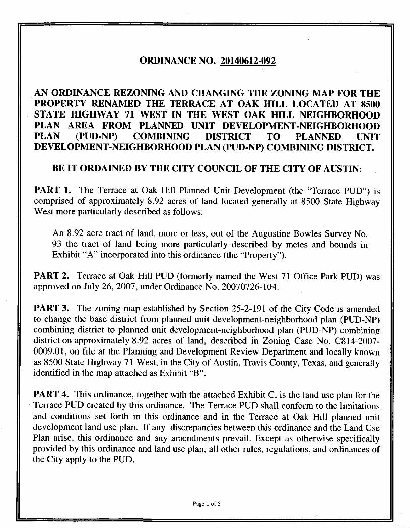
ORDINANCE NO. 20140612-092
AN ORDINANCE REZONING AND CHANGING THE ZONING MAP FOR THE PROPERTY RENAMED THE TERRACE AT OAK HILL LOCATED AT 8500 STATE HIGHWAY 71 WEST IN THE WEST OAK HILL NEIGHBORHOOD PLAN AREA FROM PLANNED UNIT DEVELOPMENT-NEIGHBORHOOD PLAN (PUD-NP) COMBINING DISTRICT TO PLANNED UNIT DEVELOPMENT-NEIGHBORHOOD PLAN (PUD-NP) COMBINING DISTRICT.
BE IT ORDAINED BY THE CITY COUNCIL OF THE CITY OF AUSTIN:
PART 1. The Terrace at Oak Hill Planned Unit Development (the "Terrace PUD") is comprised of approximately 8.92 acres of land located generally at 8500 State Highway West more particularly described as follows:
An 8.92 acre tract of land, more or less, out of the Augustine Bowles Survey No. 93 the tract of land being more particularly described by metes and bounds in Exhibit "A" incorporated into this ordinance (the "Property").
PART 2. Terrace at Oak Hill PUD (formeriy named the West 71 Office Park PUD) was approved on July 26, 2007, under Ordinance No. 20070726-104.
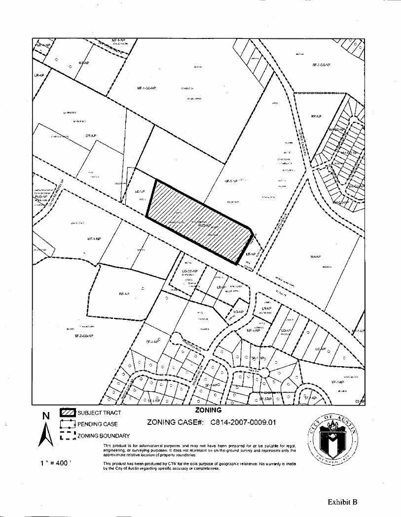
PART 3. The zoning map established by Section 25-2-191 of the City Code is amended to change the base district from planned unit development-neighborhood plan (PUD-NP) combining district to planned unit development-neighborhood plan (PUD-NP) combining district on approximately 8.92 acres of land, described in Zoning Case No. C814-2007-0009.01, on file at the Planning and Development Review Department and locally known as 8500 State Highway 71 West, in the City of Austin, Travis County, Texas, and generally identified in the map attached as Exhibit "B".
PART 4. This ordinance, together with the attached Exhibit C, is the land use plan for the Terrace PUD created by this ordinance. The Terrace PUD shall conform to the limitations and conditions set forth in this ordinance and in the Terrace at Oak Hill planned unit development land use plan. If any discrepancies between this ordinance and the Land Use Plan arise, this ordinance and any amendments prevail. Except as otherwise specifically provided by this ordinance and land use plan, all other rules, regulations, and ordinances of the City apply to the PUD.
Page 1 of 5
PART 5. The attached exhibits are incorporated into this ordinance in their entirety as though set forth fully in the text of this ordinance. The exhibits are as follows:
Exhibit A Exhibit B Exhibit C Exhibit D Exhibit
Legal description Zoning map Land Use Plan Grow Green Native and Adapted Landscape Plants Invasive Species/Problem Plants
PART 6. Land Use and Site Development Regulations.
See Sheets C-1 and C-2 of Exhibit C, the Land Use Plan for additional land use and site development regulations.
A. Except as otherwise provided in this ordinance, the Property is subject to multifamily residence Umited density (MF-1) district permitted uses, conditional uses, and site development regulations.
B. The maximum square footage for all uses shall be a total of 60,000 square feet.
C. Development of the Property may not exceed a floor to area ratio (F.A.R.) of 0.75:1.
D. Development of the Property shall not exceed 62 residential units.
E. Development of the Property shall not exceed an average density of 7 residential units per acre.
F. A site or building permit for the Property may not be approved, released, or issued if the completed development or uses of the Property, considered cumulatively with all existing or previously authorized development and uses, would generate traffic that exceeds 2,000 trips per day.
PART 7. Code Modincations. In accordance with Chapter 25-2, Subchapter B, Article 2, Division 5, (Planned Unit Developments) of City Code, the following site development regulations apply to the PUD instead of otherwise applicable City regulations:
A. Section 25-2-144(D) (Planned Unit Development (PUD) District Designation) is modified to waive the 10 acre PUD requirement.
Page 2 of 5
B. . Section 25-2-492 (Site Development Regulations) is modified to limit the maximum building coverage to 10% of the site.
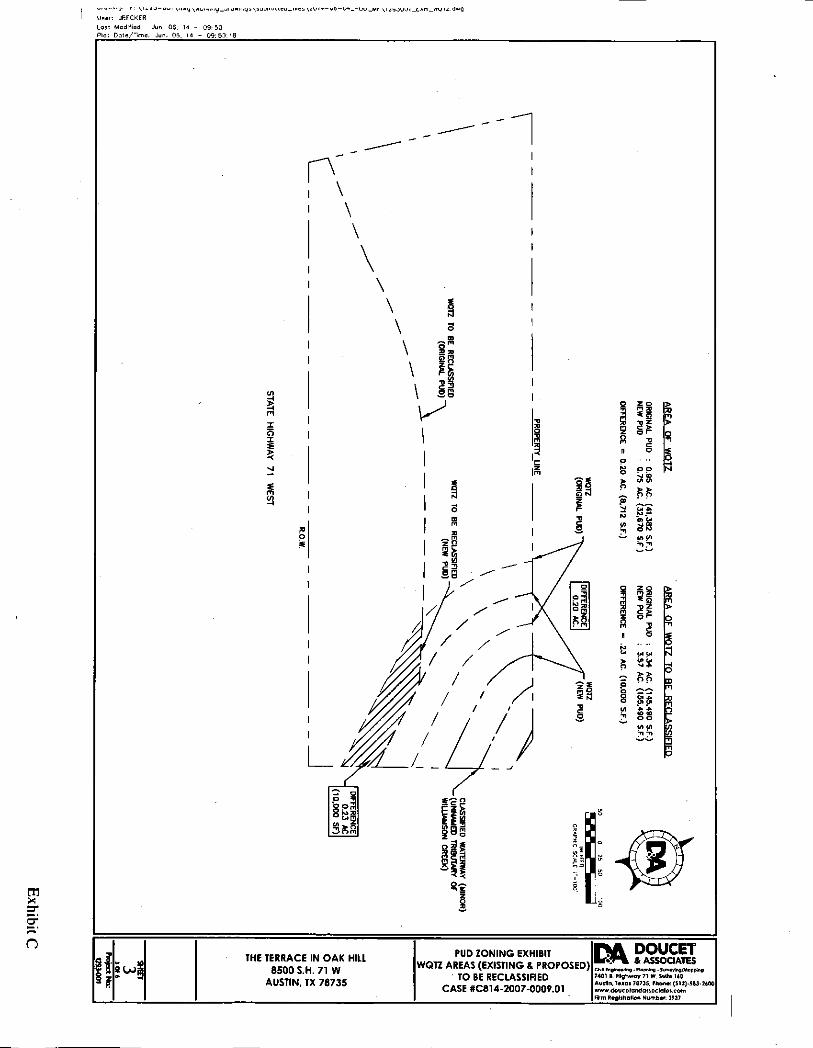
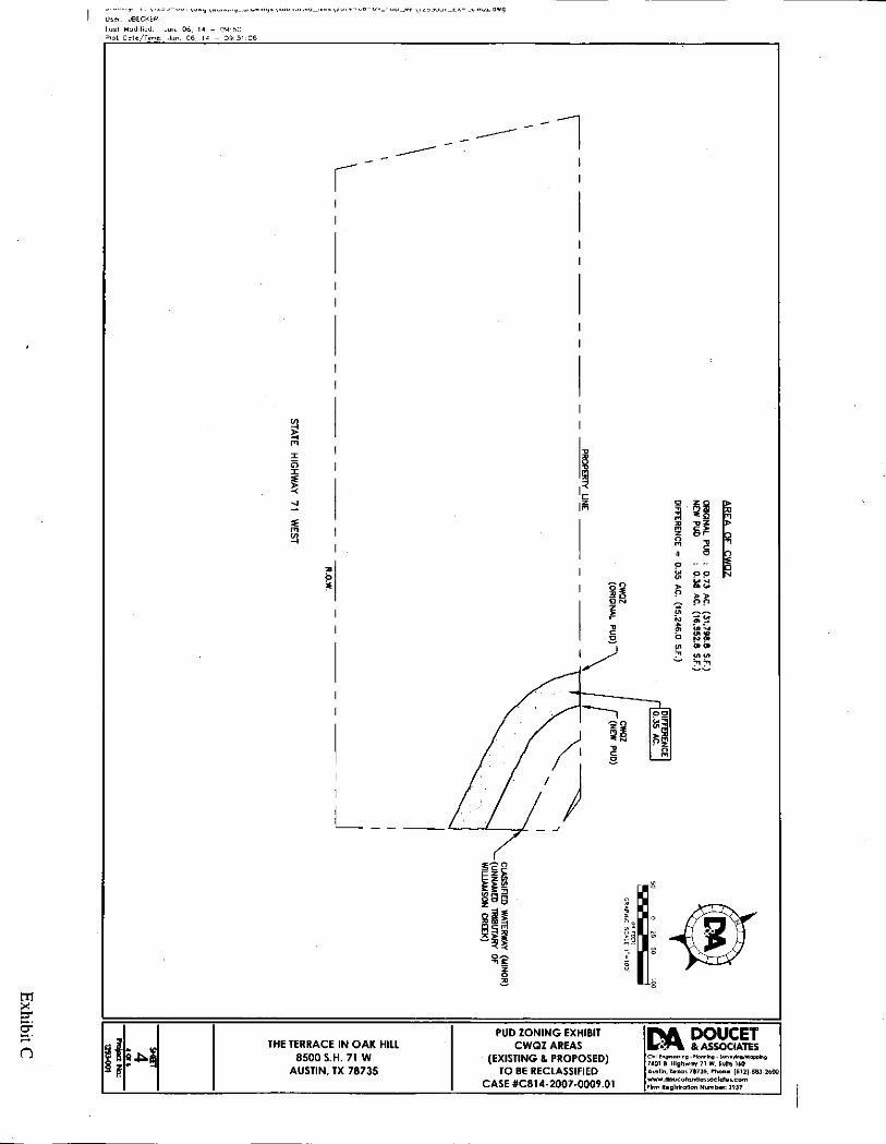
C. Section 25-8-482 (Water Quality Transition Zone) is modified to allow a 3.57 acre portion of the Property associated with Williamson Creek and identified on the Land Use Plan to be classified as Uplands Zone. See Exhibit C, Sheet C-3.
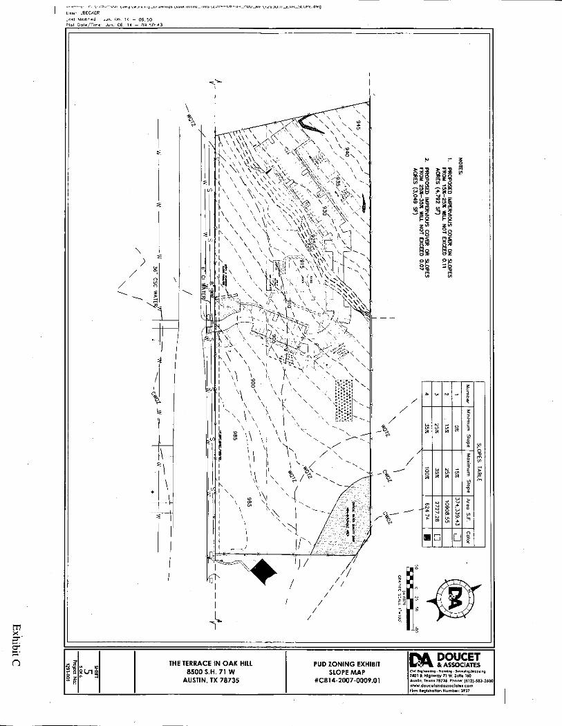
D. Sections 25-8-301 (Construction of a Roadway or Driveway) and 25-8-302 (Construction of a Building or Parking Area) are modified to allow for construction on slopes with a gradient between 15 percent and 35 percent with the following delineations:
1. this allowance does not include areas associated with building foundation or water quality/detention ponds, areas already permitted by Code, or preclude future administrative variance requests for cut-and-fill for swales and drainage ditches;
2. impervious cover on slopes from 15 percent to 25 percent shall be limited to 0.11 acres (4,792 square feet) and on slopes from 25 percent to 35 percent shall be limited to 0.07 acres (3,049 square feet); and,
3. the location of the additional impervious cover is generally depicted on Exhibit C, Sheet C-5.
PART 8. Environmental.
A. For each site plan application filed for commercial, industrial, mixed use, multifamily residential or open space areas for the PUD, the developer shall submit an integrated pest management (IPM) plan that complies with Sections 1.6.9.2(D) and (F) of the Environmental Criteria Manual to the Director of the Planning and Development Review Department for approval of the plan.
B. All trails within the PUD shall be constructed with permeable materials.
C. At the time an application for approval of a site plan is submitted for development of the Property or any portion of the Property, a landscape plan shall be submitted to the Planning and Development Review Department for
Page 3 of 5
review and approval. Ninety percent of the total plant material used, exclusive of turf, shall be native to Central Texas or on the Grow Green Native and Adapted Landscape Plants list, attached as Exhibit "D". Plants on the Invasive Species/Problem Plants list, attached as Exhibit "E", may not be used.
D. The limits of the northeast critical water quality zone and water quality transition zone, as estabhshed in City Code Sections 25-8-92 (A) and (B) (Critical Water Quality Zones Established) and as described in Exhibit C, Land Use Plan, Sheets C-3 and C-4, are based on City of Austin GIS data as of April 1,2014.
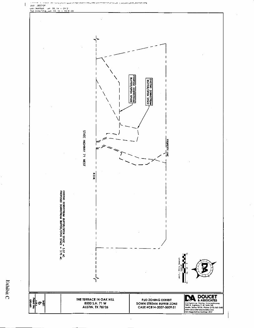
E. The location of the downstream buffer area described in Exhibit C, Land Use Plan, Sheet C-6, is approximate and may be modified as necessary to accommodate the final site layout.
F. The minimum allowable downstream buffer area is 3.75 acres.
G. The downstream buffer area shall remain undeveloped, except for the following:
water quality facilities detention facilities drainage facilities utility connections utility crossings permeable trails.
PART 9. The Property is subject to Ordinance No. 20081211-097 that estabhshed the West Oak Hill neighborhood plan combining district.
Page 4 of 5
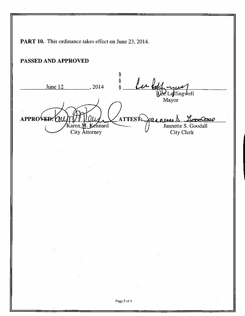
PART 10. This ordinance takes effect on June 23, 2014.
PASSED AND APPROVED
June 12 2014 §
APPRO^
City Attomey
ATTES
Lqftfingwell Mayor
Jannette S. Goodall City Clerk
Page 5 of 5
o Professional Land Surveying, Inc.
Surveying and Mapping
Office: 512-443-1724 Fax: 512-389-0943
3500 McCall Lane Austin. Texas 78744
8.921 ACRES AUGUSTINE BOWLES SURVEY NO. 93
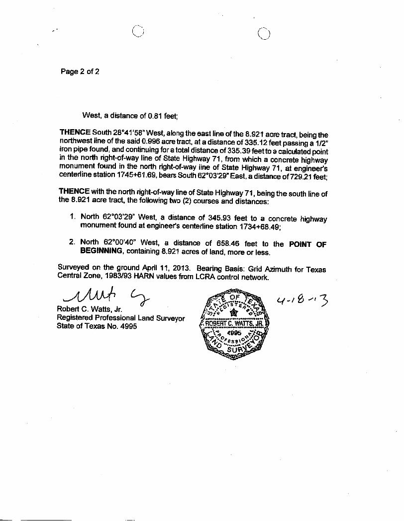
A DESCRIPTION OF 8.921 ACRES OF LAND (APPROXIMATELY 388.600 SO FT) OUT OF THE AUGUSTINE BOWLES SURVEY NO. 93, SITUATED IN TRAVIS COUNTY. TEXAS. AND BEING THE SAME PROPERTY DESCRIBED AS 7 9 ACRES OF LAND OUT OF AN 8.9 ACRE TRACT OF LAND AND 1 0 ACRE OF LAND OUT OF AN 8.9 ACRE TRACT OF LAND DESCRIBED IN VOLUME 2047 PAGE 178 OF THE DEED RECORDS OF TRAVIS COUNTY. TEXAS AND CONVEYED TO MICHAEL B. KNEPP BYTAX RESALE DEED. DATED OCTOBER 28, 2003 AND RECORDED IN DOCUMENT NO. 2003254026 OF THE OFFICIAL PUBLIC RECORDS OF TRAVIS COUNTY. TEXAS; SAID 8.921 ACRE TRACT BEING MORE PARTICULARLY DESCRIBED BY METES AND BOUNDS AS FOLLOWS:
BEGINNING at a calculated point in the north right-of-way line of State Highway 71 (150' right-of-way), being at the southwest comer of the said 8.921 acre tract, and being also at the southeast corner of Lot 1, Southwest Trails, a subdivision of record under Document No. 200000300 of the Plat Records of Travis County. Texas, from which a concrete highway monument found in the north right-of-way line of State Highway 71. at engineer's centeriine station 1719+86.53, bears North 62''00'40" West, a distance of 841.63 feet;
THENCE North 15*28'33" East departing said right-of-way line, along the common line of the 8.921 acre tract and said Lot 1, at a distance of 0.83 feet passing a 1/2" rebarfound, and continuingforatotaldistanceof 380.93 feet to a 1/2" rebar found in the south line of Lot 3, Southwest Trails, at the northwest comer of the 8.921 acre tract, being the northeast corner of said Lot 1, from which another 1/2" rebarfound bears South 50''13'26" West, a distance of 0.34 feet;
THENCE along the north line of the 8.921 acre tract, being in part, the south line of said Lot 3, and in part, the south line of a 19.687 acre tract described in a Wananty Deed to Central Texas/ SWA Mutual Housing Corporation recorded under Document No. 2001001683 of the Official Public Records of Travis County, Texas, the following two (2) courses and distances:
1. South 6r59'36" East, a distance of 1042.18 feet to a 1/2" iron pipe found;
2. South 25''43'11" East, a distance of 60.68 feet to a 1/2" iron pipe found at the north comer of a 0.996 acre tract described in a Certificate Regarding Mergers to 7-Eleven recorded in Document 2013011903 of the Official Public Records of Travis County, Texas, from which a 1/2" rebarfound bears North 22''20'58"
Exhibit A
C)
Page 2 of 2
West, a distance of 0.81 feet;
THENCE South 28°4r58''West, along the east line of the 8.921 acre tract, being the northwest line of the said 0.996 acre tract, at a distance of 335.12 feet passing a 1/2" iron pipe found, and continuing for a total distance of 335.39 feet to a calculated point in the north right-of-way line of State Highway 71, from which a concrete highway monument found in the north right-of-way line of State Highway 71, at engineer's centeriine station 1745+61.69. bears South 62''03'29" East, a distance of729.21 feet;
THENCE with the north right-of-way line of State Highway 71, being the south line of the 8.921 acre tract, the following two (2) courses and distances:
1. North 62''03'29" West, a distance of 345.93 feet to a concrete highway monument found at engineer's centeriine station 1734+68.49;
2. North 62''00'40" West, a distance of 658.46 feet to the POINT OF BEGINNING, containing 8.921 acres of land, more or less.
Surveyed on the ground April 11, 2013. Bearing Basis: Grid Azimuth for Texas Central Zone, 1983/93 HARN values from LCRA control networi<.
Robert C. Watts, Jr. - & ^ ^ ^ ^ o > Registered Professional Land Surveyor State of Texas No. 4995 f RS§.SRI.CJiAI7iuJR̂ ^
' -Vtf, 4995 y/t
A-1 " = 400 •
PENDING CASE ZONING CASE#: C814-2007-0009.01
ZONING BOUNDARY
This product Is ior inforniationaJ purpoces and may not have been prepared for or be suitable for legal, engineering, or sur\'eying puiposes. It does not represent an on-the-ground survey and represents onty the approximate relative location of property boundaries.
This product has been produced by CTM for the sole purpose of geographic reference. No v/arranty is made by the City of Austin regarding specific accuracy or completeness.
Exhibit B
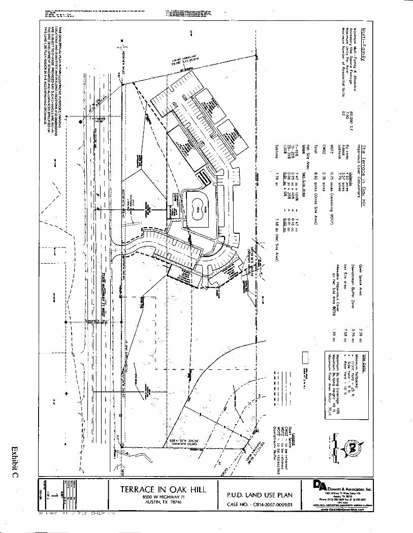
TERRACE IN OAK HILL 8500 W HIGHWAY 71
AUSTIN, TX 78746
P.U.D. LAND USE PLAN CASE NO. • C814-2007-0009.01
Doucet & Associates, Inc. 7401 B Hwj. 71 Wen. Suita UO
Amtla TX 78735 Phono: (512) 5B3-UOQ Fuc (S11) 1
www,douMBnda«ociate».com F L E T C H E R L-NI.
3 a
o o -1 " o 5 s
m X :^ - I
m m i S
o n OJ p. S o
^ 5 ^ m C
m o 3 =; z O r- > ^ H m
5^5 O m
t r t _ i
;o -ri :a
33 3
^ m
o H m
m E T
n TERRACE IN OAK HILL
8500 W HIGHWAY 71 AUSTIN, TX 78746
P.U.D. NOTES CASE NO. - C814-2007 0009.01
HWY. 7 1 / F L E T C H E R
Doucet & Associates, Inc. 7401 B Hwy^ 71 W a n . SuKe l U
A i B d n . T X 7873S Phona: ( S H ) SSJ-ZUO F n ; (511) S S l - U O l
TWt i B J 7
: M TDUI • H O t T H W m n u u o u i T T l • W t M U O U W U
www.douceiaiidassociatei.com
U s e r JBECKER
Los t M o d i f i e d : Jun. 0 6 ,
P lo t D o t e / T i m e : Jun . 06 0 9 : 5 0
- 0 9 : 5 0 : I B
n
o £
5
(/)
if THE TERRACE IN OAK HILL 8500 S.H. 71 W
AUSTIN, TX 78735
PUD ZONING EXHIBIT WQTZ AREAS (EXISTING & PROPOSED)
TO BE RECLASSIFIED CASE #0814-2007-0009.01
DOUCET & ASSOCIATES
CIvM Cng inac i lng - Pki r in ing - S w a y i n g / M a p p i n g
7401 B. Hl0hway 71 W. Sulfa )A0 Austin, TexQi 78735, Phone: (512]-5S3-26O0 www.douce landassoc la te t . com Firm Registration Number: 3937
User: JBECKER
Lost Mod i f ied : Jun.
P lo t D o t e / T i m e : Jun . 0 9 : 5 0
- 0 9 : 5 1 : 0 6
m X
n
C/)
a X
i £ m
THE TERRACE IN OAK HILL 8500 S.H. 71 W
AUSTIN, TX 78735
PUD ZONING EXHIBIT CWQZ AREAS
(EXISTING & PROPOSED) TO BE RECLASSIFIED
CASE #0814-2007-0009.01
DOUCET & ASSOCIATES
Civil Eng inear ing - P lann ing - Su rvay lng /Mapp lng
7401 B. Highway 71 W, Suite 160 Austin, Texas 78735, Phone: (512]-S83-2600 w w w . d o u c e l a n d associates, c o m Firm Registration Number: 3937
r . u u i \ u « y \ «u r F,iriy ut u w i i i y i \ s u u l l il
User: JBECKER
Las t Mod i f ied ; Jun . 0 6 , 14 - 0 9 : 5 0 P lo t D o t e / T i m e : J u n . 0 6 , 14 - 0 9 : 5 0 : 1 3
s \ z u I H - U D - u t _ r u u _ M r \ t ^ y j u u i _ t ^ M _ S L U i - ' t . a w q
m
n
\ }
/ /
> —I
\ m 3__
1
\ \
\ V" A\\v=-,«,-<. N \ — I \ vl \ \ ^ \
\ \ \ \
I \ \ ^ ' \
\ t
> 3 - 0
» g o m £ -D w o
> 3 - 0
sis m £ -D to O
( D M ?
"a?
Ro
b b p ^
s u i t THE TERRACE IN OAK HILL
8500 S.H. 71 W AUSTIN, TX 78735
PUD ZONING EXHIBIT SLOPE MAP
#0814-2007-0009.01
DOUCET & ASSOCIATES
Ctvn Engineering - Planning - Surveiilng/MappIng 7401 D. Highway 71 W, SuKe UO AusHn, Texas 78735, Phone: (S12)-583-2600 www.doucs tandassoc la tes .com Firm Registration Number: 3937
User: JBECKER
Los t Mod i f i ed : Jun .
P lo t D a t e ^ T i m e : Jun , 0 9 : 51
- 0 9 : 5 1 : 2 2
X
o £
5
£ m
^ 5
"« II u ii*
* 51
m cr
n THE TERRACE IN OAK HILL
8500 S.H. 71 W AUSTIN, TX 78735
PUD ZONING EXHIBIT DOWN STREAM BUFFER ZONE CASE #C814-2007-0009.01
DOUCET & ASSOCIATES
Civi l Eng ineer ing - P lonn ing - 1 u n r e y i n g / M o p p i n g
7401 B, Highway 71 W, Suite 160 Austin, Texas 78735, Phone: (512)-5a3-2600 www, doucetandassoc la tes .com Firm Registration Number: 3937
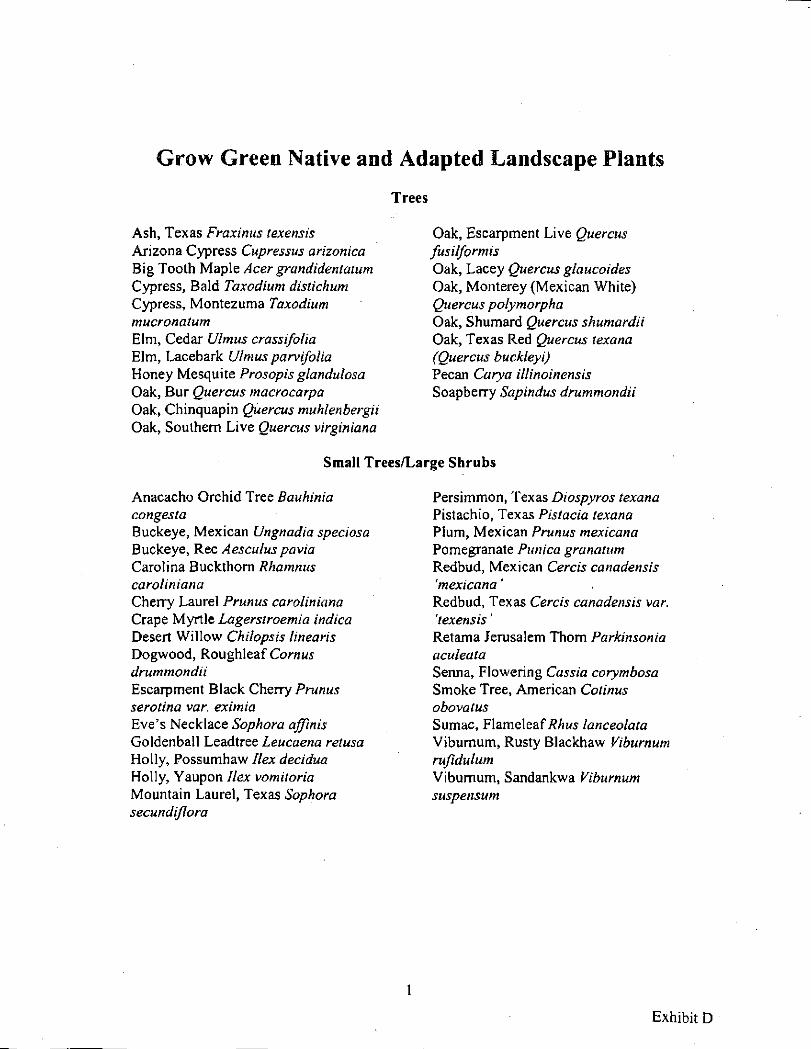
Grow Green Native and Adapted Landscape Plants
Trees
Ash, Texas Fraxinus texensis Arizona Cypress Cupressus ahzonica Big Tooth Maple Acer grandidentatum Cypress, Bald Taxodium distichum Cypress, Montezuma Taxodium mucronatum Elm, Cedar Ulmus crassifolia Elm, Lacebark Ulmus parvifolia Honey Mesquite Prosopis glandulosa Oak, Bur Quercus macrocarpa Oak, Chinquapin Quercus muhlenbergii Oak, Southern Live Quercus virginiana
Oak, Escarpment Live Quercus fusilformis Oak, Lacey Quercus glaucoides Oak, Monterey (Mexican White) Quercus polymorpha Oak, Shumard Quercus shumardii Oak, Texas Red Quercus texana (Quercus buckleyi) Pecan Carya illinoinensis Soapberry Sapindus drummondii
Small Trees/Large Shrubs
Anacacho Orchid Tree Bauhinia congesta Buckeye, Mexican Ungnadia speciosa Buckeye, Rec Aesculus pavia Carolina Buckthorn Rhamnus caroliniana Cherry Laurel Prunus caroliniana Crape Myrtle Lagerstroemia indica Desert Willow Chilopsis linearis Dogwood, Roughleaf Cornus drummondii Escarpment Black Cherry Prunus serotina var. eximia Eve's Necklace Sophora affinis Goldenball Leadtree Leucaena retusa Holly, Possumhaw Ilex decidua Holly, Yaupon Ilex vomitoria Mountain Laurel, Texas Sophora secundiflora
Persimmon, Texas Diospyros texana Pistachio, Texas Pistacia texana Plum, Mexican Prunus mexicana Pomegranate Punica granatum Redbud, Mexican Cercis canadensis 'mexicana' Redbud, Texas Cercis canadensis var. 'texensis' Retama Jerusalem Thorn Parkinsonia aculeata Senna, Flowering Cassia corymbosa Smoke Tree, American Cotinus obovatus Sumac, Flameleaf/?/iM5 lanceolata Viburnum, Rusty Blackhaw Viburnum rufidulum Viburnum, Sandankwa Viburnum suspensum
Exhibit D
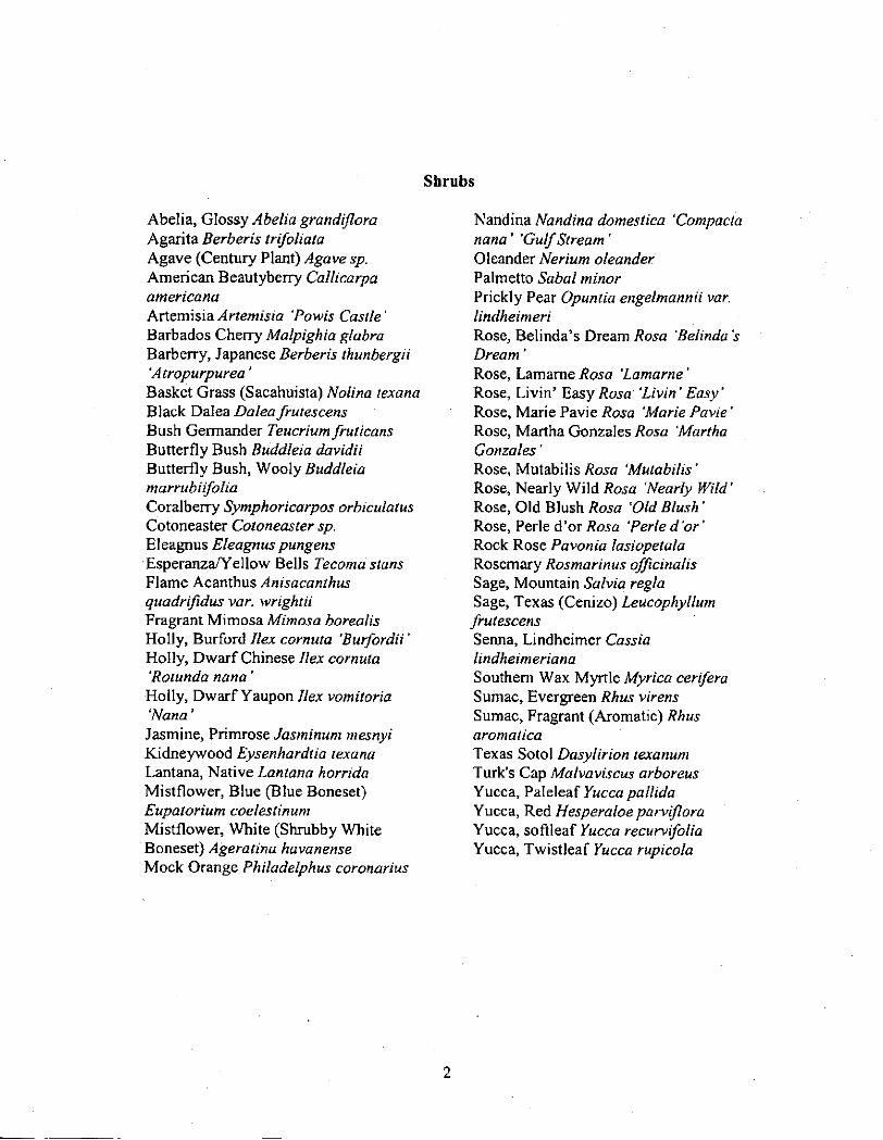
Shrubs
Abelia, Glossy Abelia grandijlora Agarita Berberis trifoliata Agave (Century Plant) y4gave sp. American Beautyberry Callicarpa americana Artemisia Artemisia 'Powis Castle' Barbados Cherry Malpighia glabra Barberry, Japanese Berberis thunbergii 'Atropurpurea' Basket Grass (Sacahuista) Molina texana Black Dalea Dalea frutescens Bush Germander Teucrium fruticans Butterfly Bush Buddleia davidii Butterfly Bush, Wooly Buddleia marrubiifolia Coralberry Symphoricarpos orbiculatus Cotoneaster Cotoneaster sp. Eleagnus Eleagnus pungens Esperanza/Yellow Bells Tecoma stans Flame Acanthus Anisacanthus quadrifidus var. wrightii Fragrant Mimosa Mimosa horealis Holly, Burford Ilex cornuta 'Burfordii' Holly, Dwarf Chinese Ilex cornuta 'Rotunda nana' Holly, Dwarf Yaupon Ilex vomitoria 'Nana' Jasmine, Primrose Jasminum mesnyi Kidneywood Eysenhardtia texana Lantana, Native Lantana horrida Mistflower, Blue (Blue Boneset) Eupatorium coelestinum Mistflower, White (Shrubby White Boneset) Ageratina havanense Mock Orange Philadelphus coronarius
Nandina Nandina domestica 'Compacta nana' 'Gulf Stream ' Oleander Nerium oleander Palmetto Sabal minor Prickly Pear Opuntia engelmannii var. lindheimeri Rose, Belinda's Dream Rosa 'Belinda's Dream' Rose, Lamame Rosa 'Lamarne' Rose, Livin' Easy Rosa 'Livin' Easy' Rose, Marie Pavie Rosa 'Marie Pavie' Rose, Martha Gonzales Rosa 'Martha Gonzales' Rose, Mutabilis Rosa 'Mutabilis' Rose, Nearly Wild Rosa 'Nearly Wild' Rose, Old Blush Rosa 'Old Blush' Rose, Perle d'or Rosa 'Perle d 'or' Rock Rose Pavonia lasiopetala Rosemary Rosmarinus officinalis Sage, Mountain Salvia regla Sage, Texas (Cenizo) Leucophyllum frutescens Senna, Lindheimer Cassia lindheimeriana Southern Wax Myrtle Myrica cerifera Sumac, Evergreen Rhus virens Sumac, Fragrant (Aromatic) Rhus aromatica Texas Sotol Dasylirion texanum Turk's Cap Malvaviscus arboreus Yucca, Paleleaf Yucca pallida Yucca, Red Hesperaloe parviflora Yucca, softleaf Yucca recurvifolia Yucca, Twistleaf Yucca rupicola
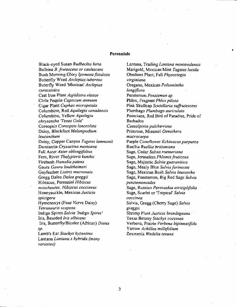
Perennials
Black-eyed Susan Rudbeckia hirta Bulbine B. frutescens or caulescens Bush Morning Glory Ipomoea fistvlosa Butterfly Weed Asclepias tuberosa Buterfly Weed 'Mexican' Asclepias curassivica Cast Iron Plant Aspidistra elatior Chile Pequin Capsicum annuum Cigar Plant Cuphea micropetala Columbine, Red Aquilegia canadensis Columbine, Yellow Aquilegia chrysantha 'Texas Gold' Coreopsis Coreopsis lanceolata Daisy, Blackfoot Melampodium leucanthum Daisy, Copper Canyon Tagetes lemmonii Damiantia Crysactina mexicana Fall Aster Aster oblongifolius Fern, River Thelypteris kunthii Firebush Hamelia patens Gaura Gaura lindeheimeri Gayfeather Liatris mucronata Gregg Dalea Dalea greggii Hibiscus, Perennial Hibiscus moscheutos, Hibiscus coccineus Honeysuckle, Mexican Justicia spicigera Hymenoxys (Four Nerve Daisy) Tetraneuris scaposa Indigo Spires Salvia 'Indigo Spires' Iris, Bearded Iris albicans Iris, Butterfly/Bicolor (African) Dietes
sp. Lamb's Ear Stachys byzantina Lantana Lantana x hybrida (many varieties)
Lantana, Trailing Lantana montevidensis Marigold, Mexican Mint Tagetes lucida Obedient Plant, Fall Physostegia virginiana Oregano, Mexican Poliomintha longiflora Penstemon Penstemon sp. Phlox, Fragrant Phlox pilosa Pink Skullcap Scutellaria suffrutescens Plumbago Plumbago auriculata Poinciana, Red Bird of Paradise, Pride of Barbados Caesalpinia pulcherrima Primrose, Missouri Oenothera macrocarpa Purple Coneflower Echinacea purpurea Ruellia Ruellia brittoniana Sage, Cedar Salvia roemeriana Sage, Jerusalem Phlomis fruticosa Sage, Majestic Salvia guaranitica Sage, Mealy Blue Salvia farinacea Sage, Mexican Bush Salvia leucantha Sage, Penstemon, Big Red Sage Salvia penstemonoides Sage, Russian Perovaskia atriciplifolia Sage, Scarlet or 'Tropical' Salvia coccinea Salvia, Gregg (Cherry Sage) Salvia greggii Shrimp Plant Justicia brandegeana Texas Betony Stachys coccinea Verbena, Prairie Verbena bipinnatifida Yarrow Achillea millefolium Zexmenia Wedelia texana
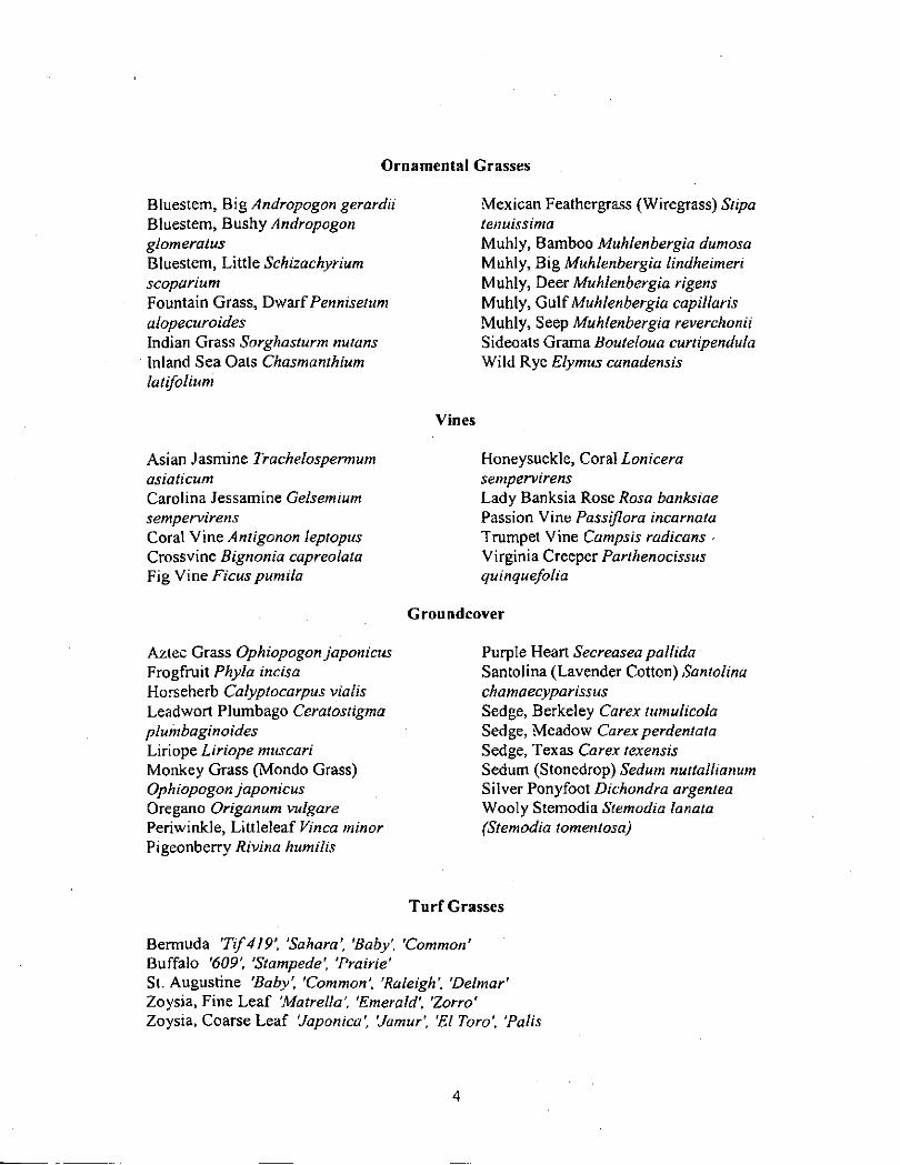
Ornamental Grasses
Bluestem, Big Andropogon gerardii hXnesiem, Bnshy Andropogon glomeratus Bluestem, Little Schizachyrium scoparium Fountain Grass, Dwaif Pennisetum alopecuroides Indian Grass Sorghasturm nutans Inland Sea Oats Chasmanthium latifolium
Asian Jasmine Trachelospemmm asiaticum Carolina Jessamine Gelsemium sempervirens Coral Vine Antigonon leptopus Crossvine Bignonia capreolata Fig Vine Ficus pumila
Mexican Feathergrass (Wiregrass) Stipa tenuissima Muhly, Bamboo Muhlenbergia dumosa Muhly, Big Muhlenbergia lindheimeri Muhly, Deer Muhlenbergia rigens Muhly, Gulf Muhlenbergia capillaris Muhly, Seep Muhlenbergia reverchonii Sideoats Grama Bouteloua curtipendula Wild Rye Elymus canadensis
Vines
Honeysuckle, Coral Lonicera sempervirens Lady Banksia Rose Rosa banksiae Passion Vine Passiflora incarnata Trumpet Vine Campsis radicans -Virginia Creeper Parthenocissus quinquefolia
Groundcover
Aztec Grass Ophiopogon japonicus Frogfruit Phyla incisa Horseherb Calyptocarpus vialis Leadwort Plumbago Ceratostigma plumbaginoides Liriope Liriope muscari Monkey Grass (Mondo Grass) Ophiopogon japonicus Oregano Origanum vulgare Periwinkle, Littleleaf Vinca minor Pigeonberry Rivina humilis
Purple Heart Secreasea pallida Santolina (Lavender Cotton) Santolina chamaecyparissus Sedge, Berkeley Carex tumulicola Sedge, Meadow Carex perdentata Sedge, Texas Carex texensis Sedum (Stonedrop) Sedum nuttallianum Silver Ponyfoot Dichondra argentea Wooly Stemodia Stemodia lanata (Stemodia tomentosa)
Turf Grasses
Bermuda 'Tif419', 'Sahara', Baby'. 'Common' Buffalo '609', 'Stampede', 'Prairie' St. Augustine 'Baby', 'Common', 'Raleigh', 'Delmar' Zoysia, Fine Leaf 'Matrella', 'Emerald', 'Zorro' Zoysia, Coarse Leaf 'Japonica', 'Jamur', 'ElToro', 'Palis
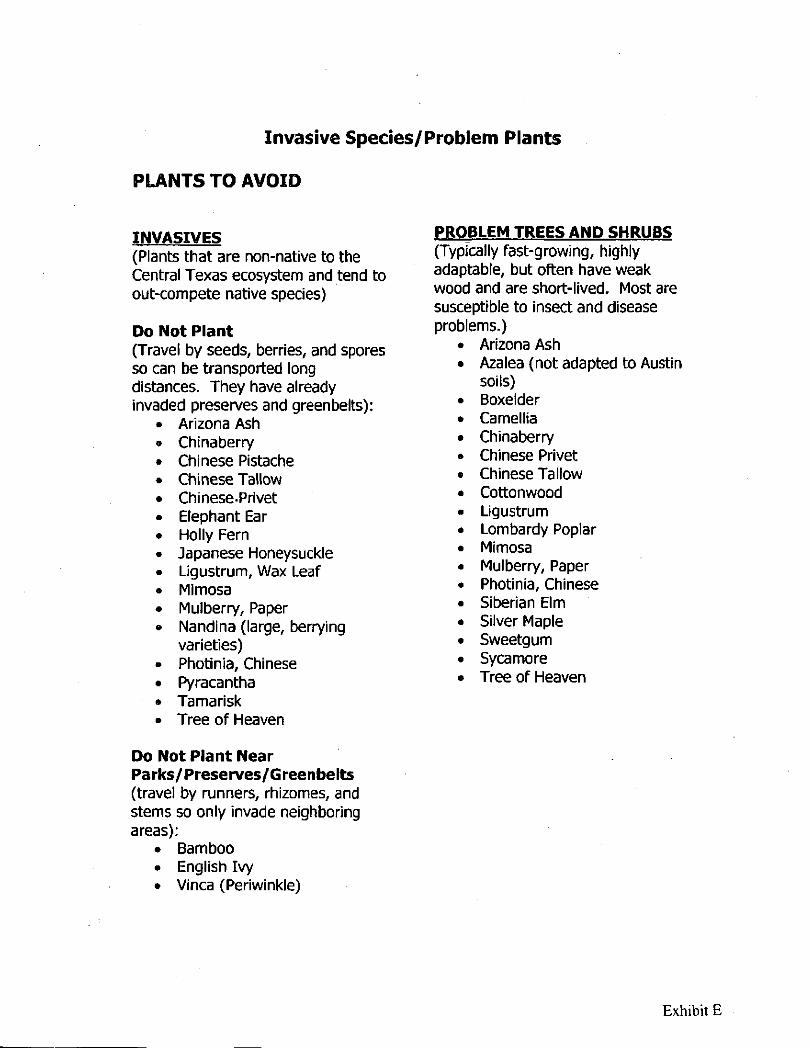
Invasive Species/Problem Plants
PLANTS TO AVOID
INVASIVES (Plants that are non-native to the Central Texas ecosystem and tend to out-compete native species)
Do Not Plant (Travel by seeds, berries, and spores so can be transported long distances. They have already invaded preserves and greenbelts):
Arizona Ash Chinaberry Chinese Pistache Chinese Tallow Chinese.Privet Elephant Ear Holly Fern Japanese Honeysuckle Ligustrum, Wax Leaf Mimosa Mulberry, Paper Nandina (large, berrying varieties) Photinia, Chinese Pyracantha Tamarisk Tree of Heaven
PROBLEM TREES AND SHRUBS (Typically fast-growing, highly adaptable, but often have weak wood and are short-lived. Most are susceptible to Insect and disease problems.)
Arizona Ash Azalea (not adapted to Austin soils) Boxelder Camellia Chinaberry Chinese Privet Chinese Tallow Cottonwood Ligustrum Lombardy Poplar Mimosa Mulberry, Paper Photinia, Chinese Siberian Elm Silver Maple Sweetgum Sycamore Tree of Heaven
Do Not Plant Near Parks/Preserves/Greenbelts (travel by runners, rhizomes, and stems so only invade neighboring areas):
• Bamboo • English Ivy • Vinca (Periwinkle)
Exhibit E