Embed Size (px)
Citation preview
290
23. GEOGRAPHY (Code No. 029) (2017-18)
Geography is introduced as an elective subject at the senior secondary stage. After ten years of general education, students branch out at the beginning of this stage and are exposed to the rigours of the discipline for the first time. Being an entry point for the higher education, students choose Geography for pursuing their academic interest and, therefore, need a broader and deeper understanding of the subject. For others, geographical knowledge is useful in daily lives because it is a valuable medium for the education of young people. Its contribution lies in the content, cognitive processes, skills and values that Geography promotes and thus helps the students explore, understand and evaluate the environmental and social dimensions of the world in a better manner.
Since Geography explores the relationship between people and their environment, it includes studies of physical and human environments and their interactions at different scales-local, state/region, nation and the world. The fundamental principles responsible for the varieties in the distributional pattern of physical and human features and phenomena over the earth's surface need to be understood properly. Application of these principles would be taken up through selected case studies from the world and India. Thus, the physical and human environment of India and study of some issues from a geographical point of view will be covered in greater detail. Students will be exposed to different methods used in geographical investigations.
Objectives:
The course in Geography will help learners to:
Familiarise with key concepts, terminology and core principles of Geography.
Describe locations and correlate with Geographical Perspectives.
List/describe what students might see, hear, smell, at a place.
List/describe ways a place is linked with other places.
Compare conditions and connections in one place to another.
Analyze/describe how conditions in one place can affect nearby places.
Identify regions as places that are similar or connected.
Describe and interpret the spatial pattern features on a thematic map.
Search for, recognize and understand the processes and patterns of the spatial arrangement of the natural features as well as human aspects and phenomena on the earth's surface.
Understand and analyse the inter-relationship between physical and human environments and utilise such knowledge in reflecting on issues related to community.
Apply geographical knowledge and methods of inquiry to emerging situations or problems at different levels-local, regional, national and global.
Develop geographical skills, relating to collection, processing and analysis of spatial data/ information and preparation of report including maps and graphs and use of computers where ever possible; and to be sensitive to issues.
Aglasem SchoolsAglasem Schools
291
GEOGRAPHY (029) CLASS XI (2017-18)
One Theory Paper 70 Marks 3 Hours
Part A Fundamentals of Physical Geography 35 Marks
Unit-1: Geography as a discipline
30
Unit-2: The Earth
Unit-3: Landforms
Unit-4: Climate
Unit-5: Water (Oceans)
Unit-6: Life on the Earth
Map and diagram 5
Part B India-Physical Environment 35 Marks
Unit-7: Introduction
30 Unit-8: Physiography
Unit-9: Climate, vegetation and soil
Unit-10: Natural hazards and Disasters
Map and Diagram 5
Part C Practical Work 30 Marks
Unit-1: Fundamentals of Maps 10 Marks
Unit-2: Topographic and Weather Maps 15 Marks
Practical Record Book and Viva 5 Marks
Part A: Fundamentals of Physical Geography 87 Periods
Unit-1: Geography as a Discipline 04 Periods
Geography as an integrating discipline, as a science of spatial attributes.
Branches of Geography; Physical Geography and Human Geography.
Scope and Career Options
Unit-2: The Earth 11 Periods
Origin and evolution of the earth; Interior of the earth.
Wegener's continental drift theory and plate tectonics.
Earthquakes and volcanoes: causes, types and effects.
Unit-3: Landforms 20 Periods
Rocks: major types of rocks and their characteristics.
Aglasem SchoolsAglasem Schools
292
Geomorphic processes: weathering, mass wasting, erosion and deposition; soil-formation.
Landforms and their evolution.
Unit 4: Climate 30 Periods
Atmosphere- composition and structure; elements of weather and climate.
Insolation-angle of incidence and distribution; heat budget of the earth-heating and cooling of atmosphere (conduction, convection, terrestrial radiation and advection); temperature- factors controlling temperature; distribution of temperature-horizontal and vertical; inversion of temperature.
Pressure-pressure belts; winds-planetary, seasonal and local; air masses and fronts; tropical and extratropical cyclones.
Precipitation-evaporation; condensation-dew, frost, fog, mist and cloud; rainfall-types and world distribution.
World climates-classification Koeppen, Differences in parameter between koeppen & Thornthwaite, Global warming and climatic changes.
Climate and Global Concerns.
Unit 5: Water (Oceans) 10 Periods
Basics of Oceanography
Oceans - distribution of temperature and salinity.
Movements of ocean water-waves, tides and currents; submarine reliefs.
Ocean resources and pollution.
Unit 6: Life on the Earth 07 Periods
Biosphere - importance of plants and other organisms; biodiversity and conservation; ecosystem and ecological balance.
Map work on identification of features based on 1 to 6 units on the outline/Physical/Political map of the world. 05 Periods
Part – B: India - Physical Environment 78 Periods
Unit-7: Introduction 04 Periods
Location, space relations, India's place in the world.
Unit-8: Physiography 28 Periods
Structure and Relief; Physiographic Divisions.
Drainage systems: Concept of river basins, Watershed; the Himalayan and the Peninsular rivers.
Unit-9: Climate, Vegetation and Soil 28 Periods
Weather and climate - spatial and temporal distribution of temperature, pressure winds and rainfall, Indian monsoon: mechanism, onset and withdrawal, variability of rainfalls: spatial and temporal; use of weather charts; Climatic types (Koeppen).
Natural vegetation-forest types and distribution; wild life; conservation; biosphere reserves.
Aglasem SchoolsAglasem Schools
293
Soils - major types (ICAR's classification) and their distribution, soil degradation and conservation.
Unit-10: Hazards and Disasters: Causes, Consequences and Management 14 Periods
Floods, Cloudbursts
Droughts: types and impact
Earthquakes and Tsunami
Cyclones: features and impact
Landslides
Map Work of features based on above units for locating and labelling on the Outline/Political/Physical map of India. 04 Periods
Part – C: Practical Work 50 Periods
Unit-1: Fundamentals of Maps 20 Periods
Geo spatial data, Concept of Geographical data matrix; Point, line, area data.
Maps -types; scales-types; construction of simple linear scale, measuring distance; finding direction and use of symbols.
Map projection- Latitude, longitude and time, typology, construction and properties of projection: Conical with one standard parallel and Mercator's projection. (only two projections)
Unit 2: Topographic and Weather Maps 30 Periods
Study of topographic maps (1 : 50,000 or 1 : 25,000 Survey of India maps); contour cross section and identification of landforms-slopes, hills, valleys, waterfall, cliffs; distribution of settlements.
Aerial Photographs: Types and Geometry-vertical aerial photographs; difference between maps and aerial photographs; photo scale determination. Identification of physical and cultural features.
Satellite imageries, stages in remote sensing data-acquisition, platform and sensors and data products, (photographic and digital).
Use of weather instruments: thermometer, wet and dry-bulb thermometer, barometer, wind vane, rain gauge.
Practical Record Book and Viva Voce
Viva to be based on Practical Unit I and II only.
Aglasem SchoolsAglasem Schools
294
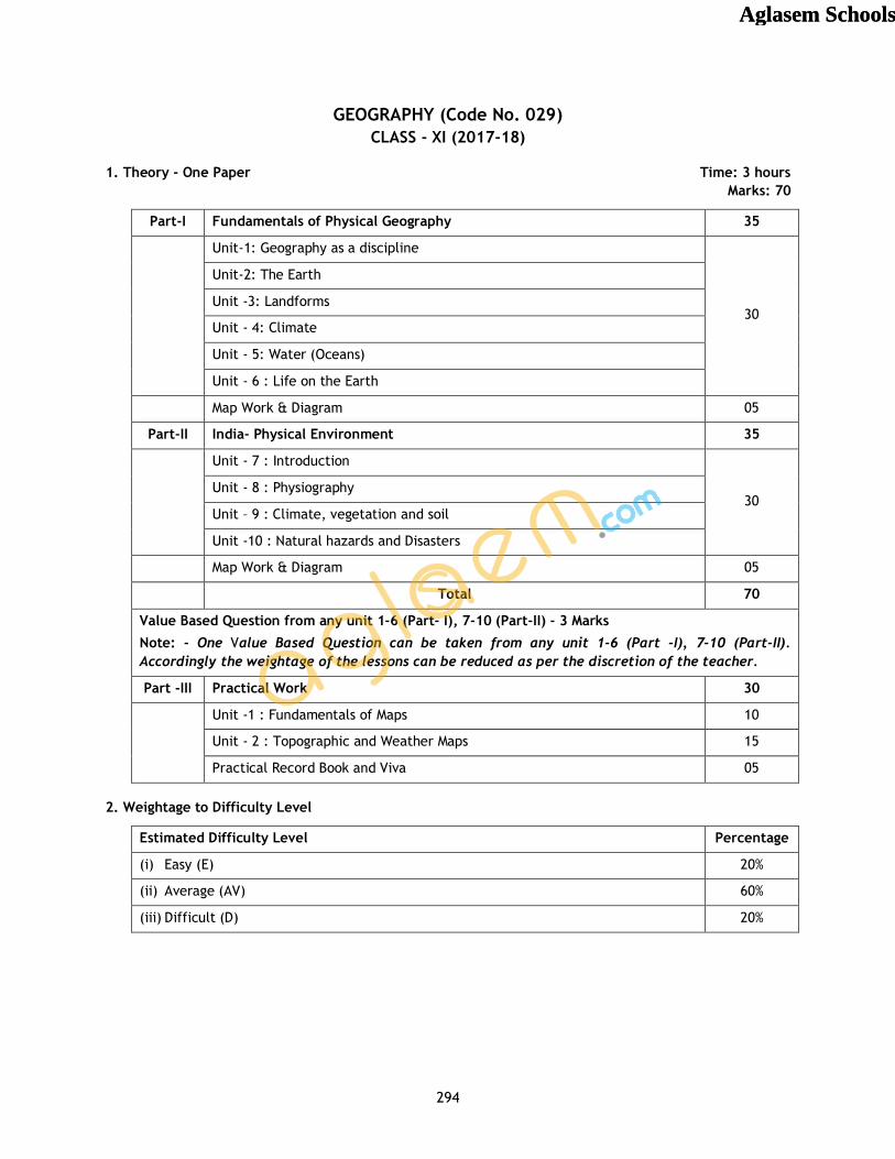
GEOGRAPHY (Code No. 029) CLASS - XI (2017-18)
1. Theory - One Paper Time: 3 hours Marks: 70
Part-I Fundamentals of Physical Geography 35
Unit-1: Geography as a discipline
30
Unit-2: The Earth
Unit -3: Landforms
Unit - 4: Climate
Unit - 5: Water (Oceans)
Unit - 6 : Life on the Earth
Map Work & Diagram 05
Part-II India- Physical Environment 35
Unit - 7 : Introduction
30 Unit - 8 : Physiography
Unit – 9 : Climate, vegetation and soil
Unit -10 : Natural hazards and Disasters
Map Work & Diagram 05
Total 70
Value Based Question from any unit 1-6 (Part- I), 7-10 (Part-II) - 3 Marks
Note: - One Value Based Question can be taken from any unit 1-6 (Part -I), 7-10 (Part-II). Accordingly the weightage of the lessons can be reduced as per the discretion of the teacher.
Part -III Practical Work 30
Unit -1 : Fundamentals of Maps 10
Unit - 2 : Topographic and Weather Maps 15
Practical Record Book and Viva 05
2. Weightage to Difficulty Level
Estimated Difficulty Level Percentage
(i) Easy (E) 20%
(ii) Average (AV) 60%
(iii) Difficult (D) 20%
Aglasem SchoolsAglasem Schools
295
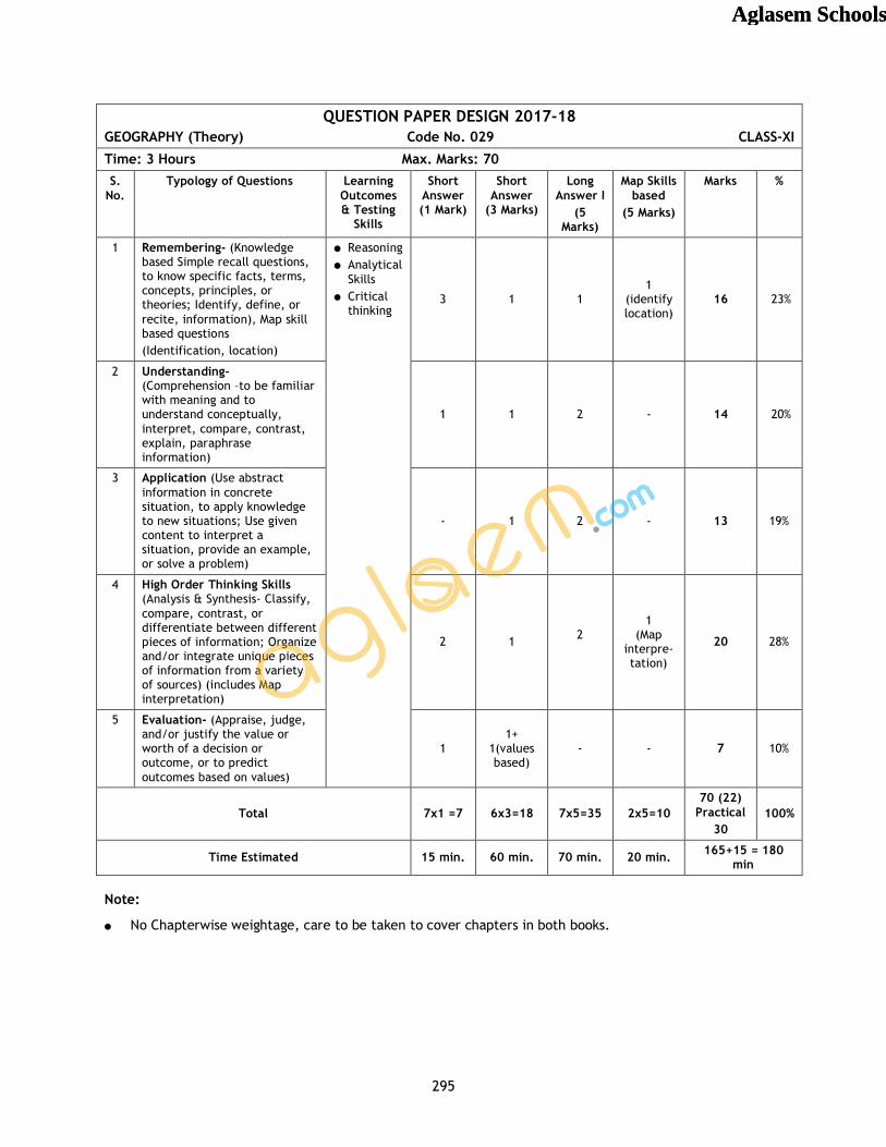
QUESTION PAPER DESIGN 2017-18 GEOGRAPHY (Theory) Code No. 029 CLASS-XI
Time: 3 Hours Max. Marks: 70 S.
No. Typology of Questions Learning
Outcomes & Testing
Skills
Short Answer (1 Mark)
Short Answer
(3 Marks)
Long Answer I
(5 Marks)
Map Skills based
(5 Marks)
Marks %
1 Remembering- (Knowledge based Simple recall questions, to know specific facts, terms, concepts, principles, or theories; Identify, define, or recite, information), Map skill based questions (Identification, location)
Reasoning Analytical
Skills Critical
thinking
3 1 1 1
(identify location)
16 23%
2 Understanding- (Comprehension –to be familiar with meaning and to understand conceptually, interpret, compare, contrast, explain, paraphrase information)
1 1 2 - 14 20%
3 Application (Use abstract information in concrete situation, to apply knowledge to new situations; Use given content to interpret a situation, provide an example, or solve a problem)
- 1 2 - 13 19%
4 High Order Thinking Skills (Analysis & Synthesis- Classify, compare, contrast, or differentiate between different pieces of information; Organize and/or integrate unique pieces of information from a variety of sources) (includes Map interpretation)
2 1 2
1 (Map
interpre-tation)
20 28%
5 Evaluation- (Appraise, judge, and/or justify the value or worth of a decision or outcome, or to predict outcomes based on values)
1 1+
1(values based)
- - 7 10%
Total 7x1 =7 6x3=18 7x5=35 2x5=10 70 (22)
Practical 30
100%
Time Estimated 15 min. 60 min. 70 min. 20 min. 165+15 = 180 min
Note:
No Chapterwise weightage, care to be taken to cover chapters in both books.
Aglasem SchoolsAglasem Schools
296
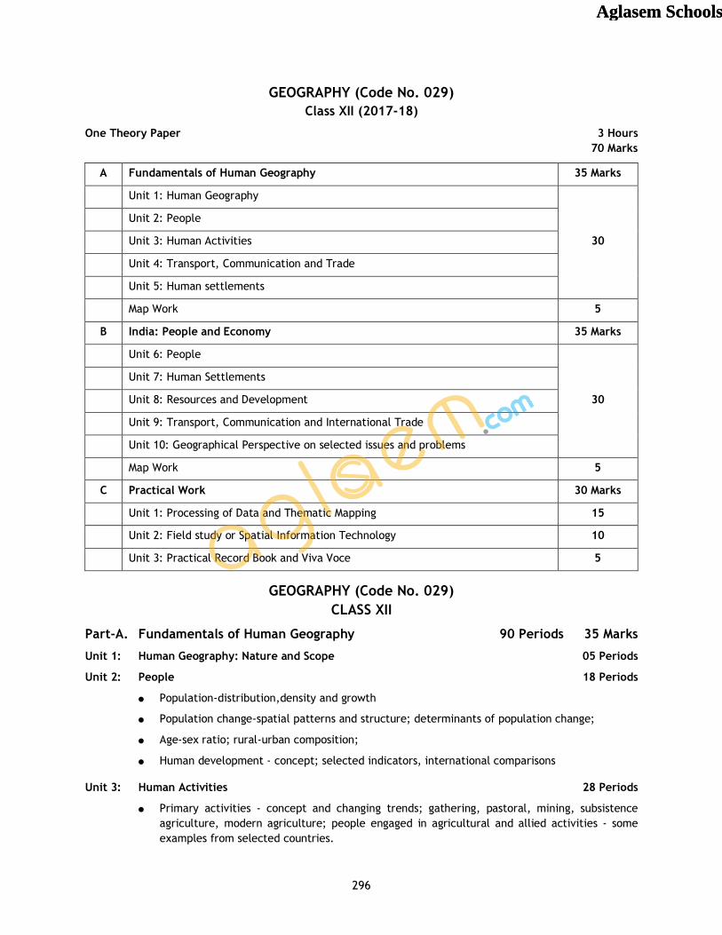
GEOGRAPHY (Code No. 029) Class XII (2017-18)
One Theory Paper 3 Hours 70 Marks
A Fundamentals of Human Geography 35 Marks
Unit 1: Human Geography
30
Unit 2: People
Unit 3: Human Activities
Unit 4: Transport, Communication and Trade
Unit 5: Human settlements
Map Work 5
B India: People and Economy 35 Marks
Unit 6: People
30
Unit 7: Human Settlements
Unit 8: Resources and Development
Unit 9: Transport, Communication and International Trade
Unit 10: Geographical Perspective on selected issues and problems
Map Work 5
C Practical Work 30 Marks
Unit 1: Processing of Data and Thematic Mapping 15
Unit 2: Field study or Spatial Information Technology 10
Unit 3: Practical Record Book and Viva Voce 5
GEOGRAPHY (Code No. 029) CLASS XII
Part-A. Fundamentals of Human Geography 90 Periods 35 Marks
Unit 1: Human Geography: Nature and Scope 05 Periods
Unit 2: People 18 Periods
Population-distribution,density and growth
Population change-spatial patterns and structure; determinants of population change;
Age-sex ratio; rural-urban composition;
Human development - concept; selected indicators, international comparisons
Unit 3: Human Activities 28 Periods
Primary activities - concept and changing trends; gathering, pastoral, mining, subsistence agriculture, modern agriculture; people engaged in agricultural and allied activities - some examples from selected countries.
Aglasem SchoolsAglasem Schools
297
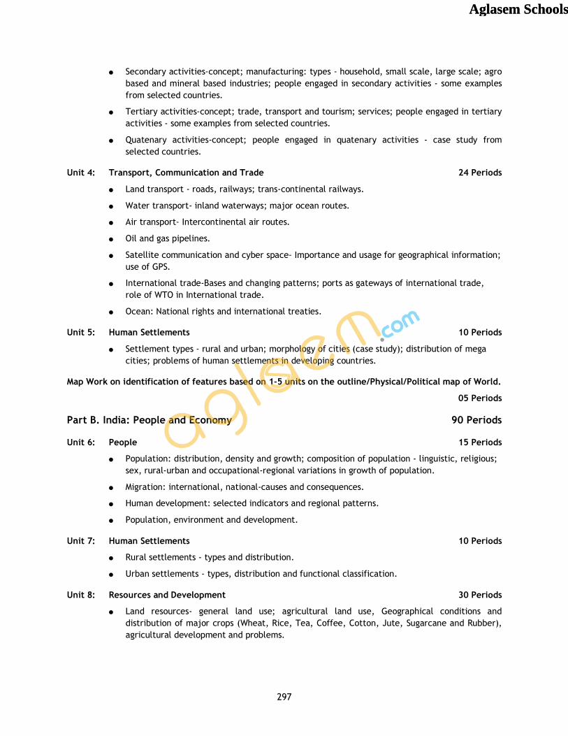
Secondary activities-concept; manufacturing: types - household, small scale, large scale; agro based and mineral based industries; people engaged in secondary activities - some examples from selected countries.
Tertiary activities-concept; trade, transport and tourism; services; people engaged in tertiary activities - some examples from selected countries.
Quatenary activities-concept; people engaged in quatenary activities - case study from selected countries.
Unit 4: Transport, Communication and Trade 24 Periods
Land transport - roads, railways; trans-continental railways.
Water transport- inland waterways; major ocean routes.
Air transport- Intercontinental air routes.
Oil and gas pipelines.
Satellite communication and cyber space- Importance and usage for geographical information; use of GPS.
International trade-Bases and changing patterns; ports as gateways of international trade, role of WTO in International trade.
Ocean: National rights and international treaties.
Unit 5: Human Settlements 10 Periods
Settlement types - rural and urban; morphology of cities (case study); distribution of mega cities; problems of human settlements in developing countries.
Map Work on identification of features based on 1-5 units on the outline/Physical/Political map of World.
05 Periods
Part B. India: People and Economy 90 Periods
Unit 6: People 15 Periods
Population: distribution, density and growth; composition of population - linguistic, religious; sex, rural-urban and occupational-regional variations in growth of population.
Migration: international, national-causes and consequences.
Human development: selected indicators and regional patterns.
Population, environment and development.
Unit 7: Human Settlements 10 Periods
Rural settlements - types and distribution.
Urban settlements - types, distribution and functional classification.
Unit 8: Resources and Development 30 Periods
Land resources- general land use; agricultural land use, Geographical conditions and distribution of major crops (Wheat, Rice, Tea, Coffee, Cotton, Jute, Sugarcane and Rubber), agricultural development and problems.
Aglasem SchoolsAglasem Schools
298
Water resources-availability and utilization-irrigation, domestic, industrial and other uses; scarcity of water and conservation methods-rain water harvesting and watershed management.
Mineral and energy resources- distribution of metallic (Iron ore, Copper, Bauxite, Manganese); non-metallic (Mica, Salt) minerals; conventional (Coal, Petroleum, Natural gas and Hydroelectricity) and non-conventional energy sources (solar, wind, biogas) and conservation.
Industries - types, factors of industrial location; distribution and changing pattern of selected industries-iron and steel, cotton textiles, sugar, petrochemicals, and knowledge based industries; impact of liberalization, privatisation and globalisation on industrial location; industrial clusters.
Planning in India- target group area planning (case study); idea of sustainable development (case study).
Unit 9: Transport, Communication and International Trade 15 Periods
Transport and communication-roads, railways, waterways and airways: oil and gas pipelines; Geographical information and communication networks.
International trade- changing pattern of India's foreign trade; sea ports and their hinterland and airports.
Unit 10: Geographical Perspective on Selected Issues and Problems 15 Periods
Environmental pollution; urban-waste disposal.
Urbanisation, rural-urban migration; problems of slums.
Land degradation.
Map work on locating and labelling of features based on above units on outline map of India. 05 Marks
Part-C Practical Work 40 Periods
Unit 1: Processing of Data and Thematic Mapping 25 Periods
Type and Sources of data: Primary, Secondary and other sources.
Tabulating and processing of data; calculation of averages, measures of central tendency, deviation and rank correlation.
Representation of data- construction of diagrams: bars, circles and flowchart; thematic maps; construction of dot; choropleth and isopleth maps.
Data analysis and generation of diagrams, graphs and other visual diagrams using computers.
Unit 2: Field Study or Spatial Information Technology 15 Periods
Field visit and study: map orientation, observation and preparation of sketch; survey on any one of the local concerns; pollution, ground water changes, land use and land-use changes, poverty, energy issues, soil degradation, impact of floods and drought, catchment area of school, Market survey and Household survey (any one topic of local concern may be taken up for the study; observation and questionnaire survey may be adopted for the data collection; collected data may be tabulated and analysed with diagrams and maps). Students can be given different topics to get more insight into various problems of society.
OR
Aglasem SchoolsAglasem Schools
299
Spatial Information Technology
Introduction to GIS; hardware requirements and software modules; data formats; raster and vector data, data input, editing and topology building; data analysis; overlay and buffer.
Prescribed Books:
1. Fundamentals of Physical Geography, Class XI, Published by NCERT
2. India, Physical Environment, Class XI, Published by NCERT
3. Practical Work in Geography, Class XI, Published by NCERT
4. Fundamentals of Human Geography, Class XII, Published by NCERT
5. India - People and Economy, Class XII, Published by NCERT
6. Practical Work in Geography, Class XII, Published by NCERT
Note: The above textbooks are also available in Hindi medium.
Aglasem SchoolsAglasem Schools
300
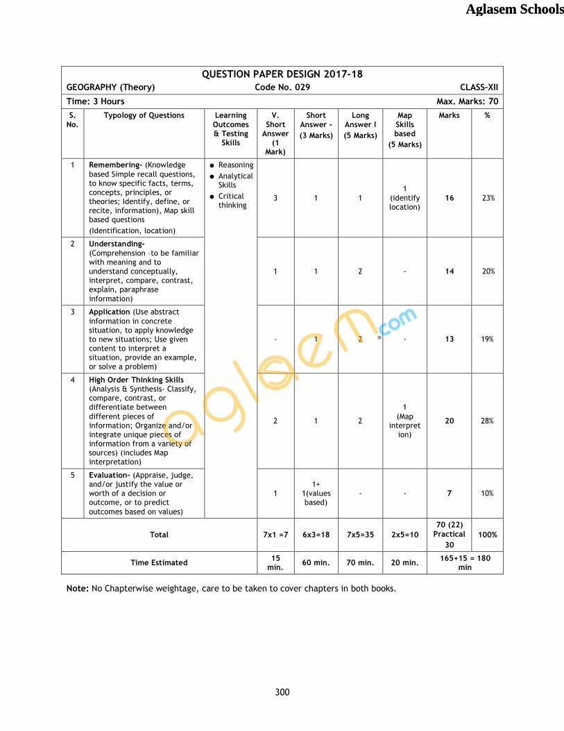
QUESTION PAPER DESIGN 2017-18 GEOGRAPHY (Theory) Code No. 029 CLASS-XII
Time: 3 Hours Max. Marks: 70 S.
No. Typology of Questions Learning
Outcomes & Testing
Skills
V. Short
Answer (1
Mark)
Short Answer - (3 Marks)
Long Answer I (5 Marks)
Map Skills based
(5 Marks)
Marks %
1 Remembering- (Knowledge based Simple recall questions, to know specific facts, terms, concepts, principles, or theories; Identify, define, or recite, information), Map skill based questions (Identification, location)
Reasoning Analytical
Skills Critical
thinking
3 1 1 1
(identify location)
16 23%
2 Understanding- (Comprehension –to be familiar with meaning and to understand conceptually, interpret, compare, contrast, explain, paraphrase information)
1 1 2 - 14 20%
3 Application (Use abstract information in concrete situation, to apply knowledge to new situations; Use given content to interpret a situation, provide an example, or solve a problem)
- 1 2 - 13 19%
4 High Order Thinking Skills (Analysis & Synthesis- Classify, compare, contrast, or differentiate between different pieces of information; Organize and/or integrate unique pieces of information from a variety of sources) (includes Map interpretation)
2 1 2
1 (Map
interpret ion)
20 28%
5 Evaluation- (Appraise, judge, and/or justify the value or worth of a decision or outcome, or to predict outcomes based on values)
1 1+
1(values based)
- - 7 10%
Total 7x1 =7 6x3=18 7x5=35 2x5=10 70 (22)
Practical 30
100%
Time Estimated 15 min. 60 min. 70 min. 20 min. 165+15 = 180
min
Note: No Chapterwise weightage, care to be taken to cover chapters in both books.
Aglasem SchoolsAglasem Schools
301
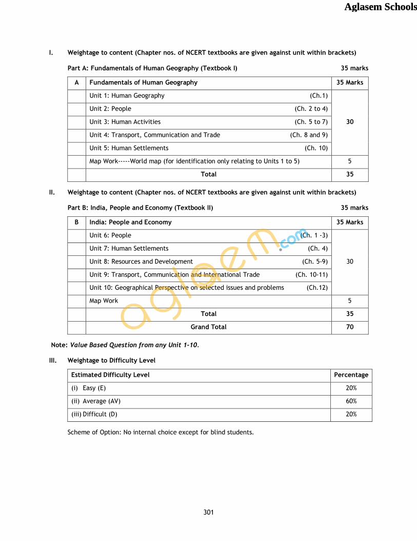
I. Weightage to content (Chapter nos. of NCERT textbooks are given against unit within brackets)
Part A: Fundamentals of Human Geography (Textbook I) 35 marks
A Fundamentals of Human Geography 35 Marks
Unit 1: Human Geography (Ch.1)
30
Unit 2: People (Ch. 2 to 4)
Unit 3: Human Activities (Ch. 5 to 7)
Unit 4: Transport, Communication and Trade (Ch. 8 and 9)
Unit 5: Human Settlements (Ch. 10)
Map Work-----World map (for identification only relating to Units 1 to 5) 5
Total 35
II. Weightage to content (Chapter nos. of NCERT textbooks are given against unit within brackets)
Part B: India, People and Economy (Textbook II) 35 marks
B India: People and Economy 35 Marks
Unit 6: People (Ch. 1 -3)
30
Unit 7: Human Settlements (Ch. 4)
Unit 8: Resources and Development (Ch. 5-9)
Unit 9: Transport, Communication and International Trade (Ch. 10-11)
Unit 10: Geographical Perspective on selected issues and problems (Ch.12)
Map Work 5
Total 35
Grand Total 70
Note: Value Based Question from any Unit 1-10.
III. Weightage to Difficulty Level
Estimated Difficulty Level Percentage
(i) Easy (E) 20%
(ii) Average (AV) 60%
(iii) Difficult (D) 20%
Scheme of Option: No internal choice except for blind students.
Aglasem SchoolsAglasem Schools
302
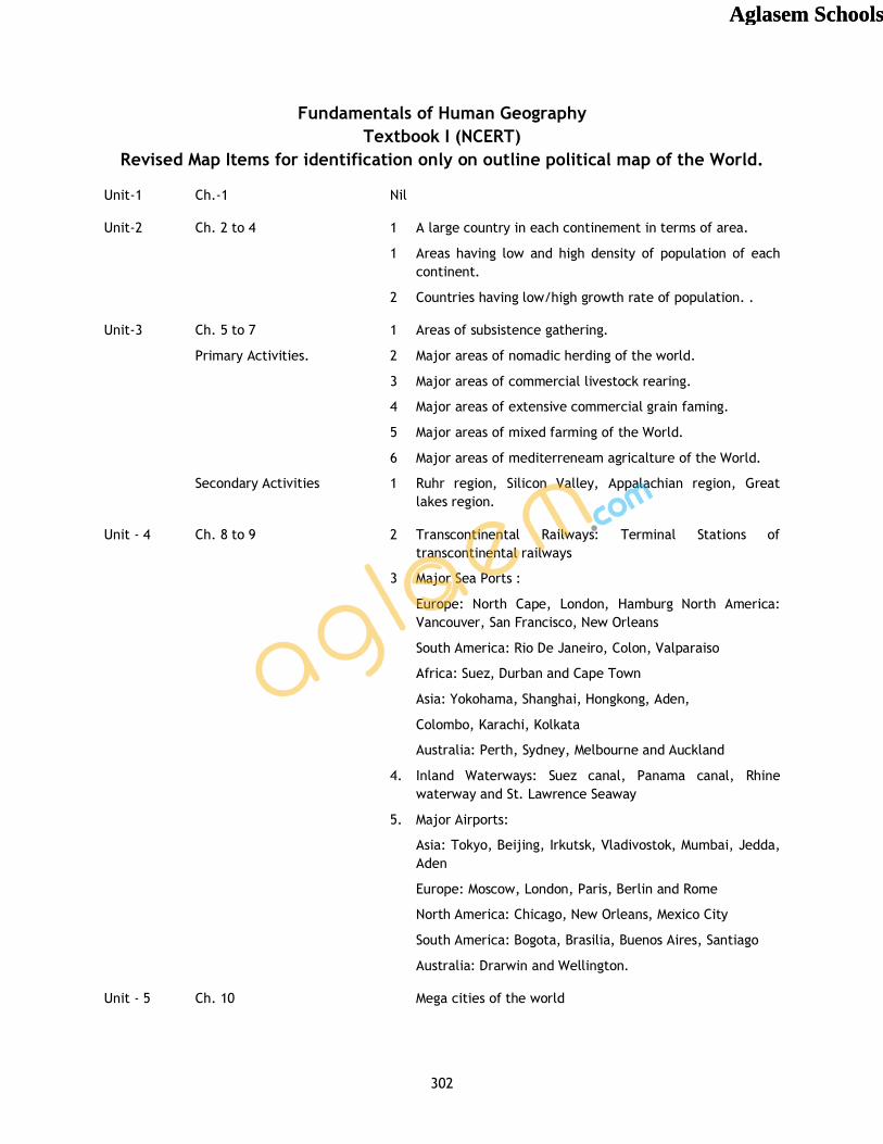
Fundamentals of Human Geography Textbook I (NCERT)
Revised Map Items for identification only on outline political map of the World.
Unit-1 Ch.-1 Nil
Unit-2 Ch. 2 to 4 1 A large country in each continement in terms of area.
1 Areas having low and high density of population of each continent.
2 Countries having low/high growth rate of population. .
Unit-3 Ch. 5 to 7 1 Areas of subsistence gathering.
Primary Activities. 2 Major areas of nomadic herding of the world.
3 Major areas of commercial livestock rearing.
4 Major areas of extensive commercial grain faming.
5 Major areas of mixed farming of the World.
6 Major areas of mediterreneam agricalture of the World.
Secondary Activities 1 Ruhr region, Silicon Valley, Appalachian region, Great lakes region.
Unit - 4 Ch. 8 to 9 2 Transcontinental Railways: Terminal Stations of transcontinental railways
3 Major Sea Ports :
Europe: North Cape, London, Hamburg North America: Vancouver, San Francisco, New Orleans
South America: Rio De Janeiro, Colon, Valparaiso
Africa: Suez, Durban and Cape Town
Asia: Yokohama, Shanghai, Hongkong, Aden,
Colombo, Karachi, Kolkata
Australia: Perth, Sydney, Melbourne and Auckland
4. Inland Waterways: Suez canal, Panama canal, Rhine waterway and St. Lawrence Seaway
5. Major Airports:
Asia: Tokyo, Beijing, Irkutsk, Vladivostok, Mumbai, Jedda, Aden
Europe: Moscow, London, Paris, Berlin and Rome
North America: Chicago, New Orleans, Mexico City
South America: Bogota, Brasilia, Buenos Aires, Santiago
Australia: Drarwin and Wellington.
Unit - 5 Ch. 10 Mega cities of the world
Aglasem SchoolsAglasem Schools
303
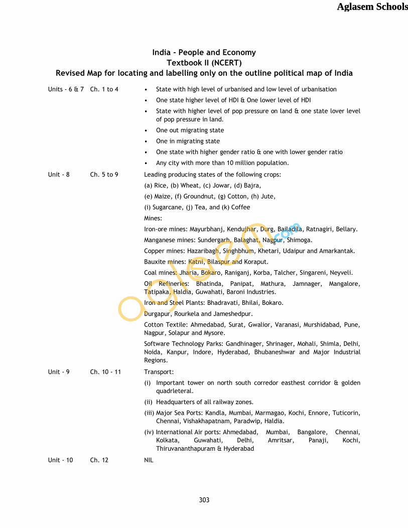
India - People and Economy Textbook II (NCERT)
Revised Map for locating and labelling only on the outline political map of India
Units - 6 & 7 Ch. 1 to 4 • State with high level of urbanised and low level of urbanisation
• One state higher level of HDI & One lower level of HDI
• State with higher level of pop pressure on land & one state lover level of pop pressure in land.
• One out migrating state
• One in migrating state
• One state with higher gender ratio & one with lower gender ratio
• Any city with more than 10 million population.
Unit - 8 Ch. 5 to 9 Leading producing states of the following crops:
(a) Rice, (b) Wheat, (c) Jowar, (d) Bajra,
(e) Maize, (f) Groundnut, (g) Cotton, (h) Jute,
(i) Sugarcane, (j) Tea, and (k) Coffee
Mines:
Iron-ore mines: Mayurbhanj, Kendujhar, Durg, Bailadila, Ratnagiri, Bellary.
Manganese mines: Sundergarh, Balaghat, Nagpur, Shimoga.
Copper mines: Hazaribagh, Singhbhum, Khetari, Udaipur and Amarkantak.
Bauxite mines: Katni, Bilaspur and Koraput.
Coal mines: Jharia, Bokaro, Raniganj, Korba, Talcher, Singareni, Neyveli.
Oil Refineries: Bhatinda, Panipat, Mathura, Jamnager, Mangalore, Tatipaka, Haldia, Guwahati, Baroni Industries.
Iron and Steel Plants: Bhadravati, Bhilai, Bokaro.
Durgapur, Rourkela and Jameshedpur.
Cotton Textile: Ahmedabad, Surat, Gwalior, Varanasi, Murshidabad, Pune, Nagpur, Solapur and Mysore.
Software Technology Parks: Gandhinager, Shrinager, Mohali, Shimla, Delhi, Noida, Kanpur, Indore, Hyderabad, Bhubaneshwar and Major Industrial Regions.
Unit - 9 Ch. 10 - 11 Transport:
(i) Important tower on north south corredor easthest corridor & golden quadrleteral.
(ii) Headquarters of all railway zones.
(iii) Major Sea Ports: Kandla, Mumbai, Marmagao, Kochi, Ennore, Tuticorin, Chennai, Vishakhapatnam, Paradwip, Haldia.
(iv) International Air ports: Ahmedabad, Mumbai, Bangalore, Chennai, Kolkata, Guwahati, Delhi, Amritsar, Panaji, Kochi, Thiruvananthapuram & Hyderabad
Unit - 10 Ch. 12 NIL
Aglasem SchoolsAglasem Schools


