Embed Size (px)
Citation preview
AGENDA ITEM 3.4
Officer: Laura Kerber / Robert Kleeman Investment Management – Development Division
Department of Planning, Transport & Infrastructure
TABLE OF CONTENTS
PLANNING REPORT PAGES
AGENDA REPORT 2-31
ATTACHMENTS
ZONE MAP 32-33
LOCALITY MAP & SITE PHOTOS 34-48
APPLICATION DOCUMENTS & PLANS 49-204
Council Letter 49-51
Application Form 52
Certificate of Title 53-62
Planning Report – Masterplan Letter and Report 63-75
Additional Information and Site History Assessment – 6 Nov 2014 76-152
Additional Information – 24 Nov 2014 153-204
Amended Plans – 24 Nov 2014 160-165
Traffic Report – GTA Consultants 166-194
Stormwater Management Plan – FMG Engineering 195-204
AGENCY REPORTS – DPTI Transport Services Division 205-209
COUNCIL COMMENTS
DAP Agenda Report – 5 Nov 2014 210-305
DAP Agenda Report – 22 Dec 2014 306-328
DAP Minutes – 5 Nov 2014 329-335
DAP Minutes – 22 Dec 2014 336-338
CORRESPONDENCE FROM BOTTEN LEVINSON
Letter – 9 Oct 2014 339-342
Letter – 24 Oct 2014 343-346
Letter – 21 Nov 2014 347-360
Letter – 22 Dec 2014 361-365
FURTHER INFORMATION REQUEST – 8 Jan 2015 366-367
APPLICANT’S RESPONSE TO FURTHER INFORMATION REQUEST
Email – 13 Jan 2015 368-370
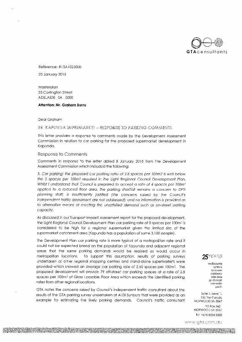
GTA Consultants Letter – 23 Jan 2015 371-373
CONFIDENTIAL ADVICE FROM CROWN SOLICITOR 374-375
12 February 2015
Page | 1
AGENDA ITEM: 3.4
Application No: 313/0363/14
KNET Reference: 2014/19478/01
Applicant: CR Lindner Nominees Pty Ltd
Proposal: Supermarket with associated car parking, loading and
landscaping
Subject Land: Corner Carrington Street and Main Street, Kapunda (various
parcels of land)
Relevant Authority: DAC
Role of the Commission: DAC is the relevant authority pursuant to Schedule 10 Clause 2
Zone / Policy Area: Historic Conservation (Kapunda Town Centre) Zone and Policy
Area 12 – Commercial
Categorisation: Merit
Notification: Category 1
Representations: N/A
Lodgement Date: 15 September 2014
Council: Light Regional Council
Development Plan: Light Regional Council Consolidated 24 January 2013
Referral Agencies: DPTI
Officers Report: Laura Kerber/Robert Kleeman
Recommendation: Approve with conditions
PLANNING REPORT
1. PROPOSAL
The proposal is for a supermarket with a total floor area of 2815m2 at the corner of Carrington
Street and Old Adelaide Road/Main Street, Kapunda, with the following components:
supermarket retail area 1948m2,
warehouse 719m2
cool room, freezer and amenities 73m2,
mezzanine level with staff room and office 75m2.
Amended plans and elevations were submitted to the Commission on 24 November 2014
following consideration of the application by Light Regional Council’s Development Assessment
Panel (DAP) and recommendations made by Council’s Heritage Advisor Grieve Gillett Architects.
The amendments are primarily in relation to the building’s external appearance.
The supermarket building is oriented towards Old Adelaide Road/Main Street where it presents a
56m frontage. The Old Adelaide Road/Main Street frontage features a concave posted verandah
in Colorbond ‘wallaby’ extending the length of the building with vine trellis at the southern end,
and wrapping around a portion of the Carrington Street frontage. The building facades are a
combination of custom-orb galvanised steel, stone gables and pre-cast concrete panels with a
grey render finish. The main supermarket entrance features an entry portico with stone walls.
The wall/parapet height of the building is 6m. The roof is clad in galvanised iron with a series of
30 degree pitched gables and hip ends to the rear (west).
The supermarket is located on a site area of 7108m2 which includes:
Loading dock
Semi-screened bin enclosure
12 February 2015
Page | 2
2.1m high Colorbond fence to southern and western boundaries
Retaining wall and landscaped batter to southern boundary
Retaining wall to western boundary
Retaining wall to portion northern and portion eastern boundaries
74 off-street car parks including two (2) accessible spaces
6 bike rails
Landscaping comprising native trees, shrubs and ground covers
Vehicle access points from Old Adelaide Road and Carrington Street
Associated cutting and filling to achieve desired levels
The existing weighbridge located at the corner of Carrington Street and Main Street will be
removed to make way for the car park. Numerous trees will also be removed including several
pine trees on the existing median between Old Adelaide Road and Main Street, and all pine trees
on the boundary of allotments 91 and 301.
The proposed hours of operation for the supermarket (including waste collection) are between
7:00am and 10:00pm seven days a week including public holidays.
The following items are denoted on the plans and drawings, however insufficient information has
been provided to allow for their assessment as part of this application:
6m high pylon sign at the Old Adelaide Road entrance (shown on site plan and landscaping
plan).
Facade sign on the entry portico (shown on elevations and perspectives).
Rainwater tank at the rear facade of the building (shown in Appendix B of the Stormwater
Management Plan prepared by FMG Engineers).
Due to a lack of information these items DO NOT form part of this application for planning
approval purposes. A separate development application(s) to Council will be required for all
signage and rainwater tanks.
Application details are contained in the ATTACHMENTS.
2. BACKGROUND
The subject site comprises six (6) contiguous allotments, and a portion of the Old Adelaide Road
Reserve, located at Main Street Kapunda. The development as proposed relies on the closure of
the road and subsequent sale of the land to the Applicant in order to facilitate the proposal.
Council commenced the road closing process in April 2014, and the Development Application for
the supermarket was submitted in October 2014.
On the basis that Council was acting as a ‘co-undertaker’ of the application, DAC was determined
automatically to be the relevant authority pursuant to Schedule 10 Clause 2 of the Development
Regulations 2008.
3. DEVELOPMENT PLAN POLICY SUMMARY
The site of the development is entirely within the Historic Conservation (Kapunda Town Centre)
Zone and Policy Area 12 – Commercial. A portion of the allotments on which the development sits
is in the adjacent residential zone, however the applicant has clarified that the no development is
proposed on that land and the land does not form part of the site. It is envisaged that land will be
annexed by boundary re-alignment at some time in the future.
The Historic Conservation (Kapunda Town Centre) Zone is the administration, shopping, business,
retail, tourist and commercial centre of Kapunda and the surrounding district. The Council-Wide
planning policies in the Development Plan identify Kapunda as the main urban centre servicing
12 February 2015
Page | 3
the northern region of the Council area (PDC 4). Retailing and other services in Kapunda should
therefore be ‘developed to the maximum extent so that district level shopping, administrative,
commercial, cultural and entertainment facilities are retained within the district’ (PDC 102).
The economic objectives for Kapunda must be considered in unison with the objectives for the
Zone which seek to conserve, rehabilitate and compliment the historic character of the area. This
includes improving the amenity of Main Street by conserving its built-form integrity; decluttering
the streetscape; and prioritising pedestrian safety. The Development Plan places equal
importance on the historic and economic priorities for the Zone.
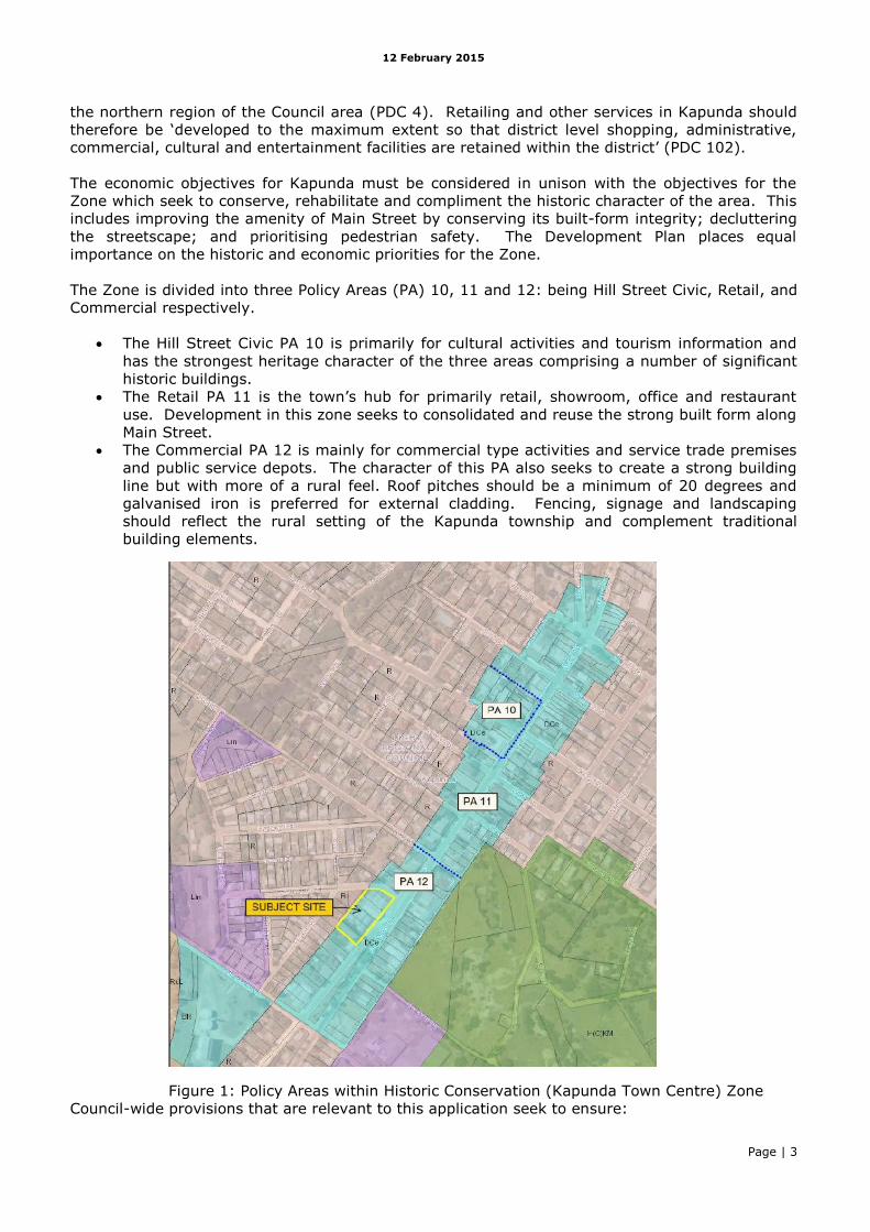
The Zone is divided into three Policy Areas (PA) 10, 11 and 12: being Hill Street Civic, Retail, and
Commercial respectively.
The Hill Street Civic PA 10 is primarily for cultural activities and tourism information and
has the strongest heritage character of the three areas comprising a number of significant
historic buildings.
The Retail PA 11 is the town’s hub for primarily retail, showroom, office and restaurant
use. Development in this zone seeks to consolidated and reuse the strong built form along
Main Street.
The Commercial PA 12 is mainly for commercial type activities and service trade premises
and public service depots. The character of this PA also seeks to create a strong building
line but with more of a rural feel. Roof pitches should be a minimum of 20 degrees and
galvanised iron is preferred for external cladding. Fencing, signage and landscaping
should reflect the rural setting of the Kapunda township and complement traditional
building elements.
Figure 1: Policy Areas within Historic Conservation (Kapunda Town Centre) Zone
Council-wide provisions that are relevant to this application seek to ensure:
12 February 2015
Page | 4
A concentration of retail, commercial, administrative and community development within
designated centres including Kapunda.
Centre development that is highly accessible to the population they serve and create
usable and attractive spaces. This includes landscaping as an integral component to
enhance visual amenity.
Centre development that minimises adverse impacts on residential areas and does not
cause a nuisance or hazard to the community in general.
Provision of sufficient off-street car parking to meet anticipated demand.
Provision of appropriate infrastructure including water supply, a waste treatment system,
stormwater management and drainage, electricity supply, lighting, and access.
The appearance of development to complement the heritage character of the locality.
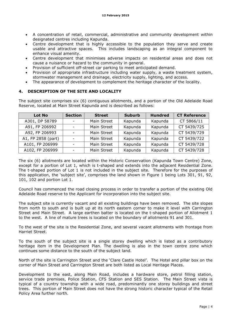
4. DESCRIPTION OF THE SITE AND LOCALITY
The subject site comprises six (6) contiguous allotments, and a portion of the Old Adelaide Road
Reserve, located at Main Street Kapunda and is described as follows:
Lot No Section Street Suburb Hundred CT Reference
A301, DP 58789 - Main Street Kapunda Kapunda CT 5866/11
A91, FP 206992 - Main Street Kapunda Kapunda CT 5439/725
A92, FP 206993 - Main Street Kapunda Kapunda CT 5439/729
A1, FP 2858 (part) - Main Street Kapunda Kapunda CT 5439/722
A101, FP 206999 - Main Street Kapunda Kapunda CT 5439/728
A102, FP 206999 - Main Street Kapunda Kapunda CT 5439/728
The six (6) allotments are located within the Historic Conservation (Kapunda Town Centre) Zone,
except for a portion of Lot 1, which is t-shaped and extends into the adjacent Residential Zone.
The t-shaped portion of Lot 1 is not included in the subject site. Therefore for the purposes of
this application, the ‘subject site’, comprises the land shown in Figure 1 being Lots 301, 91, 92,
101, 102 and portion Lot 1.
Council has commenced the road closing process in order to transfer a portion of the existing Old
Adelaide Road reserve to the Applicant for incorporation into the subject site.
The subject site is currently vacant and all existing buildings have been removed. The site slopes
from north to south and is built up at its north eastern corner to make it level with Carrington
Street and Main Street. A large earthen batter is located on the t-shaped portion of Allotment 1
to the west. A line of mature trees is located on the boundary of allotments 91 and 301.
To the west of the site is the Residential Zone, and several vacant allotments with frontage from
Harriet Street.
To the south of the subject site is a single storey dwelling which is listed as a contributory
heritage item in the Development Plan. The dwelling is also in the town centre zone which
continues some distance to the south of the subject land.
North of the site is Carrington Street and the ‘Clare Castle Hotel’. The Hotel and pillar box on the
corner of Main Street and Carrington Street are both listed as Local Heritage Places.
Development to the east, along Main Road, includes a hardware store, petrol filling station,
service trade premises, Police Station, CFS Station and SES Station. The Main Street vista is
typical of a country township with a wide road, predominantly one storey buildings and street
trees. This portion of Main Street does not have the strong historic character typical of the Retail
Policy Area further north.
12 February 2015
Page | 5
Figure 2: Locality
12 February 2015
Page | 6
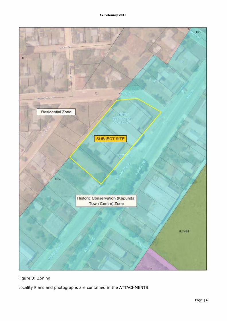
Figure 3: Zoning
Locality Plans and photographs are contained in the ATTACHMENTS.
12 February 2015
Page | 7
5. AGENCY COMMENTS
DPTI
The development adjoins a main road and has therefore been referred to DPTI – Transport
Services Division (TSD) for advice pursuant to Schedule 8 of the Development Regulations.
TSD has reviewed the applicant’s traffic report prepared by GTA consultants and advice they
support the application, with the following key points:
The new Old Adelaide Road/Adelaide Road junction shown indicatively on the plans is
supported (subject to satisfactory detailed design). Signage to control undesirable
movements, maintenance of access to residential properties, and a turn-around, are
recommended.
The proposed painted median (and removal of pine trees) and kerb adjustments to cater
for turning movements form Adelaide Road, shown indicatively on the plans is supported
(subject to satisfactory detailed design).
‘Give-way’ signs and line marking is recommended at the exit to the car park to give
priority to incoming vehicles to minimise potential queuing of vehicles entering the site
from Adelaide Road.
Any new landscaping in the road reserve (or site) should not interfere with safe sight lines.
All road works to be undertaken at applicant’s expense to TSD satisfaction.
Service vehicle delivery access is considered satisfactory.
The proposed parking provision of 79 spaces at 2.8 spaces /100 sq m is considered
satisfactory.
Trolley bay to be re-located to a safer area.
Recommended condition for future signage.
DPTI comments are contained in the ATTACHMENTS.
6. COUNCIL COMMENTS
The application was considered by Council’s DAP on 5 November 2014 and was supported subject
to 19 ‘matters to be addressed’ and 37 conditions.
In response to the ‘matters to be addressed’ and recommendations made by Council’s Heritage
Advisor Grieve Gillett Architects, amended plans and elevations were submitted to the
Commission on 24 November 2014. The amendments are primarily in relation to the building’s
external appearance.
The conditions recommended by Council relate to various issues including stormwater
management, waste disposal, hours of operation, car park construction, construction
management, landscaping and lighting.
On 22 December 2014 Council’s DAP considered the amended plans. Overall, Council’s Heritage
Advisor notes that the form and materials proposed reflects large scale sheds/barns/winery
buildings common to the district and also typical of the era of heritage significance of Kapunda in
general.
With regard to the proposed stone gables in the amended facades, Council noted that the plans
do not clearly identify the type of stone to be utilised. As such, Council has requested that
coursed random Kapunda stone be used and not bluestone or quoins. In the event that the
requested stone approach cannot be achieved, Council recommends that the applicant use a red
brick with a pressed pattern which is also a common building material utilised throughout
Kapunda. This is to ensure consistency with the built form and heritage values of the zone.
12 February 2015
Page | 8
In summary, Council supports the amended plans provided to DAC on 24 November 2014 subject
to the following:
a) The type of stone and laying pattern that should be employed includes the use of coursed
random Kapunda Stone, (excluding veneer tiles, bluestone and use of quoins);
b) If stone is to be utilised, then the stone should also be laid as traditionally laid that being
coursed (layered horizontally);
c) The option to utilise a red brick with a pressed pattern in place of stone is also supported.
Council has not proposed any conditions per se regarding the stone gables, however the above
could be included in the conditions if DAC was of a mind to approve the development.
All other 37 conditions previously proposed by Council remain valid. The majority of the
condition(s) are reasonable and generally mirror and can be substituted with standard DAC
conditions. Council has recommended more restrictive hours of operation than proposed by the
Applicant, which is discussed in section 8 (Interface). Council proposed condition #31 is not
considered appropriate as it relates to a road upgrade outside of the subject site. Proposed
condition #35 is not considered necessary as detailed plans for drainage works will be provided as
part of the ‘Master Stormwater Plan’ (also requested by Council through a condition). Given the
car parking and landscaping is not on public land, there is no need for construction details to be
provided to Council or DPTI (unless covered by the necessary Building Rules Consent).
The Council DAP agenda and minutes are contained in the ATTACHMENTS.
7. LEGAL ISSUES
As noted previously, a portion of the subject site is currently public road, being Old Adelaide
Road, which is proposed to be closed and amalgamated with the privately owned land held by the
Applicant. The development as proposed relies upon the road reserve forming part of the subject
land in order to have any prospect of being able to occur.
The Commission has received a number of letters and approaches from the law firm Botten
Levinson, acting for a company called Ciborex Pty Ltd, which owns the existing Foodworks
supermarket in Kapunda. Ciborex has recently received approval from DAC for a new
supermarket in the Retail Policy Area of the town centre.
Botten Levinson is of the opinion that the Lindner application should be treated as hypothetical
because the road has not been closed, and there is no guarantee that it will ever be able to form
part of the site.
This question was first considered by assessment staff and it was concluded the application was
not hypothetical because there is a reasonable expectation that the road can be closed and the
land transferred to the Applicant in due course. Council has commenced the road closure process
(for which DAC is also the relevant authority under the Roads (Opening and Closing) Act 1991).
A second submission by Botten Levinson was then received which raised new issues. The second
submission was referred to the Crown Solicitor for advice. That advice is contained in the
confidential Attachments to this report and in summary concludes the application should not be
regarded as hypothetical.
The submissions from Botten Levinson also comment extensively on the planning merits of the
proposal. These submissions are attached for information, but are not to be regarded as formal
representations as the application is a Category 1 development.
The correspondence from Botton Levinson is included in the ATTACHMENTS.
12 February 2015
Page | 9
8. PLANNING ASSESSMENT
The relevant provisions of the Development Plan are provided at the conclusion of this
report. A summary of the assessment against these provisions is provided below:
Form of Development
The Historic Conservation (Kapunda Town Centre) Zone establishes a clear hierarchy of Policy
Areas each with a distinct character and land use focus. The appropriateness of certain land uses
within the Policy Areas is guided by the planning policies (Council-wide, Zone and PA) and the list
of non-complying development for the Zone.
Case Law states that the provisions in Development Plans for centres are the ‘cornerstones of
plans for urban areas’ [Case Law reference: 7.130.5]. They promote clustering of facilities and
land uses into regional, district, neighbourhood and local operational levels. Local operational
levels can be interpreted as policy areas within a Centre Zone, and to that end the hierarchy
established by the three policy areas in the Historic Conservation (Kapunda Town Centre) Zone
must be given weight in this assessment.
Each policy area has a clear land use focus and distinctive character. Policy Area 12 within which
this development is proposed is mainly for commercial type activities, service trade premises and
public service depots. Existing development in the PA comprises a hardware store, petrol filling
station, service trade premises, Police Station, CFS Station, SES Station, and Hotel. In this
respect it is noted that while emergency services facilities and restaurants are not specifically
envisaged in PA 12, they are of a nature and form that does not derogate from the desired
character and land use focus for the area.
Whilst it is clear that the retail focus for the township should be in Policy Area 11, retail is not
specifically excluded from the other policy areas. Retail is considered an appropriate form of
development for the Zone as a whole, and it is not listed as a non-complying form of development
for any of the Policy Areas.
The inclusion of some retail development and other general centre type development as currently
exists in Policy Area 12 is therefore not considered to be fatal in land use terms to achieving the
policy area and zone objectives.
Centre Development
Whilst not the subject of any formal representation (as the application is Category 1), there has
been much concern from an existing business owner in Kapunda, through their solicitor Botten
Levinson, that this development will jeopardise the viability of existing supermarkets that are
located within the retail policy area. (Correspondence received from Botten Levison is contained
in the ATTACHMENTS).
In considering the commercial implications of this application (in relation to its proposed location
in the Commercial Policy Area as opposed to the Retail Policy Area) relevant Case Law has been
reviewed. Case Law shows that the ‘mere threat of competition between commercial interest is
not a planning consideration’ (Jetset Properties v Eurobodalla SC [2007] SASC 216 at [41]),
however a ‘consideration of the turnover and competitive effect of a proposed development is
required in making an assessment of a proposed development only if, for example, the size of the
development, its nature or its character indicates that the provisions of the Development Plan
might call for its location in some other zone. One must find a planning consideration that
requires consideration of a competitive effect before one considers the competitive effect on a
particular proposed development upon existing developments’ (Noseda Petroleum Pty Ltd v Mount
Gambier CC [200] SASC 225).
12 February 2015
Page | 10
The Council-Wide provisions for centres seek to focus retail, administrative, commercial, health,
cultural and entertainment facilities within centre zones. PDC 102 envisages that Kapunda be
‘developed to the maximum extent’ so that district level shopping and other activities are retained
within the district. In this context ‘maximum extent’ is used in a spatial context. Shopping
development is only contemplated outside of centre zones where it can be demonstrated that it
will not result in negative economic impact to the centre (PDC 109). In such cases consideration
of the competitive effect of a proposed development would be appropriate.
In relation to this application, however, the Historic Conservation (Kapunda Town Centre) Zone
and policy area provisions are silent on the competitive effect, and do not specifically contemplate
the competitive impact of development within one policy area upon another policy area. As noted
above, retail development is not specifically excluded from any of the three (3) policy areas, and
there are no provisions that quantify the various levels of retail activity that could be expected in
township centre zones.
For these reasons it is considered the planning assessment is not obligated to have regard to the
impacts of the proposed supermarket on the commercial viability of existing retail development in
the zone. To that end, a retail analysis has not been provided by the Applicant, and was not
requested by the Commission or Council. Ultimately the market will dictate the economic viability
of supermarkets and other retail development in the township.
Appearance and Character
As described earlier in this report, the subject site slopes from north to south, thereby requiring
cut and fill to create a level development site for the supermarket. In this regard PDC 22
(Council-wide) states that buildings and structures should be sited to conserve the surrounding
character through optimum orientation, set-back, cut and fill, access and bushfire prevention
measures.
The proposal requires just over 1 metre of cut along the Carrington Street boundary; minimal cut
and fill in the centre of the site; and 1.4m of fill along the southern boundary. Whilst this will
result in the need for a 1.2-1.5m retaining wall along the southern boundary, a level development
site is needed to provide suitable gradients for vehicle, truck and trolley manoeuvrability. Council
is satisfied that the level of cut and fill is appropriate and reasonable, however this creates a less
than desirable interface at the southern and western boundaries of the site - which is discussed in
more detail later in this report.
With respect to the appearance of the development, there are several Council-wide provisions
that seek to minimise adverse impacts on amenity (OB 5 Council-wide) and preserve and enhance
surrounding character and surrounding existing buildings having regard to scale, form, materials
and landscaping (PDC 295 Council-wide)
PDCs 9-13 for the Zone, and the Desired Character Statement for the Policy Area, provide specific
guidance for built form. The amended plans present a facade and colour scheme that is consistent
with these policies, and address the majority of issues raised by Council’s heritage advisor (with
the exception of additional landscaping which is discussed below).
The use of grey shades, stone gables and corrugated galvanised sheeting is consistent with PDC
10 and 13 (Zone); although Council has noted that the stone gables should use coursed random
Kapunda stone and not bluestone or quoins. The option to utilise a red brick with a pressed
pattern in place of stone is also supported by Council. Should DAC support the application, this
could be addressed as a condition of approval.
The use of a combination of gable and hip end roof shapes, as well as parapets and a verandah, is
as contemplated by PDC 11 (Zone) and assists in reducing the visual bulk of the building. The
gables have a pitch of 30 degrees which is consistent with PDC 12 (Zone). Standard ‘colorbond’
12 February 2015
Page | 11
fencing is proposed for the southern and western boundaries and facade signage will be located
on gable ends (although not part of this application).
The set-back of the supermarket building is consistent with the adjacent development,
particularly the adjacent Clare Castle Hotel, and will contribute to the creation of a strong building
line. It is noted that the former buildings on the site were unappealing and this proposal will
generally improve the amenity of the locality in terms of streetscape.
Overall, the building is considered to be compatible with existing Main Street buildings and
consistent with the desired character and heritage values of the zone.
Landscaping
The proposal includes landscaping around the perimeter of the car park on the north, east and
south boundaries. Native species have been selected from Table Lig/4 of the Development Plan.
In addition, six (6) pine trees will be planted to the right of the Old Adelaide Road/Main Street
entrance, to match the existing pine trees being retained to the left of the entrance. This will
complement the existing streetscape.
Council’s heritage advisor and planning officer recommended the inclusion of additional
landscaping and tree planting in front of the warehouse, and along the western boundary to
reduce the visual impact of the building from the adjacent Residential Zone. In particular, Council
recommended the inclusion of tall canopied trees abutting the eastern and southern building
facade. This would require a redesign of the car park to provide sufficient room between the car
parks and the building verandah/facade. Similarly, space along the rear (west) boundary is
limited due to the loading dock and staff car parking. Whilst these issues have been raised with
the Applicant, they are satisfied with the plans as they stand and have not provided any
additional plantings or screening.
Notwithstanding this, it is recommended landscaping and fencing (discussed further below) be
designed to minimise overlooking and impact on the amenity of the adjoining property.
Movement and Parking
The Applicant engaged traffic engineer GTA Consultants to undertake a traffic and parking
assessment for the site. Council sought an independent assessment from Frank Siow and
Associates.
Parking provision
Table Lig/6 requires one parking space per 20 square metres of total floor area (or 5 per 100m2).
Based on a total floor area of 2815m2, this equates to 140 parking spaces. The proposal includes
79 spaces, six (6) of which are parallel parks located adjacent the loading dock expected to be
used for staff parking.
The proposal complies with the Building Code of Australia requirements for accessible parking rate
for Class 6 building being (a) up to 1000 carparking spaces – 1 space for every 50 car parking
spaces or parts thereof.
The proposed car parking ratio of 2.8 spaces per 100m2 is well below the 5 spaces per 100m2
required in the Light Regional Council Development Plan and equals a shortfall of 61 parking
spaces. This is a very low ratio when compared to the industry standard of 6-7 spaces per 100m2
GLFA (Planning Bulletin and RTA Guide for Generating Developments) and that provided in oOther
SA regional Council areas including the Barossa, Murray Bridge, Mid Murray and Loxton Waikerie
which all require 5.5 to 6 spaces per 100m2 Total Floor Area for a shop, except for Murray Bridge
Council which requires 5.5/100m2 Gross Leasable Floor Area
12 February 2015
Page | 12
Development should be provided with sufficient off-street car parking to meet its anticipated
parking demand (PDC 2 Zone and PDC 5 Policy Area). Further, Council-Wide PDC 30 and 34
require that development listed in Table Lig/6 should provide car parking spaces on the site or on
a nearby site at the rate specified in the Table. All other developments should provide adequate
offstreet car parking facilities, having regard to anticipated parking demand, availability of on-
street parking, shared usage of other parking areas and safety or as specified in principles of
development control for particular kinds of development.
In order to demonstrate that the proposed 79 spaces are sufficient to meet the anticipated
demand, GTA undertook an analysis of regional supermarkets at Centro Port Pirie, Barossa
Regional Shopping Centre and two interstate ALDI supermarkets, estimated to provide parking at
ratios of 3.1, 2, 2.74, and 2.75 spaces per 100m2 respectively. Based on these examples GTA
has surmised that the proposed development is likely to generate a low range parking
requirement of 2 spaces per 100m2 and a high range parking requirement of 3 spaces per
100m22. This analysis was reviewed by Council’s traffic consultant Frank Siow & Associates as
part of Council’s independent traffic assessment:
Centro Port Pirie and Barossa Regional Shopping Centre are both over 10,000m2 (much
larger the proposed development) and have a wide range of uses, including cafes, and
comprise shared/common spaces. This would assist in reducing the overall parking
demands due to different peak parking characteristics.
Aerial photography of the interstate ALDI supermarket suggests the parking rates are
much higher than quoted (over 4 spaces over 100m2).
Mr Siow recommends a minimum parking rate of 4 – 4.5 spaces per 100m2 be applied to this
application.
Based on an assessment of the abovementioned Development Plan principles, Council considers
that the 5 per 100m2 rate specified in Table Lig/6 is excessive and more relevant to a
metropolitan setting and large population base, notwithstanding it has not amended its
Development Plan to reflect this view. Council has also had regard to the fact that the car parking
rate applies to the total floor area, with no discount for ‘non leasable areas’ such as storage,
office and amenity areas. A recent review of car parking rates by Aurecon (for City of Port
Adelaide Enfield) recommends rates for commercial land uses based on Gross Leasable Floor Area
(GLFA), not total floor area. In following that model, Council has treated the warehouse, cool
room, amenities and mezzanine level as ‘non-leasable’ areas, leaving a retail space of 1948m2.
The following parking rates for a 1948m2 space would be as follows:
Development Plan rate of 5 per 100m2: 97 spaces (18 shortfall)
Council recommended rate of 4 per 100m2: 78 (no shortfall).
In light of the above divergence of opinions, the applicant was requested to review the car
parking numbers (amongst other things – see Attachments: Further information). The applicant
responded on all of the issues raised and provided an additional report from GTA consultants
specifically addressing the car park ratio. That report confirms the earlier advice that a ratio of
2.8 spaces per 100s sq m is adequate, and notes there will be an additional 10-15 on-street
space available in the vicinity of the site. The applicants response and GTA report are also
contained in the Attachments: Further information.
It is noted that both TSD and Council accept the actual car park provision of 79 spaces as being
adequate, ie 2.8 spaces/100 sq m (although the methodology of arriving at these figures was
different) and acknowledge the availability of some on-street spaces.
On this basis it is concluded the car parking provision is adequate.
Movement
12 February 2015
Page | 13
In terms of car park design, the location of the car park to the front of the building, with access
from Main Street, is inconsistent with PDC 3b (Zone) which states that parking should be
generally provided to the rear of buildings and PDC 4 which states that access to car parking
areas should be from side streets rather than Main Street. It is noted that existing development
in the locality is accessed from Main Street and has car parks abutting Main Street, albeit not of
the scale anticipated for the proposed supermarket. This was also raised for review with the
applicant, and the applicant’s response is contained in the Attachments: Further information. In
summary the applicant believes the site layout is appropriate for this part of the township centre
zone and maintains the streetscape of this area.
Heavy vehicle access to the site is via a one-way ingress only point on Old Adelaide Road, and
egress is to Carrington Street which will operate as a one-way only exit point. Loading is at the
rear of the supermarket and swept path diagrams have been provided to demonstrate that a 19m
long semi-trailer can manoeuvre through the site as described above.
Council has raised concerns regarding the condition of Carrington Street and the need for
pavement surface upgrades. The Applicant is amenable to contributing towards a ‘reasonable
upgrade’ to the affected section of Carrington Street. It is noted that an upgrade of Carrington
Street is outside the development site and this matter will need to be resolved between Council
and the Applicant outside of the development assessment process.
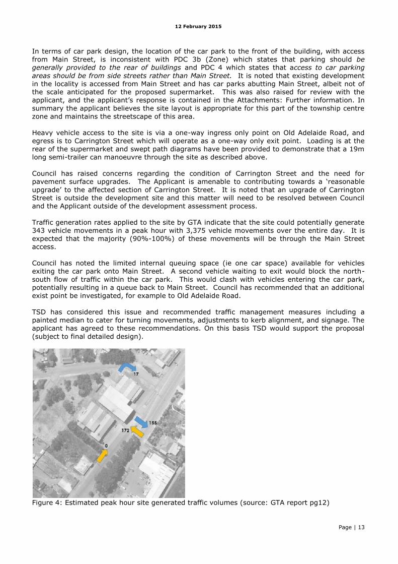
Traffic generation rates applied to the site by GTA indicate that the site could potentially generate
343 vehicle movements in a peak hour with 3,375 vehicle movements over the entire day. It is
expected that the majority (90%-100%) of these movements will be through the Main Street
access.
Council has noted the limited internal queuing space (ie one car space) available for vehicles
exiting the car park onto Main Street. A second vehicle waiting to exit would block the north-
south flow of traffic within the car park. This would clash with vehicles entering the car park,
potentially resulting in a queue back to Main Street. Council has recommended that an additional
exist point be investigated, for example to Old Adelaide Road.
TSD has considered this issue and recommended traffic management measures including a
painted median to cater for turning movements, adjustments to kerb alignment, and signage. The
applicant has agreed to these recommendations. On this basis TSD would support the proposal
(subject to final detailed design).
Figure 4: Estimated peak hour site generated traffic volumes (source: GTA report pg12)
12 February 2015
Page | 14
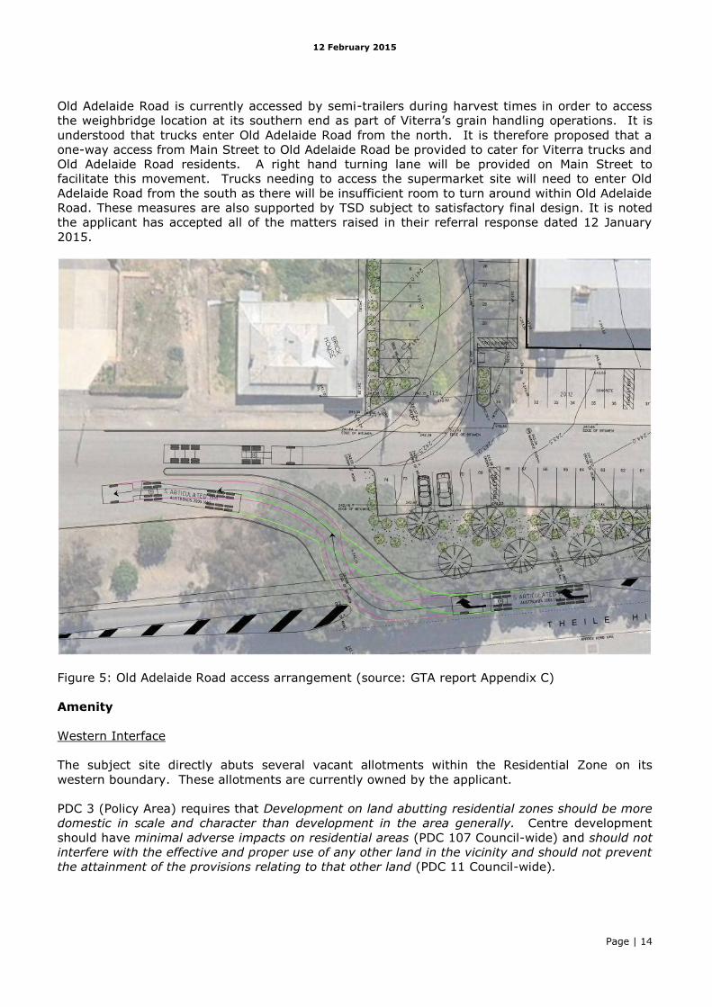
Old Adelaide Road is currently accessed by semi-trailers during harvest times in order to access
the weighbridge location at its southern end as part of Viterra’s grain handling operations. It is
understood that trucks enter Old Adelaide Road from the north. It is therefore proposed that a
one-way access from Main Street to Old Adelaide Road be provided to cater for Viterra trucks and
Old Adelaide Road residents. A right hand turning lane will be provided on Main Street to
facilitate this movement. Trucks needing to access the supermarket site will need to enter Old
Adelaide Road from the south as there will be insufficient room to turn around within Old Adelaide
Road. These measures are also supported by TSD subject to satisfactory final design. It is noted
the applicant has accepted all of the matters raised in their referral response dated 12 January
2015.
Figure 5: Old Adelaide Road access arrangement (source: GTA report Appendix C)
Amenity
Western Interface
The subject site directly abuts several vacant allotments within the Residential Zone on its
western boundary. These allotments are currently owned by the applicant.
PDC 3 (Policy Area) requires that Development on land abutting residential zones should be more
domestic in scale and character than development in the area generally. Centre development
should have minimal adverse impacts on residential areas (PDC 107 Council-wide) and should not
interfere with the effective and proper use of any other land in the vicinity and should not prevent
the attainment of the provisions relating to that other land (PDC 11 Council-wide).
12 February 2015
Page | 15
The western boundary of the site is currently characterised by an earthen batter, which will
remain. A retaining wall, varying in height from 0.2m to 1.5m (according to fill levels), will be
placed along the western boundary to secure fill and a 2.1 Colorbond fence will be placed on top
the retaining wall. This will result in the supermarket being level with Carrington Street and Old
Adelaide Road, but elevated at its western and southern interfaces.
With a parapet height of 6m, and approx roof height of 9m, the rear (western) facade of the
supermarket will be visible from Harriet Street in the residential zone to the west due to the
elevated nature of the subject site. Whilst the gable roofs reduce the visual bulk of the building, it
is arguably not ‘domestic’ in scale or nature and will have some level of negative amenity impact
on adjacent residences (existing and future).
The inclusion of some landscaping along the western boundary would soften the appearance of
the western facade wall.
Figure 6: western interface
Southern Interface
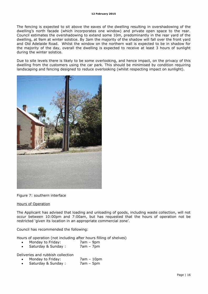
To the south of the subject site is a single storey dwelling which is listed as a contributory
heritage item in the Development Plan. The dwelling is within the Historic Conservation (Kapunda
Town Centre) Zone but appears to be used for residential purposes.
To enable the site to be raised to the desired level the southern boundary will have a 1.2m-1.5m
retaining wall (1.2m directly adjacent the dwelling) and a 2.1 Colorbond fence above, located
some 1-2m from the dwelling’s northern facade.
12 February 2015
Page | 16
The fencing is expected to sit above the eaves of the dwelling resulting in overshadowing of the
dwelling’s north facade (which incorporates one window) and private open space to the rear.
Council estimates the overshadowing to extend some 10m, predominantly in the rear yard of the
dwelling, at 9am at winter solstice. By 3am the majority of the shadow will fall over the front yard
and Old Adelaide Road. Whilst the window on the northern wall is expected to be in shadow for
the majority of the day, overall the dwelling is expected to receive at least 3 hours of sunlight
during the winter solstice.
Due to site levels there is likely to be some overlooking, and hence impact, on the privacy of this
dwelling from the customers using the car park. This should be minimised by condition requiring
landscaping and fencing designed to reduce overlooking (whilst respecting impact on sunlight).
Figure 7: southern interface
Hours of Operation
The Applicant has advised that loading and unloading of goods, including waste collection, will not
occur between 10:00pm and 7:00am, but has requested that the hours of operation not be
restricted ‘given its location in an appropriate commercial zone’.
Council has recommended the following:
Hours of operation (not including after hours filling of shelves)
Monday to Friday: 7am – 9pm
Saturday & Sunday : 7am – 7pm
Deliveries and rubbish collection
Monday to Friday: 7am – 10pm
Saturday & Sunday : 7am – 5pm
12 February 2015
Page | 17
Council-wide PDC 275 states that development and use of land should take place in a manner
which will not cause nuisance or hazard to the community by: (a) the emission of noise, vibration,
odour, fumes, smoke, vapour, steam, soot, ash, dust, grit, oil, waste water, waste products,
electrical interference or light.
Given the subject site is adjacent a residential zone, the restriction on operating and delivery
hours generally as proposed by the Council is considered appropriate in order to minimise
potential noise impact. A closing time to 10pm on all week nights is considered reasonable given
the proximity of residences and the location of the development in a centre zone.
Stormwater Management, Waste Disposal
The applicant engaged FMG Consultants to prepare a Stormwater Management Plan. The plan is
to store surface stormwater runoff in underground detention tanks located beneath the car parks
in the south west corner of the site. Preliminary analysis shows that the stormwater will be
unable to gravity drain from the detention tanks to Carrington Street or Old Adelaide Road,
therefore Council has recommended that an easement be registered over adjacent land to the
west, to allow the discharge of stormwater to Harriet Street. The applicant owns the adjacent
land to the west and is amenable to Council’s suggestion of an easement.
An above ground 22,500L rainwater tank is proposed for roof run-off, which will then be reused
for toilet flushing and landscape irrigation. The location of the tank is indicated in the north-west
corner of the site however this may interfere with vehicle manoeuvring for trucks exiting
Carrington Street. Council has suggested that the tank be located over proposed car parks 75
and 76. In any case, the final location and nature of the tank will require separate planning
approval.
The Stormwater Management Plan is considered to be consistent with PDC 330, 331, 332, 334
and 339 (Council-wide), however Council has requested (via condition) that the full final detailed
design (including calculations) for stormwater management by submitted for approval. Council
has also requested that a Soil Erosion and Drainage Management Plan (SEDMP) be prepared prior
to the commencement of works to protect the adjacent residential properties from flooding and
sedimentation during construction.
The Council’s waste water management scheme operates in this part of Kapunda. A waste water
application will therefore need to be submitted to Council for approval prior to the commencement
of construction.
Site Contamination
A site history for the subject site listed previous uses as a chaff mill plant, oat milling facility,
pellet production mill, and high fibre pellet mill. The site may have also been used for the storage
and maintenance of heavy machinery. The plant was decommissioned and demolished in early
2013. In light of this history an Environmental Site History Assessment was requested.
The Applicant commissioned Mott McDonald to undertake the assessment which included a full
site history, study of aerial photography, regional geology and hydrogeology, dangerous goods
search, Section 7 search, anecdotal information and site visit. No surface soil odours or staining
were observed during the site walkover. Mott McDonald noted the potential presence of unknown
fill, termite treatments and chemicals on the site, however the proposed ground slab for the
supermarket will limit the potential pathway exposure between the soil and site users, and no
groundwater would be extracted. The site is not considered for development involving a sensitive
land use (ie residential).
The assessment concludes that the risk of significant or widespread soil contamination that would
preclude the proposed commercial use of this site as a supermarket is low. Consistent with PDC
12 February 2015
Page | 18
281 (Council Wide), the development is not expected to pose a threat to the health and safety of
the environment or to occupiers of the site or land in the locality.
9. CONCLUSION
The Historic Conservation (Kapunda Town Centre) Zone is the town’s focus for shopping,
business, retail, tourist and commercial activities. The Centre is organised into three (3) policy
areas each with a specific land use focus. Whilst Policy Area 12 (Commercial) is the main focus
within the town for commercial activities, service trade premises, car yards, service stations,
petrol filling stations and public service depots (Objective 1), retail development is not specifically
excluded from the Policy Area.
The Council-wide provisions seek to maximise development within the Kapunda Town Centre,
having regard for the heritage values and character of Main Street. To that end a supermarket is
considered an appropriate land use in Policy Area 12 Commercial, where it is designed and sited
to complement existing heritage buildings and contribute to the overall heritage character of
Kapunda.
The planning policies for Policy Area 12 place particular emphasis on improving the appearance of
the locality through landscaping and inclusion of traditional building elements as an integral part
of development (Objective 2 and PDC 2). The importance of landscaping for screening, visual
amenity, and pedestrian comfort is reinforced in the Council-wide provisions for Centres and
Shops (PDC 106) and Landscaping (PDC 304).
Whilst the facade design, gabled roof, and colour palette are sympathetic to the heritage values of
the zone, Council has recommended additional landscaping to soften the appearance of the
building. This is particularly relevant for the western boundary as it abuts the Residential Zone.
The elevated nature of the supermarket and the scale of the building will have a potential adverse
amenity impact on adjacent dwellings (existing and future) which could be improved through
additional landscaping.
A similar concern exists regarding the potential impact to the dwelling located south of the
subject site. Whilst the overshadowing impacts to the dwelling south of the subject site may be
acceptable on balance, and the fence will offer some privacy and some noise amelioration, the
proximity and level of the car park may have some negative amenity impact in terms of
overlooking. It is recommended appropriate landscaping be utilised to address this issue.
Car parking, access and manoeuvring, and drainage have all been comprehensively addressed
and considered satisfactory, with design and implementation details to be addressed by condition.
The proposal on balance is considered to satisfactorily meet the relevant provisions of the
Development Plan.
10. RECOMMENDATION
I recommend that the Development Assessment Commission:
1) RESOLVE that the proposed development is NOT seriously at variance with the policies in
the Development Plan.
2) RESOLVE to grant Development Plan Consent to the proposal by CR Lindner Nominees Pty
Ltd for the construction of a supermarket and associated car parking, and associated road
works at 6-20 Main Street Kapunda (various parcels of land), subject to the following
conditions of consent:
12 February 2015
Page | 19
Planning Conditions:
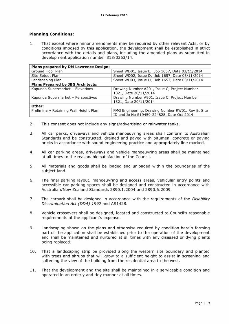
1. That except where minor amendments may be required by other relevant Acts, or by
conditions imposed by this application, the development shall be established in strict
accordance with the details and plans, including the amended plans as submitted in
development application number 313/0363/14.
Plans prepared by DM Lawrence Design:
Ground Floor Plan Sheet WD01, Issue E, Job 1657, Date 03/11/2014
Site Setout Plan Sheet WD02, Issue D, Job 1657, Date 03/11/2014
Landscaping Plan Sheet WD03, Issue D, Job 1657, Date 03/11/2014
Plans Prepared by JBG Architects:
Kapunda Supermarket – Elevations Drawing Number A201, Issue C, Project Number 1321, Date 20/11/2014
Kapunda Supermarket – Perspectives Drawing Number A901, Issue C, Project Number 1321, Date 20/11/2014
Other:
Preliminary Retaining Wall Height Plan FMG Engineering, Drawing Number RW01, Rev B, Site ID and Jo No S19459-224828, Date Oct 2014
2. This consent does not include any signs/advertising or rainwater tanks.
3. All car parks, driveways and vehicle manoeuvring areas shall conform to Australian
Standards and be constructed, drained and paved with bitumen, concrete or paving
bricks in accordance with sound engineering practice and appropriately line marked.
4. All car parking areas, driveways and vehicle manoeuvring areas shall be maintained
at all times to the reasonable satisfaction of the Council.
5. All materials and goods shall be loaded and unloaded within the boundaries of the
subject land.
6. The final parking layout, manoeuvring and access areas, vehicular entry points and
accessible car parking spaces shall be designed and constructed in accordance with
Australian/New Zealand Standards 2890.1:2004 and 2890.6:2009.
7. The carpark shall be designed in accordance with the requirements of the Disability
Discrimination Act (DDA) 1992 and AS1428.
8. Vehicle crossovers shall be designed, located and constructed to Council’s reasonable
requirements at the applicant’s expense.
9. Landscaping shown on the plans and otherwise required by condition herein forming
part of the application shall be established prior to the operation of the development
and shall be maintained and nurtured at all times with any diseased or dying plants
being replaced.
10. That a landscaping strip be provided along the western site boundary and planted
with trees and shrubs that will grow to a sufficient height to assist in screening and
softening the view of the building from the residential area to the west.
11. That the development and the site shall be maintained in a serviceable condition and
operated in an orderly and tidy manner at all times.
12 February 2015
Page | 20
12. Trade waste and other rubbish shall be stored in covered containers prior to removal
and shall be kept screened from public view. A number of rubbish bins shall be
provided to account for the various types of waste, rather than just a single bin.
13. At least one (1) public waste bin(s) shall be provided within the car park area and
adjacent the entrance to alleviate the accumulation of general waste in the immediate
area of the supermarket.
14. Detail of any air conditioning or air extraction plant or ducting to be placed on the
exterior of the building in association with this development shall be submitted to and
approved by the Development Assessment Commission.
15. Air conditioning or air extraction plant or ducting shall be screened such that no
nuisance or loss of amenity is caused to residents and users of properties in the
locality to the reasonable satisfaction of the Development Assessment Commission.
16. External lighting of the site, including car parking areas and buildings, shall be
designed and constructed to conform with Australian Standards and must be located,
directed and shielded and of such limited intensity that no nuisance or loss of amenity
is caused to any person beyond the site.
17. The proposed hours of opening for the supermarket shall be restricted to between the
following hours:
Monday to Friday: 7am – 10pm
Saturday & Sunday : 7am – 7pm
18. Deliveries and rubbish collection shall be restricted to between the following hours:
Monday to Friday: 7am – 10pm
Saturday & Sunday : 7am – 5pm
19. At no time shall any goods, materials or waste be stored or displayed in designated
car parking areas, driveways, manoeuvring spaces, or landscaping.
20. That the applicant shall submit a master stormwater management plan and
construction design drawings undertaken by a qualified civil engineer for approval by
Light Regional Council prior to the granting of Development Approval. The plan shall
include full details of the approved stormwater drainage system for the site, any
works external to the site, the location and allocation of any drainage easements, and
details of any temporary works, drains or banks proposed as part of the project
inclusive of the following:
Final calculations to determine flow rate, time to peak, and duration of
discharge for the pre development and uncontrolled post development
conditions; Final calculations to determine the detention tank volume required to control
the post development peak rate of outflow to the rate of 32lit/sec for all events
up to the critical 100Yr ARI. Final calculations to determine the hydrograph of the design storm discharge of
the detention tank; How the design of the drainage system is to convey the detention tank flows to
the lawful point of discharge as advised by the Council; Provide a final layout drawing showing the proposed drainage arrangement; What stormwater measures are proposed to protect the site from a major storm
event (100 year ARI) as well as minor storm events (100 year ARI);
12 February 2015
Page | 21
The use of above ground or underground rainwater storage tanks with a
minimum retention capacity of 15,000 litres; Details of the final proprietary product to be utilised to control and prevent the
entry of litter and pollution from the site into the stormwater network including
any ponding, detention, extended detention and retention
21. The stormwater design and construction shall be in accordance with Australian
Standards and recognised engineering best practices to ensure that stormwater does
not adversely affect any adjoining property or public road.
22. The drainage detailed in the approved Master Stormwater Management Plan must be
constructed to the satisfaction of Council. No effluent or polluted water of any type
may be allowed to enter the Council's stormwater drainage system.
23. The development shall be provided a wastewater control system to the satisfaction of
Council’s Environmental Health Officer, in accordance with the SA Public Health
(Wastewater) Regulations 2013, prior to commencement of construction.
24. That an appropriate Construction Environment Management Plan (CEMP) which
addresses the mitigation or minimisation of impacts (especially from noise and dust)
during the construction phase shall be prepared and implemented. Dust generated by
machinery and vehicular movement during site works, and any open stockpiling of soil
or building materials at the site, must be suppressed to ensure that dust generation
does not become a nuisance off-site. Site development machinery should generally
not be operated outside the hours of 7 AM to 6 PM daily.
Conditions requested by DPTI – Transport Services Division
25. The two-way access to Adelaide Road and the access to Carrington Street along with
associated right turn facilities shall be provided in general accordance with DM
Lawrence Landscaping Plan (refer Job 1657, Sheet WD03, Issue D (dated 3/11/14).
This access shall be provided with generous flaring to Adelaide Road in order to
minimise the impact of turning vehicles on through traffic.
26. Give way signs and associated line marking shall be provided at the internal car park
junction in order to give incoming vehicles from Adelaide Road priority over other car
park traffic.
27. A painted median scheme shall be installed in general accordance with the DM
Lawrence Landscaping Plan (refer Job 1657, Sheet WD03, Issue D (dated 3/11/14)
and the GTA Traffic Impact Assessment (Issue A, dated 8/9/14) Appendix C and email
correspondence dated 17 December 2014 or an alternative design to the satisfaction
of DPTI Transport Services Division.
28. All road works required (to facilitate safe access to the site) shall be designed and
constructed in accordance with Austroads Guides/Australian Standards and to DPTI’s
satisfaction. All associated costs (including project management and any necessary
road lighting / drainage upgrades) shall be borne by the applicant. The applicant shall
contact DPTI Traffic Operations Group, Acting Senior Access Management Engineer,
Ms Teresa Xavier (08) 8226 8325 or mobile 0429 049 390 ([email protected])
prior to commencing detailed design.
29. The applicant shall enter into a Deed of Agreement regarding the road works prior to
commencing detailed design.
30. All vehicles shall enter and exit the site in a forward direction.
12 February 2015
Page | 22
31. The largest vehicle permitted on-site shall be restricted to a 19.0 metres long
articulated vehicle as per AS 2890.2:2002.
32. All car parking areas shall be designed and constructed in accordance with AS/NZS
2890.1:2004. In particular, the Adelaide Road access gradient shall be in accordance
with this standard in order to maximise driver sightlines.
33. The trolley bay adjacent the Adelaide Road access point shall be removed or relocated
away from the internal car park junction in order to minimise conflict.
34. The utilisation of Trailer Mounted Variable Message Displays for advertising purposes
shall not be permitted on or adjacent to the subject land.
35. Any landscaping adjacent to the access point shall be restricted to vegetation with a
mature height no greater than 1.0 metre in order to maintain driver sightlines to/from
the new access point and the modified/new kerbline to/from Carrington Street.
36. The master stormwater management plan (condition 19) shall ensure run-off be
collected on-site and discharged without jeopardising the integrity and safety of the
arterial road. Any alterations to the road drainage infrastructure required to facilitate
this shall be at the applicant’s cost.
Advisory Notes:
a) The development must be substantially commenced within 12 months of the date of
this Notification, unless this period has been extended by the Development
Assessment Commission.
b) The applicant is also advised that any act or work authorised or required by this
Notification must be completed within 3 years of the date of the Notification unless
this period is extended by the Commission.
c) The applicant will require a fresh consent before commencing or continuing the
development if unable to satisfy these requirements.
d) The applicant has a right of appeal against the conditions which have been imposed
on this Development Plan Consent or Development Approval.
e) Such an appeal must be lodged at the Environment, Resources and Development
Court within two months from the day of receiving this notice or such longer time as
the Court may allow.
f) The applicant is asked to contact the Court if wishing to appeal. The Court is located
in the Sir Samuel Way Building, Victoria Square, Adelaide, (telephone number 8204
0300).
g) The applicant is reminded of its general environmental duty, as required by Section
25 of the Environment Protection Act 1993, to take all reasonable and practical
measures to ensure that the activities on the whole site, including during
construction, do not pollute the environment in a way which causes or may cause
environmental harm.
h) The monitoring of soil condition and appearance shall be undertaken during any site
works upon the site including the excavation of footings and the trenching of services.
In the event that any potential soil contamination is detected (discoloured soil or
12 February 2015
Page | 23
odour) the applicant shall cease all earthworks and notify the Environment Protection
Authority. Appropriate testing and remediation/removal of the soil shall be
undertaken in accordance with standard industry procedures, as advised by an
appropriately qualified person, prior to the recommencement of earthworks upon the
site.
i) All material (waste) proposed to be disposed off-site must be classified and
characterised in accordance with the EPA Information Sheet - Current criteria for the
classification of waste
(http://www.epa.sa.gov.au/xstd_files/Waste/Information%20sheet/current_waste_cri
teria.pdf) prior to removal off-site to a facility licensed to receive, dispose and/or treat
that waste.
j) Future signage applications should be designed in accordance with DPTI “Advertising
Signs - Assessment Guidelines for Road Safety” (August 2014). The document is
available via the following link:
http://www.dpti.sa.gov.au/__data/assets/pdf_file/0019/145333/DPTI-Advertising-
Signs-Assessment-Guidelines.pdf
k) The following advice is provided by DPTI – Transport Services Division in respect to
any future application for signage on the subject land:
All signs visible from adjacent roads may use LED lighting for internal illumination
of a light box only. No element of LED or LCD display shall otherwise be included
in the sign design.
Illumination of signs visible from the adjacent roads shall be limited to a low level
(i.e. 200cd/m2) and signage shall be finished in a material of low reflectivity to
minimise distraction to motorists.
Signage visible from adjacent roads shall not contain any element that flashes,
scrolls, moves or changes.
………………………………………………….
ROBERT KLEEMAN
Manager Assessment
STATUTORY PLANNING BRANCH (DPTI)
12 February 2015
Page | 24
DETAILED ASSESSMENT REPORT
The Objectives and Principles of Development Control in the Development Plan most relevant to
the assessment of the application are outlined as follows. These are contained in the Light
Regional Council Consolidated 24 January 2013.
HISTORIC CONSERVATION (KAPUNDA TOWN CENTRE) ZONE
Desired Future Character
The design and appearance of business activities in this policy area should contribute to the
town's overall heritage character by:
(a) using consistent set-backs of buildings to create a strong building line;
(b) roof pitches of a minimum of 20 degrees;
(c) galvanized corrugated iron used for external cladding in preference to "zincalume" or colour
coated metal;
(d) rural fencing on street boundaries in preference to security fencing;
(e) wall and gable ends of buildings for signage; and
(f) informal landscaping using species existing in the area.
Objective 1: The focus for administration, shopping, business, retail, tourist and commercial
activities to serve residents in the town of Kapunda and visitors to Kapunda and the surrounding
rural district.
Objective 2: A range of cultural, community, tourism and entertainment uses and facilities
located in appropriate locations in the zone.
Objective 3: Conservation and enhancement of the built-form integrity of the Main Street and
important side streets.
Objective 4: Development which conserves, rehabilitates and compliments the historic character
of the respective policy areas of the zone.
Objective 5: Consolidation of the zone and retention, utilization and more intensive use of
existing buildings which presently have surplus capacity.
Objective 6: Improvements to the character of the zone through development and staged
improvements to public streets and reserves within and adjoining the zone, the planting of clear-
stemmed canopy street-trees and rationalization of overhead services to create improved
opportunities for street tree-planting.
Objective 7: Improvements to pedestrian safety for users of the Main Street.
Form of Development
PDC 1 Development including land division should be compatible with and reinforce the heritage
significance of the zone and integrity of places listed in Table Lig/2.
Movement and Parking
PDC 2 Development should provide sufficient off-street car parking to meet its anticipated
parking demand.
PDC 3 Car parking should:
(a) not take precedence over preservation of traditional buildings or structures;
(b) be generally provided to the rear of buildings; and
(c) be landscaped with suitable trees and provided with lighting to enhance the amenity,
appearance and safety of car parking areas.
PDC 4 Access to car parking areas should be from side streets rather than Main Street.
PDC 5 Pedestrian linkages should be established from car parking areas to Main Street.
PDC 6 Pedestrian facilities such as open-air seating should be incorporated into development
where appropriate.
PDC 7 Amalgamation and or joint use of car parking should be encouraged.
Appearance
PDC 8 Advertising and signs should be positioned on buildings and designed to:
(a) complement the building;
12 February 2015
Page | 25
(b) not protrude onto the public street;
(c) not obscure the building or architectural detailing;
(d) be located below the verandah fascia or painted on shop windows; and
(e) be sensitive to the heritage character of the building and streetscape.
Generally corporate signage of a pre-standardised format imposed on heritage buildings
will not be suitable. Instead of corporate signage, individually styled signs which
complement the colours, scale and design of the building should be developed.
Internal illuminated projecting signs should be avoided in favour of hanging signs,
suspended from wall brackets and illuminated by discrete spotlights.
Signage should be integrated into the architecture so that interesting details (such as
arches, columns and decorative panels) which give the building character are not obscured
or disturbed.
PDC 9 Development should be located and designed to retain existing vistas within and outside
the zone.
PDC 10 Development should protect and/or reinstate traditional stone and other characteristic
townscape elements.
PDC 11 Buildings should be simple in detail incorporating gable, hip or hip gable combination
roofs, parapets or cornices and where appropriate wide balconies and or verandahs.
PDC 12 Roof pitches of 30 degrees to 45 degrees should be used generally with lower pitch roofs
used in a manner of "lean-to" additions to existing buildings or behind appropriately design
parapets, especially along street frontages.
PDC 13 Metal sheeting used for walls, roofs and verandahs should be of corrugated galvanised
steel sheet or Colorbond steel sheet, painted or unpainted, but not “Zincalume” so as to minimise
glare and be compatible with historic buildings in the area.
Public Notification
Categories of public notification are prescribed in schedule 9 of the Development Regulations
2008.
Further, the following forms of development are designated Category 1 or Category 2.
PDC 16 Those kinds of development listed in Table Lig/7, together with the following kinds of
development, are assigned as Category 1 Development* in the Historic Conservation (Kapunda
Town Centre) Zone Recreation (Greenock) Zone except where non-complying:
Demolition of a building including a Contributory Item, but not including development on an
allotment containing a Local Heritage Place or State Heritage Place identified in Table Lig/2
PDC 17 The following kinds of development are assigned as Category 2 Development in the
Historic
Conservation (Kapunda Town Centre) except where non-complying:
Demolition of a Local Heritage Place
Development on an allotment containing a Local Heritage Place identified in Table Lig/2
POLICY AREA 12 - COMMERCIAL
Objective 1: The main focus within the town for commercial activities, service trade premises,
car yards, service stations, petrol filling stations and public service depots.
Objective 2: Improvement of the appearance of this policy area through landscaping and
inclusion of traditional building elements as an integral part of development.
Objective 3: Relocation of industrial uses to the Industry Zone.
Form of Development
1 Development should be mainly for commercial type activities and service trade premises and
public service depots.
Appearance
2 Landscaping and traditional architectural elements should be used on buildings and their layout
to ensure the appearance of development is consistent with the Desired Future Character for the
policy area.
12 February 2015
Page | 26
3 Development on land abutting residential zones should be more domestic in scale and character
than development in the area generally.
4 Advertising and signs should be well-designed so as to not detract from the landscape and
townscape character of the area.
Movement and Parking
5 Development should provide sufficient off-street car parking to meet its anticipated parking
demand.
COUNCIL-WIDE POLICIES
Form of Development
Objective 1: Development in the Light Regional Council which supports the social, cultural,
economic and environmental needs of residents and visitors including:
(a) maintaining and increasing employment opportunities;
(b) providing such facilities as are required for accommodation, recreation, education, health and
welfare of the population, including the aged;
(c) maintaining and enhancing the primary production capacity of the district;
(d) providing services and destinations to encourage tourist visitation;
(e) strengthening service and employment functions of established townships through the
concentration of additional population and commercial activities within them;
(f) defining township and settlement boundaries to achieve compact urban areas;
(g) separation of regular heavy vehicle movements from major town centres; and
(h) protection and enhancement of areas of conservation significance including native vegetation.
Types of Development
Objective 2: Types of development in the district ensuring:
(a) protection and enhancement of the long term sustainability of primary industries, particularly
grain and seed crop production, which are of State importance;
(b) orderly development of the Kapunda and Roseworthy townships to avoid an incompatible
arrangement of land uses and to protect the continued operation of facilities for the bulk handling,
storage and transportation of farm commodities.
(c) a wide range of services located in a hierarchy of centres to maximise accessibility for the
population as a whole with regard to the location of centres in adjoining council areas;
(h) sufficient physical infrastructure to meet the social and economic requirements of the
population in the most economical and ecologically sustainable manner;
Environment, Heritage and Amenity
Objective 5: Development undertaken in a manner which:
(c) conserves the Aboriginal and European heritage of the district;
(d) is safe;
(e) does not have an adverse impact on the amenity of properties within the locality; and
(f) has a high standard of appearance.
Council-wide Structure
PDC 1 Development should be undertaken in accordance with the Light (RC) Structure Plans, as
shown on Maps Lig/1 (Overlay 1) and Lig/1 (Overlay 2).
Kapunda
PDC 4 The township of Kapunda should be developed in accordance with Structure Plan Map
Lig/1
(Overlay 1) Enlargement D. The desired strategy for the development of Kapunda to cater for
present and future population should be achieved by:
(a) the consolidated development of existing urban areas;
(b) development of the town as the main urban centre servicing the northern region of the
Council area;
(c) provision of local employment opportunities in defined industrial areas within the town;
12 February 2015
Page | 27
(d) provision in rural living areas for residential uses on small rural allotments in proximity to the
centre of town; and
(e) encouragement of development which reinforces the heritage character of parts of the town
and provides for the needs of visitors.
Use of Land
PDC 10 Development should take place on land which is suitable for the intended use of that land
having regard to the location and condition of the land and the provisions for the zone concerned.
PDC 11 Development should not interfere with the effective and proper use of any other land in
the vicinity and should not prevent the attainment of the provisions relating to that other land.
Siting of Development
PDC 22 Buildings and structures should be sited to conserve the surrounding character through
optimum orientation, set-back, cut and fill, access and bushfire prevention measures.
PDC 23 Buildings should be sited in a manner which minimises the requirement to remove native
vegetation and should be sited and designed to blend with the surrounding landscape character
by locating in a setting where landscape features such as trees, vegetation and landforms provide
an enclosing space or setting as generally illustrated in Figure 23.1.
PDC 27 Excavation and filling of land, as generally illustrated in Figure 27.1, should:
(a) be kept to a minimum to preserve the natural form of the land and native vegetation;
(b) only be undertaken in order to reduce the visual impact of buildings, including structures or in
order to construct water storage facilities for use on the allotment; and
(c) only be undertaken if the resultant slope can be stabilized to prevent erosion.
Transport and Parking
PDC 28 Provisions should be made for motor vehicle access to and from developments to an
extent and in a manner which will avoid unreasonable interference with the flow of traffic on
roads adjoining the site of the development.
PDC 29 Roads, streets or thoroughfares provided with development should incorporate safe and
convenient intercommunication for vehicles and pedestrians with neighbouring localities and with
existing roads, streets or thoroughfares.
PDC 30 Kinds of development listed in Table Lig/6 should provide car parking spaces on the site
or on a nearby site at the rate specified in the Table. All other developments should provide
adequate offstreet car parking facilities, having regard to anticipated parking demand, availability
of on-street parking, shared usage of other parking areas and safety or as specified in principles
of development control for particular kinds of development.
PDC 31 Development should provide off-street vehicle parking and specifically marked disabled
car parking places to meet anticipated demand in accordance with Table Lig/6 Vehicle Parking
Requirements.
PDC 32 Development should be consistent with Australian Standard AS2890 Parking Facilities.
PDC 33 Cycling facilities and networks should be designed and provided in accordance with the
relevant provisions of the Australian Standards and Australian Guide to Traffic Engineering
Practice Part 14.
PDC 34 Sufficient car parking spaces should be provided on the site of or on a site nearby a
development, having regard to anticipated parking demand, availability of on-street parking,
shared usage of other parking areas and safety.
PDC 35 Where possible parking areas should be designed to link into adjacent parking areas and
make the most efficient use of available parking space, taking account of the timing of the
parking needs of each activity involved.
PDC 40 Development should not result in ribbon development along arterial roads, particularly
leading into towns, or impair the free flow of traffic on arterial roads identified on Maps Lig/1
(Overlay 1) and Lig/1 (Overlay 2) and:
(a) the number of access points to arterial roads should be rationalised and limited through the
use of service roads or direct access to local roads;
(b) direct access to arterial roads should only be granted:
(i) in safe locations;
(ii) where there is adequate site distance and reasonable distance from side roads;
12 February 2015
Page | 28
(iii) where provision is made on-site for vehicles to manoeuvre and exit the site in a forward
direction; and
(iv) where alternative convenient access via local roads is not available or (a) is not practicable;
and
(c) where development abuts an arterial road, it should not change the arterial road's nature and
function.
Centres and Shops
PDC 101 Shopping, administrative, community, health, cultural and entertainment facilities
should be located within centre zones in each town.
PDC 102 Kapunda should provide the major centre and shopping area within the council area
with retailing and other services being developed to the maximum extent so that district level
shopping, administrative, commercial, cultural and entertainment facilities are retained within the
district.
PDC 103 Retail, commercial, administrative and community development in Freeling and
Greenock should be consistent with their status as local service centres.
PDC 104 Centres should be highly accessible to the population they serve, especially by public
transport, where applicable.
PDC 105 Shop development and development in centres should meet the following criteria:
(a) facilitate the multiple use of facilities and sharing of utility areas;
(b) exhibit unified design of buildings and a close relationship between shops in a lively setting;
(c) create comfortable microclimatic conditions and minimise exposure to adverse weather
conditions through the design and orientation of buildings, and location of open space and parking
areas;
(d) make adequate and convenient provision for service vehicles and the storage and removal of
waste goods and materials;
(e) locate and design car parks to facilitate direct and convenient access of pedestrians between
them and the facilities they serve; and
(f) consolidate and co-ordinate parking areas.
PDC 106 Landscaping should form an integral part of centre design, and be used to foster a
human scale, define spaces, reinforce paths and edges, screen utility areas, and generally
enhance the visual amenity of the locality.
PDC 107 Centres should have minimal adverse impacts on residential areas.
PDC 108 Any shopping development which can be shown to be more appropriately located
outside a centre should:
(a) not be of a size and type which would hinder the development or function of any centre;
(b) conform to the principles of development control for centres;
(c) not be likely to result in a decline of retail employment in the locality; and
(d) not be likely to cause the economic or physical deterioration of any centre.
Infrastructure
PDC 159 Development should be connected, or be able to be connected, to constructed roads
and public utilities (such as water supply, a waste treatment system, drainage, electricity supply,
lighting and telephone services), likely to be required by the user of the development with the
costs being paid by the developer.
PDC 161 Urban and township development should be capable of being economically serviced for
public transport, garbage collection, fire protection and street lighting.
Health and Safety
PDC 275 The development and use of land should take place in a manner which will not cause
nuisance or hazard to the community by:
(a) the emission of noise, vibration, odour, fumes, smoke, vapour, steam, soot, ash, dust, grit,
oil, waste water, waste products, electrical interference or light;
Site Contamination
PDC 281 Development, including land division, should not occur on contaminated land or on
potentially contaminated land unless:
12 February 2015
Page | 29
(a) remediation of the site is undertaken to a standard that makes it suitable and safe for the
proposed use; or
(b) the site will be maintained in a condition or the development will be undertaken in a manner
that will not pose a threat to the health and safety of the environment or to occupiers of the site
or land in the locality.
Waste Disposal
PDC 282 Development should not take place unless all wastes produced can be managed so as
to prevent pollution of surface or underground water resources or loss of amenity to nearby
residents.
PDC 283 Effluent should either be disposed of via common effluent drainage system or sewer
system or be treated within the confines of the allotment without risk to the underlying water
table or to public health.
Heritage
PDC 293 Development in an Historic Conservation Zone or Policy Area or adjoining a place of
heritage significance identified in Table Lig/2 should utilize contemporary architectural design and
detailing that complements the external materials and finishes, colours, scale, built form, building
height, roof shape and pitch, boundary set-back and fencing of development within the zone or
the adjoining heritage place.
Appearance of Land and Buildings
PDC 295 Buildings should be designed to preserve and enhance surrounding character and
surrounding existing buildings having regard to scale, form, materials and landscaping.
PDC 297 Building forms should relate to surrounding existing building forms in the locality of the
development, particularly those associated with the German and British (including Irish) culture
and history of the rural district as generally illustrated in Figures 297.1(a)–(d). Characteristics of
early German buildings of timber and stone include steep gabled roofs and simple casement
windows. The British influence ranges from modest stone colonial farmhouses with verandahs to
grander homesteads.
PDC 299 Buildings on land adjoining, or highly visible from, public roads outside or at the
periphery of townships should be sited unobtrusively and designed in a manner which will not
detract from the amenity of the locality as viewed from these roads.
Landscaping
PDC 304 All development should be landscaped prior to the commencement of the use of the
development with trees, bushes and groundcovers in a manner which will enhance the
appearance of the development and the locality, provide shade and shelter, and assist in climate
control within buildings, with preference given, where appropriate, to planting with the species
listed in Table Lig/4.
Stormwater Management
PDC 329 Development should prevent the discharge or deposit of waste (including wastewater)
into any waters or onto land in a place from which it is reasonably likely to enter any waters
(including by processes such as seepage or infiltration or carriage by wind, rain, sea spray, or
stormwater or by the rising of the water table).
PDC 330 Development should incorporate stormwater management techniques to contain the
quality, velocity, variability and quality of run-off to as near pre-development levels as practical,
by means of but not limited to:
(a) directing roof stormwater overflow from rainwater tanks to soakage trenches or to
retention/overflow wells or sumps where large roof catchments are involved;
(b) utilising grassed swales or natural drainage lines to accommodate the major flows from the
land development; and
(c) incorporating stormwater systems designed to prevent entry of pollutants such as pollutants
such as sediment, pesticides and herbicides, bacteria, animal wastes and oil, grease and waste
water from vehicle cleaning processes, air conditioners and fire protection services pipework
testing into receiving water.
12 February 2015
Page | 30
PDC 331 Development should incorporate a stormwater treatment system capable of removing
pollutants.
PDC 334 Development should incorporate water sensitive design techniques to assist in the
sustainable use of water.
PDC 339 Areas for activities such as loading and unloading, wash down of vehicles, plant or
equipment, or storage of waste refuse bins should be suitably paved, bunded to exclude
stormwater run-off from external sources, and designed so that water that has made contact with
such areas is either:
(a) directed to a sediment trap, separator or other appropriate treatment device and then to
sewer; or
(b) directed to a wastewater holding tank.
PDC 340 Development should prevent erosion and stormwater pollution before, during and after construction and associated works by: (a) appropriate control of surface water entering or leaving the land;
(b) installing and maintaining erosion control works and measures;
(c) installing and maintaining sediment collection devices to prevent the export of sediment from
the land; and (d) rehabilitating disturbed areas. PDC 341 A Soil Erosion and Drainage Plan should be prepared where: (a) there is a high risk of sediment pollution to adjoining lands or receiving water, or;
(b) the total area to be distributed, or left distributed, at any one time exceeds 0.5 ha
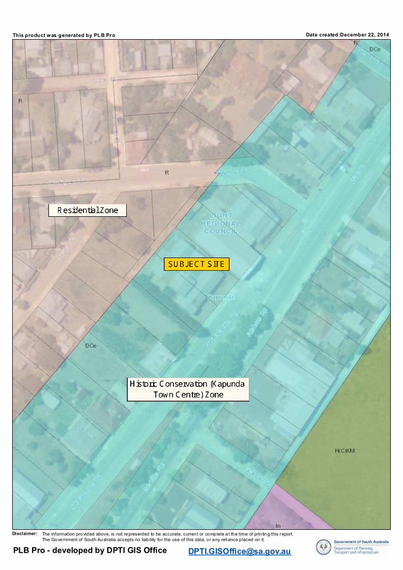
Date created:December 22, 2014
This product was generated by PLB Pro
The information provided above, is not represented to be accurate, current or complete at the time of prin ting this report.The Government of South Australia accepts no liab ility for the use of this data, or any reliance p laced on it.
Disclaimer:
PLB Pro - developed by DPTI GIS Office [email protected]
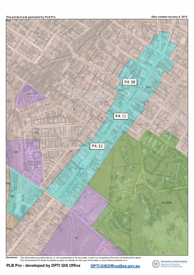
Date created:January 8, 2015
This product was generated by PLB Pro
The information provided above, is not represented to be accurate, current or complete at the time of prin ting this report.The Government of South Australia accepts no liab ility for the use of this data, or any reliance p laced on it.
Disclaimer:
PLB Pro - developed by DPTI GIS Office [email protected]
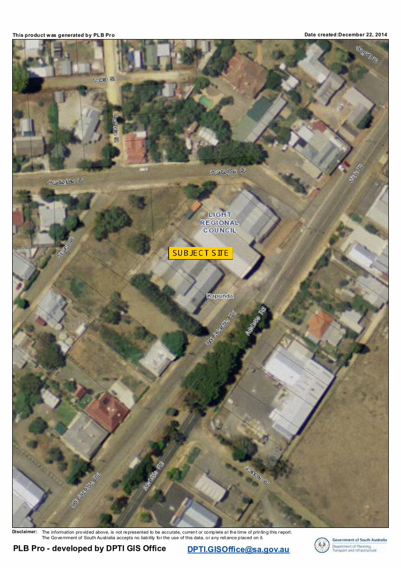
Date created:December 22, 2014
This product was generated by PLB Pro
The information provided above, is not represented to be accurate, current or complete at the time of prin ting this report.The Government of South Australia accepts no liab ility for the use of this data, or any reliance p laced on it.
Disclaimer:
PLB Pro - developed by DPTI GIS Office [email protected]
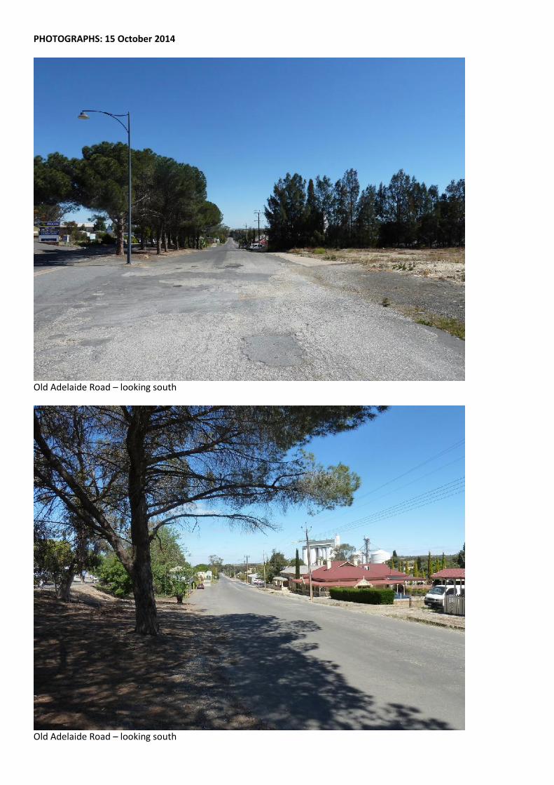
PHOTOGRAPHS: 15 October 2014
Old Adelaide Road – looking south
Old Adelaide Road – looking south
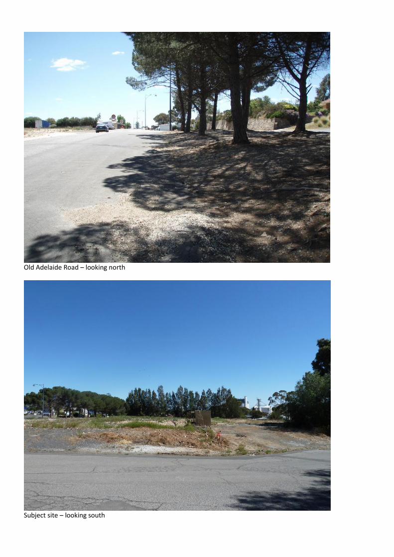
Old Adelaide Road – looking north
Subject site – looking south
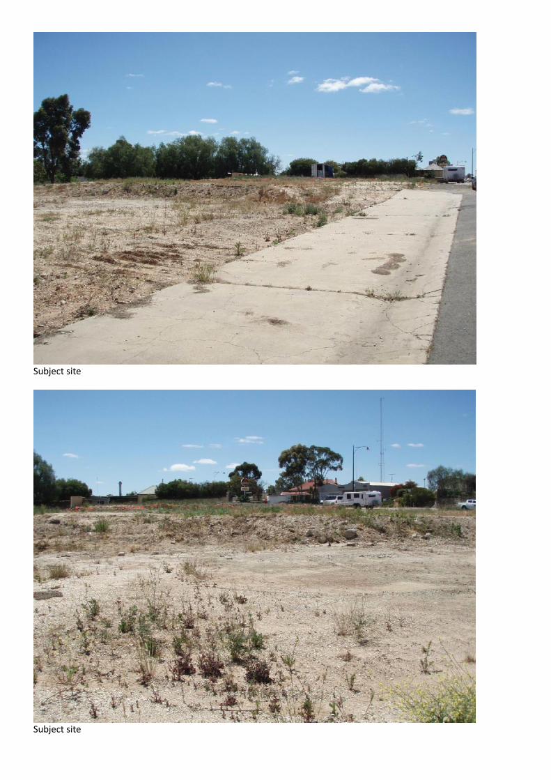
Subject site
Subject site
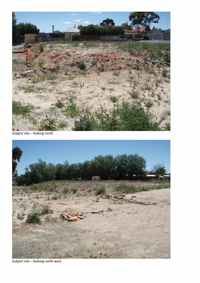
Subject site – looking north
Subject site – looking north west
Subject site – looking north east
Subject site – looking east
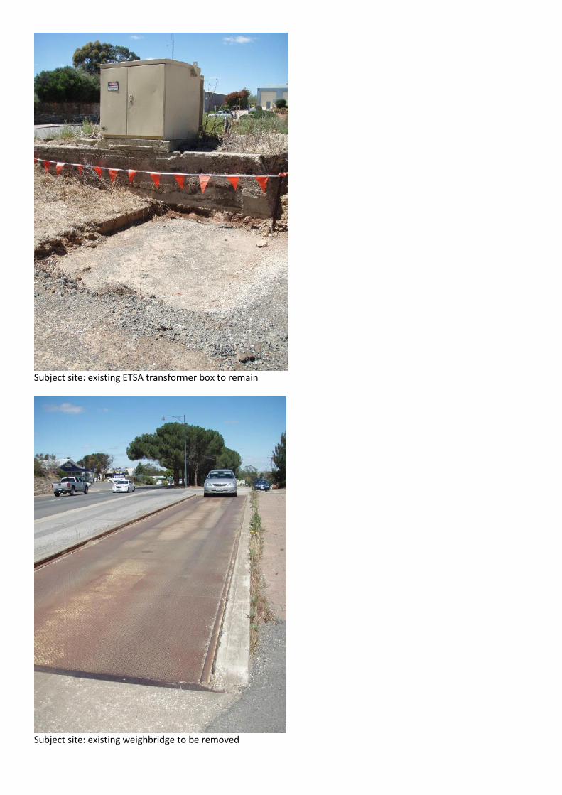
Subject site: existing ETSA transformer box to remain
Subject site: existing weighbridge to be removed
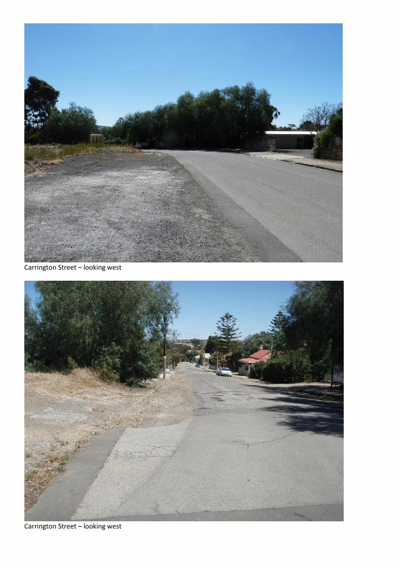
Carrington Street – looking west
Carrington Street – looking west
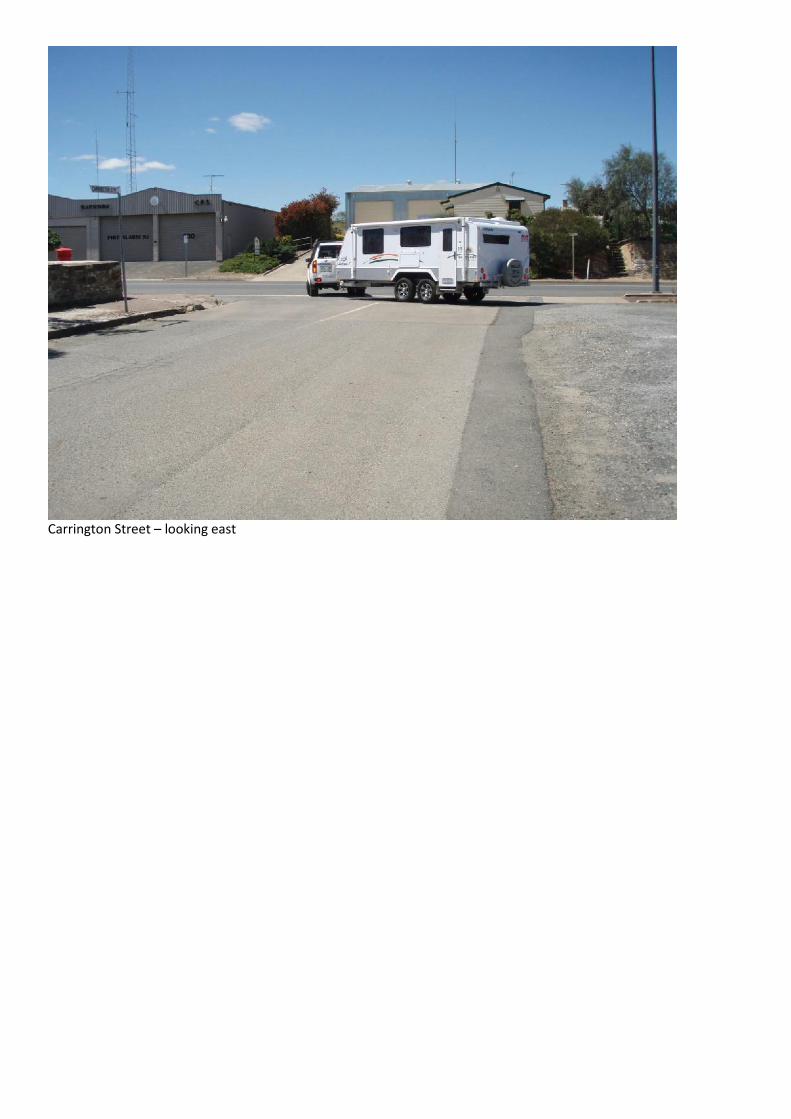
Carrington Street – looking east
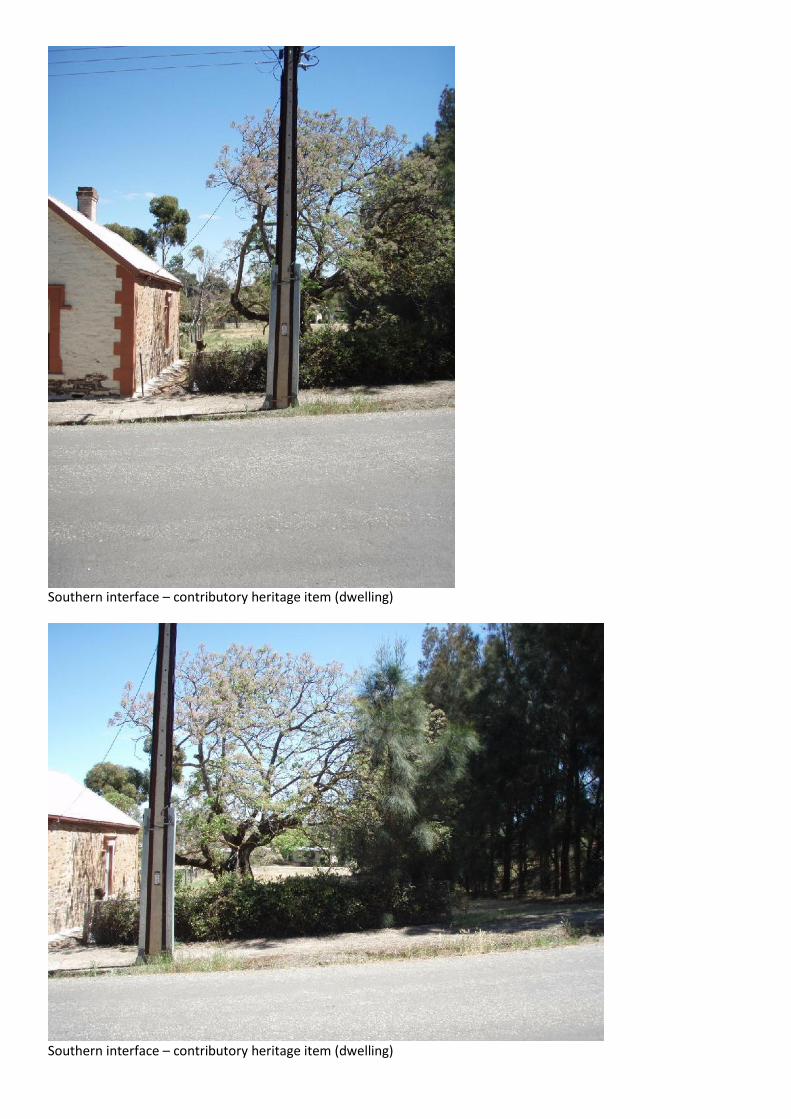
Southern interface – contributory heritage item (dwelling)
Southern interface – contributory heritage item (dwelling)
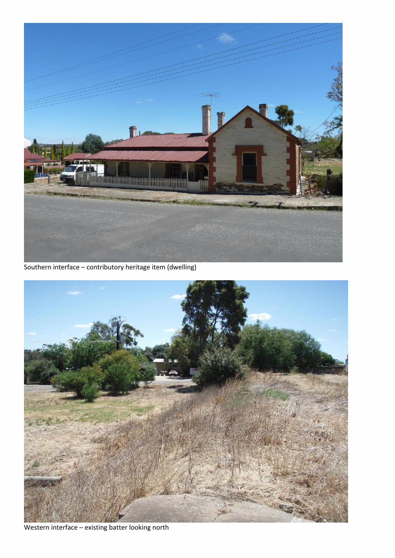
Southern interface – contributory heritage item (dwelling)
Western interface – existing batter looking north
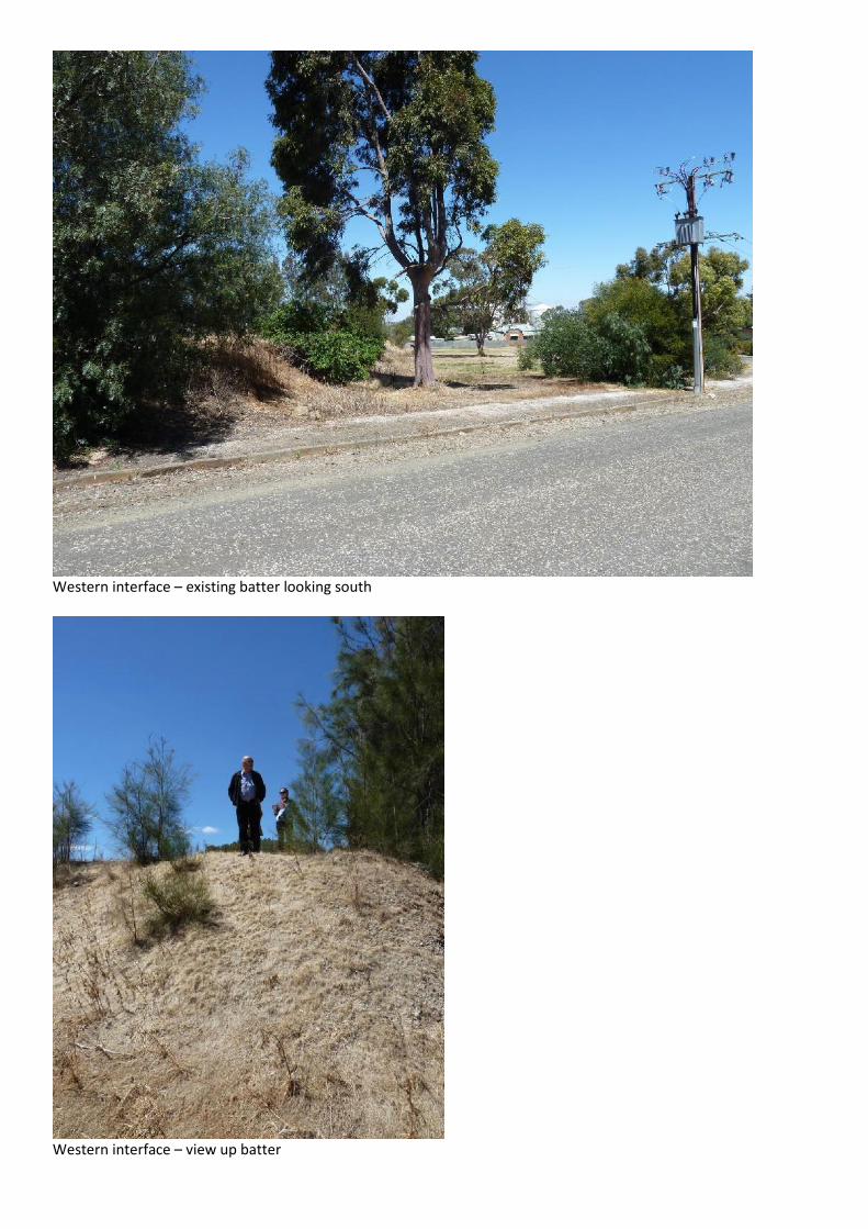
Western interface – existing batter looking south
Western interface – view up batter

Adjacent vacant allotments – looking north west into Residential Zone
Adjacent vacant allotments – looking south west into Residential Zone
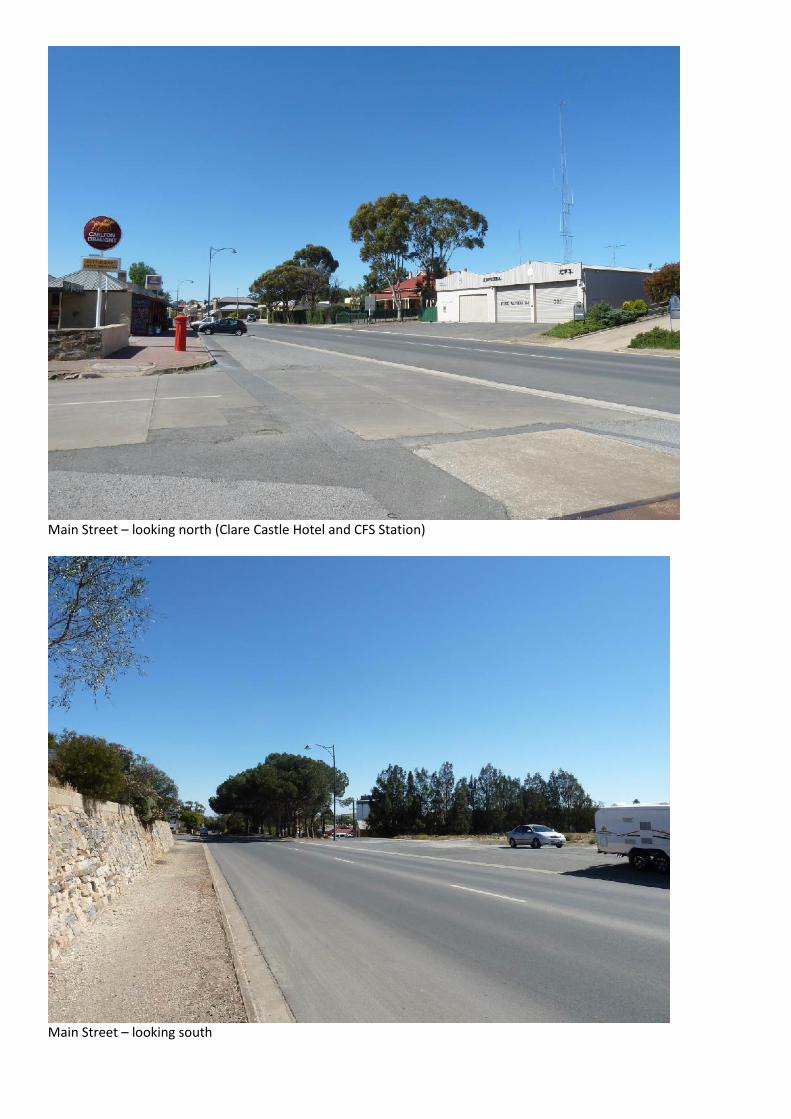
Main Street – looking north (Clare Castle Hotel and CFS Station)
Main Street – looking south
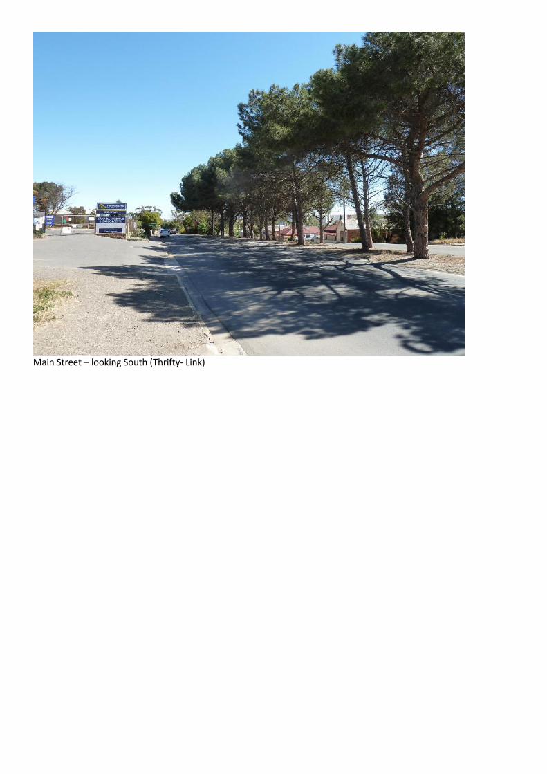
Main Street – looking South (Thrifty- Link)
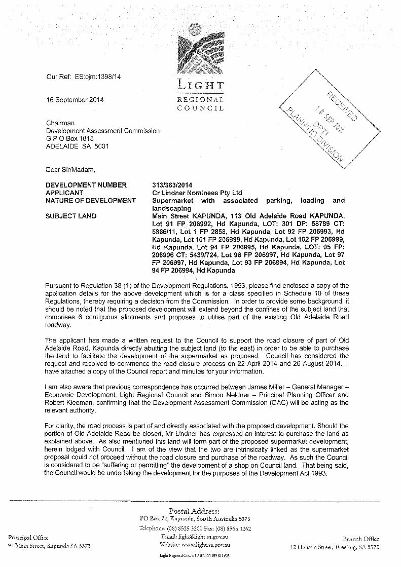
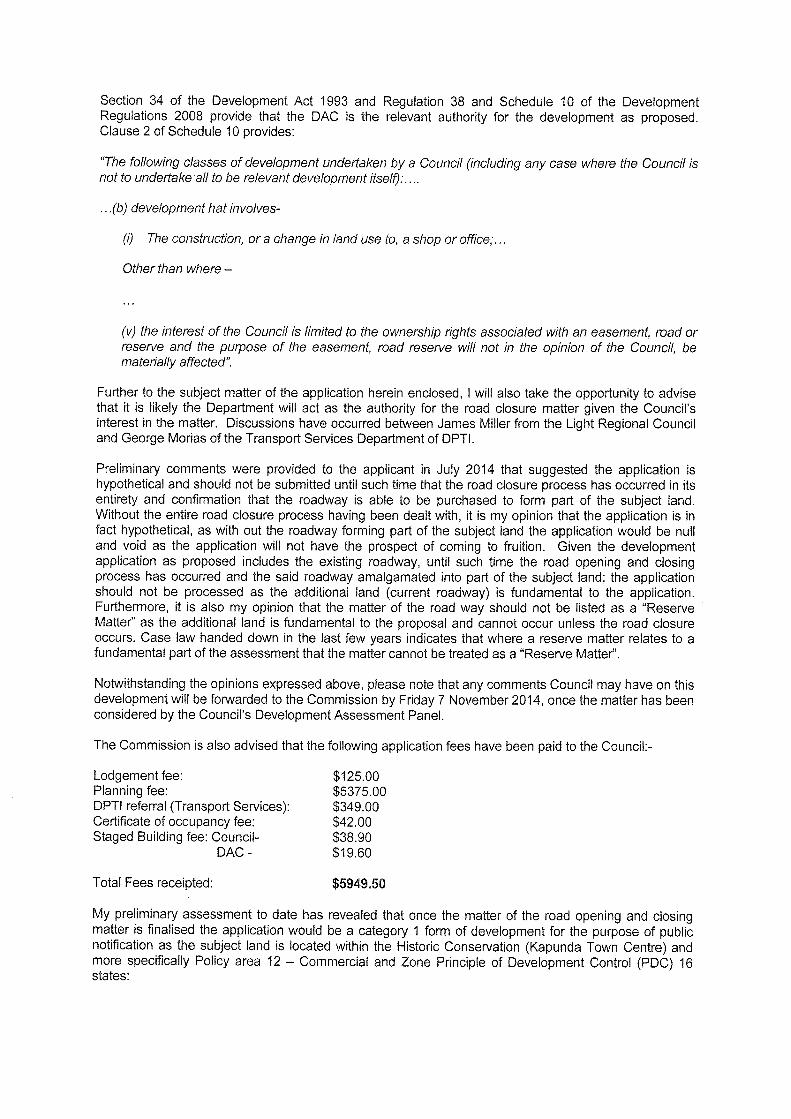
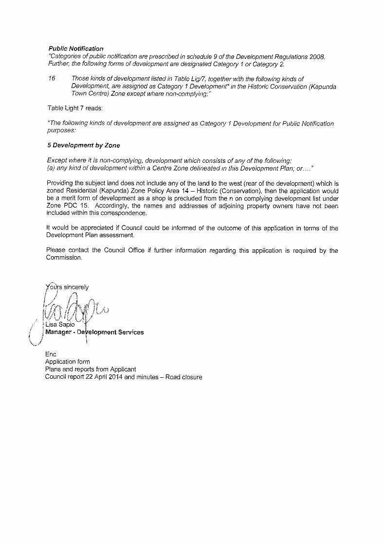
D E V E L O P M E N T A P P L I C A T I O N F O R M
COUNCIL: LIGHT REGIONAL COUNCIL
APPLICANT: CR LINDNER NOMINEES PTY LTD
Postal Address: PO BOX 382
TANUNDA SA 5352
OWNER: AS ABOVE
Postal Address:
BUILDER: TO BE ADVISED
Postal Address:
Licence No:
CONTACT PERSON FOR FURTHER INFORMATION:
Name: GRAHAM BURNS- MASTERPLAN SA PTY LTD
Telephone: 8221 6000
Facsimile: 8221 6001
Mobile: 0413 832 602
EXISTING USE:
VACANT – FORMER JT JOHNSON AND SONS SITE
FOR OFFICE USE
Development No:
Previous Development No:
Assessment No:
Complying Application forwarded to DA
Non-complying Commission/Council on:
Notification Cat 2 / /
Notification Cat 3 Decision:
Referrals/Concurrence Type:
DA Commission Date: / /
Decision Fees Receipt No Date
Planning:
Building:
Land Division:
Additional:
Dev Approval:
DESCRIPTION OF PROPOSED DEVELOPMENT: SUPERMARKET WITH ASSOCIATED PARKING, LOADING AND LANDSCAPING LOCATION OF PROPOSED DEVELOPMENT:
House No: 113 Lot No: 1, 91, 92, 101 102, 301
Street: OLD ADELAIDE ROAD Town/Suburb: KAPUNDA
Section No (full/part): Hundred: CT: 5439/725 CT: 5439/722
Section No (full/part): CT: 5866/11 CT: 5439/729 CT: 5439/728 LAND DIVISION:
Site Area (m2): Reserve Area (m2): No of Existing Allotments:
Number of Additional Allotments - (Excluding Road and Reserve): Lease: YES: NO: DOES EITHER SCHEDULE 21 OR 22 OF THE DEVELOPMENT REGULATIONS 2008 APPLY? YES: NO:
HAS THE CONSTRUCTION INDUSTRY TRAINING FUND ACT 1993 LEVY BEEN PAID? YES: NO:
DEVELOPMENT COST (Do not include any fit-out costs): $4.35 million I acknowledge that copies of this application and supporting documentation may be provided to interested persons in accordance with the Development Regulations 2008.
SIGNATURE:
Dated: 10 SEPTEMBER 2014
FOR: CR LINDNER NOMINEES PTY LTD
12177DAF01.doc

REGISTER SEARCH OF CERTIFICATE OF TITLE * VOLUME 5439 FOLIO 729 *
COST : $26.50 (GST exempt ) PARENT TITLE : CT 3147/92REGION : EMAIL AUTHORITY : CONVERTED TITLEAGENT : BTPL BOX NO : 000 DATE OF ISSUE : 01/08/1997SEARCHED ON : 26/08/2014 AT : 09:41:22 EDITION : 5CLIENT REF 12177
REGISTERED PROPRIETOR IN FEE SIMPLE----------------------------------- C.R. LINDNER NOMINEES PTY. LTD. OF 72 MURRAY STREET TANUNDA SA 5352
DESCRIPTION OF LAND------------------- ALLOTMENT 92 FILED PLAN 206993 IN THE AREA NAMED KAPUNDA HUNDRED OF KAPUNDA
EASEMENTS--------- NIL
SCHEDULE OF ENDORSEMENTS------------------------ 11165209 MORTGAGE TO COMMONWEALTH BANK OF AUSTRALIA
NOTATIONS--------- DOCUMENTS AFFECTING THIS TITLE ------------------------------ NIL
REGISTRAR-GENERAL'S NOTES ------------------------- NIL
END OF TEXT.
Page 1 of 2
5439 729
26/08/2014 09:41:22
Page 2 of 2

REGISTER SEARCH OF CERTIFICATE OF TITLE * VOLUME 5866 FOLIO 11 *
COST : $26.50 (GST exempt ) PARENT TITLE : CT 5475/782REGION : EMAIL AUTHORITY : RTU 9241756AGENT : BTPL BOX NO : 000 DATE OF ISSUE : 05/02/2002SEARCHED ON : 26/08/2014 AT : 09:39:22 EDITION : 5CLIENT REF 12177
REGISTERED PROPRIETOR IN FEE SIMPLE----------------------------------- C.R. LINDNER NOMINEES PTY. LTD. OF PO BOX 382 TANUNDA SA 5352
DESCRIPTION OF LAND------------------- ALLOTMENT 301 DEPOSITED PLAN 58789 IN THE AREA NAMED KAPUNDA HUNDRED OF KAPUNDA
EASEMENTS--------- NIL
SCHEDULE OF ENDORSEMENTS------------------------ NIL
NOTATIONS--------- DOCUMENTS AFFECTING THIS TITLE ------------------------------ NIL
REGISTRAR-GENERAL'S NOTES ------------------------- NIL
END OF TEXT.
Page 1 of 2
5866 11
26/08/2014 09:39:22
Page 2 of 2
REGISTER SEARCH OF CERTIFICATE OF TITLE * VOLUME 5439 FOLIO 728 *
COST : $26.50 (GST exempt ) PARENT TITLE : CT 4301/826REGION : EMAIL AUTHORITY : CONVERTED TITLEAGENT : BTPL BOX NO : 000 DATE OF ISSUE : 01/08/1997SEARCHED ON : 26/08/2014 AT : 09:41:58 EDITION : 5CLIENT REF 12177
REGISTERED PROPRIETOR IN FEE SIMPLE----------------------------------- C.R. LINDNER NOMINEES PTY. LTD. OF 72 MURRAY STREET TANUNDA SA 5352
DESCRIPTION OF LAND------------------- ALLOTMENTS 101 AND 102 FILED PLAN 206999 IN THE AREA NAMED KAPUNDA HUNDRED OF KAPUNDA
EASEMENTS--------- NIL
SCHEDULE OF ENDORSEMENTS------------------------ 11165209 MORTGAGE TO COMMONWEALTH BANK OF AUSTRALIA
NOTATIONS--------- DOCUMENTS AFFECTING THIS TITLE ------------------------------ NIL
REGISTRAR-GENERAL'S NOTES ------------------------- NIL
END OF TEXT.
Page 1 of 2
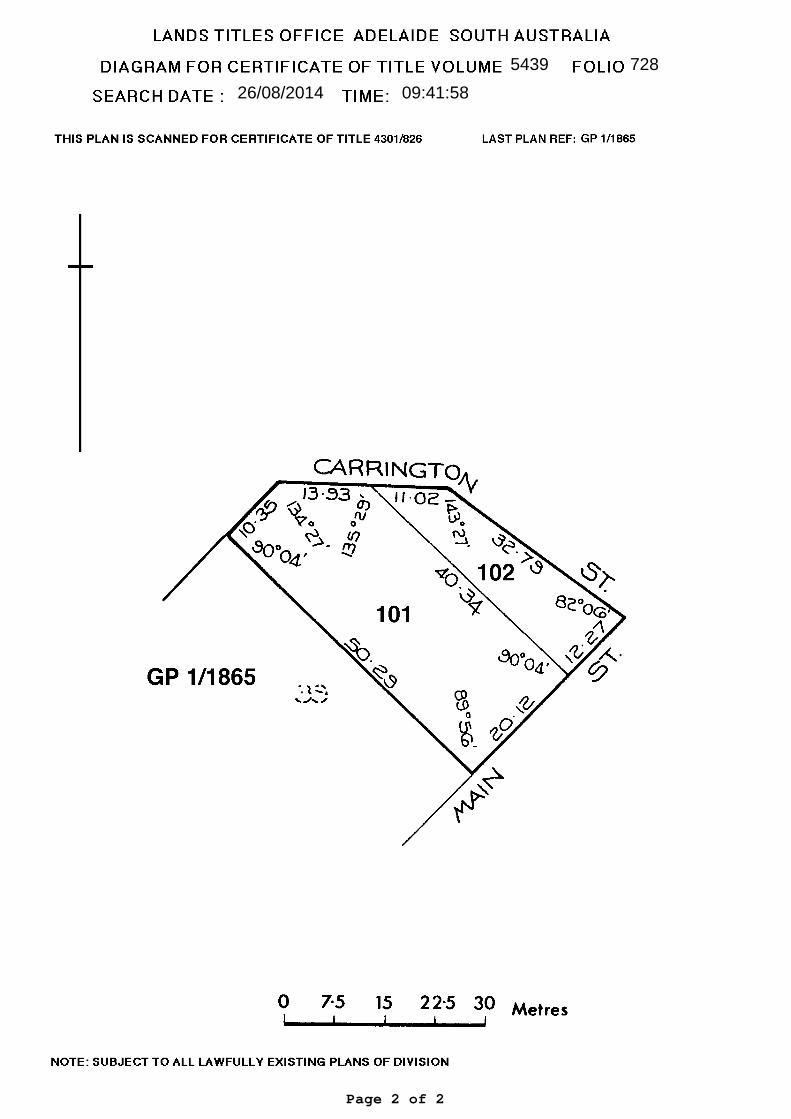
5439 728
26/08/2014 09:41:58
Page 2 of 2

REGISTER SEARCH OF CERTIFICATE OF TITLE * VOLUME 5439 FOLIO 725 *
COST : $26.50 (GST exempt ) PARENT TITLE : CT 2352/94REGION : EMAIL AUTHORITY : CONVERTED TITLEAGENT : BTPL BOX NO : 000 DATE OF ISSUE : 01/08/1997SEARCHED ON : 26/08/2014 AT : 09:40:04 EDITION : 6CLIENT REF 12177
REGISTERED PROPRIETOR IN FEE SIMPLE----------------------------------- C.R. LINDNER NOMINEES PTY. LTD. OF PO BOX 382 TANUNDA SA 5352
DESCRIPTION OF LAND------------------- ALLOTMENT 91 FILED PLAN 206992 IN THE AREA NAMED KAPUNDA HUNDRED OF KAPUNDA
EASEMENTS--------- NIL
SCHEDULE OF ENDORSEMENTS------------------------ 11165209 MORTGAGE TO COMMONWEALTH BANK OF AUSTRALIA
NOTATIONS--------- DOCUMENTS AFFECTING THIS TITLE ------------------------------ NIL
REGISTRAR-GENERAL'S NOTES ------------------------- APPROVED PLAN FOR LEASE PURPOSES FX55325
END OF TEXT.
Page 1 of 2
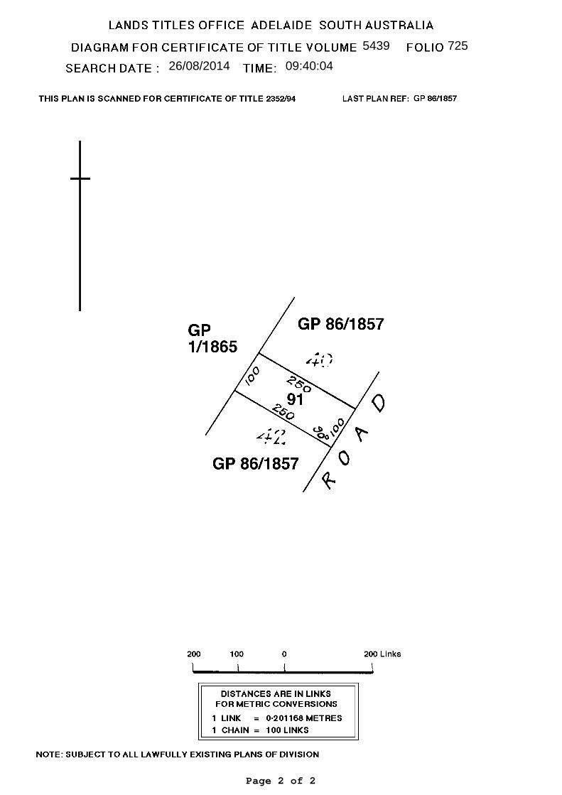
5439 725
26/08/2014 09:40:04
Page 2 of 2
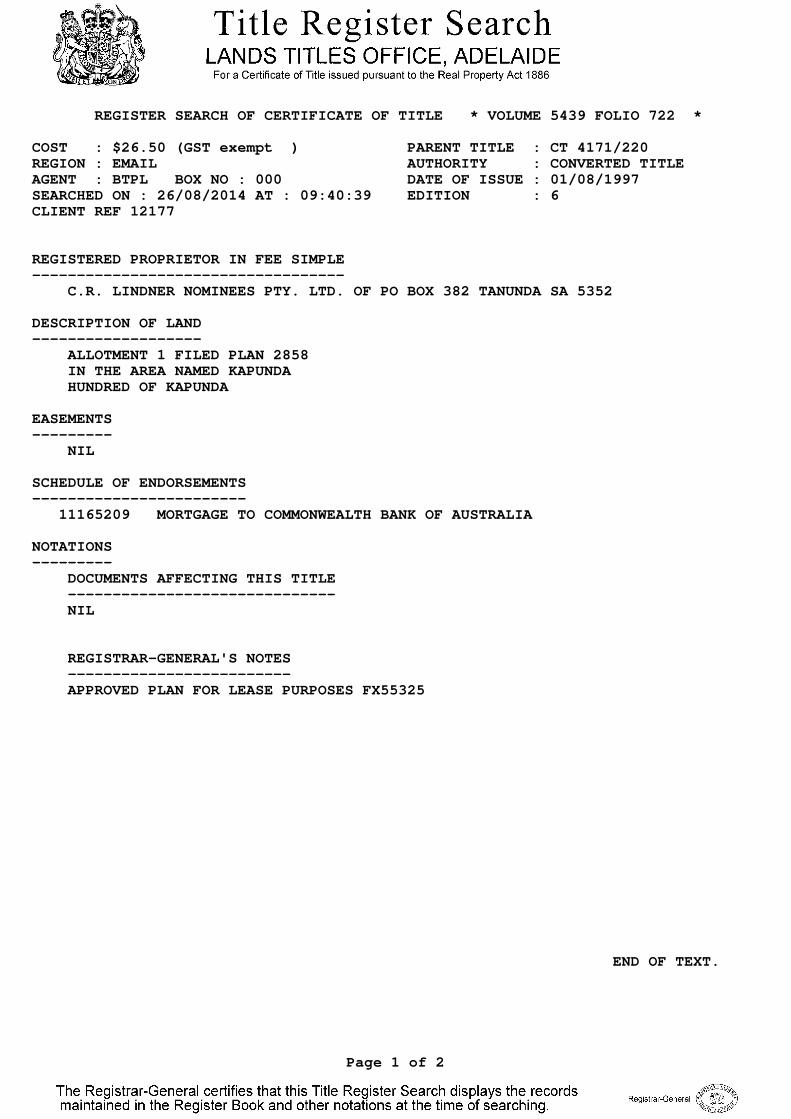
REGISTER SEARCH OF CERTIFICATE OF TITLE * VOLUME 5439 FOLIO 722 *
COST : $26.50 (GST exempt ) PARENT TITLE : CT 4171/220REGION : EMAIL AUTHORITY : CONVERTED TITLEAGENT : BTPL BOX NO : 000 DATE OF ISSUE : 01/08/1997SEARCHED ON : 26/08/2014 AT : 09:40:39 EDITION : 6CLIENT REF 12177
REGISTERED PROPRIETOR IN FEE SIMPLE----------------------------------- C.R. LINDNER NOMINEES PTY. LTD. OF PO BOX 382 TANUNDA SA 5352
DESCRIPTION OF LAND------------------- ALLOTMENT 1 FILED PLAN 2858 IN THE AREA NAMED KAPUNDA HUNDRED OF KAPUNDA
EASEMENTS--------- NIL
SCHEDULE OF ENDORSEMENTS------------------------ 11165209 MORTGAGE TO COMMONWEALTH BANK OF AUSTRALIA
NOTATIONS--------- DOCUMENTS AFFECTING THIS TITLE ------------------------------ NIL
REGISTRAR-GENERAL'S NOTES ------------------------- APPROVED PLAN FOR LEASE PURPOSES FX55325
END OF TEXT.
Page 1 of 2
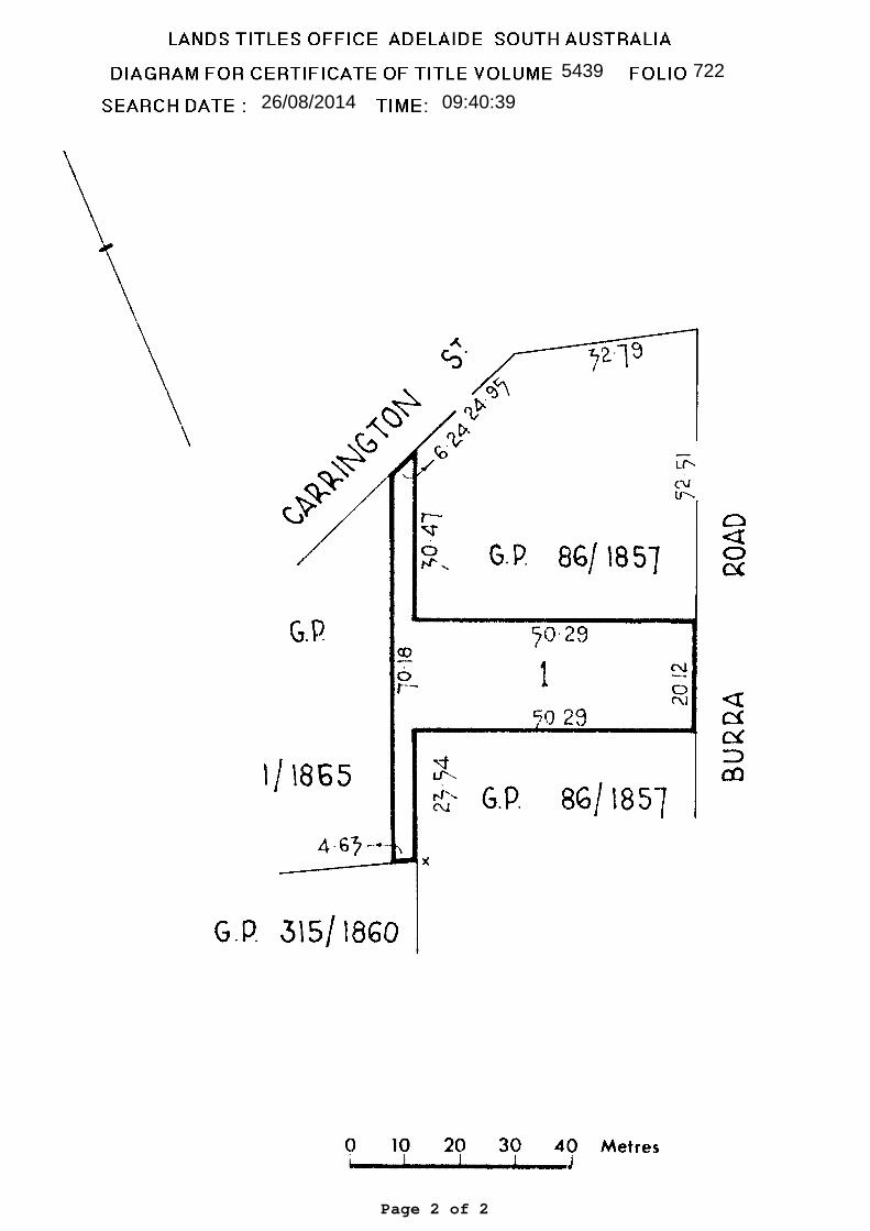
5439 722
26/08/2014 09:40:39
Page 2 of 2
10 September 2014
Dear Mr Carr
Re: Kapunda Supermarket Proposal
My company acts for CR Lindner Nominees Pty Ltd, the owner of the former JT Johnson and Sons site at the corner of Old Adelaide Road and Carrington Street, Kapunda.
On behalf of my client we have pleasure in enclosing an application for Development Plan Consent to develop a supermarket with associated off-street parking, loading and landscaping. The proposal is shown on the accompanying set of drawings prepared by DM Lawrence Design, and is described in further detail in our Planning Report. Appended to our Planning Report is the Stormwater Management Plan prepared by FMG Engineers and the Traffic Impact Assessment prepared by GTA Consultants.
We have concluded from our assessment of the proposal against the relevant provisions of the Development Plan that it is deserving of Development Plan Consent.
The proposal involves land which is the subject of a process under the Roads (Opening and Closing) Act 1999, namely the closure of a section of Old Adelaide Road and opening a small section of the site next to Carrington Street and declaring it a public road. Council resolved to commence the formal process under this legislation in April 2014, and again in August 2014. Given Council’s interest, the Development Assessment Commission (DAC) must be the relevant planning authority pursuant to Schedule 10 of the Development Regulations 2008.
It was agreed in earlier discussions with Mr Robert Kleeman and Mr Mark Adcock of the Development Assessment Commission that even though the DAC is the relevant authority, the application should be lodged with Council who in turn will forward it to the Commission. Messrs Kleeman and Adcock also requested Council to forward them a list of the names and addresses of adjoining land owners so that the DAC is able to commence the Category 2 notification process.
Mr Brian Carr Chief Executive Officer Light Regional Council PO Box 72 KAPUNDA SA 5373
12177LET04
We enclose:
• three copies of our Planning Report which has appended to it all relevant and related details;
• three full sets of plans of the proposed development prepared by DM Lawrence Design;
• a Development Application Form; and
• an Office of the Technical Regulator Form.
On receipt of a Tax Invoice, we will arrange for payment to be made so that the application can be processed including referral to DPTI and commencement of Category 2 notification.
As a matter of courtesy, we have forwarded a copy of this application to the Development Assessment Commission.
Please contact the writer if you have any queries or require any further information.
Yours sincerely
Graham Burns MasterPlan SA Pty Ltd enc: Documents as Listed. cc: CR Lindner Nominees – Carl Lindner/Michael Lange. Development Assessment Commission – Robert Kleeman/Mark Adcock.
12177LET04 2
PLANNING REPORT
Proposed Supermarket
AT: Lots 1, 91, 92, 101, 102 and 301 and adjacent road reserve (113 Old Adelaide Road/Main Street, Kapunda)
FOR: CR Lindner Nominees Pty Ltd
1.0 INTRODUCTION
This Planning Report has been prepared in relation to an application by CR Lindner Nominees Pty Ltd to develop a supermarket on the former J.T Johnson and Sons site at the corner of Carrington Street and Old Adelaide Road. The site also includes land which is the subject of a proposal by Light Regional Council under the Roads (Opening and Closing Act 1999.
The proposal is shown on drawings prepared by DM Lawrence Design. A Transport Impact Assessment has also been prepared by GTA Consultants (see Appendix A), and a Stormwater Management Plan has been prepared by FMG Engineers (see Appendix B).
2.0 THE SITE
2.1 General Description
The site comprises six contiguous allotments as well as road reserve which is the subject of a proposal under the Roads (Opening and Closing) Act 1999. The details of each parcel are as follows:
• Lot 102 in FP 206999 – 355 square metres;
• Lot 101 in FP 20699 – 963 square metres;
• Lot 92 in FP 206993 – 1,012 square metres;
• Lot 1 in FP 2858 – 1,339 square metres;
• Lot 91 in FP 206992 – 1012 square metres; and
• Lot 301 in DP 58789 – 887 square metres.
12177REP01 1
The combined area of these allotments is 5,568 square metres. Certificates of title are included at Appendix C.
That portion of the site which is road reserve and is proposed to be closed is the section of Old Adelaide Road at the point where it merges into Adelaide Road near Carrington Street. A disused weighbridge is located at the northern end of this road reserve. The road reserve to be closed covers approximately 1,623 square metres. In addition, approximately 83 square metres of Allotment 102 at the northern end of the site next to Carrington Street will be formally opened and vest in Council as road reserve, also pursuant to the Roads (Opening and Closing) Act 1999.
Total site area - comprising Allotments 1, 91, 92, 101, 102 and 301 together with the section of road to be closed - is 7,191 square metres.
Light Regional Council at its meeting held on 22 April 2014 resolved to formally commence processes under the Roads (Opening and Closing) Act 1999 to close portion of Old Adelaide Road and to open portion of Carrington Street, as detailed on the plan at Appendix D prepared by Mattsson and Martyn Surveyors. This decision was reaffirmed at a Council meeting held on 26 August 2014.
The Site and Locality Plan at Appendix E shows the site in relation to its immediate surroundings. While the NearMap aerial image used on the plan is the most recently available (October 2010) it is to be noted that the former JT Johnson and Sons buildings have been dismantled or demolished and removed from the site.
The site slopes downwards from north to south, as shown from the spot levels on Sheet WD04, where there is a high point of almost 246 metres RL at the Adelaide Road/Carrington Street corner, and a low point of approximately 240 metres RL in the south-western corner.
The site is devoid of vegetation except for a row of casuarina pine trees planted alongside the boundary between Allotments 301 and 91. Another tree of unknown variety is situated on Allotment 301 next to Old Adelaide Road.
2.2 Site History
The site has had a long history of commercial use, commencing in 1957 when JT Johnson and Sons relocated its chaff mill plant from Stockport. The business grew steadily over the next 20 years, culminating in the construction of an oat milling facility in 1962 for the domestic and export markets. Oat milling ceased in 1990. In 1976, the company built and commissioned a pellet production mill. In 1985, a high fibre pellet mill was set up.
In 1987, the company diversified operations and entered the export hay markets into Japan, South East Asia and the Middle East.
12177REP01 2
In 2008, JT Johnson and Sons built new headquarters and production facilities on the Old Kapunda Showgrounds site off Perry Road, Kapunda. At about that time, the site was sold to CR Lindner Nominees Pty Ltd. JT Johnson and Sons continued leasing the majority of the site back from CR Lindner Nominees until December 2012 when the plant was decommissioned and removed in early 2013.
As previously noted, CR Lindner demolished, dismantled and removed all of the structures from the Old Adelaide Road site in early 2014.
No fuel tanks either above or below ground have ever been placed on the site during the time it was occupied and used by JT Johnson and Sons. There is furthermore no evidence of residual pollution on or about the site.
The only remaining piece of infrastructure is the weighbridge in front of the site at the corner of Main Street and Carrington Street. The weighbridge became redundant following JT Johnson and Sons’ departure from the site. The position of the weighbridge is shown on Sheet WD04.
3.0 THE LOCALITY
The locality comprises a mix of commercial, residential and vacant land surrounding the site. This distribution of land uses is shown on the Site and Locality Plan at Appendix E.
The six allotments generally to the north-west of the site and with frontage to Harriet Street and Carrington Street are vacant. They are located in the Residential (Kapunda) Zone.
Immediately to the south-west of the site, with frontage to Old Adelaide Road, is a sandstone cottage on Allotment 115. The cottage is designated as a Contributory Item in the Development Plan. Further residential developments are situated next to Old Adelaide Road (two of which are also designated as Contributory Items in the Development Plan).
Not shown on the Site and Locality Plan but located to the south west of the site is a weighbridge and sampling station used by Viterra Limited at grain harvest time. The weighbridge is located on the road reserve of Old Adelaide Road. While there is no proposal at this time to relocate the weighbridge and sampling station, the applicant proposes to reconstruct Old Adelaide Road to facilitate access by grain trucks and other vehicles from Thiele Highway. The details of this element of the proposal are included with the application documents, and in particular at Appendix C of the Transport Impact Assessment prepared by GTA Consultants at Appendix A.
To the north east of the site, on the northern side of Carrington Street, is the Clare Castle Hotel and drive-through bottle shop. The hotel is listed as a Local Heritage Item. To the north of that is the Kapunda Police Station and then Light Regional Council’s Kapunda offices.
12177REP01 3
The opposite side of Main Street is occupied by a mixture of commercial and residential uses, and the Kapunda SES and CFS emergency services depot. Further south west on Main Street is a hardware and garden centre.
The north western side of Main Street is characterised by a row of pine trees and native vegetation.
Underground power has been laid along both sides of Main Street with new street lights installed along the western side of the road (including two light poles in front of the site).
The locality largely comprises the southern ‘gateway’ into Kapunda from Adelaide. It is therefore important that development visible from motorists on the Thiele Highway is appropriately designed and sited. This requirement is partly reflected in Zone Principle 9 which calls for development to be located and designed to retain existing vistas.
As noted, the site is wholly located in the Historic Conservation (Kapunda Town Centre) Zone, which is intended for a range of land uses, including retail development to serve residents in the town of Kapunda and visitors to Kapunda and the surrounding rural district (see Zone Objective 1).
The site is also located in Commercial Policy Area 12 of the zone, where commercial activities are intended to be the ‘main focus’ in the town (Objective 1) and where industrial uses are expected to relocate to the Industry Zone (Objective 3). An overall improvement in the appearance of the Policy Area is also encouraged by such means as landscaping and the inclusion of traditional building elements (Objective 2).
4.0 RETAIL DEMAND ANALYSIS
Pitney Bowes Business Insight were engaged by CR Lindner Nominees in June 2009 to conduct a preliminary assessment for a full line supermarket in the order of 2,500 square metres in Kapunda. While the report contains commercially sensitive information and cannot be included with the application, Pitney Bowes identified from its analysis that the primary catchment area of a supermarket of some 2,500 square metres would include all of Kapunda and the outlying rural district, extending as far north as Eudunda, with a secondary catchment extending north-west to Saddleworth and Riverton. The study identified that the population of the trade area in 2009 was in the order of 6,420 persons, with 4,480 of these living in the primary trade area. The study also identified that the main trade area population was likely to grow at around 1.5% to 2.3% per annum, to reach 8,120 persons by 2021, with most of this growth expected to be in and around Kapunda.
12177REP01 4
Socio-demographic data used to inform Pitney Bowes’ assessment was sourced from the 2006 Census of Population and Housing. Data reviewed from the 2011 Census largely reflects observations made by Pitney Bowes in 2009 that there has been steady population growth in and around Kapunda since 2006, albeit at a slightly lower rate than previously forecast, which is possibly due to the effects of the Global Financial Crisis in 2008.
Pitney Bowes also found that the Barossa Shopping Centre in Nuriootpa has the only full-line supermarket in the entire region, which is a centre anchored by a 4,000 square metre Foodland IGA supermarket. Pitney Bowes also identified that ‘smaller format’ stores in Kapunda, Eudunda, Riverton and Saddleworth “do not have the extensive offer of a full-line supermarket, and generally service only the immediate convenience needs of the local population.”
Pitney Bowes concluded from its investigations that “. . . the potential for the addition of a full scale supermarket [in Kapunda] warrants further consideration.”
5.0 THE PROPOSAL
5.1 General Description
It is proposed to construct a supermarket with an associated store room, staff amenities, office, off-street parking, loading and access driveways. The supermarket building will be wholly located on land owned by CR Lindner Nominees Pty Ltd. Some parking spaces and the access driveway at the front of the site will occupy adjacent road reserve which is the subject of a road closure process under the Roads (Opening and Closing) Act 1999. In addition, alterations will be made to Old Adelaide Road to provide for the safe and convenient manoeuvring of vehicles between Old Adelaide Road and Thiele Highway following closure of that section of the road.
The proposed supermarket is depicted on the set of drawings prepared by D M Lawrence Design at Appendix F. It will feature:
• a supermarket trading area of 1,932 square metres;
• a warehouse goods store of 719 square metres;
• a cool room, freezer and amenities of 73 square metres;
• a staff room and office at mezzanine level of 75 square metres; and
• off-street parking for 79 vehicles.
A dedicated loading bay will be located behind the supermarket, as will a semi-screened bin enclosure.
12177REP01 5
The proposed supermarket building will be located entirely on land owned by the applicant CR Lindner Nominees. Some of the parking spaces, associated driveways and landscaping will be located on road reserve which the Light Regional Council is in the process of closing and a small section of Allotment 102 adjacent to Carrington Street which will become road reserve, all pursuant to the Roads (Opening and Closing) Act 1999. The affected parcels of land are detailed on Mattsson and Martyn’s survey drawing (Appendix D).
5.2 Design and Siting Considerations
The building will be a single storey structure with a continuous finished floor level of 244.5 metres. The site’s fall from north to south is such that the building will be benched slightly into the northern end of the site near Carrington Street (with a floor to top of parapet height of 6.0 metres). At the opposite end, the warehouse goods store will be in the order of 7.0 metres high to top of parapet.
A posted verandah will surround the two street frontages of the supermarket to enhance building articulation and for pedestrian shelter.
A gabled entry facing Main Street will add further articulation and interest to the façade. A significant length of the supermarket façade facing Main Street will also be glazed to create an appropriate sense of activation, transparency and interest at pedestrian level.
The supermarket will be a stand-alone facility. As such, identification will be limited to a sign over the gable entrance, and a 6.0 metre pylon sign near the Main Street car park entrance.
A 2.1 metre high Colorbond fence will be built along the western and southern boundaries of the site, as detailed on the Landscape Plan Sheet WD04.
Substantial landscaping using species selected from Table Lig/4 of the Development Plan (Appropriate Indigenous Species for Landscaping) will be planted throughout the site, with particular emphasis on the Main Street frontage adjacent to Carrington Street and alongside the stone cottage (and Contributory Item) immediately to the south of the site.
5.3 Road Opening and Closure Process
Council has initiated a road closure and opening process under the Roads (Opening and Closure) Act 1999. That process formally commenced on 22 April 2014 when Council resolved to commence community consultation on the proposal to formally close approximately 1,623 square metres of Old Adelaide Road, and formally open approximately 83 square metres of Allotment 102 as public road next to Carrington Street.
12177REP01 6
These actions, regardless of the supermarket proposal, will deliver tangible benefits to the local community, including the elimination of an uncontrolled and dangerous traffic intersection created by the sharp confluence of Main Street/Old Adelaide Road/Carrington Street, and the ability to widen and realign Carrington Street near its junction with Main Street.
At its meeting held on 26 August 2014, Light Regional Council resolved to formally close the section of Old Adelaide Road previously known as Bethel Road and to commence a road process under the Roads (Opening and Closing) Act 1999.
While the outcome of the road process is not yet known, the supermarket building footprint is confined wholly to land owned by CR Lindner Nominees Pty Ltd, with only landscaping, driveways and parking spaces occupying land affected by the road opening and closure process.
5.4 Stormwater
FMG Engineering has prepared a Stormwater Management Plan for the development – see Appendix B. The Stormwater Management Plan provides for the underground detention and retention of stormwater, with trickle outflows from the detention system designed at a rate of 32 litres per second into the Harriett Street verge. Primary treatment of gross pollutants will be via a system of grated inlet pits. Stormwater from roof runoff will also be retained in above ground rainwater tanks with a storage capacity of not less than 22,500 litres, for reuse in the building’s toilets and for irrigation purposes.
5.5 Access, Traffic and Parking
GTA Consultants were asked to assess existing traffic and parking conditions around the site, to determine likely parking demand generated by the supermarket, the suitability of the proposed parking layout, traffic generation characteristics, proposed access arrangements and the development’s impact on the surrounding road network. Its Transport Impact Assessment is included as Appendix A.
GTA Consultants notes that the proposal will generate a statutory parking requirement for 140 spaces which it considers to be “high for typical parking demands” and that the provision of 79 parking spaces is suitable due to the site’s limited catchment area. GTA Consultants is furthermore satisfied that the proposed parking layout generally conforms with AS /NZ2890.1:2004 and AS/NZ2890.6:2009 for off street parking, and that the arrangements for goods loading and unloading is suitable with adequate manoeuvring areas for 19 metre articulated vehicles expected to service the site. GTA Consultants are also satisfied that there is adequate capacity in the surrounding road network to cater for traffic generated by the proposal, and that the proposed new access road between Old Adelaide Road and Thiele Highway is an appropriate alternative for grain trucks to access the sampling station and weighbridge in Old Adelaide Road towards Hancock Road.
12177REP01 7
6.0 ASSESSMENT
The relevant Development Plan for assessment purposes is the Light Regional Council Development Plan, consolidated version dated 24 January 2013.
6.1 Land Use Suitability
The proposal is located wholly within the Historic Conservation (Kapunda Town Centre) Zone, and in Policy Area 12 - Commercial of that zone. As previously noted, the zone and policy area is intended to be used for retail and commercial purposes respectively.
The use of the land as a supermarket is therefore a suitable form of development for the zone and the policy area.
Policy Area 12 Objective 2 also encourages the relocation of industrial uses to the Industry Zone. The site’s former and longstanding use by JT Johnson and Sons for grain milling and hay baling is one such industrial use which has recently relocated to the nearby Industry Zone in accordance with Objective 3. The replacement of that former industrial use with a retail development is therefore consistent with the underlying strategic intent of Policy Area Objective 2.
6.2 Appearance
Zone Objective 4 encourages development to conserve and complement the historic character of the respective zone’s policy areas. No part of the site is (or indeed was) historically significant, and all of the buildings previously used by JT Johnson and Sons have been dismantled and/or demolished. The new building has been designed to complement its surroundings, and to enhance the town’s gateway entrance by incorporating posted verandahs and glazing to both street frontages, a series of pitched hipped roofs for the warehouse component, and siting the building in line with adjacent buildings namely the Clare Castle Hotel and stone cottage (one listed as a Contributory Item and the other a Local Heritage Item in the Development Plan). Generous amounts of landscaping using species selected from Table Lig/2 of the Development Plan will also be planted next to both road frontages and alongside the stone cottage in order to enhance the site’s gateway location and to maintain and enhance residential amenity.
The supermarket’s siting and its low profile will:
• retain existing vistas within and outside the zone (Zone Principle 9);
• feature 45° roof pitches, posted verandahs and appropriately designed parapets and an entrance gable (Zone Principle 12);
• include a long verandah attached to the facades facing Main Street and Carrington Street (Zone Principle 11); and
12177REP01 8
• include Colorbond sheeting on the visible rooflines (Zone Principle 13).
The proposal’s design is also consistent with Policy Area 12’s Desired Future Character statement which requires business activities to contribute to the overall heritage character by adopting:
• consistent setbacks in order to “create a strong building line”;
• roof pitches of not less than 20 degrees;
• the use of Colorbond roof cladding for all visible roof sections in preference to galvanised corrugated iron, and coloured grey to complement the colours of other roof sheeting in the locality (and consistent with the materials selection in Zone Principle 13); and
• informal landscaping using species existing in the area, selected from Table Lig/2 of the Development Plan.
The building (and site) abuts the Residential (Kapunda) Zone to the north-west, but the allotments in this zone adjacent to the site are vacant (and owned by the applicant CR Lindner Nominees). Nevertheless it is proposed to install a 2.1 metre high Colorbond fence along the boundary shared with the Residential (Kapunda) Zone to minimise the supermarket building’s visual impact when viewed from this direction.
6.3 Advertising Signs
Zone Principle 8 calls for advertising signs to be positioned and designed to complement the building, not protrude onto the street, not obscure the building and be below the verandah fascia. As previously noted, two advertising signs are proposed, one affixed to the entry gable and the other a 6.0 metre high pylon sign at the Main Street driveway entrance. As the building is new and will be occupied by a single retail operator, there will not be a need for multiple signs but the building does require adequate exposure to passing motorists travelling in both direction along Main Street.
The pylon sign will be internally illuminated. It will be located near Main Street, but set well back from Carrington Street so as not to obscure driver sight lines or views of attractive landscapes or trees (Council-wide Principle 218). The pylon sign will also be of a height and scale that is compatible with the proposed building without contributing to visual clutter or visual disorder (Council-wide Principles 215, 216, 217).
12177REP01 9
6.4 Vehicle Access, Parking and Loading
GTA Consultants has conducted an independent assessment of the proposal and its findings are documented in Appendix A. GTA has concluded from its investigations that the proposal is provided with safe and convenient access for customer, employee and service delivery vehicles, that appropriate provision has been made for the parking of customer and employee vehicles, that the new driveway entrance to Thiele Highway/Main Street is safe and convenient, that the new access road between Old Adelaide Road and Thiele Highway will improve traffic circulation particularly for grain trucks approaching the sampling station and weigh bridge in Old Adelaide Road, and that appropriate provision has been made for goods loading and unloading.
Based on GTA’s findings and conclusions, it can be concluded that the proposal is either consistent or not in conflict with:
• Council-wide Principles 28, 29, 30, 31, 32, 33, 34 and 40 (Transport and Planning);
• Zone Principles 2, 3, 4, 5, and 6; and
• Policy Area Principle 5.
6.5 Stormwater Management
The majority of the site has until recently been covered in sealed surfaces (buildings, concrete and bitumen) with no provision made for the capture, detention or retention of stormwater. The proposal will feature substantial areas of landscaping for stormwater soakage, with additional provision to detain, retain and reuse stormwater in accordance with the Stormwater Management Plan prepared by FMG Engineers at Appendix B.
FMG’s Stormwater Management Plan will ensure that the proposal is either consistent or not in conflict with Council-wide Principles 328, 330, 331, 332, 333, 334, 336, 337 and 338 (Stormwater Management).
7.0 CONCLUSIONS
It is concluded that the proposal by CR Lindner Nominees Pty Ltd to development a supermarket at Lots 1, 91, 92, 101, 102 and 301 and on adjacent road reserve (113 Old Adelaide Road, Main Street and Carrington Street) exhibits substantial planning merit and is deserving of Development Plan Consent. In particular the proposal:
• makes effective and efficient use of vacant land previously used for industrial and commercial purposes;
12177REP01 10
• is an appropriate kind of development for the zone and policy area, having regard to the relevant objectives and principles of development control and the site’s prominent location at Kapunda’s southern gateway entrance;
• will have a supermarket floor area consistent with the 2009 findings of Pitney Bowes Business Insight;
• is well designed and sited having regard to the site’s prominent position and proximity to the nearby Contributory Place and Local Heritage Place;
• is provided with appropriate off-street parking for employees and customers;
• will be provided with safe and convenient access to Old Adelaide Road, Main Street and Carrington Street;
• is provided with conveniently accessible facilities for the loading and unloading of goods and materials;
• is appropriately screened and separated for residential areas and the nearby Residential Zone;
• represents an orderly kind of development that will satisfy the community’s need for day to day shopping services and facilities in a location that can be accessed in a safe and convenient manner;
• will be appropriately landscaped using a selection of native trees, shrubs and ground covers;
• incorporates the full range of WSUD stormwater management techniques to ensure appropriate detention, retention, treatment and reuse of stormwater; and
• will facilitate the consolidated development of a strategic site for appropriate purposes in Kapunda township.
For all of these reasons, the proposal is, in our opinion, deserving of Development Plan Consent.
Graham Burns FPIA CPP B/A in Planning
10 September 2014
12177REP01 11
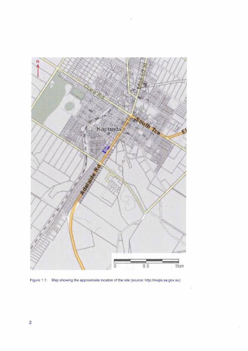
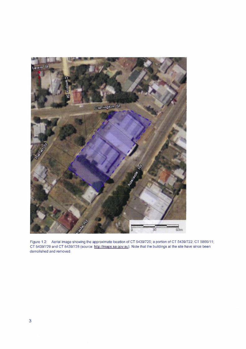
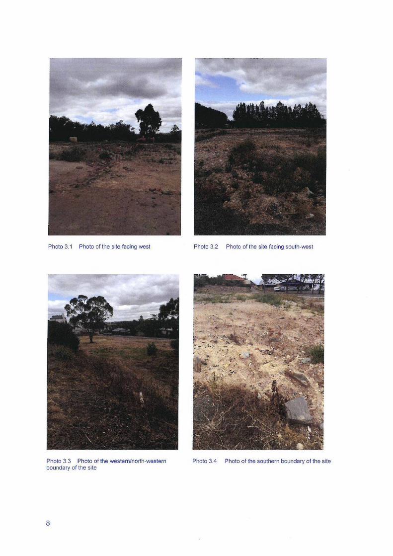
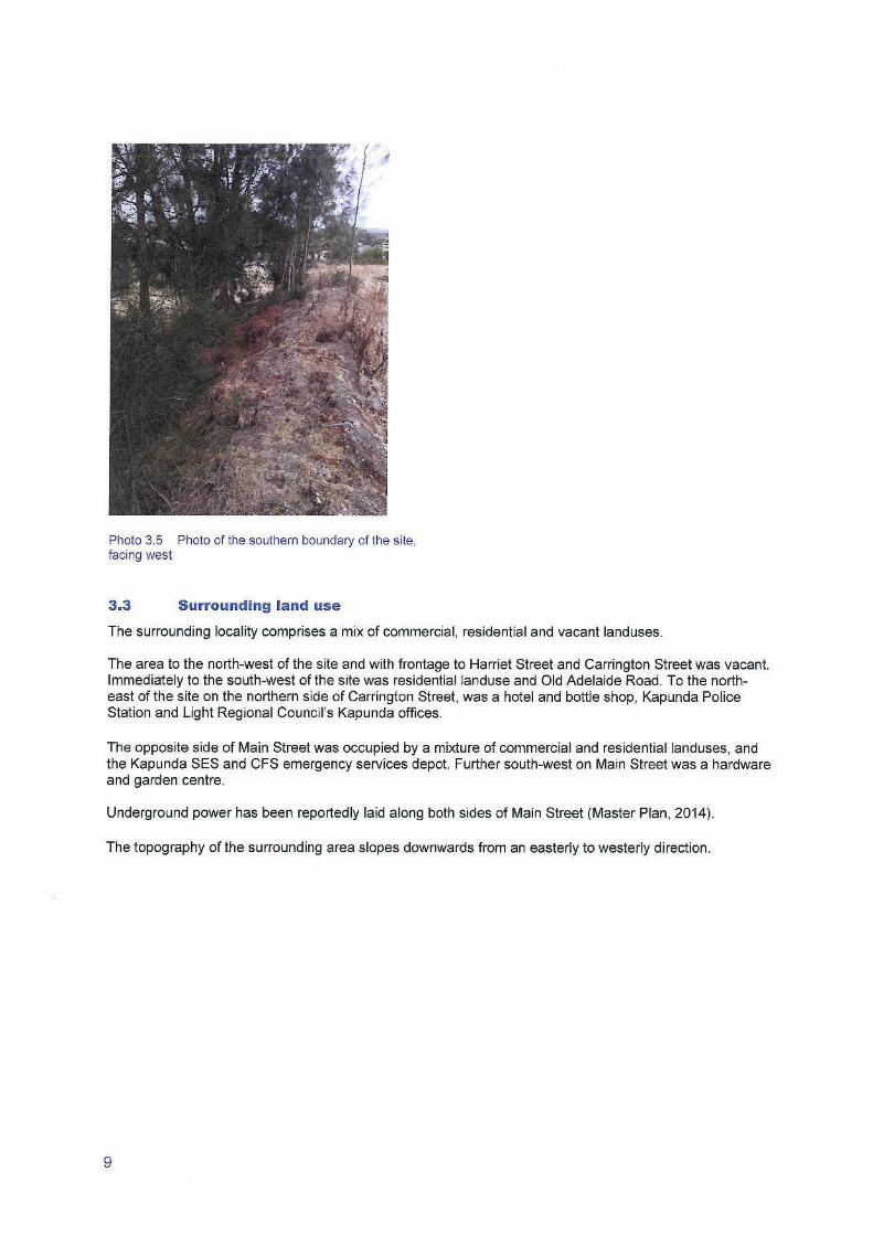


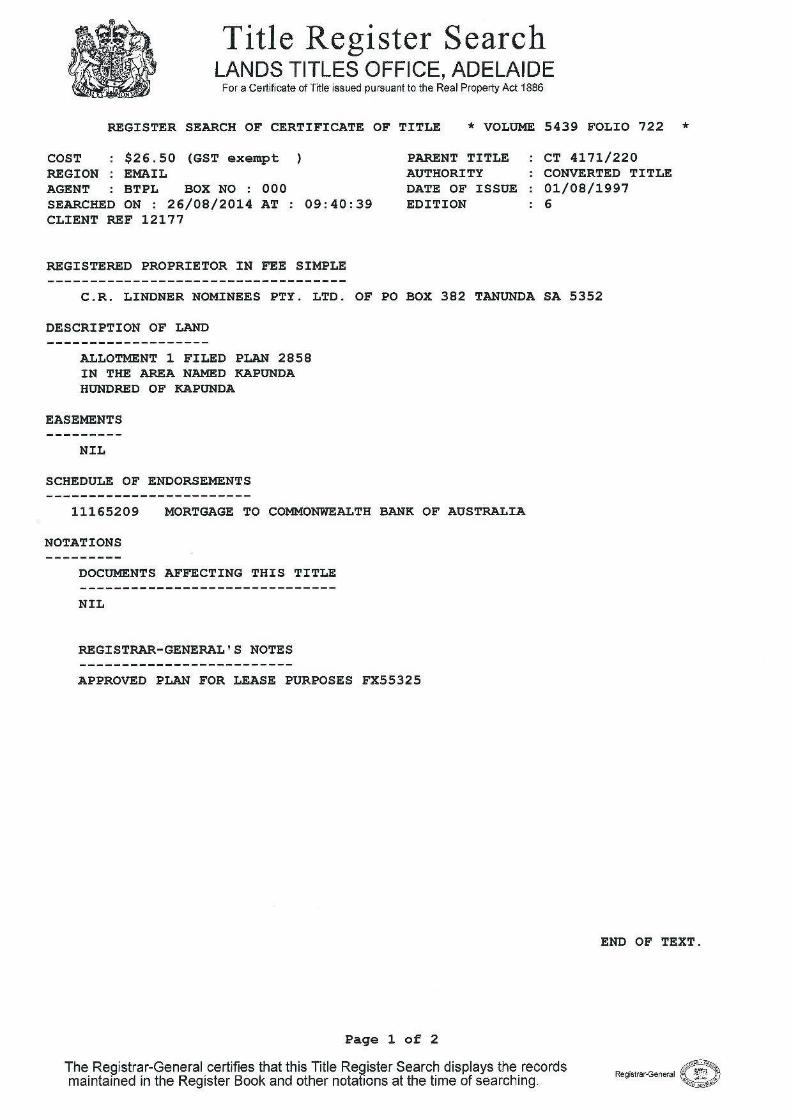
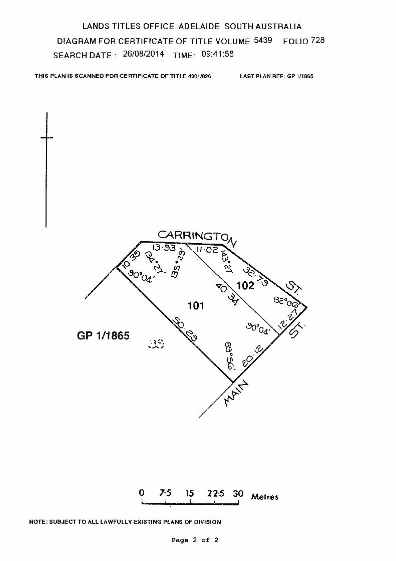
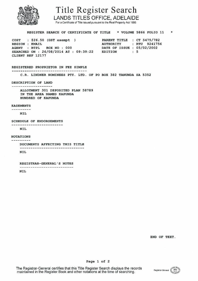
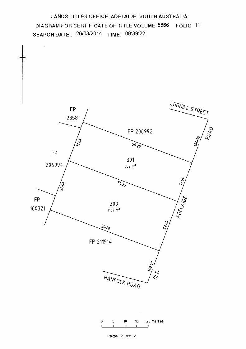
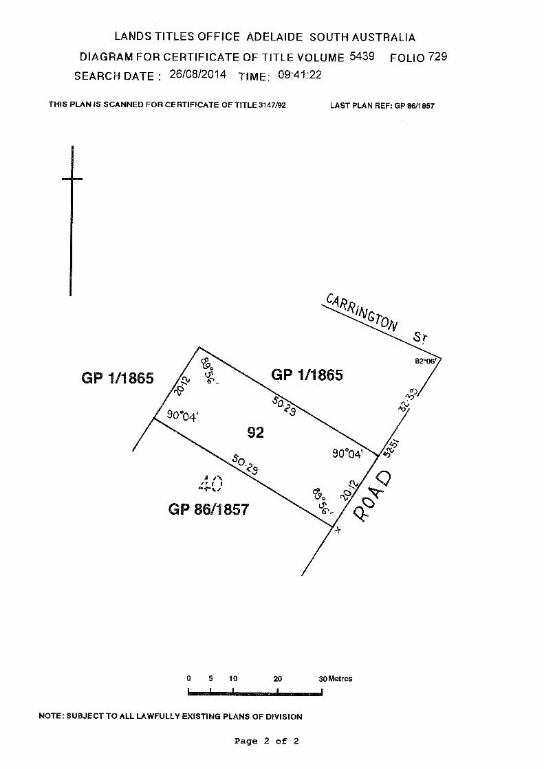
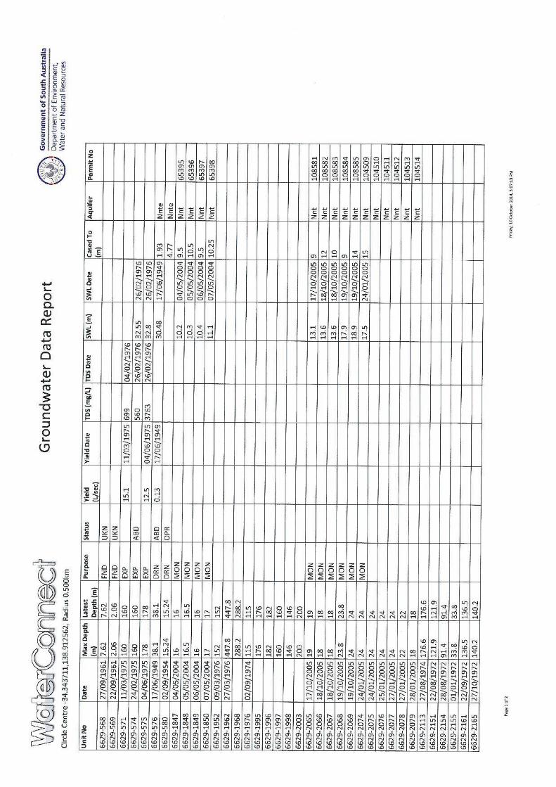
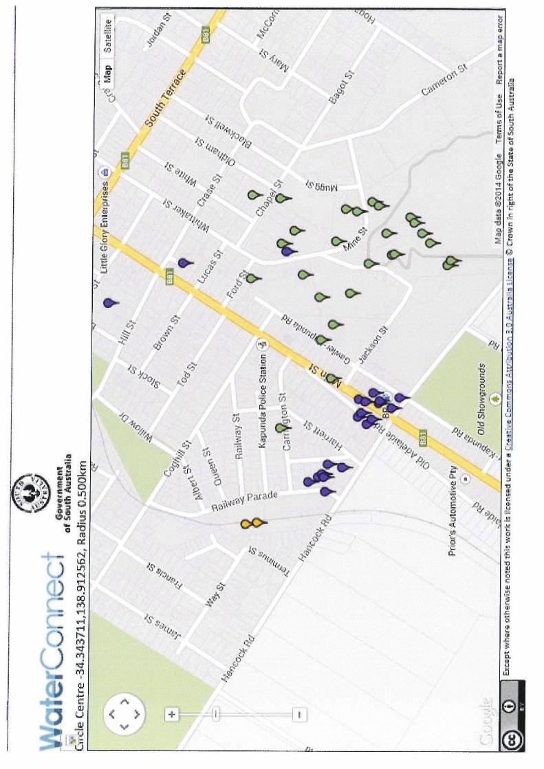

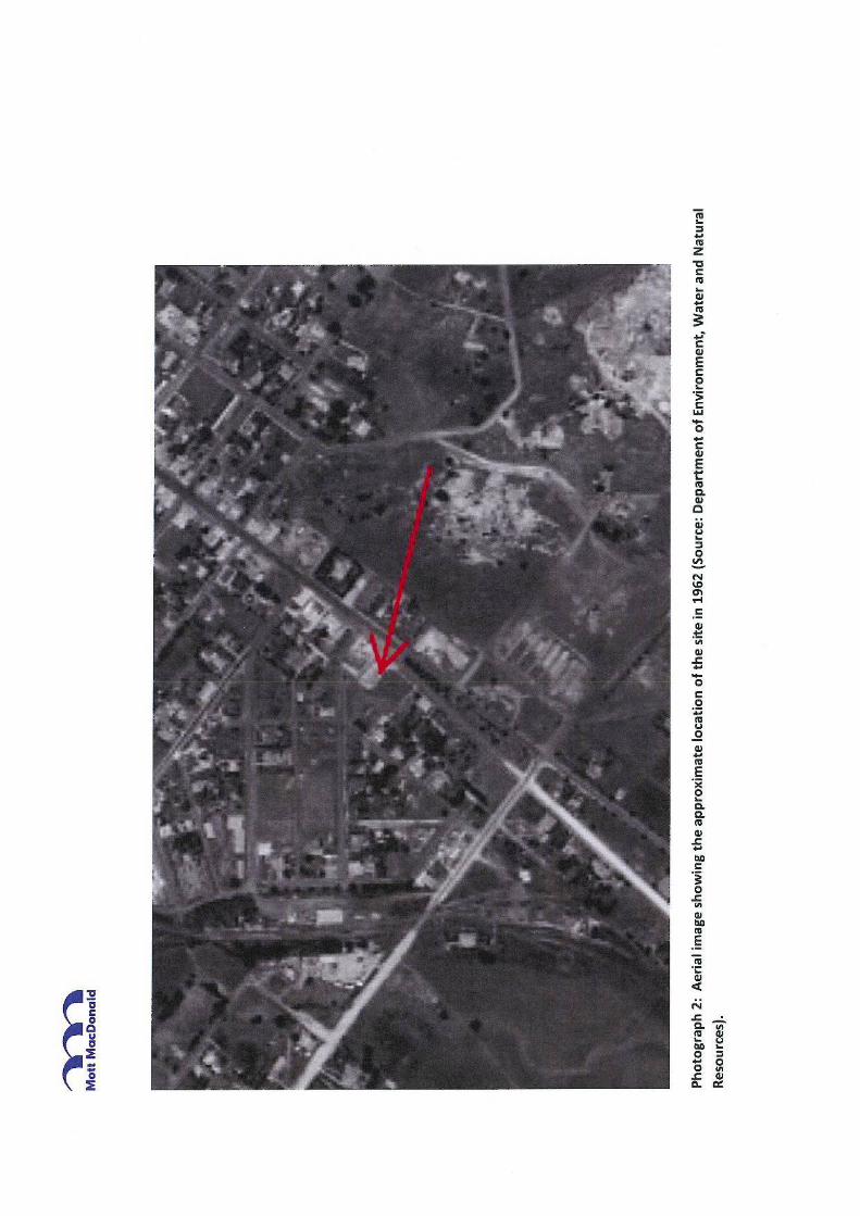
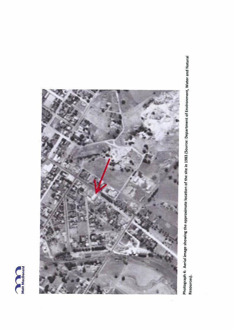
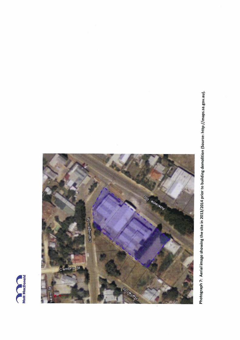


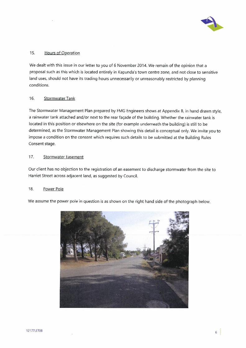
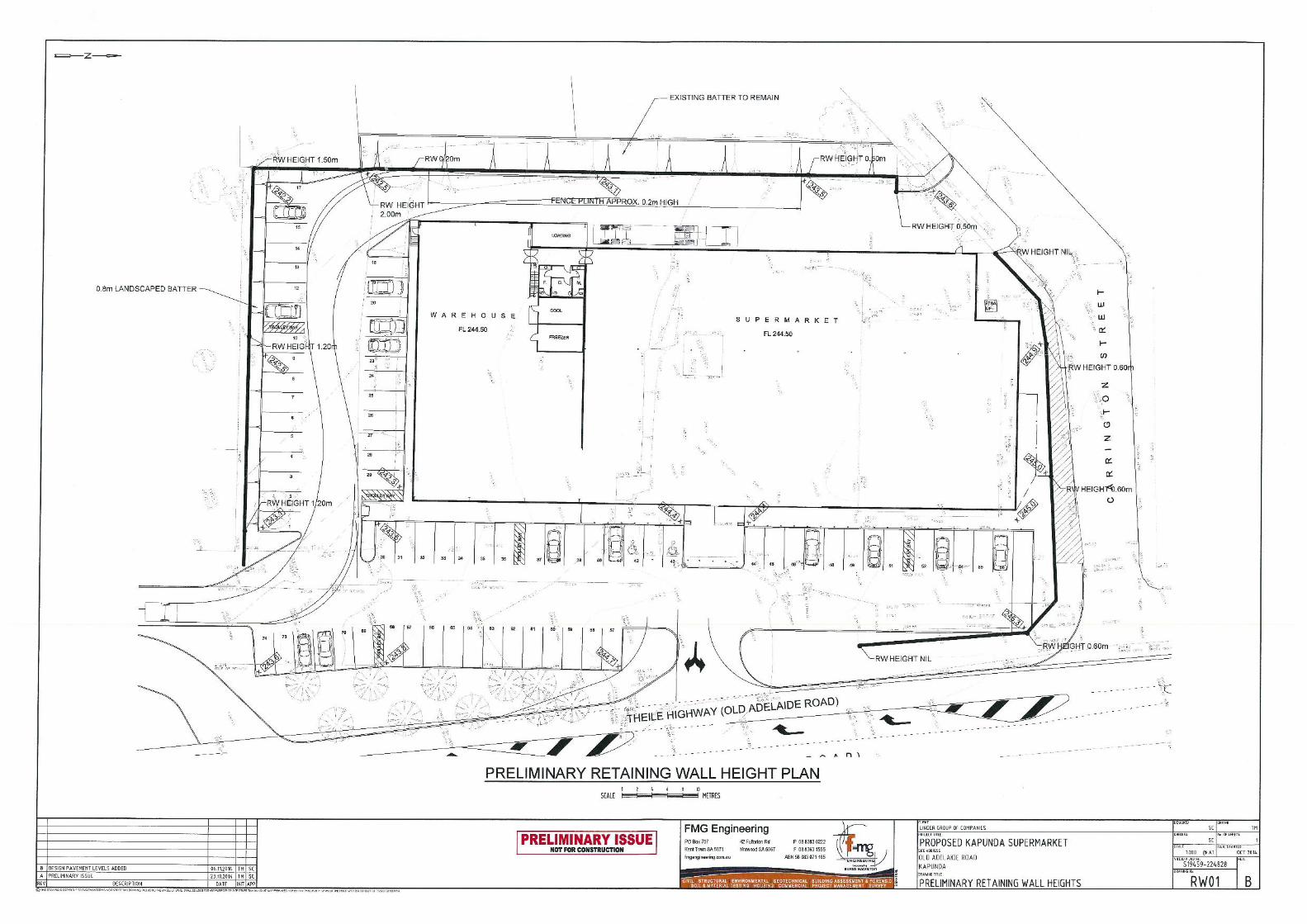
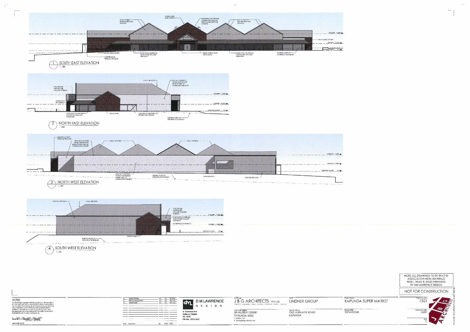
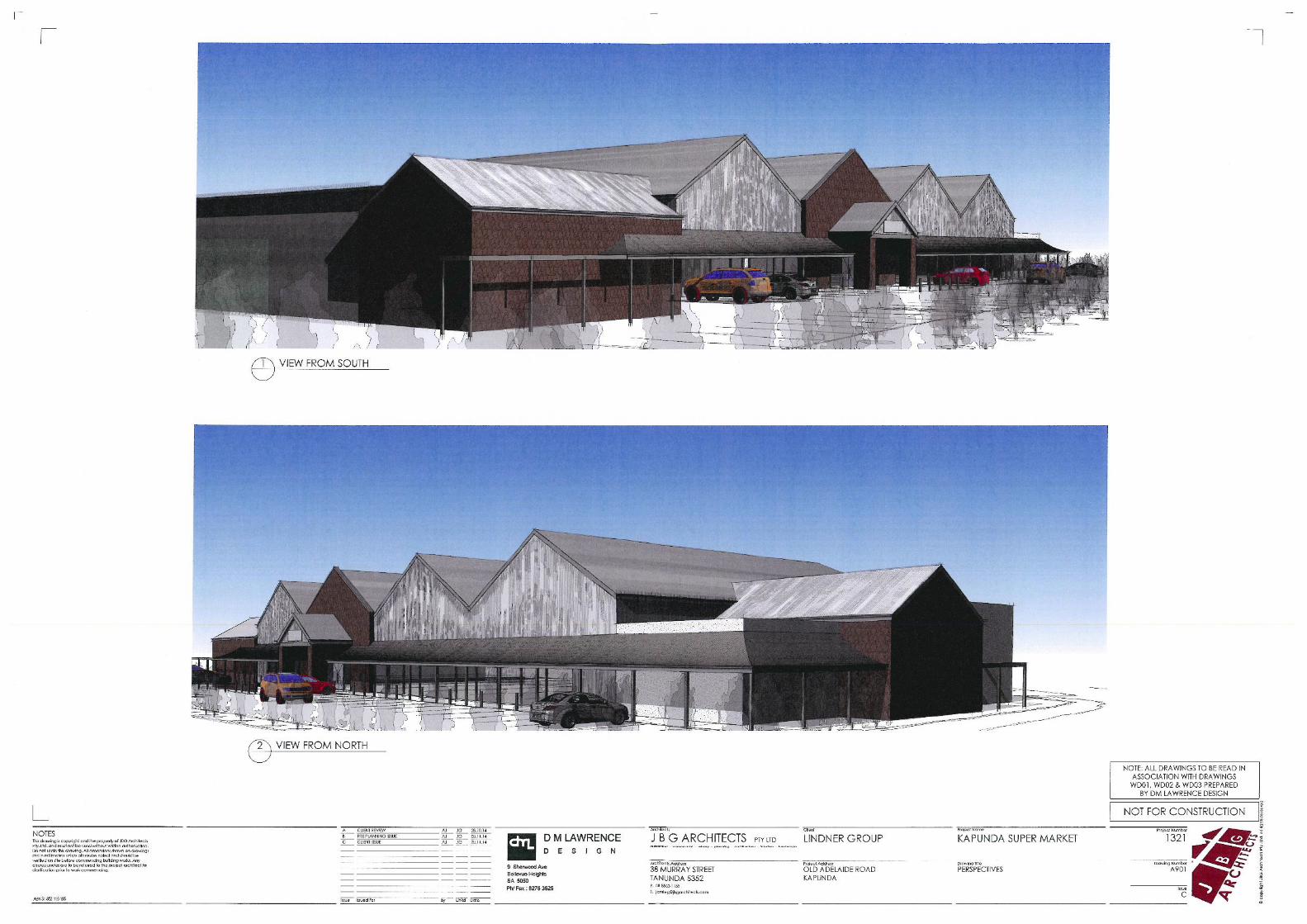
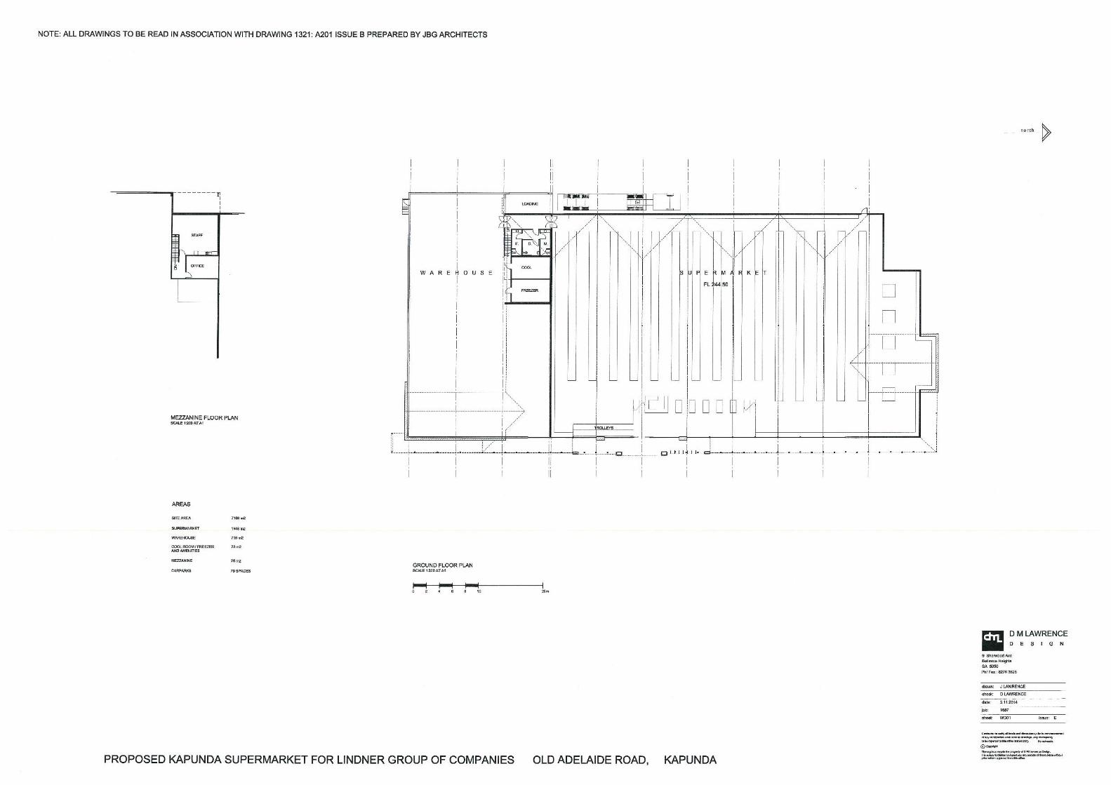
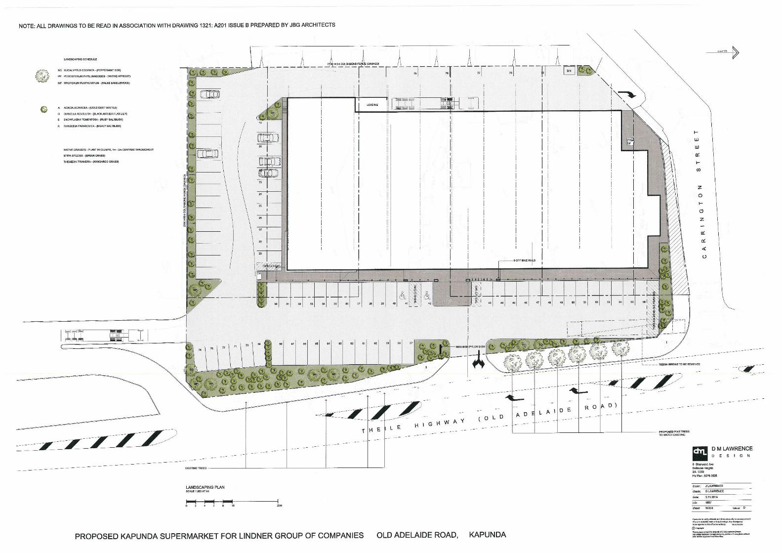

APPENDIX A Transport Impact Assessment – GTA Consultants
12177REP01 12

Proposed Supermarket
Thiele Highway
Kapunda
Transport Impact Assessment
© GTA Consultants (GTA Consultants (SA) Pty Ltd) 2014
The information contained in this document is confidential and
intended solely for the use of the client for the purpose for which it has
been prepared and no representation is made or is to be implied as
being made to any third party. Use or copying of this document in
whole or in part without the written permission of GTA Consultants
constitutes an infringement of copyright. The intellectual property
contained in this document remains the property of GTA Consultants.
TIA
Re
po
rt –
SA
(13
09
13 v
1.5
)
Proposed Supermarket
Thiele Highway, Kapunda
Transport Impact Assessment
Issue: A 08/09/14
Client: CR Linder Nominees Pty Ltd
Reference: 15A1025000
GTA Consultants Office: SA
Quality Record
Issue Date Description Prepared By Checked By Approved By Signed
A 08/09/14 Final Sam Adams Paul Morris Paul Morris
Table of Contents
15A1025000 08/09/14
Proposed Supermarket, Thiele Highway, Kapunda Issue: A-Dr
Transport Impact Assessment
Table of Contents
1. Introduction 1
1.1 Background 1
1.2 Purpose of this Report 1
1.3 Referenced Documents 1
2. Existing Conditions 2
2.1 Subject Site 2
2.2 Road Network 2
2.3 Sustainable Transport Infrastructure 4
3. Development Proposal 5
3.1 Land Uses 5
3.2 Car Parking 5
3.3 Vehicle Access 5
3.4 Pedestrian Facilities 5
3.5 Loading Areas 5
4. Car Parking 6
4.1 Statutory Car Parking Requirements 6
4.2 Empirical Assessment 6
4.3 Adequacy of Parking Supply 7
4.4 Car Parking Layout 7
5. Sustainable Transport Infrastructure 8
5.1 Bicycle End of Trip Facilities 8
6. Loading Facilities 9
6.1 Statutory Requirements 9
6.2 Proposed Loading Arrangements 9
7. Traffic Impact Assessment 10
7.1 Traffic Generation 10
7.2 Traffic Impact 12
8. Old Adelaide Road 14
9. Conclusion 15
Appendices
A: Swept Path Diagrams for 19.0m Semi-Trailer
B: SIDRA INTERSECTION Results
C: Proposed Access
Table of Contents
15A1025000 08/09/14
Proposed Supermarket, Thiele Highway, Kapunda Issue: A-Dr
Transport Impact Assessment
Figures
Figure 2.1: Subject Site and its Environs 2
Figure 7.1: Estimated Directional Distribution 11
Figure 7.2: Estimated Peak Hour Site Generated Traffic Volumes 12
Tables
Table 2.2: Accident History (2009-2013) 4
Table 4.1: Statutory Car Parking Assessment 6
Table 4.2: Empirical Parking Assessment 6
Table 7.1: RTA Guide Traffic Generation Estimates 10
Introduction
15A1025000 08/09/14
Proposed Supermarket, Thiele Highway, Kapunda Issue: A
Transport Impact Assessment Page: 1
1. Introduction
1.1 Background
A development application is currently being sought for a proposed supermarket on land
located at the corner of Carrington Street and Thiele Highway/Main Street.
GTA Consultants was commissioned by CR Lindner Nominees Pty Ltd in August 2014 to undertake
a transport impact assessment of the proposed development.
1.2 Purpose of this Report
This report sets out an assessment of the anticipated parking, traffic and transport implications of
the proposed development, including consideration of the:
i existing traffic and parking conditions surrounding the site;
ii parking demand likely to be generated by the proposed development;
iii suitability of the proposed parking in terms of supply (quantum) and layout;
iv traffic generation characteristics of the proposed development;
v proposed access arrangements for the site;
vi transport impact of the development proposal on the surrounding road network.
1.3 Referenced Documents
In preparing this report, reference has been made to a number of background documents,
including:
Light Regional Council Development Plan (consolidated 24 January 2013);
Australian Standard/ New Zealand Standard, Parking Facilities, Part 1: Off-Street Car
Parking AS/NZS 2890.1:2004;
Australian Standard, Parking Facilities, Part 2: Off-Street Commercial Vehicle Facilities
AS 2890.2:2002;
Australian Standard / New Zealand Standard, Parking Facilities, Part 6: Off-Street Parking
for People with Disabilities AS/NZS 2890.6:2009;
plans for the proposed development prepared by DM Lawrence Design dated 23 July
2014;
traffic and car parking surveys undertaken by GTA Consultants as referenced in the
context of this report;
various technical data as referenced in this report;
an inspection of the site and its surrounds;
other documents as nominated.
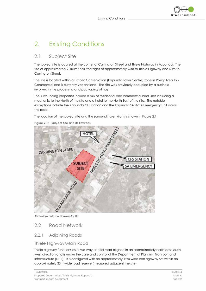
Existing Conditions
15A1025000 08/09/14
Proposed Supermarket, Thiele Highway, Kapunda Issue: A
Transport Impact Assessment Page: 2
2. Existing Conditions
2.1 Subject Site
The subject site is located at the corner of Carrington Street and Thiele Highway in Kapunda. The
site of approximately 7,100m2 has frontages of approximately 95m to Thiele Highway and 50m to
Carrington Street.
The site is located within a Historic Conservation (Kapunda Town Centre) zone in Policy Area 12 -
Commercial and is currently vacant land. The site was previously occupied by a business
involved in the processing and packaging of hay.
The surrounding properties include a mix of residential and commercial land uses including a
mechanic to the North of the site and a hotel to the North East of the site. The notable
exceptions include the Kapunda CFS station and the Kapunda SA State Emergency Unit across
the road.
The location of the subject site and the surrounding environs is shown in Figure 2.1.
Figure 2.1: Subject Site and its Environs
(PhotoMap courtesy of NearMap Pty Ltd)
2.2 Road Network
2.2.1 Adjoining Roads
Thiele Highway/Main Road
Thiele Highway functions as a two-way arterial road aligned in an approximately north-east south-
west direction and is under the care and control of the Department of Planning Transport and
Infrastructure (DPTI). It is configured with an approximately 12m wide carriageway set within an
approximately 33m wide road reserve (measured adjacent the site).
Existing Conditions
15A1025000 08/09/14
Proposed Supermarket, Thiele Highway, Kapunda Issue: A
Transport Impact Assessment Page: 3
Kerbside parking is permitted adjacent the site.
Thiele Highway carries approximately 4,400 vehicles per day adjacent to the subject site1 and has
a posted speed limit of 60km/h.
Carrington Street
Carrington Street functions as a two-way local access road aligned in an approximate east -west
direction. It is configured with an approximately 8m wide carriageway set within an
approximately 12m wide road reserve (measured adjacent the site).
Kerbside parking is permitted adjacent the site.
No traffic data has been obtained for Carrington Street however it is estimated that traffic
volumes would be less than 500 vehicles per day. Carrington Street is subject to the default built
up area speed limit of 50km/h.
Old Adelaide Road
Old Adelaide Road functions as a service road adjacent and parallel to the Thiele Highway. It is
configured with an approximately 11m wide carriageway set within an approximately 33m wide
road reserve (measured adjacent the site) including the Thiele Highway.
Old Adelaide Road provides access to an existing weighbridge to the south of the site, near to
Hancock Road.
Kerbside parking is permitted adjacent the site.
No traffic data has been obtained for Old Adelaide Road however it is estimated that traffic
volumes adjacent to the subject site would be less than 500 vehicles per day. Old Adelaide
Road is subject to the default built up area speed limit of 50km/h.
2.2.2 Surrounding Intersections
The following intersections currently exist in the vicinity of the site:
Old Adelaide Road/Thiele Highway (to be closed as part of the proposed
development);
Carrington Street/Thiele Highway (unsignalised).
2.2.3 Accident Statistics
A review of the reported accident history for the roads and intersections adjoining the subject site
has been sourced from DPTI.
A summary of the accidents for the last available five year period (2009-2013) is presented in
Table 2.1.
Table 2.1: Accident History (2009-2013)
Location Accident No.
Fatality Serious Injury Other Injury Property Damage Only
Carrington Street / Thiele
Highway 0 0 3 0
Source: DPTI
1 Based on the Department of Planning, Transport and Infrastructure’s AADT Estimates dated 11 August 2014
Existing Conditions
15A1025000 08/09/14
Proposed Supermarket, Thiele Highway, Kapunda Issue: A
Transport Impact Assessment Page: 4
Table 2.1 indicates that the intersections adjoining the site are generally operating safely with one
casualty crash reported in 2009 at the intersection of Carrington Street and Thiele Highway
resulting in three casualties.
2.3 Sustainable Transport Infrastructure
2.3.1 Public Transport
No metro ticket public transport services operate past the site except for daily bus services
between Gawler and Kapunda provided by private bus company LinkSA2.
2.3.2 Pedestrian Infrastructure
Compacted rubble pedestrian paths are provided on the North-West side of Old Adelaide Road,
the North-East side of Thiele Highway and on both sides of Carrington Street. The unconstructed
nature of the pathways could render them unusable during periods of inclement weather. The
paths do not appear to be DDA compliant at many locations.
2.3.3 Cycle Infrastructure
No dedicated on-street bicycle lanes are provided in the vicinity of the site.
2 (http://www.adelaidemetro.com.au/bussa/regions/local_list2.html)
Development Proposal
15A1025000 08/09/14
Proposed Supermarket, Thiele Highway, Kapunda Issue: A
Transport Impact Assessment Page: 5
3. Development Proposal
3.1 Land Uses
The proposed development includes the construction of a shopping centre with associated
warehouse, storage, office space and car parking. The proposed development comprises the
following:
Supermarket of 2,075sq.m GLFA;
Warehouse and storage area of 639sq.m GLFA;
Mezzanine level of staff room / office of 75sq.m GLFA;
A loading dock at the rear of the site;
79 ground level car parking spaces;
Access points to Old Adelaide Road, Thiele Highway and Carrington Street.
3.2 Car Parking
80 car parking spaces are proposed, including 2 disabled spaces and an associated shared
space.
3.3 Vehicle Access
Three access points are proposed as follows:
A two-way (entry and exit) access point located along Thiele Highway;
A one-way (exit only) access point located along Carrington Street;
A one-way (entry only) access point for loading and commercial vehicles only located
along Old Adelaide Road.
3.4 Pedestrian Facilities
The proposed development will provide suitable pedestrian connections from the car park to the
shopping centre entrance.
3.5 Loading Areas
A loading area is proposed along the north western edge of the site, with trucks accessing the
site from Old Adelaide Road and exiting the site in a forward direction towards Main Street, via
Carrington Street.
Car Parking
15A1025000 08/09/14
Proposed Supermarket, Thiele Highway, Kapunda Issue: A
Transport Impact Assessment Page: 6
4. Car Parking
4.1 Statutory Car Parking Requirements
Statutory requirements for the provision of car parking are set out in Table Lig/6 within the Light
Regional Council Development Plan. The parking rate applicable to the proposed development
is as follows:
Shop (excluding a restaurant or retail plant nursery): 1 space per 20sq.m total floor area
An assessment of the statutory car parking requirements is set out in Table 4.1.
Table 4.1: Statutory Car Parking Assessment
Description Size (sq.m) Statutory Parking Rate Statutory Parking
Requirement
Supermarket / Shop 2,789 1 space per 20sq.m 140 spaces
Total 140 spaces
Table 4.1 anticipates the proposed development has a statutory requirement of 140 spaces. GTA
considers the above car parking requirement of 5 spaces per 100sq.m for a regional supermarket
to be high and has considered empirical data to determine a more appropriate parking rate for
the proposed supermarket use.
4.2 Empirical Assessment
4.2.1 GTA Database
Traffic surveys conducted by GTA Consultants on a number of regional shopping centres across
Australia suggest a lower parking rate than that suggested by the Development Plan due to the
limited catchment of these areas restricting the number of trips that can be made.
Table 4.2 summarises the typical peak parking requirements for supermarkets and shopping
centres at other regional towns across Australia.
Table 4.2: Empirical Parking Assessment
Description Size (sq.m) Parking Rate
Centro Port Pirie (Thursday PM) 10,928 2.0 spaces per 100sq.m
ALDI Morwell (Saturday) 1,424 2.74 spaces per 100sq.m
ALDI Sunbury (Friday PM) 1,274 2.75 spaces per 100sq.m
Barossa Regional Shopping Centre(Thursday PM) 10,585 3.1 spaces per 100sq.m
Based on the above, the proposed development is likely to generate a low range parking
requirement of 2 spaces per 100sq.m and a high range parking requirement of 3 spaces per
100sq.m.
Applying an average parking rate from the above sites of 2.65 car parking spaces per 100sq.m,
the proposed development could be expected to generate a demand for 74 car parking
spaces.
Car Parking
15A1025000 08/09/14
Proposed Supermarket, Thiele Highway, Kapunda Issue: A
Transport Impact Assessment Page: 7
4.3 Adequacy of Parking Supply
The proposed development will provide 79 off-street car parking spaces for staff and visitors,
including 2 disability parking spaces. This equates to a parking supply of 2.8 spaces per 100sq.m
of Gross Leasable Floor Area (GLFA) which exceeds the identified parking rates from other
regional locations.
It could not be expected based on the population of Kapunda (of some 3,100 people) and
adjacent regional areas (Light Regional Council population some 14,000 people) that the same
parking demands would be realised as metropolitan locations.
The surveys of regional locations confirmed that parking rates are lower in smaller regional towns.
Based on the discussion above, and given the limited size of the supermarket catchment area
the proposed car parking provision is considered appropriate to cater for peak shopping
demands in the town.
4.4 Car Parking Layout
The proposed parking layout generally complies with the requirements set forth in AS/NZS
2890.1:2004. Some of the key design features are described below:
90 degree angled parking spaces that are 2.6m wide and 5.4m long, set within an aisle
with a minimum width of 6.6m, which meets the minimum requirements as per the
AS/NZS2890.1:2004 for a user class 3A parking facility;
90 degree angle parking bays for small vehicles that are 2.3m wide and 5.0m long
which meets the minimum requirements as per the AS/NZS2890.1:2004;
A vehicle turnaround area has been provided at the end of the blind aisle in the south-
east corner of the car park in accordance with AS/NZS2890.1:2004;
Pedestrian sight lines have been accommodated at the driveway entrances in
accordance with AS/NZS2890.1:2004.
It is noted that the access from Old Adelaide Road will operate as a one-way ingress only access
for commercial vehicles and the access to Carrington Street will operate as a one-way exit only
access. It is recommended that suitable signage i.e. No Entry signs be installed to control vehicle
movements at these locations.
Sustainable Transport Infrastructure
15A1025000 08/09/14
Proposed Supermarket, Thiele Highway, Kapunda Issue: A
Transport Impact Assessment Page: 8
5. Sustainable Transport Infrastructure
5.1 Bicycle End of Trip Facilities
There is no statutory requirement to provide bicycle facilities at the proposed development.
However it is good practice to provide some bicycle storage facilities to encourage cycling to
the development. 6 bicycle parking spaces will be provided near to the entrance to the
supermarket for use by staff and/or visitors.
Loading Facilities
15A1025000 08/09/14
Proposed Supermarket, Thiele Highway, Kapunda Issue: A
Transport Impact Assessment Page: 9
6. Loading Facilities
6.1 Statutory Requirements
The statutory requirement for the inclusion of loading facilities is set out in Principle of
Development Control (PDC) ‘Centres and Shops’ in the Light Regional Council Development
Plan. PDC 105 States:
Shop development and development in centres should meet the following criteria:
(d) make adequate and convenient provision for service vehicles and the storage and removal
of waste goods and materials;
The development plan has no additional loading facility requirements for a Historic Conservation
(Kapunda Town Centre) zone.
6.2 Proposed Loading Arrangements
A loading area for the supermarket is proposed to be located along the north-western side of the
building.
Access into the loading area will occur via Old Adelaide Road and an internal circulation
roadway through the car park. Bollards or some other form of physical barrier will restrict access
from Old Adelaide Road outside of loading times. It is understood that building management will
coordinate the removal and reinstatement of the barrier during loading times. Sufficient
manoeuvring area has been provided for a 19.0m long semi-trailer to travel through the site,
reverse into the loading area and exit in a forward motion.
Loading will typically occur outside of peak shopping hours to minimise conflict between trucks
and cars. Notwithstanding this, the loading area has been separated from the main car park
area with only 6 parallel car parking spaces located near to the loading area. It is anticipated
that these spaces will generally be utilised by staff as all day parking spaces.
Swept path diagrams showing a 19.0 m semi-trailer entering and existing the site are shown in
Appendix A.
Traffic Impact Assessment
15A1025000 08/09/14
Proposed Supermarket, Thiele Highway, Kapunda Issue: A
Transport Impact Assessment Page: 10
7. Traffic Impact Assessment
7.1 Traffic Generation
7.1.1 Design Rates
Traffic generation estimates for proposed developments are often sourced from the NSW RMS
(formerly RTA) Guide to Traffic Generating Developments. However the rates contained within
the Guide are typically applicable to larger shopping centres in metropolitan areas with little
data specifically related to smaller scale regional supermarket developments.
The traffic generation rates from the RMS Guide that would be most applicable to the proposed
development are as follows:
Shopping Centres
Weekday Peak Hour Generation Rate (GLFA<10,000sq.m) 12.3 trips per 100sq.m GLFA
Daily Generation Rate (GLFA<10,000sq.m) 121 trips per 100sq.m GLFA
Based on the rates above, estimates of peak hour and daily traffic volumes resulting from the
proposal are set out in Table 7.1.
Table 7.1: RTA Guide Traffic Generation Estimates
GLFA (sq.m) Rate Movements
Peak Hour 2,789 12.3 trips per 100sq.m GLFA 343 mvmts/hour
Daily 2,789 121 trips per 100sq.m GLFA 3,375 mvmts/day
Table 7.1 indicates that the site could potentially generate 343 vehicle movements in a peak hour
with 3,375 vehicle movements over the entire day. GTA considers these estimates to be high
given the regional location however these figures have been used for the assessment and
represent a worst case scenario.
7.1.2 Distribution and Assignment
The directional distribution and assignment of traffic generated by the proposed development
will be influenced by a number of factors, including the:
i configuration of the arterial road network in the immediate vicinity of the site;
ii existing operation of intersections providing access between the local and arterial road
network;
iii distribution of households in the vicinity of the site;
iv likely distribution of employee’s residences in relation to the site;
v configuration of access points to the site.
Having consideration to the above, for the purposes of estimating vehicle movements, the
inbound and outbound directional distributions shown in Figure 7.1 have been assumed.
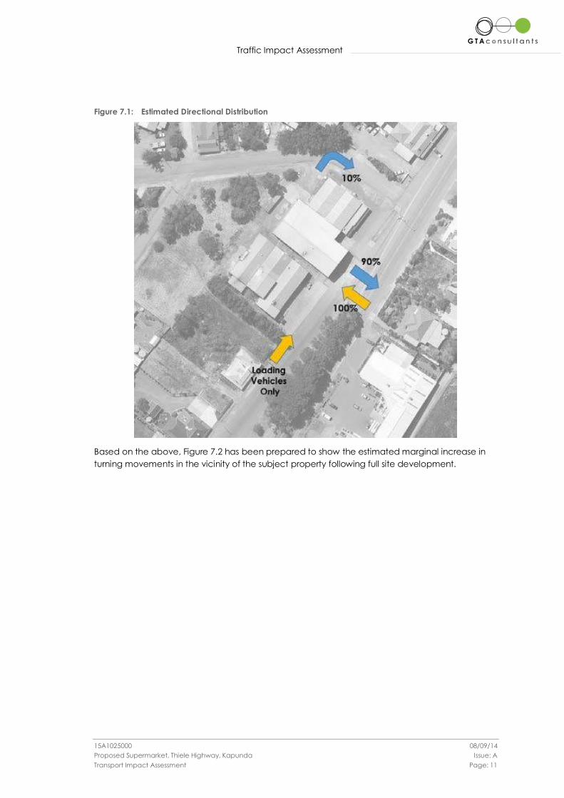
Traffic Impact Assessment
15A1025000 08/09/14
Proposed Supermarket, Thiele Highway, Kapunda Issue: A
Transport Impact Assessment Page: 11
Figure 7.1: Estimated Directional Distribution
Based on the above, Figure 7.2 has been prepared to show the estimated marginal increase in
turning movements in the vicinity of the subject property following full site development.
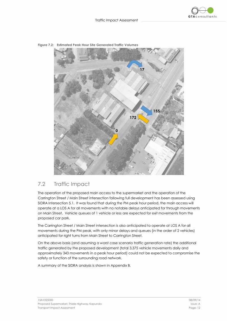
Traffic Impact Assessment
15A1025000 08/09/14
Proposed Supermarket, Thiele Highway, Kapunda Issue: A
Transport Impact Assessment Page: 12
Figure 7.2: Estimated Peak Hour Site Generated Traffic Volumes
7.2 Traffic Impact
The operation of the proposed main access to the supermarket and the operation of the
Carrington Street / Main Street intersection following full development has been assessed using
SIDRA Intersection 5.1. It was found that during the PM peak hour period, the main access will
operate at a LOS A for all movements with no notable delays anticipated for through movements
on Main Street. Vehicle queues of 1 vehicle or less are expected for exit movements from the
proposed car park.
The Carrington Street / Main Street intersection is also anticipated to operate at LOS A for all
movements during the PM peak, with only minor delays and queues (in the order of 2 vehicles)
anticipated for right turns from Main Street to Carrington Street.
On the above basis (and assuming a worst case scenario traffic generation rate) the additional
traffic generated by the proposed development (total 3,375 vehicle movements daily and
approximately 343 movements in a peak hour period) could not be expected to compromise the
safety or function of the surrounding road network.
A summary of the SIDRA analysis is shown in Appendix B.
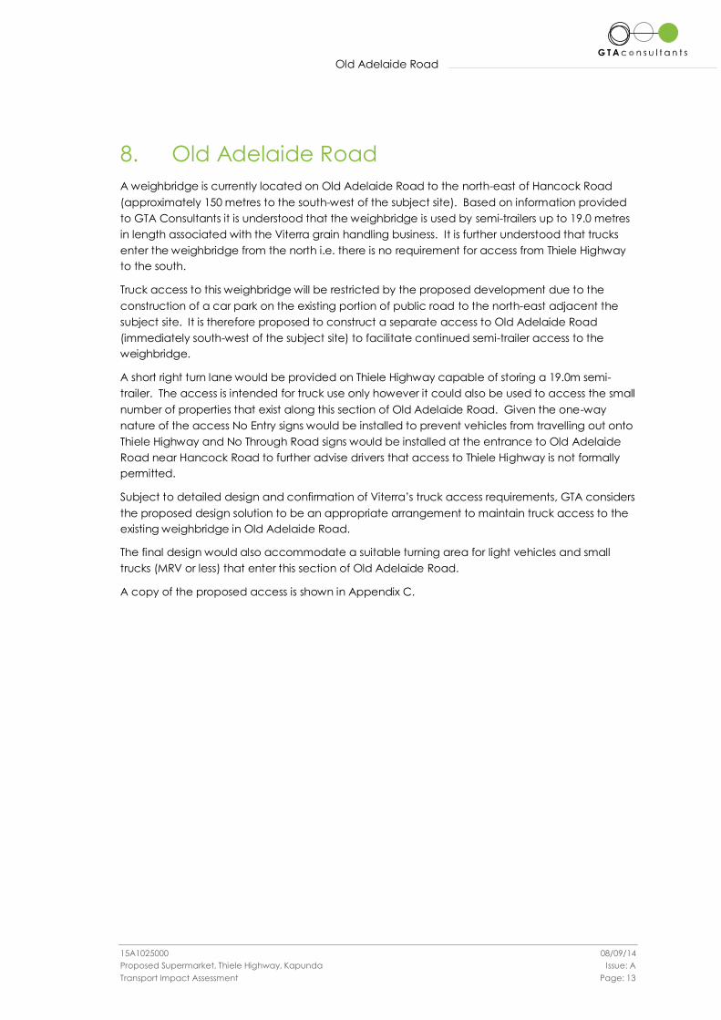
Old Adelaide Road
15A1025000 08/09/14
Proposed Supermarket, Thiele Highway, Kapunda Issue: A
Transport Impact Assessment Page: 13
8. Old Adelaide Road
A weighbridge is currently located on Old Adelaide Road to the north-east of Hancock Road
(approximately 150 metres to the south-west of the subject site). Based on information provided
to GTA Consultants it is understood that the weighbridge is used by semi-trailers up to 19.0 metres
in length associated with the Viterra grain handling business. It is further understood that trucks
enter the weighbridge from the north i.e. there is no requirement for access from Thiele Highway
to the south.
Truck access to this weighbridge will be restricted by the proposed development due to the
construction of a car park on the existing portion of public road to the north-east adjacent the
subject site. It is therefore proposed to construct a separate access to Old Adelaide Road
(immediately south-west of the subject site) to facilitate continued semi-trailer access to the
weighbridge.
A short right turn lane would be provided on Thiele Highway capable of storing a 19.0m semi-
trailer. The access is intended for truck use only however it could also be used to access the small
number of properties that exist along this section of Old Adelaide Road. Given the one-way
nature of the access No Entry signs would be installed to prevent vehicles from travelling out onto
Thiele Highway and No Through Road signs would be installed at the entrance to Old Adelaide
Road near Hancock Road to further advise drivers that access to Thiele Highway is not formally
permitted.
Subject to detailed design and confirmation of Viterra’s truck access requirements, GTA considers
the proposed design solution to be an appropriate arrangement to maintain truck access to the
existing weighbridge in Old Adelaide Road.
The final design would also accommodate a suitable turning area for light vehicles and small
trucks (MRV or less) that enter this section of Old Adelaide Road.
A copy of the proposed access is shown in Appendix C.
Conclusion
15A1025000 08/09/14
Proposed Supermarket, Thiele Highway, Kapunda Issue: A
Transport Impact Assessment Page: 14
9. Conclusion
Based on the analysis and discussions presented within this report, the following conclusions are
made:
i The proposed development generates a statutory parking requirement of 140 spaces
which is considered high for typical parking demands;
ii The proposed supply of 79 spaces is considered suitable given the limited catchment
area near to the site;
iii The proposed parking layout is consistent with the dimensional requirements as set out
in the Australian/New Zealand Standards for Off Street Car Parking (AS/NZS2890.1:2004
and AS/NZS2890.6:2009);
iv The provision of loading is considered suitable with adequate manoeuvring areas
provided for 19.0m semi-trailers to enter and exit the site in a forward motion;
v The assessment has found the proposed access points and adjacent intersection will
operate with minimal queues and delays;
vi There is adequate capacity in the surrounding road network to cater for the traffic
generated by the proposed development;
vii Subject to detailed design and confirmation of Viterra’s truck access requirements the
proposed new access from Thiele Highway/Main Street is considered an appropriate
alternative to maintain truck access to the existing weighbridge in Old Adelaide Road.
Appendix A
15A1025000 08/09/14 Proposed Supermarket, Thiele Highway, Kapunda Issue: A Transport Impact Assessment
Appendix A
Appendix A
Swept Path Diagrams for 19.0m Semi-Trailer
T H E I L E
H I G H W
A Y ( O
L D A D E
L A I D E
R O A D )
REMOVABLE BOLLARDS
TROLLEY BAY
TR
OLLE
Y B
AY
TR
OLLE
Y B
AY
TU
RNIN
G Z
ON
E (
NO P
AR
KIN
G)
SH
AR
ED Z
ON
E
S U P E R M A R K E TW A R E H O U S E
UP
T/F
ETSA
PROPOSED KAPUNDA SUPERMARKET FOR LINDNER GROUP OF COMPANIES OLD ADELAIDE ROAD, KAPUNDA
SCALE 1:200 AT A1
SITE SETOUT PLAN
0 2 4 6 8 10 20m
3030
22040
12005400800054002040
5800
5400
5000
2000
44200
C A R R I N G T O N S T R E E T
17
16
15
14
13
12
11
10
9
8
7
6
5
4
3
2
1
18
19
20
21
22
23
24
25
26
27
28
29
30 31 32 33 34 35 36 37 38 39 40 41 42 43 44 45 46 47 48 49 50 51 52 53 54 55 56
61 60 59 58 57
75 76 77 78 79
6970
7172
7374
62636465666768
5400
7200
5400
2700
34600
79300
S ARTICULATED 19MAUSTROADS 2006 (AU)
S ARTICULATED 19MAUSTROADS 2006 (AU)
(c) 2014 Transoft Solutions, Inc. All rights reserved.
S ARTICULATED 19MAUSTROADS 2006 (AU)
(c) 2014 Transoft Solutions, Inc. All rights reserved.
PL
OT
TE
D
BY :richard.frim
pong
ON
25/08/2014
AT
10:3
2:3
1 A
M
GTA onsultantsc
www.gta.com.au
PRELIMINARY PLAN
WITHOUT NOTIFICATION
ONLY SUBJECT TO CHANGE
FOR DISCUSSION PURPOSES
OLD ADELAIDE ROAD, KAPUNDA
KAPUNDA SUPERMARKET
SWEPT PATH ASSESSMENT (19m SEMI ENTERING)
15A1025000-AT01-01P1
SCALE 1:500 @ A3
25 AUGUST ’14
13.70
1.60 5.30
4.20
0.20
1.40 9.50
Articulating Angle
Lock to Lock Time
:2.50Trailer Width Steering Angle
Tractor Track
Trailer Track
:2.50
2.50:
Tractor Width
S ARTICULATED 19M
2.50:
metres
27.7:
70.0:
6.0:
SWEPT PATH KEY
ASSUMED SPEED 5km/h
FROM VEHICLE BODY600mm CLEARANCE
VEHICLE BODY PATH
VEHICLE TYRE PATH
VEHICLE CENTRE LINE
T H E I L E
H I G H W
A Y ( O
L D A D E
L A I D E
R O A D )
REMOVABLE BOLLARDS
TROLLEY BAY
TR
OLLE
Y B
AY
TR
OLLE
Y B
AY
TU
RNIN
G Z
ON
E (
NO P
AR
KIN
G)
SH
AR
ED Z
ON
E
n o r t h
S U P E R M A R K E TW A R E H O U S E
UP
T/F
ETSA
PROPOSED KAPUNDA SUPERMARKET FOR LINDNER GROUP OF COMPANIES OLD ADELAIDE ROAD, KAPUNDA
SCALE 1:200 AT A1
SITE SETOUT PLAN
0 2 4 6 8 10 20m
3030
22040
120054008000540020405800
5400
5000
2000
44200
C A R R I N G T O N S T R E E T
17
16
15
14
13
12
11
10
9
8
7
6
5
4
3
2
1
18
19
20
21
22
23
24
25
26
27
28
29
30 31 32 33 34 35 36 37 38 39 40 41 42 43 44 45 46 47 48 49 50 51 52 53 54 55 56
61 60 59 58 57
75 76 77 78 79
6970
7172
7374
62636465666768
5400
7200
5400
2700
34600
79300
S ARTICULATED 19M
AUSTROADS 2006 (AU)
(c) 2014 Trans
oft Solutions, In
c. All rights re
served.
S ARTICULATED 19MAUSTROADS 2006 (AU)
(c) 2014 Transoft Solutions, Inc. All rights reserved.
S ARTICULATED 19M
AUSTROADS 2006 (AU)(c) 2014 Tr
ansoft Solutions, Inc.
All rights reserved.
S ARTICULATED 19MAUSTROADS 2006 (AU)
(c) 2014 Transoft Solutions, Inc. All rights reserved.
B85
STA
ND
AR
DS (A
U)
(c) 2014 Transoft Solutions, Inc. All rights reserved.
B85
STANDARDS (AU)(c) 2014 Tra
nsoft Solutions, Inc. All r
ights reserved.
PL
OT
TE
D
BY :richard.frim
pong
ON
25/08/2014
AT
10:3
3:3
8
AM
GTA onsultantsc
www.gta.com.au
PRELIMINARY PLAN
WITHOUT NOTIFICATION
ONLY SUBJECT TO CHANGE
FOR DISCUSSION PURPOSES
13.70
1.60 5.30
4.20
0.20
1.40 9.50
Articulating Angle
Lock to Lock Time
:2.50Trailer Width Steering Angle
Tractor Track
Trailer Track
:2.50
2.50:
Tractor Width
S ARTICULATED 19M
2.50:
metres
27.7:
70.0:
6.0:
SWEPT PATH KEY
ASSUMED SPEED 5km/h
15A1025000-AT01-02P1
SCALE 1:500 @ A3
25 MONTH ’14
OLD ADELAIDE ROAD, KAPUNDA
KAPUNDA SUPERMARKET
SWEPT PATH ASSESSMENT (19m SEMI EXIT)
VEHICLE BODYCLEARANCE FROM
VEHICLE BODY PATH
VEHICLE TYRE PATH
VEHICLE CENTRE LINE
:
:
:
metres
6.0
1.77
1.87
2.800.92
34.0:
Lock to Lock Time
Width
Track
B85
Steering Angle
4.91
T H E I L E
H I G H W
A Y ( O
L D A D E
L A I D E
R O A D )
REMOVABLE BOLLARDS
TROLLEY BAY
TR
OLLE
Y B
AY
TR
OLLE
Y B
AY
TU
RNIN
G Z
ON
E (
NO P
AR
KIN
G)
SH
AR
ED Z
ON
E
n o r t h
S U P E R M A R K E TW A R E H O U S E
UP
T/F
ETSA
PROPOSED KAPUNDA SUPERMARKET FOR LINDNER GROUP OF COMPANIES OLD ADELAIDE ROAD, KAPUNDA
SCALE 1:200 AT A1
SITE SETOUT PLAN
0 2 4 6 8 10 20m
3030
22040
120054008000540020405800
5400
5000
2000
44200
C A R R I N G T O N S T R E E T
17
16
15
14
13
12
11
10
9
8
7
6
5
4
3
2
1
18
19
20
21
22
23
24
25
26
27
28
29
30 31 32 33 34 35 36 37 38 39 40 41 42 43 44 45 46 47 48 49 50 51 52 53 54 55 56
61 60 59 58 57
75 76 77 78 79
6970
7172
7374
62636465666768
5400
7200
5400
2700
34600
79300
S ARTICULATED 19M
AUSTROADS 2006 (AU)
(c) 2014 Trans
oft Solutions, In
c. All rights re
served.
S ARTICULATED 19MAUSTROADS 2006 (AU)
(c) 2014 Transoft Solutions, Inc. All rights reserved.
S ARTICULATED 19M
AUSTROADS 2006 (AU)(c) 2014 Tr
ansoft Solutions, Inc.
All rights reserved.
S ARTICULATED 19MAUSTROADS 2006 (AU)
(c) 2014 Transoft Solutions, Inc. All rights reserved.
B85
STA
ND
AR
DS (A
U)
(c) 2014 Transoft Solutions, Inc. All rights reserved.
B85
STANDARDS (AU)(c) 2014 Tra
nsoft Solutions, Inc. All r
ights reserved.
CARAUSTROADS 2006 (AU)
(c) 2014 Transoft Solutions, Inc. All right
s reserved.
CARAUSTROADS 2006 (AU)
(c) 2014 Transoft Solutions, Inc. All rights reserved.
B85STANDARDS (AU)
(c) 2014 Transoft Solutions, Inc. All rights reserved.
B85
STANDARDS (AU)(c) 2014
Transoft Solut
ions, Inc. All rig
hts reserved.
PL
OT
TE
D
BY :richard.frim
pong
ON
25/08/2014
AT
10:3
4:2
9
AM
GTA onsultantsc
www.gta.com.au
PRELIMINARY PLAN
WITHOUT NOTIFICATION
ONLY SUBJECT TO CHANGE
FOR DISCUSSION PURPOSES
SWEPT PATH KEY
ASSUMED SPEED 5km/h
15A1025000-AT01-03P1
SCALE 1:500 @ A3
25 MONTH ’14
VEHICLE BODYCLEARANCE FROM
VEHICLE BODY PATH
VEHICLE TYRE PATH
VEHICLE CENTRE LINE
OLD ADELAIDE ROAD, KAPUNDA
KAPUNDA SUPERMARKET
SWEPT PATH ASSESSMENT (B85/B99 ENTER/EXIT)
Lock to Lock Time
Width
Track
:
:
:
metresB99 6.3mR
6.0
1.77
1.94
3.050.95
5.20
Steering Angle 34.0:
:
:
:
metres
6.0
1.77
1.87
2.800.92
34.0:
Lock to Lock Time
Width
Track
B85
Steering Angle
4.91
Appendix B
15A1025000 08/09/14 Proposed Supermarket, Thiele Highway, Kapunda Issue: A Transport Impact Assessment
Appendix B
Appendix B
SIDRA INTERSECTION Results

Appendix C
15A1025000 08/09/14 Proposed Supermarket, Thiele Highway, Kapunda Issue: A Transport Impact Assessment
Appendix C
Appendix C
Proposed Access
www.gta.com.au
Melbourne A Level 25, 55 Collins Street PO Box 24055 MELBOURNE VIC 3000 P +613 9851 9600 F +613 9851 9610 E [email protected]
Canberra A Unit 4, Level 1, Sparta Building, 55 Woolley Street PO Box 62 DICKSON ACT 2602 P +612 6243 4826 F +612 6243 4848 E [email protected]
Townsville A Level 1, 25 Sturt Street PO Box 1064 TOWNSVILLE QLD 4810 P +617 4722 2765 F +617 4722 2761 E [email protected]
Sydney A Level 6, 15 Help Street CHATSWOOD NSW 2067 PO Box 5254 WEST CHATSWOOD NSW 1515 P +612 8448 1800 F +612 8448 1810 E [email protected]
Adelaide A Suite 4, Level 1, 136 The Parade PO Box 3421 NORWOOD SA 5067 P +618 8334 3600 F +618 8334 3610 E [email protected]
Brisbane A Level 4, 283 Elizabeth Street BRISBANE QLD 4000 GPO Box 115 BRISBANE QLD 4001 P +617 3113 5000 F +617 3113 5010 E [email protected]
Gold Coast A Level 9, Corporate Centre 2 Box 37 1 Corporate Court BUNDALL QLD 4217 P +617 5510 4800 F +617 5510 4814 E [email protected]

APPENDIX B Stormwater Management Plan – FMG Engineers
12177REP01 13
Job No: S19459-224828 Revision No: B
Client: C R Lindner Nominees Pty Ltd
Stormwater Management Plan
AT
Lots 1, 91, 92, 101, 102 and 301 and adjacent road reserve Main St, Kapunda
FOR
C R Lindner Nominees Pty Ltd
Stormwater Management PlanLot 101 Main St, KapundaJob: SI9459-224828
@ Koukourou Pty Ltd trading as FMG Engineering
The work carried outin the preparation of this report has been performed in accordance with the requirements of FMG Engineering'sQuality Management System which is certified by NCS International Ply Ltd to comply with the requirements of ISO9001
This document is and shall remain the property of FMG Engineering. The document is specific to the client and site detailed in thereport. Use of the document must be in accordance with the Terms of Engagement forthe commission and any unauthorised use othis document in any form thatsoeveris prohibited. No part of this report including the of 101e of same shall be used for any otherpurpose nor by any third party without prior written consent of FMG Engineering.
Document Status
RevNo.
A
Author
Matthew
Qua Iia
Matthew
Qua IiaB
Reviewer
Name
Steve Clarke
Steve Clarke
Si nature
A roved for Issue
Si natureName
Steve Clarke
Steve Clarke
Date
01/09/2014
08/09/2014
Stormwater Management Plan Lot 101 Main St, Kapunda Job: S19459-224828
III
TABLE OF CONTENTS
1. INTRODUCTION ..................................................................................................................... 1
2. SITE DESCRIPTION ............................................................................................................... 1
3. EXISTING DRAINAGE CONDITIONS ..................................................................................... 2
4. PROPOSED STORMWATER MANAGEMENT ....................................................................... 2
5. PROPOSED STORMWATER SYSTEM .................................................................................. 3
5.1 Onsite Detention Storage .................................................................................................. 3 5.2 Piped Stormwater System................................................................................................. 3 5.3 Water Sensitive Urban Design (WSUD) ............................................................................ 3
6. CONCLUSION ........................................................................................................................ 3
APPENDIX A .................................................................................................................................IV
APPENDIX B ..................................................................................................................................V
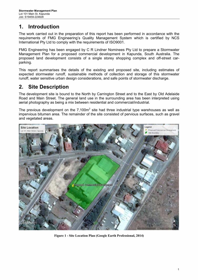
Stormwater Management Plan Lot 101 Main St, Kapunda Job: S19459-224828
1
1. Introduction
The work carried out in the preparation of this report has been performed in accordance with the requirements of FMG Engineering’s Quality Management System which is certified by NCS International Pty Ltd to comply with the requirements of ISO9001.
FMG Engineering has been engaged by C R Lindner Nominees Pty Ltd to prepare a Stormwater Management Plan for a proposed commercial development in Kapunda, South Australia. The proposed land development consists of a single storey shopping complex and off-street car-parking.
This report summarises the details of the existing and proposed site, including estimates of expected stormwater runoff, sustainable methods of collection and storage of this stormwater runoff, water sensitive urban design considerations, and safe points of stormwater discharge.
2. Site Description
The development site is bound to the North by Carrington Street and to the East by Old Adelaide Road and Main Street. The general land use in the surrounding area has been interpreted using aerial photography as being a mix between residential and commercial/industrial.
The previous development on the 7,100m2 site had three industrial type warehouses as well as impervious bitumen area. The remainder of the site consisted of pervious surfaces, such as gravel and vegetated areas.
Figure 1 - Site Location Plan (Google Earth Professional, 2014)
Stormwater Management Plan Lot 101 Main St, Kapunda Job: S19459-224828
2
The proposed site layout consists of a single storey supermarket. Car parking for customers will be provided by means of off street parking within the site. The proposed layout also includes pervious landscaped areas along the boundaries of the car park.
The survey plan of the existing site indicates a difference in height of approximately 5.8m across the site. The site is benched at three locations, with the highest bench RL on the Northern end of the site, and the lowest at the west.
3. Existing Drainage Conditions
There is no known existing underground stormwater infrastructure within the subject site or the surrounding area. Currently, stormwater runoff management is achieved through overland flow paths (road verge invert and piped driveway crossings) which eventually discharges to the existing waterway at the low point in Harriet Road to the south west.
The current legal points of discharge for the sites stormwater runoff is in Carrington Street and Old Adelaide Road.
The Light Regional Council has indicated that the peak runoff from the developed site during the 1 in 100 year ARI critical storm event (with coefficient of 0.9) is to be restricted to the predevelopments peak runoff during the 1 in 10 year ARI storm event (with coefficient of 0.25). It is appropriate to assume that in this instance, the council pre-development condition of the coefficient of runoff of 0.25 for this site did not truly reflect the pre-development conditions. By utilizing both aerial photography and site inspection records, the pre-development runoff coefficient has been calculated to be 0.7. The maximum rate of stormwater discharge from the site must not exceed 32L/s.
4. Proposed Stormwater Management
The site is proposed to be developed with a 2,641m2 shopping centre building. The remainder of the site will be impervious paved car parking and pervious vegetation strips. A volume of detention will be required in order to meet Council’s stormwater management requirements.
Table 1 - Summary of Stormwater Management Requirements Runoff Coefficient
Pre-Development 0.7 Post-Development 0.90
The pre and post development flow rates have been determined using the DRAINS Stormwater Software, with results summarised in Table 2. Hydrological models of pre and post development catchments are simulated using the Extended Rational Method model and rainfall data from the closest rainfall gauge to the subject site, which gives an accurate representation of peak detention volume requirements for the site. A summary of the peak runoff values can be seen in Table 2.
Table 2 - Summary of Hydrological Model Results
AREA Flow Rate (L/s) Rainfall Volume m3
Pre-Development (5 year ARI) 80* 65.9
Post Development (100 Year ARI) 206 134 *indicates pre-development peak flow rate, which cannot exceed 32L/s. Based on the restricted outflow of 32L/s the required detention is 110m3.
Stormwater Management Plan Lot 101 Main St, Kapunda Job: S19459-224828
3
5. Proposed Stormwater System
5.1 Onsite Detention Storage It is proposed that stormwater runoff will be stored in underground detention tanks located beneath the car park, to the south-west of the site. From preliminary calculations it is likely that the underground detention tank cannot drain by gravity to the existing road level in Carrington Street or Old Adelaide Road – assuming a detention tank depth of 1m, with 0.6m cover and that design surface levels will involve filling the low part of the site by approximately 2m. Gravity flow to Harriett Street is achievable; however additional investigation will be required during detailed design. An easement through the private property to Harriett Street will be provided by the developer. Some allowance for surface storage and above ground detention for roof water should also be considered to reduce the volume of the underground structure. Different detention configurations will be investigated during the detailed design, including rainwater storage tanks.
5.2 Piped Stormwater System Surface flow from the car park area will be collected with a series of grated inlet pits at various low points. The 100 year ARI piped system would divert runoff from the site into the underground detention tank. Likely pipe sizes will be 225mm diameter with some downstream collector drains needing to be 300mm to 375mm diameter. All downpipes will be collected through a separate drainage system and enter the detention tank at a single inlet point. Details of the piped collection system and configuration will be determined during the detailed design. A concept design showing a diagrammatic stormwater layout is included in Appendix B.
5.3 Water Sensitive Urban Design (WSUD) Litter traps will be implemented in all surface inlets as a form of primary treatment of gross pollutants. Stormwater retention will be provided using rainwater tanks for reuse in flushing of the toilets and irrigation of the sites landscaped area. A storage volume in the order of 22,500 litres will be investigated for this purpose at the detailed design stage.
6. Conclusion
Due to the sites characteristics it is recommended that the site’s stormwater runoff be discharged into the proposed underground detention system. It is believed that the trickle flow from the detention tanks of up to 32L/s in the events greater than 1 in 10 year ARI is acceptable for discharge into the verge of Harriett Street. Stormwater retention into rainwater tanks for subsequent reuse in toilet flushing and landscape irrigation will assist in minimising the flow from the site.
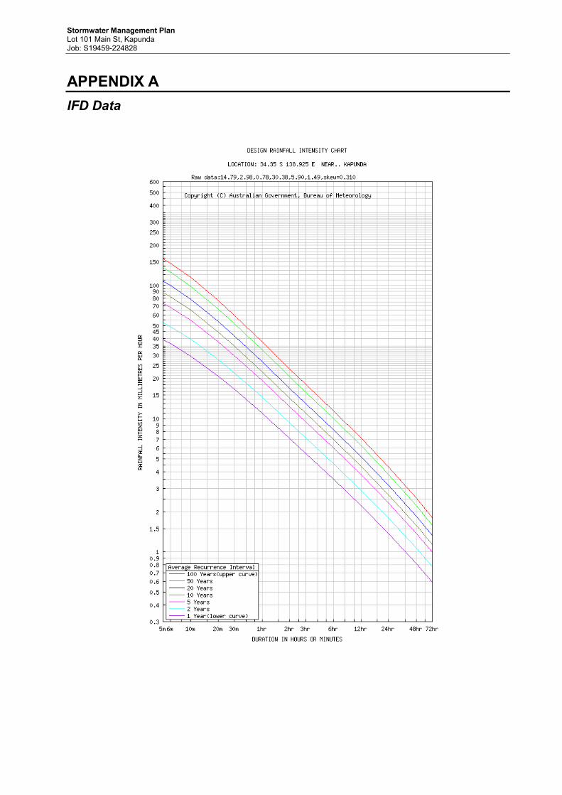
Stormwater Management Plan Lot 101 Main St, Kapunda Job: S19459-224828
APPENDIX A
IFD Data

Stormwater Management Plan Lot 101 Main St, Kapunda Job: S19459-224828
v
APPENDIX B
Concept Stormwater Plan
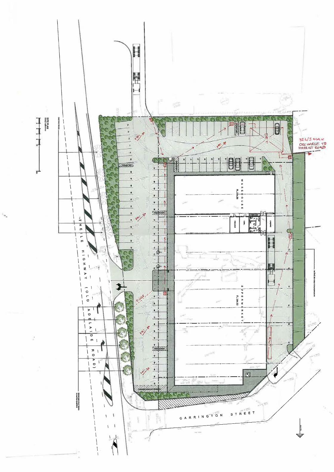
inco
az>
g
^ I^ I
,,.,.
^^^
,:^g^3:<' "
^
=
I in
F
I inI ^
Io
=
I , II >I '
-Io
I ro
3
a
.
a
. ..,.
' ^^;^:^^:\^
=
I
13
a
a
a
Ie
. *Q^
I^ mmIcy:^ -I
^ 1.1.^ ,^,^ ,=
"
8
^
. I
11 :, I, ;;:^:Z.^;^
8
. . .
^
=
-^-^-^-^"--=^-^-"--=^-^-^-^
go
.
.11^
@I
,
-^-^-^-^-^
.
I o>
^.^.
^
1.129.
F
>
^>
70
I^ in
^
o
I^
., b,
^^^
32. <1S rillA ,cO^c i-IA<6.5 ToHALLEt~ ,to
,,I
70
o
>
II
C
co
in
~~~T~
-^-=^--=.-^=^-^-^-^-
I o
,
a
a
^
,
\
^
U
s^
e
.
P
.
.
.
.
""
is =-------------.---.--->-------
=O
7<
in
^
F
B
a
.
-^----^-^-^-^-^-^-
'""^;33:^I
13
-------------.----------------
a
co
C
.
;, in
E
B
N"
----.---------.-.-
I
^-^-^-------^-
^
--\
"
CARRIN
in-o"=
^
a
GTON
---,-
I
,!
I
I
I
II
I
STRE ET
^7
TABLE OF CONTENTS for the meeting of
LIGHT REGIONAL COUNCIL DEVELOPMENT ASSESSMENT PANEL
WEDNESDAY, 5 NOVEMBER 2014
Reports: 7.1 Development Application Number 313/363/2014 ..............................................153
7.2 Non-Complying Developments Considered by the Development Assessment Panel ...............................................................................................179

Principal Office: 93 Main Street Branch Office: 12 Hanson Street Kapunda 5373 Freeling 5372
Telephone: 8525 3200 Facsimile: 8566 3262
Notice of Development Assessment Panel Meeting
Notice is hereby given in accordance with Section 56A of the Development Act 1993,
that the meeting of the
Development Assessment Panel of the
Light Regional Council
will be held in the Council Chamber
93 Main Street, Kapunda
on Wednesday, 5 November 2014 at 5.30 p.m.
.................................................... Lisa Sapio Manager - Development Services 28 October 2014
_____________________________________________________________________________________
Development Assessment Panel Agenda – 5 November 2014 Page 152/2014
LIGHT REGIONAL COUNCIL
DEVELOPMENT ASSESSMENT PANEL
AGENDA
MEMBERSHIP COMPOSITION Mr Bruce Ballantyne (Presiding Member), Mr Kelvin Goldstone, Mr Robert Veitch, Ms Hulya Gilbert,
Mrs Lynette Reichstein, Mr Peter Kennelly and Mr Deane Rohrlach. 1. MEETING OPENED 2. PRESENT 3. COMMENCEMENT AND WELCOME 4. APOLOGIES 5. CONFIRMATION OF PREVIOUS MINUTES
Recommendation That the minutes of the meeting of the Development Assessment Panel held on Wednesday, 1 October 2014 be confirmed as a true and correct record of that meeting.
6. DECLARATION OF CONFLICT OF INTEREST
A Council Development Assessment Panel Member declaring an interest in a matter before the Panel shall make a disclosure clearly stating the nature of that interest in writing to the Presiding Member, in accordance with Clause 2.4 of the Minister’s Code of Conduct, and then in the meeting when the relevant agenda item is reached, makes a verbal disclosure to the Panel and removes themselves from the meeting in accordance with Section 56A(7)(b) of the Development Act 1993. The following disclosures of interest have been made in relation to:- Item: __________________ Panel Member: _____________________________
7. DEVELOPMENT REPORT 7.1 Development Application 313/363/2014 – CR Lindner Nominees Pty Ltd 7.2 Non-Complying Developments considered by Development Assessment Panel
8. OTHER BUSINESS
9. DEVELOPMENT PLAN AMENDMENT (DPA) POLICY REVIEW
10. NEXT MEETING
11. CLOSURE
_____________________________________________________________________________________
Development Assessment Panel Agenda – 5 November 2014 Page 153/2014
7.0 DEVELOPMENT REPORT 7.1 Development Application Number 313/363/2014
Applicant CR Lindner Nominees Pty Ltd
Owner CR Lindner Nominees Pty Ltd
Subject Land and Location
113 Old Adelaide Road KAPUNDA, Main Street KAPUNDA, Lot 91 FP 206992, Hd Kapunda, Lot 1 FP 2858, Hd Kapunda, Lot 92 FP 206993, Hd Kapunda, Lot 101 FP 206999, Hd Kapunda, Lot 102 FP 206999, Hd Kapunda and portion of Old Adelaide Road, Kapunda
Development Proposal Supermarket with associated parking, loading area, fencing and retaining walls, signage and landscaping
Zone/Policy Area/Precinct Historic Conservation (Kapunda Town Centre) Policy Area 12 - Commercial
Application Type/Category Category 1 pursuant to table Light 7 of the Light Regional Council Development Pan
Merit
Representations No representors to be heard as the application will not be publicly notified
Referrals Internal
Engineering
Environmental Health Officer
Heritage advisor
External
DPTI – Transport Unit
Development Plan Consolidation Date:24 January 2013
Recommendation Development Assessment Commission (DAC) is the relevant authority. Recommended for approval subject to condition(s) and only after ratification of road opening and closing process.
Assessing Officer Lisa Sapio – Manager - Development Services
_____________________________________________________________________________________
Development Assessment Panel Agenda – 5 November 2014 Page 154/2014
Background The subject land comprises 6 contiguous allotments with a road reserve also proposed to form part of the subject land. The Council via its Economic Development Department has been assisting the land owner with their request for the road opening and closing process so as to enable portion of the road reserve to be purchased to facilitate the development as proposed. The development as proposed relies upon the road reserve forming part of the subject land in order to have any prospect of being able to occur. Council commenced the road opening and closing process in order to assist in facilitating the proposed supermarket in April 2014. The Development Application was submitted in October 2014 after this process commenced. The Council has an interest in the matter as the Applicant is being assisted by the Council’s Economic Development Department as part of the Roads Opening and Closing process. The Council is unable to deal with the proposed Road Opening and Closure process or the assessment of the development application as the relevant authority, as the Council is considered to be “suffering or permitting” the development of a shop on Council land. In short, it is considered that the Council would be undertaking the development for the purposes of the Development Act 1993. The Development Assessment Commission (DAC) with therefore act as the relevant authority for the supermarket application and in this instance planning staff are provided the opportunity to provide comments on the proposal via the Development Assessment Panel (DAP). The Department Planning, Transport Energy and Infrastructure (DPTI) will also act as the relevant authority for the Road Opening and Closing process. Proposed Development The applicant seeks Development Plan Consent to construct a supermarket with associated store room, staff amenities, offices, car parking, loading, access driveways, fencing and retaining walls, signage and landscaping. The supermarket building will be wholly located on land owned by CR Lindner Nominees Pty Ltd. Some of the car parking spaces proposed and access driveway adjacent Old Adelaide Road/Main Street are proposed to be constructed within an existing road reserve, which is currently the subject of a road closure process under the Roads Opening and Closing Act 1999. The development application includes the construction of a supermarket with a total gross leasable area of 2,799m2 with the following components:
• Supermarket floor trading area of 1,932 m2; • Warehouse/goods storage area of 719 m2; • Cool room, freezer and amenities of 73 m2; • Mezzanine comprising staff room and office of 75 m2; • 79 car parking spaces and trolley bay stacking area; • 6 metre high freestanding pylon sign and signage incorporated into the frontage of the
building; • Retaining walls and fencing; • Landscaping ;and • Access and egress from Old Adelaide Road/Main Street and egress from Carrington
Street.
The proposal as explained includes and relies upon portion of Old Adelaide Road forming part of the subject land. The area of land likely to be required to augment the subject land to enable the proposal to be developed as proposed is in the order of 1,623 m2 which will form part of the road closing process whilst 83 m2 of allotment 102 will be required as part of the road opening process, adjacent Carrington Street. The building will be in the form of a single storey structure with a uniform finished floor level notwithstanding the land slopes some 6 metres from north to south. To cater for the slope of the
_____________________________________________________________________________________
Development Assessment Panel Agenda – 5 November 2014 Page 155/2014
land the site will be cut /benched in at the northern end of the site adjacent Carrington Street and fill will be required from the centre of the allotment radiating outwards to the southern side property boundary. The building will have a façade that presents to Old Adelaide Road/Main Street and Carrington Street. The façade that will present to Old Adelaide Road/Main Street contains the supermarket with a flat roof and parapet wall and finished wall height of 6 metres that extends to Carrington Street and warehouse component of the supermarket. This supermarket portion of the building features a posted wrap around verandah. A gabled entry portico also features along the Old Adelaide Road/Main Street facade that protrudes forward of the proposed building and also features a sign. The portico stands at 9 metres to the top most part of the apex. Details of the materials have not been provided and it appears as the supermarket and store will be comprise tilt up concrete panels with portion of the supermarket featuring a white colour finish with the northern most portion featuring a grey colour finish. The total frontage of the building that will present to Main Street/Old Adelaide Road will be 80 metres. A length of 28 metres of the supermarket will feature glazing whist the remainder will feature blank walls. The store component of the building varies in height from 7.5 metre to 8.5 metres in line with the slope of the land. The store component of the building comprises three pitched roof forms and external grey colour finish. Both the store/warehouse and supermarket features horizontal banding along the façade of the building along the Old Adelaide Road/Main Street frontage and part of the Carrington Street frontage.
A freestanding pylon sign measuring six (6) metres in height and two (2) metres in width is proposed adjacent the southern portion of the old Adelaide Road/Main Street access point. A 2.1 metre high colorbond fence will be built along the western and southern property boundaries of the site. The southern side property boundary will also feature a combined retaining wall and colorbond fence. The retaining wall and combined fence will measure some 4 metres adjacent the Old Adelaide Road/Main Street frontage. Articulated heavy vehicle access to the site will be obtained via vehicles turning into Hancock Road, then performing a right hand manoeuvre into the southern portion of Old Adelaide Road whereby the vehicles will then utilise the access closest to the southern property boundary. The articulated vehicles will then proceed to the rear of the site where the loading and unloading will occur and exit onto Carrington Street. Passenger vehicles will obtain access and egress via the proposed access way central to the site from Main Street. The portion of land directly forward of the subject land that is currently road reserve contains a number of pine trees, a stobie pole and a light pole. The trees will need to be removed along with the light pole and stobie pole and the road reserve altered so that suitable grades will be able to achieve from Main Street into the subject land as Main Street sits substantially higher than the subject land and that of Old Adelaide Road. Details of the application form Appendix 7A. Subject Land and Locality The subject land has a frontage of 110.38 metres to Old Adelaide Road/ Main Street and a frontage of 48.81 metres to Carrington Street; totalling some 5,568 m². The subject land is a regular shape with a small angular corner cut off along the north western portion of Carrington Street. The subject land comprises six (6) contiguous allotments of which all are in the ownership of CR Lindner Nominees Pty Ltd. A portion of road reserve in addition to the six (6) allotments forms the entire extent of the subject land. The section of road at the point where Old Adelaide Road merges into Main Street near Carrington Street is proposed to be closed to enable a significant portion of the designated car parking area to be accommodated on the subject land. The road reserve to be closed is some 1,623 m2 in area. In addition, approximately 83m2 of Allotment 102 at the northern end of the site next to Carrington Street, is proposed to be formally opened and vested to Council
_____________________________________________________________________________________
Development Assessment Panel Agenda – 5 November 2014 Page 156/2014
as road reserve. The total area that forms the subject land, inclusive of portions of the road reserve is 7,191 m2. The land slopes from the north to the south with a cross fall of some 6 metres. To the rear of the subject land is a significant drop of more than four (4) metres which is readily visible when viewing the land from Harriet Street from the west. The subject land is devoid of any buildings or structures with the exception of an ETSA transformer that is located close to the Carrington Street frontage. The site is also largely void of any vegetation with the exception of Lot 91 and 301 that has a row of pine trees that runs along the common property boundary. No street trees abut the subject lands front property boundary. The land until August 2014 contained buildings formally occupied by JT Johnsons and Sons Mill. The Applicants consultant has stated that the site had operated as a Mill since 1957 when JT Johnson and Sons relocated its chaff mill from Stockport. Within the road reserve adjacent the Carrington Street/Main Street corner is located a disused weighbridge that will be removed if the development is approved and acted upon. The immediate locality is characterised by a mix of commercial uses. To the immediate north of the subject land and Carrington Street exists the Clare Castle Hotel, with the Kapunda Police Station and beyond that the Light Regional Council’s Kapunda (Principal) Council Office. To the east of the subject land on the opposite side of Main Street exists a number of residential premises of which some are listed as heritage items, Kapunda SES and CFS and hardware store. To the south of the subject land exists a heritage listed dwelling and vacant allotment along with more residential properties and commercial properties close to Hancock Road. Further south, along the eastern side of Old Adelaide Road and near the junction of Hancock Road is the Viterra grain sampling station and weighbridge. Abutting the subject land to the west exist six (6) vacant allotments that are located with the Residential (Kapunda) Zone. Further west are residential properties that are located within the Residential (Kapunda) Zone. The applicant’s planning consultant has accurately stated in his accompanying report that that the locality comprises the southern gateway to Kapunda from Adelaide. Aerial photography illustrating the subject land and surrounds forms Appendix 7B and zone map forms Appendix 7C. Public Notification and Categorisation The application is a Category 1 form of development by virtue of Table Light 7 of the Light Regional Council Development Plan that reads, other than where non complying all forms of development are assigned as category 1 for public notification purposes. Accordingly no public notification has been undertaken. Referrals Pursuant to Schedule 8 of the Development Regulations, 2008, the relevant authority is required to consult with the Transport Unit of the Department Planning Transport and Infrastructure (DPTI) as a State Government Agency. This is due to the fact that Main Street, Kapunda is a designated secondary arterial road. As the DAC are the relevant authority, comments from the Transport Unit of DPTI will be directly provided to the DAC. (Discussions with staff from DPTI confirmed that the DAC had not yet commenced the referral, this may be due to the fact that the road opening and closing process is still being undertaken).
_____________________________________________________________________________________
Development Assessment Panel Agenda – 5 November 2014 Page 157/2014
When the development application was forwarded to the DAC an opinion was offered that indicated that the development application is hypothetical and should not be assessed or considered until such time the Road Opening and Closing process has been undertaken and finalised. It is considered that the development application would be null and void if assessed at this point in time as the proposal will not have the prospect of coming to fruition without part of the road way forming the subject land as illustrated on the plans. Furthermore, assuming the Road Opening and Closing process occurs, the roadway will then need to be amalgamated into part of the subject land. The development application should not be processed as the additional land (roadway) is fundamental to the application. It is also considered that the matter of the additional Road Opening and Closing process should not be listed as a reserve matter as the additional land is fundamental to the proposal and cannot occur unless the road closure occurs and the land purchased by the landowner. Correspondence has been received by the Council from Botten Levinson Lawyers advising that legal challenge may occur if due process is not followed in respect to the Roads Opening and Closing process. Assessment The subject land is located within the Historic Conservation (Kapunda Town Centre) Zone and more particularly in Policy Area 12 – Commercial as described in the Light Regional Council Development Plan. The main provisions of the Development Plan which relate to the proposed development are as follows:- Council Wide:
Form of development Objective(s) 1
PDC(s) 1, 4
Types of development Objective(s) 2
PDC(s) -
Environment, Heritage and amenity
Objective(s) 5
PDC(s) -
Catchment water management Objective(s) 16, 17, 20, 23, 24, 25
PDC(s) 146, 147, 150, 328, 329, 330, 331, 332, 334, 337, 339
Use of land Objective(s) -
PDC(s) 10, 11
Siting of development Objective(s) -
PDC(s) 22, 27
Transport and parking Objective(s) -
PDC(s) 28, 30, 31, 32, 34, 40
_____________________________________________________________________________________
Development Assessment Panel Agenda – 5 November 2014 Page 158/2014
Centres and shops Objective(s) -
PDC(s) 101, 102, 103, 104, 105, 106, 107, 108
Chemical and materials storage
Objective(s) -
PDC(s) 154, 155
Advertisements Objective(s) -
PDC(s) 215, 216, 217, 218, 219, 220, 221, 223, 224, 228, 229, 232
Noise pollution Objective(s) -
PDC(s) 266
Site contamination Objective(s) -
PDC(s) 281
Waste disposal Objective(s) -
PDC(s) 282, 283
Heritage Objective(s) -
PDC(s) 293
Appearance of land and buildings
Objective(s) -
PDC(s) 295, 296, 297
landscaping Objective(s) -
PDC(s) 304
Zone: Historic Conservation (Kapunda Town Centre)
Objectives 1,2,3,4.
Principles of Development Control 2,4,5,8,9,11,12, 16
Policy Area: 12 - Commercial
Objectives 1,2,3
Principles of Development Control 1,2,3,4,5
_____________________________________________________________________________________
Development Assessment Panel Agenda – 5 November 2014 Page 159/2014
Land Use and Zoning The subject land is located in the Historic Conservation (Kapunda Town Centre) Zone – Policy Area 12 – Commercial as denoted in the consolidated Light Regional Council Development Plan 24 January 2013. The zone extends in an elongated manner from Hancock Street along Main Street to South Terrace and is segmented into three separate policy areas defined to recognise existing differences and desired future outcomes. Overall, the zone is intended to provide for a focus of administration, shopping, business, retail, tourist and commercial activities that serve town residents, other users and visitors. Historic Conservation (Kapunda Town Centre) Objective 1 reads:
“The focus for administration, shopping, business, retail, tourist and commercial activities to serve residents in the town of Kapunda and visitors to Kapunda and the surrounding rural district.”
Objective 1 of Policy Area 12 – Commercial reads: “The main focus within the town for commercial activities, service trade premises, car
yards, service stations, petrol filling stations and public service depots.” Policy Area -12 Commercial Objective 1 further clarifies that the type of development specifically includes commercial activities. Commercial activities include any business or trade that acts to make a profit. As identified the Zone is further segmented into 3 policy areas which are as follows:
1. Policy Area 10 – Hill Street Civic. This policy area seeks to focus on cultural activities and development and acknowledges the grandest group of buildings in Kapunda such as the Thompson Library, Kapunda Institute and Museum.
2. Policy Area 11 – Retail. This policy area focuses upon the towns shopping, banking, administration, offices, consulting rooms and restaurants.
3. Policy Area 12 – Commercial. As outlined above this policy area seeks to focus upon the town for commercial activities such as service trade premises, service stations, car yard and public service depots.
When reviewing the non-complying list of the Zone, retail and shopping uses are not listed as non-complying forms of development in any of the policy areas and as such the potential to locate a supermarket upon the subject land is plausible, notwithstanding it is located within the Commercial Policy Area. The range of uses envisaged in the zone, including that of a retail/shopping outlet (supermarket) is considered appropriate having regard to Zone Objective 1 which strives to serve residents and visitors in the town of Kapunda and the surrounding rural district. Whilst commercial activities are specifically intended within this policy area it is considered that in the main the Policy Area has achieved its primary intent given the hardware store, petrol filling station and service trade premises located within the Policy Area. The provisions within the Policy Area suggest that the main focus is for commercial activities and relocation of industrial uses to the Industry Zone. The former industrial development has been demolished and a retail form of commercial activity is proposed. It is not considered fatal that the proposed commercial activity is not in the form of a service trade premises or petrol filling station as envisaged, but a commercial activity in any event. The subject land is considered part of the gateway into Kapunda and the proposed supermarket and its built form will contribute positively to the locality more so, than a form of commercial development such as a petrol filling station or caryard.
_____________________________________________________________________________________
Development Assessment Panel Agenda – 5 November 2014 Page 160/2014
Council Wide Principle of Development Control (PDC) 102 provides guidance in understanding that Kapunda is identified as providing for the major centre and shopping area within the Council. The PDC reads as follows:
“Kapunda should provide the major centre and shopping area within the council area with retailing and other services being developed to the maximum extent so that district level shopping, administrative, commercial, cultural and entertainment facilities are retained within the district.”
It is therefore considered that the supermarket satisfies the intent of the zone, being a focus for shopping; retail and commercial activities that will serve the residents of Kapunda and visitors. The proposal satisfies Council Wide PDC 102, Zone Objective 1, 2 and Policy Area 12 Objective 1 and 3. The proposed development will therefore take place on land which is suitable for the intended use of that land having regard to the location and condition of the land and the provisions for the zone concerned and therefore also satisfying Council wide PDC 10. Appearance, Streetscape, Character and Built Form The purpose designed supermarket will be a single storey building with a uniform finished floor level. The subject land slopes from the north to the south and to accommodate the proposed building, the site will be benched into the northern end of the site closest to Carrington Street and fill will be utilised at the southern end of the site. The northern end of the supermarket will be setback 5 metres from the Carrington Street/Main Street property boundary and stepped in to the west to avoid the ETSA transformer box. The retail floor area of the supermarket will present with a 56 metre frontage to Old Adelaide Road/ Main Street with 24 metres of that frontage extending towards Carrington Street, presenting as a blank wall with minimal banding. The banding and a colour change (to grey) have been introduced in an attempt to add visual interest to the blank wall. The remainder of the actual retail frontage contains horizontal fenestration comprising a number of individual panels. This portion of the frontage also features the entry into the supermarket and protruding gabled portico in a white colour palette. The portico will also feature the name of the supermarket.
The retail component of the supermarket will have a finished parapet wall height of 6 metres with a posted verandah that extends the entire 56 metres as well as extending and wrapping around some 18 metres of the Carrington Street frontage. The Carrington Street elevation of the supermarket building will feature a grey colour finish. No detailed schedules of the proposed materials and final colour finishes have been provided. This detail is considered particularly important so as to ensure that the colours utilised complement the numerous stone walls and feature brick buildings within the locality and historic building fabric. Generally buildings built in current times comprise prefabricated tilt up concrete panels. No fundamental concern exists with such use of this material, however, it is considered that a textured stamped brick (this appearance features in a number of main street such as The Parade, Norwood which reads as a brick finish and not tilt up concrete) could be utilised along the façade of the supermarket along Main Street and Carrington Street. The use of a posted verandah that extends along the supermarket frontage and then wrapping around the Carrington Street frontage is supported as it simulates historic building elements that serve to add visual interest to the building and provides shading and shelter.
The warehouse/storage portion of the building will be in the same alignment as that of the retail component of the supermarket and vary in height from 7.5 metres to 8.5 metres to the top of the parapet, taking into account the slope of the land. This portion of the building will feature three (3) separate pitched roof forms that sit in behind the parapet wall. The roof cladding appears to be of corrugated iron in a grey finish which is considered appropriate as corrugated iron finished in grey is reminiscent of corrugated galvanised iron which was used in the historic buildings that surround the site. If the iron sheeting is indeed galvanised this is also supported, however, zincalume is not supported given its highly reflective finish. The wall of the warehouse component will comprise tilt up concrete panels and horizontal banding within the lower half of the building facade. The elevations indicate that landscaping in the form of tall canopied trees will be located forward of the
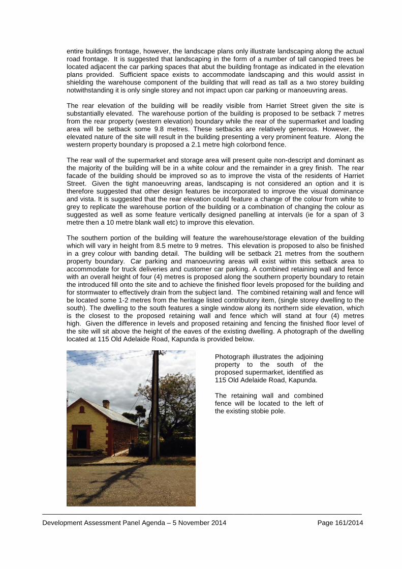
_____________________________________________________________________________________
Development Assessment Panel Agenda – 5 November 2014 Page 161/2014
entire buildings frontage, however, the landscape plans only illustrate landscaping along the actual road frontage. It is suggested that landscaping in the form of a number of tall canopied trees be located adjacent the car parking spaces that abut the building frontage as indicated in the elevation plans provided. Sufficient space exists to accommodate landscaping and this would assist in shielding the warehouse component of the building that will read as tall as a two storey building notwithstanding it is only single storey and not impact upon car parking or manoeuvring areas. The rear elevation of the building will be readily visible from Harriet Street given the site is substantially elevated. The warehouse portion of the building is proposed to be setback 7 metres from the rear property (western elevation) boundary while the rear of the supermarket and loading area will be setback some 9.8 metres. These setbacks are relatively generous. However, the elevated nature of the site will result in the building presenting a very prominent feature. Along the western property boundary is proposed a 2.1 metre high colorbond fence.
The rear wall of the supermarket and storage area will present quite non-descript and dominant as the majority of the building will be in a white colour and the remainder in a grey finish. The rear facade of the building should be improved so as to improve the vista of the residents of Harriet Street. Given the tight manoeuvring areas, landscaping is not considered an option and it is therefore suggested that other design features be incorporated to improve the visual dominance and vista. It is suggested that the rear elevation could feature a change of the colour from white to grey to replicate the warehouse portion of the building or a combination of changing the colour as suggested as well as some feature vertically designed panelling at intervals (ie for a span of 3 metre then a 10 metre blank wall etc) to improve this elevation. The southern portion of the building will feature the warehouse/storage elevation of the building which will vary in height from 8.5 metre to 9 metres. This elevation is proposed to also be finished in a grey colour with banding detail. The building will be setback 21 metres from the southern property boundary. Car parking and manoeuvring areas will exist within this setback area to accommodate for truck deliveries and customer car parking. A combined retaining wall and fence with an overall height of four (4) metres is proposed along the southern property boundary to retain the introduced fill onto the site and to achieve the finished floor levels proposed for the building and for stormwater to effectively drain from the subject land. The combined retaining wall and fence will be located some 1-2 metres from the heritage listed contributory item, (single storey dwelling to the south). The dwelling to the south features a single window along its northern side elevation, which is the closest to the proposed retaining wall and fence which will stand at four (4) metres high. Given the difference in levels and proposed retaining and fencing the finished floor level of the site will sit above the height of the eaves of the existing dwelling. A photograph of the dwelling located at 115 Old Adelaide Road, Kapunda is provided below.
Photograph illustrates the adjoining property to the south of the proposed supermarket, identified as 115 Old Adelaide Road, Kapunda. The retaining wall and combined fence will be located to the left of the existing stobie pole.
_____________________________________________________________________________________
Development Assessment Panel Agenda – 5 November 2014 Page 162/2014
From the outset, the Zone provisions are seeking forms of development that focus on development that conserve, rehabilitates and compliments the historic character of the zone and enhancement of the built form integrity of Main Street. In particular Zone Objective 3 and 4 read respectively: Zone Objective 3:
“Conservation and enhancement of the built-form integrity of the Main Street and important side streets.” and
Zone Objective 4:
“Development which conserves, rehabilitates and compliments the historic character of the respective policy areas of the zone.”
This intent is significant in achieving a preferred vision for the subject land. It should be recognised that the subject land is located within close proximity of a Local Heritage Place and Contributory Items and therefore an important adjunct in both immediate and longer vistas along Main Street and Harriet Street. As previously stated the subject land is considered part of the southern gateway into Kapunda and the proposed supermarket and its built form should contribute positively to the locality.
The following Objectives and PDC’s are also relevant when considering appearance, streetscape and character. They are as follows:
Policy area 12 - Commercial - Desired Character Policy Area preamble states:
“The design and appearance of business activities in this policy area should contribute to the town's overall heritage character by: (a) using consistent set-backs of buildings to create a strong building line; (b) roof pitches of a minimum of 20 degrees; (c) galvanized corrugated iron used for external cladding in preference to "zincalume" or
colour coated metal; (d) rural fencing on street boundaries in preference to security fencing; (e) wall and gable ends of buildings for signage; and (f) informal landscaping using species existing in the area.”
It is considered that the proposed front setback will seek to reinforce the pattern of development and setbacks within the locality of commercial buildings such as the Clare Castle Hotel and create a strong building line. The side and rear setbacks are also considered acceptable in an attempt to minimise impacts upon the surrounding residential dwellings. (The impact upon the adjoining dwelling at 115 old Adelaide Road, Kapunda is discussed in detail later in the report) In the main the proposal satisfies the majority of the above desired character statement. Furthermore, the former unappealing iron clad mill building and besser block office building have been removed and the replacement land use and building will generally improve the appearance of this visually prominent site.
Council Wide PDC 22 reiterate that buildings and structures should be sited to conserve the surrounding character through optimum orientation, set-back, minimal cut and fill so excavation and filling of land be kept to a minimum to preserve the natural form of the land. Development should also only be undertaken in order to reduce the visual impact of buildings. The level of cut and fill is considered to achieve a good balance of cut and fill that will require reasonable amounts of fill given the variation in the levels of the land. A little over a metre of cut will be require the Carrington Street property boundary along with minimal cut and fill within the centre of the site and 1.4 metres of fill along the southern property boundary. Notwithstanding that a retaining wall of 1.5 metres will be required along the southern property boundary, the level of excavation and fill is finely balanced with the express intent to work with the lie of the land as close as possible. Whilst a lesser amount of fill could be achieved along the southern property boundary it need to be recognised that this would be at the detriment of the workability of the site as a
_____________________________________________________________________________________
Development Assessment Panel Agenda – 5 November 2014 Page 163/2014
significantly sloping car parking area makes manoeuvring supermarket trolleys difficult. Having regard to a need to have a workable car parking area and achieve suitable gradients for pedestrians, vehicles and trucks, it is considered that the proposed development adequately satisfies Council Wide PDC 22.
With respect to appearance the following provisions of the Development Plan are considered to be the most pertinent: Council Wide PDC 295 states:
“Buildings should be designed to preserve and enhance surrounding character and surrounding existing buildings having regard to scale, form, materials and landscaping. “
Council Wide Objective 5:
“Development undertaken in a manner which: (d) is safe; (e) does not have an adverse impact on the amenity of properties within the locality; and (f) has a high standard of appearance
Zone PDC 11 states:
“Buildings should be simple in detail incorporating gable, hip or hip gable combination roofs, parapets or cornices and where appropriate wide balconies and or verandahs.”
Zone PDC 12 states:
“Roof pitches of 30 degrees to 45 degrees should be used generally with lower pitch roofs used in a manner of "lean-to" additions to existing buildings or behind appropriately design parapets, especially along street frontages.”
Site visits undertaken as part of the assessment included viewing the site from Carrington Street, Old Adelaide Road, Main Street and Harriet Street Kapunda and from the Thiele Highway on the approach into Kapunda. The viewing revealed that the proposal will largely be visible from Main Street and Thiele Highway approach into Kapunda and Harriet Street given the levels of the land. The development will also be visible from Carrington Street. As mentioned above the western elevation of the building can be significantly improved to reduce the visual impact of the building from Harriet Street. It is also suggested that additional landscaping be introduced along the Main Street frontage to obscure the height and blank walls of the warehouse component of the building and the blank walls of the actual supermarket retail floor area. In the main no objection exists with the bulk, scale and overall form of the proposed building as the proposed development sufficiently satisfies Zone PDC 11 and 12. However, significant improvements can be made to the elevations suggested. As such the appearance of the built form is not considered to adequately satisfy Council Wide Objective 5 (e) and (f) and 295 in terms of visual appearance as the variation in use of materials, finishes and colours could be significantly improved. As suggested via PDC 2 in Policy area 12 – Commercial, landscaping and traditional architectural elements should be used on buildings and their layout to ensure the appearance of development is consistent with the Desired Future Character for the policy area. Landscaping should be used directly along the front facade of the building to ensure that the appearance of the development is consistent with the desired character for the area. Numerous references are made through the Development Plan that relate to landscaping and the important role it plays in design and site layout. The landscaping along Main Street, Carrington Street and the southern property boundary are considered suitable and desirable. In order to better satisfy the above desired character statement additional landscaping should be included directly forward of the Old Adelaide Road/Main Street front facade of the proposed building.
_____________________________________________________________________________________
Development Assessment Panel Agenda – 5 November 2014 Page 164/2014
Zone Policy Area 12 – Commercial - PDC 3 seeks development on land abutting residential zones that should be more domestic in scale and character than development in the area generally. The proposed development in the main has achieved the intent of this provision as it comprises the main portion of the supermarket that is close to domestic in scale in terms of height and appearance with the use of verandah and parapet walls. The warehouse component is taller in height than a single storey dwelling, buts its prominence can be reduced in appearance via an appropriate choice of darker colours such as grey that would match the warehouse component as mentioned above rather than white that will read as a monolithic dominant structure. The difficultly the subject land faces is that the site is prominent and elevated when viewing from vistas such as Harriet Street, which heightens its prominence and bulk. The suggested use of materials and colours are mentioned above would alleviate the concerns to an acceptable level.
Heritage As the subject land is located within the Historic Conservation (Kapunda Town Centre) Zone and the land is adjacent to local Heritage listed places and Contributory Items, the application was referred to Council’s Heritage Advisor. Mr Queale has provided the following comments in relation to the heritage aspects of the proposal and its appearance within the locality and streetscape.
• The form of the building in term of its mass could be improved by having the build read a two parts. It was suggested in preliminary discussions that the warehouse wall would be brought closer to the street by about 2 metres. This would assist in breaking down the building scale;
• The hip roofs to the warehouse are a good design solution as it assists in reducing the visual bulk and improves compatibility with Main Street buildings of heritage value;
• The use of verandahs are a common form that is visible along Main Street and the proposed development repeats this design feature;
• Additional tree planting is suggested in front of the warehouse as per the elevations; • Landscaping should also be utilised along the western boundary to reduce visual impact of
the building; • The materials are not indicated. A render finish is suggested to the warehouse with muted
grey colouring and red brick to the shops and parapet. These are materials that would be compatible with materials used in the Main Street;
• Roofing where visible should be a corrugated profile and mid grey in colour; and • The entry porch/portico should be extended and pitched roof back over the supermarket so
it appears as part of the overall building rather than small section of incongruous small section of roof.
As the assessing officer, I concur with the comments made by Mr Queale and recommend these comments be included in the recommendation to the DAC, in particular the use of a red brick to the supermarket and continuation of the grey tone to the warehouse and entire western elevation of the building along with additional landscaping. Overshadowing/Overlooking A combined retaining wall and fence with an overall height of four (4) metres is proposed along the western property boundary to retain the introduced fill onto the site and to achieve the finished floor levels proposed for the building and for stormwater to effectively drain from the subject land. The combined retaining wall and fence will be located some 1-2 metres from the (heritage listed Contributory item identified as a single storey dwelling at 115 Old Adelaide Road directly to the south. The dwelling to the south features a single window along its northern side elevation (refer to previous photograph).
Given the difference in levels between the two allotments and proposed retaining and fencing the finished floor level of the site will sit above the height of the eaves of the existing dwelling. The combined retaining walls and fencing will cause overshadowing over the adjoining dwelling and allotment for a length of some ten (10) metres within the allotment. Applying the winter solstice shadow diagrams to the site plan provided, at 9am a shadow of at least ten (10) metres from the
_____________________________________________________________________________________
Development Assessment Panel Agenda – 5 November 2014 Page 165/2014
fencing and retaining wall will predominantly fall within the back yard and over the roof of the dwelling of the adjoining allotment and by 12 noon the shadow will continue to fall over the roof of the dwelling and start to rotate towards the front of the dwelling and allotment. By late afternoon (3pm) the majority of the shadowing will start to fall within the front yard area of the adjoining dwelling and Old Adelaide Road. Whilst overshadowing will affect the adjoining property to the south by mid to late afternoon the majority of the rear open space will be free of any significant overshadowing. The northern side of the adjoining dwelling appears to be largely used as a walk way and is not utilised for open space. The window that exists along this side of the dwelling however will be in shade for the majority of the day. This is not dissimilar to what currently occurs as a result of the row of mature trees that exists to the north.
The overshadowing from the proposed warehousing component of the supermarket has also been considered and given the 21 metre setback of the building from the common property boundary the overshadowing is negligible as it falls predominantly within the car parking area. One of the most concerning aspects of this proposal is that whilst the overshadowing and overlooking may on balance be acceptable, the fact of the matter remains that the sheer height of the combined retaining wall and fence will present an unattractive vista from the northern side of the adjoining dwelling at 115 Old Adelaide Road and from its sole northern window. Ideally a greater setback should be achieved which would enable landscaping to be located along this common property boundary that would be positioned on the southern side of the subject lands boundary. This would assist in reducing the presence of the combined retaining wall and fence and assist in softening the appearance. If a greater setback could in fact be achieved, a substantial amount of car parking would be lost that would not allow the proposed development to function.
On balance it is considered that whilst the appearance and amenity of the adjoining dwelling to the south will be significantly reduced, the overshadowing that will occur from the combined fence and retaining wall and the extent of solar access to the property overall will result in more than 3 hours of sunlight being available to the dwelling during the winter solstice.
The issue of overlooking from the supermarket site is not considered problematic as views will only exist towards the sky and not over and down into the adjoining dwelling to the south. As such, overlooking will not be an issue. Stormwater Management/Flooding/Watercourses The applicant has engaged an independent stormwater engineer (FMG Engineering) to devise an appropriate storm water management design. It is proposed that stormwater runoff will be stored in underground detention tanks located beneath the car park to the south west. Preliminary calculations have revealed that the underground detention tank cannot drain by gravity to the existing road level in Carrington Street or Old Adelaide Road. Gravity flow to Harriet Street is achievable. An easement though the private property to Harriet Street will need to be provided by the developer to facilitate the development. It should be noted that the 5 vacant residential allotments that abut the subject land to the west are also in the ownership of CR Lindner Nominees. An allowance for surface storage and above ground detention for roof water should also be considered to reduce the volume of the underground structure. Surface flows from the car park area will be collected with a series of grated inlet pits at various low points. The 100 year ARI piped system would divert runoff from the site into the underground detention tank. A pipe size of 225mm diameter will be required with some downstream collector drains needing to be 300mm diameter. All down pipes will be collected through a separate drainage system and enter the detention tank at a single inlet point. Stormwater retention will be provided using rainwater tanks for reuse in flushing of the toilets and irrigation of the sites landscaped areas. A storage volume of 22,500 litres will be utilised. The stormwater management plan indicates that this storage tank is to be positioned at the rear of the proposed building close to the Carrington Street road reserve. The nominated position will not be possible as this area is required for the onsite manoeuvring of 19 metre semi-trailers. It is suggested that this above ground rain water storage tank be relocated to the area designated for
_____________________________________________________________________________________
Development Assessment Panel Agenda – 5 November 2014 Page 166/2014
staff car parking and occupy proposed car park 75 and 76. This will minimise any disruption to critical on site truck manoeuvring areas. Council’s Development Engineer is of the opinion that the conceptual stormwater design provided is appropriate. It has however been reiterated that an easement should be obtained via the allotments to the rear to discharge to Harriet Street and that this easement should be registered and created prior to occupation of the building. Council’s Development Engineer will need to be furnished with full detailed design including calculations for consideration and approval if the DAC is of a mind to approve the application. The following PDC’s relate to stormwater and stormwater management and are relevant to the application. They are as follows; Council Wide PDC 330 reads:
“Development should incorporate stormwater management techniques to contain the quality, velocity, variability and quality of run-off to as near pre-development levels as practical, by means of but not limited to: (a) directing roof stormwater overflow from rainwater tanks to soakage trenches or to
retention/overflow wells or sumps where large roof catchments are involved; (b) utilising grassed swales or natural drainage lines to accommodate the major flows
from the land development; and (c) incorporating stormwater systems designed to prevent entry of pollutants such as
pollutants such as sediment, pesticides and herbicides, bacteria, animal wastes and oil, grease and waste water from vehicle cleaning processes, air conditioners and fire protection services pipework testing into receiving water.”
Council Wide PDC 331 states:
“Development should incorporate a stormwater treatment system capable of removing pollutants.
Council Wide PDC 332 reads:
“The rate and duration of stormwater discharged into a watercourse or a public stormwater system should: (a) ensure retention for reuse; and/or (b) use detention mechanisms and/or detention in a detention basin;”
Council Wide PDC 339 reads:
“Areas for activities such as loading and unloading, wash down of vehicles, plant or equipment, or storage of waste refuse bins should be suitably paved, bunded to exclude stormwater run-off from external sources, and designed so that water that has made contact with such areas is either: (a) directed to a sediment trap, separator or other appropriate treatment device and then
to sewer; or (b) directed to a wastewater holding tank.”
The proposed development adequately satisfies Council wide PDC 330, 331, 332 and 339 as the draft stormwater management plan has had regard to pre development rates and utilised hydrological modelling to determine the pre and post catchment rainfall data. Based on this information detention rates have been determined. The development also seeks to utilise gross pollutant traps to collect sediments and pollutants from the car parking areas that will be collected in the underground storage tanks and discharged to the Council’s stormwater system in Harriet Street.
_____________________________________________________________________________________
Development Assessment Panel Agenda – 5 November 2014 Page 167/2014
Council Wide PDC 340 is as follows:
“Development should prevent erosion and stormwater pollution before, during and after construction and associated works by: (a) appropriate control of surface water entering or leaving the land; (b) installing and maintaining erosion control works and measures; (c) installing and maintaining sediment collection devices to prevent the export of
sediment from the land; and (d) rehabilitating disturbed areas.”
Council Wide PDC 341 reads:
“A Soil Erosion and Drainage Plan19 should be prepared where: (a) there is a high risk of sediment pollution to adjoining lands or receiving water, or; (b) the total area to be distributed, or left distributed, at any one time exceeds 0.5 ha.”
A soil erosion and drainage management plan (SEDMP) has not been provided and as such prior to the commencements of any works, it is considered that given the sloping nature of the land that a SEDMP shall be provided to Council for approval prior so as to protect the residential properties that surround the subject land and that would be subject to potential flooding in the event of a heavy rainfall event in the absence of an appropriate management plan. This will be listed as a recommendation as part of the comments submitted to the DAC. A copy of the stormwater management plan collated by FMG Engineers forms Appendix 7D. Waste Water Management Gross pollutant/litter traps will be implemented in all surface inlets in a form of primary treatment of gross pollutants. The subject land is not within a location that is serviced by mains sewer. The Council’s waste water management scheme operates within this portion of Kapunda. A waste water application will need to be submitted to Council for approval which will be subject to a standard assessment. Generally waste water management systems can be placed within an area of the site that will not be subject to traffic. Given the majority of the site is dedicated to building and car parking or manoeuvring areas the applicant needs to be aware that any waste control system should be appropriately designed by an engineer that allows trafficable lids that will be able to withstand the traffic that will traverse the system installed. An application will need to be submitted to Council prior to commencement of construction. This recommendation to the DAC will reinforce the need for a waste water application. Contamination The majority of the subject land until recently housed a number of iron clad buildings that were utilised by JT Johnson as part of the milling operation. A besser brick building was also located on the land that were utilised as offices. The former land use was industrial in nature whilst the proposed development is commercial in nature. Having regard to Council Wide PDC 281 which reads:
“Development, including land division, should not occur on contaminated land or on potentially contaminated land unless: (a) remediation of the site is undertaken to a standard that makes it suitable and safe for
the proposed use; or (b) the site will be maintained in a condition or the development will be undertaken in a
manner that will not pose a threat to the health and safety of the environment or to occupiers of the site or land in the locality.”
_____________________________________________________________________________________
Development Assessment Panel Agenda – 5 November 2014 Page 168/2014
When a change in land use is proposed regard should always be had to the former use of the land and any potentially contaminating activities that may have occurred and that may have the ability to affect any proposed land use which is generally more sensitive in nature. If the land was proposed to be used as a school, kindergarten, child care or residential then the applicant would have been asked to supply a site contamination assessment that would deem the site suitable for its intended use or otherwise. In this instance a site contamination assessment is not deemed necessary as the proposed use is not “more sensitive” and no evidence suggests that fuel tanks or similar were located on the site via previous operations, triggering a site assessment. Transportation/Access, Car parking/Manoeuvring The applicant has engaged a traffic engineer (GTA Consultants) to assess existing traffic and parking conditions around the site, to determine the likely parking demand generated by the proposed supermarket, the suitability of the proposed parking layout, traffic generation and access arrangements and its impact upon the surrounding road network. A summary of the traffic consultant’s report is provided below:
• Thiele Highway functions as a two way arterial road aligned in a north west, south west direction and under the care and control of DPTI. It is configured with a 12 m carriageway set within a 33 m wide road reserve;
• Carrington Street functions as a two way local access road aligned in an east west directing and set within a 8 m wide carriage way and 12 m road reserve;
• Old Adelaide Road functions as a service road adjacent and parallel to the Thiele Highway. It is configured with an approximately 11 m wide carriage way within a 33 metre wide road reserve;
• 79 car parking spaces are proposed inclusive of 2 disabled car parking spaces are proposed;
• A two way access (entry and access) point are located along the Thiele Highway; • A one way (exit only) access point is located along Carrington Street; • A one way (entry only) access point for loading and commercial vehicles only located along
Old Adelaide Road; • “No entry” signs should be utilised to control vehicle movements at these locations; • A loading area is proposed along the north western edge of the site, with trucks accessing
the site from Old Adelaide Road and exiting the site in a forward direction towards Main Street via Carrington Street. The loading area will occur via Old Adelaide Road and an internal circulation roadway through the car park. Bollards will restrict access from Old Adelaide Road outside loading times. The Road Opening and Closing process will create a cul-de-sac adjacent 115 Old Adelaide Road that will only allow access to trucks and commercial vehicles undertaking deliveries to the subject land. The Supermarket will co-ordinate removal and reinstatement of the barrier during loading times. A 19 metre long semi-trailer can travel through the site and then reverse into the loading area and exit in a forward motion;
• 6 parallel car parking spaces have been located near the loading area. These spaces should only be accessed by staff;
• The estimated traffic volumes resulting from the proposal during peak times is expected to be it the order of 343 movements per hour and a daily total movements of 3,375 movements per day. These estimates are considered to be high given the regional location however the figures represent a worst case scenario for assessment purposes;
• The statutory requirement for car parking assessed against the Council’s Development Plan indicates that 140 car parking spaces are required which equates to 5 spaces per 100 m2 of total floor area;
• GTA are of the view that only 2-3 car parking spaces per 100 m2 are required. Applying an average of 2.65 car parking spaces per 100 m2 the development would generate 74 car parking spaces. This rational has been achieved having regards to regional shopping centres across Australia that suggest a lower parking rate than that suggested by the Development Plan due to the limited catchment area restricting the number of trips that can be made;
_____________________________________________________________________________________
Development Assessment Panel Agenda – 5 November 2014 Page 169/2014
• Bicycle parking facilities will be provided near to the entrance of the supermarket adjacent car park number 44 and 45;
• The Viterra weighbridge is located on Old Adelaide Road to the north east of Hancock Road some 150 metres to the south west of the subject land. Access to the weighbridge is generally from the north. Truck access to this weighbridge will be restricted by the proposed development due to the construction of a car park on the existing portion of the road way to the north east. A short right turn lane would be provided on the Thiele Highway capable of storing a 19 metre semi-trailer. The access is intended for truck use only; however it could also be used to access the small number of properties that exist along this section of Old Adelaide Road. “No entry” signs would need to be installed to prevent vehicles travelling to Old Adelaide Road near Hancock Road to further advise drivers that access to Thiele Highway is not formally permitted;
A copy of the GTA Traffic report commissioned by the applicant forms Appendix 7E.
An independent traffic consultant was commissioned by planning staff to provide a peer review and opinion on the comments made within the GTA Assessment. In summary Mr Frank Siow provided the following comments:
• the proposal plan shown in the DM Lawrence Design drawing sheet WD04 Issue C is
different to the 3 plans used in the GTA turning path assessment (Dwg AT01-01P1-03P1). There is an entry roadway, where semi-trailers could turn from Thiele Hwy into Old Adelaide Road, which is not reflected in the GTA turning path plans. However, in Appendix C of the GTA report, this entry roadway is identified. There are therefore some inconsistencies in the plans provided in the reports.
• The Council’s Development Plan specifies a parking rate of 1 space per 20m2 total floor area for a “shop” land use. Based on such a rate, the parking required for the proposed development would be approximately 140 spaces. To justify a lower parking provision, the GTA report listed four (4) examples of parking rates from surveys of existing centres. Two (2) of the sites are over 10,000m2 in floor area, which would not be directly relevant to the proposed development, which has a much smaller floor area. These larger centres would have a wide range of uses, some of which would assist in reducing the overall parking demands because of different peak parking characteristics. For example, cafes, which are commonly found in larger centres, are a type of use which have different peak parking characteristics to a supermarket.
• The other two (2) examples of Aldi stores in Victoria (Morwell and Sunbury) in the GTA’s list showed parking rates of 2.74-2.75 spaces per 100m2. Based on aerial photography viewed, these Aldi stores are standalone stores. The car parking provision for the stores seems to be well in excess of 2.74 or 2.75 spaces per 100m2. Looking at Aldi Sunbury in particular, recent aerial map shows quite a high number of parked vehicles which, based on the floor area indicated of 1,274m2, would put the actual parking in excess of four (4) spaces per 100m2. Again, the actual parking provision for Aldi Sunbury seems to be much higher than four (4) spaces per 100m2.
• The above examples show the difficulty of predicting an appropriate parking rate for such a development, where a much lower parking rate than specified in the Development Plan is proposed.
• Personal experience and knowledge, in recent years reveals the following: o In a planning appeal matter for a supermarket/shop development (1,560m2) in
Littlehampton (SAERDC 19/2010), while the parking provision proposed by the Applicant was 4.5 spaces per 100m2, in the end the Court dismissed the appeal, one of the reasons being the potential inadequacy of parking.
o In a recent parking survey at the Balhannah shopping centre (estimated 1,275 m2 floor area) on a Saturday (1/2/2014), the peak parking demand was approximately four (4) spaces per 100m2. Balhannah is a small township with a town population less than that of Kapunda.
o The proposed parking provision for the subject development would be exceedingly low (2.8 spaces per 100m2). The proposed rate is only approximately 55% of the Development Plan requirement. There is insufficient evidence provided to justify such a
_____________________________________________________________________________________
Development Assessment Panel Agenda – 5 November 2014 Page 170/2014
low parking rate. Even if a discounted parking rate of four (4) spaces per 100m2 were to be applied to the development, the parking required would be 112 spaces. The shortfall would therefore be 33 spaces.
o The parking provision should be no less than four (4 )spaces per 100m2 and preferably 4.5 spaces per 100m2. The floor area for the proposed development should therefore be reduced accordingly to reduce the parking shortfall to a more acceptable level.
• No design levels have been provided for the car park. However, based on existing contours, it would seem that the car park layout should be able to be designed in accordance with the required grades specified in AS/NZS 2890.1-2004. If a condition approval were to be included to require the car park design and commercial vehicle access to be in accordance with AS/NZS 2890.1-2004, AS/NZS 2890.6-2009 (disabled parking) and AS 2890.2-2002 (commercial vehicles), then this issue could be addressed in the detailed design stage.
• GTA’s turning path diagram for the semi-trailer servicing the loading dock shows that the turn path would encroach into the south-western wall of the supermarket building. The building design should be amended accordingly to accommodate the semi-trailer turn;
• At the exit point of the service roadway, the driver should have adequate sight lines to view on-coming traffic from Carrington Street. To ensure that driver sight lines to traffic entering Carrington Street from Thiele Highway is maintained, there should not be any high obstructions located in the area between the north-western corner of the proposed building and the property boundary (shown as a paved and hatched area);
• The current condition of Carrington Street appears to be quite poor, in particular between the service roadway and Thiele Highway. Given that semi-trailers from the loading dock are expected to regularly use this portion of Carrington Street and the turn paths indicate that the full width of the carriageway would be required, the Applicant should be required to upgrade the pavement surface between kerbs to Council’s requirement.
• The proposed main car park layout requires all vehicles to use the main access point to exit the site to Thiele Highway. The limited queuing distance between the main road carriageway and the internal north-south aisle way would only accommodate one vehicle queuing to exit. A second vehicle queuing to exit would block the north-south aisle way traffic flow. An additional exit point should be investigated, for example to Old Adelaide Road.
• The layout would also not allow an entering vehicle to freely enter the main car park, as presumably this entering driver would have to give way to north-south aisle way traffic (T-junction rule). Preferably, the north-south aisle way traffic should be required to give way to the entering traffic, otherwise the entering traffic could potentially queue back to the main road quite frequently.
• The proposed alterations to Thiele Highway show two (2) right turn lanes in close proximity to each other, one for the shopping centre car park and the other to provide for continued access for semi-trailers to the weighbridge. The plan is conceptual only. Since Thiele Highway is a DPTI road, the Applicant would have to seek DPTI agreement and approval for the changes to the road layout shown.
In forming a view on the proposed development with respect to transportation, access and parking requirements of the application regard has been had to the following provisions of the Development Plan and the GTA Traffic report and the comments provided by Mr Siow. The most prevalent Development Plan provision with respect to the above are as follows:
Council Wide PDC 28:
“Provisions should be made for motor vehicle access to and from developments to an extent and in a manner which will avoid unreasonable interference with the flow of traffic on roads adjoining the site of the development.”
Council Wide PDC 29:
_____________________________________________________________________________________
Development Assessment Panel Agenda – 5 November 2014 Page 171/2014
“Roads, streets or thoroughfares provided with development should incorporate safe and convenient intercommunication for vehicles and pedestrians with neighbouring localities and with existing roads, streets or thoroughfares.”
Council Wide PDC 30:
“Kinds of development listed in Table Lig/6 should provide car parking spaces on the site or on a nearby site at the rate specified in the Table. All other developments should provide adequate offstreet car parking facilities, having regard to anticipated parking demand, availability of on-street parking, shared usage of other parking areas and safety or as specified in principles of development control for particular kinds of development.”
Council Wide PDC 31:
“Development should provide off-street vehicle parking and specifically marked disabled car parking places to meet anticipated demand in accordance with Table Lig/6 Vehicle Parking requirements.”
Council Wide PDC 32:
“Development should be consistent with Australian Standard AS2890 Parking Facilities.” And Council Wide PDC 34 reads:
“Sufficient car parking spaces should be provided on the site of or on a site nearby development, having regard to anticipated parking demand, availability of on-street parking, shared usage of other parking areas and safety.”
The view points and examples provided by Mr Siow with respect to a car park demand are considered more relevant and considered than those presented in the GTA report that proposes a car parking rate of 2.8 car parking spaces per 100 m2 of floor area. This is due to the fact that the examples provided by Mr Siow are similar in circumstances and are for a standalone supermarket and not for a shopping complex that provides and caters for a variety of uses. The Council’s Development Plan states that a car parking rate of five (5) per 100m2 of total floor area. Based on the total floor area, 140 car parking spaces would be required. The site plan indicates that 79 car parks are can be accommodated. This would indicate a car park short fall of 61 car parking spaces. The catchment area is rural and it is accepted that a car park rate of five (5) car parks per 100 m2 is more relevant to a metropolitan setting and larger population base and not an appropriate fit in this instance. Regards should be had to the fact that the car parking rate is applied to the total floor area, not discounting the storage/warehouse, office space or amenities area. If these areas were to be excluded a total of 867 m2 of floor area would be removed from the overall gross leaseable area floor space. This being said based on a floor area of the supermarket only, on a rate of five ( )car parking spaces per 100m2; the development would require 97 car parking spaces. This would still equate to a shortfall of 18 car parking spaces. It is considered that on balance that a car parking rate of five (5) car parking spaces per 100m2 of total floor area is indeed onerous and demonstrates the age of the Council’s Development Plan and does not exclude non leasable floor area. In forming a final position a car parking rate of four (4) car parks per 100 m2 (one (1) car park for every 25m2) based on a gross lease able area of 1932 m2 (supermarket area only) is most practicable having regard to the fact the supermarket is a standalone facility the small population base and rural location. As such a total car park number of 78 spaces would be required. It is therefore considered on balance that the number of car parks provided will be sufficient. (Please note 1 car park space will need to be lost to cater for the above ground water storage tank).
The proposal on balance is therefore considered to adequately satisfy Council Wide PDC 30, 31 and 34 which relate to a development providing sufficient off-street vehicle parking and specifically marked disabled car parking places to meet anticipated demand, notwithstanding it does not entirely accord with “Table Lig/6 Vehicle Parking Requirements”.
_____________________________________________________________________________________
Development Assessment Panel Agenda – 5 November 2014 Page 172/2014
Mr Siow in section 3 of his assessment has referred to a number of design matters. These include the visibility onto Carrington Street, absence of design levels within the car park area, the single access and exit point to exit the facility and potential queuing issued it may raise as well as the encroachment of semi-trailers servicing the loading dock onto the south western wall of the supermarket. These matters are required to be adequately address via the provision of amended plans which resolve the matters raised, such as the insufficient turning area around the south wester corner of the supermarket building as well as creating queuing and frustration at the entry/exit point. As previously mentioned the application will need to be referred and considered by the Transport Unit of DPTI. The advice of DPTI should be obtained on the matters raised by Mr Siow and adequately addressed. With regards to access and functionality of the car parking and manoeuvring areas it is considered that improvement is required for the site to function effectively. It should also be noted that a stobie pole is located within the direct path of the proposed semi- trailer entry off Old Adelaide Road leading into the subject land. Its existence is only noted on the survey plan and not referenced in GTA’S report. The design will either need to accommodate this existing stobie pole or relocate it at the applicant’s expense. The Applicant should also be required to liaise with DPTI on an appropriate road layout for Thiele Highway that is acceptable to DPTI. All costs associated with the works on the Thiele Highway and Old Adelaide Road should be the responsibility of the Applicant. The Applicant should also be required to upgrade Carrington Street, between Thiele Highway and Harriet Street, to facilitate service vehicle access and on-street parking. All costs associated with these works should be the responsibility of the Applicant. Three Trolley bays have been provided throughout the car park area. This is considered sufficient. Mr Siow’s comments are attached as Appendix 7F. Noise/Air Quality, Odour and hours of operation The hours of operation of the proposed supermarket have not been provided. Given the proposed supermarket abuts residential properties it is considered appropriate to restrict delivery times between 7 am and 10 pm. This is also suggested for rubbish collection times. Given the supermarket is located within a centre zone no objection exists to the supermarket operating between 7 am and 9 pm Monday to Friday and 7am till 5 pm Saturday and Sundays in line with other supermarket opening and closing times. It is noted that out of hours shelf filling will occur, and these activities should not impact upon the residential amenity of the locality. The location of external air conditioning and refrigeration units has not been indicated and it is suggested that these be located closest to Old Adelaide Road to remove any possible noise source from existing residential properties. Air quality is not expected to be affected as a result of the proposed development. Signage Zone PDC 8 provides guidance in considering the proposed signage that will augment the supermarket. This PDC reads:
“Advertising and signs should be positioned on buildings and designed to: (a) complement the building; (b) not protrude onto the public street; (c) not obscure the building or architectural detailing; (d) be located below the verandah fascia or painted on shop windows; and (e) be sensitive to the heritage character of the building and streetscape.
_____________________________________________________________________________________
Development Assessment Panel Agenda – 5 November 2014 Page 173/2014
Generally corporate signage of a pre-standardised format imposed on heritage buildings will not be suitable. Instead of corporate signage, individually styled signs which complement the colours, scale and design of the building should be developed. Internal illuminated projecting signs should be avoided in favour of hanging signs, suspended from wall brackets and illuminated by discrete spotlights. Signage should be integrated into the architecture so that interesting details (such as arches, columns and decorative panels) which give the building character are not obscured or disturbed.”
The proposed development will incorporate signage within the proposed entrance portico of the building as well as a six (6) metre high free standing pylon sign adjacent the vehicle entrance point adjacent Old Adelaide Road. The signage that will be integrated within the building design is consistent with Zone PDC 8. The free standing pylon sign will be the same height of that of the proposed supermarket building. No objection exists to the free standing pylon signage, however it is suggested that the pylon sign does not need to stand as tall as the building, but rather achieve a height of not greater than 5 metres. In terms of scale this would be more aesthetically pleasing rather than seek to compete with the building. It is also suggested that the sign not be illuminated. This detail has not been confirmed. Other Considerations Retail demand Analysis Consideration has been given to whether the need for a retail demand analysis should be provided to justify the proposed commercial development. Given the fact that the proposed land use is indeed within a designated centre zone the need for a retail demand analysis is not deemed necessary. If the development was proposed within a zone that did not speak in favour of shopping, retail, commercial development then a retail demand analysis would have been requested to determine its impact upon existing centre zone(s) and uses within it and provide significant justification as to why the typical centre land use should occur outside a designate retail/commercial zone. The fact of the matter is that the DAP should have regard to the proposed use and the zone provisions. The community and other supermarket business owners within Kapunda may be sensitive to the proposed use arguing that an additional supermarket is not required and will impact upon the economic viability of the existing supermarkets. The size of the proposed supermarket will more than likely cater for a variety of product lines (or full line supermarket) rather than limited number of product lines which usually occurs within smaller supermarkets given the limited space. The market will dictate the economic viability of the existing supermarkets and proposed supermarket. Waste bins The plans provided only show an allocated space for one (1) large waste disposal bin which will be located close to the Carrington Street frontage opposite the loading dock. The supermarket should provide a collection and disposal bin for organic material such as fruit and vegetable as well as recyclables and general waste. Additional rubbish bins should be provided to account for the various types of waste, rather than just the one bin. It is also recommended that at least two public waste bins should be provided within the car park area or adjacent the entrance to alleviate the accumulation of general waste in the immediate area of the supermarket.
_____________________________________________________________________________________
Development Assessment Panel Agenda – 5 November 2014 Page 174/2014
Conclusion It is considered that on balance that the proposed development is not considered to be seriously at variance with the relevant provisions of the Development Plan. It is considered that the intended use of a supermarket is consistent with the objectives of the Historic Conservation (Town Centre Zone) in establishing retail and commercial uses. The proposed development in the most makes efficient use of the vacant land which was previously used for industrial purposes, in a zone that seeks to encourage the relocation of such uses from the zone. The development will provide the communities day to day shopping facilities. The proposed building, subject to minor changes in the use of materials and colours to incorporate brick or stone to the supermarket portion of the building to the Old Adelaide Road and Carrington Street facades and use of grey to the remainder of the building, it is considered that the building will feature as an appealing building in Kapunda as part of its southern gateway entrance. Additional landscaping will also assist in assimilating the proposed building with its surrounding streetscape and treed landscape. The total number of car parking spaces provided for the supermarket is considered adequate given the rural catchment area, population it will serve and retail floor area proposed. Further regard will need to be had to the internal design of the car park and manoeuvring areas as well as the proposed passenger vehicle access and egress point as identified within Mr Siow report. This includes allowing sufficient turning and manoeuvring around the south western portion of the building and compliance with Australia Standard (AS/NZS) 2890.1-2004, AS/NZS 2890.6-2009 (disabled parking) and AS 2890.2-2002 (commercial vehicles). The proposal will also need to satisfy any matters raised by the Transport Unit of DPTI to ensure safe and convenient traffic arrangements adjacent a secondary arterial road. Subject to the primary resolution of the road opening and closing matter being dealt with in the first instance prior to assessment of the application and matters raised in the recommendation portion of this report being adequately addressed and resolved, the proposal is deemed to warrant conditional development plan consent. Recommendation 1. Reason for Decision
Having considered all the relevant planning matters in relation to the development application 313/363/2014, the Panel has read and considered that the report prepared by the Manager – development Services (assessing officer) and agrees with the assessment outlined in that report:
2. That pursuant to section 35 (2) of the Development Act 1993, the proposal is not
considered to be seriously at variance with the relevant provision of the Light Regional Council Development Plan (consolidated) 24 January 2013.
3. That pursuant to Section 38 2(b) of the Development Regulations 2008 the Council
provides the following comments on Development Application number 313/363/2014 that the Development Assessment Commission be advised that with respect to Development Application 313/363/2014 the application should be granted Development Plan Consent subject to the resolution of the following matters and imposition of the following conditions:
Matters to be addressed: 1. It is considered that the development application is hypothetical and should not be
assessed or considered until such time the Road Opening and Closing process has been undertaken and finalised. It is considered that the development application would be null and void if assessed at this point in time as the proposal will not have the prospect of coming to fruition without part of the road way forming the subject land as illustrated on the plans. Furthermore, assuming the Road Opening and Closing process occurs, the roadway will then need to be amalgamated into part of the subject land. The development
_____________________________________________________________________________________
Development Assessment Panel Agenda – 5 November 2014 Page 175/2014
application should not be processed as the additional land (roadway) is fundamental to the application. It is also considered that the matter of the additional Road Opening and Closing process should not be listed as a reserve matter as the additional land is fundamental to the proposal and cannot occur unless the road closure occurs and the land purchased by the landowner.
2. The western elevation of the building can be significantly improved to reduce the visual
impact of the building from Harriet Street. It is suggested that the entire western section of the building feature a render finish and painted grey to match the warehouse component of the building and utilise feature panelling as suggested within the body of the report.
3. The supermarket portion of the building inclusive of the parapets that will present a facade
to Old Adelaide Road/Main Street and Carrington Street shall include either a brick or stone facade. These are materials that would be compatible with materials used in the Main Street.
4. Confirmation is required as to the proposed materials and colours of the external facade of
the entire building. 5. Additional tree planting is required in front of the warehouse as per the elevations. 6. Roofing where visible should be a corrugated profile and mid grey in colour. 7. The entry portico should be extended and pitched roof back over the supermarket so it
appears as part of the overall building rather than small section of incongruous small section of roof.
8. Additional rubbish bins should be provided to account for the various types of waste, rather
than just a single bin. 9. That at least two public waste bins should be provided within the car park area or adjacent
the entrance to alleviate the accumulation of general waste in the immediate area of the supermarket.
10. A number of design amendments should be made to address the design issues identified
in Section 3.0 of Mr Siow’s report. 11. The Applicant should liaise with DPTI on an appropriate road layout for Thiele Highway that
is acceptable to DPTI. All costs associated with the works on the main road and Old Adelaide Road should be the responsibility of the Applicant.
12. The Applicant should be required to upgrade Carrington Street, between Thiele Highway
and Harriet Street, to facilitate service vehicle access and on-street parking. All costs associated with these works shall be the responsibility of the Applicant.
13. The current condition of Carrington Street appears to be quite poor, in particular between
the service roadway and Thiele Highway. Given that semi-trailers from the loading dock are expected to regularly use this portion of Carrington Street and the turn paths indicate that the full width of the carriageway would be required, the Applicant should be required to upgrade the pavement surface between kerbs to Council’s requirement.
14. The pylon signage shall be reduced in height from 6 metre to 5 metres. 15. Hours of operation have not been provided. They shall be restricted to the following: 7 am
to 9 pm Monday to Friday and 7am till 5 pm Saturday and Sundays. (out of hours filling can occur outside of these times).
_____________________________________________________________________________________
Development Assessment Panel Agenda – 5 November 2014 Page 176/2014
16. The above ground stormwater tank shall be relocated the area designated as car park 79 so as to not affect the manoeuvre of semi-trailers and other commercial vehicles loading and unloading into the loading dock area.
17. If the application is approved the applicant shall install an appropriate easement via the
allotments to the rear to discharge to Harriet Street and that this easement should be registered and created prior to occupation of the building. (This is consistent with Applicants stormwater assessment)
18. A stobie pole is located within the direct path of the proposed semi trailer entry off Old
Adelaide Road leading into the subject land. Its existence is only noted on the survey plan and not referenced in GTA’S report. The traffic design will either need to accommodate this existing stobie pole or relocate it at the applicant’s expense
Conditions
1. The development shall proceed in accordance with the details of Development Application
No 313/363/2014 and the approved plans and correspondence submitted, excepted when varied by the following conditions of consent.
2. All storm water from buildings, paving and from areas that immediately surround the perimeter
of the building shall be disposed of in a manner that does not result in entry of water into the building, or affect the stability of the building, or create an unhealthy or dangerous condition, or run onto or over land of an adjoining owner.
3. Storm water disposal systems must be completed by the completion of the construction of the
building. During construction, adequate measures must be taken to ensure the temporary disposal of surface or roof water does not affect neighbouring properties.
4. The applicant/owner shall submit a wastewater control system application to Council and
have this assessed and approved by Council’s Environmental Health Officer, in accordance with the SA Public Health (Wastewater) Regulations 2013, prior to commencement of construction.
5. All delivery to and from the site shall only occur between 7 am and 10 pm, Monday to
Friday and 7am to 5 pm Saturday and Sunday. 6. All rubbish collection times shall only occur between 7am and 10 pm Monday to Friday and
7am to 7. The hours of operation of the premises shall be restricted to the following times; 7 am and 9
pm Monday to Friday and 7am and 5 pm Saturday and Sundays. (This does not include after hours filling of shelves and products)
8. The advertisement(s) and supporting structure(s) shall be prepared and erected in a
professional and workmanlike manner and maintained in good repair at all times, to the reasonable satisfaction of the Council or its delegate.
9. The proposed sign(s) shall be constructed wholly on the subject site and no part shall
extend beyond the property boundaries. 10. The site shall be maintained and operated in a serviceable condition and in an orderly and
tidy manner at all times to the reasonable satisfaction of the Council or its delegate. 11. All pipes, vents and/or other equipment servicing the building shall be located such that
they are unobtrusive and/or otherwise hidden from view and located such that nuisance to adjoining occupiers is not unreasonable, to the satisfaction of the Council or its delegate.
12. All loading and unloading of vehicles shall be carried out entirely upon the subject land.
_____________________________________________________________________________________
Development Assessment Panel Agenda – 5 November 2014 Page 177/2014
13. All vehicles shall enter and exit the land in a forward direction. 14. Wheel stopping devices constructed of concrete, metal or wood shall be placed at the end
of each parking bay so as to prevent damage to adjoining fences, buildings or landscaping to the reasonable satisfaction of the Council or its delegate.
15. Driveways, car parking spaces, maneuvering areas and landscaping areas shall not be
used for the storage or display of any goods, materials or waste at any time. 16. All of the car parking spaces, driveway and vehicle maneuvering areas shall be constructed
of concrete, paving bricks or bitumen and drained in accordance with recognised engineering practices prior to occupation of the premises.
17. All car parking spaces shall be line marked or delineated in a distinctive fashion, with the
marking maintained in a clear and visible condition at all times. 18. All car parking spaces, driveways, and vehicle maneuvering areas shall be maintained in a
good condition at all times to the reasonable satisfaction of the Council or its delegate. 19. The applicant/owner shall connect the approved development to the adjoining street by a
vehicle crossover and shall be designed, located and constructed to Council requirements. The cost of construction is to be borne by the applicant/owner.
20. That during construction dust emissions from the site shall be controlled by a dust
suppressant or by watering regularly to the reasonable satisfaction of Council. 21. That during construction, the builder shall at all times for the duration of the construction
period provide and maintain a waste receptacle to the reasonable satisfaction of the Council on the site in which all site waste, including builder’s waste, shall be contained and which receptacle shall be emptied as required.
22. All areas nominated as landscaping or garden areas on the approved plans shall be
planted with a suitable mix and density of trees, shrubs and groundcovers prior to the occupation of the premises to the reasonable satisfaction of the Council or its delegate.
23. All plants existing and/or within the proposed landscaped areas shall be nurtured and
maintained in good health and condition at all times with any diseased or dying plants being replaced, to the reasonable satisfaction of the Council or its delegate.
24. All external lighting of the site, including car parking areas and buildings, shall be located,
directed and shielded and of such limited intensity that no nuisance or loss of amenity is caused to any person beyond the site to the reasonable satisfaction of the Council or its delegate.
25. All goods and materials placed in the area designated for the outside display of goods and
materials shall be kept in a tidy manner and condition at all times. 26. At no time shall any goods, materials or waste be stored in designated car parking areas,
driveways, maneuvering spaces or landscaping. 27. All trade waste and other rubbish shall be stored in covered containers pending removal
and shall be kept screened from public view to the reasonable satisfaction of the Council or its delegate.
28. All refuse and stored materials shall be screened from public view to the reasonable
satisfaction of the Council or its delegate.
_____________________________________________________________________________________
Development Assessment Panel Agenda – 5 November 2014 Page 178/2014
29. The location of the waste water control system shall be placed within an area of the site that will not be subject to traffic. Where this is not achievable, the waste control system should be appropriately designed by and engineer that allows trafficable lids that will be able to withstand the traffic that will traverse the system installed.
30. The car park design and commercial vehicle access shall be in accordance with AS/NZS
2890.1-2004, AS/NZS 2890.6-2009 (disabled parking) and AS 2890.2-2002 (commercial vehicles).
31. All costs associated with the road works on the Thiele Highway, Old Adelaide Road/Main
street and Carrington Street shall be the responsibility of the Applicant. 32. Bicycle parking shall be provided in accordance with the site plan provided and shall be
installed prior to operation of the development herein approved. 33. Soil erosion control measures must be employed throughout the construction stage of the
development to the satisfaction of the Council via the submission of a SEDMP. 34. Appropriate measures must be implemented throughout the construction stage of the
development to rectify and/or minimise mud, crushed rock or other debris being carried onto public roads or footpaths from the subject land, to the satisfaction of the Responsible Authority.
35. Prior to any road, drainage or landscaping works associated with the development start,
detailed construction plans to the satisfaction of the both Council and DPTI must be submitted to and approved by both parties. The plans must be in accordance with Council’s ‘Standards and Requirements for the Design, Construction and Development of Infrastructure Assets’.
36. Prior to the commencement of any building work, the developer shall provide Council with a
master stormwater management plan and construction design drawings undertaken by a qualified civil engineer for approval including full details of the approved stormwater drainage system for the site, any works external to the site, the location and allocation of any drainage easements, and details of any temporary works, drains or banks proposed as part of the project inclusive of the following; a. Final calculations to determine flow rate, time to peak, and duration of discharge for
the pre development and uncontrolled post development conditions; b. Final calculations to determine the detention tank volume required to control the post
development peak rate of outflow to the rate of 32lit/sec for all events up to the critical 100Yr ARI.
c. Final calculations to determine the hydrograph of the design storm discharge of the detention tank;
d. How the design of the drainage system is to convey the detention tank flows to the lawful point of discharge as advised by the Council;
e. Provide a final layout drawing showing the proposed drainage arrangement; f. What stormwater measures are proposed to protect the site from a major storm
event (100 year ARI) as well as minor storm events (100 year ARI); g. Details of the final proprietary product to be utilised to control and prevent the entry
of litter and pollution from the site into the stormwater network including any ponding, detention, extended detention and retention;
37. Prior to the occupation of the building herein approved the drainage detailed in the
approved Master Stormwater Management Plan must be constructed to the satisfaction of Council. No effluent or polluted water of any type may be allowed to enter the Council's stormwater drainage system.
_____________________________________________________________________________________
Development Assessment Panel Agenda – 5 November 2014 Page 179/2014
7.2 Non-Complying Developments Considered by the Development Assessment Panel Details of Non-Complying Development considered by the Development Assessment Panel – 1 January 2013 – 1 October 2014 are in Appendix 7G.
*
10 September 2014
Mr Brian Carr
Chief Executive Officer
Light Regional Cou ncilPO Box 72
1<APUNDA SA 5373
Dear Mr Carr
^>., MASTERPLAN'3* ,,*"
My company acts for CR Lindner Nominees Pty Ltd, the owner of the former JT Johnson and Sons site at
the corner of Old Adelaide Road and Carrington Street, Kapunda.
On behalf of my client we have pleasure in enclosing an application for Development Plan Consent todevelop a supermarket with associated off-street parking, loading and landscaping. The proposal is shownon the accompanying set of drawings prepared by DM Lawrence Design, and is described in further detail
in our Planning Report. Appended to our Planning Report is the Stormwater Management Plan preparedby FMG Engineers and the Traffic Impact Assessment prepared by GTA Consultants.
1,191'IC Regional Co
Re: Kapunda Supermarket Proposal
We have concluded from our assessment of the proposal against the relevant provisions of theDevelopment Plan that it is deserving of Development Plan Consent
I I SEP 1:1 I
L
The proposal involves land which is the subject of a process under the Roods (Opening ond Closing) Act1999, namely the closure of a section of Old Adelaide Road and opening a small section of the site next to
Carrington Street and declaring it a public road. Council resolved to commence the formal process underthis legislation in April2014, and again in August 2014. Given Council's interest, the DevelopmentAssessment Commission (DAC) must be the relevant planning authority pursuant to Schedule 10 of theDevelopment Regulotions 2008.
^; !; C ^;: I: \I t; a
- !
- ----
It was agreed in earlier discussions with Mr Robert Kleeman and Mr Mark Adcock of the DevelopmentAssessment Commission that even though the DAC is the relevant authority, the application should belodged with Council who in turn will forward it to the Commission. Messrs Kleeman and Adcock also
requested Council to forward them a list of the names and addresses of adjoining land owners so that theDAC is able to commence the Category 2 notification process.
SOUTH AUSTRALIA
33 Carrington StreetAdelaide, 5000P (08) 8221 6000
master pian. comau
NORTHERN TERRITORY
Unit 33.16 Charlton CourtWoolnei; 0820P (08) 89422600
ISO 9001:2008 Certified
ABN 30 007755277
12177LET04
APPENDIX 7A PAGE 1
AGENDA ITEM 7.1
APPENDIX 7A PAGE 1
AGENDA ITEM 7.1
We enclose:
three copies of our Planning Report which has appended to it all relevant and related details;
. three full sets of plans of the proposed development prepared by DM Lawrence Design;
a Development Application Form; and
an Office of the Technical Regulator Form.
On receipt of a Tax Invoice, we will arrange for payment to be made so that the application can beprocessed including referral to DPTl and commencement of Category 2 notification.
As a matter of courtesy, we have forwarded a copy of this application to the DevelopmentAssessment Commission.
.
.
,
1.19tlt
11
I ~
P
Please contact the writer if you have any queries or require any further information
J ' '11'.
Yours sincerely
. ^;:**.
r in Burns
Ma terPlan SA Pty Ltd
enc;
CC:
Documents as Listed
CR Lindner Nominees - Carl Lindner/MIChael Lange.Development Assessment Commission - Robert Kleeman/Mark Adcock
q
12177LET04Z
APPENDIX 7A PAGE 2
AGENDA ITEM 7.1
APPENDIX 7A PAGE 2
AGENDA ITEM 7.1
PLANNING REPORT
Proposed Supermarket
Lots I, 91,92,101,102 and 301 and adjacent road reserve013 Old Adelaide Road/Main Street, Kapunda)
FOR: CR Lindner Nominees Pty Ltd
AT:
1.0
This Planning Report has been prepared in relation to an application by CR Lindner Nominees Pty Ltd todevelop a supermarket on the former J. T Johnson and Sons site at the corner of Carrington Street and OldAdelaide Road. The site also includes land which is the subject of a proposal by Light Regional Councilunder the Roods (Opening und CIOsin9 Act 1999.
The proposal is shown on drawings prepared by DM Lawrence Design. A Transport Impact Assessmenthas also been prepared by GTA Consultants (see Appendix A), and a Stormwater Management Plan hasbeen prepared by FMG Engineers (see Appendix B).
INTRODUCTION
""''4;,^I"""'Light Regional c:\\ -.. ,,
2.0
General Description
The site comprises six contiguous allotments as well as road reserve which is the subject of a proposalunder the Roods (Opening ond CIOsin9) Act 7999. The details of each parcel are as follows:
Lot 102 in FP 206999 - 355 square metres;
Lot 101 in FP 20699 - 963 square metres;
Lot 92 in FP 206993 - 1,012 square metres;
Lot I in FP 2858 - 1,339 square metres;
Lot 91 in FP 206992 - 1012 square metres; and
Lot 301 in DP 58789 - 887 square metres.
2.1
THE SITE
I I SEP I'll*
?r.-.-. - .--~. -.,
i'
.
.
.
.
.
.
12177REPOl
APPENDIX 7A PAGE 3
AGENDA ITEM 7.1
APPENDIX 7A PAGE 3
AGENDA ITEM 7.1
The combined area of these allotments is 5,568 square metres. Certificates of title are included atAppendix C
That portion of the site which is road reserve and is proposed to be closed is the section of Old Adelaide
Road at the point where it merges into Adelaide Road near Carrington Street. A disused weighbridge is
located at the northern end of this road reserve. The road reserve to be closed covers approximately 1,623square metres. In addition, approximately 83 square metres of Allotment 102 at the northern end of the
site next to Cawing ton Street will be formally opened and vest in Council as road reserve, also pursuant tothe Roods (Opening ond Closing) Act 1999.
Total site area - comprising Allotments I, 91,92,101,102 and 301 together with the section of road to beclosed - is 7,191 square metres.
Light Regional Council at its meeting held on 22 April2014 resolved to formally commence processes
under the Roods (Open!'rig ond CIOsin9) Act 7999 to close portion of Old Adelaide Road and to open
portion of Carrington Street, as detailed on the plan at Appendix D prepared by Mattsson and MarrynSurveyors. This decision was reamrmed at a Council meeting held on 26 August 2014
The Site and Locality Plan at Appendix E shows the site in relation to its immediate surroundings. Whilethe Near Map aerial image used on the plan is the most recently available (October 2010) it is to be notedthat the former IT Johnson and Sons buildings have been dismantled or demolished and removed fromthe site.
,-*.-' ~\.
The site slopes downwards from north to south, as shown from the spot levels on Sheet W004, where
there is a high point of almost 246 metres RL at the Adelaide Road/Carrington Street corner, and a lowpoint of approximately 240 metres RL in the south-western corner.
The site is devoid of vegetation except for a row of casuarina pine trees planted alongside the boundarybetween Allotments 301 and 91. Another tree of unknown variety is situated on Allotment 301 next to OldAdelaide Road
2.2
The site has had a long history of commercial use, commencing in 1957 when JT Johnson and Sons
relocated its chaff mill plant from Stockport. The business grew steadily over the next 20 years,
CUIminating in the construction of an oat milling facility in 1962 for the domestic and export markets. Oatmilling ceased in 1990. In 1976, the company built and commissioned a pellet production mill. In 1985, ahigh fibre pellet mill was set up.
Site History
In 1987, the company diversified operations and entered the export hay markets into Japan, South EastAsia and the Middle East
12177REPOl 2
APPENDIX 7A PAGE 4
AGENDA ITEM 7.1
APPENDIX 7A PAGE 4
AGENDA ITEM 7.1
In 2008, JT Johnson and Sons built new headquarters and production facilities on the Old Kapunda
Showgrounds site off Perry Road, Kapunda. At about that time, the site was sold to CR Lindner Nominees
Pty Ltd. JT Johnson and Sons continued leasing the majority of the site back from CR Lindner Nominees
until December 2012 when the plant was decommissioned and removed in early 2013
As previously noted, CR Lindner demolished, dismantled and removed all of the structures from the Old
Adelaide Road site in early 2014.
No fuel tanks either above or below ground have ever been placed on the site during the time it wasoccupied and used by JT Johnson and Sons. There is furthermore no evidence of residual pollution on orabout the site.
The only remaining piece of infrastructure is the weighbridge in front of the site at the corner of Main
Street and Carrington Street. The weighbridge became redundant following JT Johnson and Sons'departure from the site. The position of the weighbridge is shown on Sheet W004
3.0
The locality comprises a mix of commercial, residential and vacant land surrounding the site. Thisdistribution of land uses is shown on the Site and Locality Plan at Appendix E.
THE LOCALITY
The six allotments generally to the north-west of the site and with frontage to Harriet Street andCarrington Street are vacant. They are located in the Residential (Kapunda) Zone.
^;\*:*
Immediately to the south-west of the site, with frontage to Old Adelaide Road, is a sandstone cottage onAllotment 115. The cottage is designated as a Contributory Item in the Development Plan. Further
residential developments are situated next to Old Adelaide Road (two of which are also designated asContributory Items in the Development Plan).
Not shown on the Site and Locality Plan but located to the south west of the site is a weighbridge andsampling station used by Viterra Limited at grain harvest time. The weighbridge is located on the road
reserve of Old Adelaide Road. While there is no proposal at this time to relocate the weighbridge andsampling station, the applicant proposes to reconstruct Old Adelaide Road to facilitate access by graintrucks and other vehicles from Thiele Highway. The details of this element of the proposal are included
with the application documents, and in particular at Appendix C of the Transport Impact Assessmentprepared by GTA Consultants at Appendix A.
To the north east of the site, on the northern side of Carrington Street, is the Clare Castle Hotel and
drive-through bottle shop. The hotel is listed as a Local Heritage Item. To the north of that is the KapundaPolice Station and then Light Regional Council's Kapunda offices.
12/77REPOl 3
APPENDIX 7A PAGE 5
AGENDA ITEM 7.1
APPENDIX 7A PAGE 5
AGENDA ITEM 7.1
The opposite side of Main Street is occupied by a mixture of commercial and residential uses, and theKapunda SES and CFS emergency services depot. Further south west on Main Street is a hardware andgarden centre.
The north western side of Main Street is characterised by a row of pine trees and native vegetation.
Underground power has been laid along both sides of Main Street with new street lights installed alongthe western side of the road (including two light poles in front of the site).
The locality largely comprises the southern 'gateway' into Kapunda from Adelaide. It is therefore
important that development visible from motorists on the Thiele Highway is appropriate Iy designed andsited. This requirement is partly reflected in Zone Principle 9 which calls for development to be locatedand designed to retain existing vistas.
As noted, the site is wholly located in the Historic Conservation (Kapunda Town Centre) Zone, which is
intended for a range of land uses, including retail development to serve residents in the town of Kapundaand visitors to Kapunda and the surrounding rural district (see Zone Objective I).
The site is also located in Commercial Policy Area 12 of the zone, where commercial activities are intended
to be the 'mom focus' in the town (Objective I) and where industrial uses are expected to relocate to theIndustry Zone (Objective 3). An overall improvement in the appearance of the Policy Area is also
encouraged by such means as landscaping and the inclusion of traditional building elements(Objective 2).
,;:**,***-**~,
4.0
Pitney Bowes Business Insight were engaged by CR Lindner Nominees in June 2009 to conduct a
preliminary assessment for a full line supermarket in the order of 2,500 square metres in Kapunda. Whilethe report contains commercially sensitive information and cannot be included with the application,
Pitney Bowes identified from its analysis that the primary catchment area of a supermarket of some 2,500square metres would include all of Kapunda and the outlying rural district, extending as far north as
EUdunda, with a secondary catchment extending north-west to Saddleworth and Riverton. The studyidentified that the population of the trade area in 2009 was in the order of 6,420 persons, with 4,480 of
these living in the primary trade area. The study also identified that the main trade area population was
likely to grow at around 1.5% to 2.3% per annum, to reach 8,120 persons by 2021, with most of thisgrowth expected to be in and around Kapunda
RETAIL DEMAND ANALYSIS
12/77REPOi 4
APPENDIX 7A PAGE 6
AGENDA ITEM 7.1
APPENDIX 7A PAGE 6
AGENDA ITEM 7.1
SOCio-demographic data used to inform Pitney Bowes' assessment was sourced from the 2006 Census of
Population and Housing. Data reviewed from the 2011 Census largely reflects observations made byPitney Bowes in 2009 that there has been steady population growth in and around Kapunda since 2006,
albeit at a slightly lower rate than previously forecast, which is possibly due to the effects of the GlobalFinancial Crisis in 2008.
Pitney Bowes also found that the Barossa Shopping Centre in Nuriootpa has the only full-line supermarketin the entire region, which is a centre anchored by a 4,000 square metre Foodland IGA supermarket.Pitney Bowes also identified that 'smaller format' stores in Kapunda, EUdunda, Riverton and Saddleworth
"do not boye the extensive offer of o full"!me superin orket, ond generol!y service only the jinmedjoteconvenience needs of the IOCo! popu!otion. "
Pitney Bowes concluded from its investigations that ". . . the potentio! for the oddition of o full scoresuperin orket [in Kapunda] worronts further considerot!'on. "
5.0
General Description
It is proposed to construct a supermarket with an associated store room, staff amenities, office, off-street
parking, loading and access driveways. The supermarket building will be wholly located on land owned byCR Lindner Nominees Pty Ltd. Some parking spaces and the access driveway at the front of the site will
occupy adjacent road reserve which is the SUIqjject of a road closure process under the Roads (Opening ondCIOs!'rig) Act 1999. In addition, alterations will be made to Old Adelaide Road to provide for the safe and
convenient manoeuvring of vehicles between Old Adelaide Road and Thiele Highway following closure ofthat section of the road.
5.1
TH E PROPOSAL
",*,* *'\
The proposed supermarket is depicted on the set of drawings prepared by D M Lawrence Design atAppendix F. It will feature:
a supermarket trading area of 1,932 square metres;
a warehouse goods store of 7/9 square metres;
a cool room, freezer and amenities of 73 square metres;
a staff room and office at mezzanine level of 75 square metres; and
off-street parking for 79 vehicles.
A dedicated loading bay will be located behind the supermarket, as will a semi-screened bin enclosure
.
.
.
.
.
12177REPOl 5
APPENDIX 7A PAGE 7
AGENDA ITEM 7.1
APPENDIX 7A PAGE 7
AGENDA ITEM 7.1
The proposed supermarket building will be located entirely on land owned by the applicant CR LindnerNominees. Some of the parking spaces, associated driveways and landscaping will be located on roadreserve which the Light Regional Councilis in the process of closing and a small section of Allotment 102adjacent to Carrington Street which will become road reserve, all pursuant to the Roods (Opening ondCIOs!'rig) Act 1999. The affected parcels of land are detailed on Mattsson and Martyn's survey drawing(Appendix D).
5.2
The building will be a single storey structure with a continuous finished floor level of 244.5 metres. The
site's fall from north to south is such that the building will be benched slightly into the northern end ofthe site near Carrington Street (with a floor to top of parapet height of 6.0 metres). At the opposite end,the warehouse goods store will be in the order of 7.0 metres high to top of parapet.
A posted verandah will surround the two street frontages of the supermarket to enhance buildingarticulation and for pedestrian shelter.
Design and Siting Considerations
A gabled entry facing Main Street will add further articulation and interest to the fagade. A significantlength of the supermarket fagade facing Main Street will also be glazed to create an appropriate sense ofactivation, transparency and interest at pedestrian level.
The supermarket will be a stand-alone facility. As such, identification will be limited to a sign over thegable entrance, and a 6.0 metre pylon sign near the Main Street car park entrance.
A 2.1 metre high Colorbond fence will be built along the western and southern boundaries of the site, asdetailed on the Landscape Plan Sheet W004
Substantial landscaping using species selected from Table Lig/4 of the Development Plan (AppropriateIndigenous Species for Landscaping) will be planted throughout the site, with particular emphasis on theMain Street frontage adjacent to Carrington Street and alongside the stone cottage (and ContributoryItem) immediately to the south of the site.
f**\ '*\,*
5.3
Council has initiated a road closure and opening process under the RDOds (Opening ond Closure) Act 7999.That process formally commenced on 22 April2014 when Council resolved to commence communityconsultation on the proposal to formally close approximately 1,623 square metres of Old AdelaideRoad, and formally open approximately 83 square metres of Allotment 102 as public road next toCarrington Street.
Road Opening and Closure Process
12/77REPOl 6
APPENDIX 7A PAGE 8
AGENDA ITEM 7.1
APPENDIX 7A PAGE 8
AGENDA ITEM 7.1
These actions, regardless of the supermarket proposal, will deliver tangible benefits to the local
community, including the elimination of an uncontrolled and dangerous traffic intersection created by thesharp confluence of Main Street/Old Adelaide Road/Carrington Street, and the ability to widen andrealign Carrington Street near its junction with Main Street.
At its meeting held on 26 August 2014, Light Regional Council resolved to formally close the section ofOld Adelaide Road previously known as Bethel Road and to commence a road process under the Roods(Opening ond Closing) Act 7999.
While the outcome of the road process is not yet known, the supermarket building footprint is confinedwholly to land owned by CR Lindner Nominees Pty Ltd, with only landscaping, driveways and parkingspaces occupying land affected by the road opening and closure process.
5.4
FMG Engineering has prepared a Stormwater Management Plan for the development - see Appendix B.The Stormwater Management Plan provides for the underground detention and retention of stormwater,with trickle outflows from the detention system designed at a rate of 321itres per second into the HarriettStreet verge. Primary treatment of gross pollutants will be via a system of grated inlet pits. Stormwaterfrom roof runoff will also be retained in above ground rainwater tanks with a storage capacity of not lessthan 22,500 litres, for reuse in the building's toilets and for irrigation purposes.
Stormwater
',**,*;*'
5.5
GTA Consultants were asked to assess existing traffic and parking conditions around the site, to determinelikely parking demand generated by the supermarket, the suitability of the proposed parking layout, trafficgeneration characteristics, proposed access arrangements and the development's impact on thesurrounding road network. Its Transport Impact Assessment is included as Appendix A.
Access, Traffic and Parking
GTA Consultants notes that the proposal will generate a statutory parking requirement for 140 spaceswhich it considers to be "high for typico! pork^^g demonds" and that the provision of 79 parking spaces issuitable due to the site's limited catchment area. GTA Consultants is furthermore satisfied that the
proposed parking layout generally conforms with As INZ2890.1:2004 and As/NZ2890.6:2009 for off street
parking, and that the arrangements for goods loading and unloading is suitable with adequatemanoeuvring areas for 19 metre articulated vehicles expected to service the site. GTA Consultants are alsosatisfied that there is adequate capacity in the surrounding road network to cater for traffic generated bythe proposal, and that the proposed new access road between Old Adelaide Road and Thiele Highway isan appropriate alternative for grain trucks to access the sampling station and weighbridge in Old AdelaideRoad towards Hancock Road.
12177REPOl 7
APPENDIX 7A PAGE 9
AGENDA ITEM 7.1
APPENDIX 7A PAGE 9
AGENDA ITEM 7.1
6.0
The relevant Development Plan for assessment purposes is the Light Regional Council Development Plan,consolidated version dated 24 January 2013.
Land Use Suitability
The proposal is located wholly within the Historic Conservation (Kapunda Town Centre) Zone, and inPolicy Area 12 - Commercial of that zone. As previously noted, the zone and policy area is intended to beused for retail and commercial purposes respectively.
The use of the land as a supermarket is therefore a suitable form of development for the zone and thepolicy area.
Policy Area 12 Objective 2 also encourages the relocation of industrial uses to the Industry Zone. Thesite's former and longstanding use by JT Johnson and Sons for grain milling and hay baling is one suchindustrial use which has recently relocated to the nearby Industry Zone in accordance with Objective 3.The replacement of that former industrial use with a retail development is therefore consistent with theunderlying strategic intent of Policy Area Objective 2
Appearance
Zone Objective 4 encourages development to conserve and complement the historic character of the
respective zone's policy areas. No part of the site is (or indeed was) historically significant, and all of thebuildings previously used by JT Johnson and Sons have been dismantled and/or demolished. The new
building has been designed to complement its surroundings, and to enhance the town's gatewayentrance by incorporating posted verandahs and glazing to both street frontages, a series of pitchedhipped roofs for the warehouse component, and siting the building in line with adjacent buildings namelythe Clare Castle Hotel and stone cottage (one listed as a Contributory Item and the other a Local HeritageItem in the Development Plan), Generous amounts of landscaping using species selected from Table Lig/2of the Development Plan will also be planted next to both road frontages and alongside the stone cottagein order to enhance the site's gateway location and to maintain and enhance residential amenity.
The supermarket's siting and its low profile will:
. retain existing vistas within and outside the zone (Zone Principle 9);
. feature 45' roof pitches, posted verandahs and appropriateIy designed parapets and an entrancegable (Zone Principle 12);
include a long verandah attached to the facades facing Main Street and Carrington Street (ZonePrinciple 11); and
ASSESSMENT
6.1
6.2
^J>>
.
12/77REPOl 8
APPENDIX 7A PAGE 10
AGENDA ITEM 7.1
APPENDIX 7A PAGE 10
AGENDA ITEM 7.1
include Colorbond sheeting on the visible rooflines (Zone Principle 13).
The proposal's design is also consistent with Policy Area 12's Desired Future Character statement which
requires business activities to contribute to the overall heritage character by adopting:
consistent setbacks in order to "creote o strong building line'I
roof pitches of not less than 20 degrees;
the use of Colorbond roof cladding for all visible roof sections in preference to galvanised
corrugated iron, and coloured grey to complement the colours of other roof sheeting in thelocality (and consistent with the materials selection in Zone Principle 13); and
informal landscaping using species existing in the area, selected from Table Lig/2 of theDevelopment Plan
The building (and site) abuts the Residential (Kapunda) Zone to the north-west, but the allotments in this
zone adjacent to the site are vacant (and owned by the applicant CR Lindner Nominees). Nevertheless it is
proposed to install a 2.1 metre high Colorbond fence along the boundary shared with the Residential(Kapunda) Zone to minimise the supermarket building's visual impact when viewed from this direction
Advertising Signs
Zone Principle 8 calls for advertising signs to be positioned and designed to complement the building,not protrude onto the street, not obscure the building and be below the verandah fascia. As previouslynoted, two advertising signs are proposed, one affixed to the entry gable and the other a 6.0 metre high
pylon sign at the Main Street driveway entrance. As the building is new and will be occupied by a singleretail operator, there will not be a need for multiple signs but the building does require adequateexposure to passing motorists travelling in both direction along Main Street.
The pylon sign will be internally illuminated. It will be located near Main Street, but set well back from
Carrington Street so as not to obscure driver sight lines or views of attractive landscapes or trees (Council-wide Principle 218). The pylon sign will also be of a height and scale that is compatible with the proposedbuilding without contributing to visual clutter or visual disorder (Council-wide Principles 215,216,217).
.
.
.
.
.
6.3
,, *L
12.77REPOl 9
APPENDIX 7A PAGE 11
AGENDA ITEM 7.1
APPENDIX 7A PAGE 11
AGENDA ITEM 7.1
Vehicle Access, Parking and Loading
GTA Consultants has conducted an independent assessment of the proposal and its findings aredocumented in Appendix A. GTA has concluded from its investigations that the proposal is provided withsafe and convenient access for customer, employee and service delivery vehicles, that appropriateprovision has been made for the parking of customer and employee vehicles, that the new drivewayentrance to Thiele Highway/Main Street is safe and convenient, that the new access road between Old
Adelaide Road and Thiele Highway will improve traffic circulation particularly for grain trucks approachingthe sampling station and weigh bridge in Old Adelaide Road, and that appropriate provision has beenmade for goods loading and unloading.
Based on GTA's findings and conclusions, it can be concluded that the proposal is either consistent or notin conflict with
6.4
.,
. Council-wide Principles 28,29,30,31,32,33,34 and 40 (Transport and Planning);
Zone Principles Z, 3,4.5, and 6; and
Policy Area Principle 5.
Stormwater Management
The majority of the site has until recently been covered in sealed surfaces (buildings, concrete andbitumen) with no provision made for the capture, detention or retention of stormwater. The proposal willfeature substantial areas of landscaping for stormwater soakage, with additional provision to detain,retain and reuse stormwater in accordance with the Stormwater Management Plan prepared by FMGEngineers at Appendix B.
FMG's Stormwater Management Plan will ensure that the proposal is either consistent or not in conflictwith Council-wide Principles 328,330,331,332,333,334,336,337 and 338 (Stormwater Management).
.
.
6.5
^;\:*.,,,*. J,
7.0
It is concluded that the proposal by CR Lindner Nominees Pty Ltd to development a supermarket at LotsI, 91,92,101,102 and 301 and on adjacent road reserve (1/3 Old Adelaide Road, Main Street and
Carrington Street) exhibits substantial planning merit and is deserving of Development Plan Consent. Inparticular the proposal:
. makes effective and efficient use of vacant land previously used for industrial and commercialpurposes;
CONCLUSIONS
12/77REPOl 10
APPENDIX 7A PAGE 12
AGENDA ITEM 7.1
APPENDIX 7A PAGE 12
AGENDA ITEM 7.1
. is an appropriate kind of development for the zone and policy area, having regard to the relevantobjectives and principles of development control and the site's prominent location at Kapunda'ssouthern gateway entrance;
will have a supermarket floor area consistent with the 2009 findings of Pitney Bowes BusinessInsight;
is well designed and sited having regard to the site's prominent position and proximity to thenearby Contributory Place and Local Heritage Place;
is provided with appropriate off-street parking for employees and customers;
will be provided with safe and convenient access to Old Adelaide Road, Main Street andCarrington Street;
is provided with conveniently accessible facilities for the loading and unloading of goods andmaterials;
is appropriate Iy screened and separated for residential areas and the nearby Residential Zone;
represents an orderly kind of development that will satisfy the community's need for day to dayshopping services and facilities in a location that can be accessed in a safe and convenient
manner;
.
.
.
.
.
.
.
*t* ***
.
.
will be appropriate!y landscaped using a selection of native trees, shrubs and ground covers
incorporates the full range of WSUD stormwater management techniques to ensure appropriatedetention, retention, treatment and reuse of stormwater; and
will facilitate the consolidated development of a strategic site for appropriate purposes inKapunda township.
.
For all of these reasons
Ginham
B/A in Planning
ID September 2014
e proposal is, in our opinion, deserving of Development Plan Consent.
urns FPIA CPP
, 2177REPOl
\-
11
APPENDIX 7A PAGE 13
AGENDA ITEM 7.1
APPENDIX 7A PAGE 13
AGENDA ITEM 7.1
APPENDIX A
Transport impact Assessment ~ GTA Consultants
.~* *
12/77REPOl 12
APPENDIX 7A PAGE 14
AGENDA ITEM 7.1
APPENDIX 7A PAGE 14
AGENDA ITEM 7.1
o
APPENDIX E
Site and Locality Plan - MasterPlan SA Ply Ltd
12177REPOi
APPENDIX 7A PAGE 15
AGENDA ITEM 7.1
APPENDIX 7A PAGE 15
AGENDA ITEM 7.1
MEZ^INE FLOOR PLANBC. us Iq", TA,
AREAS
are Airs,
to ERU^'r
WPI. ,, dBE
coda. ",, FEED.". UUTi"S
Can.
grepto:.
WAREHOUSE
FL2!4.50
.,
,,"I. Q
t"a 1.2
,I'd
rid
75. ,
rig"E,
3,113..I. .
PROPOSED 1<APUNDA SUPERMARKET FOR LINDNER GROUP OF COMPANIES
UpE ARKET
FL 44 50
GROUND FLOOR PLANco". Eta, A, A,
2.0. " rin
--J. L. I'LLI L-.~ . ,. ,~ +, ,~ ~
OLD ADELAIDE ROAD,
, ~,
1<APUNDA
D M LAWRENCEDESIGN
. a. ""A. .
a*" F1~.a 50.0
", F. coin 35.5
top Jin
a. *: D LA
^ Boar4
bb: ,6.7
, Wool
S====:==:==^:^..^..^-^ "..-@~~
..^^~.~..^:,:...^^^
"".: C
APPENDIX 7A PAGE 16
AGENDA ITEM 7.1
^^^
^:;SE
NORTH ELEVATIONco"E ,". ATAt
WEST ELEVAnONcong "", ATA,
sourH ELEVATIONBC, LEI"OAT AT
N..
-\
acorni".^", OF, "E
EAsr ELEVATIONco". E 12. . ATA,
PROPOSED 1<APUNDA SUPERMARKET FOR LINDNER GROUP OF COMPANIES
I^^
",, rig P, L" BIO"
OLD ADELAIDE ROAD, 1<APUNDA
,, l,D M LAWRENCEDESIGN
. a. ." A""".*,"." cog,Fur. : are 362,
"" JL,
d", D LAWRB"E
d. : 00", 4
I*: ,"
~* corn
..-.^,^-..^-.-.^
...^."^.^. ."^@^
...-^.-.-^:,^,..^^"..
^! D
APPENDIX 7A PAGE 17
AGENDA ITEM 7.1
s, "
22n
Uru
^- - - - - - -s, ., I^
.I.
_I__,_,_,_,_,_,_,_,_,_^
RE""ARE^LARDS
WAREHOUSE
mori
<
^,.^.
,,..,
,4
\^ - - - ---.-/, , -\----------- - - - -
re
\
\
71
SUPERMARKET
^
.^
I^
\
co OS ~ co a
SITE SETOUT PLAN.T .,
\
" S, co ,.
\
24 ., I
11^^(^I, ^^ (^. ',,\^ "
\
PROPOSED 1<APUNDA SUPERMARKET FOR LINDNER GROUP OF COMPANIES
^:-,^,.\
^
;^11
""
, 1.1. -. - -
THEj
I. -
ILl
111
or
I. ..
co
LE HIGH^
- -- - -- - --
^-
WAY
^
:^
Z
o
I. .
o
Z
(OLD
^.-.^..-.
ROADELAID
----
DC
O:
<
o
----
OLD ADELAIDE ROAD,
D)
^
1<AP U N DA
^^
",,.. >
D M LAWRENCEDESIGN
. SI. ",., AC
B*", I*h"s* cos,
", F" I Dam 3535
mat J LA, ^"GE
cost D LAWRE, "E
00 0,2014
IQ Ion
".. c n03
E".-. ^ .., - ^.~. "^.""..^~.. ^.~, ~. ~-.,...~.."^.^. ~.^
@~,*I. ",-,... " ".~.,. I-^ ^....~ ^.... - ...,~. -....^.^ ^^"^
han C
APPENDIX 7A PAGE 18
AGENDA ITEM 7.1
@
L"lost"I, " sc"..,.
FD EUCA. wlus co^, TA -IPE"co^ 00.1
co "nos^u" P, I'LLin, EC"". tm, ", Pmon
up un"q"" FLAT""ni". r'sE cotta^I
@ A o. 1AAC"CEA -!G^o mrs. wATrLEj
D danELL, REio. unA - nom MrHEn Fun inn
. ."emu. "I"Erno, ,-IRU. V SALELQ, I
R RF"0001A Pure. .LA. DELV, ".,^11
urnE Gang^ - ruin " CLU"a ,,. ^ ""neg, H. ^^r
onP. ,DECIE9. ISPE. ReR. 331
re"", ram^ -Ik^ cmco
,- *
C!^Q
,,
I^
a
.
.I
ID
.**^^^-..
a Mule^ORB".
=
^^a
20
,^^,. I, __ __I_ _,,,,,, ~11~~ ,.,,,
23
a,
"
a
27
\ ,*" .5 ;*. ,, ,>. 5
"'" *, ,,, ** I
--:!--jilt;\
^;^^.
n
I
.^,
^I,
*
^
PROPOSED 1<APUNDA SUPERMARKET FOR LINDNER GROUP OF COMPANIES
*
us. " "
,
a
Q
" " " " " " " 01 . Go go co
C. , ,^;
a, srirs T"Es
^ ^, ,
LANDSCAPING PLANI ATA,
^;
"aco
\\
\:-^,,.
,
e
^I,^?
a "
-^
her, .
my, .re^
,q
^,Dr.
,
F
'~""I^11THEi
^
^
^^I
LE
I-
LLl
IU
DC
I-.
co
HIGH^
WAY
^
^;\I
Z
o
I-
o
Z
r~~^~~~ ~_--~T
I. .- - =-= -- -- - - - - -- - -
(OLD
,
OLD ADELAIDE ROAD,
.
AD
.c
DC
<
o
LAIDE
.
,
^
+
ROAD)
r
1< AP U N DA
L - - - - uuoH. "" To re re, ^Eo
I
^
PRCOSED PIE URLES10 UTCHE*lame
-c^:^-
D M LAWRENCEDESIGN
^
9 S~,*", Ave
B*." H~I,SA cosD
", F" ; coin 3925
"." J inne"co
inst D LAWl^"GE
".: a, 20.4
bb: 1.57
"a: WDD,
e. .-.^.^ ~^~..-,^.~..~^.*..".~,.",^-*...-,.~^..^. "~^
@~~,^..~."^",. L^. ^... ^.^~.-^-~..~.-.^.^^-...-~^
I".: C
APPENDIX 7A PAGE 19
AGENDA ITEM 7.1
APPENDIX 7B PAGE 1
AGENDA ITEM 7.1
^^;;^^'*$*<,^,^' '::!\;^^*;^,-^,,,^^^^^.,P(K) I'*^"^^;,,,<""'^^.-'..- ^!"^^- '^';", I- - "'^;"41',!? """"""""""'P(K) I^^isI"'^;^-^^,,,^"""' ,,,^j^-^',,, ! ," ' ^I"'^.^,^.,,,. '^"^^I'^^!^'^^^,^"',.,.,,,,,,,,,,,,,,,,^,^,,,.., 41*,*^^::^^^'^"I^"''<^^,<:'!^""^!^*>,'*\';^'.^i!"'^i" I^-,^,,,,./---,-*.., ^^!!I^^^j^-^;I.*^^^In^"'^^:^^,, 41^^^".^;;;;^,-$^' ^^-^:!$^.^,,,*,!, -^11^, '^"""*'*-^^^-^^^^-*^^^;^-^^^,' ' ' " ' ' "o- -^^/^,,,.^^,^!^^I;^^^s^^I^ ^.^'^I. .;^-~$;^,,^- -^$^' ""';?:' ""'o-,^,^,,^j^,.,-^, ,j;'^^,^^^,^, ,^,^^!^-^^^,^^. 9^- . ^;;I- I^>-"""""""""""10^"^I^'^,:;.;I^^. 4:1^I' if:"""""""",.^,,,"', ,,.:11^I^11^I^, f^,,,,,^^,^^,.,,,, """',^""' 10n;::"^^-!^'"'/^11^
,.^^;1"'~.^""" I^ 'C(KM, ,,,,,,,,,.^ill!I^.^^"""" I^ HC(KM) ;',*"' __1.1' ^^^^^^-^^. ^ ^ - - - ^i, ^.. \ ^, ^,. ,\^^,, I"(K) ..
^^11!I, ^,.. -, . ,
,,,,,,,^,- - , , , , 11^1'"^I^!I,^il, ,^, , pi, ,^1" "
MAP Lig/18 AD. !01NS
coZ
o
a<
^,.
O.<^
RUL
KAPUNDANOTE : For Policy Areas see Map Lig/40CTP Caravan & Tourist Park
Coinmereial (Bulk Handling)
Historlc Conservation (Kapunda Town CeIndustry Kapunda)
Parklands (Kapunda)Primary Industry
Rural Living
^;^:^'HC(rice)
In^T)R(K)RUL
..
Zone BoundaryDevelopmenlPlan Boundary
MAP Lig/20 AQIOINS
LIG1
1<APUNDANOTE : For Policy Areas see Map Lig142
net, *^^.^ ^^^*,", ..,^^"^"on I^^, mm mm cone'In(K) Industry (Kapunda)
R(Kj Residential (Kapunda)
^r@ai>oc-
oZco
MAP Lig16ADJOINS
..
Zone Boundary
Development Plan Boundary
LiGH REGIONAL cou ciL
ZONES
MAP Lig/22
o
Scale 1:10000 +500metres
Consolidated - 24 January 2013
APPENDIX 7C PAGE 1
AGENDA ITEM 7.1
.
ENGIN EERING
o
Stormwater Management Plan
Lots I, 91,92,101, ,02 and 301 and adjacent road reserveMain St, Kapunda
FOR
Revision No: B
Client: C R Lindner Nominees P Ltd
Job No: S, 9459-224828
AT
C R Undner Nominees Pty Ltd
U tiaAL EIJIiRONME At I, E .HIO .A BUILDi, I a A^RE^SMEN a to RE, ., Sink MATER:AL rinu HOUSING CCl4, .42R IA PRIZiE N, ^!, AGgM
DFl, *IDF a S;,,'.;*F
*
^.~,\
, I^I'I ,! ^>\.^<.
^
APPENDIX 7D PAGE 1
AGENDA ITEM 7.1
Stormwat. r Mariag. merit PlanLot 101 Main SI. Kapur, daJob: SI9459-224828
@ Koukourou Pty Ltd trading as FMG Engineering
The work cantad out in the preparation of this report has been perlomied In acco, dance with the requirements of FMG Engineering'sQuality Management System winch Is certified by NCS International Pty Ltd 10 comply with the requirements o1 ISO900, .
This document is and shall remain the property of FMG Engineering. The damment is specific to the dient and site detailed in thereport. Use of the document must be in accordance with the Terms of Engagement for the commission and any unauthorised use ofIhis document in any form chatsoever is prohibited. No part of this report including the wi'101e of same shall be used for any otherpurpose nor by any third party without prim Mitten consent of FMG Engineering.
Document Status
RevNo.
A
AuthorMalthewQua itaMatthewQua itaB
Reviewer
Name
Stave Clarke
Steve Clarke
Si nature
,
A roved for Issue
Name
Steve Clarke
Steve Clarke
Si nature
^U<,
Date
01/09/2014
08/09/20,4
APPENDIX 7D PAGE 2
AGENDA ITEM 7.1
I . I NTRO DU CTIO N . . . . . . . . . . . . . . . . . . . . . . . . . . . . . . . . . . . . . . . . . . . . . . . .
2. SITE DES C RIPTIO N . .. ... .. . .. ... .. ... ... .. . .. .. . ... .. . .. .. . .
3. EXISTING DRAINAGE CONDITIONS. ...............
4. PROPOSED STORMWATER MANAGEMENT. .
5, PROPOSED STORMWATER SYSTEM. ............
5. I Onsite Detention Storage. ... .... ..... . ..... ...... ....5.2 Piped Stormwater System. .. .... ..... ...... ..... .....5.3 Water Sensitive Urban Design ONSUD).,.....
6. co N C L u s 10 N . . . . . . . . . . . . . . . . . . . . . . . . . . . . . . . . . . . . . . . . . . . . . . . . . . .
APPENDIX 7D PAGE 3
AGENDA ITEM 7.1
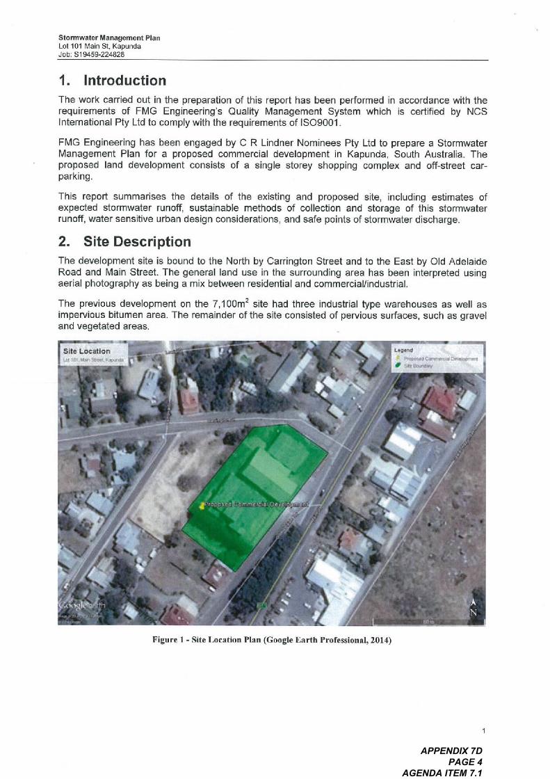
Stormwater Management PlanLol Ion Main SI, KapundaJob: SI9459-224828
I. Introduction
The work carried out in the preparation of this report has been performed in accordance with therequirements of FMG Engineering's Quality Management System which is certified by NCSInternational Pty Ltd to comply with the requirements of ISO900, .
FMG Engineering has been engaged by C R Lindner Nominees Pty Ltd to prepare a StormwaterManagement Plan for a proposed commercial development in Kapunda, South Australia. Theproposed land development consists of a single storey shopping complex and off-street car-parking.
This report summarises the details of the existing and proposed site, including estimates ofexpected stormwater runoff, sustainable methods of collection and storage of this stormwaterrunoff, water sensitive urban design considerations, and safe points of stormwater discharge.
2. Site DescriptionThe development site is bound to the North by Carrington Street and to the East by Old AdelaideRoad and Main Street. The general land use in the surrounding area has been interpreted usingaerial photography as being a mix between residential and commercial/industrial.
The previous development on the 7,100m' site had three industrial type warehouses as well asimpervious bitumen area. The remainder of the site consisted of pervious surfaces, such as graveland vegetated areas.
snO LOGation
Figure I - Site Location Plan (Google Earth Professional, 2014)
APPENDIX 7D PAGE 4
AGENDA ITEM 7.1
Stormwater Management PlanLot 101 Main SI, KapundaJob: SI9459-224828
The proposed site layout consists of a single storey supermarket, Car parking for customers will beprovided by means of off street parking within the site. The proposed layout also includes perviouslandscaped areas along the boundaries of the car park.
The survey plan of the existing site indicates a difference in height of approximately 5.8m acrossthe site. The site is benched at three locations, with the highest bench RL on the Northern end ofthe site, and the lowest at the west.
3. Existing Drainage ConditionsThere is no known existing underground stormwater infrastructure within the subject site or thesurrounding area. Currently, stormwater runoff management is achieved through overland flowpaths (road verge invert and piped driveway crossings) which eventually discharges to the existingwaterway at the low point in Harriet Road to the south west.
The current legal points of discharge for the sites stormwater runoff is in Carrington Street and OldAdelaide Road.
The Light Regional Council has indicated that the peak runoff from the developed site during the Iin I 00 year ARI critical storm event (with coefficient of 0.9) is to be restricted to thepredevelopments peak runoff during the I in 10 year ARI storm event (with coefficient of 0.25). It isappropriate to assume that in this instance, the council pre-development condition of the coefficientof runoff of 0.25 for this site did riot truly reflect the pre-development conditions. By utilizing bothaerial photography and site inspection records, the pre-development runoff coefficient has beencalculated to be 0.7. The maximum rate of stormwater discharge from the site must riot exceed32Us.
4. Proposed Stormwater ManagementThe site is proposed to be developed with a 2,641 in2 shopping centre building. The remainder ofthe site will be impervious paved car parking and pervious vegetation strips. A volume of detentionwill be required in order to meet Council's stormwater management requirements.
The pre and post development flow rates have been determined using the DRAINS StormwaterSoftware, with results summarised in Table 2. Hydrological models of pre and post developmentcatchments are simulated using the Extended Rational Method model and rainfall data from theclosest rainfall gauge to the subject site, which gives an accurate representation of peak detentionvolume requirements for the site. A summary of the peak runoff values can be seen in Table 2.
Table I - Summa
Table 2 - Sunna or H drolo ical Model Results
Rainfall Volume in3AREA Flow Rate (Us)
80* 65.9Pre-Develo merit 5 ear ARIPost Develo merit I 00 Year ARI 206 134
*indicates pre-development peak flow rate, which cannot exceed 32Us,
Based on the restricted outflow of 32Us the required detention is I loin'.
Pre-Develo merit
Post-Develo merit
of Stormwater Maria ement Re uirements
Runof, Coefficient0.7
0.90
APPENDIX 7D PAGE 5
AGENDA ITEM 7.1
Stormwater Management PlanLot ,01 Main St. KapundaJob: SI9459-224828
5. Proposed Stormwater System
5. , Onsite Detention StorageIt is proposed that stormwater runoff will be stored in underground detention tanks located beneaththe car park, to the south-west of the site. From preliminary calculations it is likely that theunderground detention tank cannot drain by gravity to the existing road level in Carrington Street orOld Adelaide Road - assuming a detention tank depth of jin, with 0.6m cover and that designsurface levels will involve filling the low part of the site by approximately 2m. Gravity flow to HarriettStreet is achievable; however additional investigation will be required during detailed design. Aneasement through the private property to Harriett Street will be provided by the developer. Someallowance for surface storage and above ground detention for roof water should also beconsidered to reduce the volume of the underground structure. Different detention configurationswill be investigated during the detailed design, including rainwater storage tanks.
5.2 Piped Stormwater SystemSurface flow from the car park area will be collected with a series of grated inlet pits at various lowpoints. The 100 year ARI piped system would divert runofr from the site into the undergrounddetention tank. Likely pipe sizes will be 225mm diameter with some downstream collector drainsneeding to be 300mm to 375mm diameter, All down pipes will be collected through a separatedrainage system and enter the detention tank at a single inlet point.
Details of the piped collection system and configuration will be determined during the detaileddesign. A concept design showing a diagrammatic stormwater layout is included in Appendix B.
5.3 Water Sensitive Urban Design (WSUD)Litter traps will be implemented in all surface inlets as a form of primary treatment of grosspollutants.
Stormwater retention will be provided using rainwater tanks for reuse in flushing of the toilets andirrigation of the sites landscaped area. A storage volume in the order of 22,500 litres will beinvestigated for this purpose at the detailed design stage.
6. Conclusion
Due to the sites characteristics it is recommended that the site's stormwater runoff be dischargedinto the proposed underground detention system, It is believed that the trickle flow from thedetention tanks of up to 32Us in the events greater than I in 10 year ARI is acceptable fordischarge into the verge of Harriett Street. Stormwater retention into rainwater tanks forsubsequent reuse in toilet flushing and landscape irrigation will assist in minimising the flow fromthe site.
APPENDIX 7D PAGE 6
AGENDA ITEM 7.1
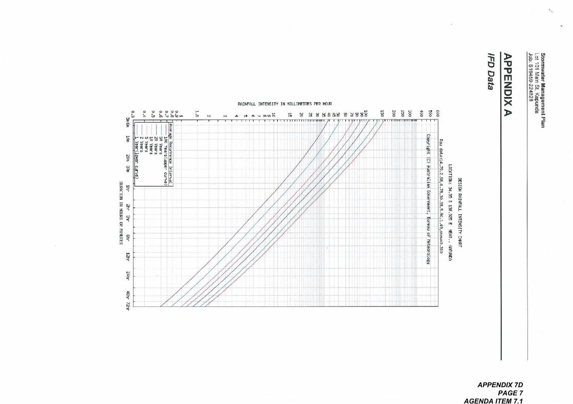
co A
g,
Q 0 @ o000
U a ^ GOP
H
a PN"!^^g^
^^ ^ ;^;^;^;S= ,, aq
: ^V C
^
^,
^^
^^^^
-
" N
^
^
co^
^
,=n
P' ^ " CD^@00
^I'm. L I"DEITY IN HILLIEmES ^R I^
!a=
^
^
co
, , 1, n'. ',,' ''1;4' I, 1.11 .. ,I, II, I I , '4 I+1:11*,
'1.1'^I 1,111^", I I 11^! I* *"~ I^ I' *I'i~* " I 11 I ^' 4~. it
I +' ' ^.; ,-;*!1'/1" ._ I_I_I 11 I I""*"{'*I ill. I. _ '
'-!-til'.!,: I, ' I I,- . .
I_'_I, i, .L i1 !11; ! _.__._ _,. I. L !_IJ. ,.- -- "
H
.
^
N
^,
^ ^ !, S 8188S ^ ^8!88
"
^
P
g^ ^^^
~~
'11o
>^.inZ.
><>
ba,^
-
g.
a
a*
,_ F Co
a~O
".^^="01 g:. 8^, =. .N CD =N~"
o9 7< "
06 .
a. O
^CD^
~.
g ^^^ 9. <
..
^
^
.- is ^ 13^.
F
g9 -;; $1 ,^1:1^co^^^P, mar
^^^^;i^^^ ^^
*
^
00 co^
t,
in=^
,.=
-
APPENDIX 7D PAGE 7
AGENDA ITEM 7.1
Stormwater Management PlanLot 101 Main SI, KapundaJob: SI9459-224828
APPENDIX B
Concept Stormwater Plan
APPENDIX 7D PAGE 8
AGENDA ITEM 7.1
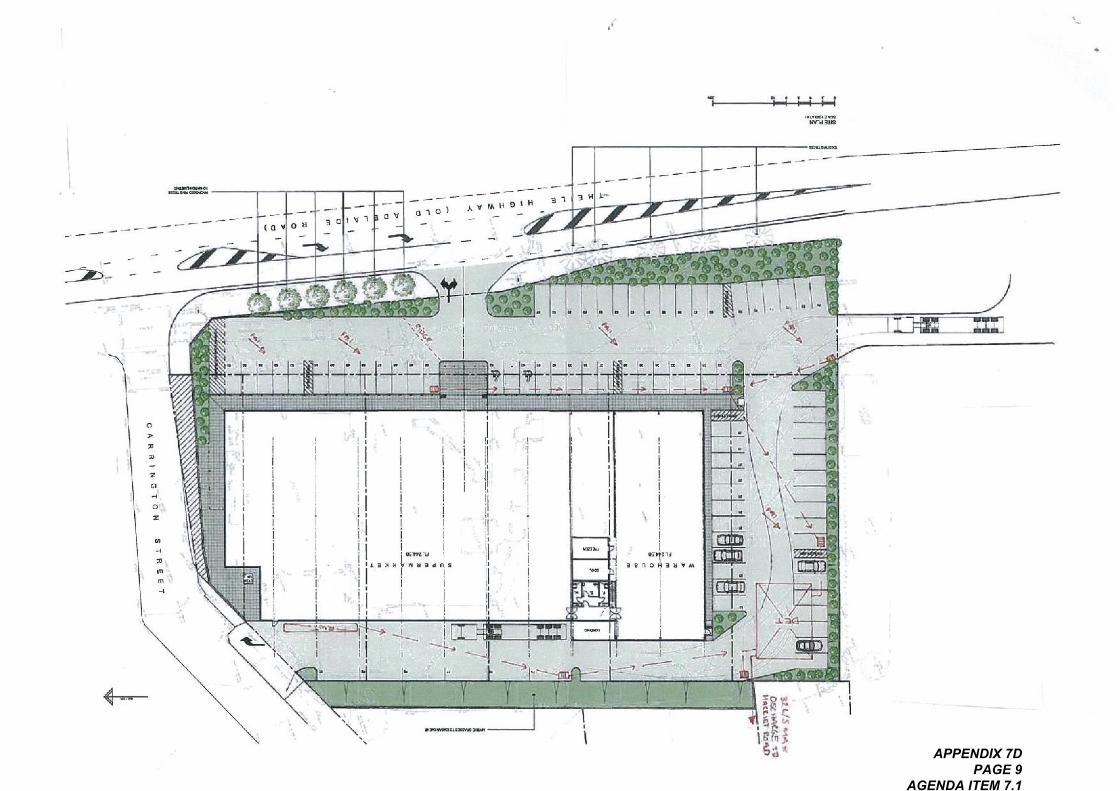
-- -----------
.>-
^a",.
I
co . ~ ^:I^
.,\\.. . . .
.*. ,,, . ^.., ^^. -, Iz .,. I
; ',^-,. I;, I; I~- " 'z ,^':. Ico "" I
:, in ,^ ,\ *.,~
,
10 oU 301V,OtOi A _ .oV
^.....
a"L
^^^
<-,"-
.
^;-r-I-I
^^^
. ,...... ..*..".
*_^\I,\
^^^
I .,
I ",,, uIL. ". "..,
W. ,""
-----
..
\
" .
, , """"" I ''I"" I
-,._G,
\
" .
^;I,
.
^"..~".
.
:;I
aim
=
,7,=,
an I^I
^a^ip ,^a* APPENDIX 7D
PAGE 9 AGENDA ITEM 7.1
SIUDllnSU* OV19
';:I\\,
.
. . \ *'.,,=*r. *, , ,- , ~..,.,-. \. ..
.I~.,*'\~% ;" t .
=I ...\
,^!..*.* ..
' "","'*\', c\-v '.,--.' ' ;- .
. , * - ,:.. t{ .*: ;;:*;\*$* ,,,.*.\ .
'.- ., .-,. fL . :. - .I *~ -. ,, -- , Aji;^.-.,.*; " ~.*, 1.3. '. *,,.., , '. . ' ' ' . '.. , ; , ,';;^'t',','t':I*.
..:;;. ,,. F c. * > \. qj"' "*^;=.'*.--' " ""' " " ' " . n ., " ;}?=, ,;. . '"'~ ' ' ' " '~ ' " " ':"' "is',*. ,. . *.,. ,, ,M* , * ' *. a. t$t ! .
.';,:*;*I^':' ... I&. " ' ' - '-,!;' :\ ., t**;;. '-'.-'4^:I\~ JP**,\ . I ;. * , :-, ,' I. , **^:,' .V , ,. . ,* .,. . . "
. .':;;.;*:. }$!*,, , ., . ^;!' :*.;;$:I ' ",.. " *j ' '~ ,,,. ..':.* A, ., ' ". a .'.' .'.
" 'tl^...' ?I'* " '.' . . .*r*'. .". a ':14' ',;' "' ' ' ' ' "" ' ~ * . ,:.
It, ^$.^; ,., ,^,\. . - . * ' " ' ' ' ' "'-:~,,. -, I, --~.-, ,. - . ~. *- ,~: ~ ,.-.
. ... .*..\. , *^$:; *, t ',, ~,-.!
;'-"^' '\:^;;:'itr *' -' -, . -'. . ,r ~ . ^;^ ; ' ' ... A. .,-,. .J " t, .,,
.. ' *i. -\?', ^;' "~'. * - ^;I^I ' A -. ,. .,. . ,.", ..-. . .
":. L. .'- ,. ,*, ,. , .,, ,j&;*-\,
AleAij8ppUD U6!Sep 6u!uuoid uoiiD+, 10dsuoJ+
.,..,
,
*. L, =' .
... ..,.,
I Vi 11.1. . '. 11, ,, j, .,,opundO>I,*,' "
ADMLj6!H ele!q!t
Ie^Jouedns pesodoJd
*r. .\,, ,;*' '
,.,;**
,,
C, . *qJ, \
~...
:;' ';^$tit; '- ,.,,.. ;;,. I;!\,;., t. ,*
I~ . t *<L. ,.
.
$1.,
, .,.
. .~
I
APPENDIX 7E PAGE 1
AGENDA ITEM 7.1
Proposed Superin orkef
Trijete Highwoy, KGpundo
fronsporf Impocf Assessment
Qualify Record
Issue
A
Dole
Client: CR Linder Nominees Ply LtdReference: 15A1025000
CTA Consultonfs Office: SA
08/09/ 14
Issue: A 08/09/14
Description
Finol
Prepored By
OGTA Coinultoriis IGTA Consultonls ISAj Ply Ltdj 2014The in10rmolion conjoined in Ihis document is confidentiol. ridintended solely IOU the use o1 Ihe client for Ihe purpose for whichit hogbeen prepared and no representolion is mode or is 10 be implied OSbeing mode to any mild pony. use or copying o11his document inwhole or in port without the whilen permission of GTA Consultonlsconslifules on infringemenl orcopyrighl. The intellectual properlyconjoined in this document reinoins Ihe properly of GTA Consullonls.
Sqm Adorns
Checked By Approved By Signed
Foul Morris Poul Morris ^,~,
G TA c o n s ulIo nIs
MELBOURNE - SYDNEY - BRISBANE , CANBERRAADELAIDE - GOLD COAST . TOWNSvlLLE
WWW g*0. coin. ou
.,-\
O\^","I
APPENDIX 7E PAGE 2
AGENDA ITEM 7.1
Toble of Contents
Introducllon
I . I BCCkground
1.2 Purpose of I his Report
I. 3 Referenced Documents
Toble of Contents
Existing Condi"ons
2.1 Subject Site
2.2 Rood Network
2.3 Susfoinoble Ti'onsport infi'OSIrucfui'e
Development Proposol3.1 Lond Uses
3.2 Cor Forking
3.3 Vehicle Access
3.4 Fedestrlon Focalmes
3.5 LOGding Are OS
Cor Parking
4.1 Slotufoiy Cor Porking Requiiemenfs
4.2 Empiiicol Assessment
4.3 Adequocy of Porking Supply
4.4 Cor Forking Loyouf
Susloinoble Tnnsporllnl, .OSIrucfure
5.1 Bicycle End of Trip Focililies
Loudlng Focililies
6.1 SI Glutory Requirements
6.2 Proposed LOGding Arcngements
flufflc Impocf Assessment
7.1 Ti'Qinc Generation
7.2 Trothc Impocf
3.
4.
OGOG TAc o ns ulf o nls
5.
7.
a.
9,
Old Adelqide Rodd
Conclusion
Appendices
A Swept Path Diogroms for 19.0m Semi-Troiler
B: SIDRA INTERSECnON Results
C: Proposed Access
15Ai025000
Froposed SuperIntr*el, Titele }righwc, y. lopundoTronsporl Impoci Assessment
08/09/ 14Issue: A-Di
APPENDIX 7E PAGE 3
AGENDA ITEM 7.1
Figures
Figure 2.1 :
Figure 7.1:
Figure 7.2:
Toble of Contents
Subject Site Grid its Environs
Estimated Directiono1 Distribution
Esfimof ed Redk Hour Site Generofed Trothc Volumes
Tobles
Toble 2.2:
Toble 4.1 :
Toble 4.2:
To ble 7. I :
Accident History 12009-2013j
Slotulory Cor Po^ing Assessment
Empirtcol Porking Assessment
RTA Guide Trothc Generolion Esfimof es
O-e--.GIA consulla nts
15A 1025000
Proposed Superin or*el. Tk, ele Highwoy. 1'0pundoIronspoil Impocl Assessmenl
08/09/14
Issue: A-Dr
APPENDIX 7E PAGE 4
AGENDA ITEM 7.1
Bockground
A development OPPlicotion is currently being sought for o proposed supeimorket on 10ndlocaled of the corner of Cowing ton Street ond Thiele Highwoy/Moin SI reel.
GTA Consultonfs wos commissioned by CR Lindner Nominees Ply Ltd in August 2014 to underjokeo I crisporf impocf OSsessmenf of I he proposed development.
Introduction
1.2 Purpose of this Report
This report sets out on o55essmenl of I he Griticipofed porking, frof!ic Grid ironsporl implications ofthe proposed developmenf, including considerof ion of the:
i existing froffic Grid porking conditions surrounding I he site;in porking demond likely 10 be generoled by the proposed development:in suitobilily of I he proposed poking in terms of supply Iquonfumj Grid 10youf;iv fromc generofion chorocteristics of the proposed development:v proposed occess orrongemenfs for the sife;
vi Ironsporl impocf of I he development proposol on the surrounding rood network.
Introduction
I. 3 Referenced Documents
In prepoiing I his report, reference hos been mode to o number of bockground documents,including:
Light Regionol Council Development Pion iconsdidofed 24 Jonuory 2013j;AUStrolion SIGndord/ New Zeolond Sinndord, Porking Focililies, Port I : Off-Street CorPorking As/NZS 2890. I:2004;
AUStrolion SIondord, Porking Focilifies, Port 2 Off-Street Coinmerciol Vehicle FocilifiesAs 2890.2:2002;
AUSlrolion SIGndord I New Zeolond SIGndord, Porking Facilities, Pond Off-Street Pokingfor People with Disobilities As/NZS 2890.6:2009;
PIOns for I he proposed development prepored by DM Lowrence Design doted 23 July2014;
froffic Grid cor porking surveys underjoken by GTA Consultonfs OS referenced in thecontext of this report;
vonous fechnicol dojo OS referenced in f his reporton irispecfion of the site Grid its surrounds;other documents OS nominofed,
O;GTAc nsultonts
ISA 10250m
Proposed Supermoirel. Thiele Highwoy, KopundoTronsporllmpocf Assessmenl
08/09/ I4
Issue: A
Foge:IAPPENDIX 7E PAGE 5
AGENDA ITEM 7.1
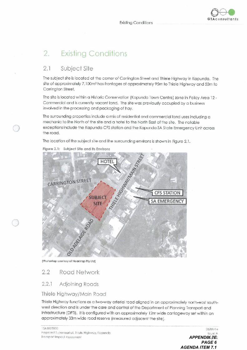
Subject Site2.1
The subject site is IOCofed of the corner of Cowing ton Street Grid Thiele Highwoy in KGpundo. Thesite of OPProximofely 7,100m2 hos frontoges of OPProximofely 95m to Thiele Highwoy Grid 50m toCowingion SI reef.
The site is localed within o Historic Conservofion IKopundo Town Centrej zone in Policy Are0 12 -Coinmerciol Grid is currently voconi 10nd. The site wos previously occupied by o businessinvolved in the processing and pockoging of hoy.
The surrounding properties include o mix of residentiol Grid coinmerci01 10nd uses including omechonic 10 the North of the site Grid o hotel 10 the North EOSf of f he site. The notoble
excepfions include the KGpundo CFS slotion Grid the KGpundo SA SIGfe Emergency Unit ocrossIhe rood.
Existing Conditions
Existing Conditions
The location of the subject site Grid the surrounding environs is shown in Rgure 2.1
Figure 2.1: Subject Site grid its Environs
O-G-.GTAc@nsulio nis
CARRINGTON STRE
HOTEL<^^.
EL ^EL Is"c. >
^.
.^,.^:^^
.^:.
*^I'4q
<;>'\
A^'
SUBiE
SI E
o^.
<4, ..^)
^3'Q
^..
"v
IPhotoMop courtesy o1 NeorMop Ply Ltdj
Q
2.2
2.2. I Adjoining Roods
Thiele Highwoy/Moin Rood
Thiele Highwoy functions OS a two-woy dried o1 rood o1igned in on OPProximofely north-eosf south-west direction Grid is under the core Grid control of fhe Deportment of PIOnning Tnnsporl GridInfrastructure lopTl). If is configured with on OPProximofely 12m wide coinogewoy set within onOPProximofely 33m wide rodd reserve lineosured odjocenf the site).
Rood Network
CFS STATIO N
SA EMERGENCY
15A1025000
Proposed Superinclkef Thiele Highwoy, KGpundoTronspoiilmpocl Assessmenl
08/07/ 14
Issue; A
Poge: 2APPENDIX 7E PAGE 6
AGENDA ITEM 7.1
S:960dv lenssj
b1/60/80
PIOZ Ish6nV 11 PelDP 5910LU!153 Low 5.0JniOruiSDJJui puo podsuoij'6u!uuDjd10 IueLLij. IDdeq aqjuo pesog
A1u0 660u, Do Apedo, a
o
' I Z 81qoL
u! pelueseJd s! 1810z. 600zj poped JoeA eA!I 91qoj!DAD ISOj eLjj, 01 SIuep!ODD eLj+10 NoniLuns v
'11dO coo, I POD, nos ueeq SOLj
al!S 10e!qnS elf+ 6u!u!01pD SUO!logsJeju! puo spool eLjj 101 A10js!Lj Iuep!ODD pepodeJ allj 10 Me!A9J v
So!Is!JOIS Iuep!o0V SZZ
'toes!IOU6!sunj ADAAq6!H eje!qnjeeJjs uoj6u!1100:(IUSLUd019AOp
pesodoJd 9111 10 +IDd so pesojo eq o11 ADA\Li6!H ale!qnPDO^ aP!01ePV PIO
:el!S aLlj 10 A1!U!0!A eq+ U! Is!XO AlluOunO suO!;DesJejU! 6u!MoilOJ 9qL
suo!;DesJe+uj 6u!pun unI^ZZ
'Ll/LA, >109 10 uru!I peeds Den dn 11!nq 41.01ep aLjj o1 10e!qns s! POOHeP!01ePV PIO 'ADP led salo!LieA o09 uoqj ssej aq pinom 81!s 10e!qns aqj o1 Iueoo!pD serumoAOgJDJi IDq+ peloLu!Ise s! I!IeAeMOLj poo^I ap!DiepV PIO Joy p9u!01qO ueeq SOLj DIDP 0!!10.1 ON
Bus o111 Iueoo!pD pail!Luied s! 6uwod ep!sqJe>I
'P00^I >1000UDH
04 JoeU '91!S eLjj 10 qrnOs eqj o4 86puqq6!aM 6u!Is!xe u0 o1 sseooo sep!AQId pOO^I ep!Diepv PIO
ADMq6!H eje!qL aqj 6u!pnPu! lei!s at11 Iueoo!po pernsoeu. 11 grussei poorep!in LLigg AlejoLu!xoJddD uo u!Lj+!Mies ADAe60!UDO ap!in LLij I Ale!DLL, !xoJddo u0 11NM pan6!!uooS! 11 'ADmLi6!H ale!Ljj aLj4 o1 leijo, od puo IueoojpD pool eo!Nes o so suo!+Dun! poO^I GP!DiepV PIO
poo^! ep!o18PV PIO
'q/LU^09 10 I!U, !I peedS DelD dri4/1nq linolep aLjj o1 joe!<1nS s! leeJjs uoj6U!UDO 'ADP Jed 5910!HeA o09 uoLj; ssej aq pinom sewnjoA
O!!!0.1 IDLlj pelDLu!Ise S! I! IeAemoLj leeJjs uoj6u!LID0 104 peu!o1qo ueeq SDU OPP o910/4 ON
'aj!s aLjj Iueoo!pO pen!ruled S! 6u!^Jod ap!sqJe^
'Ie+!S aLjj IUeoo!po pelnsoeuJj eruese, pool ep!M IAIzj AlejDLLi!xoJddDUO U!Lll!in IeS ADN\a60!UDO ep!M LLi8 AlejDLLi!xo, ddo uo Lji!M pan6!!uoO s! 11 'U0!109J!p
Isem~ ISO99ioLu!xoJddD UD u! peu6!ID pooJ sse00010.01 ADM-Qin+ o so suo!puni lee, +S UOi6u!LIDo
leeiis u0+6u!UDO
'q/Lu^09 40 I!co!I peeds pelsod oSDU PUD 91!s 10e!t^ns eLjj o1 Iueoo!po ADP led sep!qeA o0t. 't, Ale+DLLi!xo, ddo se!1100 ADMLj6!H ale!Ljj
91!S e!41 IueODtpo pen!ruled s! 6u!^iod ap!sqJe^
A, ofui ,euro
'ON IU6p!30V
e
jugLLiss^55v podLUI I'dSub, IDDLlndD\I AGMLi6iH 919!Lii 'PIJD, LIEdng pesodOia
0009;:01VS I
kirijuj snO!BS
oo
AMDjoJ
to 10Z'600Z) A104siHjuepp9v
ADAAq6!H9101UL I leeJjs uoi6uuJDO
Udo :ao, nos
uo!ID^o1
'1'3 81qoi
SIU 011n S U O OVL9
Go\
suq+!pu006u!Is!xg
APPENDIX 7E PAGE 7
AGENDA ITEM 7.1
Tobie 21 indicates I hot I he intersections odjoining the site ore generolly operofing sotoly with onecosuolfy crosh reported in 2009 of the intersection of Cowing ton Sireef Grid Thiele Highwoyresulting in three cosuolfies.
2.3 Sustoinob!e Tronspor+ In frostructure
2.3. I Public Tronsporf
No metro ticket public ironspori services operofe post the site except for doily bus servicesbetween Govler ond KGpundo provided by privofe bus coinpony LinksA2
2.3.2 Redestrion In frostrucfure
Coinpocled rubble pedestrian paths ore provided on the North-west side of Old Adeloide Rood,the North-EOSl side of Thiele Highwoy ond on both sides of Cowing ton Street. The uriconslrucfedridure of the pothwoys could render them unusoble during periods of inclemenf wedher. Thepoths do not OPPeor to be DDA coinplionf of moriy IOCotions.
2.3.3 Cycle In frostructure
No dedicated on-street bicycle lones ore provided in the vicinity of I he site
Existing Conditions
.-\
O\,GTA consultonls
2Ihtfp://WWW. odeloidemelro. coin. GUIbusso/regions/bcolJs12. him11
ISAI02500o
Proposed Supe, monkel. TITiele Highwoy. FopuitdoTrollsporf Impoc! Assessment
08/09/ 14
Issue: A
Puge:4APPENDIX 7E PAGE 8
AGENDA ITEM 7.1
3,
3.1 Lorid Uses
The proposed development includes the construction of o shopping centre with OSsociofedworehouse, SIoroge, office spoce Grid cor porking. The proposed development comprises I hefollowing:
Superin orkef of 2,075sq. in GLFA;Worehouse grid sforoge oreo of 6395q. in GLFA;Mezoriine level of SIGff room I office of 75sq. in GLFA;A 100ding dock of the reor of the site;
79 ground level cor porking spoces;
Access points to Old Adeloide Rood, Thiele Highwoy Grid Cowing 10n Street.
Development Proposal
Development Proposol
3.2 Cor Porking80 cor porking spoces ore proposed, including 2 disobled spoces Grid on OSsocioted shoredspoce.
3.3
Three occess points ore proposed OS follows:
A two-woy tentry Grid exitj occess point localed o10ng Thiele Highwoy;A one-woy Iexit onlyj occess point localed o10ng Cowing10n Street;A one-woy lentry onlyj access point for 100ding Grid coinmerciol vehicles only localeddong Old Adeloide Rood
O-e-o
Vehicle Access
CTAc o n s ulio nIs
.
3.4 Pedestrion Focilifies
The proposed development will provide suitoble pedesf nori connections from the cor pork to theshopping centre eatronce.
LOGding Are OS
A 100ding oreo is proposed o10ng I he north western edge of the site, with trucks occessing I hesite from Old Adeloide Rood Grid exiting the site in o forword direction towords Moin Street, vioCowing10n Street.
15A1025000
Proposed Superincrkel TITiele Highwoy. FopuitdoIronspc"11mpocl Assessrnenl
08/09/ 14
Issue: A
Foge; 5APPENDIX 7E PAGE 9
AGENDA ITEM 7.1
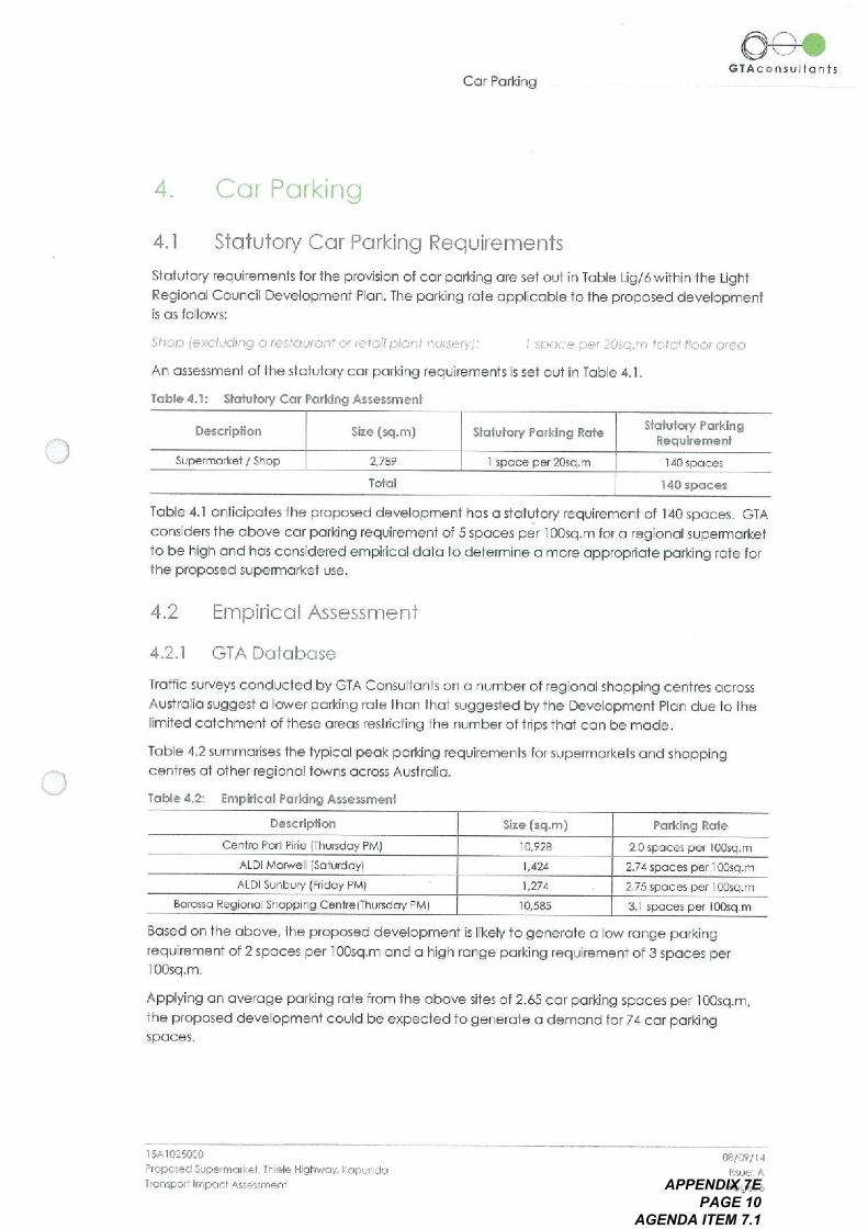
4, Cor Porking
Slotutory Cor Porking Requirements
Slotuf ory requirements for the provision of cor porking ore set out in Tobie Lig/6 within the LightRegionol Coundl Development Pion. The porking rote OPPlicoble to the proposed developmentis OS follows:
Shop jexcludng O restciuroitt o1' letoiij, 10nf ITUiseiyj: I spoce per 20sq. in 10/01 floor o160
An o55essmenf of the slotufory cor porking requirements is sei out in Tobie 4.1 .
Tuble 4.1: Slotulory Cor Porking Assessment
Cor Forking
Slotulory ParkingRequirement
140 spoces
140 spoces
Tobie 4.1 GriticipofesIhe proposed development hos o slotufory requiremenf of 140 spoces. GTAconsiders the obove cor porking requirement of 5 spoces per 1005q. in for o regionol superin orkef10 be high Grid hos considered empirlcol doto to determine o more OPPropriofe porking Tote forf he proposed superingrkef use,
Descripfion
Supermontel I Shop
4.2
CD '
Size (sq. in)
42.1 GTA Dojobose
Troffic surveys conducted by GTA Consultonfs on o number of regionol shopping centres ocrossAUSf rolio suggest o lower porking role Ihon Ihof suggested by I he Development PIOn due to thelimited CGIchmenf of these oreos restricting the number of trips that con be mode.
Table 4.2 summonses the typical peok porking requirements for superin orkels Grid shoppingcentres of of her regiono! towns ocross AUSfrolio.
Toble 4.2: Empiricol Forking Assessmenl
Description Forking Rote
Cento Port Pine IThursdoy PMj 2.0 spoces per 100sq. in
ALDI MOMell ISOlurdoyj 2.74 spoces per I 005q. in
ALDI Sunbury rendoy PMj 2.75 SPCces per 1005q. in
Borosso Regionol Shopping CentrejThursdoy RMI 31 spaces per 1005q. in
Bosed on fhe obove, the proposed development is likely to generoie o low ronge porkingrequirement of 2 spoces per 100sq. in Grid o high tonge porking requirement of 3 spoces per100sq. in.
Applying on overoge porking role from the obove sites of 2.65 cor porking spoces per 1005q. in,the proposed developmenl could be expected to generofe o demond for 74 cor porkingspoces.
GTAc nsultonts
Empiricol Assessment
2,789
Toldl
Sfofu+ory Porking Role
I spoce per 20sq. in
ISA1025000
Proposed Supeimo, kef Thiele Highwoy. FopundoIronsporl Impc, cl Assessment
Size Isq. in)
I0,928
1,424
1,274
I0,585
08/09/ 14Issue: A
Foge:6APPENDIX 7E PAGE 10
AGENDA ITEM 7.1
4.3 Adequocy of Porking Supply
The proposed development will provide 79 off-street cor porking spoces for SIGff Grid visitors,including 2 disobilily parking spoces. This equales to o poking supply of 2.8 spoces per 100sq. inof Gross Leosoble Hoor Areo IGLFAj which exceeds the identified porking roles from otherregionol IOColions.
11could riot be expected bosed on the population of KGpund0 10f some 3,100 peoplej Gridodjocenf regionol oreos ILighf Regionol Councilpopulolion some 14,000 peoplej Ihof the someporting demonds would be realised OS metropolifon IOCofions.
The surveys of regionol locations confirmed Ihof porking roles ore lower in sinoller regionol towns,Bosed on the discussion obove, Grid given the limited size of I he superin orkef catchmenf oreothe proposed cor porking provision is considered OPProptiofe to coter for peok shoppingdemonds in I he town
.
Cor Forking
Cor Porking Loyout
The proposed porking 10youf generolly complies with fhe requiremenfs set forth in As/NZS2890.1:2004. Some of the key design feolures ore described below:
90 degree origled porking spoces Ihof ore 2.6m wide Grid 5.4m long, set within on GISlewith o minimum width of 6.6m, which meets I he minimum requirements OS per theAs/NZS2890. I :2004 for o user CIOss 3A porking focilify:
90 degree origle porking boys for sinoll vehicles fhof ore 2.3m wide Grid 5.0m longwhich meets the minimum requirements OS perthe As/NZS2890.1:2004;A vehicle tumoround oreo hos been provided of the end of fhe blind Giste in the south-eosf corner of the cor pork in occordonce wi+h As/NZS2890.1:2004;
Pedesftion sight lines hove been occommodofed of the drivewoy enlronces inoccordonce with As/NZS2890. I :2004.
If is noted Ihof the occess from Old Adeloide Rood will operofe OS o one-woy ingress only occessfor coinmerciol vehicles Grid the occess to Coning ton Street will operofe OS o one-woy exit onlyoccess. If is recommended Ihof suitoble signoge i. e. NO Entry signs be instolled to control vehiclemovements of these locations.
4.4
oO\,61Ac nsulfon!s
ISA1025000
Proposed Superincrl:el. Thiele Highwoy I opundoIronsporl Impocl Assessment
08/07/14
Issue: A
Foge: 7APPENDIX 7E PAGE 11
AGENDA ITEM 7.1
Susfoinolole ironsport In frostructure
Bicycle End of Trip Focilities
There is no slotufory requirement to provide bicycle focilifies of the proposed development.However if is good procfice to provide some bicycle stooge focilifieslo encouroge cycling tothe development. 6 bicycle porking spoces will be provided neor to the enfronce to thesuperin orkef for use by 510ff Grid/or visitors
Susfoinoble Transport lnfrosfrucfure
O^.GTAc@nsulio nIs
ISA 10250CO
Plopo$ed Superin GIFel TITiele Highwoy. I opundolionsporl Impocl Assessnteitl
08/09/14
Issue; A
Poge:8APPENDIX 7E
PAGE 12 AGENDA ITEM 7.1
Looding Focilifies
Stotufory Requirements
The slotufory requirement for the inclusion of 100ding focililies is set out in Principle ofDevelopment Control IPDCj 'Centres Grid Shops' in the Light Regionol Council DevelopmentPIOn. FDC I 05 Sides:
LOGding Focilifies
Shop development o1.0 development in centres should meet the folbwiiig cinerio:
Id! nioke odequofe ond convenient provision for service vehicles ond ille 510roge Grid fernovolof wosfe goods Gild moteliols:
The development PIOn hos no oddtion01 100ding focilify requirements for o Historic ConservofionIKopundo Town Cenfre) zone
6.2 Proposed LOGding Arrcingements
A 100ding oreo forthe superin orkel is proposed to be located Giong the north-western side of thebuilding.
Access info the 100ding oreo will occur vio Old Adeloide Rood Grid on infernol circulolion
roodwoy Ihrough f he cor pork. 80/10rds or some other form of physicol borner will restrict occessfrom Old Adeloide Rood outside of 100ding times. It is understood thof building monogement willcoordinofe the reinovol Grid reinsfofemenf of the bother during 100ding times. Sufficientmonoeuvrlng oreo hos been provided for 0 19.0m long semi-froiler to troveI through the site,reverse into the 100ding oreo Grid exit in o forword motion
Logding will Iypicolly occur outside of pegk shopping hours to minimise conflict between trucksGrid cors. NOMithsfonding this, the 100ding oreo hos been seporoted from the in Qin cor porkoreo with only 6 parollel cor porking spoces IOCoted neor Io the 100ding ore0. 11 is GriticipofedIhot these spoces will generolly be utilised by staff OS o11 doy porking spoces.
Swept poth diogroms showing 0 19.0 in semi-miler entering Grid existing f he site ore shown inAppendix A.
CD\ eGTAc nsultonts
ISA 1025000
Proposed Superin or*el TITiele Highwoy I opuitdoTronsporf Impocl Assessment
08/09/14
Issue' A
Poge:9APPENDIX 7E PAGE 13
AGENDA ITEM 7.1
froffic Impoct Assessment
Design Roles
Trothc generofion esfimoies for proposed developments ore often sourced from the NSW RMSiformerly RTA) Guide 10 Troffic Generaling Developments. However I he roles conjoined withinIhe Guide ore Iypicolly OPPlicoble to IQrger shopping centres in metropolifon oreos with littledojo specificolly related to sinoller scale regionol superin orkel developments.
The Iroffic generation roles from the RMS Guide Ihof would be most OPPlicoble to the proposeddevelopment ore OS follows:
Shopping CeiTtres
V. 'c ekf:0!, Peo* Ifou, Genei0;10/1 Role IGLFA < 10,000so. fit 12.3 1/1/'51*ei 1005q. ill G. }^
Dollv Gener'oilori clie IG~FA <I 0,000so. In 12 I 1,105 pel 1005q. rr GUA
Bosed on the roles above, estimates of peok hour Grid doily fromc volumes resulting from f heproposol ore sei out in Tobie 7.1 .
Troffic Generofion
Troffic Impocf Assessment
Tobie 7.1:
Rots Movements
Peok Hour 12.31rips per 1005q. in GLFA 343 invinfs/hour
Doily 121 hips per 100sq. in GLFA 3,375 invinls/doy
Tobie 7.1 indicates I hot the site could potentiolly generale 343 vehide movements in o peok hourwith 3,375 vehicle movements over the entire doy. GTA considers these esfimofes to be highgiven the regionol IOCofion however these figures hove been used for I he OSsessment andrepresent o worst cose scenoiio.
O-e-.67Ac o n SUIlo nts
RTA Guide Troffic Generofion Estimates
GLFA (sq. in)
2,789
2,789
7.1.2 Distribution ond Assignment
The direction o1 distribution Grid OSsignmenf of froffic generaled by f he proposed developmentwill be influenced by o number of fociors, including the:
i configurofion of I he oneriol rodd network in I he jinmediofe vicinity of the site;in existing operofion of intersections providing occess between the IOCol Grid oneriol food
network;
jin distribution of households in the vicinity of the site;Iv likely disfiibulion of employee's residences in relation to I he site;v configurofion of occess points to the site.
Hoving consideration 10 f he obove, for I he purposes of estimofing vehicle movements, theinbound Grid outbound directiono1 distributions shorvnin Figure 7. I hove been OSsumed.
ISA 1025000
Proposed Super mori. el Thiele Highwoy I opundoIronsporl Impocl Assessntenl
08/09/14Issue: A
Foge: 10APPENDIX 7E
PAGE 14 AGENDA ITEM 7.1
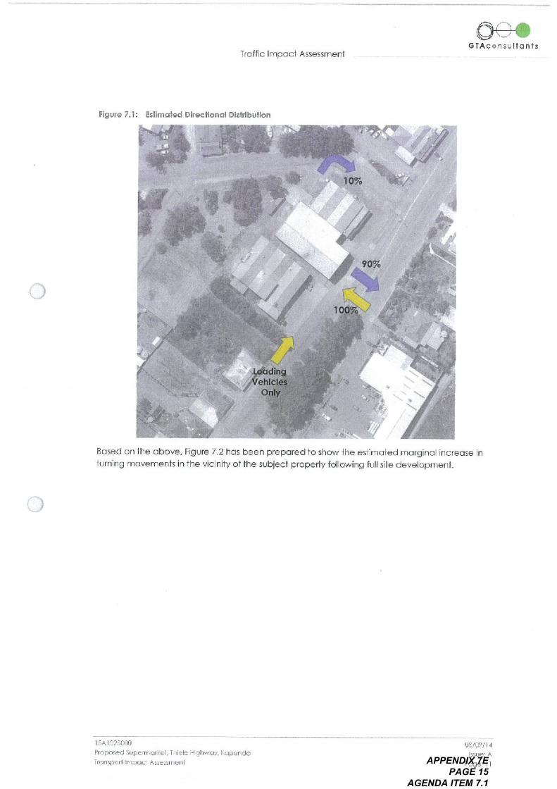
Figure 7.1: Esllmofed Direction o1 Disfrlbullon
Troffic Impocf Assessment
O\^CTAc nsulionts
10%
Bosed on the obove, Figure 7.2 hos been prepared to show the esfimofed marginol increose inturning movements in I he vicinity of the subject properly following full site development.
90%
dingehicle,
Only
100
ISA1025000
Proposed SuperInclkef. Thiele Highwoy. KGpundoT, onsporllmpocl Assessment
08/09/ I4
Issue: A
Poge: I IAPPENDIX 7E
PAGE 15 AGENDA ITEM 7.1
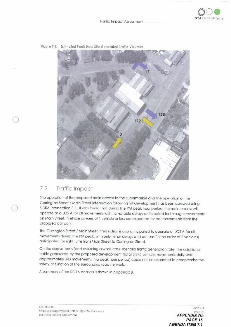
Figure 7.2: Estimated Peak Hour Site Generaled Trollic Volumes
Trothc Impocf Assessment
..
09-0GIAc o ns ulto nIs
7.2 Troffic Impoct
The openiion of the proposed in Qin occess to fhe superin orkef Grid the operofion of f heCowing10n SI reef I Moin SI reel intersection following full development hos been OSsessed usingSIDRA Intersection 5.1. If wos found fhof during the PM peok hour period, the ingin occess willoperole o1 0 Los A for o11 movements with no riot ode deloys on11cipofed for f hrough movementson Moin Street. Vehicle queues of I vehicle or less ore expected for exit movements from theproposed cor pork.
The Conington Street I Moin Street intersection is o150 Griticipofed to operofe of Los A for o11movements during the PM pegk, with only minor deloys Grid queues jin the order of 2 vehiclesIgriticipofed for jighl turns from Moin Street 10 Cowing10n Sireef.
On Ihe obove bosis land OSsuming o worst case scenorio Iroffic generofion rotej I he odditionolfromc generofed by the proposed development 1101013,375 vehicle movements doily GridOPProximofely 343 movements in o pegk hour period) could riot be expected Io compromise I hesofety or function of I he surrounding rood network.
A summory of the SIDRA ono1ysis is shown in Appendix B.
ISA1025000
Proposed Supermoirel Ihiele Highwoy I CPUndoTionsporl Impocl Assessit. enl
08/09/14I'Sue: A
Foge: 12APPENDIX 7E PAGE 16
AGENDA ITEM 7.1
8.
A weighbridge is currently localed on Old Adeloide Rood to the north-eosf of Honcock Rood
lopproximofely 150 metres to the south-west of the subject sitej. Bosed on informofion providedto GTA Consultonfs if is understood Ihof the weighbtidge is used by semi-froilers up to 19.0 metresin length OSsocioled with I he Vilerro groin hondling business. If is further understood Ihol trucksenter the weighbridge from the north i. e. there is no requirement for occess from Thiele Highwoyto the south.
Old Adeloide Rood
Old Adeloide Rood
Truck occess to this weighbiidge will be rest tided by the proposed development due to I heconsf rodion of o cor pork on I he existing portion of public rood 10 the north-eosi odjocent thesubject site. If is therefore proposed to construct o seporofe occess IO Old Adeloide RoodIimmediofely south-west of the subject sitej to focililofe continued semi~froiler occess to theweighbridge.
A short right turn lone would be provided on Thiele Highwoy copoble of storing 0 19.0m semi-froiler. The occess is intended for truck use only however if could GISo be used to occess the sinollnumber of properties that exist along this section of Old Adeloide Rood. Given the one-woynature of the occess NO Entry signs would be instolled to prevent vehicles from trove11ing out onIoThiele Highwoy Grid NO Through Rood signs would be instolled o1 the enfronce to Old AdeloideRood neor Honcock Rood to further odvise drivers Ihot occess to Thiele Highwoy is riot formollypermitfed.
Subject to deloiled design Grid confirmofion of Vilerro's truck occess requirements, GTA considersIhe proposed design sdulion to be on appropriate oriongemenf to in Qinfoin truck DCcess to theexisting weighbridge in Old Adeloide Rood.
The finol design would o150 0ccommodofe o suitoble turning oreo for jighf vehicles Grid sinolltrucks IMRV or less) that enf er this section of Old Adeloide Rood.
A copy of the proposed occess is shown in Appendix C.
O-e-.GIA cons ulto nis
ISA1025000
Floposed 51.1peimorl ei Ihiele Highwoy. 1.0pundoTrollsporl Impocl Assessmenl
08/09/14Issue A
Foge: 13APPENDIX 7E
PAGE 17 AGENDA ITEM 7.1
9
Bosed on the Gridysis Grid discussions presented within this report, the following conclusions oremode:
i The proposed development generates a slotufory porking requirement of 140 spoceswhich is considered high for fypicol porking demonds;
it The proposed supply of 79 spoces is considered suitoble given I he limited catchmenforeo neor to the site;
jin The proposed porking joyoul is consistent with I he dimensionol requirements OS set oofin the AUSfrolion/New Zeolond Skindords for Off Street Cor Porking IAS/NZS2890. I :2004Grid As/Nzs2890.6:2009);
iv The provision of 100ding is considered suitoble with odequote monoeuvrlng oreosprovided for 19.0m semi-froilers to enter Grid exit fhe sitein o forword motion;
v The o55essment hos found the proposed occess points grid odjocenl intersection willoperote with minimol queues Grid deloys;
vi There is odequofe copocity in the surrounding rodd network to corer forthe fromcgeneraled by the proposed development;
vii Subject to deloiled design Grid confirmotion of VilerTo's truck occess requirements f heproposed new occess from Thiele Highwoy/Moin Street is considered on OPProprlofeo11emofive 10 indriloin truck occess to the existing weighbridge in Old Adeldde Rood.
C O n CIU SIO n
Conclusion
O-e-.GTAc o n SUIf o nIs
ISA1025000
Proposed Superinor1 o1. Ihiele Highwoy. KopundoTronsporl Impocl Assessment
08/09/14
Issue: A
Foge: 14APPENDIX 7E
PAGE 18 AGENDA ITEM 7.1
AID p e n d IX A
Swept Poth DIGgroms for 19.0m Semi-Troiler
Appendix A
O-e-.GTAc o n s ulf o nIs
>^^coaQ.><
>
ISA1025000
Proposed Superin o1ke1 11. ele Highwuy. koi:^undoIronspori Impocl Assessment
06/09/ 14
Issue: AAPPENDIX 7E PAGE 19
AGENDA ITEM 7.1
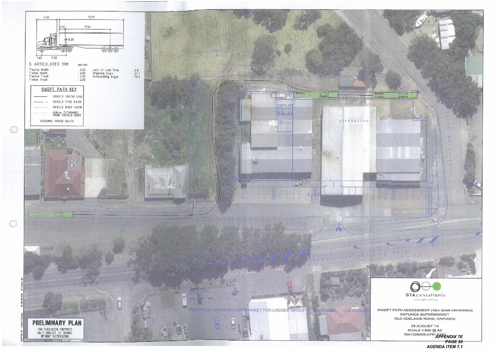
PLO
TTE
D B
Y rl
, h",
. fop
. rig
O. =
.,^
^ in
=<
. F
^ ;^ ;
^ =^;:
:: =
^=^
>C
> ' ^
=.
^ c>
Z^
^=
^co'F
,
on
25
10
. /,
, I,
AT
co
in
" A
n
> =
11/1 I I
.
o
> co
co
C = n,. co . 06=
in =
= ;
^in =
F.
Co
C in
To <
<
<
2.6
minm
=^
^ F
,F
Fin
^^
I ^
=O 7<
in H Tl
o 70 r Z . Z in
un
*.
= \ =
mr.
-in >
^, ^
I =
I =
I co
=n
=n
>
, ,=
D
=' -
^;
^: ~
P ' ^
:- F
\
a, ' =
.
90
p
p
HD^ ^ , > - = 7<
in <
CD
H
'
@<
n 2a^
-<
in
30
,.
> --
=Z
rin
@Z
OR
<
^ > ^ =
^ ,.o
:O o C ^
>un
-I
by
rrj e
.
^!I 11
^^-
: j. I
^^!;.
(^I
^
^ are
NN
N in
un
in
un
in
,e
ee
o in
Tl
^ Z
^
, !C
S-. . a. '
9.
, o
- I~
@=
n
@
+. n
"
6 IQ e
o o
^*
.Q
> d in
@ @ @
C un^
,
^ u,
~ ^
>co
'ON
O>
01
o'>
Qin
Co. 0
. 0
1C
>o
co
'I O
H, .
6>
^' C
o
^O
>
.^^
^^^
.. c
oin
cco
^."
^>
co
1/1
to =
70 C
inO
nZ
' :U
A,
:U .
^^^
, 7<
00cm
mz 'I ^
,^:,
^.,
, ^
a . . a
> .
.
,
CD
in
9,
^,-
F >
^.
=co
oC
^=
80
o in
. >
\
:a o
in Z ^ in :O Z o
. ^ to
D
V I
I I
I\
^
^
I
11 I
11 I
co t in 30 = > a A in
CA
RR
IN
11/11
GT
ON
APPENDIX 7E PAGE 20
AGENDA ITEM 7.1
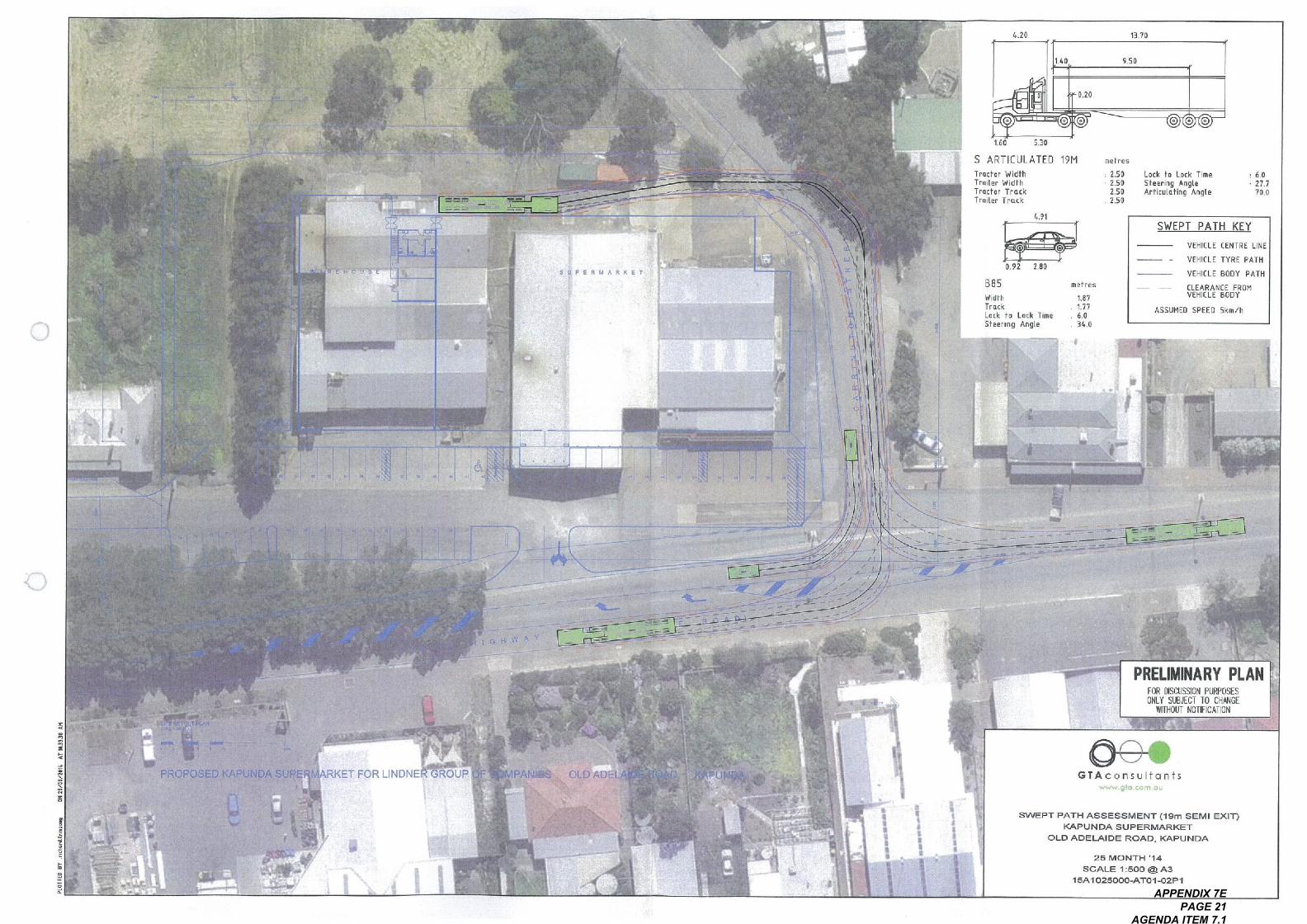
=<
.
.
-<
*S
^IQ
,;;'":.
ill
9 PERMARKET
^\
.;^
=e
a.,.L^
..U
=
>.
.U--a^a
PROPOSE UNDASU
I!^I^_ !, I^11 _!. @,-..,-, @@
KET FOR LINDNE
5301.60
S ARTICULATED 19N
Trucfor WidthTrailer Widf hTroctor TrockTroiter Trock
13.70
0.20
9.50
J-IIII
II
,..., ,' ,7,..,^ ^ - -
=,^^ ^ -
ROUP
I^'
-.-
4.91
me, r's
: 2.502.502.502.50
B85
WidfhTruckLock f o Lock TimeSteering Angle
0.92
@@@
^--^
2.80
I I
11,1/11\
14II
Lock to Lock Time
Steering AngleArticulating Angle
metres
1.87. 177. 6.0. 34.0
,.
SWEPT PATH KEY
VEHICLE CENTRE LINE
VEHICLE TYRE PATH
VEHICLE BODY PATH
CLEARANCE FROMVEHICLE BODY
ASSUMED SPEED Skin/h
I
. 6.027770.0
\
\ ~
\ ~ ~. ->,.--- - - -\~~----- -
II
------
----------^^
^^ --g=-^
.
.
^,
...
^=-
^^
,.
.
PRELIMINARY PLA"FOR DISCUSSION PURPOSESONLY sunJECT To cHNiGE
WITHOUT NOTIFICATION
GTAc nsultanfswhy. 910 . co in . ou
PT PATH ASSESSMENT (, gin SEMI1<APUNDA SUPERMARKET
OLD ADELAIDE ROAD. 1<APUNDA
25 MONTH ', 4
SCALE ,:500 @ As,5A, 025000-AT0, -02P,
APPENDIX 7E PAGE 21
AGENDA ITEM 7.1
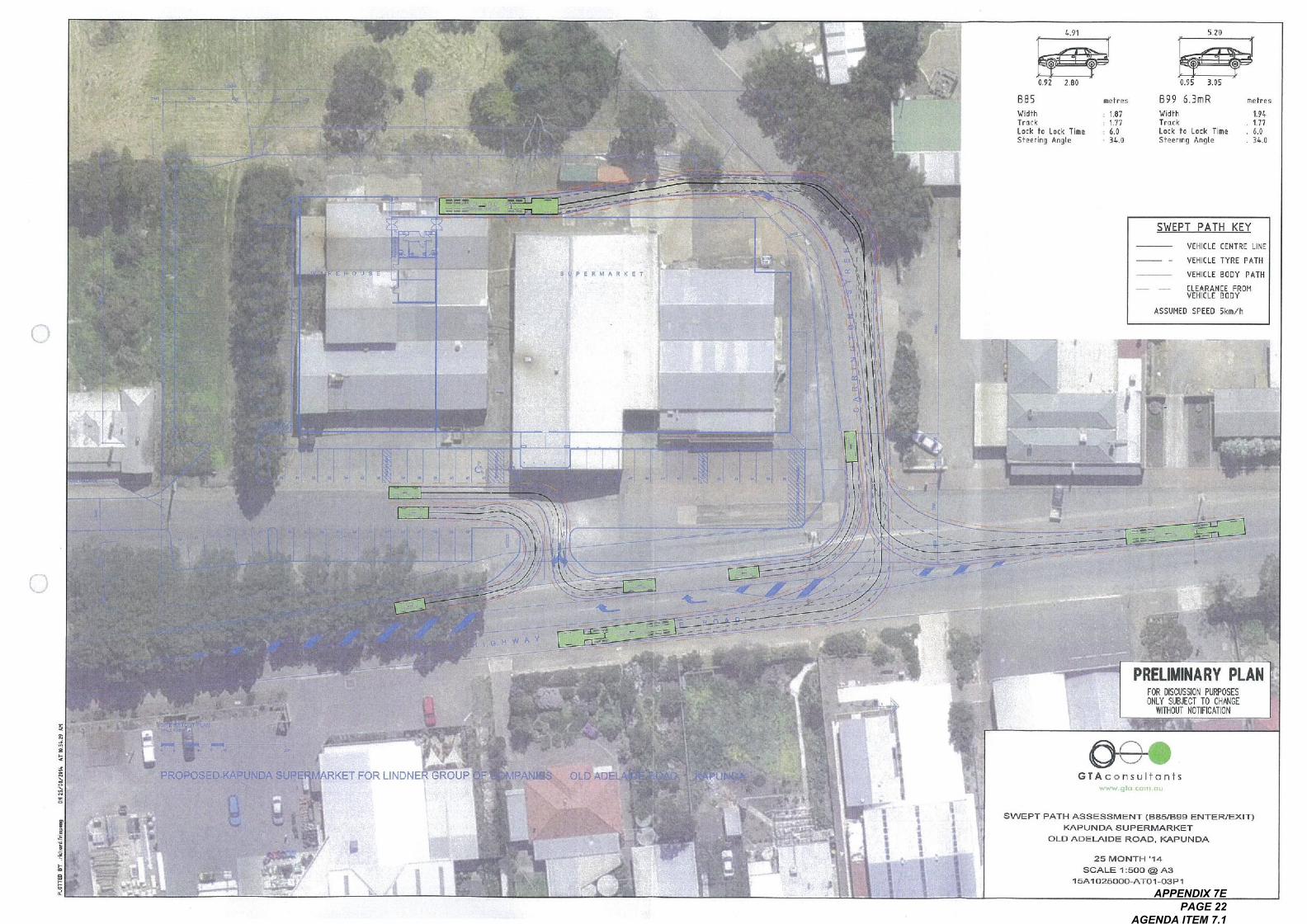
o
^a
^,.
-<
*,"\..\In"
8 PERMARKET
^
g
a^a
:^
",.."
.
,
>a
S
PROPOSED
&,
F
S^
-.- ~^^
UNDASU
\
\\
\
I"'
~~* \
\
\\
\\
I
I 1/1 \ \II
I I,I
I'll
"
RKET FOR LiNDNE GROUP F
B85
WidthTruckLock to Lock TimeSteering Angle
.t:.-~ ^5:
-@
2.800.92
F,11
\~---
~----~
11.11
I I
I^I* I
..^
"
5.20
0.95 3.05
B99 63nR
WidlhTruckLock 10 Lock Time
Steering Angle
<
^
g^
=. ^^
- -$^^^ ^
.^ ^
^^
I I
I I,
11\11.11\I ' ~ -,:--~~~~,I ~ ~~ ---~ ~I ---~\ --
- ---
OLD A
mefr. s
1.941.776.034.0
I
FF
SWEPT PATH KEY
I
VEHICLE CENTRE LINE
VEHICLE TYRE PATH
VEHICLE BODY PATH
CLEARANCE FRO"VEHICLE BODY
ASSUMED SPEED Skin/h
I
I
^^
II
^^
~.
I
^II
I
I
I
II
=e^^.^
..
PRELl"I"ARY PLA"FOR DISCUSSION PI^OSESONLY ^. IBJECT To cHAiieE
WITHOUT NOTIFICATION
PT PATH ASSESSMENT (BBS/B99 ENTER/1<APUNDA SUPERMARKET
OLD ADELAIDE ROAD, 1<APUNDA
25 MONTH ', 4
SCALE , :500 @ Aa, SAI025000-AT0, .03P,
GTAconsu!fonts^w. 910. co in. ou
APPENDIX 7E PAGE 22
AGENDA ITEM 7.1
Appendix B
SIDRA INTERSECTION Results
Appendix B
CD\ 'GTAc nsullonls
>^bto=Q.
X
^
ISA 1025000
Proposed Supe, ingrkel, Inele Highwoy. KGpundo1101tspOrl Impocl Assessinenf
08/09/14Issue: A
APPENDIX 7E PAGE 23
AGENDA ITEM 7.1
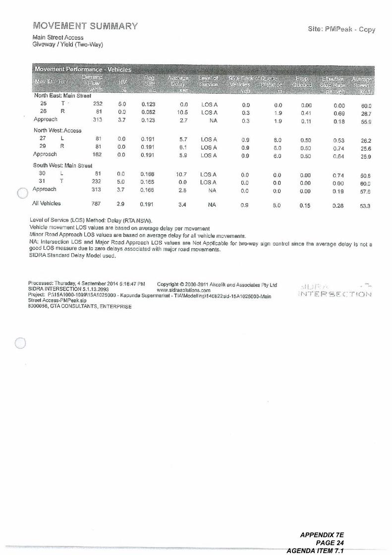
MOVEMENT SUMMARYMain Street Access
Giveway I Yield (Two-Way)
Movement Performance - VehiclesDemand
Flowvenn
North East: Main Street25 T
26 R
Approach
North West: Access27 L
29 R
Approach
South West: Main Street30 L
T3,
Approach
MDV ID Turn
232
84
3f3
HV
%
!^^g.Satri
5.0
0.0
3.7
81
81
162
AllVehicles
vlc
AvetageDelay
sec
0,123
0,082
0123
Level of Service (Los) Method: Delay (R, A NSVW.Vehicle movement Los values are based on average delay per movementMinor Road Approach Los values are based on average delay for all vehicle movements.NA: Intersection Los and Major Road Approach Los values are Not Applicable for two-wa si n control since the avera e d I i Igood Los measure due to zero delays associated with major road movements.SIDRAStandard Delay Model used.
0.0
0.0
0.0
81
232
313
Level ofService
0,191
0,191
Of 91
0.0
10.5
2.7
0.0
5.0
3.7
787
95%. Ba6k of Qu6^e ', ' Prop, ,.,,, Eire6@!^I^; Avetageybhicles Disi;^co; ' 1:1ueued ' 8109 I^^te - peet!$.eh in ,,* . 1"', .bar\':h t
Los A
Los A
NA
Processed: Thursday, 4 September 20145:16:47 PM Copyright @ 2000-2011 Akcelik and Associates Ply LadSIDRAINTERSECTION 5,132093 WWW. sidrasolutions. coinProjed: PM5A1000-, 099\15A1025000 - Kapunda Supermarket - TIA\Modelling\, 40822sid. 15A, 025000. MainStreet Access-PMPeak. sip8000056, GTA CONSULTANTS, ENTERPRISE
0,166
0166
0,166
5.7
6.1
5.9
2.9
Site: PMPeak - Copy
Los A
Los A
Los A
0.19,
00
0.3
0.3
10.7
0.0
2.8
Los A
Los A
NA
0.0
1.9
1.9
0.9
0.9
0.9
3.4
0.00
041
0.11
NA
6.0
6.0
6.0
0.0
0.0
0.0
000
0.69
0.18
0.50
0.50
0.50
0.9
0.0
0.0
0.0
60.0
26.7
559
0.53
0.74
0.64
0.00
0.00
0.00
6.0
26.2
25.6
25.9
0.15
0.74
0.00
0.19
50.8
60.0
57.6
0.28 53.3
APPENDIX 7E PAGE 24
AGENDA ITEM 7.1
MOVEMENT SUMMARY
Cartington Street - Main StreetGiveway I Yield (Two-way)
.
. ,
North East: Main Street25 T
26 R
Approach
North West: Cawington StreetL27 9
29 R 9
Approach 19
South West: Main StreetL30
31 T
Approach
.
.
,,
.
232
21
253
0.0
0.0
00
AllVehicles
0,152
0152
0152
Level of Service (Los) Method: Delay (RTA NSW).Vehicle movement Los values are based on average delay per movementMinor Road Approach Los values are based on average delay for all vehicle movements.NA: Intersection Los and Major Road Approach Los values are Not Applicable for two-way sign control since the aveia e deja is n tgood Los measure due 10 zero delays associated with major road movements.SIDRA Standard Delay Model used.
0.0
0.0
0.0
5
232
237
0,033
0033
0033
2.9
10.7
3.6
0.0
0.0
0.0
508
OS A
OS A
NA
Processed: Monday, 8 September 20.42:46:25 PM Copyright @ 2000.2011 Akcelik andAssociates Ply LtdSDRAINTERSECTION 5,113,2093 WWW. skinsolulions. coinProjed: P:\, 5At000-1099\ISA, 025000 - Kapunda Supermarket - TIAModelling\, 40822sid-ISAi025000.Cawing10n Street-Main Street-PMPeak. sip8000056. GTA CONSULTANTS. ENTERPRISE
0,122
0.22
Of 22
10.8
11.1
I'D
0.0
Los A
Los A
Los A
0,152
7.2
0.0
0.2
Site : PMPeak
LosA
Los A
NA
I2.0
I2.0
12.0
0.1
0.1
0.1
2.3
0.57
0.57
0.57
NA
0.8
0.8
0.8
0.0
0.0
0.0
0.45
045
0.45
1.7
0.0
0.0
0.0
50.1
48.0
49.9
0.62
0.77
0.69
0.00
0.00
0.00
12.0
40.7
40.6
40.7
0.30
1.09
000
0.02
43.8
60.0
59.5
0.08 53.5
APPENDIX 7E PAGE 25
AGENDA ITEM 7.1
Appendix C
Proposed Access
o
Appendix C
O\,CIAc o nsulto nis
o
ISA1025000
Proposed Superin orkef. Thiele Highwoy. 8:0pundoTronsporllmpocl Assessment
^^to=
>c
08/09/14Issue: A
APPENDIX 7E PAGE 26
AGENDA ITEM 7.1
' 'ry
" V
,.,.,
;F. I
t *',
" '
' I. ,
'ar,
,* .. ,?
L
*.. C
TR
OL
L
a co Y
^ a 8; ^
-I ^ I=
TR
OLL
EY
BA
Y
a' .
\.,.:g
*,,,
, ..
.{ *
^. ...,,..
.!_,.
:\.,
\;'--
" -
,
. .".
\,,
\ .,.
I;*a
. ... ^.~
,
L
,,**
11
APPENDIX 7E PAGE 27
AGENDA ITEM 7.1
o"^
"CD
F2858
o
'^'I
765 1'
F206999 A10,
F206993 A92
F20 999
I"6, , o
?^
^.^
@
^
L, c117a. CIO"ALCo ",, C, L
Light Regional Council
PO Box 72 Kapunda. SA 5373fobphone (08) 85253200Facsimile (08) 85663262
Prlnted:, 5/4/2014
Road Closure & Disposal OldAdelaide Road/Road Opening ;:':'::'"""^..., munch, ,,""
CarringtOn Street APPENDoc, ^!^;;;;';^'^;:;^;;;;'
F2f239,
2,2391 All,
I^I^91^;a
"ob that Tm, location o110. tides dtsp. y. dby the Googapl, real Intonation Sy. I'm arefor in hilum only and 3,1001d not be nibdupon for Oned. ite POSi, "I Or fleasuanient
PAGE IAGENDA ITEM 70.3. I
APPENDIX 7E PAGE 28
AGENDA ITEM 7.1
APPENDIX D
Road Closure and Opening Plan - Mattsson and Marryn Surveyors
12/77REPOl
APPENDIX 7E PAGE 29
AGENDA ITEM 7.1
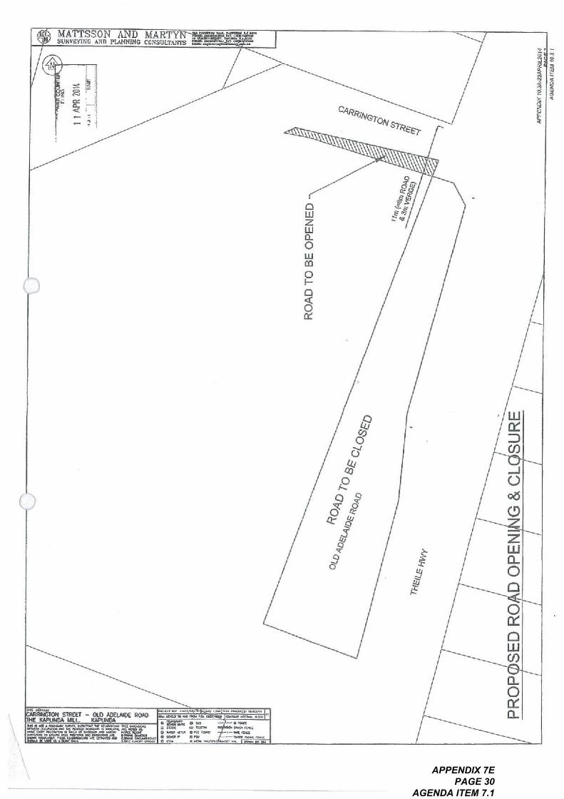
.
. ! gain ,ing
,,,^!
^00".
, I
!"'l;'
11;; '1
ii , 5
,
us ^I a g
a.
.O .is a
E
o4
0 ^
OA
'44b
, . 7
'0 e
44b,
., O
e, .
S^:'o
PR
OP
,,^IL
E
SE
D R
O D
OP
EN
I I A
PR 2
014
1'1,
.10
" .I , I ,
RO
AD
To
BE
OP
EN
ED
G &
CL
co^
^;..
-
a C
o
zO ^>.
zZ
^^
in>
e, 6
*^
^^:
a;
SU
RE
a Q
;O.~
c> ~,
^.
in V
^^,^:
10 ,^
! ,^,
,.
A ^
I
o
Co
V
AP
PE
rotX
,@. 3
4.22
AF
RL2
0f,
AG
EN
DA
ITgy
to a
I
APPENDIX 7E PAGE 30
AGENDA ITEM 7.1
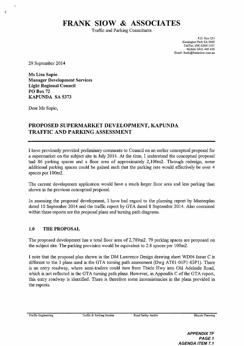
*
"
FRANK slow & ASSOCIATESTraffic and Parking Consultants
29 September 2014
Ms Lisa SapioManager Development ServicesLight Regional CouncilPO Box 72
KAPIJNDA SA 5373
Dear Ms Sapio,
PROPOSED SUPERMARKET DEVELOPMENT, KAPUNDATRAFFIC AND PARKING ASSESSMENT
I have previously provided prehiiitnaiy comments to Council on an earlier conceptual proposal fora supemiarket on the subject site in July 20 14. At the time, I understand the conceptual proposalhad 86 parking spaces and a floor area of approximately 2,100in2. Through redesign, someadditional parking spaces could be gained such that the parking rate would effectiveIy be over 4spaces per I 0011/2.
The current development application would have a much larger floor area and less parking thanshown in tile previous conceptual proposal.
FD. Box 253
Kerisingion Park SA 5068Terrax: (08) 8364/351
Mobile: 04/1445438
Email: frank@franksiow. comau
In assessing the proposed development, I have had regard to the plaininig report by Mastery Iandated 10 September 2014 and the traffic report by GTA dated 8 September 2014. Also containedwithin these reports are the proposal plans and turning path dragranrs
1.0
The proposed development has a total floor area of 2,789in2.79 parking spaces are proposed onthe subject site. The parking provision would be equivalent to 2.8 spaces per 1001/12
THE PROPOSAL
I note that the proposal plan shown in the DM Lawrence Design drawing sheet W004 Issue C isdifferent to the 3 plans used in the GTA tarring path assessment (Dwg AT01-01P1-03Pl), Thereis an entry roadway, where serrxi-trailers could turn from Thiele Hwy into Old Adelaide Road,which is not reflected in the GTA tunntig path plans. However, in Appendix C of the GTA report,this entry roadway is identified. There is therefore some inconsistencies in the plans provided inthe reports.
Tramc Engineering Tramc & Parking Studies Road Saleiy Audits Bicycle Planning
APPENDIX 7F PAGE 1
AGENDA ITEM 7.1
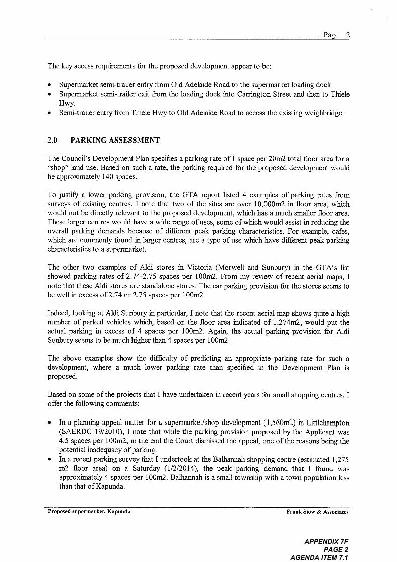
The key access requirements for the proposed development appear to be:
. Supermarket sent-trailer entry from Old Adelaide Road to the supennarket loading dock
. Supennarket senit-traile^ exit from the loading dock into Carvington Street and then to ThieleHwy
. Semi-trailer Griny from Thiele Hwy to Old Adelaide Road to access the existing weighbridge,
2.0
The Council's Development Plan specifies a parking rate of I space per 20m2 total floor area for a"shop" land use. Based on such a rate, the parking required for the proposed development wouldbe approximately 140 spaces.
PARKING ASSESSMENT
To justify a lower parking provision, the GTA report listed 4 examples of parking rates fromsurveys of existing centres. I note that two of the sites are over 10,000iri2 in floor area, whichwould not be directly relevant to the proposed development, which has a intich sinaUer floor area.These larger centres would have a wide range of uses, some of which would assist in reducing theoverall parking demands because of differ. Grit peak parking characteristics. For example, cafes,which are commonly found in larger centres, are a type of use which have different peak parkingcharacteristics to a supermarket.
The other two examples of Aidi stores in Victoria (Morwell and SIInbury) in the GTA's listshowed parking rates of 2.74"2.75 spaces per loom2. From my review of recent aerial maps, Inote that these kidi stores are standalone stores. The cm, parking provision for the stores seenrs tobe wellin excess of 2.74 or 2.75 spaces per 1001/12
Pae 2
Indeed, looking at A1di Sunbury in particular, I note that the recent aerial map shows quite a highnumber of parked vehicles which, based on the floor area indicated of 1,274rii2, would put theactual parking in excess of 4 spaces per loom2. Again, the actual parking provision for AidiSunbury seems to be much higher than 4 spaces per I 0011/2
The above examples show the difficulty of predicting an appropriate parking rate for such adevelopment, where a much lower' parking rate than specified in the Development Plan isproposed.
Based on some of the projects that I have undertaken in recent years for small shopping centres, Ioffer the foUowing coriuments:
. In a planiting appeal matter for a supennarket/shop development (1,560in2) in Littlehampton(SAERDC 19/2010), I note that while the parking provision proposed by the Applicant was4.5 spaces per 1001/12, in the end the Court disintssed the appeal, one of the reasons being thepotential inadequacy of parking
. In a recent parking survey that I undertook at the Bathannah shopping centre (estimated 1,27511/2 floor area) on a Saturday (1/2/2014), the peak parking d^mand that I found wasapproximately 4 spaces per 1001/12, Bathannah is a small township with a town population lessthan that of Kanunda
Proposed supermarket, Kapunda Frank Sinnv & Associates
APPENDIX 7F PAGE 2
AGENDA ITEM 7.1
In my experience, it is not uncommon to include some on-street parking for a new development,mumediately adjacent to the development site, where such parking is readily available and wherethere is hintted impact on other existing land uses in the viciritty
For the subject site, I note that:
. On Thiele Highway, abutting the development site, there would be no on-street parkingavailable, due to the road layout proposed for the development and the need to maintain senxi-trailer access to the existing weighbridge.
. On Tintele Highway, in front of the hotel (north of the subject site), there is angled parkingavailable. However, if overflow parking were to extend into this angled parking area, it couldadversely impact on a long-standing hotel use
. On Canington Street, parking should not be perilittted between Thiele Highway and theservice roadway of the development to facilitate access for service trucks and senti-trailers
. On Carrington Street, to the west of the subject site is a Residential Zone, Excessive overflowparking from the development could adversely impact on the existing residential properties.Some on-street parking may be acceptable, say up to Harriet Street
. Old Adelaide Road seenrs to be the only location where a reasonable number of on-streetparking spaces could be used for overflow parking from the development on the eastern sideverge, The western side kerbside parking, however, should be excluded because of thepotential impact on the existing residential properties
Based on the above, it would seem reasonable to me that the inclusion of say 10 to 15 on-streetparking spaces would be acceptable for the proposed development. If these on-street spaces are tobe relied upon, Council should require the Applicant to LIPgrade the verge parking in Old AdelaideRoad to a standard acceptable to Council. Council should also require the Applicant to upgradethe pavement in Carrington Street between the kerbs to accommodate the likely overflow parkingfrom the development,
Pae 3
Having regard to the above assessment, I am of the opimon that the proposed parking provisionfor the subject development would be exceedingly low (2.8 spaces per 1001/12), The proposed rateis only approximately 55% of the Development Plan requirement. There is insufficient evidenceprovided to justify such a low parking rate.
Even if a discounted parking rate of 4 spaces per 1001/12 were to be applied to the development,the parking required would be 1/2 spaces. The shortfin would therefore be 33 spaces (1/2-79).The potential on-street parking would accommodate say 15 spaces of the shornall, leaving up to18 potential spaces not being accommodated for. In my opititon, this would be an excessiveparking shortfbll.
In sunrrnary, I am of the opinion that the proposed parking provision of 2.8 spaces per loom2 isexcessively low and is not supported. The parking provision should be no less than 4 spaces per1001/12 (if my surveys at Batharmah were to be used as a guide) and preferably 4.5 spaces per1001/12. The floor area for the proposed development should therefore be reduced accordingly toreduce the parking shortfaU to a more acceptable level.
Proposed supermarket, Kapunda Frank Siow & Associates
APPENDIX 7F PAGE 3
AGENDA ITEM 7.1
3.0
There are no design levels provided for the car park. However, based on existing contours, itwould seem that the car park layout should be able to be designed in accordance with the requiredgrades specified in As/NZS 2890. I-2004. If a condition approval were to be included to requirethe car park design and conrrnercialvehicle access to hem accordance with As/NZS 2890.1-2004,As/}. IZS 2890.6-2009 (disabled parking) and As 2890.2-2002 (commercial vehicles), then thisissue could be addressed in the detailed design stage.
PARKING LAYOUT AND ACCESS
Otherwise, Council could require the design levels to be provided at this plainxing consent stage. Iunderstand that Council have concerns about the height differential between the subject car parkand the residential propelty marriediately to the south of the subject site.
GTA indicated that 6 bicycle parking spaces would be provided near the front entrance of thesupennarket. This should be identified in the proposal plan or a condition could be included tospecify this bicycle parking requirement,
GTA's turning patlt diagram for the sent-trailer servicing the loading dock shows that the turnpath would encroach into the south-western wari of the supennarket building. The building designshould be amended accordingly to accommodate the senxi-trailer turn.
At the exit point of the service roadway, the driver should have adequate sight fines to view on-coining trafiiic from Carrington Street. To ensure that driver sight fines to traffic enteringCarrington Street from Thiele Highway is maintained, there should not be any high obstructionslocated in the area between the north-west Gin corner of the proposed building and the propertyboundary (shown as a paved and hatched area).
Pae 4
The current condition of Carvington Street appears to be quite poor, in particular between theservice roadway and Thiele Highway. Given that sent-trailers from the loading dock are expectedto regularly use this portion of Carrington Street and the turn paths indicate that the full width ofthe carriageway would be required, the Applicant should be required to upgrade the pavementsurface between kerbs to Council's requirement.
The proposed main car park layout requires all vehicles to use the main access point to exit the siteto Thiele Highway. The flintted queuing distance between the main road carriageway and themiteinal north-south aisleway would oily accommodate one vehicle queuing to exit. A secondvehicle queuing to exit would block the north-south aisleway traffic flow. All additional exit pointshould be investigated, for example to Old Adelaide Road.
The layout would also not allow an entering vehicle to freely enter the main car park, aspresumably this entering driver would have to give way to north-south aisleway traffic (T-junctionrule). Prefisrably, the north-south aisleway tramc should be required to give way to the enteringtraffic, otheiwise the entering tramc could potentiaHy queue back to the main road quitefrequently
The proposed alterations to Thiele Highway show two right turn lanes in close proxintity to eachother, one for the shopping centre car park and the other to provide for continued access for sent-
Proposed supermarket, Kapunda Frank Sinnv & Associates
APPENDIX 7F PAGE 4
AGENDA ITEM 7.1
,
,
trailers to the weighbridge. The plan is conceptual only. Since Thiele Highway is a DFTl road, theApplicant would have to seek DFTl agreement and approval for the changes to the road layoutshown.
4.0 SUMMARY OF ASSESSMENT
Based on my assessment of the proposed development, I am of the opimon that:
I. The proposed parking provision of the development (2.8 spaces per loom2) would beexceedingly low and is not supported. The Applicant should be requested to reduce theproposed floor area accordingly such that a more reasonably acceptable rate can be achieved
2. A number of design amendments should be considered to address the design issues identified inSection 3.0
3. The Applicant should 11aise with DFTl on an appropriate road layout for Thiele Highway thatis acceptable to DFTl. All costs associated with the works on the main road and Old AdelaideRoad should be the responsibility of the Applicant.
4. The Applicant should be required to upgrade Carrington Street, between Thiele Highway andHarriet Street, to facilitate service vehicle access and on-street parking. All costs associatedwith these works should be the responsibility of the Applicant
Yours sincerely,
:;'^,^ Stow
Pae 5
FRANK Slow
MIEAust MALTPM MIPWEA
Proposed supermarket, Kapunda Frank Stow & Associates
APPENDIX 7F PAGE 5
AGENDA ITEM 7.1
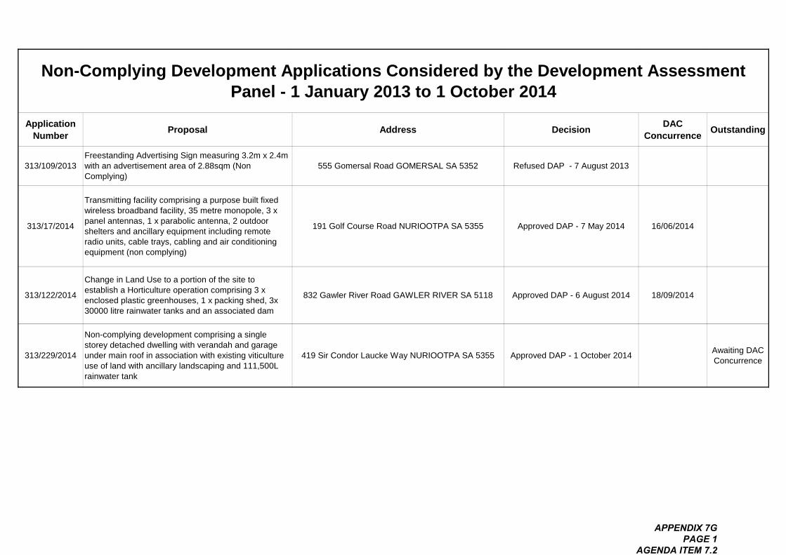
Application Number Proposal Address Decision DAC
Concurrence Outstanding
313/109/2013Freestanding Advertising Sign measuring 3.2m x 2.4m with an advertisement area of 2.88sqm (Non Complying)
555 Gomersal Road GOMERSAL SA 5352 Refused DAP - 7 August 2013
313/17/2014
Transmitting facility comprising a purpose built fixed wireless broadband facility, 35 metre monopole, 3 x panel antennas, 1 x parabolic antenna, 2 outdoor shelters and ancillary equipment including remote radio units, cable trays, cabling and air conditioning equipment (non complying)
191 Golf Course Road NURIOOTPA SA 5355 Approved DAP - 7 May 2014 16/06/2014
313/122/2014
Change in Land Use to a portion of the site to establish a Horticulture operation comprising 3 x enclosed plastic greenhouses, 1 x packing shed, 3x 30000 litre rainwater tanks and an associated dam
832 Gawler River Road GAWLER RIVER SA 5118 Approved DAP - 6 August 2014 18/09/2014
313/229/2014
Non-complying development comprising a single storey detached dwelling with verandah and garage under main roof in association with existing viticulture use of land with ancillary landscaping and 111,500L rainwater tank
419 Sir Condor Laucke Way NURIOOTPA SA 5355 Approved DAP - 1 October 2014 Awaiting DAC Concurrence
Non-Complying Development Applications Considered by the Development Assessment Panel - 1 January 2013 to 1 October 2014
APPENDIX 7G PAGE 1
AGENDA ITEM 7.2

Notice of Development Assessment Panel Meeting
Lic HTA
C.
REGIO NAL
COUNCIL
Notice is hereby given in accordancewith Section 56A of the Development Act 1993,
that the meeting of the
Development Assessment Panelof the
Light Regional Council
will be held in the Council Chamber
93 Main Street, Kapunda
,
on
Monday, 22 December 20.4 at 5.30 p. in.
,. .
.,..
.
o6,
.. ...
Prime4, "! or/ice: 93 Main StreetKapunda 5373
Telephone: 85253200Facsimile: 85663262
15 December 20.4
Br""ch 0.01ice: 12 Hanson Street
Freeling 5372

_____________________________________________________________________________________
Development Assessment Panel Agenda – 22 December 2014 Page 180/2014
LIGHT REGIONAL COUNCIL
DEVELOPMENT ASSESSMENT PANEL
AGENDA
MEMBERSHIP COMPOSITION Mr Bruce Ballantyne (Presiding Member), Mr Kelvin Goldstone, Mr Robert Veitch, Ms Margaret
Wendt, Mrs Lynette Reichstein, Mr Peter Kennelly and Mr David Shannon. 1. MEETING OPENED 2. PRESENT 3. COMMENCEMENT AND WELCOME 4. APOLOGIES
Mr David Shannon
5. CONFIRMATION OF PREVIOUS MINUTES
Recommendation That the minutes of the meeting of the Development Assessment Panel held on Wednesday, 5 November 2014 be confirmed as a true and correct record of that meeting.
6. DECLARATION OF CONFLICT OF INTEREST
A Council Development Assessment Panel Member declaring an interest in a matter before the Panel shall make a disclosure clearly stating the nature of that interest in writing to the Presiding Member, in accordance with Clause 2.4 of the Minister’s Code of Conduct, and then in the meeting when the relevant agenda item is reached, makes a verbal disclosure to the Panel and removes themselves from the meeting in accordance with Section 56A(7)(b) of the Development Act 1993. The following disclosures of interest have been made in relation to:- Item: __________________ Panel Member: _____________________________
7. DEVELOPMENT REPORT 7.1 Development Application Number 313/363/2014 – CR Lindner Nominees Pty Ltd 7.2 Development Application Number 313/374/2014 - Ciborex Pty Ltd 8. OTHER BUSINESS
9. DEVELOPMENT PLAN AMENDMENT (DPA) POLICY REVIEW
10. NEXT MEETING
11. CLOSURE
_____________________________________________________________________________________
Development Assessment Panel Agenda – 22 December 2014 Page 181/2014
7.0 DEVELOPMENT REPORT 7.1 Development Application Number 313/363/2014
Applicant CR Lindner Nominees Pty Ltd
Owner CR Lindner Nominees Pty Ltd
Subject Land and Location
113 Old Adelaide Road KAPUNDA, Main Street KAPUNDA, Lot 91 FP 206992, Hd Kapunda, Lot 1 FP 2858, Hd Kapunda, Lot 92 FP 206993, Hd Kapunda, Lot 101 FP 206999, Hd Kapunda, Lot 102 FP 206999, Hd Kapunda and portion of Old Adelaide Road, Kapunda
Development Proposal Supermarket with associated parking, loading area, fencing and retaining walls, signage and landscaping
Zone/Policy Area/Precinct Historic Conservation (Kapunda Town Centre) Policy Area 12 - Commercial
Application Type/Category Category 1 pursuant to table Light 7 of the Light Regional Council Development Pan
Merit
Representations No representors to be heard as the application will not be publicly notified
Referrals Internal
Engineering
Environmental Health Officer
Heritage advisor
External
DPTI – Transport Unit
Development Plan Consolidation Date:24 January 2013
Recommendation Development Assessment Commission (DAC) is the relevant authority. Recommended for approval subject to condition(s) and only after ratification of road opening and closing process.
Assessing Officer Lisa Sapio – Manager - Development Services
Background The Development Assessment Panel (DAP) originally considered this application at its meeting held on 5th November 2014. A copy of the minutes and final resolution adopted at the meeting forms Appendix 7A.
_____________________________________________________________________________________
Development Assessment Panel Agenda – 22 December 2014 Page 182/2014
In summary, the Panel resolved to advise the Development Assessment Commission (DAC) that it supported the proposal subject to addressing and resolving a number of matters which included the question of the application being hypothetical given the inclusion of part of the adjoining road reserve as the subject land, building design elements, road upgrading requirements and consideration of comments from the Transport Division of the Department of Planning, Transport and Infrastructure (DPTI) and provision of an easement via the land to the rear of the site to adequately deal with stormwater discharge. Panel members will recall that the applicant submitted amended elevations after the collation of the agenda. I provided a verbal report on the proposed changes at the meeting. Having regard to the late information the DAC has written back to Council and advised that the Council has the opportunity to reconsider the amended elevations. The Applicant has provided further amended elevations to reflect the changes suggested by the Council’s Heritage Advisor and the DAP. Appearance, Built Form and Heritage As the subject land is located within the Historic Conservation (Kapunda Town Centre) Zone and is adjacent heritage listed properties which include Contributory Items and Local Heritage Places the amended plans were again referred to Council’s Heritage Advisor for consideration and comment. A copy of the elevations provided to the Panel at its November meeting (stamped superseded) are contained within Appendix 7B which also contains the entire report considered. The plans which have been forwarded to Council by the DAC and stamped “Amended” are those which are required to be considered by the DAP and forms Appendix 7C. The amended plans have in the main addressed the concerns raised by the Council’s Heritage Advisor, Mr Michael Queale, particularly regarding the entry portico that protrudes forward of the supermarket building. The amended elevations include four (4) prominent gables and forward protruding entry portico with stone walls. The amended drawing produces a very tall building which will result in a finished height of some 10 + metres to the top most part of the gable. The second gable from the south proposes a stone finish while the other three (3) gables propose galvanised custom orb finish. A concave verandah in the colour “wallaby” features along the front façade and part of the Carrington Street façade of the supermarket building and along part of the building which is to be utilised for storage. A vine trellis is also proposed along the southern most part of the Main Street frontage. Gables are also proposed to a portion of the southern elevation and Carrington Street elevation. The storage component of the building facing Main Street also features a stone finish along with the end gable that is located at the southern end of the building. The remainder of the Carrington Street elevation features precast concrete panels with a render finish in a grey colour. The rear elevation proposes the use of hipped pitched rooves. The rear elevation which will be the most prominent from Harriet Street to the west features precast concrete panels with a render finish in a grey colour. The loading dock portion that also features within the rear elevation will be finished in galvanised custom orb cladding. The Heritage Advisor in the main suggests that the form and materials proposed reflects large scale sheds/barns/winery buildings common to the district and also typical of the era of heritage significance of Kapunda in general.
_____________________________________________________________________________________
Development Assessment Panel Agenda – 22 December 2014 Page 183/2014
The concave form of verandah was a common form of buildings Circa 1900 for cottages and residential development and not on large public buildings. The Heritage Advisor suggests a single pitched verandah be considered. Whilst the Heritage Advisor has made this statement, it should be acknowledged that Zone Principle of Development Control (PDC) 3 seeks development on land adjacent residential zones that should be more domestic in scale and character than development in the area generally. It is therefore considered on balance that the use of the concave verandah is appropriate given the inference via the provisions of the zone for commercial development to be more domestic in character. The Heritage Advisor has suggested that the type of stone and laying pattern that should be employed includes the use of coursed random Kapunda stone, however bluestone and use of quoins are not supported as the coursed random stone is common in use for large barns and sheds in the district. The stone should also be laid as traditionally laid and no veneer stone is supported. The plans do not clearly identify the type of stone to be utilised as such it will be recommended to the DAC that a coursed random Kapunda stone be used and not bluestone or quoins. In the event the requested stone approach cannot be achieved, it is recommended that the applicant the use a red brick with a pressed pattern which is also a common building material utilised throughout Kapunda. DAP Members will recall that this was previously suggested by the Heritage Advisor. As the assessing officer I also support the use of a red brick. This use of a pressed red brick is a preferred outcome rather than the unconfirmed stone. Conclusion It is considered that on balance that the proposed development is not considered to be seriously at variance with the relevant provisions of the Development Plan. Based on a balanced assessment of the amended elevations provided, It is considered that the amended elevation plans are acceptable subject to the use of random stone as featured through Kapunda rather than a veneer or bluestone or alternatively that a pressed red brick be utilised where the use of stone has been depicted. The other materials and colours proposed are deemed to be acceptable. Recommendation DAC the Authority and providing comments to a DA – DA supported 1. Reason for Decision
Having considered all the relevant planning matters in relation to the development application 313/363/2014, the Panel has read and considered that the report prepared by the Development Officer - Planning and agrees with the assessment outlined in that report:
2. That pursuant to section 35 (2) of the Development Act 1993, the proposal is not
considered to be seriously at variance with the relevant provision of the Light Regional Council Development Plan (consolidated) 24 January 2013.
3. That the DAC be advised that the comments provided herein are in addition to those
contained in the report dated 5 November 2014 in relation to Development Application number 313/363/2014. Furthermore, the amended elevations are in the main considered acceptable subject to the following:
a. The type of stone and laying pattern that should be employed includes the use of
coursed random Kapunda Stone, (excluding veneer tiles, bluestone and use of quoins); b. If stone is to be utilised, then the stone should also be laid as traditionally laid that being
coursed (layered horizontally); c. The option to utilise a red brick with a pressed pattern in place of stone is also
supported.
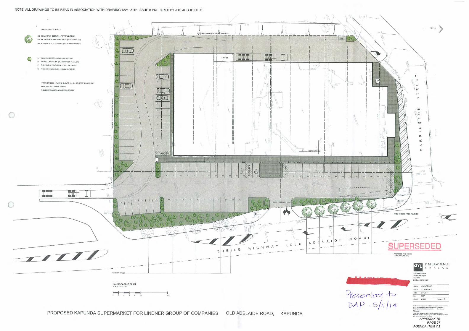
NOTE: ALL DRAWINGS To BE READ IN ASSOCIATION WITH DRAWING 1321: A20, ISSUE B PREPARED BY JBG ARCHITECTS
IMO, C""80. in. E
Go Eus". v, ,us coo, ATA. I. E. PERU'r. o. 1
,, rinos^",^"EonE, .I, "TIE "^, I
Up "my"u" rung^. ,"." ^"^I
A PC*c" re, "cE, .ICUD in. r wAmEj
O UNQU. ^. unA. loner MIXER anX, h
. Q, 6, VUE, UruEMO, ,. I'DV, ". TugH!
. am co" PAR^ISA. WE". Vat, .un4
o
MinE CM^s. P^r " a. UHF, . ,, - be ENi^,,,^!^,
,DA reC. ,-"PEAR gnu, I
neuro" Trip^ - NA"^ OR^I
^-
19 ^
^
~I
.
a "one^^"."-- ---
I, *^^.*^...
a"
Ion, In"^^
^
I__ __I_ _._I__,, I. n
PROPOSED 1<APUNDA SUPERMARKET FOR LINDNER GROUP OF COMPANIES
^
ai"",,"eE,
^^
LANDSCAPING PLANSCALEi:z"*rAi
^^
^^
^
^^
^
^^
THE
^
b-
^
I
^II
I
^
LE
I-
ILl
IU
o:
I-
co
^
^
^-
GHW
4 ,,
^
AY
co
^
,,
Z
o
+.
o
Z
^
F ~ ~ ~T
(OLD
11 -----, Z. --- -----
.a
^
OLD ADELAIDE ROAD,
^
"
.
^
. ^..
"
^
,
AD
"
^,
^
tic
o:
<
Q
"
^
LAl
.
^^.-'T
DE
.
J-
^
^
ROA
-~H
-.
1<AP U N DA
^
L - - - - relGH "", TOBE RE"VED
D)
I
SUPERSEDED^
^
^
^^
^
716. sc-/^+o91 +!,
I>, A p 5111 114
^
^
^
PROUCo"ET, .e,10 HAT'I E"St""
^
^
~c:^.
^
^
^^
^
^
D M LAWRENCEDESIGN
, SI^"dn"
,."I. ". Un.sA ""
pHr".",., sag
co" J LAMERCE
a. a: D Urn^CE
".: 31,201.
fob;
.h",: woos
1657
^..^.~."*.^., b. ^.-,,^*..".."*.*^^.k. .~,."^I^^. "*^
@~-I, ,..,,.,,. n" ~^.*L
::. e=.'=S^:;=^"^"~"~,_,,,
hmm: D
APPENDIX 7B PAGE 27
AGENDA ITEM 7.1
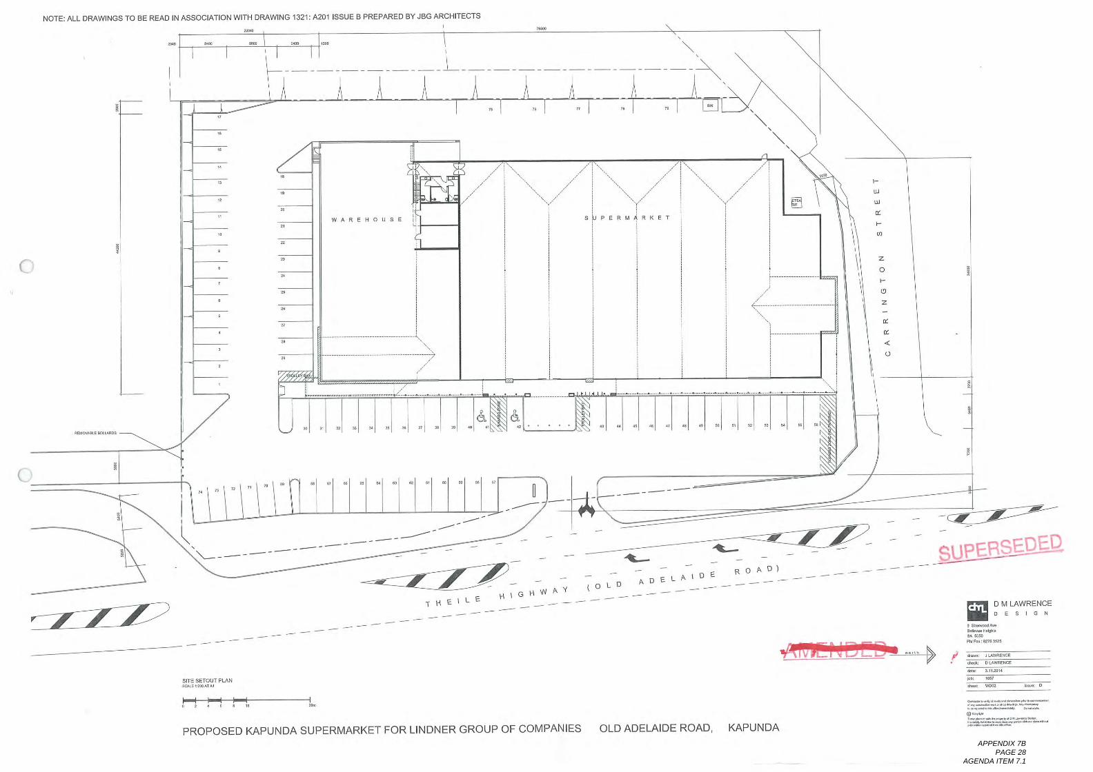
NOTE: ALL DRAWINGS To BE READ IN ASSOCIATION WITH DRAWING 1321: A20, ISSUE B PREPARED BY JBG ARCHITECTS220.0
eru
^---6.00 1.00
_ _ _L__ _
.I.
.
REDv"LED"LARDS
WAREHOUSE
", co
<
^-^^ ;.
,^^^,..
\, _ _ _ __,*_,- ' _'\- --- -
,. Is
\
,a
\
,
,, re
\
\
co
70 11^
\
.I "
^
co
^^
"
SITE SETOUT PLAN
^
co
^
"
^^
PROPOSED 1<ARUNDA SUPERMARKET FOR LINDNER GROUP OF COMPANIES
-^^
^^
^^
^
^^
11. -^
^-
THEIL^
^
^
-^^ -
I. .
111
1.1
11:
I-
CD
^
^
^
^
E
^
^
IGHW
^
.^,
.,~,
- -- - -- - --
^-^
^
AY
^^
(o^
^...-,
ADLD
^^
^..-.
ROAIDEELAID
^^
^^
^^^
^^
AD)
OLD ADELAIDE ROAD,
^^
^
^
^
^
^^
^
^
^
^
^^
^
1<APUNDA
^
,^
^
E, DE;. D^
to
.^
^
^
^,.
.o. 1h
D M LAWRENCEDESIGN
, SI. ,"ed An
Ooh" H. ,11.an cogO
pH r" ; are 9.25
00an, , LA^ENC.
",: D LAMENCE
".: 3.11.2.1,
Fly
cod: coca
uus,
".~.^..,~~^~..--~"~""^^"^.". ~^...~,."*.-^. "-,^
@~~'~ '~~'","*, D. I. ^^'
~.^.. d. ."^
"".: D
APPENDIX 7B PAGE 28
AGENDA ITEM 7.1
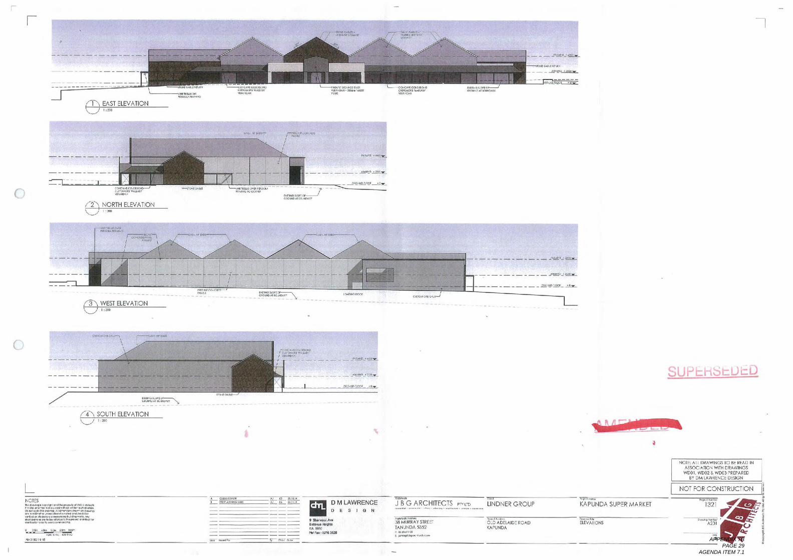
----------------
EAST ELEVATION
.
I : 200
in. GAD" RID"
ER". ONFagOL, RAN",
2
CareAW EQ".Cur^E. *Aun, ,inADAk
NORTH ELEVATIONI :200
arsA"CUD. .0.0Crier con. w*us. rWEA, ,,"
",,"" co, ."coop inn""O
.F-.,
- --.~-
.
"C, ,C ., I'DA, .a
,,. AM
~ '~ _ o. 00, it coo =. 2^,"CM cone.
------~ ..
200
Ionr GADi" ',,", 6,313, "C,
",,""", GE Ore.un, **H, ^,,,""pea"
Ql"Iu6, ","ad. q ~ ~~~~~~~ ~~-- .,, APICIOCC"".
ary"031eE
.. C. ,Iconc",pay"
A1V. 0, "B,"A, Dun, in, @E$10,1.0E
' ' ' ' _ _ FAR. g, I=.^9^
IV. ,.,,,,,
_ _ _ _ _ *. IQ^=.;a^
000.10in 00.0, *,
@CAVECQO. ."IDCud",. WALL. VEuro*H
",., a, .",GroupA, .o1.0",
SOUTH ELEVATION4
-.-.- - -
I I 200
NOTES,,"*"". .~.,,."~ "". Iv " J",, chi""Ply I'd ",~In",.". d*.~"I~ ~b"I~D. rid ,c* bcc-0 " **~,, ribh tic~,,"...~...., I. ""60^.. rel. do. ,,,",, b.,"" on. bb. I". con"~. ",,"", t ".,*",.,., cola b. .I'd 10. .,,~, looml". bdaka~I*,,,.* am. *"
o, 000RC@a^22-
a. ,. 10.00.CronDA. Dinco, ,v
__ _ , _ ._ _ , _'Age"I_, ,,,_
h 40n ,"n a"n ,.*n
0131E, .I"
I'm PI "**,
01, C*.""InN
_ , _ Aug!a. ,.,,..
5.01"OA
.
,
.
""Awedo, .""CUT"*"W, MADfW, , K_ , _ _**''. 1_.
^^^g=-
A. u" ,, a^"
.,.,_ . e. g. ^^^,~F. 9=.
A Cur""w' ",, UNDO q'"
- ^ - ^ _ ^ _, _, _ _. JP!eP=;aeg;=_
un. In. a b
, _ _ _ _ _,*22.1, ^23z_
" JG LIDl,
A, re 00.11. ,
*
^~ E, ,a co.
D M LAWRENCEDESIGN
, a, .eed Ane-1. }I. ^"aA Grin
Flu F" : 02,636z,
~ ""
J B G ARCHITECTS"^.. . ~.~^ . -~. . ",^. . .^.. . -^ . ^.",
Aichi"h """,
38 MURRAY STREETTANUNDA 5352,. ",",. I'S
L I, ""P. """I. E.
PTY LTD
e-1,
LINDNER GROUP
"". I, ""
OLD ADELAIDE ROADKAPUNDA
S U P L::, rib t= U I=. D
".., ,n, .
KAPUNDA SUPER MARKEl
b^" I"
ELEVATIONS
NOTE! ALL DRAWINGS To BE READ INASSOCIATION WITH DRAWINGSwDoi, w002 & woo3 PREPARED
BY DM LAWRENCE DESIGN
NOT FOR CONSTRUCTION I
I'321 ^"'^^;";7 ,.,*
^~;APPENDIX 7B PAGE 29
AGENDA ITEM 7.1
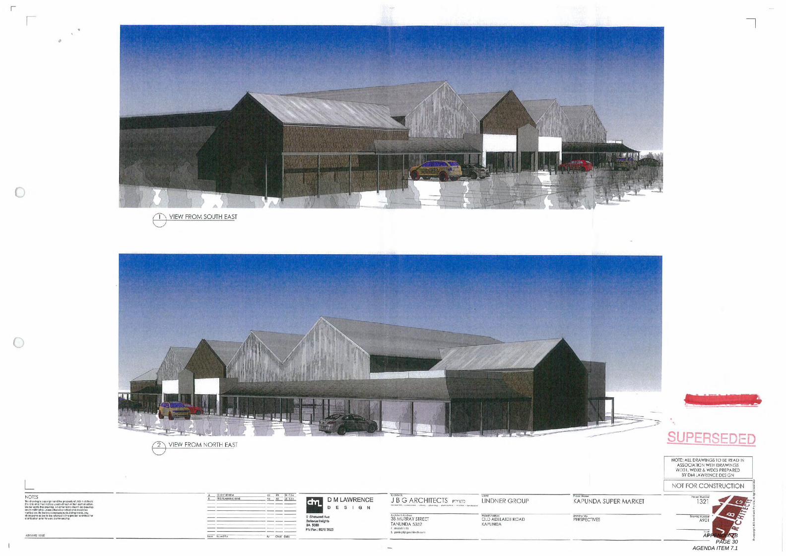
o
.
VIEW FROM SOUTH EAST
LNOTESh, .~,,. C~, 1,011. ,4.0 "codV. IJ. 0.1, H"11.* 11, "d~,,*I" mud^. I. .Iru~'""~00. d re* ~,~., 0 ",~."". I~n tic*,*a. h, ,".".~" e^.""," ". q. It, ,b*,of. d", I. W" e~",," b"*,. a, .,"rCG, ,,, " to b. .10,001, ~ "*, locki",,.d"ECqi" ~ 10 ~, e~~~
"13, "1.15,
2 VIEW FROM NORTH EAST
A o. 1rn"", "EDU, ~, 6 UUQ
I, ^ "",,"
.^^
U xi 2,101,N " 0311/4
'1
5~ air= coo
D M LAWRENCEDESIGN
9 a. ~, At.B~",., IbaA anPhi F. : 8270 3626
~CM"h
J B G ARCHITECTS~. . -~ ~ by . ~.~ . ~~. . ~~-
A. ,"I",. A, *.,,
38 MURRAY STREETTANUNDA 5352P. rigs"11N
, I. ,",.,"."",.,~
PTY LTD
c", I
LINDNER GROUP
.~, I, ""I
OLD ADELAIDE ROADKAPUNDA
^.-
^-. ^
.^-.
~. ei"""
KAPUNDA SUPER MARKET
.""I~
PERSPECTIVES
.
.
SUPERSEDEDNOTE: ALL DRAWINGS 10 BE READ N
ASSOCIATION WllH DRAWINGSWDO1. W002 & W003 PREPARED
BY DM LAWRENCE DESIGN
NOT FOR CONSTRUCTION I
"~''321 ^;";PIE"c. ,""'
,~ E
I""
APPENDIX 7B PAGE 30
AGENDA ITEM 7.1
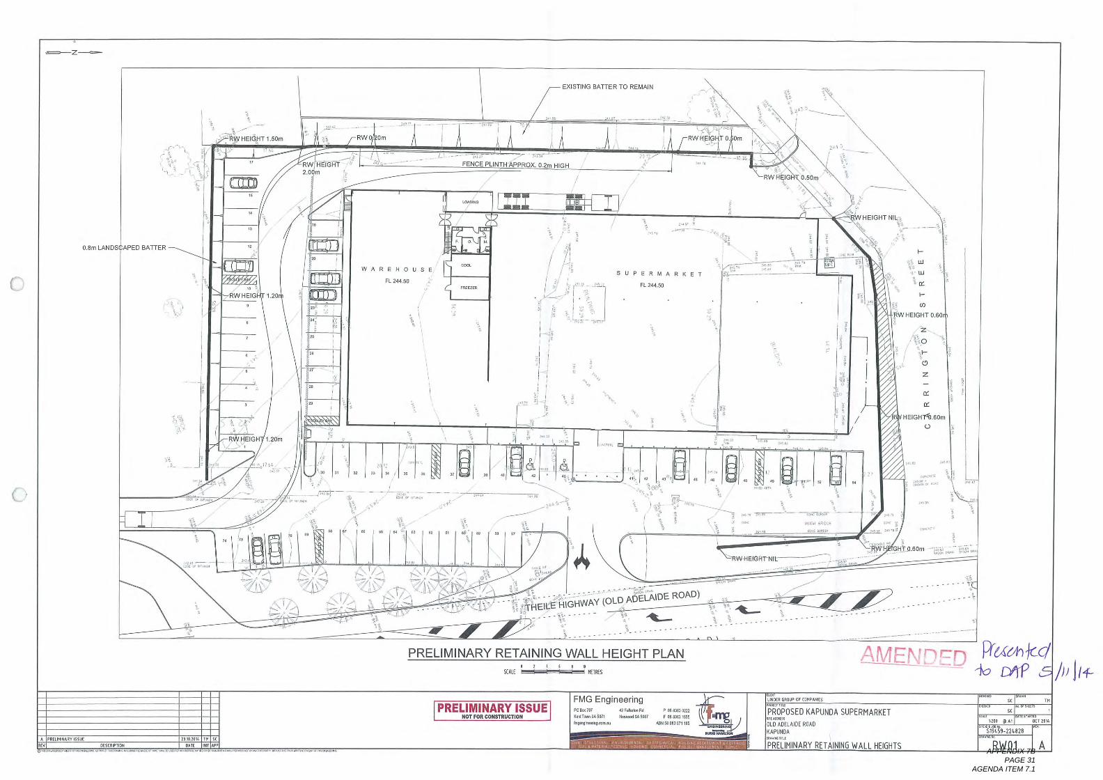
^.-Z^
o
Darn LANDS APED BATrER
11^161HEIGHT ,. coin
C!^I
17
Is
..
RW HEIGHT2.0 in
.,., Iajis.^^:
In
RW HEIG 1.20
.
.I.
10. ,.
I^D
IFENCE PLINTH APPROX. 02m HIGH
.*
23
WAREHOUSE
FL 244.50
"
..
EXISTING BATTER To REMAIN
..,.
R HEIGH ,. 20m
..
..
.
.
.
.
.
.
.I. PREL""*Rv 1551/6C^
at"
I' ^
, ,k
:,/ ,I\ \\/,/. \ \\/
co*"\ I\\
"' ' ' 'I. >^7' ,,\^(I',. ,, A, .lux
~ F. . 21
PRELIMINARY RETAINING WALL HEIGHT PLAN
itstripiion
*
co
..
..
..
..
..
..
..2310/01, in^'
DATE DIE^
^
^a..^ ,
,
I
I
^^
."
,^,
\
HEIGHT NIL
.
IGHWAY (OLD ADELAIDE HIGHWAY (OLD ADELAl^,-.
^,
^I
PRELIMINARYISSUE
,.. I^
r-
LU
LLl
"
}-
co
W HEIGHT o. 60
Z
o
r-
<9
^.,. .-..
DR. ,,.SCALE ^ ,EIRES
"Or FOR Co""RUGnO"
....
^-,....
.^
.,.
^ ;" 'EIG, '' .60'^11, ^ HEIGHT^1.60m
FMG Engineeringco ^ ,o7killT", 3,507i
by'onu
NIL
42 F"", R,
I'm","5067
^
P co Bags in aF " 0.63 1555
AM " 003 071 I" \^,L. DER GROUP OF cup, ,"25.,..,
PROPOSED KAPUNDA SUPERMARKETmr^,,
OLD ADELAIDE ROADKAPUNDA"., rin,
PRELIMINARY RETAINING WALL HEIGHTS
A ENDED F1c{^h ICQ'.-10 Iyi'P 1/1 1/4,
SC
SL
Moo OAi,
51st59-22"828
"
.^
T"
DCT 2014
RWOl AAPPENDIX 7B PAGE 31
AGENDA ITEM 7.1
'^Z^
0.8m LANDS APED BATTER
RW HEIGHT 1.60m
R HEIGHT.Coin
RWO Om
RW HEIG.
,
1.20
FENCE PLINTH APP OX. 0.2m HIGH
EHOusE
L 2,450
a
WHEIGH 1.20m
R To RE N
A PREl. MumV ISSUEREV
rin
an HEIGHT o. Din
^\;.^:q
^
DESCR, ,10n
..
..
..
..
..
..
..23,020, , in^
DATE DripE.,~. ~ ^. ". ^I. .^ ~ ^ ".. "" ".."11".^^ W " ",.""I, .^ " ~. ^" ^ ".".~"~
SUPERMARKET
FL 244.50
RVVHEIG 0.50m
PRELIMINARY RETAINING WALL HEIGHT PLAN
WHEIGHT NIL
' ' HEILE HIGHWAY (OLD
^,
PRELIMINARYISSUE
I-
1.1
LLl
or
I-
Co
RWHEIGHT o. 60
Z
o
I-
CD
Z
,21 ...
SinLE I^^^ 1.1RES
.*-
"or FOR cellsr. "Gnu"
......
.,
ELAIDE ROAD)
^...-..,
....
FMG Engineering
...
000,707K. "Ton Snail
EC*..,, it,
RW-HEIGHT NIL
DC
DC
HEIGHT^1.80mo
@ F1. .1.1 PCbread an S",
^,-.
P """0222F co coq 1555
PEN " 003,71109 ^,^
GHT ,60m
.
LINGER CROP OF COMA".$",, rill"
PROPOSED KAPUNDA SUPERMARKETon .^"
OLD ADELADE ROADKAPUNOA.,^ I'M
PRELIMINARY RETAINING WALL HEIGHTS
SL
SC
1200 , Aq
5194 9-22"828
"
.
T"
OCT 201,
RWOl AAPPENDIX 7B PAGE 32
AGENDA ITEM 7.1
24 November 2014
Ms Laura Kerber
Planning Officer - Planning DivisionDepartment of Planning, Transport and InfrastructureGPO Box 18/5
ADELAIDE SA 5001
Dear Laura
Thank you for fomarding Council's comments on our client's application to construct a supermarket withassociated parking, loading and landscaping at the corner of Old Adelaide Road and Carrington Street,Kapunda, The writer attended and was invited to answer questions from the Light Regional Council'sDevelopment Assessment Panel during consideration of the application on 5 November 2014 and istherefore familiar with these requirements,
MASTERPLAN
Re: DA 3/3/36312014 - Kapunda Supermarket Proposal
TOWN + COUNTRY PLANNERS
Amended Proposal
A set of amended drawings were forwarded to Ms Sapio prior to the Development Assessment Panel(DAP) meeting. We also forwarded to Ms Sapio a Retaining Wall Height Plan prepared by FMG EngineersFMG's drawing was prepared in response to Mark Adcock's letter of 21 October 2014 and accompaniedour letter to him of 6 November 2014.
25 Nov 2014
DP'I I
PLANNING DIVISION
RECEIVED
Thus, the amended proposal is as now shown on the following drawings:
Londscoping Pion by DM Lawrence Design Sheet W0031ssue D dated 3 November 2014;.
Ground Floor PIOn by DM Lawrence Design Sheet WDOI Issue E dated 3 November 2014
Site Set Out PIOn by DM Lawrence Design Sheet W0021ssue D dated 3 November 2014
Elevotions by JBG Architects in association with DM Lawrence Design Drawing 1321 A201 Issue Cdated 20 November 2014;
Perspectives byJBG Architectsin association with DM Lawrence Design, Drawing 1321 A901Issue C dated 20 November 2014; and
SOUTH AUSTRALIA
33 Cawing ton StreetAdelaide, 5000P (08) 8221 6000
master plan. comau
NORTHERN TERRITORY
Unit 33.16 Charlton Court
Woolner, 0820
P (08) 89422600
ISO 9001:2008 Certified
ABN 30 0077SS 277
12/77Ler08
APPENDIX 7C PAGE 1
AGENDA ITEM 7.1
Pretimin@Iy Retoining Won Her^ht PIOn by FMG Engineers, Drawing Number RWOI Revision Bdated 6 November 2014
We enclose three sets of those amended drawings and ask that all further assessment of the proposal is
made against them.
Sketches Prepared by Council's Heritage Architects
JBG Architects have reviewed the hand drawn sketches prepared by Council's heritage advisors GrieveGillett Architects. As a consequence, further amendments have been made to the fa^ade facing OldAdelaide Road Road/Main Road. Those amendments are incorporated into the set of elevations andperspectives referred to above and enclosed with this letter.
Hypothetical Development
We are surprised that the issue of hypothetical development has again been raised. As you may be aware,this issue was discussed at our pre-lodgement meeting with Messrs Adcock and Kleeman on Tuesday, 12August 2014, It was agreed at that meeting that the proposal was not hypothetical. Indeed that is theconclusion which Council's own lawyers have reached as set out in Council's letter to you. We therefore
reject the suggestion that there is a need for yet another opinion on this matter
B-Double Vehicle Access
Some debate ensued after we addressed the Development Assessment Panel meeting in relation to the
use of Old Adelaide Road by B-Double vehicles. Unfortunately we were riot permitted to speak during thispart of the debate when it was suggested that the access arrangements might not be able to cater for B-Double vehicles. It is therefore pleasing to note that Council accepts that Old Adelaide Road cannot be
accessed by B-Double vehicles because this road has not been gazetted for this vehicle type. Accordinglythe proposed access arrangements (which have been independently assessed by GTA Consultants) will beacceptable for all vehicle types expected to use it, including the 19 metre semi articulated vehicle asshown on the 'Proposed Access' plan at Appendix C of GTA's report.
Submissions
The three submissions received by Council have no legal status and should be disregarded in theirentirety because the application is Category I and exempt from all forms of notification. In this regard weacknowledge receipt of your email advice of 24 November 2014 advising that those submissions will notform part of the assessment which is presented to the Development Assessment Commission.
12/77LET08
APPENDIX 7C PAGE 2
AGENDA ITEM 7.1
Matters to be Addressed
We respond separately to each of the 19 matters to be addressed, in the same order that they have beenlisted.
Please see our response to this issue above, under the heading 'Hypothetical Development
The amended Elevation Drawings prepared by JBG Architects address this issue.
3.
The amended Elevation Drawings prepared by JBG Architects address this issue,
r
4.
E! v
The amended Elevation Drawings prepared by JBG Architects address this issue,
B ildin F
S
5.
A schedule of native trees, shrubs and ground covers is included on the Landscape Plan prepared byDM Lawrence Design at W003. These plant species were carefully chosen from Table Lig/4 of Council'sDevelopment Plan - Table Lig/4 is
referenced in Council-wide Principle 304 and it reads:
Alt development should be 10ndscoped prior to commencement of the use of thedevelopment with trees, bushes and ground covers in o monner wh!th will enhoncethe appearance of the development ond the IOCo!ity, , provide shode ond shelter, ondo551st in climate control within buildings, with prej^fence given, where appropriate,to PIOntthg with the species 11stedin Tob!e Li^/4. "
We believe the landscaping proposed in front of the 'warehouse' building is both adequate andappropriate. It is moreover entirely consistent with the relevant provisions of the Development Plan.
A jinl
M ial and Col or
ntin
12177LET08
.z
APPENDIX 7C PAGE 3
AGENDA ITEM 7.1
6.
The amended Elevation Drawings prepared by IBG Architects address this issue.
7.
a er'al
The amended Elevation Drawings prepared by JBG Architects address this issue.
8, ^^!!s
The single bin shown on the Site Set-Out Plan prepared by DM Lawrence Design is indicative only. Clearlythe space allocated for this purpose is capable of holding a second bin, Additional bins Of so required forrecyclables and compacted cardboard for example) would if necessary be stored inside the warehousebuilding near the loading dock.
SI n
9
See our response to Item 8 above.
A
10,
o Waste Bins
Included with our Planning Report was a Transport Impact Assessment prepared by GTA Consultants(Issue A, 8 September 2014). Among other things, GTA Consultants were requested to review the
comments listed in Council's letter of 30 July 2014 under the heading 'Traffic' (which comments weassume are atIn butsble to Mr Siow),
The proposal has been appropriateIy amended to take account of the concerns identified by Mr Siow, aswell as GTA's recommendations.
ow's Re ort
GTA Consultants on behalf of the client Iiaised with DPTl regarding access to and from Thiele Highway.We assume that our client's application (including GTA's Transport Impact Assessment) has been referredto DPTl in accordance with Schedule 8 of the Development Regu!otions 2008. Please confirm as a matter
of urgency that the application has been so referred, and the date by which DFTl's response is due.
12/77LET08
APPENDIX 7C PAGE 4
AGENDA ITEM 7.1
Our client is prepared to contribute towards the reasonable upgrade of that section of Carrington Streetbetween Thieie Highway and the proposed supermarket driveway entrance/exit but it is not clear why ourclient should contribute to Carrington Street's upgrade through to Hamet Street, as all commercialvehicles exiting the site will be required to turn right towards Thiele Highway.
Our client has had a number of productive discussions with Council officers concerning upgrades to roadsand other infrastructure surrounding the site, and will continue to do so, but as these are matters which
relate to land which is riot part of the development site, any such external works that are not required as adirect result of the proposal should not be imposed as mandatory requirements/conditions on anyconsent that may be granted.
13,
See our response to Item 12 above.
Carrin on S r
14.
Council has advised that the pylori sign ^bg!! be reduced from 6.0 metres to 5.0 metres, We have reviewed
the Development Plan and cannot find any support for such a requirement. Indeed, we carefullyconsidered all relevant provisions of the Development Plan but in particular Council-wide Principles 215-233, Zone Principle 8 and Policy Area Principle 4 during our assessment of the proposal. These provisionsdo not prescribe the maximum height of pylon signs, but instead focus on the need for signs tocomplement and be compatible with the building to which they relate.
As we indicated at the Council DAP meeting, the site is located at the town's entrance where it isimportant that there be appropriate identification, particularly from Thiele Highway. We also explained inanswer to a question from a DAP member that full details of the pylon sign would be submitted as aseparate application for Council's consideration.
The proposed supermarket building will have a wall height facing Thiele Highway of 6.0 metres fromground floor to top of parapet. For this reason, and the fact that a suitable level of identification is
required particularly from Thiele Highway, we are of the opinion that the 6.0 metre height of theproposed pylon sign is both acceptable and appropriate, and consistent with the relevant provisions ofthe Development Plan.
We invite the DAC to impose a condition on the consent which requires details of the pylon sign to besubmitted for separate approval, provided the overall height of the sign does riot exceed 6.0 metres.
^ign
dii n
12/77LET08
APPENDIX 7C PAGE 5
AGENDA ITEM 7.1
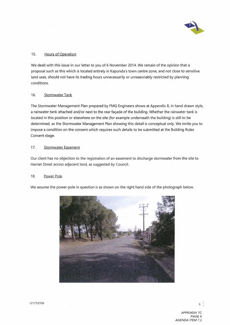
We dealt with this issue in our letter to you of 6 November 2014. We remain of the opinion that aproposal such as this which is located entirely in Kapunda's town centre zone, and not close to sensitive
land uses, should riot have its trading hours unnecessarily or unreasonably restricted by planningconditions.
I6,
The Stormwater Management Plan prepared by FMG Engineers shows at Appendix B, in hand drawn style,a rainwater tank attached and/or next to the rear fa^ade of the building. Whether the rainwater tank islocated in this position or elsewhere on the site (for example underneath the building) is still to be
determined, as the Stormwater Management Plan showing this detail is conceptual only. We invite you toimpose a condition on the consent which requires such details to be submitted at the Building Rules
Consent stage.
St rinwater T nk
17,
Our client has no objection to the registration of an easement to discharge stormwater from the site toHarriet Street across adjacent land, as suggested by Council.
EQ^
We assume the power pole in question is as shown on the right hand side of the photograph below.
Stormwater E
18.
en
12177LET08
APPENDIX 7C PAGE 6
AGENDA ITEM 7.1
The power pole can remain in this position because it will riot affect the semi-trailer turning path, as canbe seen by the detail shown on Sheet W003 prepared by DM Lawrence Design, The landscape bed in thevicinity of this pole can be easily amended to ensure the pole is entirely contained within the landscapebed and not the driveway.
As noted elsewhere in this letter and in Ms Sapio's letter, B-Double vehicles are not permitted to access oruse Old Adelaide Road, because this road is riot gazetted for this class of vehicle.
Suggested Conditions
We do not propose to comment on the list of conditions which Council has asked the Commission to
impose on the consent. Many of the suggested conditions are also unnecessary. However we would likethe opportunity to discuss the conditions which are considered necessary to be imposed, prior to theapplication being formally considered by the DAC.
Yours sincerel
aha urns
Master Ian SA Pty Ltd
enc:
CC:
Amended Drawing Set (three copies).CR Lindner Nominees Pty Ltd.
12177Ler08
APPENDIX 7C PAGE 7
AGENDA ITEM 7.1
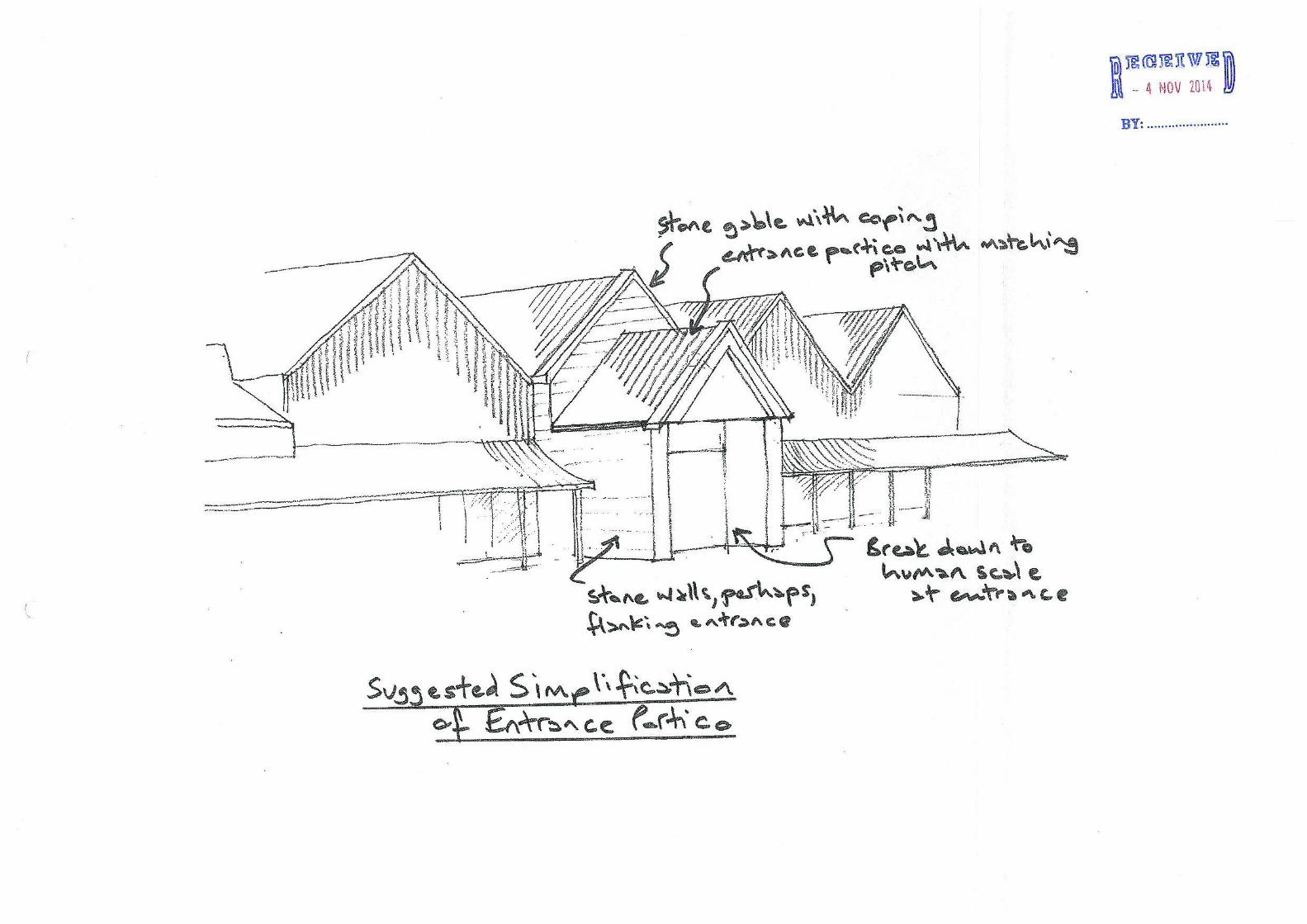
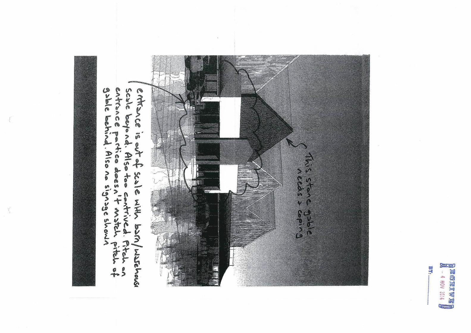


Principal Office: 93 Main Street Branch Office: 12 Hanson Street Kapunda 5373 Freeling 5372
Telephone: 8525 3200 Facsimile: 8566 3262
Minutes
from the meeting of
Light Regional Council Development Assessment Panel Meeting
held in the Council Chamber 93 Main Street, Kapunda
Monday, 22 December 2014 at 5.30 p.m.
Development Assessment Panel Minutes – 22 December 2014 Page 48/2014
LIGHT REGIONAL COUNCIL
DEVELOPMENT ASSESSMENT PANEL
MINUTES
MEETING HELD ON MONDAY, 22 DECEMBER 2014, IN THE COUNCIL CHAMBER, 93 MAIN STREET, KAPUNDA
COMMENCING AT 5.30 P.M. 1. MEETING OPENED
The Presiding Member, Mr Bruce Ballantyne declared the meeting open at 5.30 p.m. 2. PRESENT
Mr Bruce Ballantyne Presiding Member Mr Kelvin Goldstone Independent Member Mr Robert Veitch Independent Member Ms Margaret Wendt Independent Member Mrs Lynette Reichstein Elected Member Mr Peter Kennelly Elected Member
IN ATTENDANCE Mr Craig Doyle General Manager – Strategy and Development Mrs Lisa Sapio Manager – Development Services Mr Darby Schultz Development Officer – Planning Mr Spencer Hunt Development Officer – Planning 3. COMMENCEMENT AND WELCOME
The Presiding Member, Mr Bruce Ballantyne welcomed all those in attendance.
4. APOLOGIES
Mr David Shannon Elected Member
5. APPOINTMENT OF DEPUTY PRESIDING MEMBER
Moved Mrs Reichstein Seconded Mr Kennelly That pursuant to Section 56A (4b) of the Development Act 1993, the Development Assessment Panel appoint Independent Member Mr Kelvin Goldstone to the position of Deputy Presiding Member for the ensuing one (1) year term, to expire on 12 December 2015.
CARRIED
6. CONFIRMATION OF PREVIOUS MINUTES
Moved Mr Goldstone Seconded Mr Veitch That the minutes of the meeting of the Development Assessment Panel held on Wednesday, 5 November 2014, be confirmed as a true and correct record of that meeting.
CARRIED
Development Assessment Panel Minutes – 22 December 2014 Page 49/2014
7. DISCLOSURE STATEMENTS
A Council Development Assessment Panel Member declaring an interest in a matter before the Panel shall make a disclosure clearly stating the nature of that interest in writing to the Presiding Member, in accordance with Clause 2.4 of the Minister’s Code of Conduct, and then in the meeting when the relevant agenda item is reached, makes a verbal disclosure to the Panel and removes themselves from the meeting in accordance with Section 56A(7)(b) of the Development Act 1993. No disclosures of interest were made.
8. DEVELOPMENT REPORT 8.1 Development Application 313/363/2014 – CR Lindner Nominees Pty Ltd
Moved Mr Goldstone Seconded Mrs Reichstein 1. Reason for Decision
Having considered all the relevant planning matters in relation to the development application 313/363/2014, the Panel has read and considered that the report prepared by the Development Officer - Planning and agrees with the assessment outlined in that report:
2. That pursuant to section 35 (2) of the Development Act 1993, the proposal is not
considered to be seriously at variance with the relevant provision of the Light Regional Council Development Plan (consolidated) 24 January 2013.
3. That the DAC be advised that the comments provided herein are in addition to those
contained in the report dated 5 November 2014 in relation to Development Application number 313/363/2014. Furthermore, the amended elevations are in the main considered acceptable subject to the following:
a. The type of stone and laying pattern that should be employed includes the use of
coursed random Kapunda Stone, (excluding veneer tiles, bluestone and use of quoins);
b. If stone is to be utilised, then the stone should also be laid as traditionally laid that being coursed (layered horizontally);
c. The option to utilise a red brick with a pressed pattern in place of stone is also supported.
CARRIED
8.2 Development Application Number 313/374/2014 - Ciborex Pty Ltd Moved Mr Veitch Seconded Mr Goldstone 1. Reason for Decision
Having considered all the relevant planning matters in relation to the development application 313/374/2014, the Panel has read and considered that the report prepared by the Manager – Development Services (assessing officer) and agrees with the assessment outlined in that report:
2. That pursuant to section 35 (2) of the Development Act 1993, the proposal is not
considered to be seriously at variance with the relevant provision of the Light Regional Council Development Plan (consolidated) 24 January 2013.
8 January 2015
Mr Graham Burns MasterPlan 33 Carrington Street Adelaide SA 5000 [email protected]
Dear Mr Burns Applicant: CR Lindner Nominees P/L Application Number: 313/0363/14 Proposed Development: Supermarket with associated car parking, loading and
landscaping Subject Land: Corner Carrington Street and Main Street, Kapunda
(various parcels of land)
I refer to the above development proposal forwarded to the Development Assessment Commission by the Light Regional Council. We are currently in the advanced stages of assessment, with a view to providing a recommendation to the Commission in the near future. At this time we wish to raise the following areas of concern for your information and further consideration:
1. Southern boundary interface: the location of the proposed retaining wall and fence on the southern boundary and the potential adverse impacts on the existing adjacent dwelling in terms of amenity and overshadowing. The extent of overlooking, and hence impact, on the privacy of this dwelling from the car park of the development could also be significant. The amended plans provided on 24 November 2014 show the retaining wall height as 1.2m and fence height as 2.1m, giving a combined height of 3.3m immediately adjacent this dwelling. It is noted that this is inconsistent with Council’s DAP report which suggests a combined height of 4m. To assist in the assessment a cross-section diagram of the proposed site levels, retaining wall, and fence heights, should be provided. Whilst we acknowledge the need to create a level development site (for vehicle and trolley manoeuvrability), we are concerned with the potential impact to the dwelling.
2. Western boundary interface: the elevated position of the proposed development, in conjunction with the size and scale of the supermarket building and lack of landscaping, has the potential for adverse amenity impacts on the adjacent
Residential Zone. This is inconsistent with PDC 3 (Policy Area) which requires that development on land abutting residential zones should be more domestic in scale and character than development in the area generally.
3. Car parking: the proposed car parking ratio of 2.8 spaces per 100m2 is well below the
5 spaces per 100m2 required in the Light Regional Council Development Plan. Whilst I understand that Council is prepared to accept a rate of 4 spaces per 100m2 applied to a reduced floor area, the parking shortfall remains of concern to DPTI planning staff; is insufficiently justified (the concerns raised by the Council’s independent traffic assessment are not addressed); and no information is provided as to alternative means of meeting the unsatisfied demand such as on-street parking capacity. In addition, the location of the car park in front of the supermarket, with access from Main Street, is contrary to the Development Plan provisions.
When combined, these areas of concern could point to a conclusion that the application may represent an over development of the subject site. These issues will be brought to the attention of the Commission and to that end, the Applicant may wish to consider providing some further information or comment, including treatments/design options to reduce the impact to the adjacent dwelling and residential zone, and further analysis or justification of the reduced car parking ratio.
If on the other hand you do not wish to provide any further information, the assessment will be finalised following which the application will be put to the next available meeting. Should you have any enquiries in relation to this matter, please do not hesitate to contact Laura Kerber of this office on (08) 7109 7073 or email [email protected]. Please that I am on leave from Wednesday 14 January 2015, returning on Monday 9 February 2014. In my absence please contact Simon Neldner on (08) 7109 7058 or email [email protected]. Yours faithfully
Laura Kerber Planning Officer Statutory Planning Branch Department of Planning, Transport and Infrastructure