Embed Size (px)
Citation preview

An affective intelligent driving agent: driver's trajectoryand activities prediction.
Citation Di Lorenzo, G. et al. “An Affective Intelligent Driving Agent:Driver's Trajectory and Activities Prediction.” VehicularTechnology Conference Fall (VTC 2009-Fall), 2009 IEEE 70th.2009. 1-4. ©2009 Institute of Electrical and ElectronicsEngineers.
As Published http://dx.doi.org/10.1109/VETECF.2009.5378965
Publisher Institute of Electrical and Electronics Engineers
Version Original manuscript
Accessed Thu Jan 19 23:10:12 EST 2012
Citable Link http://hdl.handle.net/1721.1/58476
Terms of Use Attribution-Noncommercial-Share Alike 3.0 Unported
Detailed Terms http://creativecommons.org/licenses/by-nc-sa/3.0/

Giusy Di Lorenzo Fabio Pinelli Francisco C. Pereira Assaf Biderman Carlo Ratti Charles Lee Chuhee Lee
An Affective Intelligent Driving
Agent: Driver’s Trajectory and
Activities Prediction
This paper might be a pre-copy-editing or a post-print author-produced .pdf of an article accepted for publication. For the
definitive publisher-authenticated version, please refer directly to publishing house’s archive system.

An Affective Intelligent Driving Agent: Driver’sTrajectory and Activities Prediction
Giusy Di Lorenzo #1, Fabio Pinelli ∗1, Francisco C. Pereira #2
Assaf Biderman #3, Carlo Ratti #4, Charles Lee +1, Chuhee Lee +2
#Senseable City Lab, MIT, USA{ 1giusydilor, 2pereira, 3abider, 4ratti}@mit.edu
∗ KDDLab, ISTI-CNR, Pisa, [email protected]
+ VWoA-ERL, USA{ 1Charles.Lee, 2Chuhee.Lee}@vw.com
Abstract—The traditional relationship between the car, driver,and city can be described as waypoint navigation with additionaltraffic and maintenance information. The car can receive andstore waypoint information, find the shortest route to thesewaypoints, integrate traffic information, find points-of-interest,and alert the driver of a pre-programmed set of maintenanceissues related to the car. Here, we propose a new route systemthat is multi-goal-centric rather than waypoint-centric. Insteadof focusing on determining the route to a specified waypoint,as done in commercially available navigation systems, the systemwill analyze the driver’s behavior in order to extract the potentialset(s) of goals that the driver would like to achieve. The systemmust also understand the city on a number of levels: physical,social, and commercial. This provides the foundation for a socialand intelligent driving assistant, that helps the driver achievehis goals and helps the city perform better through interactionbetween both entities.
I. INTRODUCTION
Current navigation systems are focused on finding way-points. They are capable of pointing out the shortest route toa destination, integrating traffic information, and identifyingpoints-of-interest. These systems can successfully assist indriving to a fixed desired destination. However, individualsoften make trips with the purpose of achieving various goals,such as purchasing gasoline, watching a movie, or participatingin a public event, while the physical location of their destina-tion is flexible. Also, driving conditions in the city change inresponse to different events, influencing the accessibility levelsof areas in the city.
We envision a navigation system that mimics the friendlyexpertise of a driving companion who is familiar with both thedriver and the city. Instead of focusing solely on determiningroutes to a specified waypoint, our system utilizes the analysisof the driver’s behavior in order to identify the set of goalsthe driver would like to achieve. Furthermore, it involves anunderstanding of the city beyond what can be seen throughthe windshield, incorporating information such as business andshopping districts, tourist and residential areas, as well as real-time event information and environmental conditions.
In recent years, a multitude of tags, sensors, locationingdevices, telecommunications networks, online social networks,and other pervasive networks are proliferating in cities. Theyare constantly producing a rich stream of data that can helpdescribe dynamic rhythms in the city. Our navigation systemworks to recognize underlying patterns in this data pertainingto various aspects of the city including traffic, seasonal infor-mation, environmental conditions, commercial offerings, andevents. In-car sensors provide information about the driver’smood, attention span, as well as about interaction with the car,for example navigation decisions, acceleration and braking,climate control, and seat position. Thus, over time, the carcan learn about a driver’s habits, routes, and goals, and inthe short term, the car can dynamically adjust to the driver’scurrent state.
II. RELATED WORK
The works related to the research proposed in this paperinclude: I) Destination and trajectory prediction, II) Semanticsanalysis of the City and III) Profiling of the City using GPSdata.
A. Destination and Trajectory Prediction
The quest for efficient algorithms that predict a full routebased on previous driving behavior has motivated a number ofrelevant research works. We will now give a brief overview ofthis topic with particular emphasis on data representation andalgorithm principles as well as performance and experimentalresults when available.
In 2006, Tsutomu Terada and his colleagues [1] propose analgorithm for predicting destination given the trajectory so far.They represent historical data in the links of the grap. This datais essentially the count for each destination that was eventuallyreached passing by that link. This number is then used todetermine the probability of reaching destination d from linkl. The prediction algorithm then consists of determining theseprobabilities at each link and producing an ordered list of

predicted destinations. The authors present some results fromexperiments, but their validity is highly questionable since theyfocus on only one user (for one year).
From a different trend, Mikolaj Morzy [2] applies Spatial-Temporal Data Mining techniques for the task of trajectoryprediction. From the historical set of past traces, the systembuilds association rules out frequent patterns (e.g. X1, X2 →X3, i.e. after passing by points X1 and X2, it should pass byX3). Then, in face of a new trajectory, it tries to find the ruletail that best matches its last links (or the whole trajectory).The experimentation is based on Thomas Birkhoff’s Generatorof Moving Objects [3].
Froehlich and Krumm [4] present a system for route pre-diction that clusters past trajectories (trips) into typical routes.It then compares the current trajectory with these routes andreturns the one that is most similar. Similarity is calculated asaverage minimal distance of point to curve. I.e. in comparingtrajectory A with Route B, for each point of A, it is calculatedthe minimal distance to a link (a segment between twosubsequent points) belonging to B. In both cases, we dealexclusively with GPS points (as opposed to a base map). Asargued by many (e.g. [5]), point-to-curve map matching isvery much prone to errors with GPS data (especially whensuch representation is used in both sides, the point to matchand the base map itself). In spite of all the filtering they make,better distance measures could be applied (e.g. frechet distance[6]) as well as a more accurate map matching algorithm (e.g.one that uses geometry) would render better results. Using abase map for routes would possibly also improve the outcome.
In [7], the authors propose WhereNext, which is a methodaimed at predicting with a certain level of accuracy the nextlocation of a moving object. The prediction uses previously ex-tracted movement patterns named Trajectory Patterns, whichare a concise representation of behaviors of moving objects assequences of regions frequently visited with a typical traveltime. A decision tree, named T-pattern Tree, is built andevaluated with a formal training and test process. The treeis learned from the Trajectory Patterns that hold a certainarea and it may be used as a predictor of the next locationof a new trajectory finding the best matching path in the tree.Moreover, they propose a set of measures, tuned on a real lifecase, to evaluate evaluate a priori the predictive power of a setof Trajectory Patterns.
Finally, on a different perspective, Zheng et al [8] focuson understanding peoples behavior in which relates to theirtravel sequences of stops (as opposed to travel trajectory, assequences of passed links). The proposed model infers theinterested of a location taking into account the followingthree factors: 1) the interest of a location depends on notonly the number of users visiting this location but also theseusers’travel experiences. 2) User’s travel experiences and loca-tion interests have a mutual reinforcement relationship. 3) Theinterest of a location and the travel experience of a user relativevalues and are region related. The most interesting aspectfor our purpose is their graph organization that considershierarchical clustering of points in space. This allows the
setting up of a different perspective on travel behavior andprediction (e.g. make prediction at different levels, even whenthe driver is going to a place for the first time). Their workis however motivated towards suggestion of interesting placesto visit and travel sequences when in unfamiliar places.
B. Semantics and City
The online extraction of semantic information about thecity can reveal at any time information that is not availablethrough other channels[9]. For example, event descriptions orinformation about places (and their semantic profile) can makethe difference in supporting the driver. We use an InformationExtraction mechanism, Kusco [10], [11], that extracts thesemantic index (set of words associated to an event) usinga sequence of well known techniques: Part-of-Speech (POS)tagging[12], Noun Phrase chunking 1 and Named EntityRecognition (NER)[13]. The goal is to extract relevant entitiesfrom online documents and identification of whether theydesignate people, places, companies, organizations, and thelike. We rank the relevancy with TF-IDF (Term Frequency× Inverse Document Frequency), a common measure in theIR field. Term Frequency measures the frequency of a wordwithin a text while Inverse Document Frequency measureshow discriminant is a word in a collection of texts (e.g. aword that appears in every text has little value since it doesnot differentiate the texts; a word that is unique to a docu-ment is considered to be potentially relevant). Other relevantworks can be referred in this realm, namely Open Calais[14] and Semantic Hacker [15], which also provide semanticindexes, although their focus is not restricted to informationabout events and space (which weakens their ability to filterunwanted concepts). A related work, Scarlet [16], which isbeing integrated with Kusco, works on the extraction of therelations between concepts. Such functionality will allow fora even higher potential for assisting the driver (e.g. knowingthat the “performer” of an event is X, the theme is Y, etc.).
C. City Profiling
Over the past decade, our built environment has becomethoroughly permeated by digital wireless signals. What is newabout this blanket of bits is that, unlike the old unidirectionalsignals of radio or TV, it is bidirectional. The packets transmit-ted by cellular phones and WiFi-enabled portable devices aretied to patterns of human behavior and, if properly mined,can potentially reveal a great deal of information. Recentresearch on the analysis of telecommunication network datahas provided a better understanding of dynamics in the city,and in particular on how it is possible to perform a computa-tional and comparative analysis of space through the lens oftelecommunications usage [17], [18]. A similar approach canbe applied to the analysis of GPS trajectories to understandhow the collectivity of drivers sees and perceives the city.
1http://www.semanticsoftware.info/
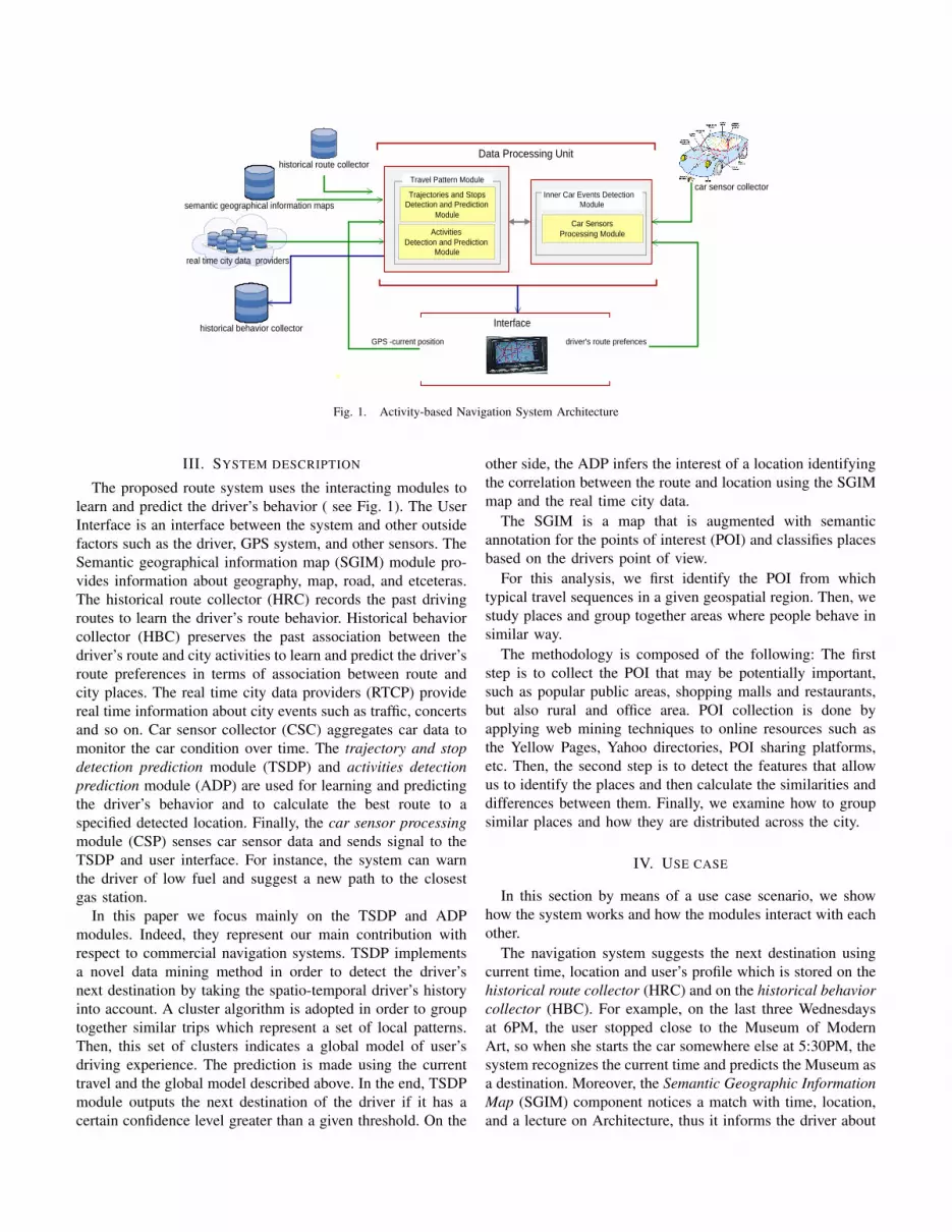
Internet
historical behavior collector
historical route collector
semantic geographical information maps
real time city data providers
InterfaceGPS -current position
car sensor collector
Car SensorsProcessing Module
Inner Car Events DetectionModule
driver's route prefences
Trajectories and StopsDetection and Prediction
Module
ActivitiesDetection and Prediction
Module
Travel Pattern Module
Data Processing Unit
Fig. 1. Activity-based Navigation System Architecture
III. SYSTEM DESCRIPTION
The proposed route system uses the interacting modules tolearn and predict the driver’s behavior ( see Fig. 1). The UserInterface is an interface between the system and other outsidefactors such as the driver, GPS system, and other sensors. TheSemantic geographical information map (SGIM) module pro-vides information about geography, map, road, and etceteras.The historical route collector (HRC) records the past drivingroutes to learn the driver’s route behavior. Historical behaviorcollector (HBC) preserves the past association between thedriver’s route and city activities to learn and predict the driver’sroute preferences in terms of association between route andcity places. The real time city data providers (RTCP) providereal time information about city events such as traffic, concertsand so on. Car sensor collector (CSC) aggregates car data tomonitor the car condition over time. The trajectory and stopdetection prediction module (TSDP) and activities detectionprediction module (ADP) are used for learning and predictingthe driver’s behavior and to calculate the best route to aspecified detected location. Finally, the car sensor processingmodule (CSP) senses car sensor data and sends signal to theTSDP and user interface. For instance, the system can warnthe driver of low fuel and suggest a new path to the closestgas station.
In this paper we focus mainly on the TSDP and ADPmodules. Indeed, they represent our main contribution withrespect to commercial navigation systems. TSDP implementsa novel data mining method in order to detect the driver’snext destination by taking the spatio-temporal driver’s historyinto account. A cluster algorithm is adopted in order to grouptogether similar trips which represent a set of local patterns.Then, this set of clusters indicates a global model of user’sdriving experience. The prediction is made using the currenttravel and the global model described above. In the end, TSDPmodule outputs the next destination of the driver if it has acertain confidence level greater than a given threshold. On the
other side, the ADP infers the interest of a location identifyingthe correlation between the route and location using the SGIMmap and the real time city data.
The SGIM is a map that is augmented with semanticannotation for the points of interest (POI) and classifies placesbased on the drivers point of view.
For this analysis, we first identify the POI from whichtypical travel sequences in a given geospatial region. Then, westudy places and group together areas where people behave insimilar way.
The methodology is composed of the following: The firststep is to collect the POI that may be potentially important,such as popular public areas, shopping malls and restaurants,but also rural and office area. POI collection is done byapplying web mining techniques to online resources such asthe Yellow Pages, Yahoo directories, POI sharing platforms,etc. Then, the second step is to detect the features that allowus to identify the places and then calculate the similarities anddifferences between them. Finally, we examine how to groupsimilar places and how they are distributed across the city.
IV. USE CASE
In this section by means of a use case scenario, we showhow the system works and how the modules interact with eachother.
The navigation system suggests the next destination usingcurrent time, location and user’s profile which is stored on thehistorical route collector (HRC) and on the historical behaviorcollector (HBC). For example, on the last three Wednesdaysat 6PM, the user stopped close to the Museum of ModernArt, so when she starts the car somewhere else at 5:30PM, thesystem recognizes the current time and predicts the Museum asa destination. Moreover, the Semantic Geographic InformationMap (SGIM) component notices a match with time, location,and a lecture on Architecture, thus it informs the driver about

this event. The whole process for making destination/activityprediction is described in Fig. 2(a).
Furthermore, while driving, the system is notified by theembedded sensor of the car that the fuel is running low.The system knows that the driver always uses a specific gasprovider based on the history of her commute (via HBC). Thesystem will select all the nearby locations for that particulargas provider. The choice of the gas stations is made with theinteractive map of the touch screen display of the navigationdevice. Now, the system re-calculates the route including alsothe gas station stop on the trip for reaching the museum.Fig. 2(b) explains graphically the interaction among car sen-sors, system and driver.
Historicalbehavior collector
Navigation System
Dataprocessing unit
geRoute(GPS_Position) getDestination(GPS_Position,
CurrentTime)
getProfile( Destinations,CurrentTime)
Semantic geographicalinformations map
Historicalroute collector
POI: Museum of Modern ART
getMAP( Destinations.Museum of Moder ART)
Destination and Anctivity Prediction Processing
Updated Map
The Map shows thepredicted route andactivity information
(a) Destination/Activity prediction
NavigationSystem
Historical BehaviorCollector
Car Sensor Collector
Data ProcessingUnit
getCurrentPositionEvent:: Fuel Low
Semantic geogrphicalinformation maps
getMap(GasStation Locations)
Route recalcualtion
POI: GasStationCompany
GPS_Position
getProfile(Fuel, GPS_Position)
Updated Map Map updating
(b) Car sensor event
Fig. 2. Use cases
V. CONCLUSIONS
In this paper we propose a new goal-centric route systemrather than waypoint-centric. Instead of focusing on determin-ing the route to a specified waypoint, as done in commerciallyavailable navigation systems, the proposed system analyzesthe driver’s behavior in order to predict the potential set(s)of goals that the driver would like to achieve. Moreover,the system uses city information at different levels: social,
physical and commercial. Thus the system is also able toprovide a social and intelligent driving assistant, improving theinteraction between driver and the space around him. Furtherinvestigation will focus the development of a effective andefficient way to understand the driver’s habits in order toimprove the quality of suggestions. Moreover, a real case testcase will be performed to validate the soundness of our novelapproach.
REFERENCES
[1] T. Terada, M. Miyamae, Y. Kishino, K. Tanaka, S. Nishio, T. Nakagawa,and Y. Yamaguchi, “Design of a car navigation system that predictsuser destination,” in MDM ’06: Proceedings of the 7th InternationalConference on Mobile Data Management. Washington, DC, USA:IEEE Computer Society, 2006, p. 145.
[2] M. Morzy, “Mining frequent trajectories of moving objects for locationprediction,” in MLDM ’07: Proceedings of the 5th international con-ference on Machine Learning and Data Mining in Pattern Recognition.Berlin, Heidelberg: Springer-Verlag, 2007, pp. 667–680.
[3] T. Brinkhoff, “A framework for generating network-based moving ob-jects,” GeoInformatica, vol. 6, no. 2, 2002.
[4] J. Froehlich and J. Krumm, “Route prediction from trip observations,”in Intelligent Vehicle Initiative (IVI) Technology Advanced Controls& Navigation Systems, SAE World Congress & Exhibition, Detroit,Michigan, USA, 2008.
[5] M. A. Quddus, W. Y. Ochieng, and R. B. Noland, “Current map-matching algorithms for transport applications: State-of-the art andfuture research directions,” Transportation Research C: Emerging Tech-nologies, vol. 15, no. 5, pp. 312–328, 2007.
[6] H. Alt, A. Erfat, G. Rote, and C. Wenk, “Matching planar maps,” Journalof Algorithms, vol. 49, no. 2, 2003.
[7] A. Monreale, F. Pinelli, R. Trasarti, and F. Giannoti, “Wherenext:a location predictor on trajectory pattern mining,” in MLDM ’07:Proceedings of the 5th international conference on Machine Learningand Data Mining in Pattern Recognition, 2009.
[8] Y. Zheng, L. Zhang, X. Xie, and W.-Y. Ma, “Mining interesting locationsand travel sequences from gps trajectories,” in 18th International WorldWide Web Conference (WWW2009), April 2009.
[9] A. Biderman, F. C. Pereira, and A. Alves, “Fusion of semantics withmobility information: Prospects and opportunities,” in Proceedings ofInMotion ’09 : Pervasive Technologies for Improved Mobility andTransportation. Workshop of Pervasive 2009, 2009.
[10] A. C. Alves, B. Antunes, F. C. Pereira, and C. Bento, “Semantic en-richment of places: Ontology learning from web,” International Journalof Knowledge-Based and Intelligent Engineering Systems (IOS Press),2009.
[11] B. Antunes, A. Alves, and F. C. Pereira, “Semantics of place: Ontologyenrichment,” in Proceedings of the 11th edition of the Ibero-AmericanConference on Artificial Intelligence. LNAI, Springer, 2008.
[12] K. Toutanova, D. Klein, C. D. Manning, and Y. Singer, “Feature-rich part-of-speech tagging with a cyclic dependency network,” in InProceedings of HLT-NAACL 2003, 2003, pp. 252–259.
[13] T. Poibeau and L. Kosseim, “Proper name extraction from non-journalistic texts,” in In Computational Linguistics in the Netherlands,2001, pp. 144–157.
[14] T. Reuters, “Open calais api,” 2009. [Online]. Available:http://www.opencalais.com/
[15] TextWise, “Semantic hacker api,” 2009. [Online]. Available:http://www.semantichacker.com/
[16] M. Sabou, M. d’Aquin, and E. Motta, “Exploring the semantic webas background knowledge for ontology matching,” Journal of DataSemantics), 2008.
[17] J. Reades, F. Calabrese, A. Sevtsuk, and C. Ratti, “Cellular census:Explorations in urban data collection,” IEEE Pervasive Computing,vol. 6, no. 3, pp. 30–38, July-September 2007.
[18] J. Reades, F. Calabrese, and C. Ratti, “Eigenplaces: analyzing cities us-ing the space-time structure of the mobile phone network,” Environmentand Planning B, in press 2009.