Embed Size (px)
Citation preview
Ապագա Հանդես (73) 1 Apaga Periodical(73)
An Overview of the Geography of Armenia
Edic Baghdaasrian
Editor Apaga, Louys
Director ARC
Armenian Highland
Nowadays the first well-known historical information about the
Armenian Highland is preserved in Sumerian cuneiform inscriptions
and dates back to 28-27 centuries BC. The early state formation
Aratta is mentioned in those inscriptions. The name is compared with
the toponym Ararat, which becomes more obvious while comparing
Sumerian and biblical stories about the great flood. In these stories
Aratta and Ararat are supposed to be place of rescue. In ancient
Mesopotamian cuneiform writings proper names were written in two
ways: phonetically (in syllables) and ideographically. In the first case
Aratta was written in three syllables (A-rat-ta), in the second case it
was written as Subur (Subari, Subartu). This means that these two
names referred to one state. The analyze of mentionings of Subur-
Subari-Subatru (the ancient ones were found in manuscripts dating
back to the 26th century BC) shows that it was found in the Armenian
Highland (in the basin of lake Van and in its south-western parts).
From the 26th century BC Mesopotamian manuscripts mentioned god
Hay(a), his eponymous land and nation. It is significant that in
Sumerian-Akkadian bilingual inscriptions Suburi of Sumerian part in
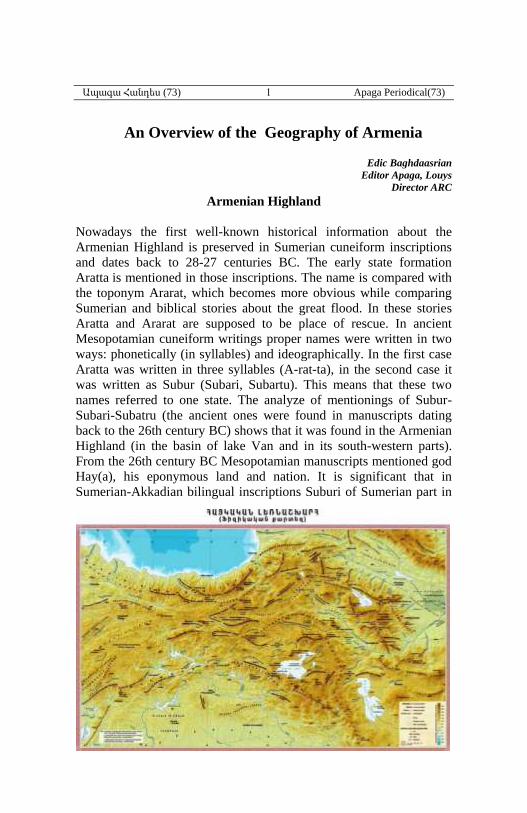
Armenian Highland
Black Sea
Lake Van
Lake Sevan
Lake Kaputan/
Urmia
Ապագա Հանդես (73) 2 Apaga Periodical(73)
Akkadian part coincided with Hay(a), which shows that these two
toponyms referred to the same land. As a matter of fact, from one
hand we have Aratta-Subur, from the other hand Subur-Hay(a), which
means that in the first half of the 3rd century BC Armenia was famous
with three equivalent names (Aratta-Hay(a)-Subur). From 24-23
centuries BC in the Armenian Highland “Arman(i)”, “Armi”, “Aram”
and other toponyms were mentioned, which were proto-forms of
“Armenia”. In inscriptions (24-23 centuries BC) of Ebla (northern part
of ancient Syria) “Sons of Haya” (“hayordiner”) were mentioned, who
lived in the land of Armi and who established relationship with other
countries. “Sons of Haya” (hayordiner) in manuscripts of Ebla, god
Haya and the land of Sumerian sources genealogically were connected
with the Armenian nature. So still from 24-23 centuries BC connected
with the Armenian Highland the main names of Armenia and the
Armenians were mentioned: Aratta, Haya, Subur and Arman(i). Subur
was no longer in use in the first half of 1st millennium BC, and the
others are still in use as Ararat, Hayk-Hayastan and Armenia.
Armenian Highland is situated in the northern borderline of Western
Asia between Asia Minor and Iranian plateaus, Black Sea and
Mesopotamian plains. The Armenian people originated and created
their state in the Armenian Highland; they created their own culture
here. The Armenian Highland almost completely coincides with the
historical Armenian homeland. From ancient times it has been
extended from the rivers Kur and Yeraskh (Araks) up to Gamirk
(Cappadocia), from Pontus and Trialet mountains to the southern parts
of the Armenian Taurus.
The Armenian Highland (about 300,000 Km2) is surrounded by high
mountain ranges: in ancient times the highland between them was
called Mijnashkharh Hayots (Midland of Armenia).
Armenian Highland has boundary with Antitaurus mountains to the
west, which divided it from the Anatolian Plateau (Asia Minor), and
to the north – with west Pontus mountains. Northern borders of the
highland stretches the watershed of Moskakan and Trialet mountains.
In the East they are the borders of Artsakh and Kur-Araks valleys.
The border of the highland reaching Karabakh turns to the west, goes
through the mountains in the north of Lake Kaputan (Urmia), then
turning to the south it includes the western coastal regions of the lake
and reaches Kordvats mountain range, which is the continuation of the
Armenian Taurus. Turning again to the west and crossing the river
Tigris, it reaches Euphrates, cuts it and goes up to Antitaurus through
Malatya mountains. In these borders the region has over 400 sq. km.
area. The surface of the Armenian Highland is divided into mountain
Ապագա Հանդես (73) 3 Apaga Periodical(73)
ranges with different directions, between which concavities and
plateaus extend, which have favorable conditions for agriculture, they
are called in the Armenian sources “fields”. The highland has 1500-
1800 m. average height above the sea level, with which it
significantly exceeds both the neighboring Iranian and Anatolian
plateaus.
In the center of the Armenian highland from east to west mountain
range Haykakan Par is situated. In the outskirts of the latter rises
extinct volcanic Ararat (Masis) with its two peaks, one of which is the
highest mountain of the Armenian Highland (5165m.) and it is called
in the Armenian sources Azat Masis (free Masis), which joins to Sis
or Lesser Ararat mountain peak (3925m.) with “Sardari aghbyur”
(Sardar spring). Masis is the holy mountain of Armenians, the symbol
of the motherland (the 18th day of the Armenian ancient calendar is
dedicated to it). People told many legends about Masis. According to
the Bible the Biblical Noah’s ark came to rest on Masis (Ararat).
From the eastern edge of Haykakan Par with the southern direction
the mountain range of Vaspurakan is expanded, the continuation of
which is the mountain range of Zagros. The Armenian plateau has
numerous mountain ranges. In the west of the mountain range of
Vaspurakan the picturesque mountain of Tsaghkants is situated, at
the edge of which is situated the only existing volcanic mountain
Tondrak (3542 m.). Up to now around him from the crater (600m.
deep) still water steams and sulfuric fluids erupt with high
temperature. In the southern part of the mountains Tsaghkants is
situated the extinct volcanic mountain Sipan (4434 m.). It is the
second highest peak of the highland. In the south of Sipan avoiding
western shores of Lake Van Bznunyats mountains are stretched which
are ended with the peak Nemrut. Nemrut is an extinct volcano,
although it was active until the first half of XV century (the last
eruption took place in 1441). The north - eastern large part of the
Armenian highland is called Lesser Caucasus. In this part there are
several prominent mountain ranges, as Javakheti, Virahayots, Bazumi,
Pambak, Geghama, Sevan, Vardenis, Mravi Artsakh mountains. From
mountains Vardenis starts and to the south up to Yeraskh (Araks)
expands the mountain range of Syunik or Zangezur, in the southern
part of which is situated the highest peak of Lesser Caucasus
Kaputjugh (3904m.). In the southern borderline of Ararat valley is
situated the highest mountain of the territory of Republic of Armenia
– Aragats (4090m.). The prairies and feeds spread over his slopes are
important livestock areas famous from ancient times. In the east of
Aragats mount Ara is situated. In the southern part of the Armenian
Ապագա Հանդես (73) 4 Apaga Periodical(73)
highland stretches mountain range of Armenian Taurus, in different
parts of which various peaks are raised (Marutasar or Maratuk,
Tsovasar, Andok, Arnos, Artos, etc.).
The Armenian Highland is famous for its richness of water resources.
It is the only Hydraulics of Western Asia and it is not by chance, that
it has got the title “The land of rivers” by the Semitic population of
Ancient Mesopotamia in II millennium BC. From here Euphrates,
Tigris, Yeraskh, Halis, Gaylget, Kur, Chorokh outflow.
The Armenian main river is Yeraskh or Araks, the basin of which is
totally included in the territory of the Armenian Highland. The
outflows of Yeraskh are situated in the area of Byuraknyan mauntains.
In the past Yeraskh separately flowed into Caspian Sea, but over time
it changed its watercourse and merged with river Kur. Yeraskh has
numerous brooks - Akhuryan, Kasakh, Hrazdan, Arpa, Vorotan,
Voghji, Tghmut etc.
From the early times Yeraskh had economic and political huge
significance. In the average current of his basin the biggest and most
prolific plane – Ararat Valley is expanded, which has been the
political center of the Armenian statehood - the Realm of Kings for
centuries. In the Armenian Valley ancient cities of the Armenian state
were built - Armavir, Yervandashat, Artashat, Vagharshapat, Dvin.
The capital of Republic of Armenia Yerevan is also situated here.
Euphrates is the longest river (3065km) of Western Asia, while
Tigris is the largest by waterflow (1850km). River Euphrates has two
branches – Western Euphrates and Eastern Euphrates. Western
Euphrates goes out from Tsaghkavet Mountains in the north of the
city Karin (Erzurum). For centuries it has been considered to be the
western border of the Kingdom of Armenia. Eastern Euphrates –
Aratsani river goes out from Tsaghkants Mountains. Both branches of
Euphrates merge near the city Kapan of Sophene and form united
Euphrates, which then going beyond the borders of the Armenian
Highland flows through Mesopotamia. The Tigris unites with the
Euphrates and form Shatt-al-Arab river, which flows into the Persian
Gulf.
Tigris also has two branches – Western and Eastern. The outflows of
Western Tigris are situated in the area of Sophene, near Lake
Sophene. Going out of the borders of the highland Tigris flows
through Mesopotamia, joins Euphrates and together with it flows into
the Persian Gulf.
River Kur goes out from Kriakunq, which is in the province Kogh of
Taօ state. With its main part it flows out of the borders of Armenian
Highland, but in ancient times it delimited Greater Armenia from Virq
Ապագա Հանդես (73) 5 Apaga Periodical(73)
and Albania. In the field of Mughan Yeraskh joins Kur and then they
together flow into the Caspian Sea.
Halis (Alis), Gayl rivers rise and flow into the Black sea from Upper
Armenia. River Chorokh belongs to the basin of Black Sea too, which
rises in Chormayr mountains situated in Sper.
In the Armenian Highland there are numerous lakes and ponds. The
most majors are Kaputan (Urmia), Van
and Sevan.
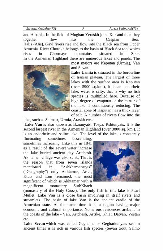
Lake Urmia is situated in the borderline
of Iranian plateau. The largest of three
lakes with the surface area is Kaputan
(over 5900 sq.km.), it is an endorheic
lake, water is salty, that is why no fish
species is multiplied here. Because of
high degree of evaporation the mirror of
the lake is continuously reducing. The
coastal zone of Kaputan has a thick layer
of salt. A number of rivers flow into the
lake, such as Salmast, Urmia, Araskh etc..
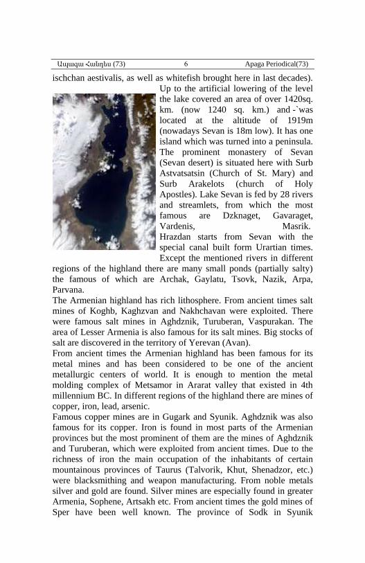
Lake Van is also known as Bznunyats, Tospa, Rshtunyats. It is the
second largest river in the Armenian Highland (over 3800 sq. km.). It
is an endorheic and saline lake. The level of the lake is constantly
fluctuating sometimes descending,
sometimes increasing. Like this in 1841
as a result of the severe water increase
the lake buried ancient city Artchesh.
Akhtamar village was also sunk. That is
the reason that from seven islands
mentioned in “Ashkharhatsuyts”
(“Geography”) only Akhtamar, Arter,
Ktuts and Lim remained, the most
significant of which is Akhtamar with a
magnificent monastery SurbKhach
(monastery of the Holy Cross). The only fish in this lake is Pearl
Mullet. Lake Van is a close basin involving in itself rivers and
streamlets. The basin of lake Van is the ancient cradle of the
Armenian state. At the same time it is a region having major
economic and cultural importance. Numerous residences arebuilt in
the coasts of the lake - Van, Artchesh, Artske, Khlat, Datvan, Vostan
etc.
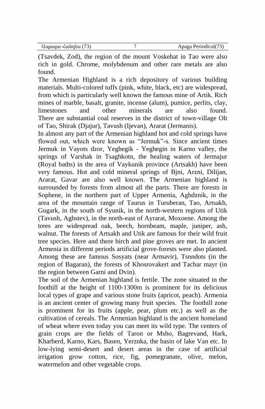
Lake Sevan which was called Geghama or Gegharkunyats sea in
ancient times is is rich in various fish species (Sevan trout, Salmo
Ապագա Հանդես (73) 6 Apaga Periodical(73)
ischchan aestivalis, as well as whitefish brought here in last decades).
Up to the artificial lowering of the level
the lake covered an area of over 1420sq.
km. (now 1240 sq. km.) and -`was
located at the altitude of 1919m
(nowadays Sevan is 18m low). It has one
island which was turned into a peninsula.
The prominent monastery of Sevan
(Sevan desert) is situated here with Surb
Astvatsatsin (Church of St. Mary) and
Surb Arakelots (church of Holy
Apostles). Lake Sevan is fed by 28 rivers
and streamlets, from which the most
famous are Dzknaget, Gavaraget,
Vardenis, Masrik.
Hrazdan starts from Sevan with the
special canal built form Urartian times.
Except the mentioned rivers in different
regions of the highland there are many small ponds (partially salty)
the famous of which are Archak, Gaylatu, Tsovk, Nazik, Arpa,
Parvana.
The Armenian highland has rich lithosphere. From ancient times salt
mines of Koghb, Kaghzvan and Nakhchavan were exploited. There
were famous salt mines in Aghdznik, Turuberan, Vaspurakan. The
area of Lesser Armenia is also famous for its salt mines. Big stocks of
salt are discovered in the territory of Yerevan (Avan).
From ancient times the Armenian highland has been famous for its
metal mines and has been considered to be one of the ancient
metallurgic centers of world. It is enough to mention the metal
molding complex of Metsamor in Ararat valley that existed in 4th
millennium BC. In different regions of the highland there are mines of
copper, iron, lead, arsenic.
Famous copper mines are in Gugark and Syunik. Aghdznik was also
famous for its copper. Iron is found in most parts of the Armenian
provinces but the most prominent of them are the mines of Aghdznik
and Turuberan, which were exploited from ancient times. Due to the
richness of iron the main occupation of the inhabitants of certain
mountainous provinces of Taurus (Talvorik, Khut, Shenadzor, etc.)
were blacksmithing and weapon manufacturing. From noble metals
silver and gold are found. Silver mines are especially found in greater
Armenia, Sophene, Artsakh etc. From ancient times the gold mines of
Sper have been well known. The province of Sodk in Syunik
Ապագա Հանդես (73) 7 Apaga Periodical(73)
(Tsavdek, Zod), the region of the mount Voskehat in Tao were also
rich in gold. Chrome, molybdenum and other rare metals are also
found.
The Armenian Highland is a rich depository of various building
materials. Multi-colored tuffs (pink, white, black, etc) are widespread,
from which is particularly well known the famous mine of Artik. Rich
mines of marble, basalt, granite, incense (alum), pumice, perlits, clay,
limestones and other minerals are also found.
There are substantial coal reserves in the district of town-village Olt
of Tao, Shirak (Djajur), Tavush (Ijevan), Ararat (Jermanis).
In almost any part of the Armenian highland hot and cold springs have
flowed out, which were known as “Jermuk”-s. Since ancient times
Jermuk in Vayots dzor, Yeghegik - Yeghegin in Karno valley, the
springs of Varshak in Tsaghkotn, the healing waters of Jermajur
(Royal baths) in the area of Vaykunik province (Artsakh) have been
very famous. Hot and cold mineral springs of Bjni, Arzni, Dilijan,
Ararat, Gavar are also well known. The Armenian highland is
surrounded by forests from almost all the parts. There are forests in
Sophene, in the northern part of Upper Armenia, Aghdznik, in the
area of the mountain range of Taurus in Turuberan, Tao, Artsakh,
Gugark, in the south of Syunik, in the north-western regions of Utik
(Tavush, Aghstev), in the north-east of Ayrarat, Moxoene. Among the
trees are widespread oak, beech, hornbeam, maple, juniper, ash,
walnut. The forests of Artsakh and Utik are famous for their wild fruit
tree species. Here and there birch and pine groves are met. In ancient
Armenia in different periods artificial grove-forests were also planted.
Among these are famous Sosyats (near Armavir), Tsnndots (in the
region of Bagaran), the forests of Khosrovakert and Tachar mayr (in
the region between Garni and Dvin).
The soil of the Armenian highland is fertile. The zone situated in the
foothill at the height of 1100-1300m is prominent for its delicious
local types of grape and various stone fruits (apricot, peach). Armenia
is an ancient center of growing many fruit species. The foothill zone
is prominent for its fruits (apple, pear, plum etc.) as well as the
cultivation of cereals. The Armenian highland is the ancient homeland
of wheat where even today you can meet its wild type. The centers of
grain crops are the fields of Taron or Msho, Bagrevand, Hark,
Kharberd, Karno, Kars, Basen, Yerznka, the basin of lake Van etc. In
low-lying semi-desert and desert areas in the case of artificial
irrigation grow cotton, rice, fig, pomegranate, olive, melon,
watermelon and other vegetable crops.
Ապագա Հանդես (73) 8 Apaga Periodical(73)
The fauna of the Armenian highland is diverse. From ancient times
the favorable conditions for the development of agriculture allow to
breed sheep, goat, cattle, donkey, and different types of birds. From
ancient times Armenia is considered to be the center of horse
breeding. According to Greek geographer Strabo in the period of
Achaemenid dominion Armenia provided 20 thousand fillies annually
for the celebrations of the god Mihr (Mitra). Especially Artsakh was
famous for its horse breeding. In ancient times pig breeding was
widespread. Among wild animals are brown bear, wolf, fox, forest
cat, lynx, badger, deer, buck, wild sheep, chamois and many types of
birds. It should be noted that in ancient times wild animal world was
more diverse. Unfortunately at present as a result of human activity
many animals, which are mentioned in Armenian and foreign sources
have completely disappeared or the living space of them has strongly
reduced. In Ararat valley a type of insect has spawned from which
vordan karmir (cochineal red) was made which had a great economic
importance and was famous abroad.
In ancient sources valuable information have been preserved about the
administrative units of Ancient Armenia – “Ashkharhner” (“Worlds”)
(“States”, “Provinces”). From the middle of IV century BC the
concept Greater Armenia (Major Armenia) and Lesser Armenia
(Armenia Minor) appeared. Over the centuries the two parts of the
Ancient Armenia had changing boundaries, therefore also different
areas.
Previously Lesser Armenia included the upper basin of Western
Euphrates as well as the upper provinces of the rivers Halis and Gayl.
After 331 BC when the Armenian independence was restored the
development of Lesser Armenia and Greater Armenia proceeded in a
unique, original way. As an independent state Lesser Armenia existed
until the 1st century AD (there was a time when the provinces of the
Pontus region near Black sea including the cities of Trebizond and
Kerasunt entered into its borders) but gradually losing its main areas it
became firstly a state dependent from Rome, and in 72 AD one of the
ordinary provinces of the latter.
The historical destiny of Greater Armenia - the homeland of the
Armenian state proceeded otherwise. Being national state it also
existed during further centuries (till the first decade of the 5th century)
and became a unifying center for the Armenian region.
According to the records of the famous Roman scholar Pliny the Elder
(1st c. AD) Artaxiad Armenia was divided into 120 provinces (in
Greek - strategies). When Arsacid dynasty took the Armenian throne
(66 AD), new modifications of the country’s administrative structure
Ապագա Հանդես (73) 9 Apaga Periodical(73)
took place as a result of which administrative units were enlarged and
the system of early middle ages “ashkharhner” or “states” appeared.
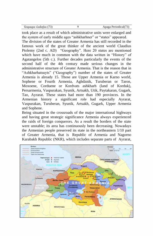
The division of the states of Greater Armenia has still recorded in the
famous work of the great thinker of the ancient world Claudius
Ptolemy (2nd c. AD) “Geography”. Here 20 states are mentioned
which have much in common with the data written in “History” of
Agatangelos (5th c.). Further decades particularly the events of the
second half of the 4th century made serious changes in the
administrative structure of Greater Armenia. That is the reason that in
“Ashkharhatsuyts” (“Geography”) number of the states of Greater
Armenia is already 15. Those are Upper Armenia or Karno world,
Sophene or Fourth Armenia, Aghdznik, Turuberan or Taron,
Moxoene, Corduene or Kordvats ashkharh (land of Korduk),
Persarmenia, Vaspurakan, Syunik, Artsakh, Utik, Paytakaran, Gugark,
Tao, Ayrarat. These states had more than 190 provinces. In the
Armenian history a significant role had especially Ayrarat,
Vaspurakan, Turuberan, Syunik, Artsakh, Gugark, Upper Armenia
and Sophene.
Being situated in the crossroads of the major international highways
and having great strategic significance Armenia always experienced
the raids of foreign conquerors. As a result the borders of the state
were unstable; its area has continuously been decreasing. Nowadays
the Armenian people preserved its state in the northeastern 1/10 part
of Greater Armenia, that is Republic of Armenia and Nagorno
Karabakh Republic (NKR), which includes separate parts of Ayrarat,
Ապագա Հանդես (73) 10 Apaga Periodical(73)
Syunik, Gugark, Utik, and Artsakh provinces1.
Provinces of Ancient Armenia
According to “Akharaysuyts” (World Mirror or World Map) by
Anania Shirakatsi2 Armenia was devided into 15 Provinces (called
“Ashkhar”) and each province consisted of few cantons, as following:
A-Greater Armenia (Մեծ Հայք, Meds Hayk)
(201cantons)3
1-Upper Armenia, had 9 cantons, 23,860km2
2-4th Armenia or Sophene, 8cantons, 18,890 km2
3-Aghdznik, 11 cantons, 17,532 km2
4-Turuberan, 16 cantons, 25,008 km2
5-Mogk, 8 cantons, 2,962 km2
6-Kortchayk, 11 cantons, 14,707 km2
7-Parskahayk, 9cantons, 11,010 km2
8-Vaspurakan, 35 cantons, 40,870 km2
9-Syunik, 12 cantons, 15,237 km2
10-Artsakh, 12 cantons, 11,528 km2
11-Paytakaran, 10 cantons, 21,000 km2
12-Utik, 8 cantons, 11,315 km2
13-Ayrarat, 22 cantons, 40,105 km2
14-Gugark, 16 cantons, 16,765 km2
15-Tayk, 8 cantons, 10,179 km2
Marats Amur Ashkhar (Province)
3 cantons, 7,327 km2
Mijagetk Hayots (Armenian Mesopotamia)
3 cantons, 27,600 km2
Greater Armenia:66BC-37AD was 312,7953 km2
Greater Armenia:363-387AD was 272,798 km2
Inner Armenia (Upper Armenia, Sophene, Turuberan, Mogk, Vaspurakan, Syunik,
Tayk, Ayrarat) was 174,011 km2
Bordering provinces
(Aghdzenik, Kortchayk, Parskahayk, Artsakh, Paytakaran, Utik,
Gugark) was 103,857 Ayrarat) was 174,011 km2
Marzpanate Armenia
1 - G. Badalyan, Institute for Armenian Studies of Yerevan State University. 2 - Anania Shirakatsi, complete works, Yerevan 1979, pp.291-298. 3 - Academician Suren Yeremian, Armenia according to “Ashkharatsuyts”, Yerevan,
1963, pp. 116-120.
Ապագա Հանդես (73) 11 Apaga Periodical(73)
(Ayrarat,Tayk, Turuberan, Mogk, Vaspurakan, Syunik) was 134,161
km2
Byzantine Armenia
(Upper Armenia, Sophene)
39,650 km2
B-Virk (Georgia)
1-Armenian Moskhika, 8,425 km2
2-Georgian Moskhika, 4,832 km2
3-Arguet1,450 km2 and Georgian Upper province 6,485 km2
4-Bdeshkh (Sapitiashkho), 2,625 km2
5-Tashir possession, 3,875 km2
6-Kakhet-Kukhet, 5,145 km2
7-Yegr(joined Virk at he end of 7th century), 1,976 km2
8-Alanats Drner (Albania passages) fortification region, 2,325 km2
Virk until 363: 17.912 km2
Virk 363-87: 22,987 km2
Virk in 387 : 34,682 km2
Marzpanate of Georgia after 532AD: 37,007 km2
Virk at the end of 7th century: 38,981 km2
C-Aghvank or Aghwank (Caucasian Albania)
1-Albania (Aran, Alania)mainland: 23,002 km2
2-Cantons taken from Armenia: 20 cantons, 26,493 km2
Maszpanate of Albania at the second half of 7th century: 72,204
Administrative division of Armenia
During History
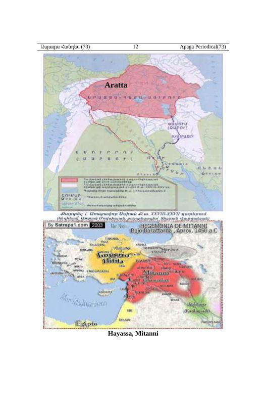
There is not much information about adminis-trative division of
prehistoric Armenian highland at the time of Aratta, Mitani, Hayasa-
Azzi, Nairi, Uratri, Arme-Shupria, Urartu (Van kingdom).
Ապագա Հանդես (73) 12 Apaga Periodical(73)
Hayassa, Mitanni
Aratta
Ապագա Հանդես (73) 13 Apaga Periodical(73)
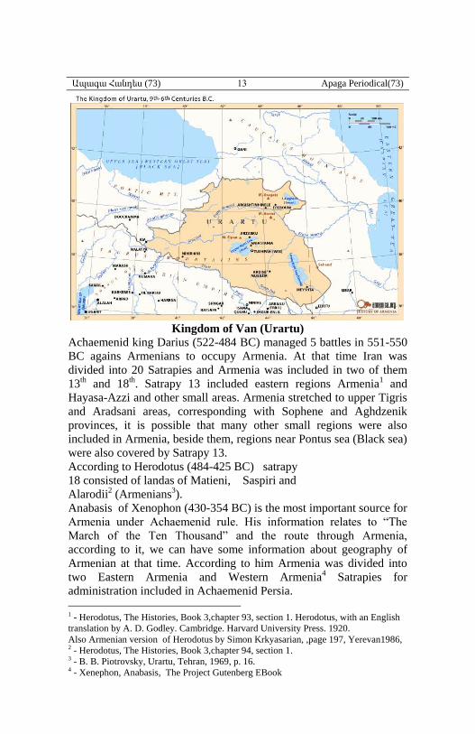
Kingdom of Van (Urartu)
Achaemenid king Darius (522-484 BC) managed 5 battles in 551-550
BC agains Armenians to occupy Armenia. At that time Iran was
divided into 20 Satrapies and Armenia was included in two of them
13th and 18th. Satrapy 13 included eastern regions Armenia1 and
Hayasa-Azzi and other small areas. Armenia stretched to upper Tigris
and Aradsani areas, corresponding with Sophene and Aghdzenik
provinces, it is possible that many other small regions were also
included in Armenia, beside them, regions near Pontus sea (Black sea)
were also covered by Satrapy 13.
According to Herodotus (484-425 BC) satrapy
18 consisted of landas of Matieni, Saspiri and
Alarodii2 (Armenians3).
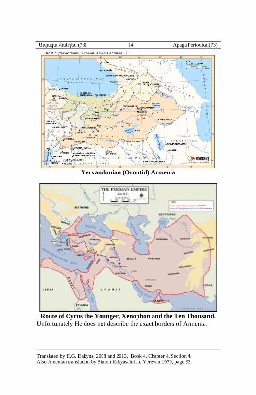
Anabasis of Xenophon (430-354 BC) is the most important source for
Armenia under Achaemenid rule. His information relates to “The
March of the Ten Thousand” and the route through Armenia,
according to it, we can have some information about geography of
Armenian at that time. According to him Armenia was divided into
two Eastern Armenia and Western Armenia4 Satrapies for
administration included in Achaemenid Persia.
1 - Herodotus, The Histories, Book 3,chapter 93, section 1. Herodotus, with an English
translation by A. D. Godley. Cambridge. Harvard University Press. 1920.
Also Armenian version of Herodotus by Simon Krkyasarian, ,page 197, Yerevan1986, 2 - Herodotus, The Histories, Book 3,chapter 94, section 1. 3 - B. B. Piotrovsky, Urartu, Tehran, 1969, p. 16. 4 - Xenephon, Anabasis, The Project Gutenberg EBook
Ապագա Հանդես (73) 14 Apaga Periodical(73)
Yervandunian (Orontid) Armenia
Route of Cyrus the Younger, Xenophon and the Ten Thousand.
Unfortunately He does not describe the exact borders of Armenia.
Translated by H.G. Dakyns, 2008 and 2013, Book 4, Chapter 4, Section 4.
Also Amenian translation by Simon Krkyasahrian, Yerevan 1970, page 93.
Ապագա Հանդես (73) 15 Apaga Periodical(73)
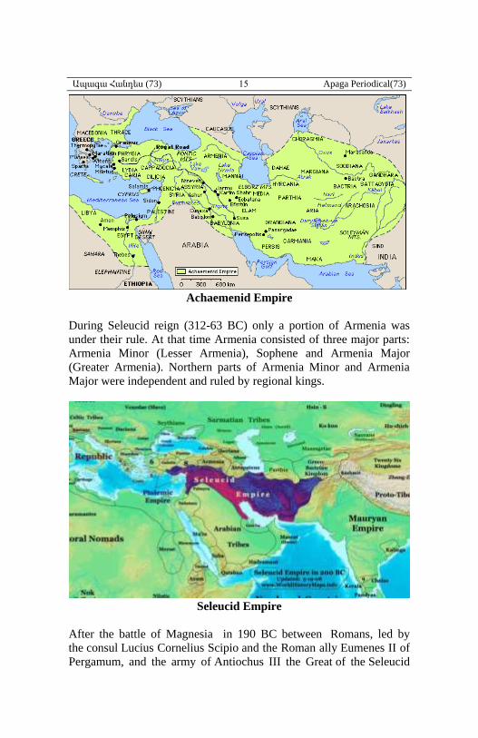
Achaemenid Empire
During Seleucid reign (312-63 BC) only a portion of Armenia was
under their rule. At that time Armenia consisted of three major parts:
Armenia Minor (Lesser Armenia), Sophene and Armenia Major
(Greater Armenia). Northern parts of Armenia Minor and Armenia
Major were independent and ruled by regional kings.
Seleucid Empire
After the battle of Magnesia in 190 BC between Romans, led by
the consul Lucius Cornelius Scipio and the Roman ally Eumenes II of
Pergamum, and the army of Antiochus III the Great of the Seleucid
Ապագա Հանդես (73) 16 Apaga Periodical(73)
Empire, Artashes and Zareh governors of Greater Armenia and
Shphene, respectively, declare independence and established
Armenian kingdoms, while Armenia Minor had already achieved
independence. We get clearer idiea about the territories the Armenian
kings were able to take under their control through information
reached us by Strabo.According to him King Artashes had captured
Caspian land (Paytakaran), Vaspurakan, (Strabo mentions
Basoropeda), Pavnitis (?), which is considered to be Syunik, Tayk,
Khordzene, Gugark, (Gogarine), Karin (Karenties), Derjan
(Derksene), and Tmorik1. Strabo also gives us description of
mountains, plateaus, valleys, etc2.
Zareh had captured lands at Antitaurus and Yegeghiats canton3.
So Main Armenia (East of Euphrates) i.e Greater Armenia and
Sophene at the time of Artashes I (189-160 BC) and Zareh consisted
of Paytakaran, Syunik, Vaspurakan, Ayrarat. Gugark, Tayk, most of
Upper Armenia, Turuberan, Fourth Armenia, Aghdzenik, Mogk, most
of Kortchayk, Utik and Artsakh, which means 14 out of 15 province
of future Arshakunian Armenia. Strabo mentions that the population
of all captured lands spoke in Armenian4.
In Tte same time (2nd century BC), Lesser Armenia was enlarged west
of Euphrates, which occupied west of mountains Paryadres5
(Parkharian) and noth-eastern shores of Pontus.
The largest of all three Armenian kingdoms was the Greater Armenia
under Artashes I.
Historians especially have reported more details starting from Tigran
II the Great (95-55 BC) of Artashesian Dynasty. After ascending the
thrown, he liberated “70 valleys” from Persia. They were a part of
Armenia at the time of Artashes I and were surrendered to Persians as
a price to get Tigran’s freedom. Tigran had been a hostage until the
age of 45 at the court of King Mithridates II of Parthia after the
Armenian defeat in 105 BC. According to many researches, this
region corresmoded with future Parskahayk province.
1 - Strabo, Book 11, Chapter 14, section 5.
http://penelope.uchicago.edu/Thayer/E/Roman/Texts/Strabo/11N*.html 2 - Ibid, XI,Chapter 14,sec. 1-16. 3 - Strabo, Book 11, Chapter 14, section 5. 4 - Strabo, Book 11, Chapter 14, section 5. 5 - Ibid, sec. 1 & 5.
Ապագա Հանդես (73) 17 Apaga Periodical(73)
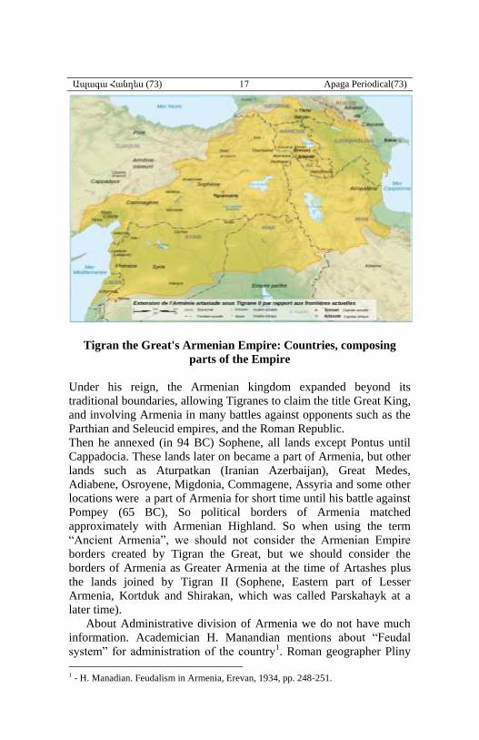
Tigran the Great's Armenian Empire: Countries, composing
parts of the Empire
Under his reign, the Armenian kingdom expanded beyond its
traditional boundaries, allowing Tigranes to claim the title Great King,
and involving Armenia in many battles against opponents such as the
Parthian and Seleucid empires, and the Roman Republic.
Then he annexed (in 94 BC) Sophene, all lands except Pontus until
Cappadocia. These lands later on became a part of Armenia, but other
lands such as Aturpatkan (Iranian Azerbaijan), Great Medes,
Adiabene, Osroyene, Migdonia, Commagene, Assyria and some other
locations were a part of Armenia for short time until his battle against
Pompey (65 BC), So political borders of Armenia matched
approximately with Armenian Highland. So when using the term
“Ancient Armenia”, we should not consider the Armenian Empire
borders created by Tigran the Great, but we should consider the
borders of Armenia as Greater Armenia at the time of Artashes plus
the lands joined by Tigran II (Sophene, Eastern part of Lesser
Armenia, Kortduk and Shirakan, which was called Parskahayk at a
later time).
About Administrative division of Armenia we do not have much
information. Academician H. Manandian mentions about “Feudal
system” for administration of the country1. Roman geographer Pliny
1 - H. Manadian. Feudalism in Armenia, Erevan, 1934, pp. 248-251.
Ապագա Հանդես (73) 18 Apaga Periodical(73)
the Elder (Gaius Plinius Secundus 23-79 AD) mentions that at his
time Armenia was devided into 120 regions, which he called them
“Strategia”1. Artashesian kingdom had two capitals: Artashat built bt
Artashes I (About 166 BC) and Tigranakert built by Tigran the Great
(About 77 BC).
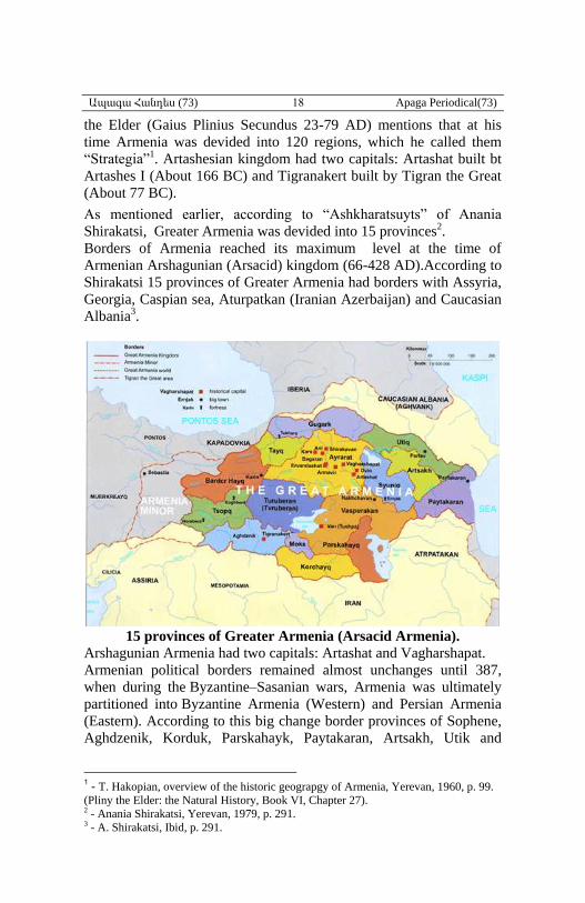
As mentioned earlier, according to “Ashkharatsuyts” of Anania
Shirakatsi, Greater Armenia was devided into 15 provinces2.
Borders of Armenia reached its maximum level at the time of
Armenian Arshagunian (Arsacid) kingdom (66-428 AD).According to
Shirakatsi 15 provinces of Greater Armenia had borders with Assyria,
Georgia, Caspian sea, Aturpatkan (Iranian Azerbaijan) and Caucasian
Albania3.
15 provinces of Greater Armenia (Arsacid Armenia).
Arshagunian Armenia had two capitals: Artashat and Vagharshapat.
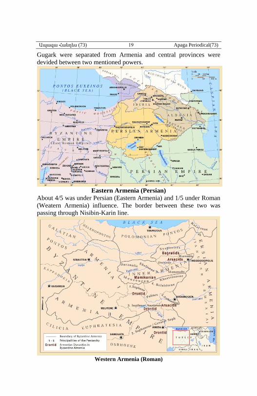
Armenian political borders remained almost unchanges until 387,
when during the Byzantine–Sasanian wars, Armenia was ultimately
partitioned into Byzantine Armenia (Western) and Persian Armenia
(Eastern). According to this big change border provinces of Sophene,
Aghdzenik, Korduk, Parskahayk, Paytakaran, Artsakh, Utik and
1 - T. Hakopian, overview of the historic geograpgy of Armenia, Yerevan, 1960, p. 99.
(Pliny the Elder: the Natural History, Book VI, Chapter 27). 2 - Anania Shirakatsi, Yerevan, 1979, p. 291. 3 - A. Shirakatsi, Ibid, p. 291.
Ապագա Հանդես (73) 19 Apaga Periodical(73)
Gugark were separated from Armenia and central provinces were
devided between two mentioned powers.
Eastern Armenia (Persian)
About 4/5 was under Persian (Eastern Armenia) and 1/5 under Roman
(Weatern Armenia) influence. The border between these two was
passing through Nisibin-Karin line.
Western Armenia (Roman)
Ապագա Հանդես (73) 20 Apaga Periodical(73)
Western Armenia
This portion of Armenia had three partition from administrative point
of view:
1-Autonomous princedoms or Satrapy Armenia: It was bounded by
lower Aradsani and upper portion of Western Tigris and consisted of
6 Armenian princedoms: Great Sophene, Angeghtun, Andzit,
Shahuniats Sophene, Hashtiank, Balahovit. Armenian princes had
only internal autonomy.
2-Inner Armenia (Armenia Inferior), It was also called “Great
Armenia” by Romans and Byzantines and consisted of 11 cantons:
Khordzian, Paghnatun, Mundzur, Daranaghi, Yegeghiats, Manabaghi,
Derjan, Karin, Shaghgomk, Sper, Aryuds. Inner Armenia was
occupied by Romans at 387. Inner Armenia corresponded with Upper
Armenia1.
3-Lesser Armenia.It corresponded with ancient Hayasa. During
collapse of the Seleucids, Lesser Armenia of Armenia Minor was the
first to declare independence and establish Armenian kingdom. There
were 5 regions in Armenia Minor: Orbalisen, Aytughan, Ayretik,
Orsen, Orbisen. After second half of the 4th century (379-395
)Armenia Minor was divided into two provinces: First Armenia
(Armenia Prima) and Second Armenia (Armenia Secunda).
The highest authority in Armenia Inferior was called “Comes
Armeniae”. In the satrapy Armenia Armenian princes were ruling
without any higher state officials.
Lesser Armenia was autonomous in internal affairs but for foreign
affairs was dependent on the Roman Emperor.
In 535 and 536, the emperor Justinian I reorganized the provincial
administration, and Armenian lands were divided into four provinces:
First Armenia, Second Armenia, Third Armenia and Fourth Armenia.
The borders of the Byzantine part of Armenia were expanded in 591
into Parskahayk of Persarmenia, but the region was the focus of
decades of warfare between the Byzantines and the Persians
(the Byzantine-Sassanid Wars) until the Arab conquest of Armenia in
640.
Eastern Armenia
EastenArmenia was also called of Marzpanate Armenia or Persian
Armenia, although these latter names were not acceptable, since the
name of a country can not be taken from the Rulers titles. After
1 - A. Shirakatsi, Ibid, p. 291.
Ապագա Հանդես (73) 21 Apaga Periodical(73)
Armenia partitioned in 387, Western portion was annexed to Roman
epire, but Eastern Armenia preserved its kingdom until 428.
In the 6th century Sasanian Iran was devided into four regions or
“Kustaks” or “Kusts”: eastern (Kusti Khorasan), western (Kusti
Korbaran), northern (Kapkoh) and southern (Kusti Nemroj). Each
Kustak had two authorities one was called “Padgospan” for
administration and the second one was “Sepahbod” or army general or
commander for military affairs. Armenia, Aturpatkan, Georgia and
Albania were included in the northern kustak. Each kustak was also
divided to smaller administrative areas called “Shahr” or “Marz” or
province. Northern kustak had 13 provinces. Marspan or governor of
Armenia was appointed by Sasanian kings, there were also two high-
rank officials Sparapet or commander-in-chief of army and Hazaapet
(Hezarbod) was responsible for economy, culture and internal
development.
According to treaty of Nvarsak in 484 between Vahan Mamikonian
and Persian court, Marzpanate Armenia was called “Tanutirakan
country” and Marzpan was “Armenian Tanuter”.
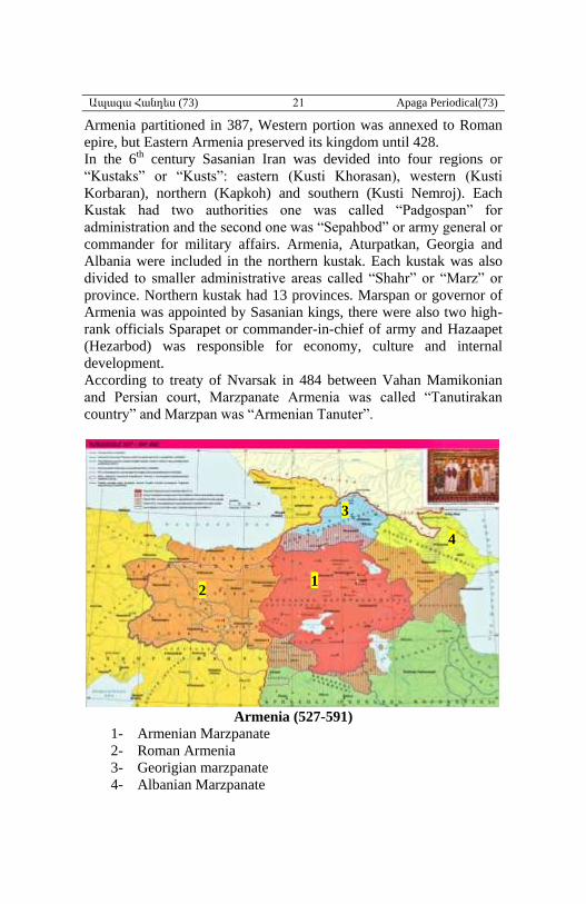
Armenia (527-591)
1- Armenian Marzpanate
2- Roman Armenia
3- Georigian marzpanate
4- Albanian Marzpanate
1 2
3
4
Ապագա Հանդես (73) 22 Apaga Periodical(73)
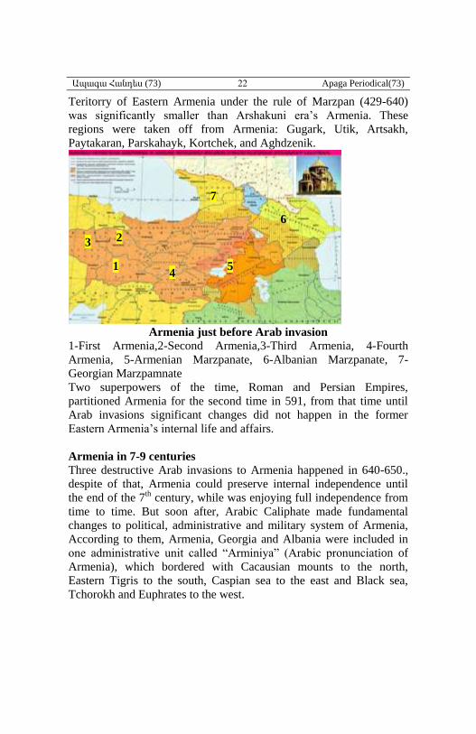
Teritorry of Eastern Armenia under the rule of Marzpan (429-640)
was significantly smaller than Arshakuni era’s Armenia. These
regions were taken off from Armenia: Gugark, Utik, Artsakh,
Paytakaran, Parskahayk, Kortchek, and Aghdzenik.
Armenia just before Arab invasion
1-First Armenia,2-Second Armenia,3-Third Armenia, 4-Fourth
Armenia, 5-Armenian Marzpanate, 6-Albanian Marzpanate, 7-
Georgian Marzpamnate
Two superpowers of the time, Roman and Persian Empires,
partitioned Armenia for the second time in 591, from that time until
Arab invasions significant changes did not happen in the former
Eastern Armenia’s internal life and affairs.
Armenia in 7-9 centuries
Three destructive Arab invasions to Armenia happened in 640-650.,
despite of that, Armenia could preserve internal independence until
the end of the 7th century, while was enjoying full independence from
time to time. But soon after, Arabic Caliphate made fundamental
changes to political, administrative and military system of Armenia,
According to them, Armenia, Georgia and Albania were included in
one administrative unit called “Arminiya” (Arabic pronunciation of
Armenia), which bordered with Cacausian mounts to the north,
Eastern Tigris to the south, Caspian sea to the east and Black sea,
Tchorokh and Euphrates to the west.
1
2 3
4 5
6
7
Ապագա Հանդես (73) 23 Apaga Periodical(73)
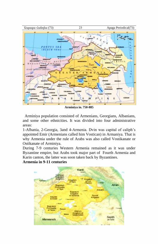
Arminiya in. 750-885
Arminiya population consisted of Armenians, Georgians, Albanians,
and some other ethnicities. It was divided into four administrative
areas:
1-Albania, 2-Georgia, 3and 4-Armenia. Dvin was capital of caliph’s
appointed Emir (Armenians called him Vostican) in Armaniya. That is
why Armenia under the rule of Arabs was also called Vostikanate or
Ostikanate of Arminiya.
During 7-9 centuries Western Armenia remained as it was under
Byzantine empire, but Arabs took major part of Fourth Armenia and
Karin canton, the latter was soon taken back by Byzantines.
Armenia in 9-11 centuries
Ապագա Հանդես (73) 24 Apaga Periodical(73)
Armenia achieved its full independence from Arabic caliphate in 885
by Armenian Bagratuni dynasty. At that time there were many
Armenian princedoms under princes or great feudal-lords (with their
own administration, army, etc). But very soon in 908 the integrity of
Bagratuni kingdom was changed and some subordinate states were
formed under Bagratuni Kingdom. The main part of the kingdom was
that of Ani-Shirak (885-1045). These states were: kingdoms of
Vaspurakan (Ardseruni dynasty 908-1021), Vanand or Kars
(Bagratuni, 963-1065), Syunik or Kapan (970-1170), Tashir-Dzoraget
or Lori (Korikian, 966-1113), Tayk (962-1001), Andzevatiats
princedom, Mogk,Taron (Bagratuni, 826-967), Artsakh (5-10 cc.),
Albanian princedom, Hamshen princedom, Georgian princedom
(Bagratuni, 9-19 cc.), Khachen princedom (10-16 cc.), Tchighb
princedom, Kakhet, Kegharj,, Samtskhe, Liparit-Baghvash, Abkhazia,
Kaysid emirate, Aghdzenik emirate, etc1. Bagratuni kingdom
collapsed in 1045.
Armenia in 11-13 centuries
During this period Armenian administrative-political system went
under fundamental changes. For a short period (1045-71) Armenia
was under Byzantine rule, despite, some of formerly mentioned states
were able to preserve their existence (Taron, Vaspurakan, Ani, etc).
Three destructive Seljuk invasions in 1043, 1049 and 1054 were
catastrophic, hundreds of villages and tens of cities wre destroyed.
Zakarian Armenia was an Armenian principality between 1201 and
1360, ruled by the Zakarian dynasty. The city of Ani was the capital
of the princedom. The Zakarids were vassals to the Kingdom of
Georgia (Bagratuni Georgia) until 1236 when they became vassals to
the Mongol Empire.Their princedom was divided into two portions,
one was under the rule of Zakare, the
1 -For details see my History of the Armenin State, in 7 volumes, in Armenian, vol. 1,
Toronto, 2013, pp.297-374.
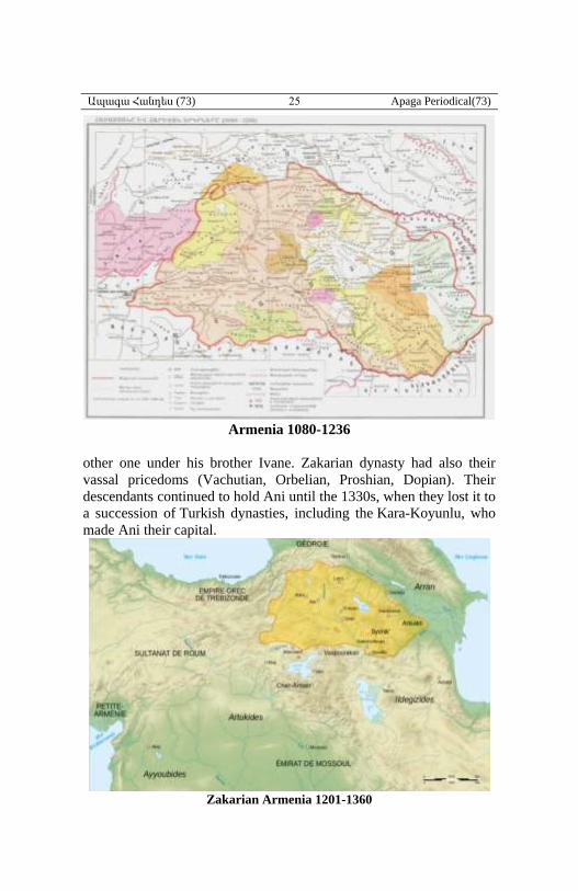
Ապագա Հանդես (73) 25 Apaga Periodical(73)
Armenia 1080-1236
other one under his brother Ivane. Zakarian dynasty had also their
vassal pricedoms (Vachutian, Orbelian, Proshian, Dopian). Their
descendants continued to hold Ani until the 1330s, when they lost it to
a succession of Turkish dynasties, including the Kara-Koyunlu, who
made Ani their capital.
Zakarian Armenia 1201-1360
Ապագա Հանդես (73) 26 Apaga Periodical(73)
Armenia in 13-15 centuries
The first Mongol invasion to Caucasus happened in 1220-21, but they
encountered strong resistance in 1221 at Shamkor (Battle of Khunan)
and were not inclined to conquer the Caucasus at that time and turned
back south to Hamadan. 14 years later, for the second time they
invaded Northern Armenia, and during 1242-1243 occupied the whole
area, and in 1242-43 invaded and occupied Southern and Western
Armenia. Consecuences of these invasions were mass murder of
population, destruction of settlements, emprisoning, plunder, etc.
Mongol Empire before 1259
Mongol empire was divided into uluses at the time of Momgke khan
(1251-1259), Armenia was included in the fourth ulus (1236-1335).
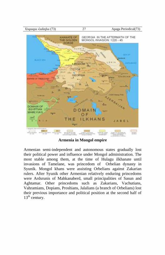
Ապագա Հանդես (73) 27 Apaga Periodical(73)
Armenia in Mongol empire
Armenian semi-independent and autonomous states gradually lost
their political power and influence under Mongol administration. The
most stable among them, at the time of Hulagu ilkhanate until
invasions of Tamelane, was princedom of Orbelian dynasty in
Syunik. Mongol khans were assisting Orbelians against Zakarian
rulers. After Syunik other Armenian relatively enduring princedoms
were Ardsrunis of Mahkanaberd, small principalities of Sasun and
Aghtamar. Other princedoms such as Zakarians, Vachutians,
Vahramians, Dopians, Proshians, Jalalians (a branch of Orbelians) lost
their previous importance and political position at the second half of
13th century.
Ապագա Հանդես (73) 28 Apaga Periodical(73)
1-Zakarian, 2-Orbelian, 3-Vakhtangian, Jalalian, Shirjanshank, 4-
Dopian, 5-Kyurikian, 6-Ardseruni, 7-Vahramian, 8-Ardserunik, 9-
Vachutian, 10-Proshian
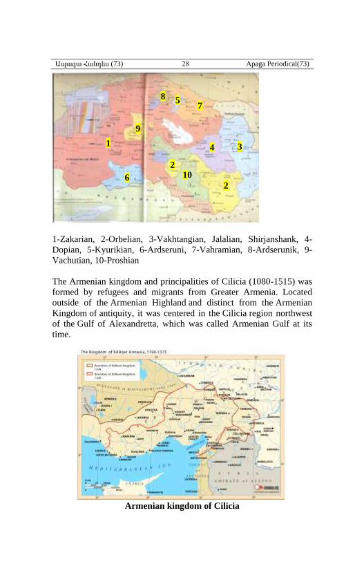
The Armenian kingdom and principalities of Cilicia (1080-1515) was
formed by refugees and migrants from Greater Armenia. Located
outside of the Armenian Highland and distinct from the Armenian
Kingdom of antiquity, it was centered in the Cilicia region northwest
of the Gulf of Alexandretta, which was called Armenian Gulf at its
time.
Armenian kingdom of Cilicia
1
2
4
5
3
10 6
9
7 8
2
Ապագա Հանդես (73) 29 Apaga Periodical(73)
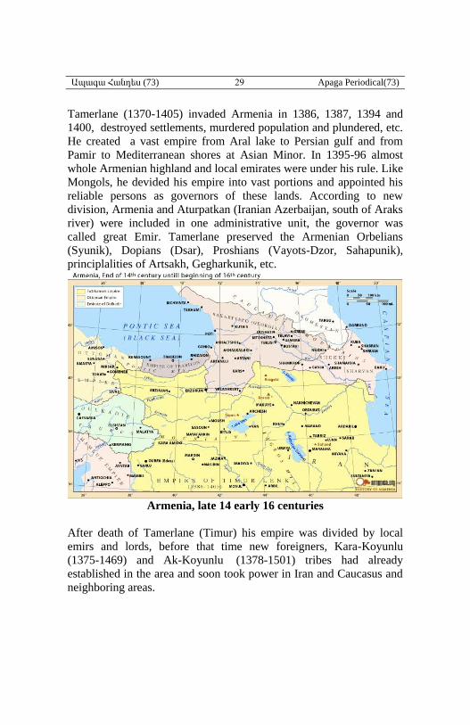
Tamerlane (1370-1405) invaded Armenia in 1386, 1387, 1394 and
1400, destroyed settlements, murdered population and plundered, etc.
He created a vast empire from Aral lake to Persian gulf and from
Pamir to Mediterranean shores at Asian Minor. In 1395-96 almost
whole Armenian highland and local emirates were under his rule. Like
Mongols, he devided his empire into vast portions and appointed his
reliable persons as governors of these lands. According to new
division, Armenia and Aturpatkan (Iranian Azerbaijan, south of Araks
river) were included in one administrative unit, the governor was
called great Emir. Tamerlane preserved the Armenian Orbelians
(Syunik), Dopians (Dsar), Proshians (Vayots-Dzor, Sahapunik),
principlalities of Artsakh, Gegharkunik, etc.
Armenia, late 14 early 16 centuries
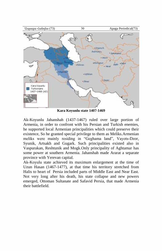
After death of Tamerlane (Timur) his empire was divided by local
emirs and lords, before that time new foreigners, Kara-Koyunlu
(1375-1469) and Ak-Koyunlu (1378-1501) tribes had already
established in the area and soon took power in Iran and Caucasus and
neighboring areas.
Ապագա Հանդես (73) 30 Apaga Periodical(73)
Kara Koyunlu state 1407-1469
Ak-Koyunlu Jahanshah (1437-1467) ruled over large portion of
Armenia, in order to confront with his Persian and Turkish enemies,
he supported local Armenian principalities which could preserve their
existence, So he granted special privilege to them as Meliks.Armenian
meliks were mainly residing in “Geghama land”, Vayots-Dzor,
Syunik, Artsakh and Gugark. Such principalities existed also in
Vaspurakan, Reshtunik and Mogk.Only principality of Aghtamar has
some power at southern Armenia. Jahanshah made Ararat a separate
province with Yerevan capital.
Ak-Koyulu state achieved its maximum enlargement at the time of
Uzun Hasan (1467-1477), at that time his territory stretched from
Halis to heart of Persia included parts of Middle East and Near East.
Not very long after his death, his state collapse and new powers
emerged, Ottoman Sultanate and Safavid Persia, that made Armenia
their battlefield.
Ապագա Հանդես (73) 31 Apaga Periodical(73)
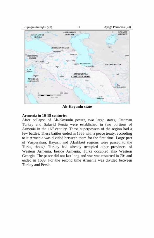
Ak-Koyunlu state
Armenia in 16-18 centuries
After collapse of Ak-Koyunlu power, two large states, Ottoman
Turkey and Safavid Persia were established in two portions of
Armenia in the 16th century. These superpowers of the region had a
few battles. These battles ended in 1555 with a peace treaty, according
to it Armenia was divided between them for the first time, Large part
of Vaspurakan, Bayazit and Alashkert regions were passed to the
Turks, though Turkey had already occupied other provinces of
Western Armenia, beside Armenia, Turks occupied also Western
Georgia. The peace did not last long and war was restarted in 70s and
ended in 1639. For the second time Armenia was divided between
Turkey and Persia.
Ապագա Հանդես (73) 32 Apaga Periodical(73)
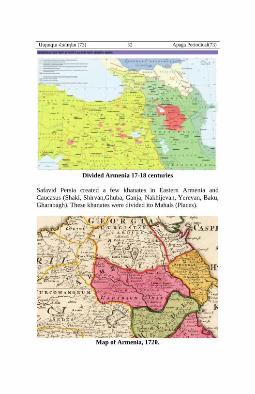
Divided Armenia 17-18 centuries
Safavid Persia created a few khanates in Eastern Armenia and
Caucasus (Shaki, Shirvan,Ghuba, Ganja, Nakhijevan, Yerevan, Baku,
Gharabagh). These khanates were divided ito Mahals (Places).
Map of Armenia, 1720.
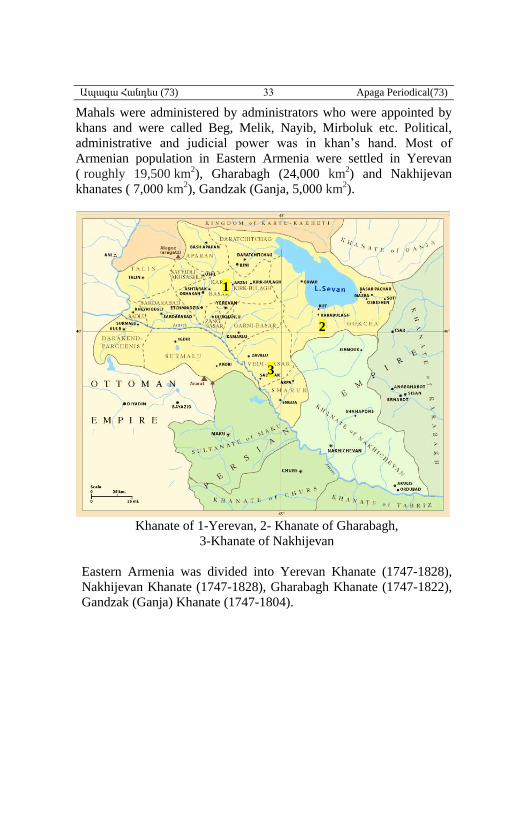
Ապագա Հանդես (73) 33 Apaga Periodical(73)
Mahals were administered by administrators who were appointed by
khans and were called Beg, Melik, Nayib, Mirboluk etc. Political,
administrative and judicial power was in khan’s hand. Most of
Armenian population in Eastern Armenia were settled in Yerevan
( roughly 19,500 km2), Gharabagh (24,000 km2) and Nakhijevan
khanates ( 7,000 km2), Gandzak (Ganja, 5,000 km2).
Khanate of 1-Yerevan, 2- Khanate of Gharabagh,
3-Khanate of Nakhijevan
Eastern Armenia was divided into Yerevan Khanate (1747-1828),
Nakhijevan Khanate (1747-1828), Gharabagh Khanate (1747-1822),
Gandzak (Ganja) Khanate (1747-1804).
2
1
3
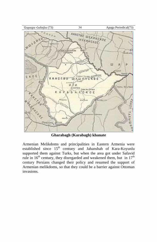
Ապագա Հանդես (73) 34 Apaga Periodical(73)
Gharabagh (Karabagh) khanate
Armenian Melikdoms and principalities in Eastern Armenia were
established since 15th centuey and Jahanshah of Kara-Koyunlu
supported them against Turks, but when the area got under Safavid
rule in 16th centuey, they disregarded and weakened them, but in 17th
century Persians changed their policy and resumed the support of
Armenian melikdoms, so that they could be a barrier against Ottoman
invasions.
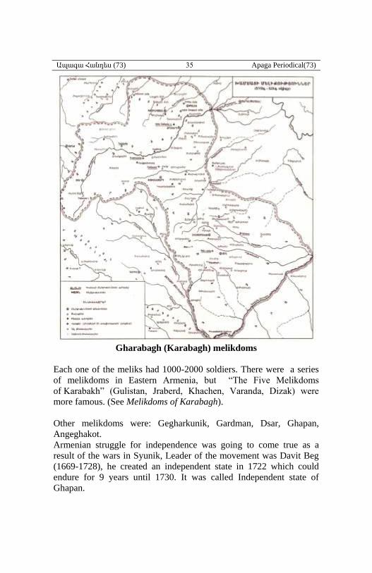
Ապագա Հանդես (73) 35 Apaga Periodical(73)
Gharabagh (Karabagh) melikdoms
Each one of the meliks had 1000-2000 soldiers. There were a series
of melikdoms in Eastern Armenia, but “The Five Melikdoms
of Karabakh” (Gulistan, Jraberd, Khachen, Varanda, Dizak) were
more famous. (See Melikdoms of Karabagh).
Other melikdoms were: Gegharkunik, Gardman, Dsar, Ghapan,
Angeghakot.
Armenian struggle for independence was going to come true as a
result of the wars in Syunik, Leader of the movement was Davit Beg
(1669-1728), հe created an independent state in 1722 which could
endure for 9 years until 1730. It was called Independent state of
Ghapan.
Ապագա Հանդես (73) 36 Apaga Periodical(73)
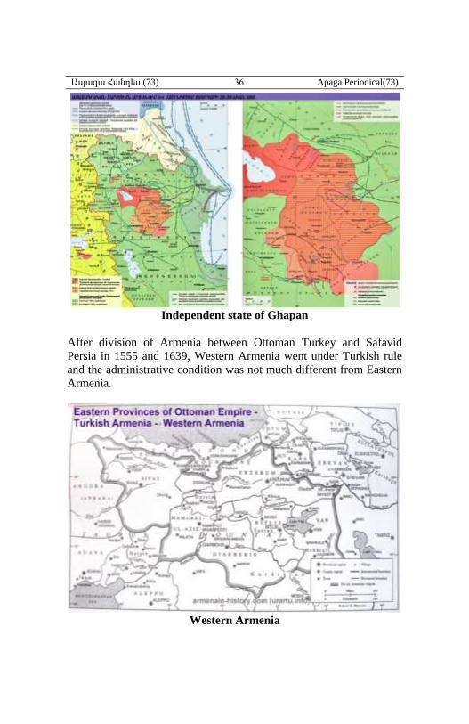
Independent state of Ghapan
After division of Armenia between Ottoman Turkey and Safavid
Persia in 1555 and 1639, Western Armenia went under Turkish rule
and the administrative condition was not much different from Eastern
Armenia.
Western Armenia
Ապագա Հանդես (73) 37 Apaga Periodical(73)
Western Armenia at the beginning was in one administrative unit
called “Ermenistan” (Capital Erzrum), which was soon change to
Vilayet of Arzrum. At a later time it was divided to vilayets of Kars,
Van, Ezrum, Diarbekir, Sivas.
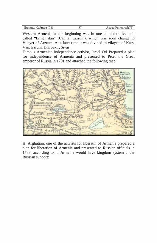
Famous Armenian independence activist, Israel Ori Prepared a plan
for independence of Armenia and presented to Peter the Great
emperor of Russia in 1701 and attached the following map:
H. Arghutian, one of the actvists for liberatin of Armenia prepared a
plan for liberation of Armenia and presented to Russian officials in
1783, according to it, Armenia would have kingdom system under
Russian support:
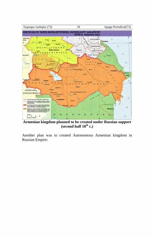
Ապագա Հանդես (73) 38 Apaga Periodical(73)
Armenian kingdom planned to be created under Russian support
(second half 18th
c.)
Another plan was to created Autonomous Armenian kingdom in
Russian Empire:
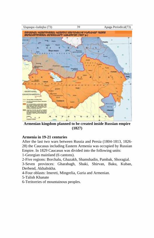
Ապագա Հանդես (73) 39 Apaga Periodical(73)
Armenian kingdom planned to be created inside Russian empire
(1827)
Armenia in 19-21 centuries
After the last two wars between Russia and Persia (1804-1813, 1826-
28) the Caucasus including Eastern Armenia was occupied by Russian
Empire. In 1829 Caucasus was divided into the following units:
1-Georgian mainland (6 cantons).
2-Five regions: Borchalu, Ghazakh, Shamshadin, Pambak, Shoragial.
3-Seven provinces: Gharabagh, Shaki, Shirvan, Baku, Kuban,
Derbend, Akhaltskha.
4-Four oblasts: Imereti, Mingrelia, Guria and Armenian.
5-Talish Khanate
6-Teritorries of mountainous peoples.
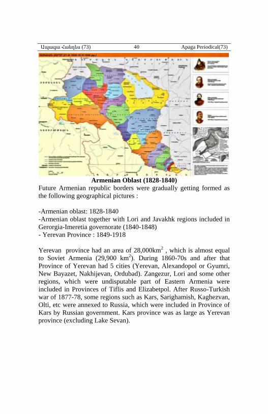
Ապագա Հանդես (73) 40 Apaga Periodical(73)
Armenian Oblast (1828-1840)
Future Armenian republic borders were gradually getting formed as
the following geographical pictures :
-Armenian oblast: 1828-1840
-Armenian oblast together with Lori and Javakhk regions included in
Gerorgia-Imeretia governorate (1840-1848)
- Yerevan Province : 1849-1918
Yerevan province had an area of 28,000km2 , which is almost equal
to Soviet Armenia (29,900 km2). During 1860-70s and after that
Province of Yerevan had 5 cities (Yerevan, Alexandopol or Gyumri,
New Bayazet, Nakhijevan, Ordubad). Zangezur, Lori and some other
regions, which were undisputable part of Eastern Armenia were
included in Provinces of Tiflis and Elizabetpol. After Russo-Turkish
war of 1877-78, some regions such as Kars, Sarighamish, Kaghezvan,
Olti, etc were annexed to Russia, which were included in Province of
Kars by Russian government. Kars province was as large as Yerevan
province (excluding Lake Sevan).
Ապագա Հանդես (73) 41 Apaga Periodical(73)
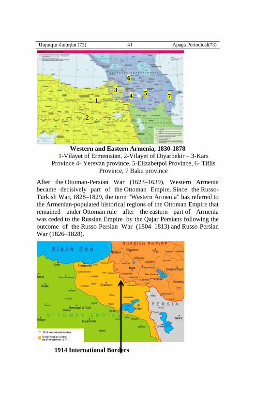
Western and Eastern Armenia, 1830-1878
1-Vilayet of Ermenistan, 2-Vilayet of Diyarbekir – 3-Kars
Province 4- Yerevan province, 5-Elizabetpol Province, 6- Tiflis
Province, 7 Baku province
After the Ottoman-Persian War (1623–1639), Western Armenia
became decisively part of the Ottoman Empire. Since the Russo-
Turkish War, 1828–1829, the term "Western Armenia" has referred to
the Armenian-populated historical regions of the Ottoman Empire that
remained under Ottoman rule after the eastern part of Armenia
was ceded to the Russian Empire by the Qajar Persians following the
outcome of the Russo-Persian War (1804–1813) and Russo-Persian
War (1826–1828).
1914 International Borders
1
2
3 4 5
6
7
Ապագա Հանդես (73) 42 Apaga Periodical(73)
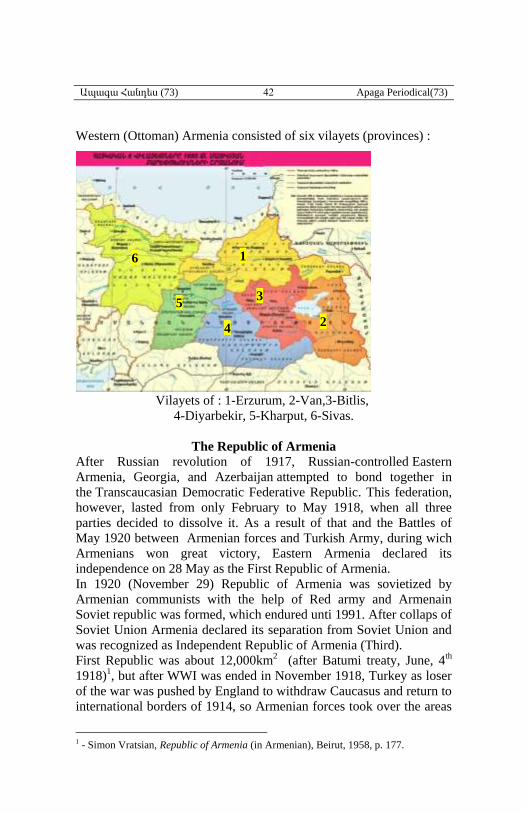
Western (Ottoman) Armenia consisted of six vilayets (provinces) :
Vilayets of : 1-Erzurum, 2-Van,3-Bitlis,
4-Diyarbekir, 5-Kharput, 6-Sivas.
The Republic of Armenia
After Russian revolution of 1917, Russian-controlled Eastern
Armenia, Georgia, and Azerbaijan attempted to bond together in
the Transcaucasian Democratic Federative Republic. This federation,
however, lasted from only February to May 1918, when all three
parties decided to dissolve it. As a result of that and the Battles of
May 1920 between Armenian forces and Turkish Army, during wich
Armenians won great victory, Eastern Armenia declared its
independence on 28 May as the First Republic of Armenia.
In 1920 (November 29) Republic of Armenia was sovietized by
Armenian communists with the help of Red army and Armenain
Soviet republic was formed, which endured unti 1991. After collaps of
Soviet Union Armenia declared its separation from Soviet Union and
was recognized as Independent Republic of Armenia (Third).
First Republic was about 12,000km2 (after Batumi treaty, June, 4th
1918)1, but after WWI was ended in November 1918, Turkey as loser
of the war was pushed by England to withdraw Caucasus and return to
international borders of 1914, so Armenian forces took over the areas
1 - Simon Vratsian, Republic of Armenia (in Armenian), Beirut, 1958, p. 177.
1
2
3
4
6
5
Ապագա Հանդես (73) 43 Apaga Periodical(73)
and borders of Republic expanded from late 1918 to April-May of
1919 and included also Lori-Pambak, Alexadrapol, areas of
Echmidzin, Surmalu, Sharur, Nakhijevan, Kars province, etc. In
summer of 1920 official borders of Republic of Armenia stretched up
to Olti coalmines including Gharabagh having area about 70,000 km2.
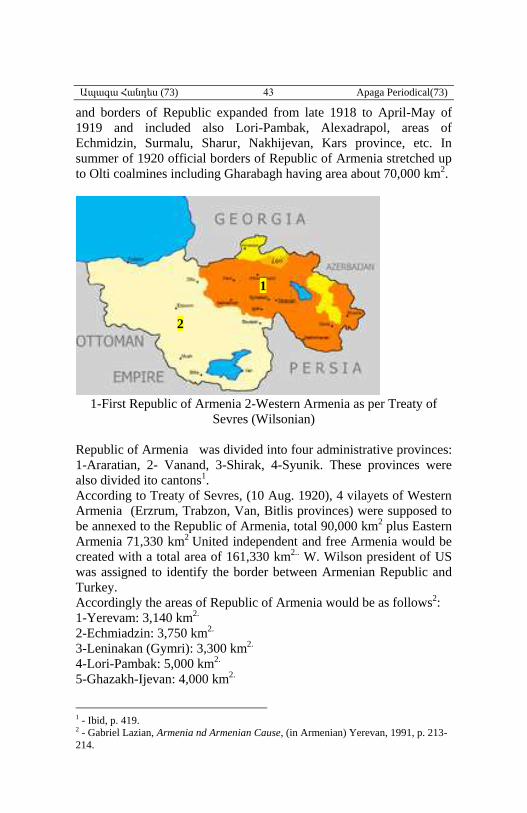
1-First Republic of Armenia 2-Western Armenia as per Treaty of
Sevres (Wilsonian)
Republic of Armenia was divided into four administrative provinces:
1-Araratian, 2- Vanand, 3-Shirak, 4-Syunik. These provinces were
also divided ito cantons1.
According to Treaty of Sevres, (10 Aug. 1920), 4 vilayets of Western
Armenia (Erzrum, Trabzon, Van, Bitlis provinces) were supposed to
be annexed to the Republic of Armenia, total 90,000 km2 plus Eastern
Armenia 71,330 km2 United independent and free Armenia would be
created with a total area of 161,330 km2.. W. Wilson president of US
was assigned to identify the border between Armenian Republic and
Turkey.
Accordingly the areas of Republic of Armenia would be as follows2:
1-Yerevam: 3,140 km2.
2-Echmiadzin: 3,750 km2.
3-Leninakan (Gymri): 3,300 km2.
4-Lori-Pambak: 5,000 km2.
5-Ghazakh-Ijevan: 4,000 km2.
1 - Ibid, p. 419. 2 - Gabriel Lazian, Armenia nd Armenian Cause, (in Armenian) Yerevan, 1991, p. 213-
214.
1
2
Ապագա Հանդես (73) 44 Apaga Periodical(73)
6-New Bayazet: 4,790 km2.
7-Daralagiaz: 2,000 km2.
8-Zangezur: 6,000 km2.
9- Surmalu: 3,650 km2
10-Sharur-Nakhijevan: 5,600
11-Akhalkalak: 2,800 km2
12-Gharabagh: 10,000 km2
13-Kars: 5,800 km2
14-Kaghezvan: 4,450
15-Ardahan: 4,000 km2
16-Olti: 3,000 km2
Total 71,330 km2
Western Armenia as per W. Wilson:
1- Van province: 20,000 out of 39,300 km2.
2- Erzrum: 40,000 out of 49,700 km2.
3- Baghesh (Bitlis): 15,000 out of 27,100 km2.
4- Trabizon: 15,000 out of 32,700 km2.
5- Total: 90,000 km2
Grand total: 71,330 plus 90,000 equals 161,330 km2
When Mustafa Kemal succeeded in his fight for Turkish
independence and forced the former wartime Allies to return to the
negotiating table, as a result, Treaty of Sevres was archived and
forgotton till today and Armenian struggle to creat United Armenia of
161,330 km2 did not end up as expected.
The Turkish national movement developed its own international
relations by the Treaty of Moscow with the Soviet Union on 16 March
1921, the Accord of Ankara with France putting an end to the Franco-
Turkish War, and the Treaty of Alexandrapol with the Armenians and
the Treaty of Kars fixing the eastern borders. By Treaty of
Alexandrapol between First Republic of Armenia and Turkey,
Armenia not only did not achieve western Armenia, but also lost more
than 40,000 km2 of its 71,330 km2 and left 29,713 km2 for Soviet
Armenia (November 29, 1920- September 21 1991).
Ապագա Հանդես (73) 45 Apaga Periodical(73)
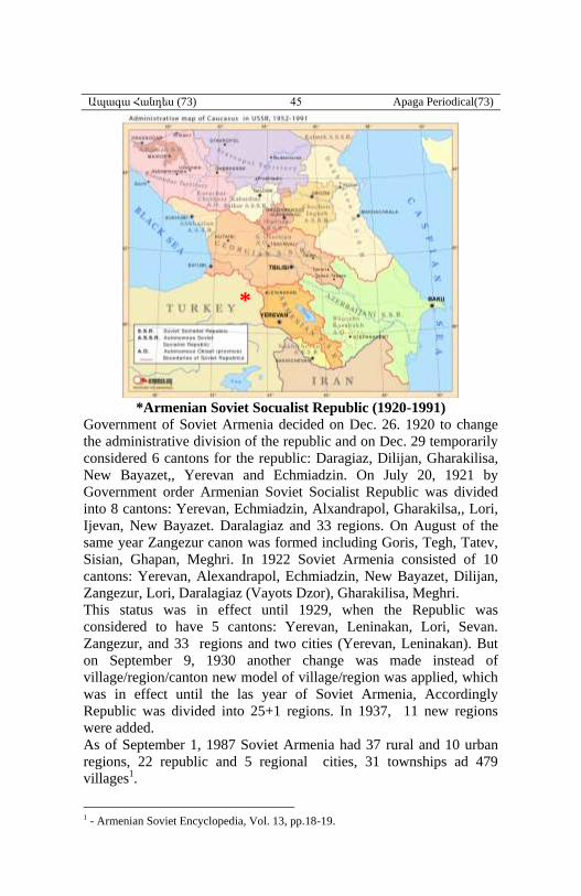
*Armenian Soviet Socualist Republic (1920-1991)
Government of Soviet Armenia decided on Dec. 26. 1920 to change
the administrative division of the republic and on Dec. 29 temporarily
considered 6 cantons for the republic: Daragiaz, Dilijan, Gharakilisa,
New Bayazet,, Yerevan and Echmiadzin. On July 20, 1921 by
Government order Armenian Soviet Socialist Republic was divided
into 8 cantons: Yerevan, Echmiadzin, Alxandrapol, Gharakilsa,, Lori,
Ijevan, New Bayazet. Daralagiaz and 33 regions. On August of the
same year Zangezur canon was formed including Goris, Tegh, Tatev,
Sisian, Ghapan, Meghri. In 1922 Soviet Armenia consisted of 10
cantons: Yerevan, Alexandrapol, Echmiadzin, New Bayazet, Dilijan,
Zangezur, Lori, Daralagiaz (Vayots Dzor), Gharakilisa, Meghri.
This status was in effect until 1929, when the Republic was
considered to have 5 cantons: Yerevan, Leninakan, Lori, Sevan.
Zangezur, and 33 regions and two cities (Yerevan, Leninakan). But
on September 9, 1930 another change was made instead of
village/region/canton new model of village/region was applied, which
was in effect until the las year of Soviet Armenia, Accordingly
Republic was divided into 25+1 regions. In 1937, 11 new regions
were added.
As of September 1, 1987 Soviet Armenia had 37 rural and 10 urban
regions, 22 republic and 5 regional cities, 31 townships ad 479
villages1.
1 - Armenian Soviet Encyclopedia, Vol. 13, pp.18-19.
*
Ապագա Հանդես (73) 46 Apaga Periodical(73)
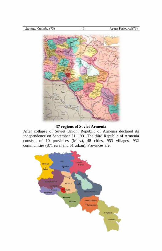
37 regions of Soviet Armenia
After collapse of Soviet Union, Republic of Armenia declared its
independence on September 21, 1991.The third Republic of Armenia
consists of 10 provinces (Marz), 48 cities, 953 villages, 932
communities (871 rural and 61 urban). Provinces are:
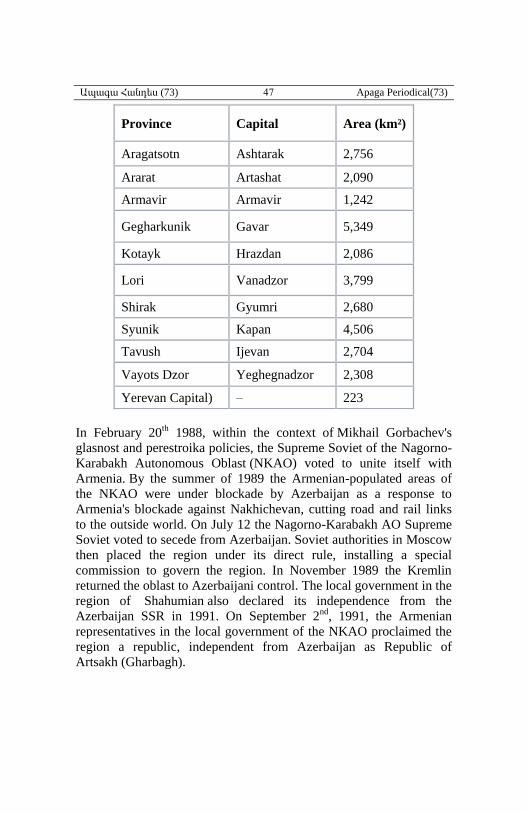
10 provinces (Marz) of the
Third Republic of Armenia
Since 1991
Ապագա Հանդես (73) 47 Apaga Periodical(73)
Province Capital Area (km²)
Aragatsotn Ashtarak 2,756
Ararat Artashat 2,090
Armavir Armavir 1,242
Gegharkunik Gavar 5,349
Kotayk Hrazdan 2,086
Lori Vanadzor 3,799
Shirak Gyumri 2,680
Syunik Kapan 4,506
Tavush Ijevan 2,704
Vayots Dzor Yeghegnadzor 2,308
Yerevan Capital) – 223
In February 20th 1988, within the context of Mikhail Gorbachev's
glasnost and perestroika policies, the Supreme Soviet of the Nagorno-
Karabakh Autonomous Oblast (NKAO) voted to unite itself with
Armenia. By the summer of 1989 the Armenian-populated areas of
the NKAO were under blockade by Azerbaijan as a response to
Armenia's blockade against Nakhichevan, cutting road and rail links
to the outside world. On July 12 the Nagorno-Karabakh AO Supreme
Soviet voted to secede from Azerbaijan. Soviet authorities in Moscow
then placed the region under its direct rule, installing a special
commission to govern the region. In November 1989 the Kremlin
returned the oblast to Azerbaijani control. The local government in the
region of Shahumian also declared its independence from the
Azerbaijan SSR in 1991. On September 2nd, 1991, the Armenian
representatives in the local government of the NKAO proclaimed the
region a republic, independent from Azerbaijan as Republic of
Artsakh (Gharbagh).
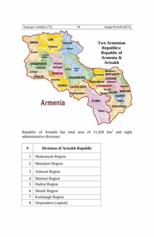
Ապագա Հանդես (73) 48 Apaga Periodical(73)
Republic of Artsakh has total area of 11,458 km2 and eight
administrative divisions:
# Divisions of Artsakh Republic
1 Shahumyan Region
2 Martakert Region
3 Askeran Region
4 Martuni Region
5 Hadrut Region
6 Shushi Region
7 Kashatagh Region
8 Stepanakert (capital)
Two Armenian
Republics:
Republic of
Armenia &
Artsakh
Republic
Artsakh


