Embed Size (px)
Citation preview
Application of Geographic Information Systems (GIS) and Remote Sensing (RS)
technologies in Monitoring and Evaluation at National Planning Commission (NPC)
By
Ademola Adeyemi
Contents
• Introduction • NPC GIS Based Projects and Programmes Monitoring and
Evaluation Solutions • NPC National Integrated Infrastructure Master Plan (NIIMP)
Database • NPC National Data Mining framework • NPC GIS Based support for macro-economic index analysis
towards NV 20:2020 • Challenges and Solutions • Data Acquisition frame work at NPC • Funding and Infrastructure • Conclusion
Introduction
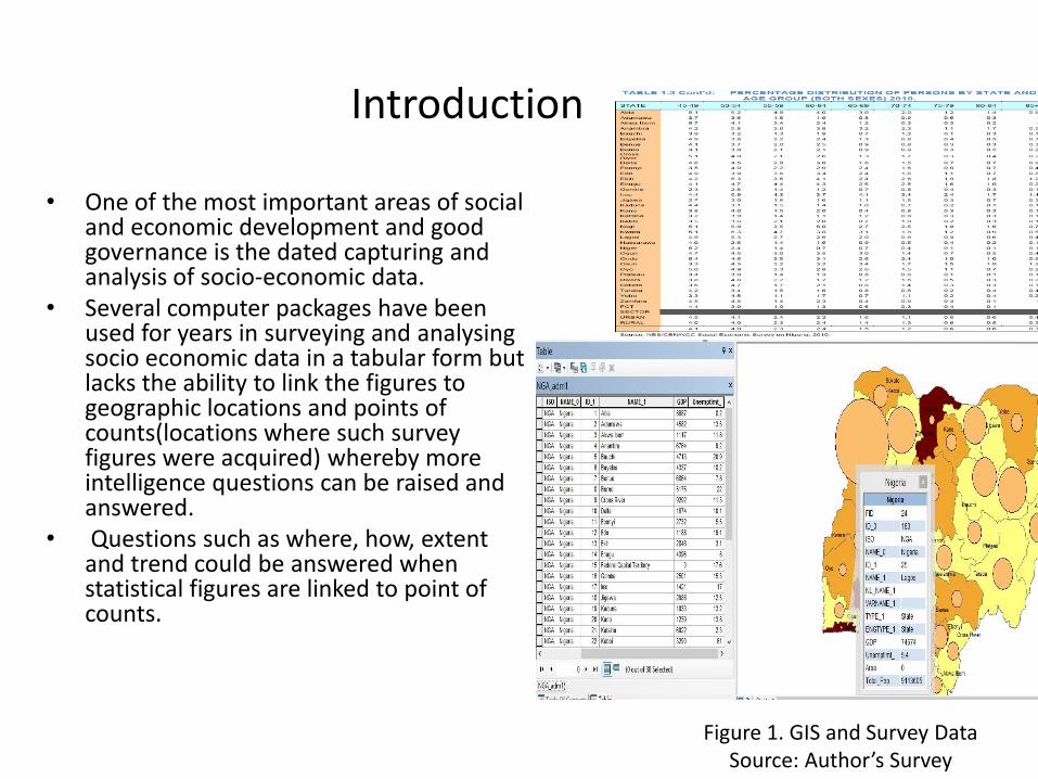
• One of the most important areas of social and economic development and good governance is the dated capturing and analysis of socio-economic data.
• Several computer packages have been used for years in surveying and analysing socio economic data in a tabular form but lacks the ability to link the figures to geographic locations and points of counts(locations where such survey figures were acquired) whereby more intelligence questions can be raised and answered.
• Questions such as where, how, extent and trend could be answered when statistical figures are linked to point of counts.
Figure 1. GIS and Survey Data Source: Author’s Survey
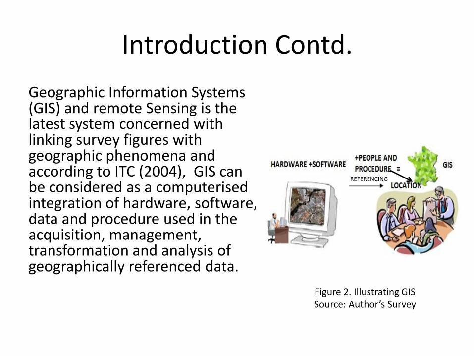
Introduction Contd.
Geographic Information Systems (GIS) and remote Sensing is the latest system concerned with linking survey figures with geographic phenomena and according to ITC (2004), GIS can be considered as a computerised integration of hardware, software, data and procedure used in the acquisition, management, transformation and analysis of geographically referenced data.
Figure 2. Illustrating GIS Source: Author’s Survey
REFERENCING

Introduction Contd.
Remote Sensing (RS) in the other hand is defined as the capturing of geographic data from a remote distance through the use of instruments such as the aerial camera mounted on aircraft or space satellite in sensing objects’ electromagnetic radiation properties thereby enabling us to access remote data that could have ordinary been difficult to reach.
GIS
R E M O T E S E N S I N G
Figure 3. Remote sensing and GIS Source: Author’s Survey
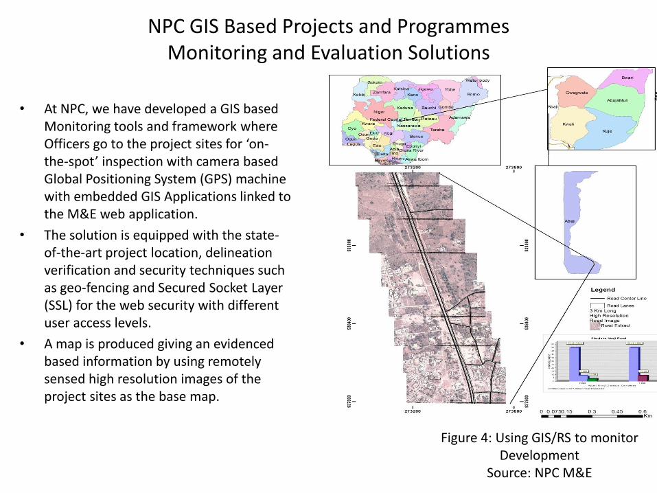
NPC GIS Based Projects and Programmes Monitoring and Evaluation Solutions
• At NPC, we have developed a GIS based
Monitoring tools and framework where Officers go to the project sites for ‘on-the-spot’ inspection with camera based Global Positioning System (GPS) machine with embedded GIS Applications linked to the M&E web application.
• The solution is equipped with the state-of-the-art project location, delineation verification and security techniques such as geo-fencing and Secured Socket Layer (SSL) for the web security with different user access levels.
• A map is produced giving an evidenced based information by using remotely sensed high resolution images of the project sites as the base map.
Figure 4: Using GIS/RS to monitor Development
Source: NPC M&E
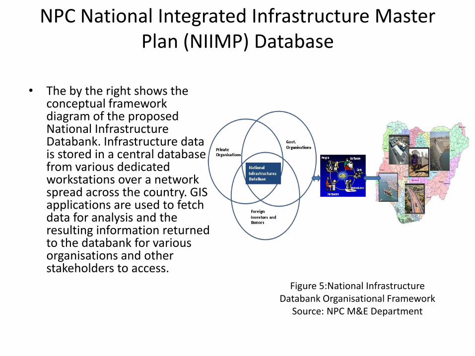
NPC National Integrated Infrastructure Master Plan (NIIMP) Database
• The by the right shows the
conceptual framework diagram of the proposed National Infrastructure Databank. Infrastructure data is stored in a central database from various dedicated workstations over a network spread across the country. GIS applications are used to fetch data for analysis and the resulting information returned to the databank for various organisations and other stakeholders to access. Figure 5:National Infrastructure
Databank Organisational Framework Source: NPC M&E Department
NPC National Data Mining framework
• This system is aimed at providing a centralized infrastructure and socio-economic data acquisition with quality assurance.
• It is the platform where theories and models about development efforts are concerted to ensure that the country’s development data are subjected to globally acceptable scientific standard scrutiny in terms of its technical and organisational sources and structure.
NPC National Data Mining framework
• National data mining framework will enable NPC to have a detailed and quality data bank of the national development data starting from projects, programmes, population, and socio-economic data that is pluggable to the expected NGDI in the nearest future.
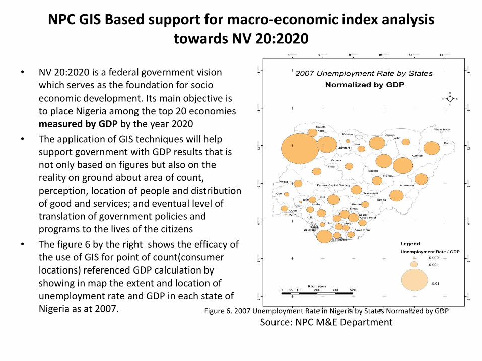
NPC GIS Based support for macro-economic index analysis towards NV 20:2020
• NV 20:2020 is a federal government vision which serves as the foundation for socio economic development. Its main objective is to place Nigeria among the top 20 economies measured by GDP by the year 2020
• The application of GIS techniques will help support government with GDP results that is not only based on figures but also on the reality on ground about area of count, perception, location of people and distribution of good and services; and eventual level of translation of government policies and programs to the lives of the citizens
• The figure 6 by the right shows the efficacy of the use of GIS for point of count(consumer locations) referenced GDP calculation by showing in map the extent and location of unemployment rate and GDP in each state of Nigeria as at 2007. Figure 6. 2007 Unemployment Rate in Nigeria by States Normalized by GDP
Source: NPC M&E Department
Challenges and Solutions
• Globally, the sophistication of RS and GIS in socio-economic development is not without some challenges, especially in Nigeria where accurate and reliable data acquisitions techniques, standardization, and organisational structures with process centralization
• these challenges are not insurmountable, at NPC, the challenges are been tackled with some standard techniques and strategies that were either adopted singularly or in their hybrid form.
• One of such challenges is the data acquisition problem that is currently being handled using the NPC M&E data acquisition framework
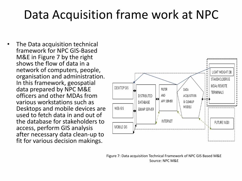
Data Acquisition frame work at NPC
• The Data acquisition technical framework for NPC GIS-Based M&E in Figure 7 by the right shows the flow of data in a network of computers, people, organisation and administration. In this framework, geospatial data prepared by NPC M&E officers and other MDAs from various workstations such as Desktops and mobile devices are used to fetch data in and out of the database for stakeholders to access, perform GIS analysis after necessary data clean-up to fit for various decision makings.
Figure 7: Data acquisition Technical Framework of NPC GIS Based M&E Source: NPC M&E
Funding and Infrastructure
• At NPC, there is inadequate funding to purchase up-to-date high resolution images where projects can be tracked. GIS and Remote Sensing need more attention from all stake holders in terms of funding. GIS/RS infrastructures cannot be funded by government alone
• . In terms of the remote sensing image acquisition, a lot of collaboration is expected from NARSDA because currently the 2.5 meter resolution of Nigeria sat2 satellite image which we could utilise for some projects is still not accessible in a ready to use form.
• NPC therefore, has no other choice than to settle for the acquisition of commercially available and very expensive high resolution images that are highly useful for GIS and Remote Sensing applications.
• This in turn, creates overhead with increase in cost of establishing and managing GIS and Remote Sensing M&E projects.
Conclusion
• The National Planning Commission (NPC) is rigorously executing the federal Government development plans using different technical and institutional instruments. In this regard, GIS/RS is one of the valuable technical instruments being used by the NPC M&E department.
• NPC has been able to harmonise its mandate with the government development plans such as the Transformation Agenda, the National Integrated Infrastructure Master Plan etc. through the establishment of a GIS Unit under the M&E department. National Planning Commission’s implementation of GIS and Remote Sensing applications for monitoring and evaluation has been useful in collecting M&E data for sustainable development.

Conclussion Contd
• Finally, it is important to know that the challenges Nigeria is facing today in information intelligence gathering is largely because of lack of adequate geo-information system stemming from the absence of a centralized location geospatial database.
• The central geospatial database is where data about National infrastructure and natural resources are stored. These include data about food, security, unemployment and road infrastructures etc. All these can be tackled when a country is able to track its geospatial data, linked to the population data. Nigeria has to know her people, where they are and the proportion of the population in a particular area at a particular period.
References
• De Soto, H. (2006) The Mystery of Capital: Why Capitalism Triumphs in the West and Fails Everywhere Else.
• Goodchild, M. F. (1990, 1992) GIScience Ten Years after Ground Truth. Transactions in GIS, 10:687-692
• Leong, K. C. (2004) The Essence of Asset Management – A Guide. Published by United Nations Development Programme, EROPH and APIGAM
• Natufe, O. Igho (2006) Governance And Politics In Nigeria, Staff And Graduate Seminar Department Of Political Science & Public Administration University Of Benin, Benin-City, Edo State, Nigeria, 21 November, 2006.
• Sivakumar, M.V.K. (2003) Satellite Remote Sensing and GIS Applications in Agricultural Meteorology Proceedings of the Training Workshop 7-11 July, 2003, Dehra Dun,India.
• ITC Educational Textbook Series; 1, Principles of Geographic Information Systems Rolf A. de by (Ed.). Second edition ISBN 90–6164–200-0 ITC, Enschede, The Netherland.
• Marrakech Roundtable on Managing for Results (2004) Available at Available at
http://www.focusintl.com/RBM051-SMES1_TM_02_Module_1_Intro_M&E.pdf, Accessed: 14. May 2014.
• Ofunne G. C. (1998). The Nigerian Guardian Newspaper Wednesday march 11, 1998, page 36.
• Jody Zall Kusek , Ray C. Rist (2004). Ten steps to Results-Based Monitoring and
Evaluation System: A hand-book for development practitioners. The International Bank for Reconstruction and Development / The World Bank, World Bank, 1818 H Street NW, Washington. • Nigeria Vision 20:2020 (2009). Economic Transformation Blueprint. National Planning
Commission

THANKS FOR LISTENING
THE END