Embed Size (px)
Citation preview

Coastal Engineering 57 (2010) 112–123
Contents lists available at ScienceDirect
Coastal Engineering
j ourna l homepage: www.e lsev ie r.com/ locate /coasta leng
Application of the equilibrium planform concept to natural beaches in Northern Ireland
Derek W.T. Jackson ⁎, J. Andrew G. CooperCentre for Coastal and Marine Research, School of Environmental Sciences, University of Ulster, Londonderry, BT52 1SA, Northern Ireland, UK
⁎ Corresponding author. Tel.: +44 28 70323083; fax:E-mail address: [email protected] (D.W.T. Jacks
0378-3839/$ – see front matter © 2009 Elsevier B.V. Adoi:10.1016/j.coastaleng.2009.09.007
a b s t r a c t
a r t i c l e i n f oAvailable online 31 October 2009
Keywords:Equilibrium planform conceptEmbayed beachesBeach stabilityWave diffraction pointNorth Ireland
The equilibrium planform concept (EPC) for bayed beaches has achieved wide currency in coastalmorphodynamics. The north coast of Ireland comprises a series of discrete headland-embayment beacheswithin which waves and currents recycle a finite sediment volume. It is therefore an ideal setting in which toexplore the applicability of the concept. Application of the approach to 9 embayment beaches on the north coastof Ireland provides some insights into the application of the concept. The planform of some beaches doescorrespond to that predicted while others do not. Those whose measured planform does not correspond tothe predicted planform can be interpreted through, (a) difficulty in identifying the wave diffraction point,(b) disequilibrium on the beach (sediment scarcity or excess), (c) geological control of beach morphology. Thesubjectivity in selecting the diffraction point renders alternative explanations difficult and reduces the utility ofthe approach on natural shorelines, where significant irregularities render identification of such points difficult.
+44 28 70324911.on).
ll rights reserved.
© 2009 Elsevier B.V. All rights reserved.
1. Introduction
The concept of equilibrium shoreline planform has achieved widecurrency in coastal morphodynamics (Bremner, 1983, LeBlond, 1979;Klein and Menezes, 2001) and coastal engineering (Silvester, 1960;Moreno and Kraus, 1999). The concept makes a number of assump-tions and a number of formulations have been presented (Yasso,1965; Silvester, 1974; Hsu and Evans, 1989; Hsu et al., 1987; Hsu et al.,1989a,b; Hsu et al., 2000) that relate shoreline position to distancefrom an origin related to a physical or dynamic location.
Various types of equilibriumare represented in examiningplanformsof bay shaped beaches ranging from ‘dynamic’where there is a constantthroughput of sediment maintaining beach stability to ‘static’ in caseswhere updrift sediment supply may cease/reduce and shorelines arerestricted to a static position. Static equilibrium models are deemeduseful in that they represent a convenient yardstick with which toascertain a particular shoreline's current stability status. An assessmentof the static model most suitable in real world conditions has beenexamined byHsu et al. (1987) andHsu andEvans (1989)where amodelbased on spiral logarithm (Yasso, 1965; Silvester, 1970a,b and others)was tested. The log-spiralmodel was shown to have limitations in termsof its reach to the outer margin of the equilibrium bay and as a result analternative parabolic model was suggested (Hsu and Evans, 1989). Theparabolic bay shapedmodel is now themostwidely adopted approach tounderstanding the stability of headland bay beaches with Hsu et al.(2004) eventually defining a methodology for stability. Detailedassessment of its usefulness and applicability can be found in Gonzalezand Medina (2001) and Klein et al. (2003a,b).
Some limitations in the model have, however, been highlighted byGonzalez (1995) including: prediction inaccuracies close to an estuarymouth (from dominant tidal dynamics); inability to predict effect ofnearshore islands as well as uncertainties in defining downcoastlimits and end points. Gonzalez (1995) does attempt to remedy someof these by proposing a semi-empirical model. Even with theadditional proposed model, limitations were still evident with thebeach systems having to conform to the following criteria:
• Assumption that wave height gradients are controlled only by thediffraction point of the control point. Other diffraction from localislands and bathymetric anomalies cannot be represented.
• Non-wave induced currents (tidal) cannot be taken account of andtherefore are assumed not to exist.
• A single point of diffraction should exist in the bay. Other diffractionpoints (control points) are assumed not to exist and therefore arenot interacting with the beach sediments.
• Intuitively, the availability of sediment and local geological frameworkover which the sediment lie must also be important factors.
In this paper we apply the Hsu and Evans (1989) approach to 9embayment systems on the north coast of Ireland in order to investigateits utility and interpretation. The north coast of Northern Ireland is anideal location inwhich to test the approach on natural beaches given itsstrongly embayed beach systems and finite sediment volume.
2. Environmental setting
Ireland has a 6500 km-long, bedrock-framed coast located between52 and 55oN (Fig. 1). Large-scale coastal plains are not present andcoastal sediments usually occur as a series of headland-embaymentbeaches or occasionally as barriers at estuary mouths (Jackson et al.,

Fig. 1. Location map of embayment beach systems around the NE coast of NorthernIreland.
113D.W.T. Jackson, J.A.G. Cooper / Coastal Engineering 57 (2010) 112–123
2005). The distribution and variable sediment composition of beachesand barriers in paraglacial settings may be explained in large part byglacial inheritance (FitzGerald and Rosen, 1987). Ice limits in Irelandduring deglaciation have largely constrained contemporary coastalgeomorphology and dynamics in that they are associated with majorsediment sources. Areas positioned close to ice limits tend to possesssandy barriers, the sand having been deposited initially by outwash andsubsequently reworked by marine processes (Cooper, 2007). Sedimentsupply on the Northern Ireland coast occurs predominantly fromreworking of shelf sands (themselves of glacial origin) (Cooper et al.,2002), and locally from erosion of bluffs of glacial sediments (Carter,1991).
Coastal sediment supply is therefore strongly related to patterns ofice movement, stabilisation and decay during the last glacial cycle.Sediment has been driven into embayments that are now separatedby a sediment-deficient seabed such that each headland-embaymentcell contains a finite sediment volume. Longshore sediment exchangebetween cells is minimal and contemporary sediment supply fromother sources (rivers and primary productivity) is similarly low. Onlyalong the northeast Antrim coast is there much sediment yield fromriver sources.
Ireland intersects the main conduit of North Atlantic cyclones,experiencing the maximum impact of Atlantic swell waves and stormactivity on its western rim. Significant deep-water wave heights (Hs)off this portion of coast can reach 15–20 m. The wave energy regimearound Ireland (Fig. 2) diminishes eastwards into the Irish Sea regionwhere Hs modal values of between 1.6 and 2 m occur and a reductionin overall wave energy by a factor of 5 take places along the eastern
Irish seaboard (Devoy, 2000). Through its northern positioning thestudy site still experiences a high-energy wave climate regime withlarge-scale refraction taking place around the northwest peripheriesof Ireland's open Atlantic coast. More specifically, wave energy variesfrom high (mean significant breaking wave height Hb, 2.18–2.52 m:Magilligan to Whitepark Bay) to moderate (1.8–1.36 m: Ballycastle toRedbay), as seen in Table 1.
The beach systems examined are situated around the northerncoastline of Northern Ireland over a distance of approximately 100km.Tidal range along this total stretch of coast falls into the microtidalcategory, ranging from 0.9 m in the southeast to 1.6 m in the northwest.
3. Beach morphology
The majority of the beaches are backed by significant vegetatedsand dunes. The morphology of the beaches on this coast was recentlycategorised by Jackson et al. (2005) who compared the observedbeach state with predicted states using the Wright and Short (1984)model. The main geomorphological attributes of each beach aredescribed below and morphometric and dynamic details are alsolisted in Table 1.
Magilligan: This 16 km embayment incorporates several majorintermediate-dissipative beach complexes including Magilligan–Benone which is backed by an extensive beach ridge plain (Lynch etal., 2009), and Castlerock and Portstewart both of which are backed byextensive dunes. The beach system is confined between the rockyInishowen peninsula in the west and basalt cliffs at Portstewart in theeast. The inlet and ebb delta of the Foyle estuary are located adjacentto the Inishowen peninsula. Waves predominantly travel from theNNW and large-scale wave refraction occurs around the Inishowenpeninsula. Wave diffraction may be occurring from a headland in theNW or from the offshore, submerged delta. Jetties are present at theBann river mouth separating Portstewart and Castlerock and a naturalrock outcrop separates Castlerock from Benone to Magilligan. Thebeach system as a whole is largely stable with no significant erosion oraccretion in the historical period.
Portrush west: This narrow, intermediate-type beach was formerlybacked by dunes that have been heavily modified. Bounded by tworocky headlands in the east and west of the site and is supplied bymainly N/NW wave approaches. A seawall is present along the entirelength of the beach (0.9 km) and a harbour was built in the east in the1800s. Beach lowering and narrowing since the seawall emplacementin the 1960s have been observed (Carter, 1991) and peat is periodi-cally exposed on the foreshore during beach lowering.
Portrush east: This 2.8 km-long intermediate-dissipative beachfronts a cuspate dune system and is bounded by two rocky headlands,Ramore Headland in the NWandWhiterocks in the east. The shorelineposition is relatively stable in the historical period. The beach islocated in the lee of a series of offshore rocky islands, which, togetherwith a prominent headland to the west, affect wave approach.Geophysical investigations have shown there to be a limited sedimentsupply in the offshore zone at the site (Kelley et al., 2006; Backstromet al., 2009).
Portballintrae: This is a horseshoe-shaped bay located betweenprominent but low rocky headlands. An existing narrow beach(0.4 km wide) is backed by bluffs of glacial and glacio/marinesediment. Human influence at the site is evident in the form of apier in the north and a harbour in the SE section of the bay. Extensivebeach narrowing has been attributed to alteration of wave patterns byemplacement of a pier in the north (Carter, 1991).
Runkerry: This 1.0 km-long beach is underlain by a boulder frameand glacial sediments. It is bounded by two high rocky headlands andthe river Bush discharges along the western headland. Sand dunesbacking the beach are located on top of glacial till. The beach switchesbeach state on a seasonal basis (intermediate to dissipative) but on
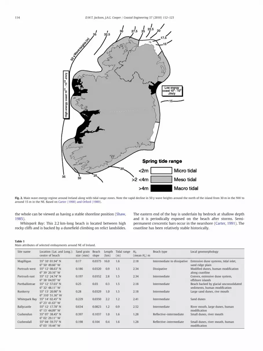
Fig. 2. Main wave energy regime around Ireland along with tidal range zones. Note the rapid decline in 50 y wave heights around the north of the island from 30 m in the NW toaround 15 m in the NE. Based on Carter (1990) and Orford (1989).
114 D.W.T. Jackson, J.A.G. Cooper / Coastal Engineering 57 (2010) 112–123
the whole can be viewed as having a stable shoreline position (Shaw,1985).
Whitepark Bay: This 2.2 km-long beach is located between highrocky cliffs and is backed by a dunefield climbing on relict landslides.
Table 1Main attributes of selected embayments around NE of Ireland.
Site name Location (Lat. and Long.):centre of beach
Sand grainsize (mm)
Beachslope
Length(km)
Tidal range(m)
Magilligan 55o 10′ 01.94” N 0.17 0.0375 16.0 1.66o 50′ 49.66” W
Portrush west 55o 12′ 08.63” N 0.186 0.0320 0.9 1.56o 39′ 20.16” W
Portrush east 55o 12′ 24.74” N 0.197 0.0352 2.8 1.56o 38′ 04.95” W
Portballintrae 55o 12′ 57.03” N 0.25 0.03 0.3 1.56o 32′ 48.11” W
Runkerry 55o 13′ 20.90” N 0.28 0.0329 1.0 1.56o 310′ 51.36” W
Whitepark Bay 55o 14′ 02.45” N 0.229 0.0350 2.2 1.26o 23′ 41.63” W
Ballycastle 55o 12′ 17.78” N 0.634 0.0823 1.2 0.96o 13′ 44.09” W
Cushendun 55o 07′ 38.45” N 0.397 0.1037 1.0 1.66o 02′ 29.11” W
Cushendall 55o 04′ 59.75” N 0.198 0.104 0.4 1.66o 03′ 19.44” W
The eastern end of the bay is underlain by bedrock at shallow depthand it is periodically exposed on the beach after storms. Semi-permanent crescentic bars occur in the nearshore (Carter, 1991). Thecoastline has been relatively stable historically.
H0
(mean Hs) mBeach type Local geomorphology
2.18 Intermediate to dissipative Extensive dune systems, tidal inlet,sand ridge plain
2.34 Dissipative Modified dunes, human modificationalong coastline
2.34 Intermediate Convex, extensive dune system,offshore islands
2.18 Intermediate Beach backed by glacial unconsolidatedsediments, human modification
2.18 Intermediate Large sand dunes, rive mouth
2.41 Intermediate Sand dunes
2.52 Intermediate River mouth, large dunes, humanmodification
1.28 Reflective–intermediate Small dunes, river mouth
1.28 Reflective–intermediate Small dunes, river mouth, humanmodification

Fig. 3. Static shoreline prediction for Magilligan embayment after diffraction point selected from headland location (image source: NASA images). Note the suggested instability ofthe coastline in the western section of the site.
Fig. 4. Static shoreline represented after the diffraction point is chosen at the submerged delta in the Magilligan embayment (image source: NASA images). Note close agreementwith actual shoreline for the entire length of the embayment.
115D.W.T. Jackson, J.A.G. Cooper / Coastal Engineering 57 (2010) 112–123

116 D.W.T. Jackson, J.A.G. Cooper / Coastal Engineering 57 (2010) 112–123
Ballycastle: This 1.2 km-long beach is composed of coarse, poorlysorted sand and fine gravel sourced primarily from rivers that dissectrelict fluvio-glacial deltas. The beach is confined between high cliffs ateach end and is backed by a sand dune system. The close proximity ofan amphidromic point results in a low tidal range and this area istransitional between remnants of high-energy Atlantic waves anddirectly approaching Irish Sea waves (lower energy) originating fromthe east. Dominant longshore drift to the west results in coastalrecession in the east and accumulation in the west at the river mouth(Carter, 1991).
Harbour construction (in several phases) in the north of theembayment, channelisation of the Margy River, beach sedimentremoval and small-scale coastal reclamation adjacent to the harbourhave all affected the shoreline morphodynamics.
Cushendun: This 1 km-long beach is located in a glaciated valleyflanked by bedrock outcrop at both margins. The Glendun River, whichenters the sea on the southern margin of the beach supplies the coarsesand and fine gravel that dominate the beach and nearshore. Longshoretransport is in a southerlydirection toward the river outlet (Carter, 1991).Human interference has manifest itself in the form of dredging and riverchannelisation in the past, effectively cutting off the linkage betweenlongshore transport of beach material and the Glendun River. Sedimentremoval from the beach has also occurred in the past with an estimated
Fig. 5. Portrush West Strand and the predicted static shorelines showing close agreement towest and a harbour end point in the east.
30,000 m3 removed over a 30-year period (1960–1990) (Carter, 1991).Historically, this coastline appears to be in a retreating phase.
Cushendall: This 0.4 km-long beach is intersected at its southernsection by the RiverDall. It is located in a glaciated valley and is boundedby high bedrock cliffs. This site had a serious problem of coastal retreatover the period 1903 to 1963 when a 45m shoreline recession wasrecorded (Carter, 1991) due to sediment removal, resulting in a beachsediment volume deficit. A sea wall installed in 1963 has left a muchnarrower and lower beach.Wave energy levels in the area aremoderatemostly originating from the Irish Sea (East).
4. Application of the planform equilibrium concept
The MEPBAY software (Klein et al., 2003b) derived from the EPC forbay beach in static equilibrium (Hsu and Evans, 1989) was used toidentify diffraction points on rectified orthophotographs (2004) ofbeaches along the north coast. In the case of the largest embaymentbeach (Magilligan), satellite imagery fromGoogle Earth is employed. Allimages are in a north (top of image) to south alignment. The MEPBAYsoftware (http://siaiacad05.univali.br/~meppe) is used to predict theshoreline position in static equilibrium at each site and the results arediscussed below.
the existing beach after two diffraction points were selected from a promontory to the

Fig. 6. Portrush East site showing the multiple diffraction points and corresponding static shoreline positions. Note the presence of the nearby Skerries islands. Close agreement canbe seen between predicted and actual shorelines in the western part of the site using part of the western headland while the eastern and western edges of the offshore Skerriesislands diffraction points predicts quite close agreement follow an approximate path of the existing salient. Less agreement is evident between actual and predicted shorelinetowards the tip of the salient.
117D.W.T. Jackson, J.A.G. Cooper / Coastal Engineering 57 (2010) 112–123
Magilligan: At this site, the dominant wave approach is from thenorthwest and diffraction is therefore likely to be centred on theheadland north of the beach. The tidal inlet of the Foyle, however, alsoprovides a potential second diffraction point on the shallowestsections of the ebb tide delta. Consequently both points are selectedfor simulation of shoreline position. The downdrift end of this 16 kmembayment is selected at the eastern edge of Portstewart beach. Fig. 3shows the result of choosing the main headland as the diffractionpoint source. The predicted static shoreline is positioned offshore ofthe actual shoreline, suggesting the coast is an unstable coast,particularly in the western section of the site towards the distal endof the cuspate foreland.
Fig. 4 shows the static shoreline prediction when the western edgeof the submerged Tunns Bank is selected as a diffraction point. At theresolution of the satellite imagery (15 m pixel size) there is quite closeagreement between actual shoreline and predicted static shoreline.East of the River Bann the actual beach is rather landward of thatpredicted. This can be attributed to the presence of the training walls,which produced some accretion on beaches the west and erosion inthe east soon after their emplacement but which now appear to bestable.
Portrush west: This embayment has distinctive promontories onboth sides of the bay. Selection of both these as diffraction points(Fig. 5) produces a simulated shoreline that is in close agreement withactual shoreline configuration at the present time. Previous work(Carter, 1991) however, has shown historical shoreline changes inresponse to construction of the harbour (1825), sand removal andseawall construction (1940–1960). The southwest section of the bayretreated by around 80 m between 1825 and 1950 while thenortheast sector accreted 80 m during the same period. Thus, whilethe modern shoreline agrees with the MEPBAY model, the naturalshoreline in the southwest part of the bay was 80 m seaward ofcontemporary shoreline.
Portrush east: The major influence on this beach planform is thepresence of a chain of offshore islands (Skerries) and a distinctivepromontory (Ramore Head) identification of three diffraction points(Fig. 6) produces a simulated shoreline that matches the actualshoreline in the east and west margins of the beach. The centralsection comprises a salient that is landward of the predicted shoreline.This is easily explained by the lack of available sediment to attain thepredicted morphology. What is more difficult to explain is the factthat the entire western section has retreated by over 100 m since1834 (Carter, 1991) without having been affected by any engineeringworks that would have altered the diffraction points.
Portballintrae: The eastern side of the bay contains a prominentharbour wall which is an obvious diffraction point. The westernheadland of this bay comprises a wide, gently sloping, intertidal tosubtidal rock platform on which a jetty (Leslie's Pier) was constructedaround 1895 (Carter, 1991). Selection of diffraction points on thismargin is more problematic since the diffraction point likely migratesacross the platform as the tide fluctuates. Selection of three diffractionpoints (Fig. 7) produces a simulated shoreline that matches quite wellthe contemporary shoreline in the west; only minor differences inshoreline position are produced by selection of diffraction point onLeslie's Pier and the adjacent rock headland. The eastern part of thebay is quite different in that the predicted shoreline is up to 50 mseaward of the actual position. Interestingly, this bay has showndramatic shoreline change in the recent past: between 1930 and 1980more than 100 m of shoreline recession occurred (Carter, 1991). Theattribution of this erosion to construction of Leslie's Pier (Carter andShaw, 1983) is at odds with the simulated shorelines from theMEPBAY model (Note the similarity in the simulated shorelinesassociated with Leslie's Pier and the natural headland).
Runkerry: A variety of diffraction points exist in this bay. Fig. 8illustrates the shoreline oppositions obtained using three of these. Thepredicted static planform of the beach matches quite well with the

Fig. 7. Portballintrae site showing the result of selection of three diffraction points where a simulated shorelines matches quite well the contemporary shoreline in the west whileonly minor differences in shoreline position are produced by selection of diffraction point on Leslie's Pier and the adjacent rock headland. The eastern part of the bay is quite differentin that the predicted shoreline is up to 50 m seaward of the actual position.
118 D.W.T. Jackson, J.A.G. Cooper / Coastal Engineering 57 (2010) 112–123
actual low water position on the beach (Fig. 8). Interestingly, both ofthe westerly diffraction points are associated with almost identicalsimulated shorelines.
Whitepark Bay: Several diffraction points were selected either sideof the bay, two on the west and one on the eastern sectors. A fairlygood agreement is found between the predicted static shoreline andactual low water beach planform (Fig. 9). The predicted staticshoreline in the western section of the beach is in better agreementwith the actual shoreline when the more landward diffraction point isused.
Ballycastle: Ballycastle embayment contains a major harbour (con-structed in two phases) and offers the opportunity to test predictions ofthe shoreline position based on a changing diffraction point. Selectingthe diffraction point in Fig. 10(i), at the end of the harbourwall after thefirst phase of construction, predicts a shoreline broadly similar to thepresent except in the western margin. Fig. 10(ii) shows the shorelinepredicted by a subsequent diffraction point located at themodern outeredge of the existing harbour. Remarkably good agreement betweenactual and predicted shorelines is clear along the entire beach. Thepredicted accretion at the western end of the beach is matched by theactual changes recorded by sequential aerial photography.
Cushendun: At this site there are two potential diffraction points,one on the natural rock headland to the south of the bay (Fig. 11(i))and a second at the tip of a jetty at the river mouth (Fig. 11(ii)). Thepredicted shoreline associated with a diffraction point to the south ofthe beach displays quite good agreement with the actual shorelineposition in the northern section of the beach (Fig. 9). However, in thesouthern zone where the Glendun River emerges, the actual shoreline
(which rests on exposed bedrock) is seaward of that predicted. Whenthe diffraction point on the end of the jetty is considered the predictedshoreline is even further landward.
Cushendall: The southeasterly approach of the dominant wavefield prompted selection of a headland diffraction point in the SE ofthe Cushendall embayment. Quite close agreement is found betweenthe predicted and actual shoreline positions (Fig. 12) with theexception of the southern section of the beachwhere a river enters thesystem and the actual shoreline is located seaward of that predicted.This finding was unexpected since the coastline has been retreating ata rapid rate throughout this embayment over the past 100 years(Carter, 1991) and there has been no change in the location of thediffraction point.
5. Discussions
The northeast coast of Northern Ireland is a locality in which thehistorical behaviour of its headland-embayment beaches is welldocumented (Carter, 1991). The high degree of indentation andisolation of the beaches in distinct embayments reduces longshoreinfluences on beach behaviour and means that each has a well-constrained sediment circulation operatingwithin fixed boundaries. Ittherefore offers an ideal location in which to test the applicability ofthe headland-embayment equilibrium planform concept (EPC) onnatural beaches.
The results presented here show considerable variability. In severalinstances quite close agreement was observed between predicted andactual shoreline planform while in others, there was little or no

Fig. 8. Runkerry embayment which displays a good agreement with predicted static and actual planforms.
119D.W.T. Jackson, J.A.G. Cooper / Coastal Engineering 57 (2010) 112–123
agreement. This approach has been used in the past to predict the impactof engineering structures (Hsu and Silvester, 1990; Hsu et al., 1993) andto assess the statusof the coastline (Kleinet al., 2003a).On thenorth coast
Fig. 9.Whitepark Bay site where several diffraction points were selected either side of the baybetween the predicted static shoreline and actual low water beach planform. Note that the pthe actual shoreline when the more landward diffraction point is used.
of Ireland the well documented historical shoreline changes offer theopportunity to set modern and predicted shorelines in their historicalcontext.
, two on the west and one on the eastern sectors. A reasonably good agreement is foundredicted static shoreline in the western section of the beach is in better agreement with

Fig. 10. Ballycastle embayment where the diffraction point in (i), at the end of the harbour wall after an initial phase of harbour construction, predicts a shoreline broadly similar tothe present except in the western margin. Selection of another diffraction point (ii) shows the shoreline predicted by a subsequent diffraction point located at themodern outer edgeof the existing harbour. Remarkably good agreement between actual and predicted shorelines is clear along the entire beach. The predicted accretion at the western end of the beachis matched by the actual changes recorded by sequential aerial photography.
120 D.W.T. Jackson, J.A.G. Cooper / Coastal Engineering 57 (2010) 112–123
At Magilligan, there is an abundant sediment supply which isreflected in the long-term stability of the site. Armed with thisknowledge, selection of the ebb delta as an alternative diffractionpoint provided a simulated coastline that was closer to reality thanthat associated with diffraction on the adjacent Inishowen headland.It does point to the importance of the ebb delta as a control on thelong-term planform stability of the site and therefore enhances theunderstanding of the coastal form. Conducting the simulation blind(with no prior knowledge of the ebb delta) would however, not haveallowed such a proposition to be tested. An alternative approachmight have been to fit the curve to the observed shoreline as a meansof identifying alternative diffraction points. Selecting the exactposition of a diffraction point on a submerged delta is however verysubjective. The leading edge of the delta is gently sloping andtherefore diffraction may take place in a broad zone dependent ontidal and wave conditions. In this situation where the coast wasknown to be stable, the shoreline predicted by the equilibriumplanform concept (EPC) was similar to that observed. This drewattention to the previously undocumented role of the ebb delta inwave transformation. Previous work confirmed the role of the ebbdelta in wave refraction (Carter et al., 1982) but not diffraction.
At Portrush west strand the predicted static shoreline using twodiffractionpoints (theheadland to thewest andharbour to theeast) is inclose agreementwith the contemporary situation. This seems to confirmthe role of the harbour in prompting accretion in the east as evidencedby historical shoreline change. In the west however, where thediffraction point has remained fixed, the actual coastline has, however,retreated by 80 m in the past century. The apparent agreementwith thecontemporary shoreline is most likely due to the need to identify adowncoast limit in MEPBAY which tend to promote agreement.
At Portrush east, a convex beach planform generally matches thatpredicted by selection of multiple diffraction points. The planformscoalesce to form the cuspate feature observed. The eastern shoreline issomewhat landward of that predicted at the confluence of the two
planforms. This could be interpreted as the result of an inadequatesediment supply; the adjacent sea bed is largely sediment poor (Lawlor,2000; Kelley et al., 2006; Backstrom et al., 2009). The shoreline is knownto have been historically stable, suggesting that it is in static equilibrium.This further suggests that the lack of sediment prevents attainment of thetheoretical shoreline.
At Portballintrae, there is considerable difficulty in selecting adiffraction point on the western side of the bay as the headland isbroad and gently sloping in the intertidal and subtidal zone.Sensitivity of predicted shoreline position to the diffraction pointlocation is marked but neither is coincident with the contemporaryshoreline.
The actual shoreline at Cushendun matches that predicted exceptin the south where the shoreline is seaward of that predictedregardless of whether the natural rock headland or the river mouthjetty is selected as a diffraction point. This might be due to the effect ofthe underlying geology (Fig. 11), which if elevated, would cause thesand on top of it to extend further seaward (Jackson and Cooper,2009). An alternative explanation may be that the river mouth altersthe local wave patterns and promotes sediment accumulation. Thesame is true at Cushendall in the vicinity of its river mouth.
While these shorelines appear to be in equilibrium, both beachesare known to have receded in historical times whereas the diffractionpoint will not have changed. This knowledge of the recorded shorelinechanges urges rejection of the conclusion that the beach is inequilibrium as implied by application of the static shoreline concept.
6. Final remarks
The EPC provides an explanation of shoreline planform on linearcoasts with prominent headlands. It has been used in the past toassess the erosional status of various headland-embayment beaches(Hsu et al., 1993; Klein and Menezes, 2001) through comparison ofpredicted and actual shorelines. Klein and Menezes (2001) for

Fig. 11. Cushendun beach where two potential diffraction points are chosen, one on thenatural rock headland to the south (i) and a second at the tip of a jetty (ii). Thepredicted shoreline associated with a diffraction point to the south of the beach displaysquite good agreement with the actual shoreline position in the northern section of thebeach. However, in the southern zone where the Glendun River emerges, the actualshoreline is seaward of that predicted. When the diffraction point (ii) is considered thepredicted shoreline is even further landward.
121D.W.T. Jackson, J.A.G. Cooper / Coastal Engineering 57 (2010) 112–123
example identified equilibrium and disequilibrium bays along thesouth Brazilian coast. The examples described in this paper showvarious levels of agreement between predicted and actual shorelineson the Northern Ireland coast for which the historic coastal behaviouris well known. This allows the predictive ability of the EPC to betested. The results presented above show various levels of agreementbetween shorelines predicted using the MEPBAY software and actualshorelines. In some cases modern shorelines closely match predictedshorelines suggesting them to be in static equilibrium. Several ofthese, however, (e.g. Portrush west) are known to be experiencinglong-term coastal recession which points toward disequilibrium. Insome cases, the approach has been a useful tool in identifyingunexpected potential influences on shoreline planform (e.g. the ebbdelta at Magilligan Point). In other instances the predicted and actual
shorelines do not coincide which prompts questions regarding suchdiscrepancy—do they reflect disequilibrium, do they reflect somenatural constraint on achievement of idealised equilibrium, or do theyreflect inherent subjectivities involved in application of the model?
In applying the concept to a range of natural beaches in NorthernIreland we present some observations regarding the practical applica-tion of the EPC as a prediction tool for beach planform equilibrium.These observations relate to the following practical aspects of applyingthe EPC:
• Subjectivity in selection of the diffraction point• Temporal variability in location of diffraction point as a result ofchanging tidal and wave conditions
• Subjectivity in selection of downdrift control point (and conse-quently wave approach angle)
The subjectivity of the selection of the diffraction point has alsobeen addressed by Lausman et al. (2010-this issue) who demon-strated through blind testing that the operator is strongly influencedby sight of the actual shoreline position. When this was not visiblethe coincidence of predicted and actual shorelines decreasedsignificantly. The natural variability of coastal systems means thatmany potential sites could be selected as the diffraction point. This isevident at Magilligan where a better shoreline fit was achieved byselection of the ebb tide delta as a diffraction point rather than theadjacent rocky headland. While this in itself is a useful findingpointing to a previously unexpected role for the ebb delta, it hindersuse of the approach in assessing the equilibrium nature of the coast.The coast is known to have been historically stable and consequentlyour provisional interpretation is that the ebb delta plays a moresignificant role in wave diffraction than the adjacent headland.Without this local knowledge a different conclusion might have beendrawn.
In addition, several diffraction points on this coast probablychange with the tide, with wave direction and with wave height. Theflat, gently sloping rocky headland at Portballintrae is a case in point.Here, the diffraction point at low tide must be several tens of metresdistant from that at high tide. A similar scale of displacement is likelyassociated with differences in wave height. These constraints do notexist in the laboratory or computer models with a vertical headlanddefining the diffraction point, a monochromatic wave field anduniform sediment size in an unconstrained setting. On a natural beachthere may also be more than one diffraction point at any given time.This is evident at Portrush West Strand, Portrush East Strand andPortballintrae where it is clear that diffraction points exist on bothsides of the bay. In these cases the full equilibrium planform is notdeveloped and identification of the downdrift control point istherefore inhibited. This is important because of the fixed relationshipin the EPC between wave approach angle and the downcoast tangentline (Hsu et al., 1987); misidentification of this downdrift pointchanges the wave approach angle and vice versa, with consequentimplications for the predicted shoreline position.
There are also a number of conceptual aspects of beach behaviourthat influence the relationship between MEPBAY-predicted and actualshorelines andwhich influence the utility of the approach in identifyingequilibrium and non-equilibrium shorelines. These include:
• Reliance on contemporary beach morphometrics as an input• Omission of other dynamic variables (secondary wave motions,tidal and river currents)
• Role of underlying geologic framework in shaping seabed (Jacksonand Cooper, 2009)
• Variability in grain size characteristics
On several beaches that are known to be in long-term recession(e.g. Portrush west), the coincidence between predicted and actualshorelines seems puzzling. However, when it is realised that theactual shoreline (i.e. the downdrift control point) forms part of the

Fig. 12. Cushendall embayment and the predicted static shoreline position using MEPBAY software. Note that overall prediction is good with the exception of the southern sectionwhere the River Dall emerges and the actual shoreline is located seaward of that predicted. The coastline at the Cushendall embayment has been retreating at a rapid rate throughoutthis embayment over the past 100 years (Carter, 1991) whilst the location of the diffraction point is presumed to have remained fixed.
122 D.W.T. Jackson, J.A.G. Cooper / Coastal Engineering 57 (2010) 112–123
prediction, this coincidence is less surprising. This acts to forceagreement between predicted and actual shorelines and limits itspredictive capacity. In theory this can be avoided if one has knowledgeof the deep-water wave approach direction, but in practice data onwave height, much less direction are rather rare for most of theworld's coasts. The equilibrium planform concept assumes that noother processes than wave diffraction influence the coastal planform.Clearly this is not a valid assumption on many natural coasts but fromthe perspective of interpreting the predicted static shorelines it is animportant consideration. On some beaches where the predictedshoreline closely matches the actual shoreline, thereby implyingstability, there are known to be large-scale secondary wave motions(viz the crescentic bars at Whitepark Bay). Assuming that thediffraction point has been selected correctly and that the waveapproach angle is correct (see above) there are two possible inter-pretations: a) that the shoreline is stable and secondarywavemotions
do not influence it; and b) that the coast is unstable and that itscoincidence with the predicted shoreline is caused by circulations thatthe model does not consider. A similar line of argument applied tosituations where the coastline does not match the predicted staticshorelinemust conclude that the deviationmay be due to either a) theoperation of dynamics that are excluded by the model, b) shorelineinstability through lack of sediment or geological control.
As in many conceptual models, no account is taken in the ECP ofgeological variables (seabed topography and material, sedimentsupply and type) as a constraint on the dynamic processes (Cooperand Pilkey, 2004; Jackson et al., 2005). In the ECP, coastal behaviour isconsidered to be unconstrained by geological factors other than theheadlands bounding the embayment. This is clearly an invalidassumption on many natural beaches where there may be shallowlyburied bedrock or semi-consolidated sediments. In theory, the modelmay be useful in identifying geological control as a factor causing
123D.W.T. Jackson, J.A.G. Cooper / Coastal Engineering 57 (2010) 112–123
deviation from the predicted static shoreline, as implied at Cushendunand Cushendall where shallow outcrop of glacial till is invoked toexplain deviation from the idealised shoreline morphology.
Application of the ECP to several beaches along the NorthernIreland coast has been a useful exercise. It has prompted questionsregarding the stability of the coast and prompted insights into coastalbehaviour that were otherwise unexpected. It has also revealed somenatural constraints on achievement of equilibrium through geologicalfactors. Most importantly, it urges caution in the simple use of the ECPto determine whether a shoreline is in equilibrium and prompts usersto consider not only the already documented issues concerning thesubjectivity of input selection but also the potential for geological,dynamic and sedimentological constraints on shoreline planformdevelopment.
Acknowledgements
Reproduction from the Ordnance Survey Northern Ireland (OSNI)map with the permission of the controller of HSMO© 2006, permit no.60089. We would also like to thank Kilian McDaid, Drawing Office(University of Ulster) and Euan Dawson (University of Ulster) for helpwith some of the figures. Thanks are also due to Robert Stewart andSam Smyth (CCMR, University of Ulster) who helped carry out DGPSsurveys and sediment sampling. Helpful and detailed discussion withJohn Hsu helped improve the paper.
References
Backstrom, J., Jackson, D.W.T., Cooper, J.A.G., 2009. Shoreface morphodynamics of ahigh-energy, steep and geologically constrained shoreline segment in NorthernIreland. Marine Geology 257, 94–106.
Bremner, J.M., 1983. Properties of logarithmic spiral beaches with particular referenceto Algoa Bay. In: McLachlan, A., Erasmus, T. (Eds.), Sandy Beaches as Ecosystems.Proc. 1st Inter. Sym. Sandy Beaches, Port Elizabeth, South Africa, pp. 97–113.
Carter, R.W.G., 1990. The Impact on Ireland of Changes in Mean Sea Level. Programmeof Expert Studies, Number 2. Department of the Environment, Dublin. pp. 128.
Carter, R.W.G., 1991. Shifting Sands: A Study of the Coast of Northern Ireland fromMagilligan to Larne. HMSO, Belfast.
Carter, R.W.G., Shaw, J., 1983. An eighty year history of shoreline erosion in a small IrishBay. Shore and Beach 51, 34–37.
Carter, R.W.G., Lowry, P., Stone, G.W., 1982. Sub-tidal ebb shoal control of shorelineerosion via wave refraction, Magilligan Foreland, Northern Ireland. Marine Geology48, 17–25.
Cooper, J.A.G., 2007. Geomorphology of Irish estuaries: inherited and dynamic controls.Journal of Coastal Research SI 39, 176–180.
Cooper, J.A.G., Pilkey, O.H., 2004. Sea-level rise and shoreline retreat: time to abandonthe Brunn Rule. Global and Planetary Change 43, 157–171.
Cooper, J.A.G., Kelley, J.T., Belknap, D.F., Quinn, R., McKenna, J., 2002. Inner shelf seismicstratigraphy off the north coast of Northern Ireland: new data on the depth of theHolocene lowstand. Marine Geology 186, 369–387.
Devoy, R.J.N., 2000. Implications of accelerated sea-level rise (ASLR) for Ireland. Proc.SURVAS Expert Workshop on European Vulnerability and Adaptation to impacts ofAccelerated Sea-Level Rise (ASLR), Hamburg, pp. 52–66.
Fitzgerald, D.M., Rosen, P.S. (Eds.), 1987. Glaciated Coasts. Academic Press, San Diego,CA.
Gonzalez, M., 1995. Morfologia de playas en equilibrio: planta y perfil. PhD Thesis,Departamento de Ciencias y Tecnicas del Agua y del Medio Ambiente, Universidadde Cantabria. Santander, Spain.
Gonzalez, M., Medina, R., 2001. On the application of static equilibrium bay formationsto natural and man-made beaches. Coastal Engineering 43 (3–4), 209–225.
Hsu, J.R.C., Evans, C., 1989. Parabolic bay shapes and applications. ProceedingsInstitution Civil Engineers Part 2 87, 557–570.
Hsu, J.R.C., Silvester, R., 1990. Accretion behind single offshore breakwater. Journal ofWaterway, Port, Coastal and Ocean Engineering, ASCE 116 (3), 362–380.
Hsu, J.R.C., Klein, A.H.F., Benedet, L., 2004. Geomorphic approach for mitigation beacherosion downdrift of littoral barrier. Proceedings 29th International ConferenceCoastal Engineering: ASCE, vol. 2, pp. 2022–2034.
Hsu, J.R.C., Silvester, R., Xia, Y.M., 1987. New characteristics of equilibrium shapebays. Proceedings 8th Australasian Conference on Coastal and Ocean Engineering,pp. 140–144.
Hsu, J.R.C., Silvester, R., Xia, Y.M., 1989a. Static equilibrium bays: new relationships.Journal of Waterway, Port, Coastal Ocean Engineers, ASCE 115 (3), 285–298.
Hsu, J.R.C., Silvester, R., Xia, Y.M., 1989b. Generality on static equilibrium bays. CoastalEngineering 12, 353–369.
Hsu, J.R.C., Uda, T., Silvester, R., 1993. Beaches downcoast of harbours in bays. CoastalEngineering 19, 163–181.
Hsu, J.R.C., Uda, T., Silvester, R., 2000. Shoreline protection methods—Japaneseexperience. In: Herbich, J.B. (Ed.), Handbook of Coastal Engineering. McGraw-Hill, New York, pp. 9.1–9.7.
Jackson, D.W.T., Cooper, J.A.G., 2009. Geological control on beach form: accommodationspace and contemporary dynamics. Journal of Coastal Research SI56, 69–72.
Jackson, D.W.T., Cooper, J.A.G., del Rio, L., 2005. Geological control of beachmorphodynamic state. Marine Geology 216, 297–314.
Kelley, J., Cooper, J.A.G., Jackson, D.W.T., Belknap, D., Quinn, R.J., 2006. Sea-level changeand inner shelf stratigraphy off Norhern Ireland. Marine Geology 232, 1–15.
Klein, A.H.F., Menezes, J.T., 2001. Beach morphodynamics and profile sequence for aheadland bay coast. Journal of Coastal Research 17 (4), 812–835.
Klein, A.H.F., Benedet, L., Hsu, J.R.C., 2003a. Stability of headland-bay beaches in SantaCatarina: a case study. Journal of Coastal Research SI 35, 151–166.
Klein, A.H.F., Vargas, A., Raabe, A.L.A., Hsu, J.R.C., 2003b. Visual assessment of bayed beachstability using computer software. Computers and Geosciences 29, 1249–1257.
Lawlor, D.P., 2000. Inner shelf sedimentology off the North Coast of Northern Ireland.Unpublished PhD thesis, University of Ulster.
Lausman, R., Klein, A.H.F., Stive, M.J.F., 2010. Uncertainty in the application of theparabolic bay shape equation: Part 1. Coastal Engineering 57, 132–141 (this issue).
LeBlond, P.H., 1979. An example of the logarithmic spiral plan of headland bay beaches.Journal of Sedimentary Petrology 49, 1093–1100.
Lynch, K., Jackson, D.W.T., Cooper, J.A.G., 2009. Foredune accretion under offshorewinds. Geomorphology 105, 139–146.
Moreno, L.J., Kraus, N.C., 1999. Equilibrium shape of headland-bay beaches forengineering design. Proc. Coastal Sediments '99, ASCE, v. 1, pp. 860–875.
Orford, J.D., 1989. A review of tides, currents and waves in the Irish Sea. In: Sweeney, J.(Ed.), The Irish Sea: A Resource at Risk, Special Publication Number 3. Geogr. Soc.Ireland, Dublin, pp. 18–46.
Shaw, J., 1985. Beach morphodynamics of an Atlantic coastal embayment: Runkerrystrand, Co. Antrim. Irish Geography 18, 51–58.
Silvester, R., 1960. Stabilization of sedimentary coastlines. Nature 188, 467–469.Silvester, R., 1970a. Coastal defense. Proceedins Institution Civil Engineers, London 45,
677–682.Silvester, R., 1970b. Growth of crenulate shaped bays to equilibrium. Journal of the
Waterways and Harbors Division 96, 275–287.Silvester, R., 1974. Coastal Engineering, Vol. 2. Elsevier, Amsterdam.Wright, L.D., Short, A.D., 1984. Morphodynamic variability of surf zones and beaches: a
synthesis. Marine Geology 56, 93–118.Yasso, W.E., 1965. Plan geometry of headland bay beaches. Journal of Geology 73,
702–714.


