Embed Size (px)
Citation preview
Central Namib Uranium Rush Strategic Environmental Assessment
ARCHAEOLOGICAL SPECIALIST REPORT
John Kinahan Quaternary Research Services
P.O. Box 22407 Windhoek
Commissioned by Southern African Institute for Environmental Assessment on behalf of
Ministry of Mines & Energy, Government of the Republic of Namibia
QRS Report 109
Submitted: 30th July 2009
2
TABLE OF CONTENTS 1. INTRODUCTION ....................................................................................................................................... 3
1.1. DEFINITION OF ARCHAEOLOGICAL HERITAGE ............................................................................ 3 1.2. IMPORTANCE OF ARCHAEOLOGICAL HERITAGE IN THE CENTRAL NAMIB CONTEXT (E.G. LIVELIHOODS, ECONOMICS, TOURISM, INTERNATIONAL OBLIGATIONS, ETC.)....................................................... 3 1.3. VULNERABILITY OF ARCHAEOLOGICAL HERITAGE TO IMPACTS CAUSED BY PROSPECTING AND MINING 6 1.4. VULNERABILITY OF ARCHAEOLOGICAL HERITAGE TO CLIMATE CHANGE................................ 12
2. CURRENT SITUATION: ......................................................................................................................... 12 2.1. STATUS OF ARCHAEOLOGICAL HERITAGE (CONSERVATION, POLITICAL AND LOCAL AWARENESS, DISTRIBUTION OF SITES/SPECIMENS, RARITY VALUE, ETC.)................................................................................ 12 2.2. POLICY AND LEGAL FRAMEWORK............................................................................................ 17
2.2.1. Namibian legislation and standards relevant to ARCHAEOLOGICAL HERITAGE .................... 17 2.2.2. International legislation and standards relevant to ARCHAEOLOGICAL HERITAGE ............... 19
2.3. INSTITUTIONAL FRAMEWORK (RELATING TO THE MANAGEMENT OF ARCHAEOLOGICAL HERITAGE)..................................................................................................................................................... 19
2.3.1. International organization(s)/networks ......................................................................................... 20 2.3.2. National government ..................................................................................................................... 20 2.3.3. Regional government..................................................................................................................... 20 2.3.4. Local government .......................................................................................................................... 20 2.3.5. CBOs ............................................................................................................................................. 20 2.3.6. NGOs ............................................................................................................................................. 20 2.3.7. Donors ........................................................................................................................................... 20 2.3.8. Private sector................................................................................................................................. 20
3. STAKEHOLDER ISSUES AND CONCERNS ....................................................................................... 22 4. ENVIRONMENTAL QUALITY OBJECTIVES ................................................................................... 23 5. IMPACT ASSESSMENT (IMPACTS CAUSED BY URANIUM PROSPECTING AND MINING TO THE THEME – RANK IN ORDER OF HIGHEST IMPACT TO LOWEST – TRY TO LIMIT THE LIST TO THE 5 MOST IMPORTANT IMPACTS)........................................................................................ 23 6. CUMULATIVE IMPACTS ...................................................................................................................... 25 7. CONCLUSIONS AND RECOMMENDATIONS................................................................................... 26
7.1. SUSTAINABILITY ANALYSIS (WILL THE URANIUM RUSH PROMOTE SUSTAINABLE DEVELOPMENT?) ............................................................................................................................................... 26 7.2. ENVIRONMENTAL GUIDELINES (BEST PRACTICE ADVICE)........................................................ 27
8. LIST OF REFERENCES.......................................................................................................................... 32 9. GLOSSARY ............................................................................................................................................... 35 10. LIST OF ABBREVIATIONS............................................................................................................... 36 11. APPENDICES:...................................................................................................................................... 37
3
1. INTRODUCTION 1.1 Definition of ARCHAEOLOGICAL HERITAGE: The thematic study and the related EQO are limited in their scope, to the material record of past human activity in the relevant part of the Erongo Region. The most severe impacts of mining activity affect the pre-colonial and early colonial archaeological record, most of which is undocumented and therefore at greater risk than sites and other remains mainly in urban areas and other formal settlements. In general use, and in terms of the National Heritage Act (27 of 2004) “heritage” has a broader meaning which goes beyond the scope of this assignment, to include the intangible cultural values of living communities, the architectural heritage, and numerous other manifestations of cultural activity such as museums, memorials and places of interest. 1.2 Importance of ARCHAEOLOGICAL HERITAGE in the Central Namib context (e.g. livelihoods, economics, tourism, international obligations, etc.): The Erongo Region has an archaeological record spanning more than one million years, including evidence of significant human evolutionary and technological advances, as well as specific adaptations to extreme aridity and environmental uncertainty. While the late Pleistocene component of the archaeological record is much reduced as a result of natural processes of deterioration, the Holocene evidence (post-dating the Last Glacial Maximum) presents an extremely comprehensive and well preserved record. The archaeology of Namib hunter-gatherers and nomadic pastoralists, and their interaction with early European trading missions has been the subject of intensive study for more than fifty years. This cumulative research effort has resulted in a very extensive literature, with numerous well documented excavations and other investigations, and several long-running research programmes involving local and international institutions1. The primary importance of archaeological heritage in this context is that it forms that material basis of knowledge about the occupation of the Namib during the Pleistocene and Holocene periods. There is securely dated evidence of human presence in this region throughout most of the last 500 000 years, with somewhat less certain dating to at least 700 000 years. Undated material from some parts of the Namib is comparable with evidence from elsewhere in southern Africa that may date to the Plio-Pleistocene boundary, up to two million years ago2. This long sequence, discontinuous though it is, covers much of the evolutionary career not only of humanity, but also of some of the other important mammalian components of the Namib environment. The human record is therefore intrinsic to the overall environmental history of the region. Its unique value, however, is that the human record – as represented by the archaeological heritage – provides a diachronic perspective that is not available from other bodies of evidence. For purposes of environmental scenario construction, the archaeological record is an invaluable knowledge base; other forms of environmental monitoring such as vegetation mapping and animal distribution studies provide a strictly synchronic perspective that cannot serve as a basis for long term scenario modelling. An integrated approach is
1 see Kinahan, J. in press. Archaeological background to Namibian history, In Wallace, M. A History of Namibia, from the beginning to the end of the colonial era. London, Hurst.; A first approximation of archaeological site distributions in Namibia. Commissioned by the Atlas of Namibia Projects, Directorate of Environment Affairs, Ministry of Environment & Tourism, Windhoek (2000). QRS Project Report No. 15. 2 Deacon, J. & Lancaster, N. 1988. Late Quaternary Paleoenvironments of Southern Africa. Oxford Science Publications.; Mitchell. P.2002. The Archaeology of Southern Africa. Cambridge University Press.
4
therefore essential both for an understanding of the environmental history of the region, and for the formulation of empirically-based future scenarios. A well developed archaeological knowledge base has positive implications for educational use of heritage resources and for possible tourism use, both yielding direct economic benefits. The educational value of heritage resources is recognized worldwide, and although the Namibian social studies curriculum covers the archaeological record in general outline, appropriate textbooks are lacking; teachers are untrained in the use of archaeological knowledge and materials, and there are few museum exhibitions covering the subject. Thus, while the archaeological heritage is integral to the school education system its potential is not
5
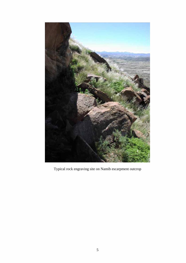
Typical rock engraving site on Namib escarpment outcrop
6
realized, due to shortcomings of literature, training and facilities. The same situation obtains at the national university, UNAM, where a short introductory module in archaeology and heritage studies is taught as part of the history course structure. UNAM cannot presently meet the need for trained archaeologists, nor can it give adequate support in this field to the school education system. The value of archaeological heritage in terms of school and university teaching has not been realized, and as a result, the economically useful functions of heritage management and academic research have not been realized. This has direct implications for the one area in which archaeological heritage does presently contribute to the national economy: tourism. There are four archaeological heritage sites in the Erongo Region that are proclaimed National Monuments: Philipp Cave, Ameib (Govt. Notice 119, 6/2/1951; Gazette No. 1575, 1/2/1951); Paula Cave, Omandumba West (Govt. Notice 165, 1/3/1951; Gazette No. 1581, 1/3/1951); Brandberg Monument Area (Govt. Notice 286, 1/8/1951; Gazette No. 1603, 1/8/1951); Bushman Paradise, Spitzkoppe (Govt.Notice 159, 1/7/1954; Gazette No. 1844, 1/7/1954). All are rock art sites: the first two are located on private farmland, while the second two are on State Land. The two farmland sites are unsupervised and the rock art has suffered from vandalism, but to a limited extent. The Bushman Paradise site, located at Spitzkoppe, has been severely vandalized; no management has been undertaken by the National Heritage Council, and there has been no regular monitoring of the site condition. The Brandberg, arguably Namibia’s premier rock art area, is largely protected by the difficulty of access to the rock art sites. One part, the Tsisab Ravine, which is home to the famous Maack (White Lady) Shelter, receives more than 15 000 visitors each year. After many years of neglect, management and visitor facilities were installed in 2005 under a European Community grant. The site is well supervised; the local guides are passably well trained, and the site is an important source of income for the local community. Tourism use of archaeological heritage sites is not confined to the proclaimed national monuments. A number of private farms in the Erongo Region are rich in rock art, especially, and include this as part of their visitor attraction. Private mountain guiding enterprises operate in the Brandberg and Spitzkoppe, and probably the Erongo, and these would include visits to rock art sites. Camping safaris also visit areas with rock art, sometimes with guided access to the rock art sites by local guides. On the coast, particularly in the !Khuiseb Delta, quad bike tours to archaeological sites are an established enterprise. None of this tourism use is regulated or in any way monitored by the National Heritage Council. All use of archaeological heritage sites, whether for research, education or tourism resorts under the authority of the National Heritage Council. However, the archaeological supervisory efforts of the Council are almost exclusively concerned with the control of legitimate research. In law, National Heritage Council permits are required for all use of archaeological sites (including tourism), although to date this provision has not been applied to any tourism operator or community enterprise. Likewise, the National Heritage Act requires that all national monument sites open to the public should have a site management plan in place. There are no management plans for any of the archaeological heritage sites in the Erongo Region.
1.3 Vulnerability of ARCHAEOLOGICAL HERITAGE to impacts caused by prospecting and mining: Despite the acknowledged global importance of the Namibian archaeological record (most particularly that of the Erongo Region), the sites and their remains have a long history of inadequate protection, many having been degraded or destroyed as a result of
7
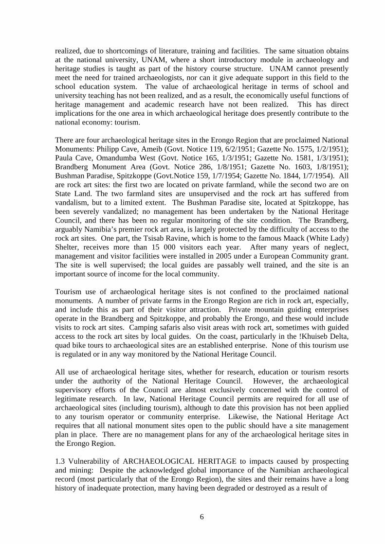
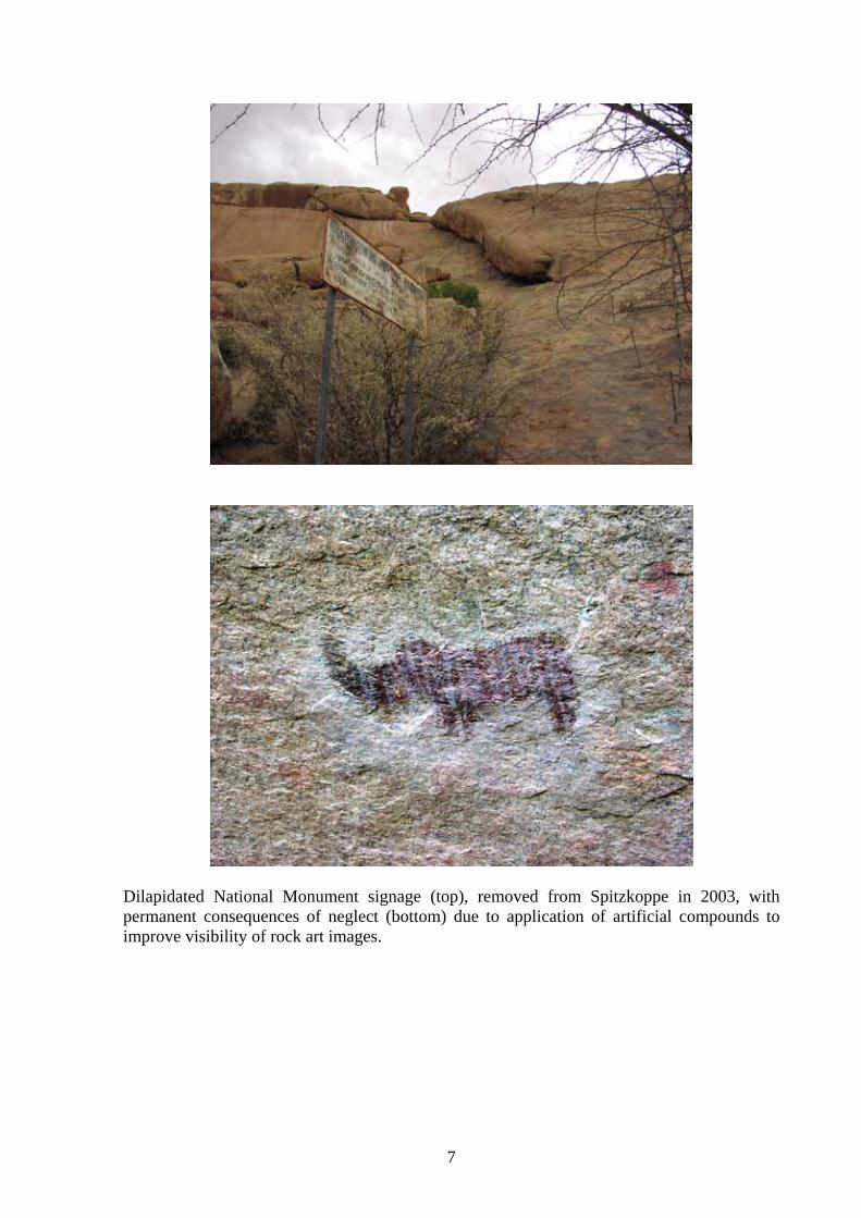
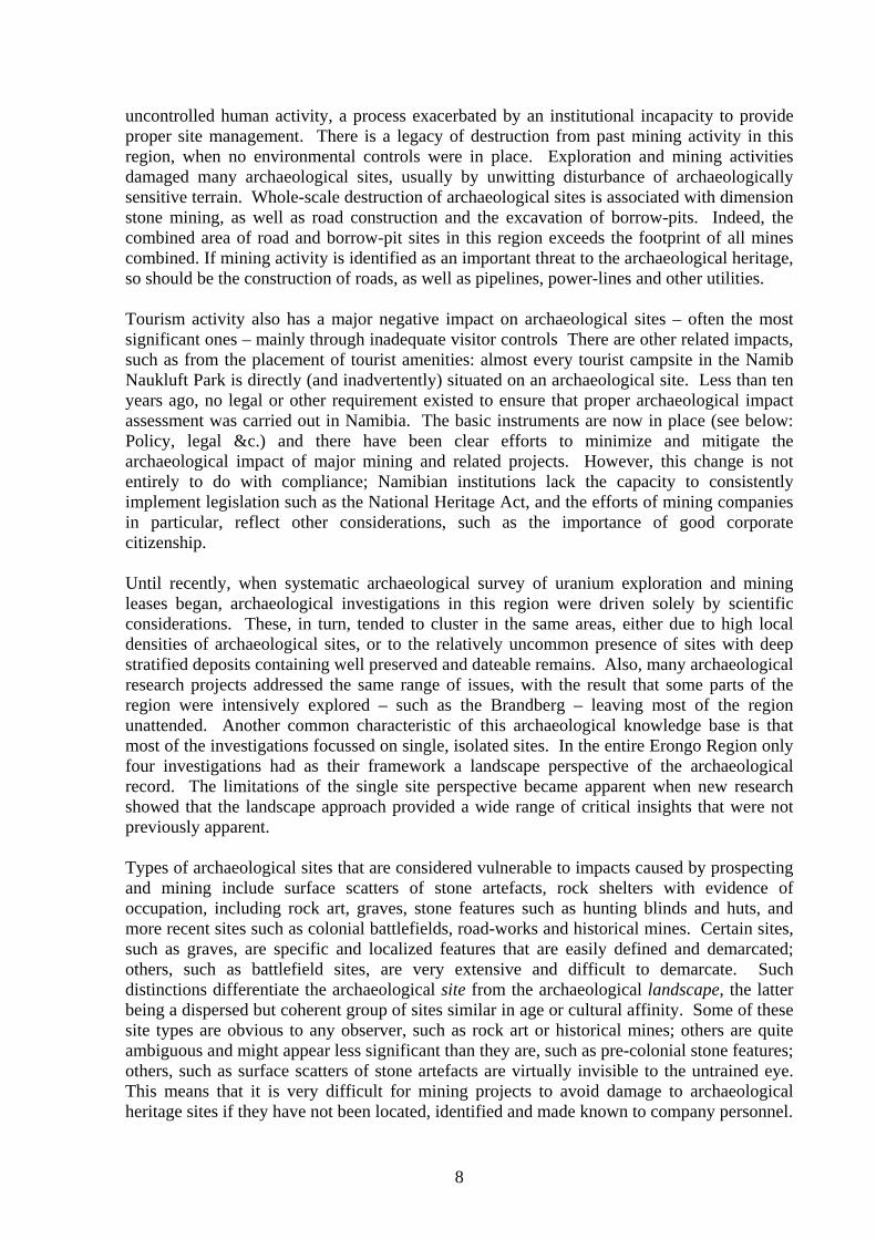
Dilapidated National Monument signage (top), removed from Spitzkoppe in 2003, with permanent consequences of neglect (bottom) due to application of artificial compounds to improve visibility of rock art images.
8
uncontrolled human activity, a process exacerbated by an institutional incapacity to provide proper site management. There is a legacy of destruction from past mining activity in this region, when no environmental controls were in place. Exploration and mining activities damaged many archaeological sites, usually by unwitting disturbance of archaeologically sensitive terrain. Whole-scale destruction of archaeological sites is associated with dimension stone mining, as well as road construction and the excavation of borrow-pits. Indeed, the combined area of road and borrow-pit sites in this region exceeds the footprint of all mines combined. If mining activity is identified as an important threat to the archaeological heritage, so should be the construction of roads, as well as pipelines, power-lines and other utilities. Tourism activity also has a major negative impact on archaeological sites – often the most significant ones – mainly through inadequate visitor controls There are other related impacts, such as from the placement of tourist amenities: almost every tourist campsite in the Namib Naukluft Park is directly (and inadvertently) situated on an archaeological site. Less than ten years ago, no legal or other requirement existed to ensure that proper archaeological impact assessment was carried out in Namibia. The basic instruments are now in place (see below: Policy, legal &c.) and there have been clear efforts to minimize and mitigate the archaeological impact of major mining and related projects. However, this change is not entirely to do with compliance; Namibian institutions lack the capacity to consistently implement legislation such as the National Heritage Act, and the efforts of mining companies in particular, reflect other considerations, such as the importance of good corporate citizenship. Until recently, when systematic archaeological survey of uranium exploration and mining leases began, archaeological investigations in this region were driven solely by scientific considerations. These, in turn, tended to cluster in the same areas, either due to high local densities of archaeological sites, or to the relatively uncommon presence of sites with deep stratified deposits containing well preserved and dateable remains. Also, many archaeological research projects addressed the same range of issues, with the result that some parts of the region were intensively explored – such as the Brandberg – leaving most of the region unattended. Another common characteristic of this archaeological knowledge base is that most of the investigations focussed on single, isolated sites. In the entire Erongo Region only four investigations had as their framework a landscape perspective of the archaeological record. The limitations of the single site perspective became apparent when new research showed that the landscape approach provided a wide range of critical insights that were not previously apparent. Types of archaeological sites that are considered vulnerable to impacts caused by prospecting and mining include surface scatters of stone artefacts, rock shelters with evidence of occupation, including rock art, graves, stone features such as hunting blinds and huts, and more recent sites such as colonial battlefields, road-works and historical mines. Certain sites, such as graves, are specific and localized features that are easily defined and demarcated; others, such as battlefield sites, are very extensive and difficult to demarcate. Such distinctions differentiate the archaeological site from the archaeological landscape, the latter being a dispersed but coherent group of sites similar in age or cultural affinity. Some of these site types are obvious to any observer, such as rock art or historical mines; others are quite ambiguous and might appear less significant than they are, such as pre-colonial stone features; others, such as surface scatters of stone artefacts are virtually invisible to the untrained eye. This means that it is very difficult for mining projects to avoid damage to archaeological heritage sites if they have not been located, identified and made known to company personnel.
9
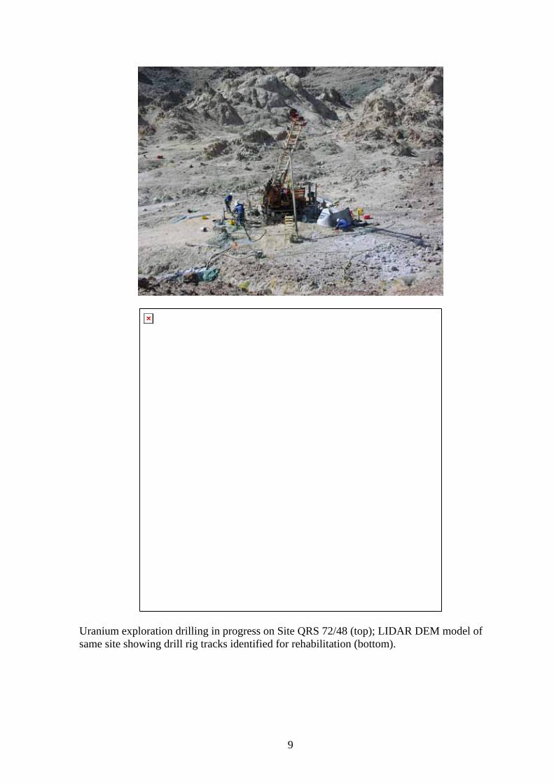
Uranium exploration drilling in progress on Site QRS 72/48 (top); LIDAR DEM model of same site showing drill rig tracks identified for rehabilitation (bottom).
10
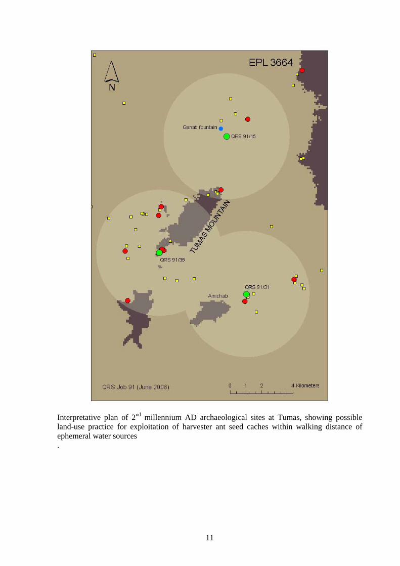
Consequently, it has become an increasingly regular practice to carry out archaeological survey and assessment of mining areas at the earliest possible stage of exploration. Archaeological sites are the material result of decisions by past human communities in the selection of places to live, to carry out certain rituals, to bury the dead, to quarry raw material for making stone artefacts, to ambush wild game for food, and to harvest edible plants. The resources on which people depend are unevenly distributed; some, such as lithic raw materials, have limited but fixed distributions, while others, such as plant and animal resources have a shifting, sometimes unpredictable distribution. Despite this complexity, archaeological site distributions are relatively predictable, especially in environments such as the Namib where a single determining factor – water – ultimately influenced every human decision. This means that it is possible to identify parts of the landscape which are likely to have a greater or lesser archaeological significance, depending on access to water, first of all, and the availability of shelter, game, raw materials and other needs, as secondary considerations. In landscape, or terrain, terms the following would be archaeologically important: granite outcrops and their surroundings; dolerite dykes, especially where these control the movement of game; river delta environments, where a mix of marine and terrestrial resources are within equal reach; isolated outcrops of sought-after material, such as chert; natural routes of movement across physical barriers such as mountain ranges or river gorges. These features are often identifiable from maps, both geological and topographic; aerial photographs, and satellite images, allowing potentially sensitive areas to be isolated prior to field survey. A considerable part of the Erongo Region is either under current uranium exploration and mining licences, or has licence applications pending. Detailed archaeological surveys have been carried out over a core group of licence areas, and this information, together with other available data provides a basis for identifying specific archaeological landscapes, relatively large land units, that are vulnerable to impacts from prospecting and mining3. Especially vulnerable are the granite outcrops and inselbergs associated with rock art and other evidence of hunter-gatherer occupation during the last 5 000 years. These are Spitzkoppe, Klein Spizkoppe, Blutkopje, Erongo and Brandberg. While it is possible that these areas will not be directly impacted, field surveys have shown that such features are surrounded by a wide zone of archaeological sensitivity, with significant site concentrations within 5km of the outcrop. A second landscape area that is considered highly vulnerable to impacts is the steppe zone stretching from Ebony in the east to Goanikontes in the west, and between Trekopje in the north and Husab in the south. The steppe zone is significant in that it contains unique evidence for the re-colonization of the Namib during the late Holocene. A third vulnerable zone is the area surrounding the Tumas Mountains, which contains well preserved evidence of hunter-gatherer occupation during the last 500 years. The fourth and final zone is the lower !Khuiseb River which contains a uniquely well preserved array of late pre-colonial sites with evidence of trade between indigenous communities and European merchants. The areas identified above have been examined and assessed in the field, either in the course of archaeological surveys for uranium projects, or as part of regional archaeological investigations. The uranium surveys are all reported in detail as part of environmental assessments, while the other investigations are for the most part reported in scientific publications. There are large areas under uranium exploration licences that have not been surveyed archaeologically, and although there is no direct empirical basis for identifying tem
3 see attached list under References
11
Interpretative plan of 2nd millennium AD archaeological sites at Tumas, showing possible land-use practice for exploitation of harvester ant seed caches within walking distance of ephemeral water sources .
12
as vulnerable, limited extrapolation from well surveyed areas suggests that the following are also vulnerable to impacts associated with uranium exploration and mining. The first area of concern is the lower Tumas drainage, extending as far as Aussinanis on the !Khuiseb River; the second is the large area of granite outcrop centring on Onanis near the eastern margin of the Namib; the third is the area between the Omaruru and Messum Rivers in the northwestern part of the Namib. 1.4 Vulnerability of ARCHAEOLOGICAL HERITAGE to Climate Change, and the value of archaeological heritage resources for understanding climate change: There appears to be no direct vulnerability, although the generally good preservation of archaeological remains in this area is partly attributable to the prevailing arid conditions. While it is possible that increased rainfall, leading to greater surface runoff, may contribute to impacts in the form of sheet erosion on surface archaeological sites, the drier, western parts of the region are in any case subject to episodic heavy rains. Likewise, increased humidity could lead to the deterioration of rock art that is considered to be well preserved as a consequence of the prevailing arid conditions. However, the specific effects of (probably rather slight) changes in humidity are not known. On the other end of the scale, a marked shift towards cool dry conditions could, if associated with larger regional trends, change the wind regime and sand transport budget of the region. In an extreme scenario this could lead to areas of well exposed archaeology being covered by drift sand, but such conditions do occasionally arise in the Namib, only to be reversed by the countervailing effects of seasonal shifts in wind regime. In general, therefore, the archaeological heritage is not considered as vulnerable to climate change. Archaeological heritage resources have a possibly unique value as proxy evidence for climate change, especially under the extremely arid conditions of the Erongo Region. Most of this environment, and especially the western parts, can be characterized as a rainfall event driven system. North of the !Khuiseb River, prevailing rainfall conditions are directly linked to seasonal ITCZ penetration of southwestern Africa, and the episodic influence of equatorial BSO events. The rainfall gradient of the region is reflected by a steep westward decrease in annual precipitation, accompanied by a very steep increase in the variation from the annual means, such that rainfall in the Namib is both statistically unpredictable. So dry are conditions in the times between rainfall events that the record of human occupation of the Namib since the Pleistocene may be considered a useful proxy for short-term climatic amelioration. The value of the archaeological record as a proxy palaeoclimatic record is well understood in other desert regions of the world, and in the Namib, the available radiocarbon evidence shows clear local responses to specific global events. Indeed, it appears that the local record is particularly responsive to changes in northern hemisphere ice sheet extent, as well as to southern hemisphere sea surface temperature changes. The Namib paleoclimatic record, of which the archaeological sequence forms a significant part, represents the only concrete evidence of environmental responses to climate change in this region. 2. CURRENT SITUATION: 2.1 Status of ARCHAEOLOGICAL HERITAGE (conservation, political and local awareness, distribution of sites/specimens, rarity value, etc.): During the last five years, detailed archaeological surveys and impact assessments have been carried out on many of the major uranium exploration leases in the western part of the Erongo Region. Surveys and assessments have been carried out on all of the leases where exploration has advanced to the development feasibility stage, or to the stage of actual mining and production. Furthermore, archaeological surveys and assessments have been carried out for a wide range of mining-
13
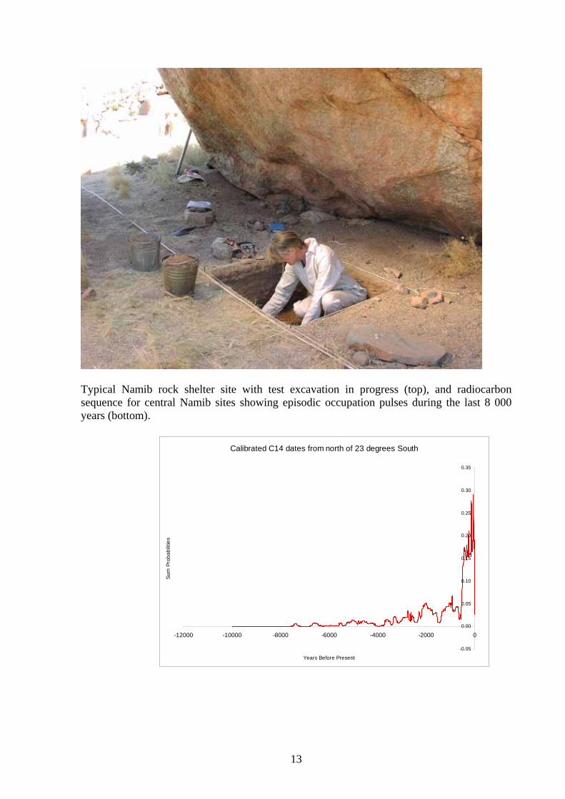
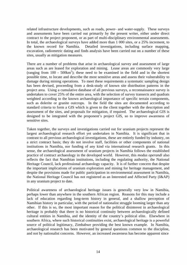
Typical Namib rock shelter site with test excavation in progress (top), and radiocarbon sequence for central Namib sites showing episodic occupation pulses during the last 8 000 years (bottom).
Calibrated C14 dates from north of 23 degrees South
-0.05
0.00
0.05
0.10
0.15
0.20
0.25
0.30
0.35
-12000 -10000 -8000 -6000 -4000 -2000 0
Years Before Present
Sum
Pro
babi
litie
s
14
related infrastructure developments, such as roads, power- and water-supply. These surveys and assessments have been carried out primarily by the present writer, either under direct contract to the project proponent, or as part of multi-disciplinary environmental assessments. In total, the archaeological surveys have added more than 1 000 sites, or a 25% increment, to the known record for Namibia. Detailed investigations, including surface mapping, excavation, radiometric dating and finds analysis have been carried out on a number of these sites, usually as mitigation measures. There are a number of problems that arise in archaeological survey and assessment of large areas such as are leased for exploration and mining. Lease areas are commonly very large (ranging from 100 - 500km2); these need to be examined in the field and in the shortest possible time, to locate and describe the most sensitive areas and assess their vulnerability to damage during mining operations. To meet these requirements a systematic sampling design has been devised, proceeding from a desk-study of known site distribution patterns in the project area. Using a cumulative database of all previous surveys, a reconnaissance survey is undertaken to cover 25% of the entire area, with the selection of survey transects and quadrats weighted according to the known archaeological importance of specific terrain components, such as dolerite or granite outcrops. In the field the sites are documented according to standard criteria to form a GIS which is given to the client together with the description and assessment of the sites, and proposals for mitigation, if required. The archaeological GIS is designed to be integrated with the proponent’s project GIS, so to improve awareness of sensitive sites. Taken together, the surveys and investigations carried out for uranium projects represent the largest archaeological research effort yet undertaken in Namibia. It is significant that in contrast to all previous archaeological investigations, these are entirely funded by industry, on a strict contract basis; they do not involve staff, facilities or other components of national institutions in Namibia, nor funding of any kind via international research grants. In this sense, the archaeological assessment of uranium projects in Namibia follows the established practice of contract archaeology in the developed world. However, this modus operandi also reflects the fact that Namibian institutions, including the regulating authority, the National Heritage Council, lack professional archaeology capacity. It is of further concern that despite the important implications of uranium exploration and mining for heritage management, and despite the provisions made for public participation in environmental assessment in Namibia, the National Heritage Council has not registered as an Interested and Affected Party (I&AP) in any uranium project to date. Political awareness of archaeological heritage issues is generally very low in Namibia, perhaps lower than anywhere in the southern African region. Reasons for this may include a lack of education regarding long-term history in general, and a shallow perception of Namibian history in particular, with the period of nationalist struggle looming larger than any other. If this is so, the most important reason for the political disinterest in archaeological heritage is probably that there is no historical continuity between archaeologically defined cultural entities in Namibia, and the identity of the country’s political elite. Elsewhere in southern Africa, where such historical continuities exist, archaeological heritage is a powerful source of political legitimacy, Zimbabwe providing the best known example. In Namibia, archaeological research has been motivated by general questions common to the discipline, and not by nationalist concerns. However, an increased awareness has become apparent since
15
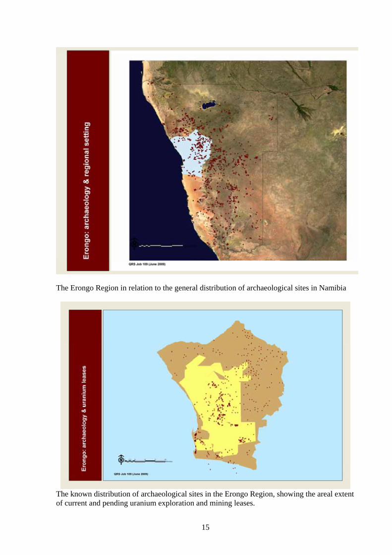
The Erongo Region in relation to the general distribution of archaeological sites in Namibia
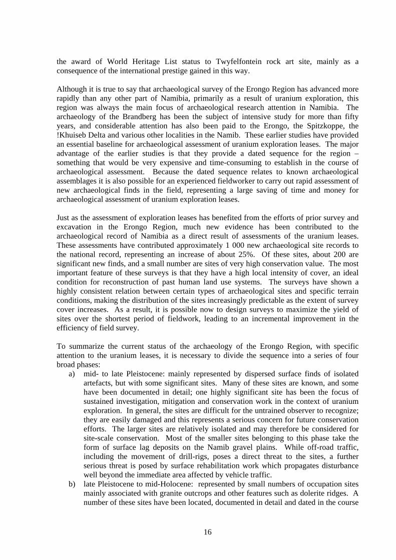
The known distribution of archaeological sites in the Erongo Region, showing the areal extent of current and pending uranium exploration and mining leases.
16
the award of World Heritage List status to Twyfelfontein rock art site, mainly as a consequence of the international prestige gained in this way. Although it is true to say that archaeological survey of the Erongo Region has advanced more rapidly than any other part of Namibia, primarily as a result of uranium exploration, this region was always the main focus of archaeological research attention in Namibia. The archaeology of the Brandberg has been the subject of intensive study for more than fifty years, and considerable attention has also been paid to the Erongo, the Spitzkoppe, the !Khuiseb Delta and various other localities in the Namib. These earlier studies have provided an essential baseline for archaeological assessment of uranium exploration leases. The major advantage of the earlier studies is that they provide a dated sequence for the region – something that would be very expensive and time-consuming to establish in the course of archaeological assessment. Because the dated sequence relates to known archaeological assemblages it is also possible for an experienced fieldworker to carry out rapid assessment of new archaeological finds in the field, representing a large saving of time and money for archaeological assessment of uranium exploration leases. Just as the assessment of exploration leases has benefited from the efforts of prior survey and excavation in the Erongo Region, much new evidence has been contributed to the archaeological record of Namibia as a direct result of assessments of the uranium leases. These assessments have contributed approximately 1 000 new archaeological site records to the national record, representing an increase of about 25%. Of these sites, about 200 are significant new finds, and a small number are sites of very high conservation value. The most important feature of these surveys is that they have a high local intensity of cover, an ideal condition for reconstruction of past human land use systems. The surveys have shown a highly consistent relation between certain types of archaeological sites and specific terrain conditions, making the distribution of the sites increasingly predictable as the extent of survey cover increases. As a result, it is possible now to design surveys to maximize the yield of sites over the shortest period of fieldwork, leading to an incremental improvement in the efficiency of field survey. To summarize the current status of the archaeology of the Erongo Region, with specific attention to the uranium leases, it is necessary to divide the sequence into a series of four broad phases:
a) mid- to late Pleistocene: mainly represented by dispersed surface finds of isolated artefacts, but with some significant sites. Many of these sites are known, and some have been documented in detail; one highly significant site has been the focus of sustained investigation, mitigation and conservation work in the context of uranium exploration. In general, the sites are difficult for the untrained observer to recognize; they are easily damaged and this represents a serious concern for future conservation efforts. The larger sites are relatively isolated and may therefore be considered for site-scale conservation. Most of the smaller sites belonging to this phase take the form of surface lag deposits on the Namib gravel plains. While off-road traffic, including the movement of drill-rigs, poses a direct threat to the sites, a further serious threat is posed by surface rehabilitation work which propagates disturbance well beyond the immediate area affected by vehicle traffic.
b) late Pleistocene to mid-Holocene: represented by small numbers of occupation sites mainly associated with granite outcrops and other features such as dolerite ridges. A number of these sites have been located, documented in detail and dated in the course
17
of assessment of uranium exploration leases. As single sites these are sometimes quite insignificant, but as survey cover increases it becomes apparent that they are best understood as local groups. Dating of these sites is critical to their interpretation because occupations in this phase leave almost identical traces, even if separated by several thousand years. These sites provide crucial evidence relating to the mid-Holocene climatic optimum and are therefore of high conservation importance. The sites are sometimes recognizable by the untrained observer; they are very easily damaged and could be considered as candidates for landscape-scale conservation initiatives.
c) late Holocene: represented by extensive networks of occupation sites, widely spread over the eastern parts of the Namib, i.e the central Erongo Region. The occupation sites, sometimes associated with rock art, well-preserved and stratified deposits, and related features such as graves and hunting blinds, represent a major archaeological asset. The sites dating to within the last 1 000 years are associated with very high local densities of sites related to grass seed and honey collecting. Archaeological remains on these sites are often very well preserved and thus allow detailed investigation of past human environmental relations. The main occupation sites are relatively easy to find and are therefore highly vulnerable to uncontrolled looting of artefacts, including pottery, metal objects and trade items such as glass beads. The peripheral sites such as seed diggings are difficult for the untrained observer to recognize and are therefore easily damaged in the course of exploration activity. Field orientation sessions with exploration staff and contractors have proven successful on several projects, as a means to sensitize workers to these sites.
d) early Historical/Colonial: represented by isolated settlement sites, military posts, burials and linear works such as tracks and earthworks. The majority of the sites in the uranium mining leases are associated with early German colonial military activity, and the South African invasion campaign of 1915. These sites include some well preserved military encampments, entrenchments, artillery defences, and other works which may be used to define landscape-scale sites such as battlefields. The individual sites are often of low significance, but together they provide a uniquely coherent grouping that is of considerable historical value. Old mine sites such as the Khan and Annandale mines are also of historical importance, and although these sites have been extensively damaged in recent years, they still have considerable potential as educational and tourism assets.
2.2 POLICY AND LEGAL FRAMEWORK 2.2.1 Namibian legislation and standards relevant to ARCHAEOLOGICAL HERITAGE. The four legal instruments currently available for the protection of archaeological heritage sites in Namibia are as follows below. It should be noted that none of these laws yet have gazetted regulations for assessment of impacts on archaeological heritage sites. The National Heritage Act (27 of 2004): The Act provides legal protection for heritage resources; makes provision for archaeological impact assessment, and for the promulgation of heritage conservation areas. The Act has no regulations or guidelines for impact assessment and the national register of heritage sites, required under the Act, is yet to be fully implemented. The Act repeals the National Monuments Act (28 of 1969) and all subsequent amendments. The Environmental Management Act (7 of 2007): The Act provides for conservation of archaeological heritage resources by including “anthropogenic factors and elements” in its definition of environment. This means that properly comprehensive environmental
18
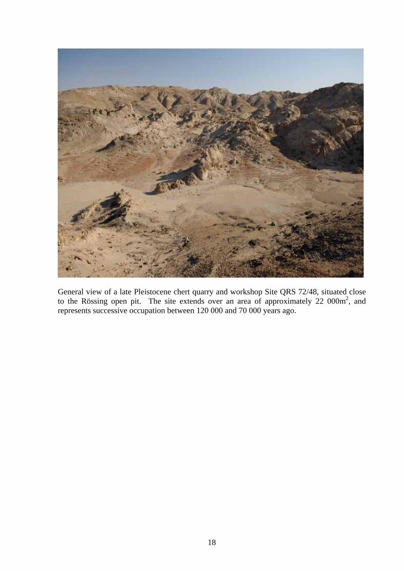
General view of a late Pleistocene chert quarry and workshop Site QRS 72/48, situated close to the Rössing open pit. The site extends over an area of approximately 22 000m2, and represents successive occupation between 120 000 and 70 000 years ago.
19
assessment should include the archaeological heritage, thus providing a second line of legal protection. The War Graves and National Monuments Amendment Act (11 of 1986): The Act which provided for the protection of war graves seems to have been repealed and this leaves the status of the grave sites somewhat uncertain. The graves are tended by a special interest group which also maintains a database of the sites. Ordinance 27 of 1968: This provides for the protection of graves in general, although it is uncertain if the Ordinance is still in force. 2.2.2 International legislation and standards relevant to ARCHAEOLOGICAL HERITAGE. The only framework applicable to Namibia is that of the various UNESCO conventions and recommendations for the protection of cultural heritage. Namibia has ratified four UNESCO conventions: the 1972 convention on World Heritage; the 2003 convention on the protection of intangible cultural heritage, and the 2005 convention on the protection of cultural diversity. Conventions that were agreed before Namibian independence (e.g. the 1972 World Heritage Convention) have to be individually ratified by member states, and Namibia is in the process of ratifying two further conventions that elate to the protection of underwater cultural heritage. As a member state of the UNESCO Council, Namibia is bound by the various Recommendations of UNESCO, and the most important of those as regards the protection of archaeological heritage are:
a) Recommendation on International Principles Applicable to Archaeological Excavations (5 December 1956). The General Principles of this agreement are closely paralleled by the provisions of the National Heritage Act (27 of 2004), and it should therefore be possible for the Namibian Attorney General to approve ratification of the agreement.
b) Recommendation concerning the Safeguarding of the Beauty and Character of Landscapes and Sites (11 December 1962). The General Principles and Protective Measures of this agreement are highly relevant to the situation arising in the Namib as a result of the Uranium Rush. The agreement addresses issues of landscape integrity that are apparently ignored by Namibian legislation.
c) Recommendation concerning the Preservation of Cultural Property Endangered by Public or Private Works (19 November 1968). The Recommendation sets out procedures for the identification of archaeological heritage sites as components of the cultural landscape and is therefore a useful complement to Namibian legislation.
d) Recommendation concerning the Protection, at National Level, of the Cultural and Natural Heritage (16 November 1972). The Recommendation sets out the need for national policy to coordinate national institutions for the greatest efficiency in cultural heritage protection.
In addition to these agreements and recommendations there are two specifically archaeological instruments that are relevant to the protection of archaeological heritage in Namibia:
a) The Burra Charter (23 February 1981; revised 1988, 1999) sets out basic principles for the conservation of archaeological sites.
b) The Vermillion Accord (1989), agreed by the World Archaeological Congress as a framework for archaeological management of burial places and human remains.
2.3 INSTITUTIONAL FRAMEWORK (relating to the management of ARCHAEOLOGICAL HERITAGE)
20
2.3.1. International organization(s)/networks: Among the few such organizations relevant to the archaeological heritage in Namibia are ICOMOS (International Council on Museums and Sites), and ICCROM (International Centre for the Study of the Preservation and Restoration of Cultural Property). Both are non-governmental bodies that provide a measure of coordination, policy advice and training, mainly aimed at the assistance of national authorities. Professional networks exist in the formal international sense, such as WAC (World Archaeological Congress); the Panafrican Association for Prehistory and Related Fields; the International Union of Pre- and Protohistoric Sciences; and ASAPA, the Association of Southern African Professional Archaeologists.
2.3.2. National government: in Namibia, the two most important institutions are the National Museum which is the legal repository of archaeological heritage material and documentation, and the National Heritage Council which is the authority responsible for the implementation of the National Heritage Act. One of the more important functions of the National Heritage Council is the establishment and maintenance of the Namibian Heritage Register. This function is not yet in operation, and the National Heritage Council has not appointed professional staff with the requisite training to carry this out.
2.3.3. Regional government in Namibia follows national government directives and does not appear to have any specific functions or discretionary powers with regard to archaeological heritage.
2.3.4. Local government, as above. 2.3.5. CBOs (Community-based Organizations) are important in the local
management of archaeological heritage sites. In the Erongo Region, two conservancies have direct control over archaeological heritage sites: the Tsisab Conservancy manages the Brandberg Monument Area under supervision of the National Heritage Council, and the Gaingos Conservancy manages the Spitzkoppe sites without supervision. The management of the Brandberg Area may be considered a qualified success, but not that of the Spitzkoppe which has resulted in degradation of the rock art sites mainly through vandalism and poorly managed tourist access. The Topnaar community in the lower !Khuiseb River has a cultural heritage foundation, but the prime archaeological sites relating to the Topnaar heritage are effectively under the control of private tourism operators in Walvis Bay. The present status of the !Khuiseb sites is unknown.
2.3.6. NGOs (Non-governmental Organizations): the only registered organization is the Namibia Archaeological Trust (NAT), which was established in 1991 to further research, education and conservation initiatives dealing with archaeological heritage. The NAT has coordinated a range of research and training projects; it has produced several archaeological publications and has organized a regional archaeological conference in Namibia. The NAT has worked in partnership with community-level organizations in the training of local guides on archaeological sites. To further the conservation of archaeological heritage, the NAT established Quaternary Research Services (QRS) as an archaeological consultancy, and has recently launched the Namib Desert Archaeological Survey as a major project to coordinate research.
2.3.7. Donors: there are at present no donor organizations directly supporting archaeological heritage research or conservation in the Erongo Region.
2.3.8. Private sector support for archaeological heritage research and conservation in the Erongo Region is mainly in the form of archaeological
21
contract services to the mining and related infrastructure sectors. Payment for these services contributes to the operations of the Namibia Archaeological Trust.
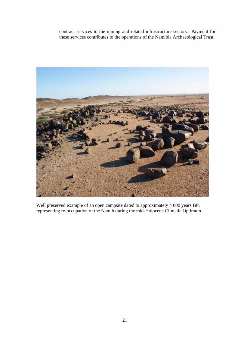
Well preserved example of an open campsite dated to approximately 4 000 years BP, representing re-occupation of the Namib during the mid-Holocene Climatic Optimum.
22
3. STAKEHOLDER ISSUES AND CONCERNS Stakeholder awareness of archaeological heritage issues is highly uneven in Namibia. Members of the general public do occasionally raise heritage issues in project public participation meetings, but these are rarely taken beyond formal notification. The perception is that for the public there are two major issues: employment and health, when it comes to uranium projects. The lack of concern is not uniform, however; while archaeological heritage might not be raised at a public meeting in Usakos, it may well arise in Swakopmund. One reason for this could be that environmental consultants (project coordinators) spend insufficient time informing the public; the public participation process seems to provide the absolute minimum information prior to meetings, probably because the project proponent would prefer to have as little information as possible in the public domain. Unsurprisingly, members of the public often see public participation meetings as project “PR”, rather than open opportunities to raise concerns. The Namibian authorities have limited awareness of archaeological heritage issues, but this is changing quite rapidly as archaeological heritage becomes a routine component of environmental assessment. The major responsibility for archaeological heritage lies with the National Heritage Council which has until now shown little inclination to participate as a stakeholder in the environmental assessment process. It appears that the Heritage Council sees itself as an authority that must be consulted and approached for permission to carry out works that have implications under the Heritage Act. The few instances in which the Council has involved itself in heritage assessment have created misunderstanding on the part of developers, and contributed to a generally negative perception of the Council. Where the Council has invited public comment on issues that affect archaeological heritage this has been done without providing the background material that the public needs in order to make an informed contribution. Clearly, there is a need for the Council to develop a more open approach to public participation. As stakeholders, environmental practitioners have until recently shown limited awareness of archaeological heritage issues. There are two reasons for this change: first, the promulgation of the National Heritage Act in 2004 clearly set out provisions for archaeological heritage assessment, making it relatively simple to include the field in the scope of impact assessment; second, Namibia has an established, but slowly changing tradition of conservationist approaches to the environment which see the human presence as a negative influence rather than an integral part of the environment. Archaeologists now increasingly form part of the stakeholder group comprising environmental practitioners in general, and this is contributing to a better appreciation of multi-disciplinary approaches to impact assessment. As stakeholders, environmental practitioners have limited freedom to comment publicly on the proposals of the mining industry, a significant employer of environmental expertise. Mining companies have in some respects behaved as model stakeholders in the field of archaeological heritage. This relatively recent development has much to do with the need felt by uranium companies to avoid controversy. This is turn, relates to the fact that uranium companies operating in Namibia are linked with holding companies in Australia and Canada, where the negative consequences of damage to the archaeological heritage have affected the public image of all uranium mining companies. The counterpart to this is seen in the approach of South African-based exploration firms which have not considered archaeological heritage issues, although where the South African firms are partners or contractors in multi-national projects they seem to adapt very quickly to the prevailing
23
approach. As the uranium industry in Namibia diversifies to include Asian and other participants it may become difficult to see the mining sector as a single stakeholder group with a common set of values. The establishment of the Uranium Stewardship Council is a key initiative that may help to maintain some cohesion in the industry when it comes to issues such as archaeological heritage.
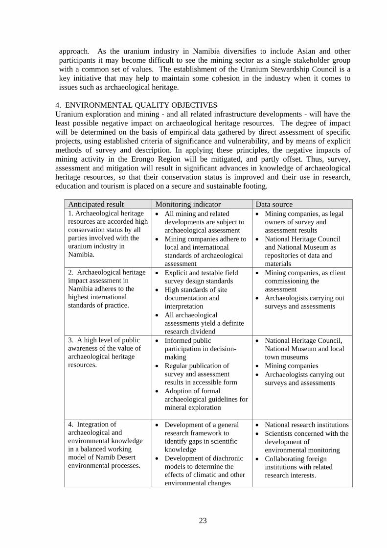
4. ENVIRONMENTAL QUALITY OBJECTIVES Uranium exploration and mining - and all related infrastructure developments - will have the least possible negative impact on archaeological heritage resources. The degree of impact will be determined on the basis of empirical data gathered by direct assessment of specific projects, using established criteria of significance and vulnerability, and by means of explicit methods of survey and description. In applying these principles, the negative impacts of mining activity in the Erongo Region will be mitigated, and partly offset. Thus, survey, assessment and mitigation will result in significant advances in knowledge of archaeological heritage resources, so that their conservation status is improved and their use in research, education and tourism is placed on a secure and sustainable footing.
Anticipated result Monitoring indicator Data source 1. Archaeological heritage resources are accorded high conservation status by all parties involved with the uranium industry in Namibia.
• All mining and related developments are subject to archaeological assessment
• Mining companies adhere to local and international standards of archaeological assessment
• Mining companies, as legal owners of survey and assessment results
• National Heritage Council and National Museum as repositories of data and materials
2. Archaeological heritage impact assessment in Namibia adheres to the highest international standards of practice.
• Explicit and testable field survey design standards
• High standards of site documentation and interpretation
• All archaeological assessments yield a definite research dividend
• Mining companies, as client commissioning the assessment
• Archaeologists carrying out surveys and assessments
3. A high level of public awareness of the value of archaeological heritage resources.
• Informed public participation in decision-making
• Regular publication of survey and assessment results in accessible form
• Adoption of formal archaeological guidelines for mineral exploration
• National Heritage Council, National Museum and local town museums
• Mining companies • Archaeologists carrying out
surveys and assessments
4. Integration of archaeological and environmental knowledge in a balanced working model of Namib Desert environmental processes.
• Development of a general research framework to identify gaps in scientific knowledge
• Development of diachronic models to determine the effects of climatic and other environmental changes
• National research institutions • Scientists concerned with the
development of environmental monitoring
• Collaborating foreign institutions with related research interests.
24
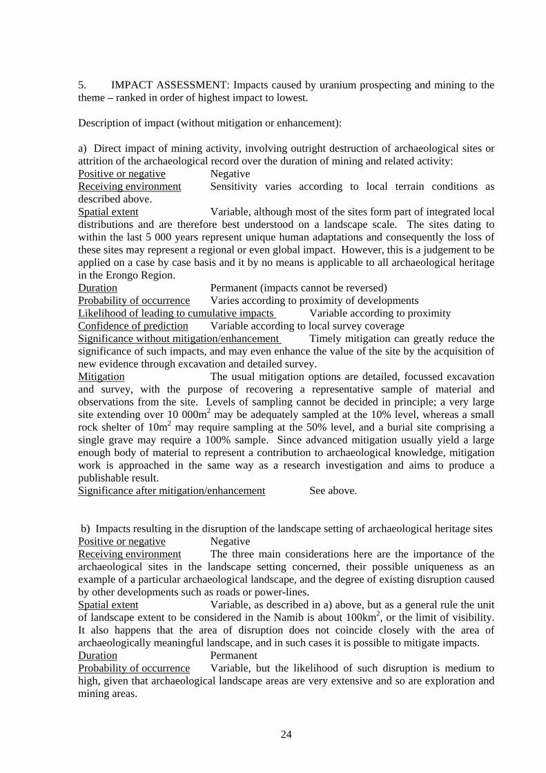
5. IMPACT ASSESSMENT: Impacts caused by uranium prospecting and mining to the theme – ranked in order of highest impact to lowest.
Description of impact (without mitigation or enhancement): a) Direct impact of mining activity, involving outright destruction of archaeological sites or attrition of the archaeological record over the duration of mining and related activity: Positive or negative Negative Receiving environment Sensitivity varies according to local terrain conditions as described above. Spatial extent Variable, although most of the sites form part of integrated local distributions and are therefore best understood on a landscape scale. The sites dating to within the last 5 000 years represent unique human adaptations and consequently the loss of these sites may represent a regional or even global impact. However, this is a judgement to be applied on a case by case basis and it by no means is applicable to all archaeological heritage in the Erongo Region. Duration Permanent (impacts cannot be reversed) Probability of occurrence Varies according to proximity of developments Likelihood of leading to cumulative impacts Variable according to proximity Confidence of prediction Variable according to local survey coverage Significance without mitigation/enhancement Timely mitigation can greatly reduce the significance of such impacts, and may even enhance the value of the site by the acquisition of new evidence through excavation and detailed survey. Mitigation The usual mitigation options are detailed, focussed excavation and survey, with the purpose of recovering a representative sample of material and observations from the site. Levels of sampling cannot be decided in principle; a very large site extending over 10 000m2 may be adequately sampled at the 10% level, whereas a small rock shelter of 10m2 may require sampling at the 50% level, and a burial site comprising a single grave may require a 100% sample. Since advanced mitigation usually yield a large enough body of material to represent a contribution to archaeological knowledge, mitigation work is approached in the same way as a research investigation and aims to produce a publishable result. Significance after mitigation/enhancement See above.
b) Impacts resulting in the disruption of the landscape setting of archaeological heritage sites Positive or negative Negative Receiving environment The three main considerations here are the importance of the archaeological sites in the landscape setting concerned, their possible uniqueness as an example of a particular archaeological landscape, and the degree of existing disruption caused by other developments such as roads or power-lines. Spatial extent Variable, as described in a) above, but as a general rule the unit of landscape extent to be considered in the Namib is about 100km2, or the limit of visibility. It also happens that the area of disruption does not coincide closely with the area of archaeologically meaningful landscape, and in such cases it is possible to mitigate impacts. Duration Permanent Probability of occurrence Variable, but the likelihood of such disruption is medium to high, given that archaeological landscape areas are very extensive and so are exploration and mining areas.
25
Likelihood of leading to cumulative impacts As above, fairly high Confidence of prediction Depends on local survey coverage Significance without mitigation/enhancement Mitigation in the context of landscape disruption would involve excluding or effectively hiding intrusive developments. There are few opportunities for either, since economics usually dictate the location of developments, and the Namib environment does not generally allow developments to be concealed. Mitigation In the case of a highly significant archaeological landscape it may be possible to use an estimation of the educational or tourism value of the pristine archaeological landscape as a comparative unit when considering the economics of routing a road or power-line according to different options. Significance after mitigation/enhancement The significance of disruptive impacts could be greatly reduced by appropriate design.
c) Impacts resulting from increased and uncontrolled access to archaeological sites Positive or negative Mainly negative, but some positive impacts could result from implementation of visitor management strategies. Receiving environment Most archaeological sites are highly sensitive to human traffic, and often suffer from the effects of trampling and soil erosion. Rock art sites are particularly sensitive to the effects of dust. Vandalism and looting are serious concerns, even where access is supervised. Spatial extent The spatial extent of impact is generally limited to the site, usually an area of less than 5ha. However, unusual or unique archaeological sites may if damaged result in a more extensive impact in terms of the loss of material and information from the archaeological record in general. It is for this reason that unique sites should not be used for purposes of tourism/ Duration Permanent Probability of occurrence Uncontrolled access invariably results in damage to the site Likelihood of leading to cumulative impacts Very high, mainly as a result of repeated visits Confidence of prediction Medium to high, depending on whether the site is being monitored or not. Significance without mitigation/enhancement The significance of such impacts is directly proportional to the value or importance of the site. Mitigation The mitigation strategy of choice is to limit access to the site and place all access under direct supervision. If an archaeological site is to be opened for public access, the provisions of the Burra Charter should be implemented as far as is practically feasible. Significance after mitigation/enhancement Significance of impacts can be greatly reduced through appropriate mitigation.
6. CUMULATIVE IMPACTS i. Key cumulative (negative) impacts (within the theme and between this, and other
themes): The most critical impact for archaeological heritage is the cumulative loss of archaeological sites and landscape as exploration and mining advances. With this cumulative loss, the value of remaining archaeological resources increases. This is also a matter for concern because archaeological surveys of mining leases are carried out under pressure of time and do not extract the maximum information from the sites. Furthermore, archaeological methods are constantly improving and it is likely that the potential of some sites will be higher
26
in the future. This may result in higher cumulative impacts than currently estimated.
ii. Opportunities for optimizing synergy within the theme and between this, and other themes: There may be possibilities for identifying specific areas that merit conservation on archaeological as well as other grounds and this could strengthen the case for setting aside places where exploration and mining would be prohibited. These areas need not necessarily lie within mining leases if the industry could be persuaded to invest resources in offset benefits for archaeological heritage in the region. For example, it should be possible to identify a series of representative archaeological “reserves” where the mining industry could support conservation and research in compensation for the loss of archaeological heritage resources within the mining lease areas. A common optimizing synergy for archaeological conservation is tourism, but this should be approached with care, for poorly managed tourism (e.g. community tourism and national monuments) can have the unintended result of simply accelerating the destruction of archaeological sites. Any such synergy will therefore require careful management.
iii. Opportunities for minimizing cumulative impacts within the theme and between this, and other themes: Optimizing synergies will help to minimize impacts but these need to be considered in broad view rather than on a project by project basis. Archaeological surveys have been carried out over most of the uranium exploration and mining leases in the Namib and proposals to minimize impacts have been implemented in a number of cases. Now, the results of these surveys are being combined under the umbrella of the Namib Desert Archaeological Survey Project which will allow a general assessment of archaeological resources, research opportunities and identification of potential offset reserves. The value of the Survey Project is that it creates a “knowledge offset” instead of, or in addition to physical offsets in the form of reserve areas. One of the functions of the Survey Project is to identify the regional archaeological value of heritage resources, so that mitigation or any other attempt to minimize cumulative impacts is carried out in a broader framework than the individual mining project.
iv. Expected Antagonistic Impacts – i.e. impacts that are impossible to mitigate and that will definitely work against the success of some other sector or project: None anticipated.
7. CONCLUSIONS AND RECOMMENDATIONS 7.1. SUSTAINABILITY ANALYSIS
a. The ‘best case scenario’ is as set out below: Uranium exploration and mining - and all related infrastructure developments - will have the least possible negative impact on archaeological heritage resources. The degree of impact will be determined on the basis of empirical data gathered by direct assessment of specific projects, using established criteria of significance and vulnerability, and by means of explicit methods of survey and description. In applying these principles, the negative impacts of mining activity in the Erongo Region will be mitigated, and partly offset. Thus, survey, assessment and mitigation will result in significant advances in knowledge of archaeological heritage resources, so that their conservation status is improved and their use in research, education and tourism is placed on a secure and sustainable footing. There will be diminishing scope for this scenario if the number of mines escalates to the maximum expected, and if these developments lead to uncontrolled decommissioning.
27
However, if the number of mines increases to the maximum there would also be greater pressure on the industry to implement conservation strategies. This would be all the more likely if the Uranium Stewardship Council was able to set a common standard for members, and if the ownership and control of uranium mining operations in Namibia was rationalized through amalgamation of mines, resulting in a small group of large operations rather than the large (and increasing) group of variable-sized operations as exists at present.
b. Key indicators of success are as set out in the table under 4. Environmental Quality Objectives.
c. Key conditions/requirements for success: i. Institutional reform and partnerships: Adequate staffing of National
Heritage Council; development and adoption of archaeological heritage guidelines for mineral exploration and mining.
ii. Policy and legal reform: Adoption of key UNESCO Recommendations.
iii. Governance improvements: Informed and technically competent handling of archaeological permit applications and assessment reports.
iv. Capacity building needs: Appointment of appropriately trained staff at key government institutions.
v. Environmental safeguards: Timely archaeological heritage survey and assessment; integration of archaeological heritage conservation needs into exploration and mining activities.
7.2. ENVIRONMENTAL GUIDELINES (Best Practice advice)
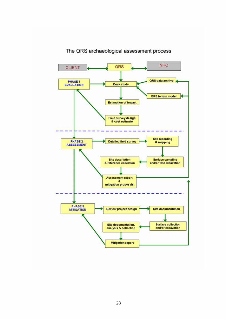
In the absence of formal regulations to the National Heritage Act, it is necessary for archaeologists and mining company clients to operate as they think best. For archaeologists this is a matter of balancing the need for a credible impact assessment against the economics of mineral exploration. The archaeological assessment has to be robust and well based on field evidence, sufficient to withstand critical scrutiny in the archaeology profession. At the same time, the assessment has often to form part of a multi-disciplinary environmental study which may impose constraints of time and money, and as increasingly happens, formats of analysis and reporting that are not necessarily appropriate to the field. The lack of formal regulations for archaeological assessment is an opportunity rather than a constraint. The circumstances of the “uranium rush” in Namibia have posed challenges for all specialist fields involved in environmental assessment, and in the case of archaeology this has lead to the development of a suite of methods and a general approach resulting from lessons learned over a large number of projects. This modus operandi, summarized below, will form the basis of a set of formal Archaeological Guidelines or Mineral Exploration and Mining in the Namib Desert, one of the anticipated results of the Namib Desert Archaeological Survey Project outlined above. The archaeological assessment process (see diagram below) devised as a result of demands experienced by the “uranium rush” consists of three phases. The archaeologist (in this case QRS) may act as intermediary between the client or project proponent, and the National Heritage Council, by facilitating permit applications and other communications. This arrangement has worked well when the Heritage Council secretariat operates efficiently, although it has the distinct disadvantage that project proponents do not have the opportunity to work directly with the Heritage Council.
28
29
Phase 1 of the archaeological assessment process is an evaluation or desk study which aims to estimate the likely scale of archaeological impact and using existing data resources, design a field survey with an estimate of costs. Intrinsic to this process is the use of the accumulating archaeological data archive, part of which is a terrain model which is used as the basis for identifying sensitive areas within the project lease. The data archive is not a public resource, although the data itself is housed at the Heritage Council in compliance with archaeological field survey permits issued for assessment surveys. Phase 2 consists of a detailed field survey which entails site recording and mapping as well as surface sampling and test excavation if required. The results of the survey form the basis of the detailed site description that accompanies the survey report. Materials collected in the course of the survey are lodged as reference collections at the National Museum. Site description is based on standardized criteria including site type (e.g. rock shelter, grave &c), affinity (e.g. late Pleistocene), size, density of materials, physical setting and state of preservation. Site locations are determined in the field by hand-held GPS and all site locations are integrated into GIS format. Complex sites are surveyed using dGPS based on a local grid, usually with a site datum point marked with a steel peg and aluminium tag, buried beneath a stone cairn. This allows further detailed survey from the same datum point. Site description data from Phase 2 surveys are integrated with the data archive referred to above. The Phase 2 survey report results in an assessment and mitigation proposals for a Phase 3 component, if this is required. The assessment of the sites is based on a ranking system (again, devised in response to the “uranium rush”) which separately evaluates the archaeological significance of the site or find, and its vulnerability. This is different from the system used elsewhere in the southern African region where a single ranking value is attached, with the inherent disadvantage that sites of high significance are almost invariably ranked as highly vulnerable. The QRS system, summarized below, ranks site significance on a scale of zero to five, with the highest value accorded to sites of high significance for the understanding of the regional sequence. Vulnerability, ranked on a parallel scale, has a highest value of five accorded to sites with a high certainty of destruction or disturbance in the context of the specific project (i.e. not through natural causes, or other possible projects). The additional advantage of this parallel ranking system is that significance and vulnerability values can be combined as ratios and used to delineate sensitivity zones. Phase 3 is a mitigation exercise implementing proposals submitted as part of the Phase 2 report. Usually, the Phase 2 report will identify sites that would require mitigation if the project specifications could not be changed. In this case the site would be subject to detailed investigation, including excavation, if justified. Sometimes the Phase 2 documentation of the site is considered sufficient for mitigation purposes. Where extensive mitigation is required it usually entails an intensified documentation, survey and possibly excavation phase, resulting in a mitigation report (as well as documentation and collection of material), that under ideal circumstances contains a sufficient record to allow the site to be damaged or destroyed in the course of the project implementation. Both Phase 2 and Phase 3 investigations are usually approached on a research project basis. This is in keeping with the now widespread practice of estimating the “knowledge dividend” of an archaeological assessment. In some EU countries for example, an archaeological assessment proposal is considered incomplete if it does not identify the knowledge, or research, dividend of the assessment. This ensures that the assessment is carried out in the
30
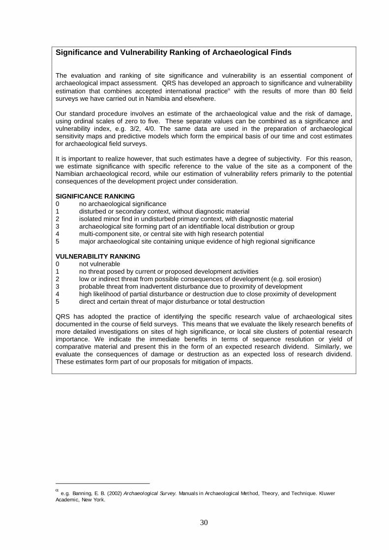
Significance and Vulnerability Ranking of Archaeological Finds
The evaluation and ranking of site significance and vulnerability is an essential component of archaeological impact assessment. QRS has developed an approach to significance and vulnerability estimation that combines accepted international practiceα with the results of more than 80 field surveys we have carried out in Namibia and elsewhere. Our standard procedure involves an estimate of the archaeological value and the risk of damage, using ordinal scales of zero to five. These separate values can be combined as a significance and vulnerability index, e.g. 3/2, 4/0. The same data are used in the preparation of archaeological sensitivity maps and predictive models which form the empirical basis of our time and cost estimates for archaeological field surveys. It is important to realize however, that such estimates have a degree of subjectivity. For this reason, we estimate significance with specific reference to the value of the site as a component of the Namibian archaeological record, while our estimation of vulnerability refers primarily to the potential consequences of the development project under consideration. SIGNIFICANCE RANKING 0 no archaeological significance 1 disturbed or secondary context, without diagnostic material 2 isolated minor find in undisturbed primary context, with diagnostic material 3 archaeological site forming part of an identifiable local distribution or group 4 multi-component site, or central site with high research potential 5 major archaeological site containing unique evidence of high regional significance VULNERABILITY RANKING 0 not vulnerable 1 no threat posed by current or proposed development activities 2 low or indirect threat from possible consequences of development (e.g. soil erosion) 3 probable threat from inadvertent disturbance due to proximity of development 4 high likelihood of partial disturbance or destruction due to close proximity of development 5 direct and certain threat of major disturbance or total destruction QRS has adopted the practice of identifying the specific research value of archaeological sites documented in the course of field surveys. This means that we evaluate the likely research benefits of more detailed investigations on sites of high significance, or local site clusters of potential research importance. We indicate the immediate benefits in terms of sequence resolution or yield of comparative material and present this in the form of an expected research dividend. Similarly, we evaluate the consequences of damage or destruction as an expected loss of research dividend. These estimates form part of our proposals for mitigation of impacts.
α e.g. Banning, E. B. (2002) Archaeological Survey. Manuals in Archaeological Method, Theory, and Technique. Kluwer Academic, New York.
31
context of a critical research programme, in this way helping to avoid the proliferation of assessments which merely provide lists of sites (or species, in the case of ecological assessments), often copied from one project to another. The great danger of assessments that neglect the knowledge dividend requirement is that they often dispense with fieldwork entirely, and become desk studies alone. The other purpose of the knowledge dividend requirement is that at each stage of the assessment the investigation will consider the value, as a contribution to knowledge, of more detailed investigation, and the potential loss of knowledge if the site is destroyed. This three phase process represents the bare outline of a tried and tested approach, applied to most, but not all uranium mining projects. There is an uneven application of this approach partly because of the absence of regulations, and partly mining companies have different perceptions of what might be sufficient and necessary for archaeological assessment. During the last four years there has been an increased willingness to undertake archaeological assessment and to implement mitigation proposals. This is partly due to the influence of the Uranium Stewardship Council and partly due to the “peer effect” of one company implementing a high standard of mitigation. The experience of recent years is that the general approach to archaeological assessment that has evolved in the uranium sector could form the basis of a set of industry guidelines, and that these, in turn, could form the basis of regulations to the National Heritage Act. However desirable, regulations to the Act are not as useful as would be a common set of standards applied within the industry. Such standards, or industry guidelines, exist in several Australian states and some mining companies active in Namibia are probably familiar with these. The intention, already discussed with the Uranium Stewardship Council and some member companies, is to draft a set of guidelines to be applied and tested in the Namib before being elaborated and finalized for acceptance by the Chamber of Mines and, perhaps by the National Heritage Council. Archaeological heritage guidelines for the uranium industry should be based on a few key considerations:
a) A common understanding of the unique value of the archaeological heritage as a record of human history and a palaeoclimatic record essential for the understanding of the Erongo Region’s response to climatic change.
b) A common standard for basic archaeological assessment involving a three phase approach in which the intensity of investigation is matched to the degree of impact posed by a particular project.
c) A common willingness to adopt measures that will minimize damage to the archaeological record of the greater Erongo Region, beyond the confines of specific mining lease areas. These measures will include:
(i) efforts to maximize the “knowledge dividend” of archaeological assessment by recognizing and supporting advanced research objectives identified during project assessments.
32
(ii) efforts to improve public access to the results of archaeological assessment and related research, by supporting publication, museum displays and development of public access to archaeological sites.
8. LIST OF REFERENCES
Published literature references are cited as footnotes in the text. List of archaeological assessment reports for uranium exploration and mining projects and related developments in the Erongo Region: Archaeological survey of the Rössing Uranium mining area on the farm Black Range (72), Karibib (1990). Report submitted under sub-contract to Rössing Uranium Limited, Windhoek (1990). QRS Project Report No. 1 A first approximation of archaeological site distributions in Namibia. Commissioned by the Atlas of Namibia Projects, Directorate of Environment Affairs, Ministry of Environment & Tourism, Windhoek (2000). QRS Project Report No. 15 A rapid assessment of archaeological sites on the proposed Windhoek to Walvis Bay (Us Pass) powerline route. Commissioned by Walmsley Environmental Consultants (Pty) Ltd for Namibia Power Corporation (Pty) Ltd. (2000). QRS Project Report No. 19 Archaeological assessment of the Langer Heinrich Uranium prospect, Namibia. Commissioned by Softchem cc (South Africa) on behalf of LHU (Namibia) (2004). QRS Project Report No. 58 Heritage Survey of the Rössing Uranium Limited Licence Area ML28. Commissioned by Rössing Uranium Limited. (2006). QRS Project Report No.72 Archaeological assessment of a proposed open-cast uranium mine at Trekopje, Erongo Region, Namibia. Commissioned by Ferret Mining & Environmental Services on behalf of UraMin (Namibia) (Pty) Ltd. (2006). QRS Project Report No. 73 Archaeological assessment of water and power supply routes to the Trekopje licence area. Commissioned by Turgis Consulting (Pty) Ltd. on behalf of UraMin (Namibia) (Pty) Ltd. (2006) QRS Project Report No. 76 Preliminary assessment of Khan Mine for possible restoration as visitor attraction. Commissioned by Rössing Uranium Limited (2006). QRS Project Report No. 78 Archaeological survey of the proposed Valencia uranium project. Commissioned by Valencia Uranium (Pty) Limited (2007). QRS Project Report No. 81 Archaeological assessment of two water supply pipeline routes to Trekopje. Commissioned by Turgis Consulting for UraMin (Namibia) Pty Ltd. (2007). QRS Project Report No. 82
33
Archaeological survey of EPL 3573, Erongo Region. Commissioned by Colin Christian & Associates for UraMin (Namibia) Pty Ltd. (2007). QRS Project Report No. 84 Archaeological assessment of granite quarry sites on EPL 2218 (UraMin). Commissioned by Turgis Consulting for UraMin (Namibia) Pty Ltd. (2007). QRS Project Report No. 86 Archaeological reconnaissance of EPL 3287, Marenica, Erongo Region. Commissioned by EnviroDynamics (Pty Ltd for West Australian Metals (WME) (2007). QRS Project Report No. 87 Goanikontes archaeological assessment: Field report on Anomaly “A” for Scoping Study. Commissioned by ASEC (Namibia) (2008). QRS Project Report No. 89 Archaeological survey of EPL 3664, Erongo Region: Preliminary report and draft mitigation proposals. Commissioned by EnviroDynamics (Pty) Ltd (Namibia) (2008). QRS Project Report No.91 Archaeological Survey of EPL 3498 (Aussinanis), Erongo Region. Commissioned by Reptile Uranium(Pty) Ltd. (Namibia) (2008). QRS Project Report No. 92 Archaeological reconnaissance of EPL 3516 & 3518. Commissioned by ASEC (Namibia) (2008). QRS Project Report No. 93 Archaeological assessment of proposed Omburu-Husab power-line: Phase 2 field survey from Ebony to Husab. Commissioned by EnviroDynamics (Pty) Ltd. (2008). QRS Project Report No. 94 Archaeological assessment of four alternative sites for a new power station at Walvis Bay. Commissionedby Ninham Shand (South Africa) (2008). QRS Project Report No. 97 Archaeological survey of a mineral exploration target area on EPL 3660. Commissioned by EnviroDynamics (Pty) Ltd. (2008) QRS Project Report No. 98 !Khuiseb Basin Archaeological Baseline Study. Commissioned by the Kuiseb Basin Management Committee for GTZ. (2008) QRS Project Report No. 100 Archaeological desk assessment of Trans Kalahari railway route alternatives within Namibia. Commissioned by SRK Consulting (South Africa) (2008). QRS Project Report No. 102. Archaeological baseline survey and mitigation for Langer Heinrich Uranium (Pty) Ltd. Commissioned by Langer Heinrich Uranium. QRS Project Report No. 101 Archaeological reconnaissance of the Husab Uranium project area. Commissioned by Extract Resources (Swakop Uranium) (2009). QRS Project Report No. 105 Archaeological survey of the proposed power-line route from Mile 6 to Dolerite. Commissioned by CSIR, South Africa, on behalf of NamPower (Pty) Ltd. (2009). QRS Project Report No. 106
34
Archaeological survey of proposed water pipeline route from Rössing Terminal Reservoir to the Valencia Mine access road. Commissioned by NamWater (2009). QRS Project Report No. 108
35
GLOSSARY Pleistocene: the last 2 million years of the geological record, prior to the Last Glacial Maximum Holocene: the last 10 000 years, following the Last Glacial Maximum Last Glacial Maximum: the period between 16 000 and 10 000 years BP, corresponding with a maximum drop in sea level to about -110m. Plio-Pleistocene boundary: the commencement of the Pleistocene, about 2 million years ago.

36
LIST OF ABBREVIATIONS All abbreviations explained in text
37
9. APPENDICES: i. Persons consulted
Mr Salomon April, Director, National Heritage Council of Namibia Mr Rainer Schneeweiss, Rössing Uranium Limited Dr Wotan Swiegers, Uranium Stewardship Council Ms Michelle Yates, Environmental Consultant
ii. Impact Assessment matrices Attached
iii. Best practice guidelines (see 7.2 above) As in text


