Embed Size (px)
Citation preview
ARMBRUSTER GOLDSMITH & DELVAC LLPLAND USE ENTITLEMENTS □ MUNICIPAL ADVOCACY
12100 WILSHIRE BOULEVARD, SUITE 1600 LOS ANGELES, CA 90025
DAVE RANDDIRECT DIAL: (310) 209-9025
Tel: (310) 209-8800 Fax: (310) 209-8801
E-MAIL: [email protected] WEB: www.AGD-LandUse.com
November 27, 2017
VIA E-MAIL
Honorable Jose HuizarPlanning & Land Use Management CommitteeCity CouncilCity of Los Angeles200 N. Spring StreetLos Angeles, CA 90012-4801
Re: Response to Appeal of11460-11488 Gateway Boulevard VTTM #73891 and Related Environmental Clearances (Council File #17-0932); Agenda Item No. 6 on November 28, 2017 PLUM Agenda
Dear Chairman Huizar and Honorable Councilmembers:
We represent 11460 Gateway LLC, the applicant of a proposed one hundred and twenty nine-unit multi-family residential project (the “Project”) located at 11460-11488 Gateway Boulevard, 2426 South Colby Avenue and 2425 South Butler Avenue (collectively the “Site”).
The Director of Planning adopted the Project’s Mitigated Negative Declaration (“MND”) on June 20, 2017, in connection with the approval of the Project’s density bonus and incentives, Community Design Overlay (“CDO”) compliance determination, and Site Plan Review approval (Case Nos. DIR-2015-4086-DB-CDO-SPR; ENV-2015-4087-MND). These actions were not appealed, and therefore became final and effective on July 6, 2017. A Notice of Determination was filed on July 7, 2017, and no timely CEQA petition was filed.
On June 27, 2017, the Deputy Advisory Agency separately approved a vesting tentative tract map (“VTTM”) for the Project, including the merger and vacation of a public alley that bisects the Site. The Deputy Advisory Agency action was subsequently appealed to the City Planning Commission (“CPC”), purportedly by Mr. Joseph Nguyen of St. Joan of Arc Church (the “Map Appeal”). No neighbors, appellant or appellant representatives attended the CPC hearing to advocate for the Map Appeal. Moreover, Council District 11 testified at the CPC hearing that someone had forged Mr. Nguyen’s signature on the Map Appeal documents, thus calling the legitimacy of the Map Appeal into question. Not surprisingly given the circumstances, the CPC swiftly and unanimously rejected the Map Appeal, relied on the previously adopted MND and found pursuant to CEQA Guidelines Section 15162 and 15164 that no Subsequent EIR, Negative Declaration or Addendum was required to approve the Project (the “CPC Actions”).
ARMBRUSTER GOLDSMITH & DELVAC LLP
Planning & Land Use Management CommitteeLos Angeles City CouncilCouncil File #17-0932November 27, 2017Page 2
On August 14, 2017, the Blum Collins law firm (on behalf of Henrietta Conrad and the Golden State Environmental Justice Alliance (collectively the “Appellants”)) appealed the CPC Actions to the City Council. Although the Project has been discussed at over a dozen community meetings and numerous public hearings dating back to November 2015, Blum Collins’ August 2017 appeal represents Appellants’ first communication of any kind regarding the Project. To our knowledge Henrietta Conrad is not a neighbor of the Site. She has neither contacted the Applicant or the Applicant’s outreach team during this process, nor participated in any of the public meetings on the Project. An internet search of her name suggests that she is either a current or possibly a former employee of the Blum Collins law firm.
On November 6, 2017, the Department of City Planning issued a memorandum and provided findings to the PLUM Committee determining that the Project qualifies as a “Sustainable Communities Project,” and is therefore exempt from CEQA pursuant to California Public Resources Code Sections 21155 and 21155.1 (the “CEQA Exemption”).
The Appellants now belatedly argue that (i) the alley vacation represents an illegal gift of public funds, (ii) a full EIR is required to address purported air quality impacts, and (iii) the Project is ineligible for the CEQA Exemption because the alley vacation is somehow tantamount to removal of public open space, as defined by California Public Resources Code Section 21155.1(a)(7)(A)(i-iii). This correspondence responds to each of the Appellants’ claims and urges the PLUM Committee’s rejection of the Appeal in full and adoption of the CEQA Exemption for the Project.
The City Lawfully and Appropriately Approved the Merger and Vacation of the Public Alley.
Without providing any justification, support or evidence of any kind, Appellants argue that the alley vacation somehow represents an “improper gift of public funds to the developer.” Appellants, however, fail to acknowledge that the Subdivision Map Act expressly authorizes merger and vacation of a public right away in conjunction with a Subdivision Approval (See Cal. Gov. Code Section 66499.20.2).1 This is not a new or novel process. The City thoroughly vetted the proposed alley vacation during the approval process for the Project’s requested VTTM. In reviewing the current condition and use of the public alley, as well as the surrounding street network, the City determined that the alley did not serve a public use and that the requested
I.
1 Section 66499.20.2 of the Subdivision Map Act states in relevant part that “[t]he filing of the map shall constitute legal merger and resubdivision of the land affected thereby, and shall also constitute abandonment of all public streets and public easements not shown on the map, provided that a written notation of each abandonment is listed by reference to the recording data creating these public streets or public easements, and certified to on the map by the clerk of the legislative body or the designee of the legislative body approving the map.”
ARMBRUSTER GOLDSMITH & DELVAC LLP
Planning & Land Use Management CommitteeLos Angeles City CouncilCouncil File #17-0932November 27, 2017Page 3
vacation and merger of the alley would be reasonable. (See December 23, 2015 Interdepartmental Correspondence from the Bureau of Engineering to the Deputy Advisory Agency stating that “[t]he Advisory Agency hereby finds that the dedications to be merged are unnecessary for present or prospective public purposes . . ..”, attached as Exhibit “A”). Furthermore, Condition No. 1 of the VTTM approval requires that “the Department of Transportation (DOT) issue a letter to the City Engineer stating that the proposed alley merger area is not necessary for present and future public use.” (See CPC Approval, Condition No. 1, attached as Exhibit “B”).
As it relates to the lack of public use, the portion of the alley to be vacated is currently utilized exclusively by the Applicant as part of the circulation and parking for the auto-body uses on site. The remainder of the alley is primarily dirt and grass and, in some locations, used as an extension to various private rear yards. The alley is also currently gated and padlocked where it abuts adjacent properties and at its southern terminus with Pearl Street, 770 feet to the south. While it is alleged that some members of the neighborhood have keys to the locks and, therefore, have access to the alley through the Site, the alley is not used for public circulation purposes. Photographic evidence of the as-built condition of this alley was submitted to the City Planning Commission on July 17, 2017. As further evidence of this lack of public use, Overland Traffic Consultants conducted 24-hour pedestrian and vehicular counts at the southerly and northerly gates to the alley on Sunday, July 16, 2017, and Tuesday, July 18, 2017, in order to identify representative weekday and weekend use of the alley. Notably, no vehicle or pedestrian traffic was counted at the northern and southern alley entrances/exits on Sunday, July 16th. On Tuesday, July 18th, one pedestrian was counted entering and leaving the alley during the 8:45 to 9:00 PM time period at the northern alley entrance/exit, and one vehicle was counted entering the alley around 7:45 PM and leaving at 8:45 PM at the southern alley entrance/exit. (See Overland Traffic Consultants Memorandum, attached as Exhibit “C”). This extremely minimal activity clearly demonstrates the lack of public use. Therefore, merger and vacation of the alley would not impair circulation or access across the alley area by the public.
Despite this, the Project has also been conditioned to construct a Fire Department turnaround entirely on the Site, which will allow the City to maintain fire safety standards and access for utility service vehicles following the effectuation of the alley merger. As the alley currently runs parallel to and then terminates at Butler Avenue at the Site, any potentially displaced traffic as a result of the alley merger could be easily accommodated by Butler Avenue, which would provide the same circulation pattern.
Therefore, the proposed alley merger has been fully reviewed and approved by the City in accordance with the Subdivision Map Act, and would not conflict with the public’s current or future use of the alley. Moreover, the alley vacation is critical to the feasibility of the Project
ARMBRUSTER GOLDSMITH & DELVAC LLP
Planning & Land Use Management CommitteeLos Angeles City CouncilCouncil File #17-0932November 27, 2017Page 4
which will provide both market rate and Very Low Income affordable housing units in close proximity to employment and an Expo Light Rail station.
The Project’s MND is Adequate and an EIR Is Not Required.
As stated above, the Director of Planning adopted the Project’s MND on June 20, 2017, in connection with the approval of the Project’s density bonus and incentives, CDO compliance determination, and Site Plan Review approval (DIR-2015-4086-DB-CDO-SPR; ENV-2015- 4087-MND). These actions were not appealed, and therefore became final and effective on July 6, 2017. A Notice of Determination was filed on July 7, 2017, (attached as Exhibit “D”) and no timely CEQA petition was filed. In rejecting the Map Appeal, the CPC relied on the previous adopted MND and found specifically that “no Subsequent EIR, negative declaration or addendum is required for approval of the project” pursuant to CEQA Guidelines Sections 15162 and 15164.
II.
Since that time, there have been no substantial changes with respect to the circumstances under which the Project is being undertaken. Specifically, there have been no changes to the zoning, land use, environmental, or public health and safety regulations that are applicable to the Site. Similarly, there have not been any changes to the existing conditions of the Site. Because the circumstances under which the Project would be undertaken have remained exactly the same since the Director’s adoption of the MND became final, there can be no new environmental effects, or any increase in the severity of previously identified potentially significant effects. As a result, no revisions are required to the previous MND, and no subsequent environmental analysis is required pursuant to CEQA Guidelines Section 15162.
The Appellants now argue that an EIR is required to reexamine the Project’s potential air quality impacts. Specifically, SWAPE (Appellants’ air quality consultant) claims - based only on a “screening analysis” - as opposed to an actual Health Risk Assessment - that the Project could result in construction and/or operational diesel particulate matter (DPM)-related health risks. However, as demonstrated below, an actual Health Risk Assessment (“HRA”) prepared for the Project by Air Quality Dynamics (“AQD”) (a recognized air quality expert) concludes that health risks “will not result in unacceptable localized air quality impacts.”
• The AQD analysis demonstrates that Project DPM-related health risks to four neighboring schools, as well as nearby residents would not exceed the applicable South Coast Air Quality Management District (“SCAQMD”) threshold of significance. (See full HRA, attached as Exhibit “E”).
• In its latest correspondence regarding the Project (dated November 17, 2017), SWAPE challenges the HRA’s “no impact” conclusion because it is based on the U.S Environmental Protection Agency (USEPA) methodology, as opposed to the
ARMBRUSTER GOLDSMITH & DELVAC LLP
Planning & Land Use Management CommitteeLos Angeles City CouncilCouncil File #17-0932November 27, 2017Page 5
“Air Hotspots Program” guidance prepared by the Office of Environmental Health and Hazard Assessment (“OEHHA”). However, as specified in AQD’s November 24, 2017 response to SWAPE, the OEHHA methodology (i) is reserved for discrete commercial and industrial development - as opposed to residential projects, (ii) has not been adopted by SCAQMD, and (iii) has been repudiated by other governmental agencies charged with protecting the environmental such as USEPA and the California Department of Toxic Substances Control (“DTSC”). (See AQD November 24, 2017 response, attached as Exhibit “F”).
• Notably, the City of Los Angeles has refused to apply the OEHHA methodology when evaluating construction air quality impacts on other residential projects. The City Council recently rejected a similar argument made by SWAPE, finding it did not constitute substantial evidence, and adopted the following finding in the course of approving a significantly larger 376-unit residential high rise project at 11750-11770 Wilshire Boulevard. In that case the City Council specifically found:
“Furthermore, although the Office of Environmental Health Hazard Assessment (OEHHA) adopted a new version of the Air Toxics Hot Spots Program Guidance Manuel for the Preparation of Risk Assessments (Guidance Manuel) in March of 2015, it is not appropriate to use the Guidance Manuel to assess the project’s short term construction impacts. The Guidance Manual was developed by OEHHA, in conjunction with CARB, for use in implementing the Air Toxics Hot Spots Program (Health and Safety Code Section 44360 et. seq.) and is intended to apply to certain stationary sources, such as power plants or industrial uses that emit toxic air contaminants. . ..”
“Moreover, SCAQMD has not developed any recommendations on its use for CEQA analysis for potential construction impacts ....” (Emphasis Added) (See Adopted CEQA Findings, (as Modified on January 26, 2017); Council File No. 16-1458- S1/Case No. CPC-2015-2662-VZC-ZAD-CDO-SPR, page F-42 (attached as Exhibit “G”). See also Planning Department memorandum to the PLUM Committee, pp.5-6 (attached as Exhibit “H”).
ARMBRUSTER GOLDSMITH & DELVAC LLP
Planning & Land Use Management CommitteeLos Angeles City CouncilCouncil File #17-0932November 27, 2017Page 6
• SWAPE’s claim that the Project would result in operational diesel particulate matter impacts is belied by both common sense and AQD’s expert evidence. First, SWAPE never conducted an HRA (or provided any other actual evidence) to empirically demonstrate the likelihood of operational DPM related impacts. AQD identifies the obvious - operational emissions impacts from the 129-unit multi-family residential Project largely result from vehicles fueled by gasoline and not diesel. Accordingly, there can be no evidence to suggest this residential Project would result in operational DPM impacts to nearby sensitive receptors.
As the HRA demonstrates, the potential DPM impacts at each of the nearby sensitive receptors, including all schools and residential uses, did not exceed the SCAQMD significance threshold. The HRA also assessed the potential non-carcinogenic health effects of the Project, and concluded that no adverse effects would result.
The City elects not to follow the 2015 OEHHA methodology as SWAPE argues, because(1) the 2015 guidance is for a regulatory scheme unrelated to CEQA (it is for the “Toxic Hot Spots” statute regulating major sources of industrial air emissions), (2) the City is the CEQA lead agency for the Project and has sole authority to select scientific methodologies for CEQA analyses (North Coast Rivers Alliance v. Marin Mun. Water Dist. (2013) 216 Cal.App.4th 614, 640), (3) the City has not adopted the 2015 guidance as its methodology, and (4) SCAQMD, the local and regional expert air quality agency, has not adopted the 2015 guidance for purposes of commenting on CEQA assessments. Thus, the City’s choice of scientific methodology is entitled to deference because it is supported by substantial evidence. (CEQA Guidelines § 15064(b); Save Cuyama Valley v. County of Santa Barbara (2013) 213 Cal.App.4th 1059, 1068; Mission Bay Alliance v. Office of Community Inv. & Infrastructure (2016) 6 Cal.App.5th 160 [upholding agency’s cancer risk significance threshold based on local air district guidance and affirming the CEQA lead agency’s decision not to use a stricter methodology].)
Accordingly, the HRA validates the MND’s conclusion that the Project’s potential air quality impacts, including those pertaining to Toxic Air Contaminants (TACs) and DPM, would be less than significant, and no further assessment is required. Further, the SWAPE analysis does not constitute new information that would require preparation of a subsequent environmental analysis under CEQA Guidelines Sections 15162 and/or 15164.
The Department of City Planning Correctly Determined that the Project is Exempt From CEQA Under Public Resources Code Section 21155 and 21155.1.
III.
On November 6, 2017, the Planning Department submitted extensive documentation and findings to the PLUM Committee demonstrating that the Project qualifies as a “Transit Priority Project” (as defined in Public Resources Code Section 21155(b)) and satisfies the numerous statutory “Sustainable Communities Project” CEQA exemption criteria (the “CEQA
ARMBRUSTER GOLDSMITH & DELVAC LLP
Planning & Land Use Management CommitteeLos Angeles City CouncilCouncil File #17-0932November 27, 2017Page 7
Exemption”). This is not surprising given the Project is a one hundred percent multi-family residential project with 15 percent of the base density dedicated to deed restricted Very Low Income Housing units, located within one-half mile of regional serving transit (i.e., the Sepulveda-Exposition Light Rail Station). In other words, the Project is exactly the type of mixed income, transit proximate, residential infill project the Legislature intended to exempt from CEQA.
Appellants’ latest correspondence to the PLUM Committee, dated November 20, 2017, suggests that the Project cannot qualify for the CEQA Exemption because it would be partially located on “developed open space” as defined by Public Resources Section 21155.1(a)(7(A)(i-iii) due to the alley vacation. To be clear, to meet the definition of “developed open space” the Project must meet all_ of the following criteria:
Is publicly owned, or financed in whole or part by public funds.(i)
Is generally open to, and available for use by, the public.
Is predominantly lacking in structural development other than structures associated with open spaces, including, but not limited to, playgrounds, swimming pools, ballfields, enclosed child play areas, and picnic facilities. (Emphasis added).
Calling an unutilized public alley way “open space” is a stretch in any context. It must be for this reason that Appellants brazenly misrepresent the statute’s definition of “developed open space” in its November 20, 2017 correspondence to the PLUM Committee challenging the CEQA Exemption. Conveniently, Appellants omit the key portion of the definition’s third prong (cited in bold italics above), which provide real world examples of actual “developed open space” such as “playgrounds, swimming pools, ballfields, enclosed child play areas, and picnic facilities.” It is obvious the legislature intended the definition of “developed open space” to apply to usable, recreational open spaces and facilities - as opposed to dead, underutilized and mostly privatized public alleys and rights of way.
Accordingly, we urge the PLUM Committee to adopt the required findings and exempt the Project from CEQA as a Sustainable Communities Project under Public Resources Code Section 21155 and 21155.1.
(ii)
(iii)
Conclusion.IV.
The Project helps address the City’s housing crisis by providing not only a significant number of new market rate units, but also a high percentage of deed-restricted Very Low Income affordable housing units. The mixed income Project is appropriately scaled and serves a demonstrable public need. The Project is located proximate to the Expo Light Rail station and
ARMBRUSTER GOLDSMITH & DELVAC LLP
Planning & Land Use Management CommitteeLos Angeles City CouncilCouncil File #17-0932November 27, 2017Page 8
would, therefore, encourage public transit use and a reduction in greenhouse gas emissions and vehicle miles traveled.
Vacation of the underutilized public alley is fundamental to developing the proposed Project and was approved in full accordance with the Subdivision Map Act and the City’s subdivision ordinances. The record clearly shows the alley is underutilized and its merger and vacation would not disrupt circulation or public use. Appellants’ contention that the vacation somehow represents an “inappropriate gift of public funds” is completely without merit and lacks any support whatsoever.
Substantial evidence in the form of an HRA prepared by AQD validates the MND’s conclusion that no construction or operational TAC impacts would result to nearby schools and/or residences. Although SWAPE provides no actual evidence to the contrary, it attempts to distract the PLUM Committee by arguing for an industrial standard and air quality methodology that the City has previously rejected for residential development. Furthermore, Appellants’ challenge to the CEQA Exemption on the grounds that merger and vacation of an underutilized public alley somehow results in the loss of “open space” intentionally misrepresents a key statutory definition and should be rejected on its face.
For the reasons stated above, we respectfully request that you deny the appeal, uphold the CPC Actions and further find the Project exempt from CEQA as a “Sustainable Communities Project.” Thank you for your careful consideration of the appeal and of our response.
Sincerely,
!ave Rand
cc Tricia Keane, CD 11Oliver Netburn, Department of City Planning Dana Sayles, three6ixty Consulting

Exhibit A
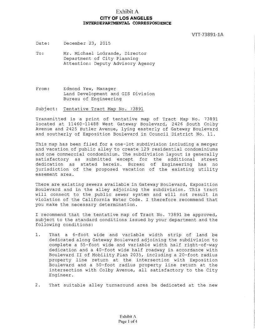
CITY OF LOS ANGELESINTERDEPARTMENTAL CORRESPONDENCE
Exhibit A
December 23, 2015Date:
Mr. Michael LoGrande, Director Department of City Planning Attention: Deputy Advisory Agency
To:
Edmond Yew, ManagerLand Development and GIS DivisionBureau of Engineering
From:
Tentative Tract Map No. 73891Subj ect:
Transmitted is a print of tentative map of Tract Map No. 73891 located at 11460-11488 West Gateway Boulevard, 2426 South Colby Avenue and 2425 Butler Avenue, lying easterly of Gateway Boulevard and southerly of Exposition Boulevard in Council District No. 11.
This map has been filed for a one-lot subdivision including a merger and vacation of public alley to create 129 residential condominiums and one commercial condominium. The subdivision layout is generally satisfactory as submitted except for the additional street dedication as stated herein. Bureau of Engineering has no jurisdiction of the proposed vacation of the existing utility easement area.
There are existing sewers available in Gateway Boulevard, Exposition Boulevard and in the alley adjoining the subdivision. This tract will connect to the public sewer system and will not result in violation of the California Water Code. I therefore recommend that you make the necessary determination.
I recommend that the tentative map of Tract No. 73891 be approved, subject to the standard conditions issued by your department and the following conditions:
That a 6-foot wide and variable width strip of land be dedicated along Gateway Boulevard adjoining the subdivision to complete a 55-foot wide and variable width half right-of-way dedication and a 40-foot wide half roadway in accordance with Boulevard II of Mobility Plan 2035, including a 20-foot radius property line return at the intersection with Exposition Boulevard and a 50-foot radius property line return at the intersection with Colby Avenue, all satisfactory to the City Engineer.
1.
2 . That suitable alley turnaround area be dedicated at the new
Exhibit APage 1 of 4
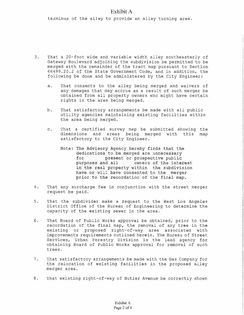
Exhibit Aterminus of the alley to provide an alley turning area.
That a 20-foot wide and variable width alley southeasterly of Gateway Boulevard adjoining the subdivision be permitted to be merged with the remainder of the tract map pursuant to Section 66499.20.2 of the State Government Code, and in addition, the following be done and be administered by the City Engineer:
3.
That consents to the alley being merged and waivers of any damages that may accrue as a result of such merger be obtained from all property owners who might have certain rights in the area being merged.
a.
That satisfactory arrangements be made with all public utility agencies maintaining existing facilities within the area being merged.
b.
That a certified survey map be submitted showing the dimensions and areas being merged with this map satisfactory to the City Engineer.
c.
Note: The Advisory Agency hereby finds that the dedications to be merged are unnecessary forpurposes and all in the real property within the subdivision have or will have consented to the merger prior to the recordation of the final map.
present or prospective publicowners of the interest
That any surcharge fee in conjunction with the street merger request be paid.
4.
That the subdivider make a request to the West Los Angeles District Office of the Bureau of Engineering to determine the capacity of the existing sewer in the area.
5.
6. That Board of Public Works approval be obtained, prior to the recordation of the final map, the removal of any tree in the existing or proposed right-of-way area associated with improvements requirements outlined herein. The Bureau of Street Services, Urban Forestry Division is the lead agency for obtaining Board of Public Works approval for removal of such trees.
That satisfactory arrangements be made with the Gas Company for the relocation of existing facilities in the proposed alley merger area.
7 .
That existing right-of-way of Butler Avenue be correctly shown
Exhibit APage 2 of 4
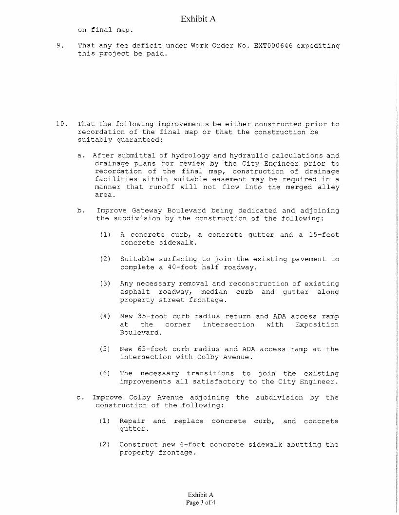
Exhibit Aon final map.
That any fee deficit under Work Order No. EXT000646 expediting this project be paid.
9.
10. That the following improvements be either constructed prior to recordation of the final map or that the construction be suitably guaranteed:
a. After submittal of hydrology and hydraulic calculations and drainage plans for review by the City Engineer prior to recordation of the final map, construction of drainage facilities within suitable easement may be required in a manner that runoff will not flow into the merged alley area.
b. Improve Gateway Boulevard being dedicated and adjoining the subdivision by the construction of the following:
(1) A concrete curb, concrete sidewalk.
a concrete gutter and a 15-foot
Suitable surfacing to join the existing pavement to complete a 40-foot half roadway.
(2)
(3) Any necessary removal and reconstruction of existing asphalt roadway, median curb and gutter along property street frontage.
(4) New 35-foot curb radius return and ADA access ramp at the corner intersection with Exposition Boulevard,
New 65-foot curb radius and ADA access ramp at the intersection with Colby Avenue.
(5)
The necessary transitions to join the existing improvements all satisfactory to the City Engineer.
(6)
Improve Colby Avenue adjoining the subdivision by the construction of the following:
c.
(1) Repair and replace concrete curb, and concrete gutter.
(2) Construct new 6-foot concrete sidewalk abutting the property frontage.
Exhibit APage 3 of 4
Exhibit A
(3) Any necessary removal and reconstruction of existing improvements.
Improve Butler Avenue adjoining the subdivision by the construction of the following:
d.
(1) Reconstruct alley intersection with the proposed alley merger to provide a V-cross section.
(2) Repair and or replace all broken, off-grade asphalt pavement and longitudinal concrete gutter along the alley frontage.
Any necessary removal and reconstruction of existing improvements.
(3)
The necessary transitions to join the existing improvement.
(4)
Remove any encroachment into the alley area.e.
Any questions regarding this report should be directed to Mr. Georgic Avanesian of the Land Development Section, located at 201 North Figueroa Street, Suite 200, or by calling (213) 202-3484.
Enc. cc: West Los Angeles Engineering District Office
Exhibit APage 4 of 4

Exhibit B
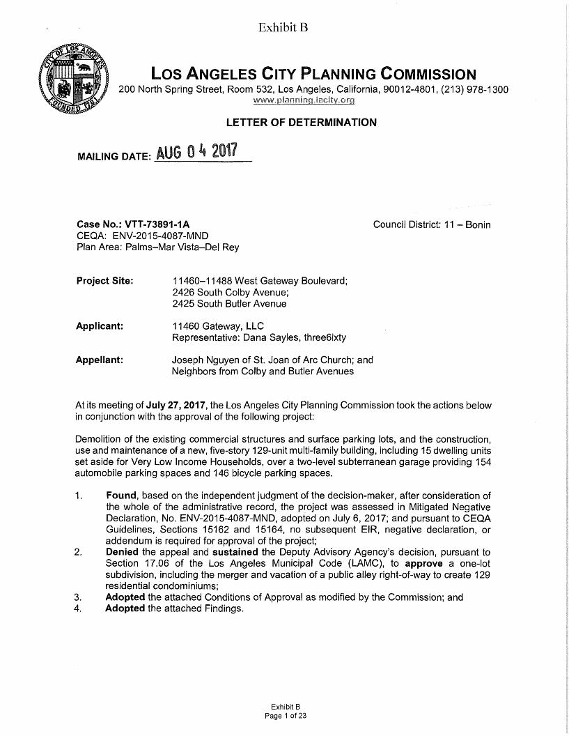
Exhibit BTO!
Los Angeles City Planning Commission200 North Spring Street, Room 532, Los Angeles, California, 90012-4801, (213) 978-1300
www.plaoHirtg.lacity.ortiM
LETTER OF DETERMINATION
AUG 0 2017MAILING DATE:
Case No.: VTT-73891-1ACEQA: ENV-2015-4087-MND Plan Area: Palms-Mar Vista-Del Rey
Council District: 11 - Bonin
Project Site: 11460-11488 West Gateway Boulevard; 2426 South Colby Avenue;2425 South Butler Avenue
Applicant: 11460 Gateway, LLC Representative: Dana Sayles, three6ixty
Appellant: Joseph Nguyen of St. Joan of Arc Church; and Neighbors from Colby and Butler Avenues
At its meeting of July 27,2017, the Los Angeles City Planning Commission took the actions below in conjunction with the approval of the following project:
Demolition of the existing commercial structures and surface parking lots, and the construction, use and maintenance of a new, five-story 129-unit multi-family building, including 15 dwelling units set aside for Very Low Income Households, over a two-level subterranean garage providing 154 automobile parking spaces and 146 bicycle parking spaces.
Found, based on the independent judgment of the decision-maker, after consideration of the whole of the administrative record, the project was assessed in Mitigated Negative Declaration, No. ENV-2015-4087-MND, adopted on July 6, 2017; and pursuant to CEQA Guidelines, Sections 15162 and 15164, no subsequent EIR, negative declaration, or addendum is required for approval of the project;Denied the appeal and sustained the Deputy Advisory Agency’s decision, pursuant to Section 17.06 of the Los Angeles Municipal Code (LAMC), to approve a one-lot subdivision, including the merger and vacation of a public alley right-of-way to create 129 residential condominiums;Adopted the attached Conditions of Approval as modified by the Commission; and Adopted the attached Findings.
1.
2.
3.4.
Exhibit BPage 1 of 23
Exhibit BPage 2VTT-73891-1A
The vote proceeded as follows:
Moved:Second:AyesAbsent:
AmbrozPerlmanChoe, Katz, Millman, Mitchell, Padilla-Campos Mack, Dake Wilson
Vote: 7-0
James K. Williams, Commission Executive Assistant II Los Angeles/City Planning Commission
Fiscal Impact Statement: There is no General Fund impact as administrative costs are recovered through fees.
Effective Date/Appeals: The decision of the Los Angeles City Planning Commission is further appealable to the Los Angeles City Council within 10 days after the mailing date of this determination letter. Any appeal not filed within the 10-day period shall not be considered by the Council. All appeals shall be filed on forms provided at the Planning Department’s Development Service Centers located at: 201 North Figueroa Street, Fourth Floor, Los Angeles; 6262 Van Nuys Boulevard, Suite 251, Van Nuys; or 1828 Sawtelle Boulevard, West Los Angeles. .
: AUG 1 h 2017FINAL APPEAL DATE:
If you seek judicial review of any decision of the City pursuant to California Code of Civil Procedure Section 1094.5, the petition for writ of mandate pursuant to that section must be filed no later than the 90th day following the date on which the City's decision became final pursuant to California Code of Civil Procedure Section 1094.6. There may be other time limits which also affect your ability to seek judicial review.
Attachments: Modified Conditions of Approval, Findings
Nicholas Hendricks, Senior City Planner Heather Bleemers, City Planner Oliver Netburn, City Planning Associate
c:
Exhibit BPage 2 of 23
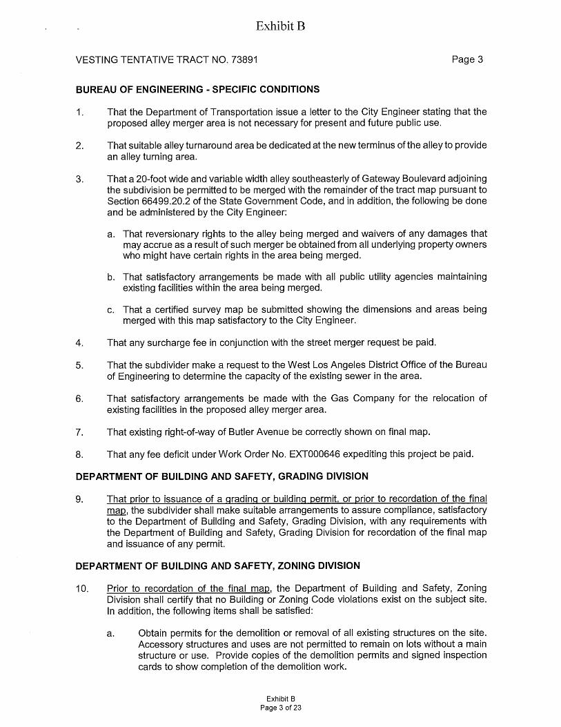
Exhibit B
Page 3VESTING TENTATIVE TRACT NO. 73891
BUREAU OF ENGINEERING - SPECIFIC CONDITIONS
That the Department of Transportation issue a letter to the City Engineer stating that the proposed alley merger area is not necessary for present and future public use.
1.
That suitable alley turnaround area be dedicated at the new terminus of the alley to provide an alley turning area.
2.
That a 20-foot wide and variable width alley southeasterly of Gateway Boulevard adjoining the subdivision be permitted to be merged with the remainder of the tract map pursuant to Section 66499.20.2 of the State Government Code, and in addition, the following be done and be administered by the City Engineer:
3.
That reversionary rights to the alley being merged and waivers of any damages that may accrue as a result of such merger be obtained from all underlying property owners who might have certain rights in the area being merged.
a.
That satisfactory arrangements be made with all public utility agencies maintaining existing facilities within the area being merged.
b.
That a certified survey map be submitted showing the dimensions and areas being merged with this map satisfactory to the City Engineer.
c.
That any surcharge fee in conjunction with the street merger request be paid.4.
That the subdivider make a request to the West Los Angeles District Office of the Bureau of Engineering to determine the capacity of the existing sewer in the area.
5.
That satisfactory arrangements be made with the Gas Company for the relocation of existing facilities in the proposed alley merger area.
6.
That existing right-of-way of Butler Avenue be correctly shown on final map.7.
That any fee deficit underwork Order No. EXT000646 expediting this project be paid.8.
DEPARTMENT OF BUILDING AND SAFETY, GRADING DIVISION
That prior to issuance of a grading or building permit, or prior to recordation of the final map, the subdivider shall make suitable arrangements to assure compliance, satisfactory to the Department of Building and Safety, Grading Division, with any requirements with the Department of Building and Safety, Grading Division for recordation of the final map and issuance of any permit.
9.
DEPARTMENT OF BUILDING AND SAFETY, ZONING DIVISION
Prior to recordation of the final map, the Department of Building and Safety, Zoning Division shall certify that no Building or Zoning Code violations exist on the subject site. In addition, the following items shall be satisfied:
10.
Obtain permits for the demolition or removal of all existing structures on the site. Accessory structures and uses are not permitted to remain on lots without a main structure or use. Provide copies of the demolition permits and signed inspection cards to show completion of the demolition work.
a.
Exhibit BPage 3 of 23
Exhibit B
VESTING TENTATIVE TRACT NO. 73891 Page 4
b. Provide a copy of DIR case DIR-2015-4086-DB-CDO-SPR. Show compliance with all the conditions/requirements of the DIR case as applicable.
Show all street/alley dedication(s) as required by Bureau of Engineering and provide net lot area after all dedication. “Area” requirements shall be re-checked as per net lot area after street/alley dedication(s). Front and side yard requirements shall be required to comply with current code as measured from new property lines after dedication.
c.
d. Obtain Bureau of Engineering approval for the proposed alley merger.
The submitted Map does not comply with the allowable maximum density (34,431/400=86 units in C2 Zone and 10,145/800=12 units in R3 Zone, maximum of 98 units allow) requirement of the [Q]C2-1 VL-CDO/R3-1 Zone. Revise the Map to show compliance with the above requirement or obtain approval from the Department of City Planning. Approval of DIR-2015-4086-DB-CDO-SPR shall satisfy this condition.
e.
Notes:
This property is located in the West Pico Boulevard Community Design Overlay.
The submitted Map may not comply with the number of parking spaces required by Section 12.21 -A,4(a) based on number of habitable rooms in each unit. If there are insufficient numbers of parking spaces, obtain approval from the Department of City Planning.
The submitted Map may not comply with the number of guest parking spaces required by the Advisory Agency.
Should the Map be implemented in conjunction with an approved Density Bonus project, the parking requirements, including the total number of parking spaces required and the number of guest parking spaces required, shall be governed by the provisions of L.A.M.C. Section 12.22-A,25 or California Government Code Sections 65915-65918.
Any proposed structures or uses on the site have not been checked for and shall comply with Building and Zoning Code requirements. Plan check will be required before any construction, occupancy or change of use.
DEPARTMENT OF TRANSPORTATION
11. A minimum of 20-foot reservoir space be provided between any security gate(s) and the property line or to the satisfaction of the Department of Transportation.
12. Parking stalls shall be designed so that a vehicle is not required to back into or out of any public street or sidewalk.
13. This project is subject to the West Los Angeles Transportation Improvement and Mitigation Specific Plan requirements. A parking area and driveway plan shall be submitted to the Department of Transportation for approval prior to submittal of building permit plans for plan check by the Department of Building and Safety. Final DOT approval should be
Exhibit BPage 4 of 23
Exhibit B
VESTING TENTATIVE TRACT NO. 73891 Page 5
accomplished by submitting detailed site/driveway plans at a scale of T-40' to DOT'S West LA/Coastal Development Review Section located at 7166 W. Manchester Ave., Los Angeles, 90045. Please contact 213-485-1062 for an appointment.
FIRE DEPARTMENT
Prior to the recordation of the final map, a suitable arrangement shall be made satisfactory to the Fire Department, binding the subdivider and all successors to the following:
14.
Access for Fire Department apparatus and personnel to and into all structures shall be required.
a.
Where above ground floors are used for residential purposes, the access requirement shall be interpreted as being the horizontal travel distance from the street, driveway, alley, or designated fire lane to the main entrance of individual units.
b.
The entrance or exit of all ground dwelling units shall not be more than 150 feet from the edge of a roadway of an improved street, access road, or designated fire lane.
c.
d. Policy Exception:
L.A.M.C. 57.09.03.B Exception:
• When this exception is applied to a fully fire sprinklered residential building equipped with a wet standpipe outlet inside an exit stairway with at least a 2 hour rating the distance from the wet standpipe outlet in the stairway to the entry door of any dwelling unit or guest room shall not exceed 150 feet of horizontal travel and the distance from the edge of the roadway of an improved street or approved fire lane to the door into the same exit stairway directly from outside the building shall not exceed 150 feet of horizontal travel.
• It is the intent of this policy that in no case will the maximum travel distance exceed 150 feet inside the structure and 150 feet outside the structure. The term “horizontal travel” refers to the actual path of travel to be taken by a person responding to an emergency in the building.
• This policy does not apply to single-family dwellings or to non-residential buildings.
Building designs for multi-storied residential buildings shall incorporate at least one access stairwell off the main lobby of the building; But, in no case greater than 150 feet horizontal travel distance from the edge of the public street, private street or Fire Lane. This stairwell shall extend unto the roof.
e.
Entrance to the main lobby shall be located off the address side of the building.f.
Any required Fire Annunciator panel or Fire Control Room shall be located within 50 feet visual line of site of the main entrance stairwell or to the satisfaction of the Fire Department.
9-
Where rescue window access is required, provide conditions and improvements necessary to meet accessibility standards as determined by the Los Angeles Fire Department.
h.
Exhibit BPage 5 of 23
Exhibit B
VESTING TENTATIVE TRACT NO. 73891 Page 6
i. No building or portion of a building shall be constructed more than 150 feet from the edge of a roadway of an improved street, access road, or designated fire lane.
Fire lane width shall not be less than 20 feet. When a fire lane must accommodate the operation of Fire Department aerial ladder apparatus or where fire hydrants are installed, those portions shall not be less than 28 feet in width.
J-
k. The width of private roadways for general access use and fire lanes shall not be less than 20 feet, and the fire lane must be clear to the sky.
I. Submit plot plans indicating access road and turning area for Fire Department approval.
m. All parking restrictions for fire lanes shall be posted and/or painted prior to any Temporary Certificate of Occupancy being issued.
Adequate off-site public and on-site private fire hydrants may be required. Their number and location to be determined after the Fire Department's review of the plot plan.
n.
No framing shall be allowed until the roadway is installed to the satisfaction of the Fire Department.
o.
Any required fire hydrants to be installed shall be fully operational and accepted by the Fire Department prior to any building construction.
P-
Site plans shall include all overhead utility lines adjacent to the site.q-
Any roof elevation changes in excess of 3 feet may require the installation of ships ladders.
r.
Fire lanes, where required and dead ending streets shall terminate in a cul-de-sac or other approved turning area. No dead ending street or fire lane shall be greater than 700 feet in length or secondary access shall be required.
s.
Where fire apparatus will be driven onto the road level surface of the subterranean parking structure, that structure shall be engineered to withstand a bearing pressure of 8,600 pounds per square foot.
t.
Where access for a given development requires accommodation of Fire Department apparatus, overhead clearance shall not be less than 14 feet.
u.
Plans showing areas to be posted and/or painted, “FIRE LANE NO PARKING” shall be submitted and approved by the Fire Department prior to building permit application sign-off.
v.
Electric gates approved by the Fire Department shall be tested by the Fire Department prior to Building and Safety granting a Certificate of Occupancy.
w.
No building or portion of a building shall be constructed more than 300 feet from an approved fire hydrant. Distance shall be computed along path of travel.
x.
Exhibit BPage 6 of 23
Exhibit B
Page 7VESTING TENTATIVE TRACT NO. 73891
y. Any roof elevation changes in excess of 3 feet may require the installation of ships ladders.
DEPARTMENT OF WATER AND POWER
Satisfactory arrangements shall be made with the Los Angeles Department of Water and Power (LADWP) for compliance with LADWP’s Water System Rules and requirements. Upon compliance with these conditions and requirements, LADWP’s Water Services Organization will forward the necessary clearances to the Bureau of Engineering. (This condition shall be deemed cleared at the time the City Engineer clears Condition No. S-
15.
1.(c).)
BUREAU OF SANITATION
Satisfactory arrangements shall be made with the Bureau of Sanitation, Wastewater Collection Systems Division for compliance with its sewer system review and requirements. Upon compliance with its conditions and requirements, the Bureau of Sanitation, Wastewater Collection Systems Division will forward the necessary clearances to the Bureau of Engineering. (This condition shall be deemed cleared at the time the City Engineer clears Condition No. S-1.(d).)
16.
INFORMATION TECHNOLOGY AGENCY
To assure that cable television facilities will be installed in the same manner as other required improvements, please email [email protected] that provides an automated response with the instructions on how to obtain the Cable TV clearance. The automated response also provides the email address of 3 people in case the applicant/owner has any additional questions.
17.
DEPARTMENT OF RECREATION AND PARKS
That the Quimby fee be based separately on the number of dwelling units within the R3 and [QJC2-1VL-CD0 zone portions of the site.
18.
URBAN FORESTRY DIVISION AND THE DEPARTMENT OF CITY PLANNING
The applicant shall submit a tree report and a landscape plan prepared by a protected Tree Expert as designated by LAMC Ordinance No. 177,404, for approval by the City Planning Department and the Urban Forestry Division of the Bureau of Street Services. The Tree Report shall provide species, health, and condition of all trees with tree locations on a site survey. The plan shall contain the Tree Expert's recommendations for the preservation of as many desirable (eight inches diameter or greater) trees as possible. An on-site 1:1 tree replacement shall be required for the unavoidable loss of any desirable on-site trees.
19.
Plant street trees and remove any existing trees within dedicated streets or proposed dedicated streets as required by the Urban Forestry Division of the Bureau of Street Services. All street tree plantings shall be brought up to current standards. When the City has previously been paid for tree plantings, the sub divider or contractor shall notify the Urban Forestry Division (213-847-3077) upon completion of construction to expedite tree planting.
20.
Exhibit BPage 7 of 23
Exhibit B
VESTING TENTATIVE TRACT NO. 73891 Page 8
DEPARTMENT OF CITY PLANNING-SITE SPECIFIC CONDITIONS As modified by the City Planning Commission on July 27, 2017
21. Prior to the recordation of the final map, the subdivider shall prepare and execute a Covenant and Agreement (Planning Department General Form CP-6770) in a manner satisfactory to the Planning Department, binding the subdivider and all successors to the following:
Limit the proposed development to a one-lot subdivision with a maximum of 129 residential condominiums
a.
b. All parking shall be provided in compliance with the Los Angeles Municipal Code and as otherwise approved under DIR-2015-4086-DB-CDO-SPR.
Prior to issuance of a certificate of occupancy, a minimum six-foot-high slumpstone or decorative masonry wall shall be constructed adjacent to neighboring residences, if no such wall already exists, except in required front yard. No such wall shall be required adjacent to the multi-family residential building to the south (along Colby Avenue) if the construction of said wall would conflict with fire access.
c.
d. That a solar access report shall be submitted to the satisfaction of the Advisory Agency prior to obtaining a grading permit.
That the subdivider considers the use of natural gas and/or solar energy and consults with the Department of Water and Power and Southern California Gas Company regarding feasible energy conservation measures.
e.
f. Recycling bins shall be provided at appropriate locations to promote recycling of paper, metal, glass, and other recyclable material.
Outdoor lighting shall be designed and installed with shielding, such that the light source cannot be seen from adjacent residential properties or the public right-of- way.
9-
h. Electric Vehicle Parking. The project shall include at least 20 percent of the total code-required parking spaces capable of supporting future electric vehicle supply equipment (EVSE). Plans shall indicate the proposed type and location(s) of EVSE and also include raceway method(s), wiring schematics and electrical calculations to verify that the electrical system has sufficient capacity to simultaneously charge all electric vehicles at all designated EV charging locations at their full rated amperage. Plan design shall be based upon Level 2 or greater EVSE at its maximum operating ampacity. Of the twenty percent EV Ready parking, five percent of the total code required parking spaces shall be further provided with EV chargers to immediately accommodate electric vehicles within the parking areas. When the application of either the required 20 percent or five percent results in a fractional space, round up to the next whole number. A label stating "EVCAPABLE" shall be posted in a conspicuous place at the service panel or subpanel and next to the raceway termination point. None of the required EV Ready parking shall apply to parking spaces used for dealership vehicle storage.
Solar Roof. A minimum of 15% of the rooftop area shall be equipped with solar photovoltaic panels to be connected to the building’s electrical system.
l.
Exhibit BPage 8 of 23
Exhibit B
Page 9VESTING TENTATIVE TRACT NO. 73891
The removal of two (2) California Sycamores (Platanus racemosa) shall be permitted. A minimum of two (2), 48-inch box trees shall be planted for each California Sycamore that is removed.
22.
For the purposes of this subdivision, the Lot Lines along Gateway Boulevard and Colby Avenue shall be designated as Front Lot Lines and all other Lot Lines shall be designated as Side Lot Lines.
23.
Regulatory Compliance Measures:24.
a. Archaeological. If archaeological resources are discovered during excavation, grading, or construction activities, work shall cease in the area of the find until a qualified archaeologist has evaluated the find in accordance with federal, State, and local guidelines, including those set forth in California Public Resources Code Section 21083.2. Personnel of the proposed Modified Project shall not collect or move any archaeological materials and associated materials. Construction activity may continue unimpeded on other portions of the Project site. The found deposits would be treated in accordance with federal, State, and local guidelines, including those set forth in California Public Resources Code Section 21083.2.i. Distinctive features, finishes and construction techniques or examples of skilled
craftsmanship which characterize an historic property shall be preserved.
ii. Deteriorated historic features shall be repaired rather than replaced. Where the severity if deterioration requires replacement of a distinctive historic feature, the new feature shall match the old in design, color, texture, and other visual qualities, and where possible, materials. Replacement of missing features shall be substantiated by documentary, physical, or pictorial evidence.
iii. Chemical or physical treatments, such as sandblasting, that cause damage to historic materials shall not be used. The surface cleaning of structures, if appropriate, shall be undertaken using the gentlest means possible.
iv. Significant archaeological resources affected by a project shall be protected and preserved. If such resources must be disturbed, mitigation measures shall be undertaken.
v. New additions, exterior alterations, or related new construction shall not destroy historic materials that characterize the property. The new work shall be differentiated from the old and shall be compatible with the massing, size, scale, and architectural features to protect the historic integrity of the property and its environment.
vi. New additions and adjacent or related new construction shall be undertaken in such a manner that if removed in the future, the essential form and integrity of the historic property and its environment would be unimpaired.
b. Human Remains. If human remains are encountered unexpectedly during construction demolition and/or grading activities, State Health and Safety Code Section 7050.5 requires that no further disturbance shall occur until the County Coroner has made the necessary findings as to origin and disposition pursuant to California Public Resources Code (PRC) Section 5097.98. In the event that human remains are discovered during excavation activities, the following procedure shall be observed:
Exhibit BPage 9 of 23
Exhibit B
VESTING TENTATIVE TRACT NO. 73891 Page 10
Stop immediately and contact the County Coroner:
1104 N. Mission Road Los Angeles, CA 90033323-343-0512 (8 a.m. to 5 p.m. Monday through Friday) or 323-343-0714 (After Hours, Saturday, Sunday, and Holidays)
If the remains are determined to be of Native American descent, the Coroner has 24 hours to notify the Native American Heritage Commission (NAHC).
The NAHC will immediately notify the person it believes to be the most likely descendent of the deceased Native American.
The most likely descendent has 48 hours to make recommendations to the owner, or representative, for the treatment or disposition, with proper dignity, of the human remains and grave goods.
If the owner does not accept the descendant’s recommendations, the owner or the descendent may request mediation by the NAHC.
25. Prior to the issuance of the building permit or the recordation of the final mao, a copy of the DIR-2015-4086-DB-CDO-SPR shall be submitted to the satisfaction of the Advisory Agency. In the event that DIR-2015-4086-DB-CDO-SPR is not approved, the subdivider shall submit a tract modification.
26. Prior to the clearance of any tract map conditions, the applicant shall show proof that all fees have been paid to the Department of City Planning, Expedited Processing Section.
27. Indemnification and Reimbursement of Litigation Costs.
Applicant shall do all of the following:
(i) Defend, indemnify and hold harmless the City from any and all actions against the City relating to or arising out of, in whole or in part, the City’s processing and approval of this entitlement, including but not limited to, an action to attack, challenge, set aside, void, or otherwise modify or annul the approval of the entitlement, the environmental review of the entitlement, or the approval of subsequent permit decisions, or to claim personal property damage, including from inverse condemnation or any other constitutional claim.
(ii) Reimburse the City for any and all costs incurred in defense of an action related to or arising out of, in whole or in part, the City’s processing and approval of the entitlement, including but not limited to payment of all court costs and attorney’s fees, costs of any judgments or awards against the City (including an award of attorney’s fees), damages, and/or settlement costs.
(iii) Submit an initial deposit for the City’s litigation costs to the City within 10 days’ notice of the City tendering defense to the Applicant and requesting a deposit. The initial deposit shall be in an amount set by the City Attorney’s Office, in its sole discretion, based on the nature and scope of action, but in no event shall the initial deposit be less than $50,000. The City’s failure to notice or collect the deposit does
Exhibit BPage 10 of 23
Exhibit B
Page 11VESTING TENTATIVE TRACT NO. 73891
not relieve the Applicant from responsibility to reimburse the City pursuant to the requirement in paragraph (ii).
Submit supplemental deposits upon notice by the City. Supplemental deposits may be required in an increased amount from the initial deposit if found necessary by the City to protect the City’s interests. The City’s failure to notice or collect the deposit does not relieve the Applicant from responsibility to reimburse the City pursuant to the requirement in paragraph (ii).
If the City determines it necessary to protect the City’s interest, execute an indemnity and reimbursement agreement with the City under terms consistent with the requirements of this condition.
(iv)
(v)
The City shall notify the applicant within a reasonable period of time of its receipt of any action and the City shall cooperate in the defense. If the City fails to notify the applicant of any claim, action, or proceeding in a reasonable time, or if the City fails to reasonably cooperate in the defense, the applicant shall not thereafter be responsible to defend, indemnify or hold harmless the City.
The City shall have the sole right to choose its counsel, including the City Attorney’s office or outside counsel. At its sole discretion, the City may participate at its own expense in the defense of any action, but such participation shall not relieve the applicant of any obligation imposed by this condition. In the event the Applicant fails to comply with this condition, in whole or in part, the City may withdraw its defense of the action, void its approval of the entitlement, or take any other action. The City retains the right to make all decisions with respect to its representations in any legal proceeding, including its inherent right to abandon or settle litigation.For purposes of this condition, the following definitions apply;
“City” shall be defined to include the City, its agents, officers, boards, commissions committees, employees, and volunteers.
“Action” shall be defined to include suits, proceedings (including those held under alternative dispute resolution procedures), claims, or lawsuits. Actions includes actions, as defined herein, alleging failure to comply with any federal, state or locallaw.
Nothing in the definitions included in this paragraph are intended to limit the rights of the City or the obligations of the Applicant otherwise created by this condition.
DEPARTMENT OF CITY PLANNING-ENVIRONMENTAL MITIGATION MEASURES
Prior to recordation of the final map the subdivider shall prepare and execute a Covenant and Agreement (Planning Department General Form CP-6770) in a manner satisfactory to the Planning Department requiring the subdivider to identify mitigation monitors who shall provide periodic status reports on the implementation of mitigation items required by Mitigation Condition Nos. 29 of the Tract’s approval satisfactory to the Advisory Agency. The mitigation monitors shall be identified as to their areas of responsibility, and phase of intervention (pre-construction, construction, postconstruction/maintenance) to ensure continued implementation of the above mentioned mitigation items.
28.
Prior to the recordation of the final map, the subdivider shall prepare and execute a Covenant and Agreement (Planning Department General Form CP-6770) in a manner
29.
Exhibit BPage 11 of 23
Exhibit B
VESTING TENTATIVE TRACT NO. 73891 Page 12
satisfactory to the Planning Department, binding the subdivider and all successors to the following:
MM-1. Biological Resources (Significant and Protected Tree Removal). Removal or planting of trees in the public right-of-way and/or removal of all protected trees shall require approval by the Board of Public Works and the Advisory Agency in the course of reviewing and approving the Vesting Tentative Tract Map, and shall adhere to the following measures:
• Prior to the issuance of any permit, the required Tree Report and plot plan shall indicate the location, size, type, and general condition of all existing trees on the site and within the adjacent public right(s)-of-way and shall be submitted for review and approval to the Urban Forestry Division of the Bureau of Street Services, Department of Public Works.
Regarding the Significant Street Trees:
All significant trees (8-inch or greater trunk diameter, or cumulative trunk diameter if multi-trunked, as measured 54 inches above the ground) on the site proposed for removal shall be replaced at a 1:1 ratio with a minimum 24-inch box tree.
A Landscape Plan shall be prepared, indicating the location of all replacement trees, to the satisfaction of the decision-maker. Net, new trees, located within the parkway of the adjacent public right(s)-of-way, may be counted toward replacement tree requirements.
All trees in the public right-of-way shall be provided per the current standards of the Urban Forestry Division of the Department of Public Works, Bureau of Street Services.
Regarding the Protected On-Site Trees:
• A minimum of two (2) trees (each with a minimum of 15 gallons measuring 1-inch in diameter and at least 7 feet in height measured from the base) of a protected species variety shall be planted for each protected tree that is removed. The canopy of the replacement trees, at the time they are planted, shall be in proportion to the canopies of the protected trees removed and shall be to the satisfaction of the Advisory Agency and the Urban Forestry Division.
• The location of the trees planted for the purposes of replacing a removed protected tree shall be clearly indicated on the required Landscape Plan, which shall also indicate the replacement tree species and further contain the phrase “Replacement Tree” in its description.
• The applicant shall post a cash bond or other assurances acceptable to the Bureau of Engineering in consultation with the Urban Forestry Division and the decision-maker guaranteeing the survival of trees required to be maintained, replaced, or relocated in such a fashion as to assure the existence of continuously living trees for a minimum of three (3) years from the date that the bond is posted or from the date such trees are replaced
Exhibit BPage 12 of 23
Exhibit B
Page 13VESTING TENTATIVE TRACT NO. 73891
or relocated, whichever is longer. Any change of ownership shall require that the new owner post a new protected tree bond to the satisfaction of the Bureau of Engineering. Subsequently, the original owner’s protected tree bond may be exonerated. The City Engineer shall use the provisions of Section 17.08 as its procedural guide in satisfaction of said bond requirements and processing. Prior to exoneration of the bond, the owner of the property shall provide evidence satisfactory to the City Engineer and Urban Forestry Division that the protected trees were properly replaced, the date of the replacement, and the survival of the replacement trees for a period of three (3) years.
Transportation/Traffic (Hazards). The applicant shall plan construction and construction staging as to maintain pedestrian access on adjacent sidewalks throughout all construction phases. This requires the applicant to maintain adequate and safe pedestrian protection, including physical separation (including utilization of barriers such as K-Rails or scaffolding, etc.) from work space and vehicular traffic and overhead protection, due to sidewalk closure or blockage, at all times. Specifically, this measure shall include the following:
• Temporary pedestrian facilities shall be adjacent to the project site and provide safe, accessible routes that replicate as nearly as practical the most desirable characteristics of the existing facility.
• Covered walkways shall be provided where pedestrians are exposed to potential injury from falling objects.
• Applicant shall keep sidewalk open during construction until only when it is absolutely required to close or block sidewalk for construction staging. Sidewalk shall be reopened as soon as reasonably feasible taking construction and construction staging into account.
DEPARTMENT OF CITY PLANNING-STANDARD CONDOMINIUM CONDITIONS
That approval of this tract constitutes approval of model home uses, including a sales office and off-street parking. Where the existing zoning is (T) or (Q) for multiple residential use, no construction or use shall be permitted until the final map has recorded or the proper zone has been effectuated. If models are constructed under this tract approval, the following conditions shall apply:
C-1.
Prior to recordation of the final map, the subdivider shall submit a plot plan for approval by the Division of Land Section of the Department of City Planning showing the location of the model dwellings, sales office and off-street parking. The sales office must be within one of the model buildings.
1.
All other conditions applying to Model Dwellings under Section 12.22-A,10 and 11 and Section 17.05-0 of the LAMC shall be fully complied with satisfactory to the Department of Building and Safety.
2.
Prior to the recordation of the final map, the subdivider shall pay or guarantee the payment of a park and recreation fee based on the latest fee rate schedule applicable. The amount of said fee to be established by the Advisory Agency in accordance with LAMC Section 17.12 and is to be paid and deposited in the trust accounts of the Park and Recreation Fund.
C-2.
Exhibit BPage 13 of 23
Exhibit B
VESTING TENTATIVE TRACT NO. 73891 Page 14
C-3. Prior to obtaining any grading or building permits before the recordation of the final map, a landscape plan, prepared by a licensed landscape architect, shall be submitted to and approved by the Advisory Agency in accordance with CP-6730.
In the event the subdivider decides not to request a permit before the recordation of the final map, a covenant and agreement satisfactory to the Advisory Agency guaranteeing the submission of such plan before obtaining any permit shall be recorded.
C-4. In order to expedite the development, the applicant may apply for a building permit for an apartment building. However, prior to issuance of a building permit for apartments, the registered civil engineer, architect or licensed land surveyor shall certify in a letter to the Advisory Agency that all applicable tract conditions affecting the physical design of the building and/or site, have been included into the building plans. Such letter is sufficient to clear this condition. In addition, all of the applicable tract conditions shall be stated in full on the building plans and a copy of the plans shall be reviewed and approved by the Advisory Agency prior to submittal to the Department of Building and Safety for a building permit.
OR
If a building permit for apartments will not be requested, the project civil engineer, architect or licensed land surveyor must certify in a letter to the Advisory Agency that the applicant will not request a permit for apartments and intends to acquire a building permit for a condominium building(s). Such letter is sufficient to clear this condition.
BUREAU OF ENGINEERING - STANDARD CONDITIONS
S-1. a. That the sewerage facilities charge be deposited prior to recordation of the final map over all of the tract in conformance with Section 64.11.2 of the LAMC.
b. That survey boundary monuments be established in the field in a manner satisfactory to the City Engineer and located within the California Coordinate System prior to recordation of the final map. Any alternative measure approved by the City Engineer would require prior submission of complete field notes in support of the boundary survey.
That satisfactory arrangements be made with both the Water System and the Power System of the Department of Water and Power with respect to water mains, fire hydrants, service connections and public utility easements.
c.
d. That any necessary sewer, street, drainage and street lighting easements be dedicated. In the event it is necessary to obtain off-site easements by separate instruments, records of the Bureau of Right-of-Way and Land shall verify that such easements have been obtained. The above requirements do not apply to easements of off-site sewers to be provided by the City.
That drainage matters be taken care of satisfactory to the City Engineer.e.
f. That satisfactory street, sewer and drainage plans and profiles as required, together with a lot grading plan of the tract and any necessary topography of adjoining areas be submitted to the City Engineer.
Exhibit BPage 14 of 23
Exhibit B
Page 15VESTING TENTATIVE TRACT NO. 73891
That any required slope easements be dedicated by the final map.9-
That each lot in the tract complies with the width and area requirements of the Zoning Ordinance.
h.
That 1-foot future streets and/or alleys be shown along the outside of incomplete public dedications and across the termini of all dedications abutting unsubdivided property. The 1-foot dedications on the map shall include a restriction against their use of access purposes until such time as they are accepted for public use.
i.
That any 1-foot future street and/or alley adjoining the tract be dedicated for public use by the tract, or that a suitable resolution of acceptance be transmitted to the City Council with the final map.
J-
That no public street grade exceeds 15%.k.
That any necessary additional street dedications be provided to comply with the Americans with Disabilities Act (ADA) of 1990.
That the following provisions be accomplished in conformity with the improvements constructed herein:
S-2.
Survey monuments shall be placed and permanently referenced to the satisfaction of the City Engineer. A set of approved field notes shall be furnished, or such work shall be suitably guaranteed, except where the setting of boundary monuments requires that other procedures be followed.
a.
Make satisfactory arrangements with the Department of Transportation with respect to street name, warning, regulatory and guide signs.
b.
All grading done on private property outside the tract boundaries in connection with public improvements shall be performed within dedicated slope easements or by grants of satisfactory rights of entry by the affected property owners.
c.
All improvements within public streets, private street, alleys and easements shall be constructed under permit in conformity with plans and specifications approved by the Bureau of Engineering.
d.
Any required bonded sewer fees shall be paid prior to recordation of the final map.e.
That the following improvements be either constructed prior to recordation of the final map or that the construction be suitably guaranteed:
S-3.
Construct on-site sewers to serve the tract as determined by the City Engineer.a.
Construct any necessary drainage facilities.b.
No street lighting improvement if no street widening per BOE improvement conditions. Otherwise relocate and upgrade street lights; one (1) Colby Avenue and one (1) on Gateway Boulevard.
Repair or replace any off-grade or broken curb, gutter and sidewalk satisfactory to the City Engineer.
c.
d.
Exhibit BPage 15 of 23
Exhibit B
VESTING TENTATIVE TRACT NO. 73891 Page 16
Plant street trees and remove any existing trees within dedicated streets or proposed dedicated streets as required by the Urban Forestry Division of the Bureau of Street Services. All street tree plantings shall be brought up to current standards. When the City has previously been paid for tree plantings, the sub divider or contractor shall notify the Urban Forestry Division (213-847-3077) upon completion of construction to expedite tree planting.
e.
f. Construct access ramps for the handicapped as required by the City Engineer.
Close any unused driveways satisfactory to the City Engineer.9-
h. Construct any necessary additional street improvements to comply with the Americans with Disabilities Act (ADA) of 1990.
That the following improvements be either constructed prior to recordation of the final map or that the construction be suitably guaranteed:
i.
a) After submittal of hydrology and hydraulic calculations and drainage plans for review by the City Engineer prior to recordation of the final map, construction of drainage facilities within suitable easement may be required in a manner that runoff will not flow into the merged alley area.
b) Improve the newly dedicated alley turning area satisfactory to the City Engineer.
c) Improve Colby Avenue adjoining the subdivision by the construction of the following:
i. Repair and replace concrete curb, and concrete gutter.
ii. Construct new 6-foot concrete sidewalk abutting the property frontage.
iii. Any necessary removal and reconstruction of existing improvements.
d) Improve Butler Avenue adjoining the subdivision by the construction of the following:
Reconstruct alley intersection with the proposed alley merger to provide a V-cross section.
i.
Repair and or replace all broken, off-grade asphalt pavement and longitudinal concrete gutter along the alley frontage.
Any necessary removal and reconstruction of existing improvements.
The necessary transitions to join the existing improvement.IV.
e) Remove any encroachment into the alley area.
NOTES:
The Advisory Agency approval is the maximum number of units permitted under the tract action. However the existing or proposed zoning may not permit this density.
Exhibit BPage 16 of 23
Exhibit B
Page 17VESTING TENTATIVE TRACT NO. 73891
Approval from Board of Public Works may be necessary before removal of any street trees in conjunction with the improvements in this tract map through Bureau of Street Services Urban Forestry Division.
Satisfactory arrangements shall be made with the Los Angeles Department of Water and Power, Power System, to pay for removal, relocation, replacement or adjustment of power facilities due to this development. The subdivider must make arrangements for the underground installation of all new utility lines in conformance with LAMC Section 17.05-N.
The final map must record within 36 months of this approval, unless a time extension is granted before the end of such period.
The Advisory Agency hereby finds that this tract conforms to the California Water Code, as required by the Subdivision Map Act.
The subdivider should consult the Department of Water and Power to obtain energy saving design features which can be incorporated into the final building plans for the subject development. As part of the Total Energy Management Program of the Department of Water and Power, this nocost consultation service will be provided to the subdivider upon his request.
FINDINGS OF FACT (CEQA)
The Department of City Planning issued Mitigated Negative Declaration No. ENV-2015-4087- MND on March 30, 2017. The Department found that potential negative impact could occur from the project’s implementation due to the removal of protected trees and pedestrian safety.
The Deputy Advisory Agency certifies that Mitigated Negative Declaration No. ENV-2015-4087- MND reflects the independent judgment of the lead agency and determined that this project would not have a significant effect upon the environment provided the potential impacts identified above are mitigated to a less than significant level through implementation of Condition No. 29 of the Tract's approval. Other identified potential impacts not mitigated by these conditions are mandatorily subject to existing City ordinances, (Sewer Ordinance, Grading Ordinance, Flood Plain Management Specific Plan, Xeriscape Ordinance, Stormwater Ordinance, etc.) which are specifically intended to mitigate such potential impacts on all projects.
The project site, as well as the surrounding area are presently developed with structures and do not provide a natural habitat for either fish or wildlife.
In accordance with Section 21081.6 of the Public Resources Code (AB 3180), the Deputy Advisory Agency has assured that the above identified mitigation measures will be implemented by adopting the attached Mitigation Monitoring Program of ENV-2015-4087-MND.
FINDINGS OF FACT (SUBDIVISION MAP ACT)
In connection with the approval of Vesting Tentative Tract Map No. 73891, the Advisory Agency of the City of Los Angeles, pursuant to Sections 66473.1, 66474.60, .61 and .63 of the State of California Government Code (the Subdivision Map Act), makes the prescribed findings as follows:
THE PROPOSED MAP WILL BE/IS CONSISTENT WITH APPLICABLE GENERAL AND SPECIFIC PLANS.
(a)
The Vesting Tentative Tract Map was prepared in conformance with the requirements of
Exhibit BPage 17 of 23
Exhibit B
VESTING TENTATIVE TRACT NO. 73891 Page 18
Section 17.06-B of the Los Angeles Municipal Code (“LAMC”), including being by a Registered Professional Engineer and containing the required components, dimensions, areas, notes, legal description, ownership, applicant, and site address information as required by the LAMC.
The subject property is located within the adopted the Palms - Mar Vista - Del Rey Community Plan which designates the subject property for General Commercial land uses with corresponding zones of C1.5, C2, C4, RAS3 and RAS4.
The property contains 43,204 square-foot (0.99 acres) lot (after dedications and vacation) and is zoned [Q]C2-1VL-CDO and R3-1 which would allow for a by-right density of 97 dwelling units (84 units within the [Q]C2 zoned portion of the property and 13 units within the R3 zoned portion of the property). The applicant is proposing to develop a building containing 129 residential condominium units.
The applicant has requested a 35% Density Bonus under concurrent Case No. DIR-2015- 4086-DB-CDO-SPR to permit 129 residential condominium units. The proposed development is contingent upon approval of Case No. DIR-2015-4086-DB-CDO-SPR. The Subdivision Map Act requires the Advisory Agency find that the proposed map be consistent with the General Plan, which includes Urban Form and Neighborhood Design (Chapter 5 of the General Plan Framework Element). Upon approval of Case No. DIR- 2015-4086-DB-CDO-SPR, the project's density, height, setbacks, and massing will be consistent with the zoning regulations, and Chapter 5 of the General Plan Framework Element.
The subdivision will result in a one-lot subdivision, including the merger and vacation of a public alley right-of-way to create 129 residential condominiums, as planned for under the General Commercial General Plan Land Use Designation.
The site is not subject to the Specific Plan for the Management of Flood Flazards (floodways, floodplains, mud prone areas, coastal high-hazard and flood-related erosion hazard areas).
As such, the Advisory Agency concludes that the proposed tract map is consistent with the intent and purpose of the General Plan.
(b) THE DESIGN AND IMPROVEMENT OF THE PROPOSED SUBDIVISION ARE CONSISTENT WITH APPLICABLE GENERAL AND SPECIFIC PLANS.
Pursuant to Section 66418 of the Subdivision Map Act, “design” of a map refers to street alignments, grades and widths; drainage and sanitary facilities and utilities, including alignments and grades thereof; location and size of all required easements and rights-of- way; fire roads and firebreaks; lot size and configuration; traffic access; grading; land to be dedicated for park or recreational purposes; and other such specific physical requirements in the plan and configuration of the entire subdivision as may be necessary to ensure consistency with, or implementation of, the general plan or any applicable specific plan. In addition, Section 66427 of the Subdivision Map Act expressly states that the “design and location of buildings are not part of the map review process for condominium, community apartment or stock cooperative projects.”
Section 17.05-C of the LAMC enumerates design standards for Subdivisions and requires that each subdivision map be designed in conformance with the Street Design Standards and in conformance to the General Plan. Section 17.05-C, third paragraph, further establishes that density calculations include the areas for residential use and areas
Exhibit BPage 18 of 23
Exhibit B
Page 19VESTING TENTATIVE TRACT NO. 73891
designated for public uses, except for land set aside for street purposes (“net area”). The requested map meets the required components of a tentative map.
The design and layout of the tentative map are consistent with the design standards established by the Subdivision Map Act and Division of Land Regulations of the Los Angeles Municipal Code. Several public agencies (including Department of Building and Safety, Bureau of Engineering, and Bureau of Sanitation) have reviewed the originally- submitted map. The Bureau of Engineering provided comments that have been included as conditions of approval. In addition, the project will be required to comply with providing necessary public access to the on-site easements.
At the April 26, 2017 Deputy Advisory hearing, the Bureau of Engineering modified its originally recommended conditions due to changes in the proposed Tract Map as well as the implementation of Mobility Plan 2035. Specifically, the Bureau of Engineering eliminated the requirement that any dedication be required along Gateway Boulevard, consistent with Mobility Plan 2035, and modified approval of the alley merger contingent upon a letter from the Department of Transportation to the City Engineer stating that the proposed alley merger area is not necessary for present and future public use.The adopted Palms - Mar Vista - Del Rey Community Plan designates the subject property for General Commercial land uses, corresponding to the C1.5, C2, C4, RAS3 and RAS4 zones. The project site is zoned [Q]C2-1VL-CDO and R3-1, consistent with the range of zones permitted on the site, per the community plan. The applicant has requested a 35% Density Bonus under concurrent Case No. DIR-2015-4086-DB-CDO-SPR to permit 129 residential condominium units. The proposed development is contingent upon approval of Case No. DIR-2015-4086-DB-CDO-SPR.
The subject site includes four (4) street frontages, with the longest frontage along Gateway Boulevard (270 feet). In order to ensure the design and improvement of proposed subdivision is consistent with the General Plan, the Advisory Agency has designated the Lot Lines along Gateway Boulevard and Colby Avenue as Front Lot Lines and all other Lot Lines as Side Lot Lines.
The applicant has submitted a Protected Tree Report, dated September 24, 2015, prepared by L. Newman Design Group, Inc., which describes the property as having a total of seven (7) trees on-site and within the Gateway Boulevard right-of-way, including two (2) protected trees, both California Sycamores (Platanus racemosa). The project, as proposed, would require the removal of all seven (7) trees, including two (2) protected trees. As required per the Mitigated Negative Declaration (ENV-2015-4087-MND), all nonprotected significant tree removals would be required to be replaced at a 1:1 ratio with a minimum 24-inch box tree and all protected tree removals would require approval from the Board of Public Works and at a minimum of a 2:1 ratio with a minimum of 15-gallon tree.
Nevertheless, pursuant to Section 17.05-R of the L.A.M.C. (Design Standard - Protected Tree Regulations), protected trees are only permitted to be removed if:
There has been prior applicable government action, or1.
The removal of the protected tree would not result in an undesirable, irreversible soil erosion through diversion or increased flow of surface waters that cannot be mitigated to the satisfaction of the City's Chief Forester, and the physical condition or location of the tree is such that:
2.
Exhibit BPage 19 of 23
Exhibit B
VESTING TENTATIVE TRACT NO. 73891 Page 20
Its continued presence in its existing location prevents the reasonable development of the property; or
a.
b. According to a report required pursuant to Section 17.06 C., acceptable to the Advisory Agency and prepared by a tree expert, there is a substantial decline from a condition of normal health and vigor of the tree, and its restoration through appropriate and economically reasonable preservation procedures and practices is not advisable; or
It is in danger of falling due to an existing and irreversible condition; orc.
d. Its continued presence at its existing location interferes with proposed utility services or roadways within or without the subject property, and the only reasonable alternative to the interference is the removal of the tree; or
It has no apparent aesthetic value, which will contribute to the appearance and design of the proposed subdivision; or it is not located with reference to other trees or monuments in such a way as to acquire a distinctive significance at the location.
e.
As shown on the submitted Site Plan, the two (2) California Sycamores are within the building footprint. Their removal is necessary to allow for reasonable development of the property.
Therefore, as conditioned, the design and improvement of the proposed subdivision are consistent with the intent and purpose of the applicable General and Specific Plans.
(c) THE SITE IS PHYSICALLY SUITABLE FOR THE PROPOSED TYPE OF DEVELOPMENT.
The subject site is a flat parcel containing 43,204 square-foot (0.99 acres) lot (after dedications and vacation) in the Palms - Mar Vista - Del Rey Community Plan Area. A mix of single- and multi-family residential and commercial uses make up the general character of the surrounding neighborhood. The surrounding properties consist of Low Residential, Medium Residential, General Commercial, Neighborhood Commercial, Limited Industrial, Light Manufacturing and Public Facilities land uses and are zoned R1- 1, R3-1VL, R3-1, [T][Q]C2-1VL-CDO, [Q]C2-1VL-CDO, [Q]CM-1VL-CDO, [Q]M2-1VL- CDO and PF-1XL. Surrounding properties are primarily developed with one-story singlefamily residential, two- to four-story multi-family residential and one- to two-story commercial buildings. North of the subject property is the Metro Expo Line and south of the subject property, across Colby Avenue, is a church.
The proposed project is considered an infill development in a neighborhood that is currently developed with residential and commercial uses.
The applicant has requested a 35% Density Bonus under concurrent Case No. DIR-2015- 4086-DB-CDO-SPR to permit 129 residential condominium units. The proposed development is contingent upon approval of Case No. DIR-2015-4086-DB-CDO-SPR.
The property is located within 1.7 kilometers to the nearest fault (Santa Monica Fault).
The property is not located within an Airport Hazard area, the Coastal Zone, the Very High Fire Hazard Severity Zone, Fire District No. 1, a Flood Zone, a Watercourse, a Hazardous Waste/Border Zone, a Methane Hazard Site, a High Wind Velocity Area, the Special Grading Area (BOE Basic Grid Map A-13372), Oil Wells area, the Alquist-Priolo Fault
Exhibit BPage 20 of 23
Exhibit B
Page 21VESTING TENTATIVE TRACT NO. 73891
Zone, a Landslide area, a Liquefaction Zone, a Preliminary Fault Rupture Study Area or a Tsunami Inundation Zone.
Therefore, as conditioned, the site is physically suitable for the proposed type of development.
THE SITE IS PHYSICALLY SUITABLE FOR THE PROPOSED DENSITY OF DEVELOPMENT.
(d)
The adopted Palms - Mar Vista - Del Rey Community Plan designates the subject property for Neighborhood Office Commercial land uses, corresponding to the C1.5, C2, C4, RAS3 and RAS4 zones. The project site is zoned [QJC2-1VL-CDO and R3-1 which would allow for a by-right density of 97 dwelling units (84 units within the [Q]C2 zoned portion of the property and 13 units within the R3 zoned portion of the property). The applicant is proposing to develop 129 residential condominium units.
The applicant has requested a 35% Density Bonus under concurrent Case No. DIR-2015- 4086-DB-CDO-SPR to permit 129 residential condominium units. The proposed development is contingent upon approval of Case No. DIR-2015-4086-DB-CDO-SPR.A mix of single- and multi-family residential and commercial uses make up the general character of the surrounding neighborhood. The surrounding properties consist of Low Residential, Medium Residential, General Commercial, Neighborhood Commercial, Limited Industrial, Light Manufacturing and Public Facilities land uses and are zoned R1- 1, R3-1VL, R3-1, [T][Q]C2-1VL-CDO, [Q]C2-1VL-CDO, [Q]CM-1VL-CDO, [QJM2-1VL- CDO and PF-1XL. Surrounding properties are primarily developed with one-story singlefamily residential, two- to four-story multi-family residential and one- to two-story commercial buildings. North of the subject property is the Metro Expo Line and south of the subject property, across Colby Avenue, is a church.
The site is not subject to the Specific Plan for the Management of Flood Hazards (floodways, floodplains, mud prone areas, coastal high-hazard and flood-related erosion hazard areas). The site is not within a very high fire hazard severity, toxic waste area, landslide area, or a preliminary fault rupture study area. The subject site is not located in a slope stability study area, high erosion hazard area, or Alquist-Priolo Fault Zone. The project has been approved contingent upon compliance with any requirements of the Department of Building and Safety, Grading Division.
Upon approval of Case No. DIR-2015-4086-DB-CDO-SPR, the proposed project with 129 residential condominium units complies with all L.A.M.C. requirements for density, parking, and yards. As conditioned, the proposed tract map is physically suitable for the proposed density of the development.
THE DESIGN OF THE SUBDIVISION AND THE PROPOSED IMPROVEMENTS ARE NOT LIKELY TO CAUSE SUBSTANTIAL ENVIRONMENTAL DAMAGE OR SUBSTANTIALLY AND AVOIDABLY INJURE FISH OR WILDLIFE OR THEIR HABITAT.
(©)
The Department of City Planning issued Mitigated Negative Declaration No. ENV-2015- 4087-MND on March 30, 2017. The Department found that potential negative impact could occur from the project’s implementation due to the removal of protected trees and pedestrian safety.
The Deputy Advisory Agency certifies that Mitigated Negative Declaration No. ENV-2015- 4087-MND reflects the independent judgment of the lead agency and determined that this
Exhibit BPage 21 of 23
Exhibit B
VESTING TENTATIVE TRACT NO. 73891 Page 22
project would not have a significant effect upon the environment provided the potential impacts identified above are mitigated to a less than significant level through implementation of Condition No. 29 of the Tract's approval. Other identified potential impacts not mitigated by these conditions are mandatory subject to existing City ordinances, (Sewer Ordinance, Grading Ordinance, Flood Plain Management Specific Plan, Xeriscape Ordinance, Stormwater Ordinance, etc.) which are specifically intended to mitigate such potential impacts on all projects.
The project site, as well as the surrounding area are presently developed with structures and do not provide a natural habitat for either fish or wildlife.
In accordance with Section 21081.6 of the Public Resources Code (AB 3180), the Deputy Advisory Agency has assured that the above identified mitigation measures will be implemented by adopting the attached Mitigation Monitoring Program of ENV-2015-4087- MND.
(f) THE DESIGN OF THE SUBDIVISION AND THE PROPOSED IMPROVEMENTS ARE NOT LIKELY TO CAUSE SERIOUS PUBLIC HEALTH PROBLEMS.
The proposed subdivision, and subsequent improvements, are subject to the provisions of the Los Angeles Municipal Code (e.g., the Fire Code, Planning and Zoning Code, Health and Safety Code) and the Building Code. Other health and safety related requirements, as mandated by law, would apply where applicable to ensure the public health and welfare (e.g., asbestos abatement, seismic safety, flood hazard management).
The project is not located on a hazardous materials site, flood hazard area, nor is it located on a site having unsuitable soil conditions. The project would not place any occupants or residents near a hazardous materials site or involve the use or transport of hazardous materials or substances.
The area surrounding the property is fully developed with similar uses indicating that sewers and other services are available and adverse impacts to the public health or safety are not likely to occur as a result of the design and improvement of the site. Therefore, the design of the subdivision and the proposed improvements are not likely to cause serious public health problems.
(g) THE DESIGN OF THE SUBDIVISION AND THE PROPOSED IMPROVEMENTS WILL NOT CONFLICT WITH EASEMENTS ACQUIRED BY THE PUBLIC AT LARGE FOR ACCESS THROUGH OR USE OF PROPERTY WITHIN THE PROPOSED SUBDIVISION.
According to the Bureau of Sanitation, there are no easements on the project site. Needed public access for roads and utilities will be acquired by the City prior to the recordation of the proposed tract. The project site contains a legally recorded lot as identified by Assessor Parcel Nos. 4260-036-042 and 4260-036-043. The site is surrounded by private properties that adjoin improved public streets and sidewalks designed and improved for the specific purpose of providing public access throughout the area. The project site does not adjoin or provide access to a public resource, natural habitat, public park, or any officially recognized public recreation area. Necessary public access for roads and utilities will be acquired by the City prior to recordation of the proposed map.
Therefore, the design of the subdivision and the proposed improvements would not conflict with easements acquired by the public at large for access through or use of property within
Exhibit BPage 22 of 23
Exhibit B
VESTING TENTATIVE TRACT NO. 73891 Page 23
the proposed subdivision.
THE DESIGN OF THE PROPOSED SUBDIVISION WILL PROVIDE, TO THE EXTENT FEASIBLE, FOR FUTURE PASSIVE OR NATURAL HEATING OR COOLING OPPORTUNITIES IN THE SUBDIVISION. (REF. SECTION 66473.1)
(h)
In assessing the feasibility of passive or natural heating or cooling opportunities in the proposed subdivision design, the applicant has prepared and submitted materials which consider the local climate, contours, configuration of the parcel(s) to be subdivided and other design and improvement requirements.
Providing for passive or natural heating or cooling opportunities will not result in reducing allowable densities or the percentage of a lot which may be occupied by a building or structure under applicable planning and zoning in effect at the time the tentative map was filed.
The lot layout of the subdivision has taken into consideration the maximizing of the north/south orientation.
The topography of the site has been considered in the maximization of passive or natural heating and cooling opportunities.
In addition, prior to obtaining a building permit, the subdivider shall consider building construction techniques, such as overhanging eaves, location of windows, insulation, exhaust fans; planting of trees for shade purposes and the height of the buildings on the site in relation to adjacent development.
These findings shall apply to both the tentative and final maps for Vesting Tentative Tract Map No. 73891.
Exhibit BPage 23 of 23

Exhibit C
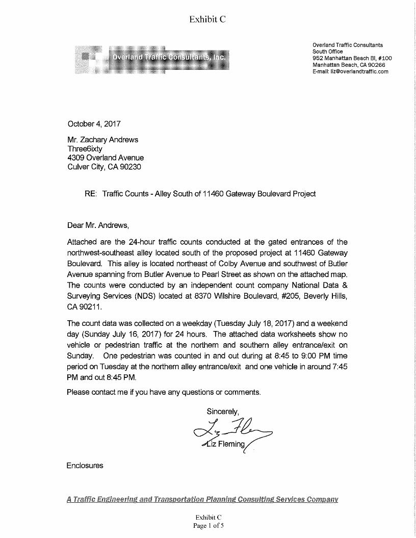
Exhibit C
Overland Traffic Consultants South Office952 Manhattan Beach Bl, #100 Manhattan Beach, CA 90266 E-mail: [email protected]
Overland Traffic Consultants. Inc.
October 4, 2017
Mr. Zachary Andrews Three6ixty4309 Overland Avenue Culver City, CA 90230
RE: Traffic Counts - Alley South of 11460 Gateway Boulevard Project
Dear Mr. Andrews,
Attached are the 24-hour traffic counts conducted at the gated entrances of the northwest-southeast alley located south of the proposed project at 11460 Gateway Boulevard. This alley is located northeast of Colby Avenue and southwest of Butler Avenue spanning from Butler Avenue to Pearl Street as shown on the attached map. The counts were conducted by an independent count company National Data & Surveying Services (NDS) located at 8370 Wilshire Boulevard, #205, Beverly Hills, CA 90211.
The count data was collected on a weekday (Tuesday July 18, 2017) and a weekend day (Sunday July 16, 2017) for 24 hours. The attached data worksheets show no vehicle or pedestrian traffic at the northern and southern alley entrance/exit on Sunday. One pedestrian was counted in and out during at 8:45 to 9:00 PM time period on Tuesday at the northern alley entrance/exit and one vehicle in around 7:45 PM and out 8:45 PM.
Please contact me if you have any questions or comments.
Sincerely,
2;Fleming
Enclosures
A Traffic EmilmmiM anti Transportation Planning, Consulting Seiwiees Company
Exhibit CPage 1 of 5
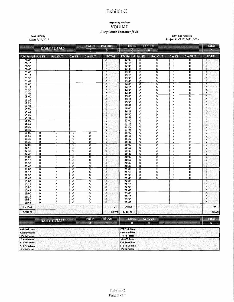
Exhibit C
Prepared byNDS/ATD
VOLUMEAlley South Entrance/Exit
City: Los Angeles
Project#: CA17_5471_002nDay: Sunday
Date: 7/16/2017
IPvd I Pi Pcc OUT Car It. Car OUT m
LY TOTALS o00 i
PM Period Ped IN Ped OUT Car OUTAM Period Ped IN Ped OUT Car IN Car OUT TOTAL Car IN S300 12:00
12:1512:3012:45
0 0 0 000:0000:1500:3000:45
0 0 0 0000 00 0 00
0 0 0 000013:00
13:1513:3013:45
0 0 00 001:0001:1501:3001:45
00 0 0 000 00 0 00
0 0 0 00014:0014:1514:3014:45
00 0 0 0002:0002:1502:3002:45
0 00 0 0000 0 0 0000 0 00 0
15:0015:1515:3015:45
0 0 00 0003:0003:1503:3003:45
00 0 0 0000 0 00 000 0 0 00
16:0016:1516:3016:45
00 0 00 004:0004:1504:3004:45
00 0 0 0000 0 00 000 0 0 00
17:0017:1517:3017:45
0 00 0 0005:0005:1505:3005:45
0 00 0 0000 0 000
0 0 0 00 0018:00
18:1518:3018:45
0 0 00 00 0 006:0006:1506:3006:45
00 0 0 000 0 0 0 0
00 0 0 00 00 0 000 0 00 00 0 0 0
19:0019:1519:3019:45
0 0 00 00 0 0 0007:0007:1507:3007:45
00 0 0 00 0 00 00 0 0 00 00 0 000 0 0 00 00 0 00
20:0020:1520:3020:45
0 0 0 000 0 0 008:0008:1508:3008:45
00 0 0 00 00 0 0 00 0 0 0 000 0 0 0
00 0 0 00 0 00 000 0 00 21:00
21:1521:3021:45
00 0 0 009:0009:1509:3009:45
0 0 0 00 00 00 000 0 0 000 0 0 00 00 0 00 0 00 0
22:0022:1522:3022:45
000 0 0 010:0010:1510:3010:45
00 0 00 000 0 00 000 0 00 0
23:0023:1523:3023:45
00 0 00 011:0011:1511:3011:45
00 0 0 0 000 0 00 000 0 0 00
TOTALS 00TOTALS
SPLIT % #DlV/0!#DIV/0!SPLIT %
P;'d iM Pi HI 1 r.ii ri TotalCo' OUTDAILY TOTALS 0 003PM Peak Hour PM Pk Volume
Pk Hr Factor
AM Peak Hour AM Pk Volume
Pk Hr Factor4-6 Volume
4-6 Peak Hour 4-6 Pk Volume
Pk Hr Factor
7 - 9 Volume 7-9 Peak Hour 7-9 Pk Volume
Pk Hr Factor
Exhibit CPage 2 of 5

Exhibit C
Prepared byNDS/ATD
VOLUMEAlley South Entrance/Exit
City: Los Angeles
Project#: CA17_5471_002nDay: Tuesday
Date: 7/18/2017
I.11 t'lj r Total
DAiAf
TOTAL PM Period Ped IN Ped OUT Car IN Car OUTAM Period Ped IN Ped OUT Car IN Car OUT000:00
00:1500:3000:45
0 12:0012:1512:3012:45
0 0 0 000 0 0 00
0 0 0 00 000 0 0 00
13:0013:1513:3013:45
0 00 0 0001:0001:1501:3001:45
0 0 0 00 00 0 0 00 00 0 0 00 0
14:0014:1514:3014:45
0 0 0 00002:0002:1502:3002:45
0 0 0 00 00 0 0 00 0
0 00 0 0015:0015:1515:3015:45
0 0 0 00 003:0003:1503:3003:45
0 0 00 0000 0 00 00 00 0 00
16:0016:1516:3016:45
0 00 0 0004:0004:1504:3004:45
0 0 0 00 00 00 0 00
0 0 0 00017:0017:1517:3017:45
0 00 0 0005:0005:1505:3005:45
0 0 0 00 00 00 0 00
0 0 0 00 00 018:00
18:1518:3018:45
0 00 0 00 0 006:0006:1506:3006:45
00 0 00 00 00 00 0 0 000 00 0 0
00 0 0 00 00 0019:0019:1519:3019:45
0 0 0 00 00 00 007:0007:1507:3007:45
0 0 00 0 000 0 00 0 1 0 100 00 0
00 0 1 0 10 00 00 020:0020:1520:3020:45
0 0 1 10 00 00 008:0008:1508:3008:45
0 00 0 00 00 000 00 0 00 00 00
0 0 1 0___10 00 00 0 021:0021:1521:3021:45
0 00 0 00 00 0009:0009:1509:3009:45
0 0 0 00 000 0 00 0 00 00 00 0 00 0 0 000 0 00 0
22:0022:1522:3022:45
00 00 0010:0010:1510:3010:45
000 00 000 00 0 0000 00 0
23:0023:1523:3023:45
000 00 011:0011:1511:3011:45
000 00 00000 0 0000 00 0
TOTALS 1 1 20TOTALS
SPLIT % 50.0% 50.0%0.0% 100.0%SPLIT %
P-H Tl Pi riOUT T-:i?.ilv TiI OUTDAILY TOTALS 10 20PM Peak Hour PM Pk Volume
Pk Hr Factor
18:45 19:15 19:15AM Peak Hour AM Pk Volume
Pk Hr Factor11 2
0.250 0.250 0.5004-6 Volume
4-6 Peak Hour 4-6 Pk Volume
Pk Hr Factor
7-9 Volume 7-9 Peak Hour 7-9 Pk Volume
Pk Hr Factor
Exhibit CPage 3 of 5
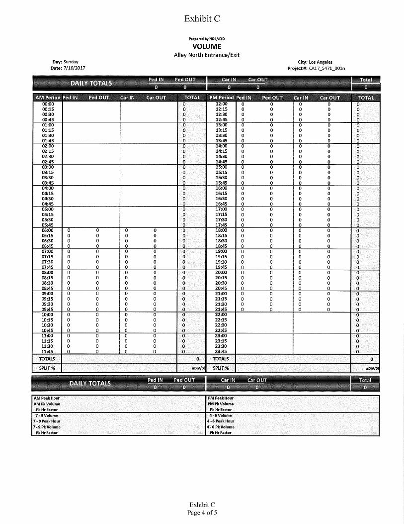
Exhibit C
Prepared byNDS/ATD
VOLUMEAlley North Entrance/Exit
Day:Sunday Date: 7/16/2017
City: Los Angeles Project#: CA17_5471_001n
T. Cur OUI TotalPed OUIDAILY TOTALSl0 "s
AM Period Ped IN Ped OUT Car IN Car OUT TOTAL PM Period Ped IN Ped OUT Car IN Car OUT TOTAL00:0000:1500:3000:45
0 12:0012:1512:3012:45
0 0 0 0 00 0 0 0 0 00 0 0 0 0 00 0 0 00 0
01:0001:1501:3001:45
13:0013:1513:3013:45
0 0 0 0 0 00 0 0 0 0 00 0 0 0 0 0
00 0 0 0 014:0014:1514:3014:45
02:0002:1502:3002:45
0 0 0 0 0 00 0 0 0 0 00 0 0 0 0 00 0 0 0 0 0
15:0015:1515:3015:45
03:0003:1503:3003:45
0 0 0 0 0 00 0 0 00 00 0 0 0 0 00 0 0 0 0 0
04:0004:1504:3004:45
16:0016:1516:3016:45
0 0 0 0 0 00 0 0 0 0 00 0 0 0 0 00 0 0 0 0 0
17:0017:1517:3017:45
05:0005:1505:3005:45
0 0 0 0 0 00 0 0 0 0 00 0 0 0 0 00 0 0 0 0 0
06:0006:1506:3006:45
0 0 0 18:0018:1518:3018:45
0 0 0 0 0 0 00 0 0 0 0 0 0 0 0 0
00 0 0 0 0 0 00 00 0 0 0 0 0 0 0 0 0
19:0019:1519:3019:45
07:0007:1507:3007:45
0 0 0 0 0 0 0 0 0 00 0 0 0 0 0 0 0 0 00 0 0 0 0 0 0 0 0 00 0 0 0 0 0 0 0 0 00 20:00
20:1520:3020:45
08:0008:1508:3008:45
0 0 0 0 0 0 0 0 00 0 0 0 0 0 0 0 0 00 0 0 0 0 0 0 0 0 00 0 0 0 0 0 0 0 0 00 009:00
09:1509:3009:45
0 0 0 21:0021:1521:3021:45
0 0 0 0 00 0 0 0 0 0 0 0 0 00 0 0 0 0 00 0 0 00 0 0 0 0 0 0 0 0 0
10:0010:1510:3010:45
0 0 22:0022:1522:3022:45
0 0 0 00 0 0 0 0 00 0 0 0 0 00 0 0 0 0 0
23:0023:1523:3023:45
11:0011:1511:3011:45
0 0 0 0 0 00 0 0 0 0 00 0 0 0 0 00 0 0 0 0 0
TOTALSTOTALS 0 0SPLIT %SPLIT % #DIV/0l #DIV/0!
?ed II Ped OUT■DAILY TOTALS o 0 0 0 0AM Peak Hour AM Pk Volume
Pk Hr Factor
PM Peak Hour PM Pk Volume
Pk Hr Factor7 -9 Volume
7-9Peak Hour 7-9 Pk Volume
Pk Hr Factor
4-6 Volume 4-6 Peak Hour 4-6 Pk Volume
Pk Hr Factor
Exhibit CPage 4 of 5
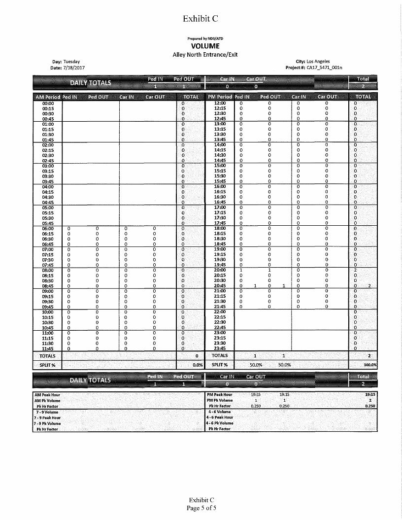
Exhibit C
Prepared by NDS/ATD
VOLUMEAlley North Entrance/Exit
City: Los Angeles Project#: CA17_5471_001n
Day: Tuesday Date: 7/18/2017
HcdOUs
1
Ped IN'DAILY TOTALS1
TOTAL PM Period Ped IN Ped OUT Car IN Car OUTAM Period Ped IN Ped OUT Car IN Car OUT TOTAL
00:0000:1500:3000:45
0 12:0012:1512:3012:45
0 0 0 0 00 00 0 00
00 0 00 000 0 000
13:0013:1513:3013:45
0 0 0 00001:0001:1501:3001:45
00 0 00000 0 000
0 00 0 0014:0014:1514:3014:45
00 0 00002:0002:1502:3002:45
00 0 00 000 0 00 000 00 00
15:0015:1515:3015:45
00 0 00 003:0003:1503:3003:45
00 0 0000 0 00 00
00 00 0016:0016:1516:3016:45
00 0 00004:0004:1504:3004:45
00 0 00 000 0 00000 0 000
17:0017:1517:3017:45
00 0 00005:0005:1505:3005:45
00 00 000 0 0 0000 0 0 000
18:0018:1518:3018:45
0 0 00 00 0 0 006:0006:1506:3006:45
000 0 0 00 0 0 0000 0 00 00 0 00
0 0 00 00 0 0 0019:0019:1519:3019:45
00 0 00 0 0 007:0007:1507:3007:45
0 000 0 00 0 00 000 00 00 0 0 0 00
0 00 0 00 00 0 020:0020:1520:3020:45
1 0 01 20 0 008:0008:1508:3008:45
0 000 0 00 00 0 00
0 0 00 00 0 0 0000 1 0 0 20 0 10 0 00
21:0021:1521:3021:45
0 0 00 00 0 0 009:0009:1509:3009:45
000 0 00 0 00 0 0
0 0 00 0 00 0 0000 0 00 0 00 00
22:0022:1522:3022:45
00 010:0010:1510:3010:45
0 0 00 00 0 0 0
00 00 000 0 00 0 0
23:0023:1523:3023:45
00 011:0011:1511:3011:45
0 0 000 00 0 0000 0 0000 0 00 0
TOTALS 1 21TOTALS 0SPLIT % 50,0% 50.0%0.0% 100.0%SPLIT %
Pod IN Pori OUT EliDAILY TOIAIS 20 □1 1
PM Peak Hour PM Pk Volume Pk Hr Factor
19:1519:15 19:15AM Peak Hour AM Pk Volume
Pk Hr Factor1 21
0.250 0.250 0.2504-6 Volume
4-6 Peak Hour 4-6 Pk Volume
Pk Hr Factor
7-9Volume 7 - 9 Peak Hour 7-9 Pk Volume
Pk Hr Factor
Exhibit CPage 5 of 5

Exhibit D
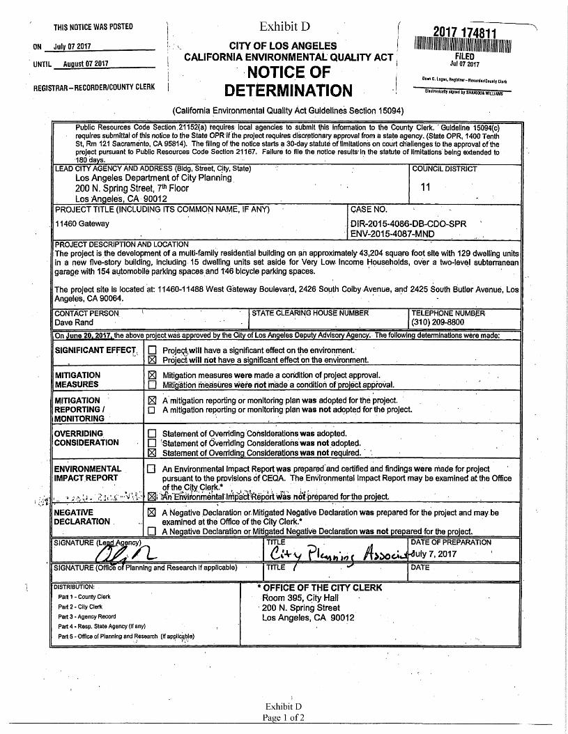
Exhibit DTHIS NOTICE WAS POSTED
CITY OF LOS ANGELES CALIFORNIA ENVIRONMENTAL QUALITY ACT
ON July 07 2017FILED
Jul 07 2017UNTIL August 07 2017 NOTICE OF DETERMINATION
Oem C. Login, H agli Irnr - R«eorder/Counl f ClerkREGISTRAR-RECORDER/COUNTY CLERK tioclfonimijr rlgned ir SHANIMIA WILLIAM?1
(California Environmental Quality Act Guidelines Section 15094)
Public Resources Code Section , 21152(a) requires local agencies to submit this Information to the County Clerk. ’ Guideline 15094(c) requires submittal of this notice to the State OPR if the project requires discretionary approval from a state agency. (State OPR, 1400 Tenth St, Rm 121 Sacramento, CA 95814). The filing of the notice starts a 30-day statute of limitations on court challenges to the approval of the project pursuant to Public Resources Code Section 21167. Failure to file the notice results4 in the statute of limitations being extended to 180 days. ________________;________ ;______ ■ ■_________ '_________________ ;_________ ______
LEAD CITY AGENCY AND ADDRESS (Bldg, Street, City, State) Los Angeles Department of City Planning 200 N. Spring Street, 7th Floor Los Angeles, CA 90012________________
COUNCIL DISTRICT
11
PROJECT TITLE (INCLUDING ITS COMMON NAME, IF ANY) CASE NO. -DIR-2015-4086-D B-CDO-S P R ENV-2015-4087-MND
11460 Gateway
PROJECT DESCRIPTION AND LOCATION 'The project is the development of a multi-family residential building on an approximately 43,204 square foot site with 129 dwelling units in a new five-story building, including 15 dwelling units set aside for Very Low- Income Households, over a two-level subterranean garage with 154 automobile parking spaces and T46 bicycle parking spaces.
The project site is located at: 11460-11488 West Gateway Boulevard, 2426 South Colby Avenue, and 2425 South Butler Avenue, Los Angeles, CA 90064. , ‘ -
STATE CLEARING HOUSE NUMBER TELEPHONE NUMBER (310) 209-8800
CONTACT PERSON Dave RandOn June 20.2017. the above project wad approved by the Pity of Los Angeles Deputy Advisory Agency. The following determinations were made:
□ Projeq|wlll have a significant effect on the environment.H Project will hot have a significant effect on the environment.
SIGNIFICANT EFFECT
El Mitigation measures were made a condition of project approval.□ Mitigation measures were riot made a condition of project approval.
H A mitigation reporting or monitoring plan was adopted for the project.□ A mitigation reporting or monitoring plan was not adopted for the project.
MITIGATIONMEASURES
MITIGATION REPORTING / MONITORING
□ Statement of Overriding Considerations was adopted.□ Statement of Overriding Considerations was not adopted.H Statement of Overriding, Considerations was not required. 1
OVERRIDINGCONSIDERATION
□ An Environmental Impact Report was prepared and certified and findings were made for project pursuant to the provisions of CEQA. The Environmental Impact Report may be examined at the Office oftheC(tyClark* , . „. v ■" it.
Hi not prepared for the project,_______ ' ■_____ ^_______
H A Negative Declaration or. Mitigated Negative Declaration was prepared for the project and may be examined at the Office of the City Clerk*
□ A Negative Declaration or Mitigated Negative Declaration was not prepared for the project.
ENVIRONMENTAL IMPACT REPORT
tvt
NEGATIVEDECLARATION
TITLE . DATE OF PREPARATION/f>^OC*J.<!uly7,2017 1
SIGNATURE (Lead Agency)
&VyTITLE 7 “
/LSIGNATURE (Office ofpianning and Research if applicable) 7 DATE
* OFFICE OF THE CITY CLERKRoom 395, City Hall 200 N. Spring Street Los Angeles, CA 90012
DISTRIBUTION: .
Part 1 - County Clerk
Part 2 - City Clerk
Part 3 - Agency Record
Part 4 - Resp. State Agency (If any)
Part 5 -Office of Planning and Research (If applicable)
s
Exhibit DPage 1 of2
2017174811
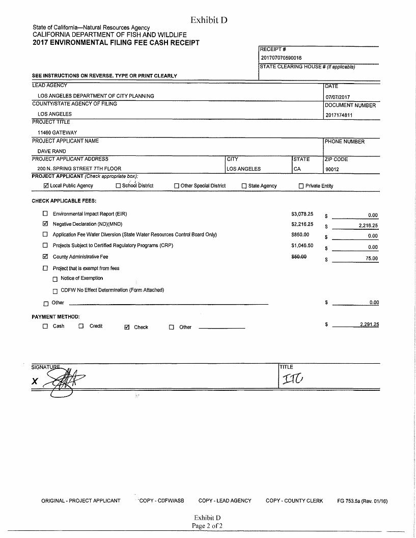
Exhibit DState of California—Natural Resources Agency CALIFORNIA DEPARTMENT OF FISH AND WILDLIFE2017 ENVIRONMENTAL FILING FEE CASH RECEIPT
RECEIPT # 201707070590016STATE CLEARING HOUSE # (If applicable)
SEE INSTRUCTIONS ON REVERSE. TYPE OR PRINT CLEARLY
LEAD AGENCY DATE
LOS ANGELES DEPARTMENT OF CITY PLANNING 07/07/2017COUNTY/STATE AGENCY OF FILING DOCUMENT NUMBER
LOS ANGELES 2017174811PROJECT TITLE
11460 GATEWAYPROJECT APPLICANT NAME PHONE NUMBER
DAVE RANDPROJECT APPLICANT ADDRESS CITY STATE ZIP CODE
200 N. SPRING STREET 7TH FLOOR LOS ANGELES CA 90012PROJECT APPLICANT (Check appropriate box):
0 Local Public Agency □ School District □ Other Special District □ State Agency □ Private Entity
CHECK APPLICABLE FEES:
□ Environmental Impact Report (EIR)
Negative Declaration (ND)(MND)
Application Fee Water Diversion (State Water Resources Control Board Only)
Projects Subject to Certified Regulatory Programs (CRP)
County Administrative Fee
Project that is exempt from fees
□ Notice of Exemption
□ CDFW No Effect Determination (Form Attached)
$3,078.25
$2,216.250.00$
0 2,216.25$□ $850.00 0.00$□ $1,046.50 0.00$0 C£Q_nnVPVV.VU 75.00$□
Other 0.00□
PAYMENT METHOD:
□ Cash □ Credit $ 2.291.250 Check □ Other
TITLESIGNATUI
x
COPY - CDFW/ASB COPY-LEAD AGENCY COPY-COUNTY CLERKORIGINAL - PROJECT APPLICANT FG 753.5a (Rev. 01/16)
Exhibit DPage 2 of 2

Exhibit E

EXHIBIT "E
AIR OVALITY DYNAMICSSPIX'IAU/JYG AM//? QUALITY AMU.YSIS
September 10,2017
Armbruster Goldsmith and Delvac LLP 12100 Wilshire Boulevard, Suite 1600 Los Angeles, California 90025 Attn: Dave Rand, Esq.
Re: 11460-11488 West Gateway Boulevard Project - Health Risk Assessment
Mr Rand:
Per your request, Air Quality Dynamics has reviewed the SWAPE comment letter which alleges the Initial Study/Mitigated Negative Declaration (1S/MND) prepared for the proposed project fails to “adequately evaluate” the projects health risk impacts. SWAPE contends that diesel particulate matter (DPM) emissions associated with project construction and operation may have the potential to expose sensitive receptors to substantial pollutant concentrations. This is based upon the preparation of a health risk screening assessment which reports cancer risk estimates for schools located in proximity of the proposed project and an adjoining resident exceed the maximum incremental cancer risk of one in one hundred thousand (1.0E-05) established by the South Coast Air Quality Management District (SCAQMD) for projects prepared under the auspices of the California Environmental Quality Act (CEQA)
As a result, SWAPE notes that should an unacceptable air quality hazard be identified utilizing a screening dispersion model methodology, “a more refined modeling approach is required prior to approval of the project” whereby “a more refined health risk assessment needs to be conducted”. Based upon this consideration, Air Quality Dynamics presents a revised health risk assessment which utilizes all relevant and appropriate assessment and dispersion modeling methodologies presented by the U.S. Environmental Protection Agency, California Environmental Protection Agency and SCAQMD to ensure a viable quantification of pollutant exposures associated with the generation of contaminant emissions from construction related activity.
Results of the refined health risk assessment showed lower DPM concentrations than the SWAPE screening analysis whereby cancer risk estimates were found to be within the SCAQMD significance threshold of 1.0E-05. The following discussion outlines the methodology utilized to conduct the refined health risk assessment and presents the revised estimates of risk.
Source Identification
The proposed project will involve the demolition of existing commercial land uses and the subsequent construction of a multi-family residential building to accommodate 129 dwelling
EXHIBIT EPage 1 of 55
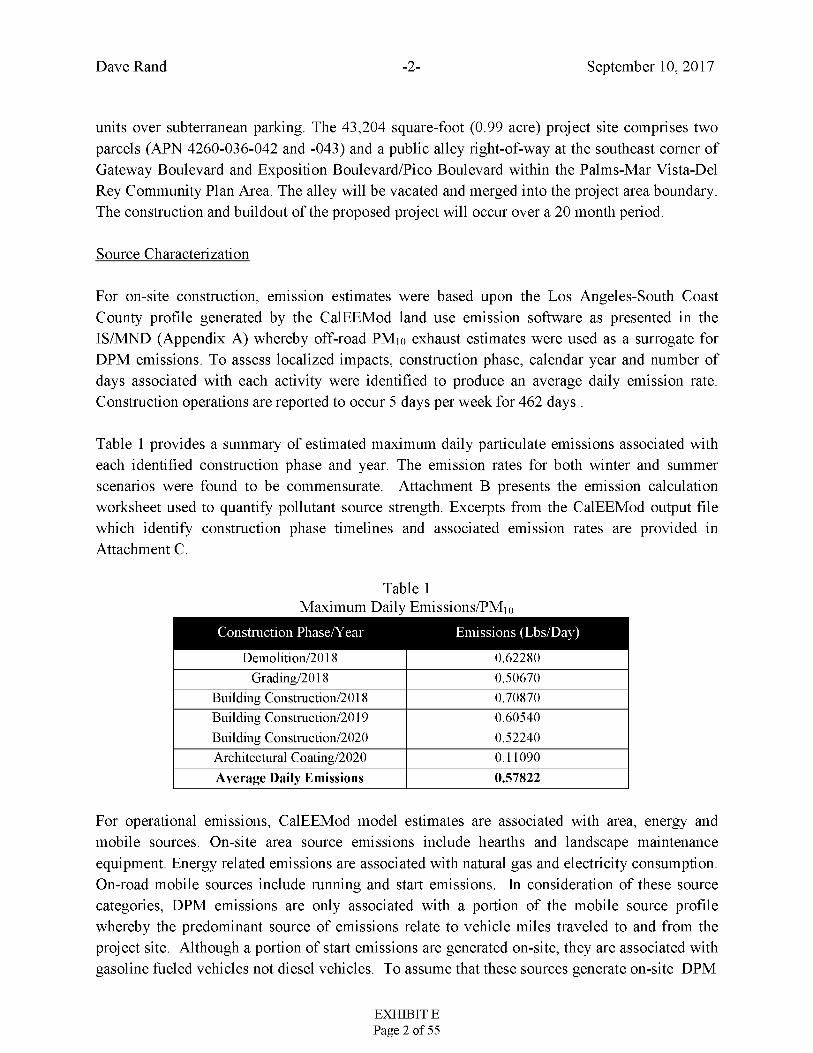
Dave Rand September 10, 2017-2-
units over subterranean parking. The 43,204 square-foot (0.99 acre) project site comprises two parcels (APN 4260-036-042 and -043) and a public alley right-of-way at the southeast comer of Gateway Boulevard and Exposition Boulevard/Pico Boulevard within the Palms-Mar Vista-Del Rey Community Plan Area. The alley will be vacated and merged into the project area boundary. The construction and buildout of the proposed project will occur over a 20 month period.
Source Characterization
For on-site construction, emission estimates were based upon the Los Angeles-South Coast County profile generated by the CalEEMod land use emission software as presented in the IS/MND (Appendix A) whereby off-road PMio exhaust estimates were used as a surrogate for DPM emissions. To assess localized impacts, construction phase, calendar year and number of days associated with each activity were identified to produce an average daily emission rate. Construction operations are reported to occur 5 days per week for 462 days .
Table 1 provides a summary of estimated maximum daily particulate emissions associated with each identified construction phase and year. The emission rates for both winter and summer scenarios were found to be commensurate. Attachment B presents the emission calculation worksheet used to quantify pollutant source strength. Excerpts from the CalEEMod output file which identify construction phase timelines and associated emission rates are provided in Attachment C.
Table 1Maximum Daily Emissions/PMio
Construction Phase/Year Emissions (Lbs/Day)
Demolition/2018 0.62280Grading/2018 0.50670
Building Construction/2018 0.70870Building Construction/2019 0.60540Building Construction/2020 0.52240Architectural Coating/2020 0.11090Average Daily Emissions 0.57822
For operational emissions, CalEEMod model estimates are associated with area, energy and mobile sources. On-site area source emissions include hearths and landscape maintenance equipment. Energy related emissions are associated with natural gas and electricity consumption. On-road mobile sources include running and start emissions. In consideration of these source categories, DPM emissions are only associated with a portion of the mobile source profile whereby the predominant source of emissions relate to vehicle miles traveled to and from the project site. Although a portion of start emissions are generated on-site, they are associated with gasoline fueled vehicles not diesel vehicles. To assume that these sources generate on-site DPM
EXHIBIT EPage 2 of 55
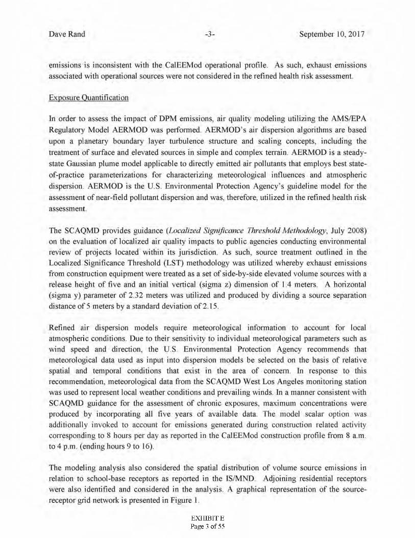
Dave Rand September 10, 2017-j-
emissions is inconsistent with the CalEEMod operational profde. As such, exhaust emissions associated with operational sources were not considered in the refined health risk assessment.
Exposure Quantification
In order to assess the impact of DPM emissions, air quality modeling utilizing the AMS/EPA Regulatory Model AERMOD was performed AERMOD’s air dispersion algorithms are based upon a planetary boundary layer turbulence structure and scaling concepts, including the treatment of surface and elevated sources in simple and complex terrain. AERMOD is a steady- state Gaussian plume model applicable to directly emitted air pollutants that employs best state- of-practice parameterizations for characterizing meteorological influences and atmospheric dispersion. AERMOD is the U S. Environmental Protection Agency’s guideline model for the assessment of near-field pollutant dispersion and was, therefore, utilized in the refined health risk assessment.
The SC AQMD provides guidance (Localized Significance Threshold Methodology, July 2008) on the evaluation of localized air quality impacts to public agencies conducting environmental review of projects located within its jurisdiction. As such, source treatment outlined in the Localized Significance Threshold (LST) methodology was utilized whereby exhaust emissions from construction equipment were treated as a set of side-by-side elevated volume sources with a release height of five and an initial vertical (sigma z) dimension of 1.4 meters. A horizontal (sigma y) parameter of 2.32 meters was utilized and produced by dividing a source separation distance of 5 meters by a standard deviation of 2.15.
Refined air dispersion models require meteorological information to account for local atmospheric conditions. Due to their sensitivity to individual meteorological parameters such as wind speed and direction, the US. Environmental Protection Agency recommends that meteorological data used as input into dispersion models be selected on the basis of relative spatial and temporal conditions that exist in the area of concern. In response to this recommendation, meteorological data from the SCAQMD West Los Angeles monitoring station was used to represent local weather conditions and prevailing winds. In a manner consistent with SCAQMD guidance for the assessment of chronic exposures, maximum concentrations were produced by incorporating all five years of available data. The model scalar option was additionally invoked to account for emissions generated during construction related activity corresponding to 8 hours per day as reported in the CalEEMod construction profile from 8 a.m. to 4 p.m. (ending hours 9 to 16).
The modeling analysis also considered the spatial distribution of volume source emissions in relation to school-base receptors as reported in the IS/MND. Adjoining residential receptors were also identified and considered in the analysis. A graphical representation of the source- receptor grid network is presented in Figure 1.
EXHIBIT EPage 3 of 55
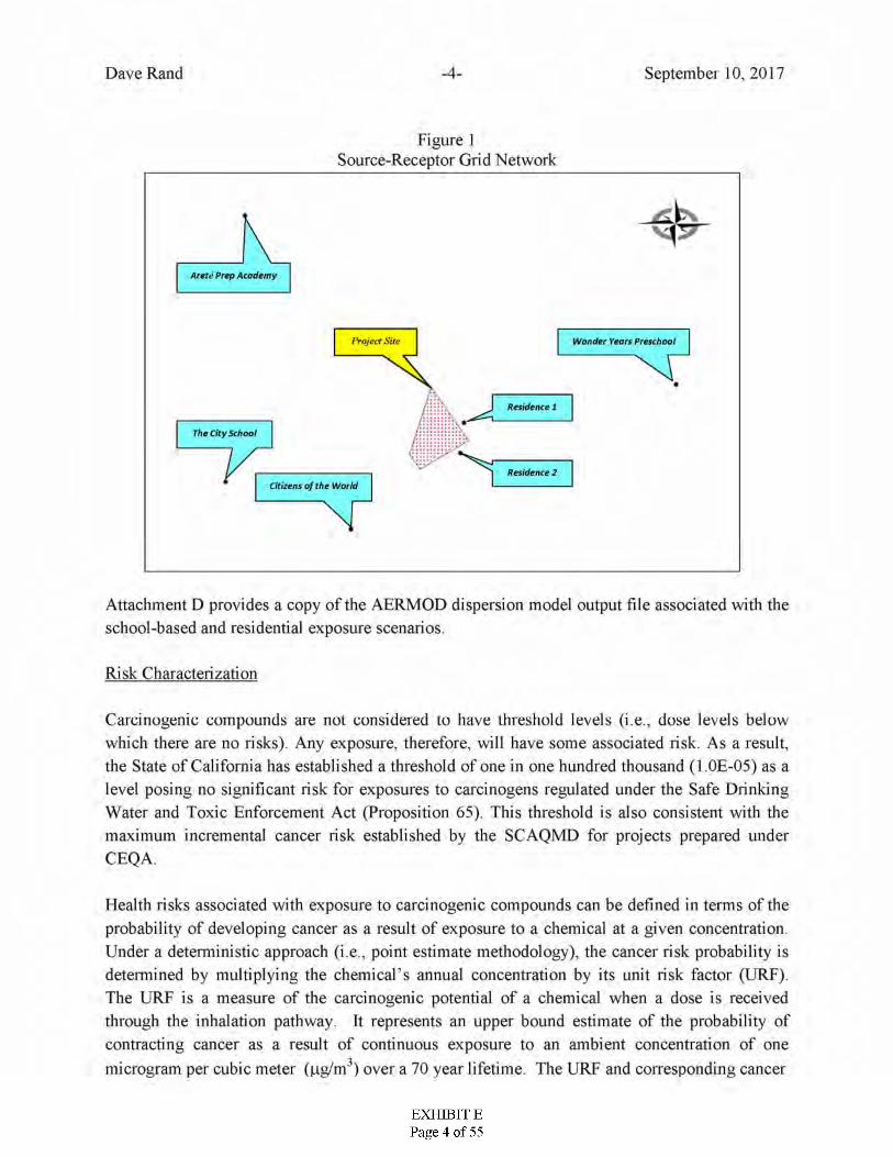
Dave Rand -4- September 10, 2017
Figure 1Source-Receptor Grid Network
Arete Prep Academy
Project Site Wonder Years Preschool
XT1M
Residence 1
jThe City Schooljj>
Residence 2Citizens of the World
NT
Attachment D provides a copy of the AERMOD dispersion model output file associated with the school-based and residential exposure scenarios.
Risk Characterization
Carcinogenic compounds are not considered to have threshold levels (i.e., dose levels below which there are no risks). Any exposure, therefore, will have some associated risk. As a result, the State of California has established a threshold of one in one hundred thousand (1.0E-05) as a level posing no significant risk for exposures to carcinogens regulated under the Safe Drinking Water and Toxic Enforcement Act (Proposition 65). This threshold is also consistent with the maximum incremental cancer risk established by the SCAQMD for projects prepared under CEQA.
Health risks associated with exposure to carcinogenic compounds can be defined in terms of the probability of developing cancer as a result of exposure to a chemical at a given concentration Under a deterministic approach (i.e., point estimate methodology), the cancer risk probability is determined by multiplying the chemical’s annual concentration by its unit risk factor (LJRF). The URF is a measure of the carcinogenic potential of a chemical when a dose is received through the inhalation pathway. It represents an upper bound estimate of the probability of contracting cancer as a result of continuous exposure to an ambient concentration of one microgram per cubic meter (ng/m1) over a 70 year lifetime. The URF and corresponding cancer
EXHIBIT EPage 4 of 55
Dave Rand September 10, 2017-5-
potency factor for DPM utilized in the assessment was obtained from the Consolidated Table of OEHHA/ARB Approved Risk Assessment Health Values.
A review of available guidance was conducted to determine applicability of the use of early life exposure adjustments to identified carcinogens. The U.S. Environmental Protection Agency provides guidance relating to the use of early life exposure adjustment factors {Supplemental Guidance for Assessing Susceptibility from Early-Life Exposure to Carcinogens, EPA/630/R- 003F) whereby adjustment factors are only considered when carcinogens act “through the mutagenic mode of action.” The U.S. Environmental Protection Agency has identified 19 compounds that elicit a mutagenic mode of action for carcinogenesis. For diesel particulates, polycyclic aromatic hydrocarbons (PAHs) and their derivatives, which are known to exhibit a mutagenic mode of action, comprise < 1% of the exhaust particulate mass. To date, the U.S. Environmental Protection Agency reports that whole diesel engine exhaust has not been shown to elicit a mutagenic mode of action. However, for risk assessments conducted under the auspices of The Air Toxics "Hot Spots" Information and Assessment Act (AB 2588, Connelly, Statutes of 1987; Health and Safety Code Section 44300 et seq.) a weighting factor is applied to all carcinogens regardless of purported mechanism of action.
As a commenting agency, the SCAQMD has not provided definitive guidance nor developed policy relating to the applicability of applying early life exposure adjustment factors for projects conducted under CEQA. Additionally, the California Department of Toxic Substances Control (DTSC) which is charged with protecting individuals and the environment from the effects of toxic substances is also responsible for assessing, investigating and evaluating proposed school sites to ensure that selected properties are free of contamination or, if the properties are contaminated, have been remediated to a level that protects the health of students and staff. Notwithstanding this responsibility, the DTSC has adopted the U.S. Environmental Protection Agency’s policy in the application of early life exposure adjustments. As such, incorporation of early life exposure adjustments for exposures to DPM emissions in the quantification of carcinogenic risk for construction of the proposed project were not considered in the refined health risk assessment.
To quantify dose, the procedure requires the incorporation of several discrete exposure variates. To account for exposures unique to the school-based populations, lifetime risk values were adjusted to account for exposure frequencies representative of reported operating days per year. For residential exposures, an exposure frequency of 260 days per year for 1.67 years (20 months) was assumed.
Point estimates for daily breathing rates representing the 95th percentile were employed for each school-based population representing the grade level and associated age range for each occupancy. For the residential exposure scenario, upper-bound breathing rates representing 3rd trimester and infant exposures were incorporated into the following dose algorithm:
EXHIBIT EPage 5 of 55
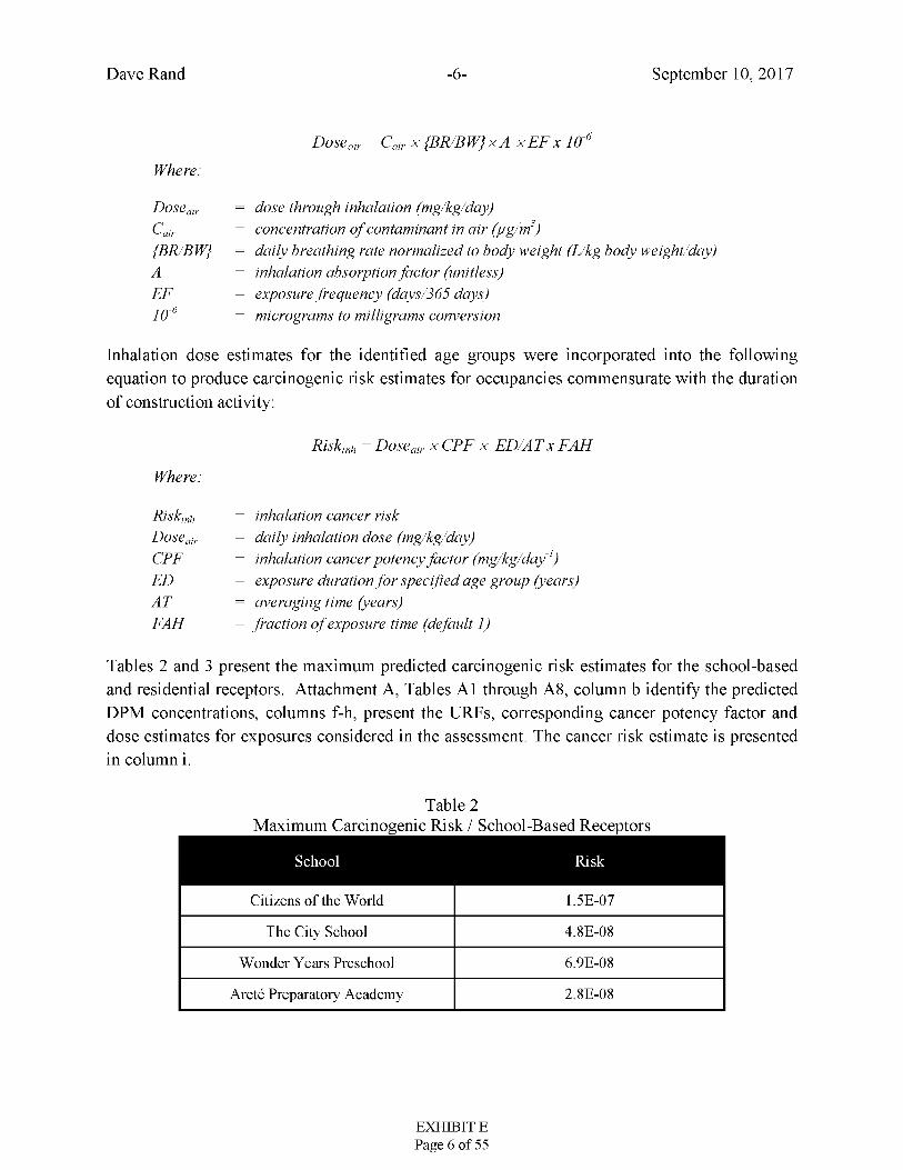
Dave Rand September 10, 2017-6-
-6C* air X {BR/BW} X A X EF X 10Dose air
Where:
dose through inhalation (mg/kg/day) concentration of contaminant in air (pg/m3)daily breathing rate normalized to body weight (L/kg body weight/day) inhalation absorption factor (unitless) exposure frequency (days/365 days) micrograms to milligrams conversion
DoseairC'—air{BR/BW}AEF
-610
Inhalation dose estimates for the identified age groups were incorporated into the following equation to produce carcinogenic risk estimates for occupancies commensurate with the duration of construction activity:
Risk Dose air x CPF x ED/AT x FAHink
Where:
Risk inhalation cancer riskdaily inhalation dose (mg/kg/day)inhalation cancer potency factor (mg/kg/day1 )exposure duration for specified age group (years)averaging time (years)fraction of exposure time (default 1)
irihDoseairCPFEDATFAH
Tables 2 and 3 present the maximum predicted carcinogenic risk estimates for the school-based and residential receptors. Attachment A, Tables A1 through A8, column b identify the predicted DPM concentrations, columns f-h, present the URFs, corresponding cancer potency factor and dose estimates for exposures considered in the assessment. The cancer risk estimate is presented in column i.
Table 2Maximum Carcinogenic Risk / School-Based Receptors
School Risk
Citizens of the World 1.5E-07
The City School 4.8E-08
Wonder Years Preschool 6.9E-08
Arete Preparatory Academy 2.8E-08
EXHIBIT EPage 6 of 55
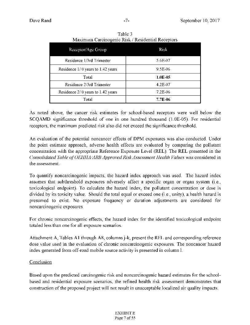
Dave Rand September 10, 2017-7-
Table 3Maximum Carcinogenic Risk / Residential Receptors
Receptor/Age Group Risk
Residence l/3rd Trimester 5.6E-07
Residence 1/ 0 years to 1.42 years 9.5E-06
Total 1.0E-05Residence 2/3rd Trimester 4.2E-07
Residence 2/ 0 years to 1.42 years 7.2E-06
Total 7.7E-06
As noted above, the cancer risk estimates for school-based receptors were well below the SCQAMD significance threshold of one in one hundred thousand (1.0E-05). For residential receptors, the maximum predicted risk also did not exceed the significance threshold.
An evaluation of the potential noncancer effects of DPM exposures was also conducted. Under the point estimate approach, adverse health effects are evaluated by comparing the pollutant concentration with the appropriate Reference Exposure Level (REL). The REL presented in the Consolidated Table of OEHHA/ARB Approved Risk Assessment Health Values was considered in the assessment.
To quantify noncarcinogenic impacts, the hazard index approach was used. The hazard index assumes that subthreshold exposures adversely affect a specific organ or organ system (i.e., toxicological endpoint). To calculate the hazard index, the pollutant concentration or dose is divided by its toxicity value. Should the total equal or exceed one (i.e., unity), a health hazard is presumed to exist. No exposure frequency or duration adjustments are considered for noncarcinogenic exposures.
For chronic noncarcinogenic effects, the hazard index for the identified toxicological endpoint totaled less than one for all exposure scenarios.
Attachment A, Tables A1 through A8, columns j-k, present the REL and corresponding reference dose value used in the evaluation of chronic noncarcinogenic exposures. The noncancer hazard index generated from off-road mobile source activity is presented in column 1.
Conclusion
Based upon the predicted carcinogenic risk and noncarcinogenic hazard estimates for the school- based and residential exposure scenarios, the refined health risk assessment demonstrates that construction of the proposed project will not result in unacceptable localized air quality impacts.
EXHIBIT EPage 7 of 55
Dave Rand September 10, 2017-8-
I can be reached at (818) 703-3294 should you have any questions or require additional information.
Sincerely,
Bill Piazza
Attachment A Attachment B Attachment C Attachment D Attachment E:
Risk Calculation Worksheets Emission Calculation Worksheet CalEEMod Output File Dispersion Model Output File List of References
EXHIBIT EPage 8 of 55
ATTACHMENT A
Risk Calculation Worksheets
EXHIBIT EPage 9 of 55

Table A1Quantification of Carcinogenic Risks and Noncarcinogenic Hazards
Citizens of the World / School-Based Receptor
Noncarcinogenic Hazards Toxicological Endpoints"MussGLC Carcinogenic RiskSource Weight
fraction
Contaminant
CRT DOSE
(itg'kg-dayi
RISK Rl'l. RfD RF.SP IMMUN KIDN OJ/LV l*VESCPI- CNS-'PNS CV/Bl. RFPRO■i ujim) : (mg/kg/day)ting kg flay) Olg'III )mg-in ) fire/nt)( b > •-h l_ _ _LsJ LL! Lai. LSIILL < m > Lai Jjii 111Li—1 JJLLLU
-lilliiiiiL > <*E-Q5 i • I Di^JPurlkulnr* I ■I-1'" \JM1 I 4E-03Construction 30FJH 6 ii-:-u«> 3.3K-03
TOTAL 5K-0* .VIE-03 OOL'«OQ 0 0E *00 OObNOO 0.01**01) 0 0E*O0 0 OE*00 0 0E«0D
* key to Toxicological Endpoints
RESPCNS/PNSC'VBLIMMUNKIDNGI'LVRE PROEYES
Respiratory SystemCentral PenphCTdl Nervous SvstemCardiovascular Blood SystemImmune SvsteraKidney<Jastr< miles timl SvslenVLiverReproductive S\stem(e.e teratogenic and develoixnenial effects) Eve imtation and/or other effects
Exposure factors used (o calculate contaminant intakeNote.
exposure frequenev (davs'vear) exposure duration (years) inhalation rote (Vkp-dav)) inhalation absorption factor averaging time I years) fiactionofline
180I 67715
I70
1hieatlunfi rate third trimester liculiung rate 0-2 Ixcathing rate 2-9 ineatiuns rate 2-In Ueatlnne rate ln-30 Ixcalhing rate ln-70
3ol10*0Sol745335290
EXHIBIT EPage 10 of 55
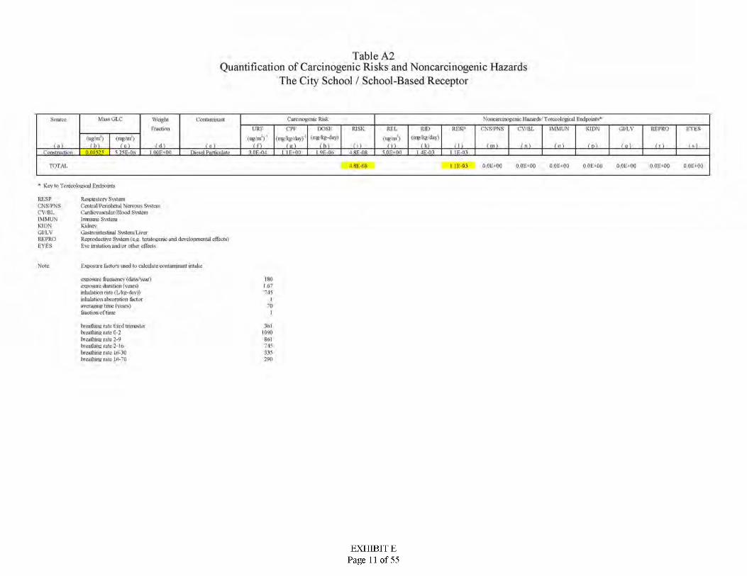
Table A2Quantification of Carcinogenic Risks and Noncarcinogenic Hazards
The City School / School-Based Receptor
Nojic-aicmogcrac Hazards Toxicological Endpoints"Muss GLC Carcinogenic RiskSource Weight
fraction
Contaminant
URL DOSEinpkg-dayi
RISK Rfl) RT.SP IMMUN KIDN GJ/LVepr Rfl. CNS-'PNS CV/Bl. RFPRO EYES>'ug'mQ i ug nf) : f mg/kg/day)tup kg flay t up in )<rap/nf)
lL- LL Uil _LsJ _ JjlLLSJ (11 _L . in > JJU Jjii 111L£2 ULLLSJ0.00515 525E-Op i • I D^JPunkuln/-.- Li± » IE-03.30E^ni I.9E-0O ■ LSfcP/L
TOTAL I8K-08 I If-03 O.OLNOO 0 0E *00 OOLNOO 0.01**00 001*00 0 OE»00 0 OL«00
* Key to Toxicological EndpoinLs
RESPCNS-'PNSCV/BLIMMUNKIDNGI’LVRE PROEYES
Respiratory SystemCentral1'Peripheral Nervous SvstcmCardiovascular Blood SvstcmImmune SvsteroKidneyGastrointestinal SvsIeiu'LiverReproductive S\stem(e.e teratogenic and develoixnenial effects) Eve imtation and/or other effects
Exposure factors used (o calculate contaminant intakeNote.
exposure frequence <duvs'vear> exposure duration (vans) inhalation rote (Vkp-dav)) uiltalaiton absorption factor averaging time I years) fiactionofline
180I 67715
I70
1hieatiunfi rate third trimester I a calliing rate 0-2 breathing rate 2-9 ineatiuns rate 2-In Ijceatlnne rate lh-30 Ixcalhing rate ln-70
3ol|090Sol745335390
EXHIBIT EPage 11 of 55

Table A3Quantification of Carcinogenic Risks and Noncarcinogenic Hazards
Wonder Years Preschool / School-Based Rec eptor
Ncj i carcinogenic Hazards Toxicological Endpoinfs"Muss GLC Carcinogenic RiskSource Weight
fraction
Contaminant
UR r Dost:(ng'Kg-dayl
RISK Rfl) Rf.SP IMMUN KIDN GJ/LY I* YESCPP REL rxS'PNS cvret. RFPRO
i ug'nC) lug nf) (mg'kgday)(ing/kg/day) uigm )lire/m)LLl LiL2 LL lLl: _ _LsJ LL: JjLi m.LSJ UU. isl 111LiJ _L ±mj UH.LSJ
O.OOttO ■ 'I'l -I'.' Ifr-sLEllflWlitf:-- Ufjffil s or.->oo 4E-03 »oi;-ti-i. .■'I'lmct'.'" : si-.11,. i»‘)F-D8TOTAI. 6 ‘)l-:-U8 •» OK-Ot oot-oo 0 0E*00 O.OfiOU 0 0E*0U OOL-OO OOE*O0 ool*oo
* Key to Toxicological Endpoints
RESPCNSPNSC'VBLIMMUNKIDNGI'LVRE PROEYES
Respiratory SystemCentral PcnnlicraJ Nervous SystemCardiovascular Blood SystemImmune SystemKidneyGastrointestinal SvslenVLiverReproductive System (e.c teraloeeruc and develoitmenial effects) Eye imtation and/or other effects
hxposuie (actors used to calculate contaminant intakeNote.
exposure frequency tdavs'vear) exposure duration (years) inhalation rote (Vkp-dav)) inhalation absorption factor avcnigiiu? time I years) fraction of time
2601.6^$61
I1
hieatiunfi rate third trimester Uculiuna rate 0-2 Ixcathirut rate 2-9 tneatiuns rate 2-In Ueatlnne rate ln-30 Ixcalhinsr rate ln-70
To)IOvK>Sol745335350
EXHIBIT EPage 12 of 55

Table A4Quantification of Carcinogenic Risks and Noncarcinogenic Hazards
Arete Preparatory Academy / School-Based Receptor
Ncji carcinogenic Hazards Toxicological Endpoints"Muss GLC Carcinogenic RiskSource Weightfraction
Contaminant
DOST
(ng'kg-dayl
RISK Rl'l. Rfl) rf.sp IMMUN KIDN GJ/LV TYESURF CPT CNS'PNS cvrat. RFPRO
iu|» nf) (mp'kg daylfrap/n/) (ing/kg/day) n*>m )rug ni iLkJ l_ _L_ _ _lU LSILLl LsJ 111 —L. lai. Lili Lai. LllLLl LIU.LSJ < m >
O-M-W 1 ■' IlLLLliiUiikL; ■ ifi-w IQClOO iiUW■vilBlnwHm 3Qi-:-'i.iTOTAI. : sk-us b l !-:-o i oot«oo OOK‘00 O.Ot'lOU 0 0E*0U O.OL-tOQ OOE‘O0 ool*oo
* Key to Toxicological Endpoints
RESPCNSPNSC'VBI.IMMUNKIDNGI'LVRE PROEYES
Respiratory SystemCentnd PcnnlicraJ Nervous SvstemCardiovascular Blood SystemIrrnimne SvsteroKidneyGastrointestinal Svsletn/LiverReproductive S\stem(e.e teratogenic and develoixnenfal effects) Eve irritation and/or other effects
Exposure factors used to calculate contaminant intakeNote.
exposure frequence (davsvear) exposure duration (vans) inhalation rote (Vkp-dav)) uiltalaiton absorption factor averaging time I years) faction of time
180I 67715
I70
1Deadline rate third trimester D entiling rate 0-2 D entiling rate 2-9 Deadline rate 2-In Deadline rate lii-30 Dentiling rate ln-70
3<ill QUOSol745335350
EXHIBIT EPage 13 of 55

Table A5Quantification of Carcinogenic Risks and Noncarcinogenic Hazards
3rd Trimester Exposure Scenario / Residential Receptor 1
Nciicarcmogcrac Hazards Toxicological Endpoints"Muss GLC Carcinogenic RiskSource Weightfraction
Contfiittuiant
ure DOSE
(tUtkg-dayi
RISK REL Rfl) RUSP IMMUN KIDN OJ/LVCPF CNS'PNS cvret. RFPRO FVES
(ug/mV :.• - (mg'kg daylling%/day) nig/m >mg m ) <rag/nf)( b > U-L lLl -L _ _—L Lai.— LL-l Lai Lil LllLiEi LEi llLLSJ n s-u 5 T7r-04 l noi>flo LULffi 5.OE-0- LiliLi i :i;-oiI0i:-n.| I SEJM
TOTAL i«K-0’ I EE-01 OOL'-OO 0 0E*00 O.OfiOU 0 0E*0U OOE-OO OOE‘00 ooe*oo
* Key to Toxicological Endpoints
RESPCNS'PNSC'VBI-IMMUNKIDNGI'LVRFPROEYES
Respiratory SystemCentral PcnnhcraJ Nervous SystemCardiovascular Blood SystemlrnmiDie SystemKidneyGaslrouilc>tinal SvsIcro'LiverReproductive System (e.c teratogenic and develoixuenial effects) Eye irritation and/or other effects
Exposwe factors used to calculate contaminant intakeNote.
exposure frequency (duvs'vear) exposure duration (years) inhalation rote <lvkp-day)) inhalation absorption (actor averaging time (years) traction of time at hom:
260(125361
II
headline rate tliird trimester h calking rate 0-2 breathing rate 2-9 headline rate 2-In headline rate 16-30 headline rate 16-"0
3ol.. 0Sol745335250
EXHIBIT EPage 14 of 55

Table A6Quantification of Carcinogenic Risks and Noncarcinogenic Hazards
1.42 Year Exposure Scenario / Residential Receptor 1
Nci icarcmogcrac Hazards Toxicological Endpoints"Muss GLC Carcinogenic RiskSource Weight
fraction
Contaminant
UR1- DOSE(ny'kg-day)
RISK REL Rfl) RESP IMMUN KIDN OJ/LY EYESCPE CNS'PNS cvret. RFPRO*(ug'raV :.• - (ny'kg'day)(ny kg'day) nig'in >tug in ) <ny/nf)
( b > LiL2 L2_ Uli _L _LL* 1±L J_i_LLi_i LU ill ini ini 111LULL ILLLSJ o >~~u 5 TTF-04 l ■ • I 1 KiMkuUQ Ufd2fl vOE+on 4E-03 i :i:-ui! saamd.. 3 Of-0-1 4.4E-04
TQTAI. 9.5K-06 I.2K-0I OOL'<OQ 0 OE»00 OOLNOO 0 0E»0U 0 0L'*O0 0 OE»00 0 OL«00
* Key to Toxicological Endpoints
RESPCNS'PNSC'VBI.IMMUNKIDNGI’LVRE PROEYES
Respiratory SystemCentral PcnnhcraJ Nervous SystemCardiovascular Blood SystemImmiDte SystemKidneyGaslroinlcstuwl SvsletnLiverReproductive System (e.e teratogenic and develoixnenial effects) Eye irritation and/or other effecis
kxixwwe (actors used to calculate contaminant intakeNote.
exposure frequency (duvs'vear) exposure duration (years) mlialalion rote <lAp-dav» inhalation absorption (actor averaging time (years) friction of time at hom:
260I 42
lO'X)I
70)
hieatiunfi rate tliird trimester Inca tiling rate 0-2 breathing rate 2-9 bieatiuns rate 2-la Ijceathme rate in-30 lx c.i thing rate ln-70
36110y*0Sol74*335250
EXHIBIT EPage 15 of 55

Table A 7Quantification of Carcinogenic Risks and Noncarcinogenic Hazards
3rd Trimester Exposure Scenario / Residential Receptor 2
Ncjicarcmogcrac Hazards Toxicological Endpoints"Muss GLC Carcinogenic RiskSource Weight
Fraction
Contaminant
DOSE
i ng'kg-dayiRISK REL Rfl) Rl-.SP IMMUN KIDN GJ/LV l*VESURF CPE CNS'PNS cvret. RFPRO
: lug nf) (mp/)^/day)<njg/nO (ing/kg/day) <ugui )rug in i LL _ _LsJ lU LSIuu in <11 ■Uii Nil Lai. LllLEU. LEIUUo < I01--01 i ■ i I'urliuiliL: 1 IE-OH JJTAT_ M£TJ3-•r- 3 Of-0-1 1 IE-04 8.8E-02
TOTAL I 2K-07 X 8E-02 OOL'«OQ 0.01**00 0,0E«0Q 0 0E*0U OOL'OO 0 OE»00 0 OL«00
* Key to Toxicological Endpoints
RESPCNSPNSC'VBI-IMMUNKIDNGI'LVRE PROEYES
Respiratory SystemCentral Pcnnhcral Nervous SystemCardiovascular Blood SystemImmune SystemKidneyGastrointestinal SvsletnLiverReproductive System (e.e teratogenic and develoixnenial effects) Eve imtation and/or other effects
Exposure factors used (o calculate contaminant intakeNote.
exposure frequency < days' year) exposure duration (years) mlialation rote <lvkp-day)) inhalation absorption (actor averaging time (years) traction of time at Ik'ihj
260(125361
I70
Iheadline rate tliird trimester I neat) urig rate 0-2 breathing rate 2-9 headung rate 2-In headline rate in-30 healhing rate 16-70
3<il.. 0Sol745335250
EXHIBIT EPage 16 of 55
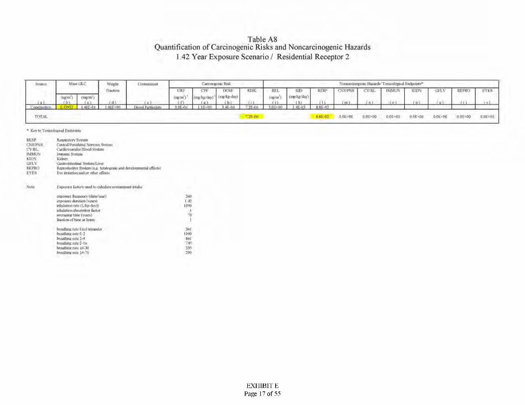
Table A8Quantification of Carcinogenic Risks and Noncarcinogenic Hazards
1 42 Year Exposure Scenario / Residential Receptor 2
Nci icarcmogcrac Hazards Toxicological Endpoinfs"Muss GLC Carcinogenic RiskSource Weight
fraction
Contaminant
UR r DOSE
(ng'kg-daylRISK Rfl) Rl-SP IMMUN KIDN GJ/LY EYESCPF RFL CNS'PNS cvret. RFPRO
i ug'nC) (ug.'nf)’: (mg/J^day)(nv%/rkty) ntg/m )iite/nt)
1—i-2 LL _U _ _LsJ iU UU LSIL_! I 1 l LIU lai 111l_ LEU LIU.LSJ> IQE-OI i ■ I ■" Dicsd Puniculmc Liup-q s of.->oo 4E-03iJilBlnWHUI 3 0i:-n.| 34E-Q4 xxi:-n:
TOTAL T2K-06 xsi:-02 OOL'-OO 0 0E*00 O.OfiOU 0 0E*0U OOE-OO OOE‘00 ooe*oo
* Key to Toxicological Endpoints
RESPCNSPNSC'VBkIMMUNKIDNGI'LVRFPROEYES
Respiratory SystemCentral Pcnrilicral Nervous SystemCardiovascular Blood SystemIimtnne SystemKidneyGastrointestinal Svsletu'LiverReproductive System (e.e teraloeeruc and develotimeiiial effects) Eve irritation and/or other effects
Exposing factors used to calculate contaminant intakeNote.
exposure frequency < days' year) exposure duration (years) mlialalion rote <lvkp-day)) mlialalion absorption (actor avenisuu? time (years)Intel ion of time at Ik'ihj
2601 42
lO'X)I
701
bieatiuiifi rate tlUrd trimester Uculluna rate 0-2 Ixcathins rate 2-9 breatiuns rate 2-to Itceatlnne rate in-30 Ixcalhmsr rate ln-70
3611090Sol74*335350
EXHIBIT EPage 17 of 55

ATTACHMENT B
Emission Calculation Worksheet
EXHIBIT EPage 18 of 55
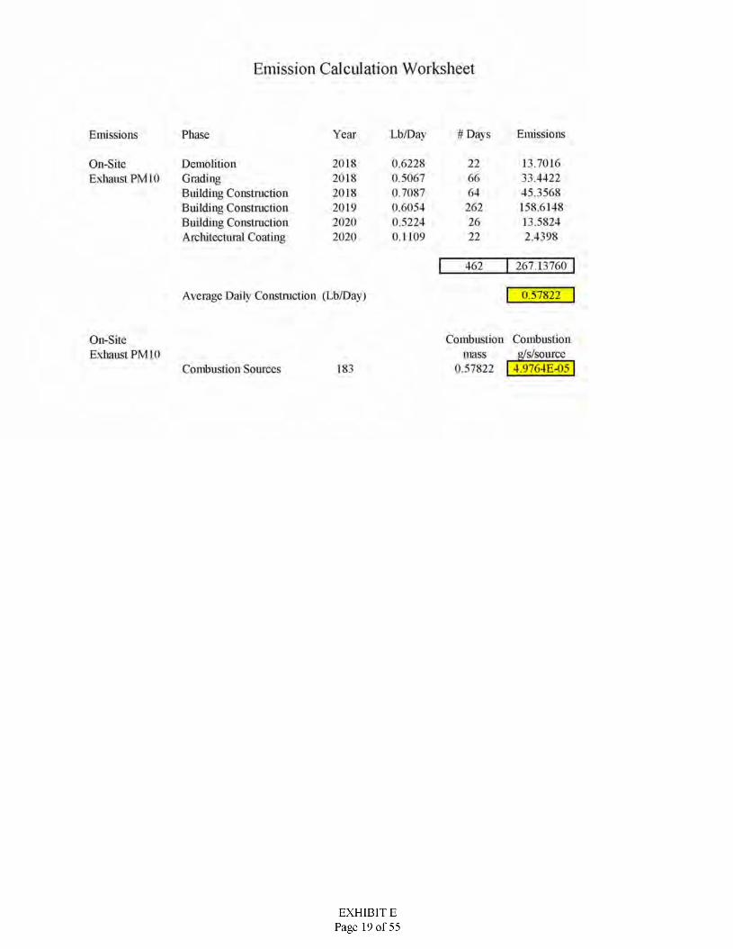
Emission Calculation Worksheet
# Davs EmissionsYear Lb/DavPhaseEmissions
22 13.701633.442245.3568158.614813.58242.4398
On-Site Exhaust PM 10
20182018201820192020 2020
0.62280.50670.70870.60540.52240.1109
DemolitionGradingBuilding Construction Building Construction Building Conslniclion Architectural Coating
66642622622
267 13760462
Average Daily Construction (Lb/Day) 0.57822
Combustion Combustion g/s/source
0.57822 | 43J764E-05
On-Site Exhaust PM 10 mass
Combustion Sources 183
EXHIBIT EPage 19 of 55

ATTACHMENT C
CalEEMod Output File
EXHIBIT EPage 20 of 55
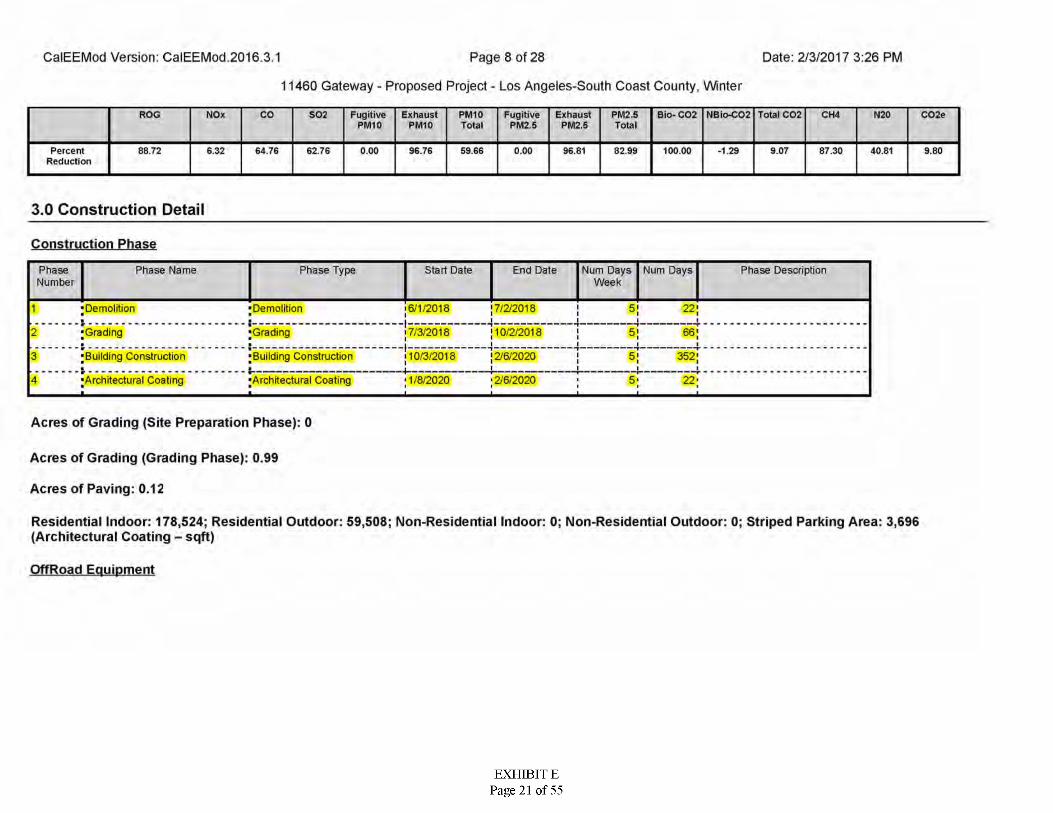
Date: 2/3/2017 3:26 PMCalEEMod Version: CalEEMod.2016.3.1 Page 8 of 28
11460 Gateway - Proposed Project - Los Angeles-South Coast County, Winter
ExhaustPM2.5
PM2.5Total
Bio- C02 Total C02ROG NOx CO S02 FugitivePM10
ExhaustPM10
PM10Total
FugitivePM2.5
NBio-C02 CH4 N20 CQ2e
PercentReduction
88.72 6.32 64.76 62.76 0.00 96.76 69.66 0.00 96.81 82.99 100.00 -1.29 9.07 87.30 40.81 9.80
3.0 Construction Detail
Construction Phase
Phase Name Num Days Num Days Week
PhaseNumber
Phase Type Start Date End Date Phase Description
16/1/2018 17/2/20181 ■Demolition■
^Grading■r - ------------------------------------^Building Construction
; Architectural Coating
•Demolitiona■----------------------^Grading
;Building Construction
^Architectural Coating
5' 22;I-I 4. 4 i
2 7/3/2018 110/2/2018 5! 66;■■ i 4:
352;3 10/3/2018 ! 2/6/2020 5!■ i! iii +•2/6/2020i4 1/8/2020 5-I 22'Ix x ±
Acres of Grading (Site Preparation Phase): 0
Acres of Grading (Grading Phase): 0.99
Acres of Paving: 0.12
Residential Indoor: 178,524; Residential Outdoor: 59,508; Non-Residential Indoor: 0; Non-Residential Outdoor: 0; Striped Parking Area: 3,696 (Architectural Coating - sqft)
OffRoad Equipment
EXHIBIT EPage 21 of 55
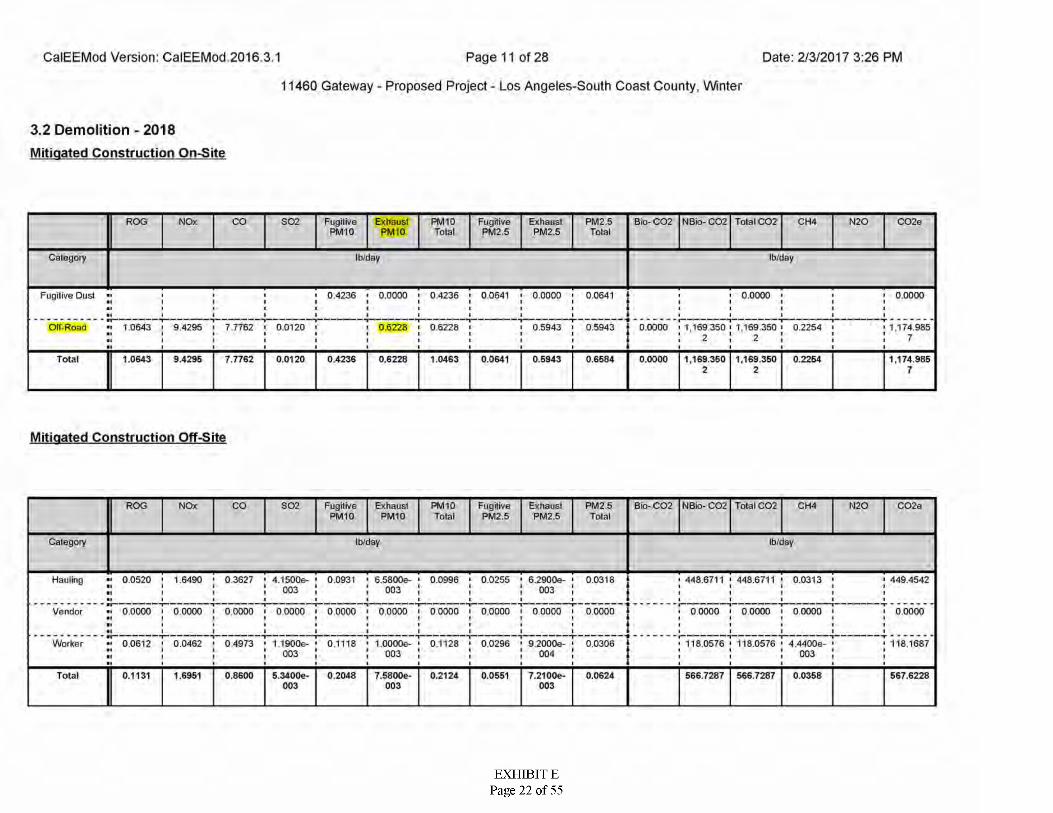
Date: 2/3/2017 3:26 PMCalEEMod Version: CalEEMod 2016 3.1 Page 11 of 28
11460 Gateway - Proposed Project - Los Angeles-South Coast County, Winter
3.2 Demolition - 2018Mitigated Construction On-Site
PM 10FugitivePM10
C02eROG NOx CO S02 Exhaust PM I0
FugitivePM2.5
ExhaustPM2.5
PM2.5 Bio- C02 NBio- C02 Total C02 CH4 N20Total Total
Ib/dayCategory Ib/day
Fugitive Dust 0.4236 I 0.0000 ■ 0.4236 ' 0.0641 • 0.0000 ' 0.0641 0.0000 0.0000
TOlf-Road 10643 i 9.4295 > 7 7762 0.0120 0 6228 ' 0.6228 0.5943 0.5943 0.0000 1,169.350 ' 1,169.350 0.2254 1,174.985
7
7.7762Total 1.0643 9.4295 0.0120 0.4236 1.0463 0.0641 0.5943 0.6584 0.0000 1,169.350 1,169.350 0.2254 1,174.9850.62282 2 7
Mitigated Construction Off-Site
FugitivePM10
ExhaustPM10
ExhaustPM2.5
Bio- CQ2 NBio- C02 Total CQ2 N2Q C02eROG NOx CO S02 PM10 FugitivePM2.5
PM2.5Total
CH4Total
Category Ib/dayIb/day
Hauling 0.0520 ' 1.6490 • 0.3627 ' 4.1500e- ' 0.0931 ' 6,5800e- ' 0.0996 ' 0.0255 • 6.2900e- ' 0.0318 448.6711 ' 448.6711 ' 0.0313 449.4542003 003 003
Vendor •• 0.0000 ' 0.0000 ' 0.0000 i 0.0000 i 0.0000 i 0.0000 i 00000 ' 0.0000 i 0.0000 0.0000 00000 1 0 0000 I 0.0000 0.0000
- -Worker 0 0612 ' 0.0462 • 0,4973 ' 1 1900e- • 0.1118 • I .OOOOe- ' 01128 ' 0.0296 • 9 2000e- ' 0.0306 118.0576 ' 118.0576 ' 4.4400e- 118.1687
003 003 004 003
7.5800e-Total 0.1131 1.6951 0.8600 5.3400e- 0.2048 0.2124 0.0551 7.21 OOe- 0.0624 566.7287 566.7287 0.0358 567.6228003 003 003
EXHIBIT EPage 22 of 55
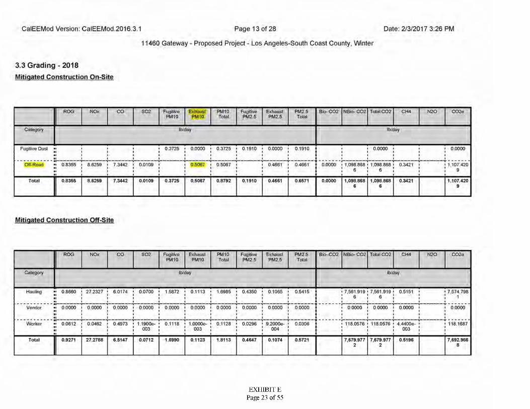
Date: 2/3/2017 3:26 PMCalEEMod Version: CalEEMod 2016 3.1 Page 13 of 28
11460 Gateway - Proposed Project - Los Angeles-South Coast County, Winter
3.3 Grading - 2018 Mitigated Construction On-Site
FugitivePM10
C02eROG NOx CO S02 Exhaust PM I0
PM10 FugitivePM2.5
ExhaustPM2.5
PM2.5 Bio- C02 NBio- C02 Total C02 CH4 N20Total Total
Category Ib/day Ib/day
Fugitive Oust 0.3725 < 0.0000 ■ 0.3725 ' 0.1910 • 0.0000 > 0.1910 0.0000 0.0000
Olf-Road 0.8355 8.6259 i 7.3442 0.0109 0.5067 0.5067 0.4661 0.4661 0.0000 1.098.868 i 1,098.868 1,107.4200.34216 6 a
7.3442Total 0.8355 8.6259 0.0109 0.3725 0.5067 0.8792 0.1910 0.4661 0.6571 0.0000 1,098.868 1.098.868 0.3421 1,107.4206 6 9
Mitigated Construction Off-Site
ROG FugitivePM10
ExhaustPM10
PM10 ExhaustPM2.5
Bio- C02 NBio- C02 Total C02 N20 C02eNOx CO S02 FugitivePM2.5
PM2 5 Total
CH4Total
Category Ib/day Ib/day
Hauling 0.8660 ' 27.2327 ' 6.0174 ' 0.0700 ' 1.5872 • 0.1113 ' 1.6985 ' 0.4350 • 0.1065 ' 0.5415 0.5151 7,574.7987,561.919 ' 7,561.9196 6 1
Vendor 0.0000 i 0.0000 ' 0.0000 i 0.0000 ' 0.0000 i 0.0000 i 0.0000 i 0.0000 i 0.0000 00000 0 0000 I 00000 I 0.0000 00000
Worker 0 0612 - 0.0462 • 0,4973 ■ 1 1900e- • 0.1118 • I.OOOOe- ' 01128 ' 0.0296 • 9 2000e- ' 0.0306 118.0576 ' 118.0576 • 4 4400e- 118.1687003 003 004 003
7,692.966Total 0.9271 27.2788 6.5147 0.0712 1.6990 0.1123 1.8113 0.4647 0.1074 0.5721 7,679.977 7,679.977 0.51962 2 8
EXHIBIT EPage 23 of 55
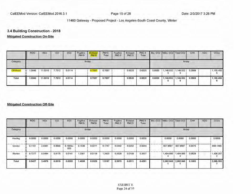
Date: 2/3/2017 3:26 PMCalEEMod Version: CalEEMod 2016 3.1 Page 15 of 28
11460 Gateway - Proposed Project - Los Angeles-South Coast County, Winter
3.4 Building Construction - 2018 Mitigated Construction On-Site
PM 10FugitivePM10
PM2.5 Total C02ROG NOx CO S02 Exhaust PM I0
FugitivePM2.5
ExhaustPM2.5
Bio- C02 NBio- C02 CH4 N20 C02eTotal Total
Ib/dayCategory Ib/day
1.0848 ' 11.0316 * 7.7512 ' 0.0114Off-Road • 07087 0.7087 0.6520 ' 0.6520 0.0000 > 1,146.532 ' 1,146.532 • 0.3569 '1,1,1 i
1,155.455■ II■ I
3 5I II
Total 1.0848 11.0316 7.7512 0.0114 0.7087 0.7087 0.6520 0.0000 1,146.532 1,146.532 1,155.4550.6520 0.35693 3 5
Mitigated Construction Off-Site
FugitivePM10
ExhaustPM10
ExhaustPM2.5
Bio- CQ2 NBio- C02 Total CQ2 N20 CQ2eROG NOx CO S02 PM10 FugitivePM2.5
PM2 5 Total
CH4Total
Category Ib/dayIb/day
Hauling 0.0000 ' 0.0000 ' 0.0000 ' 0.0000 ' 0.0000 ' 0.0000 ' 0.0000 ' 0.0000 • 0.0000 ' 0.0000 0.0000 ' 0.0000 • 0.0000 0,0000
6579597 ' 657 9597 ■ 0.0475Vendor 0.1151 ' 2.9481 i 0 8840 i 6.1800e- i 0,1536 • 0.0211 ' 0.1747 ' 0.0442 i 0.0202 0 0644 659 1465003
■VWorker 0.7277 ' 0.5494 • 5.9175 ' 0.0141 1 1.3301 • 0.0119 ' 1.3420 ' 0.3528 • 0.0109 1.404.885 ' 1,404.885 0.0529 1,406,2070.3637
24 4
Total 0.8427 3.4975 6.8015 0.0203 1 4838 0.0329 1.5167 0.3970 0.0311 0.4281 2,062.845 2,062.845 0.1003 2,065.3531 1 7
EXHIBIT EPage 24 of 55
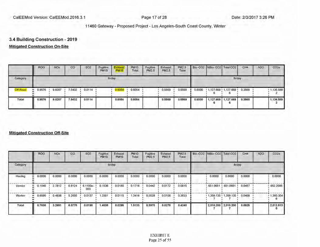
Date: 2/3/2017 3:26 PMCalEEMod Version: CalEEMod 2016 3.1 Page 17 of 28
11460 Gateway - Proposed Project - Los Angeles-South Coast County, Winter
3.4 Building Construction - 2019 Mitigated Construction On-Site
PM 10FugitivePM10
Bio- C02 Total C02 C02eROG NOx CO S02 Exhaust PM I0
FugitivePM2.5
ExhaustPM2.5
PM2.5 NBio- C02 CH4 N20Total Total
Ib/dayCategory Ib/day
Off-Road ■■ 0.9576 < 9 8207 • 7.5432 ' 0.0114 • 0.6054 0.6054 0.5569 ' 0.5569 0.0000 ' 1,127.669 • 1,127.669 0.3568 1,136.589II 'I 6 6 2I I I
Total 0.9576 9.8207 7.5432 0.0114 0.5569 0.0000 1,127.669 1,127.669 1,136.5890.6054 0.6054 0.5569 0.356B6 6 2
Mitigated Construction Off-Site
NBio- C02FugitivePM10
ExhaustPM10
ExhaustPM2.5
Bio- C02 Total CQ2 CH4 N20 C02eROG NOx CO S02 PM10 FugitivePM2.5
PM2.5TotalTotal
Category Ib/dayIb/day
Hauling 0.0000 ' 0.0000 ' 0.0000 ' 0.0000 ' 0.0000 ' 0.0000 ' 0.0000 ' 0.0000 • 0.0000 ' 0.0000 0.0000 ' 0.0000 • 0.0000 0.0000
651.0651 1 651.0651 i 0.0457Vendor 0.1040 ' 2.7812 i 0.8124 i 6.1100e- i 0,1536 i 0.0180 i 0.1716 i 0.0442 i 0.0172 0.0615 652.2085003
•VWorker 0.6590 ' 04838 ' 5.2655 ' 0.0137 ' 1.3301 • 0.0115 ' 1.3416 ' 0.3528 ' 0.0106 ' 0.3633 1,359 135 ' 1.359 135 1,360.3040.0466
77 6Total 0.7630 3.2651 6.0778 0.0198 1 4838 0.0295 1.5133 0.3970 0.0278 0.4248 2,010.200 2,010.200 0.0925 2,012.613
7 7 0
EXHIBIT EPage 25 of 55
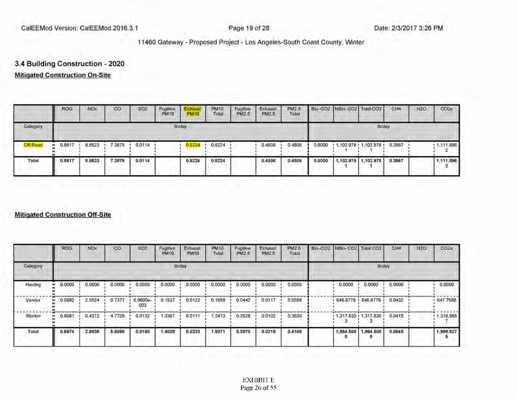
Date: 2/3/2017 3:26 PMCalEEMod Version: CalEEMod 2016 3.1 Page 19 of 28
11460 Gateway - Proposed Project - Los Angeles-South Coast County, Winter
3.4 Building Construction - 2020 Mitigated Construction On-Site
PM 10FugitivePM10
PM2.5 Bio- C02 Total C02 C02eROG NOx CO S02 Exhaust PM I0
FugitivePM2.5
ExhaustPM2.5
NBio- C02 CH4 N20Total Total
Ib/dayCategory Ib/day
Off-Road ■■ 0.8617 < 8.8523 ' 7.3875 ' 0.0114 • 05224 ' 0.5224 • 0.4806 0.4806 0.0000 1,102.978 ' 1,102.978 • 0.3567„ i * t
1,111.896■ ■ i 2■ i■
0.8617 8.8523 7.3875 0.0114 0.5224 0.0000 1,102.978 1,102.978 0.3567Total 0.5224 0.4806 0.4806 1,111.8961 1 2
Mitigated Construction Off-Site
NBio- C02FugitivePM10
ExhaustPM10
ExhaustPM2.5
Bio- CQ2 Total CQ2 N20 C02eROG NOx CO S02 PM10 FugitivePM2.5
PM2 5 Total
CH4Total
Category Ib/dayIb/day
Hauling 0.0000 ' 0.0000 • 0.0000 ' 0.0000 ' 0.0000 ' 0.0000 ' 0.0000 ' 0.0000 • 0.0000 ' 0.0000 0.0000 ' 0.0000 • 0.0000 0.0000
0.0892 I 2.5524 i 0 7377 i 6.0600e- i 0.1537 i 0.0122 ■ 0.1659 i 0.0442 i 0.0117 ■ 0.0559 646.6778 ' 646.6778 i 0.0432Vendor 647 7588003
Worker 0.6081 ' 0.4313 • 4 7720 ' 0.0132 1 1.3301 ' 0.0111 ' 1.3413 ' 0.3528 • 0.0102 1.317.830 ' 1,317.830 0.04150.3630 1,318.8683 7
0.6974Total 2.9838 5.5098 0.0193 1 4838 0.0233 1.5071 0.3970 0.0219 0.4189 1,964.508 1,964.508 0.0848 1,966.6270 0 5
EXHIBIT EPage 26 of 55
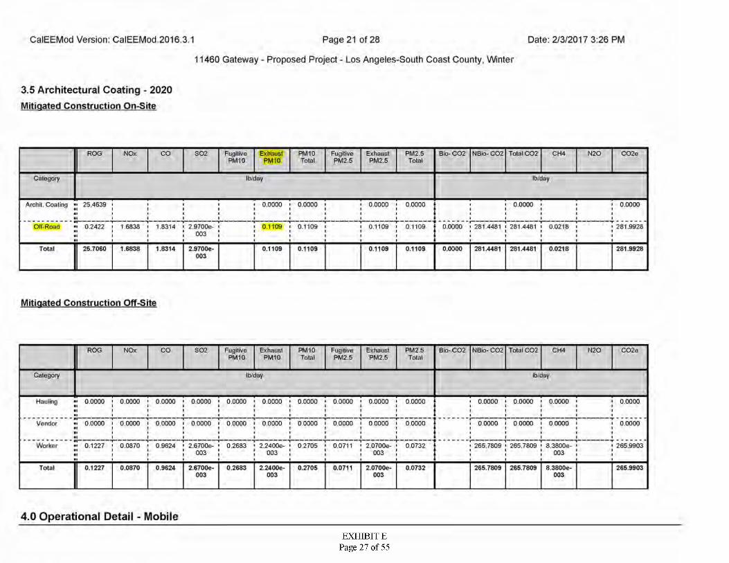
Date: 2/3/2017 3:26 PMCalEEMod Version: CalEEMod 2016 3.1 Page 21 of 28
11460 Gateway - Proposed Project - Los Angeles-South Coast County, Winter
3.5 Architectural Coating - 2020 Mitigated Construction On-Site
FugitivePM10
PM10 C02eROG NOx CO S02 Exhaust PM I0
FugitivePM2.5
ExhaustPM2.5
PM2.5 Bio- C02 NBio- C02 Total C02 CH4 N20Total Total
Ib/dayCategory Ib/day
Archit. Coaling 25.4639 0.0000 i 0.0000 0.0000 i 0.0000 0.0000 0.0000
Olf-Road ■' 0.2422 > 1 6838 ■ 1.8314 ' 2.9700e- 0.1109 0.1109 0.1109 0.0000 ' 281 4481 ■ 281 4481 ■ 0.02180.1109 281.9928003
Total 25.7060 1.6838 1.8314 2.9700e- 0.1109 0.1109 0.1109 0.0000 281.4481 281.4481 0.0218 281.99280.1109003
Mitigated Construction Off-Site
FugitivePM10
ExhaustPM10
PM10 ExhaustPM2.5
Bio- CQ2 NBio- C02 Total CQ2 N20ROG NOx CO S02 FugitivePM2.5
PM2 5 Total
CH4 C02eTotal
Category Ib/dayIb/day
Hauling 0.0000 ' 0.0000 • 0.0000 ' 0.0000 ' 0.0000 ' 0.0000 ' 0.0000 ' 0.0000 • 0.0000 ' 0.0000 0.0000 ' 0.0000 • 0.0000 0.0000
Vendor •• 0.0000 I 0.0000 ' 0.0000 I 0.0000 ■ 0.0000 I 0.0000 I 00000 I 0.0000 I 0.0000 00000 0 0000 I 0.0000 I 0.0000 0.0000
Worker 0.1227 ' 0.0870 • 0.9624 ' 2.6700e- • 0.2683 • 2.2400e- ' 0 2705 ' 0.0711 • 2.0700e- ' 0.0732 265.7809 ' 265.7809 ' S.3800e- 265.9903003 003 003 003
Total 0.1227 0.0870 0.9624 2.6700e- 0.2683 2.2400e- 0.2705 0.0711 2.0700e- 0.0732 265.7809 265.7809 8.3800e- 265.9903003 003 003 003
4.0 Operational Detail - Mobile
EXHIBIT EPage 27 of 55
ATTACHMENT D
Dispersion Model Output File
EXHIBIT EPage 28 of 55
(version 11.07) data input fileInput File Creation Date: 9/11/2017 Time: 1:48:55 PM
**BEE-Line software: Model: AERMOD.EXE**
NO ECHO
BEE-Line AERMOD "beest" Version ****
input File - F:\wd Passport\gateway\model\GATEWAY_DPM.DTA
Output File - F:\WD Passport\gateway\model\GATEWAY_dpm.LST
Met File - F:\WD Passport\gateway\metdata\wsla8.sfc
**************************************SETUP Finishes Successfully***
***********************************
09/11/17 13:48:56 PAGE 1
11460 Gateway Boulevard Project dpm off Road Emissions
¥ *** AERMOD - VERSION 16216r *** AERMET - VERSION 14134
******
*********
*** NonDFAULT CONC FLAT FLGPOL NODRYDPLT NOWETDPLT URBANMODELOPTs:
****** MODEL SETUP OPTIONS SUMMARY
**Model is Setup For Calculation of Average coNCentration values.
— DEPOSITION LOGIC -- **NO GAS DEPOSITION Data Provided.**NO PARTICLE DEPOSITION Data Provided.**Model uses no dry depletion.**Model uses no wet depletion.
FDRYDPLTWETDPLT F
**Model Uses URBAN Dispersion Algorithm for the SBL for for Total of 1 Urban Area(s):Urban Population = 9862049.0 ; Urban Roughness Length = 1.000 m
**Model Allows User-Specified Options:1. stack-tip Downwash.2. Model Assumes Receptors on flat Terrain.3. Use Calms Processing Routine.4. use Missing Data Processing Routine.5. No Exponential Decay.6. urban Roughness Length of 1.0 Meter used.
**other Options Specified:TEMP_sub - Meteorological data includes temp substitutions
**Model Accepts flagpole Receptor Heights.
**The user specified a Pollutant Type of:
Model Calculates ANNUAL Averages Only
**This Run includes:
with:
and: and: and: and: and:
183 Source(s)
OTHER
I
1 Source Group(s); and 6 Receptor(s)183 Source(s);
0 point(s), including 0 pointcap(s) and
183 VOLUME source(s)0 area type source(s)0 line source(s)0 OPENPIT source(s)0 BUOYANT line source(s) with
0 POINTHOR(s)
0 line(s)
**Model Set To Continue RUNning After the Setup Testing.
The aermet Input Meteorological Data Version Date: 14134
**Output options Selected:Model Outputs Tables of annual Averages by ReceptorModel Outputs External File(s) of High Values for Plotting (PLOTFILE Keyword)Model Outputs Separate summary File of High Ranked values (summfile Keyword)
NOTE: The Following Flags May Appear Following CONC Values: c for Calm Hoursm for Missing Hours b for Both calm and Missing Hours
97.00 ; Decay Coef. =; Emission Rate unit Factor =
* *
Base Elev. for Pot. Temp. Profile (m msl) = Emission units = grams/sec Output Units
**Approximate Storage Requirements of Model =
input Runstream File:
Output Print File:
; Rot. Angle =0.10000E+07
0.000 0.0Mi sc. Inputs:ft= micrograms/m**3
3.6 MB Of RAM.
** GATEWAY_DPM.DTA
A GATEWAY_DPM.LST
EXHIBIT EPage 29 of 55
File for Summary of Results:
AERMOD - VERSION 16216r AERMET - VERSION 14134
F:\WD Passport\gateway\model\GATEWAY_DPM.SUM
11460 Gateway Boulevard Project dpm Off Road Emissions
«*
09/11/17 13:48:56 PAGE 2
******
******
*** ***?*** ***
* ** MODELOPTS: NonDFAULT CONC FLAT FLGPOL NODRYDPLT NOWETDPLT URBAN
*** VOLUME SOURCE DATA
NUMBER EMISSION RATE PART. (GRAMS/SEC) CATS.
INIT. URBAN EMISSION RATE SOURCE SCALAR VARY
BASE ELEV.
(METERS) (METERS) (METERS) (METERS) (METERS) (METERS)
RELEASEHEIGHT
INIT.SOURCE SZX Y SY
BYID
Cl 0 0.49764E-040 0.49764E-040 0.49764E-040 0.49764E-040 0.49764E-040 0.49764E-040 0.49764E-040 0.49764E-040 0.49764E-040 0.49764E-040 0.49764E-040 0.49764E-040 0.49764E-040 0.49764E-040 0.49764E-040 0.49764E-040 0.49764E-040 0.49764E-040 0.49764E-040 0.49764E-040 0.49764E-040 0.49764E-040 0.49764E-040 0.49764E-040 0.49764E-040 0.49764E-040 0.49764E-040 0.49764E-040 0.49764E-040 0.49764E-040 0.49764E-040 0.49764E-040 0.49764E-040 0.49764E-040 0.49764E-040 0.49764E-040 0.49764E-040 0.49764E-040 0.49764E-040 0.49764E-04
AERMOD - VERSION 16216r AERMET - VERSION 14134
366911.0366907.0366911.0366916.0366906.0366911.0366916.0366921.0366926.0366901.0366906.0366911.0366916.0366921.0366926.0366931.0366936.0366897.0366901.0366906.0366911.0366916.0366921.0366926.0366931.0366936.0366941.0366946.0366901.0366906.0366911.0366916.0366921.0366926.0366931.0366936.0366941.0366946.0366951.0366901.0
3766722.03766727.0 3766727.03766727.03766732.0 3766732.0 3766732.0 3766732.03766732.03766737.0 3766737.0 3766737.0 3766737.0 3766737.0 3766737.0 3766737.03766737.03766742.0 3766742.0 3766742.0 3766742.0 3766742.0 3766742.0 3766742.0 3766742.0 3766742.0 3766742.03766742.03766747.0 3766747.0 3766747.0 3766747.0 3766747.0 3766747.0 3766747.0 3766747.0 3766747.0 3766747.03766747.03766752.0
97.0 1.401.401.40
5.00 2.32 YES HROFDYHROFDYHROFDYHROFDYHROFDYHROFDYHROFDYHROFDYHROFDYHROFDYHROFDYHROFDYHROFDYHROFDYHROFDYHROFDYHROFDYHROFDYHROFDYHROFDYHROFDYHROFDYHROFDYHROFDYHROFDYHROFDYHROFDYHROFDYHROFDYHROFDYHROFDYHROFDYHROFDYHROFDYHROFDYHROFDYHROFDYHROFDYHROFDYHROFDY
C2 97.097.097.097.0
5.00 2.32 YESC3 5.00 2.32 YES
1.40C4 5.00 2.32 YES1.40C5 5.00 2.32 YES1.40C6 97.0
97.097.097.097.097.097.097.097.097.0
5.00 2.32 YES1.401.401.401.401.401.401.401.401.401.401.401.401.40
C7 5.00 2.32 YESC8 5.00 2.32 YESC9 5.00 2.32 YESCIO 5.00 2.32 YESCll 5.00 2.32 YESC12 5.00 2.32 YESC13 5.00 2.32 YESC14 5.00 2.32 YESC15 5.00 2.32 YESC16 97.0 5.00 2.32 YES
97.0 5.00 2.32C17 YESC18 97.0 5.00 2.32 YES
97.0 5.00C19 2.32 YESC20 97.0 5.00 2.32 1.40 YES
97.0 5.00 1.40C21 2.32 YESC22 97.0
97.097.097.0
5.00 2.32 1.401.401.401.401.401.401.401.401.401.401.401.40
YESC23 5.00 2.32 YESC24 5.00 2.32 YESC25 5.00 2.32 YES
97.0 5.00 2.32C26 YESC27 97.0 5.00 2.32 YES
97.097.097.097.0
5.00 2.32C28 YES5.00C29 2.32 YES5.00 2.32C30 YES5.00C31 2.32
2.32YES
97.0 5.00C32 YES5.00 5.00 5.00 5.00 5.00 5.00 5.00 5.00
11460 Gateway Boulevard Project dpm Off Road Emissions
97.0 2.32C33 YES2.32C34 97.0
97.097.097.0
1.40 YES2.32C35 1.40 YES2.32C36 1.40 YES2.32 1.40C37 YES
97.0 2.32 1.40C38 YES97.0 2.32 1.40C39 YES97.0 2.32 1.40C40 YES
09/11/17 13:48:56 PAGE 3
£ * * * ***
******
*********
*** NonDFAULT CONC FLAT FLGPOL NODRYDPLT NOWETDPLT URBANMODELOPTS:
*** VOLUME SOURCE DATA
BASE ELEV.
(METERS) (METERS) (METERS) (METERS) (METERS) (METERS)
RELEASEHEIGHT
INIT. INIT. URBAN EMISSION RATE SOURCE SCALAR VARY
NUMBER EMISSION RATE PART. (GRAMS/SEC) CATS.
SY SZSOURCE X YBYID
5.00 2.320.49764E-04 0.49764E-04 0.49764E-04 0.49764E-04 0.49764E-04 0.49764E-04 0.49764E-04 0.49764E-04 0.49764E-04 0.49764E-04 0.49764E-04 0.49764E-04 0.49764E-04 0.49764E-04 0.49764E-04 0.49764E-04 0.49764E-04 0.49764E-04 0.49764E-04 0.49764E-04 0.49764E-04 0.49764E-04 0.49764E-04 0.49764E-04 0.49764E-04
366906.0 3766752.0366911.0 3766752.0366916.0 3766752.0366921.0 3766752.0366926.0 3766752.0366931.0 3766752.0366936.0 3766752.0366941.0 3766752.0366946.0 3766752.0366951.0 3766752.0366956.0 3766752.0366961.0 3766752.0366902.0 3766757.0366906.0 3766757.0366911.0 3766757.0366916.0 3766757.0366921.0 3766757.0366926.0 3766757.0366931.0 3766757.0366936.0 3766757.0366941.0 3766757.0366946.0 3766757.0366951.0 3766757.0366956.0 3766757.0366961.0 3766757.0
97.097.097.097.097.097.0
1.40C41 0 YES HROFDYHROFDYHROFDYHROFDYHROFDYHROFDYHROFDYHROFDYHROFDYHROFDYHROFDYHROFDYHROFDYHROFDYHROFDYHROFDYHROFDYHROFDYHROFDYHROFDYHROFDYHROFDYHROFDYHROFDYHROFDY
5.00 2.32 1.40C42 0 YES5.00 2.32 1.40C43 0 YES5.00 2.32 1.40
1.400C44 YES
2.325.000C45 YES5.00 2.32 1.40C46 0 YES
97.0 5.00 2.32 1.40C47 0 YES97.0 5.00 2.32 1.40C48 0 YES97.0 5.00 2.32 1.40C49 0 YES97.097.0
5.00 2.32 1.40C50 0 YES2.325.00 1.40C51 0 YES
5.00 2.3297.0 1.40C52 0 YES97.0 5.00 2.32 1.40C53 0 YES97.0 5.00 2.32 1.40C54 0 YES97.0 5.00 2.32 1.40C55 0 YES97.097.0
5.00 2.32 1.40C56 0 YES5.00 2.32 1.40C57 0 YES
2.3297.0 5.00 1.40C58 0 YES2.3297.0 5.00 1.40C59 0 YES
97.0 5.00 2.32 1.40C60 0 YES97.097.0
5.00 2.32 1.40C61 0 YES5.00 2.32 1.40C62 0 YES5.00 2.3297.0 1.40C63 0 YES
2.3297.0 5.00 1.40C64 0 YES97.0 5.00 2.32 1.40C65 0 YES
EXHIBIT EPage 30 of 55
1.40366966.0 3766757.0366971.0 3766757.0366906.0 3766762.0366911.0 3766762.0366916.0 3766762.0366921.0 3766762.0366926.0 3766762.0366931.0 3766762.0366936.0 3766762.0366941.0 3766762.0366946.0 3766762.0366951.0 3766762.0366956.0 3766762.0366961.0 3766762.0366966.0 3766762.0
2.320 0.49764E-040 0.49764E-040 0.49764E-040 0.49764E-040 0.49764E-040 0.49764E-040 0.49764E-040 0.49764E-040 0.49764E-040 0.49764E-040 0.49764E-040 0.49764E-040 0.49764E-040 0.49764E-040 0.49764E-04
AERMOD - VERSION 16216r *** AERMET - VERSION 14134
97.0 5.00C66 YES HROFDYHROFDYHROFDYHROFDYHROFDYHROFDYHROFDYHROFDYHROFDYHROFDYHROFDYHROFDYHROFDYHROFDYHROFDY
1.402.3297.097.097.097.097.097.097.097.097.097.097.097.097.097.0
5.00 YESC671.405.00 2.32C68 YES1.402.325.00C69 YES1.402.325.00C70 YES1.402.325.00C71 YES1.402.325.00C72 YES1.402.32C73 5.00
5.00 5.00 5.00 5.00 5.00 5.00 5.00
11460 Gateway Boulevard Project dpm off Road Emissions
YES1.402.32C74 YES1.402.32C75 YES1.402.32C76 YES1.402.32C77 YES1.402.32C78 YES1.402.32C79 YES1.402.32C80 YES
09/11/17 13:48:56 PAGE 4
*********
******
*** ■bit itbbb NonDFAULT CONC FLAT FLGPOL NODRYDPLT NOWETDPLT URBANMODELOPTS:
*** VOLUME SOURCE DATA
INIT. URBAN EMISSION RATE SOURCE SCALAR VARY
NUMBER EMISSION RATE PART. (GRAMS/SEC) CATS.
RELEASE HEIGHT
(METERS) (METERS) (METERS) (METERS) (METERS) (METERS)
BASEELEV.
INIT.SZSYX YSOURCE
BYID
2.32 1.40366971.0 3766762.0366975.0 3766762.0366906.0 3766767.0366911.0 3766767.0366916.0 3766767.0366921.0 3766767.0366926.0 3766767.0366931.0 3766767.0366936.0 3766767.0366941.0 3766767.0366946.0 3766767.0366951.0 3766767.0366956.0 3766767.0366961.0 3766767.0366966.0 3766767.0366971.0 3766767.0366907.0 3766772.0366911.0 3766772.0366916.0 3766772.0366921.0 3766772.0366926.0 3766772.0366931.0 3766772.0366936.0 3766772.0366941.0 3766772.0366946.0 3766772.0366951.0 3766772.0366956.0 3766772.0366961.0 3766772.0366966.0 3766772.0366911.0 3766777.0366916.0 3766777.0366921.0 3766777.0366926.0 3766777.0366931.0 3766777.0366936.0 3766777.0366941.0 3766777.0366946.0 3766777.0366951.0 3766777.0366956.0 3766777.0366961.0 3766777.0
11460 Gateway Boulevard ProjectDPM Off Road Emissions
97.0 5.000 0.49764E-040 0.49764E-040 0.49764E-040 0.49764E-040 0.49764E-040 0.49764E-040 0.49764E-040 0.49764E-040 0.49764E-040 0.49764E-040 0.49764E-040 0.49764E-040 0.49764E-040 0.49764E-040 0.49764E-040 0.49764E-040 0.49764E-040 0.49764E-040 0.49764E-040 0.49764E-040 0.49764E-040 0.49764E-040 0.49764E-040 0.49764E-040 0.49764E-040 0.49764E-040 0.49764E-040 0.49764E-040 0.49764E-040 0.49764E-040 0.49764E-040 0.49764E-040 0.49764E-040 0.49764E-040 0.49764E-040 0.49764E-040 0.49764E-040 0.49764E-040 0.49764E-040 0.49764E-04
AERMOD - VERSION 16216r AERMET - VERSION 14134
YES HROFDYHROFDYHROFDYHROFDYHROFDYHROFDYHROFDYHROFDYHROFDYHROFDYHROFDYHROFDYHROFDYHROFDYHROFDYHROFDYHROFDYHROFDYHROFDYHROFDYHROFDYHROFDYHROFDYHROFDYHROFDYHROFDYHROFDYHROFDYHROFDYHROFDYHROFDYHROFDYHROFDYHROFDYHROFDYHROFDYHROFDYHROFDYHROFDYHROFDY
C812.32 1.4097.0 5.00C82 YES2.32 1.4097.0 5.00C83 YES2.32 1.4097.0 5.00C84 YES2.32 1.4097.0 5.00 YESC852.32 1.4097.0 5.00C86 YES2.32 1.4097.0 5.00C87 YES
1.4097.0 5.00 2.32C88 YES2.32 1.4097.0
97.05.00C89 YES
1.405.00 2.32C90 YES97.0 5.00 2.32 1.40 YESC91
5.00 2.32 1.4097.0C92 YES5.00 2.32 1.4097.0 YESC935.00 2.32 1.4097.0C94 YES
2.32 1.4097.0 5.00C95 YES5.00 2.32 1.4097.0C96 YES
2.32 1.4097.097.097.097.097.097.0
5.00C97 YES5.00 2.32 1.40 YESC98
2.322.32
1.405.005.00
YESC991.401.40
YESC100C101C102C103C104C105C106C107C108C109C110cmC112C113C114C115C116C117C118C119C120
5.00 2.32 YES2.32 1.405.00 YES
97.097.097.097.0
5.00 2.32 1.40 YES2.325.00 1.40 YES
5.00 2.32 1.40 YES5.00 2.32 1.40 YES5.00 2.32 1.4097.0 YES5.00 2.32 1.4097.0 YES5.00 2.32 1.4097.0 YES
2.32 1.4097.097.0
5.00 YES2.32 1.405.00 YES2.32 1.4097.0 5.00 YES
97.097.097.097.0
5.00 2.32 1.40 YES2.325.00 1.40 YES2.325.00 1.40 YES
5.00 2.32 1.40 YES5.00 2.32 1.4097.0 YES5.00 2.32 1.4097.0 YES5.00 2.32 1.4097.0 YES5.00 2.3297.0 1.40 YES
09/11/17 13:48:56 PAGE 5
****** ***
***O *** ***
NonDFAULT CONC FLAT FLGPOL NODRYDPLT NOWETDPLT URBAN*** MODELOPTS:
****** VOLUME SOURCE DATA
RELEASE HEIGHT
(METERS) (METERS) (METERS) (METERS) (METERS) (METERS)
INIT. INIT. URBAN EMISSION RATE SOURCE SCALAR VARY
BASEELEV.
NUMBER EMISSION RATE PART. (GRAMS/SEC) CATS.
SY SZX YSOURCEBYID
2.325.00 1.40366911.0 3766782.0366916.0 3766782.0366921.0 3766782.0366926.0 3766782.0366931.0 3766782.0366936.0 3766782.0366941.0 3766782.0366946.0 3766782.0366951.0 3766782.0366956.0 3766782.0366961.0 3766782.0366911.0 3766787.0366916.0 3766787.0366921.0 3766787.0
97.097.097.0
0.49764E-04 0.49764E-04 0.49764E-04 0.49764E-04 0.49764E-04 0.49764E-04 0.49764E-04 0.49764E-04 0.49764E-04 0.49764E-04 0.49764E-04 0.49764E-04 0.49764E-04 0.49764E-04
YES HROFDYHROFDYHROFDYHROFDYHROFDYHROFDYHROFDYHROFDYHROFDYHROFDYHROFDYHROFDYHROFDYHROFDY
C121C122C123C124C125C126C127C128C129C130C131C132C133C134
02.325.00 1.40 YES0
5.00 2.32 1.40 YES05.00 2.3297.0 1.40 YES05.00 2.32 1.4097.0
97.0YES0
2.325.00 1.400 YES2.3297.0 5.00 1.400 YES2.325.00 1.4097.0 YES02.325.00 1.4097.0
97.0YES0
5.00 2.32 1.40 YES05.00 2.3297.0 1.400 YES5.00 2.32 1.4097.0
97.0YES0
2.325.00 1.40 YES05.00 2.32 1.4097.0 YES0
EXHIBIT EPage 31 of 55
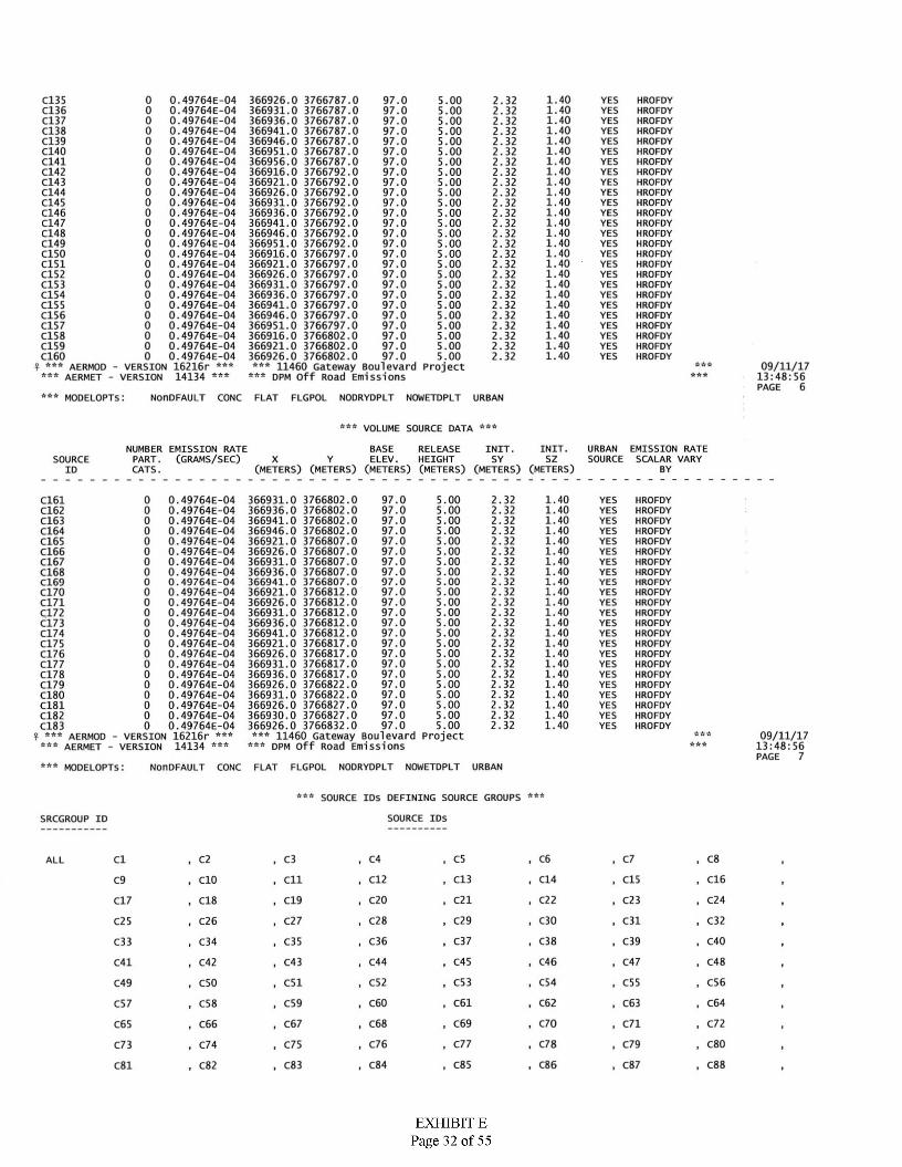
0 0.49764E-040 0.49764E-040 0.49764E-040 0.49764E-040 0.49764E-040 0.49764E-040 0.49764E-040 0.49764E-040 0.49764E-040 0.49764E-040 0.49764E-040 0.49764E-040 0.49764E-040 0.49764E-040 0.49764E-040 0.49764E-040 0.49764E-040 0.49764E-040 0.49764E-040 0.49764E-040 0.49764E-040 0.49764E-040 0.49764E-040 0.49764E-040 0.49764E-040 0.49764E-04
AERMOD - VERSION 16216r AERMET - VERSION 14134
1.401.401.401.40
C135C136C137C138C139C140C141C142C143C144C145C146C147C148C149C150C151C152C153C154C155C156C157C158C159C160
366926.0 3766787.0366931.0 3766787.0366936.0 3766787.0366941.0 3766787.0366946.0 3766787.0366951.0 3766787.0366956.0 3766787.0366916.0 3766792.0366921.0 3766792.0366926.0 3766792.0366931.0 3766792.0366936.0 3766792.0366941.0 3766792.0366946.0 3766792.0366951.0 3766792.0366916.0 3766797.0366921.0 3766797.0366926.0 3766797.0366931.0 3766797.0366936.0 3766797.0366941.0 3766797.0366946.0 3766797.0366951.0 3766797.0366916.0 3766802.0366921.0 3766802.0366926.0 3766802.0
97.0 97.0 97.0 97.0 97.0 97.0 97.0 97.0 97.0 97.0 97.0 97.0 97.0 97.0 97.0 97.0 97.0 97.0 97.0 97.0 97.0 97.0 97.0 97.0 97.0 97.0
11460 Gateway Boulevard Project dpm off Road Emissions
5.00 2.32 YES HROFDYHROFDYHROFDYHROFDYHROFDYHROFDYHROFDYHROFDYHROFDYHROFDYHROFDYHROFDYHROFDYHROFDYHROFDYHROFDYHROFDYHROFDYHROFDYHROFDYHROFDYHROFDYHROFDYHROFDYHROFDYHROFDY
5.00 2.32 YES5.00 2.32 YES
2.325.00 YES1.402.325.00 YES1.401.401.401.401.401.40
5.00 2.32 YES5.00 2.32 YES
2.325.00 YES5.00 2.32 YES5.00 2.32 YES5.00 2.32 YES
1.405.00 2.32 YES1.405.00 2.32 YES1.405.00 2.32 YES1.405.00 2.32 YES1.405.00 2.32 YES1.405.00 2.32 YES1.405.00 2.32 YES1.405.00 2.32 YES1.405.00 2.32 YES1.405.00 2.32 YES1.405.00 2.32 YES1.405.00 2.32 YES1.405.00 2.32 YES1.405.00 2.32 YES1.405.00 2.32 YES
09/11/17 13:48:56 PAGE 6
***^ AAA AAA
AAAAAA
AAAAAA AAA
AAA MODELOPTS: NonDFAULT CONC FLAT FLGPOL NODRYDPLT NOWETDPLT URBAN
aaa AAAVOLUME SOURCE DATA
URBAN EMISSION RATE SOURCE SCALAR VARY
BASEELEV.
INIT.NUMBER EMISSION RATE PART. (GRAMS/SEC) CATS.
RELEASE HEIGHT
(METERS) (METERS) (METERS) (METERS) (METERS) (METERS)
INIT.SY SZSOURCE X Y
BYID
0 0.49764E-04 366931.0 3766802.00 0.49764E-04 366936.0 3766802.00 0.49764E-04 366941.0 3766802.00 0.49764E-04 366946.0 3766802.00 0.49764E-04 366921.0 3766807.00 0.49764E-04 366926.0 3766807.00 0.49764E-04 366931.0 3766807.00 0.49764E-04 366936.0 3766807.00 0.49764E-04 366941.0 3766807.00 0.49764E-04 366921.0 3766812.00 0.49764E-04 366926.0 3766812.00 0.49764E-04 366931.0 3766812.00 0.49764E-04 366936.0 3766812.00 0.49764E-04 366941.0 3766812.00 0.49764E-04 366921.0 3766817.00 0.49764E-04 366926.0 3766817.00 0.49764E-04 366931.0 3766817.00 0.49764E-04 366936.0 3766817.00 0.49764E-04 366926.0 3766822.00 0.49764E-04 366931.0 3766822.00 0.49764E-04 366926.0 3766827.00 0.49764E-04 366930.0 3766827.00 0.49764E-04 366926.0 3766832.0
AERMOD - VERSION 16216r ***AERMET - VERSION 14134
1.40C161C162C163C164C165C166C167C168C169C170C171C172C173C174C175C176C177C178C179C180C181C182C183
97.0 5.00 2.32 YES HROFDYHROFDYHROFDYHROFDYHROFDYHROFDYHROFDYHROFDYHROFDYHROFDYHROFDYHROFDYHROFDYHROFDYHROFDYHROFDYHROFDYHROFDYHROFDYHROFDYHROFDYHROFDYHROFDY
1.4097.0 5.00 2.32 YES1.4097.0 5.00 2.32 YES1.4097.0 5.00 2.32 YES
97.0 97.0 97.0 97.0 97.0 97.0 97.0 97.0 97.0 97.0 97.0 97.0 97.0 97.0 97.0 97.0 97.0 97.0 97.0
11460 Gateway Boulevard Project DPM Off Road Emissions
5.00 2.32 1.40 YES2.32 1.405.00 YES
5.00 2.32 1.40 YES5.005.00
2.32 1.40 YES2.32 1.40 YES
5.00 2.32 1.40 YES5.00 2.32 1.40 YES5.00 2.32 1.40 YES5.00 2.32 1.40 YES
2.32 1.405.00 YES2.32 1.405.00 YES2.32 1.405.00 YES
1.405.00 2.32 YES5.00 2.32 1.40 YES5.00 2.32 1.40 YES5.00 2.32 1.40 YES5.00 2.32 1.40 YES5.00 2.32 1.40 YES5.00 2.32 1.40 YES
09/11/17 13:48:56 PAGE 7
aaaAAA AAAAAA AAAAAAAAA
AAA NonDFAULT CONC FLAT FLGPOL NODRYDPLT NOWETDPLT URBANMODELOPTS:
AAAAAA SOURCE IDS DEFINING SOURCE GROUPS
SOURCE IDSSRCGROUP ID
. C6
. C14
. C22
, C30
, C38
C8C3 C4 , C5 , C7Cl , C2
, CIO
, C18
, C26
, C34
, C42
ALL
. C13
. C21
, C29
, C37
, C45
■ C53
, C61
, C69
, C77
, C85
, C12 . C15
■ C23
, C31
, C39
, C47
■ C55
, C63
, C71
. C79
, C87
C16C9 CllC20 C24C19C17
, C28
, C36
C32C27C25
C35 C40C33
C43 C46 C48C44C41
, C52
, C60
, C68
, C76
, C84
, C54
, C62
, C70
, C78
, C86
C56C51C49 C50
C64C59C57 , C58
, C66
, C74
, C82
C72C65 C67
C80C75C73
C88C83C81
EXHIBIT EPage 32 of 55
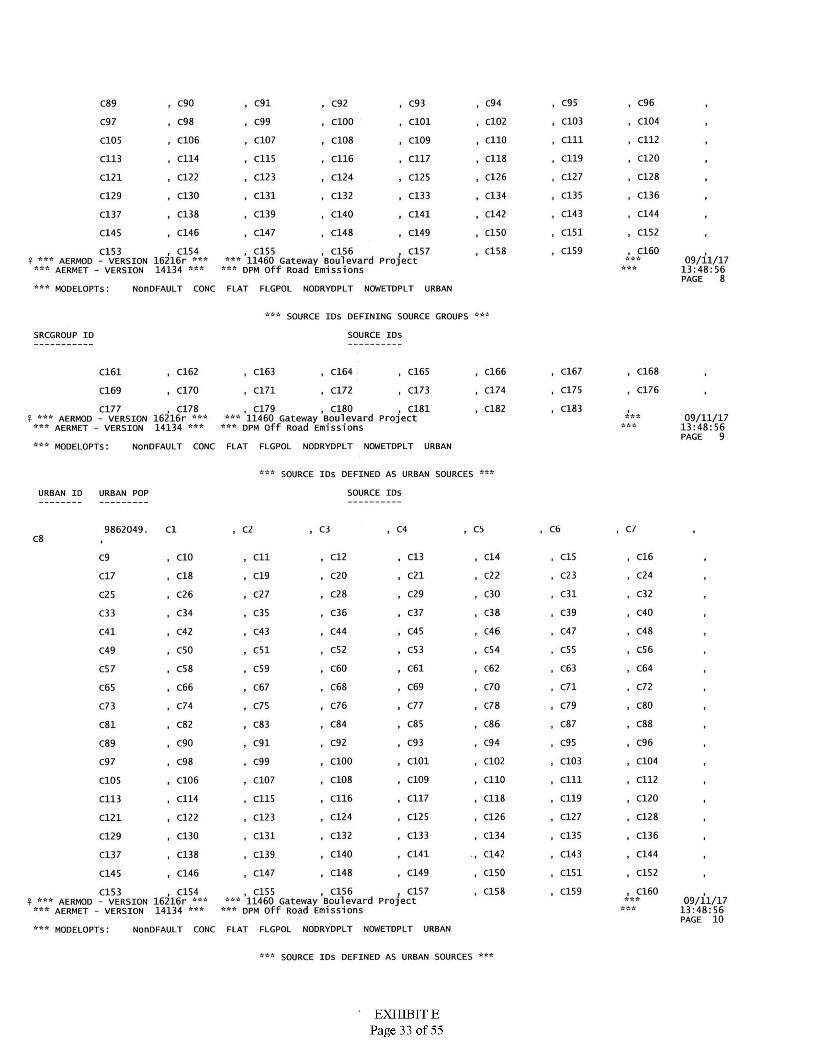
, C95
, C103
, cm
, C119
, C127
, C135
, C143
, C151
, C159
C96, C90 , C91
, C99
, C107
, C115
, C94
, C102
, C110
, C118
, C126
, C134
, C142
, Cl 50
, C158
C89 , C92
, C100
, C108
, C116
, C124
, C132
, C93
, C101
, C109
, C117
, C125
, C133
, C141
, C149
, C104
, C112
, C120
, C128
, C136
, C144
, C152
, C160
C98C97
, C106
, C114
C105
C113
C122 , C123
, C131
, C139
, C147
, C15511460 Gateway Boulevard Project
dpm off Road Emissions
C121
C130C129
, C138
, C146
, C140
, C148
C137
C145
, C156C153AERMOD - VERSION 16216r
AERMET - VERSION 14134
, C154 , C15709/11/17
13:48:56 PAGE 8
***
******
***
***
******
***¥
*** NonDFAULT CONC FLAT FLGPOL NODRYDPLT NOWETDPLT URBANMODELOPTS:
*** SOURCE IDS DEFINING SOURCE GROUPS
SOURCE IDsSRCGROUP ID
, C167
, C175
, C183
, C168
, C176
, C164
, C172
, C18011460 Gateway Boulevard Project
dpm Off Road Emissions
, C165
, C173
, C166
, C174
, C182
, C162
, C170
, C178AERMOD - VERSION 16216r
AERMET - VERSION 14134
, C163
, C171
C161
C169
, C179 , C181C17709/11/17
13:48:56 PAGE 9
******
*** ********** *** ***
*** NonDFAULT CONC FLAT FLGPOL NODRYDPLT NOWETDPLT URBANMODELOPTS:
* * **** SOURCE IDS DEFINED AS URBAN SOURCES
SOURCE IDSURBAN ID URBAN POP
, C69862049. Cl ■ C2 . C3 C4 , C5 , C7C8
C16C12 C13 C14 C15C9 CIO CllC23 C24C20 C21 C22C18 C19C17
C32C28 C29 C30 C31C26 C27C25
C36 C37 C38 C39 C40C34 C35C33
C45 C46 C47 C48C44C42 C43C41
C56C52 C53 C54 C55C50 C51C49
C63 C64C60 C61 C62C58 C59C57
C72C68 C69 C70 C71C66 C67C65
C76 C77 C78 C79 C80C75C73 C74
C85 C86 C87 C88C84C81 C82 C83
C93 C96C92 C94 C95C90 C91C89
C101 C102 C103 C104C100C98 C99C97
C112C108 C109 C110 cmC106 C107C105
C116 C117 C118 C119 C120C114 C115C113
C124 C125 C126 C127 C128C121 C122 C123
C133 C136C132 C134 C135C130 C131C129
C140 C141 C142 C143 C144C139C137 C138
C148 C149 C150 C152C151C146 C147C145
C157 C158 C159 C160C15611460 Gateway Boulevard Project
DPM Off Road Emissions
C155C153 ,AERMOD - VERSION 16216r
AERMET - VERSION 14134
C15409/11/17
13:48:56 PAGE 10
****** ***
*** ******
*** NonDFAULT CONC FLAT FLGPOL NODRYDPLT NOWETDPLT URBANMODELOPTS:
* * *SOURCE IDS DEFINED AS URBAN SOURCES
EXHIBIT EPage 33 of 55
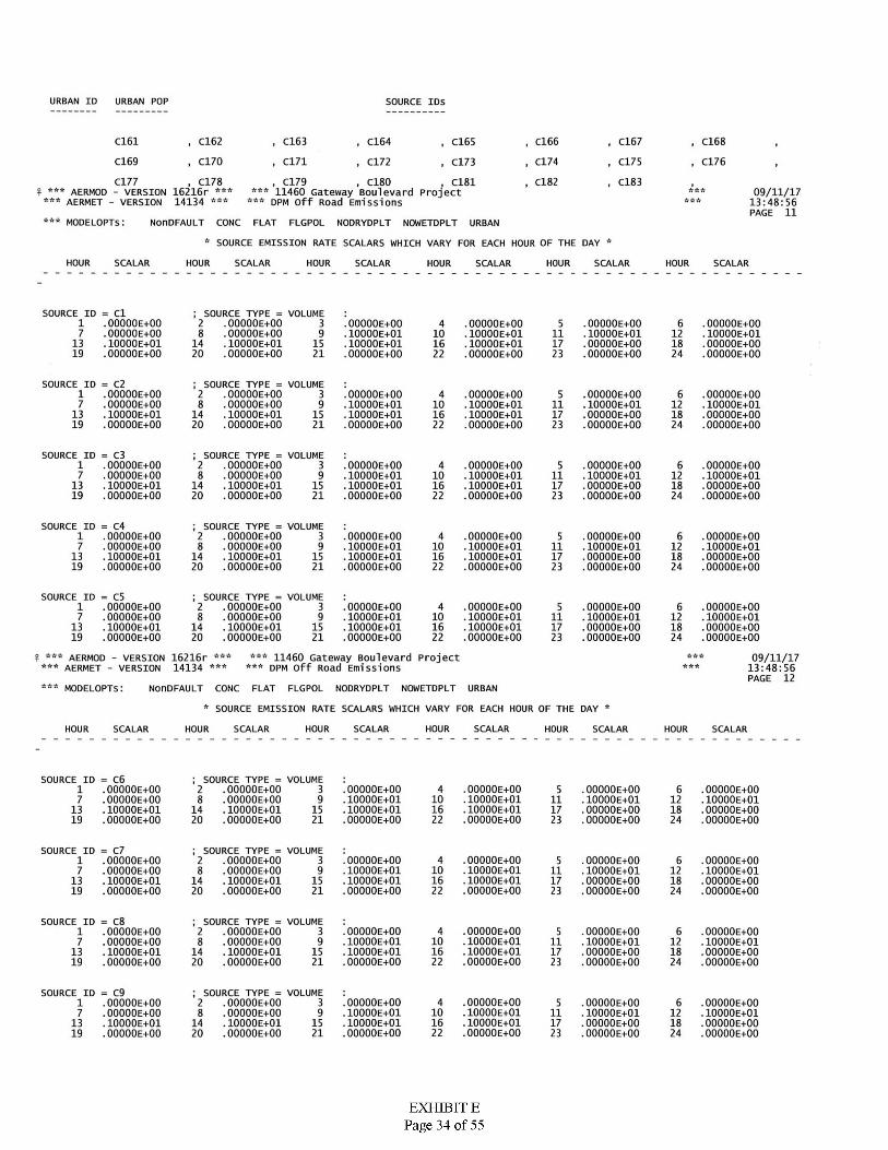
URBAN ID URBAN POP SOURCE IDS
C161 , C162
, C170
, C163
, C171
, C166
, C174
, C167
, C175
, C183
C168, C165
, C173
, C18111460 Gateway Boulevard Project
DPM Off Road Emissions
C164
C169 , C172 , C176
, C178AERMOD - VERSION 16216r
AERMET - VERSION 14134
C177 , C179 , C180 C182£ *** ***
09/11/17 13:48:56 PAGE 11
:'r AAA AAAAAAAAA AAA
AAA MODELOPTS : NonDFAULT CONC FLAT FLGPOL NODRYDPLT NOWETDPLT URBAN
A ASOURCE EMISSION RATE SCALARS WHICH VARY FOR EACH HOUR OF THE DAY
HOUR SCALAR SCALARHOUR HOUR SCALAR HOUR SCALAR HOUR SCALARHOUR SCALAR
SOURCE ID = Cl1 .OOOOOE+OO 7 .00000E+00
13 .10000E+01 19 .00000E+00
: SOURCE TYPE = VOLUME 2 .00000E+008 .00000E+00
14 .10000E+0120 .OOOOOE+OO
3 OOOOOE+OO10000E+0110000E+01OOOOOE+OO
.OOOOOE+OO
. 10000E+01
.OOOOOE+OO
.OOOOOE+OO
6 .OOOOOE+OO .10000E+01 .OOOOOE+OO .OOOOOE+OO
4 .OOOOOE+OO .10000E+01 .10000E+01 .OOOOOE+OO
59 10 11 12
15 16 17 1821 23 2422
SOURCE ID = C21 .OOOOOE+OO 7 .OOOOOE+OO
13 .10000E+0119 .OOOOOE+OO
1 SOURCE TYPE = VOLUME 2 .OOOOOE+OO 8 .OOOOOE+OO
14 .10000E+0120 .OOOOOE+OO
3 OOOOOE+OO10000E+0110000E+01OOOOOE+OO
.OOOOOE+OO
.10000E+01
.10000E+01
.OOOOOE+OO
.OOOOOE+OO
.10000E+01
.OOOOOE+OO
.OOOOOE+OO
6 .OOOOOE+OO .10000E+01 •OOOOOE+OO .OOOOOE+OO
4 59 1210 11
15 16 17 1821 23 2422
SOURCE ID = C31 .OOOOOE+OO 7 .OOOOOE+OO
13 .10000E+0119 .OOOOOE+OO
; SOURCE TYPE = VOLUME 2 .OOOOOE+OO 8 .OOOOOE+OO
14 .10000E+0120 .OOOOOE+OO
3 OOOOOE+OO10000E+0110000E+01OOOOOE+OO
.OOOOOE+OO
.lOOOOE+Ol
.10000E+01
.OOOOOE+OO
5 .OOOOOE+OO .10000E+01 .OOOOOE+OO .OOOOOE+OO
6 •OOOOOE+OO .lOOOOE+Ol .OOOOOE+OO .OOOOOE+OO
49 10 11 12
15 16 181721 22 23 24
SOURCE ID = C41 .OOOOOE+OO 7 .OOOOOE+OO
13 .lOOOOE+Ol19 .OOOOOE+OO
; SOURCE TYPE = VOLUME 2 .OOOOOE+OO8 .OOOOOE+OO
14 .lOOOOE+Ol20 .OOOOOE+OO
3 OOOOOE+OOlOOOOE+OllOOOOE+OlOOOOOE+OO
.OOOOOE+OO
.lOOOOE+Ol
.lOOOOE+Ol •OOOOOE+OO
4 5 .OOOOOE+OO.lOOOOE+Ol.OOOOOE+OO.OOOOOE+OO
6 .OOOOOE+OO .lOOOOE+Ol .OOOOOE+OO .OOOOOE+OO
9 10 11 1215 16 17 1821 22 23 24
SOURCE ID = C51 .OOOOOE+OO 7 .OOOOOE+OO
13 .lOOOOE+Ol 19 .OOOOOE+OO
; SOURCE TYPE = VOLUME 2 .OOOOOE+OO 8 .OOOOOE+OO
14 .lOOOOE+Ol 20 .OOOOOE+OO
3 OOOOOE+OOlOOOOE+OllOOOOE+OlOOOOOE+OO
4 .OOOOOE+OO ■lOOOOE+Ol .lOOOOE+Ol .OOOOOE+OO
5 .OOOOOE+OO .lOOOOE+Ol .OOOOOE+OO .OOOOOE+OO
6 .OOOOOE+OO■lOOOOE+Ol.OOOOOE+OO.OOOOOE+OO
9 10 11 1215 16 17 1821 22 23 24
11460 Gateway Boulevard Project DPM off Road Emissions
£ *** ***
AERMOD - VERSION 16216r AERMET - VERSION 14134
09/11/17 13:48:56 PAGE 12
AAA AAAAAA AAA AAA
AAA NonDFAULT CONC FLAT FLGPOL NODRYDPLT NOWETDPLT URBANMODELOPTS:
A ASOURCE EMISSION RATE SCALARS WHICH VARY FOR EACH HOUR OF THE DAY
HOUR SCALAR HOUR SCALAR HOUR SCALAR HOUR SCALAR HOUR SCALAR HOUR SCALAR
SOURCE ID = C61 .OOOOOE+OO 7 .OOOOOE+OO
13 .lOOOOE+Ol19 .OOOOOE+OO
; SOURCE TYPE = VOLUME 2 .OOOOOE+OO 8 .OOOOOE+OO
14 . lOOOOE+Ol20 .OOOOOE+OO
3 OOOOOE+OOlOOOOE+OllOOOOE+OlOOOOOE+OO
.OOOOOE+OO
.lOOOOE+Ol
.lOOOOE+Ol
.OOOOOE+OO
4 5 .OOOOOE+OO .lOOOOE+Ol .OOOOOE+OO .OOOOOE+OO
6 •OOOOOE+OO.lOOOOE+Ol.OOOOOE+OO.OOOOOE+OO
9 10 11 121615 18172221 23 24
SOURCE ID = C71 .OOOOOE+OO 7 .OOOOOE+OO
13 .lOOOOE+Ol 19 .OOOOOE+OO
; SOURCE TYPE = VOLUME 2 .OOOOOE+OO 8 .OOOOOE+OO
14 . lOOOOE+Ol20 .OOOOOE+OO
3 OOOOOE+OOlOOOOE+OllOOOOE+OlOOOOOE+OO
4 .OOOOOE+OO .lOOOOE+Ol .lOOOOE+Ol .OOOOOE+OO
.OOOOOE+OO
.lOOOOE+Ol
.OOOOOE+OO •OOOOOE+OO
65 ■OOOOOE+OO.lOOOOE+Ol.OOOOOE+OO•OOOOOE+OO
9 10 11 1215 16 181721 22 23 24
SOURCE ID = C81 .OOOOOE+OO 7 .OOOOOE+OO
13 .lOOOOE+Ol 19 .OOOOOE+OO
; SOURCE TYPE = VOLUME 2 .OOOOOE+OO 8 .OOOOOE+OO
14 . lOOOOE+Ol20 .OOOOOE+OO
.OOOOOE+OO
.lOOOOE+Ol
.lOOOOE+Ol
.OOOOOE+OO
3 OOOOOE+OOlOOOOE+OllOOOOE+OlOOOOOE+OO
4 .OOOOOE+OO■lOOOOE+Ol.OOOOOE+OO.OOOOOE+OO
6 .OOOOOE+OO.lOOOOE+Ol.OOOOOE+OO■OOOOOE+OO
59 10 1211
16 1815 1721 22 23 24
SOURCE ID = C91 .OOOOOE+OO 7 .OOOOOE+OO
13 .lOOOOE+Ol 19 .OOOOOE+OO
; SOURCE TYPE = VOLUME 2 .OOOOOE+OO 8 .OOOOOE+OO
14 .lOOOOE+Ol20 .OOOOOE+OO
3 OOOOOE+OOlOOOOE+OllOOOOE+OlOOOOOE+OO
4 .OOOOOE+OO .lOOOOE+Ol •lOOOOE+Ol .OOOOOE+OO
.OOOOOE+OO
.lOOOOE+Ol
.OOOOOE+OO
.OOOOOE+OO
65 .OOOOOE+OO . lOOOOE+Ol .OOOOOE+OO •OOOOOE+OO
9 10 11 121615 17 182221 23 24
EXHIBIT EPage 34 of 55
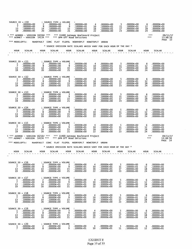
SOURCE ID = CIO1 .OOOOOE+OO7 .OOOOOE+OO13 .lOOOOE+Ol19 .OOOOOE+OO
; SOURCE TYPE = VOLUME2 .OOOOOE+OO8 .OOOOOE+OO14 .lOOOOE+Ol20 .OOOOOE+OO
3 .OOOOOE+OO 9 .lOOOOE+Ol
15 .lOOOOE+Ol 21 .OOOOOE+OO
5 .OOOOOE+OO 11 .lOOOOE+Ol 17 .OOOOOE+OO 23 .OOOOOE+OO
6 .OOOOOE+OO12 .lOOOOE+Ol18 .OOOOOE+OO24 .OOOOOE+OO
4 .OOOOOE+OO 10 .lOOOOE+Ol 16 .lOOOOE+Ol 22 .OOOOOE+OO
A**AAA
AERMOD - VERSION 16216r AERMET - VERSION 14134
11460 Gateway Boulevard Project DPM off Road Emissions
AAA AAA AAAAAA 09/11/17
13:48:56 PAGE 13
AAA AAA
AAA MODELOPTS: NonDFAULT CONC FLAT FLGPOL NODRYDPLT NOWETDPLT URBAN
* SOURCE EMISSION RATE SCALARS WHICH VARY FOR EACH HOUR OF THE DAY A
HOUR SCALAR HOUR SCALAR HOUR HOUR SCALARSCALAR HOUR HOUR SCALARSCALAR
SOURCE ID = Cll1 .OOOOOE+OO 7 .OOOOOE+OO
13 .10000E+0119 .OOOOOE+OO
; SOURCE TYPE = VOLUME 2 .OOOOOE+OO 8 .OOOOOE+OO
14 .10000E+0120 .OOOOOE+OO
3 5 .OOOOOE+OO.10000E+01.OOOOOE+OO.OOOOOE+OO
OOOOOE+OO10000E+0110000E+01OOOOOE+OO
.OOOOOE+OO
.10000E+01
.10000E+01
.OOOOOE+OO
6 .OOOOOE+OO.10000E+01.OOOOOE+OO.OOOOOE+OO
49 10 11 12
15 16 17 1821 2322 24
SOURCE ID = C121 .OOOOOE+OO 7 .OOOOOE+OO
13 .lOOOOE+Ol19 .OOOOOE+OO
; SOURCE TYPE = VOLUME 2 .OOOOOE+OO8 .OOOOOE+OO
14 .lOOOOE+Ol20 .OOOOOE+OO
3 OOOOOE+OOlOOOOE+OllOOOOE+OlOOOOOE+OO
.OOOOOE+OO
.lOOOOE+Ol
.lOOOOE+Ol
.OOOOOE+OO
5 .OOOOOE+OO .lOOOOE+Ol .OOOOOE+OO •OOOOOE+OO
6 .OOOOOE+OO .lOOOOE+Ol .OOOOOE+OO •OOOOOE+OO
49 10 11 12
15 16 17 1821 22 23 24
SOURCE ID = C131 .OOOOOE+OO 7 .OOOOOE+OO
13 .lOOOOE+Ol 19 .OOOOOE+OO
; SOURCE TYPE = VOLUME 2 .OOOOOE+OO 8 .OOOOOE+OO
14 .lOOOOE+Ol20 .OOOOOE+OO
3 OOOOOE+OOlOOOOE+OllOOOOE+OlOOOOOE+OO
5 .OOOOOE+OO .lOOOOE+Ol .OOOOOE+OO .OOOOOE+OO
.OOOOOE+OO
.lOOOOE+Ol
.OOOOOE+OO
.OOOOOE+OO
4 .OOOOOE+OO .lOOOOE+Ol .lOOOOE+Ol .OOOOOE+OO
69 10 11 12
15 17 181621 22 23 24
SOURCE ID = C141 .OOOOOE+OO 7 .OOOOOE+OO
13 .lOOOOE+Ol19 .OOOOOE+OO
; SOURCE TYPE = VOLUME 2 .OOOOOE+OO 8 .OOOOOE+OO
14 .lOOOOE+Ol20 .OOOOOE+OO
3 OOOOOE+OOlOOOOE+OllOOOOE+OlOOOOOE+OO
.OOOOOE+OO
.lOOOOE+Ol
.lOOOOE+Ol
.OOOOOE+OO
5 .OOOOOE+OO .lOOOOE+Ol .OOOOOE+OO .OOOOOE+OO
6 .OOOOOE+OO.lOOOOE+Ol.OOOOOE+OO.OOOOOE+OO
49 10 11 12
15 16 17 1821 22 23 24
SOURCE ID = C15 ; SOURCE TYPE = VOLUME 2 .OOOOOE+OO 8 .OOOOOE+OO
14 .lOOOOE+Ol20 .OOOOOE+OO
31 ■OOOOOE+OO.OOOOOE+OO.lOOOOE+Ol.OOOOOE+OO
OOOOOE+OOlOOOOE+OllOOOOE+OlOOOOOE+OO
4 •OOOOOE+OO.lOOOOE+Ol.lOOOOE+Ol.OOOOOE+OO
5 •OOOOOE+OO.lOOOOE+Ol.OOOOOE+OO.OOOOOE+OO
6 .OOOOOE+OO.lOOOOE+Ol.OOOOOE+OO.OOOOOE+OO
9 10 117 1213 15 16 17 1819 21 22 23 24
11460 Gateway Boulevard Project DPM Off Road Emissions
***
AAAAERMOD - VERSION 16216r
AERMET - VERSION 14134
aaaaaa
aaa A A A 09/11/17 13:48:56 PAGE 14
? AAA AAA
A A* MODELOPTS: NonDFAULT CONC FLAT FLGPOL NODRYDPLT NOWETDPLT URBAN
A ASOURCE EMISSION RATE SCALARS WHICH VARY FOR EACH HOUR OF THE DAY
HOUR SCALAR HOUR SCALAR HOURHOUR SCALAR HOUR SCALAR SCALAR HOUR SCALAR
SOURCE ID = C161 .OOOOOE+OO7 .OOOOOE+OO
13 .lOOOOE+Ol 19 .OOOOOE+OO
; SOURCE TYPE = VOLUME 2 .OOOOOE+OO 8 .OOOOOE+OO
14 .lOOOOE+Ol 20 .OOOOOE+OO
3 OOOOOE+OOlOOOOE+OllOOOOE+OlOOOOOE+OO
4 .OOOOOE+OO .lOOOOE+Ol .lOOOOE+Ol .OOOOOE+OO
5 .OOOOOE+OO .lOOOOE+Ol .OOOOOE+OO ■OOOOOE+OO
6 .OOOOOE+OO .lOOOOE+Ol .OOOOOE+OO .OOOOOE+OO
9 10 11 1215 16 17 1821 22 23 24
SOURCE ID = C171 .OOOOOE+OO7 .OOOOOE+OO
13 .lOOOOE+Ol19 .OOOOOE+OO
: SOURCE TYPE = VOLUME 2 .OOOOOE+OO8 .OOOOOE+OO
14 .lOOOOE+Ol 20 .OOOOOE+OO
3 OOOOOE+OOlOOOOE+OllOOOOE+OlOOOOOE+OO
.OOOOOE+OO
.lOOOOE+Ol
.lOOOOE+Ol
.OOOOOE+OO
4 5 .OOOOOE+OO .lOOOOE+Ol •OOOOOE+OO .OOOOOE+OO
6 .OOOOOE+OO.lOOOOE+Ol.OOOOOE+OO.OOOOOE+OO
9 10 11 121615 17 182221 23 24
SOURCE ID = C181 .OOOOOE+OO 7 .OOOOOE+OO
13 .lOOOOE+Ol19 .OOOOOE+OO
; SOURCE TYPE = VOLUME 2 .OOOOOE+OO8 .OOOOOE+OO
14 .lOOOOE+Ol20 .OOOOOE+OO
.OOOOOE+OO
.lOOOOE+Ol
.lOOOOE+Ol
.OOOOOE+OO
3 OOOOOE+OOlOOOOE+OllOOOOE+OlOOOOOE+OO
4 5 .OOOOOE+OO .lOOOOE+Ol .OOOOOE+OO .OOOOOE+OO
6 .OOOOOE+OO .lOOOOE+Ol .OOOOOE+OO .OOOOOE+OO
9 10 11 121615 17 18
21 22 23 24
SOURCE ID = C191 .OOOOOE+OO 7 .OOOOOE+OO
13 .lOOOOE+Ol 19 .OOOOOE+OO
I SOURCE TYPE = VOLUME 2 .OOOOOE+OO8 .OOOOOE+OO
14 .lOOOOE+Ol20 .OOOOOE+OO
.OOOOOE+OO
.lOOOOE+Ol
.lOOOOE+Ol
.OOOOOE+OO
3 OOOOOE+OOlOOOOE+OllOOOOE+OlOOOOOE+OO
4 5 .OOOOOE+OO .lOOOOE+Ol .OOOOOE+OO .OOOOOE+OO
6 .OOOOOE+OO .lOOOOE+Ol .OOOOOE+OO .OOOOOE+OO
9 10 11 121615 17 182221 23 24
SOURCE ID = C201 .OOOOOE+OO 7 .OOOOOE+OO
; SOURCE TYPE = VOLUME 2 .OOOOOE+OO 8 .OOOOOE+OO
.OOOOOE+OO
.lOOOOE+Ol.OOOOOE+OO .lOOOOE+Ol
43 5 .OOOOOE+OO .lOOOOE+Ol
6 .OOOOOE+OO .lOOOOE+Ol9 10 11 12
EXHIBIT EPage 35 of 55
17 .OOOOOE+OO 23 .OOOOOE+OO
18 .OOOOOE+OO 24 .OOOOOE+OO
13 .lOOOOE+Ol19 .OOOOOE+OO
14 .lOOOOE+Ol20 .OOOOOE+OO
15 .lOOOOE+Ol21 .OOOOOE+OO 16 .lOOOOE+Ol
22 .OOOOOE+OO
09/11/17 13:48:56 PAGE 15
11460 Gateway Boulevard Project dpm off Road Emissions
******
***
***AERMOD - VERSION 16216r ***
AERMET - VERSION 14134***?
*** ***
MODELOPTS: NonDFAULT CONC FLAT FLGPOL NODRYDPLT NOWETDPLT URBAN
** SOURCE EMISSION RATE SCALARS WHICH VARY FOR EACH HOUR OF THE DAY
HOUR SCALAR HOUR SCALARHOUR SCALAR HOUR SCALAR HOUR SCALAR HOUR SCALAR
SOURCE ID = C211 .OOOOOE+OO 7 .OOOOOE+OO
13 .10000E+01 19 .OOOOOE+OO
; SOURCE TYPE = VOLUME 2 .OOOOOE+OO 8 .OOOOOE+OO
14 .10000E+0120 .OOOOOE+OO
5 .OOOOOE+OO .10000E+01 .OOOOOE+OO .OOOOOE+OO
6 .OOOOOE+OO .10000E+01 .OOOOOE+OO .OOOOOE+OO
3 OOOOOE+OO10000E+0110000E+01OOOOOE+OO
.OOOOOE+OO
.10000E+01
.10000E+01
.OOOOOE+OO
11 129 101816 1715
23 2421 22
SOURCE ID = C221 .OOOOOE+OO 7 .OOOOOE+OO
13 .lOOOOE+Ol 19 .OOOOOE+OO
; SOURCE TYPE = VOLUME 2 .OOOOOE+OO 8 .OOOOOE+OO
14 .lOOOOE+Ol20 .OOOOOE+OO
.OOOOOE+OO
.lOOOOE+Ol
.OOOOOE+OO
.OOOOOE+OO
6 •OOOOOE+OO .lOOOOE+Ol .OOOOOE+OO .OOOOOE+OO
OOOOOE+OOlOOOOE+OllOOOOE+OlOOOOOE+OO
.OOOOOE+OO
.lOOOOE+Ol
.lOOOOE+Ol
.OOOOOE+OO
5412<) 10 111816 1715
23 2421 22
SOURCE ID = C231 .OOOOOE+OO 7 .OOOOOE+OO
13 .lOOOOE+Ol19 .OOOOOE+OO
; SOURCE TYPE = VOLUME 2 .OOOOOE+OO 8 .OOOOOE+OO
14 .lOOOOE+Ol20 .OOOOOE+OO
.OOOOOE+OO
.lOOOOE+Ol
.OOOOOE+OO
.OOOOOE+OO
6 .OOOOOE+OO .lOOOOE+Ol .OOOOOE+OO .OOOOOE+OO
OOOOOE+OOlOOOOE+OllOOOOE+OlOOOOOE+OO
53 4 .OOOOOE+OO .lOOOOE+Ol .lOOOOE+Ol .OOOOOE+OO
12119 10181715 162422 2321
SOURCE ID = C241 .OOOOOE+OO 7 .OOOOOE+OO
13 .lOOOOE+Ol19 .OOOOOE+OO
; SOURCE TYPE = VOLUME 2 .OOOOOE+OO 8 .OOOOOE+OO
14 .lOOOOE+Ol20 .OOOOOE+OO
.OOOOOE+OO
.lOOOOE+Ol
.OOOOOE+OO
.OOOOOE+OO
6 •OOOOOE+OO.lOOOOE+Ol.OOOOOE+OO.OOOOOE+OO
OOOOOE+OOlOOOOE+OllOOOOE+OlOOOOOE+OO
■OOOOOE+OO .lOOOOE+Ol .lOOOOE+Ol .OOOOOE+OO
54129 10 111816 17152421 22 23
SOURCE ID = C251 .OOOOOE+OO 7 .OOOOOE+OO
13 .lOOOOE+Ol19 .OOOOOE+OO
; SOURCE TYPE = VOLUME 2 .OOOOOE+OO 8 .OOOOOE+OO
14 .lOOOOE+Ol20 .OOOOOE+OO
.OOOOOE+OO
.lOOOOE+Ol
.lOOOOE+Ol ■OOOOOt+OO
5 .OOOOOE+OO .lOOOOE+Ol .OOOOOE+OO •OOOOOE+OO
6 .OOOOOE+OO .lOOOOE+Ol .OOOOOE+OO .OOOOOE+OO
OOOOOE+OOlOOOOE+OllOOOOE+OlOOOOOE+OO
4129 10 111816 1715
23 2421 22
09/11/17 13:48:56 PAGE 16
11460 Gateway Boulevard Project dpm Off Road Emissions ***
AERMOD - VERSION 16216r AERMET - VERSION 14134
* * *
******
******
***
*** NonDFAULT CONC FLAT FLGPOL NODRYDPLT NOWETDPLT URBANMODELOPTS:
* SOURCE EMISSION RATE SCALARS WHICH VARY FOR EACH HOUR OF THE DAY *
SCALARSCALAR HOUR SCALAR HOUR SCALAR HOURHOUR SCALAR HOURHOUR SCALAR
SOURCE ID = C261 .OOOOOE+OO 7 .OOOOOE+OO
13 .lOOOOE+Ol 19 .OOOOOE+OO
; SOURCE TYPE = VOLUME 2 .OOOOOE+OO 8 .OOOOOE+OO
14 .lOOOOE+Ol20 .OOOOOE+OO
.OOOOOE+OO
.lOOOOE+Ol
.lOOOOE+Ol ■OOOOOE+OO
.OOOOOE+OO
.lOOOOE+Ol
.OOOOOE+OO
.OOOOOE+OO
6 .OOOOOE+OO .lOOOOE+Ol .OOOOOE+OO .OOOOOE+OO
3 OOOOOE+OOlOOOOE+OllOOOOE+OlOOOOOE+OO
4 5129 10 111816 17152422 2321
SOURCE ID = C271 .OOOOOE+OO 7 .OOOOOE+OO
13 .lOOOOE+Ol 19 .OOOOOE+OO
; SOURCE TYPE = VOLUME 2 .OOOOOE+OO 8 .OOOOOE+OO
14 .lOOOOE+Ol20 .OOOOOE+OO
.OOOOOE+OO
.lOOOOE+Ol
.lOOOOE+Ol
.OOOOOE+OO
5 .OOOOOE+OO.lOOOOE+Ol.OOOOOE+OO.OOOOOE+OO
6 .OOOOOE+OO .lOOOOE+Ol .OOOOOE+OO .OOOOOE+OO
OOOOOE+OOlOOOOE+OllOOOOE+OlOOOOOE+OO
4129 10 11
16 1815 1723 2421 22
SOURCE ID = C281 .OOOOOE+OO 7 .OOOOOE+OO
13 .lOOOOE+Ol19 .OOOOOE+OO
; SOURCE TYPE = VOLUME 2 .OOOOOE+OO 8 .OOOOOE+OO
14 .lOOOOE+Ol20 .OOOOOE+OO
.OOOOOE+OO
.lOOOOE+Ol
.lOOOOE+Ol
.OOOOOE+OO
.OOOOOE+OO
.lOOOOE+Ol
.OOOOOE+OO
.OOOOOE+OO
3 OOOOOE+OOlOOOOE+OllOOOOE+OlOOOOOE+OO
5 .OOOOOE+OO.lOOOOE+Ol.OOOOOE+OO.OOOOOE+OO
64I 10 11 12
16 17 181522 23 2421
SOURCE ID = C291 .OOOOOE+OO 7 .OOOOOE+OO
13 .lOOOOE+Ol 19 .OOOOOE+OO
; SOURCE TYPE = VOLUME 2 .OOOOOE+OO 8 .OOOOOE+OO
14 .lOOOOE+Ol20 .OOOOOE+OO
.OOOOOE+OO
.lOOOOE+Ol
.lOOOOE+Ol
.OOOOOE+OO
.OOOOOE+OO
.lOOOOE+Ol
.OOOOOE+OO
.OOOOOE+OO
3 OOOOOE+OOlOOOOE+OllOOOOE+OlOOOOOE+OO
4 5 .OOOOOE+OO .lOOOOE+Ol .OOOOOE+OO .OOOOOE+OO
610 11 12916 17 181522 23 2421
SOURCE ID = C301 .OOOOOE+OO 7 .OOOOOE+OO
13 .lOOOOE+Ol19 .OOOOOE+OO
; SOURCE TYPE = VOLUME 2 .OOOOOE+OO 8 .OOOOOE+OO
14 .lOOOOE+Ol20 .OOOOOE+OO
.OOOOOE+OO
.lOOOOE+Ol
.lOOOOE+Ol
.OOOOOE+OO
.OOOOOE+OO■lOOOOE+Ol■OOOOOE+OO.OOOOOE+OO
3 OOOOOE+OOlOOOOE+OllOOOOE+OlOOOOOE+OO
5 .OOOOOE+OO.lOOOOE+Ol.OOOOOE+OO.OOOOOE+OO
6410 11 12916 17 181522 23 2421
EXHIBIT EPage 36 of 55
* * * 09/11/17 13:48:56 PAGE 17
11460 Gateway Boulevard Project DPM off Road Emissions
******
AERMOD - VERSION 16216r AERMET - VERSION 14134 ***
*** ******
*+* MODELOPTS: NonDFAULT CONC FLAT FLGPOL NODRYDPLT NOWETDPLT URBAN
** SOURCE EMISSION RATE SCALARS WHICH VARY FOR EACH HOUR OF THE DAY
HOUR SCALARHOUR SCALARSCALAR HOUR SCALAR HOUR SCALARHOUR SCALAR HOUR
SOURCE ID = C311 .OOOOOE+OO 7 .OOOOOE+OO
13 .10000E+0119 .OOOOOE+OO
; SOURCE TYPE = VOLUME 2 .OOOOOE+OO8 .OOOOOE+OO
14 .10000E+0120 .OOOOOE+OO
6 .OOOOOE+OO .10000E+01 .OOOOOE+OO .OOOOOE+OO
5 .OOOOOE+OO .10000E+01 .OOOOOE+OO .OOOOOE+OO
3 OOOOOE+OO10000E+0110000E+01OOOOOE+OO
.OOOOOE+OO
.10000E+01
.10000E+01
.OOOOOE+OO
4129 10 1118171615242321 22
SOURCE ID = C321 .OOOOOE+OO 7 .OOOOOE+OO
13 .10000E+0119 .OOOOOE+OO
; SOURCE TYPE = VOLUME 2 .OOOOOE+OO 8 .OOOOOE+OO
14 .10000E+0120 .OOOOOE+OO
.OOOOOE+OO
.10000E+01
.OOOOOE+OO
.OOOOOE+OO
6 .OOOOOE+OO .lOOOOE+Ol .OOOOOE+OO .OOOOOE+OO
3 OOOOOE+OOlOOOOE+OllOOOOE+OlOOOOOE+OO
4 .OOOOOE+OO .lOOOOE+Ol .lOOOOE+Ol .OOOOOE+OO
512111091816 1715242321 22
SOURCE ID = C331 .OOOOOE+OO 7 .OOOOOE+OO
13 .lOOOOE+Ol 19 .OOOOOE+OO
: SOURCE TYPE = VOLUME 2 .OOOOOE+OO 8 .OOOOOE+OO
14 .lOOOOE+Ol20 .OOOOOE+OO
6 .OOOOOE+OO .lOOOOE+Ol .OOOOOE+OO .OOOOOE+OO
.OOOOOE+OO
.lOOOOE+Ol
.OOOOOE+OO
.OOOOOE+OO
.OOOOOE+OO
.lOOOOE+Ol
.lOOOOE+Ol
.OOOOOE+OO
53 OOOOOE+OOlOOOOE+OllOOOOE+OlOOOOOE+OO
41210 1191816 1715
23 242221
SOURCE ID = C341 .OOOOOE+OO 7 .OOOOOE+OO
13 .lOOOOE+Ol 19 .OOOOOE+OO
; SOURCE TYPE = VOLUME 2 .OOOOOE+OO 8 .OOOOOE+OO
14 .lOOOOE+Ol 20 .OOOOOE+OO
.OOOOOE+OO
.lOOOOE+Ol
.OOOOOE+OO
.OOOOOE+OO
6 .OOOOOE+OO .lOOOOE+Ol .OOOOOE+OO .OOOOOE+OO
.OOOOOE+OO
.lOOOOE+Ol
.lOOOOE+Ol
.OOOOOE+OO
53 OOOOOE+OOlOOOOE+OllOOOOE+OlOOOOOE+OO
41210 119181715 16242321 22
SOURCE ID = C351 .OOOOOE+OO 7 .OOOOOE+OO
13 .lOOOOE+Ol 19 .OOOOOE+OO
; SOURCE TYPE = VOLUME 2 .OOOOOE+OO 8 .OOOOOE+OO
14 .lOOOOE+Ol20 .OOOOOE+OO
.OOOOOE+OO
.lOOOOE+Ol
.OOOOOE+OO
.OOOOOE+OO
6 .OOOOOE+OO .lOOOOE+Ol .OOOOOE+OO .OOOOOE+OO
OOOOOE+OOlOOOOE+OllOOOOE+OlOOOOOE+OO
4 .OOOOOE+OO .lOOOOE+Ol .lOOOOE+Ol .OOOOOE+OO
531210 1191816 17152422 2321
09/11/17 13:48:56 PAGE 18
11460 Gateway Boulevard Project dpm off Road Emissions
***AERMOD - VERSION 16216r AERMET - VERSION 14134
*********
*** NonDFAULT CONC FLAT FLGPOL NODRYDPLT NOWETDPLT URBANMODELOPTS:
* SOURCE EMISSION RATE SCALARS WHICH VARY FOR EACH HOUR OF THE DAY *
SCALARSCALAR HOUR SCALAR HOURSCALAR HOURSCALAR HOURHOUR SCALAR HOUR
SOURCE ID = C361 .OOOOOE+OO 7 .OOOOOE+OO
13 .lOOOOE+Ol19 .OOOOOE+OO
: SOURCE TYPE = VOLUME 2 .OOOOOE+OO 8 .OOOOOE+OO
14 .lOOOOE+Ol 20 .OOOOOE+OO
.OOOOOE+OO
.lOOOOE+Ol
.OOOOOE+OO
.OOOOOE+OO
6 .OOOOOE+OO.lOOOOE+Ol.OOOOOE+OO.OOOOOE+OO
OOOOOE+OOlOOOOE+OllOOOOE+OlOOOOOE+OO
.OOOOOE+OO
.lOOOOE+Ol
.lOOOOE+Ol
.OOOOOE+OO
53 41210 119181716152422 2321
SOURCE ID = C371 .OOOOOE+OO 7 .OOOOOE+OO
13 .lOOOOE+Ol19 .OOOOOE+OO
; SOURCE TYPE = VOLUME 2 .OOOOOE+OO 8 .OOOOOE+OO
14 .lOOOOE+Ol20 .OOOOOE+OO
.OOOOOE+OO
.lOOOOE+Ol
.lOOOOE+Ol
.OOOOOE+OO
.OOOOOE+OO
.lOOOOE+Ol
.OOOOOE+OO
.OOOOOE+OO
6 .OOOOOE+OO .lOOOOE+Ol .OOOOOE+OO .OOOOOE+OO
OOOOOE+OOlOOOOE+OllOOOOE+OlOOOOOE+OO
4 531210 1191816 17152422 2321
SOURCE ID = C381 .OOOOOE+OO 7 .OOOOOE+OO
13 .lOOOOE+Ol 19 .OOOOOE+OO
; SOURCE TYPE = VOLUME 2 .OOOOOE+OO 8 .OOOOOE+OO
14 .lOOOOE+Ol 20 .OOOOOE+OO
.OOOOOE+OO
.lOOOOE+Ol
.OOOOOE+OO
.OOOOOE+OO
.OOOOOE+OO
.lOOOOE+Ol
.lOOOOE+Ol
.OOOOOE+OO
5 .OOOOOE+OO .lOOOOE+Ol .OOOOOE+OO .OOOOOE+OO
63 OOOOOE+OOlOOOOE+OllOOOOE+OlOOOOOE+OO
41210 119
16 17 181522 23 2421
SOURCE ID = C391 .OOOOOE+OO 7 .OOOOOE+OO
13 .lOOOOE+Ol 19 .OOOOOE+OO
; SOURCE TYPE = VOLUME 2 .OOOOOE+OO 8 .OOOOOE+OO
14 .lOOOOE+Ol20 .OOOOOE+OO
.OOOOOE+OO
.lOOOOE+Ol
.OOOOOE+OO
.OOOOOE+OO
6 .OOOOOE+OO .lOOOOE+Ol .OOOOOE+OO .OOOOOE+OO
OOOOOE+OOlOOOOE+OllOOOOE+OlOOOOOE+OO
.OOOOOE+OO
.lOOOOE+Ol
.lOOOOE+Ol
.OOOOOE+OO
53 41210 1191816 1715
22 23 2421
SOURCE ID = C401 .OOOOOE+OO 7 .OOOOOE+OO
13 .lOOOOE+Ol 19 .OOOOOE+OO
; SOURCE TYPE = VOLUME 2 .OOOOOE+OO 8 .OOOOOE+OO
14 .lOOOOE+Ol20 .OOOOOE+OO
.OOOOOE+OO
.lOOOOE+Ol
.OOOOOE+OO
.OOOOOE+OO
6 .OOOOOE+OO .lOOOOE+Ol .OOOOOE+OO .OOOOOE+OO
OOOOOE+OOlOOOOE+OllOOOOE+OlOOOOOE+OO
.OOOOOE+OO
.lOOOOE+Ol
.lOOOOE+Ol
.OOOOOE+OO
53 41210 119
16 17 181522 23 2421
09/11/17 13:48:56 PAGE 19
11460 Gateway Boulevard project DPM Off Road Emissions
AERMOD - VERSION 16216r AERMET - VERSION 14134
*** ***
***^ *** *** ***
EXHIBIT EPage 37 of 55
MODELOPTS: NonDFAULT CONC FLAT FLGPOL NODRYDPLT NOWETDPLT URBAN* *SOURCE EMISSION RATE SCALARS WHICH VARY FOR EACH HOUR OF THE DAY
HOUR SCALAR HOUR SCALAR HOUR SCALAR HOURSCALAR SCALAR HOUR SCALARHOUR
SOURCE ID = C411 .OOOOOE+OO 7 .OOOOOE+OO
13 .10000E+0119 .OOOOOE+OO
; SOURCE TYPE = VOLUME 2 .OOOOOE+OO 8 .OOOOOE+OO
14 .10000E+0120 .OOOOOE+OO
3 OOOOOE+OO10000E+0110000E+01OOOOOE+OO
4 .OOOOOE+OO .lOOOOE+Ol .lOOOOE+Ol .OOOOOE+OO
5 .OOOOOE+OO .lOOOOE+Ol .OOOOOE+OO .OOOOOE+OO
6 .OOOOOE+OO•lOOOOE+Ol.OOOOOE+OO.OOOOOE+OO
9 10 11 1215 16 17 1821 2322 24
SOURCE ID = C421 .OOOOOE+OO 7 .OOOOOE+OO
13 .lOOOOE+Ol19 .OOOOOE+OO
; SOURCE TYPE = VOLUME 2 .OOOOOE+OO 8 .OOOOOE+OO
14 .lOOOOE+Ol20 .OOOOOE+OO
3 OOOOOE+OOlOOOOE+OllOOOOE+OlOOOOOE+OO
4 .OOOOOE+OO .lOOOOE+Ol .lOOOOE+Ol •OOOOOE+OO
5 .OOOOOE+OO .lOOOOE+Ol .OOOOOE+OO .OOOOOE+OO
6 .OOOOOE+OO.lOOOOE+Ol.OOOOOE+OO.OOOOOE+OO
9 10 11 1215 16 17 1821 22 23 24
SOURCE ID = C431 .OOOOOE+OO7 .OOOOOE+OO
13 .lOOOOE+Ol19 .OOOOOE+OO
I SOURCE TYPE = VOLUME 2 .OOOOOE+OO 8 .OOOOOE+OO
14 .lOOOOE+Ol20 .OOOOOE+OO
3 OOOOOE+OOlOOOOE+OllOOOOE+OlOOOOOE+OO
4 .OOOOOE+OO .lOOOOE+Ol .lOOOOE+Ol .OOOOOE+OO
5 .OOOOOE+OO.lOOOOE+Ol•OOOOOE+OO.OOOOOE+OO
6 .OOOOOE+OO .lOOOOE+Ol .OOOOOE+OO .OOOOOE+OO
9 10 11 1215 16 17 1821 22 23 24
SOURCE ID = C441 .OOOOOE+OO 7 .OOOOOE+OO
13 .lOOOOE+Ol19 . OOOOOE+OO
; SOURCE TYPE = VOLUME 2 .OOOOOE+OO 8 .OOOOOE+OO
14 .lOOOOE+Ol20 .OOOOOE+OO
3 OOOOOE+OOlOOOOE+OllOOOOE+OlOOOOOE+OO
4 .OOOOOE+OO .lOOOOE+Ol .lOOOOE+Ol .OOOOOE+OO
.OOOOOE+OO
.lOOOOE+Ol •OOOOOE+OO .OOOOOE+OO
5 6 .OOOOOE+OO .lOOOOE+Ol .OOOOOE+OO .OOOOOE+OO
9 10 11 1215 16 17 1821 22 23 24
SOURCE ID = C451 .OOOOOE+OO 7 .OOOOOE+OO
13 .lOOOOE+Ol 19 .OOOOOE+OO
; SOURCE TYPE = VOLUME 2 .OOOOOE+OO 8 .OOOOOE+OO
14 .lOOOOE+Ol 20 .OOOOOE+OO
3 OOOOOE+OOlOOOOE+OllOOOOE+OlOOOOOE+OO
•OOOOOE+OO .lOOOOE+Ol .lOOOOE+Ol .OOOOOE+OO
4 5 .OOOOOE+OO .lOOOOE+Ol .OOOOOE+OO .OOOOOE+OO
6 .OOOOOE+OO .lOOOOE+Ol .OOOOOE+OO •OOOOOE+OO
9 10 11 1215 16 17 1821 22 23 24
*** AERMOD - VERSION 16216r 444 AERMET - VERSION 14134
11460 Gateway Boulevard Project dpm off Road Emissions
***
***09/11/17
13:48:56 PAGE 20
******
*** MODELOPTS: NonDFAULT CONC FLAT FLGPOL NODRYDPLT NOWETDPLT URBAN
* SOURCE EMISSION RATE SCALARS WHICH VARY FOR EACH HOUR OF THE DAY 4
HOUR SCALAR HOUR SCALAR HOUR SCALAR HOUR SCALAR HOUR SCALAR HOUR SCALAR
SOURCE ID = C461 .OOOOOE+OO 7 .OOOOOE+OO
13 . lOOOOE+Ol19 .OOOOOE+OO
; SOURCE TYPE = VOLUME 2 .OOOOOE+OO 8 .OOOOOE+OO
14 . lOOOOE+Ol20 .OOOOOE+OO
3 OOOOOE+OOlOOOOE+OllOOOOE+OlOOOOOE+OO
.OOOOOE+OO
.lOOOOE+Ol
.lOOOOE+Ol
.OOOOOE+OO
4 .OOOOOE+OO .lOOOOE+Ol .OOOOOE+OO .OOOOOE+OO
5 6 .OOOOOE+OO.lOOOOE+Ol•OOOOOE+OO.OOOOOE+OO
9 10 11 1215 16 17 1821 22 23 24
SOURCE ID = C471 .OOOOOE+OO 7 .OOOOOE+OO
13 .lOOOOE+Ol 19 .OOOOOE+OO
; SOURCE TYPE = VOLUME 2 .OOOOOE+OO 8 .OOOOOE+OO
14 .lOOOOE+Ol20 .OOOOOE+OO
3 OOOOOE+OOlOOOOE+OllOOOOE+OlOOOOOE+OO
4 •OOOOOE+OO .lOOOOE+Ol .lOOOOE+Ol .OOOOOE+OO
5 .OOOOOE+OO .lOOOOE+Ol .OOOOOE+OO .OOOOOE+OO
6 .OOOOOE+OO .lOOOOE+Ol .OOOOOE+OO •OOOOOE+OO
9 10 11 1215 16 17 1821 22 23 24
SOURCE ID = C481 .OOOOOE+OO 7 .OOOOOE+OO
13 .lOOOOE+Ol 19 .OOOOOE+OO
; SOURCE TYPE = VOLUME 2 .OOOOOE+OO8 .OOOOOE+OO
14 .lOOOOE+Ol20 .OOOOOE+OO
3 OOOOOE+OOlOOOOE+OllOOOOE+OlOOOOOE+OO
.OOOOOE+OO
.lOOOOE+Ol
.lOOOOE+Ol
.OOOOOE+OO
4 .OOOOOE+OO .lOOOOE+Ol .OOOOOE+OO .OOOOOE+OO
5 6 .OOOOOE+OO .lOOOOE+Ol .OOOOOE+OO .OOOOOE+OO
9 10 11 1215 16 17 1821 22 23 24
SOURCE ID = C491 .OOOOOE+OO 7 .OOOOOE+OO
13 .lOOOOE+Ol19 .OOOOOE+OO
; SOURCE TYPE = VOLUME 2 .OOOOOE+OO 8 .OOOOOE+OO
14 .lOOOOE+Ol20 .OOOOOE+OO
3 OOOOOE+OOlOOOOE+OllOOOOE+OlOOOOOE+OO
4 .OOOOOE+OO .lOOOOE+Ol ■lOOOOE+Ol .OOOOOE+OO
5 .OOOOOE+OO.lOOOOE+Ol■OOOOOE+OO.OOOOOE+OO
6 .OOOOOE+OO•lOOOOE+Ol.OOOOOE+OO.OOOOOE+OO
9 10 11 1215 16 17 1821 22 23 24
SOURCE ID = C501 .OOOOOE+OO 7 .OOOOOE+OO
13 .lOOOOE+Ol 19 .OOOOOE+OO
; SOURCE TYPE = VOLUME 2 .OOOOOE+OO 8 .OOOOOE+OO
14 .lOOOOE+Ol20 .OOOOOE+OO
3 OOOOOE+OOlOOOOE+OllOOOOE+OlOOOOOE+OO
4 .OOOOOE+OO .lOOOOE+Ol .lOOOOE+Ol .OOOOOE+OO
5 .OOOOOE+OO .lOOOOE+Ol .OOOOOE+OO .OOOOOE+OO
6 .OOOOOE+OO■lOOOOE+Ol.OOOOOE+OO.OOOOOE+OO
109 11 1215 16 17 1821 22 23 24
11460 Gateway Boulevard Project dpm off Road Emissions
£ *** AERMOD - VERSION 16216r 444 AERMET - VERSION 14134
***
***09/11/17
13:48:56 PAGE 21
****** ***
4** MODELOPTS: NonDFAULT CONC FLAT FLGPOL NODRYDPLT NOWETDPLT URBAN
* *SOURCE EMISSION RATE SCALARS WHICH VARY FOR EACH HOUR OF THE DAY
EXHIBIT EPage 38 of 55
SCALAR HOUR SCALARHOURHOUR SCALAR HOUR SCALAR SCALARSCALAR HOUR HOUR
SOURCE ID = C511 .OOOOOE+OO 7 .OOOOOE+OO
13 .10000E+0119 .OOOOOE+OO
; SOURCE TYPE = VOLUME 2 .OOOOOE+OO 8 .OOOOOE+OO
14 .10000E+0120 .OOOOOE+OO
5 .OOOOOE+OO .lOOOOE+Ol .OOOOOE+OO .OOOOOE+OO
6 .OOOOOE+OO .lOOOOE+Ol .OOOOOE+OO .OOOOOE+OO
3 OOOOOE+OOlOOOOE+OllOOOOE+OlOOOOOE+OO
.OOOOOE+OO
.lOOOOE+Ol
.lOOOOE+Ol
.OOOOOE+OO
412119 10
17 1815 1623 2421 22
SOURCE ID = C521 .OOOOOE+OO 7 .OOOOOE+OO
13 .lOOOOE+Ol 19 .OOOOOE+OO
; SOURCE TYPE = VOLUME 2 .OOOOOE+OO 8 .OOOOOE+OO
14 .lOOOOE+Ol20 .OOOOOE+OO
.OOOOOE+OO
.lOOOOE+Ol
.OOOOOE+OO
.OOOOOE+OO
.OOOOOE+OO
.lOOOOE+Ol
.OOOOOE+OO
.OOOOOE+OO
6.OOOOOE+OO .lOOOOE+Ol .lOOOOE+Ol .OOOOOE+OO
53 OOOOOE+OOlOOOOE+OllOOOOE+OlOOOOOE+OO
411 129 1017 1815 1623 2421 22
SOURCE ID = C531 .OOOOOE+OO 7 .OOOOOE+OO
13 .lOOOOE+Ol 19 .OOOOOE+OO
; SOURCE TYPE = VOLUME 2 .OOOOOE+OO 8 .OOOOOE+OO
14 .lOOOOE+Ol20 .OOOOOE+OO
•OOOOOE+OO .lOOOOE+Ol .OOOOOE+OO .OOOOOE+OO
5 .OOOOOE+OO .lOOOOE+Ol .OOOOOE+OO .OOOOOE+OO
6.OOOOOE+OO .lOOOOE+Ol .lOOOOE+Ol .OOOOOE+OO
3 OOOOOE+OOlOOOOE+OllOOOOE+OlOOOOOE+OO
411 129 10
181715 1623 2421 22
SOURCE ID = C541 .OOOOOE+OO 7 .OOOOOE+OO
13 .lOOOOE+Ol 19 .OOOOOE+OO
; SOURCE TYPE = VOLUME 2 .OOOOOE+OO 8 .OOOOOE+OO
14 .lOOOOE+Ol20 .OOOOOE+OO
.OOOOOE+OO
.lOOOOE+Ol
.OOOOOE+OO
.OOOOOE+OO
6 .OOOOOE+OO .lOOOOE+Ol .OOOOOE+OO .OOOOOE+OO
.OOOOOE+OO
.lOOOOE+Ol
.lOOOOE+Ol
.OOOOOE+OO
53 OOOOOE+OOlOOOOE+OllOOOOE+OlOOOOOE+OO
412119 10181715 16242321 22
SOURCE ID = C551 .OOOOOE+OO 7 .OOOOOE+OO
13 .lOOOOE+Ol19 .OOOOOE+OO
; SOURCE TYPE = VOLUME 2 .OOOOOE+OO 8 .OOOOOE+OO
14 .lOOOOE+Ol20 .OOOOOE+OO
.OOOOOE+OO
.lOOOOE+Ol
.OOOOOE+OO
.OOOOOE+OO
5 .OOOOOE+OO.lOOOOE+Ol.OOOOOE+OO.OOOOOE+OO
63 OOOOOE+OOlOOOOE+OllOOOOE+OlOOOOOE+OO
.OOOOOE+OO
.lOOOOE+Ol
.lOOOOE+Ol
.OOOOOE+OO
4129 10 11
17 18161523 242221
09/11/17 13:48:56 PAGE 22
11460 Gateway Boulevard Project DPM Off Road Emissions
***
***ft**
***AERMOD - VERSION 16216r
AERMET - VERSION 14134 ******
***
*** NonDFAULT CONC FLAT FLGPOL NODRYDPLT NOWETDPLT URBANMODELOPTS:
** SOURCE EMISSION RATE SCALARS WHICH VARY FOR EACH HOUR OF THE DAY
SCALARHOUR SCALAR HOURSCALAR HOUR SCALARSCALAR HOURHOUR SCALAR HOUR
SOURCE ID = C561 .OOOOOE+OO 7 .OOOOOE+OO
13 .lOOOOE+Ol 19 .OOOOOE+OO
; SOURCE TYPE = VOLUME 2 .OOOOOE+OO 8 .OOOOOE+OO
14 .lOOOOE+Ol20 .OOOOOE+OO
.OOOOOE+OO
.lOOOOE+Ol
.lOOOOE+Ol
.OOOOOE+OO
.OOOOOE+OO
.lOOOOE+Ol
.OOOOOE+OO
.OOOOOE+OO
6 .OOOOOE+OO .lOOOOE+Ol .OOOOOE+OO .OOOOOE+OO
OOOOOE+OOlOOOOE+OllOOOOE+OlOOOOOE+OO
53 41210 1191816 17152422 2321
SOURCE ID = C571 .OOOOOE+OO 7 .OOOOOE+OO
13 .lOOOOE+Ol19 .OOOOOE+OO
; SOURCE TYPE = VOLUME 2 .OOOOOE+OO 8 .OOOOOE+OO
14 .lOOOOE+Ol20 .OOOOOE+OO
.OOOOOE+OO
.lOOOOE+Ol
.OOOOOE+OO
.OOOOOE+OO
.OOOOOE+OO
.lOOOOE+Ol
.lOOOOE+Ol
.OOOOOE+OO
5 .OOOOOE+OO .lOOOOE+Ol .OOOOOE+OO .OOOOOE+OO
63 OOOOOE+OOlOOOOE+OllOOOOE+OlOOOOOE+OO
4129 10 11
17 18161523 242221
SOURCE ID = C581 .OOOOOE+OO 7 .OOOOOE+OO
13 .lOOOOE+Ol19 .OOOOOE+OO
; SOURCE TYPE = VOLUME 2 .OOOOOE+OO 8 .OOOOOE+OO
14 .lOOOOE+Ol20 .OOOOOE+OO
6 .OOOOOE+OO .lOOOOE+Ol .OOOOOE+OO .OOOOOE+OO
OOOOOE+OOlOOOOE+OllOOOOE+OlOOOOOE+OO
.OOOOOE+OO
.lOOOOE+Ol
.lOOOOE+Ol
.OOOOOE+OO
5 .OOOOOE+OO .lOOOOE+Ol •OOOOOE+OO .OOOOOE+OO
31210 1191816 1715
22 23 2421
SOURCE ID = C591 .OOOOOE+OO 7 .OOOOOE+OO
13 .lOOOOE+Ol 19 .OOOOOE+OO
; SOURCE TYPE = VOLUME 2 .OOOOOE+OO 8 .OOOOOE+OO
14 .lOOOOE+Ol20 .OOOOOE+OO
.OOOOOE+OO
.lOOOOE+Ol
.lOOOOE+Ol
.OOOOOE+OO
.OOOOOE+OO
.lOOOOE+Ol
.OOOOOE+OO
.OOOOOE+OO
6 .OOOOOE+OO .lOOOOE+Ol .OOOOOE+OO .OOOOOE+OO
3 OOOOOE+OOlOOOOE+OllOOOOE+OlOOOOOE+OO
4 51210 1191816 17152422 2321
SOURCE ID = C601 .OOOOOE+OO 7 .OOOOOE+OO
13 .lOOOOE+Ol 19 .OOOOOE+OO
; SOURCE TYPE = VOLUME 2 .OOOOOE+OO 8 .OOOOOE+OO
14 .lOOOOE+Ol20 .OOOOOE+OO
.OOOOOE+OO
.lOOOOE+Ol
.lOOOOE+Ol
.OOOOOE+OO
.OOOOOE+OO
.lOOOOE+Ol
.OOOOOE+OO
.OOOOOE+OO
.OOOOOE+OO
.lOOOOE+Ol
.OOOOOE+OO
.OOOOOE+OO
6OOOOOE+OOlOOOOE+OllOOOOE+OlOOOOOE+OO
4 510 11 129
1816 171523 242221
11460 Gateway Boulevard Project dpm off Road Emissions
09/11/17 13:48:56 PAGE 23
ft********
ftftft AERMOD - VERSION 16216r AERMET - VERSION 14134
***
*** ******
NonDFAULT CONC FLAT FLGPOL NODRYDPLT NOWETDPLT URBANMODELOPTS:*SOURCE EMISSION RATE SCALARS WHICH VARY FOR EACH HOUR OF THE DAY*
SCALAR SCALARHOUR HOUR SCALAR HOURSCALARSCALAR HOURHOUR SCALAR HOUR
EXHIBIT EPage 39 of 55
SOURCE ID = C611 .OOOOOE+OO7 .OOOOOE+OO13 .lOOOOE+Ol19 .OOOOOE+OO
; SOURCE TYPE = VOLUME2 .OOOOOE+OO8 .OOOOOE+OO14 .lOOOOE+Ol20 .OOOOOE+OO
3 OOOOOE+OOlOOOOE+OllOOOOE+OlOOOOOE+OO
5 .OOOOOE+OO .lOOOOE+Ol •OOOOOE+OO .OOOOOE+OO
6 .OOOOOE+OO.lOOOOE+Ol.OOOOOE+OO.OOOOOE+OO
•OOOOOE+OO .lOOOOE+Ol .lOOOOE+Ol .OOOOOE+OO
49 11 1210
15 17 181621 23 2422
SOURCE ID = C621 .OOOOOE+OO 7 .OOOOOE+OO
13 .lOOOOE+Ol 19 .OOOOOE+OO
; SOURCE TYPE = VOLUME 2 .OOOOOE+OO 8 .OOOOOE+OO
14 .lOOOOE+Ol20 .OOOOOE+OO
3 OOOOOE+OOlOOOOE+OllOOOOE+OlOOOOOE+OO
.OOOOOE+OO
.lOOOOE+Ol
.lOOOOE+Ol •OOOOOE+OO
5 .OOOOOE+OO .lOOOOE+Ol .OOOOOE+OO .OOOOOE+OO
6 .OOOOOE+OO .lOOOOE+Ol .OOOOOE+OO .OOOOOE+OO
49 11 1210
15 17 181621 22 23 24
SOURCE ID = C631 .OOOOOE+OO 7 .OOOOOE+OO
13 .lOOOOE+Ol19 .OOOOOE+OO
; SOURCE TYPE = VOLUME 2 .OOOOOE+OO 8 .OOOOOE+OO
14 .lOOOOE+Ol20 .OOOOOE+OO
3 OOOOOE+OOlOOOOE+OllOOOOE+OlOOOOOE+OO
.OOOOOE+OO
.lOOOOE+Ol
.lOOOOE+Ol
.OOOOOE+OO
5 .OOOOOE+OO .lOOOOE+Ol .OOOOOE+OO .OOOOOE+OO
6 .OOOOOE+OO .lOOOOE+Ol .OOOOOE+OO .OOOOOE+OO
49 11 1210
15 16 17 1821 22 23 24
SOURCE ID = C641 .OOOOOE+OO 7 .OOOOOE+OO
13 . lOOOOE+Ol19 .OOOOOE+OO
; SOURCE TYPE = VOLUME 2 .OOOOOE+OO 8 .OOOOOE+OO
14 .lOOOOE+Ol 20 .OOOOOE+OO
3 OOOOOE+OOlOOOOE+OllOOOOE+OlOOOOOE+OO
.OOOOOE+OO
.lOOOOE+Ol
.lOOOOE+Ol •OOOOOE+OO
5 .OOOOOE+OO.lOOOOE+Ol.OOOOOe+OO.OOOOOe+OO
6 •OOOOOE+OO .lOOOOE+Ol .OOOOOE+OO .OOOOOE+OO
49 10 11 12
15 17 181621 23 2422
SOURCE ID = C651 .OOOOOE+OO 7 .OOOOOE+OO
13 .lOOOOE+Ol19 .OOOOOE+OO
; SOURCE TYPE = VOLUME 2 .OOOOOE+OO 8 .OOOOOE+OO
14 .lOOOOE+Ol 20 .OOOOOE+OO
3 OOOOOE+OOlOOOOE+OllOOOOE+OlOOOOOE+OO
.OOOOOE+OO
.lOOOOE+Ol
.lOOOOE+Ol •OOOOOE+OO
64 5 .OOOOOE+OO.lOOOOE+Ol.OOOOOE+OO.OOOOOE+OO
.OOOOOE+OO
.lOOOOE+Ol
.OOOOOE+OO
.OOOOOE+OO
9 10 11 1215 16 17 1821 22 23 24
*** H460 Gateway Boulevard Project *** dpm off Road Emissions
*** AERMOD - VERSION 16216r AERMET - VERSION 14134 ***
*** ***
***09/11/17
13:48:56 PAGE 24
?
*** MODELOPTS! NonDFAULT CONC FLAT FLGPOL NODRYDPLT NOWETDPLT URBAN
* *SOURCE EMISSION RATE SCALARS WHICH VARY FOR EACH HOUR OF THE DAY
HOUR SCALAR HOUR SCALAR HOUR SCALAR SCALAR HOURHOUR HOUR SCALAR SCALAR
SOURCE ID = C661 .OOOOOE+OO 7 .OOOOOE+OO
13 .lOOOOE+Ol19 .OOOOOE+OO
; SOURCE TYPE = VOLUME 2 .OOOOOE+OO 8 .OOOOOE+OO
14 .lOOOOE+Ol 20 .OOOOOE+OO
3 OOOOOE+OOlOOOOE+OllOOOOE+OlOOOOOe+OO
.OOOOOE+OO
.lOOOOE+Ol
.lOOOOE+Ol
.OOOOOE+OO
4 5 .OOOOOE+OO .lOOOOE+Ol .OOOOOE+OO .OOOOOe+OO
6 •OOOOOE+OO .lOOOOE+Ol .OOOOOE+OO .OOOOOE+OO
9 10 11 1215 16 17 1821 22 23 24
SOURCE ID = C671 .OOOOOE+OO 7 .OOOOOE+OO
13 .lOOOOE+Ol19 .OOOOOE+OO
; SOURCE TYPE = VOLUME 2 .OOOOOE+OO 8 .OOOOOe+OO
14 .10000E+0120 .OOOOOE+OO
3 OOOOOE+OOlOOOOE+OllOOOOE+OlOOOOOE+OO
.OOOOOE+OO
.lOOOOE+Ol
.lOOOOE+Ol
.OOOOOE+OO
64 5 .OOOOOE+OO.lOOOOE+Ol.OOOOOE+OO.OOOOOE+OO
•OOOOOE+OO .lOOOOE+Ol .OOOOOe+OO .OOOOOe+OO
9 10 11 1215 1816 1721 22 2423
SOURCE ID = C681 .OOOOOE+OO 7 .OOOOOE+OO
13 .lOOOOE+Ol19 .OOOOOE+OO
; SOURCE TYPE = VOLUME 2 .OOOOOE+OO 8 .OOOOOE+OO
14 .lOOOOE+Ol20 .OOOOOE+OO
3 OOOOOE+OOlOOOOE+OllOOOOE+OlOOOOOE+OO
.OOOOOE+OO
.lOOOOE+Ol
.lOOOOE+Ol
.OOOOOE+OO
.OOOOOe+OO
.lOOOOE+Ol
.OOOOOE+OO
.OOOOOE+OO
6 .OOOOOE+OO.lOOOOE+Ol.OOOOOE+OO.OOOOOE+OO
4 59 10 11 12
15 16 17 1821 22 23 24
SOURCE ID = C691 .OOOOOE+OO 7 .OOOOOE+OO
13 .lOOOOE+Ol 19 .OOOOOE+OO
; SOURCE TYPE = VOLUME 2 .OOOOOE+OO 8 .OOOOOE+OO
14 . lOOOOE+Ol20 .OOOOOE+OO
3 OOOOOE+OOlOOOOE+OllOOOOE+OlOOOOOE+OO
.OOOOOE+OO
.lOOOOE+Ol
.lOOOOE+Ol
.OOOOOe+OO
4 5 •OOOOOE+OO.lOOOOE+Ol.OOOOOE+OO.OOOOOE+OO
6 .OOOOOE+OO .lOOOOE+Ol .OOOOOE+OO .OOOOOE+OO
9 10 11 1215 16 17 1821 22 23 24
SOURCE ID = C701 .OOOOOE+OO 7 .OOOOOE+OO
13 .lOOOOE+Ol19 .OOOOOE+OO
; SOURCE TYPE = VOLUME 2 .OOOOOE+OO 8 .OOOOOE+OO
14 .lOOOOE+Ol20 .OOOOOE+OO
3 .OOOOOE+OO .lOOOOE+Ol .lOOOOE+Ol .OOOOOE+OO
OOOOOE+OOlOOOOE+OllOOOOE+OlOOOOOE+OO
5 .OOOOOE+OO .lOOOOE+Ol .OOOOOE+OO .OOOOOE+OO
4 6 ■OOOOOE+OO.lOOOOE+Ol.OOOOOE+OO.OOOOOE+OO
9 10 121115 16 17 1821 22 23 24
11460 Gateway Boulevard project DPM Off Road Emissions***
*** AERMOD - VERSION 16216r AERMET - VERSION 14134
***
****** 09/11/17
13:48:56 PAGE 25
*** ***
*** NonDFAULT CONC FLAT FLGPOL NODRYDPLT NOWETDPLT URBANMODELOPTS:
* SOURCE EMISSION RATE SCALARS WHICH VARY FOR EACH HOUR OF THE DAY *
HOUR SCALAR SCALARHOUR SCALAR HOUR SCALAR HOUR HOUR SCALAR HOUR SCALAR
EXHIBIT EPage 40 of 55

SOURCE ID = C711 .OOOOOE+OO7 .OOOOOE+OO13 .lOOOOE+Ol19 .OOOOOE+OO
; SOURCE TYPE = VOLUME2 .OOOOOE+OO8 .OOOOOE+OO14 . lOOOOE+Ol20 .OOOOOE+OO
.OOOOOE+OO
.lOOOOE+Ol
.OOOOOE+OO
.OOOOOE+OO
6 .OOOOOE+OO.lOOOOE+Ol.OOOOOE+OO.OOOOOE+OO
3 5OOOOOE+OOlOOOOE+OllOOOOE+OlOOOOOe+OO
.OOOOOE+OO
.lOOOOE+Ol
.lOOOOE+Ol •OOOOOE+OO
412119 10181715 162421 2322
SOURCE ID = C721 .OOOOOE+OO 7 .OOOOOE+OO
13 .lOOOOE+Ol19 .OOOOOE+OO
; SOURCE TYPE = VOLUME 2 .OOOOOE+OO 8 .OOOOOE+OO
14 .lOOOOE+Ol20 .OOOOOE+OO
.OOOOOE+OO
.lOOOOE+Ol
.OOOOOE+OO
.OOOOOE+OO
6 .OOOOOE+OO .lOOOOE+Ol .OOOOOE+OO .OOOOOE+OO
53 OOOOOE+OOlOOOOE+OllOOOOE+OlOOOOOE+OO
4 .OOOOOE+OO .lOOOOE+Ol .lOOOOE+Ol .OOOOOE+OO
129 11101816 17152422 2321
SOURCE ID = C731 .OOOOOE+OO 7 .OOOOOE+OO
13 .lOOOOE+Ol 19 .OOOOOE+OO
; SOURCE TYPE = VOLUME 2 .OOOOOE+OO 8 .OOOOOE+OO
14 .lOOOOE+Ol 20 .OOOOOE+OO
.OOOOOE+OO
.lOOOOE+Ol
.OOOOOE+OO
.OOOOOE+OO
6 .OOOOOE+OO .lOOOOE+Ol .OOOOOE+OO .OOOOOE+OO
3 OOOOOE+OOlOOOOE+OllOOOOE+OlOOOOOE+OO
.OOOOOE+OO
.lOOOOE+Ol
.lOOOOE+Ol
.OOOOOE+OO
54129 10 111816 17152421 22 23
SOURCE ID = C741 .OOOOOE+OO 7 .OOOOOE+OO
13 .lOOOOE+Ol 19 .OOOOOE+OO
; SOURCE TYPE = VOLUME 2 .OOOOOE+OO 8 .OOOOOE+OO
14 .lOOOOE+Ol20 .OOOOOE+OO
.OOOOOE+OO
.lOOOOE+Ol
.OOOOOE+OO
.OOOOOE+OO
6 .OOOOOE+OO .lOOOOE+Ol .OOOOOE+OO .OOOOOE+OO
3 OOOOOE+OOlOOOOE+OllOOOOE+OlOOOOOE+OO
.OOOOOE+OO
.lOOOOE+Ol
.lOOOOE+Ol
.OOOOOE+OO
5412119 101816 17152422 2321
SOURCE ID = C751 .OOOOOE+OO 7 .OOOOOE+OO
13 .lOOOOE+Ol19 .OOOOOE+OO
; SOURCE TYPE = VOLUME 2 .OOOOOE+OO 8 .OOOOOE+OO
14 .lOOOOE+Ol20 .OOOOOE+OO
.OOOOOE+OO
.lOOOOE+Ol
.OOOOOE+OO
.OOOOOE+OO
6 .OOOOOE+OO .lOOOOE+Ol .OOOOOE+OO .OOOOOE+OO
3 OOOOOE+OOlOOOOE+OllOOOOE+OlOOOOOE+OO
4 .OOOOOE+OO .lOOOOE+Ol .lOOOOE+Ol .OOOOOE+OO
512119 101815 16 17242321 22
09/11/17 13:48:56 PAGE 26
11460 Gateway Boulevard Project dpm off Road Emissions
******
£ *** ***
AERMOD - VERSION 16216r AERMET - VERSION 14134
*** * * ****
*** NonDFAULT CONC FLAT FLGPOL NODRYDPLT NOWETDPLT URBANMODELOPTS:
*•it SOURCE EMISSION RATE SCALARS WHICH VARY FOR EACH HOUR OF THE DAY
HOUR SCALAR HOUR SCALAR HOUR SCALARHOUR SCALAR HOUR SCALAR HOUR SCALAR
SOURCE ID = C761 .OOOOOE+OO 7 .OOOOOE+OO
13 .lOOOOE+Ol 19 .OOOOOE+OO
; SOURCE TYPE = VOLUME 2 .OOOOOE+OO 8 .OOOOOE+OO
14 .lOOOOE+Ol20 .OOOOOE+OO
.OOOOOE+OO
.lOOOOE+Ol
.OOOOOE+OO
.OOOOOE+OO
6 •OOOOOE+OO .lOOOOE+Ol .OOOOOE+OO .OOOOOE+OO
3 OOOOOE+OOlOOOOE+OllOOOOE+OlOOOOOE+OO
4 •OOOOOE+OO .lOOOOE+Ol .lOOOOE+Ol .OOOOOE+OO
510 129 11
1816 17152421 22 23
SOURCE ID = C771 .OOOOOE+OO 7 .OOOOOE+OO
13 .lOOOOE+Ol19 .OOOOOE+OO
: SOURCE TYPE = VOLUME 2 .OOOOOE+OO 8 .OOOOOE+OO
14 .lOOOOE+Ol 20 .OOOOOE+OO
.OOOOOE+OO
.lOOOOE+Ol
.OOOOOE+OO
.OOOOOE+OO
OOOOOE+OOlOOOOE+OllOOOOE+OlOOOOOE+OO
.OOOOOE+OO
.lOOOOE+Ol
.lOOOOE+Ol
.OOOOOE+OO
.OOOOOE+OO
.lOOOOE+Ol
.OOOOOE+OO
.OOOOOE+OO
63 4 510 129 1116 181715
23 2421 22
SOURCE ID = C781 .OOOOOE+OO 7 .OOOOOE+OO
13 .lOOOOE+Ol 19 .OOOOOE+OO
: SOURCE TYPE = VOLUME 2 .OOOOOE+OO8 .OOOOOE+OO
14 .lOOOOE+Ol20 .OOOOOE+OO
.OOOOOE+OO
.lOOOOE+Ol
.lOOOOE+Ol
.OOOOOE+OO
.OOOOOE+OO•lOOOOE+Ol.OOOOOE+OO.OOOOOE+OO
6 .OOOOOE+OO .lOOOOE+Ol .OOOOOE+OO .OOOOOE+OO
OOOOOE+OOlOOOOE+OllOOOOE+OlOOOOOE+OO
531210 119
16 17 18152422 2321
SOURCE ID = C791 .OOOOOE+OO 7 .OOOOOE+OO
13 .lOOOOE+Ol 19 .OOOOOE+OO
; SOURCE TYPE = VOLUME 2 .OOOOOE+OO 8 .OOOOOE+OO
14 .lOOOOE+Ol20 .OOOOOE+OO
OOOOOE+OOlOOOOE+OllOOOOE+OlOOOOOE+OO
.OOOOOE+OO
.lOOOOE+Ol
.lOOOOE+Ol
.OOOOOE+OO
.OOOOOE+OO
.lOOOOE+Ol
.OOOOOE+OO•OOOOOE+OO
6 .OOOOOE+OO.lOOOOE+Ol.OOOOOE+OO.OOOOOE+OO
4 5310 129 11
1816 171522 23 2421
SOURCE ID = C801 .OOOOOE+OO 7 .OOOOOE+OO
13 .lOOOOE+Ol 19 .OOOOOE+OO
; SOURCE TYPE - VOLUME 2 .OOOOOE+OO 8 .OOOOOE+OO
14 .lOOOOE+Ol20 .OOOOOE+OO
.OOOOOE+OO
.lOOOOE+Ol
.OOOOOE+OO •OOOOOE+OO
OOOOOE+OOlOOOOE+OllOOOOE+OlOOOOOE+OO
4 .OOOOOE+OO .lOOOOE+Ol .lOOOOE+Ol .OOOOOE+OO
5 .OOOOOE+OO .lOOOOE+Ol .OOOOOE+OO .OOOOOE+OO
6310 11 12916 17 181522 23 2421
11460 Gateway Boulevard Project DPM Off Road Emissions
09/11/17 13:48:56 PAGE 27
***
******
* * * AERMOD - VERSION 16216r AERMET - VERSION 14134
***
******
***
*** NonDFAULT CONC FLAT FLGPOL NODRYDPLT NOWETDPLT URBANMODELOPTS:
** SOURCE EMISSION RATE SCALARS WHICH VARY FOR EACH HOUR OF THE DAY
SCALAR HOUR HOUR SCALARSCALAR HOUR SCALARSCALAR HOUR SCALAR HOURHOUR
SOURCE ID = C811 .OOOOOE+OO 7 .OOOOOE+OO
; SOURCE TYPE = VOLUME 2 .OOOOOE+OO 8 .OOOOOE+OO
4 .OOOOOE+OO 10 .lOOOOE+Ol
5 .OOOOOE+OO 11 . lOOOOE+Ol
6 .OOOOOE+OO 12 .lOOOOE+Ol
.OOOOOE+OO
.lOOOOE+Ol39
EXHIBIT EPage 41 of 55
13 .lOOOOE+Ol19 .OOOOOE+OO 14 .lOOOOE+Ol20 .OOOOOE+OO 15 lOOOOE+OlOOOOOE+OO
16 .lOOOOE+Ol .OOOOOE+OO
17 .OOOOOE+OO.OOOOOE+OO
18 .OOOOOE+OO.OOOOOE+OO21 23 2422
SOURCE ID = C821 .OOOOOE+OO 7 .OOOOOE+OO
13 .lOOOOE+Ol 19 .OOOOOE+OO
; SOURCE TYPE = VOLUME 2 .OOOOOE+OO 8 .OOOOOE+OO
14 .lOOOOE+Ol20 .OOOOOE+OO
3 OOOOOE+OOlOOOOE+OllOOOOE+OlOOOOOE+OO
5 .OOOOOE+OO .lOOOOE+Ol .OOOOOE+OO ■OOOOOE+OO
6 .OOOOOE+OO .lOOOOE+Ol .OOOOOE+OO .OOOOOE+OO
4 .OOOOOE+OO .lOOOOE+Ol .lOOOOE+Ol .OOOOOE+OO
9 10 11 1215 16 17 1821 23 2422
SOURCE ID = C831 .OOOOOE+OO 7 .OOOOOE+OO
13 .lOOOOE+Ol 19 .OOOOOE+OO
; SOURCE TYPE = VOLUME 2 .OOOOOE+OO8 .OOOOOE+OO
14 .lOOOOE+Ol20 .OOOOOE+OO
3 OOOOOE+OOlOOOOE+OllOOOOE+OlOOOOOE+OO
5 .OOOOOE+OO .lOOOOE+Ol .OOOOOE+OO .OOOOOE+OO
64 .OOOOOE+OO .lOOOOE+Ol .lOOOOE+Ol .OOOOOE+OO
.OOOOOE+OO
.lOOOOE+Ol
.OOOOOE+OO
.OOOOOE+OO
9 10 11 1215 16 17 1821 22 23 24
SOURCE ID = C841 .OOOOOE+OO 7 .OOOOOE+OO
13 .lOOOOE+Ol 19 .OOOOOE+OO
; SOURCE TYPE = VOLUME 2 .OOOOOE+OO 8 .OOOOOE+OO
14 .lOOOOE+Ol 20 .OOOOOE+OO
3 OOOOOE+OOlOOOOE+OllOOOOE+OlOOOOOE+OO
.OOOOOE+OO
.lOOOOE+Ol
.lOOOOE+Ol
.OOOOOE+OO
5 .OOOOOE+OO .lOOOOE+Ol .OOOOOE+OO .OOOOOE+OO
6 .OOOOOE+OO .lOOOOE+Ol .OOOOOE+OO .OOOOOE+OO
49 10 11 12
15 16 181721 22 23 24
ISOURCE ID = C85
1 .OOOOOE+OO 7 .OOOOOE+OO
13 .lOOOOE+Ol19 .OOOOOE+OO
; SOURCE TYPE = VOLUME 2 .OOOOOE+OO 8 .OOOOOE+OO
14 . lOOOOE+Ol20 .OOOOOE+OO
3 OOOOOE+OOlOOOOE+OllOOOOE+OlOOOOOE+OO
.OOOOOE+OO
.lOOOOE+Ol
.lOOOOE+Ol •OOOOOE+OO
5 .OOOOOE+OO .lOOOOE+Ol .OOOOOE+OO •OOOOOE+OO
64 .OOOOOE+OO.lOOOOE+Ol.OOOOOE+OO.OOOOOE+OO
9 10 11 1215 16 181721 22 23 24
***
*** 11460 Gateway Boulevard Project dpm off Road Emissions
AERMOD - VERSION 16216r AERMET - VERSION 14134
******
***
*** 09/11/17 13:48:56 PAGE 28
¥ ******
MODELOPTS: NonDFAULT CONC FLAT FLGPOL NODRYDPLT NOWETDPLT URBAN
* SOURCE EMISSION RATE SCALARS WHICH VARY FOR EACH HOUR OF THE DAY *
HOUR SCALAR HOUR SCALAR HOUR SCALAR HOUR SCALAR HOUR SCALAR HOUR SCALAR
SOURCE ID = C861 .OOOOOE+OO 7 .OOOOOE+OO
13 .lOOOOE+Ol 19 .OOOOOE+OO
; SOURCE TYPE = VOLUME 2 . OOOOOE+OO8 .OOOOOE+OO
14 .lOOOOE+Ol20 .OOOOOE+OO
3 OOOOOE+OOlOOOOE+OllOOOOE+OlOOOOOE+OO
.OOOOOE+OO
.lOOOOE+Ol
.lOOOOE+Ol •OOOOOE+OO
5 .OOOOOE+OO .lOOOOE+Ol .OOOOOE+OO •OOOOOE+OO
6 .OOOOOE+OO .lOOOOE+Ol .OOOOOE+OO •OOOOOE+OO
9 10 11 1215 16 17 1821 22 23 24
SOURCE ID = C871 .OOOOOE+OO 7 .OOOOOE+OO
13 .lOOOOE+Ol19 .OOOOOE+OO
; SOURCE TYPE = VOLUME 2 .OOOOOE+OO 8 .OOOOOE+OO
14 .lOOOOE+Ol20 .OOOOOE+OO
3 OOOOOE+OOlOOOOE+OllOOOOE+OlOOOOOE+OO
4 .OOOOOE+OO .lOOOOE+Ol .lOOOOE+Ol .OOOOOE+OO
5 .OOOOOE+OO .lOOOOE+Ol .OOOOOE+OO .OOOOOE+OO
6 .OOOOOE+OO .lOOOOE+Ol .OOOOOE+OO .OOOOOE+OO
9 10 121115 16 17 1821 22 23 24
SOURCE ID = C881 .OOOOOE+OO 7 .OOOOOE+OO
13 . lOOOOE+Ol19 .OOOOOE+OO
: SOURCE TYPE = VOLUME 2 .OOOOOE+OO 8 .OOOOOE+OO
14 .lOOOOE+Ol 20 .OOOOOE+OO
3 OOOOOE+OOlOOOOE+OllOOOOE+OlOOOOOE+OO
.OOOOOE+OO
.lOOOOE+Ol
.lOOOOE+Ol
.OOOOOE+OO
4 5 .OOOOOE+OO.lOOOOE+Ol.OOOOOE+OO.OOOOOE+OO
6 .OOOOOE+OO.lOOOOE+Ol.OOOOOE+OO.OOOOOE+OO
9 10 11 121615 17 182221 23 24
SOURCE ID = C891 .OOOOOE+OO 7 .OOOOOE+OO
13 .lOOOOE+Ol 19 .OOOOOE+OO
: SOURCE TYPE = VOLUME 2 .OOOOOE+OO 8 .OOOOOE+OO
14 .lOOOOE+Ol 20 .OOOOOE+OO
3 OOOOOE+OOlOOOOE+OllOOOOE+OlOOOOOE+OO
4 .OOOOOE+OO .lOOOOE+Ol .lOOOOE+Ol .OOOOOE+OO
5 .OOOOOE+OO .lOOOOE+Ol .OOOOOE+OO .OOOOOE+OO
6 .OOOOOE+OO .lOOOOE+Ol .OOOOOE+OO .OOOOOE+OO
9 10 11 1215 16 17 1821 22 23 24
SOURCE ID = C901 .OOOOOE+OO 7 .OOOOOE+OO
13 .lOOOOE+Ol 19 .OOOOOE+OO
; SOURCE TYPE = VOLUME 2 .OOOOOE+OO 8 .OOOOOE+OO
14 .lOOOOE+Ol20 .OOOOOE+OO
3 OOOOOE+OOlOOOOE+OllOOOOE+OlOOOOOE+OO
.OOOOOE+OO
.lOOOOE+Ol
.lOOOOE+Ol
.OOOOOE+OO
4 .OOOOOE+OO .lOOOOE+Ol .OOOOOE+OO .OOOOOE+OO
6 .OOOOOE+OO .lOOOOE+Ol .OOOOOE+OO .OOOOOE+OO
5109 11 121615 17 182221 23 24
11460 Gateway Boulevard Project dpm Off Road Emissions
¥ *** AERMOD - VERSION 16216r AERMET - VERSION 14134
*** ****** 09/11/17
13:48:56 PAGE 29
***
***ft * * ***
*** MODELOPTS: NonDFAULT CONC FLAT FLGPOL NODRYDPLT NOWETDPLT URBAN
ft *SOURCE EMISSION RATE SCALARS WHICH VARY FOR EACH HOUR OF THE DAY
SCALARHOUR SCALAR HOUR SCALAR HOUR SCALAR HOUR HOUR SCALAR HOUR SCALAR
SOURCE ID = C91 ; SOURCE TYPE = VOLUME 2 .OOOOOE+OO 8 .OOOOOE+OO
14 .lOOOOE+Ol20 .OOOOOE+OO
OOOOOE+OOlOOOOE+OllOOOOE+OlOOOOOE+OO
.OOOOOE+OO
.lOOOOE+Ol
.lOOOOE+Ol
.OOOOOE+OO
1 .OOOOOE+OO .OOOOOE+OO .lOOOOE+Ol .OOOOOE+OO
3 4 .OOOOOE+OO .lOOOOE+Ol .OOOOOE+OO .OOOOOE+OO
5 6 .OOOOOE+OO .lOOOOE+Ol .OOOOOE+OO .OOOOOE+OO
107 9 11 121613 15 17 182219 21 23 24
EXHIBIT EPage 42 of 55

SOURCE ID = C921 .OOOOOE+OO7 .OOOOOE+OO13 .lOOOOE+Ol19 .OOOOOE+OO
; SOURCE TYPE = VOLUME2 .OOOOOE+OO8 .OOOOOE+OO14 .lOOOOE+Ol
20 .OOOOOE+OO
3 OOOOOE+OOlOOOOE+OllOOOOE+OlOOOOOE+OO
■OOOOOE+OO .lOOOOE+Ol ■lOOOOE+Ol .OOOOOE+OO
5 .OOOOOE+OO .lOOOOE+Ol ■OOOOOE+OO .OOOOOE+OO
6 .OOOOOE+OO.lOOOOE+Ol.OOOOOE+OO.OOOOOE+OO
49 10 11 12
15 16 17 1821 2322 24
SOURCE ID = C931 .OOOOOE+OO 7 .OOOOOE+OO
13 .lOOOOE+Ol19 .OOOOOE+OO
; SOURCE TYPE = VOLUME 2 .OOOOOE+OO8 .OOOOOE+OO
14 .lOOOOE+Ol20 .OOOOOE+OO
3 OOOOOE+OOlOOOOE+OllOOOOE+OlOOOOOE+OO
■OOOOOE+OO .lOOOOE+Ol .lOOOOE+Ol .OOOOOE+OO
5 .OOOOOE+OO .lOOOOE+Ol .OOOOOE+OO .OOOOOE+OO
6 .OOOOOE+OO•lOOOOE+Ol.OOOOOe+OO.OOOOOe+OO
49 10 11 12
15 16 17 1821 2322 24
SOURCE ID = C941 .OOOOOE+OO 7 .OOOOOE+OO
13 .lOOOOE+Ol 19 .OOOOOE+OO
; SOURCE TYPE = VOLUME 2 .OOOOOE+OO8 .OOOOOE+OO
14 .lOOOOE+Ol20 .OOOOOE+OO
3 OOOOOE+OOlOOOOE+OllOOOOE+OlOOOOOE+OO
4 .OOOOOE+OO .lOOOOE+Ol .lOOOOE+Ol .OOOOOE+OO
5 .OOOOOE+OO .lOOOOE+Ol .OOOOOE+OO .OOOOOE+OO
6 .OOOOOE+OO .lOOOOE+Ol .OOOOOE+OO .OOOOOE+OO
9 10 11 1215 16 17 1821 22 23 24
SOURCE ID = C951 .OOOOOE+OO 7 .OOOOOE+OO
13 .lOOOOE+Ol19 .OOOOOE+OO
; SOURCE TYPE = VOLUME 2 .OOOOOE+OO 8 .OOOOOE+OO
14 .lOOOOE+Ol 20 .OOOOOE+OO
3 OOOOOE+OOlOOOOE+OllOOOOE+OlOOOOOE+OO
4 .OOOOOE+OO .lOOOOE+Ol .lOOOOE+Ol .OOOOOE+OO
5 .OOOOOE+OO .lOOOOE+Ol •OOOOOE+OO .OOOOOE+OO
6 .OOOOOE+OO .lOOOOE+Ol .OOOOOE+OO .OOOOOE+OO
9 10 11 1215 16 17 1821 22 23 24
£ *** ***
AERMOD - VERSION 16216r AERMET - VERSION 14134
******
******
11460 Gateway Boulevard Project DPM Off Road Emissions
09/11/17 13:48:56 PAGE 30
******
*** MODELOPTS: NonDFAULT CONC FLAT FLGPOL NODRYDPLT NOWETDPLT URBAN
* SOURCE EMISSION RATE SCALARS WHICH VARY FOR EACH HOUR OF THE DAY *
HOUR SCALAR HOUR SCALAR HOUR SCALAR HOUR SCALAR HOUR SCALAR HOUR SCALAR
SOURCE ID = C961 .OOOOOE+OO 7 .OOOOOE+OO
13 .lOOOOE+Ol19 .OOOOOE+OO
; SOURCE TYPE = VOLUME 2 .OOOOOE+OO 8 .OOOOOE+OO
14 .lOOOOE+Ol20 .OOOOOE+OO
3 OOOOOE+OOlOOOOE+OllOOOOE+OlOOOOOE+OO
.OOOOOE+OO
. lOOOOE+Ol
.lOOOOE+Ol
.OOOOOE+OO
4 5 .OOOOOE+OO.lOOOOE+Ol.OOOOOE+OO.OOOOOE+OO
6 .OOOOOE+OO .lOOOOE+Ol .OOOOOE+OO .OOOOOE+OO
9 10 11 1215 16 17 1821 22 23 24
SOURCE ID - C971 .OOOOOE+OO 7 .OOOOOE+OO
13 .lOOOOE+Ol19 .OOOOOE+OO
; SOURCE TYPE = VOLUME 2 .OOOOOE+OO 8 .OOOOOE+OO
14 .lOOOOE+Ol20 .OOOOOE+OO
3 OOOOOE+OOlOOOOE+OllOOOOE+OlOOOOOE+OO
.OOOOOE+OO
.lOOOOE+Ol
.lOOOOE+Ol
.OOOOOE+OO
4 5 .OOOOOE+OO .lOOOOE+Ol .OOOOOE+OO .OOOOOE+OO
6 .OOOOOE+OO.lOOOOE+Ol.OOOOOe+OO.OOOOOe+OO
9 10 11 1215 16 17 1821 22 23 24
SOURCE ID = C981 .OOOOOE+OO 7 .OOOOOE+OO
13 .lOOOOE+Ol 19 .OOOOOE+OO
; SOURCE TYPE = VOLUME 2 .OOOOOE+OO 8 .OOOOOE+OO
14 .lOOOOE+Ol20 .OOOOOE+OO
3 OOOOOE+OOlOOOOE+OllOOOOE+OlOOOOOE+OO
.OOOOOE+OO
.lOOOOE+Ol
.lOOOOE+Ol
.OOOOOE+OO
4 5 .OOOOOE+OO.lOOOOE+Ol.OOOOOE+OO.OOOOOE+OO
6 .OOOOOE+OO .lOOOOE+Ol .OOOOOE+OO .OOOOOE+OO
9 10 11 1215 16 17 1821 22 23 24
SOURCE ID = C991 .OOOOOE+OO 7 .OOOOOE+OO
13 .lOOOOE+Ol 19 .OOOOOE+OO
: SOURCE TYPE = VOLUME 2 .OOOOOE+OO 8 .OOOOOE+OO
14 .lOOOOE+Ol 20 .OOOOOE+OO
3 OOOOOE+OOlOOOOE+OllOOOOE+OlOOOOOE+OO
.OOOOOE+OO
.lOOOOE+Ol
.lOOOOE+Ol
.OOOOOE+OO
4 5 .OOOOOE+OO■lOOOOE+Ol.OOOOOE+OO.OOOOOE+OO
6 .OOOOOE+OO .lOOOOE+Ol •OOOOOE+OO .OOOOOE+OO
9 10 11 1215 16 17 1821 22 23 24
SOURCE ID = C1001 .OOOOOE+OO 7 .OOOOOE+OO
13 .lOOOOE+Ol 19 .OOOOOE+OO
; SOURCE TYPE = VOLUME 2 .OOOOOE+OO 8 .OOOOOE+OO
14 .lOOOOE+Ol20 .OOOOOE+OO
3 OOOOOE+OOlOOOOE+OllOOOOE+OlOOOOOE+OO
.OOOOOE+OO
.lOOOOE+Ol
.lOOOOE+Ol
.OOOOOE+OO
4 5 .OOOOOE+OO .lOOOOE+Ol .OOOOOE+OO .OOOOOE+OO
6 .OOOOOE+OO .lOOOOE+Ol .OOOOOe+OO .OOOOOE+OO
9 10 11 1215 16 17 1821 22 23 24
11460 Gateway Boulevard Project dpm off Road Emissions
*** AERMOD - VERSION 16216r AERMET - VERSION 14134 *6*
***
***? 09/11/17
13:48:56 PAGE 31
***++* **+
MODELOPTS: NonDFAULT CONC FLAT FLGPOL NODRYDPLT NOWETDPLT URBAN
* SOURCE EMISSION RATE SCALARS WHICH VARY FOR EACH HOUR OF THE DAY *
HOUR SCALAR HOUR SCALAR HOUR SCALAR HOUR SCALAR HOUR SCALAR HOUR SCALAR
SOURCE ID = ClOl1 .OOOOOE+OO 7 .OOOOOE+OO
13 .lOOOOE+Ol 19 .OOOOOE+OO
: SOURCE TYPE = VOLUME 2 .OOOOOE+OO 8 .OOOOOE+OO
14 .lOOOOE+Ol20 .OOOOOE+OO
3 OOOOOE+OOlOOOOE+OllOOOOE+OlOOOOOE+OO
4 .OOOOOE+OO •lOOOOE+Ol .lOOOOE+Ol .OOOOOE+OO
5 .OOOOOE+OO .lOOOOE+Ol .OOOOOE+OO .OOOOOE+OO
6 .OOOOOE+OO .lOOOOE+Ol .OOOOOE+OO •OOOOOE+OO
9 10 11 121615 17 18
21 22 23 24
SOURCE ID = C1021 .OOOOOE+OO
; SOURCE TYPE = VOLUME 2 .OOOOOE+OO 3 .OOOOOE+OO .OOOOOE+OO4 5 .OOOOOE+OO 6 .OOOOOE+OO
EXHIBIT EPage 43 of 55
.lOOOOE+Ol
.OOOOOE+OO
.OOOOOe+OO
11 .lOOOOE+Ol .OOOOOE+OO .OOOOOE+OO
127 . OOOOOE+OO13 .lOOOOE+Ol19 .OOOOOE+OO8 .OOOOOE+OO14 .lOOOOE+Ol20 .OOOOOE+OO
9 .lOOOOE+Ol .lOOOOE+Ol .OOOOOE+OO
10 .lOOOOE+Ol .lOOOOE+Ol .OOOOOE+OO
181715 16242321 22
SOURCE ID = C1031 . OOOOOE+OO 7 .OOOOOE+OO
13 .lOOOOE+Ol 19 .OOOOOE+OO
; SOURCE TYPE = VOLUME 2 .OOOOOE+OO 8 .OOOOOE+OO
14 .lOOOOE+Ol20 .OOOOOE+OO
.OOOOOE+OO
.lOOOOE+Ol
.OOOOOE+OO
.OOOOOE+OO
5 .OOOOOE+OO .lOOOOE+Ol .OOOOOE+OO .OOOOOE+OO
63 OOOOOE+OOlOOOOE+OllOOOOE+OlOOOOOE+OO
.OOOOOE+OO
.lOOOOE+Ol
.lOOOOE+Ol
.OOOOOE+OO
412119 10181715 16
23 242221
SOURCE ID = C1041 .OOOOOE+OO 7 .OOOOOE+OO
13 .lOOOOE+Ol 19 .OOOOOE+OO
; SOURCE TYPE = VOLUME 2 .OOOOOE+OO 8 .OOOOOE+OO
14 .lOOOOE+Ol20 .OOOOOE+OO
.OOOOOE+OO
.lOOOOE+Ol •OOOOOE+OO .OOOOOE+OO
6 .OOOOOE+OO.lOOOOE+Ol.OOOOOE+OO.OOOOOE+OO
53 OOOOOE+OOlOOOOE+OllOOOOE+OlOOOOOE+OO
.OOOOOE+OO
.lOOOOE+Ol
.lOOOOE+Ol ■OOOOOE+OO
412119 10
17 1815 1624232221
SOURCE ID = C1051 .OOOOOE+OO 7 .OOOOOE+OO
13 .lOOOOE+Ol19 .OOOOOE+OO
; SOURCE TYPE = VOLUME 2 .OOOOOE+OO 8 .OOOOOE+OO
14 .lOOOOE+Ol 20 .OOOOOE+OO
6 .OOOOOE+OO.lOOOOE+Ol.OOOOOE+OO.OOOOOE+OO
5 ■OOOOOE+OO .lOOOOE+Ol .OOOOOE+OO .OOOOOE+OO
.OOOOOE+OO
.lOOOOE+Ol
.lOOOOE+Ol
.OOOOOE+OO
3 OOOOOE+OOlOOOOE+OllOOOOE+OlOOOOOE+OO
411 12109
1816 1715242321 22
09/11/17 13:48:56 PAGE 32
***
***11460 Gateway Boulevard Project dpm Off Road Emissions
AERMOD - VERSION 16216r AERMET - VERSION 14134
******
******¥
*** NonDFAULT CONC FLAT FLGPOL NODRYDPLT NOWETDPLT URBANMODELOPTS:
** SOURCE EMISSION RATE SCALARS WHICH VARY FOR EACH HOUR OF THE DAY
SCALAR HOUR SCALARHOURHOUR SCALAR HOUR SCALARHOUR SCALAR HOUR SCALAR
SOURCE ID = C1061 .OOOOOE+OO7 .OOOOOE+OO
13 .lOOOOE+Ol19 .OOOOOe+OO
; SOURCE TYPE = VOLUME 2 .OOOOOE+OO 8 .OOOOOE+OO
14 .lOOOOE+Ol 20 .OOOOOE+OO
6 ■OOOOOE+OO.lOOOOE+Ol.OOOOOE+OO.OOOOOE+OO
.OOOOOE+OO
.lOOOOE+Ol
.OOOOOE+OO
.OOOOOE+OO
3 OOOOOE+OOlOOOOE+OllOOOOE+OlOOOOOE+OO
.OOOOOE+OO
.lOOOOE+Ol
.lOOOOE+Ol
.OOOOOE+OO
5411 1210917 18161523 242221
SOURCE ID = C1071 .OOOOOE+OO7 .OOOOOE+OO
13 .lOOOOE+Ol19 . OOOOOE+OO
; SOURCE TYPE = VOLUME 2 .OOOOOE+OO 8 .OOOOOE+OO
14 .lOOOOE+Ol20 .OOOOOE+OO
.OOOOOE+OO
.lOOOOE+Ol
.OOOOOE+OO
.OOOOOE+OO
6 .OOOOOE+OO .lOOOOE+Ol •OOOOOE+OO .OOOOOE+OO
.OOOOOE+OO
.lOOOOE+Ol.10000t+01
.OOOOOE+OO
53 OOOOOE+OOlOOOOE+OllOOOOE+OlOOOOOE+OO
41211109
17 18161523 242221
SOURCE ID = C1081 .OOOOOE+OO 7 .OOOOOe+OO
13 .10000E+01 19 . OOOOOE+OO
; SOURCE TYPE = VOLUME 2 .OOOOOE+OO8 .OOOOOE+OO
14 .lOOOOE+Ol20 .OOOOOE+OO
.OOOOOE+OO
.lOOOOE+Ol
.OOOOOE+OO
.OOOOOE+OO
.OOOOOE+OO
.lOOOOE+Ol
.lOOOOE+Ol
.OOOOOE+OO
5 .OOOOOE+OO.lOOOOE+Ol.OOOOOE+OO.OOOOOE+OO
63 OOOOOE+OOlOOOOE+OllOOOOE+OlOOOOOE+OO
4129 10 11
17 18161523 242221
SOURCE ID = C1091 .OOOOOE+OO 7 .OOOOOE+OO
13 .lOOOOE+Ol 19 .OOOOOe+OO
; SOURCE TYPE = VOLUME 2 .OOOOOE+OO 8 .OOOOOE+OO
14 .lOOOOE+Ol20 .OOOOOE+OO
6 .OOOOOE+OO .lOOOOE+Ol .OOOOOE+OO .OOOOOE+OO
.OOOOOE+OO
.lOOOOE+Ol
.lOOOOE+Ol
.OOOOOE+OO
5 .OOOOOE+OO .lOOOOE+Ol .OOOOOE+OO .OOOOOE+OO
3 OOOOOE+OOlOOOOE+OllOOOOE+OlOOOOOE+OO
412119 101816 1715
23 2421 22
SOURCE ID = CllO1 .OOOOOE+OO 7 .OOOOOE+OO
13 .lOOOOE+Ol 19 .OOOOOE+OO
; SOURCE TYPE = VOLUME 2 .OOOOOE+OO 8 .OOOOOE+OO
14 .lOOOOE+Ol 20 .OOOOOE+OO
.OOOOOE+OO
.lOOOOE+Ol
.lOOOOE+Ol
.OOOOOE+OO
.OOOOOE+OO
.lOOOOE+Ol
.OOOOOE+OO
.OOOOOE+OO
6 .OOOOOE+OO .lOOOOE+Ol .OOOOOE+OO .OOOOOE+OO
OOOOOE+OOlOOOOE+OllOOOOE+OlOOOOOE+OO
53 41210 1191816 17152422 2321
09/11/17 13:48:56 PAGE 33
11460 Gateway Boulevard Project DPM Off Road Emissions
***AERMOD - VERSION 16216r *** AERMET - VERSION 14134
******¥***
NonDFAULT CONC FLAT FLGPOL NODRYDPLT NOWETDPLT URBANMODELOPTS:
*SOURCE EMISSION RATE SCALARS WHICH VARY FOR EACH HOUR OF THE DAY*
SCALAR HOUR SCALAR HOUR SCALARSCALAR HOURHOURHOUR SCALARHOUR SCALAR
SOURCE ID = Clll1 .OOOOOE+OO 7 .OOOOOE+OO
13 .lOOOOE+Ol 19 .OOOOOE+OO
; SOURCE TYPE = VOLUME 2 .OOOOOE+OO8 .OOOOOE+OO
14 .lOOOOE+Ol 20 .OOOOOE+OO
■OOOOOE+OO .lOOOOE+Ol .OOOOOE+OO .OOOOOE+OO
.OOOOOE+OO
.lOOOOE+Ol
.lOOOOE+Ol
.OOOOOE+OO
.OOOOOE+OO
.lOOOOE+Ol
.OOOOOE+OO
.OOOOOE+OO
63 OOOOOE+OOlOOOOE+OllOOOOE+OlOOOOOE+OO
4 5129 10 111816 1715
23 242221
SOURCE ID = C1121 .OOOOOE+OO 7 .OOOOOE+OO
13 .lOOOOE+Ol 19 .OOOOOE+OO
; SOURCE TYPE = VOLUME 2 .OOOOOE+OO 8 .OOOOOe+OO
14 .10000E+0120 .OOOOOE+OO
.OOOOOE+OO
.lOOOOE+Ol
.lOOOOE+Ol
.OOOOOE+OO
.OOOOOE+OO
.lOOOOE+Ol
.OOOOOE+OO
.OOOOOE+OO
6 .OOOOOE+OO.lOOOOE+Ol.OOOOOE+OO.OOOOOE+OO
OOOOOE+OOlOOOOE+OllOOOOE+OlOOOOOE+OO
4 531210 119
16 17 181522 23 2421
EXHIBIT EPage 44 of 55
SOURCE ID = C1131 .OOOOOE+OO7 .OOOOOE+OO13 .lOOOOE+Ol19 .OOOOOE+OO
; SOURCE TYPE = VOLUME 2 .OOOOOE+OO 8 .OOOOOE+OO
14 .10000E+0120 .OOOOOE+OO
3 OOOOOE+OOlOOOOE+OllOOOOE+OlOOOOOE+OO
5 .OOOOOE+OO .lOOOOE+Ol .OOOOOE+OO .OOOOOE+OO
6 .OOOOOE+OO•lOOOOE+Ol.OOOOOE+OO.OOOOOE+OO
4 •OOOOOE+OO .lOOOOE+Ol . lOOOOE+Ol •OOOOOE+OO
9 11 121015 17 181621 22 23 24
SOURCE ID = C1141 .OOOOOE+OO 7 .OOOOOE+OO
13 .lOOOOE+Ol19 .OOOOOE+OO
; SOURCE TYPE = VOLUME 2 .OOOOOE+OO 8 .OOOOOE+OO
14 .lOOOOE+Ol20 .OOOOOE+OO
3 OOOOOE+OOlOOOOE+OllOOOOE+OlOOOOOE+OO
5 .OOOOOE+OO■lOOOOE+Ol.OOOOOE+OO.OOOOOE+OO
6 .OOOOOE+OO .lOOOOE+Ol .OOOOOE+OO .OOOOOE+OO
4 .OOOOOE+OO.lOOOOE+Ol.lOOOOE+Ol•OOOOOE+OO
9 10 11 1215 16 17 1821 22 23 24
SOURCE ID = C1151 .OOOOOE+OO 7 .OOOOOE+OO
13 .lOOOOE+Ol19 .OOOOOE+OO
; SOURCE TYPE = VOLUME 2 .OOOOOE+OO 8 .OOOOOE+OO
14 .lOOOOE+Ol20 .OOOOOE+OO
3 OOOOOE+OOlOOOOE+OllOOOOE+OlOOOOOE+OO
.OOOOOE+OO •lOOOOE+Ol .lOOOOE+Ol .OOOOOE+OO
5 ■OOOOOE+OO.lOOOOE+Ol.OOOOOE+OO•OOOOOE+OO
6 .OOOOOE+OO .lOOOOE+Ol .OOOOOE+OO .OOOOOE+OO
49 10 11 12
15 16 17 1821 22 23 24
*** AERMOD - VERSION 16216r AERMET - VERSION 14134
***ft**
****** 11460 Gateway Boulevard Project
DPM Off Road Emissions***
***09/11/17
13:48:56 PAGE 34
¥ ***
*** MODELOPTS: NonDFAULT CONC FLAT FLGPOL NODRYDPLT NOWETDPLT URBAN
* SOURCE EMISSION RATE SCALARS WHICH VARY FOR EACH HOUR OF THE DAY ‘
HOUR SCALAR HOUR SCALAR HOUR SCALAR HOUR SCALAR HOUR SCALAR HOUR SCALAR
SOURCE ID = C1161 .OOOOOE+OO 7 .OOOOOE+OO
13 .lOOOOE+Ol19 .OOOOOE+OO
; SOURCE TYPE = VOLUME 2 .OOOOOE+OO 8 .OOOOOE+OO
14 .lOOOOE+Ol20 .OOOOOE+OO
3 OOOOOE+OOlOOOOE+OllOOOOE+OlOOOOOE+OO
.OOOOOE+OO
.lOOOOE+Ol
.OOOOOE+OO
.OOOOOE+OO
4 ■OOOOOE+OO •lOOOOE+Ol .lOOOOE+Ol .OOOOOE+OO
5 6 ■OOOOOE+OO .lOOOOE+Ol .OOOOOE+OO .OOOOOE+OO
9 10 11 1215 16 17 1821 22 23 24
SOURCE ID = C1171 .OOOOOE+OO 7 .OOOOOE+OO
13 .lOOOOE+Ol19 .OOOOOE+OO
; SOURCE TYPE = VOLUME 2 .OOOOOE+OO 8 .OOOOOE+OO
14 .lOOOOE+Ol20 .OOOOOE+OO
3 OOOOOE+OOlOOOOE+OllOOOOE+OlOOOOOE+OO
.OOOOOE+OO
.lOOOOE+Ol
.lOOOOE+Ol
.OOOOOE+OO
.OOOOOE+OO
.lOOOOE+Ol
.OOOOOE+OO
.OOOOOE+OO
4 5 6 .OOOOOe+OO.lOOOOE+Ol.OOOOOE+OO.OOOOOe+OO
9 10 11 1215 16 17 1821 22 23 24
SOURCE ID = C1181 .OOOOOE+OO 7 .OOOOOE+OO
13 .lOOOOE+Ol 19 .OOOOOE+OO
; SOURCE TYPE = VOLUME 2 .OOOOOE+OO 8 .OOOOOE+OO
14 .lOOOOE+Ol20 .OOOOOE+OO
3 OOOOOE+OOlOOOOE+OllOOOOE+OlOOOOOE+OO
4 .OOOOOE+OO .lOOOOE+Ol .lOOOOE+Ol ■OOOOOE+OO
5 .OOOOOE+OO . lOOOOE+Ol .OOOOOE+OO .OOOOOE+OO
6 .OOOOOE+OO.lOOOOE+Ol.OOOOOE+OO.OOOOOE+OO
9 10 11 121615 17 1821 22 23 24
SOURCE ID = C1191 .OOOOOE+OO 7 .OOOOOE+OO
13 .lOOOOE+Ol19 .OOOOOE+OO
; SOURCE TYPE = VOLUME 2 .OOOOOE+OO 8 .OOOOOE+OO
14 .lOOOOE+Ol 20 .OOOOOE+OO
3 OOOOOE+OOlOOOOE+OllOOOOE+OlOOOOOE+OO
.OOOOOE+OO
.lOOOOE+Ol ■lOOOOE+Ol .OOOOOE+OO
4 5 .OOOOOE+OO .lOOOOE+Ol .OOOOOE+OO .OOOOOE+OO
6 .OOOOOE+OO.lOOOOE+Ol•OOOOOE+OO.OOOOOE+OO
9 10 11 1215 16 17 1821 22 23 24
SOURCE ID = C1201 .OOOOOE+OO7 .OOOOOE+OO
13 .lOOOOE+Ol19 .OOOOOE+OO
; SOURCE TYPE = VOLUME 2 .OOOOOE+OO 8 .OOOOOE+OO
14 . lOOOOE+Ol20 .OOOOOE+OO
3 OOOOOE+OOlOOOOE+OllOOOOE+OlOOOOOE+OO
4 .OOOOOE+OO .lOOOOE+Ol .lOOOOE+Ol .OOOOOE+OO
.OOOOOE+OO
.lOOOOE+Ol •OOOOOE+OO .OOOOOE+OO
6 .OOOOOE+OO .lOOOOE+Ol .OOOOOE+OO .OOOOOE+OO
59 10 11 12
15 16 17 1821 22 23 24
11460 Gateway Boulevard Project dpm Off Road Emissions***
AERMOD - VERSION 16216r AERMET - VERSION 14134
*** *** 09/11/17 13:48:56 PAGE 35
***¥*** ***
*** NonDFAULT CONC FLAT FLGPOL NODRYDPLT NOWETDPLT URBANMODELOPTS:
* *SOURCE EMISSION RATE SCALARS WHICH VARY FOR EACH HOUR OF THE DAY
HOUR SCALARHOUR SCALAR HOUR SCALAR HOUR SCALAR HOUR SCALAR SCALARHOUR
SOURCE ID = C1211 .OOOOOE+OO7 .OOOOOE+OO
13 .lOOOOE+Ol19 .OOOOOE+OO
; SOURCE TYPE = VOLUME 2 .OOOOOE+OO 8 .OOOOOE+OO
14 .lOOOOE+Ol20 .OOOOOE+OO
3 .OOOOOE+OO .lOOOOE+Ol •lOOOOE+Ol .OOOOOE+OO
.OOOOOE+OO
.lOOOOE+Ol
.lOOOOE+Ol
.OOOOOE+OO
4 5 .OOOOOE+OO.lOOOOE+Ol.OOOOOE+OO.OOOOOE+OO
6 .OOOOOE+OO.lOOOOE+Ol.OOOOOE+OO.OOOOOE+OO
9 10 11 121615 17 182221 23 24
SOURCE ID = C1221 .OOOOOE+OO7 .OOOOOE+OO
13 .lOOOOE+Ol19 .OOOOOE+OO
; SOURCE TYPE = VOLUME 2 .OOOOOE+OO 8 .OOOOOE+OO
14 .lOOOOE+Ol 20 .OOOOOE+OO
3 .OOOOOE+OO.lOOOOE+Ol•lOOOOE+Ol•OOOOOE+OO
.OOOOOE+OO
.lOOOOE+Ol
.lOOOOE+Ol
.OOOOOE+OO
4 5 .OOOOOE+OO.lOOOOE+Ol.OOOOOE+OO.OOOOOE+OO
6 .OOOOOE+OO .lOOOOE+Ol .OOOOOE+OO .OOOOOE+OO
9 10 11 1215 16 17 18
2221 23 24
SOURCE ID = C123 : SOURCE TYPE = VOLUME
EXHIBIT EPage 45 of 55
.OOOOOE+OO
.lOOOOE+Ol
.OOOOOE+OO
.OOOOOE+OO
6 .OOOOOE+OO.lOOOOE+Ol.OOOOOE+OO.OOOOOE+OO
51 .OOOOOE+OO 7 .OOOOOE+OO
13 .lOOOOE+Ol 19 .OOOOOE+OO
2 .OOOOOE+OO8 .OOOOOE+OO14 .lOOOOE+Ol20 .OOOOOE+OO
3 .OOOOOE+OO .lOOOOE+Ol .lOOOOE+Ol .OOOOOE+OO
.OOOOOE+OO
.lOOOOE+Ol
.lOOOOE+Ol
.OOOOOE+OO
412119 10181715 162421 2322
SOURCE ID = C1241 .OOOOOE+OO 7 .OOOOOE+OO
13 .lOOOOE+Ol 19 .OOOOOE+OO
; SOURCE TYPE = VOLUME 2 .OOOOOE+OO8 .OOOOOE+OO
14 . lOOOOE+Ol20 .OOOOOE+OO
.OOOOOE+OO
.lOOOOE+Ol
.OOOOOE+OO
.OOOOOE+OO
6 .OOOOOE+OO .lOOOOE+Ol .OOOOOE+OO •OOOOOE+OO
53 OOOOOE+OOlOOOOE+OllOOOOE+OlOOOOOE+OO
4 .OOOOOE+OO .lOOOOE+Ol .lOOOOE+Ol .OOOOOE+OO
129 1110181715 16242321 22
SOURCE ID = C1251 .OOOOOE+OO 7 .OOOOOE+OO
13 .lOOOOE+Ol19 .OOOOOE+OO
; SOURCE TYPE = VOLUME 2 .OOOOOE+OO8 .OOOOOE+OO
14 -lOOOOE+Ol 20 .OOOOOE+OO
.OOOOOE+OO
.lOOOOE+Ol
.OOOOOE+OO
.OOOOOE+OO
6 .OOOOOE+OO . lOOOOE+Ol .OOOOOE+OO .OOOOOE+OO
3 5OOOOOE+OOlOOOOE+OllOOOOE+OlOOOOOE+OO
4 .OOOOOE+OO .lOOOOE+Ol .lOOOOE+Ol .OOOOOE+OO
129 1110181715 162421 22 23
09/11/17 13:48:56 PAGE 36
11460 Gateway Boulevard Project DPM Off Road Emissions
aaa***
*** AERMOD - VERSION 16216r AERMET - VERSION 14134
*** ****** ******
*** MODELOPTS: NonDFAULT CONC FLAT FLGPOL NODRYDPLT NOWETDPLT URBAN
SOURCE EMISSION RATE SCALARS WHICH VARY FOR EACH HOUR OF THE DAY **
HOUR SCALARHOUR SCALARHOUR SCALAR HOUR SCALAR HOUR SCALARHOUR SCALAR
SOURCE ID = C1261 .OOOOOE+OO 7 .OOOOOE+OO
13 .lOOOOE+Ol19 .OOOOOE+OO
; SOURCE TYPE = VOLUME 2 .OOOOOE+OO 8 .OOOOOE+OO
14 .lOOOOE+Ol20 .OOOOOE+OO
.OOOOOE+OO
.lOOOOE+Ol
.OOOOOE+OO
.OOOOOe+OO
6 .OOOOOE+OO .lOOOOE+Ol .OOOOOE+OO •OOOOOE+OO
3 OOOOOE+OOlOOOOE+OllOOOOE+OlOOOOOE+OO
.OOOOOE+OO
.lOOOOE+Ol
.lOOOOE+Ol
.OOOOOE+OO
54 129 10 111816 1715
23 242221
SOURCE ID = C1271 .OOOOOE+OO 7 .OOOOOE+OO
13 .lOOOOE+Ol 19 .OOOOOE+OO
; SOURCE TYPE = VOLUME 2 .OOOOOE+OO 8 .OOOOOE+OO
14 .lOOOOE+Ol20 .OOOOOE+OO
.OOOOOE+OO
.lOOOOE+Ol
.OOOOOE+OO
.OOOOOE+OO
6 .OOOOOE+OO .lOOOOE+Ol .OOOOOE+OO .OOOOOE+OO
OOOOOE+OOlOOOOE+OllOOOOE+OlOOOOOE+OO
.OOOOOE+OO
.lOOOOE+Ol
.lOOOOE+Ol
.OOOOOE+OO
5411 129 10
1815 16 1722 23 2421
SOURCE ID = C1281 .OOOOOE+OO 7 .OOOOOE+OO
13 .lOOOOE+Ol 19 .OOOOOE+OO
; SOURCE TYPE = VOLUME 2 .OOOOOE+OO 8 .OOOOOE+OO
14 .lOOOOE+Ol20 .OOOOOE+OO
.OOOOOE+OO
.lOOOOE+Ol
.OOOOOE+OO
.OOOOOE+OO
6 .OOOOOE+OO .lOOOOE+Ol .OOOOOE+OO .OOOOOE+OO
OOOOOE+OOlOOOOE+OllOOOOE+OlOOOOOE+OO
.OOOOOE+OO.10000t+01
.lOOOOE+Ol
.OOOOOE+OO
53 4 1210 1191816 17152422 2321
SOURCE ID = C1291 .OOOOOE+OO 7 .OOOOOE+OO
13 .lOOOOE+Ol19 .OOOOOE+OO
; SOURCE TYPE = VOLUME 2 .OOOOOE+OO 8 .OOOOOE+OO
14 .lOOOOE+Ol20 .OOOOOE+OO
6 .OOOOOE+OO .lOOOOE+Ol .OOOOOE+OO .OOOOOE+OO
.OOOOOE+OO
.lOOOOE+Ol
.lOOOOE+Ol
.OOOOOE+OO
.OOOOOE+OO
.lOOOOE+Ol
.OOOOOE+OO
.OOOOOE+OO
3 OOOOOE+OOlOOOOE+OllOOOOE+OlOOOOOE+OO
4 5 1210 11916 181715
23 2421 22
SOURCE ID = C1301 .OOOOOE+OO 7 .OOOOOE+OO
13 .lOOOOE+Ol19 .OOOOOE+OO
; SOURCE TYPE = VOLUME 2 .OOOOOE+OO 8 .OOOOOE+OO
14 .lOOOOE+Ol 20 .OOOOOE+OO
•OOOOOE+OO.lOOOOE+Ol.OOOOOE+OO.OOOOOE+OO
6 .OOOOOE+OO .lOOOOE+Ol .OOOOOE+OO .OOOOOE+OO
OOOOOE+OOlOOOOE+OllOOOOE+OlOOOOOE+OO
.OOOOOE+OO
.lOOOOE+Ol
.lOOOOE+Ol
.OOOOOE+OO
53 41210 119
16 17 18152422 2321
09/11/17 13:48:56 PAGE 37
11460 Gateway Boulevard Project dpm off Road Emissions
***AERMOD - VERSION 16216r AERMET - VERSION 14134
aaaaaa
aaaA**
AAA? AAAAAA
AAA NonDFAULT CONC FLAT FLGPOL NODRYDPLT NOWETDPLT URBANMODELOPTS:
* SOURCE EMISSION RATE SCALARS WHICH VARY FOR EACH HOUR OF THE DAY *
HOUR SCALARSCALAR HOUR SCALAR HOUR SCALARSCALAR HOURHOURHOUR SCALAR
SOURCE ID = C1311 .OOOOOE+OO 7 .OOOOOE+OO
13 .lOOOOE+Ol 19 .OOOOOE+OO
; SOURCE TYPE = VOLUME 2 .OOOOOE+OO 8 .OOOOOE+OO
14 .lOOOOE+Ol20 .OOOOOE+OO
.OOOOOE+OO
.lOOOOE+Ol
.lOOOOE+Ol
.OOOOOE+OO
.OOOOOE+OO
.lOOOOE+Ol
.OOOOOE+OO
.OOOOOE+OO
6 .OOOOOE+OO.lOOOOE+Ol.OOOOOE+OO.OOOOOE+OO
OOOOOE+OOlOOOOE+OllOOOOE+OlOOOOOE+OO
4 53 1210 11916 17 1815
23 242221
SOURCE ID = C1321 .OOOOOE+OO 7 .OOOOOE+OO
13 .lOOOOE+Ol19 .OOOOOE+OO
; SOURCE TYPE = VOLUME 2 .OOOOOE+OO 8 .OOOOOE+OO
14 .lOOOOE+Ol 20 .OOOOOE+OO
.OOOOOE+OO
.lOOOOE+Ol •lOOOOE+Ol .OOOOOE+OO
.OOOOOE+OO
.lOOOOE+Ol
.OOOOOE+OO
.OOOOOE+OO
6 .OOOOOE+OO .lOOOOE+Ol .OOOOOE+OO .OOOOOE+OO
OOOOOE+OOlOOOOE+OllOOOOE+OlOOOOOE+OO
4 53 1210 11917 18161523 242221
SOURCE ID = C1331 .OOOOOE+OO 7 .OOOOOE+OO
13 .lOOOOE+Ol
; SOURCE TYPE = VOLUME 2 .OOOOOE+OO 8 .OOOOOE+OO
14 .lOOOOE+Ol
.OOOOOe+OO
.10000E+01
.lOOOOE+Ol
.OOOOOE+OO
.lOOOOE+Ol
.OOOOOE+OO
6 .OOOOOE+OO .lOOOOE+Ol .OOOOOE+OO
.OOOOOE+OO
.lOOOOE+Ol
.lOOOOE+Ol
4 53 10 11 12916 17 1815
EXHIBIT EPage 46 of 55
.OOOOOE+OO 24 .OOOOOE+OO20 .OOOOOE+OO 21 .OOOOOE+OO 2319 .OOOOOE+OO 22 ■OOOOOE+OO
SOURCE ID = C1341 .OOOOOE+OO 7 .OOOOOE+OO
13 .lOOOOE+Ol 19 .OOOOOE+OO
; SOURCE TYPE = VOLUME 2 .OOOOOE+OO 8 .OOOOOE+OO
14 .lOOOOE+Ol20 .OOOOOE+OO
.OOOOOE+OO
.lOOOOE+Ol
.OOOOOE+OO
.OOOOOE+OO
6 .OOOOOE+OO .lOOOOE+Ol .OOOOOE+OO .OOOOOE+OO
3 OOOOOE+OOlOOOOE+OllOOOOE+OlOOOOOE+OO
5.OOOOOE+OO .lOOOOE+Ol .lOOOOE+Ol •OOOOOE+OO
4 129 11101815 17162421 2322
SOURCE ID = C1351 .OOOOOE+OO7 .OOOOOE+OO
13 .lOOOOE+Ol19 .OOOOOE+OO
; SOURCE TYPE = VOLUME 2 .OOOOOE+OO 8 .OOOOOE+OO
14 .lOOOOE+Ol20 .OOOOOE+OO
.OOOOOE+OO
.lOOOOE+Ol
.OOOOOE+OO
.OOOOOE+OO
6 .OOOOOE+OO .lOOOOE+Ol .OOOOOE+OO ■OOOOOE+OO
3 OOOOOE+OOlOOOOE+OllOOOOE+OlOOOOOE+OO
•OOOOOE+OO .lOOOOE+Ol .lOOOOE+Ol .OOOOOE+OO
54 129 11101815 17162421 22 23
09/11/17 13:48:56 PAGE 38
11460 Gateway Boulevard Project dpm off Road Emissions
? *** AERMOD - VERSION 16216r *** AERMET - VERSION 14134 ***
*** ****** ***
*** NonDFAULT CONC FLAT FLGPOL NODRYDPLT NOWETDPLT URBANMODELOPTS:
* SOURCE EMISSION RATE SCALARS WHICH VARY FOR EACH HOUR OF THE DAY *
HOUR SCALARHOUR HOUR SCALAR HOUR SCALAR HOUR SCALARHOUR SCALAR SCALAR
SOURCE ID = C1361 .OOOOOE+OO 7 .OOOOOE+OO
13 .lOOOOE+Ol 19 .OOOOOE+OO
: SOURCE TYPE = VOLUME 2 .OOOOOE+OO 8 .OOOOOE+OO
14 .lOOOOE+Ol20 .OOOOOE+OO
63 .OOOOOE+OO .lOOOOE+Ol .lOOOOE+Ol .OOOOOE+OO
5 .OOOOOE+OO .lOOOOE+Ol .OOOOOE+OO .OOOOOE+OO
.OOOOOE+OO
.lOOOOE+Ol
.OOOOOE+OO
.OOOOOE+OO
OOOOOE+OOlOOOOE+OllOOOOE+OlOOOOOE+OO
4129 10 111815 16 17242321 22
SOURCE ID = C1371 .OOOOOE+OO 7 .OOOOOE+OO
13 .lOOOOE+Ol 19 .OOOOOE+OO
: SOURCE TYPE = VOLUME 2 .OOOOOE+OO8 .OOOOOE+OO
14 .lOOOOE+Ol20 .OOOOOE+OO
•OOOOOE+OO .lOOOOE+Ol .lOOOOE+Ol .OOOOOE+OO
.OOOOOE+OO
.lOOOOE+Ol
.OOOOOE+OO
.OOOOOE+OO
6 .OOOOOE+OO.lOOOOE+Ol.OOOOOE+OO.OOOOOE+OO
3 OOOOOE+OOlOOOOE+OllOOOOE+OlOOOOOE+OO
54129 10 111816 17152421 22 23
SOURCE ID = C1381 .OOOOOE+OO 7 .OOOOOE+OO
13 .lOOOOE+Ol 19 .OOOOOE+OO
; SOURCE TYPE = VOLUME 2 .OOOOOE+OO 8 .OOOOOE+OO
14 .lOOOOE+Ol20 .OOOOOE+OO
6OOOOOE+OOlOOOOE+OllOOOOE+OlOOOOOE+OO
.OOOOOE+OO
.lOOOOE+Ol
.lOOOOE+Ol
.OOOOOE+OO
■OOOOOE+OO .lOOOOE+Ol . OOOOOE+OO .OOOOOE+OO
•OOOOOE+OO.lOOOOE+Ol.OOOOOE+OO.OOOOOE+OO
3 4 5 129 10 111815 16 172421 22 23
SOURCE ID = C1391 .OOOOOE+OO 7 .OOOOOE+OO
13 .lOOOOE+Ol 19 .OOOOOE+OO
; SOURCE TYPE = VOLUME 2 .OOOOOE+OO 8 .OOOOOE+OO
14 .lOOOOE+Ol20 .OOOOOE+OO
.OOOOOE+OO
.lOOOOE+Ol
.lOOOOE+Ol
.OOOOOE+OO
.OOOOOE+OO
.lOOOOE+Ol
.OOOOOE+OO
.OOOOOE+OO
6 ■OOOOOE+OO.lOOOOE+Ol.OOOOOE+OO.OOOOOE+OO
3 OOOOOE+OOlOOOOE+OllOOOOE+OlOOOOOE+OO
4 5 129 10 11181615 172421 22 23
SOURCE ID = C1401 .OOOOOE+OO 7 .OOOOOE+OO
13 .lOOOOE+Ol 19 .OOOOOE+OO
; SOURCE TYPE = VOLUME 2 .OOOOOE+OO 8 .OOOOOE+OO
14 .lOOOOE+Ol 20 .OOOOOE+OO
OOOOOE+OOlOOOOE+OllOOOOE+OlOOOOOE+OO
.OOOOOE+OO
.lOOOOE+Ol
.lOOOOE+Ol
.OOOOOE+OO
.OOOOOE+OO
.lOOOOE+Ol
.OOOOOE+OO ■OOOOOE+OO
6 •OOOOOE+OO.lOOOOE+Ol.OOOOOE+OO.OOOOOE+OO
3 4 510 129 11
1815 16 1722 2421 23
11460 Gateway Boulevard Project dpm off Road Emissions
09/11/17 13:48:56 PAGE 39
******? *** AERMOD - VERSION 16216r
AERMET - VERSION 14134 ******
******
***
*** NonDFAULT CONC FLAT FLGPOL NODRYDPLT NOWETDPLT URBANMODELOPTS:
4 *SOURCE EMISSION RATE SCALARS WHICH VARY FOR EACH HOUR OF THE DAY
HOUR SCALAR SCALAR HOUR SCALARHOUR HOUR SCALARSCALAR HOUR SCALARHOUR
SOURCE ID = C1411 .OOOOOE+OO 7 .OOOOOE+OO
13 .lOOOOE+Ol 19 .OOOOOE+OO
I SOURCE TYPE = VOLUME 2 .OOOOOE+OO 8 .OOOOOE+OO
14 .lOOOOE+Ol20 .OOOOOE+OO
.OOOOOE+OO
.lOOOOE+Ol
.lOOOOE+Ol
.OOOOOE+OO
63 OOOOOE+OOlOOOOE+OllOOOOE+OlOOOOOE+OO
4 .OOOOOE+OO .lOOOOE+Ol .OOOOOE+OO .OOOOOE+OO
.OOOOOE+OO
.lOOOOE+Ol
.OOOOOE+OO
.OOOOOE+OO
5 12109 1116 1815 17
242221 23
SOURCE ID = C1421 .OOOOOE+OO 7 .OOOOOE+OO
13 .lOOOOE+Ol 19 .OOOOOE+OO
; SOURCE TYPE = VOLUME 2 .OOOOOe+OO 8 .OOOOOE+OO
14 .lOOOOE+Ol20 .OOOOOE+OO
.OOOOOE+OO
.lOOOOE+Ol
.lOOOOE+Ol
.OOOOOE+OO
63 OOOOOE+OOlOOOOE+OllOOOOE+OlOOOOOE+OO
4 .OOOOOE+OO .lOOOOE+Ol .OOOOOE+OO .OOOOOE+OO
.OOOOOE+OO
.lOOOOE+Ol
.OOOOOE+OO
.OOOOOE+OO
5 12109 1116 1815 1722 2421 23
SOURCE ID = C1431 .OOOOOE+OO 7 .OOOOOE+OO
13 .lOOOOE+Ol 19 .OOOOOE+OO
; SOURCE TYPE = VOLUME 2 .OOOOOE+OO 8 .OOOOOE+OO
14 .lOOOOE+Ol20 .OOOOOE+OO
.OOOOOE+OO
.lOOOOE+Ol
.lOOOOE+Ol
.OOOOOE+OO
6OOOOOE+OOlOOOOE+OllOOOOE+OlOOOOOE+OO
4 .OOOOOE+OO .lOOOOE+Ol .OOOOOE+OO •OOOOOE+OO
.OOOOOE+OO
.lOOOOE+Ol
.OOOOOe+OO
.OOOOOE+OO
3 510 129 1116 1815 1722 2421 23
EXHIBIT EPage 47 of 55
SOURCE ID = C1441 .OOOOOE+OO7 .OOOOOE+OO
13 .lOOOOE+Ol19 .OOOOOE+OO
; SOURCE TYPE = VOLUME2 .OOOOOE+OO8 .OOOOOE+OO
14 .lOOOOE+Ol20 .OOOOOE+OO
5 .OOOOOE+OO .lOOOOE+Ol .OOOOOE+OO .OOOOOE+OO
6 .OOOOOE+OO.lOOOOE+Ol.OOOOOE+OO.OOOOOE+OO
3 OOOOOE+OOlOOOOE+OllOOOOE+OlOOOOOE+OO
.OOOOOe+OO
.lOOOOE+Ol
.lOOOOE+Ol
.OOOOOE+OO
4 12119 1017 1815 1623 2421 22
SOURCE ID = C1451 .OOOOOE+OO 7 .OOOOOE+OO
13 .lOOOOE+Ol 19 .OOOOOE+OO
; SOURCE TYPE = VOLUME 2 .OOOOOE+OO8 .OOOOOE+OO
14 .lOOOOE+Ol 20 .OOOOOE+OO
.OOOOOE+OO
.lOOOOE+Ol
.OOOOOE+OO
.OOOOOE+OO
5 .OOOOOE+OO .lOOOOE+Ol .OOOOOE+OO .OOOOOE+OO
63 OOOOOE+OOlOOOOE+OllOOOOE+OlOOOOOE+OO
4 •OOOOOE+OO .lOOOOE+Ol .lOOOOE+Ol .OOOOOE+OO
11 129 1017 1815 1623 2421 22
09/11/17 13:48:56 PAGE 40
**+11460 Gateway Boulevard Project DPM Off Road Emissions
AERMOD - VERSION 16216r AERMET - VERSION 14134
******
**** ***
*** NonDFAULT CONC FLAT FLGPOL NODRYDPLT NOWETDPLT URBANMODELOPTS:
** SOURCE EMISSION RATE SCALARS WHICH VARY FOR EACH HOUR OF THE DAY
SCALARHOUR SCALAR HOURHOUR SCALARHOUR SCALAR HOUR SCALAR SCALAR HOUR
SOURCE ID = C1461 .OOOOOE+OO 7 .OOOOOE+OO
13 .lOOOOE+Ol19 .OOOOOE+OO
; SOURCE TYPE = VOLUME 2 .OOOOOE+OO 8 .OOOOOE+OO
14 .lOOOOE+Ol20 .OOOOOE+OO
•OOOOOE+OO .lOOOOE+Ol .OOOOOE+OO .OOOOOE+OO
6 .OOOOOE+OO•lOOOOE+Ol.OOOOOE+OO.OOOOOE+OO
.OOOOOE+OO
.lOOOOE+Ol
.lOOOOE+Ol
.OOOOOE+OO
53 OOOOOE+OOlOOOOE+OllOOOOE+OlOOOOOE+OO
4 12119 10181715 16242321 22
SOURCE ID = C1471 .OOOOOE+OO 7 .OOOOOE+OO
13 .lOOOOE+Ol19 .OOOOOE+OO
; SOURCE TYPE = VOLUME 2 .OOOOOE+OO 8 .OOOOOE+OO
14 .lOOOOE+Ol20 .OOOOOE+OO
.OOOOOE+OO
.lOOOOE+Ol
.OOOOOE+OO
.OOOOOE+OO
5 .OOOOOE+OO.lOOOOE+Ol.OOOOOE+OO.OOOOOE+OO
63 OOOOOE+OOlOOOOE+OllOOOOE+OlOOOOOE+OO
.OOOOOE+OO
.lOOOOE+Ol
.lOOOOE+Ol
.OOOOOE+OO
4 11 129 1017 18161523 2421 22
SOURCE ID = C1481 .OOOOOE+OO 7 .OOOOOE+OO
13 .lOOOOE+Ol19 .OOOOOE+OO
; SOURCE TYPE = VOLUME 2 .OOOOOE+OO 8 .OOOOOE+OO
14 .lOOOOE+Ol20 .OOOOOE+OO
■OOOOOE+OO .lOOOOE+Ol .OOOOOE+OO .OOOOOE+OO
6 .OOOOOE+OO .lOOOOE+Ol .OOOOOE+OO .OOOOOE+OO
.OOOOOe+OO
.lOOOOE+Ol
.lOOOOE+Ol
.OOOOOE+OO
53 OOOOOE+OOlOOOOE+OllOOOOE+OlOOOOOE+OO
4 12119 1017 1815 1623 2421 22
SOURCE ID = C1491 .OOOOOE+OO 7 .OOOOOE+OO
13 .lOOOOE+Ol19 .OOOOOE+OO
; SOURCE TYPE = VOLUME 2 .00000b+008 .OOOOOE+OO
14 .lOOOOE+Ol 20 .OOOOOE+OO
.OOOOOE+OO
.lOOOOE+Ol
.OOOOOE+OO
.OOOOOE+OO
6 .OOOOOE+OO .lOOOOE+Ol .OOOOOE+OO .OOOOOE+OO
.OOOOOE+OO
.lOOOOE+Ol
.lOOOOE+Ol
.OOOOOE+OO
53 OOOOOE+OOlOOOOE+OllOOOOE+OlOOOOOE+OO
4 129 10 1117 18161523 2421 22
SOURCE ID = C1501 .OOOOOE+OO 7 .OOOOOE+OO
13 .lOOOOE+Ol 19 .OOOOOE+OO
; SOURCE TYPE = VOLUME 2 .OOOOOE+OO 8 .OOOOOE+OO
14 .lOOOOE+Ol 20 .OOOOOE+OO
.OOOOOE+OO
.lOOOOE+Ol
.OOOOOE+OO
.OOOOOE+OO
.OOOOOE+OO
.lOOOOE+Ol
.lOOOOE+Ol
.OOOOOE+OO
5 .OOOOOE+OO .lOOOOE+Ol .OOOOOE+OO .OOOOOE+OO
63 OOOOOE+OOlOOOOE+OllOOOOE+OlOOOOOE+OO
4 12119 1016 17 1815 22 23 2421
11460 Gateway Boulevard Project dpm off Road Emissions
09/11/17 13:48:56 PAGE 41
******AERMOD - VERSION 16216r
AERMET - VERSION 14134* * ****
***** *¥ *** ***
*** NonDFAULT CONC FLAT FLGPOL NODRYDPLT NOWETDPLT URBANMODELOPTS:** SOURCE EMISSION RATE SCALARS WHICH VARY FOR EACH HOUR OF THE DAY
SCALARHOUR SCALAR HOUR SCALAR HOURHOUR SCALARHOUR SCALARHOUR SCALAR
SOURCE ID = C1511 .OOOOOE+OO 7 .OOOOOE+OO
13 .lOOOOE+Ol19 .OOOOOE+OO
: SOURCE TYPE = VOLUME 2 .OOOOOE+OO 8 .OOOOOE+OO
14 .lOOOOE+Ol20 .OOOOOE+OO
.OOOOOE+OO
.lOOOOE+Ol
.lOOOOE+Ol
.OOOOOE+OO
.OOOOOE+OO
.lOOOOE+Ol
.OOOOOE+OO
.OOOOOE+OO
6 .OOOOOE+OO .lOOOOE+Ol .OOOOOE+OO .OOOOOE+OO
OOOOOE+OOlOOOOE+OllOOOOE+OlOOOOOE+OO
5( 1210 11916 17 1815
23 242221
SOURCE ID = C1521 .OOOOOE+OO 7 .OOOOOE+OO
13 . lOOOOE+Ol19 .OOOOOE+OO
; SOURCE TYPE = VOLUME 2 .OOOOOE+OO 8 .OOOOOE+OO
14 .lOOOOE+Ol20 .OOOOOE+OO
.OOOOOE+OO
.lOOOOE+Ol
.OOOOOE+OO
.OOOOOE+OO
.OOOOOE+OO
.lOOOOE+Ol
.lOOOOE+Ol
.OOOOOE+OO
.OOOOOE+OO
.lOOOOE+Ol
.OOOOOE+OO
.OOOOOE+OO
6OOOOOE+OOlOOOOE+OllOOOOE+OlOOOOOE+OO
4 53 10 121191816 1715
23 242221
SOURCE ID = C1531 .OOOOOE+OO 7 .OOOOOE+OO
13 .lOOOOE+Ol19 .OOOOOE+OO
; SOURCE TYPE = VOLUME 2 .OOOOOe+OO 8 .OOOOOE+OO
14 .lOOOOE+Ol20 .OOOOOE+OO
.OOOOOE+OO
.lOOOOE+Ol•lOOOOE+Ol.OOOOOE+OO
.OOOOOE+OO
.lOOOOE+Ol
.OOOOOE+OO
.OOOOOE+OO
6 .OOOOOE+OO .lOOOOE+Ol .OOOOOE+OO .OOOOOE+OO
OOOOOE+OOlOOOOE+OllOOOOE+OlOOOOOE+OO
4 53 10 121191816 1715
23 242221
SOURCE ID = C1541 .OOOOOE+OO 7 .OOOOOE+OO
; SOURCE TYPE = VOLUME 2 .OOOOOE+OO 8 .OOOOOE+OO
.OOOOOE+OO
.lOOOOE+Ol.OOOOOE+OO .lOOOOE+Ol
6 .OOOOOE+OO.lOOOOE+Ol
.OOOOOE+OO
.lOOOOE+Ol4 53 1210 119
EXHIBIT EPage 48 of 55
17 .OOOOOE+OO.OOOOOE+OO
18 .OOOOOE+OO 24 .OOOOOE+OO
13 .lOOOOE+Ol19 .OOOOOE+OO
14 .lOOOOE+Ol20 .OOOOOE+OO
15 .lOOOOE+Ol21 .OOOOOE+OO
16 .lOOOOE+Ol22 .OOOOOE+OO 23
SOURCE ID = C1551 .OOOOOE+OO 7 .OOOOOE+OO
13 .lOOOOE+Ol19 .OOOOOE+OO
; SOURCE TYPE = VOLUME 2 .OOOOOE+OO8 .OOOOOE+OO
14 .lOOOOE+Ol 20 .OOOOOE+OO
.OOOOOE+OO
.lOOOOE+Ol
.OOOOOE+OO
.OOOOOE+OO
6 .OOOOOE+OO 12 .lOOOOE+Ol 18 .OOOOOE+OO 24 .OOOOOE+OO
3 .OOOOOE+OO 9 .lOOOOE+Ol
15 .lOOOOE+Ol 21 .OOOOOE+OO
4 .OOOOOE+OO 10 .lOOOOE+Ol 16 .lOOOOE+Ol 22 .OOOOOE+OO
5111723
09/11/17 13:48:56 PAGE 42
11460 Gateway Boulevard Project DPM Off Road Emissions
******
^ *** AERMOD - VERSION 16216r AERMET - VERSION 14134
ftftft***
ftftft***
MODELOPTS: NonDFAULT CONC FLAT FLGPOL NODRYDPLT NOWETDPLT URBAN
** SOURCE EMISSION RATE SCALARS WHICH VARY FOR EACH HOUR OF THE DAY
HOUR SCALAR HOUR SCALARSCALAR HOUR SCALAR HOUR SCALAR HOUR SCALARHOUR
SOURCE ID = C1561 .OOOOOE+OO 7 .OOOOOE+OO
13 .10000E+0119 .OOOOOE+OO
; SOURCE TYPE = VOLUME 2 .OOOOOE+OO 8 .OOOOOE+OO
14 .10000E+0120 .OOOOOE+OO
.OOOOOE+OO
.lOOOOE+Ol
.OOOOOE+OO
.OOOOOE+OO
6 .OOOOOE+OO.lOOOOE+Ol.OOOOOE+OO.OOOOOE+OO
3 OOOOOE+OOlOOOOE+OllOOOOE+OlOOOOOE+OO
.OOOOOE+OO
.lOOOOE+Ol
.lOOOOE+Ol
.OOOOOE+OO
54129 10 111815 16 17
23 2421 22
SOURCE ID = C1571 .OOOOOE+OO 7 .OOOOOE+OO
13 .lOOOOE+Ol 19 .OOOOOE+OO
: SOURCE TYPE = VOLUME 2 .OOOOOE+OO 8 .OOOOOE+OO
14 .lOOOOE+Ol20 .OOOOOE+OO
.OOOOOE+OO
.lOOOOE+Ol
.OOOOOE+OO
.OOOOOE+OO
6 .OOOOOE+OO .lOOOOE+Ol .OOOOOE+OO .OOOOOE+OO
3 OOOOOE+OOlOOOOE+OllOOOOE+OlOOOOOE+OO
.OOOOOE+OO
.lOOOOE+Ol
.lOOOOE+Ol
.OOOOOE+OO
54129 10 11
16 17 1815242321 22
SOURCE ID = C1581 .OOOOOE+OO 7 .OOOOOE+OO
13 .lOOOOE+Ol 19 .OOOOOE+OO
; SOURCE TYPE = VOLUME 2 .OOOOOE+OO 8 .OOOOOE+OO
14 .lOOOOE+Ol20 .OOOOOE+OO
5 .OOOOOE+OO .lOOOOE+Ol .OOOOOE+OO .OOOOOE+OO
6 .OOOOOE+OO .lOOOOE+Ol .OOOOOE+OO .OOOOOE+OO
3 OOOOOE+OOlOOOOE+OllOOOOE+OlOOOOOE+OO
4 .OOOOOE+OO .lOOOOE+Ol .lOOOOE+Ol .OOOOOE+OO
129 10 111816 1715
23 2421 22
SOURCE ID = C1591 .OOOOOE+OO 7 .OOOOOE+OO
13 .lOOOOE+Ol 19 .OOOOOE+OO
; SOURCE TYPE = VOLUME 2 .OOOOOE+OO 8 .OOOOOE+OO
14 .lOOOOE+Ol20 .OOOOOE+OO
OOOOOE+OOlOOOOE+OllOOOOE+OlOOOOOE+OO
.OOOOOE+OO
.lOOOOE+Ol
.lOOOOE+Ol ■OOOOOE+OO
5 .OOOOOE+OO .lOOOOE+Ol .OOOOOE+OO .OOOOOE+OO
6 .OOOOOE+OO.lOOOOE+Ol.OOOOOE+OO.OOOOOE+OO
3 411 129 10
1815 16 1723 2421 22
SOURCE ID = C1601 .OOOOOE+OO 7 .OOOOOE+OO
13 .lOOOOE+Ol 19 .OOOOOE+OO
; SOURCE TYPE = VOLUME 2 .OOOOOE+OO8 .OOOOOE+OO
14 .lOOOOE+Ol20 .OOOOOE+OO
.OOOOOE+OO
.lOOOOE+Ol
.lOOOOE+Ol
.OOOOOE+OO
.OOOOOE+OO
.lOOOOE+Ol
.OOOOOE+OO
.OOOOOE+OO
6 .OOOOOE+OO.lOOOOE+Ol•OOOOOE+OO.OOOOOE+OO
3 OOOOOE+OOlOOOOE+OllOOOOE+OlOOOOOE+OO
4 5129 10 111816 1715
21 22 23 24
11460 Gateway Boulevard Project DPM Off Road Emissions
09/11/17 13:48:56 PAGE 43
***
******
***AERMOD - VERSION 16216r
AERMET - VERSION 14134*** ***
¥***
NonDFAULT CONC FLAT FLGPOL NODRYDPLT NOWETDPLT URBANMODELOPTS:*ft SOURCE EMISSION RATE SCALARS WHICH VARY FOR EACH HOUR OF THE DAY
SCALAR HOUR SCALAR HOUR SCALARHOUR SCALAR HOURSCALARHOUR SCALAR HOUR
SOURCE ID = C1611 .OOOOOE+OO 7 .OOOOOE+OO
13 .lOOOOE+Ol19 .OOOOOE+OO
: SOURCE TYPE = VOLUME 2 .OOOOOE+OO 8 .OOOOOE+OO
14 .lOOOOE+Ol 20 .OOOOOE+OO
OOOOOE+OOlOOOOE+OllOOOOE+OlOOOOOE+OO
.OOOOOE+OO
.lOOOOE+Ol
.lOOOOE+Ol
.OOOOOE+OO
5 .OOOOOE+OO . lOOOOE+Ol .OOOOOE+OO .OOOOOE+OO
6 .OOOOOE+OO.lOOOOE+Ol.OOOOOE+OO.OOOOOE+OO
3 410 11 12916 1815 1722 23 2421
SOURCE ID = C1621 .OOOOOE+OO 7 .OOOOOE+OO
13 .lOOOOE+Ol 19 .OOOOOE+OO
; SOURCE TYPE = VOLUME 2 .OOOOOE+OO 8 .OOOOOE+OO
14 .lOOOOE+Ol20 .OOOOOE+OO
.OOOOOE+OO
.lOOOOE+Ol
.lOOOOE+Ol
.OOOOOE+OO
.OOOOOE+OO
.lOOOOE+Ol
.OOOOOE+OO
.OOOOOE+OO
3 OOOOOE+OOlOOOOE+OllOOOOE+OlOOOOOE+OO
4 5 ■OOOOOE+OO .lOOOOE+Ol .OOOOOE+OO .OOOOOE+OO
610 11 12916 17 181522 23 2421
SOURCE ID = C1631 .OOOOOE+OO 7 .OOOOOE+OO
13 .lOOOOE+Ol19 .OOOOOE+OO
; SOURCE TYPE = VOLUME 2 .OOOOOE+OO 8 .OOOOOE+OO
14 .lOOOOE+Ol20 .OOOOOE+OO
.OOOOOE+OO
.lOOOOE+Ol
.lOOOOE+Ol
.OOOOOE+OO
.OOOOOE+OO
.lOOOOE+Ol
.OOOOOE+OO
.OOOOOE+OO
3 OOOOOE+OOlOOOOE+OllOOOOE+OlOOOOOE+OO
4 5 •OOOOOE+OO .lOOOOE+Ol .OOOOOE+OO •OOOOOE+OO
610 11 12916 17 181522 23 2421
SOURCE ID = C1641 .OOOOOE+OO 7 .OOOOOE+OO
13 .lOOOOE+Ol19 .OOOOOE+OO
; SOURCE TYPE = VOLUME 2 .OOOOOE+OO 8 .OOOOOE+OO
14 .lOOOOE+Ol20 .OOOOOE+OO
.OOOOOE+OO
.lOOOOE+Ol
.lOOOOE+Ol
.OOOOOE+OO
OOOOOE+OOlOOOOE+OllOOOOE+OlOOOOOE+OO
4 5 .OOOOOE+OO .lOOOOE+Ol .OOOOOE+OO .OOOOOE+OO
6 .OOOOOE+OO .lOOOOE+Ol .OOOOOE+OO .OOOOOE+OO
310 11 12916 17 181522 23 2421
EXHIBIT EPage 49 of 55
SOURCE ID = C1651 .OOOOOE+OO7 .OOOOOE+OO
13 .lOOOOE+Ol19 .OOOOOE+OO
; SOURCE TYPE = VOLUME2 .OOOOOE+OO8 .OOOOOE+OO
14 .lOOOOE+Ol20 .OOOOOE+OO
6 .OOOOOE+OO 12 .lOOOOE+Ol 18 .OOOOOE+OO 24 .OOOOOE+OO
5 .OOOOOE+OO .lOOOOE+Ol .OOOOOE+OO .OOOOOE+OO
3 .OOOOOE+OO9 .lOOOOE+Ol
15 .lOOOOE+Ol21 .OOOOOE+OO
4 .OOOOOE+OO10 .lOOOOE+Ol16 .lOOOOE+Ol22 .OOOOOE+OO
111723
09/11/17 13:48:56 PAGE 44
11460 Gateway Boulevard Project dpm Off Road Emissions
***AERMOD - VERSION 16216r 444 AERMET - VERSION 14134***
***
*** NonDFAULT CONC FLAT FLGPOL NODRYDPLT NOWETDPLT URBANMODELOPTS:
* SOURCE EMISSION RATE SCALARS WHICH VARY FOR EACH HOUR OF THE DAY 4
SCALARHOUR SCALAR HOURSCALAR HOUR SCALAR HOUR SCALARHOUR SCALAR HOUR
SOURCE ID = C1661 .OOOOOE+OO 7 .OOOOOE+OO
13 .10000E+0119 .OOOOOE+OO
; SOURCE TYPE = VOLUME 2 .OOOOOE+OO 8 .OOOOOE+OO
14 .10000E+0120 .OOOOOE+OO
.OOOOOE+OO
.10000E+01
.OOOOOE+OO
.OOOOOE+OO
6 .OOOOOE+OO .10000E+01 .OOOOOE+OO .OOOOOE+OO
3 OOOOOE+OO10000E+0110000E+01OOOOOE+OO
4 .OOOOOE+OO.10000E+01.10000E+01■OOOOOE+OO
5 1210 1191816 1715
23 2421 22
SOURCE ID = C1671 .OOOOOE+OO 7 .OOOOOE+OO
13 .10000E+0119 .OOOOOE+OO
; SOURCE TYPE = VOLUME 2 .OOOOOE+OO 8 .OOOOOE+OO
14 .10000E+0120 .OOOOOE+OO
.OOOOOE+OO
.10000E+01
.OOOOOE+OO
.OOOOOE+OO
6 .OOOOOE+OO.10000E+01.OOOOOE+OO.OOOOOE+OO
OOOOOE+OO10000E+0110000E+01OOOOOE+OO
.OOOOOE+OO
.lOOOOE+Ol
.lOOOOE+Ol
.OOOOOE+OO
53 4 12119 101816 17152422 2321
SOURCE ID = C1681 .OOOOOE+OO 7 .OOOOOE+OO
13 .lOOOOE+Ol19 .OOOOOE+OO
; SOURCE TYPE = VOLUME 2 .OOOOOE+OO 8 .OOOOOE+OO
14 .lOOOOE+Ol20 .OOOOOE+OO
.OOOOOE+OO
.lOOOOE+Ol
.OOOOOE+OO
.OOOOOE+OO
6 .OOOOOE+OO .lOOOOE+Ol .OOOOOE+OO .OOOOOE+OO
3 OOOOOE+OOlOOOOE+OllOOOOE+OlOOOOOE+OO
4 .OOOOOE+OO .lOOOOE+Ol •lOOOOE+Ol .OOOOOE+OO
5 12111091816 1715
23 2421 22
SOURCE ID = C1691 ' .OOOOOE+OO7 .OOOOOE+OO
13 .lOOOOE+Ol 19 .OOOOOE+OO
; SOURCE TYPE = VOLUME 2 .OOOOOE+OO 8 .OOOOOE+OO
14 .lOOOOE+Ol20 .OOOOOE+OO
.OOOOOE+OO
.lOOOOE+Ol
.OOOOOE+OO
.OOOOOE+OO
6 .OOOOOE+OO.lOOOOE+Ol.OOOOOE+OO.OOOOOE+OO
.OOOOOE+OO
.lOOOOE+Ol
.lOOOOE+Ol
.OOOOOE+OO
53 OOOOOE+OOlOOOOE+OllOOOOE+OlOOOOOE+OO
41210 119
16 17 181523 2421 22
SOURCE ID = C1701 .OOOOOE+OO 7 .OOOOOE+OO
13 .lOOOOE+Ol 19 .OOOOOE+OO
; SOURCE TYPE = VOLUME 2 .OOOOOE+OO 8 .OOOOOE+OO
14 .lOOOOE+Ol20 .OOOOOE+OO
.OOOOOE+OO
.lOOOOE+Ol
.lOOOOE+Ol
.OOOOOE+OO
.OOOOOE+OO
.lOOOOE+Ol
.OOOOOE+OO
.OOOOOE+OO
6 .OOOOOE+OO .lOOOOE+Ol .OOOOOE+OO .OOOOOE+OO
3 OOOOOE+OOlOOOOE+OllOOOOE+OlOOOOOE+OO
4 5 129 10 111816 1715
23 2421 2209/11/17
13:48:56 PAGE 45
11460 Gateway Boulevard Project DPM Off Road Emissions
***AERMOD - VERSION 16216r 444 AERMET - VERSION 14134
*** ******* *** +**
*** NonDFAULT CONC FLAT FLGPOL NODRYDPLT NOWETDPLT URBANMODELOPTS:
4 SOURCE EMISSION RATE SCALARS WHICH VARY FOR EACH HOUR OF THE DAY 4
SCALAR HOUR SCALAR HOUR SCALARSCALAR HOURHOUR SCALAR HOURHOUR SCALAR
SOURCE ID = C1711 .OOOOOE+OO 7 .OOOOOE+OO
13 .lOOOOE+Ol19 .OOOOOE+OO
; SOURCE TYPE = VOLUME 2 .OOOOOE+OO 8 .OOOOOE+OO
14 .lOOOOE+Ol 20 .OOOOOE+OO
.OOOOOE+OO
.lOOOOE+Ol
.OOOOOE+OO
.OOOOOE+OO
OOOOOE+OOlOOOOE+OllOOOOE+OlOOOOOE+OO
.OOOOOE+OO
.lOOOOE+Ol
.lOOOOE+Ol
.OOOOOE+OO
.OOOOOE+OO
.lOOOOE+Ol
.OOOOOE+OO
.OOOOOE+OO
63 4 510 11 12916 181715 22 23 2421
SOURCE ID = C1721 .OOOOOE+OO7 .OOOOOE+OO
13 .lOOOOE+Ol19 .OOOOOE+OO
; SOURCE TYPE = VOLUME 2 .OOOOOE+OO 8 .OOOOOE+OO
14 .lOOOOE+Ol20 .OOOOOE+OO
.OOOOOE+OO
.lOOOOE+Ol
.lOOOOE+Ol
.OOOOOE+OO
.OOOOOE+OO
.lOOOOE+Ol
.OOOOOE+OO
.OOOOOE+OO
6 .OOOOOE+OO .lOOOOE+Ol .OOOOOE+OO .OOOOOE+OO
OOOOOE+OOlOOOOE+OllOOOOE+OlOOOOOE+OO
4 53 1210 11916 17 1815
2422 2321
SOURCE ID = C1731 .OOOOOE+OO 7 .OOOOOE+OO
13 .lOOOOE+Ol 19 .OOOOOE+OO
; SOURCE TYPE = VOLUME 2 .OOOOOE+OO 8 .OOOOOE+OO
14 .lOOOOE+Ol20 .OOOOOE+OO
.OOOOOE+OO
.lOOOOE+Ol
.lOOOOE+Ol
.OOOOOE+OO
.OOOOOE+OO
.lOOOOE+Ol
.OOOOOE+OO
.OOOOOE+OO
6 .OOOOOE+OO .lOOOOE+Ol .OOOOOE+OO .OOOOOE+OO
OOOOOE+OOlOOOOE+OllOOOOE+OlOOOOOE+OO
4 53 1210 11916 17 1815
23 242221
SOURCE ID = C1741 .OOOOOE+OO 7 .OOOOOE+OO
13 .lOOOOE+Ol 19 .OOOOOE+OO
; SOURCE TYPE = VOLUME 2 .OOOOOE+OO 8 .OOOOOE+OO
14 .lOOOOE+Ol20 .OOOOOE+OO
.OOOOOE+OO
.lOOOOE+Ol
.lOOOOE+Ol
.OOOOOE+OO
.OOOOOE+OO
.lOOOOE+Ol
.OOOOOE+OO
.OOOOOE+OO
6 .OOOOOE+OO .lOOOOE+Ol .OOOOOE+OO .OOOOOE+OO
OOOOOE+OOlOOOOE+OllOOOOE+OlOOOOOE+OO
4 53 1210 11916 17 1815 22 23 2421
SOURCE ID = C1751 .OOOOOE+OO
; SOURCE TYPE = VOLUME 2 .OOOOOE+OO .OOOOOE+OO .OOOOOE+OO5 .OOOOOE+OO 63 .OOOOOE+OO 4
EXHIBIT EPage 50 of 55
11 .lOOOOE+Ol17 .OOOOOE+OO23 .OOOOOE+OO
12 .lOOOOE+Ol18 .OOOOOE+OO24 .OOOOOE+OO
7 .OOOOOE+OO13 .lOOOOE+Ol19 .OOOOOE+OO
8 .OOOOOE+OO14 .lOOOOE+Ol20 .OOOOOE+OO
9 .lOOOOE+Ol 15 .lOOOOE+Ol 21 .OOOOOE+OO
10 .lOOOOE+Ol 16 .lOOOOE+Ol 22 .OOOOOE+OO
09/11/17 13:48:56 PAGE 46
11460 Gateway Boulevard Project dpm off Road Emissions
***^ *** AERMOD - VERSION 16216r AERMET - VERSION 14134
******
*********
MODELOPTS: NonDFAULT CONC FLAT FLGPOL NODRYDPLT NOWETDPLT URBAN
* SOURCE EMISSION RATE SCALARS WHICH VARY FOR EACH HOUR OF THE DAY *
HOUR SCALAR HOUR SCALARHOUR SCALAR HOUR SCALAR HOUR SCALAR HOUR SCALAR
SOURCE ID = C1761 .OOOOOE+OO 7 .OOOOOE+OO
13 .10000E+0119 .OOOOOE+OO
; SOURCE TYPE = VOLUME 2 .OOOOOE+OO 8 .OOOOOE+OO
14 .10000E+0120 .OOOOOE+OO
.OOOOOE+OO
.10000E+01
.OOOOOE+OO
.OOOOOE+OO
6 .OOOOOE+OO .10000E+01 .OOOOOE+OO .OOOOOE+OO
3 OOOOOE+OO10000E+0110000E+01OOOOOE+OO
.OOOOOE+OO
.10000E+01
.10000E+01
.OOOOOE+OO
5411 129 10
1815 16 1723 2421 22
SOURCE ID = C1771 .OOOOOE+OO 7 .OOOOOE+OO
13 .10000E+01 19 .OOOOOE+OO
; SOURCE TYPE = VOLUME 2 .OOOOOE+OO 8 .OOOOOE+OO
14 .10000E+0120 .OOOOOE+OO
.OOOOOE+OO
.10000E+01
.OOOOOE+OO
.OOOOOE+OO
6 .OOOOOE+OO .10000E+01 .OOOOOE+OO .OOOOOE+OO
3 .OOOOOE+OO .10000E+01 .10000E+01 .OOOOOE+OO
5OOOOOE+OOlOOOOE+OllOOOOE+OlOOOOOE+OO
4129 10 111816 1715
23 2421 22
SOURCE ID = C1781 .OOOOOE+OO 7 .OOOOOE+OO
13 .lOOOOE+Ol 19 .OOOOOE+OO
; SOURCE TYPE = VOLUME 2 .OOOOOE+OO 8 .OOOOOE+OO
14 .lOOOOE+Ol20 .OOOOOE+OO
.OOOOOE+OO
.lOOOOE+Ol
.OOOOOE+OO
.OOOOOE+OO
.OOOOOE+OO
.lOOOOE+Ol
.lOOOOE+Ol
.OOOOOE+OO
5 .OOOOOE+OO .lOOOOE+Ol .OOOOOE+OO .OOOOOE+OO
63 OOOOOE+OOlOOOOE+OllOOOOE+OlOOOOOE+OO
410 11 129
1815 16 1722 23 2421
SOURCE ID = C1791 .OOOOOE+OO 7 .OOOOOE+OO
13 .lOOOOE+Ol 19 .OOOOOE+OO
; SOURCE TYPE = VOLUME 2 .OOOOOE+OO 8 .OOOOOE+OO
14 .lOOOOE+Ol20 .OOOOOE+OO
.OOOOOE+OO
.lOOOOE+Ol
.OOOOOE+OO
.OOOOOE+OO
6 .OOOOOE+OO .lOOOOE+Ol .OOOOOE+OO .OOOOOE+OO
3 OOOOOE+OOlOOOOE+OllOOOOE+OlOOOOOE+OO
4 .OOOOOE+OO.lOOOOE+Ol.lOOOOE+Ol.OOOOOE+OO
59 10 11 12
1816 17152421 22 23
SOURCE ID = C1801 .OOOOOE+OO 7 .OOOOOE+OO
13 .10000t+01 19 .OOOOOE+OO
: SOURCE TYPE = VOLUME 2 .OOOOOE+OO 8 .OOOOOE+OO
14 .lOOOOE+Ol20 .OOOOOE+OO
.OOOOOE+OO
.lOOOOE+Ol
.lOOOOE+Ol •OOOOOE+OO
.OOOOOE+OO
.lOOOOE+Ol
.OOOOOE+OO
.OOOOOE+OO
6 .OOOOOE+OO•lOOOOE+Ol•OOOOOE+OO.OOOOOE+OO
3 OOOOOE+OOlOOOOE+OllOOOOE+OlOOOOOE+OO
4 59 10 11 12
1816 171523 2421 22
11460 Gateway Boulevard Project DPM Off Road Emissions
09/11/17 13:48:56 PAGE 47
***AERMOD - VERSION 16216r AERMET - VERSION 14134
******
******
********ft
*** NonDFAULT CONC FLAT FLGPOL NODRYDPLT NOWETDPLT URBANMODELOPTS:
SOURCE EMISSION RATE SCALARS WHICH VARY FOR EACH HOUR OF THE DAY **
HOUR SCALAR HOUR SCALAR HOUR SCALARHOUR SCALARHOUR SCALARHOUR SCALAR
SOURCE ID = C1811 .OOOOOE+OO 7 .OOOOOE+OO
13 .lOOOOE+Ol 19 .OOOOOE+OO
: SOURCE TYPE = VOLUME 2 .OOOOOE+OO 8 .OOOOOE+OO
14 .lOOOOE+Ol20 .OOOOOE+OO
OOOOOE+OOlOOOOE+OllOOOOE+OlOOOOOE+OO
.OOOOOE+OO
.lOOOOE+Ol
.lOOOOE+Ol
.OOOOOE+OO
5 .OOOOOE+OO .lOOOOE+Ol .OOOOOE+OO .OOOOOE+OO
6 •OOOOOE+OO.lOOOOE+Ol.OOOOOE+OO.OOOOOE+OO
3 410 11 12916 181715 22 23 2421
SOURCE ID = C1821 .OOOOOE+OO 7 .OOOOOE+OO
13 .lOOOOE+Ol 19 .OOOOOE+OO
: SOURCE TYPE = VOLUME 2 .OOOOOE+OO 8 .OOOOOE+OO
14 .lOOOOE+Ol20 .OOOOOE+OO
.OOOOOE+OO
.lOOOOE+Ol
.lOOOOE+Ol
.OOOOOE+OO
6 .OOOOOE+OO .lOOOOE+Ol .OOOOOE+OO .OOOOOE+OO
OOOOOE+OOlOOOOE+OllOOOOE+OlOOOOOE+OO
4 5 .OOOOOE+OO .lOOOOE+Ol .OOOOOE+OO .OOOOOE+OO
3 10 11 12916 17 1815 22 23 2421
SOURCE ID = C1831 .OOOOOE+OO 7 .OOOOOE+OO
13 .lOOOOE+Ol 19 .OOOOOE+OO
; SOURCE TYPE = VOLUME 2 .OOOOOE+OO 8 .OOOOOE+OO
14 .lOOOOE+Ol20 .OOOOOE+OO
.OOOOOE+OO
.lOOOOE+Ol
.lOOOOE+Ol •OOOOOE+OO
.OOOOOE+OO
.lOOOOE+Ol
.OOOOOE+OO
.OOOOOE+OO
6 .OOOOOE+OO .lOOOOE+Ol .OOOOOE+OO .OOOOOE+OO
3 OOOOOE+OOlOOOOE+OllOOOOE+OlOOOOOE+OO
4 510 11 12916 17 1815 22 23 2421
11460 Gateway Boulevard Project DPM Off Road Emissions
09/11/17 13:48:56 PAGE 48
***AERMOD - VERSION 16216r AERMET - VERSION 14134
******
ft****ft
******? ***
*** NonDFAULT CONC FLAT FLGPOL NODRYDPLT NOWETDPLT URBANMODELOPTS:****** DISCRETE CARTESIAN RECEPTORS
(X-COORD, Y-COORD, ZELEV, ZHILL, ZFLAG) (METERS)
2.0);2.0);
( 366967.0, 3766743.0,
( 366641.0, 3766703.0,
2.0);2.0);
97.0,
97.0,
97.097.0( 366972.0, 3766785.0,
( 366815.0, 3766637.0,
97.0,
97.097.0 97.0,
EXHIBIT EPage 51 of 55
( 367266.0, 3766838.0, 97.0,
11460 Gateway Boulevard Project dpm Off Road Emissions
2.0);97.0, ( 366668.0, 3767072.0, 97.0, 97.0,
09/11/17 13:48:56 PAGE 49
2.0);AERMOD - VERSION 16216r
AERMET - VERSION 14134*** ***
*** ******
*** ***
*** MODELOPTS: NonDFAULT CONC FLAT FLGPOL NODRYDPLT NOWETDPLT URBAN
*** METEOROLOGICAL DAYS SELECTED FOR PROCESSING (1=YES; 0=NO)
1111111111111111111111111111111111111111111111111111111111111111111111
1111111111111111111111111111111111111111111111111111111111111111111111
11111111111111111111111111111111111111111111111111111111111111111111111111111111
1111111111111111111111111111111111111111111111111111111111111111111111111111
1111111111111111111111111111111111111111111111111111111111111111111111
l
METEOROLOGICAL DATA ACTUALLY PROCESSED WILL ALSO DEPEND ON WHAT IS INCLUDED IN THE DATA FILE.NOTE:
****** UPPER BOUND OF FIRST THROUGH FIFTH WIND SPEED CATEGORIES (METERS/SEC)
8.23, 10.80,1.54, 3.09, 5.14,11460 Gateway Boulevard Project
dpm off Road Emissions09/11/17
13:48:56 PAGE 50
^ *** ***
AERMOD - VERSION 16216r AERMET - VERSION 14134
******
******
***
*** MODELOPTS: NonDFAULT CONC FLAT FLGPOL NODRYDPLT NOWETDPLT URBAN
****** UP TO THE FIRST 24 HOURS OF METEOROLOGICAL DATA
Met version: 14134Surface file: profile file:Surface format: free Profile format: free Surface station no.:
wsla8.sfcwsla8.PFL
Upper air station no.:0 3190 Name: unknown Year: 2008
Name: unknown Year: 2008
First 24 hours of scalar data YR MO DY JDY HR W* DT/DZ ZICNV ZIMCH M-0 LEN Z0 BOWEN ALBEDO REF WS WDHO U* HT REF TA HT
288.4288.0287.9287.8287.6 288.1 288.1288.4288.9290.0292.0293.0293.6293.1292.6292.0291.1290.4289.5 289.4 289.4 289.4 289.4289.1
08 01 01 08 01 01 08 01 01 08 01 01 08 01 01 08 01 01 08 01 01 08 01 01 08 01 01 08 01 01 08 01 01 08 01 01 08 01 01 08 01 01 08 01 01 08 01 01 08 01 01 08 01 01 08 01 01 08 01 01 08 01 01 08 01 01 08 01 01 08 01 01
1 01 -999.0 -9.000 -9.000 -9.000 -999. -999. -99999.0 1 02 -999.0 -9.000 -9.000 -9.000 -999. -999. -99999.0 1 03 -999.0 -9.000 -9.000 -9.000 -999. -999. -99999.0 1 04 -999.0 -9.000 -9.000 -9.000 -999. -999. -99999.0 1 05 -999.0 -9.000 -9.000 -9.000 -999. -999. -99999.0 1 06 -999.0 -9.000 -9.000 -9.000 -999. -999. -99999.0 1 07 -999.0 -9.000 -9.000 -9.000 -999. -999. -99999.0 1 08 -999.0 -9.000 -9.000 -9.000 -999. -999. -99999.0 1 09 21.6 -9.000 -9.000 -9.000 53. -999. -99999.0 1 10 66.0 -9.000 -9.000 -9.000 139. -999. -99999.0 1 11 126.1 -9.000 -9.000 -9.000 371. -999. -99999.0 1 12 144.0 -9.000 -9.000 -9.000 600. -999. -99999.0 1 13 126.0 -9.000 -9.000 -9.000 722. -999. -99999.0 1 14 69.5 -9.000 -9.000 -9.000 753. -999. -99999.0 1 15 32.0 -9.000 -9.000 -9.000 767. -999. -99999.0 1 16 14.4 -9.000 -9.000 -9.000 773. -999. -99999.0 1 17 -999.0 -9.000 -9.000 -9.000 -999. -999. -99999.0 1 18 -999.0 -9.000 -9.000 -9.000 -999. -999. -99999.0 1 19 -999.0 -9.000 -9.000 -9.000 -999. -999. -99999.0 1 20 -999.0 -9.000 -9.000 -9.000 -999. -999. -99999.0 1 21 -999.0 -9.000 -9.000 -9.000 -999. -999. -99999.0 1 22 -999.0 -9.000 -9.000 -9.000 -999. -999. -99999.0 1 23 -999.0 -9.000 -9.000 -9.000 -999. -999. -99999.0 1 24 -999.0 -9.000 -9.000 -9.000 -999. -999. -99999.0
0.400.400.400.400.400.400.400.400.400.400.400.400.400.400.400.400.400.400.400.400.400.40
1.00 1.00 999.00999.00999.00999.00999.00999.00999.00999.00999.00999.00999.00999.00999.00999.00999.00999.00999.00999.00999.00999.00999.00999.00999.00999.00
999. -9.0 5.51.00 1.001.00 999. -9.0 5.51.001.00
999. -9.0-9.0
5.51.00 999. 5.5
1.001.00
1.00 999. -9.0 5.51.00 999. -9.0 5.51.00 1.00 999. -9.0 5.5
1.00 0.55 1.00 0.32 1.00 0.24 1.00 0.21 1.00 0.20 1.00 0.20 1.00 0.21
999. -9.0 5.5999. -9.0 5.5999. -9.0 5.5999. -9.0 5.5999. -9.0 5.5999. -9.0 5.5
-9.0999. 5.51.001.001.001.001.00
0.24 999. -9.0 5.50.33 999. -9.0 5.50.59 999. -9.0
999. -9.05.5
1.00 5.51.00 999. -9.0 5.51.00 1.00 999. -9.0 5.5
1.00 1.001.00 1.001.00 1.001.00 1.00
999. -9.0 5.5999. -9.0 5.5
0.40 999. -9.0 5.50.40 999. -9.0 5.5
First hour of profile data YR MO DY HR HEIGHT F WDIR 08 01 01 01 08 01 01 01
sigmav-99.00-99.00
WSPD AMB_TMP SiqmaA 288.5 99.0
-999.0
sigmaw-99.00-99.00
5.5 0 -999. 9.1 1 -999.
-99.00-99.00 99.0
F indicates top of profile (=1) or below (=0)******
11460 Gateway Boulevard Project DPM off Road Emissions
09/11/17 13:48:56 PAGE 51
***AERMOD - VERSION 16216r AERMET - VERSION 14134
******
****** ***
*** NonDFAULT CONC FLAT FLGPOL NODRYDPLT NOWETDPLT URBANMODELOPTS:
5 YEARS FOR SOURCE GROUP: ALL , C4
*** VALUES AVERAGED OVER , C2
THE ANNUAL AVERAGE CONCENTRATION INCLUDING SOURCE(S): , C3Cl , C5
, C13
, C21
, CIO
, C18
, C8 ■ C9
, C17
, C25
, Cll , C19
, C27
, C12
, C20
, C28
C6 , C7
. C16
, C24
C14 , C15
C26C22 C23
*** DISCRETE CARTESIAN RECEPTOR POINTS
IN MICROGRAMS/M**3 **** CONC OF OTHER
EXHIBIT EPage 52 of 55
X-COORD (M) Y-COORD (M)X-COORD (M) Y-COORD (M) CONC CONC
366972.00 3766785.00 366967.00 3766743.00 0.439520.57714
366815.00 3766637.00 0.01648 366641.00 3766703.00 0.00525
366668.00 3767072.00 0.00305367266.00 3766838.00 0.00450
AERMOD - VERSION 16216r AERMET - VERSION 14134
*** 11460 Gateway Boulevard Project OPM off Road Emissions
******
09/11/17 13:48:56 PAGE 52
******
****** ***
*** NonDFAULT CONC FLAT FLGPOL NODRYDPLT NOWETDPLT URBANMODELOPTS:
5 YEARS ****** THE SUMMARY OF MAXIMUM ANNUAL RESULTS AVERAGED OVER
IN MICROGRAMS/M**3 AAAA CONC OF OTHER
NETWORKRECEPTOR (XR, YR, 2ELEV, ZHILL, ZFLAG) OF TYPE GRID-IDAVERAGE CONCGROUP ID
0.57714 AT ( 0.43952 AT ( 0.01648 AT ( 0.00525 AT ( 0.00450 AT ( 0.00305 AT ( 0.00000 AT ( 0.00000 AT ( 0.00000 AT ( 0.00000 AT (
97.00,97.00,97.00,97.00,97.00,97.00,0.00,0.00,0.00,
2.00)2.00)2.00)2.00)2.00)2.00)0.00)0.00)0.00)0.00)
366972.00,366967.00,366815.00,366641.00,367266.00,366668.00,
0.00, 0.00, 0.00, 0.00,
3766785.00,3766743.00,3766637.00,3766703.00,3766838.00,3767072.00,
0.00, 0.00, 0.00, 0.00,
97.00,97.00,97.00,97.00,97.00,97.00,0.00,0.00,0.00,0.00,
1ST HIGHEST VALUE IS 2ND HIGHEST VALUE IS 3RD HIGHEST VALUE IS 4TH HIGHEST VALUE IS 5TH HIGHEST VALUE IS 6TH HIGHEST VALUE IS 7TH HIGHEST VALUE IS 8th HIGHEST VALUE IS9th highest value is
10th highest value is
DCALLDCDCDCDCDC
0.00
AAA RECEPTOR TYPES: GC = GRIDCARTGP = GRIDPOLR DC = DISCCART DP = DISCPOLR
AERMOD - VERSION 16216r AERMET - VERSION 14134
11460 Gateway Boulevard Project DPM Off Road Emissions
09/11/17 13:48:56 PAGE 53
*** *** *** ********* ******
*** MODELOPTS:
Message Summary : AERMOD Model Execution
----------- Summary of Total Messages -------------
0 Fatal Error Messaqe(s)0 warning Message(s)
1558 informational Message(s)
43848 Hours were Processed
115 Calm Hours identified
1443 Missing Hours identified ( 3.29 Percent)
NonDFAULT CONC FLAT FLGPOL NODRYDPLT NOWETDPLT URBAN
******
A Total of A Total of A Total of
A Total of
a Total of
a Total of
**************** FATAL ERROR MESSAGES NONE ******
**************** WARNING MESSAGES*** ***NONE
************************************ ***************************************
aermod Finishes Successfully ***
EXHIBIT EPage 53 of 55

ATTACHMENT E
List of References
EXHIBIT EPage 54 of 55
1. California Air Pollution Control Officers Association, 2016. California Emissions Estimator Model (CalEEMod).
2. California Air Resources Board, 2017. Consolidated Table of OEHHA/ARB Approved Risk Assessment Health Values.
3. California Code of Regulations, Title 22, Section 12703.
4. California Health and Safety Code, Section 44360.
5. City of Los Angeles Project, 2017. Initial Study/Proposed Mitigated Negative Declaration - Palms-Mar Vista-Del Rey Community Plan Area - 11460 Gateway Boulevard Project.
6. Office of Environmental Health Hazard Assessment, 2015. Air Toxic Hot Spots Program Risk Assessment Guidelines. Guidance Manual for Preparation of Health Risk Assessments.
7. South Coast Air Quality Management District (SCAQMD, 2008. Localized Significance Threshold Methodology.
8. South Coast Air Quality Management District (SCAQMD), 2017. Preliminary Draft Report. Proposed Amended Rule 1401 - New Source Review of Toxic Air Contaminants.
9. South Coast Air Quality Management District (SCAQMD), 2017. Air Quality Significance Thresholds.
10. South Coast Air Quality Management District (SCAQMD). Meteorological Data Set for West Los Angeles.
11. SWAPE, 2017. Comments on the 11460 Gateway Boulevard Project.
12. United States Environmental Protection Agency, 1986. Guideline on Air Quality Models (Revised). EPA-450/2-78-027R.
13. United States Environmental Protection Agency, Office of Research and Development, 2008. Child-Specific Exposure Factors Handbook. EPA/600/R-06/096F.
14. United States Environmental Protection Agency, 2004. Regulatory Model-AERMOD. EPA-454/B-03-001.
User’s Guide for the AMS/EPA
15. United States Environmental Protection Agency, 2015.Regulatory Model - AERMOD - Addendum. EPA-454/B-03 -001.
User’s Guide for the AMS/EPA
16. United States Environmental Protection Agency, 2005. Supplemental Guidance for Assessing Susceptibility from Early-Life Exposure to Carcinogens, EPA/630/R-003F).
17. United States Environmental Protection Agency, Office of Air Quality Planning and Standards, 2015. AERMOD Implementation Guide.
18. United States Environmental Protection Agency, 2017. Integrated Risk Information System (IRIS). Diesel Engine Exhaust.
EXHIBIT EPage 55 of 55

Exhibit F
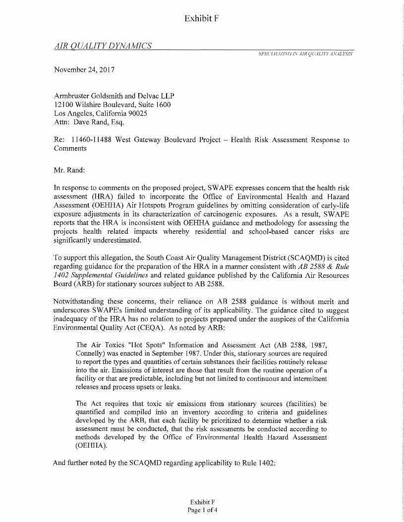
Exhibit F
:
AIR QUALITY DYNAMICSSPECIALIZING IN AIR QUALITY ANALYSIS
November 24, 2017
Armbruster Goldsmith and Delvac LLP 12100 Wilshire Boulevard, Suite 1600 Los Angeles, California 90025 Attn: Dave Rand, Esq.
Re: 11460-11488 West Gateway Boulevard Project - Health Risk Assessment Response to Comments
Mr. Rand:
In response to comments on the proposed project, SWAPE expresses concern that the health risk assessment (HRA) failed to incorporate the Office of Environmental Health and Hazard Assessment (OEHHA) Air Hotspots Program guidelines by omitting consideration of early-life exposure adjustments in its characterization of carcinogenic exposures. As a result, SWAPE reports that the HRA is inconsistent with OEHHA guidance and methodology for assessing the projects health related impacts whereby residential and school-based cancer risks are significantly underestimated.
To support this allegation, the South Coast Air Quality Management District (SCAQMD) is cited regarding guidance for the preparation of the HRA in a manner consistent with AB 2588 & Rule 1402 Supplemental Guidelines and related guidance published by the California Air Resources Board (ARB) for stationary sources subject to AB 2588.
Notwithstanding these concerns, their reliance on AB 2588 guidance is without merit and underscores SWAPE's limited understanding of its applicability. The guidance cited to suggest inadequacy of the HRA has no relation to projects prepared under the auspices of the California Environmental Quality Act (CEQA). As noted by ARB:
The Air Toxics "Hot Spots" Information and Assessment Act (AB 2588, 1987, Connelly) was enacted in September 1987. Under this, stationary sources are required to report the types and quantities of certain substances their facilities routinely release into the air. Emissions of interest are those that result from the routine operation of a facility or that are predictable, including but not limited to continuous and intermittent releases and process upsets or leaks.
The Act requires that toxic air emissions from stationaiy sources (facilities) be quantified and compiled into an inventory according to criteria and guidelines developed by the ARB, that each facility be prioritized to determine whether a risk assessment must be conducted, that the risk assessments be conducted according to methods developed by the Office of Environmental Health Hazard Assessment (OEHHA).
And further noted by the SCAQMD regarding applicability to Rule 1402:
Exhibit FPage 1 of 4
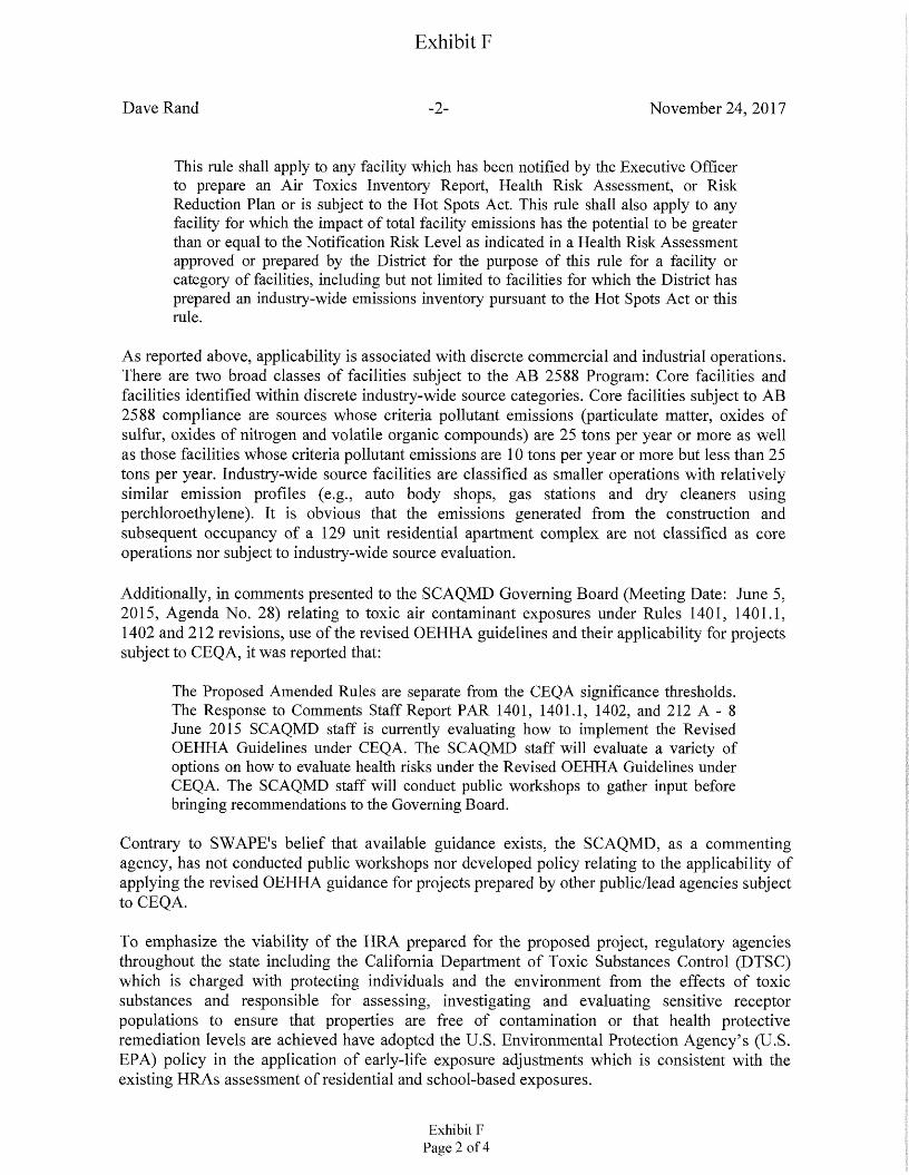
Exhibit F
Dave Rand November 24, 2017-2-
This rule shall apply to any facility which has been notified by the Executive Officer to prepare an Ah* Toxics Inventory Report, Health Risk Assessment, or Risk Reduction Plan or is subject to the Hot Spots Act. This rule shall also apply to any facility for which the impact of total facility emissions has the potential to be greater than or equal to the Notification Risk Level as indicated in a Health Risk Assessment approved or prepared by the District for the purpose of this rule for a facility or category of facilities, including but not limited to facilities for which the District has prepared an industry-wide emissions inventory pursuant to the Hot Spots Act or this rule.
As reported above, applicability is associated with discrete commercial and industrial operations. There are two broad classes of facilities subject to the AB 2588 Program: Core facilities and facilities identified within discrete industry-wide source categories. Core facilities subject to AB 2588 compliance are sources whose criteria pollutant emissions (particulate matter, oxides of sulfur, oxides of nitrogen and volatile organic compounds) are 25 tons per year or more as well as those facilities whose criteria pollutant emissions are 10 tons per year or more but less than 25 tons per year. Industry-wide source facilities are classified as smaller operations with relatively similar emission profiles (e.g., auto body shops, gas stations and dry cleaners using perchloroethylene). It is obvious that the emissions generated from the construction and subsequent occupancy of a 129 unit residential apartment complex are not classified as core operations nor subject to industry-wide source evaluation.
Additionally, in comments presented to the SCAQMD Governing Board (Meeting Date: June 5, 2015, Agenda No. 28) relating to toxic air contaminant exposures under Rules 1401, 1401.1, 1402 and 212 revisions, use of the revised OEHHA guidelines and their applicability for projects subject to CEQA, it was reported that:
The Proposed Amended Rules are separate from the CEQA significance thresholds. The Response to Comments Staff Report PAR 1401, 1401.1, 1402, and 212 A - 8 June 2015 SCAQMD staff is currently evaluating how to implement the Revised OEHHA Guidelines under CEQA. The SCAQMD staff will evaluate a variety of options on how to evaluate health risks under the Revised OEHHA Guidelines under CEQA. The SCAQMD staff will conduct public workshops to gather input before bringing recommendations to the Governing Board.
Contrary to SWAPE's belief that available guidance exists, the SCAQMD, as a commenting agency, has not conducted public workshops nor developed policy relating to the applicability of applying the revised OEHHA guidance for projects prepared by other public/lead agencies subject to CEQA.
To emphasize the viability of the HRA prepared for the proposed project, regulatory agencies throughout the state including the California Department of Toxic Substances Control (DTSC) which is charged with protecting individuals and the environment from the effects of toxic substances and responsible for assessing, investigating and evaluating sensitive receptor populations to ensure that properties are free of contamination or that health protective remediation levels are achieved have adopted the U.S. Environmental Protection Agency’s (U.S. EPA) policy in the application of early-life exposure adjustments which is consistent with the existing HRAs assessment of residential and school-based exposures.
Exhibit FPage 2 of 4
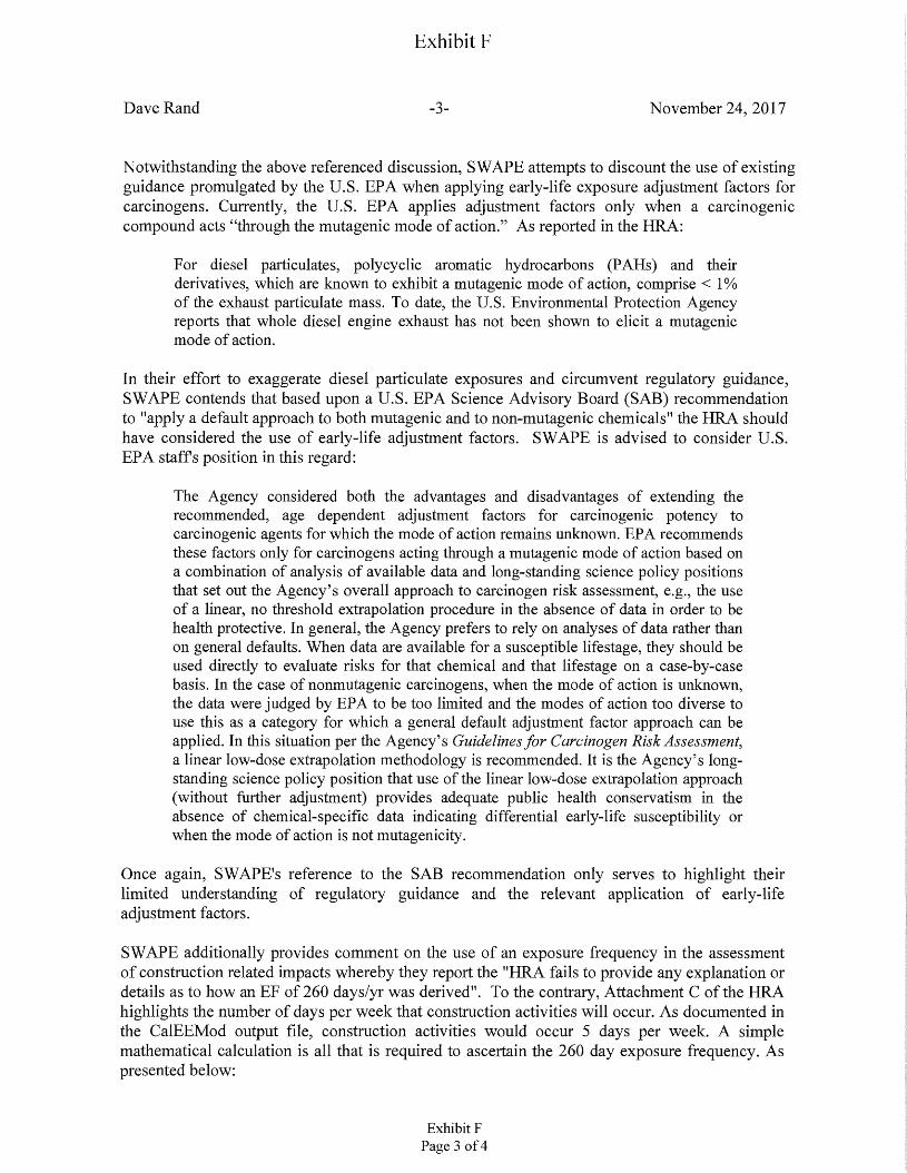
Exhibit F
Dave Rand November 24, 2017-3-
Notwithstanding the above referenced discussion, SWAPE attempts to discount the use of existing guidance promulgated by the U.S. EPA when applying early-life exposure adjustment factors for carcinogens. Currently, the U.S. EPA applies adjustment factors only when a carcinogenic compound acts “through the mutagenic mode of action.” As reported in the HRA:
For diesel particulates, polycyclic aromatic hydrocarbons (PAHs) and their derivatives, which are known to exhibit a mutagenic mode of action, comprise < 1% of the exhaust particulate mass. To date, the U.S. Environmental Protection Agency reports that whole diesel engine exhaust has not been shown to elicit a mutagenic mode of action.
In their effort to exaggerate diesel particulate exposures and circumvent regulatory guidance, SWAPE contends that based upon a U.S. EPA Science Advisory Board (SAB) recommendation to "apply a default approach to both mutagenic and to non-mutagenic chemicals" the HRA should have considered the use of early-life adjustment factors. SWAPE is advised to consider U.S. EPA staffs position in this regard:
The Agency considered both the advantages and disadvantages of extending the recommended, age dependent adjustment factors for carcinogenic potency to carcinogenic agents for which the mode of action remains unknown. EPA recommends these factors only for carcinogens acting through a mutagenic mode of action based on a combination of analysis of available data and long-standing science policy positions that set out the Agency’s overall approach to carcinogen risk assessment, e.g., the use of a linear, no threshold extrapolation procedure in the absence of data in order to be health protective. In general, the Agency prefers to rely on analyses of data rather than on general defaults. When data are available for a susceptible lifestage, they should be used directly to evaluate risks for that chemical and that lifestage on a case-by-case basis. In the case of nonmutagenic carcinogens, when the mode of action is unknown, the data were judged by EPA to be too limited and the modes of action too diverse to use this as a category for which a general default adjustment factor approach can be applied. In this situation per the Agency’s Guidelines for Carcinogen Risk Assessment, a linear low-dose extrapolation methodology is recommended. It is the Agency’s longstanding science policy position that use of the linear low-dose extrapolation approach (without further adjustment) provides adequate public health conservatism in the absence of chemical-specific data indicating differential early-life susceptibility or when the mode of action is not mutagenicity.
Once again, SWAPE's reference to the SAB recommendation only serves to highlight their limited understanding of regulatory guidance and the relevant application of early-life adjustment factors.
SWAPE additionally provides comment on the use of an exposure frequency in the assessment of construction related impacts whereby they report the "HRA fails to provide any explanation or details as to how an EF of 260 days/yr was derived". To the contrary, Attachment C of the HRA highlights the number of days per week that construction activities will occur. As documented in the CalEEMod output file, construction activities would occur 5 days per week. A simple mathematical calculation is all that is required to ascertain the 260 day exposure frequency. As presented below:
Exhibit FPage 3 of 4
Exhibit F
Dave Rand November 24, 2017-4-
5 days per week x 52 weeks per year = 260 days per year
In a final comment provided by SWAPE, the HRA is alleged to have failed to address the projects operational emissions which were reported to have a de minimis emission potential for the generation of on-site diesel particulates to warrant consideration. SWAPE argues that PM 10 exhaust emissions reported in the CalEEMod output file should be used as a surrogate for diesel particulates to address operational emissions. As such, SWAPE cites an excerpt from the CalEEMod User's Guide to attempt to document the HRAs inadequacy for its omission. Specifically, SWAPE reports:
CalEEMod calculates the emissions associated with on-road mobile sources. These are associated with residents, workers, customers, and delivery vehicles visiting the land use types in the project. The emissions associated with on-road mobile sources includes running and starting exhaust emissions, evaporative emissions, brake and tire wear, and fugitive dust from paved and unpaved roads. Starting and evaporative emissions are associated with the number of starts or time between vehicle uses and the assumptions used in determining these values are described below. All of the other emissions are dependent on vehicle miles traveled (VMT).
We are at a loss at to the relevance of this citation as it only serves to support the HRAs omission of operational impacts. There are no discrete PM10 exhaust emissions associated with on-site mobile source activity from diesel fueled vehicles reported in the CalEEMod emissions estimation model. SWAPE's comment that the HRAs interpretation of the mobile source profile is "entirely incorrect and unsubstantiated" is beyond comprehension. SWAPE is advised to review CalEEMod's calculation methodology to gain a basic understanding of its operational mobile source emission estimates.
As noted above, the existing HRAs assessment methodology is not subject to either AB 2588 nor Rule 1402 guidelines. As such, the exposure varieties used in the preparation of the HRA were appropriate and referenced as to their applicability. Documentation associated with the use of an exposure frequency commensurate with reported construction related activity and the exclusion of operational emissions were clearly presented in the ERA.
Contrary to SWAPE's contentions, the assessment and dispersion modeling methodologies used in the preparation of the HRA were relevant and appropriate and effectively quantified the exposure potential of diesel particulate emissions associated with the construction and operation of the proposed residential apartment complex whereby revision of the HRA is not warranted.
I can be reached at (818) 703-3294 should you have any questions or require additional information.
Sincerely,
Bill Piazza
Exhibit FPage 4 of 4

Exhibit G
Exhibit G
Case No. CPC-2015-2662-VZC-ZAD-CDO-SPR CF 16-1458-S1
F-1
As modified on January 26, 2017
FINDINGS
General PlanA.
1. General Plan Land Use Designation.
The subject property is located within the West Los Angeles Community Plan area (effective July 27, 1999), which designates the property as General Commercial with corresponding zones of C1.5, C2, C4, RAS3, RAS4, and P. The requested Zone Change is necessary to update the existing [Q] condition relative to signage prohibitions and impose a (T)(Q) in order to reflect the proposed project. The existing [Q] corresponds to Ordinance No. 173,680-SA2, which prohibits off-site signs, pole signs, mural signs, and supergraphic displays and other ‘Q’ conditions required under Ordinance No. 159,060. This [Q] is no longer necessary as any signage will be governed by existing signage regulations of the LAMC and any subsequent amendments to said sign regulations. The project does not propose any of the prohibited signage of the existing [Q], which includes off-site signs, pole signs, mural signs, and supergraphic displays. Ordinance No. 159,060 reflects a previous and expired entitlement on the project site that limited development to 17-stories, 400,000 square feet of office floor area, and required parking. Ordinance 159,060 establishing the then (T)(Q)C2-2 Zone expired in 1988. The ‘CDO’ corresponds to the establishment of the West Wilshire Boulevard Community Design Overlay District under Ordinance No. 174,161, which became effective on September 24, 2001.
The project involves the construction of a 34story residential building with a total of 376 multi-family dwelling units. The project is utilizing a ministerial Density Bonus by setting aside 5 percent of the dwelling units, equal to 16 units, for Very Low Income households in exchange for a 20 percent Density Bonus to achieve an additional 63 units in lieu of the byright density of 313 base dwelling units. The dwelling units will range in size from 79 units with less than three habitable rooms, 226 units of three habitable rooms, and 71 units with more than three habitable rooms. The project incorporates an approximately 40,544 square- foot, privately maintained, publicly accessible open space area.
The development is consistent with the applicable zoning regulations and land use policies of the West Los Angeles Community Plan, which aims to provide a variety of housing opportunities, maximize development opportunities around future transit systems, and to enhance the positive characteristics of existing uses which provide the foundation for community identity, such as scale, height, bulk, setbacks and appearance.
2. General Plan Text
a. West Los Angeles Community Plan: The residential project is consistent with several goals, objectives, and polices of the West Los Angeles Community Plan. The plan text includes the following relevant residential and commercial land use goals, objectives and policies:
Goal 1: A safe, secure, and high quality residential environment for all economic, age, and ethnic segments of the Community.
214CF-16-1458-S1 -1503 Exhibit GPage 1 of 108
Exhibit GCase No. CPC-2015-2662-VZC-ZAD-CDO-SPRCF 16-1458-S1
F-2
Objective 1-1: To provide for the preservation of existing housing and for thedevelopment of new housing to meet the diverse economic and physical needs of the existing residents and projected population of the Plan area to the year 2010.
Policy 1-1.1: Protect existing single family residential neighborhoods from new out-of-scale development and other incompatible uses.
Policy 1-1.3: Provide for adequate multi-family residential development.
Objective 1-2: To reduce vehicular trips and congestion by developing newhousing in proximity to adequate services and facilities.
Policy 1-2.1: Locate higher residential densities near commercial centers and major bus routes where public service facilities and infrastructure will support this development
Policy 1-2.3 Do not increase residential densities beyond those permitted in the Plan unless the necessary infrastructure and transportation systems are available to accommodate the increase.
Objective 1-3: To preserve and enhance the varied and distinct residentialcharacter and integrity of existing residential neighborhoods.
Policy 1-3.1: Require architectural compatibility and adequate landscaping for new multi-family residential development to protect the character and scale of existing residential neighborhoods.
Objective 1-4: To promote adequate and affordable housing and increase itsaccessibility to more segments of the population, especially students and senior citizens.
Policy 1-4.1: Promote greater individual choice in type, quality, price and location of housing.
Policy 1.4-2: Ensure that new housing opportunities minimize displacement ofresidents.
Encourage multiple residential development in specified commercial zones.
Policy 1.4-3:
The project is a residential development consisting of 376 units, of which 16 will be set aside for very Low Income households, associated recreational amenities, and 74,112 square feet of public and private open space including a 40,544 square-foot publicly accessible open space, and private amenities for residents including a pool deck and spa, fitness room and club room.
The project site is currently improved with a 42,900 square-foot, single-story supermarket building, which will be demolished to accommodate the residential tower. The existing 17-story, 364,791 square-foot office building at the intersection of Wiishire and Granville Avenue will remain, as will an existing four-level subterranean parking structure spanning the project site. To support the foundation of the new residential building, the project proposes the partial demolition and reconstruction of a portion of the
215CF-16-1458-S1-1504 Exhibit GPage 2 of 108
Exhibit G
F-3Case No. CPC-2015-2662-VZC-ZAD-CDO-SPRCF 16-1458-S1
four-level subterranean parking structure. A total of 1,090 parking spaces will be provided and the project will contain 360,291 square feet of floor area upon full build out.
b. Framework Land Use Chapter: The Framework Element's Land Use chapter policy encourages the retention of the City's stable residential neighborhoods and proposes incentives to encourage whatever growth that occurs to locate in neighborhood districts, commercial and mixed-use centers, along boulevards, industrial districts, and in proximity to transportation corridors and transit stations. Land use standards and densities vary by location to reflect the local conditions and diversity and range from districts oriented to the neighborhood, the community, the region, and, at the highestlevel, the national and international markets.
The General Plan Framework identifies General Commercial as offering a “diversity of retail sales and services, office, and auto-oriented uses comparable to those currently allowed in the "C2" zone (including residential). They are located outside of districts, centers, and mixed-use boulevards and occur at the intersections of major and secondary streets, or as low rise, low-density linear "strip" development along major and secondary streets.”
The project supports and will be generally consistent with the General Plan Framework Land Use Chapter as it accommodate development of residential uses in accordance with the applicable policies of the West Los Angeles Community Plan. Specifically, the project will comply with the Community Centers following goal, objective and policies set forth in the General Plan Framework Land Use Chapter:
Goal 3H: Lower-intensity highway-oriented and local commercial needs outside centers and districts. Pedestrian-oriented, high activity, multi- and mixed-use centers that support and provide identity for Los Angeles' communities.
Generally, maintain the uses, density, and character of existing low-intensity commercial districts whose functions serve surrounding neighborhoods and/or precluded from intensification due to their physical characteristics.
Policy 3.12.1: Accommodate the development of uses in areas designated as“General Commercial’’ in the community plans in accordance with Tables 3-1 and 3-7. The range and densities/intensities of uses permitted in any area shall be identified in the community plans.
Objective 3.12:
The project is providing 376 residential dwelling units within the allowable density provided by the underlying C2-2-CDO zoning and the State’s Density Bonus provisions. The property has no height limit and proposes a 34-story high rise tower in proximity to other high rise towers, ranging from 165 to 334 feet in height. As proposed, the project is meeting the intent of the goals, policies and objectives of the West Los Angeles Community Plan.
c. Housing Element: 2013-2021 Housing Element, the Housing Element of the General Plan, is the City’s blueprint for meeting housing and growth challenges. The Housing Element identifies the City’s housing conditions and needs, identifies goals, objectives, and policies that are the foundation of the City’s housing and growth strategy, and provides an array of programs the City has committed to in order to implement and
216CF-16-1458-S1 -1505 Exhibit GPage 3 of 108
Exhibit GCase No. CPC-2015-2662-VZC-ZAD-CDO-SPRCF 16-1458-S1
F-4
create sustainable, mixed-income neighborhoods across Los Angeles. The project is consistent with the following goals, objectives and policies of the Housing Element:
Goal 1: Housing Production and Preservation: A City where housing production and preservation result in an adequate supply of ownership and rental housing that is safe, healthy and affordable to people of all income levels, races, ages, and suitable for their various needs.
Objective 1.1: Produce an adequate supply of rental and ownership housing in order to meet current and projected needs.
Policy 1.1.3: Facilitate new construction and preservation of a range of different housing types that address the particular needs of the city’s households.
The project includes 376 residential units in a range of sizes, including studios and one and two bedroom units. The variety in dwelling unit types will accommodate a variety of family sizes within the existing mixed-use community. The project’s 376 residential units will help further achieve the Mayor’s goal of producing 100,000 dwelling units by 2021.
Goal 2: Safe, Livable and Sustainable Neighborhoods
Objective 2.2: Promote sustainable neighborhoods that have mixed-income housing, jobs, amenities services and transit.
Policy 2.2.1: Provide incentives to encourage the integration of housing withother compatible land uses.
Policy 2.2.2: Provide incentives and flexibility to generate new multi-family housing near transit and centers, in accordance with the General plan Framework element, as reflected in Map ES. 1.
Objective 2.3: Promote sustainable buildings, which minimize adverse effects on the environment and minimize the use of non-renewable resources.
Policy 2.3.2: Promote and facilitate reduction of water consumption in new and existing housing.
Policy 2.3.3: Promote and facilitate reduction of energy consumption in new and existing housing.
Policy 2.3.4: Promote and facilitate reduction of waste in construction and building operations.
Objective 2.4: Promote livable neighborhoods with a mix of housing types, quality design and a scale and character that respects unique residential neighborhoods in the City.
Policy 2.4.3: Develop and implement sustainable design standards in public and private open space and street rights-of-way. Increase access to open space, parks and green spaces.
217CF-16-1458-S1 -1506Exhibit G
Page 4 of 108
Exhibit G
Case No. CPC-2015-2662-VZC-ZAD-CDO-SPR CF 16-1458-S1
F-5
The proposed residential project will replace a supermarket structure with a residential building to include 376 units of housing and 74,112 square feet of public and private open space, including a 40,544 square-foot publicly accessible and privately maintained open space. The project also includes several private amenities for residents including a pool deck and spa, fitness room and club room. In addition, the project will comply with all state, regional, local and LAMC requirements for water and energy conservation and waste reduction. The project will be constructed to LEED Silver certification standards.
d. Health and Wellness Element: Plan for a Healthy Los Angeles, the Health and Wellness Element of the General Plan, seeks the promotion of a healthy built environment in a manner that enhances opportunities for improved health and well-being, and which promotes healthy living and working conditions. As further analyzed in the EIR and herein, the project is consistent with the following policies:
Healthy building design and constructionPolicy 2.2:
“Promote a healthy built environment by encouraging the design and rehabilitation of buildings and sites for healthy living and working conditions, including promoting enhanced pedestrian-oriented circulation, lighting, attractive and open stairs, healthy building materials and universal accessibility using existing tools, practices, and programs.”
The project includes retention of the existing 17-story office structure and subterranean parking and the new construction of 376 residential dwelling units and associated amenities. New construction will comply with all LAMC regulations, including the Green Building Code, and will pursue LEED Silver certification standards. The project also includes 74,112 square feet of public and private open space, including landscaped courtyards and pathways that will be publicly accessible. The project’s location, near several public transportation lines will encourage pedestrian circulation.
Policy 2.6: Repurpose underutilized spaces for health
“Work proactively with residents to identify and remove barriers to leverage and repurpose vacant and underutilized spaces as a strategy to improve community health.”
Active spacesPolicy 3.8:
“Support public, private, and nonprofit partners in the ongoing development of new and innovative active spaces and strategies to increase the number of Angelenos who engage in physical activity across ages and level of abilities."
The project will replace an existing surface parking lot with a 40,544 square-foot publicly accessible and privately maintained park that will be a significant benefit to the immediate community.
In addition, the project includes 74,112 square feet of public and private open space, including residential amenities that will promote physical activity for residents, such as a club room, fitness center, pool deck and spa, and several landscaped recreational areas.
218CF-16-1458-S1-1507 Exhibit GPage 5 of 108
Case No. CPC-2015-2662-VZC-ZAD-CDO-SPR CF 16-1458-S1
Exhibit GF-6
Policy 5.1: Air pollution and respiratory health
“Reduce air pollution from stationary and mobile sources; protect human health and welfare and promote improved respiratory health.”
The project is located within walking distance of several public transportation lines and is adjacent to designated bicycle routes and lanes. Project residents and visitors will be within walking distance of retail, restaurants and jobs. In addition, the project provides 465 total bicycle parking spaces and EV ready parking spaces, to encourage alternative means of transportation, thus reducing air pollution from vehicles. The project also provides HVAC systems for all residential units with the minimum Code required MERV rated filters to improve the health and welfare of project residents.
Policy 5.7: Land use planning for public health and GHG emission reduction
“Promote land use policies that reduce per capita greenhouse gas emissions, result in improved air quality and decreased air pollution, especially for children, seniors and others susceptible to respiratory diseases. ”
As discussed above, the project includes bicycle parking and EV ready spaces to help reduce GHG emissions during operation of the project.
e. Mobility Element: Mobility Plan 2035, the Mobility Element of the General Plan, will not be negatively affected by the recommended action herein. The project is consistent with the five goals of the plan to provide:
1. Safety First2. World Class Infrastructure3. Access for All Angelenos4. Collaboration, Communication and Informed Choices5. Clean Environments & Healthy Communities
Pursuant to Mobility Plan 2035, the designations of the project’s adjacent streets are: Wilshire Boulevard, adjoining the project site to the north, is designated a Boulevard II and has a 110-foot right-of-way; Stoner Avenue, adjoining the project site to the east, is designated a Local Street-Standard and has a 60-foot right-of-way; Granville Avenue, adjoining the project site to the west, is designated a Local Street-Standard and has a 60-foot right-of-way; and the alley, adjoining the project site to the south, has a 20-foot right-of-way. Moreover, the Bureau of Engineering has required dedications and improvements on Wilshire Boulevard and improvements at the dedicated corner cuts at Stoner Avenue and Glanville Avenue. Additionally, the project includes Project Design Features J-1 and J-2 aimed at addressing transportation-related impacts during construction of the project.
The applicant is requesting Special Permission to allow a 10 percent reduction of the required off-street parking spaces for commercial uses because the project site is located within 1,500 feet of two bus line stops used in conjunction with the dedicated
219CF-16-1458-S1 -1508Exhibit G
Page 6 of 108
Exhibit G
Case No. CPC-2015-2662-VZC-ZAD-CDO-SPR CF 16-1458-S1
F-7
Bus Rapid Transit (BRT) lane on Wilshire Boulevard for the Metro Rapid Transit Line 720. Specifically, the closest stop for the westbound Metro Rapid 720 is located on Wilshire Boulevard near Barrington Avenue, 311 feet away from the project site, and the closest stop for the eastbound Metro Rapid 720 is located on Wlshire Boulevard near Barrington Avenue, 299 feet away. The project site is served by the following Metro public transit lines, with a collective estimated ridership of 17,604,510 for the year 2015.
• Metro Local Lines: 4 (Downtown Los Angeles to Santa Monica), 20 (Downtown Los Angeles to Santa Monica)
• Metro Rapid Lines: 704 (Downtown Los Angeles to Santa Monica), 720 (Santa Monica to Commerce)
The immediate project vicinity is also served by the following lines:
• Santa Monica Big Blue Bus Lines: 1 (UCLA-Venice), 2 (UCLA-Santa Monica), 14 (Brentwood-Culver City), 15 (West Los Angeles-Brentwood Village), 16 (Marina Del Rey-University High School), and 17 (Culver City-UCLA)
Based on the 2010 Bicycle Plan, the existing bicycle system in the study area consists of limited coverage of bicycle lanes (Class II) and bicycle routes (Class III). Bicycle lanes, which are facilities where bicycles have use of a dedicated and striped lane within the roadway, are a component of street design with dedicated striping, separating vehicular traffic from bicycle traffic. These facilities offer a safer environment for both cyclists and motorists. Bicycle routes, which are facilities where bicycles share the lane with vehicular traffic on a marked and signed roadway, are identified as bicycle-friendly streets where motorists and cyclists share the roadway and there is no dedicates striping of a bicycle lane. Bicycle routes are preferably located on collector and lower volume arterial streets.
The City’s Bicycle Plan designates Wilshire Boulevard as a Backbone Bikeway Network and a Bicycle Lane. The following bicycle lanes are located near the project site:
Bicycle Lanes (Class II) near the project site:• San Vicente Boulevard from 26th Street to Bundy Drive
Bicycle Routes (Class III) near the project site:• San Vicente Boulevard from Bundy Drive to Wlshire Boulevard• Federal Avenue from Wilshire Boulevard to Ohio Avenue• Texas Avenue from Bundy Drive to Federal Avenue
f. Sewerage Facilities Element: Improvements may be required for the construction or improvement of sewer facilities to serve the subject project and complete the City sewer system for the health and safety of City inhabitants, which will assure compliance with the goals of this General Plan Element.
Entitlement FindingsB.
1. Zone and Height District Change Findings
220CF-16-1458-S1 -1509 Exhibit GPage 7 of 108
Exhibit GCase No. CPC-2015-2662-VZC-ZAD-CDO-SPRCF 16-1458-S1
F-8
a. Pursuant to L.A.M.C. Section 12.32.C.7, and based on these Findings, the recommended action is deemed consistent with the General Plan and is in conformity with public necessity, convenience, general welfare and good zoning.
The project includes a Zone Change for the entire project site from [Q]C2-2-CDO to (T)(Q)C2-2-CDO. Approval of the Zone Change will update the existing [Q] on the project, which includes specific prohibitions on types of signage, including off-site signs, pole signs, mural signs and supergraphic displays, and implement “(T)(Q)” to reflect the proposed development on the project site. The proposed Zone Change maintains the existing regulations of the underlying C2 Zone, Height District 2, and the West Wilshire CDO. It retains the existing zoning pattern on the project site, does not grant additional development rights that are otherwise not applicable to adjoining properties, and is only necessary to reflect the proposed density and improvement conditions necessary to effectuate the project.
The project will be developed within the allowable density, floor area, height, and setback regulations of the existing zone, inclusive of the permitted Density Bonus. The project includes the replacement of a supermarket with a new residential development consisting of 376 units with four levels of subterranean parking. The development of this site is consistent with the pattern of high rise development along Wilshire Boulevard and will be adjacent to mid- to high-rise, high-density commercial, retail, and office uses along Wilshire Boulevard, transitioning to lower density multi-family residential neighborhoods to the north and south of Wilshire Boulevard. A 334-foot tall high-rise office building is located across Wilshire Boulevard to the north and is in the [Q]C4-2-CDO Zone. Three residential buildings with heights of approximately 281 feet, 168 feet and 165 feet are located across Stoner Avenue to the east and are in the [Q]C2-2-CDO and R4-1 Zones. Low- to mid-rise multi-family residential uses are located to the south across the alley and are in the R3-1 Zone. Low- to mid-rise multi-family residential uses and low-rise office uses are located to the west across Granville Avenue and are in the [Q]C2-1L-CDO and R3-1 Zones. The project site is well served by several bus lines. Metro Local and Rapid bus lines collectively served 17,604,510 million riders in 2015. The project will further contribute to the concentration of similar land uses in the vicinity and the City finds that the Zone Change will be in conformity with public necessity, convenience, general welfare and good zoning.
ADDITIONAL FINDINGS FORA’ Q’ QUALIFIED CLASSIFICATION:
b. The project will protect the best interests of and assure a development more compatible with the surrounding property or neighborhood.
The project is consistent with the development standards of the existing underlying zoning of the project site, inclusive of the use of a ministerial density bonus. It represents a scale and intensity of development that was not only contemplated by the West Los Angeles Community Plan, but which is compatible with adjacent land uses, which consists of mid- and high-rise residential and commercial office structures.
The project will maintain an existing high-rise office structure on the project site, will demolish an existing supermarket, and reinforce and reconfigure an existing subterranean parking lot to accommodate the new 34-story high rise residential building. It promotes the West Los Angeles Community Plan’s goals and policies of encouraging new residential
221CF-16-1458-S1-1510Exhibit G
Page 8 of 108
Exhibit G
Case No. CPC-2015-2662-VZC-ZAD-CDO-SPRCF 16-1458-S1
F-9
development to meet existing and future housing needs. In addition, the project meets the following additional goals, policies, and objectives:
Goal 1: A safe, secure, and high quality residential environment for all economic, age,and ethnic segments of the Community.
Objective 1-1: To provide for the preservation of existing housing and for thedevelopment of new housing to meet the diverse economic and physical needs of the existing residents and projected population of the Plan area to the year 2010.
Policy 1-1.1: Protect existing single family residential neighborhoods from new out-of-scale development and other incompatible uses.
Policy 1-1.3: Provide for adequate multi-family residential development.
Objective 1-2: To reduce vehicular trips and congestion by developing newhousing in proximity to adequate services and facilities.
Policy 1-2.1: Locate higher residential densities near commercial centers and major bus routes where public service facilities and infrastructure will support this development.
Policy 1-2.3 Do not increase residential densities beyond those permitted in the Plan unless the necessary infrastructure and transportation systems are available to accommodate the increase.
Objective 1-3: To preserve and enhance the varied and distinct residentialcharacter and integrity of existing residential neighborhoods.
Policy 1-3.1: Require architectural compatibility and adequate landscaping for new multi-family residential development to protect the character and scale of existing residential neighborhoods.
To promote adequate and affordable housing and increase its accessibility to more segments of the population, especially students and senior citizens.
Policy 1-4.1: Promote greater individual choice in type, quality, price and location of housing.
Objective 1-4:
Policy 1.4-2: Ensure that new housing opportunities minimize displacement ofresidents.
Encourage multiple residential development in specified commercial zones.
Policy 1.4-3:
The “Q” Conditions will ensure that the project is constructed as approved herein and subject to the mitigation measures and project design features identified in the EIR.
c. The project will secure an appropriate development in harmony with the objectives of the General Plan.
222CF-16-1458-S1 -1511 Exhibit GPage 9 of 108
Exhibit GCase No. CPC-2015-2662-VZC-ZAD-CDO-SPR CF 16-1458-S1
F-10
The project promotes and is consistent with the intensity and pattern of development of General Commercial land use areas along the south side of Wilshire Boulevard, which is characterized by the West Los Angeles Community Plan as “developed with high rise office buildings.” The General Plan Framework identifies General Commercial as offering a “diversity of retail sales and services, office, and auto-oriented uses comparable to those currently allowed in the "C2" zone (including residential). They are located outside of districts, centers, and mixed-use boulevards and occur at the intersections of major and secondary streets, or as low rise, low-density linear "strip" development along major and secondary streets.”
The project supports and will be generally consistent with the General Plan Framework Land Use Chapter as it accommodate development of residential uses in accordance with the applicable policies of the West Los Angeles Community Plan. Specifically, the project will comply with the Community Centers following goal, objective and policies set forth in the General Plan Framework Land Use Chapter:
Goal 3H: Lower-intensity highway-oriented and local commercial needs outside centers and districts. Pedestrian-oriented, high activity, multi- and mixed-use centers that support and provide identity for Los Angeles' communities.
Generally, maintain the uses, density, and character of existing low-intensity commercial districts whose functions serve surrounding neighborhoods and/or precluded from intensification due to their physical characteristics.
Objective 3.12:
Policy 3.12.1: Accommodate the development of uses in areas designated as “General Commercial” in the community plans in accordance with Tables 3-1 and 3-7. The range and densities/intensities of uses permitted in any area shall be identified in the community plans.
The project is providing 376 residential dwelling units within the allowable density provided by the underlying C2-2-CDO zoning and the State’s Density Bonus provisions. The property has no height limit and proposes a 34-story high rise tower in proximity to other high rise towers, ranging in height from 165 to 334 feet in height. As proposed, the project is meeting the intent of the goals, policies and objectives of the West Los Angeles Community Plan.
The project will provide an appropriate development that is in harmony with the General Plan by supporting many of the land use goals, objectives and policies identified in the West Los Angeles Community Plan. The project will: reduce vehicular trips and congestion by developing new housing in proximity to adequate services and facilities; locate higher residential densities near established mixed-use, high-rise areas, and near high capacity public transit.
d. The project will prevent or mitigate potential adverse environmental effects of the zone change.
The project has been conditioned herein to comply with all project design features, mitigation measures and the mitigation monitoring program of environmental impact report, Case No. ENV-2013-3747-EIR (SCH No. 2014031014), which begin with Condition No. Q-17 through Condition No. Q-19.
223CF-16-1458-S1 -1512Exhibit G
Page 10 of 108
Exhibit G
Case No. CPC-2015-2662-VZC-ZAD-CDO-SPR CF 16-1458-S1
F-11
2. Special Permission for Reduction of Off-Street Parking Spaces
a. The action is in conformity with the public necessity, convenience, general welfare and good zoning practice.
The applicant is requesting Special Permission to allow a 10 percent reduction of the required off-street parking spaces for commercial uses because the project site is located within 1,500 feet of two bus stops used in conjunction with the dedicated Bus Rapid Transit (BRT) lane on Wilshire Boulevard for the Metro Rapid Transit Line 720. The closest stop for the westbound Metro Rapid 720 is located on Wilshire Boulevard near Barrington Avenue, 311 feet away from the project site, and the closest stop for the eastbound Metro Rapid 720 is located on Wilshire Boulevard near Barrington Avenue, 299 feet away. The project site is served by the following Metro public transit lines, with a collective estimated ridership of 17,604,510 for the year 2015.
• Metro Local Lines: 4 (Downtown Los Angeles to Santa Monica), 20 (Downtown Los Angeles to Santa Monica)
• Metro Rapid Lines: 704 (Downtown Los Angeles to Santa Monica), 720 (Santa Monica to Commerce)
The immediate project vicinity is also served by the following lines:
• Santa Monica Big Blue Bus Lines; 1 (UCLA-Venice), 2 (UCLA-Santa Monica), 14 (Brentwood-Culver City), 15 (West Los Angeies-Brentwood Village), 16 (Marina Del Rey-University High School), and 17 (Culver City-UCLA).
In addition to the aforementioned Metro Rapid 720 bus stops, there is a bus stop for the westbound Metro Local 20 455 feet away from the project site and the eastbound stop is 357 feet away, both on Wilshire Boulevard near Westgate Avenue.
The 2010 Bicycle Plan, adopted in March 1, 2011, identifies streets near the project site as part of the plan. The City’s Bicycle Plan designates Wilshire Boulevard as a Backbone Bikeway Network and a Bicycle Lane. The following bicycle lanes are located near the project site:
Bicycle Lanes (Class II) near the project site:• San Vicente Boulevard from 26th Street to Bundy Drive
Bicycle Routes (Class III) near the project site:• San Vicente Boulevard from Bundy Drive to Wilshire Boulevard• Federal Avenue from Wilshire Boulevard to Ohio Avenue• Texas Avenue from Bundy Drive to Federal Avenue
The project includes 465 total bicycle parking spaces for residential and commercial uses. For non-residential uses, 51 bicycle parking spaces are provided and 376 long-term and 38 short-term bicycle parking spaces are provided to meet the LAMC requirement for residential uses. Short and long-term bicycle parking spaces are located throughout the project site.
The area surrounding the project site is highly urbanized and adjacent to transit as described above. The request to allow 10 percent parking reduction for commercial uses
224Exhibit GPage 11 of 108
CF-16-1458-S1 -1513

Exhibit GCase No. CPC-2015-2662-VZC-ZAD-CDO-SPR CF 16-1458-S1
F-12
located within 1,500 feet of a transit facility is in conformity with the public necessity, convenience, and general welfare because the project site is located along a major transit corridor, specifically Wilshire Boulevard, which contains bus stops for Metro Local 20 and Metro Rapid 720. In addition, the project includes 1,090 vehicle parking spaces and 465 bicycle parking spaces for the use of the project residents, employees and visitors, thereby relieving the community of limited street parking. Therefore, project residents and visitors will be able to reduce their use of street parking by using public transit, walking or biking to the project site.
The project will enhance the built environment in the surrounding neighborhood by providing a residential building that will provide much-need housing, including 16 units for Very Low Income households, and a 40,544 square-foot publicly accessible open space to the community, city, and region. The project encourages the use of public transportation and bicycles to arrive at the site by providing publicly accessible open space in conjunction with the existing office building with short-term bicycle parking spaces located at the ground level and within the podium parking structure. The ground level building entrances are accessible directly from the sidewalk, a short distance from transit stops. Therefore, the project site is accessible via several modes of public transportation and is within walking distance of residential and commercial uses. In addition, the project includes EV ready parking spaces, loading areas, and improvements to the surrounding sidewalks. In addition, the project is subject to conditions of approval and project design features to minimize any adverse effects during construction and operation of the project. Specifically, Project Design Feature J-1, requires the applicant to prepare a construction management plan that includes measures such as: limiting potential lane closures to off-peak travel periods, to the extent feasible; scheduling receipt of construction materials during non-peak travel periods, to the extent possible; coordinating deliveries to reduce the potential trucks waiting to unload for extended periods of time; and prohibiting parking by construction workers on adjacent streets and directing construction workers to park on-site or other designated parking areas. Therefore, the project is in conformity with good zoning practices.
Based on the analysis above, the action is in conformity with the public necessity, convenience, general welfare and good zoning practice.
b. The action will be in substantial conformance with the various elements and objectives of the General Plan.
The project includes the development of a 34-story residential building with 376 multi-family dwelling units, including 16 units for Very Low Income households, and an approximately 40,544 square-foot publicly accessible open space area on a 2.8-acre site. The existing 364,791 square-foot, 17-story office building will remain. The project includes 1,090 vehicle parking spaces, including 447 residential parking spaces and 643 commercial parking spaces, and 465 bicycle parking stalls to serve the entire project.
The West Los Angeles Community Plan, a part of the Land Use Element of the General Plan, includes the following relevant land use objectives and policies that are consistent with the request for a 10 percent reduction of off-street parking for commercial uses:
Objective 1-2: To reduce vehicular trips and congestion by developing new housing in proximity to adequate services and facilities.
225CF-16-1458-S1 -1514 Exhibit GPage 12 of 108
Exhibit G
Case No. CPC-2015-2662-VZC-ZAD-CDO-SPRCF 16-1458-S1
F-13
Locate higher residential densities near commercial centers and major bus routes where public service facilities and infrastructure will support this development.
Do not increase residential densities beyond those permitted in the Plan unless the necessary infrastructure and transportation systems are available to accommodate the increase.
Policy 1-2.1:
Policy 1-2.3
In addition, Mobility Plan 2035, the Mobility Element of the General Plan, includes the following relevant objectives and policies that are consistent with the request for a 10 percent reduction of off-street parking for commercial uses:
Goal 2: World class infrastructure
Policy 2.3: Pedestrian Infrastructure. Recognize walking as a component of everytrip, and ensure high quality pedestrian access in all site planning and public right-of-way modifications to provide a safe and comfortable walking environment.
Bicycle Networks. Provide safe, convenient, and comfortable local and regional bicycling facilities for people of all types and abilities.
Policy 2.6:
Policy 2.10: Loading Areas. Facilitate the provision of adequate on and off-street loading areas.
Policy 2.15: Allocation of Transportation Funds. Expand funding to improve the built environment for people who walk, bike, take transit, and for other vulnerable roadway users.
Goal 3: Access for all Angelenos.
Land Use Access and Mix. Promote equitable land use decisions that result in fewer vehicle trips by providing greater proximity and access to jobs, destinations, and other neighborhood services.
Policy 3.3:
Policy 3.4: Transit Services. Provide all residents, workers and visitors with affordable, efficient, convenient, and attractive transit services.
Bicycle Parking: Provide bicyclists with convenient, secure and well- maintained bicycle parking facilities.
Policy 3.8:
Clean environments and healthy communities.Goal 5:
Clean Fuels and Vehicles. Continue to encourage the adoption of low and zero emission fuel sources, new mobility technologies, and supporting infrastructure.
Policy 5.4:
The project site is also located with the West Los Angeles Transportation Improvement and Mitigation Specific Plan area. As such, the project applicant is required to comply with the provisions of the Specific Plan including the Transportation Impact Assessment (TIA) Fee to LADOT for the purpose of funding transportation improvements.
226Exhibit GPage 13 of 108
CF-16-1458-S1 -1515
Exhibit GCase No. CPC-2015-2662-VZC-ZAD-CDO-SPRCF 16-1458-S1
F-14
The reduction therefore is in substantial conformance with the various elements and objectives of the General Plan as stated above.
ADDITIONAL FINDINGS FOR SPECIAL PERMISSION FOR THE REDUCTION OF OFF- STREET PARKING:
a. The commercial or industrial buildings are located on a lot not more than 1,500 feet distant from the portal of a fixed rail transit station, or bus station, or other similar transit facility.
Without the use of exceptions permitted in the Code, the requirements for vehicular parking for the project will require a total of 714 spaces for the existing 357,100 square-foot, commercial office building at the project site. In an effort to encourage the use of the existing public transit services by residents, employees and visitors, the project is seeking to reduce the required commercial parking by 10% given the project site’s proximity to the Metro Rapid Line 720. The project location is part of the Wilshire Bus Rapid Transit (BRT) Project that includes a dedicated peak period bus lane. The Wlshire BRT project is intended to further improve bus passenger travel times, service reliability, ridership of the existing Wilshire corridor and encourage a shift from automobile use to public transit. The portion of the Wlshire BRT Project became operational on November 16, 2015. The nearest Rapid Line 720 stop is located one block east of the project site at Wlshire Boulevard and Barrington Avenue. That stop also services Metro Bus line 20 and Santa Monica Big Blue Bus line 2.
The project is served by the following bus lines that are within walking distance:
Santa Monica Big Blue Bus Lines: 1 (UCLA-Venice), 2 (UCLA-Santa Monica),14 (Brentwood-Culver City), 15 (West Los Angeles-Brentwood Village), 16 (Marina Del Rey-University High School), and 17 (Culver City-UCLA)
Metro Local Lines; 4 (Downtown Los Angeles to Santa Monica), and 20 (Downtown Los Angeles to Santa Monica)
Metro Rapid Lines: 704 (Downtown Los Angeles to Santa Monica), and 720 (Santa Monica to Commerce)
The project site is also adjacent to City designated bicycle lanes and routes. The project includes 465 bicycle parking spaces, including both short-term and long-term bicycle parking spaces, that are dispersed throughout the project site.
b. The reduction will not otherwise be materially detrimental to the public welfare or injurious to the properties or improvements in the surrounding area.
The area surrounding the project site is highly urbanized. Adjacent land uses are mid- to high-rise, high-density commercial, retail, and office uses along Wlshire Boulevard, transitioning to lower density multi-family residential neighborhoods to the north and south of Wlshire Boulevard. A 334-foot tall high-rise office building is located across Wlshire Boulevard to the north and three residential buildings with heights of approximately 281 feet, 168 feet and 165 feet are located across Stoner Avenue to the east. Low- to mid-rise multifamily residential uses are located to the south across the alley. Low- to mid-rise multi-family residential uses and low-rise office uses are located to the west across Granville Avenue.
227CF-16-1458-S1 -1516 Exhibit GPage 14 of 108
Exhibit G
Case No. CPC-2015-2662-VZC-ZAD-CDO-SPR CF 16-1458-S1
F-15
The request to allow a 10 percent parking reduction for commercial uses located within 1,500 feet of a transit facility will not be materially detrimental to the public welfare or injurious to the properties or improvements in the surrounding area because the project site is located along Wilshire Boulevard, a major transit corridor. As stated previously, the project location is part of the Wlshire Bus Rapid Transit (BRT) Project that includes a dedicated peak period bus lane. The Wlshire BRT project is intended to further improve bus passenger travel times, service reliability, ridership of the existing Wilshire corridor and encourage a shift from automobile use to public transit. The portion of the Wlshire BRT Project became operational on November 16, 2015. The nearest Rapid Line 720 stop is located one block east of the project site at Wlshire Boulevard and Barrington Avenue. That stop also services Metro Bus line 20 and Santa Monica Big Blue Bus line 2. In spite of the allowable vehicle parking reductions, the project provides sufficient parking to serve the entire project. The project includes 1,090 vehicle parking spaces and 465 bicycle parking spaces for the use of the project, thereby relieving the community of limited street parking.
The project site is a centrally located transit-oriented area of the city. The project is designed to support the use of public transportation by providing pedestrian access to transit stops and facilities for bicyclists that will naturally reduce the number of vehicles that travel to the project site. The project encourages the use of public transportation and bicycles to arrive at the site by providing publicly accessible open space in conjunction with the existing office building with short-term bicycle parking spaces located at the ground level and within the podium parking structure. The ground level building entrances are accessible directly from the sidewalk, a short distance from transit stops. Several modes of transportation serve the project site including Metro Rapid, Metro Local, Big Blue Bus and Culver City Bus lines, as well as City designated bicycle lanes and routes.
Additionally, the project site is also located with the West Los Angeles Transportation Improvement and Mitigation Specific Plan area. As such, the project applicant is required to comply with the provisions of the Specific Plan including, Transportation Impact Assessment (TIA) Fee to LADOT for the purpose of funding transportation improvements.
Therefore, based on the project’s proximity to transit, the project site’s mixed-use nature, the provision of 465 bicycle parking spaces, and the payment of TIA fees, the parking reduction will not be materially detrimental to the public welfare or injurious to the properties or improvements in the surrounding area.
c. The surrounding area will not be adversely affected by overflow parking or traffic congestion originating or terminating at the lot, and the reduction will not otherwise be materially detrimental to the public welfare or injurious to the properties or improvements in the surrounding area.
The project is located along Wilshire Boulevard, a major transit corridor, that is within walking distance of several bus stops. The project site is served by the following Metro public transit lines, with a collective estimated ridership of 17,604,510 for the year 2015.
Metro Local Lines: 4 (Downtown Los Angeles to Santa Monica), 20 (Downtown Los Angeles to Santa Monica)Metro Rapid Lines: 704 (Downtown Los Angeles to Santa Monica), 720 (Santa Monica to Commerce)
228Exhibit GPage 15 of 108
CF-16-1458-S1 -1517
Exhibit GCase No. CPC-2015-2662-VZC-ZAD-CDO-SPR CF 16-1458-S1
F-16
In addition, the project site is located along streets with designated bicycle lanes and routes. The project is subject to conditions of approval, as well as project design features, to minimize any adverse effects due to parking or traffic congestion during construction and operation of the project. Specifically, Project Design Feature J-1, requires preparation of a construction management plan subject to the approval of the Los Angeles Department of Transportation.
The measures shall include but are not limited to the following:
Maintaining existing access for land uses in proximity of the Project Site, including land uses that are accessed from the alley to the south of the Project Site;
Limiting potential lane closures to off-peak travel periods, to the extent feasible;
Scheduling receipt of construction materials during non-peak travel periods, to the extent possible;
Coordinating deliveries to reduce the potential trucks waiting to unload for extended periods of time;
Prohibiting parking by construction workers on adjacent streets and directing construction workers to park on-site or other designated parking areas;
Maintaining adequate and safe pedestrian protection including physical separation (including utilization of barriers such as K-Rails, scaffolding, etc.) from work space and vehicular traffic, and overhead protection, due to sidewalk closures or blockage, at all times;
o Temporary pedestrian facilities shall be adjacent to the Project Site and provide, safe, accessible routes that replicate as nearly as practical the characteristics of the existing facility;
o Covered walkways shall be provided where pedestrians are exposed to potential injury from falling objects;
o Sidewalks shall be closed or blocked only when necessary for construction staging, and shall be reopened as soon as reasonably feasible taking construction and construction staging into account;
Complying with the approved construction traffic control plans that identify all traffic control measures, signs, delineators, etc., to be implemented by the construction contractor through the duration of construction; and
Using flag persons to control traffic movement during the ingress and egress of trucks and heavy equipment from the Project Site and/or temporary lane closures.
As such, implementation of the conditions of approval, as well as the above project design feature, will ensure that the reduction in required parking will not increase traffic congestion and will not be materially detrimental to the public welfare or injurious to the properties or improvements in the surrounding area.
3. Design Overlay Plan Approval
229CF-16-1458-S1 -1518 Exhibit GPage 16 of 108
Exhibit G
F-17Case No. CPC-2015-2662-VZC-ZAD-CDO-SPRCF 16-1458-S1
a. The project substantially complies with the West Wilshire Boulevard Community Design Overlay Guidelines and Standards.
Pursuant to Ordinance No. 171,161, the project site is located within the West Wilshire Boulevard Community Design Overlay District, effective September 24, 2001. The West Wilshire Boulevard Community Design Overlay District (CDO) provides guidelines and standards for public and private development projects in commercially zoned areas along Wilshire Boulevard. The intent of the CDO is to provide guidance and direction in the design of buildings and storefronts that will enhance the appearance of the street.
West Wilshire Boulevard CDO Guidelines and Standards
The West Wilshire Boulevard CDO provides Design Guidelines and Standards that offer direction for storefront rehabilitation and infill development. They address such concerns as site planning, pedestrian-oriented building design, location and design of parking structures and surface parking, landscaping, and signage.
The project includes the construction of a 34story residential building containing up to 376 multi-family residential dwelling units, including market-rate units and 16 units for Very Low Income households, and an approximately 40,544 square-foot, privately maintained, publicly accessible open space area. The project site is currently occupied with a 42,900 square- foot, single-story supermarket building, to be demolished under the project; a 364,791 square-foot, 17-story office building, to remain; and a four-level subterranean parking structure spanning the project site. To support the foundation of the new residential building, the project proposes the partial demolition and reconstruction of a portion of the four-level subterranean parking structure, resulting in a total of 1,090 parking spaces on-site. In total, the project will contain 360,291 square feet of floor area upon full build out.
Below is a consistency analysis of the project with the applicable design guidelines and standards of the West Wilshire Boulevard CDO.
Chapter III - Design Guidelines and Standards
Building OrientationGuideline 1:
The project is located at the rear of the property, along the alley, with the primary entrance to the building facing Wilshire Boulevard. Pedestrian and bicycle access to the project site will be provided via gates along Wilshire Boulevard, Stoner Avenue and Granville Avenue. Pedestrian paths lead directly to the primary entry to the building, with access at ground level.
Open SpaceGuideline 3:
The project provides 74,112 square feet of private and common open space. All landscaped areas are designed with a variety of drought-tolerant, low-maintenance plant species. Private space for residents includes balconies and common open space for residents
230Exhibit GPage 17 of 108
CF-16-1458-S1 -1519
Exhibit GCase No. CPC-2015-2662-VZC-ZAD-CDO-SPR CF 16-1458-S1
F-18
includes a fitness room, club room, pool deck and spa. In addition, the project provides a 40,544 square-foot, privately maintained open space that will be publicly accessible. The public open space has a frontage of 110 feet 9 inches along Wilshire Boulevard and a frontage of 306 feet 11 inches along Stoner Avenue. The open space includes various amenities including a stage and lawn, tables and chairs, benches, water features, paved pathways and grasscrete. Landscaping includes planters with various shrubs and flowers, grass, and various tree types including Australian Willow, White Adler, Tipu Tree, Shamel Ash and Pink Tabebuia. In addition, the project has been conditioned to prohibit the use of gates around the perimeter of the park. Other tree types include existing Ficus trees planted in the parkways that will remain, Jacaranda along the driveway off of Granville Avenue and Coral Tree within the auto court. The residential amenity deck includes a plank paving, a pool, spa and seating. Landscaping on the pool deck includes planters with Dragons Blood and Triangle Palm trees.
Guideline 4: Circulation
As discussed above, pedestrian and bicycle access to the project site will be provided via gates along Wilshire Boulevard, Stoner Avenue and Granville Avenue. Pedestrian paths lead directly to the primary entry to the building, with access at ground level. Vehicular access to the subterranean parking levels is via two driveways, one from Granville Avenue and one from Stoner Avenue. A second driveway via Granville Avenue leads to the motor court/residential drop-off area and the podium parking level. A second driveway via Stoner Avenue, is a designated fire lane, to be used by emergency vehicles only, will be paved with grasscrete. A loading deck and building service entry is located along the alley so as to not interfere with pedestrian and vehicular access to the project.
Guideline 5: Articulation
The project is designed in a contemporary architectural style. The building will be constructed with a concrete frame with floor-to-ceiling glazing consisting of panels with metal and fritted glass. Horizontal balcony planes, with glass guardrails, are intersected by vertical elements that extend to the rooftop cornice, including building insets, windows, an elevator core, and vertical fins along the building edges. The ground floor includes floor to ceiling aluminum/ glass storefront and a canopy at the building entrance. Specifically, these architectural elements and varied surface materials provide vertical articulation that break up the building planes and reduce the visual mass of the building.
Guideline 6: Building Continuity with Openings
The ground floor of the project is differentiated from the upper floors with a floor to ceiling height of approximately 15 feet and with the use of continuous storefront glazing and does not incorporate the use of large building openings.
Guideline 7; Entry Treatment
231CF-16-1458-S1 -1520 Exhibit GPage 18 of 108
Exhibit G
Case No. CPC-2015-2662-VZC-ZAD-CDO-SPRCF 16-1458-S1
F-19
The ground floor includes floor to ceiling aluminum/ glass storefront and a canopy at the building entrance.
Window Security GrillesGuideline 8:
Not applicable, the project does not include security grilles or permanently affixed security bars.
Mechanical Equipment Screening and Trash ContainersGuideline 10:
Rooftop mechanical equipment will be screened from view behind screening walls or be located within enclosed mechanical rooms on the ground floor and the subterranean parking levels. Trash containers will be located within an enclosed trash room on the ground floor and will not be visible to the public.
Guideline 12: Exterior Surface Materials
As discussed above, the building will be constructed with a concrete frame with floor-to- ceiling glazing consisting of panels with metal and fritted glass. Horizontal balcony planes, with glass guardrails, are intersected by vertical elements that extend to the rooftop cornice, including building insets, windows, an elevator core, and vertical fins along the building edges. No highly reflective or mirrored glass will be incorporated into the building design.
Guideline 13: Color
The building utilizes clear aluminum framed storefront glazing with painted ribbed metal panel and painted metal siding for accents that will be compatible with the color scheme of the project. The use of color will be minimal and will not incorporate bright or intense colors.
Guideline 14: Ground Floor Lighting
The project includes low-level exterior lights adjacent to buildings and along pathways for security and wayfinding purposes. In addition, low-level lighting to accent signage, architectural features, and landscaping elements will be incorporated throughout the project site. The open space area includes low-level fixture lighting for security and wayfinding purposes as well as low-level accent lighting for landscape elements. Project lighting will provide on-site lighting while minimizing light trespass from the project site, reducing sky- glow, and improving nighttime visibility through glare reduction. All on-site exterior lighting, including lighting fixtures on the pool deck, will be shielded or directed toward areas to be illuminated to limit spill-over onto nearby residential areas.
Guideline 15: Awnings and Canopies
As discussed above, an entrance canopy is incorporated on the ground floor, at the primary entrance to the building.
Guideline 16: Surface Parking
232Exhibit GPage 19 of 108
CF-16-1458-S1-1521
Exhibit GCase No. CPC-2015-2662-VZC-ZAD-CDO-SPR CF 16-1458-S1
F-20
Not applicable, the project does not include any surface parking.
Guideline 17: Parking Structures
The project does not include an above-grade parking structure. The majority of the parking spaces are located within the subterranean parking garage. However, 28 parking spaces are located within an enclosed podium parking level at grade. The rear wall of the podium parking level abuts the adjacent alley and is composed of a solid wall with landscaping along the perimeter. In addition, the pool deck is located on the rooftop of the podium parking level and is therefore integrated into the design of the building.
Openings in Building Frontages for Vehicular AccessGuideline 18:
As discussed above, the subterranean parking garage is accessed via two driveways on the side streets, one from Granville Avenue and one from Stoner Avenue.
Guideline 19: Through Pedestrian Access
The project site is developed with an existing office building along Wilshire Boulevard. New construction includes the residential building and the publicly accessible open space. Pedestrian access will be available from Wlshire Boulevard, Granville Avenue and Stoner Avenue. Pedestrian pathways connect the new and existing uses so as to avoid any conflicts with vehicular driveways. All pathways will be sufficiently illuminated and landscaped to provide comfort and security to pedestrians.
Guideline 20: Street Trees
All existing street trees along Wlshire Boulevard, Granville Avenue and Stoner Avenue will remain, including 15 Ficus trees and 11 Sweetgums. Ten Australian Wllow trees will be planted along the rear of the project adjacent to the alley.
Guideline 21: Landscaping for Surface Parking Lots
Not applicable, the project does not include a surface parking lot.
Landscaping for Parking StructuresGuideline 22:
As discussed above, the project does not include an above-grade parking structure. The majority of the parking spaces are located within the subterranean parking garage. However, 28 parking spaces are located within an enclosed podium parking level, at grade. Landscaping will be planted around the perimeter of the podium along Granville Avenue and the alley. The parking entrance signage will comply with all LAMC and West Wlshire Boulevard CDO requirements for signage.
As detailed above, the project substantially complies with all applicable design guidelines and standards of the West Wilshire Boulevard CDO.
233CF-16-1458-S1-1522 Exhibit GPage 20 of 108
Exhibit G
Case No. CPC-2015-2662-VZC-ZAD-CDO-SPRCF 16-1458-S1
F-21
The structures, site plan and landscaping are harmonious in scale and design with existing development and any cultural, scenic or environmental resources adjacent to the site and in the vicinity.
b.
As discussed above, the project is designed in a contemporary architectural style. The building will be constructed with a concrete frame with floor-to-ceiling glazing consisting of panels with metal and fritted glass. Horizontal balcony planes, with glass guardrails, are intersected by vertical elements that extend to the rooftop cornice, including building insets, windows, an elevator core, and vertical fins along the building edges. The ground floor includes floor to ceiling aluminum/ glass storefront and a canopy at the building entrance. Specifically, these architectural elements and varied surface materials provide vertical articulation that break up the building planes and reduce the visual mass of the building.
Overall, the character of the project site currently consists of commercial uses and is generally consistent with the high-rise development of the surrounding area. The area surrounding the project site is highly urbanized and includes a mix of low- to high-rise buildings containing a variety of land uses. In general, high-density commercial, retail, and office uses front Wilshire Boulevard in the vicinity of the project site, transitioning to lower density multi-family residential neighborhoods to the north and south of the Wlshire Boulevard commercial corridor.
A high-rise office building and attached parking garage are located directly north of the project site, fronting the north side of Wilshire Boulevard. Known as “Landmark I,” this 334-foot-tall office building displays the same building materials, color scheme, and architectural style as the office building on the project site, which is known as “Landmark II.” The Landmark I building is flanked on either side by two strip mall shopping centers. The areas further north are mostly occupied by low-rise, multi-family residential uses.
A high-rise residential community is located directly east of the project site across Stoner Avenue. Known as “Barrington Plaza,” this multi-family residential community is comprised of three high-rise buildings centered around an outdoor recreation area that includes a pool, a pool deck, and tennis courts. The northernmost building of Barrington Plaza reaches a height of 281 feet, while the other two buildings reach heights of 168 and 165 feet. The areas farther east are occupied by a mix of multi-family residential, commercial, and institutional uses, including another high-rise office building, the Los Angeles National Veteran’s Park, and the West Los Angeles Medical Center (a Veterans Administration hospital) along Wlshire Boulevard. Approximately one mile east of the project site, a concentration of highrise office buildings along Wlshire Boulevard within the Westwood Regional Center creates an urban skyline backdrop visible from the project site vicinity.Low- to mid-rise multi-family residential uses are located to the south of the project site across the alley. In addition, the campus of University High School is located approximately one block south of the project site on Texas Avenue. Low- to mid-rise multi-family residential uses and medical office uses are located directly west of the project site across Granville Avenue. Farther west, Wlshire Boulevard is characterized by low-rise commercial, retail, and restaurant uses with storefronts that are built to the sidewalk.
The EIR fully analyzed the project’s aesthetics including views and compatibility with existing development in the surrounding area in Section IV.A of the Draft EIR. Overall, publicly available scenic vistas of the identified visual resources, such as the Santa Monica Mountains, are limited due to the predominantly flat terrain of the area and the dense, intervening development that blocks long-range, expansive views. Wlshire Boulevard,
234Exhibit GPage 21 of 108
CF-16-1458-S1 -1523
Exhibit GCase No. CPC-2015-2662-VZC-ZAD-CDO-SPR CF 16-1458-S1
F-22
adjacent to the project site to the north, is designed as a scenic highway in the West Los Angeles Community Plan. According to the Community Plan, scenic highways are roadways which merit special controls and/or visual enhancement programs in order to protect scenic resources. The land contiguous to a scenic highway is known as a scenic corridor. The Community Plan states that it is appropriate that protective land use controls be established for these corridors, particularly with respect to signage and billboards. Two such land use controls are the West Wlshire Boulevard CDO and Ordinance No. 173,680-SA2 (effective 1/18/2001). The subject property is currently zoned [Q]C2-2-CDO, where the existing ‘Q’ prohibits off-site signs, pole signs, mural signs, and supergraphic displays. The EIR determined that project level and cumulative impacts with regard to aesthetics, visual character and views will be less than significant.
As such, the project will be compatible in scale and design with existing development and any cultural, scenic or environmental resources adjacent to the site and in the vicinity.
4. Site Plan Review Findings
a. Pursuant to L.A.M.C. Section 16.05, and based on these Findings, the recommended action is deemed in substantial conformance with the purposes, intent and provisions of the General Plan, applicable community plan, and any applicable specific plan.
The project is a residential development consisting of 376 units, of which 16 will be set aside for very Low Income households, associated recreational amenities, and 74,112 square feet of public and private open space including a 40,544 square-foot publicly accessible open space, and private amenities for residents including a pool deck and spa, fitness room and club room.
The project site is currently improved with a 42,900 square-foot, single-story supermarket building, which will be demolished to accommodate the residential tower. The existing 17- story, 364,791 square-foot office building at the intersection of Wilshire and Granville Avenue will remain, as will an existing four-level subterranean parking structure spanning the project site. To support the foundation of the new residential building, the project proposes the partial demolition and reconstruction of a portion of the four-level subterranean parking structure. A total of 1,090 parking spaces will be provided and the project will contain 360,291 square feet of floor area upon full build out.
The project site is located within the West Los Angeles Community Plan area, the West Los Angeles Transportation Improvement and Mitigation Specific Plan area and the West Wlshire Boulevard Community Design Overlay area.
The mixed-use project is consistent with several goals, objectives, and polices of the West Los Angeles Community Plan. The plan text includes the following relevant residential and commercial land use goals, objectives and policies:
Goal 1: A safe, secure, and high quality residential environment for all economic, age,and ethnic segments of the Community.
Objective 1-1: To provide for the preservation of existing housing and for thedevelopment of new housing to meet the diverse economic and
235CF-16-1458-S1 -1524 Exhibit GPage 22 of 108
Exhibit G
Case No. CPC-2015-2662-VZC-ZAD-CDO-SPRCF 16-1458-S1
F-23
physical needs of the existing residents and projected population of the Plan area to the year 2010.
Policy 1-1.1: Protect existing single family residential neighborhoods from new out-of-scale development and other incompatible uses.
Policy 1-1.3: Provide for adequate multi-family residential development.
Objective 1-2: To reduce vehicular trips and congestion by developing newhousing in proximity to adequate services and facilities.
Policy 1-2.1: Locate higher residential densities near commercial centers andmajor bus routes where public service facilities and infrastructure will support this development.
Policy 1-2.3 Do not increase residential densities beyond those permitted in the Plan unless the necessary infrastructure and transportation systems are available to accommodate the increase.
Objective 1-3: To preserve and enhance the varied and distinct residentialcharacter and integrity of existing residential neighborhoods.
Policy 1-3.1: Require architectural compatibility and adequate landscaping for new multi-family residential development to protect the character and scale of existing residential neighborhoods.
Objective 1-4: To promote adequate and affordable housing and increase itsaccessibility to more segments of the population, especially students and senior citizens.
Policy 1-4.1: Promote greater individual choice in type, quality, price andlocation of housing.
Policy 1.4-2: Ensure that new housing opportunities minimize displacement ofresidents.
Policy 1.4-3: Encourage multiple residential development in specified commercial zones.
The project is a residential development consisting of 376 units, of which 16 will be set aside for very Low Income households, associated recreational amenities, and 74,112 square feet of public and private open space including a 40,544 square-foot publicly accessible open space, and private amenities for residents including a pool deck and spa, fitness room and club room.
The project site is currently improved with a 42,900 square-foot, single-story supermarket building, which will be demolished to accommodate the residential tower. The existing 17-story, 364,791 square-foot office building at the intersection of Wilshire and Granville Avenue will remain, as will an existing four-level subterranean parking structure spanning the project site. To support the foundation of the new residential building, the project proposes the partial demolition and reconstruction of a portion of the four-level subterranean parking structure. A total of 1,090 parking spaces will be provided and the project will contain 360,291 square feet of floor area upon full build out.
236Exhibit GPage 23 of 108
CF-16-1458-S1 -1525
Exhibit GCase No. CPC-2015-2662-VZC-ZAD-CDO-SPR CF 16-1458-S1
F-24
Pursuant to Ordinance No. 171,161, the project site is located within the West Wilshire Boulevard Community Design Overlay District (CDO), effective September 24, 2001. The West Wilshire Boulevard CDO provides guidelines and standards for public and private development projects in commercially zoned areas along Wilshire Boulevard. The intent of the CDO is to provide guidance and direction in the design of buildings and storefronts that will enhance the appearance of the street. The project is in substantial compliance with all applicable design guidelines including building orientation, open space, circulation, articulation, ground floor treatments and lighting and pedestrian access.
Based on the above analysis, the project is in substantial conformance with the purposes, intent and provisions of the General Plan and the Specific Plan.
b. That the project consists of an arrangement of buildings and structures (including height, bulk and setbacks), off-street parking facilities, loading areas, lighting, landscaping, trash collection, and other such pertinent improvements, that is or will be compatible with existing and future development on adjacent properties and neighboring properties.
The area surrounding the project site is highly urbanized. Adjacent land uses are mid- to high-rise, high-density commercial, retail, and office uses along Wilshire Boulevard, transitioning to lower density multi-family residential neighborhoods to the north and south of Wilshire Boulevard. A 334-foot tall high-rise office building is located across Wilshire Boulevard to the north and is in the [Q]C4-2-CDO Zone. Three residential buildings with heights of approximately 281 feet, 168 feet and 165 feet are located across Stoner Avenue to the east and are in the [QJC2-2-CDO and R4-1 Zones. Low- to mid-rise multi-family residential uses are located to the south across the alley and are in the R3-1 Zone. Low- to mid-rise multi-family residential uses and low-rise office uses are located to the west across Granville Avenue and are in the [Q]C2-1L-CDO and R3-1 Zones.
The following project elements are incorporated into the project design in a manner that is compatible with both existing and future development in the surrounding area:
i. Building Design. The project is designed in a contemporary architectural style. The building will be constructed with a concrete frame with floor-to-ceiling glazing consisting of panels with metal and fritted glass. Horizontal balcony planes, with glass guardrails, are intersected by vertical elements that extend to the rooftop cornice, including building insets, windows, an elevator core, and vertical fins along the building edges. The ground floor includes floor to ceiling aluminum/ glass storefront and a canopy at the building entrance. Specifically, these architectural elements and varied surface materials provide vertical articulation that break up the building planes and reduce the visual mass of the building.
ii. Building Orientation/Frontage. The project is located at the rear of the property, along the alley, approximately 330 feet from the Wilshire Boulevard property line. The primary entrance to the building faces Wilshire Boulevard and is indicated with sliding glass doors and a canopy above. The ground floor of the project is differentiated from the upper floors with a floor to ceiling height of approximately 15 feet and with the use of continuous storefront glazing.
237CF-16-1458-S1-1526 Exhibit GPage 24 of 108
Exhibit G
Case No. CPC-2015-2662-VZC-ZAD-CDO-SPRCF 16-1458-S1
F-25
Pedestrian and bicycle access to the project site will be provided via gates along Wilshire Boulevard, Stoner Avenue and Granville Avenue. Pedestrian paths lead directly to the primary entry to the building, with access at ground level.
The project includes improvements to the sidewalks around the perimeter of the project site, including maintenance of existing Ficus street trees, new parkway planting and the installation of new street lights. Required sidewalk widths are as follows:
• Wilshire Boulevard =15 feet• Stoner Avenue =10 feet• Granville Avenue =10 feet• Alley = no sidewalk required
iii. Height/Bulk. The project involves the construction of a 34story residential building with a total of 376 multi-family dwelling units. The tower is approximately 338 feet to top of parapet and approximately 380 feet to the top of the penthouse. The tower floor plan is 178 feet 3 inches in length by 63 feet in depth. The western portion of the project includes an enclosed podium parking level, including 28 parking spaces and short-term bicycle parking spaces, with an outdoor pool deck above.
iv. Setbacks. The project is set back approximately 330 feet from the Wlshire Boulevard property line, 22 feet 6 inches from the Stoner Avenue property line, 15 feet from the Granville Property line and 20 feet from the alley.
v. Open Space and On-Site Landscaping. The project complies with LAMC open space requirements and includes a total of 74,112 square feet of public and private open space in the form of a 40,544 square-foot park, pathways and other open space features that connect the various uses on the project site, as well a residential amenity spaces. Pursuant to LAMC requirements, a minimum of 25 percent (12,143.75 square feet) of the common open space shall be planted. However, over 40,000 square feet of open space will be landscaped including the park and other at grade areas. All landscaped areas are designed with a variety of drought-tolerant, low-maintenance plant species. At least 92, 24-inch box trees will be planted throughout the property, including tree wells in the parkways along the project site perimeter.
The project provides a 40,544 square-foot, privately maintained park space that will be publicly accessible. The public open space has a frontage of 110 feet 9 inches along Wlshire Boulevard and a frontage of 306 feet 11 inches along Stoner Avenue. The open space includes various amenities including a stage and lawn, tables and chairs, benches, water features, paved pathways and grasscrete. Landscaping includes planters with various shrubs and flowers, grass, and various tree types including Australian Willow, White Adler, Tipu Tree, Shamel Ash and Pink Tabebuia. In addition, the project has been conditioned to prohibit the use of gates around the perimeter of the park. Other tree types include existing Ficus trees planted in the parkways that will remain, Jacaranda along the driveway off of Granville Avenue and Coral Tree within the auto court.
Private space for residents includes balconies and common open space for residents includes a fitness room, club room, pool deck and spa. In addition, The residential
238Exhibit GPage 25 of 108
CF-16-1458-S1-1527
Exhibit GCase No. CPC-2015-2662-VZC-ZAD-CDO-SPRCF 16-1458-S1
F-26
amenity deck includes a plank paving, a pool, spa and seating. Landscaping on the pool deck includes planters with Dragons Blood and Triangle Palm tree.
vi. Off-Street Parking and Driveways. The project includes 1,090 vehicle parking spaces. Vehicle parking is provided within an existing four-level subterranean parking structure and one podium parking level with 28 parking spaces. Vehicular access to the subterranean parking levels is via two driveways, one from Granville Avenue and one from Stoner Avenue. A second driveway via Granville Avenue leads to the motor court/residential drop-off area and the podium parking level. A second driveway via Stoner Avenue, is a designated fire lane, to be used by emergency vehicles only, will be paved with grasscrete. The driveway locations are located to not interfere with driver and pedestrian visibility and safety. In addition, the project provides 465 short and long-term bicycle parking spaces for commercial and residential uses.
vii. Building Signage and Lighting. All signage will complement contemporary architectural style of the building and will comply with all LAMC requirements. In addition, the project is subject to the requirements of Ordinance No. 173,680 that prohibits off-site signs, pole signs, mural signs and supergraphics.
The project includes low-level exterior lights adjacent to buildings and along pathways for security and wayfinding purposes. In addition, low-level lighting to accent signage, architectural features, and landscaping elements will be incorporated throughout the project site. The open space area includes low-level fixture lighting for security and wayfinding purposes as well as low-level accent lighting for landscape elements. Project lighting will provide on-site lighting while minimizing light trespass from the project site, reducing sky-glow, and improving nighttime visibility through glare reduction. All on-site exterior lighting, including lighting fixtures on the pool deck, will be shielded or directed toward areas to be illuminated to limit spill-over onto nearby residential areas.
viii. Loading Areas. A loading deck and building service entry is located along the alley so as to not interfere with pedestrian and vehicular access to the project.
ix. Trash Collection. Trash containers will be located within an enclosed trash room on the ground floor and will not be visible to the public.
The project site consists of an existing office building, the new residential building and a new park space, off-street parking facilities, a loading area, lighting, landscaping, trash collection, and other such pertinent improvements. The project adds a residential building to the urban mixed-use nature of the surrounding the site by replacing an existing supermarket with housing and publicly accessible open space to serve the community. The project enhances the existing urban mix of uses in the neighborhood by providing much-needed housing, including affordable housing units, to meet the needs of the growing residential population in the area. As such, the project is compatible with existing development on adjacent and neighboring properties.
c. That any residential project provide recreational and service amenities to improve habitability for its residents and minimize impacts on neighboring properties.
The project provides 74,112 square feet of private and common open space. All landscaped areas are designed with a variety of drought-tolerant, low-maintenance plant species.
239CF-16-1458-S1 -1528 Exhibit GPage 26 of 108
Exhibit G
F-27Case No. CPC-2015-2662-VZC-ZAD-CDO-SPR CF 16-1458-S1
Private space for residents includes balconies and common open space for residents includes a fitness room, club room, pool deck and spa. In addition, the project provides a 40,544 square-foot, privately maintained open space that will be publicly accessible. The public open space has a frontage of 110 feet 9 inches along Wilshire Boulevard and a frontage of 306 feet 11 inches along Stoner Avenue. The open space includes various amenities including a stage and lawn, tables and chairs, benches, water features, paved pathways and grasscrete. Landscaping includes planters with various shrubs and flowers, grass, and various tree types including Australian Wllow, White Adler, Tipu Tree, Shamel Ash and Pink Tabebuia. In addition, the project has been conditioned to prohibit the use of gates around the perimeter of the park. Other tree types include existing Ficus trees planted in the parkways that will remain, Jacaranda along the driveway off of Granville Avenue and Coral Tree within the auto court.
The residential open space amenities include private balconies, a pool deck and spa, fitness room and club room. The residential amenity deck includes a plank paving, a pool, spa and seating. Landscaping on the pool deck includes planters with Dragons Blood and Triangle Palm trees.
In addition, the EIR prepared for the project found that with implementation of regulatory requirements, such as the payment of the Dwelling Unit Construction Tax and/or the payment of Quimby Fees, impacts to local parks and recreation facilities will be less than significant. Therefore, it is determined that the project provides sufficient recreational and service amenities to serve residents without creating negative impacts on neighboring properties.
5. Findings of Fact (CEQA)I. INTRODUCTION
The Environmental Impact Report (EIR), consisting of the Draft EIR and the Final EIR, is intended to serve as an informational document for public agency decision-makers and the general public regarding the objectives and components of the project at 11750-11770 Wlshire Boulevard; 1211-1235 Stoner Avenue; 1222 Granville Avenue, Los Angeles, California 90025, consisting of a 34-story residential building containing up to 376 multi-family dwelling units and an approximately 40,544 square-foot, privately maintained, publicly accessible open space area (this is a revision from the originally submitted project) on a 2.8-acre site.
ENVIRONMENTAL DOCUMENTATION BACKGROUND
The project was reviewed by the Los Angeles Department of City Planning, Environmental Analysis Section (serving as Lead Agency) in accordance with the requirements of the CEQA. The City prepared an Initial Study in accordance with Section 15063(a) of the State CEQA Guidelines. Pursuant to the provisions of Section 15082 of the State CEQA Guidelines, the City then circulated a Notice of Preparation (NOP) to State, regional and local agencies, and members of the public for a 33-day period commencing on March 6, 2014. The purpose of the NOP was to formally inform the public that the City was preparing a Draft EIR for the project, and to solicit input regarding the scope and content of the environmental information to be included in the Draft EIR.
Written comment letters responding to the NOP were submitted to the City by public agencies and interested organizations. Comment letters were received from various public agencies.
240Exhibit GPage 27 of 108
CF-16-1458-S1-1529
Exhibit GCase No. CPC-2015-2662-VZC-ZAD-CDO-SPR CF 16-1458-S1
F-28
Also, written comments were provided by interested organizations and/or individuals via mail, email or submittal at the NOP scoping meeting. The NOP, Initial Study, and NOP comment letters are included in Appendix A of the Draft EIR.
The Draft EIR evaluated in detail the potential effects of the project. It also analyzed the effects of a reasonable range of four alternatives to the project, including a “No Project” alternative. The Draft EIR for the project (State Clearinghouse No. 2014031014), incorporated herein by reference in full, was prepared pursuant to CEQA and State, Agency, and City CEQA Guidelines (Pub. Resources Code § 21000, et seq.; 14 Cal. Code Regs. §15000, et seq.; City of Los Angeles California Environmental Quality Act Guidelines). The Draft EIR was circulated for a 46-day public comment period beginning on April 28, 2016, and ending on June 13, 2016. Copies of the written comments received are provided in the Final EIR. Pursuant to Section 15088 of the CEQA Guidelines, the City, as Lead Agency, reviewed all comments received during the review period for the Draft EIR and responded to each comment in Section III of the Final EIR.
The City released a Final EIR for the project on September 19, 2016, which is hereby incorporated by reference in full. The Final EIR is intended to serve as an informational document for public agency decision-makers and the general public regarding objectives and components of the project. The Final EIR addresses the environmental effects associated with implementation of the project, identifies feasible mitigation measures and alternatives that may be adopted to reduce or eliminate these impacts, and includes written responses to all comments received on the Draft EIR during the public review period. Responses were sent to all public agencies that made comments on the Draft EIR at least 10 days prior to certification of the Final EIR pursuant to CEQA Guidelines Section 15088(b). In addition, all individuals that commented on the Draft EIR also received a copy of the Final EIR. The Final EIR was also made available for review on the City’s Department of City Planning website. Hard copies of the Final EIR were also made available at four libraries and the City Department of Planning. Notices regarding availability of the Final EIR were sent to those within a 500-foot radius of the project site, as well as individuals who commented on the Draft EIR, attended the NOP scoping meeting, or provided comments during the NOP comment period.
Following publication of the Final EIR, the applicant made minor changes to the site plan to increase the amount of publicly accessible open space. An Errata dated October 26, 2016 (the “Errata”) was prepared to address these minor changes.
A duly noticed public hearing for the project was held by the Hearing Officer/Deputy Advisory Agency on behalf of the City Planning Commission on September 28, 2016.
The documents and other materials that constitute the record of proceedings on which the City’s CEQA findings are based are located at the Department of City Planning, Environmental Review Section, 200 North Main Street, Room 750, Los Angeles, California 90012. This information is provided in compliance with CEQA Section 21081.6(a)(2).
FINDINGS REQUIRED TO BE MADE BY LEAD AGENCY UNDER CEQA
Section 21081 of the California Public Resources Code and Section 15091 of the State CEQA Guidelines (the “Guidelines”) require a public agency, prior to approving a project, to identify significant impacts and make one or more of three possible findings for each of the significant impacts.
241CF-16-1458-S1 -1530 Exhibit GPage 28 of 108
Exhibit G
Case No. CPC-2015-2662-VZC-ZAD-CDO-SPRCF 16-1458-S1
F-29
The first possible finding is that “[c]hanges or alterations have been required in, or incorporated into, the project which avoid or substantially lessen the significant environmental effect as identified in the final EIR.” (Guidelines Section 15091
A.
(a)(1)); and
The second possible finding is that “[sjuch changes or alterations are within the responsibility and jurisdiction of another public agency and not the agency making the finding. Such changes have been adopted by such other agency or can and should be adopted by such other agency.” (Guidelines Section 15091(a)(2)); and
B.
C. The third possible finding is that “[sjpecific economic, legal, social, technological, or other considerations, including provision of employment opportunities for highly trained workers, make infeasible, the mitigation measures or Project alternatives identified in the final EIR.” (Guidelines, Section 15091(a)(3)).
The findings reported in the following pages incorporate the facts and discussions of the environmental impacts that are found to be significant in the Final EIR for the project as fully set forth therein. Section 15091 of the CEQA Guidelines requires findings to address environmental impacts that an EIR identifies as “significant.” For each of the significant impacts associated with the project, either before or after mitigation, the following sections are provided:
Description of Significant Effects - A specific description of the environmental effects identified in the EIR, including a judgment regarding the significance of the impact;
1.
Reference to the identified Project Design2. Project Design Features Features that are a part of the project (numbering of the features corresponds to the numbering in the Draft EIR);
Mitigation Measures - Reference to the identified mitigation measures or actions that are required as part of the project (numbering of the mitigation measures correspond to the Mitigation Monitoring Program, which is included as Section V of the Final EIR);
3.
Finding - One or more of the three specific findings in direct response to CEQA Section 21081 and CEQA Guidelines Section 15091;
4.
Rationale for Finding - A summary of the reasons for the finding(s);5.
Reference - A notation on the specific section in the Draft EIR which includes the evidence and discussion of the identified impact.
6.
IV. DESCRIPTION OF THE PROJECT
The project applicant proposes to demolish the existing supermarket building and construct in its place a 34-story residential building containing up to 376 multi-family dwelling units. At least 16 of the residential units, or five percent of the maximum units allowed under the R4 zoning designation (which corresponds with the C2 zone), will be set aside as affordable housing for Very Low Income residents. The residential building includes various amenities to serve the needs of project residents and guests, including a lobby, lounge, fitness center, recreation room,
242Exhibit GPage 29 of 108
CF-16-1458-S1 -1531
Exhibit GCase No. CPC-2015-2662-VZC-ZAD-CDO-SPR CF 16-1458-S1
F-30
and bicycle storage area, as well as leasing offices. An outdoor pool, pool deck, and terrace serve the recreational needs of project residents and guests. The proposed residential building would reach a height of 338 feet to the top of the parapet level and be designed in a contemporary architectural style.
The project, includes construction of an approximately 40,544 square-foot, privately maintained, publicly accessible open space area at the northeast corner of the project site fronting Wilshire Boulevard consisting of enhanced landscape and hardscape features, including seating areas, pedestrian pathways, raised planters, and shade trees.
To support the foundation of the new residential building, the project proposes the partial demolition and reconstruction of the four-level subterranean parking structure. Upon completion, the project provides a total of 1,090 parking spaces (this is a revision from the originally submitted project). The project retains the existing office building and pedestrian plaza in the northwest portion of the project site, with no changes to existing operations therein.
In total, the project removes approximately 42,900 square feet of existing floor area and constructs approximately 360,291 square feet of new floor area, resulting in a net increase of approximately 317,391 square feet of floor area within the project site. With implementation of the project, the project site includes a total of 717,391 square feet of developed floor area. Upon completion of the project, the total Floor Area Ratio (FAR) on the project site, inclusive of the existing office building, will increase from 3.27:1 to 5.9:1.
The project incorporates features to support and promote environmental sustainability, including “green” principles that comply with the City of Los Angeles Green Building Code (as amended pursuant to Ordinance No. 182,849). In so doing, the new buildings would be capable of achieving at least Silver certification under the U.S. Green Building Council’s Leadership in Energy and Environmental Design (LEED)-CS® or LEED NC® Rating System as of January 1, 2011.
Project construction is anticipated to occur over approximately 30 months and is anticipated to be completed in 2020. Construction of the project will commence with demolition of the existing supermarket structure. Partial demolition of the subterranean parking garage will then be completed in order to install a pile foundation system for the residential building. Following installation of the pile foundation system, building construction, paving/concrete installation, and landscape installation will occur.
V. ENVIRONMENTAL IMPACTS FOUND NOT TO BE SIGNIFICANT OR LESS THAN SIGNIFICANT IN THE INITIAL STUDY
The City Planning Department prepared an Initial Study dated March 6, 2014. The Initial Study is located in Appendix A of the Draft EIR. The Initial Study found the following environmental impacts not to be significant or less than significant:
A. Agricultural and Forest Resources1. Farmland2. Existing Zoning for Agricultural Use or Williamson Act Contract3. Forest Land or Timberland Zoning4. Loss or Conversion of Forest Land5. Cumulative Impacts
243CF-16-1458-S1 -1532 Exhibit GPage 30 of 108
Exhibit G
F-31Case No. CPC-2015-2662-VZC-ZAD-CDO-SPR CF 16-1458-S1
Air QualityB.Objectionable Odors1.
C. Biological ResourcesSensitive Biological Species Riparian Habitat and Wetlands Movement of any Resident or Migratory Species Habitat Conservation Plans
1.2.3.4.
Cultural ResourcesHistorical Resources Archeological Resources Paleontological Resources Tribal Cultural Resources, discussed below
D.1.2.3.4.
Geological ResourcesSeismic-related ground failure Landslides
E.1.2.
Hazards and Hazardous MaterialsHazardous MaterialsAirport Land Use Plans and Private Airstrips Wildland Fires
F.1.2.3.
Hydrology and Water Quality100-Year Flood Hazard Areas, 100-year Flood and Flooding Seiche, Tsunami or Mudflow
G.1.2.
Land Use and PlanningDivide an Established Community Habitat or Natural Community Conservation Plans
H.1.2.
Mineral ResourcesLoss of Availability of Known Mineral Resources Loss of Mineral Resources Recovery Site Cumulative Impacts
1.2.3.
NoiseJ.Airport Land Use Plans Private Airstrips
1.2.
Population and HousingInduce Substantial Population Growth Displacement of Existing Housing Displacement of Existing Residents
K.1.2.3.
Transportation/Circulation1. Air Traffic Patterns
L.
Because the proposed project was filed prior to July 1, 2015, the project is not subject to AB 52 regarding tribal cultural resources. Three letters requesting construction monitoring were
Exhibit GPage 31 of 108
244CF-16-1458-S1-1533
Exhibit GCase No. CPC-2015-2662-VZC-ZAD-CDO-SPR CF 16-1458-S1
F-32
received from the Gabrielino Tongva Indians of California, Gabrieleno Band of Mission Indians - Kizh Nation, and the Fernandeno Tataviam Band of Mission Indians on June 7, 2016, September 21, 2016 and October 18, 2016, respectively. None of the letters that were received provide any substantial evidence that tribal cultural resources are located at the project site. Nonetheless, pursuant to Public Resources Code section 21080.3.2 (c)(1), these letters and requested mitigation measure have been included in the administrative record. In conclusion, impacts to tribal cultural resources are less than significant.
ENVIRONMENTAL IMPACTS FOUND NOT TO BE SIGNIFICANT PRIOR TO MITIGATION
VI.
The following impact areas were determined to be less than significant, and based on that analysis and other evidence in the administrative record relating to the project, the City finds and determines that the following environmental impact categories will not result in any significant impacts and that no mitigation measures are needed:
AestheticsA.
Enacted in 2013, SB 743 adds Public Resources Code Section 21099, which provides that “aesthetic and parking impacts of a residential, mixed-use residential, or employment center project on an infill site within a transit priority area shall not be considered significant impacts on the environment.” As set forth in Section IV.A.2, Light, Glare, and Shading, of the Draft EIR, the project is a residential project on an infill site within a transit priority area. Therefore, the Project’s aesthetic impacts, pursuant to SB 743 shall not be considered to be significant impacts. CEQA Appendix G, which includes a comprehensive list of environmental topics under CEQA, does not expressly list shade and shadow impacts. The Los Angeles CEQA Thresholds Guide, however, considers shade and shadow impacts to be a type of aesthetic visual character impact under question 1c of Appendix G. The City has issued Zoning Information File (Zl) No. 2145, confirming that SB 743 applies to a project’s aesthetic impacts, including shade and shadow impacts. As such, the aesthetic impact analyses contained in the Draft EIR (visual character/quality, views, light and glare and shading) and below are included for informational purposes only.
Visual Character/Quality and Views1.
Construction Impacts (Visual Character and Views): During construction activities for theProject, the visual appearance of the project site is altered due to the removal of the existing supermarket and on-site landscaping. In addition, construction activities, including site preparation, grading, and excavation; the staging of construction equipment and materials; and the construction of the proposed structure alters the visual character of the project site and adjacent roadways. These construction activities are visible to pedestrians and motorists on adjacent streets, as well as to viewers within nearby buildings. In accordance with Project Design Features A. 1-1 and A. 1-2, temporary construction fencing is to be placed along the periphery of the project site to screen much of the construction activity from view at the street level, and graffiti is to be removed, as needed, from all temporary walkways and construction fencing throughout the project construction period.
Overall, while affecting the visual character of the project area on a short-term basis, project construction activities do not substantially alter or degrade the existing visual character of the project site, or generate substantial long-term contrast with the visual character of the surrounding area, for the following reasons: (1) views of construction activity are limited in
245CF-16-1458-S1 -1534 Exhibit GPage 32 of 108
Exhibit G
Case No. CPC-2015-2662-VZC-ZAD-CDO-SPR CF 16-1458-S1
F-33
duration and location as a result of intervening development; (2) the project site appearance is typical of construction sites in urban areas; (3) construction occurs within an urban setting with a high level of human activity and development; and (4) impacts are reduced through standard best management practices implemented during the construction period, including the use of construction fencing placed along the periphery of the project site to screen much of the construction activity from view at the street level, pursuant to Project Design Feature A. 1-1. Therefore, with implementation of the project design features, aesthetics/visual character impacts associated with construction are less than significant, and no mitigation measures are required. Moreover, as per Zoning Information File (Zl) No. 2145 and SB 743, aesthetic impacts “shall not be considered significant impacts on the environment.”
Operation Impacts (Visual Character): The project alters the visual character of the project site by: (1) replacing a single-story supermarket with a high-rise residential building and attached pool deck in the southern portion of the project site; and (2) substantially increasing the amount of on-site landscaping, particularly by replacing an existing surface parking lot with an approximately 40,544 square-foot privately maintained, publicly accessible open space area along Wilshire Boulevard. The project does not result in any changes to the visual character of the on-site office building or landscaped courtyard in the northwestern portion of the project site.
As depicted in the visual simulations in the Draft EIR Section IV.A.1, the introduction of the high- rise residential building results in changes to short-range, focal views and long-range, distant views of the project site. Due to the height and mass of the proposed building, the changes to short-range views, particularly along the immediately adjacent roadways of Granville Avenue and Stoner Avenue, is more substantial than changes to long-range views (see, for example, View 5 in Draft EIR Figure IV.A.1 6 on page IV.A.1-26 and View 8 in Figure IV.A.1 9 on page IV.A.1-29). As shown, within short-range views from street-level vantage points adjacent to the project site, the project is highly visible and is substantially taller and have more mass than the existing supermarket.
The Wlshire Boulevard commercial corridor in the vicinity of the project site is anchored by a concentration of five other high-rise buildings, the tallest of which reaches a height of 334 feet, only four feet less than the height of the proposed high-rise building. The project site’s C2 Zone normally permits a maximum FAR of 6:1, which is slightly greater than the project’s proposed FAR, and places no restriction on maximum building height (as discussed below under subheading 3.d.3.e, the project requests a zone change to remove certain existing Q conditions from the project site’s zoning designation). Thus, while the project substantially alters the visual character of the project site compared to existing conditions, which consists of a surface parking lot and low-rise building, the project is out of character with the surrounding area or inconsistent with the amount and intensity of development that is otherwise permitted for properties within the same zone. Furthermore, close-range views of the project are similar to close-range views of the other high-rise buildings on and adjacent to the project site.
Additionally, as shown in the visual simulations in the Draft EIR, the proposed high-rise building consists of a slim, steel frame construction with floor-to-ceiling glazing accented by light metal and fritted glass panels, which are compatible with the existing architectural features of the surrounding environment. These architectural elements and varied surface materials provide horizontal and vertical articulation that reduce the perceived bulk and mass of the building. The visual simulations also demonstrate that, while the project can be seen from distant locations, views of the project are intermittent due to the densely developed nature of the project area. As shown in View 4 in Draft EIR Figure IV.A.1 5 on page IV.A.1-25, View 6 in Draft EIR Figure IV.A.1 7 on page IV.A.1-27, and View 7 in Draft EIR Figure IV.A.1 8 on page IV.A.1-28, once the
Exhibit GPage 33 of 108
246CF-16-1458-S1 -1535
Exhibit GCase No. CPC-2015-2662-VZC-ZAD-CDO-SPR CF 16-1458-S1
F-34
viewer moves beyond a block or two from the project site, the only portion of the project site that is visible are the upper floors of the high-rise residential building and existing office building. From other locations within similar distances from the project site, such as View 3 in Draft EIR Figure IV.A.1 4 on page IV.A.1-24 (located approximately two blocks east of the project site), the proposed residential building is not be visible at all. Each of these simulations shows that when the project is visible from long-distance vantage points, the height of the proposed high- rise building is within the context of the heights of the existing high-rise buildings on and adjacent to the project site. As such, the project complements the existing high-rise skyline.
Finally, the project improves the visual character of the project site’s Wilshire Boulevard frontage. Under existing conditions, the visual character of the project site’s Wlshire Boulevard frontage east of the office building is characterized by a surface parking lot. The setback between the supermarket and the Wlshire Boulevard sidewalk (approximately 250 feet) creates a visual emphasis on surface parking when viewed in the context of the surrounding structures fronting Wlshire Boulevard, particularly those within the designated Mixed-Use Boulevard to the west. The project replaces the surface parking lot with an approximately 40,544 square-foot privately maintained, publicly accessible open space area along Wlshire Boulevard. The proposed open space area activates this portion of the Wlshire Boulevard frontage by providing mature trees, planters, and hardscape features and direct pedestrian access from the street front in accordance with the West Wlshire Boulevard CDO. As shown in Draft EIR Figure IV.A.1 10 on page IV.A.1-38, with its tree and landscape cover, pedestrian pathways, and seating areas, the proposed open space is an improvement to the visual character of the project site and area, particularly along the Wlshire Boulevard frontage.
Based on the analysis above, it is concluded that the project does not substantially alter, eliminate or degrade the existing visual character of the project area, including existing visual resources, or introduce elements that substantially detract from the visual character of the project area. Therefore, impacts to aesthetics/visual character are less than significant, and no mitigation measures would be required. Moreover, as per Zoning Information File (Zl) No. 2145 and SB 743, aesthetic impacts “shall not be considered significant impacts on the environment.”
Operation Impacts (Views): The analysis of view impacts focuses on whether access to visual resources on the project site or in the project area blocks or diminishes as a result of the project. There are no visual resources located on the project site. Off-site visual resources that may be viewed within the same viewshed as the project site from public or private vantage points in the area include the Santa Monica Mountains to the north of the project site, the Pacific Ocean to the west of the project site, and the Westwood high-rise skyline to the east of the project site.
The Pacific Ocean is located approximately 3 miles west of the project site. Given the distance and dense, urban development located between the project site and the Pacific Ocean, views of the Pacific Ocean are not available looking west from public, street-level vantage points in the project vicinity. However, limited and distant private views of the Pacific Ocean are available from elevated vantage points in the vicinity, including from the Barrington Plaza residential buildings, the 11775 Wilshire Boulevard commercial building, and possibly other high-rise buildings located farther east on Wlshire Boulevard. The analysis focuses on impacts to the private views from within the Barrington Plaza buildings because they are the closest high-rise buildings to the project site and are located directly east of the project site. As shown in View 1 and View 2 in Draft EIR, the extent to which the project site blocks views of the Pacific Ocean from Barrington Plaza varies depending on several factors, including the height of the vantage point and the building in which the viewer is located. In general, the central building of the Barrington Plaza complex affords better quality views of the Pacific Ocean than the northern
247CF-16-1458-S1-1536 Exhibit GPage 34 of 108
Exhibit G
Case No. CPC-2015-2662-VZC-ZAD-CDO-SPR CF 16-1458-S1
F-35
and southern buildings, due to its location and orientation relative to the project site and viewshed. From some locations, views of the Pacific Ocean are already partially or mostly obscured by the existing on-site office building and other high-rise development in the distance. At these locations, development of the project results in further blockage of already intermittent views. However, other locations provide better quality, panoramic views of the Pacific Ocean. At these locations, the project appears in the foreground of the view, similar to the existing office building, but does not result in substantial view blockage, as the majority of the distant background view remains visible. In the analysis of view impacts, consideration is given to the extent of obstruction and whether the project covers more than an incidental/small portion of the resource, and if the obstruction occurs from a public or private vantage point (under CEQA, the question is whether a project will affect the environment of persons in general, not whether a project will affect particular persons). Because the project only affects a limited number of private views of the Pacific Ocean, and because only some units could experience substantial view blockage, the project’s impacts on views of the Pacific Ocean are not considered substantial.
The Westwood high-rise skyline is located approximately 1 mile east of the project site. Given its distance from the project site, the dense intervening development, and the curvature of Wilshire Boulevard east of San Vicente Boulevard/Federal Avenue, views of the Westwood skyline are not available from public (i.e., street-level) locations within the vicinity of the project site. Private views of the Westwood skyline may be available from the upper floors of the Barrington Plaza residential buildings, the 11775 Wilshire Boulevard commercial building, and other high-rise buildings farther east on Wilshire Boulevard; however, such views do not include the project because the project site is located west or south of these uses. Private views that include the Westwood skyline and the project may also be available from high-rise buildings farther west along Wilshire Boulevard (e.g., at Wilshire Boulevard and Bundy Drive). However, given the distances between these buildings, the project site, and the Westwood skyline, the project’s residential building appears similar to the existing on-site and adjacent high-rise buildings in the vicinity. Therefore, the project does not obstruct existing views of the Westwood skyline beyond the existing conditions.
in the vicinity of the project site, public views of the Santa Monica Mountains are available looking north along the Granville Avenue roadway corridor. However, due to the terrain and intervening development, such views are intermittent. Furthermore, the project’s residential building is set back approximately 94 feet from Granville Avenue, and as such, does not block views of the Santa Monica Mountains. The Santa Monica Mountains are not visible from Stoner Avenue adjacent to the project site due to terrain and intervening development. Similarly, as the viewer moves farther south, views of the Santa Monica Mountains generally become unavailable. Private panoramic views of the Santa Monica Mountains may be available from some units on the upper floors of the high-rise buildings surrounding the project site, including the Barrington Plaza residential buildings and the 11775 Wilshire Boulevard commercial building. However, the project does not appear within these views because the project site is located west and south of these buildings. Therefore, the project does not obstruct existing views of the Santa Monica Mountains.
As for views of scenic resources available from Wilshire Boulevard, a designated scenic highway, due to the distance and dense, urban development located between the project site and the Pacific Ocean, views of the Pacific Ocean are not available looking west from public vantage points on Wilshire Boulevard in the project vicinity. Similarly, due to the distance from the project site, the dense intervening development, and the curvature of Wilshire Boulevard east of San Vicente Boulevard/Federal Avenue, views of the Westwood skyline are not available
Exhibit GPage 35 of 108
248CF-16-1458-S1 -1537
Exhibit GCase No. CPC-2015-2662-VZC-ZAD-CDO-SPR CF 16-1458-S1
F-36
looking east from public vantage points on Wilshire Boulevard in the project vicinity. Views of the Santa Monica Mountains may be available from locations on Wilshire Boulevard when looking north along intersecting north/south perimeter streets (e.g., Granville Avenue). However, such views are not affected by project development because the project site is located on the south side of Wlshire Boulevard. Finally, there are no scenic resources located on the project site. Therefore, the project does not damage or obstruct views of visual resources along the Wlshire Boulevard scenic highway.
The project would not substantially obstruct an existing view of a visual resource. Therefore, impacts to views are less than significant. As per Zoning Information File (Zl) No. 2145 and SB 743, aesthetic impacts “shall not be considered significant impacts on the environment.”
Cumulative Impacts: The majority of the related projects are located farther south of the project site along Santa Monica Boulevard and beyond, or farther north of the project site along San Vicente Boulevard and beyond. Generally speaking, these related projects are not located sufficiently close to the project site to enter the same field of view as the project. While the potential exists for the proposed high-rise residential building to be seen in distant background views including these related projects, the extent to which the project site is distinguishable among the greater fabric of urban development would be minimal. The nearest related projects are Related Project No. 6 and Related Project No. 7, located approximately four blocks west and three blocks east of the project site along Wlshire Boulevard, respectively. Related Project No. 6 involves the construction of a mixed-use development, including 108 residential dwelling units and 13,000 square feet of retail uses. Related Project No. 7 involves the construction of an office building, including approximately 240,000 square feet of office and medical office uses. Each type of project is consistent with existing uses in the project area. Given the dense intervening development along Wlshire Boulevard, the extent to which the related projects and the project are visible within the same field of view is limited, and likely entails intermittent views of the upper floors of the proposed residential high-rise building. Furthermore, similar to the project, future developments are subject to applicable LAMC requirements, such as height limits, density, and setback requirements, and are reviewed by the City to ensure consistency with adopted guidelines and standards that relate to aesthetics and visual character. Further, many of the related projects in the area represent infill development that is not expected to be out of scale or character with the existing visual environment. Therefore, it is not anticipated that future development will substantially alter, degrade, or eliminate the existing visual character of the project area, including existing visual resources, or introduce elements that substantially detract from the visual character of the area. Thus, project impacts associated with aesthetics/visual character are not cumulatively considerable, and cumulative impacts associated with aesthetics/visual character are less than significant. Moreover, as per Zoning Information File (Zl) No. 2145 and SB 743, aesthetic impacts “shall not be considered significant impacts on the environment.”
Visual and scenic resources within and near the project site include the Pacific Ocean, the Santa Monica Mountains, and the Westwood skyline. The majority of the related projects are located farther south of the project site along Santa Monica Boulevard and beyond, or farther north of the project site along San Vicente Boulevard and beyond. The nearest related projects are Related Project No. 6 and Related Project No. 7, located approximately four blocks west and three blocks east of the project site along Wilshire Boulevard, respectively. None of the related projects is located sufficiently close to the project site to combine with the project and result in substantial view blockage of the identified visual resources. As such, future development in the project area is not expected to cumulatively obstruct public views of visual resources within and in the immediate vicinity of the project site. Project impacts associated
249CF-16-1458-S1-1538 Exhibit GPage 36 of 108
Exhibit G
Case No. CPC-2015-2662-VZC-ZAD-CDO-SPR CF 16-1458-S1
F-37
with views are not cumulatively considerable, and cumulative impacts associated with views are less than significant. Moreover, as per Zoning Information File (Zl) No. 2145 and SB 743, aesthetic impacts “shall not be considered significant impacts on the environment.”
Light or Glare2.
Construction Impacts: Lighting needed during project construction has the potential to generate light spillover to off-site sensitive land uses in the project vicinity, including the residential uses directly west and south of the project site. However, construction activities will occur in accordance with the provisions of LAMC Section 41.40, which limits the hours of construction to between 7:00 A.M. and 9:00 P.M. on weekdays and between 8:00 A.M. and 6:00 P.M. on Saturdays, with no construction permitted on Sundays. Therefore, construction will occur primarily during daylight hours, and construction lighting is only to be used for the duration needed if construction were to occur during evening hours. Furthermore, construction-related illumination is used for safety and security purposes only, and is shielded and/or aimed so that no direct beam illumination is provided outside of the project site boundary in accordance with Project Design Feature A.2-1. Therefore, light resulting from construction activities does not significantly impact off-site sensitive uses, substantially alter the character of off-site areas surrounding the construction area, or interfere with the performance of an off-site activity.
Daytime glare could potentially occur during construction activities, if reflective construction materials were positioned in highly visible locations where the reflection of sunlight could occur. However, any glare would be highly transitory and short-term, given the movement of construction equipment and materials within the construction area and the temporary nature of construction activities. In addition, large, flat surfaces that are generally required to generate substantial glare are typically not an element of construction activities. Furthermore, as noted above, construction primarily occurs during the daytime hours in accordance with the LAMC. Therefore, there is a negligible potential for nighttime glare associated with construction activities to occur.
With compliance with regulatory requirements and implementation of project design features, light and glare associated with project construction will not substantially alter the character of off-site areas surrounding the project site or interfere with the performance of an off-site activity. Impacts from project-related sources of artificial light and glare during construction are less than significant, and no mitigation measures are required. As per Zoning Information File (Zl) No. 2145 and SB 743, aesthetic impacts “shall not be considered significant impacts on the environment.”
Operation Impacts:
(i) Lighting Impacts from the Residential Building
To estimate light levels that result from operation of the proposed residential building, an interior lighting scenario was studied along the south side of the project site that includes residential lighting in the proposed tower’s upper floors and lighting at the ground floor from the building’s amenities. The south side of the proposed tower was chosen as the focus of the interior lighting scenario because it is closest to existing residential uses due to the residential tower’s proposed siting and the narrow width of the alley that separates the existing residential uses to the south from the project site. Additionally, to provide a conservative analysis, the lighting scenario assumed that the building calculation model is within 20 to 25 feet from the property line when,
Exhibit GPage 37 of 108
250CF-16-1458-S1-1539
Exhibit GCase No. CPC-2015-2662-VZC-ZAD-CDO-SPR CF 16-1458-S1
F-38
in fact, the proposed setback is up to 94 feet to the property line to the west of the project site. Therefore, the potential lighting impacts at the west property line are likely overstated.
The residential building lighting analysis assumed that a typical evening/night has a residential occupancy of 80 percent (percentage of overall residences with internal lighting turned on during early nighttime hours) and first floor amenities occupancy of 50 percent (percentage of overall amenities spaces with internal lighting turned on during average nighttime business hours). In order to determine the anticipated maximum amount of light spill onto adjacent properties, the residential building lighting analysis assumed 60 percent as the transmittance factor for the proposed residential tower glazing. Per Southern California Edison (SCE) guidelines, the maximum recommended transmittance factor is 70 percent for daylighting applications and in typical Southern California residential structures. Industry standard practice is to use glass with a 40-50 percent transmittance factor. Residential interior reflectance factors are assumed to be 80 percent for ceilings, 50 percent for walls, and 30 percent for floors. A pool deck podium is anticipated for the project site with well-shielded, low-level lighting proposed for the area. The reflectance of the adjacent asphalt streets is assumed to be three percent, since very little light is reflected back up to the neighboring residential units.
As shown in Appendix D of the Lighting Report included in Appendix C of the Draft EIR, the high-rise residential tower light spill is 0.2 FC or less at the southern property line of the project site, which is well below the 2.0 FC threshold at the adjacent residential properties to the south. Even if the residential tower were to experience a higher occupancy rate during normal nighttime hours than assumed, with the nature of the residential lighting proposed and the distance of the building from the residences to the south (and other light sensitive receptors to the north, east, and west) impacts will continue to be less than significant.
Based on these levels, the ambient light level produced by the proposed high-rise residential tower is less than the current ambient light level produced by the adjacent high-rise apartments. In addition, as per Zoning Information File (Zl) No. 2145 and SB 743, aesthetic impacts “shall not be considered significant impacts on the environment.”
(ii) Lighting Impacts from Other Lighting Sources
Additional light sources associated with project operation include low-level exterior lights adjacent to buildings and along pathways for security and wayfinding purposes. In addition, low- level lighting to accent signage (discussed below), architectural features, and landscaping elements will also be incorporated throughout the project site. Project lighting is designed to provide efficient and effective on-site lighting while minimizing light trespass from the project site, reducing sky-glow, and improving nighttime visibility through glare reduction. Specifically, in accordance with Project Design Feature A.2-3, all on-site exterior lighting, including lighting fixtures on the pool deck, will be shielded and directed toward areas to be illuminated to limit spillover onto nearby residential areas. Additionally, in accordance with LAMC Section 93.0117(b), exterior light sources other than signage lighting (discussed below) is designed so that lighting levels produced do not exceed 2 foot-candles above ambient lighting at the property line of the nearest residential property or light-sensitive receptor.
In addition, lighting for the open space area along Wilshire Boulevard is consistent with guidelines established for the West Wilshire Boulevard Community Design Overlay District (CDO). The open space area includes low-level fixture lighting for security and wayfinding purposes, as well as low-level accent lighting for landscape elements.
251CF-16-1458-S1 -1540 Exhibit GPage 38 of 108
Exhibit G
Case No. CPC-2015-2662-VZC-ZAD-CDO-SPR CF 16-1458-S1
F-39
Proposed signage for the residential building includes monument signage, building identification signage at the entry portico and garage entries, and general ground level and wayfinding pedestrian signage. Signage for the open space area along Wilshire Boulevard includes identification signage and informational signage (e.g., hours of operation). No off-premises or billboard advertising are proposed as part of the project. The proposed signage for the project is either LED back-lit acrylic panel signage or laminated signage with top-mounted hooded LED lighting to reduce potential light spill. In accordance with LAMC Section 14.4.4 E, lighting used to illuminate project signage is designed so that lighting levels produced do not exceed 3 FC above ambient lighting, as measured at the property line of the nearest residential^ zoned property.
Additional sources of light include headlights from on-site vehicles. Such lighting is typical of the mixed-use urban character of the surrounding area. Furthermore, the size and amount of parking associated with the circulation areas is not greater than existing conditions. Additionally, as is the case under existing conditions, the proposed parking is subterranean, which substantially reduces on-site lighting levels from vehicle headlights. The project maintains the existing on-site driveway off of Granville Avenue. Headlights from vehicles exiting the project are directed toward the residential receptors west of the project site during the evening hours. In addition, there would also be headlights from vehicles exiting the project from the new parking garage exits at the southeast and southwest corners of the project site, which would be directed toward the residential receptors to the east and west of the project site during the evening hours. However, such lighting levels are similar to or less than existing levels because the project results in a net reduction in average daily trips and P.M. peak-hour trips from the project site. Therefore, light generated by headlights exiting the project driveway during the evening hours does not result in a substantial adverse impact. Moreover, as per Zoning Information File (Zl) No. 2145 and SB 743, aesthetic impacts “shall not be considered significant impacts on the environment.”
(iii) Glare Impacts
Glare generation is generally associated with sun angles and, although glare resulting from reflected sunlight is frequent at certain times of the year, it can also be produced during evening and nighttime hours by artificial light directed toward a light sensitive land use. New building windows and fagades that could reflect sunlight and cause off-site glare impacts will be developed at the project site. Specifically, the project includes floor-to-ceiling glazing consisting of panels with metal and fritted glass. However, in accordance with Project Design Feature A.2- 2, glass and building materials are anti-reflective or treated with an anti-reflective coating in order to minimize glare. Nighttime lighting generally consists of identification sign illumination and parking lot security and pedestrian lighting. As required by Project Design Feature A.2-3, all exterior lighting is hooded, well shielded, and light is directed downward. Vehicle headlights are also a source of nighttime lighting. Such lighting is consistent with the character of the surrounding area, similar to existing levels, and largely contained within the subterranean parking garage. Additionally, for the reasons stated above, glare from headlights exiting the project driveways does not result in substantial adverse glare impacts on adjacent receptors. Therefore, project development does not result in glare levels that are excessive or otherwise out of character with the project area. Moreover, as per Zoning Information File (Zl) No. 2145 and SB 743, aesthetic impacts “shall not be considered significant impacts on the environment.”
(iv) Conclusion
Exhibit GPage 39 of 108
252CF-16-1458-S1-1541
Exhibit GCase No. CPC-2015-2662-VZC-ZAD-CDO-SPR CF 16-1458-S1
F-40
With the implementation of regulatory requirements and the specific project design features, light and glare associated with project operation do not substantially alter the character of offsite areas surrounding the project site; interfere with the performance of an off-site activity; generate light intensity levels of 2.0 FC or more at the property line of the nearest off-site residence or other light-sensitive use; or produce a light intensity exceeding 3.0 FC at the property line of a residence or other sensitive receptor (for illuminated signage). Therefore, impacts from Project-related sources of artificial light and glare during operation are less than significant, and no mitigation measures are required. Moreover, as per Zoning Information File (Zl) No. 2145 and SB 743, aesthetic impacts “shall not be considered significant impacts on the environment.”
Cumulative Impacts:development projects, as well as general ambient growth projected to occur, as described in Section III, Environmental Setting, of the Draft EIR. The related projects generally consist of infill development and redevelopment of existing uses, including mixed-use, residential, commercial, office, and institutional developments. Development of the project in conjunction with the related projects in the area introduces new or expanded sources of artificial light and glare. Consequently, ambient light and glare levels in the West Los Angeles area may increase overall. However, the additional artificial light and glare sources introduced by these projects does not significantly alter the existing light and glare environment that currently exists in the immediate project area. In addition, each of the related projects is required to comply with existing regulatory requirements that address light spill and glare and will be subject to discretionary review to ensure that building designs do not create substantial light spill or glare impacts. Furthermore, the related projects are sufficiently distant from the project site so as not to result in cumulative light spill or glare impacts. Specifically, the closest related project (Related Project No. 7) is located approximately three blocks east of the project site on Wlshire Boulevard and based on its distance from the project site does not result in light spill to any of the same properties as the project. Therefore, the project’s contribution to cumulative impacts related to light and glare is not cumulatively considerable. Moreover, as such, cumulative impacts with regard to light and glare is less than significant, and no mitigation measures are required. As per Zoning Information File (Zl) No. 2145 and SB 743, aesthetic impacts “shall not be considered significant impacts on the environment.”
Cumulative growth in the greater project area includes 26 known
Shade or Shadow3.
Shadow-sensitive uses are not be shaded by the project for more than four hours between the hours of 9:00 A.M. and 5:00 P.M. Pacific Daylight Time between early March and early November. However, the project shades Sensitive Receptor 1 (the northernmost residential building in the Barrington Plaza residential high-rise community located to the east of the project site) for more than three hours between the hours of 9:00 A.M. and 3:00 P.M. during the winter solstice. Sensitive Receptor 1 is considered to be shadow-sensitive because it includes routinely usable outdoor spaces in the form of private balconies. The private balconies are arranged in four columns on the western elevation of the Barrington Plaza building (one on either end of the building and two in the middle). During the hours of shading, the project’s shadow gradually spans across the building so that no single private balcony is shaded for more than three hours. Therefore, the DEIR conservatively concluded that the project shades a shadow-sensitive use for more than three hours between the hours of 9:00 A.M. and 3:00 P.M. Pacific Standard Time between early November and early March. However, as per Zoning Information File (Zl) No. 2145 and SB 743, aesthetic impacts “shall not be considered significant impacts on the environment.”
253CF-16-1458-S1 -1542 Exhibit GPage 40 of 108
Exhibit G
Case No. CPC-2015-2662-VZC-ZAD-CDO-SPR CF 16-1458-S1
F-41
Cumulative Impacts: Cumulative shading impacts can occur when related projects are located sufficiently close to the project site so as to create shadows that overlap with those of the proposed project and affect the same shade-sensitive uses. Based on the location of the related projects identified in the area, as shown in Figure 111-1 in Section III, Environmental Setting, of the Draft EIR, the related projects are sufficiently distant from the project site so as not to result in cumulative shading impacts. Specifically, the closest related project (Related Project No. 7) is located approximately three blocks east of the project site on Wilshire Boulevard and does not shade Sensitive Receptor 1. Therefore, the project’s contribution to cumulative shading impacts is not cumulatively considerable. As such, cumulative impacts with regard to shading are less than significant, and no mitigation measures are required. In addition, as per Zoning Information File (Zl) No. 2145 and SB 743, aesthetic impacts “shall not be considered significant impacts on the environment.”
4. Project Design Features
The City finds that the Project Design Features A.1-1 to A.1-6 and A.2-1 to A.2-3, incorporated into the project, reduce the potential aesthetics impacts of the project. The Project Design Features were taken into account in the analysis of potential impacts.
B. Air Quality
Consistency with Applicable Air Quality Management Plan1.
The SCAQMD’s 2012 Air Quality Management Plan (“AQMP”) contains a comprehensive list of pollution control strategies directed at reducing emissions and achieving the National Ambient Air Quality Standards. The project complies with all SCAQMD rules and regulations that are in effect at the time of development. Therefore, impacts are less than significant.
2. Violation of Air Quality Standards or Substantial Contribution to Air Quality Violations
As demonstrated in Draft EIR Section IV.B and Draft EIR Appendix D:
Mass Daily Construction Emissions: Based on conservative assumptions, the mass dailyemissions generated during the project construction phase do not exceed the thresholds of significance recommended by the SCAQMD. Therefore, impacts are less than significant.
Localized Impacts from Construction Activities: As presented in Section IV.B, Air Quality, of the Draft EIR, a conservative estimate of maximum localized construction emissions for off-site sensitive receptors does not exceed the localized screening thresholds for CO, NOx, PM10, and PM2.5. Therefore, impacts are less than significant.
Construction Odors: As a result of the project applicant’s mandatory compliance with applicable SCAQMD rules and regulations, construction activities and materials result in less-than- significant impacts with regard to odors.
Construction Toxic Air Contaminants (TACs): The greatest potential for TACs emissions during construction comes from diesel particulate matter emissions associated with heavy-duty equipment during demolition, excavation and grading activities. Potential TAC impacts during proposed construction activities were evaluated by identifying potential sources of TAC
254CF-16-1458-S1-1543 Exhibit GPage 41 of 108
Exhibit GCase No. CPC-2015-2662-VZC-ZAD-CDO-SPR CF 16-1458-S1
F-42
emissions. Page IV.B-35 of the Draft EIR identified the greatest potential for TAC emissions during construction are from diesel particulate (DPM) emissions associated with heavy equipment operations. DPM has no acute exposure factors and, therefore, the discussion appropriately focused on long-term exposure that could lead to carcinogenic risk. The SCAQMD Handbook does not recommend analysis of TACs from short-term construction activities. The rationale for not requiring a health risk assessment (HRA) for construction activities is the limited duration of exposure. According to SCAQMD methodology, health effects from carcinogenic air toxics are usually described in terms of individual cancer risk. Specifically, "Individual Cancer Risk” is the likelihood that a person continuously exposed to concentrations of TACs over a 70- year lifetime will contract cancer based on the use of standard risk assessment methodology. Given the short-term construction schedule of approximately 30 months, the project does not result in a long-term (i.e., 70-year) source of TAC emissions, as disclosed on page IV.B-35 of the Draft EIR. No residual emissions and corresponding individual cancer risk are anticipated after construction. Because there is such a short-term exposure period (30 out of 840 months of a 70-year lifetime), TAC emissions result in a less-than-significant impact.
Nonetheless, for informational purposes, a HRA was conducted for short-term DPM emission exposure from the 30 months of anticipated construction. The HRA demonstrates that health risks from the project are a maximum of 6.2 in a million for adjacent residences south of the project site, which is below the applicable significance threshold of 10 in a million. It is noted that this risk assumes an outdoor exposure for the entire length of construction and does not account for any reductions from the time spent indoors where air quality tends to be better. Thus, this analysis is overstated. DPM construction emissions result in a less than significant impact.
Furthermore, although the Office of Environmental Health Hazard Assessment (OEHHA) adopted a new version of the Air Toxics Hot Spots Program Guidance Manual for the Preparation of Risk Assessments (Guidance Manual) in March of 2015, it is not appropriate to use the Guidance Manual to assess the project’s short-term construction impacts. The Guidance Manual was developed by OEHHA, in conjunction with CARB, for use in implementing the Air Toxics “Hot Spots” Program (Health and Safety Code Section 44360 et. seq.) and is intended to apply to certain stationary sources, such as power plants or industrial uses that emit toxic air contaminants. The new Guidance Manual does not provide specific recommendations for evaluation of short-term use of mobile sources (e.g., heavy-duty diesel construction equipment). Moreover, SCAQMD has not developed any recommendations on its use for CEQA analyses for potential construction impacts. Therefore, the DEIR properly relied on the L.A. CEQA Thresholds Guide for determining the project’s potential impacts related to TAC emissions during construction.
Mass Daily Operational Emissions: The mass daily emissions generated during project operations do not exceed the thresholds of significance recommended by the SCAQMD. Therefore, impacts are less than significant.
Localized Operational Impacts: As shown in Table IV.B-8 in Section IV.B, Air Quality, localized impacts from on-site operational emissions do not exceed any of the applicable SCAQMD localized significance thresholds (LSTs). Therefore, impacts are less than significant.
Operational TACs: The project does not include sources of acutely and chronically hazardous TACs such as those that are typically used in industrial manufacturing processes (e.g., chrome plating, electrical manufacturing, petroleum refinery). In addition, no such acutely and chronically hazardous materials are currently used within the project site. As such, the project
255CF-16-1458-S1-1544Exhibit G
Page 42 of 108
Exhibit G
Case No. CPC-2015-2662-VZC-ZAD-CDO-SPR CF 16-1458-S1
F-43
will not release substantial amounts of TACs that result in significant impacts on human health. Impacts are less than significant.
Operational Odors: The project does not include any uses identified by the SCAQMD as being associated with odors. Garbage collection areas for the project shall be covered, and good housekeeping practices to prevent objectionable odors from garbage collection areas. Therefore, potential odor impacts are less than significant.
Cumulative Impacts: According to the SCAQMD, individual construction projects that exceed the SCAQMD’s recommended daily thresholds for project-specific impacts cause a cumulatively considerable increase in emissions for those pollutants for which the Air Basin is in nonattainment. Construction-related daily emissions at the project site do not exceed any of the SCAQMD’s regional or localized significance thresholds. Thus, the project’s contribution to cumulative construction-related regional emissions results in a less-than-significant cumulative impact. Construction of the project also has a less-than-significant impact with regard to localized emissions. Therefore, the project’s contribution to cumulative air quality is less than significant.
According to the SCAQMD, if an individual project results in air emissions of criteria pollutants that exceed the SCAQMD’s recommended daily thresholds for project-specific impacts, then the project results in a cumulatively considerable net increase of these criteria pollutants. Operational emissions from project build-out and the project under existing conditions do not exceed the SCAQMD’s regional thresholds. Therefore, the emissions of non-attainment pollutants and precursors generated by project operation is not cumulatively considerable.
Consistency with General Plan Air Quality Element3.
As set forth in Section IV.B of the Draft EIR, the project is consistent with the General Plan Air Quality Element of the City’s General Plan. Therefore, impacts are less than significant.
C. Greenhouse Gas Emissions
Construction and Operation Impacts: The project generates GHG emissions. However, even a very large individual project does not generate enough GHG emissions on its own to significantly influence global climate change. Moreover, as set forth in Section IV.C of the Draft EIR, the project is consistent with CARB’s Climate Change Scoping Plan for the implementation of AB 32, Executive Orders S-3-05 and B-30-15; SB 375, SCAG’s Sustainable Communities Strategy, and the City of Los Angeles Green Building Code. Therefore, the project does not conflict with any applicable plan, policy, or regulation of an agency adopted for the purpose of reducing the emissions of GHGs, and project-specific impacts with regard to climate change are less than significant. Moreover, as set forth in Table IV.C-4 of the Draft EIR, the existing project site total annual GHG emissions are estimated to be 13,162 metric tons of C02e. As Table IV.C-6 shows that the project will only generate 4,057 metric tons of C02e annually, representing an annual reduction in GHG emissions of 9,105 metric tons of C02e. Therefore, impacts are less than significant.
1.
Cumulative Impacts: Although the project is expected to emit GHGs, the emission of GHGs by a single project into the atmosphere is not itself necessarily an adverse environmental effect. Rather, it is the increased accumulation of GHG from more than one project and many sources in the atmosphere that may result in global climate change. The resultant consequences of that climate change can cause adverse environmental effects. A project’s
2.
256CF-16-1458-S1-1545 Exhibit GPage 43 of 108
Exhibit GCase No. CPC-2015-2662-VZC-ZAD-CDO-SPR CF 16-1458-S1
F-44
GFIG emissions are typically very small in comparison to state or global GFIG emissions and, consequently, they, in isolation, have no significant direct impact on climate change. The State has mandated a goal of reducing statewide emissions to 1990 levels by 2020, even though statewide population and commerce is predicted to continue to expand. In order to achieve this goal, the CARB is in the process of establishing and implementing regulations to reduce statewide GFIG emissions. Currently, there are no applicable CARB, SCAQMD, or City of Los Angeles significance thresholds or specific reduction targets, and no approved policy or guidance to assist in determining impact significance at the project or cumulative levels. Additionally, there is currently no generally accepted methodology to determine whether GFIG emissions associated with a specific project represents new emissions or existing, displaced emissions. Therefore, consistent with CEQA Guidelines Section 15064h(3), the City, as lead agency, has determined that the project’s contribution to cumulative GFIG emissions and global climate change is less than significant if the project is consistent with the applicable regulatory plans and policies to reduce GFIG emissions: Executive Orders S 3 05 and B-30-15; SB 375; SCAG’s Sustainable Communities Strategy; and the City of Los Angeles Green Building Ordinance.
The Draft EIR illustrates that implementation of the project design features and compliance with State mandates, such as AB 32 and the California Renewables Portfolio Standard, lead to GFIG reductions. These represent a reduction from no action taken or “NAT” and support State goals for GFIG emissions reduction. The methods used to establish this relative reduction are consistent with the approach used in the CARB’s Climate Change Scoping Plan for the implementation of AB 32.
The project is consistent with the approach outlined in CARB’s Climate Change Scoping Plan, particularly its emphasis on the identification of emission reduction opportunities that promote economic growth while achieving greater energy efficiency and accelerating the transition to a low-carbon economy. In addition, as recommended by CARB’s Climate Change Scoping Plan, the project uses “green building” features as a framework for achieving GFIG emissions reductions, as the project is designed to achieve the standards of the Silver Rating under LEED.
The project also complies with the City of Los Angeles Green Building Code, which emphasizes improving energy conservation and energy efficiency, increasing renewable energy generation, and changing transportation and land use patterns to reduce auto dependence. The project design features advance these objectives. Further, the related projects are also anticipated to comply with many of these same emissions reduction goals and objectives (e.g., City of Los Angeles Green Building Code).
As part of SCAG’s 2012-2035 SCS/RTP, a reduction in VMT within the region is a key component to achieve the 2020 and 2035 GFIG emission reduction targets established by CARB. As shown in Appendix D to the Draft EIR, the project results in a VMT reduction of 16.5 percent in comparison to the NAT scenario, and is consistent with the SCS/RTP.
Additionally, the project has incorporated sustainability design features to reduce VMT and the project’s potential impact with respect to GFIG emissions. With implementation of the project Design Features, the project results in a 16.4 percent reduction in GFIG emissions from the NAT scenario. The project Design Features and GFIG reduction measures make the project consistent with AB 32.
The project is consistent with the applicable GFIG reduction plans and policies. The NAT comparison demonstrates the efficacy of the measures contained in these policies. Moreover,
257CF-16-1458-S1 -1546Exhibit G
Page 44 of 108
Exhibit G
Case No. CPC-2015-2662-VZC-ZAD-CDO-SPR CF 16-1458-S1
F-45
while the project is not directly subject to the Cap-and-Trade Program, that Program will indirectly reduce the project’s GHG emissions by regulating “covered entities” that affect the project’s GHG emissions, including energy, mobile, and construction emissions. More importantly, the Cap-and-Trade Program will backstop the GHG reduction plans and policies applicable to the project in that the Cap-and-Trade Program will be responsible for relatively more emissions reductions, if California’s direct regulatory measures reduce GHG emissions less than expected. This will ensure that the GHG reduction targets of AB 32 are met. Also, the project is consistent with applicable land use policies of the City of Los Angeles and SCAG pertaining to air quality, including reducing GHG emissions. Thus, given the project’s consistency with State, SCAG, and City of Los Angeles GHG emission reduction goals and objectives, the project does not conflict with any applicable plan, policy or regulation of an agency adopted for the purpose of reducing the emissions of GHGs. In the absence of adopted standards and established significance thresholds, and given this consistency, the project’s impacts are concluded to be less than significant and not cumulatively considerable.
Project Design Features3.
The City finds that Project Design Features C-1, C-2, C-3 and C-4, which are incorporated into the project and are incorporated into these Findings as though fully set forth herein, reduce the potential greenhouse gas emissions of the project. These Project Design Features were taken into account in the analysis of potential impacts.
Geology and SoilsD.
Seismic Hazards1.
(a) Fault Rupture
The project site is not within a currently established Alquist-Priolo Earthquake Fault Zone for surface fault rupture hazards, but the project site is located within a City-designated Fault Rupture Study Area for the Santa Monica Fault. The site-specific fault rupture hazard investigation concluded that the closest active fault to the project site is the North Branch of the Santa Monica Fault, located approximately 940 feet south of the project site, and that active faults are not present at the project site. Further, additional faulting studies are not required as the North Branch of the Santa Monica Fault is more than 500 feet from the project site. Therefore, no active or potentially active faults with the potential for surface fault rupture are known to pass directly beneath the project site, and as such, the potential for surface rupture due to faulting occurring beneath the project site is considered low. Impacts are less than significant, and no mitigation measures are required.
(b) Strong Seismic Ground Shaking
The project site is located within the seismically active region of Southern California. Thus, the project site is subject to strong seismic ground shaking typical of areas within Southern California. The seismic exposure for the project site was analyzed in the Geotechnical Investigation. As with other development projects in the Southern California region, the project will comply with the current seismic design provisions of the 2013 California Building Code to minimize seismic impacts. The 2013 California Building Code incorporates the latest seismic design standards for structural loads and materials, as well as provisions from the National Earthquake Hazards Reduction Program (NEHRP) to mitigate losses from an earthquake and provide for the latest in earthquake safety. Additionally, construction of the project is required to
258CF-16-1458-S1 -1547 Exhibit GPage 45 of 108
Exhibit GCase No. CPC-2015-2662-VZC-ZAD-CDO-SPR CF 16-1458-S1
F-46
adhere to the seismic safety requirements contained in the Los Angeles Building Code (U\MC, Chapter IX, Article 1). The Los Angeles Building Code incorporates by reference the California Building Code, with City amendments for additional requirements. The Los Angeles Department of Building and Safety (LADBS) is responsible for implementing the provisions of the Los Angeles Building Code. The project is also required to comply with the site plan review and permitting requirements of the LADBS, including the recommendations provided in a final, site-specific geotechnical report subject to LADBS review and approval, pursuant to project Design Feature D-1. Through compliance with regulatory requirements and site-specific geotechnical recommendations, the project does not cause or accelerate geologic hazards related to strong seismic ground shaking, which result in substantial damage to structures or infrastructure, or expose people to substantial risk of injury. Therefore, impacts related to strong seismic ground shaking are less than significant, and no mitigation measures are required.
(c) Liquefaction
The State of California Seismic Hazard Zone Map for the Beverly Hills Quadrangle indicates that the project site is not located in an area designated as liquefiable. This determination is based on groundwater depth records, soil type, and distance to a fault capable of producing a substantial earthquake. In addition, the project site is not located within an area identified by the City of Los Angeles as having a potential for liquefaction. The soils at and below the basement excavation level on the project site are primarily dense and stiff to hard. Based on these considerations, the Geotechnical Investigation concluded that the potential for liquefaction at the project site is low. Therefore, impacts related to liquefaction are less than significant, and no mitigation measures are required.
(d) Seismically Induced Settlement
The nature of the soils at the project site is dense and consolidated. Based on these considerations, the Geotechnical Investigation, Proposed High Rise Tower, 11750 Wilshire Boulevard, Los Angeles, California (Geotechnical Investigation) prepared for the project by Geocon West, Inc. (March 24, 2014), which is included as Appendix E of the EIR, concluded that the potential for appreciable seismically induced settlements is very low. Therefore, impacts related to seismically induced settlement are less than significant, and no mitigation measures are required.
2. Sedimentation and Erosion
As evaluated in Section IV.F, Hydrology and Water Quality, of the Draft EIR, project-related construction activities will occur in accordance with erosion control requirements, including grading and dust control measures, imposed by the City pursuant to grading permit regulations. As part of these requirements, the project will adhere to Best Management Practices (BMPs) prescribed as part of a Storm Water Pollution Prevention Plan (SWPPP) pursuant the National Pollutant Discharge Elimination System (NPDES). requirements that include the implementation of BMPs, impacts are less than significant, and no mitigation measures are required.
With compliance with regulatory
3. Soil Stability
According to the Geotechnical Investigation, the soils underlying the project site consist of Pleistocene age alluvial-fan deposits consisting of gravel, sand, silt, and clay. The Geotechnical Investigation concluded that the integrity of the soils underlying the project site is such that the
259CF-16-1458-S1-1548Exhibit G
Page 46 of 108
Exhibit G
F-47Case No. CPC-2015-2662-VZC-ZAD-CDO-SPR CF 16-1458-S1
project could be adequately supported provided the recommendations of the Geotechnical Investigation are implemented pursuant to Project Design Feature D1. No soil or geologic conditions were encountered that pose a substantial safety risk during project construction or operation. Furthermore, the existing fill encountered during site exploration is suitable for re-use as an engineered fill, provided any encountered oversize material (greater than 6 inches) and any encountered deleterious debris are removed pursuant to Project Design Feature D-1. Pursuant to Project Design Feature D-1, and as part of the project’s site plan review and permitting process, the project applicant is required to prepare and implement a final, site- specific geotechnical report that incorporates the recommendations of the Geotechnical Investigation. Through compliance with regulatory requirements and site-specific geotechnical recommendations, impacts related to soil stability are less than significant, and no mitigation measures are required.
4. Subsidence
According to the Geotechnical Investigation, the project site is not located within an area of known ground subsidence. No large-scale extraction of groundwater, gas, oil, or geothermal energy will occur under the project. Therefore, the Geotechnical Investigation concluded that there is little or no potential for ground subsidence due to withdrawal of fluids or gases at the project site. Therefore, impacts related to subsidence are less than significant, and no mitigation measures are required.
5. Groundwater
According to the California Geological Survey, the historic high groundwater level beneath the project area is approximately 20 feet below the existing ground surface. The historic high groundwater level is based on available groundwater records from the early 1900s to the 2000s. Groundwater seepage was encountered in the boring conducted as part of the Geotechnical Investigation within granular layers at depths of 20 and 40 feet beneath the existing ground surface. Prior borings drilled at the project site reported groundwater encountered at depths of 35 to 40 feet beneath the ground surface. Foundation installation for the proposed residential building requires an export of approximately 16,000 cy of soil from below the existing foundation of the parking garage. The existing structure has a drainage system located below the slab-on- grade, which could increase the potential for water to collect in the proposed excavations. In addition, the potential exists for groundwater levels to vary seasonally, and for groundwater seepage conditions to develop where none previously existed, especially in impermeable finegrained soils which are heavily irrigated or after seasonal rainfall. Accordingly, the project design incorporates recommendations from the Geotechnical Investigation to ensure that a temporary dewatering system is installed in the event that groundwater is encountered during excavation, as required by Project Design Feature D-1. The project also ensures that the existing permanent dewatering system, which will be relocated to another location within the proposed subterranean parking structure, are reconstructed to meet the standards outlined in Section 8.5 of the Geotechnical Investigation. The final permanent dewatering system will also be subject to existing NPDES permit requirements, as discussed in Section IV.F, Hydrology and Water Quality, and Section IV.E, Hazards and Hazardous Materials, of the Draft EIR.
Additionally, recent Low Impact Development (LID) requirements promote stormwater infiltration and have the potential to result in shallower seepage conditions and thus affect groundwater conditions in the immediate vicinity of the project site. As discussed in Section IV.F, Hydrology and Water Quality, of the Draft EIR, the project does not propose infiltration systems as part of its post-construction stormwater runoff management system due to the relatively high
260CF-16-1458-S1-1549 Exhibit GPage 47 of 108
Exhibit GCase No. CPC-2015-2662-VZC-ZAD-CDO-SPR CF 16-1458-S1
F-48
groundwater table in the vicinity. Runoff from the project will be directed to planting media distributed throughout the project site to catch downstream flows. There, pollutants will be filtered, absorbed, and biodegraded by the soil and plants prior to discharge into the local stormwater infrastructure serving the project site. Given these design features, potential geologic hazards from groundwater are less than significant, and no mitigation measures are required.
6. Expansive and Corrosive Soils
According to a prior investigation performed by Leighton in June 1987, the soils at a depth of 40 feet below the ground surface are considered to be “non-expansive” as defined by 2013 California Building Code Section 1803.5.3. As previously discussed, according to the Geotechnical Investigation, buried ferrous metals (e.g., pipes) on the project site could be exposed to corrosion, if additional precautions are not implemented. However, implementation of Project Design Feature D-1 ensures that necessary precautions (e.g., protective coatings, cathodic protection) as determined by a corrosion engineer are taken to avoid premature corrosion of buried metal pipes and concrete structures in direct contact with corrosive soils, subject to the approval of the Department of Building and Safety. Therefore, impacts with regard to expansive and corrosive soils are less than significant, and no mitigation measures are required.
7. Landform Alteration
The project site is currently occupied by an approximate 42,900 square-foot, single-story supermarket building; an approximately 357,100 square-foot, 17-story office building; and surface parking and circulation areas. There are no unique geologic or topographic features located on the project site, such as hilltops, ridges, hillslopes, canyons, ravines, rock outcrops, water bodies, streambeds, or wetlands. Therefore, no landform alteration impacts can occur, and no mitigation measures are required.
1. 8. Cumulative Impacts
Due to the site-specific nature of geological conditions (i.e., soils, geological features, subsurface features, seismic features, etc.), geology impacts are typically assessed on a project-by-project basis rather than on a cumulative basis. Nonetheless, cumulative growth in the project area could expose a greater number of people to seismic hazards. However, as with the project, the related projects (i.e., retail, restaurant, residential, office, and education facility uses) are subject to established guidelines and regulations pertaining to building design and seismic safety, including those set forth in the California Building Code and the Los Angeles Building Code. With adherence to such regulations, project impacts with regard to geology and soils are not cumulatively considerable.
9. Project Design Features
The City finds that Project Design Feature D-1, H-4 and H-5, which are incorporated into the project and are incorporated into these Findings as though fully set forth herein, reduce the potential geological impacts of the project. These Project Design Features were taken into account in the analysis of potential impacts.
Hazards and Hazardous MaterialsE.
261CF-16-1458-S1 -1550Exhibit G
Page 48 of 108
Exhibit G
Case No. CPC-2015-2662-VZC-ZAD-CDO-SPR CF 16-1458-S1
F-49
Construction and Operational Impacts of Hazardous Materials, Proximity to a School and Emergency Response Plan1.
(a) Construction Impacts
(1) Hazardous Materials Use and Storage
During demolition and building construction, fuel and oils associated with construction equipment, as well as coatings, paints, adhesives, and caustic or acidic cleaners could be used, handled, and stored on the project site. The use, handling, and storage of these materials could increase the opportunity for hazardous materials releases and, subsequently, the exposure of people and the environment to hazardous materials. However, all potentially hazardous materials will be used and stored in accordance with manufacturers’ instructions and do not include materials beyond what are generally used in typical construction activities, thereby reducing the risk of hazardous materials use. In addition, applicable laws and regulations are aimed at establishing specific guidelines regarding risk planning and accident prevention, protection from exposure to specific chemicals, and the proper storage of hazardous materials. The project will be in full compliance with all applicable federal, state, and local requirements concerning the use, storage, and management of hazardous materials. Consequently, there is limited potential for project construction activities to expose people to a substantial risk resulting from the release or explosion of a hazardous material, or from exposure to a health hazard in excess of regulatory standards. In addition, no significant quantities of hazardous substances were noted on-site at the time of the Phase I ESA inspection on November 14, 2013 and no evidence of hazardous environmental conditions was observed on the project site. Therefore, impacts related to the use, storage, and management of hazardous materials during construction is less than significant and no mitigation measures are required.
(2) Hazardous Waste Generation, Handling, and Disposal
During on-site grading and building construction, fuel, and oils associated with construction equipment, as well as coatings, paints, adhesives, and caustic or acidic cleaners, could be used, handled, and stored on the project site. Use and disposal of such materials is typical for construction activities. Use of and disposal of hazardous materials during construction shall occur in compliance with manufacturers’ instructions and all applicable federal, state, and local requirements. In particular, construction activities will occur in accordance with specific OSHA requirements regarding worker safety and use of hazardous materials, and construction activities will be conducted in accordance with permits and associated conditions issued by the City of Los Angeles Department of Building and Safety. With compliance with relevant regulations and requirements, project construction activities do not expose people to a substantial risk resulting from the release or explosion of a hazardous material, or from exposure to a health hazard, in excess of regulatory standards. Therefore, impacts associated with hazardous waste management during construction are less than significant and no mitigation measures are required.
(3) Underground and Aboveground Storage Tanks
Partial demolition of the subterranean parking garage will be completed in order to install a pile foundation system for the residential building. The demolition will occur within an approximately 13,300 square-foot area in the parking garage and require an export of approximately 16,000 cy of soil from below the existing foundation of the parking garage. Six underground storage tanks (USTs) associated with a previous auto sales/leasing facility were removed from the project site
262CF-16-1458-S1 -1551 Exhibit GPage 49 of 108
Exhibit GCase No. CPC-2015-2662-VZC-ZAD-CDO-SPR CF 16-1458-S1
F-50
in 1961. Subsequent to the removal of the USTs, the project site was redeveloped twice (once in the mid-1960s and again in 1990). To construct the existing subterranean parking garage, 40 to 45 feet of soil was excavated and removed from the project site. Thus, any impacted soil associated with the auto sales/leasing facility and former USTs was removed and disposed of during past excavation activities. Thus, there is limited potential to encounter residual contamination in the subsurface during project-related excavation activities.
The project site is equipped with a 1,000-gallon double-wall steel UST that contains diesel fuel for the emergency generator. This UST is located at the northwest corner of the existing office building, is placed inside a concrete vault, and is not in contact with soil. An on-site reconnaissance conducted as part of the Phase I ESA did not detect any evidence of leaks, stains, or spills from the UST, and no releases have been reported. Below-grade construction activities associated with the project will be confined to an approximately 13,300 square-foot area within the parking garage. The demolition area is located approximately 100 feet from the UST at its closest point. Therefore, there is no potential to encounter the UST or residual contamination in the subsurface (since the UST is not in contact with soil) during construction at the project site. In addition, because the on-site diesel fuel above ground storage tank (AST) is located in the office building, it could not be encountered or affected during project construction. Based on the above, impacts related to USTs and ASTs during construction are less than significant, and no mitigation measures are required.
(4) Asbestos-Containing Materials
Based on the age of the on-site buildings (constructed in 1990), it is unlikely that asbestos- containing materials are present on-site. Furthermore, in accordance with SCAQMD Rule 1403, the applicant shall be required to conduct a comprehensive asbestos survey prior to demolition, subject to approval by the LADBS. In the unlikely event that asbestos-containing materials are found within areas proposed for demolition (e.g., the retail building), suspect materials will be removed by a certified asbestos abatement contractor in accordance with applicable regulations. Therefore, impacts related to asbestos-containing materials are less than significant, and no mitigation measures are required.
(5) Lead-Based Paint
Based on the age of the on-site buildings (constructed in 1990), it is unlikely that lead-based paint is present on-site. In the unlikely event that lead-based paint is found within areas proposed for demolition, suspect materials will be removed in accordance with procedural requirements and regulations for the proper removal and disposal of lead-based paint. Therefore, impacts related to lead-based paint are less than significant and no mitigation measures are required.
(6) Polychlorinated Biphenyls
Based on the age of the on-site equipment (constructed in 1990), and the conditions observed on-site, it is unlikely that PCBs are present on-site. In the unlikely event that PCBs are found within areas proposed for demolition, suspect materials shall be removed in accordance with all applicable federal, state, and local regulations. Therefore, impacts related to PCBs are less than significant and no mitigation measures are required.
(7) Oil Wells and Methane Gas
263CF-16-1458-S1 -1552Exhibit G
Page 50 of 108
Exhibit G
F-51Case No. CPC-2015-2662-VZC-ZAD-CDO-SPR CF 16-1458-S1
The project site is not within a designated Methane Zone or Methane Buffer Zone. There are no oil wells on the project site, and the project site is not located within an oil field. Therefore, the potential for construction of the project to result in the accidental release or upset of subsurface methane or oil is negligible. Impacts related to oil wells and methane gas during construction are less than significant and no mitigation measures are required.
(8) Other Site Conditions
The project will require dewatering during construction. Discharges from dewatering operations can contain high levels of fine sediments, which if not properly treated, could lead to exceedance of the NPDES requirements. The project requires the relocation of the existing groundwater sump pump and filtration system that is currently maintained under General NPDES Permit No. CAG994004 to another area within the subterranean parking garage. Pursuant to Project Design Feature F-4 in Section IV.F, Hydrology and Water Quality, of the Draft EIR, the temporary pump and filtration system comply with all relevant NPDES requirements related to construction and discharges from dewatering operations, including treatment and monitoring consistent with the requirements of the current permanent dewatering system. Therefore, impacts associated with dewatering during construction are less than significant and no mitigation measures are required.
The project requires the installation of a pile foundation system within a portion of the subterranean parking garage, which requires an export of approximately 16,000 cy of soil from below the existing foundation of the parking garage. A former dry cleaner operated on the project site from at least 1970 until approximately 1985. While it is not known whether PCE was used on-site in connection with this dry cleaning facility, in 1990 the project site was redeveloped to construct the existing improvements and 40 to 45 feet of soil was excavated and removed to construct the existing parking garage. Thus, any impacted soil associated with the former dry cleaner was likely removed and disposed of. Furthermore, as noted in the Phase I ESA, current and former on-site dry cleaning tenants also operated in the existing office building in 2003 and in 2008-2012. However, these tenants consisted of drop-off cleaners. No dry cleaning activities have been conducted on-site since 1990 when the existing on-site buildings were constructed. Thus, the potential to encounter residual contamination in the subsurface during project-related excavation activities is considered to be very low. In the unlikely event that contaminated soil is found, the soil shall be removed and remediated at an approved disposal facility in accordance with regulatory requirements. Therefore, impacts related to subsurface contamination from the previous on-site dry cleaner during construction are less than significant and no mitigation measures are required.
(9) Emergency Response
According to the Safety Element of the City of Los Angeles General Plan, the project site is not located along a designated disaster route. The nearest disaster routes are San Vicente Boulevard approximately 0.5 mile to the north and Santa Monica Boulevard approximately 0.5 mile to the south. Project construction is confined to the immediate vicinity of the project site and, therefore, will not interfere with these routes or have a significant impact on the City’s emergency evacuation plan. However, construction activities could increase response times for emergency vehicles traveling to the project site and nearby uses along surrounding streets. As part of the project, a construction management plan and haul truck route program shall be implemented during construction to minimize potential conflicts between construction activity and through traffic and ensure that adequate and safe access remains available to, from and within the project site during construction activities (refer to Project Design Features J-1 and J-2
264CF-16-1458-S1-1553 Exhibit GPage 51 of 108
Exhibit GCase No. CPC-2015-2662-VZC-ZAD-CDO-SPR CF 16-1458-S1
F-52
in Section IV.J, Traffic, Access, and Parking, of the Draft EIR). The construction management plan and haul truck route program are subject to review and approval by the Los Angeles Department of Transportation (LADOT). Therefore, construction of the project is not anticipated to significantly impair implementation of, or physically interfere with, any adopted or on-site emergency response or evacuation plans and impacts are less than significant and no mitigation measures are required.
(b) Operation Impacts
Hazardous Materials Use and Storage(1)
Operation of the project will involve the limited use of potentially hazardous materials typical of those used in residential developments, including cleaning agents, paints, pesticides, and other materials used for landscaping. Because of the intensity of the proposed residential uses, hazardous materials will be used and stored on-site at similar levels to that of the previously existing supermarket uses. However, all potentially hazardous materials will be used, stored, and disposed of in accordance with manufacturers’ specifications and handled in compliance with applicable standards and regulations. Any risks associated with these materials are adequately reduced to a less-than-significant level through compliance with these standards and regulations. Therefore, as the project complies with applicable regulations and does not expose persons to substantial risk resulting from the release of hazardous materials or exposure to health hazards in excess of regulatory standards, impacts associated with the use of these hazardous substances during operation of the project are less than significant and no mitigation measures are required.
Hazardous Waste Generation, Handling, and Disposal(2)
The extent to which hazardous materials will be used and stored on-site and hazardous wastes will be disposed of will be similar to operation of the existing supermarket building. Specifically, activities involving the handling and disposal of hazardous wastes on-site will occur in compliance with all applicable federal, state, and local requirements concerning the handling and disposal of hazardous waste. Further, hazardous wastes shall continue to be properly stored and conveyed to licensed waste treatment, disposal, or recycling facilities. Therefore, with compliance with relevant regulations and requirements, operational activities do not expose people to a substantial risk resulting from hazardous waste, handling and disposal. Thus, impacts during operation of the project are less than significant, and no mitigation measures are required.
(3) Underground and Aboveground Storage Tanks
The existing UST and AST that store diesel fuel for the emergency generator will remain with implementation of the project. As noted in the Phase I ESA, the UST is equipped with an electronic leak detection system that is regularly monitored by trained personnel, and has passed all required tests and certifications. The UST and AST operate in compliance with applicable regulations. No evidence of leaks, stains, or spills was observed as part of the Phase I ESA investigation, and no releases have been reported. The Phase I ESA concluded that the UST and AST do not represent a significant environmental concern. Existing monitoring and regulatory compliance enforcement efforts shall continue with implementation of the project. Therefore, the UST and AST will not expose people to substantial risk resulting from the release or explosion of a hazardous material, or from exposure to a health hazard in
265CF-16-1458-S1-1554Exhibit G
Page 52 of 108
Exhibit G
Case No. CPC-2015-2662-VZC-ZAD-CDO-SPR CF 16-1458-S1
F-53
Impacts associated with USTs and ASTs are less thanexcess of regulatory standards, significant, and no mitigation measures are required.
Asbestos-Containing Materials(4)
Development of the project includes the use of commercially sold construction materials that do not contain asbestos or asbestos-containing materials. Project construction is therefore not anticipated to increase the occurrence of friable asbestos or asbestos-containing materials at the project site. Operation of the new development proposed at the project site does not include asbestos or asbestos-containing materials and does not expose persons to friable asbestos. As such, operation of the project upon completion does not expose people to substantial risk resulting from the release or explosion of a hazardous material, or from exposure to a health hazard, in excess of regulatory standards. Thus, impacts associated with asbestos-containing materials during operation of the project are less than significant and no mitigation measures are required.
Lead-Based Paint(5)
Development of the project includes the use of commercially sold construction materials that do not include lead-based paint. Project development is therefore not anticipated to increase the occurrence of lead-based paint at the project site. Operation of the new development proposed at the project site will not expose persons to lead-based paint, as no lead-based paints shall be used. As such, the project does not expose people to substantial risk resulting from the release or explosion of a hazardous material, or from exposure to a health hazard, in excess of regulatory standards. Thus, impacts associated with lead-based paint during operation of the project are less than significant, and no mitigation measures are required.
Polychlorinated Biphenyls(6)
In accordance with existing regulations, the new electrical systems to be installed as part of the project do not contain PCBs. Therefore, during operation of the project, maintenance of such electrical systems will not expose people to PCBs. In addition, the project applicant shall comply with applicable laws regulating PCBs. Therefore, impacts related to PCBs during project operation are less than significant and no mitigation measures are required.
Oil Wells and Methane Gas(7)
The project site is not within a designated Methane Zone or Methane Buffer Zone. There are no oil wells on the project site, and the project site is not located within an oil field. Therefore, the project does not expose people to a substantial risk resulting from the release or explosion of oil or methane gas, or from exposure to a health hazard associated with oil or methane gas, in excess of regulatory standards. Impacts during operation of the project are less than significant, and no mitigation measures are required.
Other Site Conditions(8)
The project requires the relocation and reconstruction of the existing groundwater sump pump and filtration system that is currently maintained under General NPDES Permit No. CAG994004 to another area within the subterranean parking garage. The NPDES permit requires monthly, quarterly, and annual sampling in accordance with appropriate EPA procedures. According to the latest sampling records documented in the Phase I ESA, all constituent pollutants, including
266CF-16-1458-S1-1555 Exhibit GPage 53 of 108
Exhibit GCase No. CPC-2015-2662-VZC-ZAD-CDO-SPR CF 16-1458-S1
F-54
VOCs, were found to be below the effluent limits established in the NPDES permit. Thus, the Phase I ESA concluded that the dewatering system does not represent a significant environmental concern. Existing monitoring and regulatory compliance enforcement efforts will continue with implementation of the project. Therefore, impacts associated with the dewatering system are less than significant and no mitigation measures are required.
(9) Emergency Response
Existing emergency response and evacuation plans will be updated and/or new plans created, as appropriate, to include operation of the project. As discussed in Section IV.J, Traffic, Access, and Parking, of the Draft EIR, traffic generated by the project does not result in significant impacts to project area intersections, including intersections along the City-designated disaster routes along San Vicente Boulevard and Santa Monica Boulevard, based on LADOT criteria. Furthermore, the drivers of emergency vehicles normally have a variety of options for avoiding traffic, such as using sirens to clear a path of travel or driving in the lanes of opposing traffic. Therefore, it is not anticipated that project operations significantly impair the implementation of, or physically interfere with, any adopted or on-site emergency response or evacuation plans or a federal, state, or local agency’s emergency evacuation plan. As such, impacts associated with emergency response and emergency evacuation plans are less than significant and no mitigation measures are required.
Cumulative Impacts: The related projects in the vicinity of the project site include retail,restaurant, residential, office, and educational facility uses. Operation of these related projects can reasonably be expected to involve the limited use of potentially hazardous materials typical of those used in residential and commercial developments, including cleaning agents, paints, pesticides, and other materials used for landscaping. However, all future development located within the vicinity of the project site shall be subject to the same local, regional, state, and federal regulations pertaining to hazards and hazardous materials. It is expected that all potentially hazardous materials shall be used, stored, and disposed of in accordance with manufacturers’ specifications and handled in compliance with applicable standards and regulations. Any risks associated with these materials is adequately reduced to a less-than- significant level through compliance with these standards and regulations. Therefore, with full compliance with all applicable federal, state, and local laws, rules and regulations, cumulative impacts are less than significant and no mitigation measures are required.
F. Hydrology and Water Quality
Surface Water Quality, Groundwater, Surface Water Flood Hazards, Hydrology/Drainage1.
(a) Construction
(1) Surface Water Hydrology
Construction activities for the project includes demolition of the one-story supermarket building and hardscape and landscape around that structure, while preserving the office building and four-level underground parking structure. Construction of the 34-story residential building and the approximately 40,544 square-foot open space area follows demolition. These activities have the potential to temporarily alter existing surface drainage patterns and flows on the project site by diverting existing surface flows. The project requires the relocation and reconstruction of the existing groundwater sump pump and filtration system that is currently maintained under General NPDES Permit No. CAG994004 to another area within the subterranean parking
267CF-16-1458-S1 -1556Exhibit G
Page 54 of 108
Exhibit G
Case No. CPC-2015-2662-VZC-ZAD-CDO-SPR CF 16-1458-S1
F-55
garage. During construction, temporary pumps and filtration shall be utilized in compliance with the NPDES permit to collect and treat surface flows from drainage area B, as well as rainwater that directly enter the below-grade parking structure after the supermarket is demolished and before the residential building is constructed.
The project shall comply with all applicable City grading permit regulations that require necessary measures, plans, and inspections to reduce sedimentation and erosion. Thus, through compliance with all NPDES groundwater discharge requirements (related to the dewatering system), implementation of BMPs, and compliance with applicable City grading regulations, the project does not substantially alter the project site drainage patterns in a manner that results in substantial erosion, siltation, flooding on- or off-site. Similarly, adherence to standard compliance measurements in construction activities ensures that during construction the project does not cause flooding, substantially increase or decrease the amount of surface water flow from the project site into a water body, or result in a permanent, adverse change to the movement of surface water. Finally, as the existing project site is almost entirely impervious and remains so during the majority of the construction period, construction activities have a minimal effect on drainage patterns. As such, construction-related impacts to surface water hydrology are less than significant, and no mitigation measures are required.
(2) Surface Water Quality
Construction activities such as earth moving, maintenance/operation of construction equipment, dewatering, and handling/storage/disposal of materials could contribute to pollutant loading in stormwater runoff. A SWPPP shall be prepared pursuant to Section 99.05.106 of the Los Angeles Green Building Code that includes a menu of BMPs that may include the following: sandbags; storm drain inlets protection; stabilized construction entrance/exit; wind erosion control; and stockpile management.
The project requires dewatering during construction. Discharges from dewatering operations can contain high levels of fine sediments, which if not properly treated, lead to exceedance of the NPDES requirements. The project requires the relocation and reconstruction of the existing groundwater sump pump and filtration system that is currently maintained under General NPDES Permit No. CAG994004 to another area within the subterranean parking garage. The temporary pumps and filtration system shall comply with all relevant NPDES requirements related to construction and discharges from dewatering operations including treatment and monitoring consistent with the requirements of the current permanent dewatering system. Additionally, excavation is anticipated in an approximately 13,300 square-foot area below the parking structure’s lowest level to provide for foundation reinforcement to support the proposed high-rise structure. On-site watering activities to control dust (e.g., water trucks, sweepers, watering of soils) could contribute to pollutant loading in runoff. Such activities will be limited to the parking garage, and runoff will be contained within the garage limits and managed during construction through the use of the temporary dewatering pumps and filtration system.
Through compliance with NPDES requirements and City grading regulations, including the implementation of BMPs, construction of the project does not result in discharge that cause: (1) pollution which alters the quality of the water of the State (i.e., Santa Monica Bay) to a degree which unreasonably affects beneficial uses of the waters; (2) contamination of the quality of the water of the State by waste to a degree which creates a hazard to the public health through poisoning or through the spread of diseases; or (3) nuisance that is injurious to health; affect an entire community or neighborhood, or any considerable number of persons; and occurs during or as a result of the treatment or disposal of wastes. Furthermore, construction of the project
268CF-16-1458-S1-1557 Exhibit GPage 55 of 108
Case No. CPC-2015-2662-VZC-ZAD-CDO-SPR CF 16-1458-S1
Exhibit GF-56
does not result in discharges that cause regulatory standards to be violated in Santa Monica Bay. As such, construction-related impacts to surface water quality are less than significant, and no mitigation measures are required.
(3) Groundwater Hydrology
The project site does not contain water supply wells, nor do any wells exist within 1 mile of the project site. The project does not include the construction of water supply wells. Additionally, project construction does not reduce groundwater recharge rates since no appreciable recharge occurs on-site.
Development of the 34-story residential high-rise building over the existing underground parking structure requires demolition and reconstruction of portions of the subterranean parking structure. Excavation is anticipated in an approximately 13,300 square-foot area below the parking structure’s lowest level to provide for foundation reinforcement to support the proposed high-rise structure. Groundwater encountered during excavation will be directed to the temporary dewatering system and discharged in accordance with NPDES permit requirements. Operation of the temporary dewatering system will have a minimal effect on local groundwater hydrology in the immediate vicinity of the project site. The purpose of dewatering operations is to protect existing and proposed building structures on-site. As is the case under existing conditions, groundwater pumping will be limited to the top 10 to 15 feet of the groundwater table (based on the historic high groundwater level). As such, regional impacts to groundwater flow and level are not considered to be significant. Therefore, as project construction will not adversely impact the rate or direction of flow of groundwater, result in appreciable changes to groundwater recharge capacity, or affect water supply wells, the project impacts on groundwater hydrology are less than significant, and no mitigation measures are required.
(4) Groundwater Quality
The project includes excavation in an approximately 13,300 square-foot area below the parking structure’s lowest level to provide for foundation reinforcement to support the proposed high-rise structure. The project requires dewatering during construction. Discharges from dewatering operations can contain high levels of fine sediments, which if not properly treated, could lead to exceedance of NPDES requirements. The project requires the relocation and reconstruction of the existing groundwater sump pump and filtration system that is currently maintained under General NPDES Permit No. CAG994004 to another area within the subterranean parking garage. Therefore, during construction, temporary pumps and filtration shall be utilized in compliance with the NPDES permit. The temporary system shall comply with all relevant NPDES requirements related to construction and discharges from dewatering operations, including treatment and monitoring consistent with the requirements of the current permanent dewatering system.
Contaminated soil, if present, has the potential to adversely impact the quality of groundwater. A former dry cleaner operated on the project site from at least 1970 until approximately 1985. In 1990, the project site was redeveloped to construct the existing improvements, and 40 to 45 feet of soil was excavated and removed from the project site to construct the existing parking garage. Thus, any impacted soil associated with the former dry cleaner was likely removed and disposed of. Based on the project site’s redevelopment history and quarterly groundwater monitoring associated with the dewatering system in the parking garage, the former historical
269CF-16-1458-S1 -1558Exhibit G
Page 56 of 108
Exhibit G
Case No. CPC-2015-2662-VZC-ZAD-CDO-SPR CF 16-1458-S1
F-57
dry cleaner on-site is no longer considered a recognized environmental condition. In the unlikely event that contaminated soil is found, the soil will be captured and removed from the project site and remediated at an approved disposal facility in accordance with DTSC and or/Los Angeles Fire Department (LAFD) requirements regarding containment and disposal.
Surface contaminants also have the potential to adversely impact the quality of groundwater. During on-site grading and building construction, hazardous materials, such as fuels, paints, solvents, and concrete additives, could be used, and require proper management and, in some cases, disposal. The management of any resultant hazardous wastes could increase the opportunity for hazardous materials releases into groundwater. As discussed in Section IV.E, Hazards and Hazardous Materials, of the Draft EIR, compliance with all applicable federal, State, and local requirements concerning the handling, storage and disposal of hazardous waste reduce the potential for the construction of the project to release contaminants into groundwater that could affect existing contaminants, expand the area or increase the level of groundwater contamination, or cause a violation of regulatory water quality standards at an existing production well. In addition, as there are no groundwater production wells or public water supply wells within 1 mile of the project site, construction activities are not anticipated to affect existing wells. Accordingly, project impacts on groundwater quality are less than significant, and no mitigation measures are required.
(b) Operation
(1) Surface Water Hydrology
The project site is currently developed with a one-story supermarket building, a 17-story office building, a paved parking lot and circulation areas, and a four-level below-grade parking structure spanning the project site. The project site has approximately 94.6 percent impervious surface coverage. Development of the project reduces the amount of impervious surface area on-site to approximately 64.8 percent. While there is a reduction in impervious surface area, there will be no incremental change in runoff volumes that flow into the existing storm drain system and the flow patterns and discharge points under existing conditions will be generally maintained. As such, the project does not result in an incremental impact on flooding during a 50-year storm event, nor substantially reduce or increase the amount of surface water in a water body, nor result in a permanent adverse change to the movement of surface water that results in an incremental effect on the capacity of the existing storm drain system. Thus, operation of the project results in a less-than-significant impact on surface water hydrology, and no mitigation measures are required.
(2) Surface Water Quality
The project decreases the percentage of impervious surface area on-site compared to existing conditions. Under existing conditions, most runoff from the project site is discharged without any controls. In order to comply with LID requirements, the project implements BMPs to reduce the quantity and improve the quality of rainfall runoff from the project site. Furthermore, feasibility screening methods delineated in the LID manual were applied to determine which BMPs best suit the project. Based on the screening criteria, infiltration is not considered feasible at the project site due to the relatively high groundwater and the proximity of the existing and proposed structures to the groundwater. In addition, there is not a sufficient amount of proposed landscaping to justify the use of a stormwater capture system for irrigation reuse. The project therefore implements High Efficient Biofiltration Systems as the proposed means of stormwater management. Accordingly, project runoff from all on-site drainage areas is directed
270CF-16-1458-S1 -1559 Exhibit GPage 57 of 108
Exhibit GCase No. CPC-2015-2662-VZC-ZAD-CDO-SPR CF 16-1458-S1
F-58
to planting media where pollutants are filtered, absorbed, and biodegraded by the soil and plants prior to discharge to City storm drains.
Due to the incorporation of the LID Flow-Through Planter BMPs, operation of the project does not result in discharges that cause: (1) pollution which alters the quality of the waters of the State (i.e., Santa Monica Bay) to a degree which unreasonably affects beneficial uses of the waters; (2) contamination of the quality of the waters of the State by waste to a degree which creates a hazard to the public health through poisoning or through the spread of diseases; or (3) nuisance that is injurious to health; affect an entire community or neighborhood, or any considerable number of persons; and occurs during or as a result of the treatment or disposal of wastes. Furthermore, operation of the project does not result in discharges that cause regulatory standards to be violated. Therefore, impacts to surface water quality are less than significant, and no mitigation measures are required.
Cumulative Impacts:(c)
Surface Water Hydrology(1)
The Ballona Creek Watershed is the geographic context for the cumulative impact analysis on surface water hydrology. The project in conjunction with forecasted growth in the Ballona Creek Watershed could cumulatively increase stormwater runoff flows. However, the project has no net impact on stormwater flows. Therefore, the project does not contribute to cumulative impacts to surface water hydrology. Also, in accordance with City requirements, related projects and other future development projects are required to implement BMPs to manage stormwater in accordance with LID guidelines. Furthermore, the City of Los Angeles Department of Public Works reviews each future development project on a case-by-case basis to ensure sufficient local and regional infrastructure is available to accommodate stormwater runoff. As such, cumulative impacts are less than significant.
Surface Water Quality(2)
Future growth in the Ballona Creek Watershed is subject to NPDES requirements relating to water quality for both construction and operation. In addition, since the project site is located in a highly urbanized area, future land use changes or development are not likely to cause substantial changes in regional surface water quality. In addition, the project does not have an adverse impact on water quality, and improves the quality of on-site flows due to new BMPs that collect, treat, and discharge runoff from the project site. Also, it is anticipated that the project and other future development projects will be subject to LID SUSMP and/or SWPPP requirements and implementation of measures to comply with total maximum daily loads (TMDLs). Increases in regional controls associated with other elements of the MS4 Permit improve regional water quality over time. Therefore, based on the fact that the project does not have an adverse impact, and given the project’s and the related projects’ compliance with all applicable laws, rules and regulations, the project’s contribution to cumulative impacts to surface water quality is not cumulatively considerable. As such, cumulative impacts are less than significant.
(3) Groundwater Hydrology
Cumulative groundwater hydrology impacts result from the overall utilization of groundwater basins located in proximity to the project site and the related projects. In addition, interruptions to existing hydrology flow by dewatering operations of underground water have the potential to
271CF-16-1458-S1-1560Exhibit G
Page 58 of 108
Exhibit G
Case No. CPC-2015-2662-VZC-ZAD-CDO-SPR CF 16-1458-S1
F-59
affect groundwater levels. Any calculation of the extent to which the related projects extract or otherwise directly use groundwater is speculative. However, no water supply wells, spreading grounds, or injection wells are located within a 1-mile radius of the project site.
The purpose of the project’s dewatering operations is to protect both existing and proposed building structures, and groundwater pumping is limited to the top 10 to 15 feet of the groundwater table (based on the historic high groundwater level). As is the case under existing conditions, the dewatering system under the project will not operate at all times and shall only be activated when the level of the water reaches the permitted level that initiates the dewatering operations. While periodic dewatering has the potential to have a minimal effect on groundwater hydrology locally at the project site, dewatering operations at such a localized level do not have the potential to affect regional groundwater hydrology. Furthermore, dewatering operations are already conducted at the project site, and the amount of dewatering does not increase with implementation of the project. Therefore, there is no incremental change in the average volume of groundwater pumped from the project site.
Other proposed projects within the groundwater basin will likely incorporate structural designs for subterranean levels that are able to withstand hydrostatic forces and incorporate comprehensive waterproofing systems in accordance with current industry standards and construction methods. If any of the related projects require permanent dewatering systems, such systems will be regulated by the SWRCB permit requirements. Should excavation for other related projects extend beneath the groundwater level, temporary groundwater dewatering systems will be designed and implemented in accordance with SWRCB permit requirements. Similar to the project, dewatering operations are limited to localized impacts to the groundwater level. Based on the above, the project’s contribution to cumulative impacts to groundwater hydrology is not cumulatively considerable. As such, cumulative impacts are less than significant.
Groundwater Quality(4)
Compliance with all applicable existing regulations at the project site prevent the project from affecting or expanding any potential areas affected by contamination, increasing the level of contamination, or causing regulatory water quality standards at an existing production well to be violated, as defined in the California Code of Regulations, Title 22, Division 4, Chapter 15 and the Safe Drinking Water Act. As with the project, the related projects are unlikely to cause or increase groundwater contamination because of compliance with existing statutes and regulations. Therefore, the project’s contribution to cumulative impacts to groundwater quality is not cumulatively considerable. As such, cumulative impacts are less than significant.
Land Use and PlanningG.
Community Division, Compatibility and Consistency with Land Use Plans and Policies1.
Community Division and Land Use Compatibility: As set forth in Section IV.G, Land Use, of the Draft EIR, the project does not physically divide an established community because it is being constructed on a site that has already been developed. The project site is currently occupied by an approximately 42,900 square-foot, single-story supermarket building; an approximate 357,100 square-foot, 17-story office building; and surface parking and circulation areas. The surrounding area is highly urbanized and includes a mix of low- to high-rise buildings containing a variety of land uses. In general, high-density commercial, retail, and office uses front Wilshire Boulevard in the vicinity of the project site, transitioning to lower density multi-family residential
272CF-16-1458-S1-1561 Exhibit GPage 59 of 108
Exhibit GCase No. CPC-2015-2662-VZC-ZAD-CDO-SPR CF 16-1458-S1
F-60
neighborhoods to the north and south of the Wilshire Boulevard commercial corridor. No existing streets will be eliminated and no existing residents will be displaced. Thus, the development does not separate the community from those elements that establish the area as a community.
The residential land use proposed by the project is compatible with and complements existing and future development in the project area. While the project increases the density, scale, and height of development on the project site, these changes are not be out of character with the surrounding area, which is a highly urbanized neighborhood that is characterized by a varied mix of land uses at various scales of development. In general, high-density commercial, retail, and office uses front Wilshire Boulevard in the vicinity of the project site. The project maintains this pattern of land use distribution by focusing high-density development along Wilshire Boulevard. In terms of land use type and building height, massing, and scale, the proposed high-rise building is similar to and compatible with the three high-rise residential buildings immediately east of the project site across Stoner Avenue. The proposed open space area also complements the surrounding urban environment by providing a publicly accessible destination for passive recreational use for the locale.
The discretionary actions required for the project do not promote development that is incompatible with the surrounding community. The requested zone change from [QJC2-2-CDO to (T)(Q)C2-2-CDO adds a T classification to the project site’s zoning designation and adds new Q conditions that replace the Q conditions that were adopted in 1984 pursuant to Ordinance 159,060, the purpose of which was to specifically guide development of the current site plan (e.g., supermarket and office building). The type of land use proposed by the project is permitted within the C2 Zone. The project’s use of a density bonus pursuant to LAMC Section 12.22.A.25 (which is permitted by-right and is not a discretionary request) maximizes the opportunity for developing residential uses within an HQTA identified in SCAG’s 2012-2035 RTP/SCS. Further, the project also maximizes such opportunities along a Comprehensive Transit Enhanced Street (i.e., Wilshire Boulevard) designated in Mobility Plan 2035 and immediately adjacent to a Mixed-Use Boulevard identified in the General Plan Framework. At approximately 134 dwelling units per acre, the project’s density is not out of character with the surrounding area. For example, the property immediately east of the project site is developed with three high-rise residential buildings ranging in height from 161 to 285 feet above grade. The project provides adequate open space to meet the recreational needs of project residents pursuant to Section 12.21G of the LAMC, including an outdoor pool, pool deck, and landscaped terrace that are integrated along the western portion of the residential building, as well as a 2,560 square-foot fitness center, a 1,450 square-foot recreation room, and private balconies. The project also provides an approximately 40,544 square-foot, publicly accessible, privately maintained open space area. With a total of approximately 74,112 square feet of usable open space, the project is compatible with surrounding land uses. The requested 10 percent reduction in the required parking for the existing office building is consistent with local and regional plans to reduce single-occupancy vehicle trips and promote the use of public transit, and does not represent a substantial conflict with surrounding uses. The requested reduced setback on Granville Avenue results in a setback of one foot less than the current requirement (15 feet rather than 16 feet), which does not result in an appreciable difference visually or with respect to the relationship between the project site and surrounding land uses. Furthermore, a 15-foot setback is what is currently provided by the existing parking garage, and maintaining the existing 15-foot setback allows the proposed podium level to align properly with existing development. Therefore, the proposed setback on Granville Avenue is not out of character with the surrounding area.
273CF-16-1458-S1 -1562Exhibit G
Page 60 of 108
Exhibit G
Case No. CPC-2015-2662-VZC-ZAD-CDO-SPR CF 16-1458-S1
F-61
The project will not substantially or adversely change the existing land use relationships between the project site and existing off-site uses, or have a long-term effect of adversely altering a neighborhood or community through ongoing disruption, division, or isolation. Impacts related to land use compatibility are less than significant.
The project’s physical characteristics do not prevent or substantially impair existing adjacent land uses to continue their function since the project includes uses compatible with those of the surrounding area. Therefore, impacts are less than significant.
Consistency with Land Use Plans and Policies; The development of the project is subject to numerous state, regional and City land use plans and policies, such as the 2008 Regional Comprehensive Plan (RCP), the Southern California Compass Blueprint Growth Vision, the Regional Transportation Plan/Sustainable Communities Strategy, the City General Plan, the West Los Angeles Transportation Improvement and Mitigation Specific Plan, the Plan For a Healthy Los Angeles, the Citywide Design Guidelines, the 2013-2021 Housing Element, and City Planning and Zoning Code requirements. The project is substantially consistent with all land use plans and policies.
Specifically, the project is consistent with applicable objectives and policies in the General Plan Framework Land Use Chapter as shown in Table IV.G-1 of the Draft EIR. The project is consistent with the relevant objectives and policies that support the goals of the General Plan Framework’s Urban Form and Neighborhood Design Chapter. The project site’s location directly adjacent to a Mixed-Use Boulevard, the walkability of the project area, the project’s provision of bicycle parking, and the availability of public transit options provide residents with convenient alternatives to vehicle travel, such as walking and biking. The project includes open space and recreational amenities that promote livability for project residents, including an outdoor pool, pool deck, and landscaped terrace, as well as a fitness center and recreation room in the residential building. Furthermore, the project includes an approximately 40,544 square-foot publicly accessible, privately maintained open space area. As discussed in Section IV.A.1, AestheticsA/isual Quality and Views, of the Draft EIR, the project is designed in a contemporary architectural style that employs design elements to ensure compatibility with surrounding land uses. The height of the proposed residential building is generally consistent with other high-rise buildings in the immediate area, including the high-rise office building on the project site, the high-rise office building immediately north across Wilshire Boulevard, and the three high-rise residential buildings immediately east across Stoner Avenue. As such, the project is compatible with existing development in the vicinity.
The project is consistent with the relevant objectives and policies that support the goals of the General Plan Framework’s Open Space and Conservation Chapter, which guides the provision, management, and conservation of the City’s public open space resources. Although no public open space exists on the project site, the project increases the amount of open space and recreational uses on the project site. Specifically, the project provides approximately 40,544 square feet of open space consisting of a variety of open space features and recreational amenities available to project residents and guests, as well as an approximately 40,544 square- foot, publicly accessible, privately maintained open space area. Private open space recreational amenities available to project residents and guests include an outdoor pool, pool deck, and landscaped terrace that are integrated along the western portion of the residential building, as well as a 2,560 square-foot fitness center and a 1,450 square-foot recreation room in the residential building. The residential units also include private balconies. The publicly accessible open space area includes seating areas, pedestrian pathways, raised planters, and shade trees. All planting areas are designed with a variety of drought-tolerant, low-maintenance plant
274CF-16-1458-S1 -1563 Exhibit GPage 61 of 108
Exhibit GCase No. CPC-2015-2662-VZC-ZAD-CDO-SPR CF 16-1458-S1
F-62
species. The open space area will be open to the public from approximately 8:00 A.M. until sunset. Landscape planters and hardscape features are distributed throughout the parking and circulation areas and along building perimeters. In addition, the pedestrian plaza at the main entrance to the existing office building is to be retained. The project’s landscaped areas and recreational amenities reduce the demand for open space in the project vicinity and improve the visual character of the project site.
The project is also consistent with the relevant objectives and policies that support the goals of the General Plan Framework’s Economic Development Chapter, which promotes continued economic development and investment in targeted districts and centers. Specifically, the project focuses new development directly adjacent to a Mixed-Use Boulevard on Wilshire Boulevard, which facilitates the ability of project residents to patronize local businesses.
The project is consistent with the relevant objectives and policies that support the goals of the General Plan Framework’s Infrastructure and Public Services Chapter, which calls for monitoring service demands and forecasting the future need for infrastructure improvements, maintaining an adequate system/service to support the needs of population and employment, and implementing techniques that reduce demands on utility infrastructure or services, where appropriate. There are adequate supplies and infrastructure capacity to serve the electricity and natural gas demands of the project. There are adequate supplies and infrastructure capacity to serve the water and wastewater demands of the project, as well as adequate landfill capacity to accommodate the project’s solid waste generation during construction and operation. The City’s police protection, fire protection, school, library, and parks/recreation services and facilities are able to adequately serve the project’s demand for these services with implementation of mitigation measures.
In addition, the project is consistent with the relevant objectives and policies that support the goals of Mobility Plan 2035, which implements the General Plan Framework’s Transportation Chapter. Mobility Plan 2035 presents a guide to the further development of a citywide transportation system which provides for the efficient movement of people and goods. Mobility Plan 2035 recognizes that primary emphasis must be placed on maximizing the efficiency of existing and proposed transportation infrastructure through advanced transportation technology, through reduction of vehicle trips, and through focusing growth in proximity to public transit. The project represents an infill development within an existing urbanized area that concentrates new residential and pedestrian-friendly open space uses along a Comprehensive Transit Enhanced Street (i.e., Wilshire Boulevard). Approximately 13 bus lines serve the project vicinity. The project site is located directly adjacent to a Mixed-Use Boulevard identified in the General Plan Framework. The Mixed-Use Boulevard designation encourages pedestrian-friendly uses that enhance the walkability of an area. In addition, the project provides approximately 447 bicycle parking spaces on-site. Therefore, the project provides residents and visitors with convenient access to public transit and opportunities for walking and biking, which facilitate a reduction in vehicle miles traveled.
The project is also consistent with applicable objectives and policies in the West Los Angeles Community Plan as shown in Table IV.G-2 of the Draft EIR; the Los Angeles General Plan Housing Element as shown in Table IV.G-3 of the Draft EIR; and the LAMC as shown in Section IV.G (Land Use) of the Draft EIR.
The project’s consistency with the applicable goals and principles set forth in the 2012-2035 Regional Transportation Plan/Sustainable Communities Strategy and Compass Growth Vision is shown in Table IV.G-4 of the Draft EIR.
275CF-16-1458-S1-1564Exhibit G
Page 62 of 108
Exhibit G
F-63Case No. CPC-2015-2662-VZC-ZAD-CDO-SPR CF 16-1458-S1
The project’s consistency with the applicable goals and policies set forth in the Regional Comprehensive Plan is shown in Table IV.G-5 of the Draft EIR.
Therefore, the project is substantially consistent with applicable goals, policies, and objectives in local and regional plans that govern development on the project site. The project is not be in substantial conflict with the adopted Community Plan or with relevant environmental policies in other applicable plans. Impacts related to land use consistency are less than significant.
Cumulative Impacts: There are 26 related projects in the vicinity of the project site. The related projects generally consist of infill development and redevelopment of existing uses, including mixed-use, residential, commercial, office, and institutional developments. As with the project, the related projects are required to comply with relevant land use policies and regulations. The closest related projects to the project site (Related project No. 6 and Related project No. 7) are located approximately three blocks to the west and east of the project site (respectively) on Wilshire Boulevard. These proposed developments comprise a variety of uses, including apartments, retail uses, office, and medical office uses. The project is compatible with the various developments planned throughout the surrounding vicinity, as well as with existing uses in the immediate area. While the project in combination with the related projects represents a continuing trend of infill development at increased densities, future development inclusive of the project also serves to modernize the project area and provide sufficient infrastructure and amenities to serve the growing population. Such related projects are not expected to fundamentally alter the existing land use relationships in the community, but rather concentrate development on particular sites and promote a synergy between existing and new uses. Furthermore, as analyzed above, the project’s proposed residential use and open space is compatible with surrounding land uses. Thus, the project does not have a cumulatively considerable impact on land use compatibility. As such, the combined land use compatibility impacts associated with the project’s incremental effect and the effects of other related projects is less than significant.
NoiseH.
Operational Noise1.
On-Site Stationary Noise Sources(a)
(i) Mechanical Equipment
As part of the project, new rooftop mechanical equipment (i.e., HVAC condenser units) will be located at the roof level. Although operation of this equipment generates noise, regulatory compliance ensures that all on-site mechanical equipment comply with the regulations under Section 112.02 of the LAMC, which prohibits noise from air conditioning, refrigeration, heating, pumping, and filtering equipment from exceeding the ambient noise levels on the premises of other occupied properties by more than 5 dBA. Therefore, noise impacts from mechanical equipment are less than significant.
(ii) Outdoor Spaces
The project includes an outdoor pool deck and landscaped terrace along the western portion of the residential building. The outdoor pool deck and terrace have a height of approximately 25 feet on Granville Avenue. In addition, the pool deck and terrace are set back approximately 20 feet from the alley to the south and approximately 15 feet from Granville Avenue. The project
276CF-16-1458-S1-1565 Exhibit GPage 63 of 108
Exhibit GCase No. CPC-2015-2662-VZC-ZAD-CDO-SPR CF 16-1458-S1
F-64
also proposes the development of a publicly accessible open space area at the northeast corner of the project site. The open space area includes seating areas and pedestrian pathways.
For the noise analysis, it is estimated that up to 300 people could gather at the outdoor pool deck and up to 200 people could gather at the open space area. Both of these estimates are conservative and likely overestimate the number of people that are present within either area at any given time. The outdoor pool areas are shielded to off-site receptors by a solid parapet wall (a minimum of approximately 6 feet high) along the perimeter of the pool deck, and the tower portion of the project at the east side. Reference noise levels of 75 dBA and 71 dBA (Leq at 3.3 feet distance) for a male and female speaking in loud voice, respectively, were used for analyzing noise from the use of these areas. In order to analyze a typical noise scenario, it was assumed that up to 50 percent of the people (half male and the other half female) are talking at the same time. The operation hours for the pool and open deck areas are estimated to be from 8:00 A.M. to 10:00 P.M. The open space area shall be open to the public from approximately 8:00 A.M. to sunset. Draft EIR Table IV.H-15 presents the estimated noise levels from the outdoor gathering areas at the off-site sensitive receptors. As indicated in Table IV.H-15, the estimated noise levels at all off-site locations does not exceed the significance threshold of 5 dBA (Leq) above ambient noise levels. Therefore, noise impacts from outdoor spaces are less than significant.
Under the redesigned site plan, the open space area will be expanded to accommodate additional persons. Thus, the noise levels from people gathering within the open space would increase as compared to the originally proposed project. The noise level from people gathering within the expanded open space would be approximately 64.9 dBA Leq, at the nearest off-site sensitive receptor (the multi-family residential use on the east side of Stoner Avenue), which is similar to the measured daytime ambient noise level of 63.8 dBA. Therefore, given the existing ambient noise levels in the project vicinity, and the closure of the open space area by sunset, the noise levels from the expanded open space would not increase the existing ambient noise levels at the off-site sensitive receptors by 5 dBA or more. As such, noise levels from the expanded open space area would not result in new significant operational noise impacts.
(iii) Parking Facilities
The project retains the existing four-level subterranean parking structure, which will be reconfigured to include 1,090 parking spaces. In addition, the existing surface parking lot will be removed to construct the publicly accessible open space area. Sources of noise within the parking areas primarily include car movement (engine noise), doors opening, people talking, and intermittent car alarms. Noise levels within the parking areas fluctuate with the amount of automobile and human activity. Noise levels are highest in the early morning and evening when the greatest number of people enter and exit the project site. Since the subterranean parking levels is fully enclosed on all sides, noise generated within the parking garage is effectively shielded from the off-site sensitive receptors located in the vicinity to the project site so that the ambient noise levels at these receptors do not increase by more than 5 dBA. Furthermore, driveways within the parking garage will utilize non-squeal surface finishes, as specified in Project Design Feature H-4, to further reduce noise. Surface parking area noise levels are lower compared to existing conditions given the removal of the surface parking spaces. The project also introduces a new circular driveway in the central portion of the project site to provide vehicular drop-off and pick-up for the residential building. The circular driveway could be accessed by only a few vehicles at a time for limited durations and will not generate an appreciable increase in noise levels. In addition, as discussed previously, operational-related noise generated by motor driven vehicles within the project site is regulated by Section 114.02
277CF-16-1458-S1-1566Exhibit G
Page 64 of 108
Exhibit G
F-65Case No. CPC-2015-2662-VZC-ZAD-CDO-SPR CF 16-1458-S1
of the LAMC, which prohibits the operation of any motor driven vehicles upon any property within the City in a manner that causes the noise level on the premises of any occupied residential property to exceed the ambient noise level by more than 5 dBA. Thus, noise impacts associated with parking facilities are less than significant.
(iv) Loading Dock/Trash Collection Areas
New service and loading docks for the residential building will be constructed at the southeast end of the residential building. Access will be provided from Stoner Avenue and the adjacent alley to the south of the project site. Based on measured noise levels from typical loading dock facilities, delivery trucks (while idling at the loading dock) could generate noise levels of approximately 71 dBA (Leq) at a distance of 50 feet from the noise source. In accordance with the LAMC, the design of the new loading dock and trash collection areas includes enclosures to provide shielding from off-site noise sensitive receptors. With compliance with existing regulations, noise levels related to typical loading and unloading activities and trash collection is less than significant.
Off-Site Traffic (Mobile Sources)(b)
Future plus Project(0
Future roadway noise levels were calculated along 16 off-site roadway segments in the vicinity of the project site. The off-site roadway noise levels were calculated using the traffic data provided in the project’s Transportation Study. Under the project, traffic volumes along some of the analyzed roadway segments are reduced when compared with Future without the project conditions as discussed in Section IV.J., Traffic Access and Parking, of the Draft EIR. However, slight increases in traffic volumes occur along some of the analyzed roadway segments due to differences in traffic distribution. This increase in roadway traffic was analyzed to determine if any traffic-related noise impacts results from project operation. Table IV.H-16 of the Draft EIR provides a summary of the off-site roadway noise impact analysis. The calculated CNEL levels are conservative because they are calculated in front of the roadways and do not account for the presence of any physical sound barriers or intervening structures. As shown in Table IV.H- 16, the project results in a reduction of up to 0.4 dBA (CNEL) in traffic-related noise levels along Stoner Avenue, due to the overall net reduction in the traffic volumes. Traffic-related noise levels will not increase at any of the studied street segments. Therefore, off-site traffic noise impacts associated with Future plus project conditions are less than significant.
Existing plus Project(ii)
The analysis of off-site traffic noise impacts above was based on the incremental increase in traffic noise levels attributable to Future with project conditions as compared to Future without the project conditions. Additional analysis was made to determine the potential noise impacts based on the increase in noise levels due to project-related traffic compared with the existing baseline traffic noise conditions.
As shown in Table IV.H-17 of the Draft EIR, when compared with conditions with the supermarket in place, the project results in a maximum of a 0.1 dBA (CNEL) increase in traffic noise along Wilshire Boulevard. However, the Existing plus project analysis is conservative, as baseline ambient mobile noise levels are expected to increase by the time the project is completed. Nevertheless, the estimated increase in off-site traffic noise levels as compared to existing conditions is well below the 3 dBA CNEL significance threshold.
278Exhibit GPage 65 of 108
CF-16-1458-S1-1567
Exhibit GCase No. CPC-2015-2662-VZC-ZAD-CDO-SPR CF 16-1458-S1
F-66
Composite Noise Level Impacts from project Operations(c)
An evaluation of the potential composite noise level increase (i.e., noise levels from all noise sources combined) at the analyzed sensitive receptor locations was also performed. Noise associated with the project’s off-site traffic is less than Future without project conditions due to the reduction in average daily trips with the supermarket in place; therefore, traffic noise is not added to the overall composite noise impacts.
The overall sound environment at the areas surrounding the project site includes contributions from each on-site and off-site individual noise source associated with the typical daily operation of the project. Principal on-site noise sources associated with the project include mechanical equipment, outdoor areas (i.e., the private pool deck and terrace and the publicly accessible open space area), and parking facilities.
Table IV.H-18 of the Draft EIR presents the estimated composite noise levels in terms of CNEL at the off-site sensitive receptors. As indicated in Table IV.H-18, the project results in an increase of 0.1 dBA (at Location R5) to 2.6 dBA (at Location R3) at off-site receptors in the vicinity of the project site. The maximum in increase of 2.6 dBA is below the most stringent 3 dBA significance threshold. Therefore, composite noise level impacts due to the project operations are less than significant.
Cumulative Impacts: The project site and surrounding area have been developed with uses that have previously generated, and will continue to generate, noise from a number of community noise sources, including vehicle travel, mechanical equipment (e.g., HVAC systems), outdoor activity areas, and intermittent landscaping maintenance activities. Each of the related projects that have been identified within the general project vicinity also generate stationary-source and mobile-source noise due to ongoing day-to-day operations. All related projects are of a residential, retail, commercial, or institutional nature, and these uses are not typically associated with excessive exterior noise levels. However, each project produces traffic volumes that are capable of generating roadway noise impacts. Due to provisions set forth in the LAMC that limit stationary source noise from items such as rooftop mechanical equipment, noise levels are less than significant at the property line for each related project. In addition, with regulatory compliance and implementation of the proposed project design features presented in this section, noise impacts associated with operations within the project site are less than significant. With regulatory compliance and based on the distance of the related projects from the project site and the noise levels associated with the project after implementation of the proposed project design features, cumulative stationary source noise impacts associated with operation of the project and related projects are less than significant.
The project and related projects in the area produce traffic volumes (off-site mobile sources) that generate roadway noise. Cumulative noise impacts due to off-site traffic were analyzed by comparing the projected increase in traffic noise levels from “Existing” conditions to “Future plus Project” conditions to the applicable significance criteria. Future cumulative conditions include traffic volumes from future ambient growth, related projects, and the project. The calculated traffic noise levels under “Existing” and “Future plus Project” conditions are presented in Table IV.H-19 of the Draft EIR. As shown therein, cumulative traffic volumes result in a maximum increase of 0.8 dBA (CNEL) along Barrington Avenue, between Wilshire Boulevard and Texas Avenue, which is below the most stringent 3 dBA significance threshold. At all other analyzed roadway segments, the increase in cumulative traffic noise is lower. Therefore, cumulative noise impacts due to off-site mobile noise sources associated with the project, future growth, and related projects are less than significant.
279CF-16-1458-S1 -1568Exhibit G
Page 66 of 108
Exhibit G
Case No. CPC-2015-2662-VZC-ZAD-CDO-SPR CF 16-1458-S1
F-67
Project Design Features:2.
The City finds that Project Design Features H-3 and H-4, which are incorporated into the project and are incorporated into these Findings as though fully set forth herein, reduce the potential operational noise impacts of the project. These Project Design Features were taken into account in the analysis of potential impacts.
Public Services and Recreation
Police Protection, Fire Protection, Schools, Libraries, and Parks and Recreation1.
Police Protection (Construction): Pursuant to Project Design Feature 1.1-1, the project applicant shall implement temporary security measures, including security fencing, lighting, and locked entry to secure the project site, during construction. With implementation of these measures, potential impacts associated with theft and vandalism during construction activities are less than significant.
Project construction activities could also potentially impact the surrounding roadways and Los Angeles Police Department (LAPD) protection services and police response times in the Project. As discussed in Section IV.J, Traffic, Access, and Parking, of the Draft EIR, access to the project site and the surrounding vicinity could be impacted by project-related construction activities, such as temporary lane closures, roadway/access improvements, utility line construction, and the generation of traffic as a result of construction equipment movement, hauling of soil and construction materials to and from the project site, and construction worker traffic. Although construction activities are short-term and temporary for the area, project construction activities could increase response time for police vehicles along Wlshire Boulevard and main connectors due to travel time delays caused by traffic during the construction phase. However, as discussed in Section IV.J, Traffic, Access, and Parking, of the Draft EIR, most, if not all, of the construction worker and haul truck trips occur outside the typical weekday commuter morning and afternoon peak periods, reducing the potential for traffic-related conflicts. In addition, a construction management plan shall be implemented during project construction pursuant to Project Design Feature J-1 in Section IV.J, Traffic, Access, and Parking of the Draft EIR, to ensure that adequate and safe access is available within and near the project site during construction activities. Features of the construction management plan shall be developed in consultation with LADOT and may include limiting potential lane closures to off- peak travel periods, to the extent feasible, and scheduling the receipt of construction materials during non-peak travel periods. Appropriate construction traffic control measures (e.g., signs, delineators, etc.) will also be implemented to ensure emergency access to the project site and traffic flow is maintained on adjacent right-of-ways. In addition, construction-related traffic generated by the project do not significantly impact LAPD response times within the project vicinity as emergency vehicles normally have a variety of options for avoiding traffic, such as using sirens to clear a path of travel or driving in the lanes of opposing traffic.
Implementation of the project design features above and the construction management plan (Project Design Feature J-1) ensure that project construction activities do not result in a demand for additional police protection services that substantially exceed the capability of the LAPD to serve the project site, and that project construction does not cause a substantial increase in emergency response times as a result of increased traffic congestion. Therefore, impacts on police protection services during project construction are less than significant.
Fire Protection:
280CF-16-1458-S1 -1569 Exhibit GPage 67 of 108
Exhibit GCase No. CPC-2015-2662-VZC-ZAD-CDO-SPR CF 16-1458-S1
F-68
(1) Construction
Construction activities have the potential to result in accidental on-site fires from such sources as the operation of mechanical equipment and the use of flammable construction materials. However, in compliance with Occupational Safety and Health Administration (OSHA) and Fire and Building Code requirements, construction managers and personnel are trained in emergency response and fire safety operations, which include the monitoring and management of life safety systems and facilities. Additionally, fire suppression equipment (e.g., fire extinguishers) specific to construction will be maintained on-site. Furthermore, project construction shall occur in compliance with all applicable federal, state, and local requirements concerning the handling, disposal, use, storage, and management of hazardous waste. Thus, compliance with regulatory requirements effectively reduces the potential for project construction activities to expose people to the risk of fire or explosion related to hazardous materials.
Construction of the project could require temporary lane closures along the project site’s Wilshire Boulevard, Stoner Avenue, and Granville Avenue frontages to construct trenching associated with utility installation. Construction activities also generate traffic associated with the movement of construction equipment, the hauling of materials by construction trucks, and construction worker traffic. As such, construction activities could increase response times for emergency vehicles due to travel time delays caused by traffic. However, construction worker and haul truck trips are expected to occur outside the typical weekday commuter morning and afternoon peak periods, reducing the potential for traffic-related conflicts. In addition, as discussed in Section IV.J, Traffic, Access, and Parking, of the Draft EIR, a construction management plan will be implemented during project construction pursuant to Project Design Feature J-1 to ensure that adequate and safe access remains available within and near the project site during construction activities. Features of the construction management plan, which shall be developed in consultation with the LADOT, may include limiting potential lane closures to off-peak travel periods, to the extent feasible, and using flag persons to control traffic movement during temporary traffic flow disruptions. In addition, designated truck queuing, equipment staging, and construction worker parking areas shall be provided. Since emergency access to the project site will remain clear and unobstructed during construction of the project, impacts related to LAFD emergency access are less than significant.
Thus, project construction does not require the addition of a new fire station or the expansion, consolidation, or relocation of an existing facility in order to maintain service. Therefore, project- level impacts with regard to fire protection and emergency medical services during construction are less than significant, and no mitigation measures are required.
(2) Operation
(a) Facilities and Equipment
The project site is expected to continue to be served by Fire Station No. 37, the “first-in” station for the project site, located approximately 1.2 miles east of the project site. In addition, Fire Stations No. 19 and No. 59 continue to be available to serve the project site in the event of an emergency.
As no housing currently exists on the project site, there are currently no residents on the project site that generate a demand for LAFD fire protection and emergency medical services. The project includes the development of new multi-family dwelling units which generate a new
281CF-16-1458-S1 -1570Exhibit G
Page 68 of 108
Exhibit G
Case No. CPC-2015-2662-VZC-ZAD-CDO-SPR CF 16-1458-S1
F-69
residential population of approximately 703 persons in the service area of Fire Station No. 37. The project’s population increases the demand for LAFD fire protection and emergency medical services. However, the project implements construction and Fire Code requirements regarding structural design, building materials, site access, fire flow, storage and management of hazardous materials, alarm and communications systems, building sprinkler systems, helicopter access, etc. Compliance with these requirements shall be demonstrated as part of a plot plan submitted to LAFD for review and approval prior to the issuance of a building permit in accordance with Project Design Feature 1.2-1. The project design feature together with compliance with applicable regulatory requirements ensure that adequate fire prevention features will be provided. Therefore, impacts with regard to LAFD facilities and equipment are less than significant.
Response Distance and Times and Emergency Access(b)
Pursuant to Section 57.507.3.3 of the LAMC, for land uses in the Industrial and Commercial category, which includes the project site, the required response distance from a fire station with an engine is 1 mile and the required response distance from a truck company is 1.5 miles. Fire Station No. 37 is located approximately 1.2 miles away and is equipped with a task force and an ambulance. Therefore, the project falls within the LAFD’s maximum prescribed response distance from a fire station with a truck company, but outside of the maximum prescribed response distance from a fire station with an engine company. As stipulated in the LAMC, when response distances exceed any of these recommendations, all structures must be equipped with automatic fire sprinkler systems and any other fire protection devices deemed necessary by the Fire Chief (e.g., fire signaling systems, fire extinguishers, smoke removal systems). Therefore, each structure shall be equipped with a sprinkler system in accordance with applicable regulations.
Emergency vehicles access the project site directly from Stoner Avenue and Granville Avenue. As discussed in Section IV.J, Traffic, Access, and Parking, of the Draft EIR, traffic generated by the project does not result in significant impacts to project area intersections, including intersections along the City-designated disaster routes along San Vicente Boulevard and Santa Monica Boulevard, based on LADOT criteria. Furthermore, the drivers of emergency vehicles normally have a variety of options for avoiding traffic, such as using sirens to clear a path of travel or driving in the lanes of opposing traffic. Therefore, project-related traffic is not anticipated to impair the LAFD from responding to emergencies at the project site or the surrounding area. Overall, impacts with regard to response distance and times and emergency access are less than significant.
(c) Fire Flow
Domestic and fire water service to the project site will continue to be supplied by the Los Angeles Department of Water and Power (LADWP). Fire flow to the project shall be required to meet City of Los Angeles fire flow requirements. Section 57.507.3.1 of the LAMC establishes fire flow standards by development type. According to the LAFD, the project is required to have a minimum fire flow of 6,000-9,000 gpm from four to six adjacent hydrants flowing simultaneously. Additionally, hydrants must be spaced to provide adequate coverage of the building exterior and must deliver a minimum pressure of 20 psi at full flow. LADWP has indicated that the existing public water system in the vicinity of the project site cannot supply the required fire flow range. Therefore, pursuant to Project Design Feature K.1-2 in Section IV.K.1, Utilities and Service Systems—Water, of the Draft EIR, the project applicant shall coordinate with LADWP to ensure that necessary improvements to the off-site fire water system are
282CF-16-1458-S1-1571 Exhibit GPage 69 of 108
Exhibit GCase No. CPC-2015-2662-VZC-ZAD-CDO-SPR CF 16-1458-S1
F-70
implemented so that the system is able to provide the required fire flow, as determined by LAFD. All improvements will be designed and constructed in accordance with applicable City standards, including those set forth in the City Plumbing Code. Additionally, on-site fire water lines, mainline connections, and hydrants will be constructed, as necessary, to comply with applicable City requirements regarding fire flows and to provide fire flow service to the project. With implementation of Project Design Feature K.1-2, the project meets the fire flow requirement and impacts are less than significant.
Schools: Schools that serve the project site are Emerson Community Charter School, Brockton Elementary School and University Senior High School. The total net increase of students as a result of the project is approximately 236 students. Based on existing enrollment and capacity data from the Los Angeles Unified School District (“LAUSD”), Emerson Community Charter School and University Senior High School have adequate capacity to accommodate the new students generated by the project. Specifically, with the addition of project-generated students, Emerson Community Charter School has a seating overage of 359 students and University Senior High School has a seating overage of 1,132 students (i.e., existing seating overages reported from LAUSD minus Project-generated students). Based on existing enrollment and capacity data from LAUSD and with the addition of project-generated students, Brockton Elementary School has a seating shortage of 102 students (i.e., existing seating overage reported from LAUSD minus Project-generated students).
Pursuant to Senate Bill 50, the applicant shall be required to pay development fees for schools to the LAUSD prior to the issuance of the project’s building permit. The payment of these fees is considered full and complete mitigation of project-related school impacts. Therefore, the applicable development fees for schools to the LAUSD offset the impact of additional student enrollment at schools serving the project area. Thus, although Brockton Elementary School has a seating shortage, with adherence to existing regulations, impacts to schools are less than significant.
Parks and Recreation: The nearest park and recreation facilities to the project site are the Felicia Mahood Multipurpose Center located approximately 0.7 mile from the project site at 11338 Santa Monica Boulevard and the Westwood Recreation Center located approximately 0.77 mile from the project site at 1350 South Sepulveda Boulevard.
The project proposes the construction of an approximately 40,544 square-foot, privately maintained, publicly accessible open space area in the northeast corner of the project site. The open space area consists of landscaping, seating areas, pedestrian pathways, raised planters, and shade trees.
The project’s new residential units introduces an estimated residential population of 703 persons. The population increase associated with the project generates additional demand for parks and recreational facilities in the project area.
The residential building includes various amenities to serve the recreational needs of project residents and guests, including a fitness center, residential recreation room, and bicycle storage area. Thus, while the project’s estimated 703 residents is expected to utilize off-site public parks and recreational facilities to some degree, the project is not expected to cause or accelerate substantial physical deterioration of off-site public parks or recreational facilities given the provision of on-site open space and recreational amenities. The estimated six employees associated with the project’s residential building result in a negligible indirect demand for parks and recreational facilities. Furthermore, the project shall pay in lieu fees in
283CF-16-1458-S1 -1572 Exhibit GPage 70 of 108
Exhibit G
F-71Case No. CPC-2015-2662-VZC-ZAD-CDO-SPR CF 16-1458-S1
accordance with Section 17.12 of the LAMC, the City’s parkland dedication ordinance enacted under the Quimby Act. in addition, the project’s provision of approximately 40,544 square feet of publicly accessible, privately maintained open space directly serves the recreational needs of the project residents and community. Therefore, the project helps meet the demand in the community for quality open space and there is a less-than-significant impact.
Libraries: The nearest library to the project site is the West Los Angeles Regional Branch Library. The proposed project’s 376 residential dwelling units result in a net increase of approximately 703 residents. According to the LAPL, the West Los Angeles Regional Branch Library’s current service population is approximately 35,269 persons. Thus, with the addition of the project’s 703 estimated residents, the service population of the 13,740 square-foot West Los Angeles Regional Branch Library will be 35,972 persons, and the library will continue to meet the building size recommendations set forth in the 2007 Branch Facilities Plan (i.e., 12,500 square feet for a service population of 45,000 or less) under existing conditions. With regard to future library service, the population of the City of Los Angeles Subregion is projected to grow by a rate of approximately 2.1 percent between 2013 and 2017. Applying this same growth rate to the service area of the West Los Angeles Regional Branch Library, the estimated service population in 2017 is 36,010 persons. Thus, with the addition of the project’s 703 estimated residents, the service population of the 13,740 square-foot West Los Angeles Regional Branch Library is 36,713 persons, and the library will continue to meet the building size recommendations set forth in the 2007 Branch Facilities Plan (i.e., 12,500 square feet for a service population of 45,000 or less) under future conditions. Furthermore, the LAPL has not indicated that the West Los Angeles Regional Branch Library is currently experiencing any service deficiencies. Overall, with the addition of project residents, the West Los Angeles Regional Branch Library will continue to meet the library sizing standards recommended in the 2007 Branch Facilities Plan under existing and future conditions.
In addition, the project’s residential units will also be equipped to receive individual internet service, which provides information and research capabilities that studies have shown reduce demand at physical library locations. Further, the project does not conflict with or impede implementation of the applicable policies and goals related to libraries in the General Plan Framework or West Los Angeles Community Plan.
The addition of the proposed project residents does not exceed the capacity of the closest local library to adequately serve the existing residential population based on target service populations or as defined by the LAPL, or substantially increase the demand for library services for which current demand exceeds the ability of the facility to adequately serve the population. Impacts on library facilities are less than significant, and no mitigation measures are required.
Cumulative Impacts:
Police Services (Construction): In general, impacts to LAPD services and facilities during the construction of each related project will be addressed as part of each related project’s development review process conducted by the City. Due to the proximity to the project site, should project construction occur concurrently with the construction of Related project Nos. 6 and 7 (located approximately four blocks west and three blocks east of the project site on Wilshire Boulevard, respectively), then specific coordination among these multiple construction sites will be required and implemented through the project’s construction management plan, which ensure emergency access and traffic flow is maintained on adjacent right-of-ways. In addition, construction-related traffic generated by the project and the related projects will not significantly impact LAPD response times within the project vicinity as emergency vehicles
284CF-16-1458-S1-1573 Exhibit GPage 71 of 108
Exhibit GCase No. CPC-2015-2662-VZC-ZAD-CDO-SPR CF 16-1458-S1
F-72
normally have a variety of options for avoiding traffic, such as using sirens to clear a path of travel or driving in the lanes of opposing traffic. Therefore, the project’s contribution to cumulative impacts on emergency response is not cumulatively considerable.
Fire Protection: The geographic context for the cumulative impact analysis for fire protection and emergency medical services are the service areas of Fire Station Nos. 37, 19, and 59. The project, in conjunction with growth forecasted in the City through the project buildout year, cumulatively generate a demand for fire protection service, thus potentially resulting in cumulative impacts on fire protection facilities. Cumulative growth in the greater project area includes 26 known development projects, as well as general ambient growth projected to occur, as described in Section III, Environmental Setting, of the Draft EIR. A number of the identified related projects and ambient growth projections fall within the service areas of Fire Station Nos. 37, 19, and 59. The increase in development and residential service populations from the project and related projects result in a cumulative increase in the demand for LAFD services. However, similar to the project, the related projects are located within an urbanized area and will be reviewed by the LAFD to ensure that sufficient fire safety and hazards measures are implemented to reduce potential impacts to fire protection and emergency medical services. Furthermore, each related project will be required to comply with regulatory requirements related to fire protection and emergency medical services.
Each of the 26 related projects is located within a developed, urbanized area and falls within an acceptable distance from one or more existing fire stations. In addition, each related project within the City of Los Angeles will also be subject to the City’s routine construction permitting process, which includes a review by LAFD for compliance with building and site design standards related to fire life safety, as well as coordinating with LADWP to ensure that local fire flow infrastructure meets current code standards for the type and intensity of land uses involved. Furthermore, over time, LAFD will continue to monitor population growth and land development throughout the City and identify additional resource needs, including staffing, equipment, trucks and engines, ambulances, other special apparatuses, and possibly station expansions or new station construction that may become necessary to achieve the desired level of service. Through the City’s regular budgeting efforts, LAFD’s resource needs will be identified and monies allocated according to the priorities at the time.
Thus, the project’s contribution to cumulative impacts to fire protection and emergency medical services will not be cumulatively considerable. As such, cumulative impacts with regard to fire protection and emergency medical services are less than significant, and no mitigation measures are required.
Schools: The project, in conjunction with growth forecasted in the City through the project buildout year, cumulatively generate students, thus potentially resulting in cumulative impacts on schools. Cumulative growth in the greater project area includes 26 known development projects, as well as general ambient growth projected to occur, as described in Section III, Environmental Setting, of the Draft EIR. The related projects generally consist of infill development and redevelopment of existing uses, including mixed-use, residential, commercial, office, and institutional developments. A number of the related projects and ambient growth projections fall within the attendance boundaries of the LAUSD and the same schools that serve the project. In particular, 22 of the 26 Related Projects fall into the feeder pattern that ultimately use University Senior High School. However, as with the project, future development, including the related projects, is required to pay development fees for schools to the LAUSD prior to the issuance of building permits pursuant to Senate Bill 50. Pursuant to Government Code Section 65995, the payment of these fees is considered full and complete mitigation of school impacts
285CF-16-1458-S1 -1574Exhibit G
Page 72 of 108
Exhibit G
Case No. CPC-2015-2662-VZC-ZAD-CDO-SPR CF 16-1458-S1
F-73
generated by the related projects. Therefore, cumulative impacts with regard to schools are less than significant.
Parks and Recreation: Cumulative growth in the greater project area includes specific known development projects, as well as general ambient growth projected to occur. The related projects generally consist of infill development and redevelopment of existing uses, including mixed-use, residential, commercial, office, and institutional developments. Twenty-five of the 26 related projects (with the exception of Related project No. 19) and ambient growth projections fall within a 2-mile radius of the project site, the geographic area analyzed for purposes of assessing impacts to parks and recreational facilities. The Community Plan area is currently underserved when considering the desired parkland standards provided in the Public Recreation Plan. As the population continues to grow within a 2-mile radius of the project area, increased demand lowers the existing parkland to population ratio if new facilities are not constructed.
While it is anticipated that the project’s provision of on-site open space will meet the recreational needs of project residents, the project will meet some, but not all, of the parkland provision goals set forth in the Public Recreation Plan. Development of the related projects could exacerbate the Community Plan Area’s deficiency in parkland per the Public Recreation Plan’s standards. Notwithstanding, as previously indicated, the standards set forth in the Public Recreation Plan are Citywide goals and are not intended to be requirements for individual development projects. Furthermore, as with the project, the related projects will undergo discretionary review on a case-by-case basis and be expected to coordinate with the DRP. Future development projects are also required to comply with the park and recreation requirements of Sections 12.21, 12.33, 17.12, and 21.10.3(a)(1) of the LAMC, as applicable. Furthermore, the project will make a positive contribution toward alleviating the open space deficiency in the community through the provision of an approximately 40,544 square-foot, publicly accessible, privately maintained open space area. As such, cumulative impacts to parks and recreational facilities are less than significant.
Libraries: There are 26 related projects located in the project vicinity. Of the 26 related projects, 16 projects are residential in nature or have residential components. The residential population of a library’s service area is the primary metric used by the LAPL for assessing the adequacy of library services and planning for future growth. The LAPL has not established any facilities criteria based on employment in a library’s service area. Employees generated by the non-residential related projects are more likely to use library facilities near their homes during non-work hours, as opposed to patronizing the West Los Angeles Regional Branch Library on their way to or from work or during their lunch hours. Additionally, students and staff generated by the educational-related projects are more likely to utilize library services provided by their educational facility. Therefore, the non-residential related projects will not substantially contribute to the project’s cumulative demand for library services.
As shown in Table IV.I.5-2 of the Draft EIR, implementation of the 16 applicable related projects result in the development of 2,952 new residential units and, based on an average household size of 2.02 persons per household, generate a service population of approximately 5,964 residents. Therefore, the related projects and the project add a total of 6,637 persons to the West Los Angeles Regional Branch Library’s estimated 2017 service population of 36,010, for a future service population of 42,647 persons. However, this estimate is likely overstated, as it does not consider that much of the growth associated with the project and related projects is already accounted for in the service population projections based on SCAG projections. Residents from the projects and related projects may also utilize the Brentwood and Westwood
286CF-16-1458-S1 -1575 Exhibit GPage 73 of 108
Exhibit GCase No. CPC-2015-2662-VZC-ZAD-CDO-SPR CF 16-1458-S1
F-74
Branch Libraries. Even assuming that residents from all 16 applicable related projects utilize the West Los Angeles Regional Branch Library, with a cumulative future service population of 42,647 persons, the 13,740 square-foot library will continue to meet the building size recommendations set forth in the 2007 Branch Facilities Plan (i.e., 12,500 square feet for a service population of 45,000 or less) in the project build-out year. Thus, the project’s contribution to cumulative impacts to library services is not cumulatively considerable. As such, cumulative impacts with regard to library services are less than significant, and no mitigation measures are required.
Project Design Features2.
The City finds that Project Design Feature 1.1-1, which is incorporated into the project and is incorporated into these Findings as though fully set forth herein, reduces the potential construction police protection services impacts of the Project.
The City finds that Project Design Feature 1.2-1, which is incorporated into the project and is incorporated into these Findings as though fully set forth herein, reduces the potential fire protection services impacts of the project.
These Project Design Features were taken into account in the analysis of potential impacts.
Transportation/CirculationJ.
Construction:1.
Peak-Hour Intersection Impacts(a)
Pursuant to Project Design Feature J-1, construction truck activity is expected to occur outside of peak traffic hours (i.e., between 10:00 A.M. and 3:00 P.M.). Construction workers are expected to arrive before 7:00 A.M. and leave before 3:00 P.M. or after 6:00 P.M. Therefore, no construction related traffic activity will occur during either the morning or afternoon peak periods, and traffic impacts from construction related activities are less than significant.
Access and Safety Impacts(b)
During project construction, access to the project site will be maintained via the surface driveways along Stoner Avenue and Granville Avenue. In addition, access will be maintained at all times to the public alley south of the project site, which provides access to loading areas, as well as adjacent properties. An approximately 940-square foot area within the curb lane on Stoner Avenue in front of the existing driveway to the subterranean parking garage will be used for construction equipment staging. It is anticipated that pedestrian sidewalks, including the sidewalk along the Stoner Avenue staging area, will be maintained during construction through either the existing sidewalks/facilities or through temporary walkways, as required in the construction management plan, which is implemented pursuant to Project Design Feature J-1. The construction management plan includes measures to ensure pedestrian safety along affected sidewalks and temporary walkways (e.g., use of directional signage, maintaining continuous and unobstructed pedestrian paths, and/or providing overhead covering). Additionally, minor trenching may occur to install utilities on Granville Avenue and Stoner Avenue. Trenching will occur in limited areas and traffic directed around such activities as required. The trenching-related activities are limited and short-term in nature. Any potential
287CF-16-1458-S1 -1576Exhibit G
Page 74 of 108
Exhibit G
Case No. CPC-2015-2662-VZC-ZAD-CDO-SPR CF 16-1458-S1
F-75
temporary lane closures to accommodate utility work shall be addressed as part of the construction management plan, which is implemented pursuant to Project Design Feature J-1.
Pursuant to Project Design Feature J-1, a construction management plan shall be implemented during project construction to ensure that adequate and safe access remains available within and near the project site during construction activities. Features of the construction management plan, which shall be developed in consultation with LADOT, include maintaining existing access for land uses in proximity of the project site, limiting potential lane closures to off-peak travel periods, to the extent feasible, and using flag persons to control traffic movement during the ingress and egress of trucks and heavy equipment from the project site and/or temporary lane closures. Implementation of the construction management plan minimizes potential conflicts between construction activity and pedestrian and vehicular traffic in the vicinity of the project site. With implementation of the construction management plan (Project Design Feature J-1) and haul truck route program (Project Design Feature J-2), construction traffic impacts related to access and safety are less than significant.
(c) Bus/Transit Impacts
No construction-related activities will take place on Wlshire Boulevard. The transit stops located closest to the project site on the corner of Wlshire Boulevard and Barrington Avenue, as well as Wlshire Boulevard and Westgate Avenue, will be maintained. There are no bus/transit routes on Stoner Avenue or Granville Avenue along the project site. Therefore, project construction does not result in a temporary loss of bus stops or rerouting of bus lines and impacts to bus/transit service are less than significant.
Parking Impacts(d)
Construction: Truck and construction equipment staging, as well as construction workerparking, will be accommodated within the project site and within an approximately 940 square foot equipment staging area within the curb lane on Stoner Avenue, in front of the existing driveway to the subterranean parking garage. Project construction is not anticipated to require the removal of, or impair access to, on-street parking spaces along Wlshire Boulevard, Stoner Avenue, or Granville Avenue. Therefore, impacts related to on-street parking during construction are anticipated to be less than significant.
Thus, project construction will not: (1) cause substantial delays and disruption of existing traffic flow; (2) require substantial roadway and/or sidewalk closures to the extent that a hazard to roadway travelers and/or pedestrians could occur; (3) result in changes to bus/transit service such that a substantial inconvenience to riders could occur; or (4) result in the substantial loss of on-site and/or off-site parking such that the parking needs of the project area are not met. Therefore, construction-related impacts to traffic, access, and parking are less than significant, and no mitigation is required.
Operation:2.
Traffic volume projections were developed to analyze the existing traffic conditions after completion of the project. Potential operational impacts were analyzed in the Draft EIR through the study of six intersections, in two traffic horizon years (Existing Year 2014 and Future Year 2017) using the City Department of Transportation (LADOT), guidelines and methodologies and the Highway Capacity Manual (HCM) Methodology for both signalized and unsignalized intersections.
288CF-16-1458-S1-1577 Exhibit GPage 75 of 108
Exhibit GCase No. CPC-2015-2662-VZC-ZAD-CDO-SPR CF 16-1458-S1
F-76
Based on LADOT’s Traffic Study Policies and Procedures, when estimating the project’s net new trips, trip credits for an existing use is appropriate, if the existing use was active for at least six months during the past two years. Pursuant to the WLA TIMP, LADOT shall grant a credit for each trip generated by the existing use, if the existing use has been in place and operating for at least one year continuously during the four years immediately preceding the application for the project. The existing supermarket was in operation for at least six months during the past two years and for at least one year continuously during the past four years immediately preceding the application for the project. The period for determining trip credits is measured from LADOT’s approval of a memorandum of understanding (MOU) for the traffic study. LADOT has the sole authority to determine whether or not to grant trip credits. LADOT’s approval of the MOU for the project traffic study (Appendix A to the Traffic Impact Assessment [Draft EIR Appendix J.1]) and the Traffic Impact Assessment (Approval letter [Draft EIR Appendix J.2]), represent LADOT’s approval of the existing use credits for the supermarket. The trip generation forecast shown in Table IV.J-4 of the Draft EIR reflects the project and the removal of the existing supermarket building. As shown in Table IV.J-4, the project is estimated to generate a net reduction of 400 daily trips, including a net increase of 77 trips during the A.M. peak hour (net reduction of 22 inbound trips and 99 outbound trips) and a net reduction of 86 trips during the P.M. peak hour (net reduction of 22 inbound trips and a net reduction of 64 outbound trips). For informational purposes, the Draft EIR contains a traffic impact analysis assuming no existing supermarket trip credits (the No Supermarket Scenario, Draft EIR section VI).
(e) Intersection Level of Service
The intersection level of service analyses for the Existing With project and the Future With project conditions are summarized in Table IV.J-5 and Table IV.J-5 of the Draft EIR. Figures illustrating these traffic forecasts are provided in the Appendix J.1 of the Draft EIR. Regarding Existing Conditions, the project results in minor increases or minor decreases in the V/C ratios at the signalized study intersections, but none of the increases exceed the threshold for a significant impact. In addition, based on the analysis of the unsignalized intersection of Stoner Avenue and Wilshire Boulevard (Study Intersection No. 3), the installation of a traffic signal is not warranted under Existing Wth project Conditions. As such, pursuant to the thresholds of significance stated above, project impacts during Existing With project Conditions are less than significant, and no mitigation is required. Regarding Future With project Conditions, the project results in minor increases or minor decreases in the V/C ratios at the signalized study intersections, but none of the increases exceed the threshold for a significant impact. In addition, based on the analysis of the unsignalized intersection of Stoner Avenue and Wilshire Boulevard (Study Intersection No. 3), the installation of a traffic signal is not warranted under Future With project Conditions. Pursuant to the thresholds of significance above that are based on LOS and a sliding scale of project-related V/C ratios that are reduced as the LOS increases, project impacts during Future With Project Conditions are less than significant, and no mitigation is required.
While the Transportation Study assumed that the project will commence operations in 2017 (and thus was used as the analysis build-out year), the projected build-out year for the project evolved throughout the course of preparing the Draft EIR and associated technical studies. Based on the anticipated timing of the City’s review and entitlement process, as well as current market conditions in the construction industry, the estimated completion and occupancy of the project was re-assessed and anticipated to occur in the year 2020. Therefore, as referenced throughout the Draft EIR, including within Section IV.J, Traffic, Access and Parking, an Extended Horizon Analysis reflecting buildout of the project in 2020 was included in the Draft EIR. The Extended Horizon Analysis also accounts for an updated list of related projects. The
289CF-16-1458-S1 -1578Exhibit G
Page 76 of 108
Exhibit G
Case No. CPC-2015-2662-VZC-ZAD-CDO-SPR CF 16-1458-S1
F-77
analysis concludes that with a buildout year of 2020, impacts at the analyzed intersections and street segments are still less than significant. Therefore, the supplemental Extended Horizon Analysis does not change any of the conclusions in the Transportation Study or Draft EIR.
CMP Freeway Analysis(f)
Based on the project trip-generation estimates shown in Table IV.J-4 in the Draft EIR, the project is expected to generate approximately 77 net new trips in the morning peak hour and a reduction in trips of approximately 86 net trips in the afternoon peak hour. As shown in Figure 9 in the Transportation Study included in Appendix J.1 of the Draft EIR, there will be fewer than 150 A.M. or P.M. peak-hour trips distributed to the freeways in the project area (e.g., the I-405). Therefore, the project’s impacts on CMP freeway facilities are less than significant, and no mitigation is required.
CMP Arterial Monitoring Station Analysis(9)
As shown in Figure 9 in the Transportation Study, the project is estimated to generate fewer than the 50 trips during the peak hours at the monitoring stations at Santa Monica Boulevard and Wilshire Boulevard and at Bundy Drive and Santa Monica Boulevard. Therefore, the project’s impacts on CMP arterial monitoring stations are less than significant, and no mitigation is required.
Caltrans Analysis(h)
The Agreement between City of Los Angeles and Caltrans District 7 on Freeway Impact Analysis Procedures (State of California and City of Los Angeles, revised January 2016) was reviewed to determine the potential study locations on State freeways (e.g., freeway ramp and mainline segments) that may be required for analysis, demonstrated by the worksheets presented in the Transportation Study, the project does not meet any of the criteria established, and thus, an analysis of freeway ramps or mainline segments is not required.
Based on this review and as
Street Segment Analysis(0
As shown in Table IV.J-7 in the Draft EIR, application of the LADOT significant impact criteria to the Existing Wth project conditions indicates that the project does not result in any significant impacts at any of the street segments. A net decrease in traffic volumes (i.e., up to 4 percent) is anticipated at the study street segments with the development of the project. As the project results in a decrease in ADT volumes, it can be concluded that the project similarly does not result in significant impacts at any of the street segments in the future conditions. Therefore, the project’s impacts on street segments are less than significant, and no mitigation is required.
Access and CirculationG)The intersections nearest the proposed vehicular access points (i.e., the existing vehicular access points to the plaza level and the access ramp to the subterranean parking on Granville, the existing access ramp on Stoner Avenue that would be relocated, and the new service and loading docks for the residential building would be constructed to the south of the residential building with access from Stoner Avenue and the adjacent alley)_are Granville Avenue and Wlshire Boulevard and Stoner Avenue and Wlshire Boulevard. As shown in Table IV.J-6 on page IV.J-45, the signalized intersection of Wlshire Boulevard and Granville Avenue is
290CF-16-1458-S1 -1579 Exhibit GPage 77 of 108
Exhibit GCase No. CPC-2015-2662-VZC-ZAD-CDO-SPR CF 16-1458-S1
F-78
projected to operate at LOS A during the A.M. and P.M. peak hours under Future With project Conditions. The unsignaiized intersection of Stoner Avenue and Wilshire Boulevard is also projected to operate at acceptable conditions (i.e., LOS E or better) during the A.M. and P.M. peak hours under Future Wth project Conditions. Therefore, project impacts with regard to access and circulation are less than significant, and no mitigation is required.
Public Transit(k)
As shown in Table IV.J-4 of the Draft EIR, the project is expected to result in a net increase of approximately 77 net A.M. peak-hour trips and a net reduction of approximately 86 net P.M. peak-hour trips. Assuming an AVO of 1.4 and mode split of 7 percent, the project results in approximately eight net new transit trips in the A.M. peak-hour and a net reduction of approximately eight transit trips in the P.M. peak hour.
The project site is well served by numerous established transit routes and these trips are spread across the commuter network. Wth approximately 31 buses during the morning A.M. peak hour serving Wlshire Boulevard adjacent to the project site, the project results in an average increase of less than one transit trip per bus during the A.M. peak hour, which is a negligible increase. Thus, the existing transit service in the vicinity adequately accommodate the projectgenerated transit trips during the A.M. peak hour. Because the project is estimated to generate a net reduction in P.M. peak-hour trips, the project is not anticipated to have a significant impact on the transit system during the P.M. peak hour. Thus, based on the calculated number of generated transit trips and available transit capacity, impacts on existing and future transit services in the project vicinity are less than significant, and no mitigation is required.
(I) Parking
As shown in Table IV.J-8 of the Draft EIR, based on the residential parking requirements set forth in Section 12.22.A25d(1) of the LAMC (commonly referred to as Density Bonus Parking Option 1) and the office parking requirements set forth in Section 12.21.A4 of the LAMC, the project is required to provide 1,090 parking spaces, including 447 residential parking spaces and 643 office parking spaces. The office parking reflects the proposed 10 percent reduction pursuant to Section 12.24Y of the LAMC for sites located less than 1,500 feet from a transit facility. The project proposes to provide a total of 1,090 parking spaces. Even with approval of the 10 percent reduction for the office use, the project still exceeds the applicable parking requirements of the LAMC. In addition, as per Zoning Information File (Zl) No. 2145 and SB 743, parking impacts “shall not be considered significant impacts on the environment.”
As shown in Table IV.J-8, the project is required to provide 414 bicycle parking spaces for the new residential use. In total, 447 residential bicycle parking spaces will be provided. Thus, impacts related to automobile and bicycle parking are less than significant and no mitigation is required.
Bicycle, Pedestrian, and Vehicular Safety(m)
The project retains the existing vehicular access point to the existing plaza level off of Granville Avenue. The driveway will be 24 feet wide, which provides adequate width for two-way traffic. A new internal circular driveway will be created at the center to provide vehicular drop-off and pick-up for the residential building and access to the parking garage located within the proposed building. The current two access points to the subterranean parking garage from Stoner Avenue and Granville Avenue will remain the same; however, the existing access ramp on Stoner
291CF-16-1458-S1-1580Exhibit G
Page 78 of 108
Exhibit G
Case No. CPC-2015-2662-VZC-ZAD-CDO-SPR CF 16-1458-S1
F-79
Avenue will be converted for use as a fire lane only and will feature a sliding gate. The trash collection area are enclosed and not be visible from the residential area to the south.
All proposed driveways will operate with unrestricted movements for both inbound and outbound traffic. Project driveways will be located on low volume local streets. Based on a review of the conceptual site plan, the proposed driveways provide adequate depth and storage to allow vehicle circulation without impeding or disrupting traffic flow on local or arterial streets. Furthermore, driveway designs shall be subject to U\DOT approval as part of the City’s standard review and permitting process. While the project retains the existing vehicular access point to the plaza level off of Granville Avenue, the existing access ramp on Stoner Avenue will be converted for use as a fire lane, and new service and loading docks for the residential building will be constructed. The new driveway cuts for the parking garage/loading dock on the southeast corner of the project site are not expected to create pedestrian, vehicular, or bicycle conflicts on Stoner Avenue or the alley adjacent to the project site.
Under the project, there will be four pedestrian access points. There will be a gateway to the park on the corner of Wilshire Boulevard and Stoner Avenue. A second entry to the park is located midblock off of Wilshire Boulevard. Pedestrians will also be able to access the project site through sidewalks located at the Granville Avenue driveway. Finally, there will be another access point for pedestrians off of Stoner Avenue adjacent to the northeast corner of the proposed building. As such, the project improves pedestrian flow through and around the project site. Under the project, bicycle access will be provided via each of the pedestrian access points. Thus, as with improved pedestrian access, the project also improves bicycle access. In addition, the project does not result in physical changes that disrupt bicycle access along Stoner Avenue, Granville Avenue, or Wilshire Boulevard. Furthermore, the project access locations are required to conform to City standards and designed to provide adequate sight distance, sidewalks, and/or pedestrian movement controls that meet the City’s requirements to protect pedestrian safety. Therefore, the project does not substantially increase hazards to bicyclists, pedestrians, or vehicles. Impacts related to bicycle, pedestrian, and vehicular safety are less than significant, and no mitigation is required.
Cumulative Impacts:
Construction(a)
The related projects are dispersed throughout the project area and will draw upon a workforce from all parts of the Los Angeles region. Many of the construction workers are anticipated to arrive and depart the individual construction sites during off-peak hours (i.e., arrive prior to 7:00 A.M. and depart by 3:00 or after 6:00 P.M.), thereby avoiding generating trips during the A.M. and P.M. peak traffic periods. In addition, the haul truck routes for the related projects will be approved by the Department of Building and Safety according to the location of the individual construction site and the ultimate destination. The City’s established review process takes into consideration overlapping construction projects and balances haul truck routes to minimize the impacts of cumulative hauling on any particular roadway. Furthermore, as stated in Project Design Feature J-1, the project’s construction management plan will take into account and be coordinated with other construction management plans that are in effect or have been proposed for other projects in the immediate project vicinity, specifically Related project No. 7 located at 11600-11620 Wilshire Boulevard and Related project No. 16 located at 10955 Wilshire Boulevard. In conclusion, cumulative construction impacts are less than significant.
Operation(b)
292CF-16-1458-S1 -1581 Exhibit GPage 79 of 108
Exhibit GCase No. CPC-2015-2662-VZC-ZAD-CDO-SPR CF 16-1458-S1
F-80
The traffic models used in the analysis incorporated forecasted traffic increases due to ambient growth, as well as the related projects. Furthermore, the CMP analysis presented above evaluates traffic impacts on a larger, regional scale. Therefore, cumulative impacts on intersections, the regional transportation (freeway) system, street segments, and access as a result of the project are accounted for in the analysis above. Potential cumulative impacts with regard to these issues were found to be less than significant, and no mitigation is required.
With regard to public transit, similar to the project, the related projects will generate an overall increase in transit riders. The anticipated increased transit ridership associated with the project and related projects is not expected to exceed the capacity of transit systems. The effect is a positive impact and is consistent with City land use and transportation policies to reduce traffic. Thus, cumulative impacts with regard to transit will be less than significant, and no mitigation is required.
Wth regard to parking and bicycle, pedestrian, and vehicular safety, it is anticipated that future related projects will be subject to City review to ensure that adequate parking and access/circulation will be maintained in the vicinity of the project site. Thus, cumulative impacts with regard to parking and bicycle, pedestrian, and vehicular safety will be less than significant, and no mitigation is required.
2. Project Design Features
The City finds that Project Design Feature J-1 and J-2, which are incorporated into the project and incorporated into these Findings as though fully set forth herein, will reduce the potential construction transportation/circulation impacts of the project. These Project Design Features were taken into account in the analysis of potential impacts.
UtilitiesK.
Wastewater, Water, Solid Waste, Energy Usage1.
Construction activities will result in a negligible and temporary wastewaterWastewater:generation and are not anticipated to have any adverse impact on wastewater conveyance or treatment infrastructure. In addition, most construction impacts associated with the installation of on-site wastewater facilities and off-site connections are expected to be confined to trenching and will be temporary in nature. Therefore, project construction impacts to the wastewater conveyance or treatment system will be less than significant.
It is estimated that the project will generate a net increase in the average daily wastewater flow from the project site of approximately 41,866 gallons per day (gpd) or approximately 0.04 mgd. As set forth in the Errata, the expanded open space area would result in only a nominal increase in wastewater generation. The Hyperion Treatment Plant has a capacity of 450 mgd and current wastewater flow levels are at 362 mgd, resulting in available capacity of 88 mgd. The project’s increase in average daily wastewater flow of 0.04 mgd will represent approximately 0.05 percent of the 88 mgd remaining capacity. Therefore, the project-generated wastewater will be accommodated by the existing capacity of the Hyperion Treatment Plant and a less than significant impact will occur.
Based on the current approximate flow levels and design capacities in the sewer system and the project’s estimated wastewater flow, the City determined that the existing sanitary sewer lines that serve the project site will have an adequate capacity to accommodate the additional
293CF-16-1458-S1 -1582Exhibit G
Page 80 of 108
Exhibit G
Case No. CPC-2015-2662-VZC-ZAD-CDO-SPR CF 16-1458-S1
F-81
infrastructure demand created by the project. As set forth in the Errata, the expanded open space area will result in a nominal increase in wastewater generation that will be accommodated by existing infrastructure. No upgrades to existing public sewer lines will be required. Therefore, the project will not cause a measurable increase in wastewater flows. Thus, impacts with regards to wastewater generation and infrastructure capacity will be less than significant, and no mitigation measures are required.
Water: Consistent with LADWP’s methodology, the analysis of the project’s impacts relative to water supply is based on a calculation of the project’s water demand by applying the sewage generation rates established by the City of Los Angeles Bureau of Engineering, which also serve to estimate water demand, to the proposed uses, as provided in Table IV.K.1 5 of the Draft EIR. As shown, it is estimated that the project will result in a net increase in the project site’s average daily water demand of approximately 51,418 gpd, or approximately 57.6 acre-feet per year (assuming constant water use throughout the year). As set forth in the Errata, the expanded open space area will increase consumption by 351 gpd, which is a nominal increase when compared with the projected available water supplies documented by LADWP’s 2010 Urban Water Management Plan. It should be noted that the project’s estimated water demand is conservative, as it does not account for water conservation features. Based on LADWP’s 2010 Urban Water Management Plan water demand projections through 2035, as shown in Table IV.K.1 of the Draft EIR, the water demand for the City in 2017 during average year hydrological conditions is expected to reach approximately 629,680 acre-feet. During a singledry year, water demand is estimated to reach approximately 667,460 acre-feet and during a multiple-dry year period, water demand is forecasted to reach approximately 661,200 acre-feet. As concluded in LADWP’s 2010 Urban Water Management Plan, projected water demand for the City will be met by the available supplies during an average year, single-dry year, and multiple-dry year through the year 2035, which includes the year 2017. The project’s estimated net increase in water demand of approximately 57.6 acre-feet per year will comprise approximately 0.01 percent of the water demand for the City in 2017 during an average year, single-dry year, and multiple-dry year period. Therefore, the project will be well within the available and projected water supplies for normal, single-dry, and multiple-dry years through the year 2035 and, as such, LADWP will be able to meet the water demand for the project. The estimated water demand for the project will not exceed the available supplies projected by LADWP. Thus, LADWP will be able to meet the water demand of the project, as well as the existing and planned future water demands of its service area.
Based on a review of construction projects of similar size and duration, a conservative estimate of construction water use will be range from 1,000 to 2,000 gpd, it is anticipated that the temporary construction water use will be substantially less than the net new water consumption of approximately 51,418 gpd compared to the project at buildout. In addition, the increase in water demand associated with project construction will be temporary in nature. Therefore, the project’s impacts on water supply will be less than significant.
Water service to the project site will continue to be supplied by LADWP for domestic and fire protection uses. The Los Angeles Aqueduct Filtration Plant (“LAAFP”) has a remaining capacity of treating approximately 50 to 150 mgd, depending on the season. As shown in Table IV.K.1 5 of the Draft EIR, it is estimated that the project will result in a net increase in the project site’s average daily water demand of approximately 51,418 gpd, or approximately 57.6 acre-feet per year (assuming constant water use throughout the year), which represents approximately 0.03 percent to 0.1 percent of the remaining treatment capacity of the LAAFP. Therefore, implementation of the project is not expected to measurably reduce the LAAFP’s capacity, and no new or expanded water treatment facilities will be required.
294CF-16-1458-S1-1583 Exhibit GPage 81 of 108
Exhibit GCase No. CPC-2015-2662-VZC-ZAD-CDO-SPR CF 16-1458-S1
F-82
Pursuant to Project Design Feature K.1-2, the project applicant will coordinate with LADWP to ensure that necessary improvements to the off-site fire water system are implemented so that the system is able to provide the required fire flow, as determined by LAFD. All improvements will be designed and constructed in accordance with applicable City standards, including those set forth in the City Plumbing Code. Additionally, on-site fire water lines, mainline connections, and hydrants will be constructed as necessary to comply with applicable City requirements regarding fire flows and to provide fire flow service to the project. With implementation of Project Design Feature K.1-2, local water infrastructure will have adequate capacity to provide the required fire flow to the project, and will have adequate capacity to provide domestic water flow. Therefore, impacts with regard to water infrastructure will be less than significant.
Solid Waste: It is anticipated that construction of the project will generate a total ofapproximately 8,993.9 tons of demolition debris and 930.9 tons of construction debris, for a combined total of 9,924.8 tons of construction-related waste generation. In accordance with Project Design Feature K.3-1, the project’s construction contractor will be required to implement a construction waste management plan to achieve a minimum 75 percent diversion from landfills. The project will dispose of approximately 2,481.2 tons of construction-related waste in the County’s inert landfill throughout the construction period. This amount of construction and debris waste will represent approximately 0.004 percent of the Azusa Land Reclamation Landfill’s existing remaining disposal capacity of 59.83 million tons (refer to Table IV.K.3-1 on page IV.K.3-14). Thus, the total amount of construction and demolition waste generated by the project will represent a fraction of the remaining capacity at the unclassified landfill serving Los Angeles County. Since the County’s unclassified landfill generally does not face capacity shortages, and the County’s unclassified landfill will be able to accommodate project-generated waste, construction of the project will not result in the need for an additional disposal facility to adequately handle Project-generated construction-related waste. Also, since construction and demolition waste will be hauled by a private construction contractor permitted by the City, the project will not result in the need for an additional solid waste collection route. Therefore, construction impacts to solid waste facilities will be less than significant.
Operation of the new uses on the project site will generate solid waste. As shown in Table IV.K.3-5 of the Draft EIR, when accounting for the removal of the existing supermarket, operation of the project will result in a net increase of approximately 607.9 tons of solid waste generated on the project site annually, or 1.67 tons per day. As a passive recreational use, the amount of solid waste generated by the proposed open space area will be negligible. Assuming that all project-related solid waste is disposed at a landfill, which is conservative given the City’s current diversion rate of 76 percent (as previously discussed), the net increase in solid waste disposal associated with the project will represent an approximate 0.02 percent increase in the City’s annual solid waste disposal quantity based on the 2014 disposal rate of approximately 3.11 million tons.
Project-generated solid waste will be collected by a private solid waste hauler and taken for disposal at one of the County’s Class III landfills open to the City of Los Angeles. As shown in Table IV.K.3-1 of the Draft EIR, the estimated remaining capacity for County Class III landfills open to the City of Los Angeles is approximately 93.47 million tons in 2014. Thus, the project’s net increase of 607.9 tons of annual solid waste disposal will represent approximately 0.0007 percent of the 2014 estimated remaining Class III landfill capacity available to the City of Los Angeles. In addition, the project’s net increase of approximately 1.67 tons of daily solid waste will represent between 0.013 and 0.09 percent of the remaining daily intake capacity for the various landfills available to the City of Los Angeles. Thus, based on the existing available
295CF-16-1458-S1 -1584Exhibit G
Page 82 of 108
Exhibit G
F-83Case No. CPC-2015-2662-VZC-ZAD-CDO-SPR CF 16-1458-S1
capacities of landfills that serve the City of Los Angeles, the project’s solid waste disposal demands could be met without the need for additional landfill capacity.
Energy Usage: During operation of the project, energy will be consumed for multiple purposes including, but not limited to, heating/ventilating/air conditioning (HVAC), refrigeration, lighting, electronics, office equipment, and commercial machinery. Energy will also be consumed during project operations related to water usage, solid waste disposal, and vehicle trips. Annual energy use has been calculated for buildout of the project and is shown in Table VII 2 of the Draft EIR. As shown in Table VII 2, due to the removal of the existing on-site supermarket, the project is expected to result in a net reduction in energy use of approximately 4,586,301 kWh of electricity per year, 49,839 cubic feet of natural gas per month, 18,153 gallons of diesel fuel per year, and 107,921 gallons of gasoline per year. As such, the project will have a beneficial impact with regard to energy consumption.
Cumulative Impacts:
Wastewater: Development of the project in conjunction with the related projects will result in an increase in the demand for sanitary sewer service in the Bureau of Sanitation’s service area. Assuming that each of the 26 related projects is tributary to some or all of the City sewers serving the project site, forecasted growth from the related projects will generate an average daily wastewater flow of approximately 938,597 gpd or approximately 0.94 mgd, as shown in Table IV.K.2 5 of the Draft EIR. Combined with the project’s net increase in wastewater generation of 41,866 gpd (0.04 mgd), this equates to a cumulative increase in average daily wastewater flow of approximately 980,463 gpd, or 0.98 mgd. The project combined with the specific related projects will result in a total cumulative wastewater flow of approximately 500.98 mgd. Based on the existing and future capacity of the Hyperion Service Area of approximately 550 mgd, the Hyperion Service Area is expected to have adequate capacity to accommodate the 500.98 mgd cumulative wastewater flows. Therefore, cumulative impacts will be less than significant.
Water: The estimated water demand of the related projects is shown in Table IV.K.1 6 of the Draft EIR. As shown in Table IV.K.1 6, the related projects will generate a total average water demand of approximately 1,116,837 gallons per day or 1,252 acre-feet annually. The estimate of the related projects’ water demand is conservative as it does not account for water conservation measures, such as the mandatory indoor water reduction rates required by the City of Los Angeles Green Building Code. The project in conjunction with the related projects will yield a cumulative average water demand of approximately 1,168,255 gallons per day or 1,309 acre-feet annually. Based on LADWP’s 2010 Urban Water Management Plan water demand projections, as shown in Table IV.K.1 3 of the Draft EIR, the water demand for the City in 2017 during average year hydrological conditions is expected to reach approximately 629,680 acre-feet. During a single-dry year, water demand is estimated to reach approximately 667,460 acre-feet and during a multiple-dry year period, water demand is forecasted to reach approximately 661,200 acre-feet, approximately 1,309 acre-feet per year will represent approximately 0.21 percent, 0.20 percent, and 0.20 percent, respectively, of the water demand for the City in 2017 during an average year, single-dry year, and multiple-dry year period. Thus, the total annual cumulative water demand of approximately 1,309 acre-feet associated with the project and the related projects will be within the available and projected water demand of the LADWP’s 2010 Urban Water Management Plan. In addition, based on the service area reliability assessment conducted by the LADWP in its 2010 Urban Water Management Plan, LADWP determined that it will be able
The estimated annual cumulative water demand of
296CF-16-1458-S1-1585 Exhibit GPage 83 of 108
Exhibit GCase No. CPC-2015-2662-VZC-ZAD-CDO-SPR CF 16-1458-S1
F-84
to reliably provide water to its customers through the year 2035, as well as the intervening years (i.e., 2017).
Development of the project and future new development in the vicinity of the project site will cumulatively increase demands on the existing water infrastructure system. However, the improvements to the water system that are required pursuant to Project Design Feature K.1-2 will bring the existing system into compliance with LAMC-required fire flows for the area, and will improve the capacity of the system to serve cumulative demand. Furthermore, new development projects will be subject to LADWP review to assure that the existing public utility facilities will be adequate to meet the domestic and fire water demands of each project, and individual projects will be subject to LADWP and City requirements regarding infrastructure improvements needed to meet respective water demands, flow and pressure requirements, etc. LADWP, Los Angeles Department of Public Works, and the Los Angeles Fire Department will conduct ongoing evaluations to ensure facilities are adequate. Therefore, cumulative impacts from the project and related projects on the water infrastructure system will be less than significant.
Solid Waste: Construction of the project in conjunction with forecasted growth in the County (inclusive of the related projects) will generate construction and demolition waste, resulting in a cumulative increase in the demand for unclassified landfill capacity. The project will dispose of approximately 2,481 tons of construction and demolition waste in the County’s unclassified landfill after accounting for recycling pursuant to Project Design Feature K.3-1. The Citywide Construction and Demolition Debris Recycling Ordinance (Ordinance No. 181,519) requires all mixed construction and demolition waste generated within City limits be taken to a City certified construction and demolition waste processor. As such, it is anticipated that future cumulative development will implement similar measures to divert construction and demolition waste from landfills. Furthermore, the unclassified landfill does not face capacity issues and will be expected to have sufficient capacity to accommodate cumulative demand. Therefore, cumulative impacts on the unclassified landfill will be less than significant and no mitigation measures are required.
Operation of the project in conjunction with forecasted growth in the County (inclusive of the related projects) will generate municipal solid waste and result in a cumulative increase in the demand for waste disposal capacity at Class III landfills. As previously stated, the countywide demand for landfill capacity is continually evaluated by the County through preparation of the County Integrated Waste Management Plan Annual Reports. Each Annual Report assesses future landfill disposal needs over a 15-year planning horizon. As such, the 2014 Annual Report projects waste generation and available landfill capacity through 2029. Per the 2014 Annual Report, the forecasted 2017 waste generation volume for the County is approximately 23.2 million tons. The Annual Report assumed a 66 percent diversion rate, resulting in a disposal of 7.88 million tons in Class III Landfills and transformation facilities. Given the recent approval of the City’s Exclusive Franchise System, which the City expects to start implementing in 2017, waste diversion from City sources will likely be higher than the assumed 66 percent as stated previously. Moreover, the estimated project generation net increase of approximately 607.9 tons of waste per year will represent only a negligible fraction (approximately 0.008 percent) of the cumulative waste generation in 2017. Thus, the project’s contribution to the County’s estimated cumulative waste stream in the project buildout year will not be cumulatively considerable.
Project Design Features2.
297CF-16-1458-S1 -1586Exhibit G
Page 84 of 108
Exhibit G
F-85Case No. CPC-2015-2662-VZC-ZAD-CDO-SPR CF 16-1458-S1
The City finds that Project Design Features K.1-1, K.1-2 and K.3-1, which are incorporated into the project and incorporated into these Findings as fully set forth herein, reduce the potential utilities impacts of the project related to Wastewater/Sewer, Water, Solid Waste, Electrical Usage and Cumulative Impacts. These project design features were taken into account in the analysis of potential impacts.
ENVIRONMENTAL IMPACTS FOUND TO BE LESS THAN SIGNIFICANT AFTER MITIGATION
VII.
The following impact area was concluded by the Draft EIR to be less than significant with the implementation of mitigation measures described in the Final EIR. Based on that analysis and other evidence in the administrative record relating to the project, the City finds and determines that mitigation measures described in the Final EIR reduce potentially significant impacts identified for the following environmental impact categories to below the level of significance.
Public Services - Police Protection (Operation)A.
The project site is served by the West Los Angeles Community Police Station located at 1663 Butler Avenue, approximately 1 mile southeast of the project site. The project will introduce a new residential and visitor population to the project site and increase the service population of the West Los Angeles Community Police Station service area. The West Los Angeles Community Police Station service area is supported by 236 sworn officers and a 12-person civilian support staff. As shown in Table IV. 1.1 3 of the Draft EIR, the project's estimated net police service population will be 1,015 persons, which will increase the existing service population of the West Los Angeles Community Police Station service area from 230,288 persons to 231,303 persons. The officer-per-resident ratio will change from 1.024 to 1.020 per 1,000 residents. However, a change of 0.004 in the officer-to-resident ratio is not a significant difference. The officer-to-resident ratios are lower for this part of the City as they are influenced by demand/crime rates. As discussed in the Section IV. 1.1 of the Draft EIR, based on recent data, the crimes per capita within the West Los Angeles Community Police Station service area are 34 per 1,000 residents while the crimes per capita citywide are 50 crimes per 1,000 residents. Therefore, the project will not represent a significant change in the officer-per- resident ratio of the West Los Angeles Community Police Station service area.
The project will implement Project Design Feature 1.1-2, which will include on-site security features such as keycard entry for the proposed residential tower and within the proposed parking structure, as well as private on-site security, and a closed circuit security camera system. Additionally, pursuant to Project Design Features 1.1-3 and 1.1-4, the project will include appropriate lighting to ensure security and well-lit areas. Pursuant to Project Design Feature 1.1-5, the project Applicant will submit a diagram of the project site to the LAPD West Bureau Commanding Officer that includes access routes and any additional information that might facilitate police response. The project's design features will help offset the project-related increase in demand for police services. Implementation of these measures will integrate CPTED strategies that will create high-visibility areas, and deter criminal activities. However, even with the implementation of the project design features, the officer-to-resident ratio of the West Los Angeles Community Police Station service area will still be below the citywide ratio, and the response time still will be above the LAPD set standard time of 7 minutes. The Los Angeles CEQA Thresholds Guide and Appendix G of the CEQA Guidelines do not provide a numeric threshold for response times. The response time of 7 minutes is a standard that the City tries to adhere to, but the significance threshold does not include any quantitative criteria. Nonetheless, the LAPD has stated that the project will have the potential to result in a significant
298CF-16-1458-S1-1587 Exhibit GPage 85 of 108
Exhibit GCase No. CPC-2015-2662-VZC-ZAD-CDO-SPR CF 16-1458-S1
F-86
impact on police services. Therefore, the project could generate a demand for additional police protection services that will substantially exceed the capability of the LAPD to serve the project site. As such, impacts to police protection services will be potentially significant and mitigation is required.
Cumulative Impacts: As shown in Table IV. 1.1 4 of the Draft EIR, based on the police service population factors provided in the Los Angeles CEQA Thresholds Guide, the related projects will generate a population increase of approximately 13,842 persons within the service area of the West Los Angeles Community Police Station. The project will generate approximately 1,015 persons within the service area. Combined with the related projects, a cumulative total service population increase of 14,857 persons will occur. Utilizing the West Los Angeles Community Police Station service area crimes per capita rate of 0.034 crimes per capita, the project could result in 35 additional crimes per year and related projects could result in 473 additional crimes per year, for a total of 508 additional crimes per year within the West Los Angeles Community Police Station service area. The project will represent approximately eight percent of the cumulative increase in potential crimes. This degree of cumulative growth will substantially increase the demand for LAPD services in the West Los Angeles Community Police Station service area. However, although the project will not decrease the current officer-to-resident ratio in the West Los Angeles Community Police Station service area, the LAPD has indicated that the project will have a significant impact on police protection services. In addition to Project Design Features 1.1-3 through 1.1-5, the project will implement Mitigation Measure 1.1-1, which will reduce project-level impacts to a less-than-significant level.
Furthermore, the project site and the related projects are located within a highly urbanized area and it is assumed each of the related projects identified will likewise be developed within an acceptable distance from one or more existing police stations. Similar to the project, each related project will be subject to the City of Los Angeles’ routine construction permitting process, which includes a review by the LAPD to ensure that sufficient security measures are implemented to reduce potential impacts to police protection services. The LAPD will continue to monitor population growth and land development throughout the City and identify additional resource needs including staffing, equipment, vehicles, and possibly station expansions or new station construction that may become necessary to achieve the desired level of service. Through the City’s regular budgeting efforts, the LAPD’s resource needs will be identified and monies allocated according to the priorities at the time. In addition, it is anticipated that the related projects will implement mitigation measures similar to Mitigation Measure 1.1-1, which will reduce cumulative impacts to police protection services. Therefore, the project’s contribution to cumulative impacts to police protection services will not be cumulatively considerable and, as such, cumulative impacts on police protection services will be less than significant.
Project Design Features1.
The City finds that Project Design Features 1.1-3 through 1.1-5, which are incorporated into the project and incorporated into these Findings as set forth herein, reduce the impacts related to operation police protection services. These project design features and were taken into account in the analysis of project impacts.
Mitigation Measures2.
The City finds that Mitigation Measures 1.1-1, which is incorporated into the project and incorporated into these Findings as set forth herein, reduce the impacts related to operation
299CF-16-1458-S1 -1588Exhibit G
Page 86 of 108

Exhibit G
Case No. CPC-2015-2662-VZC-ZAD-CDO-SPR CF 16-1458-S1
F-87
police protection services to less than significant. This mitigation measure was taken into account in the analysis of project impacts.
Finding3.
With implementation of the Mitigation Measure 1.1-1, impacts related to operational police protection services are less than significant. No further mitigation measure is required. With implementation of MM-l.1-1, the project’s contribution to cumulative impacts related to operational police protection services is less than significant.
4. Rationale for Finding
The mitigation measure will implement the LAPD’s recommendations for the project and reduce project-level impacts to police protection services to a less-than-significant level. While the project’s contribution to cumulative impacts to police protection services will not be cumulatively considerable, implementation of Mitigation Measure 1.11 will further reduce cumulative impacts
5. Reference
For a complete discussion of impacts associated with Public Services please see Section IV.1.1 of the Draft EIR.
Police Protection,
ENVIRONMENTAL IMPACTS FOUND TO BE SIGNIFICANT AND UNAVOIDABLEIX.
The project results in the following impacts, which are significant and unavoidable.
Noise - ConstructionA.
On-site Construction Noise: Noise impacts from project construction activities occurring within or adjacent to the project site will be a function of the noise generated by construction equipment, the location of the equipment, the timing and duration of the noise-generating construction activities, and the relative distance to noise sensitive receptors. Construction activities will generally include demolition, site grading and excavation within the subterranean parking garage, building construction, and landscape installation. Each stage of construction will involve the use of various types of construction equipment and will, therefore, have its own distinct noise characteristics. Demolition generally involves the use of backhoes, front-end loaders, and heavy-duty trucks. Grading and excavation typically requires the use of earth moving equipment, such as excavators, front-end loaders, and heavy-duty trucks. Building construction typically involves the use of cranes, forklifts, concrete trucks, and delivery trucks. Noise from construction equipment will generate both steady-state and episodic noise that could be heard within and adjacent to the project site.
Individual pieces of construction equipment that will be used for project construction produce maximum noise levels (Lmax) of 74 dBA to 90 dBA at a reference distance of 50 feet from the noise source, as shown in Table IV.H-10 of the Draft EIR. These maximum noise levels will occur when equipment is operating under full power conditions (i.e., the equipment engine at maximum speed). However, equipment used on construction sites often operates under less
300CF-16-1458-S1-1589 Exhibit GPage 87 of 108
Exhibit GCase No. CPC-2015-2662-VZC-ZAD-CDO-SPR CF 16-1458-S1
F-88
than full power conditions, or on part power. To more accurately characterize construction- period noise levels, the average (hourly Leq) noise level associated with each construction stage is calculated based on the quantity, type, and usage factors for each type of equipment that will be used during each construction stage. These noise levels are typically associated with multiple pieces of equipment operating simultaneously.
Table IV.H-11 of the Draft EIR provides the estimated construction noise levels for various construction stages at the off-site noise sensitive receptors. The estimated noise levels represent the worst-case scenario in which all construction equipment was assumed to operate simultaneously and was assumed to be located at the construction area nearest to the affected receptors. These assumptions represent the worst-case noise scenario as construction activities will, typically, spread out throughout the entire site further away from the affected receptors. Furthermore, since excavation activities will be contained within the subterranean parking garage, noise from these activities will likely be reduced. As indicated in Table IV.H-11, potential construction related noise impacts at receptors R1 and R5 will be less than significant. However, the estimated construction noise levels at the nearby residential uses represented by receptors R2, R3, and R4, which are directly adjacent to the project site, will exceed the significance threshold from 20.2 dBA at receptor R4 to up to 33.4 dBA at receptor R3. Therefore, temporary noise impacts associated with the project’s on-site construction activities will be significant.
Off-Site Construction Noise: In addition to on-site construction noise sources, materialsdelivery, concrete mixing, and haul trucks (construction trucks), and construction worker vehicles will require access to the project site during the construction phase. The major noise sources associated with off-site construction trucks will be associated with delivery/haul trucks. Construction delivery/haul trucks will generally access the project site from I-405 via Wilshire Boulevard. Outbound access to Wilshire Boulevard and inbound access from Wilshire Boulevard will occur via Stoner Avenue or Granville Avenue adjacent to the project site. The peak period with the highest number of construction trucks will occur during the building construction phase. During this phase, there will be a maximum of 75 construction trucks coming to and leaving the project site (equal to 150 total trips) per day. The site demolition and grading phases will have up to 70 construction trucks (140 total trips) per day. There will also be construction trucks during other construction phases of the project (e.g., parking structure upgrade and site landscaping). However, the level of construction-related truck activity will be greatest during the building construction phase, as other construction phases will have a maximum of 10 to 70 construction trucks per day per phase. Therefore, to present a worst-case analysis, the analysis of off-site construction truck traffic noise impacts is based on the construction truck trips during a maximum worst-case day during the building construction phase.
The hourly truck trips were determined based on a five-hour period (between 10 A.M. and 3 P.M.) and a uniform distribution of trips, which will result in a maximum of 30 truck trips per hour. Table IV.H-12 on page IV.H-28 of the Draft EIR presents the estimated construction- related construction truck noise levels along the proposed construction truck routes with noise sensitive receptors (i.e., residential and hospital uses). As indicated on Table IV.H-12, the noise level generated by construction trucks will be below the existing daytime ambient noise level along Wilshire Boulevard between Granville Avenue and I-405. The estimated noise level from construction trucks along Stoner Avenue (between the project site and Wilshire Boulevard) will exceed the existing ambient noise level by 4.9 dBA, which will be below the significance threshold of 5 dBA for construction-related noise. The estimated noise level from haul trucks along Granville Avenue (between the project site and Wilshire Boulevard) will exceed the
301CF-16-1458-S1-1590Exhibit G
Page 88 of 108
Exhibit G
F-89Case No. CPC-2015-2662-VZC-ZAD-CDO-SPR CF 16-1458-S1
existing ambient noise level by 12.8 dBA, which will exceed the significance threshold of 5 dBA for construction related noise by 7.8 dBA. As described above, the estimated construction truck noise levels represent the worst-case construction phase (i.e., building construction). During other construction phases, the number of construction trucks will be lower, which will result in lower noise levels. Nonetheless, temporary noise impacts from off-site construction traffic will be significant.
The noise from off-site construction will not combine with on-site construction noise to create a material increase in noise levels on the sensitive receptors. Under a worst-case analysis (i.e., with all construction equipment operating near the off-site receptors), the maximum increase in the calculated noise levels (accounting for both on-site construction and off-site truck traffic) will be 0.2 dBA at receptors R2 and R4, which is considered negligible and will not be perceptible. There will be no increase at receptor R3, as it is located further from the truck routes. Therefore, the off-site truck traffic will have a negligible increase to the on-site construction noise levels at the off-site receptors. However, as noted, temporary noise impacts from off-site construction traffic is in and of itself significant.
Cumulative Construction Noise: Noise from construction of development projects is typically localized and has the potential to affect areas immediately within 500 feet from the construction site. Thus, noise from construction activities for two projects within 1,000 feet of each other can contribute to a cumulative noise impact for receptors located midway between the two construction sites. With the exception of Related project No. 7, all related projects are located a substantial distance (a minimum of 1,400 feet) from the project site. Related project No. 7 is an Office Building development at 11620 Wilshire Boulevard (approximately 770 feet east of the project site). There are existing apartment buildings located between the related project and the project along the local streets south of Wilshire Boulevard. However, they are shielded from the related project and the project construction sites by intervening development; therefore, contributions from the project to the cumulative construction noise impacts will be minimal and impacts will be less than significant.
Project Design Features1.
The City finds that Project Design Features H-1 and H-2, which are incorporated into the project and incorporated into these Findings as fully set forth herein, reduce the potential construction noise impacts of the project. These Project Design Features were taken into account in the analysis of potential impacts.
Mitigation Measures2.
The City finds that Mitigation Measures H-1, H-2, H-3, and H-4, which are incorporated into the project and incorporated into these Findings as fully set forth herein, reduce the potential construction noise impacts of the project. These mitigation measures were taken into account in the analysis. There are no additional feasible mitigation measures the project could implement to avoid significant construction noise impacts.
Findings3.
The City finds that changes and alterations and mitigation measures were made to the project to reduce the significant construction noise impacts of the project. No additional measures are available to reduce these impacts to less-than-significant levels.
302CF-16-1458-S1 -1591 Exhibit GPage 89 of 108
Exhibit GCase No. CPC-2015-2662-VZC-ZAD-CDO-SPR CF 16-1458-S1
F-90
4. Rationale for Findings
Noise impacts from on-site construction activities will be significant at receptors R2, R3, and R4. Compliance with the required mitigation measures will reduce noise levels related to on-site construction noise to the extent feasible. In particular, implementation of Mitigation Measure H-1 will reduce the noise generated by on-site construction activities at receptors R2, R3, and R4 by 10 dBA. However, the temporary noise barrier will only be effective in reducing the construction noise at the ground level, and will not be effective at reducing noise levels at the balconies at the apartment buildings at receptors R2, R3, and R4. The estimated construction-related noise reductions attributable to Mitigation Measures H-2 and H-3, although not easily quantifiable, will also ensure that noise impacts associated with on-site construction activities will be reduced to the extent feasible. The minimum 10 dBA noise reduction provided by the prescribed Mitigation Measures is considered a substantial reduction (i.e., reduction of the loudness in half). However, such impacts will remain significant and unavoidable.
Reference5.
For a complete discussion of impacts associated with Noise, please see Section IV.H of the Draft EIR.
Noise - Construction VibrationB.
The project will generate ground-borne construction vibration during site demolition and excavation/grading activities when heavy construction equipment, such as large bulldozers, will be used. In accordance with the project design features, project construction will not use impact pile driving methods and, as such, impact pile driving vibration is not included in this construction vibration analysis. Table IV.H-13 indicates that vibration velocities from typical heavy construction equipment operations that will be used during construction of the project will range from 0.003 to 0.089 PPV at 25 feet from the equipment. The estimated vibration velocity levels (from all construction equipment) will be well below the significance thresholds of 0.2 PPV (applicable to the multi-story apartment buildings south and west of the project site) and 0.5 PPV (applicable to the office tower to the north of Wilshire Boulevard and the residential towers to the east of the project site). Therefore, vibration impacts associated with potential building damage during construction activities will be less than significant.
Wth regard to human annoyance, Table IV.H-14 of the Draft EIR indicates that the estimated ground-borne vibration levels from construction equipment will be below the significance threshold for human annoyance at receptors R1 and R5. However, the estimated vibration levels at receptors R2, R3, and R4 will be above the 72 VdB significance threshold. Therefore, temporary vibration impacts on human annoyance during the construction period will be significant.
Construction trucks during the construction phase will generate ground-borne vibration as they travel along the project-designated haul routes. Vibration generated by the construction trucks will be similar to existing trucks (e.g., delivery and trash collection trucks) along the existing roadways. Furthermore, per FTA “it is unusual for vibration from sources such as buses and trucks to be perceptible, even in locations close to major roads.” Therefore, potential impacts
303CF-16-1458-S1-1592Exhibit G
Page 90 of 108
Exhibit G
Case No. CPC-2015-2662-VZC-ZAD-CDO-SPR CF 16-1458-S1
F-91
associated with vibration from construction trucks traveling along the designated haul routes will be less than significant.
Cumulative construction vibration: Ground-borne vibration decreases rapidly with distance. Potential vibration impacts due to construction activities are generally limited to buildings/structures that are located in close proximity of the construction site (i.e., within 50 feet). The nearest related project is approximately 770 feet from the project. Therefore, due to the rapid attenuation characteristics of ground-borne vibration, there is no potential for a cumulative construction impact with respect to ground-borne vibration, and cumulative impacts will be less than significant.
1. Mitigation Measures
The City finds that there are no feasible mitigation measures the project could implement to avoid the significant construction vibration noise impacts.
Findings2.
Vibration impacts from on-site construction activities with respect to human annoyance at receptors R2, R3 and R4 will be significant and unavoidable. Impacts will be temporary, intermittent, and limited to during daytime hours when large construction equipment (e.g., large bulldozer) is operating within 80 feet of a sensitive receptor.
Rationale for Findings3.
Temporary vibration impacts during construction will be less than significant with respect to the threshold for building damage, but significant with respect to the threshold for human annoyance at receptors R2, R3 and R4. Compliance with the regulatory requirements and implementation of project design features will reduce vibration impacts with respect to human annoyance, and will ensure that vibration impacts with respect to building damage remain less than significant. Additional mitigation measures considered to reduce vibration impacts with respect to human annoyance included the installation of a wave barrier, which is typically a trench or a thin wall made of sheet piles installed in the ground (essentially a subterranean sound barrier to reduce noise). However, wave barriers must be very deep and long to be effective, and there is not sufficient space (e.g., buffer land) to construct wave barriers on the project site.
In addition, constructing a wave barrier to reduce the project’s construction-related vibration impacts will, in and of itself, generate ground borne vibration from the excavation equipment, at levels that will likely be higher than those generated by project construction (as the installation area will extend beyond the project construction area and closer to the off-site receptor). Thus, it is concluded that it will be infeasible to build a wave barrier, and that there are no feasible mitigation measures that could be implemented to reduce the vibration impacts associated with human annoyance to a less-than-significant level. Therefore, vibration impacts from on-site construction activities with respect to human annoyance will remain significant and unavoidable. Impacts will be temporary, intermittent, and limited to during daytime hours when large construction equipment (e.g., large bulldozer) is operating within 80 feet of a sensitive receptor.
4. Reference
304CF-16-1458-S1-1593 Exhibit GPage 91 of 108
Exhibit GCase No. CPC-2015-2662-VZC-ZAD-CDO-SPR CF 16-1458-S1
F-92
For a complete discussion of impacts associated with Noise, please see Section IV.H of the Draft EIR.
ALTERNATIVES TO THE PROJECTX.
In addition to the project, the Draft EIR evaluated a reasonable range of four alternatives to the project. These alternatives are: (1) No Project Alternative - Supermarket Use; (2) Reduced Density Alternative; (3) Alternate Design Alternative; and (4) Office Alternative. In accordance with CEQA requirements, the alternatives to the project include a “No Project” alternative and alternatives capable of eliminating the significant adverse impacts of the project. These alternatives and their impacts, which are summarized below, are more fully described in section V of the Draft EIR.
A. Summary of Findings
Based upon the following analysis, the City finds, pursuant to CEQA Guidelines section 15096(g)(2), that none of the alternatives or feasible mitigation measures within its powers would substantially lessen or avoid any significant effect the project would have on the environment.
Project ObjectivesB.
An important consideration in the analysis of alternatives to the project is the degree to which such alternatives would achieve the objectives of the project. As more thoroughly described in the Draft EIR Section II, Project Description, both the City and applicant have established specific objectives concerning the project, which are incorporated by reference herein and discussed further below.
C. Project Alternatives Analyzed
Alternative 1 - No Project-Supermarket Use1.
Under Alternative 1, the existing supermarket building would remain on the project site and would be occupied by a new tenant that would continue to operate it as a supermarket use. No new construction or demolition activities would occur, although it is assumed that minor renovation work would be required to reconfigure the interior of the building to suit the specific layout requirements of the new tenant. No changes to the existing on-site parking or access/circulation areas would occur. For purposes of this analysis, it is assumed that the hours of operation of this supermarket use would be from 7:00 a.m. to 10:00 p.m., seven days a week.
Impact Summary: Alternative 1 would avoid all of the project’s significant environmentalimpacts, including impacts related to on-site noise impacts during construction and vibration impacts from on-site construction activities. However, because the project’s net reduction in daily and P.M. peak-hour trips would not be realized under Alternative 1, this Alternative would result in greater impacts with respect to operational air quality impacts, greenhouse gas impacts, and traffic impacts. Alternative 1 would reduce all of the project’s remaining less-than- significant impacts with the exception of the less-than-significant operation noise impacts, which would be similar to project levels.
Findings: Alternative 1 (No project—Supermarket Use) would avoid all of the project’ssignificant environmental impacts, including impacts related to on-site noise impacts during
305CF-16-1458-S1-1594Exhibit G
Page 92 of 108
Exhibit G
Case No. CPC-2015-2662-VZC-ZAD-CDO-SPR CF 16-1458-S1
F-93
construction and vibration impacts from on-site construction activities with respect to human annoyance. However, because the project’s net reduction in daily and P.M. peak-hour trips would not be realized under Alternative 1, this Alternative would result in greater impacts with respect to operational air quality impacts, greenhouse gas impacts, and traffic impacts. Alternative 1 would reduce all of the project’s remaining less-than-significant impacts. Therefore, the No project Alternative is environmentally superior to the project. However, Alternative 1 would not meet any of the project objectives or the project’s underlying purpose to create a high-density, mixed-use development that provides new housing opportunities that accommodate a range of income needs, ample recreational and service amenities for project residents, and publicly accessible open space. It is found, pursuant to Public Resources Code section 21081, subsection (a)(3), that specific economic, legal, social, technological, or other considerations, including considerations identified in Section XII of these Findings (Statement of Overriding Considerations), make infeasible the No project Alternative described in the Draft EIR.
Rationale for Findings: No changes to existing land uses or operations on-site would occur under Alternative 1. Alternative 1 would not meet any of the project objectives or the underlying purpose of the project. Specifically, Alternative 1 would not meet the objective of maximizing new housing units on the project site to help meet the market demand for new housing in Southern California, particularly in the West Los Angeles Community. Alternative 1 would also not meet the objective to provide an affordable housing component, nor would it meet the objective to encourage pedestrian activity along the Wilshire Boulevard mixed-use corridor by creating a privately maintained, publicly accessible open space area. In addition, Alternative 1 would not meet the objective to increase the amount of publicly accessible open space in the West Los Angeles Community Plan area. Alternative 1 would not meet the objective to ensure that new development complies with the design requirements of the West Wilshire Boulevard Community Design Overlay District. In addition, Alternative 1 would not meet the objective of creating an iconic, highly visible project consistent with existing high-rise development along Wilshire Boulevard. Further, Alternative 1 would not meet the objective to enhance walkability and create a street-level identity for the project site through the introduction of a privately maintained, publicly accessible open space area built to the street frontage, nor would it meet the objective to provide adequate on-site vehicle and bicycle parking. Lastly, Alternative 1 would not meet the objective to provide a sustainable development consistent with the principles of smart growth, such as sustainable design features, mixed use, infill, proximity to transit, and walkability.
Overall, Alternative 1 would not meet any of the project objectives or the project’s underlying purpose to create a high-density, mixed-use development that provides new housing opportunities that accommodate a range of income needs, ample recreational and service amenities for project residents, and publicly accessible open space to serve the recreational needs of the community.
Reference: For a complete discussion of impacts associated with Alternative 1, please see Section V of the Draft EIR.
Alternative 2 - Reduced Density Alternative2.
The Reduced Density Alternative (Alternative 2) would represent a reduction in net new project development by approximately 25 percent. The reduction would occur in the number of residential dwelling units and the size of the privately maintained, publicly accessible open space area fronting Wilshire Boulevard, translating to a total of 282 residential dwelling units in
306CF-16-1458-S1-1595 Exhibit GPage 93 of 108
Exhibit GCase No. CPC-2015-2662-VZC-ZAD-CDO-SPR CF 16-1458-S1
F-94
the residential building and a 13,500-square foot open space area. The reduction in residential density would be achieved by reducing the overall height of the residential building by approximately 25 percent and maintaining the same approximate building footprint as that of the project. Thus, the maximum height of the residential building would be approximately 254 feet above grade, or 26 stories. The amount of square footage associated with the outdoor pool deck and the residential amenities and support uses in the ground floor of the residential building would be substantially similar to that of the project. Due to the significant reduction in density, Alternative 2 would not set aside any units as affordable housing. As with the project, Alternative 2 would retain the existing office building and pedestrian plaza in the northwest portion of the project site, with no changes to the existing operations therein. Table V-2 of the Draft EIR provides a summary of the types and sizes of land uses included in Alternative 2. As shown in Table V-2, Alternative 2 would construct approximately 272,358 square feet of new floor area, resulting in an increase of approximately 229,458 square feet of net new floor area on the project site.
Other than building height, the design of Alternative 2’s residential building would be similar to that of the project. The architectural, lighting, signage, and landscape elements of Alternative 2 would be similar to those of the project. As with the project, the design of Alternative 2 would be consistent with the design guidelines established in the West Wilshire Boulevard Community Development Overlay CDO. Alternative 2 also would incorporate sustainability features to comply with the City of Los Angeles Green Building Code (as amended pursuant to Ordinance No. 182,849) and be capable of achieving at least Silver certification under the U.S. Green Building Council’s Leadership in Energy and Environmental Design (LEED)-CS® or LEED-NC® Rating System as of January 1, 2011.
The internal access and circulation scheme for Alternative 2 would be the same as that of the project. Alternative 2 would retain the subterranean parking garage and reconfigure the parking areas to provide parking pursuant to LAMC requirements.
As with the project, Alternative 2 would require demolition of the existing supermarket and partial demolition of the subterranean parking garage to install a pile foundation system for the residential building. Thus, Alternative 2 would require a similar export of demolition materials and soil as the project, as well as a similar amount of imported soil associated with landscape installation. The overall duration of construction would be incrementally reduced compared to the project due to the reduced amount of building construction. However, construction activities during maximum activity days would be similar to those of the project.
Impact Summary: Alternative 2 is included in this alternatives analysis based on its potential to reduce the significant impacts of the project, as well as public input received during the scoping period expressing concerns over the aesthetic impacts attributable to the height of the project’s proposed high-rise building, traffic impacts, and air quality impacts. Alternative 2 would reduce but would not avoid the project’s significant environmental impacts related to on-site noise impacts during construction and vibration impacts from on-site construction activities with respect to human annoyance. This Alternative would reduce many of the project’s less-than- significant impacts, including impacts associated with views; light and glare; air quality during construction and operation; greenhouse gas emissions; operational noise; public services; traffic; and utilities and service systems. All other impacts would be similar under this Alternative when compared with the project.
Findings: Alternative 2 would reduce but would not avoid the project’s significant environmental impacts related to on-site noise impacts during construction and vibration impacts from on-site
307CF-16-1458-S1-1596Exhibit G
Page 94 of 108
Exhibit G
Case No, CPC-2015-2662-VZC-ZAD-CDO-SPR CF 16-1458-S1
F-95
construction activities with respect to human annoyance. This Alternative would reduce many of the project’s less-than-significant impacts, including impacts associated with views; light and glare; air quality during construction and operation; greenhouse gas emissions; operational noise; public services; traffic; and utilities and service systems. All other impacts would be similar under this Alternative when compared with the project. Alternative 2 would not meet the project’s underlying purpose to the same extent as the project. It is found, pursuant to Public Resources Code section 21081, subsection (a)(3), that specific economic, legal, social, technological, or other considerations, including considerations identified in Section XII of these Findings (Statement of Overriding Considerations), make infeasible Alternative 2 described in the Draft EIR.
Rationale for Findings: While Alternative 2 would include all of the components proposed by the project, such components would be reduced under this Alternative. Furthermore, due to the significant reduction in density, Alternative 2 would not set aside any units as affordable housing, and, as such, would not be eligible for a density bonus under LAMC Section 12.22.A.25 (SB 1818). As such, Alternative 2 would not meet the project’s underlying purpose to create a high-density, mixed-use development that provides new housing opportunities that accommodate a range of income needs, ample recreational and service amenities for project residents, and publicly accessible open space to serve the recreational needs of the community to the same extent as the project. In addition, due to the significant reduction in density and housing units, this Alternative would not meet the objective to maximize new housing units on the project site to help meet the market demand for new housing in Southern California, and in particular in the West Los Angeles Community, nor would it meet the objective to provide an affordable housing component to address the City’s affordable housing crisis. Additionally, with the reduction in building height, Alternative 2 would not meet the objective to create an iconic, highly visible project consistent with existing high-rise development along Wilshire Boulevard to the same extent as the project.
This Alternative would meet the objective to encourage pedestrian activity along the Wilshire Boulevard mixed-use corridor by replacing a surface parking area with a privately maintained, publicly accessible open space area, but to a lesser extent than the project, due to the reduction in the size of the open space area. In addition, Alternative 2 would meet the objective to increase the amount of publicly accessible open space in the West Los Angeles Community Plan area and provide the community with a destination for passive recreational use, but to a lesser extent than the project. This Alternative would meet the objective to ensure that new development complies with the design requirements of the West Wilshire Boulevard Community Design Overlay District, as well as the objective to provide adequate on-site vehicle and bicycle parking. Overall, Alternative 2 would not meet the project’s underlying project objectives to the same extent as the project.
Reference: For a complete discussion of impacts associated with Alternative 2, please see Section V of the Draft EIR.
Alternative 3 - Alternative Design Alternative3.
The Alternate Design Alternative (Alternative 3) provides a reconfigured design for the proposed residential building that would reduce the building’s height while maintaining a comparable number of dwelling units by redistributing the building’s floor area across a larger floor plate. Thus, in terms of the types and amounts of net new floor area, Alternative 3 would be substantially similar to the project. However, the residential units would be within an L-shaped building at the southeast corner of the project site. The east wing of the building would span
308CF-16-1458-S1-1597 Exhibit GPage 95 of 108
Exhibit GCase No. CPC-2015-2662-VZC-ZAD-CDO-SPR CF 16-1458-S1
F-96
approximately half of the project site’s Stoner Avenue frontage, while the south wing of the building would span nearly all of the project site’s southern/alley frontage. The residential building would include 14 stories on top of a ground floor lobby and amenity level for a total height of 15 stories. Alternative 3 would provide the same type and amount of affordable housing as the project, and as such, would be eligible for a density bonus under LAMC Section 12.22.A.25 (SB 1818). As with the project, Alternative 3 would retain the existing office building and pedestrian plaza in the northwest portion of the project site.
Alternative 3 would include a similar amount of residential open space and amenities in the residential building. Flowever, due to the reduced amount of space available on the podium level deck above the subterranean parking garage, the pool and pool deck would be located on the roof of the residential building. With the elimination of the ground-level open space, Alternative 3 would include surface parking. To offset the reduced height, the footprint of new development under Alternative 3 would be approximately 30 percent larger than that of the project. Because of the additional area that would be needed for the expanded building floor plate, Alternative 3 would not include a publicly accessible open space area.
Alternative 3 would be built in a similar architectural style with lighting and signage as the project. Alternative 3 also would incorporate sustainability features to comply with the City of Los Angeles Green Building Code (as amended pursuant to Ordinance No. 182,849) and, like the project, would be capable of achieving at least Silver certification under the U.S. Green Building Council’s Leadership in Energy and Environmental Design (LEED)-CS® or LEED-NC® Rating System as of January 1, 2011.
Because of its building frontage on Stoner Avenue, pedestrian access to the plaza level under Alternative 3 would be via the Granville Avenue driveway. Access to the subterranean parking garage would be the same as under the project, with two ingress/egress driveways located in the same locations on Stoner Avenue and Granville Avenue, respectively. Parking would be provided on the remaining portion of the existing surface parking lot and the subterranean parking garage. Wth the same types and amounts of net new square footage, the UVMC parking requirement for Alternative 3 would be the same as the project’s parking requirement (i.e., 1,090 spaces). It is anticipated that Alternative 3 would be able to provide the required number of parking spaces.
As with the project, Alternative 3 would require demolition of the existing supermarket. Due to the increased footprint of the proposed residential building, the amount of demolition in the parking garage and the amount of subterranean work required to install the building foundation system would be greater than that of the project. Therefore, Alternative 3 would result in a greater volume of exported demolition materials and exported soil compared to the project. The amount of residential open space would be similar to the project; however, due to reconfiguration of the site, the amount of imported soil associated with landscape installation would be incrementally reduced compared to the project. The overall duration of construction would be similar to that of the project.
Impact Summary: Alternative 3 was included in the alternatives analysis based its potential to reduce the shading impacts of the project, as well as public input received during the scoping period expressing concerns over the aesthetic impacts attributable to the height of the project’s proposed high-rise building. Alternative 3 would not avoid any of the project’s significant environmental impacts, including on-site noise impacts during construction, and human annoyance vibration from on-site construction activities. Alternative 3 would result in greater impacts with regard to construction noise and vibration due to the additional amount of
309CF-16-1458-S1 -1598Exhibit G
Page 96 of 108
Exhibit G
Case No. CPC-2015-2662-VZC-ZAD-CDO-SPR CF 16-1458-S1
F-97
subterranean work required to install the building foundation system. Alternative 3 would also result in greater impacts with regard to aesthetics/visual character. Impacts associated with air quality during construction; greenhouse gas emissions; geology and soils; hazards and hazardous materials; hydrology and water quality; land use; construction traffic; parks/recreation; and solid waste during construction would also be greater under this Alternative. The only impacts that would be reduced would be impacts related to water supply due to elimination of the open space area fronting Wilshire Boulevard, and air traffic patterns and safety, due to the reduction in building height. All other impacts would be similar to those of the project.
Findings: Alternative 3 would not avoid any of the project’s significant environmental impacts, including on-site noise impacts during construction, and human annoyance vibration from onsite construction activities. Alternative 3 would result in greater impacts with regard to construction noise and vibration due to the additional amount of subterranean work required to install the building foundation system. Alternative 3 would also result in additional impacts with regard to aesthetics/visual character. Impacts associated with air quality during construction; greenhouse gas emissions; geology and soils; hazards and hazardous materials; hydrology and water quality; land use; construction traffic; parks/recreation; and solid waste during construction would also be greater under this Alternative. The only impacts that would be reduced would be impacts related to water supply, and air traffic patterns and safety. All other impacts would be similar to those of the project. Alternative 3 would not meet the project’s underlying purpose and the objectives that support the project’s underlying purpose to the same extent as the project. It is found, pursuant to Public Resources Code section 21081, subsection (a)(3), that specific economic, legal, social, technological, or other considerations, including considerations identified in Section XII of these Findings (Statement of Overriding Considerations), make infeasible the Reduced Fleight/Reduced Signage Alternative described in the Draft EIR.
Rationale for Findings: The types and amounts of net new floor area proposed underAlternative 3 would be substantially similar to the project. However, the design, mass, and scale of the building would be out of character with other mid- to high-rise buildings in the vicinity, and would not create a richer pedestrian environment. Furthermore, Alternative 3 would not include a privately maintained, publicly accessible open space area along Wlshire Boulevard. As such, Alternative 3 would not meet the project’s underlying purpose to create a high-quality, mixed-use development that provides new housing opportunities that accommodate a range of income needs, ample recreational and service amenities for project residents, and publicly accessible open space to serve the recreational needs of the community. In addition, this Alternative would not meet the objective to encourage pedestrian activity along the Wilshire Boulevard. In addition, as evaluated above, this Alternative would not be consistent with some design guidelines established in the West Wilshire Boulevard CDO and, as such, would not meet the objective to ensure that new development complies with the design requirements of the West Wilshire Boulevard Community Design Overlay District. This Alternative would not meet the objective to create an iconic, highly visible project consistent with existing high-rise development along Wilshire Boulevard.
This Alternative would meet the objectives to maximize new housing units on the project site and to provide a sustainable development. Finally, this Alternative would meet the objective to provide adequate on-site vehicle and bicycle parking. Overall, Alternative 3 would not meet the project’s underlying purpose and the objectives that support the project’s underlying purpose to the same extent as the project. Moreover, Alternative 3 would not avoid any of the project’s significant and unavoidable impacts, would result in new and unavoidable significant impacts and would in increase impacts with respect to the impact categories set forth above.
310CF-16-1458-S1 -1599 Exhibit GPage 97 of 108
Case No. CPC-2015-2662-VZC-ZAD-CDO-SPR CF 16-1458-S1
Exhibit GF-98
Reference: For a complete discussion of impacts associated with Alternative 3, please see Section V of the Draft EIR.
Alternative 4 - Office Alternative4.
The Office Alternative (Alternative 4) provides an alternative land use, consistent with the underlying C2 zoning, for the project site where the new high-rise building is an office rather than residential use. The floor area of the proposed high-rise building would be substantially similar to that of the project. The height of the high-rise building would be reduced compared to the project’s height of 338 feet, with a maximum height of approximately 290 feet above grade level. However, the footprint would be bigger, and the area west of the high-rise building along the Granville Avenue frontage would be developed with a four-level, above-grade parking structure (rather than a pool deck) to serve a portion of the parking requirements of the new office building (the balance of the parking would be in the existing below-grade garage and at the surface level). Thus, the overall footprint of new development under Alternative 4 would be approximately 40 percent larger than that of the project. Because of the additional area that would be needed for the expanded building floor plate and surface parking to serve the office use, Alternative 4 would not include a publicly accessible open space area. As with the project, Alternative 4 would retain the existing office building and plaza in the northwest portion of the project site, with no changes to the existing operations therein. Table V-4 of the Draft EIR provides a summary of the types and sizes of land uses included in Alternative 4. As shown in Table V-4, Alternative 4 would construct approximately 360,291 square feet of new floor area, resulting in an increase of approximately 317,391 square feet of net new floor area on the project site.
In general, Alternative 4’s high-rise structure would be designed in a similar, contemporary architectural style as the project. However, some design elements would be different (e.g., Alternative 4 would not include private balconies). Signage under Alternative 4 would be characteristic of other high-rise office buildings in the area. Open space under Alternative 4 would include planters, perimeter landscaping, and streetscape, but would be reduced in comparison to the project due to the increased footprint of new development, the increased parking, and the elimination of the publicly accessible open space area and residential open space amenities. Additionally, the new office use would not require the setbacks on Stoner Avenue and the alley that are provided by the project.
Vehicular access to the project site would be the same as under the project, with one driveway on Stoner Avenue (to the subterranean garage) and two driveways on Granville Avenue (one to the motor court and one to the subterranean garage). Access to the above-grade parking garage would be provided via the motor court.
As with the project, Alternative 4 would require demolition of the existing supermarket. Due to the increased footprint of new development, the amount of demolition in the parking garage and the amount of subterranean work required to install the building foundation system and secure the above-grade parking garage would be greater than that of the project. Therefore, Alternative 4 would result in a greater volume of exported demolition materials and exported soil. Due to the reduction in ground level landscaped open space areas, the amount of imported soil associated with landscape installation would be incrementally reduced. The overall duration of construction would be incrementally increased compared to the project due to the construction of the above-grade parking garage.
311CF-16-1458-S1-1600Exhibit G
Page 98 of 108
Exhibit G
Case No. CPC-2015-2662-VZC-ZAD-CDO-SPR CF 16-1458-S1
F-99
Impact Summary: Alternative 4 is included in this alternatives analysis based on the existing zoning designation of the project site, as well as public input received during the scoping period expressing concerns over impacts to public services and utilities. Alternative 4 would not avoid any of the project’s significant environmental impacts, including impacts related to on-site noise impacts during construction and vibration impacts from on-site construction activities with respect to human annoyance. Alternative 4 would result in greater impacts to the project’s significant environmental impacts related to on-site noise and vibration impacts during construction. Alternative 4 would also result in additional significant and unavoidable impacts related to air quality during construction and traffic intersection capacity. Additionally, impacts associated with aesthetics/visual character; operational air quality; greenhouse gas emissions; geology and soils; hazards and hazardous materials; hydrology and water quality; operational noise; police and schools; and traffic during construction would be greater under this Alternative. All other impacts would be similar to or less than those of the project.
Findings: Alternative 4 would not avoid any of the project’s significant environmental impacts, including impacts related to on-site noise impacts during construction and vibration impacts from on-site construction activities with respect to human annoyance. Alternative 4 would result in greater impacts to the project’s significant environmental impacts related to on-site noise and vibration impacts during construction. Alternative 4 would also result in additional significant and unavoidable impacts related to air quality during construction and traffic intersection capacity. Additionally, impacts associated with aesthetics/visual character; operational air quality; greenhouse gas emissions; geology and soils; hazards and hazardous materials; hydrology and water quality; operational noise; police and schools; and traffic during construction would be greater under this Alternative. All other impacts would be similar to or less than those of the project. Alternative 4 would not meet the objectives related to housing. It is found pursuant to Public Resources Code section 21081, subsection (a)(3), that specific economic, legal, social, technological, or other considerations, including considerations identified in Section XII of these Findings (Statement of Overriding Considerations), make infeasible the Reduced Density Alternative described in the Draft EIR.
Rationale for Findings: Alternative 4 would meet the objective to ensure that new development complies with the design requirements of the West Wilshire Boulevard Community Design Overlay District. This Alternative would also meet the objective to create an iconic, highly visible project. The alternative would meet the objectives to provide adequate on-site vehicle and bicycle parking, and a sustainable development.
Alternative 4 provides an alternative land use for the project site in which the new high-rise building is an office use rather than a residential use. As such, Alternative 4 would not meet the project’s underlying purpose to create a mixed-use development that provides new housing opportunities that accommodate a range of income needs, ample recreational and service amenities for project residents, and publicly accessible open space to serve the recreational needs of the community. Furthermore, this Alternative would not meet the objective to maximize new housing units on the project site to help meet the market demand for new housing in Southern California, and in particular in the West Los Angeles Community. This Alternative would not meet the objective to encourage pedestrian activity along the Wilshire Boulevard mixed-use corridor because it would not replace a surface parking area with a privately maintained, publicly accessible open space area. Alternative 4 would also not meet the objective to increase the amount of publicly accessible open space in the West Los Angeles Community Plan area and provide the community with a destination for passive recreational use. In addition, this Alternative would not meet the objective to enhance walkability through the creation of a privately maintained, publicly accessible open space area built to the street.
312CF-16-1458-S1 -1601 Exhibit GPage 99 of 108
Case No. CPC-2015-2662-VZC-ZAD-CDO-SPR CF 16-1458-S1
Exhibit GF-100
Overall, while it would meet some objectives, Alternative 4 would not meet the objectives related to housing that support the project’s underlying purpose. Moreover, Alternative 4 would not avoid any of the project’s significant and unavoidable impacts, would result in new and unavoidable significant impacts, and would in increase impacts with respect to the impact categories set forth above.
Reference: For a complete discussion of impacts associated with Alternative 4, please see Section V of the Draft EIR.
D. Alternatives Rejected as Being Infeasible
In addition to the four alternatives listed above, three other alternatives were considered and rejected.
Alternative Site: The results of a search to find an alternative site on which the project could be built determined that suitable similar locations are not available to meet the project objectives to create a high-density, mixed-use development that provides new housing opportunities, ample recreational and service amenities, and publicly accessible open space to serve the recreational needs of the community. The project site is located along a segment of Wilshire Boulevard that is already developed with high-rise buildings. Other portions of Wilshire Boulevard that are comprised of sites that are predominantly developed with high-rise buildings include the Westwood Regional Center and, to a lesser extent, the area surrounding the Wilshire Boulevard/Centinela Avenue intersection. It is not expected that the Applicant can reasonably acquire, control or have access to an alternative site within these locations that would provide for the uses and square footage proposed by the project. Other locations along the Wilshire Boulevard commercial corridor in the project area are not considered suitable for project development because the proposed high-rise building would be incompatible with surrounding development, would not meet the project objective to create an iconic, highly visible project consistent with existing high-rise development along Wilshire Boulevard, and would likely result in significant impacts with respect to aesthetics and land use.
Furthermore, given the densely developed nature of the project area, development of the project at an alternative site would be unlikely to avoid the project’s significant noise impacts, which are associated with proximity to adjacent noise-sensitive receptors. As such, if there were a suitable alternative site available to accommodate the project, it is probable that the project’s significant noise impacts would simply be transferred to another location.
Based on the above, an alternative site is not considered feasible, as it is not expected that the applicant can reasonably acquire, control or have access to a suitable alternative site that would provide for the uses and square footage proposed by the project. In addition, development of the project within other locations along the Wilshire Boulevard commercial corridor that are not currently developed with high-rise buildings would be incompatible with surrounding development, would not meet the project objectives, and would likely result in new significant impacts. Further, a suitable alternative site would not be likely to avoid the significant impacts of the project. Thus, in accordance with Section 15126.6(f) of the State CEQA Guidelines, this alternative was rejected from further consideration.
Alternatives to Eliminate Shading Impacts: The analysis in Section IV.A.2, Light, Glare, and Shading, of the Draft EIR conservatively concluded that the project would result in a significant shading impact on Sensitive Receptor 1 during the winter solstice absent the application of Zl 2145 and SB 743, which provide that aesthetic impacts “shall not be considered significant
313CF-16-1458-S1-1602Exhibit G
Page 100 of 108
Exhibit G
Case No. CPC-2015-2662-VZC-ZAD-CDO-SPR CF 16-1458-S1
F-101
impacts on the environment.” An analysis was performed to determine the extent to which the building setbacks would need to be adjusted or the height would need to be reduced in order to eliminate the shading impact. It was determined that the impact could be eliminated if the height of the proposed high-rise building is reduced by over 50 percent to 15 stories or less. Such a limitation on project development would result in a development that is unable to meet the basic project objectives, including: to maximize new housing units on the project site to help meet the market demand for new affordable housing in Southern California, and in particular in the West Los Angeles Community; to provide an affordable housing component to address the City’s affordable housing crisis; and to create an iconic, highly visible project consistent with existing high-rise development along Wilshire Boulevard. Furthermore, due to the presence of the existing office building and limited space available on-site for new development, it was determined that the proposed high-rise building could not be relocated within the project site so as to avoid the shading impact. As such, there is no feasible design alternative to eliminate the project’s shading impact on Sensitive Receptor 1 during the winter solstice.
Alternatives to Eliminate Significant Noise and Vibration Impacts During Construction: Alternatives were considered to eliminate the significant short-term construction noise and vibration impacts of the project. As discussed in Section IV.H, Noise, of the Draft EIR, significant noise and vibration impacts would occur during project construction for limited durations from the operation of construction equipment and vehicles on-site. Based on the thresholds upon which the construction noise and vibration analysis is based, the average noise levels generated by common pieces of construction equipment, and close distance between the project site and the nearest sensitive receptor (i.e., approximately 20 feet), it would not be technically feasible to reduce the construction noise level to a level below the significance threshold (i.e., 5 dBA above the ambient noise level), which translates to a reduction of 33 dBA. Furthermore, the major source of noise during construction would be the demolition of the existing supermarket, which would be required for any feasible development on the project site to meet the project objectives. Lastly, any reduction in the intensity of the project’s daily construction activities would actually increase the overall duration of the construction period. Based on the above, alternatives to eliminate the project’s short-term noise and vibration impacts during construction were rejected from further consideration.
Environmentally Superior AlternativeE.
Section 15126.6(e)(2) of the CEQA Guidelines indicates that an analysis of alternatives to a project shall identify an Environmentally Superior Alternative among the alternatives evaluated in an EIR. The CEQA Guidelines also state that should it be determined that the No project Alternative is the Environmentally Superior Alternative, the EIR shall identify another Environmentally Superior Alternative among the remaining alternatives.
Table V-1 of the Draft EIR provides a summary matrix that compares the impacts of associated with the project with the impacts of each of the analyzed alternatives. A more detailed description of the potential impacts associated with each alternative in Section V (Alternatives) of the Draft EIR. Pursuant to Section 15126.6(c) of the CEQA Guidelines, the analysis below addresses the ability of the alternatives to “avoid or substantially lessen one or more of the significant effects” of the project.
Alternative 1 (No project—Supermarket Use) would avoid all of the project’s significant environmental impacts, including impacts related to on-site noise impacts during construction and vibration impacts from on-site construction activities with respect to human annoyance. However, because the project’s net reduction in daily and P.M. peak-hour trips would not be
314CF-16-1458-S1-1603 Exhibit GPage 101 of 108
Exhibit GCase No. CPC-2015-2662-VZC-ZAD-CDO-SPR CF 16-1458-S1
F-102
realized under Alternative 1, this Alternative would result in greater impacts with respect to operational air quality impacts, greenhouse gas impacts, and traffic impacts. Alternative 1 would reduce all of the project’s remaining less-than-significant impacts. However, Alternative 1 would not meet any of the project objectives to create a high-density, mixed-use development that provides new housing opportunities that accommodate a range of income needs, ample recreational and service amenities for project residents, and publicly accessible open space. Furthermore, as stated above, the CEQA Guidelines require the identification of an Environmentally Superior Alternative other than a No project Alternative.
In accordance with the CEQA Guidelines, a comparative evaluation of the remaining alternatives indicates that Alternative 2 (Reduced Density Alternative) would reduce the greatest number of project impacts and have the fewest significant and unavoidable impacts. On this basis, Alternative 2 is considered the Environmentally Superior Alternative. As described above, Alternative 2 would reduce, but would not avoid, the project’s significant environmental impacts related to on-site noise impacts during construction and vibration impacts from on-site construction activities with respect to human annoyance. Additionally, this Alternative would reduce many of the project’s less-than-significant impacts, including impacts associated with views; light and glare; air quality during construction and operation; greenhouse gas emissions; operational noise; public services; traffic; and utilities and service systems. All other impacts would be similar under this Alternative. Furthermore, Alternative 2 would not result in additional significant and unavoidable impacts. However, Alternative 2 would not meet the project objectives to the same extent as the project.
XI. OTHER CEQA CONSIDERATIONS
A. Growth Inducing Impacts
Section 15126.2(d) of the CEQA Guidelines requires a discussion of the ways in which a proposed project could induce growth. This includes ways in which a project will foster economic or population growth, or the construction of additional housing, either directly or indirectly, in the surrounding environment.
The project will result in the construction of up to 376 new residential apartment units. As such, the project will increase the residential population of the City of Los Angeles. According to SCAG’s 2012-2035 RTP/SCS, between 2014 and 2017, population in the Los Angeles subregion will grow by approximately 59,790 persons, housing will increase by approximately 42,711 households, and employment will increase by approximately 44,237 jobs. The project is projected to result in a net increase of approximately 703 new residents, or approximately 1.2 percent of the total population growth projected for the subregion. The project’s 376 units will account for approximately 0.9 percent of the total housing growth projected for the subregion. The project is also projected to result in a net increase of approximately six estimated employees associated with the residential building, or approximately 0.01 percent of the total employment growth projected for the subregion. Therefore, the project’s population, housing, and employment generation will be well within SCAG’s respective projections for the Subregion. As such, the project will not cause an exceedance of SCAG’s population, housing, or employment projections, nor will it induce substantial indirect population or housing growth related to project-generated employment opportunities.
Construction workers will not be expected to relocate their households’ places of residence as a direct consequence of working on the project as the work requirements of most construction projects are highly specialized so that construction workers remain at a job site only for the time
315CF-16-1458-S1-1604Exhibit G
Page 102 of 108
Exhibit G
Case No. CPC-2015-2662-VZC-ZAD-CDO-SPR CF 16-1458-S1
F-103
in which their specific skills are needed to complete a particular phase of the construction process. Therefore, given the availability of construction workers, the project will not be considered growth inducing from a short-term employment perspective.
The area surrounding the project site is already developed with residential, commercial, and institutional uses, and the project will not remove impediments to growth. While the project may require local infrastructure upgrades to maintain and improve sewer, electricity, and natural gas lines on-site and in the immediate vicinity of the project site, such improvements will be intended primarily to meet project-related demand, and will not necessitate regional utility infrastructure improvements that have not otherwise been accounted for and planned for on a regional level. Water infrastructure improvements will include upsizing mainlines adjacent to the project site and installing new mainline connections and hydrants within the project site, improvements will bring the existing fire water system into compliance with LAMC-required fire flows for the area, and will not create substantial surplus infrastructure capacity that could foster indirect growth. In addition, the project will not require any major roadway improvements, and access improvements will be limited to driveways necessary to provide immediate access to the project site.
These
Overall, the project will be consistent with the growth forecast for the City of Los Angeles Subregion, and will be consistent with regional policies to reduce urban sprawl, efficiently utilize existing infrastructure, reduce regional congestion, and improve air quality through the reduction of vehicle miles traveled. Therefore, growth-inducing impacts will be less than significant.
Significant Irreversible Environmental ChangesB.
Section 15126.2(c) of the CEQA Guidelines provide an EIR is required to address any significant irreversible environmental changes that will occur should the proposed project be implemented. The types and level of development associated with the project will consume limited, slowly renewable, and non-renewable resources. This consumption will occur during construction of the project and will continue throughout its operational lifetime. The development of the project will require a commitment of resources that will include (1) building materials, (2) fuel and operational materials/resources, and (3) the transportation of goods and people to and from the project site.
Building Materials and Solid Waste: Solid waste generation during construction and operation of the project is addressed in Section IV.K.3, Utilities and Service Systems—Solid Waste, of the Draft EIR. Construction of the project will require consumption of resources that do not replenish themselves or which may renew so slowly as to be considered non-renewable. These resources will include certain types of lumber and other forest products, aggregate materials used in concrete and asphalt (e.g., sand, gravel and stone), metals (e.g., steel, copper and lead), and petrochemical construction materials (e.g., plastics).
During construction of the project, a minimum of 75 percent of the non-hazardous demolition and construction debris will be recycled and/or salvaged for reuse in accordance with project Design Feature K.3-1. In addition, during operation, the project will provide a designated recycling area for project residents to facilitate recycling in accordance with the City of Los Angeles Space Allocation Ordinance (Ordinance No. 171,687). Thus, the consumption of nonrenewable building materials such as lumber, aggregate materials, and plastics will be reduced.
Water: Consumption of water during construction and operation of the project is addressed in Section IV.K.1, Utilities and Service Systems—Water, of the Draft EIR. As evaluated therein, the
316CF-16-1458-S1 -1605 Exhibit GPage 103 of 108
Case No. CPC-2015-2662-VZC-ZAD-CDO-SPR CF 16-1458-S1
Exhibit GF-104
water demand generated by construction activities for the project will be substantially less than the net new water consumption of the project at buildout, and will be temporary in nature. In addition, the project’s operational water demand will fall within the projected water supplies for average, single-dry, and multiple-dry years, and LADWP will be able to meet the water demand for the project in addition to the existing and planned water demands of its future service area. Furthermore, pursuant to project Design Feature K.1-1, the project will implement a variety of water conservation features including, but not limited to, the use of: drought-tolerant plants and indigenous species for landscaping, high-efficiency plumbing fixtures and appliances, and weather-based irrigation. Thus, as evaluated in Section IV.K.1, Utilities and Service Systems—Water Supply, of the Draft EIR, while project operation will result in the irreversible consumption of water, the project will not result in a significant impact related to water supply.
Energy Consumption and Air Quality: During ongoing operation of the project, non-renewable fossil fuels will represent the primary energy source, and thus the existing finite supplies of these resources will be incrementally reduced. Fossil fuels, such as diesel, gasoline, and oil, will also be consumed in the use of construction vehicles and equipment. Construction activities for the project will not require the consumption of natural gas, but will require the use of fossil fuels and electricity. As the consumption of fossil fuels will occur on a temporary basis during construction, impacts related to the construction consumption of fossil fuels will be less than significant.
Project consumption of non-renewable fossil fuels for energy use during project operation is addressed in the Initial Study included in Appendix A of the Draft EIR. As evaluated therein, the project’s increase in electricity and natural gas demand will be within the anticipated service capabilities of the LADWP and the Southern California Gas Company, respectively. In addition, the estimated net new electrical and natural gas consumption are conservative estimates and do not factor in reductions in consumption from the implementation of energy conservation features. Specifically, the project will comply with the City’s Green Building Ordinance, as applicable, and, in accordance with project Design Feature C-1 in Section IV.C, Greenhouse Gas Emissions, of the Draft EIR, new buildings will be designed to be environmentally sustainable and to achieve at least Silver certification under the U.S. Green Building Council’s Leadership in Energy and Environmental Design (LEED)-CS® or LEED-NC® Rating System as of January 1, 2011. Therefore, with the implementation of energy conservation features, energy will not be used in a wasteful manner, and long-term impacts associated with the consumption of fossil fuels will not be significant.
Environmental Flazards: The project’s potential use of hazardous materials is addressed in Section IV.E, Flazards and Flazardous Materials, of the Draft EIR. As evaluated therein, the types and amounts of hazardous materials that will be used in connection with the project will be typical of those used in residential developments (e.g., household cleaning solvents, pesticides for landscaping, painting supplies, and petroleum products). Construction of the project will also involve the temporary use of potentially hazardous materials, including vehicle fuels, paints, oils, and transmission fluids. Flowever, all potentially hazardous materials will be contained, stored, and used in accordance with manufacturers’ instructions and handled in compliance with applicable federal, state, and local regulations. Any associated risk will be adequately reduced to a less than significant level through compliance with these standards and regulations. As such, compliance with regulations and standards will serve to protect against significant and irreversible environmental change that could result from the accidental release of hazardous materials.
317CF-16-1458-S1-1606Exhibit G
Page 104 of 108
Exhibit G
Case No. CPC-2015-2662-VZC-ZAD-CDO-SPR CF 16-1458-S1
F-105
Project construction and operation will require the irretrievable commitment of limited, slowly renewable, and non-renewable resources, which will limit the availability of these resources and the project site for future generations or for other uses. However, the consumption of such resources will not be considered substantial and will be consistent with regional and local growth forecasts and development goals for the area. The loss of such resources will not be highly accelerated when compared to existing conditions and such resources will not be used in a wasteful manner. Therefore, although irreversible environmental changes will result from the project, such changes are concluded to be less than significant.
C. CEQA Considerations
1. The City, acting through the Department of City Planning is the “Lead Agency” for the project, evaluated the EIR. The City finds that the EIR was prepared in compliance with CEQA and the CEQA Guidelines. The City finds that it has independently reviewed and analyzed the EIR for the project, that the Draft EIR which was circulated for public review reflected its independent judgment and that the Final EIR and the Errata reflect the independent judgment of the City.
2. The EIR evaluated the following potential project and cumulative environmental impacts: Aesthetics; Air Quality; Biological Resources; Cultural Resources; Geology and Soils; Greenhouse Gas Emissions; Hazards and Hazardous Materials; Hydrology and Water Quality; Land Use and Planning; Noise; Population, Housing and Employment; Public Services; Transportation; and Utilities. Additionally, the EIR considered Growth Inducing Impacts and Significant Irreversible Environmental Changes. The significant environmental impacts of the project and the alternatives were identified in the EIR.
3. The City finds that the EIR provides objective information to assist the decision- makers and the public at large in their consideration of the environmental consequences of the project. The public review period provided all interested jurisdictions, agencies, private organizations, and individuals the opportunity to submit comments regarding the Draft EIR. The Final EIR was prepared after the review period and responds to comments made during the public review period.
4. Textual refinements and the Errata were compiled and presented to the decision- makers for review and consideration. The City staff has made every effort to notify the decision-makers and the interested public/agencies of the Errata and of_each textual change in the various documents associated with project review. These textual refinements arose for a variety of reasons. First, it is inevitable that draft documents would contain errors and would require clarifications and corrections. Second, textual clarifications were necessitated in order to describe refinements suggested as part of the public participation process.
5. The Department of City Planning evaluated comments on environmental issues received from persons who reviewed the Draft EIR. In accordance with CEQA, the Department of City Planning prepared written responses describing the disposition of significant environmental issues raised. The Final EIR provides adequate, good faith and reasoned response to the comments. The Department of City Planning reviewed the comments received and responses thereto and has determined that neither the comments received nor the responses to such comments add significant new information regarding environmental impacts to the Draft EIR. The Lead Agency has based its actions on full appraisal of all viewpoints, including all comments received up to the date of adoption of these findings, concerning the environmental impacts identified and analyzed in the EIR.
318CF-16-1458-S1-1607 Exhibit GPage 105 of 108
Case No. CPC-2015-2662-VZC-ZAD-CDO-SPR CF 16-1458-S1
Exhibit GF-106
6. The Final EIR and the Errata_document changes to the Draft EIR. The Final EIR and Errata provide additional information that was not included in the Draft EIR. Having reviewed the information contained in the Draft EIR, the Final EIR, the Errata, and in the administrative record, as well as the requirements of CEQA and the CEQA Guidelines regarding recirculation of Draft EIRs, the City finds that there are no new significant impacts, substantial increase in the severity of a previously disclosed impact, significant information in the record of proceedings or other criteria under CEQA that would require recirculation of the Draft EIR, or preparation of a supplemental or subsequent EIR.
Specifically, the City finds that:
a. The Responses To Comments contained in the Final EIR fully considered and responded to comments claiming that the project would have significant impacts or more severe impacts not disclosed in the Draft EIR and include substantial evidence that none of these comments provided substantial evidence that the project would result in changed circumstances, significant new information, considerably different mitigation measures, or new or more severe significant impacts than were discussed in the Draft EIR.
b. The City has thoroughly reviewed the public comments received regarding the project and the Final EIR as it relates to the project to determine whether under the requirements of CEQA, any of the public comments provide substantial evidence that would require recirculation of the EIR prior to its adoption and has determined that recirculation of the EIR is not required.
c. None of the information submitted after publication of the Final EIR, including testimony and documents submitted at the public hearings on the project, constitutes significant new information or otherwise requires preparation of a supplemental or subsequent EIR. The City does not find this information and testimony to be credible evidence of a significant impact, a substantial increase in the severity of an impact disclosed in the Final EIR, or a feasible mitigation measure or alternative not included in the Final EIR.
d. As demonstrated in the Errata, the proposed increase in the size of the publicly accessible open space following publication of the Final EIR will not result in a new significant impact, a substantial increase in the severity of an impact disclosed in the Final EIR, or otherwise require recirculation of the Draft EIR, or preparation of a supplemental or subsequent EIR.
7. The mitigation measures identified for the project were included in the Draft and Final EIRs. As revised, the final mitigation measures for the project are described in the Mitigation Monitoring Program (MMP). Each of the mitigation measures identified in the MMP is incorporated into the project. The City finds that the impacts of the project have been mitigated to the extent feasible by the mitigation measures identified in the MMP.
8. CEQA requires the Lead Agency approving a project to adopt a MMP or the changes to the project which it has adopted or made a condition of project approval in order to ensure compliance with the mitigation measures during project implementation. The mitigation measures included in the EIR as certified by the City as adopted by the City serves that function. The MMP includes all of the mitigation measures and project design features adopted by the City in connection with the approval of the project and has been designed to ensure compliance with such measures during implementation of the project. In accordance with CEQA, the MMP provides the means to ensure that the mitigation measures are fully enforceable. In accordance with the requirements of Public Resources Code Section 21081.6, the City hereby adopts the MMP.
319CF-16-1458-S1 -1608Exhibit G
Page 106 of 108
Exhibit G
Case No. CPC-2015-2662-VZC-ZAD-CDO-SPR CF 16-1458-S1
F-107
9. In accordance with the requirements of Public Resources Section 21081.6, the City hereby adopts each of the mitigation measures expressly set forth herein as conditions of approval for the project.
10. The custodian of the documents or other material which constitute the record of proceedings upon which the City’s decision is based is the City Department of City Planning.
11. The City finds and declares that substantial evidence for each and every finding made herein is contained in the EIR, which is incorporated herein by this reference, or is in the record of proceedings in the matter.
12. The City is certifying an EIR for, and is approving and adopting findings for, the entirety of the actions described in these Findings and in the EIR as comprising the project.
13. The EIR is a Project EIR for purposes of environmental analysis of the project. A Project EIR examines the environmental effects of a specific project. The EIR serves as the primary environmental compliance document for entitlement decisions regarding the Project by the City and other regulatory jurisdictions.
14. The City finds that none of the public comments to the Draft EIR or subsequent public comments or other evidence in the record, including any changes in the project in response to input from the community and the Council Office, include or constitute substantial evidence that would require recirculation of the Final EIR prior to its certification and that there is no substantial evidence elsewhere in the record of proceedings that would require substantial revision of the Final EIR prior to its certification, and that the Final EIR need not be recirculated prior to its certification.
STATEMENT OF OVERRIDING CONSIDERATIONSXII.
The Final EIR identified the following unavoidable significant impacts: 1) Noise - construction noise; and 2) Noise - construction vibration. Section 21081 of the California Public Resources Code and Section 15093(b) of the CEQA Guidelines provide that when the decisions of the public agency allows the occurrence of significant impacts identified in the Final EIR that are not substantially lessened or avoided, the lead agency must state in writing the reasons to support its action based on the Final EIR and/or other information in the record. Article I of the City’s CEQA Guidelines incorporates all of the State CEQA Guidelines contained in Title 15, California Code of Regulations, Sections 15000 et seq. and thereby requires, pursuant to Section 15093 (b) of the CEQA Guidelines, that the decision-maker adopt a Statement of Overriding Considerations at the time of approval of a project if it finds that significant adverse environmental effects identified in the Final EIR cannot be substantially lessened or avoided. These findings and the Statement of Overriding Considerations are based on substantial evidence in the record, including but not limited to the Final EIR, the source references in the Final EIR, and other documents and material that constitute the record of proceedings.
Accordingly, the City adopts the following Statement of Overriding Considerations. The City recognizes that significant and unavoidable impacts will result from implementation of the project. Having (i) adopted all feasible mitigation measures, (ii) rejected as infeasible alternatives to the project, (iii) recognized all significant, unavoidable impacts, and (iv) balanced the benefits of the project against the project’s significant and unavoidable impacts, the City hereby finds that the each of the project’s benefits, as listed below, outweighs and overrides the significant unavoidable impacts of the project.
320CF-16-1458-S1-1609 Exhibit GPage 107 of 108
Exhibit GCase No. CPC-2015-2662-VZC-ZAD-CDO-SPR CF 16-1458-S1
F-108
Summarized below are the benefits, goals and objectives of the project. These provide the rationale for approval of the proposed project. Any one of the overriding considerations of economic, social, aesthetic and environmental benefits individually would be sufficient to outweigh the significant unavoidable impacts of the project and justify the approval, adoption or issuance of all of the required permits, approvals and other entitlements for the project and the certification of the completed Final EIR. Despite the unavoidable noise and vibration impacts caused by the construction of the project, the City approves the project based on the following contributions of the project to the community:
• Providing new housing units on the project site to help meet the market demand for new housing in Southern California, and in particular in the West Los Angeles Community. Providing 16 units for Very Low Income households to address the City’s affordable housing crisis;
• Increasing the amount of much-needed open space in the West Los Angeles Community Plan area and provide the community with a destination for recreational use by providing approximately 40,544 square feet of publicly accessible, privately maintained open space;
• Reducing vehicle miles travelled by redeveloping an infill site with high-density housing within walking distance of jobs, retail amenities, and public transit in furtherance of the goals and objectives of local and regional land use plans related to reductions in air quality and greenhouse gas emissions; and
• Improving the jobs/housing balance by adding housing in the vicinity of a number of large scale commercial office buildings, including one on the project site.
Finding: For the reasons set forth above, the EIR appropriately took trip and other credits for the historic supermarket use in determining the project’s potential impacts, including traffic impacts. For informational purposes, the EIR included a hypothetical No Supermarket Scenario that did not take trip or other credits for the historic use of the supermarket. Under this scenario, there would be unavoidable significant traffic impacts at Intersection 4 (Barrington Avenue and Wilshire Boulevard) and at two street segments (Stoner Avenue north of Texas Avenue and Granville Avenue north of Texas Avenue). As discussed in the EIR, these are not significant impacts under CEQA. For all the foregoing reasons, the City Council finds that the benefits of the project, as approved, outweigh and override the significant and unavoidable impacts identified above.
321CF-16-1458-S1 -1610Exhibit G
Page 108 of 108

Exhibit H
Exhibit H
DEPARTMENT OF CITY PLANNING
EXECUTIVE OFFICES 200 N. Spring Street. Room 525 Los Angeles, CA 90012-4801VINCENT P. BERTOOT, AICPDIRECTOR(213)978-1271
KEVIN I. KELLER, AICP DEPUTY DIRECTOR (213)978-1272LISAM. WEBBER, AICP DEPUTY DIRECTOR (213) 978-1274
JANZATORSKIDEPUTYDIRECTOR(213)978-1273
City of Los AngelesCALIFORNIACITY PLANNING COMMISSION
DAVID H. J. AMBROZ PRESIDENTRENBB DAKE WILSONVICE-PRESIDENT
ROBERT L. AHN CAROLINE CHOE RICHARD KATZ JOHN W. MACK SAMANTHA MILLMAN VERONICAPADILLA-CAMPOS DANA M. PERLMAN
&ft
ERIC GARCETTIMAYORROCKY WILES COMMISSION OFFICE MANAGER (213)978-1300http ^/plBiming. la city, org
January 26, 2017
Councilmember Jose Huizar, Chair Councilmember Marqueece Harris-Dawson Councilmember Gilbert A. Cedillo Councilmember Mitchell Englander Councilmember Felipe Fuentes .
Planning and Land Use Management Committee Los Angeles City Hall 200 N. Spring Street Los Angeles, CA 90012 •
Re: City Planning Case Nos: CPC-2015-2662-VZC-ZAD-CDO-SPR, and ENV-2013-3747-El R 16-1458, 16-1458-S1Council File Nos:
11750-11770 Wilshire BoulevardProject Address:
On November 17,2016, the City Planning Commission certified the EIR and approved CPC-2015- 2662-VZC-ZAD-CDO-SPR, for the construction of a 34-story residential building with a total of 376 multi-family dwelling units. The project is utilizing a ministerial Density Bonus by setting aside 5 percent of the dwelling units, equal to 16 units, for Very Low Income households in exchange for a 20 percent Density Bonus to achieve an additional 63 units in lieu of the by-right density of 313 base dwelling units. The project incorporates an approximately 40,544 square-foot privately maintained, publicly accessible open space area on a 2,8-acre site. The existing 42,900 square- foot single-story supermarket building will be demolished to accommodate the new residential building and the existing 364,791 square-foot, 17-story office building will remain. .
Appeals of the City Planning Commission’s actions and recommendations of ENV-2013-3747- E!R and CPC-2015-2662-VZC-ZAD-CDO-SPR were filed on December 12, 2016 and December 14, 2016. The appeals were filed by: Craig M. Collins, representative for the Golden State Environmental Justice Alliance (GSEJA).
APPEAL ANALYSIS
The Appellant’s statements are duplicative of their November 16, 2016 appeal letter to the City Planning Commission, which in and of itself is duplicative of their June 13, 2016 Draft EIR comment letter. The Appellant does not provide any new information or substantial evidence to justify the recirculation of the EIR or to otherwise dispute the findings of the EIR, A more detailed response to each of the Appellant’s statements from the June 13, 2016 letter can be found in the Final EIR Response to Comment Letter No. 4. Below are responses to the Appellant’s November 16, 2016 City Planning Commission appeal letter:
ENV-2013-3747-0544
4754Exhibit HPage 1 of 10
Exhibit H
Page 2CF Nos. 16-1458, 16-1458-S1 Appeal Response
Appellant’s Statements: Timing of City Planning Commission Submission
• Not enough time was given to submit documents prior to the Commission Meeting.
Staff Response ■
Notification of the November 17, 2016, City Planning Commission hearing'was conducted in accordance with City requirements. The 10-day notice is set forth in Los Angeles Municipal Code (LAMC) Section 17.06 and is consistent with longstanding City practice. As set forth on the Planning Commission’s agenda for the November 17, 2016, meeting:
Written submissions are governed by Rule 10 of the Los Angeles City Planning Commission Rules and Operating Procedures, a copy of which is posted online at http://planning.lacity.org/Forms_Procedures/CPCPolicy.pdf. Day of hearing submissions (20 copies must be provided) are limited to 2 pages plus accompanying photographs. Submissions that do not comply with these rules will be stamped “File Copy. Non-Complying Submission.” Noncomplying submissions will be placed into the official case file, but they will not be delivered to or considered by the CPC, and will not be included in the official administrative record for the item at issue. *
Nonetheless, although the commenter’s submission was over 2 pages in length, it was accepted for submission and responses are provided herein.
Appellant’s Statements: Baseline Determination
• The Court of Appeal wrongly decided the North County Advocates v. City of Carlsbad case (North County) contrary to the Communities for a Better Environment vs. South Coast Air . Quality Management District case (CBE).Therefore, the City does not have the discretion to determine the project’s baseline (i.e., allowing trip credits for the historic supermarket use on the project site).
Staff Response
In the CBE case cited by the Appellant, the California Supreme Court held that “[njeither CEQA nor the CEQA Guidelines mandates a uniform, inflexible rule” for determination of the existing conditions baseline. A lead agency has the discretion to decide “exactly how the existing physical conditions without the project can most realistically be measured, subject to review, as with all CEQA factual determinations, for support by substantial evidence.”1 Thus, the City, as lead agency, has the discretion to choose a different baseline if its decision is supported by substantial evidence,2 .
As set forth in Section VI, Baseline Discussion, of the Draft EIR (DEIR), taking trip credits for the historic market use is not only consistent with the LADOT’s long-standing practice, it is required under the West Los Angeles Transportation Improvement and Mitigation Specific Plan (WLA TIMP),3 an ordinance adopted by the City Council that applies to the project site. The project’s Traffic Study takes into account the operation of the supermarket, pursuant to the requirements of the WLA TIMP, as well as LADOT established practices that allow trip credits for an existing use if the existing use was active for at least six months during the past two years.4
The trip credits used in the DEIR were based on a pre-existing supermarket use and established trip generation rates set forth by the Institute of Transportation Engineers (ITE). This approach
Communities fora Better Environment vs. South Coast Air Quality Management Distr. (2010) 48 Cal.4th 310,1327-328.2 Neighbors for Smart Rail v. Exposition Metro Line Construction Authority (2013) 57 Cal.4th 439.3 Ordinance No. 171,492, adopted March 8, 1997,4 LADOT’s Traffic Study Policies and Procedures, June 2013.
ENV-2013-3747-0545
4755Exhibit HPage 2 of 10
Exhibit H
Page 3CF Nos. 16-1458, 16-1458-S1 Appeal Response
and methodology calls for the imputation of the trips and a credit for a longstanding use even though it was not in operation at the time that the CEQA analysis commenced. Therefore, the Transportation Study appropriately imputed trips to the supermarket in establishing the baseline. The Appellant does not provide substantial evidence that this baseline methodology is inappropriate.
Appellant’s Statements: Sustainability Features
• The project will have greenhouse gas impacts - therefore, the project should be required to use Energy Star labeled products and appliances.
• The Draft EIR was misleading because it stated that permeable pavement would be included “where appropriate.” This pavement is not a sustainability feature. •
Staff Response
The Appellant states that the project has greenhouse gas (GHG) impacts. However, as indicated in Section IV.C, Greenhouse Gas Emissions, of the DEIR, the project has a less-than-significant GHG impact. The Appellant provides no evidence to the contrary. The project will have Energy Star Appliances including dishwashers as indicated in Project Design Feature K.1-1, which is a condition of approval for the project. Energy efficient equipment will be provided under California Code of Regulations (CCR) Title 24 standards. In addition, the project will comply with Project Design Feature C-1, which states that the “design of the new buildings shall incorporate features to be capable of achieving at least Silver certification under the U.S. Green Building Council’s Leadership in Energy and Environmental Design (LEED)-CS® or LEED-NC® Rating System.”
Regarding permeable pavement, the Final EIR clarified that the entire project site sits over a four- level, subterranean parking structure, so there is effectively no portion of the site at grade which is directly over “earth” which would benefit from permeable pavement. Instead, raised planters and mounded areas will recapture rainwater. Notwithstanding, Project Design Feature K.1-1 states that the project shall incorporate other water conservation measures, including the use of drought-tolerant plants and indigenous species, and the use of weather-based irrigation controller with rain shutoff. Therefore, contrary to the Appellant’s statements, the project will incorporate several sustainability features.
Appellant's Statements: Shading and Size of Development
• The project’s residential tower at 380 feet would dwarf several high rise structures located in the vicinity of the project site.
• The project would have shading impacts because it is not exempt from aesthetics impacts under SB 743 and therefore exceeds shade/shadow thresholds in the 2006 LA City CEQA Thresholds Guide.
Staff Response
As discussed in Section IV.A, AestheticsA/isual Character and Views of the Draft EIR, the project site is located along the high-density Wilshire Boulevard corridor. The proposed residential building would reach a maximum height of approximately 349 feet to the top of the parapet. Its recessed rooftop structures at 380 feet will not be perceptible from the ground level. There are five high-rise buildings in the project vicinity including the Barrington Plaza buildings to the east (at 281 feet, 168 feet and 165 feet) and to the north (11755 Wilshire Boulevard) at 334 feet, only 15 feet less than the residential tower. Therefore, contrary to the Appellant’s statements, the project will not “dwarf surrounding development. Moreover, there is no height limit for the projectsite.
ENV-2013-3747-0546
4756Exhibit HPage 3 of 10
Exhibit H
Page 4CF Nos. 16-1458, 16-1458-S1 Appeal Response
Contrary to the Appellant's statement, the project is a transit priority project under SB 743 and its . aesthetic impacts including shade/shadow impacts are therefore not considered significant under CEQA. Taking effect in 2014, SB 743 added Public Resources Code Section 21099, which provides that “aesthetic and. parking impacts of a residential, mixed-use residential, or employment center project on an infill site within a transit priority area shall not be considered significant impacts on the environment” Therefore, SB 743 supersedes the 2006 LA City CEQA Thresholds Guide. As set forth in Section IV.A.2, Light, Glare, and Shading, of the Draft EIR, the project is a residential project on an infill site within a transit priority area. Zoning Information File No. 2452 (Zl) and ZIMAS confirm that the project site is located in a Transit Priority Area, and therefore qualifies as a transit priority project under SB 743. The Zl states that aesthetics impacts would still need to be addressed if expressly required in a specific plan or Community Design Overlay. However, neither the West Los Angeles Transportation Improvement and Mitigation Specific Plan or the West Wilshire Boulevard Community Design Overlay require a project’s shade and shadow impacts to be addressed. Notwithstanding, the Draft EIR provided a full shade/shadow analysis for informational purposes only. Nevertheless, that project’s aesthetic impacts are exempted pursuant to SB 743 and the Appellant provides no evidence to the contrary.
Appellant’s Statements: Air Quality Analysis
• The DEIR should have addressed the cumulative risk to adjacent residents from the diesel particulate matter (DPM) from construction along with their other exposures by conducting a health risk assessment.
• SWAPE (Soil Water Air Protection Enterprises) discloses that construction of the project could have an overall health risk impact on infants and children of 1040 new cancers in a million, over the South Coast Air Quality Management District (SCAQMD) standard of 10 . in a million.
Staff Response
Contrary to the Appellant’s statements, potential impacts from toxic air contaminants (TACs) during construction, including from diesel particulate (DPM) emissions associated with heavy equipment, were evaluated on page IV.B-35 of the DEIR. Furthermore, other emission sources, including NOx, were analyzed. As shown on Table IV.B-4 (page IV.B-34), Table IV.B-5 (page IV.B-36), Table IV.B-6 (page IV.B-38), and Table IV.B-8 (page IV.B-40) of the DEIR, the project does not exceed local or regional emissions thresholds for NOx, CO, PM10 and PM2.5 during construction and operation. .
Furthermore,.DPM has no acute exposure factors (i.e., no short-term effects) and, therefore, the discussion appropriately focused on long-term exposure that could lead to carcinogenic risk. The SCAQMD Handbook does not recommend analysis of TACs from short-term construction activities. Specifically, the rationale for not requiring a health risk assessment (HRA) for construction activities is the limited duration of exposure. According to SCAQMD methodology, health effects from carcinogenic air toxics are usually described in terms of individual cancer risk. Specifically, “Individual Cancer Risk” is the likelihood that a person continuously exposed to concentrations of TACs over a 70-year lifetime will contract cancer based on the use of standard risk assessment methodology. Given the short-term construction schedule of approximately 30 months, the project does not result in a long-term (i.e., 70-year) source of TACs emissions. No residual emissions and corresponding individual, cancer risk are anticipated after construction. Because there is such a short-term exposure period (30 out of 840 months of a 70-year lifetime), a health risk assessment was not required for the project and the Draft EIR correctly concluded construction TACs emissions results in a less-than-significant impact.
In reference to present and future cancer risks to the residents within the project area, there was no quantitative analysis required for future cancer risk within the project area as the project was
ENV-2013-3747-0547
4757Exhibit HPage 4 of 10
Exhibit H
CF Nos. 16-1458, 16-1458-S1 Appeal Response Page 5
determined to be consistent with the recommendations regarding the siting of new sensitive land uses near potential sources of TACs emissions provided in CARB’s Air Quality and Land Use Handbook: A Community Health Perspective (2005). Specifically, the project site is not located within 500 feet from a roadway that serves more than 100,000 vehicles per day. The Appellant provides no evidence of which roadway or volume along the roadway that would meet this criterion, The I-405 Freeway is located approximately one mile to the east of the site. The busiest roadway within 500 feet of the project site is Wilshire Boulevard. Based on peak-hour volumes from the intersection adjacent to the project site, the average daily traffic volumes along Wilshire Boulevard are approximately 50,000 vehicles per day, which does not exceed the CARB threshold of 100,000 vehicles per day. The Appellant has failed to provide evidence that a health risk assessment is required given the project site location.
Notwithstanding the fact that the health risk assessment is not necessary for the reasons stated above, the Appellant submits a screening-level analysis from SWAPE, not an actual health risk assessment, A major limitation of the SWAPE analysis is that it relied on a "screening level” model to evaluate health risks, which does not take into account site specific conditions, including, but not limited to, meteorological data. Page 4-25 of the Office of Environmental Health Hazard Assessment (OEHHA)’s The Air Toxics Hot Spots Program Guidance Manual for Preparation of Health Risk Assessments states: "[screening models are normally used when no representative meteorological data are available and may be used as a preliminary estimate to determine if a more detailed assessment is warranted.” Screening level results that show a potential significant impact are relevant to the extent that they demonstrate that additional analysis using a refined mode should be conducted. Specifically, the SWAPE analysis was conducted using a screening level model (AERSCREEN) which provides overly conservative results in terms of assessing impacts. Additional analysis was not conducted by SWAPE or otherwise provided by the Appellant Therefore, relying on a screening-level analysis to determine impacts is not reliable and the Appellant does not provide evidence to the contrary.
In addition, the SWAPE analysis uses the OEHHA protocol, the use of which is not supported by substantial evidence. Specifically, the OEHHA protocol is required for stationary source emissions, not mobile construction emissions, and was created to explicitly consider the risks of air toxics on infants and children.5 Although OEHHA adopted a new version of the Air Toxics Hot Spots Program Guidance Manual for the Preparation of Risk Assessments (Guidance Manual) in March 2015, it is not appropriate to use the Guidance Manual to assess the project’s short term construction impacts. The Guidance Manual was developed by OEHHA, in conjunction with CARB, for use in implementing the Air Toxics "Hot Spots" Program (Health and Safety Code Section 44360 et. seq.) and is intended to apply to certain stationary sources, such as power plants or industrial uses that emit toxic air contaminants. The new Guidance Manual does not provide specific recommendations for evaluation of short-term use of mobile sources (e.g., heavy- duty diesel construction equipment). Moreover, SCAQMD has not developed any recommendations on its use for CEQA analyses for potential construction impacts. Therefore, the DEIR properly relied on the LA. CEQA Thresholds Guide for determining the project’s potential impacts related to TAC emissions during construction. Case law also supports the conclusion that the OEHHA protocol is not required. 6
5 Office Of Environmental Health Hazard Assessment, Air Toxics Hot Spots Program, Risk Assessment Guidelines: Guidance Manual for Preparation of Health Risk Assessments, Preface Page 1 and Introduction Page 1-1, February 2015.6 In its November 29,2016 ruling, the California Court of Appeals upheld the environmental review forthe Golden State Warrior’s San Francisco stadium plan against a lawsuit that argued that stricter air quality standards like OEHHA should have been used in that environmental review. See page 48 of that ruling. On January 17, 2017, the California Supreme Court denied the appellants’ petition for review of the First District Court of Appeal's decision in Mission Bay Alliance v, Office of Community Investment and Infrastructure, etal. (GSW Arena LLC, et ai, Real Parties in Interest) (2016) 6 Cal.App.5th 160; Supreme Court Case No. S239371.
ENV-2013-3747-0548
4758Exhibit HPage 5 of 10
Exhibit H
Page 6CF Nos. 16-1458, 16-1458-S1 Appeal Response
Contrary to the Appellant’s statements that the SWAPE analysis shows a significant cancer . impact, the SWAPE is flawed, relying on inaccurate data. Specifically, the SWAPE analysis inflates cancer risk by using a residential exposure duration of 30 years, instead of a 70-year lifetime based on the use of standard risk assessment methodology identified above. SWAPE’s analysis also incorrectly assumes that construction would occur on the entire site, but the office building on the project site will be retained - thus reducing the total area of construction area. For informational purposes, a HRA dated January 2017, attached herein, was conducted for shortterm DPM emission exposure from the 30 months of anticipated construction. The HRA demonstrates that health risks from the project would be a maximum of 6.2 in a million for adjacent residences south of the project site, which is below the significance threshold of 10 in a million. This HRA assumes an outdoor exposure for the entire length of construction and does not account for any reductions from the time spent indoors where air quality tends to be better. Thus, this analysis is overstated. In conclusion, DPM construction emissions would result in a less than significant impact The Appellant fails to provide evidence to the contrary.
Appellant's Statements: Greenhouse Gas Emissions
• A 15% reduction in trip counts from local transit should not have been included in the calculation of the No-Action Taken (NAT) scenario because “no action has been taken and the proposed building is where it is.”
• An 85.4% reduction in area source emissions due to the non-inclusion of hearths is inappropriate because hearths would be physically impossible to install to begin with and would violate SCAQMD rules.
• The DEIR does not describe the source of the reduction from the NAT Scenario for waterand wastewater. , ■
• No reductions for CALGreen Code should be included and would not "reach this number anyway.”
• The NAT Scenario is subject to question because after the California Supreme Court’s opinion in Center for Biological Diversity et al, v. California Department of Fish and Wildlife, the City should not assume that a local land used project should be compared to AB 32 standards or that compliance with regulatory programs is the standard - rather, more efficiency than the statewide average is required.
Staff Response
The Appellant asserts that the project should not have taken a 15% reduction in trip counts due to the use of local transit. However, the Appellant makes a strange argument that this is not allowed because the project has not yet been built, However, the point of the NAT comparison analysis, as explained on page IV.C-32 of the DEIR, is to calculate what difference in GHG emissions a project would have over existing conditions in the absence of greenhouse gas emissions reduction measures. The Appellant also claims that the local transit reduction is not appropriate because of the location of the project. However,, the project is located along Wilshire Boulevard, a major transit corridor with a dedicated Bus Rapid Transit bus lane. Specifically, the project site is served by Metro Local 4 and Rapid 704, which had a collective estimated ridership of 17,604,510 in 2015. Notwithstanding their flawed logic, the reduction for transit/walk-ins shown in Table IV.J-4 in Section IV.J. Traffic, Access, and Parking, of the Draft EIR accounts not only for transit usage to and from the project site, but also for those who may walk to and from the project site from the surrounding office buildings, residential areas, institutions, commercial buildings, or other transit stops. The transit/walk-in estimates are reasonable given the proximity to the aforementioned Metro Rapid Bus lines, Wilshire Bus Rapid Transit lanes, as well as numerous other transit routes and stops in the surrounding area of the project. In addition, the guidelines outlined in the LA DOT Traffic Study Policies and Procedures allow for a transit/walk-in credit of 15 percent for a development within 0.25 mile walking distance of a Metro Rapid Bus
ENV-2013-3747-0549
4759Exhibit H
Page 6 of 10
Exhibit H
CF Nos. 16-1458, 16-1458-S1 Appeal Response Page 7
stop. The trip generation estimates outlined in the Transportation Study were based on ITE Trip Generation methodology, other trip-generation studies, professional engineering guidelines and engineering judgment, which allow trip-generation rates to be modified to reflect the presence of public transportation service, ridesharing or TDM measures, enhanced pedestrian and bicycle trip making opportunities, or other special characteristics of the site or surrounding area. For these reasons, in the professional opinions of LADOT and the traffic consultant, the transit/walk-in percentage credits applied to the project are appropriate, and the commenter provides no evidence to the contrary. LADOT’s concurrence with this assessment is evidenced by both the MOU contained in Appendix A to the Transportation Study and the related Transportation Assessment Letter in Appendix J,2 of the Draft EIR. Therefore, the conclusions of the transit/walk- in reduction are based on substantial evidence in the record.
In addition, at least 4 percent of the residential units would be set aside for very low-income residents (16 of the 376 units). CalEEMod applies a percent VMT reduction based on the percentage of units that are deed-restricted below market housing. This reduction in VMT is calculated internal to CalEEMod based on the CAPCOA guidance document, Quantifying Greenhouse Gas Mitigation Measures. This results in an additional 1.5 percent reduction for a total VMT reduction of 16.5 percent.
Regarding their statement that the 85.4% reduction for area source emissions is inappropriate, again the Appellant fails to understand the intent of the NAT comparison analysis. As explained on page IV.C-39 of the DEIR, the NAT scenario was calculated using the CalEEMod emissions inventory model, which includes hearths and landscape maintenance equipment. The NAT scenario is what the emissions would be in the in the absence of GHG emissions reductions measures and policies, such as SCAQMD’s Healthy Hearts Initiative and SCAQMD Rule 445.7 Therefore, the Appellant’s statement about the reduction is wrong because it is based on a misunderstanding of the NAT comparison analysis, Finally, contrary to the Appellant’s statements, the source of the reduction from the NAT Scenario for water and wastewater is found on page IV.C-42 of the DEIR, which states that in compliance with the CALGreenCode, a 20% minimum reduction in water usage and wastewater generation was applied. As discussed in the CalEEMod User Manual, Appendix A: Calculation Details for CalEEMod, CalEEMod includes the 2008 CALGreen Code (CCR Title 24 part 6 Energy Efficiency Standards) in the energy use modeling. Therefore, as explained on page IV.C-41 of the DEIR, the 15 percent reduction is appropriate because it complies with the regulatory requirements of the CALGreen Code (i.e., the 2008 CALGreen Code) that is included in CalEEMod. The Appellant provides no evidence to the contrary.
Contrary to the Appellant’s statement, the DEIR did not use the NAT comparison analysis as the standard with which to measure GHG impacts. Rather, the significance determination for GHG impacts was made based on whether the project was found to be consistent with the applicable regulatory plans and policies to reduce GHG emissions; Executive Orders S-3-05 and B-30-15; SB 375; SCAG’s Sustainable Communities Strategy; and the City of Los Angeles Green Building Ordinance. As noted on page IV.C-35 of the DEIR, CEQA Guidelines Section 15064.4 does not establish a threshold of significance for a project’s climate change impacts, and neither CARB, SCAQMD, nor the City of Los Angeles have adopted a project-level significance threshold that are applicable to the project. Therefore, the City, as lead agency, selected a significance threshold based on recent direction from the California Supreme Court in Center for Biologicaf Diversity et al., v. California Department of Fish and Wildlife, and The Newhall Land and Farming Company, 62 Cal.4th 204 (2015). In the latter case, the Supreme Court set out various pathways to compliance and, contrary to the Appellant’s statement, did not define one sole standard for assessing GHG impacts. Rather, the Court stated that, among various pathways, a lead agency could assess a project’s climate change impacts and consistency with AB 32’s goals by looking to compliance with regulatory programs designed to reduce GHG emission from particular
7 FAQ Healthy Hearths, http://www.aqmd.gov/healthyhearths/faq, accessed December 29,2016.
ENV-2013-3747-0550
4760Exhibit HPage 7 of 10
Exhibit H
Page 8CF Nos. 16-1458, 16-1458-S1 Appeal Response
activities. Executive Orders S-3-05 and B 30-15, SB 375, SCAG’s Sustainable Communities Strategy, and the City of Los Angeles Green Building Ordinance are all regulatory programs applicable to the project that are designed to reduce GHG emissions. Therefore, consistent with direction from the Supreme Court, the DEIR assessed the project’s consistency with these programs in determining whether the project’s impacts to climate change would be significant. The Appellant provides no evidence that analysis of consistency with regulations is an inappropriate methodology.
Appellant’s Statements: Water Infrastructure• Concerning fire protection impacts, the DEIR did not address whether there is sufficient
water pressure in the current infrastructure to meet the Los Angeles Fire Department (LAFD) requirements.
• The project should have already coordinated with LADWP to ensure that necessaryimprovements are implemented with impacts to infrastructure and public services evaluated in the DEIR. .
Staff Response
Contrary to the Appellant’s statements, potential fire protection service impacts were adequately analyzed in the DEIR in Section IV.1.2, Public Services—Fire Protection. As explained on page IV.I.2-16 of the DEIR, there are less-than-significant impacts on fire flow requirements. The project will be required to comply with Project Design Feature K.1-2, which states that the project applicant will coordinate with LADWP to ensure that necessary ^improvements to the off-site fire water system are implemented so that the system is able to provide the required fire flow, as determined by LAFD. Contrary to the Appellant’s statement, this PDF is a commitment to action and is a condition of approval for the project. Therefore, the Appellant’s assertion that this action should “have been done already” is incorrect. Furthermore, as part of the City’s ministerial building permit process, within its Master Model, LADWP accounts for other related projects in the vicinity when reviewing infrastructure capacity and the ability to accommodate a given project. In addition, the project is also subject to the City’s routine construction permitting process, which includes coordinating with LADWP to ensure that local fire flow infrastructure meets current code standards for the type and intensity of land uses involved. Finally, the project will be required to comply with Project Design Feature 1.2-1, which states that prior to the issuance of a building permit, the project applicant shall submit a plot plan to the LAFD for approval that includes various design features, including, but not limited to: access for LAFD apparatus and personnel; access roads, including fire lanes; installation of required fire hydrants. Therefore, the project has less-than- significant impacts on fire protection services and the Appellant provides no evidence to the contrary.
Appellant’s Statements: Traffic• The 2006 LA City CEQA Thresholds Guide requires that “neighborhood intrusion” impacts,
for both Granville and Stoner Avenues be assessed.-• The traffic impacts at Barrington Avenue and Wilshire Boulevard and along Stoner Avenue
and Granville Avenue without supermarket taken as the baseline are significant and require mitigation.
Staff Response :
Contrary to the Appellant’s assertion that the 2006 LA City CEQA Thresholds Guide required a neighborhood intrusion analysis, as outlined on page IV.J-29 of Section IV.J, Traffic, Access, and Parking, of the DEIR, the screening criterion in the 2006 LA CEQA Thresholds Guide is whether
ENV-2013-3747-0551
4761Exhibit HPage 8 of 10
Exhibit H
Page 9CF Nos. 16-1458, 16-1458-S1 Appeal Response
a project would generate more than 120 daily vehicle trips on a local residential street. As the project would result in a net decrease in daily traffic to/from the project site, including along the study residential street segments, the criteria is not met and a neighborhood intrusion analysis is not required. Nonetheless, impacts to three residential street segments, including both Granville and Stoner Avenues, were analyzed according to LADOT’s Traffic Study Policies and Procedures. As shown in Table IV.J-7 of the DEIR, the project results in a net decrease in daily traffic and impacts on the analyzed street segments are less than significant. The Appellant provides no evidence to the contrary.
Section VI, Baseline Discussion, of the Draft EIR provides a discussion of the theoretical operational effects of the project that would occur if there was no historical supermarket use on the project site and no existing supermarket building. Under this hypothetical scenario, the project traffic would exceed the operational significance thresholds at Intersection 4, Barrington Avenue and Wilshire Boulevard and at two street segments (Stoner Avenue north of Texas Avenue and Granville Avenue north of Texas Avenue). As discussed, the scenario with no historical supermarket use overstates traffic volumes and was provided for informational purposes only. The theoretical increase in traffic is not considered to be a significant impact under CEQA. As stated above in the first Staff Response above, the Transportation Study and DEIR appropriately imputed trips to the supermarket in establishing the baseline. The Appellant does not provide substantial evidence that this methodology is inappropriate.
Appellant’s Statements: Alternatives Analysis• The City rejected an alternative site because the developer does not own it; however, this
is only a factor to consider.
Staff Response
As explained in Section V, Alternatives, of the Draft EIR, in accordance with Section 15126.6(f) of the State CEQA Guidelines, the primary reason for rejecting an alternative site from further analysis was that it is not expected that the applicant can reasonably acquire, control or have access to a suitable alternative site that would provide for the uses and square footage proposed by the project. However, contrary to the Appellant’s assertion that this was the only factor that that City considered, CEQA Guidelines Section 15126.6(C) allows an alternative analysis to include an evaluation of how the alternative meets project objectives. The DEIR analyzed how each of the alternatives would meet the project objectives and whether it would avoid the project’s significant and unavoidable impact. Therefore, the Appellant is incorrect in stating that the City rejected alternatives based solely on the inability of the developer to acquire an alternative site.
Appellant's Statements: Energy Impacts• The DEIR did not contain an adequate analysis of the project’s energy impacts in violation
of Appendix F of the CEQA Guidelines. .
Staff Response
The Appellant is wrong. A full analysis of the project’s energy impacts was presented in the Draft EIR Section VII - Other CEQA Considerations beginning on page VII-12, which concluded that the project has less-than-significant energy impacts during construction and operation.
ENV-2013-3747-0552
4762Exhibit HPage 9 of 10
Exhibit H
CF Nos, 16-1458, 16-1458-S1 Appeal Response Page 10
Conclusion
The Appellant has failed to provide substantial evidence to dispute the City’s analysis of the project in the EIR and does not adequately disclose how the City erred in its actions relative to the EIR and the approval of the associated entitlements. As such, Planning staff respectfully recommends that the appeal be denied .in part and granted in part to allow staff to include the conclusions of the Health Risk Assessment as described herein and to further clarify the traffic baseline.
Sincerely,
V*)
Alejandro A. Huerta Planning AssistantMajor Projects, Department of City Planning
Attachment:
Health Risk Assessment
ENV-2013-3747-0553
4763Exhibit HPage 10 of 10