Embed Size (px)
Citation preview

1
Diploma Thesis - analysis and design SS 2009Chair of Landscape Architecture and Public Space, Prof. R. Keller
LAO
Auckland Waterfront

2

3
Auckland Waterfront
Diploma Thesis - analysis and design SS 2009 TU Munich | School of ArchitectureInstitute for Urban Design, Urbanism and Landscape Chair of Landscape Architecture and Public Space, Prof. R. Keller
by Eva S. Grimme

4

5
content - analysis
preface 9
AKL
01 A brief history 11 02 Land of the long white cloud 15 03 The region and the city 19
AKL City
04 Urban development 21 05 Infrastructure 27 06 Public space 31
AKL City Waterfront
07 The Waitemata Harbour 37
08 Shorelines 43 09 Precincts of the waterfront 49
10 Waterfrontals 59
11 Waterfront views 63 12 Urban morphology 85
13 Waterfront icons 89
résumé 101

6

7
content - design
Urban Volcanism 14 Design concept 105
15 Strategic masterplan 113
16 Wharf design 117
Urban Volcanism - idea 117 Distribution 118 Scale 120 Form 122 Materials 130 Program 140
annotation 143
reference list 145
figure index 147

8

9
preface
Waterfront cities have a natural ability to produce strong images. Often their compact urban centres are condensed up to the water’s edge, creating an intense contrast between the volume of the built environ-ment and the expansive surface of the seascape.The ‘image of a city’ has great relevance for the national and international interurban competition, and pressure has been building up to produce marketable, media-effective images (Petrow 2008). This devel-opment is evident in the current discussion about the future of Queens Wharf, one of the central wharves on Auckland’s waterfront that will be opened to the public in the near future. The various voices proposing their ideas for the wharf’s development seem to chorus one vision: an “iconic building” that turns Auckland into a “ world-class city”. Can architecture work as the magic potion for a city’s image? Or does it appear like tacky lip-gloss on a malfunctioning city organism? Could urban space cater for a more honest experience of the city? And what is the role and potential of urban space in the creation of municipal identity?
The following analysis tried to capture different components of Auckland as a region (AKL), as a city (AKL City) and of Auckland’s urban waterfront (AKL City Waterfront) preliminary to formulating a design proposal for Queens Wharf, which is documented in the seceond part of this broschure.

10

11
Only one millennium ago, the first humans arrived on those islands in the southern Pacific that are named New Zealand today - a brief time span compared by the standards of world history. The first settlers were adventurous and ingenious Polynesians, who had learned to sail against the wind, and used their celestial navigation skills to travel south from their home archipelagos. Settlements were established all over the country, mostly along the coast. The Auckland Isthmus, or Tamaki Makaurau (‘Tamaki desired by many’), was relatively densely settled in the pre-European period, due to its rich natural resources (land and sea). The oldest relics of Maori settlements date back approximately 800 years. Although urban development destroyed many of the region’s archaeological sites, Auckland still retains ‘remarkable Maori archaeologi-cal assemblages’ (Cameron, Hayward & Murdoch 2008 p.75) in particular on its volcanic cones. For Maori, the land has a major symbolic and spiritual importance. The inhabitants of the region had an intimate knowledge of their landscape and named all dominant features, cones, hills and rocks. To those familiar with the landscape, the names are symbols for the identity and history of the region’s tribal groups, they ‘bring the natural and the archaeological landscape to life’ (ibid. p. 77). In 1642 the isolated islands got their first visit from Europe with Dutch explorer Abel Tasman and his crew. It was not until over a century later, when the British penal colony was established in New South Wales, Australia that visits by Europeans usually searching for timber, became more frequent. Still, those inter-mittent, first encounters had great impact on Maori life through some of the European ships’ cargo: pigs, potatoes, influenza and muskets. The firearms were introduced to the tribes of the north, and caused an imbalance of power, and successively the devastation of Auckland’s Maori settlements and consequently the local tribes seeking refuge to the south. As a result, the first European settlers found ‘a region devoid of their inhabitants’ (ibid. p.78).In the 1830s missionaries introduced Christianity to the local tribes and the first European villages devel-oped. Governor Hobson made the decision to establish the colony’s new capital on the southern shores of the Waitemata Harbour, and in 1840 the Union Jack was raised, marking the birth of Auckland as a city.Although its status as capital was lost to Wellington after only a few years, the new town was characterised by growth and expansion. By the 1890s Auckland had grown out of being ‘a rough colonial town’ (ibid. p.89). After the initial wave of settlers mostly from Britain and Ireland, often coming via Australia, immi-grants from places like France, Germany, Italy, China and India had arrived in the town, and gave it a very cosmopolitan nature. The introduction of refrigeration brought revolutionary changes to New Zealand’s role as an exporter. Shipments with frozen meat and dairy products were leaving the isolated country towards
AKLA brief history01
< Auckland City 1886
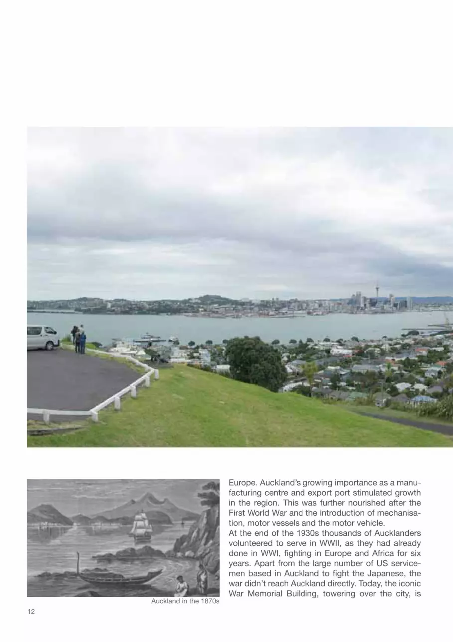
12
Europe. Auckland’s growing importance as a manu-facturing centre and export port stimulated growth in the region. This was further nourished after the First World War and the introduction of mechanisa-tion, motor vessels and the motor vehicle. At the end of the 1930s thousands of Aucklanders volunteered to serve in WWII, as they had already done in WWI, fighting in Europe and Africa for six years. Apart from the large number of US service-men based in Auckland to fight the Japanese, the war didn’t reach Auckland directly. Today, the iconic War Memorial Building, towering over the city, is
Auckland in the 1870s

13
Auckland today
commemorating the many citizens that lost their lives in conflicts. In the 1950s the city’s motorway net-work was built like in most other western countries, and urban Auckland started sprawling along its infra-structural arteries. Auckland’s many local bodies formed the Auckland Regional Authority (ARA) in 1965, which from then on coordinated regional planning, and got the construction of a regional sewage plant and the international airport on the way. The progressive development of Auckland’s extensive regional park network is also an important outcome of the ARA and is being continued by Auckland Regional Council (ARC) today. In the new millennium Auckland’s growth has been undiminished and is projected to continue. The region is trying to manage its effects by intensification in urban Auckland and a (re)vitalisation of its public trans-port network. In 2011 New Zealand is hosting the Rugby World Cup. The event is currently catalyst for numerous developments in the city; a pivotal role plays the redevelopment of Auckland’s waterfront and the increase in public access to it.

14

15
New Zealand is situated in the southern hemisphere, between the Tasman Sea and the South Pacific Ocean. The two main Islands, North Island and South Island, extend from 34º to 47º southern latitude, equivalent to the distance between Hamburg and Naples. Auckland sits on a narrow point of the North Is-land, on an isthmus between Waitemata Harbour and Manukau Harbour. The city is built on an active field of about 50 volcanoes. The field’s volcanoes have all been active in the last 250,000 years. The youngest of them, Rangitoto Island, erupted only 600 years ago; and a new volcano in the Auckland field is likely to erupt ‘sometime in the future’ (Cameron, Hayward & Murdoch 2008 p.12). The volcanic cones, sticking out of the city like green camel humps, are a distinct feature of Auckland’s landscape, even though many were quarried away since the arrival of European settlers, and their scoria used for building aggregate, road metal and solid fill. The other key component in Auckland’s landscape is the interpenetration of land and sea. At the end of the last Ice Age the rising sea encroached over the land and river valleys were drowned. Their meandering and branching shapes are still recognisable in many of the Auckland region’s estuaries (ibid. p.21).The ocean also has pivotal influence on New Zealand’s climate. The isolation from continental influences generates a warm temperate climate, with humid summers and damp winters. From Auckland north the cli-mate is subtropical, and compared with the other main centres of New Zealand, Auckland has the highest annual rainfall (1240mm/yr). The predominant wind directions are NE (warm and humid) and SW (drier and cool); the wind has great impact on one’s perception of temperature. Although the climate is temperate, the weather can change very quickly and makes Auckland a typical four-seasons-in-a day city.Flora and Fauna in New Zealand are of unusual diversity due to its climate, geology and history. The Islands have long been isolated from other continental landmasses and produced a high level of endemic spe-cies. With humans, new species were introduced. They established easily in the favourable conditions and some have developed into a threat to native species. In order to protect the remaining biological heritage the government is working resolutely on conservation and restoration through the Department of Conser-vation (DOC). In addition, MAF Biosecurity New Zealand is guarding the country’s borders, checking all passengers and goods coming into the country to minimize the risk of an invasion by pests or diseases and ensuring quarantine requirements are met. For example, the restricted public access to the wharves in central Auckland is a quarantine provision. Since the 1990s there has been an increasing appreciation of native plant species among landscape architects and gardeners in New Zealand. Traditionally, formal European-style garden designs were the norm, with flamboyantly flowering plants, as it is commonly seen in Auckland’s older city parks. Since the tide has turned favourably for New Zealand’s native plants it has become a huge trend, and the diverse and complex foliage of the natives is utilised to create varied gar-dens and their use is especially popular for complementing modern architecture.
Land of the long white cloud02
< Contours of central Auckland City

16
Auckland’s vegetation
Metrosideros excelsaPohutukawa, NZ Christmas treeThis evergreen tree epitomises the New Zealand summer lifestyle. Around Christmas, Pohutukawa explode into a vibrant crimson bloom, and being a tree of coastal areas, it is part of the iconic picture of a Kiwi summer holiday: a bach on a sunny beach overhung by the gnarled branch-es of the Pohutukawa. It is an ‘extremely tough tree toler-ant of salt-laden winds’, it can grow in dry sunny places and poor soil, and is therefore quite commonly used as a roadside tree around Auckland.
Cyathea dealbataPonga, silver fernThe fronds of this tree fern are a well-known symbol of New Zealand. It is a national emblem and decorates army and sports uniforms, as well as bus shelters and bank notes. The iconic plant itself is just as omnipresent in forests through out the country. It requires a sheltered site and preferably good moist soil, and is therefore only found in Auckland’s parks and private gardens.
Leptospermum scopariumManukaThis shrub with its small, dark green leaves is a common sight throughout New Zealand. At the times of Captain Cook and Co. most of the Auckland isthmus would have been covered by Manuka dominated shrub-lands. Its prolific flowers are much loved by bees, and being fast growing it is a popular screen, shelter and filler plant in landscaping.
Rhopalostylis sapidaNikauThis species is the world’s most southerly palm, and New Zealand’s only native palm. It is very slow growing and ‘its fronds emerge from bulbous sheaths atop a single trunk that is ringed with the scars of fallen leaves’. Its exotic appearance makes it a very popular plant in land-scaping, even though it requires a shady sheltered site in deep moist soil. Nevertheless, Nikaus have been used as an element in the roadside planting of central Auckland’s main shopping street.
A selection of the most distinctive and iconic plants in New Zealand that can be found in the Auckland region. Plant information has been sourced form Cave & Paddison.

17
Phormium tenaxNew Zealand flax, harakekeThese clump-forming perennial have long sword-shaped leaves and are common all over the country. They are very tolerant plants, withstanding strong and coastal winds and growing in dry or damp conditions. The sturdy and fibrous leaves have been and still are used by Maori for weaving into clothing and household items. Today many colourful Phormium cultivars exist and are widely used in public and private landscaping.
Cordyline australisCabbage tree, ti koukaThe tree is also among the best-known plants of New Zealand because of its distinctive shape. Its clusters of long leaves can be seen throughout both islands in a va-riety of habitats. They create a pacific atmosphere and their hardiness makes them a popular tree for private gar-dens and public spaces in Auckland.
Agathis australisKauriAmong the giant trees of New Zealand the Kauri excels in majesty, venerability and longevity. It is a slow grow-ing, coniferous tree with narrow and leathery leaves. The size and strength of its timber made it a popular building material (construction of buildings, flooring, masts of sail-ing ships), and as a result the Kauri population has been decreased considerably; today the felling is far more re-stricted. In Auckland Kauri are naturally growing in the forests of the West (Waitakere Ranges) and North of the region, in down town Auckland City an artificial grove of Kauri has been planted within a public space.
Avicennia marina MangrovesMangroves are halophytic (salt-tolerant) plants. The typi-cally woody trees and shrubs inhabit the intertidal mar-gins of coastal and estuarine environments (ARC,2007-b). In New Zealand Mangroves are confined to the northern coastlines of the North Island, and consist of Manawa (Avicennia marina subsp. australasica). Mangroves are the prevalent vegetation, when travelling through the Auckland region the olive-green shrubby trees are clearly visible from all the motorways out of town, and reoccur-ring in the plentiful estuaries.

18
Rodney District
Waitakere City
North Shore City
Auckland City
Manukau City
Papakura District
FranklinDistrict

19
Today the Auckland Region is home to 1.37 million people. It is the most populated of the 16 regions in New Zealand, and makes up one third of the country’s total population. The region is ethnically very diverse, 70% of new migrants settle in the region and over one third of all people who call Auckland home were born overseas. Auckland’s populations is made up of 11.1% Maori, 14.4% Pacific peoples, 18.9% Asians, and 56.5% Europeans, and only 8% identify themselves as New Zealanders (ARC, 2007). The region is comprised of three districts and four cities: Rodney District, Waitakere City, North Shore City, Auckland City, Manukau City, Papakura District, Franklin District. Generally the districts in the north and south are less populated and show a more rural life-style, whereas the cities form a sprawling urban agglomeration referred to as ‘Greater Auckland’ or ‘Auckland Metropolitan Area’ Currently the region is still under the jurisdiction of the Auckland Regional Council (ARC) and the seven Ter-ritorial Local Authorities, but the transition to a single unitary authority, governing over a then ‘Super City’, as recommended by the Royal Commission on Auckland Governance, has been initiated. For a visitor it is hard to identify the outlines of the different cities within the metropolitan area. Each city is made up of various suburbs that all have a distinctive character. It is more the changing atmospheres within this heterogenic accumulation of suburbs that one experiences rather than what city or district you are in. Although there are numerous sub-centres found all over Greater Auckland, the one that dominates them all and is said to be the heart of the region is Auckland City’s central business district, the CBD. It is a triangular area bounded by the Waitemata Habrour and the transport corridors. It is developing from its historic function as Auckland commercial centre towards an increasingly mixed-use centre. Besides its economic importance, accommodation, education, entertainment and tourism are growing sectors (ACC 2009-d).
The region and the city03
< Auckland‘s cities and districtsAuckland region
1 : 2 500 000Auckland‘s metropolitan urban limits
1 : 2 500 000

20

21
Urban development04
Auckland City is the starting point of Auckland’s urban growth. Maori had been living on the isthmus for at least six centuries when Governor Hobson bought the first 3000 acres of Ngati Whatua land. The fortified villages of the local Maori tribes were concentrated around the elevated areas of the land. With the arrival of the European settlers most growth of the new town occurred in proximity of the port in Commercial Bay. Like in all mercantile cities near the sea, a river or a lake, waterborne transport was essential for trade and travel before the construction of roads on land. In its early days Auckland City had ‘a primitive shape of tents, raupo houses and some wooden houses staggering up from Shortland Cresent to Fore Street’ (McLauchland 2008 p.63). Immigration to New Zealand was stimulated by cheap fares and the promise of cheap land. From 1860 until 1880 population numbers exploded in Auckland City as well as in the rest of the colony. Auckland’s urban development has always been intrinsically linked to its transport network. Before the ar-rival of the first street cars (trams) and trains around 1900, people would settle within walking distance of the new town along the south shore of the Waitemata Harbour. ‘(…) As the city grew it facilitated the ex-pansion of Auckland’s built-up area in two ways; in a intermittent linear pattern to the west and south along the railway line, and in a more continuous manner along the main streetcar routes’ (Arbury 2005 p.70). New suburbs evolved, forming an arc of suburban development by 1915, the rail network led to new towns like Otahuhu and New Lynn and ferry services across the harbour catalysed the development of north shore communities such as Devonport, Takapuna and Birkenhead. After the economic depression in the 1930s and the Second World War Auckland went into an era of unprecedented growth, caused by the post-war ‘baby-boom’, along with both internal and external im-
AKL City
Auckland urban limits

22
migration. Until then, the City had stayed fairly compact. With the arrival of the automobile after WW2 the predetermination of the transit network was overcome, and the urban development proceeded without constraints, leading to a rapid decentralisation of urban growth. Building the Harbour Bridge in 1959 and other big infrastructural investments reveal that Auckland had committed itself to being a large city and ‘the balance between public and private transport was tipped heavily in favour of the car’ (Auckland Regional Growth Forum, 1997). By the mid 1960s Auckland, as a region, had passed the half-million mark and had become one of the most dispersed cities in the world. For one decade planners believed they could subdue growth by reducing the number of migrants, by redirect-ing labour-intensive industries to other parts of the country, and by putting an emphasis on family planning. Until 1970 they had realised though that their attempts of slowing the growth had failed, and population size and growth were out of their control. Therefore, they now started to focus on planning where and how the growth should happen, and in what way the available space could be utilised more sustainably. The oil crisis of 1974 and the sharemarket crash of 1987 lead to an economic stagnation. Population numbers continued to climb though, and the Auckland Region had a population of one million people for the first time in 1996. Up until the 1990s urban intensification was slow, mainly due to its unpopularity with the people. In the last 15 years circumstances have changed, and the development of apartments, terraced housing and town houses has been an increasingly notable trend (Arbury 2005 p.73). This change was induced by the share market crash of the 1980s that resulted in office buildings being vacated and turned into apartments. Also an increase of immigrants from countries (mostly Asian), where living in an apartment
Auckland urban limits

23
is a familiar life style, consolidated this trend. Today central Auckland is ethnically different to the rest of Auckland, with higher proportions of Asian residents. Increasing traffic congestion throughout the Auck-land region made commuting more difficult than ever before, and therefore encouraged inner city workers and students to live in central Auckland (Auckland Regional Growth Forum, 1997). In the early 1990s there were only 1,400 people living in the CBD, today there are nearly 20,000 residents, of which 84% are under 44 years old and 32% are students (ACC 2009-d). A similar ‘re-centralisation’ process happened in many other cities: Melbourne, Vancouver, Portland and San Francisco. Nevertheless, many critics regret the city’s continuous and untamed growth. The subsequent evolution of Auckland City’s built environment did not leave much evidence of its Victorian and Edwardian past. In 1999 the Auckland Region Growth Strategy (RGS) was compiled to create a vision for Auckland’s growth for the next 50 years. The growth concept’s main purpose is to contain Auckland’s urban sprawl (see fig-ures above for a comparison of today’s urban limits of Munich and Auckland, both have a population of around 1.3 million people). Despite some greenfield developments, the strategy aims to meet future hous-ing demands through intensification rather than further sprawling. The main goals will be hard to achieve for the RGS, not only the still common stigmatisation of intensification projects, but even more the popu-lation projections for the region will put pressure on the concept’s implementation. In 1999 the Regional Growth Forum estimated in 2050 between 1,6 and 2,2 million could be living in the region, and recent studies consolidate the prospect of 2 million residents before 2040 (McDermott, 2008).
Munich urban limits

24
AKL City development
road network
1841 1880 1947 2008
population
1841: The humble beginnings of the new capital already had a street layout very similar to the one of Auckland CBD today. Two thirds of the regions 3,000 residents lived on the isthmus at this stage. 1880: The road network had pervaded the entire isthmus. Although the roads were all unsealed back then and ap-parently terribly muddy, they connected the various little communities that had developed and made trade possible. In the south, the town of Onehunga benefited from the trade opportunities that arose with its location on the shores of the Manukau Harbour. The isthmus was still home for half of the regions 32,000 residents.1947: The coverage of the road network had become a lot more comprehensive. The roads give an idea of the many different subdivision projects that took place, covering the land with suburbia. The number of people living in the region had increased by 1,000 percent since the 1880s, the isthmus was home for 127,407 (40 percent) of them.2008: Auckland City’s infrastructure was further intensified: Bridges were built over both harbours, the arterial in-frastructure of the motorways was implemented and countless cul-de-sacs were developed. They symbolise more single house developments, that fill out the remaining space on the isthmus. The population figure shows there are less ‘Aucklanders in Auckland’ again. The region is totalling 1.3 million people today, Auckland City accounts for 400,000 thousand of them, which still makes it the biggest city in New Zealand. The empty squares are equivalent to the number of people that are predicted to still move to the region until 2040.
= 5,000 Auckland City residents= 5,000 residents + = 10,000 Auckland Region residents

25
1841 1880 1947 2008
population
Comment: The historic road networks have been copied from historic maps from the Auckland City Library Historic Collec-tion (see figure index for details). There were no consecutive maps for the road network outside Auckland City found in the context of this analysis, therefore the study area is restricted to the isthmus, although road development obviously also took place outside of it.

26

27
Infrastructure05
The geographical situation and continuous growth of Auckland has always been a challenge for its infrastructure. Auckland City is centrally located in the Auckland region and the most populated city in the region, and thus, home to most of the region’s major hospitals, sporting and cultural venues and generates approximately 17 percent of New Zealand’s economic wealth (Bell & Johns 2006 p.30). So it is no surprise that the infrastructure on the isthmus is fac-ing multiple pressures, including its natural spatial constraints, ad-hoc urban growth and its concurring function as local, regional and national transport corridor.Since the beginning automobile era Auckland’s transport has been heavily based on private vehicles. Reasons for this one directional development were the political environment, the illusion of cheapness, by building motorways and parking buildings bit by bit and the growing myth that Aucklanders would never abandon their cars for commut-ing, because of some anthropological peculiarity (McLauchland, 2008, p.205). Up until the end of the 20th century, the motorway network has therefore been the limiting factor for the region’s growth. Whenever the existing transport system had reached a point of saturation, new motorway extensions have been built, and the city sprawled further along their perimeters. Public transport was restricted to a neglected railway system and busses that got stuck on overcrowded roads. This led to the paradox of mutual congestion; fewer people relied on public transport and took to their cars, which further escalated the problem (ibid. p.220). In the new millennium the improvement of the public transport network has gained higher priority, not the least because of the public resistance to further motorway exten-sions on the isthmus and the aims of Regional Growth Strategy.
< Britomart Transport Centre

28
Motorway systemState highway SH1 (similar to a German Bundesstraße) is the longitudinal connection in New Zealand, running through both islands. In the Auckland region the high-way is extended to a state motorway (comparable to a two lane German Autobahn), the Northern and Southern motorway. Also, there are the North Western and South Western motorways. However, all national traffic has to be funnelled through the Auckland isthmus, where it is joined by the regional traffic and the short-distance trav-ellers within Auckland City. Therefore chronically con-gested pinholes in the motorway network are the Central Motorway Junction (aka ‘Spaghetti Junction’) and the Harbour Bridge.Auckland City together with its neighbouring cities, dis-tricts and the regional authorities are making a great ef-fort to keep up with the region’s growth and the subse-quently necessary adaptation of its infrastructure. Aim of their work is to improve flow and capacity of the arterial roads in the city, to take away traffic from the CBD and promote public transport as well as cycling and pedes-trian activity. One of the key issues that has been discussed for several years, is the second crossing of the Waitemata Harbour. There has been a steady increase in demand for the in-frastructural icon of the 1960s, and today over 60 million
trips per year are made over the Auckland Harbour Bridge. In May 2008 a single solution from a list of originally 159 options was announced. The proposed option comprises four tunnels – two for trains and two for motorists – to the east of the existing Harbour Bridge. A construction date has not been set yet, though the work on identifying the best option for a third crossing of the Waitemata Harbour has already begun.
Public transportBuses are the most frequented service of the public transport system. Apart from the free City Circuit Bus and the Link bus, servicing a route around the perimeter of the CBD, most buses run on radial routes from the Auckland CBD outwards to the suburbs and surrounding cities. Ferry services are popular among commuters from the northern shores of the Waitemata Harbour. The trip across the harbour lets them avoid the congested Harbour Bridge and parking fees in the central city. In 2003 the Britomart Transport Centre was opened, with its underground train terminal beneath the former Auckland Post Office and over ground an accumulation of stops for the various bus routes. There is only one long distance passenger rail way service from Auckland to Wellington. Regionally there are three railway lines operating. The urban rail service has seen a light increase in passengers since the opening of the Britomart and the subsequent improvements in service and frequency. Nevertheless, a new analysis of commuting patterns shows that the proportion of people taking the car to work has risen slightly, from 78,4% in 1996 to 78,8% in 2006 (Collins 2009).As can be expected in an ‘autophile’ nation, cycling has not been considered as a means of public transport for a long time. The city is making a great effort to get people on their bikes, with cycle maps, campaigns educating cyclists and motorists about how to share roads safely and literary competitions for the best cycling story (ACC, 2009-c). Many inner city roads have been retrofitted with bike lanes to allow for multimodal traffic.
Great Barrie
r Island car fe
rry
Waiheke Island car ferryB
HS
NM
SMSWM
NWM
railway
F
SH 1
airport
main infrastructure1 : 750 00

29
CBDAuckland City’s centre is encompassed by arterial transport routes. To get across the infrastructural corridor pedestri-an and motorist alike have to use one of the many bridges. To the north of the CBD, and therewith towards Auckland City’s water edge, Fanshawe St in combination with Quay St function as an arterial link between east and west. Their average of about 30,000 vehicles a day intersect with the fleet of commuters and tourists at the bottom of Queen St, where the constellation of Britomart Transport Centre, Ferry Terminal and main shopping facility create high volumes of pedestrian traffic. On an average week day morning, between 7am and 9am, approximately 73,000 people enter the CBD. Of these 41,000 (56 percent) come by car, nearly 30,000 (40 percent) use the bus, rail and ferry services and around 3,000 (4 percent) walk or cycle (ACC 2009-d).
Northe
rn Moto
rway
Southern Motorway Railway
Quay Street
Bus Netw
ork
Ferry Services
Road classification according to Auckland City District Plan - Central Section:
Strategic road > North. and South.MotorwaysRegional arterial road > Quay St
30

31
Local Maori tribes preferred to build their fortified villages (‘Pa’) on elevations like headlands and volcanic cones, in order to obtain an advantage over their enemies in the case of an attack. For European settlers the steepness of these sites were a hindrance in their young city, and therefore either shovelled and quar-ried away to be used as building material (like Point Britomart) or left undeveloped. That’s why today the map of archaeological sites on the isthmus (below) showing the prominent Maori settlements reads like a map of Auckland’s main public parks.So it is no surprise that most parks in and around the CBD have an undulating topography, with curved paths winding along hillsides and numerous stairs to overcome the often steep gradient of the terrain. The exception is the completely level Victoria Park, which is located on the reclaimed land of Freeman’s Bay. There is no designated pedestrian zone within the CBD, pedestrian traffic is subordinate to motorised traf-
Public space06
Pukekawa > x > Auckland Domain
Te Rehu > x > Bayf ield Park Te Horotio > x > Albert ParkTaurarua Point Resolution Park
Maungawhau > x > Mt. Eden DomainRemuwera > x > Mt. Hobson Domain
Rangitoto > x > Little Rangitoto
Te Kopuke > x > Mt. St. John Domain
Maungakiekie > x > One Tree Hill Domain
Te Tatua > x > Three Kings Reserve
Otahuhu > x > Mt. Richmond Domain
Taurere > x > Taylor's Hill Reserve
Mataherehere Parnell Park> x >> x >
Maungarei > x > Mt. Wellington Domain
Owairaka > x > Mt. Alber Domain
Puketapapa > x > Mt. Roskill Domain
Oka > x > Pt. Erin Park
Te Tou > x > Auckland Gas Works
> x >Rerenga-Oraiti > x > Emily Place
Ngahu-Wera Customs Building
Maunaina > x > Remuera
Mutukaroa > x > Hamlin's Hill/Mutukaroa Regional Park
Aponga o Tainui > x > McLennan Hill
Whakamuhu > x > Achilles PointTe Pane o Horoiwi > x > West Tamaki Point
Orakei > x > Orakei Point
Okahu x Umuponga x
Kohimaramara > x > Tamaki Yacht Club House
Onehunga > x > Onehunga
Waikowai > x > Wattle Bay
Tauparapare x
Whau > x > Blockhouse Bay
< Public transit space Queen Street
Maori settlement name > x > today‘s name 1 : 100 000

32
fic. Most streets follow the colonial ‘main street’ design that is typical for most cities and towns throughout Australia and New Zealand. The buildings lining both sides of the street have adjoining canopies, so pe-destrians can wonder along the shop windows sheltered from sun and rain. However, there is a hierarchy of pedestrian friendliness among the streets in the CBD. The ones that offer more quality than the ordinary footpath, for example due to more width, urban design interventions or lower traffic density, have been categorised as ‘public transit spaces’. These spaces have the primary use of interlinkage, but they pro-
0m
250m
0m 500m
Point
Erin
Par
k
Victo
ria P
ark
Aote
a Sq
uare
Te W
ero
Isalnd
Quee
n El
zabe
th II
Frey
berg
Plac
eAl
bert
Park
Auck
land
Dom
ain
D.-M
. Rob
inson
Par
k
public parks public squares public transit space venturous public space
Albert Park
AucklandDomain
VictoriaPark
Pt ErinPark
Queen Elizabeth II SquareFreyberg Place
Te Wero Island
Takutai Square
Khartoum Place
Quay StViaduct Harbour
Aotea SquareQueen St
Princess Wharf
Wynnyard Point
Dover-MyerRobinson Park
1 : 25 000

33
vide also space for social interaction. Apart from the public parks, public transit spaces and the different public squares in the CBD with their expected layout and varied designs, another type of public space was mapped, the ‘venturous public space’. These spaces are defined by a total lack of intentional design and furnishing, it is qualities such as panoramic views or solitude that attract people to these places (de-scription: see 09 Precincts of the waterfront // Western Reclamation and Princess Wharf, all others follow here).
Public parks
Albert ParkThe park was the site of the Maori village Rangipuke. With the arrival of the European settlers the ridge top was home for the imperial troops and then called ‘Albert Barracks’. Af-ter the troops’ withdrawal from the colony in 1870 the land was set aside as a public reserve (Cameron,Hayward & Murdoch 2008 p. 199). The garden has a formal layout with a Victorian fountain in its centre, various statues and me-morials, as well as a collection of exotic trees. At the top of Victoria Street East is the park’s main entrance from the city. There, the impressive Gateways sculpture by Chris Booth, an archway made of basalt boulders, towers amongst the big Pohutakawa trees. Due to its proximity to the Auckland University city campus the park is a very popular place for students to hang out, as well as CBD workers in their lunchtime. From Queen St it is a steep rise to get up to the entrance of the park, and then another steep climb up the system of stairs to get to the main part of the park.
Auckland DomainThe ‘Domain’ was New Zealand’s first park, granted to the country by George Grey in 1860 and opened in 1893. The park is located on one of the oldest volcanoes in Auckland, and ‘is the one above all others that holds in a single grasp space, tranquillity, elevated and elevating vistas, architec-tural grandeur and a brilliantly arrayed record of (the) cultur-al history (of New Zealand) (McLauchland 2008 p. 152). The Domain (81ha) has green clearings edged by a huge variety of mature trees, duck ponds that are fresh water springs, and at its perimeter paths wind through native bush. The manicured playing fields are used for cricket in summer and rugby and soccer in the winter months. The Park also con-tains the Winter Gardens and Fernery, and the neoclassi-cal War Memorial Buildings that are home to the Auckland Museum. The ‘Domain’ has several roads running through it; never-theless it is a popular short cut for pedestrians and cyclists of the surrounding suburbs into the CBD via the Grafton Bridge. Jazz concert at the Domain
War Memorial - Auckland Domain
elevated city view from Albert Park
34
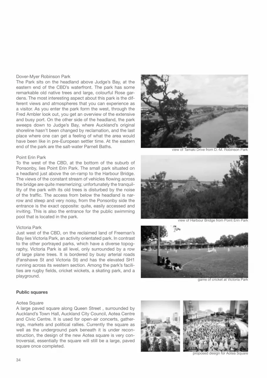
Dover-Myer Robinson ParkThe Park sits on the headland above Judge’s Bay, at the eastern end of the CBD’s waterfront. The park has some remarkable old native trees and large, colourful Rose gar-dens. The most interesting aspect about this park is the dif-ferent views and atmospheres that you can experience as a visitor. As you enter the park form the west, through the Fred Ambler look out, you get an overview of the extensive and busy port. On the other side of the headland, the park sweeps down to Judge’s Bay, where Auckland’s original shoreline hasn’t been changed by reclamation, and the last place where one can get a feeling of what the area would have been like in pre-European settler time. At the eastern end of the park are the salt-water Parnell Baths.
Point Erin ParkTo the west of the CBD, at the bottom of the suburb of Ponsonby, lies Point Erin Park. The small park situated on a headland just above the on-ramp to the Harbour Bridge. The views of the constant stream of vehicles flowing across the bridge are quite mesmerizing; unfortunately the tranquil-lity of the park with its old trees is disturbed by the noise of the traffic. The access from below the headland is nar-row and steep and very noisy, from the Ponsonby side the entrance is the exact opposite: quite, easily accessed and inviting. This is also the entrance for the public swimming pool that is located in the park.
Victoria ParkJust west of the CBD, on the reclaimed land of Freeman’s Bay lies Victoria Park, an activity orientated park. In contrast to the other portrayed parks, which have a diverse topog-raphy, Victoria Park is all level, only surrounded by a row of large plane trees. It is bordered by busy arterial roads (Fanshawe St and Victoria St) and has the elevated SH1 running across its western section. Among the park’s facili-ties are rugby fields, cricket wickets, a skating park, and a playground.
Public squares
Aotea SquareA large paved square along Queen Street , surrounded by Auckland’s Town Hall, Auckland City Council, Aotea Centre and Civic Centre. It is used for open-air concerts, gather-ings, markets and political rallies. Currently the square as well as the underground park beneath it is under recon-struction, the design of the new Aotea square is very con-troversial, essentially the square will still be a large, paved square once completed.
view of Tamaki Drive from D.-M. Robinson Park
view of Harbour Bridge from Point Erin Park
game of cricket at Victoria Park
proposed design for Aotea Square

35
Viaduct Harbour waterfront
downtown Queen St
entrance to Te Wero Island
Kauri grove at QE II Square
Queen Elizabeth II SquareThis square is situated opposite the main entrance of the Britomart transport centre. It features a geometrical grove of Kauri trees and fire-boulder water feature.
Freyberg PlaceThis place is open, paved and equipped with many different styles of seating. Located along High Street it is very popu-lar for a short rest for the passers-by.
Takutai SquareThis square is situated in the ‘backyard’ of the Britomart transport centre. Trademark for this square is a pop jet wa-ter feature and the rocks that are placed along side of it.
Te Wero IslandThe artificial island sits in the centre of the Viaduct harbour; it can be accessed via the heritage lifting bridge. The island is used for special events, usually marine related; otherwise it functions as a car park for the berth owners. There are plans for a second bridge, connecting the Te Wero Island to the Wynnyard Quarters (Western Reclama-tion), creating a spinal link of the waterfront precincts. The initial plan was to have the bridge finished in time for the 2011 Rugby World Cup, recently the date for completion has been postponed and the design and scale of the bridge is being revised.
Public transit spaces
Queen StSince Auckland’s early days, Queen St has been the city’s main street. The street that runs along the former valley of the Horotiu stream, is highly frequented by cars, busses and pedestrians (about 40 000 people/day) today. The rhythmic flow of vehicles and pedestrian is clocked by the numer-ous traffic lights along the intersections with other inner city streets. Between 2006 and 2008 the pedestrian component of Queen St was upgraded. A sense of public space has been created by wider foot paths, improved lighting and street furniture, as well as more plantings and trees.
Khartoum PlaceIs more a pedestrian link between Kitchener and Lorne Street than a public square. Essentially it is a staircase with an incorporated, tiled water feature, underneath beautiful large trees with a cluster of benches.
Viaduct HarbourSee 09 Precincts of the waterfront

36

37
CD 5.233m below benchmark
Captain Cook WharfbenchmarkB.M. 98-21 SO 69501
HATMHWS
MLWN
MHWN
MLWSLAT
Spring Range2.88mNeap Range
1.77m
Charted Deptharound 10mbelow CD
MSL
3.1m HIGH
0.7m LOW
03. A
pril
2009
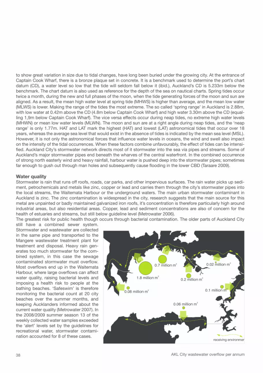
The Auckland Isthmus is embraced by two natural harbours. From the south by the Manukau Harbour, which leads into the Tasman Sea, and from the north by the Waitemata Harbour, an arm of the Hauraki Gulf, which leads into the Pacific Ocean. The Waitemata Harbour was formed by rising sea levels flooding a river valley (see chapter 02) and more recently, by volcanic eruptions. The Maori name of the harbour ‘Wai te Mataa’ translates into ‘sparkling waters’. With a light sea breeze on a sunny Auckland day, the calm waters of the harbour can really live up to this description. The Gulf islands, Rangitoto and Waiheke, shelter the harbour from Pacific storms and large swells.Since humans have settled on the isthmus its two harbours have been vital transport routes. Using canoes or boats and later scows and ferries to transport goods and people was much more convenient, especially prior to the estab-lishment of the roading system. As a matter of fact, the Waitemata only forfeited its importance for the regional trans-portation network in 1959, when the Harbour Bridge was built across its narrowest point, and with it the vehicular and freight boats servicing the harbour died.All around the New Zealand coastline the tidal regime is semi-diurnal, meaning that on most days there are two low and two high tides occurring (LINZ 2008). The difference between high and low tide is most apparent in the north and west of the harbour, where large mudflats around the mouths of the tidal rivers become exposed with the retraction of the water. On Auckland City’s waterfront the oscillating water level is noticed less (see fig. above). Since the establish-ment of Auckland as a colonial capital the city has protruded into deeper waters, and the original beaches that used
The Waitemata HarbourAKL City waterfront
07
< the ‚sparkling waters‘ from Princess Wharf
38
1.8 million m3
0.7 million m3
0.2 million m3
0.02 million m3
0.1 million m3
0.06 million m3
0.08 million m3
receiving environment
AKL City wastewater overflow per annum
to show great variation in size due to tidal changes, have long been buried under the growing city. At the entrance of Captain Cook Wharf, there is a bronze plaque set in concrete. It is a benchmark used to determine the port’s chart datum (CD), a water level so low that the tide will seldom fall below it (ibid.), Auckland’s CD is 5.233m below the benchmark. The chart datum is also used as reference for the depth of the sea on nautical charts. Spring tides occur twice a month, during the new and full phases of the moon, when the tide generating forces of the moon and sun are aligned. As a result, the mean high water level at spring tide (MHWS) is higher than average, and the mean low water (MLWS) is lower. Making the range of the tides the most extreme. The so called ‘spring range’ in Auckland is 2.88m, with low water at 0.42m above the CD (4.8m below Captain Cook Wharf) and high water 3.30m above the CD (equal-ling 1,9m below Captain Cook Wharf). The vice versa effects occur during neap tides, no extreme high water levels (MHWN) or mean low water levels (MLWN). The moon and sun are at a right angle during neap tides, and the ‘neap range’ is only 1.77m. HAT and LAT mark the highest (HAT) and lowest (LAT) astronomical tides that occur over 18 years, whereas the average sea level that would exist in the absence of tides is indicated by the mean sea level (MSL). However, it is not only the astronomical forces that influence water levels in oceans, the wind and swell also impact on the intensity of the tidal occurrences. When these factors combine unfavourably, the effect of tides can be intensi-fied. Auckland City’s stormwater network directs most of it stormwater into the sea via pipes and streams. Some of Auckland’s major stormwater pipes end beneath the wharves of the central waterfront. In the combined occurrence of strong north easterly wind and heavy rainfall, harbour water is pushed deep into the stormwater pipes; sometimes far enough to gush out through man holes and subsequently cause flooding in the lower CBD (Taraare 2009).
Water qualityStormwater is rain that runs off roofs, roads, car parks, and other impervious surfaces. The rain water picks up sedi-ment, petrochemicals and metals like zinc, copper or lead and carries them through the city’s stormwater pipes into the local streams, the Waitemata Harbour or the underground waters. The main urban stormwater contaminant in Auckland is zinc. The zinc contamination is widespread in the city, research suggests that the main source for this metal are unpainted or badly maintained galvanized iron roofs, it’s concentration is therefore particularly high around industrial areas, but also residential areas. Copper, lead and sediment concentrations are also of concern for the health of estuaries and streams, but still below guideline level (Metrowater 2006).The greatest risk for public health though occurs through bacterial contamination. The older parts of Auckland City still have a combined sewer system. Stormwater and wastewater are collected in the same pipe and transported to the Mangere wastewater treatment plant for treatment and disposal. Heavy rain gen-erates too much stormwater for the com-bined system, in this case the sewage contaminated stormwater must overflow. Most overflows end up in the Waitemata Harbour, where large overflows can affect water quality, raising bacterial levels and imposing a health risk to people at the bathing beaches. ‘Safeswim’ is therefore monitoring the bacterial count at 20 city beaches over the summer months, and keeping Aucklanders informed about the current water quality (Metrowater 2007). In the 2008/2009 summer season 13 of the weekly collected water samples exceeded the ‘alert’ levels set by the guidelines for recreational water, stormwater contami-nation accounted for 8 of these cases.

39
passenger ferry
DVP 12NCP 15
BKH 15
SB 15
GH 50
PH 35
R&M 25
HMB 35
WH 35
GBI 150
WHI 35
BSW
15
GBI 270
very frequentless frequent
seasonal
car ferry
passenger ferry
N
M CFM
F
CM
O
MM
Fm
m mm m
mm
m m m
m m
C argo ships
F erry wharves
Marinas
N avy base
O cean liners
moorings
passenger ferry
DVP 12NCP 15
BKH 15
SB 15
GH 50
PH 35
R&M 25
HMB 35
WH 35
GBI 150
WHI 35
BSW
15
GBI 270
very frequentless frequent
seasonal
car ferry
passenger ferry
N
M CFM
F
CM
O
MM
Fm
m mm m
mm
m m m
m m
C argo ships
F erry wharves
Marinas
N avy base
O cean liners
moorings
passenger ferry
DVP 12NCP 15
BKH 15
SB 15
GH 50
PH 35
R&M 25
HMB 35
WH 35
GBI 150
WHI 35
BSW
15
GBI 270
very frequentless frequent
seasonal
car ferry
passenger ferry
N
M CFM
F
CM
O
MM
Fm
m mm m
mm
m m m
m m
C argo ships
F erry wharves
Marinas
N avy base
O cean liners
moorings
< - 2mmudf lats exposed at low tide
< - 5m
< - 10m
< - 20m
< - 30m
very frequentless frequent
seasonal/rarely
car ferry
passenger ferry
Marinas
C argo ships
F erry wharves
N avy base
O cean liners
moorings
< - 2mmudf lats exposed at low tide
< - 5m
< - 10m
< - 20m
< - 30m
very frequentless frequent
seasonal/rarely
car ferry
passenger ferry
Marinas
C argo ships
F erry wharves
N avy base
O cean liners
moorings
< - 2mmudf lats exposed at low tide
< - 5m
< - 10m
< - 20m
< - 30m
very frequentless frequent
seasonal/rarely
car ferry
passenger ferry
Marinas
C argo ships
F erry wharves
N avy base
O cean liners
moorings
Lower Waitemata Harbour
Contours
Ferry routes
Waterborneactivities

40
Princess Wharf
high tide02/04/0901:30pm3.1 m
low tide03/04/0908:07am0.7 m

41
Queens Wharf
high tide02/04/0901:30pm
3.1 m
low tide03/04/0908:07am
0.7 m

42

43
Shorelines08
Not long after the signing of the Treaty of Waitangi (the beginning of British governance) Lieutenant- Gover-nor Hobson went on an examination of the harbours along the North Island’s east coast in search for more Maori signatories for the treaty and land for a new town. After Whangarei, Mangawhai and Mahurangi they sailed into the Waitemata Harbour. Felton Mathew, a member of the party aboard the Herald, found ‘the south side of the harbour (…) shoal, and the shores, though undulating flats of moderate elevation, are des-titute of wood and water (…)’ (McLauchland 2008 p.56) The lack of trees was a clear disadvantage for the establishment of a new town, nevertheless, Hobson chose the area around Horotiu Bay (later Commercial Bay) to laying the foundations of the young nation’s new capital, as this was the best place for transferring goods and settlers from their ships to shore. In 1841 the first settlers and government officials arrived in Auckland, and its shoreline began to be transformed. The European names of the headlands and bays along the foreshore reflect the pattern of settlement, Commercial Bay for example was the business centre for the young capital. To the east lay Official Bay, where government officers first put up camp, and Mechanic’s Bay was home to the workmen who built the city. Historic images show building materials, barrels and all sorts of other goods scattered around the flat sandy beaches in the early days. On low tide, the beaches were also the preferred way for traffic, because there wasn’t any sealed roads yet and the horse carts easily got stuck in the muddy streets. As stated above, Waitemata Harbour was not ideal for shipping, therefore providing wharves was a priority for the settlement. ‘The first reclamation of Auckland’s early foreshore was the formation of Fore Street (later Fort Street) from the shoreline of Commercials Bay, completed 1850.’ (Campbell N & Truttman L p.3) The first wharf, Wynyard Pier (not identical with today’s Wynyard Pier) ran out from Official Bay was in place by 1851, it stretched into the harbour for more than 100 metres. ‘Foreshore reclamation (…) gathered pace from 1875 when the Auckland Harbour Foreshore Act endowed more than 5,000 acres of the harbour floor to the (Auckland Harbour) Board’ (McLauchland 2008 p.143). One year later the work on a pier at the bot-tom of Queen Street started. It quickly became the main wharf (today: Queens Wharf), always busy with workers and wanderers and eventually was lengthened to more than 1000 metres.
< Queens Wharf // Princess Wharf // Tank Farm

44
POIN
T ER
IN
FREE
MAN
'S B
AY
ST M
ARY'
S BA
Y
BRIC
KFIE
LD B
AY
POIN
T ST
ANLE
YCO
MMER
CIAL
BAY
POIN
T BR
ITOM
ART
OFFI
CIAL
BAY
MECH
ANIC
'S B
AY
ST G
EORG
E'S
BAY
POIN
T DU
NLOP
POIN
T BA
RNAB
AS
JUDG
E'S
BAY
HOBS
ON B
AY
Original shoreline from 1840
Slowly beaches and mudflats were transformed into (more or less) dry land and the shoreline was turned into a water’s edge made up from timber retaining walls.Not only did the settlers shift the shoreline, they also transformed the relief of the land. Point Britomart, the headland forming the eastern end of Commercial Bay was cut away after the British garrison had departed from their Fort on top of the point in 1870. The elevation had always impeded traffic amongst the Bays, and had to go in order to enable a rail connection out of town. The excavation was used as fill for the major reclamations that took place, Freeman’s Bay (1886 – 1917), Mechanic’s Bay 1872 – 1915 and St George’s Bay (1904 – 1916).With the increasing economical importance of the port the construction of docks and port-related facilities further shaped Auckland’s shoreline. In the early years of the 20th century the increasing turn-over and mechanisation of port operations demanded further adaptations. The old wooden structures of Queens Wharf were successively replaced by ferro-concrete and work on the wharf sheds had started. Over the decades cargo handling methods and containerisation required Auckland port to embark on fur-ther reclamation projects. By 1971 the a Axis Fergusson container terminal was ready to welcome a new

45
HARB
OUR
BRID
GE
WES
THAV
EN M
ARIN
A
WYN
NYAR
D W
HARF
VIAD
UCT
HARB
OUR
PRIN
CESS
WHA
RF
CAPT
AIN
COOK
WHA
RF
MARS
DEN
WHA
RF
AXIS
BLE
DISL
OE
CONTAINER TERMINAL
JELL
ICO
WHA
RF
AXIS
FER
GUSS
ON
CONTAINER TERMINAL
MECH
ANIC
'S B
AY
QUEE
NS W
HARF
JUDG
E'S
BAY
HOBS
ON B
AY
FREE
MAN
'S B
AY
ST M
ARY'
S BA
Y
TAMAKI DRIVE
Todays shoreline
generation of cargo ships. Since then the large cranes and stacks of TEUs (20-foot equivalent unit) com-pose a colourful and ever changing landscape along Auckland’s eastern shoreline. The technical development has never eased, and currently work on the Axis Fergusson container terminal extension is under way. Whereas in the early days land based materials, such as volcanic cones or ‘night soil’ (human excrement) was used for the reclamation, today maintenance dredgings from the seabed and dredgings from the commercial shipping lane in the Rangitoto Channel are mixed with dry cement and are being deposited into the reclamation area where this so called ‘mudcrete’ solidifies. The bays and headlands of the original shoreline, the cradle of Auckland’s urban growth, have been eaten up entirely by the reclamation and wharf building process that has provided Auckland with an additional area of 240 ha. There is only one place left where you can gather an idea of what the Auckland’s waterfront used to look like before the arrival of the European settlers, in the east, at Judge’s Bay.The following maps show the successive reclamation stages and wharf building activities since 1841. The data for these figures has been retrieved from historic maps of Auckland City Library’s historic collection (see figure index for details).

46
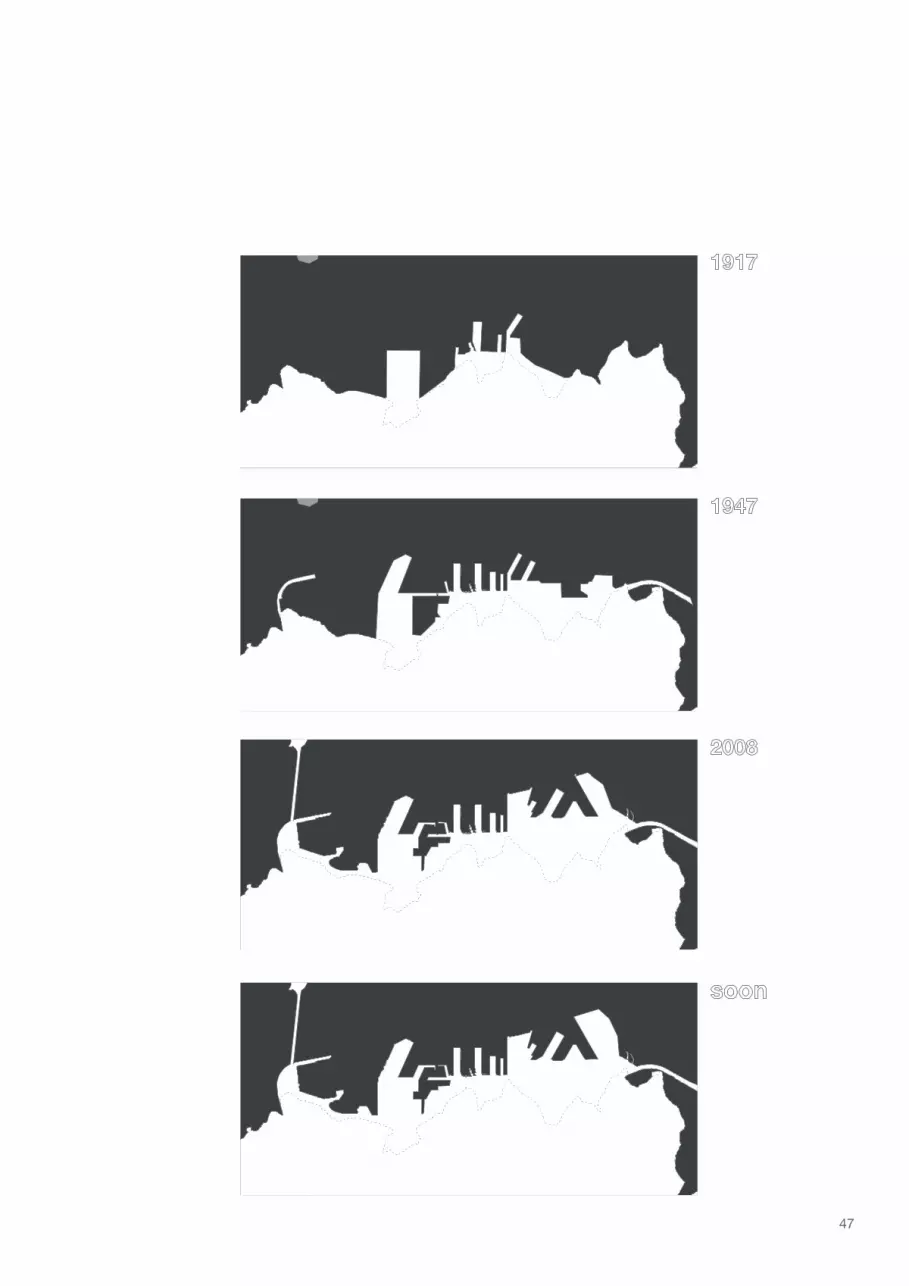
Shoreline transformation
47

48

49
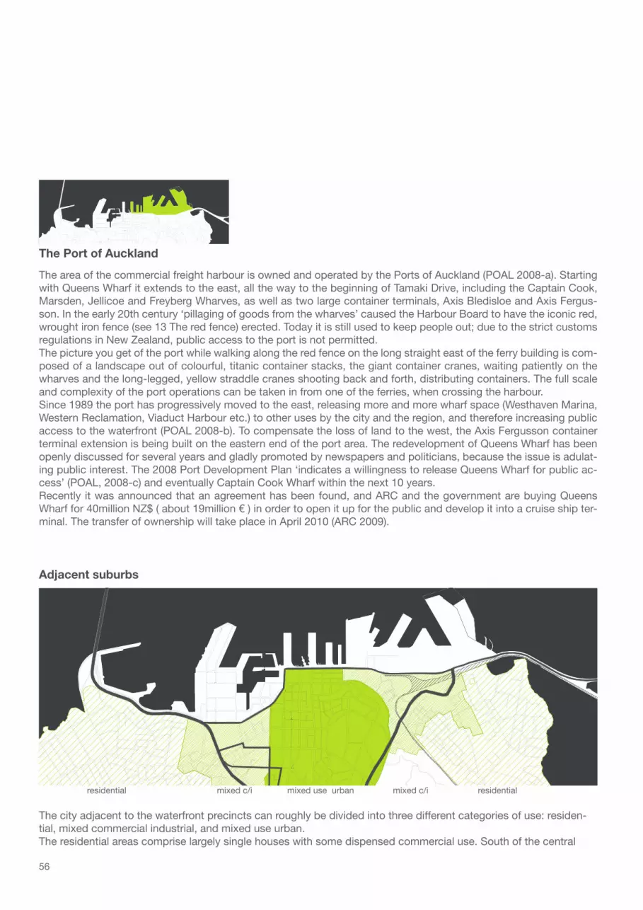
Precincts of the waterfront09
Ken Cumberland, Professor of Geography at the Auckland University (cited in McLauchlan 2008 p.181) once established that Auckland had a higher proportion of water surface to land area within fifty kilome-tres of its central post office than any other city of its size. The maps of the urban development of the city (Chapter 04) also show how the city organism has slowly filled out the whole isthmus right to its frag-mented and porous edge, only sparing the volcanic cones and swampy areas. Where is the waterfront in a city such as Auckland? Where does it begin? And does it have an end?Undoubtedly, the proximity to water has a great influence and can be sensed anywhere in the city. Once the generic term waterfront is defined more precisely, in the context of this analysis, as urban waterfront, its location is more easily identified. A city’s urban waterfront is the stretch of coastline, however altered it may be, that the city is inextricably linked to, from its founding, to its subsequent development. In Auck-land, the urban waterfront consists of the reclaimed land and wharf constructions that over time have been extended to reach deeper, more navigable waters of the Waitemata.Starting in the west with the Harbour Bridge, the gateway to the city, Auckland’s urban waterfront expands for over 4 kilometres, up to Judges Bay as its eastern boundary. In the following a brief characterisation of the different precincts that can be made out along this stretch of shoreline, their functions, atmospheres and history is given.
< The city from the Harbour Bridge

50
According to the Auckland Regional Council (2005), Westhaven is the southern hemisphere’s largest and most well-equipped ma-rina. Nestled against the eastern side of Point Erin, it offers nearly 2000 berths in the vicinity of the city and plays an important part in the ‘image of the city’. The nicely arrayed fleet of dazzling white boats is the blue print of a romantic ocean side town scene and expression of the New Zealanders’ ocean loving character.
Westhaven Marina
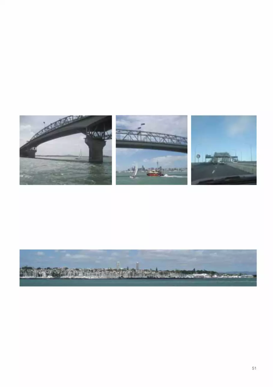
The opening of the four-lane harbour bridge in July 1959 was the beginning of a new evolutionary stage for the Auck-land city organism. Complying with the 1950s and 1960s zeitgeist, developments in this stage were dictated by cars and their efficient and unobstructed flow. There had been plans for a harbour crossing since the second decade of settlement on, so one would think enough time had been spent on thinking about the project. Anyway, vehicle num-bers were soaring in the early 1960s, and the forecasts revealed capacity of the bridge would be reached before the end of the decade; so the talk was of another crossing. Instead, two more lanes on each side were attached by a Japanese engineering firm, and therefore referred to as the ‘Nippon-clip-ons’, but not long after the 8 lanes of this ar-terial link to the north didn’t cope with the growing traffic. 30 years after the opening of the harbour bridge, a two lane bridge was built across the upper harbour, only giving short termed relief. The harbour bridge has rightly been called a ‘cheapskate’s government project’, but for all that it still had a huge impact on the North Shore’s development, and provides one of the most impressive and iconic views of the city when crossing it from north to south. Plans to allow pedestrians and cyclists crossing the bridge would give them the chance to enjoy this remarkable view as well, and at a much lower speed.
The Harbour Bridge
51
According to the Auckland Regional Council (2005), Westhaven is the southern hemisphere’s largest and most well-equipped ma-rina. Nestled against the eastern side of Point Erin, it offers nearly 2000 berths in the vicinity of the city and plays an important part in the ‘image of the city’. The nicely arrayed fleet of dazzling white boats is the blue print of a romantic ocean side town scene and expression of the New Zealanders’ ocean loving character.
Westhaven Marina
The opening of the four-lane harbour bridge in July 1959 was the beginning of a new evolutionary stage for the Auck-land city organism. Complying with the 1950s and 1960s zeitgeist, developments in this stage were dictated by cars and their efficient and unobstructed flow. There had been plans for a harbour crossing since the second decade of settlement on, so one would think enough time had been spent on thinking about the project. Anyway, vehicle num-bers were soaring in the early 1960s, and the forecasts revealed capacity of the bridge would be reached before the end of the decade; so the talk was of another crossing. Instead, two more lanes on each side were attached by a Japanese engineering firm, and therefore referred to as the ‘Nippon-clip-ons’, but not long after the 8 lanes of this ar-terial link to the north didn’t cope with the growing traffic. 30 years after the opening of the harbour bridge, a two lane bridge was built across the upper harbour, only giving short termed relief. The harbour bridge has rightly been called a ‘cheapskate’s government project’, but for all that it still had a huge impact on the North Shore’s development, and provides one of the most impressive and iconic views of the city when crossing it from north to south. Plans to allow pedestrians and cyclists crossing the bridge would give them the chance to enjoy this remarkable view as well, and at a much lower speed.
The Harbour Bridge

52
In the early 20th century the harbour was built as a so called light basin, for small barges, with the construction of the central wharves, it lost its purpose and was from then on used for smaller fishing vessels. Over time European settlers moved away from Freeman’s Bay, especially after the construction of the motorway in the 1950s, and mainly Pacific Islanders and Maori were living around the viaduct harbour, in increasingly derelict housing. In the 1990s the precinct was redeveloped as a mixed-use area (apartments and restaurants), and its status there with catapulted into the upper, affluent class. During the two America’s Cups (international sailing regatta, in 2000 and 2003) the Viaduct Harbour precinct experienced its busiest times. Today, the restaurants seem always brimming with locals and tour-ists, especially during one of the yachting shows that take place in the Viaduct Basin. There is a remarkably large number of benches and high quality street furniture in this precinct, that really set it apart from the rest of waterfront precincts. The shape of the basin creates an introvert atmosphere in the public space that runs along its edge. The Viaduct Basin is fringed by the masts of sailing ships and residential or industrial buildings. The apartment complexes in the west though produce a daunting atmosphere, their upmarketness, the lacking sense of community and the obvious need for security and privacy of the often only part-time occupants makes this part of the precinct despite its gorgeous setting a sterile place.
Viaduct Harbour
All but romantic would be the common description for this waterfront precinct. This area has been used for port-relat-ed industries, marine and warehouse uses since its completion in 1930. The collection of bulk-liquid storage tanks for chemicals, oils and marine fuels on the wharf has led to it being referred to as ‘the Tank Farm’. The various cylindri-cal volumes of the tanks, most plain white, produce an anonymous picture. Like with most industrial facilities you’re never quite sure what is actually happening inside those functionalistic constructions. Some people are attracted by the anonymity of the place. The road running along the edge of the reclamation is popular for those who want to escape the busy city and enjoy some solitude; some people have even parked up permanently with their caravans. And as a matter of fact, at the point, the white tanks and the humming city behind you, overlooking the breathtaking scenery of the harbour, and watching the urban nomads fishing off the concrete wharf, one can think of it as being romantic, in an alternative, crude urban, post-industrial way.Since 2006 the city and regional councils have been working on a scheme for the deconstruction of the industrial facilities and a redevelopment of the wharf. Until the Rugby World Cup in 2011 the first stage was supposed to be completed, a linear connection from the Western Reclamation across the new Te Wero bridge to the Viaduct Harbour precinct. The plans for the new bridge are being revised though. For the second to fourth stages, scheduled for 2014 to 2025, redevelopments with apartments, smaller scale retail, maritime uses and event areas, as well as a park at the point of the wharf are planned (Sea+City Project Ltd. 2007).
Western Reclamation

53
In the early 20th century the harbour was built as a so called light basin, for small barges, with the construction of the central wharves, it lost its purpose and was from then on used for smaller fishing vessels. Over time European settlers moved away from Freeman’s Bay, especially after the construction of the motorway in the 1950s, and mainly Pacific Islanders and Maori were living around the viaduct harbour, in increasingly derelict housing. In the 1990s the precinct was redeveloped as a mixed-use area (apartments and restaurants), and its status there with catapulted into the upper, affluent class. During the two America’s Cups (international sailing regatta, in 2000 and 2003) the Viaduct Harbour precinct experienced its busiest times. Today, the restaurants seem always brimming with locals and tour-ists, especially during one of the yachting shows that take place in the Viaduct Basin. There is a remarkably large number of benches and high quality street furniture in this precinct, that really set it apart from the rest of waterfront precincts. The shape of the basin creates an introvert atmosphere in the public space that runs along its edge. The Viaduct Basin is fringed by the masts of sailing ships and residential or industrial buildings. The apartment complexes in the west though produce a daunting atmosphere, their upmarketness, the lacking sense of community and the obvious need for security and privacy of the often only part-time occupants makes this part of the precinct despite its gorgeous setting a sterile place.
Viaduct Harbour
All but romantic would be the common description for this waterfront precinct. This area has been used for port-relat-ed industries, marine and warehouse uses since its completion in 1930. The collection of bulk-liquid storage tanks for chemicals, oils and marine fuels on the wharf has led to it being referred to as ‘the Tank Farm’. The various cylindri-cal volumes of the tanks, most plain white, produce an anonymous picture. Like with most industrial facilities you’re never quite sure what is actually happening inside those functionalistic constructions. Some people are attracted by the anonymity of the place. The road running along the edge of the reclamation is popular for those who want to escape the busy city and enjoy some solitude; some people have even parked up permanently with their caravans. And as a matter of fact, at the point, the white tanks and the humming city behind you, overlooking the breathtaking scenery of the harbour, and watching the urban nomads fishing off the concrete wharf, one can think of it as being romantic, in an alternative, crude urban, post-industrial way.Since 2006 the city and regional councils have been working on a scheme for the deconstruction of the industrial facilities and a redevelopment of the wharf. Until the Rugby World Cup in 2011 the first stage was supposed to be completed, a linear connection from the Western Reclamation across the new Te Wero bridge to the Viaduct Harbour precinct. The plans for the new bridge are being revised though. For the second to fourth stages, scheduled for 2014 to 2025, redevelopments with apartments, smaller scale retail, maritime uses and event areas, as well as a park at the point of the wharf are planned (Sea+City Project Ltd. 2007).
Western Reclamation

54
The ferry terminal, with its main building ‘Pier 1’ on the south-western edge of Queens Wharf and ‘Piers 2&3’ be-tween Princess and Queens Wharf, and the historic Ferry Building is the busiest area along the waterfront. Here, the vast majority of ferry services depart with more than 4.2 million passengers per year (Fullers Group Limited 2008) on board, to all sorts of destinations in the Waitemata Harbour and beyond. Whereas local commuters mostly use the ferry connections to the North shore and Waiheke Island, tourists book day trips to the various islands and harbour cruises. The Imperial Baroque style ferry building, erected by the Auckland Harbour Board in 1912, is one of the most signifi-cant pieces of architecture for Auckland City. According to the District plan (ACC 2008), the ferry building (category A) together with the two Wharf Pavillions (aka Public Shelter, category B) to the west that are used as Booking offices for the tourist ferries, are protected as historic buildings. The ferry building was once designed as the gateway to the city from the harbour, during the heydays of the ferry services; today it is over towered by the glossy facades of the high rises on the other side of Quay Street. Nevertheless, it forms a unique backdrop to the ferry terminal, and its shops, ice cream parlours and restaurants in ground and first floor are very popular among locals and tourists, and not the least for their harbour views. This precinct attracts a great number and variety of people, it is subject to the dynamics of the ferries and the pas-senger fleet and still serves a minimal amount of public space and amenities, and therefore feels often overcrowded, congested and chaotic.
Ferry Terminal
Like all the other central wharves (Queens, Captain Cook and Marsden) Princess Wharf started off as a commercial wharf, first opened in 1924. In 1998 it was redeveloped, and a modern complex that is reminiscent of a ship taking up nearly all of the wharf’s extension, was built. The mixed-use development contains the Overseas Passenger Ter-minal, the Hilton Hotel, apartments and restaurants. The original wharf structure appears overloaded by the volume of the debatable architectural translation of a ship; nevertheless public access is possible along the water’s edge. A similar effect occurs like at the Viaduct precinct, the exclusiveness of the architecture and its uses don’t create a real public atmosphere, you feel uncertain, like a trespasser. The few people that still use the public space on the wharf appreciate the off-putting atmosphere and the resulting solitude and sedateness so close to the CBD at the point of the wharf. There is no benches or public seating, but the more adventurous use the wooden beams for lunchtime sun bathing, away from any city noise and three metres above the sparkling waters of the harbour.About 70 cruise ships are calling at the port every year, the number is said to be increasing over the next few years. The passengers of most ships are being processed at Princess Wharf’s Passenger Terminal, which is located in the eastern half of the Princess Wharf Building, from where gangways can be extended out to the ships.
Princess Wharf

55
The ferry terminal, with its main building ‘Pier 1’ on the south-western edge of Queens Wharf and ‘Piers 2&3’ be-tween Princess and Queens Wharf, and the historic Ferry Building is the busiest area along the waterfront. Here, the vast majority of ferry services depart with more than 4.2 million passengers per year (Fullers Group Limited 2008) on board, to all sorts of destinations in the Waitemata Harbour and beyond. Whereas local commuters mostly use the ferry connections to the North shore and Waiheke Island, tourists book day trips to the various islands and harbour cruises. The Imperial Baroque style ferry building, erected by the Auckland Harbour Board in 1912, is one of the most signifi-cant pieces of architecture for Auckland City. According to the District plan (ACC 2008), the ferry building (category A) together with the two Wharf Pavillions (aka Public Shelter, category B) to the west that are used as Booking offices for the tourist ferries, are protected as historic buildings. The ferry building was once designed as the gateway to the city from the harbour, during the heydays of the ferry services; today it is over towered by the glossy facades of the high rises on the other side of Quay Street. Nevertheless, it forms a unique backdrop to the ferry terminal, and its shops, ice cream parlours and restaurants in ground and first floor are very popular among locals and tourists, and not the least for their harbour views. This precinct attracts a great number and variety of people, it is subject to the dynamics of the ferries and the pas-senger fleet and still serves a minimal amount of public space and amenities, and therefore feels often overcrowded, congested and chaotic.
Ferry Terminal
Like all the other central wharves (Queens, Captain Cook and Marsden) Princess Wharf started off as a commercial wharf, first opened in 1924. In 1998 it was redeveloped, and a modern complex that is reminiscent of a ship taking up nearly all of the wharf’s extension, was built. The mixed-use development contains the Overseas Passenger Ter-minal, the Hilton Hotel, apartments and restaurants. The original wharf structure appears overloaded by the volume of the debatable architectural translation of a ship; nevertheless public access is possible along the water’s edge. A similar effect occurs like at the Viaduct precinct, the exclusiveness of the architecture and its uses don’t create a real public atmosphere, you feel uncertain, like a trespasser. The few people that still use the public space on the wharf appreciate the off-putting atmosphere and the resulting solitude and sedateness so close to the CBD at the point of the wharf. There is no benches or public seating, but the more adventurous use the wooden beams for lunchtime sun bathing, away from any city noise and three metres above the sparkling waters of the harbour.About 70 cruise ships are calling at the port every year, the number is said to be increasing over the next few years. The passengers of most ships are being processed at Princess Wharf’s Passenger Terminal, which is located in the eastern half of the Princess Wharf Building, from where gangways can be extended out to the ships.
Princess Wharf
56
The area of the commercial freight harbour is owned and operated by the Ports of Auckland (POAL 2008-a). Starting with Queens Wharf it extends to the east, all the way to the beginning of Tamaki Drive, including the Captain Cook, Marsden, Jellicoe and Freyberg Wharves, as well as two large container terminals, Axis Bledisloe and Axis Fergus-son. In the early 20th century ‘pillaging of goods from the wharves’ caused the Harbour Board to have the iconic red, wrought iron fence (see 13 The red fence) erected. Today it is still used to keep people out; due to the strict customs regulations in New Zealand, public access to the port is not permitted. The picture you get of the port while walking along the red fence on the long straight east of the ferry building is com-posed of a landscape out of colourful, titanic container stacks, the giant container cranes, waiting patiently on the wharves and the long-legged, yellow straddle cranes shooting back and forth, distributing containers. The full scale and complexity of the port operations can be taken in from one of the ferries, when crossing the harbour. Since 1989 the port has progressively moved to the east, releasing more and more wharf space (Westhaven Marina, Western Reclamation, Viaduct Harbour etc.) to other uses by the city and the region, and therefore increasing public access to the waterfront (POAL 2008-b). To compensate the loss of land to the west, the Axis Fergusson container terminal extension is being built on the eastern end of the port area. The redevelopment of Queens Wharf has been openly discussed for several years and gladly promoted by newspapers and politicians, because the issue is adulat-ing public interest. The 2008 Port Development Plan ‘indicates a willingness to release Queens Wharf for public ac-cess’ (POAL, 2008-c) and eventually Captain Cook Wharf within the next 10 years. Recently it was announced that an agreement has been found, and ARC and the government are buying Queens Wharf for 40million NZ$ ( about 19million € ) in order to open it up for the public and develop it into a cruise ship ter-minal. The transfer of ownership will take place in April 2010 (ARC 2009).
The Port of Auckland
residential mixed c/i mixed use urban mixed c/i residential
Adjacent suburbs
The city adjacent to the waterfront precincts can roughly be divided into three different categories of use: residen-tial, mixed commercial industrial, and mixed use urban.The residential areas comprise largely single houses with some dispensed commercial use. South of the central

57
The area of the commercial freight harbour is owned and operated by the Ports of Auckland (POAL 2008-a). Starting with Queens Wharf it extends to the east, all the way to the beginning of Tamaki Drive, including the Captain Cook, Marsden, Jellicoe and Freyberg Wharves, as well as two large container terminals, Axis Bledisloe and Axis Fergus-son. In the early 20th century ‘pillaging of goods from the wharves’ caused the Harbour Board to have the iconic red, wrought iron fence (see 13 The red fence) erected. Today it is still used to keep people out; due to the strict customs regulations in New Zealand, public access to the port is not permitted. The picture you get of the port while walking along the red fence on the long straight east of the ferry building is com-posed of a landscape out of colourful, titanic container stacks, the giant container cranes, waiting patiently on the wharves and the long-legged, yellow straddle cranes shooting back and forth, distributing containers. The full scale and complexity of the port operations can be taken in from one of the ferries, when crossing the harbour. Since 1989 the port has progressively moved to the east, releasing more and more wharf space (Westhaven Marina, Western Reclamation, Viaduct Harbour etc.) to other uses by the city and the region, and therefore increasing public access to the waterfront (POAL 2008-b). To compensate the loss of land to the west, the Axis Fergusson container terminal extension is being built on the eastern end of the port area. The redevelopment of Queens Wharf has been openly discussed for several years and gladly promoted by newspapers and politicians, because the issue is adulat-ing public interest. The 2008 Port Development Plan ‘indicates a willingness to release Queens Wharf for public ac-cess’ (POAL, 2008-c) and eventually Captain Cook Wharf within the next 10 years. Recently it was announced that an agreement has been found, and ARC and the government are buying Queens Wharf for 40million NZ$ ( about 19million € ) in order to open it up for the public and develop it into a cruise ship ter-minal. The transfer of ownership will take place in April 2010 (ARC 2009).
The Port of Auckland
mixed use urbanmixed c/iresidential
wharves adjoins the high-density inner city, with a mix of office, commercial and residential use. Between the high rises of the inner city and the residential areas, there are zones of mixed commercial industrial use. Here buildings with large floor space, but less height are accumulated around the infrastructural corridors of motorway and railway.

58

59
The different precincts of the waterfront all have a character of their own, their built environment, the amen-ities they offer and their potential for certain activities create a certain atmosphere and also attract certain groups of people. In the context of this analysis it was not possible to do a scientifically sound census of the different user groups at Auckland’s waterfront, to establish the demographic configuration or their so-cial and ethnic background. Also, the waterfront is hub of the regional transport network and largely a pub-lic transit space, with people passing through from a large catchment area, therefore the social set up of the waterfront precincts and adjacent precincts does not necessarily reflect the people of the waterfront.During the fieldwork for this analysis and the many visits of the Auckland Waterfront, I took photos of some of the people I met. I asked all of them the same three questions: What are you doing at the waterfront? How did you get here? How long did it take you to get here? The photos were taken between Princess Wharf and Tinley St (see figure above) at various times of the day. The people I took photos of were chosen more or less randomly. The frontal photos show people I saw very frequently, like taxi drivers waiting for ferry passengers, the construction workers and commuters passing through the ferry terminal on their way to work, and people that are more specifically linked to the waterfront, such as the captain and the MAF and Customs officers. Many of the women I talked to did not want to have their photo taken, which explains the higher percentage of male Waterfrontals. One group of people I would have liked to include are the joggers you see every morning, but they never wanted to stop.To conclude, Waterfrontals are a personally empirical selection of people one might meet at Auckland’s Waterfront, a random selection, randomly distributed amongst the following pages.
Quay StQuay St Quay St
Custom St
Albe
rt St
Hobs
on S
t
Fede
ral S
t
Brito
mar
t Pl
Wyndham St
Victoria St West
Wellesley St West
Que
en S
t
Durham St West
Fort St
Shortland St
Gor
e St
Que
en S
t
Com
mer
ce S
t
< The construction worker is en-joying a mince pie in his morning tea break at the corner of Quay and Tinley St. He travelled in his own car to work this morning, which took him about 40min.
Tinl
ey S
t
Waterfrontals10
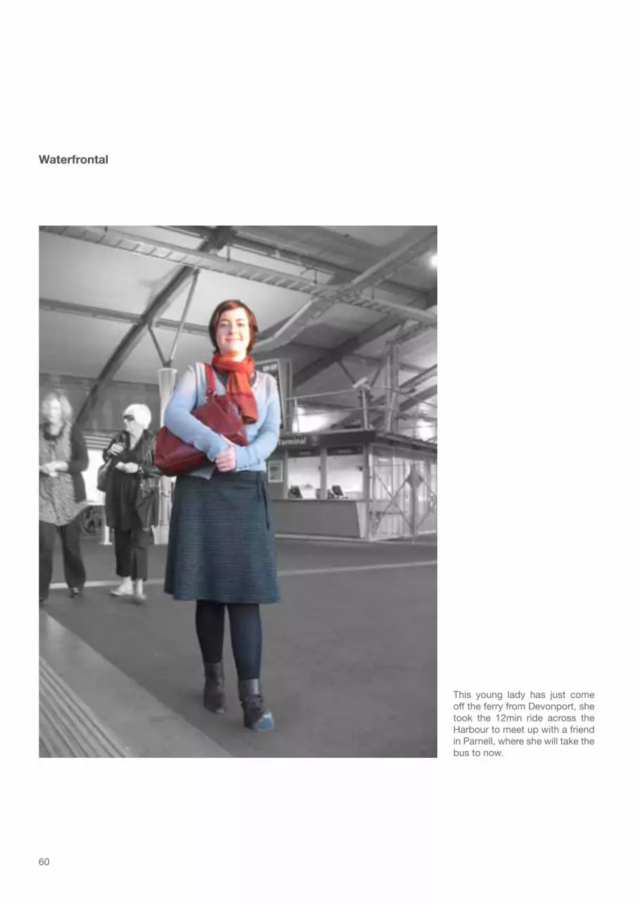
60
This young lady has just come off the ferry from Devonport, she took the 12min ride across the Harbour to meet up with a friend in Parnell, where she will take the bus to now.
Waterfrontal

61
07:50 am - these two students have just arrived outside the Maritime School in Quay St, they travel together by ferry every morning from Half Moon Bay. The trip takes about 35min. From the ferry terminal it is only a short stroll to their school.
Waterfrontal

62
Queens Wharf in the urban panorama
One Tree HillTamaki Drive
Sky Tower Princess Wharf

63
Waterfront views11
from the northern motorway
from Stanley Point
from Mt. Victoria, Devonport
Harbour Bridge
Harbour BridgeTank Farm
Sky Tower
Sky Tower
Westahven MarinaAuckland CityHospital
Mt Eden
War Memorial Museum

64
Queens Wharf close up
Princess Wharf Takapuna
Shed 11

65
from Princess Wharf
from the Ferry Buildingf
Takapuna
Shed 10 Ferry Building Sky Tower
Stanley Point DevonportRangitoto Island
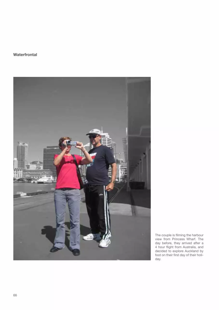
66
The couple is filming the harbour view from Princess Wharf. The day before, they arrived after a 4 hour flight from Australia, and decided to explore Auckland by foot on their first day of their holi-day.
Waterfrontal

67
The ticket conductor is working for Fullers, he lives in the CBD and can therefore walk to work every day, it takes him only a few minutes.
Waterfrontal

68
Looking north-east from the top of Princess Wharf across the Waitemata Harbour: Devonport and the large naval vessels can bee seen with the volcanic cones of Rangitoto Island, Mt Vic-toria and North Head as backdrop. To the east the container cranes of the port are contrary landmarks
The landscape of the upper harbour is more homogenous, the gentle curve of the Harbour Bridge arch is also blending in. The eye gets caught by the high rises of Takapuna in the distance, and the white cylinders of the Tank Farm closer up.
Views from Princess Wharf
Rangitoto Island Mt Victoria
Devonport
North Head
Harbour BridgeTank Farm
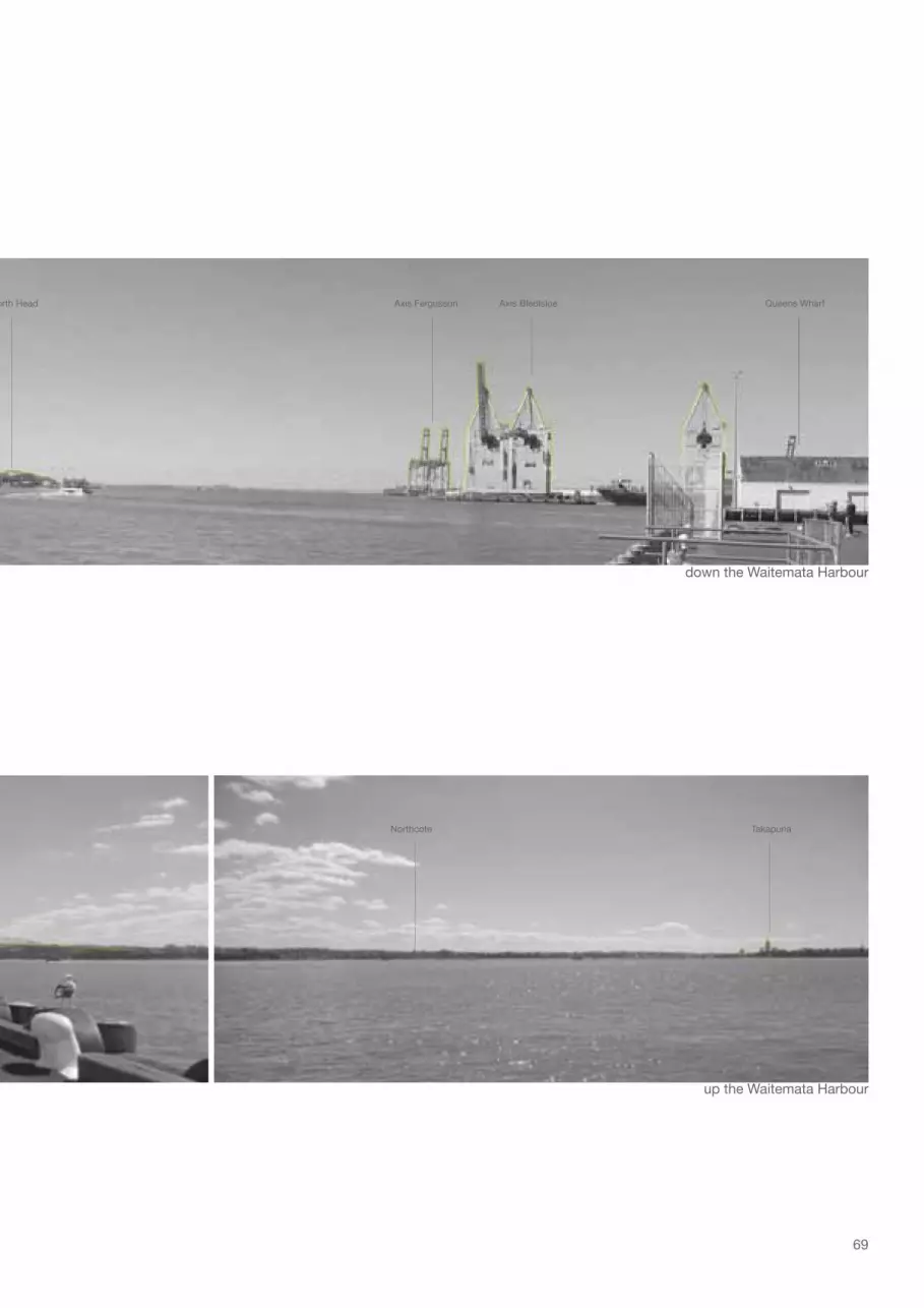
69
down the Waitemata Harbour
up the Waitemata Harbour
North Head
Northcote Takapuna
Axis Fergusson Axis Bledisloe Queens Wharf

70
Views from Queens Wharf
There is only restricted public access to Queens Wharf, for this reason the photo to the right was take from a passing ship. Still it gives a good impression of the pan-oramic city view that you would experience standing at the end of the wharf, and of the scale of the wharf. From the view point it is about 350 metres to Quay St. The top photo is taken from the car park behind the ferry termi-nal which is obstructing the view of the historic Ferry Building.

71
towards the city
up Queen St
Ferry Building Sky Tower

72
Waterfrontals

73
Zipping up their safety vests for the photo – they’re working underneath one of the ferry ter-minals, using hydro-demolition to remove old concrete. They travelled to work in their com-pany truck from south Auckland, which takes them 30min every morning.
Waterfrontal

74
Views down Gore St

75
Quay St
Quay St
Quay StCustom St
Albe
rt St
Hobs
on S
t
Fede
ral S
t
Brito
mar
t Pl
Wyndham St
Victoria St West
Wellesley St West
Que
en S
t
Durham St West
Fort St
Shortland St
Com
mer
ce S
t
Tyler St
Galway St
Que
en S
t
The area north of Fort St is reclaimed land, therefore the streets are on the same level as the wharves extending out into the harbour. As a result, there is, if at all, only a thin line of water vis-ible for pedestrians in the streets perpendicular to Quay St. The heavy traffic on Quay St, the red fence and the fleet of imported cars often parked on the wharves work as physical and visual barriers. The only place where an elevated view of the water is possible is in Commerce St (see next page), where the demoli-tion of a building left a gap. The vacant lot between Fort St and Shortland St is currently used as a carpark. The street level in Shortland St is about 3m above the wharves’ level, and allows for a view of the water.In Queen St (pp. 78-79) the Ferry Building and Ferry Terminal ob-struct all possible waterfront views. The ochre coloured facade of the historic Ferry Building though can been seen from along way up Queen St.

76
Views down Commerce St

77
Quay St
Quay St
Quay StCustom St
Albe
rt St
Hobs
on S
t
Fede
ral S
t
Brito
mar
t Pl
Wyndham St
Victoria St West
Wellesley St West
Que
en S
t
Durham St West
Fort St
Shortland St
Gor
e St
Tyler St
Galway St
Que
en S
t

78
Waterfrontal
Two service coordination su-pervisors. They work for Ports of Auckland and travel to work by car, it takes them 40min and 60min, the length of the trip can vary depending on traffic flow.
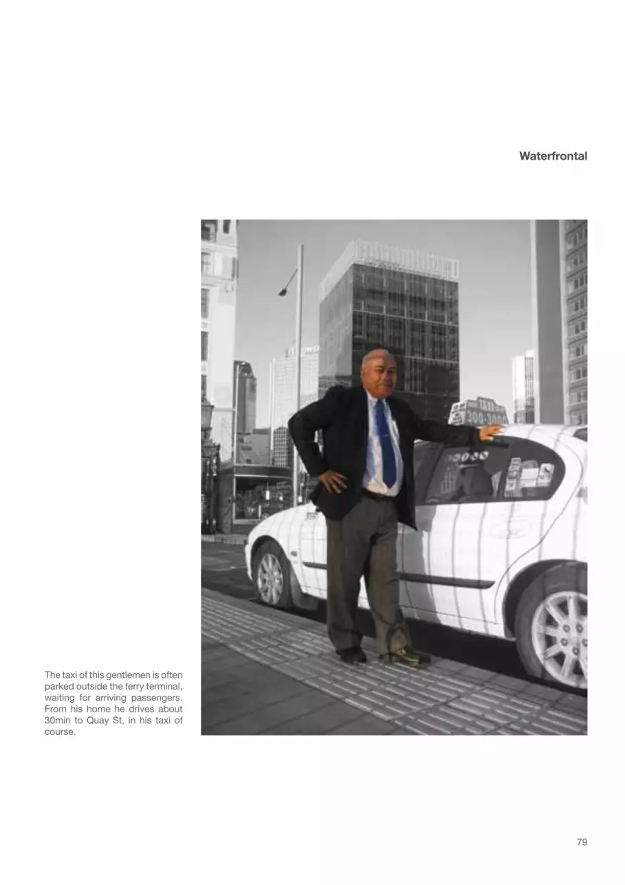
79
Waterfrontal
The taxi of this gentlemen is often parked outside the ferry terminal, waiting for arriving passengers. From his home he drives about 30min to Quay St, in his taxi of course.

80
Views down Queen St
Quay St
Quay St
Quay StCustom St
Albe
rt St
Hobs
on S
t
Fede
ral S
t
Brito
mar
t Pl
Wyndham St
Victoria St West
Wellesley St West
Que
en S
t
Durham St West
Fort St
Shortland St
Gor
e St
Com
mer
ce S
t
Tyler St
Galway St

81

82
Every morning this man takes the short ferry ride across from Devonport. In Auckland City he travels another 10min by bike to reach the office where he works.
Waterfrontal
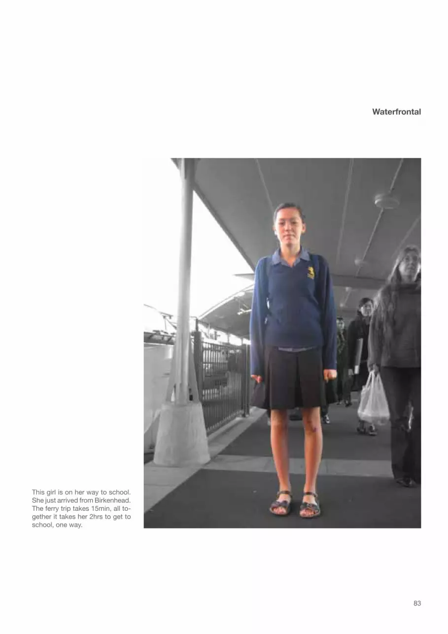
83
This girl is on her way to school. She just arrived from Birkenhead. The ferry trip takes 15min, all to-gether it takes her 2hrs to get to school, one way.
Waterfrontal

84

85Historic buildings
The figure above shows the distribution of activities in the proximity of the finger wharves. Morphologi-cal features of note are the extent of residential use in the Viaduct area, the amalgamation of very large sites south of Princess Wharf, combined with very limited ground floor activation in contrast to the fine grain of uses east of the Britomart Transport Centre with a relatively high degree of activated ground floor space.The area also shows a high density of heritage buildings (green) and buildings that are being considered for heritage protection (hatched green). Again the large sites south of Princess Wharf are noted, here for the absence of historic value.
Activities
Public space
Community
Retail
Food/ Beverage Transport/ Carparks
Under development
Activatedground floorCommercial
Residential
Non-permanent residential
Industrial
Urban morphology12
< Sign in Quay St
Northcote
Britomart
Viaduct Harbour
Princess Wharf Queens Wharf
Quay St

86
Waterfrontal
Another ferry passenger from Devonport. He enjoys riding his skateboard along the red fence on Quay St to work.

87
Waterfrontal
The MAF and Customs officers are working in the port area, con-trolling the incoming goods. They both travel to work by car it takes them 10min and 50min. The MAF officer who has to travel for long-er is starting work earlier to avoid the peak hour traffic jams.

88

89
The following pages illustrate characteristic features of Auckland’s urban waterfront by dissecting the space into four scenes: The Front row, the historic Waterfront, the Finger wharves and the Harbour basin.The line of buildings forming the front row of Auckland’s CBD is an amalgamation of various building styles and a statement for Auckland’s economic development. Towards the east the facades of the Colonial Sugar Refinery or The Northern Steamship Company Ltd. Building are remnants of the harbours heydays, when money was earned with real goods. Towards the west the modern high rises of banks and consul-tancy service providers dominate the scene. The various scales of buildings provide a rather unbalanced picture, nevertheless efforts are being made to enhance the historic Britomart quarter, to preserve the city’s colonial waterfront heritage. The Ferry Building at the bottom of Queen Street together with the Red Fence is the most distinctive feature of Auckland’s historic waterfront. In 1912 the Red Fence was originally planned to only enclose Queens Wharf, then known as Queen Street Wharf. Soon though the decision was made to fence off the adjoining wharves as well, in order to prevent the stealing of goods. In 1994 the red fence was extended to the east, not as elaborate but still in keeping with the original. The fence, its gates and the ornamental lamps are designated a category A heritage object by the Auckland City Council. The bars of the fence are gapped quite closely and when moving along side them they align to one blazing red wall. This intensifies the otherwise already extremely linear space along the wharves and container terminals and the fence’s function as a merciless barrier between city and waterfront.On the port owned wharves container stacks, fleets of imported cars and cranes dominate the scene. The coordinated and automated port operations create a calm atmosphere; the continuous process of unload-ing and loading brings a slow but steady change to the wharves’ landscape.On the water, the ferry services, cargo and cruise ship vessels also create a constant change of volumes. The smaller commuter ferries set the pace with their shortly frequented movement. The berthing of larger vessels happens in longer intervals, but their majestic appearance has great impact on the space.
Waterfront icons13
< The red fence near the Queens Wharf entrance

90
The Front row
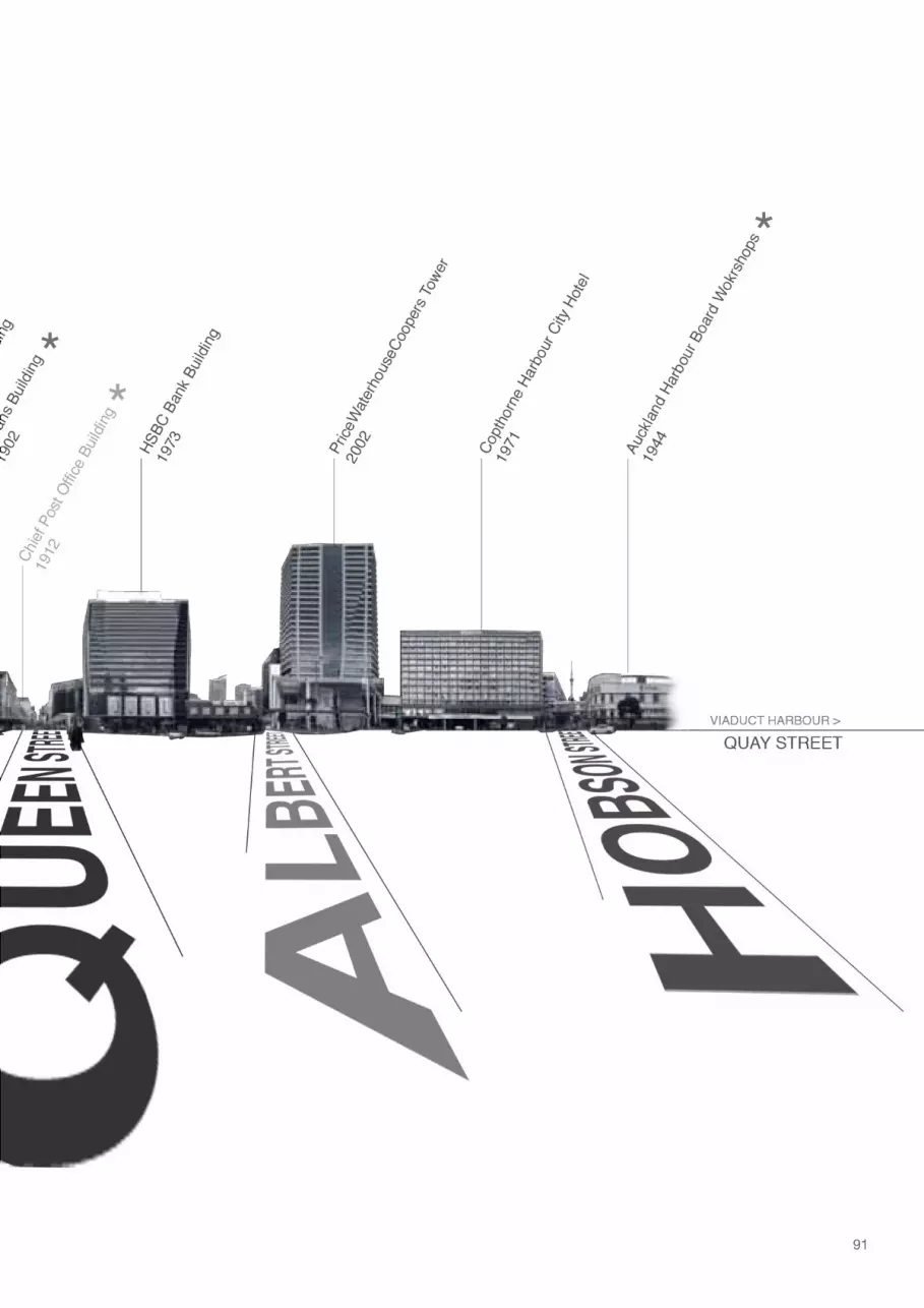
91

92
The historic Waterfront

93

94
The Finger wharves

95

96
The Harbour basin

97

98
Waterfrontal
This man is skipper on one of the tourist cruise boats, he lives in North Harbour. The trip to Auck-land City takes him 40min on his own vessel.

99
Waterfrontal
This lunch breaker works in one of the high rises along Quay St. He takes a 30min bus ride to work every day, so he can read on the way to work too.

100

101
Waterfront - problems and potentials
One of the major issues today is the detachment of the waterfront precincts from the adjoining city. This is mainly caused by the highly frequented arterial link roads running along the urban waterfront’s perimeter. The underlying cause for this is the infrastructural dilemma of the physical restrictions of the isthmus and the dominance of private vehicle transport. The regional infrastructural hierarchy has to be reorganised to avoid unnecessary through-traffic in the CBD. The second harbour crossing that has been in the planning for a long time can play a major role in the redirecting of regional traffic.A reduced vehicular traffic flow from east to west also allows for the consolidation and redevelopment of north-south pedestrian traffic corridors, reconnecting the public transit space of central Auckland with the public space of the waterfront. This makes especially sense in the case of Queens Wharf, which has origi-nated as an extension of Queen St.An extension of this kind also allows for a better linkage between the different modes of Auckland’s public transport system: Ferries, buses and trains. In combination with a more attractive and sufficient cycling track network, the mixed-modal public transportation would become a true alternative to the private car.
The analysis of the waterfront views portrays the high value of the open space at the point of the wharves; only there, a full panoramic view of the Waitemata Harbour landscape can be taken in. The topography and their lay-out in combination with the distraction of vehicular traffic do hardly allow for any views of the water in the streets adjoining the waterfront. This makes the experience of walking out of the city onto wa-ter, the transition from the three-dimensional built environment to the two-dimensional open space of the wharf, from the busy and noisy city streets to a decelerated and tranquil environment, particularly valuable. Besides the harbour views, Queens Wharf provides a perspective of the city and its historic buildings along Quay St that can usually only be caught from passing ferries.
The interjacent position of Queens Wharf, between the built and the natural environment produces a very strong sense of space - a sense for Auckland as a city and for its landscape. Now that Queens Wharf will finally be opened to the public, its unique natural qualities as public space should be nourished and utilised to the benefit of the people of Auckland and its visitors.
résumé

102
Waterfrontal
Eating their lunch – they both work for the same company in Quay St. One lady takes a 10 min train ride to Britomart Transport Centre every morning, the other one takes the bus, for 20min.

103
Waterfrontal
The South Korean couple is eating their last lunch in New Zealand, their flight back home is leaving in a few hours. They walked from their backpacker hostel to their lunch spot at the waterfront.

104

105
Wharf development
The essence of the above analysis is the great potential Queens Wharf bears as public space and the obstacles that keep it from being one. The following sequence of figures shows strategic provisions that address these problems and their underlying causes at the Auckland waterfront and subsequently a design proposal for the public space on Queens Wharf.
Design concept14Urban Volcanism
Shed 11 Shed 10
QuayStreet
CustomStreet
FortStreet
FerryBuilding
BritomartTransport
Centre
Queen Street Queen Street Queen StreetQueens Wharf

106
Status quo - The city is separated from its waterfront. The ‘Red Fence’, preventing unauthorised access to the port, and the heavy traffic in Quay St cause this disconnection. Equally, the interchange between regional ferry terminal and the Britomart transport centre are affected by vehicle dominance.
R

107
The Re-reclamation - In early 2010 the gates to Queens Wharf will be opened and all port related activi-ties retreat to the east. The physical barrier of the fence is overcome, the difficult pedestrian accessibility remains.

108
The Novelty Factor - The public explores the long locked-up wharf space. The two Sheds are used as a unique event space during the Rugby World Cup 2011. Afterwards they are being removed. Their desolate state would demand thorough restoration in order to keep them on the wharf permanently. The then cre-ated public platform offers space for further special large scale events.

109
The Crossing - The second harbour crossing, implemented as a tunnel, diverts traffic from the CBD and re-duces unnecessary through traffic in Quay St. The street level in lower Queen St and the Britomart precinct is raised to sidewalk level. The new surface works as Shared Space, emphasising the pedestrian connec-tion of city and waterfront and further calming the traffic.

110
Urban Volcanism I - The concrete wharf is being perforated by urban shells. They create a sequence of spaces on the platform, which are flexible in use and changing in day and night.

111
Urban Volcanism II - Natural particles align along the ruptures created by the urban shells. The soft surface they create contrasts the hard surface of the wharf and the urban shells. It provides a new range of possible activities along the waterfront.

112
Connectivity - Future growth of the regional ferry services is sustained with 2 additional ferry berths. The improved cycle network is making inter-modal transport, such as ferry-bike or train-bike, more attractive for people. The new cruise ship terminal is situated on the neighbouring Captain Cook wharf in close prox-imity to the city and its new waterfront park.

113
Focal point of this design is Queens Wharf. In order to achieve the desired connection of the city with its waterfront, certain design issues need to be solved in the urban context, comprising all of Auckland’s ur-ban waterfront.The implementation of the second harbour crossing will have great impact on vehicle traffic in the CBD. With a tunnel running more or less parallel to the Harbour Bridge that surfaces near Wellington St, unnec-essary through-traffic will be diverted from the CBD. Motorists coming from north use the tunnel to cross the harbour, and then continue to the east via the central Motorway Junction south of the CBD. This ulti-mately causes less traffic in Quay St, which so far has been classified as regional arterial road. The proposed Shared Space encompasses the lower Queens St outside the Britomart Transport Centre, as well as the Britomart precinct. The adjoining streets in longitudinal direction are also included. This sequence of pedestrian friendly axes is connecting shops, cafes and businesses of the lower CBD to the waterfront, and at the same time the successional elevated bumps slow down traffic in Quay St, Custom and Fort St. The Shared Space allows pedestrians and cyclists to move more safely and uninterrupted from traffic lights between the regional ferry terminal and the Britomart Transport Centre. Visitors arriving by cruise ship will also benefit from the easy access to the city from the new international Cruise Ship Ter-minal at Captain Cook Wharf. The unitary surface and level also enhances the Britomart precinct and its adjoining streets, and will create an appropriate setting for the numerous historic builds in this area.Auckland has grown to meet the requirements of the automobiles that drive though it. Its traffic is an el-ementary part of it, and therefore the Shared Space is limited to the lower end of Queen St, where the dominance of the traffic is causing the disconnection of the waterfront. In the central section of Queen St the current Street layout (pedestrian footpath elevated from vehicle lane) is basically retained. Only the lane hierarchy will change, cycle lanes are introduced and the existing four lanes for vehicles will be reduce to 3 lanes. The centre lanes will function as a passing lane, in one section for the left side of the road and in another section for the right side. Queen St remains a road for motorised traffic along its entire length, only from Aotea Square northwards the pedestrian and cyclist friendliness is gradually increased. The Shared Space at the end of the street then leads onto the Public Wharf Space, a public space for pedestrians and cyclists only.The new tunnel is taking pressure of the Harbour Bridge, which will make lane space available for cycle and pedestrian lanes. This allows people to pause and take in the great view from the bridge for which there has not been time so far, when travelling by car. The cycle track across the bridge is part of the Waterfront Cycle Track, which runs along Auckland’s entire urban waterfront. It is offering a convenient and effective cycle connection from the north-eastern and south-eastern suburbs to the western suburbs. Along Quay St and Tamaki Drive a cycle lane is already in place, it is quite narrow though. For the western part of the track, it is more a matter of designating more space for cyclists and improving signage, than actually building a new track, that is required to realise the Waterfront Cycle Track. Anyway, a track of this kind encourages people to take their cycles instead of their cars to got to the city. It is bypassing the regional ferry terminal as well as Britomart Transport Centre and therefore makes the interchange between public transport and cycle an attractive option. The track also improves the connection between the public parks of the CBD, such as Point Erin Park, Victoria Park, Meyer-Dover Park and the new Queens Wharf public space. The exact course of the Waterfront Cycle Track also depends on the redevelopment of the Tank Farm, and eventual project like the Te Wero Bridge.
15 Strategic masterplan

114
Public Wharf SpacePedestrians and Cyclists
Waterfront accesspedestrian and cyclists
Shared Spacepedestrians, cyclists and motorised traffic on one level
Split SpacePedestrians elevated from cycle and vehicle lanes
Waterfront Cycle TrackIndependent track or marked out cycle lane

115

116
Auckland volcanic field1 : 100 000
Scoria cone with crater
Scoria cone
Auckland Region
Auckland City
Auckland Metropolitan Area

117
Urban Volcanism - idea
Mt Victoria, Devonport
Urban topographyratio width/ 3x height
16 Wharf design
Auckland volcanic field1 : 100 000
Scoria cone with crater
Scoria cone
Auckland Region
Auckland City
Auckland Metropolitan Area
80
7060
5040
30
20
10 The landscape in the Auckland Region is defined by the ocean and volcanic activity. Rising magma has perforated the land; the eruptions have left behind several impressive volcanic cones. Over time, the city organism has filled out the entire isthmus, only the steep slopes of the volcanic cones were spared. Today these remnants of Auckland’s natural land-scape appear to be poking though the layer of ur-ban development. Most of the volcanoes are public reserves and offer great views of the city. From the city, the bizarre green humps appear like sleeping giants amongst the little houses.These iconic landmarks of the Auckland region were inspiration for the wharf design. The wharf is an arti-ficial construction, therefore the design is a negative mirror-image of the natural volcanic process.Urban Volcanism is the perforation of a man made platform by urban elements and the successive ac-cumulation of natural particles.

118
Distribution
Queens Wharf, as the extension of Queen St, Auck-land’s pivotal main street, is a focal point in the context of the city’s image. Therefore, early in the design process a model of the CBD was used to develop the design. The work on the model helped to understand the scale of the wharf platform and the relation of design to city.

119
The first models recreated the volcanic landscape on the wharf. It seemed like too much of the plat-form’s two-dimensionality was lost that way. So, a reduction of the artificial landscape happened, leav-ing only a field of urban volumes piercing through the platform. Working with the model made it possible to test out many variations. Conceptual, strategic and pro-grammatic decisions led to a sequence of volumes, variable in size, carefully thinning out towards the wharf’s point.

120
Que
ens
Wha
rf
Capt
ain
Cook
Wha
rf
Mar
sden
Wha
rf
Que
ens
Wha
rf
Capt
ain
Cook
Wha
rf
Mar
sden
Wha
rf
Que
ens
Wha
rf
Capt
ain
Cook
Wha
rf
Mar
sden
Wha
rf
View protection area Protected view shaft
Scale
Views to the coastal marine area are protected by the Auckland Regional Council via the Auckland Re-gional Plan: Coastal (see excerpt right). Within the ‘View protection area’ buildings of no more than 5m in height are permitted. In the areas marked out as ‘Protected view shafts’ any building requires a re-stricted discretionary activity resource consent. The urban shells are being distribute in a way so that the view protection regulations are being met. By varying the scattered volumes in height and size a dynamic picture is created. The peak in height is reached with the volumes on the eastern half of the wharf. This group of shells will also be the focus of the programmatic layout of the park. They are ar-ranged in a way that they loosely outline a space towards the centre of the wharf. The shells are over towering the square space. Their height is contrast-ing the vastness and distance one experiences oth-erwise on the wharf platform.

121
0.00m street level
+ 10.00m
+ 20.00m
- 10.00m
+ 30.00m
+ 40.00m
+ 50.00m
+ 60.00m
+ 70.00m
+ 80.00m
+ 90.00m
+ 13.00m + 15.00m + 16.00m
- 6.00m
+ 17.00m + 20.00m + 14.00m
+ 12.00m + 13.00m + 14.00m + 13.00m
+ 42.00m
+ 83.00m
0.00m
50 sqm 78 sqm
93 sqm
86 sqm 125 sqm
42 sqm
66 sqm 70 sqm 78 sqm 135 sqm
53 sqm
Queens Wharf 29,000 sqm
Sequence of heights
Floor space area

122
Form
The urban elements piercing though the wharf plat-form are a derivative of the built environment. Other than the buildings of the city, they are only empty shells, waiting to be occupied by the public and flexible uses.

123
Model prototypes
In the process of breaking through the concrete plat-form, the walls of the urban shells are buckled and forged, leaving the shells with a deformed surface.

124
04
03
02
01
01
02
03
04

125

126
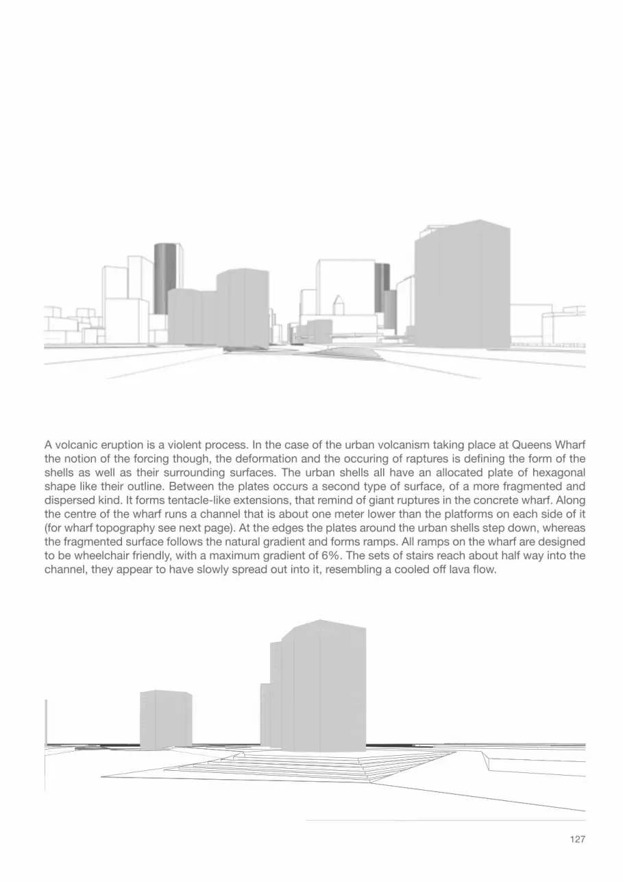
127
A volcanic eruption is a violent process. In the case of the urban volcanism taking place at Queens Wharf the notion of the forcing though, the deformation and the occuring of raptures is defining the form of the shells as well as their surrounding surfaces. The urban shells all have an allocated plate of hexagonal shape like their outline. Between the plates occurs a second type of surface, of a more fragmented and dispersed kind. It forms tentacle-like extensions, that remind of giant ruptures in the concrete wharf. Along the centre of the wharf runs a channel that is about one meter lower than the platforms on each side of it (for wharf topography see next page). At the edges the plates around the urban shells step down, whereas the fragmented surface follows the natural gradient and forms ramps. All ramps on the wharf are designed to be wheelchair friendly, with a maximum gradient of 6%. The sets of stairs reach about half way into the channel, they appear to have slowly spread out into it, resembling a cooled off lava flow.

128
+ 3.00m
+ 2.00m
+ 3.00m
+ 3.00m
+ 2.00m
+ 2.00m
+ 3.00m
+ 2.00m
+ 3.00m
+ 3.00m
+ 3.00m
outli
ne s
hed
11
outli
ne s
hed
10
0.00mmean sea level
0.00mmean sea level
0.00mmean sea level
Original wharf topographyin meters above mean sea level

129
+ 3.00m
+ 2.00m
+ 3.00m
+ 3.00m
+ 3.00m
+ 2.00m
+ 2.00m
+ 2.00m+ 3.00m
0.00mmean sea level
0.00mmean sea level
0.00mmean sea level
+ 3.00m
+ 3.00m
New wharf topography

130
MaterialsUrban shells
The supporting structure for the urban shells is made up of six non-corroding steel girders. The shells’ cladding is divided into large panels that are fixed to a non-corroding steel substructure. The relatively wide joints between the panels give the shells a de-constructed and fragmented look.

131
Untreated, punched copper sheets are used as cladding panels for the shells. They are attached to the steel framing through their feather-edge rims. An irregular pattern of circular to oval shape is punched out of the cooper sheets, that way semi-shade on the inside of the shells is provided during the day. At night, the urban shells emit a diffuse glow, casting circular spots of light on the surrounding surface. An allusion to the sparkling waters of the Waitemata Harbour. Over 8 - 15 years the metal caldding will form a dark brown to green patina..

132
De Young Museum, San FransiscoArchitects: Herzog & DeMeuron
Jardi Botanic, BarcelonaArchitects: Carlos Ferrater, Josep Lluis Canosa
Landscape architect: Bet Figueras
Tracks and platforms

133
Each urban shell sits in a homogenous concrete platform. The tentacle tracks and the floors of the shells are made from large concrete slabs that sit in a steel framing. The joints between the slabs are quite generous, to emphasise the defragmentation of the track. People will not be able to actually see the water below, but they sense that there is no solid ground beneath the track. Inside some shells venti-lation grills are placed between the concrete slabs. This way cool air from beneath the wharf can rise up into the towers on hot summer days.Wooden benches accompanied by bollard lamps are located on the fragmented tracks. They are set back from the edge of the track, so there is enough room to comfortably sit on both sides of the bench-es, and therefore enjoy views in two directions.

134
coolair
concrete platform
originalsurface
originalsurface
soilconcrete slabs
grill grill
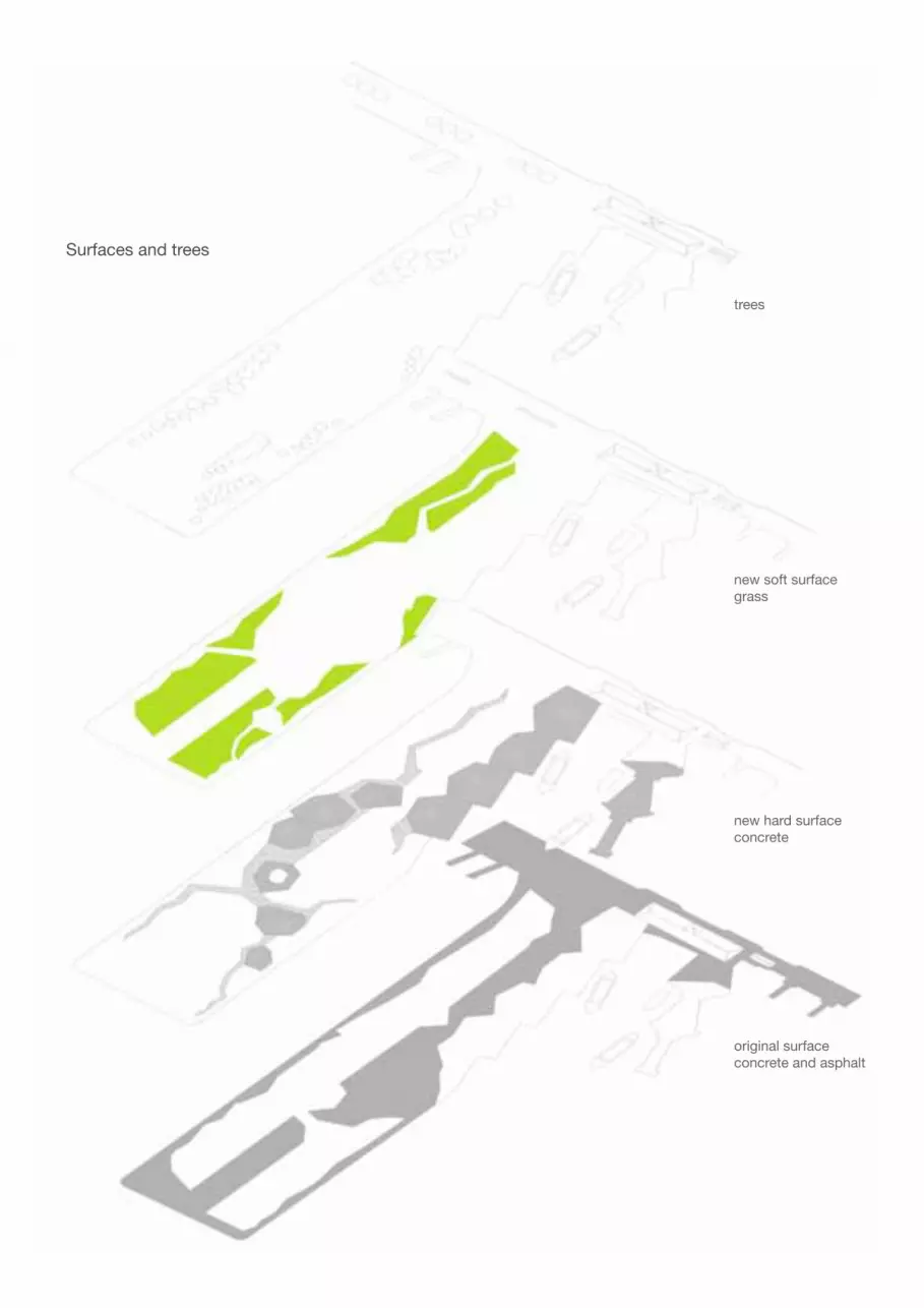
135
original surfaceconcrete and asphalt
new hard surfaceconcrete
new soft surfacegrass
trees
Surfaces and trees

136
Kanuka grove‘Kunzea ericoides’
lawn coastal grasses Kanuka‘Kunzea ericoides’
Pohutukawa‘Metrosideros excelsa’
0 m
2 m
4 m
8 m
6 m
10 m
12 m
14 m
16 m
18 m
Vegetation
The soft surfaces, which are constituted by grass, align with the concrete slab tracks. Most of the grassy areas are made up from shortly trimmed lawn - to encourage people to walk across these areas or use them for sports or lunch break picnics. In some parts, groups of coastal grasses are planted, such as ‘Aus-trofestuca littoralis’, ‘Chinolochia bromoides’, ‘Leptocarpus simils’ e.g. They structure the lawn and create smaller, sheltered and more private spots.The trees of the park are mostly concentrated along the edge of the tracks. In the southern half of the wharf Pohutukwa ‘Metrosideros excelsa’ dominate. They are a typical coastal tree and their cantilevered
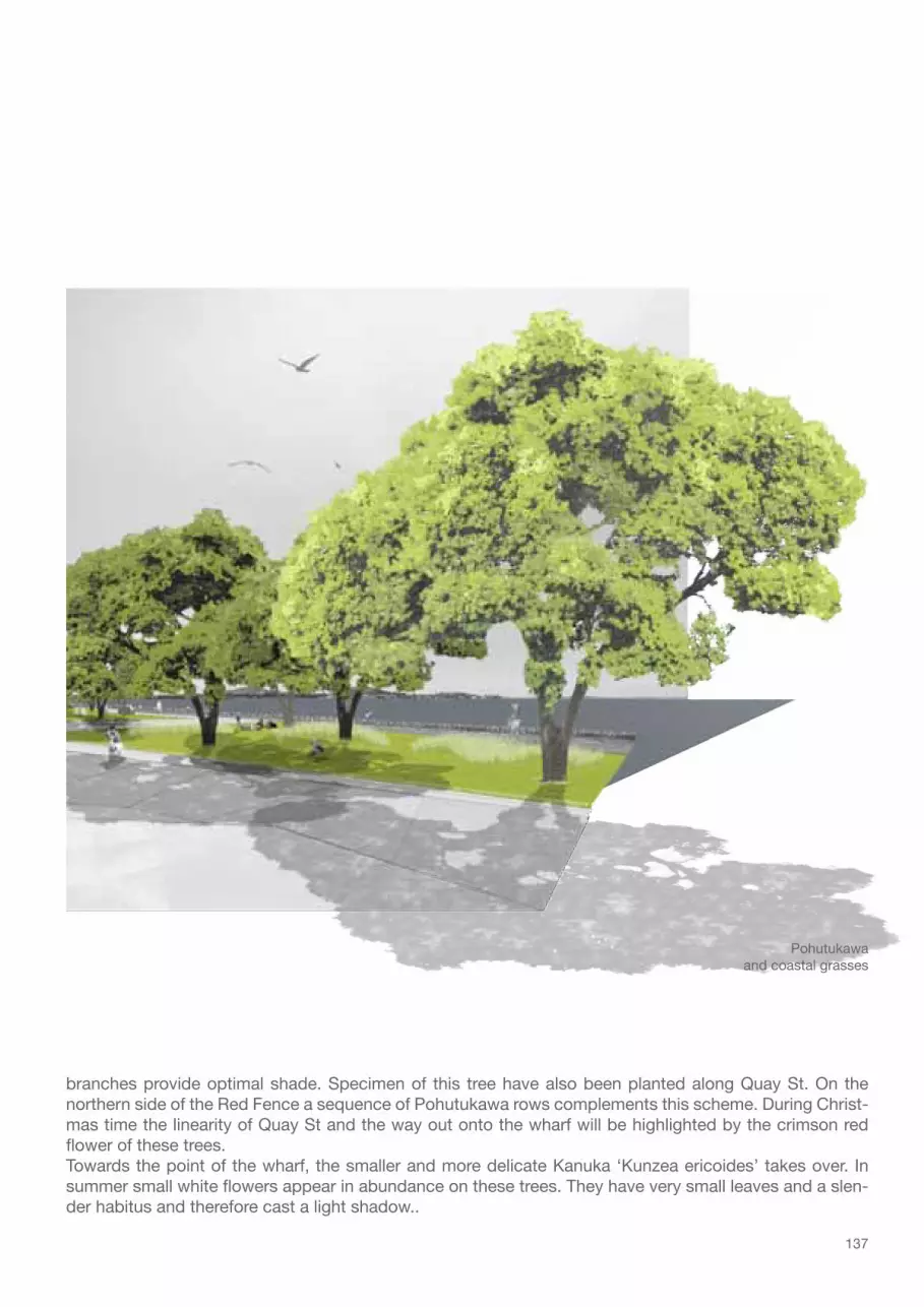
137
Pohutukawaand coastal grasses
branches provide optimal shade. Specimen of this tree have also been planted along Quay St. On the northern side of the Red Fence a sequence of Pohutukawa rows complements this scheme. During Christ-mas time the linearity of Quay St and the way out onto the wharf will be highlighted by the crimson red flower of these trees.Towards the point of the wharf, the smaller and more delicate Kanuka ‘Kunzea ericoides’ takes over. In summer small white flowers appear in abundance on these trees. They have very small leaves and a slen-der habitus and therefore cast a light shadow..

138
own design 2009
Ligthing
The inside of the urban shells is illuminated by small and bright spotlights. They are hanging on steel cables fixed between the structural girders of the shells. The lights are positioned at differ-ent levels inside the shell to en-hance the three-dimensionality of the space.Lighting on the wharf is limited to the tracks (bollard lamps) and the wharf’s edge (embedded spots). The gap between the two levels of the wharf is illuminated from beneath, accentuating the public space’s main axis.

139
The tow sheds on Queens Wharf are in a desolate state. Their historic value is not significant enough as to rectify their restoration. Nevertheless, the roof structure and cladding is made from Kauri timber. The wood of this tree used to be a popular material in house and boat building due to its durability. To-day the trees are nearly extinct and their wood very costly. Therefore, the Kauri timber from Shed 10 and 11 will be recycled into benches for the wharf park. The back of the benches tilts two ways, so people can choose which side of the bench they want to sit on, depending on what view they want to have.
Benches

140
ProgramUrban shells
Public BBQ
Workers from the CBD can come down to the wharf to barbecue a steak on the public gas bbqs during lunch break and families can meet here for a sunday feast.
Sea to Sky Staircase
The convoluted staircase inside this shell reaches from below the water level up to a viewing platform. There are entrances from both levels of the wharf.
Catered Lunch Bar
Some panels of this shell’s facade slide up like a visor. On the inside people can enjoy lunch from varying restaurants while enjoying the views.
Children’s play
Inside this shell a giant pool of balls and bouncy surfaces and climbing walls are located.
Coffee Bar
Waiting Lounge
For ferry customers
Temporary uses
The open air exhibition and show room can be rented for commercial, cultural and private uses.
Stage
The northern facade of this shell opens with two great roller doors. The inside is fitted out with a stage for concerts, performances or speeches.
Public toilets
From one side accessible for ferry customers from the other side for visitors to the wharf.
Ticket office
For commuter and tourists.

141
Wharf Special events - lawn
Christmas choralsMoonshine CinemaCommunal picnicPublic viewing
Special events - concrete
ConcertsPerformancesRallies
Visiting vessels
Show casing the marine or natural history of the region, for example.
Main tracks
Pedestrian and cyclists
Special event - concrete
For annual festivals like Matariki, the Auckland Lantern Festival or the Diwali festival, stalls can be placed on either side of the former cart dock.
Special event - asphalt
Vintage car showsCar boot salesSkate ramps
Direct access
For ferry passengervia turnstiles

142

143
annotation
In March 2009, when I decided on ‘Auckland Waterfront’ as the title of my diploma thesis design, Queens Wharf was supposed to be opened to the public ‘some time in the future’. As it turned out, only a few months later the deal was done, and the Auckland Regional Council and the New Zealand Government bought the wharf. At the end of August 2009 a two stage competition commenced, looking for the best possible design for Queens Wharf. Well over 200 different designs for the wharf were entered, some more or others less in keeping with the design objectives and the extremely tight budget. Until this day, the winner out of the eight finalists has not been announced yet. Nevertheless, the controversy about the future of Queens Wharf has been undiminished and will surely not ease with the conclusion of the com-petition.I worked on my design independent from the competition’s brief. My strategy was to search for solu-tions of the problems I encountered on site during my visits in Auckland and to design a unique entrance to the city that most of all should have one quality - to be public. A generous public space is the only instrument to fully utilises the qualities of the wharf, its strong sense of space and unique setting. Urban Volcanism is about designing an urban park with amenities and functions, but also providing space for the people and visitors of Auckland. So they can step out of their city into a contrasting environment, where they can play, relax eat, meet other people and enjoy the stunning views of the Waitemata Harbour and the city.
I would like to thank everyone who helped me compose the analysis and design for this diploma thesis. Beginning with the ‘Waterfrontals’ and the helpful people at University of Auckland, National Institute of Creative Arts and Industries, Auckland City Library and Auckland City Council. My dear family and friends, who gave me moral support through all stages of this work. And my professor and tutors from the Chair of Landscape Architecture and Public Space, TU Munich, for their critical questions .
A copy of the complete Urban Volcanism presentation plan is attached at the back of this brochure.
Eva S. Grimme, November 2009.

144

145
reference list
ACC – Auckland City Council (2008), District Plan, Central Area Section, Appendix 1, Schedule of Buildings, Heritage Properties, Places, Monuments and Objects of Special Value and Those Subject to Heritage Order, Auckland City Council, Auckland
ACC – Auckland City Council (2009-a), Public squares and Plazas – Te Wero Island, viewed 25/05/09, http://www.aucklandcity.govt.nz/whatson/places/squares/default.asp
ACC – Auckland City Council (2009-b), Victoria park map - victoriaparkcol.pdf, viewed: 25/05/09, http://www.aucklandcity.govt.nz/whatson/places/sportsparks/default.asp
ACC – Auckalnd City Council (2009-c), Bikes and cycleways, viewed: 20/06/09, http://www.aucklandcity.govt.nz/auckland/trans-port/bikes/default.asp
ACC – Auckland Cit Council (2009-d), CBD facts and figures, viewed 13/07/09, http://www.aucklandcity.govt.nz/auckland/econ-omy/cbd/default.asp
Arbury, Joshua (2005), From Urban Sprawl to Compact City – An analysis of urban growth management in Auckland, (Diss.) viewed: 22/05/09, http://www.docstoc.com/docs/2363780/From-Urban-Sprawl-to-Compact-City-An-analysis-of-urban-growth
ARC - Auckland Regional Council (2005), Auckland Waterfront - Vision 2040, Auckland Regional Council and Auckland City, Auckland
ARC - Auckland Regional Council (2007-a), Our Auckland, viewed: 16/06/09, http://www.arc.govt.nz/auckland/our-auckland/our-auckland_home.cfm
ARC - Auckland Regional Council (2007-b),The New Zealand mangrove: review of the current state and knowledge, viewed: 19/06/09, http://www.arc.govt.nz/.../ARCTP%20325%20Mangrove_review_(web).pdf
ARC – Auckland regional Council (2009), ARC and government to buy Queens Wharf, viewed: 17/06/09, http://www.arc.govt.nz/council/news-and-events/regionwide-news/index.cfm?2BC821EB-14C2-3D2D-B97A-731FC2A93354&news_uuid=E20F2E83-145E-173C-98BE-CBB47DB25E85
Auckland Local Government Geospatial information (ALGGi) (2009), GIS mapping website, viewed 16/06/09, http://maps.auck-land.govt.nz/Alggi/
Auckland Regional Growth Forum (1997), A place sought by many: A brief history of regional planning for Auckland’s growth, Regional Growth Forum, Auckland
Auckland Regional Growth Forum (1999), Auckland Regional Growth Strategy: 2050, A Vision for managing growth in the Auckland Region, Regional Growth Forum, Auckland
Bell G S & Johns D A (2006), A Strategic Approach to Developing Liveable and Sustainable Arterial Corridors in Auckalnd City, New Zealand, Institute of Transport Engineers. ITE Journal; Jul-2006; 76, 7; ABI/INFROM Global pg. 30
Cameron E, Hayward B & Murdoch G (2008) A field guide to Auckland, Randomhouse NZ, Auckland
Campbell N & Truttman L, Auckland City Heritage Walks – Auckland’s original shoreline, Auckland City and Heart of Auckland City, Auckland
Cave Y & Paddison V (2005), The gardener’s encyclopaedia of New Zealand native plants, Randomhouse NZ, Auckland
Collins S (2009), Aucklanders stick with cars as best way to travel, NZHerald, 07/07/09, viewed 09/07/09, http://www.nzherald.co.nz/auckland-region/news/article.cfm?l_id=117&objectid=10582953
Fullers Group Limited (2008), Ferries have a much bigger role to play in public transport (media release 27 February 2008), viewed: 31/05/09, http://www.fullers.co.nz/news-events/news-archive/ferries.php
146
Historic Places Trust – Pouhere Taonga, New Zealand (2001), Ferry Building (register number: 102), viewed: 31/05/09, http://www.historic.org.nz/Register/ListingDetail.asp?RID=102&sm=
LINZ – Land Information New Zealand (2008), Charts and Hydrographic Services – Tides around New Zealand, viewed 22/06/09, http://www.linz.govt.nz/hydro/tidal-info/tidal-intro/nz-tides/index.aspx
McDermott, Phillip (2008), Auckland’s Population, viewed: 22/05/09, http://www.royalcommission.govt.nz
McLauchlan G (2008), The life and times of Auckland – A colourful story of a city, Penguin Group, Rosedale
Petrow C A (2008), Creating Atmosphere: Hafencity Hamburg, Topos – Concept and Form, 65/2008
Ports of Auckland (2008-a), Red fence Heritage Walk, viewed: 31/05/09, http://www.poal.co.nz/news_media/publications/POAL_red_fence_heritage_walk_brochure.pdf.
Ports of Auckland (2008-b), Community and Environment – public access to the waterfront, viewed 31/05/09, http://www.poal.co.nz/community_environment/
Ports of Auckland (2008-c), Port Developememnt Plan, viewed: 31/05/09, http://www.poal.co.nz/about_us/port_development_plan.htm Sea+City Porjects Ltd. (2007), Design concept, viewed: 27/05/09, http://www.seacity.co.nz/design_concept_moving_forward.htm
Metrowater (2005), Stormwater contaminants the long term threat to our waterways, Auckland Waterways, issue 5, 12/2005
Metrowater (2007), How storms affect bathing beach water quality, Auckland Waterways, issue 9, 01/2007
Taraare K – stormwater engineer metrowater (2009), Personal interview (stormwater management on Auckland’s waterfront), 02/04/2009

147
Drawing of Auckland in 1886 by George Treacy Stevens, Auckland City Library Historic Col-lection #374, http://www.aucklandcity.govt.nz/dbtw-wpd/maps/maps.html 61
Drawing of Auckland in 1886 by George Treacy Stevens, Auckland City Library Historic Col-lection #374, http://www.aucklandcity.govt.nz/dbtw-wpd/maps/maps.html 61
270deg panoramic view of Auckland, photo-merged image, photo by Christian Lamker 2009 Auckland in the 1970s, Heritage Image # 7-A1879, Auckland City Library, http://0-www.aucklandcity.govt.nz.www.elgar.govt.nz/dbtw-wpd/heritageimages/apphoto.htm, viewed 19/06/09
Central isthmus contours, University of Auckland, National Institute of Creative Artsand Industries 2009New Zealand on the globe, own design on basis of Google Earth image 13/06/2009New Zealand’s regions, own design on basis of http://mapsof.net/uploads/static-maps/new_zealand_regions.png, viewed 20/05/09
Pohutukawas on the beach, image from http://upload.wikimedia.org/wikipedia/commons/5/5b/PohutukawaCornwallis.jpg, viewed 19/06/09Pohutukawa flowering, image from http://upload.wikimedia.org/wikipedia/commons/b/bb/PohutuAk.jpg, viewed 19/06/09Pong frond, image from http://farm1.static.flickr.com/60/200515672_d888f5bc0c.jpg?v=0, viewed 19/06/09Ponga in the forest, image form http://www.bildungsservice.at/faecher/geo/Staaten%20und%20Landschaften/Neuseeland/NZ%202003%20-%20Abel%20Tasman%20NP%20-%20IMG_1546.JPG, viewed 19/06/09Young Manuka, photo by authorManuka flower, image from http://planetplant.net/wp-content/uploads/2009/02/blog-erics-leptospermum-scoparium-feb09.JPG, viewed 19/06/09 Nikaus in Queen St, Auckland, photo by authorNikaus in private garden, Northland, photo by authorCluster of flax, image from http://www.hear.org/starr/images/full/starr-071024-0365.jpg, viewed 19/06/09Flax flowers, image form http://www.shawgreen.co.uk/images/products/PhormiumTenax.jpg, viewed 19/06/09Cabbage tree flowering, image from http://www.biopix.dk/Temp/JKO%20Cordyline%20australis%2000141.JPG, viewed 19/06/09Cabbage tree, image from http://www.foresthistory.org.au/Cabbage%20Tree%20(Cordyline%20australis),%20Feb%2007%20(MH).jpg, viewed 19/06/09Kauri trunk, image form http://www.bushmansfriend.co.nz/site/images/31825.jpg, viewed 19/06/09Kauri leaves, image form http://www.nurgapuukool.ee/pic/foorum/east07/agathis_austra-lis1.JPGMangroves in Auckland, image from http://k53.pbase.com/u38/jeanvanwyk/large/25072644.pc240014.jpgMangroves’ roots, http://upload.wikimedia.org/wikipedia/commons/a/aa/Mangrove-trunk.jpg, viewed 19/06/09Cities and districts in the Auckland region, own design on the basis of http://maps.auck-land.govt.nz, viewed 19/06/09Auckland region, own design on the basis of http://maps.auckland.govt.nz, viewed 21/06/09Auckland urban metropolitan limits, own design on the basis of http://maps.auckland.govt.nz, viewed 28/06/09
01.1
10.1
12.1
12.2
14.115.115.2
16.1
16.2
16.3
16.4
16.516.6
16.716.817.1
17.2
17.3
17.4
17.5
17.6
17.7
17.8
18.1
19.1
19.2
1
1 1
1 12
1 1
321
654
1
2121
1 1
11
2
1 1
2121
2
1
2
1
2121
1 1
2
1
1 1
1 1
1
1
01
13
15
17
19
21
23
25
27
29
10
12
14
16
18
20
22
24
26
28
11
3130
3332
3736
41
43
45
47
49
51
53
55
57
38
40
42
44
46
48
50
52
54
56
39
5958
6160
6362
6564
69
71
73
75
77
79
81
83
85
66
68
70
72
74
76
78
80
82
84
67
8988
1
12
1 1 2
1 23 45 67 8
1 23 45 67 8
11 2
1 1
1 1
1 2 1 23 3
1
11
11
1321
12354
1234
1 1
1321
12
12
1
1 1
1234
1234
1
21 3
41
1 243 5
21 3
4 5
1
1 2
43 5
321
321
2
1
2
1
2
1
2
1
21
21
21
321
3
321
321
4
321
321
765
5 4 4 8
1
1
3534
1
1 1
1 1
1 1
1 1
1 1
1 1
2
9190
9392
9594
9998
103102
105104
107106
109108
111110
113112
115114
117116
119118
127126
129128
131130
133132
135134
137136
139138
141140
125124
123122
121120
9796
1 1
8786
1
1
1 1
11
11
11
11
1 1
1 12
1 1
321
654
1
2121
1 1
11
2
1 1
2121
2
1
2
1
2121
1 1
2
1
1 1
1 1
1
1
01
13
15
17
19
21
23
25
27
29
10
12
14
16
18
20
22
24
26
28
11
3130
3332
3736
41
43
45
47
49
51
53
55
57
38
40
42
44
46
48
50
52
54
56
39
5958
6160
6362
6564
69
71
73
75
77
79
81
83
85
66
68
70
72
74
76
78
80
82
84
67
8988
1
12
1 1 2
1 23 45 67 8
1 23 45 67 8
11 2
1 1
1 1
1 2 1 23 3
1
11
11
1321
12354
1234
1 1
1321
12
12
1
1 1
1234
1234
1
21 3
41
1 243 5
21 3
4 5
1
1 2
43 5
321
321
2
1
2
1
2
1
2
1
21
21
21
321
3
321
321
4
321
321
765
5 4 4 8
1
1
3534
1
1 1
1 1
1 1
1 1
1 1
1 1
2
9190
9392
9594
9998
103102
105104
107106
109108
111110
113112
115114
117116
119118
127126
129128
131130
133132
135134
137136
139138
141140
125124
123122
121120
9796
1 1
8786
1
1
1 1
11
11
11
1 1
1 1
1 12
1 1
321
654
1
2121
1 1
11
2
1 1
2121
2
1
2
1
2121
1 1
2
1
1 1
1 1
1
1
01
13
15
17
19
21
23
25
27
29
10
12
14
16
18
20
22
24
26
28
11
3130
3332
3736
41
43
45
47
49
51
53
55
57
38
40
42
44
46
48
50
52
54
56
39
5958
6160
6362
6564
69
71
73
75
77
79
81
83
85
66
68
70
72
74
76
78
80
82
84
67
8988
1
12
1 1 2
1 23 45 67 8
1 23 45 67 8
11 2
1 1
1 1
1 2 1 23 3
1
11
11
1321
12354
1234
1 1
1321
12
12
1
1 1
1234
1234
1
21 3
41
1 243 5
21 3
4 5
1
1 2
43 5
321
321
2
1
2
1
2
1
2
1
21
21
21
321
3
321
321
4
321
321
765
5 4 4 8
1
1
3534
1
1 1
1 1
1 1
1 1
1 1
1 1
2
9190
9392
9594
9998
103102
105104
107106
109108
111110
113112
115114
117116
119118
127126
129128
131130
133132
135134
137136
139138
141140
125124
123122
121120
9796
1 1
8786
1
1
1 1
11
11
11
1
1
1 1
1 12
1 1
321
654
1
2121
1 1
11
2
1 1
2121
2
1
2
1
2121
1 1
2
1
1 1
1 1
1
1
01
13
15
17
19
21
23
25
27
29
10
12
14
16
18
20
22
24
26
28
11
3130
3332
3736
41
43
45
47
49
51
53
55
57
38
40
42
44
46
48
50
52
54
56
39
5958
6160
6362
6564
69
71
73
75
77
79
81
83
85
66
68
70
72
74
76
78
80
82
84
67
8988
1
12
1 1 2
1 23 45 67 8
1 23 45 67 8
11 2
1 1
1 1
1 2 1 23 3
1
11
11
1321
12354
1234
1 1
1321
12
12
1
1 1
1234
1234
1
21 3
41
1 243 5
21 3
4 5
1
1 2
43 5
321
321
2
1
2
1
2
1
2
1
21
21
21
321
3
321
321
4
321
321
765
5 4 4 8
1
1
3534
1
1 1
1 1
1 1
1 1
1 1
1 1
2
9190
9392
9594
9998
103102
105104
107106
109108
111110
113112
115114
117116
119118
127126
129128
131130
133132
135134
137136
139138
141140
125124
123122
121120
9796
1 1
8786
1
1
1 1
11
11
11
1
figure index

148
Suburban Auckland, University of Auckland, National Institute of Creative Artsand Industries, 2009Auckland urban limits, own design on the basis of http://maps.auckland.govt.nz, viewed 28/06/09
Auckland urban limits and surrounding land mass, own design on the basis of http://maps.auckland.govt.nz, viewed 28/06/09Munich urban limits, own design on the basis of Bautaetigkeit_91-06.pdf in Stadt Bau Plan.850 Jahre Entwicklung in München, Franz Schiermeier Verlag 2008
Road network of Auckland City in 1841, own design on the basis of Auckland City Library Map # 6601, http://www.aucklandcity.govt.nz/dbtw-wpd/maps/mapsadv.html, viewed 11/05/09Road network of Auckland City in 1880, own design on the basis of Auckland City Li-brary Map # 190, http://www.aucklandcity.govt.nz/dbtw-wpd/maps/mapsadv.html, viewed 11/05/09Auckland’s population in 1841 and 1880, own design on the basis of http://www.auckland-city.govt.nz/auckland/introduction/bush/popn.asp, viewed 05/07/09Road network of Auckland City in 1947, own design on the basis of Auckland City Library Map # 3531, http://www.aucklandcity.govt.nz/dbtw-wpd/maps/mapsadv.html, viewed 11/05/09Road network of Auckland City in 2008, University of Auckland, National Institute of Crea-tive Artsand Industries, 2009Auckland’s population in 1947 and 2008, own design on the basis of http://www.auckland-city.govt.nz/auckland/introduction/bush/popn.asp, viewed 05/07/09Britomart transport centre, photo by Christian Lamker 2009
Main infrastructure in the Auckland region, own design on the basis of googlemapsOwn deisgn 2009, based on ad classification in Central Section of Auckland City District Plan, http://www.aucklandcity.govt.nz/council/documents/central/maps/cbdmap07.asp, viewed 26/03/09
Public transit space Queen St, photo by author 2009Maori settlements on the isthmus and today’s names, own design on the basis of Auckland Regional Planning Division (1975), Archaeological Sites in the Auckland Region, own print, pp.16-17
Public space in central Auckland City, own designElevated city view from Albert Park, image from http://images.google.de/imgres?imgurl=http://upload.wikimedia.org/wikipedia/commons/b/b6/Albert_Park_-_View_-_02.jpg&imgrefurl=http://commons.wikimedia.org/wiki/File:Albert_Park_-_View_-_02.jpg, viewed 04/07/09War Memorial – Auckland Domain, image from http://davidwallphoto.com/images/%7B2F8D4911-2717-476B-AF4D-14FB0C9BDA0A%7D.jpg, viewed 04/07/09 Jazz concert at the Domain, image from http://www.newzealandtravelblog.co.nz/wp-con-tent/gallery/sunday-afternoon-jazz-at-the-auckland-domain/Berridge_DSC_02020001_Jazz%20at%20the%20Auckland%20Domain.JPG, viewed 04/07/09
View of Tamaki Drive from D.-M. Robinson Park, photo by author 2009View of Harbour Bridge from Point Erin Park, photo by author 2009Game of cricket at Victoria Park, image from http://www.geocities.jp/kiwidream1997hp/NewZealandPhoto/photo-image/victoria/cricket03.jpg, viewed 04/07/09Proposed design for Aotea Square, image from http://static.stuff.
20.1
21.1
22.1
23.1
24.1
24.2
24.3
24.1
24.2
25.3
26.1
28.129.1
30.131.1
32.133.1
33.2
33.3
34.134.234.3
34.4
1
1 1
1 12
1 1
321
654
1
2121
1 1
11
2
1 1
2121
2
1
2
1
2121
1 1
2
1
1 1
1 1
1
1
01
13
15
17
19
21
23
25
27
29
10
12
14
16
18
20
22
24
26
28
11
3130
3332
3736
41
43
45
47
49
51
53
55
57
38
40
42
44
46
48
50
52
54
56
39
5958
6160
6362
6564
69
71
73
75
77
79
81
83
85
66
68
70
72
74
76
78
80
82
84
67
8988
1
12
1 1 2
1 23 45 67 8
1 23 45 67 8
11 2
1 1
1 1
1 2 1 23 3
1
11
11
1321
12354
1234
1 1
1321
12
12
1
1 1
1234
1234
1
21 3
41
1 243 5
21 3
4 5
1
1 2
43 5
321
321
2
1
2
1
2
1
2
1
21
21
21
321
3
321
321
4
321
321
765
5 4 4 8
1
1
3534
1
1 1
1 1
1 1
1 1
1 1
1 1
2
9190
9392
9594
9998
103102
105104
107106
109108
111110
113112
115114
117116
119118
127126
129128
131130
133132
135134
137136
139138
141140
125124
123122
121120
9796
1 1
8786
1
1
1 1
11
11
11
11
1 1
1 12
1 1
321
654
1
2121
1 1
11
2
1 1
2121
2
1
2
1
2121
1 1
2
1
1 1
1 1
1
1
01
13
15
17
19
21
23
25
27
29
10
12
14
16
18
20
22
24
26
28
11
3130
3332
3736
41
43
45
47
49
51
53
55
57
38
40
42
44
46
48
50
52
54
56
39
5958
6160
6362
6564
69
71
73
75
77
79
81
83
85
66
68
70
72
74
76
78
80
82
84
67
8988
1
12
1 1 2
1 23 45 67 8
1 23 45 67 8
11 2
1 1
1 1
1 2 1 23 3
1
11
11
1321
12354
1234
1 1
1321
12
12
1
1 1
1234
1234
1
21 3
41
1 243 5
21 3
4 5
1
1 2
43 5
321
321
2
1
2
1
2
1
2
1
21
21
21
321
3
321
321
4
321
321
765
5 4 4 8
1
1
3534
1
1 1
1 1
1 1
1 1
1 1
1 1
2
9190
9392
9594
9998
103102
105104
107106
109108
111110
113112
115114
117116
119118
127126
129128
131130
133132
135134
137136
139138
141140
125124
123122
121120
9796
1 1
8786
1
1
1 1
11
11
11
1
1
1 1
1 12
1 1
321
654
1
2121
1 1
11
2
1 1
2121
2
1
2
1
2121
1 1
2
1
1 1
1 1
1
1
01
13
15
17
19
21
23
25
27
29
10
12
14
16
18
20
22
24
26
28
11
3130
3332
3736
41
43
45
47
49
51
53
55
57
38
40
42
44
46
48
50
52
54
56
39
5958
6160
6362
6564
69
71
73
75
77
79
81
83
85
66
68
70
72
74
76
78
80
82
84
67
8988
1
12
1 1 2
1 23 45 67 8
1 23 45 67 8
11 2
1 1
1 1
1 2 1 23 3
1
11
11
1321
12354
1234
1 1
1321
12
12
1
1 1
1234
1234
1
21 3
41
1 243 5
21 3
4 5
1
1 2
43 5
321
321
2
1
2
1
2
1
2
1
21
21
21
321
3
321
321
4
321
321
765
5 4 4 8
1
1
3534
1
1 1
1 1
1 1
1 1
1 1
1 1
2
9190
9392
9594
9998
103102
105104
107106
109108
111110
113112
115114
117116
119118
127126
129128
131130
133132
135134
137136
139138
141140
125124
123122
121120
9796
1 1
8786
1
1
1 1
11
11
11
11
1 1
1 12
1 1
321
654
1
2121
1 1
11
2
1 1
2121
2
1
2
1
2121
1 1
2
1
1 1
1 1
1
1
01
13
15
17
19
21
23
25
27
29
10
12
14
16
18
20
22
24
26
28
11
3130
3332
3736
41
43
45
47
49
51
53
55
57
38
40
42
44
46
48
50
52
54
56
39
5958
6160
6362
6564
69
71
73
75
77
79
81
83
85
66
68
70
72
74
76
78
80
82
84
67
8988
1
12
1 1 2
1 23 45 67 8
1 23 45 67 8
11 2
1 1
1 1
1 2 1 23 3
1
11
11
1321
12354
1234
1 1
1321
12
12
1
1 1
1234
1234
1
21 3
41
1 243 5
21 3
4 5
1
1 2
43 5
321
321
2
1
2
1
2
1
2
1
21
21
21
321
3
321
321
4
321
321
765
5 4 4 8
1
1
3534
1
1 1
1 1
1 1
1 1
1 1
1 1
2
9190
9392
9594
9998
103102
105104
107106
109108
111110
113112
115114
117116
119118
127126
129128
131130
133132
135134
137136
139138
141140
125124
123122
121120
9796
1 1
8786
1
1
1 1
11
11
11
1
1
1 1
1 12
1 1
321
654
1
2121
1 1
11
2
1 1
2121
2
1
2
1
2121
1 1
2
1
1 1
1 1
1
1
01
13
15
17
19
21
23
25
27
29
10
12
14
16
18
20
22
24
26
28
11
3130
3332
3736
41
43
45
47
49
51
53
55
57
38
40
42
44
46
48
50
52
54
56
39
5958
6160
6362
6564
69
71
73
75
77
79
81
83
85
66
68
70
72
74
76
78
80
82
84
67
8988
1
12
1 1 2
1 23 45 67 8
1 23 45 67 8
11 2
1 1
1 1
1 2 1 23 3
1
11
11
1321
12354
1234
1 1
1321
12
12
1
1 1
1234
1234
1
21 3
41
1 243 5
21 3
4 5
1
1 2
43 5
321
321
2
1
2
1
2
1
2
1
21
21
21
321
3
321
321
4
321
321
765
5 4 4 8
1
1
3534
1
1 1
1 1
1 1
1 1
1 1
1 1
2
9190
9392
9594
9998
103102
105104
107106
109108
111110
113112
115114
117116
119118
127126
129128
131130
133132
135134
137136
139138
141140
125124
123122
121120
9796
1 1
8786
1
1
1 1
11
11
11
1

149
34.5
35.135.235.335.4
36.1
37.1
38.1
39.1
39.239.3
40.140.241.141.2
42.1
44.1
45.1
46.146.2
46.3
46.4
47.1
47.2
47.3
47.4
48.1
1
1 1
1 12
1 1
321
654
1
2121
1 1
11
2
1 1
2121
2
1
2
1
2121
1 1
2
1
1 1
1 1
1
1
01
13
15
17
19
21
23
25
27
29
10
12
14
16
18
20
22
24
26
28
11
3130
3332
3736
41
43
45
47
49
51
53
55
57
38
40
42
44
46
48
50
52
54
56
39
5958
6160
6362
6564
69
71
73
75
77
79
81
83
85
66
68
70
72
74
76
78
80
82
84
67
8988
1
12
1 1 2
1 23 45 67 8
1 23 45 67 8
11 2
1 1
1 1
1 2 1 23 3
1
11
11
1321
12354
1234
1 1
1321
12
12
1
1 1
1234
1234
1
21 3
41
1 243 5
21 3
4 5
1
1 2
43 5
321
321
2
1
2
1
2
1
2
1
21
21
21
321
3
321
321
4
321
321
765
5 4 4 8
1
1
3534
1
1 1
1 1
1 1
1 1
1 1
1 1
2
9190
9392
9594
9998
103102
105104
107106
109108
111110
113112
115114
117116
119118
127126
129128
131130
133132
135134
137136
139138
141140
125124
123122
121120
9796
1 1
8786
1
1
1 1
11
11
11
1
1
1 1
1 12
1 1
321
654
1
2121
1 1
11
2
1 1
2121
2
1
2
1
2121
1 1
2
1
1 1
1 1
1
1
01
13
15
17
19
21
23
25
27
29
10
12
14
16
18
20
22
24
26
28
11
3130
3332
3736
41
43
45
47
49
51
53
55
57
38
40
42
44
46
48
50
52
54
56
39
5958
6160
6362
6564
69
71
73
75
77
79
81
83
85
66
68
70
72
74
76
78
80
82
84
67
8988
1
12
1 1 2
1 23 45 67 8
1 23 45 67 8
11 2
1 1
1 1
1 2 1 23 3
1
11
11
1321
12354
1234
1 1
1321
12
12
1
1 1
1234
1234
1
21 3
41
1 243 5
21 3
4 5
1
1 2
43 5
321
321
2
1
2
1
2
1
2
1
21
21
21
321
3
321
321
4
321
321
765
5 4 4 8
1
1
3534
1
1 1
1 1
1 1
1 1
1 1
1 1
2
9190
9392
9594
9998
103102
105104
107106
109108
111110
113112
115114
117116
119118
127126
129128
131130
133132
135134
137136
139138
141140
125124
123122
121120
9796
1 1
8786
1
1
1 1
11
11
11
11
1 1
1 12
1 1
321
654
1
2121
1 1
11
2
1 1
2121
2
1
2
1
2121
1 1
2
1
1 1
1 1
1
1
01
13
15
17
19
21
23
25
27
29
10
12
14
16
18
20
22
24
26
28
11
3130
3332
3736
41
43
45
47
49
51
53
55
57
38
40
42
44
46
48
50
52
54
56
39
5958
6160
6362
6564
69
71
73
75
77
79
81
83
85
66
68
70
72
74
76
78
80
82
84
67
8988
1
12
1 1 2
1 23 45 67 8
1 23 45 67 8
11 2
1 1
1 1
1 2 1 23 3
1
11
11
1321
12354
1234
1 1
1321
12
12
1
1 1
1234
1234
1
21 3
41
1 243 5
21 3
4 5
1
1 2
43 5
321
321
2
1
2
1
2
1
2
1
21
21
21
321
3
321
321
4
321
321
765
5 4 4 8
1
1
3534
1
1 1
1 1
1 1
1 1
1 1
1 1
2
9190
9392
9594
9998
103102
105104
107106
109108
111110
113112
115114
117116
119118
127126
129128
131130
133132
135134
137136
139138
141140
125124
123122
121120
9796
1 1
8786
1
1
1 1
11
11
11
1
1
1 1
1 12
1 1
321
654
1
2121
1 1
11
2
1 1
2121
2
1
2
1
2121
1 1
2
1
1 1
1 1
1
1
01
13
15
17
19
21
23
25
27
29
10
12
14
16
18
20
22
24
26
28
11
3130
3332
3736
41
43
45
47
49
51
53
55
57
38
40
42
44
46
48
50
52
54
56
39
5958
6160
6362
6564
69
71
73
75
77
79
81
83
85
66
68
70
72
74
76
78
80
82
84
67
8988
1
12
1 1 2
1 23 45 67 8
1 23 45 67 8
11 2
1 1
1 1
1 2 1 23 3
1
11
11
1321
12354
1234
1 1
1321
12
12
1
1 1
1234
1234
1
21 3
41
1 243 5
21 3
4 5
1
1 2
43 5
321
321
2
1
2
1
2
1
2
1
21
21
21
321
3
321
321
4
321
321
765
5 4 4 8
1
1
3534
1
1 1
1 1
1 1
1 1
1 1
1 1
2
9190
9392
9594
9998
103102
105104
107106
109108
111110
113112
115114
117116
119118
127126
129128
131130
133132
135134
137136
139138
141140
125124
123122
121120
9796
1 1
8786
1
1
1 1
11
11
11
1
co.nz/1233108507/287/527287.jpg, viewed 04/07/09Proposed design for Aotea Square, image from http://static.stuff.co.nz/1233108507/287/527287.jpg, viewed 04/07/09 Kauri grove at Queen Elizabeth II Square, photo by author 2009Entrance to Te Wero Island, photo by author 2009Downtown Queen St, photo by author 2009Viaduct Harbour waterfront, photo by Christian Lamker 2007
Waitemata harbour, photo by author 2009
Tides in Waitemata Harbour, own design on the basis of data retrieved from http://www.linz.govt.nz/hydro/tidal-info/index.aspx, viewed 04/06/09
AKL City wastewater overflow per annum, own design based on Auckland Waterways, Issue 9, 01/2007
Lower Waitemata Habrour contours, own design on the basis of Thatcher D (2002), Hau-raki Gulf – Boaties Atlas, Captain Teach PressWaterborne activities, own designFerry routes, own design
Princess Wharf – high tide, photo by author 2009Princess Wharf – low tide, photo by author 2009Queens Wharf – high tide, photo by author 2009Queens Wharf – low tide, photo by author 2009
Queens Wharf // Princess Wharf // Tank Farm, photo by author 2009
Original shoreline form 1840, own design on the basis of Campbell N & Truttman L, Auck-land City Heritage Walks – Auckland’s original shoreline, Auckland City and Heart of Auck-land City, AucklandToday’s shoreline, own design
Shoreline transformation – 1840, see 40.1Shoreline transformation – 1841, own design on the basis of Auckland City Library Map # 6601, http://www.aucklandcity.govt.nz/dbtw-wpd/maps/mapsadv.html, viewed 11/05/09Shoreline transformation – 1867, own design on the basis of Auckland City Library Map # 4610, http://www.aucklandcity.govt.nz/dbtw-wpd/maps/mapsadv.html, viewed 11/05/09Shoreline transformation – 1886, own design on the basis of Auckland City Library Map #198, http://www.aucklandcity.govt.nz/dbtw-wpd/maps/mapsadv.html, viewed 11/05/09Shoreline transformation – 1917, own design on the basis of Auckland City Library Map # 3115, http://www.aucklandcity.govt.nz/dbtw-wpd/maps/mapsadv.html, viewed 11/05/09Shoreline transformation – 1947, own design on the basis of Auckland City Library Map # 3531, http://www.aucklandcity.govt.nz/dbtw-wpd/maps/mapsadv.html, viewed 11/05/09Shoreline transformation – 2008, own design on the basis of University of Auckland, Na-tional Institute of Creative Arts and Industries, 2009Shoreline transformation – soon, own design on the basis of Ports of Auckland information leaflet, 2008
The city from the Harbour Bridge, photo by author 2009

150
50.151.151.251.351.4
53.153.253.353.453.5
55.155.255.355.455.5
56.157.157.257.3
57.4
57.5
58.1
60.1
60.1
62.162.262.363.1
63.2
63.3
1
1 1
1 12
1 1
321
654
1
2121
1 1
11
2
1 1
2121
2
1
2
1
2121
1 1
2
1
1 1
1 1
1
1
01
13
15
17
19
21
23
25
27
29
10
12
14
16
18
20
22
24
26
28
11
3130
3332
3736
41
43
45
47
49
51
53
55
57
38
40
42
44
46
48
50
52
54
56
39
5958
6160
6362
6564
69
71
73
75
77
79
81
83
85
66
68
70
72
74
76
78
80
82
84
67
8988
1
12
1 1 2
1 23 45 67 8
1 23 45 67 8
11 2
1 1
1 1
1 2 1 23 3
1
11
11
1321
12354
1234
1 1
1321
12
12
1
1 1
1234
1234
1
21 3
41
1 243 5
21 3
4 5
1
1 2
43 5
321
321
2
1
2
1
2
1
2
1
21
21
21
321
3
321
321
4
321
321
765
5 4 4 8
1
1
3534
1
1 1
1 1
1 1
1 1
1 1
1 1
2
9190
9392
9594
9998
103102
105104
107106
109108
111110
113112
115114
117116
119118
127126
129128
131130
133132
135134
137136
139138
141140
125124
123122
121120
9796
1 1
8786
1
1
1 1
11
11
11
1
1
1 1
1 12
1 1
321
654
1
2121
1 1
11
2
1 1
2121
2
1
2
1
2121
1 1
2
1
1 1
1 1
1
1
01
13
15
17
19
21
23
25
27
29
10
12
14
16
18
20
22
24
26
28
11
3130
3332
3736
41
43
45
47
49
51
53
55
57
38
40
42
44
46
48
50
52
54
56
39
5958
6160
6362
6564
69
71
73
75
77
79
81
83
85
66
68
70
72
74
76
78
80
82
84
67
8988
1
12
1 1 2
1 23 45 67 8
1 23 45 67 8
11 2
1 1
1 1
1 2 1 23 3
1
11
11
1321
12354
1234
1 1
1321
12
12
1
1 1
1234
1234
1
21 3
41
1 243 5
21 3
4 5
1
1 2
43 5
321
321
2
1
2
1
2
1
2
1
21
21
21
321
3
321
321
4
321
321
765
5 4 4 8
1
1
3534
1
1 1
1 1
1 1
1 1
1 1
1 1
2
9190
9392
9594
9998
103102
105104
107106
109108
111110
113112
115114
117116
119118
127126
129128
131130
133132
135134
137136
139138
141140
125124
123122
121120
9796
1 1
8786
1
1
1 1
11
11
11
1
01
0908
13
15
17
19
21
23
25
27
29
10
12
14
16
18
20
22
24
26
28
11
3130
3332
3736
41
43
45
47
49
51
53
55
57
38
40
42
44
46
48
50
52
54
56
39
5958
6160
6362
6564
69
71
73
75
77
79
81
83
85
66
68
70
72
74
76
78
80
82
84
67
8786
8988
1
12
1 1 2
1 23 45 67 8
1 23 45 67 8
11 2
1 1
1 1
1 2 1 23 3
1
11
11
1321
12354
1234
1 1
1321
12
12
1
1 1
1234
1234
1
21 3
41
1 243 5
21 3
4 5
1
1 2
43 5
321
321
2
1
2
1
2
1
2
1
21
21
21
321
3
321
321
4
321
321
765
5 4 4 8
1
1
1
3534
1
1 1
1 1
1 1
1 1
1 1
1 1
2
1 1
32 4
1 19190
9392
9796
1 1
1 1
1
1 1
1 12
1 1
321
654
1
2121
1 1
11
2
1 1
2121
2
1
2
1
2121
1 1
2
1
1 1
1 1
1
1
01
13
15
17
19
21
23
25
27
29
10
12
14
16
18
20
22
24
26
28
11
3130
3332
3736
41
43
45
47
49
51
53
55
57
38
40
42
44
46
48
50
52
54
56
39
5958
6160
6362
6564
69
71
73
75
77
79
81
83
85
66
68
70
72
74
76
78
80
82
84
67
8988
1
12
1 1 2
1 23 45 67 8
1 23 45 67 8
11 2
1 1
1 1
1 2 1 23 3
1
11
11
1321
12354
1234
1 1
1321
12
12
1
1 1
1234
1234
1
21 3
41
1 243 5
21 3
4 5
1
1 2
43 5
321
321
2
1
2
1
2
1
2
1
21
21
21
321
3
321
321
4
321
321
765
5 4 4 8
1
1
3534
1
1 1
1 1
1 1
1 1
1 1
1 1
2
9190
9392
9594
9998
103102
105104
107106
109108
111110
113112
115114
117116
119118
127126
129128
131130
133132
135134
137136
139138
141140
125124
123122
121120
9796
1 1
8786
1
1
1 1
11
11
11
1
1
1 1
1 12
1 1
321
654
1
2121
1 1
11
2
1 1
2121
2
1
2
1
2121
1 1
2
1
1 1
1 1
1
1
01
13
15
17
19
21
23
25
27
29
10
12
14
16
18
20
22
24
26
28
11
3130
3332
3736
41
43
45
47
49
51
53
55
57
38
40
42
44
46
48
50
52
54
56
39
5958
6160
6362
6564
69
71
73
75
77
79
81
83
85
66
68
70
72
74
76
78
80
82
84
67
8988
1
12
1 1 2
1 23 45 67 8
1 23 45 67 8
11 2
1 1
1 1
1 2 1 23 3
1
11
11
1321
12354
1234
1 1
1321
12
12
1
1 1
1234
1234
1
21 3
41
1 243 5
21 3
4 5
1
1 2
43 5
321
321
2
1
2
1
2
1
2
1
21
21
21
321
3
321
321
4
321
321
765
5 4 4 8
1
1
3534
1
1 1
1 1
1 1
1 1
1 1
1 1
2
9190
9392
9594
9998
103102
105104
107106
109108
111110
113112
115114
117116
119118
127126
129128
131130
133132
135134
137136
139138
141140
125124
123122
121120
9796
1 1
8786
1
1
1 1
11
11
11
1
Boats at the Westhaven Marina, photo by author 2009Harbour Bridge, photo by author 2009Harbour Bridge and the city, photo by author 2009Driving over the Harbour Bridge, photo by author 2009Westhaven Marina, photo by author 2009
Mobile home at Wynyard Point, photo by author 2009The Tank Farm, photo by author 2009Viaduct Basin, photo by author 2009Urban design features at the Viaduct Harbour precinct, photo by author 2009Viaduct Harbour residential area, photo by author 2009
Princess Wharf with berthed ship, photo by author 2009Hilton Hotel on Princess Wharf, photo by author 2009Lunch breaker at Princess Wharf point, photo by author 2009Ferry Building and Terminal, photo by author 2009Ferry Building side on, photo by author 2009
Waterfront – adjacent suburbs, own design 2009Container cranes on Axis Fergusson, photo by author 2009Container stacks, photo by author 2009Residential area, ortho. photo from University of Auckland, National Institute of Creative Arts and Industries, 2009Mixed c/i use area, ortho. photo from University of Auckland, National Institute of Creative Arts and Industries, 2009Mixed use urban area, ortho. photo from University of Auckland, National Institute of Crea-tive Arts and Industries, 2009
Waterfrontal, photo by author 2009
Waterfrontal, photo by author 2009
Waterfrontal, photo by author 2009
own design 2009own design 2009own design 2009Panoramic view of Auckland from the motorway on the north shore, image from http://www.seacity.co.nz/images_trueviews.htm, photo point 1, viewed 18/07/09View of Auckland from Stanley Point, image from http://www.seacity.co.nz/images_trueviews.htm, photo point 3, viewed 18/07/09270deg view of Auckland from Mt Victoria in Devonport, photo-merged image, photos by Christian Lamker 2009

151
1
1 1
1 12
1 1
321
654
1
2121
1 1
11
2
1 1
2121
2
1
2
1
2121
1 1
2
1
1 1
1 1
1
1
01
13
15
17
19
21
23
25
27
29
10
12
14
16
18
20
22
24
26
28
11
3130
3332
3736
41
43
45
47
49
51
53
55
57
38
40
42
44
46
48
50
52
54
56
39
5958
6160
6362
6564
69
71
73
75
77
79
81
83
85
66
68
70
72
74
76
78
80
82
84
67
8988
1
12
1 1 2
1 23 45 67 8
1 23 45 67 8
11 2
1 1
1 1
1 2 1 23 3
1
11
11
1321
12354
1234
1 1
1321
12
12
1
1 1
1234
1234
1
21 3
41
1 243 5
21 3
4 5
1
1 2
43 5
321
321
2
1
2
1
2
1
2
1
21
21
21
321
3
321
321
4
321
321
765
5 4 4 8
1
1
3534
1
1 1
1 1
1 1
1 1
1 1
1 1
2
9190
9392
9594
9998
103102
105104
107106
109108
111110
113112
115114
117116
119118
127126
129128
131130
133132
135134
137136
139138
141140
125124
123122
121120
9796
1 1
8786
1
1
1 1
11
11
11
1
64.164.264.164.2
66.167.1
68.168.269.1
69.2
70.170.270.170.2
72.173.1
74.174.274.375.175.275.3
76.176.276.377.177.277.377.4
78.179.1
80.180.280.380.480.581.181.281.381.4
own design 2009own design 2009Queens Wharf seen from Princess Wharf, photo-merged image, photos by author 2009Queens Wharf seen from top floor of Ferry Building, photo-merged image, photos by au-thor 2009
Waterfrontal, photo by author 2009Waterfrontal, photo by author 2009
own design 2009own design 2009Panoramic view of the lower Waitemata Harbour, photo-merged image, photos by author 2009Panoramic view of the upper Waitemata Harbour, photo-merged image, photos by author 2009
own design 2009own design 2009View from Queens Wharf of the City, photo-merged image, photos by author 2009View down Queens Wharf, photo-merged image, photos by author 2009
Waterfrontal, photo by author 2009Waterfrontal, photo by author 2009
Waterfront view from Gore St/Quay St intersection, photo by author 2009Waterfront view from Gore St /Tyler St intersection, photo by author 2009Waterfront view from Gore St /Galway St intersection, photo by author 2009Waterfront view from Gore St /Custom St intersection, photo by author 2009Waterfront view from Gore St /Fort St intersection, photo by author 2009Map indicating view points Gore St, own design 2009
View looking north from Commerce St /Quay St intersection, photo by author 2009View looking north Commerce St /Tyler St intersection, photo by author 2009View looking north from Commerce St /Galway St intersection, photo by author 2009View looking north from Commerce St /Custom St intersection, photo by author 2009View looking north from Commerce St /Fort St intersection, photo by author 2009View looking north from Commerce St /Shortland St intersection, photo by author 2009Map indicating view points Commerce St, own design 2009
Waterfrontal, photo by author 2009Waterfrontal, photo by author 2009
View looking north from Queen St /Quay St intersection, photo by author 2009View looking north from Queen St /Galway St intersection, photo by author 2009View looking north from Queen St /Custom St intersection, photo by author 2009View looking north from Queen St /Fort St intersection, photo by author 2009 Map indicating view points Queen St, own design 2009View looking north from Queen St /Shortland St intersection, photo by author 2009View looking north from Queen St / Wyndham St intersection, photo by author 2009View looking north from Queen St/ Durham St intersection, photo by author 2009View looking north from Queen St/ Victoria St intersection, photo by author 2009
1
1 1
1 12
1 1
321
654
1
2121
1 1
11
2
1 1
2121
2
1
2
1
2121
1 1
2
1
1 1
1 1
1
1
01
13
15
17
19
21
23
25
27
29
10
12
14
16
18
20
22
24
26
28
11
3130
3332
3736
41
43
45
47
49
51
53
55
57
38
40
42
44
46
48
50
52
54
56
39
5958
6160
6362
6564
69
71
73
75
77
79
81
83
85
66
68
70
72
74
76
78
80
82
84
67
8988
1
12
1 1 2
1 23 45 67 8
1 23 45 67 8
11 2
1 1
1 1
1 2 1 23 3
1
11
11
1321
12354
1234
1 1
1321
12
12
1
1 1
1234
1234
1
21 3
41
1 243 5
21 3
4 5
1
1 2
43 5
321
321
2
1
2
1
2
1
2
1
21
21
21
321
3
321
321
4
321
321
765
5 4 4 8
1
1
3534
1
1 1
1 1
1 1
1 1
1 1
1 1
2
9190
9392
9594
9998
103102
105104
107106
109108
111110
113112
115114
117116
119118
127126
129128
131130
133132
135134
137136
139138
141140
125124
123122
121120
9796
1 1
8786
1
1
1 1
11
11
11
11
1 1
1 12
1 1
321
654
1
2121
1 1
11
2
1 1
2121
2
1
2
1
2121
1 1
2
1
1 1
1 1
1
1
01
13
15
17
19
21
23
25
27
29
10
12
14
16
18
20
22
24
26
28
11
3130
3332
3736
41
43
45
47
49
51
53
55
57
38
40
42
44
46
48
50
52
54
56
39
5958
6160
6362
6564
69
71
73
75
77
79
81
83
85
66
68
70
72
74
76
78
80
82
84
67
8988
1
12
1 1 2
1 23 45 67 8
1 23 45 67 8
11 2
1 1
1 1
1 2 1 23 3
1
11
11
1321
12354
1234
1 1
1321
12
12
1
1 1
1234
1234
1
21 3
41
1 243 5
21 3
4 5
1
1 2
43 5
321
321
2
1
2
1
2
1
2
1
21
21
21
321
3
321
321
4
321
321
765
5 4 4 8
1
1
3534
1
1 1
1 1
1 1
1 1
1 1
1 1
2
9190
9392
9594
9998
103102
105104
107106
109108
111110
113112
115114
117116
119118
127126
129128
131130
133132
135134
137136
139138
141140
125124
123122
121120
9796
1 1
8786
1
1
1 1
11
11
11
1
1
1 1
1 12
1 1
321
654
1
2121
1 1
11
2
1 1
2121
2
1
2
1
2121
1 1
2
1
1 1
1 1
1
1
01
13
15
17
19
21
23
25
27
29
10
12
14
16
18
20
22
24
26
28
11
3130
3332
3736
41
43
45
47
49
51
53
55
57
38
40
42
44
46
48
50
52
54
56
39
5958
6160
6362
6564
69
71
73
75
77
79
81
83
85
66
68
70
72
74
76
78
80
82
84
67
8988
1
12
1 1 2
1 23 45 67 8
1 23 45 67 8
11 2
1 1
1 1
1 2 1 23 3
1
11
11
1321
12354
1234
1 1
1321
12
12
1
1 1
1234
1234
1
21 3
41
1 243 5
21 3
4 5
1
1 2
43 5
321
321
2
1
2
1
2
1
2
1
21
21
21
321
3
321
321
4
321
321
765
5 4 4 8
1
1
3534
1
1 1
1 1
1 1
1 1
1 1
1 1
2
9190
9392
9594
9998
103102
105104
107106
109108
111110
113112
115114
117116
119118
127126
129128
131130
133132
135134
137136
139138
141140
125124
123122
121120
9796
1 1
8786
1
1
1 1
11
11
11
11
1 1
1 12
1 1
321
654
1
2121
1 1
11
2
1 1
2121
2
1
2
1
2121
1 1
2
1
1 1
1 1
1
1
01
13
15
17
19
21
23
25
27
29
10
12
14
16
18
20
22
24
26
28
11
3130
3332
3736
41
43
45
47
49
51
53
55
57
38
40
42
44
46
48
50
52
54
56
39
5958
6160
6362
6564
69
71
73
75
77
79
81
83
85
66
68
70
72
74
76
78
80
82
84
67
8988
1
12
1 1 2
1 23 45 67 8
1 23 45 67 8
11 2
1 1
1 1
1 2 1 23 3
1
11
11
1321
12354
1234
1 1
1321
12
12
1
1 1
1234
1234
1
21 3
41
1 243 5
21 3
4 5
1
1 2
43 5
321
321
2
1
2
1
2
1
2
1
21
21
21
321
3
321
321
4
321
321
765
5 4 4 8
1
1
3534
1
1 1
1 1
1 1
1 1
1 1
1 1
2
9190
9392
9594
9998
103102
105104
107106
109108
111110
113112
115114
117116
119118
127126
129128
131130
133132
135134
137136
139138
141140
125124
123122
121120
9796
1 1
8786
1
1
1 1
11
11
11
1
1
1 1
1 12
1 1
321
654
1
2121
1 1
11
2
1 1
2121
2
1
2
1
2121
1 1
2
1
1 1
1 1
1
1
01
13
15
17
19
21
23
25
27
29
10
12
14
16
18
20
22
24
26
28
11
3130
3332
3736
41
43
45
47
49
51
53
55
57
38
40
42
44
46
48
50
52
54
56
39
5958
6160
6362
6564
69
71
73
75
77
79
81
83
85
66
68
70
72
74
76
78
80
82
84
67
8988
1
12
1 1 2
1 23 45 67 8
1 23 45 67 8
11 2
1 1
1 1
1 2 1 23 3
1
11
11
1321
12354
1234
1 1
1321
12
12
1
1 1
1234
1234
1
21 3
41
1 243 5
21 3
4 5
1
1 2
43 5
321
321
2
1
2
1
2
1
2
1
21
21
21
321
3
321
321
4
321
321
765
5 4 4 8
1
1
3534
1
1 1
1 1
1 1
1 1
1 1
1 1
2
9190
9392
9594
9998
103102
105104
107106
109108
111110
113112
115114
117116
119118
127126
129128
131130
133132
135134
137136
139138
141140
125124
123122
121120
9796
1 1
8786
1
1
1 1
11
11
11
11
1 1
1 12
1 1
321
654
1
2121
1 1
11
2
1 1
2121
2
1
2
1
2121
1 1
2
1
1 1
1 1
1
1
01
13
15
17
19
21
23
25
27
29
10
12
14
16
18
20
22
24
26
28
11
3130
3332
3736
41
43
45
47
49
51
53
55
57
38
40
42
44
46
48
50
52
54
56
39
5958
6160
6362
6564
69
71
73
75
77
79
81
83
85
66
68
70
72
74
76
78
80
82
84
67
8988
1
12
1 1 2
1 23 45 67 8
1 23 45 67 8
11 2
1 1
1 1
1 2 1 23 3
1
11
11
1321
12354
1234
1 1
1321
12
12
1
1 1
1234
1234
1
21 3
41
1 243 5
21 3
4 5
1
1 2
43 5
321
321
2
1
2
1
2
1
2
1
21
21
21
321
3
321
321
4
321
321
765
5 4 4 8
1
1
3534
1
1 1
1 1
1 1
1 1
1 1
1 1
2
9190
9392
9594
9998
103102
105104
107106
109108
111110
113112
115114
117116
119118
127126
129128
131130
133132
135134
137136
139138
141140
125124
123122
121120
9796
1 1
8786
1
1
1 1
11
11
11
1

152
81.581.681.781.8
82.183.1
84.185.185.2
86.187.1
88.1
90.1
92.1
94.1
96.1
98.199.1
102.1103.1
View looking north from Queen St/ Victoria St intersection, photo by author 2009View looking north from Queen St/ Wellesley St intersection, photo by author 2009View looking south from Queen St/ Rutland St intersection, photo by author 2009View looking north from Queen St/ Mayoral Drive intersection, photo by author 2009
Waterfrontal, photo by author 2009Waterfrontal, photo by author 2009
Sign in Quay St promising an architectural delight, photo by author 2009Urban morphology, own design 2009Historic buildings, own design 2009
Waterfrontal, photo by author 2009Waterfrontal, photo by author 2009
The red fence lamp, photo by author 2009
Front row and streets, own design 2009
Historic waterfront, own design 2009
Finger wharves, own design 2009
Harbour basin, own design 2009
Waterfrontal, photo by author 2009Waterfrontal, photo by author 2009
Waterfrontal, photo by author 2009Waterfrontal, photo by author 2009
1
1 1
1 12
1 1
321
654
1
2121
1 1
11
2
1 1
2121
2
1
2
1
2121
1 1
2
1
1 1
1 1
1
1
01
13
15
17
19
21
23
25
27
29
10
12
14
16
18
20
22
24
26
28
11
3130
3332
3736
41
43
45
47
49
51
53
55
57
38
40
42
44
46
48
50
52
54
56
39
5958
6160
6362
6564
69
71
73
75
77
79
81
83
85
66
68
70
72
74
76
78
80
82
84
67
8988
1
12
1 1 2
1 23 45 67 8
1 23 45 67 8
11 2
1 1
1 1
1 2 1 23 3
1
11
11
1321
12354
1234
1 1
1321
12
12
1
1 1
1234
1234
1
21 3
41
1 243 5
21 3
4 5
1
1 2
43 5
321
321
2
1
2
1
2
1
2
1
21
21
21
321
3
321
321
4
321
321
765
5 4 4 8
1
1
3534
1
1 1
1 1
1 1
1 1
1 1
1 1
2
9190
9392
9594
9998
103102
105104
107106
109108
111110
113112
115114
117116
119118
127126
129128
131130
133132
135134
137136
139138
141140
125124
123122
121120
9796
1 1
8786
1
1
1 1
11
11
11
11
1 1
1 12
1 1
321
654
1
2121
1 1
11
2
1 1
2121
2
1
2
1
2121
1 1
2
1
1 1
1 1
1
1
01
13
15
17
19
21
23
25
27
29
10
12
14
16
18
20
22
24
26
28
11
3130
3332
3736
41
43
45
47
49
51
53
55
57
38
40
42
44
46
48
50
52
54
56
39
5958
6160
6362
6564
69
71
73
75
77
79
81
83
85
66
68
70
72
74
76
78
80
82
84
67
8988
1
12
1 1 2
1 23 45 67 8
1 23 45 67 8
11 2
1 1
1 1
1 2 1 23 3
1
11
11
1321
12354
1234
1 1
1321
12
12
1
1 1
1234
1234
1
21 3
41
1 243 5
21 3
4 5
1
1 2
43 5
321
321
2
1
2
1
2
1
2
1
21
21
21
321
3
321
321
4
321
321
765
5 4 4 8
1
1
3534
1
1 1
1 1
1 1
1 1
1 1
1 1
2
9190
9392
9594
9998
103102
105104
107106
109108
111110
113112
115114
117116
119118
127126
129128
131130
133132
135134
137136
139138
141140
125124
123122
121120
9796
1 1
8786
1
1
1 1
11
11
11
1
1
1 1
1 12
1 1
321
654
1
2121
1 1
11
2
1 1
2121
2
1
2
1
2121
1 1
2
1
1 1
1 1
1
1
01
13
15
17
19
21
23
25
27
29
10
12
14
16
18
20
22
24
26
28
11
3130
3332
3736
41
43
45
47
49
51
53
55
57
38
40
42
44
46
48
50
52
54
56
39
5958
6160
6362
6564
69
71
73
75
77
79
81
83
85
66
68
70
72
74
76
78
80
82
84
67
8988
1
12
1 1 2
1 23 45 67 8
1 23 45 67 8
11 2
1 1
1 1
1 2 1 23 3
1
11
11
1321
12354
1234
1 1
1321
12
12
1
1 1
1234
1234
1
21 3
41
1 243 5
21 3
4 5
1
1 2
43 5
321
321
2
1
2
1
2
1
2
1
21
21
21
321
3
321
321
4
321
321
765
5 4 4 8
1
1
3534
1
1 1
1 1
1 1
1 1
1 1
1 1
2
9190
9392
9594
9998
103102
105104
107106
109108
111110
113112
115114
117116
119118
127126
129128
131130
133132
135134
137136
139138
141140
125124
123122
121120
9796
1 1
8786
1
1
1 1
11
11
11
11
1 1
1 12
1 1
321
654
1
2121
1 1
11
2
1 1
2121
2
1
2
1
2121
1 1
2
1
1 1
1 1
1
1
01
13
15
17
19
21
23
25
27
29
10
12
14
16
18
20
22
24
26
28
11
3130
3332
3736
41
43
45
47
49
51
53
55
57
38
40
42
44
46
48
50
52
54
56
39
5958
6160
6362
6564
69
71
73
75
77
79
81
83
85
66
68
70
72
74
76
78
80
82
84
67
8988
1
12
1 1 2
1 23 45 67 8
1 23 45 67 8
11 2
1 1
1 1
1 2 1 23 3
1
11
11
1321
12354
1234
1 1
1321
12
12
1
1 1
1234
1234
1
21 3
41
1 243 5
21 3
4 5
1
1 2
43 5
321
321
2
1
2
1
2
1
2
1
21
21
21
321
3
321
321
4
321
321
765
5 4 4 8
1
1
3534
1
1 1
1 1
1 1
1 1
1 1
1 1
2
9190
9392
9594
9998
103102
105104
107106
109108
111110
113112
115114
117116
119118
127126
129128
131130
133132
135134
137136
139138
141140
125124
123122
121120
9796
1 1
8786
1
1
1 1
11
11
11
1
1
1 1
1 12
1 1
321
654
1
2121
1 1
11
2
1 1
2121
2
1
2
1
2121
1 1
2
1
1 1
1 1
1
1
01
13
15
17
19
21
23
25
27
29
10
12
14
16
18
20
22
24
26
28
11
3130
3332
3736
41
43
45
47
49
51
53
55
57
38
40
42
44
46
48
50
52
54
56
39
5958
6160
6362
6564
69
71
73
75
77
79
81
83
85
66
68
70
72
74
76
78
80
82
84
67
8988
1
12
1 1 2
1 23 45 67 8
1 23 45 67 8
11 2
1 1
1 1
1 2 1 23 3
1
11
11
1321
12354
1234
1 1
1321
12
12
1
1 1
1234
1234
1
21 3
41
1 243 5
21 3
4 5
1
1 2
43 5
321
321
2
1
2
1
2
1
2
1
21
21
21
321
3
321
321
4
321
321
765
5 4 4 8
1
1
3534
1
1 1
1 1
1 1
1 1
1 1
1 1
2
9190
9392
9594
9998
103102
105104
107106
109108
111110
113112
115114
117116
119118
127126
129128
131130
133132
135134
137136
139138
141140
125124
123122
121120
9796
1 1
8786
1
1
1 1
11
11
11
1

153
104.1105.2
106.1107.1
108.1109.1
110.1111.1
112.1
114.1
116.1117.1117.2
118.1118.2119.1119.2
120.1120.2121.1121.2
122.1122.2123.1123.2
124.1125.
Studio work at university, photo by author 2009own design 2009
own design 2009own design 2009
own design 2009own design 2009
own design 2009own design 2009
own design 2009
own design 2009
own design 2009, based on Cameron E, Hayward B & Murdoch G (2008)own design 2009own design 2009
photo by author 2009photo by author 2009photo by author 2009photo by author 2009
own design 2009, based on Auckland Regional Plan: Coastal by ARC 2008photo by author 2009own design 2009own design 2009
photo by author 2009photo by author 2009photo by author 2009photo by author 2009
own design 2009own design 2009
1
1 1
1 12
1 1
321
654
1
2121
1 1
11
2
1 1
2121
2
1
2
1
2121
1 1
2
1
1 1
1 1
1
1
01
13
15
17
19
21
23
25
27
29
10
12
14
16
18
20
22
24
26
28
11
3130
3332
3736
41
43
45
47
49
51
53
55
57
38
40
42
44
46
48
50
52
54
56
39
5958
6160
6362
6564
69
71
73
75
77
79
81
83
85
66
68
70
72
74
76
78
80
82
84
67
8988
1
12
1 1 2
1 23 45 67 8
1 23 45 67 8
11 2
1 1
1 1
1 2 1 23 3
1
11
11
1321
12354
1234
1 1
1321
12
12
1
1 1
1234
1234
1
21 3
41
1 243 5
21 3
4 5
1
1 2
43 5
321
321
2
1
2
1
2
1
2
1
21
21
21
321
3
321
321
4
321
321
765
5 4 4 8
1
1
3534
1
1 1
1 1
1 1
1 1
1 1
1 1
2
9190
9392
9594
9998
103102
105104
107106
109108
111110
113112
115114
117116
119118
127126
129128
131130
133132
135134
137136
139138
141140
125124
123122
121120
9796
1 1
8786
1
1
1 1
11
11
11
11
1 1
1 12
1 1
321
654
1
2121
1 1
11
2
1 1
2121
2
1
2
1
2121
1 1
2
1
1 1
1 1
1
1
01
13
15
17
19
21
23
25
27
29
10
12
14
16
18
20
22
24
26
28
11
3130
3332
3736
41
43
45
47
49
51
53
55
57
38
40
42
44
46
48
50
52
54
56
39
5958
6160
6362
6564
69
71
73
75
77
79
81
83
85
66
68
70
72
74
76
78
80
82
84
67
8988
1
12
1 1 2
1 23 45 67 8
1 23 45 67 8
11 2
1 1
1 1
1 2 1 23 3
1
11
11
1321
12354
1234
1 1
1321
12
12
1
1 1
1234
1234
1
21 3
41
1 243 5
21 3
4 5
1
1 2
43 5
321
321
2
1
2
1
2
1
2
1
21
21
21
321
3
321
321
4
321
321
765
5 4 4 8
1
1
3534
1
1 1
1 1
1 1
1 1
1 1
1 1
2
9190
9392
9594
9998
103102
105104
107106
109108
111110
113112
115114
117116
119118
127126
129128
131130
133132
135134
137136
139138
141140
125124
123122
121120
9796
1 1
8786
1
1
1 1
11
11
11
1
1
1 1
1 12
1 1
321
654
1
2121
1 1
11
2
1 1
2121
2
1
2
1
2121
1 1
2
1
1 1
1 1
1
1
01
13
15
17
19
21
23
25
27
29
10
12
14
16
18
20
22
24
26
28
11
3130
3332
3736
41
43
45
47
49
51
53
55
57
38
40
42
44
46
48
50
52
54
56
39
5958
6160
6362
6564
69
71
73
75
77
79
81
83
85
66
68
70
72
74
76
78
80
82
84
67
8988
1
12
1 1 2
1 23 45 67 8
1 23 45 67 8
11 2
1 1
1 1
1 2 1 23 3
1
11
11
1321
12354
1234
1 1
1321
12
12
1
1 1
1234
1234
1
21 3
41
1 243 5
21 3
4 5
1
1 2
43 5
321
321
2
1
2
1
2
1
2
1
21
21
21
321
3
321
321
4
321
321
765
5 4 4 8
1
1
3534
1
1 1
1 1
1 1
1 1
1 1
1 1
2
9190
9392
9594
9998
103102
105104
107106
109108
111110
113112
115114
117116
119118
127126
129128
131130
133132
135134
137136
139138
141140
125124
123122
121120
9796
1 1
8786
1
1
1 1
11
11
11
11
1 1
1 12
1 1
321
654
1
2121
1 1
11
2
1 1
2121
2
1
2
1
2121
1 1
2
1
1 1
1 1
1
1
01
13
15
17
19
21
23
25
27
29
10
12
14
16
18
20
22
24
26
28
11
3130
3332
3736
41
43
45
47
49
51
53
55
57
38
40
42
44
46
48
50
52
54
56
39
5958
6160
6362
6564
69
71
73
75
77
79
81
83
85
66
68
70
72
74
76
78
80
82
84
67
8988
1
12
1 1 2
1 23 45 67 8
1 23 45 67 8
11 2
1 1
1 1
1 2 1 23 3
1
11
11
1321
12354
1234
1 1
1321
12
12
1
1 1
1234
1234
1
21 3
41
1 243 5
21 3
4 5
1
1 2
43 5
321
321
2
1
2
1
2
1
2
1
21
21
21
321
3
321
321
4
321
321
765
5 4 4 8
1
1
3534
1
1 1
1 1
1 1
1 1
1 1
1 1
2
9190
9392
9594
9998
103102
105104
107106
109108
111110
113112
115114
117116
119118
127126
129128
131130
133132
135134
137136
139138
141140
125124
123122
121120
9796
1 1
8786
1
1
1 1
11
11
11
1 1
1 1
1 12
1 1
321
654
1
2121
1 1
11
2
1 1
2121
2
1
2
1
2121
1 1
2
1
1 1
1 1
1
1
01
13
15
17
19
21
23
25
27
29
10
12
14
16
18
20
22
24
26
28
11
3130
3332
3736
41
43
45
47
49
51
53
55
57
38
40
42
44
46
48
50
52
54
56
39
5958
6160
6362
6564
69
71
73
75
77
79
81
83
85
66
68
70
72
74
76
78
80
82
84
67
8988
1
12
1 1 2
1 23 45 67 8
1 23 45 67 8
11 2
1 1
1 1
1 2 1 23 3
1
11
11
1321
12354
1234
1 1
1321
12
12
1
1 1
1234
1234
1
21 3
41
1 243 5
21 3
4 5
1
1 2
43 5
321
321
2
1
2
1
2
1
2
1
21
21
21
321
3
321
321
4
321
321
765
5 4 4 8
1
1
3534
1
1 1
1 1
1 1
1 1
1 1
1 1
2
9190
9392
9594
9998
103102
105104
107106
109108
111110
113112
115114
117116
119118
127126
129128
131130
133132
135134
137136
139138
141140
125124
123122
121120
9796
1 1
8786
1
1
1 1
11
11
11
1

154
1
1 1
1 12
1 1
321
654
1
2121
1 1
11
2
1 1
2121
2
1
2
1
2121
1 1
2
1
1 1
1 1
1
1
01
13
15
17
19
21
23
25
27
29
10
12
14
16
18
20
22
24
26
28
11
3130
3332
3736
41
43
45
47
49
51
53
55
57
38
40
42
44
46
48
50
52
54
56
39
5958
6160
6362
6564
69
71
73
75
77
79
81
83
85
66
68
70
72
74
76
78
80
82
84
67
8988
1
12
1 1 2
1 23 45 67 8
1 23 45 67 8
11 2
1 1
1 1
1 2 1 23 3
1
11
11
1321
12354
1234
1 1
1321
12
12
1
1 1
1234
1234
1
21 3
41
1 243 5
21 3
4 5
1
1 2
43 5
321
321
2
1
2
1
2
1
2
1
21
21
21
321
3
321
321
4
321
321
765
5 4 4 8
1
1
3534
1
1 1
1 1
1 1
1 1
1 1
1 1
2
9190
9392
9594
9998
103102
105104
107106
109108
111110
113112
115114
117116
119118
127126
129128
131130
133132
135134
137136
139138
141140
125124
123122
121120
9796
1 1
8786
1
1
1 1
11
11
11
11
1 1
1 12
1 1
321
654
1
2121
1 1
11
2
1 1
2121
2
1
2
1
2121
1 1
2
1
1 1
1 1
1
1
01
13
15
17
19
21
23
25
27
29
10
12
14
16
18
20
22
24
26
28
11
3130
3332
3736
41
43
45
47
49
51
53
55
57
38
40
42
44
46
48
50
52
54
56
39
5958
6160
6362
6564
69
71
73
75
77
79
81
83
85
66
68
70
72
74
76
78
80
82
84
67
8988
1
12
1 1 2
1 23 45 67 8
1 23 45 67 8
11 2
1 1
1 1
1 2 1 23 3
1
11
11
1321
12354
1234
1 1
1321
12
12
1
1 1
1234
1234
1
21 3
41
1 243 5
21 3
4 5
1
1 2
43 5
321
321
2
1
2
1
2
1
2
1
21
21
21
321
3
321
321
4
321
321
765
5 4 4 8
1
1
3534
1
1 1
1 1
1 1
1 1
1 1
1 1
2
9190
9392
9594
9998
103102
105104
107106
109108
111110
113112
115114
117116
119118
127126
129128
131130
133132
135134
137136
139138
141140
125124
123122
121120
9796
1 1
8786
1
1
1 1
11
11
11
1
1
1 1
1 12
1 1
321
654
1
2121
1 1
11
2
1 1
2121
2
1
2
1
2121
1 1
2
1
1 1
1 1
1
1
01
13
15
17
19
21
23
25
27
29
10
12
14
16
18
20
22
24
26
28
11
3130
3332
3736
41
43
45
47
49
51
53
55
57
38
40
42
44
46
48
50
52
54
56
39
5958
6160
6362
6564
69
71
73
75
77
79
81
83
85
66
68
70
72
74
76
78
80
82
84
67
8988
1
12
1 1 2
1 23 45 67 8
1 23 45 67 8
11 2
1 1
1 1
1 2 1 23 3
1
11
11
1321
12354
1234
1 1
1321
12
12
1
1 1
1234
1234
1
21 3
41
1 243 5
21 3
4 5
1
1 2
43 5
321
321
2
1
2
1
2
1
2
1
21
21
21
321
3
321
321
4
321
321
765
5 4 4 8
1
1
3534
1
1 1
1 1
1 1
1 1
1 1
1 1
2
9190
9392
9594
9998
103102
105104
107106
109108
111110
113112
115114
117116
119118
127126
129128
131130
133132
135134
137136
139138
141140
125124
123122
121120
9796
1 1
8786
1
1
1 1
11
11
11
11
1 1
1 12
1 1
321
654
1
2121
1 1
11
2
1 1
2121
2
1
2
1
2121
1 1
2
1
1 1
1 1
1
1
01
13
15
17
19
21
23
25
27
29
10
12
14
16
18
20
22
24
26
28
11
3130
3332
3736
41
43
45
47
49
51
53
55
57
38
40
42
44
46
48
50
52
54
56
39
5958
6160
6362
6564
69
71
73
75
77
79
81
83
85
66
68
70
72
74
76
78
80
82
84
67
8988
1
12
1 1 2
1 23 45 67 8
1 23 45 67 8
11 2
1 1
1 1
1 2 1 23 3
1
11
11
1321
12354
1234
1 1
1321
12
12
1
1 1
1234
1234
1
21 3
41
1 243 5
21 3
4 5
1
1 2
43 5
321
321
2
1
2
1
2
1
2
1
21
21
21
321
3
321
321
4
321
321
765
5 4 4 8
1
1
3534
1
1 1
1 1
1 1
1 1
1 1
1 1
2
9190
9392
9594
9998
103102
105104
107106
109108
111110
113112
115114
117116
119118
127126
129128
131130
133132
135134
137136
139138
141140
125124
123122
121120
9796
1 1
8786
1
1
1 1
11
11
11
1
1
1 1
1 12
1 1
321
654
1
2121
1 1
11
2
1 1
2121
2
1
2
1
2121
1 1
2
1
1 1
1 1
1
1
01
13
15
17
19
21
23
25
27
29
10
12
14
16
18
20
22
24
26
28
11
3130
3332
3736
41
43
45
47
49
51
53
55
57
38
40
42
44
46
48
50
52
54
56
39
5958
6160
6362
6564
69
71
73
75
77
79
81
83
85
66
68
70
72
74
76
78
80
82
84
67
8988
1
12
1 1 2
1 23 45 67 8
1 23 45 67 8
11 2
1 1
1 1
1 2 1 23 3
1
11
11
1321
12354
1234
1 1
1321
12
12
1
1 1
1234
1234
1
21 3
41
1 243 5
21 3
4 5
1
1 2
43 5
321
321
2
1
2
1
2
1
2
1
21
21
21
321
3
321
321
4
321
321
765
5 4 4 8
1
1
3534
1
1 1
1 1
1 1
1 1
1 1
1 1
2
9190
9392
9594
9998
103102
105104
107106
109108
111110
113112
115114
117116
119118
127126
129128
131130
133132
135134
137136
139138
141140
125124
123122
121120
9796
1 1
8786
1
1
1 1
11
11
11
1
11 2
3
1431421
1 1
1 12
1 1
321
654
1
2121
1 1
11
2
1 1
2121
2
1
2
1
2121
1 1
2
1
1 1
1 1
1
1
01
13
15
17
19
21
23
25
27
29
10
12
14
16
18
20
22
24
26
28
11
3130
3332
3736
41
43
45
47
49
51
53
55
57
38
40
42
44
46
48
50
52
54
56
39
5958
6160
6362
6564
69
71
73
75
77
79
81
83
85
66
68
70
72
74
76
78
80
82
84
67
8988
1
12
1 1 2
1 23 45 67 8
1 23 45 67 8
11 2
1 1
1 1
1 2 1 23 3
1
11
11
1321
12354
1234
1 1
1321
12
12
1
1 1
1234
1234
1
21 3
41
1 243 5
21 3
4 5
1
1 2
43 5
321
321
2
1
2
1
2
1
2
1
21
21
21
321
3
321
321
4
321
321
765
5 4 4 8
1
1
3534
1
1 1
1 1
1 1
1 1
1 1
1 1
2
9190
9392
9594
9998
103102
105104
107106
109108
111110
113112
115114
117116
119118
127126
129128
131130
133132
135134
137136
139138
141140
125124
123122
121120
9796
1 1
8786
1
1
1 1
11
11
11
1
11 2
3
143142
1
1 1
1 12
1 1
321
654
1
2121
1 1
11
2
1 1
2121
2
1
2
1
2121
1 1
2
1
1 1
1 1
1
1
01
13
15
17
19
21
23
25
27
29
10
12
14
16
18
20
22
24
26
28
11
3130
3332
3736
41
43
45
47
49
51
53
55
57
38
40
42
44
46
48
50
52
54
56
39
5958
6160
6362
6564
69
71
73
75
77
79
81
83
85
66
68
70
72
74
76
78
80
82
84
67
8988
1
12
1 1 2
1 23 45 67 8
1 23 45 67 8
11 2
1 1
1 1
1 2 1 23 3
1
11
11
1321
12354
1234
1 1
1321
12
12
1
1 1
1234
1234
1
21 3
41
1 243 5
21 3
4 5
1
1 2
43 5
321
321
2
1
2
1
2
1
2
1
21
21
21
321
3
321
321
4
321
321
765
5 4 4 8
1
1
3534
1
1 1
1 1
1 1
1 1
1 1
1 1
2
9190
9392
9594
9998
103102
105104
107106
109108
111110
113112
115114
117116
119118
127126
129128
131130
133132
135134
137136
139138
141140
125124
123122
121120
9796
1 1
8786
1
1
1 1
11
11
11
1
11 2
3
143142
126.1127.1127.2
128.1129.1
130.1130.2131.1131.2
132.1
132.2132.3
132.4132.5132.6133.1
134.1135.1
136.1136.2137.1
138.1139.1139.2139.3
140.1141.1
142.1
own design 2009own design 2009own design 2009
own design 2009own design 2009
own design 2009own design 2009own design 2009own design 2009
de Young Museum, San Fransisco, image from http://www.cvent.com/destination-guide/san-francisco/images/de-young-museum.jpg, viewed 03/11/09de Young Museum, San Fransisco, image from http://figure-ground.com/data/de_young/0018.jpg, viewed 03/11/09de Young Museum, San Fransisco, image from http://www.thegogglesdonothing.com/photos/d/165-2/de_young_skin, viewed 03/11/09jardi botanic, Barcelona, photo by author 2006jardi botanic, Barcelona, photo by author 2006jardi botanic, Barcelona, photo by author 2006own design 2009
own design 2009own design 2009
own design 2009own design 2009own design 2009
own design 2009own design 2009own design 2009own design 2009
own design 2009own design 2009
own design 2009
1
1 1
1 12
1 1
321
654
1
2121
1 1
11
2
1 1
2121
2
1
2
1
2121
1 1
2
1
1 1
1 1
1
1
01
13
15
17
19
21
23
25
27
29
10
12
14
16
18
20
22
24
26
28
11
3130
3332
3736
41
43
45
47
49
51
53
55
57
38
40
42
44
46
48
50
52
54
56
39
5958
6160
6362
6564
69
71
73
75
77
79
81
83
85
66
68
70
72
74
76
78
80
82
84
67
8988
1
12
1 1 2
1 23 45 67 8
1 23 45 67 8
11 2
1 1
1 1
1 2 1 23 3
1
11
11
1321
12354
1234
1 1
1321
12
12
1
1 1
1234
1234
1
21 3
41
1 243 5
21 3
4 5
1
1 2
43 5
321
321
2
1
2
1
2
1
2
1
21
21
21
321
3
321
321
4
321
321
765
5 4 4 8
1
1
3534
1
1 1
1 1
1 1
1 1
1 1
1 1
2
9190
9392
9594
9998
103102
105104
107106
109108
111110
113112
115114
117116
119118
127126
129128
131130
133132
135134
137136
139138
141140
125124
123122
121120
9796
1 1
8786
1
1
1 1
11
11
11
1


