Embed Size (px)
Citation preview
Smith ScholarWorks Smith ScholarWorks
Geosciences: Faculty Publications Geosciences
6-1984
Barbados Ridge; Inner Trench Slope Sedimentation Barbados Ridge; Inner Trench Slope Sedimentation
William J. Cleary University of North Carolina at Wilmington
H. Allen Curran Smith College, [email protected]
Paul A. Thayer University of North Carolina at Wilmington
Follow this and additional works at: https://scholarworks.smith.edu/geo_facpubs
Part of the Geology Commons
Recommended Citation Recommended Citation Cleary, William J.; Curran, H. Allen; and Thayer, Paul A., "Barbados Ridge; Inner Trench Slope Sedimentation" (1984). Geosciences: Faculty Publications, Smith College, Northampton, MA. https://scholarworks.smith.edu/geo_facpubs/57
This Article has been accepted for inclusion in Geosciences: Faculty Publications by an authorized administrator of Smith ScholarWorks. For more information, please contact [email protected]
BARBADOS RIDGE: INNER TRENCH SLOPE SEDIMENTATION'
WILLIAM J. CLEARY
Department of Earth Sciences University of North Carolina at Wilmington
Wilmington, North Carolina 28403
H. ALLEN CURRAN
Department of GeologySmith College
Northampton, Massachusetts 01063
AND
PAULA. THAYER'
Department of Earth Sciences University of North Carolina at Wilmington
Wilmington, North Carolina 28403
ABSTRACT: A study of 27 piston cores from the Barbados Ridge shows that Quaternary sediments of this inner trench slope are chiefly foraminiferal-pteropod-nanno oozes that have been reworked and/or emplaced by gravity currents. These oozes are mixed with volcanogenic sediments and minor amounts of material derived from the insular shelf. Irregular topography greatly influences the type and dispersal of bottom sediments, particularly on the east side of the ridge. Reworking occurs on topographic highs where fines are winnowed out and mass wasting and gravity currents are initiated; these processes ultimately result in the leveling of irregular floors of deeper, intervening slope basins.
Petrographic analyses of graded intervals from the basin floors and slopes reveal the sands to be mixtures ofplanktic foraminifers (35%), pteropods (10%), and fresh, angular volcanic detritus (10-90%). Planktic foraminifers are commonly form-segregated on the basis of test shape in the graded intervals, On the east flank of the Barbados Ridge, graded sands of insular-shelf origin are locally important; these sands consist of molluscan, algal, and barnacle fragments (0-25%), quartz (0-30%), and minor metaquartz, K-feldspar, and gneissic fragments. The presence of these terrigenous constituents suggests reworking of sediment from Tertiary land or subsea outcrops; additional evidence in favor of reworking is the occurrence of recrystallized radiolarians (Oceanic Group) and biomicrite gravels. Volcanogenic sediments are areally widespread and dispersed throughout the upper 6 m of the cores and consist of fresh calcic plagioclase (5-40%), together with tuffaceous and pumaceous fragments. We believe these sediments have experienced reworking and resedimentation by bottom currents, with the initial deposition related to volcanic activity on nearby St. Vincent in the Lesser Antilles.
INTRODUCTION
The identification of different styles of sedimentation in complex deep-sea settings is vital to the recognition of ancient analogs in the rock record. The Barbados Ridge represents an inner trench slope (as defined by Karig 1974), and it offers a unique opportunity to study a tectonically active continental margin area where a wide variety of biogenic and terrigenous sediments are being
1 Manuscript received 31 December 1982; revised 8
September 1983. 2 Present address: Amoco Production Company (USA),
P.O. Box 50879, New Orleans, Louisiana 70150.
deposited. Sediment and acoustical studies in lower-trench slope settings (Moore and Karig 1976; Moore 1979), such as those of the Sunda Arc System, have shown the existence of sediment ponds in this type of depositional environment. Sediment in these ponds consists of redeposited hemipelagic clays, pelagic oozes, and shallow-water material emplaced by slumping and turbidity current activity. In some cases, lithified deposits similar to the above occur on continents (Underwood and Bachman 1982). Melange material and the lithified counterparts of trench slope ponded sediments have been mapped in an uplifted slope basin on the island of Nias near Sumatra (Moore 1979), as
JOURNAL OF SEDIMENTARY PETROLOGY, VOL. 54, No. 2, JUNE, 1984, P. 0527-0540
Copyright © 1984, The Society of Economic Paleontologists and Mineralogists 0022-4472/84/0054-0527/$03.00
528 WILLIAM J. CLEARY. H. ALLEN CURRAN. AND PAUL A. THAYER
� Puerto Rico
Caribbean
Sea
BARBADOS
0 I 2 3 4 l,,,J I I I
KM
13°
15'
13°
!0'
13° 05'
�----�----�----�13°
00'
59° 40' 59
° 35' 59° 30' 59° 25'
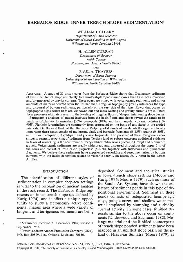
F10. 1.-lndex map for Barbados. Inset map shows location of Barbados in the eastern part of the Caribbean Sea.
well as numerous other orogenic belts (Underwood and Bachman 1982).
This reconnaissance study is concerned with the diverse nature of sediments along one of the salient tectonic features of the Caribbean Sea, the Barbados Ridge. The paper describes the mineralogy, petrology, and microfaunal characteristics of the sediments and interprets the dominant sedimentary processes active on the Barbados Ridge (Fig. 1). There is a complex interaction between tectonic processes, volcanism, and multiple sediment sources in this area; and knowledge of the resulting patterns of sedimentation should be of use in attempts to interpret similar ancient deposits.
METHODS
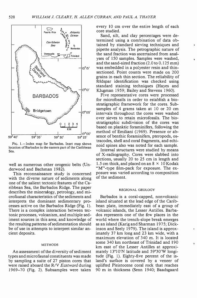
An assessment of the diversity of sediment types and microfaunal constituents was made by sampling a suite of 27 piston cores that were raised aboard the R/V Eastward during 1969-70 (Fig. 2). Subsamples were taken
every 10 cm over the entire length of each core studied.
Sand, silt, and clay percentages were determined using a combination of data obtained by standard sieving techniques and pipette analysis. The petrographic nature of the sand fraction was ascertained from analyses of 150 samples. Samples were washed, and the sand-sized fraction (2.0 to 0.125 mm) was embedded in a polyester resin and thinsectioned. Point counts were made on 200 grains in each thin section. The reliability of feldspar identification was checked using standard staining techniques (Hayes and Klugman 1959; Bailey and Stevens 1960).
Five representative cores were processed for microfossils in order to establish a biostratigraphic framework for the cores. Subsamples of 4 grams taken at 10 or 20 cm intervals throughout the cores were washed over sieves to retain microfossils. The biostratigraphic subdivision of the cores was based on planktic foraminifers, following the method of Emiliani (I 969). Presence or absence of benthic foraminifers, pteropods, ostracodes, shell and coral fragments, and echinoid spines also was noted for each sample.
Internal structures were studied by means of X-radiography. Cores were slabbed into sections, usually 20 to 25 cm in length and 1.5 cm thick, and placed on an 8 x 10 Kodak "M"-type film-pack for exposure. The exposure was varied according to composition of the sediment.
REGIONAL GEOLOGY
Barbados is a coral-capped, nonvolcanic island situated at the lead edge of the Caribbean plate, immediately east of a group of volcanic islands, the Lesser Antilles. Barbados represents one of the few places in the world where the trench-slope break emerges as an island (Karig and Sharman 1975; Dickinson and Seely 1979). The island is approximately 37 km long and 23 km wide, with a maximum elevation of 340 m. It is located some 340 km northeast of Trinidad and 190 km east of the Lesser Antilles at approximately 13°1 0'N latitude and 59'30'W longitude (Fig. 1). Eighty-five percent of the island's surface is covered by a veneer of uplifted Pleistocene coral rock that reaches 90 m in thickness (Senn 1940; Baadsgaard
BARBADOS RIDGE SEDIMENTATION 529
13°
30'
13°
00'
0 10
Nautical Miles
L_ _____ ---1._uc._=z::_"""=�..L-'--L.::;====s.__1_--c-. 1_._= _1o ____ o_F _ _J 12,30,
60° 30 1 60° 00 1
59°
001
58°
301
Fm. 2.-Bathymetric chart of the Barbados Ridge showing locations of cores used in this study. Cores identified with an asterisk and number are portrayed in Figure 5. (Modified after unpublished data from J. G. Newton, 1972.)
1960;Macintyre 1967;andJames 1972). The remaining area, the Scotland District, is an erosional window into underlying folded and faulted strata of Tertiary age.
Deep test wells confirm the presence of a thick, structurally complex group of Tertiary strata beneath the entirety of Barbados (Baadsgaard 1960). Although 4,583 m ofTertiary sediments were encountered during drilling, the true thickness is unknown since the section is often repeated by isoclinal folding, faulting, and bedding plane shearing (Senn 1940, 1947; Baadsgaard 1960; and Daviess I 97 l).
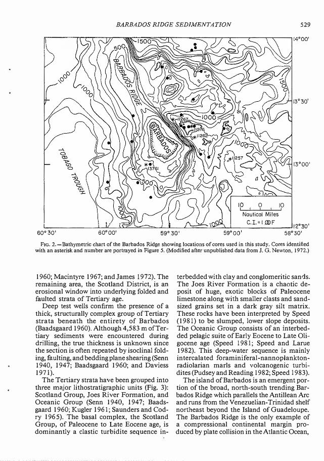
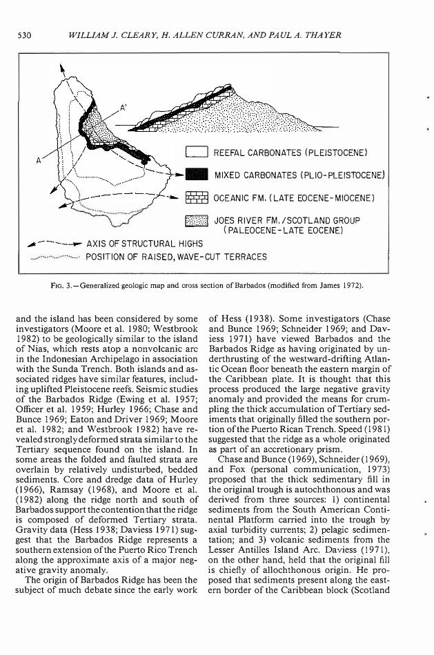
The Tertiary strata have been grouped into three major lithostratigraphic units (Fig. 3): Scotland Group, Joes River Formation, and Oceanic Group (Senn 1940, 194 7; Baadsgaard 1960; Kugler 1961; Saunders and Codry I 96 5). The basal complex, the Scotland Group, of Paleocene to Late Eocene age, is dominantly a elastic turbidite sequence in-
terbedded with clay and conglomeritic san1s. The Joes River Formation is a chaotic deposit of huge, exotic blocks of Paleocene limestone along with smaller clasts and sandsized grains set in a dark gray silt matrix. These rocks have been interpreted by Speed (1981) to be slumped, lower slope deposits. The Oceanic Group consists of an interbedded pelagic suite of Early Eocene to Late Oligocene age (Speed 1981; Speed and Larue 1982). This deep-water sequence is mainly intercalated foraminiferal-nannoplanktonradiolarian marls and volcanogenic turbidites (Pudsey and Reading 1982; Speed l 983).
The island of Barbados is an emergent portion of the broad, north-south trending Barbados Ridge which parallels the Antillean Arc and runs from the Venezuelian-Trinidad shelf northeast beyond the Island of Guadeloupe. The Barbados Ridge is the only example of a compressional continental margin produced by plate collision in the Atlantic Ocean,
530 WILLIAM J. CLEARY, H. ALLEN CURRAN, AND PAULA. THAYER
A
.,,.,,..
LJ REEFAL CARBONATES (PLEISTOCENE)
-- MIXED CARBONATES (PLIO-PLEISTOCENE)
ffi OCEANIC FM, (LATE EOCENE-MIOCENE)
H,}}j JOES RIVER FM, /SCOTLAND GROUP ( PALEOCENE-LATE EOCENE)
,,,,------ AXIS OF STRUCTURAL HIGHS ··· POSITION OF RAISED, WAVE-CUT TERRACES
FIG. 3.-Generalized geologic map and cross section of Barbados (modified from James 1972).
and the island has been considered by some investigators (Moore et al. 1980; Westbrook 1982) to be geologically similar to the island of Nias, which rests atop a non volcanic arc in the Indonesian Archipelago in association with the Sunda Trench. Both islands and associated ridges have similar features, including uplifted Pleistocene reefs. Seismic studies of the Barbados Ridge (Ewing et al. 1957; Officer et al. 1959; Hurley 1966; Chase and Bunce 1969; Eaton and Driver 1969; Moore et al. 1982; and Westbrook 1982) have revealed strongly deformed strata similar to the Tertiary sequence found on the island. In some areas the folded and faulted strata are overlain by relatively undisturbed, bedded sediments. Core and dredge data of Hurley (1966), Ramsay (1968), and Moore et al. (1982) along the ridge north and south of Barbados support the contention that the ridge is composed of deformed Tertiary strata. Gravity data (Hess 1938; Daviess 1971) suggest that the Barbados Ridge represents a southern extension of the Puerto Rico Trench along the approximate axis of a major negative gravity anomaly.
The origin of Barbados Ridge has been the subject of much debate since the early work
of Hess (1938). Some investigators (Chase and Bunce 1969; Schneider I 969; and Daviess 1971) have viewed Barbados and the Barbados Ridge as having originated by underthrusting of the westward-drifting Atlantic Ocean floor beneath the eastern margin of the Caribbean plate. It is thought that this process produced the large negative gravity anomaly and provided the means for crumpling the thick accumulation of Tertiary sediments that originally filled the southern portion of the Puerto Rican Trench. Speed (1981) suggested that the ridge as a whole originated as part of an accretionary prism.
Chase and Bunce (I 969), Schneider (1969), and Fox (personal communication, 1973) proposed that the thick sedimentary fill in the original trough is autochthonous and was derived from three sources: 1) continental sediments from the South American Continental Platform carried into the trough by axial turbidity currents; 2) pelagic sedimentation; and 3) volcanic sediments from the Lesser Antilles Island Arc. Daviess (1971), on the other hand, held that the original fill is chiefly of allochthonous origin. He proposed that sediments present along the eastern border of the Caribbean block (Scotland
BARBADOS RIDGE SEDIMENTATION 531
Group) slid downslope (olistostrome) in Early Tertiary time into the Puerto Rico Trench. Results from the Deep Sea Drilling Project (DSDP) Leg 78A, on a track northeast of Barbados, have indicated that pelagic and hemipelagic sediments are being both accreted and subducted along the inner trench wall. The stratigraphic column of Site 541 (approximately 260 km northeast of Barbados) shows a stratigraphic inversion of Miocene and younger sediments in a folded, faulted, and thickened unit (Moore et al. 1982).
Over the last ten years, a large quantity of geophysical data has been obtained from the Barbados Ridge (Westbrook 1975, 1982; Peter and Westbrook 1976; Biju-Duval et al. 1978, 1982; Moore et al. 1982). These data and DSDP core data have been used to support the previously mentioned idea that the ridge represents part of a wide accretionary sediment pile that developed in conjunction with the evolution of the Lesser Antilles Arc (Westbrook 1975, 1982; Speed 1981). Seismic studies suggest that the Tobago Trough and the Barbados Ridge together comprise an exceptionally broad forearc region (Westbrook 1975, 1982; Speed I 981). The island of Barbados represents an exposure of this wide, mature forearc complex near its thickest point (Speed 1981).
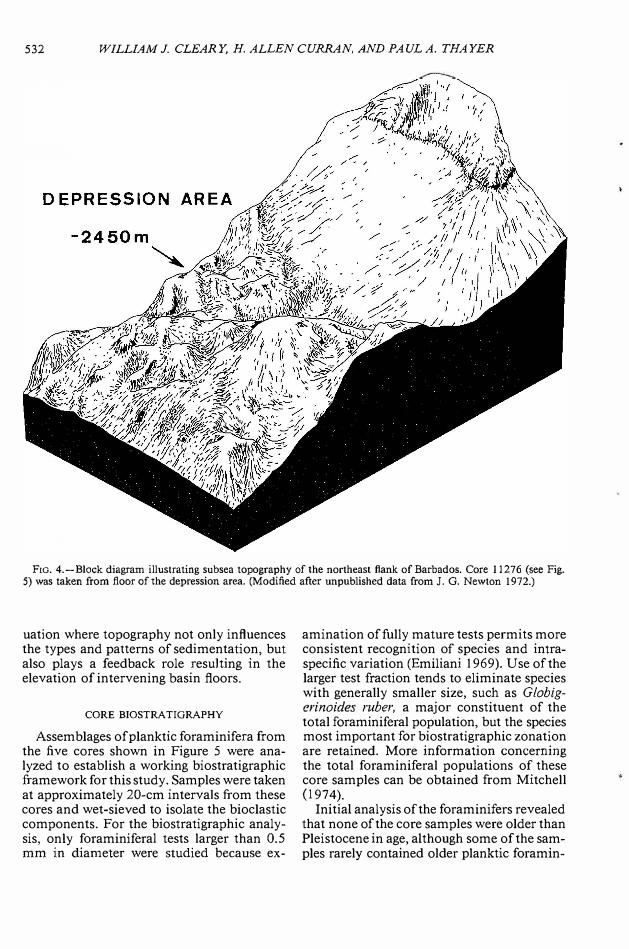
Although much work has been done on Barbados subaerial geology, few studies have dealt with the offshore sediments, submarine rock outcrops, or subsea depositional environments. Macintyre (1967, 1970) studied reefs and shelf sediments on the west side of the island, and Hurley (1966) and Ramsay (1968) did limited dredging and coring on the Barbados Ridge north and south of the island. To date, there have been no published studies concerned with the eastern shelf and slope of Barbados, or with river and beach sediments of the island.
SEDIMENTS
The general surface of the Barbados Ridge (Figs. 2, 4) is blanketed by a light to dark brown, thin (10-100 cm) calcilutite layer. These sediments are generally fine-grained and of Holocene age. A variety of interbedded, gray to brown, fine- and coarse-grained gravity current em placed sequences (10-280 cm thick) occur below this upper mud cover
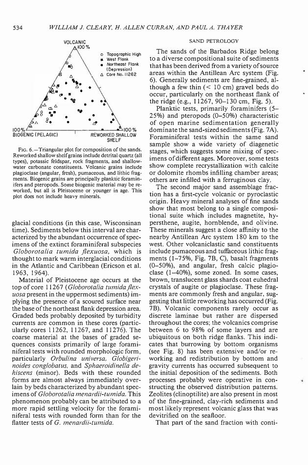
(Fig. 5). Several processes are active along the ridge and have resulted in the deposition of unique units with a complicated sedimentary history. The sediments within these units can be grouped into three categories and include: 1) pelagic; 2) hemipelagic (volcanic); and 3) recycled sediments (Fig. 6).
The pelagic sediments, which are dominant, are normally light brown to tan, the lighter color generally reflecting the high carbonate content. Sand- and silt-sized grains which are included as pelagic constituents are volumetrically less important and consist primarily of pteropods and foraminifers. Nannoplankton are important clay- and siltsized constituents of the pelagic oozes, but their presence was only noted during cursory examination and not studied.
Hemipelagic sediment consists primarily of volcanogenic sediments that have been spread across the Barbados Ridge as a result of eruptions in the nearby Antillean Arc to the west. Terrigenous clays from the island of Barbados may be delivered to the deep-sea and may be locally important, particularly on the east side of the island, but volumetrically, the terrigenous clays are probably not significant.
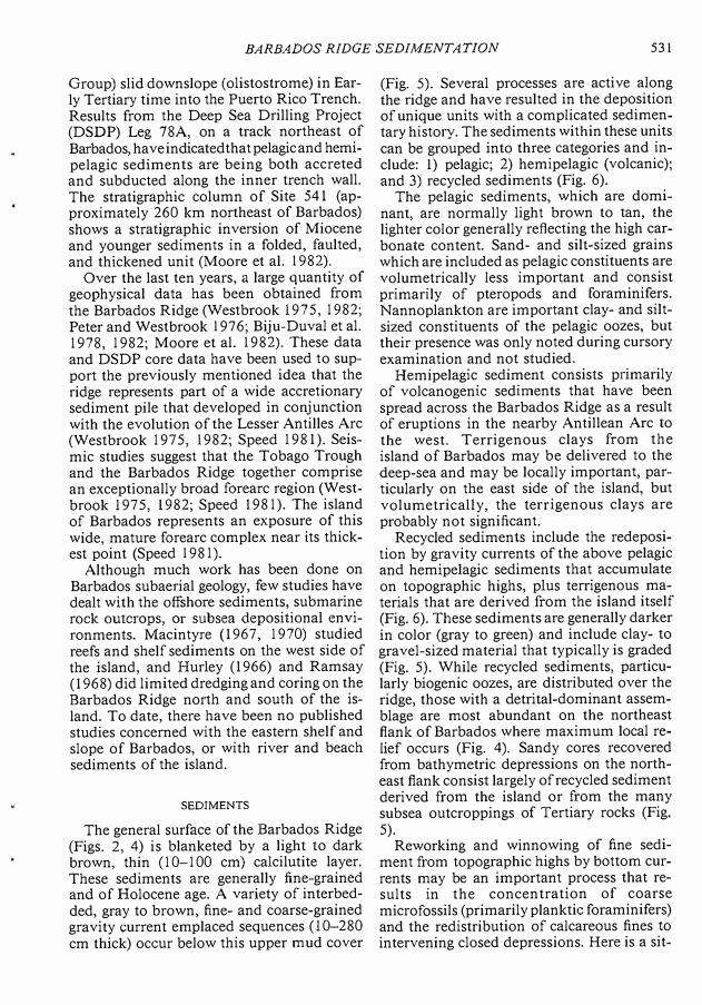
Recycled sediments include the redeposition by gravity currents of the above pelagic and hemipelagic sediments that accumulate on topographic highs, plus terrigenous materials that are derived from the island itself (Fig. 6). These sediments are generally darker in color (gray to green) and include clay- to gravel-sized material that typically is graded (Fig. 5). While recycled sediments, particularly biogenic oozes, are distributed over the ridge, those with a detrital-dominant assemblage are most abundant on the northeast flank of Barbados where maximum local relief occurs (Fig. 4). Sandy cores recovered from bathymetric depressions on the northeast flank consist largely of recycled sediment derived from the island or from the many subsea outcroppings of Tertiary rocks (Fig. 5).
Reworking and winnowing of fine sediment from topographic highs by bottom currents may be an important process that results in the concentration of coarse microfossils (primarily planktic foraminifers) and the redistribution of calcareous fines to intervening closed depressions. Here is a sit-
532 WILLIAM J. CLEARY, H. ALLEN CURRAN, AND PAUL A. THAYER
F1G. 4.-Block diagram illustrating subsea topography of the northeast flank of Barbados. Core l I 276 (see Fig. 5) was taken from floor of the depression area. (Modified after unpublished data from J. G. Newton 1972.)
uation where topography not only influences the types and patterns of sedimentation, but also plays a feedback role resulting in the elevation of intervening basin floors.
CORE BIOSTRA TIGRAPHY
Assemblages of planktic foraminifera from the five cores shown in Figure 5 were analyzed to establish a working biostratigraphic framework for this study. Samples were taken at approximately 20-cm intervals from these cores and wet-sieved to isolate the bioclastic components. For the biostratigraphic analysis, only foraminiferal tests larger than 0.5 mm in diameter were studied because ex-
amination of fully mature tests permits more consistent recognition of species and intraspecific variation (Emiliani 1969). Use of the larger test fraction tends to eliminate species with generally smaller size, such as Globigerinoides ruber, a major constituent of the total foraminiferal population, but the species most important for biostratigraphic zonation are retained. More information concerning the total foraminiferal populations of these core samples can be obtained from Mitchell (I 974).
Initial analysis of the foraminifers revealed that none of the core samples were older than Pleistocene in age, although some of the samples rarely contained older planktic foramin-
BARBADOS RIDGE SEDIMENTATION 533
WEST
f--FLANK"" 1----- EAST FLAN K-------1
SW
HIGH
SE
HIGH
- ,-.--�-
7:..!.-::::::--11- .. --'
- ,.._-jj
-�- ,..-- .. -,1- .. _,--jj-
--,..-
-..E_ il -11 jj- �-7-t:JC -Jl-.!...Jf -w\1-..
-� ... -�\j -�-
EAST
HIGH
.. ., .. ,; • .tJ• . . . . . �.
:.4: .. :.: .. :._li-,£t.5.tif ·'."',·.� ·
NE EAST
DEPRESSION
11267
13761
I
D:: 1410 m
D::2200 m
D=2450 m
11257
I
11262
I
11276
j
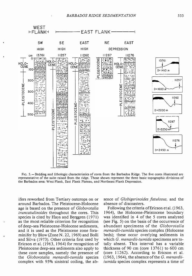
F1G. 5.-Bedding and lithologic characteristics of cores from the Barbados Ridge. The five cores illustrated are representative of the suite raised from the ridge. Those shown represent the three basic topographic divisions of the Barbados area: West Flank, East Flank Plateau, and Northeast Flank Depression.
ifers reworked from Tertiary outcrops on or around Barbados. The Pleistocene-Holocene age is based on the presence of G/oborota/ia truncatulinoides throughout the cores. This species is cited by Hays and Berggren ( l 971) as the most reliable criterion for recognition of deep-sea Pleistocene-Holocene sediments, and it is used as the Pleistocene zone foraminifer by Blow (Zone N. 22, l 969) and Bolli and Silva (l 973). Other criteria first used by Ericson et al. (l 963, 1964) for recognition of Pleistocene deep-sea sediments also apply to these core samples, namely the presence of the Globorotalia menardii-tumida species complex with 95% sinistral coiling, the ab-
sence of Globigerinoides fistulosus, and the absence of discoasters.
Following the criteria ofEricson et al. (l 963, l 964), the Holocene-Pleistocene boundarywas identified in 4 of the 5 cores analyzed(see Fig. 5) on the basis of the occurrence ofabundant specimens of the G/oborotaliamenardii-tumida species complex (Holocenebeds); these occur overlying sediments inwhich G. menardii-tumida specimens are totally absent. This interval has a variablethickness of 90 cm ( core 13 7 6 l) to 600 cm(core 11262). According to Ericson et al.(l 963, l 964), the absence of the G. menardiitumida species complex represents a time of
534 WILLIAM J. CLEARY, H. ALLEN CURRAN, AND PAUL A. THAYER
VOLCANIC 100%
•
•
.,,
•
o Topographic High • West Flank • Northeast Flank
(Depression) 6'. Core No, 11262
• • •
• • ,,. ••
IOO%L----------��-.c,100% BIOGEN IC (PELAGIC) REWORKED SHALLOW
SHELF
FJG. 6.-Triangular plot for composition of the sands. Reworked shallow shelf grains include dctrital quartz (all types), potassic feldspar, rock fragments, and shallowwater carbonate constituents. Volcanic grains include plagioclase (angular, fresh), pumaceous, and lithic fragments. Biogenic grains are principally planktic foraminifers and pteropods. Some biogenic material may be reworked, but all is Pleistocene or younger in age, This plot does not include heavy minerals.
glacial conditions (in this case, Wisconsinan time). Sediments below this interval are characterized by the abundant occurrence of specimens of the extinct foraminiferal subspecies Globorotalia tumida j/exuosa, which is thought to mark warm interglacial conditions in the Atlantic and Caribbean (Ericson et al. 1963, 1964).
Material of Pleistocene age occurs at the top of core 11267 ( Globorotalia tumidaflexuosa present in the uppermost sediments) implying the presence of a scoured surface near the base of the northeast flank depression area. Graded beds probably deposited by turbidity currents are common in these cores (particularly cores I 1262, 11267, and l 1276). The coarse material at the bases of graded sequences consists primarily of large foraminiferal tests with rounded morphologic form, particularly Orbulina universa. G/obigerinoides conglobatus, and Sphaeroidinella dehiscens (minor). Beds with these rounded forms are almost always immediately overlain by beds characterized by abundant specimens of Globorotalia menardii-tumida. This phenomenon probably can be attributed to a more rapid settling velocity for the foraminiferal tests with rounded form than for the flatter tests of G. menardii-tumida.
SAND PETROLOGY
The sands of the Barbados Ridge belong to a diverse compositional suite of sediments that has been derived from a variety of source areas within the Antillean Arc system (Fig. 6). Generally sediments are fine-grained, although a few thin ( < IO cm) gravel beds do occur, particularly on the northeast flank of the ridge (e.g., 11267, 90-130 cm, Fig. 5).
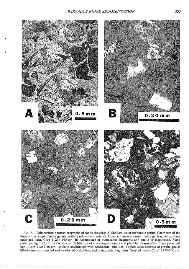
Planktic tests, primarily foraminifers (5-25%) and pteropods (0-50%) characteristic of open marine sedimentation generally dominate the sand-sized sediments (Fig. 7 A). Foraminiferal tests within the same sand sample show a wide variety of diagenetic stages, which suggests some mixing of specimens of different ages. Moreover, some tests show complete recrystallization with calcite or dolomite rhombs infilling chamber areas; others are infilled with a ferruginous clay.
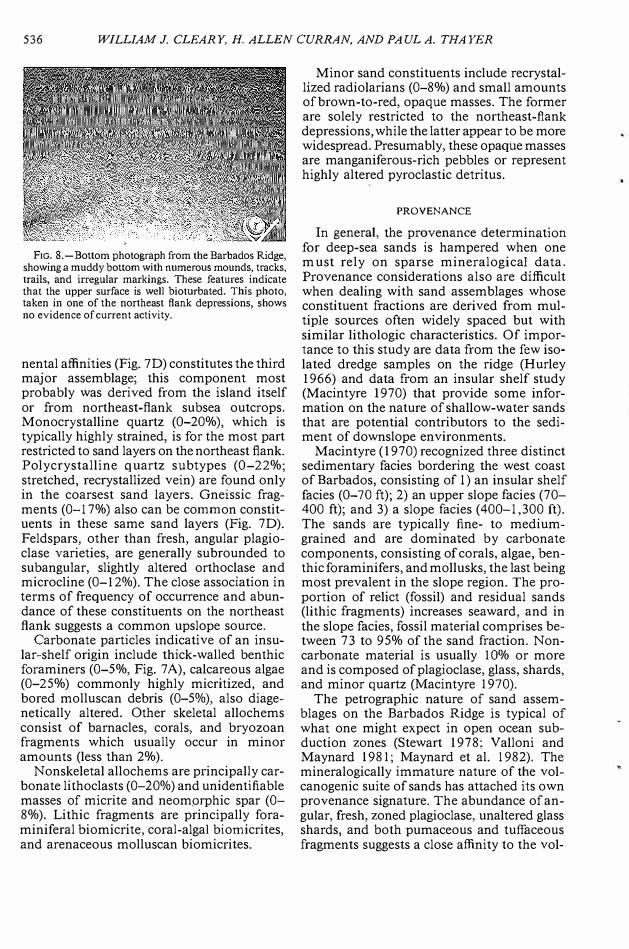
The second major sand assemblage fraction has a first-cycle volcanic or pyroclastic origin. Heavy mineral analyses of fine sands show that most belong to a single compositional suite which includes magnetite, hypersthene, augite, hornblende, and olivine. These minerals suggest a close affinity to the nearby Antillean Arc system 180 km to the west. Other volcaniclastic sand constituents include pumaceous and tuffaceous lithic fragments (1-75%, Fig. 7B, C), basalt fragments (0-50%), and angular, fresh calcic plagioclase (l-40%), some zoned. In some cases, brown, translucent glass shards coat euhedral crystals of augite or plagioclase. These fragments are commonly fresh and angular, suggesting that little reworking has occurred (Fig. 7B). Volcanic components rarely occur as discrete laminae but rather are dispersed throughout the cores; the volcanics comprise between 6 to 98% of some layers and are ubiquitous on both ridge flanks. This indicates that burrowing by bottom organisms (see Fig. 8) has been extensive and/or reworking and redistribution by bottom and gravity currents has occurred subsequent to the initial deposition of the sediments. Both processes probably were operative in constructing the observed distribution patterns. Zeolites (clinoptilite) are also present in most of the fine-grained, clay-rich sediments and most likely represent volcanic glass that was devitrified on the seafloor.
That part of the sand fraction with con ti-
BARBADOS RIDGE SEDIMENTATION 535
A 0,5mm B
C D
Fm. 7 .-Thin-section photomicrographs of sands showing: A) Shallow-water carbonate grains. Chambers of the foraminifer Amphistegina sp. are partially infilled with micrite. Opaque masses are micritized algal fragments. Plane polarized light, Core 11264-240 cm. B) Assemblage of pumaceous fragments and augite or piagioclase. Plane polarized light, Core 13753-190 cm. C) Mixture ofvolcanogenic sands and planktic foraminifers. Plane polarized light, Core 11267-50 cm. D) Sand assemblage with continental affinities. Typical suite consists of granite gneiss Ii tho fragments, rounded and weathered orthoclase, and metaquartz fragments. Crossed nicols, Core 11273-220 cm.
536 WILLIAM J. CLEARY, H. ALLEN CURRAN, AND PAUL A. THAYER
F1G. 8.-Bottom photograph from the Barbados Ridge, showing a muddy bottom with numerous mounds, tracks, trails, and irregular markings. These features indicate that the upper surface is well bioturbated. This photo, taken in one of the northeast flank depressions, shows no evidence of current activity.
nental affinities (Fig. 7D) constitutes the third major assemblage; this component most probably was derived from the island itself or from northeast-flank subsea outcrops. Monocrystalline quartz (0-20%), which is typically highly strained, is for the most part restricted to sand layers on the northeast flank. Polycrystalline quartz subtypes (0-22%; stretched, recrystallized vein) are found only in the coarsest sand layers. Gneissic fragments (0-17%) also can be common constituents in these same sand layers (Fig. 7D). Feldspars, other than fresh, angular plagioclase varieties, are generally subrounded to subangular, slightly altered orthoclase and microcline (0-12%). The close association in terms of frequency of occurrence and abundance of these constituents on the northeast flank suggests a common upslope source.
Carbonate particles indicative of an insular-shelf origin include thick-walled benthic foraminers (0-5%, Fig. 7 A), calcareous algae (0-25%) commonly highly micritized, and bored molluscan debris (0-5%), also diagenetically altered. Other skeletal allochems consist of barnacles, corals, and bryozoan fragments which usually occur in minor amounts (less than 2%).
Nonskeletal allochems are principally carbonate lithoclasts (0-20%) and unidentifiable masses of micrite and neomprphic spar (0-8%). Lithic fragments are principally foraminiferal biomicrite, coral-algal biomicrites, and arenaceous molluscan biomicrites.
Minor sand constituents include recrystallized radiolarians (0-8%) and small amounts of brown-to-red, opaque masses. The former are solely restricted to the northeast-flank depressions, while the latter appear to be more widespread. Presumably, these opaque masses are manganiferous-rich pebbles or represent highly altered pyroclastic detritus.
PROVENANCE
In general, the provenance determination for deep-sea sands is hampered when one must rely on sparse mineralogical data. Provenance considerations also are difficult when dealing with sand assemblages whose constituent fractions are derived from multiple sources often widely spaced but with similar lithologic characteristics. Of importance to this study are data from the few isolated dredge samples on the ridge (Hurley 1966) and data from an insular shelf study (Macintyre 1970) that provide some information on the nature of shallow-water sands that are potential contributors to the sediment of downslope environments.
Macintyre (1970) recognized three distinct sedimentary facies bordering the west coast of Barbados, consisting of I) an insular shelf facies (0-70 ft); 2) an upper slope facies (70-400 ft); and 3) a slope facies (400-1,300 ft). The sands are typically fine- to mediumgrained and are dominated by carbonate components, consisting of corals, algae, benthic foraminifers, and mollusks, the last being most prevalent in the slope region. The proportion of relict (fossil) and residual sands (lithic fragments) increases seaward, and in the slope facies, fossil material comprises between 73 to 95% of the sand fraction. Noncarbonate material is usually 10% or more and is composed of plagioclase, glass, shards, and minor quartz (Macintyre 1970).
The petrographic nature of sand assemblages on the Barbados Ridge is typical of what one might expect in open ocean subduction zones (Stewart 1978; Valloni and Maynard 1981; Maynard et al. 1982). The mineralogically immature nature of the volcanogenic suite of sands has attached its own provenance signature. The abundance of angular, fresh, zoned plagioclase, unaltered glass shards, and both pumaceous and tuffaceous fragments suggests a close affinity to the vol-
BARBADOS RIDGE SEDIMENTATION 537
canic islands to the west. Preliminary heavy mineral analyses support this contention. Recent ash falls (1812 and 1902) related to volcanic activity on St. Vincent account for the presence of pyroclastic debris found in shelf and slope sands. Samples from both the ash fall and shelf pyroclastics have similar characteristics (Macintyre 1970). Although the exact source of the volcanogenic sands found in the cores cannot be determined, it seems most likely that Mt. Soufriere on the island of St. Vincent or another volcanic center in the Lesser Antilles chain has been the source.
The presence of mixtures ofrelatively fresh, shallow-water carbonate constituents, worn carbonate shells, and shallow-water lithic fragments (coral-algal biomicrites) indicates the immediate source area for these sands is the insular shelfand slope surrounding Barbados. This is to be expected, considering the close proximity of the island.
Sand grains with continental affinities, such as granite-gneiss, orthoclase, metaquartz, and strained monocrystalline quartz, suggest a derivation from the Tertiary rocks that comprise the core ofBarbados. The Early Tertiary Scotland Group, in particular, is comprised of folded, interbedded turbidite sequences. Seismic profiles across the Barbados Ridge north of Barbados reveal a thick sequence of highly contorted rocks (Westbrook 1982). Limited dredging in this area recovered flyschlike rocks similar to those that comprise the St. Andrews Formation on Barbados (Hurley 1966). Submarine erosion or mass wasting of subsea outcrops within canyons and slope gullies may account for the presence of these "continental" sands. The presence of recrystallized radiolarian frustules (I 0%) suggests the Tertiary outcrops of the Scotland Group are the immediate source rocks.
SAND DISPERSAL AND SEDIMENTARY PROCESSES
The recognition of source areas for sands found on the Barbados Ridge provides a good basis for interpreting both the dispersal history of these sediments and the depositional processes. We can recognize two source areas based on detrital sand-grain composition within this open-ocean environment where pelagic contributions are commonplace. The first of these is the Barbados Ridge
identified by the continental suite of detrital grains. The second source is the volcanic Antillean Arc to the west, which contributes the immature, volcanogenic, plagioclase-enriched sands.
Ash falls similar to those described by Teal (1902), Diller and Steiger (1902), and Sigurdsson et al. (I 980) were responsible for the widespread distribution and deposition of the pyroclastic sand assemblages. Their initial deposition resulted in the draping of a series of thin-sediment layers over the existing topography identical to normal pelagic settling. Subsequent winnowing by bottom currents transported much of the fine material, resulting in redeposition in other areas. In addition, mass wasting along topographic highs may rework some of these discrete layers and transport the pelagic grains (foraminifers and pteropods) together with the volcanogenic sediment into the bathymetric depressions that occur along the ridge. A similar sequence of events has been suggested as the cause for the emplacement of graded, foraminifer-rich calcilutite turbidites in lower slope basins now exposed on Nias Island, Indonesia (Moore et al. I 980).
Mass wasting on Barbados Ridge is probably similar to that which occurs subaerially on Barbados within the Scotland District (Fig. 1 ). Here mass wasting is an important process in modification of the landscape. The Scotland District, more completely described earlier, is partly composed of folded, interbedded, poorly consolidated silts and clays that are highly plastic. By their very nature these rocks are prone to slope failure, which leads to the formation of amphitheater-shaped scarps and hummocky topography where flows come to rest. One such flow, known as the Bascobel slip, was induced by heavy rains in 190 I and removed one square mile of material, ultimately leading to massive soil destruction (Price 1962). Events such as these may have been quite common along the ridge during the Pleistocene sea-level oscillations.
It seems plausible then to assume that mass wasting such as this has occurred on the upper slope off Barbados and in deeper-water environments where subsea outcrops of Tertiary rocks are reported to exist. At depths of 2,000 m on the insular slope off the northeast coast of Barbados, a number of steep escarpments occur (J. Newton, pers. comm.; and
538 WILLIAM J. CLEARY, H. ALLEN CURRAN, AND PAUL A. THAYER
RIV Eastward cruises, 1969-70). These have been interpreted to be slump features with arcuate forms, and all have precipitous slopes, relief up to 130 m, and talus piles at their bases. These forms are similar to documented features related to slumping in a variety of other submarine tectonic settings (Moore 1977; Dingle 1977; Embley and Jacobi 1977; and Embley 1982).
Inspection by the authors of echograms (RIV Eastward cruises (1969-70) shows that similar features abound along the northeast flank. Coring at the base of the steep slopes (Fig. 5) or in intervening depressions that separate the numerous topographic highs has revealed sections of graded bioclastic and detrital turbidites (Fig. 5; e.g., 11267, 90-130 cm). The emplacement of these beds results in the infilling of the depressions and leveling of the floors of those basins closest to the island.
CONCLUSIONS
This study, while descriptive in nature, shows that sediments of the Barbados Ridge are diverse in terms of provenance, dispersal, and mode of emplacement. The nature of depositional processes active within this geologic setting can be deduced from sediment texture, compositional analyses of sand constituents, and the nature of the microfaunal assemblages.
The following conclusions are drawn from analyses of the observed sedimentary patterns:
I) The distribution and abundance of lutites and biogenic oozes in the upper IO m of the sediment column indicate that pelagic settling has been the dominant sedimentation process operative on the Barbados Ridge from Late Pleistocene through Holocene time.
2) Carbonate sands of insular shelf originand rework,d terrigenous material found in thick, graded sand interbeds indicates that turbidity-current activity is responsible for the emplacement of ponded sediments.
3) Steep subsea scarps and talus piles andcomparisons with land geology suggest that subsea mass wasting is an active process on the Barbados Ridge.
4) Topography influences the type and dispersal of sediment, particularly on the northeast flank of the island. Reworking occurs on
topographic highs where fines are winnowed and gravity sedimentation is initiated. Deposition resulting from these downslope movements ultimately produces the flat floors of the small sediment ponds.
5) The ubiquitous occurrence of fresh volcanogenic sediments throughout the cores suggests that (a) bottom currents have been an important process in redistributing these sediments since their initial deposition, and (b) burrowing by bottom organisms is important in mixing volcanogenic sedimentsthroughout the upper sediment column.
ACKNOWLEDGMENTS
We wish to express our appreciation to the Duke University Oceanography Program for use of the R/V Eastward. The project was originally initiated by 0. H. Pilkey Jr., Duke University, from whom the cores were obtained.
Cooperation and suggestions during various phases of the study from J. G. Newton, I. G. Macintyre, and 0. H. Pilkey Jr. aregratefully acknowledged. Numerous studentsat the University of North Carolina-Wilmington and Smith College assisted duringvarious phases of the study, including D. A.Mitchell (Smith), H. Whitlley, J. Hostettler,J. Burnette, G. Pyles, and S. Smith (allUNC-W). We thank M. E. Field, U.S. Geological Survey, G. F. Moore, Cities ServiceCompany, and M. B. Underwood, Universityof Missouri, for reviewing the manuscript andproviding helpful criticism.
REFERENCES
BAADSGAARD, P.H., 1960, Barbados, W. I.: Exploration results 1950-1958: Copenhagen, 21st Internat. Geol. Cong. Rept., pt. 18, p. 21-27.
BAILEY, E. H., AND STEVENS, R. F., 1960, Selective staining of K-feldspar and plagioclase on rock slabs and thin sections: Am. Mineral., v. 45, p. 1020-1025.
Buu-DUVAL, B., MASCALE, A., MONTADERT, L., AND
WANNES0N, J ., 1978, Seismic investigations in the Colombia, Venezuela and Grenada basins, and on the Barbados Ridge for future IPOD drilling: Geol. Mijnbouw, v. 57, p. 105-106.
Buu-DUVAL, B., LEQUELLEE, P., MASCALE, A., RENARD, V., AND VALERY, P., 1982, Multibeam bathymetric survey and high resolution seismic investigations on the Barbados Ridge Complex (Eastern Caribbean): A key to knowledge and interpretation ofan accretionary wedge: Tectonophysics, v. 86, p. 275-304.
BLOW, W. H., 1969, Late Middle Eocene to Recent
BARBADOS RIDGE SEDIMENTATION 539
planktonic foraminiferal biostratigraphy, in Bronnimann, P., and Renz, H. H., eds., Proceedings of the First International Conference on Planktonic Microfossils, v. 1: Leiden, E. J. Brill, p. 199-422.
BoLu, H. M., AND SILVA, I. P., 1973, Oligocene to Recent planktonic foraminifera and stratigraphy of the Leg 15 sites in the Caribbean Sea, in Edgar, N. T., eds., Initial Reports of the Deep Sea Drilling Project, Volume XV: Washington, U.S. Government Printing Office, p. 475-497.
CHASE, R. L., AND BUNCE, E.T., 1969, Underthrusting of the eastern margin of the Antilles by the floor of the western North Atlantic Ocean and origin of the Barbados Ridge: Jour. Geophys. Research, v. 74, p, 1413-1420.
DAVIESS, S. N., 1971, Barbados: A major submarine gravity slide: Geol. Soc. America Bull., v. 82, p. 2593-2602.
DICKINSON, w. R., AND SEELY, D, R, 1979, Structure and stratigraphy of fore arc regions: Am. Assoc. Petroleum Geologists Bull., v. 63, p. 2-3 L
DILLER, J. s., AND STEIGER, G,, 1902, Volcanic dust and sand from St. Vincent caught at sea and at Barbados: Science, v. 15, p, 947-950.
DINGLE, R. V., 1977, The anatomy of a large submarine slump on a sheared continental margin (SE Africa): lour. GeoL Soc. London, v. 134, p. 293-310.
EATON, J. F., AND DRIVER, E. S., 1969, Geophysical investigations in the eastern Caribbean: Curacao Ridge to Barbados: EOS, v. 50, p. 208.
EMBLEY, R. W., 1982, Anatomy of some Atlantic margin sediment slides and some comments on ages and mechanisms, in Saxon, S., and Nieumenhuis, J. K., eds., Marine slides and other mass movements, NATO Conference Series IV, Marine Sciences: New York, Plenum, p, l 89-2 I 3.
EMBLEY, R. w., AND JACOBI, R. D., 1977, Distribution and morphology of large submarine sediment slides and slumps on Atlantic continental margins: Marine Geotechnology, v. 2 (Marine Stability), p. 205-228.
EMILIANI, C., 1969, A new paleontology: Micropa!eontology, v. 15, p. 265-300.
ERICSON, D. 8., EWING, M., AND WOLLIN, G., 1963, Pliocene-Pleistocene boundary in deep-sea sediments: Science, v. 139, p. 727-737.
ERICSON, D. B., EWING, M., AND WOLLIN, G., 1964, The Pleistocene epoch in deep-sea sediments: Science, v. 146, p. 723-732.
EWING, J. I., OFFICER, C. B., JOHNSON, H. R., AND EDWARDS, R. D., 1957, Geophysical investigations in the eastern Caribbean: Trinidad Shelf, Tobago Trough, Barbados Ridge, Atlantic Ocean: Geo!. Soc. America Bull., v. 68, p. 897-9 I 2.
HAYES, J. R., AND KLUGMAN, M. A., 1959, Feldspar staining methods: Jour. Sed. Petrology, v. 29, p. 227-232.
HAYS, J. D., AND BERGGREN, w. A., 1971, Quaternary boundaries and correlations, in Funnell, B. M., and Reidel, W.R., eds., Micropaleontology of the Oceans: Cambridge, Cambridge University Press, p. 669-691.
HESS, H. H., 1938, Gravity anomalies and island arc structure with particular reference to the West Indies: Am. Philos. Soc. Proc., v. 79, p, 71-96.
HURLEY, R. J., 1966, Geological studies of the West Indies: Canada Geol. Survey Paper 66-15, p. 139-150.
JAMES, N. P., 1972, Late Pleistocene reef limestones, northern Barbados, W. I. [unpub. Ph.D. thesis]: Montreal, McGill University, 242 p.
KARIG, D. E., I 974, Evolution of arc systems in the western Pacific: Earth and Planetary Sci. Annual Review, v. 2, p. 151-175.
KARIG, D. E., AND SHARMAN, G. F., 1975, Subduction and accretion in trenches: Geo!. Soc. America Bull., v. 86, p. 377-389.
KUGLER, H. G., 1961, Tertiary of Barbados: Geo!. Mag., v. 98, p. 348-350.
MACINTYRE, I. G., 1967, Submerged coral reefs, west coast of Barbados, West Indies: Can. lour. Earth Sci., V. 4, p. 461-474.
---, 1970, Sediments off the west coast of Barbados: Diversity of origins: Marine Geology, v. 9, p. 5-23.
MAYNARD, J, B., VALLON!, R., AND Yu, H. S., 1982, Composition of modern deep-sea sands from arc-related basins, in Legett, J. K., ed., Trench forearc geology: Sedimentation and tectonics in modern and ancient active plate margins: Geological Society of London, Spec. Pub!. 10, London, Blackwell Scientific Publications, p. 551-561.
MITCHELL, D. A., 1974, A microfaunal analysis of some Barbados core samples [unpubl. B.S. thesis]: Northampton, Massachusetts, Smith College, 61 p.
MOORE, D. G., 1977, Submarine slides, in Voight, B,, ed., Rockslides and Avalanches, v. l , Natural Phenomena: Developments in Geotechnical Engineering, 14A, p. 564-604.
MooRE, G. F., l 979, Petrography of subduction zone sandstones from Nias Island, Indonesia: Jour. Sed. Petrology, v. 49, p. 71-84.
MOORE, G. F., AND l<ARIG, 0. E., 1976, Development of sedimentary basins on the lower trench slope: Geology, v. 4, p. 693-697.
MOORE, G. F., BILLMAN, H. G., HEHANUSSA, P. E., AND KAR1G, D. E., 1980, Sedimcntology and paleobathymetry of Neogene trench-slope deposits, Nias Island, Indonesia: lour. Geology, v. 88, p. 161-180.
MOORE, J. c., Buu-DUVAL, B., AND 16 OTHERS, 1982, Off scraping and underthrusting of sediment at the deformation front of the Barbados Ridge: Deep-sea Drilling Project Leg 78A: Geo!. Soc. America Bull., v. 93, p. 1065-1077.
OFFICER, C. B., EWING, J, I., HENNION, J, F., HARKRIDER, D. G., AND MtLLER, D. E., 1959, Geophysical investigations in the eastern Caribbean: Summary of 1955and 1956 cruises, in L. H. Ahrens, ed., Physics andchemistry of the Earth: New York, Pergamon Press,p. 17-109.
PETER, G., AND WESTBROOK, G. K., 1976, Tectonics of Southwestern North Atlantic and Barbados Ridge Complex: Am. Assoc. Petroleum Geologists Bull., v. 60, p. 1078-1106.
PRICE, E.T., 1962, Notes on the geography of Barbados: lour. Barbados Museum and Historical Society, v. 24, p. 119-154.
PUDSEY, C. J., AND READING, H. G., 1982, Sedimentology and structure of the Scotland Group, Barbados, in Legett, J. K., ed., Trench forearc geology: Sedimentation and tectonics on modern and ancient active plate margins: Geological Soc. London, Spec. Publ. l 0, London, Blackwell Scientific Publications, p. 197-214.
540 WILLIAM J. CLEARY, H. ALLEN CURRAN, AND PAUL A. THAYER
RAMSAY, A. T. S., 1968, A preliminary study of some Barbados Ridge cores: Maritime Sediments, v. 4, p. 108-112.
SAUNDERS, J. B., AND CODRY, w. G., 1965, The biostratigraphy of the Oceanic Formation in the Bath Cliff Section of Barbados: Trans. 4th Caribbean Geo!. Con(, Trinidad, p. 179-183.
SCHNEIDER, E. D., 1969, Models for rifted and compressional continental margins: Geo!. Soc. America Abs. w. Progr., v. 2, no. 7, p. 291-292.
SENN, A., 1940, Paleogene of Barbados and its bearing on history and structure of the Antillean-Caribbean region: Am. Assoc. Petroleum Geologists Bull., v. 24, p. 1548-1610.
---, 1947, Die Geologic der Insel Barbados B.W.I. (Kleine Antillen) und die Morphologcnse der Umliegenden Marinen Grossformen: Ecologae Geo!. Helvetiae, v. 40, p. I 99-222.
SJGURDSSON, H., SPARKS, R. S, J,, CAREY, S, N., AND HUANG, T. C., I 980, Volcanogenic sedimentation in the Lesser Antilles Arc: Jour. Geology, v. 88, p, 523-540.
SPEED, R. C., I 981, Geology of Barbados: Implications for an accretionary origin: Oceanologica Acta, Supp. 1, V, 4, p, 259-265.
---, 1983, Structure of the accretionary complex of Barbados, I: Chalky Mount: Geo!. Soc. America Bull., v. 94, p.92-116.
SPEED, R. C., AND LARUE, D. K., 1982, Barbados: Ar-
chitecture and implications for accretion: Jour. Geophys. Res., v. 85, p. 3633-3643.
STEWART, R. J., 1978, Neogene volcaniclastic sediments from Ataka Basin, Aleutian Ridge: Am. Assoc. Petroleum Geologists Bull., v. 62, p. 87-97.
TEAL, J. J, H., 1902, Volcanic dust from the West Indies: Nature, v. 66, p. 130.
UNDERWOOD, M. B., AND BACHMAN, S. B., 1982, Sedimentary facies associations within subduction complexes, in Legett, J. K., ed., Trench forearc geology: Sedimentation and tectonics on modern and ancient active plate margins: Geological Soc. London, Spec. Pub!. 10, London, Blackwell Scientific Publications, p, 537-550.
VALLON!, R., AND MAYNARD, J.B., I 981, Detrital modes of Recent deep-sea sands and their relation to tectonic setting: a first approximation: Sedimentology, v. 28, p. 75-83.
WESTBROOK, G, K., 1975, The structure of the crust and upper mantle in the region of Barbados and the Lesser Antilles: Geophys. Jour. Royal Astron. Soc., v. 43, p. 211-242.
---, I 982, The Barbados Ridge Complex: Tectonics of a mature forearc system, in Legett, J. K., ed., Trench forearc geology: Sedimentation and tectonics on modem and ancient active plate margins: Geological Soc. London, Spec. Pub!. 10, London, Blackwell Scientific Publications, p. 275-290.


