Embed Size (px)
Citation preview

NY Rising Community Reconstruction Program—Breezy Point
1
Breezy PointNY Rising Community Reconstruction PlanMARCH 2014
NY Rising Community Reconstruction Program

Breezy Point—NY Rising Community Reconstruction Program
Members of the Breezy Point NYRCR Planning CommitteeDenise Neibel (Chair)Tom BachJoanne FogartySteven GreenbergMarty IngramKathleen McEnroePete MullhollandArthur SmithRobert Taikina
All photos taken by Consultant Team unless
otherwise noted
This document was developed by the NY Rising Community Reconstruction (NYRCR) Breezy Point Planning Committee as part of the NYRCR Program within the Governor’s Office of Storm Recovery. The NYRCR Program is supported by New York State (NYS) Homes and Community Renewal, NYS Department of State, and NYS Department of Transportation.
The document was prepared by the following consultant firms:
• HR&A Advisors
• Parsons Brinckerhoff
• Beyer Blinder Belle Architects & Planners
• Mathews Nielsen Landscape Architects
• Hammes Company
• OpenPlans
• Johnson & Asberry
NY Rising Community Reconstruction Program—Breezy Point
Foreword Introduction
In the span of approximately one year, beginning in August 2011, the State of New York experienced three extreme weather events. Hurricane Irene, Tropical Storm Lee, and Superstorm Sandy wreaked havoc on the lives of New Yorkers and their communities. These tragic disasters signaled that New Yorkers are living in a new reality defined by rising sea levels and extreme weather events that will occur with increased frequency and power. They also signaled that we need to rebuild our communities in a way that will mitigate against future risks and build increased resilience.
To meet these pressing needs, Governor Andrew M. Cuomo led the charge to develop an innovative, community-driven planning program on a scale unprecedented and with resources unparalleled. The NY Rising Community Reconstruction (NYRCR) Program empowers the State’s most impacted communities with the technical expertise needed to develop thorough and implementable reconstruction plans to build physically, socially, and economically resilient and sustainable communities.
Program Overview
The NYRCR Program, announced by Governor Cuomo in April of 2013, is a more than $650 million planning and implementation process established to provide rebuilding and resiliency assistance to communities severely damaged by Hurricane Irene, Tropical Storm Lee, and Superstorm Sandy. Drawing on lessons learned from past recovery efforts, the NYRCR Program is a unique combination of bottom-up community participation and State-provided technical expertise. This powerful combination recognizes not only that community members are best positioned to assess the needs and opportunities of the places where they live and work, but also that decisions are best made when they are grounded in rigorous analysis and informed by the latest innovative solutions.
One hundred and two storm-affected localities across the State were originally designated to participate in the NYRCR Program. The State has allocated each locality between $3 million and $25 million to implement eligible projects identified in the NYRCR Plan. The funding for these projects is provided through the U.S. Department of Housing
and Urban Development (HUD) Community Development Block Grant – Disaster Recovery (CDBG-DR) program.1
Forty-five NYRCR Communities, each comprising one or more of the 102 localities, were created and led by a NYRCR Planning Committee composed of local residents, business owners, and civic leaders. Members of the Planning Committees were identified in consultation with established local leaders, community organizations, and in some cases municipalities. The NYRCR Program sets a new standard for community participation in recovery and resiliency planning, with community members leading the planning process. Across the State, more than 500 New Yorkers represent their communities by serving on Planning Committees. More than 400 Planning Committee Meetings have been held, during which Planning Committee members worked with the State’s NYRCR Program team to develop community reconstruction plans and identify opportunities to make their communities more resilient. All meetings were open to the public. An additional 125-plus Public Engagement Events attracted thousands of community members, who provided feedback on the NYRCR planning process and proposals. The NYRCR Program’s outreach has included communities that are

Breezy Point—NY Rising Community Reconstruction ProgramBreezy Point—NY Rising Community Reconstruction Program
traditionally underrepresented, such as immigrant populations and students. All planning materials are posted on the NYRCR Program’s website (www.stormrecovery.ny.gov/nyrcr), providing several ways for community members and the public to submit feedback on materials in progress.
Throughout the planning process, Planning Committees were supported by staff from the Governor’s Office of Storm Recovery (GOSR), planners from New York State (NYS) Department of State (DOS) and NYS Department of Transportation (DOT), and consultants from world-class planning firms that specialize in engineering, flood mitigation solutions, green infrastructure, and more.
With the January 2014 announcement of the NYRCR Program’s expansion to include 22 new localities, the program comprises over 2.7 million New Yorkers and covers nearly 6,500 square miles, which is equivalent to 14% of the overall State population and 12% of the State’s overall geography.
The NYRCR Program does not end with this NYRCR Plan. Governor Cuomo has allocated over $650 million of funding to the program for implementing projects identified in the NYRCR
Plans. NYRCR Communities are also eligible for additional funds through the program’s NY Rising to the Top Competition, which evaluates NYRCR Communities across eight categories, including best use of technology in the planning process, best approach to resilient economic growth, and best use of green infrastructure to bolster resilience. The winning NYRCR Community in each category will be allocated an additional $3 million of implementation funding. The NYRCR Program is also working with both private and public institutions to identify existing funding sources and create new funding opportunities where none existed before.
The NYRCR Program has successfully coordinated with State and Federal agencies to help guide the development of feasible projects. The program has leveraged the Regional Economic Development Council’s State Agency Review Teams (SARTs), comprised of representatives from dozens of State agencies and authorities, for feedback on projects proposed by NYRCR Communities. The SARTs review projects with an eye toward regulatory and permitting needs, policy objectives, and preexisting agency funding sources. The NYRCR Program is continuing to work with the SARTs to streamline the permitting process and ensure shovels are in the ground as quickly as possible.
On the pages that follow, you will see the results of months of thoughtful, diligent work by NYRCR Planning Committees, passionately committed to realizing brighter, more resilient futures for their communities.
The NYRCR Plan
This NYRCR Plan is an important step toward rebuilding a more resilient community. Each NYRCR Planning Committee began the planning process by defining the scope of its planning area, assessing storm damage, and identifying critical issues. Next, the Planning Committee inventoried critical assets in the community and assessed the assets’ exposure to risk. On the basis of this work, the Planning Committee described recovery and resiliency needs and identified opportunities. The Planning Committee then developed a series of comprehensive reconstruction and resiliency strategies, and identified projects and implementation actions to help fulfill those strategies.
The projects and actions set forth in this NYRCR Plan are divided into three categories. The order in which the projects and actions are listed in this NYRCR Plan does not necessarily indicate the NYRCR Community’s prioritization of these projects and actions. Proposed Projects are

NY Rising Community Reconstruction Program—Breezy PointNY Rising Community Reconstruction Program—Breezy Point
projects proposed for funding through a NYRCR Community’s allocation of CDBG-DR funding. Featured Projects are projects and actions that the Planning Committee has identified as important resiliency recommendations and has analyzed in depth, but has not proposed for funding through the NYRCR Program. Additional Resiliency Recommendations are projects and actions that the Planning Committee would like to highlight and that are not categorized as Proposed Projects or Featured Projects. The Proposed Projects and Featured Projects found in this NYRCR Plan were voted for inclusion by official voting members of the Planning Committee. Those voting members with conflicts of interest recused themselves from voting on any affected projects, as required by the NYRCR Ethics Handbook and Code of Conduct.
The Breezy Point NYRCR Community is eligible for up to $19.5 million in CDBG-DR implementation funds.2
While developing projects for inclusimon in this NYRCR Plan, Planning Committees took into account cost estimates, cost-benefit analyses, the effectiveness of each project in reducing risk to populations and critical assets, feasibility, and community support. Planning Committees also considered the potential likelihood that a project or action would be eligible for CDBG-DR
funding. Projects and actions implemented with this source of Federal funding must fall into a Federally-designated eligible activity category, fulfill a national objective (meeting an urgent need, removing slums and blight, or benefiting low to moderate income individuals), and have a tie to the natural disaster to which the funding is linked. These are among the factors that the Governor’s Office of Storm Recovery will consider, in consultation with local municipalities and nonprofit organizations, when determining which projects and actions are best positioned for implementation.
The total cost of Proposed Projects in this NYRCR Plan exceeds the NYRCR Community’s CDBG-DR allocation to allow for flexibility if some Proposed Projects cannot be implemented due to environmental review, HUD eligibility, technical feasibility, or other factors. Implementation of the projects and actions found in this NYRCR Plan are subject to applicable Federal, State, and local laws and regulations, including the Americans with Disabilities Act (ADA). Inclusion of a project or action in this NYRCR Plan does not guarantee that a particular project or action will be eligible for CDBG - DR funding or that it will be implemented. The Governor’s Office of Storm Recovery will actively seek to match projects with funding sources.
In the months and years to follow, many of the projects and actions outlined in this NYRCR Plan will become a reality helping New York not only to rebuild, but also to build back better.

Breezy Point—NY Rising Community Reconstruction Program

NY Rising Community Reconstruction Program—Breezy Point
ContentsExecutive summary _______________________________________________________________________________________ i
I. Community overviewA. Geographic scope of NYRCR Plan ______________________________________________________________________I–1
B. Description of storm damages _________________________________________________________________________I–7
C. Critical issues _______________________________________________________________________________________I–13
D. Community vision ___________________________________________________________________________________I–17
E. Relationship to regional plans _________________________________________________________________________I–21
II. Assessment of risk and needsA. Description of community assets and assessment of risk _________________________________________________ II–1
B. Assessment of needs and opportunities _______________________________________________________________ II–15
III. Reconstruction and resiliency strategiesReconstruction and resiliency strategies __________________________________________________________________III–1
IV. Implementation–project profilesOverview of proposed and featured projects _____________________________________________________________ IV–1
Enhanced dune walkways ______________________________________________________________________________ IV–3
Housing elevation study ________________________________________________________________________________ IV–7
Multi-purpose community relief center __________________________________________________________________ IV–11
Summer store relocation ______________________________________________________________________________ IV–19
Repaired docks ______________________________________________________________________________________ IV–23
Stormwater drainage improvements ____________________________________________________________________ IV–29

Breezy Point—NY Rising Community Reconstruction Program
Housing elevation study .................................................................................................................................... 17
Repair docking facilities for emergency use ..................................................................................................... 19
Multi-purpose community relief center ..............................................................................................................21
Relocation of summer stores .............................................................................................................................26
V. Additional materials .......................................................................1
Additional resiliency recommendations ..............................................................................................................2
Master table of projects ........................................................................................................................................3
Public engagement process .................................................................................................................................4
Community asset inventory ..................................................................................................................................7
Glossary .................................................................................................................................................................8
Endnotes ................................................................................................................................................................9
NY Rising Community Reconstruction Program—Breezy Point
Breezy/Rockaway Point bayside protection ______________________________________________________________ IV–37
Roxbury bayside protection ___________________________________________________________________________ IV–43
National Park Service (NPS) collaboration _______________________________________________________________ IV–51
Rockaway Point Boulevard elevation ___________________________________________________________________ IV–57
V. Additional materialsA. Additional resiliency recommendations _________________________________________________________________ V–1
B. Master table of projects ______________________________________________________________________________ V–4
C. Public engagement process __________________________________________________________________________ V–6
D. Community asset inventory __________________________________________________________________________ V–10
E. Related projects and programs _______________________________________________________________________ V–13
F. Glossary ___________________________________________________________________________________________ V–37
G. Endnotes __________________________________________________________________________________________ V–39

NY Rising Community Reconstruction Program—Breezy Point
FiguresFigure I-1: Breezy Point Planning Area _____________________________________________________________________I–2
Figure I-2: Superstorm Sandy Flood Level Map _____________________________________________________________I–8
Figure 1-3: Jamaica Bay Regional Overview _______________________________________________________________I–22
Figure II-1: New York State Department of State (NYS DOS) Risk Map ________________________________________ II–2
Figure II-2: Asset Map—Housing & Economic ______________________________________________________________ II–4
Figure II-3: Asset Map—Health & Social Services, Infrastructure, and Natural & Cultural _______________________ II–10
Figure II-4: Geographic Distribution of Risk Scores Map ____________________________________________________ II–12

Breezy Point—NY Rising Community Reconstruction Program
TablesTable III.1: Strategy: Improve and Expand Coastal Protection ________________________________________________III–6
Table III.2: Strategy: Strengthen Community resiliency ____________________________________________________ III–10
Table III.3: Strategy: Protect and bolster infrastructure ____________________________________________________ III–13
Table V.1: Additional resiliency recommendations __________________________________________________________ V–2
Table V.2: Master table of projects ________________________________________________________________________ V–4
Table V.3: Risk assessment tool _________________________________________________________________________ V–10
Table V.4: Complete asset inventory _____________________________________________________________________ V–12
Table V.5: Existing plans, studies, and projects: Emergency preparedness and capacity building ________________ V–13
Table V.6: Existing plans, studies, and projects: Coastal Protection __________________________________________ V–15
Table V.7: Existing plans, studies, and projects: Miscellaneous community planning, public realm, open space,
and waterfront planning efforts __________________________________________________________________________ V–17
Table V.8: Existing plans, studies, and projects: Housing ___________________________________________________ V–20
Table V.9: Existing plans, studies, and projects: Economic development & economic opportunity ________________ V–22
Table V.10: Existing plans, studies, and projects: Transportation _____________________________________________ V–23
Table V.11: Existing plans, studies, and projects: Drainage & energy _________________________________________ V–28
Table V.12: Existing plans, studies, and projects: Natural resources & open space _____________________________ V–30

Executive summary

i
Breezy Point—NY Rising Community Reconstruction Program
NYRCR and Breezy Point
The westernmost tip of the Rockaway Peninsula in Queens, comprised of the Breezy Point, Rockaway Point, and Roxbury communities, experienced some of the most devastating damage seen in New York City when Superstorm Sandy (Sandy) hit in October 2012. These tight-knit and well-organized communities quickly organized to support one another in the immediate aftermath of the storm, and proactively began to plan for longer term resiliency, including by commissioning a comprehensive study on coastal protection.
The NY Rising Community Reconstruction Program (NYRCR) has provided these communities, grouped together in the program as “Breezy Point,” an opportunity to leverage their capacity to invest in long-term initiatives that will protect and enhance the Community. The NYRCR program has been driven by a Planning Committee of nine Community members, including representatives from the three community associations - the Roxbury People’s Association, Point Breeze Association, and Rockaway Point Association - the Breezy Point Cooperative, and other civic leaders.
Breezy Point lies at the westernmost end of the Rockaway Peninsula.
Executive summary

ii
NY Rising Community Reconstruction Program—Breezy Point
An electrical fire consumed 135 homes in the Community during Sandy. Source: Flickr user CSondi, licensed
under Creative Commons.
This Plan outlines a comprehensive approach for reconstruction and reflects the results of a 7-month community-based planning process to identify strategies and projects for rebuilding and resiliency. This Plan complements and builds on the numerous other efforts already underway, led by residents, public agencies, utilities, community organizations, and building owners throughout the Rockaway Peninsula and New York City. The Governor’s Office of Storm Recovery has allocated up to $19.5 million in Federal Community Development Block Grant – Disaster Recovery (CDBG-DR) monies to fund eligible recovery and resiliency projects in the Breezy Point Planning Area.

iii
Breezy Point—NY Rising Community Reconstruction Program
A community-driven process
This Plan is the product of a collaborative community-based process led by the Committee. The Breezy
Point Planning Area showed among the highest levels of participation of any Community across the State in
the NYRCR program.
Through three Public Engagement Events as well as 10 Committee meetings, many of which were well at-
tended by the public, the Planning Committee gathered public feedback on critical assets, needs, opportuni-
ties, and goals. Feedback was synthesized into the Community Vision Statement and all feedback informed
identifying and planning projects. Based on this feedback, the Committee developed a Plan that seeks to
address the unique needs of Breezy Point, Rockaway Point, and Roxbury.
As a community located on the edge of a barrier island and along the shores of Jamaica Bay, Breezy
Point shares similar coastal protection challenges with other NYRCR Planning Areas on the Rockaway
Peninsula and the communities along the Bay in Brooklyn, Queens, and Nassau County. The Planning
Committee participated in the Jamaica Bay Working Group to develop comprehensive and longer term
protection strategies.

iv
NY Rising Community Reconstruction Program—Breezy Point
Hundreds of residents gather at the Colony Theater for a NYRCR Public
Engagement Event.
Sandy’s impacts and the recovery
As a low-lying community surrounded by water on three sides, Breezy Point
was devastated by Sandy. Residents stranded during the storm witnessed
high-velocity waves and powerful winds that ripped homes off of their foun-
dations and funneled telephone poles and other large debris through roads
and pathways, puncturing building structures and anything else in their path
from the Atlantic Ocean to Jamaica Bay. During the storm, an electrical fire
consumed 135 homes.
Residents returned to Breezy Point to find buildings severely damaged
and in many cases, completely destroyed. Flood waters destroyed base-
ments and first floors of homes as well as vast amounts of business in-
ventory and personal goods. During and immediately after the storm,
residents organized and supported one another by providing shelter and
sharing basic supplies. In the weeks and months afterwards, members
of the Breezy Point Cooperative returned to rebuild their community to-
gether. Yet, more than 17 months after the Storm, homes remain seve-
rely damaged or demolished and many residents have yet to return.

v
Breezy Point—NY Rising Community Reconstruction ProgramBreezy Point—NY Rising Community Reconstruction Program
Critical issues
As a community there are a few central issues that drive the needs, strategies, and projects in this plan:
Coastal protection and the physical aspects of resiliency that will protect all residents from the effects of rising sea levels and potential intensification of extreme weather events.
Economic and social resiliency projects that can leverage existing Cooperative and other funding sources to enhance community capacity to respond after extreme events, with a particular focus on the most vulnerable residents, especially seniors.
Drainage and infrastructure, given the significant recurring flooding issues that are exacerbated by extreme weather events.

vi
NY Rising Community Reconstruction Program—Breezy PointNY Rising Community Reconstruction Program—Breezy Point
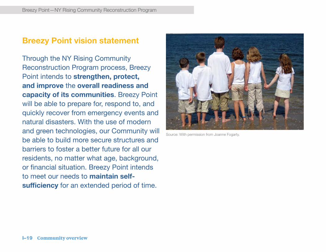
Community vision statement
Through the NY Rising Community Reconstruction process, Breezy Point intends to strengthen, protect, and improve the overall readiness and capacity of its communities. Breezy Point will be able to prepare for, respond to, and quickly recover from emergency events and natural disasters. With the use of modern and green technologies, our Commu-nity will be able to build more secure structures and barriers to foster a better future for all our residents, no matter what age, background, or financial situation. Breezy Point intends to meet our needs to maintain self-sufficiency for an extended period of time.
A blueprint for future resiliency
The NYRCR Plan for Breezy Point provides an outline for the implementation of the goals of the Planning Committee.
Recovery support functions
There are six Recovery Support Functions, established by President Barack Obama in 2011 through the National Disaster Recovery Framework, that structure this NYRCR Plan. These Recovery Support Functions were utilized when developing needs, opportunities, strategies and projects to ensure that a comprehensive approach is reinforced throughout the effort to shape a comprehensive resiliency strategy for the Community.
Strategies and projects
This Plan contains three strategies and 10 Proposed and Featured Projects to improve the resiliency of Breezy Point, as described below. Proposed Projects are projects that the Breezy Point Planning Committee has recommended to be funded through the NYRCR process. Featured Projects are innovative projects that may require additional funding sources for implementation, and for which the Committee has recommended funding an initial phase of implementation. The projects are not listed in any priority order.
Given the wealth of existing or planned government and citywide programs, the Plan recommends supporting other efforts by filling funding gaps or suggesting policy changes. Finally, the Committee sought to identify projects that are highly feasible and able to be implemented on a short timeline. Building on this framework, the Committee focused on creating projects that provide near-term and immediate coastal protection, strengthen community resiliency, and protect and bolster infrastructure.

vii
Breezy Point—NY Rising Community Reconstruction ProgramBreezy Point—NY Rising Community Reconstruction Program
Improve and expand coastal protection Enhanced dune walkways (Proposed). To ensure continuous oceanside coastal protection while still allowing for beach access, this proposed project would create an uninterrupted dune along the ocean with raised pedestrian and vehicle access.
Bayside coastal protection in Breezy Point & Rockaway Point (Featured). This includes three discrete near-term bayside coastal protection projects along the most vulnerable areas in Breezy Point and Rockaway Point.
Roxbury bayside protection (Featured). This project would pursue near-term bayside coastal protection projects along the most vulnerable areas in Roxbury.
National Park Service collaboration (Featured). This project would collaborate with the National Park Service (NPS) to identify and strengthen key vulnerabilities on NPS property that threaten the Breezy Point Community.
Rockaway Point Boulevard Elevation (Featured). This project would raise and strengthen Rockaway Point Boulevard – the Community’s sole access route – and ensure accessibility during an emergency.
Repaired docks (Proposed). This project would repair two bayside docks destroyed by Superstorm Sandy.
Stormwater drainage improvements (Proposed). This project would make stormwater drainage improvements in Breezy Point and Roxbury.
Strengthen community resiliency
Housing elevation study (Proposed). This project would evaluate housing elevation needs and strategies for the Community and create a basis for collective action.
Multi-purpose community relief center (Proposed). This project would create a new facility to serve as a community-based emergency recovery resource.
Summer store relocation (Proposed). This project would significantly improve the resiliency of the Community’s small but important “summer store” retail cluster, which is regularly flooded.
Protect and bolster infrastructure

viii
NY Rising Community Reconstruction Program—Breezy PointNY Rising Community Reconstruction Program—Breezy Point
Floyd Bennett Field
Rockaway Inlet
Manhattan Beach
Marine Parkway Bridge
Breezy Point NYRCR Plan Proposed and Featured Projects

ix
Breezy Point—NY Rising Community Reconstruction ProgramBreezy Point—NY Rising Community Reconstruction Program
Outline of the plan
The Plan begins with a Community Overview, which provides an orientation to the Community, the critical issues laid bare by Superstorm Sandy, and the Planning Committee’s work in the context of ongoing resiliency and recovery work.
Section II. Assessment of Risks and Needs, describes the diverse assets at risk from future storms, and describes how Planning Committee deliberation and public feedback catalogued those risks. Using the risk assessment tool developed by the NYRCR Program, this section identifies key opportunities for action that form the rationale for resiliency strategies and the related projects developed by the Planning Committee.
The following Section III. Reconstruction and Resiliency Strategies describes strategies developed by the Committee to respond to needs, opportunities, and risks to assets measured through the risk assessment process.
The Proposed and Featured Projects, which are the path to implementing those strategies, are described in more detail in Section IV. Implementation - Project Profiles.
Section V. Additional Resiliency Recommendations, the final section, describes additional resiliency recommendations strongly supported by the Community, but which lack an identified source of funding. It also describes the public engagement process in more detail, and provides additional supporting documentation for the Plan.

x
NY Rising Community Reconstruction Program—Breezy PointNY Rising Community Reconstruction Program—Breezy Point
An envisioned multi-purpose community & relief center.

Opposite page photo source: With permission from AJ Smith

I. Community overview
I–1 Community overview
Breezy Point—NY Rising Community Reconstruction Program
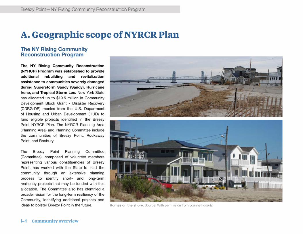
A. Geographic scope of NYRCR PlanThe NY Rising Community Reconstruction Program
The NY Rising Community Reconstruction (NYRCR) Program was established to provide additional rebuilding and revitalization assistance to communities severely damaged during Superstorm Sandy (Sandy), Hurricane Irene, and Tropical Storm Lee. New York State has allocated up to $19.5 million in Community Development Block Grant - Disaster Recovery (CDBG-DR) monies from the U.S. Department of Housing and Urban Development (HUD) to fund eligible projects identified in the Breezy Point NYRCR Plan. The NYRCR Planning Area (Planning Area) and Planning Committee include the communities of Breezy Point, Rockaway Point, and Roxbury.
The Breezy Point Planning Committee (Committee), composed of volunteer members representing various constituencies of Breezy Point, has worked with the State to lead the community through an extensive planning process to identify short- and long-term resiliency projects that may be funded with this allocation. The Committee also has identified a broader vision for the long-term resiliency of the Community, identifying additional projects and ideas to bolster Breezy Point in the future. Homes on the shore. Source: With permission from Joanne Fogarty.

NY Rising Community Reconstruction Program—Breezy Point
Community overview I–2
NY Rising Community Reconstruction Program—Breezy Point
RE
ID A
V
BEACH
201 ST
BAYSIDE DR
BEACH
219 ST
OCEANSIDE AV
BE
DFO
RD
AV
New York Rising Community Reconstruction Program Breezy Point Planning Area
QUEENS
BRONX
NEW JERSEY
BROOKLYNSTATEN ISLAND
3,0001,500Feet
0 ¯
Breezy Point Tip (NPS)
Rockaway Inlet
Atlantic Ocean
Fort Tilden (NPS)
Marine P
arkway G
il
Hodges B
ridge
Planning Area Boundary
Rockaway Point Boulevard
Breezy Point
Rockaway Point
Roxbury
Source: New York City Department of City Planning, MAPPluto v13.1;NYRCR planning committee and public input.
Overview of Planning Area
National Park Service (NPS)Other Open Space
Roads
BuildingsOverview of Planning Area
Figure I-1: Breezy Point Planning Area

I–3 Community overview
Breezy Point—NY Rising Community Reconstruction Program
The Breezy Point Planning Area presents unique and critical challenges and opportunities for rebuilding and recovery. Located on the westernmost end of the Rockaway Peninsula, the Planning Area is surrounded on three sides by water, with a deep Atlantic Ocean-facing beach to the south and west, as well as shoreline along Jamaica Bay to the north. This, combined with the area’s low elevation, makes it the most vulnerable point on the Peninsula. The Planning Area is additionally surrounded by extensive open space, which provides a wealth of natural assets but also increases the Community’s risk, as much of the parkland is exposed along its coastline. The surrounding Gateway National Recreation Area includes Breezy Point Tip at the westernmost end of the Planning Area; The Cove in the middle; and Fort Tilden and Jacob Riis Park, two major recreational beach destinations, to the east. The Planning Area connects to the rest of the Peninsula via a single road, Rockaway Point Boulevard, and to southern Brooklyn via the Marine Parkway-Gil Hodges Memorial Bridge at its easternmost edge.
Breezy Point, 1935 (top left). Breezy Point 1939 (top right). Youth on the beach (bottom). Source: Far
Rockaway High School Online Alumni Association’s Rockaway Beach Reunion Web Site (top left and right). With
permission from Denise Neibel (bottom).
Community overview I–4
NY Rising Community Reconstruction Program—Breezy Point
Community overview
The 11-mile long Rockaway Peninsula once consisted of barrier islands and marshland protected by smaller barrier islands to the south. Over time, the natural east-to-west movement of sediment eliminated the smaller islands and also created the Community of Breezy Point. The Rockaway Peninsula neighborhoods emerged in the early 19th century as recreational destinations and transformed into year-round neighborhoods after the construction of the Cross Bay Veterans Memorial Bridge in 1923.
The 500-acre Planning Area is owned by the Breezy Point Cooperative. With origins as a summer campground, Breezy Point evolved into a formalized Cooperative bungalow community in the early 1960s. Amidst outcry over the Atlantic Improvement Company’s purchase of 800 acres of land designed to replace bungalows with high-rise residential buildings, the Cooperative formed to buy back half of this land, and the well-organized community has continued to protect its quality of life for decades since.
The Cooperative owns the entire area and, through Cooperative dues, maintains infrastructure, public space, sidewalks and roadways, streetlights, and buildings. The
Cooperative manages key operations and services, including local sanitation removal, water main maintenance and security functions, and volunteer emergency services. The Cooperative also has a number of committees that oversee planning and project management, including a land use committee. This formal organization, combined with high degrees of civic engagement, make Breezy Point a very well-organized community with a strong vision for the future.
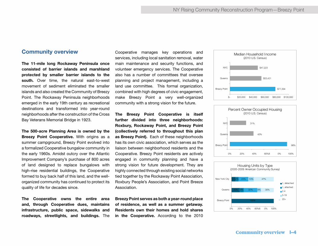
The Breezy Point Cooperative is itself further divided into three neighborhoods: Roxbury, Rockaway Point, and Breezy Point (collectively referred to throughout this plan as Breezy Point). Each of these neighborhoods has its own civic association, which serves as the liaison between neighborhood residents and the Cooperative. Breezy Point residents are actively engaged in community planning and have a strong vision for future development. They are highly connected through existing social networks tied together by the Rockaway Point Association, Roxbury People’s Association, and Point Breeze Association.
Breezy Point serves as both a year-round place of residence, as well as a summer getaway. Residents own their homes and hold shares in the Cooperative. According to the 2010
100%
20%
10%
9%
7%
32%
23%
9%
13%
30%
47%
0% 20% 40% 60%8 0% 100%
Breezy Point
Queens
New York City
Housing Units by Type
(2005-2009 American Community Survey)
1, detached
1, attached
2-4
5-19
20+
$77,394
$53,421
$47,223
$- $20,000 $40,000 $60,000 $80,000 $100,000
Breezy Point
Queens
NYC
Median Household Income(2010 U.S. Census)
98%
43%
31%
0% 20% 40% 60%8 0% 100%
Breezy Point
Queens
NYC
Percent Owner Occupied Housing(2010 U.S. Census)
I–5 Community overview
Breezy Point—NY Rising Community Reconstruction Program
Source: With permission from Denise Neibel.
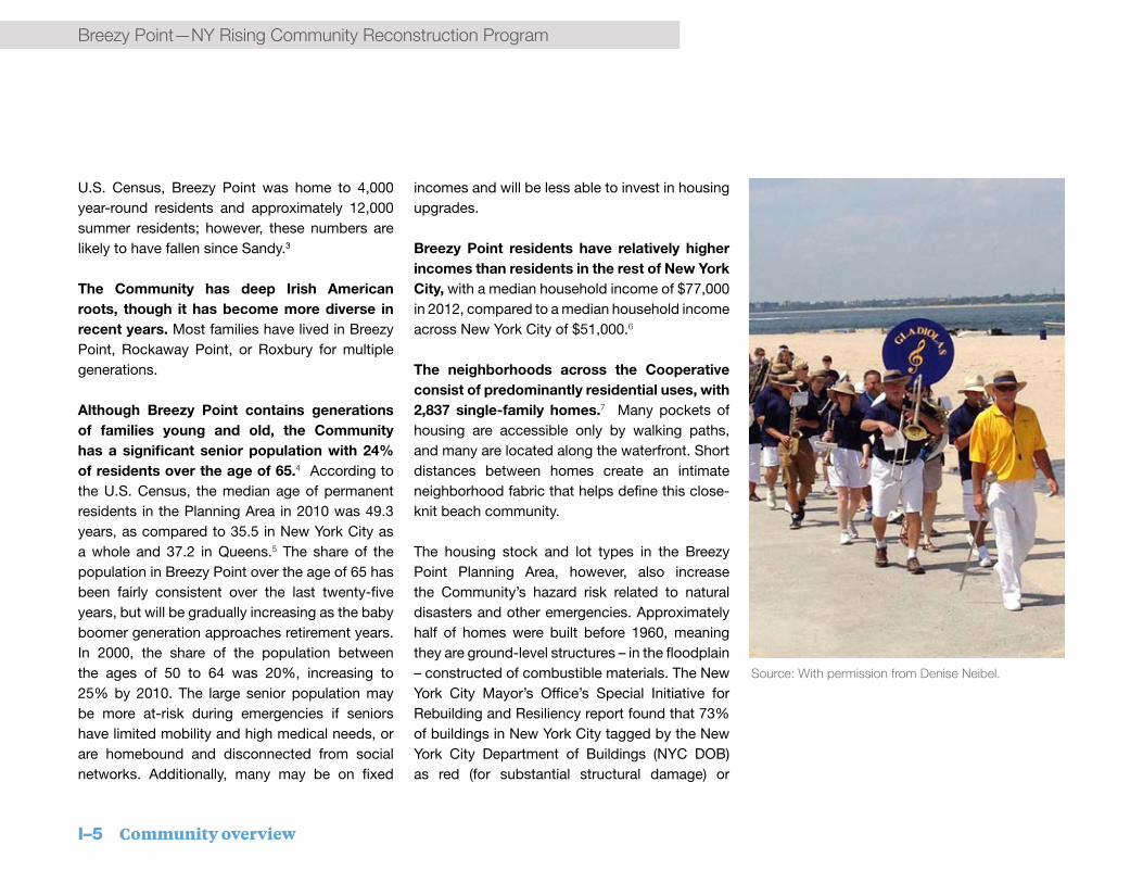
U.S. Census, Breezy Point was home to 4,000 year-round residents and approximately 12,000 summer residents; however, these numbers are likely to have fallen since Sandy.3
The Community has deep Irish American roots, though it has become more diverse in recent years. Most families have lived in Breezy Point, Rockaway Point, or Roxbury for multiple generations.
Although Breezy Point contains generations of families young and old, the Community has a significant senior population with 24% of residents over the age of 65.4 According to the U.S. Census, the median age of permanent residents in the Planning Area in 2010 was 49.3 years, as compared to 35.5 in New York City as a whole and 37.2 in Queens.5 The share of the population in Breezy Point over the age of 65 has been fairly consistent over the last twenty-five years, but will be gradually increasing as the baby boomer generation approaches retirement years. In 2000, the share of the population between the ages of 50 to 64 was 20%, increasing to 25% by 2010. The large senior population may be more at-risk during emergencies if seniors have limited mobility and high medical needs, or are homebound and disconnected from social networks. Additionally, many may be on fixed
incomes and will be less able to invest in housing upgrades.
Breezy Point residents have relatively higher incomes than residents in the rest of New York City, with a median household income of $77,000 in 2012, compared to a median household income across New York City of $51,000.6
The neighborhoods across the Cooperative consist of predominantly residential uses, with 2,837 single-family homes.7 Many pockets of housing are accessible only by walking paths, and many are located along the waterfront. Short distances between homes create an intimate neighborhood fabric that helps define this close-knit beach community.
The housing stock and lot types in the Breezy Point Planning Area, however, also increase the Community’s hazard risk related to natural disasters and other emergencies. Approximately half of homes were built before 1960, meaning they are ground-level structures – in the floodplain – constructed of combustible materials. The New York City Mayor’s Office’s Special Initiative for Rebuilding and Resiliency report found that 73% of buildings in New York City tagged by the New York City Department of Buildings (NYC DOB) as red (for substantial structural damage) or

Community overview I–6
NY Rising Community Reconstruction Program—Breezy Point
destroyed were built before 1961.8
The Rockaway Peninsula
Neighborhoods across the Rockaway Peninsula face shared challenges. These include risks associated with climate change and sea level rise, limited access to critical transportation and health services, and ongoing struggles for economic vitality. The whole Peninsula is relatively geographically isolated, and unique in character among New York City neighborhoods. In general, Rockaway Peninsula communities are primarily residential with small
pockets of mostly local retail. Strong connections to the beach and to the natural resources of Jamaica Bay are highly valued and integral to the area’s identity. Breezy Point, Rockaway East, and Rockaway West, therefore, have collaborated in the NYRCR planning process and will continue to
work toward implementing solutions to serve the larger issues facing the peninsula.
Bungalow-style homes in Breezy Point are built within close proximity to one another.
Source: With permission from Denise Neibel.

I–7 Community overview
Breezy Point—NY Rising Community Reconstruction Program
Summary of storm impacts
The combination of high tide, a full moon, and Superstorm Sandy (Sandy) created a massive surge of water that devastated many of the exposed coastal communities of the Rockaway Peninsula. Beyond the storm and the emergencies in its immediate aftermath, all residents have been affected in some way by building damage, extended power and utility outages, lasting transportation disruptions, displacement, and financial hardship.
Situated at the westernmost point of the Peninsula, the waterfront neighborhoods of Breezy Point, Rockaway Point, and Roxbury suffered significant damage. High-velocity waves struck directly from the oceanside, lifting the first row of houses off their foundations and onto those behind. Ocean water punched through the dunes along beach access walkways and flowed onto Rockaway Point Boulevard, Breezy Point’s main street. The force of ocean waves, reaching record-breaking heights, pushed significant volumes of sand up into these neighborhoods while simultaneously washing the rest of the beaches away. Meanwhile, rising waters in Jamaica Bay poured into the Community, meeting the ocean’s waters on land.
Breezy Point homes destroyed by fire in the aftermath of Superstorm Sandy. Source: Flickr user Tom Parr23,
licensed under Creative Commons.
“Every single thing you knew is gone. Not a single family wasn’t impacted by the storm in this community.” – NYRCR Participant
B. Description of storm damages
Because water surged across the Planning Area from both sides, not a single home was left untouched. Flood waters inundated properties and, in many cases, rose several feet into ground floors. The market building in Roxbury, two waterfront restaurants along Jamaica Bay (the Bay House and Kennedy’s), a bar on the ocean-facing side (the Sugar Bowl), and the Breezy Point security barracks were

Community overview I–8
NY Rising Community Reconstruction Program—Breezy Point
RE
ID A
V
BEACH
201 ST
BAYSIDE DR
BEACH
219 ST
OCEANSIDE AV
BED
FOR
D A
V
New York Rising Community Reconstruction Program Breezy Point Planning Area
QUEENS
BRONX
NEW JERSEY
BROOKLYNSTATEN ISLAND
3,0001,500Feet
0 ¯
Breezy Point Tip (NPS)
Rockaway Inlet
Atlantic Ocean
Fort Tilden (NPS)
Marine P
arkway G
il
Hodges B
ridge
Planning Area Boundary
Rockaway Point Boulevard
6-12 ft>12 ft
Wave Action & Water Movement
3-6 ft
< 3 ft
Superstorm Sandy Flood Depths
Source: FEMA Sandy Modeling Task Force Final High Resolution Surge Area- Field-Veri�ed Febru-ary 14, 2013. Basemap: New York City De-partment of City Planning, MAPPluto v13.1;Buildings; Street Centerlines
Planning Area Boundary
Superstorm Sandy Flood ExtentsFigure I-2: Superstorm Sandy Flood Level Map

I–9 Community overview
Breezy Point—NY Rising Community Reconstruction Program
destroyed. Sandy damaged roadways and sidewalks, and the Community’s ball fields were inundated. Even after the stormwaters receded, existing poor drainage conditions meant that water levels in Breezy Point remained elevated for days, hampering mobility and exacerbating damage to homes.
By damaging electrical power systems, the storm sparked fires that rapidly spread between homes and burned through the night. Flooding prevented emergency responders from reaching the fires, which eventually consumed 135 homes. The spread of the fire was also facilitated by the concentration of wood-frame, densely-packed homes. Overall, a total of 355 homes were lost as a result of Superstorm Sandy, more than 10% of the Community’s 2,837 houses.
The storm severely impacted critical transportation infrastructure, which provides the primary access in and out of the Rockaway Peninsula. Rockaway Point Boulevard was completely submerged and the Community’s bayside docks were destroyed. The Marine Parkway-Gil Hodges Memorial Bridge and Cross Bay Veterans Memorial Bridge closed in advance of Sandy. By the time mandatory evacuation was announced, many residents felt it was too late to safely leave and were stranded without
Breezy Point homes destroyed by Superstorm Sandy.

Community overview I–10
NY Rising Community Reconstruction Program—Breezy Point
many options for several days until the bridges reopened. The storm knocked out the A train subway line, severing public transit connections to the Peninsula in general. The line, however, is less critical for mobility in Breezy Point.
The storm also severely affected power, natural gas, and water supplies. Damages to the Long Island Power Authority (LIPA) power system left Breezy Point residents without power for weeks. National Grid’s natural gas system was impaired and did not come fully back online until spring 2013. Additionally, the water supply system had to be repaired and flushed before water was potable. Residents were advised not to drink the water after the storm until the New York City Department of Health and Mental Hygiene (NYC DOHMH) declared it safe in February 2013, and those in the most damaged areas had to wait even longer.
Sandy’s impacts demobilized first responders, preventing critical service providers from entering the Community. The Rockaway Point Fire Department lost all equipment, and the Point Breeze Fire Department lost a utility vehicle. Due to pervasive flooding, the New York City Fire Department (FDNY) had difficulty reaching the Community upon first reports of the fire around 11pm, eventually reaching the community at 1am.
All of the bayside docks were damaged, leaving alternate access out of the question.
The storm destroyed natural assets and protective features surrounding the Community. The dunes fronting Fort Tilden were lost to the storm. Jacob Riis Park, to the east, suffered significant damage to its parking lot and bathhouse. All of the dunes that serve as protective buffers to the effects of flooding and erosion along the edge were washed out.
Recovering from the storm
Rebuilding homes is an urgent issue. In the days after the storm, contractor vans and trucks filled the streets of Breezy Point as homeowners began to repair their homes. While some homeowners have recovered from Sandy damage, many houses remain damaged or under repair, and many residents are still unable to return to their homes. The City of New York is running a comprehensive citywide program to rebuild destroyed homes and rehabilitate damaged ones, but the progress has been slower than expected by most residents. Permitting and funding are both challenges in the rebuilding process, and many residents are concerned about rising flood insurance rates but are unclear of what, if any, action they should take to minimize insurance
The Breezy Point fire zone in the aftermath of
Sandy

I–11 Community overview
Breezy Point—NY Rising Community Reconstruction ProgramBreezy Point—NY Rising Community Reconstruction Program
impacts. Overall, homes with damage claims totaling more than 50% of their value must be elevated, and the Cooperative is concerned with the impact to the fabric of the Community from partial elevation of neighborhoods.
Infrastructure has largely been repaired, but gaps and risks remain. All roads have been repaired, mainly by the Cooperative, which also repaired some of the sidewalks; National Grid repaired other sidewalks after tearing them up for construction. Sidewalks in the fire zone, along Oceanside Avenue, along the Roxbury bay front, and small pockets in other areas still need repair. All of the bayside docks remain damaged and unusable. The Community’s gas mainlines have been converted from low to high pressure by National Grid. To make the electrical power supply system more resilient, Public Service Electric and Gas Company (PSE&G) has identified hardening measures for the four substations on the Rockaway Peninsula and enacted management restructuring actions.
Because of the damage to the A train, temporary ferry service was put in place between the Rockaway Peninsula and Manhattan roughly two weeks after the storm hit. A train service was restored at the end of May 2013, after the causeway that connects the Peninsula to Howard
Community members volunteer to build a new playground after Sandy. Source: With permission from Joanne
Fogarty.
Beach was repaired. The MTA spent six months clearing debris, rebuilding track, replacing wiring, and building a sea wall to stabilize and protect the embankment. City and State agencies are also evaluating other opportunities to bolster transportation to the Peninsula.
The Breezy Point Cooperative has been extremely active in the recovery of the Community. The Cooperative recently completed
a section (Beach 201st Street to Bedford Avenue) of a long-term comprehensive dune project, built with its own funds, sand, and staff. The Federal Emergency Management Agency (FEMA) Hazard Mitigation Grant Program (HMGP) is expected to provide the primary source of funding for the completion of the double dune system. The grant is also expected to support new bayside protection.

Community overview I–12
NY Rising Community Reconstruction Program—Breezy Point
Construction of new homes and installation of a cesspool. (top); rebuilding of dunes (bottom right).

I–13 Community overview
Breezy Point—NY Rising Community Reconstruction Program
Superstorm Sandy created or exposed a number of critical issues across the Breezy Point communities. While some of these issues are not new to residents, the storm and the NYRCR public engagement process have brought to light the following critical issues facing this Community.
Vulnerability to extreme weather and sea level rise
The neighborhoods across the Breezy Point Cooperative face significant vulnerabilities to extreme weather events and sea level rise, and lack protection in the short term. While the oceanside beach is relatively deep and the Cooperative is creating a new double dune system, the dunes will take time to complete and the Planning Area will remain exposed for a number of years. The bayside is especially vulnerable, with many homes abutting the edge with little-to-no protection along most of the perimeter. Problematically, due to the distance between the community and the water, any protection system would need to sit in very close proximity to homes.
The current housing stock remains highly vulnerable. Homes severely damaged or destroyed by Sandy must be elevated according
to new building codes, leaving many residences in the Community at ground level and at risk of flooding during extreme storms. This mixed housing elevation causes secondary issues with accessibility and continuity in the fabric of the neighborhoods.
Reliance on National Park Service
The Planning Area is surrounded by water and
National Park Service (NPS) property, which are important assets to the Community, yet also pose great risks. Currently, the Gateway National Recreation Area properties adjacent to the Planning Area do not connect to, or have plans for implementing, a coastal protection system. Further, The Cove, also part of the Gateway National Recreation Area and sitting on Rockaway Inlet, has been eroding over time, which poses a considerable threat not only to
Vulnerable bayside homes from the Riis Landing Ferry Dock.
C. Critical issues

Community overview I–14
NY Rising Community Reconstruction Program—Breezy Point
the adjacent properties, but also to Rockaway Point Boulevard, the only road in and out of the Community. Breezy Point’s overall safety and protection depends on cooperation from NPS in designing and implementing coastal protection solutions that complement the Community’s efforts.
Prolonged and regular stormwater flooding
The Planning Area has experienced flooding and drainage issues over time, but the following three areas regularly flood and retain water after rain events:
▪ Rockaway Point ball fields
▪ Residential area southeast of Bedford Avenue and Rockaway Point Boulevard
▪ Roxbury main parking lot
These areas remained flooded for days after Sandy due to their poor drainage, exacerbating difficulties in reaching impacted people and damaged homes. On a regular basis, this flooding hinders accessibility to homes and recreational space and causes health and safety risks due to standing, stagnant water in warmer months and large swaths of ice in the winter.
In addition to flooding caused by storms, the area has a high water table, which continues to increase with sea level rise. The Planning Area’s rising water table complicates flooding and drainage and causes issues with the functioning of these systems.
Rising insurance rates
Under current legislation, flood-prone communities and homes may pay increasing premiums for flood insurance. While the exact impact and scale of these increases continues to evolve at the Federal level and in the insurance
industry, graduated increases are anticipated. If a system providing comprehensive coastal protection to a 100-year storm, that is, a storm that has a 1% chance of occurring in any given year, is not built and certified to petition for Flood Insurance Rate Map (FIRM) revisions, individual homeowners must undertake measures to protect their homes or face increasing insurance costs. On the whole, this issue poses a threat to the whole Cooperative if people can no longer afford to stay in their homes and residents leave the community. This larger-scale disinvestment could have serious economic implications for the whole Community.
Rebuilt homes with new elevation in Breezy Point

I–15 Community overview
Breezy Point—NY Rising Community Reconstruction Program
FEMA flood maps and flood risk
The Federal Emergency Management Agency (FEMA) describes its assessment of flood risk through flood maps referred to as Flood Insurance Rate Maps (FIRMs). These maps are used by the National Flood Insurance Program (NFIP) to set flood insurance rates. Before Superstorm Sandy, FEMA had begun a coastal flood study to update FIRMs for portions of New York and New Jersey, using improved methods and data to better reflect coastal flood risk. When Superstorm Sandy hit New York City, the FIRMs in use were based on information from 1983 and inundation extended well beyond what these maps estimated would be the 100-year floodplain.
After Superstorm Sandy, FEMA first released Advisory Base Flood Elevation (ABFE) maps based on the partially completed flood study for certain communities, which were designed to help in rebuilding and recovery efforts. In December 2013, FEMA released preliminary FIRMs for New York City. The final updated FIRMs are anticipated to be released in 2015. These final FIRMs will guide new Flood Insurance rates for homeowners and businesses in the floodplain. FEMA’s flood maps do not take into account future conditions and thus do not factor in potential sea level rise.
A STRONGER, MORE RESILIENT NEW YORK313
To address the transit challenges posed by theclosure of the A train, in November 2012, theCity launched temporary ferry service betweenthe Rockaways and Manhattan. Paid for in partwith Federal money and using a landing siteprovided by National Grid, the service cost rid-ers $2 per trip.
Another important piece of infrastructure inSouth Queens impacted by Sandy was theRockaway Wastewater Treatment Plant. This fa-cility suffered severe flooding and was out ofservice during the storm, leaving wastewateruntreated for three days, although chlorine wasapplied to untreated effluent. Notwithstandingthese releases, water quality samples taken byDEP following the storm showed minimal waterquality impacts, due in part to dilution of efflu-ent that resulted from the high volumes ofwater that Sandy brought with it. The RockawayWastewater Treatment Plant finally regained fulltreatment capacity approximately two weeksafter the storm.
Sandy caused significant erosion along thebeaches of South Queens. In fact, the USACEestimated that Rockaway Beach alone lost 1.5million cubic yards of sand, much of it pushedup into neighborhood streets or washed intothe Atlantic. Segments of the area’s boardwalkwere also destroyed, although the portionsbuilt of concrete tended to emerge unscathedor to sustain only minor to moderate damage.
Schools in the area were also damaged. In total,37 schools in South Queens were closed for upto two months. Until repairs could be com-pleted. Students at these schools wererelocated to school facilities that had not beendamaged to ensure that instructional disrup-tion was kept to a minimum.
As significant as Sandy’s impacts were on themany neighborhoods of South Queens, they alsoinspired acts of heroism. These efforts rangedfrom the relief operations undertaken by commu-nity-based organizations, other non-profits, localresidents, and outside volunteers. The outpour-ing of financial and on-the-ground support helpedmany to begin addressing the damage done totheir homes, supported efforts to clean up thearea and assisted residents who were displacedor remained in the area but whose access togoods and services were impaired. In fact, theexperience of Sandy inspired 40 local organiza-tions to form a new coalition called RockawayUnited. This group was established to coordinateservices post-Sandy more effectively and to putmechanisms in place for future disasters. Effortssuch as these were, in many ways, the silver lin-ings that emerged from an otherwise gravesituation, providing a ray of hope that, out of thetragedy of Sandy, the neighborhoods of SouthQueens will emerge with strengthened commu-nity networks that will be critical to resiliency inthe future.
What Could Happen in the Future
Going forward, the neighborhoods of SouthQueens face a variety of risks relating to climatechange. (See chart: Risk Assessment: Impactof Climate Change)
Major RisksGiven the area’s coastal exposure, the most sig-nificant climate change-related risk posed tothe neighborhoods of South Queens is floodingfrom coastal storms, which is likely to be exac-erbated by projected sea level rise. This risk issignificant even today, as illustrated by recently
Jamaica Bay
Jamaica Bay
Atlantic Ocean
1983 FIRMs 100-Year Floodplain
2013 PWMs 100-Year Floodplain
Overlap
RockawayInlet
Comparison of 1983 FIRMs and Preliminary Work Maps
Restoration of the Rockaways Beachfront
Following Sandy, a top priority for the City was the reopening of the beaches of the RockawayPeninsula in time for the summer of 2013. To this end, the Department of Parks and Recreation(DPR) repaired portions of the boardwalk that had sustained only minor or moderate damage topre-Sandy designs, repaired and replaced damaged lifeguard stations and restrooms, and cre-ated resilient “boardwalk islands” in several compromised locations to provide access to beachfacilities and amenities. Looking to the future, DPR intends not only to restore the boardwalk infull but also to continue to support beach restoration projects that will protect the neighbor-hoods that it fronts. DPR also is prioritizing opportunities for beach-fueled economic develop-ment in both the near- and long-terms that could contribute to the wider recovery of theRockaway Peninsula, South Queens, and the city as a whole (See South Queens Initiatives 7 & 8).
Rockaway Beach, 1902
1983 FIRMs 100-Year Floodplain
2013 PWMs 100-Year Floodplain
Overlap
R
Source: FEMA
National Flood Insurance Program (NFIP) FEMA developed NFIP in the 1960s to provide homeowners with flood insurance, which was not readily available in the private market. Through NFIP, property owners in participating communities are able to buy subsidized, government-backed insurance to protect against flood losses. The Biggert-Waters Act of 2012 proposed the controversial repeal of subsidies and other restructuring in order to make the program more financially sound. Coupled with the previously mentioned FIRM map adjustments, this repeal would result in substantial premium increases for many policyholders. In a move to bring flood insurance rate relief to coastal communities in the wake of Superstorm Sandy, in March 2014 Congress passed and President Obama signed the Homeowner Flood Insurance Affordability Act into law. The law caps average annual flood insurance premium increases at 15%-18%, and allows subsidies for insurance rates that are based on best available flood maps. It also designates a flood insurance advocate to educate homeowners and policy holders on mitigation measures that can help reduce flood insurance rates, and recognizes among these measures methods for reducing flood risk that provide alternatives to building elevation for residential buildings such as attached homes whose structures cannot be elevated.
Source: NYC Speacial Initiative for Rebuilding and Resiliency: A Stronger, More Resilient New York, FEMA.

Community overview I–16
NY Rising Community Reconstruction Program—Breezy Point
Future conditions: dealing with a changing climate
Climate change is a real and significant concern for New York’s coastal communities. Two impacts of climate change have the most bearing on the future risk to New York’s coastal communities from future storm events and flooding: (1) Sea Level Rise and (2) increased frequency and intensity of storm events. On March 31, 2014, the International Panel on Climate Change (IPCC) released Climate Change 2014: Impacts, Adaptation and Vulnerability, reiterating the risk to coastal communities across the globe and assigning a high confidence that risks from extreme weather events and of sea level rise will continue to increase in the future due to climate change. Closer to home, the New York Panel on Climate Change (NPCC) continues to look at the potential risks presented to New York City in light of climate change. In their Climate Risk Information 2013, the NPCC made the following projections for 2050:
• Sea Level will increase between 7 and 31 inches with a mid-range projection of 11 to 24 inches.
• The annual chance of today’s 100-year storm (which is a 1% chance) will increase to between 1.4 and 5.5% with a mid-range estimate of 1.7 to 3.2%.
• Flood heights associated with a 100 year storm event will increase between .6 and 2.6 feet with a mid-range projection of .9 to 2.0 feet.
• Precipitation (rain/snowfall) will increase by 1 to 15% with a mid-range projection of 5 to 10%.
These projected changes all increase the extent and likelihood of flooding in New York’s coastal communities.
I–17 Community overview
Breezy Point—NY Rising Community Reconstruction Program
D. Community visionBreezy Point is a cohesive community with a strong tradition of community engagement. Devastating though it was, Superstorm Sandy’s (Sandy’s) destruction surfaced the resiliency embedded within Breezy Point’s robust social networks. Building on recovery efforts, the planning process brought residents together to envision a more resilient future.
Community participation in the NY Rising Community Reconstruction (NYRCR) process was no different. Each meeting was attended by large numbers of the Community, whether it be a Planning Committee meeting or a larger Public Engagement event. Residents asked for multiple channels to provide feedback (e.g., voicemail boxes and e-mail), and Committee Members provided NYRCR updates and solicited feedback at civic meetings, social clubs, and other larger-scale community events. The vision and goals established through the NYRCR process reflect the collective voice of this small, but strong community. Tremendously rooted in generations of families and in coastal living, the Breezy Point Community will continue to do everything possible to protect and maintain its quality of life for generations to come.
With input from the public, the Committee developed a guiding vision statement, as well as short-term and long-term resiliency and recovery goals for Breezy Point. Setting targets and aspirations for the future helped the community to think beyond the current state and began to paint the picture of a more resilient, sustainable community. By looking at assets, needs, and opportunities, the community defined a vision and goals, from which it generated strategies and projects to reach those goals.
Short-Term (2-5 years) Long-Term (5-10 years)
• Improvecoastalprotection
• Rebuilddamagedhomes
• Strengthenemergencypreparedness
• Supportcommercialrecoveryand
redevelopment
• Improveshort-termwatermanagementand
drainage
• Protectandmeettheneedsofseniorsand
othervulnerablepopulations
• Strengthentheedge(oceanandbay)
• Protectallhomesacrossthecommunities
• Createsustainabledrainage/water
managementsystemsforthelong-term
• Strengthenoverallinfrastructureandsurface
area
• Becomeself-sufficientinemergencies
• Leveragegreentechnologiesandsystems
inreconstruction
“Breezy Point’s coming back. And it’s [going to] be a lot better community.” — Breezy Point Planning Committee Member

Community overview I–18
NY Rising Community Reconstruction Program—Breezy Point
I–19 Community overview
Breezy Point—NY Rising Community Reconstruction ProgramBreezy Point—NY Rising Community Reconstruction Program
Breezy Point vision statement
Through the NY Rising Community Reconstruction Program process, Breezy Point intends to strengthen, protect, and improve the overall readiness and capacity of its communities. Breezy Point will be able to prepare for, respond to, and quickly recover from emergency events and natural disasters. With the use of modern and green technologies, our Community will be able to build more secure structures and barriers to foster a better future for all our residents, no matter what age, background, or financial situation. Breezy Point intends to meet our needs to maintain self-sufficiency for an extended period of time.
Source: With permission from Joanne Fogarty.

NY Rising Community Reconstruction Program—Breezy Point
Community overview I–20
NY Rising Community Reconstruction Program—Breezy Point

I–21 Community overview
Breezy Point—NY Rising Community Reconstruction Program
Rockaway Peninsula overview
Situated on land that originally made up a series of barrier islands and marshland, the three Rockaway Peninsula communities have a similar geomorphology and low elevation. A good proportion of the land area is located at or just above sea level, making neighborhoods along the shorelines vulnerable to flooding even during normal high tides. The coastline ranges from long, wide beaches with gentle dunes, to soft, marshy edges, to shorelines punctured by inlets and man-made and natural basins.
On the oceanside, the Rockaway Peninsula faces risks due to its extensive unobstructed coastline and the proximity of homes and infrastructure to the water’s edge. While much of the coastline contains beaches, many lack extensive natural protective features, such as dunes, and experience regular beach erosion. At the same time, the Rockaway Peninsula, as a barrier island, provides valuable protection to communities within the bay, reducing surge and wave heights within the bay itself. The beach nourishment and dune-building efforts being undertaken by the U.S. Army Corps of Engineers (USACE) and others on the peninsula therefore
have risk-reducing impacts for all communities on the bay.
Communities along the bayside of the Rockaway Peninsula are at risk. Some communities are fronted by open beaches and others are set further away from the water’s edge, with much of the bayside bordered by a mix of edges ranging from tidal wetlands to bulkheads, and a baywall to the west, which was overtopped during Superstorm Sandy. While natural protective features and shoreline structures built along the perimeter of the bay may provide protection against the lesser storm events, they are collectively insufficient to protect against the 100-year storm event. Some of the shoreline structures are aging, or inadequately maintained, leaving these communities vulnerable to flooding.
Other Challenges in Common Areas of common regional interest extend beyond coastal protection, to health care and transportation.
Like its neighbors in Rockaway East and Rockaway West, the Breezy Point Community is concerned about access to health care as large providers close or consolidate their facilities,
and concerns exist about the providers that do remain. The Community plans to coordinate efforts with Rockaway East, Rockaway West, and other South Queens NY Rising Communities to expand health care services.
Many Jamaica Bay communities also face insufficient emergency access. In multiple locations throughout the Rockaway Peninsula, including Breezy Point, Belle Harbor, and Rockaway Beach, fires started due to the interaction of seawater and electrical infrastructure. Fire trucks were unable to reach these areas due to extensive flooding. Single access routes like Rockaway Point Boulevard, as well as other roadways and bridges serving the Broad Channel and Howard Beach Planning Areas, were damaged or flooded, constraining emergency response and hindering evacuation.
As projects move from planning into implementation, Breezy Point will continue to collaborate with its neighbors and the larger Jamaica Bay region to leverage resources to develop solutions that solve common challenges.
E. Relationship to regional plans

Community overview I–22
NY Rising Community Reconstruction Program—Breezy Point
Jamaica Bay Wildlife
Refuge
Jamaica Bay Wildlife
RefugeWest Pond
Sunset Cove
Canarsie Pier
Spring Creek
Mill Basin Outlet
Plumb Beach
Riis Landing
North Channel
East Pond
Dead Horse Bay
Marine Parkway Bridge
JFK Airport
North Channel / Addabbo Bridge
Cross Bay Veterans Bridge
Floyd Bennet Field
Jacob Riis Park
Fort Tilden
Breezy Point Tip
Howard Beach
Howard Beach
Rockaway East
Rockaway East
Rockaway West
Rockaway West
Breezy Point
Breezy Point
Broad ChannelBroad
Channel
Southern BrooklynPeninsula
Southern BrooklynPeninsula
FiveTownsFive
Towns
Sheepshead Bay
Sheepshead Bay
GerritsenBeach
GerritsenBeach
South Valley Stream
South Valley Stream
0 13,0006,500Feet
QUEENS
BRONX
NEW JERSEY
BROOKLYNSTATEN ISLAND
New York Rising Community Reconstruction Program Jamaica Bay Regional Overview
Planning Area Boundaries
Gateway National ParkJamaica Bay Unit
Gateway National Park LandGateway National Park Legislative Boundary
Jamaica Bay Regional OverviewFigure 1-3: Jamaica Bay Regional Overview

I–23 Community overview
Breezy Point—NY Rising Community Reconstruction Program
Marine Parkway-Gil Hodges Memorial Bridge.
Regional perspectives: Jamaica Bay
From Sea Gate on the western edge of the Southern Brooklyn Peninsula, to South Valley Stream at its headwaters in Nassau County, communities in and around Jamaica Bay suffered enormous damage from Superstorm Sandy. The Bay, known as a unique ecosystem in an urban landscape, is famous for its salt marsh islands, intertidal flats, horseshoe crabs, and migratory birds that use the area as a critical refuge during their seasonal travels. Beyond the water, Jamaica Bay is surrounded by woodland and forests that host a wide array of wildlife. This dynamic system has attracted people for generations, and many of its surrounding communities are partially defined by their close proximity to Jamaica Bay’s waters. However, this proximity also served as a hazard during Superstorm Sandy. At the height of the storm, the Bay swelled and water surged up through a network of creeks and streams, infiltrating neighborhoods and inundating homes, businesses and roadways.
Shared risk, shared resiliencyConnected hydrologically and ecologically, Jamaica Bay is a unifying feature tying together six NYRCR Planning Areas in New York City: Breezy Point; Rockaway West; Rockaway East;
Broad Channel; New and Old Howard Beach; and Gerritsen Beach/Sheepshead Bay. A seventh Planning Area – the Southern Brooklyn Peninsula Community Planning Area, which includes
Brighton Beach, Coney Island, Manhattan Beach, and Sea Gate – is in close proximity at the mouth of Jamaica Bay. The Bay and its tributaries have a far-reaching influence that extends beyond

Community overview I–24
NY Rising Community Reconstruction Program—Breezy Point
New York City- the Five Towns (which includes the Village of Cedarhurst, Hewlett, Village of Lawrence, Woodmere, Village of Hewlett Neck, Village of Hewlett Harbor, Meadowmere and Inwood), and South Valley Stream Community Planning Areas in Nassau County- are also impacted by what happens in the Bay. With their connected shoreline, these communities share a unique ecological amenity and future resiliency strategies could have a profound impact upon that relationship.
All of the Jamaica Bay communities suffered significantly during Sandy, some from flooding or surge and some from wave action damage. According to an assessment conducted by the New York City Department of Buildings (NYC DOB), 37% of the buildings destroyed during Sandy citywide were located in Jamaica Bay.9 Homes, businesses, beaches, parklands, schools, roadways, and mass transit were all damaged; the area also endured one of the most extensive and long-lasting power outages in the city.
Flooding risks are likely to be exacerbated throughout the Bay by projected sea level rise associated with climate change. Based on the Federal Emergency Management Agency’s (FEMA)’s Preliminary Flood Insurance Rate
Maps, the 100-year floodplain in the borough of Queens has expanded by 40% since the prior best available Flood Insurance Rate Maps from 1983, and floodplain expansion has been especially dramatic for the Jamaica Bay/South Queens area, with the number of buildings in the floodplain having risen by 70%.10 It is anticipated that this trend will continue, and the low-lying areas surrounding Bay communities are likely to continue to experience more frequent flooding and greater flood depths.
There are also ecological factors to consider: Jamaica Bay is a tidal estuary. Though severely degraded over the 19th and 20th centuries, the Bay remains a dynamic ecosystem, providing critical habitat to a variety of species, including a number of protected and threatened birds that inhabit both the beach and Bay. Habitat loss and degradation of the Bay’s chemical, physical, and biological environment has largely been due to human activities; however, over the last two decades, City, State, and Federal policies and activities have yielded dramatic improvements in the Bay’s water and habitat quality.
In this hydrologically-connected system, projects and interventions in one area of the Bay can have ecological and coastal protection ramifications across the estuary.
The cumulative impact of individual projects implemented in different locations around the Bay can be greater than the sum of their individual impacts.
Planning for Jamaica Bay
As described in the Description of Storm Damages section of this Plan, Superstorm Sandy had a devastating impact on communities, and individual NYRCR Committees have developed strategies to rebuild and become resilient to future storm risks. At the same time, communities in and around Jamaica Bay realize the need for collaboration. Understanding that projects and other actions in one area can have profound impacts across the estuary, these communities have sought to create a unified, collective voice in support of resiliency efforts throughout the Bay. Mindful of the communities’ call for cooperation, the Governor’s Office of Storm Recovery created the Jamaica Bay Regional Working Group (JBRWG), a collection of representatives from the NYRCR communities closest to Jamaica Bay, shown in Figure I-3. The JBRWG views this final plan as the vehicle for its collective voice in support of ongoing and emerging resiliency efforts by stakeholders in Jamaica Bay.
The JBRWG believes that collaboration with

I–25 Community overview
Breezy Point—NY Rising Community Reconstruction ProgramBreezy Point—NY Rising Community Reconstruction Program
• Breezy Point/Roxbury Long-Term Comprehensive Edge Protection – This project envisions a system of dunes, berms, marsh restoration, raised roads, floodwalls and baywalls, partially on NPS land, for comprehensive protection of the Breezy Point and Roxbury communities. This would include work at the Cove, as well as the property lines along the cooperative, including Breezy Point Tip.
• Breezy Point Comprehensive Flood Protection System – This proposed dune system would provide sustainable, natural flood and erosion protection utilizing the area’s existing natural features. The plan is comprised of an oceanside double dune system and complementary set of bayside flood and erosion protections that are designed to safeguard the community from future storm events. An application for this project was formally submitted by the State to FEMA on March 20, 2014, through FEMA’s Hazard Mitigation Grant Program (HMGP).
• Broad Channel Shoreline Protection – A potential project from the Broad Channel NYRCR committee is a “Resiliency Campus,” a rebuilding program to enhance the resiliency of several important community centers damaged during Sandy. The NPS property line hugs the campus site, the northwest quadrant of the neighborhood, and interventions here would further protect these community assets.
• Edge Protection for Upper Jamaica Bay – The JBRWG supports the inclusion of protective measures for communities located in upper Jamaica Bay, including Gerritsen Beach, Sheepshead Bay, and Manhattan Beach, in the USACE East Rockaway Inlet to Rockaway Inlet Reformulation Study. This
would include protections for Plumb Beach and the water body of Sheepshead Bay, which were points of entry for storm surge during Superstorm Sandy.
• Howard Beach Shoreline Protection – The New York State Department of Environmental Conservation (NYS DEC) is currently working toward designing and implementing protective strategies on NPS property in lower Spring Creek. The Howard Beach NYRCR committee has also proposed work on NPS property at Upper Spring Creek, Charles Memorial Park, and Shellbank and Hawtree Basins.
• Rockaway East and West Bay and Coastal Protection – A system of bay walls, groins, and dunes are being implemented to protect Rockaway West. The JBRWG also supports additional bayside protections including bulkheads and natural solutions at vulnerable locations in Roackaway East, along the western, northern, and eastern shoreline of Arverne, in Sommerville, and in Bayswater. Additionally, Jacob Riis Park, the westernmost boundary of the Rockaway West Planning Area geographic scope, remains NPS property. The JBRWG supports work at this location, through either dunes along the beachfront or berms within the property, and believes the project would ensure protection of the entire community.
• Surge Barrier at Rockaway Inlet – The JBRWG supports the New York City Special Initiative for Rebuilding and Resiliency’s (SIRR) call for the USACE to initiate an expedited study to examine the feasibility of developing a surge barrier and alternative measures at Rockaway Inlet as part of the previously mentioned Rockaway reformulation study.
The JBRWG supports the following USACE and NPS projects:

NY Rising Community Reconstruction Program—Breezy Point
Community overview I–26
NY Rising Community Reconstruction Program—Breezy Point
agencies active in Jamaica Bay, namely the U.S. Army Corps of Engineers (USACE) and the National Park Service (NPS) is paramount. Through various habitat restoration projects, in addition to coastal protective measures along the Rockaway Peninsula, USACE has long been a committed partner in the sustainability of Jamaica Bay. Moreover, because of its management of the Gateway National Recreation Area, NPS has an ongoing interest as a responsible steward of its federally protected lands.
Lastly, the JBRWG supports the Science and Resiliency Institute at Jamaica Bay, a partnership among academic institutions, government agencies, nongovernmental organizations and community groups dedicated to the promotion and understanding of resilience in Jamaica Bay and its surrounding communities. Institutions taking part include: Columbia University, Rutgers University, SUNY Stonybrook, Stevens Institute of Technology, Cornell University, CUNY, NASA Goddard Institute for Space Studies, the Wildlife Conservation Society, and New York Sea Grant. The Science and Resiliency Institute at Jamaica Bay was created in response to a Request for Expression of Interest put out by NPS, the City of New York, and the Trust for Public Land, with grant funding from the Rockefeller Institute.
Existing plans, studies, and projects
Due to the myriad challenges and risks associated with the region, plans and projects to improve resiliency and the overall urban environment existed before Superstorm Sandy at the Federal, State, regional, and City levels. Attention on the region has only grown since Sandy, as have the number of planned and active projects.
To avoid duplication of plans and to best identify how the NYRCR Program may fill existing gaps, it is essential to understand and assess the scope of, and potential relationships to, existing initiatives. This includes resiliency and Sandy recovery plans, as well as other hazard mitigation, waterfront, infrastructure, and sustainability plans. The analysis and recommendations included in these plans contributed valuable information and ideas to the NYRCR planning process and project definitions.
Key programs, plans, and projects – and their linkage to the Breezy Point Community’s rebuilding and resiliency strategies and projects – are described below. The appendix to this report contains a more detailed description of these and other Federal, State, and local ongoing plans
and projects that are related to rebuilding and resiliency efforts.
Federal initiativesHurricane Sandy Coastal Resiliency Competitive Grants Program (U.S. States Department of the Interior)
The Hurricane Sandy Coastal Resiliency Competitive Grants Program, funded by the U.S. Department of the Interior (DOI) and administered by the National Fish and Wildlife Foundation (NFWF), will award more than $100 million in grants throughout the region affected by Sandy to projects that assess, restore, enhance, or create wetlands, beaches, and other natural systems to better protect communities, as well as fish and wildlife species and habitats, from the impacts of future storms and naturally occurring events.
The Breezy Point Community has partnered with the National Park Service to apply for a DOI/NFWF grant to undertake actions to restore The Cove and Breezy Point Tip.
The Federal Emergency Management Agency (FEMA) Hazard Mitigation Grant Program (HMGP) is a national program that provides grants to states and local governments to implement long-term hazard mitigation measures after a

I–27 Community overview
Breezy Point—NY Rising Community Reconstruction Program
major disaster declaration. The Breezy Point Cooperative worked closely with the City of New York to develop a $58 milllion HMGP application to fund the development of an oceanside double dune system along with bayside flood and erosion protections. On March 20, 2014, the State of New York submitted the application to FEMA for consideration, with Governor Cuomo calling for an expedited approval.
Gateway National Park General Management Plan
The majority of the undeveloped land in and around the Bay is part of Gateway National Recreation Area, one of the nation’s few urban national parks, encompassing 26,607 acres in Brooklyn, Queens, Staten Island, and New Jersey. Given this large presence, NPS will be an important player in resiliency efforts in the Bay. The National Park Service is currently updating the General Management Plan (GMP) for the area, which has been prepared over the last four years and will guide future management of the park. The Final GMP/Environmental Impact Statement will be released in the spring of 2014. The GMP is particularly important to any resiliency strategies proposed in Breezy Point, as NPS manages all of the land surrounding Breezy Point and Roxbury,
including Breezy Point Tip, Fort Tilden, and Jacob Riis Park. As the Committee looks to develop its long-term, comprehensive coastal protection strategy, coordination with NPS could leverage projects outside Breezy Point Cooperative boundaries and emphasize more nature-based coastal protection measures.
U.S. Army Corps of Engineers (USACE) efforts
The USACE is a major player in both coastal protection and ecological restoration efforts within Jamaica Bay through a number of ongoing studies and projects that could provide resiliency benefits. These include studies that predated Sandy as well as post-Sandy updates to the previous plans and studies. While initiated and led by the USACE, the projects that stem from these studies may have many implementation partners including multiple State and City agencies. Currently, there are no USACE studies for the Breezy Point Planning Area.
• Hudson Raritan Estuary-Comprehensive Restoration Plan (HRE-CRP)
Adopted in 2009, the USACE and Port Authority of New York/New Jersey developed the HRE-CRP in collaboration with Federal, State, municipal, and non-
governmental organizations as well as other regional stakeholders. The plan sets forth a consensus vision, master plan, and strategy for future ecosystem restoration in the New York/New Jersey Harbor. In Jamaica Bay, the plan identified over 50 potential restoration sites. Two of the sites, Breezy Point Tip and The Cove, are within the Planning Area.
• East Rockaway Inlet to Rockaway Inlet (Rockaway Beach)
The project was authorized by the Flood Control Act in 1965 and modified by the Water Resource Development Act (WRDA) of 1974. When funded, the USACE designed, constructed, and maintained the project from 1977 until 2004 under additional appropriations and WRDA authorizations. Because of the high cost of continually replenishing the eroding shoreline, the USACE was directed in 2003 to “reformulate” the original plan so that a long term, cost-effective solution to the effects of continued erosion on the Rockaway Peninsula could be identified. Funding for the reformulation was not appropriated for several years, but by 2011, the USACE had identified alternatives. The Disaster Relief Appropriations Act of 2013 authorized funding for the reformulation

Community overview I–28
NY Rising Community Reconstruction Program—Breezy Point
study and reconstruction/re-nourishment of the previously completed ocean beach portions of the project. Phase 1, for which the draft reformulation report is scheduled to be ready by late Spring 2014, looks at beach nourishment and additional erosion control and/or storm damage risk reduction measures on the oceanside of the Rockaway Peninsula. Phase 2, for which the draft reformulation report is expected in November 2015, will investigate flooding on the bayside of the Peninsula and will evaluate potential coastal storm risk management measures, including nature-based alternatives.
Projects that are recommended by the reformulation phases will require further cooperative teaming agreements and funding appropriations. Under the reformulation study, coastal protection measures proposed by Breezy Point and other communities around the Bay might be considered by the USACE.
City initiativesSpecial Initiative for Rebuilding and Resiliency. The Special Initiative for Rebuilding and Resiliency (SIRR) was convened by then-Mayor Michael Bloomberg in December 2012 to assess
the damage wrought by Sandy and consider the implications going forward for New York City in light of climate change and sea level rise projections. In June 2013, SIRR released its findings in a comprehensive report, A Stronger, More Resilient New York (SIRR Report), which outlined New York City’s plan for rebuilding post-Sandy and ensuring resiliency into the future. The plan contains actionable recommendations for communities affected by the storm as well as chapters covering citywide issues, such
as coastal protection, buildings, insurance, utilities, liquid fuels, health care, transportation, parks, water and wastewater, and other critical networks. For Breezy Point, SIRR proposed working with the USACE to study dune systems, along with exploring options to mitigate risk to Jamaica Bay communities through a large-scaled regional intervention, such as a surge barrier. The report and latest updates on implementation can be found on the SIRR website: http://www.nyc.gov/html/sirr/.8
Looking into Jamaica Bay, with protective marshalands in the foreground

I–29 Community overview
Breezy Point—NY Rising Community Reconstruction Program
Particularly relevant to NYRCR Communities are ongoing and potential future updates to the building and zoning code. New York City’s Building Resiliency Task Force identified 33 recommendations to the City Council. Many of these recommendations are still in various states of review, and 16 initiatives have been passed. In addition, the New York City Department of City Planning’s Flood Resilience Zoning Text Amendment was approved by City Council on October 9, 2013. The amendment removed obstacles for homes that are rebuilding in the floodplain, allowing homes to build to the new standards.
NYC Recovery: Build it Back and Business Resiliency Investment Program
In addition to resiliency, the City has launched several initiatives under the NYC Recovery program to help residents across the five boroughs recover from the damage caused by Superstorm Sandy. The Build it Back program seeks to assist homeowners, landlords, and tenants whose homes were damaged by the storm. The Business Resiliency Investment Program will offer incentives to businesses to invest in improvements to protect against severe weather. Some of these recovery programs support resiliency investments and will help improve individual homes and businesses in
the communities surrounding Jamaica Bay. More information on the NYC Recovery program can be found here: http://www.nyc.gov/html/recovery/.
New York City Regional Economic Development Council’s Five-Year Strategy Plan
This plan entails a comprehensive economic strategy to address and promote poverty prevention/job training, government fiscal responsibility and infrastructure investment, and balanced investment among all of New York City’s businesses. The Council outlines four key objectives to address these principles: improve quality of life; create a pro-growth, pro-jobs environment; invest in the future; and foster innovation and inter-regional cooperation. Specific approaches such as supporting small businesses and neighborhood revitalization align with the goals of NYRCR.
Key takeaways
The volume of projects, planned and underway, in and around Breezy Point presents significant opportunities to bolster the strength and capacity of the Community. The most obvious takeaway of these collective efforts is that all of these projects require some
degree of coordination to ensure critical issues are addressed and duplication of effort remains minimal. Even modest coordination will ensure greater outcomes.
The Committee’s goal is to leverage as many projects and funding sources as possible to maximize the overall resiliency of Breezy Point. The Planning team has reviewed the above projects in order to inform and shape Breezy Point’s NYRCR proposals, and the projects in this plan seek to complement existing projects, either by contributing to them or filling gaps where needs are not being met. One of the most serious gaps that remain for Breezy Point is the lack of available funding to repair or retrofit second homes. The Community will continue to seek alternatives to assist the large proportion of residents whose second homes remain at risk or unaddressed.

Community overview I–30
NY Rising Community Reconstruction Program—Breezy Point
Breezy Point neighborhoods are rebuilding and homeowners must understand new and evolving building codes.

I–31 Community overview
Breezy Point—NY Rising Community Reconstruction ProgramBreezy Point—NY Rising Community Reconstruction Program
Recovery support functions: a framework for a holistic resiliency plan

II. Assessment of risk and needs

II–1 Assessment of risk and needs
Breezy Point—NY Rising Community Reconstruction Program
Assets include places and resources valued by the Breezy Point community and important both to the Community’s recovery from Superstorm Sandy (Sandy) and its everyday functioning. The asset inventory assembles and describes Breezy Point’s key assets, emphasizing those assets that provide recovery support functions. The risk assessment evaluates the risk to these assets and describes the potential storm and flood impacts to community functions. Together with the community vision and critical issues, the asset inventory and risk assessment were used to shape the needs and opportunities, inform the development of projects, and evaluate the potential risk reduction and other benefits of proposed projects.
A major objective of the asset inventory is to assist in evaluating risk from future storms and flooding. In order to facilitate this evaluation, New York State Department of State (NYS DOS) has developed and mapped three assessment areas (risk areas): Extreme, High, and Moderate. The risk area was identified for each asset.
The assets identified were also organized by NY Rising Community Reconstruction (NYRCR) asset class. The Asset Classes are similar to
Breezy Point—NY Rising Community Reconstruction Program
What do the risk areas mean?NYS DOS, with the assistance of the National Oceanic and Atmospheric Administration (NOAA), mapped geographic areas representing the likelihood for coastal flooding. They identified three risk areas:
• Extreme: Areas currently at risk of frequent inundation and vulnerable to erosion and wave action over three feet (FEMA V zone), subject to shallow coastal flooding (within the National Weather Service’s shallow coastal flooding advisory threshold), or likely to be inundated in the future due to sea level rise (assumes three feet).
• High: Areas outside the extreme risk area that are currently at risk of infrequent inundation (FEMA A zone, meaning there is a 1% annual chance of flooding) or at future risk of shallow coastal flooding with sea level rise (assumes three feet).
• Moderate: Areas outside the extreme and high risk areas but currently at moderate risk of inundation from infrequent events (FEMA shaded X zone, meaning there is a 0.2% annual chance of flooding) or at risk of being in the 100 year floodplain with sea level rise (assumes of three feet), and any areas expected to be inundated by a category three hurricane.
A more detailed description of the NYS DOS Risk Assessment Area Mapping Methodology can be found on the NYRCR website, as can a link to on online viewer for the risk assessment area maps, at http://stormrecovery.ny.gov/community-reconstruction-program.
A. Description of community assets and assessment of risk

Assessment of risk and needs II–2
NY Rising Community Reconstruction Program—Breezy Point
REI
D A
V
BEACH 201 ST
BAYSIDE DR
BEACH 219 ST
OCEANSIDE AV
BED
FOR
D A
V
New York Rising Community Reconstruction Program Breezy Point Planning Area
QUEENS
BRONX
NEW JERSEY
BROOKLYNSTATEN ISLAND
3,0001,500Feet
0 ¯
Breezy Point Tip (NPS)
Rockaway Inlet
Atlantic Ocean
Fort Tilden (NPS)
Marine Parkw
ay Gil
Hodges B
ridge
Planning Area Boundary
Rockaway Point Boulevard
Extreme
High
ModerateNYS DOS Risk Area
Source: Risk Areas; New York State Department of State (DOS) Risk Assessment Areas. Basemap: New York City Department of City Planning, MAPPluto v13.1; Buildings; Street Centerlines
Planning Area Boundary
NYS DOS Risk Assessment AreasFigure II-1: New York State Department of State (NYS DOS) Risk Map
NY Rising Community Reconstruction Program—Breezy Point
A. Description of community assets and assessment of risk
II–3 Assessment of risk and needs
Breezy Point—NY Rising Community Reconstruction Program
the six Recovery Support Functions, but differ slightly in order to facilitate use of the NYS DOS risk assessment tool (described in the following section) as the tool is designed to evaluate risk to physical assets but does not evaluate community and capacity building. Breezy Point Committee Members noted that many of those assets identified as Health and Social Services in their asset inventory provided important community capacity building functions following Sandy, and would be relied on in future disasters.”
Assets were identified through a combination of research and data gathering and stakeholder and public engagement. The list of assets described drew from extensive public outreach, including Public Engagement Events and outreach through an online interactive community asset map (http://breezypoint.nyrisingmap.org). Both the online maps and the physical maps provided at Public Engagement Events allowed Community members to comment on assets and highlight the needs and issues associated with these assets. It also allowed Community members to add or correct information about assets and to insert missing assets.
Housing assets
For Breezy Point residents, housing assets are more critical than any other asset. Breezy Point is predominately residential and the housing mostly consists of single-family detached homes, some of which are beach bungalows. Most houses are on narrow lots, creating an unusual density for a community of single-family homes, which helps contribute to its close-knit feel. Nearly 50% of homes were built before 1960, and many are constructed of combustible materials. Sandy destroyed hundreds of homes across Breezy Point, Rockaway Point, and Roxbury. All homes were flooded and many continue to be at high risk going forward. For assessment purposes, housing was grouped into areas according to its neighborhood and location within the NYS DOS Risk Areas:
(1) Roxbury Housing -– High-Risk Area
(2) Roxbury Housing -– Extreme-Risk Area
(3) Breezy Point Housing -– High-Risk Area
(4) Breezy Point Housing -– Extreme-Risk Area
Economic assets
While the Breezy Point Planning Area does not contain a high concentration of economic assets, the small businesses in the Community are largely locally operated and provide critical services to the Community. The main commercial hub in Breezy/Rockaway Point is located off Rockaway Point Boulevard and Highland Place, and is a very important community asset, serving as the economic heart of the Community. This commercial area contains a grocery store, hardware store, restaurant, bank, and the Cooperative’s Administrative Office and provides important year-round basics to near-by residents. In this small, tight-knit community, even limited business areas can play a significant role in the lives of residents, such as the “summer stores” that provide retail and food service during the peak season. In addition, a community center, restaurants, clubs, and service providers are distributed across the Community, all of which provide essential services. Roxbury has fewer economic assets, which makes them all the more important to the local residents. These include two social clubs, the Sugar Shack snack bar, LoVoi’s Service Station, Pebbles Restaurant and the former Kate’s Market Place, where the damaged building still stands but the business has not reopened after Sandy.

Assessment of risk and needs II–4
NY Rising Community Reconstruction Program—Breezy Point
REI
D A
V
BEACH
201 ST
BAYSIDE DR
BEACH
219 ST
OCEANSIDE AV
BED
FOR
D A
V
New York Rising Community Reconstruction Program Breezy Point Planning Area
QUEENS
BRONX
NEW JERSEY
BROOKLYNSTATEN ISLAND
3,0001,500Feet
0 ¯
Planning Area Boundary
¬¬3 ¬¬4
¬¬1
¬¬2
·¬6
·¬3·¬1
·¬2 ·¬6
·¬4·¬5
·¬7·¬8
·¬9
Extreme
High
ModerateRisk Area
Assets
Source: New York City Department of City Planning, MAPPluto v13.1;NYRCR planning committee and public input.
Planning Area Boundary
Asset Map: Housing & Economic
EconomicHousing
Housing Asset Areas
1BreezyPointHousing–ExtremeRiskArea
2BreezyPointHousing–HighRiskArea
3 RoxburyHousing–ExtremeRiskArea
4RoxburyHousing–HighRiskArea
Economic Asset Name
1Bank
2RoxburySocialClub
3CommercialArea
4CooperativeBoardOffice
5 Kennedy’sRestaurant
6 Lovoi’s
7 PebblesRestaurant
8 SugarShack
9 SummerStore
Figure II-2: Asset Map—Housing & Economic
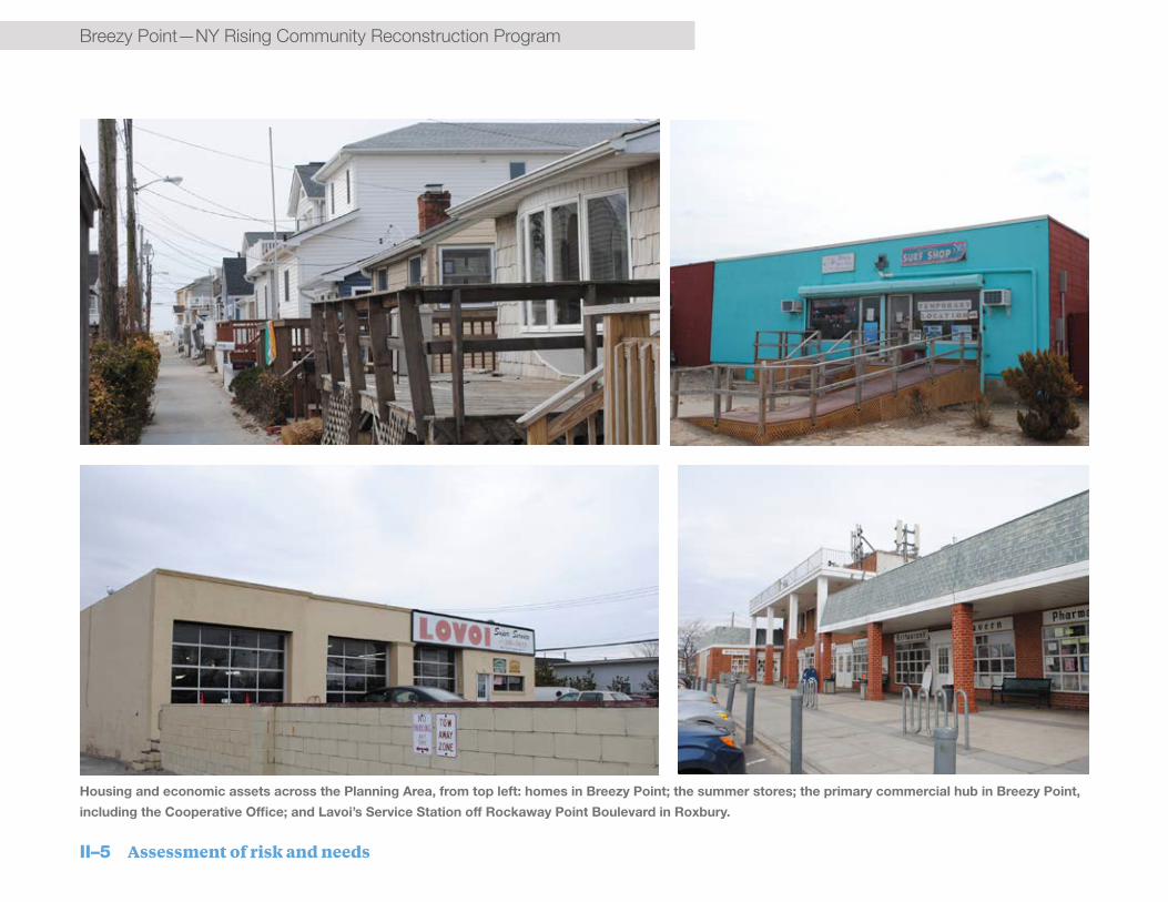
II–5 Assessment of risk and needs
Breezy Point—NY Rising Community Reconstruction ProgramBreezy Point—NY Rising Community Reconstruction Program
Breezy/Rockaway Point commercial hub.
Housing and economic assets across the Planning Area, from top left: homes in Breezy Point; the summer stores; the primary commercial hub in Breezy Point,
including the Cooperative Office; and Lavoi’s Service Station off Rockaway Point Boulevard in Roxbury.

Assessment of risk and needs II–6
NY Rising Community Reconstruction Program—Breezy PointNY Rising Community Reconstruction Program—Breezy Point

II–7 Assessment of risk and needs
Breezy Point—NY Rising Community Reconstruction Program
Health and social service assets
While the Community is rich in community organizations, many neighborhoods within the Community do not have health or social services, and residents must travel to reach such services. Within the Cooperative is a local medical center that provides residents with basic care. In addition, the area boasts an abundance of emergency services, including the Point Breeze Volunteer Fire Department, Rockaway Point Volunteer Fire Department, and Roxbury Volunteer Fire Department, which are also essential assets to the Community.
In addition, there are a few public buildings that provide important public services to Breezy Point. The Colony Theater serves as an important medium-sized gathering space for hosting government, administrative, and community events. The smaller (soon to reopen) Activity Center also supports targeted group events and club gatherings. Finally, the Cooperative’s Equipment Facility (the area’s only Public Works Facility) stores the equipment needed for cleanup after a storm.
The Planning Area has three of only ten remaining volunteer fire departments in the City.

Assessment of risk and needs II–8
NY Rising Community Reconstruction Program—Breezy Point
The Community has a number of other recreational and cultural amenities, such as sports fields, a lighthouse, and two 9/11 memorials. Residents use these spaces as common, public gathering spaces and they contribute significantly to the spirit and connectedness of the Community. Residents highly value these assets and would like to protect them as part of larger Community resiliency projects.
Infrastructure systems assets
Rockaway Point Boulevard is the only access route between the Community and the rest of the Peninsula as well as the Marine Parkway-Gil Hodges Memorial Bridge, which connects the western portion of the Rockaway Peninsula to Brooklyn. Sandy compromised this access route and the bridge, which severely impacted the Community. Because it is predominantly residential, and located on a peninsula, Breezy Point residents frequently rely on retail amenities and other services outside of the Community, and thus access to and from the Community are critical to day-to-day life as well as for evacuation and assistance in an emergency.
Utilities are also a major concern. Public Service Electric and Gas (PSE&G) transmission lines, the New York City water supply system, and the National Grid natural gas mains along Rockaway Point Boulevard were also identified as assets by the Community. These utilities are critical for communications and safety during an event, especially if the Community is physically cut off from the rest of the Peninsula or mainland.
The ballfields are the heart of the Community.
Before Sandy, the Community had two bayside docks that provided potential alternative access to Breezy Point. The docks located at Colony Theater, and Kennedy’s Restaurant were largely destroyed.
Natural and cultural resource assets
Beaches serve a critical role for the Community, providing both recreational benefits and potential protection against future storms.
The Cove provides beach and dune habitat for shorebirds and wildlife. This National Park Service (NPS)-owned land is located between Breezy Point and Roxbury at one of the narrowest points on the Rockaway Peninsula. Due to The Cove’s proximity to Rockaway Point Boulevard and the observed high rate of erosion along its coastline, its risk and recovery function is linked to that of one of the Planning Area’s key infrastructure assets—further erosion of The Cove will have direct impacts on Rockaway Point Boulevard and access to Breezy Point’s adjacent neighborhoods.

II–9 Assessment of risk and needs
Breezy Point—NY Rising Community Reconstruction ProgramBreezy Point—NY Rising Community Reconstruction Program
Health & Social Services Asset Name
1BreezySocialClubs
2PointBreezeVolunteerFIreDepartment
3RockawayPointVolunteerFireDepartment
4RoxburyVolunteerFireDepartment
5MedicalCenter
6ColonyTheater
7CooperativeEquipmentFacility
Infrastructure Asset Name
1 FerryDockAtColonyTheater
2 FerryDockAtKennedy’s
3 FerryDockAtRiisLanding
4 FerryDockAtTheCove
5 MarinePwyGilHodgesBridge
6 RockawayPointBlvd
Natural & Cultural Asset Name
1 Ballfields–Roxbury
2 Ballfields–BreezyPoint
3 BaysideBeaches
4 BreezyPointBeach
5 GatewayNationalPark
6 TheCove
The Activity Center (above); St. Thomas Moore
Church (middle); view from the beach (below).

Assessment of risk and needs II–10
NY Rising Community Reconstruction Program—Breezy PointNY Rising Community Reconstruction Program—Breezy Point
RE
ID A
V
BEACH
201 ST
BAYSIDE DR
BEACH
219 ST
OCEANSIDE AV
BED
FOR
D A
V
New York Rising Community Reconstruction Program Breezy Point Planning Area
QUEENS
BRONX
NEW JERSEY
BROOKLYNSTATEN ISLAND
3,0001,500Feet
0 ¯
Planning Area Boundary
¬¬5
¬¬6
¬¬5
¬¬5
¬¬5
¬¬4
¬¬2
¬¬1
¬¬3
¬¬3
··5
··6··2
··1··4
··3
¬¬3¬¬5
¬¬6¬¬4
¬¬2¬¬1 ¬¬7
Extreme
HighModerate
Risk Area
Assets
Source: New York City Department of City Planning, MAPPluto v13.1;NYRCR planning committee and public input.
Planning Area Boundary
Asset Map: Health & Social Services, Infrastructure, and Natural & Cultural
Community Capacity Building and Health & Social Services InfrastructureNatural & Cultural
Figure II-3: Asset Map—Health & Social Services, Infrastructure, and Natural & Cultural

II–11 Assessment of risk and needs
Breezy Point—NY Rising Community Reconstruction Program
NYS DOS Risk Assessment Tool
The NYS DOS Risk Tool assigns a risk score to each asset by evaluating three factors:
• Hazard: the likelihood and magnitude of future storm events
• Exposure: the local topographic and shoreline conditions that tend may increase or decrease coastal hazards
• Vulnerability: the capacity of an asset to return to service after a storm, taking into account its material strength relative to the coastal hazard as well as its regenerative capacity
Collectively, hazard, exposure, and vulnerability determine the chance that an asset could be damaged or destroyed by a storm event (e.g., “risk”). This analysis identifies which assets within the Community are most at risk in comparison to other assets. Further, it allows potential projects to be evaluated by their ability to reduce risk to assets.
Assessment of risk to assets and systems
The assessment of risk to specific assets or systems of assets in a community produces important information to help guide Planning Committee decisions about projects and priorities. Risk from future storms and flooding is evaluated based on three factors: hazard, exposure, and vulnerability. Hazard can be described by each asset’s location relative to the NYS Department of State (NYS DOS) risk areas.
The entirety of the Breezy Point Planning Area falls within one of the NYS DOS Risk Areas, with the majority of the Planning Area in the high risk area and some waterfront assets in the extreme risk area. Almost all of the Planning Area lies below the Base Flood Elevations currently identified by the Federal Emergency Management Authority (FEMA)—in a 100-year storm (a storm with a 1% annual chance of occurring) all but one small high point in the Planning Area would be inundated.
Located at the tip of the Rockaway Peninsula on a narrow, low-lying section of land between the Atlantic Ocean and the Rockaway Inlet, Breezy Point is highly exposed to coastal flooding from all sides. On the south (ocean) side, the
Community is exposed to heavy wave action, though somewhat protected by the wide beach and dunes present on Breezy Point Beach. On the north (Rockaway Inlet) side, the Community is exposed to storm surge as well as ongoing coastal erosion.
Most assets in the extreme risk area are those assets located directly on the Rockaway Inlet where they are most exposed to erosion and flooding. This includes bayside housing, the two ferry docks, and The Cove. Of the three Communities, Roxbury, due to higher rates of erosion, is more exposed to flooding, with a greater percentage of its housing and other assets falling within the extreme risk area.
Housing is highly vulnerable to flooding and associated damage due to wood-frame construction, small lot size, lack of elevation, and limited access onto and off the Peninsula. Housing at higher elevations or that has been elevated above grade, though still at risk, is less vulnerable to flood damage. Breezy Point’s few valuable economic assets are also at risk during a future emergency or weather-related event.
Risk to transportation assets pose a significant threat to access to and from the Community, and for emergency response. Rockaway

Assessment of risk and needs II–12
NY Rising Community Reconstruction Program—Breezy Point
REI
D A
V
BEACH
201 ST
BAYSIDE DR
BEACH
219 ST
OCEANSIDE AV
BED
FOR
D A
V
New York Rising Community Reconstruction Program Breezy Point Planning Area
QUEENS
BRONX
NEW JERSEY
BROOKLYNSTATEN ISLAND
3,0001,500Feet
0 ¯
Planning Area Boundary
Breezy Point Tip (NPS)
Rockaway Inlet
Atlantic Ocean
Fort Tilden (NPS)
Marine P
arkway G
il
Hodges B
ridge
Rockaway Point Boulevard
Moderate (6-23)Residual (<6)
High (24-53)
Severe (>53)Risk Score
Source: Risk Levels; NYRCRP Asset Inventory and Risk Assessment Tool. Basemap: New York City Department of City Planning, MAPPluto v13.1; Buildings; Street Centerlines
Planning Area Boundary
Risk Scores
The risk score is calculated using the NYRCR Program Asset Inventory and Risk Assessment Tool. This tool measures the relative risk to an asset based on the hazard in question (in this case a 100 year storm event), as well as the asset’s exposure (local topographic and shoreline conditions) and vulnerability (the capacity of an asset to return to service after a storm). Risk scores help identify assets with elevated potential for storm damage.For information on the tool and how to use it, see:http://stormrecovery.ny.gov/resources-0
Figure II-4:Geographic Distribution of Risk Scores [map]

II–13 Assessment of risk and needs
Breezy Point—NY Rising Community Reconstruction ProgramBreezy Point—NY Rising Community Reconstruction Program
Point Boulevard, a critical access route, is highly exposed to future damage due to its proximity to the rapid erosion of The Cove. Because the Community has only one means of access, the exposure of Rockaway Point Boulevard presents a risk to emergency access during a disaster event. Beyond Rockaway Point Boulevard, the Marine Parkway Gil Hodges Bridge – a critical connection between the Peninsula and Brooklyn – is also at high risk. Emergency Communication Systems are also threatened due to the exposure of the Breezy Point Cooperative’s emergency alarm system–sirens mounted 30 feet above the ground—to high winds in storm events.
In all of the areas, utilities lack redundancy and are at risk in major events. The Community has no centralized wastewater or stormwater treatment systems. The method by which the Community currently manages household sanitary waste – through the use of passive wastewater treatment and disposal units – puts it particularly at risk. Under extreme storm conditions, and even in more frequent rain-induced flood events, the units have the potential to operate under diminished capacity. In the long term, rising groundwater could cause the units, which rely on infiltration, to lose their effectiveness. In addition, flooding and ponding occurs in sections of the Community during and after extreme storm
events and in certain locations, water can stand and stagnate for days.
Overall, given the Community’s small size and constrained connections to other areas, the lack of redundancy of its critical infrastructure increases the vulnerability of assets throughout the Community.

Assessment of risk and needs II–14
NY Rising Community Reconstruction Program—Breezy PointNY Rising Community Reconstruction Program—Breezy Point

II–15 Assessment of risk and needs
Breezy Point—NY Rising Community Reconstruction ProgramBreezy Point—NY Rising Community Reconstruction Program
Through the NY Rising Community Reconstruction (NYRCR) planning process, the Breezy Point Planning Committee and residents identified the Community’s key resiliency needs and opportunities. This includes what it needs to be safe and to bounce back from extreme weather events and shocks from climate change. Residents also identified opportunities to better address the Community’s goals, including social
B. Assessment of needs and opportunitiesand economic resiliency. Breezy Point can leverage various opportunities to catalyze its recovery and ensure a stronger future.
The needs and opportunities discussed here reflect the firsthand experiences of residents and their knowledge of risks, challenges, unmet demands, and untapped potential across the neighborhoods of Breezy Point.
A strengthened edge
Breezy Point’s low elevation and open edges leave the Community highly exposed to multiple risks from coastal storms and places all of the Planning Area in a high-risk flood zone. While heavy wave action was concentrated on the oceanside of
A view along the bayside of Roxbury
NY Rising Community Reconstruction Program—Breezy Point
Assessment of risk and needs II–16
NY Rising Community Reconstruction Program—Breezy Point
the Planning Area during Superstorm Sandy, flooding came from both the ocean and the Bay. Further, future storms will be different and all edges of the Community are vulnerable. A comprehensive approach to coastal protection is required to fully protect the Community and allow it to continue to exist not just near, but with, the water. Comprehensive protection will require coordination with the rest of the Peninsula and Jamaica Bay, as well as various government entities and stakeholders.
Needs: Breezy Point has an urgent need for measures to strengthen its edges and protect the community from near-term future flooding as well as a 100-year storm. There is a particular need to focus on the most vulnerable areas around the edges of the Planning Area, which include most of bayside, open dune crossings on the beach, and exposure at National Park Service (NPS) property lines.
Additionally, any measures taken must not alienate this coastal community by blocking access to the water and/or views. Overall, there is a need for the Community to balance coastal protection measures while maintaining the essence of the beach community and quality of life.
Opportunities: The Community benefits from ample resources, including a large amount of harvestable sand, a well-organized Cooperative
structure, the ability to generate some complimentary funding within the Cooperative, and potential funding from other existing programs.
The Community has already started to leverage resources and opportunities to begin strengthening the edge. For example, before the NYRCR planning process started, the Cooperative hired its own engineer to begin a conceptual plan for a self-assessed comprehensive coastal protection system. The Cooperative’s shared ownership structure further empowers it to act on behalf of all its residents in aiding implementation. The Cooperative was able to secure a permit from the NYS Department of Environmental Conservation (NYS DEC) allowing it to harvest a certain amount of sand every year from the oceanside in order to construct dunes. Likewise, there are two pending applications for grants to support coastal protection projects, including a $58 million grant from FEMA’s Hazard Mitigation Grant Program (HMGP) and a joint application with NPS for a grant from the U.S. Department of the Interior to study and restore The Cove.
There is an opportunity to enhance these efforts and take advantage of other resources to expand coastal protection. New York State has endorsed the City’s pending HMGP application to implement Bay and beach coastal protection. Should this grant receive federal approval, it will
create a significant opportunity to coordinate HMGP and available CDBG-DR and other funding to ensure comprehensive protection along all of the vulnerable coastal edges of the Community. There are also opportunities to explore additional in-water “green” infrastructure solutions to restore and protect the natural resources surrounding the Community.
Finally, given the funding and organization of the Cooperative, there is an opportunity to generate more scaled or creative solutions that present co-benefits to the Community, such as a greenway recreational belt that connects the communities and NPS property with a linked bike/walkway, benches, the docks, and other recreational amenities.
Rebuilt and resilient housing
As a predominantly residential community, housing is the defining feature of Breezy Point and its most vulnerable asset. Superstorm Sandy (Sandy) destroyed 10% of homes, with many more severely damaged; compromised or incomplete coastal protection leaves all of the homes in the Community exposed to significant risk.9 There is a strong need to protect all of the homes across the Planning Area in order to

II–17 Assessment of risk and needs
Breezy Point—NY Rising Community Reconstruction ProgramBreezy Point—NY Rising Community Reconstruction Program
prevent recurring physical and economic impact to individual homeowners and the Community as a whole.
While strengthening the edge is a critical and valuable first line of defense, near-term, smaller scale solutions at the edge will not provide complete protection from coastal surge or flooding. Some homes across the community have been or will be elevated, either by the individual homeowner or through the City’s housing recovery program. This leaves the Community with the need to address the question of what to do with the non-elevated homes. Some residents do not want to elevate their homes and others find it may be physically difficult to do so based on their building type or their proximity to other homes. Overall, individual homeowners need to evaluate the steps required to protect their homes and the Cooperative needs to evaluate and make strategic decisions about planning the Community for the future.
Needs: The primary housing-related need for the Community is to avoid recurring damage and lessen the physical and financial risk for homeowners. There is a high need to help individuals find credible information on housing programs as well as flood risk and insurance, to help them assess options, understand trade-
offs, make well-informed decisions, and access resources as steps toward more resilient homes. This is particularly the case for those not currently eligible for elevation through New York City’s Build it Back program (BiB) due to factors such as degree of damage, income limits, and/or secondary home status.
There is also a need to understand the overall risk to the whole Community – economic as well as physical – and establish a short- and long-term strategy for land use, redevelopment, and the overall fabric of the neighborhoods. Because all of the residents of the Community are financially connected to the Cooperative, there is a need to maintain the economic well-being of the Community and maintain land and home values. Further, not every individual qualifies for government programs, nor can every individual afford to take action to mitigate the risks to their homes, so there is a need to identify various options that can maximize homeowner assistance to the entire Planning Area. There is also a need to evaluate the impact of elevation to the design and accessibility of the Community to ensure safe access and egress, establish consistent street-level frontage, and maintain the character of the neighborhoods.
Opportunities: While the opportunity to directly help each homeowner is limited, there are some opportunities for the Community. First, many homes may be elevated through BiB, with costs fully covered through the program. This not only helps individual homeowners, but it helps the Community address some of the initial questions and challenges associated with elevating. Also, through the work it has already completed, the Cooperative has access to quality developers who understand the unique needs of its housing stock and can help the Community evaluate its options, generate comprehensive strategies, and expedite overall construction.
Protected and redundant infrastructure
Breezy Point needs to ensure that it can support basic life safety needs if it is cut off from the rest of the Peninsula or mainland New York City. It also needs to provide reliable, predictable infrastructure and utilities to maintain regular commerce, health, and function of the Community. Because the Cooperative is not fully connected to New York City infrastructure or services, it needs to be able to support its own infrastructure

NY Rising Community Reconstruction Program—Breezy Point
Assessment of risk and needs II–18
NY Rising Community Reconstruction Program—Breezy Point
and services and ensure redundancy for critical services – both for major events as well as day-to-day living. The Planning Area has particular infrastructure needs and opportunities across transportation, water/wastewater management, and power/utilities.
Needs: Most of Breezy Point’s transportation needs are driven by the risk of extreme flooding, the impact of which ranges from creating a problem with accessing certain areas because of pooling water to creating extreme life safety issues due to being stranded. To prevent lack of access to the Community during a major event,
Some people are elevating or rebuilding while others struggle.
Rockaway Point Boulevard needs to be elevated or otherwise protected. There is also a need to expand the number of options in and out of the Community, either on land or by water, and to ensure alternatives to evacuation or getting help or supplies into the Community. Finally, accessibility across the Planning Area needs to be improved to guarantee residents can access their homes and/or leave their neighborhood if needed. Breezy Point needs to address its chronic on-land flooding and drainage issues to improve the resiliency of its key assets and the Community as a whole. The Cooperative also needs to evaluate its wastewater management and the long-term
viability of its septic system in the context of a rising water table. In addition, the Community needs to address the compounding issues of flooding and drainage issues mixed with septic overages, and consider how wastewater systems function and integrate with elevated homes.
Breezy Point power, water, and gas are all vulnerable utilities. The Community needs to take steps to ensure that these systems are protected and have redundancies, especially during an emergency. Back-up power is the greatest need to help ensure community health and safety during an event.

II–19 Assessment of risk and needs
Breezy Point—NY Rising Community Reconstruction ProgramBreezy Point—NY Rising Community Reconstruction Program
Opportunities: There are a number of opportunities to address these various transportation needs and related issues. First, there are opportunities to explore converting a National Park Service (NPS) road to an alternate route in and out of the Community in an emergency. There are a number of services roads in the park that could extend to the edge of Breezy/Rockaway Point and through to Jacob Riis Park. Recognizing that all of the surrounding NPS property is also at risk of flooding, there are also opportunities to enable access via new bayside docks that could accommodate emergency
vehicles and high pedestrian traffic. To improve intra-Community transit, there are opportunities to combine different initiatives, such as housing elevation and drainage, and to rethink roads and sidewalks to expand and improve access. Finally, there are opportunities to achieve co-benefits from improved transportation solutions. For example, an elevated Rockaway Point Boulevard could serve as a sea wall with embedded and protected utilities and with a built in recreational greenway that connects with NPS properties and other coastal protection infrastructure.
There are a large number of parking lots and paved surfaces across the Community which contribute to drainage issues. There is an opportunity to target a few of the key root problem areas to significantly reduce the most impactful flooding in the Community. Further, there is an opportunity to strengthen the wastewater treatment system across the Cooperative: the New York City sewer system stops about halfway up Rockaway Point Boulevard, and there is an opportunity to extend it to the property line and connect the Community.
To ensure resilient utility service in the Planning Area, Breezy Point’s public buildings and parking lots could be leveraged as sites for solar panels. Further, the small size and independent governance structure of the Community makes it an ideal candidate for a microgrid, which would enable the Community to harvest and use its own power, particularly important in an emergency. Also, given its location, Breezy Point could utilize wind power, which could directly benefit the Community and could have large economic benefits for generating power for others.
The Colony Theater provides a great community space but it does not accommodate the whole
Community.

NY Rising Community Reconstruction Program—Breezy Point
Assessment of risk and needs II–20
NY Rising Community Reconstruction Program—Breezy Point
Safe, resilient community spaces
The Community currently has neither adequate space to provide relief services after an emergency, nor the space to gather as a community on a regular basis. The lack of common, large public space not only prevents large gatherings but also inhibits the ability of the Community to organize effectively.
Needs: The Community needs a safe, public facility large enough to accommodate a significant portion of the population, especially during an event when residents may be seeking power, heat, water, comfort, and information, etc. Additionally, the Community needs an indoor public gathering space that can accommodate large public events on a regular basis – such as sports tournaments, multi-school activities, or Peninsula-wide events – with both the immediate Community as well as other communities.
The Medical Center in Breezy Point provides basic health care for the Community.

II–21 Assessment of risk and needs
Breezy Point—NY Rising Community Reconstruction Program
Opportunities: The Planning Area benefits from many underdeveloped lots, which could accommodate a large community space. There are many opportunities to create co-benefits from a large Community space, including indoor sports fields, professional meeting rooms, a community kitchen, or a daycare center.
Strengthened health, social, and economic resiliency
While addressing the needs of physical assets and the built environment is essential, addressing the needs of people and the overall health of the Community is just as critical. Breezy Point has a number of risks and issues that need to be addressed to strengthen its social and economic resiliency now and for the future.
Needs: Breezy Point needs to expand its efforts and programs to better protect and address concerns of vulnerable residents, in particular its large senior population. Seniors tend to face higher needs in emergencies, including the need for suitable evacuation procedures and a generally higher need for continuous access to health services and medication. In addition, accessibility and financial issues may arise for senior residents on fixed incomes. For example, some seniors may not be able to elevate their
homes, or if they do, they may have accessibility issues with having their homes over 10 feet off the ground. Further, seniors may have financial issues if the Cooperative needs to raise assessments to pay for increased maintenance of new resilient buildings, equipment, or infrastructure.
Local business owners are also vulnerable to severe weather events, and need to better understand resiliency upgrade options and financial issues confronting them. Business owners who also own a home in the Community or in the floodplain face compounded issues and have high needs for assistance.
Overall, the entire Community needs greater access to health services and amenities. Because of its size, Breezy Point alone cannot attract and sustain additional health care service providers, so the Community needs to identify opportunities to work with other communities on the Rockaway Peninsula to attract larger, quality health care service providers to the Peninsula. For ongoing mental and physical health, the Planning Area needs to protect its natural and cultural resources, the amenities that enhance the quality of life and embody the spirit of Breezy Point.
Opportunities: Between the Cooperative, neighborhood associations, and other local organizations, there are many opportunities to enhance the social and economic resiliency for everyone in the Community. Additionally, Breezy
Point benefits from a large proportion of trained local Emergency Medical Technicians (EMTs) and firefighters, who present the opportunity not only to help in an emergency but also to build up the capacity of the Community to prepare for and organize around events and issues.

Assessment of risk and needs II–22
NY Rising Community Reconstruction Program—Breezy Point

II–23 Assessment of risk and needs
Breezy Point—NY Rising Community Reconstruction ProgramBreezy Point—NY Rising Community Reconstruction Program
The projects in this plan were developed through the following Community-based process:
• Resiliency needs and opportunities were brainstormed through extensive public engagement. Needs were discussed in the context of reducing short and long-term risk and increasing the resiliency of assets, systems, and people. Opportunities to build off of existing community strengths were
also identified.
• With a thorough, baseline understanding of the Community’s resiliency needs and opportunities, the Committee identified overarching strategies to address the most critical needs in the community, and to take advantage of existing opportunities. Public input guided the refinement of these strategies.
• In order to implement strategies, the Committee identified specific projects. These projects directly address the needs and opportunities identified at the beginning of the process.
Strategy
PROJECT
PROJECT
PROJECT
PROJECT
PROJECT
PROJECT
PROJECT
PROJECT
PROJECT
Strategy
Strategy
Need
Need
Need
Opportunity
Opportunity
Opportunity
NYRCR Project Development Process
Opposite page source: With permission from Joanne Fogarty

III. Reconstruction and resiliency strategies

III–1 Reconstruction and resiliency strategies
Breezy Point—NY Rising Community Reconstruction Program
Reconstruction and resiliency strategiesThe Breezy Point Planning Area is a close-knit, well-organized, and well-informed community that launched resiliency studies and projects well before Superstorm Sandy (Sandy) and the NY Rising Community Reconstruction (NYRCR) Program began. The community has a keen awareness of the risks and benefits associated with living along the water and has taken steps toward improving the resiliency of the Community to protect itself from, and also to abide alongside, the water. The strategies generated through the NYRCR Program build on the Community’s efforts to-date and seek to further bolster its resiliency for the future.
Extensive Planning Committee deliberation and community engagement generated three overarching, critical strategies for Breezy Point:
1. Improve and expand coastal protection
2. Strengthen Community resiliency
3. Protect and bolster systems and infrastructure
Each of these strategies and their accompanying near-, medium-, and long-term Proposed and Featured Projects, build toward the Community’s long-term vision to bolster and expand the health, vitality, and sustainability of the Community.
This section describes these three strategies and the multiple elements that support them. Section IV describes specific Proposed and Featured Projects in more detail. The Additional Resiliency Recommendations in Section V as well as other ideas laid out here provide further context and proposals for the near, medium, and long term that support a resilient Breezy Point.
These recommendations also establish a framework for growing and enhancing the Community’s resiliency initiatives beyond and in conjunction with the NYRCR Program. The
most immediate opportunity to complement and exponentially expand the impact of this NYRCR Plan is by aligning strategies with the pending Federal Emergency Management Agency (FEMA) Hazard Mitigation Grant Program (HMGP) application. The State has submitted the Community’s $58 million HMGP application to FEMA. The proposal would implement coastal protection along the Bay and beach. Assuming the grant is approved by the Federal government, HMGP funds can support the majority of Breezy Point’s near-term strategy to improve and expand coastal protection. The NYRCR Program can
Proposed and Featured Projects
Proposed Projects are projects that the Planning Committee recommends for funding with its NYRCR Community Development Block Grant - Disaster Recovery (CDBG-DR) allocation. These are high priority projects that the Committee and Community support for funding because they address key resiliency needs, and provide immediate and/or multidimensional benefits.
Featured Projects are innovative projects for which an initial study or discrete first phase is proposed to be funded by CDBG-DR or another identified funding source. Subsequent phases of projects funded by the Committee’s CDBG-DR allocation will be need to be funded by another source.

Reconstruction and resiliency strategies III–2
NY Rising Community Reconstruction Program—Breezy Point
Conceptual vision for the bayside of the Breezy Point Planning Area.

III–3 Reconstruction and resiliency strategies
Breezy Point—NY Rising Community Reconstruction Program
complement the scope included in the grant by adding key elements, including elevated beach crossings. The Breezy Point Planning Committee (Committee) and Community as a whole fully support this strategy and see tremendous opportunity and value in finding synergies between the two programs.
1. Improve and expand coastal protection
The Community will pursue comprehensive edge protection strategies to ensure long-term viability and sustainability. While the Community has already begun to implement coastal protection projects, beginning with its dune system along the ocean, comprehensive coastal protection against a 100-year storm is the most important strategy to reduce the vulnerability of the Community.
Early in the planning process, however, it became clear that it would require significant funding beyond the up to $19.5 million NYRCR allocation to achieve these comprehensive coastal protection goals. Comprehensive protection requires myriad
protective measures along the Bay and ocean, as well as interventions along eastern and western community boundaries shared with the National Park Service (NPS).
The Committee also recognizes the negative consequences of comprehensive coastal protection measures, especially in terms of their impacts on the Community’s relationship with the water. Infrastructure measures such as bay walls and dunes that would be high enough to protect the Community from 100-year storm events would also block views and access to the very amenities that residents treasure. Large scale infrastructure measures may also not solve the problems of regular moon tide flooding or a larger storm that might overtop that infrastructure.
With all of these conditions and trade-offs in mind, the Committee deliberated extensively on how to achieve the Community’s coastal protection goals using a combination of the Community Development Block Grant-Disaster Recovery (CDBG-DR) allocation and other sources of funding.
The resulting Coastal Protection strategy takes a flexible approach to address specific, ongoing problem areas while preserving Community access to the water. By proposing a range of projects on both the oceanside and the Bay, the strategy complements ongoing projects to rebuild oceanside dunes and provides the flexibility to utilize other funding opportunities that may become available.
Key to this strategy is the aforementioned $58 million FEMA HMGP application for a comprehensive flood protection system for Breezy Point. The application proposes an oceanside double dune system and complementary set of bayside flood and erosion protections designed to safeguard the community from future storm events. Pending grant approval, the Committee’s list of featured projects will help move implementation forward by providing a greater level of design detail backed by Community support.
The Community will pursue comprehensive edge protection strategies to ensure the long-term viability and sustainability of Breezy Point.

Reconstruction and resiliency strategies III–4
NY Rising Community Reconstruction Program—Breezy Point

III–5 Reconstruction and resiliency strategies
Breezy Point—NY Rising Community Reconstruction Program
Beyond providing targeted protection and a flexible approach, the strategy also looks to leverage naturally occurring and manmade protective elements both within the Community and on neighboring lands. For example, existing dunes on NPS lands could be built up to protect against higher flood waters or enhanced with habitat restoration measures to be more resilient. Roadway infrastructure could be raised to protect against flooding but also to store utilities and provide emergency access. By looking beyond the Community’s boundaries, protective measures can provide benefits beyond coastal protection and to a wider audience.
Similarly, the strategy proposes a mix of traditionally engineered “grey” infrastructure and nature-based “green” infrastructure measures. By doing so, the Committee seeks not only to improve coastal protection but to generate environmental co-benefits that support wildlife, NPS, and the larger community.
Finally, the Committee strongly supports a regional study of coastal protection for Jamaica Bay communities, with specific emphasis on the need to understand the effects of storm-surge barrier placement on Breezy Point. This is one of the Committee’s Additional Resiliency Recommendations.
This combination of coastal resiliency Proposed and Featured Projects will provide immediate benefits, address existing gaps, and provide co-benefits beyond coastal protection.
Homes along the Bay are particularly vulnerable.

Reconstruction and resiliency strategies III–6
NY Rising Community Reconstruction Program—Breezy Point
Table III-1 – Strategy: Improve and Expand Coastal Protection
Projectname Shortprojectdescription Estimatedcost ProposedorFeaturedProject
RegionalProject(Y/N)
Enhanceddunewalkways
Toensurecontinuousoceansidecoastalprotectionwhilestillallowingforbeach
access,thisproposedprojectwouldcreateanuninterrupteddunealongthe
oceanwithraisedpedestrianandvehicleaccess.
$5.5million Proposed Y
NationalParkServiceCollaboration
ThePlanningCommitteeseekstocollaboratewiththeNationalParkService
(NPS)toidentifyandstrengthenkeyvulnerabilitiesonNPSpropertythat
threatentheBreezyPointCommunity.Thisprojectwouldsupporteffortsto:(1)
restoreimportantecologicalhabitat;(2)identifywaysofincorporatingresiliency
intoecologicalrestorationprojects;and(3)enablesecondaryemergencyaccess
viaNPSserviceroads.
Unknown Featured Y
BaysidecoastalprotectioninBreezyPoint&RockawayPoint
Thisprojectproposesthreediscretenear-termbaysidecoastalprotection
projectsalongthemostvulnerableareasinBreezyPointandRockawayPoint.
Thesesmallermeasuresaredesignedtoreduceexposuretostormsurgeand
waveforcesfrommorefrequentstormevents(lessthana10-yearstorm).
$11.3million Featured Y
BaysidecoastalprotectioninRoxbury
Thisprojectproposesnear-termbaysidecoastalprotectionprojectsalongone
ofthemostvulnerableareas:Roxbury.Thesesmallermeasuresaredesignedto
reduceexposureofkeyassetstoequinoxtidesandstormsurgeandwaveforces
frommorefrequentstormevents(lessthana10-yearstorm).
$19.3million Featured Y
ElevationofRockawayPointBoulevard
ThisprojectproposestoraiseandstrengthenRockawayPointBoulevard–the
BreezyPoint/RoxburyCommunity’ssoleaccessroute–andensureaccessibility
duringanemergency.
$76.5million Featured N

III–7 Reconstruction and resiliency strategies
Breezy Point—NY Rising Community Reconstruction Program
2. Strengthen Community resiliency
To complement the coastal protection strategy, the Breezy Point Planning Committee seeks to implement a multi-pronged strategy to address the various physical, economic, and social challenges that make the Community vulnerable. The Committee recognizes that implementing protective infrastructure at the edges is not the sole solution to the problem; rather, pursuing strategies within and across the Community would help ensure the adaptability and sustainability of Breezy Point over the long term. In other words, strengthening the physical, economic, and social resiliency of the Community, is as critical to strengthening the edge.
Breezy Point seeks to restore and improve the built environment, and to do so in a strategic way that protects it from flood, fires, or other extreme shocks. The first near-term step toward this strategy is to analyze the current state of the built environment and evaluate specific issues, risks, and opportunities — asset by asset, block by block. The Committee recommends pursuing a strategic project that would identify priority risk areas for housing and businesses, focusing on
Breezy Point seeks to implement a multi-pronged strategy to strengthen its overall Community resiliency.
those assets that experience recurring damage from flooding or are most vulnerable to coastal surge. The project would evaluate the current stock, looking at challenges and opportunities to leverage across the entire Community, documenting all of the commonalities across the building types to generate programs that expedite recovery and resiliency for all residents. For example, a survey of all homes could generate information to produce a uniform foundation plan, expedited process agreements from the NYC Department of Buildings (NYC DOB), or standard elevation plans that could generate or facilitate bulk elevation certificates. The Cooperative must also understand home and business owners’ interest and ability to contend with protection and resiliency measures and identify additional opportunities – public or private – that can help individuals or the Community as a whole finance near and longer term strategies. Finally, the project would identify opportunities to establish large community spaces that could offer multiple benefits to the Community, including offering safety and security after an emergency.
All of this work would produce a master community strategic plan that establishes guidelines and proposals for the overall design, reconstruction, and new development within Breezy Point. The plan will prioritize the most at-risk buildings and residents, and present medium- and longer-term financing options to support solutions that provide the greatest
benefits. To start, the Community will invest in moving and elevating the summer stores, which are known to be highly vulnerable to flooding and provide an important resource to local residents. Ultimately, the Community’s strategy to assess and address the built environment over the near- and long-term seeks to protect physical assets and guarantee the stability and sustainability of property value, assets, financial and social health, and well-being.
In addition to producing this comprehensive Community plan, the Committee recommends that homeowner and business recovery programs be expanded to help more residents in the Cooperative build back and establish an individual resiliency plan for the future. For example, many of the homeowners in the Community expressed that they would benefit from having access to education and counseling services to help them fully understand recovery programs, regulations, processes, insurance and financial options, and

Reconstruction and resiliency strategies III–8
NY Rising Community Reconstruction Program—Breezy Point
Source: Rockaway Point News.

Breezy Point—NY Rising Community Reconstruction Program
trade-offs. Likewise, the Community supports the idea of a technical assistance program for both businesses and homeowners to help them understand the physical or organizational steps they could take to reduce risk, whether that means small changes in the day-to-day or larger-scale physical changes like relocating mechanical equipment or elevating the building. Small business owners would also benefit from a local business-to-business program that can encourage peer sharing and work to revitalize commercial activity across the Rockaway Peninsula. Further, the entire Cooperative would benefit from increased access to capital to help pursue resiliency measures. While there is universal interest in grants, capital in the form of low-cost loans would also have a significant impact on the Community’s ability to physically protect its assets as well as its financial and economic stability.
Finally, the Committee will pursue efforts in the near and long term to improve the health, social capacity, and strength of the Community. The Planning Committee will bolster the overall social resiliency of the Community, with an eye toward emergency preparedness and response. The Cooperative will expand outreach; update emergency preparedness plans, training and drills; and establish clearer responsibilities at the neighborhood association level to ensure all community members are engaged, prepared and safe, especially vulnerable populations.
The Community will also coordinate with other communities across the Peninsula to draw greater quality health care services to the area, again with a focus on emergency care.
Source: With permission from Denise Neibel.

NY Rising Community Reconstruction Program—Breezy Point
Reconstruction and resiliency strategies III–10
Table III-2 – Strategy: Strengthen Community resiliency
Projectname Shortprojectdescription EstimatedcostProposedorfeaturedproject
Regionalproject(Y/N)
Housingelevationstudy
TheBreezyPointNYRCRPlanningCommitteeproposesfundingastudyto
evaluatehousingelevationneedsandstrategiesforBreezyPoint.Ultimately,
thisstudywouldprovidepossiblecommunitydevelopmentandredevelopment
strategiesaswellasinformationthatmayallowtheCommunitytonegotiatewith
acontractorforadiscountedbulkrateforelevation.
$275,000 Proposed N
Multipurposecommunityreliefcenter
Thisprojectentailstheconstructionofanewbuildingtoserveasacommunity-
basedemergencyrecoveryresource.Itseverydayusewouldprovideamuch-
neededcommunitycenterforBreezyPointresidents.
$6.7-$8.2million Proposed N
Summerstorerelocation
Thisprojectwouldsignificantlyimprovetheresiliencyofthesmallbutimportant
“summerstore”retailcluster,whichfloodsregularly.
$2million Proposed N
RockawayPointBoulevardelevation
ThisprojectproposestoraiseandstrengthenRockawayPointBoulevard–the
BreezyPointCommunity’ssoleaccessroute–andensureaccessibilityduring
anemergency.
$76.5million Featured N

III–11 Reconstruction and resiliency strategies
Breezy Point—NY Rising Community Reconstruction Program
3. Protect and bolster systems and infrastructure
In order to maintain the overall sustainability and resiliency of the Breezy Point Community,
Over the near- and long-term, Breezy Point will pursue strategies to protect and bolster its critical infrastructure and utilities.
One of many docks destroyed by Sandy.
the Committee proposes a comprehensive strategy to protect existing critical infrastructure and utilities and also create redundancies. In the near term, these projects would focus on the most acute needs and risks and would set the context to evaluate larger needs and create longer-term proposals for
future consideration. This strategy would address multiple elements: utilities, roads and surface area, and water management.
Because the Community primarily relies on outside service providers for power and gas, larger and longer-term strategies would rely on cooperation and alignment with those organizations and the rules that regulate them. The Community would seek opportunities to work with those service providers to expand service and strengthen existing infrastructure, including finding opportunities to bury utility cables or strengthen existing utility poles to withstand extreme weather events. The Community may also pursue a strategy to establish a local solar or wind-powered micro-grid that could plug into a larger regional system or could create efficiencies, redundancies, and economic opportunities for the immediate Community. By starting to move

NY Rising Community Reconstruction Program—Breezy Point
toward alternate power generation and storage, the Committee will pursue strategies to implement solar power throughout the Community, focusing on NYRCR Program projects where feasible.
The Community will pursue multiple initiatives to improve and expand access via roads and paved surface areas. In the long term, the Committee envisions strategically aligned projects to elevate key roads, including but not limited to Rockaway Point Boulevard, and establish design strategies to minimize storm water drainage issues across the entire Community. First, the Committee proposes pursuing projects in the near term to expand access routes in and out of the community, such as repairing critical docking facilities and working with National Park Service to identify emergency egress via service roads. Further, in the near term, the Community will pursue projects to achieve the goal of reducing chronic flooding issues associated with poor drainage. Implementing targeted solutions, such as permeable pavers and bioswales, in the highest need areas will be the first step toward the longer-term strategy.
In addition to addressing drainage issues with the large amount of impermeable surface area, the Committee suggests pursuing longer term strategies to address wastewater and emergency water needs. The Committee suggests the
Community consider a study of the sustainability of the current wastewater system, including proposals for whether the Cooperative should maintain the status quo, upgrade the system, or consider a hybrid or altogether new system. The Committee also suggests pursuing longer-term strategies to evaluate and expand access to water during emergencies, such as creating new dedicated fire hydrants or adding low-cost drafting systems to new, bolstered docks.
Reconstruction and resiliency strategies III–12
Rockaway Point Yacht Club Dock.

III–13 Reconstruction and resiliency strategies
Breezy Point—NY Rising Community Reconstruction Program
Table III. 3 – Strategy: Protect and bolster infrastructure
Projectname ShortprojectdescriptionEstimatedcost
Proposedorfeaturedproject
RegionalProject(Y/N)
Repairdocks ThisprojectwouldrepairtwobaysidedocksdestroyedbySuperstormSandy.
NewdockswouldincreaseemergencyaccesstotheCommunityandwould
enhancerecreationalactivitiesonthebay.
$3.2million Proposed N
Stormwaterdrainageimprovements
Low-lyingareasofBreezyPointandRoxburyactasbowlsthatcollectand
retainstormwaterrunoff,resultinginpoolsofstandingwaterforweeksatatime.
Stormwaterdrainageprojectswouldaddressparticularlyacuteproblemsinthree
areaswithamixof“grey”(hard)and“green”(soft)infrastructureapproaches.
$12.5million Proposed N

IV. Implementation–project profiles

IV–1 Implementation–project profiles
Breezy Point—NY Rising Community Reconstruction Program
Improve and expand coastal protection
Strengthen community resiliency
Protect and bolster infrastructure
Enhanced dune walkways
Housing elevation study* Repair docks
Breezy/Rockaway Point bayside protection
Multi-purpose community relief center*
Stormwater drainage improvements
Roxbury bayside protection
Summer store relocation*
NPS collaboration*
Rockaway Point Boulevard elevation
Overview of Proposed and Featured projectsThe Proposed and Featured Projects on the following pages are those projects that the Committee, with input from the community, has either prioritized for funding through its up to $19.5 million allocation of CDBG-DR or has identified funding through additional sources. This section describes each project and the potential costs10 and benefits that would result from each project if funded.
* Project siting shown as a demostration of concept and can be
implemented in multiple locations or includes the entire Community.

Implementation–project profiles IV–2
NY Rising Community Reconstruction Program—Breezy Point
Floyd Bennett Field
Rockaway Inlet
Manhattan Beach
Marine Parkway Bridge
Breezy Point NYRCR Plan Proposed and Featured Projects

IV–3 Implementation–project profiles
Breezy Point—NY Rising Community Reconstruction Program
STRATEGY: IMPROVE AND EXPAND COASTAL PROTECTIONProposed ProjectRecovery Support Functions
$5.5MCost
Health & Social Services
MEDIUM
Risk Reduction
Environmental Benefits
Economic Benefits
Timeline (years)
20 4 6
HIGH
MEDIUM
MEDIUM
Enhanced dune walkways To ensure continuous oceanside coastal protection while still allowing for beach access, this Proposed Project would create an uninterrupted dune along the ocean with raised pedestrian and vehicle access.
Project descriptionBreezy Point has natural coastal protection in the form of dunes running along the oceanside from Breezy Point Tip until Beach 201st Street. Currently, seven access routes cut through this natural dune system from Beach 222nd Street to Beach 201st Street. During Superstorm Sandy, these access routes served as inundation points, channeling storm surge waters and causing destruction to homes in Breezy Point.
The Committee proposes a combination of high-impact matting and hard structures to strengthen these access points. This project, combined with the Community’s dune reconstruction project, would provide continuous coastal protection along the oceanside beach property line of the Breezy Point Community.
The Committee proposes dune infill and beach matting at five of the existing beach access locations. Filling in the existing beach access points along with enhancing surrounding dunes at these points will create an uninterrupted dune along the ocean. To allow for continued beach access, matting can be placed over the newly filled dune. This matting would allow emergency vehicles and pedestrians to access the beach, and is compliant with requirements of the Americans with Disabilities Act (ADA).
For the remaining two access points, 8-foot high raised access ramps would fill the existing gaps in the dunes at these locations while allowing vehicle access to the beach. At 25 feet wide, the ramps would allow emergency vehicle and pedestrian access. Additionally, the access ramps would be 320 feet long, creating a gentle slope compliant with ADA requirements.

Implementation–project profiles IV–4
NY Rising Community Reconstruction Program—Breezy Point
Top left: existing access trails. Top right: matting option for beach access. Bottom: Section of more formalized ocean beach access option.

IV–5 Implementation–project profiles
Breezy Point—NY Rising Community Reconstruction Program
TOTAL COST $5.5 MILLION
Project Component Cost Estimate
Infillroadwaysfortwoaccesspoints $3.2million
Duneinfillandmattingforfive
accesspoints
$2.3million
Total $5.5 million
This conceptual-level cost estimate was developed based on current unit pricing and typical soft cost assumptions. Cost estimates will continue to be refined as more information is developed about the project.
This NYRCR Proposed Project would complement the Community’s dune construction project, which is expected to be funded by the Federal Emergency Management Agency (FEMA) Hazard Mitigation Grant Program (HMGP). Depending on the total, final costs for both projects, the respective funding sources may split or share the costs differently, to ensure a continuous oceanside solution.
BenefitsEconomic benefits
MEDIUM
A complete, uninterrupted dune system along the oceanside of Breezy Point would mitigate recurring loss and damage to homes and businesses from storm events. This cost avoidance would have a stabilizing effect on the economy and land value of the Community.
Based on analysis of construction and labor costs in the area, this project is estimated to create 8 construction jobs over the course of 3 years.
Health and social benefits
MEDIUM
This project would provide social benefits to the Community by providing safe vehicular and pedestrian access points to the beach, a recreational amenity for the Community.
Cost-benefit analysisThis project fortifies proven weak points in the Breezy Point Community’s oceanside coastal defenses. By filling in gaps in the dune where floodwaters entered in previous storm events, this project protects key assets within Breezy Point. At the same time, the project preserves the Community’s access to the beach, a key recreational

Implementation–project profiles IV–6
NY Rising Community Reconstruction Program—Breezy Point
facility. It also preserves emergency access to the beach. These benefits justify the cost of implementation.
Risk reduction HIGH
The Breezy Point oceanside poses a threat to the Community during storm events. During Sandy, wave action on the oceanside of Breezy Point not only inundated the Community but brought high velocity waves that damaged structures as well. Filling in gaps in the existing dune, either with beach infill or constructing a raised roadway, would create continuous protection along Breezy Point’s oceanside beach. Together, the Breezy Point oceanside beach and dunes can protect against flooding, wave action, and erosion. The beach acts as a buffer, reducing the exposure of assets to surge waters and waves, while dunes offer additional protection by dissipating wave action.
Enhancing these natural shore defenses reduces the exposure of key assets including Breezy Point housing in extreme and high risk areas. Dunes, however, are gradually eroded over time and during storm events and, therefore, require re-nourishment.
Timeframe for implementation
20 4 6 Once approved, and assuming a straightforward permitting process, this short-term project would require approximately 2 to 4 years to design, review, permit, and construct.
Regulatory requirementsReview and/or permitting by City, State, and Federal agencies is anticipated for this project. Environmental review is prescribed by the New York State Environmental Quality Review Act (SEQRA) and the New York City Environmental Quality Review (CEQR) process. Project implementation may require permits from U.S. Army Corps of Engineers (USACE), NYS Department of Environmental Conservation (NYS DEC), NYS Department of State (NYS DOS), and/or NYC Department of City Planning (NYC DCP).
Jurisdiction This project is located entirely within the privately owned land of the Breezy Point Cooperative and within the jurisdiction of New York City.

IV–7 Implementation–project profiles
Breezy Point—NY Rising Community Reconstruction Program
Housing elevation study
The Breezy Point NYRCR Planning Committee proposes funding a study to evaluate housing elevation needs and strategies for Breezy Point. Ultimately, this study would provide possible community development and redevelopment strategies as well as information that may allow the Community to negotiate with a contractor for a discounted bulk rate for elevation of homes.
Project descriptionThis project proposes a study to explore the options and strategies to plan the elevation of housing in Breezy Point. Although the increased cost of flood insurance is being slowed with the adoption of the Homeowner Flood Insurance Affordability Act, many residents of Breezy Point remain confused by the changing regulations and the varying information about costs of elevating their homes. This project would aim to provide a more reliable and locally-tailored resource for the Community. The elements of the study would then be combined with a negotiated bulk discount rate for a contractor to evaluate individual homes and elevate them as appropriate (with elevation costs to be paid for by the homeowner).
TOTAL COST$275,000
The cost for this study estimates the following scope of work:
• Conduct an elevation analysis of the Community and make recommendations on which homes should be elevated and when, given both flood and insurance risks
• Identify the requirements necessary for future development specific to geographic locations within the Community
Proposed ProjectRecovery Support Functions
$275,000Cost
Risk Reduction
Economic Benefits
Timeline (years)
20 4 6
MEDIUM
MEDIUM
STRATEGY: STRENGTHEN COMMUNITY RESILIENCY
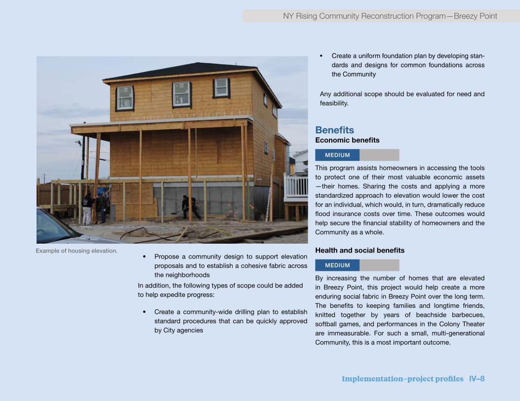
Implementation–project profiles IV–8
NY Rising Community Reconstruction Program—Breezy Point
• Propose a community design to support elevation proposals and to establish a cohesive fabric across the neighborhoods
In addition, the following types of scope could be added to help expedite progress:
• Create a community-wide drilling plan to establish standard procedures that can be quickly approved by City agencies
• Createauniformfoundationplanbydevelopingstan-dards and designs for common foundations acrosstheCommunity
Any additional scope should be evaluated for need and feasibility.
BenefitsEconomic benefits
MEDIUM
This program assists homeowners in accessing the tools to protect one of their most valuable economic assets —their homes. Sharing the costs and applying a more standardized approach to elevation would lower the cost for an individual, which would, in turn, dramatically reduce flood insurance costs over time. These outcomes would help secure the financial stability of homeowners and the Community as a whole.
Health and social benefits
MEDIUM
By increasing the number of homes that are elevated in Breezy Point, this project would help create a more enduring social fabric in Breezy Point over the long term. The benefits to keeping families and longtime friends, knitted together by years of beachside barbecues, softball games, and performances in the Colony Theater are immeasurable. For such a small, multi-generational Community, this is a most important outcome.
Example of housing elevation.

IV–9 Implementation–project profiles
Breezy Point—NY Rising Community Reconstruction Program

Implementation–project profiles IV–10
NY Rising Community Reconstruction Program—Breezy Point
Cost-benefit analysisThe cost of this study is comparatively quite low when judged against the long-term benefits it provides. The actual economic benefits to individuals would vary and the discount that could be achieved is unknown and likely to be dependent on a certain rate of participation in order to gain the necessary economies of scale. Still, due to the interest within the Community for elevation, and understanding the risk reduction and associated social benefits in ensuring the long-lasting existence of the Community, this project can have an impact far beyond its initial investment.
Risk reduction MEDIUM
Superstorm Sandy emphasized the vulnerability of housing on the Rockaway Peninsula, which was even more pronounced in Breezy Point. Coastal protection is needed, yet these interventions will require time to be implemented at a scale that protects the entire Community against storm surge. The best protection against damage from storm surge includes both fortifying the coastline and elevating houses, ensuring that occupiable floors are safely above the flood elevation. This project is focused on facilitating the latter, guaranteeing that as many homes can be raised as possible. Additionally, this study would better address the needs of seniors, a significant and
growing population in the Community, who may be on fixed incomes and unable to absorb dramatic increases in the costs of maintaining their homes.
Timeframe for implementation
10 2 3
The study is estimated to take approximately 6 months to complete.
Regulatory requirements No regulatory requirements will apply to the study.
Jurisdiction This project is located entirely within the privately owned land of the Breezy Point Cooperative and within the jurisdiction of New York City.

IV–11 Implementation–project profiles
Breezy Point—NY Rising Community Reconstruction Program
Multi-purpose community relief centerThe project would construct a building to serve as a community-based emergency recovery resource. Its everyday use would provide a much-needed community center for Breezy Point residents.
Project description Since there are no viable alternatives for retrofitting existing structures, this project would fund the creation of a new multi-purpose community relief center hub that would provide a large, central, safe location to house the coordination of emergency and relief services following a disaster, such as access to food, water, power, medical services, information, and special services for seniors or other vulnerable populations. In an effort to extend the impact of the multi-purpose relief center “hub” in Breezy Point, funds would also be allocated to harden smaller “satellite” locations in the Planning Area that would act as distribution centers for supplies and information.
While the Breezy Point Cooperative’s Administrative offices served as a makeshift gathering space after the storm, the facility was not adequately equipped to serve the community, lacking back-up power and communications
systems, as well as sufficient space for gathering. There was also no emergency preparedness plan and a lack of adequate emergency supplies. The relief center would leverage existing local knowledge and relationships across the Cooperative to provide essential information to residents and businesses; coordinate across multiple providers of community-based emergency health and social services consistent with a local Emergency Preparedness Plan; and help to evaluate community needs and efficiently distribute resources. The center could also provide a regular meeting space for Community Emergency Response Team (CERT) or Ready New York trainings and serve as a neighborhood contact for NYC Office of Emergency Management (NYC OEM) and other emergency and first responders. The relief center could be complemented by smaller “satellite” locations that can serve as distribution centers for supplies and information.
Proposed ProjectRecovery Support Functions
$6.7- 8.2MCost
Health & Social Services
HIGH
Risk Reduction
Economic Benefits
Timeline (years)
20 4 6
MEDIUM
HIGH
STRATEGY: STRENGTHEN COMMUNITY RESILIENCY

Implementation–project profiles IV–12
NY Rising Community Reconstruction Program—Breezy Point
Conceptual vision of a multi-purpose community center in Breezy Point.

IV–13 Implementation–project profiles
Breezy Point—NY Rising Community Reconstruction Program
To serve its emergency preparedness purpose, the hub should be located in a large, elevated, flood-proofed community space where logistics, communications, and supplies can be managed and distributed. It should also have backup heating and cooling, restrooms and showers, a kitchen, and a large ground-floor space to allow people to gather and connect with others. It would also feature solar power atop the building and the surrounding parking stalls to provide back-up power. The building would be fully compliant with the design standards of the Americans with Disabilities Act. Many of these features are compatible with the year-round use of the building as a community and recreation center. They are also consistent with building requirements developed from Planning Committee (Committee) discussions as well as local and national best practice resilient building and siting criteria.
While some open space is distributed across the community, most of Breezy Point is residential. As such, the Community recommends potentially locating the multipurpose community relief center hub next to the ball fields near Rockaway Point Boulevard. This site is centrally located along the evacuation route and adjacent to a large open space (ball fields and parking lots) that can act as a large gathering area. It is also near both the Breezy Point commercial stores and “summer stores,” the Point Breeze Volunteer Fire Department, and both the Point Breeze Association and the Breezy Point Cooperative offices. The Committee considered the feasibility of retrofitting existing structures to serve as a central relief hub, but ultimately
decided that the ideal location would require new, resilient construction.
Because of Breezy Point’s unique Cooperative ownership and organizational structure, the Breezy Point Cooperative is a strong candidate to operate the hub. The Cooperative has the ability to provide year-round programming emergency resources. To ensure rapid response and effective coordination during an emergency, the project would support a program manager who would have the following responsibilities:
• Maintaining regular contact and coordination across local and regional emergency, health and human services organizations and NYC OEM
• Managing disaster preparedness-related programming, which could include trainings and practice drills, “Know your neighbor” events, and outreach to vulnerable populations
• Ensuring the building has basic emergency supplies and ready equipment, such as radios or push-to-talk phones and fully functional back-up power sources
During non-emergency times, the building would serve as a community recreation center, and would be built to include indoor sports amenities, locker rooms, meeting and office space, a community kitchen, and daycare. This

Implementation–project profiles IV–14
NY Rising Community Reconstruction Program—Breezy Point
The Planning Committee proposes three projects around the ball fields in Breezy Point, as demonstrated by this conceptual site plan. The projects would include
an integrated stormwater strategy that would regrade the existing ballfields, repave the surrounding parking lots with permeable materials, construct a new elevated
and hardened sustainable multi-purpose community center and raised stores that can be used as a relief center during a storm event. The relief center would be
designed with emergency solar back-up power
2
Site Plan: Breezy Point Ballfields Area
(ft)
TheBallfieldsareaprojectsincludeanintegratedstormwaterstrategythatwillregradetheexistingballfields,repavethesurroundingparkinglotswithpermeablematerials,constructanewelevatedandhardenedsustain-ablemulti-purposecommunitycenterwhichcanbeusedasareliefcenterduringastormevent.Itisdesignedwithemergencysolarback-uppowerandre-buildthesummerstoresatanelevatedlocation.
ROCKAWAYPT.BLVD
PermeableParkingLotswithimproveddrainage
PermeableParkingLotswithimproveddrainage
PermeableParkingLotswithimproveddrainage
Multi-purposecommunityreliefcenter
Relocatedsummerstores
Improvednorthsouthpedestrian/bikeconnectionEmergencyaccesscorridor
ExistingTennisCourts
Ballfieldswithimproveddrainage
0 200’N

IV–15 Implementation–project profiles
Breezy Point—NY Rising Community Reconstruction Program
space would fill a much-needed gap in public space in the community—providing the only public restrooms and open gathering space. This new community amenity would also help strengthen the economy of the Community by bringing in additional revenue through renting for sports or private events.
TOTAL COST
$6.7 – $8.2 MILLION
The Committee recommends allocation of approximately $6.7 million to $8.2 million for the creation of a multipurpose community relief center and satellite locations. The relief center would require funding to cover two types of expenses:
• Capital funding: Construction costs associated with this project would include new building construction or significant retrofitting, a fixed back-up generator, solar power, elevation and flood-proofing measures, back-up hardened communications equipment, locker rooms and showers, meeting rooms, office space, daycare, and a community kitchen.
• Operational funding: Funding would be used to support capacity building and a part-time program manager to provide year-round emergency programming and capacity building for two years.
While the costs for required capital improvements would depend upon the final design, a relief center with 18,000
square feet of usable space could cost approximately $5 million in capital. These cost estimates assume the mitigation measures implemented provide a high degree of flood protection. Costs for a program manager and emergency preparedness programming at the relief center could also vary widely, depending on the availability of funds and the needs identified in the Community. The annual cost of the program manager and emergency preparedness programming (plus overhead) could range from $20,000 to $60,000, for a total project cost of $40,000 to $120,000 over the course of 2 years.
After 2 years, the Cooperative would be responsible for the modest costs of emergency preparedness programming, maintenance of the building on an ongoing basis, and emergency supplies and equipment.
BenefitsHealth and social benefits
HIGH
Creating a relief center to provide space, supplies and support would reduce the health safety risks associated with a disaster for the entire population. Specifically a relief center would reduce the risk of:
• Lack of access to basic medical supplies, food, water, heat, and other necessities;
• Emotional or psychological distress
• Displacement of children, relatives, and friends

Implementation–project profiles IV–16
NY Rising Community Reconstruction Program—Breezy Point
4
Section: A Section through the Breezy Point Community Center looking north
(ft)
Ballfieldwith improveddrainage
Playground Elevatedmulti-purposecommunityreliefcenterwithparkingbelowAccessRoad
PermeableParkingwithdrainageswales
Swale
Rooftop/ParkingLotSolar PanelOpportunitiesBallfieldsusedasLarge
GatheringSpaceinDisasterEvents
Cafe/Catering
Parkingbelowbuilding
0 20’
Section through the Breezy Point Community Center looking north.

IV–17 Implementation–project profiles
Breezy Point—NY Rising Community Reconstruction Program
• Confusion or lack of information across the Community
The relief center would also serve to increase the overall social resiliency of the Community through ongoing training and emergency preparedness planning across the Community. Vulnerable populations, such as senior and physically impaired residents, would stand to benefit the most, given that they are most likely to need assistance and a safe place to go after an emergency if their homes are not safe or warm. Further, the relief centers would provide much-needed public space for events, meetings, and sports activities with other communities.
Economic benefits
MEDIUM
The relief centers would support a part-time employee to build organizational capacity for 2 years. Capital expenses associated with building community centers would also create a small number of temporary jobs for construction and installation of resiliency building improvements.
The multipurpose community relief center would also be a source of revenue and potential savings for the Community. By charging for sports or private events, the community center would generate revenue, which could be put toward emergency preparedness programming, the purchase of emergency supplies, or other relief and recovery needs. If in the future, Breezy Point creates a micro-grid in the Community, the solar carport may serve as one contributing energy source in the larger system.
The relief center would likely have a neutral or potentially net positive impact on local government spending. Because emergency response would be centralized in one place, the center could incrementally reduce government costs of coordination and emergency response and recovery in the future. The new community relief center would require coordination with NYC OEM.
Cost-benefit analysis
As described above, a Breezy Point Cooperative-wide relief center network would provide numerous benefits to the Community in the event of a disaster, including reducing overall risk to residents and providing critical health and social services.
This project would not only benefit residents in the immediate aftermath of emergency events, but would benefit the Community year-round. Perhaps most importantly, this project has broad public benefits and particularly serves vulnerable populations—key priorities of the Planning Committee.
While programming costs to help build capacity and develop an emergency preparedness plan would be available for a 2-year CDBG-DR funding period, the benefits of the relief center would be sustainable beyond the funding period so long as the Cooperative dedicates modest resources to maintain emergency equipment, sustain emergency plans, and continue coordination with the City. There are no apparent negative externalities associated with the proposed project.
Implementation–project profiles IV–18
NY Rising Community Reconstruction Program—Breezy Point
Risk reduction HIGH
The multipurpose relief center network would reduce risk to residents of Breezy Point, most of whom live in one-story homes in the floodplain. In addition to the direct risk reduction to individual residents, there would be co-benefits from using the solar power generated on a daily basis, as well as during an emergency. The carport can lead to overall savings as it reduces the facility’s use of energy generated by a utility. This initial solar investment can serve as a baseline to develop a micro-grid for the whole community.
Centralizing emergency response in one place, rather than across three volunteer fire departments, a security office, and the Cooperative Offices, would help ensure more efficient emergency response and would improve coordination with NYC OEM, first responders, or any other organizations needing to coordinate with the Community in an emergency.
Implementation timeframe
10 2 3
Once the project has been formally initiated, it would take approximately 1 to 2 years to implement. The key issues that could most dramatically affect the timeframe are the design and approval process as well as seasonality challenges with construction.
While there are current conceptual and architectural designs prepared for a relief and community center, respectively, a more complete physical building design and plan would need to be created. This would take approximately 4 to 6 months. Depending on the scope of the work, and taking into account the seasonality of construction, the capital improvement construction phase could take 6 to 18 months.
For programming and operations, the Cooperative would hire a part-time program manager who would be responsible for creating a plan to implement programming. Programming can start within 3 to 6 months after the program manager is on board.
Regulatory requirementsIt is anticipated that a regulatory review would not be needed for the execution of this project. Because the sites would provide relief and not function as formal shelters or evacuation centers they would not be held to FEMA regulations. NYC OEM must also be engaged in facilitating coordination with citywide emergency preparedness efforts.
Jurisdiction
This project is located entirely within the privately owned land of the Breezy Point Cooperative and within the jurisdiction of New York City.
IV–19 Implementation–project profiles
Breezy Point—NY Rising Community Reconstruction Program
STRATEGY: STRENGTHEN COMMUNITY RESILIENCYProposed ProjectRecovery Support Functions
$2MCost
Health & Social Services
MEDIUM
Risk Reduction
Environmental Benefits
Economic Benefits
Timeline (years)
20 4 6
MEDIUM
LOW
LOW
Summer store relocation
This project would significantly improve the resiliency of the small but important “summer store” retail cluster, which floods regularly.
Project descriptionThe “summer stores” of Breezy Point include two buildings totaling approximately 7,000 square feet on the western edge of the ball fields near the Point Breeze Association building. These buildings include seasonal retail and a small snack bar and grill.
This Proposed Project would fund the construction of resilient commercial space that relocates the existing stores and potentially provides an opportunity for year-round commercial establishments. The relocated summer stores would incorporate sustainable features such as rooftop solar panels. Since the building would need to be elevated to protect against flooding, there is the opportunity to provide parking underneath the relocated summer stores, and allowing water to flow through during a flooding event
This project would create a model for more resilient commercial buildings in Breezy Point, allowing for these
businesses to reopen quickly after a storm event and serve the Community in helping to establish restoration of everyday services. Breezy Point does not have many commercial buildings, but the ones that do exist are vulnerable to regular flooding.
TOTAL COST $2 MILLION
Cost estimates for this project include design, permitting, and construction.
Economic Benefits
MEDIUM
Preserving the summer stores in Breezy Point would help to
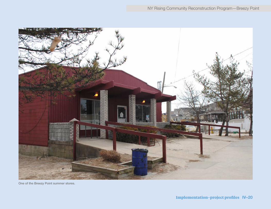
Implementation–project profiles IV–20
NY Rising Community Reconstruction Program—Breezy Point
One of the Breezy Point summer stores.

IV–21 Implementation–project profiles
Breezy Point—NY Rising Community Reconstruction Program
ensure that small, community serving retail would continue to exist in Breezy Point. These stores, operating already on a thin margin are a source of local seasonal employment and income, a rarity within this Community.
Health and social benefits
MEDIUM
Elevating summer stores, which provide a valuable amenity to residents, would help them to stay open following a storm or major flooding event. This would protect the already limited services in these communities, providing residents access to food, service, and socialization.
Cost-benefit analysis
The proposed project would help to establish a new model for resilient building in Breezy Point. While it would not directly reduce the risk of flooding to the surrounding Community, it may play a supportive role to the nearby multipurpose relief center after a disaster, and would ensure that the businesses would not be forced to shut down after flooding. Considering the long-term use of the stores and buildings, the benefits of this project outweigh the cost.
Risk reduction LOW
Relocating the summer stores would help to create a new
resilient commercial building type in Breezy Point. Better able to withstand surging waters and storm conditions, as well as regular flooding, the stores would remain a part of the Community fabric for a long time. Additionally, having the related projects as a part of the larger comprehensive strategy would help to establish a freshly defined heart of the Community. After an emergency, these elevated spaces could play a supporting role as an annex to the primary multipurpose relief center.
Timeframe for implementation
20 4 6 This project could be implemented in 1 to 2 years.
Regulatory requirementsThe project would likely be subject to regulatory review from a number of City agencies, including the New York City Department of Buildings (NYC DOB), and the New York City Department of City Planning (NYC DCP).
Jurisdiction This project is located entirely within the privately owned land of the Breezy Point Cooperative and within the jurisdiction of New York City.

Implementation–project profiles IV–22
NY Rising Community Reconstruction Program—Breezy Point
3
Site Plan: Zoom-in Summer Stores
ThesummerstoresaregoingtoberebuiltabovetheBFEtoresistfloodingdamageduringstormevents.TheirsitingwilltakeadvantageofviewsandaccesstotheBallfields.
(ft)
Relocatedsummerstores
Footprintofexistingsummerstores
0 100’N
The summer stores would be rebuilt above the base flood elevation, which is the computed elevation resulting from floodwater that has a 1% chance of equaling or
exceeding that level in a given year, to resist flood damage during storm events. Their siting will take advantage of views, current zoning, and access to the
ball fields.

IV–23 Implementation–project profiles
Breezy Point—NY Rising Community Reconstruction Program
STRATEGY: PROTECT AND BOLSTER INFRASTRUCTUREProposed ProjectRecovery Support Functions
$3.2MCost
Health & Social Services
MEDIUM
Risk Reduction
Timeline (years)
20 4 6
LOW
Repaired docksThis project would repair two bayside docks destroyed by Superstorm Sandy. New docks would increase emergency access to the Community and would enhance recreational activities on the Bay
Project descriptionBreezy Point has long maintained active docking facilities along the Bay. Two of these docks, located near the Bay House/Colony Theater and Kennedy’s Restaurant, were severely damaged during Sandy. While some portions of each dock remains in place, both remain unusable since the storm. The project would involve repairing the two docks to enable regular use and accommodate ferry and emergency vehicle access. Repair would entail the following for each dock:
▪ Removing and replacing timber pile bents outside of the mean high water mark; all sub-deck elements (such as floor beams, bracing, etc.); and all wood decking
▪ Installing free-standing safety railing
▪ Restoring the two docks will provide redundancy for evacuation/egress and access to the Community for emergency service providers
TOTAL COST $3.2 MILLION
Project Component Cost Estimate
Dock at Kennedy’s Restaurant $1.2 million
Dock at the Colony Theater $2.0 million
TOTAL $3.2 million

Implementation–project profiles IV–24
NY Rising Community Reconstruction Program—Breezy Point

IV–25 Implementation–project profiles
Breezy Point—NY Rising Community Reconstruction Program
The cost estimate assumes the following:
▪ The dock at Kennedy’s is 370 feet by 6 feet, and leads to a boat loading and docking area that is 40 feet by 25 feet wide.
▪ The dock at the Colony Theater is 320 feet by 12 feet and leads to a boat loading and docking area that is 100 feet by 25 feet.
▪ The docks would be repaired in place and to the same dimensions and functions as they previously operated.
▪ Timber piles within the mean high-water mark can be reused.
This conceptual-level cost estimate was developed based on current unit pricing and typical soft cost assumptions. Cost estimates would continue to be refined as more information is developed about the project.
BenefitsEconomic benefits
LOW
Based on analysis of construction and labor costs in the area, this project is estimated to create seven construction jobs over a two-year period.
Repairing the docks would also be of benefit to Kennedy’s Restaurant, the Colony Theater, and other nearby businesses that may enjoy increased patronage from Breezy Point residents who come to use the dock facilities.
Health and social benefits
MEDIUM
This project would provide emergency access to the Community for evacuation and/or supplies, increasing residents’ access to health and other services. As a co-benefit, it provides a recreational amenity to the Community to use the docks for fishing and other recreational uses. Finally, repairing the docks would improve community aesthetics.
Cost-benefit analysis
Repairing the docking facilities at Kennedy’s and the Bay House/Colony Theater would return two key assets to the Community and provide a means of emergency access in future disasters. The emergency access benefits and recreational co-benefits of this project would justify the cost.
Risk reduction
LOW
By strengthening, hardening, and repairing the facilities, this project reduces risk to the ferry docks at the Bay House/Colony Theater and Kennedy’s Restaurant. Repairs would include measures to harden the docks which would decrease their vulnerability to future storms. Analysis using the NYS Department of State (NYS DOS) Risk Assessment Tool suggests that assets protected by this project would see a 75% reduction in their risk score in a 10-year storm event. Restoration of the docks would restore community

Implementation–project profiles IV–26
NY Rising Community Reconstruction Program—Breezy Point

IV–27 Implementation–project profiles
Breezy Point—NY Rising Community Reconstruction Program
use of the Bay and provide additional access points for evacuation, emergency response, and recovery efforts during future disasters.
Timeframe for implementation
20 4 6 Once approved, and assuming a straightforward permitting process, this short-term project would require approximately 2 to 4 years to design, review, permit, and construct.
Regulatory requirementsReview and/or permitting by City, State, and Federal agencies is anticipated to be required for this project. Environmental review is prescribed by the National Environmental Policy Act (NEPA), NYS State Environmental Quality Review Act (SEQRA), and/or NYC Environmental Quality Act (CEQA) processes. Project implementation may require permits from U.S. Army Corps of Engineers (USACE), NYS Department of Environmental Conservation (NYS DEC), NYS DOS, and/or NYC Department of City Planning (NYC DCP).
Jurisdiction The jurisdiction of this project would fall within the Breezy Point Cooperative, New York City, NPS and/or USACE.

Implementation–project profiles IV–28
NY Rising Community Reconstruction Program—Breezy Point

IV–29 Implementation–project profiles
Breezy Point—NY Rising Community Reconstruction Program
Proposed ProjectRecovery Support Functions
$12.5MCost
Health & Social Services
MEDIUM
Risk Reduction
Economic Benefits
Timeline (years)
20 4 6
MEDIUM
MEDIUM
STRATEGY: PROTECT AND BOLSTER INFRASTRUCTURE
Stormwater drainage improvementsLow-lying areas of Breezy Point and Roxbury act as bowls that collect and retain stormwater runoff, resulting in pools of standing water for weeks at a time. Stormwater drainage projects would address particularly acute problems in three areas with a mix of “grey” (hard) and “green” (soft) infrastructure approaches.
Project description Drainage issues are particularly acute in three areas of Breezy Point and Roxbury:
▪ The southeast residential area of Breezy Point bounded by Bedford Avenue, Oceanside Drive, Reid Avenue, and Rockaway Point Boulevard
▪ The Breezy Point ball field area (8th Avenue south of Rockaway Point Boulevard), comprising mainly recreational uses (such as a baseball field, basketball court, etc.), maintenance yards for municipal purposes, parking lots, and boat storage, but also used for community meetings and events
▪ The Roxbury parking area, a combination of impermeable paved areas and unpaved areas
All three areas tend to experience problems with stormwater several times per year, even during regular rain
events, leaving areas under water and delaying recovery. For example, after winter storms, water pools and freezes, creating dangerous ice ponds that inhibit residents from necessary access. Following Superstorm Sandy, water ponded for weeks after floodwaters receded, cutting residents off from their homes, leaving gathering spaces under water, and delaying recovery.
In the southeast residential area, a storm drain system would be implemented to collect stormwater and pump it out of the area. The system would consist of an underground network of pipes and a central pumping station (with back-up generator). The collection system would consist of a series of inlets connected to the pump station with PVC sewer piping. Because of the flat topography of the area, it may be difficult to obtain the slopes needed for proper drainage. If this is the case, additional smaller pumping stations may be required. The collected stormwater would be moved to a main station

Implementation–project profiles IV–30
NY Rising Community Reconstruction Program—Breezy Point
Proposed location of drainage improvements.

IV–31 Implementation–project profiles
Breezy Point—NY Rising Community Reconstruction Program
INFI
LTRA
TIO
N
PERMEABLE PAVER PARKING STALL
OVERLAND FLOW COLLECTED IN BIOSWALES
PERMEABLE CONCRETE PAVEMENT DRIVE AISLE FILTRATION
STONE, TYP.
STORMWATER OVERFLOW INLET
STORMWATER COLLECTION PIPE
RAINGARDEN BIOSWALE AREA
RAISED BALLFIELDS WITHUNDERGROUND STORAGE
UNDERGROUND STORAGESTONE BASE
PERMEABLE CONCRETE PAVEMENT
that would pump it over the first south side dune into the area between the existing dunes. Since this area is undeveloped and the soil is sandy, infiltration rates would be rapid.
In the Breezy Point ball field area, water runs off of the surrounding paved parking areas into the low-lying ball fields. To combat this problem, a multi-pronged approach would be undertaken: First, repave asphalt in roads and parking lots with permeable pavers and concrete to increase surface area and create a mechanism for more effective infiltration, thereby reducing the amount of stormwater runoff. (Asphalt in roadways would be replaced
with permeable pavement to provide more strength and durability in heavy traffic areas.) Second, raising the ball fields to the same level as the surrounding parking lot areas would reduce the natural bowl effect of the low-lying ball fields. Third, a new stormwater collection and pumping system (essentially, a storm drain system) would dispose of excess stormwater that flows into the area. While these three elements of the project work together, each element also has independent utility.
The Roxbury parking lot project would consist of two elements that would have independent utility but also could work together. First, the amount of stormwater
This section demonstrates how new grey and green infrastructure would help infilitrate and capture stormwater.

Implementation–project profiles IV–32
NY Rising Community Reconstruction Program—Breezy Point
TYPICAL HOMES
HIGH POINTHIGH POINT
STORMWATER COLLECTION PIPE
DRAIN INLETS
CONNECTING RAISED PATHS
CENTRAL WALKWAY
Plan view and section of residental drainage improvements.

IV–33 Implementation–project profiles
Breezy Point—NY Rising Community Reconstruction Program
runoff would be reduced by repaving the parking lot with permeable materials, similar to the treatment of the parking lots around the Breezy Point ball fields. (The Cooperative has already experimented with permeable materials in this parking lot by installing a small strip of pervious concrete, with positive results—stormwater no longer ponds in this small area.) Second, a new stormwater collection and pumping system would dispose of excess stormwater that collects in the parking lot areas.
Total cost $12.5M
Project Component Cost Estimate
Southeast Breezy Residential Area $3.9 million
Breezy Point Ballfields $5.6 million
Roxbury parking area $3.0 million
TOTAL $12.5 million
This conceptual-level cost estimate was developed based on current unit pricing and typical soft cost assumptions. Cost estimates will continue to be refined as more information is developed about the project.
BenefitsEconomic benefits
MEDIUM
On the whole, cost avoidance from reduced damage from reoccurring flooding of homes, businesses, and infrastructure could be relatively significant. Mitigating flooding and drainage issues would stabilize the overall economy of the targeted areas and the Community as a whole.
Based on analysis of construction and labor costs in the area, this project is estimated to create 54 construction jobs over the course of one year.
Health and social benefits
MEDIUM
This Proposed Project reduces risk to the Community’s most important assets: its homes. By reducing standing water, the project would ensure access to over 100 homes after a flood, increasing mobility for local residents. By clearing two large, flat, open areas — the ball field area and the Roxbury parking area — of flooding more quickly, the project would help provide space for staging areas for post-disaster recovery. The project also protects a key recreational amenity by promoting faster recovery after a storm or flooding event.

Implementation–project profiles IV–34
NY Rising Community Reconstruction Program—Breezy Point
1
Site Plan: Breezy Point Ballfields Area
Anintegratedstormwaterstrategyfortheballfieldsareawillincluderepavingtheparkinglotwithpermeablematerialsandraisetheballfieldstothesamelevelassurroundingparkinglotarea.
N
PermeableParkingLotswithimproveddrainagewithswales
PermeableParkingLotswithimproveddrainagewithswales
Ballfieldswithimproveddrainage
Drainageswalesalongtheedgesofballfieldsandparkinglots
0 200’
An integrated stormwater strategy for the ball fields area would include repaving the parking lot with permeable materials and raise the ball fields to the same level
as surrounding parking lot area.

IV–35 Implementation–project profiles
Breezy Point—NY Rising Community Reconstruction Program
By reducing standing water in low-lying areas of Breezy Point and Roxbury, the Proposed Project may reduce the potential for mosquito breeding and the consequent adverse health effects for residents. Reducing standing water would create a safer environment and would enhance the aesthetics of the physical environment of the surrounding neighborhood, making the Community more attractive.
Cost-benefit analysisThis project would provide a solution to ongoing stormwater management problems in Breezy Point and Roxbury, which were particularly acute after Sandy. Its implementation would promote recovery after flooding and storm events. It is anticipated that the Community would benefit from this project several times a year, whenever heavy rain is experienced and would also benefit the Community after flooding events by promoting faster stormwater drainage.
Risk reduction MEDIUM
These projects would reduce the frequency and intensity of flooding from rain events and the resultant damaging effects on property and infrastructure. While not as catastrophic as coastal storm events, stormwater flooding regularly puts community assets at risk of minor flood damage. While they would not create significant flood
reduction in the case of a 100-year coastal storm event, the projects would enable more efficient and effective drainage following storm events, thus aiding in more rapid recovery and potentially reducing the length of time that floodwaters remain. These projects also would reduce the cumulative impacts and damage placed on infrastructure and the built environment from flooding.
Timeframe for implementation
10 2 3
This short-term Project will require approximately 2 years to design and construct.
Regulatory requirementsReview and/or permitting by City, State, and Federal agencies is anticipated to be required for this project. Environmental review is prescribed by the NYS State Environmental Quality Review Act (SEQRA) and the NYC City Environmental Quality Review (CEQR) process. Project implementation may require permits from U.S. Army Corps of Engineers (USACE), NYS Department of Environmental Conservation (NYS DEC), NYS Department of State (NYS DOS), NYC Department of City Planning (NYC DCP).

Implementation–project profiles IV–36
NY Rising Community Reconstruction Program—Breezy Point
Jurisdiction The jurisdiction of this project would fall within the Breezy Point Cooperative, the Ciy of New York, NPS and/or USACE.

IV–37 Implementation–project profiles
Breezy Point—NY Rising Community Reconstruction Program
Featured ProjectRecovery Support Functions
$11.3MCost
Health & Social Services
MEDIUM
Risk Reduction
Timeline (years)
20 4 6
MEDIUM
Economic Benefits
MEDIUM
Breezy/Rockaway Point bayside protection This project proposes three near-term bayside coastal protection projects along the most vulnerable areas in Breezy Point and Rockaway Point. These smaller measures are designed to reduce exposure to storm surge and wave forces from more frequent storm events (less than a 10-year storm).
Project descriptionThis project proposes three discrete elements to protect the bayside of Breezy and Rockaway Point: two bay walls and an armored dune (see diagram). Bay walls are used in areas where there is limited land available along the shoreline, because the shoreline is narrow or steep or development is in close proximity to the edge. Armored dunes, which have a wider base, gentle slope, and overall a more natural feel, can be implemented where there is more land available. These near-term, smaller-scale projects are designed to protect against the flooding from more frequent storm events while allowing continued waterfront access and unobstructed views.
Bay walls: The 4-foot high Colony Theater bay wall would be approximately 850 feet long and would be built adjacent
to the existing walkway from Reid Avenue to Bayside Avenue. The 4-foot high Ocean Avenue bay wall would be approximately 200 feet long and would be built adjacent to the existing walkway between Ocean Avenue and the first beach access road. These sheet pile sea walls would extend approximately 20–30 feet underground.
Armored Dune: The 4-foot high Kennedy’s Restaurant armored dune would be approximately 1,000 feet long and would be built adjacent to the existing walkway between Kennedy’s (Seabreeze Walk and Clinton Walk). It is referred to as an “armored dune” because the dune is reinforced with rocks on the side facing the Bay; this ensures that the dune will not be washed away in a flood event.
An alternative to the elements described above is to build
STRATEGY: IMPROVE AND EXPAND COASTAL PROTECTION

Implementation–project profiles IV–38
NY Rising Community Reconstruction Program—Breezy Point
Level of ProtectionApprox Surge Elevation = 5’-6’Note: actual innundation will vary based on storm conditions
Flooding Likely Avoided
Bayside Coastal Protection in Breezy PointProposed Project
Existing Conditions
Baywall
Potential Extended BaywallArmored Dune
# Height of intervention above existing grade (ft)
# Elevation of intervention (NAVD88)
3,0001,500Feet
0 ¯
Breezy Point Tip (NPS)
Rockaway Inlet
Atlantic Ocean
Fort Tilden (NPS)
Marine Parkw
ay Gil
Hodges B
ridge
Rockaway Point Boulevard
REI
D A
V
BEACH 201 ST
BEACH 219 ST
OCEANSIDE AV
BED
FOR
D A
V
Existing Dunes & High Elevation (above 8’ elevation)

IV–39 Implementation–project profiles
Breezy Point—NY Rising Community Reconstruction Program
7
Section: Breezy Point - Bay Wall - looking East
Coastline
+0.00’
(ft)
BFE
Ground Level Before Elevation
Mean Sea Level (NAVD88)
Ground Level
(ft)
Coastline
+6.00’
+10.00’
+6.00’
+10.00’
AfourfoothighbaywallalongtheBreezybayside,builtadjacenttotheexistingsidewalk,willprovidesomelevelofprotectionfromstormsurges.Thewallisexpectedtobeapprox.8”thickandwillextend20to30feetunderground.
ColonyTheaterRepairedDock
Beach ExistingSidewalk4’ high
8”wideBay Wall
0 20’
A four foot high baywall along the Breezy bayside, built adjacent to the existing sidewalk, would provide some level of protection from storm surges. The wall is
expected to be approximately 8” thick and will extend 20 to 30 feet underground.
This plan view of Breezy/Rockaway Point shows the section diagram location below.
7
Section: Breezy Point - Bay Wall - looking East
Coastline
+0.00’
(ft)
BFE
Ground Level Before Elevation
Mean Sea Level (NAVD88)
Ground Level
(ft)
Coastline
+6.00’
+10.00’
+6.00’
+10.00’
AfourfoothighbaywallalongtheBreezybayside,builtadjacenttotheexistingsidewalk,willprovidesomelevelofprotectionfromstormsurges.Thewallisexpectedtobeapprox.8”thickandwillextend20to30feetunderground.
ColonyTheaterRepairedDock
Beach ExistingSidewalk4’ high
8”wideBay Wall
0 20’

Implementation–project profiles IV–40
NY Rising Community Reconstruction Program—Breezy Point
a 4-foot bay wall in all three locations that is capable of supporting deployable floodwalls on top that would be installed prior to a storm event. This option requires the bay walls be constructed with a stronger foundation that can support up to 6 feet of deployables on top. This alternative would be implemented as the first part of a comprehensive strategy that would protect the complete bayside, eastern, western and oceanside of Breezy Point and Rockaway Point. Alone, however, this option with deployables does not provide any additional protection beyond the proposed 4-foot walls and armored dune.
TOTAL COST $11.3 MILLION
Project Component Cost Estimate
Colony Theater bay wall $4.7 million
Ocean Avenue bay wall $1.3 million
Kennedy’s Armored Dune $5.3 million
TOTAL $11.3 million
This conceptual-level cost estimate was developed based on current unit pricing and typical soft cost assumptions. The Community may wish to pursue slightly different implementation options that may result in higher or lower
costs. Cost estimates will continue to be refined as more information is developed about the project.
The Federal Emergency Management Authority’s (FEMA) Hazard Mitigation Grant Program (HMGP) is expected to provide the primary funding for this project. If needed, the NYRCR Program may supplement funding.
Economic benefits
MEDIUM
Bay walls and an armored dune along the coast of Breezy Point and Rockaway Point would mitigate loss and damage to homes and businesses from storm events (less severe than a 10-year storm). This cost avoidance would have a stabilizing effect on the economy and land value of the Community.
These three project elements would not secure or add any new permanent jobs, and entail no substantial increase in local economic activity. Based on analysis of construction and labor costs in the area, these projects are estimated to create approximately 31 construction jobs over the course of 2 years. They would also protect economic assets such as the commercial area.

IV–41 Implementation–project profiles
Breezy Point—NY Rising Community Reconstruction Program
Health & social benefits
MEDIUM
The armored dune at Kennedy’s Restaurant would prevent beach erosion and maintain the existing beach, allowing for continued access and recreational use of this community asset. Additionally, the baywalls could be designed with amenities that integrate and enhance public access and use of the waterfront.
Cost-benefit analysisWhile the project would not provide protection from flooding during a 100-year storm event, construction of the baywall and armored dune protect an especially exposed area along the bayside of Breezy Point against more frequent storm events (less than a 10-year storm event). As explained in the risk reduction section below, the project would protect key assets in Breezy Point including homes and businesses at risk from flooding in more frequent storm events as well as provide limited protection measures in the form of wave attenuation and beach maintenance that provide protection during larger storm events.
The alternative project would provide the possibility to build onto these existing measures and expand protection in the future. Together with the economic and health and social benefits it provides, the benefits of this project justify the estimated costs.
Risk reduction MEDIUM
Together, the elements of this project would provide protection up to approximately 5 to 6 feet of surge, minimizing damage to Breezy Point assets caused by inland flooding from more frequent storm events. The projects would protect approximately 900 buildings in Breezy Point from flooding caused by more frequent storm events including residences and key assets such as the bank, commercial area, Breezy Point Cooperative Administrative Office, Rockaway Point Volunteer Fire Department, Kennedy’s Restaurant, and the Colony Theater. Additionally, the projects would prevent flooding of segments of Rockaway Point Boulevard, the sole means of access for the Community. Lack of access poses a threat to many assets in the Community, as was experienced during Sandy when firefighters were unable to reach fires due to flooding. This project would allow Rockaway Point Boulevard to continue to serve as an evacuation route as well as provide secure access for emergency vehicles during more frequent storm events.
The project elements would not protect against surge from larger storm events. The three elements are located at especially low-lying areas of the bayside that serve as inundation points for inland flooding. Above approximately 5 to 6 feet of surge, water would begin to inundate at other

Implementation–project profiles IV–42
NY Rising Community Reconstruction Program—Breezy Point
areas along the bayside. The bay walls may, however, provide some benefits in larger storm events in the form of wave attenuation and water velocity reduction, reducing the exposure of surrounding assets even during larger storm events. Additionally, the armored dune at Kennedy’s Restaurant may dissipate wave action as well as protect against shoreline degradation caused by ongoing erosion and storm events, while the armoring would protect the dune itself against erosion during a storm event. This would maintain the beach and protects assets along the Bay by limiting their exposure to surge waters and waves.
Lastly, the alternative project to construct 4-foot baywalls that can support deployables would allow for expanded protection in the future. While this alternative project alone would not provide additional protection, it could be the first step in constructing a baywall stretching from the Colony Theater to the dunes at Beach 219th Street that could be built to a 100-year storm design.
Timeframe for implementation
20 4 6
Once approved, and assuming a straightforward permitting process, each short-term project element would require approximately 2 to 4 years to design, review, permit, and construct.
Regulatory requirementsReview and/or permitting by City, State, and Federal agencies is anticipated to be required this project. Environmental review is prescribed by the New York State Environmental Quality Review (SEQR) Act and the New York City Environmental Quality Review (CEQR) process. Project implementation may require permits from the USACE, the NYS Department of Environmental Conservation (NYS DEC), the NYS Department of State (NYS DOS), and the NYC Department of City Planning (NYC DCP).
Jurisdiction The projects fall above the mean high water mark and within the property of the Breezy Point Cooperative, and within the jurisdiction of the City of New York. If the project approaches the mean high water mark, jurisdiction may also include National Park Service (NPS) and/or U.S. Army Corps of Engineers (USACE).

IV–43 Implementation–project profiles
Breezy Point—NY Rising Community Reconstruction Program
Featured ProjectRecovery Support Functions
$19.3MCost
Health & Social Services
MEDIUM
Risk Reduction
Environmental Benefits
Economic Benefits
Timeline (years)
20 4 6
MEDIUM
MEDIUM
MEDIUM
STRATEGY: IMPROVE AND EXPAND COASTAL PROTECTION
Roxbury bayside protectionThis project proposes near-term bayside coastal protection projects along the most vulnerable areas in Roxbury. These smaller measures would be designed to reduce exposure of key assets to equinox tides and storm surge and wave forces from more frequent storm events (less than a 10-year storm).
Project description This project proposes three elements to protect the bayside of Roxbury: bay wall, an armored dune, and two groins (see diagram). Bay walls are used in areas where there is limited land available along the shoreline, because the shoreline is narrow or steep or development is in close proximity to the edge. Armored dunes, which have a wider base, gentle slope, and overall a more natural feel, can be implemented where there is more land available. Groins provide protection by mitigating against erosion. These elements would be designed to integrate with the Community and enhance recreational opportunities along the water, including a connected walkway, benches, etc.
The 4-foot high bay wall on the western edge of the beach in Roxbury would be approximately 1,100 feet long and would extend approximately 20-30 feet under ground. It would be built adjacent to the existing walkway along
Bayside Avenue between Beach 184th Street and Beach 181st Street.
The 4-foot high armored dune on the eastern edge of the beach in Roxbury would be approximately 1,800 feet long and would be built adjacent to the existing walkway along Bayside Avenue between Beach 181st Street and the eastern edge of Roxbury at Riis Landing. It is referred to as an “armored dune” because the dune is reinforced with rocks on the side facing the Bay; this ensures that the dune will not be washed away in a flood event.
Two groins that currently extend into the waters of Rockaway Inlet on the north/bayside of Roxbury have deteriorated and would be repaired to their original state. The groin at the western edge/National Park Service border is 350 feet and the groin at Roxbury Avenue/Beach 181st Street is 100 feet.

Implementation–project profiles IV–44
NY Rising Community Reconstruction Program—Breezy Point
Level of ProtectionApprox Surge Elevation = 6’-7’Note: actual innundation will vary based on storm conditions
Flooding Likely Avoided
Bayside Coastal Protection in RoxburyProposed Project
Existing Conditions
BaywallArmored DuneGroins
# Height of intervention above existing grade (ft)
# Elevation of intervention (NAVD88)
3,0001,500Feet
0 ¯
Breezy Point Tip (NPS)
Rockaway Inlet
Atlantic Ocean
Fort Tilden (NPS)
Marine P
arkway G
il
Hodges B
ridge
Rockaway Point Boulevard
RE
ID A
V
BEACH
201 ST
BEACH
219 ST
OCEANSIDE AV
BED
FOR
D A
V
Existing Dunes & High Elevation (above 8’ elevation)

IV–45 Implementation–project profiles
Breezy Point—NY Rising Community Reconstruction Program
6
Section: Breezy Point - Typical Dunes at Roxbury bayside and Breezy Point Ocean side
(ft)
+8.00’+10.00’
+0.00’
+17.00’
Existingduneswillbeinfilled.Atkeypointspedestrianaccesswillbemaintainedtothewaterbypathwayslinedwithmobi-mat.
OceanorBayside InfillDunewithPedestrianAccess VehicularRd.
0 20’
This section demonstrates how dunes would be infilled and how matting would be used at key points to maintain pedestrian access.
This plan view of Roxbury shows the section diagram location along the beach (below).
6
Section: Breezy Point - Typical Dunes at Roxbury bayside and Breezy Point Ocean side
(ft)
+8.00’+10.00’
+0.00’
+17.00’
Existingduneswillbeinfilled.Atkeypointspedestrianaccesswillbemaintainedtothewaterbypathwayslinedwithmobi-mat.
OceanorBayside InfillDunewithPedestrianAccess VehicularRd.
0 20’
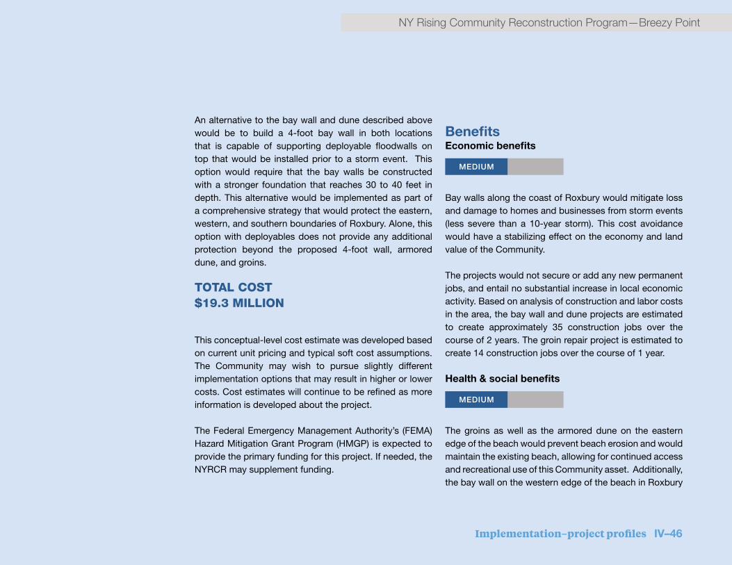
Implementation–project profiles IV–46
NY Rising Community Reconstruction Program—Breezy Point
An alternative to the bay wall and dune described above would be to build a 4-foot bay wall in both locations that is capable of supporting deployable floodwalls on top that would be installed prior to a storm event. This option would require that the bay walls be constructed with a stronger foundation that reaches 30 to 40 feet in depth. This alternative would be implemented as part of a comprehensive strategy that would protect the eastern, western, and southern boundaries of Roxbury. Alone, this option with deployables does not provide any additional protection beyond the proposed 4-foot wall, armored dune, and groins.
TOTAL COST $19.3 MILLION
This conceptual-level cost estimate was developed based on current unit pricing and typical soft cost assumptions. The Community may wish to pursue slightly different implementation options that may result in higher or lower costs. Cost estimates will continue to be refined as more information is developed about the project.
The Federal Emergency Management Authority’s (FEMA) Hazard Mitigation Grant Program (HMGP) is expected to provide the primary funding for this project. If needed, the NYRCR may supplement funding.
BenefitsEconomic benefits
MEDIUM
Bay walls along the coast of Roxbury would mitigate loss and damage to homes and businesses from storm events (less severe than a 10-year storm). This cost avoidance would have a stabilizing effect on the economy and land value of the Community.
The projects would not secure or add any new permanent jobs, and entail no substantial increase in local economic activity. Based on analysis of construction and labor costs in the area, the bay wall and dune projects are estimated to create approximately 35 construction jobs over the course of 2 years. The groin repair project is estimated to create 14 construction jobs over the course of 1 year.
Health & social benefits
MEDIUM
The groins as well as the armored dune on the eastern edge of the beach would prevent beach erosion and would maintain the existing beach, allowing for continued access and recreational use of this Community asset. Additionally, the bay wall on the western edge of the beach in Roxbury

IV–47 Implementation–project profiles
Breezy Point—NY Rising Community Reconstruction Program
would be designed with amenities that integrate and enhance public access and use of the waterfront.
Cost-benefit analysisWhile these projects would not provide protection from flooding during a 100-year storm event, construction of the bay wall and dune would protect an especially exposed area along the bayside of Roxbury against flooding from moon tides, sea level rise, and more frequent storm events. As explained in the risk reduction below, the project would protect key assets in Roxbury that are at risk from flooding from equinox tides, sea level rise, and more frequent storm events as well as provide limited protection against larger storm events in the form of wave attenuation and reducing beach erosion. The project would also provide the possibility to expand protection in the future. Together with the economic and health and social benefits, the project benefits would justify the estimated cost.
Risk reduction MEDIUM
While they would not prevent flooding from a 100-year storm event, the bay wall and dune would protect against future flooding from sea-level rise, high tides, and more frequent storms. Together, the projects would provide protection up to approximately 6 to 7 feet of surge,
minimizing damage to Roxbury assets caused by flooding from equinox tides and more frequent storm events. The project would protect approximately 400 buildings including residences and key assets including the Roxbury social clubs and the Roxbury Volunteer Fire Department. The project also prevents flooding of Rockaway Point Boulevard, a key asset to the Community as the sole means of access for the Community. This would allow Rockaway Point Boulevard to continue to serve as an evacuation route as well as provide secure access for emergency vehicles during more frequent storm events.
The projects would not protect against surge from larger storm events. Above approximately 6 to 7 feet of surge, water would begin to inundate along the western boundary of Roxbury from The Cove, and the eastern boundary from NPS property. The project however, may provide some benefits during larger storm events. The wall and armored dune may provide wave attenuation and water velocity reduction in more severe storm events. The armored dune would protect against shoreline degradation caused by ongoing erosion and storm events, while the armoring would protect against erosion of the dune itself. Groins capture sediment from currents and beach drift, reducing the erosion rate or even causing the beach to expand in size. A wide beach would protect assets between the Bay and the roadway by limiting their exposure to surge waters and waves. Together the projects would reduce the exposure of key assets in Roxbury even during more severe storm events.

Implementation–project profiles IV–48
NY Rising Community Reconstruction Program—Breezy Point
8
Section: Bay Wall - Roxbury looking East
Coastline
+0.00’
(ft)
BFE
Ground Level Before Elevation
Mean Sea Level (NAVD88)
Ground Level
(ft)
Coastline
+6.00’
+10.00’
+6.00’
+10.00’
AfourfoothighbaywallalongthenarrowwesternRoxburybayside,builtadjacenttotheexistingsidewalk,willprovidesomelevelofprotectionfromstormsurges.Thewallisexpectedtobeapprox.8”thickandwillextend20to30feetunderground.
Beach 4’ high8”wide
Bay Wall
ExistingSidewalk
0 20’
A 4 foot high bay wall along the narrow western Roxbury bayside, built adjacent to the existing sidewalk, would provide some level of protection from storm
surge. The wall is expected to be approx. 8” thick and will extend 20 to 30 feet underground.
This plan view of Roxbury shows the section diagram location along the western edge of the community (below).

IV–49 Implementation–project profiles
Breezy Point—NY Rising Community Reconstruction Program
Timeframe for implementation
20 4 6
Once approved, and assuming a straightforward permitting process, the bay wall and dune would each require approximately 2 to 4 years to design, review, permit, and construct and the groin repair would require approximately 1 year.
Regulatory requirementsReview and/or permitting by City, State, and Federal agencies is anticipated to be required for this project. Environmental review is prescribed by the NYS State Environmental Quality Review Act (SEQRA) and the NYC City Environmental Quality Review (CEQR) process. Project implementation may require permits from U.S. Army Corps of Engineers (USACE), NYS Department of Environmental Conservation (NYS DEC), NYS Department of State (NYS DOS), NYC Department of City Planning (NYC DCP).
Jurisdiction These projects fall within the property of the Breezy Point Cooperative, and within the jurisdiction of the City of New York. If the project approaches the mean high water mark, jurisdiction may also include NPS and/or USACE.

Implementation–project profiles IV–50
NY Rising Community Reconstruction Program—Breezy Point

IV–51 Implementation–project profiles
Breezy Point—NY Rising Community Reconstruction Program
STRATEGY: IMPROVE AND EXPAND COASTAL PROTECTIONFeatured ProjectRecovery Support Functions
TBDCost
Risk Reduction
Environmental Benefits
HIGH
Timeline (years)
20 4 6
HIGH
National Park Service (NPS) collaborationThe Planning Committee seeks to collaborate with the National Park Service (NPS) to identify and strengthen key vulnerabilities on NPS property that threaten the Breezy Point Community. This project would support the efforts of the Cooperative to work with NPS, which could include: (1) restore important ecological habitat and identify ways of incorporating resiliency into ecological restoration projects; and (2) enable secondary emergency access via NPS service roads.
Project descriptionBreezy Point and Roxbury are adjacent to land and water comprising components of Gateway National Recreation Area, which is under the jurisdiction of NPS. To improve the overall resiliency of the Community, Breezy Point can work with NPS to generate mutually beneficial solutions that preserve the character and integrity of the end of the Peninsula.
Ecological restoration and resiliency
Two specific areas of Gateway National Recreation Area suffer from environmental degradation resulting from both man-made and natural activities. Breezy Point Tip, located
on the western end of the Rockaway Peninsula, and The Cove, located on the bayside between Roxbury and Breezy Point, were listed as potential ecological restoration opportunities in the 2009 Hudson-Raritan Estuary Comprehensive Restoration Plan (HRE CRP). The HRE CRP recommended restoring beach and dune habitat in The Cove and maritime forest on Breezy Point Tip, among other recommendations. The Cooperative has proposed working with NPS to begin implementing the restoration measures recommended in the HRE CRP. The collaboration would include examining how resiliency measures, such as enhanced dunes or wetlands and living shorelines, could be incorporated into restoration projects to provide a level of coastal protection for the Breezy Point Community.
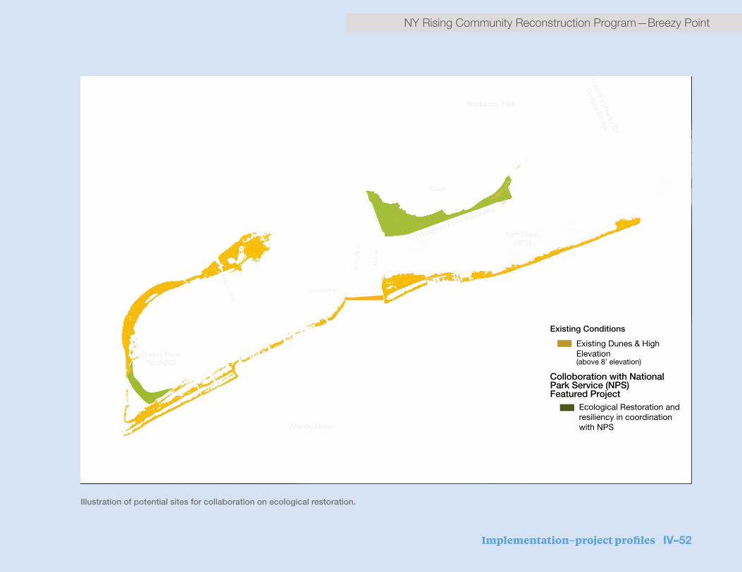
Implementation–project profiles IV–52
NY Rising Community Reconstruction Program—Breezy Point
Illustration of potential sites for collaboration on ecological restoration.
Dune Habitat
Maritime Habitat Restoration
Cove
Colloboration with National Park Service (NPS)Featured Project
Existing Conditions
Ecological Restoration and resiliency in coordination with NPS
3,0001,500Feet
0 ¯
Breezy Point Tip (NPS)
Rockaway Inlet
Atlantic Ocean
Fort Tilden (NPS)
Marine P
arkway G
il
Hodges B
ridge
Rockaway Point Boulevard
RE
ID A
VBEAC
H 201 ST
BEACH
219 ST
OCEANSIDE AV
BED
FOR
D A
V
Existing Dunes & High Elevation (above 8’ elevation)

IV–53 Implementation–project profiles
Breezy Point—NY Rising Community Reconstruction Program
Secondary access
Rockaway Point Boulevard is currently the only means of access to the Breezy Point Community. Within the boundaries of Fort Tilden, NPS maintains service roads that could provide a secondary means of access to the Community during emergency situations for evacuation and emergency response. These service roads were once open to Breezy Point residents but currently are not accessible. In return for use as secondary access, the Breezy Point Cooperative could support maintenance operations for the service roads. Discussions about providing access to and from Breezy Point during and immediately after evacuation orders using these service roads should be initiated.
TOTAL COST TBD The final costs of the projects with NPS are not yet known, and will take further analysis to estimate. The projects can be broken down discretely by scope and time and the Breezy Point Planning Committee is vested in supporting these efforts and may be willing to contribute NYRCR Program funds toward the effort if doing so will help expedite remediation efforts.
To date, the Breezy Point Cooperative and NPS have partnered to submit a grant request to the Department of Interior/National Fish and Wildlife Foundation’s (DOI/NFWF) Hurricane Sandy Coastal Resiliency Competitive Grant Program for restoration of The Cove and Breezy Point Tip. The outcome of the application and amount of the award would determine the scope of the restoration plan.
Section view of Cove restoration with protective features.
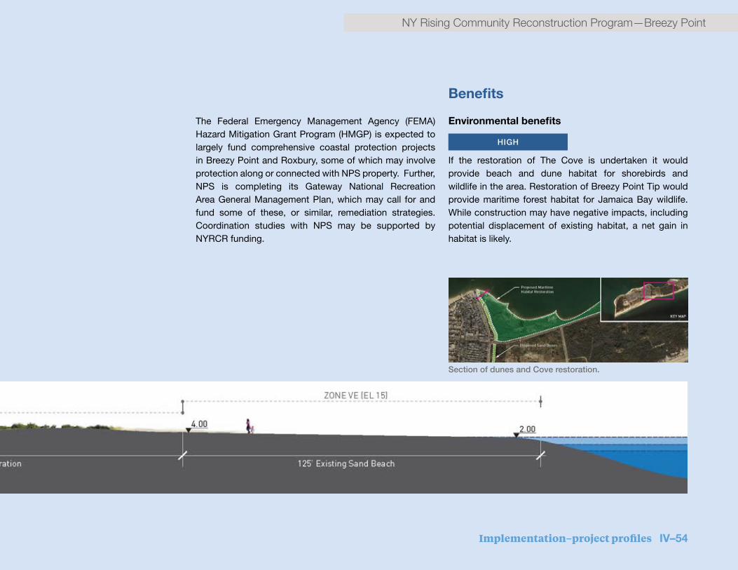
Implementation–project profiles IV–54
NY Rising Community Reconstruction Program—Breezy Point
Section of dunes and Cove restoration.
The Federal Emergency Management Agency (FEMA) Hazard Mitigation Grant Program (HMGP) is expected to largely fund comprehensive coastal protection projects in Breezy Point and Roxbury, some of which may involve protection along or connected with NPS property. Further, NPS is completing its Gateway National Recreation Area General Management Plan, which may call for and fund some of these, or similar, remediation strategies. Coordination studies with NPS may be supported by NYRCR funding.
Benefits
Environmental benefits
HIGH
If the restoration of The Cove is undertaken it would provide beach and dune habitat for shorebirds and wildlife in the area. Restoration of Breezy Point Tip would provide maritime forest habitat for Jamaica Bay wildlife. While construction may have negative impacts, including potential displacement of existing habitat, a net gain in habitat is likely.
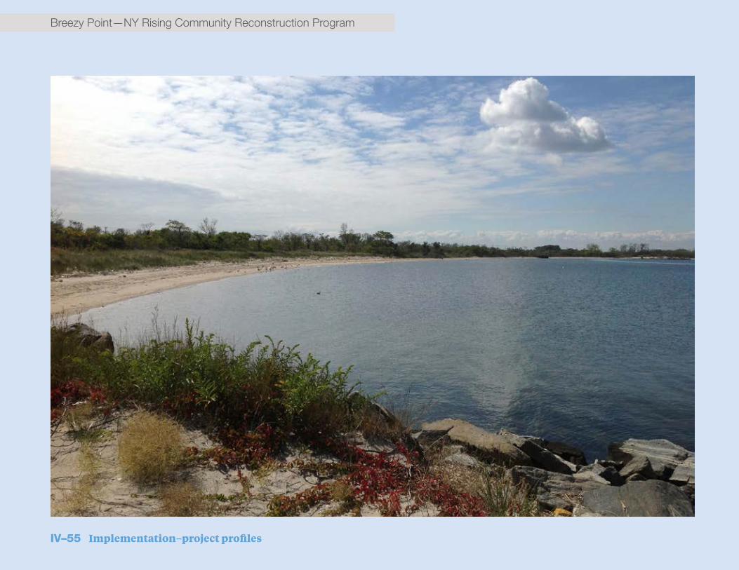
IV–55 Implementation–project profiles
Breezy Point—NY Rising Community Reconstruction Program

Implementation–project profiles IV–56
NY Rising Community Reconstruction Program—Breezy Point
Cost-benefit analysisIf the restoration of The Cove is undertaken, it would provide beach and dune habitat for shorebirds and wildlife in the area. Restoration of Breezy Point Tip would provide maritime forest habitat for Jamaica Bay wildlife. While construction may have negative impacts, including potential displacement of existing habitat, a net gain in habitat is likely.
Risk reduction
HIGH
Restoration and resiliency measures in The Cove and Breezy Point Tip would reduce the exposure of some assets within Breezy Point. Restoration of The Cove would also mitigate erosion that could lead to the collapse or undermining of Rockaway Point Boulevard, and would dramatically reduce the exposure of this asset to future damage and prevent potential repair costs
Timeframe for implementation
20 4 6
Timeframe for implementation would vary based on scope, approach, and collaboration on projects, but near-term restoration and secondary access projects could be implemented in 2 to 3 years. Winning the joint Breezy Point/NPS DOI/NFWF grant to support the restoration projects could expedite implementation of that and other projects.
Jurisdiction The jurisdiction of this project falls under Breezy Point Cooperative and NPS.

IV–57 Implementation–project profiles
Breezy Point—NY Rising Community Reconstruction Program
Featured ProjectRecovery Support Functions
TBDCost
Health & Social Services
MEDIUM
Risk Reduction
Environmental Benefits
Economic Benefits
Timeline (years)
20 4 6
RISK
MEDIUM
MEDIUM
Rockaway Point Boulevard elevationThis project proposes to raise and strengthen Rockaway Point Boulevard – the Breezy Point Community’s sole access route – to strengthen this critical piece of infrastructure and ensure accessibility during an emergency.
Project descriptionThe Breezy Point Community’s sole connection to the rest of the Rockaway Peninsula is Rockaway Point Boulevard, which is highly vulnerable to flooding and increased structural instability. Raising the roadway above the Base Flood Elevation (BFE) would ensure that it would not be covered by floodwaters in the future and would allow the northern edge to be shored up while solutions to rectify and prevent erosion in The Cove are developed and implemented.
This project proposes to raise just under a mile of Rockaway Point Boulevard approximately 7 feet to a final elevation of 14.5 feet, 3.5 feet above BFE. Approximately 4,500 feet of the road stretching from Roxbury to Breezy Point would be reconstructed on top of a mounded levee to raise it above flooding levels and protect it from storm surge.
The newly raised roadway would gradually slope up to its
new height as it passes south of Roxbury, and would slope downward again upon entering Breezy Point. The raised roadway would require greater width to account for the side slopes needed for drainage and erosion prevention.
In addition to providing a more resilient means of access, the newly raised road would have space in the levee underneath it, which could be used to provide more resilient, below-ground utility infrastructure, such as power lines.
TOTAL COSTTBD
The Breezy Point Committee has recognized this as a creative, important solution for coastal protection as well as for bolstering infrastructure. An initial total estimate to elevate Rockaway Point Boulvard is $76 million.
The total cost estimate assumes the following:
STRATEGY: IMPROVE AND EXPAND COASTAL PROTECTION
Implementation–project profiles IV–58
NY Rising Community Reconstruction Program—Breezy Point
▪ The extent of the affected roadway is 4,500 feet
▪ The roadway would be reconstructed with two lanes in each direction, a median, and a bike lane in each direction
▪ All applicable City, State, and Federal standards for roadway configuration would be followed
▪ The conceptual-level cost estimate was developed based on current unit pricing and typical soft cost assumptions. Cost estimates will continue to be refined as more information is developed about the project.
Significant collaboration between the Community and the New York City Department of Transportation (NYC DOT) would be required to confirm the exact cost of implementation, but the Community may consider repurposing NYRCR Program funds toward a study or other efforts that may help to expedite an improved solution. The total cost of a study or other potential NYRCR funding would be determined with DOT and the state.
BenefitsEconomic benefits
HIGH Elevating Rockaway Point Boulevard would mitigate loss
and damage from storm events. This cost avoidance would have a stabilizing effect on the economy and land value of the Community. Based on analysis of construction and labor costs in the area, this project is estimated to create 164 construction jobs over the course of 2 years.
Environmental benefits
MEDIUM
National Park Service (NPS) lands may be better protected against storm events with the completion of this project.
Health and social benefits
MEDIUM
This project would provide social benefits to the Community by providing safe vehicular and pedestrian access points to the beach, a recreational amenity for the Community.
Cost-benefit analysisRaising Rockaway Point Boulevard creates a resilient roadway that is protected against future storm events, allowing access to be maintained to and from the Breezy Point communities. Raising Rockaway Point Boulevard would allow for unimpeded access to the Breezy Point Cooperative for residents and emergency vehicles before, during, and after a storm event. Relocating utilities below ground would reduce and/or eliminate power outages during storm events. Additionally, NPS lands may be

IV–59 Implementation–project profiles
Breezy Point—NY Rising Community Reconstruction Program
better protected against storm events with the completion of this project. These benefits to the Community would justify the estimated cost of the project.
Risk reduction HIGH
Rockaway Point Boulevard is a critical asset in the Breezy Point Planning Area. By raising Rockaway Point Boulevard, risk is reduced to the asset itself, The Cove, and the adjacent Roxbury housing.
Timeframe for implementationThe timeframe for implementation is to be determined. An important first step in the process will be initiating discussion between New York State, NYC Department of Transportation (NYC DOT), the Cooperative, and the National Park Service (NPS) regarding a partnership to fund implementation, as well as stakeholder involvement to guide the design.
Regulatory requirementsReview and/or permitting by City, State, and Federal agencies is anticipated for this project. Environmental review is prescribed by the NY State Environmental Quality Review Act (SEQRA) and the New York City Environmental Quality Review (CEQR) process. Project implementation
may require permits from U.S. Army Corps of Engineers (USACE), NYS Department of Environmental Conservation (NYS DEC), NYS Department of State (NYS DOS), and NYC Department of City Planning (NYC DCP).
Jurisdiction
The roadway is a New York State road maintained by New York City Department of Transportation (NYC DOT). In order to be raised, the roadway would need to be widened, raising the possibility that it would extend onto NPS land and/or onto Breezy Point Cooperative land. Property purchase and/or creation of easements would be determined as part of the permitting and environmental review process.

V. Additional materials

V–1 Additional materials
Breezy Point—NY Rising Community Reconstruction Program
A. Additional resiliency recommendationsThe Proposed and Featured Projects discussed in the previous section were selected by the Planning Committee in order to address some of the most critical needs in Breezy Point. However, these projects were selected out of a much broader list of actions after lengthy discussion by the Planning Committee. While funding is not yet secured for these projects, the Committee strongly recommends and supports the implementation of the Additional Resiliency Recommendations detailed below.
Additional Recommendations
Strategy Project name Short project description
Regional project(Y/N)
Estimated cost
Improve and expand coastal protection
Construct flood wall/surge barrier The planning committee recommends the siting of a Jamaica Bay surge barrier by the City or State that does not exacerbate flooding in Roxbury and Breezy Point
Y >$25 million
Protect and bolster infrastructure
Create long-term comprehensive green infrastructure strategy
The planning committee recommends working partnering with relevant agencies to develop green approaches to managing stormwater and wastewater in Breezy Point
N <$500,000
Protect and bolster infrastructure
Meet with PSE&G to discuss alternative energy sources, including future long-term microgrid study or pilot project, on-shore wind project, and solar installations on utility poles in Breezy Point
The planning committee recommends discussing potential of purchasing agreement with PSE&G for excess alternative energy, may require coordination with Park Service
N No cost
Strengthen community resiliency
Reactivate ferry stop for Manhattan service at coast guard dock
The planning committee recommends reactivating the ferry stop at Riis landing during peak season to create a direct connection to Manhattan
N $1-$25 million
Strengthen community resiliency
Create program to help individual homeowners assess physical condition and resiliency of both primary and secondary homes
Creation of auditing program to assess how resilient homes are and how they can be strengthened to withstand strong weather events
N $1-$25 million
Strengthen community resiliency
Create program to help individual homeowners understand financing options for making improvements of both primary and secondary homes
Creation of program to include financial education for making resiliency improvements
N <$500,000
Strengthen community resiliency
Create program for training of community to understand insurance and other resiliency-related housing issues
Creation of program to include education on understanding of changing landscape in insurance
N <$500,000

Additional materials V–2
NY Rising Community Reconstruction Program—Breezy Point
Additional Recommendations
Strategy Project name Short project description
Regional project(Y/N)
Estimated cost
Improve and expand coastal protection
Construct flood wall/surge barrier The planning committee recommends the siting of a Jamaica Bay surge barrier by the City or State that does not exacerbate flooding in Roxbury and Breezy Point
Y >$25 million
Protect and bolster infrastructure
Create long-term comprehensive green infrastructure strategy
The planning committee recommends working partnering with relevant agencies to develop green approaches to managing stormwater and wastewater in Breezy Point
N <$500,000
Protect and bolster infrastructure
Meet with PSE&G to discuss alternative energy sources, including future long-term microgrid study or pilot project, on-shore wind project, and solar installations on utility poles in Breezy Point
The planning committee recommends discussing potential of purchasing agreement with PSE&G for excess alternative energy, may require coordination with Park Service
N No cost
Strengthen community resiliency
Reactivate ferry stop for Manhattan service at coast guard dock
The planning committee recommends reactivating the ferry stop at Riis landing during peak season to create a direct connection to Manhattan
N $1-$25 million
Strengthen community resiliency
Create program to help individual homeowners assess physical condition and resiliency of both primary and secondary homes
Creation of auditing program to assess how resilient homes are and how they can be strengthened to withstand strong weather events
N $1-$25 million
Strengthen community resiliency
Create program to help individual homeowners understand financing options for making improvements of both primary and secondary homes
Creation of program to include financial education for making resiliency improvements
N <$500,000
Strengthen community resiliency
Create program for training of community to understand insurance and other resiliency-related housing issues
Creation of program to include education on understanding of changing landscape in insurance
N <$500,000
Table V.1: Additional resiliency recommendations
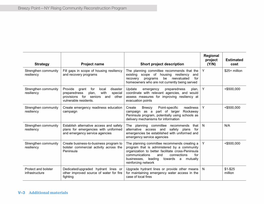
V–3 Additional materials
Breezy Point—NY Rising Community Reconstruction Program
Strategy Project name Short project description
Regional project(Y/N)
Estimated cost
Strengthen community resiliency
Fill gaps in scope of housing resiliency and recovery programs
The planning committee recommends that the existing scope of housing resiliency and recovery programs be reevaluated for homeowners who are not currently being served
Y $25+ million
Strengthen community resiliency
Provide grant for local disaster preparedness plan, with special provisions for seniors and other vulnerable residents.
Update emergency preparedness plan, coordinate with relevant agencies, and would assess measures for improving resiliency at evacuation points
Y <$500,000
Strengthen community resiliency
Create emergency readiness education campaign
Create Breezy Point-specific readiness campaign as a part of larger RockawayPeninsula program, potentially using schools as delivery mechanisms for information
Y <$500,000
Strengthen community resiliency
Establish alternative access and safety plans for emergencies with uniformed and emergency service agencies
The planning committee recommends that alternative access and safety plans for emergencies be established with uniformed and emergency service agencies
N N/A
Strengthen community resiliency
Create business-to-business program to bolster commercial activity across the Peninsula
The planning committee recommends creating a program that is administered by a community organization to better facilitate cross-Peninsula communications and connections for businesses, leading towards a mutually reinforcing network
Y <$500,000
Protect and bolster infrastructure
Dedicated/upgraded hydrant lines or other improved source of water for fire fighting
Upgrade hydrant lines or provide other means for maintaining emergency water access in the case of local fires
N $1-$25million

Additional materials V–4
NY Rising Community Reconstruction Program—Breezy Point
B. Master table of projectsMaster Project List
Strategy Project name Short project descriptionEstimated
costProject
category
Regional project (Y/N)
Improve and expand coastal protection
Enhanced dune walkways
To ensure continuous ocean side coastal protection while still allowing for beach access, this proposed project creates an uninterrupted dune along the ocean with raised pedestrian and vehicle access.
$5.5 million Proposed project
Y
Strengthen community resiliency
Housing elevation study
The Breezy Point Planning Committee proposes funding a study to evaluate housing elevation needs and strategies for Breezy Point. Ultimately, this study wouldprovide possible community development and redevelopment strategies as well as information that may allow the Community to negotiate with a contractor for a discounted bulk rate for elevation.
$275,000 Proposed project
N
Multi-purpose community relief center
This project entails the construction of a new building to serve as a community-based emergency recovery resource. Its everyday use Year round, it would provide a much-needed community center for Breezy Point residents.
$6.7 - $8.2 million
Proposed project
N
Summer store relocation
This project would significant improve the resiliency of the small but important “summer store” retail cluster, which floods regularly.
$2 million Proposed project
N
Protect and bolster infrastructure
Repaired docks This project would repair to two bayside docks destroyed by Superstorm Sandy. New docks would increase emergency access to the community and would enhance recreational activities on the bay.
$3.2 million Proposed project
N
Table V.2: Master table of projects

V–5 Additional materials
Strategy Project name Short project descriptionEstimated
costProject
category
Regional project (Y/N)
Protect and bolster infrastructure
Stormwater drainage improvements
Low-lying areas of Breezy Point and Roxbury act as bowls that collect and retain stormwater runoff, resulting in pools of standing water for weeks at a time. Stormwater drainage projects would address particularly acute problems in three areas with a mix of “gray” (hard) and “green” (soft) infrastructure approaches.
$12.5 million
Proposed project
N
Improve and expand coastal protection
Breezy/Rockaway Point bayside protection
This project proposes three discrete near-term bayside coastal protection projects along the most vulnerable areas in Breezy Point and Rockaway Point. These smaller measures are designed to reduce exposure to storm surge and wave forces from more frequent storm events (less than a 10 year storm).
$11.3 million
Featured project
Y
Roxbury bayside protection
This project proposes near-term bayside coastal protection projects along the most vulnerable areas Roxbury. These smaller measures are designed to reduce exposure of key assets to equinox tides and storm surge and wave forces from more frequent storm events (less than a 10 year storm).
$19.3 million
Featured project
Y
NPS collaboration The Planning Committee seeks to collaborate with the National Park Service (NPS) to identify and strengthen key vulnerabilities on NPS property that threaten the Breezy Point Community. This project would support efforts to: (1) restore important ecological habitat; (2) identify ways of incorporating resiliency into ecological restoration projects; and (3) enable secondary emergency access via NPS service roads.
Unknown Featured project
Y
Rockaway Point Boulevard elevation
This project proposes to raise and strengthen Rockaway Point Boulevard – the Breezy Point/Roxbury Community’s sole access route -- to strengthen this critical piece of infrastructure and ensure accessibility during an emergency.
$76.5million
Featured project
N
Breezy Point—NY Rising Community Reconstruction Program

Additional materials V–6
NY Rising Community Reconstruction Program—Breezy Point
C. Public engagement process
Public EngagementPublic engagement has been central to all phases of development of the Breezy Point NY Rising Community Reconstruction (NYRCR) Plan. NYRCR was designed to be a community-driven process. The Breezy Point Planning Committee, consisting of representatives of the Community, held Public Engagement Events and Planning Committee Meetings over the course of seven months to solicit substantial public feedback. In total, over 400 residents, as well as elected officials and government representatives, participated in Breezy Point NYRCR events. In addition to in-person engagement with the Community, the Planning Committee used online tools such as an online Interactive Community Map to solicit feedback from community members unable to attend meetings. The Planning Committee utilized the Community guidance and feedback to identify assets, needs, and ultimately, the projects that are proposed for funding in the NYRCR Plan. Continuous public engagement has ensured that the NYRCR Plan reflects the Community’s priorities for rebuilding and resiliency.
Planning CommitteeThe Breezy Point NYRCR Planning Committee Members are volunteer members who represent various constituencies within the Planning Area including but not limited to, homeowners, civic leaders and business owners. The Planning Committee held 11 formal Planning Committee Meetings over the course of seven months. Planning Committee members engaged in lively debate during the meetings. All Planning Committee meetings were held at the Colony Theater, announced publicly on the NYRCR website and were open to the public.
Planning Committee meetings addressed all topics covered in this Plan; specific tasks and discussions held at the meetings included: identification of community assets, assessment of needs and opportunities, formalization of reconstruction and resiliency strategies, creation of priority projects, and finalization of proposed and Featured Projects. The Planning Committee spearheaded the community outreach strategy, identifying avenues for outreach to the Planning Area’s population and soliciting public feedback throughout the process.
Public Engagement EventsPublic Engagement Events were designed to be highly interactive and maximize community feedback on the priorities and needs of the community. Three Public Engagement Events were held prior to the submission of the NYRCR Plan. The Planning Committee selected community-based venues with accessibility and proximity to targeted stakeholders. At the Public Engagement Events, the Planning Committee offered general information about the NYRCR process; presented outcomes and information gathered to date; and solicited feedback through dynamic discussions and interactive displays. Following each Public Engagement Event, community feedback was aggregated and analyzed to inform discussion during Planning Committee meetings.
Public Engagement Event #1 (October 2013)Program Scope; Goals, and Timeline; Feedback on Vision; Community Assets; and Needs and Opportunities
Public Engagement Event #1 showcased the NYRCR program scope and presented the Planning Committee’s assessment of community assets and needs and opportunities. This first Public Engagement Event took place at the Colony

V–7 Additional materials
NY Rising Community Reconstruction Program—Breezy Point
Theater and began with a formal presentation that introduced NYRCR and the program’s objectives. Following the presentation, an open house-style event was held in which Planning Committee members invited community input on a number of topics including identification of assets, needs, opportunities, and goals, as featured on the display boards. While the public engaged in conversation around the display boards, they were invited to take part in interactive exercises by placing stickers and notes on feedback boards. This feedback mechanism created a useful record of community discussion from the Public Engagement Event for the Planning Committee to use during future meetings.
Public Engagement Event #2 (November 2013)Contents of Draft Conceptual Plan; Gathering feedback on Strategies and Projects
The second Public Engagement Event solicited public responses to priority resiliency strategies determined by the Planning Committee and public. The meeting was also held at the Colony Theater and utilized a similar format to Public Engagement Event #1 and included an introductory presentation followed by breakout stations. Planning Committee members staffed the breakout stations that displayed the potential
strategies. The public was again invited to interact with display boards, engage Planning Committee members in conversation, and offer their feedback with stickers and written notes placed on feedback boards. Community members’ comments provided powerful guidance to the Planning Committee on the types of projects to pursue that addressed the Breezy Point priorities and concerns, and substantially shaped project development going forward.
Public Engagement Event #3 (February/March 2014)Presentation of proposed and Featured Projects, and additional resiliency recommendations; Gathering feedback on Strategies and Projects
The third Public Engagement provided a critical opportunity to share the proposed and featured Projects with the Community and obtain feedback on these projects. The Breezy Point Planning
Community members provide input on assets, needs, and opportunities at Public Meeting #1.

Additional materials V–8
NY Rising Community Reconstruction Program—Breezy Point
Committee hosted the meeting at the Breezy Point Activity Center over a three-day period to maximize the opportunity for public involvement.
Public Engagement Event #3 featured the proposed projects in an open-house setting; community members filtered in and out of
the event, engaged with the material in lively discussion with fellow community members, and shared their opinions on the feedback boards. Upon entering the Public Engagement Event, each community member was given fake dollar bills, each worth $500,000 or $1 million, to the total of the up to $19.5 million CDBG–DR allocation and
asked to place the bills into boxes designated for the proposed projects. After reviewing the project boards, community members were invited to cast votes on proposed projects at the voting table, which prompted debate over how to spend the allocations. Several members of the public came back more than once over the weekend to further
Residents review Proposed and Featured Projects at the third public meeting.

V–9 Additional materials
Breezy Point—NY Rising Community Reconstruction Program
review project boards and cast their final votes. The total allocation per Proposed Project was tallied and shared at the next Planning Committee meeting to inform deliberations and final voting on the proposed projects.
Public Engagement Event #4 (April/May 2014 or TBD) Presentation of Final Plan and announcement of projects
Public Engagement Event #4 will take place in April/May and conclude the Public Engagement Event series. At this Public Engagement Event, the Planning Committee will present the proposed projects and the NYRCR Plan to the public.
Public Engagement Event OutreachThe Planning Committee spearheaded outreach for Public Engagement meetings. Planning Committee members leveraged Breezy Point’s robust community distribution channels, including: the Breezy Point Cooperative (website, mailing list, public alert, and monthly bulletin), the Rockaway Point News, and the Roxbury, Rockaway Point, and Point Breeze Associations (mailing lists). The Planning Committee also distributed print materials, including palm cards,
flyers, and storefront posters. Additionally, a toll free number (888-642-8886), was set-up with a voicemail system to communicate information about the meetings and to allow residents without computers to proovide feedback.
Online Engagement and Social Media OutreachThe NYRCR website, located at www.stormrecover.ny.gov/nyrcr, served as a valuable public resource. The Breezy Point NYRCR page is located at http://stormrecovery.ny.gov/nyrcr/community/breezy-point and featured announcements, meeting dates and locations, and materials produced by the Planning Committee throughout the process. The NYRCR website also directed visitors to the NYRCR Facebook page (located at https://www.facebook.com/NYStormRecovery) and Twitter account (@NYStormRecovery). Communities were also able to submit comments through the NYRCR website and by emailing [email protected].
A customized interactive online public engagement was generated for the Community through an online Interactive Community Map located at http://breezypoint.nyrisingmap.org/. The Community Map allowed users to confirm specific physical and cultural assets significant
to Breezy Point, identify recovery and resiliency needs, and suggest rebuilding and resiliency initiatives. The Planning Committee distributed flyers and conducted outreach to promote the Interactive Community Map. Public comments on the map were summarized and presented to the Planning Committee and utilized as an additional feedback metric.

Additional materials V–10
NY Rising Community Reconstruction Program—Breezy PointBreezy Point—NY Rising Community Reconstruction Program
D. Community asset inventory
Asset Risk Area Asset Class Asset Sub-‐categorySocially
Vulnerable Populations
Critical Facility
Community Value
Erosion Rate
WaterlineShore
DefensesProtective Vegetation
Dunes
Barrier Island or Filled
Wetland
Landscape Attribute Score
("Yes" = +0.5)
HazardScore
Exposure Score
Vulnerability Score
Risk Score
BREEZY POINT HOUSING -‐ EXTREME RISK Extreme Housing
Mixed-‐use Housing Yes No High Yes Yes Yes Yes Yes Yes 3 3 5.00 4 60
BREEZY POINT HOUSING -‐ HIGH RISK High Housing
Mixed-‐use Housing Yes No High No Yes Yes Yes Yes Yes 2.5 3 3.50 3 32
ROXBURY COOPERATIVE HOUSING -‐ EXTREME RISK Extreme Housing
Mixed-‐use Housing Yes No High Yes Yes Yes Yes Yes Yes 3 3 5.00 4 60
ROXBURY COOPERATIVE HOUSING -‐ HIGH RISK High Housing
Mixed-‐use Housing Yes No High Yes Yes Yes Yes Yes Yes 3 3 4.00 3 36
BANK High EconomicBanks and financial services No No High No Yes Yes Yes Yes Yes 2.5 3 3.50 4 42
POINT BREEZE VFD HighHealth_and_Social_Services
Emergency Operations / Response No
Yes, FEMA High No Yes Yes Yes Yes Yes 2.5 3 3.50 4 42
ROCKAWAY POINT VFD HighHealth_and_Social_Services
Emergency Operations / Response No
Yes, FEMA High No Yes Yes Yes Yes Yes 2.5 3 3.50 4 42
ROXBURY VFD HighHealth_and_Social_Services
Emergency Operations / Response No
Yes, FEMA High Yes Yes Yes Yes Yes Yes 3 3 4.00 4 48
COLONY THEATER HighHealth_and_Social_Services
Government and Administrative Services No No High Yes No Yes Yes Yes Yes 2.5 3 3.50 4 42
BREEZY POINT BEACH High
Natural_and_Cultural_Resources
Parks and Recreation No No High No No No No No Yes 0.5 3 1.50 2 9
CO-‐OP'S EQUIPMENT FACILITY High
Health_and_Social_Services
Public Works Facilities No
No, Locally Significant High No Yes Yes Yes Yes Yes 2.5 3 3.50 3 32
BOZO'S CLUB High Economic Small Business No No High Yes Yes Yes Yes Yes Yes 3 3 4.00 2 24COMMERCIAL AREA High Economic Small Business No No High No Yes Yes Yes Yes Yes 2.5 3 3.50 4 42
CO-‐OP BOARD OFFICE High Economic Small Business No No High No Yes Yes Yes Yes Yes 2.5 3 3.50 2 21FERRY DOCK AT COLONY THEATER Extreme
Infrastructure_Systems Transportation No No High Yes No Yes Yes Yes Yes 2.5 3 4.50 4 54
FERRY DOCK AT KENNEDY'S Extreme
Infrastructure_Systems Transportation No No High Yes No Yes Yes Yes Yes 2.5 3 4.50 4 54
Risk Assessment Tool -‐ Breezy PointRisk AssessmentAsset Information Landscape Attributes
Table V.3: Risk assessment tool

V–11 Additional materials
Breezy Point—NY Rising Community Reconstruction Program
FERRY DOCK AT RIIS LANDING Extreme
Infrastructure_Systems Transportation No No High Yes No Yes Yes Yes Yes 2.5 3 4.50 4 54
FERRY DOCK AT THE COVE Extreme
Infrastructure_Systems Transportation No No High Yes No Yes Yes Yes Yes 2.5 3 4.50 4 54
MARINE PWY GIL HODGES BRIDGE Moderate
Infrastructure_Systems Transportation No
No, Locally Significant High No Yes Yes Yes Yes Yes 2.5 3 3.00 2 18
ROCKAWAY POINT BLVD HighInfrastructure_Systems Transportation No
No, Locally Significant High Yes Yes Yes No Yes Yes 2.5 3 3.50 4 42
THE COVE Extreme
Natural_and_Cultural_Resources Water Bodies No No High Yes No Yes No Yes Yes 2 3 4.00 4 48

Additional materials V–12
NY Rising Community Reconstruction Program—Breezy Point
Economic AssetsName Asset Subcategory
Bank Banks and financial servicesSurf Club (beach club) Marina / Water Based BusinessCommercial Area (includes Co-op Office)Small BusinessSilver Gulf Beach Club Small BusinessBay House Small BusinessBozo's Club Small BusinessKenedy's Restaurant (former) Small BusinessPebbles Small BusinessLoVois Small BusinessMayor's Committee Small BusinessStore (not in service) Small BusinessSugar Shack Small BusinessSummer Street Commerce Cluster Small Business9/11 Memorial (Breezy Point) Tourism Destinations9/11 Memorial (Roxbury) Tourism Destinations
Health and Social Service AssetsName Asset Subcategory
Colony Theater Community CentersMeeting Space Community CentersBreezy Point Clubhouse Community CentersBreezy Point Coop Activities Center Community CentersChrist Community Church Cultural or Religious EstablishmentsRoxbury Point Breezy Point Catholic ClubCultural or Religious EstablishmentsSt. Edmund Church Cultural or Religious EstablishmentsSt. Genevieve's Church Cultural or Religious EstablishmentsSt. Thomas More Church Cultural or Religious EstablishmentsProtestant Church Cultural or Religious EstablishmentsRoxbury Street Catholic Club Cultural or Religious EstablishmentsSt. Thomas More Church Hall Cultural or Religious EstablishmentsSt. Genevieve's Hall Cultural or Religious EstablishmentsAlarm System Units Emergency Operations / ResponseAlarm System Units Emergency Operations / ResponseAlarm System Units Emergency Operations / ResponseFDNY Eng 329 Emergency Operations / ResponsePoint Breeze Volunteer Fire Department Emergency Operations / ResponseRockaway Point Volunteer Fire DepartmentEmergency Operations / ResponseRoxbury Volunteer Fire Department Emergency Operations / ResponseWater Meters/Emergency Dispatch Emergency Operations / ResponseWater Meters/Emergency Dispatch Emergency Operations / ResponseWater Meters/Emergency Dispatch Emergency Operations / ResponseWater Meters/Emergency Dispatch Emergency Operations / ResponseWater Meters/Emergency Dispatch Emergency Operations / ResponseMedical Center Healthcare FacilitiesNational Park Service Military InstallationsUS Coast Guard Military InstallationsGarbage Transfer Station Public Works FacilitiesBreezy Point Cooperative Maintenance Equipment Facility Public Works FacilitiesLifeguard Shack Public Works FacilitiesSchool House SchoolsCaffrey Conroy Learning Center Schools
Infrastructure System AssetsName Asset Subcategory
Field Warehouse: Gas Tanks & Shop GarageLiquid FuelsLIPA overhead feed Power SupplyLIPA Substation Power Supply3x Cell Towers TelecommunicationsSiren TelecommunicationsSiren TelecommunicationsSiren TelecommunicationsVerizon Central Access Point TelecommunicationsVerizon Switch TelecommunicationsBayhouse Ferry Dock TransportationGateway Ferry Dock TransportationKennedy's Ferry Dock TransportationRPYC Ferry Dock TransportationInformation/Control Booth TransportationMarine Parkway Gil Hodges Bridge TransportationRockaway Point Blvd TransportationWater/gas access along Rockaway BoulevardWater Supply
Natural and Cultural ResourcesName Asset Subcategory
Historic Bunkers Historic Landmarks and FacilitiesHistoric Bunkers Historic Landmarks and FacilitiesBallfield & Tennis Court Parks and RecreationBallfield & Tennis Courts Parks and RecreationBreezy Point Beach Parks and RecreationBreezy Point Tip Parks and RecreationFort Tilden Parks and RecreationJacob Riis Park Parks and RecreationBeaches Parks and RecreationCritical Access Point (Cove) Parks and RecreationKaboom Park Parks and RecreationLighthouse Parks and RecreationPark Parks and RecreationPlayground/Handball Parks and RecreationPlayground Parks and RecreationPlayground/Basketball Parks and Recreation
The following table contains the complete list of assets for Breezy Point, with additions from the Planning Committee and public.
Table V.4: Complete asset inventory

V–13 Additional materials
Breezy Point—NY Rising Community Reconstruction Program
E. Related projects and programsThe projects and recommendations proposed by the Planning Committees were analyzed within the context of existing federal, regional, city, and local studies and projects. Relevant efforts include studies, campaigns, projects, funding programs, and plans that are both directly related to resiliency and emergency preparedness and those that impact community planning in Breezy Point/Roxbury, Rockaway West, and Rockaway Est. By understanding the wide range of efforts already underway in the community, the Planning Committees developed recommendations that build-off of existing efforts, fill gaps, and avoid redundancies.
The below table of studies, plans, and projects represent a selection of the key efforts that were considered during the NYRCR process as well as a few critical regional or citywide programs that are particularly relevant to resiliency, planning, and community development. Given the interdependencies between the three Rockaway Peninsula Planning Areas, particularly in the areas of coastal protection, economic development, and transportation/emergency access and evacuation, the key reports are summarized for the three Rockaway Peninsula Planning Areas together in this Appendix.
Table V.5: Existing plans, studies, and projects: Emergency preparedness and capacity building
Error! No text of specified style in document. / 1
Table of existing plans, studies, and projects –Emergency preparedness & capacity building
Recovery Support Functions
Plan/Project Name Lead Organization(s) Initiative Description
Com
mun
ity P
lann
ing
& C
apac
ity B
uild
ing
Econ
omic
D
evel
opm
ent
Hea
lth &
Soc
ial
Serv
ices
H
ousi
ng
Infr
astr
uctu
re
Nat
ural
& C
ultu
ral
Res
ourc
es
RE, RW, BP
Precedent: Disaster preparedness model development
Red Hook Coalition; Good Shepard Services
The Red Hook Coalition is developing a long-term community recovery and emergency preparedness plan that will be a NYC Office of Emergency Preparedness (OEM) recognized document. This document will identify necessary mitigation, select projects to be undertaken, assign champions, and develop strategies to implement the plan. It is hoped that the development of this plan can become a replicable model of disaster preparedness and community planning. Supplementing this planning effort the Red Hook Coalition will help coordinate a teen Civilian Emergency Preparedness Team (CERT) training program that will engage youth in disaster preparedness planning.
X X
RE
Precedent: Red Hook WiFi The Digital Stewards, Red Hook Initiative (RHI)
A community-wide WiFi network was developed by the Red Hook Initiative involving neighbors and volunteers. Well over 18 wireless routers have been installed at businesses and non-profits, extending the coverage to all of the main corridors in Red Hook. This program is now being elevated as an example for both disaster response and access expansion regionally and nationally.
X X
ALL
2014 NYC Hazard Mitigation Plan (HMP)
New York City Office of Emergency (OEM); NYC Department of City Planning (DCP)
The HMP identifies the City’s risk to a range of hazards and identified strategies to reduce the effects of these hazards. Strategies outlined in the report influence all neighborhoods of New York City, including across the Rockaways.
X
Table of existing plans, studies, and projects – Coastal Protection
Recovery Support Functions
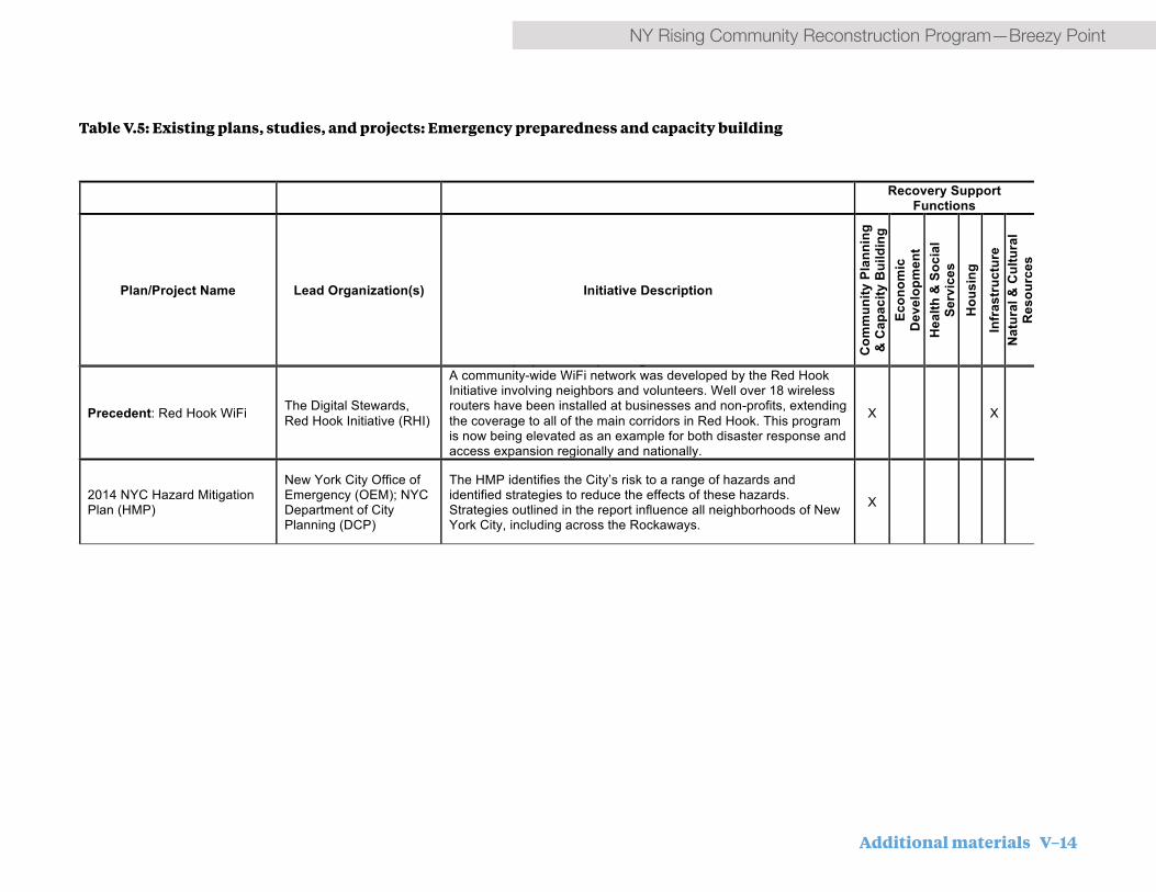
Additional materials V–14
NY Rising Community Reconstruction Program—Breezy Point
Table V.5: Existing plans, studies, and projects: Emergency preparedness and capacity building
Error! No text of specified style in document. / 1
Table of existing plans, studies, and projects –Emergency preparedness & capacity building
Recovery Support Functions
Plan/Project Name Lead Organization(s) Initiative Description
Com
mun
ity P
lann
ing
& C
apac
ity B
uild
ing
Econ
omic
D
evel
opm
ent
Hea
lth &
Soc
ial
Serv
ices
H
ousi
ng
Infr
astr
uctu
re
Nat
ural
& C
ultu
ral
Res
ourc
es
RE, RW, BP
Precedent: Disaster preparedness model development
Red Hook Coalition; Good Shepard Services
The Red Hook Coalition is developing a long-term community recovery and emergency preparedness plan that will be a NYC Office of Emergency Preparedness (OEM) recognized document. This document will identify necessary mitigation, select projects to be undertaken, assign champions, and develop strategies to implement the plan. It is hoped that the development of this plan can become a replicable model of disaster preparedness and community planning. Supplementing this planning effort the Red Hook Coalition will help coordinate a teen Civilian Emergency Preparedness Team (CERT) training program that will engage youth in disaster preparedness planning.
X X
RE
Precedent: Red Hook WiFi The Digital Stewards, Red Hook Initiative (RHI)
A community-wide WiFi network was developed by the Red Hook Initiative involving neighbors and volunteers. Well over 18 wireless routers have been installed at businesses and non-profits, extending the coverage to all of the main corridors in Red Hook. This program is now being elevated as an example for both disaster response and access expansion regionally and nationally.
X X
ALL
2014 NYC Hazard Mitigation Plan (HMP)
New York City Office of Emergency (OEM); NYC Department of City Planning (DCP)
The HMP identifies the City’s risk to a range of hazards and identified strategies to reduce the effects of these hazards. Strategies outlined in the report influence all neighborhoods of New York City, including across the Rockaways.
X
Table of existing plans, studies, and projects – Coastal Protection
Recovery Support Functions

V–15 Additional materials
Breezy Point—NY Rising Community Reconstruction Program
Table V.6: Existing plans, studies, and projects: Coastal Protection
Plan/Project Name Lead Organization(s) Initiative Description
Com
mun
ity P
lann
ing
& C
apac
ity B
uild
ing
Econ
omic
D
evel
opm
ent
Hea
lth &
Soc
ial
Serv
ices
Hou
sing
Infr
astr
uctu
re
Nat
ural
& C
ultu
ral
Res
ourc
es
Hazard Mitigation Grant Program (Federal Emergency Management Agency)
FEMA’s Hazard Mitigation Grant Program (HMGP) provides funds to support a variety of types of projects that will reduce or eliminate losses from future disasters. Projects must provide a long-term solution and a project’s potential savings must be more than the cost of implementing the project. Funds may be used to protect either public or private property or to purchase property that has been subjected to, or is in danger of, repetitive damage. In New York, the HMGP program is administered by New York State. The Breezy Point/Roxbury Community is under consideration for a substantial grant to implement coastal protection measures on the ocean and bay sides of the Community.
X X X X
Hurricane Sandy Coastal Resiliency Competitive Grants Program (Department of the Interior)
The Hurricane Sandy Coastal Resiliency Competitive Grants Program, funded by the Department of the Interior (DOI) and administered by the National Fish and Wildlife Foundation (NFWF), will award more than $100 million in grants throughout the region affected by Hurricane Sandy to projects that assess, restore, enhance or create wetlands, beaches and other natural systems to better protect communities, as well as fish and wildlife species and habitats, from the impacts of future storms and naturally occurring events. The Breezy Point/Roxbury Community has partnered with Gateway National Recreation Area to apply for a DOI/NFWF grant to undertake actions to restore the Cove and Breezy Point Tip. The growing acceptance of these types of restoration/resiliency approaches also influenced the development of coastal protection measures in Rockaway West and Rockaway East.
X X
Targeted Bulkhead Repair/Raising Program NYC EDC
The SIRR Report recommended a city-wide bulkhead raising program targeted to low-lying neighborhoods at risk of regular tidal flooding on the bayside of the Rockaway Peninsula, Broad Channel, Howard Beach, among other locations. This program will work in conjunction with a new citywide waterfront inspections program. NYC EDC is the implementation agency. Beach Channel Drive is already undergoing bulkhead repair under this program. The program could be a source of funding for bulkhead repair in Arverne in Rockaway East.
X
Error! No text of specified style in document. / 1
Table of existing plans, studies, and projects –Emergency preparedness & capacity building
Recovery Support Functions
Plan/Project Name Lead Organization(s) Initiative Description
Com
mun
ity P
lann
ing
& C
apac
ity B
uild
ing
Econ
omic
D
evel
opm
ent
Hea
lth &
Soc
ial
Serv
ices
H
ousi
ng
Infr
astr
uctu
re
Nat
ural
& C
ultu
ral
Res
ourc
es
RE, RW, BP
Precedent: Disaster preparedness model development
Red Hook Coalition; Good Shepard Services
The Red Hook Coalition is developing a long-term community recovery and emergency preparedness plan that will be a NYC Office of Emergency Preparedness (OEM) recognized document. This document will identify necessary mitigation, select projects to be undertaken, assign champions, and develop strategies to implement the plan. It is hoped that the development of this plan can become a replicable model of disaster preparedness and community planning. Supplementing this planning effort the Red Hook Coalition will help coordinate a teen Civilian Emergency Preparedness Team (CERT) training program that will engage youth in disaster preparedness planning.
X X
RE
Precedent: Red Hook WiFi The Digital Stewards, Red Hook Initiative (RHI)
A community-wide WiFi network was developed by the Red Hook Initiative involving neighbors and volunteers. Well over 18 wireless routers have been installed at businesses and non-profits, extending the coverage to all of the main corridors in Red Hook. This program is now being elevated as an example for both disaster response and access expansion regionally and nationally.
X X
ALL
2014 NYC Hazard Mitigation Plan (HMP)
New York City Office of Emergency (OEM); NYC Department of City Planning (DCP)
The HMP identifies the City’s risk to a range of hazards and identified strategies to reduce the effects of these hazards. Strategies outlined in the report influence all neighborhoods of New York City, including across the Rockaways.
X
Table of existing plans, studies, and projects – Coastal Protection
Recovery Support Functions

Additional materials V–16
NY Rising Community Reconstruction Program—Breezy Point
Table V.6: Existing plans, studies, and projects: Coastal Protection
Plan/Project Name Lead Organization(s) Initiative Description
Com
mun
ity P
lann
ing
& C
apac
ity B
uild
ing
Econ
omic
D
evel
opm
ent
Hea
lth &
Soc
ial
Serv
ices
Hou
sing
Infr
astr
uctu
re
Nat
ural
& C
ultu
ral
Res
ourc
es
Hazard Mitigation Grant Program (Federal Emergency Management Agency)
FEMA’s Hazard Mitigation Grant Program (HMGP) provides funds to support a variety of types of projects that will reduce or eliminate losses from future disasters. Projects must provide a long-term solution and a project’s potential savings must be more than the cost of implementing the project. Funds may be used to protect either public or private property or to purchase property that has been subjected to, or is in danger of, repetitive damage. In New York, the HMGP program is administered by New York State. The Breezy Point/Roxbury Community is under consideration for a substantial grant to implement coastal protection measures on the ocean and bay sides of the Community.
X X X X
Hurricane Sandy Coastal Resiliency Competitive Grants Program (Department of the Interior)
The Hurricane Sandy Coastal Resiliency Competitive Grants Program, funded by the Department of the Interior (DOI) and administered by the National Fish and Wildlife Foundation (NFWF), will award more than $100 million in grants throughout the region affected by Hurricane Sandy to projects that assess, restore, enhance or create wetlands, beaches and other natural systems to better protect communities, as well as fish and wildlife species and habitats, from the impacts of future storms and naturally occurring events. The Breezy Point/Roxbury Community has partnered with Gateway National Recreation Area to apply for a DOI/NFWF grant to undertake actions to restore the Cove and Breezy Point Tip. The growing acceptance of these types of restoration/resiliency approaches also influenced the development of coastal protection measures in Rockaway West and Rockaway East.
X X
Targeted Bulkhead Repair/Raising Program NYC EDC
The SIRR Report recommended a city-wide bulkhead raising program targeted to low-lying neighborhoods at risk of regular tidal flooding on the bayside of the Rockaway Peninsula, Broad Channel, Howard Beach, among other locations. This program will work in conjunction with a new citywide waterfront inspections program. NYC EDC is the implementation agency. Beach Channel Drive is already undergoing bulkhead repair under this program. The program could be a source of funding for bulkhead repair in Arverne in Rockaway East.
X
Error! No text of specified style in document. / 1
Table of existing plans, studies, and projects –Emergency preparedness & capacity building
Recovery Support Functions
Plan/Project Name Lead Organization(s) Initiative Description
Com
mun
ity P
lann
ing
& C
apac
ity B
uild
ing
Econ
omic
D
evel
opm
ent
Hea
lth &
Soc
ial
Serv
ices
H
ousi
ng
Infr
astr
uctu
re
Nat
ural
& C
ultu
ral
Res
ourc
es
RE, RW, BP
Precedent: Disaster preparedness model development
Red Hook Coalition; Good Shepard Services
The Red Hook Coalition is developing a long-term community recovery and emergency preparedness plan that will be a NYC Office of Emergency Preparedness (OEM) recognized document. This document will identify necessary mitigation, select projects to be undertaken, assign champions, and develop strategies to implement the plan. It is hoped that the development of this plan can become a replicable model of disaster preparedness and community planning. Supplementing this planning effort the Red Hook Coalition will help coordinate a teen Civilian Emergency Preparedness Team (CERT) training program that will engage youth in disaster preparedness planning.
X X
RE
Precedent: Red Hook WiFi The Digital Stewards, Red Hook Initiative (RHI)
A community-wide WiFi network was developed by the Red Hook Initiative involving neighbors and volunteers. Well over 18 wireless routers have been installed at businesses and non-profits, extending the coverage to all of the main corridors in Red Hook. This program is now being elevated as an example for both disaster response and access expansion regionally and nationally.
X X
ALL
2014 NYC Hazard Mitigation Plan (HMP)
New York City Office of Emergency (OEM); NYC Department of City Planning (DCP)
The HMP identifies the City’s risk to a range of hazards and identified strategies to reduce the effects of these hazards. Strategies outlined in the report influence all neighborhoods of New York City, including across the Rockaways.
X
Table of existing plans, studies, and projects – Coastal Protection
Recovery Support Functions

V–17 Additional materials
Breezy Point—NY Rising Community Reconstruction Program
Error! No text of specified style in document. / 3
Table of existing plans, studies, and projects – Miscellaneous community planning, public realm, open space, and waterfront planning efforts
Recovery Support Functions
Plan/Project Name Lead Organization(s) Initiative Description
Com
mun
ity P
lann
ing
& C
apac
ity B
uild
ing
Econ
omic
D
evel
opm
ent
Hea
lth &
Soc
ial
Serv
ices
Hou
sing
Infr
astr
uctu
re
Nat
ural
& C
ultu
ral
Res
ourc
es
ALL
SIRR Report
Special Initiative for Rebuilding and Resiliency. On June 11, 2013, former Mayor Michael Bloomberg announced the release of A Stronger, More Resilient New York (SIRR Report), forming New York City’s plan for rebuilding post Sandy and ensuring resiliency into the future. The plan contains actionable recommendations both for rebuilding communities in the City affected by the storm and for increasing the resiliency of buildings and infrastructure citywide. All NYRCR Communities within the city have and will need to continue to coordinate with ongoing City initiatives. More broadly, the SIRR Report lays out numerous city-wide initiatives to improve resiliency for systems, including coastal protection, buildings, insurance, utilities, liquid fuels, healthcare, transportation, parks, water and wastewater, and other critical networks.
X X X X X X
NYC Building and Zoning Code Revisions
Ongoing and potential future updates to the building and zoning code are particularly relevant to NYRCR communities in the Rockaways. New York City’s Building Resiliency Task Force identified 33 recommendations to the City Council. Many of these recommendations are still in various states of review, and 16 initiatives have been passed. In addition, the New York City Department of City Planning's Flood Resilience Zoning Text Amendment was approved by City Council on October 9, 2013. The amendment removed obstacles to homes that are rebuilding in the flood zone, allowing homes to build to the new standards. The report and latest updates on implementation can be found on the SIRR website: http://www.nyc.gov/html/sirr/.
X X
Table V.7: Existing plans, studies, and projects: Miscellaneous community planning, public realm, open space, and waterfront planning efforts

Additional materials V–18
NY Rising Community Reconstruction Program—Breezy Point
Table V.7: Existing plans, studies, and projects: Miscellaneous community planning, public realm, open space, and waterfront planning efforts
All South Queens? Dredged Materials & Climate
Change Pilot Project: Technology, Applications and Demonstration Project - Phase 1
PANYNJ and Nautilus
The Port Authority of New York & New Jersey (PANYNJ) is exploring the beneficial reuse of dredged materials in ways that are environmentally sustainable and can improve coastal resiliency through the Dredged Materials & Climate Change Pilot Project. During the first phase, the pilot is aimed at 1) analyzing state-of-the-art technologies for the reuse of dredged materials, 2) evaluating a range of possible applications that could help address climate change, and 3) proposing a future demonstration project on southwest Brooklyn's waterfront. The findings could provide additional coastal protection options for low-lying South Queens neighborhoods.
X X
RW, RE Special Initiative for Rebuilding
and Resiliency (SIRR) Analysis - Environmental Justice Alliance
Sandy Regional Assembly, Environmental Justice Alliance (NYC-EJA)
Report analyzes proposals made by the SIRR Report and provides supplemental recommendations aimed at addressing environmental justice and social justice issues. Proposals relevant to Red Hook include providing funding for the Red Hook Significant Maritime Industrial Area (SMIA), expediting the remediation of the Gowanus Canal, and establishing a Community Resilience Center.
X X X X X X
RW, RE
DDC Capital Project at Brooklyn Public Library
NYC Department of Design and Construction (NYCDDC) and Brooklyn Public Library
Red Hook Library boiler to be replaced after sustaining considerable damage in Superstorm Sandy X X
RW, RE,
NYC DCP’s Resilient Neighborhoods Initiative
New York City Department of City Planning (DCP)
NYC DCP’s Resilient Neighborhoods Initiative is a series of neighborhood planning studies in support of disaster recovery. Working closely with communities, NYC DCP will develop locally specific strategies to address recovery needs, increase resilience, and support the vitality of neighborhoods in the near and long term. Rockaway West is in the phase I set of neighborhoods to be examined under this initiative, which is just getting underway in spring 2014. Rockaway East is in a Phase II set of neighborhoods to be examined under this initiative; however, Phase II has not yet been funded. The NY Rising projects recommended by the Committees, especially those around Beach 108th Street and Mott Avenue, will be an important part of a larger neighborhood resiliency approach.
X X
Table of existing plans, studies, and projects – Housing
Recovery Support Functions
Error! No text of specified style in document. / 3
Table of existing plans, studies, and projects – Miscellaneous community planning, public realm, open space, and waterfront planning efforts
Recovery Support Functions
Plan/Project Name Lead Organization(s) Initiative Description
Com
mun
ity P
lann
ing
& C
apac
ity B
uild
ing
Econ
omic
D
evel
opm
ent
Hea
lth &
Soc
ial
Serv
ices
Hou
sing
Infr
astr
uctu
re
Nat
ural
& C
ultu
ral
Res
ourc
es
ALL
SIRR Report
Special Initiative for Rebuilding and Resiliency. On June 11, 2013, former Mayor Michael Bloomberg announced the release of A Stronger, More Resilient New York (SIRR Report), forming New York City’s plan for rebuilding post Sandy and ensuring resiliency into the future. The plan contains actionable recommendations both for rebuilding communities in the City affected by the storm and for increasing the resiliency of buildings and infrastructure citywide. All NYRCR Communities within the city have and will need to continue to coordinate with ongoing City initiatives. More broadly, the SIRR Report lays out numerous city-wide initiatives to improve resiliency for systems, including coastal protection, buildings, insurance, utilities, liquid fuels, healthcare, transportation, parks, water and wastewater, and other critical networks.
X X X X X X
NYC Building and Zoning Code Revisions
Ongoing and potential future updates to the building and zoning code are particularly relevant to NYRCR communities in the Rockaways. New York City’s Building Resiliency Task Force identified 33 recommendations to the City Council. Many of these recommendations are still in various states of review, and 16 initiatives have been passed. In addition, the New York City Department of City Planning's Flood Resilience Zoning Text Amendment was approved by City Council on October 9, 2013. The amendment removed obstacles to homes that are rebuilding in the flood zone, allowing homes to build to the new standards. The report and latest updates on implementation can be found on the SIRR website: http://www.nyc.gov/html/sirr/.
X X X
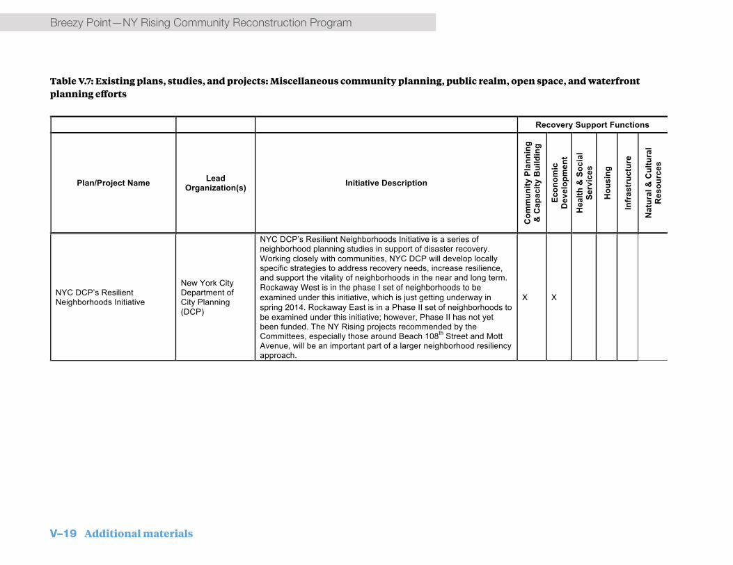
V–19 Additional materials
Breezy Point—NY Rising Community Reconstruction ProgramAll South Queens? Dredged Materials & Climate
Change Pilot Project: Technology, Applications and Demonstration Project - Phase 1
PANYNJ and Nautilus
The Port Authority of New York & New Jersey (PANYNJ) is exploring the beneficial reuse of dredged materials in ways that are environmentally sustainable and can improve coastal resiliency through the Dredged Materials & Climate Change Pilot Project. During the first phase, the pilot is aimed at 1) analyzing state-of-the-art technologies for the reuse of dredged materials, 2) evaluating a range of possible applications that could help address climate change, and 3) proposing a future demonstration project on southwest Brooklyn's waterfront. The findings could provide additional coastal protection options for low-lying South Queens neighborhoods.
X X
RW, RE Special Initiative for Rebuilding
and Resiliency (SIRR) Analysis - Environmental Justice Alliance
Sandy Regional Assembly, Environmental Justice Alliance (NYC-EJA)
Report analyzes proposals made by the SIRR Report and provides supplemental recommendations aimed at addressing environmental justice and social justice issues. Proposals relevant to Red Hook include providing funding for the Red Hook Significant Maritime Industrial Area (SMIA), expediting the remediation of the Gowanus Canal, and establishing a Community Resilience Center.
X X X X X X
RW, RE
DDC Capital Project at Brooklyn Public Library
NYC Department of Design and Construction (NYCDDC) and Brooklyn Public Library
Red Hook Library boiler to be replaced after sustaining considerable damage in Superstorm Sandy X X
RW, RE,
NYC DCP’s Resilient Neighborhoods Initiative
New York City Department of City Planning (DCP)
NYC DCP’s Resilient Neighborhoods Initiative is a series of neighborhood planning studies in support of disaster recovery. Working closely with communities, NYC DCP will develop locally specific strategies to address recovery needs, increase resilience, and support the vitality of neighborhoods in the near and long term. Rockaway West is in the phase I set of neighborhoods to be examined under this initiative, which is just getting underway in spring 2014. Rockaway East is in a Phase II set of neighborhoods to be examined under this initiative; however, Phase II has not yet been funded. The NY Rising projects recommended by the Committees, especially those around Beach 108th Street and Mott Avenue, will be an important part of a larger neighborhood resiliency approach.
X X
Table of existing plans, studies, and projects – Housing
Recovery Support Functions
Error! No text of specified style in document. / 3
Table of existing plans, studies, and projects – Miscellaneous community planning, public realm, open space, and waterfront planning efforts
Recovery Support Functions
Plan/Project Name Lead Organization(s) Initiative Description
Com
mun
ity P
lann
ing
& C
apac
ity B
uild
ing
Econ
omic
D
evel
opm
ent
Hea
lth &
Soc
ial
Serv
ices
Hou
sing
Infr
astr
uctu
re
Nat
ural
& C
ultu
ral
Res
ourc
es
ALL
SIRR Report
Special Initiative for Rebuilding and Resiliency. On June 11, 2013, former Mayor Michael Bloomberg announced the release of A Stronger, More Resilient New York (SIRR Report), forming New York City’s plan for rebuilding post Sandy and ensuring resiliency into the future. The plan contains actionable recommendations both for rebuilding communities in the City affected by the storm and for increasing the resiliency of buildings and infrastructure citywide. All NYRCR Communities within the city have and will need to continue to coordinate with ongoing City initiatives. More broadly, the SIRR Report lays out numerous city-wide initiatives to improve resiliency for systems, including coastal protection, buildings, insurance, utilities, liquid fuels, healthcare, transportation, parks, water and wastewater, and other critical networks.
X X X X X X
NYC Building and Zoning Code Revisions
Ongoing and potential future updates to the building and zoning code are particularly relevant to NYRCR communities in the Rockaways. New York City’s Building Resiliency Task Force identified 33 recommendations to the City Council. Many of these recommendations are still in various states of review, and 16 initiatives have been passed. In addition, the New York City Department of City Planning's Flood Resilience Zoning Text Amendment was approved by City Council on October 9, 2013. The amendment removed obstacles to homes that are rebuilding in the flood zone, allowing homes to build to the new standards. The report and latest updates on implementation can be found on the SIRR website: http://www.nyc.gov/html/sirr/.
X X
Table V.7: Existing plans, studies, and projects: Miscellaneous community planning, public realm, open space, and waterfront planning efforts

Additional materials V–20
NY Rising Community Reconstruction Program—Breezy Point
Error! No text of specified style in document. / 5
Plan/Project Name Lead Organization(s) Initiative Description
Com
mun
ity P
lann
ing
& C
apac
ity B
uild
ing
Econ
omic
D
evel
opm
ent
Hea
lth &
Soc
ial
Serv
ices
H
ousi
ng
Infr
astr
uctu
re
Nat
ural
& C
ultu
ral
Res
ourc
es
RE, RH, LM
Weathering the Storm: Rebuilding a More Resilient New York City Housing Authority Post-Sandy
The Alliance for a Just Rebuilding; ALIGN; Community Development Project at the Urban Justice Center; Community Voices Heard; Faith in New York; Families United for Racial and Economic Equality; Good Old Lower East Side; Red Hook Initiative; New York Communities for Change
This report assesses how NYCHA residents living in storm-affected zones are faring after Superstorm Sandy and proposes solutions for how NYCHA and the City can address the issues exposed by Sandy. For this research, participating community groups surveyed public housing residents living in NYCHA buildings in Red Hook, Coney Island, Lower East Side, Far Rockaway, and Gowanus. The report includes research findings and recommendations.
X
ALL
NYC Recovery: Build it Back Program NYC Recovery
The City’s “Build It Back” program seeks to assist homeowners, landlords, and tenants whose homes were damaged by the storm. The NYC Recovery Program is also offering business loans and grants to small business owners whose businesses were damaged by the storm. Most of these recovery programs support resiliency investments and will help improve individual homes and businesses in the communities surrounding Jamaica Bay.
X
All
Precedent: Sandy Design Help Desk
Fifth Avenue Committee (FAC); Enterpise Community Partners; Architecture for Humanity; New York City Housing Recovery Office (HRO)
A weekend workshop, staffed by volunteer architects, provided pro-bono assistance to Red Hook homeowners/building owners addressing questions about resiliency upgrades and repairs. The workshop was able to assist 12 property owners and highlighted the key challenges that homeowners are facing in repair/resiliency work.
X
All South Queens? Dredged Materials & Climate
Change Pilot Project: Technology, Applications and Demonstration Project - Phase 1
PANYNJ and Nautilus
The Port Authority of New York & New Jersey (PANYNJ) is exploring the beneficial reuse of dredged materials in ways that are environmentally sustainable and can improve coastal resiliency through the Dredged Materials & Climate Change Pilot Project. During the first phase, the pilot is aimed at 1) analyzing state-of-the-art technologies for the reuse of dredged materials, 2) evaluating a range of possible applications that could help address climate change, and 3) proposing a future demonstration project on southwest Brooklyn's waterfront. The findings could provide additional coastal protection options for low-lying South Queens neighborhoods.
X X
RW, RE Special Initiative for Rebuilding
and Resiliency (SIRR) Analysis - Environmental Justice Alliance
Sandy Regional Assembly, Environmental Justice Alliance (NYC-EJA)
Report analyzes proposals made by the SIRR Report and provides supplemental recommendations aimed at addressing environmental justice and social justice issues. Proposals relevant to Red Hook include providing funding for the Red Hook Significant Maritime Industrial Area (SMIA), expediting the remediation of the Gowanus Canal, and establishing a Community Resilience Center.
X X X X X X
RW, RE
DDC Capital Project at Brooklyn Public Library
NYC Department of Design and Construction (NYCDDC) and Brooklyn Public Library
Red Hook Library boiler to be replaced after sustaining considerable damage in Superstorm Sandy X X
RW, RE,
NYC DCP’s Resilient Neighborhoods Initiative
New York City Department of City Planning (DCP)
NYC DCP’s Resilient Neighborhoods Initiative is a series of neighborhood planning studies in support of disaster recovery. Working closely with communities, NYC DCP will develop locally specific strategies to address recovery needs, increase resilience, and support the vitality of neighborhoods in the near and long term. Rockaway West is in the phase I set of neighborhoods to be examined under this initiative, which is just getting underway in spring 2014. Rockaway East is in a Phase II set of neighborhoods to be examined under this initiative; however, Phase II has not yet been funded. The NY Rising projects recommended by the Committees, especially those around Beach 108th Street and Mott Avenue, will be an important part of a larger neighborhood resiliency approach.
X X
Table of existing plans, studies, and projects – Housing
Recovery Support Functions
Table V.8: Existing plans, studies, and projects: Housing

V–21 Additional materials
Breezy Point—NY Rising Community Reconstruction Program
Recovery Support Functions
Plan/Project Name Lead Organization(s) Initiative Description
Com
mun
ity P
lann
ing
& C
apac
ity B
uild
ing
Econ
omic
D
evel
opm
ent
Hea
lth &
Soc
ial
Serv
ices
H
ousi
ng
Infr
astr
uctu
re
Nat
ural
& C
ultu
ral
Res
ourc
es
RW, RE Precedent: Gowanus Houses
tenant disaster training program
Fifth Avenue Committee (FAC); Families United for Racial and Economic Equality (FUREE)
The disaster preparedness project will engage and train tenants in Gowanus Houses on climate change, disaster planning and recovery; create a community hub; and develop a disaster preparedness plan and training program for volunteers to respond in disasters
X X
RE
FAR ROC Design Competition NYC Housing Preservation & Development (HPD)
FAR ROC [For a Resilient Rockaway] is a two-phase design competition that will explore innovative strategies for the planning, design and construction of a resilient and sustainable development at Arverne East, an 80+ acre site on the Rockaway Peninsula. The Competition received 117 unique design proposals from over 20 countries around the globe. Competitions winners were announced in October 2013. The winning proposal, “Small Means & Great Ends,” incorporates a series of small, affordable, and smart interventions that center on three strategies: reduce and control damage; provide access in the event of a storm; and ensure quick recovery. The design aims not only to better weather future natural disasters, but also to create a stronger socio-economic environment–moving beyond resilience and becoming ‘antifragile’, where both the design and community benefit and improve after enduring stress.
X
RW, RE Best practices for disaster
response in supportive housing report
Supportive Housing Network of NY
Research and report on best practices in disaster response plans to supportive housing providers and government partners; clarify government agency roles and protocols as they apply to supportive housing during disasters
X X
RW, RE White paper on reducing
regulatory barriers for MF retrofit
Furman Center for Real Estate and Urban Policy
Identify promising retrofit strategies for three common affordable, multi-family housing building types; Prepare and publicize three case studies and engineering analysis and a white paper on findings and recommendations to reduce regulatory barriers
X
RW, RE
Physical Needs Assessment (PNA) model development with resiliency considerations
NYC Energy Efficiency Corporation
Incorporation of additional resiliency and energy saving analysis into Physical Needs Assessment (PNA), Develop a model for PNA reports that includes energy efficiency and resiliency
X X
Error! No text of specified style in document. / 5
Plan/Project Name Lead Organization(s) Initiative Description
Com
mun
ity P
lann
ing
& C
apac
ity B
uild
ing
Econ
omic
D
evel
opm
ent
Hea
lth &
Soc
ial
Serv
ices
H
ousi
ng
Infr
astr
uctu
re
Nat
ural
& C
ultu
ral
Res
ourc
es
RE, RH, LM
Weathering the Storm: Rebuilding a More Resilient New York City Housing Authority Post-Sandy
The Alliance for a Just Rebuilding; ALIGN; Community Development Project at the Urban Justice Center; Community Voices Heard; Faith in New York; Families United for Racial and Economic Equality; Good Old Lower East Side; Red Hook Initiative; New York Communities for Change
This report assesses how NYCHA residents living in storm-affected zones are faring after Superstorm Sandy and proposes solutions for how NYCHA and the City can address the issues exposed by Sandy. For this research, participating community groups surveyed public housing residents living in NYCHA buildings in Red Hook, Coney Island, Lower East Side, Far Rockaway, and Gowanus. The report includes research findings and recommendations.
X
ALL
NYC Recovery: Build it Back Program NYC Recovery
The City’s “Build It Back” program seeks to assist homeowners, landlords, and tenants whose homes were damaged by the storm. The NYC Recovery Program is also offering business loans and grants to small business owners whose businesses were damaged by the storm. Most of these recovery programs support resiliency investments and will help improve individual homes and businesses in the communities surrounding Jamaica Bay.
X
All
Precedent: Sandy Design Help Desk
Fifth Avenue Committee (FAC); Enterpise Community Partners; Architecture for Humanity; New York City Housing Recovery Office (HRO)
A weekend workshop, staffed by volunteer architects, provided pro-bono assistance to Red Hook homeowners/building owners addressing questions about resiliency upgrades and repairs. The workshop was able to assist 12 property owners and highlighted the key challenges that homeowners are facing in repair/resiliency work.
X
All South Queens? Dredged Materials & Climate
Change Pilot Project: Technology, Applications and Demonstration Project - Phase 1
PANYNJ and Nautilus
The Port Authority of New York & New Jersey (PANYNJ) is exploring the beneficial reuse of dredged materials in ways that are environmentally sustainable and can improve coastal resiliency through the Dredged Materials & Climate Change Pilot Project. During the first phase, the pilot is aimed at 1) analyzing state-of-the-art technologies for the reuse of dredged materials, 2) evaluating a range of possible applications that could help address climate change, and 3) proposing a future demonstration project on southwest Brooklyn's waterfront. The findings could provide additional coastal protection options for low-lying South Queens neighborhoods.
X X
RW, RE Special Initiative for Rebuilding
and Resiliency (SIRR) Analysis - Environmental Justice Alliance
Sandy Regional Assembly, Environmental Justice Alliance (NYC-EJA)
Report analyzes proposals made by the SIRR Report and provides supplemental recommendations aimed at addressing environmental justice and social justice issues. Proposals relevant to Red Hook include providing funding for the Red Hook Significant Maritime Industrial Area (SMIA), expediting the remediation of the Gowanus Canal, and establishing a Community Resilience Center.
X X X X X X
RW, RE
DDC Capital Project at Brooklyn Public Library
NYC Department of Design and Construction (NYCDDC) and Brooklyn Public Library
Red Hook Library boiler to be replaced after sustaining considerable damage in Superstorm Sandy X X
RW, RE,
NYC DCP’s Resilient Neighborhoods Initiative
New York City Department of City Planning (DCP)
NYC DCP’s Resilient Neighborhoods Initiative is a series of neighborhood planning studies in support of disaster recovery. Working closely with communities, NYC DCP will develop locally specific strategies to address recovery needs, increase resilience, and support the vitality of neighborhoods in the near and long term. Rockaway West is in the phase I set of neighborhoods to be examined under this initiative, which is just getting underway in spring 2014. Rockaway East is in a Phase II set of neighborhoods to be examined under this initiative; however, Phase II has not yet been funded. The NY Rising projects recommended by the Committees, especially those around Beach 108th Street and Mott Avenue, will be an important part of a larger neighborhood resiliency approach.
X X
Table of existing plans, studies, and projects – Housing
Recovery Support Functions
Table V.8: Existing plans, studies, and projects: Housing

Additional materials V–22
NY Rising Community Reconstruction Program—Breezy Point
Error! No text of specified style in document. / 7
Table of existing plans, studies, and projects – Economic Development & Economic Opportunity
Recovery Support Functions
Plan/Project Name Lead Organization(s) Initiative Description
Com
mun
ity P
lann
ing
& C
apac
ity B
uild
ing
Econ
omic
D
evel
opm
ent
Hea
lth &
Soc
ial
Serv
ices
H
ousi
ng
Infr
astr
uctu
re
Nat
ural
& C
ultu
ral
Res
ourc
es
RW, RE? Neighborhood Game-Changer
Investment Competition
New York City Economic Development Corporation (EDC)
NYCEDC launched a $90,000,000 competition for development of “game-changing” projects that will enhance the vitality, connectivity, and economic strength of areas impacted by Superstorm Sandy including South Queens.
X
ALL
NYC Recovery: Business Resiliency Investment Program (BRIP)
New York City Economic Development Corporation (EDC)
The Business Resiliency Investment Program (BRIP) is a $110 million CDBG-DR-funded program that will provide funds to both business tenants and owners to make improvements that enhance resiliency to severe weather-related events. It will focus on funding a portion of the incremental costs of one or more “Approved Resiliency Measures” through grants and loans; the program focuses on funding resiliency improvements and not repairs.
X
ALL
New York City Regional Economic Development Council’s Five-Year Strategy
New York City Regional Economic Development Council
This plan is a comprehensive economic strategy to address and promote poverty prevention/job training, government fiscal responsibility and infrastructure investment, and balanced investment among all of New York City’s businesses. The Council outlines four key objectives to address these principles: improve quality of life, create a pro-growth, pro-jobs environment, invest in the future, and foster innovation and inter-regional cooperation. Specific approaches such as supporting small businesses and neighborhood revitalization align with the goals of NYRCR.
X
Table of existing plans, studies, and projects – Transportation
Recovery Support Functions
Table V.9: Existing plans, studies, and projects: Economic development & economic opportunity

V–23 Additional materials
Breezy Point—NY Rising Community Reconstruction ProgramIN
TER
NA
L - C
omm
Plan/Project Name Lead Organization(s) Initiative Description
Com
mun
ity P
lann
ing
& C
apac
ity B
uild
ing
Econ
omic
D
evel
opm
ent
Hea
lth &
Soc
ial
Serv
ices
H
ousi
ng
Infr
astr
uctu
re
Nat
ural
& C
ultu
ral
Res
ourc
es
RW, RE, BP
2010 Comprehensive Citywide Ferry Study
NYC Economic Development Corporation (EDC)
This study provided an overview of development potential for passenger ferry transportation throughout New York City. The planning study analyzed and prioritized potential routes drawn from a group of over forty waterfront sites in the five boroughs. As discussed in the study, enhanced ferry service in Red Hook could provide multiple local and regional benefits, including increased access to a variety of destinations in Red Hook, as well as substantial reductions in commuting time to Manhattan, which could further increase the neighborhood's attractiveness.
X
RW, RE, BP
2013 Comprehensive Citywide Ferry Study
NYC Economic Development Corporation (EDC)
Given the success of the East River Ferry’s first two years of service and dramatic development changes on New York City’s waterfront, NYC EDC is developing an updated and expanded Citywide Ferry Study that builds on the recommendations first identified in the 2010 Comprehensive Ferry Study. A preliminary report was published in late 2013 as a precursor to the Final Report that is anticipated for release in 2014. The preliminary report’s findings on economic impacts and potential value capture strategies have relevance for NY Rising communities considering bolstering ferry service. The report found that residential property values near East River ferry stops in Brooklyn and Queens increased 8% over comparable property values further from the stops; similarly areas near ferry stops realized almost 5% more residential and commercial building space development than areas farther from ferry stops. The report found that ferry routes serving more distant locations provide accessibility benefits but generate higher operating costs requiring greater funding support if they are to maintain fares similar to other transit modes.
X
RW, RE, BP
Ferry Policy and Planning in New York City: Considerations for a Five-Borough Ferry System
NYC EDC
In conjunction with the Citywide Ferry Study update, this paper provides a preliminary road map for expansion to a five-borough ferry system, building on lessons learned and defining best practices.
X
Error! No text of specified style in document. / 7
Table of existing plans, studies, and projects – Economic Development & Economic Opportunity
Recovery Support Functions
Plan/Project Name Lead Organization(s) Initiative Description
Com
mun
ity P
lann
ing
& C
apac
ity B
uild
ing
Econ
omic
D
evel
opm
ent
Hea
lth &
Soc
ial
Serv
ices
H
ousi
ng
Infr
astr
uctu
re
Nat
ural
& C
ultu
ral
Res
ourc
es
RW, RE? Neighborhood Game-Changer
Investment Competition
New York City Economic Development Corporation (EDC)
NYCEDC launched a $90,000,000 competition for development of “game-changing” projects that will enhance the vitality, connectivity, and economic strength of areas impacted by Superstorm Sandy including South Queens.
X
ALL
NYC Recovery: Business Resiliency Investment Program (BRIP)
New York City Economic Development Corporation (EDC)
The Business Resiliency Investment Program (BRIP) is a $110 million CDBG-DR-funded program that will provide funds to both business tenants and owners to make improvements that enhance resiliency to severe weather-related events. It will focus on funding a portion of the incremental costs of one or more “Approved Resiliency Measures” through grants and loans; the program focuses on funding resiliency improvements and not repairs.
X
ALL
New York City Regional Economic Development Council’s Five-Year Strategy
New York City Regional Economic Development Council
This plan is a comprehensive economic strategy to address and promote poverty prevention/job training, government fiscal responsibility and infrastructure investment, and balanced investment among all of New York City’s businesses. The Council outlines four key objectives to address these principles: improve quality of life, create a pro-growth, pro-jobs environment, invest in the future, and foster innovation and inter-regional cooperation. Specific approaches such as supporting small businesses and neighborhood revitalization align with the goals of NYRCR.
X
Table of existing plans, studies, and projects – Transportation
Recovery Support Functions
Table V.10: Existing plans, studies, and projects: Transportation

Additional materials V–24
NY Rising Community Reconstruction Program—Breezy Point
Error! No text of specified style in document. / 9
Recovery Support Functions
INTE
RN
AL
- Com
m
Plan/Project Name Lead Organization(s) Initiative Description
Com
mun
ity P
lann
ing
& C
apac
ity B
uild
ing
Econ
omic
D
evel
opm
ent
Hea
lth &
Soc
ial
Serv
ices
H
ousi
ng
Infr
astr
uctu
re
Nat
ural
& C
ultu
ral
Res
ourc
es
ALL
New York-New Jersey-Connecticut Hurricane Sandy Follow-up and Transportation Vulnerability Assessment and Adaptation Analysis Project
FHWA; New York, New Jersey and Connecticut Departments of Transportation; North Jersey Transportation Planning Authority (NJTPA); New York Metropolitan Transportation Council (NYMTC); South Western Regional Planning Agency (SWRPA); Greater Bridgeport Regional Council (GBRC)
This research project, initiated by Federal Highway Administration (FHWA), will examine the impacts on the transportation system from Hurricanes Sandy and Irene and Tropical Storm Lee and identify strategies to protect select transportation assets from the impacts of extreme weather and climate change.
X
ALL Metropolitan Transportation Authority (MTA) Capital Needs Assessment 2015-2034
Metropolitan Transportation Authority (MTA)
The 20-year capital needs assessment establishes the planning context prior to the development of five-year capital programs for the MTA. As discussed in the document, MTA’s goal is to maintain a transportation system that is resilient to future natural hazards and the impacts of possible climate change.
X
BP, RE, RW MTA Rockaway Crossings
Mater Plan
Metropolitan Transportation Authority (MTA
MTA Triborough Bridge and Tunnel Authority (TBTA) is conducting a study to assess and develop engineering alternatives for potential replacement or reconstruction scenarios for the Rockaway Crossings – the Gil Hodges Memorial Bridge and Cross Bay Bridge. The study will develop a Long Term Rockaway Crossing Facility Master Plan, outlining future capital expenditures the Authority should allocate as part of its capital Program.
X
INTE
RN
AL
- Com
m
Plan/Project Name Lead Organization(s) Initiative Description
Com
mun
ity P
lann
ing
& C
apac
ity B
uild
ing
Econ
omic
D
evel
opm
ent
Hea
lth &
Soc
ial
Serv
ices
H
ousi
ng
Infr
astr
uctu
re
Nat
ural
& C
ultu
ral
Res
ourc
es
RW, RE, BP
2010 Comprehensive Citywide Ferry Study
NYC Economic Development Corporation (EDC)
This study provided an overview of development potential for passenger ferry transportation throughout New York City. The planning study analyzed and prioritized potential routes drawn from a group of over forty waterfront sites in the five boroughs. As discussed in the study, enhanced ferry service in Red Hook could provide multiple local and regional benefits, including increased access to a variety of destinations in Red Hook, as well as substantial reductions in commuting time to Manhattan, which could further increase the neighborhood's attractiveness.
X
RW, RE, BP
2013 Comprehensive Citywide Ferry Study
NYC Economic Development Corporation (EDC)
Given the success of the East River Ferry’s first two years of service and dramatic development changes on New York City’s waterfront, NYC EDC is developing an updated and expanded Citywide Ferry Study that builds on the recommendations first identified in the 2010 Comprehensive Ferry Study. A preliminary report was published in late 2013 as a precursor to the Final Report that is anticipated for release in 2014. The preliminary report’s findings on economic impacts and potential value capture strategies have relevance for NY Rising communities considering bolstering ferry service. The report found that residential property values near East River ferry stops in Brooklyn and Queens increased 8% over comparable property values further from the stops; similarly areas near ferry stops realized almost 5% more residential and commercial building space development than areas farther from ferry stops. The report found that ferry routes serving more distant locations provide accessibility benefits but generate higher operating costs requiring greater funding support if they are to maintain fares similar to other transit modes.
X
RW, RE, BP
Ferry Policy and Planning in New York City: Considerations for a Five-Borough Ferry System
NYC EDC
In conjunction with the Citywide Ferry Study update, this paper provides a preliminary road map for expansion to a five-borough ferry system, building on lessons learned and defining best practices.
X
Error! No text of specified style in document. / 7
Table of existing plans, studies, and projects – Economic Development & Economic Opportunity
Recovery Support Functions
Plan/Project Name Lead Organization(s) Initiative Description
Com
mun
ity P
lann
ing
& C
apac
ity B
uild
ing
Econ
omic
D
evel
opm
ent
Hea
lth &
Soc
ial
Serv
ices
H
ousi
ng
Infr
astr
uctu
re
Nat
ural
& C
ultu
ral
Res
ourc
es
RW, RE? Neighborhood Game-Changer
Investment Competition
New York City Economic Development Corporation (EDC)
NYCEDC launched a $90,000,000 competition for development of “game-changing” projects that will enhance the vitality, connectivity, and economic strength of areas impacted by Superstorm Sandy including South Queens.
X
ALL
NYC Recovery: Business Resiliency Investment Program (BRIP)
New York City Economic Development Corporation (EDC)
The Business Resiliency Investment Program (BRIP) is a $110 million CDBG-DR-funded program that will provide funds to both business tenants and owners to make improvements that enhance resiliency to severe weather-related events. It will focus on funding a portion of the incremental costs of one or more “Approved Resiliency Measures” through grants and loans; the program focuses on funding resiliency improvements and not repairs.
X
ALL
New York City Regional Economic Development Council’s Five-Year Strategy
New York City Regional Economic Development Council
This plan is a comprehensive economic strategy to address and promote poverty prevention/job training, government fiscal responsibility and infrastructure investment, and balanced investment among all of New York City’s businesses. The Council outlines four key objectives to address these principles: improve quality of life, create a pro-growth, pro-jobs environment, invest in the future, and foster innovation and inter-regional cooperation. Specific approaches such as supporting small businesses and neighborhood revitalization align with the goals of NYRCR.
X
Table of existing plans, studies, and projects – Transportation
Recovery Support Functions
Table V.10: Existing plans, studies, and projects: Transportation

V–25 Additional materials
Breezy Point—NY Rising Community Reconstruction Program
Error! No text of specified style in document. / 9
Recovery Support Functions
INTE
RN
AL
- Com
m
Plan/Project Name Lead Organization(s) Initiative Description
Com
mun
ity P
lann
ing
& C
apac
ity B
uild
ing
Econ
omic
D
evel
opm
ent
Hea
lth &
Soc
ial
Serv
ices
H
ousi
ng
Infr
astr
uctu
re
Nat
ural
& C
ultu
ral
Res
ourc
es
ALL
New York-New Jersey-Connecticut Hurricane Sandy Follow-up and Transportation Vulnerability Assessment and Adaptation Analysis Project
FHWA; New York, New Jersey and Connecticut Departments of Transportation; North Jersey Transportation Planning Authority (NJTPA); New York Metropolitan Transportation Council (NYMTC); South Western Regional Planning Agency (SWRPA); Greater Bridgeport Regional Council (GBRC)
This research project, initiated by Federal Highway Administration (FHWA), will examine the impacts on the transportation system from Hurricanes Sandy and Irene and Tropical Storm Lee and identify strategies to protect select transportation assets from the impacts of extreme weather and climate change.
X
ALL Metropolitan Transportation Authority (MTA) Capital Needs Assessment 2015-2034
Metropolitan Transportation Authority (MTA)
The 20-year capital needs assessment establishes the planning context prior to the development of five-year capital programs for the MTA. As discussed in the document, MTA’s goal is to maintain a transportation system that is resilient to future natural hazards and the impacts of possible climate change.
X
BP, RE, RW MTA Rockaway Crossings
Mater Plan
Metropolitan Transportation Authority (MTA
MTA Triborough Bridge and Tunnel Authority (TBTA) is conducting a study to assess and develop engineering alternatives for potential replacement or reconstruction scenarios for the Rockaway Crossings – the Gil Hodges Memorial Bridge and Cross Bay Bridge. The study will develop a Long Term Rockaway Crossing Facility Master Plan, outlining future capital expenditures the Authority should allocate as part of its capital Program.
X
INTE
RN
AL
- Com
m
Plan/Project Name Lead Organization(s) Initiative Description
Com
mun
ity P
lann
ing
& C
apac
ity B
uild
ing
Econ
omic
D
evel
opm
ent
Hea
lth &
Soc
ial
Serv
ices
H
ousi
ng
Infr
astr
uctu
re
Nat
ural
& C
ultu
ral
Res
ourc
es
RW, RE, BP
2010 Comprehensive Citywide Ferry Study
NYC Economic Development Corporation (EDC)
This study provided an overview of development potential for passenger ferry transportation throughout New York City. The planning study analyzed and prioritized potential routes drawn from a group of over forty waterfront sites in the five boroughs. As discussed in the study, enhanced ferry service in Red Hook could provide multiple local and regional benefits, including increased access to a variety of destinations in Red Hook, as well as substantial reductions in commuting time to Manhattan, which could further increase the neighborhood's attractiveness.
X
RW, RE, BP
2013 Comprehensive Citywide Ferry Study
NYC Economic Development Corporation (EDC)
Given the success of the East River Ferry’s first two years of service and dramatic development changes on New York City’s waterfront, NYC EDC is developing an updated and expanded Citywide Ferry Study that builds on the recommendations first identified in the 2010 Comprehensive Ferry Study. A preliminary report was published in late 2013 as a precursor to the Final Report that is anticipated for release in 2014. The preliminary report’s findings on economic impacts and potential value capture strategies have relevance for NY Rising communities considering bolstering ferry service. The report found that residential property values near East River ferry stops in Brooklyn and Queens increased 8% over comparable property values further from the stops; similarly areas near ferry stops realized almost 5% more residential and commercial building space development than areas farther from ferry stops. The report found that ferry routes serving more distant locations provide accessibility benefits but generate higher operating costs requiring greater funding support if they are to maintain fares similar to other transit modes.
X
RW, RE, BP
Ferry Policy and Planning in New York City: Considerations for a Five-Borough Ferry System
NYC EDC
In conjunction with the Citywide Ferry Study update, this paper provides a preliminary road map for expansion to a five-borough ferry system, building on lessons learned and defining best practices.
X
Error! No text of specified style in document. / 7
Table of existing plans, studies, and projects – Economic Development & Economic Opportunity
Recovery Support Functions
Plan/Project Name Lead Organization(s) Initiative Description
Com
mun
ity P
lann
ing
& C
apac
ity B
uild
ing
Econ
omic
D
evel
opm
ent
Hea
lth &
Soc
ial
Serv
ices
H
ousi
ng
Infr
astr
uctu
re
Nat
ural
& C
ultu
ral
Res
ourc
es
RW, RE? Neighborhood Game-Changer
Investment Competition
New York City Economic Development Corporation (EDC)
NYCEDC launched a $90,000,000 competition for development of “game-changing” projects that will enhance the vitality, connectivity, and economic strength of areas impacted by Superstorm Sandy including South Queens.
X
ALL
NYC Recovery: Business Resiliency Investment Program (BRIP)
New York City Economic Development Corporation (EDC)
The Business Resiliency Investment Program (BRIP) is a $110 million CDBG-DR-funded program that will provide funds to both business tenants and owners to make improvements that enhance resiliency to severe weather-related events. It will focus on funding a portion of the incremental costs of one or more “Approved Resiliency Measures” through grants and loans; the program focuses on funding resiliency improvements and not repairs.
X
ALL
New York City Regional Economic Development Council’s Five-Year Strategy
New York City Regional Economic Development Council
This plan is a comprehensive economic strategy to address and promote poverty prevention/job training, government fiscal responsibility and infrastructure investment, and balanced investment among all of New York City’s businesses. The Council outlines four key objectives to address these principles: improve quality of life, create a pro-growth, pro-jobs environment, invest in the future, and foster innovation and inter-regional cooperation. Specific approaches such as supporting small businesses and neighborhood revitalization align with the goals of NYRCR.
X
Table of existing plans, studies, and projects – Transportation
Recovery Support Functions
Recovery Support Functions
INTE
RN
AL
- Com
m
Plan/Project Name Lead Organization(s) Initiative Description
Com
mun
ity P
lann
ing
& C
apac
ity B
uild
ing
Econ
omic
D
evel
opm
ent
Hea
lth &
Soc
ial
Serv
ices
H
ousi
ng
Infr
astr
uctu
re
Nat
ural
& C
ultu
ral
Res
ourc
es
ALL
New York Metropolitan Transportation Council (NYMTC) Plan 2040 Regional Transportation Plan (RTP)
New York Metropolitan Transportation Council (NYMTC)
Adopted in September 2013, this plan includes the NYMTC members’ vision for the planning area and lays out the long-range framework for maintaining and improving the region’s transportation system. One of seven “shared goals” of the NYMTC members is to improve the resiliency of the regional transportation system. As discussed in the document, NYMTC’s members will continue to plan for improving the resiliency of the transportation system so that the system can better resist disruptions to services and facilities and recover from them when they occur.
X
Woodhaven/Cross Bay Boulevards Select Bus Service (SBS) Study
New York City Department of Transportation (NYC DOT) MTA/NYCTransit
NYC DOT and MTA/NYC Transit are studying the Woodhaven/Cross Bay Boulevards for conversion of the existing Limited-Stop Q52/53 bus routes to Select Bus Service (SBS) to make existing bus service substantially faster and more reliable, while maintaining needed traffic flow and parking, and also making the corridor safer for all users. These routes extend from Rockaway Park and Arverne in the Rockaways to Woodside and Rego Park in central Queens; therefore, the study and potential improvements will include not just Woodhaven and Cross Bay Boulevards, but also streets to the north and south including Broadway, Roosevelt Avenue, and Rockaway Beach Boulevard. The Woodhaven/Cross Bay Boulevards corridor was first identified as a preferred location for Select Bus Service improvements in 2009, which led to short-term safety improvements. Long-term recommendations include roadway capital improvements and the implementation of Select Bus Service. This study is just getting under way and the first public workshop will be held on April 24, 2014.
X
Table V.10: Existing plans, studies, and projects: Transportation

Additional materials V–26
NY Rising Community Reconstruction Program—Breezy Point Recovery Support
Functions
INTE
RN
AL
- Com
m
Plan/Project Name Lead Organization(s) Initiative Description
Com
mun
ity P
lann
ing
& C
apac
ity B
uild
ing
Econ
omic
D
evel
opm
ent
Hea
lth &
Soc
ial
Serv
ices
H
ousi
ng
Infr
astr
uctu
re
Nat
ural
& C
ultu
ral
Res
ourc
es
ALL
New York Metropolitan Transportation Council (NYMTC) Plan 2040 Regional Transportation Plan (RTP)
New York Metropolitan Transportation Council (NYMTC)
Adopted in September 2013, this plan includes the NYMTC members’ vision for the planning area and lays out the long-range framework for maintaining and improving the region’s transportation system. One of seven “shared goals” of the NYMTC members is to improve the resiliency of the regional transportation system. As discussed in the document, NYMTC’s members will continue to plan for improving the resiliency of the transportation system so that the system can better resist disruptions to services and facilities and recover from them when they occur.
X
Woodhaven/Cross Bay Boulevards Select Bus Service (SBS) Study
New York City Department of Transportation (NYC DOT) MTA/NYCTransit
NYC DOT and MTA/NYC Transit are studying the Woodhaven/Cross Bay Boulevards for conversion of the existing Limited-Stop Q52/53 bus routes to Select Bus Service (SBS) to make existing bus service substantially faster and more reliable, while maintaining needed traffic flow and parking, and also making the corridor safer for all users. These routes extend from Rockaway Park and Arverne in the Rockaways to Woodside and Rego Park in central Queens; therefore, the study and potential improvements will include not just Woodhaven and Cross Bay Boulevards, but also streets to the north and south including Broadway, Roosevelt Avenue, and Rockaway Beach Boulevard. The Woodhaven/Cross Bay Boulevards corridor was first identified as a preferred location for Select Bus Service improvements in 2009, which led to short-term safety improvements. Long-term recommendations include roadway capital improvements and the implementation of Select Bus Service. This study is just getting under way and the first public workshop will be held on April 24, 2014.
X
Recovery Support Functions
INTE
RN
AL
- Com
m
Plan/Project Name Lead Organization(s) Initiative Description
Com
mun
ity P
lann
ing
& C
apac
ity B
uild
ing
Econ
omic
D
evel
opm
ent
Hea
lth &
Soc
ial
Serv
ices
H
ousi
ng
Infr
astr
uctu
re
Nat
ural
& C
ultu
ral
Res
ourc
es
ALL
New York Metropolitan Transportation Council (NYMTC) Plan 2040 Regional Transportation Plan (RTP)
New York Metropolitan Transportation Council (NYMTC)
Adopted in September 2013, this plan includes the NYMTC members’ vision for the planning area and lays out the long-range framework for maintaining and improving the region’s transportation system. One of seven “shared goals” of the NYMTC members is to improve the resiliency of the regional transportation system. As discussed in the document, NYMTC’s members will continue to plan for improving the resiliency of the transportation system so that the system can better resist disruptions to services and facilities and recover from them when they occur.
X
Woodhaven/Cross Bay Boulevards Select Bus Service (SBS) Study
New York City Department of Transportation (NYC DOT) MTA/NYCTransit
NYC DOT and MTA/NYC Transit are studying the Woodhaven/Cross Bay Boulevards for conversion of the existing Limited-Stop Q52/53 bus routes to Select Bus Service (SBS) to make existing bus service substantially faster and more reliable, while maintaining needed traffic flow and parking, and also making the corridor safer for all users. These routes extend from Rockaway Park and Arverne in the Rockaways to Woodside and Rego Park in central Queens; therefore, the study and potential improvements will include not just Woodhaven and Cross Bay Boulevards, but also streets to the north and south including Broadway, Roosevelt Avenue, and Rockaway Beach Boulevard. The Woodhaven/Cross Bay Boulevards corridor was first identified as a preferred location for Select Bus Service improvements in 2009, which led to short-term safety improvements. Long-term recommendations include roadway capital improvements and the implementation of Select Bus Service. This study is just getting under way and the first public workshop will be held on April 24, 2014.
X
Table V.10: Existing plans, studies, and projects: Transportation

V–27 Additional materials
Breezy Point—NY Rising Community Reconstruction Program
Error! No text of specified style in document. / 11
Recovery Support Functions
INTE
RN
AL
- Com
m
Plan/Project Name Lead Organization(s) Initiative Description
Com
mun
ity P
lann
ing
& C
apac
ity B
uild
ing
Econ
omic
D
evel
opm
ent
Hea
lth &
Soc
ial
Serv
ices
H
ousi
ng
Infr
astr
uctu
re
Nat
ural
& C
ultu
ral
Res
ourc
es
RW
Remediation of Rockaway Park Former Manufactured Gas Plant Site
NYS DEC and National Grid
The Rockaway Park Former Manufactured Gas Plant (MGP) site sits on a large block at the northwest corner of Beach Channel Drive and Beach 108th Street. From the late 1870s until 1958, gas for cooking, lighting, heating, and commercial purposes was manufactured at the site. Evidence of by-products that resulted from the manufacturing process were found at the site, and required clean-up and remediation to contain contaminants from further spreading in subsurface soil or groundwater. Remediation measures on the site included excavation of soil to eight feet below grade, installing migration barriers, developing recovery wells, and capping the site, among other activities. Remediation measures were completed on the site itself in 2012, before Superstorm Sandy hit. The site was used for staging for Sandy recovery activities, and a portion of the site is currently used for parking for the Rockaway Ferry. Off-site remediation activities are still being defined, but will include complete remediation in the city-owned bulkhead area across Beach Channel Drive; the resulting landscaped open space is included in the NYC DPR Rockaway Parks Conceptual Plan as the Beach 108th Esplanade.
X X
RW, RE
Assorted DDC Capital Projects and NYC DOT 10 Year Capital Plan Projects
NYC Department of Design and Construction (DDC); NYC Department of Environmental Protection (DEP); NYC Department of Transportation (DOT)
Assorted capital transportation projects planned, underway, or recently completed include: – Reconstruction of Columbia Street, Phase II/BED768B/SEK002321
(HWK700B) – Reconstruction of Columbia Street/BED768 (HWK700A) – Brooklyn Waterfront Greenway: Sunset Park Connector (HWK1048D) – Retaining wall - Hamilton Avenue westbound (RWK017) - east of
Smith Street – Retrofit/upgrade of asphalt plant at Hamilton Avenue (HWKF2007) – Hamilton Avenue/Gowanus Canal (BIN 2-24023)
X X
Table V.10: Existing plans, studies, and projects: Transportation

Additional materials V–28
NY Rising Community Reconstruction Program—Breezy Point
Table of existing plans, studies, and projects – Drainage & Energy
Recovery Support Functions
INTE
RN
AL
Plan/Project Name Lead Organization(s) Initiative Description
Com
mun
ity P
lann
ing
& C
apac
ity B
uild
ing
Econ
omic
D
evel
opm
ent
Hea
lth &
Soc
ial
Serv
ices
H
ousi
ng
Infr
astr
uctu
re
Nat
ural
& C
ultu
ral
Res
ourc
es
ALL
NYC Wastewater Resiliency Plan: Climate Risk Assessment and Adaptation Study
NYC Department of Environmental Protection (DEP)
Building upon previous studies, this climate risk assessment and adaptation study sets forth cost-effective strategies for reducing flooding damage to wastewater infrastructure and safeguarding public health and the environment. This comprehensive study examined buildings and infrastructure at DEP’s 96 pumping stations and 14 wastewater treatment plants, identifying and prioritizing infrastructure that is most at risk of flood damage. The plan identified $15.1 million in resiliency upgrades for Rockaway WWTP, which occupies a superblock along Beach Channel Drive between Beach 108th and Beach 104th streets. Given the damage experienced in Superstorm Sandy and the expense to make the WWTP resilient, the plan notes that NYC DEP is evaluating alternatives for the WWTP, including conversion to a pumping station. Changing the function of the WWTP is a long-term effort, but could greatly benefit plans the Committee has identified for economic resiliency along Beach 108th Street and Beach Channel Drive. The plan also made recommendations for resilience measures at the Bayswater and Seagirt Pumping Stations in Rockaway East.
X
Table V.11: Existing plans, studies, and projects: Drainage & energy

V–29 Additional materials
Breezy Point—NY Rising Community Reconstruction Program
Error! No text of specified style in document. / 13
Recovery Support Functions
INTE
RN
AL
Plan/Project Name Lead Organization(s) Initiative Description
Com
mun
ity P
lann
ing
& C
apac
ity B
uild
ing
Econ
omic
D
evel
opm
ent
Hea
lth &
Soc
ial
Serv
ices
H
ousi
ng
Infr
astr
uctu
re
Nat
ural
& C
ultu
ral
Res
ourc
es
Green Infrastructure Program NYC DEP
In many parts of New York City, both stormwater and household wastewater flow into a common system, called a combined sewer. In heavy rain events, the system becomes overwhelmed and a mix of excess stormwater and untreated wastewater discharges directly into the City’s waterways at combined sewer outfalls. NYC DEP’s Green Infrastructure Program was created to address water quality impacts that result from combined sewer overflow events. Under this program, NYC DEP and its partner agencies design, construct and maintain a variety of sustainable green infrastructure practices such as green roofs, rain gardens, and Right-of-way Bioswales on City-owned property such as streets, sidewalks, schools, and public housing. The program also provides grants for green infrastructure projects on private property. The Rockaway Peninsula is served by separated stormwater sewers (or by no stormwater system at all in places, simply surface drainage), so the area is not eligible for the NYC DEP Green Infrastructure Program projects or grants. However, the program’s structure, standard designs, and its emphasis on funding maintenance provide guidance and resources for developing a successful bioswales program.
X X
RE, RW
DDC Capital Projects
NYC Department of Design and Construction (DDC); NYC Department of Environmental Protection (DEP)
Assorted repairs and rehabilitation of intercepting sewers is being undertaken. X
Table of existing plans, studies, and projects – Natural Resources & Open Space
Recovery Support Functions
Table V.11: Existing plans, studies, and projects: Drainage & energy

Additional materials V–30
NY Rising Community Reconstruction Program—Breezy PointIN
TER
NA
L
Com
m n
ame
Plan/Project Name Lead Organization(s) Initiative Description
Com
mun
ity P
lann
ing
& C
apac
ity B
uild
ing
Econ
omic
D
evel
opm
ent
Hea
lth &
Soc
ial
Serv
ices
H
ousi
ng
Infr
astr
uctu
re
Nat
ural
& C
ultu
ral
Res
ourc
es
NYC DCP New York City Comprehensive Waterfront Plan—Vision 2020
NYC DCP
A comprehensive analysis and overall vision for New York City’s 520 miles of shoreline. It includes a strategic framework for the City’s waterfront, short- and long-term strategies, and is used to guide land and water use decisions. Priorities in the plan focus on expanding public access, supporting the working waterfront, improving water quality, restoring the ecology of the waterfront, enhancing the Blue Network (the waterways between the five boroughs), and increasing the resiliency of the City in respect to climate change and sea-level rise.
X
NYC DCP New York City Waterfront Revitalization Program NYC DCP
The New York City Waterfront Revitalization Program (WRP) is the city's principal coastal management tool, and implements the CWP. It establishes the City's policies for development and use of the waterfront, and provides the framework for evaluating the consistency of all discretionary actions in the coastal area. When a proposed project is located in the City’s designated waterfront area, and it requires a local, state, or federal discretionary action, a determination of the project's consistency with the policies and intent of the WRP must be made before the project can move forward.
X X
NYC DCP Designing for Flood Risk NYC DCP
Designing for Flood Risk identifies key principles to guide the design of new buildings in flood zones so that construction will be more resilient to the effects of climate change and coastal flood events. Recognizing the distinct character and needs of higher-density urban environments, the report provides recommendations for how regulations and individual project design can incorporate these principles. The study informed the Department of City Planning’s Flood Resilience Zoning text amendment adopted by City Council in 2013.
X X
Error! No text of specified style in document. / 13
Recovery Support Functions
INTE
RN
AL
Plan/Project Name Lead Organization(s) Initiative Description
Com
mun
ity P
lann
ing
& C
apac
ity B
uild
ing
Econ
omic
D
evel
opm
ent
Hea
lth &
Soc
ial
Serv
ices
H
ousi
ng
Infr
astr
uctu
re
Nat
ural
& C
ultu
ral
Res
ourc
es
Green Infrastructure Program NYC DEP
In many parts of New York City, both stormwater and household wastewater flow into a common system, called a combined sewer. In heavy rain events, the system becomes overwhelmed and a mix of excess stormwater and untreated wastewater discharges directly into the City’s waterways at combined sewer outfalls. NYC DEP’s Green Infrastructure Program was created to address water quality impacts that result from combined sewer overflow events. Under this program, NYC DEP and its partner agencies design, construct and maintain a variety of sustainable green infrastructure practices such as green roofs, rain gardens, and Right-of-way Bioswales on City-owned property such as streets, sidewalks, schools, and public housing. The program also provides grants for green infrastructure projects on private property. The Rockaway Peninsula is served by separated stormwater sewers (or by no stormwater system at all in places, simply surface drainage), so the area is not eligible for the NYC DEP Green Infrastructure Program projects or grants. However, the program’s structure, standard designs, and its emphasis on funding maintenance provide guidance and resources for developing a successful bioswales program.
X X
RE, RW
DDC Capital Projects
NYC Department of Design and Construction (DDC); NYC Department of Environmental Protection (DEP)
Assorted repairs and rehabilitation of intercepting sewers is being undertaken. X
Table of existing plans, studies, and projects – Natural Resources & Open Space
Recovery Support Functions
Table V.12: Existing plans, studies, and projects: Natural resources & open space
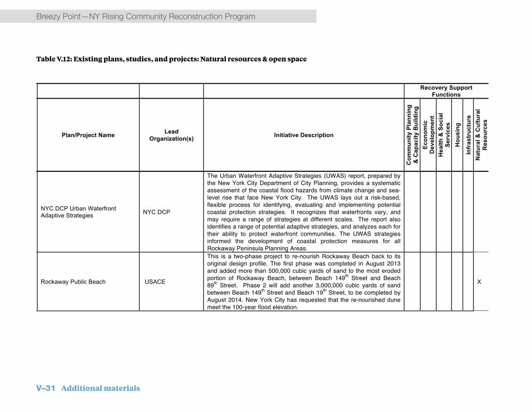
V–31 Additional materials
Breezy Point—NY Rising Community Reconstruction Program
Error! No text of specified style in document. / 15
Recovery Support Functions
INTE
RN
AL
C
omm
nam
e
Plan/Project Name Lead Organization(s) Initiative Description
Com
mun
ity P
lann
ing
& C
apac
ity B
uild
ing
Econ
omic
D
evel
opm
ent
Hea
lth &
Soc
ial
Serv
ices
H
ousi
ng
Infr
astr
uctu
re
Nat
ural
& C
ultu
ral
Res
ourc
es
NYC DCP Urban Waterfront Adaptive Strategies NYC DCP
The Urban Waterfront Adaptive Strategies (UWAS) report, prepared by the New York City Department of City Planning, provides a systematic assessment of the coastal flood hazards from climate change and sea-level rise that face New York City. The UWAS lays out a risk-based, flexible process for identifying, evaluating and implementing potential coastal protection strategies. It recognizes that waterfronts vary, and may require a range of strategies at different scales. The report also identifies a range of potential adaptive strategies, and analyzes each for their ability to protect waterfront communities. The UWAS strategies informed the development of coastal protection measures for all Rockaway Peninsula Planning Areas.
Rockaway Public Beach USACE
This is a two-phase project to re-nourish Rockaway Beach back to its original design profile. The first phase was completed in August 2013 and added more than 500,000 cubic yards of sand to the most eroded portion of Rockaway Beach, between Beach 149th Street and Beach 89th Street. Phase 2 will add another 3,000,000 cubic yards of sand between Beach 149th Street and Beach 19th Street, to be completed by August 2014. New York City has requested that the re-nourished dune meet the 100-year flood elevation.
X
Table V.12: Existing plans, studies, and projects: Natural resources & open space

Additional materials V–32
NY Rising Community Reconstruction Program—Breezy Point
Recovery Support Functions
INTE
RN
AL
C
omm
nam
e
Plan/Project Name Lead Organization(s) Initiative Description
Com
mun
ity P
lann
ing
& C
apac
ity B
uild
ing
Econ
omic
D
evel
opm
ent
Hea
lth &
Soc
ial
Serv
ices
H
ousi
ng
Infr
astr
uctu
re
Nat
ural
& C
ultu
ral
Res
ourc
es
BP, RE, RW
WAVES Action Agenda & Brooklyn Waterfront Greenway Plan NYC Mayor’s Office
The Waterfront Action Agenda is the three year implementation component of Vision 2020: New York City Comprehensive Waterfront Plan. The WAVES Action Agenda recommends initiatives throughout the City to transform the City’s waterfront. Among the recommendations for the Rockaway Peninsula are the following:
¥ Constructing new recreational amenities and landscaping at Rockaway Beach Park
¥ Continuing development of the Edgemere Urban Renewal Area, adding an additional 434 homes, 5.5 acres of parkland, 4 acres of restored wetlands, and infrastructure and pedestrian improvements to the existing 307 housing-unit development.
¥ Transforming the vacant lot at the Beach 80th Street Marina into a public waterfront esplanade
¥ Completing construction of next phase of Arverne by the Sea: the Dunes, a 270 two-family home development, and a new YMCA recreation center
¥ Studying the feasibility of planting 3,000 eelgrass plants at Breezy Point Tip
X X X
Table V.12: Existing plans, studies, and projects: Natural resources & open space

V–33 Additional materials
Breezy Point—NY Rising Community Reconstruction Program
Error! No text of specified style in document. / 17
Recovery Support Functions
INTE
RN
AL
C
omm
nam
e
Plan/Project Name Lead Organization(s) Initiative Description
Com
mun
ity P
lann
ing
& C
apac
ity B
uild
ing
Econ
omic
D
evel
opm
ent
Hea
lth &
Soc
ial
Serv
ices
H
ousi
ng
Infr
astr
uctu
re
Nat
ural
& C
ultu
ral
Res
ourc
es
RE
Science and Resilience Institute at Jamaica Bay (SRI@JB)
Brooklyn College, City of New York, National Park Service
The Science and Resilience Institute at Jamaica Bay (SRI@JB) is a new top-tier science and resilience center hosted by Brooklyn College in New York City. The Institute. is a partnership among academic institutions, government agencies, nongovernmental organizations and community groups. Core partnerships are sustained among the National Park Service, the City of New York, and a Consortium of nine research institutions. The Institute advances understanding of how the Jamaica Bay system responds to disturbance and shares this information to facilitate efforts to promote greater resilience in New York City and around the world through the following core activities: Conducts research to understand the temporal nature and robustness of the resilience of Jamaica Bay, New York Harbor, Hudson Raritan Estuary and Gateway National Recreation Area Develop models for studying the fundamental nature of resilient systems, and Determine how best to manage ecosystems to ensure resilience and sustainability; Provides technical assistance and guidance to the institute’s governmental partners, including the National Park Service, New York City Parks and the New York City Department of Environmental Protection; and Serves as a center for education and the dissemination of knowledge about processes that affect resilience and contribute to the changes in the urban ecosystem. Further information on the institute, which is still ramping up operations, can be found at http://www.srijb.org.
X X X X
Table V.12: Existing plans, studies, and projects: Natural resources & open space

Additional materials V–34
NY Rising Community Reconstruction Program—Breezy Point
Recovery Support Functions
INTE
RN
AL
C
omm
nam
e
Plan/Project Name Lead Organization(s) Initiative Description
Com
mun
ity P
lann
ing
& C
apac
ity B
uild
ing
Econ
omic
D
evel
opm
ent
Hea
lth &
Soc
ial
Serv
ices
H
ousi
ng
Infr
astr
uctu
re
Nat
ural
& C
ultu
ral
Res
ourc
es
RE
Jamaica Bay Watershed Protection Plan
NYC Department of Environmental Protection (DEP)
Authorized in 2005 and initially published in 2007, the plan is intended to support restoring and maintaining the water quality and ecological integrity of the Bay. A number of ongoing initiatives driven by this plan include wastewater treatment upgrades, green infrastructure and other stormwater management improvements and a variety of ecological improvements and pilot projects. The Plan recommends complete sewer separation for the Rockaways (reflected in the many ongoing sewer projects listed on the City’s online project mapper); transfer of lands in Edgemere from NYC Housing Preservation and Development (NYC HPD) to NYC Department of Parks and Recreation (NYC DPR); increased access to Jamaica Bay through implementation of a Rockaway Gateway Greenway; and the acquisition of additional lands for the Seagirt Avenue wetlands restoration project. While Breezy Point does not participate in the City wastewater or stormwater systems, understanding the City’s evolving approaches to water management could influence future decisions.
X X
RE
Gateway National Recreation Area General Management Plan
National Park Service (NPS)
The majority of the undeveloped land in and around the bay is part of Gateway National Recreation Area, one of the nation’s few urban national parks, encompassing 26,607 acres across Brooklyn, Queens, Staten Island, and New Jersey. Given this large presence, NPS will be an important player in resiliency efforts in the Bay. The park is currently updating its General Management Plan (GMP), which has been prepared over the last four years and will guide future management of the park. The final GMP and Environmental Impact Statement will be released in Spring 2014.
X X
Table V.12: Existing plans, studies, and projects: Natural resources & open space

V–35 Additional materials
Breezy Point—NY Rising Community Reconstruction Program
Error! No text of specified style in document. / 19
Recovery Support Functions
INTE
RN
AL
C
omm
nam
e
Plan/Project Name Lead Organization(s) Initiative Description
Com
mun
ity P
lann
ing
& C
apac
ity B
uild
ing
Econ
omic
D
evel
opm
ent
Hea
lth &
Soc
ial
Serv
ices
H
ousi
ng
Infr
astr
uctu
re
Nat
ural
& C
ultu
ral
Res
ourc
es
RE
Hudson Raritan Estuary (HRE) Comprehensive Restoration Plan (CRP)
U.S. Army Corps of Engineers (USACE); Port Authority of New York and New Jersey (PANYNJ)
Adopted in 2009, the USACE and Port Authority of New York/New Jersey developed the HRE-CRP in collaboration with Federal, State, municipal, and non-governmental organizations as well as other regional stakeholders. The plan sets forth a consensus vision, master plan, and strategy for future ecosystem restoration in the New York/New Jersey Harbor. In Jamaica Bay, the plan identified 50 potential restoration sites. Several of these sites are located on the Rockaway Peninsula: Breezy Point Tip and The Cove (near the Breezy Point/Roxbury planning area); Vernam/Barbadoes and Rockaway Reef, in the Rockaway West vicinity; and several locations in Rockaway East, including Brant Point, Dubos Point, and Bayswater State Park, Somerville Basin, Conch Basin, Mott Basin, Seagirt Avenue Wetlands, and Arverne Urban Renewal Area. The identified sites and the proposed ecological restoration measures influenced Committee coastal protection project development.
X X
RE
Jamaica Bay, Marine Park, and Plumb Beach New York Ecosystem Restoration Feasibility Study
U.S. Army Corps of Engineers (USACE); NYC Department of Environmental Protection (DEP)
The study is a joint undertaking of the USACE and the New York City Department of Environmental Protection (NYC DEP) initiated following Superstorm Sandy and is intended to provide an expedited limited reevaluation of USACE restoration projects in the bay to address post-Sandy changes. The interim draft report identified eight priority restoration sites (550 acres) from the HRE-CRP recommendations; three of them (Brant Point, Dubos Point, and Bayswater State Park) are in Rockaway East. The feasibility study will look at Marsh Island Restoration Projects being undertaken under the USACE’s Continuing Authorities Program. The study shows the growing acceptance of ecological restoration as a potential resiliency measure, which informed development of coastal protection measures. This study may be combined with the Rockaway Reformulation Study’s Phase 2.
X X
Table V.12: Existing plans, studies, and projects: Natural resources & open space

Additional materials V–36
NY Rising Community Reconstruction Program—Breezy Point
Recovery Support Functions
INTE
RN
AL
C
omm
nam
e
Plan/Project Name Lead Organization(s) Initiative Description
Com
mun
ity P
lann
ing
& C
apac
ity B
uild
ing
Econ
omic
D
evel
opm
ent
Hea
lth &
Soc
ial
Serv
ices
H
ousi
ng
Infr
astr
uctu
re
Nat
ural
& C
ultu
ral
Res
ourc
es
RE
East Rockaway Inlet to Rockaway Inlet (Rockaway Reformulation Study)
U.S. Army Corps of Engineers (USACE)
This study is often referred to as the Rockaway Reformulation Study. The project was authorized by the Flood Control Act in 1965 and modified by the Water Resource Development Act (WRDA) of 1974. When funded, USACE designed, constructed, and maintained the project from 1977 until 2004 under additional appropriations and WRDA authorizations. Because of the high cost of continually replenishing the eroding shoreline, the Corps was directed in 2003 to “reformulate” the original plan so that a long term, cost-effective solution to the effects of continued erosion on the Rockaway Peninsula could be identified. Funding for the reformulation was not appropriated for several years, but by 2011, the USACE had identified alternatives. Superstorm Sandy led to need to revise these alternatives. The Sandy Appropriations Act authorized funding for the reformulation study and reconstruction/re-nourishment of the previously completed ocean beach portions of the project. Phase 1, for which the draft reformulation report is scheduled to be ready by late Spring 2014, looks at beach nourishment and additional erosion control and/or storm damage risk reduction measures on the ocean side of the Rockaway Peninsula. Phase 2, for which the draft reformulation report is expected in November 2015, will investigate flooding on the Jamaica Bay side of the peninsula and evaluate potential coastal storm risk management measures, including nature-based alternatives. Projects that are recommended by the reformulation phases will require further cooperative teaming agreements and funding appropriations. It is under the reformulation study that coastal protection measures proposed by NYRCR Communities around the bay might be considered by the USACE. .
X X
Table V.12: Existing plans, studies, and projects: Natural resources & open space

V–37 Additional materials
Breezy Point—NY Rising Community Reconstruction Program
F. GlossaryADAAmericans with Disabilities Act A law enacted by U.S. Congress that prohibits discrimination against people with disabilities in employment, transportation, public accommodation, communications, and government activities.
BFEBase Flood Elevation The computed elevation resulting from floodwater that has a 1% chance of equaling or exceeding that level in a given year.
BiBNYC Build It BackA program provided by the City to assist homeowners, landlords and tenants repair or receive reimbursement for property and homes damaged by Superstorm Sandy.
CBO
Community-Based Organization A not-for-profit organization that operates within a local community.
CDBG-DRCommunity Development Block Grant-Disaster Recovery Federal grants administered by the U.S. Department of Housing and Urban Development (HUD) and allocated to cities, counties and States to facilitate rebuilding and recovery of disaster areas as designated by the President of the United States.
CEQRNew York City Environmental Quality Review A State Environmental Quality Review Act (SEQR) mandated process by which City agencies determine the effect, if any,
the approval of a discretionary action of the City may have on the environment.
CUNYCity University of New YorkThe public university system of New York City.
DOIDepartment of InteriorThe U.S. Federal government executive department responsible for the conversation and management of federal land and natural resources.
EMTsEmergency Medical Technicians A health care provider that specializes in emergency medical services.
FDNYFire Department of New York The New York City governmental agency responsible for providing first responders to fires, public safety and emergency situations, disasters, and terrorist acts.
FIRMsFlood Insurance Rate MapsThe official map of a community used by FEMA to delineate a community’s base flood elevations, flood zones, and floodplain boundaries.
FEMAFederal Emergency Management Agency An agency within the U.S. Department of Homeland Security responsible for the coordination of the response to a state of emergency declared disaster.
GMPGeneral Management PlanA plan developed and implemented by National Park Service (NPS) concerning the preservation, protection and management of a national park.
HMGPHazard Mitigation Grant ProgramFederal grants administered by FEMA allocated to mitigation activities that reduce disaster losses and protect life and property from future disasters.
HRE-CRPHudson Raritan Estuary Comprehensive Restoration PlanA plan developed in 2009 by USACE and Port Authority of New York/New Jersey that established a vision, master plan, and strategy for future ecosystem restoration in the New York/New Jersey Harbor.
HUDUnited States Department of Housing and Urban Development The U.S. Federal government executive department responsible for executing federal policies on housing and metropolises.
LIPALong Island Power AuthorityA municipal subdivision of the State of New York that operates a retail electric system on Long Island and provides service to customers in Nassau and Suffolk counties and the Rockaway Peninsula in Queens.
MTA
Metropolitan Transportation Authority

Additional materials V–38
NY Rising Community Reconstruction Program—Breezy Point
A public benefit corporation responsible for providing public transportation in 12 counties in southeastern New York and two counties in southwestern Connecticut.
NEPANational Environmental Policy ActA law enacted by U.S. Congress in 1969 that established a national environmental policy for federal actions.
NFWFNational Fish and Wildlife FoundationA public charity created by the U.S. Congress in 1984 that administers grants for the protection and restoration of fish, wildlife, plants and habitats.
NPSNational Park ServiceThe U.S. Federal government executive department responsible for the management of U.S. national parks, American national monuments, and historical properties.
NYC DCPNew York City Department of City Planning The New York City governmental agency responsible for the strategic development of the City’s physical and socioeconomic planning.
NYC DEPNew York City Department of Environmental ProtectionThe New York City governmental agency responsible for providing the City’s water supply; managing the City’s wastewater system; and regulating the City’s environment, including air quality, hazardous waste, and quality of life issues.
NYC DOBNew York City Department of Buildings The New York City governmental agency responsible for the enforcement of building codes and zoning regulations; the issuance of building permits; and the inspection of new and existing building.
NYC DOHMHNew York City Department of Health and Mental Hygiene The New York City governmental agency responsible for public health, including the issuance of birth certificates and dog licenses and the enforcement of restaurant code.
NYC DOTNew York City Department of Transportation The New York City governmental agency responsible for the management of the City’s transportation infrastructure.
NYC DPRNew York City Department of Parks and RecreationThe New York City governmental agency responsible for the management of City parks, monuments, and historic house museums; the preservation of the City’s ecological diversity; and the provider of recreational and athletic facilities and programs.
NYC OEMNew York City Office of Emergency Management The New York City governmental agency responsible for preparation, coordination and education of emergency response and recovery.
NYRCRNY Rising Community Reconstruction A program established by Governor Andrew M. Cuomo to provide additional rebuilding and revitalization assistance to communities damaged by Superstorm Sandy, Hurricane Irene, and Tropical Storm Lee.
NYS DECNew York State Department of Environmental Conservation The New York State governmental agency responsible for the conservation, improvement, and protection of natural resources; the management of State owned lands; and the regulation of environmental laws and regulations.
NYS DOSNew York State Department of State The New York State governmental agency responsible for strategic investment in the revitalization and economic growth of regions.
SEQRNew York State Environmental Quality ReviewA mandated process by which the sponsoring or approving governmental body determines and mitigates the effect, if any, the approval of a discretionary action of a government entity may have on the environment.
SIRR ReportA Stronger, More Resilient New York A comprehensive plan commissioned by former Mayor Michael Bloomberg detailing actionable recommendations for the rebuilding and increased resiliency of communities and infrastructure impacted by Superstorm Sandy.
USACEUnited States Army Corps of EngineersThe U.S. federal agency under the Department of Defense composed of civilian and military personnel and responsible for providing public and military engineering services.
WRDAWater Resource Development ActA law enacted by U.S. Congress in 2013 pertaining to the conservation and development of water and related resources.

V–39 Additional materials
Breezy Point—NY Rising Community Reconstruction Program

Additional materials V–40
NY Rising Community Reconstruction Program—Breezy Point
G. Endnotes1. Five of the 102 localities in the program—Niagara, Herkimer, Oneida, Madison, and Montgomery Counties—are not funded through the CDBG-DR program.
2. The following localities’ allocations comprise the NYRCR Community’s total allocation: Breezy Point - $16.5 million; Locality B - $3 million.
3. Esri. Census 2010 Summary Profile: Breezy Point/Roxbury. Washington: US Census Bureau, 21 Dec 2010. Microsoft Excel file.
4. Esri. Census 2010 Summary Profile: Breezy Point/Roxbury. Washington: US Census Bureau, 21 Dec 2010. Microsoft Excel file.
5. Esri. Market Profile: Breezy Point/Roxbury. Washington: US Census Bureau, 21 Dec 2010. Microsoft Excel file.
6. Esri. Census 2010 Summary Profile: Breezy Point/Roxbury. Washington: US Census Bureau, 21 Dec 2010. Microsoft Excel file.
7. New York City. Special Initiative for Rebuilding and Resiliency. A stronger, More Resilient New York. 11 June 2013, Web. 3 Mar 2014.
8. New York City. Special Initiative for Rebuilding and Resiliency. A stronger, More Resilient New York. 11 June 2013, Web. 3 Mar 2014.
9. New York City. Special Initiative for Rebuilding and Resiliency. A stronger, More Resilient New York. 11 June 2013, Web. 3 Mar 2014.
10. (1) Construction costs have been provided by VJ Associates, a construction cost consulting firm. To provide cost estimates that account for the preliminary level of design work that has been conducted, conservative markups were included. As a percentage of estimated hard costs these include: general requirement (10%), general contractor overhead and profit (21%), design contingency (25%), soft cost allowance (30%), and 3% annual escalation. (2) Certain components of building hardening costs were provided by Dewberry, an architecture and engineering firm. (3) All construction job estimates are based on local construction cost and construction wage data, as well as standard industry assumptions of labor as a percentage of total hard costs. Data source is Bureau of Labor Statistics, Quarterly Census of Employment and Wages 2012.

Additional materials V–41
NY Rising Community Reconstruction Program—Breezy Point