Embed Size (px)
Citation preview
SERIES-7
CENSUS OF INDIA 2001
HARYANA
DISTRICT CENSUS HANDBOOK
Part - A & B
. .
DISTRICT YAMUNANAGAR
VILLAGE & TOWN DIRECTORY
VILLAGE AND TOWNWISE PRIMARY CENSUS ABSTRACT
Sunil Gulati of the Indian Administrative Service
Director of Census Operations, Haryana
(i)
CENSUS OF INOlA 2001
INDIA .~. HARYANA
DISTRICT Y AMUNANAGAR Km ;)
'-.
BOUNDARY: STATE; DISTRICT ... ...... ". ". " ....... .. . TAHSIL; C.D. BLOCK ... .. ... , ...... ... ... .. .
HEADQUARTERS ; DISTRlCT " TAHSIL " C.D. BLOCK .. .
o 5 10 15 20 Km
C.D. BLOCKS A SADAVRA B BILASPUR C MUSTAFABAD D RADAUR E JAGADHRI F CHHACHHRA ULl
C.D. BLOCK BOUNDARY EXCLUDES STATUTORY TOWN (S)
BOUNDARIES ARE UPDATED UPTO 1.1.2000
PARTS OF TAHSIL CHHACHHRAULI FALL IN C.D. BLOCK BILASPUR P
PART OF C.D. BLOCK B1LASPUR B
PART OF CD. BLOCK CHHACHHRA ULI F
TCYrAL AREA OF DISTRICT (In Sq. Km) 1768.00
TOTAL POPULATION OF DISTRICT .. 1.0 4].630
TOTAL NUMBER OF TOWNS IN DISTRICT ..... 11
TOTAL NUMBER OF VILLAGES IN DISTRICT .. 639
mSTRICT Y AMUNANAGAR - .. - .. .. _ .. _ .. . CHANGE IN JUR ISDICTION 1991- 2001
K:m. 10 10 Km.
® @ 0
NATJONAL HIGHWAY ......... ............ ......... ..... . STATE HlGHWAY ... ............ ... ... ...... ... ... '" .. .
... .. . ... .. . __ ..;.N;,;;H:.....;,;"73;;;__
SH 6
" ,,_ -;---" - . .- . ..,
L "'<,.. .. ,r,(
IMPORTANT METALLED ROAD .. . RAILWAY LlNE WITH STATION, BROAD GAUGE RIVER AND STREAM. ... ... ... ." .. . ... .. . .. . CANAL ... ... .. . ...... .. . ............ ......... .. , ... ... .. . VILLAGE HAVING 5000 AND ABOVE POPULATION WITH NAME URBAN AREA WITH POPULATION SIZE - CLASS I , lV & V
TELEGRAPH OFFICE ... ... .. ...... ... ... .. . .. . .. . DEGREE COLLEGE I TECHNICAL INSTITUTlON ..... ' ......... .. . REST HOUSE AND CANAL BUNGALOW ... ................... ........ . Other villages having College I Technical Institution I RH I CB / FB etc. are shown as ...... ...... ... ...... ... ... ... .. .
RS
Kharwan • ••• TO
RH . CB
• D6.rpur PB
\ ~ TAHSIL i CHHAC-·"
,r r . I-!flRAULl. ' ... '_"l ,.. !
. - ' TAHSIL .' ./ • ~ JAGADHRI 1( ..
1\. . ,.,r
_'"
BOUNDARY . STATE DISTRICT TAHSIL
AREA LOST TO DlSTR1CT -KURUKSHETRA
The maps included in this publication are based upon Survey.oflndia map with the permission of the Surveyor General ofIndia. © Government ofIndia, Copyright 2007.
Product Code Number
. ??-17?-200 l-CEN- Book(E)
(ii)
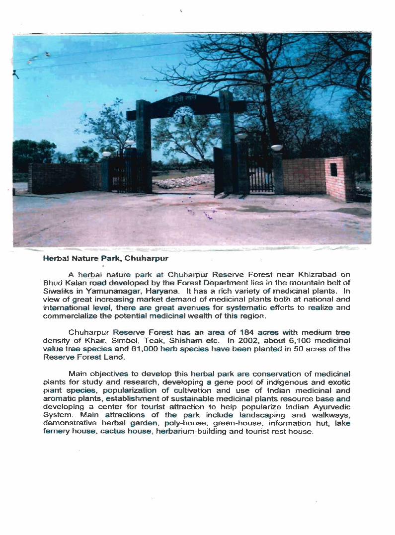
Herbal Nature Park, Chuharpur
A herbal nature p ark at Chuharpur Reserve Forest near Khizrabad on Bhud Kalan road developed by the Forest Department lies in the mountain belt of Siwaliks in Yarnunanagar. Haryana. It has a rich variety of medicinal plants. In view of great increasing market demand of medicinal plants both at national and international level, there are great avenues for systematic efforts to realize and commercialize the potential medicinal wealth of this region.
Chuharpur Reserve Forest has an area of 184 acres with medium tree density of Khair. Simbol, Teak, Shisham etc. In 2002, about 6,100 medicinal value tree species and 61 ,000 herb species have been planted in 50 acres of the Reserve Forest land.
Main objectives to develop this herbal park are conservation of medicinal plants for study and research, developing a gene pool of indigenous and exotic plant species, popularization of cultivation and use of Indian medicinal and aromatic plants, establishment of sustainable medicinal plants resource base and developing a center for tourist attraction to help popularize Indian Ayurvedic System. Main · attractions of the park include landscaping and walkways, demonstrative herbal garden, poly-house, green-house, information hut, lake fernery house, cactus house, herbarium-building and tourist rest house.

Foreword
Preface "
Acknowledgements
Contents
District Highlights - 2001 Census
Important Statistics in the District
Ranking of Tahsils in the State District at a glance: Yamunanagar
Statements 1-9 :
Statement 1
Statement 2
Statement 3
Statement 4
Statement 5
Statement 6
Statement 7
Statement 8
Statement 9
Analytical Note
Name of the headquarters of the district/tahsils, their rural-urban
status and distance from district headquarters, 2001
Name of the headquarters of the district/C.D. Blocks, their rural-urban
status and distance from district headquarters, 2001
Population of the district at each Census from 1901 to 2001
Area, Number of villages/towns and population in the district and
tahsil, 2001
C.D. Blockwise number of villages and rural population, 2001
Population of Urban Agglomerations/towns, 2001
Villages with population of 5,000 and above at C.D. Block level as
per 2001 Census and amenities available
Statutory towns with popUlation less than 5000 as per 2001 Census
and amenities available
Houseless and Institutional population of tahsils, rural and urban, 200 I
(i) History and scope of the District Census Hand Book
(ii) . Brief History of the District
(v)
Pages IX
XI
XI1
XllI
XlV
XVI
xvii
XVlll
XVlll
XVllJ
xx
xxi
XXI
XXll
XX11J
XX11J
3
4
(iii)
(iv)
Adminstrative Set-up
Physical features
Location and size
Physiography
Drainage
Climate'
Natural Economic resources, namely, Fores.try, Minerals and mining, Soil and cropping
pattern, Land and land-use pattern, Tenancy, Agriculture, Irrigation, Animal husbandry,
5
7
7
8
8
8
. Fishery, Industry, Trade and commerce, Transport, Electricity & power and Gram Panchayats 9
(v) Census Concepts
(vi) Non-Census Concepts
(vii) 2001 Census findings - Population and its distributions
Brief analysis of PCA data based on inset tables 1 to 36
Brief analysis of the Village Directory and Town Directory data based on inset tables 37 to 47
Brief analysis of the data on houses and household amenities, Houselisting Operations, Census data based on inset tables 48 to 52
(viii) Major social and cultural events (ix) Brief description of places of religious, historical or archaeological importance
and places of tourist interest in the district
(x) Scope of ViUage Directory and Town Directory
PART A - VILLAGE AND TOWN DIRECTORY
Section I - Village Directory
(a) Note explaining the abbreviations used in Village Directory .
(b) List of villages merged in towns and outgrowths at 2001 Census
(c) C.D. Blockwise Village Directory Data
Sadaura C.D. Block
(i) C.D. Block Map
(ii) Alphabetical list of villages alongwith location codes 1991 and 2001
(iii) Village Directory
Bilaspur C.D. Block
(i) C.D. Block Map
(ii) Alphabetical list of villages alongwith location codes 1991 and 2001
(iii) Village Directory
Mustafabad C.D. Block
(i) C.D. Block Map
(vi)
18
23
27
34
54
61
66 68
71
75
78
83
85
86
101
103
106
133
(ii) Alphabetical I ist of villages alongwith location codes 1991 and 2001
(iii) Village Directory
Radaur C.D. Block
(i) C.D. Block Map
(ii) Alphabetical list of villages al~ngwith location codes 1991 and 2001
(Ui) Village Directory \..
Jagadhri C.D. Block
(i) C.D. Block Map
(ii) Alphabetical list of villages alongwith location codes 1991 and 200 t
(iii) Village Directory
Chhachhrauli C.D. Block
(i) C.D. Block Map
(ii) Alphabetical list of villages alongwith location codes 1991 and 2001
(iii) Village Directory
(d) Appendices to Village Directory
Appendix I
Appendix IA
Appendix IB
Appendix IC
Appendix II
Appendix IIA
Appendix III
Appendix IV
Appendix V
Abstract of Educational. Medical and other Amenities in
villages- C.D. Block level
Villages by number of Primary Schools
Villages by Primary, Middle and Secondary Schools
Villages with different sources of drinking water facilities available
Villages with 5,000 and above population which do not have
one or more amenities available
Census Towns which do not have one or more amenity
Land utilisation data in respect of Census towns/non-municipal towns
C.D. Blockwise list of inhabited villages where no amenity
other than drinking water facility is available
Summary showing number of villages not having
Scheduled Castes population
Appendix VI Summary showing number of villages not having
Scheduled Tribes population
Appendix VIlA: List of villages according to the proportion of the Scheduled
Castes to the total population by ranges
Appendix VIIB: List of villages accordi~g to the proportion of the Scheduled
Tribes to the total population by ranges
(vii)
135
138
155
157
160
179
181
184
207
209
214
246
250
250
250
251
251
252
252
252
252
253
267
Section II - Town Directory
(a) Note explaining the abbreviations used in Town Directory
(b) Statement I
(c) Statement II
(d) Statement III
(e) Statement IV
(f) Statement V
(g) Statement VI
(h) Statement VII
Status and Growth History
Physical aspects and location of towns, 1999
Municipal finance i998-99
Civic and other amenities, 1999
Medical, Educational, . Recreational and Cultural facilities, 1 999
Trade, Commerce, Industry' and Banking,1999
Civic and other amenities in slums, 1999
(i) Appendix to Town Directory - Towns showing their outgrowths' with population
PART B - PRIMARY CENSUS ABSTRACT
(a) Brief note on Primary Census Abstract
(b) District Primary Census Abstract (General)
(c) Appendix to District Primary Census Abstract i.e., Urban blockwise figures of
Total, SC and ST Population
Primary Census Abstract for. Scheduled Castes
C.D. Block wise Village Primary Census Abstract
Urban Primary Census Abstract
ANNEXURES
Annexure I
Annexure II
Annexure III
Annexure IV
Annexure V
Annexure VI
Annexure VII
Annexure VIII
Number of villages under each Gram Panchayat
(Data could not be compiled)
Fertility and Mortality, 1991 Census
Various measures of fertility and mean age at marriage, 1991 Census
Percentage distribution of Migrants b/place of birth/place of last residence, 1991 and 2001 Censuses.
Briefaccount of main religions in the district/tahsil as per 1991 and 200'1 Censuses.
Marital Status of Population as per 1991 and 2001 Censuses. I
Age, Sex and Education in the district, 1991 and 2001 Censuses.
Distribution of different mother tongues returned ir 1991 and 2001 Censuses.
(viii)
268
272
274
274
276
278
282
284
288
291
294
300
314
320
410
431
431
435
436
449
452
455
459
Foreword
The District Census Handbook (DCHB), .published by Census Organisation since 1951 Census, is one of the important publications in the context of planning and development at grass-root level. The
publication, ~ich is brought out for each district, contains several demographic and socip-economic characteristics village-wise and town-wise of the district alongwith the status of availability of civic amenities, infrastructural facililties, etc.
The scope of the DCHB was initially confined to a few Census Tables and Primary Census Abstract (PCA) of each village and town within the district. Thereafter, at successive Censuses, its scope and coverage has been enlarged. The DCHB published at the 1961 Census provided a descriptive account of the district, administrative statistics, census tables and a village and town directory including PCA. The 1971 Census-DCHB series was in three parts: Part-A related to village and town directory, Part-B to vi1lage and town PCA and Part-C comprised analytical report, administrative statistics, district census tables and certain analytical tables based on PCA and amenity data in respect of villages. The 1981 Census DCHB was in two parts: Part-A contained village and town directory and Part-B the PCA of village and town including the SCs and STs PCA up to tahsil/town levels. New features alongwith restructuring of the formats of village and town directory were added into it. In Village Directory, all amenities except electricity were brought together and if any amenity was not available in the referent vi11age, the distance in broad ranges from the nearest place having such an amenity, was given. Information on new items such as ~dult literacy centres, primary health sub-centres and community health workers in the village were provided so as to meet the requirements of some of the Revised Minimum Needs Psrogramme. Information on approach to the village was provided for the first time in the Village Directory so as to give the details on number of inaccessible villages in each district. In the Town Directory, a statement (IV-A) on slums was introduced to provide the details on civic and other amenities in the notified slums of Class I and Class II towns.
3. The 1991 Census DCHB, by and large, followed the pattern of presentation of 1981 Census, except the format of PCA was restructured. Nine -fold industrial classification of main workers was given against the four-fold industrial classification presented in the 1981 Census. In addition, sex-wise population in 0-6 age group was included in the PCA for the first time with a view to enable the data users to compile more realistic literacy rate as all children below 7 years of age had been treated as illiterate at the time of 1991 Census. One of the important innovations in the 1991 Census was the Community Development Block (CD block) level presentation of village directory and PCA data instead of the traditional tahsilltalukIPS level presentation. It was expected that the presentation of village directory and PCA data at CD block level will help the planners in formulation of micro level development plans, CD block being the lowest administrative unit.
4. The present series of2001 Census DCHBs have been made more informative and exhaustive in terms of coverage and content. The Village Directory has been enlarged in scope by including a number of other facilities likf~ banking, recreational and cultural facilities, newspapers and magazines and 'most important commodity' manufactured in village. Income and expenditure of grarp panchayat, wherever possible, has been provided. Apart from these, more details on distance(s) at which basic amenities are available (if not available in the village), are given. This includes educational facilities (namely primary and middle schools and college), medical facilities (viz. Allopathic Hospital, Maternity & Child Welfare Centre and Primary Health Centre), drinking water, post & telegraph (post office and phone), communication, bank, credit societies and recreational facilities. In town directory, the statement on Slums has been modified and its coverage enlarged by including
_details on all sluqIs instead of 'notified slums'. The information is given in case of all statutory towns irrespective of their class, against only Class I and Class II towns in the 1981 and 1991 Censuses. The basic amenities
(ix)
available in the villages and towns are analysed in depth with the help of a number of cross-classified inset tables and statements. Two other significant additions in the publication are. inclusion of 'motif' highlighting significant characteristic of the district and analytical notes as annexures. The analytical notes on (i) fertility and mortality and (ii) various measures offertility and mean age at marriage are prepared based on 1991 Census. Whereas, in the notes relating to (i) per,<entage distribution of migrants by place of birth/place of.last residence, (ii) main religions, (iii) marital status of population, (iv) age, sex and education, and (v) distribution of spectrum of mother tongue, nature and extent of changes occurred in the district in its basic socio-demographic features during the decade 1991-2001 are analysed. The eight digits permanent location code (PLCN) in all the villages and towns have been assigned keeping in view the future needs.
5. The village and town level amenity data have been collected, compiled and computerized in prescribed record'structure under the supervision of Shri Sunil Gul.~ti, lAS, Director of Census Operations, Haryana. Thereafter, efforts have bee made to ensure comparability of the information with that of 1991 Census data and the information brought out by tl1e respective State Governments in their annual reports and statistical handbooks for the various years after 1991. The task ofplanning, designing and coordination of this publication was carried out by Shri R.G.Mitra, Deputy Registrar General, (C&T) and Dr. l.C.Agrawal, Senior Research Officer of Social Studies Division. Dr. R.P. Singh, Deputy Registrar General (Map) provided the technical guidance in the preparation of maps. Whereas, Shri Anil Kumar Arora, Deputy Director of Data Processing Division who worked under the overall supervision of Shri Himakar, Add!. Director (EDP) helped in preparation of record structute for computerization ofvillage and town directory data and the programme for the generation of Village Directory and Town Directory statements including analytical inset tables. The draft DCHB manuscripts received from the Census Directorates have been scrutinised in the Social Studies Division under the guidance ofShri S. L. Jain, Deputy Director and Shri R. K. Mehta, Assitant Director. I am thankful to all of them and others who ~ontributed to make this publication possible.
'-Jew Delhi l7th October, 2006
(x)
D.K. Sikri Registrar General &
Census Commissioner, ,India
Preface
The District Census Handbook (DCI·II3) is a joint-venture of the Celltml and thc State (fov('rIlnwnls. It is one of the most valunble publications of lhe Censlis Organisation anti ils data nre widelv used bv
f1(llllinistrators, planners, acadcmicians,-rcscarchers, variotts departll1ents and general public as an- llulhcl11 i~ sO~lfl;e of data. Il i~ in~er-alia ~lscd (or ~lclill1ita~.ion of C(1l1stit~lencics, Ii.mnulation of va rio liS dislricllcvel plans. It IS the only publicatIOn, whlcll provides baSIC data "pto Village level for rural areas and wanl-wise ('or each city/town of every district of the Country .
..... The CCIISII~ t.aking in ll~dia !s a tw.() ph~sed operation, Vi7., Hottselisting and Popttlat ion Ellumeralioll. DIIJ'lng llollseflsllllg OperatIOn, It was Identlficd where and how the people lived. while ill the Population Enul11eration, the actual Census took place which was carried out during 9'h_28'10 February. 20() I wilh a revisional round frolll I" March 10 5'10 March. 200 I
For [JCHU publication, population data was taken from Census, whereas IIOll-cenSlIS data was t'olleded with tJle active oollaboratioll of State Govt. The very first DCI 10 pulll icalion was brollght oul ill 11)51 Censtls. which c()lllailled only a few Ccnslls Tables and PCA at village/town Icvel. Laler lll1. the scope and coverage of the publicati('ll was widened by including the c()[lIprehensivc data of Village and Town Dirct:lmic( including PCA data at Tahsilrrown level. For the first tillle ill 199 I Census. presclltntioll of all these data W;lS at C.D.Block level and continued in 200 I Censlls also, which will help the Scholars. Planncrs. Ptllicy makers. Social Scientists. ··ete. in the formulation of micro-level deVelopment plans, policies and research. -
The historical !irst millennium Census of 200 I was conducted under the dynamic guidance ol"Sh . .I. K. 83l1thill, lAS. Ex-Registrar Gelleral & Cellsus COlllmissioncr. India and thc credit I'or the SHccesslid accomplishment of this huge lask goes to him. I am highly grateful to him as well as his worthy !mcccssor Sh. O.K. Sikr,i, lAS, Additional Secretary and Registrar General &. CenSllS COlllmissioncr of Indin f\lr thcir valuable guid~nce in bringing out this publication. I also express my thanks 10 Dr. I. C. Agrawal. Assistant Registrar General (Social Studies), Sh. S. L. Jain, Deputy Director (SS) ami Or. R_ P. Singh. Consultant and the then Deputy Registrar General (Map), who took great pains in giving the final shape to Ihis puhlicalinn.
In this Directorate, Sh. Amarjit Sillgh Toor, Assistant Director. spearheaded Ihe DCI IElullit. wlw rendered dedicated and painstaking services in processing. compilation of data. limning of annlyticalnotcs nnt! hringing out this publication. In this lask, he was assisted by Sh. K.K. Khallnr, St~tistical Inveslig.ato~·.(ir. II. I "Iso. record my appreciation for Sh. Karan Singh, De·puly Director. whose services were val\Jahle 11\ olltcome 01 this publication. Lastly, I record my appreciation for the best clTorts pllt in. by the stair or '.K'I.m. Mal)_,md Tabulation Secti(l(,S. Name of the Oflicers/StnfT members. who rendered Ihelr vahmhlc cllnlnhlltlPIl nrc gIven
in the acknowledgement of this pUblicat ion.
Chandigarh Dated 24'10 ApriJ. 2007
(xi)
. SUlIil Glliati, lAS
Dircctor, Census Operations.
Ilaryan<l
Dl'afting and FillalisaCion of nC1l1J
Sh. Amarjit Singh 1'001'
J)CHD Section
Mrs. S.P. Ralra
SIl. K.K.Khattar
Sh. Harsh Kumar
Sh. K.K. Parashar
Sh. Nagesh Kumar
Sh. R.K,Madan
Sh. Lekh Raj
Mrs. Neera Sharma
Mrs, Si!oni Dhawan
Map Section
Sh. K. Selvam
Mrs. Anjll Sein
Mrs Neelam Lakhanpal
Sh. Ashwjnj Kumar
Sh. Galltam Kumar Roy
Sh. Mahesh Luthra
Sh. Nanu Ram
Others associated with the Pl'oject
Sh. M. S. Bhatnagar
Mrs. Meena Rattan
Mrs. Ullla Sharma
Sh. K.M. Deshmukh ,
Sh. Jaswant Singh
Cover Design'
Sh. Vidya sagar
Acknowledgement
Assistant Director
St. Investigator Gr. II
St. Investigator Gr. II
St. Investigator Gr. JIJ
St. Investigator Gr. TlI
St. Investigator Gr. III
St. Investigator Gr. HI Compiler
Data Entry Operator
Data Entry Operator
Geographer
Senior Draftsman
Senior Draftsman
Senior Draftsman
Draftsman
Draftsman
Ferro Print Operator
Assistant Director
Sl. lnvestigator Gr. I
L.D.C.
Proof Reader
SelliorCumpiler
Senior [)raHs1ll3n
(xii)
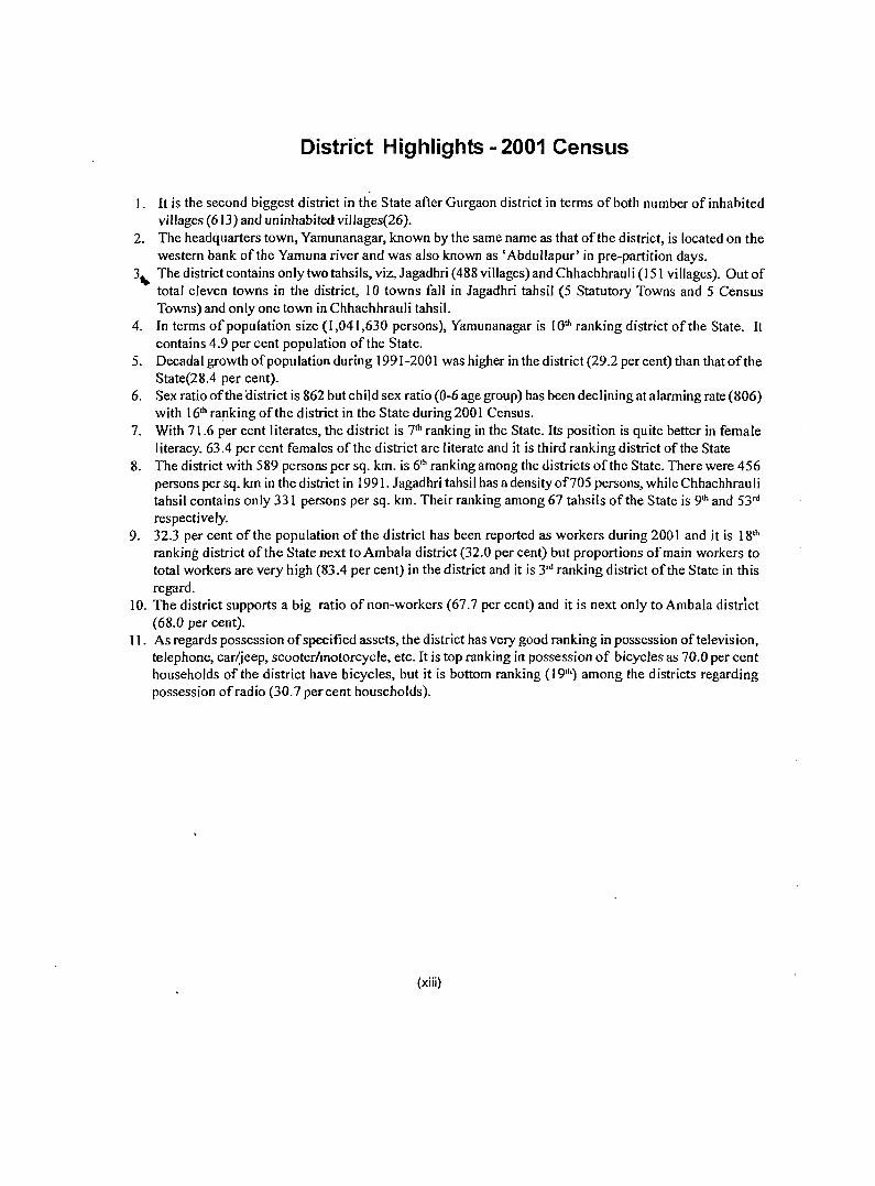
District Highlights - 2001 Census
I. It is the second biggest district in the State after Gurgaon district in terms of both number of inhabited villages (613) and uninhabited villages(26).
2. The headquarters town, Yamunanagar, known by the same name as that of the district, is located on the western bank of the Yamuna river and was also known as 'AbdulJapur' in pre-partition days.
3 .. The district contains only two tahsils, viz, Jagadhri (488 villages) and Chhachhrauli (151 villages). Out of total eleven towns in the district, 10 towns fall in Jagadhri tahsil (5 Statutory Towns and 5 Census Towns) and only one town in Chhachhrauli tahsil.
4. In terms of population size (1,041,630 persons), Yamunanagar is 10th ranking district of the State. It contains 4.9 per cent population of the State.
5. Decadal growth of population during 1991-2001 was higher in the district (29.2 percent) than that of the State(28.4 per cent).
6. Sex ratio of the (Ii strict is 862 but child sex ratio (0-6 age group) has been declining at alarming rate (806) with 16th ra!1king of the district in the State during 2001 Census.
7. With 71.6 per cent I iterates, the district is 7th ranking in the State. Its position is quite better in female literacy. 63.4 per cent females of the district are literate and it is third ranking district ofthe State
8. The district with 589 persons per sq. km. is 6th ranking among the districts of the State. There were 456 persons per sq. km in the district in 1991. Jagadhri tahsil has adensityof705 persons, while Chhachhrauli tahsil contains only 331 persons per sq. km. Their ranking among 67 tahsils of the State is 9th and 53rd
respecti vely. 9. 32.3 per cent of the population of the district has been reported as workers during 2001 and it is 18th
ranking district of the State next to Ambala district (32.0 per cent) but proportions of main workers to total workers are very high (83.4 per cent) in the district and it is 3rd ranking district of the State in this regard.
10. The district supports a big ratio of non-workers (67.7 per cent) and it is next only to Ambala district (68.0 per cent).
11. As regards possession of specified assets, the district has very good ranking in possession of television, telephone, car/jeep, scooter/motorcycle, etc. It is top ranking in possession of bicycles as 70.0 per cent households ofthe district have bicycles, but it is bottom ranking (19th) among the districts regarding possession of radio (30.7 percent households).
(xiii)
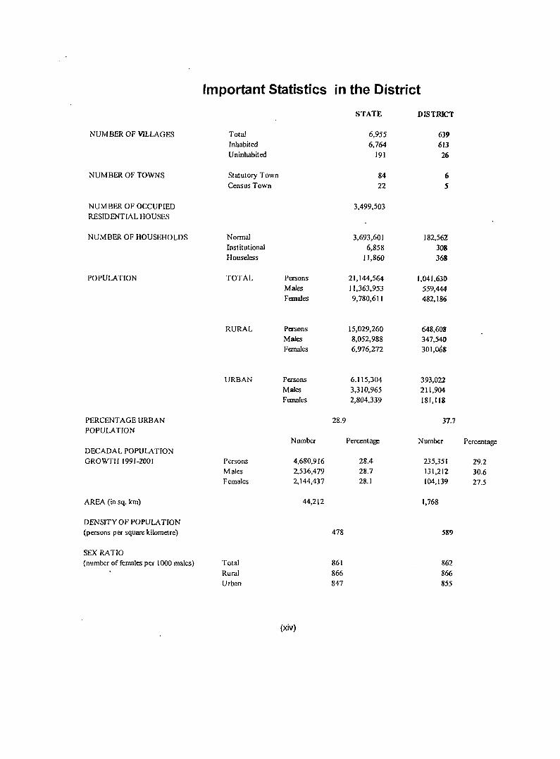
1m portant Statistics in the District
STATE DISTRICT
NUMBER OF VILLAGES Total 6,955 639 Inhabited 6,764 613 Uninhabited 191 26
NUMBER OF TOWNS Statutory Town 84 6 Census Town 22 5
NUMBER OF OCCUPIED 3,499,503 RESIDENTIAL HOUSES
NUMBER OF HOUSEHOLDS Normal 3,693,601 182,562 Institutional 6,858 308 Houseless 11,860 363
POPULATION TOTAL Persons 21,144,564 1,041,630 Males 11,363,953 559,444 Females 9,780,611 482,186
RURAL Persons 15,029,260 648,608 Males 8,052,988 347,540 Females 6,976,272 301,068
URBAN Persons 6,115,304 393,022 Males 3,310,965 211,904 Females 2,804,339 181,118
PERCENT AGE URBAN 28.9 37.7 POPULATION
Number Percentage Number Percentage DECADAL POPULATION GROWTH 1991-2001 Persons 4,680,916 28.4 235,351 29.2
Males 2,536,479 28.7 131,212 30.6 Females 2,144,437 28.1 104,139 27.5
AREA (in sq. km) 44,212 1,768
DENSITY OF POPULATION (persons per square kilometre) 478 589
SEX RATIO (number of females per 1000 males) Total 861 862
Rural 866 866 Urban 847 855
(xiv)
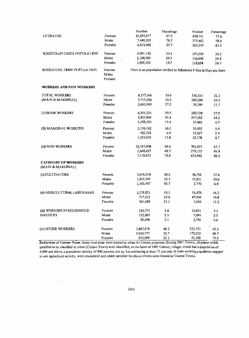
Number Percentage Number Percentage LITERATES Persons 12,093,677 67.9 638,711 71.6
Males 7,480,209 78.5 375,462 78.8 Females 4,613,468 55.7 263,249 63.4
SCHEDULED CASTE POPULA TION Persons 4,091,110 19.4 255,550 24.5 Males 2,188,585 19.3 136,696 24.4 Females 1,902,525 19.5 118,854 24.7
SCHEDULED TRIBE POPULATION Persons There is no population notified as Scheduled Tribes in Haryana State Males
Females
WORKERS AND NON WORKERS
TOT AL WORKERS Persons 8,377,466 39.6 336,533 32.3 (MAIN & MARGINAL) Males 5,715,526 50.3 280,289 50.1
Females 2,661,940 27.2 56,244 11.7
(I) MAIN WORKERS Persons 6,241,324 29.5 280,728 27.0 Males 4,933,004 43.4 247,262 44.2 Females 1,308,320 13.4 33,466 6.9
(II) MARGINAL WORKERS Persons 2,136,142 10.1 55,805 5.4 Males 782,522 6.9 33,027 5.9 Females 1,353,620 13.8 22,778 4.7
(iii) NON WORKERS Persons 12,767,098 60.4 705,097 67.7 Males 5,648,427 49.7 279,155 49.9 Females 7,118,671 12.8 425,942 88.3
CATEGORY OF WORKERS (MAIN & MARGINAL)
(i) CULTIVATORS Persons 3,018,014 36.0 58,701 17.4 Males 1,855,547 32.5 55,931 20.0 Females 1,162,467 43.7 2,770 4.9
(ii) AGRICULTURAL LABOURERS Persons 1,278,821 15.3 54,470 16.2 Males 717,133 12.6 47,044 16.8 Females 561,688 21.1 7,426 13.2
(iii) WORKERS IN HOUSEHOLD Persons 214,755 2.6 10,831 3.2 INDUSTRY Males 132,069 2.3 7,091 2.5
Females 82,686 3.1 3,740 6.6
(iv) OTHER WORKERS Persons 3,865,876 46.2 212,531 63.2 Males 3,010,777 52.7 170,223 60.7 Females 855,099 32.1 42,308 75.2
Definition of Census Town: Some rural areas were treated as urban for Census purposes. During 200 I Census, all places which qualified to be classified as urban (Census Town) were identified, on the basis of 1991 Census, villages which had a popUlation of 4,000 and above, a population density of 400 persons per sq. km and having at least 75 per cent of male working population engaged
in non agricultural activity, were considered and which satisfied the above criteria were treated as Census Towns.
(xv)
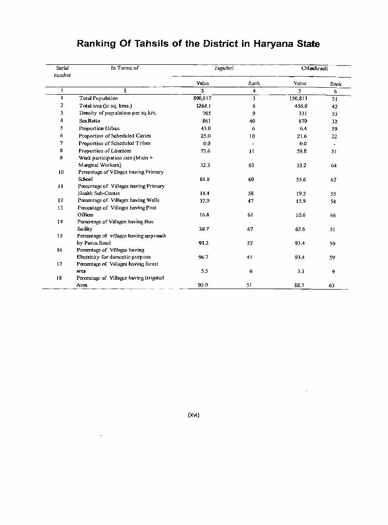
Ranking Of Tahsils of the District in Haryana State
Serial In Terms of Jagadhri Chhachrauli number
Value Rank Value Rank 2 3 4 5 6
Total Population 890,817 3 150,813 51 2 Total area (in sq. kms.) 1264.1 6 456.0 42 3 Density ofpopulation per sq.km. 705 9 331 53 4 SeltRatio 861 40 870 32 5 Proportion Urban 43.0 6 6.4 59 6 Proportion of Scheduled Castes 25.0 10 21.6 22 7 Proportion of Scheduled Tribes 0.0 0.0 S Proportion of Literates 73.6 11 59.8 51 9 Work participation rate (Main +
Marginal Workers) 32.3 63 32.2 64 10 Percentage of Villages having Primary
School 81.8 60 55.6 67 II Percentage of Villages having Primary
H ea1th Sub-Centre IS.4 58 19.2 55 12 Percentage of Villages having Wells 37.9 47 15.9 58 13 Percentage of Villages having Post
Offices 16.8 6] 10.6 66 14 Percentage of Villages having Bus
facility 30.7 67 63.6 51 15 Percentage of villages havingapproach
by Pucca Road 93.2 52 93.4 50 16 Percentage of Villages having
Electricity for domestic p urp ose 96.7 41 93.4 59 17 Percentage of Villages having forest
area 5.5 6 3.3 9 18 Percentage of Villages having Irrigated
Area 93.9 51 88.7 63
(xvi)
District at a Glance· Yamunanagar Serial Item Value Ranking of the District in
No. Haryana State (T otal)
Total Rural Urban
I Population 1,041,630 648,608 393,022 9
2!Ir No. of Households 183,238 107,918 75,320 8
3 Share in total population (%) (H ary an a) 4.9 4.3 6.4 9
4 Decadal Growth rate (%) 29.2 22.5 41.9 5
Child Population (age 0-6)(%) to total District 14.4 15.5 12..6 16
5 population
6 Sex Ratio (females per 1000 males) 862 866 855 10
7 Child Sex Ratio (0-6) 806 814 789 16
3 Urban Population (%) 37.7 - 37.7 4
9 Literacy rate (%) 71.6 65.4 81.7 7
10 Female Literacy rate (%) 63-4 55.3 76.4 . 3
tl Male Female Gap in Literacy (%) 15.4 18.8 9.9 Share ofS.C. Population (%) to total population 4
12 in District 24.5 31.5 13.1
13 Workers to Total Population 32.3 34.0 295 18
14 Main Workers to Total Workers 83.4 79.7 90.6 3
15 S.C Literacy 62.9 62.2 65.6 6
16 Density 'of population 58't.~' 385 4610 6
17 Permanent Houses (% of Total Census Houses) 65.8 54.5 83.1 10
18 Condition of Houses Good (%) 47.7 40.6 58.6 8 Households having no Exclusive Room OT and one 17
19 room(% of Tota! Households) 33.2 34.0 32.1 Households with availability of Electricity (% of 4
20 Total Households.) 89.3 84.7 96.4 Household having Tap Water (% of Total 14
21 Households) 39.9 21.9 67.3
22 Households having Bathroom within houses (%) 565 40.6 80.7 4
23 Households having Kitchen within hl2.uses (%) 66.7 57.5 80.7 3
24 Households having Television (%) 66.3 56.7 80.9 4
25 Households having Telephone (%) 17.9 9.5 30.8 4
26 Households having Bank Accounts (%) 50.6 47.4 55.6 7
27 Households having Radio (%) 30.7 29.7 32.2 19
28 Households having Car/J eep (%) 4.0 2.2 6.6 7
29 Households having ScooterlM .Cycle (%) 24.3 18.9 32.5 5
30 Househbld~havingBicycle (%) 70.0 70.8 68.8 1 .. -Households having no draina&~ of waste water 9
31 (%) 19.6 ,
26.0 9.7
32 Household having no Latrine (%) 50.8 75.2 137 15
33 Households having none of assets (%) 13.6 16.1 8.2 2 Type of Fuel used ( Fire wood, Crop residue,
34 Cow dung Cake) (%) by households 59.8 84.5 22.2 13
35 LPG used as fuel (%) by households 33.6 12.3 66.1 9
(xvii)
STATEMFNTI NAME OF THE HEADQUARTERS OFDISTRICT/TAHSIL, THEIR KURAUURBAN STATUS AND DISTANCE
FROMDISTRICTHEADQUAR1DlS,2001
81. No. Name of N arne of D istrictrr ahs il Whether- Distance of tahsil headquarters from district Districtrrahsil Headquarters U rban!Rural headquarters by Road IRailway (in Km)
2 3 4 5
Yamunanagar Yamunanagar Urban 010 1 Jagadhri Jagadhri Urban 717 2 Chhachhrauli Chhachhrauli Urban 19/NA
Statement 1 presents the status and distance of tahsil headquarters from the district headquarters by road and rairway in 2001. Jagadhri tahsil headquarters is at a distance of7 kms from district headquarters both by road and by rail. Chhachhrauli tahsil headquarters is not connected by rail and it is at a distance of 19 kms by road from district headquarters. Both the tahsil headquarters are urban.
STATEMFNT2 NAMEOFTHEHEADQUAR'TERS OFDISTRICT/C.D.BLOCK, THEIR RURAUURBAN STATUS AND DISTANCE
FROMDISTRICf HEADQUARTEllS. 2001
SI. Narneof Narne of District/C.D.Block Whether Distance ofC.D.Block headquarters from
No. Districtl C.D.Block Headquarters Urban!Rural district headquarters by Road !Railway (in Km)
2 3 4 5 Yamunanagar Yamunanagar Urban 0/0
Sadaura Sadaura Urban 35INA
2 Bilaspur Bilaspur Urban 21INA
3 Mustafabad Mustafabad Urban 23/18
4 Radaur Radaur Urban 18INA
5 Ja~dhri JDgfldhri Urban 7n 6 Chhachhrauli Chhachh raul i Urban 19INA
Statement 2 shows the status of C.D. block headquarters alongwith distance from district headquarters in 2001 by road and railway. All the six c.o. block headquarters in the district are urban. Sadaura c.o. block is at the farthest distance of35 kms by road. Only two C.O. block headquarters i.e. Mustafabad and Jagadhri are connected with district headquarters by rail and are at a distance of 18 kms and 7 kms but by road at a distance of 23 and 7 kms respectively. Bilaspur, Chhachhrau(i and Radaur C.O. block headquarters are at a distance of 21, 19 and 18 kms by road only respectively from district headquarters.
STATEMENT 3 POPULATION OF THE DISTRICT AT EACH CFNSUS FROM 1901 TO 2001
District T/RIU Census Year Persons Males Females Decadal Population Variation Absolute Percentage
2 3 4 5 6 7 8
Yamunanagar Total 1901 234,603 129,562 105,041
1911 198,649 112,719 85,930 . -35,954 -15.3
1921 214,427 120,294 94,133 15,778 7.9
1931 213,007 119,098 93,909- -1,420 -0.7
1941 243,803 135,323 108,480 30,796 14.5
1951 262,906 142,824 120,082 1?,W3 7.8
1961 370,224 201,604 168,620 107,318 40.8
1971 478,483 258,988 219,495 108,259 29.2
1981 632,820 341,218 291,602 154,337 32.3
1991 806,279 428,232 378,047 173,459 27.4
2001 1,041,630 559,444 482,186 235,351 29.2
Cont.. ...
(xviii)
STATEMENT 3 POPULATION OF THE DISTRlCT AT MeH CliNSUS FROM 1901TO 2001
District TIRlU Census Year Persons Males Females DecadaJ Population Variation Absolute Percentage
2 3 4 5 6 7 8
Rural 1901 199,944 111,137 88,807
1911 170,312 97,375 72,937 -29,632 -14.8
1921 187,477 105,659 81,818 17,165 10.1 1931 183,352 102,643 80,709 -4,125 -2.2 1941 209,290 116,419 92,871 25,938 14.1
1951 203,797 109,991 93,806 -5,493 -2.6
1961 263,931 142,574 121,357 60,134 29.5
1971 337,926 182,460 155,466 73,995 28.0
1981 441,762 237,612 204,150 103,836 30.7
1991 529,352 280,903 248,449 87,590 19.8
2001 648,608 347,540 301,068 119,256 22.5
Urban 1901 34,659 18,425 16,234
1911 28,337 15,344 12,993 -6,322 -18.2
1921 26,950 14,635 12,315 -1,387 -4.9
1931 29,655 16,455 13,200 2,705 10.0
1941 34,513 18,904 15,609 4,858 16.4
1951 59,109 32,833 26,276 24,596 71.3
1961 106,293 59,030 47.263 47,184 79.8
1971 [40,557 76,528 64,029 34,264 32.2
1981 191,058 103,606 87,452 50,501 35.9
1991 276,927 147,329 129,598 85,869 44.9
2001 393,022 211,904 181,IIB 116,095 41.9
Statement 3 gives us sexwise popUlation and decadal variation at each Census from 1901 to 2001 by residence. Decadal growth in earlier censuses of 190 I-II and 1921-31 witnessed negative growth. Highest decadal growth was noticed in the decade 1951-61 when the growth rate was 40.8. Afterwards decadal growth was swinging up and down, but with downward trend. It was 22.5 during 1901-200 I decade. Rural areas experienced negative growth at alternate decade upto 1951-61. After thatdecadal growth rate swinged up and down between 20-30. During 1991-2001, it was 22.5. Comparatively, decadal growth rates for urban areas were quite higher than rural areas. 1901-11 and 1911-21 decades decadal growth was negative--but afterwards growth rates were very steep especially during 1941-51 (71.3) 1951-61 (79.8) owing to migration of population at the time of partition of the country. After that decadal growth rate became stable between 30 and 45. During 1991-2001 decadal growth rate in urban areas was 41.9.
(xix)
STATEMENT-4 ARFA, NUMBm OF VILLAGES I TOWNS AND POPULATION IN DISTRICT AND TAHSIL, 2001
District / Tahsil / UA / T / Area in Population Number of villages Number Number Number Population
Town RI sq. kms. per sq of of of
U kms. statutory census households towns towns
Inhabited Uninhabited Persons Males Females 2 3 4 5 6 7 8 9 10 II 12 13
Yamunanagar T 1768.00 589 613 26 6 5 183,238 1,041,630 559,444 482,186 R 1682.74 385 613 26 107,918 648,608 347,540 301,068 U 85.26 4610 6 5 75.320 393,022 211,904 181.118
Jagadhri T 1264.07 705 472 16 5 5 158,136 890,817 478,783 412,034 R 1189.35 427 472 16 84,551 507,505 271,881 235,624 U 74.72 5130 5 5 73,585 383,312 206,902 176,410
Sadaura (MC) U 6.75 1952 2,398 13,176 6,936 6,240 Bilaspur (Cf) U 8.51 1131 1,714 9,621 5,102 4,519 Mustafabad (Cf) U 7.16 1189 1.578 8,516 4,494 4,022 Radaur (MC) U 2.59 4532 2,155 11,737 6,170 5,567 Farakhpur (Cf) U 1.35 6474 1,761 8,740 4,702 4,038 Kansepur (Cf) U 2.42 6179 2,807 14,952 7,962 6,990 BOOa(MC) U 1.94 5067 1,650 9,830 5,399 4,431
Yamunanagar UA U 44.00 6971 59,522 306,740 166,137 140,603 (a) Yamunanagar U 16.32 11624 36652 189696 101782 87914 (Mel) (b) Jagadhri (M CI ) U 24.80 4084 19,601 101,290 55,844 45,446
(c) SaSauli (Cf) U 2.88 5470 3,269 15,754 8,511 7,243
Olhachhrauli T 455.59 331 141 10 25,1 02 150,813 80,661 70,152 R 445.05 317 141 10 23,367 141,103 75,659 65,444 U 10.54 921 1,735 9,710 5,002 4,708
Olbachhrauli (Me) U 10.54 921 1,735 9,710 5,002 4,708
Statement 4 depicts area, number of villages/towns, population and density for each constituent unit i.e. tahsil/town. Jagadhri tahsil is comparatively bigger in terms of area, density, number of villages/towns and population. Jagadhri tahsil has a density of705, whereas Chhachhrauli tahsil has only 331. There are 472 villages in Jagadhri tahsil and 141 in Chhachhrauli tahsil. As regards towns, Jagadhri tahsil contains five statutory and 5 census towns and Chhachhrauli tahsil has only one statutory town. Highest density of 11,624 is witnessed in Yamunanagar M CI. followed by Farakhpur c.T. (6,474), Kansepur C.T. (6,179) and Sasauli C.T. (5470). The lowest density (317) is noticed in rural areas of Chhachhrauli tahsil followed by rural areas of Jil-gadhri tahsil (421). Jagadhri tahsil contains 1189.35 sq. kms rural area and 74.72 Sq. kms urban area, whereas 9hhachhrauli tahsil possesses 445.05 Sq. kms of rural area and 10.54 sq. kms of urban area.
(xx)
STATFMIfNT-5
C. D. BLOCK WISE NUMBER OF VILLAGES AND RURAL POPULA nON, 200 t
Sl.No. Name of CD. block Number ofviflages Rural populalion
Total Inhabited Persons Males Females.
2 3 4 5 6 7
Sad aura 63 61 46,785 24,989 21,796
2 Dilaspur 127 124 102,274 54,458 47,816
3 Mustafabad 79 77 90,952 48,314 42,631!
4 Radaur 85 80 92,602 49,622 42,980
5 lagp.dhri III 106 141,786 76,877 64,909
6 Chhachhrauli 174 165 174,209 93,280 80,929
District (Rural) Total 639 613 648,608 347,540 301,068
Statement 5 presents e.D. blockwise number of total and inhabited villages and rural population by sex in 2001. Among C.D. blocks Chhachhrauli e.D. block with 174 villages and a population of 1,74,209 is the biggest one in the district followed by Bilaspur C.D. block (127 villages, 102,274 population) and Jagadhri C.D. block (111 villages 141,786 population).SmaIIest one is Sadilllra C.D. block with 63 villages and a population of46,785 followed by by Mustafabad C.D. block (79 villages, 90,952) population and Radaur(85 villages, 92,602 population).
STATEMENT-6
POPULATION OF UR~AN AGGLOMERATIONS (INCLUDING CONSTITUENT UNITS) / TOWNS, 2001 SI.No. Name of Urban status Name of tahsil where Population
UA{[own town # is located Persons Males Females
2 3 4 5 6 7 Sadaura M.C. Jagadhri 13,176 6,936 6,240
2 Bilaspur C.T Jagallhri 9,621 5,102 4,519 3 Mustafabad C.T. Jagadhri 8,516 4,494 4,022 4 Radauf M.C. Jagndhri 11,737 6,170 5,567 5 Farakhpur C.T. Ja~lhri 8,140 4,702 4,038 6 Kansepuf C.T Jagadhri 14,952 7,962 6,990 7 Buria M.C. Jag.'ldhri 9,830 5,399 4,431 8 Yall1l1lumpgar U.A. Jagadhri 306,140 166,137 140,603 9 (a) Yamunanagar M.C!' Jagadhri 189,696 101,782 87,914 10 (b) Jagadhri M.C!' Jagadhri 101,290 55,844 45,446 II (c) Sasauli C.T. Jagadhri 15,754 8,511 7,243 12 Chhachhrauli M.C. Chhachhrauli 9,710 5,002 4,708
District (Urban) total 393,022 211,904 181,118
Statement 6 explains the population of urban agglomerations (including constituent units) aIJd towns ofthe district in 2001. There are 6 statutory and 5 Census Towns in the distriGt. There is one urban agglomeration namely, Yamunanagar , which constitutes Yamunanagar M.C!', Jagadhri M.C!' ancl Sasauli Census TowlI. Gut of II towns (6 statutory and 5 Census towns), bulk of the towns 5 statutory and 5 census towns are located in Jagadhri.tahsil. In Chhachhrauli tahsil, only one town is located. In population size, Yamunanagar Municipal Council (1,89,696 persons), and Jagadhri, Municipal Council (1,0 l,290 persons) both part ofYamunanagar Urban Agglomeration are the biggest urban centres ofthe district. Mustafabad Census Town (8.516 persons), f<'arakhpur Census Town (8,740 persons) and Bilaspur Census Town (9,621 persous) are at the lowest ranks in pOPl!lation size. The onl~: town Chhachhrauli M.e. ofChhachhrauli tahsil possesses a population 0[9,710 persons.
(xxi)
STATFMENT-7 VILLAGES WITH POP[JLA nON OF 5,000 AND ABOVE AT C.D. HI_OCI( LEVEL AS PER 2001 CFNS lIS
AND AMENITIES A VAILAHLE.
SI. Name of C.D. Name of village
No. block
2 3 • Mustafabad Kalawar(351)
2 Radaur Jathlana (4)
3 Jagadhri Badhi Majra (126)
4 Chhachhrauli Kharwan (314)
5 Chhachhrauli Khizrabad (165)
SI. Name of C.D. No. block Educational
Senior College
Secondary School
2 8 9 Mustafabad
2 Radaur
3 Jagadhri
4 Chhachhrauli
5 Chhachhrauli
Location code Population Whether it is number Tahsil
headquarters
4 5 6
00093700 5373 No
OOIOSIWO 6127 No
00117100 6334 No
00121100 7839 No
00133500 5704 Ncr
Amenities available Medical Drinking Communic
Water ation
Whether it is C.D. block headquarters
7 No
No
No
No
No
Banking
Primary Primary Tap Railway Commercial Co-operative Health Health Sub· water station Ban-!< Bank Centre centre
10 II 12 13 14 15 Yes No
Yes '1'10 Yes No Yes No
Yes No 2
Statement 7 details C.D. blockwise villages with population 5000 and above and amenities evailable therein in 24}01. There are only five such villages in the district. One village each falls in Mustafabad, Radaur and Jagadhri C.O. blocks. Two villages fall in Chhachhrauli C.O. block. Kharwan village with population of7,839 of Chhachhralili C.D. block is the biggest village of the district. All villages have senior secondary school, prirflaJY health sub centre except only village i.e Badhi Majra of Jagadhri C.D. block which does not have these amenities. The amenity of college and railway station is not available in any of these villages. Primary health centre and commercial banks are available only in Kharwan and Khi~';rabad villages ofChhachhrauli C.D. block. Khizrabad village has 2 co-operative banks. Another village having cooperative bank is lathlana of Radaur C.D. block. Drinking water amenity as tap water is available in all such villages of the district.
(xxii)
ST ATEMENT-8
STATUfORYTOWNS WITH POPULATION LESS THAN 5000 AS PER 2001 CENSUS AND AMENITIES AVAILABLE
There is no statutory town with less than 5,000 population in Yamunanagar district, therefore this statement is not applicable.
. STATEMENT-9
HOtNELESS AND INSTITUTIONAL POPULATION OF TAHSILS, RURAL AND URBAN, 2001
SI. District fTahsil / Town Tf Houseless population rnstitutional population ... RI Number of Persons Males Females Number of Persons Males Females U households households
2 3 4 5 6 7 8 9 10 II Yamunanagar T 368 1,675 953 722 308 5,488 3,446 2,042
R 139 674 395 279 117 2.186 1,536 650 U 229 1,001 558 443 191 3,302 1,910 1,392
2 lagfldhri T 305 1,379 799 580 264 3,992 2,604 1,388 R 99 504 299 205 83 1,072 870 202 U 206 875 500 375 181 2,920 1,734 1,186
3 Sadaura (M C) U 5 20 11 9 13 114 61 53 4 Bilaspur (CT) U 3 I 2 9 70 44 26 5 M ustafabad (CT) U l' 6 3 3 6 Radaur(MC) U 7 52 29 23 7 Farakhpur (CT) U 8 Yamunanag;tr (M CI) U 143 513 302 211 107 1,716 868 848
9 la[!ildhri (M CI) U 55 330 180 150 38 489 278 211
10 Sasauli (CT) U 2 9 6 3 I 7 5 2 II Kansep ur (CT) U
12 Buria(MC) U 5 466 446 20 13 Chhachhrauli T 63 ' 296 154 142 44 • 1,496 842 654
R 40 170 96 74 34 1,114 666 448 U 23 126 58 68 10 382 176 206
14 Chhachhrauli (MC) U 23 126 58 68 10 382 176 206
Statement 9 portrays the houseless and institutional population by residence and sex for each constituent unit i.e. tahsil/town in 2001. Highest number of houseless (513) and institutional (1716) popUlation is found in Yamunanagar M.e!. followed by Jagadhri M.e!. (Houseless 330 and institutional 489) Among the tahsils, Jagadhri tahsil has 1,379 as house less and 3992as institutional population and Chhachhrauli tahsil has reported 296 as houseless and 1496 as institutional population. Radaur M.e, Buria M.e. and Mustafabad Census Town have not reported any house less population. Farakhpur C.T and Kansepur C.T. have reported ~either houseless nor institutional population.
(xxiii)

ANALYTICAL NOTE

ANAlYTICAL NOTE
. Analytical Note
(i) History and scope of the District Ce~sus Handbook:
~er since the beginning of first post Independence Census ofIndia 1951, the publication of District Census Handbooks (DCHBs) has become a regular feature of the Indian Census, produced by the Census Organisation on behalf of the State Government. The DCHB is a unique publication, which gives the Census as well as Non-Census data down to every village in case of rural areas and ward within the town/urban areas in the State. Undisputedly, it is recognized as one ofthe most comprehensive source of information. In fact, this is the only publication which provides Primary Census Abstracts based on Census and NonCensus data on infrastructure and amenities available, such as educational, medical, postal, communicational, etc. at the sub-micro level of village in case of rural areas and ward in town. It is inter alia used for delimitation of constituencies, formulation of local level and regional plans and serves as a valuable tool for district administration.
Evidently, DCHB is and has remained to be the
most comprehensive and valuable product of the
Census organization ever since its initiation. It has been
the endeavour c;f the Census of India to enlarge the
content and coverage of the data presented at every
Census. The DCHB series of 1951 Census contained important Census Tables and the Primary Census
Abstract. At the 1961 Census, the scope of the DCHB
was enlarged by including a descriptive account ofthe
district, administrative statistics, Census tables and the
Village and Town Directory. 111 1971, the DCHBs
were planned in three parts; Part - A included the
Village and Town Directory, Part - B included Village
and Townwise PCA, while the Part - C was meant to
include analysis of Census data and a write up covering
social, cultural, historical and other important aspects.
However, in some States/Union Territories Part-C
remained confined to the District Tables only.
3
During 1981 Census, some new features were added and the formats of Village and Town Directory were restructured, somewhat. These volumes were published for each district in two parts. Part- A included Village and Town Directory, while Part-B included Primary Census Abstract (PCA) of every village in case of rural and ward in town/urban area. The inclusion of Scheduled CastesPCA was the additional feature of the 1981 Census. Besides, the new parameters introduced at 1981 Census, viz; information on Adult Literacy Centres, Primary Health Sub-Centres and Community Health Workers in the villages aimed to provide information to meet the requirement of the Revised Minimum Needs Programmes, and information on approach to the village was also provided for the first time in the Village Directory aimed to help in taking stock of villages requiring road linkages in the district. Likewise, Statement IV-A in the Town Directory aimed to provide data on slums so as undertake development activities in such areas.
The manner of presentation of the DCHBs for the 1991 Census was, by and large, the same as followed in 198 I Census. However, the format of PCA was slightly restructured in the 1991 Census for the benefit of data users. This apart, the village level data was presented Community Development (CD) Blockwise to cater the need of grass root planning as envisaged under the five year plans. The nine-fold industrial classification of the main workers was reintroduced by replacing the four-fold industrial category adopted at the 1981 Census. In addition, the peA also gave population in the 0-6 age group by sex essential for working out effective literacy rate, besides providing proportion of child population in this age-group.
The DCHB 2001, the present volume, is the sixth in series; and fourth after inception of Haryana State on 1 st. November, 1966. The pattern followed is, by and large, similar to that of the 1991 Census. The new
features included information on the availability of newspapers/magazines, banking facility, agricultural and non- agricultural societies, recreational and cultural
facilities, and important commodities manufactured in the village find mention. More important is that it is for the first time in the history of Indian Census that Permanent Location Code Number (PLCN) has been
allotted to every village in the State to meet the demand
from different organizations to study the village level
data over a time spell. It is believed that the permanent
location codes assigned to each village would help in
tracing the precise location of a village on account of
jurisdictional changesin the boundaries of various
administrative areaS in the times to come ..
(ii) Brief history of the district : * District Yamunanagar derives its name from its
headquarters town Yamunanagar. The antiquity of the region is well established on the basis of the discovery of numerous pre-historic, proto-historic and historical sites. On the basis of excavations and findings, we can prepare an outline ofthe choronological sequence of the earliest cultures ofthe district. Some of its towns and villages such as Sad aura, Sugh, Jagadhri and Kapal Mochan find mention in ancient Indian literature.
Stone tools of the primitive people of the lower palaeolithic age had been used by the earliest inhabitants of this area. Unfortunately, this area has not so far yielded any pre-Harappan or mature Harappan site.
Sometime in the later half of second millennium
B.C., Aryans settled in the land of the sacred rivers, the Sarasvati, the Drishadvati and the Yamuna. Their prominent tribes performed yajnas and recited and composed hymns. This area was included in the kingdom of the Pandvas and their successors, the Prikshitas.
The earljest literary reference to the region, now
comprising Yamunanagar is found in Taittiriya Aranayaka which mentions Turghna identified with Shrughna or Sugh as the bordering region towards the north ofKurukshetra and also finds mention in Panini. During the sixth century B.C. it came under the influence of Buddhism.
This region formed part of Mauryan empire as revealed by the the discovery of Maury an Terracottas and Northern Black Polished Ware at several places. Its importance as a stronghold of Ashoka's dominion
*Extracts taken from Haryana District Gazetteers-Ambala, 1984.
4
DISTRICT CENSUS HANDBOOK: YAMUNANAGAR
is confirmed by Topra edict and stupas at Sugh and Chaneti, The Topra edict stood on the Yamuna in Topra village in Jagadhri Tahsil until it was removed by Firoz Shah in A.D. 1356 and fixed at Kotla Firoz Shah in Delhi.
The inclusion of this region in the Indo-Greek Kingdom of north-west is proved with the discovery of coins of Appolodotus and Antimachus from Amadalpur (Jagadhri Tehsil) ofStraton and Menander from Chhoti Krori and Sad aura ( Jagadhri tehsil) and several coins ofMenander from SUgb (Jagadhri tehsil).
The discovery of Kushan a bricks at seve~al places and coins of Vasudeva and the recovery of abundant Kushana finds in the neighbouringdistrictsjustitythat this district was included in the Kushana empire. The region ofBuria, Sugh and Jagadhrihas yielded several coins of Amoghabhuti, a chieftain of the famous Kunindas. Kuninda coins were also procured from Sadaura. The Kunindas who were settled between the Satluj and the Yamuna, were the collaborators of the Yaudheyas (another famous republican people, settled over a large area covering parts of Punjab, Haryana, Rajasthan and Western Uttar Pradesh), in ousting the foreign Kushanas beyond the Satluj. Some of the Kuninda coins are cast on Kushana model bearing the figure of Shiva with trident and the symbols of deer, tree and river. In course of time the Kunindas lost their independent existence probably because of their fusion with the expanding republic of the Yaudheyas whose coins have been found almost allover Haryana. This receives some support from the Prayaga Prasasti (Allahabad Pillar Inscription) ofSamudragupta·in the 4th century A.D. which does not mention the Kunindas though ,it refers to the Yaudheyas.
According to R.C. Majumdar. the region between Lahore and Kamal (including the present Yamunanagar district) formed a part of Samudragupta's empire. Gupta's hold over the region continued under Chandragupt-II Vikramaditya whose expedition to Punjab and Bactria is recounted in the Mahrauli Pillar Inscription and whose silver coins ar~ found in plenty all over the eastern Punjab. In 'J'f' century A.D. the region formed a part of the Srikantha'Janapada of the Pushpabhutis of Thanesar, Rajyavardhana and Harshavardhana marched through this region to meet the Huna menace in the nort)1.
Towards the close of the seventh and first part of eighth century A.D., the district fell prey to the imperial ambitions ofYasovarman ofKanauj and Lalitaditya of Kashmir. It was included in the empih!: of Partihara Mihira Bhoja (A.D. 833-A.D .• 890). In lOth century
ANAL YTICA L NOTE
Mahmud Ghazni and his successors several times raided the region buta brief spell of peace was restored in the 12th century A.D. under the Chauhans of Delhi. An inscription dated A.D. 1164 gives an idea of the role which the region played in resisting the Muslim invaders. The region remained under the Chauhana rule. But the decisive victory of Shihab-ud-din-Ghuri over Prithiviraja III brought it under Muslim rule in A.D. 1192.
After the death ofShihab-ud-din-Ghuri, Qutb-uddin Ait5ak established Muslim rule in north India. No reference of the region now comprising Yamunanagar district is available but possibly the region was included in the Sultanate at some stage. Firuz Tughluq (1355-88) constructed a canal from the Yamuna to Hisar and this canal probably provided water to the plains of the region. After Firuz's death, the region felt the full force of these intensive discords which rent the Delhi kingdom. As a result, the region comprising present Yamunanagar district possibly went out of control of the Tughluqs. Afterwards, the destruction by the invasion of Timur (1398) took place and confusion prevailed after the departure ofTimur in north-western India. In 1450 Bahlol Lodi brought the area under his sway which lasted, under him and his successors until 1526. Babur, the Mughal invader from Central Asia wrested it from Lodis. Hamayun who succeeded Babur in 1530, took keen interest in the district and the town ofBuria is said to be built in his times. TheAini-Akbari mentions that mahals of Sadaura and Mustafabad formed part of Sirhind Sarkar of the Delhi Subah. There was brick-fort at Sadaura. Shah lahan built the Rang Mahal, a well built place with massive stone arches at Buria.
After Aurangzeb's death, the political scene changed and various forces rose in opposition to the empire. Banda Bahadur (1670-1713), a disciple of Guru Gobind Singh launched a fierce attack on this area (1709-10). Accompanied by thousands of sturdy Sikh followers, Banda Bahadur who had set up his headquarters at Sehri and Khanda, the twin villages in Rohtak district trumpled under his feet the parganas of Mustafa bad, Ambala and Sadaura. However, his success proved· to be short-lived. At Sadaura, Banda gave tough battle to the Mughals (1710) but lost the ground to the superior forces. After the defeat of Banda, Khidmat, a Mughal official governed this area tiIl1739.
After Nadir's retreat from India, chaos and confusion which spread in every nook and corner of
5
the Mughal empire, held the territory (including present Yamunanagar district) in its dark fold.
The newly founded principalities of Mustafa bad, Arnauli, Buria, lagadhri, Damla, Chhachhrauli and Bilaspur of present Yamunanagar district continued to exist as independent potentates until the British came on the scene in 1805. However, the British, on assumption of control over Delhi wished to bring these principalities under their political influence. The bellicose chiefs disliking this prospect formed a confederacy to fight the British and started opposing them.
In 1847-Ambaladistrict was formed with acquired strip of territory around Ambala and small principalities were merged in it. The district played a significant part in the uprising of 1857. The entire Indian troops stationed at Ambala, a military depot of great importance at that time were disaffected towards the British and rose in open revolt. But the British were too alert to suppress this revolt.
Yamunanagar district was created vide Haryana Government notification No. S.O. 149/P.A. 17/18871 S.5/89 dated 16th October, 1989, comprising Jagadhri sub division and Sadaura sub-tahsil ofNaraingarh subdivision of Ambala district and Radaur sub-tahsil of Kurukshetra district with effect from the 1st. day of November, 1989.
(iii) Administrative set up :
Yamunanagar district is located in the north eastern part of the State. Its eastern boundary with Uttar Pradesh is formed by the Yamuna river. The State has been experiencing inter-district and intertahsil jurisdictional transfers ever since its formation on 1st. November, 1966. There were 7 districts at the 1971 Census which increased to 12 in 1981, 16 in 1991 and further to 19 in 2001. Likewise the number of tahsils has increased from 32 to 67 and towns from 65 to]06 in 197Iand 200] respectively.
In 1991 Haryan.a State contained four Administrative Divisions namely Ambala, Rohtak, Gurgaon and Hisar. Ambala Division covered Ambala, Yamunanagar, Kurukshetra and Kaithal districts; Rohtak division extended on Kamal, Panipat, Sonipat, and Rohtak districts; Gurgaon Division spread over Gurgaon, Faridabad, Rewari and Mahendragarh districts; and Hisar Division controlled lind, Bhiwani, Hisar and Sirsa districts.
DISTRICT CENSUS HANDBOOK: YAMUNANAGAR
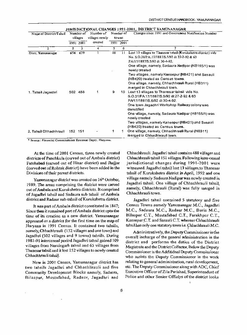
JURISDICTIONALCHANGFS 1991-2001, DISTRICTYAMUNANAGAR Name of Districtffahsil Number of Number of Number of Changes since 1991 and Government Notification Number
villages villages newly
1991 2001 created
:z 3 4
Distt. Yamunanagar 654 639
towns
1991 2001
5 6 10 II
7 Lost 13 villages to Thanesar tahsil (Kurukshetra district) vide No. S.0.3lfPA.17/1887/S.5/92 dt 27-2-92 & 63 P A/17 /1887 /S.5/92 dt 30-4-92. One village, namely, Sadaura Naqipar (HB155/1) was newly created Two villages, namely Kansepur (HB421) and Sasauli (HB420) treated as Census towns. One village, namely, Chhachhrauli Rural (HB311) merged in Chhachhrauli town.
1. Tahsil Jagadhri 502 488 9 10 Lost 13 villages to Thanesartahsil vide No.
2. Tahsil Chhachhrauli 152 151 1
* Source: Financial Commissioner Revenue Deptt. Haryana.
At the time of 200 1 Census, three. newly created districts of Panch kula (carved out of Ambala district) Fatehabad (carved out of Hisar district) and Jhaiiar (carved out ofRohtak district) have been added in the Divisions of their parent districts.
Yamunanagar district was created on 16th October, 1989. The areas comprising the district were carved out of Ambala and Kurukshetra districts. It comprised of Jagadhri tahsil and Sadaura sub tahsil of Ambala district and Radaur sub-tahsil ofKurukshetra district.
It was part of Ambala district constituted in 1847; Since then it remained part of Ambala district upto the time of its creation as a new district, Yamunanagar appreared as a district for the first time on the map of Haryana in 1991 Census. It contained two tahsils, namely, Chhachhrauli (152 villages and one town) and Jagadhri (502 villages and 9 towns) tahsils. During 1981-91 intercensal period Jagadhri tahsil gained 109 villages from Naraingarh tahsil and 65 villages from Thanesartahsil and it lost 152 villages to newly created Chhachhrauli tahsiJ.
Now in 2001 Census, Yamunanagar district has two tahsils Jagadhri a·tld Chhachlirauli and five Community Development Blocks namely, Sadaura, Bilaspur, Mustafabad, Radaur, Jagadhri and
6
S.O.31/PA 17/1887/S.5/92 dt27-2-92 & 63 PN17!1887/S.5!92 dt30-4-92. One town Jagadhri Workshop Railwaycolonywas denotified One village, namely, Sadaura Nadipar (HB155/1) was newly created Two villages, namely Kansepur (HB421) and Sasauli (HB420) treated as Census towns. One village, nam ely, ChhachhrauJi Rural (HB311) merged in Chhachhrauli town.
Chhachhrauli. Jagadhri tahsil contains 488 villages and Chhachhrauli tahsil 151 villages. Following inter-censal jurisdictional changes during 1991-2001 were witnessed. Jagadhri tahsil lost 13 villages, to Thanesar tahsil of Kurukshetra district in April, 1992 and one village namely Sadaura Nadiparwas newly created in Jagadhri tahsil. One village of Chhachhrauli tahsil, namelY, Chhachhrauli (Rural) was fully merged in Chhachhrauli town.
Jagadhri tahsil contained 5 statutory and five Census Towns namely Yamunanagar M.C., Jagadhri M.C., Sadaura M.C., Radaur M.C., Buria M.C., Bilaspur e.T., Mustafabad C.T., Farakhpur e.T., Kansepur ~.T. and Sasauli C.T. whereas Chhachhrauli tahsil has only one statutory town i.e. fhhachhrauli M.e.
Administratively, the Deputy Commissioner is,the overall incharge of the general administration in the .district and performs the duties of the District Magistrate and the District Collector. Below the Deputy Commissioner is the Additidnal Deputy Commissioner who assists the Deputy Commissioner in the work relating to general administration, rural development, etc. The Deputy Commissioner along :with ADC, Chief Executive Officer of Zi la Parishad, Superintendent of Police and other Senior Offic~rs ofthe district looks
ANALYTICA L NOTE
after the development and regulatory functions in the district.
To decentralize the authority in the administrative set up, the district is divided into two sub-divisions, Jagadhri and Chhachhrauli. Sub-divisions are not necessarily co-terminus with the name of their respective tahsils. However, in Yamunanagar district both the tahsils have sub-division status also. Zila Parishad and Panchayat Samitis correspond to the district;:nd C.D. Block boundaries respectively except that the municipal areas are not covered by them.
The Zila Parishad, elects its President and VicePresident from amongst the elected members. The term of office of members is five years. An officer in the senior scale of LA.S. is deputed by the State Government as the Chief Executive Officer to the Zila Parishad. The Parish ad is also assisted by various departments of the district. At the Community Development Block level, each Panchayat Samiti has an elected Chairman and Vice Chairman. The Block Development and Panchayat Officer works as Executive Officer of the Panchayat Samiti. The executive authority for the purpose of carrying out the provisions of the HaryanaZilaParishad and Panchayat Samitis (C.D . Blocks) Act vests in the Chief Executive Officer and the ,Block Development and Panchayat Officer respectively.
The statutory urban local bodies are municipal councils and municipal committees, The urban local bodies elect councilors from each of the ward and their term is five years.
Process of governance at the lowest level is gram panchayat which makes adequate arrangements for the development in various fields in rural areas.
(iv) Physical Features
Location and Size :
Yamunanagar district lies between 29° 55' 44" N and 30° 28' 34" N latitude and between 77° 04' E and 77° 36' 05" E longitude. It has a geographical area of 1,768.00* sq.kms. which comprises ofl,682.74 sq. kms. of rural area and 85.26 sq.kms of urban area
Yamunanagardistrict is triangular-shaped with base made by boundary with Himachal Pradesh in the North and apex touching Kamal district in the South. It is bounded by Uttar Pradesh in the east. Yamuna river makes boundary"between the district and Uttar Pradesh State. To _its west lies Ambala district and in the southwest is Kurukshetra district.
7
*Area figures supplied by the Surveyor Gencrnl of India are provisional.
Physiography:
The district has Siwalik Hills and Foothill rolling plain in the north and northeast; and flood plain along the Yamuna river in the east and southeast. The important rivers/nadis of the district are the Yamuna, the Saraswati, the Chautang, the Raks~ the Somb, the Boli, etc.
Yamuna river after rising from snowclad peaks of the Middle Himalayas at Yamnotri, enters the district from its north eastern corner through a narrow corridor in the Siwaliks. It is a perennial river. The Boli nadi joins the Somb nadi near Dadupur and then the combined Somb & Boli nadisjoin the Yamllna river at Mehar Majra. The Rakshi stream takes its birth in the rolling foothill plain while the Chautang and the Saraswati nadis originate in the lower hills. Generally, the slope of the district is from northeast to southwest in which direction most of the riversfnadis/rainfed torrents flow down.
Physiographically, we can sub-divide the district
as Yamunanagar Siwalik; Sadaura Plain, Yamunanagar
Plain, Yamunanagar Khadar and Bet Yamunanagar.
Yamunanagar Siwalik lies in parts along the northern
border of the district with Himachal Pradesh. It has
hilly topography and highest concentration of rainfall.
Mostly it is covered with reserved forests. Only foot
paths and minor tracks lead towards plain along the
river beds and boundary of reserved forests. Sadaura
Plain is a piedmont plain (alluvial fan) and is traversed
by a large number of rainfed streams. It is undulating
and contains large stretches of silt, sand and pebbles
in the beds of seasonal streams. It is an undulating
sandy plain with a perceptible slope near the hills. Soils
are poor and sandy. Yamunanagar Plain extends over
Jagadhri and Chhachhrauli tahsils, lying to the
southwest of Sad aura Plain. The region slopes towards
southwest. It is a plain area with relatively richer loamy
soils. Yamunanagar Khadar lies along Yamuna river in
the eastern part of the district. It is formed by deposition
of alluvium sediments, clay and sand. Silty loam is easily
workablp and productive. Bet Yamunanagar I ies in the
southwestern corner of the district. It is a low lying
plain area.
Drainage:
The general slope ofthe district is from north-east to southwest and the important rivers of the district are the Yamuna, the Saraswati ,the Markanda and the Chautang. The district forms part of the semi-hilly region and is intersected by many streams and rivulets. Except the Yamuna all other streams are seasonal. The Yamuna is the source of western Yamuna canal system providing irrigation to Haryana State.stre~ms/ rivers emerging from the lower Siwalik hills hringdown heavy floods during the monsoon months. This has necessitated vast schemes of drainage system.
The general character of the streams in the district is that of broad sandy courses, varying in width from 1/10 kilometre to more than a kilometer. These are dry during greater part of the year but bring heavy flood during rainy season.
The district is mainly drained by non-perennial streams. The Yamuna is the only perennial river which fonns eastern boundary of the district. The Yamuna river after rising from the snow-clad peaks of the Himalayas at Yamnotri enters the district from its northeastern corner through a narrow corridor in Siwaliks. The whole district is dissected by rivulets. streams, nadis and rivers which emanate from the lower h ills in the northern parts of the district. Bali nadi and Pathrala nadijoin the Somb nadi near Dadupur village and then these combined nadisjoin the Yamuna river near Mehar Majra.The Rakshi stream takes its birth in the rolling foothill plain while the Chautang and the Saraswati rivers originate in the lower hi lis. Generally the slope of the district is from northeast to southwest in which direction most of the rivers/nadislrainfed torrents flow down.
Boli Nadi or Palasi Khad or Pathrala nadi and Somb Nadi on the border ofSirmaur district (Himachal Pradesh) discharge their water into Western Yamuna Canal near Dadupur. The Run nadi, a tributary of the Markanda and the Markanda river rise in Himachal Pradesh and after flowing through the district in southerly direction enter Kurukshetra district. The Nakti nadi, also known as Sadhaurawali or Sadadani, is fo~med slightly above the Sadhaura town by the confluence ofSukar rao, Fandi rao and Khundra rao. It joins the Markanda river just north of village Jafagmr.
Climate:
The district has a sub tropical continental monsoon climate where we find seasonal rhythm, hot summers, cool winter, unreliable rainfall and great variation in temperature. In winters dense fog occurs during
8
DISTRICT CENSUS HANDBOOK; YAMUNANAGAR
December and January. The district also gets occasional winter rains from cyclones. Rainfall is concentrated in the monsoon months ofJuly and August.
Rainfall records for two stations Dadupur and J agadhri show - average annual rainfall of 1063 .2mm. and 913.6mm. respectively (Based on averages exceeding 100 years prior to 1970) whereas average annual rainfall for the district was 147.3 cms., third highest among the-districtsofthe State. About 83 per cent of the annual normal rainfall is received during June to September and about 8 per cent during winter months of. December to February. The rainfall in the district generally increases from south-west to northeast. The variation in the annual rainfall in the district from year to year is appreciable. The average number of rainy days for Jagadhri station is 43. The heaviest rainfall in 24 hours recorded at any station in the district was 444.5 mm. at Dadupur on 2nd July, 1956.
Meteorological Observatory for tl"!e north-eastern Haryana is located at Ambala which is representative of the climatic conditions in the district in general. From March temperature increase rapidly. M,ay and June are generally the hottest months in the year with the mean daily maximum temperature at 39.50 C and mean daily minimum temperature at 25.20 C. The heat in the summer season is intense. With the advance of the monsoon by about the end of June, there is a slight drop in the day temperature but the nights still continue to be quite warm. The weather during monsoon remains oppressive due to high moisture in the 'air. After the withdraw I of monsoon by mid-8eptember nights become progressively cooler but day temperatures slightly increase. The decrease in temperature is rapid from November. January is generally the colde.st month. During the winter season, cold waves sweep1he region in the wake of passing western disturbances and the temperature drops down occasionally below the freezing point. Frosts are a likely phenomenon in the district on such occasions. The highest maximum temperature recorded at Ambala was 47.80 C on 17t1l June, 1923 & 29t1l May, 1944; and the lowest mi¢imum temperature recorded was - 1.1 0 C on 19th January, 1947.
During monsoon season relative humidity is high (between 70 and 85 percent). Atmosphere is generally dry for the rest of year. The driest part of the year is the summer season whefl relative humidity is the lowest, about 26 per cent. Cloudiness is moderate to heavy during monsoon season. The skies are mainly clear or lightly clooded during the J:emaining part of the year. Light winds generally blow In the district In I .
the post-monsoon and co,ld season winds are
ANALYTICAL NOTE
predominantly from northwest. In the beginning of summer season easterly or south-easterly winds blow on some days. May to September easterlies or southeasterly winds predominate.
Natural Economic Resources
Forestry:
Forests playa great role in the economy of the district. The district covers Jagadhri, Kalsia, Chuharpur, Kalesar and Sadaura forest ranges which come under the Yamunanagar Forest Division headed by the Deputy Conservator of Forests stationed at Yamunanagar. The district falls in the North Forest circle with headquarters at Panchkula. Earlier Panchkula, Ambala and Yamunanagar districts were part of Ambala district and total area under forests during 1977-78 was 61 1.45 sq. kms. which has increased to 646.89 sq. kms (for three constituent districts) during 2000-0 1. Income from the forest produce during 1977-78 was Rs. 4 I .9 lakhs. At present nurseries of different species are raised for afforestation and reafforestation. The staff also attends to the soil conservation work and anti-erosion measures.
Forests are the source of much needed fuel for the public and timber for the forest based industries and for making agricultural implements. Forests provide raw material for paper industries, saw mills and packing industries.
The government is also developing forest strips along railway lines, roads and canals. Efforts are being made to increase the areas under forests by raising more and more plantations in the district as a part of farm forestry programme. The eucalyptus and poplar trees have attracted attention as they grow fast with minimum interference to the crops.
Kalesar Wild life Sanctuary is located in the district near the borders of Himachal Pradesh and Uttranchal. The lone Sal forest ofHaryana also known as Kalesar Forest is also inhabited of various types of wild animals like Panther, monkey. wild pigs. cheetal, sambhar, kakkar. wild cock, etc.
Herbal Nature Park at Chuharpur Reserve Forest near Khizrabad in the district has been developed by the Forest Department to grow rich variety of medicinal plants.
9
TWIN OF FORESTS IN THEDISlRICT: 2000·(ll SI. No. Ty pe of Forest ArCli
(in Sq.Kms.)
2 3
2
3
4
5
Reserved Forests
Protected Forests
Unclassed Forests
Forests u/S38 ofIFA 1927
Forests U1S4&5 ofLPA 1900
Total Forest area
69.44
127.9J
6.48
o.me 14.11
217-" Source: Principal Chief Conservator of Forests, HaryaoaZOOO-O I
The district has a favourable climate for the growth of rich vegetation owing to reasonably good minfall and elevation. Shisham (Dalbergia sissoo), Kikar (Acacia nilotica), Aam (Mangifera indica),. Jamun (Syzgium cumini), PeepaI (Ficus religiosa), Bd (Ficus bengalensis), Neem (Azadirachta indica), etc are the important tree species grown in the area.. Safeda (Eucalyptus hybrid) has been introduced since 1963 in the forest areas as well as agricultural fields and along the roads.
In the hilly tract of the district, natural vegetation is mainly of forest growth and its degradation stages. Tropical dry deciduous forests and sub tropical forests are found here.These forests contain a number-ofhard wood species like chhall, khair and Jhingan. Growth is more dense on northern and north eastern slopes. Dry deciduous type forest forms into pure bamboo forest in more moist areas, on outer hills degenerate ioto scrub forest where biotic interference is considerable and extensive incidence of grazing takes place. Main tree species found are chhall, khair,jhingan. amaltas, sain, bahera and dhak.Sal occurs on the northern slopes of Siwalik hills in Kalesar tract. The Kalesar reserve forest is the only Sal forest in the whole of Haryana State. Other species of occasional occurrence are sandhan, phaldhu, semul, amla, kachnar, papri, toon, robini, etc.
A large number of climbers and grasses are also seen. Babbar is an important grass growing naturally in many areas. It is used for manufacturing of paper.Sarala is an important fodder grass growing in Siwalik hills. A number of medicinal and ornamental plants are also found in the district..Some of which are bah era, harar, amla, kamela, amaltas etc. Ornamental trees like Bougainvillaea, bambusa vulgaris and jacaranda can be seen in parks, rest houses and along roads.
The primates, the highest group of mammals are represented by the rhesus macaque or bandar and the common langur. The tiger and leopard are no more seen in the district. Some other carnivorous animals which may be seen in the district are the jungle cat, the small Indian civet, the common mongoose giddar and the Indian fox. The five stripped squirrel or gilheri, the common house rat, the house mouse and the Indian hare comprise the rodent fauna though not very commonly seen.
A large number of game birds like combduck, common teal, cotton teal, spot bill duck, large whistling teal, tree duck, dabchick, eastern greylag goose, Brahminy duck, common shelduck, pintail mallard, gadwall, wigeon, blue winged teal, shoveller, common pochard and tufted duck are foood in the district. Some are residential and some visit the district in winter. Kingfishers, sandpipers and stints are seen in sizeable tanks, lakes and rivers. Pigeons and doves are common in the district. Partridges and quails are also very common. Cattle egret can be seen moving along with grazing cattle. Other common birds which can be seen in the district are large Indian parakeet, sparrow, bee eater, coppersmith cuckoo, koel, crow pheasant, bulbul, robin, red munia etc.
Birds of economic importance are also commonly seen such as scavengers like pariah kite, vulture, tawny eagle, jungle crow & house crow keep the district clear of dead animals by feeding on them. Black winged kite, Indian shikra & falcon are resident birds. Spotted owlet, eagle owl and bubo-bubo keep check on not only rodent but also various insect pests. Various types of swifts also feed on insects and caterpillars. Poisonous and non-poisonous snakes of various kinds, lizard, and tortoises are also foood in the district.
Minerals and Mining:
Major part of the district is formed of alluvium rocks of recent period. North eastern fringe of the district is formed of Siwalik rocks ofMio-Pleistocene period. The underground water in the district is generally fresh and suitable for domestic and irrigation purposes. Subathu rocks along with other tertiary rock formations extend in sub-montainous and footh ill region of the district which holds prospects for the storage of petroleum, gas or both at depths in reservoirs caused due t9 repeated folding and faulting of rocks.
The part of outer Himalayas confined to a narrow belt along northern boundary of the district contains
10
DISTRICT CENSUS HANDBOOK: YAMUNANAGAR
traces of placer gold, deposits of ce!TIent, chemical grade limestone, shale, building material and clay minerals. Sand, bajri, pebbles, gravel and boulders are found in the river bed of the Yamuna, the Saraswati, the Chautang, the Somb and the Pathrala riverslNadis.
Ordinary clay suitable for manufacturing of bricks is available in plenty in all parts of the district.
Soil and Cropping Pattern :
Major part of the district is inundated by the seasonal rivers/rivulets. Silty loam and coarse loam are found in the region. The soils in the district are mainly silty loam (khaddar), loam (Bhangar & Nardak), piedmont (Ghar & Kandi), silty clay (Naili & Chhachhra Dakar) and light loam (Seoti). The soils as classified by the National Bureau of Soil survey and Land Use Planning (ICAR), Nagpur, consist mainly ofUdalfs, Aquents-tluvents and Ochrepts-Orthents types.
The crops grown in the district are divided into two main categories viz. Kharif and Rabi, 10caJly calIed as Sawani and Sadhi. The former is the summer season harvest and the tater the winter season harvest. Any crop which does not strictly fall within these two harvests is known as a zaid crop and its harvest is called the zaid kharif or zaid rabi, according to the harvest with which it is assessed. Toria (an oilseed) is cultivated as zaid kharif and vegetables, melon and green fodder as zaid rabi.
The major kharif crops of the district are paddy, maize,potatoes and sugarcane while the minor ones include bajra, pulses and vegetables.
The majorrabi crops grown in the district include wheat, rape seed, mustard seeds and pulsesletc.
Land and land-use pattern :
In the year 2000-01 against a geographical area of 1768.00* sq kms. (includes 85.26sq kms. of urban area), the area of the district according to village papers supplied by the revenue authorities is 1634.40 sq. kms. (only rural area). This shows differync'i,in two sets of areas arrived at by different methods of measurement adopted by two separate agencies. However, we will discuss landuse here as per village records. Of the total area of 163,440 hectares, 6,443 hectares is covered by uninhabited villages of the district; 7,129 hectares is under forests, 120,812 hectares is net sown area; 4,717 hectares is culturable waste (including gauchar and groves) and 24,339 hectares of area is not available for cultivation to ~hich we may call barren unculturable land.
ANALYTICAL NOTE
Net area sown in 'the district is 73.9 percent of the total rural area of the district. Jagadhri tahsil has rural area as 118~.35 sq lans whereas Chhachhrauli tahsil contains rural area of 445.05 sq. kms.
* Area figures supplied by the surveyor General of India are provisional.
Tenancy:
Tenancy system was the outcome of insecure days after the decay of Mughal empire owing to conflict betwee?f'two classes viz - the landlords and the tenants. Taking into consideration, the deteriorating state of agriculture and the cultivator, the Punjab Tenancy Act of 1887 was enacted prov iding the right of occupancy.
After Independence, the government decided to bring land reforms especially to carry out its policy of 'Land to tiners' in order to improve the condition of cultivators and increase agricultural production. Haryana State comprised areas which were earlier either in Punjab or in Pepsu (Patiala and East Punjab States Union) and had two different sets oflegislation applicable to the State areas which were as follows:
Punjab Laws
(1) The East Punjab Utilisation of Lands Act, 1949
(2) The Punjab abolition of Ala Malikiyat and TaJukdari Rights Act, 1952
(3) The Punjab Occupancy Tenants Act, 1952
(4) The Punjab Security of Land Tenures Act, 1953
(5) The Punjab Bhudan Yagna Act, 1955
Pepsu Laws
(1) The Pepsu abolition of the Ala Malkiyat and Talukdari Rights Act, 1954
(2) The Pep~u Occupancy Tenancy Act, 1952
(3) The Pepsu Tenancy and Agricultural Lands Act, 1955
(4) The Pepsu Bhudan Yagna Act, 1955
After the merger ofPepsu with Punjab two more Acts, the Punjab Resumption of Jagirs Ace, 1957 and Punjab 'village Common Lands (Regulation) Act, 1961 were enacted.
Under the East Punjab Utilisation of Lands Act, 1949, the government enforced the utilisation of every inch of available culturable land. Under this Act a notice to take over the land is served on every land owner who allows his land to remain uncultivated for
11
6 or more consecutive harvests and the land taken over is leased out to others for a term ranging 7 to 20 years, priority being given to Harijans.
Abolition of Ala Malikiyat and Talukdari Rights Acts of 1952 and 1954, the rights of ala malik in the land held by adna malik were abolished.
Occupancy Tenants Acts of 1952 and 1954 declared all occupancy tenants as the owners of the land. The Punjab Security of Land Tenures Act, 1953 and the Pepsu Tenancy and Agricultural Lands Act, 1955 contained provisions relating to ceiling on agricultural land holdings, utilization of surplus area and security for tenants against exploitation and ejectment were in force in different parts of ,Haryana. Government was further empowered to utilise the surplus area of both land-owners and tenants for the resettlement of ejected tenants, landless labourers and small land-owners. All areas owned by a local owner above 30 standard acres and by a displaced person above 50 standard acres were considered as surplus area.
Haryana Ceiling on Land Holdings Act, 1972 was enacted as recommended by the Central Land Reforms Committee, which provided for the assessment of permissible area in relation to a family instead of an individual and reduced the permissible area limit to 7.25 hectares of rand under assured irrigation capable of growing at least two crops in a year, 10.9 hectares of land under assured irrigation capable of growing at least one crop in a year or 21.8 hectares in respect of any other land including banjar and land under orchards.
Owners of land generally cultivate their land themselves known as khudkasht (self cultivation). Sometimes the land is leased to small/marginal/landless farmers on theka (contract) or batai (Share-cropping). The normal rate ofbatai is one-third depending upon the provision of irrigation, fertilisers, seeds etc. However the rate of contract varies from time to time depending upon the quality of land and facility of irrigation system etc. Between the two, theka (contract farming) is more prevalent. As large number offarmers own modern machinery, they prefer to offer services
. for various types of agricultural.operations against payment. This system is gaining popularity.
Average size of land holding in Haryana is 2.1 hectares, which is relatively higher than the all India average of 1.6 hectares. 27.8 per cent of the land holdings were below 0.5 he,ctares, more than 50 per cent holdings were of the size between 0.5 and 3.0
hectares. Only 0.4 percent land holdings were of the size 20 hectares and above. 2.4 and 1.9 percent of the landholdings were respectively of the size of 5 to 7.5 hectares and 7.5 to 10 hectares.
In Yamunanagar district landholdings numbered 65,367, out ofthese 18,482 landholdings were less than half hectare size. Under each category of one half to one hectare and one to two hectare sizes, there were almost one-fifth of the total landholdings. Only 155 landholdings were more than 20 hectares size whereas between 10 to 20 hectares, there were 866 landholdings. Average size of the landholdings in the district was 2.0 hectares and lesser than the State average of2.1 hectares. With the increase in size of landholdings, the number oflandholdings steeply decreases as there were 8031 holdings in 2-3 hectares, 4,720 in 3-4 hectares and 2,909 in 4-5 hectares size 4.3 per cent of the total holdings were of the size of5 to 7.5 hectares and 1.8 percent of the size of 7.5 to 10 hectares.
Agriculture:
Dependency upon agriculture is decreasing slowly as 33.4 percent of the main workers have been reported as workers deriving their livelihood from agricultural pursuits which include cultivators and agricultural labourers during 200 I Census as against 49.5 per cent in 1991 Census. It is ranking 15th with this percentage (33.4) among the districts of the State. With 34.9 percent of marginal workers deriving their earnings from agricultural activities, the district is at the bottom among the districts of the State. Diversification is taking place in the economy of the district.
The government is making all efforts to encourage agricultural production by distributing improved seeds, fertilizers, pesticides, providing Jatest developments in modem techniques, multiple cropping pattern techniques, increasing irrigation facilities, providing easy 10l').ns for modem agricultural machinery, etc
Area and ProductioD, 1998-99 SI. Crop Area Production
No. (in hectares) (in tonnes)
I Paddy 58,000 130,000 2 Wheat 64,000 252,000 3 Sugprcane 41,000 237,000 4 Bajra 1,000 1,000 5 Maize 2,000 4,000 6 Pulses (Masson) 3,000 2,000 7 Rapeseed Mustard 1,000 1,000 8 Other oil seeds 2,000 3,000
12
DISTRICT CENSUS HANDBOOK' YAMUNANAGAR
9 Potatoes 1,479 21,000 10 Onions 172 NA II Other vegetables 1,067 NA 12 Mangoes 397 NA 13 Other fresh fruits 5 NA
Source: Statistical Abstract ofHaryana 1999·2000
In paddy growing, with a production of 1.3 Lakh tonnes, it is a mediocre district. Maize is grown in five districts of the State and it is 3rd
• ranking district with a production of 4,000 tonnes only.
In sugarcane production, Haryana State with TIl position in the Indian Union earned a good ranking and it is the chief cash crop of the district. With a production of 2.4 lakh tonnes of sugarcane (Gur) it is first ranking district of the State. Sugarcane is grown in 41,000 hectares in the district. In potato production also, the district is .fd' ranking with a production of21 ,000 tonnes. Small quantity of Baji-a (1,000 tonnes) is also produced. The district is 3rd ranking in production of onions. Summer vegetables are grown in adequate quantities.
The district had its share as 2.9 per cent in area under various crops as well as production in the State. During 1998-99 the district produced 2.5 lakh tonnes of wheat. By producing 2,000 tonnes of pulses (Massar) it shared first rank in the State with Ambala district. In the Indian Union, in the production of Rapeseed and Mustard oil seeds Haryana State is 4· ranking but Yamunanagar district, with a production of 1000 tonnes out oftotal production of 6.2 lakh tonnes -in the State, made its presence only.
During 1998-99, in the district, vegetables and fruits were grown on 3,120 hectares as compared to 66,825 hectares in the State. With an area of 397 hectares under mangoes it was the 3rd ranking distriet of the State.
Use of agricultural machinery I is not so much intensive as in other districts like lind, Fatehabad, Hisar, Sirsa, Kaithal, Kamal, Sonipat, Rohtak, etc.
Apart from compost, cattle dung and green manures, chemical fertiJizers are being used increa~ingly. During 1999-2000 chemical ferti I izers (NPKh were used to the tune of 43,842 tonnes in the district. Qut of this 34,338 tonnes was Nitrogenous (N), 8,892 tonnes Phosphatic (P) and 612 tonnes Potassic (K).
Irrigation:
The average annual rainfall (1994-98) in the district is 1,417mm and it is the second highest among the districts in the State (first being' Ambala with 1,459.3mm) Though 'the rainfall is. irregular and variations from year to year are considerable yet the
ANALYTICAL NOTE
rains never fail altogether. The uncertainty necessitates the development of artificial sources of irrigation. The district forms part of semi hilly region and is intersected by many streams and rivulets. Except the Yamuna, all other streams are seasonal. The Yamuna river is the source of Western Yamuna Canal System providing irrigation to Haryana State. Canal irrigation. is concentrated only in the eastern and southern parts of the district. Well irrigation was done in remaining areas before the introduction of diesel pumping sets. Further with t1'ie extension ofelectricity facility in rural areas, electric tubewells have become more popular. There are only two major sources of irrigation in the district i.e. tubewells and canals. In 1998-99 canal irrigation was done in 4,000 hectares. Irrigation by tubewells was done on one lakh of hectares and there were 8,823 diesel tubewells and 16,763 electric pumping sets in the district. Kuhl or duct irrigation is prevalent in hilly areas of the district. The sO!Jrces of water supply to the kuhls are perennial and non perennial springs and small streams. Haryana State Minor Irrigation Tubewell Corporation has also undertaken to provide new kuhls in the area.
Animal husbandry :
The district possesses a fairly large number of livestock including cattle, buffaloes, horses ponies, sheep, goats, donkeys, mules, camels and pigs. The district has 3.6 per cent of the total area of the State and shares 3.7 percent of the total livestock population of the State.
Livestock, 1997 Category Livestock, 1997 Percentage
Number of Haryana Y. Nagar State Stock
2 3 4 Cattle 2,399,800 111,600 4.7 Buffaloes 5,tJ8,300 163,600 3.2 Horses and Ponies 49,100 2,600 5.3 Donkeys 63,400 1,100 1.7
Mules 34,500 1,600 4.6 Sheep 1,293,300 30,500 2.4 Goats 7<J7,200 31,000 3.9 Camels 96,200 @ N Pigs 675,100 46,800 6.9 Poultry 9,222,900 676,500 7.3 @ less than 50 N means negligible Source: Statistical Abstract ofHaryana. 1999-2000
As per Quinquennial Livestock Census of 1997, there was 388,800 livestock popUlation and 676,500 poultry birds in the district. It has good proportions of poultry birds, pigs, horses & ponies, cattle, mules and
13
goats which are 7.3, 6.9, 5.3, 4.7, 4.6 and 3.9 respectively of their respective stock in the State. Buffaloes numbering 163,600 form 3.2 per cent of the total buffaloes in the State. Cattle and buffaloes play an important role in the economy of the district though mechanisation is taking place yet animal husbandry forms integral part of agriculture. Donkeys with a population of 1100 are 1.7 per cent of their stock in the State. Camels are in small number i.e less than 50 only. lOA per cent are milch cattle and 14.6 per cent are cross-bleed milch cattle of the total cattle in the district whereas 37.0 per cent of the total buffaloes in the district are milch buffaloes. Yamunanagardistrict ranks fifth in the State with 32.2 per cent milk cattle and buffaloes in the district.99.6 lakh I itres of milk was procured through co-operative societies in the year 1998-99 in three districts of Panchkula, Ambala and Yamunanagar. There is a milk chilling center in the district wth a daily intake capacity of 15,000 litres.
Animal husbandry in the district is looked after by the Deputy Director, Intensive Cattle Development
Projec~ Yamunanagar. He is assisted by Assistant Directors and Sub-Divisional Officers (Animal
Husbandry) Semen Bank Officer, Assistant Poultry Development Officer and a team of 21 Veterinary
Surgeons and 87 Veterinary and Livestock
Development Assistants.Their main duties relate to
help cattle breeding, artificial insemination work, control of contagious diseases among livestock, improvement oflivestock and provision of veterinary aid.
To provide breeding facilities promptly, to penetrat_e the benefits effectively to interior rural areas, to implement piggery development schemes, training persons in raising poultry on scientific lines and supplying improved breed of poultry, veterinary institutions such as 7 Civil Veterinary HOspitals, 2 Regional Artificial Insemination Centres, 21 Civil Veterinary Dispensaries, 33 Stockman Centers and I Poultry Extension Centre are functioning in the district. There is one'Gosadan and one Gaushala also. The ban on cow-slaughter posed a problem of old, inferior and unproductive cattle. To house these useless unclaimed and unproductive cattle, the government opened a Gosadan at Mandewala, where animals are kept till their natural death and saved from starvation.Gaushala is located in lagadhri town. It is
run on charity to house the unproductive and useless cattle. However this has been converted into cattlebreeding-cum-milk producing center with the help of government and is self dependent with the sale of milk.
Milk is derived mostly from cows and buffaloes. Cattle and buffaloes numbered 275,200 in the district and out of these 32.2 per cent were milch livestock. Government gave incentives to dairy farming through subsidized loans, subsidies to milk cooperative societies and establishment of milk collection centres. In Yamunanagar district there were 81 Dairy and Milk· Supply Co-operative Societies in 1998-99 which produced milk and milk products worth Rs. 66.45 lakhs and sold these products for Rs. 68.95 lakhs. Hilly tract of the district has the possibility for sheep development.As per livestock Census of 1997, there were 30,500 sheep in the district. Sheep provide necessities of vital importance like meat for food, wool for clothing, skin for industrial enterprise and manure for agriculture.
There were three recognized slaughter houses in the district where 3,200 sheep 3,600 goats and 3,500 pigs were slaughtered during 1999-2000.
Fishery :
Fisheries development in the district is looked after by the Fisheries Department. Natural sources of fish in the district include the Yamuna and its tributaries; the Chautang and the Rakshi, the Markanda and its tributaries and streams controlled by the State government. Tajewala and Dadupur are famous for Mahaseer fis~. Besides these natural sources, fish are also available in canals, ponds and reservoirs formed by flood embankments. 255 hectares of area had been stocked for fish development in the district and production of 1,391 tonnes of marketing fish was done during 1999-2000. Apart from local market surplus fishis exported to Delhi, Uttar Pradesh and West Bengal for sale. An income of Rs.11.04 lakhs was obtained from fisheries. 2,440 licences were issued during the same period to private parties/persons.
Industry:
Yamunanagar district remained industrially backward though it has got some momentum since the beginning of twentieth century. Few and important brassware manufacturing units were located at
14
DISTRICT CENSUS HANDBOOK: YAMUNANAGAR
Jagadhri in the past as revealed by excavations at Sugh. These brasswares were exported to provinces and other parts of Punjab. Some important industries like Punjab Pulp and Paper Mills established in 1929 (changed ownership name to Shree Gopal Paper Mills in 1937), Saraswati Sugar Mills in 1933 and Bharat Starch and Chemicals in 1938 all located at Abdullapur (presently known as Yamunanagar) have flourished into units with very big investments. Two industrial un its came up during 1946-47 both deal ing in manufacturing of various types of machinery like sugar, paper, cement, brick making machines etc. Railway Workshop Jagadhri was established in 1954-55 and Mis Haryana Distillery in 1962-63 all located in Yamunanagar - Jagadhri complex are having good investments.
During 1999, there were 1,146 registered working factories in Yamunanagar district employing an estimated number of35,699 workers.
Industrial production in tbe district 1998-99
Item
Paper
Cement
Sugar
Production
80,482 metric tonnes
13,367 metric tones
10,302 metric tonnes
S()urce : Statistical Abstract ofHaryana. 1999-2000
On the basis of number of registered working factories, workers employed and production or production value, it is seen that major industrial concentration is in the areas offood product;;, wood & wood products, paper & paper products, non-metallic mineral products, basic metal & alloys industries, metal products & parts etc.
Other smaller fields are chemical & chemical products, rubber, plastic & petroleum products, electrical machinery, apparatus & ~ppliances, transport equipment parts, other manufacturing industries, repair services etc.
Large and Medium Industrial Units
As per directory of large and medium industrial I
un its, 1999 by the Department of industries, Haryana, there were only 8 such units in the district, all located in Yamunanagartown. Detail of which is as follows:-
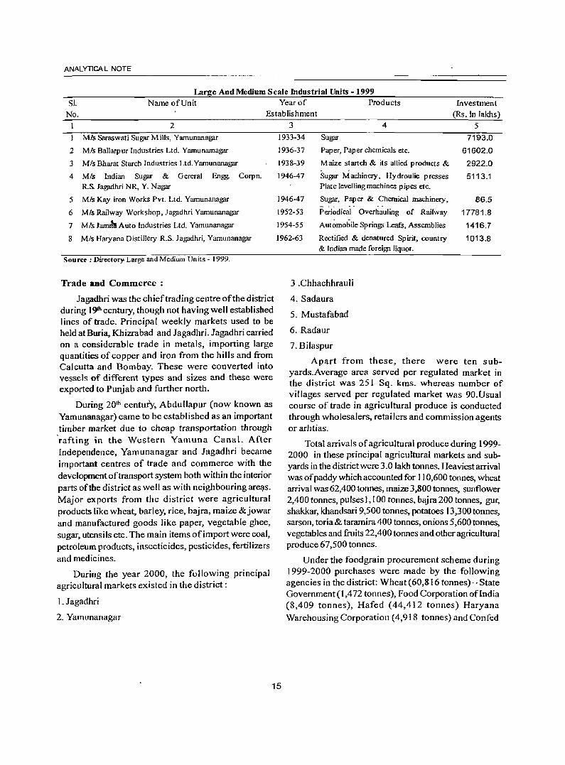
ANALYTICA L NOTE
Large And Medium Scale Industrial Units -1999
SI. Name of Unit Year of Products Investment
(Rs. In lakhs) No. Establishment
2
MIs Saraswati Sugar Mills, Yamunanagar
2 MIs Ballarpur Industries Ltd. Yamunamagar
3 MIs Bharat Starch Industries Ltd.Yamunanagar
4 MIs Indian Sugar & Gereral Engg. Corpn. R.& Jagjidhri NR, Y. Nagar
5 Mis Kay iron Works Pvt. Ltd. Yamunanagar
6 MIs Railway Workshop, Jagadhri Yamunanagar
7 MIs Jamrbt Auto Industries Ltd. Yamunanagar
8 MIs Haryana Distillery R.S. Jagadhri, Yamunanagar
Source: Directory. Large and Medium Units - 1999.
Trade and Commerce :
Jagadhri was the chief trading centre of the district during 19'" century, though not having well established lines of trade. Principal weekly markets used to be held at Buria, Khizrabad and Jagadhri. Jagadhri carried on a considerable trade in metals, importing large quantities of copper and iron from the hills and from Calcutta and Bombay. These were converted into vessels of different types and sizes and these were exported to Punjab and further north.
During 20th century, Abdullapur (now known as Yamunanagar) came to be established as an important timber market due to cheap transportation through ·rafting in the Western Yamuna Canal. After Independence, Yamunanagar and Jagadhri became important centres of trade and commerce with the development of transport system both within the interior parts of the district as well as with neighbouring are~s. Major exports from the district were agricultural products like wheat, barley, rice, bajra, maize & jowar and manufactured goods like paper, vegetable ghee, sugar, utensils etc. The main items of import were coal, petroleum products, insecticides, pesticides, fertilizers and medicines.
During the year 2000, the following principal agricultural markets existed in the district:
1. Jagadhri
2. Yamunanagar
3 4 5 1933-34 Sugar 7193.0
1936-37 Paper, Paper chemicals etc. 61602.0
1938-39 Maize startch & its allied products & 2922.0 . .
1946-47 Sugar Machinery. Hydroulic presses 5113.1 Plate levelling machines pipes etc.
1946-47 Sugar, Paper & Chemical machinery, 86.5
1952-53 Periodical Overhauling of Railway 17781.8
1954-55 Automobile Springs Leafs, Assemblies 1416.7
1962-63 Rectified & denatured Spirit, country 1013.8 & Indian made foreign liquor.
3.Chhachhrauli
4. Sadaura
5. Mustafabad
6. Radaur
7. Bilaspur
Apart from these, there were ten subyards.Average area served per regulated market in the district was 251 Sq. kms. whereas number of villages served per regulated market was 90.Usual course of trade in agricultural produce is conducted through wholesalers, retailers and commission agents or arhtias.
Total arrivals of agricultural produce during 1999-2000 in these principal agricultural markets and subyards in the district were 3.0 lakh tonnes. Heaviest arrival was of paddy which accounted for 110,600 tonnes, wheat arrival was 62,400 tonnes, maize 3,800 tonnes, sunflower 2,400 tonnes, pulses 1,100 tonnes, bajra 200 tonnes, gur, shakkar, khandsari 9,500 tonnes, potatoes 13,300tonnes, sarson, toria& taramira400 tonnes, onions 5,600 tonnes, vegetables and fruits 22,400 tonnes and other agricultural produce 67,500 tonnes.
Under the foodgrain procurement scheme during 1999-2000 purchases were made by the following agencies in the district: Wheat (60,816 tonnes)-State Government (l,472 tonnes), Food Corporation oflndia (8,409 tonnes), Hafed (44,412 tonnes) Haryana Warehousing Corporation (4,918 tOllnes) and Confed
15
(1,605 tonnes), Paddy (110,465 tonnes) - State Government (227 tonnes), Hafed (&,338 tonnes). Rice millers (98,054 tonpes), Haryana Warehousing Corporation(2,138 tonnes), Agro (1,094 tonnes) and Confed (614 tonnes). There were 23 cold stores in the district with a storage capacity of 29,000 tonnes during 1998-99.
During 200 I-02,eleven export oriented U11its were functioning in the district which earned Rs.13.1 cror~s.
Total establishments/enterprises in the district as per Economic Census,1998 were 36,183. Nonagricultural enterprises formed 97.3 per cent of the total establishments. Only 28.5 per cent of the total enterprises employed one or more hired workers. 90.3 per cent establishments were functioning under own premises whereas 3,515 establishments were without premises. 98.0 per cent of the enterprises functioned throughout the year whereas 735 enterprises were seasonal. Ownership of94.4 per cent enterprises was in private hands. 74.5 per cent of the enterprises did not make use of power or fuel.
Employment in these enterprises was 100,974 persons, of these 8,422 were females and 851 children. Hired workers numbered 62,331 which included 7;162 females and 462 children.
During 19th century when the faci I ities of modern banking and co-operative credit were not available, the money lending was controlled by the sahukars in towns and petty shopkeepers in villages. They exploited the poor land holders.
BANKING INSTrrurloNs IN THE DISTRIcr, MARCH 2001.
District/Tahsil TI No.ofVillagesl Scheduled! Co-operative RI Towns where Commercial banking U banking facility banking institutions
2 Jagadhri T
R
U
Chhachhrauli T
R
U
District Total T
R
U
is available
3
3D
20
10
8
7
I
38
27
II Source: Data collected from the field
institutions
4 5
75 12
19
56 11
6 6
4 4
2 2
81 18
23 5
58 13
16
DISTRICT CENSUS HANDBOOK: YAMUNANAGAR
Institutional finance is a must for development of any area. It is available through both commercial and co-operative banks. In Yamunanagar district there were 99 banking institutions including 18 Co-operative banking institutions in March 2001. Jagadhri tahsil possessed 87 banks, while Chhachhrauli tahsil had only 12 banks. Among the urban areas, Yamunnagar M.C!" had major concentration of31 banks being the district headquarters town. The remaining institutions were available in Jagadhri M.C1.16 banks, Radaur M.C. 5 banks, Bilaspur C.T. 4 banks, Chhachhrauli M.C 4 banks, Sasauli C.T. 4 banks, Sadaura M.C. 3 banks, Mustafabad C.T. 3 banks and Buria M.e. 1 bank. Rural areas shared 28.3 per cent o(the banking institutions in the district and urban areas reported as 71.7 per cent. There were I 0 schedule~ banking institutions per one lakh of population in the district.
Apart from the above scheduled commercial and co-operative banks, there were 857* co-operative societies in the district registered with the Registrar of Co-operative Societies, Haryana under the rural development and co-operation progr<!mme. These cooperative societies functioned in different fields as in March, 2001:
1 Agricultural Credit Co-op. Societies 121 2 Non-Agricultural Credit Co-op. Societies 33 3 Marketing Co-operative S<Xfieties 2 4 Milk Supply Co-operative Societies 81 5 Weaver Co-operative Societies 4 6 Consumer Co-operative Societies 5 7 Housing Co-operative Societies 42 8 Farming Co-operative Societies 9 9 Sugarcane Co-operative Societies 6 10 Other Co-operative Societies 554
Total 857 *Source: Statistical Abstract Haryana, 2002-03.
Transport:
The mountainous chatacter and beds of torrents at short intervals in the district made the construction of roads and their maintenance difficult. It was only after Independence that road development got impetus. Now, 620 villages out of639 villages 'in the district are approached through metalled roads. Rickshaws, threewheelers, autos, local buses became effective means of conveyance in urban and sUl:r.ounding areas. The tempo has become very popular recently as means of public transport espe~ially in rural areas and gainfully employed for carrying goods on short distances.
ANAL YTICA L NOTE
Transport and communication system is the nervous system ofllie economy of a particular area. Rugged topographyoftJ:le district particularly in the north mars development of transport system. However, new avenues have been opened to develop these areas into tourist resorts by linking these through metalled roads. The district headquartes town is well connected from all comers of the district by roads. National highway -73 passes through the district starting from Panchkula via Saba entering the district netho Mustafabad and reaching J agadhri and Yamunanagar then to Saharanpur (UP). State highway-6A starting from Jagadhri via Tajewala,. Kalesar and then going to Paonta Sahib (H.P), SH-1 leads from Jagadhri to Bilaspur, Sadaura and then through Naraingarh (Ambala) reaches Raipur Rani (Panchkula), SH.-4coming fromKalaAmb (H.P) enters the district via Sad aura and then goes to Shabbad and S.H.-6 starting from Yarnunanagar to Radaur and then passes through Pipli and Pehowa (Kurukshetra). Other roads of the district include Jagadhri-Chhachhrauli-Darpur, ChhachhrauliBilaspur, Chhachhrauli-Raiyanwala (Near Tajewala) Jagadhri-Buria, Yamunanagar-Jathlana-Indri, JathlanaRadaur, Jagadhri to (Sadau.ra-Shahbad)State Highway, Bilaspur to Haryana-Himachal Pradesh border. The only Broad Gauge Railway Line passing through the district is Ambala-Saharanpur with Jagadhri workshop, Darazpur,. and Mustafabad railway stations situated on the line in the district.
Total road length in the district during 2001-02 was 1,140 kilometres, out of which only 64 kilometres were National Highways and the remaini.ng was State Highways as per information supplied by the Engineerin-chief, P. W.D (B&R) Haryana. The district, with 115 kilometres of road length per lakh of population, is placed at lOth. place among the districts of the State. Important focal points ofthe district include Jagadhri, Yamunanagar, Chhachhrauli, Radaur, Buria, Bilaspur, Mustafabad, Farakhpur, Kansepur, Sasauli and Sadaunl.
Transport statistics as supplied by the Transport Commissioner, Haryana for the year 2000-2001, there were 1,105 Cars, 147 Jeeps, 471 Tractors and 6,098 Motorcycles/Scooters/ Autocycles registered in the
district whereas 65,038 Motorcycles I Scooters/ Autocyc1es, 48C Jeeps, 12,675 Private Motor Cars and
17
5,516 Tractors were on road in the district during the same period.
Electricity and Power:
Power availability in the State has improved drastically over the last three decades. During 1967-68 power availability was 601 million KWH which increased to 16,855 million KWH during 2000-01. There were 35,46,572 total electric connections in the State, out of which 27,63,467 were domestic connections in 2000-0 1.
In Yamunanagar district, as regards use of electricity for domestic purposes, outof613 inhabited vlllages in the district 604 are electrified. 548 villages make use of electricity for agricultural purposes and 489 for other purposes as per information supplied by the revenue authorities in Village Directories during 1998-99.
Census 2001 results show 89.3 per cent of the households in the district make use of electricity for lighting purposes. The district with this percentage ranks 4th. among the districts of the State.
Gram Panchayats, composition, jurisdiction and role in Development of Village and its economy
Village has been the basic unit of administration and instrument of development ofIndian Society since ancient times, the institute of 'Panchayat' being an integral part of self-governance at grass-root level. The term 'Panchayati Raj' refers to the process of governance at the lowest level i.e. Panchayat. There is a three tier system of governance in the State; 'Gram Panchayat' at the village level, 'Panchayat Samiti' at the community development block level and 'Zila Parishad' at the district level.
Haryana Panchayati Raj Act 1994, provides that th~ Govemmentshall by election establish a Gram Panchayat by name in every Sabha Area constituted for any village or a part of village or group of contiguous villages with a population of not less than five hundred and the Gram PanclJayat shall consist of a Sarpanch elected by Gram Sabha frniH amongst its Voters, by secret ballot and Six to Twenty Panches from wards in a Gram Panchayat area. Haryana Panchayati Raj Election Rules, 1994 fmther provide that the minimum mimber of seatsfwards in a Gram Panchayat having population upto 500 shall be Six and for every additional five hundred popu lation or fraction thereof one extra seat shall be provided subject to a maximum of Twenty seats.
The last general elections of Panchayats in the State were held in March, 2000 under the provisions of Act of 1994. Every Gram Panchayat, Panchayat Samiti and Zila Parishad has adequate seats reserved for Scheduled Castes and also for the women. The district has 428 Gram Panchayats', 6Panchayat Samitis and the Zila Parishad.
It is obligatory on the part of a Gram Panchayat to make adequate arrangements in the field of agriculture, animal husbandry, dairy milk, poultry, fisheries, social and farm forestry, minor forest produce, fuel, fodder, village and cottage industry, drinking water, rural electrification and non-conventional energy sources, poverty alleviation programme, education, adult and non formal education, public libraries. cultural activities, markets and fares, rural sanitation. public health and family welfare, women and child development, social welfare which also includes welfare of the handicapped and mentally retarded, welfare of the weaker sections, public distribution system, maintenance of community assets, construction and maintenance of dharamshalas and similar institutions, cattle sheds, ponds, cart-stand! bus stop, regulation of manure pits in public places, etc. Panchayat Samitis are meant to oversee the activities being undertaken by Gram Panchayats and assist them in achieving their goals. At the district level, it is the Zila Parishad which coordinates and advises the government on the issues relating to developmental activities in the villages, allocation of work to Gram Panchayats and Panchayat Samitis and also approve the budget required for Gram Panchayats and Panchayat Samitis in carrying out developmental programmes.
(v) Census Concepts:
Building:
A <building' is generally a single structure on the ground. Sometimes it is made up of more than one component unit which are used or likely to be used as dwellings (residences) or establishments such as shops, business houses. offices, factories, workshops, worksheds, schools, places of entertainment, places of worship, godowns, stores, etc. It is also possible that buildings which have componenf units may be used for a combination of purposes such as shopcum-residence, workshop-cum-residence. office-cumresidence, etc.
Usually a structure will have four walls and a roof. But in some "areas the very nature of construction of house~ is such that there may not be
18
DISTRICT CENSUS HANDBOOK: YAMUNANAGAR
any wall. Such is the case of conical structures where' entrance is also provided but they may not have any walls. Therefore. such of the conical structures are also treated as separate buildings.
Permanent Houses :
Houses, the walls and roof of which are made of permanent materials. The material of walls can be anyone from the following, namely, galvanized iron sheets or other metal sheets, asbestos sheets, burnt bricks, stones or concrete. Roof may be made of from anyone of the following, namely, tiles, slate, gal van ized iron sheets, metal sheets, asbestos sheets, bricks, stones or concrete.
Semi-permanent Houses :
Houses in which either the wall or the roof is made of permanent material and' the other is made of temporary material.
Temporary HOdses :
Houses in which both walls and roof are made of materials, which have to be replaced frequently. Walls may be made from anyone of the following temporary materials, namely. grass, thatch. bamboo, plastic, polythene, ~ud, unburnt bricks or wood. Roof may be made from anyone of the following temporary materials, namely, grass, thatch, bamboo, wood, mud, plastic or polythene.
Dwelling Room :
A room is treated as a dwelling room if it has walls with a doorway and a roof and should be wide and long enough for a person to sleep in, i.e. it should ha.ve a length of not less than 2 meters and a breadth of at least 1.5 meters and a height of2 meters. A dwelling room would include living room, bedroom, dining room, drawing room, study room, servant's room and other habitable rooms. Kitchen, bathroom, latrine, store room, passageway and verandah which are not normally usable for living are not considered as dwelling rooms. A room, used for mUltipurpose stich as sleeping, sitting, dining, storing, cooking, etc., is regarded as a dwelling room. In a situation where a census house is used as a shop or office., etc., and the household also stays in it then the room is not considered as a dwelling rOQm.But if a, garage or servant quarter is used by a servant and if shelhe also lives in it as a separate household then this has been considered as a dwelling room available to the servant's household. Tent or conical. shaped hut if tlsed for living by any household is also considered
ANAL YTICA L NOTE
as dwelling room.
A dwelling room, which is shared by more than one household, has not been counted for in any of them. If two households have a dwelling room each but in addition also share a common dwelling room, then the common room has not been counted. for either of the households.
Census House :
A 'Census House' is a building or part of a building used or recogn ised as a separate unit because of havin~a separate main entrance from the road or common courtyard or staircase, etc. It may be occupied or vacant. It may be used for residential or non-residential purpose or both.
In certain peculiar situations, the manner in which buildings and census houses were identified for numbering in the field by the enumerators is described hereunder:
Sometimes a series of different buildings are found along a street which are joined with one another by common walls on either side looking like a continuous structure. These different units are practically independent of one another and are likely to have been built at different times and owned by different persons. In such cases, though the whole structure with all the adjoining units apparently appears to be one building, each portion was treated as a separate building and its constituent units as separate census houses.
On the other hand, one may come across, particularly in large cities of multi-storeyed ownership flats. In these cases while the structure looks like one building, different persons own the flats. In case of such multi-storeyed structures, having a number of flats owned by different persons, the entire structure was treated as one building and each flat as a separate census house.
Ifwithin a large enclosed area, there are separate buildings owned by different persons then each such building is treated as a separate building. There can be a situation where within an enclosed compound there are separate buildings owned by an undertaking or company or even government that are actually in occupation of different persons. For example, Indian Oil Corporation colony where the buildings are owned by the Corporation but these are in occupation of their employees. Each such building was treated as a separate building. But if in anyone of these buildings there were flats in occupation of different households,
19
each such flat was reckoned as a separate census house.
Sometimes it becomes difficult to apply the definition of census house strictly in certain cases. For example, in an urban area, if a flat has five rooms, each room having direct entrance from the common staircase or courtyard. By definition, this has to be treated as five census houses. If all these five rooms are occupied by a single household it was not realisitc to treat them as five census houses. In such a case, 'singleness' of use of these rooms along with the main house should be considered and the entire flat was treated as one census house. On the other hand, if two independent households occupy these five rooms, the first household living in 3 rooms and the second household occupying 2 rooms, then considering the use, the first three rooms together were treated as one census house and the remaining rooms as another census house. But if each room was occupied by an independent household, then each such room was treated as a separate census house.
In case of hostels, hotels. etc., even if the door of each room in which an inmate lives opens to a common verandah, staircase, courtyard or a common room, as it happens almost invariably, the entire hostel/ hotel building was treated as one census house but if such hostelslhotels have out-houses or other structures used for different purposes or the same purpose, then each structure attached to the main hostellhotel was treated as a separate census house.
In some parts of the country, in rural areas, the pattern of habitation is such that a group of huts, located in a compound, whether enclosed or unenclosed, is occupied by one household. While the main residence may be treated in one hut, other huts may be used for sleeping, as a kitchen, bath room, baithak, etc. Though each of the huts was a separate structure, they form a single housing unit and therefore, have to be treated collectively as one building and one census house. If some of the huts are used by one household and the others by a second household as residence, then the two groups of huts were treated as separate census houses. However, if there were also other huts in the compound used for other purposes and not as part of the household's residence such as, cattle shed, workshed, etc., these were treated as separate census houses.
On the other hand, in urban areas, where more than one structure within an enclosed or open
compound (premises) belonging to the same person, e.g., the main house, the servant's quarter, the garage, etc., only one building number was given for this group and each of the consituent a separate census house number.
Only cases where a structure with roof and pillars has come up was treated as a building.
Village:
The basic unit for rural areas is the revenue village which has definite surveyed boundaries. The revenue village may comprise of one or more hamlets but the entire village is treated as one unit for presentation of data. In unsurveyed areas, like villages within forest areas, each habitation area with locally recognized boundaries is treated as one village.
Rural-Urban Area:
The data in tables on Houses, Household Amenities and Assets are presented separately for rural and urban areas. The unit of classification in this regard is 'town' for urban areas and 'village' for rural areas. In the Census ofIndia 200 I, the definition of urban area adopted is as follows:
( a)All places with a municipality, corporation, cantonment board or notified town area committee. etc.
(b)A place satisfying the following three criteria simultaneously:
(i)A minimum population of 5,000;
(ii)at least 75 percent of male working population engaged in non-agricultural pursuits;and
(iii)a density of population of at least 400 per sq. km. (1,000 per sq. mile)
For identification of places which would qualify to be classified as 'urban' all villages, which, as per the 1991 Census had a popUlation of 4,000 and abQve, a population density of 400 persons per sq. km. and having at least 75 percent of male working population engaged in non-agricultural activitiy were considered. To work out the proportion of male working population referred to above against b) (ii), the ~ata relating to main workers were taken into account.
Apart from these, the outgrowths(OGs) of cities ·and towns have been treated as urban under 'Urban Agglomerations'. Examples of out-growths are railway colonies, university campuses, port areas, military camps, etc., that may have come up near a statutory town or city but within the revenue limits of a village or villages contiguous to the town or city.
20
DISTRICT CENSUS HANDBOOK: YAMUNANAGAR
Each sqch individual area by itself may not satisy the demographic criteria laid down at (b) above to qualifY it to be treated as an independent urban unit but may deserve to be clubbed with the towns as a continuous urban spread. Thus, the town level data, wherever presented, also includes the data for outgrowths of such towns.
City:
Towns with population of 1,00,000 and above are called cities.
Urban Agglomeration:
An Urban Agglomeration is a continuous urban spread constituting a town and its adjoining urban outgrowths (OGs) or two or more physically contiguous towns together and any adjoining urban outgrowths of such towns. In some cases railway colonies. university campuses, port areas, etc., may come up near a city or statutory town outside its statutory limits but within the revenue limits of a village or villages contiguous to the town or city. Each such individual area by itself may not satisfy the minimum population limit to qualify it to be treated as an independent urban unit but may deserve to be clubbed with the town as a continuous urban spread. For the purpose of delineation of Urban Agglomerations during Census of India 2001, following criteria are taken as pre-requisites:
(a) The core town or at least one of the constituent towns of an Urban Agglomeration should necessarily be a statutory town; and
(b) The total population of all the constituents (i.e. towns and outgrowths) of an Urban Agglomeration should not be less than 20,000 (as per the 1991 Census). With these two basic criteria having been met, the following are the possible different situations in which Urban Agglomerations woulB be constituted:
i)a city or town with one or more contiguous outgro';"lhs;
ii)two or more adjoining towns with their outgrowths; and
iii)a city and one or more adjoining towns with their outgrowths all of whic~ form a continuous spread.
Household:
A 'household' is usually a group of persons who normally live together and take'their meals from a common kitchen unless the exigencies of work
\
ANALYTICAL NOTE
prevent any of them from doing so. Persons in a household may be related or unrelated or a mix of both. However, if a group of unrelated persons live in a census house but do not take their meals from the common kitchen, then they are not constituent of a common household. Each such person was to be treated as a separate household. The important link in finding out whether it was a household or not was a common kitchen. There may be one member households, two member households or multi-member households.
Instiifttional Household:
A group of unrelated persons who live in an institution and take their meals from a common kitchen is called an Institutional Household. Examples of Institutional Households are boarding houses, messes, hostels, hotels, rescue homes, jails, ashrams, orphanages, etc. To make the definition more clearly perceptible to the enumerators at the Census 2001, it was specifically mentioned that this category or households would cover only those households where a group of unrelated persons live in an institution and share ~ common kitchen.
Houseless Household :
Households who do not live in buildings or census houses but live in the open on roadside, pavements,
I in hume pipes, under f1y-overs and staircases, or in the open in places of worship, mandaps, railway platforms, etc., are treated as Houseless Households.
Scheduled Castes & Scheduled Tribes :
Article 341 of the Constitution provides that the President may, with respect to any State or Union Territory, specifY the castes, races or tribes or parts of or groups within castes, races or tribes which shall for the purposes of the Constitution be deemed to be Scheduled Castes in relation to that State or Union territory. Similarly, Article 342 provides for specification of tribes or tribal communities or parts of or group within tribes ortribal communities which are deemed to be for the purposes of the Constitution the Scheduled Tribes in relation to that State or Union territory. In pursuance of these provisions, the list of Scheduled Castes and/or Scheduled Tribes are notified for each State and Union territory and are valid only within the jurisdiction of that State or Union territory and not outside.
It is important to mention here that under the Constitution (Scheduled Castes) Order, 1950, no person ~ho professed a religion different from Hinduism was deemed to be a member of a
21
Scheduled caste in addition to every member of the Ramdasi, Kabirpanthi, Majhabi or Sikligar caste resident in Punjab or Patiala and East Punjab States Union were in relation to that State whether they professed the Hindu or the Sikh religion. Subsequently, in September, 1956, by an amendment, the Presidential Order of 1950 and in all subsequent Presidential Orders relating to Scheduled Castes, the Hindu and the Sikh religions were placed on the same footing with regard to the specification of Scheduled Castes. Later on, as per the amendment made in the Cons1itution (Scheduled Castes) Order 1990, the Hindu, the Sikh and the Buddhist were placed on the same footing with regard to the recognition of the Scheduled Castes.
The list of Scheduled Castes or Scheduled Tn"bes are notified for each State and Union Territory and are valid only within the juridiction of that State or Union Territory and not outside. There is no population notified as Scheduled Tribes in Haryana State. The list containing names of Scheduled Castes notified in Haryana State for Census 2001 is as given below:
SCHEDULED CASTES
1.AdDbarmi
2. Balmiki, Chura, Bhangi
3. Bangali
4. Barar, Burar, Berar
5. Batwal
6. Bauria, Bawaria
7. Bazigar
8. Bhanjra
9. Chamar, Iatia Chamar, Rehgar, Raigar, Ramdasi, Ravidasi
10. Chanal
11. Dagi
12. Darain
13. Deha, Dhaya, Dhe;:t
14. Dhanak
r5. Dhogri, Dhangri, Siggi
16. Dumna, Mahasha, Doom .
17. Gagra
18. Gandhila, Gandil Gondola
19. Kabirpanthi, Iulaha
20. Khatik
21. Kon, KoJi
22.~arija,~arecha
23. Mazhabi
24. Megb
25. Nat
26.0d
27. Pasi
28. Perna
29. Pherera
30. Sanhai
31. Sanhal
32. Sansi. Bhedkut, Manesh
33. Sansoi
34. Sapela
35. Sarera
36. Sikligar
37. S irkiband
SCHEDULED TRIBES
Nil
Language and Mother Tongue :
As per the census concept, each language is a group of \Dother tongues. The census questionnaire collects information on the mother tongue of each person and mother tongue is defined as the language spoken in childhood by the person's mother to the person. If the mother died in infancy, the language mainly spoken in the person's home in childhood will be the mother tongue. In the case of infants and deaf mutes, the language usually spoken by the mother is considered as mother tongue. It is not necessary that the language spoken as mother tongue should have a script.
Literate:
A person age 7 years and above who can both read and write~ with understanding in any language is taken as literate. A person who can only read but cannot write is not literate. It is not necessary that to be considered as literate, a person should have received any formal education or passed any minimum educational standard. Literacy could also have been achieved through adult literacy classes or through any non-formal educational system. People who are blind and can read in Braille are treated as literates.
22
DISTRICT CENSUS HANDBOOK: YAMUNANAGAR
Literacy Rate :
Literacy rate of the population is defined as the percentage of literates in the age group seven years and above. For different age groups the percentage of literates in that age group gives the literacy rate.
Educational Level :
The highest level of education a person has completed.
Work:
Work is defined as participation in any economically productive activity with or without compensation, wages or profit. Such participation may be physical and/or mental in nature. Work involves. not only actual work but also includes effective supervision and direction of work. It even includes part time help or unpaid work on farm, family enterprise or in any other economic activity. All
persons engaged in 'work' as defined above are workers. Persons who are engaged in cultivation or milk production even solely for domestic consumption are also treated as workers.Reference period for determining a person as worker and non-worker is one year preceding the date of enumeration.
Main worker :
A person who has worked for major part of the reference period ( i.e. six months or more during the last one year preceding the date of enumeration) in any economically productive activity is termed as 'Main worker' .
Marginal Worker:
A person who worked for les~ than six months of the reference period ( i.e. in the last one year preceding the date of enumeration) in any economic activity is termed as 'Marginal worker' .
Non-Worker
A person who has not worked at all in any economically productive activity during the reference period (i.e. last one year preceding the date of enumeration) is termed as 'Non-worker'.
Cultivator :
For purposes of the Census a person is classified as cultivator if he or she is engaged in cultivation on land owned or held from government or held from private persons or institutions for payment in money, kind or share. Cultivatidn includes effective
ANALYTICA L NOTE
supervision or direction in cultivation. A person who has given out her/his land to another person or persons or institution(s) for cultivation for money, kind or share of crop and who does not even supervise or direct cultivation in exchange of land, is not tryated as cultivator. Similarly, a person working on another person's land for wages in cash or kind or· a combination of both (agricultural labourer) is not treated as cultivator. Cultivation involves ploughing, sowing, harvesting and production of cereals and millet crops such ~s wheat, paddy, jowar, bajra, ragi, etc., and other crops such as sugarcane, tobacco, groundnuts, tapioca, etc., and pulses, raw jute and kindred fiber crop, cotton, cinchona and other medicinal plants, fruit growing, vegetable growing or keeping orchards or groves, etc. Cultivation does not include the following plantation crops-tea, coffee, rubber, coconut and betel-nuts (area).
Agricultural Labourer:
A person who works on another person's land for wages in money or kind or share is regarded as an agricultural labourer. She/he has no risk in the cultivation, but merely works on another person's land for wages. An agricultural labourer has no right of lease or contract on 'land on which she/he works.
Household Industry Worker :
Household industry is defined as an industry
conducted by the head of the household herselflhimself
and or by the members of the household at home or within the village in rural areas and only within the precincts of the house where the household lives in urban areas. The larger proportion of workers in household industry should consist of members of the household including the head. The industry should not be run on the scale of a registered factory which
would qualifY or has to be registered under the Indian Factories Act and should be engaged in manufacturing,
processing, servicing and repairs of goods. It does
not include professions such as a Pleader, Doctor, Musician, Dancer, Waterman, Astrologer, Dhobi,
Barber, etc. or merely trade or business, even if such professions, trade or services are run at home by
members of the household.
Other Worker:
A person who has been engaged in some economic activitY during the reference period but not
23
as a cultivator or agricultural labourer or in Household Industry is termed as a 'Other Worker (OW)'. The type of workers that come under this category of 'OW' include all government servants, municipal employees, teachers, factory workers, plantation workers, those engaged in trade, commerce, business, transport, banking, mining, construction, political or social work, priests, entertainment artists, etc. In effect, all those workers other than cultivators or agricultural labourers or household industry workers, are 'Other Workers'.
Work Participation Rate :
Percentage of workers (main + marginal) to total population,
Population Density :
Population density is the number of persons inhabited per square kilometre of the area.
Age:
Age is measured III terms of the completed number of years.
Sex-Ratio:
Number offemales per 1000 males in a population.
(vi) Non Census Concepts :
Improved Drinking Water :
If the household had access to drinking water supplied from a tap, hand pump, tube well or well (protected or covered) situated within or outside the premises, it is considered as having access to improved drinking water. It may be mentioned that such uniform definition may not be valid across all states.
System of Sewerage :
Generally, a sewerage system would mean a network of mains and branches of underground conduits for the conveyance of sewerage to the point of disposal. Sewers that carry only household and industrial wastage are called separate sewers; those that carry storm water from roofs, streets and other surfaces are known as storm water drains, while those carrying both sewage and storm water are called combined sewers. However, in some towns which are not provided with such underground sewerage system, it is served by open surface drain, box drain, sylk pattern drain, etc., in these towns.
Type of Latrine and Method of Disposal of Night Soil:
There are three prevalent systems of disposal of human wastes, viz. (i) underground sewerage, (ii) sanitary water flush latrines with individual disposal systems, like septic tank, leaching cess pool and collecting well, and (iii) dry type of latrines with manual scavenging. The system of underground sewerage provides for the street sewerage with which are connected the sanitary latrines constructed in the houses having water closets and fitted with flushing cistern (or hand flushing). Through this sewer the faecal matter is transported without the need for scavenging. This system generally exists in cities and big towns.
Where the streets sewer does not exist these sanitary water flush latrines are connected to a local septic tank with a sub-soil dispersion system or a leaching pit. Here the liquid wastes from the water closet is disposed of locally in leaching pit, a septic tank with a soil dispersion system is constructed. This dispersion requires an optimum travel through the pores of the soil which renders the harmful liquid bacterially innocuous by the slow process of filtration through the soil traversed.
Where the soil is impermeable, collecting wells are constructed and the sanitary water flush latrines are connected with them. These wells are cleaned at periodic intervals by a suitable device. The dry type of latrines are of service type latrines from where human excreta is removed by scavengers from house to house, in most cases carrying it on their heads or shoulders or in baskets with handle or wheel barrows. These are then collected in bullock carts or trucks or tractors and trolleys for being carried to the dumping grounds.
Fertility :
In demography, the word fertility is used in relation to the actual production of children or;: occurrence of births specially live births. Fertility is a measure of rate at which population adds to itself by births and normally assessed by relating the number of births to a full or part of the population, such as number of married women or number of w<?!'llen of child bearing age. The definitions of the terminology used in computing different fertility rates are mentioned below:
24
DISTRICT CENSUS HANDBOOK: YAMUNANAGAR
Crude Birth Rate(CBR) :
Ratio of the number of live births in a year to the mid year population, normally expressed per 1,000 population.
Number of live births during the year
CBR= ------------ x 1,000 Mid-year Population
Crude Death Rate(CDR)
Ratio of the number of deaths in a year to the mid year population, normally expressed per 1,000 population.
Number of deaths during the year
CDR =------------ x 1,000 Mid-year Population
Natural Growth Rate:
Growth rate is obtained as the difference between crude birth rate and crude death rate in the absence of migration.
Age Specific Fertility Rate (ASFR) :
Number of live births in a year to female popUlation in any specified age group normally expressed per 1,000 women.
Number of live births in a particular age-group
ASFR=---------------x 1,000 Mid~year female population of the same age-group
Age Specific Marital Fertility Rate (ASMFR) :
N umber of live births in a year to 'married female population in any specified age group normally expressed per 1,000 married women.
Number of live births in a particular
age-group
ASMFR:=--------------- x 1,000 Mid-year married female population
of the same age-group
General Fertility Rate (GFR) :
Number of live births per 1,000 women in the reproductive age-grdup (15-49) years in a given year.
Number of live births in a year
GFR=--------------------------
Mid-year female populfltion in the
age-group (1.5-49) years
x 1,000
ANAL YTICA L NOTE
General Marital Fertility Rate (GMFR):
Number of live births per] ,000 married women in reproductive age-group (15-49) years in a given year.
Number of live births in a year
GMFR ------------- x 1,000
Mid-year married female population
in the age-group (15-49) years
Total Fertility Rate (TFR) :
It is obtained as the total of the age specific fertility rates (number of children born per woman of the particular age) for the entire reproductive age span. It provides the average number of children that will be born to a woman under the fertility levels indicated by the age specific fertility rates assuming that there is no mortality of women till the completion of reproductive period.
45-49
TFR = 5 x:E ASFR
15-19
1,000
Total Marital Fertility Rate (TMFR)
Average number of children that would be born to a married woman if she experiences the current fertility pattern throughout her reproductive span (15-
49) years assuming that there is no mortality of women till the completion of reproductive period.
45-49
TMFR = 5 x:E ASMFR
15-19
1,000
Age-Specific Mortality Rate (ASMR) :
Number of deaths in a particular age and sex group per 1000 population of the same age group.
Number of deaths in a particular
age-group
ASMR = x 1,000 Mid-year population of the same
age-group
25
ql :Probability of dying between birth and age 1.
This can be used as approximate value of Infant Mortality Rate (IMR) which gives the ratio of number of deaths in a year of children aged less than one year to the number of births in that year.
q2 :Probability of dying between birth and age 2.
qS :Probability of dying between birth and age 5. This indicator is also known as Under
Five Mortality Rate (U5MR)
Infant Mortality Rate (IMR) :
Ratio of the number of infant deaths (deaths of children below one year) in a year to per thousand live births in that year.
Number of infant deaths during the year
IMR= ------------ x 1,000 Number of live births during the year
Infant mortality rate comprises of two parts, viz., Neo-natal mortality rate and Post neo-natal mortality rate. The neo-natal mortality rate also comprises of two parts viz., Early neo-natal mortality rate" and late neo-natal mortality rate. These are defined as:
Neo-Natal Mortality Rate (NMR) :
Number of infants dying within the first month of life (28 days or under) in a year per 1,000 live births of the same year.
Number of infant deaths aged 28 days or under during the year
NMR= --------------- x 1,000 Number oflive births during the year
Early Neo- Natal Mortality Rate : Number of infant deaths of less than 7
days during the year ---------------- xl,OOO
Number oflive births during the year
Late Neo-Natal Mort~lity Rate : Number of infant deaths of7 days to less than
29 days during the year ______________ x 1,000
Number of live births during the year
Post Neo-Natal Mortality Rate (PNMR) Number of deaths of29 days to less than
one year during the year _______________ xl,.OOO
Number of live births during the year
Peri-Natal Mortality Rate (PMR) :
Number of still births plus deaths within 1st week of delivery per 1,000 births in a year.
Number of still births and infant deaths of less than 7 days during the year
PMR = --------------- x 1,000 Number oflive births and still
births during the year
Still Birth Rate (SBR) :
Number of still births during the year --------------- x 1,000
Number of live births and still births during the year
Maternal Mortality Rate (MMR) :
Number of deaths of women in the age group 15-49 while pregnant or within 42 days of termination of pregnancy from any cause related to pregnancy and child birth per 1,00,000 live births in a given year.
Number of maternal deaths to women in the age group 15-49
MMR= -------------.... 100,000 Number oflive births during the year
Eligible Couple (Couples per 1,000 population) :
Number of currently married females in the age group15-44 years per 1,000 persons of all ages.
Child Woman Ratio (0-4) :
1. Number of children in the age group 0-4 years per 1000 women in the age group 15-49 years.
Child Woman Ratio (5-9) :
2. Number of children in the age group 5-9 years
per 1000 women in the age group 15-49 years.
Migration:
Migration is the third component of population change, the other two being mortality and fertility. A person is considered as a migrant by place of birth if the place in which he/she is enumerated during the census is other than the place of his/her birth. Similarly a person is considered as a migrant by place of last residence if the place in which he/she is enumerated during the census is other than his/her place of immediate last residence outside the village or town and not simply in another house or locality in the same village or town.
Certain aspects concerning temporary movement! migration of people has been explained below as these
26
DISTRICT CENSUS HANDBOOK: YAMUNANAGAR
are important-components concerning migration :-
(i) Migration of persons in search of job is high in the country. In many cases such migrants are only seasonal in nature. People migrate to other places for work in a particular season and come back again to their usual place of residence after three or four months. All such workers are treated as migrants. Similarly, if a person moved to any other place for attending short term vocational or educational course that lasted for only few months of a year, shelhe too were considered as a migrant.
(ii) Where a person had merely gone out to another place or had been shifting from one place to another purely on tour, pilgrimage, visit to hospital for treatment or for temporary business purposes, such persons are not deemed to have had another residence different from the place where she! he or her/his family normally resides. She/ he is not considered as migrant.
(iii) A woman temporarily moves into a hospital or to her parents or other relative's house for delivery and if the hospital or the parents! relatives houses is in a place different from usual place of residence, the place where the hospital or parents!relative's house is the place of last residence of the child but not of the mother.
A new response category 'Mo~ed after birth' was added in Census of India 2001 in the question on 'reasons for migration' to bring out additional migration patte·rns. Natural calamities or distress migration as a reason for migration for last residence migrants included in 1991 Census, is covered under category of 'Others'. The reason for migration has been determined as applicablJ at the time of migration and not in reference to any point of time after that. For example, if a person had moved from the place of herlhis last residence for the purpose of education and subsequently at some point 'of time got employment there onlr, the reason for migration would be 'education' and not 'work/employment'.
Internal and International Migration :
The migrational movements are of three types:
(i) Migration wi~in the state itself with its
ANALYTICAL NOTE
components
(a) Migration within the district of enumeration (intra district migration)
(b) Migration from one district of state to another district of state (inter district migration);
(ii) Migration from one state to another Stateof the country (inter-state migration);
(iii) ~igration from one country to another country. fie first two streams together constitute internal migration, while the last type of movement is called international migration.
The present name of the country, state or district and not the name by which they were known at the time of her/his birth or last residence were recorded.
Rural-Urban Components of Migration:
Rural or Urban status in respect of migrants have been detennined as app licable at the time of migration and not with reference to any point of time after that.
The flow of migrants consists of four streams viz. rural to rural, rural to urban, urban to rural and urban to urban.
Civic Status of Urban Units:
Civic Status of a town/city is determined on the basis of Civic Administrative authority of the town e.g., Municipal Corporation/Corporation, Municipal Committee! Municipal council, Municipality etc.
Size Class of UAffown
Size-class of VA/Town is based on the population size of the UAICityrrown UAs.frowns with 1,00,000 and above population are classified as Class I UAs I towns. These Class I UAs/towns are now further sub classified in to seven sub classes namely MI to M7 depending on the population size of UAlCityrrown. These are M7 (5,000,000 and above); M6 (2,000,000 to 4,999,999); M5 (1,000,000-1,999,999); M4 (500,000-999,999); M3(300,000-499,999); M2 (200,000-299,999) & MI (100,000-199,999) towns with, 50,000 to 99,999 population are classified as Class II towns, 20,000 to 49,999 population are Class III towns, population with 10,000-19,999 are Class IV towns, popUlation with 5000 and 9999 are Class V towns and towns with less than 5000 population are Class VI towns.
Slum Area:
The Slum Areas (Improvement and Clearance)
Act, 1956 whicQ was enacted by the Central Govt. defined slums as (a) Areas where buildings are in any
27
respect unfit for human habitation; or (b) are by reasons of dilapidation, overcrowding, fault arrangement and
design of such buildings, narrowness or faulty
arrangement of streets, lack of ventilation, light or sanitation facilities, or any combination ofthesefactors,
are detrimental to safety, health or morals.
Mega City :
The concept of 'Mega city' is a recent phenomenon in the Urban Sociology and is defined in term of metropolitan city in the form of large size, problem of management of civic amenities and capacity to absorb the relatively high growth of population. Indian Census in 1991 treated the population size of 5 million and abOve as the cut off point to identifY a place as the mega city. Whereas, for the purpose of inclusion in Centrally Sponsored Scheme for Infrastructure Development in Mega cities the Ministry of Urban Affairs and employment, Department of Urban Development adopted the criteria of 4 million and above population as per 1991 Census for Mega Cities. In 200 I Census, cities with 10 millions,and above popUlation have been treated as Mega cities.
(vii) 2001 Census findings - Population, its distribution :
Located in the northeastern part of the State, Yamuna nagar district was created on 1 st November, 1989 by including parts of Ambala district. It covers an area of 1768 sq. km which makes 4.0 per cent of the State's area. As per the final popUlation totals of Census 2001, it has a popUlation of 1041630 comprised of 559444 males and 482186 females, and accounts for 4.9 per cent of the State's population. During 1991-2001 population of the district has increased by 29.2 per cent as against 28.4 per cent for the State as a whole. The district with 37.7 per cent of its popUlation residing in urban areas is among the most urbanized districts of the State. It has sex ratio of 862 females per 1000 males which is close to the State average (861). The district has a literacy rate of 71.6 per cent, which too is higher than that" of the State (67.9 per cent). Likewise, the female literacy too, (63.4 per cent) is higher than that of the State (55.7 per cent).
Yamunanagar is the sugar bowl ofHaryana State. As per the Statistical Report for the year 2002-2003 out of 136,700 hectares of land under sugarcane cultivation in the State 44,300 hectares fall in

Yam unanagar district alone. Likewise, out of the total production of2,500,000 tonnes for the year 2002-2003 the contribution of Yamunanagar is to the extent of 160,000 tonnes. The district is one of the most developed districts in the State and this is primarily associated with the growth of sugar industries and the existence of lagadhari railway junction, which has linked the district with other parts of the State and the Country. This apart, this is an important center for timber trade. Infact, the setting up of the Herbal Plants garden in the district has further given impetus to the growth and overall development of the district. Based on the composite index value, Yamunanagar (1075) ranks fourth among the districts in the State. However, it moves to 5th rank in the rural area with a composite index of 928.6. The districts which have better index in rural area are Ambala, Panchkula, Kurukshetra, Rewari. Further in Urban area it moves to 6th place with composite index of 1052.8.89.5 per cent of the households are living in their own accommodation while 7.3 per cent of household are in rented accommodation.
As per the houselisting data of Census 2001 out of 259,609 Census houses in the district 246,720 are occupied and 12,889 are vacant. As such the proportion of vacant houses in Yamunanagar (5.2 per cent) is significantly lower than that of the State (6.3per cent). Further, among the occupied Census houses 70 per cent are under use for residential or partly residential purposes and the remaining 30 per cent are being used for non-residential purposes; the corresponding figures for the State are 73.2 and 26.8 per cent respectively.
47.7 per cent ofthe households in the district are residing in houses which are good in condition and tbis percentage is marginally higher than that of the State (47.1per cent). As regards permanent houses too, the district (65.8 per cent) is at par with that of the State as such (65.8 per cent).
Only Two-fifth households in the district (39.9 per cent) have access to Tap water which is significantly lower than that of the State (48.1per cent). Only five districts namely Jhajjar (29.9 per cent), Jind (30.9 per cent), Kaithal (33.6 per cent), Sonipat (35.2 per cent) and Rohtak (36.2 per cent) fall below Yamunanagar district in the availability of tap water. However, Yamuna nagar district ranks the highest in the availability of drinking water within the premIses both in rural as well as in urban areas, which is mainly hand pump water on account of high water level Rural 83.3 per cent, Urban 30.4 per cent households use had pump water for drinking.
28
DISTRICT CENSUS HANDBOOK: YAM~NAGAR
More than one- half of the rural households (56.3 per cent) have access to drinking water within the premises and this percentage is almost twice that oftne State (30.7 per cent) and six times that of Rohtak (9.2 per cent), the district with the lowest percentage. Likewise, the proportion of urban househo Ids having _cess to drinking water within the premises in this district (86.1 per cent) is appreciably higher than that of the State (76.0 per cent).
Separate kitchen is available to 66.7 pa-cent of the households in Yamunanagar district is significantly higher than that of the State (54.6 per cent). Even in rural areas of the district 57.4 per cent of the households have availability of kitchen as compared to 80.7 per cent in urban areas.
One-third (33.6 per cent) of the households use LPG as fuel for cooking Yamunanagar district which is quite close to that of the State (30.2 per cent) and nearly double than the Country as a whole (17.5 per cent). The rural areas too, have faired well as ]2.3 per cent of rural households in the district are using LPG for cooking compared with 66.1 per cent in urllan areas of the district. However, the use of traditional fuel in the form of firewood or cow-dung cake or crop residue is still dominant as three-fifths (59.8 per cent) of the households are still dependent on either fire-wood or crop-residue or cow dung cake as fuel for cooking. Easy availability of the fire wood appears to be the prime reason for excessive use of fire wood as 39.8 per cent of the households in the district are using it for cooking. This however, does not auger well for a State like Haryana where hardly 4 per cent ofthe area is under forests.
The use of electricity as the source Of lighting is fairly high in Yamunanagar witq 89.3 per cent of the households obtaining lighting through electricity ranks fourth among the districts in the State.
Yamunanagar, with 56.5 per cent of the households having separate bathroom, is betl<fr pll,lced than 1he State (51.6 per cent) as such. Ho~ever, every second household (50.8 per cent) in this district 'as no latrine compared with 55.5 per cent in the State as such. Barely 11.4 per cent of the households in Yamunanagar have the ~uxury of water cldset latrine. Although marginally better than the State, it is one-third of Panch kula (33.0 per cent), the district with highest percentage of households having water closet latrine. The position of Yamunan{lgar district ·with regard to waste water out-let conn~cted to drainage, closed or open, is surely not very, enc~uraging. One- fifth
ANALYTICA L NOTE
(19.6 per cent of the' households have no drainage connectivity for waste water out let compared with 23.2 per cent [or the State as a whole.
In Yamunanagar district two-third (66.3 per cent) of the households have television which is appreciably better than the State as such (53.0 per cent).
Likewise, this district ranks fourth in the availability oftelephone, 17.9 per cent households in the district having availability of telephone. the best eqllipped district in the State. Furthermore, Yamunanagar district ranks 5th in the availability of motorcycle/scooter/moped (24.3 per cent) and this percentage is better than that of the State (19.0 per cent). The luxury of car/jeep/van is available to 4.0 per cent of the households which is less than that of the State (4.3 per cent).
Interestingly almost one- fifth (13 .6per cent) of the total households in the district do not have any kind of asset with them. Although this percentage is relatively lower than the State yet it is fairly h igh in itself in view of the overall development of the district.
Yamunanagar district ranks 9th in the State containing 1,041,630 persons and accounts for 4.9 per cent of the total population of the State as 'per 2001 Census.. The growth of population in the district was 40.S'percent during 1951-61 as against 33.8 percent for the State as a whole. In the succeeding decades, it was 292 per cent during 1961-71; 32.3 per cent in 1971--81; 27.4 per cent during 1981-91; and 29.2 per cent during 1991-2001 in comparison to growth rate of population for the State as a whole which is 28.4 per cent. The relative lower growth rate ofpopulation may be attributed to success of family welfare programmes, out-migration and sluggish growth ofIpdustries which discouraged in-migration. Out of the two tahsils, Jagadhrihas more population. Nearly two-third (97.5 per cent) of the total urban population of the district is concentrated in Jagadhri tahsil only. 37.7 per cent of the total population ofthe district lives in urban areas which accounts for 6.4 per cent of the total urban population of the State in 2001.
The density of population in the district has gone up to 556 persons per square kilometre in 2001 as against 456 persons in 1991. The literacy rate is 7l.6 per cent for the district as a whole which is above the State average of 67.9 per cent. The gap between male female literacy rates has decreased.
The district has recorded a considerable decrease in sex ratio from·883 in 1991 to 862 in 2001 a decline
29
of21 points. The decline is relatively more in the district in the child sex ratio (0-6 age group) from 888 in 1991 to 806 in 2001. In rural areas of the district the sex ratio has declined to 866 in 200 I from what it was in 1991 (884). The main reasons oflow sex ratio may be due to out migration and medical facilities available in the towns of Jagadhri and Yamunanagar. The rural child sex ratio in the age group of 0-6 has dropped by 80 points in Jagadhri tahsil to S04 and 59 points in Chhachhrauli tahsils to 846 during 1991-2001. If we arrange tahsils in descending order as per sex ratio in 2001, Chhachhraul i tahsil (865) ranks 31 st, Jagadhri (867) 40th while as per sex ratio in the age group 0-6, Chhachhrauli tahsil (846) ranks 15 th and Jagadhri (804) ranks 50th •
The strength of population in 0-6 age group in the district has increased to 150,008 in 2001 from 141,285 in 1991 but the proportion of population in age group 0-6 which has declined from 17.5 per cent in 1991 to 14.4 per cent in 2001. The proportion of population in 0-6 age group to total population has decreased in rural areas ofboth the tahsil during 1991-200 1. But in J agadhri tahsil of the district, the mnnerica1 strength in age group 0-6 in rural areas has decreased from 76,297 (1991) to 76,216 (2001). It clearly reflects that we need to have altogether different strategy as now the number offresh children is likely to decrease in times to come. Infra structure is already there, but inputs needed to build the society as per social norms would be different keeping in mind the requirements of the children and the aged people.
Economy of the district which was mainly agrarian in the past, is now transforming fast. Big industries relating to Brassware, Sugar, Paper and all ied activities are well established here. With 27.9 per cent of working population in 1991 there has been little change in 2001 as 32.3 per cent reported as workers and ranks 18th among 19 districts of Haryana State. Due to the special emphasis given on to net the work offemales, work participation rate has increased from 2.8 per cent to 11.7 per cent in the district over the decade. Similar emphasis was also laid on to net the marginal workers resulting in major change. There were 0.3 per cent marginal workers in 1991 whereas 5.4 per cent were reported in 2001. Yamunanagar district has a big army of non-workers (with 67.7 per cent) and is second to Ambala district in this regard. Women participation is also the lowest in these two districts. The main reason for this can be attributed to the concentration ofPunjabi population which shifted here
after partition. Only 33.6 per cent workers were engaged in agricultural pursuits and 3.2 per cent were engaged in HousehoJd Industry, whereas a major part (63.2 per cent) of workers were pursuing other occupations. Of the total female workers 75.2 per cent were reported in Other Worker category. In rural areas 49.5 per cent of the total workers are engaged in agricultural activities and only 2.9 per cent ar~ in Household Industry. Whereas in urban areas 92.8 per cent of the total workers are engaged in Other Workers category.
In the district, out of the total 1,041,630 persons 27.0 per cent are main workers and 5.4 per cent marginal workers. Work participation rates for the district had been the lowest among the districts ofthe State in 1991 Census which has been still maintained during 2001 Census also, though the work participation has gone up from 2.2 percent in 1991 to 7.0 per cent in 2001 Census for female main workers. Similarly work participation of female marginal workers has also increased from 0.5 per cent to 4.7 per cent. When we compare rural and urban statistics of2001 we find work participation rates for males and females among marginal workers is quite high .Females work participation rate among main workers is also higher in rural areas.
Tahsilwise break up indicates that total workers are to the tune of32.3 and 32.2 percent in Jagadhri and Chhachhrauli tahsils respectively whereas main workers are 27.1 and 25.8 per cent of the total population respectively. Male Marginal workers are almost similar i.e. 5.7 per cent in Jagadhri tahsil and 7.0 per cent in Chhachhrauli tahsil whereas similar trends for female marginal workers have been noted as 4.5 per cent in Jagadhri tahsil and 6.4 per cent in Chhachhrauli tahsil. The district (67.7 percent in 2001 as against 72.1 per cent in 1991 Census) has reduced the percentage of non-workers by 4.4 per cent during 2001 Census.
~
The district ranks 18th among the districts so far as work participation rate is concerned and-also ranks I 8 I!! for female work participation rate in 2001 Census. It shows relative stagnation inspite of high fertility of land, industrially developed area with sufficient rainfall coupled with underground sweet-water. Relatively low percentage of workers also conveys the growing magnitude of unemployment in the tahsils of the district Chhachhrauli (32.2 per cent) and Jagadhri (32.3per cent) tahsils figure in bottom ten tahsils in respect of
30
DISTRICT CENSUS HANDBOOK: YAMUNANAGAR
rural workers to total rural population in the State. Jagadhri tahsil has registered 27.1 per cent of Main Workers and is placed at 7th lowest position while contrary to it Chhachhrauli tahsil occupies 9th highest rank with 25.8 per cent main workers.
Agenda for Governance:
Agenda to Govern # 1 :
Let us see what should be our first and foremost Priority. Haryana population density is already 478 up from 128 in 195 L Almost making entire Haryana theoretically urban. Will we be able to sustain so much pressure ?
So our First Agenda to Govern emerges in working seriously on Family size & Fertility issues. Motivating the parents from all communities into Spacing, use of Contraceptives etc. Recentlygood beginning has been made by the State Population Commission by recommending 2 child norm strictly for Government job, Legislative responsibilities etc .. At the same time State must be serious about caring for the growing share of the Aged and the Infirm as also implementing compulsory registration of births & deaths.
Agenda to Govern #2 :
The next issue is the Haryana .sex ratio, which at 861 is the worst amongst Indian States & perhaps the World. Our Child Sex ratio of 0-6 ages is at 819 down from 879 and shows distinct po~sibilities of male child preference being practiced silently through possibly female infanticide & foeticide.
The solution lies in Raising status of women. Making the presence of Women visible and actively contributing to raising their status in aecision-making at Community and Family level.
Agenda to Govern #3 :
Though the Literacy of the State has gone up substantially from 25.7% in 1971 to 61.9% in 2001 and especially Female Literacy hilS gone up from 10.3% to 55.7% it is worth considering that the Large Percentage of people who were illiterate in 1971 must still be around. Also the Male-Female GAP 'is still 22.8% almost double that of Punjab and our Sex Ratio of Literates is still 617 as against 748 of Punjab and 998 of Kerala.
\
As a long term Investment in Society building there is need therefore to promote ana popularize functional
\
literacy e.g. to pull farmers out of the ",heat rice cycle,
ANAL YTIGA L NOTE
to conserve water and sh_ift from flood irrigation to
Sprinkler, Drip etc., Rain Water Harvesting, Organic FarmIng, the need to pay their Electricity dues, disposal of waste water and Solid waste, raising age at marriage,
spacing of children, the need for proper schooling of female child as well etc.
A~enda to Govern #4 :
Considering that the real development of the Mental faculyes occurs 80% in the first 14 years of life itself an<rthat the share of Children 0-14 years in 2001 Census was almost 36% it is worthwhile to see as to whether we are really investing into the future of our country. The 2001 Census shows that 210,364 children were added to the numericals strength of children in the 0-6 years age group as compared to 1991.
The need therefore is to invest in Software for Education i.e. better trained and locally resident Teachers as well Anganwadi Level Trainers who can entice children to schools and Anganwadis and keep them there and sow the Right seeds (Sanskars) for a strong India, where every child will feel proud to be an Indian and also understand what being an Indian means. 'Implementing c9mpulsory primary education for the 0-14 yrs can be easily done by making quality education available early in life, especially to the girt child thus stopping dropouts.
Agenda to Govern #5 :
In 1966 the 10+2 system was made mandatory in all States with the Aim of absorbing 25% students in Vocational Streams. But 35 years later that is yet to be achieved and the pressure on Higher Education has grown, with 30% of all Class XII students opting for colleges and Professional Institutions. The National Average Pass percentage is 40% in Board exams, the CBSE being the best with 60% in Tenth class.
In Haryana as per 1991 Census only 0.5% population was having any Technical Diploma and another 0.1 % were having any kind of Non Technical Diploma or other Qualification as compared with 0.4% for each category in India. As against this Graduates and above being 2.3% in Haryana and 3.0% for india as a whole. Thus as against a Targeted 25% students going in Vocational Stream we have only 0.5% into any kind of Vocational Education. The percentage of Marginal Workers were 2.3% of the Total Population in 1991 which has gone up to 10.1 %
. in 2001 yet there is a lot to do in this area of Vocationalization of the Rural economy.
31
It has something to do with the respect the Society of the State is giving to various vocations. e.g. the State needs Plumbers, but they are generally from outside the State, same about Nurses, Masons, Juice Vendors, Pop-corn makers etc. Why can't the people of Haryana give as much respect to the Vocation of Nursing as Kerala gives, or Turners as Batala gives and so on ... The NRIs and the benefits due to them ultimately will belong to the State. It is time that Haryana too made vocational education affordable, available & respectable so that we too can have successful enterpreneurs, and why not NRls? Our education must enable employment opportunities especially in the services sector, which no State can afford to ignore.
Agenda To Govern #6 :
At the outset it must be clear that urbanisation is NOT the solution to Unemployment it is always cheaper to settle a person in his village than in the town.
When it comes to employment opportunities it is vital to see that in a State like Haryana 'which does not have too many Mineral resources the scope is largely to work in the Household, Cottage, and Small Scale Industries Sector. Besides generating a large Manpower and Skilled persons base this Sector also creates Entrepreneurs for tomorrow. In Haryana there is a perceptible shift from Primary Sector to Non Primary Sector of about 6.3% but the HHI has gained less than even I % and its share in the State is less than HHI share in India(4.1%) what to talk of developed States like Tamil Nadu ,Kerala. Karnataka and Punjab. It is time to work hard on Household Ind., Small Scale Industries sector & economic upliftment of women.
We must therefore work to settle people in their village encourage employment opportunities & skills however small. About the Rural Non Farm Sector we have talked in detail. We must also encourage Swadeshi. In the real sense it means that if East India Company, sitting thousands of miles away could visualize a huge market in India why don't we see a market in our· local District towns, villages and settlements. And that their requirements should be attended to by the Community itself, within the Village, within the Tahsil and within the Districts. The need of today could be a Multilevel marketing network of
locally made goods so that decentralized level Employment could be sustained by the use of local resources to cater to local requirements. May be we need a Swadeshi Net ,a Network to ensure easy access by Urban dweller °to Rural products.
Agenda to Govern #7 :
The Census of India studies in detail the Use of premises for various activities, it is relevant to look at the Use of independent Premises for geneniting employment. As per 2001 Census in Haryana ,only 0.8 % buildings housed any kind of industrial activity. Further the number has been almost stagnating since 1970. The reason perhaps is not very far to see. Today despite having the resources few go in for a 2nd or a 3rd property and feel secure about it. One is always scared about a Tenant not vacating or some-one forcibly occupying your premises if you are not stationed there(as is rampant in case of NRI s of Punjab. It is vital that people invest in Buildings and Premises as they have the Highest Forward and Backward linkages with the consumption of Manpower as against Gold, which is one of the most dead investment of wealth. Today a well to do Indian Youth is not sure where to invest wisely and securely.
For Haryana can these issues not be attended timely by enforcing right to property of each and every Individual Investor in his Premises. For this we must amend Rent Control Act immediately and come down heavily on prevent forcible occupation of any premises by hoodlums.
Agenda to Govern # 8
An issue that will always be related to Workers is the Working Conditions orthe Quality of Life. Census has for the first time gone into the issue of Slums and quite a few indirect parameters of Quality of Life are being compiled in the Houselisting scaooing operations. Segregation and Disposal of Solid Waste, Waste Water, providing Toilets for homes. As per 2001 data, in Haryana 55.5% of human fraternity, especially women have still got no Toilets at all and with the fast dwindling green cover the mere answering of nature's call could become a source of stress to womankind.
It is often said that the villages of Haryana were cleaner when there was no water supply. Today the very entry to a large number of Villages is absolutely uninviting to a common man who will sooner or later opt to move to the city. The society at Jarge can't have two sets of standards, one for the RuraJites and another for the Urbanites. More so when the Village as well
32
DISTRICT CENSUS HANDBOOK: YAMUNANAGAR
as slum dweller has access to the same Television and electronic media and resultantly similar ambitions. The option of making possible suitable disposal of Solid as well as liquid Household waste especially in Rural areas must be clearly explored. In order to prevent urbanization ultimately the Disposal of these wastes is going to be the key issue. The solution may not lie in State providing the facilities, but State can definitely become a motivator to educate and inculcate values in the Society so that the entire neighbourhood does not look like a garbage dump and the Society learns to take responsibility for the wastes it generates and its disposal.
Agenda to Govern # 9
The Mother Earth has bestowed upon man limited resources in terms of land , water, and Energy (fossil fuels) . It is vital for us to see that the means of production are decentralized in such a manner that things are produced using locally available resources and also consumed locally. Gandhiji's dream of a Vi Ilage was as a self rei iant identity. It automatically ensured the lowest possible usage of Energy resources.
Here the emphasis on clean fuels, recycling of Biomass and use of Renewable Energy needs to be gone into. The industry as well as households must use Energy appropriate to their requirements. The Working Women in particular suffer acute health conditions due to the use of Firewood in 52% and Cowdung cakes in 26% Households (1991) . This renders a large percentage of them physically incapacitated and workdays are lost. Ultimately the use of Smokeless· ovens, Solar stoves, Gobar gas or LPG or even Kerosene Oil in a big way can make a big dent on this front. The Industry must work out its own ways to use renewable sources of energy and this sector in itself has a huge Employment potential.
Agenda to Govern # 10
The chief responsibility since ancient times ofthe State has been to maintain tbe Revenue records which are the basic records. Yet 55 years after Independence we do not have any Maps of the area of the Village lying within the Lal Dora. Outside no Village can we see the village maps depicting the residential houses within the area as we can see in city Sectors. Nor do most Village houses have Perm1in,ent Numbers~
The Khadi and Village Industry secto'r involves financing of Rural Artisans. Usually such people have little or no Agriculture land. yet usually they very much have homestead land. Unfortunately the homestead land is usually not recorded any- where in an)!' records
ANAlYTICA L NOTE
of the right as such. As 'a result if one wishes to take a loan by mortgaging his homestead land to a bank, he
can not do so out of lack of mortgage deed.
This is because the bank would only accept a "REGISTERED MORTGAGE DEED" and no Land Revenue Officer is willing to recognize and register the mortgage deed in respect of homestead land. While the Revenue Authorities keep an excellent record of revenue land, unfo~nately there is no proper record kept regarding homestead land which the Revenue Authorities would accept a final and fair evidence of ownership of homestead land.
The problem becomes very painful for a landlessl small artisans who is at a loss as to what to mortgage ifhe wishes to avail credit. The situation has worsened as National Housing Bank earmarked Rs. 5000Cr. for Rural Housing, which will find no takers. Banks giving housing loans in viIIage Abadi area (caIled LaI Dora in DelhilHaryana) insist on mortgage of the homestead but are unable to get the same affected as the Revenue authorities express their inabil ity to Mortgage the same.
The solution could be found by getting a Register of Residential properties made in every village. A parivar (family) Register is prepared in this way by the Village Panchayet Development Officer in U.P . This Register could be given the Legal status of being a legitimate Record of Rights and in its remarks column an entry can be made whenever the Property is Mortgaged in favour of a Bank or other Lender or if it changes hand. The vital issue is to give a legal sanctity to this Transaction involving residential property in the village.
Rural non farm sector
We have tried to distill below some of the areas where obvious visible opportunities to generate employment in context of Haryana State.
Agriculture
The rising awareness and demand for Indian System of Medicine across the Globe has potential for growing of medicinallHerbs plants which would greatly help the farmers in the villages in selling their produce to the Phannaceutical companies for manufacture of Drugs. The Panchayati Raj Institutions have to be given technical assistance for raising Herbal gardens on their lands and making saplings so that in turn they are motivated to grow medicinal plants for commercial purposes. This would require setting up of processing plants for value addition of the produce. Government oflndia has recently formu lated a policy of enlarging
33
the reach of Indian System of Medicine and growing of medicinal plants through Vanaspati Van Projects, the growing of Medicinal plants and Herbs would besides motivate the farmer to diversify his cropping pattern, help the Village youth to harness employment opportunities in this activity.
Horticulture & floriculture
The growth and promotion of Horticulture, especially organic farming in Haryana State has far more potential and it deserves attention as large areas of the State are ecologically and environmentally suitable for this purpose. There is tremendous scope for setting up food processing plants for value addition of products relating to growing of vegetables like tomato Puree, Tomato, Ketch ups, Potato Chips and even frozen vegetables & curries.
Livestock, Poultry. Production of milk and dairy products
The census 2001 data indicate that there is shift of
9.4 percent working population from Agriculture sector
towards Household industries and in category of other
workers thereby making unemployment situation
worse in these sectors. Developed Nations like
Denmark, Australia, Canada after embarking on policy
of Development of live stock have experienced a
sustained economic growth. They not only became self
sufficient in Dairy production but also realized a
substantial Quantum of surplus for the rest of the world
which became a source of foreign exchange earner to
these countries. Keeping conditions of Haryana into
the consideration like availability offodder,gr~ss etc.
Livestock Farming planning can be undertaken to
accommodate the drop out labour force from
Agriculture and arrest their migration to urban areas.
In Gujarat State 20 lakh women contribute daily their
milk to Cooperative societies and production of milk
has become their bread earner. Similar Societies can
be encouraged for generation of employment
opportunities in rural areas. Setting up of Milk and
chilling plants at focal points covering at least 100 villages.
Forestry
Nearly 1,558 sq kms. ofHaryana State are under forestry during 2002-03. Districts Panchkula and Yammunanagar have maximum area under forest 382 and 218 sq. kms. respectively.This constitutes only
3.5 per cent under the coverage of forest. Obviously, in relation to international standards the coverage of areas under forest is hardly conducive for maintaining bio~div.ersity in the State. This concern has to be addressed by the authorities by bringing unutilized agriculture land under cover of forest.
Fishing
Pisciculture development in the State in Rural
areas would enhance the scope for income generation
opportunities. This needs building small culture pond~
in the villages. The technical and financial assistance
has to come forth liberally from the State Govt.
Man ufacturing
Other m~or Rural Non Farm Sector entries cover
the Cottage and Small Scale Industries and Household
industries. Due to proximity to the NCR these could
cover Construction Industry, leather, earthen pottery,
wooden toys, zan jutis, Sweetmeats such as Reveri &
Gachak, Milk Products, Auto anciIliaries & spares and
various other Village Industries.
The proximity to NCR again opens up vast vistas of opportunities:
34
DISTRICT CENSUS HANDBOOK: YAMUNANAGAR
In the Information Technology Sector ranging from Call Centres to Software Development Parks etc. This needs large skilled Manpower and allied skills like Airconditioning etc.
In the Trade and Commerce Sector it should be possible to shift some Trade and Commerce activity from Delhi to Haryana. This needs investment in Transport, Warehousing storage and communication sector. In the adventure tourism, funworld , Rural Tourism and health tourism sector as also Religious pilgrimages a lot of unexplored potential still exists which can be explored with little investment in Infrastructure.
Issues for research
Based on the data thrown up by this paper a
number of Research Opportunities are thrown up such
as Impact of employment Opportunities on
urbanization and vice versa, rural versus urban
employment opportunities, employment in NCR versus
non NCR Haryana, male versus female employment
in urban areas, impact of urbanization on female
employment, employment of rural versus urban
women, sectoral breakup of employment etc.
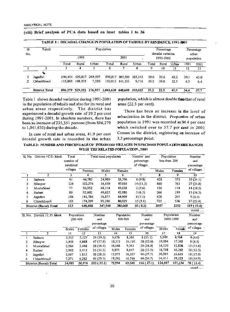
ANALYTICAL NOTE
(viii) Brief analysis of peA data based on inset tables 1 to 36
TABLE 1: DECADAL CHANGE IN POPULATION OFTAHSILS BYRESIDENCE, 1991-*1
SI. Tahsil Population Percentage Percentage No. decadal variation urban
1991 2001 1991-2001 population
Total Rural Urban Total Rural Urban Total Rural Urban 1991 2001 2 3 4 5 6 7 8 9 10 II 12 13
" Jaf1jldhri 690,414 420,817 269,597 890,817 507,505 383,312 29.0 20.6 42.2 39.1 43.0 2 Chhachhrauli 115,865 108,535 7,330 150,813 141,103 9,710 30.2. 30.0 32.5 6.3 6.4
District Total 806,279 529,352 276,927 1,041,630 648,608 393,022 29.2 22.5 41.9 34.4 37.7
Table 1 shows decadal variation during 1991-2001 in the population oftahsils and also for its rural and urban areas respectively. The district has experienced a decadal growth rate of29.2 per cent during 1991-2001. In absolute numbers, there has been an increase of235,351 persons (from 806,279 to 1,041,630) ~uringthe decade.
population, which is almost double than that of rural areas (22.5 per cent).
There has been an increase in the level of urbanization in the district. Proportion of urban population in 1991 was recorded as 34.4 per cent which switched over to 37.7 per cent in 2001
In case of rural and urban areas, 41.9 per cent Census in the district, registering an increase of decadal growth rate is recorded in the urban 3.3 percentage point.
TABLE2: NUMBER AND PERCENTAGE OF INHABITED VILLAGFS IN SPECIFIID POPULATION SIZERANGFS wrm TIlERELATIDPOPULATION,2001
Sl.No. District / C.D. block Total Total rural population Number and Population Number number of percentage less than 200 and inhabited of villages percentage villages Persons Males Females Males Femalc:s of villages .
2 3 4 5 6 7 8 9 10
Sadaura 61 46,785 24,989 21,796 6 (9.8) 428 373 19 (31.1) 2 Bilaspur 124 102,274 54,458 47,816 14 (11.3) 860 765 27 (21.8) 3 Mustafabad 77 90,952 48,314 42,638 2 (2.6) 150 114 14(18.2)
4 Radaur 80 92,602 49,622 42,980 5 (6.3) 266 199 13(16.3) 5 Jagadhri 106 141,786 76,877 64,909 8 (7.5) 428 265 9 (8.5)
6 Chhachhrauli 165 174,209 93,280 80,929 15 (9.1) 725 536 37 (22.4)
District (Rural) Total 613 648,608 347,540 301,068 50 (8.2) 2857 2252 119 (19.4) contd ......
SL No. District / C.D. block Population Number Population Number Population Number 200-499 and 500-999 and 1000-1999 and
percentage percentage . percentage
Males Females of villages Males Females of villages Males Female! of villages
2 II 12 13 14 15 16 17 18 19
Sadaura 3,513 3,127 24 (39.3) 9,676 8,365 8(13.1) 5,549 4,764 4 (6.6) 2 Bilaspur 5,456 4,868 47 (37.9) 18,312 16,110 28 (22.6) 19,894 17,302 8 (6.5)
3 Mustafabad 2,866 2,468 28 (36.4) 10,666 9,343 20 (26.0) 14,510 12,82& 12 (15.6) 4 Radaur 2,912 2,412 25 (31.3) 9,973 8,647 26 (32.5) 18,758 16,292 10 (12.5)
5 Jagadhri 2,067 1,813 30 (28.3) 12,075 10,337 40 (37.7) 30,985 26,615 18(17.0)
6 Chhachhrauli 7,271 6,282 49 (29.7) 19,292 16,746 44 (26.7) 34,411 29,323 18(10.9)
District (Rural) Total 24,085 20,970 203 (33.1) 79,994 69,548 166 (27.1) 124,107 107,124 70 ( 11.4) contd ......
35
DISTRICT CENSUS HANDBOOK: YAMUNANAGAR
TABLE 2: NUMBm AND PERCENTAGE OF INHABITFD VILLAGE<; IN SPECIFlFD POPULATION SlZERANGES WITH THE RELATED POPULA nON, 2001
Sl. No. District/C.D. block Population Number Popufation Number Population 2000-4999 and 5000-9999 and 10000 and above
percentage percentage
Males Females of villages Males Females of villages Males Females 2 20 21 22
Sadaura 5,823 5,167 0(0.0)
2 Bilaspur 9,936 8,771 0(0.0)
3 Mustafabad 17,268 15,366 i (1.3)
4 Radaur 14,468 12,548 I (1.3)
5 Jagadhri 27,621 23,246 1 (0.9)
6 Chhachhrauli 24,397 21,683 2 (1.2)
District (Rural) Total 99,513 86,781 5 (0.8)
Table 2 gives C.D. blockwise number and percentage of inhabited villages in specified population size ranges in the district. There are 50 villages in the district having less than 200 population. Maximum numberofvilJages 166 outof613 are in the population range 1000-1,999 and in this range maximum 44 out of 166 are covered under Chhachhrauli C.D. block
23 24 25 26 27 0(0.0) 0(0.0)
2,854 2,519 0(0.0) 3,245 2,882 0(0.0) 3,701 2,633 0(0.0) 7,184 6,359 0(0.0)
16,984 14,393 0(0.0)
with population 63,734. In the population range 5000-
9999, there are only 5 viHages. Out of these 5 villages,
2 villages are in Chhachhrauli CD block and one each
in Mustafabad, Radaur and Jagadhri CD blocks
respectively. There is no village in the district having population 10,000 and above.
TABLE3 : NEW TOWNS, DENOTIFIED, DECLASSIFlED AND MERGED TOWNS IN 2001 CFNSUS
Name of town (a) New
(i) Statutory town I. Nil
(ii) Census towns 1. Kansepur CT 2. Sasauli CT (b) Denotified (i) Statutory towns ofl991 censuS denotified and also did not satisfy the criteria to be treated as census towns 1. Jagadhri (Workshop Railway Colony) (ii) Statutory towns of 1991 census denotified but identified as census towns based on demographic and economic criteria
1. Nil (iii).G~nsus towns of 1991 census which are notified as statutory town in 2001 census
I.~il <~
(c) Dlfclassified
I. '''Nil (d) Wholly merged with other town(s)
1. Nil Declassified means the census tOmlS of 1991 census which failed to satisfy the demographic and economic criteria.
"'''<-If.,j.
Tabl~3 presents information about the new statutory! Cen~~s towns, denotified, declassified and.merged towns during 2001 Census. Kansepur and Sasauli have been treated as new Census towns and Jagadhri
36
Workshop Railway Colony M.C. which was set up on the revenue estate of Sasauli village has been denotified and Sasauli village has been treated as Census town in 2001 Census.
ANAL YTICA L NOTE
TABLE4 : DISTRIBUfIONOFVILLAGliN BY
POPULATION DENSITY, 2001
Ran~of Total Percentage Population Percentage
population number of oofvillages distribution
density villages in in each of
(per each population population
square population density
kilometer) density range range
2 3 4 5
0-10 'iii 6 1.0 141
11-20 4 0.7 132
21-50 8 1.3 783 0.1
51-100 14 2.3 2,281 0.4
101-200 38 6.2 17,742 2.7
201-300 93 15.2 62,568 9.6
301-500 243 39.6 251,681 38.8
501 + 207 33.8 313,280 48.3
Not known District Total 613 100.0 648,608 100.0
Population Density (Rural) ofthe district 414.5
Table 4 exhibits distribution of villages by density
of population ranges. Out of total 613 inhabited
villages, 6 villages fall in the 0-10 range of population
density. 243 villages fall in population density range
of30 1-500 and 207 villages have a high population
density range of 501 or more. It signifies that these
villages (30 1 and above density ranges) accommodate
more than three-fourth (87.1 per cent) rural population
of the district. On the other hand, 93 villages fall in the
population density range of201-300 having share of
only 9.6 per cent rural population. Rural density
(414.5) worked out in this table relates to inhabited
villages only hence it will not tally with the district rural density given in Summary Statement No.4 which is
worked out on the basis of total district area (supplied
by the Surveyor General ofIndia) minus urban area.
37
TABLES: SEX RATIO OF STATE
AND DISTRICT, 1901-2001 Census State District Ymunanagar
Year Total Rural Urban Total Rural Urban
2 3 4 5 6 7 1901 867 861 908 811 799 881 1911 835 834 842 762 749 847 1921 844 848 811 783 774 841 1931 844 851 792 789 786 802 1941 869 879 806 802 798 826 1951 871 877 845 841 853 800 1961 868 874 842 836 851 801 1971 867 870 853 848 852 837 1981 870 876 849 855 859 844 1991 865 864 868 883 884 880 2001 861 866 847 862 866 855
Table 5 gives us the information regarding sex ratio in the district and the State from 1901 to 2001. Sex ratio of the district always remained lower than the State for the period 1901 to 1981 and the same is true for rural areas also, but this trend reversed during 1991 and 2001 Censuses. There is a mixed trend in the variation of sex ratio of urban areas. It is less than th!:! State urban sex ratio during 1901 and1951 to 1981 Censuses & vice versa for the remaining Censuses.
TABLE6: SEX RATIO BYTAHSILS, 2001
SL No. Name Of Tahsil Sex ratio
Total Rural Urban 2 3 4 5
I Jagadhri 861 867 853 2 Chhachhrauli 870 865 941
District Total 862 866 855
Table 6 depicts the sex ratio by tahsils in the district
during 2001. The district has an overall sex ratio of
862 which is slightly more than that of the State (861).
Sex ratio in Jagadhri tahsil is 861, which is lower than
the Chhachhrauli tahsil (870) and even less than that
of the district sex ratio (862).
TABLE7: SEX RATIO BYCD BLOCKS, 2001
SI. No. Name of CD block Sex ratio
2 3
Sadaura 872
2 Bilaspur 878
3 Mustafabad 883
4 Radaur 866
5 Jagadhri 844
6 Chhachhrauli 868
District (Rural) Total 866
Table 7 explains the sex ratio by C.D. blocks in
the district. The rural sex ratio in the district is 866.
Among C.D. blocks, which essentially are the rural
units, the sex ratio shows considerable disparities. It
is the highest (883) in Mustafabad C.D. block and the
lowest (844) in Jagadhri C.D. block.
TABLE8 : SEX RATIO OF RURAL POPULATION BY RANGES, 2001
Range of Number Percentage Population Percentage
sex ratio of of villages 2001 distribution
for inhabited in each of
villages villages range population
2 3 4 5
Less than 700 20 3.3 5,848 0.9
700-749 15 2.4 18,494 2.9
750-799 43 7.0 34,503 5.3
800-849 127 20.7 131,283 20.2
850-899 214 34.9 268,551 41.4
900-949 128 20.9 150,881 23.3
950-999 48 7.8 33,126 5.1
1000-1099 17 2.8 5,876 0.9
1100+ 0.2 46
Districf'Totaf 613 100.0 648,608 100.0
Sex ratio (Rural) for District 866
38
DISTRICTCENSUS HANDBOOK: YAMUNANAGAR
Table.8 elaborates on the sex ratio of rural
population by ranges in 2001. 128 villages in the district
are having fairly high sex ratio in the range 900-949
females per thousand males. Sex ratio is below 750 in
35 villages. 18 villages in the district have more than
1000 sex ratio per thousand males but contain only 0.9
per cent of the total population.
TABLE9: SEX RATIO OF URBAN AGGLOMERATIONS I TOWNS, 2001
SI.No. NameofU.A./Town Urban Sex ratio status of
town
2 3 4
Sadaura MC 900
2 Bilaspur CT 886
3 Mustafabad CT 895
4 Radauf MC 902
5 Farakhpur CT 859
6 Kansepur CT 878
7 Buria MC 821
8 Yamunanagar UA 846
9 (a) Yamunanagar MCI 864
10 (b) J agadhri MCI 814
II (c) Sasauli CT 851
12 Chhachhrauli MC 941
Sex ratio (Urban) for the district 855
Table 9 depicts the sex ratio of urban agglomerations/towns in 2001. The district is having· an urbal) sex ratio of855 which is lower than the rural sex ratio (866) in the district. There are six statutory and five non-statutory towns in the district. The town wise breakup of sex ratio reveals that it is the highest in Chhachhrauli M.C.(94 I) and the lowest in Jagadhri M.CI. (814). The main reason of low sex ratio in Jagadhri M.Cl.(814) may be male selective immigration attracted by the industrial town.
ANAlYTICA L NOTE
TABLE 10: SEX RATI9 OF POPULATION IN THE AGE GROUP 0-6 FOR TAHSILS, 2001
SI. Name of T I Total population in 0-6 age Sex
No. Tahsil RI group ~------~--=-~U Persons Males Females for 0-6
ratio
age group
2 3 4 5 6 7 1 Jagadhri T 124,512 69,259 55,253 798
R 76,216 42,252 33,964 804 .. U 48,296 27,007 21,289 788 2 Chhachhrauli T 25,496 13,818 11,678 845
R 24,193 13,104 11,089 846
U 1,303 714 589 825 District Total T 150,008 83,077 66,931 806
R 100,409 55,356 45,053 814 U 49,599 27,721 21,878 789
Table 10 reveals child sex ratio in the age group 0-6 in the constituent tahsils. The district has a child sex ratio of806, which is significantly lower than the child sex ratio (819) in the State. As the general trend follows that rural sex ratio is higher than the urb~ the same is true for the district also. The rural child sex ratio (814) is higher than that of Urban (789). This pattern is also true for both the tahsils i.e. Jagadhri and Chhachbrauli.
TABLE 11 : SEX RATIO OF POPULATION IN TIIE AGE GROUP 0-6 FOR C.D. BWCKS, 200 1
SI.No. Name of Total population in 0-6 age Sex ratio
C.D. Block group for 0-6
Persons Males Females age group
2 3 4 5 6
Sad aura 7,385 4,055 3,330 821
2 Bilaspur 15,997 8,863 7,134 805
3 Mustafabad 12,864 7,180 5,684 792
4 Radaur 13,690 7,649 6,041 790
5 Jagadhri 21,583 11.928 9,655 809
6 Chhachhrauli 28,890 15,681 13,209 842
District (Rural) Total 100,409 55,356 45,053 814
39
Table 11 reports rural child population and
sex ratio in the age group 0-6 among C.D. blocks.
The child sex ratio (0-6) shows considerable. disparity.
It is the highest (842) in Chhachhrauli C.D. block and
the lowest (790) in Radaur C.D. block exhibiting a
gap of 52 points. Average figure for the rural part of
the district is 814.
TABLEI2: SEX RATIO OF RURAL POPULATION IN THEAGEGROUP 0-6 BYRANGES, 2001
Range of
sex ratio for villages
Number Percentage PopUlation Percentage
of distribution 2001 distribution inhabited of villages of villages popUlation
2 3 4 5 Less than 700 136 22.2 13,484 13.4 700-749 63 10.3 12,777 12.7 750-799 90 14.7 18,857 18.8 800-849 73 11.9 16,540 16.5 850-899 74 12.1 13,498 13.4 900-949 54 8.8 9,384 9.3 950-999 35 5.7 8,050 8.0 1000-1099 45 7.3 5,703 5.7 1100+ 43 7.0 2,116 2.1 District (Rural) Total 613 100.0 ,100,409 100.0
S ex ratio (Rural) for District 814
Table 12 depicts the sex ratio of rural population in the age group 0-6 by ranges. More than one-fifth (136 villages) villages have less than 700 sex ratio in the age group 0-6 yrs. which constitute 13.4 per cent
oftotal rural population of the district. 88 villages in the district have more than 1000 females per thou-sand males, whose share is 14.3 per cent of the total villages and 7.8 per cent of rural population. 147 villages out of 613 villages have child sex ratio 800-899. 24.0 per cent of the villages and 29.9 per cent of the rural popUlation of the district fall in this range.
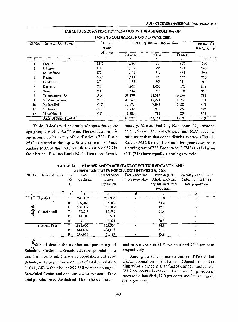
DISTRICT CENSUS HANDBOOK: YAMUNANAGAR
TABLE 13: SEX RATfO OF POPULATION IN THE AGE GROUP 0-6 OF
URBAN AGGWMERATIONS ITOWNS,2001
Sl.No. Name ofUA / Town Urban status
of town
2 3
Sadaura MC
2 Bilaspur CT
3 Mustafabad CT
4 Radaur MC
5 Farakhpur CT
6 Kansepur CT
7 Buria MC
8 Yamunanagar UA UA
9 (a) Yamunanagar Mel
10 (b) J ag;idhri MCI
11 (c) Sasauli CT
12 Chhachhrauli MC
District(Urban) Total
Table 13 deals with sex ratio of population in the
age group 0-6 of U .A.s/Towns. The sex ratio in this
age group in urban areas of the district is 789. Buria
M.C. is placed at the top with sex ratio of 852 and Radaur M.C. at the bottom with sex ratio of 726 in the district. Besides Buria M.C., five more towns,
Total population in 0-6 age group Sex ratio for 0-6 age group
Persons Males Females 4 5 6 7
1,590 911 679 745 1,397 799 598 748 1,101 615 486 790 1,514 877 637 726 1,166 655 511 780 1,902 1,050 852 811 1,456 786 670 852
38,170 21,314 16,856 791 23,663 13,271 10,392 783 12,775 7,087 5,688 803 1,732 956 776 812 1,303 714 589 825
49,599 27,72.1 21,878 789
namely, Mustafabad CT, Kansepur CT, Jagadhri
M.C!', Sasauli CT and Chhachhrauli M.C. have sex
ratio more than that of the district average (789). In Radaur M.C. the child sex ratio has gone down to an alarming rate of726. Sad aura M.C.(745) and Bilaspur
C.T. (748) have equally alarming sex ratio.
TABLE 14: NUMBER AND PERCmTAGEOF SCHIDULID CASTES AND
SCHEDULID TRmFS POPULATION IN TAHSILS, 2001 SJ. No. Name of Tahsil TI Total Total Scheduled
RI population Castes U population
2 3 4 5 Jagpdhri T 890,817 222,955
R 507,505 173,566
'a.- U 383,312 49,389
~ Chhachhrauli T 150,813 32,595 R 141,103 30,571
U 9,710 2,024
District Total T 1,041,630 255,550 R 648,608 204,137 U 393,022 51,413 .
~ .)bJe 14 detaiJs the number and percentage of
Scheduled Castes and Scheduled Tribes population in
tahsils of the district. There is no population notified as
Scheduled Tribes in the State. Out of total popUlation
(1,041,630) in the district 255,550 persons belong to
Scheduled Castes and constitute 24.5 per cent of the
total population of the district. Their share in rural
40
Total Scheduled Percentage of Percentage of Scheduled Tribes popUlation Scheduled ~astes Tribes population to
population to total total population population
6 7 8 25.0 34.2 12.9 21.6 21.7
20.8 24.5 31.5 13.1
and urban areas is 31.5,per cent and 13.1 per cent respectively.
Among the tahsils, concentration of Scheduled Castes popUlation in rural areas of Jagadhri tahsil is higher (34.2 per cent) than that ofChhachhrauli tahsil (21.7 per cent) whereas in urban areas·the position is reverse i.e Jagadhri (12.9 per cent) and Chhachhrauli (20.8 per cent).
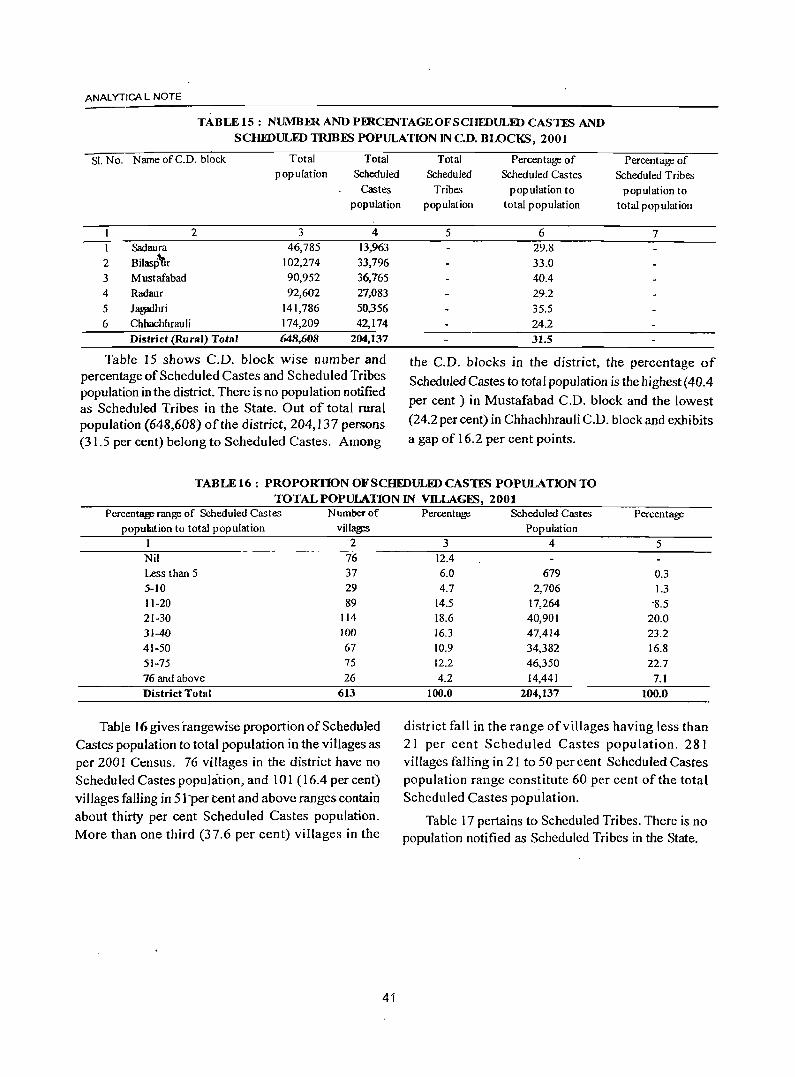
ANAL YTiCA L NOTE
TABLE1S: NUMBER AND PFRCENTAGEOFSCHEDULED CASTES AND SCHEDULED TRmES POPULATION IN cn. BWCKS, 2001
SI. No. NameofC.D. block
2 I Sadaura
2 Bilasp"nr 3 Mustafabad 4 Radaur
5 J~hri
6 Chbachhrauli
Total population
3 46,785
102,274 90,952 92,602
141,786 174,209
Total Scheduled
Castes population
4 13,963 33,796 36,765 27,083 50,356 42,174
District (Rural) Total 648,608 204,137
Table 15 shows C.D. block wise number and percentage of Scheduled Castes and Scheduled Tribes population in the district. There is no population notified as Scheduled Tribes in the State. Out of total rural population (648,608) of the district, 204,137 persons (31.5 per cent) belong to Scheduled Castes. Among
Total Scheduled
Tribes population
5
Percentage of Scheduled Castes
population to tota] population
6 29.8 33.0 40.4 29.2 35.5 24.2 31.5
Percentage of Scheduled Tribes
population to total population
7
the C.D. blocks in the district, the percentage of
Scheduled Castes to total population is the highest (40.4 per cent) in Mustafabad C.D. block and the lowest
(24.2 per cent) in Chhachhrauli C.D. block and exhibits
a gap of 16.2 per cent points.
TABLE 16: PROPORTION OF SCHEDULED CASTES POPULATION TO TOTAL POPULATION IN Vll..LAGES, 2001
Percentage range of Scheduled Castes Number of population to tota] population vill~
1 2 Nil 76 Less than 5 37 5-10 29 11-20 89 21-30 114 31-40 100 41-50 67 51-75 75 76 and above 26 District Total 613
Table 16 gives rangewise proportion of Scheduled Castes population to total population in the villages as per 200! Census. 76 villages in the district have no Scheduled Castes population, and 101 (16.4 per cent) vi Ilages falling in 5] 'per cent and above ranges contain about thirty per cent Scheduled Castes population. More than one third (37.6 per cent) villages in the
41
Percentage Scheduled Castes Percentage Population
3 4 5 12.4 6.0 679 0.3 4.7 2,706 1.3
14.5 17,264 '8.5 18.6 40,901 20.0 16.3 47,414 23.2 10.9 34,382 16.8 12.2 46,350 22.7 4.2 14,441 7.1
100.0 204,137 100.0
district fall in the range of villages having less than 21 per cent Scheduled Castes population. 281 villages falling in 21 to 50 per cent Scheduled Castes population range constitute 60 per cent of the total Scheduled Castes population.
Table 17 pertains to Scheduled Tribes. There is no population notified as Scheduled Tribes in the State.
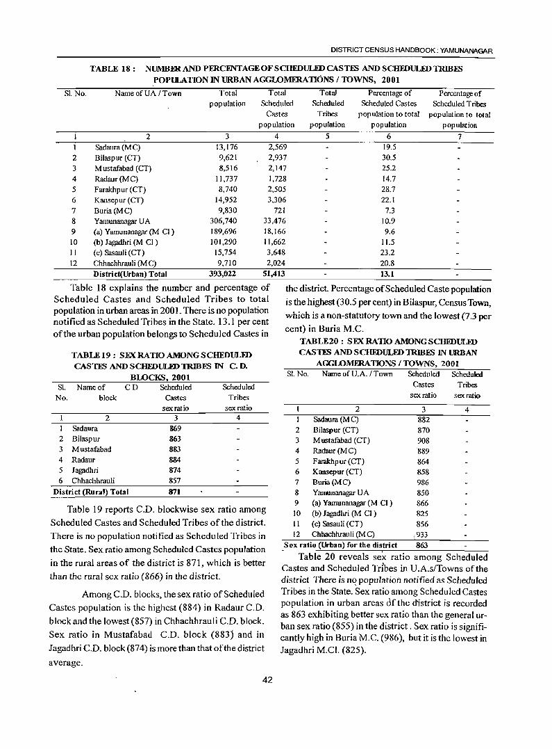
DISTRICT CENSUS HANDBOOK: YAMUNANAGAR
TABLE 18: NUMB1lRANDPERCINTAGEOFSCHFDULEDCASnS ANDSCHFDULEDTRIB:ES
POPULATION IN URBAN AGGLOMERATIONS / TOWNS, 2001
Sl. No. NameofUA/Town Total Total Total Percentage of Percentage of population Scheduled Scheduled Scheduled Castes Scheduled Tribes
Castes Tribes population to total population to total population population population population
2 3 4 5 6 7 I Sad aura (M C) 13,176 2,569 19.5
2 Bilaspur (CT) 9,621 2,937 30.5 3 Mustafabad (CT) 8,516 2,147 25.2
4 Radaur(MC) 11,737 1,728 14.7 5 Farakhpur (CT) 8,740 2,505 28.7 6 Kansepur (CT) 14,952 3,306 22.1 7 Buria(MC) 9,830 721 7.3 8 Yamunanagar UA 306,740 33,476 10.9 9 (a) Yamunanagar (M CI) 189,696 18,166 9.6 10 (b) Jagadhri (M CI) 101,290 11,662 11.5 II (c) Sasauli (CT) 15,754 3,648 23.2 12 Chhachhrauli (M C) 9,710 2,024 20.8
District(Urban) Total 393,022 51,413 13.1
Table 18 explains the number and percentage of Scheduled Castes and Scheduled Tribes to total population in urban areas in 2001. There is no population notified as Scheduled Tribes in the State. 13.1 per cent of the urban population belongs to Scheduled Castes in
TABLEJ9: SEXRATIOAMONGSCHEDULED
CASTES AND SCHIDULJiDTRIBES IN C. D.
BWCKS,2001 Sl. Name of CD Scheduled Scheduled
No. block Castes Tribes sex ratio sex ratio
2 3 4 I Sadaura 869 2 Bilaspur 863 3 Mustafabad 883 4 Radaur 884
5 Jagpdhri 874 6 Chhachhrauli &57
District (Rural) Total 871
Table 19 reports C.O. blockwise sex ratio among
Scheduled Castes and Scheduled Tribes of the district.
There is no population notified as Scheduled Tribes in
the State. Sex ratio among Scheduled Castes population
in the rural areas of the district is 871, which is better
than the rural sex ratio (866) in the district.
Among C.O. blocks, the sex ratio of Scheduled
Castes population is the highest (884) in Radaur C.D.
block and the lowest (857) in Chhachhrauli C.D. block.
Sex ratio in Mustafabad C.O. block (883j and in
Iagadhri C.O. block (874) is more than that ofthe district
average.
42
the district. Percentage of Scheduled Caste population
is the highest (30.5 per cent) in Bilaspur, Census Town,
which is a non-statutory town and the lowest (7.3 per
cent) in Buria M.C. TABLE20: SEXRATIOAMONGSCIDDULID
CASUS AND SCHEDULFl> TRIBES IN URBAN AGGWMERATIONS I TOWNS, 2001
SI. No. Name ofU.A. I Town Scheduled Scheduled Castes Tribes
sex ratio sex ratio
2 3 4 1 Sadaura (M C) 882 2 Bilaspur (CT) 870 3 M ustafabad (CT) 908 4 Radaur(MC) '889 5 Farakhpur (CT) 864 6 Kansepur (CT) 858 7 Buria(MC) 986 8 Yamunanagar UA 850 9 (a) Yamunanagar (M CI) 866 10 (b) Jagadhri (M CI ) 825 II (c) Sasauli (CT) 856 12 Chhachhrau Ii (M C) 1933
Sex ratio (Urban) for the district 863
Table 20 reveals sex ratio among Scheduled Castes and Scheduled Tri'bes in U.A.s/Towns of the district There is n~ population notified as Scheduled Tribes in the State. Sex ratio among Scheduled Castes population in urban areas Of the district is recorded as 863 exhibiting better sex ratio than the general urban sex ratio (855) in the district. Sex ratio is significantly high in Buria M.C. (986), but it is the lowest in Iagadhri M.C!' (825).
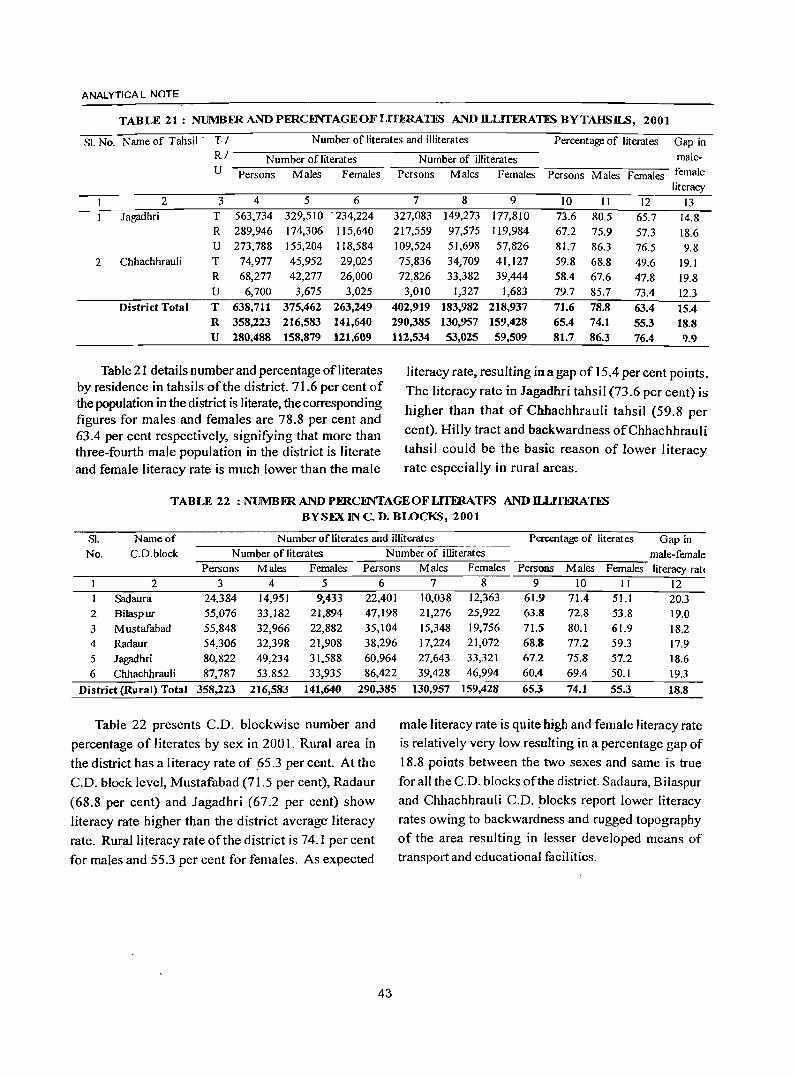
ANALYTICA L NOTE
TABLE 21: NUMBmANDPERCIiNTAGEOFLITERATIS ANDD...LITERATES BYTAHSILS, 2001
SI. No. Name of Tahsil . TI Number of literates and illiterates Percentage of literates Gap in RI Number ofliterates Number of illiterates male-U Persons Males Females Persons Males Females Persons Males Females female
literacy 2 3 4 5 6 7 8 9 10 11 12 13
Jagadhri T 563,734 329,510 ·234,224 327,083 149,273 177,810 73.6 80.5 65.7 14.8 R 289,946 174,306 115,640 217,559 97,575 119,984 67.2 75.9 57.3 18.6 U 273,788 155,204 118,584 109,524 51,698 57,826 81.7 86.3 76.5 9.8
2 Chhachhrauli T 74,977 45,952 29,025 75,836 34,709 41,127 59.8 68.8 49.6 19.1 R 68,277 42,277 26,000 72,826 33,382 39,444 58.4 67.6 47.8 19.8 U 6,700 3,675 3,025 3,010 1,327 1,683 79.7 85.7 73.4 12.3
District Total T 638,711 375,462 263,249 402,919 183,982 218,937 71.6 78.8 63.4 15.4 R 358,223 216,583 141,640 290,385 130,957 159,428 65.4 74.1 55.3 18.8 U 280,488 158,879 121,609 112,534 53,025 59,509 81.7 86.3 76.4 9.9
Table 21 details number and percentage ofiiterates literacy rate, resulting in a gap of I 5.4 per cent points. by residence in tahsils of the district. 71.6 per cent of The literacy rate in Iagadhri tahsil (73.6 per cent) is the population in the district is literate, the corresponding
higher than that of Chhachhrauli tahsil (59.8 per figures for males and females are 78.8 per cent and 63.4 per cent respectively, signifying that more than cent). Hilly tract and backwardness ofChhachhrauli
three-fourth male population in the district is literate tahsil could be the basic reason of lower literacy
and female literacy rate is much lower than the male rate especially in rural areas.
TABLE 22 : NUMBERANDPmCFNTAGEOFLITmAnS ANDILLlTERATIS BYSEX IN C. D. BWCKS, 2001
SI. Name of Number of literates and illiterates Pcn:entage of literates Gap in No. C.D.block N umber of literates Number of illiterates male-female
Persons Males Females Persons Males Females Persons Males Females literacy rate 2 3 4 5 6
Sadaura 24,384 14,951 9,433 22,401
2 Bilaspur 55,076 33,182 21,894 47,198
3 Mustafabad 55,848 32,966 22,882 35,104 4 Radaur 54,306 32,398 21,908 38,296
5 Jagadhri 80,822 49,234 31,588 60,964
6 Chhachhrauli 87,787 53,852 33,935 86,422
District (Rural) Total 358,223 216,583 141,640 290,385
Table 22 presents C.D. blockwise number and
percentage of literates by sex in 2001. Rural area in
the district has a I iteracy rate of !is.3 per cent. At the
C.D. block level, Mustafabad (71.5 per cent), Radaur
(68.8 per cent) and Jagadhri (67.2 per cent) show
literacy rate higher than the district average' literacy
rate. Rural literacy rate of the district is 74.1 per cent
for males and 55.3 per cent for females. As expected
43
7 8 9 10 11 12 10,038 12,363 61.9 71.4 51.1 20.3 21,276 25,922 63.8 72.8 53.8 19.0 15,348 19,756 71.5 80.1 61.9 18.2 17,224 21,072 68.8 77.2 59.3 17.9 27,643 33,321 67.2 75.8 57.2 18.6 39,428 46,994 60.4 69.4 50.1 19.3
130,957 159,428 65.3 74.1 55.3 18.8
male literacy rate is quite high and female literacy rate
is relatively very low resulting in a percentage gap of
18.8 points between the two sexes and same is true
for all the C.D. blocks of the district. Sadaura, Bilaspur
and Chhachhrauli C.D. blocks report lower literacy
rates owing to backwardness and rugged topography
of the area resulting in lesser developed means of
transport and educational facilities.
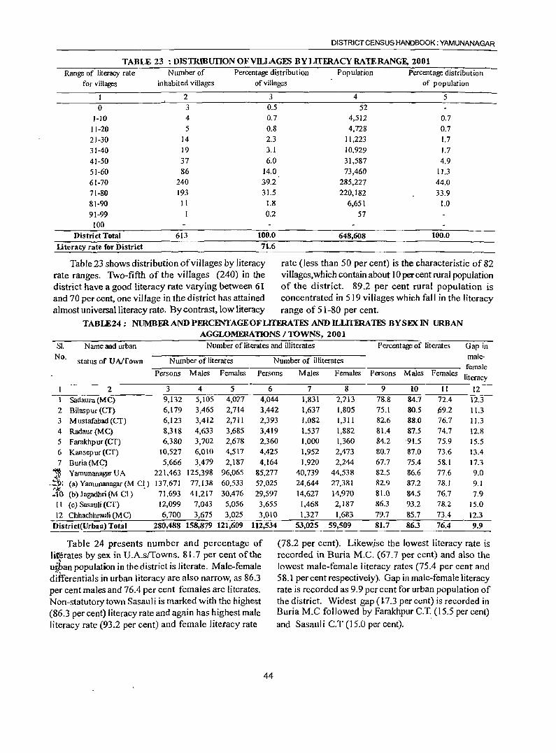
DISTRICT CENSUS HANDBOOK: YAMUNANAGAR
TABLE 23 :DISTRIBUfIONOFYILLAGES BY LlTFRACY RATE RANGE, 2001
Range of literacy rate Number of Percentage distribution Population Percentage distribution
for villages inhabited villages of villages of population
1 2 3 4 5
0 3 0.5 52
1-10 4 0.7 4,512 0.7
11-20 5 0.8 4,728 0.7
21-30 14 2.3 11,223 1.7
31-40 19 3.1 10,929 1.7
41-50 37 6.0 31,587 4.9
51-60 86 14.0 73,460 11.3
61-70 240 39.2 285,227 44.0
71-80 193 31.5 220,182 33.9 81-90 11 1.8 6,651 1.0
91-99 0.2 57 100
District Total 613 100.0 648,608 100.0
literacy rate for District 71.6
Table 23 shows distribution of villages by literacy rate (less than 50 per cent) is the characteristic of 82 rate ranges. Two-fifth of the villages (240) in the villages, which contain about 10 percent rural population district have a good literacy rate varying between 61 of the district. 89.2 per cent rural population is and 70 per cent, one village in the district has attained concentrated in 519 villages which fall in the literacy almost universal literacy rate. By contrast, low literacy range of 51-80 per cent.
TABLE24: NUMBFRANDPmCI!NTAGEOFLITFRATES ANDILLrnRATES BYSEXIN URBAN AGGLOMERATIONS / TOWNS, 2001
SI. Name and urban Number of literates and illiterates Percentage of literates Gap in
No. status of UA/Town Number of literates Number of illiterates male-
female Persons Males Females Persons Males Females Persons Males Females
literacy
2 3 4 5 6 7 8 9 10 11 12 1 Sadaura (M C) 9,132 5,105 4,027 4,044 1,831 2,213 78.8 84.7 72.4 12.3 2 Bilaspur (Cf) 6,179 3,465 2,714 3,442 1,637 1,80S 7S.1 80.5 ~9.2 11.3 3 Mustafabad (CT) 6,123 3,412 2,711 2,393 1,082 1,311 82.6 88.0 76.7 11.3
4 Radaur(MC) 8,318 4,633 3,68S 3,419 1,537 1,882 81.4 87.5 74.7 12.8
5 Farakhpur (Cf) 6,380 3,702 2,678 2,360 1,000 1,360 84.2 '91.5 75.9 15.5
6 Kansepur (Cf) 10,527 6,010 4,517 4,425 1,952 2,473 80.7 87.0 73.6 13.4
7 Buria(MC) 5,666 3,479 2,187 4,164 1,920 2,244 67.7 75.4 58.1 17.3
~ Yamunan~UA 221,463 125,398 96,065 85,277 40,739 44,538 82.5 86.6 77.6 9.0 .;"
-~~ (a) Yamuoanagar (M CI.) 137,671 77,138 60,533 52,025 24,644 27,381 82.9 87.2 78.1 9.1 ex 410 (b) Jagadhri (M CI) 71,693 41,217 30,476 29,597 14,627 14,970 81.0 84.5 76.7 7.9
II (c) Sasauli (Cf) 12,099 7,043 5,056 3,655 1,468 2,187 86.3 93.2 78.2 15.0 12 Chhachhrauli (Me) 6,700 3,675 3,025 3,010 1,327 1,683 79.7 8S.7 73.4 12.3
District(UrbalJ) Total 280,488 158,879 121,609 112,534 53,025 59,509 81.7 86.3 76.4 9.9
Table 24 presents number and percentage of literates by sex in U.A.slTowns. 81.7 per cent of the , upan popUlation in the district is literate. Male-female differentials in urban literacy are also narrow, as 86.3 per cent males and 76.4 per cent females are literates. Non-statutory town Sasauli is marked with the highest (86.3 per cent) literacy rate and again has highest male literacy rate (93.2 per cent) and female litetacy rate
(78.2 per cent). Likewjse the lowest literacy rate is recorded in Buria M.C. (67.7 per cent) and also the lowest male-female literacy rates (75.4 per cent and 58.1 per cent respectively). Gap in male-female literacy rate is recorded as 9.9 per cent for urban population of the district. Widest gap en.3 percent) is recorded in Buria M.C followed by Farakhpur C.T .. (15.5 per cent) and Sasauli C.T (15.0 per cent).
44
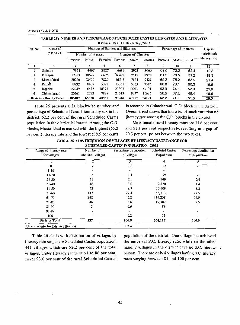
ANAL YTICA L NOTE
TABLE 25: NUMBDlAND PERCENTAGE OF SCHEDULED CASTES LITERATES AND ILLITERAlNl BYSEX IN C.D. BLOCKS,200t
S!. No. Name of Number ofliterates and illiterates Percentage of literates Gap in C.D.block Number of literates Number of illiterates male/female
Persons Males Females Persons Males Females Persons Males Females literacy rate
2 3 4 5 6 7 8 9 10 II 12 Sadaura 7324 4497 2827 6639 2973 3666 63.0 72.2 52.4 19.8
2 Bilaspur 17303 10627 6676 '16493 7515 8978 61.5 70.5 51.2 19.3 3 Mustafabad 20220 12400 7820 16545 7124 9421 65.2 75.2 53.9 21.4 4 Rada?fto 13732 8409 5323 13351 5965 7386 60.8 70.1 50.3 19.8 5 Jag;ldhri 21049 16672 10377 23307 10203 13104 63.9 74.1 52.3 21.9 6 Chhachhrauli 20561 12733 7828 21613 9977 1I636 58.5 67.2 48.4 18.8
District (Rural) Total 106189 65338 40851 97948 43757 54191 62.2 71.6 51.3 20.3
Table 25 presents C.D. blockwise number and is recorded in Chhachhrauli C.D. block in the district.
percentage of Scheduled Caste literates by sex in the Overall trend shows that there is not much variation of district. 62.2 per cent of the rural Scheduled Castes literacy rate among the C.D. blocks in the district. population in the district is literate. Among the C.D. Male-female rural literacy rates are 71.6 per cent blocks, Mustafabad is marked with the highest (65.2 and 51.3 per cent respectively, resulting in a gap of
per cent) literacy rate and the lowest (58.5 per cent) 20.3 per cent points between the two sexes.
TABLE 2(t : DIS~unON OF VILLAGES BYLHERACYRAlERANGEFOR SCHEDULED CASTES POPULATION, 2001
Range of literacy rate for villages
Number of
inhabited villages
Percentage distribution
of villages Scheduled Castes Percentage distribution
Population of popUlation
o 1-10 11-20 21-30 31-40 41-50 51-60 61-70 71-80 81-90 91-99
100 Distric~ Total
literacy rate for District (Rural)
2 7
6 11 16 52
147 248 46
3
537
Table 26 deals with distribution of villages by
literacy rate ranges for Scheduled Castes population.
441 villages which 'are 82:2 per cent of the total
vi 11ages, under I iteracy range of 51 to 80 per cent,
cover 93.0 per cent of the rural Scheduled Castes
45
3 1.3
l.l
2.0 3.0 9.7
27.4 46.2
8.6 0.6
0.2 100.0
62.2
4 22
79 749
2,820 10,609 56,113
114,258 19,387
89
11 204,137
5
0.4 1.4 5.2
27.5 56.0
9.5
100.0
population of the district. One village has achieved
the universal S.C. literacy rate, while on the other
hand, 7 villages in the district have no. S.C ... literate
person. There are only 4 villages having S.C, literacy
rates varying between 81 and 100 per cent.
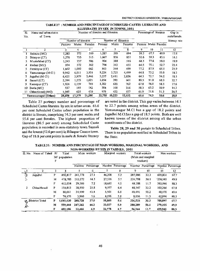
DISTRICT CENSUS HANDBOOK: YAMUNANAGAR
TABLE27 : NUMBERANDPERCENTAGEOFSC~ULIDCASTFS LITERATFS AND ILLITERATES BYSEX INTOWNS,2001
Sl. Name and urban status Number of literates and illiterates Percentage of literates Gap in No. of Town male/female
. Number of literates Number of illiterates lit eracy rat e Persons Males Females Persons Males Females Persons Males Females
1 2 3 4 5 6 7 8 9 10 11 12 I Sad aura (M C) 1,282 772 510 1,287 593 694 59.3 67.7 49.9 17.8
2 Bilaspur (CT) 1,270 755 515· 1,667 816 851 52.6 59.3 45.1 14.1 3 M ustafabad (CT) 1,243 737 506 904 388 516 68.3 77.8 58.0 19.9
4 Radaur(MC) 934 572 362 794 343 451 64.5 75.1 52.7 22.4
5 Farakhpur (CT) 1,662 1,000 662 843 344 499 77.2 87.5 65.5 21.9
6 Yamunanagar (M CI) 9,942 6,011 3,931 8,224 3,725 4,499 64.8 73.2 55.0 18.2 7 Jagadhri (M Cl) 6,425 3,979 2,446 5,237 2,411 2,826 64.3 72.7 54.2 18.5 8 Sasauli (CT) 2,594 1,573 1,021 1,054 393 661 80.5 91.0 68.3 22.7
9 Kansepur (CT) 1,924 1,159 765 1,382 620 762 67.8 76.0 58.3 17.6 10 Buria(MC) 337 195 142 384 168 216 58.3 65.2 50.9 14.3 11 Chhachhrauli (M C) 1,045 625 420 979 422 557 61.9 71.8 51.3 20.5
Yamunanagar (Urban) 28,658 17,378 11,280 22,755 10,223 12,532 65.6 74.3 55.6 18.8
Table 27 portrays number and percentage of Scheduled Castes literates by sex in urban areas. 65.6 per cent Scheduled Castes urban population in the district is literate, comprising 74.3 per cent males and 55.6 per cent females. The highest proportion of literates (80.5 per cent) among Scheduled Caste population is recorded in non-statutory town Sasauli and the lowest (52.6 per cent) in Bilaspur Census town. Gap of 18.8 per cent points in male & female literacy
are noted in the district. This gap varies between 14.1 to 22.7 points among urban areas of the district. Yamunanagar M.Cl has a gap of 18.2 points and Jagadhri M.C!. has a gap of 18.5 points. Both are well known towns of the district among all the urban constituents of the district.
Table 28,29 and 30 pertain to Scheduled Tribes. There is no popUlation notified as Scheduled Tribes in the State.
TABLE31: NUMBFRANDPFRCENTAGEOFMAlNWORKFRS,MARGINAL WORKERS, AND
NON-WORKERS BYSEX IN TAHSILS, 2001 S)' No. Name of Tahsil PI Total Main workers Marginal workers Total workers Non workers
MI population (M ain and marginal F workers)
Number Percentage Number Percentage Number Percentage N~mber Percentage
•• .1 2 3 4 5 6 7 8 9 10 11 12 i) Jal?jl.dhri P ,., 890,817 241,778 27.1 46,208 5.2 287,986 32.3 602,831 67.7 ..
M 478,783 212,272 44.3 27,526 5.7 239,798 50.t '238,985 49.9 ,.' F 412,034 29.506 7.2 18,682 4.5 48,188 11.7 363,846 88.3
2 Chhachhrauli P 150,813 38,950 25.8 9,597 6.4 48,547 32.2 102,266 67.8
M 80,661 34,990 43.4 5,501 6.8 40,491 50.2 40,170 4,9.8
F 70,152 3,960 5.6 4,096 5.8 8,056 11.5 62,096 88.5
,~.District Total P 1,041,630 280,728 27.0 55,805 5.4 336,533 32.3 705,097 67.7 .' M 559,444 247,262 44.2 33,027 5.9 280,289 50.1 279,155 49.9 ):$-
F 482,186 33,466 6.9 22,778 4.7 ,56,244 f1.7 425,942 88.3
46
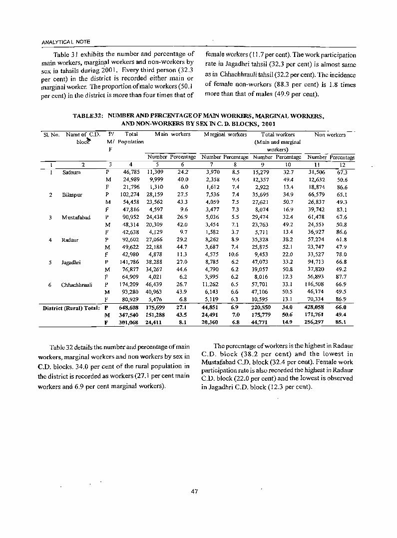
ANAL YTICA l NOTE
Table 31 exhibits the number and percentage of female workers (11.7 per cent). The work partic ipation main workers, margin~1 workers and non-workers by rate in Jagadhri tahsil (32.3 per cent) is almost same sex in tahsils during 2001. Every third person (32.3
as in Chhachhrauli tahsil (32.2 per cent). The incidence per cent) in the district is recorded either main or marginal worker. The proportion of male workers (50.1 of female non-workers (88.3 per cent) is 1.8 times
per cent) in the district is more than four times that of more than that of males (49.9 per cent).
TABLE32: NUMBER AND PERCENTAGE OF MAIN WORKERS, MARGINAL WORKERS, AND NON-WORKERS BY SEX IN C. D. BLOCKS, 2001
SI.No. Name of C.D. PI Total Main workers Marginal workers Total workers Non workers bloclt MI Population (M ain and marginal
F workers) Number Percentage Number Percentage Number Percentage Number Percentage
2 3 4 5 6 7 8 9 10 II 12 Sadaura P 46,785 11,309 24.2 3,970 8.5 15,279 32.7 31,506 67.3
M 24,989 9,999 40.0 2,358 9.4 12,357 49.4 12,632 50.6 F 21,796 1,310 6.0 1,612 7.4 2,922 13.4 18,874 86.6
2 Bilaspur P 102,274 28,159 27.5 7,536 7.4 35,695 34.9 66,579 65.1 M 54,458 23,562 43.3 4,059 7.5 27,621 50.7 26,837 49.3 F 47,816 4,597 9.6 3,477 7.3 8,074 16.9 39,742 83.1
3 Mustafabad P 90,952 24,438 26.9 5,036 5.5 29,474 32.4 61,478 67.6 M 48,314 20,309 42.0 3,454 7.1 23,763 49.2 24,55] 50.8 F 42,638 4,129 9.7 1,582 3.7 5,711 13.4 36,927 86.6
4 Radaur P 92,602 27,066 29.2 8,262 8.9 35,328 38.2 57,274 61.8
M 49,622 22,188 44.7 3,687 7.4 25,875 52.1 23,747 47.9 F 42,980 4,878 11.3 4,575 10.6 9,453 22.0 33,527 78.0
5 Jagadhri P 141,786 38,288 27.0 8,785 6.2 47,073 33.2 94,713 66.8
M 76,877 34,267 44.6 4,790 6.2 39,057 50.8 37,820 49.2 F 64,909 4,021 6.2 3,995 6.2 8,016 12.3 56,893 87.7
6 Chhachhrauli P 174,209 46,439 26.7 11,262 6.5 57,701 33.1 116,508 66.9
M 93,280 40,963 43.9 6,143 6.6 47,106 50.5 46,174 49.5
F 80,929 5,476 6.8 5,119 6.3 10,595 13.1 70,334 86.9
District (Rural) Total: P 648,608 175,699 27.1 44,851 6.9 220,550 34.0 428,058 66.0
M 347,540 151,288 43.5 24,491 7.0 175,779 50.6 171,761 49.4
F 301,068 24,411 8.1 20,360 6.8 44,771 14.9 256,297 85.1
Table 32 details the number and percentage of main The percentage of workers is the highest in Radaur
workers, marginal workers and non workers by sex in C.D. block (38.2 per cent) and the lowest in
C.D. blocks. 34.0 per cent of the rural population in Mustafabad C.D. block (32.4 per cent). Female work participation rate is also recorded the highest in Radaur
the district is recorded as workers (27.1 per cent main C.D. block (22.0 per cent) and the lowest is observed workers and 6.9 per cent marginal workers). in Jagadhri C.D. block (12.3 per cent).
47
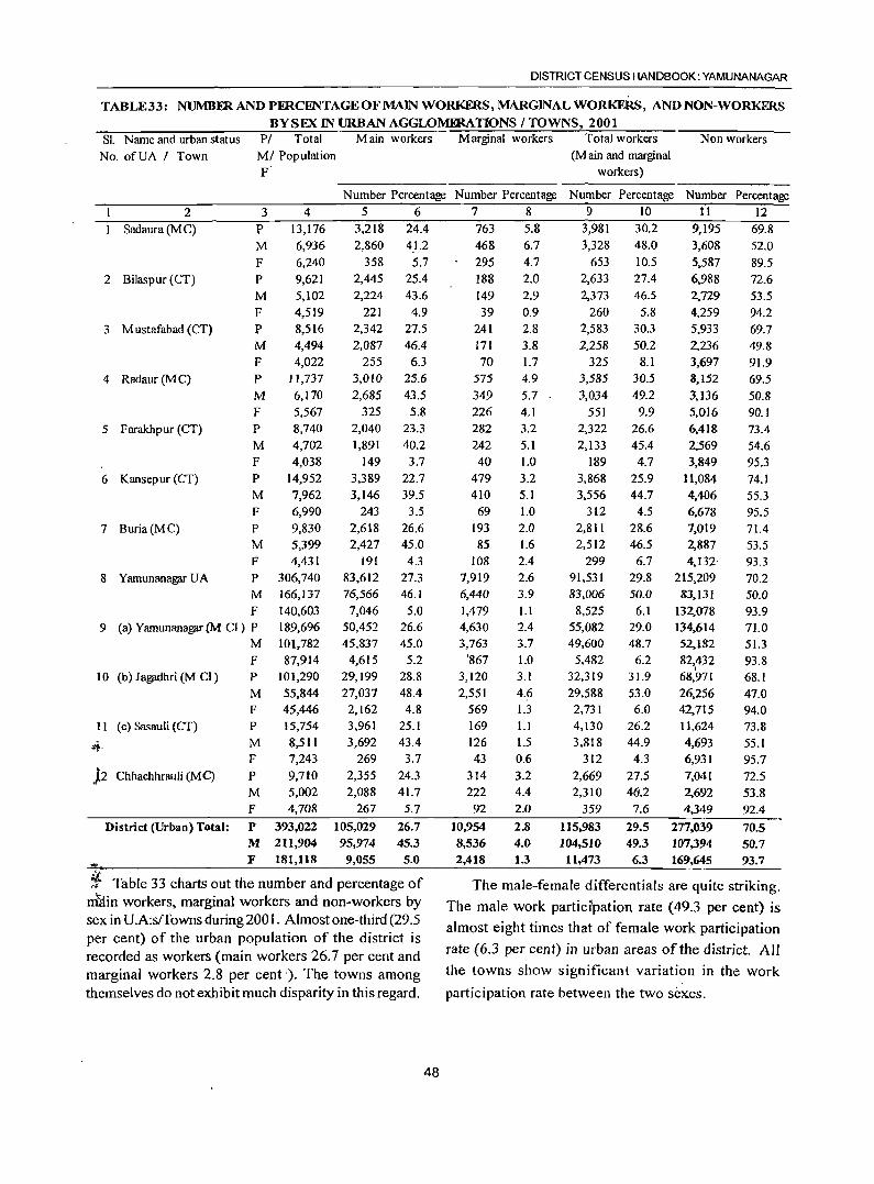
DISTRICT CENSUS HANDBOOK: YAMUNANAGAR
TABLE33: NUMBFR AND PERCENTAGE OF MAIN WORKERS, MARGINAL WORKERS, AND NON-WORKERS
BYSEXINURBAN AGGLOMERATIONS I TOWNS, 2001 SL Name and urban status PI Total Main workers Marginal workers Total workers Non workers
No. ofUA I Town MI Population (Main and marginal F workers)
2
Sadaura (M C)
2 Bilaspur (CT)
3 M ustafabad (CT)
4 Radaur (M C)
5 Farakhpur (CT)
6 Kansepur (CT)
7 Buria(MC)
3 P
M F P M
F P M F
4 13,176 6,936 6,240 9,621 5,102 4,519 8,516 4,494 4,022
P 11,737
M 6,170 F 5,567 P 8,740 M 4,702 F 4,038 P 14,952 M 7,962 F 6,990 P 9,830 M 5,399 F
8 Yamunanagar UA P
4,431 306,740 166,137 140,603 189,696 101,782
M F
9 (a) Yamunanagar (M CI) P
M F 87,914
101,290 55,844 45,446
10 (b) Jagadhri (M CI) P
11 (c) Sasauli (CT)
~.
)2 Chhachhrauli (M C)
District (Urban) Total:
M F P 15,754 M 8,511 F 7,243 P 9,710 M 5,002 F 4,708
P 393,022 M 211,904 F 181,118
Number Percentage Number Percentage Number Percentage Number Percentage
5 6 7 8 9 10 11 12 3,218 24.4 763 5.8 3,981 30.2 9.195 69.8 2,860 41.2 468 6.7 3,328 48.0 3,608 52.0
358 5.7 295 4.7 653 10.5 5,587 89.5 2,445 25.4 188 2.0 2,633 27.4 6,988 72.6 2,224 43.6 149 2.9 2,373 46.5 2,729 53.5
221 4.9 39 0.9 260 5.8 4,259 94.2 2,342 27.5 241 2.8 2,583 30.3 5,933 69.7 2,087 46.4 171 3.8 2,258 50.2 2,236 49.8
255 6.3 70 1.7 325 8.1 3,697 91.9 3,010 25.6
2,685 43.5 325 5.8
2,040 23.3 1,891 40.2
149 3.7 3,389 22.7 3,146 39.5
243 3.5 2,618 26.6 2,427 45.0
191 83,612 76,566 7,046
50,452 45,837
4,615 29,199 27,037 2,162 3,961 3,692
269 2,355 2,088
267
105,029 95,974
9,055
4.3 27.3 46.1
5.0 26.6 45.0
5.2 28.8 48.4 4.8
25.1 43.4
3.7 24.3 41.7
5.7
26.7 45.3
5.0
575 349 226 282 242
40 479 410
69 193 85
108 7,919 6,440 1,479 4,630 3,763
'867 3,120 2,551
569 169 126 43
314 222
92
10,954 8,536 2,418
4.9
5.7 4.1 3.2 5.1 1.0 3.2 5.1 1.0 2.0 1.6 2.4
2.6 3.9 l.l 2.4 3.7 1.0 3.1 4.6 1.3 1.1 1.5 0.6 3.2 4.4 2.0
2.8 4.0
1.3
3,585 30.5
3,034 49.2 551 9.9
2,322 26.6 2,133 45.4
189 4.7 3,868 25.9 3,556 44.7
312 4.5 2,81 I 28.6 2,512 46.5
299 91,531 83,006
8,525 55,082 49,600
5,482 32,319 29,588 2,731 4,130 3,818
312 2,669 2,310
359
115,983 104,510
11,473
6.7 29.8 50.0
6.1 29.0 48.7
6.2 31.9 53.0 6.0
26.2 44.9
4.3 27.5 48.2
7.6
29.5 49.3 6.3
8,152
3,136 5,016 6,418 2,569 3,849
11,084 4,406 6,678 7,019 2,887 4,132
215,209 83,131
132,078 134,614 52,1.82 82,432
I 68,971 26,256 42,715 11,624 4,693 6,931 7,041 2,692 4,349
277,039 107,394 169,645
69.5 50.8 90.1 73.4 54.6 95.3 74.1 55.3 95.5 71.4 53.5 93.3 70.2 50.0 93.9 71.0 51.3
93.8 68.1 47.0 94.0 73.8 55.1
95.7 72.5 53.8 92.4
70.5 50.7 93.7
it ~;; Table 33 charts out the number and percentage of The male-female differentials are quite striking. ntiin workers, marginal workers and non-workers by sex in U.A:s/Towns during 200 L Almost one-third (29.5 per cent) of the urban population of the district is recorded as workers (main workers 26.7 per cent and marginal workers 2.8 per cent). The towns among themselves do not exhibit much disparity in this regard.
48
The male work particrpation rate (49.3 per cent) is
almost eight times that of female work participation
rate (6.3 per cent) in urban areas of the district. All
the towns show significant variation in the work
participation rate between the two sexes.
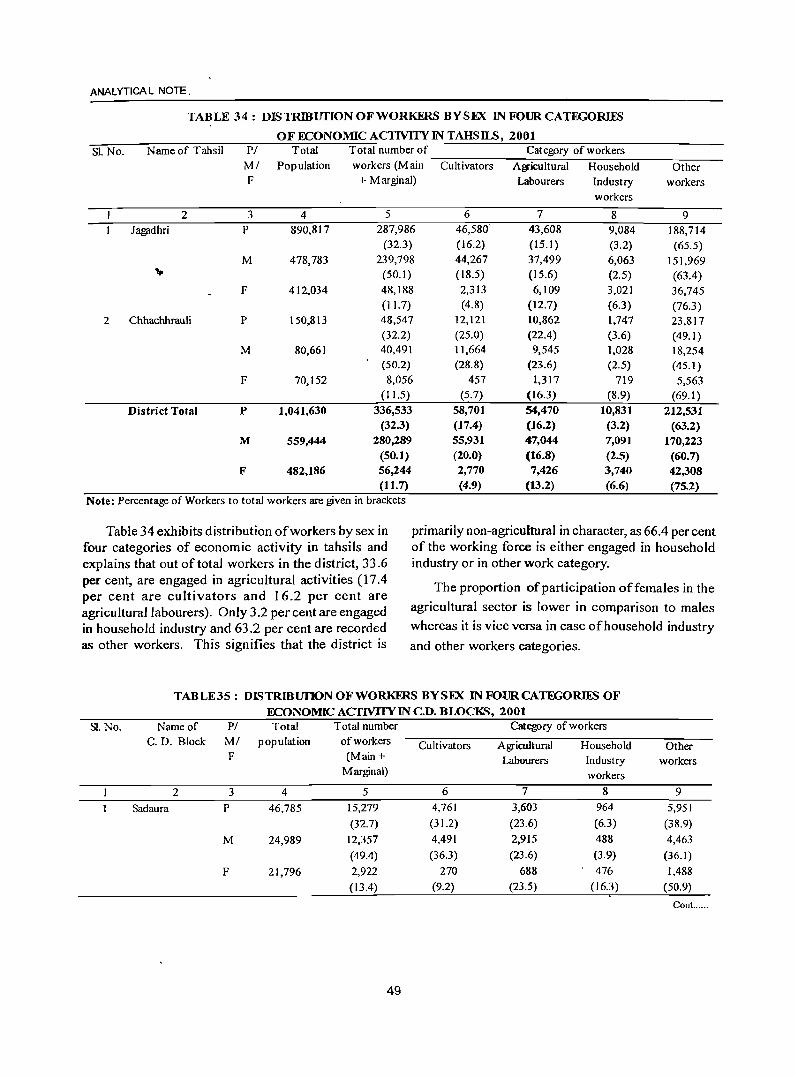
ANALYTICA L NOTE.
SI. No.
TABLE 34: DISTRIBUTION OF WORKERS BYSEX INFOURCATEGORIES
OF ECONOMIC ACTIVITY IN TAHSILS, 2001 Name of Tahsil PI Total Total number of Category of workers
2 Ja~dhri
MI Population workers (Main Cultivators Ag,icultural Household F + Marginal) Labourers Industry
3 4 P 890,817
M 478,783
F 412,034
5 ;287,986
(32.3)
6 46,580'
(16.2) 44,267 (18.5)
7 43,608 (15.1) 37,499 (15.6)
workers
8
2 Chhachhrauli P 150,813
239,798 (50.1) 48,188 (II. 7) 48,547 (32.2) 40,491 (50.2)
2,313 (4.8)
12,121 (25.0) 11,664 (28.8)
6,109 (12.7) 10,862 (22.4)
9,084 (3.2) 6,063 (2.5) 3,021
(6.3) 1,747 (3.6) 1,028 (2.5)
M
F
District Total p
M
F
80,661
70,152
1,041,630
559,444
482,186
8,056 (11.5)
336,533 (32.3)
280,289 (50.1) 56,244 (11.7)
Note: Percentage of Workers to total workers are given in brackets
457 (5.7)
58,701 (17.4) 55,931 (20.0) 2,770 (4.9)
9,545 (23.6)
1,317 (16.3) 54,470 (16.2) 47,044 (16.8) 7,426
(13.2)
719 (8.9)
10,831 (3.2) 7,091 (2.5) 3,740 (6.6)
Other workers
9 188,714 (65.5)
151,969 (63.4) 36,745 (76.3) 23,817 (49.1 ) 18,254 (45.1 ) 5,563
(69.1 ) 212,531
(63.2) 170,223
(60.7) 42,308 (75.2)
Table 34 exhibits distribution of workers by sex in four categories of economic activity in tahsils and explains that out of total workers in the district, 33.6 per cent, are engaged in agricultural activities (17.4 per cent are cultivators and 16.2 per cent are agricultural labourers). Only 3.2 per cent are engaged in household industry and 63.2 per cent are recorded as other workers. This signifies that the district is
primarily non-agricultural in character, as 66.4 per cent of the working force is either engaged in household industry or in other work category.
Sl. No.
The proportion of participation of females in the
agricultural sector is lower in comparison to males
whereas it is vice versa in case of household industry
and other workers categories.
TABLE35: DISTRmunoNoFWORKERS BYSEX INFOURCATEGORIFS OF ECONOMIC ACTIVITY IN C.D. BWCKS, 2001
Name of PI Total Total number Category of workers
C. D. Block MI popUlation of workers Cultivators Agricultural Household Other F (Main + Labourers Industry workers
Marginal) workers
2 3 4 5 6 7 8 9
Sadaura P 46,785 15,279 4,761 3,603 964 5,951
(32.7) (31.2) (23.6) (6.3) (38.9)
M 24,989 12,357 4,491 2,915 488 4,463
(49.4) (36.3) (23.6) (3.9) (36.1)
F 21,796 2,922 270 688 476 1,488
(13.4) (9.2) (23.5) (16.3) (50.9)
Cont. .....
49
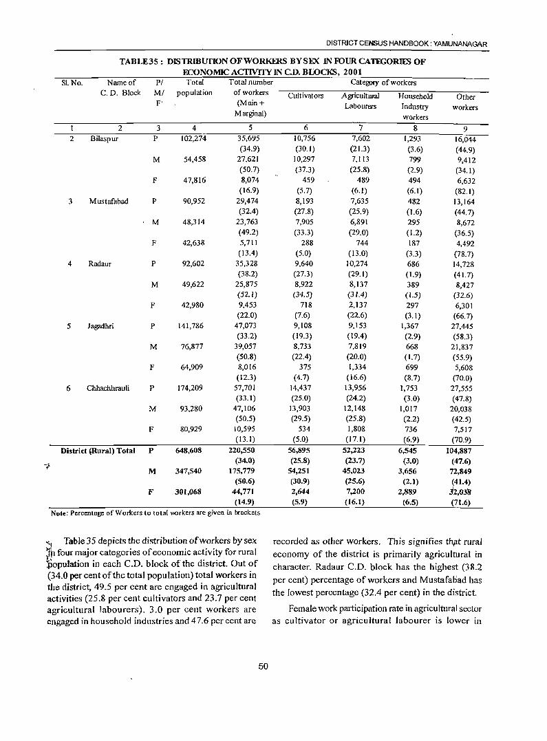
DISTRICT CENSUS HANDBOOK: YAMUNANAGAR
TABLE35: DISTRmurIoN OF WORKERS BY SEX IN FOUR CATEGORIES OF ECONOMIC ACfIVITY IN C.D. BLOCKS, 2001
SLNo. Name of PI Total Total number Category of workers C. D. Block MI population of workers Cultivators Agricultural Household Other
F' (Main + Labourers Industry workers Marginal) workers
2 3 4 5 6 7 8 9 2 Bilaspur P 102,274 35,695 10,756 7,602 1,293 16,044
(34.9) (30.1) (21.3) (3.6) (44.9) M 54,458 27,621 10,297 7,113 799 9,412
(50.7) (37.3) (25.8) (2.9) (34. I) F 47,816 8,074 459 489 494 6,632
(16.9) (5.7) (6.1) (6. I) (82. I) 3 Mustafabad P 90,952 29,474 8,193 7,635 482 13,164
(32.4) (27.8) (25.9) (1.6) (44.7) M 48,314 23,763 7,905 6,891 295 8,672
(49.2) (33.3) (29.0) (1.2) (36.5) F 42,638 5,711 288 744 187 4,492
( 13.4) (5.0) (13.0) (3.3) (78.7) 4 Radaur P 92,602 35,328 9,640 10,274 686 14,728
(38.2) (27.3) (29.1) (1.9) (41.7) M 49,622 25,875 8,922 8,137 389 8,427
(52.1) (34.5) (31.4) (1.5) (32.6) F 42,980 9,453 718 2,137 297 6,301
(22.0) (7.6) (22.6) (3.1) (66.7) 5 Jagadhri P 141,786 47,073 9,108 9,153 1,367 27,445
(33.2) (19.3) (19.4) (2.9) (58.3) M 76,877 39,057 8,733 7,819 668 21,837
(50.8) (22.4) (20.0) (1.7) (55.9) F 64,909 8,016 375 1,334 699 5,608
(12.3) (4.7) (16.6) (&.7) (70.0) 6 Chhachhrauli P 174,209 57,701 14,437 13,956 1,753 27,555
(33.1) (25.0) (24.2) (3.0) (47.8) M 93,280 47,106 13,903 12,14& 1,017 20,038
(50.5) (29.5) (25.8) (2.2) (42.5) F 80,929 10,595 534 1,80& 736 7,517
(13.1) (5.0) (17.1) (6.9) (70.9)
District ~Rural) Total P 648,608 220,550 56,895 52,223 6,545 104,887
-~ (34.0) (25.8) (23.7) (3.0) (47.6)
M 347,540 175,779 54,251 45,023 3,656 72,849 (50.6) (3Q.9) (25.6) (2.1) (41.4)
F 301,068 44,771 2,644 7,200 2,889 .h03~ (14.9) (5.9) (16.1) (6.5) (71.6)
Note: Percentage of Workers to total \\Orkers are given in brackets
"4 Table 35 depicts the distribution of workers by sex recorded as other workers. This signifies th,at rural t.P four major categories of economic activity for rural economy of the district is primarily agricultural in ~population in each C.D. block of the district. Out of character. Radaur C.D. block has the highest (38.2 (34.0 per cent of the total population) total workers in per cent) percentage of workers and Mustafaoad has the district, 49.5 per cent are engaged in agricultural
the lowest percentage (32.4 per cent) in the district. activities (25.8 per cent cultivators and 23.7 per cent agricultural labourers). 3.0 per cent workers are Female work participation rate in agricultural sector engaged in household industries and 47.6 per cent are as cultivator or agricultural labourer is lower in
50
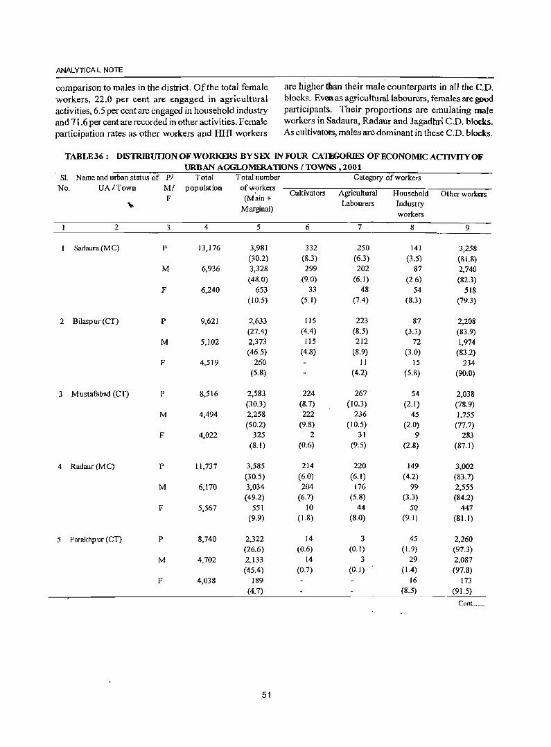
ANAL YTICA L NOTE
comparison to males in the district. Of the total female are higher than their male counterparts in all the C.D.
workers, 22.0 per cent are engaged in agricultural blocks. Even as agricultural labourers, females are good
activities, 6.5 per cent are engaged in household industry participants. Their proportions are emulating male and 71.6 per cent are recorded in other activities. Female workers in Sadaura, Radaur and Jagadhri C.D. blocks.
participation rates as other workers and Hill workers As cultivators, males are dominant in these C.D. blocks.
TABLE36: DISTRlBUfION OF WORKERS BYSEX IN FOUR CATEGORIES OF ECONOMIC ACTIVITY OF URBAN AGGLOMmATIONS I TOWNS, 2001
SI. Name and urban status of PI Total Total number Category of workers No. UA/Town MI population of workers
F (Main + Cultivators Agricultural Household Other workers
;,. Marginal)
Labourers Industry workers
2 3 4 5 6 7 8 9
Sadaura (M C) P 13,176 3,981 332 250 141 3,258 (30.2) (8.3) (6.3) (3.5) (8\.8)
M 6,936 3,328 299 202 87 2,740 (48.0) (9.0) (6.1) (2.6) (82.3)
F 6,240 653 33 48 54 518 (10.5) (5.1) (7.4) (8.3) (79.3)
2 Bilasp ur (CT) p 9,621 2,633 115 223 87 2,208 (27.4) (4.4) (8.5) (3.3) (83.9)
M 5,102 2,373 115 212 72 1,974 (46.5) (4.8) (8.9) (3.0) (83.2)
F 4,519 260 II 15 234 (5.8) (4.2) (5.8) (90.0)
3 Mustafabad (CT) P 8,516 2,583 224 267 54 2,038 (30.3) (8.7) (10.3) (2.1) (78.9)
M 4,494 2,258 222 236 45 ],755 (50.2) (9.8) (10.5) (2.0) (77.7)
F 4,022 325 2 31 9 283 (8.1) (0.6) (9.5) (2.8) (87.1)
4 Radaur(MC) P 11,737 3,585 214 220 149 3,002 (30.5) (6.0) (6.1) (4.2) (83.7)
M 6,170 3,034 204 176 99 2,555 (49.2) (6.7) (5.8) (3.3) (84.2)
F 5,567 551 10 44 50 447 (9.9) (1.8) (8.0) (9.1) (81.1)
5 Farakhpur (CT) P 8,740 2,322 14 3 45 2,260 (26.6) (0.6) (0.1) (1.9) (97.3)
M 4,702 2,133 14 3 29 2,087 (45.4) (0.7) (0.1) ( 1.4) (97.8)
F 4,038 189 16 173 (4.7) (8.5) (91.5)
ConL. ....
51
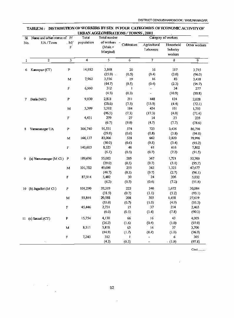
DISTRICT CENSUS HANDBOOK: YAMUNANAGAR
TABLE36: DISTRlBUIlON OF WORKERS BYSEX IN FpUR CATEGORDiB OFOCONOMIC ACIlVITY OF URBAN AGGLOMERATIONS /lOWNS ,2001
Sl. Name and urban status of P/ Total Total number Category of workers
No. VA/Town . M/ population of workers Cultivators Agricultural Household Other workers
F (Main + Marginal)
Labourers Industry
workers
2 3 4 5 6 7 8 9
6 Kansepur (CT) P 14,952 3,868 20 16 117 3,715 (25.9) (0.5) (0.4) (3.0) (96.0)
M 7,962 3,556 19 16 83 3,438 (44.7) (0.5) (0.4) (2.3) (96.7)
F 6,990 312 I 34 277 (4.5) (0.3) (10.9) (88.8)
7 Buria(MC) P 9,830 2,811 211 448 124 2,028 (28.6) (7.5) (15.9) (4.4) (72.1)
M 5,399 2,512 184 434 101 1,793 (46.5) (7.3) (17.3) (4.0) (71.4)
F 4,431 299 27 14 23 235 (6.7) (9.0) (4.7) (7.7) (78.6)
8 Yamunan3gflf VA P 306,740 91,531 574 723 3,436 86,798 (29.8) (0.6) (0.8) (3.8) (94.8)
M 166,137 83,006 528 662 2,820 78,996 (50.0) (0.6) (0.8) (3.4) (95.2)
F 140,603 8,525 46 61 616 7,802 (6.1) (0.5) (0.7) (7.2) (91.5)
9 (a) Yamunan3gflf(M CI) P 189,696 55,082 285 367 1,721 52,709 (29.0) (0.5) (0.7) (3.1) (95.7)
M 101,782 49,600 255 343 1,325 47,677 (48.7) (0.5) (0.7) (2.7) (96.1)
F 87,914 5,482 30 24 396 5,032 (6.2) (0.5) (0.4) (7.2) (91.8)
10 (b) J~hri (M CI) P 101,290 32,319 223 340 1,672 30,084 (31.9) (0.7) (1.1) (5.2) (93.1)
M 55,844 29,588 208 303 1,458 27,619 (53.0) (0.7) (1.0) (4.9) (93.3)
F 45,446 2,731 15 37 214 2,465 (6.0) (0.5) (1.4) (7.8) (90.3)
11 (c) Sasauli (CT) P 15,754 4,130 66 16 43 4,005 (26.2) (1.6) (0.4) (1.0) (97.0)
M 8,511 3,818 65 16 37 3,700 (44.9) (1.7) (0.4) (1.0) (96.9)
F 7,243 312 I 6 305
(4.3) (0.3) . (1.9) (97.8)
Cont... .......
52
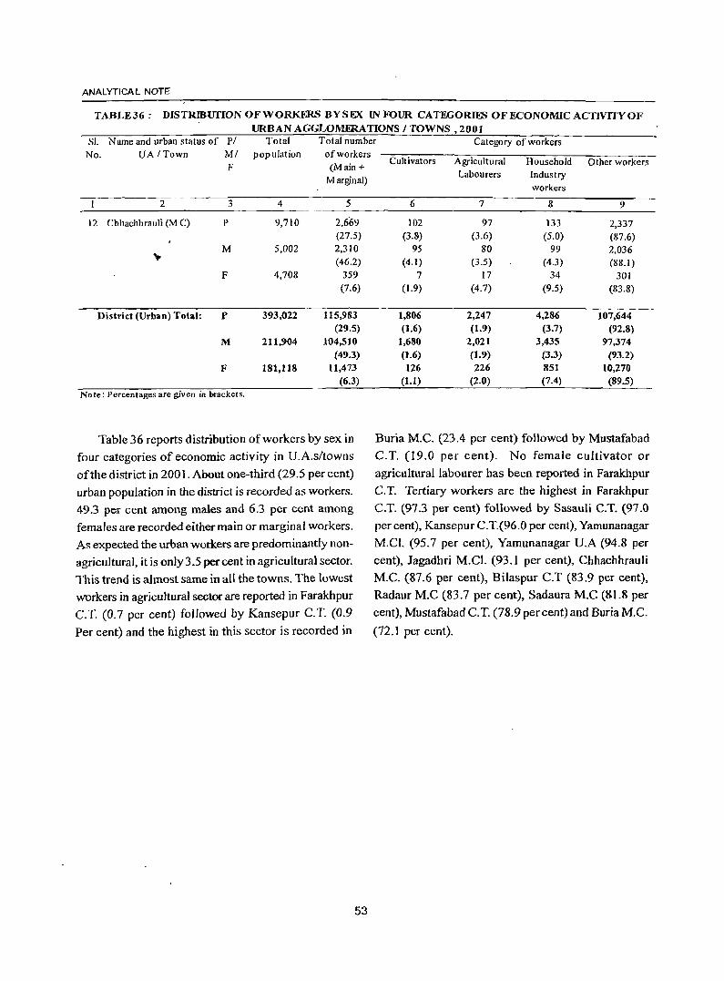
ANAL YTICA L NOTE
TABLE36: DISTR~urION OF WORKERS BYSEX IN FOUR CATEGORIES OF ECONOMIC ACTIVITY OF URBAN AGGLOMERATIONS / TOWNS, 2001
SI. N arne and urban status of PI Total Total number Category of workers No. UA ITown MI population of workers
F (Main +
Marginal)
2 3 4 5
12 Chhachhrauli (M C) P 9,710 2,669 (27.5)
M 5,002 2,310 .",
(46.2) F 4,70S 359
(7.6)
District (Urban) Total: P 393,022 115,983 (29.5)
M 211,904 104,510 (49.3)
F 181,118 11,473 (6.3)
Note: Percentages are given in brackets.
Table 36 reports distribution of workers by sex in
four categories of economic activity in U.A.s/towns of the district in 2001. About one-third (29.5 per cent)
urban population in the district is recorded as workers.
49.3 per cent among males and 6.3 per cent among
females are recorded either main or marginal workers.
As expected the urban workers are predominantly non
agricultural, it is only 3.5 percent in agricultural sector.
This trend is almost same in all the towns. The lowest workers in agricultural sector are reported in Farakhpur
C.T. (0.7 per cent) followed by Kansepur C.T. (0.9
Per cent) and the highest in this sector is recorded in
53
Cultivators Agricultural Household Other workers Labourers Industry
workers
6 7 S 9
102 97 133 2,337 (3.8) (3.6) (5.0) (S7.6)
95 SO 99 2,036 (4.1) (3.5) (4.3) (88.1)
7 17 34 301 (1.9) (4.7) (9.5) (S3.S)
1,806 2,247 4,286 107,644 (1.6) (1.9) (3.7) (92.8)
1,680 2,021 3,435 97,374 (1.6) (1.9) (3.3) (93.2) 126 226 851 10,270
(1.1) (2.0) (7.4) (89.5)
Buria M.C. (23.4 per cent) followed by Mustafabad
C.T. (19.0 per cent). No female cultivator or
agricultural labourer has been reported in Farakhpur
C. T. Tertiary workers are the highest in Farakhpur
C.T. (97.3 per cent) followed by Sasauli C.T. (97.0 per cent), Kansepur C.T.(96.0 per cent), Yamunanagar
M.CL (95.7 per cent), Yamunanagar U.A (94.8 per
cent), Jagadhri M.C!' (93.1 per cent), Chhachhrauli
M.C. (87.6 per cent), Bilaspur C.T (83.9 per cent), Radaur M.C (83.7 per cent), Sadaura M.C (81.8 per
cent), Mustafabad C. T. (78.9 per cent) and Buria M.C.
(72.1 per cent).
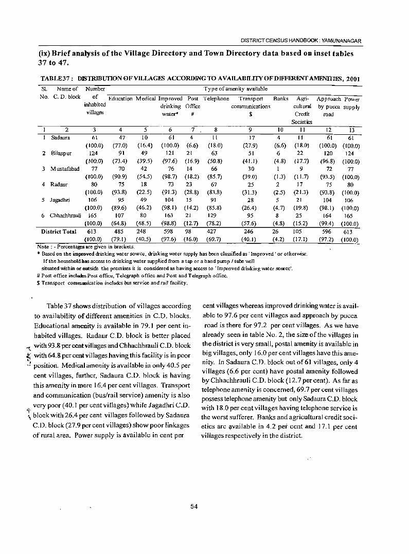
DISTRICT CENSUS HANDBOOK: YAMUNANAGAR
(ix) Brief analysis of the Village Directory and Town Directory data based on inset tables 37 to 47.
TABLE37: D~TRIBurION OF VILLAGES ACCORDING TO AVAILABILITY OF DIFFERENT AMENITIES, 2001
Sl. Name of Number Type of amenity available
No. C. D. block of Education Medical Improved Post Telephone Transport Banks Agri- Approach Power inhabited drinking Office communications cultural by pucca supply villages water* # $ Credit road
Societies
2 3 4 5 6 7 8 9 10 11 12 13 Sadaura 61 47 10 61 4 II 17 4 I I 61 61
(100.0) (77.0) (16.4) (100.0) (6.6) (18.0) (27.9) (6.6) (18.0) (100.0) (100.0) 2 Bilaspur 124 91 49 121 21 63 51 6 22 120 124
(100.0) (73.4) (39.5) (97.6) (16.9) (50.8) (41.1) (4.8) (17.7) (96.8) (100.0) 3 Mustafabad 77 70 42 76 14 66 30 1 9 72 77
(lOO.O) (90.9) (54.5) (98.7) (18.2) (85.7) (39.0) (1.3) (11.7) (93.5) (100.0) 4 Radaur 80 75 18 73 23 67 25 2 17 75 80
(100.0) (93.8) (22.5) (91.3) (28.8) (83.8) (31.3) (2.5) (21.3) (93.8) (100.0) 5 Jagadhri 106 95 49 104 IS 91 28 5 21 104 106
(100.0) (89.6) (46.2) (98.1) (14.2) (85.8) (26.4) (4.7) (19.8) (98.1) (100.0) 6 Chhachhrauli 165 107 80 163 21 129 95 8 25 164 165
(100.0) (64.8) (48.5) (98.8) (12.7) (78.2) (57.6) (4.8) (15.2) (99.4) (100.0) District Total 613 485 248 598 98 427 246 26 105 596 613
(100.0) (79.1) (40.5) (97.6) (16.0) (69.7) (40.1) (4.2) (17.1) (97.2) (100.0) Note: • Percentages are given in brackets . .. Based on the improved drinking _tcr source, drinking _ter supply has been classified as 'Improved' or otherwise.
If the household has access to drinking w.lter supplied from a tap or a hand pump / tube \\ell situated within or outside the premises it is considered as having access to 'Improved drinking w.lter source'.
# Post office includes Post office, Telegraph office and Post and Telegraph office. S Transport commllllication includes bus service and rail facility.
Table 37 shows distribution of villages according
to availability of different amenities in CD. blocks.
Educational amenity is available in 79.1 per cent in
habited villages. Radaur C.D. block is better placed
'<t with 93.8 per cent villages and Chhachhrauli C.D. block ." t' with 64.8 percentvilJages having this facility is in poor
:".: position. Medical amen ity is available in only 40.5 per
cent villages, further, Sadaura C.D. block is having
this amenity in mere 16.4 per cent villages. Transport
and communication (bus/rail service) amenity is also
very poor (40.1 per cent villages) while Jagadhri C.D. ~~
:, block with 26.4 per cent villages followed by Sadaura
C.D. block (27.9 percent villages) show poor linkages
of rural area. Power supply is available in cent per
54
cent villages whereas improved drinking water is available to 97.6 per cent villages and approach by pucca
road is there for 97.2 per cent villages. As we have already seen in table No.2, the size of the villages in the district is very small, postal amenity is available in big villages, only 16.0 per cent villages have this amenity. In Sadaura C.D. bjock out of61 villages, only 4 villages (6.6 per cent) have postal amenity followed by Chhachhrauli C.D. block (12.7 percent). As far as telephone amenity is concerned, 69.7 per cent villages possess telephone amenity but only Sad aura C.D. block with 18.0 per cent villages having telephone service is the worst sufferer. Banks and agricultural credit societies are :;rvailable in 4.2 pei cent and 17.1 per cent villages respectively in the district.
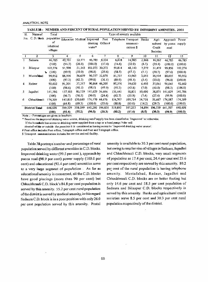
ANALYTICAL NOTE
TABLE38: NUMBFR AND PFRCENT OF RURAL POPULATION SFRVID BY DIFFERJ!Nf AMJiNITIES, 2001
SI. Name of Total' Type of amenity available
No. C. D. hklck population Education Medical Improved Post Telephone Transport Banks Agri- Approach Power of drinking Office # communi- cultural by pucca supply
inhabited water· cations $ Credit road villages Societies
2 3 4 5 6 7 8 9 10 11 12 13 Sadaura 46,785 42,701 12,171 46,785 .8,134 6,818 14,985 2,868 16,567 46,785 46,785
(100) (91.3) (26.0) (100.0) (17.4) (14.6) (32.0) (6.1) (35.4) (100.0) (100.0) 2 Bilaspur 102,274 91,908 51,143 101,075 30,272 59,814 48,140 7,272 31,439 99,856 102,274
" (100) (89.9) (50.0) (98.8) (29.6) (58.5) (47.1) (7.1) (30.7) (97.6) (100.0) 3 Mustafabad 90,952 88,506 56,659 90,757 32,878 81,737 43,963 3,053 20,934 88,005 90,952
(100) (97.3) (62.3) (99.8) (36.1) (89.9) (48.3) (3.4) (23.0) (96.8) (100.0) 4 Radaur 92,602 91,301 37,317 90,864 46,205 85,376 39,620 6,493 37,061 91,045 92,602
(100) (98.6) (40.3) (98.1) (49.9) (92.2) (42.8) (7.0) (40.0) (98.3) (100.0)
5 Jagadhri 141,786 137,103 80,129 141,629 34,666 131,441 50,831 10,490 38,871 141,629 141,786
(100) (96.7) (56.5) (99.9) (24.4) (92.7) (35.9) (7.4) (27.4) (99.9) (100.0)
6 Chhachhrauli 174,209 147,810 120,680 174,170 44,676 154,707 109,714 24,718 51,667 174,187 174,209
(100) (84.8) (69.3) (100.0) (25.6) (88.8) (63.0) (14.2) (29.7) (100.0) (100.0)
District Total 648,608 599,329 358,099 645,280 196,831 519,893 307,253 54,894 196,539 641,507 648,608
(100) (92.4) (55.2) (99.S) (30.3) (80.2) (47.4) (8.5) (30.3) (98.9) (100.0) Note: • Perceutages are given in brackets . .. Based on the improved drinking water source, drinking wate} supply has been classified as . Improved' or otherwise.
If the housdwld has access to drinking W<lter supplied from a tap or a hand pump I tube \\ell situated within or outside the premises it is considered as having access to • Improved drinking W<lter source'.
# Post office iaeludes Post 0 ffice. Telegraph office and Post and Telegraph office. $ Transport communication includes bus service and rail facility.
Table 38 portrays 'number and percentage of rural
population served by different amenities in C.D. blocks.
Improved drinking water (99.5 per cent ), approach by
pucca road (98.9 per cent) power supply (100.0 per
cent) and educational (92.4 per cent) amenities serve
to a very large segment of population. As far as
educational amenity is concerned, all the C.D. blocks
have good placings (more than 90 per cent) but
Chhachhrauli C.D. block's 84.8 per cent population is
served by this amenity. 55.2 per cent rural population
of the district is served by medical amenity, in this regard
Sadaura C.D. block is in a poor position with only 26.0
per cent popUlation served by this amenity. Postal
amenity is available to 30.3 per cent rural population,
but owing to smaller size of villages in Sadaura, Jagadhri and Chhachhrauli C.D. blocks, very small segments
of population as 17.4 per cent, 24.4 per cent and 25.6
per cent respectively are served by this amenity. 80.2
per cent of the rural population is having telephone
amenity. Mustafabad, Radaur, Jagadhri and
Chhachhrauli C.D. blocks are on better footing but
only 14.6 per cent and 58.5 per cent population of Sadaura and Bilaspur C.O. blocks respectively is
served by this amenity. Banks and agricultural credit
societies serve 8.5 per cent and 30.3 per cent rural
population respectively of the district.
55
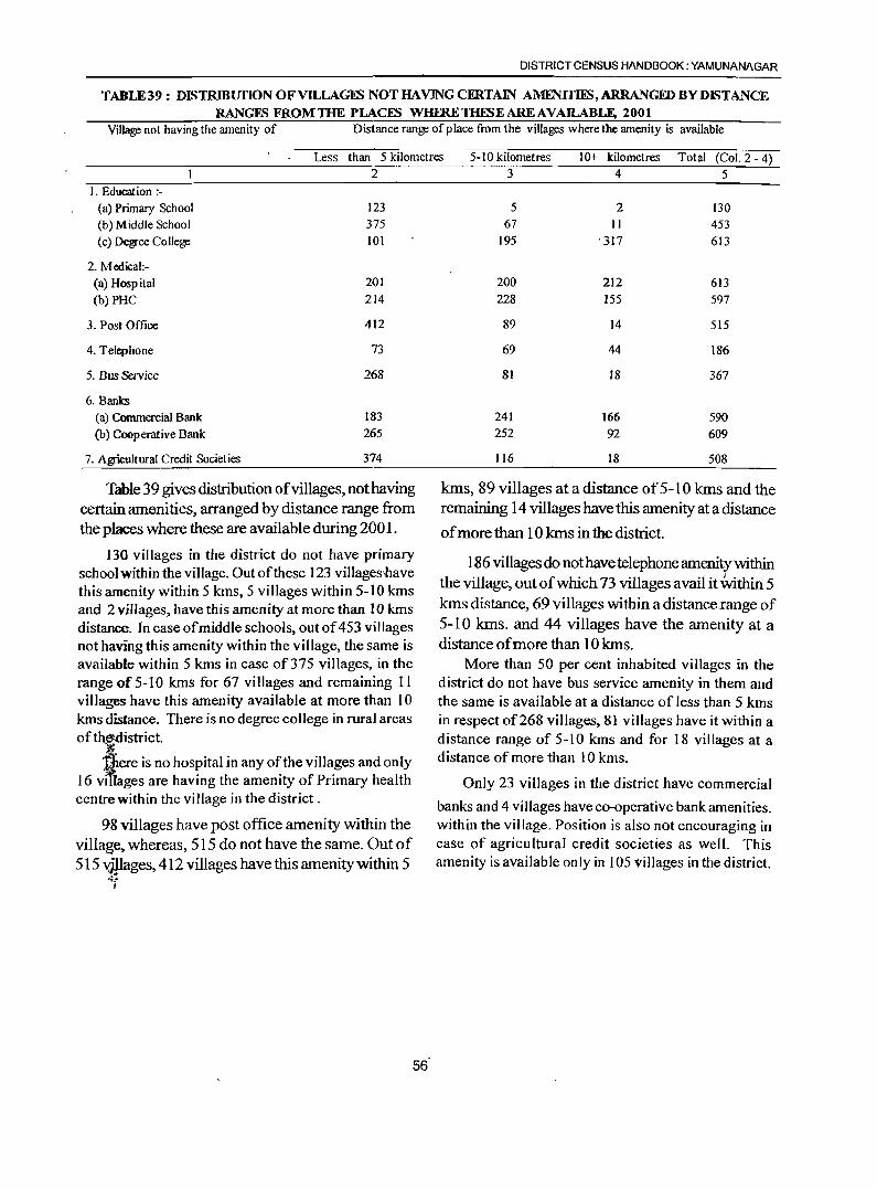
DISTRICT CENSUS HANDBOOK: YAMUNANAGAR
TABLE39 : DISTRIBUfION OFVILLAGFS NOT HAVING CFRTAIN AMFNIfIES, ARRANGID BY DISTANCE RANGFS FROMTHE PLACFS WHFRETHESEAREAVAILABLE, 2001
Village not having the amenity of Distance range of p lace from the villages where the amenity is available
Less than 5 kilometres 5-10 kilometres 10+ kilometres Total (Col. 2 - 4) 2
I. Education :-(a) Primary School 123
(b) Middle School 375 (c) Degree College 101
2. Medical:-(a) Hospital 201
(b) PHC 214
3. Post Office 412
4. Telephone 73
5. Bus Service 268
6, Banks
(a) Commercial Bank 183
(b) Cooperative Bank 265
7. Agricultural Credit Societies 374
Table 39 gives distribution of villages, not having certain amenities, arranged by distance range from the places where these are available during 2001.
130 villages in the district do not have primary school within the viHage. Out ofthese 123 villagesflave this amenity within 5 kms, 5 villages within 5-10 kms and 2 villages, have this amenity at more than 10 kms distance. In case of middle schools, out of 453 villages not having this amenity within the village, the same is available within 5 kms in case of375 villages, in the range of 5-1 0 kms for 67 villages and remaining 1 I villages have this amenity available at more than 10 kms distance. There is no degree college in rural areas of th.~djstrict.
'i1iere is no hospital in any of the villages and only 16 vlfiages are having the amenity of Primary health centre within the village in the district.
98 villages have post office amenity within the village, whereas, SIS do not have the same. Out of 515 vjpages, 412 villages have this amenity within 5
.;~
I
3 4 5
5 2 130 67 II 453
195 ' 317 613
200 212 613 228 155 597
89 14 515
69 44 186
81 18 367
241 166 590 252 92 609
116 18 508
lans, 89 villages at a distance of 5-1 0 lans and the remaining 14 villages have this amenity at a distance
of more than 10 lans in the district.
186 villages do not have telephone amenity within the village, out of which 73 villages avail it Within 5 lans distance, 69 villages within a distance range of 5-10 lans. and 44 villages have the amenity at a distance of more than 10 kms.
More than 50 per cent inhabited villages in the district do not have bus service amenity in them and the same is available at a distance of less than 5 kms in respect of268 villages, 81 villages have it within a distance range of 5-10 kms and for 18 villages at a distance of more than 10 kms.
Only 23 villages in the district have commercial
banks and 4 villages have co-operative bank amenities. within the village. Position is also not encouraging in case of agricultural credit societies as well. This amenity is available only in 105 villages in the district.
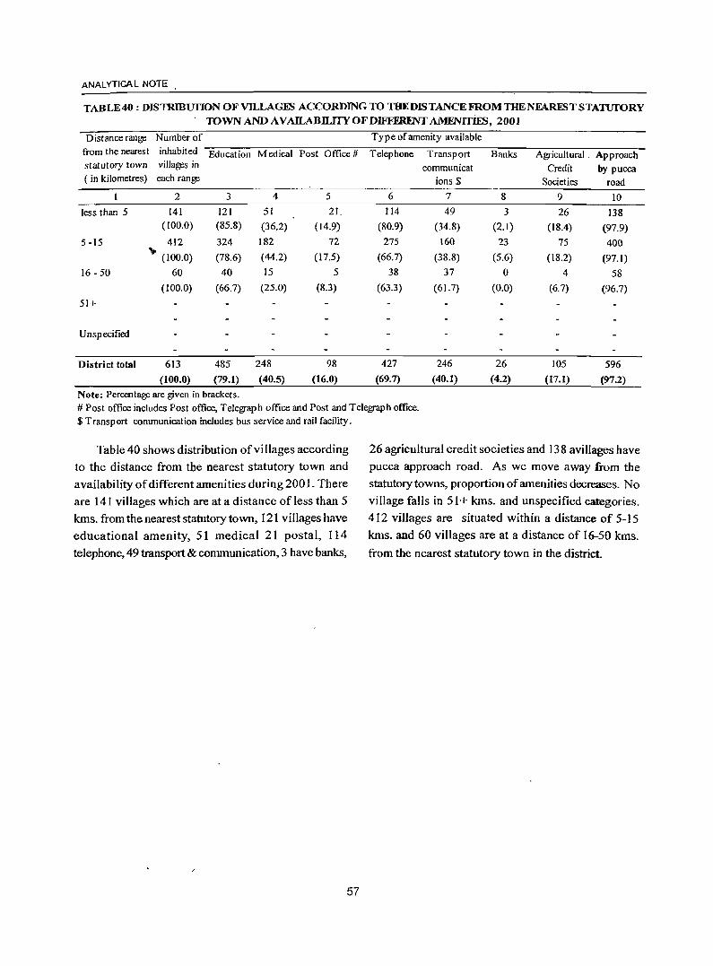
ANAL YTICA L NOTE .
TABLE 40 : DIsTRmurIoN OF VILLAGES ACCORDING TO THE DISTANCE FROM THENFAREST STATUfORY . TOWN AND AVAILABILITYOFDIFFFlm'IT AM.ENITIES, 2001
Distance ran~ Number of Type of amenity available
from the nearest inhabited Education Medical Post Office # Telephone Transport Banks Agricultural. Approach statutory town villages in communicat Credit by pucca ( in kilometres) each range ions $ Societies road
2 3 4 5 6 7 8 9 IO
less than 5 141 121 51 21. 114 49 3 26 138 (100.0) (85.8) (36.2) (14.9) (80.9) (34.8) (2.1) (18.4) (97.9)
5 -15 412 324 182 72 275 160 23 75 400 \0 (100.0) (78.6) (44.2) (17.5) (66.7) (38.8) (5.6) (18.2) (97.1)
16 - 50 60 40 15 5 38 37 0 4 58
(100.0) (66.7) (25.0) (8.3) (63.3) (61.7) (0.0) (6.7) (96.7)
51+
Unspecified
District total 613 485 248 98 427 246 26 105 596
(100.0) (79.1) (40.5) (16.0) (69.7) (40.1) (4.2) (17.1) (97.2)
Note: Percentage are given in brackets. # Post office includes Post office, Telegraph office and Post and Telegraph office. $ Transport communication includes bus service and rail facility.
Table 40 shows distribution ofvillages according
to the distance from tbe nearest statutory town and
availability of different amenities during 2001. There
are 141 villages which are at a distance of less than 5
kms. from the nearest statutory town, 121 villages have
educational amenity, 51 medical 21 postal, 114
telephone, 49 transport & communication, 3 have banks,
/
57
26 agricultural credit societies and 138 avillages have
pucca approach road. As we move away :from the statutory towns, proportion of amenities decreases. No
village falls in 51 + kms. and unspecified categories.
4 I 2 villages are situated within a distance of 5-15
kms. and 60 villages are at a distance of 16-50 kms.
from the nearest statutory town in the districL
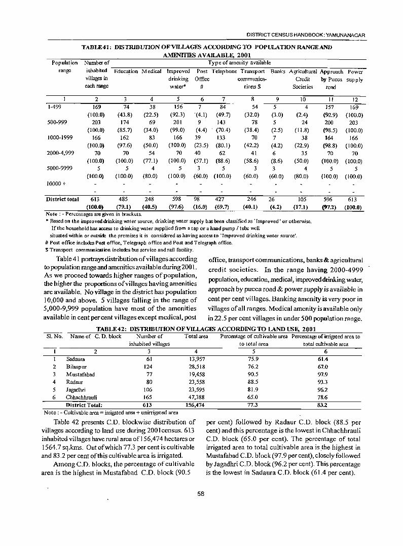
DISTRICT CENSUS HANDBOOK: YAMUNANAGAR
TABLE41: DISTRIBUTION OF VILLAGES ACCORDJNGTO POPULATIONRANGEAND
AMENITIliS AVAILABLF, 2001 Population Number of Type of amenity available
range inhabited Education Medical Improved Post Telephone Transport Banks Agricultural Approach Power
1-499
500-999
1000-1999
2000-4,999
5000-9999
10000 +
District total
villages in
each range
2 169
(100.0) 203
(100.0) 166
(100.0) 70
(100.0) 5
(100.0)
613 (100.0)
3 74
(43.8) 174
(85.7) 162
(97.6) 70
(100.0) 5
(100.0)
485 (79.1)
Note: - Percentages arc given in brackets.
4 38
(22.5) 69
(34.0) 83
(50.0) 54
(77.1) 4
(80.0)
248 (40.5)
drinking water*
5 156
(92.3) 201
(99.0) 166
(100.0) 70
(100.0) 5
(100.0)
598 (97.6)
Office
#
6 7
'(4.1) 9
(4.4) 39 (23.5) 40 (57. t)
3 (60.0)
98 (16.0)
7 84
(49.7) 143
. (70.4)
133 (80.1)
62 (88.6)
5 (100.0)
427 (69.7)
communica-tions $
8 54
(32.0) 78
(38.4) 70
(42.2) 41
(58.6) 3
(60.0)
246 (40.1)
9 5
(3.0) 5
(2.5) 7
(4.2) 6
(8.6) 3
(60.0)
26 (4.2)
Credit Societies
10 4
(2.4) 24
( 11.8) 38
(22.9) 35
(50.0) 4
(80.0)
105 (17.1)
• Based on the improved drinking miter source, drinking miter supply has been classified as . Improved' or other~se. If the household has access to drinking miter supplied from a tap or a hand pump / tube well
situated ~thin or outside the premises it is considered as having access to "Improved drinking miter source'. # Post office includes Post office. Telegraph office and Post and Telegraph office. S Transport communication includes bus service and rail facility.
by Pucca supply road
II 157
(92.9) 200
(98.5) 164
(98.8) 70
(100.0) 5
(100.0)
596 (97.2)
12 169
(100.0) 203
(100.0) 166
(100.0) 70
(100.0) 5
(100.0)
613 (100.0)
Table 41 portrays distribution of villages according to popUlation range and amenities available during 200 1. As we proceed towards higher ranges of population, the higher the proportions of villages having amenities are available. No village in the district has population
office, transport communications, banks & agricultural
credit societies. In the range having 2000-4999 population, education, medical, improVed drinking water,
approach by pucca road & power.supply is available in
10,000 and above. 5 villages falling in the range of cent per cent villages. Banking amenity is very poor in 5,000-9,999 population have most of the amenities villages of all ranges. Medical amenity is available only available in cent percent villages except medical, post in 22.5 per cent villages in under 500 population range.
TABLE 42: DISTRIBUTION OFVILLAGFS ACCORDING TO LAND USF, 2001 Sf. No. Name of C. D. block Number of Total area Percentage of cultivable area Percent~ of irrigated area to
inhab i ted v iIIages
2 3 4
Sadaura 61 13,957 2 Bilaspur 124 28,518 3 Mustafabad 77 19,458 4 Radaur 80 23,558 5 Jagadhri 106 23,595 6 Chhachhrauli 165 47,388
District Total: 613 156,474 Note: - Cultivable area = irrigated area + unirrigated area
Table 42 presents CD. blockwise distribution of villages according to land use during 2001 census. 613 inhabited villages have rural area of156,474 hectares or 1564.7 sq.kms. Out of which 77.3 percent is cultivable and 83.2 per cent of this cultivable area is irrigated.
Among C.D. blocks, the percentage of cu Itivable area is the highest in Mustafabad C.D. block (90.5
58
to total area
5 75.9 76.2 90.5 88.5 81.9 65.0 77.3
total cultivable area
6 61.4 67.0 97.9 93.3 96.2 78.6 83.2
per cent) followed by Radaur C.D. block (88.5 per cent) and this percentage is the lowest in Chhachhrauli C.D. block (65.0 per cent). The p'ercentage of total irrigated area to total cultivable area is.the highest in Mustafabad C.D. block (97.9 per cent), closely followed by Jagadhri C.D. block (96.2 per cent). This percentage is the lowest in Sadaura C.D. block (61.4 per cent).
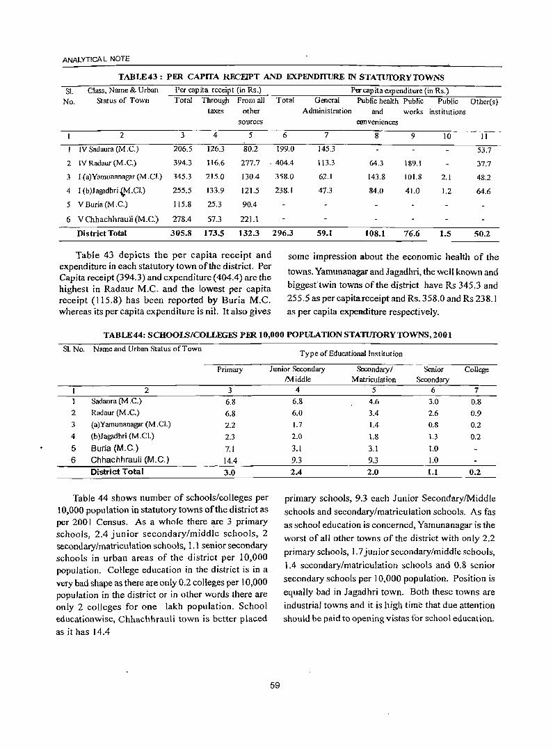
ANALYTICAL NOTE
TABLE43: PER CAPITA RECEIPT AND EXPFNDII1JR.E IN STATUfORYTOWNS
SI. Class, Name & Urban Per capita receipt (in Rs.) Per capita expenditure (in Rs.)
No. Status of Town Total Through From all Total General Public health Public Public Other(s) taxes other Administration and works institutions
sources conveniences
2 3 4 5 6 7 8 9 10 II
IV Sadaura (M .C.) 206.5 126.3 80.2 199.0 145.3 53.7
2 IV Radaur (M .C.) 394.3 116.6 277.7 ·404.4 113.3 64.3 189.1 37.7
3 I (a)Yamunanagar (M.C!,) 345.3 215.0 130.4
4 I (b)Jagadhri{.M.CI.) 255.5 133.9 121.5
5 VBuria(M.C.) 115.8 25.3 90.4
6 V Chhachhrauli (M.e.) 278.4 57.3 221.1
District Total 305.8 173.5 132.3
Table 43 depicts the per capita receipt and expenditure in each statutory town of the district. Per Capita receipt (394.3) and expenditure (404.4) are the highest in Radaur M.C. and the lowest per capita receipt (115.8) has been reported by Buria M.C. whereas its per capita expenditure is nil. It also gives
358.0 62.1 143.8 101.8 2.1 48.2
238.1 47.3 84.0 41.0 1.2 64.6
296.3 59.1 108.1 76.6 1.5 50.2
some impression about the economic health of the
towns. Yamunanagar and Jagadhri, the well known and
biggest twin towns of the district have Rs 345.3 and
255.5 as per capita receipt and Rs. 358.0 and Rs 238.1 as per capita expenditure respectively.
TABLE44: SCHOOLS/COLLEGES PER 10,000 POPULATION STAnITORYTOWNS, 2001
SI. No. Name and Urban Status of Town
Primary
2 3
Sadaura (M .C.) 6.8
2 Radaur (M.C.) 6.8
3 (a)Yamunanagar (M .CI.) 2.2
4 (b)Jagadhri (M .CI.) 2.3
5 Buria (M.G.) 7.1
6 Ghhachhrauli (M.G.) 14.4
District Tota I 3.0
Table 44 shows number of schools/colleges per 10,000 popu lation in statutory towns ofthe district as per 200 I Census. As a whole there <!-re 3 primary schools, 2.4 junior secondary/middle schools, 2 secondary/matriculation schools, 1.1 senior secondary schools in urban areas of the district per 10,000 population. College education in the district is in a very bad shape as there are only 0.2 colleges per 10,000 population in the district or in other words there are only 2 colleges for one lakh population. School educationwise, Chhachhrauli town is better placed as it has 14.4
Type of Educational Institution
Junior Secondary Secondary/ Senior College
59
!Middle Matriculation Secondary 4 5 6 7
6.8 4.6 3.0 0.8
6.0 3.4 2.6 0.9
1.7 1.4 0.8 0.2
2.0 1.8 1.3 0.2
3.1 3.1 1.0
9.3 9.3 1.0
2.4 2.0 1.1 0.2
primary schools, 9.3 each Junior Secondary/Middle
schools and secondary/matriculation schools. As fas as school education is concerned, Yamunanagar is the
worst of all other towns of the district with only 2.2
primary schools, 1.7 junior secondary/middle schools,
1.4 secondary/matriculation schools and 0.8 senior
secondary schools per 10,000 population. Position is
equally bad in Jagadhri town. Both these towns are industrial towns and it is high time that due attention
should be paid to opening vistas for school education.
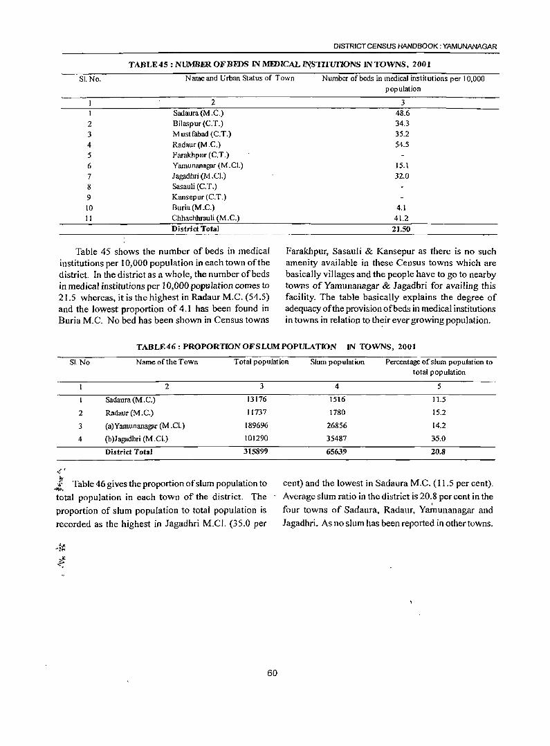
DISTRICT CENSUS HANDBOOK: YAMUNANAGAR
TABLE45 : NUMBER OF BEDS IN MEDICAL ~STITUI10NS IN TOWNS, 2001
SI.No. Name and Urban Status of Town Number of beds in medical institutions per 10,000 population
2 1 Sadaura(M.C.)
2 Bilaspur (C.T.)
3 Mustfabad (C.T.)
4 Radaur (M.C.)
5 Farakhpur (C.T.)
6 Yamunanagar (M.C!,)
7 Jagadhri (M .Cl.)
8 Sasauli (C.T.)
9 Kansepur (C.T.)
10 Buria (M.C.)
11 Chhachhrauli (M.C.)
District Total
Table 45 shows the number of beds in medical institutions per 10,000 population in each town of the district. In the district as a whole, the number of beds in medical institutions per 10,000 popUlation comes to 21.5 whereas, it is the highest in Radaur M.C. (54.5) and the lowest proportion of 4.1 has been found in Buria M.C. No bed has been shown in Census towns
3 48.6 34.3 35.2
54.5
15.1
32.0
4.1
41.2
21.50
Farakhpur, Sasauli & Kansepur as there is no such amenity available in these Census towns which are basically villages and the people have to go to nearby towns of Yamunanagar & Jagadbri for availing this facility. The table basically explains the degree of adequacy of the provision of beds in medical institutions in towns in relation to th~ir ever growing population.
TABLE46: PROPORTIONOFSLUMPOPULATION IN TOWNS, 2001
S!.No. Name of the Town Total population Slum population Percentage of slum population to
2
3
4
2
Sadaura(M.C.)
Radaur (M.C.)
(a)Yamunanagar (M.Cl.)
(b)J agadhri eM. Cl.)
District Total
3
13176
11737
189696
101290
315899
.(. J
::" ~ Table 46 gives the proportion of slum population to
total population in each town of the district. The
proportion of slum population to total population is
recorded as the highest in Jagadhri M.C!' (35.0 per
total population
4 5
1516 11.5
1780 15.2
26856 14.2
35487 36.0
65639 20.8
cent) and the lowest in Sadaura M.C. (11.5 per cent).
- Average slum ratio in the district is 20.8 per cent in the I
four towns of Sadaura, Radaur, Yamunanagar and
Jagadhri. As no slum has been reported in other towns.
60
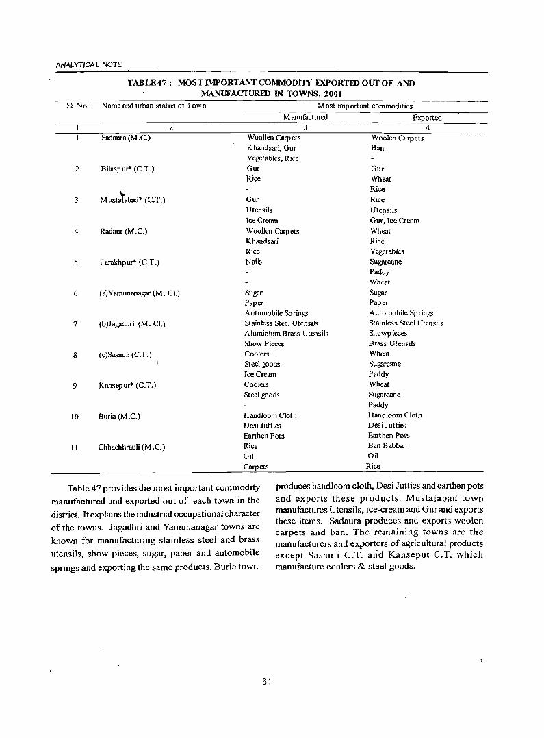
ANAL YTICA l NOTE
S1. No.
2
3
4
5
6
7
8
9
10
II
TABLE47: MOST IMPORTANT COMMODllY EXPORTFDOurOF AND MANUFACTURED IN TOWNS, 2001
Name and urban status of Town Most important commodities
Manufactured Exported 2 3 4
Sadaura (M .C.) Woollen Carpets Woolen Carpets Khandsari, GUT Ban Vegetables, Rice
Bilaspur* (C.T.) Gur Gur Rice Wheat
..,. Rice
Mustafabad* (C.T.) Gur Rice Utensils Utensils Ice Cream Gur, lee Cream
Radaur (M.C.) Woollen Carpets Wheat Khandsari Rice Rice Vegetables
Farakhpur* (C.T.) Nails SUg)ll'cane Paddy Wheat
(a)Yamunanag)ll' (M. Cl.) Sugar Sugar Paper Paper Automobile Spring; Automobile Spring;
(b)Jagadhri (M. Cl.) Stainless Steel Utensils Stainless Steel Utensils Aluminium Brass Utensils Showpieces Show Pieces Brass Utensils
(c)Sasauli (C.T.) Coolers Wheat Steel goods SUg)ll'cane Ice Cream Paddy
Kansepur* (C.T.) Coolers Wheat
Steel goods Sugarcane Paddy
Buria(M.C.) Handloom Cloth Handloom Cloth Desi Jutties Desi Jutties
Earthen Pots Earthen Pots
Chhachhrauli (M . C.) Rice Ban Babbar
Oil Oil
Carpets Rice
Table 47 provides the most important commodity manufactured and exported out of each town in the
district. It explains the industrial occupational character of the towns. Jagadhri and Yamunanagar towns are known for manufacturing stainless steel and brass
utensils, show pieces, sugar, paper and automobile
springs and exporting the same products. Buria town
produces handloom cloth, Desi Jutties and earthen pots and exports these products. Mustafabad town manufactures Utensils, ice-cream and Gur and exports these items. Sadaura produces and exports woolen carpets and ban. The remaining towns are the manufacturers and exporters of agricultural products except Sasauli C.T. arid Kanseput C.T. which manufacture coolers & steel goods.
61
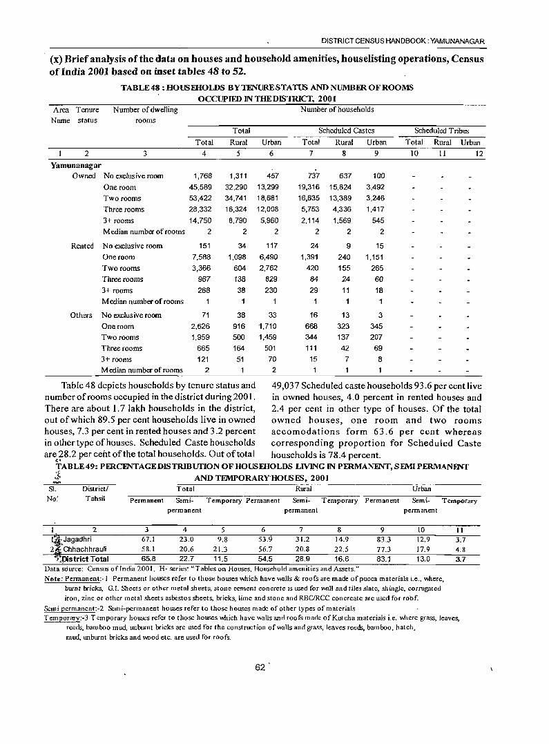
DISTRICT CENSUS HANDBOOK: YAMUNANAGAR
(x) Brief analysis of the data on houses and household am~nities, houselisting operations, Census ofIndia 2001 based on inset tabJes 48 to 52.
TABLE 48 : HOUSEHOLDS BY TENURE STATUS AND NUMBER OF ROOMS
OCCUPIED IN THEDISlRICf, 2001 Area Tenure Number of dwelling N umber of households
Name status rooms
Total Scheduled Castes Scheduled Tribes
Total Rural Urban Total Rural Urban Total Rural Urban
2 3 4 5 6 7 8 9 10 11 12
Yamunanagar Owned No exclusive room 1,768 1,311 457 737 637 100
One room 45,589 32,290 13,299 19,316 15,824 3,492
Two rooms 53,422 34,741 18,681 16,635 13,389 3,246
Three rooms 28,332 16,324 12,008 5,753 4,336 1,417
3+ rooms 14,750 8,790 5,960 2,114 1,569 545
Median number of rooms 2 2 2 2 2 2
Rented No exclusive room 151 34 117 24 9 15
One room 7,588 1,098 6,490 1,391 240 1,151
Two rooms 3,366 604 2,762 420 155 265
Three rooms 967 138 829 84 24 60
3+ rooms 268 38 230 29 11 18
Median number of rooms 1 1
Others No exclusive room 71 38 33 16 13 3
One room 2,626 916 1,710 668 323 345
Two rooms 1,959 500 1,459 344 137 207
Three rooms 665 164 501 111 42 69
3+ rooms 121 51 70 15 7 8
Median number of rooms 2 2 1
Table 48 depicts households by tenure status and 49,037 Scheduled caste households 93.6 per cent live number of rooms occupied in the district during 200 L in owned houses, 4.0 percent in rented houses and There are about 1.7 lakh households in the district, 2.4 per cent in other type of houses. Of the total out of which 89.5 per cent households live in owned owned houses, one room and two rooms houses, 7.3 per cent in rented houses and 3.2 percent accomodations form 63.6 per cent whereas in other type of houses. Scheduled Caste households corresponding proportion for Scheduled Caste are 28.2 per cent of the total households. Out of total households is 78.4 percent.
~.
TABLE 49: PFRCINTAGEDISTRlBUnON OF HOUSEHOLDS LIVING IN PERMANINT, SEMI PERMANliNf
~~ AND TEMPORARYHOUSES. 2001 ..... S1. District! Total Rural Urban N(f~ Tahsil Permanent Semi· Temporary Permanent Semi- Temporary Permanent Semi- Temporary
permanent permanent permanent
2 3 4 5 6 7 8 9 10 I ~Jagadhri 67.1 23.0 9.8 53.9 31.2 14.9 83.3 12.9 2 Chhachhrauli 58.1 20.6 21.3 56.7 20.8 22.5 77.3 17.9
}.pistrict Total 65.8 22.7 11.5 54.5 28.9 16.6 83.1 13.0 Data sdurce: Census of India 2001, H- series: "Tables on Houses, Household amenities and Assets." Note: Permanent:-I Permanent houses refer to those houses ooich have W<llls & roofs are made of pucea materials i.e., ooere,
Durnt Ixicks, G.1. Sheets or other metal sheets, stone cement concrete IS used for \MIll and tiles slate, shingle, corrugated iron, zinc or other metal sheets asbestos sheets, bricks, lime and stone and RBC/RCC con create are used for robf.
Semi permanent:-2 Semi-permanent houses refer to those houses made of other types of materials
11 3.7 4.8 3.7
Temporary:-3 Temporary houses refer to those houses ooich have W<llls and roofs made of Kutch a materials i.e. ooere grass, leaves, reeds, bamboo mud, unburnt bricks are used for the construction ofW<llls and grass, leaves reeds, bamboo, hatch, mud, tmburnt bricks and m>od etc. are used for roofs.
62
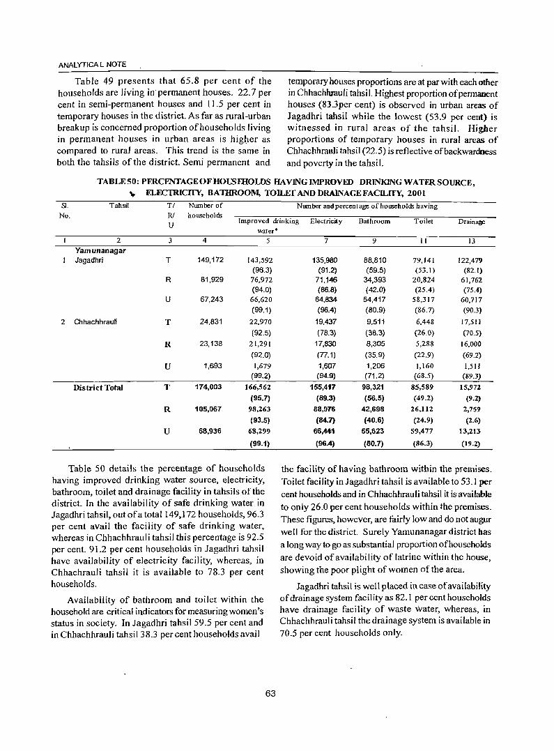
ANALYTICAL NOTE
Table 49 presents that 65.8 per cent of the households are living in' permanent houses. 22.7 per cent in semi-permanent houses and 11.5 per cent in temporary houses in the district. As far as rural-urban breakup is concerned proportion of households living in permanent houses in urban areas is higl:Ier as compared to rural areas. This trend is the same in both the tahsils of the district. Semi permanent and
temporary houses proportions are at par with each other in Chhachhrauli tahsil. Highest proportion of permanent houses (83.3per cent) is observed in urban areas of Jagadhri tahsil while the lowest (53.9 per cent) is witnessed in rural areas of the tahsil. Higher proportions of temporary houses in rural areas of Chhachhrauli tahsil (22.5) is reflective of backwardness and poverty in the tahsil.
TABLE50: PERCENTAGEOFHOUSmOLDS HAYING IMPROVED DRlNKING WATFR SOURCE, .., ELECTRICITY, BATHROOM, TOILET AND DRAINAGE FACILITY, 2001
81. Tahsil TI NlUTIber of Nwnber and percentage of households having No. RI households
U Improved drinking Electricit y Bathroom Toilet Drain~
2
Yamunanagar 1 Jagadhri
2 Chhachhrauli
District Total
3
T
R
U
T
R
U
T
R
U
4
149,172
81,929
67,243
24,831
23,138
1,693
174,003
105,067
68,936
water* 5
143,592 (96.3)
76,972 (94.0)
66,620
(99.1)
22,970
(92.S)
21,291
(92.0)
1,679 (99.2)
166,562
(95.7)
98.263
(93.5)
68,299
(99.1)
Table 50 details the percentage of households having improved drinking water source, electricity, bathroom, toilet and drainage facility in tahsils of the district. In the availability of safe drinking water in Jagadhri tahsil, outofa total 149,172 households, 96.3 per cent avail the facility of safe drinking water, whereas in Chhachhrauli tahsil this percentage is 92.5 per cent. 91.2 per cent households in Jagadhri tahsil have availability of electricity facility, whereas, in Chhachrauli tahsil it is available to 78.3 per cent households.
Availability of bathroom and toilet within the household are critical indicators for measuring women's status in society. In Jagadhri tahsil 59.5 per cent and in Chhachhrauli tahsil 38.3 per cent households avail
63
7 9 II 13
135,980 88,810 79,141 122,471)
(91.2) (59.5) (53.1) (82.1) 71,146 34,393 20,824 61,762 (86.8) (42.0) (25.4) (75.4)
64,834 54,417 58,317 60,717
(96.4) (80.9) (86.7) (90.3)
19,437 9,S11 6,448 17,511
(78.3} (38.3) (26.0) (70.5)
17,830 8,30S 5,288 16,000
(77.1) (3S.9) (22.9) (69.2)
1,607 1,206 1,160 1,511 (94.9) (71.2) (68.5) (89.3)
155,417 98,321 85,589 15.972
(89.3) (56.5) (49.2) (9.2)
88,976 42,698 26.112 2,759
(84.7) (40.6) (24.9) (2.6)
66,441 55,623 59,477 13,213
(96.4) (80.7) (86.3) (19.2)
the facility of having bathroom within the premises. Toilet facility in Jagadhri tahsil is available to 53.1 per cent households and in Chhachhrauli tahsil it is available to only 26.0 per cent households within the premises. These figures, however, are fairly low and do not augur well for the district. Surely Yamunanagar district has a long way to go as substantial proportion of households are devoid of availability of latrine within the house, showing the poor plight of women of the area.
Jagadhri tahsil is well placed in case of availability of drainage system facility as 82.1 per cent households have drainage facility of waste water, whereas, in Chhachhrauli tahsil the drainage system is available in 70.5 per cent households only.
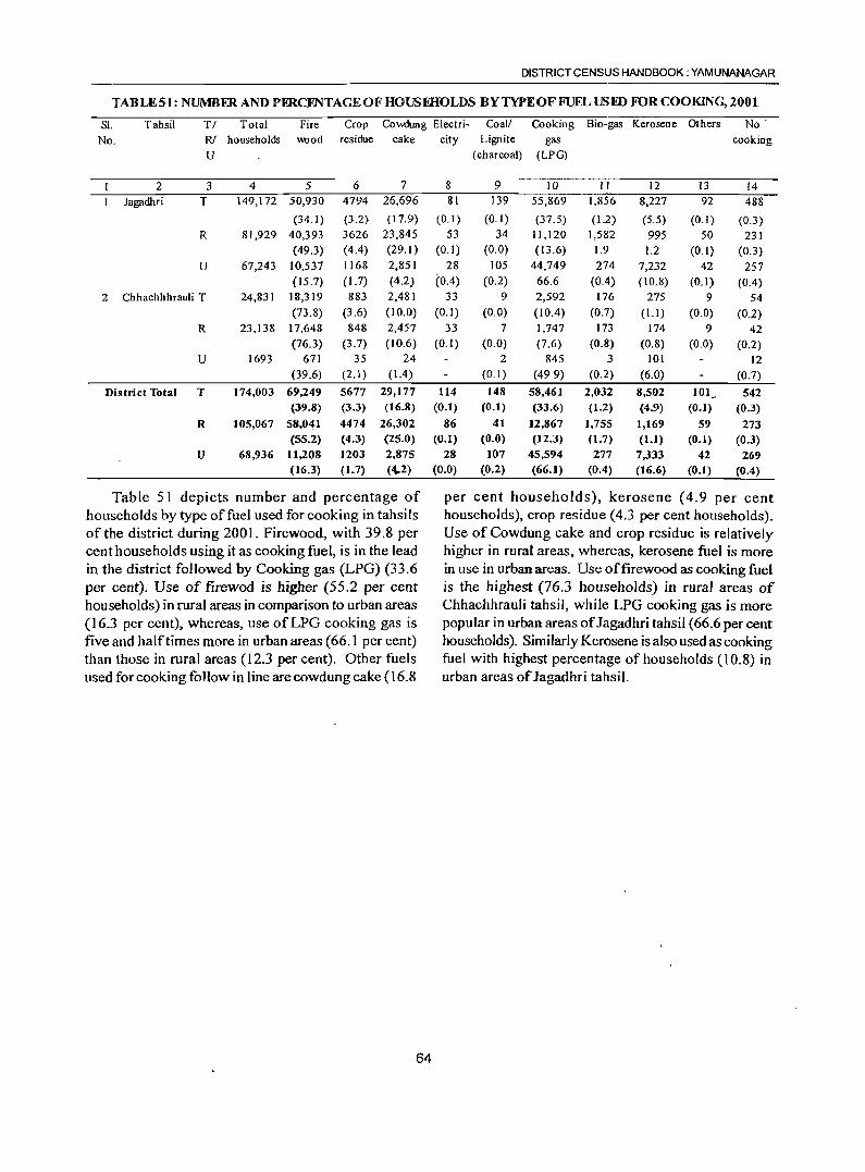
DISTRICT CENSUS HANDBOOK: YAMUNANAGAR
TABLESt: NUMBER AND PERCINTAGEOFHOUSEHOLDS BY TYPE OF FUEL USED FOR COOKING, 2001
Sl. Tahsil TI Total Fire Crop Cowdung Electri- Coal! Cooking Bio-gas Kerosene Others No
No. R! households \\Ood residue cake city Lignite gas cooking
U (charcoal) (LPG)
2 3 4 5 6 7 8 9 10 II 12 13 14 Jagadhri T 149,172 50,930 4794 26,696 81 139 55,869 1,856 8,227 92 488
(34.1) (3.2) (17.9) (0.1) (0.1) (37.5) (1.2) (5.5) (0.1) (0.3) R 81,929 40,393 3626 23,845 53 34 11,120 1,582 995 50 231
(49.3) (4.4) (29.1) (0.1 ) (0.0) (13.6) 1.9 1.2 (0.1) (0.3) U 67,243 10,537 1168 2,851 28 105 44,749 274 7,232 42 257
(15.7) (1.7) (4.2) (0.4) (0.2) 66.6 (0.4) (10.8) (0.1) (0.4) 2 Chhachhhrauli T 24,831 18,319 883 2,481 33 9 2,592 176 275 9 54
(73.8) (3.6) (10.0) (0.1) (0.0) (10.4) (0.7) (1.1) (0.0) (0.2) R 23,138 17,648 848 2,457 33 7 1,747 173 174 9 42
(76.3) (3.7) (10.6) (0.1) (0.0) (7.6) (0.8) (0.8) (0.0) (0.2) U 1693 671 35 24 2 845 3 101 12
(39.6) (2.1) (1.4) (0.1) (499) (0.2) (6.0) (0.7)
District Total T 174,003 69,249 5677 29,177 114 148 58,461 2,032 8,502 101 - 542 (39.8) (3.3) (16.8) (0.1) (0.1) (33.6) (1.2) (4.9) (0.1) (0.3)
R 105,067 58,041 4474 26,302 86 41 12,867 1,755 1,169 59 273 (55.2) (4.3) (2S.0) (0.1) (0.0) (12.3) (1.7) (1.1) (0.1) (0.3)
U 68,936 11,208 1203 2,875 28 107 45,594 277 7,333 42 269 (16.3) (1.7) (4,.2) (0.0) (0.2) (66.1) (0.4) (16.6) (0.1) (0.4)
Table 51 depicts number and percentage of per cent households), kerosene (4.9 per cent households by type of fuel used for cooking in tahsi Is households), crop residue (4.3 per cent households). of the district during 200 I. Firewood, with 39.8 per Use of Cowdung cake and crop residue is relatively cent households using it as cooking fuel, is in the lead higher in rural areas, whereas, kerosene fuel is more in the district followed by Cooking gas (LPG) (33.6 in use in urban areas. Use of firewood as cooking fuel per cent). Use of firewod is higher (55.2 per cent is the highest (76.3 households) in rural areas of households) in rural areas in comparison to urban areas Chhachhrauli tahsil, while LPG cooking gas is more (16.3 per cent), whereas, use of LPG cooking gas is popular in urban areas of Jagadhri tahsil (66.6 per cent five and halftimes more in urban areas (66.1 per cent) households). Similarly Kerosene is also used as cooking than those in rural areas (12.3 per cent). Other fuels fuel with highest percentage of households (l0.8) in used for cooking follow in line are cowdung cake (16.8 urban areas of Jagadhri tahsil.
64
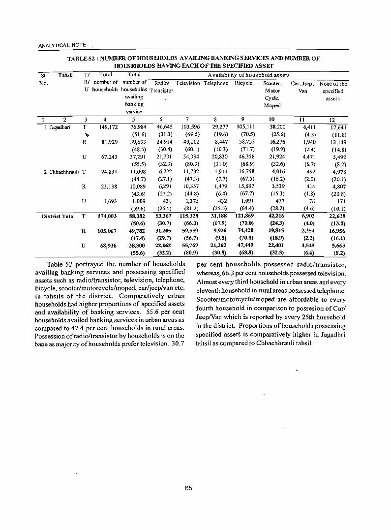
ANAL YTICA L NOTE .
SI.
TABLE 52 : ~UMB.ER OF HOUS mOLDS AVAILING BANKING SERVICES AND NUMBER OF
HOUSEHOLDS HAVING FACH OF THE SPECIFIID ASSET
Tahsil TI Total Total Availability of house hold assets No. R! number of number of Radiol Television Telephone Bicycle Scooter, Car, Jeep, None of the
U households households Transistor Motor Van specified availing Cycle, assets banking Moped service
2 3 4 5 6 7 8 9 to II 12 I J ag;ldhari T 149,172 76,984 46,645 103,596 29,277 105,111 38,200 6,41 I 17,641
... (51.6) (31.3) (69.5) (19.6) (70.5) (25.6) (4.3) ( 11.8) R 81,929 39,693 24,914 49,202 8,447 58,753 16,276 1,940 12,149
(48.5) (30.4) (60.1) (10.3) (71. 7) (19.9) (2.4) (14.8) U 67,243 37,291 21,731 54,394 20,830 46,358 21,924 4,471 5,492
(55.5) (32.3) (80.9) (31.0) (68.9) (32.6) (6.7) (8.2) 2 Chhachhrauli T 24,831 11,098 6,722 11,732 1,911 16,758 4,016 492 4,978
(44.7) (27.1) (47.3) (7.7) (67.5) (16.2) (2.0) (20.1) R 23,138 10,089 6,291 10,357 1,479 15,667 3,539 414 4,807
(43.6) (27.2) (44.8) (6.4) (67.7) (15.3) (1.8) (20.8) U 1,693 1,009 431 1,375 4~2 1,091 477 78 171
(59.6) (25.5) (81.2) (25.5) (64.4) (28.2) (4.6) (10.1)
District Total T 174,003 88,082 53,367 115,328 31,188 121,869 <12,216 6,903 22,619 (50.6) (30.7) (66.3) (17.9) (70.0) (24.3) (4.0) (13.0)
R 105,067 49,782 31,205 59,559 9,926 74,420 19,815 2,354 16,956 (47.4) (29.7) (56.7) (9.5) (70.8) (18.9) (2.2) (16.1)
U 68,936 38,300 22,162 55,769 21,262 47,449 22,401 4,549 5,663 (55.6) (32.2) (80.9) (30.8) (68.8) (32.5) (6.6) (8.2)
Table 52 portrayed the number of households per cent households possessed radio/transistor, availing banking services and possessing specified whereas, 66.3 per cent households possessed television. assets such as radio/transistor, television, telephone, Almost every third household in urban areas and every bicycle, scooter/motorcycle/moped, car/jeep/van etc. eleventh household in rural areas possessed telephone. in tahsils of the district. Comparatively urban Scooter/motorcycle/moped are affordable to every households had higher proportions of specified assets
fourth household in comparison to possesion of Car/ and availability of banking services. 55.6 per cent households availed banking services in urban areas as JeepNan which is reported by every 25th household
compared to 47.4 per cent households in rural areas. in the district. Proportions of households possessing
Possession ofradioltransistor by households is on the specified assetS is comparatively higher in Jagadhri
bane as majority ofhouseholds prefer television. 30.7 tahsil as compared to Chhachhrauli tahsil.
65
(xi) Major social and cultural events,
Yamunanagar district is famous for fairs and festivals. Kapal Mochan fair is very popular fair held annually.
Dussehra, Diwali, Holi, Janamashtami are the common festivals. The minor festivals are Shivratri, Gugga Naumi, Raksha Bandhan, Durga Ashtami, Lohri and Sankrante. A few festivals like Karwa Chauth, Nirjala Ekadshi and Hoee are celebrated by women.
After Dussehra, a festival known as Garbara garbari is celebrated by the females and it continues for five days. It is a festival of unmarried girls but married women can also take part. The lamps are put in baked covers of earth with holes in them and the girls sing and dance with these lamps in their hands. The girls finish the celebration on the fifth day after Dussehra by throwing the lamps into the tanks.
Bawan Dwadshi is another important religious festival celebrated in the district. Fairs dedicated to Vamana, an incarnation of Vishnu, are held at Jagadhri on Bhadon Sudi Dwadshi (August-September). The images of deities from different temples are taken out in procession. The devotees observe fast and take bath in a nearby sacred river or tank.
Teej festival, associated with cultural affinity of Haryana, is celebrated with full fervor.
Besides, festivals of different religious groups like Guru Nanak Gurparb, Mahavir Jayanti, Id-ul-fitr, Idul-Zuha, Moharram, Guru Ravidas Jayanti, Balmiki Jayanti, Christmas and Easter are celebrated with great enthusiasm.
Kapal Mochan Fair: As per Hindu mythology, Kl!}>al Mochan has the work place of Maharishi Ved VX~s son of Maharishi Prashar.There are five tirths in th~vicinity of Kapa) Mochan.!t is believed that the Pandavas along with Draupdi visited the place and took dip in the holy tanks to wash off the sins they -had attracted by killing their relatives in the battle of Kurukshetra. According to another Hindu mythology, Lor~ Rama had visited Kapal Mochan in the Pushpak Vim}m while retumingtoAyodhya after killing Ravana. Kapal Mochan fair is celebrated for four days on Kartik Purnmashi (October-November) annually. The holy tank ofKapal Mochan, the venue of this fair is located about 18 kilometres from Jagadhri on BilaspurRanjitpura road, in Jagadhri tahsil. Kapal Mochan is sacred both for Hindus and Sikhs. It is the biggest fair
66
DISTRICT CENSUS HANDBOOK: YAMUNANAGAR
in the district that attracts pilgrims from all over India. The pilgrims, over one million, take holy dip in Kapat Mochan, Rin Mochan and S,uraj Kund and pay obeisance to the statue of a cow and a calf standi ng on its banks. Different institutions organize community kitchens during the mela.
Jor Mela:The annual three-day. Jor Mela at K apalM ochan G urdw ara also takespJace from 24th.
November. Guru Gobind Singh had cleaned his . weapons in the sarovar after the Bhangani war and stayed there for 52 days.It has great followings among Sikhs.
Shah Kumaish Fair: A religious fair in honour of Shah Kumaish is held in Sadhaura in February.The fair was started by Bairam Khan in A.D. 1556. The visitors worship the tomb of Shah Kumaish. The devotional singing, drum beating and wrestling are other attractions of this fair.
Suraj Kund Fair: Dedicated to Sun god a religious fair is held on Bhadon Sudi 6 (August-September) at Sugh near Jagadhri.
Panch Tirathi Fair: A religious fair in memory of five Pandavas who are believed to have taken bath in the Panchtirtha tank, located in village Harnaul (Jagadhri tahsil) for four days in Magh (JanuaryFebruary).
Mela Santoor: A religious fair is held in village Basantoor, (Jagadhri tahsil) in Bhadon (AugustSeptember) for three days. It is said to be associated with Raja Shantanu ofMahabharata. There is a sacred well, the water of which is said to be as sacred as that of the Ganges.
Voluntary Organisations
Voluntary Organisations playa piorieermle in the provision of welfare service to the vulnerable sections of society i.e. women, children and handicapped persons. Nort ssigns importance to the welfare services and helps them by sizeable allotments.
As per Directory 2000, published by the Director,
Social Justice & Empowerment;Haryana the following Welfare Organisations were functioning in different fields in the district:
1. District Council for Child Welfare, Yamunanagar
Located in Nehru Park, Yamunanagar, it runs Creches and Balwaris for the public welfare.
ANALYTICAL NOTE
2. Mahila Kalyan Samiti,Yamunanagar
Located in Model Town, Yamunanagar, it is working for the welfare of women.
3. Worth,Yamunanagar
Located in Bal Bhavan, Nehru Park,Yamunanagar, it is working for the welfare of women.
4. Kushth & Jan Kalyan Samiti, Yamunanagar
Located in Model Town, Yamunanagar, it is working for the ~elfare of Lepers.
5. Prevention of Blindness Association, Yamunanagar
Located in Civil Hospital, Yamunanagar, it is working for the prevention of Blindness.
6. Sh. Deena Nath Kohli Charitable, Jagadhri
Run by Sh. Inder Sain Khetrapal C/o Sanatan Dharma Mandir, Sadhaura, it is engaged in social activities for public welfare.
7. Roshni Eyes & General Charitable Hospitality Hospital, Jorian, Yamunanagar
Located near Dr. Raj Kumar Hospital, Yamunanagar, it is working for the prevention of Blindness.
8. Jyoti Kunj, Yamunanagar
. Located in Bal Kunj, Yamunanagar, it is engaged in literacy campaign.
9. Women League, Girls Industrial School, Yamunanagar
Located in Nehru Park, Model Town, Yamunanagar, it is running an Industrial Training School.
f
10. Indian Red Cross Society, Yamunanagar
Located in Gobindpuri, Yamunanagar, it is engaged in the welfare of the public and provides medical facilities to the community.
11. Utthan, Yamunanagar
Located in Lal Dwara, Yamunanagar, it is working for the welfare of women and handicapped.
12. Vishv Kalyan and Satsang Sabha, Yamunanagar
Located in Brijpuri, Yamunanagar, it is engaged in social and religious activities for the public welfare.
13. Yuva Vikas Kendra, Chhachhrauli
Located in village Ganauli (Chhachhrauli), it is engaged i~ the welfare of youth and social activities.
14. lYfahajan l(aJyan Sabha, Yamunanagar
67
Located in Civil Hospital, Yamunanagar, it is engaged in social welfare activities.
15. Jan Kalyan Sabha, Yamunanagar
Located in Civil Hospital, Yamunanagar, it is engaged in social welfare activities.
16. Nehru Yuva Kendra, Yamunanagar
Located in Model Town, Yamunanagar, it is engaged in welfare of youth and social activities.
17. Manav Utthan, Yamunanagar
Located in Yamunanagar, it is engaged in social welfare activities.
I8.Bharat Vikas Parishad, Yamunanagar
Located in Yamunanagar, it is engaged in social welfare activities.
19. Bharat Vikas Parishad, J agadhri
Located in Jagadhri,it is engaged in social welfare activities.
20. Shakti Vahini, Yamunanagar
Located in Model Town, Yamunanagar, it is engaged in social welfare activities.
21. Sahara, Jagadhri
Located in Housing Board Colony, Sector-17, Jagaghri, it is engaged in social welfare activities .
22. Paryas, Jagadhri
Located in Sector-I 7 , J agadhri, it is engaged in social welfare activities.
23. Yamunanagar Club, Yamunanagar
Located in Yamunanagar, it is engaged in social welfare activities.
24. Lion's Club, Jagadhri
Located in Jagadhri, it is engaged in social welfare activities.
25. Lion's Club, Yamunanagar
Located in Yamunanagar, it is engaged in social welfare activities.
26. Lion's Club, Twin Town, Yamunanagar
Located in Yamunanagar, it is engaged in so.cial welfare activities.
27. Lion's Club, Metal City, Jagadhri
Located in Jagadhri, it is engaged in social welfare activities.
28. Lion's Club, Workshop, Jagadhri

Located in Jagadhri, it is engaged in social welfare activities.
29. Rotary Club, Yamunanagar
Located in Yamunanagar, it is engaged in social welfare activities.
30. Rotary Club, Jagadhri, North
Located in Yamunanagar, it is engaged in social welfare activities.
31. Rotary Rotaract Club, Jagadhri
Located in Jagadhri, it is engaged in social welfare activities.
32. Rotary Club, Jagadhri
Located in Jagadhri, it is engaged in social welfare activities.
33. Rotary Club, Mustafabad
Located in Mustafabad, it is engaged in social welfare activities.
34. Rotary Club Radaur
Located in Radaur, it is engaged in social welfare activities.
35. Jagadhri Club, Jagadhri
Located in Jagadhri, it is engaged in social welfare activities.
36. Bhartiya Mahila Kalyan Sangh Yamunanagar
Located in Aggarwal Bhavan, Yamunanagar, it is engaged in social welfare activities.
37. Samaj Hitkari Sangthan, Yamunanagar
Located in Yamunanagar, it is engaged in social welfare activities.
38.~nner Wheel'Club, Yamunanagar
. .;Located in Yamunanagar, it is engaged in social welfare activities.
39. All India Somaj Sewa Kendra, Yamunanagar
Located on Kansepur Road, Yamunanagar, it is enga-ged in social welfare activities.
;"
40.~arav Kalyan Social Welfare Society, Jagadhri
Located in Shashtri Colony, Jagadhri, it is engaged in social welfare activities.
41. Bharat Vikas Parishad, Sadaura
Located in Sadaura, it is engaged in social welfare activities.
68
DISTRICT CENSUS HANDBOOK: YAMUNANAGAR
(xii) Brief description of places of religious, historical or archaeological importance and places of tourist interest in the district :
Chhachhrauli :
Chhachhrauli is the headquarters of the tahsil of the same name. It was the capital of erstwhile princely State of Kalsia which was established in 1763. It is located about 11 kilometres from Jagadhri towards north-east. Prominent buildings
. of the town are Ravi Palace, Clock Tower, Fort and Janak Niwas.
Kalesar Wild Life Sanctuary (Chhachhrauli Tahsil)
Situated on the banks of the holy Yamuna in the Siwalik foot hills, Kalesar forests provide a panorma of nature's beauty. Kalesar is just 130 kilometres from Chandigarh and can be reached via, Naraingarh, KalaAmb, Sadaura, Bilaspur and Chhachhrauli. It has been recently declared as a wild life sanctuary. Kalesar is a reserve forest.
Yamunanagar:
It is located on the bank of western Yamuna Canal. Previously it was known as Abdullapur. After 1947 a camp to accommodate refugees was established and later on model town anQ few other colonies were established. Now it is one of the major industrial centres of Haryana ~nd has the distinction of having many large and medium scale industrial units. It is a big timber market and has many saw mills. A city centre complex on the Western Yamuna Canal has been developed which is having a lake, a restaurant, club, view tower, stadium, swimming pool, library, museum and gymnasium hall.
The State Government has provided oases of
comfort, relaxation and recreation br creating
tourist complexes for the road-weary all over
Haryana.These complexes include motels, restaurants and resorts. In Yamunanagar distriot
• I the department oftouflsm has developed one such tourist resort which is kno.wn as Grey' Pelican,
Yamunanagar. Facilities available include a guest
house, restaurant, bar, lounge for gathering and garden party facilities.Non-air~ conditioned
accommodation of two double bed rooms is
available for the tourists.
ANALYTICAL NOTE
Jagadhri:
Jagadhri is the headquarters of the tahsil of the same name. The town is thought to be relic of the old name Yugandhari. Probably the name of Yugandhara was used for a region, inhabited by a tribe of the same name and it comprised some mountainous tracts. Discovery of old coins of different periods prove the antiquity of the place. The town had come into prominence again in the Sikh times';.Nadir Shah destroyed it but it was rebuilt by Buria Chief Rai Singh. Jagadhri is famous for brass utensils allover India and is the biggest centre of this Industry. There are two important temples namely Gauri Shankar temple and Devi Bhavan.
Sadaura ( Jagadhri Tahsil) :
Sadaura was the camping ground of sadhus in ancient times on their way to the Ganga and is the corruption of the original name Sadhu-Rah. It is about 40 kms. north-west of Yamunanagar and 15 kms. from Bilaspur on the BilaspurNaraingarh road. The mound is spread over an area of about 4 acres. Sad aura is situated on the bank ofNakti or Sadhorawali Nadi. The antiquity of the site goes back to about 3,000 years. The pottery by which the cultural choronology of the site has be ascertaind are Painted Grey Ware, Black Slipped Ware, Northern Black Polished ware, Kushana Stamped pottery, Red polished ware of the Gupta period, Red ware of the Rajput perod and Glazed Ware of Sultanat and Mughal periods respectively. The structural finds from the site include two bastions made of lakhauri bricJcs. During the course of excavation, a circular structure made of wedge shaped bricks of about 35 courses was seen which is still exposed. The finds from the site include beads of shell, terracotta, turquoise & fragments of glass bangles.Discovery of ancient copper case, coins point towards the antiquity of the place.There are tI\ree temples,Gaggarwala,Toronwala and l'v1anokamna and three- tanks along with them. These t~mples and tanks .. a_re held in high esteem.Besides, there is a tomb of Hazrat Shah Kumesh built in A.D. 1450 with a mosque dating A.D. 1600. A fair is held every year and is reported to have been started in A.D. 1556 by Bairam Khan. A Sangni Mosque built of blocks of gray stone, in the 16th century is located in the west of the town and is in ruins.
69
Sugh ( Jagadhri Tahsil) :
It is situated on the bed of old Yamuna now the Western Yamuna canal and is located about 5 kilometres east of Jagadhri and has been identified with the ancient city of Shrughana. It was an important city in northern India and has been mentioned in vedic literature and past literature. Detailed accounts of the city are recorded by Hiuen Tasang, chinese traveller who visited the city in the first half of the 7th century. His account shows that Shrughana was the capital city of a kingdom which extended on both sides of the Yamuna river under the Siwalik ranges. The archaeological findings at Sughhave revealed that the town existed from circa 600 B.C. to circa A.D. 300. The archaeological finds included pottery, terracotta figurines, coins, sealings, etc. Among these terracotta finds a broken figure depicting a headless child with a takhti in lap on display in the National Museum, New Delhi, is of special interest. The importance of the plaque lies in the fact that the writing board had alphabets belonging to Sunga period. No such figure has been found from any other site in India.
Chaneti ( Jagadhri Tahsil) :
It is a small village situated about 3 kilometres east of Jagadhri and nearly the same distance from the famous site of Sugh. Just about one hundred metres south-west of the village lies a huge brick mound which is of20 metres diameter and is 8 metres high. The bricks used are well burnt and yellowish red in colour. The very shape and structure of this mound, the laying of concentric layers of huge bricks, the gradually diminishing diameter as the structure rises. the bricks well set in the circular fashion and the testimony ofHiuen Tsang, the Chinese traveHer, lead us to believe that the mound is the remnant of an Ashokan stupa. This finding, however, has to be confirmed by more positive epigraphicafor excavational evidence.
Bilaspur (Jagadhri tahsil):
It is a place of great antiquity, associated with Rishi Ved Vyas, the writer of Mahabharata. The name of the town has been corruptetI from original Vyaspur. There are a number of tirthas in and around Bilaspur. Among these, the most famous
is Kapal Mochan situated about 2.5 kilometres north of Bilaspur on Bilaspur-Nahan road and located on the eastern bank of the Saraswati river. Kapal Mochan tank is held in high esteem and big fair is held here in October-November for five days from Ekadashi to Puranmashi. KapalMochan is a holy tirtha of Haryana and hosts Rin Machan kund, Suraj Kund, Vyas Kund and Siddheshwara Temple with plenty of sculptural remains, antiquities and a widely spread mound. Gurdwara Kapal Mochan dedicated to Guru Gobind Singh Ji is also located here.
The earlier findings from the site made by Cunningham include two fragmentary Gupta inscriptions alongwith some Indo-Sassaman coins and coins ofMenander. The sculptural finds from the site include an image of Uma-Maheswara of the late Gupta period which is preserved in RadhaKrishna temple. A Vishnu head in relief and a Vaikuntha image on a slab also of the late Gupta period are preserved in Department of Archaeology and Museums, Haryana.Recent explorations at the site of late Gupta period can be seen in old gurdwara. Pottery reported from the site include Red ware and Grey Ware.
Basatianwala ( Jagadhri Tahsil) :
Panchmukhi Hanuman temple is located in village Basatianwala, 4 kilometres away from Bilaspur on Bilaspur-Chhachhrauli road. The temple has a gigantic idol of Hanuman with a face having five different images.
Sandhaya (Jagadhri tahsil) : ~ ~ The village is located about 6 ki lometers north ~Bilaspur on the Bilaspur-Nahan highway. Here are two sites namely larasandh-ka-tila and Gyarsiyan Sati Mata Ashram. Iarasandh-ka-tila is located about 2 kms. West of the village and has a huge mound of about 70x70 metres oriented nID-th-south with lot of pot sherds distributed over tt;~ surface .
..... 1' Towards the northern portion of the mound is
seen massive gateway facing north, with walls rising to an approximate height of 8metres, made up of lakhauri bricks. Similarly at many places, traces of walls can be seen on the surface. The potsherds belong to Kushana and Gupta period in the form of bowls and vases in Red Ware and
70
DISTRICT CENSUS HANDBOOK: YAMUNANAGAR
Red Slipped Ware. Regular visits of the villagers have yielfled plenty of coins; sculptures, beads, terracotta figurines and other antiquities from this mound. However, all have met the hands of treasure-hunters.
On the same road leading to larasandh-ka-tila is Gyarsiyan Sati Mata Ashram located about 1.5 kms from the village. Here are few stone sculptures and architectural members of a non-existent temple, dated to the 16 th_17th century A.D. Proper identification could not be done as they have all been reused, as a part of the newly constructed brick structure and coated with lime and ochre.
Buria:
It is located 6 kilometres to the East of lagadhri near the western bank of Yamuna Canal. It is an ancient town which has seen many upheavals. The Chinese traveller, Hiuen Tsang, visited Buria in 7th century, as referred in his memoirs. The place was rehabilitated by Mughal emperors, Humayun and Shah lahan. Shah lahan erected a Rang Mahal here, a well-built place with stone arches. Buria was the headquarters of a considerable principality held by the Sikhs in 1760. A small fort of the erstwhile Buria Chief is used by his successors as their residence.
Adi Badri, (Jagadhri tahsil) :
Situated about 18 kilometres to the north of Bilaspur in the foot-hills of the Siwaliks, it 'is a place associated with ancient past. The river Saraswati is believed to have originated frot;n this place. A number of sculpture of Shiva-Parvati and Ganesha belonging to 9th_I Dlh century A.D, and a few Buddhist images belonging to II th1121h century A.D. have been discovered from this place.
Basantoor (Jagadhri tahsil) :
I
It lies north-east ofChhachhrauli towp and is said to be associated with Raja Shantanu ofMilhabharata. There is a sacred well whose water is said to be as sacred as that bfthe Ganga: The place has also yielded Painted Grey Ware.
Harnaul (Jagadhri tahsil) :
Situated about 7 kilometres west of lagadhri, the place is held in high esteem because of the-Panch Tirtha,
ANALYTICAL NOTE.
a sacred tank. It is believed that the five Pandavas took bath in the tank 'here. A big fair is held every year in January- February.
Sakhi Sarvar (Jagadhri tahsil) :
A shrine is located on a peak of the lower Siwalik hills near Khizri in Jagadhri tahsil. Its structure is not unlike that of the shrine dedicated to Guga Fir. Sakhi Sarvar was not a local saint, and little is known of him in the neigQ_bourhood. A businessman is said to have built the shrine. A fair is held here on every Thursday in July-August.
(xi) Scope of Village and Town Directory
Village Directory:
Amenities and land use:
In the Village Directory, certain basic data are provided for each village separately. All the villages in the district have been arranged Community Development (C.D.) blockwise and villages within the C.D. block are arranged according to their permanent location code number (PLCN). The Census and non Census data have been presented by C.D. block in the Village Directory portion of the District Census Handbook to meet the demand of data users and planners for the formulation of C.D. level planning etc. It is for the first time in the history of the Indian Census that eight digit PLCN has been assigned to each village within the StatelUT from the first village of the first tahsil of the first district upto the last village of last tahsil of the last district. PLCNs assigned to villages at the 2001 Census will be adopted at the time of Census of India 2011 with some minor changes. The field length of the complete PLCN structure for a village has been kept upto 8 digits. The first 6 digits represent the code number of the existing village, while the last 2 digits have been kept to accommodate change in the village, if any, which may occur du~ to'split in the existing village or addition of new village or creation of town out of existing village, etc at the subsequent Censuses.
The format of village directory prescribed for the
Census 2001 is almost similar to that of 1991 Census
except for a few modifications as has already been explained in the analytical note, It contains information
on area, population, households, availability of the
71
amenities like educational, medical', drinking water,
post, telegraph and telephone communication facilities,
banking facilities in commercial and cooperative sectors, credit societies on agricultural and non agricultural aspects, recreational and cultural facilities
available in the village, approach to village, distance
of the village from the nearest town, availability of
power supply for domestic and agricultural uses and
other purposes, availability of newspapers/magazines,
important commodities manufactured in the viUage, area under different types of land use such as, under
forest, cultivation (irrigated and unirrigated), cultivable
waste including gauchar and groves and area not available for cultivation. The data presented in the Village Directory have been collected from the
district/tahsil and revenue agencies and other concerned departments in the State.
Town Directory :
There are seven statements in the Town Directory. These statements have been compiled from the information supplied by the local bodies of the State and the contents thereof are as follows:
Statement I :
This statement gives class, name and civic
administration status of the town and its location code which runs into eight digits, name of tahsil, name of
C.D. block in case of non-municipal (Census) town,
number of households, population and decadal growth
rate of the towns 190 I - 2001, density of popUlation,
and sex ratio for the last three decadal censuses.
Statement II :
This statement provides data on physical aspects
viz; rainfall, temperature of towns, location of town
with respect to its dista~ce from State/district/tahsil headquarters, from the nearest city/railway -station/
bus route, etc.
Statemeut III
It shows the position of municipal finances for the
year 1998-99. The income and expenditure figures
have been given in Rs."OOO" in respect of each statutory town in the district under various heads like,
income through taxes, revenue derived from municipal
properties and power apart from taxation, Govt. grant, loan advances and expenditure on general
administration, Public safety, Public Health and conveniences, Public Works and Public Institutions etc.
Statement IV :
This statement indicates civic and other amenities available in each town of the district. It also contains total population, and Scheduled Castes population. There is no population notified as Scheduled Tribes in the State. The details given under civic and other amenities include availability of roads, both pucca and kutcha, system of sewerage, number of latrines, method of disposal of night soil, protected water supply, fire fighting service and number of electric connection available in the town.
Statement V :
Statement V explains the status of medical, educational, recreational and cultural facilities in the town. The medical facilities cover number ofhospitalsl dispensariesffB clinics. The number of beds available under each type of medical institutions is also given. Similarly, the educational facilities shown include availability of Arts/Science/Commerce colleges of degree level, medical colleges, polytechnics, shorthand, typewriting and vocational training institutions, higher secondary/int~rmediate/PUC/Junior college level, secondary/matriculation, junior secondary/ middle school, primary school and adult literacy classes! c~tres. This statement also includes information on ~lrking women's hostels alongwith number of seats
tfl~
72
DISTRICT CENSUS HANDBOOK: YAMUNANAGAR
and number of recreational and cultural centers like , stadia, cinema, auditorium/the~tre/community halls, public libraries in each town.
Statement VI :
Information on three most important commodities
manufactured and exported is given for each town.
It also contains information on number of banks , agricultural credit and non agricultural credit societies
available in each town of the district.
Statement VII :
Like 1981 and 1991 Censuses, information on the
availability of civic and other amenities in slum areas
has been collected during this Census too. The only
difference in the previous two Censuses and present
Census is that during the 1981 and 1991 Censuses, this information was collected in statement IVA, while
in the 2001 Census, it has been collected in statement
VII. In view to collect an exhaustive infor;nation in slum demography etc., this separate statement has been introduced. Slum data collected in this Statement
will be used as an aid and tool for urban planning of
the towns. Various types of information viz., name of the slum area, total number of households and popUlation of the slum areas, availability of paved roads (in ,Kms.) in.the slum area, system of sewerage, number of latrines (private and community), available
method of disposal of night soil, number of tap points installed for the supply of protected water and electric cQnnections available for domestic road lighting and
other purposes have been collected in this statement.
Part-A : Village and Town Directory

VILLAGE DIRECTORY
Section-I
Village Directory
Village Directory :
(A) NOTE EX~AINING THE ABBREVIATIONS USED IN
VILLAGE DIRECTORY
The "Village Directory" is one of the traditional compilations of the Census. It gives the list of villages, their location code numbers, their area, population, number of households, amenities such as educational, medical, drinking water, post and telegraph, commercial and co-operative banks, agricultural, nonagricultural and other credit societies, recreational and cultural facilities, communication, approach to vilJage, nearest town with a distance, power supply, availability of newspapers and magazines, most important commodity manufactured and land use of each village.
Village is a statutory recognized unit having a definite boundary and separate land records. In case, a complete village is treated as an outgrowth of urban agglomeration, data on amenities for that village, have not been given in the Village Directory, but shown along with the urban component. The villages which are considered as Census towns, are shown in Town Directory. For those villages which have partly merged in an outgrowth ofU.A., the amenities data are shown in the Village Directory for those particular villages.
The 'un-inhabited' villages (villages with no population) have been indicated as such after furnishing details in columns 1 to 3 i.e., Serial number, Name of village & location code number and unhabited is shown of the village against column no. 4 to 18. The land use data for such villages are shown in col. 19 to 23.
The Village Directory format has 23 columns and the details given under each column for the village is as follows:
75
Columns 1: Serial Number
Self explanatory. All the villages within the C.D. Block are presented serially in the ascending order of their location code number.
Columns 2: Name and Location Code Number of village.
The name and location code number of the village are shown against these columns. This also includes the forest and uninhabited villages.
Column 3 : Area of the village
The area of the villages is given in hectares. Wherever, the area figures are not furnished by the concerned department the column has been left blank.
Column 4 : Total popUlation
The total popUlation of the village as per 200 I Census is given against this column.
Column 5 : Number of households
The number of households as per 200 I Census is given in this column.
Amenities:
In columns 6 to 23, availability in respect of different amenities such as education, medical, drinking water, post, telegraph, banks, credit societies, communication, power, approach road, etc., in each village have been depicted with appropriate codes against the columns concerned. Wherever, the amenities are not available in the village, a dash C-) is shown in the column and next to it in brackets the distance in broad ranges, viz., < 5 kms, 5-10 kms and 10+ kms of the nearest place, where the facil ity is available are given. Column wise details are given below:

VILLAGE DIRECTORY
Column 10: Commercial and Co-operative
Banks
If the village is served by any banking service,
commercial bank, co-operative bank etc.the same is indicated in codes mentioned below along with the
number of banks in brackets. If not available the distance of nearest place where the facility exis~ is
given:
(i) C~mercial Bank CM
(ii) Co-operative Bank CP
Column 11: Credit Societies
If the village enjoys the services of Credit
Societies i.e. Agricultural Credit Societies, Non Agricultural Credit Societies or Other Credit Societies, the same are indicated in codes mentioned below
along with the number of such societies in brackets. In case the facility is not available within the village the distance of the nearest place where such facility exists is given :
(i) Agricultural Credit Society ACS
(ii) Non- Agricultural Credit Society NCS
(iii) Other Credit Society OCS
Column 12 : Recreational and cultnral facilities
If facilities such as CinemaIVideo hall, Sports
Club, Stadium/Auditorium are available in the village.
the same are recorded in these columns. If the
facilities are not available the particulars of the nearest
place with the facilities are recorded. The information
is indicated in codes mentioned below along with the
number of such facilities in brackets:
(i)
(ii)
(iii)
Cinema / Video Hall
Sports Club
Stadium I Auditorium
Column 13 : Communications
CV
SP
ST
If the village is served by any mode of publicI private transport like Bus, Railway station or Navigable water ways they are to be mentioned as
follows:
(i)
(ii)
(iii)
Bus
Railway Station
Navigable Waterway
BS
RS
NW
77
Column 14: Approach to village
Approach to village refers to the state of road
leading to village. The approach to the village is
indicated in following codes:
(i) Paved Road PR
(ii) Mud road MR (iii) Foot path FP (iv) Navigable River NR (v) Navigable Canal' NC
(vi) Navigable waterways NW other than River, Canal
Column 15 : Nearest Town and distance
The distance is given in kilometers in brackets
against the name of the town nearest to the village.
Column 16: Power supply
Availability of Power Supply in the village, whatever may be the form of its use are given by using following codes:
(i) Electricity for domestic use
(ii) Electricity for agricultural use
(iii) Electricity for other purposes
(iv) Electricity for all purposes
Column 17 : News PaperlMagazine
ED
EAG
EO
EA
If village receives any News PaperlMagazine the same is noted in this column using following codes:
(i) Newspaper N
(ii) Magazine M
Column 18 M.ost important commodities manufactured
The names of three most important commodities
manufactured in the village are recorded against this
column.
Column 19 to 23 Land use i.e. area under
different types of land use
Land use data maintained by the StatelUT Govts.
are furnished against these columns. The data concerning area under forest, irrigated land (by
source), un-irrigated land, culturable waste and Area
not available for cultivation in the village are shown
against these columns. The area figures are given in hectare(s) up to one decimal. Dash '-' is recorded wherever the information. is not made available by the concerned department. The c.odes used for different types of irrigation facilities available in the village are indicated below:
(i) Government Canal GC
(ii) Private Canal PC
(iii) ,Well (without electricity) W
(iv) Well (with electricity) WE
(v) Tubewell (without electricity) TW
(vi) Tubewell (with electricity) TWE
(vii) Tank TK
(viii) River R
(ix) Lake L
(x) Waterfall WF
(xi) Others 0
(xii) Total T
The village directory also carries the following appendices.
Appendix-I
It gives the abstract of educational, medical and other amenities available in villages C.D. Block wise of the district.
Appendix-I A :
Indicates number of villages C.D. Block wise having one or more primary schools.
Appendix-I B :
"" ~ Indicates number of villages C.D. Block wise !),aving primary, middle and secondary schools.
Appendix-I-C :
Shows number of villages C.D. Block wise with different sources of drinking water facilities.
~ppendix-II :
• Indicates the list of villages with 5,000 and above popUlation which do not have one or more important amenities.
78
DISTRICT CENSUS HANDBOOK:YAMUNANAGAR
Appendix-II-A:
Indicates list of Census Towns which do not have one or more amenities.
Appendix-III:
It gives the land utilization data in respect of Census towns/non-municipal towns.
Appendix-IV :
C.D. Blockwise list of inhabited villages, where no amenity other than drinking water facility, is available.
Appendix-V :
Summary showing number ofviHages not having Scheduled Castes population.
Appendix-VI :
Summary showing number of villages not having Scheduled Tribes population.
Appendix-VII A, VII B :
The appendix shows the list of villages according to proportion of the Scheduled castes and Scheduled Tribes to the total popUlation by ranges.
(b) List of Villages merged in towns and Outgrowths at 2001 Census
Name of Name ofviUage Tahsil
Jagadhri Garhi Munda (408) Jagadhri (R) (400) Hundewala (406) Gulabnagar (404)
Yamunanagar Gobindpuri (414) Munda Majra (413) Yamunanagar ( R) (415)
Mumida (416) Habibpur (417), Chandpur (419).
Chhachhrauli Chhachhrauli (311)
Name Qf town and outgrowth in which
merged Jagadhri M.CI. Jagadbri M.C!' Jagadhri M.CI. Jagadhri M.CI. Yamunanagar M..CI. Yamunanagar M.CI. Yamunanagar.M.CI.
Yamunanagar M.CI. Yanrunanagar M.G . Yamunanagar M.C!' ClIhachhrauli M.C.
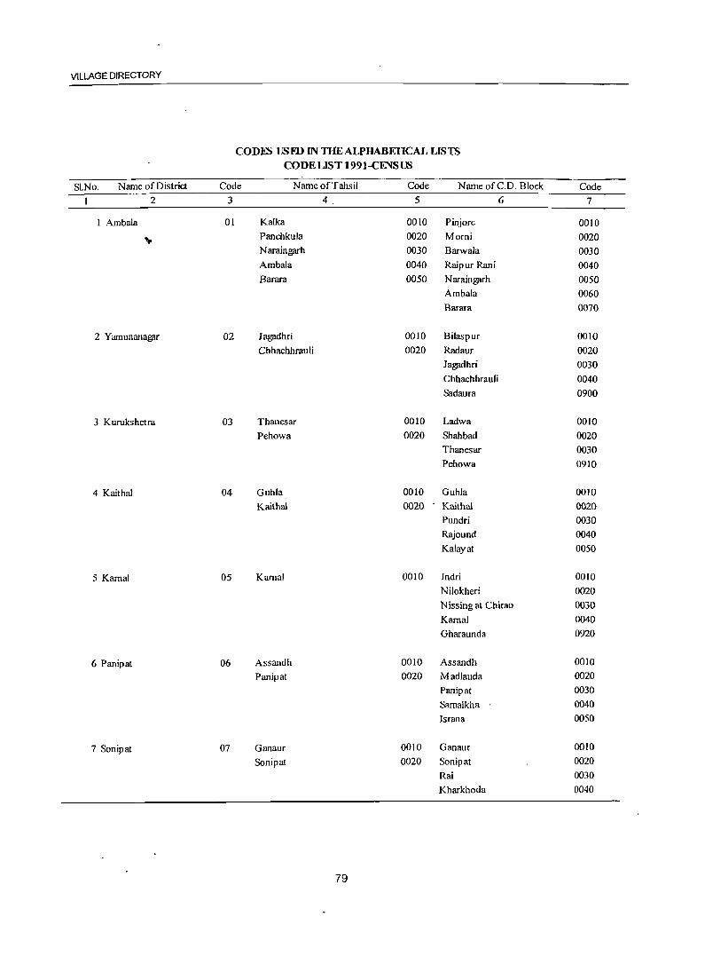
VILLAGE DIRECTORY
CODFS USID IN THE ALPHABETICAL LISTS CODEUST 1991-CENSUS
SLNo. Name of District Code Name of Tahsil Code Name ofC.D. Block Code
1 2 3 4 5 6 7
1 Ambala 01 Kalka 0010 Pinjore 0010
" Panchkula 0020 Morni 0020 Naraingarh 0030 Barwala 0030 Ambala 0040 Raipur Rani 0040 Barara 0050 Naraingarh 0050
Ambala 0060 Barara 0070
2 Yamunanagar 02 Jagadhri 0010 Bilaspur 0010
Chhachhrauli 0020 Radaur 0020 Jagadhri 0030 Chhachhrauli 0040 Sadaura 0900
3 Kurukshctra 03 Thanesar 0010 Ladwa 0010
Pehowa 0020 Shahbad 0020 Thanesar 0030 Pehowa 0910
4 Kaithal 04 Guhla 0010 Guhla 0010
Kaithal 0020 Kaithal 0020 Pundri 0030 Rajound 0040
Kalayat 0050
5 Kamal 05 Karnal 0010 Indri 0010
Nilokheri 0020
Nissing at Chirao 0030
Kamal 0040
Gharaunda 0920
6 Panipat 06 Assandh 0010 Assandh 0010
Panipat 0020 Madlauda 0020
Panipat 0030
Samalkha 0040
Israna 0050
7 Sonipat 07 Ganaur 0010 Ganaur 0010
Sonipat 0020 Sonipat 0020
Rai 0030
Kharkhoda 0040
79
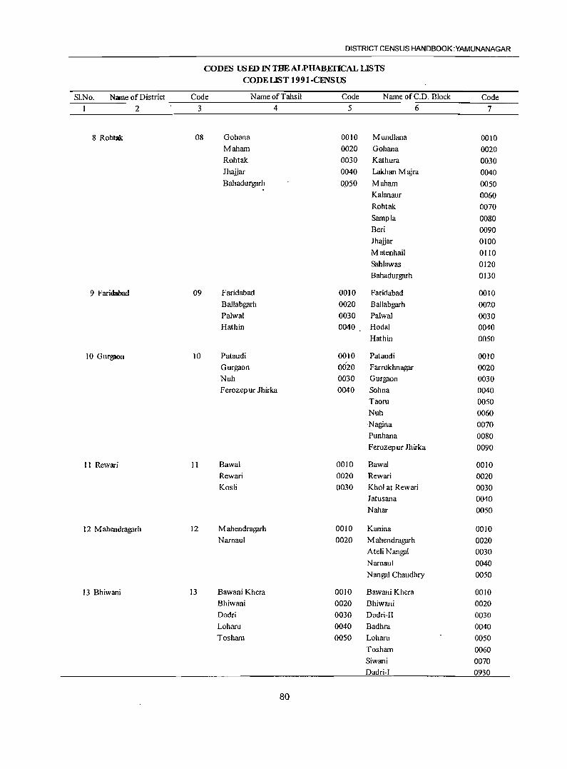
DISTRICT CENSUS HANDBOOK :YAMUNANAGAR
CODES USED INTHEALPHAB,EI'lCAL LISTS
CODE LIST 1991-CFNSlB
SI.No. Name of District Code Name of Tahsil Code Name ofC.D. Block Code
1 2 3 4 5 6 7
8 Rohtak 08 Gohana 0010 Mundlana 0010 Maham 0020 Gohana 0020 Rohtak 0030 Kathura 0030 Jhaijar 0040 Lakhan M ajra 0040 Bahadurgarh 0.050 Maham 0050
Kalanaur 0060 Rohtak 0070
Sampla 0080 Beri 0090 Jhaijar 0100
Matenhail 0110 Sahlawas 0120 Bahadurgarh 0130
9 Faridabad 09 Faridabad 0010 Faridabad 0010 Ballabgarh 0020 Ballabgarh 0020 Palwal 0030 Palwal 0030 Hathin 0040 Hodal 0040
Hathin 0050
10 GUrg;K)n 10 Pataudi 0010 Pataudi 0010 Gurgaon 0020 F arrukhnagar 0020 Nuh 0030 Gurgaon 0030 Ferozepur Jhirka 0040 Sohna 0040
Taoru 0050 Nuh 0060 Nagina 0070 Punhana 0080 Ferozepur Jhirka 0090
11 Rewari II Bawal 0010 Bawal 0010 Rewari 0020 Rewari 0020
Kosli 0030 Khol at Rewari 0030 Jatusana 0040 Nahar 0050
12M ahendragarh 12 M ahendragarh 0010 Kanina 0010 Narnaul 0020 M ahendragarh 0020
AteliNangal 0030 Narnaul 0040
N angal Chaudhry 0050
13 Bhiwani 13 Bawani Khera 0010 Bawani Khera 0010 Bhiwani 0020 Bhiwani 0020 Dadri 0030 Dadri-Il 0030
Loharu 0040 Badhra 0040 Tosham 0050 Loham 0050
Tosham 0060 Siwani 0070 Dadri-I 0930
80
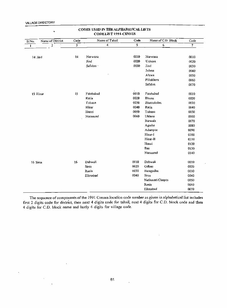
VILLAGE DIRECTORY
CODFS USED IN THEALPHABEfICAL LISTS CODE LIST 199 I-CENSUS
SI.No. Name of District Code Name of Tahsil Code Name ofC.D. Block Code
1 2 3 4 5 6 7
14 lind 14 Narwana 0010 Narwana 0010
Jind 0020 Uchana 0020
Safidon . 0030 Jind 0030
lulana 0040 Alewa 0050 PilIukhera 0060
Safidon 0070
IS Hisar 15 Fatehabad 0010 Fatehabad 0010
Ratia 0020 Bhuna 0020
Tohana 0030 Bhattukalan 0030
Hisar 0040 Ratia 0040
Hansi 0050 Tohana 0050
Narnaund 0060 Uklana 0060
Barwa1a 0070
Agroha 0080
Adampur 0090
Hisar-I 0100
Hisar-II OliO
Hansi 0120
Bas 0130
Narnaund 0140
16 Sirsa 16 Dabwali 0010 Dabwali 0010
Sirsa 0020 Odhan 0020
Rania 0030 Baragudha 0030
Ellenabad 0040 Sirsa 0040
Nathusari Chopta 0050
Rania 0060
Ellenabad 0070
The sequence of components of the 1991 Census location code number as given in alphabetical I ist includes first 2 digits code for distrIct, then next 4 digits code for tahsil, next 4 digits for C.D. block code and then 4 digits for C.O. block name and lastly 4 digits for village code.
81

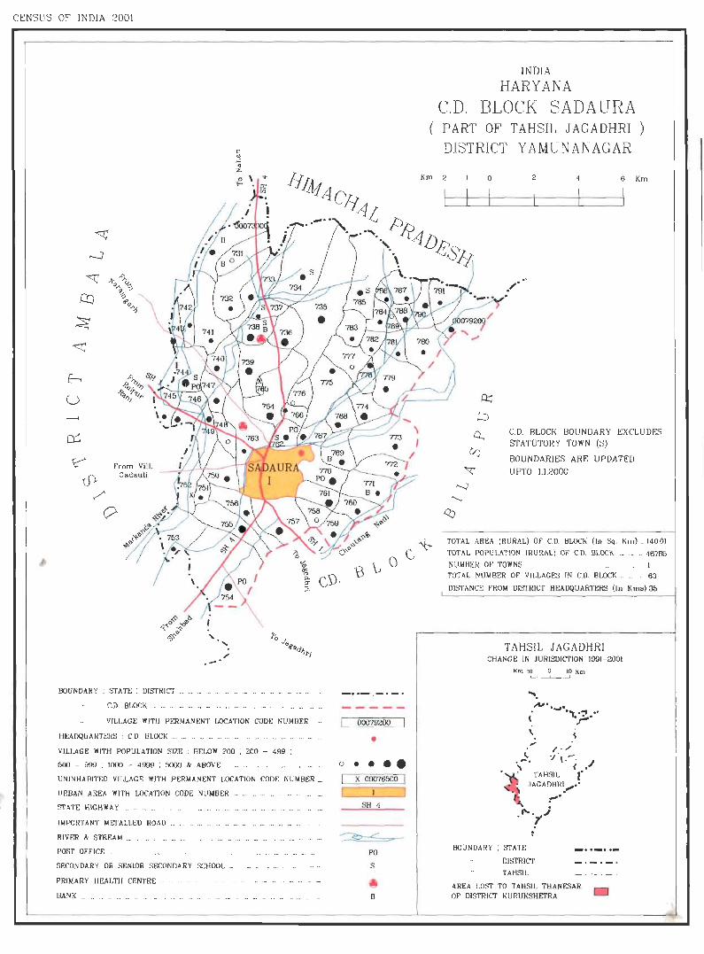
CENSUS OF INDIA 2001
;' .-' BOUNDARY: STATE: DISTRICT _ ....... __ ._ ._
c ., .c: ., ;c.
o \ ... ....
C.D. Bl.OCK .. , ... ... ._ ... ... ._ _. ._ ._ ... ... ... ... ._
VILLAGE WITH PERMANENT LOCATION CODE NUMBER
HEADQUARTERS : C.D. BLOCK ._ ._ .... ___ . _. ... _ .. _ .... _ ... _ ...
VILLAGE WITH POPULATION SIZE : BELOW 200 ; 200 - 499 ;
500 - 999 : 1000 - 4999 : 5000 & ABOVE ...... .
UNINHABITED VILLAGE WJTH PERMANENT LOCATION CODE NUMBER _
URBAN AREA WITH LOCATION CODE NUMBER . ___ ........ .
STATE HIGHWAY . ___ _
IMPORTANT METALLED ROAD ._
RIVER & STREAM __ ._
POST OFFICE ._ ...
SECONDARY OR SENIOR SECONDARY SCHOOL _
PRIMARY HEALTH CENTRE -
BANK _ __ ... _ ... _ ._ ... _
- .. - :- .-.
00079200
• o • • ••
X 00076500
SH 4
PO
S
INDIA HARYANA
C.D. BLOCK SADA URA ( PART OF TAHSIL JAGADHRI
DISTRICT Y AMUNANAGAR )
Km 2 o 2 6 Km
.~.
C.D. BLOCK BOUNDARY EXCLUDES STATUTORY TOWN (S)
BOUNDARIES ARE UPDATED
U PTO 1.1.2000
TOTAL AREA (RURAL) OF CD. BLOCK (In Sq. Km) ... 140.01
TOTAl. POPUl.ATION (RURAl.) OF C.D Bl.OCK ... . __ . 46785
NUMBER OF TOWNS .... _ . . ........ ___ ...... 1 TOTAL NUMBER OF' VILLAGES IN C.D. BLOCK . __ .. 63
DISTANCE FROM DISTRICT HEADQUARTERS (In Kms) 35
TA HSIL JAGADHRI CHANGE IN JURISDICTION 1991- 2001
Km 10 )0 Km
.... "". --.t-. . ........ '
< ".,:.-' \
" c.. / . / . '" ·' ·l .- · ~ =" ( •
TAHSIL r JAG A DHRJ ...... •
f'" "' . . "",." .
BOUNDARY ; STATE
DISTRICT
TAHSIL
AREA LOST TO TAHSIL THANESAR OF DISTRICT KURUKSHETRA

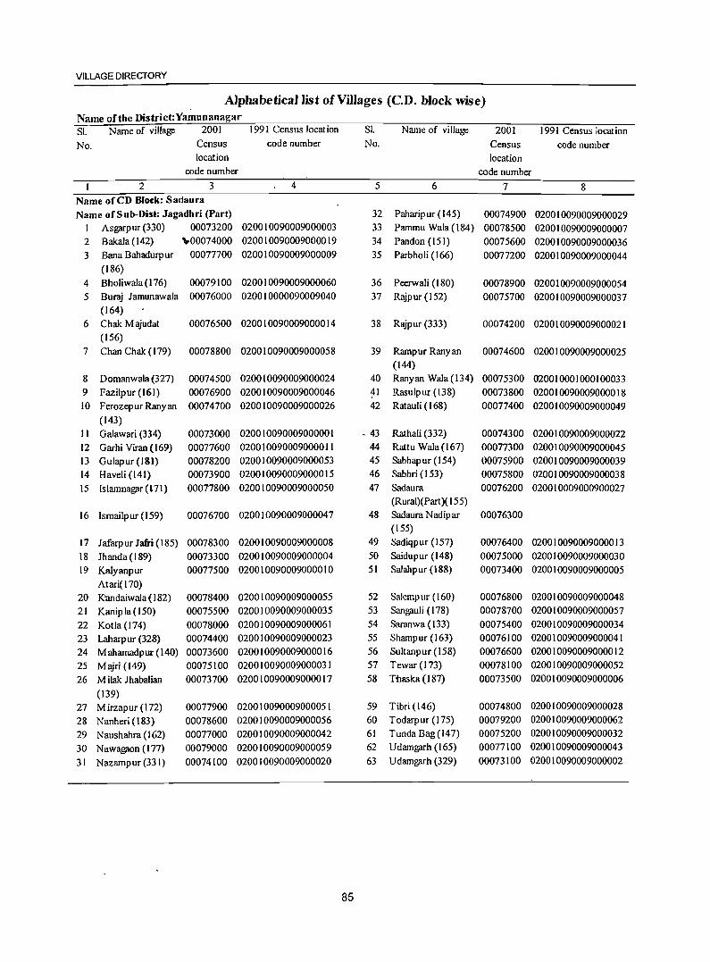
VILLAGE DIRECTORY
Alphabetical list of Villages (CD. block wise) Name of the District:Yamunanagar SI. Name of village 2001 1991 Census location S1. Name of village 2001 1991 Census location No. Census code number No. Census code number
location location code number code number
2 3 4 5 6 7 8 Name oCeD BIOt:k: Sadaura Name of Sub-Dis.: Jagadhri (Part) 32 Paharipur (145) 00074900 020010090009000029
I Asgarpur (330) 00073200 020010090009000003 33 Pammu Wala(184) 00078500 020010090009000007 2 Bakala(142) \0000074000 020010090009000019 34 Pandon (15 I) 00075600 020010090009000036 3 Bana Bahadurp ur 00077700 020010090009000009 35 Parbholi (166) 00077200 020010090009000044
(186) 4 Bholiwala (176) 00079100 020010090009000060 36 Peerwali (180) 00078900 020010090009000054 5 Buraj lamunawala 00076000 020010000090009040 37 Rajpur(152) 00075700 020010090009000037
(164) 6 Chak M ajudat 00076500 020010090009000014 38 Rajpur (333) 00074200 020010090009000021
(156) 7 Chan Chak (179) 00078800 020010090009000058 39 Rampur Ranyan 00074600 020010090009000025
(144) 8 Domanwala (327) 00074500 020010090009000024 40 Ranyan Wala (134) 00075300 020010001000100033 9 Fazilpur (161) 00076900 020010090009000046 41 Rasulpur (138) 00073800 020010090009000018 10 F erozep ur Rany an 00074700 020010090009000026 42 Ratauli ( 168) 00077400 020010090009000049
(143) II Galawari (334) 00073000 020010090009000001 • 43 Rathali (332) 00074300 020010090009000022 12 Garhi Viran (169) 00077600 020010090009000011 44 Rattu Wala (167) 00077300 020010090009000045 13 Gulapur (181) 00078200 020010090009000053 45 Sabhapur (154) 00075900 020010090009000039 14 Haveli (141) 00073900 020010090009000015 46 Sabhri (153) 00075800 020010090009000038 15 Islamnagar(171) 00077800 020010090009000050 47 Sadaura 00076200 020010009000900027
(Rural)(Part)( 155) 16 Ismailp ur (159) 00076700 020010090009000047 48 Sadaura Nadipar 00076300
(155) 17 Jafarpur Jafri (185) 00078300 020010090009000008 49 Sadiqpur (157) 00076400 020010090009000013 18 lhanda (189) 00073300 020010090009000004 50 Saidupur (148) 00075000 020010090009000030 19 Kalyanpur 00077500 020010090009000010 51 Salahpur (188) 00073400 020010090009000005
Atari(170) 20 K'andaiwala (182) 00078400 020010090009000055 52 Salerr:pur (160) 00076800 020010090009000048 21 Kanip la ( 150) 00075500 020010090009000035 53 Sangauli (178) 00078700 020010090009000057 22 Kotla (174) 00078000 020010090009000061 54 Saranwa (133) 00075400 020010090009000034 23 Laharpur (328) 00074400 020010090009000023 55 Shampur (163) 00076100 020010090009000041 24 Mahamadpur(I40) 00073600 020010090009000016 56 Sultanpur (158) 00076600 020010090009000012 25 Majri (149) 00075100 020010090009000031 57 Tewar (173) 00078100 020010090009000052 26 M ilak lhabalian 00073700 020010090009000017 58 Tnaska (187) 00073500 020010090009000006
(139) 27 Mirzapur (172) 00077900 020010090009000051 59 Tibri (146) 00074800 020010090009000028 28 Nanheri (183) 00078600 020010090009000056 60 Todarpur (175) 00079200 020010090009000062 29 Naushahra (162) 00077000 020010090009000042 61 Tunda Bag (147) 00075200 020010090009000032 30 Nawagaon (In) 00079000 020010090009000059 62 U damgarh (165) 00077100 020010090009000043
31 Nazampur (331) 00074100 020010090009000020 63 Udamgarh (329) 00073100 020010090009000002
85
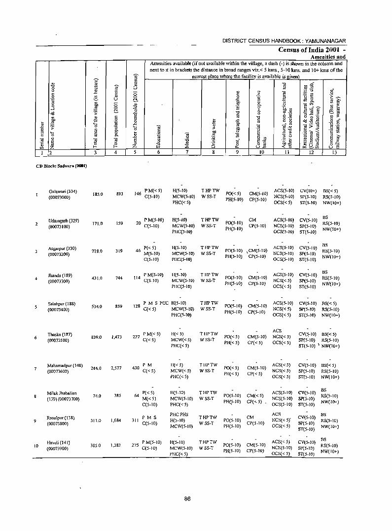
-;;-
]' " '" 01) 5 -0 '<ii 0 [.) u 0 0.> f;l
" ..c " 0
0 e- o.> 0 .'S U C!-0> 0
"" 0 '" 0 ::§ 0 -0
...l -0 <Id .;;: C!- ..c
" ., " " ",
co £ 0 " ... ::§ 'ia 0
" .... ..c: ..c .;;: 0 "3 ,.., § ~
C- o .... 0 .. " 0 C- " .0
~ .,
:9 ~ e e " " I~
0 Z VJ I-
I 2 3 4 5
CD Block: Sadaura (0001)
Galawari (334) (00073000)
18S.0 893 146
Udamgarh (329) 2
(00073100) 171.0 159 20
Asgarpur (330) 3
(00073200) 228.0 319 46
Jhanda (189) 4
(00073300) 431.0 744 114
Salahpur (188) S
(00073400) S34.0 8S9 128
Thaska (187) 839.0 1,473 227 6
(00073S00)
Mahamadpur (140) 7
(00073600) 244.0 2,S77 430
Milak Jhabalian 74.0
(139) (00073700) 385 64
Rasulpur (138) 9
(00073800) 311.0 1,684 311
Haveli (141) 10 3850 1,382 275
(00073900)
DISTRICT CENSUS HANDBOOK: YAMUNANAGAR
Census of India 2001 -Amenities and
Amenities available (ifnot available within the village, a dash (-) is shown in the column and next to It in brackets the distance in broad ranges viz.< 5 kms., 5-10 kms. and 10+ kms of the
nearest place where the facility is available is given -0 ~.g " '" " 01) e '';:: "0 ,j
" > ~e 0
0 .~ .a .~ ,-. ..c: <fl 0 C- "3 C- o i;;' " C- o
~~s ::: ~ 11 0 .~ ~ " " -0 " 6 ~~ 3l! .= e~ 8 0
'" if; -0 o ._ [.) 0 ... ... ..c: " " g ~ .g.g § t::" 2 '" ~
g- o; -..:'" ._ -0 ',p 0 .,
lib e 4"::::: g>~
'" ._ " 'u ,,-0 .~ is 0 ~ " ... .:t: e .S! -a E § ., .~
., 11 " 0 :;;; e '" " 0 ~ E ::l e i;;' 0 :.s .g :u ~8:.a " .. .= tf e~ J! Q.~ e ~
-0 ::i: Ci 0 o '" ""-,, 0:-;::: r.tl .,., U.o ...: 15 u e 6 7 8 9 10 11 12 13
PM«S) H(S-IO) THPTW PO«5) CM(5-IO)
ACS(S-IO) CV(IO+) BS{< 5) C(S-IO) MCW(S-IO) WSS-T NCS(S-IO) SP(S-IO) RS(S-IO)
PHC« S) PR(S-IO) CP(5-10)
OCS« S) ST(S-IO) NW(lO+)
PM(5-10) H(5-1O) THPTW CM ACS(5-1O) CY(5-10) BS
P0(5-IO) RS(5-IO) C(5-10) MCW(S-IO) WSS-T CP(S-IO) NCS(5-10) SP(S-IO)
PHC(5-1O) PH(S-IO)
OCS(5-1O) ST(5-1O) NW(IO+)
P«5) H(S-IO) THPTW ACS(S-IO) CV(S-IO) BS
PO(S-IO) ,CM(S-IO) RS(5-10) M(S-IO) MCW(S-IO) WSS-T NCS(S-IO) SpeS-to) C(S-IO) PHC(S-IO)
PR(S-IO) CP(S-IO) OCS(5-10) ST(5-IO)
NW(IO+)
P M(S-IO) H(S-IO) THPTW ACS(S-IO) CV(S-IO) BS
PO(S-IO) CM(S-IO) RS(5-10) C(S-lO) MCW(S-IO) WSS-T NCS{<5) SP(5-10)
PHC(S-IO) PH(S-IO) CP(5-10)
OCS«S) ST(S-IO) NW(IO+)
P M S PUC H(S-IO) THPTW PO(S-IO) CM(S-IO)
ACS(S-IO) CV(S-IO) BS{<5) C«5) MCW(S-IO) WSS-T NCS«S) SP(5-10) RS{5-IO)
PHC(S-IO) PH(5-10) CP(5-10)
OCS«S) ST(S-to) NW(IO+)
P M«S) H«S) THPTW ACS
CV(5,-IO) PO«5) CM(5-1O) NCS«5) BS«S)
C«S) MCW«S) WSS-T SP(S-IO) RS(5-10) PHC« 5)
PH«5) CP« 5) OCS«S) ST(S-IO) \ NW(IO+)
PM H«5) THPTW PO« S) CM(S-lO)
ACS«5) eV(S-IO) BS« S) C« 5) MCW«5) WSS-T NCS«5) SP(S-IO) RS(5-10)
PHC«5) PH« 5) CP« 5)
OCS« 5) ST(S-IO) NW(IO+)
P«5) H(5-10) THPTW ACS(S-IO) eV(5-10) BS
PO(S-IO) CM« 5) RS(5-10) M«5) MCW(5.1O) WSS-T NCS(5-1O) Sp(5-to) C(S-IO) PHC« S)
PHQ-IO} CP« 5) OCS(5-10) ST(5-10)
NW(lO+)
PMS PHCPHS
THPTW CM ACS
CV(S-IO) BS
C(5-1O) H(S-IO)
WSS-T POtS-to)
CP(S-IO) NCS«Sr
SP(S-IO) RS(5-10)
MCWe5-10) PH(5-10) OCS« 5) ST(S-IO)
NW(IO+)
PM(5-10) H(S-IOJ THPTW ACS«5) eV(5-10) BS
PO(5-10) CM(5-10) RS(S-IO} C(S-IO) MCW(5-1O) WSS-T NCS(5-10} SP(S-IO)
PHC« 5) PH(5-1O) CP(S-IO)
OCS« 5) ST(5-1O) NW(IO+)
86
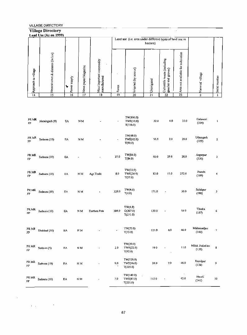
VILLAGE DIRECTORY
Village Directory Land Use (As on 1999)
14 15
PRMR Naraingarh (8) EA FP
PRMR Sadaura (10) EA
FP
PRMR Sadaura (10) EA
FP
PRMR FP
Sadaura (10) EA
PRMR Sadaura (10) EA FP
PRMR FP
Sadaura (10) EA
PRMR Shahbad (10) EA
FP
PRMR FP
Sadaura (5) EA
PRMR Sad.ura (10) EA
FP
PRMR Sadaura (10) EA FP
16 17 18
NM
NM
NM Agr.Tools
NM
NM Earthen Pots
NM
NM
NM
NM
Land use (i.e. area under different types ofland use in hectare)
19 20 21 22 23
TW(106.0} TWE(IO.0) 32.0 4.0 33.0 T(II6.0)
TW(48.0} TWE(42.0) 50.0 2.0 29.0 T(90.0)
27.0 TW(84.0)
60.0 29.0 28.0 T(84.0)
TW(33.0) ItO TWE(24 0) 83.0 11.0 272.0
T(57.0)
329.0 TW(4.0)
171.0 30.0 T(4.0)
TW(4.0) 384.0 0(267.0) 130.0 540
T(27 1.0)
TW(73.0) 121.0
T(73 0) 4.0 46.0
TW(20.0) 2.0 TWE(22.0) 190 11.0
T(42.0)
TW(129.0) 9.0 TWE(96.0) 24.0 7.0 46.0
T(225.0)
TW(1400) 7.0 TWE(81.0) 1150 42.0
T(221.0)
87
2
Galawari (334)
Udamh'llrh 2
(329)
Asgarpur (330)
3
lhanda 4
(189)
Salahpur (188)
5
Thaska 6
(187)
Mahamadpur (140)
7
Milak lhabalian (139)
8
Rasulpur 9
(138)
Haveli 10
(141)
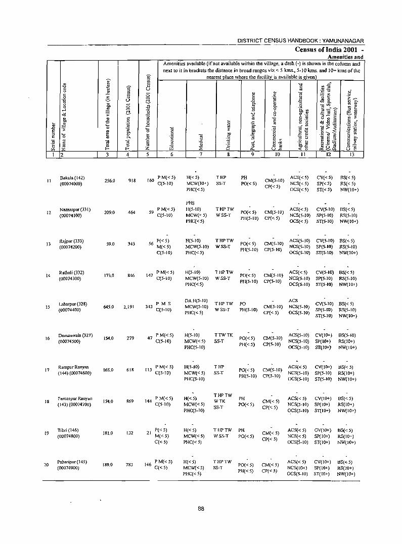
'" ~ iil u 1! t::
-0 !! '"" '" 0 0 u
0 ., ~ -t:: .c ~ 0
.9 5- 0
'id c.> ~ " -u '" 0 ~ <:>
~ <:> "0
!::!. 0 o"IJ .;;: ..c::
'" " " § bl) -5 !9 ~ ,g '.g 0 .... ..c::
.£) 0 ';;: -s ""' E os g- o ::l '8 ~ u C C.
" .D
OJ § ~ OJ E °5 b '" :z. CI) :z. I-- I--
1 2 3 4 5
Bakala (142) 918 [60 II
(00074000) 256.0
Nazampur (331 ) 209.0 464 59 12
(00074100)
Rajpur (333) 13
(00074200) 59.0 343 56
Rathali (332) 14
(00074300) 173.0 846 147
Laharpur (328) IS 645.0 2,191 343
(00074400)
Domanwa1a (327) 16
(00074500) 154,0 279 47
Rampur Ranyan 165.0 618 115 17
(144) (00074600)
18 Ferozepur Ranyan (143) (00074700)
114,0 869 144
19 Tibri (146) (00074800)
181.0 132 21
20 Paharipur (14S) (00074900)
189.0 783 146
DISTRICT CENSUS HANDBOOK: YAMUNANAGAR
Census of India 2001 -Amenities and
Amenities avaIlable (if not available within the village, a dash (-) is shown in the column and
next to it in brackets the distance in broad ranges viz. < 5 kms., 5-10 kms. and 10+ kms of the nearest place where the facility is available is I!,iven
-a ~ 2" t:: os ., " '§ ~.;:; 0 oJ
t:: .~ ~~ u 0 e ~ 'E ~ ..c:: cS8. v ~ Co " ;:I
'" d'" ~ ~ Co .:! ]l 0 ~~ ~ :a"E '" " 6 ~-"0 u ... _
"3 ~ a ~.,
t:: b. 0 '" ~ '" -0 <> 0 ~
j c o ._
dd .g . .@ c • ..c:: '"
t:: g o c Co ...:'" d;;:11 ';:: 0
~ ~ '" ._
OJ e . ..: '2 ~ t:: ~ Bl1 g"Ol :::; 0 bl) v .~ OJ c 11 '" - ....
._ 8 ;:I
U :;;; E '" :l U ~ e :J E ~ u :0 c E-'" .2 ti t .~ :g :l
~ ·c '" 8~ ~~ §:: "0 0 ~~r/j ~ Q 0.. ~ 0 u E! 6 7 8 9 10 II 12 13
PM«S) H«5) THP PH CM(5-10)
ACS«S) CV«5) BS«S) C(S-IO) MCW(IO+) SS-T PO« 5) NCS« 5) SP«S) RS« 5)
PHC«S) CP« S)
OCS« S) ST«5) NW(IO+)
PHS P M« 5) H(5-IO) THPTW
PO« 5) CM(5-10) ACS«S) CV(S-IO) BS« 5)
C(5-10) MCW« 5) WSS-T NCS(5-10) SP(5-1O) RS(5-1O) PHC«5)
PH(5-1O) CP«5) OCS«5) ST(S-IO) NW(IO+)
P«5) H(5-10) THPTW PO« 5) CM(5-10)
ACS(5-JO) CV(5-IO) BS« 5) M«5) MCW(5-10) WSS-T NCS(5-10) SP(S-IO) RS(5-10) C(5-10) PHC«S)
PH(5-10) CP(S-IO) OCS(5-10) ST(5-IO) NW(IO+)
PM«5) H(5-IO) THPTW PO«5) CM(S-IO)
ACS« 5) CV(5-1O} 8S«5) C(5-10) MCW(S-IO) WSS-T NCS(5-JO) Sp(S-IO) RS(5-10)
PHC« S) PH(S-IO) CP(S-IO)
OCS(5-10) ST(5-10) NW(IO+)
PM S DA H(5-10)
THPTW ACS
CV(5-IO} BS«S) PO MCW(5-10) CM(S-IO) NCS(5-10)
C(5-10) PHC«S)
WSS-T PH(5-10) CP«5) OCS(5-10)
SP(5-IO) RS(5-10) ST(5-IO) NW(IO+)
P M«5) H(5-10) TTWTK PO« 5) CM(5-1O)
ACS(5-10) CV(IO+) 8S(5-10) C(S-IO) MCW«5) SS-T NCS(5-10) SP(IO+) RS(IO+)
PHC(5-10) PH« S) CP(S-IO)
OCS(S-IO) ST(IO+) NW(IO+)
PM«S) H(S·IO) THP PO« 5) CM(5-10)
ACS«S) CV(IO+) 6S«5) C(5-1O) MCW« S) SS-T NCS(S-JO) SP(5-1O) RS(IO+)
PHC(5-10) PH(S-IO) CP(5-10)
OCS(S-IO) ST(S-IO) NW(IO+)
P M« S) H«5) THPTW
ACS« S) CV(IO+) 6S«5) WTK
PH CM«5)
C(5-1O) MCW{<S) SS-T
PO« S) CP« S)
NCS(S-IO) SP(IO+) RS(IO+) PHC(5-IO) OCS(S-IO) ST(IO+) NW(IO+)
P« 5) H«S) THPTW PH CM«S)
ACS« S) GV(IO+) BS«5) M«S) MCW«5) WSS-T PO«5) NCS« 5) SP(IO+) RS(lO+) C«S) PHC« 5)
CP«S) OCS(5-10) ST(IO+) NW(IO+)
P M« 5) H«S) THPTW PO«5) CM«S)
ACS« S) CV(IO+) BS«5) C«S) MCW«S) SS-T
PH« 5) CP« 5) NCS(IO+) SP( 10+) RS(IO+)
PHC«5) OCS(5-10) ST(IO+) NW(IO+)
88
VILLAGE DIRECTORY
Village Directory Land Use (As on 1999)
Land use (i.e. area under different types of land use in hectare)
E c:: 0 ..,.
"15 c:: ?;- OIl o,E; V c:: " :u :u "3 u 0 ::l " ~
., E "0 .... c:: ., .~ E <> c::~ ..s ._ '"
DIl '0 0 g ~ .. " ~ OIl " ::l .. > :0 " ~ '" c
_ 0
.:;: ~ ~ ~.: ..!:! ]' ....
~ ~ "'." 'OJ .. B 1:: " >- ~. 0. .. &.3 e ." .. c:: > .D ..c B 0. §- ~ - '" '" § 0 a .5 Jl -0 .g lil " ""-OJ rr .... 0. u .!!!J 0 c:: e " '" - ::l
t; 'iii .S E-fi c:: " iii 0. iJ: iJ: B a e OIl '" E - ::l ~ 't 0. Z 0 Z ::2: E 0 :g ;§ ::l .. ., -< I:l.. ~ UOIl -< Z U)
14 15 16 17 18 19 20 21 22 23 2 I
PRMR Sadaura (6) EA N TW(220.0)
30.0 6.0 Bakala
11 FP T(220.0) (142)
PRMR TW(120.0) Nazampur Sadaura (10) EA NM TWE(20.0) 50.0 12.0 7.0 ... 12 FP
T(140.0) (331)
PRMR Kala Amb (H.P.) (7) EA N
TWE(50.0) FP T(50.0) 2.0 1.0 6.0
Rajpur (333) l3
PRMR TW(IOO.O) Rathali Sadaura (7) EA NM TWE(20.0) 32.0 5.0 16.0 14 FP
T(120.0) (332)
PRMR TW(393.0) Laharpur Sadaura (8) EA NM Earthen Pots TWE(52.0) 12.0 46.0 142.0 IS FP
T(445.0) (328)
PRMR Sadaura (10) EA N TWE(J02.0)
41.0 2.0 90 Domanwala
FP T(I02.0) (327) 16
PRMR Sadaura (6) EA 410
TWE(124.0) 350 1.0 5.0
Rampur Ranyan FP T(l24.0) (144) 17
PRMR TW(IO.0) Ferozepur Ranyan Sadaura (5) EA N TWE(136.0) 12.0 160 18 FP
T(146.0) (143)
WE(52.0) PRMR
Sadaura (2) EA TW(45.0)
8.0 1.0 Tibri (146) FP TWE(38.0) 19
T(135.0)
PRMR TW(30.0) Paharipur Sadaura (3) EA NM 37.0 TWE(90.0) 14.0 18.0 20 FP
T(120.0) (/45)
89
DISTRICT CENSUS HANDBOOK: YAMUNANAGAR
Census of India 2001 -Amenities and
Amenities available (if not available within the village, a dash (-) is shown in the column and next to it in brackets the distance in broad ranges viz.< 5 kms., 5-10 kms. and 10+ kms of the
-;;;- nearest place where the facility is available is given
" " '" " ~ '" ] ~~ "" '" " 0 u c.> " " " " § ~ ,,' '"
.<: :g <5 '" > Oi c.> 0 g " 0 0 .~ ~
'0 t .~ ~ .~ u r:!. ..t: ce;! 8.
" 0. " ?i' c.> <5 '" " OiVl ~ ~ 0 DO 0. u
~ 0 "" 11 0 .~ til 3 =:" E ....l r:!. "0 8- ~ B <!3 .;; ..c: "Cl CI;J .~ ~] .::! ~ '" & '" ' ~
l " '" '" "" " " u 0 .... '" ::= -5 0 " .... a o '- ~:9 ~ " . ..t: " g :J .~ 0 " c. o " ""' ..t:
~ . '" '';::; 0 .D .;; 0 :; ""' <d ~ <d ]~ OJ > :l '" ._ ~
.~ .§ ~ ~ c.> -.. 0. 0 '" "§ ~ .....
* 0 .... 0 DO " E e:! 0 0. " ~~ Oi " 11 " .0 u :;;; S '" :l <.> 1ij S " s ?i'
] " "Ei <d S <.> :;; ~ s.,.. .~~ ~.S ~ s ::= s (5 "
:l "
.S 8$ z ~ z "" ::E 0 ~ 8VJ 0= rn I- III ~ ~(5 u e 1 2 3 4 5 6 7 8 9 10 II 12 13
Saidupur (148) P M«5) H«5) TTWW PH ACS
CY(JO+) BS« 5) 21 259.0 589 104 CM«5) NCS(IO+)
(00075000) C«5) MCW«5) TK SS-T PO{<5) CP(5-10) OCS(5-10)
SP(lO+) RS(IO+) PHC« 5) ST(IO+) NW{lO+)
Majri (149) P M«5) PHS H«5)
THPTW ACS« 5) CY(S-to) BS« 5) 22 88.0 405 77 MCW«5) PO{< 5) CM«S)
(00075100) C«5) PHC«5)
WSS-T PH« 5) CP« 5)
NCS« 5) SP(5-1O) RS(5-lO) OCS«5) ST(5-1O) NW(IO+)
23 Tunda Bag (147)
310 --- Uninhabited ----(00075200)
Ranyan Wala P«5) H«5) THPTW ACS«5) CY
BS«5) 24
(134) (00075300) 137.0 315 55
M«5) MCW«5) SS-T PO« 5) CM«5)
NCS(IO+) SP(5-10~ RS«5)
C«S) PHC«5) PH« 5) CP«5)
OCS(S-IO) ST(5-10)
NW(IO+)
Saranwa (133) P(3) M S PHS HC<5)
THPTW PO ACSNCS CY(S-lO) BS 25 947.0 4,047 741 PUC MCW(IO+) CM«5) RS(5-10)
(00075400) C« 5) PHC«5)
WSS-T PH« 5) CP«5)
OCS SP(5-to) NW(lO+)
ST(5-to)
Kanipla C 150) 173 PM«5) H«5) THPTW
PO{< 5) CM« 5) ACS« 5) CY(IO+) BS« 5)
26 (00075500)
278.0 1,115 C« 5) MCW(IO+) WSS-T NCS(lO+) SP(5-10) RS(IO+)
PHC« 5) PH«5) CP« 5)
OCS(5-10) ST(5-10) NW(lO+)
d Pandon (151) PM«5) H«5) THPTW ACS«5) CY(IO+) BS« 5) 27 257.0 833 137 PO{< 5) CM«5)
(00075600) C«5) MCW«5) WSS-T PH«5) CP« 5)
NCS(IO+) SP(5-10) RS(5-1O) PHC« 5) OCS(5-10) ST(5-10) NW{lO+)
PM«S) H«5) THPTW ACS
CV(IO+) BS« 5) Rajpur (152) 194 PO«5) CM«5) NCS(iO+) 28 (00075700)
287.0 1,114 C« 5) MCW(lO+) WSS-T SP(S-lO) RS(IO+)
PHC« 5) PH«5) CP« 5) OCS(5-iO)
ST(5-10) NW(IO+)
S,\bhri (153) 16
P«5) H(<:5) THPTW PO« 5) CM«5)
ACS« 5) ~V(IO+) BS« 5) 29
(00075800) 45.0 108
M«5) MCW«5) WSS-T NCS(iO+) SP(5-lO) RS{IO+) C«5) PHC« 5)
PH«5) CP(5-IO) OCS(S-IO) ST(5-10) NW(lO+)
Sabhapur (154) PM«5) PHSH«5)
THPTW ACS« 5) CY(IO+) B~« 5) 30 102.0 737 106 MCW«5) PO«5) CM«5)
(00075900) C«5) PHC«5)
WSS-T PH« 5) ep(S-IO)
NCS«5) . SP{5-10) RS(lO+) OCS{5-10) ST(5-10) NW(IO+)
Buraj Jamunawala 96.0 678 106
P M«5) H{<5) THPTW PO« 5) CM«5)
ACS« 5) CY(lO+) BS« 5) 31
(164)(00076000) C« 5) MCW(lO+) SS-T NCS(IO+) SP(S-IO) RS(IO+) PHC«.5)
PH« 5) CP(5-10) OCS(5-10) ST(5-10) NW(lO+)
90
VILLAGE DIRECTORY
Village Directory Land Use (As on 1999)
14 15
:: MR Sadaura (3)
;: MR Sadaura (5)
16 17
EA N
EA N
---- Uninhabited ------
:: MR Sad aura (5)
PRMR FP Sadaura (5)
PR MR, Sadaura (3) FP
~R MR Sadaura'(3) FP
PRMR FP Sadaura (2)
PR MR Sadaura (3) FP
;; MR Sadaura (4)
PR MR Sadaura (3) FP
EA NM
EA NM Gur
EA
EA
EA
EA
EA
EA
18
Land use (i.e. area under different types of land use in hectare)
19 20
TW(50.0)
TWE(I63.0) T(213.0)
TW(46.0)
TWE(32.0) T(78.0)
TW(90.0)
TWE(32.0) T(122.0)
TW(356.0) TWE(400.0)
T(756.0)
TW(lIO.O)
TWE(83.0) T(193.0)
TW(74.0) TWE(91.0)
T(165.0)
TW(145.0) TWE(40.0) T(185.0)
TW(26.0)
TWE(S.O)
T(34.0)
TW(40.0) TWE(32.0)
T(nO)
91
21
14.0
1.0
3.0
40.0
40.0
46.0
55.0
100
70.0
22 23
10.0 22.0
1.0 8.0
2.0 10.0
51.0 100.0
5.0 40.0
6.0 40.0
50 42.0
1.0. 10.0
4.0 160
26.0
2
Saidupur (148)
Majri (149)
Tunda Bag (147)
Ranyan Wala (134)
Saranwa
(133)
KanipJa (150)
Pandon (151)
Rajpur (152)
Sabhri (153)
Sabhapur (154)
Buraj Jamunawala
(164)
... .. .0
§ s::
21
22
23
24
25
26
27
28
29
30
31
DISTRICT CENSUS HANDBOOK: YAMUNANAGAR
Census of I~dia 2001 -Amenities and
Amenities available Of no! available within the village, a dash (-) is sho'Wll in the column and next to it in brackets the distance in broad ranges viz. < 5 krns .• 5-10 krns. and 10+ krns of the
1 ~ nearest_place where the facility is available is given \
., :a ] ~ ~ .. "0 ., ., 0 U <> " :l ., '';:; C) .," '"
..<:: :a 0 '" ,.. ] ~t u
'" 0 ~ .,
0 0 .~ .~ ~ .~ U t!- ..<:: tS 8.. u ., Co
" "3 " iii' 0 E 0 "'
., Co r..> eU') .. ~ ;:: ~ "0 1i .~ '" ....l 0 "0 b i!~~ :l "
~ ~ t!- ..<:: "t> ~ .£ ~~ ~ '" u ::s ..c: ,_ .,
" '" OJ "0 " ._ o 0 S § c ~ -s 0 :l
~ ..<:: '" '" g ~ {l .<;:: _g .~ 0 '" ""' ..<:: ~ -.; _:'" -'_ ~ '';:: 0 .;; 0 "3 .... -.; :;:: e .<;:: '" >- ::> '" .-
§ os "- 0 '" '2 ","t> .§ to ~ '2 ~ .... e 0 til 0 on C> _ <>
'" 0 '" "- .~ ""iii '" 1i " 13 ti S ~ ., .D " :.;;;; S '" ~ ~.= -.;
I~ S ~ § u 'g '" tf §~ .~~ '5 :l u.s ~ §:;: ~ r- :z: "0 :::!: is 0 ~~~ en UI £>.. U.a -<: 0 U e
1 2 3 4 5 6 7 8 9 10 11 12 13
Shampur (163) 194.0 1,250 211
P M« 5) H«5) THPTW PO«5) CM«5)
ACS« 5) CV(IO+) BS« 5) 32
(00076100) C«5) MCW(IO+) WSS-T NCS(5-10) SP(lO+) RS(IO+) PHC«5)
PH«5) CP« 5) OCS(5-10) ST(IO+) NW(IO+)
Sadaura PM AC H«5) THPTW ACS«5) eV(5-10)
BS 33 (Rura1XPartX155) 14.0 705 134
C«5) MCW«5) WSS-T PO PH CM«5)
NCS« 5) SP(5-10) RS(5-10)
(00076200) PHC«5)
CP« 5) OCS«5) ST(5-IO)
NW(IO+)
Sadaura Nadipar P«5) MCWPHC
THPTW ACS«5) eV(IO+) BS«5) 34 483.0 395 87 RMP(3) PO{<5) CM«5)
(155) (00076300) M«5) H« 5)
WSS-T PH« 5) CP« 5)
NCS« 5) SP(IO+) RS(IO+) C«5) OCS« 5) ST(IO+) NW(IO+)
Sadiqpur (157) PM«5) H«5) THPTW ACS
CV(IO+) BS«5) 35 530.0 2,175 391 PO«5) CM«5) NCS«5)
(00076400) C«5) MCW(IO+) WSS-T PH«5) CP« 5) OCS«5)
SP(IO+) RS(lo+) PHC« 5) ST(IO+) NW(IO+)
36 Chak Majudat
13.0 ---- Uninhabited ----( 156)(00076500)
Sultanpur (158) 351 66
P M«5) He<5) THPTW PH CM«5)
ACS« 5) eV(5-10) BS« 5) 37
(00076600) 73.0
C«5) MCW«5) WSS-T PO{< 5) NCS«5) SP(5-10) RS(5-10) PHC«5)
CP« 5) OCS«S) ST(5-1O) NW(IO+)
lsmailpur (159) PM«S) He<5) THPTW ACS« 5) eV(IO+) BS
38 315.0 917 151 PO«5) CM« 5) RS(IO+) (00076700) C«5) MCW«5) WSS-T
PH«5) CP« 5) NCS« 5) SP(lO+)
NW(IO+) PHC(5-1O) OCS«S) ST(IO+)
Salempur (160) P M«5) H«5) THPTW PH ACS« 5) eV(IO+) BS
39 157.0 633 125 CM«5) RS(IO+) (OO076S00) C«5) MCW«5) SS-T PO{<5)
CP« 5) NCS« 5) SP(IO+)
NW(1O+) PHC« 5) OCS«5) ST(IO+)
Fazilpur(161) 739 122
PM«5) H« 5) THPTW PO«5)
CM l\CS« 5) eV(5-10) BS«5) 40
(00076900) 24S.0
C«5) MCW«5) WSS-T CP« 5) NCS« 5) SP« 5) RS(5-10) PHC« 5)
PH« 5) OCS«5) ST(5-10) NW(1O+)
Naushnhra (162) P M« 5) H«5) THPTW ACS SP
BS« 5) 41 227.0 1,191 199 PO PH(S) CM«5) NCS(S-IO) CV(5-10)
(00077000) C« 5) MCW(IO+) 5S-T CP« 5) OCS(S-IO) S;T(5-10)
RS(5-1O) PHC«5) NW(IO+)
Udamgarh (165) 144.0 286 42
PM«5) H«5) THPTW PH eM ACS«5) eV(5-10) BS«5) 42
(00077100) C«S) MeW«5) SS-T PO{<5) CP«5) NCS«5) SP« 5) RS(5-1O) PHC« 5) OCS«5) ST(5-10) NW(IO+)
92
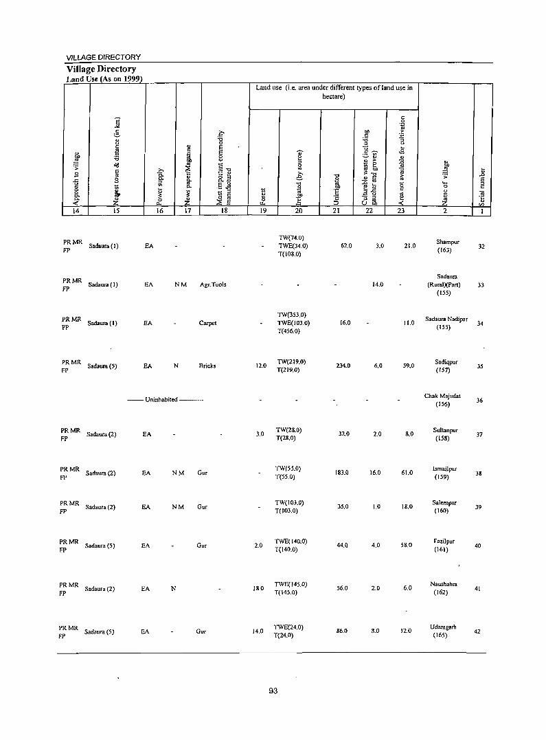
VILLAGE DIRECTORY
Village Directory Land Use (As on 1999)
'8 -'" ~ C;-
" :a 0 0
~ " E c E 4J i bl) :a 0
~ <)
~ .,
Q . ;;: ~ ~
>. "'.",
B c.. "
1:: ~
B 0. o " ..c
" g- Oo_ il '" E <> 1;; 0. ._ ~ I:: ~ ~ ~ 1;; " 0. o a 0- Z Z 0 ::.E E -< ~
14 15 16 17 18
PRMR Sadaura (I) EA
FP
PRMR FP
Sadaura(l) EA NM Agr.Tools
PRMR Sadaura (1)
FP EA Carpet
PRMR Sadaura (5)
FP EA N Bricks
-- Uninhabited ---
PRMR Sadaura (2) EA
FP
PRMR Sadaura (2)
FP EA NM Gur
PRMR Sadaura (2)
FP EA NM Gur
PRMR Sad.ura (5)
FP EA Gur
PRMR FP Sadaura (2) EA N
PRMR FP Sadaura (5) EA Gur
Land use (i.e. area under different types ofland use in
1;;
~ u.. 19
12.0
3.0
2.0
18.0
14.0
~
" e ::s 0
'" € 'tl
~ bI)
E 20
TW(74.0) TWE(34.0) T(IOS.O)
TW(353.0) TWE(103.0) T(456.0)
TW(2 I 9.0) T(219.0)
TW(28.0) T(28.0)
TW(55.0) T(55.0)
TW(103.0) T(103.0)
TWE(140.0) T(140.0)
TWE(145.0) T(145.0)
TWE(24.0) T(24.0)
93
hectare)
"0
" til 01)
:§ c
::> 21
62.0
16.0
234.0
32.0
183.0
35.0
44.0
56.0
86.0
c 0 .~
bl) .1= c :a -3 :J 0
"0 ~ .s c ~ ._ '" ~'" " " > :0 - 0 ~ 1(1 ... :;::~ ;;
~ ..!!Iij -e la b .3'5
c .. - :::J e :J '" Ubi) -< 22 23
3.0 21.0
14.0
11.0
6.0 59.0
2.0 8.0
16.0 61.0
1.0 18.0
4.0 58.0
2.0 6.0
8.0 12.0
" ~ .;;:
""' 0 4J
~ 2
Shampur (163)
Sadaura (Rural)(Part)
(155)
Sadaura Nadipar (155)
Sadiqpur (157)
Chak Majudat (156)
Sultanpur (158)
IsmaiJpur (159)
Salempur (160)
Fazilpur (161)
Naushahra (162)
Udamgarh (165)
t .0 E 2 'ii '5 en I
32
33
34
35
36
37
38
39
40
41
42
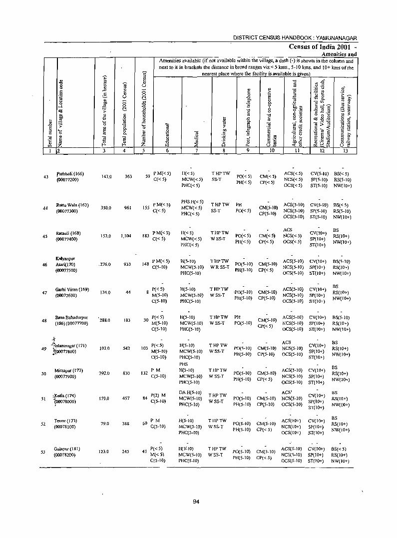
DISTRICT CENSUS HANDBOOK: YAMUNANAGAR
Census of India 2001 -Amenities and
Amenities available (if not available within the village, a dash (-) is shown in the column and next to it in brackets the distance in broad ranges viz. < 5 krns., 5-10 kms. and 10+ kms of the
-;;;- nearest place where the facility is available is given
1 ::l
4) E "0 '" .0-'0 -;;;- <> c 0 U .. " ::l <> " ::l -.;:: Q ,>,
'" " .,
E c ..c: c 0 c .~ ~t u 0 5 " 0 0 tii 2 'E ~ .g u ~ ..c: ..a g_
" c. ~ :; <LJ ~
U
~ 0 u1 " C. " ]V:r-- ~ ~ 0 ....l 0 "0 ] 6 .~ ~ "0 ;::I;::: S ::l " ~ .;;: ~ ..c "0 <> ~ 'c -§ l! .a ~t\j
CIJ til c " '" ~ <> " c rg "0 o ._ <) 0 .... c _
~ oS 0 ~ ..c: fa c g ~ -8 . .g ~ .~ 0 c. .~ ,9 .... ..c tii f'! OJ ....:'" o;:;;:-a ~ .;; 0 :; .... 0; ~ e~ .~ 19 S .. c. 0 c OIl '8 c ..: ::l ... e 0 ~ .g OIl " E e .2 til S § '" c 0 '" c. <iI c ] u
10 S .0 ~ S w ::l " ~ ~ 0; u S S S e .:l
tf S""" .~] ~.S ~ §l ·c Ii ::J .", 0 ~
::l " 8 0 8.8 " ;Z; iE ::E <0 ~ ~Ci) 0·_
m Z f-< 0.- U E! I 2 3 4 5 6 7 8 9 10 11 12 13
I'arbholi (166) 147.0 363 59
P M«5) H«5) THPTW PO« 5) CM«5)
ACS« 5) CV(5-Hl) BS« 5) 43
(00077200) C« 5) MCW«5) SS-T NCS«5) SP(5-1O) RS(5-10) PHC« 5)
PH«5) CP«5) OCS« 5) ST(5-10) NW(IO+)
Rattu Wala (167) P M«S) PHS H« S)
THPTW PH ACS(5-IO) eV(S-IO) BS« 5) 44 350.0 961 ISS MCW«5) CM(5-1O)
(00077300) C« 5) PHC« S)
SS-T PO«5) CP(5-1O)
NCS(5-10) SP(S-IO) RS(S-IO) OCS(S-IO) ST(5-10) NW(lo+)
Ratauli (168) PM«S) H«S) THPTW ACS
CV(IO+) BS
45 153.0 1,104 183 PO«S) CM«5) NCS«5) RS(IO+) (00077400) C« 5) MCW«5) WSS-T
PH« S) CP« 5) OCS«5) SP(IO+)
NW(IO+) PHC« S) ST(IO+)
Kalyanpur PM«5) H(5-10) THPTW ACS(S-IO) CV(10+) 8S(5-10)
46 Atari(170) .276.0 933 148 C(5-10) MCW(S-IO) WRSS-T
PO(S-JO) CM(S-IO) NCS(S-IO) SP(IO+) RS(IO+)
(OOO77SOO) PHC(S-IO)
PH(5-10) CP« 5) OCS(S-IO) ST(IO+) NW(IO+)
Garhi Viran (169) P«5) H(5-10) THPTW ACS(5-10) CV(IO+) BS
134.0 44 8 ,PO(S-IO) CM(5-lO) RS(IO+) 47 (00077600) M(S-IO) MCW(5-10) WSS-T NCS(5-10) SP(IO+)
C(5- 10) PHC(5-10) PH(5-10) CP(S-IO)
OCS(S-IO) ST(JO+) NW(IO+)
Sana Bahadurpur 288.0 183 30
P«5) H(5-10) THPTW PH CM(S-IO)
ACS(5-10) CV(lO+) BS(5-IO) 48
(186) (00077700) M(5-10) MCW(5-10) WSS-T PO(S-IO) NCS(5-JO) SP(IO+) RS(IO+) C(5-10) PHC(5-10)
CP« 5) OCS(S-IO) ST(IO+) NW(IO+)
4 ACS BS
-;Islamnagar (171) P«5) H(5-1O) THPTW CV(IO+) 49 102.0 S42 103 P0(5-10) CM(5-10) NCS(5-JO) RS(IO+)
!{00077800) M(5-1O) MCW(S-JO) WSS-T PH(5-1O) CP(S-IO) OCS(5-1O)
SP(IO+) NW(IO+) C(5-10) PHC(5-10) ST(IO+)
PHS
Mirzapur (172) PM H(S-IO) THPTW ACS(5-1O) CV(IO+) BS
50 292.0 830 132 PO(S-IO) CM(5-IO) RS{IO+) (00077900) C(5-10) MCW(5-10) WSS-T
PH(S-IO) CP«S) NCS(5-10) SP(IO+)
NW(IO+) PHC(5-10) OCS(5-1O) ST{IO+)
,J(otla (174) P(2) M DA H(S-IO)
THPTW ACS'
CY(IO+) BS
179.0 457 84 MeW(5-IO) PO(5-1O) CM(5-1O) NCS(5-1O) RS(IO+) S\ 100078000) C(5-10) WSS-T SP(IO+)
PHC(5-IO) PH(S-IO) CP(5-10) OCS(S-IO) ST(IO+)
NW(IO+)
Tewllr (173) PM H(S-IO) THPTW ACS(lO+) CV(IO+) BS
S2 79.0 388 60 PO(S-IO) CM(5-10) RS(IO+) (00078100) C(S-IO) MCW(5-IO) WSS-T
PH(5-1O) CP«5) NCS(IO+) SP(IO+)
NW(IO+) PHC(5-10) OCS(IO+} ST(IO+)
S3 Gulapur (181)
123.0 245 41 P« 5) H(S~IO) THPTW
PO(S-IO) CM(5-IO) ACS(5-JO) CV(IO+) BS«S)
(OOO78200) M«5) MCW(S-IO) WSS-T PH(S-IO) CP«5)
NCS(S-IO) SP(IO+) RS(IO+) C(S-IO) PHC(5-10) OCS(5-1O) ST(IO+) NW(IO+)
94
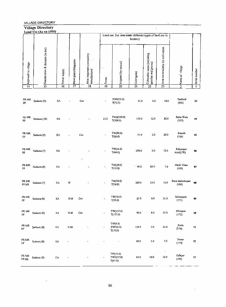
VILLAGE DIRECTORY
VilJage Directory Land Use (As on 1999)
14 15
PRMR FP Sadaurn (5) EA
PRMR Sadaura (10) EA
FP
PRMR Sadaura (4) EA
FP
PRMR Sadaura (7) EA
FP
PRMR Sadaura (6) EA
FP
PRMR Sadaura (7) EA
FPNR
PRMR Sadaura (6) EA
FP
PRMR Sadaurn (6) EA
FP
PRMR Sadaura (8) EA
FP
PRMR Sadaura (8) EA
FP
PRMR Sadaura (8) EA
FPNR
16 17 18
Gur
Gur
N
NM Gur
NM Our
NM
Land use (i.e. area under different types of land use in hectare)
19
12.0
20
TWE(72.0)
T(n.O)
TWE(109.0) T(109.0)
TW(SO.O} T(80.0)
TW(44.0) T(44.0)
TW(IO.O) T(IO.O)
TW(36.0) T(36.0)
TW(50.0) T(50.0)
TW(157.0) T(157.0)
TW(4.0) TWE(6.0) T( 10.0)
TW(14.0) TWE(27.0) T(41.0)
95
21
51.0
135.0
510
208.0
. 40.0
203.0
23.0
90.0
1340
69.0
62.0
22 23
6.0 lito
12.0 82.0
2.0 20.0
2.0 22.0
83.0 1.0
35.0 14.0
8.0 21.0
8.0 37.0
3.0 32.0
3.0 7.0
10.0 10.0
2
Parbholi (166)
Rattu Wala (167)
Ratauli (168)
Kalyanpur Atari(170)
Garhi Viran (169)
Bana Bahadurpur (186)
lslamnagar (l71)
Mirzapur (172)
Kotla (174)
Tewar (173)
Gulapur (181)
43
44
45
46
tr1
.. 49
50
51
52
53
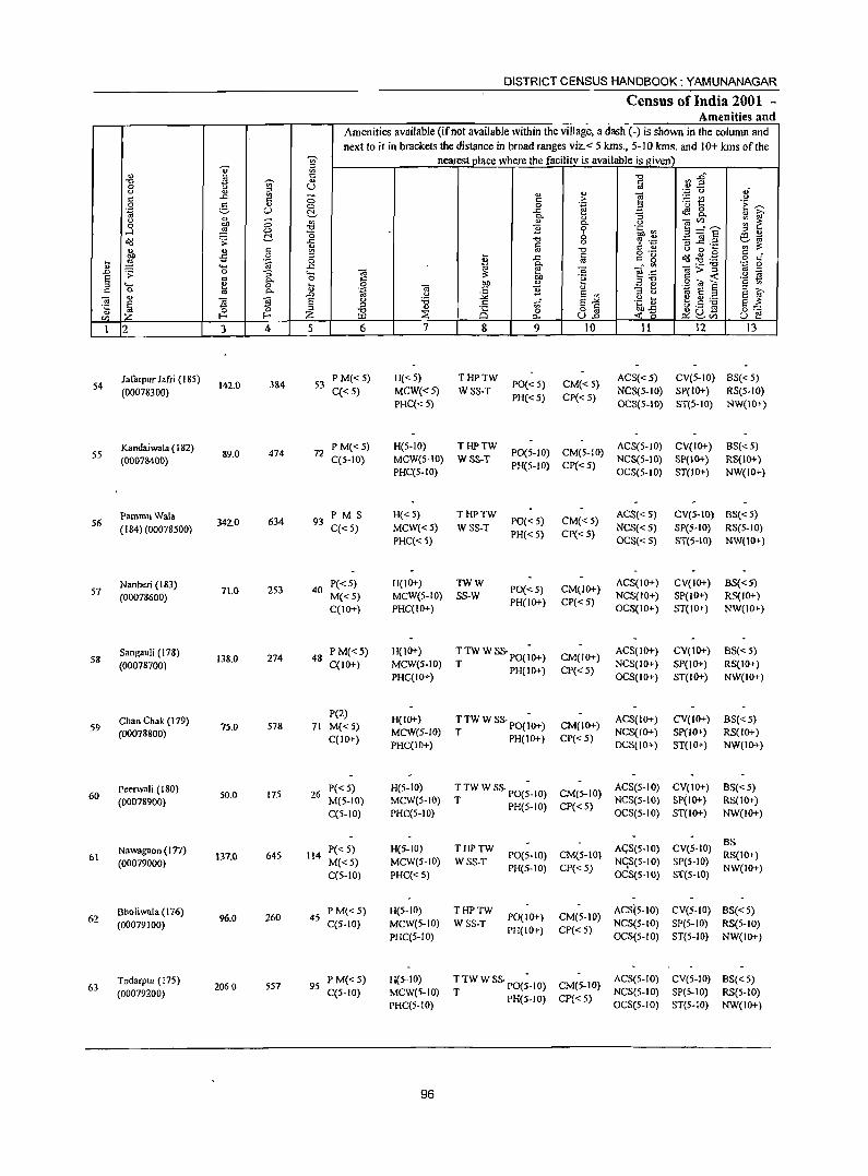
DISTRICT CENSUS HANDBOOK: YAMUNANAGAR
Census of India 2001 -Amenities and
Amenities available (if not available within the village, a dash (-) is shown in the column and next to it in brackets the distance in broad ranges viz. < 5 kms., 5-10 kms. and 10+ kms of the
~ nearest place where the facility is available is given ~
:l
" '" c:: '" 3~ -cI !!! -;;;- .., Iii 8 " ::l U of " "
',p ()
" ..c:: E 0
.., e - '" " c > .S? "
.., '" 0 .~ 3 '0 1:: .~ ~
'OJ :,::, (.) c:!- ..c:: cf9 ~ " ~ " ~ 0. " :;
u '" " ;;1Zl ~ i!: 0 bll
~ 0. u
....l ~ '" B 0 .~ ~ ~=E -0 0 ~ S Od .;; ..c: -cI
" '? 'p '3 ~.2 ~" .., Iii '" :;: ~ '" " '" -cI C " " 0 ...
0 ::l o .- 0'/1 .g.g c _
... ,g -5 .~ 0 t ..c:: Iii ~" ~ o c
" .... ~ ..c: 1;l g- ,- -cI .~ ~ ..0 .;; a -a .... ;; :;: til d e .'": ;;>::s E '" a c "e ::s-cl " -< '2 ~ ::l .... e 0 ... .~
bll " .!:: e .S? ~ S " a ... d c B " :l >,
<II 0. ..0 " :.;;; E '" ::s " ~ E ::s E " d
., ~ ~ E g 'i5 .g t g.5 ~ ~
c ~ E~ E :;: .~ :l ;i3 " i§ a " bll-B 0:-;::
IZl Z l- E-< Z ~ Po. U..o -< 0 ~ ~Vl U E! I 2 3 4 5 6 7 8 9 10 11 12 13
]afarpur ]afri (18S) 384 53
PM«S) H«S) THPTW PO« 5) CM«5)
ACS«5) CV(S-IO) 8S«S) 54
(00078300) 142.0 C« 5) MCW«5) WSS-T NCS(5-10) SP(IO+) RS(5-10)
PHC« 5) PH« 5) CP« 5)
OCS(5-10) ST(5-10) NW(\O+)
Kandaiwala (182) 474 72
PM«5) H(S-IO) THPTW PO(S-IO) CM(5-1O)
ACS(5-10) CV(IO+) 8S«S) 55
(00078400) 89.0
C(5-10) MCW(5-10) WSS-T NCS(5-10) SP(lO+} RS(IO+} PHC(5-1O)
PH(5-10) CP« 5} OCS(5-10) ST(lO+) NW(IO+)
Pammu Wala 634 93
PM S H«5) THPTW PO« 5) CM«5)
ACS« S) CV(S-IO) 8S« 5) 56
( 184)(00078500) 342.0
C«5) MCW«5) WSS-T NCS« 5) SP(5-1O) RS(S-IO)
PHC«5) PH« S) CP« 5)
OCS«5) ST(5-10) NW(IO+)
Nanheri (183) 253 40
P« 5) H(IO+) TWW PO«5) CM(IO+)
ACS(IO+) CV(IO+) 8S«5) 57
(00078600) 71.0
M«5) MCW(5-1O) SS-W NCS(IO+) SP(IO+) RS(IO+)
C(IO+) PHC(IO+) PH(IO+) CP« 5)
OCS(IO+) ST(IO+) NW(IO+)
58 Sangauli (178)
138.0 274 48 PM«5) H(lO+) TTWWSS·PO(;O+) CM(IO+)
ACS(lO+) CV(IO+) BS« 5)
(00078700) C(IO+) MCW(5-10) T PH(lO+) CP« 5)
NCS(IO+) SP(JO+) RS(lO+) PHC(IO+) OCS(IO+) ST(IO+) NW(IO+)
Chan Chak (I 79) P(2)
H(IO+) TTWWSS.pO{;O+) ACS(IO+) CV(IO+) 8S«S) 59 75.0 578 71 M«5) CM(lO+)
(00078800) C(lO+)
MeW(5-IO) T PH(IO+) CP« 5)
NCS(IO+) Sp(IO+) RS(IO+) PHC(IO+) OCS(IO+) ST(IO+) NW(IO+)
60 Peerwali (180)
50.0 175 26 P« S) H(5-10) TTW W SS· PO(;-IO) CM(5-IO)
ACS(5-IO) CV(IO+) BS« 5)
(00078900) M(5-10) MCW(S-IO) T PH(5-10) CP«S)
NCS(S-IO) SP(IO+) RS(IO+)
C(5-10) PHC(S-IO) OCS(S-IO) ST(IO+) NW(IO+)
Nawa!,'lIon (I n) P« S) H(5-IO) THPTW AGS(5-1O) CV(5-1O) 8S
61 137.0 645 114 PO(S-IO) CM(S-lO) RS(IO+) (00079000) M«5) MCW(5-IO) WSS-T
PH(5-10) CP« 5) NCiS(S-IO) SP(S-IO)
NW(IO+) C(S-IO) PHC«5) OCS(S-IO) S'f(5-10)
Booliwala (176) 96.0 260 45
PM«5) H(5-10) THPTW PO(lO+) CM(5-1O)
ACS(5-JO) CV(S-IO) 8S«S) 62
(00079100) C(5-10) MCW(S-IO) WSS-T NCS(5-JO) SP{5-1O) RS(5-10) PHC{5-10)
PH(IO+) CP« 5) OCS(S-JO) ST(5-JO) NW(IO+)
63 Todarpur (17S)
2060 557 95 P M« 5) H(5-IO) ~TWWSS.pO(;_JO) CM(5-10)
ACS(S-JO) CV(S-IO) 8S«S)
(00079200) C(5-10) MCW(5-1O) PH(5-1O) CP« 5)
NCS(5-10) SP(5-1O) RS(5-10) PHC(5-10) OCS(5-10) ST(5-1O) NW(IO+)
96
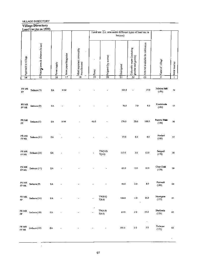
VILLAGE DIRECTORY
Village Directory Land Use (As on 1999)
14 15
PR MR Sadaura (5) FP
PRMR FP NR Sadaura (9)
:: MR Sadaura (5)
~:: Sadaura(ll)
~:- Sadaura(ll)
PR MR Sadaura (I I) FPNR
PRMR Sadaura (9)
FPNR
PRMR Sadaura (10)
FP
PRMR Sadaura (10)
FP
::~: Sadaura(IO)
EA
EA
EA
EA
EA
EA
EA
EA
EA
EA
16 17 18
NM
NM
Land use (i.e. area under different types of land use in hectare)
19
40.0
20
TW(5.0) T(5.0)
TW(S.O) T(8.0)
TW(4.0) T(4.0)
97
21
105.0
76.0
174.0
57.0
117.0
63.0
40.0
106.0
650
195.0
22 23
37.0
7.0 6.0
20.0 108.0
6.0 8.0
3.0 13.0
2.0 10.0
2.0 8.0
7.0 16.0
20 25.0
60 5.0
2
Jafarpur Jafri (185)
KandaiwaJa (182)
PammuWaia (lS4)
Nanheri (IS3)
Sangauli (178)
ChanChak (179)
Peerwali (180)
Nawagaoo (177)
Bholiwala (176)
Todarpur (175)
54
55
56
57
58
59
60
61
62
63
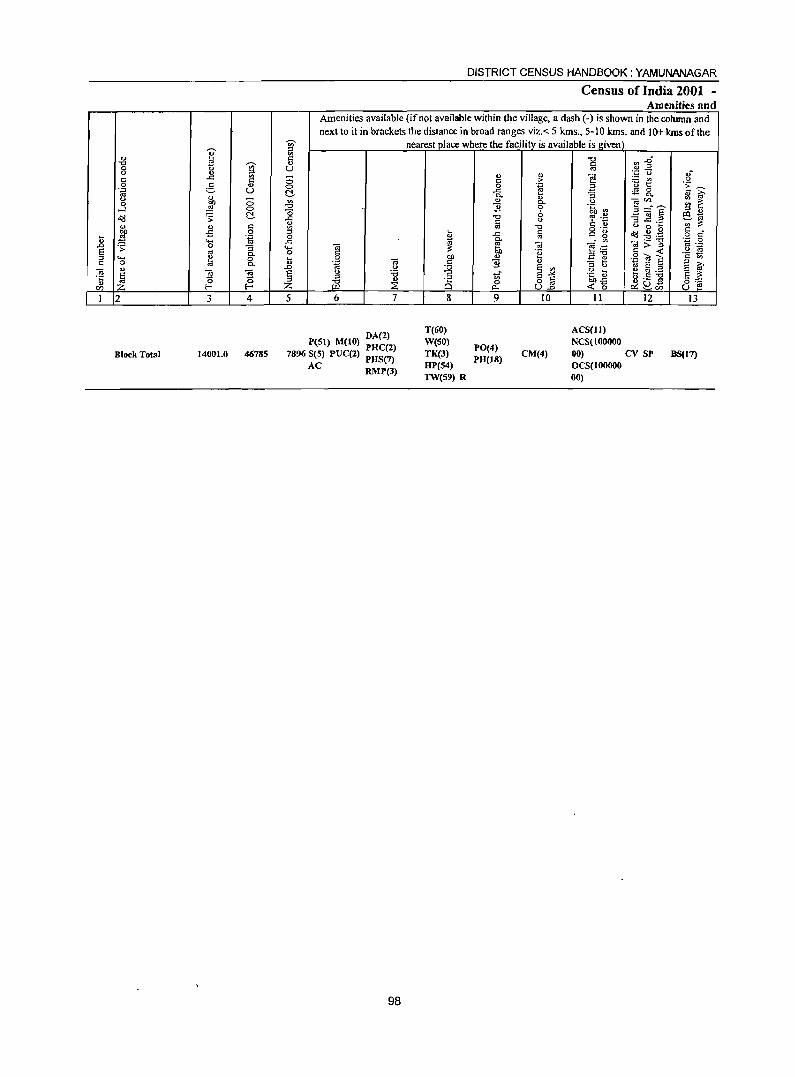
DISTRICT CENSUS HANDBOOK: YAMUNANAGAR
Census of India 2001 -Amenities and
Amenities available (if not available within the village, a dash (-) is shown in the column and next to it in brackets the distance in broad ranges viz. < 5 krns., 5-10 lans. and 10+ kms of the
-;;;- nearest place where the facility is available is given ~ ;::I
~ III ... C "0 ~~ "0 ~ -;;;- 0) c 0 U '" " ... ~ '" " ~
0.= U ... -C -C C 0 C > ~t " 0 5 ... 0 0 .~ .~ ~ .~ U -C ~ 0
~ 0- S c.. 0) ~
" " 0 !Il " '" <.> OJ''' :: ~ 0 on 0-,_:j ,g 0 "0 1i 0 .~ ~ ~ ~~i :s " ~ -0 6 lIlt;; o"(j .s: -C "0
" ~ .~ ... " :s ..c._ ';;;:;: '" " '" '" "0 " 0 ~ ~
o ._ ~ ~ . .g c • OJ) il 0 .... -C C
C .. g .... ~ 0g 0
~ '" 0 c
'" ..... -C 0- o;;>-g '';:: 0 ..0 ~ 0 S ..... 0; e 0; ~.t::
'" ._ E '" C- o c 00 .~ ;::1"0 C < .2 ~ :s ..... ~ 0 ~
0 on '" .:::: ~ .2 ~ S c '" c 0 .~ 0; c 1i " ;::I 0-;::I " t;; E '" ~ ~ 0) .0 " :.;;; E "' OJ E ~ <a E " '6 c t; 8~ .g ti e Cl) .-
'c 5 ;::I .g '" C§ I>ll -C ~G] 5::::: '" '" 0 o '" en :z l- f-- :z Dol ~ "'- U..o <:0 c.:~r:n U e I 2 3 4 5 6 7 8 9 10 11 12 13
DA(2) T(60) ACS(II)
P(Sl) M(IO) PHC(2) W(SO) PO(4)
NCS(lOOOOO
Block Total 14001.0 46785 7896 S(5) PUC(2) PHS(7) TK(3) PH(IS)
CM(4) 00) cv SP BS(17)
AC RMP(3) HP(54) OCS(lOOOOO TW(59) R 00)
98
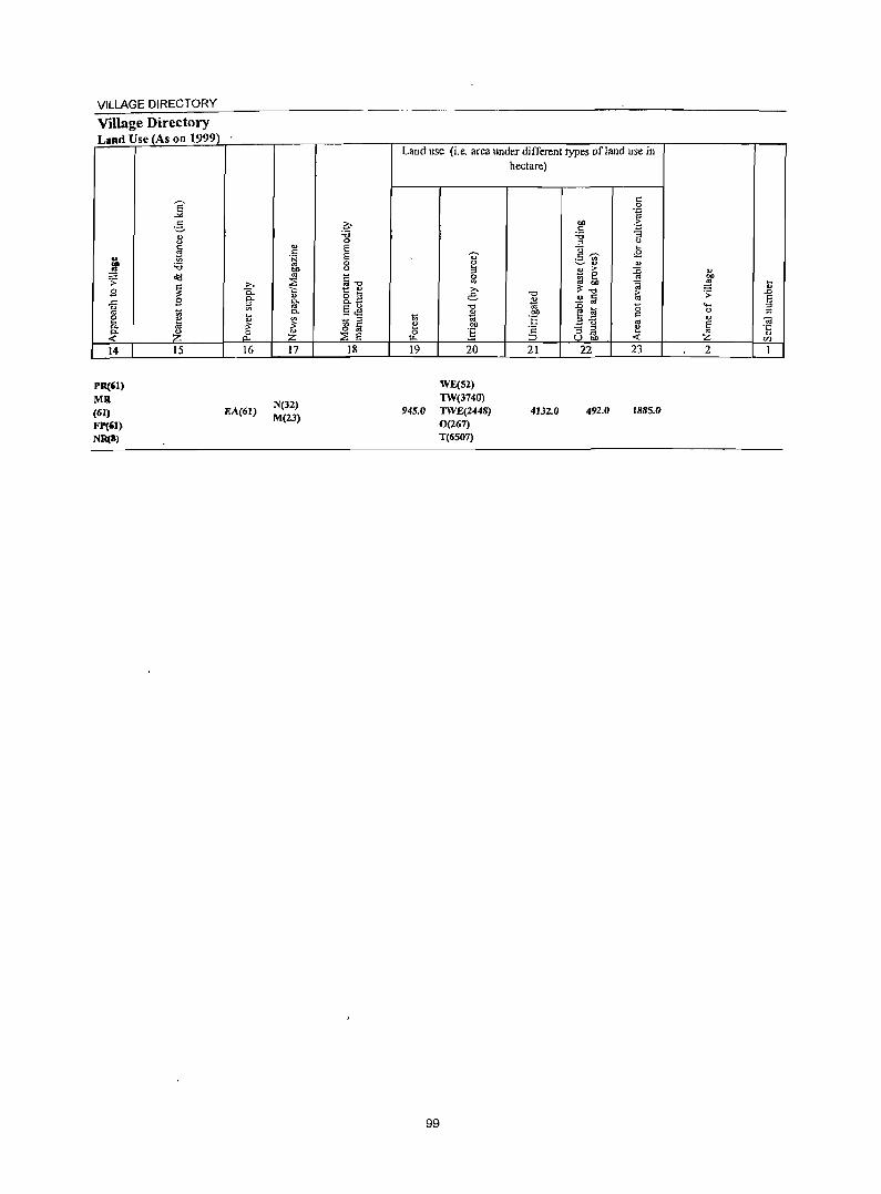
VILlAGE DIRECTORY
Village Directory Land Use (As on 1999)
14
PR(61)
MR (61) FP(61) NR(8)
15 16
EA(61)
17
N(32) M(23)
18
Land use (i.e. area under different types of land use in hectare)
19 20
WE(52) TW(3740)
945.0 TWE(2448) 0(267) T(6507)
99
21
4132.0
22 23
492.0 1885.0
2

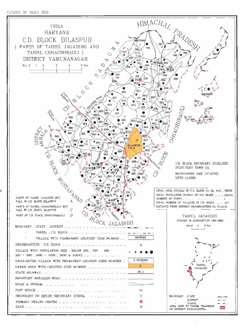
CENSUS OF I DlA 2001
INDIA HARYANA
C.D. BLOCK BILASPUR PARTS OF TAHSIL JAGADHRI AND
TAHS1L CHHACHHRAULJ )
DISTRICT Y AMUNANAGAR Km 2 o 2
I
PARTS OF TAHSIL JAGA!}HRI BUT FALL IN c.!}. BLOCK Bll.ASPUR
PARTS OF TAHSIL CHHACHHRAUU BUT
4
FALL IN C.D. BLOCK B1LASPUR C
PART OF C.!}. BLOCK CHHACHHRAUU D
BOUNDARY : STATE : DISTRICT _.
TAHSIL ; CD BLOCK
6 Km
VILLAGE WI'l'H PERMANENT LOCATION CODE NUMBER _ .. .
HEADQUARTERS : C.D. BLOCK .... _ ....... _ ... ... . _ ... _ . ...... .. ... _. __ ._ .. .
VILLAGE WITH POPULATION SIZE: BELOW 200 : 200 - 499 : 500 - 999 ; WOO - 4999 ; 5000 & ABOVE._ _. . __ _. _ . . _ ... ... ... . ..
UNlNHABITED Vl1LAGE W1TH PERMANENT LOCATION CODE NUMBER ...
URBAN AREA WlTH LOCATION CODE NUMBER. . .. _. .. . .... .. .
STATE HlGHWAY ......... ... _ .......... .
IMPORTANT METALLED ROAD ..... .. .. .
RIVER & STREAM _ ... _. .. ... _.
POST OFFICE ... ... ... .. ... ... . ..
SECONDARY OR SENIOR SECONDARY SCHOOL ...... ...... ... . _ ............ _.
PRIMARY HEALTH CENTRE ... _. ... ... _. ._ ... .'. ... ... _. ... ... ._ ._. . ..
BAN K ... _. .__ _. ... ... .. . ... ... ... ... _ ._ ... ._ ... ... ... ... _. ... __ ... ... ._ ..
00079300
• o • •••
X 00136000
))
SH I
PO
B
000 1 f
I ,I
I /
C.D. BLOCK BOUNDARY EXCLUDES S'I'_II.TUTORY TOWN (S)
BOUNDARIES ARE UPDATED UPTO 1.12000
TOTAL AREA (RURAL) OF C.D. BLOCK (In Sq. Km) _ 288.85
TOTAL POPULATION (RURAL) OF C.D. BLOCK _. _. _ 102274 NUMBER OF TOWNS _ _ _ ._ _ ____ . ___ . __ . 1
TOTAL NUMBER OF VILLAGES IN C.D. BLOCK _ __ 127
DISTANCE FRON DISTRICT HEADQUARTERS (In Kms) 2l
TAHS]L JAGADHR] CHANGE IN JUR1S!}]CTION 1991-2001
KmUJ 0 IOKm
... . . .;'\0< . _ " .".-. •
( .-;:,. .. \
~. ,;. . \ r · ._ ). TAHSIL· Jr"
JAGADHRl •
~.
1'- . ,; . r
BOUNDARY . STATE
DISTRICT TAHSIL
. ,..
AREA LOST TO TAHSIL THANESAR OF OISTRlcr KURUKSHETRA

VILLAGE DIRECTORY
Alphabetical list ofVilJages (C.D. block wise) Name of the District:Yamunanagar SI.No. Name of village 2001 Census location code 1991 Census btation code number
number 2 3 4
Name of CD Block: Bilaspur Name of S ub-Dist: Jagadhri (Part)
I AharwaJa (273) 00083900 020010001000100149 2 Ali Sherpur M ajra (246) 00082000 020010001000100089 3 Ambwala (278) 00087400 020010001000100121 4 Ambwala (288) 00093QOO 020010001000100164 5 Arnauli (323) 00091300 020010001000100229 6 Azizpur (292) 00089000 020010001000100124 7 Bajawali (45) 00081400 020010OD.Z000200081 8 Bankat (240) 00082100 020010001000100102 9 Bansewala (SO) 00082700 020010001000100108
10 Bhagwanpur (35) 00079900 020010001000100069 II Bharnnauli (227) 00084300 020010001000100145 12 Bhattuwala (251) 00080400 020010001000100071 13 Bhawanipur (276) 00083700 020010001000100131 14 Bhil Chhappar (280) 00087500 020010001000100165 15 Bhogpur (285) 00088500 020010001000100117 16 Bihta(242) 00083500 020010001000100134 17 Bodhi (44) 00081200 020010001000100079 18 Budheri (324) 00090800 020010001000100235 19 Butgarh <54) 00088100 020010002000200113 20 Chaharwala (289) 00092900 020010001000100122 21 Chanda Kheri (300) 00089700 020010001000100201 22 Chaurahi (272) 00087200 020010001000100150 23 Chhaiiu Nagala (376) 00091500 020010001000100237 24 ChhaJaur (244) 00082400 .020010001000100105 25 Chuharpur (40) 00079400 020010001000100063 26 Daryapur (303) 00089900 020010002000200159 27 Dayalgarh (250) 00080300 020010001000100070 28 Dhalaur (287) 00088800 020010001000100120 29 Dhanaura (252) 00079800 020010001000100068 30 Faquir M ajra (56) '00087800 020010001000100129 31 Fatehgarh Tumbi (59) 00088300 020010002000200115 32 GadwaJi (247) 00080100 020010001000100090 33 Gianawala (337) 00092100 020010001000100196 34 Haibatpur (291) 00092500 020010001000100172 35 Hartaul (271) 00087000 020010001000100156 36 lamiatgarh (55) 00088000 020010001000100113 37 Juda latan (335) 0009\900 020010002000200205 38 Juda Shci Khan (332) 00090400 020010001000100204 39 Kaimpura (281) 00087600 020010001000100166 40 Kakrauni (299) 00089600 020010001000100200 41 Kapoori Kalan (294) 00089500 020010001000100170 42 Kapoori Khurd (293) 00089400 020010001000100169 43 Katarwali (238) 00084600 020010001000100137
103
DISTRICT CENSUS HANDBOOK :YAMUNANAGAR
Alphabetical list of Villages <C;.D. block wise) Name of the District:Yamunanagar SLNo. Na 200 I Census location code 1991 Census location code number
me number 2 3 4
44 Katarwali (239 00084400 020010001000100136 45 Kathgarh (37) 00079600 020010001000100066 46 Khera Brahmanan (298) 00090000 020010002000200199 47 Kotra Khas (274) 00084000 020010001000100148 48 Kurali (284) 00088400 020010001000100116 49 Kurewala (269) 00087100 020010001000100155 50 Machhrauli (263) 00083300 0200)0002000200130 51 Majri (249) 00080500 020010001000100072 52 M akhaur (297) 00090100 020010001000100198 53 Malak Raipur (58) 00089200 020010001000100126 54 Malakpur (290) 00092600 020010001000100174 55 Manakpur (286) 00088700 020010004000400142 56 Mandhar (333) 00090500 020010001000100206 57 Manglaur (49) 00082500 020010001000100084 58 M arwa Kalan (283) 00089300 020010001000100168 59 M arwa Khurd (295) 00092400 020010001000100171 60 M auhri (277) 00087300 020010002000200163 61 Mianpur(51) 00082800 020010002000200109 62 M Hak Sukhi (373) 00090600 020010001000100227 63 M i1kara (258) 00081800 020010001000100087 64 M i1kkhas (275) 00083800 020010001000100132 65 M ugalwali (259) 00081700 020010001000100085 66 M unda Khera (282) 00087700 020010001000100167 67 Musimbal Hindwan (371) 00091600 020010001000100225 68 Musimbal Muslamanan (372) 00091700 020010002000200226 69 Muzafat (241) 00084500 020010002000200135 70 Nagai Patti M achhrauli (262) 00083100 020010001000100130 71 Nagli (264) 00083200 020010001000100095 72 Nagli (32) 00085200 020010001000100107 73 Naiwala (42) 00081300 020010002000200080 74 Nathanpur (43) 00081100 020010001000100078 75 Nawan Shahar (342) 00092800 020010001000100175 76 Pabni Kalan (336) 00092000 020010002000200194 77 Pabni Khurd (334) 00091800 020010002000200207 78 Painsal (61) 00088900 020010001000100123 79 Paniwala (39) 00079300 020010001000100064 80 Paonti (374) 00090700 020010001000100~28 81 Parbhaoli (52) 00082900 020010001000100112 82 Pilkhanwala (260) 00081900 020010001000100088 83 Pipliwala (41) 00081000 020010001000100077 84 Raianwala (267) 00084100 020010002000200147 85 Ramgarh Majra (60) 00089100 020010001000100125 86 Ramgarh Sawai (245) 00082200 020010001000100103 87 Rampur Gainda (36) 00079700 020010.002000200067 88 Rampur Harian (48) 00083400 020010001000100106
104
VILLAGE DIRECTORY
Alpbabeticallist of Villages (C.D. block wise) Name ofthe District:Yamunanagar SI. No. Na 2001 Census location code 1991 Census location code number
me number 2 3 " 89 Rampur Kamboan (243) 00082300 020010001000100104
90 Ranipur (256) 00080900 020010001000100076 91 Ranjitpur (254) 00080700 020010001000100074 92 Rasulpur (296) 00092200 020010001000100197 93 Rohla Heri (257) 00081600 020010001000100086 94 ~lpur(46) 00081500 020010002000200082 95 Sanaur (57) 00087900 020010001000100127 96 Sandhai (265) 00083600 020010002000200133 97 Sarawin (62) 00088600 020010001000100118 98 Shah Quamaispur (375) 00091400 020010001000100236 99 Shahpur (302) 00089800 020010001000100161
100 Sbahpur (382) 00091200 020010001000100234 101 Shekhupura (338) 00092300 020010001000100195 102 Sbergarh (248) 00080200 020010001000100091 103 Singhpura (53) 00088200 020010001000100114 104 Suabari (253) 00080600 020010001000100073 105 Suhanpur (255) 00080800 020010001000100075 106 Sunder Bahadurpur (34) 00080000 020010001000100092 107 Taharpur Khurd (261) 00083000 020010001000100111 108 Teha Brahmanan (331) 00090300 020010002000200203 109 Tehi Jatan (330) 00090200 02001000]000100202 110 Tunde Ki Taparian (47) 00082600 020010002000200083 111 Uddham Garh (341) 00092700 020010002000200176 112 Udhamgarh (266) 00084200 020010001000100146 113 Uttamwala (38) 00079500 020010001000100065
Name of CD Bid: Bilaspur Name ofSub-Dist: Chhachhrauli (Part)
1 Bbagwangarh UrfBansantaur (26) 00136200 020020002000200015 2 Bherthal (326) 00127700 020020001000100083 3 Chagnauli (304) 00128000 020020001000100076 4 Faqira M ajra (24) 00136300 020010002000200021 5 lbrahimpur (29) 00136800 020020001000100005 6 Mahmudpur (325) 00127600 020010002000200084 7 Pheruwala (305) 00128100 020020002000200079 8 Piruwala (30 I) 00]27900 020020001000]00077 9 Ramkheri (329) 00127800 020020001000100078
10 Sankhera (306) 00128200 020020001000100075 II Shabudinpur Kalan(22) 00136500 020010002000200013 12 Shahbudinpur Khurd(23) 00136400 020010002000200023 13 Tahri (27) 00136700 020020004000400002 14 Yarah (21) 00136600 020020001000100012
105
DISTRICT CENSUS HANDBOOK: YAMUNANAGAR
Census of India 2001 -Amenities and
Amenities available (if not available within the village, a dash (-) is shown in the column and next to it in brackets the distance in broad ranges viz. < 5 kms., 5.-10. kms. and 10+ kms of the
y;- nearest place where the facility is available IS given 0' :::>
"" ~~ u e E c y;- o>
'" oi "" U -;:: (,) 0 0 El v " e ~t: 0 t.> " ;::; c ;>
.~ ~ c ..c c
0 -~ a tS8. 0 c 8 0 .c :; " ii' .~ ;::, t!- o.. ;;
~~E ::; 2: & ;::; " 0.. 0 0 '" 11 0 .~ ~ :::> "
0 ~ 0 "" b -3 ~ .~ ,:!l ~ -..l 0
"0 cp ';:; ~'" t!- o
'" ~ ~ .;;;: ..c. c § .z; o 0 ~
0>
'" "" ~.g .g 5 c" ... " c '" ~ ..c c c 0 -5 0 :;1
~ '" 1l>~ ·c 0
OJ) .~ a
~ ....:'" -~ .~
~ ~ .... ..c <il ~:g " 0 :; '- <il
.~ .0 .;;;:
9 <a E <: '" E '" 0.. a c 01) " .:: ... :::l ..... " 0 ~ 0 <il c 11 '" :::> <.> ta E :l E ii' :::l l.ii p. .~ <.> :g E '" .g ~ e~:.o c a .0
..: g~ E ~ ~ ...
~ l E <.> '6 c :g 01)..c o ._ ~
0"" E "
:::l " 8 ..(" ~~U5 U E
"0 ~ "'- U.o <> .z_ r- Z f.Ll <ZJ
} 2 3 4 5 6 7 8 9 10 11 12 13
CD Block: Bilaspur (0002)
P«5) H(IO+) TWWTK ACS(5-IO) CV(IO+) BS(5-IO) Paniwala (39)
136,0 188 26 M(5-10) MCW(5-10) SS-W
PO« 5) CM(lO+) NCS(lO+) SP(IO+) RS{lO+) (OOO7930<l) C(IO+) PHC(5-1O) PH(tO+) CP(5-tO) OCS(5-1O) ST(IO+) NW(IO+)
P« 5) H(IO+) TWWTK
CM(IO+) ACS(S-IO) CV(IO+) BS(5-IO) Chuharpur (40)
127.0 116 24 M«5) MCW(5-10) SS-W
PO«5) NCS(IO+) SP(tO+) RS(IO+) 2
(00079400) C(lO+) PHC{IO+) PH(lO+) CP(5-10)
OCS(5-1O) ST(lo+) NW(IO+)
P M«5) H« 5)
TWW ACS(5-JO) CV(IO+) BS(IO+) Uttamwala (38) 52.0 151 26 MCW(IO+)
SS-W PO« 5) CM(IO+)
NCS(IO+) SP(lO+) RS(IO+) 3 (00079500) C(IO+)
PHC(IO+) PH(IO+) CP« 5) OCS(5-10) ST(lO+) NW(IO+)
DARMP THPTWW ACS
CV(IO+) as
H« 5) PH CM(lD+) NCS(lO+) RS(JO+)
Kathgarh (37) 637.0 1.113 207 P MC(IO+) MCW«5) TK
PO« 5) SP(1O+) 4 (00079600) SS-T CP(5-lO) OCS(S-IO)
ST(IO+) NW(IO+)
PHC(IO+)
P« 5) H(IO+) ACS«5) CV(IO+) BS(5-lO) RampurGainda
273.0 lOS 19 M«5) MCW(5-ID) WSS-W 1'0« 5) CM(IO+) NCS(JO+) SP(5-IO) RS(5-1O) 5
(36) (00079700) C(JO+) PHC(5-1O) PH(5-10) CP(5-IO)
OCS(5-10) ST(5-10) NW(IO+) ~~
" , DAPHS as THPTWW
ACS{< 5) CV(JO+) Dhanaura (252) 83 PMS H«5)
TK PO« 5) CM(lO+) NCS(JO+) SP(tO+)
RS(IO+) 6 384.0 498 C{IO+) MCW«5}
NW(IO+) (00079800) PHC(IO+)
SS-T PH(5-IO) CP(5-IO) OCS(5-10) ST(IO+)
H«5) THPTWW ACS« 5) CV(IO+)
BS Bhagwanpur (35)
859 153 P M« 5)
MCW«5) TK PO«5) CM(IO+) NCS(IO+) I SP(IO+)
RS(IO+) 7 365.0 C(IO+)
NW(IO+) (00079900) PHC(IO+) SS-T PH(5-IO) CP« 5) OCS(5-IO) ST(IO+) .".
H(IO+) TTWW
CM(IO+) ACS« 5) CV(IO+) BS(5-1O) Sunder Bahadurpur
683.0 1.569 273 P M C(IO+) MCW{IO+) SS-T
PO«5) NCS(IO+) SP(IO+) RS(IO+) 8 (34) (00080000) PHC(IO+) PH(5-IO) CP(IO+)
OCS(5-10) ST(IO+) NW(1O+) ,
H(IO+) ACS« 5) CV(lo+) as
P M(5-10) THPTWW PH(3) CM(IO+) RS(JO+) 9
Gadwali (247) 312.0 827 118
C(lO+) MCW(IO+)
SS-T PO«5) NCS(JO+) SP(IO+) NW(1O+) (00080100) PHC(IO+) CP(IO+)
OCS(5-IO) ST(IO+)
106
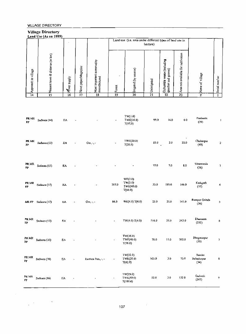
VILLAGE DIRECTORY
Village Directory Land Use (As on 1999)
14 15
::: MR Sadaura (14) EA
PRMR fP Sadaura (13) EA
PRMR Sadaura (13) EA
fP
PRMR Sadaur. (17) EA
FP
MRFP Sadaura (17) EA
PRMR Sadaura ( 17) EA
fP
PRMR Sadaura (16) EA
FP
PRMR Sadaura (39) EA
FP
PRMR Sadaura (16) EA
FP
16 17 18
Gur, -,-
Gur, -.-
Earthen Pots, -, -
Land use (i.e. area under different types of land use in hectare)
19
217.0
84.0
20
TW(I.O) TWE(16.0) T(17.0)
TWE(20.0) T(20.0)
WE(3.0) TW(3.0) TWE(40.0) T(46.0)
WE(4.0) T(4.0)
TW{4.0) T(4.0)
TW(36.0) TWE(40.0) T(76.0)
TW(22.0) TWE(20.0) T(42.0)
TW(25.0) TWE(BO.O) T(105.0)
107
21
99.0
83.0
37.0
33.0
23.0
116.0
76.0
565.0
52.0
22 23
14.0 60
2.0 22.0
7.0 8.0
195.0 146.0
21.0 141.0
21.0 243.0
11.0 202.0
3.0 73.0
30 1520
2
Paniwala (39)
Chullarpur (40)
Utlamwala (38)
Kathgarh (37)
Rampur Gainda (36)
Dhanaura (252)
Bhagwanpur (35)
Sunder Bahadurpur
(34)
Gadwah (247)
2
3
4
5
6
7
9
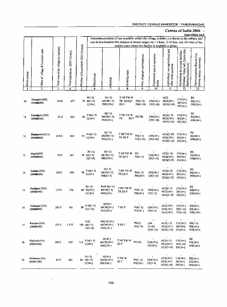
DISTRICT CENSUS HANDBOOK: YAMUNANAGAR
Census of India 2001 _
Amenities and Amenities available (if not available within the village, a dash (-) is shown in the column and next to it in brackets the distance in broad ranges viz. < 5 kms., 5-10 kms. and 10+ kms of the
'Vi' nearest place where the facility_is available is g!ven e " ., ~ -0 ~~ -0 19 'Vi' " § 0 <.> U u '" " '" 'C 0 .; c:: .c ~ a '" > e ~t! <> c:: 0 :§, .,
0 0 .~ B .~~ .~ (.)
~ .c tB 8. .. 0..
" :J ~ ! u a ., " Ole/) 0 ~ c, <>
....l 0 -0 ] 0 .§> .2 3---~ (; 6 " '" o"d .:;: ~ -0 -3] .§ e!.t;;i ..c;
'" <.> C l:) " ., ~
" ..,
'" ., .. -0 o ._ <.> 0 ~ c:: _
~ -5 0 " ~ .c § ': ~ Cd .g .g ~ .~ 0 '" o c:: .... .c <a 0.. ._ -0 'p 0 .0 .;; 0 "3 .... 2 ;.l: ~ Ol e·<;:: ~>~
... _ E '" 0 'e ·2 ~ .... !:!
c, co '" ,,"0
.2 .. a " a ~ .9 '3 M '" 0 '" c, Oi .: ]1 ., e ~ <> .0 .. <.> :.;;; E ., <.> ... .. E "
~ E S S E g 'i3 c:: In- E~ .~_g ~ .5:g e ;.l: os a a ~ -0 " 8 0:':
'" :::E 0 o "' ~ ~Vl til Z E- E- III .,., (.).0 <15 (.) I'! I 2 3 4 5 6 7 8 9 10 11 12 13
Sherprh (248) P«5) H«5) THPTWW ACS
CV(IO+) BS
JO 154.0 477 74 M«5) MCW«5) TIC R[16]C PO« 5) CM(lO+) NCS(IO+) RS(IO+) (00080200)
C(IO+) PHC(IO+) SS-T PH(S-IO) CP(S-IO) OCS(5-IO) SP(IO+)
NW(IO+) ST(IO+)
Dayalt;I'Th (250) P M«5) H«5)
THPTWW POPH ACS«5) CV(IO+) BS
II (00080300)
61.0 266 46 C(IO+)
MCW«S) TIC SS-T
CM(IO+) NCS(IO+) SP(IO+)
RS(IO+) PHC(IO+) CP(5-10)
OCS(S-to) ST(IO+) NW(IO+)
Bhattuwala (251 ) P M«5) H« 5)
THPTWW ACS(5-JO) CV(IO+) BS
12 (00080400)
219.0 602 93 C(IO+)
MCW« 5) TKSS-T
PO«S) CM(IO+) NCS(IO+) SP(IO+)
RS(IO+) PHC(IO+) PH(S-IO) CP(S-IO)
OCS(S-IO) ST(IO+) NW(IO+)
Majri(249) P«5) H«5)
THPTWW PH ACS«5) CV(IO+) BS
13 55.0 341 56 M«5) MCW«5) CM(lo+) RS(lO+) (OOOSOSOO)
C(5-10) PHC(IO+) TKSS-T PO«5)
CP(S-IO) NCS(IO+) SP(IO+)
NW(IO+) OCS(5-10) ST(IO+)
Suabari (253) P M« 5) H«5)
THPTWW ACS« 5) CV(IO+) BS
14 (00080600)
185.0 499 78 C(IO+)
MCW«5) TKSS-T
PO« 5) CM(IO+) NCS(IO+) SP(IO+)
RS(IO+) PHC{<5) PH{IO+) CP(S-IO)
OCS(5-10) ST(IO+) NW(IO+)
Ranjilpur (254) P« 5) RMPH«5)
THPTWW ACS« S) CV(lO+) BS
15 (00080700)
117.0 370 68 M(IO+) MCW«5) TlCSS-T
PO« 5) CM(IO+) NCS(JO+) SP(IO+)
RS(IO+) C(IO+) PHC(IO+) PH(IO+) CP« S)
OCS(5-10) ST(IO+) NW(IO+)
Sultanpur (255) PM« S) H(IO+)
ACS(IO+) CV(IO+) BS(IO+) 16 203.0 561 88 MCW(IO+) TSS-T PO« 5) CM(IO+)
(00080800) C(5-10) PHC(IO+) PH(IO+ ) CP« 5)
NCS(IO+) SP(5-10) RS(IO+) OCS{lO+) ST{5-10) NW(IO+)
Ranipur (256) P(2) PHS H(IO+)
PH(2) CM ACS«S) CV(IO+) BS« 5) 17 3530 1,177 180 M«5) MCW(IO+) TSS-T
(00080900) C{5-IO) PHC(IO+)
PO« 5) (S-IO) NCS(IO+) SP(lO+) RS(IO+) CP(5-10} OCS(5-IO} ST(IO+} NW(IO+)
Pipliwala (41) P M«5) H(IO+)
THPTWW ACS« 5) CV(IO+) BS
18 (00081000)
2000 639 114 C(IO+)
MCW(IO+) SS-T
PO PH CM(IO+) NCS(IO+) SP(5-10)
RS(IO+) PHC(IO+) CP(lO+)
OCS(S-IO) ST(IO+) NW(IO+)
Nathanpur (43) P«5) H(IO+)
TTWW ACS{IO+) CV(IO+) 9S(IO+) 19 81.0 362 66 M«5) MCW(IO+) PO« 5) CM(JO+)
(00081100) C(lO+) PHC(IO+)
SS-T PH(IO+) CP« 5)
NCS{IO+) SP(IO+) RS(IO+) OCS(5-1O) ST(IO+) NW(IO+)
108
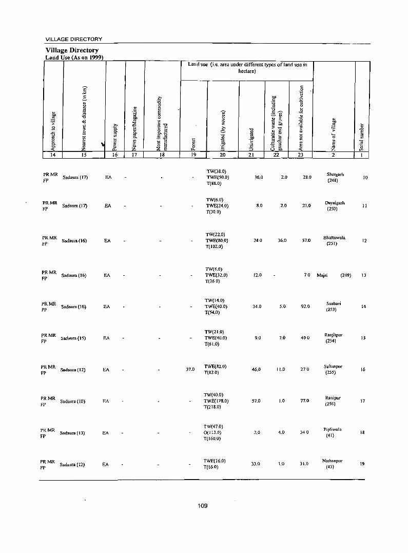
VILLAGE DIRECTORY
Village Directory Land Use (As on 1999)
14 15
PRMR FP Sadaura (17) EA
PRMR FP Sadaura (17) EA
:: MR Sadaura (16) EA
::MR Sadaura(16) EA
~~ MR Sadaura (16) EA
PRMR FP Sadaura (15) EA
PRMR FP Sadaura (12) EA
:: MR Sadaura ( 10) EA
PRMR FP Sadaura (13) EA
~ MR Sadaura (12) EA
16 17 18
Land use (Le. area under different types of land use in hectare)
19 20
TW(38.0) TWE(50.0) T(88.0)
TW(6.0) TWE(24.0) T(30.0)
TW(22.0) TWE(80.0) T(102.0)
21
36.0
8.0
240
22 23
2.0 28.0
2.0 21.0
36.0 57.0
2
Shergarh (248)
Dayalgarh (250)
Bhattuwala (251)
TW(4.0) TWE(32.0) T(36.0)
12.0 70 Majri (249)
37.0
TW(14.0) TWE(40.0) T(54.0)
TW(21.0) TWE(40.0) T(61.0)
TWE(82.0) T(82.0)
TW(40.0) TWE(178.0) T(218.0)
TW(47.0) 0(113.0) T(160.0)
TWE(16.0) T(I6.0)
109
34.0
9.0
46.0
57.0
2.0
33.0
5.0
7.0
11.0
1.0
4.0
1.0
92.0
400
270
77.0
340
31.0
Suabari (253)
Ranjitpur (254)
Sultanpur (255)
Ranipur (256)
Pipliwala (41)
Nathanpur (43)
10
II
12
13
14
15
16
17
18
19
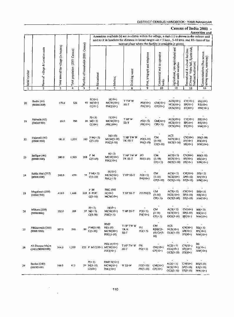
DISTRICT CENSUS HANDBOOK: YAMUNANAGAR
Census oflndia 2001 -Amenities and
Amenities available (ifnot available within the village, a dash (-) is shown in the column and next to it in brackets the distance in broad ranges viz.< 5 kms., 5-10 kms. and 10+ kms of the
1 nearest place where the facilitv is available is given ~ "0 tn.g " i -;;;- ii § .~ "0 oJ
'"0 U 0
5l .. ~ ] ~t! u u
0 c E~
c ..r::: " 0 'l:l
<!'l 8-0 6
., 0 -a ~
~ f "ta u !::!. " '" ] ~-E
4) ... g- o u ;:; ., ]i .~ ~ ~M
0 1 -0
6 ....l 0 -0
'" '" ._ ~ jg .2 !::!. u § ·N ';;';;: ~ .;: ..r:::
[ij u 0 ~ " "tJ ~ .g.g § r:;'" " " c "' ~ -a '" s:: 0 ~ 1'l 0 ::>
~ '" - '" ._ "tJ
";:: 0 .~ 0
]>-~ '" ._ l;; '0 ..r::: i:! "@ e~ .~ 19 ..0 .;: :; """ "@
OIl "§ _g f! .g"<l a c ., a gl a. 0 § OIl <lJ ., G ~
._ 0 l;; '" c 1i '" u '" a '"
::> 0 :a a. .~ u :Q a '" .g ~ ~~;a E~
c ..0
tf E-'" 0; " <d ~ a u :;:; .S o a ~-g ~uJ5 o ._ ~
::> " 0
U E! li (') 0 ::> ;E ::;;; Q '" U.c. f--' f-' Z '" 1 2 3 4 5 6 7 8 9 10 II 12 13
POO+) H(lO+) TTWW
CM(IO+) ACS(IO+) CV(IO+) BS(IO+) Bodhi (44)
119.0 526 92 M(IO+) MCW(IO+) SS-T
POCIO+) NCS(IO+) SP(IO+) RS(IO+) 20
(00081200) C(lO+) PHC(IO+) PH(10+) CP(IO+) OCS(IO+) ST(1O+) NW(IO+)
P«5) H(IO+) THPW
CM(lo+) ACS(IO+) CV(IO+) 8S(10+) Naiwala (42)
85.0 390 56 M«5) MCW(IO+) SS-T
PO«5) NCS(IO+} SP(lO+) RS(IO+)
21 (00081300)
C(IO+) PHq I 0+) PH(IO+) CP«5) OCS(IO+) ST(IO+) NW(IO+)
H(S-to) CM
ACS CV(JO+) BS(5-10) PM«5) THPTWW
NCS(IO+) Bajawali (45) 1,035 165 MeW(5-IO) PO(5-10)
(5-10) SP(IO+) RS(IO+) 22 181.0 C(5-10) TK SS-T
PH(5-10) OCS(5-10) (00081400) PHC(5-10) CP(5-10) ST(lO+) NW(IO+)
PM H«5)
THPTWW pO CM ACS«5) CV(IO+) 8S(5-10) 23
SafiJpur(46) 580.0 1,503 268
q5-10} MCW(lO+)
TK SS-T PH(5-IO) (S-IO) NCS(IO+) SP(IO+) RS(IO+) (0008IS00) PHC(IO+)
CP(':: 5) OCS(5-JO) ST(IO+) NW(IOf-)
P M«5) H(IO+)
CM ACS«5) CV(IO+) BS« 5) Rohla Heri (2S7) 479 74 MCW(IO+) THP SS-T PO« S)
(5-10) NCS(IO+) SP(5-1O) RiS(IO+) 24 248.0
q5-1O) (00081600) PHC« 5) PH(JO+)
CP(S-IO) OCS(S-IO) ST(5-IO) NW(lO+)
PM PHCPHS CM ACS{< 5) CV(IO+) 8S« S) Mugalwali (259)
4180 1,460 225 S PUC H(ID+) THPSS-T POPH(2) (5-10) NCS(IO+) SpeS-lO) RS(IO+}
25 (00081700)
C(5-10) MCW(lO+) CJ>« 5) OCS(5-10) ST(5-JO) NW(JO+)
P(':: 5) H(IO+) CM ACS«5) aV(lo+) BS«5) Milkara (258)
132.0 188 37 M«5) MCW(IO+) THPSS·T PO«5) (5-10) NCS(lO+) SP(5-10) RS{IO+)
26 PH(IO+)
(00081800) C(5-IO) PHC«5)
CP« 5) OCS(5-10) ~(IO+) NW(IO+)
RMP THPTWW CM ACS
CV(IO+) BSe< 5) PM(5-10) H(5-1O) PH R[6]C(5- NCS(IO+)
Pilkhanwala (260) 99 TKR
Sp(IO+) RS(IO+) 27 307.0 598
C(5-1D) MCW(IO+) PO« 5) 10) CP(5- OCS(5-10)
(00081900) SS-T
ST(W+) NW(IO+) PHC(5-IO) 10)
PHS H(ID+) CV(IO+)
as THPTWW PH ACS« 5)
RS(IO+) Ali Sherpur Majrn 223 P M C(JO+) MCW(IO+) CM(IO+)
NCS(IO+) SP(I,O+) 28 264.0 1,359
SS-T PO« 5) NW(IO+)
(246) (00082000) PHC(IO+) CP(IO+}
OCS(5·IO) ST(lO+)
P« 5) RMPH{IO+) ACS« 5) "CV(IO+) BS(5-10) Bankal (240)
1460 413 59 M(5-10) MCW(IO+) WSS-W PO(5-10) CM(lO+) NCS(IO+) SP(S-IO) as(S-tO)
29 (00082(00)
C(IO+) PHC(IO+) PH(S-IO) CPt 10+) OeS(5-10) ST(5·10) NW(IO+)
110
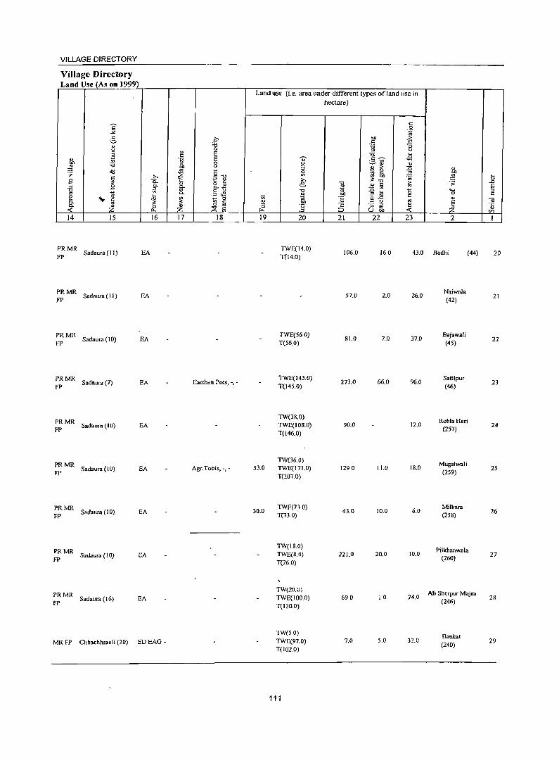
VILLAGE DIRECTORY
Village Directory Land Use (As on 1999)
Land use (i.e. area under different types ofland use in
hectare)
E c: 0
..>< '-g 2, 0 on 'S :.0
c: ., :.0 "3 u 0 :s <.> c: " E <> ... t! c:
E dj' <.c:l " .~ .5~ on :.0 0 e ""-' 0 0
~ bIJ <.> :s o ... :D " a(I '" ~-o - 0 .;;: ~ ~ ~ ... '" bIJ
~ >. ?:~ ~ .!'! tl B 0. t: ~ >.
~ 0- 0 o :::> e "'" ~ iii ~ ..0 .I:: 0-
0. _ 2 E g ~ '" .5 Jl "'" '" ..0 a 0 ..... :s
t; 0. 0 bIJ 0 c: e 'I!p ~ .~ ?! _ :s t:; ~ ·6 E!.c c:
" c. " ~ § !:! a <.> os E 0; ." - ;;;l !:! ·c c. Z 0 Z ;::;: E 0 E :s OJ ~ '" < 0., "- ::> u bO < tI)
14 15 16 17 18 19 20 21 ;22 23 2 1
PRMR Sadaura (I I) EA
TWE(14.0) 106.0 160 43.0
FP T(14.0) Bodhi (44) 20
PRMR Sadaura (II) EA 57.0 2.0 26.0
Naiwala FP (42)
21
PRMR Sadaura (J 0) EA
TWE(56.0) 81.0 7.0 37.0
B.jawali FP T(56.0) (45)
22
PRMR Sadaura (7) EA Earthen Pots, -.-
TWE(145.0) 273.0 66.0 96.0
Safilpur FP T(145.0) (46)
23
PRMR TW(38.0)
RohlaHeri
FP Sadaura (10) EA TWE(JOS.O) 90.0 12.0
(257) 24
T(146.0)
PRMR TW(36.0)
Mugalwali Sadaura (10) EA Agr.Tools, -, - 53.0 TWE(171.0) 1290 11.0 18.0 25
FP T(207.0) (259)
PRMR Sadaura (10) EA 30.0
TWE(7.3.0) 43.0 10.0 6.0
Milleara
FP T(730) (258) 26
PRMR TW(18.0)
Pilkhanwala Sadaura (l0) EA TWE(8.0) 221.0 20.0 10.0 27
FP T(26.0) (260)
PRMR TW(20.0)
Ali Sherpur Ma]ra Sadaura ( 16) EA TWE(100.0) 690 1.0 74.0 28
FP T(120.0) (246)
TW(50) Sankat
MRFP Chhachhrauli (20) EDEAG - TWE(97.0) 7.0 5.0 32.0 (240)
29 T(102.0)
111
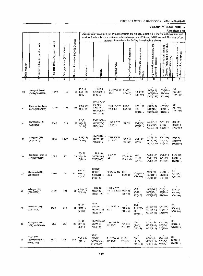
DISTRICT CENSUS HANDBOOK: YAMUNANAGAR
Census of India 2001 -Amenities and
Amenities available (if not available within the village, a dash (-) is shown in the column and next to it in brackets the distance in broad ranges viz.< 5 kms., 5-10 kms. and 10+ kms of the
-;;- nearest place where the facility is available is given
~ iil '" c: "0 :a1 -0 tl ~
., Iii 0 u u ., ".p t,) ,;
c: ..c:: '" 0 v " ! ..:: '" u c: c .~ 0 e.. " <::> 0 '01:: 'E ~ 0g U ..c 4S 8. ." - ~ Q.
" :1 v ~ u '" " - en :;: 1: .3 :W 0 Q. " e .~ 0 "0 1l 0 .~ en "0 .§ ~ .~ '" " "d .;;: ~ ..c "0 6 ro .~ ~~ ~ c <.> t: v
:W 0 c: ., "0 00'"
-5 0 '" ~ r::: o ._
Od ~.~ § c ... .~ 0 " ..c ., c_ ~ " ..... ..c 10 ~ "Ca:;:1i ''';:: 0
..0 .;;: 0 :; ..... -.; ~ ro e:a B ·z E .. C- o c: Of) .~ c: < °2 ~ '" ..... fa 0 .... 0 tlI) ., E ~ .S? OJ S c 0 C- D °ii -.;
~ 1l " § ~ '" .0 <.> E '" :l <> 10 E ::I
~ S -.;
~ s u :.;; lji" E-"" .~ ~ ~ u ._
S ~ oj ~ :l .g v 8 0 o c: ""..c:: ~D] 0:-::: u Z ::;;; ull <0 en Z W p... C::~en U e
1 2 3 4 5 6 7 8 9 10 II 12 13
Ramgarh Sawai P«S) H(IO+)
THPTWW PH(2) ACS«S) CV(IO+) BS
30 (24S) (00082200)
182.0 169 2S M(5-10) MCW(IOt-) SS-T PO« S)
CM«S) NCS(IO+) SP(IO+)
RS(IO+) C(IO+) PHC(IO+) CP(IO+)
OCS(5-10) ST(IO+) NW(IO+)
NH(2)RMP
Rampur Kamboan PM«5) (2) R[S]
THPTWW PH(2) CM (S- ACS« 5) CV(IO+) BS
31 (243) (00082300)
IS7.0 702 118 C(5-1O)
CH{5-10) TKSS-T PO« 5) 10) NCS(IO+) SP(IO+)
RS(IO+) MCW(IO+)
CP(10+) OCS(S-IO) ST(lO+) NW(lO+)
PHC(S-IO)
Chhalaur (244) P 1(3) RMPH(IO+)
THPTWW ACS« 5) CV(IO+) 8S« 5) 32 260.0 718 127 M«5) MCW(IO+) PO PH CM(IO+)
(00082400) C(IO+) PHC(IO+)
TKSS-T CP(10+)
NCS(IO+) SP(IO+) RS(IO+) OCS(S-IO) ST(lO+) NW(IO+)
Manglaur (41) PM«5) RMPH(IO+)
THPTWW ACS«5) CV(IO+) BS« 5) 33 317.0 1,569 266 MCW(IO+) PO« 5) CM(IO+)
(00082500) C(IO+) PHC(IO+)
TKSS-T PH(IO+) CP(IO+)
NCS(IO+) SP(IO+) RS(lo+) OCS(5-1O) ST(lO+) N W(I 0+)
Tunde Ki Taparian P« 5) H(5-10)
THPW CM ACS(5-JO) CV(IO+) BS(5-10) 34 109.0 lSI 23 M«5) MCW(IO+) PO(S-IO)
(47) (00082600) C(IO+) PHC(5-10)
SS-T PH(5-IO)
(5-10) NCS(JO+) SP(IO+} RS(IO+) CP{< 5) OCS(5-JO) ST(IO+) NW(JO+)
P« 5) RMP(2)
BS Bansewala (SO) H(JO+) TTWWTK PH ACS«5) CV{IO+)
35 (000827oo)
154.0 790 137 M«5) MCW(IO+) SS-T P0(5-10)
CM(IO+) NCS(IO+) SP(IO+)
RS(IO+) C(IO+)
PHC(IO+) CP(lO+)
OCS(5-1O) ST(IO+) t\_W(IO+)
Mianpur (51) P M« 5) H(S-IO) THPTWW
CM ACS(S-IO) CV(IO+) BS« 5) 36 248.0 508 78 MCW(IO+) TK+R(5]C Ss. PO« 5)
(OO082800) C(S-IO) PHC(5-10) T PH« 5)
(5-10) NCS(IO+) SP(IO+ ) RS{IO+) CP« 5) OCS(S-IO) ST(IO+) NW(IO+)
P«5) RMP
eM BS Parbhaoli (52) H(5-10) TTWWTK ACS(S-IO) CV(lO+)
37 (00082900)
1960 659 91 M(IO+) MCW(5-10) SS-T
PO« 5) R[S]C(5-NCS(5-1O) SP(lO+) RS(IO+)
C(IO+} PHC(5-10)
PH«5) 10) OCS(S-IO) ST(lo+)
NW(lO+) CP(IO+}
Taharpur Khurd P« 5) RMPH(5-10)
THPTWW CM ACS« 5) CV(IO+) BS
38 (261) (00083000)
78.0 203 29 M«5) MCW«S) TK SS-T
PO« 5) (S-IO) NCS(S-IO) SP(IO+)
RS(IO+) C(IO+) PHC«5) PH(IO+)
CP« 5) OCS(5-IO) ST(IO+) NW(IO+)
Nagai Patti RMP
8S PM«5) H(5-1O) THPTWW PH(3) CM ACS« 5) CV(IO+)
39 Machhrauh (262) 260.0 976 164 C(JO+) MCW(S-IO) TK SS-T PO«5) (5-10) NCS(S-IO) SP(IO+)
RS(to+) (00083100)
PHC(5-10) CP(S-to) OCS(5-1O) ST(IO+) NW(IO+)
112
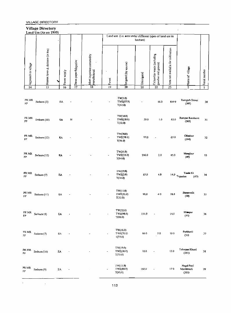
VILLAGE DIRECTORY
Village Directory Land Use (As on 1999)
14 15
:: MR Sadaura (3) EA
:: MR Sadaura (10) EA
~:MR Sadaura(12) EA
;: MR Sadaura (12) EA
~: MR Sadaura (7) EA
:: MR Sadaura (II) EA
:: MR Sadaura (8) EA
:: MR Sadaura (7) EA
:: MR Sadaura (10) EA
PRMR FP Sadaura (9) EA
16 17 18
N
Land use (i.e. area under different types of land use in hectare)
19 20
TW(5.0) TWE(57.0) T(62.0)
TW(14.0) TWE(IS.O) T(32.0)
TW(38.0) TWE(58.0) T(96.0)
TW(31.0) TWE(33.0) T(64.0)
21
59.0
97.0
206.0
22 23
16.0 1040
1.0 65.0
670
2.0 45.0
2
Ramgarh Sawai (245)
Rampur Kamboan (243)
ChhaJaur (244)
Manglaur (49)
TW(22.0) TWE(2.0) T(24.0)
67.0 4.0 14.0 .TundeKi Tapanan (47)
TW(II.O) TWE(21.0) T(32.0)
TW(32.0) TWE(48.0) T(80.0)
TW(26.0) TWE(71.0) T(97.0)
TW(19.0) TWE(36.0) T(S5.0)
TW(J3.0) TWE(80.0) T(93.0)
113
90.0
154.0
840
10.0
150.0
40 28.0
14.0
5.0 100
13.0
17.0
Bansewala (50)
MioPpur (51)
Parbhaoti (52)
Taharpm Khurd (261)
Nagai Patti Machhmuli
(262)
30
31
32
33
34
35
36
37
38
39
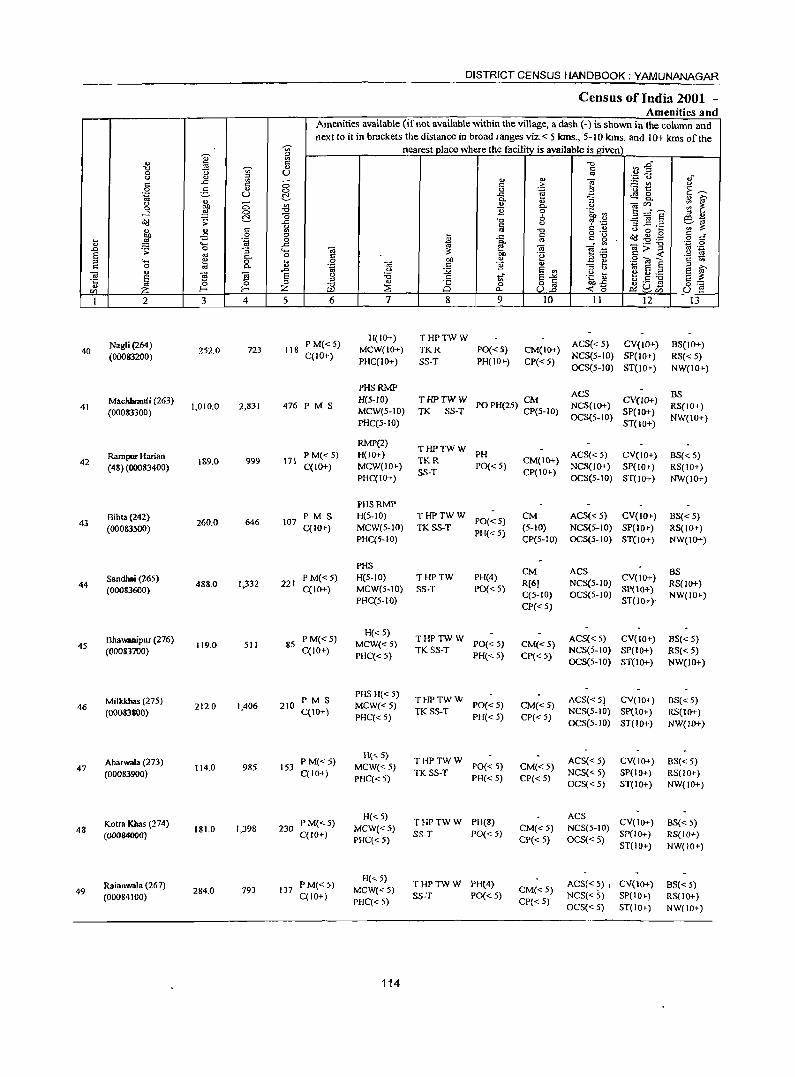
40
41
42
43
44
45
46
47
48
49
2
Nagli(264) (000&3200)
Machhraufi (263) (000&3300)
Rampur Hadan (48) (00083400)
Bihta(242) (00083500)
Sandhai (265) (00083600)
Bhawaoipur (276) (000837tJ0)
Milkkbas (275) (00083800)
Aharwala (273) (00083900)
Kotra Khas (274) (00084000)
RaianW31a (267) (000&4100)
3 4
252.0 723
1,010.0 2,831
1&9.0 999
260.0 646
488.0 1,332
119.0 511
212.0 1,406
114.0 985
181.0 1,398
284.0 793
DISTRICT CENSUS HANDBOOK: YAMUNANAGAR
Census of India 2001 -Amenities and
I Amenities available (if not available within the village, a dash (-) is shown in the column and next to it in brackets the distance in broad ranges viz.< 5 kms., 5-10 kms. and 10+ kms of the
nearest place where the facility is available is given
u
5 6
fl8 PM«5) C(IO+)
476 PM S
171 P M« 5) C(IO+)
107 P M S C(IO+)
221 P M«5) C(IO+)
85 PM«5) C(IO+)
210 PM S C(IO+)
153 PM«5) C(IO+)
230 P M« 5) C(lO")
137 PM«5) C(IO+)
7
H(IO+) MCW(IO+) PHC(IO+)
8 9
THPTWW TKR PO«5) SS-T PH(IO+)
10 11 12
CM(IO+) ACS« 5) CV(IO+) CP« 5) NCS(5-10) SP(IO+)
OCS(5-IO) ST(lO+)
PHSRMP H(S-IO) MCW(5-1O) PHC(S-IO)
THPTWW CM TIC SS-T POPH(25) CP(S-IO)
ACS CV(IO+)
NCS(IO+) SP(lO+)
RMP(2) H(IO+) MCW(IO+) PHC(IO+)
PHSRMP H(5-10) MCW(5-10) PHC(5-10)
PHS
THPTWW PH TKR SS-T PO«5)
THPTWW TK SS-T PO« 5)
PH« 5)
H(5-1O) T HP TW PH(4) PO« 5) MCW(5-10) SS-T
PHC(5-IO)
H«5) MCW«5) PHC« 5)
PHS H«5) MCW«5) PHC« 5)
H«5) MCW« 5) PHC« 5)
H« 5)
MCW« 5) PHC«5)
H« 5) MCW«5) PHC« 5)
114
THPTWW TK SS-T PO« 5)
PH« 5)
THPTWW TK SS-T PO« 5)
PH« 5)
T HP TW W PH(8) SS-T PO«5)
THPTWW PH(4) SS-T PO« 5)
OCS(5-1O) ST(10+)
CM(IO+) ACS« 5) CVC I 0+) CP(IO+) NCS(lO+) SP(lO+)
OCS(5-10) ST(IO+)
CM ACS« 5) CV(IO+) (5-10) NCS(5-10) SP(lO+) CP(5-10) OCS(5-10) ST(lO+)
CM R(6) C(5-10) CP« 5)
CM«5) CP« 5)
CM«5) CP« 5)
CM«5) CP« 5)
CM«5) CP« S)
CM«5) CP« 5)
ACS CV(lO+) NCS(5-10) SP(IO+) OeS(5-10) ST(IO+),
ACS«S) CV(10+) NCS(5-10) SP(IO+) OCS(5-10) ST(IO+)
ACS« 51 CV(lo+) NCS(5-10} SP(IO+) OCS(5-10) ST(lo+)
ACS« 5) NCS«5) OCS« 5)
CV(IO+) SP(IO+) ST(IO+)
ACS CV(IO+) NCS(5-10) SP{IO+)
OCS« S} ST(IO) +
ACS«5) I CV(1O+) NCS« 5) SP(IO+) OCS« 5) ST(IO+)
13
BS(IO+) RS« 5) NW(IO+)
BS RS(lO+) NW(lO+)
BS«5) RS(IO+) NW(IO+)
BS« 5) RS(IO+) NW(IO+)
BS RS(lO+) NW(IO+)
8S« 5) RS« 5) NW(IO+)
BS« 5) RS(IO+) NW(lO+}
BS« 5) RS(IO+) NW(IO+)
BS«5) RS{IO+) NW(IO+)
BS« 5) RS(IO+) NW(IO+)
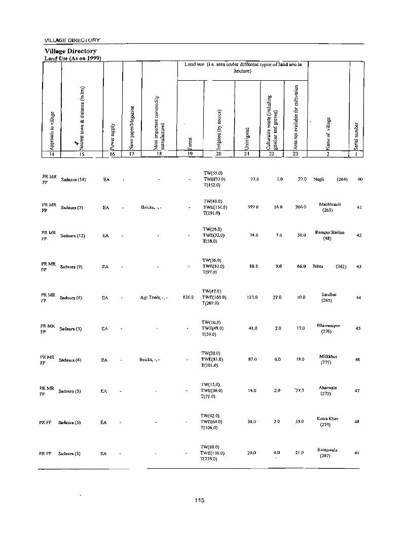
VILlAGE DIRECTORY
Village Directory Land Use (As on 1999)
Land use (i e. area under different types ofland use in hectare)
S <:: 0
~ "ta :8 0 "" .£i <:: u 'i3 'i3 g c.> 0 ;:l
~ Q) E U ... <:: ., 'a E .... <::~ <8 ._ '"
~ 'i3 0 e ~'" " c.> ;:l B & ::0 ., <iI.I oJ C .;:
~ ~ ~ ... oJ
~ ... '" oJ "0 ~~ ~ g ~ 0.. t Q) >.
., " 8.3 e -0 ~
.;;: .D
.c g C- o.. '" ~ a E 0
;:l oJ .5 J9 "0 1a ~ ~ 15 .... ::I oS -;; '" 0..
~ 'E' 0 '" ~
<:: e ,,~ ~ ;:l '" E~ '" " "iii
Co ~ til ~ bO
~ 0.. u ] '2 "3 g e '0::;
Z 0 ~ E 0 '" -< a.. Z I..t. ::> u OIl -< en
14 15 16 17 18 19 20 21 22 23 2 I
PRMR TW(5S.0)
FP Sadaura (14) EA TWE(97.0) 77.0 1.0 22.0 Nagli (264) 40
T(IS2.0)
PRMR TW(40.0)
Machhrauli
FP Sadaura(7) EA Bricks,., - TWE(I5I.O) 5970 16.0 206.0
(263) 41
T(I91.0)
PRMR TW(26.0)
Rampur Harian Sadaura (12) EA TWE(32.0) 74.0 7.0 SO.O 42
FP T(58.0) (48)
PRMR TW(36.0)
FP Sadaura (9) EA TWE(61.0) 88.0 9.0 66.0 Bihta (242) 43
T(97.0)
PRMR TW(47.0)
Sandhai Sadaura (6) EA Agr.Tools, -,- 126.0 TWE(160.0) 123.0 22.0 10.0 44
FP T(207.0) (265)
PRMR TW(IO.0)
Bhawanipur Sadaura(5) EA TWE(49.0) 41.0 2.0 17.0 45
FP T(S9.0) (276)
PRMR TW(20.0)
Milkkhas
FP Sadaura(4) EA Brides, -,- TWE(81.0) 87.0 6.0 18.0
(27S) 46
T(IOJ.O)
PRMR TW(15.0)
Aharwala Sadaura (3) EA TWE(S6.0) 14.0 2.0 '27.0
FP (273) 47
T{71.0)
TW(42.0) KotraKhas
PRFP Sadaura(5} EA TWE(64.0) 38.0 20 35.0 (274)
48 T(106.0)
TW{89.0) Raianwala
PRFP Sadaura (3) EA TWE{IS0.0) 20.0 4.0 21.0 (267)
49 T(239.0)
115
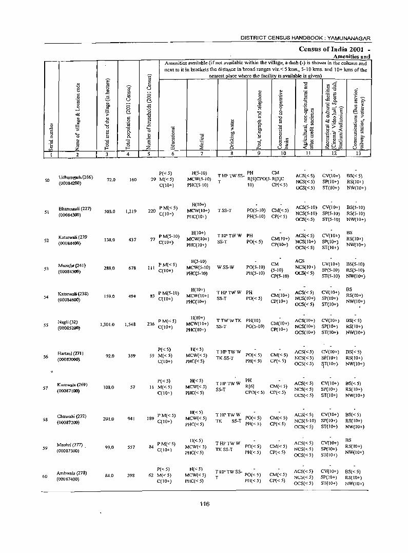
i UJ
I
50
51
52
53
54
55
56
57
58
59
60
2
Udhamg:>Jh (166)
(00084200)
Bhamnauli (227) (00084300)
Katarwali (239 (00084400)
Muzafat (241) (00084500)
Kalarwali (238) (00084600)
Nagli (32) {0008S200}
Hartaul (VI) (00087000)
Kurewala. (269) (00087100)
Chamahi (272) (00087200)
Mauhri (277) _ (00087300)
Ambwala (278) (000&7400)
3 4
72.0 160
503.0 1,219
138.0 437
288.0 678
159.0 494
1,301.0 1,548
92.0 359
108.0 57
201.0 941
99.0 557
84.0 398
DISTRICT CENSUS HANDBOOK: YAMUNANAGAR
Census of India 2001 -Amenities and
Amenities available (if not available within the village, a dash (-) is shown in the column and next to it in brackets tbe distance in broad ranges viz. < 5 kms., 5- \ 0 krns. and 10+ krns of the
nearest olace where the facility is available is Riven
5 6
P« 5) 29 M« 5)
C(IO+)
220 PM«5) C(lO+)
77 P M(S-IO) C(10+)
til PM«5) C{ID+)
83 P M(S-lO) C(lO+)
236 P M« 5) C(10+)
P« 5) 59 M«5)
C(1O+)
P« 5) II M«5)
C(10+)
189 PM«5) C{IO+)
84 PM« 5) C(IO+)
P« 5) 62 M« 5)
C(10+)
7
H(5-1O) MCW(S-IO) PHC(5-10)
H(IO+) MCW(IO+) PHC(IOt)
H(IOt) MCW(IO+) PHC(IOt)
H(5-10) MCW(5-10) PHC(5-1O)
H(lO+) MCW(IO+) PHC(IO+)
H(IO+) MCW(IO+) PHC(IOt)
H«5)
MCW«5) PHC« 5)
H«5) MCW«5) PHC«S)
H«5) MCW{<5) PHC«5)
H«5) MCW«5) PHC« 5)
H« 5) MCW«5) PHC« 5)
116
9 10 II 12
PH CM T HI' TW SS- R[5]CPO(5. R[5]C ACS{<5)
NCS«5) OCS« 5)
CV(lO+) SP(IO+) ST(IO+)
T 10) CP« 5)
TSS-T PO(5-10) CM«5) PH(5-10) CP«5)
ACS(5-10) CV{IO+) NCS(5-10) SP(5-1O) OCS«S) ST(S-IO)
THPTWW PH SS-T PO{<5)
WSS-W P0{5-10) PH{5-10)
THPTWW PH SS-T PO« 5)
ACS{< 5) CV(IOt) CM(IO+) NCS{IO+) SP(IO+) CP(IOt) oeS« 5) ST(IO+)
ACS CM NCS(IO+) (5-10) CP(5-10) OCS« 5)
ACS{<5) CM(IO+) NCS(IO+) CP(IO+) oes« 5)
CV(IO+) SP(5-10) ST(5-1O)
CV(IOt) SP(IO+) ST(IOt)
TTWWTK PH(IO) ACS(IO+) CV(IO+) SS-T PO{S-IO) CM(IO+) NCS(IO+) SP(IOt)
CP(IOt) OCS(IOt) ST(IOt)
THPTWW PO«5) TK SS-T PH« 5)
CM«5) CP« 5)
ACS« 5) NCS{< 5) oeS{<5)
CV(IO+) SP(1O+)
~T{lO+}
PH THPTWW R[6] CM«5)
SS-T CPO« 5) CP{< 5)
ACS{<5) NCS« 5) OCS{<5)
CV{IOt} SP(IO+) ST(IO+)
THPTWW PO«5) TK SS-T PH« 5)
THPTWW PO«5) TK SS-T PH« 5)
THPTWSS- PO(~5) T PH«5)
CM«S) CP«5)
CM«5) CP« 5)
CM«5) CP« 5)
ACS« 50) CV(IOt) NCS(S-IO) SP{IO+) OCS« 5) ST(IOt)
ACS«5) NCS«5) OCS«5)
ACS«5) NCS« 5) OCS«5)
CV(IO+) SP(IOt) ST(lO+)
CV(IO+) SP(ID+) ST{IO+)
B$« 5) RS(IO+) NW(IO+)
BS(5-1O) RS(5-10) NW(IO+)
BS RS(ID+) NW(IO+)
BS(5-1O) RS(5-10) NW(IOt)
BS RS(IO+) NW(IO+)
BS« 5) RS(IO+) NW(lO+)
BS« 5) RS(ID+) NW(IOt)
BS«5) RS{lO+) NW(IOt)
BS« 5) RS(ID+) NW(IO+)
BS RS(lO+) NW(IO+)
BS«5) RS(ID+) NW(IO+)

VILLAGE DIRECTORY
Village Directory Land Use (As on 1999)
Land use (i. e. area under different types of land use in hectare)
E s:: 0 _,. .~
5 .q OJ) .f; s::
" -0 :.a "3 u
" 0 '" u c E U ....
~ s:: '" .~ E ., s::~ <E
~ .- "' :.a 0 ~ ~ ., .,
"" " '" > ~ " ~ '" ~""C 1:i e ;;: ~ g :W ~
» i>'~ '0; ....
B 0. 1:: e » ... " e -0 1;; .;;: .0
..c: B 0. a. o '" ., ., s:: .§ a. ~ - '" <.> r;; '" .5 ~ -0 1;l ~ a a ....
to
~ a. ., bJl 0 C e ~ ti 1;l :§ ~..c: s::
" ~ '" ., OJ 0. '" '" til e OJ)
_ <.)
~ 0. Z 0 ~ 0 0 :§ s:: - '" ., 'C:
::E E ::s to < " <: "" "" ::> uoo IZl
14 15 16 17 18 19 20 21 22 23 2 1
TW(S.O) Udhamgarh
PRFP Sadaura (8) EA TWE(55.0) 1.0 8.0 50 T(63.0)
(266)
TW(60.0) Bhamnauli
FP Chhachhraul i (15) EDEAG· Earthen Pots, ., • TWE(179.0) 118.0 14.0 132.0 51 T(239.0)
(227)
TW(29.0) KatarwalJ
PRFP Sadaura (18) EA TWE(80.0) 17.0 3.0 9.0 (239
52 T(109.0)
TW(40.0) Muzafat
FP Chhachhrauli (14) EA TWE(IIS.O) 43.0 87.0 53 T(158.0)
(241)
TW(I3.0) Katarwali
PRFP Sadaura (I 8) EA TWE(80.0) 17.0 35.0 14.0 (238)
54 T(93.0)
PRMR Chhachhrauli (25) EA Earthen Pots, -, .
TWE(17.0) 169.0 3.0 1112.0 Nagli (32)
FP T(17.0) 55
PRMR TW(14.0)
Hartaul FP
Sadaura (4) EA TWE(68.0) 2.0 1.0 7.0 (271)
56 T(82.0)
PRMR TW(29.0)
Kurewala
FP Sadaura (3) EA TWE(40.0) 33.0 3.0 3.0
(269) 57
T(69 0)
PRMR TW(7.0)
Chaurahi Sadaura (3) EA Bricks, -,- TWE(161.0) 6.0 9.0 18.0 58
FP T(168.0) (272)
PRMR TW(I7.0)
Mauhri Sadaura (5) EA Bricks, .,. TWE(41.0) 240 50 120 59
FP T(58.0) (277)
PRMR TW(4.0)
Ambwala Sadaura (2) EA TWE(9.0) 64.0 2.0 7.0 60
FP T(l3.0) (278)
117
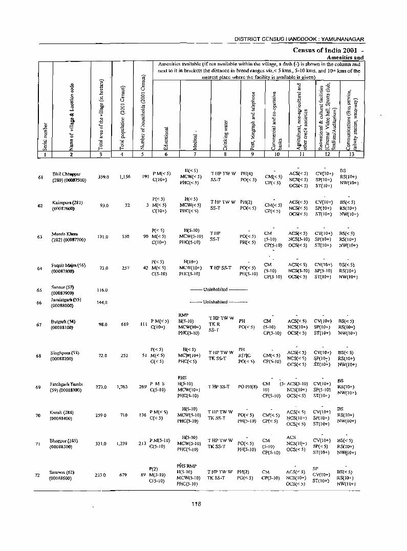
-;;;-
I :>
<> E "C -;;;- '" 0 <> U .. '" ::> r: ..c E <5 a g '" 0 .~ U !::!. ... -..
'" a ~ 0 "C ...l 0 (5 ~ ~ !::!. ..c
~ .. " c
~ -5 0 ... .~ 0
" ..... ..c .0 -;: 0 "3 ..... S '" c.. 0 :l ._ e 0 ... c 0 '" c.. '"
C) .0 <d E ~ ~ a 'c
~ " '" !- Z til
I 2 3 4 5
Bhil Chhappar 61
(280) (00087500) 359.0 1,156 191
Kaimpura (281) 62
(00087600) 93.0 22 3
MundaKhera 63
(282) (00017700) 131.0 550 90
Faquir Main. (56) 64
(00087800) 73.0 257 42
65 Sanaur (51)
116.0 (00087900)
66 Jamiatgam (55)
144.0 (00088000)
67 Butgarit (54) (00088100)
98.0 619 III
Singhpura (53) 68 72.0 252 SI
(0008&200)
Fatehgarh Twnb. 69
(59) (0008S3oo) 273.0 1,763 269
Kurali (284) 70
(00088400) 2590 710 136
Bhogpur (285) 71
(00088500) 321.0 1,239 213
72 Sar.wln (62) (00088600)
2330 679 89
DISTRICT CENSUS HANDBOOK: YAMUNANAGAR
Census of India 2001 _ Amenities and
Amenities available (if not available within the village, a dash (-) is shown in the column and next to it in brackets the distance in broad ranges viz.< 5 kms., 5-10 kms. and 10+ kms of the
nearest place where the facility is available is given "C ~ :a" c '" ''::: (.) ~f '" '" f! ~t c >
0 .~ .a .~ ----..c <!l 0 i}- "3 0. Q) >,
" <Ii'" ~ ~ B a. " 0 "t=o '" 3:gE' &; ~
"0 6 % .£ c " ;3..c: .= ..__..~
'" -0 <> 0 ~ ;g ~ .. ~ c
o ._ a(I .g .,g <I.) ..c
'" r: g o c
d a. "' ._ -0
'.;1 0 OJ ::: ti, <Ii E:i3 <Ii >- :l '" .-c .~ c -< .~ !; 0
<d Ql) '" E e 'g ~ E c '" .;::; c B '" :l
l3 .~ ~ S '" :l "
~.S ~ a R "C -" E~ .~~ E ::: .g .,
;§ 0 0:;:::: ~ o '" -<0 ~u-W p.. U.o ..__..CI) U e!
6 7 8 9 10 II 12 13
PM«5) H«5)
THPTWW PH(4) ACS« 5) CV(10+) BS
C(lO+) MCW«5)
SS-T PO« 5) CM« 5)
NCS«5) SP(lO+) RS(JO+)
PHC«5) CP« 5) OCS« 5) ST(IO+) NW(lO+)
P« 5) H«5) THPTWW PH(2) ACS« 5) CV(lO+) BS«5)
M«5) MCW«5) CM«5) C(IO+) PHC« 5)
SS-T PO« 5) CP« 5)
NCS« 5) SP(IO+) RS(IO+) OCS«5) ST(IO+) NW(10+)
P« 5) H(5-1O) THP eM ACS«5) CV(IO+) BS«5)
M«5) MCW(5-10) PO«5) C(IO+) PHC(5-10)
SS-T PH« 5)
(5-10) NCS(5-10) SP(lO+) RS(IO+) CP(5-10) OCS« 5) ST(IO+) NW(IO+)
P« 5) H(IO+) eM A.CS« S) CV{ \0+) BS« 5)
M«5) MCW(I(}I-) THPS5-T PO«5) C(5-10) PHC(5-10) PH(5-10)
(5-10) NCS(5-JO) SP(S-IO) RS(IO+) CP(5-10) OCS« 5) ST(I(}I-) NW(I(}I-)
--Uninhabited ----
--Uninhabited -----
RMP THPTWW
PM«5) H(5-JO) TKR
PH CM ACS«5) CV(JO+) BS«5) C(lO+) MCW(IO+)
SS-T PO« 5) (5-10) NCS(IO+) SP(IO+) RS(I(}I-)
PHC(5-10) CP(S-IO) OCS{<5) ST(IO+) NW(I(}1-)
P«5) H«S) THPTWW
PH ACS« 5) CV(IO+) BS« S)
M«5) MC}V(I(}I-) R[7]C CM«5) C«5) PHC«5)
TKSS-T PO«S) CP(5-10)
NCS« 5) ~P(\Ot) RS(\(}I-)
OCS«S) T(IO+) NW(I(}I-)
PJ-JS PM S H(5-10) CM (5- ACS(5-10) CV(IO+)
BS T HPSS-T POPH(8) RS(lO+)
C(5-10) MCW(IO+) 10) NCS(IO+) SP(5-IO) PHC(S-IO) CP(5-10) OCS«S) ST(I(}I-)
NW(IO+)
P M« 5) H(5-10)
THPTWW ACS«S) CV(\O+) BS
MCW(5-10) PO« 5) CM«5) RS(IO+) C« 5) TKSS-T J":ICS(10+) SP(IO+)
PHC(5-IO) PH(5-10) CP« 5) OCS«5) ST(IO+)
NW(IO+)
PM(5-10) H(5-IO)
THPTWW CM ACS
CV(IO+) BS« 5) MCW(5-10) PO«5) NCS(IQ+)
C(5-10) PHC(5-10)
TKSS-T PH(5-10)
(5-10) OCS«5)
SP« 5) RS(IO+) CP(5-\O} ST(lO+) NW~)O+}
P(2) rHSRMP
SP M(5-10)
H(5-10) THPTWW PH(2) eM ACS(<" 5) CV(IO+)
BS«5)
OS-IO) MCW(5-10) TKSS-T PO« 5) CP(S-IO) NCS(IO+)
ST(IO+) RS(IO+)
PHC(S-IO) OCS« 5) NW(IO+)
118
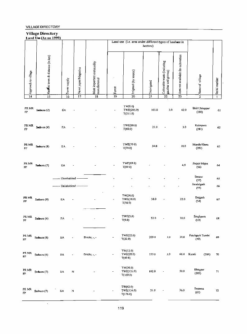
VILLAGE DIRECTORY
VilJage Directory Land Use (As on 1999)
14 15
;:: MR Sadaura (2)
=: MR Sadaura (8)
PRMR FP Sadaura (7)
16 17 18
EA
EA
EA
EA
--Umnhabited -----
--- Uninhabited ----------
;:: MR Sadaura (9) EA
=: MR Sadaura (4) EA
EA Bricks, -,-
PRMR FP Sadaura (4) EA Bricks, -,-
;: MR Sadaura (7) EA N
;: MR Sadaura (7) EA N
Land use (i.e. area under different types of land use in hectare)
19 20
TW(6.0) TWE(205.0) T(21 1.0)
TWE(69.0) T(69.0)
TWE(79.0) T(79.0)
TWE(69.0) T(69.0)
TW(20.0) TWE(IS.O) T(38.0)
TWE(9.0) T(9.0)
TWE(22.0) T(22.0)
21
103.0
21.0
34.0
38.0
530
2090
22 23
3.0 42.0
3.0
18.0
4.0
22.0
10.0
3.0 39.0
2
Bhil Chhappar (280)
Kaimpura (281)
MundaKhera (282)
Faquir Majra (56)
Sanaur (57)
Jamiatgarh (55)
Bulgarh (54)
Singhpura (53)
Fateh!,'llrh Tumbi (59)
TW(12.0) TWE(28.0) T(40 0)
1500 3.0 66.0 Kurali (284)
TW(36.0) TWE(133.0)
T(169.0)
TW(42.0) TWE(134.0) T(176.0)
119
102.0
21.0
50.0
36.0
Bhogpur (285)
SaTaWIn (62)
61
62
63
64
65
66
67
68
69
70
71
72
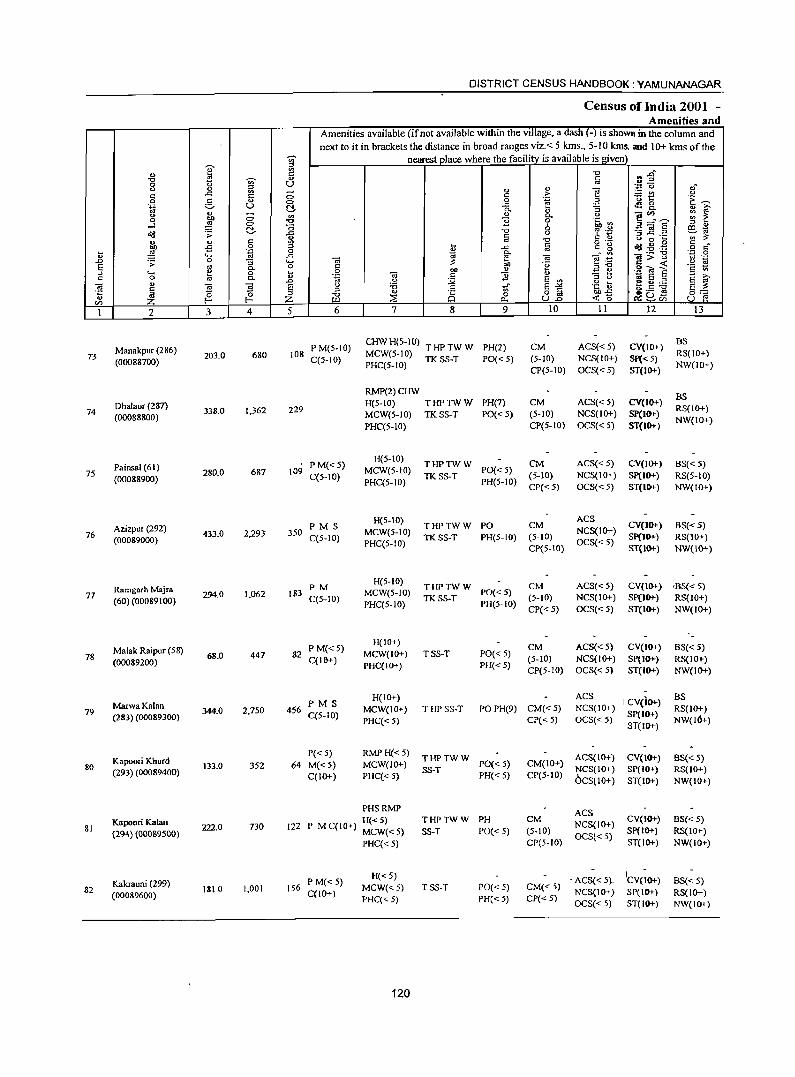
DISTRICT CENSUS HANDBOOK: YAMUNANAGAR
Census oflndia 2001 -DI I an Arne "fes d
Amenities available (ifnot available within the village, a dash (-) is shown in the column and next to it in brackets the distance in broad ranges viz.< 5 kms., 5-10 kms. and 10+ kms of the
.,. I nearest place where the facility is available is given
<I)
~ "0 c; ..g~
"0 ~
., § 0 U 0 " ~ - .., '" ]
-.;:'0 ",-
c ..c: 0 c .~ ~t: " 0 5
., 0 0 .~~
.~ u t!- ..c: ~8.
'" 0. "
:; : f 0
~ 0 ~
.., Co .!'! iii'"
0 11 ....l 0 a
~.g S-='e ~ 0 6 '" " o'(l .;;: ..c: "0 " -3]I .:2 Ee,.tj ., § ~ .,
" c ~ -0
C ., o a ~ '" ~ .s 0 ~ § o .- ~ _g . .g c
~ . ~ 0 ... ..c: c g 0 r:!
" .... ..c: <;;j 0. --,,'" "G;;:'"g "'::: 0 .D a 'iii e! 0;
os ._ .;;: :; .... ~ E;g '2 ~ E "' Co 0 C
Of) .~ c « ::l .... e 0 ~ 0 Of) " E e .2 O! 8 c 0 "' Co " .~ 'iii c 11 " '" >, .D U
~ E ::l " .. E ::l
E '" 0; " ~ l E u :a 1i E J2 .~ ti ~.5 ~ E ~ .~ !ii '" i "0 ... 8 a o a Of)..c: 0=-= CIl Z ~ ::1i Co U..o «0 ~8oo u e!
I 2 3 4 5 6 7 8 9 10 11 12 13
Manakpur (286) P M(5-IO) CHWH(5-1O) THPTWW PH(2) CM ACS« 5) CV(IO+) BS
73 (00088700)
203.0 680 108 C(5-IO) MCW(5-IO) TK SS-T PO« 5) (5- 10) NCS(IO+) SI'«5)
RS(JO+) PHC(5-10)
CP(5-10) OCS«5) ST(IO+) NW(JO+)
RMP(2)CHW BS
Dhalaur (287) H(5-IO) THPTWW PH(7) CM ACS« 5) CV(IO+) 74 338.0 1,362 229 RS(IO+)
(00088800) MCW{5-IO) TKSS-T PO«5) (5-10) NCS(10+) sp(10+) PHC(5-IO) CP{5-IO) OCS« 5) ST(IO+)
NW(IO+)
Painsal (61) PM«5) H(5-IO)
THPTWW CM ACS«5) CV(JO+) BS« 5) 75
(00088900) 280.0 687 109
C(5-IO) MCW{5-IO)
TKSS-T PO« 5)
(5-10) NCS(IO+) Sp(IO+) RS(5-IO) PHC(5-10) PH(5-IO)
CP«5) OCS«5) ST{IO+) NW(IO+)
PMS H(5-10)
THPTWW PO CM ACS
CV(JOl-) Azizpur (292) 6S«5) 76 (00089000)
433.0 2,293 350 C(5-IO) MCW(5-JO)
TKSS-T PH(5-10) (5-10) NCS(IO+)
Sp(IO+) RS(IO+) PHC(5-1O) CP(5-10)
OCS«5) ST{IO+) NW(IO+)
Ramgarh Majra PM H(5-IO)
THPTWW CM ACS«5) CV{lO+) '6S« 5) 77
(60) (00089100) 294.0 1,062 183
C(5-10) MCW(5-10)
TKSS-T PO« 5) (5-10) NCS{IO+) Sp(IO+) RS{IO+)
PHC(5-JO) PH(5-1O) CP« 5) OCS{< 5) ST(IO+) NW(JO+)
Malak Raipur (58) P M«5) H(IO+)
CM ACS«5) CV(IOT) 6S«5) 78 68.0 447 82 MCW{IO+) TSS-T PO« 5)
(00089200) C(16+) PHC(IO+) PH« 5)
(5-10) NCS(IO+) SP(IOT} RS(IO+) CP(5-10) OCS«5) ST(IO+) NW(IO+)
PMS H(IO+) ACS
I CV(JO+) BS
79 MarwaKalan 344,0 2,750 456 MCW(IO+) THP SS-T PO PH(9) CM«5) NCS(IO+) RS(IO+) (283) (00089300) C(5-1O)
PHC« 5) CP«5) OCS«5) Sp(IO+)
NW(IO+) ST(IO+)
Kapoori Khurd P«5) RMP H«5)
THPTWW ACS(IO+) CV{IOT) 6S« 5) 80 133.0 352 64 M«5) MCW(IO+) PO« 5) CM(IO+)
(293) (00089400) C(IO+) PHC«5) SS-T
PH« 5) CP(5-10) NCS(IO+) SP(lIl+) RS(IO+) OCS(IO+) ST(IO+) NW(IO+)
PHSRMP ACS Kapoori Kalan
222.0 730 122 H«5) THPTWW PH CM
NCS(IO+) CV(IO+) BS« 5)
81 (294) (00089500)
P MC(IO+) MCW«5) SS-T POC< 5) (5-10) Sp(IO+) RS(IO+)
PHC« 5) CP(5-10) OCS« 5)
ST(IO+) NW(IO+)
Kakrauni (299) P M«5) H«5) . ACS« 5}. ICV(;O+) 6S« 5)
82 (00089600)
1810 1,001 156 C(lO+)
MCW«5) TSS-T PO«5) CM« 5) NCS{IO+) SP(IO+) RS(IO+)
PHC«5) PH« 5) CP« 5) OCS« 5) ST(IO+) NW(IO+)
120
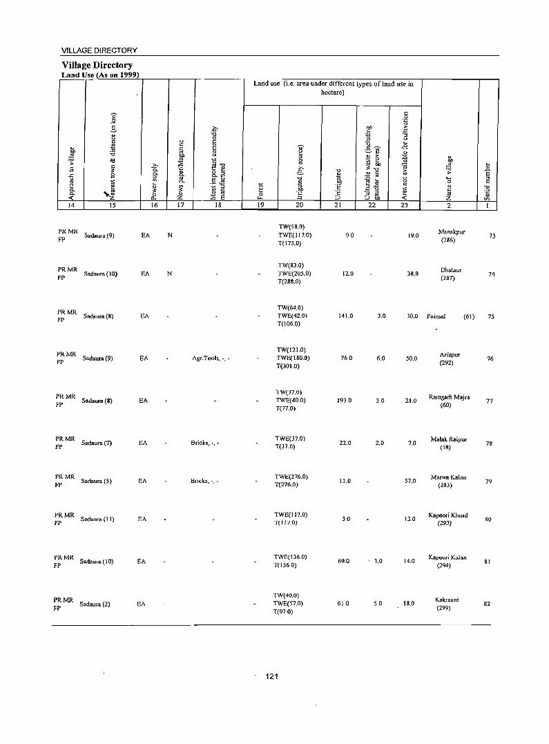
VILLAGE DIRECTORY
Village Directory Land Use (As on 1999)
14 15
:: MR Sadaura (9) EA
::MR Sadaura(IO) EA
:: MR Sadaura (8) EA
PRMR FP Sadaura (9) EA
;: MR Sadaura (8) EA
:: MR Sadaura (7) EA
;;:; MR Sadaura (5) EA
PRMR FP Sadaura (II) EA
PRMR FP Sadaura (I 0) EA
~: MR Sadaura (2) EA
16 17 18
N
N
Agr. Tools, -, -
Bricks, -,-
Bricks. -.-
Land use (i.e. area under different types ofland use in hectare)
19 20
TW(58.0) TWE(117.0) T{17S.0)
TW(83.0) TWE(20S.0) T(288.0)
21 22 23
90 19.0
12.0 38.0
2
Manakpur (286)
Dhalaur (287)
TW(64.0) TWE(42.0) T(I06.0)
141.0 3.0 30.0 Painsal (61)
TW(I 2 1.0) TWE(180.0) T(301.0)
TW(37.0) TWE(40.0) T{77.0)
TWE(37.0) T{37.0)
TWE{276.0) T{276.0)
TWE(117.0) T{l17.0)
TWE{136.0) T(1360)
TW{40.0) TWE(57.0) T{97.0)
121
76.0
1930
22.0
11.0
3.0
69.0
610
6.0 50.0
30 21.0
2.0 7.0
57.0
13.0
. 3.0 14.0
50 18.0
Azizpur (292)
Ramgarh Majra (60)
Malak Raipur (58)
MarwaKalan (283)
Kapoori Khurd (293)
Kapoori Kalan (294)
Kakrauni (299)
73
74
75
76
77
78
79
80
81
82
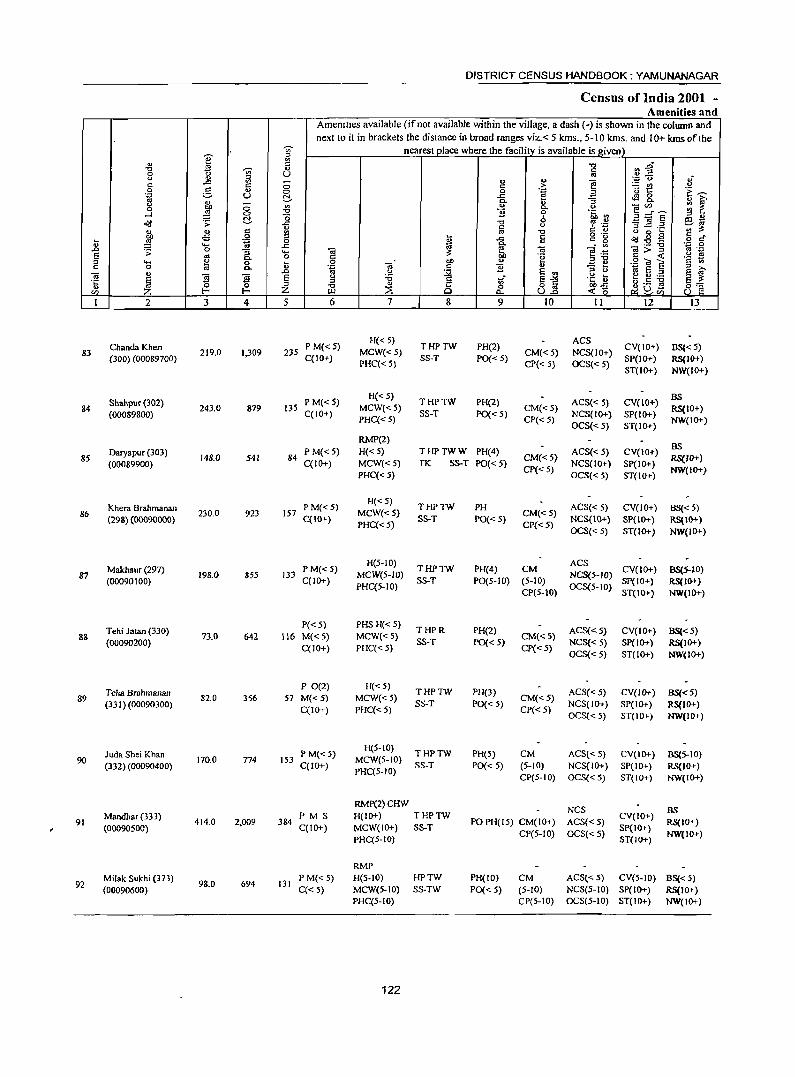
DISTRICT CENSUS HANDBOOK: YAMUNANAGAR
Census of India 2001 -Amenities and
Amemlles available (ifnot available within the village, a dash H is shown in the colwnn and next to it in brackets the distance in broad ranges viz.< 5 kms., 5-10 kms. and 10+ kms of the
I ~ nearest place where the facility is available is given '" " " "0 i'l~ "0 -;;;- " c
0
~ U '" .1i <.> ;:; '" u
~ ',0:: (.,)
c c > :.:: tIJ 0 g '" 0 0 "E ;:; t:: 1:~ 'N u ~ ..c ~ g_
~ Co
" :; ... i:;'
;:; '" u - CZl ~ i: 0 Co <.>
~::::fE 0 "0 1i 0 .~ Vl ....l a '" " ~ .:; ~ ..c: -0 (, '? . .M 3.2 .2 ~-... c u ~~
" .5 <=! OJ "0 " " u 0 ~ ~
o ._ ~ . ~ E .g 0 ~ ..c a c g <l>J-8g o c " .... ..c: ~ ;; - '" ;;;;:"g .,;:j 0 .0 0 ;;
... _ .;;: :; .... ~
OJ _
u lQ 5 OJ 0 c: .~ ~ ._
.§ ~ ~ Co ","0 ·s U;
'" .... ~ 0 ~ 0 OIl u .:= e c: 0 .~ ;; c: '8 " '" >. '" c. .0 " :st 5 '" '" " lQ 5 :::J 5 ~ ]
., fj fj 5 " :a .~ i; ~ g :.a § 8 tf 5""
'" '" " 8.2 0Il..c: ~~~ 5_
0 ~ 0 "t:J 0 8 .§ CZl Z f- Z ~ :::E t>. ...:: <; 1 2 3 4 5 6 7 8 9 10 11 12 13
Chanda Khen P M« 5) H«5)
THPTW PH(2) ACS
CV(IO+) BS« 5) 83 219.0 J,309 235 MCW« 5) CM«5) NCS(IO+)
(300) (00089700) C(lO+) PHC«S)
SS-T PO« 5} CP« S) OCS«S)
SP(IO+} RS(JO+) ST(JO+} NW(IO+)
Shahpur (302) P M« S) H«5)
THPTW PH(2) ACS« 5) CV(lO+) BS
84 (00089800)
243.0 879 135 C(lO+}
MCW«5) SS-T PO« 5)
CM«5) NCS(lO+) SP(IO+)
RS(1O+) PHC« 5) CP« 5}
OCS« 5) ST(JO+) NW(JO+)
RMP(2) BS
Daryapur (303) PM«5) H« 5) THPTWW PH(4) ACS« 5) CV(JO+) 85
(00089900) !48.0 54! 84
C(IO+) MCW«5) TK SS-T PO« 5) CM«5)
NCS(IO+) SP(IO+) RS(IO+)
PHC« 5) CP« 5)
OCS«5) ST(IO+) NW(IO+)
Khera Brahmanan PM«5) H«S)
THPTW PH ACS« 5} CV(IO+) BS« 5} 86 230.0 923 157 MCW«5) CM«5)
(298) (OOO90000) C(IO+} PHC« 5)
SS-T PO«S) CP«5)
NCS(IO+} SP(IO+) RS(IO+} OCS« 5} ST(IO+) NW(IO+)
Makhaur (297) P M« 5) H(5-10)
THPTW PH(4) CM ACS
CV(IO+) BS(5-1O) 87 198.0 855 l33 MCW(5-lO) NCS(5-lO)
(00090100) C(IO+) PHC(5-1O}
SS-T PO(5-1D) (5-10) OCS(5-1O)
SP(IO+) RS(10+) CP(5-IO) ST(IO+) NW(IO+)
Tehi Jatan (330) P«5) PHSH«5)
THPR PH(2) ACS«5) CV(IO+) BS«5) 88 73.0 642 116 M«S) MCW«5) CM«5)
(00090200) C(IO+} PHC« 5)
SS-T PO« 5) CP« 5)
NCS« 5) SP(IO+) RS(JO+) OCS«5) ST(IO+) NW(IO+)
Teha Brahmanan P O(2} H«5)
THPTW PH(3) ACS« 5) CV(IO+) BS«5) 89 82.0 356 57 M«5) MCW«5) CM« 5)
(331) (00090300) C(10+) PHC«5)
SS-T PO{< 5) CP«5)
NCS(IO+) SP(IO+) RS(JO+) OCS« 5) ST(IO+) NW(lO+)
Juda Shei Khan PM«5) H(5·1O)
THPTW PH(S) CM ACS«5) CV(IO+) BS(5-IO) 90 170.0 n4 153 MCW(5-1O)
(332) (00090400) C(10+} PHC(5-10)
SS-T PO« 5) (5-10) NCS(IO+) SP(IO+) RS(10+) CP(S-IO) OCS« 5) ST(IO+) NW(IO+)
RMP(2)CHW NCS 8S
Mandhar (333) PMS H(JO+) THPTW CV(IO+) 91 414.0 2,009 384 PO PH(IS) CM(IO+) ACS«5) RS(IO+)
(00090S00) C(IO+) MCW(IO+) SS-T CP(5-10) OCS«5)
SP(IO+} NW(IO+)
PHC(5-10) ST(IO+}
RMP Milak Sukhi (373)
98.0 694 131 PM«5} H(5-1O) HPTW PH(IO} CM ACS«5) CV(S-IO) BS« 5)
92 (00090600) C« 5) MCW(5-10) SS-TW PO« 5) (S-IO) NCS(S-IO} SP(IO+) RS(IO+)
PHC(5-10) CP(S-IO) OCS(5-10) ST(IO+) NW(IO+)
122
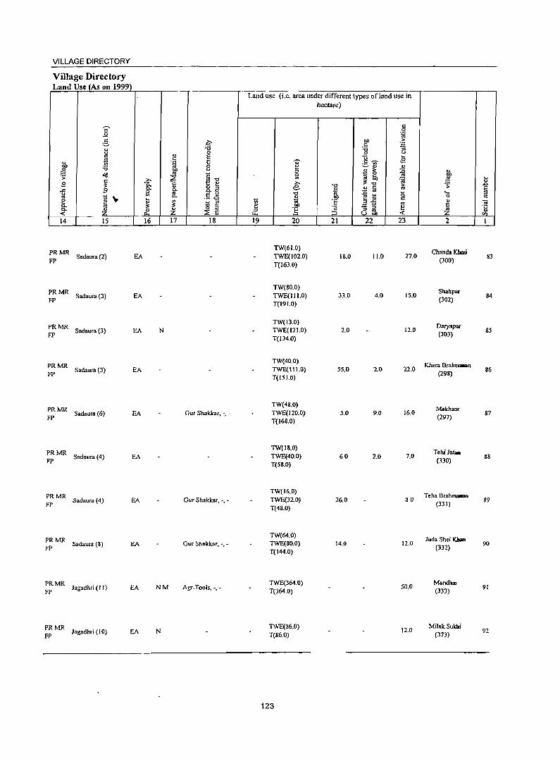
VILLAGE DIRECTORY
Village Directory Land Use_(As on 1999)
I r:: .q :.::. "
.",
" " 0
r:: E f! r::
" .~ E '" OIl :0 0 "g OIl " a'(I '" ~] .;;:
~ ~ g ~ .,_ .,_ " o ::l ..c: a c. 0. ~ l) '" .5 .M '" ~ .. c. e ~ '"
_ ::s c. ~ ~ [;j -~ Z 0 Z :E E p..,
14 15 16 17 18
PRMR FP
Sadaura(2) EA
PRMR FP
Sadaura (3) EA
PRMR Sadaura(3) EA N
FP
PRMR FP
Sadaura (3) EA
PRMR FP
Sadaura(6) EA Gur Shakkar, -, -
PRMR FP
Sadaura(4) EA
PRMR FP
Sadaura (4) EA Gur Shakkar, -,-
PRMR FP
Sadaura (8) EA Gur Shakkar, -,-
PRMR Jagadhri (II)
FP EA NM Agr.Tools, -,-
;: MR Jagadhri (10) EA N
Land use (i.e. area under different types ofland use in
'" e 0 ~
19
U" f:! ::l g >-. e
.",
" lit .!:!> !i 20
TW(61.0) TWE(102.0) T(163.0)
TW(80.0) TWE(1I1.0) T(19!.0)
TW(l3.0) TWE(121.0) T(134.0}
TW(40.0) TWE(\11.0) T(15!.O)
TW(48.0) TWE(120.0) T(168.0)
TW(IS.O) TWE(40.0) Te58.0)
TW(16.0) TWE(32.0} T(48.0)
TW(64.0) TWE(80.0) T(144.0)
TWE(364.0) T(364.0)
TWE(86.0) T(86.0)
123
hectare)
c 0 .~
OIl >
'" ~ :g " "0 ....
c ~ .s ._ ., ~ ... '" " > :g - 0 l(j ....
~ .",
~.; iU " c M - ..
~ to '0 .!:!> 3fi c t: '" 'c - ::l e
;:J ::l '" « u "" 21 22 23
18.0 11.0 27.0
33.0 4.0 15.0
2.0 12.0
55.0 2.() 22.0
5.0 9.0 16.0
60 2.0 7.0
26.0 80
14.0 12.0
50.0
12.0
1to .!!! :s: ..... 0
" ~ 2
Chanda Kberi (300)
Shahpur (302)
DaryapW' (303)
Khera Brahm_n (298)
Makhaur (297)
Tehi Jata. (330)
Teha Brahmaoran (331)
Juda Shei Kloan (332)
Mandhar (333)
MilakSukhi (373)
..8 § c "iii .t: .. '" 1
83
84
85
86
87
88
89
90
91
92
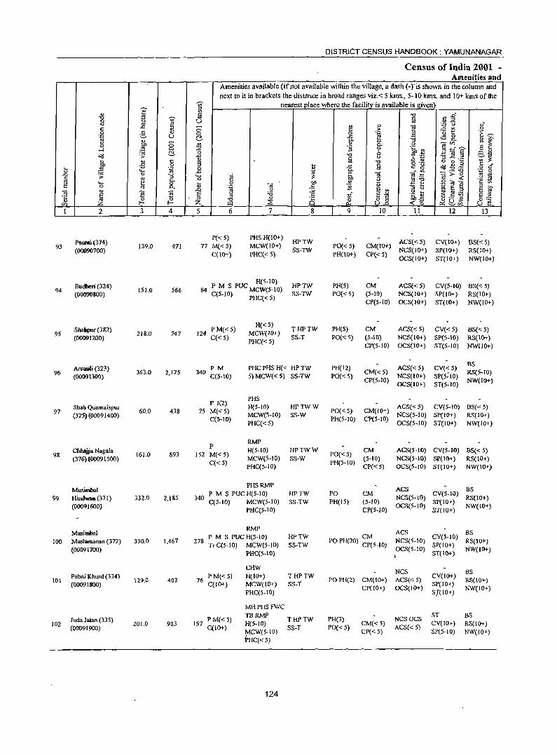
e dl -c ti "<i>' 0 <.I Q) ::l
..c: '" s:: ii 0 :5 .~ u '" <.I ;::; 0 bl}
-l :§ 0 C!-~ ·s
Q) ., s::
~ -5 0
6 .~ ""-
"'" ·s 0 ;:; s @ C-::l .... 0 c: 0 '" C-
'" -0; 5 ~ .~ E Z 0
C/) t- I-
I 2 3 4
Paonti (314) 93 139.0 411
(00090700)
Budberi (324) 94 ISI.O 566
(00090800)
Shabpur (382) 95 218.0 747
(00091200)
Arnauli (323) 96
(00091300) 363.0 2,175
97 Shah Quama;spur
60.0 438 (375) (00091400)
98 Cbhajjll Nagala
161.0 893 (316) (00091500)
Musimbal 99 HindwaB(371) 332.0 2,185
(0009 J 600}
Musimbal 100 Muslamanan (372) 350.0 1,467
(00091700)
Paooi )(hurd (334) 101 129.0 402
(00091800)
Juda Jalan (335) 102 201.0 983
(00091900)
"<i>' ~ 5 U ;::; <:> do '" :s! o ..c: .. ~ 0 ..c:
"""' o ~ o
..0 E ::l Z 5
77
84
124
340
75
152
340
278
16
DISTRICT CENSUS HANDBOOK: YAMUNANAGAR
Census of India 2001 -Amenities and
Amenities available (ifnot available within the village, a dash (-ris shown in the column and next to it in brackets the distance in broad ranges viz.< 5 kms., 5-10 krns. and 10+ krns ofthe
nearest place where the facility is available is given
§ ~ 2" 0';::: () ,,-
" '" "§ ~t c: > <.I 0 .~ ~ 'E ~ -a ..s 0
C-
~ ~ " 0
-0;'" C- .g B 0
bh~ ~=E 6 eM "0 '? '.0 '3 ~.~ a <.I '" ;l: -0 c: ...
t a o ._
~ .g .~ § r:! ..c: c: g ~ ~ - '" Cl;;""§l ",a 0
ca ca e:a oj g c: g t: < .~
.8 -0; bl} ., .a ... .g ril e c: 1;;
.S S "'3 ti ::l til <.I .,. §~ .. E ::> E f <.I :a 1;;- .~ ~ f3.s ~ ::l .S §::: -c " 0 0 o c: ODS ~ ~ P- ull -< 0 ~u+' u f! ~cn
6 7 8 9 10 11 12 13
P« 5) PHSH(IO+) HPTW ACS«5) CV(IO+) BS« 5)
M«S) MCW(lO+) PO«5) CM(IO+} C(lO+) PHC« 5)
SS-TW PH(\O+) CP« 5)
NCS(IO+) SP(1O+) RS(lO+) OCS(1O+) ST(IO+) NW(IO+)
R(S-IO) HPTW PH(S) CM ACS«S) CV(S-to) BS« S) P M S PUC MCW(S-IO)
C(5-10) PHC« 5) SS-TW PO« 5) (5-10) NCS{lO+) SP(IO+) RS(IO+) CP(5-1O) OCS(IO+} ST(IO+) NW{IO+)
PM«5) H{<5)
THPTW PH(5) CM ACS«S) CV«S) BS« 5) MCW(10+) C«5)
PHC« 5) SS-T PO« 5) (5-10) NCS(IO+} SP(5-10) RS(IO+)
CP(5-IO) OCS(IO+) ST(5-10) NW(1O+)
PM PHCPHSH« HPTW PH(12) ACS« 5) CV«5) BS
C(5-10) 5) MCW« 5) SS-TW PO«5) CM«5)
NCS(IO+) Spe5: 10) RS(S-IO)
CP(5-10) OCS(IO+) ST(5-10)
NW(IO+)
P 1(2) PHS
M«5) H(5-10) HPTWW
PO«5) CM(IO+) ACS« 5) CV(5-1O) BS«5)
C(5-10) MCW(5-10) SS-W
PH(5-10) CP(S-IO) NCS(5-10) SP(IO+) RS(IO+)
PHC«S) OCS(5-10) ST(IO+) NW(lO+)
P RMP
M«5) H(S-IO) HPTWW
PO«5) CM ACS(5-IO) CV(5-1O) 8S«5)
C«5) MCW(5-IO) SS-W
PH(5-10) (5-10) NCS(5-IO) SP(IO+) R.S(IO+)
PHC(5-10) CP«5) OCS(5-JO) ST(JO+) NW(IO+)
PHSRMP ACS BS
P M S PUC H(5-1O) HPTW PO CM NCS(5-IO)
CV(5-JO) RS(lO+)
C(5-1O) MCW(S-JO) SS-TW PH(15) (5-10) SP(IO+) PHC(S-IO) CP(5-10)
OCS(5-lD) ST(IO+)
NW(IO+)
RMP ACS as
P M S PUC H(5-1O) HPTW PO PH(20) ~~5-1O) NCS(5-JO)
CV(5-1O) RS(lO+)
Tr C(5-1O) MeW(S-IO) SS-TW SP(IO+) Pl:IC(5-10)
OCS(5-IO) ST(IO+)
NW(IO+) I
CHW NCS as
PM«5) H(IO+) THPTW CVCIO+) POPH(2) CM{IO+) ACS{<: 5) RS{IO+)
C{JO+) MCW(IO+) SS-T CP(IO+) OCS(IO+)
SP(IO+) NW(IO+)
PHC(S-IO) S7(10+)
MHPHSFWC
P M« 5) TBRMP
THPTW PH(3) NCSOCS ST BS
157 H(S-IO) CM« 5) CV(IO+) RS(IO+) C(IO+)
~CW(5-1O) SS-T PO« 5)
CP«5) ACS« 5)
SP(5-10) NW(IO+) HC«5)
124
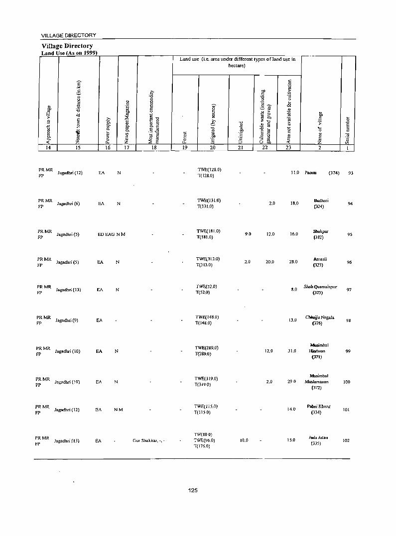
VILLAGE DIRECTORY
Village Directory Land Use (As on 1999)
14 15
;: MR Jagadhri (12)
;: MR Jagadhri (6)
16 17
EA N
EA N
PRMR Jagadhri (5) EDEAG NM
FP
PRMR Jagadhri (5) EA N
FP
PRMR Jagadhri (13) EA N
FP
PRMR Jagadhri (9) EA
FP
PRMR Jagadhri (10) EA N
FP
PRMR Jagadhri (10)
FP EA N
PRMR Jagadhri (12) EA NM
FP
PRMR FP
Jagadhri (13) EA
18
Gur Shakkar. -. -
Land use (i.e. area under different types ofland use in hectare)
19 20 21 22 23 2
TWE(128.0) T( 128.0)
11.0 Paonli (374)
TWE(131.0) T(131.0)
TWE(181.0) T(181.0)
TWE(31J.0) T(313.0)
TWE(52.0) T(52.0)
TWE(148.0) T(148.0)
TWE(289.0) T(289.0)
TWE(319.0) T(3190)
TWE(115.0) T(1150)
TW(800)
TWE(96.0) T(176.0)
125
2.0
9.0 12.0
2.0 20.0
12.0
2.0
10.0
18.0
16.0
28.0
8.0
13.0
31.0
290
14.0
15.0
Budheri (324)
Sbahpur
(382)
Arnauli (323)
Shah Quamaispur (375)
Chhajju Nagala (376)
Musimbal Hiudwan
(371)
Musimbal Muslamanan
(372)
Palmi Khurd
(334)
Juda Jatan (335)
~
'" ..c
5 " ~ '" Ul
93
94
95
96
97
98
99
100
101
102
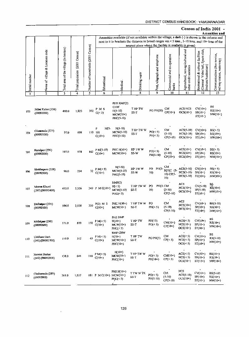
DISTRICT CENSUS HANDBOOK: YAMUNANAGAR
Census of India 2001 -Amenities and
Amenities available (ifnot available within the village, a dash (-) is shown in the column and next to it in brackets the distance in broad ranges viz.< 5 kms., 5-10 kms. and 10+ kms of the
~ nearest olace where the facility is available is given '[ ~
" " "U ~~ "U tl -;;;- " " 0 U '" ,,-<) " ~ - ., .,
1l '';::: 0 ".
" .c
0 c .~ ;.: CIl <)
0 5 .,
0 0 11 .a '0 1:: .~ ~
iii U ~ ..c tS 8.
" 0. ., :; " ~ <) ;:::; '" " 0. <) e CI'J .. .- ~ ~ 0 ~ 11 -l 0 "U 6 ~tb ~
~ "0 il~§ '" " ~ '> .c "U C) 6 '£ co 1ii ., c '" ._ ';;";;:: ~ " c '" oJ -0 o ._ <) 0 k " . -5 .!2 '" J .c c c g ~ ~ .g
:u ~ _g '" o " ""' t;i §- OJ - '"
._ -0 ~~ 0
..0 '> 0
1 ""' 11 e .-::! 1l;>~ oJ ._
§ '" 0 bo .~ ",-0 ·s ~ ""' ~ k 0 OJ
bO ", .=! e .S! O! E
" 0 0. " .~ c: 11 E ~ ..0 C) :;;; E '" '" <) 1<i E '" " .~ ~ OJ E ~ OJ E <) '6 " of E~ I~ .s :g g,f '5 ~ '" '" " 8 oo..c Z ~ "U 0 o '"
CI) Z t.Ll ::E tl. U..o -< b ~ SU5 U e I 2 3 4 5 6 7 8 9 10 11 12 13
PHS RMP(2)
Palmi Kalan (336) PMS CHW
THPTW CM ACSNCS CV(lO+) BS
103 (OO092000) 480.0 1,823 302
C«5) H(5-10)
SS-T PO PH(30) CPt 10+) OCS(IO+) SP(10+) RS(IO+)
MCW(lO+) NW(IO+) PHC(5-10)
ST(IO+)
Gianawala (337) P M(5- H(5-10)
THPTWW CM ACS(5-10) CV(IO+) BS« 5) 104
(00092100) 97.0 608 110 10) MCW(5-10)
SS-T PO«5)
(5-10) NCS(S-to) SP(IO+) RS(to+) C(10+) PHC(S-IO) PH« 5)
CP(S-IO) OCS(IO+) ST(10+) NW(IO+)
Rasulpur (296) P M(5-10) PHCH(IO+) HPTWW PO«5)
CM ACS(IO+) CV(IO+) BS« 5) lOS
(00092200) 197.0 978 162
C(IO+) MCW(IO+) SS-W (5-10) NCS(IO+) SP(IO+) RS{IO+) PH(5-IO)
CP(IO+) OCS{10+) ST(IO+) NW(IO+)
H(5-10) PO
CM Shekbupura (338) PM«S) HPTWW PH(S- R[5]C (5- ACS(5-1O) CV(IO+) BS«5)
106 (00092300) 96.0 234 32
C(lO+) MCW(5-10)
SS-W 10) 10) CP(5- NCS(5-10) SP(IO+) RS(IO+) PHC(5-IO)
10) OCS{5-10) ST(IO+) NW(IO+)
RMP(2) ACS :~(IO+) Marwa Khurd H«5) THPTWW PO PH(5·CM
NCS(IO+) CV{5-1O)
107 (295) (00092400) 4S3.0 2,326 349 P M C(IO+) MCWeS-IO) SS-T 10) (5-10) SP(5-10)
PHC« 5) CP(5-10) OCS{IO+)
ST(IO+) NW(IO+)
HaibatpuT (291 ) P(2) M S PHC H(IO+) THPTWW PO CM ACS
CV(IO+) 108 504.0 2,138 330 NCS(IO+)
BS{5-10)
(00092500) C(IO+) MCW(IO+) SS-T PH« 5) (5-10) OCS(IO+)
SP(IO+) RS{IO+) CP(5-10) ST(IO+) NW(IO+)
PHSRMP
Mallll<pw (290) PM«S) H(lO+) THPTW PH(12) ACS«5) eVel"") BS
109 (00092600)
171.0 870 150 C(IO+) MCW(lO+} SS-T PO« 5)
CM(lO+) NCS(IO+) SP(IO+)
RS{IO+)
PHC«5) CP(IO+)
OCS(IO+) ST(IO+} NW(IO+)
RMPCHW
UddhamGarh PM«5) H(IO+) THPTW CM ACS«5) CV(IO+) BS
110 (341 )(00092700) 110.0 JJ2 49
C(IO+) MCW(10+) SS-T POPH(5)
CP« 5) NCS« 5) SP(IO+) RS(5-1O}
PHC(IO+) OCS«5) ST(IO+) NW(IO+)
Nawan Sbahar P M«5) H(IO+)
THPTWW ACS« 5) CV(IO+) BS(IO+) III 138.0 644 110 MCW(IO+) PO« 5} CM(IO+}
(342) (00092800) C(10t) PHC(10+)
SS-T PH(IO+) CP« 5)
NCS« 5) SP{IO+) RS(JO+) OCS(10+) ST(IO+) NW(IO+)
Chaharwala (289) PHSH(IO+)
TTWWTK CM NCS
CV(lO+) 112 261.0 1,037 181 P M C(IO+) MCW(IO+) PO« 5) ACS(5-10)
BS{5-10)
(00092900) PIjC« 5)
SS-T PH(5-1O)
(5-10) OCS(JO+)
SP(lO+) RS(IO+) CP(5-10) ST(IO+) NW(IO+)
126
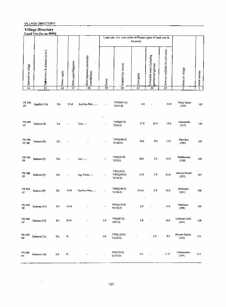
VILLAGE DIRECTORY
VilJage Dire.ctory Land Use (As on 1999)
14 15
PRMR FP Jagadhri (14) EA
PRMR Sadaura(8) EA
FP
PRMR Sadaura (9) EA
FPNR
PRMR Sadaura (9) EA
FP
PRMR FP
Sadaura (6) EA
PRMR FP
Sadaura (8) EA
PRMR Sadaura ( IS) EA
FP
PRMR Sadaura (12) EA
FP
PRMR Sadaura (12) EA
FP
:: MR Sadaura (10) EA
16 17 18
NM Earthen Pots, -, -
Gur,-,-
Gur, -,-
Agr.Tools, -, -
NM Earthen Pots, -, -
NM
NM
N
N
Land use (i.e. area under dIfferent types ofland use in hectare)
19
3.0
2.0
20
TWE(421.0) T(42 1.0)
TWE(60.0) T(60.0)
TWE(166.0) T(166.0)
TWE(520) T(52.0)
TW(120.0) TWE(254.0) T(374.0)
TWE(246.0) T(246.0)
TWE(156.0) T(156.0)
TWE(97.0) T(97.0)
TWE(128.D) T(12S.0)
WE(2290) T(229.0)
127
21 22 23
6.0 53.0
17.0 10.0 10.0
10.0 8.0 13.0
28.0 3.0 130
33.0 3.0 43.0
214.0 20 42.0
2.0 13.0
3.0 10.0
. 2.0 8.0
1.0 . 31.0
2
Pabni Kalan (336)
Gianawala (337)
Rasulpur (296)
Shekhupura (338)
MarwaKhurd (295)
Haibatpur (291)
Malakpur (290)
UddhamGarh (341)
Na wan Shahar (342)
Chaharwala (289)
103
104
lOS
106
107
108
109
110
III
112
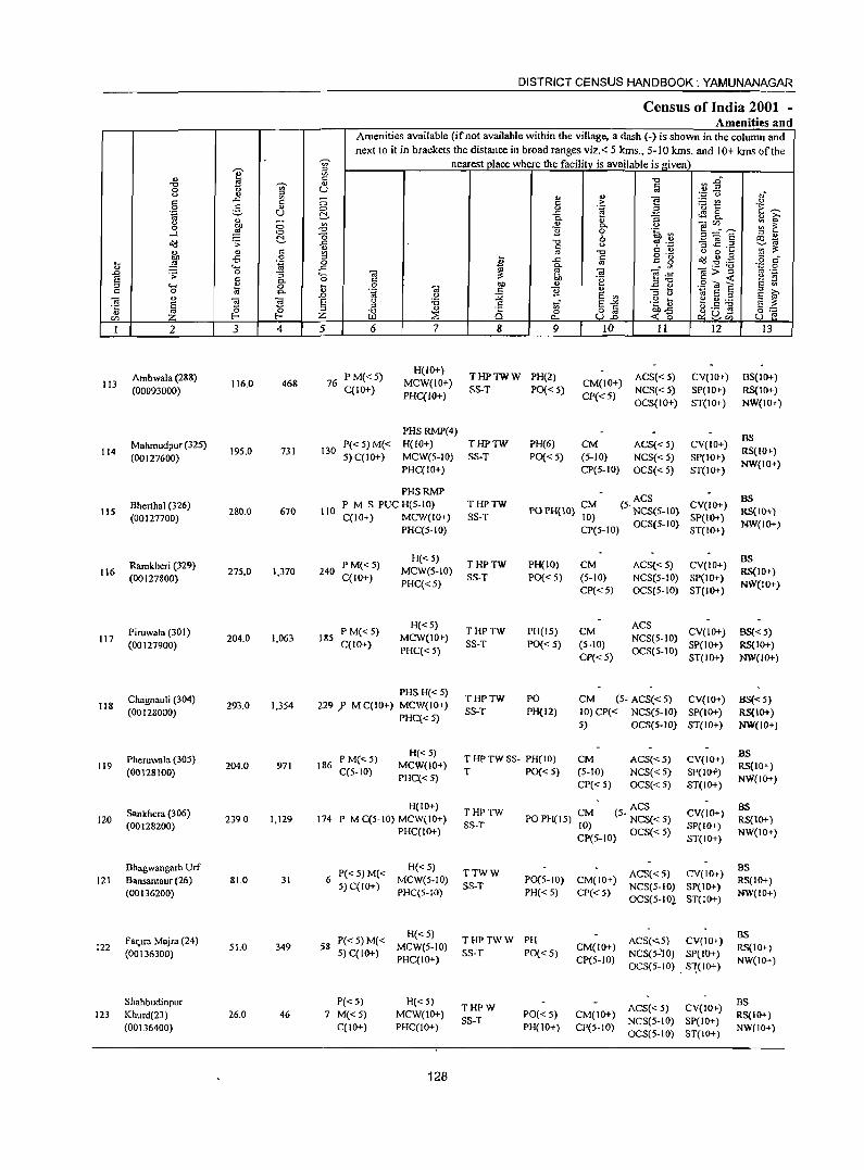
I " "0 -;;;-0 <.> " :;l
'" ..r:: ~
0 e. u .~
<.> '" -~ <::> 0 <::> -l
d-old .;;: ., '" "
~ -5 0 ~ .~ ., ""' ..0 .;;: 0 ;; a "' 0. :;l .... ~ 0
'" 0 c.. ., -.;
~ !S '5 a 2! ~ U)
I 2 3 4
Ambwala (288) 113 116.0 468
(00093000)
Mahmudpur (325) 114
(00127600) 19S.0 731
Bherthal (326) liS
(00127700) 280.0 670
Ramkheri (329) 116 27S.0 1,370
(00127800)
Piruwala (301) 117
(00 I 27900} 204.0 1,063
Chagnauli (304) 118 293.0 1,3S4
(00128000)
PheruwaJa (305) 119
(00128100) 204.0 971
San khera (306) 120 2390 1,129
(00128200)
Bhagwangarh Urf 121 Bansantaur (26) 81.0 31
(00136200)
Faq.ra Majra (24) 122
(00136300) 51.0 349
Shahbudinpur 123 Khurd(23) 26.0 46
(00136400)
~ ;g Q)
U -0 0 d-'" "0 "0 ..r:: ., ~ 0
..r:: .... 0 ~
'" ..0 a :;l
;z; 5
76
130
110
240
185
DISTRICT CENSUS HANDBOOK: YAMUNANAGAR
Census of India 2001 -Amenities and
Amenities available (if not available within the village, a dash (-) is shown in the column and next to it in brackets the distance in broad ranges viz.< 5 kms., 5-10 kms. and 10+ kms of the
nearest place where the facility is available is given "0 ~~ a
" '" or; 0 ,j
'" > ] ~~ <.> 0 .~ ·E ~ .c oS a 0. :; 0. " ~ " " -ern.._ ::: 1: 0. u
11 0 .~ ~ ~ ~.§
:;l .., o e:!.~ "0 u ~ ~p
" c ., ~ ~ "' "0 0·- o a ~
J .c '" c g ~..g .g .2 r:: "' 0. '" C;>~ <ii a -.; "' -.; e .~ .~ c bb "e " « <>
E1l c 0 "" '" .2 «t E .~ OJ c 11 '" "3 ti :;l
~ <.> :;.;; a '" . g ~ <ii a :;l s 0 :0 tf a"" t'! 0 ..... s ~ :;l c o .5 -g
"0 " ts 0 o a .'i:"~ 0::: ::E ~U-W t>.. U..o ~U) U e
6 7 8 9 10 II 12 13
P M« 5) H(IO+)
THPTWW PH(2) ACS« 5) CV(1O+) BS(IO+) MCW(IO+) CM(IO+)
C(10+) PHC(IO+)
SS-T PO« 5) CP«5)
NCS«5) SP(IO+) RS(IO+) OCS(IO+) ST(IO+) NW(IO+)
PHSRMP(4) BS
P« 5) M« H(IO+) THPTW PH(6) CM ACS«S) CV(IO+) 5) C(IO+) MCW(5-10) SS-T PO« 5) (S-IO) NCS{<S) SP(IO+)
RS(IO+)
PHC(IO+) CP(S-IO) OCS« S) ST(IO+) NW(IO+)
PHSRMP ACS BS P M S PUC H(5-1O) THPTW CM (S· NCS(5-10) CV(IO+)
C(IO+) MCW(IO+) SS-T POPH(lO} 10) SP(IO+) RS(10+)
PHC(5-10) CP(5-10) OCS(S-IO)
ST(IO+) NW(lO+)
P M«5) H«S) THPTW PH(IO) CM ACS« 5) CV(IO+)
BS MCW(S-IO) RS(IO+)
C(IO+) PHC« S)
SS-T PO« 5) (5-10) NCS(S-IO) SP(IO+) NW(lO+)
CP« 5) OCS(S-IO) ST(IO+)
PM«5) H«S)
THPTW PH(15) CM ACS
CV(IO+) BS« 5) C(IO+)
MCW(IO+) SS-T PO« 5) (5-1O)
NCS(5-1O) SP(IO+) RS(IO+)
PHC« S) CP«5}
OCS(S-IO) ST(lO+) NW(IO+)
PHS H«5) THPTW PO CM (5- ACS« 5) CV(IO+) BS« 5) 229 J' M C(IO+) MCW(IO+) SS-T PH(12) 10}CP« NCS(5-10) SP(IO+) RS(IO+)
PHC« 5) 5) OCS(5-IO) ST(lO+} NW(JO+)
P M«S) H«5) THPTWSS- PH(IO) CM ACS«5) CV(IO+) BS
186 C(5-10)
MCW(IO+) T PO« 5) (5-10) NCS«5) SP(IO",,)
RS(IO+) PHC«5)
CP« S) OCS« 5) ST(IO+) NW(IO+}
H(IO+) THPTW
PO PH( 15) ;:;; ACS BS
174 P MC(S-IO) MCW(IO+) (5- NCS« 5) CV(IO+) RS(lO+)
PHC(IO+) SS-T
OCS«5) SP(IO+)
NW(IO+) CP(5-10} ST(IO+)
P« 5) M« H«5} TTWW ACS«5) CV(IOT)
BS 6
5) C(IO+} MCW(S-IO)
SS-T P0(5-10) CM(IO+)
NCS(5-10} SP(IO+) RS(IO+)
PHC(5-IO) PH« 5) CP« 5) OCS(5-IOl ST(IO+)
NW(IO+)
P«5}M« H«5) THPTWW PH ACS(<'5) CV(IO+)
BS .58
5) C(IO+) MCW(S-IO)
SS-T PO«5) CM(10+)
NCS(5-'10) SP{IO+) RS(IO+)
PHC(IO+) CP(5-1O) OCS(5-10) . S"\(IO+)
NW(IO+)
P«5) H«5) THPW ACS«5) CV(IO+) BS
7 M« 5} MCW(lO+} SS-T
PO«5) CM(lO+) NCS(5-10} SP(IO+)
RS(IO+) C(IO+} PHC(IO+) PH(lO+) CP(5-10)
OCS(5-IO) ST(IO+) NW(lO+)
128
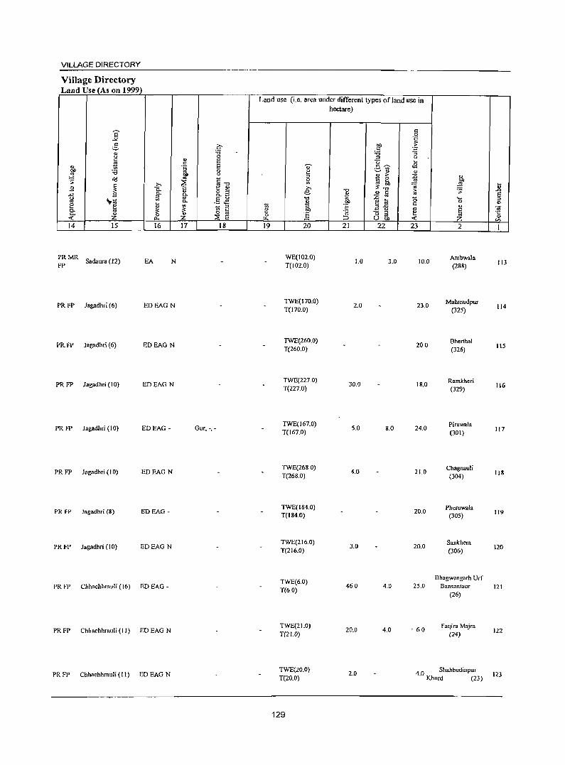
VILLAGE DIRECTORY
Village Directory Land Use (As on 1999_l
14 15
~: MR Sadaura (12)
16
EA N
PR FP Jagadhri (6) EDEAG N
PR FP lagadhri (6) EDEAG N
PR FP Jagadhri (10) EDEAG N
PR FP Jagadhri (10) EDEAG -
PR FP Jagadhri (10) EDEAG N
PR FP Jagadhri (8) EDEAG -
PR FP Jagadhri (10) EDEAGN
PR FP Chhachhrauli (16) ED EAG -
PR FP Chhachhrauli (II) ED EAG N
PR FP Chhachhrauli (II) ED EAG N
17
c :a o E E o o
~"O [~ .§ JS
::J '" C o '" ::E E 18
Gur, -,-
Land use (i.e. area under different types of land use in hectare)
19 20
WE(102.0) T(102.0)
TWE(170.0) T(170.0)
TWE(260.0) T(260.0)
TWE(227.0) T(227.0)
TWE(167.0) T(167.0)
TWE(2680) T(268.0)
TWE(l84.0) T(184.0)
TWE(216.0) T(216.0)
TWE(6.0) T(60)
TWE(21.0) T(2l.0)
TWE(20.0) T(20.0)
129
21 22
1.0 3.0
2.0
30.0
S.O 8.0
4.0
3.0
460 4.0
20.0 4.0
2.0
23
10.0
23.0
200
18.0
24.0
21.0
20.0
20.0
2S.0
. 60
2
Ambwala (288)
Mahmudpur (32S)
Bhenhal (326)
Ramkheri (329)
Piruwala (301)
Chll!,'ll.uli (304)
Pheruwala (30S)
Sankhera (306)
Bhagwangarh Urf Bansantaur
(26)
Faqira Mnjra (24)
4 0 Shahbudinpur . Khurd (23)
113
114
liS
116
117
11&
119
120
121
122
123
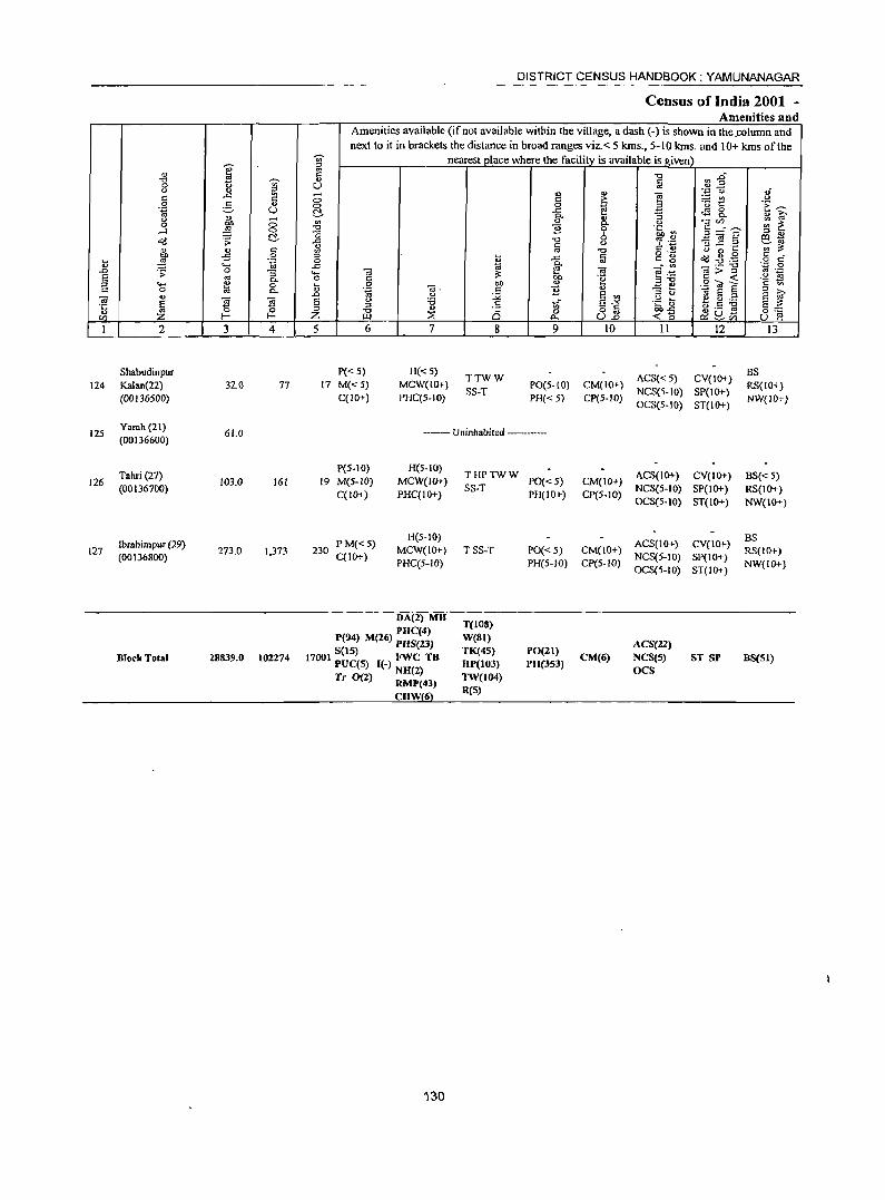
DISTRICT CENSUS HANDBOOK: YAMUNANAGAR
Census of India 2001 -Amenities and
Amenities available (if not available within the village, a dash (-) is shown in the .column and
next to it in brackets the distance in broad ranges viz. < 5 kms., 5-10 kms. and 10+ kms of the -;;;- nearest place where the facility is available is given
I " '" ~ 5 "'" ~~ "'" Iii 0 !:l U <J '" .~ '0 oJ
'" .<: '" 0
., '" e ~~ <> '" '" 0': .S! g ... 0 0
~ 3 .1: ~ 1<i U ~ .<: ~ 8.. ., <>. "3 " i;f u 0 '" '" <.) "CZl ;;: ~ 0 OIl <>. ....l ~ 0 ::g "B 0 '~.g 5=,? $2 o(J .s: ~ _g "'"
0 -3 ~ .::! v a <.) s!: t) ~~ " '" '" '" 11 u 0 ~
bO -5 0 '" ~ o ._
~ ~.g '" -.... ~ .~ _g ..c <=: g o '" '" ..... ;;; ~ " . '" _ ..... "'0 ',p 0
.0 0 " e·~ g>~ '" .-.s: :; ..... ~ 'a ~ E '" c. 0 '" .~ ::J"O ::J .... ~ 0 .... 0 OIl
., ~ ., .2 OJ e
'" 0 c. '" .~ ". '" B .,
"3 t; " '" .0 " :.;;a E '" 1<i e '" e ~ <a <a ~ S <> :0 tf S-" . ~~ e u ......
'5 Iii '0 " ::J
" .s o a (.) .5 -g §::: F2 z "'" :2: Q 0 ~U-CZl Z f- f.J..I '" U.o <'0 ~rn U e
I 2 3 4 5 6 7 8 9 10 II 12 13
Shabudinpur P« 5) H«5) TTWW ACS« 5) CV(IO+)
BS 124 Kalan(22) 320 77 17 M«S) MCW(IO+) PO(S-lO) CM(IO+) RS(IO+)
(00136500) C(IO+) PHC(5-10) SS-T
PH« 5) CP(5-1O) NCS(S-IO) SP(IO+)
NW(!o+) OCS(5-IO) ST(IO+)
125 Yarah (21)
61.0 --Uninhabited -------(00136600)
Tahri (27) P(5-10) H(5-IO)
THPTWW ACS(IO+) CV(IO+) BS« 5) 126 103.0 161 19 M(5-10) MCW(lO+) PO«5) CM(IO+)
(00136700) C(lO+) PHC(IO+)
SS-T PH(IO+) CP(5-JO)
NCS(5-10) SP(IO+) RS(lO+) OCS(5-!0) ST(IO+) NW(IO+)
Ibrahimpur (29) P M«5) H(5-10)
ACS(JO+) CV(IO+) BS
127 273.0 1.373 230 MCW(JO+) TSS-T PO« 5) CM(lO+) RS(IO+) (00136800) C(JO+)
PHC(5-1O) PH(5-W) CP(5-10) NCS(5-IO) SP(IO+)
NW(lO+) OCS(5-10) ST(IO+)
DA(2) MH T(IOS)
1'(94) M(26) PHC(4) W(S!) ACS(22) S(15) PHS(Z3) TK(45) PO(2!)
Block Total 28839.0 102274 17001 PUC(S) 1(_) FWC TB HP(103) PH(353) CM(6) NCS(5) sr sp BS(51)
NH(2) OCS Tr 0(2) RMP(43) TW(t04)
CHW6 R(5)
130
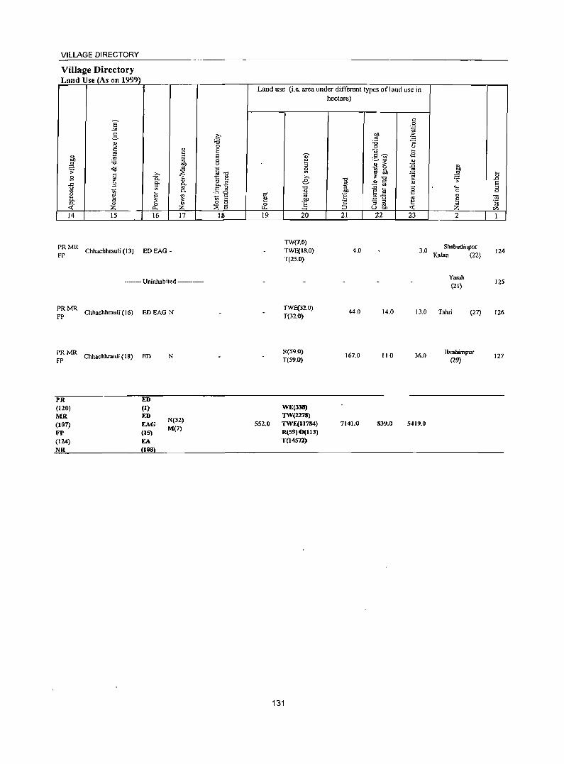
VILLAGE DIRECTORY
Village Directory Land Use (As on 1999)
14 15 16 17
~: MR Chhachhrauli (13) ED EAG _
---- Uninhabited ----
:: MR Chhachhrauli (16) ED EAG N
PRMR FP Chhachhrauli (18) ED N
PR ED (120) (I) MR ED
N(32) (107) EAG FP (IS)
M(7)
(124) EA NR 1118
18
Land use (i.e. area under different types of land use in hectare)
19
552.0
20
TW(7.0) TWE(J!W) T(25.0)
TWF.(32.0) T(32.0)
R(59.0) T(59.0)
WE(J3II) TW(2278) TWE(1I784) R(59) 0(113) T(14572)
131
21
4.0
440
167.0
7141.0
22
14.0
110
839.0
23 2
3.0 Shabudinpur Kalan (22)
Yarah (21)
13.0 Tahri (27)
36.0
5419.0
IbIabimpur (29)
124
125
126
127

CENSUS OF INDIA 2001
lNDlA
HARYANA
C.D. BLOCK MUSTAFABAD ( PART OF TAHSIL JAGADHRI )
DISTRICT YAMUNANAGAR
Km 2 o 2 4 6 Km
~ }
() . P/"o
~,-f ~b<tl"
~
C.D. BLOCK BOUNDARY EXCLUDES E-< S'fATUTORY TOWN (S)
U] BOUNDARIES ARE UPDATED UPm Ll2000 1--1
Q
.... ./ ._' cn BLOcK
BOUNDARY ; DISTRICT __ _ ... __ _ ._ _. .. ... ._ __ ._ ._ .. ._ .. __ .. . _ _ . ... _ . _ , _ • _ .. _ . _
C.D. BLOCK ... ... ... ... . ____ .. ' ... . __ __ - ___ _ _ .
VILLAGE WlTH PERM ANENT LOCATION CODE NUMBER __ t 00093100
HEADQUARTERS : C.D. BLOCK ...... _ .. _ ._ _ _ .. _ ._'. _ _ ._ ... .. ... •
VILLAGE WITH POPULATION SIZE : BELOW 200 " 200 - 499 : 0 • • ••
500 -- 999 ; 1000 -- 4999 ; 5000 & ABOVE _ .. ....... _ ._ ... ..... .
UNINHABITED VILLAGE WITH PERMANENT LOCATION CODE NUMBER ... ;;;;1 = X=O;:::O=094=:800==:1 URBAN AREA WITH LOCATION CODE NUMBER .- _. _. _. _ .. _. -- 1-1 __ .=lD;___---'1
NATIONAL HIGHW AY ... . Nt: 73
IMPORiANT MEl'ALLED ROAD ... .. ...... ''' ...... _
RAILWAY LINE WITH STATION, BROAD GAUGE ... .
RIVER & STREAM ... ._ .. ... ... ... ... ._ .. ' .. ... ._ ... ... ... _ ... ... _. . .. .- ... ~ POS'!' OFFICE .. ' ... ... .. _ ... .... _ .. ... ... ... ... ... .. .. ... _ ... __ ... _ ... . .. PO
S
PS SECONDARY OR SENIOR SECONDARY SCHOOL
POLICE STATION ... . ' ... _ ... . _ _ .. _ ...
PRIMARY HEALTH CENTRE
BANK ... .. ... ... ... . _ ... .. ... ._ ... ._ ._ ... _. .. .
~
B
..... \
TOTAL AREA (RURAL) OF CD. BLOCK (In Sq Km) _ 197.9f> TOTAL POPULATION (RURAL) OF C.D. BLOCK - - _. 90952 NUUBER OF TOWNS _ _ _ .- _. ___ ._ .- .. __ ... I
TOTAL NUMBER OF' YllJ.AGES IN C.D. BLOCK _ . .. .. 7'9 DISTANCE fROIl DISTRlCT HEADQUARTERS (In Kms) Z3
TAHSIL JAGADHRI
CHANGE IN JURISDICTION 1991- 2001
KmIO (l Ml_ L_L_j
~ ........ -. --.;" .1 .;
... . 'r'.
\ )
" ..... . / .". .. . ~ ... . c....... . ~"., TAHSIL I J \~ JAGADHRJ r
'\ ./ '"
(. f '- ' ,.., .; . ..,. i
TAHSIL JU!E,\ um ro T AllS!1 TIIA1<E3A R OF 0lSTRJC"r KURUKSlIEI'RA CJ

VILLAGE DIRECTO~Y
Alpbabeticallist of Villages (CD. block wise) Name orthe District:Yamunanagar S1. No. Na 2001 Census location code 1991 Census location code number
me number 2 3 4
Name ofeD Block: Mustafabad Name ofSub-Dist:Jagadhri (Part)
1 Ajijpur (348) 00093600 020010001000100182 2 Akbarpur (463) 00097500 020010003000300339
3 ~bli (357) 00095000 020010003000300213 4 Badanpuri (481) 00097800 020010040004000341 5 Bal Chhapar (365) 00094500 020010002000200208 6 Balsuha (176) 00100600 020010002000200412
7 Bhagwanpur (447) 00098700 020010002000200498
Ii Bham BhoH (435) 00096100 020010003000300222
9 Bhambol (434) 00096900 020010003000300267
IO Bhogpur (17 I) 00100400 020010002000200417
11 Bir Balsuha (177) 00100500 020010003000300411
12 Chhapper M ansurpur (443) 00095600 020010003000300215
13 Daira(361) 00094800 020010003000300211
14 Darajpur (431) 00097300 020010003000300290
IS Daulatpur Mahan (453) 00099300 020010003000300280
16 Faridpur (452) 00099200 020010003000300279
17 Fatehpur (448) 00098800 020010004000400140
18 Gadhaula (359) 00095800 020010003000300218
19 Gadhauli (437) 00095700 020010003000300216
20 Gandapra (441) 00096700 020010004000400270
21 Garhi Gosain (438) 00096500 020010003000300217
22 Garhi Sikandarah (186) 00100300 020010003000300418
23 Goglon (432) 00097100 020010003000300291
24 Gohlni (462) 00097900 020010003000300340
25 Gundana (179) 00099900 020010003000300410
26 Gundani (178) 00099800 020010002000200409
27 Hangoli (459) 00098200 020010003000300286
28 Hasanpur (430) 00097200 020010003000300292
29 Hudia(173) 00100800 020010002000200415
30 Ja~hauli (343) 00093100 020010002000200177
31 lamalpur (174) 00100900 020010002000200414
32 landhera (433) 00097000 020010003000300294
33 Jhar Chandna (458) 00098100 020010003000300285
34 Kabulpur(181) 00099600 020010002000200407
35 Kajiwas (457) 00099500 020010003000300284
135
DISTRICT CENSUS HANDBOOK :YAMUNANAGAR
Alpbabeticallist of Villages (CD. block wise) Name oftbe District:Yamunanagar SI. No. Na 2001 Census location code 1991 Census location code number
me number 2 3 4
36 KaJanpur (461) 00097400 020010003000300289
37 KaJawar (351) 00093700 020010001000100187
38 Kanahri Kalan (440) 00096800 020010003000300288
39 Kanarhi Khurd (436) 00096300 020010003000300221
40 Khanpur (439) 00096400 020010003000300268
41 Khanpur Rajputan (345) 00093300 020010001000100179
42 Khera Kalan (355) 00095100 020010004000400186
43 Khera Khurd (356) 00095400 020010004000400185
44 Kheri Darshan Singh (354) 00093800 020010001000100188
45 Kotar Khana (366) 00094600 020010003000300209
46 Kulchandu (340) 00094100 020010001000100190
47 Kulpur (450) 00099000 020010003000300277
48 Landaura (367) 00095900 020010003000300219
49 Lawana (349) 00095300 020010003000300184
50 Lawani (341) 00093500 020010003000300181
51 M aghar Pura ( 446) 00098500 020010003000300273
52 M aheswari (339) 00094200 020010001000100173
53 Mali Majra(454) 00098400 020010003000300281
54 Masana Jatan (184) 00100000 020010002000200420
55 Mehmadpur(451) 00099100 020010004000400278
56 Milak Majra (368) 00096200 020010003000300220
57 Modhli (480) 00097700 020010003000300342
58 M ohammadpur (t 75) 00100700 020010002000200413
59 M uradp UT (346) 00093400 020010001000100180
60 NaglaJagir (364) 00094400 020010001000)00193
61 N agla Khalsa (344) 00093200 020010001000100178
62 Namdarpur (455) 00098300 020010003000300282
63 Panjaura (363) 00094300 020010001000100192
64 Panjauri (353) 00093900 020010001000100191
65 Rajpura (369) 00096000 020010003000300223
66 Ramgarh (187) 00100200 020010002000200429
67 Rupauli (180) 00099700 020010004000400342
68 SabalpuT (358) 00095500 020010003000300214
69 Sabilpur Jatan (360) 00094900 020010003000300212
70 Saran (449) 00098900 020010003000300276
136
VILLAGE DIRECTORY
Alphabetical list of Villages (C.D. block wise) Name oftlae District:Yamunanagar SI. No. Na 2001 Census location code 1991 Census location code number
me number 2 3 4
71 Satari (352) 00094000 0200]0001000100189
72 Shahab Pura (185) 00100100 0200]0002000200419
73 ShahplJt (350) 00095200 020010003000300183
74 Sialba (460) 00098000 020010003000300287
75 ;;5ukhdaspur (442) 00096600 0200]0003000300269
76 Sultanpur (445) 00098600 020010003000300272
77 Talakaur (362) 00094700 020010003000300210
78 Topra Khurd (464) 00097600 0200)0004000400338
79 Uncha Chandan a (456) 00099400 020010003000300283
137
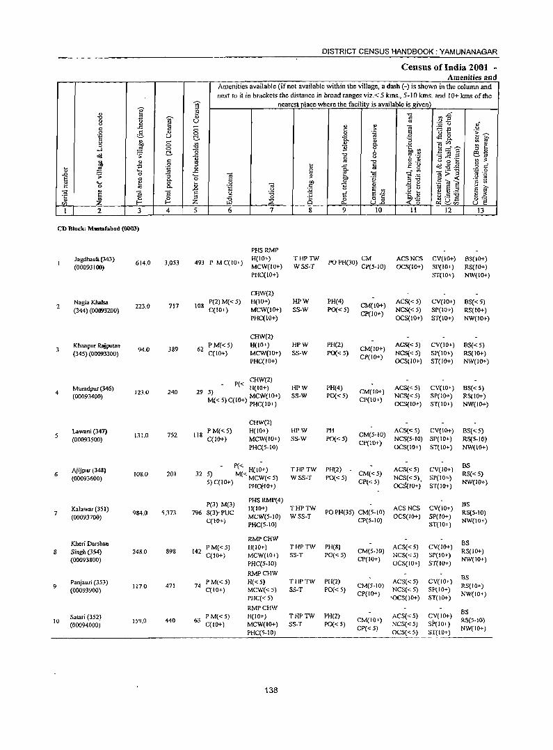
DISTRICT CENSUS HANDBOOK: YAMUNANAGAR
Census of India 2001 -Amenities and
Amenities available (if not available within the village, a dash (-) is shown in the column and next to it in brackets the distance in broad ranges viz. < 5 kms., 5-10 kms. and 10+ kms of the
-;;;- nearest place where the facility is available is l!iven
I ;; " 0: -0 &1~ "0
~ .,
§ 0 U " " '" - " " ]
";:: Q ,j C ..c: c 0 c .e ~f! u 0 § ... 0 0 -:a E~ .~ U t:!. ..c: ~8..
" fro ~ :; ., ~ " s f! CIl"'- ~ ~ 0 OIl i3 0. " ....l "g 0 ] 6 "fo ~ C!.. 0 _g:a s '" " ~ .;;: ..c: ] '? ".:; .co 1<i
~ " ;:s..c: ...... ';;'~
~ " § "0 C ., u 0 .... .;; .... ..c: c g "g Cd .g.g 8 s:f .... .~ 0 B ..
" "-' ..c: ~ ~ _- '" Oi>-g -,::: 0
.D .;; 0 g_ .... -.; -a e .~ '" ._ S .. 0 § "e ",-0 c < "2 ~ '" ..... ~ 8- .... 01) ., .:::: e .9 O! E c 0 <> .~ Oi r::: ] '" 1il S '" Cl .D u :.;;; S '" ::> " e g ~ S ~ -a E ~ 3 E g :a 8 1;[ E~ .~ li3 E ~ ~5 .z ~ '" Jl " 0 o oj oo..c: ~uS 0:=
<Zl f- Z ::E "" U..o <15 ~cn U e 1 2 3 4 5 6 7 8 9 10 11 12 13
CD Block: M_fabad (0003)
PHSRMP
Jagdhauli (343) 614.0 3,053 493 P M C(lO+)
H(IO+) THPTW PO PH(30) ~~5-10) ACSNCS CV(lO+) BS(IO+)
(00093100) MCW(IO+) WSS-T OCS(IO+) SP(IO+) RS(IO+) PHC(IO+) ST(IO+) NW(IO+)
CHW(2)
Nagla Khalsa 717 108
P(2) M« 5) H(IO+) HPW PH(4) CM(IO+)
ACS« 5) CV{IO+) 8S« 5) 2
(344) (00093200) 223.0
C(tO+) MCW(IO+) SS-W PO{< 5) NCS«5) SP(IO+) RS(IO+) PHC(IO+)
CP(IO+) OCS(IO+) ST(IO+) NW(lO+)
CHW(2)
Khanpur RlYputan 389 62
P M«5) H(IO+) HPW PH(2) CM(JO+)
ACS«5) CV(IO+) 8S«5) 3
(345) (00093300) 94.0
C(IO+) MCW(IO+) SS-W PO«5) NCS« 5) SP(lO+) RS(IO+) PHC(lO+)
CP(IO+) OCS(lO+) ST(IO+) NW(IO+)
Muradpur (346) P« CHW(2)
HPW PH(4) ACS«5) CV(IO+) BS«5) 4 123.0 240 29 5)
H(IO+) CM(IO+)
(00093400) M«S)C(IO+) MCW(IO+) SS-W PO«5) CP(IO+)
NCS«5) SP(lO+) RS(IO+) PHC(lO+) OCS(IO+) ST(IO+) NW(IO+)
CHW(2)
Lawani (347) 752 118
P M«5) H(IO+) HPW PH CM(5-1O)
ACS«5) CV(IO+) BS« 5) .5
(00093500) 131.0
C(1O+) MCW(JO+) SS-W PO« 5) NCS(5-JO) SP(IO+) RS(5-10) PHC(5-10)
Cp(IO+) OCS(IO+) ST(IO+) NW(IO+)
Ajijpur (348) P« THPTW PH(2) ACS«5) CV(IO+)
BS
6 108.0 201 32 S) M« H(lO+) CM«5) RS«S} (00093600) 5) C(IO+) MCW« 5) WSS-T PO« 5) NCS«S) SP(IO+)
PHCfIO+) CP« 5)
OCS(lO+)' ST(JO+) NW(IO+)
P(3) M(3) PHSRMP(4) as
KaJawar (351) H(IO+) THPTW ACSNCS CV(IO+) 7
(00093700) 9&4.0 5,373 796 S(3)'PUC
MCW(S-JO) WSS-T POPH(3S) CM(.5-IO)
OCS(IO+) SP(IO+) RS(S·IO)
C(IO+) PHC(5-10)
CP{5-10) ST{IO+)
NW(lO+)
Kheri Darsban RMPCHW as
PM«5) H(IO+) THPTW PH(S) ACS«5) CV(JO+) 8 Singh (354) 248.0 898 142
C(10+) MCW(lO+) SS-T PO« 5) CM(5·1O)
NCS« 5) SP(IO+) RS(IO+)
(00093800) PHC(5-1O)
CP(IO+) OCS(IO+) ST(IO+)
NW(lO+)
RMPCHW as 9
Panjauri (353) 117.0 471 74
PM«5) H«5) THPTW PH(2) CM(5-10)
ACS«5) CV(IO+) RS(IO+)
(00093900) C(IO+) MCW«5) SS-T PO« 5) NCS«S) SP(IO+)
PHC«5) CP(lO+)
'OCS(lO+) ST(lO+) NW(IO+)
RMPCHW BS
Salari (352) P M«5) H(IO+) THPTW PH(2) ACS« 5) CV(IO+) 10 159.0 440 63
C(IO+) MCW(IO+) SS-T PO« 5) CM(IO+)
NCS«5) SP(lO+) RS(5·10)
(00094000) CJ>«5) NW(IO+)
PHC(5-10) OCS« 5) ST(\O+)
138
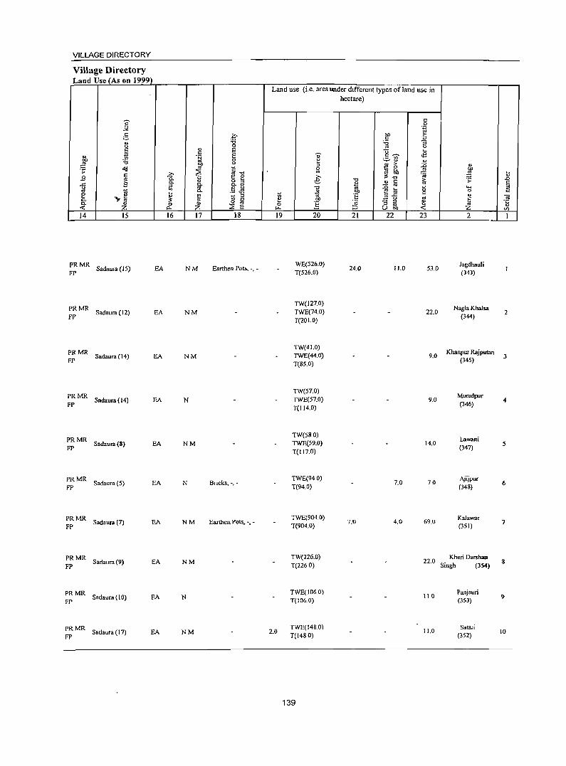
VILLAGE DIRECTORY
Village Directory Land Use (As on 1999)
14 15
PRMR FP
Sadaura (15) EA
PRMR Sadaura (12) EA
FP
PRMR FP
Sadaura (14) EA
PRMR FP
Sadaura (14) EA
PRMR FP
Sadaura (8) EA
PRMR Sadaura (5) EA
FP
PRMR FP
Sadaura (7) EA
PRMR FP
Sadaura(9) EA
PRMR Sadaura (10) EA
FP
PRMR FP
Sadaura (11) EA
16 17 18
NM Earthen Pots, -, -
NM
NM
N
NM
N Bncks, -,-
NM Earthen Pots, -, -
NM
N
NM
Land use (i.e. area under different types ofland use in hectare)
19 20 21 22 23
WE(S26.0) 24.0 11.0 53.0
T(526.0)
TW(127.0) TWE(74.0) 22.0 T(201.0)
TW(41.0) TWE(44.0) 9.0 T(SS.O)
TW(57.0) TWE(57.0) 9.0 T(l14.0)
TW(58 0) TWE(59.0) 14.0 T(117.0)
TWE(940) 7.0 70
T(94.0)
TWE(904.0) 7.0 4.0 69.0
T(904.0)
TW(226.0) 22.0
T(226 0)
TWE(t06.0) 110
T(I06.0)
2.0 TWE(148.0)
11.0 T(1480)
139
2
Jagdhauli (343)
Nagla Khalsa 2
(344)
Khanpur Rajpulan (345)
3
Muradpur 4
(346)
Lawani (341)
5
Ajijpur (348) 6
Kalawar (351)
7
Kheri Darshan 8
Singh (354)
Panj.uri 9
(353)
Satari (352)
10
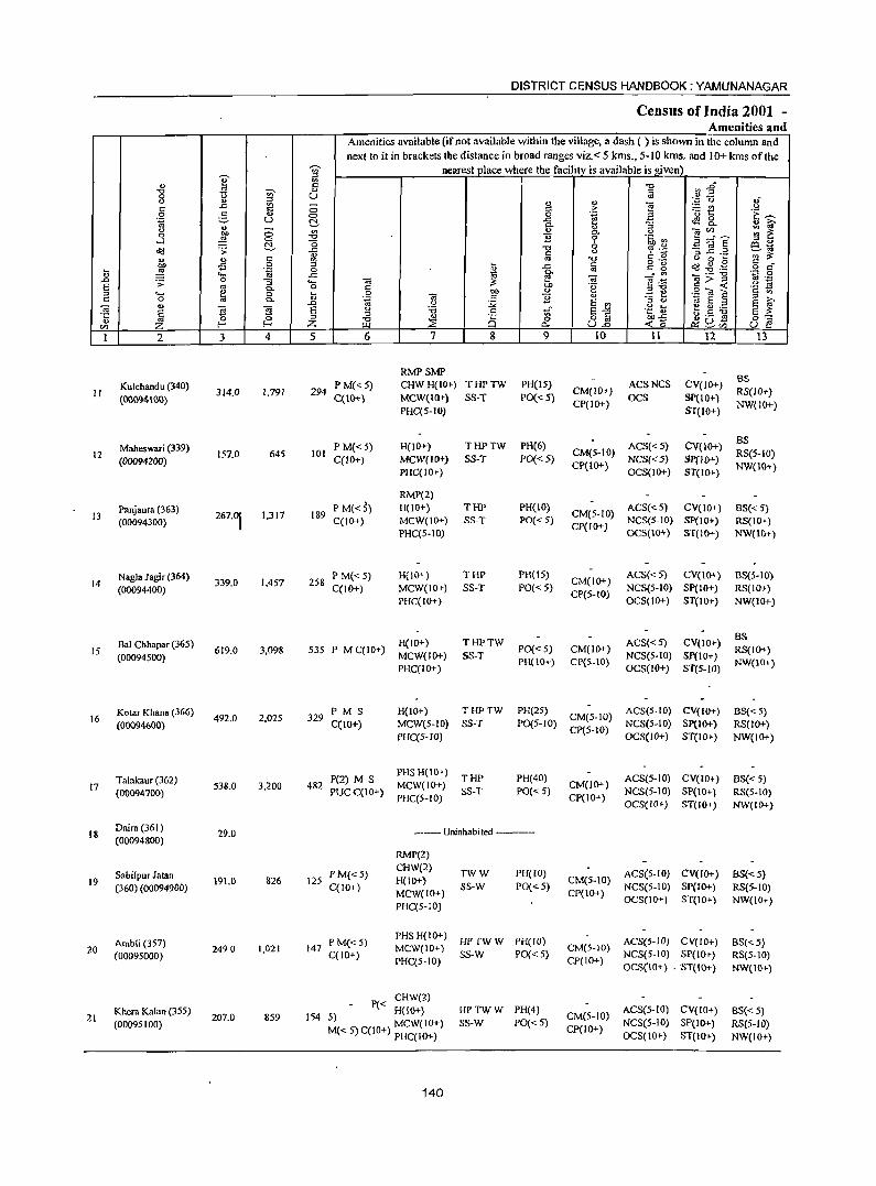
II
12
13
14
15
16
17
18
19
20
21
2
Kulchandu (340)
(0009"'\00)
Maheswari (339) (00094200)
Panjaura (363) (00094300)
Nagla Jagir (364) (00094400)
Bal Chhapar (365) (00094500)
Kotar Khan. (366)
(0009%00)
Talakaur (362) (00094700)
Daira (361) (00094800)
Sabi/pur Jatan (360) (00094900)
Ambli (357) (00095000)
Khera Kalan (355) (00095100)
3 4
314.0 1,791
157.0 645
267.~ 1,317
339.0 1.457
619.0 3,098
492.0 2,025
538.0 3,200
29.0
191.0 826
2490 1,021
207.0 859
DISTRICT CENSUS HANDBOOK: YAMUNANAGAR
Census of India 2001 -Amenities and
Amenities available (if not available within the village, a dash (-) is shown in the column and next to it in brackets the distance in broad ranges viz. < 5 kms., 5-10 kms. and 10+ kms of the
nearest vlace where the facilitv is available is !!.iven
5 6
294 P M« 5) C(lO+)
101 PM{< 5) C(lO+)
189 P M(<5) C(IO+)
258 P M« S) C(IO+)
7 8
RMPSMP CHWH(I~) THPTW MCW(IO+) SS-T PHC(5-10)
H{lO+) MCW(lO+) PHC(IO+)
RMP(2) H(I~)
MCW(IQ+) PHC(5-10)
H(10+) MCW(IQ+) PHC(IO+)
THPTW SS-T
THP SS-T
THP SS-T
HCIQ+) 535 P M C(lO+) MCW(IQ+)
THPTW SS-T
PHC(IO+)
9
PH(15) PO« 5)
PH(6)
PO« 5)
PH(lO) PO« 5)
PH(15) PO{< 5)
PO« 5) PH{IO+)
10
CM(lO+) CP(IO+)
11
ACSNCS OCS
12
CV(IO+) Sp(IO+) ST(IO+)
CM(5-10) ACS«5) CP(IO+) NCS«5)
OCS(lO+)
CV(IO+) gP(IO+) ST(IO+)
ACS« 5) CV(lO+) CM(5-1O) NCS(5-10) SP(IO+) CP(IO+) OCS(IO+) ST(IQ+)
CM(IO+) CP(5-1O)
CM(lO+) CP{S-IO)
ACS« 5) CV(IO+) NCS(5-10) SP(IO+) OCS(IO+) ST(IO+)
ACS«5) CV(lO+) NCS(5-10) Sp(IO+) OCS(IO+) ST(5-IO)
329 PM S cc I 0+)
H(IO+) MCW(5-1O) PHC(5-1O)
THPTW SS-T
PH(25) ACS(5-10) CV(IO+) PO(5-10) CM(5-1O) NCS(5-1O) Sp(IO+)
CP(5-10) OCS(lO+) ST(IO+)
P(2) M S PHSH(IO+) THP 482 PU C( ) MCW(IO+) SS-T
PH(40) PO« 5) C 10+ PHC(5-10)
12S P M« 5) C(IO+)
147 P M«5) C(IO+)
------- Uninhabited ------
RMP(2) CHW(2) H(IO+) MCW(IO+) PHC(5-10)
TWW SS-W
PHeW) PO« 5)
PHS H(IO+} HP TW W PH(IO} MCW(IO+) sS-W PO« 5) PHC(5-10)
P« CHW(2) H(IO+)
154 5) MCW(IO+) M« 5) C(IO+) PHC(IO+)
HPTWW PH(4) SS-W PO«5)
140
CM(IO+) CP(IO+)
ACS(5-10) CV(IO+) NCS(5-10) SP(IO+) OCS(lO+) ST(IO+)
CM(5-10) ACS(5-IO) CV(IO+) CP(IO+) NCS(5-10) SP(IQ+)
OCS(IO+) ST(JO+)
CM(5-IO) ACS(5-1O) CV(IO+) NCS(5-10) SP(IO+}
CP(IO+) OCS(tO+). ST(IO+)
CM(5-10) ACS(5-1O) CV(IO+} CP(lO+) NCS(5-1O} SP(IQ+)
OCS(lO+) ST(1O+)
13
BS RS(IO+) NW(IO+)
BS RS(5-1O) NW(IO+)
BS« 5) RS(IO+) NW(lO+)
BS(5-10) RS(IO+) NW(JO+)
BS RS(IO+) NW(lO+)
BS« 5) RS(IO+) NW(IO+)
BS« 5) RS(5-10) NW(IO+)
BS« 5) RS(5-10) NW{IO+)
BS« 5) RS(5-IO) NW(IO+}
BS«5) RS(5-IO) NW(IO+)
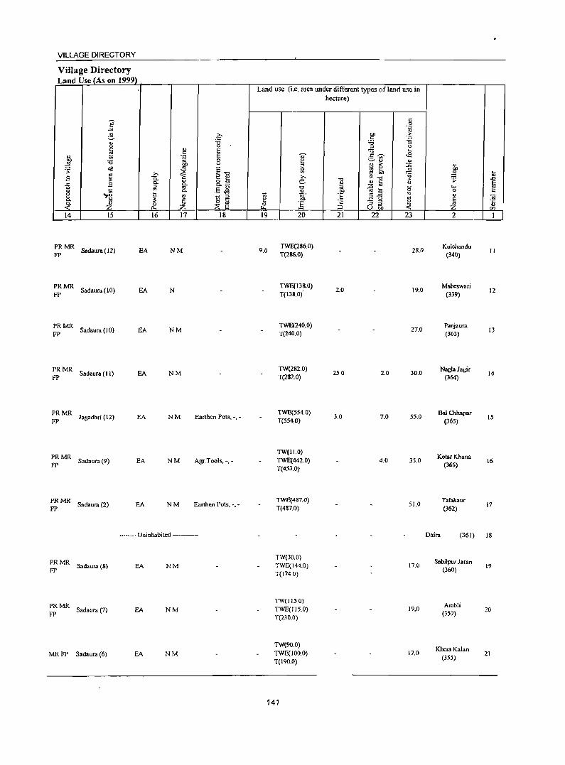
141
i <:
22
23
24
25
26
27
28
29
30
31
32
2
Shahpur (350) (00095200)
Lawana (349) (00095300)
Khera Khurd (356) (00095400)
Sabalpur (358) (00095500)
Chhapper Mansurpur (443) (00095600)
Gadhauli (437) (00095700)
Gadhaula (359) (00095800)
Landaura (367) (00095900)
Rajpura (369) (00096000)
Bham Bholi (435)
(00096100)
Milak Majm (368) (00096200)
3 4
39.0 69
261.0 1,687
98.0 387
288.0 1,567
493.0 2.,678
166.0 917
327.0 1,445
116.0 593
1930
494.0 2.742
SI.O 358
DISTRICT CENSUS HANDBOOK; YAMUNANAGAR
Census of India 2001 -Amenities and
Amenities available (ifnot available within the village, a dash (-) is shown in the colunm and next to it in brackets the distance in broad ranges viz.< 5 kms., 5-10 kms. and 10+ kms of the
nearest JlIace where the facility is available is_given)
5 6 7
CHW(2) P{< H{IO+)
13 5) MCW(IO+} M« 5) C(lO+) PHC(5-1O)
266 PM«5) CCI 0+)
PHS H(IO+) MCW(IO+) PHC(5-1O}
8
HPW SS-W
HPW SS-W
~ o .c c.. .,
1i
9 10 II 12
PO« 5} CM(5 10) ACS« 5} CV(IO+} - NCS(5-IO) SP(IO+)
PH(5-10) Cp(10+) OCS(IO+) ST(IO+)
PH(4)
PO«5) CM{S-IO) Cp(JO+)
ACS NCS(5- CV(;O+) 10) OCS(IO+) SP(IO+)
ST(IO+}
RMPCHW(2)
71 PM S PUC C(IO+)
H(IO+} HPW PH(2)
PO« S) ACS« 5) CV{IO+)
CM(5-10) NCS(5-1O) SP(IO+) MCW(IO+) SS-W Cp(IO+) OCS(IO+) ST(IO+) PHC(5-IO)
H{lO+) 269 P MC(IO+) MCW(IO+)
PHCC< 5)
426 P(3) M(3) S ~IO+} PUC C(IO+) M\:;W« 5)
PHC(IO+)
161 P(2) M C(IO+)
254 P M{<5) C(IO+)
96 PM«5) C(IO+)
12S PM«S) C(JO+)
PHSH(IO+) MCW(IO+)
PHC« 5)
RMP(2) CHW(2) H(IO+) MCW(IO+)
PHCC5-lO)
H(S-10) MCW(IO+)
PHCCIO+)
H(lO+) MCW{IO+)
PHC«5)
H(5-
HPW SS-W
THPTW SS-T
THPTW WSS-T
HPW
SS-W
PH(36)
PO«5) CM«.5) CP(IO+)
ACS«S) NCS«5) OCS(IO+)
CV(lO+) SP(IO+) ST(IO+)
PO PH(50) CM« 5) CP«5)
ACS« 5) CV(IO+) NCS(5-10) SP(IO+) OCS(IO+) ST(IO+)
PH(S)
PO« 5}
ACS(5-10) CV(IO+) CM(5-10) NCS(5-10) Sp(JO+) CP(S-IO) OCS(5-10) ST(IO+}
ACS(5-IO) CV(IO+) PO PH(16) CM(5-10) NCS(5-IO) Sl>'(lO+)
CP(IO+) OCS(5-10) ST(IO+)
HPTW SS- PH(14)
TW PO«5) CM«5) CP(5-10}
ACS« 5) NCS(JO+) OCS(lO+)
CV(IO+) SP(IO+) ST(IO+)
THPTW PA(3) SS-T PO«5)
CM(5-10) ACS«5) NCS« 5)
CP« 5) OCS« 5)
CV(IO+) SP{lO+)
ST(lP+)
P(2) M S 463 PUC Tr
C(5-10)
10} T HPTW POPHPO) CM(S-IO)
CP(5-10)
ACS NCS(S- CV ;0+) 10) .. (I
MCW(IO+) SS-T PHC(5-10)
58 S) P« H(IO+)
M« 5) C(lD+) MCW« 5) PHC(IO+)
142
THPTW PH(12)
W SS-T PO(IO+)
OCS(IO+) SP{lO+) ST(IO+)
CM(5-IO) ACS« 5) CP« S) NCS« 5)
OCS«5)
CV(IO+) SP(IO+) ST(IO+)
13
BS«5) RS(5-10) NW(lO+)
BS« 5} RS(5-10) NW(IO+)
BS« 5) RS(5-1D) NW(lO+)
BS RS(S-IO) NW(ID+)
BS RS(5-1O) NW(lO+)
BS RS(5-1O)
,NW(IO+)
BS RS(5-IO) NW(IO+)
BS« 5) RS(IO+) NW(IO+)
BS«5) RS(IO+)
NW(lO+)
as RS(IO+)
NW(IO+)
BS RS(IO+) NW(IO+)
VILLAGE DIRECTORY
Village Directory Land Use (As on 1999)
Land use (i.e. area under different types ofland use in hectare)
E '" 0 _,. .~
e .£' OIl .::; '" -3 '" "0 '6 <.>
" 0
" <.>
'" Ii "0 ... til c
" ·tJ e 'U c ~ ..s ._ '" 1 '6 0 2 ~" '" ~ v
" ~ > ~ u .;; ~ ~ ~""Cl Sl ~ 8 OIl ...
~ >. :::~ 'iii :§ .,
.9 is.. 1:: ~ >. "0 [:; .;; .r>
0. " o ::s e " !ii E ..c: 9 ~ a. 0.- ~ :0 g '" .§ .a "C 15 .... ::l
t:i 0. ~ OIl e a 0 '" 8 ~ c
fa ~ ::s t:i E "..c: '" <.>
~ 0. ::: '" c e 00
_ u
§ 0. ". Z <.> o '" ] '2 :; ::s ~ 0 ::E e 0 '" .,
<: p... z ""' ;::J u OIl Z <Zl
14 15 16 17 18 19 20 21 22 23 2 I
MRFP Sadaura (8) EA NM TWE(38.0)
1.0 Shahpur 22 T(38.0) (350)
PRMR TW(160.0)
Lawana Sadaum (6) EA NM TWE(82.0) 19.0 23 FP T(242.0) (349)
PRMR TW(40.0)
KhemKhurd Sadaum (6) EA NM TWE(48.0) 10.0 24
FP T(88.0) (356)
PRMR TW(82.0)
Sabalpur Sadaura (5) EA NM TWE(162.0) 3.0 41.0 25 FP T(244.0) (358)
PRMR TWE(438.0) Chhapper
FP Sadaum (2) EA NM Earthen Pots, -, -
T(4380) 6.0 49.0 Mansurpur 26
(443)
PRMR Sadaura (8) EA NM
TWE(145.0) 210
Gadhauli FP T(145.0) (437)
27
PRMR TW{104.0)
Gadhoula Sadaum (8) EA NM TWE(I92.0) 31.0 28 FP T(296.0)
(359)
PRMR Sadaum (4) EA N
TWE(I02.0) 14.0 Landaum
29 FP T(102.0) (367)
PRMR Sadaum (6) EA N
TWE(I75.0) 18.0 Rajpura
30 FP T(175.0) (369)
PRMR TW(&.O)
Bham Bholi Sadaura (9) EA NM Earthen Pots, -, - TWE(4230) 130 40 46.0 31
FP T(43 1.0) (435)
PRMR TW(60)
Milak Majra Sadaura (8) EA NM TWE(60.0) 15.0 32
FP T(66.0) (368)
143
DISTRICT CENSUS HANDBOOK: YAMUNANAGAR
Census of India 2001 _
ANeliities a n d Amenities available (if not available within the village, a dash (-) is shown in the column and next to it in brackets the distance in broad ranges viz.< 5·kms., 5-10 kms. and 10+ Imls of the
"in nearest place where the facility is available is I(iven
~ f;l
" ~ Ii -0 ~~ -0 § 0 ~ U <.> '" '" " '" f!
".0 0 .; c ..c c g c > ~~
<.>
0 C '" 0 .~ 2 'E~ :g ;;::- u C!- ..c ~ 8..
~ 0- '"
:; : f <.> ;:; '" " <.> Oi'" 0 -0 E Co
...l 0 -0 0 "th ~ 2:g-e ::s '" C!- 6 trl~
~ 'f> -Ii -0 U ~ .~ "3 ...c:: .:! ~'"
~ '" c g a -0 u 0 .._ '" ~ .,s .~ ~ c
o ._ ~ .g .g § d' .._
~ ..c '"
c g '" .... ..c tii Co _" ., ._ -0 'p 0
.D 'f> 0 :; .... Oi ~ Oi Itt -Oi>::s '" ._
§ '" Co 0 C ~ .~ 3:.0 c « 'a ~ ... e 0 ::; 0 CI) " ,:!:::: e .9 'd E c 0 '" Co .~ -a .S E '" S ~
'" .D u E '"
::s u 0; a ::s
~ ~ ~ l § u :a ~ 'it E-'" .~ ~ ~ .5 :g E ~ ::s '" o c ~~ <U E- Z
-0 ::E 0 ull ~u- 0= en >I.l ~ ~'" u e 1 2 3 4 5 6 7 8 9 10 11 12 13
CHW(2)
33 Kanarhi Khmd
224.0 1,248 187 P M« 5) H(IO+) HPW PH(\O) CM(5-1O)
ACS« 5) CV(IO+) BS« 5)
(436) (00096300) C(IO+) MCW(IO+) SS-W PO« 5) CP(IO+)
NCS«5) SP(JO+) RS(IO+)
PHC(5-10) OCS«5) ST(JO+) NW(JO+)
CHW(2) ACS NCS« CV(~O+)
34 Khanpur (439)
442.0 2,155 346 P M« 5) H(JO+) HPlWSS- PH(18)
CM(5-1O) 5) BS« 5)
(00096400) C(IO+) MCW(IO+) TW PO« 5) CP(IO+) OCS(lO+) SP(IO+) RS(IO+)
PHC(5-10) ST(IO+) NW(IO+)
Garhi Gosain (438) P M«5) PHSH(IO+)
TTWW ACS(5-10) CV(IO+) BS«5) 35 133.0 717 126 MCW«5) PO« 5) CM«5)
(00096S00) C(JO+) PHC(IO+)
TKSS-T PH« 5) CP«S)
NCS(5-10) SP(IO+) RS(IO+) OCS(IO+) ST(IO+) NW(IO+)
36 Sukhdaspur (442)
119.0 569 81 PM«S) H(IO+) ill> lW SS- PH(20)
CM«S) ACS NCS(S- CV(;O+) BS«5) 10)
(00096600) C(IO+) MCW«5) TW PO« S) CP«5) OCS(IO+) SP(IO+) RS(IO+)
PHC(IO+) ST(IO+) NW(IO+)
37 Gandapra (441)
216.0 972 137 PM«S) H(IO+)
THPSS-T PH(12)
CM«5) ACS«5) CV(IO+) BS«5)
(00096700) C(JO+) MCW(JO+) PO«S) CP(IO+)
NCS(S-IO) SP(IO+) RS(JO+) PHC(IO+) OCS(IO+) ST(tO+) NW(IO+)
PHSCHW(2)
Kanahri Kalan 2,096 344 PM S H(IO+)
HPSS-HP POPH(2J) CM«5) ACS«S) CV(IO+) BS« 5)
38 414.0 (440) (00096800) C(IO+) MCW(IO+)
CP(IO+) NCS«5) SP(IO+) RS(IO+)
PHC« 5) OCS(IO+) ST(IO+) NW(IO+)
Bhambol (434) PM S PUC PHCPHSH(5- ACS(5-10) CV(5-IO) B.sc< 5)
399.0 2,233 3S0 10) MCW(5- ~TWSS- POPH(25) CM(5-IO) 39 (00096900) TrC(S-IO) NCS(5-10) SP(IO+) RS(5-10)
10) CP(S-IO) OCS(5-10) ST(IO+) NW(IO+)
PHC PH(IS) ACS(5-10)
40 landhera (433)
159.0 375 77 P M« 5) C(S- H(S-IO) THPTW CM(S-IO)
CV(5-10) BS« 5)
(00097000) 10) MCW(5-10) WSS-T PO« S) CP«S)
NCS(5-10) SP(5-10) RS(5-IO)
'\ OCS(lO+) ST(S-IO). NW(10+)
Goglon (432) P M« 5) C(S-H(S-
THPTW PH(IS) ACS«5) CV(S-IO) BS
41 (00097100)
11\6.0 967 124 10)
10}MCW(5-SS-T PO«5)
CM(IO+) NCS(5-IO) SP(5-1O) RS«5)
10) PHC«5) CP«5) OCS(5-1O) ST(S-IO)
NW(IO+)
RMP(2) -Hasanpur (430) P M« 5) C(5- H(S-IO) THPTW PH(15) ACS«5) . CV(S-IO)I BS
42 (00097200)
103.0 760 127 10) MCWeS-IO) SS-T PO« 5)
CM(IO+) NCS«5) SP(S-IO) RS«S)
PHC(S-IO) CP« 5)
OCS«5) ST(S-IO) NW(IO+)
144
VILLAGE DIRECTORY
Village Directory Land Use (As on 1999)
e _,. g 0 ., :0 <> 0
'" t: E ~ s:::
" .~ E bI) :0 0 :§ bll u
~ '" ~~ .;;: ~ .0 B ~ 1:: e 0-" .t: B 0- go 8.B
" ~ ,5 J9 '" 0-e :: ~ ~ ~ " 0- :a '" '" ~ .,
0 " o '" Z p.., Z ~ E
14 15 16 17 18
PRMR FP
Sadaura (9) EA NM
PRMR Sadaurn (7) EA NM AgLTools. -. -
FP
PRMR SadauraeS) EA NM
FP
PRMR Sadaura(2) EA NM
FP
PRMR Sadaura(2)
FP EA N
PRMR FP
Sadaurn (5) EA NM Agr.TooI5. -.-
PRMR Sadaura (9)
FP EA NM Agr. T 0015. -, -
MRFP Jagadhri (3) EA NM
PRMR FP Sadaurn (12) EA NM
~: MR Sadaurn (12) EA NM
Land use (i.e. area under different types ofland use in
~ 0 ~
19
., ~ £
€ "0 ., :i! bll
:§ 20
TW(42.0) TWE(154.0) T(196.0)
TW(IOS.O) TWE(303.0) T(411.0)
TWE(113.0) T{113.0)
TWE(I04.0) T(I04.0)
TWE(184.0) T(J84.0)
TW(I04.0) TWE(279.0) T(383.0)
TWp.O) TWE(363.0) T(366.0)
TWE(l30.0) T(l30 0)
TWE(158.0) T(ISS.O)
TWE(83.0) T(83.0)
145
hectare)
"0
" :i! 00
'E ;§ 21
1.0
2.0
15.0
s::: 0 -:g
bI) > s::: . .,
:0 "3
" " <:l .... ~ s:::~ ._ '"
~" " u > ~ 1i e :a :::~ ~ ..!! ta
~ a " .ai3 s:::
'" "3 :l l!:! U g:, <
22 23
2&.0
3'-0
1.0 19.0
lS.o
32.0
1.0 30.0
1.0 30.0
14.0
18.0 10.0
1.0 19.0
., bI)
:§ .;;: ..... 0
" ~ 2
Kanarhi Khurd (436)
Khanpur (439)
G.rhi Gosain (438)
Sukhdaspur (442)
Gandapra (441)
Kanahri Kalan (440)
Bhambol (434)
landhera (433)
Goglon (432)
Hasan pur (430)
.... " .0 E :l s:::
~ " '" I
33
34
35
36
37
38
39
40
41
42
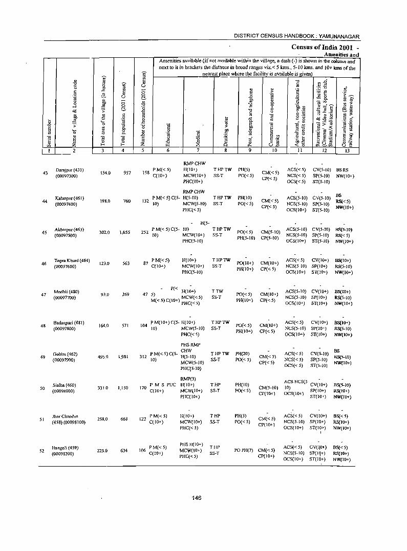
I ., "0 u;-0
~ " c .c 0 5 " .~ U
" -" ~ 0 0 0 ....l
o"(j .;: ~
'" " c
E -5 0 t; .~ ....
..0 0 :> :; E '" 0. ::> .... 1a 0 c 0 Co .,
Q E S J '5 Z_ 0 en l-<
I 2 3 4
Oarajpur (431) 957 43
(00097300) 154.0
Kalanpur (461) 44 198.0 760
(00097400)
Akbarpur (463) 1,655 45
(00097500) 302.0
Topra Khurd (464) 563 46
(00097600) 123.0
Modhli (480) 47
(00097700) 93.0 269
8adanpuri (481) 48
(00097800) 164.0 571
49 Gohlni (462)
495.0 1.981 (00097900)
Sialba (460) 1,150 50 3310
(00098000)
Jhar Chandn. 258.0 668 51
(458) (00098100)
Hangoli (4S9) 52 225.0 634
(00098200)
-;;;-;:1
'" C ., U
0 0 ~
'" "0 (3 .c: ~ ::> 0 .c: .... 0 .... " ..0 E ::> Z 5
DISTRICT CENSUS HANDBOOK; YAMUNANAGAR
Census of India 2001 -Amenities and
Amenities available (if not available within the village, a dash (-) is shown in the column and next to it in brackets the distance in broad ranges viz.< 5 kms., 5- 10 kms. and 10+ kms of the
nearestj>lace where the facility_is available is given) "0 rl-§ iii . .= 0 .;
" " -a c > ~t " 0 '"ci ~ 'E ~ ..c: <l'l 0 0.
" 0. " i;' .,
0. " -aU) ~ ~ "2 9 .~ '" 3=8' ::> " "0 0 t? .~ -3 ~.~ S~ c " '" "0 C '" " 0 .... .... .c iii g -g o"(j .g.g g r::
" 'OJ 0. ...:'" ~>-g '.::1 0 E! Q "'._ ] ~ ~:g .~ ~ 00 ~ c <
0 00 oS:! .9 O! E .~ Q .5 .2 '" ::i ti
" -'" E '" .~] tii e ::s
E f " :a c tf E-'" e 11) ...... ;:1
~ 8 o iii ~D~ §:-;: "0 0 I:.t.l p., U..o <15 0:: ~en U e 6 7 8 9 10 II 12 13
RMPCHW
158 PM« 5) H(IO+) THPTW PH(5)
CM«5) ACS« 5) CV(5-1O) BSRS
C(lO+) MCW(lO+) SS-T PO« 5) NCS«5) SP(5-10) NW(10+) PHC(IO+)
CP«5) OCS«5) ST(5-10)
RMPCHW P M« 5) C(5- H(S-IO) THPTW PH(IO) ACS(S-IO) CV(S-IO)
BS 132 CM«5) RS«S) 10) MCW(S-JO) SS-T PO«5) NCS(S-IO) SP(5-JO)
PHC«S) CP« 5)
OCS(IO+) ST(S-IO) NW(IO+)
H(5-
252 P M« 5) C(S- 10) THPTW
PO«5) CM(5-10) ACS(S-JO) CV(S-IO) BS(5-IO)
10) MCW(IO+) SS-T NCS(S-IO) SP(5-10) RS« S) PHC(5-IO)
PH(5-10) CP(S-to) OCS(IO+) ST(5-IO) NW(,IO+)
87 P M« 5) H(IO+) THPTW
PO(I 0+) CM(IO+) ACS« 5) CV(IO+) 85(10+)
C(IO+) MCW(IO+) SS-T NCS(5-JO) SP{IO+) RS{5-1O) PHC(5-10)
PH(IO+) CP« S) OCS(IO+) ST(IO+) NW(IO+)
47 P« H(IO+) TTW
PO«5) CM(IO+) ACS(S-IO) CV(IO+) BS(IO+)
~«5)C(10+) MCW«5) SS-T NCS(5-10) SP(IO+) RS{5-1O) PHC« 5)
PH(lO+) CP«S) OCS(IO+) ST(IO+) NW(JO+)
104 P M(IO+) C(5- H(IO+) THPTW
PO«5) CM(IO+) ACS«5) CV(lO+) BS(IO+)
10) MCW(5-1O) SS-T NCS(5-10) SP(IO+) RS(S-10) PHC« S)
PH(IO+) CP« 5) OCS(IO+) ST(IO+) NW(IO+)
PHSRMP CHW
THPTW PH(20) ACS« 5) CV(5-1O) BS
312 P M« 5) C(5- H(5- to) CM{<S) RS(5-10) 10) MCW(5-JO) SS-T PO« 5) NCS« S) SP(S-JO)
CP« 5) OCS« 5) ST(5-10)
NW(JO+) PHC(S-IO)
RMP(3) ACS NCS(S- CV(~O+)
170 PM S PUC H(IO+) THP PH(IO)
CM(5-to) BS(5-IO)
10) C(IO+) MCW(IO+) SS-T PO{< 5)
CP(10+) OCS(IO+) SP(IO+) RS(JO+) PHC(IO+) ST(lO+) NW(JO+)
122 PM«S) H(tO+) THP PH(3)
CM«5) ACS«5) CV(to+) BS« 5)
C(to+) MCW(tO+) SS-T PO{< S) NCS(S-IO) SP(IO+) RS(IO+) PHC« 5)
CP(lO+) OCS(IO+) ST(IO+) NW(IO+)
I
P M« S) PHSH(IO+)
THP ACS« 5) CV(lO+) BS«5) 106 MCVl(IO+) POPH(7) CM{<5)
C(IO+) PHC« 5)
SS-T CP(IO+)
NCS(S-IO) SP(lq+) RS(IO+) OCS(IO+) ST(JO+) NW(IO+)
146
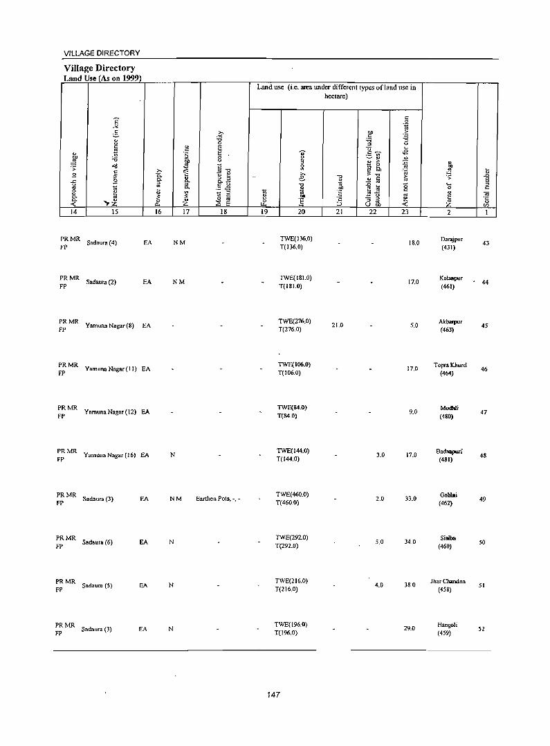
VILLAGE DIRECTORY
Village Directory Land Usej_As on 1999)
14 15
;~ MR Sadaura (4) EA
;~ MR Sad aura (2) EA
;~ MR Yamuna Nagar(S) EA
;~MR Yamuna Nagar (11) EA
;~MR YamunaNagar(12) EA
;: MR Yamuna Nagar (16) EA
;~ MR Sadau .... (3) EA
;~ MR Sadaura (6) EA
PRMR FP Sadaura (5) EA
;: MR Sadaura (3) EA
16 17 18
NM
NM
N
NM Earthen Pots, -, _
N
N
N
Land use (i.e. area under different types of land use in hectare)
19 20
TWE(136_O)
T(136.0)
TWE(I81.0)
T(18LO)
TWE(276_0)
T(276.0)
TWE(I06_O)
T(to6.0)
TWE(84.0)
T(84.0)
TWE(I44.O) T(144.0)
TWE(460.0) T(460.0)
TWE(292.0)
T(292.0)
TWE(2 1 6.0)
T(2 1 6.0)
TWE(196.0) T(196.0)
147
21
21.0
22 23
IS.O
17.0
5;0
17.0
9.0
3..0 17.0
2.0 33.0
5.0 34.0
4.0 380
29.0
2
Darajpur (431)
Kalanpur
(461)
Akbarpur (463)
Topra lChurd (464)
ModhIi
(480)
Bad:mpuri (481)
Gohlni
(462)
Sialba (460)
J har Chandna (458)
Hangoli
(459)
43
44
45
46
47
48
49
50
51
52
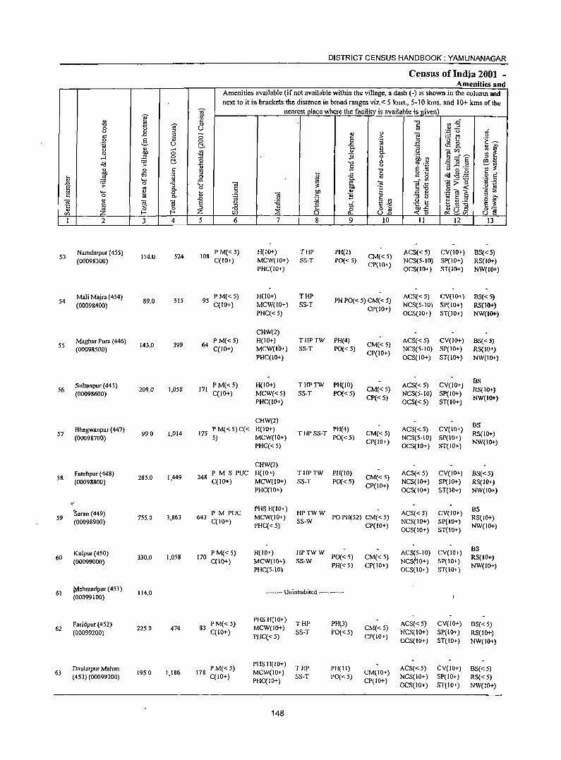
DISTRICT CENSUS HANDBOOK: YAMUNANAGAR
Census of Indja 2001 -Amenities and
Amenities available (if not available within the village, a dash (-) is shown in the column and
next to it in brackets the distance in broad ranges viz. < 5 kms .• 5-10 kms. and 10+ kms of the
I ~ nearest place where the facility is available is_given
'" c "0 ~ :2" 'Q -;;;- OJ Iii 0 (.)
" OJ ~ - '" " "§ '';:: u "j
c ..<: 0 c .?: - '" " 0 g " 0 0 e a '0 t .~ ~
.~ U ~ -a "5 ~8. M ~ u '" ;; '" " e(l)_---. 00 "' 0- C) '" ~ 0 ,g "0 ]i 0 .~.!2 ....l 0 (5 E=a§ ;:;l "
~ .;;; d- ..<: "0 6 eta g ~ " c ~ ::r ..c._ '" ~ '" <> " "t:l " 0 ~ 00 .s 0 ;::J .... a
o ._ Od ~ .~ .~ g .... ,g ".g 0 "
..<: s:: ~ '" ..... ..<: ~ ~ ._ -0
.0 .;;; 0 ]. ..... -a -a e .~ 1i>~ <II ._
" -Ei '" 0 c '" "g ::1-0
.S! "' S '§ t! ::I ..... I:! 0 .... 0 -a 01) ~ .. " 0 " 'g c:: ]i "3 ~ '" "- .0 0 :;;; a '" ~ ~ .2 a in' .. -a
~ ~ -a E C) :;; .S Tf, e~ .~ a b.s ~ e ~ ·c 'i5 "
::I " 00"<: .. ~ Z -0 :s 0 0 o '" «15 ~ ~Vl
0::: en f-< t.LI Il-. U.o (.) e 1 2 3 4 5 6 7 8 9 10 II 12 13
Namdarpur (455) 524 108
P M« 5) H(IO+) THP PH(2) CM«5)
AC8«5) CV(IO+) B8«5) 53
(00098300) 114.0
C(IO+) MCW(JO+) SS-T PO« 5) NCS(5-1O) SP(JO+) RS(IO+) PHceJO+)
CP(IO+) OCS(IO+) ST(JO+) NW(IO+)
Mali Majra (454) 95
P M« 5) H(IO+) THP PH PO« 5) CM« 5)
ACS«5) CV(IO+) BS«5) 54
(0009&400) 89.0 515
C(IO+) MCW(IO+) SS-T NCS(5-10) SP(IO+) RS(IO+) PHce<5)
CP(IO+) OCS(IO+) ST(lO+) NW(IO+)
CHW(2)
Maghar Pura (446) 399 64
P M«5) H(lO+) THPTW PH(4) CM« 5)
ACS« 5) CV(IO+) BS«5) 55
(00098500) 143.0 C(IO+) MCW(lb+) SS-T PO«5) NCS(5-10) SP(IO+) RS(JO+)
PHC(IO+) CP(IO+)
OCS(10+) ST(IO+) NW(I()T)
Sultanpur (445) PM«5) H(IO+) THPTW PH(lO) ACS« 5) CV(JO+) BS
56 209.0 1,058 171 CM«5) RS{lO+) (00098600) celO+) MCW«5) SS-T PO{< 5)
CP« 5) NCS(5-IO) SP(JO+)
NW(I()T) PHC(JO+) OCS« 5) ST(IO+)
CHW(2) 8S
57 Bhagwanpur (447)
990 1,014 175 PM«S)C« H(IO+)
T HP SS-T PH(4)
CM«5) ACS«5) CV(IO+)
RS(IO+) (00098700) 5) MCW(IO+) PO« 5) NCS(5-IO) SP(IO+)
PHC«5) CP(lO+)
OCS(IO+) ST(IO+) NW(JO+)
CHW(2) Fatehpur (448)
1,449 248 PM S PUC H(IO+) THPTW PH(lO)
CM« 5) ACS«5) CV(IO+) 8S«5)
58 (00098800)
285.0 C(10+) MCW(IO+) SS-T PO{< 5) NCS(IO+) SP(IO+ ) RS(IO+)
PHC(IO+) CP(IO+)
OCS(JO+) ST(lO+) NW(I()T)
" -Saran (449) PM PUC
PHSH(IO+) HPTWW ACS« 5) CV(JO+) BS
59 755.0 3,863 643 MCW(lO+) PO PH(52) CM« 5) RS(IO+) (00098900) C(10+)
PHC«5) SS-W
CP(lO+) NCS(IO+) SP(IO+)
NW(IO+) OCS(IO+) ST{IO+)
Kulpur(450) PM«5) H(JO+) HPTWW ACS(5-10) CY(10+) BS
330.0 1,058 170 PO« 5) CM«5) RS(lO+) 60 (00099000) C(10+) MCW(IO+, SS-W NCSelO+) SP{IO+)
PHce5-10) PH«5) CP(IO+)
OCS(JO+) ST(IO+) NW(lO+)
61 ~ehmadpur (451 )
114.0 ---_- Uninhabited ------(00099100)
Faridpur(452) PM«5) PHS H(10+)
THP PH(3) ACS«5) CY(lO+) 8S« 5) 62 225.0 470 83 MCW(lO+) CM« 5)
(00099200) C(10+) PHC«5)
SS-T PO«5) CP(lO+)
NCS(IO+) Sp(IO+) RS(IO+) OCS(IO+) ST(IO+) NW(IO+)
Daulatpur Mahan P M«5) PHSH(IO+)
THp PH(II) ACS«5) CY(IO+) 8S« 5) 63 1950 1,1&6 178 MCW(IO+) CM(lO+)
(453) (00099300) C(lO+) PHC(IO+)
SS-T PO« 5) CP(lO+)
NCS(IO+) SP(IO+) RS« 5) OCS(IO+) ST(10+) NW(1O+)
148
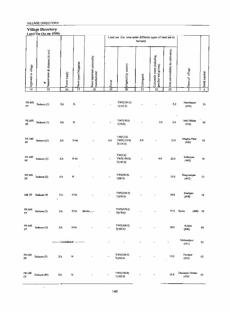
VILLAGE DIRECTORY
Village Directory Land Use (As on 1999)
.s
14 15
:: MR Sad.ur. (I) EA
PRMR Sadaura (1) EA
FP
PRMR Sadaura(l) EA
FP
PRMR Sadaura (2) EA
FP
PRMR Sadaura (2) EA
FP
MRFP Sadaura (4) EA
PRMR Sadaura(S) EA
FP
PRMR Sadaura(S) EA
FP
16 17 18
N
N
NM
NM
N
NM
NM Bricks, -,-
NM
----- Uninhabited ----------
PRMR Sadaura (S)
FP EA N
~ MR Sadaura (40) EA N
Land use (Le. area under different types ofland use in hectare)
19
6.0
20
TWE(105.0) T(I05.0)
TWE(78.0) T(78.0)
TW(12.0) TWE(l!2.0) T(124.0)
TW(5.0) TWE(!80.0) T(185.0)
TWE(SO.O) T(gO.O)
TWE(256.0) T(256.0)
TWE(678.0) T(678.0)
TWE(300.0) T(300.0)
TWE(206.0) T(206.0)
TWE(166.0) T(166.0)
149
21 22 23
9.0
3.0 8.0
6.0 13.0
4.0 20.0
19.0
29.0
77.0
30.0
19.0
29.0
2
Namdarpur (455)
M.liMajra (454)
Maghar Pura (446)
Sultanpur (44S)
Bhagwanpur
(447)
Fatehpur (44S)
Saran (449)
Kulpur (4S0)
Mehmadpur (451)
Faridpur (452)
Dau!atpur Mahan (453)
53
54
55
56
57
58
S9
60
61
62
63
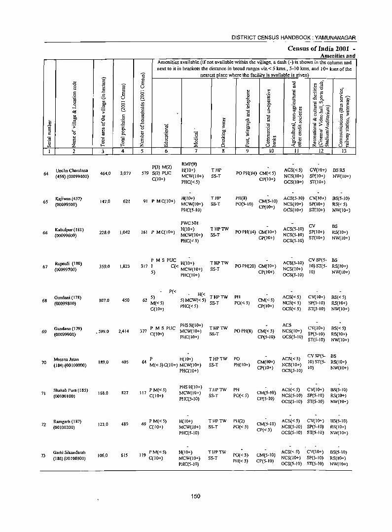
'? " -0 ~ ~ 0 <> " c ..c c 0 g .. .~ u <> " -0 OIl <:>
...:l ,g 0
t:!-~ .;; u " C
~ -= 0 ~ .~ l) .... .0 .;; a :; E '" 0. ::l .... ~ 0 C 0 '" a.
t> 'iii E ~ S ·c '" ~ u
en Z 1 2 3 4
Uncha Chandana 64 464.0 3,077
(456) (00099400)
Kajiwas (457) 147.0 621 65
(00099500)
Kabulpur( 181) 66
(00099600) 22S.0 1,042
Rupauli (1 80) 67
(00099100) 359.0 1,823
Gundani (17&) 68
(00099800) 107.0 450
Gundana (179) 69 , 599.0 2,414
(00099900)
Massn. Jatan 70
(184) (00100000) 189.0 405
Shahab Pum (185) 71
(00100100) 168.0 827
Ramgarh ( 1 87) 72
(00100200) 123.0 480
73 Garhi Sikandarah
106.0 615 (186)(00100300)
DISTRICT CENSUS HANDBOOK: YAMUNANAGAR
Census of India 2001 -Amenities and
Amenities available (if not available within the village, a dash (-) is shown in the column and next to it in brackets the distance in broad ranges viz. < 5 kms., 5-10 kms. and 10+ kms of the
11 nearest place where the facilitv is available is given '" {i -0 ~~ a u
u ., "§
;g 0 8-0 c ,::: t! <:> 0 .a <3 '1:: -:;:: t:!- ..c f! <lS a
a. ... :; 0.
~ ~ '" " <> - en 0.
~=E -0 "2 0 -~.2 -0 6
:l .,
..c ] -3 ~ .2 ~~ II) C) c.o
~ -0 C) a ~
I ..c: a g 'g ~ .g .g c _
i! o c
~ 0; - '" o;:;"g 'C 0 .... ""@ e:ii '" ._
0 .~ 5 "OJ ~ .~ 19 ~ 0 OIl " .a .. c "' .,
.~ OJ c B IU :; t; .~ E § ::l it;' .0 <> :;;; E ., E
E <> :a c _- E..>d .~] e :g ._ §6 ::> <>._ ] ::l -0 " 8 ~ a a z ::a «'0 ~~'" I.I.l J:l., U.o U e 5 6 7 8 9 10 11 12 13
P(3) M(2) RMP(9} H(IO+) THP ACS«5) CV(I{}t) BSRS
579 S(2) PUC PO PH(84) CM« 5) C(JO+)
MCW(IO+) SS-T CP(IO+)
NCS(I{}t) SP(IO+) NW(IO+) PHC« 5) OCS(IO+) ST(IO+)
91 P MC(IO+) H(IO+) THP PH(S)
CM(5-10) ACS(5-JO) CY(JO+) 8S(5-1O)
MCW(IO+) SS-T PO(S-IO) NCS(IO+) SP{IO+} RS«5) PHC(5-10)
Cp(IO+) OCS(IO+) ST(IO+) NW(IO+)
FWCNH CY
H(IO+) THPTW ACS(5-IO) BS
161 P MC(IO+) MCW(IO+) SS-T
PO PH(14) CM(IO+) NCS(5-IO)
SP(IO+) RS(JO+)
PHC«5) CP(IO+)
OCS(5-IO) ST(IO+) NW(IO+)
P M S PUC H(IO+) THPTW ACS(S-IO) CV Spe5- BS
317 I C« MCW(JO+) SS·T PO PH(20) CM(IG+)
NCS(IO+) 10) ST(5- RS(IO+)
5) PHC(ID+)
CP(IO+) OCS(S-IO)
10) NW(IO+)
P« H« 5) THPTW PH ACS«5) CV(IO+) BS« 5)
62 M«5)
5) MCW«5) S3-T PO« S)
CM«S) NCS«5) SP(S-IO) RS(IO+)
C(IO+) PHC« 5) CP(IO+)
OCS«S) ST(5-IO) NW(IO+)
PM S PUC PHS H(IO+)
THPTW ACS
CY(IO+) BS« 5) 377 MCW(IO+) POPH(8) CM«5) NCS(IO+)
C(IO+) PHC(JO+)
SS-T CP(S-IO) OCS(5-10)
SP(5-IO) RS(IO+) ST(5-IO) NW(IO+)
P H(lO+) THPTW PO ACS« 5) CV SP(S- BS
64 M« 5)C(10+) MCW(IO+) SS-T PH(1O+)
CM{IO+) NCS(JO+)
10) 3T(5- RS(IO+)
PHC(IO+) CP(IO+)
OCS(5-10) 10) NW(IO+)
P M«5) PHS H(lO+)
THPTW PH ACS« 5) CV(IO+) BS(5-10) 117 MCW(IO+) CM(5-10)
C(IO+) PHC(5.JO)
SS-T PO« 5) CP(5-JO)
NCS(5-JO) SP(5-IO) RS(JO+) OCS(5-IO) ST(5-10) NW(IO+)
69 P M«5) H(IO+) THPTW PH(2) CM(5-IO)
ACS«S) CV(IO+) BS(5-10) C(IO+) MCW(lO+) SS-T PO«5) NCS(5·1O) SP(5-IO) RS(IO+)
PHC(5-10) CP«S)
OCS(5-10) ST(S-IO) NW(IG+)
119 PM«5) H(IO+) THPTW
PO« 5) CM(S-IO) ACS«5} CV(IO+) BS(5-10)
C(IO+) MCW(IO+) SS-T NCS(IO+) SP(5-10) RS(IO+) PHC(5-10)
PH« 5) CP(S.IO) OCS(5-10) ST(5-10) NW(IO+)
150
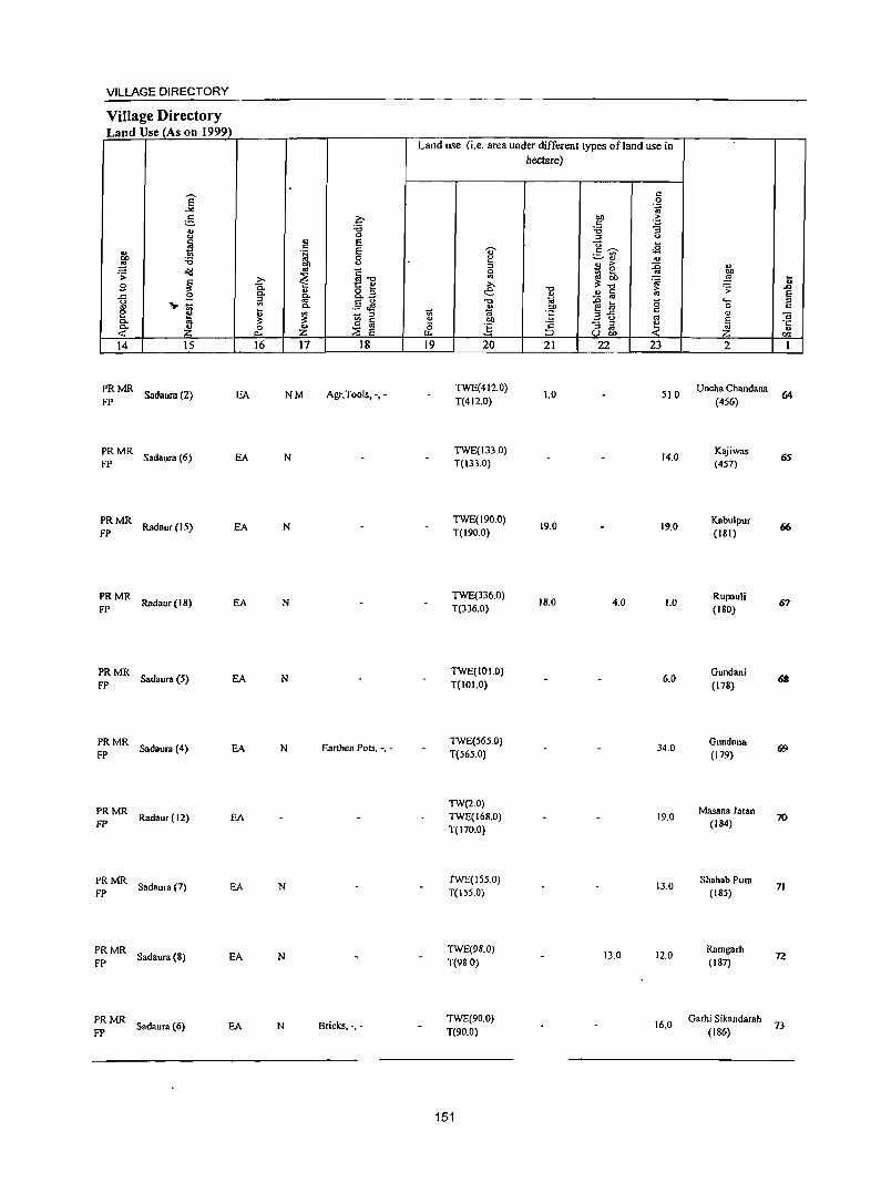
VILLAGE DIRECTORY
Village Directory Land Use (As on 1999)
14 15
~: MR Sadaura (2) EA
:: MR Sadaura (6) EA
:: MR Radaur (15) EA
:: MR Radaur(18) EA
:: MR Sadaura (5)
PRMR Sadaura (4) EA
FP
PRMR FP
Radaur (12) EA
PRMR Sad.ura (7) EA
FP
:: MR Sadaur. (8) EA
PRMR FP Sadaura (6) EA
16 17 18
NM Agr.Tools. -. -
N
N
N
N
N Earthen Pots, -, -
N
N
N Bricks, -,-
Land use (i.e. area under different types of land use in hectare)
19 20
TWE(412.0)
T(4 I 2.0)
TWE(133.0) T(I33.0)
TWE(I90.0) T(190.0)
TWE(336.0) T(336.0)
TWE(IOI.O)
T(lOI.O)
TWE(5650)
T(565.0)
TW(2.0)
TWE(168.0) T(170.0)
TWE(155.0} T(ISS.O)
TWE(9S.0)
T(98 0)
TWE(90.0)
T(90.0)
151
21 22 23
1.0 510
14.0
19.0 19.0
18.0 4.0 1.0
6.0
34.0
19.0
13.0
13.0 12.0
16.0
2
Uncha Chandana
(456)
Kajiwas (457)
Kabulpur (181)
Rupauli (180)
Gundani
(178)
Gundana (179)
Masana Jatan (184)
Shahab Pur. (185)
Ramgarh
(187)
Garhi Sikandarah
(186)
64
65
66
67
69
70
71
n
73
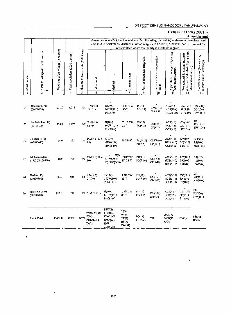
DISTRICT CENSUS HANDBOOK; YAMUNANAGAR
Census of India 2001 -Amenities and
Amenities available (if not available within the village, a dash C-) is shown in the column and next to it in brackets the distance in broad ranges viz. < 5 kms., 5-10 kms. and 10+ kms of the
¥ ~ nearest jJlace where the facility is available is given) '" ~1 '" <= "0 "0 -;;;- " a 0 u
" <U iil - ., <t> -.; '.0 0 .f c:: ..c:: c:: 0 <= >
._ III 0
.9 e ., 0 0 .~ a 'u 5 .~ ~
1;;' u ~ ..r::: <El 0- ., i;';' " ... - 0- ., "3
'" ., - CI) :;: ~ 0 ~ 0 0- <>
~=E .....l 0 "0 1i 0 .~ ~ ;:l .,
~ "0 8 eta ~ '> ..c:: "0 '" ._ -3 ~.2 ., § § .2 '" :;: " ... <= '" -g u 0 .. bJl oS 0 ;:l .. ..c <= g ~ ~ • .@ § cf .... ~ .~ _g B os
" .... ~
0- - ., -.;;;"g 0';: 0 .0 ;;: 0 "3 .... -.; ~ -.;
~=6 " .-s os 0- 0 C .~ 5 ttl ~ .~ ~ g .... ta 0 .. 0 bJl " .:t:: e 0 0- " .~ -.; c 1i " ~ E § ;:l >-.
'" .0 " ;.:;1 E '" ;:l <>
E ~ 0; J ~ E <> :a .~ h ~ .E :g °E ~ ;:l to tf E">< §::: ;:l -0 '" i§ 0 o c ""';:; ~ S:?.C15 CI) I- Z [..Ll ~ 0.. u2 -< 0 u e
1 2 3 4 5 6 7 g 9 10 11 12 13
74 Bhogpur (171)
230.0 1,012 168 P M«5) H(lOT) THPTW PH(4)
CM(5-10) ACS{< 5) CV(IO+) BS(5-1O)
(00100400) C(lO+) MCW(IO+) SS-T PO« 5) CP{< 5)
NCS{IO+) SP(5-10) RS(IO+) PHqIO+) OCS{S-IO) ST(S-IO) NW(IO+)
Bir Balsuha (171) P M«5) H(IO+) THPTW PH(16) ACS« 5) CV(IO+) BS
75 (00100500)
198.0 1,377 207 C(IO+) MCW(IO+) SS-T PO« S)
CM{<5) NCS«5) SP(IO+)
RS(IO+)
PHqIO+) CP« 5) OCS«5) ST(IO+)
NW(IO+)
76 Balsuha (176)
124.0 195 32 P M« 5) C(5- H{lO+)
WSS-W P0(5-10) CM(5-10) ACS«S) CV(IO+) BS« 5)
(00100600) 10) MCW(IO+) PH«S) CP(lO+)
NCS(5-10) SP(S-IO) RS(IO+) PHqS-IO) OCS{S-IO) ST(S-IO) NW{lO+)
Mohammadpur PM{<5)C(5-H(S-
PH(II) ACS(S-to) CV(IO+) BS«5) 77 189.0 770 98 10) MCW(S- T HP TW CM«5) (17S)(OO I 007(0) 10) 1O)PHq5-IO) TKSS-T P0(5-1O)
CP(5-10) NCS{S-IO) SP(IO+) RS(IO+) OCS(S-IO) ST(JO+) NW(IO+)
Hudia(l73) P M« 5) H(IO+) THPTW PH(12) ACS(5-IO) CV(IO+) BS
78 (00100800) 130.0 505 88
C(JO+) MCW(IO+) SS-T PO(5-IO) CM(IO+)
NCS(5-IO) SP(IO+) RS{IO+)
PHqlO+) CP(5-10)
OeS(5-10) ST(IO+) NW(IO+)
Jamalpur (174) H(IO+) THPTW PH(J9) ACS«5) CV(IO+) BS
79 (00100900)
185.0 692 113 P MC(IO+) MCW(IO+) SS-T PO« 5)
CM(JO+) NeS{<5) SP(IO+)
RS(IO+)
PHC(IO+) CP« 5)
OCS«S) ST(IO+) NW(IO+)
PHC(2) T(56)
P(80) M(26) PHS(I6) W(23) ACS(9)
S(I6) FWe NH PO(14) BS(30) Block Total 19601_0 90952 14752 PUC(12) I TK(2) eM NeS(3) eY(3)
RMP(33) UP(73)
PU(903) OCS
RS(2) Tr(2) SMP
TW(51) CHW
152
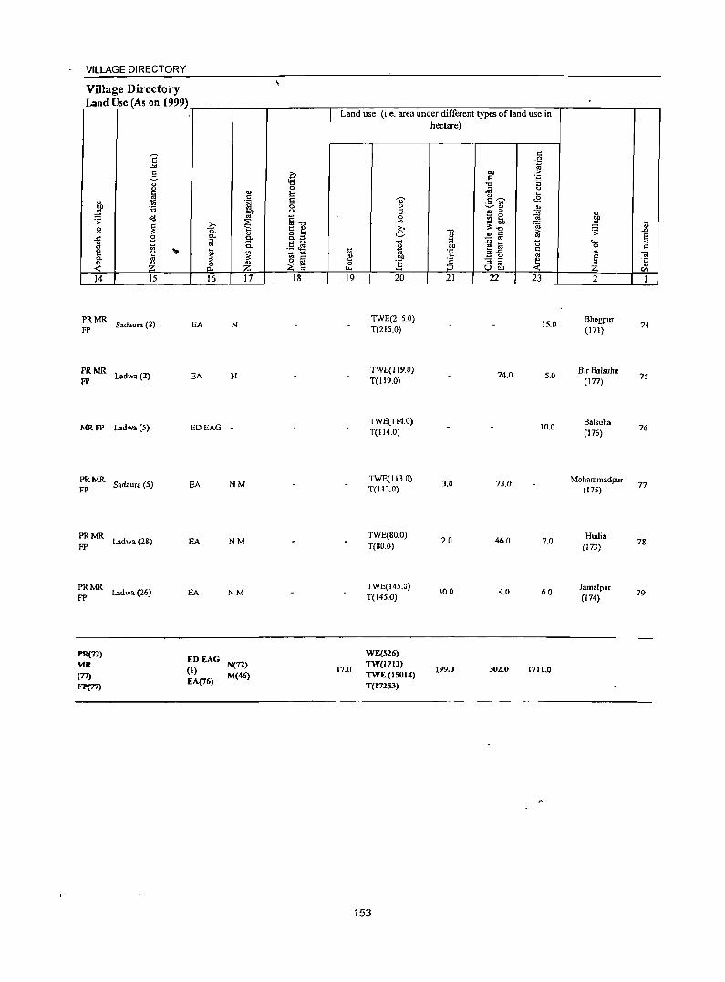
VILLAGE DIRECTORY
Village Directory Land Use (As on 1999)
., ~ .;;: g ..r:: g e a.. Co
-< 14
PRMR FP
PRMR FP
MRFP
PRMR FP
PRMR FP
PRMR FP
PR(71) MR
(77) FJ'(77)
S -" e " " ~
'6 ~
~ g 1;; ., 10 Z 15
Sadaura (8)
Ladwa(2)
Ladwa (5)
Sadaura (5)
Ladwa(28)
Ladwa (26)
Q)
" 'rJ Ill)
'" ~ ;>, Q. a.. " §-~ 0-... ~ ~
Z p..,
16 17
EA N
EA N
EDEAG -
EA NM
EA NM
EA NM
EDEAG (1) N(72)
EA(76) M(46)
.q "0 0 E E 0
" ~"O t:: " 8.3 .9 JS - '" ., " o '" ::E E 18
Land use (i.e. area under different types of land use in
1;; e 0
I-L.
19
17.0
" ~ 0 VI
e "0
* Ill)
E 20
TWE(215.0) T(2IS.0)
TWE(119.0) T(1I9.0}
TWE(114.0) T(114.0)
TWE(113.0) T(I13.0)
TWE(80.0) T(80.0)
TWE(145.0) T(145.0)
WE(S26) lW(171J)
lWE(ISOI4) T(l72SJ)
153
hectare)
"t:l
" t;j Ill) ·s § 21
J.O
2.0
30.0
199.0
" .~ .. ;. .5 'c "0 :5 ;1 u "0 .... c~ <S ._ til
~ Q)
" " ;>- :0 - 0 ~~ '" ~
;. ~1ii '" ~ ~ 0 ",.c " _ "
'" - ::l e :l '" UIlI) -< 22 23
15.0
74.0 5.0
10.0
73.(}
46.0 2.0
4.0 60
302.0 1711.0
" E .... " .;;: ..0
a ""' :l 0 " " ~ ~
Q)
CIl
2 I
Bhogpur 74
(171)
BirBalsuha 75
(177)
Balsuha 76
(176)
Mohammadpur 77
(175)
Hudia 78
(173)
Jamalpur 79
(174)

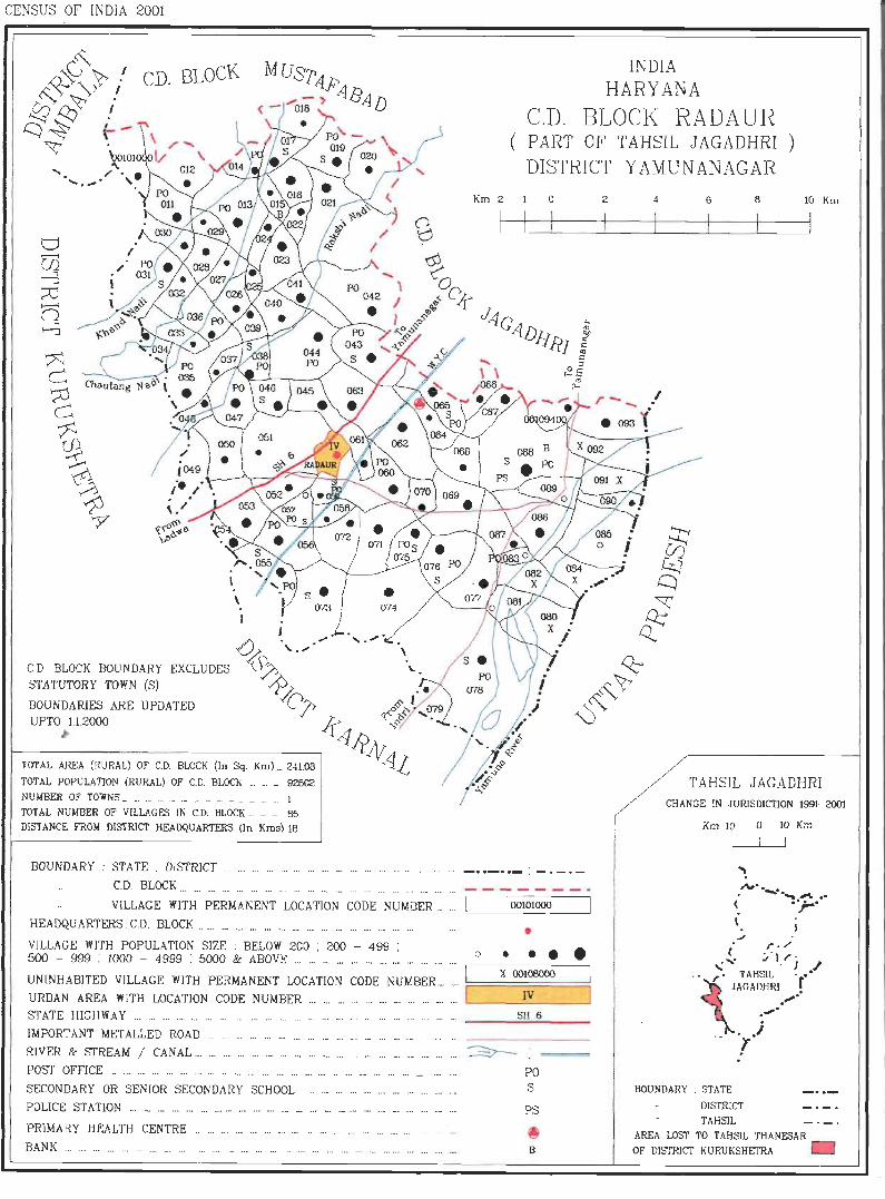
CENSUS OF INOlA 2001
INDIA HARYANA
C.D. BLOCK RADAUR ( PART OF TAHSIL JAGADHRI )
DISTRICT Y AMUNANAGAR
I -0 .'- .......... C.D. BLOCK BOUNDARY EXCLUDES ~ \.. STATUTORY TOWN (S) ~ BOUNDARIES ARE UPDATED L'J> UP," ~U2000 .lr
4l» ; J'< '.
TOTAL AREA (RURAL) or C.D. BLOCK (In Sq. Km)... 241.08 Al TOTAL POPULATION (RURAL) OF CD. BLOCK ... ..... 92602 NUMBER OF TOWNS _ .. _ ._ .. __ .. __ _ _ _ ... 1
TOTAL NUMBER OF VILLAGES IN C.D. BLOCK ..... _ 85
DISTANCE FROM DISTRICT HEADQUARTERS (In KIDs} 18
Km 2 o
BOUNDARY : STATE : DISTRICT ......... ...... .. . -- . _.- .- .-. ... . ... -. --- _.. ... - .. - .. - , -. - . -C.D. BLOCK ... ... ... ... ... ... ... '.' ... ... '" ... ... ... ... ... ... ... ... . .. -- ------VILLAGE WITH PERMANENT LOCATION CODE NUMBER .. ... L-__ OO_lO_lO_OO_---,
HEADQUARTERS C.D. BLOCK ..... ... ............ ... ...... ...... ... ...... ......... .. . • VILLAGE WITH POPULATION SIZE: BELOW 200 : 200 - 499 : 500 - 999 : 1000 - 4999 : 5000 & ABOVE ... ... ... ... ... . .. ...... " . ... ..... . 0 • • • • UNINHABITED VILLAGE WITH PERMANENT LOCATION CODE NUMBER ... " I URBAN AREA WlTH LOCATION CODE NUMBER ... '" ... ...... ... ... n . n. n m I
X 00108000 I IV I
STATE HIGHWAY ...... ....... n ..... . SH 6 n . ...... _ ... ___ ~.;;._ __
IMPORTANT METALLED ROAD ... ... .. .
RIVER & STREAM / CANAL ... ... .' ... ... ... n ... .. . ••• ... • • • ... n . • ..
POST OFFICE n ............... n •• n .. .. ... .. . ...... ... n .......... n • •• . .. ... • . ... .
SECONDARY OR SENIOR SECONDARY SCHOOL
POLICE S1 A TION ... '" ... ... ... . n ••• ••• ... .. . n. ... .. . . _ ... _ ." ... ••• n. ... ... . _ .. .
PRIMARY HEALTH CENTRE BANK m .. .. _ _ _ _ .. _
PO S
PS
~ B
2 4 6 8 10 Km
TAHSIL JAGADHRI CHANGE IN JURISDICTION 1991-2001
KmlO 0 lOKm
I I I
."" ......... __ ~ .. ( .ar -\
( r · / _ . j 't r ' "' . I /
. • ~. TAHSIL 'r" JAGADHRI •
.~ . . -'
.1 !
BOUNDARY ; STATE
OfSTRlCT
TAHSIL
AREA LOST TO TAHSIL THANESAR OF D1STR1cr KU RUKSHETRA 0

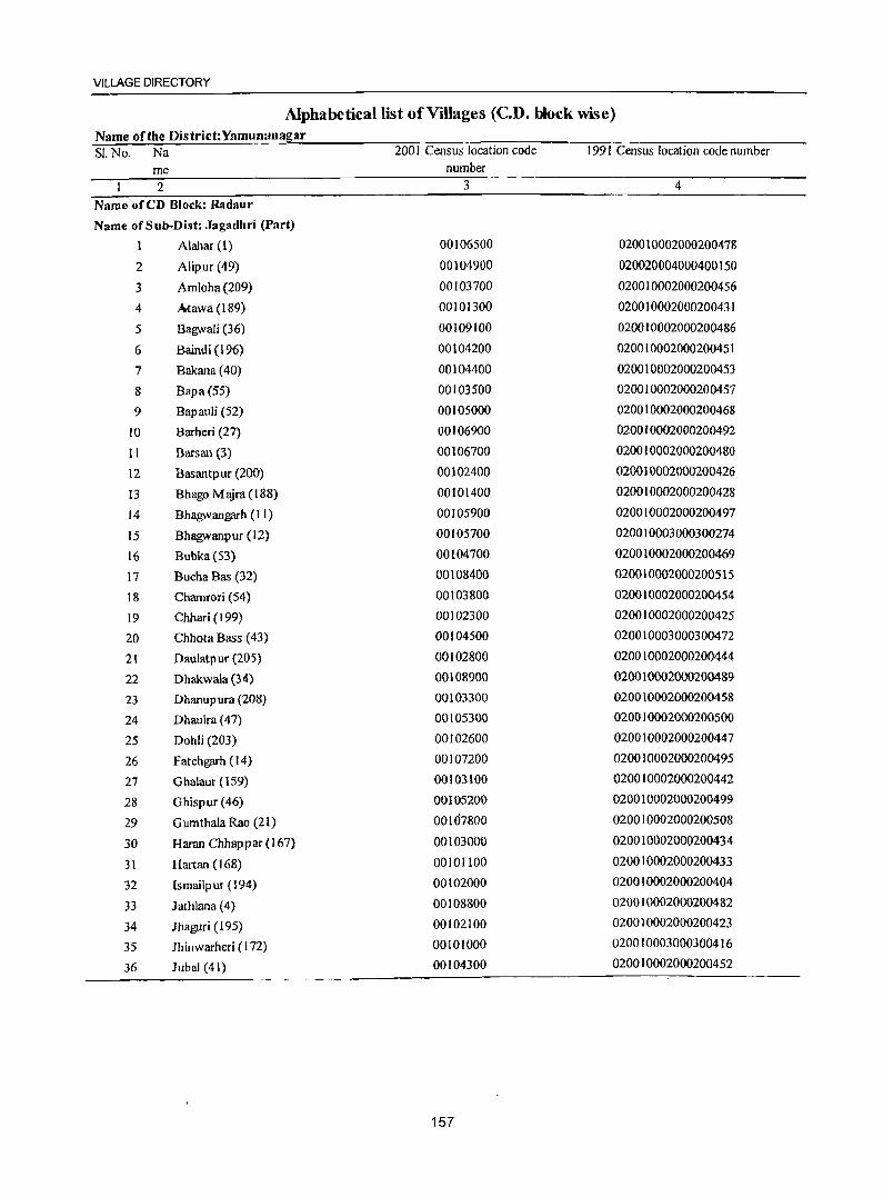
VILLAGE DIRECTORY
Alphabeticailist of Villages (c.n. block wise) Name ofthe District:Yamunanagar SI. No. Na
me 2
Name ofeD Block: Radaur
Name ofSub-Dist: Jagadhri (Part)
1 Alahar(l)
2 Alipur (49)
3 Amloha (209)
4 Mawa (189)
5 Bagwali (36)
6 Baindi (196)
7 Bakana (40)
8 Bapa(S5)
9 Bapauli (52)
10 Barheri (27)
II Barsan (3)
12 Basantpur (200)
13 Bhago M ajra (188)
14 Bhagwan~h (11)
IS Bhagwanpur (I2)
16 Bubka(53)
17 Bucha Bas (32)
18 Chamrori (54)
19 Chhari (1 99)
20 Chhota Bass (43)
21 Daulatpur (205)
22 Dhakwala (34)
23 Dhanup ura (208)
24 Dhaulra (47)
25 Dohli (203)
26 Fateh~h (14)
27 G halaur (159)
28 Ghispur(46)
29 GumthalaRao (21)
30 Haran Chhappar(167)
31 Hartan (168)
32 lsmailp ur (194)
33 Jathlana (4)
34 Jhaguri (195)
35 lhinwarheri (172)
36 Jubal (41)
2001 Census location code number
3
00106500
00104900
00103700
00101300
00109100
00104200
00104400
00103500
00105000
00106900
00106700
00102400
00101400
00105900
00105700
00104700
00108400
00103800
00102300
00104500
00102800
00108900
00103300 00105300
00102600
00107200
00103100
00105200
00107800
00103000
00101100
00102000
00108800
00102100
00101000
00104300
157
1991 Census location code number
4
020010002000200478
020020004000400150
020010002000200456
020010002000200431
020010002000200486
020010002000200451
020010002000200453 020010002000200457
020010002000200468
020010002000200492
020010002000200480
020010002000200426
020010002000200428
020010002000200497
020010003000300274
020010002000200469
020010002000200515
020010002000200454
020010002000200425
020010003000300472
020010002000200444
0200100020002004&9
020010002000200458
020010002000200500
020010002000200447
020010002000200495
020010002000200442
020010002000200499
020010002000200508
020010002000200434
020010002000200433
020010002000200404
020010002000200482
020010002000200423
020010003000300416
020010002000200452
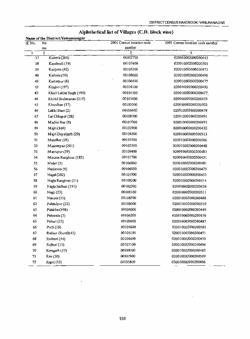
DISTRICT CENSUS HANDBOOK :YAMUNANAGAR
Alphabetical list of Villages (C.D. block wise) Name of the District:Yamunanagar SI.No. Na 2001 Census location code ]99] Census location code number
me number 2 3 4
37 Kalesra(204) 00102700 020010002000200445
38 Kandrauli (19) 00107400 020010002000200505
39 Kanjnon (42) 00106300 020010003000300473
40 Karhera (30) 00108600 020010002000200490
41 Kartarpur (6) 00106400 020010002000200477
42 Khajuri (197) 00104100 020010002000200450
43 Kheri Lakha Singh (190) 00101500 020010002000200427,
44 Khirki Brahmanan (210) 00103400 020010002000200459
45 Khurdban (17) 00105500 020010002000200502
46 Lakhi Bans (2) 00106600 020010003000300479
47 La] Chhapar (28) 00108700 020010002000200491
48 Madho Bas (8) 00107000 020010002000200493
49 Majri (169) 00102900 020010002000200432
50 M:yri Dayal~h (29) 00108300 020010003000300513
51 M andhar (26) 00107500 0200]0002000200506
52 Mansurpur (201) 00102500 020010002000200448
53 Marrupur (39) 00109400 020010002000200483
54 MasanaRanghran (183) 00101700 020010002000200421
55 Mohri (5) 00106800 020010002000200481
56 Nachraon (9) 00106000 020010002000200475
57 Nagai (202) 00103900 020010002000200455
58 Nagla Ranghran (31) 00108200 020010002000200514
59 Nagla Sadhan (191) 00102200 020010002000200424
60 NagJi (23) 00108100 020010002000200511
61 Nakum(33) 00108500 020010002000200488
62 Pahladpur (22) 00108000 020010002000200510
63 Palakha (198) 00104000 020010002000200449
64 Palewala (7) 00106200 020010002000200476
65 Pobari (35) 00109000 020010003000300487
66 Potli (16) 00105600 020010002000200503
67 Radaur (Rural)( 45) 00105100 020010003000300471
68 Radauri (44) 00104600 020010002000200470
69 Rajheri (15) 00107100 020010002000200494
70 Rarngarh (37) 00109200 020010002000200485
71 Rao (20) 00107900 020010002000200509
72 Rapri (13) 00105800 020010002000200496
158
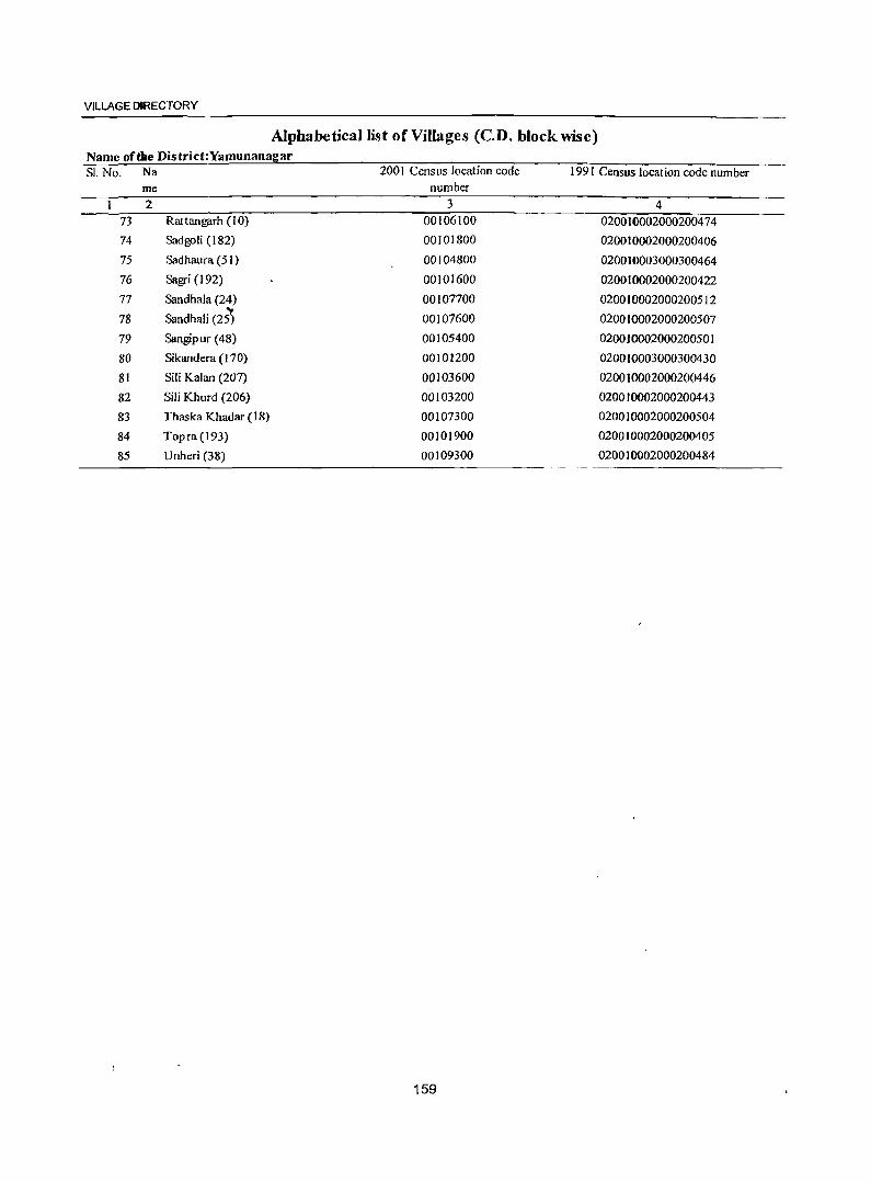
VILLAGE DIRECTORY
Alphabetical list of Villages (Cn. block wise) Name of die District:Yamunanagar SI. No. Na 2001 Census location code 1991 Census location code number
me number 2 3 4
73 Rattangarh (10) 00106100 020010002000200474
74 Sadgoli (182) 00101800 020010002000200406
75 Sadhaura (51) 00104800 020010003000300464
76 Sagri (192) 00101600 020010002000200422
77 Sandhala (24) 00107700 020010002000200512
78 Sandhali (25) 00107600 020010002000200507
79 Sangipur (48) 00105400 020010002000200501
80 Sikandera (170) 00101200 020010003000300430
81 Sili Kalan (207) 00103600 020010002000200446
82 Sili Khurd (206) 00103200 020010002000200443
83 Thaska Khadar (18) 00107300 020010002000200504
84 Topra(J93) 00101900 020010002000200405
85 Unheri (38) 00109300 020010002000200484
159
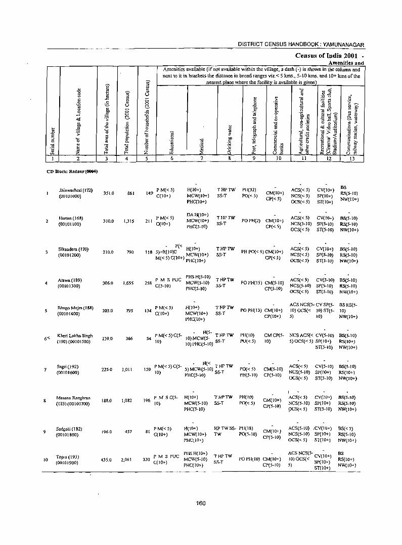
DISTRICT CENSUS HANDBOOK: YAMUNANAGAR
Census of India 2001 -Amenities and
Amenities available (if not available within the village, a dash (-) is shown in the column and
next to it in brackets the distance in broad ranges viz. < 5 kms., 5-10 kms. and 10+ kIlls of the
'" nearest place where the facility is available is I!:iven
"" ::>
" 19 ;g -0 ",.0 "CI -;;;- <I) c
0 0 (J ., .. :;J 0 1l :;J :.g '0 ~.
E - " " e " 0 c .?: '0 ~ 0
0 ,§_ " 0 0 ';;l .a 'E ~ .~ u ~ .<: ~ 8..
j 0.
t '3 .. G' g ;:; '" " 0 (ilCll :;: ~
,...l 0 -0 'B 'lib '" 9=e '0 ;;l OJ d<j ~ ~ -0 '? .~ CCI ~ ..c: '3 l! .2 ';;'~ '" lij
~ ~ " '" 'g c " o 0 ~ 0 ::> ~
o ._
a(J~~ § cf ~ 'g 0 ~
..c: '" " g '- .c 0. _- '" '':: 0
.0 .;; 0 '3 .... (il ~ ~ 'iii e .-;: g>..;: 11 .;; § .. g- o c .~ ::s"O 'c t! .... " to 0 .. " .::: e .9.., § " 0 lU 0. .~ 'iii .S 'B " ';;l E " >.
'" ..Q 0 E '" " 0 e ~ OJ E '3 7i E :.a ~ ti" E"'" .~ ] ~.5 ~ ·c ::s
~ ~ ~ :;J -0 .. 8 8] §:: .. Z ::;;: 0 ~o ~(J~ en UJ to.. ~'" u f'!
I 2 3 4 5 6 7 S 9 10 II 12 \3
CD Block: Radaur (0004)
lhinwarheri (172) P M« S) H(IO+) THPTW Pl-I(32) ACS«S) CV(IO+) BS
(00101000) 351.0 861 149
C(IO+) MCW(IO+) SS-T PO« 5) CM(IO+)
NCS«5) SP(IO+) RS(S-IO)
PHC(lO+) CP« 5)
OCS«5) ST(IO+) NW(lO+)
Hartan (168) P M«S) DAl-I(IO+)
THPTW ACS«5) CV(lO+) BS(5-10) 2 310.0 1,31S 211 MCW(IO+) POPH(2) CM(IO+)
(00101100) C(IO+) PHC(5-JO)
S5-T CP« 5)
NCS(S-IO) SP(S-IO) RS(S-IO) OCS«5) ST(S-IO) NW(IO+)
3 Sikandera (170)
210.0 790 118 P« H(IO+) THPTW
Pl-I PO{< 5) CM(IO+) ACS«S) CV(IO+) BS(S-IO)
(00101200) 5)+R[10]C MCW(lO+) SS-T NCS«5) SP(S-IO) RS(5-10) M« S) C(IO+) PHC(IO+) CP«5)
OCS«S) ST(5-JO) NW(IO+)
Atawa(189) PM S PUC PHS 1-1(5-10)
THPTW ACS«5) CV(5-10} BS(5-10) 4 306.0 1.6S5 2S8 MCW(S-IO) PO PH(15) CM(S-IO)
(00101300) C(5-1O) PHC(5-10)
SS-T CP(S-IO)
NCS(S-IO) SpeS-to) RS(5-1O) OCS«5) ST(5-10) NW(JO+)
Shago Majra (188) PM«5) H(1O+) THPTW ACS NCS(5- CV SP(S- BSRS(5-
S (00101400)
203.0 79S 134 C(lO+) MCW(IO+) SS-T
PO PH(I3) CM(IO+) 10) OCS« 10) ST(5- 10)
PHC(IO+) CP(IO+) 5) 10) NW(JO+)
Kheri Lakha Singh P M« 5) C(5-H(S-
PH(IO) CMCP(S- NCS ACS« CV(S-IO) BS(5-1O) 6"- 139.0 366 S4 10) MCWeS- T HP TW
(190) (00101500) 10) 10) PHC(S-IO) SS-T PO« 5) 10) 5) OCS« 5) SP(IO+) RS(IO+) ST(5-10) NW(IO+)
Sagr; (192) - H« ACS«5) CV(5-10)
7 2250 1,011 IS9 PM«5)C(S- 5) MCW(S-IO) THPTW PO«S) CM(5-10) BS(5-10)
(00101600) 10) PHC(5-1O) SS-T PH(5-JO) CP(5-JO) NCS(S-JO) SP(IO+) RS(IO+) OCS«S) ST(S-IO) NW(IO+)
I
& Masan. Ranghran
18&.0 1,082 196 PM S C(S- H(lO+) THPTW PHeW)
CM(IO+) ACS« 5) CV(lO+) BS{5-1O)
(183) (00 I 0 1700) 10) MCW(S-IO) SS-T PO« 5) CP(5-10)
NCS(S-IO) SP(lO+) RS(S-IO) PHC(5-1O) 9CS«S) ST(S-IO) NW(IO+)
9 Sadgoli (182)
196.0 457 81 P M«5) H(IO+) HP TW SS- PH(I&)
CM(IO+) ACS(S-IO) ,CV(IO+) BS« 5)
(00101800) C(lO+) MCW(IO+) TW PO(5-10) CP(5-10)
NCS(5-10) SP(IO+) RS(S-IO) PHC(IO+) OCS« 5) ST(IO+) NW(IO+)
PMSPUC PHSH(IO+)
THPTW ACS NCS(S- - as
10 Topra (193)
43S.0 2,061 330 MCW(S-IO) PO PH(IO) CM(IO+) 10) OCS« CV(IO+) RS(IO+) (00101900) C(IO+) SS-T 5) SP(IO+) PHC(IO+) CP(S-IO)
ST(IO+) NW(lO+)
160
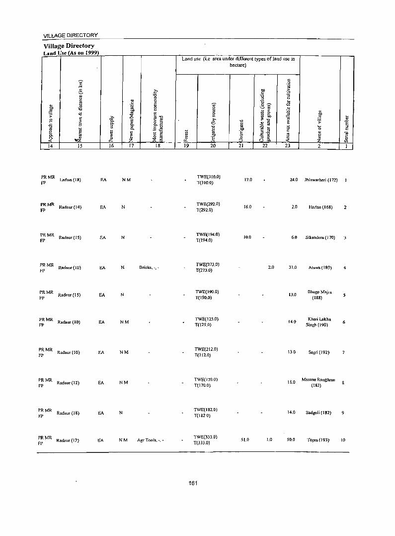
VILLAGE DIRECTORY
Village Directory Land Use (As on 1999)
14 15
PRMR Ladwa (18) EA
fP
PRMR Radaur(l4) EA
FP
PRMR Radaur(15) EA
FP
PRMR Radaur(IO) EA FP
PRMR Radaur (15) EA
FP
PRMR Radaur (10) EA FP
PRMR Radaur (10) EA
FP
PRMR Radaur (12) EA
FP
PRMR Radaur(18) EA
FP
PRMR Radaur (12) EA
FP
16 17 18
NM
N
N
N Bricks, -,-
N
NM
NM
NM
N
NM Agr Tools, -, -
Land use (i.e area under different types ofland use in hectare)
19 20 21 22 23
TWE(31O.0) 17.0 24.0
T(31O.0)
TWE(292.0) 16.0 2.0
T(292.0)
TWE(194.0) 10.0 6.0
T{194.0)
TWE(273.0) 2.0 31.0
T{273.0)
TWE(19O.0) 13.0
T(I90.0)
TWE(12S.0) 14.0
TeI25.0)
TWE(212.0) 130
T(212.0)
TWE(170.0) 18.0
T(170.0)
TWE(182.0) 14.0
T(182.0)
TWE(333.0) 51.0 1.0 50.0
T(333.0)
161
2
lhinwarheri (172)
Hartan (168) 2
Sikandera (170) 3
Atawa(189) 4
Bha&o Majr. (188)
5
Kheri Lakha Singh (190)
6
Sagri (192) 7
Masan. Ranghran (IS3)
8
Sadgoli (182) 9
Toprs (193) 10
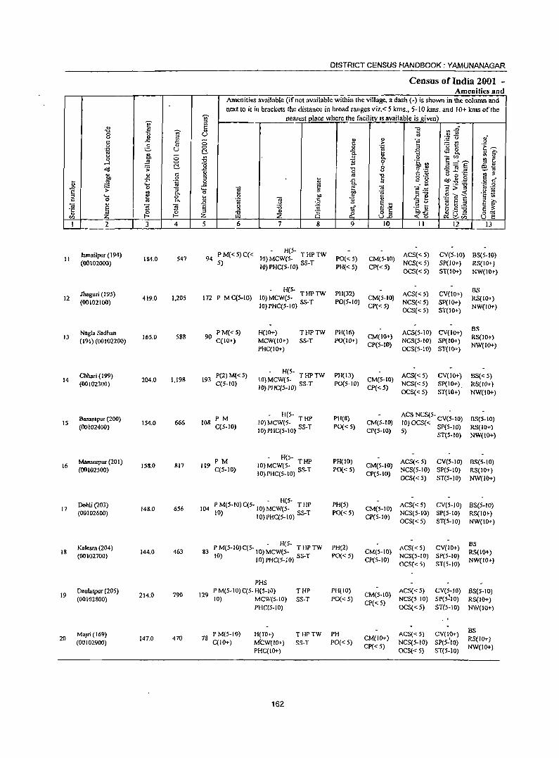
DISTRICT CENSUS HANDBOOK: YAMUNANAGAR
Census of India 2001 -Amenities and
Amenities available (ifnot available within the village, a dash (-) is shown in the column and next to it in brackets the distance in broad ranges viz.< 5 kms., 5-10 kms. and 10+ kms of the
~
nearest place where the facility IS available is ,given} .,
I :>
'" E .", ~.g '0 -;;;- ., Q
0 U '" <.> ... ~ It> " ;g~ '8-e: .r: e: (; c > ~ 0 :.§, It> 0 0 .~ 'u 1: 'E ~ .~ u C!- .c t.S 8. " ~ " Q.
" :; u (; "' " - til ;;: ~ .3 E .", ]
Q. " ~ :~r~ 0 -0
0 .~ II :> " C!- o 0:1 ~ .:d .;;; 13 '" " ~ :~ -;:~ c :l.s:; ._ ... " c '" ., -0 " 0 ...
~ .;; 0 g 1il .s:: iii c g ~.~~ § d l> .... .~ .r: ~
Q. _- '" ',p 0 .D .;; 0 :; .... «i ~ «i e:g «i>= '" ._ § «S [l. 0 c 0g g'iu~ 'a ~ ..... !a 0 l> .g ]
bll .. £ ~ c 0 0. Q ] '.g E § :r ;>, <U .D ~ :.;;< E '" :r <.>
E ~ ~ § !i! g S " :a c ..r S-"< .~ t ~.S ~ ::l :s It> '" 8] §::: '"
0 ~ Z -0 ~ 8 0 ~~ ~ ~rn en Z I-< ~ 0.. U e
I 2 3 4 5 6 7 8 9 10 II 12 13
Ismailpur (194) PM«5)C« - H(5-
ACS«S) CV(S-IO) B3(5-10) II 184.0 547 94 10) MCW(5- THPTW PO«S) CM(S-IO)
(00102000) 5) 10) PHC(5-IO) 3S-T PH« 5) CP«5) NCS«5) SP(1O+) RS(IQ+) OCS« 5) 5T(10+) NW(IO+)
lbaguri (195) - H(5-
PH(32) ACS« 5) CV(IO+) BS
12 419.0 1,205 172 P M C(5-IO) JO)MCW(5- THPTW CM(5-JO) RS(IO+) (00102100) 10) PHC(5-IO) SS-T PO(5-IO)
CP«5) NC5«5) SP(IO+)
NW(IO+) OCS«5) ST(IO+)
Nagla Sadhan 90 PM«5) H(10+) THPTW PH(16) ACS(5-10) CV(IO+) BS
13 16S.0 S88 CM(JO+) RS(IO+) (19J) (OOJ02200) C(JO+) MCW{IO+) SS-T PO(I 0+)
CP(S-IO) NCS(S-IO) SP(IO+}
NW(IO+) PHC(IO+) OCS(5-10) ST(JO+)
Dlhari (J 99) P(2) M« 5) H(5-
PH(l3) ACS« 5) CV{JO+) BS«5) 14 204.0 1.198 193 10) MCW(5- THPTW CM(5-IO)
(O(102300) C(5-IO} 10) PHC(5-10) SS-T PO(5-IO) CP«S)
NCS«S) SP(IO+) , RS(IO+) OCS«5) ST(IO+) NW(1O+)
Basantpu( (200) PM - H(5-
PH(S) AC5 NCS(5- CV(;-lO) BS(5-IO) 15
(00102400) 154.0 666 108
C(5-1O) 10) MCW(5- T HP
PO« 5) CM(S-IO) JO) OCS« SP(5-1O)
IO)PHC(5-IO) SS-T CP(5-10) RS{lO+) 5) 5T(5-10) NW(IO+)
MaJlSurpU( (201) PM - H(5-
PH(IO) ACS« S) CV(5-10) 8S(5-1O) 16 158.0 817 119 (0) MCW(S- THP CM(S-IO)
(00102S00) C(S-IO) 10) PHC(5-10) SS-T PO« 5) CP(S-IO)
NCS(5-IO) SP(5-IO) RS(IO+) OCS« 5) ST(5-1O) NW(IO+)
Dohli (203) - H(5-
PH(S) ACS«5) eV(S-IO) BS(S-IO) 17 148.0 656 J04 P M(5-1O) C(5- J 0) MCW(S- T HP CM(5-10)
(00102600) JO) IO)PHC(5-IO) SS-T PO« 5) CP(S-to)
NCS(5-10) SP(S-IO) RS(IO+) OCS«5) ST(S-IO) NW(IO+)
Kalesra (204) . H(5-
PH(2) ACS«5) CV(IO+) BS
18 144.0 463 83 P M(5-IO) C(S- 10) MCW(5- T HP TW CM(5-10} RS(IO+) (00102700) 10) 10) PHC(S-JO) SS-T PO«5) NCS(S-IO) SP(S-IO)
CP(5-10) OCS« 5) ST(S-IO)
NW(IO+)
PHS
19 Daulalpur (20S)
214.0 790 J29 P M(5-10)C(S. H(5-IO) THP PH(IO)
CM(5-IO) ACS« 5) CV(S-IO) 8S(5-10)
(00102800) (0) MCW(5-1O) SS-T PO« 5) CP«S)
NCS(5-1O) SP(5~1O) RS(IO+) PHC(S-lO) OCS« 5) 5T(5-10) NW(IO+)
MaJri(169) P M(5-10) H(lO+) THPTW PH ACS« S) CV(IO+) BS 20
(00102900) 147.0 470 78
C(JO+) M'CW(IO+) SS-T PO«S) CM(JO+)
NCS(S-IO) SP(5-'IO) RS(IO+)
PHC(JO+) CP«S)
OCS«5) ST(5-10) NW(lO+)
162
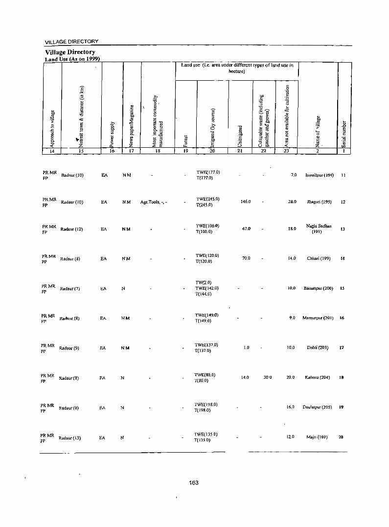
VILLAGE DIRECTORY
Village Directory Land Use (As on 1999)
14 15
:: MR Rndnur (10)
PR MR Radaur (10) FP
PRMR Radnur(12) FP
PRMR. FP Radaur (8)
PRMR FP Radaur (7)
PRMR FP Radaur (&)
PR MR Radaur (9) FP
PRMR Radaur(8)
FP
PRMR Radaur(8) FP
EA
EA
EA
EA
EA
EA
EA
EA
PRMR Radaur(13) EA
FP
16 17 18
NM
NM Agr.Tools. -.-
NM
NM
N
NM
NM
N
N
N
Land use (i.e. area under different types of land use in hectare)
19 20
TWE(I77.0) T(rn.O)
TWE(245.0) T(245.0)
1WE(lOo.o) T(lDD.O)
TWE(12o.D) T(120.0)
TW(2.0) TWE(142.0) T(144.0)
TWE(149.0) T(149.0)
TWE(137.0) T(137.0)
TWE(80.0) T(SO.O)
TWE(198.0) T(19S.0)
TWE(135 0) T(13S.0)
163
21 22
146.0
47.0
70.0
1.0
14.0 300
23
7.0
28.0
18.0
14.0
2
Ismailpur (194) 11
Jhaguri (195)
Nagla Sadhan (191)
Chhari (199)
12
13
f4
10.0 Basantpur (200) 15
9.0 Mansurpur(201) 16
10.0 Dohl; (203) 17
20.0 Kalesr. (204) 18
16.0 Daulatpur (205) 19
12.0 Majri (169) 20
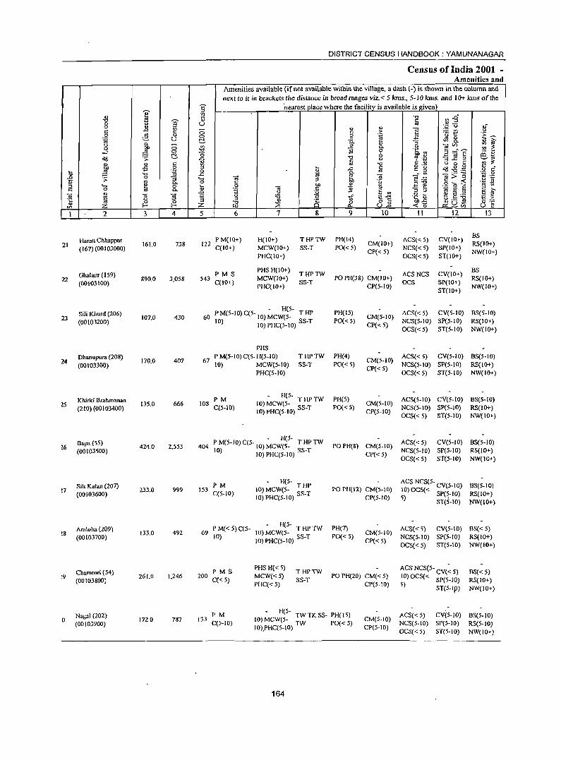
DISTRICT CENSUS HANDBOOK: YAMUNANAGAR
Census of India 2001 -Amenities and
Amenities available (if not available within the village, a dash (-) is shown in the column and next to it in brackets the distance in broad ranges viz.< 5 kms., 5-10 kms. and 10+ kms of the
I '§" nearest place where the facilitv is available is !liven
~ ~ -g ~ 2" ~ ... 0
~ U oJ .f (.) 4)
" " e 'p to)
c:: ..c: a c:: ,.. 'Et u 0 g <I.) 0 0 'g " 'E ~ 'g u t!- .c: -'3 ~ &.
<1 ir " .... ~
(.) a '" OiVl :: ~ 0 00 0- (.)
....:J ~ 0 "tl "8 0 ~~ .~ B :~~f E ~~ t!- (5 6
.:c! .;;: ..c: "CI g Iii 0 § .~ "3~=
'" is: '" ., c:: "CI (.) 0 ~
00 -5 0 ::l ~ .c: Iii c .. ~ ~ ..g . .@ § c .... ~ .~ 0 .. ..... ..c ., g. "<U
._ "0 .;:: 0 .D .;;: 0 "3 '- "<U is: e·~ "<U>::l '" ._ E: '" c.. 0 c:: ~ 'g ,,-0 c:: ...: .!o! E " '- 1;} 0 l"> 0 "<U
bQ " .=: ~ .~ ~ ~ '" ~ c:: 0 c.. '.g c:: B ::l ,.,
'" ..0 0 :.;;; E '" " (.) E ~ ro
~ ]. "]. E g :a c:: tf E"'" .~~ ~.S ~ ·c ::l " 8 o c:: §::: .. ~ ~ z ti3 ~
0 u2 ...:i5 ~uQj u e Vl "-I 2 3 4 5 6 7 8 9 10 11 12 13
Hamn Chhappar P M(IO+) H(IO+) THPTW PH(14) ACS« 5) CV(IO+) BS
21 (167) (00103000)
161.0 738 122 C(JO+) MCW(IO+) SS-T PO« 5)
CM(IO+) NCS« 5) SP(IO+)
RS(IO+)
PHC(IO+) CP« 5)
OCS«5) ST(lO+) NW(10+)
Ghalaur (159) PMS PHS H(lO+)
THPTW ACSNCS CV(IO+) BS
22 (00103100) 89(}.0 3,058 543
C(JO+) MCW(IO+)
SS-T PO PH(38) CM(IO+)
OCS SP(JO+) RS(IO+)
PHC(IO+) CP(5-10) ST{lO+)
NW(IO+)
Sili Khurd (206) - H(5-
PH(15) ACS«5) eV(5-10) BS(5-IO) 23 107.0 430 60 P M(5-10) C(5- 10) MCW(5- T HP CM(5-1O)
(00103200) 10) 10) PHC(5-10) SS-T PO«5) CP« 5)
NCS(5-1O) SP(5-10) RS(IO+) OCS«5) ST(5-1O) NW(IO+)
PHS
Dhanupura (208) 170.0 407 67
PM(5-to) C(5-H(5-1O) THPTW PH(4) CM(5-10)
ACS« 5) CV(5-10) BS(5-10) 24
(00103300) 10) MCW(5-IO) SS-T PO«5) NCS(5-10) SP(5-IO) RS(IO+) PHC(5-1O)
CP« 5) OCS« 5) ST(5-10) NW(IO+)
Khirki Brahm.nan PM H(5-
PH(5) ACS(5-1O) CV(5-to) BS(5-10) 135.0 666 to8 10) MCW(S- T HP TW Z5 (210)(00 I 03400) C(5-10) to) PHC(S-IO) SS-T PO« 5)
CM(5-lD) NCS(5-H» SP(5-IO) RS(lO+)
CP(S-IO) OCS«5) ST(5-tO) NW(IO+)
B.pa (~5) - H(5-
ACS« 5) CV(S-IO) ~6 424.0 2,553 404 P M(5-10) C(5- to) MCW(S- T HP TW PO PH(8) CM(5-lD)
BS(5-10)
(00103500) 10) 10) PHC(5-10) SS-T CP«5) NCS(5-IO) SP(5-to) RS(lo+) OCS«5) ST(5-10) NW(IO+)
Sill Kalan (207) PM - H(5- ACS NCS(5- CV~-IO) BS(5-10)
17 233.0 999 153 10) MCW(5- T HP POPH(12) CM(5-10) 10)OCS« SpeS-to) (00103600) C(5-10) 10) PHC(5-10) SS-T CP(5-10} RS(IO+)
5) STc5-IO) NW(IO+)
Amloha (209) P M« 5)C(5-- H(5-
PH(7} ACS« 5) CV(5-H) BS« 5) !8 133.0 492 69 10) MCW(5- T HP TW CM(5-10)
(00103700) 10) 10) PHC(5-1 0) SS-T PO«5} CP« 5)
NCS(5-1O) SP(5-lD) RS(ID+)
OCS« 5) ST(5-10) NW(JO+)
Chamrori (54) PM S PHS H« 5)
THPTW ACS NCS(5- CV(~ 5) BS« 5) ~9 261.0 1,246 200 MCW«5) PO PH(20) CM« 5) 10) OCS« SP(5-lD) (00103800) C«5) SS-T RS(IO+)
PHC« 5) CP(5-10) 5) ST(5-IP) NW(IO+)
NagaI (202l 133 PM 10)~Cw~t TWTKSS- PH(15) ACS« 5) CV(5-1O) 8S(5-1O)
0 172 0 787 CM(5-to) (00103900) C(5-1O) 10»)'HC(5-10) TW PO« 5) CP(5-10)
NCS(S-IO) SP(5-10) RS(5-10) OCS«5) ST(5-1D) NW(IO+)
164
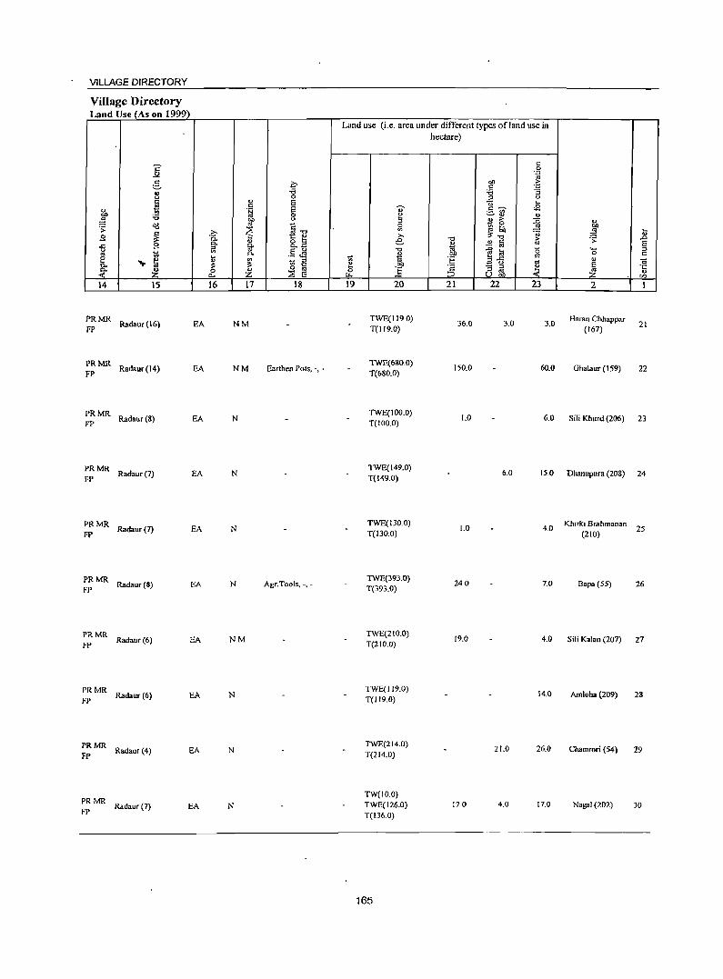
VILLAGE DIRECTORY
Village Directory Land Use (As on 1999)
Land use (i.e. area under different types ofland use in hectare)
E c 0 _,. -~
g c 00 .~ ., -i5 ~ :;
" 0 ::> " ~ " S V .... c ~ .§ S "
,,~ <2 .- '" :0 0 ~
~ <U " ;J ~ " " ;> ::0 " ';:' <l(!
~ §-o iil ~! '" E J!- =a .... B ~ 1:: e >. " 0.
" e -0 ~ ~ .0 0. o ::I M £ fa E -" 9 ::I g- o.. ~
""' " '" S " '" ~ :a 0 ::I
'" g ~ 0. .- ~ tJ 00 c 0 c e ... en
18 E 1;; :§ Z73 .. " 01
0.. ~ ~ ~ 00 E 0. ~ Z "' ] c ;;; ~ e ·c
<>: 0 :;E E :::J U ..: ~ " a.. t>- oo IZl
14 15 16 17 18 19 20 21 n 23 2 1
PRMR Radaur(16) EA NM
TWE(119.0) 36.0 3.0 3.0
Haran Chhappar FP T(1l9.0) (167)
21
PRMR Radaur(14) EA NM Earthen Pots, -, -
TWE(680.0) 150.0 60.0 Ghalaur (159)
FP T(680.0) 22
PRMR Radaur(S) EA N
TWE(100.0) 1.0 6.0 sa; Khurd (206)
FP T(IOO.O) 23
PRMR Radaur(7) EA N
TWE(149.0) 6.0 15.0 Dhanupura (208)
FP T(l49.0) 24
PRMR Radaur(7) EA N
TWE(130.0) 1.0 4.0
Khirki Brahman.n
FP T(130.0) (210) 25
PRMR Radaur(S) EA N Agr. Tools, -. -
TWE(393.0) 240 7.0 Bapa (55) 26
FP T(393.0)
PRMR ROOaur(6) EA NM
TWE(21O.0) 19.0 4.0 Sili Kalan (207)
FP T(21O.0) 27
PRMR Radaur(6) EA N
TWE(119.0) 14.0 Amloha (209) 28
FP T(119.0)
PRMR Radaur (4) EA N
TWE(214.0) 21.0 26.0 Chamrori (54) 29
FP T(214.0)
PRMR TW(IO.O)
Radaur (7) EA N TWE(126.0) 170 4.0 17.0 NagaI (202) 30 FP T(136.0)
165
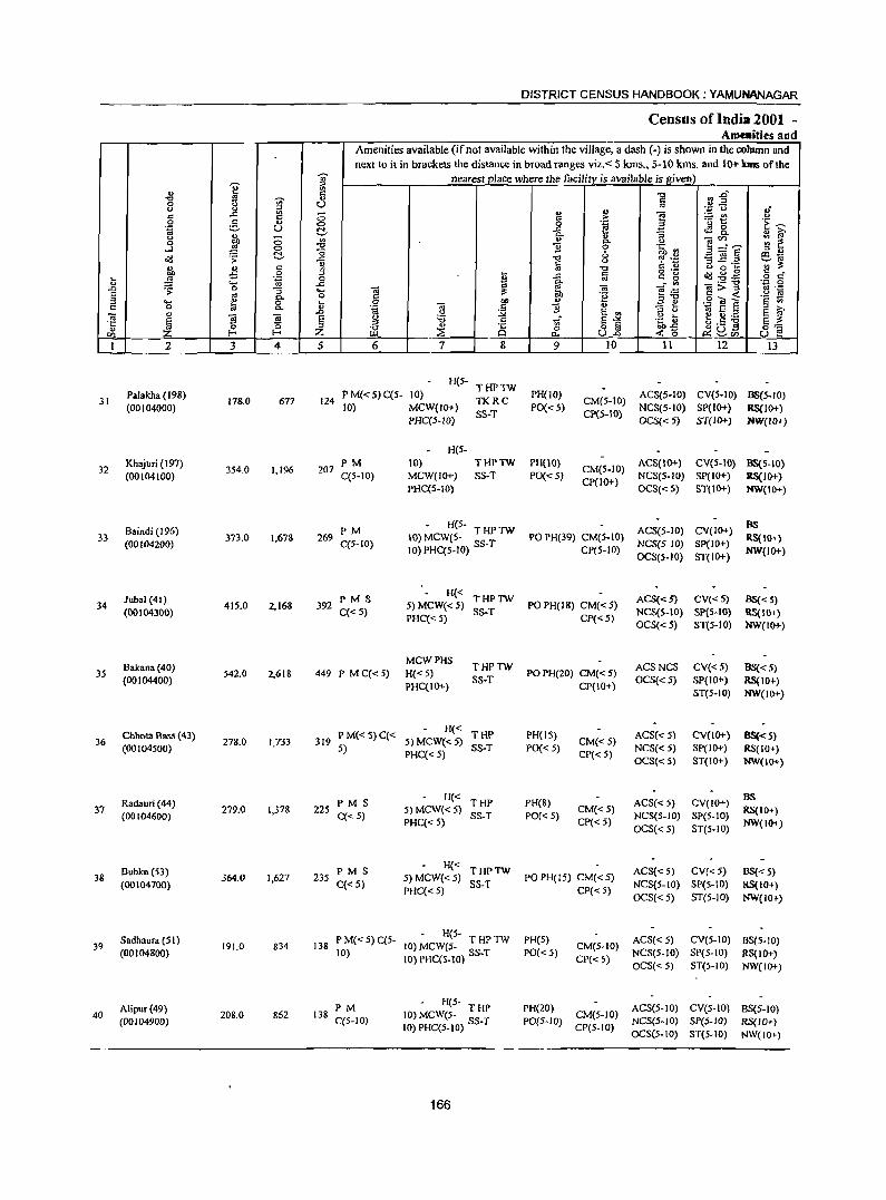
e " "" ~ ., 0
'" " ::> c ..c '" c 0 :.§, u .~ U <> ., ;:; 0 ~ ...l '" OIl .;;: ~
i\l, '" c ~ 0 ... ~ .~
" .... .0 ~ 0 :; S gJ "" " '- 0 :. c 0 "'" ~ '" ~ ~ ~ <Il E-
I 2 3 4
31 Palakha (198)
178.0 677 (00104000)
32 Khajuri (197)
3S4.0 (00104100)
1,196
Baindi (196) 33 373.0 1,67&
(00104200)
lubal (41) 34 415.0 2,168
(001043()0)
Bakana (40) 3S 542.0 2,61&
(00104400)
Chhota Bass (43) 36 278.0 1,733
(00104500)
Radauri (44) 37
(00104600) 279.0 1,378
Bubka(S3) 38 364.0 1,627
(00104700)
Sadhaura (51) 39 191.0 834
(00104800)
Alipur(49) 40 208.0 862
(00104900)
-;;;-::> l!l .,
U ;:; '" d. '" ::g
_g " !(j
_g .... 0
u .0
§ Z 5
124
207
269
392
DISTRICT CENSUS HANDBOOK: YAMUNANAGAR
Census of India 2001 -Ame.ities and
Amenities available (if not available within the village, a dash (-) is shown in the column and next to it in brackets the distance in broad ranges viz. < 5 Ions., 5-10 kms. and 1 ()+ laDs ofthe
nearest place where the facility is available is given)
i ~ :2" ''::; CJ ,,"
" " ] ~t! '" t > .~ 'E ~
:; tS 8. " ii;> '" _ <Il
;;: ~ "" '" ~="s 11 0 ·c ::> U
"" 0 ~.rJ ~ ~.a ~ ~
1ii '" § ·N ";;;'!:!: '0 '" 0 .. tl ..c c ~ .g.g c c"
'" c 0 0 1ii ~ _" '" -a>'g '.0 0
.1 !:!: -a e~ .~ .~ ofl '2 c <
1 .£ E e .9..., E r: .. -a '" ::> 'a B
E '" ::> '" ~ E ::s E ii;> .~ '" ... t.5 ~ g '0 1if S-'< .~~ S !:!: ;Z ~ 8 rf o §
~~ii5 0:0=
U.o <'0 u e 6 7 8 9 10 11 12 13
H(5-THPTW
P M«.5) C(5- 10) TKRC
PH(10) CM(.5-IO)
ACS{5-1O) CV(S-IO) 88(5-10) 10) MCW(IO+)
SS-T PO« 5)
CP(5-10) NCS(5-10) SP(IO+) RS(IO+)
PHC(5-1O) OCS«5) ST(IO+) NW(IO+)
H(5-
PM 10} THPTW PH(lO) CM(S-IO)
ACS(IO+) CV(5-IO) 88(5-10) C(5-IO) MCW(IO+) SS-T PO« S) NCS(5-1O) SP(lO+) RS(IO+)
PHC(S-lO) CP(IO+)
OCS«5) ST(IO+) NW(\O+)
PM H(S-
ACS(5-10) CV(lO+) as
IO} MCW(S- T HP TW PO PH(39) CM(S-IO) RS{IO+) C(5-10) 10) PHC(S-IO) SS-T CP(5-10)
NCS(5-1O) Sp(IO+) NW(IO+)
OCS(5-10) ST(IO+)
PMS H« THPlW ACS«5) CV«5) BS«5)
5}MCW«5) PO PH(18) CM« 5) q< 5) PHC« 5)
SS-T CP« 5)
NCS(5-10) SpeS-to) RS{IO+} OCS«5) ST(S-10) NW(IO+)
MCWPHS THPTW ACSNCS CV«5) 88«5)
449 P M C«5) H«5) PO PH(ZO) CM« 5) SS-T OCS« 5) SP(IO+) RS{IO+)
PHC(IO+) CP(IO+) ST(S-IO) NW(IO+)
PM{<S)C« H« THP PH(15) ACS«S) CV(IO+) BS«5)
319 5jMCW«5) CM«5) 5)
PHC«S) SS-T PO« 5)
CP«S) NCS« 5) SP(IO+) RS(IO+) OCS«5) ST(10+) NW(\O+)
PMS H«
THP PH(S) ACS« 5) CV(IO+) BS
225 C« S) 5) MCW« 5)
SS-T PO« 5) CM« 5)
NCS(S-IO) SP{S-10) RS{10+)
PHq< 5) CP« 5) OCS« 5) ST(5-10)
NW(IO+)
PMS H« THPlW ACS«5) CV«5) BS« 5) 235 5) MCW«5) PO PH(IS) CM« 5)
C«5) PHC« 5)
SS-T CP« 5)
NCS(5-LO) SP(S-IO) RS(10+) OCS« S) ST(S-IO) NW{IO+)
P M« 5) C(S-- H(S-
PH(S) ACS«S) CV(S-IO) BS{5-1O) 138 (0) MCW(5- T HP TW CM(5-1O)
10) 10) PHC(5-10) SS-T PO«5) CP«5)
NCS(S-IO) SP(S-to) RS(IO+) OCS« 5) ST(5-10) NW(IO+)
PM - H(5-
PH(20) ACS(S-IO) CV(S-to) BS(5-1O) 138 10) MCW(5- T HP CM(5-10)
C(S-lO) 10) PHC(S-IO) SS-T PO(S-IO) CP(5-1O)
NCS(5-10) SP(5-1O) RS{IO+) OCS(5-10) ST(5-1O) NW{IO+)
166
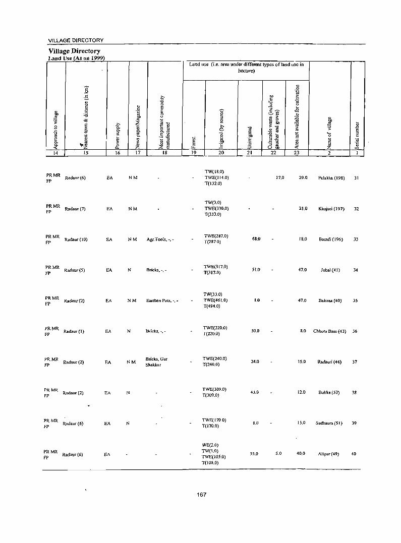
VILLAGE DIRECTORY
Village Directory Land Use (As on 1999)
E _".
g i=' ., -a " 0
" ~ t: E u 'fij E 01) :a 0
~ 01) " ~ '" ~-g . ;; ~ ~
>. B 0.
" o ... ..c B a. Co CoB g ~ '" .S ~ ~ Co e e ~ ~ :::J Co .. '" '" o '" Co
"'~ 0 ~ « "" ~ E 14 15 16 17 18
PRMR Radaur(6)
FP EA NM
PRMR FP
Radaur(7) EA NM
PRMR Radaur (10) EA NM Agr.Tools, -,-
fP
PRMR Radaur(5)
FP N Bricks, -,-
PRMR fP
Radaur(2) EA NM Eanhen PolS, -, -
PRMR Radaur (I) EA N Bricks, -,-
FP
PRMR Radaur (2) EA NM
Bricks, Gur FP Shakkar
:: MR Radaur (2) EA N
PRMR Radaur (6) EA N
FP
PRMR Radaur(6) EA
FP
Land use (i.e. area under different types of land use in
11 0 ~
19
a:;-e :::J g
€ ",
" l;j
:§ 20
TW(IS.O) TWE(114.0) T(I32.0)
TW(3.0) TWE(330.0) T(333.0)
TWE(287.0) T(287.0)
TWE(317.0) T(317.0)
TW(33.0) TWE(46 1.0) T(494.0)
TWE(220.0) T(220.0)
TWE(240.0) T(240.0)
TWE(J09.0) T(309.0)
TWE(170.0) T{170.0)
WE(2.0) TW(1.0) TWE(IOS.0) T(108.0)
167
hectare)
t:: .8 ~
OJ) '5 t: ;g :;
" U ... .S 'Ui' <E ~'" '" " > ::0 ~ 0 l3 ... '" ~~ :;;
"0 1:; " ..!! a 1ii
~~ <> "" 'E '" B " '" .;: - :::J e :::J oJ ;:l Ubi) « 21 22 23
17.0 29.0
21.0
68.0 18.0
51.0 47.0
1.0 47.0
50.0 8.0
24.0 15.0
43.0 12.0
8.0 13.0
55.0 5.0 40.0
" bI) .. ~ " ~ .0 E .... :::J
0 c
" <a E 'S ~ rn 2 I
Pa!akha (198) 31
Khajuri (197) 32
Bamdi (196) 33
Jubal (41) 34
Bakana (40) 35
Chhota Bass (43) 36
Radauri (44) 37
Bubka (53) 38
Sadhaura (5 I ) 39
Alipur(49) 40
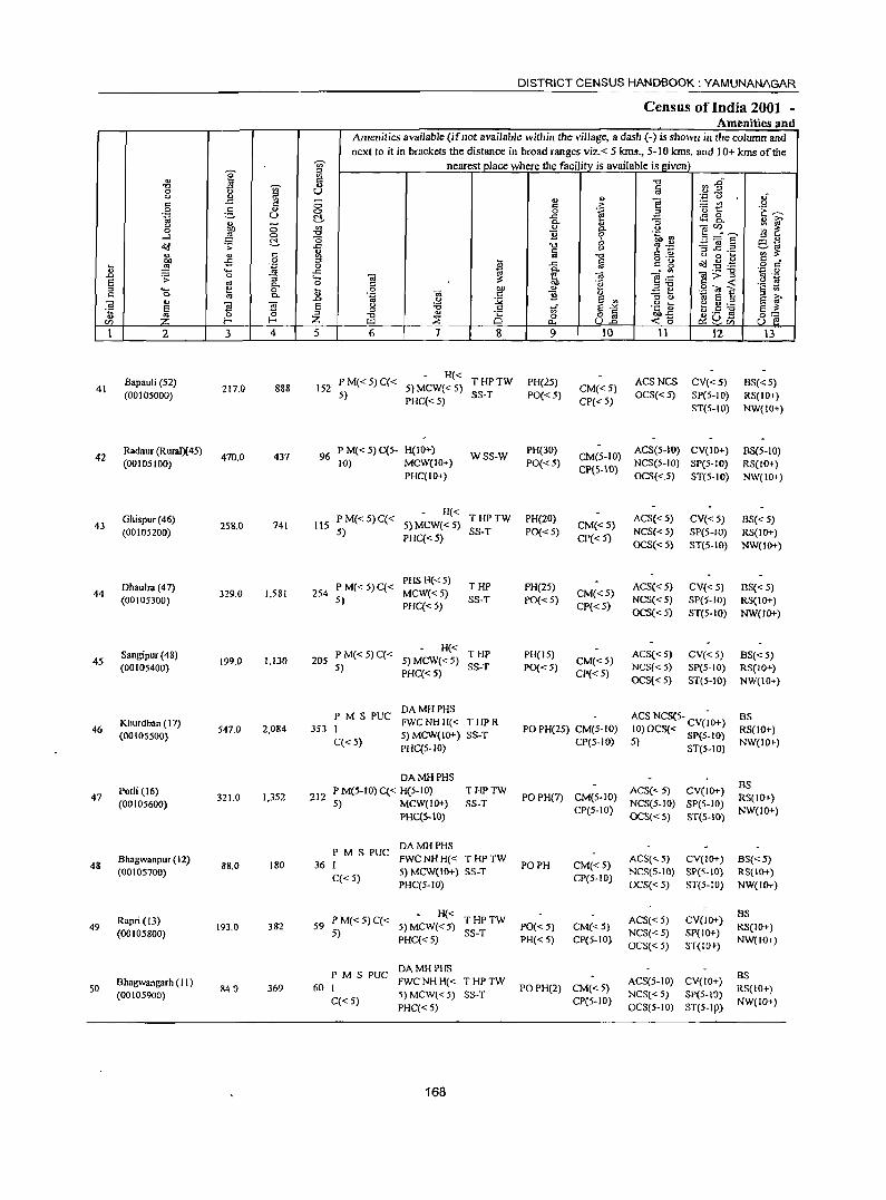
DISTRICT CENSUS HANDBOOK: YAMUNANAGAR
Census of India 2001 -Amenities and
Amenities available (if not available within the village, a dash (-) is shown in the column and
next to it in brackets the distance in broad ranges viz. < 5 kms., 5-10 kms. and J 0+ kms of the -;;;- nearest place where the facility is available is given
I :;:J
... 8 ] ~~ -0 ~ 0 .; " Q)
" '';:: 0
'" ..<:: ~ ;:; ., e - '" u 0 5
., '" .~ '0 t:: '1:~ 0 0 ~ .a .~ u ~ ..<:: 4S 8-... 0- 0 Q) G'
" ;:; {J " " " <U'" ;;; ~ 0 ~ f ._J <=> -0 '2 .~ rn 3=f'E ::l " &(J .;; t:!- ..<:: -0 ~ .~ 3 ~.= ~~
'" " c ~ § 1
c C) " 0 ,_ ~~ ~ -5 0
* ..<:: g '8 ~ .g.g .g §~ ~ 'g 0 .... ..c 0- <3 ....:'" <3;>-g ..0 .;; 0 0 .... <U E ~ .~
'" ._ ~ <.) ~
E '" 0- 0 C OIl 'g ",-0 §'<i!~ '§ fj '" .... i!! 0 ~ 0 -a ~ " -3t c <> '" 0- .~ B .~ E § ] '"
.D <> :.::;; E '" .~.M E G'
~ 21 ~ s u :a '" 1i E-'" ~ _s ~ s ~ '" 0 '" -0 ... ·c 8~ 0:= f- Z ;Z Cl
0 <'0 ~u~ u f! '" U.l J:l. ~'" 1 2 3 4 5 6 7 8 9 10 II 12 13
Bapauli (52) PM«5)C« H«
THPTW PH(25) ACSNCS CV«5) BS« 5) 41 217.0 888 152 5) MCW« 5) CM«5)
(00IOS000) S) PHq<5)
SS-T PO«S) CP« 5)
OCS«S) SP(S-IO) RS(IO+) ST(5-IO) NW(IO+)
42 Radaur (RuralX 45)
470.0 437 96 P M« 5) C(5- H(IO+)
WSS-W PH(30)
CM(5-10) ACS{5-10) CV{IO+) BS{5-10)
(00 \OS I 00) 10) MCW(JO+) PO«S) CP(S-\\l)
NCS(S-IO) SP(S-IO} RS(IO+) PHqIO+) OCS«5) ST(5-10) NW(IO+}
Ghispur (46) PM«5)C« H« THPTW PH(20) ACS« 5) CV« 5) BS« 5)
43 258.0 741 115 5) MCW«5) CM«S) (00IOS200) S)
PHq< 5) SS-T PO«5)
CP« 5) NCS«5) SP(S-IO) RS(IO+) OCS«5} ST(5-IO) NW(JO+)
Dhaulra (47) PM«5)C« PHSH«5)
THP PH(25) ACS« 5) CV«5} BS«5} 44 329.0 1,581 254 MCW«5) CM«5}
(00105300) 5) PHq<5)
SS-T PO{< 5) CP«5)
NCS« 5) SP(5-1O) RS(JO+) OCS«5) ST(5-1O) NW(JO+)
Sangipur (48) P M« 5) C« H« THP PH(15) ACS« 5) CV« 5) BS« 5)
45 199.0 1,130 205 5) MCW«5) CM«5) (00105400) S)
PHq< 5) SS-T PO« 5)
CP« 5} NCS« 5) SP(S-IO) RS(IO+) OCS«5) ST(5-10) NW(IO+)
PM S PUC DAMHPHS ACSNCS(5- - BS
46 Khurdban (17)
547.0 2,084 353 I FWCNH H« T HP R
PO PH(25) CM(5-10) 10)OCS« CV(JO+) RS(IO+) (00 I OS5OO}
C«5) 5) MCW(IO+) SS-T
CP(5-10) 5) Spe5-JO) NW(IO+) PHC(5-1O) ST(5-10)
DA MH PHS BS
Potli (16) P M(S-IO) C« R(5-IO) THPTW ACS« 5) CV(IO+) 47
(00105600) 321.0 1,352 212
5) MCW(IO+) SS-T POPH(7) CM(5-IO)
NCS(5-1O) SP(5-10) RS(10+)
PHC(S-IO) CP(5-1O)
OCS«5) ST(5-10) NW(IO+)
PM S PUC DAMHPHS
48 Bhagwanpur(12)
88.0 180 36 I FWC NH H« T HP TW
PO PH CM« 5) ACS«S) CV(IO+) BS« 5)
(00105700) C«5)
5) MCW(IO+) SS-T CP(5-10)
NCS(5-IO) SP(S-IO) RS(JO+) PHC(5-10) OCS«5) ST(5-10) NW(IO+}
Rap'; (13) PM«5)C« H« THPTW ACS«5) CV(IO+)
BS 49
(00105800) 193.0 382 59
5) 5) MCW«5)
SS-T PO« 5) CM«5)
NCS« 5) SP(IO+) RS(IO+)
PHC« 5) PH« 5) CP(5-10) OCS« 5) ST(IOt)
NW(IO+)
PM S PUC DAMHPHS
BS SO
Bhagwangarh (II) 840 369 60 I
FWCNHH« THPTW POPH(2) CM«5}
ACS(5-1O) CV(IO+) RS(IO+)
(00105900) 5) MCW{< 5) SS-T NCS« 5) SP(5-IO) C«5)
PHC«5) CPC5-10)
OCS(S-IO) ST(5-IP> NW(IO+)
168
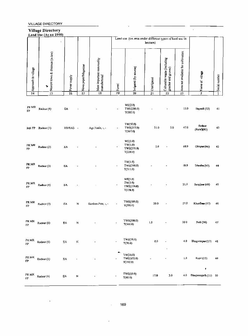
VILLAGE DIRECTORY
Village Directory Land Use (As on 1999)
14 15
PRMR FP Radaur (4)
16
EA
MR FP Radaur (\) EDEAG -
PRMR FP Radaur (2) EA
~: MR Radaur (3) EA
~:MR Radaur(4) EA
~: MR Radaur (7) EA N
::: MR Radaur (6) EA N
PRMR Radaur (5)
FP EA N
PRMR Radaur(3) EA
FP
PRMR Radaur (4)
FP EA N
17 18
Agr.Tools, -, -
Earthen Pots, -, -
Land use (i.e. area under different types ofland usc in hectare)
19 20
WE(2.0) TWE(200.0) T(202.0)
TW(SO.O) TW6(3\7.0) T(367.0)
WE(2.0) TW(I.O) TWE(235.0) T(238.0)
TW(I.O) TWE(31O.0) T(311.0)
WE(LO) TW(3.0) TWE(I74.0) T(178.0)
TWE(SOO.O) T(500.0)
TWE(300.0) T(300.0)
TWE(76.0) T(76.0)
TW(20.0) TWE(I72.0) T(1920)
TWE(60.0) T(60.0)
169
21 22 23
15.0
51.0 S.O 47.0
2.0 18.0
18.0
21.0
20.0 27.0
1.0 200
8.0 4.0
1.0
17.0 3.0 4.0
2
Bapau!i (52)
Radaur (RuraIX45)
Ghispur(46)
Dhauba(47)
S.ngipur (48)
41
42
43
44
45
Khurdban (17) 46
Potli (16) 47
Bhagwanpur (12) 48
Rapri (13) 49
Bhagwangarh (II) 50
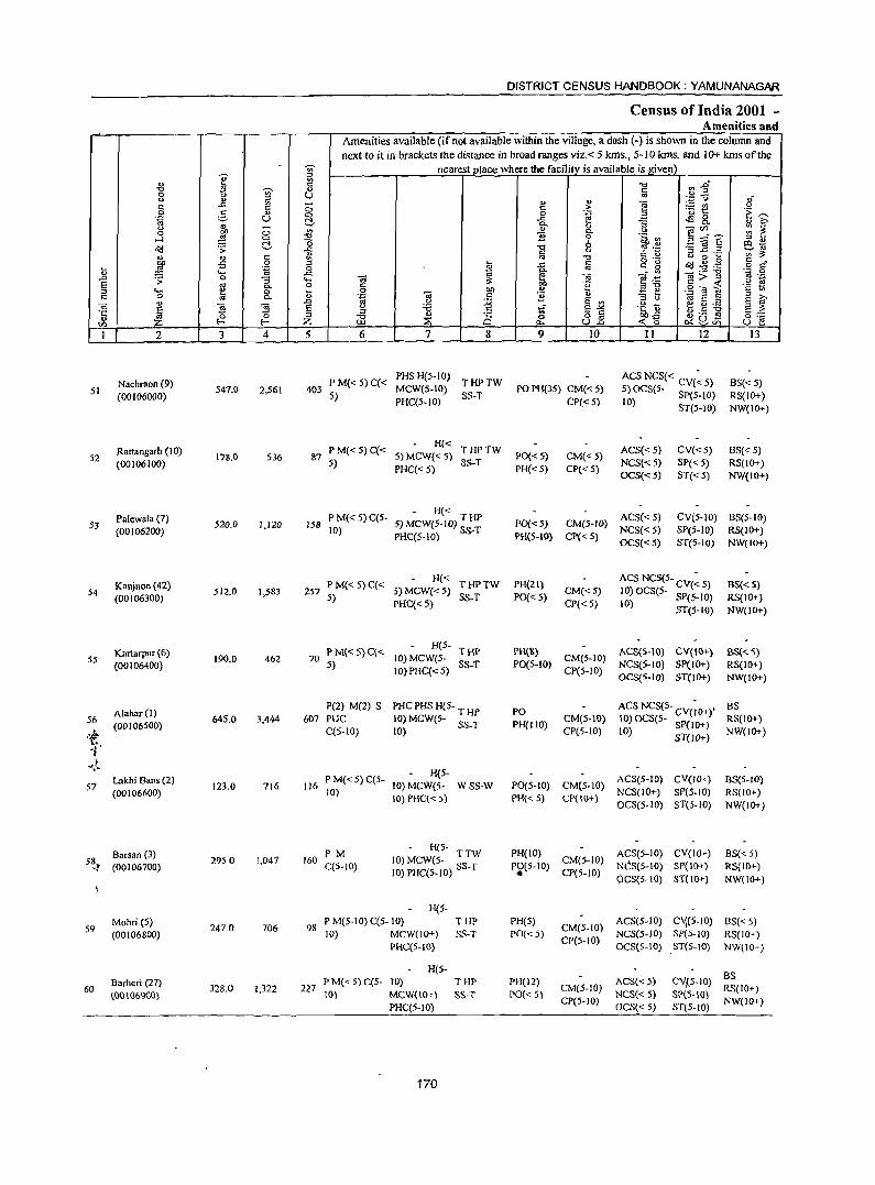
DISTRICT CENSUS HANDBOOK: YAMUNANAGAR
Census of India 2001 -Amenities and
Amenities available (if not available within the village, a dash (-) is shown in the column and
next to it in brackets the distance in broad ranges viz.< 5 kIDs., 5-10 kIDs. and 10+ kIDs of the
., ~ nearest place where the facilitv is available is given)
'" en ..g'" .., ] " "'" "" ~ e Ia 8 ~ .~ e3 oJ
c: 19 <5 ... " e :::t! u c: >
0 g G) 0 0 .'" E .M8. .~ ~ .~ U ~
.c E! gJ, - 0..
" :; ~ f 0 0 "' ~ 0. .~ C<iCll
....l ~ 0 "" 0 tib~ S::fE' "0 " G)
o'd .;; ~ .c: "0 6 ~ 'C -3 ~.2 e~ " fii <> "' ~ :t .. c: '" "" '" G) '-' 0 ~ o ._
c • -s 0 " ~ 1 '" c: g o'd~~ ~ .~ a '" .g § G) .... ..c: i·;; .0 .;; 0 ~
-.; C<i>", '" ._ '3 .... .~ N E '" "'- 0 .~ ::s'O ·3 'a ~ '" .... ~ 0 ~ 0 00
., .:: ~ " "' c a "'-
., 'g C<i c ]i '" E ~ ... .0 '-' ~ E '" ::s u ~ E .:!
" § a " E '-' 'B Ii s"'" .i: Q> S ;:. .;:: -0 '" ::1
" 8 8 ~ ~-g ~ tJ S G) ~ "'" 0 0:;:: til Z e-- Z ~ ~ <>- c:>:.._.,'" () e I 2 3 4 5 6 7 8 9 10 II 12 13
Nachraon (9) PM«5)C« PHS H(5-IO)
THPTW ACSNCS« CV(~5) BS«5) 51
(00106000) 541.0 2,561 403
5) MCW(S-IO)
S5-T PO PII(3S) CM( < 5) 5) OCS(S- SP(5-IO) RS(IO+)
PHC(5.IO) CP« 5) 10) ST(5-IO) NW(IO+)
Rattangarh (IO) P M«5) C« H«
THPTW ACS« 5) CV«5) BS« 5} 52 178.0 536 87 5) MCW«5) PO{< 5) CM«5)
(00106100) 5) PHC« 5)
SS-T PH« 5) Cr« 5}
NCS«5) SI'« 5) RS(IO+) OCS«S} ST« 5) NW(IO+)
Palewala (7) - H«
ACS«5) CVe5-JO) BS(S-IO) 53 520.0 1,120 158 P M« 5) C(5- 5) MCW(5-1O) T HP PO{<5) CM(5·10)
(00106200) 10) PHC(S.IO) SS-T PH(S-IO} CP«5) NCS«5) SP(5·1O) RS(IO+) OCS«5) ST(5-IO) NW(lO+)
Kanjnon (42) PM«S)C« H«
THPTW PH(21) ACS NCS(5. CV(~ 5) BS«S) 54
(00106300) 512.0 1,583 257
5) 5) MCW«5)
SS-T PO« 5) CM«5} 10) OCS(5- SP(5.10) RS(IO+)
PHC«S) CP« 5) 10) ST(S.IO) NW(IO+)
Kartarpur (6) PM«5)C« H(5.
THP PH(&) ACS(S-\O) CV(\O+) BS« S) 55 190.0 462 70 10) MCW(5· CM(5-1O)
(00106400) 5) 10) PHC{< S)
SS-T P0(5-10) CP(S-IO)
NCS(5-lO) 5P(IO+) RS(IO+) OCS(S-IO} 5T(10+) NW(IO+)
Alahar(l) P(2) M(2) S PHC PHS H(S. T HI' PO ACS NCS(S- CV(~O+)' BS
56 (00106500)
645.0 3,444 607 PUC 10)MCW(5- SS-T PH(IIO) CM(S·IO) 10) OCS(5· 5P(10+) RS(IO+}
.~ C(5.IO) 10) CP(5·IO) 10) ST(lO+} NW(IO+)
~r ~!~
H(S·
57 Lakhi Bans (2)
123.0 716 116 P M« 5) C(5-
10) MCW(S- WSS·W PO(S·IO) CM(S-IO) ACS(S-IO) CV(lO+) 8S(5-IO)
(00106600) 10) 10) PHC«5) PHI< 5} CP(IO+}
NCS(IO+) SP(5-10) RS(IO+) OCS(5·10) ST(5.10) NW(IO+)
Barsan (3) PM • H(5·
PH(IO) ACS(S-IO) CV(IO+) BS«5) 2950 1,047 160 10) MeW(5. -: TW CM(5.10) 5~1 (00106700) C(5-1O) 10) PHe(S.IO) S5·T P~(5-IO)
CP(5·10) NCS(5-IO) SP(IO+) RS(IO+) 9CS(5-1O) ST(lO+} NW(IO+}
H(5-
59 Mohri (5)
247.0 706 98 P M(S·lO) C(5. 10) THP PH(S)
CM(5.10) ACS(5-10) q(5.10) BS«5)
(00106800) IO} MCW(IO+) S5-T PO« 5) CP(S·!O)
NCS(5·JO) SP(5.1O) RS(IO+) PHC(5-IO) OCS(S·IO} ST(5·10) NW(IO~)
H(S· BS
60 8arheri (27)
328.0 1,322 227 PM«5)C(5· to) THP PH(J2)
CM(5-IO) ACS« 5) CV{5.10)
RS(IO+} (OGlO6900) 10) MCW(IO*) SS-T PO«5) NeS« 5) SP(5·\0)
PHC(5·10) CP(5·1O)
DCS« S) ST(5·1O) NW(IO+)
170
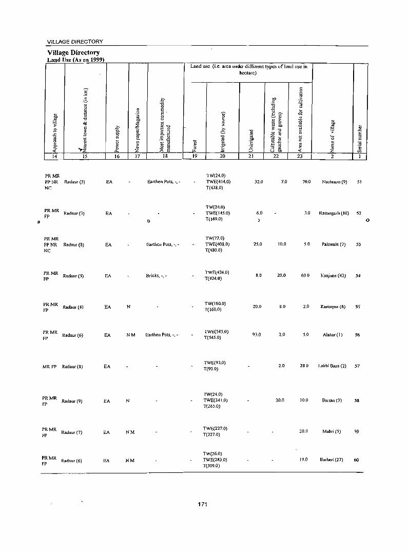
VILLAGE DIRECTORY
Village Directory Land Use (As on 1999)
14 15
PRMR FP NR Radaur (5) NC
:: MR Radaur (3)
PRMR FP NR Radaur (8) NC
:: MR Radaur (S)
:: MR Radaur (8)
:: MR Radaur (6)
MR FP Radaur (8)
PRMR Radaur (9)
FP
PRMR Radaur(7)
FP
PRMR Radaur (6)
FP
EA
EA
EA
EA
EA
EA
EA
EA
EA
EA
16 17 18
Earthen Pots, -, -
Earthen Pots, -, -
Bricks, -,-
N
NM Earthen Pots, -, -
N
NM
NM
Land use (i.e. area under different types ofland use in hectare)
19 20
TW(24.0) TWE(414.0) T(438.0)
TW(24.0) TWE(14S.0) T(169.0)
TW(72.0) TWE(40S.0) T(480.0)
TWE(424.0) T(424.0)
TW(160.0) T(160.0)
TWE(545.0) T(545.0)
TWE(93.0) T(93.0)
TW(24.0) TWE(24 1.0) T(265.0)
TWE(227.0) T(227.0)
TW(26.0) TWE(283.0) T(309.0)
171
21
32.0
6.0
:)
25.0
8.0
20.0
93.0
22 23
7.0 70.0
3.0
10.0 50
20.0 600
8.0 2.0
2.0 5.0
2.0 28.0
20.0 10.0
20.0
19.0
2
Nachraon (9) 51
Rattangarh (10) 52
o
Palewala (7) 53
Kanjnon (42) 54
Kartarpur (6) 55
Alahar(l) 56
Lakhi Bans (2) 57
Barsan (3) 58
Mohri (5) 59
Barheri (27) 60
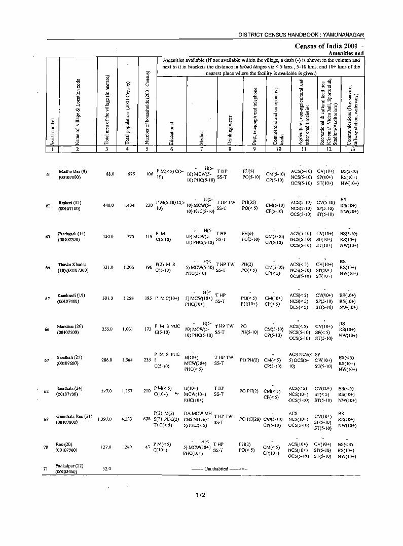
DISTRICT CENSUS HANDBOOK: YAMUNANAGAR
Census of India 2001 -Amenities and
Amenities available (if not available within the village, a dash (-) is shown in the column and
next to it in brackets the distance in broad ranges viz, < 5 kms" 5-10 kms, and 10+ kms of the
e ~ nearest place where the facility is available is given)
'" c "0 ~ :2" "0 U ... c 0 :g U .,
oJ '" ... '';:; 0
c .c E - '" " e :.= UJ <> <:> " > 0 ~ " <:> 0 .~ a '0 t:: 'E ~ .~ U ..c: 4S g_
'" C:!- P- O> ::; .. i:i'
'" ;:; '" " OJ</) :: ~ 0 on "'- <.> ;:§ <:> "0 11 9 .~ ~ 3=S ...l (5 ::0 "
O(! ';: C:!- .c "0 0 ~ .~ -3 ~.2 ~~ " fd " " " <: :l "0 <.> 0 ~
~ -5 0 ~ a o ,-~ .g.g " "
~ .~ 0 " fr ~ ~ o c:: .... .c j '- "0 ''';:: 0
.c ';; 0 "3 .... Oi @j '" f! .-::! 'iii> =:s '" ._ s ., 0 'g c < '2 ~ "'- c
" ::0"0 .~ ci! S :l ..... 1ii 0 ~ 0 on .:: ~ c 0 Co g OJ c:: B " >. .., ..0 0 :;;; s .. :l '" 'iO S :l
S ~ OJ ~ E S <.> :a li .g ~ t .s;g li S " c E"'" ~::: ., 0 :l "0 " 8 0 o c <0 en Z 1- 1- Z w ::E <l.. u~ ~ ~'" u e
1 2 3 4 5 6 7 8 9 10 11 12 13
Madho Bas (8) P M« S)C(S-- H(5-
PH(S) ACS(S-IO) CV(IO+) 8S(5-10) 61 88.0 675 106 10) MCW(5- T HP CM(5-10)
(00107000) to) 10) PHC(5-10) SS-T POlS-tO) CP(S-IO)
NCS(5-IO) SP(lO+) RS(IO+) OCS(5-10) ST(IO+) NW(IO+)
RltJ"eri (15) • H(5-
PH(35) ACS(5-1O) CV(S-IO) BS
62 440,0 1,434 230 P M(5-1O) C(S. 10) MCWeS- T HP TW CM(5-10) RS(IO+) (00107100) 10) 10)PHC(5-IO) SS-T PO« S) NCS(5-IO) SP(5-10)
CP(S-IO) OCS(5-10) ST(5-1O)
NW(IO+)
Fatehgarh (14) PM - H(5-
PH(6) ACS(5-IO) CV(IO+) BS(5-10) 130.0 775 119 10) MCW(S- T HP CM(S-IO) 63
(OOI(}7200) C(S-IO} to)PHC(5-tO) SS-T PO(S-IO) NCS(5-10) SP(lO+) RS(IO+) CP(5-1O)
OCS(5-10) ST(IO+) NW(IO+)
Tbaska Khadar P(2) M S - H« PH(2) ACS«5) CV(IO+)
BS
64 331.0 1,206 196 5) MCW(5-10) THPTW CM(S.IO) RS(IO+) (1S}(OOI07300) C(S-IO) PHC(5-10) SS-T PO« 5)
CP«5} NCS(5-1O) SP(IO+)
NW(IO+) OCS(S-IO) ST(IO+)
Kaadrauli (19) - H« ACS« 5) CV(IO+) BS{IO+)
65 501,0 1,268 195 P M C(IO+) 5)MCW(10+) THP PO« 5) CM(IO+) (OO107400) PHC(lo+) SS-T PH{IO+) CP« 5)
NCS« S) SP(S-IO) RS(JO+) OCS«5} ST(5-10) NW(IO+)
Maudhar (26) PMSPUC - H{5- PO ACS« 5) CV(IO+)
BS 66 255.0 1,061 173 10) MCW(5- THPTW CM(5-10) RS(IO+)
(00107500) C(5-IO) 10) PHC(5-IO} SS-T PH(5-1O) NCS(S-IO) SP« 5} CP(5-10) OCS(5-1O) ST(S-IO)
NW(IO+)
Sandhali (25) PMSPUC
H(IO+) THPTW ACS NCS« SP
BS«5} 67 286.0 1,564 235 J POPH(2) CM«5) 5) OCS(5- CV(lo+)
(OOI07600) C(S-IO)
MCW(IO+) SS-T CPtS-IO) 10) ST(5-JO)
RS(IO+) PHC« 5) NW(IO+)
68 Sandhala (24)
277.0 1,357 210 P M«5) H(IO+) THP
POPH(2) CM«5) ACS« 5) CV(IO+) BS«5)
(OOIOnOO) C{IO+) ...,. MCW(IO+) SS-T NCS(IO+} SP«5} RS(IO+) PHC(IO+)
CP« 5) OCS(5-10) ST(5-10) NW(10+)
Gumthala Rao (21) P(2) M(2) DAMCWMH THPTW ACS
CV(IO+) BS 69
(00107800) 1,391.0 4,333 678 S(2) PUC(2) PHS NH H« PO PH(28) CM(5-10) NCS(IO+) RS(JO+)
TrC«5) 5) PHC« 5) SS-T CP(S-IO) OCS(5-IO) SP(5-IO)
NW{IO+) ST(5-10)
Rao(20) P M«5) - H« PH(2) ACS(IO+) CV(IO+) BS« 5) 70 127.0 289 43 5)MCW(10+) THP CM«S} (00107900) C(IO+) PHC(IO+) SS-T PO« 5)
CP(IO+} NCS(IO+) SP(5-IO) RS(IO+) OCS(S-IO} ST(5-10) NW(IO+)
71 Pahladpur (22)
52.0 ------- Unmhabited -----(00108000)
172

VILLAGE DIRECTORY
Village Directory Land Use (As on 1999)
Land use (i.e. area under different types of land use in hectare)
E c 0
-" '.g ~ .f' bO 'E; .s "
.", 13 ;:; <.> ., 0 <.> § C E ]-;;- ....
" .~ .~ E -.;- <E bO 0
~ '-' " " ~ .", <.> ., > :0 " o(j '" <: 0 ~! '" 1 .;;: ~ .0 ~ "'.", '" :a ~
9 t: " e: 0..
" 8.3 "'" ..!:! Iii f;j .;;: .0
..c: 9 0.. fr ~ E l;l a E <> ";3 "§ a '0 .... ::t
i1 0.. ..... ca bO 0 " e ~ ~ ::t e !il ·E ::t.e c " OJ
0.. "rl;J '" c bO .:: g '" E 0.. Z 0 "
0 '" 0 :.§ ." ::t '" i!! '"
os < 0... Z :2 E '"' ;::J U bO < Z en 14 15 16 17 18 19 20 21 22 23 2 1
PRMR TW(5.0)
Radaur (7) EA NM TWE(52.0) 26.0 5.0 Madho Bas (8) 61 FP
T(57.0)
PRMR TW(IO.0)
FP Radaur (10) EA Agr. Tools, -,- TWE(400.0) 300 Rajheri (15) 62
T(410.0)
PRMR TW(5.0)
Radaur (6) EA N TWE(76.0) 15.0 4.0 30.0 Fatehgarh (14) 63 FP T(SI.O)
PRMR TW(ISO.O)
Thaska Khadar Radaur(7) EA NM TWE(120.0) 4.0 27.0 64
FP T(300.0) (18)
PRMR TWE(4IS.0) FPNR Radaur(12) Earthen Pots, -, -
T(415.0) 86.0 . Kandrauli (19) 65
NC
PRMR Radaur(IO) EA NM
TWE(227.0) 5.0 22.0 1.0 Mandbar (26)
FP T(227.0) 66
PRMR TWE(247.0) FPNR Radaur(2) EA
T(247.0) 14.0 250 Sandhali (25) 67
NC
PRMR Radaur(2) EA
TWE{l28.0) 149.0 Sandhal .. (24)
FP T(128.0) 68
PRMR Radaur(9) EA NM Earthen Pots, -. -
TWE(800.0) 5000 91.0
Gumthala Rao 69
FP T(800.0) (21)
PRMR TW(5.0)
Radaur (2) EA TWE(116.0) 6.0 Rao(20) 70 FP T{l21.0)
------- Uninhabited ----------- Pahladpur (22) 71
173
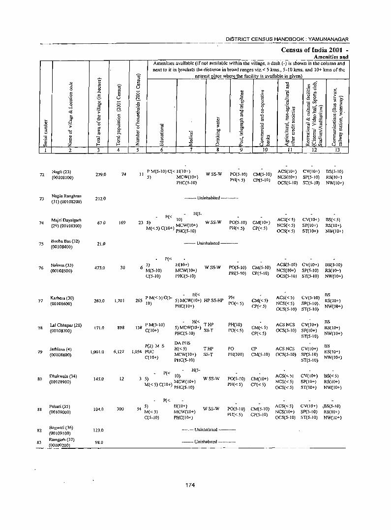
~ ill " ~ C "0 -;;;- ., 0 " ~
u " " -" ..<::
" 0 0 c " 0 .~ '=' U ~ " " 0 '" 0 ~ "0
...l 0 "0 <>'Il .;;: r! ..<:: ., " " c ~ bll -5 0 ... ,§ .~ 0
" ... ..c .0 . s; 0 ""5 ... E oj g- o ::l ..... ~ ... " 0 Po u
"iii " "iii .D
E l E ·c " ::l
" '" f- Z CIl z I 2 3 4 5
72 Nagli (23) (00108100)
279.0 74 II
73 Nagla Ranghran
212.0 (31 )(00 1 08200)
Majri Oayalgarh 74 670 169 23
(29) (00108300)
75 Sucha Sas (32)
21.0 (00108400)
76 Nakum(33)
473.0 30 6 (00108500)
Karhera (30) 265 77
(00108600) 262.0 1,701
78 Lal Chhapar (28) (00108700)
171.0 898 lJ8
Jathlana (4) 79
(00108800) 1,001.0 6,127 1,054
Dhakwala (34) 80
(00108900) 145.0 12 3
81 Pobari (35)
104.0 300 54 (00109000)
82 Bagwali (36)
123.0 (00109100)
83 Ramgarh (37)
98.0 (00109200)
DISTRICT CENSUS HANDBOOK; YAMUNANAGAR
Census of India 2001 -Amenities and
AmenitIes available (if not available within the village, a dash (-) is shown in the column and next to it in ~rackets the distance in broad ranges viz. < 5 kms., 5-10 kms. and 10+ kms of the
nearest place where the facility. is available is given' "C cn~ a .~ "0 0'
'" '" e '" > ~2 .~ 0 .~ El C:~ .s::: .a 0 p. "3 ~ " ~ '" " ~c/.l .. _ ;;; ~ 0- <.I
B .~ :: 0 E7a§
::l .,
"0 '" 6 "£ 0).,
c " ::l ..c ._ ';;;' ~.
'" -0 " 0 ... ... a g "g ~ -8 .g " -" §. o " ~ ...:'" .- "0 ',p 0
a; ]>.< '" .-a; bb e :::: .~ N c 'e ::l"O 0 bll <l)
-3 ~ .S< O! E c '" .~ OJ " '8 a " ~ .S! :Q ... .g ~ ~ 5 .2 E " "C C 'ii E~ §~ ::>
" 8 8] go] "C ~ 0 <0 u E! ~ 0... C>::......-CIl
6 7 8 9 10 II 12 13
P M(5-10) C« H(10+) WSS-W PO(5-IO) CM(5-JO)
ACS(IO+) CV(IO+) BS(5-10) S) MCW(lO+)
PH{< 5) CP{5-10) NCS(IO+) SP(5-10) RS(IO+)
PHC(S-IO) OCS(5-10) ST(5-1O) NW(IO+)
--- Uninhabited -------
P« H(5-
10) ACS« 5) CV(IO+) BS« S) S) MCW(IO+) WSS-W PO(S-IO) CM(IO+)
M« 5) C(IO+) PHC(5-1O) PH« 5) CP« S) NCS«5) SP{IO+) RS(IO+} OCS« 5) ST{IO+) NW(IO+)
-- Uninhabited ----
P« 5) H(IO+)
WSS-W P0{5-10) CM(S-IO) ACS(5-1O) CV(IO+) BS(5-1O)
M(5-1O) MCW(IO+) PH(5-IO} CP(5-10)
NCS(IO+) SP(5-to) RS(IO+) C(S-IO) PHC(5-1O) OCS(S-IO) ST(5-IO) NW(IO+)
- H« PH ACS« 5) CVeS-IO) BS
P M« 5) C(5- S) MCW(IO+) HP SS-HP CM«5) 10) PHC(IO+) PO{<5) NCS«5} SP(5-IO},
RS(!O+) CP« 5)
OCS(5-1O) ST(5-1O) NW(IO+)
P M(5-10) - H«
PH(IO) ACSNCS CV(JO+) BS
5) MCW(IO+) T HP CM«5) RS(IO+) C(IO+) PHC(5-1O) SS-T PO{< 5)
CP«5) OCS(5-10) SP(IO+)
NW(lO+} ST(5-\0)
P(2) M S DAPHS
BS H« S) THP PO CP ACSNCS CV(IO+)
PUC MCW(IO+) SS-T PH(300) CM(S-IO) OCS(5-10) SP(5-IO)
RS(10+) C(IO+)
PHC(5-10) ST(S-IO) NW(lo+)
P« H(5-
10) ACS{<5) CV(\O+} BS« S} 5) MCW(IO+) WSS-W PO(5-IO) CM(lO+)
M« 5) C(10+) PHC(5-10) PH« 5) CP« 5) NCS«5) SP(IO+) RS(IO+) OCS« 5) ST(IO+) NW(IO+)
P« 5) H(IO+}
WSS-W PO(5-tO) CM(5-1O) ACS«5) CV(lO+) ,BS(5-10)
M«5) MCW(IO+) PH« 5) CP(5-IO}
NCS(IO+) SP(5-10) RS(IO+) C(5-10) PHC(IO+) OCS(5-10) ST(S-IO} NW(IO+)
-_- Uninhabited --------
------ Uninhabited ---------
174
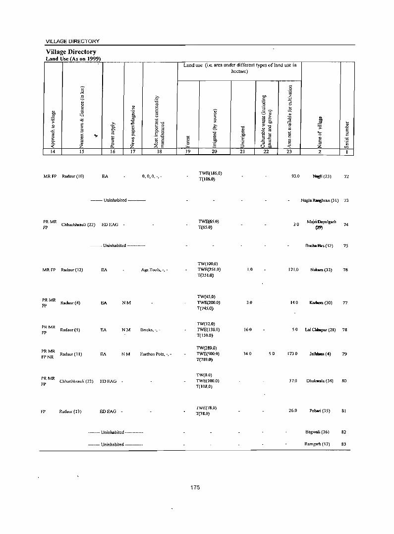
VILLAGE DIRECTORY
Village Directory Land Use (As on 1999)
E -'" 2-" 0
" '" " 1;; bl) :.a ~
~ .s: ~ g
..r:: .8 0
'" ~ .... e Co 0. Z < 14 15
MR FP Radaur (10) EA
0 :.a 0
" E " .~ E 0
bl) 0
'" ~-o >. ~ 0. t:: " 0- " 8.3 Co iil '" .5 eM Co
~ ~ ::J
'" " 0 Z 0 '" 0.- ::E E
16 17 18
0,0,0, -,-
--- Uninhabited ---------
PRMR FP ChhachhrauH (22) ED EAG -
--Uninhabited -----
MR FP Rad.ur (12) EA Agr.Tools, -, -
PRMR Radaur(4)
FP EA NM
PRMR Radaur (S)
FP EA NM Bricks,-, -
PRMR Radaur (II)
FPNR NM Earthen Pots, -, -EA
:: MR Chhachhrauli (22) ED EAG _
FP Radaur(l3) EDEAG -
----- Uninhabited -----------
----- Uninhabited ----------
Land use (i.e. area under different types ofland use in hectare)
19 20
TWE(186.0) T{186.0)
TWE(6S.0) T(6S.0)
TW(IOO.O) TWE(251.0) T(351.0)
TW(4S.0) TWE(200.0) T(245.0)
21 22 23
93.0
20
1.0 121.0
3.0 140
2
Nodi (23) 72
Nagla Rqhran (31) 73
Majri Dayalgarh
(29) 74
Buc:haBas (32) 7S
Nabun(33) 76
Kadoaa (30) 77
TW(12.0) TWE(J38.0) T(150.0)
160 5 0 Lal Chhapar (28) 78
TW(289.0) TWE(SOO.O) T(789.0)
TW(8.0) TWE(IOO.O) T(108.0)
TWE(18.0) T(78.0)
175
340 so 173.0
37.0
26.0
JallllaBa (4) 79
Dhakwala (34) 80
Pobari (35) 81
Bagwali (36) 82
Ramgarb (37) 83
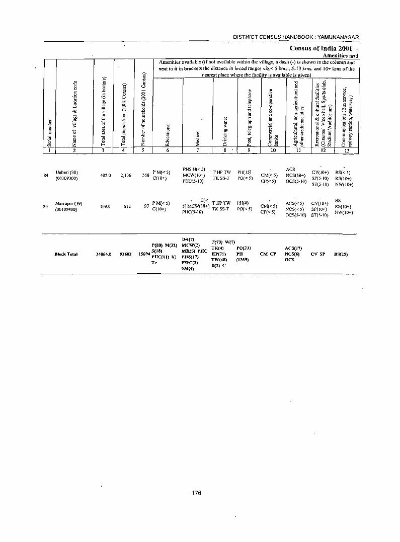
84
85
2
Unheri (38) (00109300)
Marrupur (39) (00109400)
Block Tot:lI
3 4
402.0 2,136
169.0 612
24064.0 92602
DISTRICT CENSUS HANDBOOK: YAMUNANAGAR
Census of India 2001 -Amenities and
Amenities available (if not available within the village, a dash (-) is shown in the column and next to it in brackets the distance in broad ranges viz.< 5 kms., 5-10 kms. and 10+ kms of the
nearest place where the facility is available is ~iven
5 6
318 PM«5) C(lO+)
97 P M« 5) C(lO+)
peSO) M(3!)
IS()94 S(18) PUC(JI) 10 Tr
7
PHSH«5) MCW(10+) PHC(5-1O)
8
THPTW TKSS-T
9
PH(l5) PO«5)
- H« THPTW 5) MCW(10+) TK SS-T PHC(5-IO)
PH(4)
PO« 5)
DA(7) MCW(!) MR(S) PRC PHS(17) FWC(3) NH(4)
176
T(70) W(7) TK(4) PO(l3)
RP('I) PH TW(48) (1269) R(2) C
10
CM«5) CP« 5)
CM{<5) CP«5)
CM CP
11 12
ACS NCS(IO+) CV(JO+) OCS(5-1O) SP(5-1O)
ST{5-1O)
ACS« 5) CV(JO+) NCS«5) SP(10+) OCS(5-10) ST(S-IO)
ACS(17) NCS(6) OCS
cv SP
13
BS« 5) RS(JO+) NW(IO+)
BS RS(lO+) NW(IO+)
BS(2S)
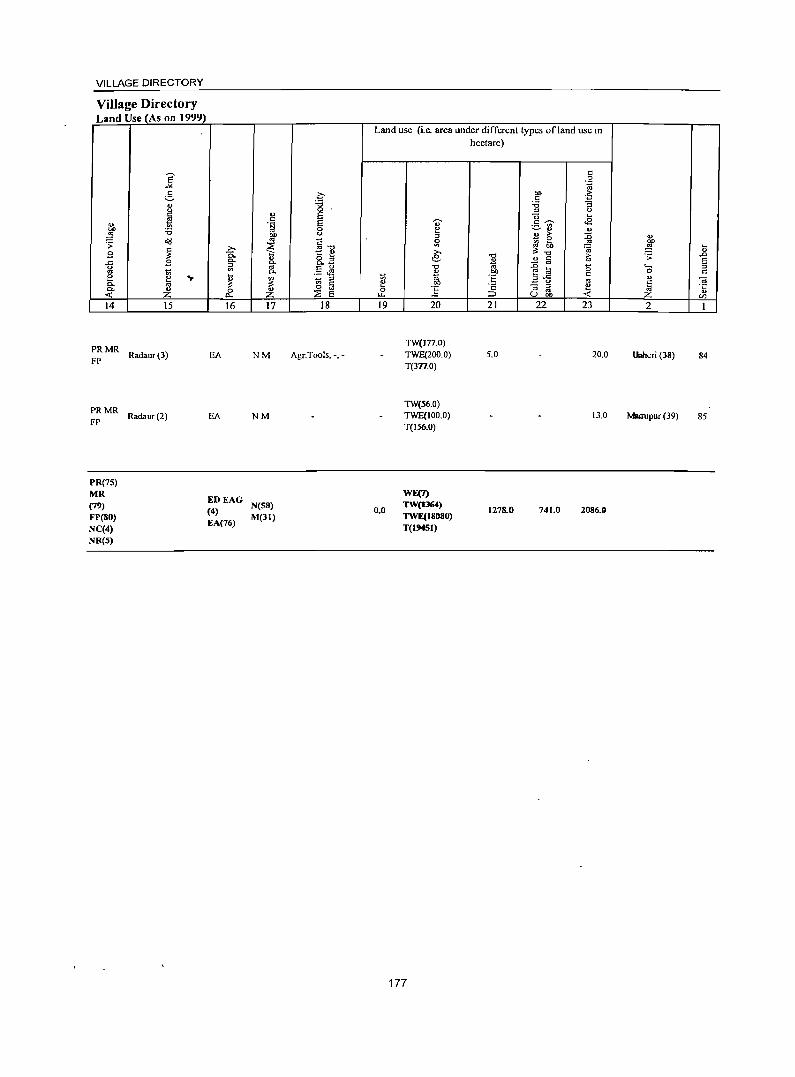
VILLAGE DIRECTORY
Village Directory Land Use (As on 1999)
<I> 01)
~ .;;: 8 .c: u «I e c. 0. < 14
PRMR FP
PRMR FP
PR(7S) MR (79)
FP(80) NC(4) NR(5)
e -" g " <.)
§ .~ -0
a<!!
~ B
~ .,. «I
" Z 15
Radaur(3)
Radaur (2)
.., c: .t;j 01) «I ,... ;g
-0. " c.. 1il-iil c..
~ ~ 0 " p.., Z 16 17
EA NM
EA NM
EDEAG (4) N(SS)
EA(76) M(31)
.~ "" 0 E E 0 u
g""O '.
1:: " 8.~ .5 ~
" '" § 0 :;;;; E
18
Agr.Tools, -, -
Land use (i.c. area under different types ofland lise in hectare)
~ 0 ..... 19
0.0
" e " ~ ,... e -0
" til btl
:§ 20
TW(177.0) TWE(200.0) T(3n.0)
TW(56.0) TWE(100.0) T(I56.0)
WE(7) TW(I364) TWE(18080) T(I'HSI)
177
21 22 23
5.0 20.0
13.0
1278.0 741.0 2086.0
2
u..heri (38)
Mairupur (39)
~
" .D
5 c:
OJ ·c " en
84
85

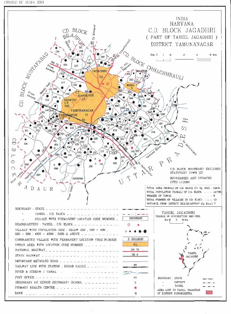
CENSUS OF INDIA 2001
o o ><' -l" ',{~'v.,15
of:' , ~~ ~ "-
A D A U R
BOUNDARY: STATE ... _ .....
00109500 •• / .
'" - ..J.. ,"'" r; I
'l:J • .!'f •
'\ i · · •
TAHSIL , C.D. BLOCK .. _ .. ... .._ ... ... ... . ..
VILLAGE WITH PElUIANENT LOCATION CODE NUMBER '"
HEADQUARTERS: TAHSlL ; C.D_ BLOCK ...... _ .. ...... ...... ...... ..
VILLAGE WITH POPULATION SIZE: BELOW 200 . 200 - 499 . 500 - 999 : 1000 - 4999 : 5000 & ABOVE .. .. ... ... ... ... ... ..
UNINHABITED VILLAGE WITH PERMANENT LOCATION CODE NUMBER
URBAN AREA WITH LOCATION CODE NUMBER ... ...
NATIONAL HIGHWAY ...... ... __ ............. ... ........... '
STATE HIGHWAY . .. _ ... ..... _ ............... ... ... . _. _
IMPORTANT METALLED ROAD ............ ...... _ .. ... .. ... _.
RAILWAY LINE WITH STATION . BROAD GAUGE ...... _ . ........... .. .
RIVER & STREAM / CANAL .
POST OFFICE .. ' ... ..- ... .. ... -
SECONDARY OR SENIOR SECONDARY SCHOOL "' __ .. _ .. ........ _
PRIMARY HEALTH CENTRE _ .. ... ...... .................. .. ...... ... ... _.
BANK ...... ...... '" .. ' .. _ ........ _ _ . ... ... _. ... ... ... ._ '" ... ... ... _. ... .. ... .
INDIA HARYANA
CD_ BLOCK JAG ADHRI ( PART OF TAHSIL JAGADHRI )
DISTRICT YAMUNANAGAR
Km 2 o 2 4 6 Km
?~ C.D. BLOCK BOUNDARY EXCLUDES STATUTORY TOWN (S)
BOUNDARIES ARE UPDATED UPTO 1.1.2000
TOTAL AREA (RURAL) OF CD. BLOCK (In Sq. Km} ._ 246.81
TOTAL POPULATlO}l {RURAL} OF C.D. BLOCK ..... - 141786 NUMBER OF TOWNS .. .. .. . .. .. .. - ._ ...... .. 6
TOTAL NUMBER OF VILLAGES IN C.D. BLOCK ... .. .. III D1::ITANCE FROM DISTRICT HEA DQUARTERS (In Kms.) 7
TAHSIL JAGADHRI . - -. . ---CHANGE IN JURISDICTION 1991-2001
00109500
@ •
o ••••
X 00111000
VIl
NH 73
SH6
RS
~:= PO
S
• B
Km 10 10 Km I I
Ar ..... £ .1..:z. ... \
,
." r · /
, ~. ;'- I/' .-... . J •
• - TAHSIL '1" '6 JAGADHRI J
BOUNDARY . srATE
DISTRICT TAHSIL
r' "1"" :
"
AREA W::IT TO TAHSIL THANESAR OF' DlSTRICT KURUKSHETRA o

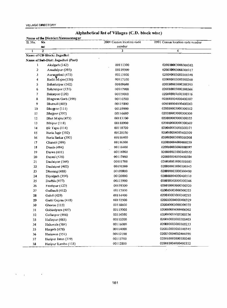
VILLAGE DIRECTORY
Alphabetical list of Villages (C.D. block wise) Name of~ District:Yamunanagar SI.No. Na 2001 Census location code 1991 Census location code number
me number
2 3 4 Name of CD Block: Jagadhri
Name of S.b-Dist: Jagadhri (Part)
1 Akalgarh (142) 00111300 020010003000300382
2 Amadalpur (395) 00119500 020010003000300317
3 Auran'tbad (475) 00113100 020010003000300348
4 Badhi ajra(126) 00117100 020010003000300360
5 Bahadurpur (162) 00109600 020010003000300395
6 Bahrampur (131) 00117900 020010003000300366
7 Bakarpur (120) 00119000 0200]0003000300316
8 Bhagwan Garh (398) 00116500 020010004000400307
9 Bhatauli (405) 00115800 0200)0004000400263
10 Bhogpur (Ill) 00119900 020010003000300312
II Bhojpur(397) 00116600 0200)0003000300306
12 Bhut Majra(473) 00113700 020010003000300335
13 Bibipur (11 8) 00118900 020010003000300369
14 Bir Tapu (114) 00118700 020010003000300371
15 Buria Jagir (392) 00120100 020010004000400309
16 Buria Sarkar (393) 00116400 020010003000300308
17 Chaneti (399) 00116300 020010004000400259
18 Damla(484) 00110400 020010003000300397
19 Darwa(411) 00116900 020010003000300322
20 Dasani (128) 00117400 0200)0004000400384
21 Daulatpur (144) 00111700 020010003000300385
22 Daulatpur (482) 00110300 020010003000300343
23 Dhorang (488) 00109800 020010003000300400
24 Diyalgarh (394) 00120000 020010004000400310
25 Dudhla (477) 00113900 020010003000300346
26 Fetehpur (123) 00119300 020010003000300320
27 Gadhauli (412) 00117000 020010003000300323
23 Galoti (429) 00114400 020010003000300293
29 Garhi Gujran (418) 00112500 020010004000400329
30 Ghoron (115) 00118600 020010003000300372
31 Gobindpura (407) 00115000 020010004000400302
32 Gollanpur (466) 00114300 020010003000300336
33 Hafizpur (483) 00110200 020010003000300403
34 Haluwala (384) 00116000 020010003000300233
35 Hargarh (478) 00114000 020010003000300345
36 Hariawas (151) 00112100 020010004000400390
37 Haripur Jatan (379) 00115700 020010003000300240
38 Haripur Kambo (155) 00112800 020010004000400352
181
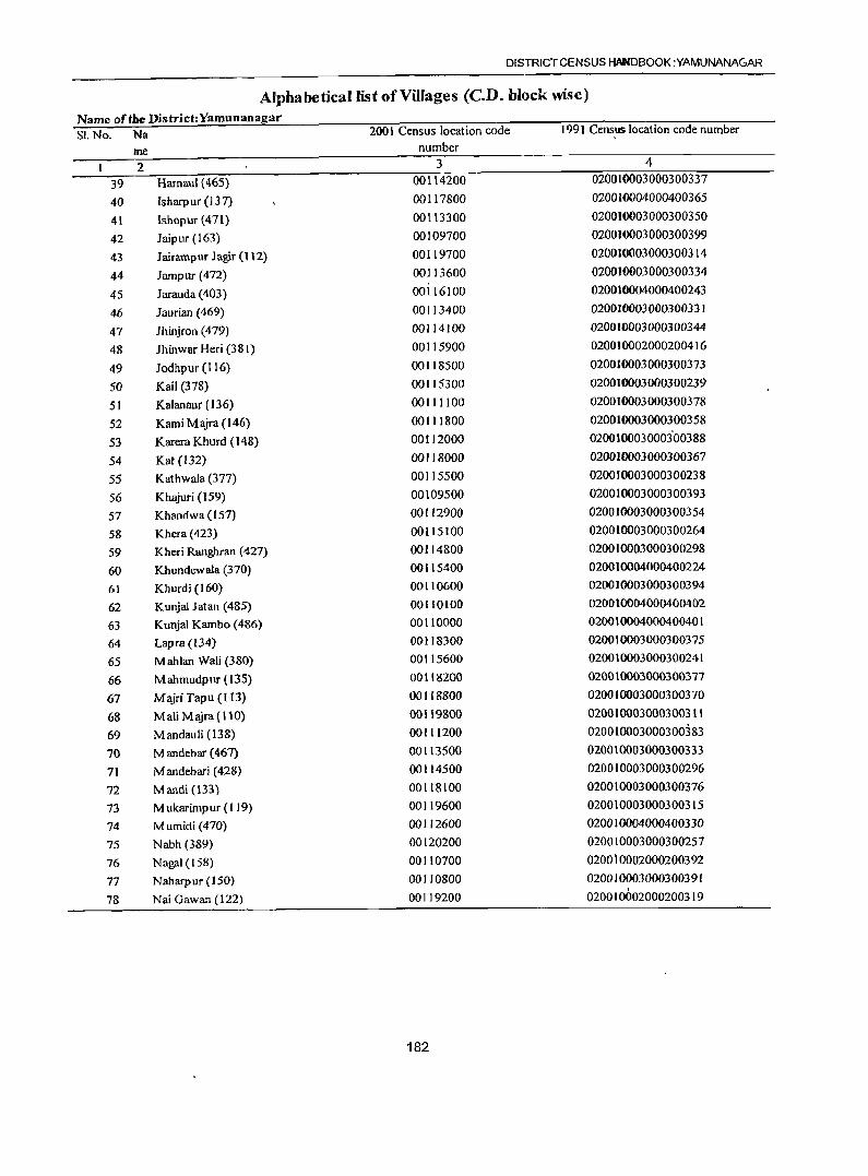
DISTRICT CENSUS HANDBOOK :YAMUNANAGAR
Alphabetical list of Villages (CD. block wise) Name of the District:Yamunanagar SI.No. Na 2001 Census location code 199 I Census location code number
me number
2 3 4
39 Harnaul (465) 00114200 020010003000300337
40 Isharpur (137) 00117800 020010004000400365
41 Ishopur(471) 00113300 020010003000300350
42 Jaipur (163) 00109700 020010003000300399
43 JrurrunpurJa~r(112) 00119700 020010003000300314
44 Jampur (472) 00113600 020010003000300334
45 Jarauda (403) 00116100 020010004000400243
46 Jaurian (469) 00113400 020010003000300331
47 lhinjron (479) 00114100 020010003000300344
48 Jhinwar Heri (381) 00115900 020010002000200416
49 Jodhpur (116) 00118500 020010003000300373
50 Kail (378) 00115300 020010003000300239
51 Kalanaur (136) 00111100 020010003000300378
52 Kami Majra (146) 00111800 020010003000300358
53 Karera Khurd (148) 00112000 0200100030003'00388
54 Kat (132) 00118000 020010003000300367
55 Kathwala (377) 00115500 020010003000300238
56 Khajuri (159) 00109500 020010003000300393
57 Khandwa (157) 00112900 020010003000300354
58 Khera (423) 00115100 020010003000300264
59 Kheri Ranghran (427) 00114800 020010003000300298
60 Khundcwala (370) 00115400 020010004000400224
6] Khurdi (160) 00110600 0200)0003000300394
62 Kunjal Jatan (485) 00110100 020010004000400402
63 Kunjal Kambo (486) 00110000 020010004000400401
64 Lapra (134) 00118300 020010003000300375
65 Mahlan Wali (380) 00115600 020010003000300241
66 Mahmudpur (135) 00118200 020010003000300377
67 MajriTapu (I [3) 00118800 020010003000300370
68 Mali Majra (110) 00119800 020010003000300311
69 Mandauli (138) 00111200 020010003000300383
70 M andebar (467) 00113500 020010003000300333
7) M andebari (428) 00114500 020010003000300296
72 Mandi (133) 00118100 020010003000300376
73 M ukarimpur (119) 00119600 020010003000300315
74 Mumidi (470) 00112600 020010004000400330
75 Nabh (389) 00120200 020010003000300257
76 Nagfll (158) 00110700 020010002000200392
77 Naharpur (150) 00110800 020010003000300391
78 Nai Gawan (122) 00119200 020010002000200319
182
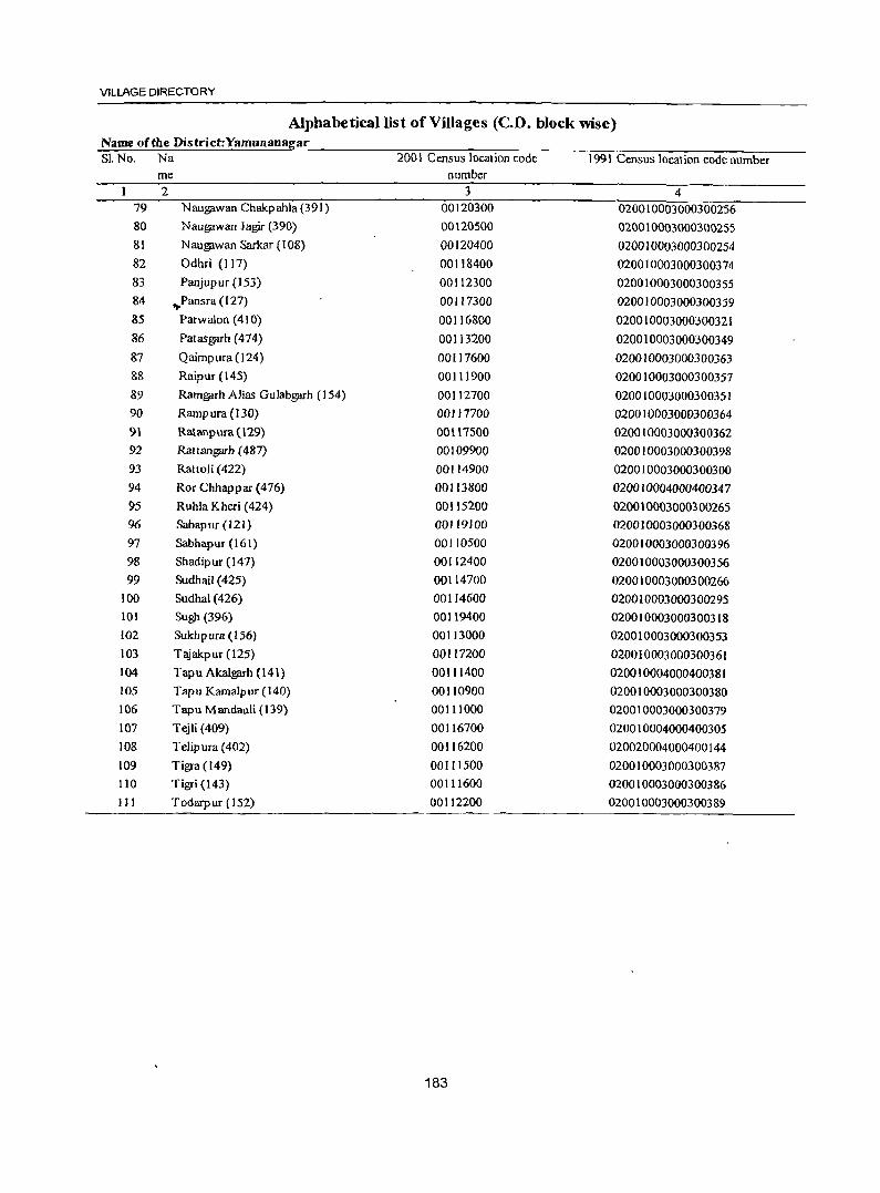
VILLAGE DIRECTORY
Alphabetical list of Villages (C.D. block wise) Name of the District:Yamunanagar SI. No. Na 2001 Census location code 1991 Census location code number
me number 2 3 4
79 N aUg;lwan Chakp ahla (391) 00120300 020010003000300256 80 Naug;lwan Jagir (390) 00120500 020010003000300255 81 Naug;lwan Sarkar (108) 00120400 020010003000300254 82 Odhri (117) 00118400 020010003000300374 83 Panjupur (153) 00112300 020010003000300355 84 .,.Pansra (127) 00117300 020010003000300359 85 Parwalon (410) 00116800 020010003000300321 86 Patasgarh (474) 00113200 020010003000300349 87 Qaimpura(l24) 00117600 020010003000300363 88 Raipur (145) 00111900 020010003000300357 89 Ramgarh Alias Gulabgarh (154) 00112700 020010003000300351 90 Rampura (UO) 00117700 020010003000300364 91 Ratanpura (\29) 00U7S00 020010003000300362 92 RaHangarh (487) 00109900 020010003000300398 93 Rattoli (422) 00114900 020010003000300300 94 Ror Chhappar (476) 00113800 020010004000400347 95 Ruhla Kheri (424) 00115200 020010003000300265 96 Sabapur (121) 00119100 020010003000300368 97 Sabhapur (161) 00110500 020010003000300396 98 Shadipur (141) 00112400 020010003000300356 99 Sudhail (425) 00114700 020010003000300266
100 Sudhal (426) 00114600 020010003000300295 101 Sugl1 (396) 00119400 020010003000300318 102 Sukhpura (156) 00113000 020010003000300353 103 Tajakpur (125) 00117200 020010003000300361 104 Tapu Akalg;'lrh (141) 00111400 020010004000400381 105 Tapu Karnalpur (140) 00110900 020010003000300380 106 Tapu Mandauli (139) 00111000 020010003000300379 107 Tejli (409) 00116700 020010004000400305 108 Telipura (402) 00116200 020020004000400144 109 Tigre (149) 00111500 020010003000300387 110 Tigri (143) 00111600 020010003000300386 III Todarpur (152) 00112200 020010003000300389
183
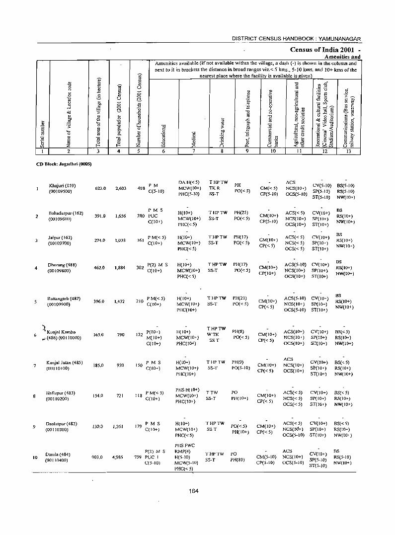
DISTRICT CENSUS HANDBOOK: YAMUNANAGAR
Census of India 2001 -Amenities and
Amenities available (if not available withm the village, a dash (-) is shown in the column and
next to it in brackets the distance in broad ranges viz. < 5 kms., 5-10 kms. and 10+ kms of the ';;;' nearest place where the facility is available is I!iven' .., ::>
'" S ::g -0 r: ~" -c ';;;'
., s:; 0 <) U '" <) '" a ~.::: C3 of ..c: - ., '" f:! 5 c: co c:: > ~t! u
e- O> 0 C .~ 3 'E ~ .~ u C!. ..c ~ 8-<) '" - c. '" :; " ~ 0 ~ C> .Jg " 0. U 0lC/) ::: 1: -'l 0 "3 0 .~ ~ 3"':~
t:!- (3 0 - d S ::> ..,
o:c! .;;: ..<: -c <) ~ .:::: :l..c:::> eta " '" c 1A fii -c c '" u 0 0i:: ~ :;:
~ -5 0 ::> ~ s:; o ._
~:9~ c _
~ ~ 0 ~ ..c
'" c~ ~ o c: ., ..... ..<: c. ',p 0 .D .;;: 0 "3 '"' (ij ii< 1: d e=a os> ::>
os ._
S oJ c.. 0 s:; 00 .~
'~"' ~ "2 ~ ::> ..... ., 0 ~ 0 OIl " E ~ s:; 0 lii c. u '.g OJ s:; "3 ..,
::I » "
.D u ;Q E '" ::> <) e ~.2 IS oJ d E l<i ~ § <) :a s:; _" S'>< .~ ~ E ;;: '5 ::> '" '" ~ cj N ~
0 -c E 0 8~ 00"<: 0:::: C/) f-< Z !.Ll ::E c.. <0 .:.: '" u ~
1 2 3 4 5 6 7 8 9 10 11 12 13
CD Block: Jagadhri (0005)
Khajuri (159) PM DA H«5) THPTW
PH ACS
623.0 2,603 40& MCW(IO+) TKR CM« 5) NCS(10+) CV(5-1O) BS(5-1()
(00109500) C(5-1O) PHC{5-1O) SS-T
PO«5) CP(5-IO) OCS(5-1O)
SP(5-10) RS(5-10) ST(5-1O) NW(lO+)
Bahadurpur (162) PMS
H(IO+) THPTW PH(25) ACS« 5) CV(IO+) BS
2 (00109600)
391.0 1,656 280 PUC MCW(IO+) SS-T PO«5) CM(IO+)
NCS(lO+) SP(IO+) RS(1O+)
C(lO+) PHC«5)
CP(5-10) OCS(IO+) ST(IO+)
NW(IO+)
Jaipur (163) PM«5) H(IO+) THPTW PH(17) ACS« 5) CV(IO+) BS
3 (00109700)
274.0 1,038 161 C(10+) MCW(IO+) SS-T PO« 5}
CM(JO+) NCS« 5) SP(10+)
RS(JO+)
PHC«S) CP« 5)
OCS« 5) ST(lO+) NW(IO+)
Dhorang (488) P(2) M S H(IO+) THPTW PH(I7) ACS(5-10) CV(10+) BS
4 (00109800)
462_0 1,884 302 C(IO+) MCW(1O+) SS-T PO« 5)
CM(IO+) NCS(lO+) SP(lO+)
RS(IO+)
PHC«5) CP(10+)
OCS(lO+) ST(IO+) NW(IO+)
Rattangarh (487) PM« 5) H(10+) THPTW PH(21) ACS(5-1O) CV(IO+) BS
5 (00109900) 396.0 1,432 210
C(lO+) MCW(IO+) SS-T PO« 5) CM(IO+)
NCS(IO+) Sp(IO+) RS(IO+)
PHC(10+) CP« 5)
OCS(5-10) ST(JO+) NW(IO+)
:'t P(IO+) H(IO+) THPTW
PH(8) ACS{IO+) CV(IO+) 6
Kunjal Kambo 165.0 790 132 WTK CM(IO+) 6S«5)
'" (486) (001 10000) M(10+) MCW(lO+) SS-T
PO« 5) CP« 5)
NCS(IO+) SP(IO+) RS(IO+) C(10+) PHC(ID+) OCS(IO+) Sf(IO+) NW(IO+)
Kunjal Jatan (485) PM S H(lO+) THPTW PH(9) ACS
CV(10+) BS« 5) 7 185.0 920 150 CM(lO+) NCS(IO+)
(00110100) C(IO+) MCW(IO+) SS-T PO(5-10) CP« 5) OCS(IO+)
SP(IO+) RS(IO+) PHC(lO+) ST(IO+) NW(IO+)
Hafizpur (483) P M«5) PHS H(IO+)
TTW PO AC!>«5) CV(lO+) BS«5) 8 154.0 721 118 MCW(10+) CM(10+)
(00110200) C(IO+) PHC(10+)
SS-T PH(lO+) CP« 5)
Nc;S{< 5) Sp(IO+) RS(IO+) OCS« 5) ST(JO+) NW(IO+)
Daulatpur (482) 130.0 1,261 179
PM S H(IO+) THPTW PO«5) CM(JD+)
ACS«5) CV(IO+) BS« 5) 9
(00110300) C(lO+) MCW(lO+) SS-T NCS(J(j+) SP(10+) RS(lO+)
PHC«5) PH(lO+) CP«5)
OCS(5-10) ST(IO+) NW(10+)
PHSFWC
Damla (484) P(2) M S RMP(4)
THPTW PO ACS
CV(lO+) BS
10 (00110400)
903.0 4,985 759 PUC 1 H(5-1O) SS-T PH(80)
CM(5-10) NCS(IO+) SP{5-IO)
RS(5-10) C(5-10) MCW(5-1O) CP(5-10) OCS(5-10)
ST(5-10) NW(lO+)
PHC«5)
184
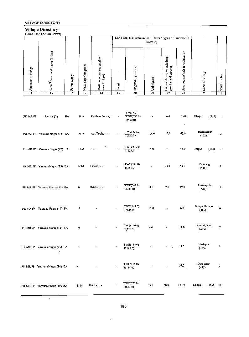
VILLAGE DIRECTORY
Village Directory Land Use (As on 1999)
14 IS
PRMRFP Radaur (3) EA
PRMRFP Yamuna Nagar (14) EA
PRMRFP Yamuna Nagar (I 7) EA
PRMRFP YamunaNagar(15) EA
PRMRFP YamunaNagar(15) EA
PRMRFP Yamuna Nagar (15) EA
PRMRFP Yamuna Nagar (15) EA
PRMRFP Yamuna Nagar (15) EA
."
PRMRFP Yamuna Nagar (14) EA
PR MR FP Yamuna Nagar (10) EA
16 17 18
NM Earthen Pots, -,'
NM Agr.Tools, -,'
NM , ,
NM Bricks, -.-
N Bricks, -, -
N
N
N
NM Bricks, '.-
Land use (i.e. area under different types ofland use in hectare)
19 20
TW(17.0) TWE(535.0) T(552.0)
TWE(320.0) T(320.0)
TWE(225.0) T(225.0)
TWE(38LO) T(38 1.0)
TWE(34 1.0) T(34 1.0)
TWE(144.0) T(144.0)
TWE(170.0) T(170.0)
TWE(140.0) T(140.0)
TWE(114.0) T(114.0)
TWE(673.0) T(673.0)
185
21 22 23
6.0 65.0
14.0 15.0 42.0
4.0 45.0
23.0 58.0
4.0 2.0 49.0
15.0 60
4.0 110
14.0
16.0
45.0 28.0 157.0
2
Khajuri (159)
Bahadurpur (162)
Jaipur (163)
Ohorang (488)
Rattangarh (487)
Kunjal Kambo (486)
Kunjal Jatan (485)
Hatizpur (483)
Daulatpur (482)
2
3
4
5
6
7
8
9
Damla (484) 10
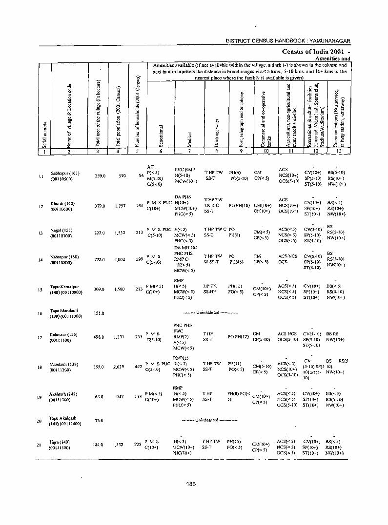
DISTRICT CENSUS HANDBOOK: YAMUNANAGAR
Census of India 2001 -Amenities and
Amenities available (ifnot available within the village, a dash (-) is shown in the column and next to it in brackets the distance in broad ranges viz.< 5 Ions., 5-10 Ions. and 10+ Ions of the
'in' nearest place where the facilitv is available is I!iven) 'iT :1
" ~ "0 ~ $. "0 .s 'in' " § 0 u (.) <> " i3l " " ]
'z u .,-e ..<: c:: ;:; " > :..::: en <> .9 e. u C> 0 .~ '- 1:: 'E ~
(.) C- .c g 0
1'i ~
c.. " :l "" c.. " ~ j
;:; -8 " c.. u E~~ ;:: ~ 0 B 0 ~~ ~ -0 6 ~:;;J§
:1 .,
C- al-~ .:; -ii "0 0 '? 'z:: ~~ t:: C U
";:$ ..c:: ._
~ " r::: g '" "0 c.J 0 ~
oS 0 ~ c o .- ~ ~ .g c _
~ ~ .~ ~ .c ., c_ ~ o c
u ._ ...a c.. "a$"g .= a
.D . ;:: 0 :; .... .. ;: ~ "& e .::: '" .-S '" 0. 0 C 00 .~ :1"0 C < .~ S ::I .... E 0 V 0 "" " ~ ~ .9 O! E c Vi
0 OJ to; B " " '" to; .. 0. ..0 ';i c.J :.;;; E '" " 0 0; E :;j
S '" .. " ~ ~ § 0 :a 1;[ E-'" <> ~ 1:! Q:).- S ;:
'0: 1 :;j .S ;:: " 0.= -g "0 " Q 0 o fa OJ) .c 8'S u Z ~ <5 ~u-
f/l /JJ a.. U..o ~C/1
I 2 3 4 5 6 7 8 9 10 II 12 13
AC PHCRMP ACS
Sabbapur (161) 550 84 1'« 5)
H(5-IO) THPTW PH(4) CM
NCS(IO+} CV(lO+) BS(5-10)
11 (OOI10500) 259.0 M(5-1O) SS-T P0(5-10) CP« 5) SP(5-10) RS{lO+)
C(5-IO) MCW(IO~) OCS(5-10)
ST(5-10) NW(JO+)
DAPHS THPTW ACS
Kburdi (160) 379.0 1,797 296
PMSPUC H(JO+) TKRC POPH(18} CM(IO+) NCS(IO+)
CV(IO~) BS«5) 12 (00110600) C(IO+) MCW(IO+) SP(IO+) RS(IO+)
PHC«5) SS-T CP(IO+} OCS(IO+)
ST(IO+) NW(IO+)
Nagai (158) PM S PUC H«5) THPTWC 1"0 ACS«5) CV(5-1O) BS
13 223.0 1,5)5 213 CM« 5) RS(5-10) (00110100) C(S-IO) MCW«S) SS-T PH(8)
CP« 5) NCS«5) 51'(5.10)
NW(lO+) PHC« 5) OCS«5) ST{S.IO)
DAMHHC
Nabarpur (150) PM S PHCPHS
THPTW PO CM ACSNCS eV(S-IO) BS
14 m.o 4,002 599 RMPO RS(5-10) (00110800) C(5-IO)
H«5) WSS-T PH(45) CP«5) OCS SP(5-IO)
NW(JO+) MCW«S)
ST(5-10)
RMP Tapu Kamalpur 309_0 1,580 213
P M«5) H«5) HPTK PH(12) CM(IO+)
ACS«5) CV(JO+) BS« 5) 15
(140) (00 II 0900) C(IO+) MCW«5) SS-HP 1'0«5) NCS«5) SP(IO+) RS(5-10) PHC« 5)
CI"«5) OCS{<5) ST(IO+) NW(IO+)
16 Tapu Mandauli
151.0 --- Uninhabited --------(139)(00111000)
PHCPHS
Kalanaur (136) PMS FWC THP CM ACSNCS CY(5-10)
498.0 1,331 235 RMP(2) POPH(12) BSRS
17 (00111100) C(5-IO) SS-T CP(S-IO) OCS(5-JO) SI"(5-10) NW(IO+)
H«5) MCW«5}
ST(5-10)
RMP(2} CV BS RS(5
Mandauli (138) P M S PUC H«5} THPTW PH(ll) ACS« 5) 18 355.0 2,629 442 CM(5-10) (5- 10) SP(5· 10)
(00111200) C(S-IO} MCW«5) SS-T PO« 5) NCS(IO+) I"HC« 5}
CP{<5) OCS(5-10)
10) ST(5- NW{IO+) 10)
RMP Akalgarh (142)
63.0 947 153 P M«5) H«5) THP I"H(8) PO« CMCIO+) ACS«5) CV(JO+) 6S«5)
19 (00111300) C(JO+) MCW{< 5) SS-T 5) CP« 5) NCS« 5) SP(lO+) RS(5-10) PHC« 5) OCS(5-10) ST(lO ... ) NW{JO+)
20 Tapu Akalgarh
13.0 --- Uninhabited -----.-(141)(00111400)
Tigra(149) 184.0 1,532 223
P M S H«5) THPTW PH(l5) CM(lO+)
ACS« 5) CY(IO+) BS«5) 21 (001 J 1500) C(lO+} MCW(lO+) SS-T 1'0«5) NCS« 5) SP(IO+) RS(lO+)
PHC(IO+) CP« 5)
OCS«5) ST(lO+) NW(IO+)
186
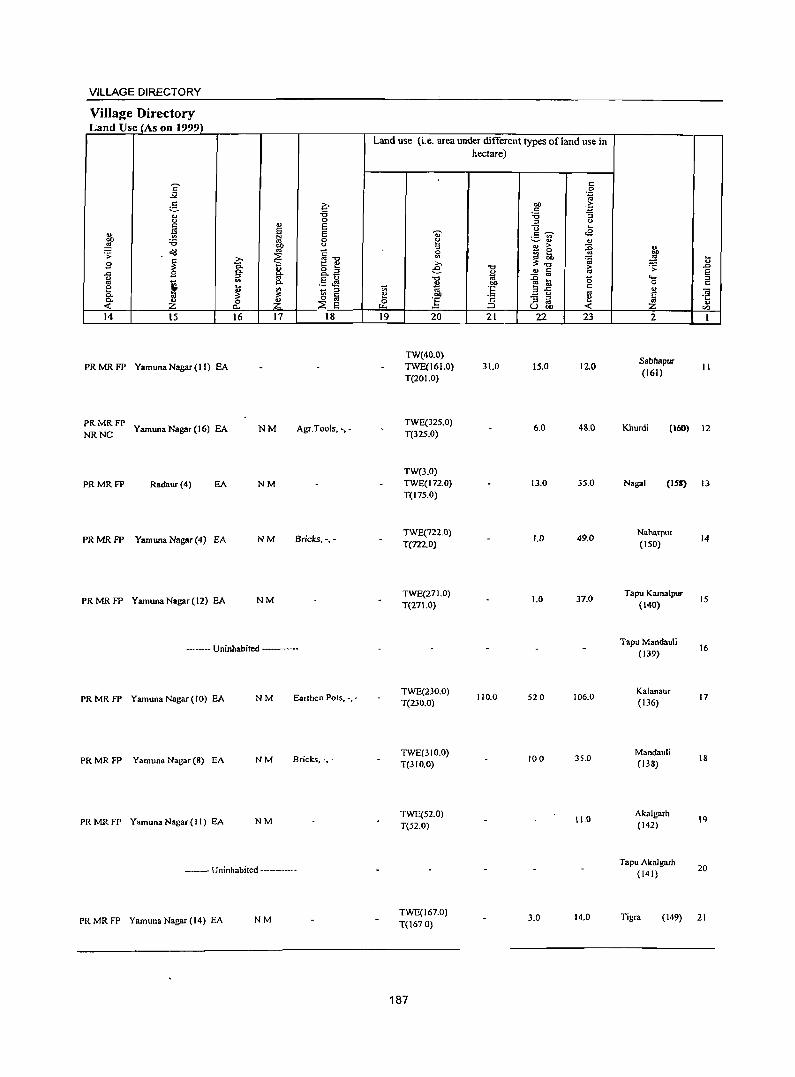
VILLAGE DIRECTORY
Village Directory L'and Ulie (Ali on 1999)
14 i5
PRMRFP Yamuna Nagar (I I) EA
PRMRFP NR NC Yamuna Nagar (16) EA
PRMRFP Radaur (4) EA
PR MR FP Yamuna Nagar (4) EA
PRMRFP Yamuna Nagar (12) EA
16 17 18
NM Agr.Tools. -. -
NM
NM Bricks. -.-
NM
------ Uninhabited -----
PRMRFP YamunaNagar(IO) EA NM Earthen Pots. -•.
PR MR FP Yamuna Nagar (8) EA NM Bricks. -.'
PR MR FP Yamuna Nagar ( I I) EA NM
------- Uninhabited ----------
PRMRFP Yamuna Nagar (14) EA NM
Land use (i.e. area under different types of land use in hectare)
19 20
TW(40.0} TWE(161.0) T(201.0)
TWE(32S.0) T(nS.O)
TW(3.0) TWE(I72.0) T(175.0)
TWE(722.0) T(722.0)
TWE(27 1.0) T(27 1.0)
TWE(230.0) T(230.0)
TWE(310.0) T(310.0)
TWE(52.0) T(52.0)
TWE(167.0) T(1670)
187
21
31.0
110.0
22 23
15.0 12.0
6.0 48.0
13.0 35.0
1.0 49.0
1.0 37.0
520 106.0
100 35.0
11.0
3.0 14.0
2
Sabhapur
(161)
... <U
.D E :::l C ;;; ·c .. <n
II
Khurdi (160) 12
Nagai (lSI) 13
Naharpur (ISO)
Tapu Kamalpur (140)
Tapu Mandaul; (139)
Kalanaur (136)
Mandauli (138)
Akalgarh (142)
Tapu Akal gaeh (141)
14
15
16
17
18
19
20
Tige. (149) 21
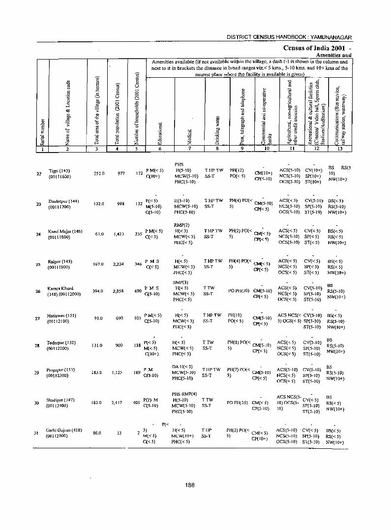
DISTRICT CENSUS HANDBOOK: YAMUNANAGAR
Census of India 2001 -Amenities and
Amenities available (if not available within the village, a dash (-) is shown in the column and
next to it in brackets the distance in broad ranges viz. < 5 kms., 5-10 kms. and 10+ kms of the -u;- nearest place where the facilitv is available is ~iven) :::l .,
~ E "0 ~~ -0 '§' a c: 0 '" 0 <!) '';:: c.J ,j c: .c E a " " e ;..::: v.I 0 c: > 0 g <!) 0 0 .~ z '0 t: 'E ~ .~ u ~ -'" ca 8..
<I) Q. "3 ., ~
0 a "' " 0
~~E ~ ~ 0 "" Q.
~ -0 :9 0 .~ '" ...:I 0 -0 6 :::l "
~ .;:;: ~ .<: "0 % .~ '3 l! .2 tIl -<> ~'" <!) c: "' ~ ~
., c: gj "' -0 0'- <> 0 .... c: _ -5 0 :;; ..c § t:: .. ~ et(f ~ • .@ ... .~ 0 0-
o C ., ..... ..c ~ ._ -0
.~ 0 .D .;:;: 0 "3 ...... -.; f! "iii "§ .~ ]>_,;: '" ._ E '" 0 OJ] 0g <.> ~
Q. '" :::l"O '2 ~ :::l ..... 1:! 0 ... .~ OJ] '" .!:! ~ .9 O! E
c 0 "' Q. '" "iii c :9 E '" :::l U ~ E ;:l :::l >-.
" .0 <.> :.;;a .g ~ E ~ "iii E ~
"iii E u :a c: ~. E""" ~.S :.g .~ ~ :3 ;:l ... 8 8~ ""..c 5:::
~ -0 0 ~ 2.ci5 en Z ILl :::s p.. <15 u f! 1 2 3 4 5 6 7 8 9 10 11 12 13
PHS
Tigri (143) PM«5) H(5-10) THPTW PH(12) ACS(5-10) CV(IO+) BS RS(5
22 (00111600)
2SI0 977 172 C(IO+) MCW(S-IO) SS-T PO« 5)
CM(IO+) NCS(5-1O) SP(lO+)
10)
PHC(5-10) CP(5-1O)
OCS(5-1O) ST{IO+) NW(IO+)
Daulatpur (144) 132.0 998 132
P«5) H(5-IO) THPTW PH(4) PO« CM(~-IO) ACS« 5) eV(5-10) 8S« 5) 23
(00111700) M(5-10) MCW{5-10) SS-T 5) CP« 5) NCS(5-10) SP(5-IO) RS(5-10) C(5-IO) PHC(S-IO) OeS(5-1O) ST(S-IO) NW(IO+)
RMP(2)
Kami Majra (146) 61.0 1,423 235
PM«5) H«5) THPTW PH(2) PO« CM« 5) ACS«5) CV«5) BS{<5) 24
(00111800) C«5) MCW«5) SS-T 5) CP«5) NCS(5-1O) SP« 5) RS« 5) PHC«5) OCS(5-IO) ST« 5) NW(IO+)
Raipur (14S) 167.0 2,224 346
PMS H«5) THPTW PH(4) PO{< C~< 5) ACS« 5) CV«5) BS{<5) 25
(00111900) C«5) MCW« 5) SS-T 5) CP« 5) NCS{<5) SP« 5) RS« 5) PHC«S) OCS«5) ST{< 5) NW{IO+)
SMP(3) BS
Karera Khurd 394.0 2,858 490
PMS H«5) TTW POPH(30) CM(5-1O)
ACS« 5) CV(S-IO) 26
(148) (00112000) C(5-IO) MCW« 5) SS-T NCS«5) SP(5-1O) RS(5-10)
PHC«5) CP« 5)
OCS«5) ST(5-1O) NW(IO+)
27 Hariawas (151)
91.0 690 103 PM« 5) H«S) THPTW PH(IO)
CM{S-IO) ACS NCS« CV(5-10) BS« 5)
(00112100) C(5-10) MCW« 5) SS-T PO« 5) CP«5)
5) OCS« 5) SP(5-1O) RS(5-1O) PHC« 5) ST(5-1O) NW{IO+)
Todarpur (152) P«5) H«5) TTW PH(8)PO« CM(~-IO) ACS«5) CV(5-10) BS
28 131.0 900 138 RS(5-10) (00111200) M«S) MCW«5) SS-T 5) CP« 5) NCS«5) SP(S-IO)
C(lO+) PHC« 5) OCS«5) ST(5-IO) NW(IO+)
PanJupur ( 153) PM DA H« 5)
THPTW PH(7) PO« CM(~-IO) ACS{5-IO) CV(5-1O) BS
29 183.0 1,125 189 MCW(5-1O) RS(S-IO) (001l2300) C(5-10) SS-T 5) CP«5) NCS«5) SP(5-10)
PHC(5-IO) OCS«5) ST(5-lO)
NW(lO+)
PHSRMP(4) ACS NCS(5- CV(~ 5) BS
30 Shadipur (147)
183.0 2,417 405 P(2) M H(5-IO) TTW
PO PH(35) CM«5) (00112400) C(5-1O) MCW(5-10) SS-T 10) OCS(S- SP(5- 0) RS«5)
CP(5-10) 10) I PHC(5-1O) ST(S-IO) NW(IO+)
P«
31 Garhi Gujran (418)
86.0 13 2 5) H«5) THP ~H(2) PO« CM(~ 5) ACS(5-10) . tV« 5) 8S« 5)
(00112500) M«5) MCW(IO+) SS-T ) CP(JO+) NCS(5-IO) SP(S-IO) RS«5)
C«5) PHC{< 5) OCS(5-IO) ST(5-10) NW(IO+)
188
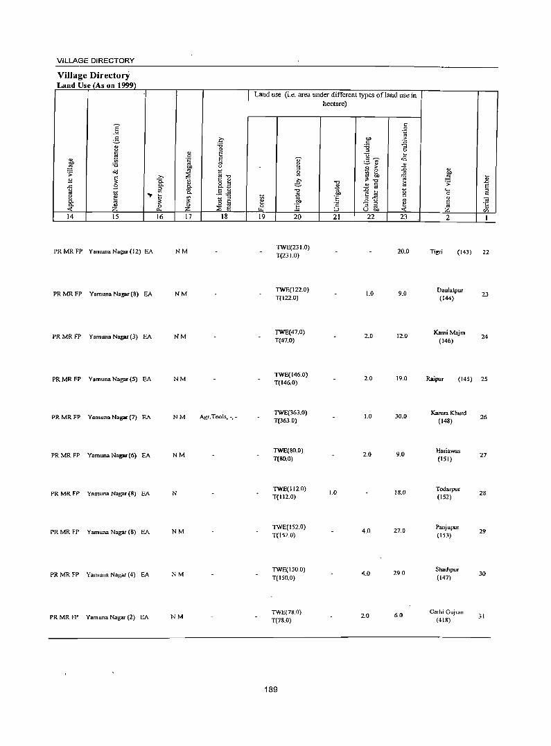
VILLAGE DIRECTORY
Village Directory Land Use (As on 1999)
14 15
PR MR FP Yamuna Nagar(12) EA
PR MR FP Yamuna Nagar (8) EA
PR MR FP Yamuna Nag;u-(3) EA
PR MR FP Yamuna Nag;u- (5) EA
PR MR FP Yamuna Nagar (7) EA
PRMRFP Yamuna Nagar (6) EA
PR MR FP Yamuna Nagar(8) EA
PR MR FP Yamuna Nagar (8) EA
PR MR FP Yamuna Nagar (4) EA
PR MR FP Yamuna Nagar (2) EA
16 17 18
NM
NM
NM
NM
NM Agr. Tools, -, -
NM
N
NM
NM
NM
Land use (i.e. area under different types ofland use in hectare)
19 20
TWE(23 1.0) T(231.0)
TWE(122.0) T(I22.0)
TWE(47.0) T(47.0)
TWE(146.0) T(146.0)
TWE(363.0) T(363.0)
TWE(80.0) T(80.0)
TWE(112.0) T(112.0)
TWE(l52.0) T(152.0)
TWE(150.0) T(150.0)
TWE(78.0) T(78.0)
189
21
1.0
22 23
20.0
1.0 9.0
2.0 12.0
2.0 19.0
1.0 30.0
2.0 9.0
18.0
4.0 27.0
4.0 290
2.0 6.0
2
Tigri (143) 22
Daulatpur (144)
KamiMajra (146)
23
24
(145) 25
Karera Khurd (148)
Hariawas (151)
Todarpur (152)
Panjupur (153)
Shad'pur (147)
Garhi Gujran (418)
26
27
28
29
30
31
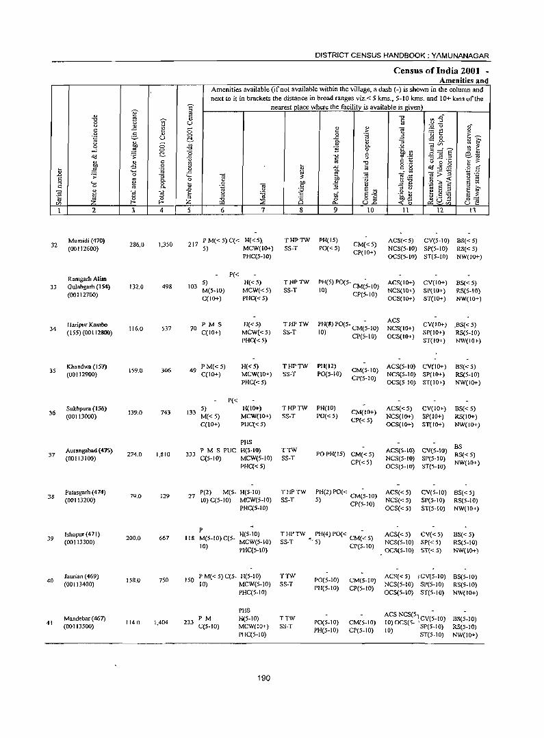
DISTRICT CENSUS HANDBOOK: YAMUNANAGAR
Census of India 2001 -Amenities and
Amenities available (if not available within the village, a dash (-) is shown in the column and next to it in brackets the distance in broad ranges viz.< 5 kms., 5-10 kms. and 10+ kms of the
j gj nearest place where the facility is available is j(iven)
'" 1'! "0 n ~ .. -0 ~
<> Iii 0 <.> U <.> '" " " on (,) .,"
c: ..c: 19 C; c >- e - '" <.> 0 g '" C> 0 .~ a ·u 1:: E~ .~ U ~ ..c: ~ ~
<U 0-
" "3 .., ~ <.> C; '" '" - CI) ~ 1: 0 bO 0.. <.> g=s ...l ~ co "0 B 0 .~ ~
~ "0 6 m~ o(l .;> ..c -0 <.> 7 .::: -3 jg .2 ~ "' c: ., ., c: 1A '" -0 C '" <.> 0 ~ '" ;;:: bO -5 0 ::l ~ ..c: Iii
o .- 0<3..g .g .§ c'" :u ~ .~ 0 0- r= ... ~ ..... ..c "'" E! OJ OJ:>"§
"';:; 0 .J::J .;; 0 "3 ._ OJ ~ ~:B
os .-S "' 0.. 0 C bO '§ c: < S:! S '"
._ ~ 0 ~ 0 bO '" a ., .~ "' 6 c '" c: 0 '" 0.. '" '.g OJ ~ B " "3 t3 ::l >-.
'" .c <.> sJ:l ~ E :l E ~ OJ
~ OJ S <.> :.a 'ii .~ ~ e C1) ._
'5 a 0 '" ::l .., .s g § g a '5 g"" "' -0 C5 0 bO ..c:
CI) Z f-' Z i:LI ::E c:>.. U.c <0 P::;~CI) U e 1 2 3 4 5 6 7 8 9 10 11 12 13
Mumidi (470) 286.0 1,350 217
PM«5)C« H«5). THPTW PH(15) CM«5)
ACS«5) CV(S-IO) 8S«5) 32
(00112600) 5) MCW(JO+) SS-T PO«5) NCS(5-10) SP(5-IO) RS«5) PHC(5-10)
CP(IO+) OCS(5-10) ST(5-1O) NW(lO+)
Ramgarh Alias P«
5) H«5) THPTW PH(S) PO(5- CM(~-IO) ACS(IO+) CV(IO+) 8S«5) 33 Gulabgarh (154) 132.0 498 103
M(5-10) MCW{<5) SS-T 10) CP(5-10) NCS{IO+) SP(IO+) RS{S-IO) (00112700)
C(IO+) PHC« S) OCS(IO+) STeIO+) NW(IO+)
Haripur Kambo PMS H«S) THPTW PH(S) PO(S- CM(~-lO) ACS
CV(IO+) ,BS«5) 34 116.0 537 70 NCS(IO+)
(155) (00112800) C(10+) MCW«5) SS-T 10) CP(5-10) OCS(IO+) SP(IO+) RS(5-1O)
PHC« 5) ST(IO+) NW(IO+)
Khandwa (157) 159.0 306 49
P M«5) H«S) THPTW PH(12) CM(S-IO)
ACS(5-10) CV(IO+) BS« 5) 3S
(00112900) C(10+) MCW(IO+) SS-T P0(5-10) NCS(5-10) SP(IO+) RS{5-10) PHC«S)
CP(5-10) OCS{S-IO) ST(IO+) NW(IO+)
P{< Sukhpura (156)
139.0 743 133 5) H{IO+) THPTW PH{IO)
CM{IO+) ACS«5) CV(IO+) BS{< 5)
36 (00113000) M«5) MCW{IO+) SS-T PO« 5) NCS(IO+) SP(lO+) RS(IO+)
C{IO+) PHC«5) CP« 5)
OCS(IO+) ST(IO+) NW(IO+)
PHS BS
Aurangabad (475) 274.0 1,810 333
PMSPUC H(5-10) TTW PO PH(15) CM«5)
ACS(S-IO) eV(S-IO) 37
(00113100) C(S-IO) MCW(5-1O} SS-T NCS(S-IO) SP(5-10) RS{< 5)
PHC«S) CP«5)
OCS(5-1O) ST(5-1O) NW(IO+)
Palasgarh (474) 79.0 129 27
P(2) M(S- H(S-IO) THPTW PH(2) PO« CM(~-IO) ACS«5) CV(S-IO) BS« 5) 38
(00113200) 10) C(5-IO) MCW(5-IO) SS-T 5) CP(5-10) NCS«5) SP(S-IO) RS(5-10)
PHC(5-IO) OCS« 5) ST(S-IO) NW(IO+)
Ishopur(471) P
H(5-1O) T HP TW PH(4) PO« C - ACS« 5) CV«5) BS« 5) 39 200.0 667 118 M{5-10) C(5-
(00113300) MCW(5-10) SS-T ~. 5) M« 5) NCS(5-10) SP«5) RS(5-1O) 10)
PHC(S-IO) CP(5-1O)
OCS(5-10) ST«5) NW(JO+}
laurian (469) 158.0 750 ISO
P M« 5) C(S- H(5-10) TTW PO(5-1O) CM(5-IO)
ACS{< 5) jCV(S-IO) BS(S-IO) 40
(00113400) 10) MCW(5-10) SS-T NCS(S-IO) SP(5-10) RS(5-1O) PHC(5-10)
PH(5-10) CP(S-IO) OCS(5-1O) ST(5-10) NW(IO+)
PHS ACS NCS(S:CV(;_IO) Mandebar (467)
114.0 1,404 233 PM H(5-10) TTW
PO(5-10) CM(5-10) BS(5-10) 41
(00113500) C(5-IO) MCW(lO+) SS-T 10) OCS(5- SP(5-1O) RS(S-IO) PHC(5-10)
PH(5-10) CP(5-10) 10) ST(5-10) NW(IO+)
190
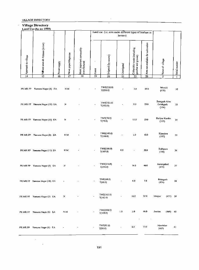
VILLAGE DIRECTORY
Village Directory Land Use (As on 1999)
e -'"
e- o :.a ., u 0
~ " E c " j;j E "" 0 :.a ~ ~
u
o<! E .;;: ~ ~
>- "'.", .3 Ci. 1:: i!:!
" ..c .3 0. g- o '" 0. _
iii ~ E U 1;; c.. ._ t.fS 8 i!:! lil ~ t; '" 0.
~ ~ 0 a 0. 0 Z ::E ..: p.. E
14 15 16 11 18
PRMRFP Yamuna Nagar (4) EA NM
PRMR FP YamunaNagar(IO) EA N
PRMRFP Yamuna Nagar (10) EA N
PRMRFP Yamuna Nagar (8) EA NM
PRMRFP Yamuna Nagar (II) EA NM
PRMRFP Yamuna Nagar (5) EA N
PRMRFP Yamuna Nagar (10) EA
PRMRFP Yamuna Nagar (3) EA N
PR MR FP Yamuna Nagar (6) EA NM
PR MR FP Yamuna Nagar (6) EA
Land use (i.e. area under different types of land use in
t; e 0 ~
19
.... f:! '" Sl >-e
.", .. 'OJ bJ)
] 20
TWE(228.0) T(228.0)
TWE(103.0) T(103.0)
TWE(78.0) T(78.0)
TWE(146.0) T(146.0)
TWE(109.0) T(109.0)
TWE(214.0) T(214.0)
TWE(6S.0) T(68.0)
TWE(162.0) T(162.0)
TWE(108.0) T(IOS.0)
TWE(93.0) T(93.0)
191
hectare)
"0 ., til
:§' c
:::::> 21
8.0
1.0
c 0 .~
bJ) E c :.a a '" u .... c ~ .g ._ '" ~ '" .. s 6 :0
~!' ..
=a ii'i ~ fa
e] '0 c:
E 0 .. "3 rJ !! u OJ) <
22 23
3.0 55.0
6.0 23.0
15.0 23.0
1.0 12.0
22.0
14.0 46.0
4.0 7.0
16.0 22.0
3.0 46.0
S.O 13.0
" l !J .;;: ..0 E .... '" 0 c
" ~ <a li C/)
2 1
Mumidi (470)
32
Ramgarb Alias Gulabgarh 33
(154)
HaripurKambo 34
(155)
Khandwa 35
(157)
Sukhpura 36
(156)
Aurangabad 37
(475)
Palasgarh 38
(474)
Ishopur (471) 39
Jaurian (469) 40
Mandebar (467) 41
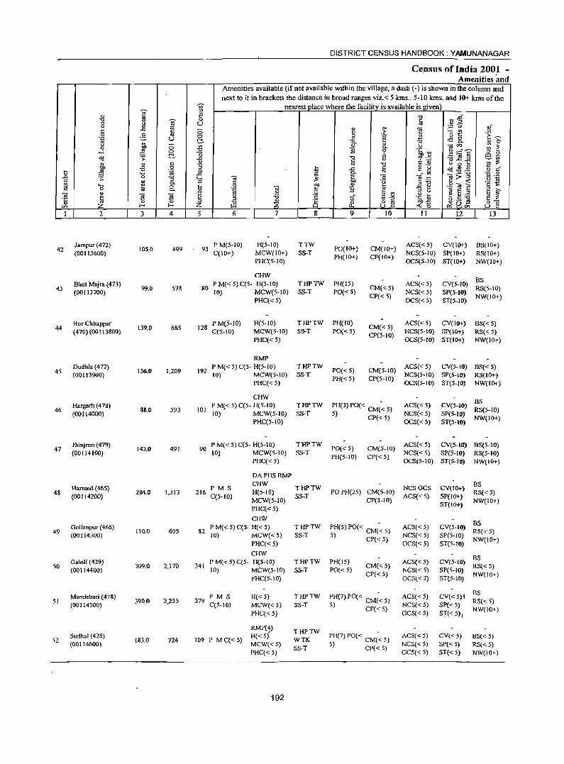
DISTRICT CENSUS HANDBOOK: YAMUNANAGAR
Ce.nsus oflndia 2001 -Amenities and
Amenities available (if not available within the village, a dash (-) is shown in the column and next to it in brackets the distance in broad ranges viz.< 5 kms .• 5-10 kms. and 10+ kms of the
~ nearest jJlace where the facility is available is_given]
'" e le -0 ~~ -0 ..
~ <l a 8 t) ;g U ... ... " 0';:; C; o-
s::: ..0:: <l 0 s::: > "§ - '" u 0 ~ '" C> 0 .~ a '0 1:: 'E ~ .~ U ...c: 4S8. ~ 0- ::; o [t;' u ..
0 ... " «l'" ;;; i: 0 bO '" 0- <)
-l ~ C> "0 "2 0 °tb ~ 3==E' ~ -0 <> " " ~ .;;: ..c:: -0 u 6 .~ '3.8..= 6~ <U s::: '" ~ " " c: ;g '" -0 o ._ <) 0 ~
§ co. ~ .,s 0
~ ..c:: c c g c(J ~-g ~ .~ _g '" ... '- e- «i _" '" «i;;:-g ":::; 0 .D .;;: 0 ::; '- «l ~ E .~ '" .-S as 0- 0 C tlO .~ ,,-0 C -< '2 ~ :::l 'a ~ 0 ~ 0 "" <U
-§ t3 .2 -a E r: 0- <U .~ «l so; "2 " a ~ " .D '-' ;Q s '" til a :::l
~ § ~ S E '-' '0 c: 'i E-'" .~ ~ f:! p-- E ~ ::l :::l
" 8 o S bl)..c:: 38] ~ -0 ~
0 0:-;:::
'" Z !- Z I.LI 0.. U.o -<: 0 r:>:: '-' '" U E! 1 2 3 4 5 6 7 8 9 10 II 12 13
Jampur(4n) 499 93
PM(5-10) H{5-IO) TTW PO(IO+) CM(IO+)
ACS«5) CV(IO+) BS(IO+) 42
(00113600) 105.0
C(IO+) MCW(IO+) SS-T NCS(5-10) SP(IO+) RS(IO+) PHC(S-IO)
PH(IO+) CP(IO+) OCS(5-10) ST(IO+) NW(lO+)
CHW Bhut Majra (473) P M« 5) C(5- H(S-IO) THPTW PH(IS) ACS«S) CV{5-IO)
BS 43
(00113700) 99.0 578 80
10) MCW(5-1O) SS-T PO«5) CM«5)
NCS« S) SP(5-IO) RS(5-10)
PHC« S) CP« 5)
OCS«5) ST(5-10) NW(IO+)
Ror Chhappar P M(5-1O) H(S-IO) THPTW PHeIO) CM«S)
ACS«5) CV(IO+) BS« 5) 44 (476)(00113800)
139.0 685 128 C(5-10) MCW(S-IO) SS-T PO«5) NCS{S-IO) SP(JO+) RS« 5)
PHC« 5) CP(5-10)
OCS(5-1O) ST(IO+) NW(IO+)
RMP Oudhla(4n)
156.0 1,209 192 P M« S) C(S- H(5- 10) THPTW
PO« S) CM(S-IO) ACS«S) CY(5-IO) BS« S)
45 (00113900) 10) MCW(S-IO) $oT NCS(5-1O) SP(5-10) RS(IO+) PHC« 5)
PH«S) CP(5-10) OCS(S-IO) ST(5-IO) NW(IO+)
CHW BS
Hargarh (478) P M( < 5) C(5- H(S-IO) THPTW PH(3)PO« CM(~5) ACS« S) CV(5-10) 46
(OOIl4000) 88.0 S93 101
10) MCW(S-IO) SS-T S) CP« 5) NCS« 5) Spes-tO) RS(S-IO)
PHC{S-lO) OCS« 5) ST(5-tO) NW(IO+)
Jhinjron (4-79) P M« 5) C(5- H(S-JO) TH?TW PO« S) CM(S-IO)
ACS« 5) CV(S-IO) B8(5-10) 47
(00114100) 143.0 491 90
10) MCW(S-IO) SS-T NCS«S) SP(S-IO) RS(S-IO) PHC« 5)
PH(5-IO) CP« S) OCS(5-1O) ST(5-IO) NW(IO+)
OAPHSRMP
Harnaul (465) PMS CHW
THPTW NCSOCS CV(IO+) BS
48 (OOI142(0) 284.0 1,313 216
C(5-lO) H(5-IO)
SS-T PO PH(25) CM(5-1O)
ACS« 5) SP(II}!-) RS« 5)
MCW(5-10) CP(S-IO) NW(IO+) PHC«S)
ST{lO+)
CHW as Gollanpur (456) PM«5)C(S- H«S) THPTW PH(5) PO« CM(~ S) ACS« S) CV(S-IO)
49 110.0 605 &2 RS«5) (00114300) 10) MCW«S) SS-T S) CP« S) NCS« S) SP(S-IO)
PHC« 5) OCS« 5) ST(5-IO) NW(IO+)
CHW as Galoli (429) P M« 5) C(5- H(5-10) THPTW PH(15) ACS« S) CV(S-IO)
50 309.0 2,170 341 CM«5) RS«5) (00114400) 10) MCW(S-IO) SS-T PO« 5)
CP« 5) NGS« S) SP(5-IO)
NW(IO+) PHC(5-10) OCSt< 5) ST(5-10)
Mandebari (428) PM S H«S) iHPTW PH(7) PO« CM(~ 5) ACS« 5) CY«S)I as
51 390.0 2,235 379 RS« 5) (00114S00) C(5-10) MCW«5) SS-T 5) CP« 5} NCS« S) SP« 5)
PHC«5) OCS« 5) ST« 5), NW(IO+)
RMP(4) THPTW
52 Sudhal (426)
183.0 724 109 PM C«5) H«S)
WTK PH(7) PO« CM(~ 5) ACS«5) CV«5) 8S«5) (00114600) MCW«S) 5) CP« 5) NCS«S) SP« 5) RS« 5)
PHC« 5) SS-T
OCS«5) ST« 5) NW(IO+)
192
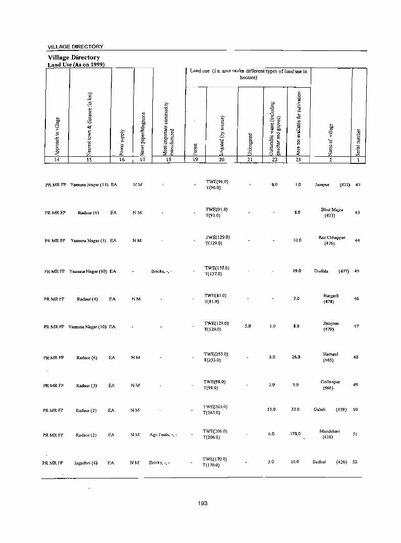
VILLAGE DIRECTORY
Village Directory Land Use (As on 1999)
~ ~ B ..c g 2 0. 0. -< 14 IS
PR MR FP Yamuna Nagar (15) EA
PRMRFP Radaur (4) EA
PR MR FP Yamuna Nagar (5) EA
PRMRFP YamtmaNagar(IO) EA
PRMRFP Radaur (4) EA
PRMRFP YamunaNagar(IO) EA
PRMRFP Radaur (6) EA
PRMRFP Rad.ur(3) EA
PRMRFP Rad.ur (2) EA
PRMRFP Rad.ur(2) EA
PRMRFP Jagadhri (4) EA
16 17 18
NM
NM
NM
Bricks, -,-
NM
NM
NM
NM
NM Agr.Tools. -,-
NM Bricks, -,-
Land use (Le. area under different types ofland use in hectare)
19 20
TWE(96.0) T(96.0)
TWE(91.0) T(91.0)
TWE(129.0) T(129.0)
TWE(131.0) T(131.0)
TWE(SI.O) T(Sl.O)
TWE(129.0) T(129.0)
TWE(253.0) T(253.0)
TWE(98.0) T(98.0)
TWE(263.0) T(263.0)
TWE(206.0) T(206.0)
TWE(1100) T(170.0)
193
21
5.0
22 23
8.0 1.0
8.0
10.0
19.0
1.0
1.0 8.0
5.0 26.0
3.0 9.0
13.0 330
6.0 178.0
3.0 10.0
2
lampur (412) 42
BhutMajra (413)
Ror Chhappar (476)
43
44
Dudhla (411) 45
Hargarh (478)
Jhinjron (419)
Hamoui (465)
Goll.npur (466)
46
47
48
49
Galoli (429) 50
Mandebari (428)
51
Sudhal (426) 52
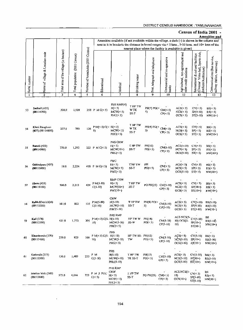
DISTRICT CENSUS HANDBOOK: YAMUNANAGAR
Census of India 2001 -Amenities and
Amenities available (if not available within the village, a dash (-) is shown in the column and next to it in brackets the distance in broad ranges viz. < 5 lans., 5-10 kills. and 10+ lans of the
-;;;-- nearest place where the facility is available is given \ ~ iil
'" '" "0 a'J 2"' "0 .s
'" .,
§ 0 ..., U <.> '" ;:l '';: u oJ" c:: ..c:: ~ 0 " '" e :.: U') <.> c::
1 0 g '" <=> 0 .3 '13 t:: 'E ~ .~ U ..c ~ g_ ~
C!. "" "5 " ~ u 0 '" '" u ~ ~hE ;;: 1: 0 :2 0 "0 11 9 .~ ~ ...l "0 ;:l ...
~ .;;: C!. ..c:: "0 0 '? .~ 3 ~.2 ~~ § <.>
" .,
'" ~ ] '" " u 0 ... o ._ § c "" .,s 0 ;:l ... ..c c._~ ~ .g .g
~ :2 .'" 0 " ""' '" ..c:: ~ ~ ._ "0 ·z 0
.0 .;;: 0 "5 "- OJ OJ e .~ ~>~ '" ._
S '" 0 c:: OJ) .~ '2 ~ ;:l '- ... "" 0 OJ) ., ;:l"O .2 ~ a tq 0 ~ OJ 11 'I) .=:: ::: E ~ '" 0 "" .~ '" .0 <.> ~ 6 ., ;:l u ~ E ::s
OJ .,
.~~ s ~ S E " :a ~- E-'" ~ .5 :g s :s: ·c ;:l
'" ~ ::J "0
Q)
8 13 8] 0:::: ... Z :2 ...: (5 ~u~ en Z P.I "'"'
~en U e 1 2 3 4 5 6 7 8 9 10 11 12 13
PHS RMP(4) THPTW
53 Sudhail (425)
398.0 1,528 253 P MC«5) H« 5)
WTK PH(7) PO« CM(~ 5) ACS«5) CV«5) BS« 5) (00114700) MCW«5)
SS-T 5) CP« 5) NCS« 5) SP(5-1O) RS« 5) PHC« 5) OCS« 5) ST(5-IO) NW(IO+)
P M« 5) C« H« 5) THPTW
PH(4) PO« CM(~ 5) ACS«5) 54
ICbe:ri Rangh ran 237.0 789 136 WTK
CV«5) BS« 5) (427) (00114800) 5) MCW«5)
SS-T 5) . CP« 5) NCS« 5) SP« 5) RS«5) PHC« 5) OCS{<5) ST« 5) NW(IO+)
PHSCHW Rattol; (422)
230.0 1,293 222 P MC«5) H«5) THPTW PH(16)
CM(5-10) ACS(5-1O) CV«5) BS{<5)
55 (00114900) MCW(10+) SS-T PO«5) NCS«S) SP« 5) RS« 5)
PHC« 5) CP{< 5)
OCS(5-IO) ST« 5) NW(IO+)
FWC Gobindpura (407)
18.0 2,224 418 P MC«5) H("'S) THPTW PH
CM«5) ACS«S) CV« 5) BS« 5)
56 (00115000) MCW«5) SS-T PO«5) NCS«S) SP« 5) RS« 5)
PHC« 5) CP«5)
OCS(5-10) ST«5) NW(IO+)
RMPCHW Kbera (423)
506.0 2,213 424 P M(5-10) H« 5) THPTW
POPH(25) CM(5-1O) ACS«5) CV« 5) BS«5)
57 (00115100) C(S-IO) MCW(IO+) SS-T NCS«5) SP(IO+) RS«5)
PHC(IO+) CP«5)
OCS«5) ST(IO+) NW(IO+)
CHW Ruhla Kheri (424)
181.0 822 135 PM(5-10) H(S-IO) THPTW PH(8) PO« CM(~-IO) ACS«5) CVeS-IO) BS(5-IO)
58 (00115200) C(5-IO) MCW(S-IO) SS-T 5) CP(S-IO) NCS«5) SP{S-IO) RS{5-10)
PHC(5-IO) OC5«5) ST(S-IO) NW(IOt)
PHSRMP ACSNCS(S- -
Kail (378) P M« 5)C{5- H(5-10) HPTWW PH(14) BS 59
(00115300) 431.0 1,773 305
10) MeW(S-IO) SS-W PO« 5) CM(S-IO) 10)OCS(5- eV{5-10) RS(5-IO~ CP(5-10) 10) SP(IO+) NW(IO+)
PHC«S) ST(IO+)
PHS
60 KhWldewala (370)
2S9.0 925 166 PM«5)C(5- H(S-IO) HP TW SS- PH(12)
CM(5-10) AgS« 5) CV(S-IO) 85« 5) (00115400) 10) MCW(S-IO) TW PO« S)
CP(S-IO) N S(5-IO) SP(IO+) RS(5-1O)
PHC«5) OCS(5-10) S;r(IO+) NW(IO+)
PHS
61 Kathwala (377)
136.0 1,409 235 PM H(5-1O) THPTW PH(15)
CM{5-IO) ACS« 5) CV(5-1O) BS{< 5)
(00115500) C(5-IO) MCW(5-1O) TK SS-T PO« 5) CP« 5)
NCS(5-1O) S~IO+) RS(5-1O) PHC(5-10) OCS(5-1O) S (10+) NW(IO+)
PHSRMP
Mahlan Wah (380) PMSPUC CHW
THPTW ACS NCS(5- CV{~ BS 62 575.0 4,044 723 H« 5) PO PH(25) CM«5) 10) 5) RS« 5) (00115600) C« 5) SS-T OCS(IO+~ SP~5-10) MCW«5) CP«5) NW(IO+)
PHC« 5) ST 5-10)
194
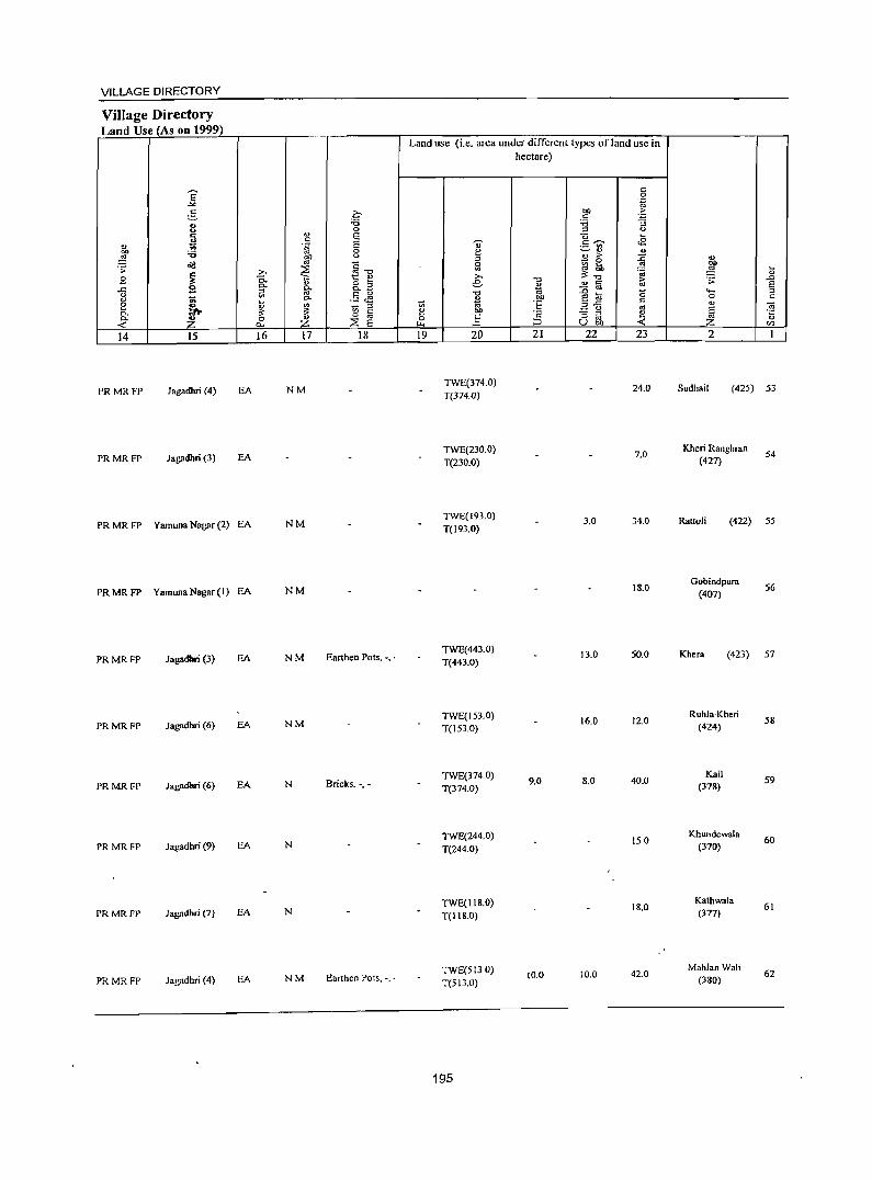
VILLAGE DIRECTORY
Village Directory Land Use (As on 1999)
Land use (i.e. area under different types ofland use in hectare)
E c 0 ... ..g
5 Z;- oo ._E: c <> '6 '6 :; <> 0 '" <> c g E os u ~
" ;; 'S E .., c::~ ..s OIl
._ .. '6 0 ~ ~'" ..
~ ~ <.> ., >
.;g ~-g
~ 0 ::D ... '> ~ iil :fI ... '" ~ .8 ~ 2:- » ~~ ~ Q;
0- Q; 8.a e "0 ~ .;;: ,.D
..c:: g 0- go * .. c E
'" - ..
g '" .§ J! "0 -e ta a .... '" 0. " bO 0 C
e ~ ~ '" '" '" ij. 'E ",..c:: c ., 0- ~
1;; c e ~ g '" S <ii 0- ~
0 '" ] '2 e 'E ::E 0 '" '" ~ ...: p.. E ~ ;:J U bO ...: en
14 15 16 17 18 19 20 21 22 23 2 I
PRMRFP Jagadbri (4) EA NM TWE(314.0)
24.0 Sudhail (425) 53 T(J74.0)
PRMRFP Jagadbri (3) EA TWE(230.0) 1.0
Kheri Ranghran 54
T(230.0) (421)
PRMRFP Yamuna Nagar (2) EA NM TWE(193.0) 3.0 34.0 RattoH (422) 55 T(193.0)
PRMRFP Yamuna Nagar (I) EA NM 18.0 Gobindpum
56 (401)
PRMRFP Jagadbri (3) EA NM Earthen Pots, -, . TWE(443.0) 13.0 SO.O Khera (423) 57 T(443.0)
Jagadhri (6) EA NM TWE(IS3.0) 16.0 12.0
Ruhla-Kheri 58 PRMRFP T(IS3.0) (424)
Bricks. -,-TWE(374.0)
9.0 8.0 40.0 Kail
59 PRMRFP Jagadhri (6) EA N T(314.0) (378)
TWE(244.0) 150 Khundewala
60 PRMRFP Jagadhri (9) EA N T(244.0) (370)
TWE(II8.0) 18.0 Kathwala
61 PRMRFP Jagadhri (7) EA N T(l18.0) (377)
PRMRFP Jagadhri (4) EA NM Earthen Pots, -, . TWE(5130) T(513.0)
10.0 10.0 42.0 MahlanWali
62 (380)
195
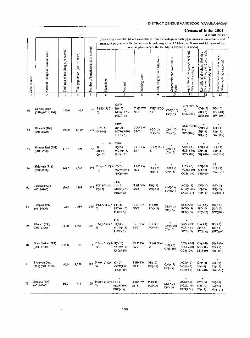
'Vi'
" e ~
"0 .s ~ ... 0 0 ~ u "
., c: ..r:: c: ;; 0 :5 '" 0 '.g u ., !::!-" ;; {j 0 bO
...l ~ 0
dI! .s;: ~ :g '" "
., c: :g ~ -5 0
t .~ 0 "8 ..r::
..0 .s;: '3 ..... e .. 0- 0
" .... '" 0 _g '" 0 a 0..
Oi .,
~ E e ~ 'fi ~
;:;J
en f- Z I 2 J 4 5
Haripur Jatan 105 63 190.0 625 (379)(00 I 15700)
Bhatauli (405) 64
(00115800) 123.0 1.419 240
Jhinwar Heri (38 I) 65 110.0 121 56
(00115900)
Haluwala (384) 1,060 66
(00116000) 167.0 177
Jarauda (403) 180.0 1.868 353 67
(00116100)
6& Telipura (402)
92.0 1,389 246 (00116200)
69 Chaneti (399)
183.0 1,935 303 (00116300)
70 Buria Sarkar (393)
155.0 64 S (00116400)
71 Bhagwan Garh
99.0 1,079 192 (398) (00116500)
72 Bhojpur (397)
92.0 714 120 (00116600)
DISTRICT CENSUS HANDBOOK:YAMUNANAGAR
Census of India 2001 -Amenities and
Amenities available (ifnot available within the village, a dash (-) is sho_in the column and next to it in brackets the distance in broad ranges viz. < 5 kms., 5-10 kms. IUld 10+ kms of the
nearest_])lace where the facility is available is given "0 ~i fa .; ., ... e! ~"
c: .:! ;;Of:! .~ 0 ., ;:1 eg_ 1:~ .c 0-
~ '3 ., ~ ., 0
~~~E ;:: 1: B ~~ " '" '0 8 ~ ._ §~ .2 e~ c: <= Z '" ;;; <II '0 g 'g "" 0 .... c: _
~ .c @ ~.g .,g o '" 0- • .0 0
ca" .; ._ "0
Oi e ~ Voi> ;:J .~ oM '" 00
~ :;'0 §';;j ~
0 "" '" .::: e '" '" .~ Oi ] B 'g e § " >-<..> e '" ::s t>
E ~ " :a ',;;- e_,. .~ L-o e u ,_
::l c: bh.s go ~ g,-: "0 '" C§ 0 82 >Ll ~ c. ..: 0 Il¢~", u e 6 7 8 9 10 II 12 13
CHW ACS NCS(S- CV{~ 5)
P M« 5) C« H« 5) THPTW PH(5) PO« CM(~-IO) BS« 5) 10) 5) MCW«5) SS-T 5) CP{< 5) OCS(IO+) SP{< 5) RS(5-JO)
PHC«5) S1{5--IO) NW(JO+)
CHW ACS NCS(5- CV{~ 5) PM S H{<5) THPTW
PO« 5) CM«5) BS« 5) 10)
C(5-IO) MCW(5-IO) SS-T PH« 5) CP« 5) OCS(IO+) SP«5) RS« 5)
PHC«5) S1'«5) NW(IO+)
P« CHW 5) H« 5) THPTW PH(2) PO« CM(~ 5) ACS« 5) CV«5) BS« 5) M«5) MCW« 5) S5-T 5) CP« 5) NCS(5-1O) SI'«5) RS« 5) C« 5) PHC«5) OCS(IO+) ST(.s..rO) NW(IO+)
P M« 5) C(5- H« 5) THPTW ACS«5) CV«5) BS
PO« 5) CM«5) RS« 5) 10) MCW(IO+) S5-T NCS(5-1O) 51'«5)
PHC(5-10) PH« 5) CP« 5)
OCS(IO+) ST(.s..tO) NW(IO+)
PHS P(2) M«5) H("'5) THPTW PH(15)
CM«5) ACS«5) CV{<5) B8«5)
C«5) MCW«5) S5-T PO«5) NCS(5-1O) Sp«5) RS{< 5) PHC«5)
CP(ID+) OCS{IO+) ST(5--10) NW(IO+)
PM«5)C« H«5) THPTW PH(IO) CM«5)
ACS«5) CV«5) BS« 5) 5) MCW«5) S5-T PO«5)
CP« 5) NCS«5) SP«5) RS«5)
PHC« 5) OCS«5) ST(5-JO) NW(IO+)
PHS
PM«5)C« H«5) THPTW PH(IO) CM(5-10)
ACS(5-JO) CV«5) BS« 5) 5) ,MCW«5) S5-T PO«5)
Cpe< 5) NCS«5) Sp«5) RS«5)
PHC« 5) OCS« 5) 8T(5--JO) NW(IO+)
P M« 5) C(5- H(5-JO) THPTW PH(6) PO« CM« 5) ACS(5-10) CV(5-IO) BS(5-10) 10) MCW(5-IO) S5-T 5) CP(5-IO) NCS(5-10) SP(5-1Il) RS« 5)
PHC(5-10) OCS(IO+) ST(5-IO) NW(IO+)
P M« 5) C« H« 5) THPTW PHeIO) CM« 5)
ACS«5) CV« 5) SS«5) 5) MCW(IO+) SS-T PO« 5)
CP« 5) NCS«5) SP« 5) RS«5)
PHC(5-1O) OCS«5) ST(5-IO) NW(IO+)
P M« 5) q< H« 5) 'THPTW PH(lO) CM«5)
ACS« 5) CV«5) BS« 5) 5) MCW(IO+) 5S-T PO«5)
CP«5) NeS(S-IO) SP(5-l0) RS« 5)
PHC«5) OCS(IO+) ST«5) NW(JO+)
196
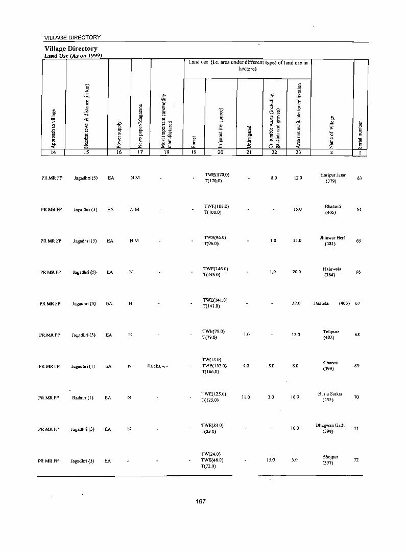
VILLAGE DIRECTORY
Village Directory Land Use (As on 1999)
Land use (i.e. area under different types ofland use in hectare)
E " 0 ~ .~
g 2:- btl ·fi " '" :a :a "3 u
" 0 '" u
~ " E Q ... ., f;j E " c ~ <B .- '" "" :a 0 e ~ ., '" ~ btl u
'" " ;> :0 ... o(j '" 1i-o ~ 0 .;;:
~ ~ ~ ... ~ bl)
~ >. ~~ 'OJ ~ ...
S "0. t:: ~ § .,
'" .", ;> .;;: .0
B 0.. o " " ~ a oS E .c 0.. c.. ~ <> i,l '" .5 Jg .", t;; .g 1;1 0 '- ::l oS
~ a. " .~ 0 " 0
~ d 3-fi c a ~ 1:1: ::l e .!: os " ~ " bO E 0- Z 0 Z 0 " 0 :g c "3 ~ ~ os « p.. :2: E '-'- ::> u bO Z " en 14 15 16 17 18 19 20 21 22 23 2 1
PRMRFP Jagadhri (5) EA NM TWE(170.0)
8.0 12.0 Haripur J.tan
63 T(170.0) (379)
PRMRFP Jagadhri (3) EA NM TWE(IOS.O)
15.0 Bhatauli
64 T(108.0) (405)
PRMRFP Jagadhri (3) EA NM TWE(96.0)
10 13.0 Jhinwar Heri
65 T(96.0) (381)
PRMRFP Jagadhri (5) EA N TWE(146.0)
1.0 20.0 Haluwala
66 T(146.0) (384)
PRMRFP Jagadhri (4) EA N TWE(141.0)
39.0 larauda (403) 67 T(141.0)
PRMRFP Jab",dhri (3) EA N TWE(79.0)
1.0 12.0 Telipura
68 T(79.0) (402)
TW(14.0) Chaneli
PRMRFP Jagadhr; (I ) EA N Bricks. -_. TWE(152.0) 4.0 5.0 8.0 (399)
69 T(I66.0)
N TWE(125.0)
11.0 3.0 16.0 Buria Sarkar
PRMRFP Radaur (I) EA T(125.0) (393) 70
PRMRFP Jagadhr; (3) EA N TWE(83.0) 16.0
Bhagwan Garh 71
T(83.0) (398)
TW(24.0) Bhojpur
PRMRFP Jagadhri (3) EA TWE(48.0) 15.0 5.0 (397) 72
T(72.0)
197
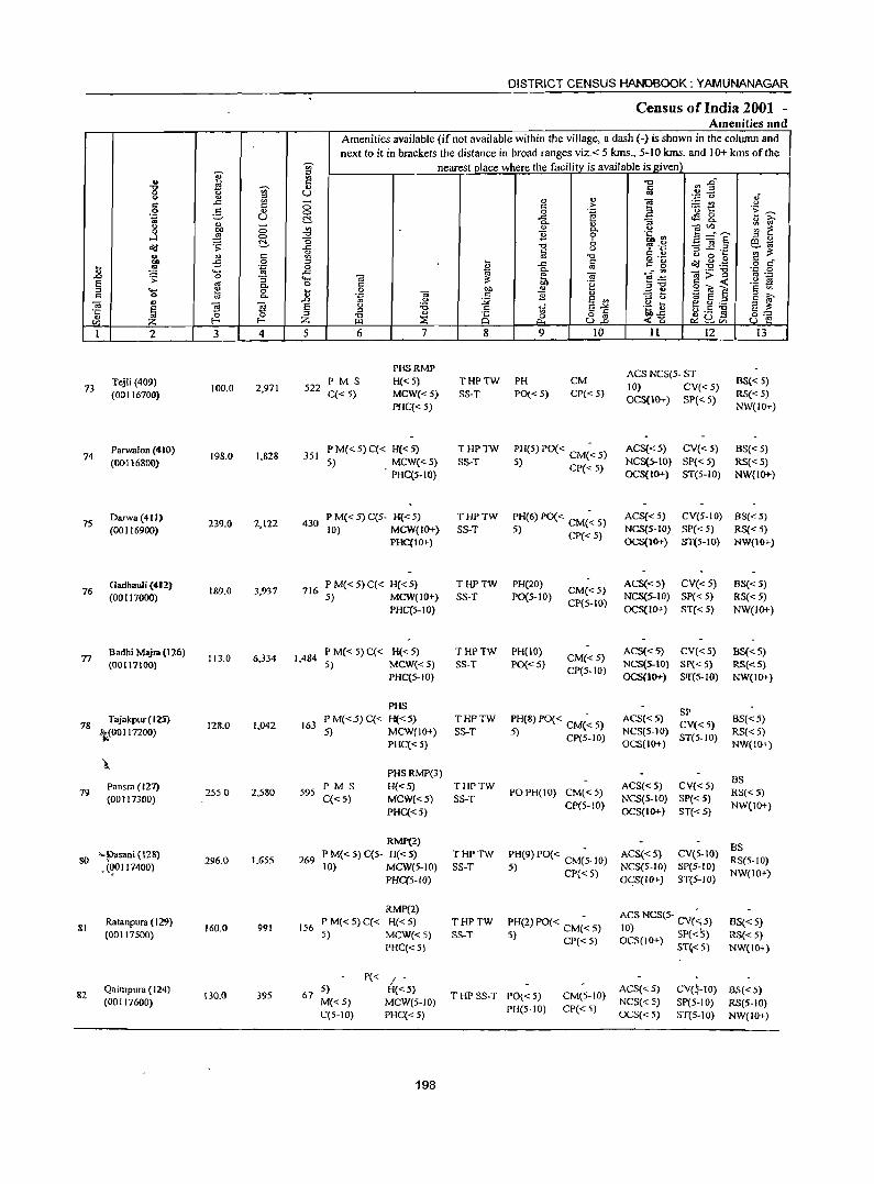
DISTRICT CENSUS HANDBOOK: YAMUNANAGAR
Census of India 2001 -Amenities and
Amenities available (if not available within the village, a dash (-) is shown in the column and next to it in brackets the distance in broad ranges viz. < 5 krns., 5-10 krns. and 10+ kms of the
Ui' nearest place where the facilitv is available is e:iven j
;:J .. E "0 :J E" "0
I ., c
0 <.> U '" <> " - " '" e .:;= (.) oJ' c ..c:
0 '" ,.. 'Et! <.>
0 e- O) 0 0 .~ .E '1: ~ .~ U !::!- ..c: ~&. " i:i' ., - 0- ., "S <>
'" " <.> OJVl : ~ 0 ~ 0 c.. ....l 0 "0 B 0 .~.~ !:i=E' '" '" !::!- "0 6 e~ o'd .;;: ..c "'" -3 l! .a
'" Iii u §.2 '" ~ .. <!l C '" -0 <.> 0 ...
'"' ;5 0 '" ~ '" ~ .g . .g '" " t _g 0g 0 ~ ..c: co c g o c
'- ..c g. _:"' ];;"3 '0 0 .D ~ 0 Oi '" ._ ;:; ..... Oi ~ lib ~:a '2 ~ s '" c.. 0 '" .~ olo~ '" .... " 0 t og t>I> " .:::: ~
" 0 to 0. Oi '" B '" ;;;> <.> ~ S § § i:i' ., .D <.> :.;;; S ., OJ ~ 2i ~ s <.> 'B c tf s~ .~ ~ ~ 11.)._
S ~ ·c '" ~ D S " ~ '" -0 .,
;§ 0 o oj ... .<: 0:= en :z f- Z III ::;; 0. U..o <0 c.:: ~Vl u e I 2 3 4 5 6 7 8 9 10 II 12 13
PHSRMP ACS NCS(5- ST
Tejli (409) P M S H« 5) THPTW PH CM BS« 5) 73 100.0 2,971 522 10) CV«5)
(00116700) C« 5) MCW« 5) SS-T PO{< 5) CP« 5) OCS(IO+) SP« 5)
RS« 5) PHC« 5) NW(IO+)
74 Parwalon (410)
198.0 1.828 351 PM{<5)C« H«5) THPTW PH(5) PO{< CM(~ 5) ACS{<5) CV«5) BS« 5)
(00116800) 5) MCW«5) SS-T 5) CP« 5) NCS(5-)() SP« 5) RS« 5) PHC(5.IO) OCS(I()+) ST{5-1O) NW{IO+)
75 Darwa(4tl)
239.0 2,122 430 P M« 5) C(5- H« 5) THPTW PH(6) PO{< CM{~ 5) ACS«5) CV(S-IO) BS« 5)
(00116900) 10) MCW(IO+) SS-T 5) CP«5) NCS(5-IO) SP« 5) RS{< 5) PHC(IO') OCS(10+) ST(5-10) NW(IO+)
76 Gadhauli (412)
189.0 3,937 716 PM«5)C« H«5) THPTW PH(20)
CM«.5) ACS«5) CV« 5) BS«5)
(00117000) 5) MCW(!O+) SS-T P0(5-1O) CP(S-I()
NCS(5-IO) SP« 5) RS« 5) PHC(5-10) OCS(IO+) ST« 5) NW(IO+)
n 8adhi Majra(126) 113.0 6,334 1,484
P M« 5)C« H«5) THPTW PH(IO) CM«5)
ACS«5) CV«5) 8S«5) (00117100) 5) MCW« 5) SS-T PO« 5)
CP(5-10) NCS(S-IO) SP« 5) RS« 5)
PHC(5-IO) OCS(IO+) SJf(S-IO) NW(IO+)
PHS SP
78 Tajakpur( 125)
128.0 1.042 163 P M«5) C« H« 5) THPTW PH(8) PO« CM(~ 5) ACS«5)
CV« 5) BS«5)
-'teOO 117200) 5) MCW(JO+) SS-T 5) CP(S-IO) NCS(5-10) ST(5-IO) RS« 5)
PHC« 5) OCS(IO+) NW(IO+)
\. PHSRMP(3)
BS Pansra (127) P M S H«5) THPTW ACS«5) CV« 5)
79 (00117300)
2550 2,580 595 C«5) MCW«5) SS-T
POPH(lO) CM« 5) NCS(5-IO) SP« 5)
RS«5)
PHC«5) CP(5-10)
OCS(IO+) ST« 5) NW(IO+)
RMP(2) BS
80 "~sani (128) 296.0 1,655 269 PM«5}C(5- H«5} THPTW PH(9) PO« CM(~-IO) ACS«5) CV(5-tO) RS(5-IO} , (<]0 117400) 10) MCW(5-IO) SS-T 5) CP«5) NCS(5-1O) SP(5-10) NW(IO+)
PHC(5-1O) OCS(IO+) ST(5-1O)
RMP(2) ACS NCS(S- CV(· 5)
81 Ratanpura (129)
160.0 991 156 PM«5)C« H«5) THPTW :H(2) PO« CM(~ 5) 10) ~ BS« 5) (00117500) S} MCW«S) SS-T J) CP«5) OCS(IO+) SP« 5) RS«S)
PHC«5) ST~< 5) NW(IO+)
P« / -82
Qaimpura (124) 130.0 395 67
5) H«5) THP SS-T PO« 5) CM(S-lO)
ACS« 5) CV(~-IO) SS« 5) (00117600) M«5) MCW{5-10)
PH(5-10) CP« 5) NCS« 5) SP(5-10) RS(S-IO)
C(5-10) PHC«5) OCS« 5) ST(5·IO) NW(IO+)
198
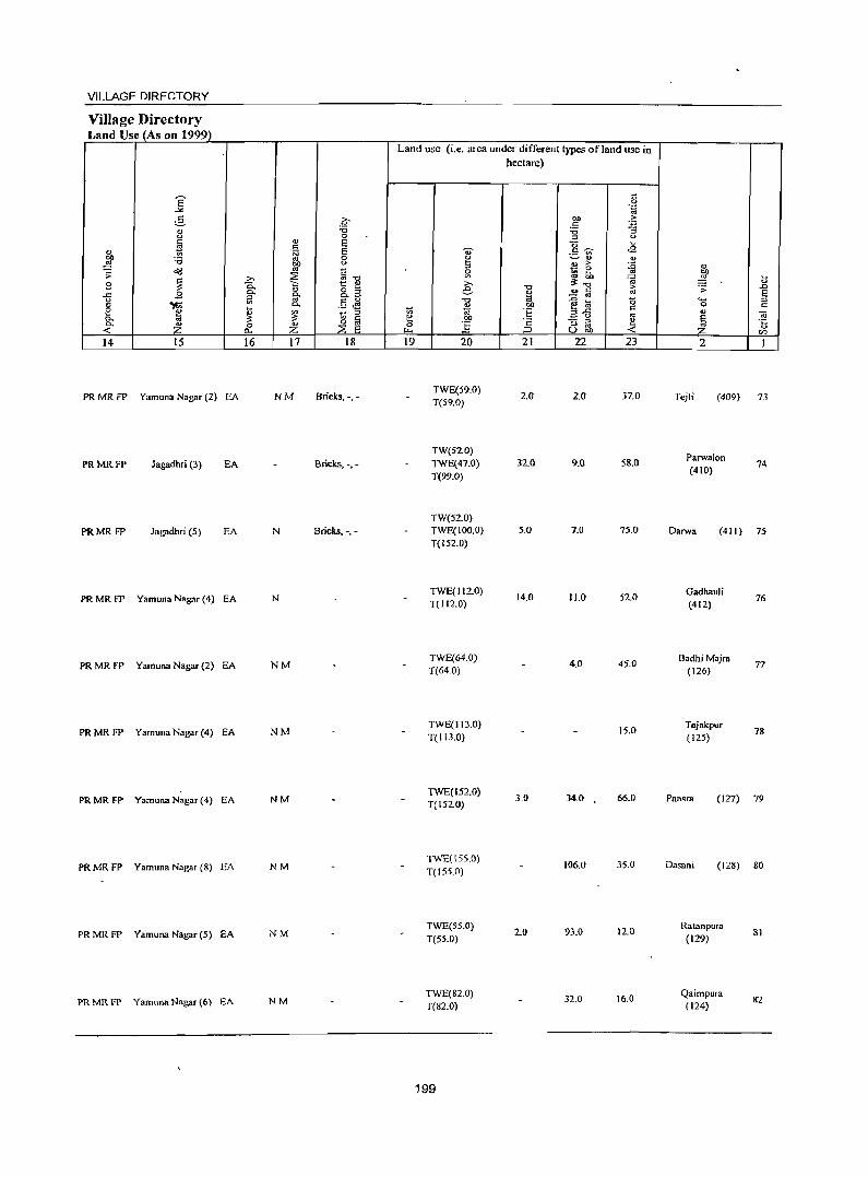
VILLAGE DIRECTORY
Village Directory Land Use (As on 1999)
E -'" e- o ., :a 0 0
~ ., E s:: ., 'iii E
"" 'B 0
~ en 0
01! '" " .;;: ~ ~ ~ ~] B
0. <U o ;:1 ..c B ~
0. 0. _
u
"'{i '" . 5 ~ '" ~ 0. e '" ~ 1;; ~ a. o:! :>: a. Z 0 <U 0
« C>. z ::2 E 14 15 16 17 18
PRMRFP Yamuna Nagar (2) EA NM Bricks. -.-
PRMRFP Jagadhri (3) EA Bricks, -.-
PRMRFP Jagadhri (5) EA N Bricks. -.-
PRMRFP Yamuna Nagar (4) EA N
PRMRFP Yamuna Nagar (2) EA NM
PRMRFP Yamuna Nagar (4) EA NM
PRMRFP Yamuna Nagar (4) EA NM
PR MR FP Vamuna Nagar (8) EA NM
PR MR FP Vamuna Nagar (5) EA NM
PR MR FP Vamuna Nagar (6) EA NM
Land use (i.e. area under different types of land use in
'" 1:! 0 ~
19
.., g ::J
~ >-e
.",
'" '" bI)
:§ 20
TWE(59.0) T(59.0)
TW(52.0) TWE(47.0) T(99.0)
TW(52.0) TWE(IOO.O) T(152.0)
TWE(1I2.0) T(112.0)
TWE(64.0) T(64.0)
TWE(II3.0) T(113.0)
TWE(152.0) T(152.0)
TWE(\55.0) T(155.0)
TWE(55.0) T(55.0)
TWE(82.0) T(82.0)
199
hectare)
-cJ
~ bI)
'E '2 :::> 21
2.0
32.0
5.0
14.0
3.0
2.0
s:: 0 .~
"" .f; c: :a :; ::> 0
"0 M
c~ ¢l ._ '" ~., ., <t> >
~ _ 0
rtf M
~~ ... o s:: >
- oj '" {i til (5
3--5 s::
'" "3 ~ e Ubi) «
22 23
2.0 37.0
9.0 58.0
7.0 75.0
11.0 52.0
4.0 45.0
15.0
34.0 66.0
106.0 35.0
93.0 12.0
32.0 16.0
., bI)
~ ~
<> .;; .0 E .... ::>
0 c: ., <i E
'" li Z <Zl
2 I
Tejli (409) 73
Parwalon 74
(410)
Darwa (411 ) 75
Gadhauli 76
(412)
BadhjMajra 77
(126)
Tajakpur 78
(125)
Pan~ra (127) 79
Dasani (128) 80
Ratanpura
(129)
Qaimpura (124)
81
82
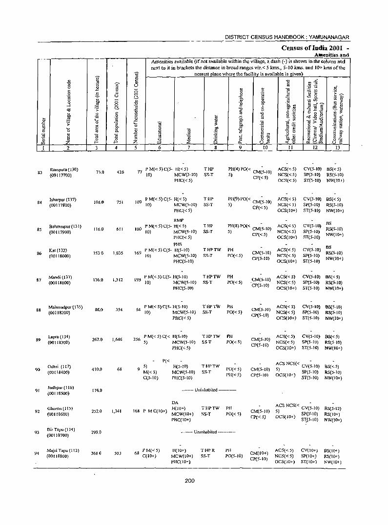
DISTRICT CENSUS HANDBOOK: YAMUNANAGAR
Ce,nsus of India 2001 -Amenities and
Amenities available (if not available within the village, a dash (-) is shown in the column and next to it in brackets the distance in broad ranges viz. < 5 kIDs., 5-10 kms. and 10+ kms of the
I '? nearest J)lace where the facility is available is given \
., :g "0 n1 "0
~ G)
" 0 U ., <.) ... 0';;: u ,;
" ..c '" 0 ... " ~ ~t! 0
ii " > 0 g 0 0 .~ a E..-.. "g u (;!, ..c ~ 8.. ., 0.. t 11 <I) iO' <.) ;:; U) ... -;a til ~ ~ 0 ~
0.. .....l a 3! "2 0 -c CI) !:l_""'" ;;3 G)
~ 0 " ~.~ _-roE to-.; acl .s: ..c "0
" ~ ...c ~= '" c ';;;'~ u <I) " U) .. "0 " " " 0 ... bll -s 0 ::l .... ..c g g "g aid ~.g s:: ,
t ~ .~ 0 ., o c .... ..c -.; 0- '" ]>'g '';;' 0 .D .s: 0 g_ .... -;a ~ ~ -;a e .~ .~ OJ § .. 0 '" '0 ;;3"0 o ... ~ ..... e 0 t 0 -;a ""
., 0> .=; ~ " U) c 0 '" 0- ~ c "2 .~ E I: § iO' u .D c.> :;;; §J2
:;l <.) e C).2 ~ !§ -;a E <> '6 .g ~ E -0 ::s c ti o .S -g EZ t ~
::s -0 .,
8 o § _,Z :2 0 ~o ~U- (} .§ til !- ;Z; ~ p., U.n ~CI)
I 2 3 4 5 6 7 8 9 10 11 12 13
Rampura (130) 73.0 426 17
PM«5)C(5- H«5) THP PH(4) PO« CM(~-10) ACS{< 5) CV(5-10) BS« 5) 83
(00117700) to) MCWe5-10) SS-T 5) CP« 5) NCS«5) Spe5-IO) RS(5-1O) PHC« 5) OCS«5) ST(5-IO) NW(IO+)
Isharpur (137) 106.0 751 109
P M« 5) C(5- H« 5) THP PH(9) PO« CM(~-IO) ACS« 5) CV(5-IO) BS« 5) 84
(00117800) 10) MCW(5-10) SS-T 5) CP« 5) NCS« 5) SP(S-IO) RS(5-JO) PHC«5) OCS(IO+) ST(S-IO) NW(IO+)
RMP Bahrampur (131) PM«5)C(5- H«5) THP PH(S) PO« CM(~-IO) ACS«5) CV(5-IO) BS
85 J16.0 611 100 RS(5-JO) (00117900) 10) MCW(S-to) SS-T 5) CP« 5) NCS«5) SP(5-IO)
PHC« 5) OCS(JO+) ST(5-10) NW(IO+)
PHS Kat (132) P M« 5) C(5- H(5-JO) THPTW PH ACS{<5) CV(S-IO) BS
86 (00)18000)
JS:! 0 1,035 \69 10) MCW(S-IO) SS-T PO(<: 5)
CM(S-lO) NCS« 5) SP(5-to)
RS(5-IO)
PHC(S-IO) CP(5-10)
OCS(IO+) ST(S-IO) NW(IO+)
87 Mandi(I33)
136.0 1,312 193 P M« 5) C(5- H(5-1O) THPTW PH
CM(5-IO) ACS«S) CV(5-10) BS«5)
(00118100) 10) MCW(5-1O) SS-T PO«5) CP(S-IO)
NCS{<5) SP(5-10) RS(5-IO) PHC(5-1O) OCS(IO+) ST{5-10) NW{IO+)
Mahmudpur(135) 86.0 354 54
P M« 5) C(S- H{5-IO) THPTW PH CM(5-10)
ACS{<S) CV{5-IO) B8(5-IO) 88
(00118200) 10) MCW(5-10) SS-T PO« 5) NCS« 5) SP(S-IO) RS(5-10) PHC« 5)
CP(5-IO) OCS(JO+) ST(5-JO) NW(IO+)
Lapra (134) 262.0 1,646 256
P M« 5) C« H(5-IO) THPTW PH CM(5-IO)
ACS« 5) CV(5-IO) BS« 5) 89
(00118300) 5) MCW(S-IO) SS-T PO«5) NCS« 5) SP(S-IO) RS(5-10) PHC« 5)
CP(5-1O) OCS(IO+) ST(5-10) NW(IO+)
P« ACS NCS« CV(;-lO) Odhri (117)
410.0 68 9 5) H(S-ID) THPTW
PO« 5) M«5)
90 (00118400) M«S) MCWeS-IO) SS-T
CM(S-lO) 5) SP(5-10) RS(5-IO) C(5-1O) PHC(5-1O)
PH«5) CP(5-10) OCS(IO+) ST(S-10) NW(IO+)
91 Jodhpur (116) (00118500)
174.0 ----- Uninhabited --------
DA ACS NCS( < CVe;-IO)
92 Gharon (I 15)
2S2.0 1,341 168 P M C{IO+) H(IO+) THPTW PH
CM(5-10) BS(5-IO)
(00l18600) MCW(lO+) SS-T PO« 5) 5) SP(5!.1O) RS(lO+) PHC(IO+)
ep« 5) OCS(IO+) S"I;{S-IO) NW(JO+)
93 BirTapu (114) (00118700)
299.0 --- Unmhabited --------
94 Majri Tapu (113)
3680 503 68 P M« 5) H(IO+) THPR PH
CM(lO+) ACS«5) CV(IO+) 6S(\0+)
(00118800) C(IO+) MCW(IO+) SS-T PO(5-10) CP(5-1O)
NCS«5) SP(IO+ ) RS(IO+) PHC(IO+) OCS(IO+) ST(IO+) NW(IO+)
200
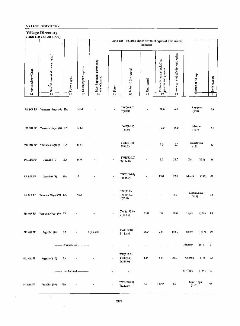
VILLAGE DIRECTORY
Village Directory Land Use (As on 1999)
Land use (i.e. area under different types of land use in hectare)
j " 0 -~
6 c OIl > :;; "
.;:;
" :;; :; " "
0 " " ~ " E u ... .. ·S E "U' 5~ <2
~ :;; 0 ~ ~" " bll " <U > :g " Cd '" t: ~ 0 -;;
~ ~ ~ ... ~ ~ :>. "'..., ;;:~ ~
... 2 0.. 1:: " :>. " " o :; e "0 1:; ';> ..0
.c B Co c. c. ~ ~ 2 a e ~ i_;l '" .S JJ "0 ~ til 15 ..... ::l
-,.e Co .. ·ff 0 " [ ~ ~ to tii c '" g "..<: '" " -a
'" e:! OIl ~ " e <- o '" ;§ - ::l e:! ·c
Z 0 ~ 0 ] BgJ, ~ c. ~ E r.z.. .( " en 14 15 16 17 18 19 20 21 22 23 2 1
PRMRFP Yamuna Nagar (6) EA NM TWE(48.0)
19.0 6.0 Rampura
83 T(48.0) (130)
PRMRFP Yamuna Nagar (8) EA NM TWE(8LO)
10.0 15.0 Isharpur
84 T(81.0) (137)
PRMRFP Yamuna Nagar (8) EA NM TWE(91.0)
90 16.0 Bahrampur
85 T(91.0) (131)
PRMRFP Jagadhri (7) EA NM TWE(124.0)
8.0 21.0 Kat (132) 86 T(124.0)
PRMRFP Jagadhri (8) EA N TWE(104.0)
15.0 17.0 Mandi (133) 87 T(104.0)
TW(39.0) Mahmudpur
PRMRFP Yamuna Nagar (9) EA NM TWE(44_0) 3.0 88 T(83.0)
(135)
PRMRFP Yamuna Nagar (9) EA TWE(192 0)
33.0 7.0 300 Lap,a (134) 89 T(192.0)
PRMRFP Jagadhri (8) EA Agr.Tools, -,-TW(J82.0)
64.0 2.0 1620 Odhri (117) 90 T(182.0)
------ Uninhabited ---------- Jodhpur (116) 91
TW(212.0)
PRMRFP Jagadhri (10) EA TWE(6.0) 6.0 50 23.0 Ghoron (liS) 92 T(2 I 8.0)
----- Uninhabited ------- 8irTapu (114) 93
PRMRFP Jagadhri (16) EA TWE(220.0)
4.0 t39.0 5.0 MajriTapu
94 T(220.0) (113)
201
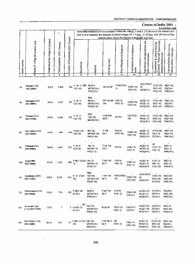
DISTRICT CENSUS HANDBOOK: YAMUNANAGAR
Census of India 2001 -Amenities and
" Amenities available (ifnot available within the village, a dash (-) is shown in the column and next to it in brackets the distance in broad ranges viz. < 5 kms., 5-10 kms. and 10+ kms of the
~ nearest place where the facility is available is !!iven) e ~ '" i1~
., " -0 -0 ~ -;;;- " ~ 0 u C) " iil ., '" i
',p c,) ,;
'" ..c::
" ;::; '" > - '" <J .,. 5 ., 0 0 ~
'u t ·E ~ 1ii U C!. ..c:: ~ & : f c. u M. ;::; " '" ~:'e 0 ~ c. o-l ~ 0 11 0 .~ Ul
;oJ " ~
(5 b ~ -<Id .s: ..c:: -0 u ~ .~ '3 ~ .~ ~ .. ., " '" ;: ... ... '" oj -0 C) 0 ... :l o .- ~ .g .g s c" "" -s 0 :;; ..c:: til c .. ~ ... ~ .~ 0
" ... ..c:: j c. .- -0 'C 0
.D ~ 0 "3 .... -.; ~ -.; e~ ]>~ OJ .-
J: ~
c. 0 " .~ '2 ~ g ... 0 ... 0 "" " E ~ .,. til E 0 c. '" ~
-.; " 11 " ::l >. .D <J :;;; E '" ::l <J 1ii S ::l E ~ -.; " n 5 Eo <> ~ 'Vf Eo"'" .~ \) ~.S ~ § t: 't ::l ::l
" 8 o " 6b-s 13:-:: ~ ~ ;z: -0 ::; 0 ull ~u-
'" z ~ "" -< 0 ~'" u E! I 2 3 4 5 6 7 8 9 10 11 12 I3
8ibipur(118) 2S2.0 1,847 266
PM S PUC H{IO+) HP SS-HP PH(6} PO« CM(~-IO) ACS NCS« CV{;-IO) BS(5-10)
95 S) (0011&900) C(5-10) MCW(IO+) 5) CP(5-10) OCS(IO+) SP{S-IO) RS(IO+)
PHC(IO+) ST(5-IO) NW(IO+)
PHS
8akaIpUl" (120) 206.0 1,161 19S
PM S H(IO+) HP TW ss- PH(l7) CM(S-IO)
ACS«5) CV(5-1O) 8S(S-10) 96
(00119000) C(5-1O) MCW(IO+) TW PO« 5) NCS« S) SP(S-IO) RS(IO+) PHC(S-IO)
CP(5-1O) OCS(IO+) ST(5-10) NW(IO+)
Sabapur (121) PM S PHC
THPTW CMCP(S- ACS«5) CV(S-IO) 8S(S-10) 97 2S90 1,636 270 H(S-IO) PO PH
(00119100) C(S-IO) MCW(IO+)
SS..:r 10) NCS«S) SP(S-IO) RS(S-IO) OCS(IO+) ST(S-IO) NW(IO+)
Nai a.wan ( 122) 944 146
P M(5-10) H(S-IO) TTW PH(IO) CM(S-IO) ACS« S} CV(S-IO) 8S(S-10)
98 (00119200)
134.0 C(5-1O) MCW(5-10) SS-T PO(S-IO) NCS«5) SP« 5) RS(S-IO)
PHC(S-IO) CP(S-IO)
OCS(IO+) ST(IO+) NW(IO+)
Fetehpur(123) PM S H« 5) THPTW ACS«S) SP
BS« 5) 99 240.0, 1,424 233 PO PH CM« 5) CV« 5)
(00119300) C(S-IO) MCW«5) SS-T CP« S)
NCS«5) ST«5)
RS«S)
PHC« 5) OCS(IO+)' NW(IO+)
Sugh(396) 1,207 206
P M« S) C« H« 5) THPTW PH(12) CM«S)
ACS«S) CV« 5) BS« S) 100
(00119400) 353.0 5) MCW«5) SS-T PO« S) NCS« 5) SP«S) RS«S)
PHC« 5) CP« 5)
OCS(IO+) ST(S-IO) NW(IO+)
PHS ACS NCS« CV(;-IO) Amadalpur (39S)
2,556 412 r M SC(5- H(5-10) THPTW PH(7) PO(5- CM(~-IO) 8S(5-10)
101 407.0 5) (00119500) 10) MCW(5-1O) SS-T 10) CP(5-10) OCS(IO+) SP(5-10) RS(5-IO)
PHC(S-IO) ST(IO+) NW(IO+)
102 Mukarimpur (I 19)
103.0 770 128 P M(S-IO) H(IO+) THPTW PH(IO)
CM(5-IO) ACS(5-10) CV{IO+) 8S(10+)
(00119600) C(IO+) MCW(IO+) SS-T POC< 5) CPCIO+)
NCS(<5) SP(IO+) RS(5-IO) PHC(IO+) ~S(IO+) ST(IO+) NW(IO+)
Jalrampur Jagir - P« -
ACS(S-IO) qV(IO+) 8S« S) 103 119.0 7 5)M«5) H(S-IO) WSS-W PO(5-10) CM(IO+)
(112) (00119700) C(IO+) ~CW(IO+) PH«5) CP(IO+) NCS(5-1O) SP(IO+) RS(5-1O)
PHC(5-10) OCS(IO+) ST(IO+) NW(IO+)
104 Mali Majra (110)
201.0 592 97 P M« 5) C(5- H(5-10) THPTKC PH
CM«S) ACS«5) eveS-to) 8S(5-IO)
(00119800) 10) MCW(lO+) SS-T PO« 5) CP(S-IO)
NCS«5) SP(5-10) RS{IO+) PHC(IO+) OCS(IO+) ST(5-10) NW(IO+)
202
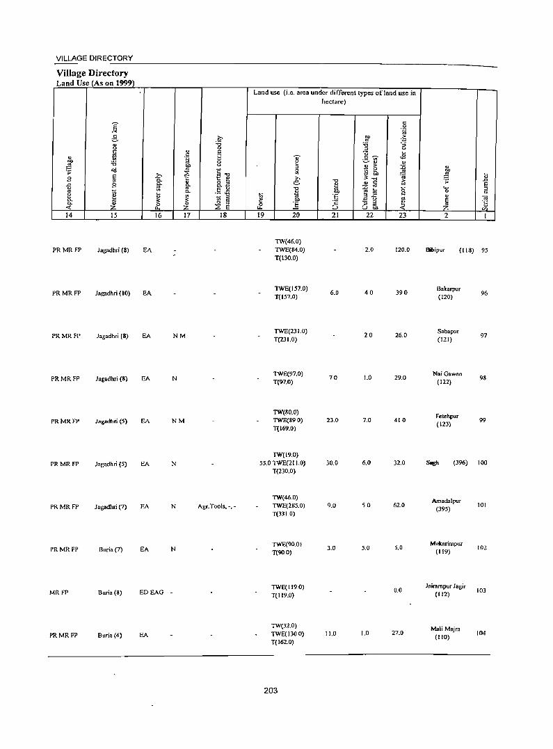
VILLAGE DIRECTORY
Village Directory Land Use (As on 1999)
14 15
PRMRFP Jagadhri (8)
16 17
EA
PRMRFP Jagadhri (10) EA
PRMRFP Jagadhri (8) EA NM
PRMRFP Jagadhri (8) EA N
PRMRFP Jagadhri (5) EA NM
PRMRFP Jagadhri (5) EA N
PRMRFP Jagadhri (7) EA N
PRMRFP Buria (7) EA N
MRFP Buria (8) ED EAG -
PRMRFP Buria (4) EA
18
Agr.Tools, -,-
Land use (i.e. area under different types ofland use in hectare)
19 20
TW(46.0) TWE(84.0) T(130.0)
TWE(157.0) T(157.0)
1WE{231.0) T(231.0)
1WE(97.0) T(97.0)
TW(80.0) TWE(890) T(169.0)
TW(19.0) 55.0 TWE(21 1.0)
T(230.0)
TW(46.0) TWE(285.0) T(331 0)
TWE(90.0)
T(90.0)
TWE(119.0) T(119.0)
TW(32.0) TWE(l300) T(162.0)
203
21
6.0
70
23.0
30.0
9.0
3.0
11.0
22 23
2.0 120.0
40 390
20 26.0
1.0 29.0
7.0 410
6.0 32.0
50 62.0
5.0 5.0
0.0
1.0 27.0
2
fR1ipur (lIS) 95
Bakarpur (120)
Sabapur
(121)
l\Iai Gawnn (122)
Fetehpur (123)
96
97
98
99
(396) 100
Amadalpur (395)
Mukarimpur (119)
Jairampur Jagir (112)
Mali Majra (110)
101
102
103
104
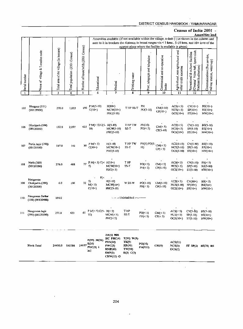
., " El "0
'"' 0 u u It) " t: ..c: ~ 0 g '" .~ U .., " "" ;:; 0
~ ..J 0 !:!. ~ .;;:
j '" t: -5 0
I; ".g 'H .0 .;; 0 :; E '" 0.
" .... ~ 0 s:: 0 0--.; ., s l "5 ~ ~ en 1 2 3 4
8hogpur (I 1 I) 105
(00119900) 270.0 1,033
Diyalgarh (394) 106
(00120000) 132.0 2,097
8uria Jagir (392) 107
(00120100) 167.0 141
Nabh (389) 108
(00120200) 276.0 488
Naugawan 109 Chalcpahla (391) 6.0 150
(00120300)
110· Naugawan Sarbr
164.0 (108) (00120400)
Naugawan Jagir III 271.0 423
(390) (00120500)
Block Total 24456.0 141786
DISTRICT CENSUS HANDBOOK: YAMUNANAGAR
Ce.nsus of India 2001 -Amenities imd
Amenities available (if not available within the village, a dash (-) is shown in the column and
next to it in brackets the distance in broad ranges viz. < 5 kms., 5-10 kms. and 10+ kms of the ~
nearest place where the facility is available is given ~ c "0 :J~ OJ C
U " It) ., ',p 0 OJ·
;:; t: .~ e :.= V) " 0 ·0 til .3 'u t:: .~ ~ ..c: ~ 8-t!- o. ~ :; ~ ~
'" .,
0. u ]dE' ~ ~ -0 B 0 .~.~ "0 6 CQ~
..c: -0
" -3 _g .2 ~~ '" c C U '" '" -0 o ._ u 0 ~
§ c .. " ~ ..c: 1a = .. ~ ~ .g.g 0 ..c: ~ ~ -.; 7d:;:""g "';:: 0
'H OJ e .~ " ._ 0 t: 'f! ,,"0 t: ...: '2 ~ kl 0 bl) OJ
-3 ~ .2 (a E .~ OJ c B u
:l '" .0 .!'! :.g E ., 1ii E " E ~ E u tf E-" .g ~ e u._
" -0 .s o .s --g §::= " "0 C)
0 0 82 ~-g z ~ c:!u- u e Ul Cl.. ~'" 5 6 1 8 9 10 11 12 13
190 P M(5-10) H(IO+)
THPSS-T PH
CM(5-IO) ACS« 5) CV(IO+) 8S(10+) C(1O+) MCW(IO+) P0(5-10) NCS«5) SP(IO+) RS(IO+)
PHC(5-10) CP(IO+)
OCS(IO+) ST(IO+) NW(lO+)
425 P M« 5) C(5- H(5-10) THPTW PH(IO)
CM«5) ACS«5) CV(5-10) 8S(5-1O)
10) MCW(5-10) SS-T PO«5) NCS«5) SP(5-10) RS(IO+) PHC(S-IO)
CP(5-1O) OCS(IO+) ST(IO+) NW(IO+)
30 P M«5) H(5-10) THPTW PH(5) PO(5- CM(~ 5) ACS(5-10) CV(5-10) 8S(5-10) C(IO+) MCW(IO+) SS-T 10) Cp« 5) NCS(5-IO) SP(5-10) RS(IO+)
PHC(5-10) OCS(5-1O) ST(IO+) NW(IO+)
77 PM«5)C« H(IO+) THP
PO«5) CM«5) ACS«5) CV(5-10) BS«5)
5) MCW(IO+) SS-T NCS«5) SP(5-1O) RS(5-IO) PHC«5)
PH«5) CP(5-10) OCS(lO+) ST(5-10) NW{lO+)
P«
32 5) H(5-1O)
WSS-W PO(5-1O) CM(5-10) ACS« 5) CV(IO+) BS«5) Me<5) MCW(IO+)
PH« 5) CP(5-10) NCS(S-JO) SP(IO+) RS(lo+)
C(IO+) PHC(5-IO) OCS(IO+) ST(IO+) NW(lO+)
--Uninhabited ----
61 P M« 5) C(5- H« 5) THP
PO« 5) CM« 5) ACS« 5) CV(S-tO) 8S(5-10)
\0) MCW«5) SS-T PH« 5) CP«5)
NeS{<5) SP{5-!0) RS{IO+) PHC«5) OCS(IO+) ST(5-1O) NW(JO+)
P(99) M(36)
S(26) 24157 PUC(8) I
DA(6) MH
HC PHC(4) PHS(24) FWC(3) RMP(40) SMP(3) CHW(12) 0
T(99) WeB) TK(9) HP(95) TW(90) R(3) C(3)
PO(I5) PH(957)
CM(S) ACS(21) NCS(3) OCS(2)
ST SP(2) BS(28) RS
AC
204
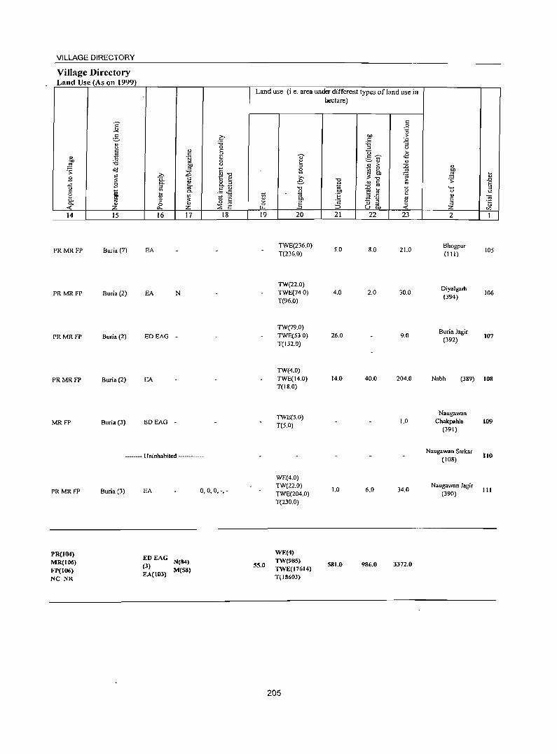
VILLAGE DIRECTORY
Village Directory Land Use (As on 1999)
14 15
PRMRFP Buria (7)
PRMRFP Buria (2)
PRMRFP Buria (2)
PRMRFP Buria (2)
MRFP Buria (3)
16 17 18
EA
EA N
EDEAG -
EA
EDEAG -
-- Uninhabited ----
PR MR FP
PR(104) MR(l06) FP(I06) NC NR
Buria (3) EA 0,0,0, -,-
EDEAG (3) N(84)
EA(I03) M(SS)
Land use (i e. area under different types of land use in hectare)
19
55.0
20
TWE(236.0) T(236.0)
TW(22.0) TWE(740) T(96.0)
TW(79.0) TWE(530) T(132.0)
TW(4.0) TWE(14.0) T(18.0)
TWE(5.0) T(5.0)
WE(4.0) TW(22.0) TWE(204.0) T(230.0)
WE(4) TW(98S) TWE(17614) T(l860J)
205
21
5.0
4.0
26.0
14.0
1.0
SSI.0
22 23
8.0 21.0
2.0 30.0
9.0
40.0 204.0
1.0
6.0 34.0
986.0 3372.0
2
Bhogpur (111)
Diyalgarh (394)
Buria Jagir (392)
105
106
107
Nabh (389) 108
Naugawan Chakpahla
(391)
Naugawan Sarkar (108)
Naugawan Jagir (390)
109
110
111


CENSUS OF INDIA 2001
INDIA HARYANA
C.D. BLOCK CHHACHHRAULI (PARTS OF TAHSIL CHHACHHRAULI AND
TAHSIL JAGADHRI) DISTRICT Y AMUNANAGAR
Km 2 1 0 2 4 6 8 10 Krn
TOTAL AREA (RURAL) OF CD. BLOO< (In Sq. Km).. 519.70 TOTAL POPULATION (RURAL) Of CD. BLOCK , . .. .. 174209 .\_..
NUMBER OF TOWNS ., .. .. ' . .. .. .. .. .. .... .. .. , J ~
TOTAL NUMBER OF VIllAGES IN C.D. BLOCK '.' - ' 174 (J DISTANCE FROM DISTRICT HEADQUARTERS (In Kms) 19
PARTS OF TAHSIL J AGADHRl BUT FALL IN CD. BLOCK BILASPUR A
C. D. BLOCK BOUNDARY EXCLUDES STATUTORY TOWN ( S )
PARTS OF TAHSIL CHHACHHRAULI BUT FALL IN CP. BLOCK BILASPUR F BOUNDARIES ARE UPDATED
UPTO 1. L 2000
BOUNDARY ;STATE
TAHSIL : CD. BLOCK ... - - . - . - ; ----
VILLAGE WITH PERMANENT LOCATION CODE NUMBER "
HEADQUARTERS: TAHSIL: CD. BLOCK ..... ' '" ...... ... .......... "
VILLAGE WITH POPULATION SIZE : BELOW 200 : 200 - 499 ; 500 - 999 ; 1000 - 4999 : 5000 & ABOVE ... .., ... ... ... ... ... ...
UNINHABITED VILLAGE WITH PERMANENT LOCATION CODE NUMBER ...
URBAN AREA WITH LOCATION CODE NUMBER
STATE HIGHWAY .. '" ......... .. .
IMPORT ANT METALLED ROAD .. ,.,
o
00136100
@ •
• • • • X 00124000
XI
SH SA
RIVER & STREAM / CANAL ... ... ... ... ... ... ... ... ... ... ~ : ====
POST OFFICE ... ... ... ... ... ... ... ... ... .. . ... ... ." ... ... ... ... PO
SECONDARY OR SENIOR SECONDARY SCHOOL ." " ... ... . .. ... ... . . ._ S
POLlCE STATION ...... ...... ", ." ." '" .. , '" '" '" ... ... . ........... . " PS
PRIMARY HEALTH CENTRE ... ............ " _ .. _.. . ..... ,,_ ... ~
BANK ... ...... '" ....... ' . ...... ", ...... " . .................. ., .... . _ . ... . _ . ....... " B

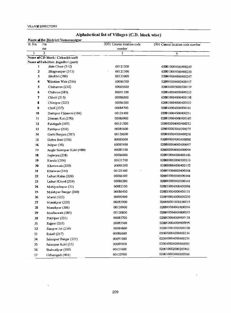
VILLAGE DIRECTORY
Alphabetical list of Villages (C.D. block wise) Name of the District:Yamunanagar SI. No. Na 2001 Census location code 1991 Census location code number
me number
2 3 4 Name .fCD Block: Chhachhrauli
Name .fSub-Dist: Jagadhri (part)
I Bala Chaur (312) 00121200 020010004000400249 2 Bhagwanpur (313) 00121300 020010004000400250 3 Bhukhri (388) 00121000 02~IOO04000400247
4 'Bisation Wala (216) 00086700 020010004000400157
5 Chabutron (232) 00085600 020010005000500139
6 Chahron (383) 00091100 020010004000400232
7 Chholi (215) 00086800 020010004000400158
3 Chintpur (225) 00086500 020010004000400153
9 Choli (237) 00084700 020010004000400101
10 Dadupur Chhawni (106) 00121400 020010064000400251
11 Dharam Kot (270) 00086900 020010004000400160
12 Fatehgarh (107) 00121500 020010004000400252
13 Fatehpur (230) 00085800 020010003000300275
14 Garhi Banjara (387) 00120600 020010004000400258
15 Gohra Bani (236) 00085000 020010004000400098
16 Jaitp ur (30) 00085400 020010004000400097
17 Jangle Salempur Kohi (489) 00085100 020010004000400094
IS Jogiwara (228) 00086000 020010004000400143
19 Kanalsi (104) 00121700 020010003000300313
20 Khanuwala (220) 00086300 020010004000400152
21 Kharwan (314) 00121100 020010004000400248
22 Lalhari Kalan (226) 00086100 020010005000500144
23 Lalhari Khurd (224) 00086200 020010005000500141
24 Mahiyudinpur (31) 00085300 020010004000400096
25 M alakp ur BangFlf (268) 00086400 020010004000400151
26 Marnli (322) 00090900 020010004000400230
27 Manakpur (229) 00085900 020010001000100119
28 M anakpur (386) 00120900 020010004000400246
'19 M odhuwala (385) 00120800 020010004000400245
30 Prithipur (231) 00085700 020010004000400138
31 Rajpur (235) 00085500 020010004000400099
32 Ramp ur J at (234) 00084800 020010004000400100
33 Rukali (2 17) 00086600 020010004000400154
34 SaJempur BangFlf (321) 00091000 020010004000400231
35 Salempur Kohi (33) 00084900 020010004000400093
36 Shahzadpur (J09) 00121600 020010002000200461
37 U dharngarh (401) 00120700 020010003000300260
209
DISTRICT CENSUS HANDBOOK :YAMUNANAGAR
Alphabetical list of Villages (C.D. block wise) Name of the District:Yamunanagar Sl. No. Na
me 2
Name of CD Block: Chhachhrauli
Name ofSub-Dist: 0002
I Ahmad M ajra (187)
2 Alipur (102)
3 Ashabpura (212) 4 Bachon (182)
5 Bahadurpur (164) 6 Bakkarwala ( 177)
7 BaJauli (208)
8 Balla M ajra (71 )
9 Baniawala (13)
10 Baroli M ajra (191)
II Begampllr (80) 12 Bell?flrh (73) 13 Beli Bhud (63) 14 Bhangera Bhangeri Bagp at (9) 15 Bhilpura (200)
16 Bhilpura (76) 17 Bhlld Kalan (67) 18 Bhud M ajra (70)
19 Bhul Kheri (85) 20 Bichpari (77) 21 Bir Taharpur (490)
22 Chakbaba Sahib Singh (7) 23 Chaneta (316) 24 ChaowaJa (328)
25 Chikan (12) 26 Chuharpllr Kalan (168) 27 Chuharpur Khurd(207) 28 Chuharpur M angalsingh (19) 29 Dadupur ]attan (222)
30 Dadupur Malion (193)
31 Dammunpur Bara(J01) 32 Dammunpur Chhota (99)
33 Damoli (J 95)
~ 34 Darpur (17)
~ 35 Darwa(78) 36 Dasaura (198)
2001 Census location code 1991 Census location code number number
3 4
00132200 020020004000400019 00121900 020020005000500467 00126300 020020004000400094 .00132700 020020004000400022 00131500 020020004000400113 00133200 020020004000400047 00129200 020020004000400095 00125300 020020004000400123 00134600 020020004000400029 00130100 020020004000400044 00125500 020020004000400125 00124900 020020004000400138 00125000 020020004000400120 00134300 020020004000400048 00125600 020020004000400140 00123100 020020004000400107 00130900 020020004000400118 00125200 020020004000400122 00124400 020020004000400105 00123200 020020004000400135 00135800 020020004000400004 00133700 020020004000400054 00126800 020020004000400089 00127400 020020004000400081 00134900 020020004000400026 00130800 020020004000400111 00126500 020020004000400093 00135200 020020004000400024 00129800 020020004000400~18
00129000 020020004000400042 00122000 020020004000400143 00122300 020020004000400146 00129500 020020004000400064 00135500 020020004000400009 00124700 020020004000400136 00130400 020020004000400063
210
VILLAGE DIRECTORY
Alphabetical list ofVilJages (C.D. block wise) Name ofthe District:Yamunanagar Sl. No. Na 2001 Census location code 1991 Census location code number
me number 2 J 4
37 Daulatpur (180) 00132900 020020004000400034
38 Dekriwala (66) 00131300 020020004000400117
39 Deodhar (72) 00125400 020020004000400124
40 Dhakwala ( 183) 00132800 020020004000400035
41 Doiwala (69) 00125100 020020004000400121
42 Ganaula (308) 00128400 020020004000400073
43 Ganauli (309) 00128300 020020004000400074
44 Gulabg;u-h (169) 00130700 020020004000400110
45 Gurdhanpur (204) 00126100 020020004000400097
46 Hafizpur (173) 00131900 020020004000400045
47 Hafzi (172) 00130200 020020004000400061
48 Haidarpur (233) 00136000 020020004000400001
49 Hal-dari Gujar(95) 00122100 020020004000400151
50 Hal-dari Maru (88) 00123400 020020004000400133
51 Harauli(194) 00129100 020020005000500067
52 Harewa(83) 00124100 020020004000400103
53 Hasanpur (90) 00123600 020020004000400131
54 Ismailpur (86) 00123900 020020004000400127
55 J aidhar (82) 00124300 020020004000400]04
56 Jaidhari (81) 00124500 020020004000400106
57 Jairarnpur Khalsa (98) 00122400 020020004000400]45
58 Jangle Mehmiwala (491) 00135600 020020004000400007
59 Jatanwala (18) 00135400 020020004000400010
60 J atheri (307) 00127300 020020004000400080
61 Jungle Kalesar (2) 00134100 020020004000400050
62 Kalesar(J) 00134000 020020004000400051
63 Kaniawala (74) 00123000 020020004000400139
64 Kansli (11) 00135000 020020004000400027
65 Karkauli (171) 00130300 020020004000400062
66 Khadri (97) 00123700 020020004000400130
67 Khanp ura (213) 00128700 020020004000400070
68 Khanpuri (210) 00126400 020020004000400071
69 Kherki (202) 00126000 020020004000400098
70 Khijri (8) 00134200 020020004000400049
71 Khilanwala (10) 00134700 020020004000400028
72 Khizrabad (165) 00133500 020020004000400056
73 KhoJ Darpur (492) 00135700 020020004000400006
74 Khol Fatehgarh (25) 00136100 020020004000400014
211
DISTRICT CENSUS HANDBOOK :YAMUNANAGAR
Alphabetical list of Villages (C.D. block wise) Name of the District:Yamunanagar Sl. No. Na 200 I Census location code 1991 Census location code number
me number 2 3 4
75 Kishanp ura (167) 00131600 020020004000400112
76 Koliwala (68) 00131000 020020004000400119
77 Kot Basawa Singh (185) 00132500 020020004000400020
78 Kot M ushtarka (184) 00132600 020020004000400036
79 Kot Sarkari (188) 00132100 020020004000400037
80 Kotra Kahansingh (189) 00130000 020020004000400038
81 Lahasabad (175) 00131800 020020004000400059
82 Lahoriwala (89) 00123500 020020004000400132
83 Lakar-mai Pratap pur (92) 00122900 020020005000500141
84 Leda Khadar ( I 90) 00129900 020020004000400039
85 Leda Khas (3 I 0) 00127200 020020004000400085
86 Ledi (221) 00129700 020020004000400040
87 Lopon (219) 00128900 020020004000400041
88 Mahab Aliwala (178) 00132000 020020004000400046
89 Malikpur Khadir (170) 00130600 020020004000400109
90 M anbharwala (79) 00124600 020020004000400126
91 M and Kheri (3 19) 00126600 020020004000400091
92 Mandauli Gagar (103) 00121800 020020004000400149
93 Mandewala (64) 00131100 020020004000400115
94 Manipur(223) 00132300 020020005000500017
95 Meghuwala (14) 00134400 020020004000400031
96 Mehar Majra (105) 00122100 020020004000400148
97 Mir Mayeinpur (100) 00122200 020020004000400147
98 M irpur (320) 00127100 020020004000400086
99 Mujafat Kalan (166) 00133400 020020004000400057
100 Mujafat Khurd (176) 00133300 020020004000400058
101 M ujahidwala (75) 00124800 020020004000400137 102 M ukarapur (18 I) 00133000 020020005000500033
103 M ukaribp ura (3 I 7) 00]26900 020020005000500087
~ 104 M unda Khera (3 I 8) 00127000 020020004000400088
~105 Nagai Chakbat (6) 00133600 020020005000500055
106 Nagai Patti Milk (5) 00133800 020020004000400053
107 Nahar Taharpur (2] 1) 00128500 020020004000400072
108 Nainwala (65) 00131200 020020004000400116
109 Nandgarh (87) 00123800 020020004000400129
,,";l 10 Nathanpur (15) 00134500 020020004000400134
~ <4-. ,
VILLAGE DIRECTORY
Alphabetical list of Villages (CD. block wise) Name of the District:Yamunanagar SI. No. Na 2001 Census location code 1991 Census location code number
me number 2 3 4
III Nathanp ur (91) 00123300 020020004000400030
112 Nawazpur (93) 00122800 020020004000400152
113 Panch Khola (493) 00134800 020020004000400008
114 Panjeton (315) 00126700 020020004000400090
115 .fip Ii M ajra ( 199) 00130500 020020004000400108
116 Raipur (196) 00129400 020020004000400065
117 Raiyanwala (4) 00133900 020020004000400052
118 Ram!?ilrh Alias Arjun Majra (186) 00132400 020020004000400016
119 Rampur Khadar (94) 00122600 020020004000400142
120 Salempur Khadar (214) 00128600 020020004000400069
121 Shahjahanpur (201) 00125700 020020005000500100
122 Shahzadwala (16) 00135100 020020004000400025
123 Sherpur (206) 00125900 020020004000400101
124 ,Singh Pura (205) 00124200 020020004000400102
125 Sipianwala (20) 00135300 020020004000400011
126 Taharpur Kalan (28) 00135900 020020004000400003
127 Tahirnun (174) 00131700 020020004000400060
128 Tl!iewala(3) 00131400 020020004000400114
129 Tapu laidhar (84) 00124000 020020004000400128
130 Taranwala (327) 00127500 020020004000400082
131 Tanmwala (209) 00129300 020020005000500066
132 Telipura (96) 00122500 020010004000400244
133 Tibbi Raiyan (179) 00133100 020020004000400032
134 Tihaoon (218) 00128800 020020004000400068
135 Tu~ur(192) 00129600 020020004000400043
136 Urjaoi (203) 00126200 020020004000400096
137 Yakubpur (197) 00125800 020020004000400099
213
" g Z 2 3
CD Block: Chhachhrauli (000<i)
2
3
4
5
6
7
1\
9
Choli (237) (00084700)
Rampur lat (234) (00084800)
Salempur Kobi (33) (00084900)
Gohra Bani (236) (00085000)
Jangle Salempur Kohi (489) (00085100)
''Mahiyudinpur (3 I) (00085300)
Jaitpur (30) (00085400)
Rajpur (235) (00085500)
Chabutron (B2) (00085600)
10 Prith.pur(231) (000&5700)
207.0
189.0
161.0
194.0
144.0
331.0
198.0
113.0
163.0
259.0
4
543
612
644
134
22
848
992
588
415
989
DISTRICT CENSUS HANDBOOK: YAMUNANAGAR
Census of India 2001 -Amenities and
Amenities available (if not available within the village. a dash (-) is shown in the column and next to it in brackets the distance in broad ranges viz.< 5 kms., 5-10 kms. and 10+ kms ofthe
nearest place where the facility is available is given
5 6
83 PM S C(IO+)
94 PM«5) C(IO+)
PM 96 C(lO+)
23 P« 5) M«5) C(JO+)
4 P« 5) M«5) C(IO+)
141 PM«5) C(IO+)
156 PM«5) C(10+)
80 P« 5) M«5) C(IO+)
66 P« 5) M«S) C(IO+)
171 PM«5) C(IO+)
7
H(IO+) MCW(5-IO) PHC(IO+)
H(IO+) MCW(5-1O) PHC(5-10)
DARMP H(IO+) MCW(5-10) PHC(IO+)
H(IO+) MCW(5-to) PHC(IO+)
H(10+) MCW(5-1O) PHC(IO+)
H(IO+) MCW(IO+) PHC(IO+)
H(IO+) MCW(IO+) PHC(IO+)
H(IO+) MCW(IO+) PHC(IO+)
H(IO+) MCW(IO+) PHC(IO+)
RMP(3) H(IO+) MCW(IO+) PHC(IO+)
214
u
t u ]
9 10
THPTW W TK PO PH(4) CM(jO+) SS-T CP(IO+)
THPTW WTK PH(5)
PO«5) SS-T
THPTW PH(9) WTK SS-T PO« 5)
HP ilW W PH(2) TK PO(IO+) SS-W
TSS-T PO«5) PH«5)
THPTW WTK PO«5) SS-T PH«5)
~S-:; PO« 5) PH«S)
HPTWW PH
~~W PO«S)
THPTW PH(5) TK SS-T PO« S)
CM(IO+) CP(IO+)
CM(IO+) CP(IO+)
CM(IO+) CP(5-10)
CM(IO+) CP(IO+)
CM(IO+) CP(5-10)
CM(IO+) CP(IO+)
CM(IO+) CP(IO+)
CM(IO+) CP(S-IO)
CM(IO+) CP« 5)
11 12
ACS(S-IO) CV(IO+) NCS(5-IO) SP(IO+) OCS« 5) ST(IO+)
ACS«5) NCS«5) OCS« 5}
CV(IO+) SP(IO+) ST(IO+}
ACS(5-10) CV(IO+) NCS(5-IO) SP(IO+) OCS«5) ST(IO+)
ACS(5-10) ,CV{lO+) NCS(5-10) SP(IO+) OCS«5) ST(lO+)
ACS(5-IO) CV(IO+) NCS(S-IO) SP(IO+) OCS« 5) ST(IO+)
ACS(S-IO) CV(I 0+) NCS(S-IO) SP(IO+) OCS« 5) ST(IO+)
ACS(S-IO) CV(IO+) NCS(5-10) SP(IO+) OCS(5-1O) ST(IO+)
ACS(5-10) CV(IO+} NCS(5-10) SP(IO+) OCS« 5) ST(IO+)
ACS«5) NCS«5) OCS« 5)
ACS« 5) NCS« 5) OCS«5)
CV(IO+) SP(IO+) ST(IO+)
CV(IO+) SP(IO+) ST(IO+)
13
BS« 5) RS(IO+) NW(JO+)
BS RS(IO+) NW(IO+)
BS RS(IO+) NW(IO+)
BS«5) RS(IO+) NW(JO+)
BS«S) RS(IO+) NW(IO+)
BS«5) RS(IO+) NW(1O+)
BS RS(IO+) NW(IO+)
BS« 5) RS(lO+) NW(1O+)
BS RS(IO+) NW(lO+)
BS(5-1O) RS(IO+) NW(lO+)
VILLAGE DIRECTORY
Village Directory Land Use (As on 1999)
Land use (Le. area under different types of land use in hectare)
E t:: 0
-'" .~
3 a 01} ·Ei t::
'" '6 :a :; <.>
" 0 ::l u c E "0 ~
~ t:: d) .);j E '0 t::~ .a .- '" 01} '6 0 ~ ~'" " ~ ... <.> ::l e ~ ::0 " &II ..
~1l .;;:
~ 51 ~~ os 01}
~ >, ra ~ ~
B "5. >, '" .. 8.2 e "0 ~ .;;: .D
..<: B 0.. D. C> '" t:: E iii 1;; ::£ os u .,
.5 ~ "0 ~ b ... :;J os
'" c.. ... OIl 0 c e ~ t; 1;; ::s~ c
~ ~ '" ~ ::l 'E os '" OJ Co ~ Cl § e :§ ~ u E 0. '2 :; :;J e .;:;
...: Z 0 Z ::E E 0 os ~ u
Po. ~ 0 C) 01} ...: Q)
14 15 16 17 18 19 20 21 22 23 2 1
PRMR TW(49.0)
Sadaura (12) EA N Gur, -,- TWE(I00.0) 33.0 2S.0 Choli (237) FP
T(149.0)
PRMR TW(37.0)
Rampur Jat Sadaura (14) EA N Gur, -,- TWE(76.0) 20.0 7.0 490 2
FP T(113.0) (234)
PRMR TW(31.0)
Salem pur Kohi Sadaura (12) EA N Gur, -,- TWE(3S.0) 48.0 3.0 44.0 3
FP T(66.0) (33)
PRMR TW(50.0)
GohraBani
FP Sadaura (IS) EA Gur, -,- TWE(33.0) 16.0 27.0 63.0
(236) 4-O(S.O) T(88.0)
MRFP Sadaura (15) EA Gur, -.- 10.0 2.0 132.0 Jangle Salempur
5 Kohi (489)
PRMR Chhachhrauli (28) EA Gur, -,-TW(S.O)
141.0 2.0 172.0 Mahiyudinpur
FP 0( 11.0) T{l6.0) (31)
PRMR Chhachhrauli (22) EA Gur,', -
TW(II.O) 41.0 71.0 9.0 Jaitpur (30) 7
FP O( 66.0) T{nO)
PRMR TW(44.0)
Sadaura (18) EA Gur, -,- TWE(IS.O) 60 150 30.0 Raj pur (235) 3 FP T(62.0)
PRMR TW(S6.0) Chabutron
Sadaura (I 5) EA N Gur,-,- TWE(41.0) 9.0 1l.0 46.0 (232)
9 FP T(97.0)
PRMR TW(85.0) TWE Prithipur
Chhachhrauli (17) EA NM (115.0) ,190 40.0 (231)
10 FP T(200.0)
215
" I ""0 0 " ; (.) " ..c '" " " 0 e- O> .~ u
1>t u 0 o ~ -l 0
~ ~ .s;:
" ., " 01) -5 0
t '" ~g
~ .... 0 .D :;
E '" c.. g .... ~ 0 0 os c..
1 " s g E Z ~ ~ en
I 2 3 4
Fatehpur (230) 29 II
(00085800) 212.0
Manakpur (229) 324.0 2,207 12
(00085900)
Jogiwara (228) 344 13
(00086000) 144.0
14 Lalhari Kalan (226)
141.0 1,069 (00086100)
15 Lalhari Khurd (224)
49.0 464 (00086200)
Khanuwala (220) 16 147.0 209
(00086300)
Malakpur Bangar 17 624.0 1.955
(2~8) (00086400)
18 Chintpur (225)
121.0 504 (00086500)
Rukali (217) 19
(00086600) 234.0 295
20 Bisation Wala (216)
521.0 1,473 (00086700)
21 Chholi (215)
396.0 1,898 (00086800)
Dharam Kot (270) 22 31&.0 1,560
(00086900)
DISTRICT CENSUS HANDBOOK: YAMUNANAGAR
Census of India 2001 -Amenities and
Amenities available (if not available within the village, a dash (-) is shown in the column and next to It in brackets the distance in broad ranges viz. < 5 kms., 5-10 kms. and 10+ kms of the
~ nearest place where the facility is available is Riven ;g
-0 ~ ~ .. " 1a U .; " "
",c 0
0 "id ~t <> " >
~ ·E~ 0 0 ~ ~ ..c ~ 8.. .. >,
0.. " .. ~ '" " - f/l 0..
~::- e-"'" B 0 .~ fIJ ~ ., '0 b ""0 «J .~ '3 _g .2 !Q-{; " u § .~ ~~ gJ os "0 <> 0 ~
~ ~f ~ or: til ~ .. g ~ .g .g 0 c.. ..c:: "iii;;'"g ~ ~ ""§ .,:! ... _
'() "iii i$ J!S c: -< " " 11 ;:1"0 .S! <a E g '" t 0 01) .::: ~ .~ "id c B ;:I u ~ ~.2 ei6'
~ u
~ E '" (.) '6 'if E"'" .~ \) e :;: ::l ~ .5 -g -0 ...
Ci 0 o iii M-5 0::: :z: ~ ~u-I'll 0.. U.D -< 0 ~'" u f! 5 6 7 8 9 10 11 12 13
3 P«5) H(IO+) THPTW PH
CM(IO+) ACS« 5) CV{IQ+) B5«5)
M«5) MCW(lO+) SS-T PO«5) NCS« 5) SP(IQ+) RS(JO+)
C(lO+) PHC(lO+) CP« 5}
OCS« 5) ST(lO+) NW(JO+)
RMP(4) THPTW BS
365 PM«5) H(lD+)
WTK PH(9)
CM(IO+} NCSOCS CV(IO+)
R5(JO+-} C(IO+) MCW(10+) PO{<5) ACS(S-IO) SP(IO+)
PHC(IO+) SS-T CP(5-10)
ST(IO+) NW(JO+)
58 PM«5) H(IO+) THPTW PH(2) CM(lO+)
ACS« 5) CV(IO+) BS«5) C(IO+) MCW(IO+) WTKSS-T PO«5) NCS« 5) SP(lO+) RS(JO+-)
PHC(IO+) CP«5)
OCS« 5) ST(JO+) NW(JO+)
RMP(4) THPTW BS
82 P M S PUC H(IQ+} WTK POPH(6) CM(IO+)
ACS« 5) CV(IQ+) RS(IO+-)
I C(IO+) MCW(IO+) SS-T CP« 5)
NCS« 5) SP(IO+) NW(JO+)
PHC(IO+) OCS« 5) ST(IO+)
RMP(2) THPTW
81 P M(5-1O) H(IO+)
WTK PH(4)
CM(IO+) ACS« 5) CV(IO+) BS«5)
C(10+) MCW(IO+) SS-T
PO«5) CP« 5)
NCS« 5) SP(lO+) RS(JO+-) PHC(IO+) OCS« 5) ST(lO+) NW(IOt-)
39 PM«5) RMPH(lO+) THPTW
PH(2) ACS« 5) CV(lO+) 8S{<5) MCW(IO+) WTK CM(IO+}
C(IO+) PHC(IO+) SS-T
• PO«5) CP« 5)
NCS« 5) SP(IO+) RS(JO+-)
OCS«5) ST(IO+) NW(IO+-)
PM PHS H« 5)
THPTW ACS« 5) CV(IO+) B5«5) 349 C(IO+) MCW«5) POPH(6) CM« 5)
PHC«5) WSS-T
CP« 5) NCS« 5) SP(IO+} RS(JO» OCS«5) ST(IO+) NW(10t-)
18 P« 5) H(IO+) THPTW
ACS« 5) CV(IO+) BS«5) WTK PO«5) CM(IO+)
M(<5) MCW(10+) SS-T PH«5} Cpe< 5)
NCS«S) SP(IO+j RS(JO» C(IO+} PHC(IO+) OCS« 5) S~(lO+) NW(JO+-)
o P«S) H(5-10) THPTW
PH(2) ACS« 5) CV(IO+) BS«5) 5 M«5) MCW(5-10)
WTK PO« 5)
CM(5-10) NCS« 5) SP(IO+) R5(IO+-}
SS·T CP(S-IO) C(5-10) PHC(5-lo') OCS«5} ST(IO+) NW(IO+)
RMP(2) THPTW
259 1'M(S-\O) H(5-10) WTK POPH(8) CM(5-10)
ACS«5) CV(\O+) BS«5) C(1O+} MCW(5-10)
SS·T CP(S-IO) NCS(:< 5) SP(IO+) RS(JO+-}
PHC(5-10) OCS«5) ST(IO+) NW(JO+-}
PHS RMP(2) THPTW BS
302 PM«5) CHWH«5) WTK POPH(8) CM« 5)
ACS« 5) CVC(O+) RS(IO+-)
C(1O+) MCW«5) NCS(5-lO) SP(lO+) PHC« 5)
SS·T CP«5) OCS« 5} ST(W+)
NW(IOI-)
276 P M« 5) J:;I« 5) THPTW
PH(7) ACS
CV(~O+) WTK CM«5) NCS(S-IO}
BS«5) C(1O+) MCW« 5)
SS-T PO«5)
CP« 5) OCS« 5) SP(IO+) RS(JO+)
PHC« 5) ST(IO+) NW(IO+)
216
VILLAGE DIRECTORY
Village Directory Land Use (As on 1999)
Land use (i.e. area under different types ofland use in hectare)
E '" -'" .~ g c- oo .£;
'" 0 :0 :0 :; ..,. <U
0 ::> <.) c E t; c " ~
." i;j E ., .5 ~ .s :W :0 0 e ~." ~ 00 0 " >
~ '" '" ~ " .;;: ~"'O 0 - 0
~ gj ~ 1 ~
2;> .. ~.; ~ ~
9 Po t:: '" e '" '" 8.3 -0 ~ .;;: .0
..c 9 ~ Co ." " c E g '" 1ii - '" t; Co .5 JJ J ~ a 15 ..... ::>
2 .. ~
00 c 0 c ~ ::> .. "E ",..c " 0.. a<p '" C 1:!
_ 0
'" E ~ 0.. ~ Z o '" 0 '" - :l e <t: ::E E :l '" oJ 0.. .... :::> (.)bI) < '" rI)
14 15 16 17 18 19 20 21 22 23 2 1
PRMR TW(87.0) TWE
Fatehpur Chhachhrauli (16) EA NM (105.0) 70 1.0 12.0 II
FP (230) T(192.0)
PRMR TW(53.0)
Manakpur Chhachhnmli (15) EA NM 45.0 TWE(89.0) 7.0 25.0 105.0 12
FP (229) T(142.0)
PRMR TW(43.0)
Jogiwara Chhachhrauli (16) EA NM TWE(73.0) IS.O 10.0 13
FP T(116.0) (228)
PRMR TW(32.0)
Lalhan Kalan Chhachhrauli (14) EA NM TWE(7S.0) 7.0 5.0 19.0 14
FP T(IIO.O) (226)
PRMR TW(12.0) Lalhari Khurd
Chhachhrauli (14) EA NM TWE(26.0) 3.0 1.0 7.0 FP (224)
15 T(J8.0)
PRMR TW(lI.O)
Khanuwala
FP Chhachhrauli (14) EA NM TWE(26.0) 18.0 1.0 91.0
(220) 16
T(37.0)
PRMR TW(82.0) TWE
Malakpur Bangar Sadaura (5) EA Earthen Pots. -. (124.0) 293.0 39.0 86.0 17
FP T(206.0) (268)
PRMR TW(SI.O) Chintpur
Sadaura (14) EA NM TWE(27.0) 2.0 1.0 10.0 18 FP T(J08.0)
(225)
TW(4S.0) PRMR
Sadaura(S) EA N TWE(4S.0) 40.0 3.0 95.0 Rukali (217) 19 FP T(96.0)
PRMR TW(103.0) Bisation Wala
Sadaura (7l EA N TWE (160.0) 169.0 2.0 87.0 20 FP T(263.0)
(216)
TW(360) TWE PRMR
Sadaura (5) EA N (2360) 550 3.0 66.0 Chholi (215) 21 FP T(272.0)
PRMR TW(17.0)TWE Dharam Kot
Sadaura (3) EA (200.0) 68.0 2.0 31.0 22 FP T(2I7.0)
(270)
217
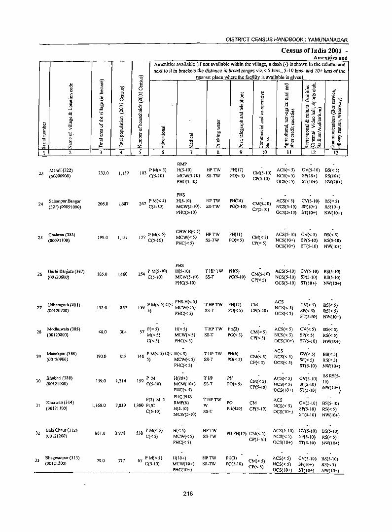
I " -0 '3 0 <> u c .c ;g 0 g ... 'g U
~ <> C 0 ,g ....I 0
o'IJ .;;: ~
" " c
~ -5 '~ ~
" .... 0 .D .;;: "3 E os 0.
::l .... ~ 0 c o· 0.
" ~ -.; S ·c E
" '" I- ~ '" z 1 2 3 4
Mamli(322) 233.0 1,139 23
(00090900)
Salem pur Bangar 24
(321) (00091000) 206.0 1,687
Chahron (383) 25
(00091100) 199.0 I,IJI
Garhi Banjara (387) 16S.0 1,460 26
(00120600)
27 Udhamgarh (401)
132.0 857 (00120700)
Modhuwala (38S) 48.0 304 28
(00120800)
Manalcpur (386) 29 190.0 818
(00120900)
Bhukhri (388) 30
(00121000) 159.0 1,214
31 Kharwan (314)
1,168.0 7,839 (ODI21100)
32 Bala Chaur (312)
861.0 2.778 (00121200)
33 Bhagwanpur (3 J3)
79.0 377 (00121300)
DISTRICT CENSUS HANDBOOK: YAMUNANAGAR
Census of India 2001 -Amenities and
Amenities available (if not available within the village, a dash (-) is shown in the column and next to it in brackets the distance in broad ranges viz. < 5 kms., 5- JO kms. and 10+ kms oftne
~ nearest place where the facility_ is available is _given '" i;l
~~ C -0 ., a U
.~~ ., " ~ 'p c.J
C c .~ ~t c 0 ~
e;,.-... ~ -a <f! 0 ... i1i'
" ~ 0.
'" .,
0. -.;'" :;: ~ -0 11 0 ·c 3;:::"'5 0 " OIl'" ::l "
-0 f .~ '3 ~.2 ~~ ..c c <J
'" " ~ os "t:I C " <> o ~ 0'-~ ~.g .g :~r j .c r::: c g 0 ..
..c: 0. ....:'" _._ "0
-.; ~ -.; g>~ OJ -.... e .-<;::: " -0 C OIl ., .~ ::s-O .S! 'at E '§ ~
..8 0 OJ c 11 " .t:: ~
.~ E '" ::l " ~ E ::l
E f <> :.Q .~ ] e g:.a E " :.a E~ ::s ::l
" .S '" ~ Q£l
E_ Z -0 :2: 0 0 o '" ~o J3 'e Ul p.. U.D
5 6 7 8 9 to 11 12 13
RMP
183 PM«S) H(S-IO) HPTW PH(I7) CM(S-IO)
ACS« S) CV(S-IO) BS« S) C(5-IO) MCW{5-IO) SS-TW ?O« 5) NCS« 5) SP(lO+) RS(IO+)
PHC(S-lO) CP(5-IO)
OCS«S) ST(lO+) NW(lO+)
PHS
267 PM«S) H(5-10) HPTW PH(14) CM(S-IO)
ACS« S) eV(S-IO) BS« 5) C(5-1O) MCW{5-IO). SS-TW ?O(5-10) NCS{5-1O) 8P(10+) RS{IO+)
PHC(5-IO) CP(5-10)
OCS(5-IO) ST(IO+) NW(IO+)
PM(<5) CHW H« 5)
HPTW PH(lI) ACS(5-IO) CV«5) BS« 5) 177 C(S-IO) MCW«5)
SS-TW pO«S) CM«5)
NCS(IO+) SP(5-10) RS(5-10) PHC« S) CP« S)
OCS(IO+) ST(S-IO) NW(IO+)
PHS
254 P M(S-IO) H(5-1O) THPTW PH(S) CM(S-IO)
ACS(S-IO) eV(S-IO) 8$(S-IO) C(S-IO) MCW(S-IO) SS-T pO(5-lO) NCS(S-IO) SP(5-10) RS(5-IO)
PHC(S-IO) CP«S)
OCS(S-IO) ST(lO+) NW(lO+)
PHS H« 5) THPTW PH(12) CM
ACS CV« 5) BS« 5) IS9 PM«S)C« MCW«S) NCS«S)
5) PHC« 5) SS-T PO«5) CP(5-1O) OCS«5)
SP« S) RS« 5) ST(5-1O) NW(IO+)
57 P« S) H«5) THPTW PH(2) CM«5)
ACS«5) CV«5) BS« 5) M«5) MCW«S) SS-T PO« S) NCS«S) SP« S) RS« S) C« 5) PHC« 5)
CP« 5) OCS(IO+) ST(5-1O) NW(IO+)
148 P M« 5) C« H« S) THPTW PH(6) ACS
CV«5) BS« S) CM«5) NCS« 5) 5) MCW«5) S5-T PO« S)
CP« 5) OCS« 5) SP« 5) RS« 5)
PHC«S) ST(5-10) NW{IO+)
PM H(IO+) THP PH ACS« 5) CV(5-1O) BS RS(5-
199 C(S-IO) MCW(IO+) SS-T PO«S) CM«5)
NCS« 5) Spe5-IO) 10)
CP(5-1O) NW(IO+) PHC« 5) OCS(JO+) ST(5-10) I
P(2) M S PHCPHS
THPTW ACS 1,380 PUC
RMP(6) W
PO eM NCS« 5)
CV(5-IO) BS(5-IO)
C(S-IO) H(5-1O)
SS-T PH(450) CP(5-10)
OCS(IO+) SP(5-1O) RS« 5)
MeW(S-IO) ST(5-10) NW(IO+)
530 P M«5) H«5) HPTW PO PH( 17) CM( < 5)
ACS(5-IO) CV(S-IO) BS(5-10) C«5) MCW«5) SS-TW
CP(5-IO) NCS« 5). SP(5-10) RS« 5)
PHC« 5) OCS(IO+) ST(5-IO) NW(IO+)
6S PM«5) H(IO+) HPTW PH(3) CM« S)
ACS« 5) CV(5-10) BS(5-10) C(5-10) MCW(IO+) SS-TW PO(5-10)
CP«5) NCS« 5) SP(IO+) RS«5)
PHC(IO+) OCS(IO+) ST(IO+) NW(IO+)
218
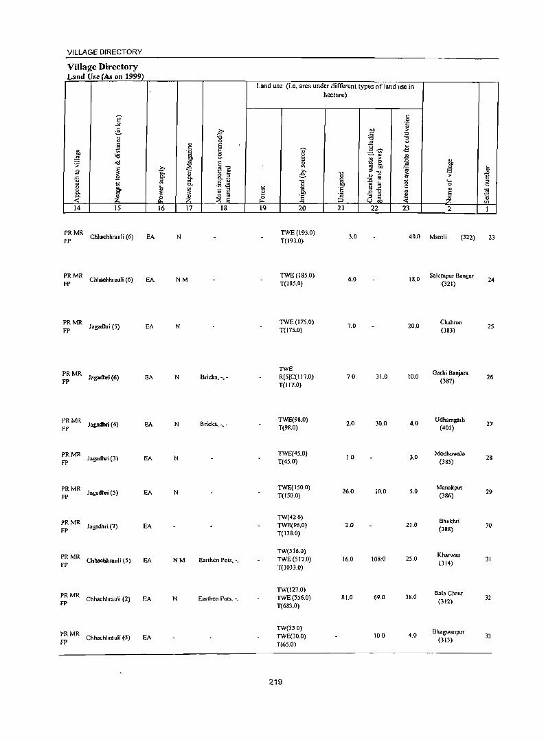
VILLAGE DIRECTORY
Village Directory Land Use (As on 1999)
14 15
:: MR Chhachhrauli (6)
:: MR Chhachhrauli (6)
~: MR Jagadhri (S)
PR MR Jagadhri (6) FP
PRMR Jagadhri (4)
FP
PRMR Ja!,'lIdbri (3)
FP
PRMR Jagadhri (5)
FP
PRMR J agadhri (7)
FP
PRMR Chhachhrauli (5)
FP
PRMR Chhachhrauli (2)
FP
PRMR Chhachhrauli (:5)
FP
EA
EA
EA
EA
EA
EA
EA
EA
EA
EA
EA
16 17 18
N
NM
N
N Bricks, -.-
N Bricks, -.-
N
N
NM Earthen Pots, -,
N Earthen Pots, -,
Land lise (i.e. area under different types ofland use in hectare)
19 20 21 22 23 2
TWE(193.0) T(l93.0)
3.0 40.0 Maml; (322)
TWE(18S.0) T(185.0)
TWE(17S.0) T(17S.0)
TWE R[S)C(I17.0) T(117.0)
TWE(98.0) T(98.0)
TWE(45.0) T(4S.0)
TWE(ISO.Q) T(ISO.O)
TW(42.0) TWE(96.0) T(138.0)
TW(SI6.0) TWE(SI7.0) T(1033.0)
TW(127.0) TWE(SS6.0) T(683.0)
TW(350) TWE(30.0) T(6S.0)
2.19
6.0
7.0
70
2.0
10
26.0
2.0
16.0
81.0
18.0
20.0
31.0 10.0
30.0 4.0
3.0
10.0 S.O
21.0
108:0 2S.0
69.0 38.0
100 4.0
Salempur Bangar (321)
Chahron (383)
Garh; Banjara (387)
Udhamgarh (401)
Modhuwala (38S)
Manakpur (386)
Bhukhri (388)
Kharwan (314)
Bala Chaur (312)
Bhagwanpur (313)
.... ..8 § '" ] " U)
23
24
25
26
27
28
29
30
31
32
33
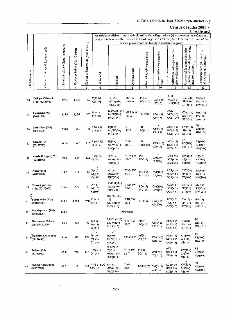
e '" -0 ~ '" 0 <.> u ~ c: ..c: 0 -3
., .~ U u <Il 0 1 0
....l 0 ~ o'IJ .;;:
~ u '" -5 .~ .... ,g '" ....
..0 .s; 0 :; E <II 0.
'" .... e 0 c: 0 ttl C. ., -.; g !:i ~ .~ 0 til Z f-<
I 2 3 4
Dadupur Clihawni 34 176.0 1,036
(106)(00121400)
Fatelogarh (I 07) 35 305.0 2,t36
(00121500)
Shabladpur (109) 36
(00121600) 240.0 S44
KanaIsi (t 04) 37 385.0 1,317
(00121700)
Manclauli Gagar (103) 420.0 695 38
(00121800)
Alipur(102) 118.0 114 39
(00121900)
Dammunpur Bara 40 142.0 439
(101)(00122000)
I( 'MeharMajra (105)
268.0 1,609 41 '1(00122100)
42 Mir Mayeinpur (100)
120.0 (00122200)
Dammllnpur Chhota 43 66.0 478 599)(00122300)
44 1airampur Khalsa (98) ~(00122400) 91.0 1,323
Telipura (96) 45
(00122500) 195.0 798
Rampur Khadar (94) 46
(00112600) 503.0 1,117
DISTRICT CENSUS HANDBOOK: YAMUNANAGAR
Census of India 2001 -Amenities and
Amenities available (if not available within the village, a dash (-) is shown in the column and next to it in brackets the distance in broad ranges viz.< 5 kms., 5-10 krns. and 10+ krns of the
-;;- nearest place where the facility is available is given ~
'" -0 II .go. '" c: U '" '" ...
~ '';::'0 ..;
0 c: :> ~t 0
0 0 .~ 3 'i:~ (:!. ..c: ~ 8-0. '"
:; u i:i' '"
., 0. u
~~E :;: ~ -0 11 <5 0 .~ ~ '" u b Ol ~ .c: -0
" ~ .~ 3 ~.z ';;~ ~ c: '" -0 u 0 ....
'" II ..c: a g "g o'IJ~.g 5 c 0 .c: 'a ~ -.; .....:'" _._ "'0 '';:: 0 .... "iii '" > '"
<II ._
~ ~ .~ .E S 0 '" 'f~ ","0 s"<i!:::: ... 0 Oil .., 3 ~ '" '" U "g "iii .G '2
.., 'g Ei § ;::J ..0 U
~ e '" e f E <> -6 tf E"'" .~ t ~.~ ~ '" §::: '" -0 '" S 0 o a oo..c
Z III ~ p.. U..o <'0 ~ ~Qi U e 5 6 7 8 9 10 11 12 I3
P(2) M H(IO+) HPTW PH(4) ACS
CV(S-IO) BS(S-IO) 193 CM(5-10) NCS« 5)
C(5-10) MCW(JO+) SS-TW P0(5-10) CP« 5) OCS{IO+)
SP(S·tO) RS(tO+) PHC(5-10) ST(!o+) NW(IO+)
PMS DDAH(IO+)
HPTWW ACS
CV(S-IO) BS(S-IO) 365 MCW(JO+) POPH(7) CM« 5) NCS«5)
C(5-IO) PHC(JO+)
SS-W CP« 5) OCS(JO+)
SP(5· 10) RS(IO+) ST(tO+) NW(lO+)
96 PM«S) H(JO+) T PH ACS« 5) CV(5-tO) BS
C(5-IO) MCW(IO+) SS-T PO«5) CM«S)
NCS«5) SP« 5) RS(IO+)
PHC(IO+) CP« 5)
OCS(IO+) ST(S-JO) NW(JO+)
PM(S-IO) H(IO+) THP PH ACS«5) SP
BS(IO+) 213 CM(5-1O) CV(IO+)
C(10+) MCW(IO+) SS-T PO(5-10) CP« 5)
NCS« 5) ST(IO+)
RS(IO+)
PHC«5) OCS(JO+) NW(lO+}
122 P M« 5) H(lO+) THPTW PH CM(IO+)
ACS«5) CV(IO+) BS«5) C(10+) MCW(IO+) SS-T PO«5)
CP(IO+) NCS«5) SP« 5) RS(JO+)
PHC(lO+) OCS«5) ST(IO+) NW(JO+)
16 P« 5) H(IO+) THPTW PO« 5) CM(lO+)
ACS«5) CV(tO+) BS(5-IO)
M«5) MCW(IO+) SS-T PH(IO+) CP(IO+)
NCS«5) SP(IO+) RS(IO+) C(10+) PHC(IO+) OCS«5) ST(IO+) NW(IO+)
P«5) RMP H(IO+)
THPTW ACS«5) CV(IO+) BS« 5) 61 MCW(IO+) PO« 5) CM(IO+)
M«5) PHC(5-10)
SS-T PH(JO+) CP(I9+)
NCS«5) SP(!O+) RS(IO+) C(IO+) OCS«5) ST(IO+) NW(IO+)
RMP(2) H(S-
238 PM S !O) THPTW POPH(6) CM«5)
ACS«5) CV(lot) BS« 5) C«5) MCW(IO+) SS-T
CP(IO+) NCS«'5) SI>(IO+) RS(IO+)
PHC(5-10) OCS«5) ST(IO+) NW(lO+]
------- UninhabIted ------
92 P« 5) RMP H(5-10)
THPTW PH(2) ACS«5) CV(IO+) BS
MCW(lO+) CM(5-IO) RS(IO+) M«5) SS-T PO« 5) NcS« 5) SP(IO+) C(JO+)
PHC(5-1O) CP(IO+) OCS«5) ST(IO+)
NW(IO+)
192 P«5) H(5-IO) PH(I I) ACS« 5) CV(IO+) BS
HPSS-HP CM(5-10) RS(IO+) M«5) MCW(IO+) PO« 5)
CP(5-JO) NCS«5) SP(IO+)
NW(IO+) C(JO+) PHC« 5) OCS«5) ST(tO+)
PHSRMP ACS
137 P M« 5) H(IO+) THPTW PH(4) CV(IO+) BS
C(JO+) MCW(IO+) SS-T PO« 5) CM«5) NCS«5)
SI:'(lO+) RS(lO+)
P~C(JO+) ep(5-10) OCS«5)
ST(IO+) NW(IO+)
158 PM S PUC H«S) THP ACS« 5) cvdo+) BS
C(S-IO) MCW(tO+) £S-T PO PH(IO) CM(5-JO)
NCS« 5) SP(IO+) RS(IO+)
PHC(5-JO) CP« 5)
OCS« 5) ST{JO+) NW(IO+)
220
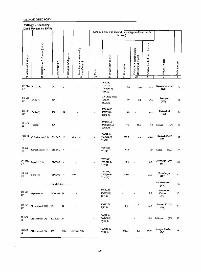
VILLAGE DIRECTORY
Village Directory Land Use (As on 1999)
14 15
~: MR Buria (7)
~: MR Buria (4)
~ MR Buria (2)
~: MR Buria (7)
16
EA
EA
EA N
EA
PRMR FP Chhacbhrauli (15) ED EAG N
~~ MR Chhachhrauli (15) ED EAG N
;~ MR Jagadhri (11) EDEAG N
:: MR Buria (5) EDEAG N
17 18
Gur.-••
Gur. -. -
- .. - Uninhabited -.--.
;: MR Jagadhn (10) EDEAG N
:: MR Chhachhrauli (10) ED N
PRMR FP Chhachhrauli (5) EDEAG N
;: MR Chhachhrauli (6) EA NM Earthen Pots, '.
Land use (i.e. area under different types ofland use in hectare)
19 20
WE(S.O) TW(5LO) TWE(37.0) T(96.0)
TW(70.0) TWE (\55.0) T(225.0)
TW(IOO.O) TWE(90.0) T(190.0)
TW(IOS.O) TWE(200.0) T(30S.0)
TW(41.0) TWE(260) T(67.0)
TW(II.O) T(Il.O)
TW(36.0) TWE(41.0) T(n.O)
TW(S9.0) TWE(53.0) T(142.0)
TW(28.0) TWE(31.0) T(59.0)
TW(75.0) T(75.0)
TW(89.0) TWE(90.0)
T(179.0)
TW(131.0) T(13l.0)
221
21
2.0
3.0
8.0
7.0
288.0
99.0
57.0
98.0
60
275.0
22
14.0
2.0
69.0
1.0
1.0
23
64.0
75.0
44.0
2
Dadupur ChhawnI (106)
Falehgarh (107)
Shahzadpur (109)
6.0 Kanab; (104)
64.0 Mandauli Gagar
(lIB)
8.0 Alipur (102)
8.0
28.0
7.0
10.0
Dammunpur Bara (IOI)
MeharMajra (105)
Mir Mayeinpur (IOO)
Dammunpur
Chhota (99)
Jairampur Khalsa
(98)
16.0 Telipura (96)
96.0 Rampur Khadar
(94)
34
35
36
37
38
39
40
41
42
43
44
45
46
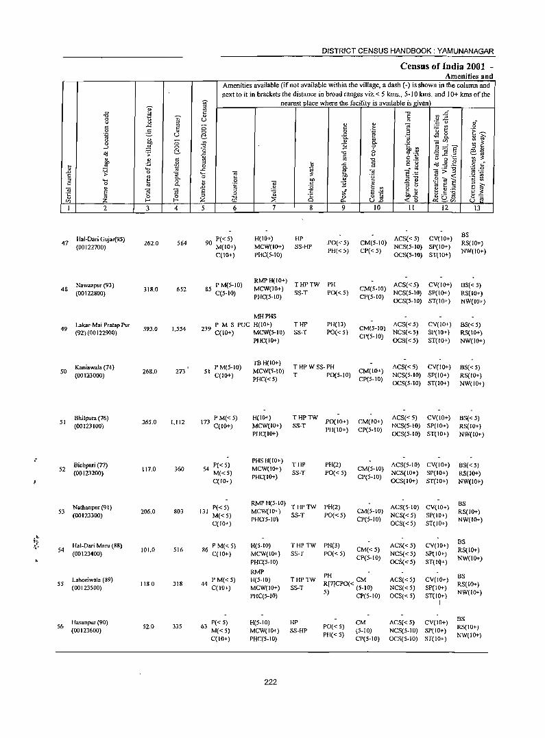
e ... "t:J '" ~
0 1:> "' (.) ... ~ " -" " 0 e- ... .~ U (.)
., -0 Oll 0 ...l ~ 0
~ ~ .s: " '" c: 00 -5 0 ,__ ~ .~
" .... ..0 .s: 0 :; E OJ 0. ;;J "-' e 0 c 0
'" 0. ., " "if ~ ·c § " ~ CI) z I 2 3 4
Hal-Dari Gujar(95) 47
(00122700) 262.0 S64
Nawazpur (93) 48
(00122800) 318.0 652
Lakar-Mai Pratap Pur 49
(92) (OO J 22900) 593.0 1,554
Kaniawala (74) 50
(00113000) 268.0 273
Bhilpura (76) SI
(00123100) 36S.0 1,112
,-Bichpari (n)
52 117.0 360 (00123200)
Nathanpur (91) 53
(00123300) 206.0 803
.,\, '(
Hal-Dari Maru (88) 01.' 54 101.0 516 (00123400)
~
Lahoriwala (89) 55
(00123500) 1180 318
Hasanpur (90) 56
(00123600) 52.0 335
DISTRICT CENSUS HANDBOOK: YAMUNANAGAR
Census of India 2001 -Amenities and
Amenities available (if not available within the village, a dash (-) is shown in the column and next to it in brackets the distance in broad ranges viz. < 5 kms., 5-10 kms. and 10+ kms of the
gj nearest IJIace where the facility is avaIlable is given "'
~~ " "t:J ... " U " ... ... "§
';::; 0 ... -(3 " .2: :.::: en (.)
0 0 i'! .3 '0 t: '1: ~ ..c: ~ 0 C!- o. :; 0. ... i;;' "'
<L> <> (.) -;;;'" ;:: ~ e 0.
.", 0 "th :: 3d"? ;;J '" <5 " Ill-.c "0 0) '? .';: '3 ;g .2 ~.,
v fa c: '" ;:: '" "0 o ._ (.) 0 ,__ ~ '" :;; .c 1ii ': a d'd ..g .g 0 ri _g
~ ~ _._ "0 '';:; 0 .... -;;; -;;; e·t:: '" ;> ::J .~ .~
0 c: '2 ::J"O g",~ :;; 0 bI) ...
~ e c '" .~ -;;; c: e " .~ ~.~ ::I
..0 u :;;; E "' ::I (.)
S f E (.) :a if ~ ~ ;;J .E E -" ~ .s -g §:: ::J <> o § bI)..t: "0 ~ 0 0 ~ 8", z ~ 0.- U..o <0 U e
5 6 7 8 9 10 11 12 13
P«5) H(IO+) HP ACS«S) CV(IO+) BS
90 M(IO+) MCW(IO+) SS-HP .PO« 5) CM(5-10)
NCS(S-IO) SP(IO+) RS(IO+)
C(IO+) PHC(S-IO) PH« 5) CP«5)
OCS(5--IO) ST(IO+) NW(IO+)
85 P M(5-10) RMPH(IO+)
THPTW PH ACS«5) CV(IO+) BS«S) C(S-IO)
MCW(IO+) SS-T PO« 5}
CM(5-10) NCS(5-10) SP(IO+) RS(IO+)
PHC(S-IO) CP(5-1O) OCS(5-1O) ST(IO+) NW(JO+)
MHPHS P M S PUC H(IO+) THP PH(J3)
CM(5-10) ACS« 5) CV(IO+) BS« S)
239 C(IO+) MCW(S-IO) SS-T PO{< 5) NCS«5) SP(IO+) RS{10+) PHC(IO+)
CP(S-IO) OCS«5) ST(IO+) NW(IO+)
P M(5-10) TB H(IO+)
THPWSS-PH ACS«5) CV(IO+) BS«5) 51
C(IO+) MCWeS-IO)
T PO(S-IO) CM(IO+)
NCS(5-1O) SP(IO+) RS(IO+) PHC«S) CP(S-IO)
OCS(S-IO) ST(IO+) NW(IO+)
173 PM«5) H(IO+) THPTW PO(IO+) CM(IO+)
ACS«5) CV(IO+) B$« S) C(IO+) MCW(IO+) SS-T NCS(5-10) SP(IO+) RS(IO+)
PHC(IO+) PH(IO+) CP(5-10)
OCS(5-10) ST(IO+) NW(IO+)
PHS H(IO+) P«5) THP PH(2) ACS(5-1O) CV(IO+) BS« 5)
54 MCW(IO+) CM(5-10) M«5)
PHC(IO+) SS-T PO« 5)
CP(5-1O) NCS(IO+) SP(IO+) RS(IO+)
C(lO+) OCS(lO+) ST(lO+) NW(IO+)
P«S} RMPH(5-10)
THPTW PH(2) ACS(5-1O) CV(IO+) BS
131 M«5)
MCW(IO+) SS-T PO«5)
CM(5-10) NCS« 5) SP(IO+)
RS(IO+)
C(IO+) PHC(5-1O) CP(5-10)
OCS« 5) ST(IO+) NW(IO+)
86 PM«5) H(5-1O) THPTW PH(3) ACS« 5) CV(lO+} BS
CM«5} RS(IO+) C(IO+) MCW(IO+) SS-T PO« 5) NCS« 5) SP(IO+)
PHC(5-1O) CP(5-10)
OCS«5) ST(IQ+) NW(IO+)
RMP PH
PM«5) H(5-10) THPTW CM ACS« 5) CV(IO+) BS
44 C(IO+) MCW(IO+) SS-T R[7]CPO« (5-10) NCS« 5) SP(IO+)
RS(IO+)
PHC(5-10) 5) CP(5-10) OCS« 5) ST(IO+) NW(IO+)
I
P« 5) H(5-IO) HP CM ACS« 5) CV(IO+) BS 63
M«5) MCW(IO+) SS-HP PO« 5)
(5-10) NCS(5-1O) SP(IO+) RS(lO+)
C(IO+) PHC(5-10) PH« 5)
CP(5-IO) OCS(5-1O) ST(IO+) NW(IO+)
222
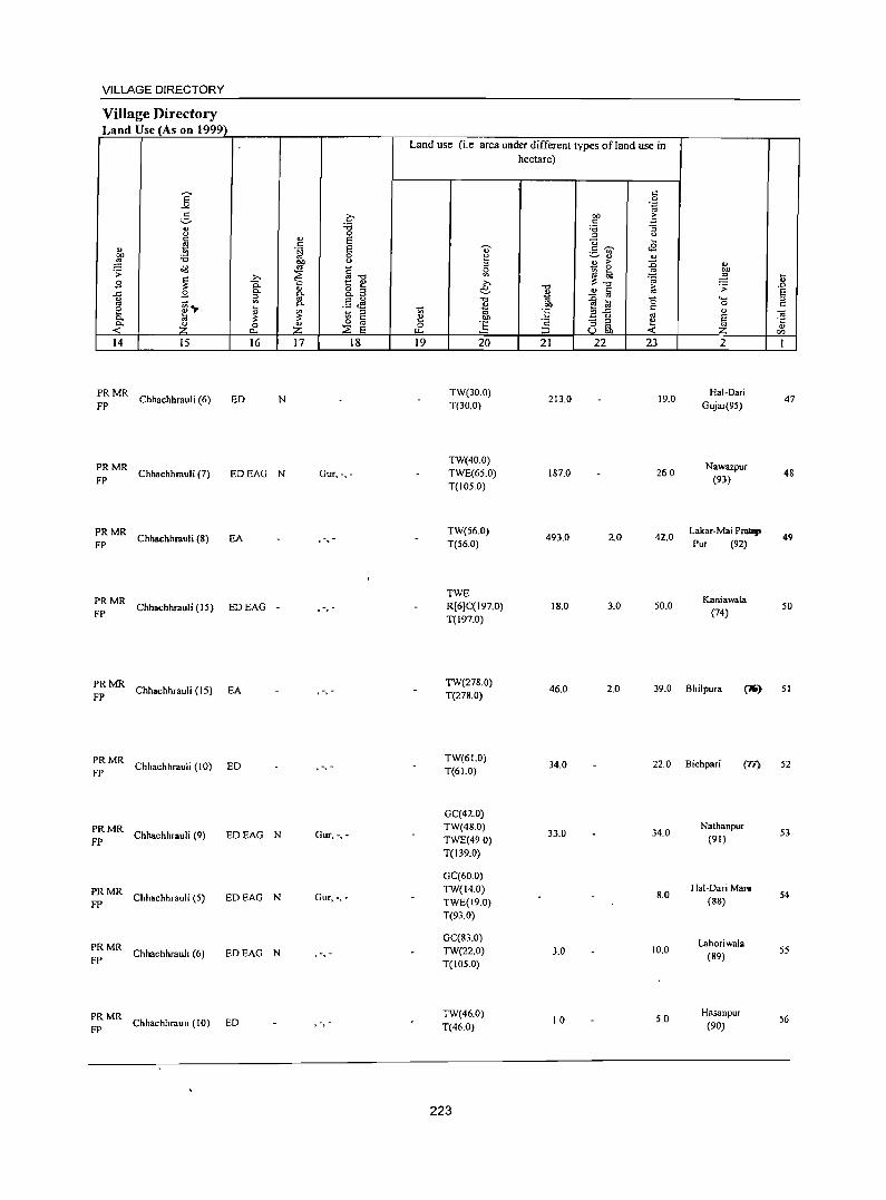
VILLAGE DIRECTORY
Village Directory Land Use (As on 1999)
14 15
;: MR Chhachhrauli (6)
16
ED N
~: MR Chhachhrauli (7) EDEAG N
:: MR Chhachhrauli (8) EA
PRMR FP Chhachhrauli (15) EO EAG -
~: MR Chhachhrauli (15) EA
PRMR FP
Chhachhrauli (10) ED
PRMR Chhachhrauli (9)
FP EDEAG N
PRMR Chhachhrauli (5)
FP EDEAG N
PRMR Chhachhrauh (6)
FP EDEAG N
PRMR FP
Chhachhrauh (10) ED
17 18
Gur,-,-
. -, -
, ,
Gur, -,-
Gur, -,-
, ,
, ,
Land use (i.e area under different types ofland use in hectare)
19 20
TW(30.0) T(30.0)
TW(40.0) TWE(65.0) T(105.0)
TW(56.0) T(56.0)
TWE R[6JC( 197.0) T(197.0)
21
213.0
187.0
493.0
18.0
22 23
19.0
260
2.0 42.0
3.0 50.0
2
Hal-Dari Gujar(95)
Nawazpur (93)
Lakar-Mai Prallp Pur (92)
KaniawaLa (74)
47
48
49
50
TW(278.0) T(278.0)
46.0 2.0 39.0 Bhilpura (lJO) 51
TW(61.0) 34.0 220 Bichpari (Tl) 52
T(61.0)
GC(42.0) TW(48.0)
33.0 34.0 Nathanpur
53 TWE(490) (91)
T(139.0)
GC(60.0) TW(14.0)
8.0 Hal-DariMal1l
54 TWE(19.0) (88)
T(93.0)
GC(83.0) Lahoriwala
TW(22.0) 3.0 10.0 (89)
55 T(105.0)
TW(46.0) 10 5.0
Hasanpur 56
T(46.0) (90)
223
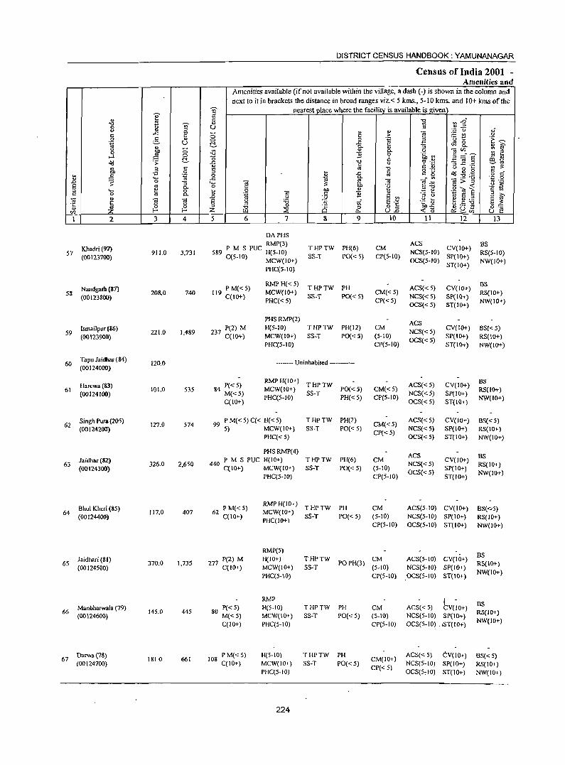
DISTRICT CENSUS HANDBOOK: YAMUNANAGAR
Census of India 2001 -Amenities and
Amenities available (if not available within the village, a dash (-) is shown in the column and next to it in brackets the distance in broad ranges viz.< 5 kms., 5- 10 kms. and 10+ kms of the
~ nearest place where the facility is available is given e 1;l
" " "t:f ~~ "t:f ~ ~ " " 8 u " " 1;l " "
',p u oi
" ..c
" ;:; " > ""§ =E~ (J
0 e. '" C> 0 ~~ .3 .~ ~ .~ u ~ .g_ r;9 8..
" " :; " s " ~ ;:; '" '" 0. u ""iii'" :;: ~ j C> "0 "# 0 .~.~ !3 ="8 "0 " '" " ~ .s: ~ ..c "0 -3 ~ .::!
t:Q ~
" fa u r!:: 0 ';;'~
g'" " " ~ "0 (J 0 ...
£ 0 ... " o ._
~ ~ .g " " t ,g "1a 0 " ..c " c_ g o " .... .c ~
<>- ""iii:;:"g '';:: a
.D .s: 0 "3 .... ""iii " ""iii ~:6 " ._
S " 0. 0 " 6h .~ " -< '2 ~ '" .... e 0 t 0 OJ) " E e .g Cd E " 0 '" 0. .~ OJ " "# " E S "
..0 (J :.;;; S '" ::J U ~ ~.::! ""iii g
~ " ... E E (J :a .s .r S'>< .~ .s E ~ '5 0 ::J '" " o c g.5 --g .. "0 Ci 0 0==
'" Z f- Z ~ ::E .,., u.2 -< 0 ~u~ u E! '-' '"
1 2 3 4 5 6 7 8 9 10 11 12 13
DAPHS
Khadri (97) RMP(3)
THPTW PH(6) CM ACS
CV(IO+) BS
57 911.0 3,731 589 P M S PUC H(5-10) NCS(S-IO) RS{5-10) (00123700) C(5-10) MCW(IO+) SS-T PO{< 5) CP(5-10) SP(10+)
OCS(5-10) NW(lO+) PHC(5-10)
ST(lO+)
Nandgarh (87) 119 PM«5) RMPH«5)
THPTW PH ACS«5) CV(IO+) BS
58 (00123800)
208.0 740 C(IO+)
MCW(IO+) SS-T PO{< 5)
CM«5) NCS«5) SP{IO+)
RS(JO+) PHC«S) CP« 5)
OCS«5) ST(IO+) NW(IO+)
PHSRMP(2) ACS
Ismailpur (86) 221.0 1,489 237 P(2) M H(S-ID) THPTW PH(12) CM
NCS«5) CV(IO+) BS« 5)
59 (00123900) C(IO+) MCW{IO+) SS-T PO{< 5) (5-10) SP{IO+) RS{IO+)
PHC(5-10) CP(S-IO) OCS«5)
ST(IO+) NW(IO+)
60 Tapu Jaidhar (84)
120.0 ----- Uninhabited ------(00124000)
Harewa(83) 84 P«5) RMPH(IO+)
THPTW ACS«5) CV(IO+) BS
61 (00124100)
101.0 535 M«5)
MCW{lO+) SS-T
PO{<5) CM« 5) NCS«5) SP(IO+)
RS(lO+)
C{1O+) PHC(5-JO) PH«5) CP(5-10)
OCS«5) ST(IO+) NW(IO+)
Singh Pura (205) 127.0 574
99 P M« 5) C« H« 5) THPTW PH(2) CM«5)
ACS«5) CV(IO+) BS{< 5) 62
(00124200) 5) MCW(IO+) SS-T PO«5) CP«5)
NCS«5) SP(IO+) RS(IO+) PHC« 5) OCS{< 5) ST(IO+) NW(IO+)
PHS RMP(4) ACS BS
Jaidhar (82) 440 P M S PUC H(IO+) THPTW PH(6) CM CV(JO+) 63
(00124300) 326.0 2,650
C(IO+) MCW(IO+) SS-T PO{< 5) (5-10) NCS«5)
SP(IO+) RS{IO+)
PHC(S-IO) CP(5-10) OCS« S)
ST(IO+) NW(IO+)
Bhul Kheri (8S) 62 PM«S) RMPH(IO+)
THPTW PH CM ACS(5-JO) CV(IO+) BS(<:'S) 64 117.0 407 MCW(IO+)
(00124400) C(IO+) PHC(IO+)
SS-T PO« 5) (5-10) NCS(5-10) SP(IO+) RS(IO+) CP(S-IO) OCS(S-IO) ST(IO+) NW(IO+)
RMP(5) BS
65 Jaidhari (81)
370.0 1,735 277 P(2) M H(IO+) THPTW POPH(3)
CM ACS(5-10) CV(IO+)
(00124500) C(IO+) MCW(IO+) SS-T (5-10) NCS(5-10) SP(IO+) RS(lO+)
PHC(5-10} CP(5-10) OCS(5-10} ST(IO+) NW(IO+)
RMP 1 Manbharwala (79) P«5) H(S-IO) THPTW PH CM ACS« 5) CV(IO+)
BS 66 145.0 445 80 RS(IO+)
(00124600) M«5) MCW(IO+) SS-T PO« 5) (5-10) NCS(5-IO) SP(IO+) C(IO+) PHC{S-IO) CP(5-10) OCS(5-10) . ,ST(IO":) NW(IO+)
67 Darwa(7&)
1810 661 108 P M{< 5) H(5-IO) THPTW PH
CM(IO+) ACS« 5) C:V{IO+} BS{< 5)
(00124700) C(JO+) MCW(IO+) SS-T PO« 5) CP«5)
NCS(5-10) SP(IO+) RS(IO+) PHC(5-10) OCS(S, 10) ST(IO+) NW(IO+)
224
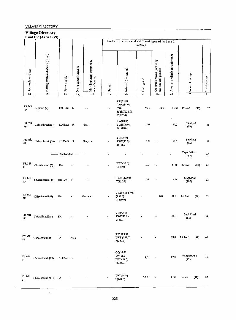
VILLAGE DIRECTORY
Village Directory Land Use (As on 1999)
14 15
:: MR Jagadhri (9)
16
EDEAG N
;: MR ChhaehhrauJi (5) ED EAG N
:: MR ChhaehhrauJi (10) ED EAG N
17 18
Gur, -,-
Gur, -,-
---- Uninhabited ------
:: MR ChhaehhrauJi (5) EA
:: MR Chhachhrauli (I) EDEAG N
:: MR Chhaehhrauli (6) EA Gur.-, -
:: MR Chhaehhrauli (S) EA
:: MR Chhaehhrauli (&) EA NM
:: MR Chhachhmuli (\ 0) ED EAG N
:: MR Chhachhrauli (II) EA
Land use (i.e. area under different types ofland use in hectare)
19 20
GC(83.0) TW(2&1.0) TWE R[6JC(32S.0) T(692.0)
TW(8&.O) TWE(90.0) T(17B.0)
TW(76.0) TWE(SO.O) T(IS6.0)
TWE(38.0) T(38.0)
TWE(122.0) T(122.0)
TW(80.0) TWE (150.0) T(230.0)
TW(43.0) TWE(40.0) T(&3.0)
TW(150.0) TWE(142.0) T(292.0)
GC(IO.O) TW(58.0) TWE(57.0) T(125.0) ,
TW(144.0) T(144.0)
225
21 22
75.0 10.0
8.0
7.0
12.0
10
8.0
3.0
20.0
23 2
134.0 Khadri (97)
22.0
5&.0
Nandgarh (87)
Ismailpur (86)
Tapu Jaidhar (S4)
51.0 Harewa (S3)
4.0 Singh Pum
(205)
8S.0 Jaidhar (82)
34.0 Bhul Kheri
(&5)
7S.0 Jaidhari (81)
170 Manbharwala
(79)
17.0 Darwa (78)
57
58
59
60
61
62
63
64
65
66
67
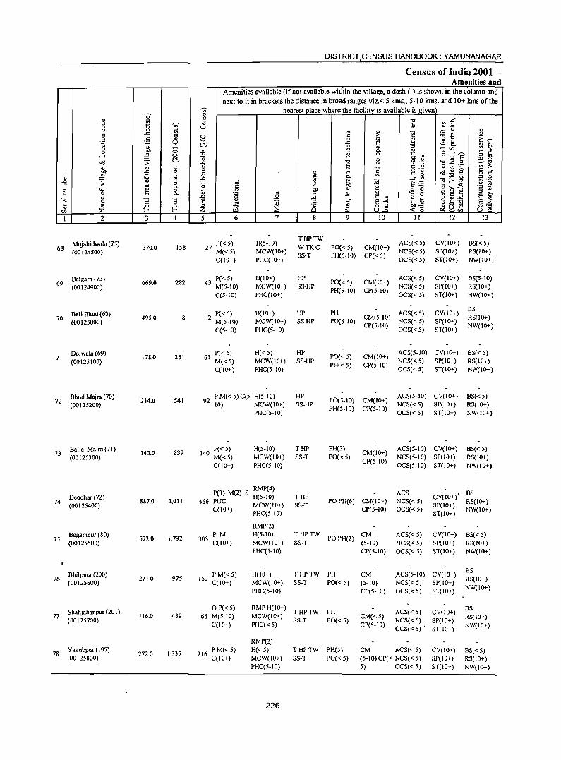
DISTRICT CENSUS HANDBOOK: YAMUNANAGAR
Census of India 2001 -Amenities and
Amenities available (if not available within the village, a dash (-) is shown in the column and
next to it in brackets the distance in broad ranges viz. < 5 krns., 5-10 krns. and 10+ kms of the -;;;- nearest place where the facility is available is given
~ " '" ~ 2" " c: -0 -c ~ '" " c: 0 U '" <> " " "
''';: 0 .; ..c: '" - " ] - '" <> c: c: 0 c: > '0 1:: 'E ~ 0 -2. " 0 0 .~
.~ u C .c: tS 8.. " ~ " Q. ., :;
<> bl) 0 '" " Q. .~ Oi'" : ~ 0 ~ -c 11 0 ::;=E -l 0 bh~ " " C -0 6 ID ;;;
cl<l '> ..c: -0 ~ ·z '3 ~ ~~ c: <> ';;;~ " '" c: " '" -c c: " () 0 ~ ;g o ._
~ .s . .@ § d' co .s 0 ~ .c: c: c: 15 ~ ~ .~ 0 ~ '" " ..... ..c: Q. ...:'"
._ .." ;:: 0 0 ~ Oi ]>~
'" ._ .0 '> :; "- "iii ~ e .~ .~ S E '" 0- 0 c:
btl " .~ " -0 .2 OJ E c: '" " "- fa 0 ~
0 "iii 11 .::: ~ ;:;J >. c: 0 0- '.g c: E '" " ()
~ E ::s
~ " ~ S ..D () :;;; .g t b.S ~ E ~
E E g 'B .E ..r E-'" §:= '" ~
;:;J -0 " Q ~ 8] oo..c: ~ ~Cij " Z f-o Z ~ :::8 Po. <0 u f! '" I 2 3 4 5 6 7 8 9 10 11 12 13
27 PC< 5) H(5-10) THPTW
ACS« 5) CV(IO+) BS«5) 68
Mujahidwala (75) 370.0 158 WTKC PO« 5) CM{lO+)
(00124800) M«5) MCW(lO+) SS-T PH(5-1O) CP«5)
NCS« 5) SP(IO+) RS(IO+) C(10+) PHC(ID+) OCS«5) ST(10+) NW(IO+)
Belgarh (73) P«5) H(IO+) HP PO« 5) CM(IO+) ACS« 5) CV(IO+) BS(5-10)
69 669.0 282 43 (00124900) M(S-IO) MCW(IO+) SS-HP
PH(5-10) CP(S-IO) NCS«S) SP(IO+) RS(IO+)
C(S-ID) PHC(ID+) OCS«S) ST(IO+) NW(IO+)
P«5) H(\O+) HP PH ACS« 5) CV(\O+) BS
70 Seli Shud (63)
49S.0 8 2 CM(5-10) RS(IO+) (00125000) M(S-IO) MCW(IO+) SS-HP PO(S-10)
CP(5-IO) NCS«S) SP(IO+)
NW(IO+) C(S-IO) PHC(5-10) OCS« S) ST(IO+)
Doiwala(69) P«S) H«5) HP PO« 5) CM(IO+)
ACS(S-IO) CV(IO+) BS«5) 71
(00125100) 178.0 261 61
M«5) MCW(IO+) SS-HP NCS«5) SP(IO+) RS(IO+) C(IO+) PHC(S-IO)
PH« 5) CP(5-10) OCS«5) ST(IO+) NW{IO+)
Bhud Majra (70) 541
P M« 5) C(5- H(5-10) HP PO(S-IO) CM(IO+)
ACS(5-10) CV(IO+) BS«5) 72
(00125200) 214.0 92 (0) MCW(IO+) SS-HP NCS« 5) SP(IO+) RS(IO+)
PHC(S-IO) PH(S-IO) CP(5-ID)
OCS«5) ST(IO+) NW(IO+)
Balla Majra (71 ) 143.0 839
P« 5) H(S-IO) THP PH(3) CM(IO+)
ACS(5-JO) CV(IO+) BS« 5) 73
(00125300) 140
M«5) MCW(IO+) SS-T PO«5) NCS(5-10) SP(IO+) RS(IO+) C(IO+) PHC(5-10)
CP(5-10) OCS(5-10) ST(IO+) NW(IO+)
RMP(4) ACS BS
Deodhar (72) P(3) M(2) S H(5-10) THP CV(IO+) ,
74 (00125400)
887.0 3,011 466 PUC MCW(lO+) SS-T POPH(6) CM(IO+) NCS« 5)
SP(IO+) RS(IO+)
C(10+) PHC(5-10) CP(5-10) OCS{< 5) ST(IO+)
NW(IO+)
RMP(2) Begampur (80)
1,792 PM H(5-10) THPTW
POPH(2) CM ACS«S) CV(IO+) 8S«5)
75 (00125500)
522.0 303 C(IO+) MCW(IO+) SS-T (5-10) NCS« 5) SP(IO+) RS(IO+)
PHC(5-10) CP(5-10) OCS('< 5) ST(IO+) NW(IO+)
Bhilpura (200) 152 PM«5) H(IO+) THPTW PH CM .ACS(5-10) CV(IO+} BS
2710 975 76 (00125600) C(IO+) MCW(IO+) SS-T PO{< 5) (5-10) NCS« 5) SP(IO+)
RS(IO+)
PHC(5-IO) CP(5-10) OCS«5) ST(IO+) NW(10+)
Shahjahanpur (201) o P« 5) RMPH(lO+)
THPTW PH ACS« 5) CV(IO+) BS
77 116.0 439 66 M(5-10) MCW(IO+) CM«5) RS(IO+) (00125700) SS-T PO« 5) NCS« 5) SP(IO+) C(lO+) PHC« 5) CP(5-IO)
OCS«5) • ST(IO+) NW(IO+)
RMP(2)
78 Yakubpur (197)
272.0 1,337 P M\< 5) H«5) THPTW PH(S) CM ACS« 5) CV(lO+) BS« 5)
(00125800) 216 C(IO+) MCW(IO+) SS-T PO« 5) (5-lO)CP« NCS«5) SP(Iq+) RS(IO+) PHC(S-IO) 5) OCS« 5) ST(10+) NW(IO+)
226
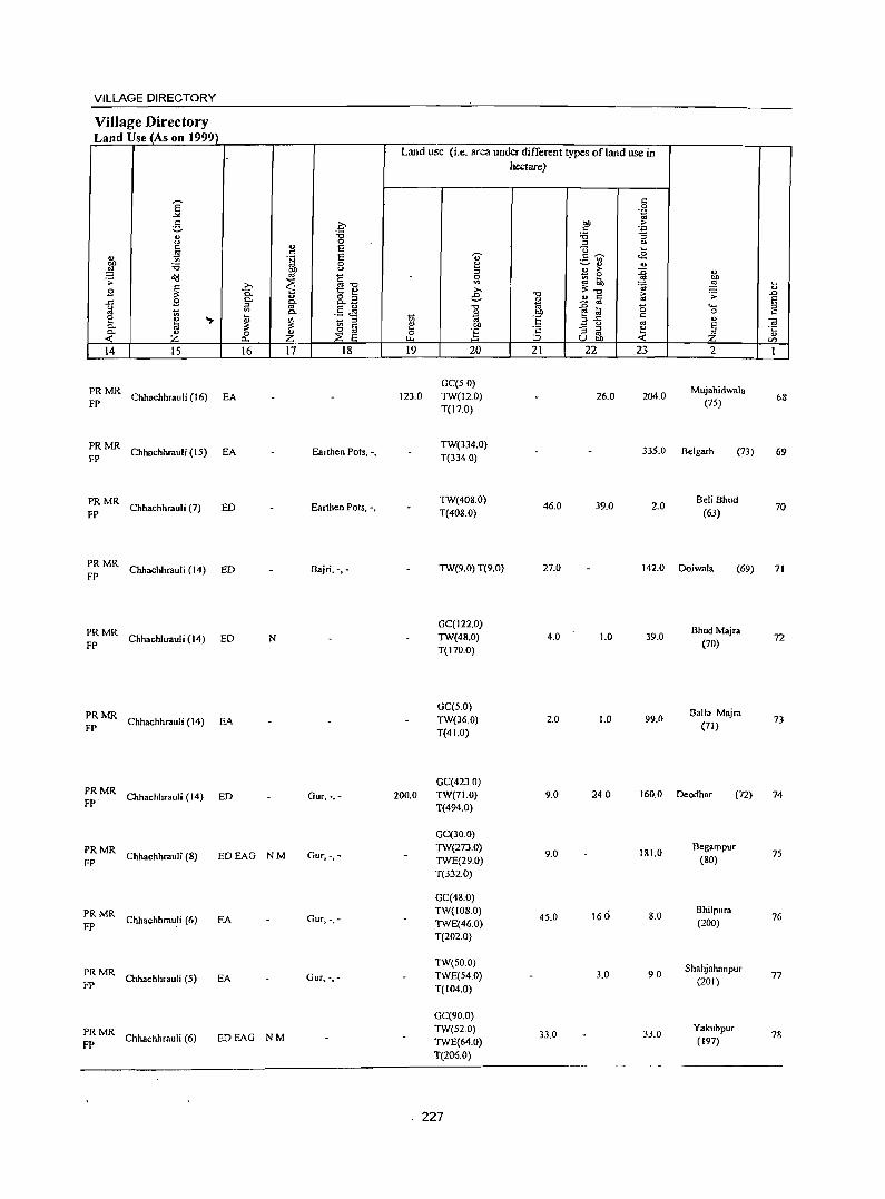
VILLAGE DIRECTORY
Village Directory Land Use (As on 1999)
Land use (i.e. area under different types ofland use in hectare)
K <: 0 .~
g 0 bO > <: '.p
" :a :a :; 0
t) 0 '" 0 c E <3 '-
ti c::
~ ·S E .., .9 ';)' <8 :a 0 ~ ~" ..
bll 0
'" " > :0 " ~ '" E - 0 . :;: ~
0 :a ... '" bO
~ >-. .. -0 '" "'.: ~ ,g ...
B 0.. t:: e e " u "0 &; .:;: ..0
..r= B 0. o '" " " c:: E g-o. _
- os ~ '" .5 JS -0 1<i -e to (5 .... '" '" Co " '6'
0 <: 2 ~ .,.
~ 1;; 'OJ <:
?! - '" ",..r= ., " ~ 0- U> C e bO
_ 0
E 0- " 0
., o os 0 ] '2 :; '" e OJ :2: E
., ., < Z p.. Z '" ::> u bO < Z en
14 IS 16 17 18 19 20 21 22 23 2 1
PRMR GC(S 0)
Mujahidwala Chhachhrauli (16) EA 123.0 TW(12.0) 26.0 204.0 68
FP T(17.0) (7S)
PRMR Chhachhrauli (IS) EA Earthen Pots, -,
TW(334.0) 335.0 Belgarh
FP T(334.0) (73) 69
PRMR Chhachhrauli (7) ED Earthen Pots, -,
TW(408.0) 46.0 39.0 2.0
Beli Bhud
FP T(408.0) (63) 70
PRMR Chhachhrauli (14) ED Bajri, -,- TW(9.0) T(9.0) 27.0 142.0 Doiwala
FP (69) 71
PRMR GC(122.0)
BhudMajra Chhachhrauli (14) ED N TW(48.0) 4.0 1.0 39.0 72
FP T(170.0) (70)
PRMR OC(S.O)
Balla Majra Chhachhrauli (14) EA TW(36.0) 2.0 1.0 99.0 73
FP T(41.0) (71)
PRMR OC(423.0)
FP' Chhachhrauli (14) ED Our, -,- 200.0 TW(71.0) 9.0 240 160.0 Deodhar (72) 74 T(494.0)
GC(30.0)
PRMR Chhachhrauli (8) EDEAG NM Our. -,-
TW(273.0) 9.0 181.0
Begampur 75
FP TWE(29.0) (80) T(332.0)
GC(48.0)
PRMR Chhachhra,\li (6) EA Our. ->-
TW(108.0) 4S.0 160 8.0
Bhilpura 76
FP TWE(46.0) (200) T(202.0)
PRMR TW(SO.O) Shahjahanpur
Chhachhrauli (5) EA Our.->- TWE(S4.0) 3.0 90 77 FP T(104.0)
(201)
GC(90.0)
PRMR Chhachhrauli (6) EDEAG NM
TW(S2.0) 33.0 33.0
Yakubpur 78
FP TWE(64.0) (197) T(206.0)
. 227
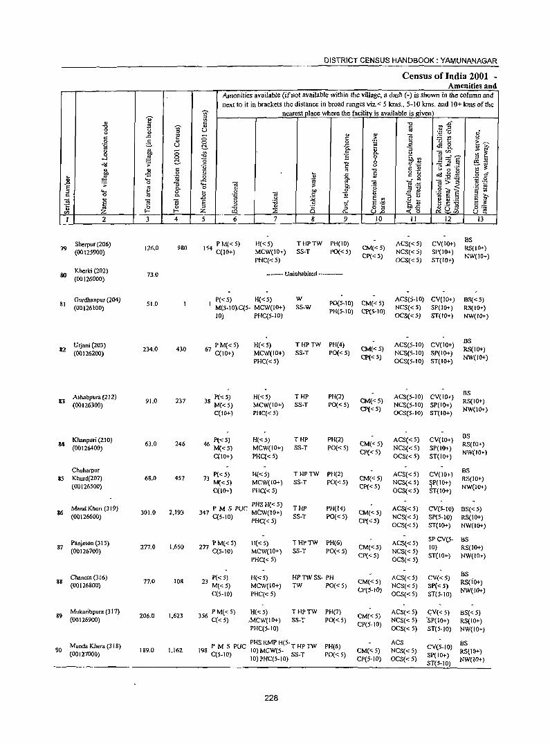
DISTRICT CENSUS HANDBOOK: YAMUNANAGAR
Census of India 2001 -Amenities and
Amenities available Cifnot available within the village, a dash C-) is shown in the column and next to it in brackets the distance in broad ranges viz. < 5 kms., 5-10 kms. and 10+ krns of the
-;;;- nearest place where the facility is available is given) '0 :J
'" ~ :2"' " ~ c:: "0
"0 -;;;- " § 0 u " " a " " e
.;:: (,) oJ" c:: ..c:: c ::> c:: .~ - '" 8 .~ e, " 0 0 a ·0 1:: c:~ u t!- ..c ~8.
1;l ~ 0- :; "
., ::> "
C) OjCl) 0 OIl '" "]i
0- " ..l ..s 0 "tJ 6 ~:3 5="S ~ '" ~ r:!. "0 I:!l~
o"IJ ..c: -g '" .- ~ £.a " " c 4) ~~
l '" c '" '" "'" o .- " 0 ... § C -B 0 :J ... ..c c c g o(j:Q~ ~ .... .~ 0 ~ 0- m . .. .~ .g <> .c:: ..0 .;;; 0 :; .... OJ ?: ~ OJ e .<;0: g>~ E '" 0- 0 § ~ 'B ","", 'E ~ ;;r. .... ~ 0 II OIl ~ ., .S! "01 S c 0 0- .~ OJ c:: "]i " "3 0 § ?i' ..c .g :;;; E '"
<0 E ::;I .. .. OJ B .~ ~ ~.5 ~ !j E (.)
"'" c:: 'of E-'" S ?: -t ~ 0 ;::! => " ~ 8] 0= ;g ~ ~o ~u ... CIl Z I- Z ::E ....... u:> u ~
I 2 3 4 5 6 7 8 9 10 II 12 I3
Sherpur (206) P M«5) H«5) THPTW PH(IO) ACS«5) CV(IO+) BS
79 (00125900)
126.0 980 154 C(10+) MCW(IO+} SS-T PO« 5) CM« 5)
NCS«5) SP(IO+) RS(IO+)
PHC«5) CP«5}
OCS«5) ST(IO+) NW(IO+)
80 Kherki (202) (00126000)
73.0 ---- Uninhabited -----------
Gurdhanpur (204) P«5) H«5) W P0(5-10) CM« 5)
ACS(5-10) CV(IO+) BS«5) 31
(00126100) 51.0
M(5-IO}C(5- MCW(IO+) SS-W NCS«5) SP(IO+) RS(IO+) 10) PHC(5-10)
PH(5-IO) CP(5-IO) OCS«5) ST(lO+) NW(IO+)
Urjani (203) PM«5) H«5) THPTW PH(4) ACS(5-IO) CV(IO+) as
82 (00126200)
234.0 430 67 C(lO+) MCW(IO+) SS-T PO« 5) CM«5)
NCS(5-10) SP(IO+) RS(IO+)
PHC«S) CP«5)
OCS(5-10) ST(IO+) NW(IO+)
Ashabpura (212) 38 P« 5) H«S) THI' PH(2) ACS(5-10) CV(IO+} BS
8J (00126300)
91.0 237 M«S) MCW(IO+) SS-T 1'0«5)
CM«5) NCS(5-10) SP(IO+)
RS(IO+)
C(IO+) PHC«S) Cp« 5)
OCS(S-IO) ST(IO+) NW(JO+)
Khanpuri (210) P«5) H«5} THI' PH(2) ACS« 5) CV(IO+) BS
34 (00126400)
63.0 246 46 M« 5) MCW(IO+) SS-T PO«5) CM«5)
NCS«5) SP(IO+) RS(IO+)
C(IO+) PHC(<5) CP«S)
OCS« 5) ST(IO+) NW(JO+)
Chuharpur P«5) H«5) THPTW PH(2} ACS« 5) CV(IO+)
BS 85 Khurd(207) 68.0 457 73
M«5) MCW(IO+) SS-T PO«5) CM«5)
NCS«5) ~P(IO+) RS(IO+)
(00126500) C(IO+) PHC« 5)
Cp« 5) OCS(<5) ST(IO+)
NW(IO+)
Mand Kheri (319) PHS H«5)
THP PH(l4) ACS«5) CV(5-1O) BS« 5) 36 301.0 2,193 347 P M S PUC MCW(lO+) CM«5)
(00126600) C(5- 10) PHC( < 5) SS-T PO« 5) Cp« 5)
NCS« 5) SP(5-1O) RS(IO+) OCS« 5) ST(IO+) NW(IO+)
Panjelon (31 5) 2n PM(<5) H«5) THPTW PH(6) ACS« 5) SP CVeS- BS
87 (00126700)
277.0 1.650 C(5-10) MCW(IO+) SS-T PO« 5)
CM«5) NCS«5)
IO} RS(lO+)
PHC« 5) CP« 5)
OCS«5} ST(IO+) NW(IO+)
Chane!a (316) P«5) H«5) HPTWSS- PH ACS«S) CV«5) BS
83 (00126800)
77.0 108 23 M«5) MCW(IO+) TW PO« 5)
CM«5) NCS« 5} SP{< 5)
RS(io+)
C(5-1O) PHC« 5) CP(5-10)
OCS«5) ST(5-10) NW(IO+)
89 Mukaribpura (317)
206.0 1.623 356 P M« 5) H«5) THPTW PH(7) CM«5)
ACS« 5) eV« 5) BS«5) (00126900) C« 5) ,MCW(10+) SS-T PO«5)
CP(5-10) NCS« 5) ·SP(IO+) RS(IO+)
PHC(5-IO) OCS«5) ST(5-IO} NW(IO+)
Munda Khera (3 18) P M S PUC PHS RMP H(5. T HP TW PH(6) ACS
CV(S-IO) BS
90 189.0 1.162 198 C(5-1O) 10) MeW(5- SS-T CM« 5) NCS«5) RS(IO+) (00127000) PO« 5) SP(IO+) 10) PHC(5-10) CP(5-IO) OCS«5)
ST(5-IO) NW(IO+)
228
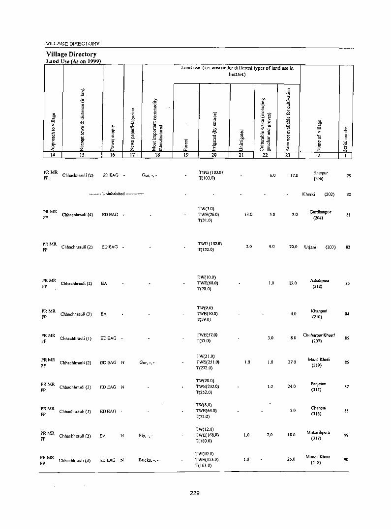
'VILLAGE DIRECTORY
Village Directory Land Use (As on 1999)
E .,., c
;::. .. 0 c ~ " 00 :.0 ~ Oil .;;:
.9 ~ ..c .9 g
! e 0. <U 0. Z <: 14 15
~: MR Chhachhrauli (2)
>-C. "-
" '" ~ 0
p..
16
EDEAG -
a :.0 0
" E c .~ E
0 00 u <U C ~ <U'O
1:: ..,
8. o ~ c.B
<U .5 ~ 0.
~ 1;; " C ... 0 <U z ~ E 17 18
Our,·, -
---- Uninhabited ----
;: MR Chhachhrauli (4) EDEAG -
PRMR FP Chhachhrauli (2) EDEAG -
PRMR Chhachhrauli (2) EA
FP
PRMR Chhachhrauli (3) EA
FP
PRMR Chhachhrauli (I) EDEAG
FP -
PRMR Chhachhrauli (2)
FP EDEAG N Gur, -,-
PRMR Chhachhrauli (2)
FP EDEAG N
PRMR Chhachhrauh (3) EDEAG
FP -
PRMR Chhachhrauli (2)
FP EA N Ply, -,-
PRMR Chhachhrauh (3)
FP EDEAG N Bncks, -,-
Land use (i.e. area under different types of land use in hectare)
19 20
TWE(103.0) T(1D3.0)
TW(5.0) TWE(26.0) T(31.0)
21
13.0
~ :g "0 c ~ ._ '" ~" " > - 0
~~ ... c
- os -e a :s..c _ 0
- :s :s <U U 00
22
6.0
5.0
23
17.0
2.0
2
Sherpur (206)
Kherki (202)
Gurdhanpur
(204)
TWE(I52.0) T(152.0)
3.0 9.0 70.0 Urjano (203)
TW(lO.O) Ashabpurn TWE(6S.0) 1.0 12.0
T(78.0) (212)
TW(9.0) Khanpuri TWE(50.0) 4.0
T(59.0) (210)
TWE(57.0) 3.0 80
Chuharpur Khurd T(57.0) (207)
TW(21.0) Mand Kheri
TWE(251.0} 1.0 1.0 270 T(272.0)
(319)
TW(20.0) Panjeton
TWE(232.0} 1.0 24.0 T(252.0)
(315)
TW(S.O) Chaneta
TWE(64.0) 5.0 (316)
T(72.0)
TW(12.0) Mukaribpura
TWE(168.0) 1.0 7.0 180
T(ISO.O) (317)
TW(ID.O) Munda Khera
TWE(153.0) 1.0 25.0
T(163.0) (318)
229
~ .. .0 E " c
~ " CIl
79
so
SI
S2
83
84
85
86
87
8S
89
90
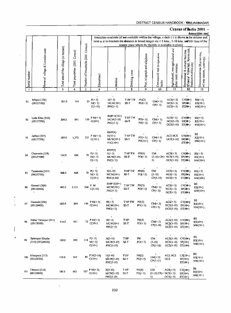
I " ." 0 ~ 0 " ..c ~ c 0 3 " 'g u
" <.> Ol) 0 0 ~ 0 .....l
!::\. ~ .;:
" '" c
~ -5 0 .... 'ia '" .... ..0 .:;: 0 :; E <tt 0-
" .... ., 0 c 0 a 0-
" Cil S ~ 'IS ·c
'" "' ~ en Z 1 2 J 4
Mirpur (320) 201.0 143 91
(00127100)
Leda Khas (310) 92
(00127200) 204.0 841
latheri (307) 93
(00127300) 289.0 1,373
Chaowala (328) 134.0 94
(00127400) 488
Taranwala (327) 108.0 466 95
(00127500)
Ganauli (309) 96
(00128300) 462.0 2,131
Ganaula (308) 97 265.0 884
(00128400)
Nahar Taharpur (2 I I) 98
(00128500) 116.0 461
'" Salem pur Khadar 99 119.0 690
(214) (00128600)
Khanpura (213) 100
(00128700) 110.0 507
Tihanon '(218) 101 1860 643
(00128800)
DISTRICT CENSUS HANDBOOK: YAMUNANAGAR
CeJ_1SUS ofllldia 2001 -Amenities and
Amenities available (if oot available within the village, a dash (-) is shown .. the column and next to it in brackets the distance in broad ranges viz. < 5 kms., 5- 10 kms. 3111110+ kms of the
~ nearest place where the facility IS available is given a c .", ~~ " § U ,f ., ';::::: C). - " "§ ~t <.>
0 c > 'E ~ C> 0 .~ 3 !::\. ..c t.!9g_ " iii' 0-"
:; '" " 0- <.> OJ'''' ;;: ~ -0 B 0 .~ ~ ~=E '0 " " " III ~
..c -0 <.> ~ '';:: 3_g .2 ~ "' ~ § -0 C " <.> a ~ '" ~ " ~ §
o ._ o'd.g .f! c "
0 " ..c c g o c ..c ~ e- ci Vl OJ;;;.''g 'g 0 .... OJ Cil <.> E 0 Ol) .~
.... _ c ..: c ,,-0 'c .... '~ g> " .=! ~ .S! ';a, E '" " Cil B " " iii' ..0 <.> :.g E '" " <.> 1i:i E" S
E <.> 'i3 c _" S"'" .g 0 ~ 00 ._ s ~ " '" uC:'O
" iZ " 8 0 o § Oll..c ~os 0=-= Z ::'E tl.. U..o <t:b ~.", U e 5 6 7 8 9 10 11 12 IJ
25 P« 5) H« 5) THPTW PH(3)
CM«5) ACS«5) CV(I&+) BS« 5)
M«5) MCW(lO+) SS-T PO«5) NCS«5) SP(IO+-) RS(IO+) C(5-10) PHC« 5)
CP« 5) OCS« 5) ST(IOt-) NW(IO+)
\50 P M« 5) RMPH(IO+)
THPTW ACS« 5) CV{I6I-) BS« 5) C(!O+)
MeW{S-IO) SS-T
PO« S) CM« 5) NCS(5-10) SP(lOt-) RS(!O+)
PHC« 5) PH« 5) CP« 5) OCS(5-10) ST(tO+-) NW(IO+)
RMP(4) BS
P M«5) H(IO+) THPTW ACSNCS CV(l&+) 221
C(IO+) MCW(IO+) SS-T PO« 5) CM«5)
OCS(5-1O) SP(I .... ) RS(IO+)
PHC(IO+) PH(IO+) CP« 5)
ST(I6I-) NW(IO+)
RMP(2)
79 P« 5) H«5) THPTW PH(6) CM ACSe<5) CV{IO» BS« 5) M«5) MCWe5-10) SS-T PO« 5) (5-10) CP« NCS(5-10) SP(l .... ) RS(IO+) C«5) PHC«5) 5) OCS(5-1O) ST(I6I-) NW(IO+)
74 P« 5) H(5-IO) THPTW PH(6) eM ACS«5) CV(I6I-) BS«5) M«5) MCW(IO+) SS-T PO« 5) (5-10) NCS«5) Sp(IO+-} RS(IO+) CCI 0+) PHC(5·10) CP(5-10) OCS« 5) ST(I .... ) NW(IO+)
PM RMPH(IO+)
THPTW PH(5) ACS« 5) CV(IO+-) BS
368 C(5-10)
MCW(IO+) SS-T PO« 5)
CM« 5) NCS«5) SP(lO»
RS(IO+) PHC« 5) CP« 5)
OCS«5) ST(IO+-, NW(IO+)
146 PM«5) H«5) THPTW PH(3) ACS« 5) CV(IOJ.} BS
CM«5) RS(IO+) C(IO+) MCW(IO+) SS-T PO«5) CP« 5)
NCS(5-IO) SP(IO+-) NW(IO+),
PHC«5) OCS(5-10) ST(IO+-)
77 PM«5) H«5) THP PH(4) ACS(5-1O) CV(IO+-) BS
- C(IO+) MCW(IO+) SS·T PO«5) CM«5)
NC~(5-IO) SP(IO+) RS(IO+)
PHC« 5) CP(5-10)
OC (5-10) ST(IO+-) NW(IO+)
118 P« 5) H(5-10) THP PH CM ACS(5-1O) CV(IO+) BS RS(IO+)
M«5) MCW(5-10) SS·T PO«5) (5-10) NCS(S-IO) SP(IO+) C(JO+) PHC(5-IO) CP(5-10) OCS(5-10) ST(IO+)
NW(IO+)
80 P M(5-10) H(5-10) THP PH(2) ACSNCS CYPO+) BS
C(JO+) tw1CW(5-IO) SS-T PO«5) CM«5)
OCS SP(IO+) RS(IO+)
PHC(5-10) CP(5-10)
ST(IO+) NW(IO+)
PM«5) H(5-10) THP PH(4) eM ACS« 5) CV~IO+) B:;
107 C(IO+) RS(IO+) MCW(5·to) SS·T PO«5) (5-IO)CP« NCS«5) SP(IO+) PHC(5·I.O) 5) OCS« 5) ST(IO+)
NW(IO+)
230
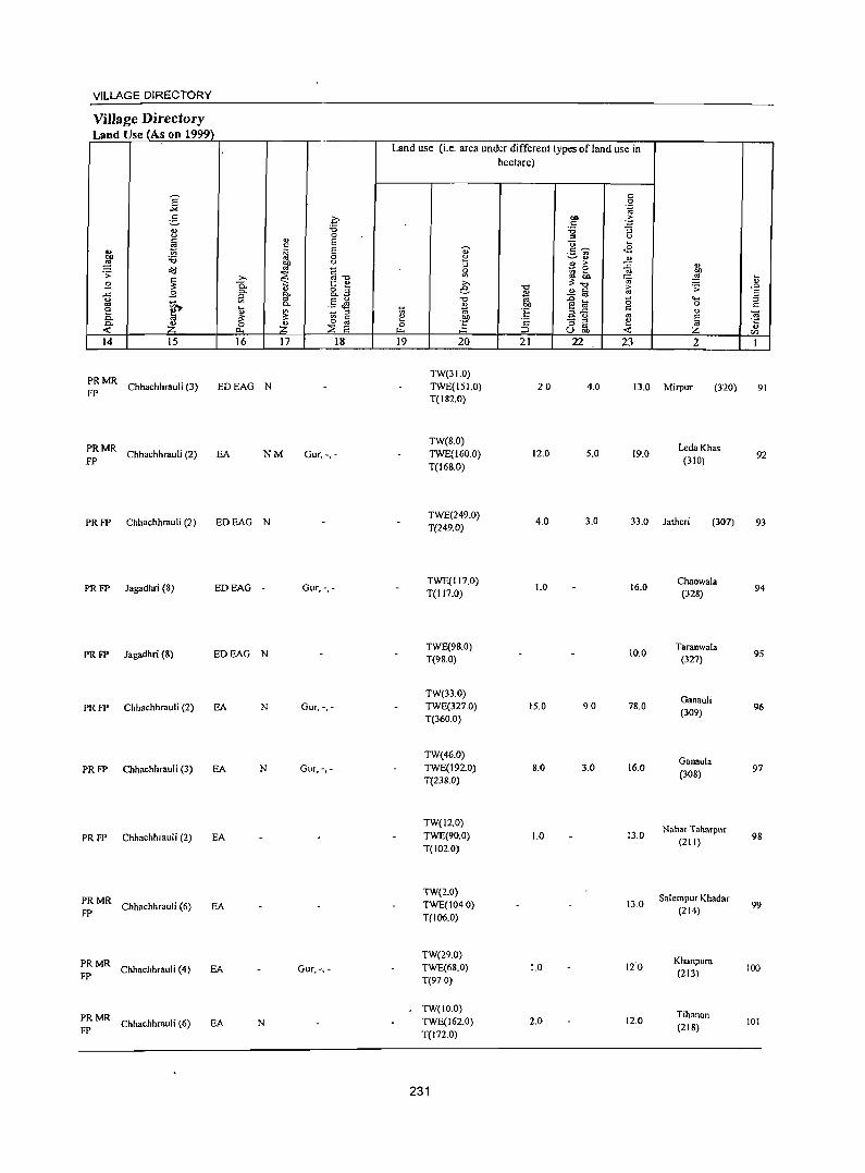
VILLAGE DIRECTORY
ViJJage Directory Land Use (As on 1999)
Land use (i.e. area under different types of land use in hectare)
S c 0
"'" .~
5 0 011 .~ C
'" '6 '6 :; " OJ
0 :s " ~ c E "0 ~ ., ~ E .,. .5 ~ <2
co '6 0 e ~ <> '" ~ Of) " :l " ;. ::0 ., ~ OJ C - 0 .s:
~ ill ra ~ '" Of)
~ ;., "'"0 ::; :a ~ t;
B 0. ~ " e: " 8.a "0 [:; .;; .0 ..c B 0- 0. '" " c E iil 0; - '" .... " ~ 2- .5 J! "0 -e:a 15 ::J ., 0) co 0 c a
~ ~ ::J ~ til ·E :s.e c '" a. :a '" c I:! i
_ " '" ~ ~ 0 ·c - ::> e 0. Z 0 Z '" 0 :s ..
<: ~ E ;::l <: u 0... ~ UOf) <I)
14 15 16 17 18 19 20 21 22 23 2 I
PRMR TW(31.0)
Chhachhrauli (3) EDEAG N TWE(I 5 1.0) 20 4.0 13.0 Mirpur (320) 91 FP
T(182.0)
PRMR TW(8.0)
LedaKhas
FP Chhachhrauli (2) EA NM Gur, -,- TWE(I60.0) 12.0 5.0 19.0
(310) 92
T(168.0)
PRFP Chhachhrauli (2) EDEAG N TWE(249.0)
4.0 3.0 33.0 Jatheri (307) 93 T(249.0)
PRFP Jagadhri (8) EDEAG - Gur, -,-TWE(117.0)
1.0 16.0 Chaowala
T(117.0) (328) 94
PRFP lagadhri (8) EDEAG N TWE(98.0)
10.0 Taraowala
95 T(98.0) (327)
TW(33.0) Gaoauli
PRFP Chhachhrauli (2) EA N Gur, -,- TWE(327.0) 15.0 90 78.0 (309)
96 T(360.0)
TW(46.0) GaDaula
PRFP Chhachhrauli (3) EA N Gur,-,- TWE(I92.0) 8.0 3.0 16.0 (308)
97 T(238.0)
TW(12.0) Nah.r Taharpur
PRFP Chhachhrauli (2) EA TWE(90.0) 1.0 13.0 98 T(102.0)
(211)
PRMR TW(2.0)
Salem pur Khadar Chhachhrauli (6) EA TWE(1040) 13.0 99
FP T(J06.0) (214)
PRMR TW(29.0)
Khanpura Chhachhrauli (4) EA Gur,-, - TWE(68.0) 1.0 120
(213) 100 FP T(97 0)
PRMR TW(JO.O)
Tihanon Chhachhrauli (6) EA N TWE(162.0) 2.0 12.0
(218) 101
FP T(I72.0)
231
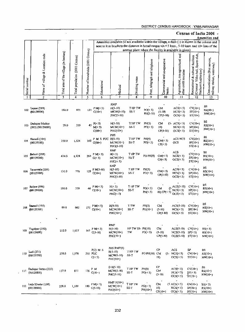
DISTRICT CENSUS HANDBOOK: YAMUNANAGAR
Certsus of India 2001 -Amenities and
Amenities available (if not available within the village, a dash (-) is shown in the column and next to it in brackets the distance in broad ranges viz. < 5 kms., 5-10 kms. and 10+ kms of the
-;;;- nearest place where the facility. is available is given -0- ;:l
" ~ ~ fi -0 ~.g "" " 0 ~ u ., " '" - ., '" e '.0 u ,,-"
..e t: <: > ~t! " .2 5 ., 0
0 .~ -~ ~ §. a ta U ..e "3 ~ &. Ol) ~
" - P- Ol)
" bO 0 '" '" P- " -eu:_ ;;: 2: 0 ~ 0 -0 '2 0 '§h ~ ...:/
t:!- -0 b ~ ~.§ ;:l "
~ ·s ..c -0
" '? on S1a Ol) " c: Ol) ~ ;l:
'" <II c: ~ '" '0 o .- <.) 0 ... .g g bO -5 0 ... ..e " t:~ ~ a<j ~ .g ...
~ . ~ 0 '" .. Ol) .... ..e ~
P- .- -0 .0 0 e ;:; e~ -a > :J ... -'> "3 ... -a .!'! !:i S oj C- o "
bO 0g § (ij ~ :J ... td 0 ... 0 -.; bO " a Ol) c '" c 0 C- Ol) '~ c '2 - ... 'iij s § ;:l >-
" .0 " :;;; E '" ;:l " S ~ ;:;
E (;j !'i s " :a " 1i E-'" .g i> e fl)._
.~ a :J ;:l
" C§ 8.8 bO..e <.).S] §:= .. ~ -0 0 OIl Z E-< Z LJ.l ~ ~ « a ~2.", u e I 2 3 4 5 6 7 8 9 10 II 12 13
RMP BS
102 Lopon (219)
166.0 871 131 P M« 5) H(5-1O) THPTW
PO« 5) CM ACS«5) CV(lO+)
RS(IO+) (00128900) C(IO+) MCW(5-10) SS-T (5-Hl) NCS«5) SP(IO+)
PHC(5-10) PH(5-1O)
CP(5-IO) OCS«5) ST(IO+) NW(IO+)
Dadupur Mal ion P«5) H(5-10) THPTW PH(3) CM (5- ACS« 5) CV(lO+) BS
103 (193) (00129000)
79.0 339 45 M«5) MCW(JO+) SS-T PO«5) 10) NCS« 5) SP(IO+) RS(IO+)
C(IO+) PHC(IO+) CP(5-IO) OCS«5) ST(lO+) NW(IO+)
PHS BS
Harauli (194) P M S PUC H(5-1O) THPTW PH(4) ACSNCS CV(IO+) 104
(00129100) 259.0 1,524 248 C(IO+) MCW(JO+) SS-T POC< 5)
CM«5) OCS SP(IO+)
RS(IO+)
PHC(S-IO) CP«5)
ST(lo+) NW(lO+)
RMP ACS as
lOS BaIauli (208)
424.0 I,S28 264 PM«5) H«5) THPTW POPH(8) CM«S) NCS« S)
CV(IO+) RS(IO+)
(00129200) C«5) MCW(IO+) SS-T SP(IO+)
PHC« 5) Cp«5) OCS«S)
ST(IO+) NW(IO+)
RMP BS
106 Tarunwala (209)
131.0 776 29 P M(5-1O) H(5-10) THPTW PH(S) CM«5)
ACS«5) CV(lO+) RS(IO+)
{DOl 29300) I C(IO+) MCW(IO+) SS-T PO« 5) NCS«5) SP(IO+) PHC(5-IO)
CP(5-JO) OCS«5) ST(IO+)
NW(IO+)
Raipur (196) 46 PM«5) H«5) THPTW CM (SACS(S-IO) CV(lO+) BS
107 {oo I 29400)
100.0 339 C(IO+) MCW(IO+) SS-T
POC< 5) 10) CP« S) NCS« 5) SP(IO+)
RS(IO+)
PHC« 5) PH«5)
OCS«5) ST(IO+) NW(IO+)
Damoli (19S) PM«5) H(5-10) TTW PH(5) CM ACS(S-IO) CV(IO+) BS
108 (00129500)
990 962 171 C(IO+) MCW(IO+) SS-T PO(IO+) (5-10) NCS«5) SP(IO+)
RS(JO+)
PHC(IO+) CP(5-10) OCS«5) ST(IO+) NW(IO+)
RMP
109 Tugalpur (192)
212.0 1>017 PM«S) H(5-JO) HPTW SS- PHeIO) CM ACS{5-IO) CV(IO+) BS«5)
(00129600) 167 C(5-JO) MCW(IO+) TW PO«5) (S-IO) NCS(S-IO) SP« S) RS(IO+) PHC(IO+) CP(5-JO) OCS(S-IO) ST(lO+) NW(IO+)
P(2) M S PHSRMP(6)
CP ACS SP BS ledi (221) H(5-IO) THPTW
110 278.0 1>576 25S PUC PO PH(18) CM (S- NCS«5) CV(IO+) RS(IO+) (00129700)
C«S) MCWe5-10) SS-T
10) OCS«5) ST(IO+) NW(lO+) PHC(IO+)
Dadupur Jaltan (222) PM D H(5-10)
THPTW PH(9) CP
ACS« 5) CV(IO+) BS 111
(00129800) 137.0 81 I 126
C(JO+) MCWe5-10)
SS-T 1'0« 5) CM
NCS« 5) ~P« 5) RS(IO+)
PHC(5-IO) (5-10) OCS« 5) . ST(IO+) NW(IO+)
leda Khada.r (190) PM«5) RMPH(IO+)
THPTW CM (5 ACS« 5) GV(IO+) BS«5) 112 228.0 1,189 MCW(IO+) PO{<S)
(00129900) 180 C(S-IO) PHCfI O+)
SS-T PH(JO+)
10) NCS« 5) SP(IO+) RS(IO+) CP(IO+) OCS« S) ST(IO+) NW(IO+}
232
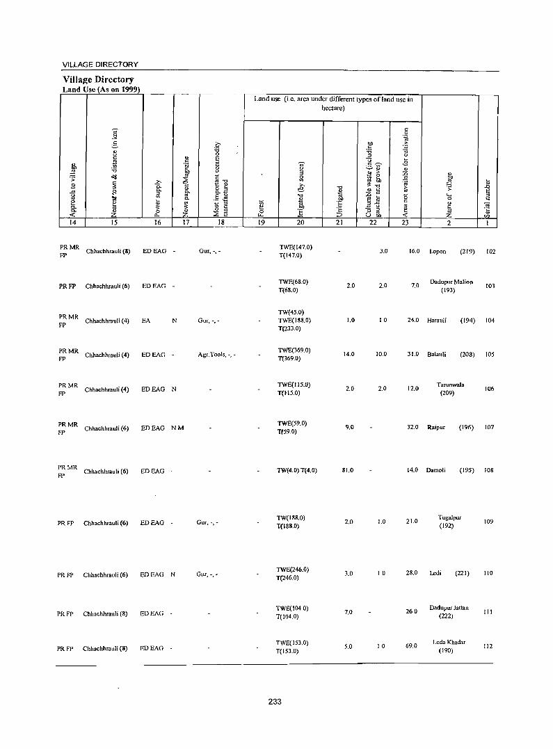
VILLAGE DIRECTORY
Village Directory Land Use (As on 1999)
]' 5 c :a '" <) 0
" u E t! " M> 'iii E :a 0 ,g ~ " ~ .;;:
~ ~"O ~
>-B c.. t: e
" ..r:: B 0. g- o ::;J
g ::;J 0._
'II! '" .§ .M c. e ta :;; '" ::;J a. ;;:: ;;:: l3 c: a. ~ 0 ~
~
::E ..: 0.. E 14 15 16 17 18
PRMR ehhaehhrauli (8) EDEAG Gur, -,--
FP
PRFP Chhaehhrauli (6) EDEAG -
PRMR FP
Chhaehhrauli (4) EA N Gur, -,-
PRMR Chhaehhrauli (4) EDEAG Agr.Tools, -,-
FP -
PRMR Chhaehhrauli (4)
FP EDEAG N
PRMR Chhaehhrauli (6) EDEAG NM
FP
~: MR Chhaehhrauli (6) EDEAG -
PR FP Chhaehhrauli (6) ED EAG - Gur, -,-
PRFP Chhaehhrauli (6) EDEAG N Gur, -.-
PR FP Chhaehhrauli (S) EDEAG
PRFP ehh.ehhr.uli (8) EDEAG -
Land use (i.e. area under different types of land use in
t:; e 0
u.. 19
.,. ~ ::;J 0 '" >-e "0 ., 'OJ "" Ii
20
TWE(147.0) T(147.0)
TWE(6S.0) T(68.0)
TW(4S.0) TWE(18S.0) T(233.0)
TWE(369.0) T(369.0)
TWE(IIS.O) T(IIS.O)
TWE(S9.0) T(S9.0)
TW(4.0) T(4.0)
TW(188.0)
TeIS8.0)
TWE(246.0) T{246.0)
TWE(1040) T(104.0)
TWE(IS3.0) T(IS3.0)
233
hectare)
"" " :a ::;J
u .5 ';;" ~ u u >
~~ "0 ., '" " 'OJ - ~ ..g ~ .~ 3-5 t:
'2 - ::;J ::;J ~ ~ U 00
21 22
3.0
2.0 2.0
1.0 10
14.0 10.0
2.0 2.0
9.0
81.0
2.0 1.0
3.0 10
7.0
S.O 10
" 0 .~
.:: "§ <)
.... <B 0)
:0 '" ~ 00
~ ,g .... u
t:; .;;: .0 E
b .... ~ 0
" '" ~ E OJ e '5 ~ ..: VI
23 2 1
16.0 Lopon (219) 102
7.0 Dadupur Malion
103 (193)
24.0 Harauli (194) 104
31.0 Balauli (208) lOS
12.0 Tarunwala
(209) 106
32.0 Raipur (196) 107
14.0 Damoli (195) 108
21.0
28.0
26.0
69.0
Tugalpur (192)
Ledi (221)
Dadupur Jattan (222)
Leda Khad.r (190)
109
110
III
112
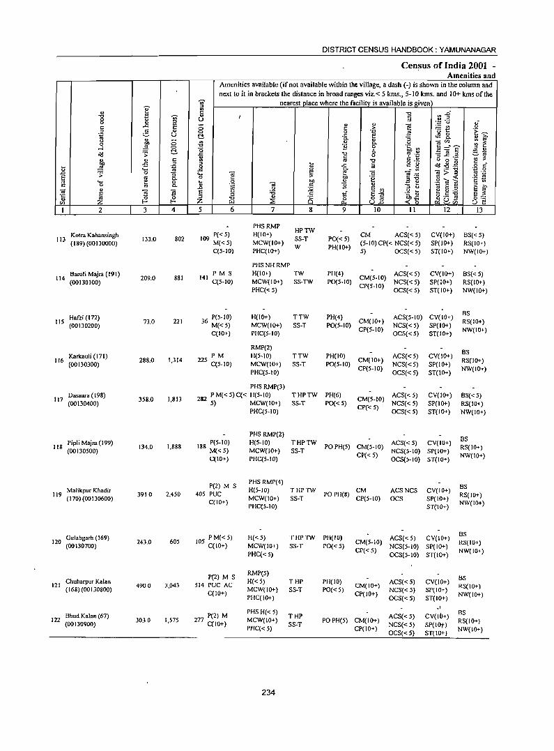
DISTRICT CENSUS HANDBOOK: YAMUNANAGAR
Census of India 2001 -Amenities and
Amenities available (if not available within the village, a dash (-) is shown in the column and next to it in brackets the distance in broad ranges viz.< 5 kms., 5-10 kms. and 10+ kms of the
-;;;- nearest place where the facility is available is given U' :J
'" <I)
~ C ." ~ 2" ."
~ .. I fd 0 u
(.) " '';:; u .,-c ..c '" (5 " " E! :.: rn (.) C C > 0 :.§. '" 0 0 .~ E '0 1::: 'E ~ .~ u !::!- .c ~ ~ ... ~
" 0- " ::J (.)
bJ) (5 .. " 0- (.) ] :~E '" ~ 0 ,g 0 "0 11 0 .~ ~ gj " .....l C!- o 6 f3.a ~ .;;: ..c "0 <J ~ 'z -3 ~ .::!
~ c '" :J: ~ " c '" ." C " <J 0 ~
-:S 0 ::J
~ a o ._
~ -8 .g c _ ., ,g .~ 0 ..c c g o c ._ ..c 0- ...:'" -;;:] 'P 0
_o .;;: 0 :; .... 0; :J: e 0; e·";:: oJ .-
s '" 0- 0 C bJ) .~ ::J"O ~ < '2 ~ :J .... e 0 ~ 0 Oil " .:: e .2 O! E c 0 ., 0- 0 'ia OJ c 1i " rtS E ::J
::J _
" .0 (.) :;;;; E ., ::J (.)
S f 0;
~ :§ :§ S u '6 .S tf s->< .~~ e g ;a
'1: ::J :J ., o C ~ Qbl §::: .. ~ ~ Z ." ~ Q 0 ull < (5 IZl D-l ~ U e
I 2 3 4 5 6 7 8 9 10 II 12 13
PHSRMP HPTW
Kotra Kahansingh 109 P« 5) H(IO+) CM ACS«5) CV(IO+) BS« 5) 113 133.0 802 SS-T PO«5)
(189) (00130000) M«5) MCW(IO+) W PH(IO+)
(5-IO)CP« NCS«5) SP(IO+) RS(IO+) C(5-10) PHC(IO+) 5) OCS«5) ST(IO+) NW(IO+)
PHSNHRMP
Bamli Majra (191) 141
PM S H(IO+) TW PH(4) CM(5-IO)
ACS«5) CV(IO+) BS« 5) 114
(00130100) 209.0 881
C(5-1O) MCW(IO+) SS-TW P0(5-IO) NCS«5) SP(IO+) RS(IO+) PHC« 5)
CP(5-10) OCS«5) ST(IO+) NW(IO+)
Hafzi (172) 36 P(5-IO) H(IO+) TTW PH(4) ACS(5-IO) CV(IO+) BS
115 (00130200)
73.0 221 M«5) MCW(IO+) SS-T P0(5-IO)
CM(IO+) NCS«5) SP(IO+)
RS(IO+)
C(IO+) PHC(5-10) CP(5-1O)
OCS«S) ST(IO+) NW(IO+)
RMP(2) BS
Karkauli (171) PM H(5-1O) TTW PH(IO) ACS« 5) CV(IO+) 116
(00130300) 288.0 1,314 225 C(5-10) MCW(IO+) SS-T PO(5-10)
CM(IO+) NCS«5) SP(IO+)
RS(lO+)
PHC(5-10) CP(5-IO)
OCS«5) ST(IO+) NW(lO+)
PHS RMP(3) Dasaura (198)
1,813 282 PM«5)C« H(5-1O) THPTW PH(6)
CM(5-IO) ACS« 5) CV(IO+) BS« 5)
117 358.0 (00130400) 5) MCW(IO+) SS-T PO«5)
CP«5) NCS« 5) SP(IO+) RS(IO+)
PHC(5-10) OCS«5) ST(IO+) NW(IO+)
PHS RMP(2) BS
Pipli Majra (199) 188 P(5-IO) H(5-10) THPTW ACS« 5) CV(IO+) 118
(00130500) 134.0 1,888
M«5) MCW(IO+) SS-T POPH(5) CM(5-10)
NCS(5-10) Sp(IO+) RS(IO+)
C(IO+) PHC(5-10) CP« 5)
OCS(5-10) ST(IO+) NW(IO+)
P(2) M S PHS RMP(4)
BS 119
Malikpur Khadir 3910 2,450 405 PUC
H(5-10) THPTW POPH(8)
CM ACSNCS CV(IO+) RS(IO+) (170)(00130600) MCW(IO+) SS-T CP(5-10) OCS SP(IO+) C(IO+)
PHC{5-10) ST(IO+) NW{IO+)
Gulabgarh (169) 105 PM«5) H«5) THPTW PH(IO) ACS«5) CV(IO+) BS
120 243.0 605 CM(5-10) RS(IO+) (00130700) C(IO+) MCW(IO+) SS-T PO« 5) NCS(5-IO) SP(IO+)
PHC«5) CP« 5)
OCS(5-10) ST(10+) NW(IO+)
P(2) M S RMP(5)
BS 121
Chuharpur Kalan 4900 3,043 514 PUC AC
H« 5) THP PH(lO) CM(IO+)
ACS« 5) CV(IO+) (168) (00130800) MCW(IO+) SS-T PO« 5) NCS« 5) SP(IO")
RS(IO+) C(10+)
PHC(IO+) CP(IO+)
OCS«5) ST(IO+) NW(IO+)
-' Bhud Kalan (67) 77 P(2) M
PHS H« 5) THP ACS«5) CV(lb+)
as 122 3030 1,575 MCW(IO+) PO PH(5) CM(IO+)
(00130900) 2 C{lO+) SS-T NCS«5) SP(IOt) RS(IO+)
PI1C« 5) CP(IO+) OCS«5) ST(IO+)
NW(IO+)
234
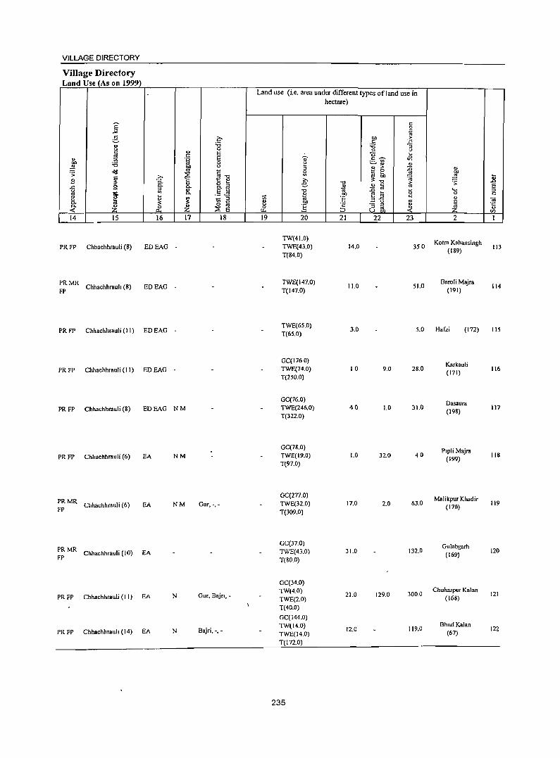
VILLAGE DIRECTORY
Village Directory Land Use (As on 1999)
14 15
PRFP Chhachhrauli (8)
:: MR Chhachhrauh (8)
16
EDEAG -
EDEAG -
PR FP Chhachhrauli (II) EO EAG -
PR FP Chhachhrauli (II) ED EAG -
17
PR FP Chhachhrauli (8) ED EAG N M
PR FP Chhachhrauli (6) EA NM
~: MR Chhachhrauli (6) EA NM
~: MR Chhachhrauli (10) EA
PR FP Chhachhrauli (I I) EA N
PR FP Chhachhrauh (14) EA N
a '0 o E E 8 c: "'"'" 1:: " o ~ c:>.3 E 0 ._ <S _ :l
'" C o '" ::E E
18
Gur, -,-
Gur, Bajn,-
Bajri, -, -
Land use (Le. area under different types ofland use in hectare)
19 20
TW(41.0) TWE(43.0) T(84.0)
TWE(147.0) T(t47.0)
21 22 23
14.0 350
11.0 51.0
2
Kotra Kahansingh (189)
Baroli Majra (191)
TWE(6S.0) T(6S.0)
3.0 5.0 Hafzi (172)
GC(176 0) TWE(74.0) T(2S0.0)
GC(76.0) TWE(246.0) T(322.0)
GC(78.0) TWE(19.0) T(97.0)
GC(277.0) TWE(32.0) T(309.0)
GC(37.0) TWE(43.0) T(80.0)
GC(34.0) TW(4.0) TWE(2.0) T(40.0)
GC(144.0) TW(14.0) TWE(14.0) T(I72.0)
235
10 9.0
40 1.0
1.0 32.0
17.0 2.0
31.0
21.0 129.0
12.0
28.0
31.0
4.0
63.0
132.0
300.0
119.0
Karkauli (171)
Dasaura (198)
Plpli Majra (199)
Malikpur Khadir (170)
Gulabgarh (169)
Chuharpur Kalan (168)
Bhud Kalan (67)
~ u .0
§ C
-a .;: u til
113
114
liS
116
117
118
119
120
121
122
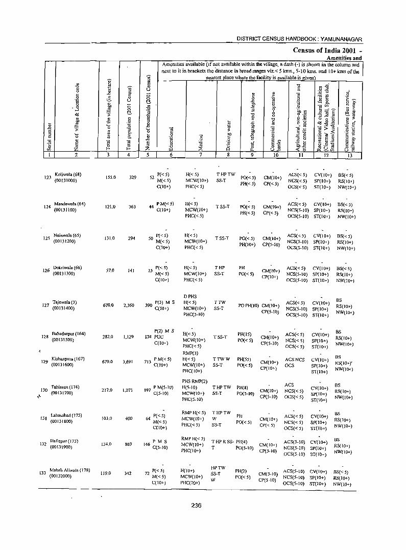
DISTRICT CENSUS HANDBOOK: YAMUNANAGAR
Census of India 2001 -Amenities and
Amenities available (if not available within the village, a dash (-) is shown in the column and
next to it in brackets the distance in broad ranges viz. < 5 kms., 5-10 kms. and 10+ kms of the
~ :!l nearest place where the facili!Y_ is available is given
i ..
::.g " c "" "0
'" <> c 0 U '" " " " u " "§
".;::: u .1{ ..c: E - ~t c 0 c ;> 0 e- " 0 0 .~ a c~ .~ U ~ ..c:
"3 c£S 8. ~ ~ " 0- " " ~ 0 .. '" 0. <> 0i1Zl
'3 "0 B 0 .~ en 9 ="8 <:> "0 6 " '" o<l '> ~ '0 7 .~ '3 ~.~ c:) '" ..c: c <> ';;;'~
~ " c .. '" '0 C ... o 0 ~ ~
o ._ c £ 0
! ..c: iii C:_ ~ ~:9~ ·2 s" ~ ~ 'ta 0
" ._ ..c c.
~ 0 ~ 'iii ~>~ '" ._ .D "3 .... -;;; e ;t:: .~ Jj E '" .~
~ 0. 0
.~ bI) u "",, .9 O! E c '" " .... 0 ~ - " c 0 '" 0. ., 'iii c B " 3 ti B ~ 'iii a.>
~ l .D .,
" .;;; E '" 't: 4) ~ ~.2
~ E g :a c tf E-" ~cJ] E ~ "E " ;il " i§ 0 o iii bO .c 0::: IZl Z r- Z ::;E p., U.D <<5 ~~1Zl U e! I 2 3 4 5 6 7 8 9 10 II 12 I3
Koliwala (68) 329 52 P« 5) H« 5) THPTW
PO« 5) CM(IO+) ACS«5) CV(lO+) BS« 5) 123
(00131000) 155.0
M«5) MCW(IO+) SS-T NCS« 5) SP(IO+) RS(IO+) C(lO+) PHC« 5)
PH« 5) CP« 5) OCS«5) ST(IO+) NW(IO+)
124 Mandewala (64)
121.0 363 44 PM«5) H«5) TSS-T PD« 5) CM(IO+)
ACS«5) CV(IO+) BS« 5) (00131100) C(IO+) MCW(IO+)
PH«5) CP«5) NCS(5-10) SP(IO+) RS(lo+)
PHC« 5) OCS(5-10) ST(IO+) NW(JO+)
125 Nainwala (65)
131.0 294 50 P« 5) H« 5) TSS-T PD« 5) CM(IO+)
ACS« 5) CV(IO+) BS«5) (00131200) M«5) MCW(IO+)
PH(IO+) CP(5-10) NCS(5-1O) SP(lO+) RS(lo+)
C(10+) PHC« 5) OCS(S-\O) ST(\O+) NW(IO+)
Dekriwala (66) 15 P« 5) H«5) THP PH CM(lO+)
ACS« 5) CV(IO+) BS«5) 126 (00131300)
57.0 141 M«5) MCW(IO+) SS-T PO« 5) NCS(5-IO) SP(lO+) RS(1O+) C(IO+) PHC«5)
CP{IO+) OCS(5-JO) ST(IO+) NW(IO+)
o PHS BS Tajewala (3) 390 P(3) M S H«5) TTW ACS«5) CV(IO+) 127
(00\31400) 670.0 2,360
C(IO+) MCW(IO+) SS-T PO PH(IO) CM(IO+)
NCS(5-10) SP(IO+) RS(IO+)
PHC(5-1O) CP(5-IO)
OCS(5-10) ST(IO+) NW(IO+)
Bahadurpur (164) P(2) M S
H«5) PH(15) ACS«5) CV(IO+) BS
128 (0013\500)
282.0 1,129 174 PUC MCW(IO+)
TSS-T PO«5)
CM(IO+) NCS«S) SP(IO+)
RS(IO+) C(lO+)
PHC«5) CP(5-IO)
OCS«5) ST(IO+) NW(lO+)
RMP(3) BS Kishanpura (167) 713 P M«5) H«5) TTWW PH(55) ACSNCS CV(10+) 129
(00131600) 679.0 3,691
C(lO+) MCW(IO+) SS-T PO«5) CM(IO+)
OCS SP(IO+) RS(IO+y
PHC(IO+) CP(IO+)
ST(IO+) NW(IO+)
PHSRMP(2) ACS BS Tahimun (174) 197 P M(5-IO) H(S-IO) THPTW PH(8) CV(IO+) 130
(00131700) 217.0 1,071
C(5-1O) MCW(IO+) SS-T PO(5-10) CM(10+) NCS«5)
SP(IO+) RS(lo+)
,~ PHC(S-IO) CP(5-1O) OCS«5)
ST(lO+) NW(lO+)
Lahasabad (175) 64 PC< 5) RMPH«5) THPTW
PH ACS{< 5) CV(lO+) BS
131 103.0 400 MCW(IO+) W CM(IO+) RS(lO+) (00131800) M«5) PO«5) NCS« 5) SP(IO+) C(\O+)
PHC« 5) SS-T CP«5) OeS« 5) ST(IO+) NW(lO+)
Hatizp~r (173) 146 P M S RMPH«5)
T HP R SS- PH(4) ACS(5-10) CV(IO+) BS \32 134.0 869 MCW(IO+) CM(IO+) RS(lo+) (00131900) C(S.IO) T PO(S-IO) NCS(5-IO) SP(IO+) PHqIO+) CP(5-10)
OCS(5-1O) ST(IO+) NW(lO+)
Mahab Aliwala (178) 72 P« 5) H(IO+) HPTW
PH(2) ACS(S·IO) CV(IO+) 133 119.0 342 SS-T CM(5-10) BS« 5) (00132000) M«5) MCW(!o+)
W PO« 5)
CP(5-10) NCS(5-10) SP(IO+) RS(IO+)
C(IO+) PHC(IQl-) OCS(5-10) ST(IO+) NW(lO+)
236
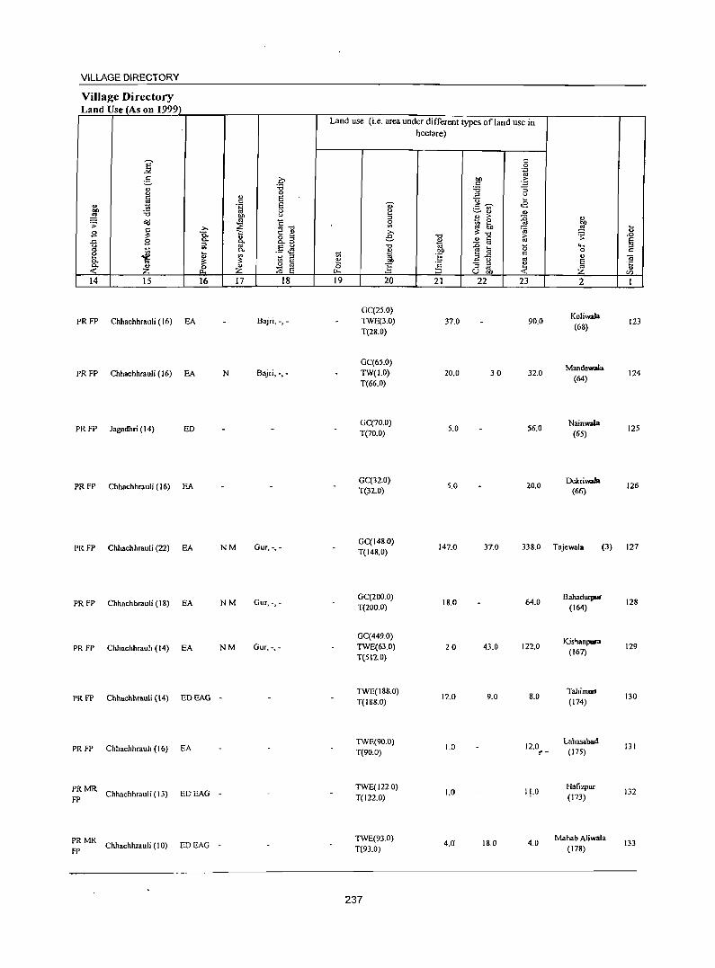
VILLAGE DIRECTORY
Village Directory Land UseJAs on 1999)
14 15
PR FP Chhachhrauli (16) EA
PR FP Chhachhrauli (16) EA
PR FP Jagadhri (14) ED
PR FP Chhachhrauli (16) EA
PR FP Chhachhrauli (22) EA
PRFP Chhachhrauli (18) EA
PR FP Chhachhrauh (14) EA
16
PRFP Chhachhrauli (14) EDEAG
PR FP Chhachhrauh (16) EA
PRMR Chhachhrauli (13) EDEAG
FP
PRMR FP
Chhachhrauli (10) EDEAG
17 18
Bajri, -,-
N Bajri, -,-
NM Gur. -.-
NM Gur. -,-
NM Gur.-.-
-
-
-
Land use (i.e. area under different types ofland use in hectare)
19 20
GC(2S.0) TWE(3.0) T(2&.0)
GC(65.0) TW(1.0) T(66.0)
GC(70.0) T(70.0)
GC(32.0) T(32.0)
21 22 23
37.0 90.0
20.0 30 32.0
5.0 56.0
5.0 20.0
2
Koliwala (68)
Mandewala (64)
Nainwala (65)
Dekriwafa (66)
123
124
125
126
GC(148.0) T(148.0)
147.0 37.0 338.0 Tajewala (3) 127
GC(200.0) 18.0 64.0
BahadUlJllll" 128
T(2000) (164)
GC(449.0) Kishanpara
TWE(63.0) 20 43.0 122.0 (167)
129 T(512.0)
TWE(188.0) 12.0 9.0 8.0
TahimurJ 130
T(188.0) (174)
TWE(90.0) 1.0 12.0
Lahasabad 131
T(90.0) ~- (175)
TWE(1220) 1.0 11.0
Hafizpur 132
T(122.0) (173)
TWE(93.0) 4.0 18.0 4.0
Mahab Aliwala 133
T(93.0) (178)
237
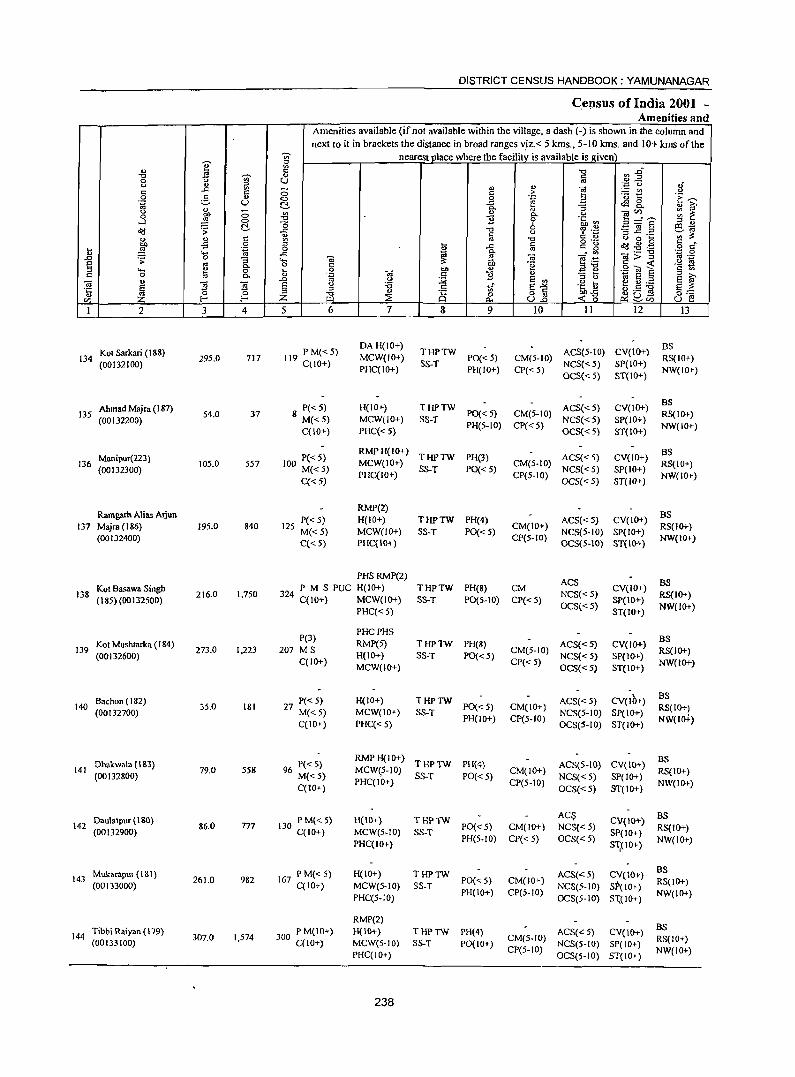
DISTRICT CENSUS HANDBOOK: YAMUNANAGAR
Census of India 2001 -Amenities and
Amenities available (if not available within the village, a dash (-) is shown in the column and next to it in brackets the distance in broad ranges ,,:iz.< 5 kms., 5-10 kms. and 10+ kms of the
';;;- nearest pJace where the facility_ is available isgiven Q' :::t
<> ~ :g "C .s:f
-0 ~ 8 s:: '" :::t 0 ., .. - ,; <.I " '" " " ""§
-,p 0
s:: ..c: 5 ;; " ;>
._ en <.I
0 e- o 0 .~ a '0 t:: .~ ~ 0g U ~ ..c: rf!8. " ~ 9 .,.
" :;
u ;:; '" " C. <.I catl) ~ ~ 0 -0 :9 0 .~ ~ l3=ae ,_) 0 :::t " ~ (5 6 1Il0; oa .:;: ..c: "C <:) ~ 0i$ :3 ..c: .2 " " " a -0 <> 0 .... ';;;~ ., '" 8_ .~ ~ .g.g s:: •
:§ .;:; .9 :::t
~ ..c: s:: o s::
t; 0 '" ... 0; ..c: ~ ._ -0 '.0 0
.D 0 C<l ~ .~ ~>< "'._ .:;: :; "0 C<l <:) ~
E '" Co <:: -2 :::s"C "§ ~ s .... " 0 ... 0 bI) " .::: e .9 'OJ S 0 l;; c. " .~ C<l s:: :9 " ..0 u :;;; E "'
:::s <> 0; E :::t E ~ ca " ] ~ § <> :a tl §'§ .~ ~ i3 .5 ~ E ~ '5 § :::t
" s::
0 -0 ::E B 0 oo..c: ~u- 0:0=
tI) Z f-' f-' Z P.l C. U..o ...:15 ~'" U e! 1 2 J 4 5 6 7 & 9 10 11 12 IJ
Kot Sarkari (188) PM«5) DAH(IO+)
THPTW ACS{5-IO) CV(IO+) BS
134 295.0 717 119 C(IO+) MCW(IO+) PO« 5) CM(5-10) RS(IO+) (00132100) PHC(IO+)
S5-T PH(IO+) CP« 5)
NCS«5) SP(IO+) NW(IO+)
OC5« 5) 5T(10+)
Ahmad Majra (187) 8 1'« 5) H(IO+) THPTW ACS«5) CV(IO+) BS
135 54.0 37 PO« 5) CM(5-10) RS(IO+) (00132200) M«5) MCW(IO+) 55-T
PH(5-10) CP« 5) NC5« 5) 5P(IO+)
NW(IO+) C(IO+) PHC« 5) OCS«5) ST(IO+)
Manipur(223) 100 P« 5) RMPH(IO+)
THPTW PH(3) AC5«5) CV(IO+) BS 136 105.0 557 MCW(IO+) CM(5-1O) RS(IO+)
(00132300) M«5) PHC(IO+)
SS-T 1'0« 5) CP(5-JO)
NCS« 5) SP(IO+) NW(IO+)
C«5) OCS«5) ST(IO+)
Ramgarh Alias Arjun RMP(2)
a5 125 P« 5) H(IO+) THPTW PH(4) ACS« S) CV(IO+)
137 Majra (186) 19S.0 840 M«5) MCW(IO+) SS-T PO« S)
CM(IO+) NCS(S-IO) 51'(10+)
RS(IO+) (00132400)
C«S) PHC(IO+) CP(5-IO)
OCS(5-10) 5T(\0+) NW(IO+)
PHS RMP(2) ACS as
Kot Basawa Singh I' M S PUC H(10+) THpTW PH(8) CM CV(IO+) 13&
(185) (00132500) 216.0 1.7S0 324 C(IO+) MCW(lO+) 5S-T P0(5-10) CP« 5)
NCS«5) SP(IO+)
RS(IO+)
pHC« 5) OCS« 5)
ST(\o+) NW(IO+)
1'(3) PHCPHS
Kot Mushtarka (184) RMP(5) THPTW PH(8) ACS« 5) CV(IO+) BS
139 (00132600)
273.0 1.223 207 MS H(IO+) SS-T PO« 5)
CM(5-10) NCS{< 5) 5P(10+)
RS(lO+) C(IO+)
MCW(JO+) CP« 5)
OCS«5) 5T(10+) NW(IO+)
Bachon ( 182) P«5) H(IO+) THpTW ACS«5) CV(1O+) BS
140 35.0 181 27 PO«S) CM(lO+) RS{IO+) (00132700) M«5) MCW(IO+) SS-T
PH(IO+) CP(S-IO) NCS(5-JO) SP(IO+)
NW(lo+) C(10+) PHC« 5) OCS(5-1O) ST(IO+)
Dhakwala (183) 96 P« 5) RMP H(IO+)
THpTW PH(4) ACS(S-IO) CV(\O+) BS
141 79.0 5S8 MCW<S-IO) CM(IO+) RS(W+) (00132800) M«5) SS-T PO«S) NCS«S) SP(IO+)
C(\O+) pHC(lO+) CP(5-10)
OCS«S) ST(IO+) NW(IO+)
Daulatpur (I SO) 130 I' M« 5) H(IO+) THPTW Aqi
C)/(IO+) BS
142 86.0 n7 1'0« 5) CM(IO+) NCS«5) RS(IO+) (00132900) C(IO+) MCW(S-IO) SS-T 5P(lO+ ) PHC(IO+)
PH(S-IO) CP« 5) OC5«5) S"I;(IO+)
NW(IO+)
MUkarapur(181) 167 PM«5) H(IO+) THPTW ACS('" 5) CV(IO+) BS
143 261.0 982 PO« 5) CM(IO+) RS(IO+) (00133000) C{JO+) MCW(S-IO) SS-T NCS(5-10) SP(IO+) PHC(5-10)
PH(IO+) Cp(5-10) OCS(5-10) S1;(10+)
NW(IO+)
RMP(2) BS Tibbi Raiyan (179) 300 P M(IO+) H(IO+) THPTW PH(4) ACS«5) CV(IO+) 144 307.0 I.S74 CM(S-IO) RS(JO+) (00133100) C(IO+) MCW(S-IO) 3S-T PO(IO .. ) NCS(5-10) SP(IO+)
PHC(IO+) CP(S-IO)
OCS(5-10) ST(IO+) NW(IO+)
238
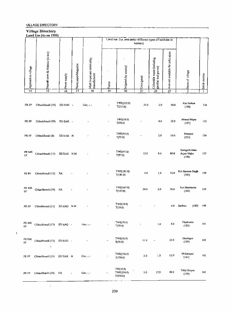
VILLAGE DIRECTORY
Village Directory Land Use (As on 1999)
Land use (i.e. area under different types of land use in hectare)
E c 0
_". .~
e- o t>Il ;>
:a c § II) :a <> 0
" <>
~ v E c u ~
" .§ E u- .s "7n' e :W :a 0 e ~ QJ <!)
t>Il u QJ :>-~ '" fJ.",
:l - 0 :g ~ .;;:
~ ~ gj ~
~ z. "'~ 1d ~ ~
9 t ~ :>. .,
0. ., o " e -0 i;; ~ .s:>
..c 9 g- o. 0. _
~ .2& s g
l '" '" .§ J§ -0 e t93 g .... " 2 ~ 0.
11 ., t>Il 0 C
~ 1;i § ~ :~ "..c " a. :§ _ u
'" E OJ 0. Z 0 Z 0 Ci - ::l ~ '5 -< ~ E " '" ~ ~ ~ ::> Ubi) -< (/)
14 15 16 17 18 19 20 21 22 23 2 1
PRFP Chhachhrauli (10) EDEAG - Gur, -,-TWE(217.Q)
3S.0 3.0 40.0 Kot Sarkari
134 T(217.Q) (188)
PR FP Chhachhrauli (10) EOEAG -TWE(18.0)
4.0 32.0 Ahmad Majra
135 T(18.0) (187)
PRFP Chhachhrauh (8) EDEAG N TWE(93.0)
2.0 10.0 Manipur
136 T(93 0) (223)
PRMR TWE(97.0) Ramgarh Alias
FP Chhachhrauli (II) EDEAG NM T(97.0)
120 6.0 80.0 Arjun Maj,a 137 (186)
PRFP Chhachhrauli (11) EA TWE(I S 1.0)
1.0 1.0 33.0 Kot Basawa Singh
138 T(I81.0) (185)
PRMR Chhachhrauli (10) EA
TWE(I67.0) 34.0 2.0 70.0
Kot Mushtarka 139
FP T(167.0) (184)
PR FP Chhachhrauli (11) EDEAG NM TWE(29.0)
6.0 Bachon (182) 140 T(29.0)
PRMR Chhachhrauli (13) EDEAG Gur, -,-
TWE(70.0) 1.0 8.0
Dhakwl\Ia 141
FP - T(70 0) (IS3)
PRMR Chhachhrauli (13) EDEAG
TWE(50.0) 110 2S.0
Daulatpur 142
FP - T(SO.O) (180)
PR FP Chhachhraufi (15) EDEAG N Gur, -,-TWE(196.0) T(I96.0)
2.0 1.0 63.0 Mukarapur
143 (lSI)
TW(I6.0) Tibbi Raiyan
PRFP Chhachhrauli (10) EA Gur, -,- TWE(224.0) 2.0 17.0 48.0 (179)
144
T(240.0)
239
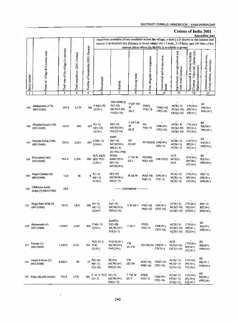
DISTRICT CENSUS HANDBOOK: YAMUNANAGAR
Census of India 2001 -Amenities and
Amenities available (if not available within the village, a dash (-) is shown in the column and next to it in brackets the distance in broad ranges viz.< 5 kms., 5-10 kms. and 10+ kms of the
-;;;- nearest place where the facility is available is given
K ii1 " t: "0 :l~ "0 ~ '" t: 0 0 ;:l u '" 0 " .';:: (,) ,J
-" :g - " " e! =Et': 0
'" 0 t: ;> 0 3 " 0 0 .~ a 't ~ ".g u ~ .t: ~g " i(;' " - Q.
" :; 0 OIl a .a " c.. 0
]~E ::: ~ 0 ~ a ]i 6 .~ ~ ....l -0 " " o'(! .;; t!- -" "0 0 ~ ~.c ~ jg .:: e:.~
'" t: '" ;::: " " c "' '" "0 t: " 00'" OIl oS 0 :l
I t:
o -_ ctd ~ .g § d' ...
~ "g 0 ..c .. " g <I> .... -" e- ta -:"' ta>"g "';:: 0
.0 .;; 0 :; ..... -;;; e .'": ., ._ u -S '" C- o '" bO -~ ,,"0 C -< "§ ~ :l .... !! 0 ... 0 OIl " .=! e .!2 <a S c 0 '" C- o .~ OJ c ]i " .0 0 .;;; S "' " u 10 S :l S i(;'
~ " "§
~ S g 'i3 u ... ~ .5 :g ~
c ti S-'" -.: v S ;::: 0 " "0 " i§ 0 o c bOoS 0:::: ..,
Z :2 u2 ~ ~U) en f- Ul Po. -< 0 u e I 2 3 4 5 6 7 8 9 10 \I 12 13
PHS RMP(3) THPTW BS
145 Bakkarwala (I 77)
347.0 2,179 360 P M(5-10) H(S-IO)
W PH(2)
CM(5-10) ACS« 5) CV(10+)
RS(IO+) (00133200) C(lO+) MCW(S-IO) PO«5) NCS(5-1O) SP(IO+)
PHC(5-1O) SS-T CP(S-IO)
OCS(5-1O) ST(10+) NW(IO+)
M\\iafat Khurd (\76) P«5) H(S-10) THPTW
PH ACS« 5) CV(IO+) BS
146 153.0 840 127 M(5-10) W CM(1O+) RS(IO+) (00133300) MCW(IO+)
SS-T PO« 5)
CP(5-10) NCS(5-10) SP(10+)
NW(IO+) C(IO+) PHC(S-lO) OCS(S-IO) ST(lO+)
RMP
Mujafat Kalan (166) 297 PM«S) H(S-IO) HP ACS« 5) CV(IO+) BS
147 (00133400)
339.0 2,013 C(lO+) MCW(lO+) SS-HP
PO PH(12) CM(lO+) NCS«5) Sp(IO+)
RS(IO+)
PHC«5) CP« 5)
OCS«5) ST(IO+) NW(IO+)
HCPHCPHS
Khizrabad (165) P(3) M(2) NH(6)
TTWW PH(300) ACS
CV(10+) BS
148 954.0 5,704 992 S(2) PUC RMP(19) 0 CMCP(2) NCS(3) RS(IO+) (00133500)
C(IO+) H(5-1O) SS-T PO(5-10)
OCS SP(10+)
NW(IO+) MCW(IO+)
ST(IO+)
149 Nagai Chakbat (6)
11.0 3& 6 P« 5) H(5-1O) WSS-W PO(5-IO) CM(IO+)
ACS«5) CV(IO+) BS«5) (00133600) M«5) MCW(lO+)
PH«5} CP« 5) NCS« 5) SP(IO+) :RS(10+)
C(lO+) PHC« 5) OCS«5) ST(IO+) NW(IO+)
150 Cbakbaba Sahib Singh (7) (001 33700}
59.0 -- Uninhabited -----
151 Nagai Patti MiIlc'(5)
791.0 I,M7 309 P« 5) H(5-1O) TWSS-T P0(5-1O) CM(10+)
ACS«5) CV(IO+) BS« 5) (00133800) M«5) MCW(ID+)
PH(5-IO) CP(5-10) NCS(5-10) SP(10+) RS(IO+)
C(IO+) PHC(5-10) OCS(5-10) <ST(IO+) NW(IO+)
RMP(3) BS
152 Raiyanwala (4)
1,059.0 2,567 435 PM«5) H(5-1O) TSS-T
PH(5) CM(IO+) ACS«5) CV(IO+)
RS(IO+) (00133900) C(IO+) MCW(IO+) PO«5)
CP(5-10) NCS(5-10) SP(IO+)
NW(IO+) PHC« 5) 0\=S(5-10) ST(IO+)
K.lesar (I) P(2) M S PHS H(lO+)
TW ACS
CV(IO+) BS
153 (00134000)
1,219.0 2,331 391 PUC MCW(IO+) SS-TW
POPH(IO) CM(IO+) NCS(5-10) Sp(IO+)
RS(IO+) C(lO+) PHC(IO+) CP(IO+) OCS(5-10)
ST(10+) NW(IO+)
Jungle Kalesar (2) 17 P(5-10) H(IO+) TW ACS« 5) CV(IO+) BS
154 (00134100)
4.682.0 83 M«5) MCW(10+) SS-TW
P0(5-10) CM(5-IO) NCS« 5) S.P{ 10+)
RS(IO+)
C(5-10) PHC(5-10) PH(5-IO) CP(5-10)
OCS« 5) ST(IO+) NW(IO+)
PM S PUC H«5) TTWW PH(4) ACS« 5) CV(IO+) BS
155 Khijri (8)(00134200) 795.0 1,673 281 C«5) MCW(10+) SS-T PO«5)
CM(IO+) NCS« 5) SP(IO+)
RS(IO+)
PHC«5) CP(5-IO)
OCS«5) ST(IO+) NW(IO+)
240
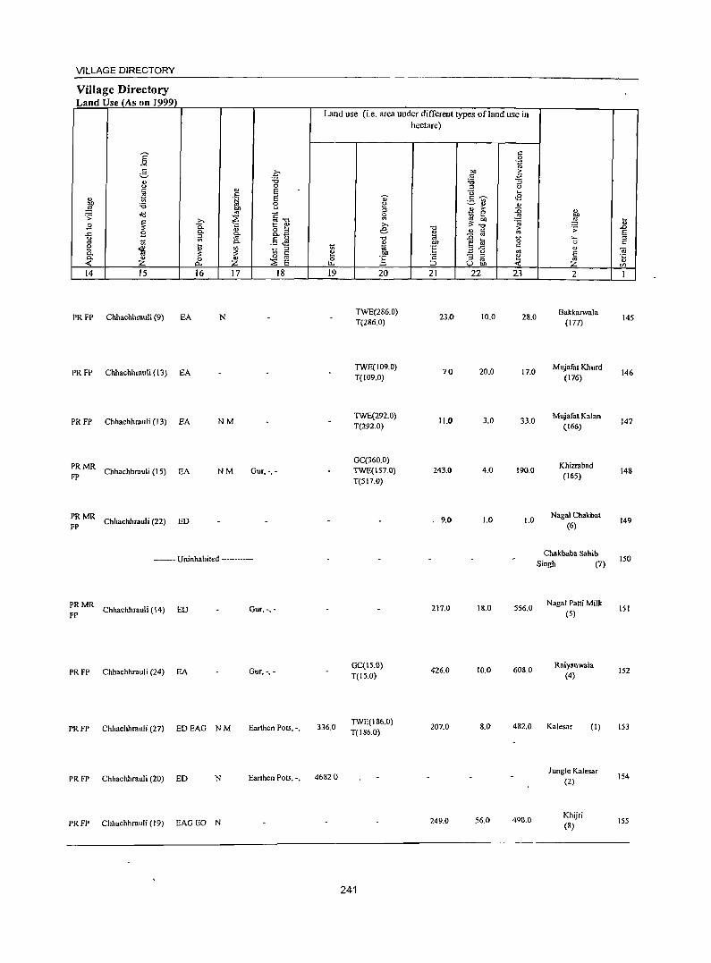
VILLAGE DIRECTORY
Village Directory Land Use (As on 1999)
14 15
PR FP Chhachhrauli (9) EA
PR FP Chhachhrauli (13) EA
PR FP Chhachhrauli (13) EA
:: MR Chhachhrauli (15) EA
:: MR Chhachhrauli (22) ED
16 17
N
NM
NM
. .q "C o E E o <>
§"O 1:: e &.a .5 JS _ ::s
~ @ ::;; E
18
Gur,', •
----•. Uninhabited --.----
:: MR Chhachhrauli (14) ED Gur, -,-
PR FP Chhachhrauli (24) EA GUT, -,-
PRFP Chhachhrauli (27) EDEAG NM Earthen Pots, "
PRFP Chhachhrauli (20) ED N Earthen Pots, -,
PRFP Chhachhrauli (19) EAGEO N
Land use (i.e. area under different types ofland use in hectare)
19
336.0
4682 ()
20
TWE(286.0) T(286.0)
TWE(109.0) T(109.0)
TWE(292.0) T(292.0}
GC(360.0) TWE(157.0)
T(SI7.0}
GC(15.0} T(15.0)
TWE(186.0) T(186.0)
241
21
23.0
70
11.0
243.0
9.0
217.0
426.0
207.0
249.0
22 23
10.0 28.0
20.0 17.0
3.0 33.0
4.0 190.0
1.0 1.0
18.0 556.0
10.0 608.0
8.0 482.0
56.0 490.0
2
Bakkarwala (177)
Mujafat Khurd
(176)
Mujafat Kalan (166)
Khizrabad (165)
Nagai Chakbat (6)
Chakbaba Sahib Singh (7)
NagaI Patti Milk
(5)
Raiyanwala (4)
Kalesar (I)
Jungle Kalesar (2)
Khijri (8)
145
146
147
148
149
150
1St
152
153
154
155
DISTRICT CENSUS HANDBOOK: YAMUNANAGAR
Cens~s of India 2001 -Amenities and
Amenities available (ifnot available within the village, a dash (-) is shown in the column and next to it in brackets the distance in broad ranges viz. < 5 kms., 5-10 kms. and 10+ kms of the
'V;' neares~ace where the faciHty_is available is given ]' i;l
~ C "tJ ~ ~ .. '"
.. c 0 <> u '" 0 " :::l .~ <3 oJ c ..c ~ 0 .. " "i'! ;.:: U'l .~ t: > .9 5 '" 0 0 .~ a 'u t:: C:~ til u t:!- ..c: tS 8- " [i;' " 0. "3 <) 0 ., OJ " ] ~~e ~ ~ .3 ~ 0. <)
0 "tJ ] 0 ·c rn t:!- o 6 ~.2
:::l OJ
~ .;; ..c: "0 :g ~ .2 Ill~ <> ~'"
~ t: C t) ., ;;::
j " § ., "0 <) 0 .. .g
J c g "g <Ill ~ . .g '" .... .~ 0 ..c: oj .g g-
" .... ..c a - '" _._, "'C
..0 ~ 0 :; .... -;;; -;;; g>.;( oj .-
S ~ .t:: .~ S OJ 0. 0 C .~ :>"0 :::l .... ~ 0 .. 0 -;;; Oll " ~ ., .9 OJ E c ., c 0 Co '" . ~ C ] " - .. E [i;' "
.0 u :;;; S VI :> 0 til e :>
0;
~ ~ ~ e u :a .5 tf S"'" .~ ~ t.s ~ S ;;:: .;:: ~
::> ::> ., o Iii ""-::; " I- Z -0 ::E Ci 0 ~u- 0::=
rn Ul ~ U.o « 0 ~CI) U E! 1 2 3 4 5 6 7 8 9 10 II 12 13
Bhangera Bhangeri PHSRMP
BS PM(5-10) H(IO+) THPTW PH ACS« 5) CV(IO+)
156 Bagpat(9) 626.0 2,312 391 C(IO+) MCW(IO+) SS-T PO« 5)
CM(IO+) NCS« 5) SP(IO+)
RS(IO+) (00134300)
PHC(5-1O) CP(5-to)
OCS«5) ST(IO+) NW(lO+)
Meghuwala(14) P«5) H(IO+) THPTW ACS«5) CV(lO+) BS
IS7 11S.0 499 PO(lO+) CM(lo+) RS(IO+) (00134400) 8S M(IO+) MCW(IO+) SS-T
PH(IO+) CP(5-10) NCS(5-IO) SP(\O+}
NW(lO+) C(lO+) PHC(IO+) OCS(S-to) ST(lO+)
Nathanpur (IS) P«5) H(10+) THPTW
ACS«S) CV(IO+) BS
158 (00134S00)
66.0 64 12 M(lO+) MCW(IO+) TK PO(lO+) CM(IO+)
NCS(5-1O) SP(IO+) RS(lO+)
C(IO+) PHC(IO+) SS-T PH(IO+) CP(5-10)
OCS(5-10) ST(IO+) NW(IO+)
Baniawala (13) P«5) H(IO+) TTWW ACS(5-10) CV(IO+) BS
159 (00134600)
122.0 691 110 M(S-to) MCW(IO+) SS-T PO« 5) CM(lO+)
NCS(5-lO) SP(IO+) RS(IO+)
C(5-10) PHC(5-lO) PH(5-10) CP(5-to)
OCS(5-lO) ST(IO+) NW(lO+)
Khilanwala (10) 254 P M(5-10) H(IO+) TW PH(3) ACS(5-10) CV(lO+) BS
160 306.0 1,443 CM(IO+) RS(IO+) (00134700) C(IO+) MCW(10+) SS-T PO(S-IO) CP(5-lO)
NCS(S-IO) SP(IO+) NW(IO+)
PHC(IO+) OCS(S-IO) ST(IO+)
161 Panch Khola (493)
2,496.0 --- Uninhabited ------(00134800)
Chikan (12) S7 P« S) H(IO+) PH ACS(5-10) CV(IO+) BS
162 224.0 543 TSS-T CM(IO+) RS(JO+) (00134900) M(S-lO) MCW(S-IO) PO(S-IO)
CP(S-IO) NCS(S-IO) SP(IO+)
NW(IO+) C(lO+) PHC(S-IO) OCS(S-IO) S1(lO+)
Kansli (II) P«S) H(IO+) TWWR PH ACS«5) CV(lO+) BS
163 131.0 779 131 CM(IO+) RS(IO+) (00135000) M(5-IO) MCW(IO+) SS-W PO« 5) NCS(5-10) SP(IO+)
C(5-10) PHC(IO+) CP(5-10)
OCS(5-1O) ST(IO+) NW(IO+)
Shahzadwala (16) 140 P M« S) H(5-1O) THPTW
PH ACS«5) CV(IO+) BS« S) Iq1. 284.0 800 W CM(IO+)
(00135100) C(5-10) MCW(IO+) SS-T
PO(5-10) CP« 5)
NCS(5-10) SP(IO+) RS(IO+) , PHC(IO-r) OCS(5-10) ST(IO+) NW(IO+) (.
.$I' Chuharpur 165 Mangalsingh (19) 53.0 477 7& P« S) H(5-10) THPTW
PO(S-IO) CM(IO+) ACS« 5) CV(to+) BS«5)
(00 I 3S200) M«5) MCW(IO+) SS-T
PH(IO+) CP«5) NCS(5-IO) SP(IO+) RS(IO+)
C(IO+) PHC(5-1O) OCS(5-10) ST(IO+) NW(IO+)
Sipianwala (20) 47 PM«5) H(5-IO) TTWW PH ACS
CV(tO+) BS
166 (00135300)
52.0 298 C(5-10) MCW(IO+) SS-T PO(S-IO)
CM(IO+) NCS(5-10) SP(lO+)
RS(IO+)
PHC(IO+) CP(5-10) OCS(S-IO)
ST(IO+) NW(IO+)
Jatanwala (18) P«5) H(5-IO) TTW PH ACS« 5) CV(lO+) BS
167 (00135400)
23S.0 1,116 199 M(S-IO) MCW(IO+) SS-T PO(5-to)
CM(IO+) NCS(S-IO) SP(IO+)
RS(lO+)
C(IO+) PHC(IO+) CP(5-10)
OCS(S-IO) ST(IO+) NW(lO+)
242
VILLAGE DIRECTORY
VilJage Directory Land Use (As on 1999)
Land use (i.e. area under different types ofland use in hectare)
E c 0
.>< '.g 2- .£ bll .<: c -3 " "0 :.a
<.>
" 0 :l <.> c E "0 ~
1>'0 til .S E ~ c ~ .a gj, " ._ '"
:0 0 ~ ~ ., " ~ " :l !! ~ :0 " ~ '" §-o .s:
~ 0
~!' .!2 g '" .,
I:; B ! c.. t: u §
.;;
" g_.a "0 > .s: ..0 ..c Co Co " '" fij '" E [;l a '" ~§ Ji "0 ~ :0 '0 ..... :l
1;; 0. " bO E~ 0 c: e ~ ~ ~ 1;; :l 1;; ~ 'E c: " "iii Co c: e bll .3 <> '" ~ Co Z 0 ~
0 OJ 0 ] ·s :ia e ·c ..: a... :E E u.. ;:J Ubi) <t: " rn 14 15 16 17 18 19 20 21 22 23 2 I
TW(20.0) Bhangera PRFP Chhachhrauli (16) EA NM Gur, -,- TWE(17S.0) 272.0 4S.0 114.0 Bhangeri Bagpat 156
T(19S.0) (9)
TW(32.0) Meghuwala
PRFP Chhachhrauli (14) EA Gur, -,- TWE(54.0) 7.0 22.0 157 T(86.0)
(14)
TW(4.0) Nathanpur
PRFP Chhachhrauli (14) EA Gur, -,- TWE(34.0) 2.0 26.0 158 T(38.0)
(15)
PRFP Chhachhrauli (16) EDEAG -TWE(50.0)
16.0 56.0 Bani.wala
159 , -~ -T(SO.O) (13)
PRFP Chhachhmuli (17) EDEAG TWE(29.0)
109.0 168.0 Khilanwala
160 - , . T(29.0) (10)
-- Uninhabited -----Panch Khola
161 (493)
PRFP Chhachhmuli (19) ED N 1740 42.0 3.0 S.O Chikan (12) 162
PRFP Chhachhrauli (18) FA 940 37.0 Kansli (1 I) 163
PRFP ChhachhrauIi (\6) EA Gur,-,-TWE(86.0)
61.0 1.0 136.0 ShahzadwaIa
164 T(86.0) (16)
PRMR TW(23.0) Chuharpur
Chhachhrauli (13) EDEAG - TWE(21.0) 2.0 7.0 Mangalsingh 165 FP T(44.0) (\9)
PRMR ChhachhrauIi (12) EDEAG N Gur,-, -
TWE(36.0) 30 13.0
SlpianwaIa 166
FP T(36.0) (20)
PRMR ChhachhrauIi (19) EDEAG N Gur, -,-
TWE(67.0) 9S.0 73.0
Jatanwala 167
FP T(67.0) (18)
243
2
168 Oarpur(17) (00135500)
169 Jangle Mehmiwala (491) (00135600)
170 Khol Darpur (492) (00135700)
171 BirTaharpur (490) (00135800)
172 Taharpur Kalan (28) (00135900)
Haidarpur (233) 173
(OOI36000)
174 Khol Falehgarh (25) (00136100)
Block Tolal
3 4
350.0 1,669
671.0
820.0
91.0
4130 2,297
92.0 422
85.0
51923.0 174209
DISTRICT CENSUS HANDBOOK: YAMUNANAGAR
Census of India 2001 -Amenities and
Amenities available (if not available within the village, a dash (-) is shown in the column and next to it in brackets the distance in broad ranges viz. < 5 kms., 5-10 kms. and 10+ kms of the
nearest place where the facility is available is given
5 6
288 P M« 5) C(IO+)
7
PHS H(5-10) MCW(lO+) PHC(5-10)
8
TTWW SS-T
9
PH(3) PO« 5)
--- Uninhabited ---
--Uninhabited -------
-- Uninhabited ------
PM 392 C(IO+)
68 P(5-10) M(IO+) C(lO+)
PHS RMP(2) H«5) TW MCW(IO+) SS-T PHC(IO+)
H«5) TTWW MCW(IO+) SS-T PHC(IO+)
PH PO«5)
PH PO{<5)
--- Uninhabited -------
0(3) DA(4) T(ll8)
MH HC P(124) PHC(3)' W(40)
29018 M(39) S(26) PHS(32) TB TK(20) PO(21)
PUC(18) AC NH(7) AP(137) PH(1430)
o RMP(148) TW(126)
CHW(2) 0 R(2) C
244
'" >
l a
8 "'" a 0; .~
'" E '" g~ U..o
10
CM(IO+) CP(5-IO)
CM(IO+) CP(5-1O)
CM(IO+) CP(5-10)
CM(6) CP(4)
11 12
ACS« 5) CV(IO+) NCS(5-1O) SP(lO+) OCS(5-1O) ST(JO+)
ACS« 5) CV(IO+) NCS(5-10) SP(IO+) OCS(5-10) ST(JO+)
ACS(5-10) CV(JO+) NCS(5-10) SP(IO+) OCS(5-10) ST(IO+)
ACS(25) NCS(9) SP(3) OCS(6)
13
BS RS(IO+) NW(IO+)
BS RS(IO+) NW(IO+)
BS« 5) RS(IO+) NW(IO+)
8S(95)
VILL..J-\'.:U:' Llln[:v I un.,
Village Directory Land Use (As on 1999)
Land lise (i.e. area under different types of land use in hectare)
] c: 0 .~
.g ~ on E c: ... :a "3
<.> 0 " <) c: '" E "0 ~
t! c: E '" <E '" ·tJ .5 ~
~ '6 0 g ~ ., ., ~
<)
" ~ E; ~ Q)
'f> ~
~ ~"'O iil '" ~ on >, ~~ ~ "g !:;
.9 ~ 0. 1:: ., >,
'" R2 e "0 ~ 'f> ..0
-" .9 0. 0.. .1:l " a E g ~ to .5 J! "0 to :0 "0 '- " '"
0.. ~ bO e lil 0 c
~ j 1;; c: ~ ~ 1;; :l 'E "-,,
'" " <ii c: Ie! on ~ <.) E 0. " 0 "
0 '" 0 .§ '2 "3 " Ie! d '':;
:::E '" " .( Z 0... Z E ~ ;::J u on .( Z C/)
14 15 16 17 18 19 20 21 22 23 2 I
PRMR Chhachhrauli (19) EO N Gur, -,-
FP 210.0 2.0 138.0 oarpur (17) 168
------ Uninhabited ------------Jangle Mehrniwala
169 (491)
--Uninhabited -----------Kholoarpur
170 (492)
----- Uninhabited -----------Sir Taharpur
171 (490)
PRFP Chhachhrauli (16) EDEAG N Gur, -,-TWE(48.0)
2790 86.0 Taharpur Kalan
172 T{48.0) (28)
PR FP Chhachhrauli (13) EoEAG N TWE(49.0)
3.0 9.0 31.0 Haidarpur
173 T(49.0) (233)
--Uninhabited --------Khol Fatehgarh
174 (25)
PR EAG£O GC(3187)
(164) (I) WE(8)
MR EI>(14) N(SS) 5560_0
TW(6O%) 6595.0 1289.0 9797_0
(114) ED£AG M(28) TWE(I4821)
FP (64) 0(82)
(165) EA(86) T(24194)
245
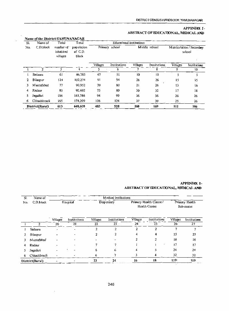
Name of the District:YAMUNANAGAR SI. Name of Total Total
No. C.D.block number of' population
inhabited of C.D.
villages block
2 3 4
Sadaura 61 46.785
2 Bilaspur 124 102.274
3 Mustafabad 77 90,952
4 Radaur 80 92,602
5 Jagadhri 106 141,786
6 Chhachhrauli 165 174,209
District(Rural) 613 648,608
SI. Name of
No. C.D.block Hospital
Villages Institutions
2 20 21
Sadaura
2 Bilaspur
3 Mustafabad
4 Radaur
5 Jagadhri
6 Chhachhrauli
District(Rural}
DISTRICT CENSUS HANDBOOK :YAMUNANAGAR
APP.ENDIX J-ABS1RACT OF FDUCA TIONAL, MFDICAL AND
Educational institutions
Primary school Middle school Matriculation / Secondary
school
Villages Institutions Villages Institutions Villages Institutions
~ 6 7 8 9 10
47 51 10 10 5 5 91 94 26 26 15 15 70 80 21 26 13 16 75 80 30 32 17 18 94 99 36 36 26 26
106 124 37 39 25 26
483 528 160 169 101 106
APPl'ND1X 1-ABSTRACT OF IDUCATIONAL, MEDICAL AND
Medical institutions
Dispensary Primary Health Centre / Primary Health
Health Centre Sub-centre
Villages Institutions Villages Institutions Villages Institutions
22 23 24 25 26 27
2 2 2 2 7 7
2 2 4 4 23 23
2 2 16 16
7 7 17 17
6 6 4 5 24 24
6 7 3 4 32 32
23 24 16 18 119' 119
246
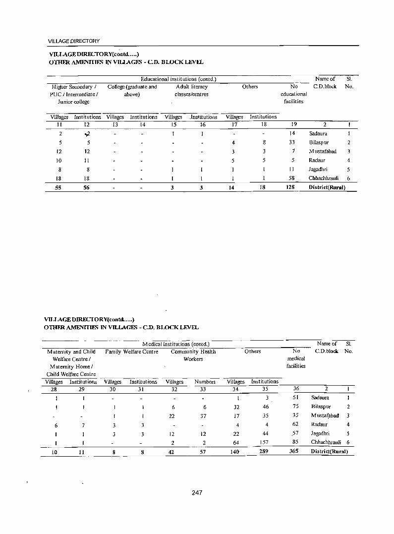
VILLAGE DIRECTORY
VILLAGE DIRECTORY(contd ••... )
OTHFR AMENITIES IN VIUAGES - C.D. BWCK LEVEL
Educational institutions (contd.) Name of Sl.
Higher Secondary / College (graduate and Adult literacy Others No C.D.block No.
PU C / Intermediate / above) classes/centres educational
Junior college facilities
Villages Institutions Villages Institutions Villages .Institutions Villages Institutions
II 12 13 14 15 16 17 18 19 2
2 Y. I 14 Sadaura
5 5 4 8 33 Bilaspur 2
12 12 3 3 7 Mustafabad 3
10 II 5 5 5 Radaur 4
8 8 II Jagadhri 5
18 18 I 58 Chhachhrauli 6
55 56 3 3 14 18 128 District(Rural)
VILLAGEDIRECTORY(contd. .... )
OTHFR AMFNITIES IN VILLAGES - C.D. BWCK LEVEL
Medical institutions (contd.) Name of Sl.
Maternity and Child Family Welfare Centre Community Health Others No C.D.block No.
Welfare Centre / Workers medical
Maternity Home / facilities
Child Welfare Centre
Villages Institutions Villages Institutions Villages Numbers Villages Institutions
28 29 30 31 32 33 34 35 36 2
1 I 3 51 Sadaura
6 6 32 46 75 Bilaspur 2
I 22 37 17 35 35 Musta~abad 3
6 7 3 3 4 4 62 Radaur 4
I 3 3 12 12 22 44 57 Jagadhri 5
I 2 2 64 157 85 Chhachhraul; 6
10 11 8 8 42 57 141t 289 365 District(Rural)
247
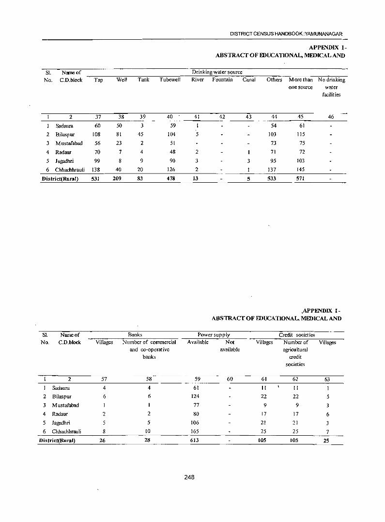
DISTRICT CENSUS HANDBOOK :YAMUNANAGAR
APPENDIX 1-ABSTRACT OF FDUCATIONAL, MEDICAL AND
Sl. Name of Drinking water source
No. C.D.block Tap Well Tank Tubewell River Fountain Canal Others More than No drinking
one source water
facilities
2 37 38 39 40 41 42 43 44 45 46
Sadaura 60 50 3 59 I 54 61
2 Bilaspur 108 81 45 104 5 103 115
3 Mustafabad 56 23 2 51 73 75
4 Radaur 70 7 4 48 2 71 72
5 Jagadhri 99 8 9 90 3 3 95 103
6 Chhachhrauli 138 40 20 126 2 137 145
District(Rural) 531 209 83 478 13 5 533 571
,APPFNDIX 1-ABSTRACT OF EDUCATIONAL, MIDICAL AND
Sl. Name of Banks Power supply Credit societ ies
No. C.D.block Villages Number of commercial Available Not Villages Number of Villages and co-operative available agricultural
banks credit
societies
2 57 58 59 60 61 62 63
Sadaura 4 4 61 II II I
2 Bilaspur 6 6 124 22 22 5 3 Mustafabad I 77 9 9 3 4 Radaur 2 2 80 17 17 6
5 Jagadhri 5 5 106 21 21 3
6 Chhachhrauli 8 10 165 25 25 7
District(Rural) 26 28 613 105 105 25
248
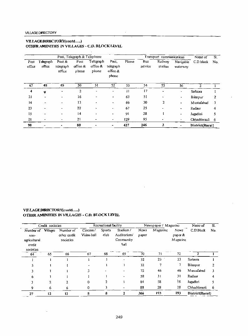
VILLAGE DIRECTORY
VlLLAGEDIRECfORY(contd .•..• )
OTHER AMENITIES IN VILLAGES - C.D. BWCK LEVEL
Post, Telegraph & Telephone Transport communications Name of SI. Post Telegraph Post & Post Telegraph Post, Phone Bus Railway Navigable C.D.block No.
office office telegraph office & office & telegraph service station waterway office phone phone office &
phone
47 48 49 50 51 52 53 54 55 56 2
4 ~ 2 II 17 Sadaura
21 16 63 51 Bilaspur 2
14 13 66 30 2 Mustafabad 3
23 22 67 25 Radaur 4
15 14 91 28 Jagadhri 5 21 21 129 95 Chhachhrauli 6
98 88 427 246 3 District(Rural)
VlLLAGEDIRECTORY(contd .•.•. )
OTHm AMFNmES IN VILLAGES - C.D. BLOCK LJl.VEL
Credit societies Recreational facility Newspaper I Magazine Name of SI. Number of Villages Number of Cinema/ Sports Stadium I News Magazine News C.D.block No.
non- other credit Video hall club Auditorium! paper paper &
agricultural societies Community Magazine
credit hall
societies
64 65 66 67 68 69 70 71 72 2
32 23 23 Sadaura
5 32 7 7 Bilaspur 2
3 3 72 46 46 Muslafabad 3
6 I 58 31 31 Radaur 4
3 2 2 0 2 84 58 58 Jagadhri 5
9 6 6 0 3 88 28 28 Chhachhrauli 6
27 12 12 5 8 2 366 193 193 District(Rura1)
249
DISTRICT CENSUS HANDBOOK :YAMUNANAGAR
APPENDIX lA- VILLAGEDIRFCTORY VILLAGES BY NUMBER OF PRIMARY SCHOOLS
Name of the Distrid:YAMUNANAGAR
SI. No. Name of C. D. block Total number Number of primary schools of inhabited None One Two Three
villages
I 2 3 4 5 6 7
1 Sadaura 61 14 44 2
2 Bilaspur 124 33. 88 3
3 Mustafabad 77 7 63 4 3
4 Radaur 80 5 70 5
5 Jagadhri 106 12 89 5
6 Chhachhrauli 165 59 92 10 4
District Total: 613 130 446 29 8
APPENDIX IB - VILLAGEDIRFCTORY VILLAGES BY PRIMARY, MIDDLE AND SECONDARY SCHOOLS
Name of the Distriet:YAMUNANAGAR
Four +
8
SI.No. Nameof C. D. Total number of Type of educational institutions available
block inhabited villages No School At least one At least one At least one middle primary school and primary school and school and one
no middle school one middle school secondary school
2 3 4 5 6 7
Sadaura 6J 14 37 10 5
2 Bilaspur 124 33 65 26 15
3 Mustafabad 77 7 49 21 13
4 Radaur 80 5 45 30 17
5 Jagadhri 106 12 58 36 26
6 Chhachhniuli 165 59 69 37 2S
Total: 613 130 323 160 101
APPENDIX lC- VILLAGE DIRECTORY
VILLAGI!S WITH DIFFERENT SOURCES OF DRINKING W ATFR FACILITIES AVAILABLE
Name ofthe Distriet:YAMUNANAGAR
SI. No. Name of C.D. Number of villages with different sources of drinking water available
block Only tap Only well Only tube well Only handpump M ore than one
source only from
tap, well, tube
well, handpump
2 3 4 5 6 7
Sad aura 61
2 Bilaspur 6 3 115
3 Mustafabad 75
4 Radaur 7 72
5 Jagadhri 2 1 103
6 Chhachhrauli "' 2 3 8 145 , District Total: 13 15 3 11 571
250
VILLAGE DIRECTORY
APPFNDIX 11- VILLAGE DIRECTORY
VILLAGES WITH 5,000 AND ABOVE POPULA TlON WHICH DO NOT HAVE ONE OR MORE AMENmES AVAILABLE
Name of the Dis triet: YAMUNANAGAR SI. No. Name of village Location code Name of C. D. block Population Amenities not available
number Senior Secondary Colle~
School
2 3 4 5 6 7
Kalawar (351) 00093700 Mustafabad 5373 Available N.A.
2 .,.
00108800 lathlana (4) Radaur 6127 Available N.A.
3 Badhi M ajra (126) 00117100 Jagadhri 6334 N.A. N.A.
4 Kharwan (314) 00121100 Chhachhrauli 7839 Available N.A.
5 Khizrabad (165) 00133500 Chhachhrauli 5704 Available N.A.
Cont.. ......
SI.No. Name of village Amenities not available
Primary Health Tap drinking BlJs facility Approach by Pucca Commercial Bank Sub Centre water road
2 8 9 10 11 12
Kalawar (351) Available Available Available Available N.A.
2 Jathlana (4) Available Available Available Available N.A.
3 Badhi M ajra (126) N.A. Available N.A. Available N.A.
4 Kharwan (314) Available Available N.A. Available Available
5 Khizrabad (165) Available Available Available Available Available Note: N.A means Not available.
APPFNDIX II-A CENSUS TOWN CFNSlS TOWNS WHlCHDONOTHAVEONEORMORE AMFNITIES
Name of the Distriet:YAMUNANAGAR SI. Name of census Location Name of C. D. block Population Amenities not available
No.
I
2
3
4
5
town
2
Bilaspur
Mustafabad
Kansepur
Farakhpur
Sasauli
code number
3
40302000
40303000
40309000
40305000
40308000 Note: N.A. means Not available.
SI. Name of census No. town
4
Tap drinking water
2 9
Bilaspur Available
2 Mustafabad Available
3 Kansepur Available
4 Farakhpur Available
5 Sasauli Available Note : N.A. means Not available.
(indicate N. A. where amenity not available) Senior Secondary College
5 6 7
9.621 Available N.A.
8,516 Available N.A.
14.952 N.A. N.A.
8.740 N.A. N.A.
15.754 Available N.A.
Amenities not available ( indicate N. A. where amenity not available)
Bus facility Approach by Pucca
10 11
Available
Available
N.A.
N.A.
Available
251
Available
Available
Available
Available
Available
Health Centre
8
Available
Available
N.A.
N.A.
N.A.
Banks
12
Available
Available
N.A.
N.A.
Avmlable
• ... ~
DISTRICT CENSUS HANDBOOK ;YAMUNANAGAR
APPENDIX 111- VILLAGEDIRFCTORY
LAND UfILISATION DATA IN RESPECT OF CENSUS TOWNS I NON-MUNICIPAL mWNS SI. Name of Census town Land use (i.e., area under different types of land use in hectare)
No. and C.D. block within Total area Forest Irrigated by source Unirrigated Culturable waste Area not brackets (including gauchar availab Ie for
& groves) cultivation
2 3 4 5 6 7 8 Bilaspur (Bilaspur) 851.0 T(426.0) TWE(426.0) 198.0 45.0 182.0
2 M ustafabad (M ustafabad) 716.0 .T(616.0) TWE(616.0) 8.0 3.0 89.0 3 Kanesp ur(J agadhri) 242.0 T( 180.0) TWE( 180.0) 62.0 4 Farakhpur (Jagadhri) 135.0 T(90.0) TWE(90.0) 45.0
5 Sasauli (Jagadhri) 288.0 T(138.0) TWE(138.0) 2.0 148.0
APPENDIX V - VILLAGE DIRECTORY
APPIiNDIX IV - VILLAGE DIRECTORY S UMMARY SHOWING NUMBER OF VILLAGES NOT
C.D. BWCKWISE LIST OF INHABITFD VILLAGES HAVING SCHFDULED CASUS POPULATION
WHERE NO AMIiNITY OTHER TIIAN DRINKING SI. Name of Total Uninhabited Inhabite Number of
WATFR FACILlTYIS AVAILABLE No. C.D. block villages villages d villages inhabited
Name of the District:YAMUNANAGAR villages
Serial number Location code Name of village having no Scheduled
number Castes 2 3 population
Name of CD Block: Sadaura Nil 2 3 4 5 6
Name of CD Block: Bilaspur Nil Sadaura 63 2 61 15
Name of CD Block: Mustafabad Nil 2 Bilaspur 127 3 124 17
3 Mustafabad 79 2 77 3 Name of CD Block: Radaur Nil
4 Radaur 85 5 80 5 Name of CD Block: Jagadhri Nil 5 Jagadhri III 5 106 10 Name of CD Block: Chhachhrauli Nil 6 Chhachhrauli 174 9 165 26
Name of CD Block: Chhachhrauli Nil District Total 639 26 613 76
APPENDIX VI - VIllAGE DIRECTORY
SI. No.
SUMMARY SHOWING NUMBER O~ VILLAGES N?T ~A~G SCHFDULE? T~BF.S POPUItTION Name of C. D. block Total Villages Umnhablted villages Inhabited villages Number of inhabited
villages having no Scheduled Tribes
population
2 3 4 5 6 Sadaura 63 2 61 61
2 Bilaspur 127 3 124 124 3 Mustafabad 79 2 77 77 4 Radaur 85 5 80 80 5 Jagadhri III 5 106 106 6 Chhachhrauli 174 9 165 165
District Total 639 26 613 613
252
VILLAGE DIRECTORY
APPENDIX VU A- VILLAGE DIRECTORY
LlSTOFVILLAGFB ACCORDING TO THEPROPORTlON OFTHESCHFDULFDCASTFB TO
THE TOTAL POPULATION BY RANGFB
Name of the District:YAMUNANAGAR Range of Scheduled Castes pop u[alion
(p ercentages)
Name of CD Block: Sadaura
Less than 5
5-JO
11-20
21-30
31-40
41-50
Location code number
2
00074100
00073200
00077100
00073700
00076000
00076900
00079200
00078000
00073400
00073500
00073900
00074200
00077300
00077500
00079100
00074400
00075400
00073000
00073300
00079000
00075900
00076700
00077000
00076800
00073800
00077900
00076400
00074300
00074900
00075500
00074700
00074000
Name of village
3
Nazampur (331)
Asgarpur (330)
Udamgarh (165)
M itak Jhabalian (139)
Buraj lamunawala (164)
Fazilpur (161)
Todarpur (175)
KotJa(174)
SaJahp ur ( 188)
Thaska (187)
Ha\leli (141)
Rajpur (333)
Rattu Wala (167)
Kalyanp ur Alari( 170)
Bholiwala ( 176)
Laharpur (328)
Saranwa (133)
Galawari (334)
Jhanda(189)
Nawagaon (171)
Sabhapur(154)
Ismailpur (159)
N aushahra ( 162)
'5alemp ur (160)
Rasulpur (138)
M irzapur (I n)
Sadiqpur (157)
Rathali (332)
Paharip'Ur (145)
KanipJa (150)
Ferozepur Ranyan (143)
Sakala (142)
· DISTRICT CENSUS HANDBOOK :YAMUNANAGAR
APPENDIX VII A- VILLAGE DIRECTORY LlSTOFVILLAG~ ACCORDINGTOTHEPROPORTIONOFTHESCHEDULEI>CAST~ TO
THE TOTAL POPULATION BY RANGES Name of the District:YAMUNANAGAR Range of Scheduled Castes population
(percentages)
51-75
76 and above
Name of CD Block: Bilaspur
Less than 5
5-10
1-20
Location code number
2
00077800 00073600 00076100 00074500 00075000 00075600 00075700 00074600 00075100
00075300 00076200 00076600 00076300 00018200
00136800 00088600 00083200 00080000 00080600 00080500
00082900 00128200 00085200
00080200 00081200 00127700 00087100 00083500 00088300 00090300 00080900 '00090500 00082000 00019600 00082400
254
Name of village
3
Islamnagar (171) M ahamadp ur ( 140) Shamp ur (I 63 ) Domanwala (327) Saidupur (148) Pandon (151) R1Ypur(152)
Rampur Ranyan (144) Majri (149)
Ranyan Wala(134) Sadaura (Rural)(Part)( ISS)
Sultanpur (158) Sadaura Nadipar (155) Gulapur (181)
Ibrahimpur (29)
Sarawin (62) Nagli(264)
Sunder Bahadurpur (34)
Suabari (253) Majri(249)
ParbhaoJi (52) Sankhcra (306) Nagli (32)
Shergjllb (248)
Bodhi(44)
Bherthal (326) Kurewala (269) Bihta(242)
Fateh&Jrh Tumbi (59) Teha Brahmanan (331) Ranipur (256)'
Mandhar (333) A Ii Sherpur ~ ajra (246) Kathg3rh (31) Chhalaur (244)
VILLAGE DIRECTORY
APPENDIX VII A- VILLAGE DIRECTORY
LIST OF VILLAGES ACCORDING TO THE PROPORTION OF THE SCHEDULED CASTES TO mE TOTAL POPULATION BY RANGES
Name ofthe District:YAMUNANAGAR Range of Scheduled Castes population
(p ercentages)
21-30
.JI-4U
Location code number
2
00082100 00089000 00082800 00090600 00090800 00080100 00081800 00127900 00081400 00084500 00088900 00083700 00091300 00087000 00083400 00081000 00087300 00089300 00092400 00081700 00090400
00083600 00079900 00079800 00088700 00080700 00088500 00091700 00083900 00091600 00092500 00089900 00082700 00084300 00089400 00080400 00089500 00082300 00082200 00128000 00092600 00090100 00083800 00083100 00090700
255
Name of village
3
Bankat (240) Azizpur (292) Mianpllr(51) M i1ak Sukhi (373) Budheri (324) Gadwali (247) Milkara (258) Piruwala (301) Bajawali (45) M uzafat (241) Painsal (61) Bhawanipur (276) Arnauli (323) Hartaul (271) Rampur Harian (48) Pipliwala (41) Mauhri (277) Marwa Kalan (283) Marwa Khurd (295) M ugplwaJi (259) Juda Shel Khan (332)
Sandhai (265) Bhagwanpur (35) Dhanaura (252) Manakpur (286) Ranjitpur (254) Bhogp ur (285) Musimbal Muslamanan (372) Aharwala (273) Musimbal Hindwan (371) Haibatpur (291) Oaryapllr (303) Bansewala (50) Bharnnauli (227) Kapoori Khurd (293) Bhattuwala (251) Kapoori Kalan (294) Rampur Kamboan (243) Ramgnrh Sawai (245) <;:hagnauli (304) MaJakpur (290) M akhaur (297) M ilkkhas (275) Nagpl Patti Machhrauli (262) Paonti (374)
DISTRICT CENSUS HANDBOOK :YAMUNANAGAR
LIST OF VILLAGES ACCORDlNGTO THE PROPORTION OFTHESCHIDULID CASTES TO THE TOTAL POPULATION BY RANGES
Name of the District:YAMVNANAGAR Range of Scheduled Castes population
(percentages )
41-50
51-75
76 and above
Location code number
2
00084000 00092100 00092900 00088100 00090000 .
00084100 00089800 00084600 00089700 00083300 00089200 00087200 00092000 00087700 00087800 00082500 00088800
00081500 00088400 00087500 00127800 00128100 00091800 00127600 00091200 00084200 00091900 00089600 00084400 00081100 00093000 00089100 00091400
00092700 00079400 00092200 00090200 00091500 00092800 00088200 00136500
256
Name of village
3
Kotra Khas (274) Gianawala (337) Chaharwala (289) Butgarh (54)
Khera Brahmanan (298) Raianwala (267)
Shahpur (302) Katarwali (238) Chanda Kheri (300) Machhrauli (263) Malak Raipur (58) Chaurahi (272) Pabni Kalan (336) Munda Khera (282) Faquir M ajra (56) Manglaur (49) Dhalaur (287)
Safilp ur (46) Kurali (284) Bhil Chhappar (280) Ramkheri (329) Pheruwala (305) Pabni Khurd (334) Mahmudpur (325) Shahpur (382) U dhamg;trh (266) Juda Jatan (335) Kakrauni (299) Katarwali (239 Nathanpur (43) Ambwala (288) Ramg;trh Majra(60) Shah Quamaispurp75)
Uddham Garh (341) Chuharpur (40) Rasulpur (296) Tehi Jatan (330) Chhajju Nagala(376) Nawan Shahar (342)
Singhpur.a (53) Shabudinpur Kalan(22)
VILLAGE DIRECTORY
APPFNDlX VII A- VILLAGE DIRECTORY LISTOFVILLAGFS ACCORDING TO THE PROPORTION OF THE SCHEDULEO CASTFS TO
TIlE TOTAL POPULATION BYRANGFS Name ofthe District:YAMUNANAGAR Range of Scheduled Castes population
(percentages)
Name ofeD Block: Mustafabad I...eS! than 5
~1J-20
21-30
31-40
Location code number
2
00097000
00099300
00100200
00100800
00100600
00099900
00097100
00100000
00093500
00100100
00095000
00099800
00093800
00100700
00096600
00093700
00098300
00094300
00093300
00100400
00094700
00095200
00099500
00097700
00099400
00094900
00097600
00098200
00093100
00095600
00099000
00094000
00098500
00094100
00096300
257
Name of village
3
Jandhera (433)
Daulatpur Mahan (453)
Ram~rh (187)
Hudia (173)
Balsuha ( 176)
Gundana (179)
Goglon (432)
M as,ma Jatan (184)
Lc'lwani (347)
Shahab Pura(185)
Ambli (357)
G undani ( 17S)
Kheri Darshan Singh (354)
M oharnmadpur (175)
Sukhdaspur (442)
Kalawar(351)
Narndarpur (455)
Panjaura (363)
Khanpur Rajputan (345)
BhogpUf (171)
Talakam (362)
Shahp lIr (350)
Kajlwas (457)
Modhli (480)
Uncha Chandana (456)
Sabilpur Jatan (360)
Topra Khurd (464)
Hangoli (459)
Jagdhalili (343)
Chhapper Mansurpur (443)
KlIlplir (450)
.Satari (352)
Maglmr Pura(446)
Kulchandll (340)
Kanarhi Khurd (436)
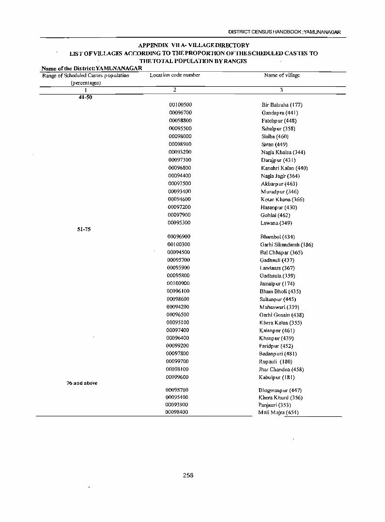
DISTRICT CENSUS HANDBOOK :YAMUNANAGAR
APPENDlX V1I A- VILLAGE DIRECTORY LIST OFVlLLAGFS ACCORDING TO THE PROPORTION OF THE SCHEDULED CASTFS TO
THE TOTAL POPULATION BYRANGFS Name of the District:YAMUNANAGAR Range of Scheduled Castes population
(p ercent ages)
41-50
51-75
76 and above
Location code number
2
00100500
00096700
00098800
00095500
00098000
00098900
00093200
00097300
00096800
00094400
00097500
00093400
00094600
00097200
00097900
00095300
00096900
00100300
00094500 00095700
00095900
00095800
00100900
00096100
00098600
00094200
00096500
00095100
00097400
00096400
00099200
00097800
00099700
00098100
00099600
00098700 00095400 00093900 00098400
258
Name of village
3
Bir Balsuha (177)
Gandapra(441)
Fatehpur (448)
Sabalpur (358)
Sialba (460)
Saran (449)
Nagla Khalsa (344)
DaraJp ur (431)
Kanahri Kalan (440)
Nagla Jagir (364)
Akbarpur (463)
M uradpur (346)
Kotar Khana (366)
Hasanpur (430)
Gohlni (462)
Lawana (349)
Bhambol (434)
Garhi Sikandarah (186)
Bal Chhapar (365)
Gadhau1i (437)
Landaura (367)
Gadhaula (359)
Jamalpur (174)
Bham Bholi (435)
Sultanpur (445)
Maheswari (339)
Garhi Gosain (438)
Khera Kalan (355)
Kalanpur (461)
Khanpur(439)
Faridpur (452)
Badanp uri (481)
Rupauli (180)
Jhar Chan dna (458)
Kabulp ur (181)
Bhagwanpur (441) Khera Khurd (356) Panjauri (353) Mali M ajra (454)
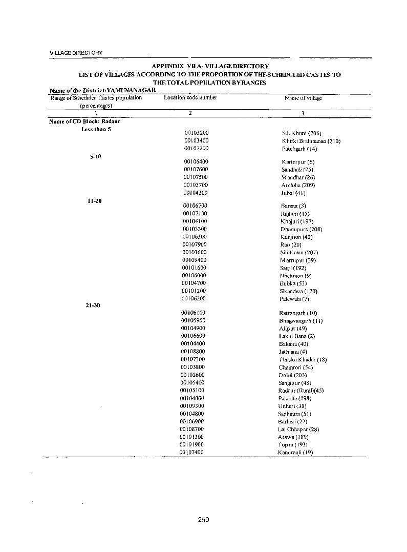
VILLAGE DIRECTORY
APPENDIX VII A- VILLAGE DIRECTORY
LIST OFVILLAGFS ACCORDING TO THE PROPORTION OFTHESCHFDULED CASTFS TO THE TOTAL POPULATION BY RANGES
Name of the District:YAMUNANAGAR Range of Scheduled Castes population
(p ercentages)
Name of CD Block: Radaur Less than 5
S-JO
11-20
21-30
Location code number
2
00103200 00103400 00107200
00106400 00107600 00107500 00103700 00104300
00106700
00107100 00104100 00103300 00106300 00107900
00103600 00109400 00101600 00106000 00104700 00101200 00106200
00106100 00105900 00104900 00106600 00104400 00108800 00107300 00103800 00102600 00105400 00105100 00104000 00109300 00104800 00106900 00108700 00101300 00101900 00107400
259
Name of village
3
Sili Khurd (206)
Khirki Brahmanan (210) Fatehgarh (14)
Kartarpur (6) Sandhali (25) M andhar (26) Amloha (209) lubal (41)
Barsan (3) R~jheri ( 15) Khajuri (197) Dhanupura (208) Kanjnon (42) Rao (20)
Sili Kalan (207) Marrupur (39) Sagri (192) Nachraon (9) Bubka (53) Sikandera (170) Palewala (7)
Rattangarh (10) Bhagwangarh ( I J) Alipur (49) Lakhi Bans (2) Bakana(40) Jathlana (4) Thaska Khadar (18) Chamrori (54) Dohli (203) Sangip ur (48) Radaur (Rural)( 45) Palakha ( 198) Unheri (38) Sadhaura (51 ) Barheri (27) Lal Chhapar (28) Atawa(189) Topra (193)
Kandrau.li (19)
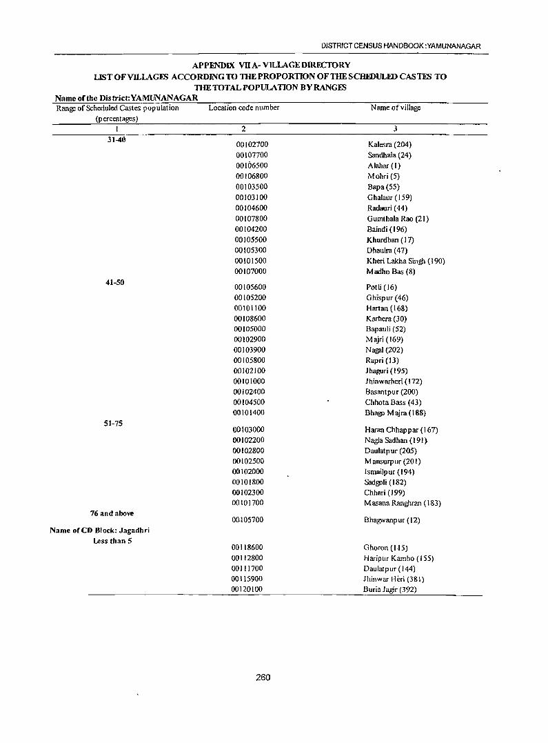
DISTRICT CENSUS HANDBOOK :YAMUNANAGAR
APPENDIX VII A- VlLLAGEDmECTORY LISTOFYILLAGES ACCORDING TO THE PROPORTION OFTHESCHFDULID CASTES TO
THE TOTAL POPULATION BY RANGES Name ofthe District:YAMUNANAGAR Range of Scheduled Castes population
(p ercentages)
31-40
41-50
51-75
76 and above
Name oCeD Block: Jagadhri Less than 5
Location code number
2
00102700 00107700 00106500 00106800
00103500 00103100 00104600 00107800 00104200
00105500 00105300 00101500 00107000
00105600 00105200 00101100 00108600 00105000 00102900
00103900 00105800 00102100 00101000 00i02400 00104500 00101400
00103000 00102200 00102800 00102500 00102000 00101800 00102300 00101700
00.105700
00118600 00112800 00111700 00115900 00120100
260
Name of village
3
Kalesra (204)
Sandhala (24) Alahar (1)
Mohri (5) Bapa(55) Ghalaur (159) Radauri ( 44)
Gumthala Rao (21) Baindi (196) Khurdban (17) Dhaulra (47)
Kheri Lakha Singh (190) M adho Bas (8)
Pot Ii (16) G hisp ur (46) Hartan (168) Karhera (30) Bapauli (52)
Majri (169)
Na!1fl1 (202) Rapri (13) Jhaguri (195) J hinwarheri (172) Basantpur (200) ChhotaBass (43) Bhago M ajra (188)
Haran Chhappar (167) Nagla Sadhan (191) Daulatpur (205) M ansurp ur (20 I ) Ismailp ur (194) Sadgoli (182) Chhari (199) M asana Ranghran ( 183)
Bhagwanpur (12)
Ghoron (1-15) Haripur Kambo (ISS) Daulatpur (144) Jhinwar Heri (381) Buria Jagir (392)
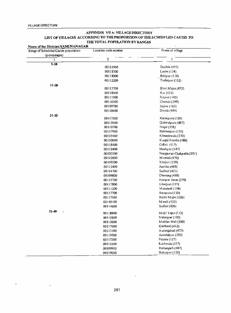
VILLAGE DIRECTORY
APPENDIX VU A- VILLAGE DIRECTORY LIST OFYILLAGES ACCORDING TO THE PROPORTION OF THE SCHEDtJLED CAST~ TO
THE TOTAL POPULATION BY RANGES Name ofthe District:YAMUNANAGAR Range of Scheduled Castes population
(p ercentages)
5-10
11-20
21-30
31-40
Location code number
2
00113900 00118300 00118900 00112200
00113700 001 J8000 00111900 00116300 00109700 00110400
00117500 00115000 00110700 00117900 00115400 00110000 00118400 00112400 00120300 00112600 00109500 00113400 00114700 00109800 00115700 00117800 00111200 00117700 00117100 00118100 00114600
00118800 00110800 00115600 00117000 00113100 00119500 0_Q117300 00115500 00109900 00119000
261
Name of village
3
Dudhla (477) Lapra (134)
Bibipur (118) Todarpur (152)
Bhut M ~ira (473) Kat (132) Raipur (145) Chaneti (399) Jaipur (163) Dmnla (484)
Ratanpura (129) Gobi l1dpura (407) Nagai (158) Bahrampur (131) Khundewala (370) Kunjal Kambo (486) Odhri (117) Shadipur (147) Naugilwan Chakpahla(391) M IImidi (470) K h1~iuri ( 159) 1 aurian (469) Sudhail (425) D hnrang (488) Hanpur latan (379) Isharpllr (137) M andauli ( 138) Rampura (130)
Baclhi M'!ira(126) Mandi(133) SlIdhal (426)
M ajri Tapu (I J3) N aharp ur ( 150) M ahlan Wali (380) Gadhallii (412) Allrangabad (475) Amadalpur (395) Pansra ( 127) Kathwala (377) Rattangarh (487) Bakarpur (120)
DISTRICT CENSUS HANDBOOK :YAMUNANAGAR
APPENDIX VII A- VILLAGE DffiECTORY
LIST OF VILLAGES ACCORDING TO THE PROPORTION OF THE SCHEDULED CASTES TO THE TOTAL POPULATION BY RANGES
Name of the District:YAMUNANAGAR Range of Scheduled Castes population
(percentages)
41-50
51-75
Location code number
2 00119900 00111500 00109600 00114200 00119100. 00111800 00120200 00116500 00114900 00115800 00112300 00110600 00117600 00119800 00119400 00117400
00110100 00110900 0011 I 100 00114100 00113300
00119300 00)16200 00116600 00117200 00116700 00115200 00119200
00110200 00114300 00110500 00114800 00115300 00111600 00110300 00113500 00116100 00116800 00115100 00120000 00113800 00112000 00113000 00113600
262
Name ofviJIage
3 Bhogpur (Ill) Tigra (149) Bahadurpur (162) Harnaul (465) Sabap ur (12 I ) Kami Majra (146) Nabh (389)
Bhagwan Garh (398) Rattoli (422) Bhatauli (405) Panjupur(153) Khurdi (160) Qaimpura(124) Mali Majra (110) Sugh (396) Dasani (128) Kunjallatan (485) Tapu Kamalpur (140) Kalanaur (136) lhinjron (479) Ishopur (471)
Fetehpur (123) Telipura (402) Bhojpur (397) Tajakpur (I 25) TejJi (409) RuhlaKheri (424) Nai Gawan (122)
Hafizpur (483) Gollanpur (466) Sabhapur (16 I) Kheri Ranghran (427) Kail (378) Tigri (143) Daulatpur (482) Mandebar (467)
1 arauda <403) Parwalon (410) Khera (423) Diyalgarh (394) Ror Chhappar (476) Karera Khurd (148) Sukhpura(156) Jampur (472)
VILLAGE DIRECTORY
APPENDIX VII A- VILLAGE DIRECTORY LIST OFYILLAGES ACCORDING TO THE PROPORTION OF THE SCHEDULED CASTIS TO
THE TOTAL POPULATION BY RANGES Name oftbe Distrid:YAMUNANAGAR Range of Scheduled Castes population
(p ercentages)
76 and above
Name of CD Block: Chhachhrauli
Less than 5
5-10
Location code number
2
00114400
00116900
00114500
00116000
00114000
00112700
00134700
00085300
00131300
00134400
00135400
00123300
00086300
00122800
00134600
00124800
00121800
00122700
00135100
00125500
00133900
00121300
00085000
00085500
00133500
00084900
00086000
00125600
00133200
00126200
00133000
00123500
0013 1900
00134300
00134000
263
Name of village
3
Galoli (429)
Darwa(41 I)
M andebari (428)
Halliwala (384)
Hargarh (478)
R;mlgarh Alias Gtdlbgarh (154)
Khilanwala (10)
M ahiyudinpur (11)
Dekri\\ala (66)
M cg)llIwala ( 14)
Jatanwala (18)
Nathanpur (91)
Khanuwala (220)
Nawazpur (93)
Blmiawala (13)
M ujahidwala (75)
Mandalili Gagar(I03)
Hal-Dari GlIjar(95)
Shahzadwala (16)
Begmllpur (80)
Raiyanwala(4)
Bha~wanpur (313)
Gohra Ikmi (236)
R~iptJr (235)
Khizrahad (165)
Salelllplir Kohi (33)
JOgiW3J a (228)
Bhilplira (200)
Bakkm wala (177)
Urjani (203)
M lIkarapur (181)
. Lahoriwala (89)
Halizp ur ( 173)
Bhangcra Bhangeri Bagpat (9)
Kalesar (I)
DISTRICT CENSUS HANDBOOK :YAMUNANAGAR
APPmDlX vn A~ VILLAGE DIRECTORY LIST OF VILLAGES ACCORDING TO THEPROPORll0NOFTHESCHEDULID CASTES TO
TIIETOTALPOPULATION BY RANGES Name of the District:YAMUNANAGAR Range of Scheduled Castes population
(percentages)
11-20
21-30
Location code number
2
00132800 00125800 00124700 00130500 00122000 00130000 00085900 00133400 00086500 0013 1600 00131500 00135500 00135900 00131100 00125200 00121000 00130800 00130900 00125700 00130400 00124100 00084700 00132400 00127400 00131400
00086400
0013J800 00132100 00124300 00122100 00122900 00124500 00122600 00136000 00125300 00123000 00130700 00127300 00125400 00130600 00129100 00124900 00132600 00090900
264
Name of village
3
D hakwala (J 83) Yakubpur {I 97) Darwa (78) Pip Ii M ajra (199) Dammunpur Bara (101) Kotra Kahansingh (189) M anakp ur (229) Mujafat Kalan (J66) Chintpur (225) Kishanpura (167) Bahadurpur (164) Darpur (17) Taharpur Kalan (28) Mandewala (64) Bhud Majra (70) Bhukhri (388) Chuharpur Kalan (168) Bhud Kalan (67) Shahjahanpur (201) Dasaura (198) Harewa (83) Choli (237)
Ramgarh Alias Arjun Majra (186) Chaowala (328) TajewaJa (3)
Malakpur Bangar (268)
Lahasabad (175) Kot Sarkari (188) Jaidhar (82) Mehar Majra(105) Lakar-Mai Pratap Pur (92) J aidhari (81) Rampur Khadar (94) Haidarpur (233) Balla Majra (71) Kaniawala (74) GuJabgarh (169) J atheri (307) Deodhar (72) M alikp ur Khadir (I 70) H arau Ii (194) Belgarh (73) Kot Mushtarka(184) Mamli (322)
VILLAGE DIRECTORY
APPENDIX VII A- VILLAGE DIRECTORY
LJSTOFVILLAGES ACCORDING TO THE PROPORTION OFTHESCHEDVLEDCASTES TO THE TOTAL POPULATION BY RANGES
Name of tile District:YAMUNANAGAR Range of Scheduled Castes population Location code number Name of village
(p ercentages)
1 2 3
00129900 Leda Khadar (190) 00122400 Jairamplif Khalsa (98) 00130300 Karkauli (171) 00091000 Salcmpur Bangilr (321) 00133100 Tibhi Raiyan (179) 00126800 Chanela (316)
00123100 Bhilpura (76) 00132200 Ahmad M<\ira(IS7)
31-40
00134200 Khijri(S) 00122500 Telipura (96) 000S6200 Lalhari Khurd (224)
00128800 Tihanon (218)
00091100 Chahron (383) 00128900 Lopon (219)
00127000 Mlinda Khera(31S) 00127500 Taranwala (327) OOOS6900 Dharmn Kot (270) 00129600 Tugalpur (192) 00086800 Chholi (215)
00131200 Nainwala (65) 00123700 Khadri (97)
00132500 Kot Hasawa Singh (185) 00131000 Kohwala (68) 00131700 Tahimlln (174)
00129500 Damoli (195)
00129800 Dadllpur Jattan (222)
00126700 Panjctnn (315)
00084800 Ranlpllr Jat (234)
00120900 M anakpur (386) 00130100 Baroli M ajra (191)
00126900 M ukaribp ura (317) 00086700 Bisalion Wala(216)
00121500 Fatehgarh (t07)
00121100 Kharwan(314)
00121400 Dadliplir Chhawni (106)
4]-50 00127200 Leda Khas (310)
00085600 Chahulron (232)
00129700 Ledi (221) ..
00085700 Pnthlpllr (231)
00123800 NaOllgarh (87)
00128700 Khallpura (213)
265
DISTRICT CENSUS HANDBOOK :YAMUNAtW3AR
APPENDIX VII A- VILLAGE DIRECTORY LIST OF VILLAGIS ACCORDING TO THE PROPORTION OF THE SCHIDVLED CASTES TO
THE TOTAL POPULATION BY RANGES Name of the District:YAMUNANAGAR Range of Scheduled Castes population
(percentages)
51-75
76 and above
Location code number
2
00126600 00122300 00128400 00129300 00121700 .
00123900 00120700 00126300 00128500 00125100
00086100 00128300 00124600 00125900 00124400 00130200 00121200 00132000 00120600 00129200 00123600 00126500
00121600 00120800 00126400
Note:- Villages having NIL Scheduled Castes Population have been excluded
266
Name of village
3
M and Kheri (319) Dammunpur Chhota (99) Ganaula (308) Tarunwala (209) Kanalsi (104) Ismailp ur (86) Udhamgarh (401) Ashabp ura (212) Nahar Taharpur (211) DoiwaJa (69)
Lalhari Kalan (226) Ganauli (309) M anbharwala (79) Sherpur (206) Bhul Kheri (85) Hafzi (172) Bala Chaur (312) Mahab Aliwala (178) Garhi Banjara (387) Balauli (208) Hasanpur (90) Chuharp ur Khurd(207)
Shahzadpur (109) M odhuwala (385) Khanp uri (210)
VILLAGE DIRECTORY
APPFl'IDIX VII B - VILLAGE DIRECTORY LIST OF YILLAGES ACCORDING TO THE PROPORTION OF THE SCHEDULED TRIBES TO
THE TOTAL POPULATION BY RANGFS
Name of the District:YAMUNANAGAR Range of Scheduled Tribes population
(p ercentages)
Name orCD Block: Sadaura
Name ofeD Block: Bilaspur
Name .feD Block: Mustafabad
Name ofeD Block: Radaur
Name orCD Block: Jagadhri
Name oleD Block: Chhachhrauli
Location code number
2
267
Name of village
3
Nil
Nil
Nil
Nil
Nil
Nil
DISTRICT CENSUS HANDBOOK :YAMUNANAGAR
Section-II
Town Directory
NOTE EXPLAINING THE ABBREVIATIONS USED IN THE TOWN DIRECTORY
Town Directory Statements (I to VII)
Statement I : Status and Growth History
Column (2): Class, name and civic administration status of town
Class has been introduced to facilitate analysis of town directory data at the State and all India levels. It is presented according to 200 I Census Population of the town as follows:
Population Class
] 00,000 and above
50,000 - 99,999 II
20,000 - 49,999 III
10,000 - 19,999 IV
5,000 - 9,999 V
Below 5,000 VI
Town with a population of one hundred thousand (100,OOO)and above is treated as a city.
The civic administration status of the towll, as in
the-y:ear 2000, is indicated within bracket against the '"" name, of the town. The following abbreviations are
used to denote civic status of town.
(i) Municipal Corporation (ii) Municipal Committee (iii) Municipal Council (iv) Cantonment Board/Cantonment (v) Census Towll
(vi) Estate Office Other columns need no comments.
M. Corp. MC M.C!' CB CT EO
268
Statement II - Physical aspects and location of towns, 1999
Columns 3 to 5 : Physical Aspects
In these columns the Rainfall and Maximum & Minimum Temperature of the town are recorded.
Columns 6, 7 and 8 :
Name of the State headquarter, District headquarter and Sub-Divisional headquarter with distance from the referent town in kilometers, has been recorded in these cloumns respectively. If the names mentioned in these columns are the same as the referent town itself, the distance is recorded as (0) zero.
Columns 9 & 10 :
Name of the nearest city with one lakh and more
and five lakh and more population are recorded.
Columns 11, 12 and 13 :
If referent town enjoys the facility of railway
station, bus route facility or navigable river/canal, its name has been mentioned. If not available, then the name of nearest place with distance, where such
facility exists has been mentioned.
Statement III : Municipal Finance 19~8-1999
Item~wise amount of receipt and expenditure in thousand rupees, relating to municipal finance of the
town for the year 1998-99 is recorded.
Statement IV: Civic and Other amenities, 1999
Columns (l to 5) : Self explanatory.
TOWN DIRECTORY
Column (6) : Road length (in kms.)
Information about kutchalpucca road is recorded separately for the roads within the limits of the
referent town.
(i) Pucca Road P R
(iJ) Kutcha Road KR
Column (7): System of Sewerage
Generally, 'by sewerage system is implied the network of mains and branches of underground conduits for the conveyance of sewerage to the point of disposal. Sewers that carry only household and industrial wastes are called separate sewers, those that carry storm water from roofs, streets and other surfaces are known as storm water drains, while those carrying both sewage and storm water arc called combined sewers.
The codes used for different types of drainage system are as follows :
(i) Sewer S (ii) Open Surface Drains OSD (iii) Box Surface Drains BSD (iv) SylkDrains SO (v) Cesspool method CP (vi) Pit System Pt (vil) Others 0
Columns 8 to 11 : Number of latrines
Number of various types of latrines both Public and Private are given in these columns.
Column 12 : Method of disposal of night soil
The various prevalent methods of disposal of night soil are given below' with codes:
(i) Head Loads HL
(ii) Basket B
(iii) Wheel Barrows WB
(iv) Septic Tank ST
(v) Pit System Pt
(vi) Sewerage S
(vii) Others 0
Columns 13 and 14 Water supply
Source and capacity of storage system. The following codes are used in these columns:
269
Column 13:
(i) Tap water T
(ii) Tube-well water TW
(iii) Tank Water TK
(iv) Well water W
Columa 14:
(v) Over Head Tank OHT
(Vl) Service Reservoir SR
(vii) Pressure Tank PT
The information on major source of water supply are given in column 13 and the storage capacity against each in kilo-litres (in brackets) are presented in column 14.
Columa 15 : Fire Fighting Service
In case the fire fighting service is available in the referent town 'yes' is recorded. If the facility is not available within the town, the name of the nearest place having this facility with its distance from the referent town has been recorded.
Columns 16 to 20 : Electrification (Number of connections)
Different types of electric connections have been shown in these columns, i.e. Domestic, Industrial, Commercial, Road lighting (points) & others.
Statement V Medical, Educational, Recreational and Cultural Facilities, 1999
Columns 1 to 3 : Self explanatory.
ColumDs 4 & 5 :
The data Covers aU such medical institutions run by or aided by Government/Semi GovernmentILocal bodies and Charitable institutions or Social agencies like the Missionaries. Where the family planning centres are attached to hospitals or maternity and child welfare centres or Primary Health Centres, these have been treated as independent units and counted separately using following codes:
(i) Hospital H (ii) Dispensary D (iii) Health Centre HC (iv) Family Welfare Centre FWC (v) T:B. Clinic TB (vi) Nursing Home NH (vii) Others 0
In case of more than one institution of any type, the number of such institution (s) has been indicated within brackets e.g. D(3), NH(8), etc. The institutions have further been distingui~hed by providing additional codes within the bracket as given below:
(1) Ayurvedic
en) Unani
(ill) Homoeopathic
Columns 6 to 9 :
A
U
Hom
The codes used for these columns are as follows:
(i)
(ii)
(iii)
(iv)
(v)
(vi)
(vii) (viii) (ix)
Arts only
Science only
Commerce only
Arts & Science only
Arts & Commerce only
Combined for all categories
-Arts, Science
and Commerce
Law 'University Others
A
S
C
AS
AC
ASC
L U o
Column 10 : Recognized shorthand, typewriting and vocational training institutes
"Recognised" should mean recognised by some statutory authority like education department, commerce department, labour department etc. of the government or semi government or autonomous bo~ies, publicisector undertakings etc.
1.The following codes are used: ~ ~.' (i) Vocational Training VT
Institute
(ii) Shorthand SH
Jiii) Typewriting Type ~. Shorthand & SH Type ~.(IV)
":fo'l, Typewriting (v) Others 0
The vocational institutions like-Applied Art/ Painting College, Pharmacy College, B.Ed. College, Teacher's Training Institute, Music/Dance School, Nursing School etc. are covered under 'Others'.
270
DISTRICT CENSUS HANDBOOK :YAMUNANAGAR
Columns 11 to 14 :
Higher SecondarylIntermediatelSenior Secondary/ PUC/Junior College level, Secondary/Matriculation, Middle Schools/Junior Secondary and Primary Schools.
Schools up to class V are treated as Primary or Elementary schools. These include Nursery schools, Kindergarden schools, Pre-Primary schools, Junior Basic schools upto class V and Primary schools upto class IV.
Schools class VIII are considered as Middle schools or Junior Secondary Schools.
Schools upto class X are considered as Matriculation or Secondary schools.
Schools upto XI or XII classes are considered as Higher SecondarylIntermediatelPre University/Junior College etc. This would cover 10+2 classes whether held in schools or colleges.
If there are composite schools like middle schools with primary classes or Secondary schools with Middle classes, these are also included in the number of Primary and Middle schools, respectively. For example, if in a town, there are two Primary Schools and one Middle school with Primary classes, the number of Primary schools in the town is given as three and that of Middle schools as one, though there are only three educational institutions.
If there are more institutions of a type in the town, the number is indicated within bracket alongwith the abbreviation e.g. P(4), M(3).
Column 15 : Adult literacy c1asse~/centres
This column has been introduced keeping in view the Minimum Needs Programme of the Planning Commission. There are number of Adult Education Centres which are included in these columns.
If an educational facility is not available in the town, the name of the nearest place and its distance in kilomefres from the town where the facility IS
available is mentioned.
Column 16 : Working Women's hostels with number of seats .
The number of working women's hostel, if available in the referent town, is mentioned with
TOWN DIRECTORY
number of seats. If the facility is not available in the town, the name of nearest place with distance, where the facility is available is recorded.
Columns 17 to 19: Recreational and Cultural Facilities
Stadium, Cinema, AuditoriumIDramalCommunity Hall are covered under recreational & ·cultural facilities. The particulars of permanent recreatio~ar facilities are considered for these columns.
" Column 20 : Public Libraries, Reading Rooms
Number of public libraries and reading rooms available in the referent town are recorded in codes as follows:
(i) Public Library
(ii) Reading room
PL
RR
Statement VI : Trade, Commerce, Industry and Banking, 1999
Columns 3 to 8 : Names of three most important commodities exported and names of three most
271
important commodities manufactured in the town are recorded.
Column 9 : Number of Banks
Number of Banks available in the referent town both Commercial and Co-operative banks are recorded against this column.
Column 10 & 11 : Number of Agricultural Credit Societies and Non Agricultural Credit Societies
The total number of Agricultural Credit Societies and Non Agricultural Credit Societies in the referent town are recorded against these columns.
Statement VII : Civic and other Amenities in Slums, 1999
This is the statement on civic and other amenities in all slums whether notified or not for towns having statutory bodies, like municipal committees, Municipal Corporation, Estate office etc.
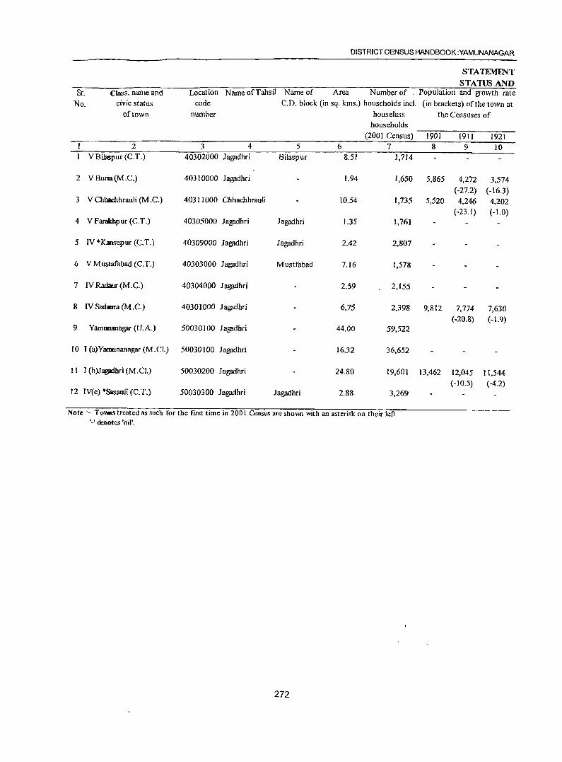
DISTRICT CENSUS HANDBOOK :YAMUNANAGAR
STATEMINT STATUS AND
Sr. Class, name and Location Name of Tahsil Name of Area Number of . Population and growth rate
No. civic status code C.D. block (in sq. kms.) households incl. (in brackets) of the town at of town number houseless the Censuses of
households
(2001 Census) 1901 1911 1921 2 3 4 5 6 7 8 9 10
V Bilaspur (C.T.) 40302000 Jagadhri Bilaspur 8.51 1,714
2 V Buria(M.C.) 403lO000 J ag;:tdhri 1.94 1,650 5,865 4,272 3,574 (-27.2) (-16.3)
3 V Chhachhrauli (M .C.) 403 II 000 Chhachhrauli 10.54 1,735 5,520 4,246 4,202 (-23.1 ) (-1.0)
4 V Farakhpur (C.T.) 40305000 Jaglldhri Jaglldhri 1.35 1,76)
5 IV *Kansepur (C.T.) 40309000 Jaglldhri Jagadhri 2.42 2,807
6 V Mustafabad (C.T.) 40303000 Jagadhri Mustfabad 7.16 1,578
7 IV Radaur (M .C.) 40304000 Jagadhri 2.59 2,155
8 IV Sadaura (M .C.) 40301000 Jagadhri 6.75 2,398 9,812 7,774 7,630 (-20.8) (-1.9)
9 Yamunanagar (U.A.) 50030100 Jagadhri 44.00 59,522
10 1 (a)Yamunanagar (M.CI.) 50030100 Jagadhri 16.32 36,652
)) I (b)Jagadhri (M .Cl.) 50030200 Jagadhri 24.80 19,601 13,462 12,045 11,544 (-10.5) (-4.2)
12 IV(c) *Sasauli (C.T.) 50030300 Jagadhri Jagadhri 2.88 3,269
Note '- To\WIS treated as such for the first time in 2001 Census are ShOWl with an asterisk on their left '-' denotes 'nil',
272
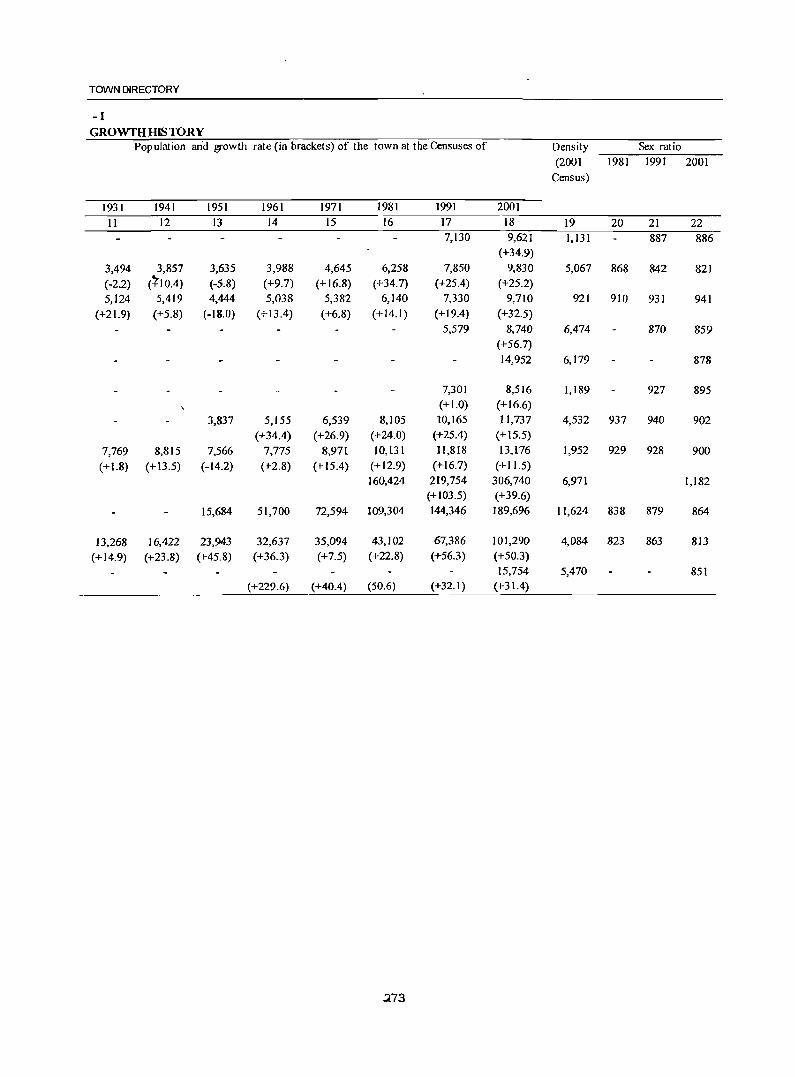
TOWN DIRECTORY
-1 GROWTH IDS TORY
Population an'd growth rate (in brackets) of the town at the Censuses of Density Sex ratio
(2001 1981 1991 2001 Census)
1931 1941 1951 1961 1971 1981 1991 2001
II 12 13 14 15 16 17 18 19 20 21 22 7,130 9,621 1,131 887 886
(+34.9)
3,494 3,857 3,635 3,988 4,645 6,258 7,850 9,830 5,067 868 842 821 (-2.2) (~IO.4) (-5.8) (+9.7) (+16.8) (+34.7) (+25.4) (+25.2) 5,124 5,419 4,444 5,038 5,382 6,140 7,330 9,710 921 910 931 941
(+21.9) (+5.8) (-18.0) (+13.4) (+6.8) (+14.1) (+ 19.4) (+32.5) 5,579 8,740 6,474 870 859
(+56.7) 14,952 6,179 878
7,301 8,516 1,189 927 895 (+1.0) (+16.6)
3,837 5,155 6,539 8,105 10,165 11,737 4,532 937 940 902 (+34.4) (+26.9) (+24.0) (+25.4) (+ 15.5)
7,769 8,815 7,566 7,775 8,971 10,131 n,818 13,176 1,952 929 928 900 (+ 1.8) (+13.5) (-14.2) (+2.8) (+ 15.4) (+ 12.9) (+16.7) (+ 11.5)
160,424 219,754 306,740 6,971 1,182 (+ 103.5) (+39.6)
15,684 51,700 72,594 109,304 144,346 189,696 11,624 838 879 864
13,268 16,422 23,943 32,637 35,094 43,102 67,386 101,290 4,084 823 863 813 (+14.9) (+23.8) (+45.8) (+36.3) (+7.5) (+22.8) (+56.3) (+50.3)
15,754 5,470 851 (+229.6) (+40.4) (50.6) (+32.1) (+31.4)
.273
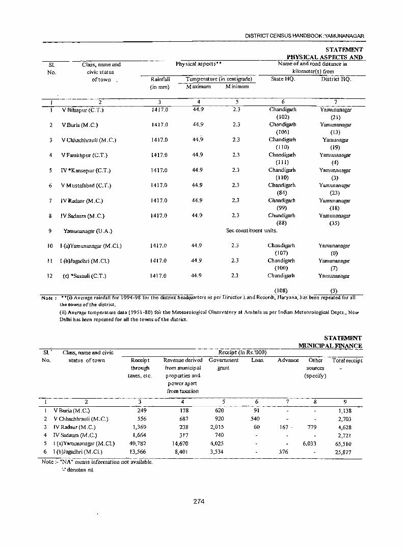
DISTRICT CENSUS HANDBOOK :YAMUNANAGAR
STATEMENT PHYSICAL ASPECTS AND
SI. Class, name and Physical aspects** Name of and road distance in
No. civic status kilometer(s) from
of town Rainfall Temperature (in centigrade) State HQ. District HQ.
(in mm) Maximum Minimum
2 3 4 5 6 7
V Bilaspur (C.T.) 1417.0 44.9 2.3 Chandigarh Yamunanagar (102) (2 J)
2 V Buria (M .C.) 1417.0 44.9 2.3 Chandigarh Yamunanagar (106) (13)
3 V Chhachhrauli (M .C.) 1417.0 44.9 2.3 Chandigarh Yamunagar (110) (19)
4 V Farakhpur (C.T.) 1417.0 44.9 2.3 Chandigarh Yamunanagar (III) (4)
5 IV *Kansepur (C.T.) 1417.0 44.9 2.3 Chandigarh Yamunanagar
(110) (3)
6 V Mustafabad (C.T.) 1417.0 44.9 2.3 Chandigarh Yamunana!?fll" (84) (23)
7 IV Radaur (M .C.) 1417.0 44.9 2.3 Chandigarh Yamunana!?fll" (99) (18)
8 IV Sadaura (M .C.) 1417.0 44.9 2.3 Chandigarh Yamunana!?fll" (88) (35)
9 Yamunanagar (U .A.) See constituent units.
10 I (a)Yamunanagar (M.Cl.) 1417.0 44.9 2.3 Chandigarh Yamunana!?fll" (107) (0)
II I (b)Jagadhri (M .CI.) 1417.0 44.9 2.3 Chandigarh Yamunanagar (100) (7)
12 (c) *Sasauli (C.T.) 1417.0 44.9 2.3 Chandigarh Yamunanagar
(J08) (3) Note: U(i) Average rainfall for 1994-98 for the district headquarters as per Director Land Records, Haryana, has been repeated for all
SI. ' No.
1
2
3
4
5
6
the towns of the district.
(ii) Average temperature data (J 951-80) for the Meteorological Observatory at Ambala as per Indian Meteorological Deptt., New Delhi has been repeated for all the towns of the district.
Class, name and civic
status of town
2
V Buria(M .C.)
V Chhachhrauli (M .C.)
IV Radaur (M .C.)
IV Sadaura (M .C.)
1 (a)Yamunanagar(M.CI.)
I (b}Jagadhri (M .Cl)
Receipt
through
taxes, etc.
3
249
556
1,369
1,664
40,782
13,566
Revenue derived
from municipal
properties and
power apart
from taxation
4
178
687
238
317
14,670
8,401
Receipt (in Rs.'OOO)
Government Loan
grant
5 6
620 91
920 540
2,015 60
740
4,025
3,534
STATFMllNT MUNICIP AL FINANCE
Advance Other Total receipt
sources
(specify)
7 8
167 . 779
6,033
376
9
1,138
2,703
4,628
2,721
65,510
25,877
Note :- "NA" means information not available.
'_' denotes nil.
274
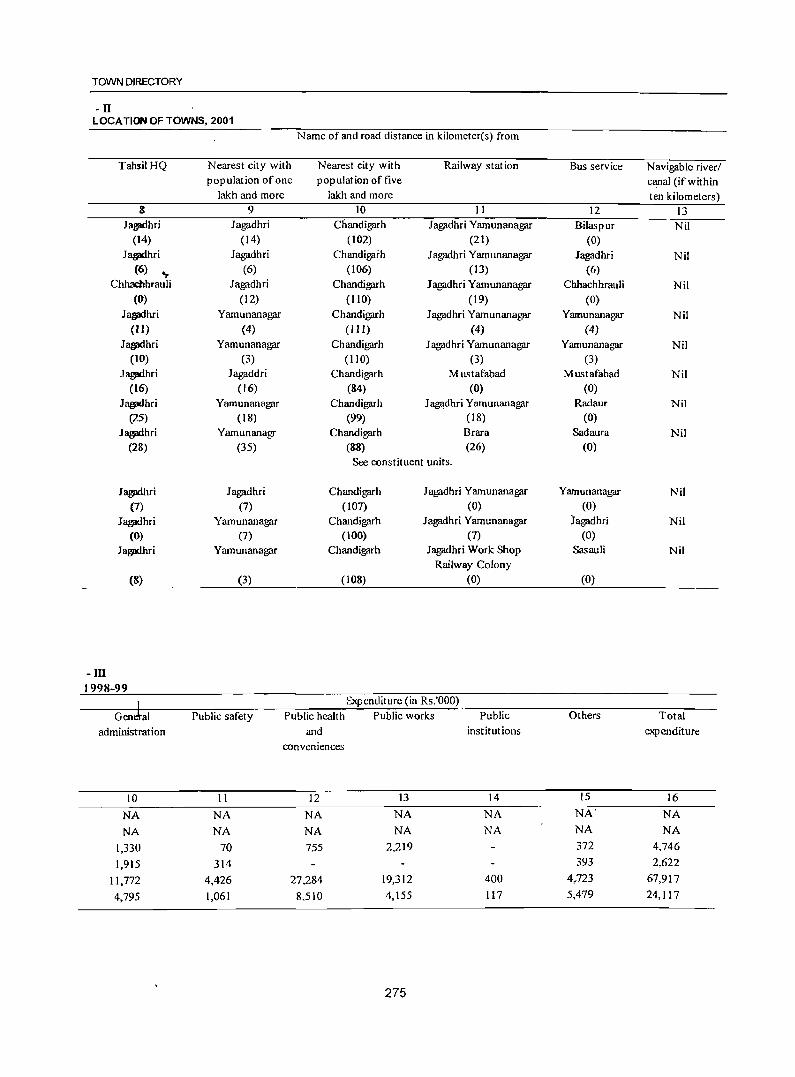
TOWN DIRECTORY
-n LOCA TION OF TOWNS, 2001
TahsilHQ
8 Jagedhri
(14)
J~ri
(6) ~
Chhachhrauli (0)
Jall!l'ihri (ll)
J all!I'i h ri (10)
J all!I'ihri (16)
J~hri
(25)
J~ri
(28)
Jaglldhri (7)
J~hri
(0)
J all!l'ihri
-ill 1998-99
(8)
Nearest city with population of one
lakh and more 9
Jagadhri (14)
Jagadhri (6)
Jagadhri (12)
Yamunanagar (4)
Yamunanagar (3)
Jagaddri (16)
Yamunanagar (18)
Yamunanagr (35)
Jagadhri (7)
Yamunanagar (7)
Yamunanagar
(3)
Name of and road distance in kilometer(s) from
Nearest city with Railway station Bus service Navigable river/ population oftive canal (if within
lakh and more ten kilometers) 10 II 12 13
Chandigarh Jagadhri Yamunanagar Bilaspur Nil (102) (21) (0)
Chandigaih Jagadhri Yamunanagar Jagadhri Nil (106) (13) (6)
Chandigarh Jagadhri Yamunanagar Chhachhrauli Nil (110) (19) (0)
Chandigarh Jagadhri Yamunanagar Yamunanagar Nil ( Ill) (4) (4)
Chandigarh Jagadhri Yamunanagar Yamunanagar Nil (lID) (3) (3)
Chandigarh Mustafabad Mustafabad Nil (84) (0) (0)
Chandigarh Jagadhri Yamunanagar Radaur Nil (99) (18) (0)
Chandigarh Brara Sadaura Nil (88) (26) (0)
See constituent units.
Chandigarh Jagadhri Yamunanagar Yamunanagar Nil (to7) (0) (0)
Chandigarh Jagadhri Yamunanagar iagadhri Nil (100) (7) (0)
Chandigarh Jagadhri Work Shop Sas au Ii Nil Railway Colony
(108) (0) (0)
.1 Expenditure (in Rs.'OOO) ----~G-ro-J+a~I------~P~ub~17ic-s-a~re-ty----~P-u~bl~ic~h~~~lt~h~~P~u~b~h~"c~w-o-r7ks--~ --~P~u~b~lic--------~O~th~e-rs--------~T=-ot-a71----
administration and institutions expenditure
conveniences
10 II 12 13 14 15 16
NA NA NA NA NA NA" NA
NA NA NA NA NA NA NA
1,330 70 755 2,219 372 4,746
1,915 314 393 2,622
11,772 4,426 27,284 19,312 400 4,723 67,917
4,795 1,061 8.510 4,155 117 5,479 24,117
275
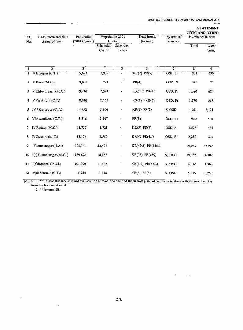
SI. Class, name and civic Population Pop ulation 200 I
DISTRICT CENSUS HANDBOOK :YAMUNANAGAR
STATEME'iT CMC AND OTHER
Number of latrines
No. status of town (2001 Census) --=-:---:-;-C-:e,-n_su;::-s-;--:-:--:-Scheduled Scheduled
Road length (in kms.)
System of sewerage
Total Water borne Castes Tribes
2 3 4 5 6 7 8 9 V Bilaspur (C.T.) 9,621 2,937 KR(2) PR(5) OSD,Pt 981 490
2 VBuria(M.C.) 9,830 721 PR(4) OSD, S 970 21
3 V Chhachhrauli (M .C.) 9,710 2,024 KR(1.5) PR(4) OSD, Pt 1,080 680
4 V Farakhpur (C.T.) 8,740 2,505 KR(I) PR(O.5) OSD, Pt 1,670 588
5 IV *Kansepur (C.T.) 14,952 3,306 KR(3) PR(2) S,OSD 4,901 3,121
6 V M ustafabad (C.T.) 8,S16 2,147 PR(8) OSD, Pt 950 560
7 IV Radaur (M.C.) 11,737 1,728 KR(3) PR(7) OSD, S 1,523 45S
8 IV Sadaura (M .C.) 13,176 2,569 KR(4) PR(4.5) OSD, Pt 2,282 763
9 Yarnunanagar (U.A.) 306,740 33,476 KR(49.3) PR(216.3; 29,089 19,592
10 I (a)Yarnunanagar (M .CL) 189,696 18,166 KR(38) PR(159) S,OSD 19,482 14,382
11 I (b)Jagadhri (M.CL) 101,290 11,662 KR(8.3) PR(52.3) S,OSD 4,372 1,960
12 IV(c) ·Sasauli (C.T.) IS,754 3,648 KR(3) PReS) S,OSD 5,235 3,250
Noh;- I. '" Of In case thiS service IS not available In tfie town, tfie name of the nearest place Wllere available along With distance from the town has been mentioned.
2. ,_, denotes Nil.
276
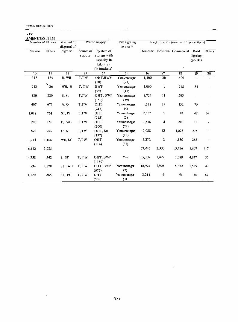
TOWN DIRECTORY
-IV AMENITIES 1999
Number of latrines Method of Water supply Fire fighting Electrification (number of connections) disposal of service**
Service Others night soil Source of System of Domestic Industrial Commercial Road Others supply storage with lighting
capacity in (points) kilolitres
(in bracket s)
10 11 12 13 14 15 16 17 18 19 20 317 174 B,WB T,TW OHT,BWP Yamunanagar 1,500 20 500
~ 36 (20) (21)
913 WB, B T,TW BWP Yamunanagar 1,060 118 84 (59) (13)
180 220 B, Pt T,TW OHT,BWP Yamunanagar 1,724 11 503 (150) (19)
407 675 Pt,O T,TW OHT Yamunanagar 1,648 29 152 76 (215) (4)
1,019 761 ST, Pt T,TW OHT Yamunanagar- 2,657 5 84 42 36 (215) (3)
240 150 B, WB T,TW OHT Yamunanagar 1,536 8 200 18 (200) (23)
822 246 0, S T,TW OHT, SR Yamunanagar 2,088 12 1,026 275 (137) (18)
1,214 1,166 WB,ST T,TW OHT Yamunanagar 2,272 12 1,130 262 (114) (35)
6,412 3,085 57,447 3,333 13,436 5,607 117
4,758 342 S, ST T, TW OHT,BWP Yes 35,309 1,422 7,689 4,047 35 (1180)
534 1,878 ST, WB T,TW OHT,BWP Yamunanagar 18,924 1,905 5,652 1,535 40 (675) (7)
1,120 865 ST, Pt T,TW OHT Yamunanagar 3,214 6 95 25 42 (50) (3)
277
DISTRICT CENSUS HANDBOOK :YAMUNANAGAR
STATEMENT MEDICAL, EDUCATIONAL, RECRFA TIONAL
SI. Class, name and Population Medical facilities* * Educational facilities**
No civic status (2001
of town Census) Hospitalsl Beds in Artsl Medical Engineering Polytechnics
Disp ensariesl T .B. medical Science! colleges colleges
clinics etc. institu- Commerce! tions Law/
noted Other coIJeges
in (of degree level column and above)
4
2 3 4 5 6 7 & 9
V Bilaspur (C.T.) 9,621 HC FWC NH(7) 33 Yamunanagar Yamunanagar Jagadhri Yamunanagar H-Jagadhri(14) (21) (21) (14) at Damla D-Jagadhri(14) (21) TB-Jagadhr(14)
2 VBuria(M.C.) 9,830 HC FWC 4 Yamunanagar Yamunanagar Jagadhri Yamunanagar H-Jagadhri (6) (13) (13) (6) at Damla
D-Fatehgarh (4) (13) TB-Jagadhri (6)
NH-Jagadhri (6)
3 V Chhachhrauli (M.C.) 9,710 HC FWC NH(5) 40 Yamunanagar Yamunanagar Jagadhri Yamunanagar
H-Jagadhri(12) (19) (19) (12) at Damla
D-Kot Sarkari (10) (19)
TB-Jagadhri(12)
4 V Farakhpur (C.T.) 8,740 H-Yamunanagar(4) 0 Yamunanagar Yamunanagar Jagadhri Y;amunanagar 0-Yamunanagar( 4) (4) (4) (II) at Oamla FWC-Yamunanagar (4) (4) TB-Yamunanagar (4)
NH-Yamunanagar (4)
5 IV *Kansepur (C.T.) 14,952 H-Yamun an agar (3) 0 Yamunanagar Yamunanagar Jagadhri Yamunanagar
D-Yamunanagar (3) (3) (3) (10) at Damla
HC-Yamunanagar (3) (3)
FWC-Yamunanagar (3) TB-Yamunanagar (3)
NH -Yamunanagar (3)
6 VMustafabad (C.T.) 8,516 HC FWC 30 Yamunanagar Yamunanagar MuIJana Yamunanaga'r H-Jagadhri (16) (23) (23) (12) at Damla D-Jagadhri (16) (23) TB-Jagadhri (16) NH-Jagadhri (16)
7 IV Radaur (M .C.) 11,737 H HC FWC NH (7) 64 AC Yamunanagar Yamunanagar D-Bhagwangarh (4) (18) at Damla TB-Yamunanagar (18) (18)
278
TOWN DIRECTORY
-v AND CULTURAL FAc;ILITIES, 1999
Recognised
shorthand,
type -
writing
and
vocational
training
institutions
10
o
SH
Higher
Secondary/
Intermediate!
Senior
Secondary/
PUC (Pre-
university
coltege)/
Junior college
level
II 4
Yamunanagar
(4)
Yamunanagar
(3)
4
3
Educational facilities**
Secondary/ Junior Primary
Matriculation Secondary schools
and
Middle
schools
12 13 14 5 6 10
3 3 7
9 9 14
5 6 7
7 7 9
7 7 7
4 7 8
Adult
literacy
classes/
centres,
others
15 NA
NA
NA
NA
NA
NA
NA
279
Working
women's
hostels
with number
of seats
16 Thanesar
(69)
Thanesar
(61)
Thanesar
(67)
Thanesar
(53)
Thanesar
(45)
Thanesar
(61)
Thanesar (30)
Number of recreational and cultural
facilities
Stadium Cinema Auditorium / Public
Drama! libraries
Community including
Halls reading
rooms
17 18 19 20
PL RR
Contd .....
DISTRICT CENSUS HANDBOOK :YAMUNANAGAR
STATEMENT MIDICAL, FDUCATIONAL, RECRFATIONAL
SJ. Class, name and' Population Medical facilities H Educational facilities ....
No civic status (2001
of town Census) Hospitals/ Beds in Arts/ Medical Engineering Polytechnics
Dispensaries/T.B. medical Science! colleges colleges
clinics etc. institu- Commerce! tions Law/ noted Other colleges
in (of degree level
column and above)
4
1 2 3 4 5 6 7 8 9
8 IV Sadaura(M.C.) 13,176 D HC(2) FWC(2) 64 AC Yamunanagar Jagadhri Yamunanagar
NH(6) (35) (28) at Damla H-Jagadhri (28) (35) TB-Jagadhri (28)
9 Yamunanagar (U.A.) 306,740 H(5) D(A-(I),6) HC 610 AC(2)
FWC(8) TB(2) ASC(4)
NH(50) Others(2)
10 I (a)Yamunanagar (M.Cl.) 189,696 H(2) D(A-(I),5) 286 ASC(4) Jagadhri Yamunanagar
FWC(5) TB (7) at Damla NH(26) Other (7) H C-J agadhri(7)
II I (b)Jagadhri (M.CI.) 101,290 H(3) D HC 324 AC(2) Yamunanagar Yamunanagar FWC(3) TB NH(24) (7) at Damla Others (7)
12 (c) Sasauli* (C.T.) 15,754 H-Yamunanagar (3) 0 Yamunanagar Yamunanagar Jagadhri Yamunanagar D-Yamunanagar (3) (3) (3) (8) at Damla HC-Jagadhri(12) (3) FWC-Yamunanagar
(3) TB-Yamunanagar (3)
NH-Yamunanagar (3)
Notes :- I. ,**, Ifa medical or educational facility is not available in the town. the name of the nearest place and its distance from the
town where facility is available, has been mentioned.
280
TOWN DIRECTORY
-v AND CULTURAL FACILITIES, 1999
Educational facilities** Working Number of recreational and cultural women's facilities
Recognised Higher Second ary I Junior Primary Adult hostels Stadium Cinema Auditorium! Public shorthand, Secondary! Matriculation Secondary schools literacy with number Drama! libraries
type- Intermediate! and classes! of seats Community including writing Senior Middle centres, Halls reading
and Secondary I schools others rooms vocational PUC (Pre-
training university
inst itutions 09l1ege)/ Junior college
level
10 II 12 13 14 15 16 17 18 19 20
SH 0 4 -....6 9 9 NA Ambala PL RR (52)
VT(2) 30 48 57 69 NA 5 5 PL(2) SH (7)
"" RR(lO) 3
0(7)
VT 15 27 33 41 NA Thanesar 3 4 PL RR(9) SH (57) (49)
0(5)
0 13 18 20 23 NA Thanesar 2 PL RR (55)
VT 2 3 4 5 NA Thanesar
SH (2) 0 (51)
281
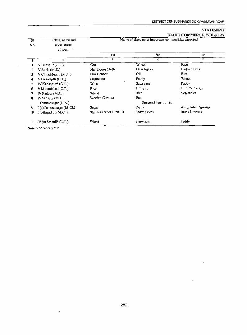
SI. No.
1
2 3 4
5 6 7 8
9 JO
11
Class, name and civic status
of town
2 VBilaspur (C.T.) VBuria(M.C.) V Chhachhrauli (M .C.) V Farakhpur (C.T.) IV Kansepur* (C.T.) VMustafabad (C.T.) IV Radaur (M .C.) IV Sadaura (M.C.)
Yamunanag;:rr (U.A.) I (a)Yamunanagar(M.CJ.) I (b)Jagadhri (M.CJ.)
IV (c) Sasauli* (C.T.)
Note :- '.' denotes 'nil'.
DISTRICT CENSUS HANDBOOK :YAMUNANAGAR
STATEMENT TRADE, COMMFRCE. INDUSTRY
Name ofthree most important commodities"exported
1st 2nd 3rd
3 4 5 Gur Wheat Rice
Handloom Cloth Desi Jutties Earthen Pots
Ban Babbar Oil Rice
Sug;:rrcane Paddy Wheat
Wheat Sugarcane Paddy
Rice Utensils Gur, Ice Cream
Wheat Rice Vegetables
Woolen Carpets Ban
See constituent units
Sug;tr Paper Automobile Spring;
Stainless Steel Utensils Show pieces Brass Utensils
Wheat Sugarcane Paddy
282
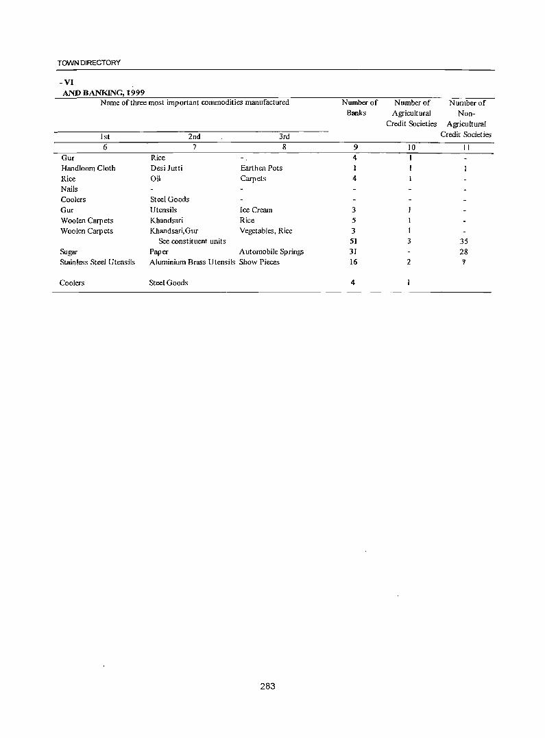
TOWN DIRECTORY
-VI AND BANKING, 1999
Name of three most important commodities manufactured
1st 6
Gur Handloom Cloth Rice Nails Coolers Gur Woolen Carpets Woolen Carpets
Sugar Stainless Steel Utensils
Coolers
2nd 3rd
Rice Desi Jutti
Oil
Steel Goods
7
Earthen Pots Carpets
Utensils Ice Cream Khandsari Rice
8
Khandsari,Gur Vegetables, Rice See constituent units
Paper Automobile Springs Aluminium Brass Utensils Show Pieces
Steel Goods
283
Number of Number of Number of Banks Agricultural Non-
Credit Societies Agricultural
Credit Societies
9 10 II 4 I 4
3 5 3 I 51 3 35 31 28 16 2 "!
4
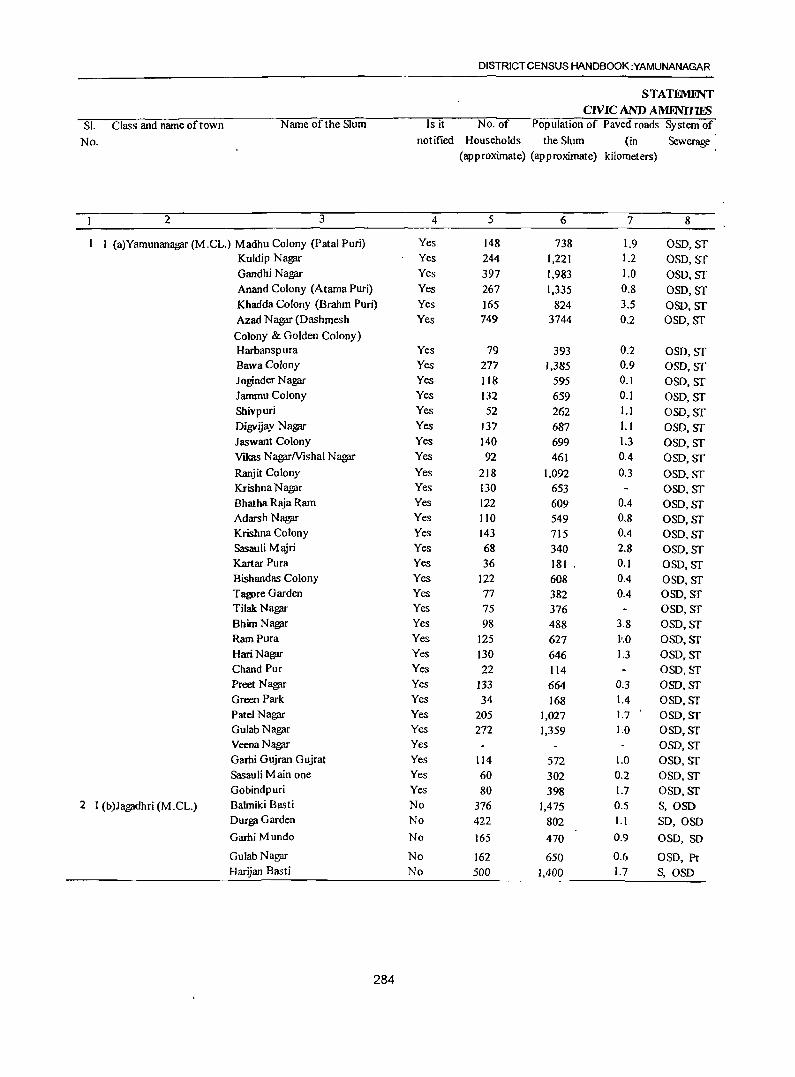
SI. Class and name of town Name of the Slum
No.
2 3
I (a)Yamunanag;u- (M.CL.) Madhu Colony (Patal Puri) Kuldip Nagar Gandhi Nagar Anand Colony (Atama Puri) Khadda Colony (Brahm Puri) Azad N ag;u- (Dashmesh
Colony & Golden Colony) Harbanspura BawaColony Joginder Nagar Jammu Colony Shivpuri Digvijay Nagar Jaswant Colony VIkas Nag;u-Nishal Nag;u-
Ranjit Colony Krishna Nagar Bhatha Raja Ram Adarsh Nag;u-Krishna Colony
SasauliM*i Kartar Pura Bishandas Colony T~reGarden
Tilak Nag;u-Bhim Nagllr Ram pura HariNagar Chand Pur Preet N ag;u-Green Park Patel Nagar Gulab Nagllf Veena Nagllf Garhi Gujran Gujrat Sasauli Main one Gobindpuri
2 I (b)Jagadhri (M.CL.) Balmiki Basti OUfgll Garden
Garhi Mundo
Gulab Nagllf Harijan Basti
284
DISTRICT CENSUS HANDBOOK :YAMUNANAGAR
STATFMINT CIVIC AND .AMFN11'lES
Is it No. of Population of Paved roads System of
notified Households the Slum (in Sewerage (approximate) (approximate) kilometers)
4 5 6 7 8
Yes 148 738 1.9 OSD,Sf Yes 244 1,221 1.2 OSD, Sf Yes 397 1,983 1.0 OSD,Sf Yes 267 1,335 0.8 OSD, ST Yes 165 824 3.5 OSD,ST Yes 749 3744 0.2 OSD, Sf
Yes 79 393 0.2 OSD, ST Yes 277 1,385 0.9 OSO,Sf Yes Jl8 595 0.1 OSO, Sf Yes 132 659 0.1 OSD,Sf Yes 52 262 I.J OSO, Sf Yes 137 687 I.J OSD,ST Yes 140 699 1.3 OSD, Sf Yes 92 461 0.4 OSO,Sf Yes 218 1.092 0.3 OSD. ST Yes 130 653 OSD,ST Yes 122 609 0.4 OSD,ST Yes liD 549 0.8 OSD,ST Yes 143 715 0.4 OSD.ST Yes 68 340 2.8 OSD.ST Yes 36 181 . 0.1 OSD,ST Yes 122 608 0.4 OSD,ST Yes 77 382 0.4 OSD,Sf Yes 75 376 OSO,ST Yes 98 488 3.8 OSD,ST Yes 125 627 Jo.O OSD,ST Yes 130 646 1.3 OSD,ST Yes 22 114 OSD.~T
Yes 133 664 0.3 OSD.ST Yes 34 168 1.4 OSD. ST Yes 205 1,027 1.7 OSD, ST Yes 272 1,359 1.0 OSD,ST Yes OSO,ST Yes 114 572 1.0 OSD,ST Yes 60 302 0.2 OSD, ST Yes 80 398 1.7 OSD,ST No 376 1,475 0.5 S,OSD No 422 802 I.! SO,OSD No 165 470 0.9 OSD, SD
No 162 650 0.6 OSD, Pt No 500 1,400 1.7 S,OSD
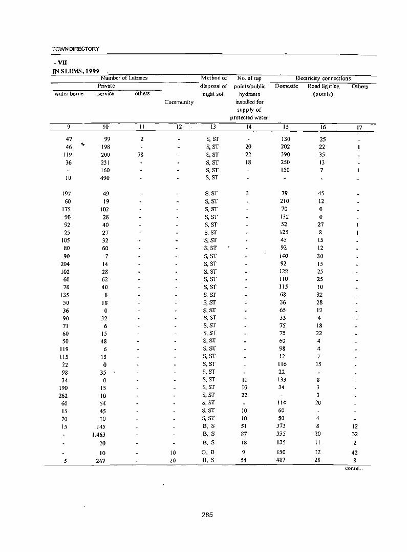
TOWN DIRECTORY
-VII IN SLUMS, 1999
Number of Latrines Method of No. of tap Electricity connections Private disposal of points/public Domestic Road lighting Others
water borne service others night soil hydrants (points)
Community installed for
supply of
protected water
9 10 II 12 13 14 15 16 17
47 99 2 S, ST 130 25 46 ~ 198 S,ST 20 202 22
119 200 78 S,ST 22 390 35 36 231 S,ST 18 250 13
160 S,ST 150 7 10 490 S,ST
197 49 S,ST 3 79 45 60 19 S,ST 210 12
175 102 S,ST 70 0 90 28 S,ST 132 0 92 40 S,ST 52 27 25 27 S,ST 125 8
105 32 S,ST 45 15 80 60 S,ST 92 12 90 7 S,ST 140 30
204 14 S,ST 92 15 102 28 S,sr 122 25 60 62 S,ST 110 25 70 40 S,ST 115 10
135 8 s,sr 68 32 50 18 S,ST 36 28 36 0 S,ST 65 12 90 32 S,ST 35 4 71 6 S,ST 75 18 60 15 S,ST 75 22 50 48 S,ST 60 4
119 6 S,ST 98 4
115 15 S,ST 12 7 22 0 s,sr 116 15 98 35 s,sr 22 34 0 S,ST 10 133 8
190 15 S,ST 10 34 3 262 10 S,ST 22 3 60 54 S,ST 114 20 15 45 S,ST 10 60 70 10 S,ST 10 ~O 4 15 145 B, S 51 373 8 12
1,463 B, S 87 335 20 32
20 B, S 18 135 II 2
10 10 0, 8 9 150 12 42
5 267 20 B, S 54 487 28 8 contd ...
285
SI. Class and name oftown Name of the Slum
No.
2 3
Harijan Basti Tapri Hari Parshad
Opp. Dimple Cinema Hondawala Farm Kali M andir Colony
Leper Colony
NaJagarh M!\ira Tapari Mand Kheri
Gori Shankar Colony Udharn Garhi Majri KesarNagar Bhagat Pura Malwia Nagar Rajesh Colony M anohar (!;blony Kalyan Nagar Sarswati Colony VlShkarma Cloony Shanti Colony Ganga Nagar Colony Mahavir Colony Bharat Sewak N agar Colony Basant Nagar Gandhi Nagar Dur!?ilColony Sawan Puri Shankar Puri Partap Nagar Darshan Nagar New Garhi Mundo Ram Na!?ilf Ganesh N a!?f1T Mohan Nagar Roop Nagar Ext. Gandhi Dham Teli Majra Nala!?f1Th Ki Taprian
3 IV Radaur (M .C.) Balmiki Basti Harijan Basti
Patak M1tiri 4 IV Sadaura (M.C.) Ramdasia Mohalla Ward No.
XII & XIII Balmiki Basti Ward No. VI Harijan Basti Ward No. IV
Note :- "NA" means information not available. ,
286
DISTRICT CENSUS HANDBOOK :YAMUNANAGAR
Is it No. of
notified Households
STAU.ME'lT CIVIC AND AMENmES
Population of Paved roads System of
the Slum (in Sewerage (approximate) (approximate) kilometers)
4 5 6 7 8
No 46 189 0.3 OSD, Pt
No 40 175 0.4 OSD, Pt No 703 1,105 0.5 OSD, SD
No 29 120 0.2 S, Os!) No 101 371 0.5 OSD, Pt No 157 750 1.5 OSD, SD
No 982 2,590 1.0 S,OSD No 165 975 0.5 OSD No 140 856 1.0 0 No 325 1,825 2.0 S, OS!) No 61 316 0.8 S No 292 1,682 3.0 S,05O No 76 390 1.0 S,05O No 392 2,250 2.5 S, OS{) No 201 1,215 1.5 S, OSD No 275 1,376 1.8 S, 050 No 165 456 1.0 OSD No 60 342 0.8 OSD No 121 590 1.0 S, 0Sl) No 192 941 1.5 S, Os[) No 145 649 1.0 S, Os{) No 61 372 1.0 S. OSD No 130 872 2.0 S, Os[) No 242 1,242 2.5 S, Os[) No 100 772 1.5 S,OSD No 98 756 1.5 OID No 237 1,242 2.0 S, OS[) No 101 540 0.5 a No 97 512 0.5 OSD No 80 472 0.8 OSD No 168 812 1.0 S,08O No 172 978 1.5 S, OSD No 204 1,490 2.0 S, OSD No 79 475 1.0 0 No 179 992 2.0 S, OSD Yes 75 3M 0.5 OSD Yes 120 600 0.5 OSD Yes 160 800 0.5 OSD No 65 514 0.5 OSD,Pt
No 80 480 0.5 OSD ,Pt No 75 522 0.5 OSD,Pt
TOWN DIRECTORY
-vn IN SLUMS, 1999
Number of Latrines Method of No. of tap Electricity oonnections Private disposal of points/public Domestic Road lighting Others
water bome service others night soil hydrants (poiDts)
Community installed for supply of
protected water
9 10 11 12 13 14 15 16 17
20 B, 0 42 2 ~
0, B 25 8 3 325 B, S 325 12 22
12 12 B, S 6 16 5
6 O,B 80 10 12 12 B,O 157 21 4
B,O 800 22 3 B,O 154 10 2 B,O 86 10 4 B,O 200 17 5
'" B,'S 49 6 1 B,O 182 18 6 B, 0 70 6 B. S 361 18 7 B, S 171 6 1 B, S 200 8 2 B, S 135 2 B. S 47 4 B, S III 3 2 B, S 161 2 I B, S 135 4
0 45 5 B, 0 121 I B,O 192 2 4 B, S 87 I 3 B,O 89 6 B, S 179 2 2 B, S 86 5 B, S 91 2 B, S 62 4
0, B 161 3 2 0, B 150 5 1 0, B 199 8
B, ° 68 2 B,O 160
50 D,S 6 75 15 70 D,S 7 120 18 60 O,S 8 160 17
NA ST 4 60 2
NA ST 6 70 3
NA ST 5 68 4
287
DISTRICT CENSUS HANDBOOK :YAMUNANAGAR
APPFNDIX TO TOWN DIRECTORY TOWNS SHOWING THEIR OUfGROWTHS WITH POPULATION
Sl. No. Name of the Town with Population of Core Town Outgrowth Population of outgrowth Location Code No.
2 3 4 5 Nil
288
PRIMARY CENSUS ABSTRACT
Part B- Primary Census Abstract
289

PRIMARY CENSUS ABSTRACT
Brief note on Primary Census Abstract
The first census of the third mil lenni urn and twe!lty l_ first century the Census of India, 2001 was the
14th continuous and uninterrupted Indian census since 1872. Thus, 2()o 1 Census will provide data on population and its characteristics marking transition from one century and millennium to another.
The gigantic operation of Population Enumeration (considered by many to be the single largest and complex peace time administrative exercise in the world) was made possible due to the door to door universal canvassing of the Household Schedule by ab~ut 2 million enume~tors and supervisors covering 593 districts, 5,463 sub-districts, 5,161 towns and 638,588 villages. The comprehensive Household Schedule which replaced the individual slip had three parts and two sides A a~d B. Part I contained the Location Particulars; Part II related to the Individual Particulars and Part III contained questions for Household engaged in CultivationIPlantation . The part II of the Household Schedule had 39 columns and 23 questions all of which were universally canvassed and no sampling was resorted to during enumeration.
~ata Processing
A quantum leap was made in the technology front while processing the Census 2001 data both for Houselisting and Population Enumeration. The Census schedules for both the phases were scanned through high speed scanners in fifteen data centers across the country and hand-written data from the schedules were converted into digitized form through Intelligent Character Reading (ICR) software for creation of ASCII records for further processing. The designing and formatting of the Household Schedule had to be done very carefully using specialized software so as to ensure uniformity, which was an essential pre-requisite for scanning. The selection of appropriate state-of-art technology in data processing has made it possible to produce all the Houselisting as well as Population Enumeration tables on full count basis for the first time in the history of Census. For Census 2001, auout 202 million schedules consisting
291
of about 1,028 million records were scanned and processed within a span of only 10 months starting October, 2002.
Task Force on Quality Assurance
Aft~r the data is processed, it is expedient on the part of the data producing agency to satisfy itself about its quality before putting the same in public domain. This has to be done mainly through the process of internal consistency, comparison with similar data in the past and also through validation with likewise data, if available, from external sources. Quite often the local knowledge and perception has to be brought into play to understand both the existing and the new emerging trends of population distribution and characteristics. The other very important aspect of the data quality is to ensure complete coverage of all geographical areas especially for the population enumeration phase where the data is disseminated right up to the village level in the rural areas and the ward level in the urban areas. Thus ensuring the complete coverage and correct geographical linkage of each enumeration block was one of the major planks of the quality control, specially for small area population statistics.
A very comprehensive check and edit mechanism was put in place to objectively examine the preliminary Census 2001 Population Enumeration results and finally clear them for use. The responsibility of the final clearance of data was with the Task Force on Quality Assurance (TFQA), headed by the Registrar General and Census Commissioner. India. The other members of the TFQA were the Heads and senior officers of the Census Division, Data Processing Division, Map Division, Demogr,:aphy Division and Social Studies Division. The Directors of Census Operations were co-opted as members whenever the TFQA discussed the data for their States/Union territories. The Directors and their senior officers were required to make detailed presentations of data for their own State both in respect to the quality and the coverage and only after the full possible satisfication of the TFQA, the population data was cleared.
There has been a major departure in Census 200 1 from the past in respect of the procedure followed for finalization of {he Scheduled Castes and the Scheduled Tribes population. In the earlier censuses, the total Scheduled Castes and Scheduled Tribes populations were finalized at the time of the manual compilation of the Primary Census Abstracts (PCA) at the Regional Tabulation Offices which were specially set up for this purpose. The individual Scheduled Castes and the Scheduled Tribes population for each state was finalized much later based on manual coding done by the coders. In 200 I Census, each individual Scheduled Caste and the Scheduled Tribe have been coded directly on the computers by the Data Entry Operators through a process known as Computer Assisted Coding (CAG) and taken up along with the processing of PCA data. The CAC process involves pulling down, from the relevant dictionary of the Scheduled Castes and the Scheduled Tribes, on the computer screen and coding from the dictionary by referring to the image of the specific Qndividual entry in the Household Schedule appearing on the screen. The CAC of the response on Religion, wherever required, was also undertaken along with the processing of PC A. This is because the Scheduled Castes status had to be determined in relation to the religion of the individual. Two Special Task Forces, one on Religion and the other on Scheduled Castes! Scheduled Tribes were constituted for scrutiny and appropriate classification of these responses.
The main task of the Special Task Force on Religion was to appropriately merge or group the new responses encountered and code it into the appropriate religious ~mmunity based on available literature and local krjowledge. The Special Task Force on Scheduled di\stes and Scheduled Tribes examined the different
DISTRICT CENSUS HANDBOOK :YAMUNANAGAR
The entire work relating to the data validation and scrutiny was completed by all the States/Union Territories under the overall supervision and monitoring of the Census Division of the Office of the Registrar General, India with active cooperation and support of the Social Studies Division, Data Processing Division, Data Dissemination Division and Map Division.
Primary Census Abstract
The Primary Census Abstract which is yet another important publication of 2001 Census gives basic information on Area, Total Households, Total population, Scheduled Castes, Scheduled Tribes population, Population in the age group 0-6, Literates, Main workers and Marginal workers classified by the four broad industrial categories, namely, (i) Cultivators, (ii) Agricultural labourers, (iii) Household Industry Workers, and (iv) Other workers and also Non-workers. The characteristics of the Total Population includes Scheduled Castes, Scheduled Tribes, Institutional and Houseless population and are presented by sex and rural-urban residence. This data is presented at different levels, namely, India, States/Union territories, Districts and Cities, Urban Agglomerations (Population 1,00,000 and above) in three different tables. In addition, the Appendix of said publication provides Houseless and Institutional Households and their popUlation by residence and sex for 2001 for India, States and Union territory.
Apart from the India and State/Union Territory volumes for Primary Census Abstract, the District Census Handbook contains District Primary Census Abstract, Appendix to District Primary Census Abstract, Primary Census Abstr~ct for S~heduled
Scheduled Castes and Scheduled Tribes entries encoun- Castes, Primary Census Abstract for Scheduled tered and classified these into appropriate category of Tribes, Village Primary Census Abstract and Urban the Scheduled Castes or the Scheduled Tribes Primary Census Abstract of the concerned district in principally based on the Presidential Notification and the State.
t!\l a~ailable lite~ature. Thus a :ery .systematic and It was for the first time at the 1981 Census that s~entlfic mechamsm was operationalised to firm up the Primary Census Abstract (PCA) was brought out
• the individual religion and the individual Scheduled for the Scheduled Castes and the Scheduled Tribes Castesn'ribes returns. The Scheduled Castes and the separately on the pattern of General Primary Census Scheduled Tribes population in 2001 Census, is thus being finalized by aggregating the population data for individual Scheduled Castes and the Scheduled Tribes at appropriate geographical levels.
Abstract. This practice was continued in 1991 also. In the 1961 and 1971 Census.es, such data were made available in Table C-VlU-Social and (::ultural table and to some extent in the series 'Special Tables for Scheduled Castes/Scheduled Tribes'.
292
PRIMARY CENSUS ABSTRACT
The format of Primary Census Abstract has been restructured slightly il_) the 2001 Census as compared to that of 1991 Census. The nine-fold industrial classification of main workers given in the Primary Census Abstract of 1991 Census has been discontinued and its place, fourfold industrial classification of both 'main workers' and 'marginal workers' are included. In 1981 census only main workers were presented in to four categories. 9ne of the novel features of the primary census abstract of 199 I census was the presentation of data of the .,.
Name of the Primary Census Abstract
1. District Primary Census Abstract
population of age group 0-6 is continued in200 I Census also. This will help the data users in better analysis and understanding of this literacy data.
Level of presentation in District Census Handbooks:
The Primary Census Abstract data in different PCAs are presented at different levels. The level of presentation of Primary Census Abslrncts are as under:
Level of presentation
2. Primary Census Abstract for Scheduled Castes
District/C.D. BlocklUA/Cityffown
District/C.D. Block/Town
District/C.D. Block/Town 3. Primary Census Abstract for Scheduled Tribes
4. Village Primary Census Abstract
5. Urban Primary Census Abstract
The PCA Data for villages was presented CD Block wise for the first time in 1991 Census. This practice is continued in 2001 Census also. The data for each CD B lock is presented both for rural and urban ar~as separately. All the villages within the CD Block constitute the rural portion and the Census Towns and Outgrowths are shown under the urban portion of the CD Block. In case a CD Block is spread over two or more districts, than poftion which falls within the district is presented, the data pertaining to remaining portion of the CD Block is presented in the concerned District Census Handbook. The data in the Urban Primary Census Abstract for each town as well as for town with outgrowths in the district are presented. The data for all the wards and the outgrowths of the town(s) are also presented separately below the concerned town(s).
The District Primary Census Abstract is presented in 59 columns. The Primary Census Abstract for Scheduled Castes and Primary Census Abstract for Scheduled Tribes are presented in 52 columns. The Village Primary Census Abstract .and Urban Primary Census Abstract are presented in 5& columns.
The concepts and definitions used in the column heading are explained under the sub heading 'Census Concepts' in the Analytical Note. The term 'Total Population' includes the Scheduled Castes, the Scheduled Tribes, the Institutional and the Houseless populations. The explanation regarding area figures presented at various level in the Primary Census Abstracts are as follows:
C.D. BlockIVillage wise
Town/Ward level
Area Figures
The area figures supplied by local revenue authorities of the district in respect of tahsils, Police Stations and by the local bodies in respect of towns are given in square kilometers. The area figures of the villages supplied by the Tahsildars in acres have been converted and shown in hectares. The area figures of the CD Block is the total of the village areas coming under each CD Block. The area figures for the district are the same as adopted by the Surveyor General of India to maintain uniformity at the national level. The total area figures of all the tahsilslCD Blocks within the district may noltally with area figures of the district because former represents land use area only. Similarly, the total of all the villages may not tally with the entire rural of Police Station/ Tahsil. The difference may be due to the fact that while the area covered by hills, forests and rivers etc., have been accounted in the Tahsils and P.S. level the same may not be covered under the area of the villages. Apart from this it may also differ due to varying methods of computation adopted at different levels.
An appendix to District Pri!f.lary Census Abstract has also been furnished showing urban enumeration block-wise particulars on Total Population, the Scheduled Castes Population and the Scheduled Tribes Population for each town.
293
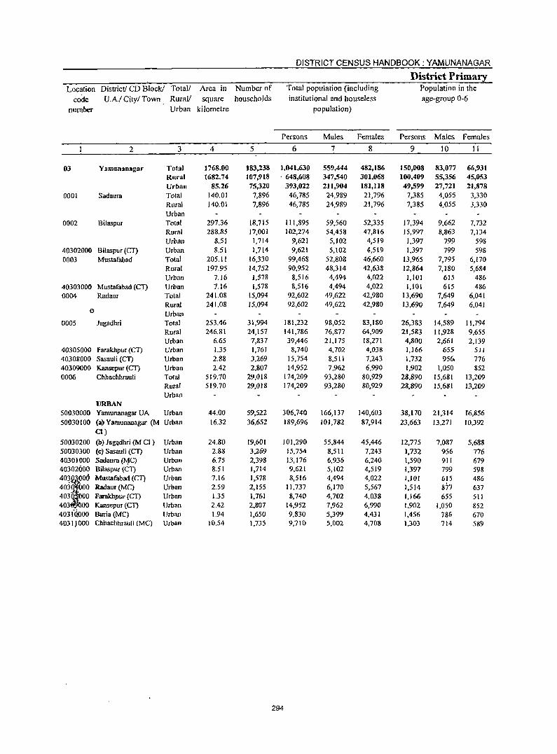
DISTRICT CENSUS HANDBOOK: YAMUNANAGAR
District Primary Location District! CD Block! Total/ Area in Number of Total population (including Population in the
code U.A.I City/ Town Rural! square households institutional and houseless age-group 0-6
number Urban kilometre population)
Persons Males Females Persons Males Females
2 3 4 5 6 7 8 9 10 11
03 Yamunanagar Total 1768.00 183,238 1,041,630 559,444 482,186 150,008 83,077 66,93] Rural 1682.74 107,918 . 648,608 347,540 301,068 100,409 55,356 45,053 Urban 85.26 75,320 393,022 211,904 181,118 49,599 27,721 21,878
0001 Sadaura Total 140.01 7,896 46,785 24,989 21,796 7,385 4,055 3,330 Rural 140,01 7,896 46,785 24,989 21,796 7,385 4,055 3,330 Urban
0002 Bilaspur Total 297.36 18,715 1l1,895 59,560 52,335 17,394 9,662 7,732 Rural 288.85 17,001 102,274 54,458 47,816 15,997 8,863 7,134 Urban 8.51 1,714 9,621 5,102 4,519 1,397 799 598
40302000 Bilaspur (CT) Urban 8.51 1,714 9,621 5,102 4,519 1,397 799 598 0003 Mustafabad Totat 205.11 16,330 99,468 52,80S 46,660 13,965 7,795 6,170
Rural 197.95 14,752 90,952 48,314 42,638 12,864 7,180 5,684 Urban 7.16 ],578 8,516 4,494 4,022 1,101 615 486
40303000 Mustafabad (en Urban 7.16 l.5n 8,516 4,494 4,022 1.101 615 486 0004 Radaur Total 241.08 15,094 92,602 49,622 42,9S0 13,690 7,649 6,041
Rural 241.08 15,094 92,602 49,622 42,980 13,690 7,649 6,041 0 Urban
0005 Jagadhri Total 253.46 31,994 181,232 98,052 83,180 26,383 14,589 11,794 Rural 246.81 24,157 141,786 76,877 64,909 21,583 11,928 9,655 Urban 6.65 7,837 39,446 21,175 18,271 4,800 2,661 2,139
40305000 Farakhpur (C1) Urban 1.35 1,761 8,740 4,702 4,038 1,166 655 511 40308000 SasauJi (CT) Urban 2.88 3,269 15,754 8,511 7,243 1,732 956, 776 40309000 Kansepur (CT) Urban 2.42 2,807 14,952 7,962 6,990 1,902 1,050 852 0006 Chhachhrauli Total 519.70 29,018 174,209 93,280 80,929 28,890 15,681 13,209
Rural 519.70 29,018 174,209 93,280 80,929 28,890 15,681 13,209 Urban
URBAN 50030000 Yamunanagar UA Urban 44.00 59,522 306,740 166,137 140,603 38,170 21,314 f6,856 50030100 (a) Yamunanagar (M Urban 16.32 36,652 189,696 101,782 87,914 23,663 J3,271 10,392
0) 50030200 (b) Jag<}dhri (M CI ) Urban 24.80 19,601 101,290 55,844 45,446 12,775 7,087 5,688 50030300 (c) Sasauli (CT) Urban 2.88 3,269 15,754 8,511 7,243 1,732 956 776 40301000 Sadaura (11C) Urban 6.75 2,398 13,176 6,936 6,240 1,590 911 679 40302000 Bilaspur (Cn Urban 8.51 1,714 9,621 5,102 4,519 1,397 799 598
'03f Mustafabad (Cn Urban 7.16 1,578 8,516 4,494 4,022 1,101 615 486 403 000 Radaur(MC) Urban 2.59 2,155 11,737 6,170 5,567 1,514 87'7 637 403 00 Farakhpur (CT) Urban 1.35 1,161 8,740 4,702 4,038 1,166 655 511 403 00 Kansepur (Cn Urban 2.42 2,807 14,952 7,962 6,990 1,902 1,050 852 403iQOOO Boria (MC) Urban 1.94 1,650 9,830 5,399 4,431 1,456 786 670 4031JOOO Cbhachhrauli (Me) Urban 10.54 1,735 9,710 5,002 4,708 1,303 714 589
294
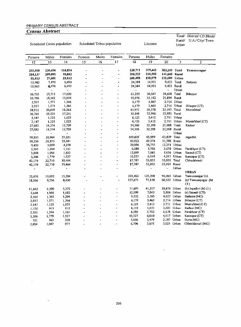
PRIMARY CENSUS ABSTRACT
Census Abstract Total/ District! CD Block!
Rural! U A/ City/ Town Scheduled Castes population Scheduled Tribes population Literates Urban
Persons Males Females Persons Males Females Persons Males Females
12 13 14 15 16 17 18 19 20 3 2
255,550 136,696 118,854 638,711 375,462 263,249 Total Yamunanagar 204,137 109,095 95,042 358,223 216,583 141,640 Rural
51,413 27,601 23,812 280,488 158,879 121,609 Urban
13,963 7,470 6,493 24,384 14,951 9,433 Total Sadaura 13,963 ~470 6,493 24,384 14,951 9,433 Rural
Urban
36,733 19,713 17,020 61,255 36,647 24,608 Total Bilaspur
33,796 18,142 15,654 55,076 33,182 21,894 Rural
2,937 1,571 1,366 6,179 3,465 2,714 Urban
2,937 1,571 1,366 6,179 3,465 2,714 Urban Bilaspur (CT)
38,912 20,649 18,263 61,971 36,378 25,593 Total Mustafabad
36,765 19,524 17,241 55,848 32,966 22,882 Rural
2,147 1,125 1,022 6,123 3,412 2,711 Urban
2,147 1,125 1,022 6,123 3,412 2,711 Urban Mustafabad (CT)
27,083 14,374 12,709 54,306 32,398 21,908 Total Radaur
27,083 14,374 12,709 54,306 32,398 21,908 Rural Urban
59,815 31,964 27,851 109,828 65,989 43,839 Total Jagadhri
50,356 26,875 23,481 80,822 49,234 31,588 Rural
9,459 5,089 4,370 29,006 16,755 12,251 Urban
2,505 1,344 1,161 6,380 3,702 2,678 Urban Farakhpur (Cl)
3,648 1,966 1,682 12,099 7,043 5,056 Urban Sasauli (CT)
3,306 1,779 1,527 10,527 6,010 4,517 Urban Kansepur (Cl) 42,174 22,710 1,9,464 87,787 53,852 33,935 Total Chhachhrauli
42,174 22,710 19,464 87,787 53,852 33,935 Rural Urban
URBAN
33,476 18,092 15,384 221,463 125,398 96,065 Urban YamunanagarUA
18.166 9,736 8,430 137,671 77,138 60,533 Urban (a) Yamunanagar (M CI)
11,662 6,390 5,272 71,693 41,217 30,476 Urban (b) Jagadhri (M CI)
3,648 1,966 1,682 12,099 7,043 5,056 Urban (c) Sasauli (CI)
2,569 1,365 1,204 9,132 5,105 4,027 Urban Sadaura (MC)
2,937 1,571 1,366 6,179 3,465 2,714 Urban Bilaspur (CT)
2,147 1,125 1,022 6,123 3,412 2,711 Urban Mustafabad (CT)
1,728 915 813 8,318 4,633 3,685 Urban Radaur(MC)
2,505 1,344 1,161 6,380 3,702 2,678 Urban Farakhpur (CT)
3,306 1,779 1,527 10,527 6,010 4,517 Urban Kansepur (Cl)
721 363 358 5,666 3,479 2,187 Urban Buria(MC)
2,024 1,047 977 6,700 3,675 3,025 Urban Chhachhrauli (MC)
295
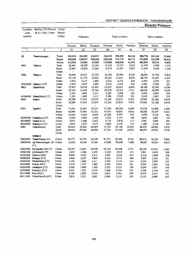
·DISTRICT CENSUS HANDBOOK: YAMUNANAGAR
District Primary Location District! CD Block! Total/
code U.A.I City/ Town Rural/
number Urban Illiterates Total workers Main workers
Persons Males Females Persons Males Females Persons Males Females
2 3 21 22 23 24 25 26 27 28 29
03 Y:lmunanagar Total 402,919 183,982 218,937 336,533 280,289 56,244 280,728 247,262 33,466 Rural 290,385 130,957 159,428 220,550 175,779 44,771 175,699 151,288 24,411 Urban 112,534 53,025 59,509 115,983 104,510 11.473 105,029 95,974 9,055
0001 Sadaura Total 22,401 10,038 12,363 15,279 12,357 2,922 11,309 9,999 1,310 Rural 22,401 10,038 12,363 15,279 12,357 2,922 11,309 9,999 1,310 Urban
0002 Bilaspur Total 50,640 22,913 27,727 38,328 29,994 8,334 30,604 25,786 4,818 Rural 47,198 21,276 25,922 35,695 27,621 8,074 28,159 23,562 4,597 Urban 3,442 1,637 1,805 2,633 2,373 260 2,445 2,224 221
40302000 BiJaspur (Cl) Urban 3,442 1,637 1,805 2,633 2,373 260 2,445 2,224 221 0003 Mustafabad Total 37,497 16,430 21,067 32,057 26,021 6,036 26,780 22,396 4,384
Rural 35,104 15,348 19,756 29,474 23,763 5,711 24,438 20,309 4,129 Urban 2,393 1,082 1,311 2,583 2,258 325 2,342 2,0&7 255
40303000 MllStafabad (el) Urban 2,393 1,082 1,311 2,583 2,258 325 2,342 2,087 255 0004 Radaur Total 38,296 17,224 21,072 35,328 25,875 9,453 27,066 22,188 4,878
Rural 38,296 17,224 21,072 35,328 25,87S 9,453 27,066 22,188 4,878 Urban
0005 Jagadhri Total 71,404 32,063 39,341 57,393 48,564 8,829 47,678 42,996 4,682 Rural 60,964 27,643 33,321 47,073 39,057 8,016 38,288 34,267 4,021 Urban 10,440 4,420 6,020 10,320 9,507 813 9,390 8,729 661
40305000 Famkhpur (Cl) Urban 2,360 1,000 1,360 2,322 2,133 189 2,040 1,891 149 40308000 Sasauli (Cl) Urban 3,655 1,468 2,187 4,130 3,818 312 3,961 3,692 269 40309000 Kansepur (CT) Urban 4,425 1,952 2,473 3,868 3,556 312 3,389 3,146 243 0006 Chbachhrauli Total 86,422 39.428 46,994 57,701 47,106 10,595 46.439 40,963 5,476
Rural 86,422 39,428 46,994 57,701 47,106 10,595 46,439 40,963 5,476 Urban
URBAN 50030000 Yamunanagar UA Urban 85,277 40,739 44,538 91,531 83,006 8,525 83,612 76,566 7,046 50030100 (a) Yamunanagar (M Urban 52,025 24,644 27,381 55,082 49,600 5,482 50,452 45,837 4,615
CI)
50030200 (b) Jagadhri (M CI ) Urban 29,597 14,627 14,970 32,319 29,588 2,731 29,199 27,037 2,162 50030300 (c) Sasauli CCl) Urban 3,655 1,468 2,187 4,130 3,818 312 3,961 3,692 269 40301000 Sadaura (MC) Urban 4,044 1,831 2,213 3,981 3,328 653 3,,218 2,860 358 40302006 Bilaspur (Cl) Urban 3,442 1,637 1,805 2,633 2,373 260 2,445 2,224 221 40303000 Mustafabad (CT) Urban 2,393 1,082 1,311 2,583 2,258 325 2,342 2,087 255 40304000 Radaur(MC) Urban 3,419 1,537 1,882 3,585 3,034 551 3,010 2,685 325 40305000 FaraJdlpur (CT) Urban 2,360 1,000 1,360 2,322 2,133 189 2,040 1,891 149 40309000 Kansepur (Cl) Urban 4,425 1,952 2,473 3,868 3,556 312 3,389 3,146 243 40310000 Buria(MC) Urban 4,164 1,920 2,244 2,811 2,512 299 2,618 2,427 191 40311000 Chhachhrauli (MC) Urban 3,010 1,327 1,683 2,669 2,310 359 2,355 2,088 267
296
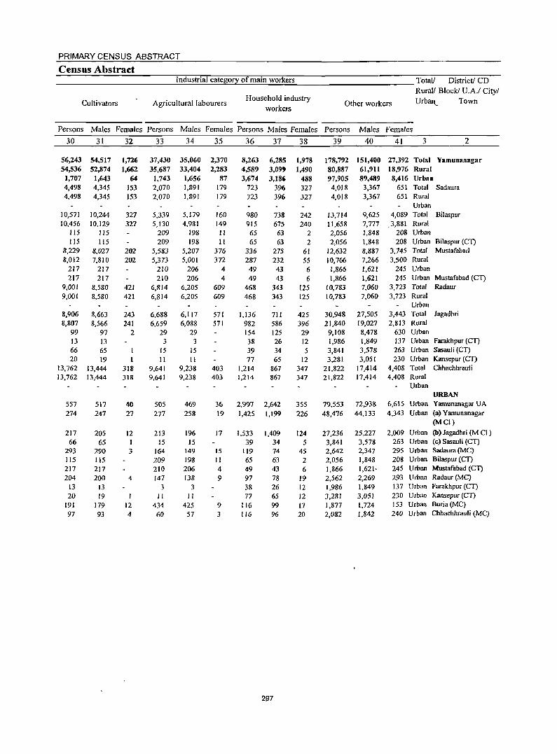
PRIMARY CENSUS ABSTRACT
Census Abstract ____________ _:I:;_nd::;::u:::s;,::tr;,::ia:::'_;;c=at::;e,£go::;::f:...<y_;o::.:f_:m::;a:::i.:.::n_:w.:_:o:.:.rk:::e:.:.r::_s ___________ - Total! District! CD
Cultivators Agricultural labourers Household industry
workers
RuralJ Block! U.AJ City!
Other workers Urb!Ul._ Town
Persons Males Females Persons Males Females Persons Males Females Persons Males Females
30
56,243 54,536
1,707 4,498 4,498
10,571 10,456
115
115 8,229 8,012
217 217
9,001 9,001
8,906 8,807
99 13 66 20
13,762 13,762
557 274
217 66
293 115 217 204
13 20
191 97
31
54,517 52,874
1,643 4,345 4,345
10,244 10,129
115 115
8,027 7,810
217 217
8,580 8,580
8,663 8,566
97 13 65 19
13,444 13,444
517 247
205 65
290 115 217 200
13 19
179 93
32
1,726 1,662
64 153 153
327 327
202 202
421 421
243 241
2
1
318 318
40 27
t2 I 3
4
12 4
33
37,430 35,687
1,743 2,070 2,070
5,339 5,130
209 209
5,583 5,373
210 210
6,814 6,814
6,688 6,659
29 3
15 II
9,641 9,641
505 277
213 IS
164 209 210 147
3 II
434 60
34
35,060 33,404
1,656 1,891 1,891
5,179 4,981
198 198
5,207 5,001
206 206
6,205 6,205
6,117 6,088
29 3
15 II
9,238 9,238
469 258
196 15
149 198 206 138
3 II
425 57
35
2,370 2,283
87 179 179
160 149 II 11
376 372
4 4
609 609
571 571
403 403
36 19
17
15 II 4 9
9 3
36
8,263 4,589 3,614
723 723
980 915 65 65
336 287 49 49
468 468
1,136 982 154 38 39 77
1,214 1,214
37
6,285 3,099 3,186
396 396
738 675 63 63
275 232 43 43
343 343
711 586 125 26 34 65
867 867
2,997 2,642 1,425 1,199
1,533 39
119
65 49 97 38 77
116 116
1,409 34 74 63 43 78 26 65 99 96
38
1,978 1,490
488 327 327
242 240
2 2
61 55 6 6
125 125
425 396 29 12 5
12 347 347
355 226
124 5
45 2 6
19 12 12 17 20
39
178,792 80,887 97,905 4,018 4,018
13,714 11,658 2,056 2,056
12,632 10,766 1,866 1,866
10,783 10,783
30,948 21,840
9,108 1,986 3,841 3,281
21,822 21,822
79,553 48,476
27,236 3,841 2,642 2,056 1,866 2,562 1,986 3,281 1,877 2,082
40
151,400 61,911 89,489
3,367 3,367
9,625 7.777 1,848 1,848 8,887 7,266 1,621 1,621 7,060 7,060
27,505 19,027 8,478 1,849 3,578 3,051
17,414 17,414
72,938 44,133
25,227 3,578 2,347 1,848 1,621' 2,269 1,849 3,051 1,724 1,842
41 3 2
27,392 Total Yamunanagar 18,976 Rural 8,416 Urban
651 Total Sadaura 651 Rural
Urban 4,089 Total Bilaspur
3,881 Rural 208 Urban 208 Urban Bi1aspur (eT)
3,745 Total Mustafabad 3,500 Rural
245 Urban 245 Urban Mustafabad (eT)
3,723 Total Radaur 3,723 Rural
Vrl>an 3,443 Total Jagadhri 2,813 Rural
630 Urban 137 Url>an Farakhpur (CT) 263 Urban Sasauli (CT) 230 Urban Kansepur (CT)
4,408 Total Chhachhrauli 4,408 Rural
Urban URBAN
6,615 Urban Yamunanagar UA 4,343 Urban (a) Yamunanagar
(Mel)
2,009 Urban (b) Jagadhri (M el ) 263 Urban (c)Sasauli (CT) 295 Urban Sadaura (MC) 208 Urban Bilaspur (CI) 245 Urban Mustafabad (eT) 293 Urban Radaur (Me) 137 Urban Farakhpur (eT) 230 Urban Kansepur (CT) 153 Urban Buria (Me) 240 Urban Chhachhrauli (MC)
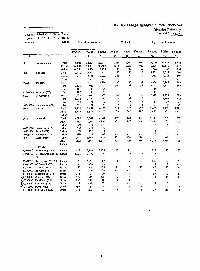
DISTRICT CENSUS HANDBOOK: YAMUNANAGAR
District Primary Location District! CD Block! Total/ Industrial cateB0!2:
code U.A.I City! Town Rural/
number Urban Marginal workers Cultivators Agricultural labourers
Persons Males Females Persons Males Females Persons Males Females
1 2 3 42 43 44 45 46 47 48 49 50
03 Yamunanagar Total 55,805 33,027 22,778 2,458 1,414 1,0« 17,040 11;984 5,056
Rural 44,851 24,491 20,3<i0 2,359 1.)77 982 16,536 11,619 4,917
Urban 10,954 8,536 2,418 99 37 62 504 365 139
0001 Sad aura Total 3,970 2,358 1,612 263 146 117 1,533 1,024 509 Rural, 3,970 2,358 1,612 263 146 117 1,533 1,024 509 Urban
0002 Bilaspur Total 7,724 4,208 3,516 300 168 132 2,486 2.146 340 Rural 7,536 4,059 3,477 300 168 132 2,472 2,132 340 Urban 188 149 39 14 14
40302000 Bilaspur (CT) Urban 188 149 39 14 14
0003 Mustafabad Total 5,277 3,625 1,652 188 100 88 2,319 1,920 399 Rural 5,036 3,454 1,582 181 95 86 2,262 1,890 372 Urban 241 171 70 7 5 2 57 30 27
40303000 Mustafabad (CT) Urban "241 171 70 7 S' 2 57 30 27
0004 Radaur Total 8,262 3,687 4,575 639 342 297 3,460 1,932 1,528 Rural 8,262 3,687 4,575 639 342 297 3,460 1,932 1,528 Urban
0005 Jagadhri Total 9,715 5,568 4,147 302 168 134 2,500 1,737 763 Rural 8,785 4,790 3,995 301 167 134 2,494 1,731 763 Urban 930 778 152 6 6
40305000 Farakhpur (C1) Urban 282 242 40
40308000 Sasauli (C1) Urban 169 126 43 1
40309000 Kansepur (CT) Urban 479 410 69 5 5
0006 Chhachhrauli Total 11,262 6,143 5,119 675 459 216 4,315 2,910 1,405 Rural 11,262 6,143 5,119 675 459 216 4,315 2,910 1,405 Urban
URBAN 50030000 Yarnunanagar UA Urban 7,919 6,440 1,479 17 II 6 218 193 25 50030100 (a) Yarnunanagar (M Urban 4,630 3,763 867 II 8 3 90 85 5
CI)
50030200 (b) J agadhri (M CI ) Urban 3,120 2,551 569 6 3 3 127 107 20 50030300 (c) Sasauli (CT) Urban 169 126 43 40301000 Sadaura (Me) Urban 763 468 295 39 9 30 86 53 33
40302000 Bilaspur (eT) Urban 188 149 39 14 14 40303000 Mustafabad (Cn Urban 241 171 70 7 5 2 57 30 27
U:0304000 Radaur (MC) Urban 575 349 226 10 4 6 73 38 35
~0305000 Farakhpur (CT) Urban 282 242 40 1 0309000 Kansepur (CT) Urban 479 410 69 5 5
"~0310000 Buria(MC) Urban 193 85 108 20 5 15 14 9 5 40311000 Chhachhrauli (MC) Urban 314 222 92 5 2 3 37 23 14
298
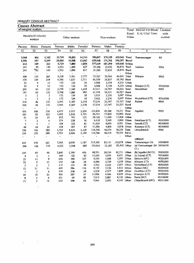
PRIMARY CENSUS ABSTRACT
Census Abstract of marBinal workers Total! District! CD Block! Location
Household industry Rural/ U.A.! City/ Town code
Other workers Non-workers Urban number workers
Persons Males Females Persons Males Females Persons Males Females
51 52 53 54 55 56 57 58 59 3 2
2.568 806 1,762 33,739 18,823 14.916 705,097 279,155 425,942 Total Yamunanagar 03 1.956 557 1,399 24,000 10,938 13.062 428.058 171,761 256,297 Rural
612 249 363 9,739 7,885 1,854 277,039 107,394 169,645 Urban 241 92 149 1,933 1,096 837 31,506 12,632 18,874 Total Sadaura 0001 241 ~92 149 1,933 1,096 837 31,506 12,632 18,874 Rural
Urban
400 133 267 4,538 1,761 2,777 73,567 29,566 44,001 Total Bilaspur 0002 378 124 254 4,386 1,635 2,751 66,579 26,837 39,742 Rural
22 9 13 152 126 26 6,988 2,729 4,259 Urban
22 9 13 152 126 26 6,988 2,729 4,259 Urban Bilaspur (CT) 40302000 200 65 135 2,570 1,540 1,030 67,411 26,787 40,624 Total Mustafabad 0003
195 63 132 2,398 1,406 992 61,478 24,551 36,927 Rural
5 2 3 172 134 38 5,933 2,236 3,697 Urban
5 2 3 172 134 38 5,933 2,236 3,697 Urban Mustafabad (Cn 40303000
218 46 172 3,945 1,367 2,578 57,274 23,747 33,527 Total Radaur 0004
218 46 172 3,945 1,367 2,578 57,274 23,747 33,527 Rural Urban
436 106 330 6,477 3,557 2,920 123,839 49,488 74,351 Total Jagadhri 0005
385 82 303 5,605 2,810 2,795 94,713 37,820 56,893 Rural
51 24 27 872 747 125 29,126 11,668 17,458 Urban
7 3 4 274 238 36 6,'H8 2,569 3,849 Urban Farakhpur (Cl) 40305000
4 3 I 164 122 42 11,624 4,693 6,931 Urban Sasauli (Cl) 40308000
40 18 22 434 387 47 11,084 4,406 6,678 Urban Kansepur (CT) 40309000
539 150 389 5,733 2,624 3,109 116,508 46,174 70,334 Total Chhachhrauli 0006
539 150 389 5,733 2,624 3,109 116,508 46,174 70,334 Rural Urban
URBAN 439 178 261 7,245 6,058 1,187 215,209 83,131 132,078 Urban Yamunanagar UA 50030000
296 126 170 4,233 3,544 689 134,614 52,182 82,432 Urban (a) Yamunanagar (M 50030100 CI)
139 49 90 2,848 2,392 456 68,971 26,256 42,715 Urban (b) J agadhri (M CI ) 50030200
4 3 164 122 42 11,624 4,693 6,931 Urban (c) Sasau1i (Cl) 50030300
22 13 9 616 393 223 9,195 3,608 5,587 Urban Sad aura (MC) 40301000
22 9 13 152 126 26 6,988 2,729 4,259 Urban Bilaspur (CT) 40302000
5 2 3 172 134 38 5,933 2,236 3,697 Urban Mustafabad (eT) 40303000
52 21 31 440 286 154 8,152 3,136 5,016 Urban Radaur(MC) 40304000
7 3 4 274 238 36 6,418 l-,5f:fJ 3,849 Urban Farakhpur (Cn 40305000
40 18 22 434 387 47 11,084 4,406 6,678 Urban Kansepur (CT) 40309000
8 2 6 151 69 82 7,019 2,887 4,132 Urban Buria (Me) 40310000
17 3 14 255 194 61 7,041 .2,692 4,349 Urban Chhachhrauli (MC) 40311000
299

DISTRICT CENSUS HAND BOOK: YAMUNANAGAR APPENDIX TO DISTRICT PRIMARY CENSUS ABSTRACT
TOTAL, SCHEDULED CASTES AND SCHEDULED TRIBES POPULATION - URBAN BLOCK WISE Location Code Name of town Name of ward Boundaries of Total Scheduled Scheduled
urban block I EB population Castes Tribes number popUlation population
2 3 4 5 6 7 40301000 Sadaura (MC) Ward No. I EBNo. I 428 40301000 Sadaura (MC) Ward No. I EB No.2 426 4 40301000 Sadaura (MC) Ward No.2 EB No.3 524 40301000 Sadaura (MC) Ward No.2 EB No.4 353 9 40301000 Sadaura (MC) Ward No.3 EB No.5 941 40301000 Sadaura (MC) Ward No. 4 EB No.6 262 5 40301000 Sadaura (MC) Ward No. 4 EB No.7 659 165 4030 I 000 Sadaura (MC) Ward No.5 EB No.8 710 190 4030 I 000 Sadaura (MC) Ward No.5 EB No.9 489 88 40301000 Sadaura(MC) Ward No. 6 EB No. 10 508 20 40301000 Sadaura (MC) Ward No.6 EBNo. II 882 586 40301000 Sadaura (MC) Ward No.7 EB No. 12 881 4030 I 000 Sadaura (MC) Ward No. 8 EB No. 13 736 21 40301000 Sadaura (MC) Ward No. 9 EB No. 14 443 40301000 Sadaura (MC) Ward No. 9 EB No. 15 504 9 40301000 Sadaura (MC) Ward No. 10 EBNo.16 678 171 4030 I 000 Sadaura (MC) Ward No. 10 EB No. 17 350 30 40301000 Sadaura(MC) Ward No. II EB No. 18 409 24 40301000 Sadaura(MC) Ward No. II EB No. 19 468 48 40301000 Sadaura (MC) Ward No. 12 EB No. 20 415 40301000 Sadaura (MC) Ward No. 12 EB No. 21 496 256 40301000 Sadaura (MC) Ward No. 13 EB No. 22 1,119 528 40301000 Sadaura (MC) Ward No. 13 EBNo.23 495 415 40302000 Bilaspur (CT) Ward No. I EBNo.l 779 328 40302000 Bilaspur (Cn Ward No. I EB No.2 701 665 40302000 Bilaspur (cD Ward No. 1 EBNo.3 683 683 40302000 Bilaspur (CT) Ward No. I EB No.4 773 476 40302000 Bilaspur (CT) Ward No. I EB No.5 717 102 40302000 Bilaspur (CT) Ward No. I EBNo.6 777 112 40302000 Bilaspur (CT) Ward No. I EB No.7 739 342 40302000 Bilaspur (Cn Ward No. 2 EBNo.8 992 175 40302000 ~ilaspur (CT) Ward No. 2 EB No.9 460 40302000 Bilaspur (CT) Ward No. 2 EB No. 10 790 5 40302000 Bilaspur (CT) Ward No. 2 EBNo.l1 974 40302000 Bilaspur (CT) Ward No. 2 EBNo.12 534 2) 40302000 Bilaspur (Cn Ward No. 2 EB No. 13 702 28 40303000 Mustafabad (Cn Ward No. I EBNo. I 508 232 40303000 Mustafabad (CT) Ward No. I EB No.2 689 51 40303000 Mustafabad (CT) Ward No. 1 EB No.3 953 153 40303000 Mustafabad (CT) Ward No. I EB No.4 445 9 40303000 Mustafabad (CT) Ward No. I EB No.5 616 108 40303000 Mustafabad (CT) Ward No. I EB No.6 722 221 40303000 Mustafabad (CT) Ward No. I EB No.7 341 40303000 Mustafabad (CT) Ward No. 2 EBNo.8 765 . 72 40303000 Mustafabad (CT) Ward No.2 EB No.9 660 225 40303000 Mustafabad (CT) Ward No.2 EB No. 10 427 73 40303000 Mustafabad (CT) Ward No.2 EBNo. II 909 338 40303000 Mustafabad (CT) Ward No.2 EB No. 12 905 265 40303000 Mustafabad (CT) Ward No.2 EB No. 13 576 400
300
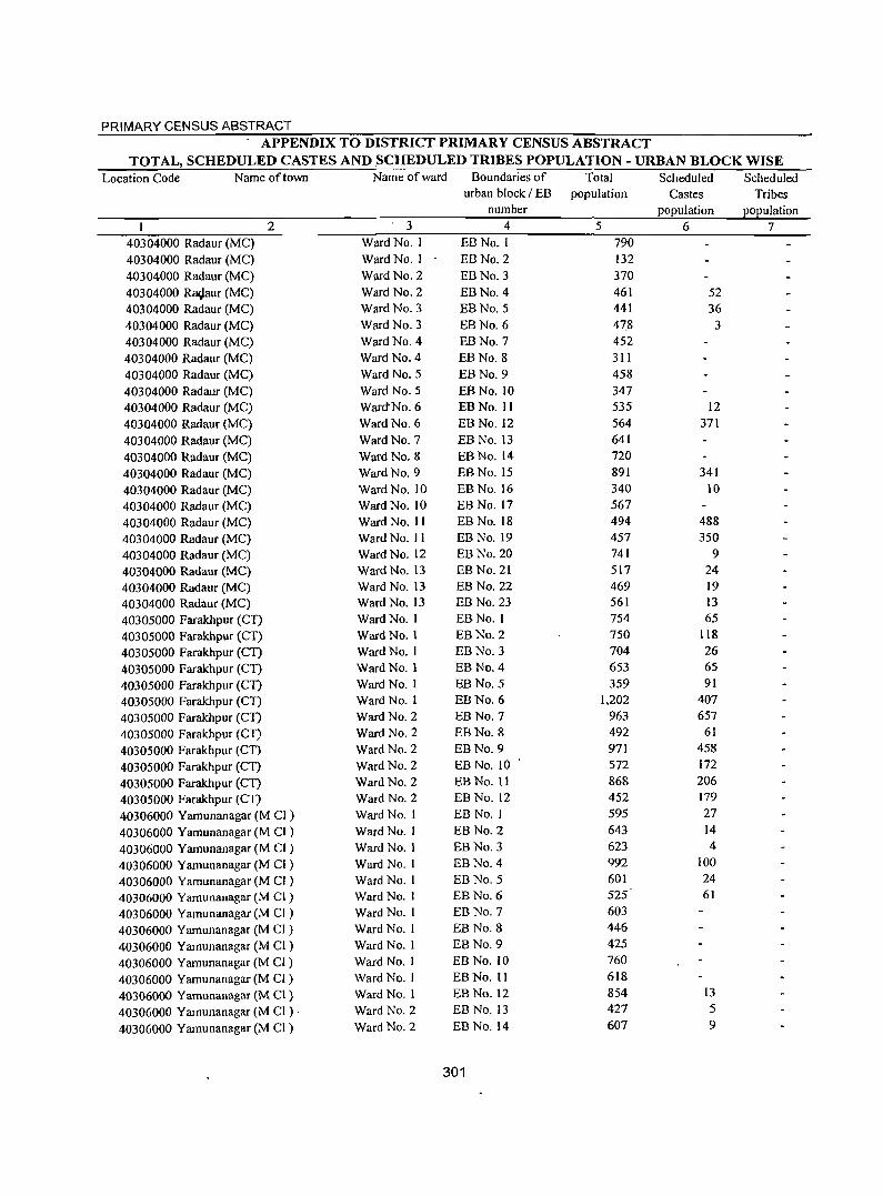
PRIMARY CENSUS ABSTRACT APPENDIX TO DISTRICT PRIMARY CENSUS ABSTRACT
TOTAL, SCHEDULED CASTES AND SCHEDULED TRIBES POPULA nON - URBAN BLOCK WISE Location Code Name of town Name of ward Boundaries of Total Scheduled Scheduled
urban block / EB population Castes Tribes number population popUlation
2 3 4 5 6 7 40304000 Radaur (MC) Ward No. I EBNo.1 790 40304000 Radaur (MC) Ward No. I EB No.2 132 40304000 Radaur(MC) Ward No. 2 EBNo.3 370 40304000 Ra9aur(MC) Ward No. 2 EBNo.4 461 52 40304000 Radaur (MC) Ward No.3 EBNo.5 441 36 40304000 Radaur(MC) Ward No. 3 EBNo.6 478 3 40304000 Radaur (MC) Ward No. 4 EBNo.7 452 40304000 Radaur (MC) Ward No. 4 EB No.8 311 40304000 Radaur (MC) Ward No.5 EBNo.9 458 40304000 Radaur(MC) Ward No. 5 EBNo.1O 347 40304000 Radaur(MC) Ward-No.6 EBNo. II 535 12 40304000 Radaur (MC) Ward No. 6 EB No. 12 564 371 40304000 Radaur (MC) Ward No. 7 EB No. 13 641 40304000 Radaur(MC) Ward No. 8 EBNo.14 720 40304000 Radaur (MC) Ward No. 9 EBNo.15 891 341
40304000 RadaurCMC) Ward No. 10 EB No. 16 340 10 40304000 Radaur (MC) Ward No. 10 EB No. 17 567
40304000 Radaur (MC) Ward No. II EB No. 18 494 488 40304000 Radaur (MC) Ward No. II EB No. 19 457 350 40304000 Radaur (MC) Ward No. 12 EB No. 20 741 9 40304000 Radaur (MC) Ward No. 13 EB No. 21 517 24 40304000 Radaur(MC) Ward No. 13 EB No. 22 469 19 40304000 Radaur(MC) Ward No. 13 EB No. 23 561 13
40305000 Farakhpur (CT) Ward No. I EBNo.1 754 65 40305000 Farakhpur (CT) Ward No.1 EB No.2 750 118
40305000 Farakhpur (CT) Ward No. I EB No.3 704 26
40305000 Farakhpur (CT) Ward No.1 EBNo.4 653 65
40305000 Farakhpur (CT) Ward No. I EBNo.5 359 91 40305000 Farakhpur (CT) Ward No.1 EBNo.6 1,202 407
40305000 Farakhpur (CT) Ward No.2 EB No.7 963 657
40305000 Farakhpur (CT) Ward No.2 EB No.8 492 61
40305000 Farakhpur (CT) Ward No.2 EB No.9 971 458
40305000 Farakhpur (CT) Ward No.2 EB No. 10 ' 572 172
40305000 Farakhpur(CT) Ward No. 2 EB No. II 868 206
40305000 Farakhpur (CT) Ward No. 2 EB No. 12 452 179
40306000 Yamunanagar (M CI) Ward No.1 EBNo.1 595 27
40306000 Yamunanagar (M Cl) Ward No. I EB No.2 643 14
40306000 Yamunanagar (M CI) Ward No.1 EB No.3 623 4
40306000 Yamunanagar (M CI) Ward No. I EB No.4 992 100
40306000 Yamunanagar (M CI ) Ward No. 1 EBNo.5 601 24
40306000 Yamunanagar (M CI ) Ward No. I EBNo.6 525 61
40306000 Yamunanagar (M CI ) Ward No. I EB No.7 603
40306000 Yamunanagar (M CI) Ward No. I EBNo.8 446
40306000 Yamunanagar (M CI) Ward No. I EB No.9 425
40306000 Yamunanagar (M CI) Ward No.1 EBNo. ro 760
40306000 Yamunanagar (M CI) Ward No. I EBNo.11 618
40306000 Yamunanagar (M CI) Ward No.1 EB No. 12 854 13
40306000 Yamunanagar (M CI ) . Ward No.2 EB No. 13 427 5
40306000 Yamunanagar (M CI) Ward No. 2 EB No. 14 607 9
301
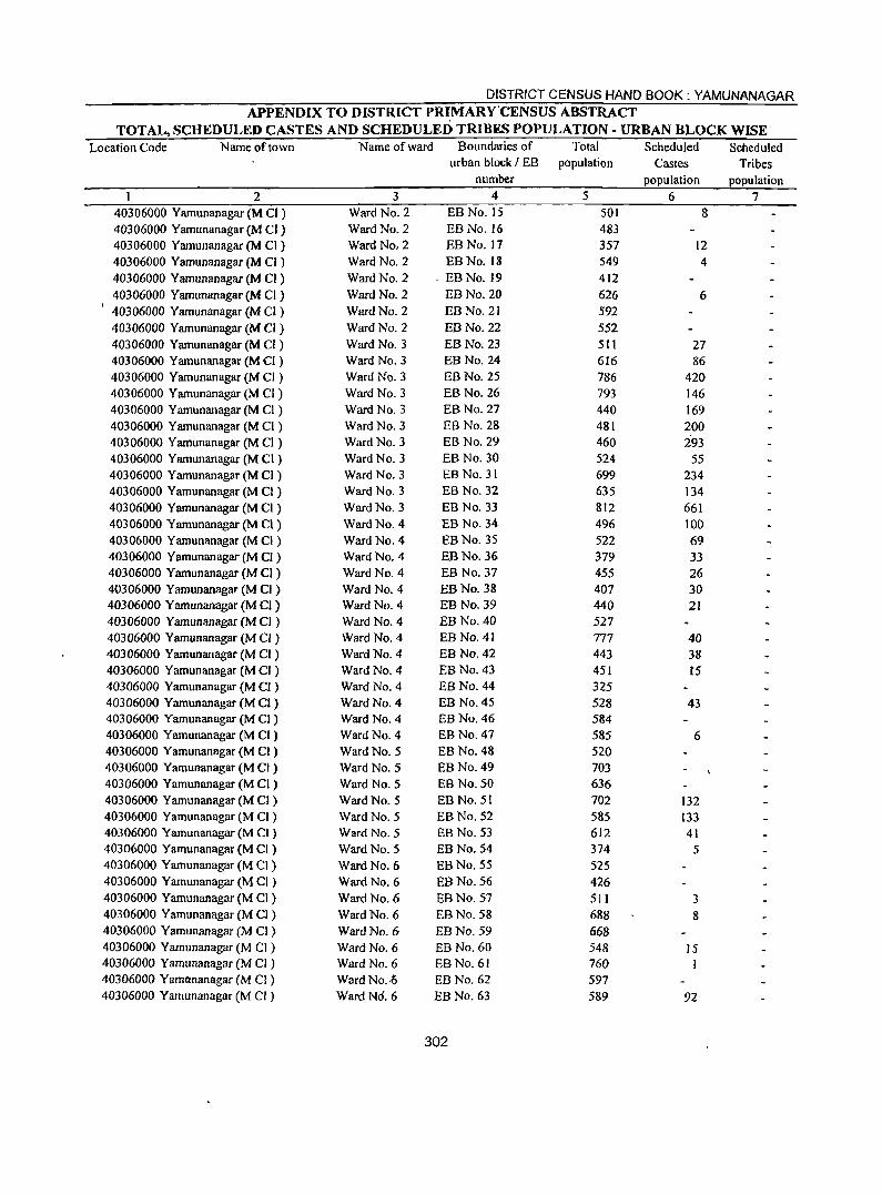
DISTRICT CENSUS HAND BOOK: YAMUNANAGAR APPENDIX TO DISTRICT PRIMARY'CENSUS ABSTRACT
TOTAL, SCHEDULED CASTES AND SCHEDULED TRIBES POPULATION - URBAN BLOCK WISE Location Code Name of town Name of ward Boundaries of Total Scheduled Scheduled
urban block I EB population Castes Tribes number population population
2 3 4 5 6 7 40306000 Yamunanagar (M Cl) Ward No. 2 EB No. IS SOl 8 40306000 Yamunanagar (M CI ) Ward No. 2 EB No. 16 483 40306000 Yamunanagar (M CI ) Ward No, 2 EB No. 17 357 12 40306000 Yamunanagar (M CI ) Ward No. 2 EBNo.18 549 4 40306000 Yamunanagar (M CI ) Ward No. 2 . EBNo.19 412 40306000 Yamunanagar (M Cl ) Ward No. 2 EBNo.20 626 6 40306000 Yamunanagar (M CI ) Ward No. 2 EBNo.21 592 40306000 Yamunanagar (M Cl ) Ward No. 2 EBNo.22 552 40306000 Yamunanagar (M Cl ) Ward No.3 EB No. 23 511 27 40306000 Yamunanagar (M CI ) Ward No. 3 EBNo.24 616 86 40306000 Yamunanagar (M CI ) Ward No.3 EB No. 25 786 420 40306000 Yamunanagar (M CI ) Ward No.3 EB No. 26 793 146 40306000 Yamunanagar (M Cl ) Ward No.3 EB No. 27 440 169 40306000 Yamunanagar (M Cl ) Ward No.3 EB No. 28 481 200 40306000 Yamunanagar (M Cl ) Ward No.3 EB No. 29 460 293 40306000 Yamunanagar (M Cl ) Ward No.3 EB No. 30 524 55 40306000 Yamunanagar (M CI ) Ward No. 3 EB No. 31 699 234 40306000 Yamunanagar (M Cl) Ward No.3 EB No. 32 635 134 40306000 Yamunanagar (M Cl) Ward No. 3 EB No. 33 812 661 40306000 Yamunanagar (M C1 ) Ward No.4 EB No. 34 496 100 40306000 Yamunanagar (M CI ) Ward No. 4 EB No. 35 522 69 40306000 Yamunanagar (M CI) Ward No. 4 EB No. 36 379 33 40306000 Yamunanagar (M CI) Ward No.4 EBNo.37 455 26 40306000 Yamunanagar (M CI) Ward No. 4 EB No. 38 407 30 40306000 Yamunanagar (M CI) Ward No. 4 EB No. 39 440 21 40306000 Yamunanagar (M CI) Ward No. 4 EB No. 40 527 40306000 Yamunanagar (M CI) Ward No. 4 EB No. 41 777 40 40306000 Yamunanagar (M a) Ward No. 4 EB No. 42 443 38 40306000 Yamunanagar (M CI) Ward No. 4 EBNo.43 451 15 40306000 Yamunanagar (M CI ) Ward No. 4 EB No. 44 325 40306000 Yamunanagar (M CI ) Ward No. 4 EB No. 45 528 43 40306000 Yamunanagar (M CI ) Ward No. 4 EB No. 46 584 40306000 Yamunanagar (M CI) Ward No. 4 EB No. 47 585 6 40306000 Yamunanagar (M CI ) Ward No. 5 EB No. 48 520 40306000 Yamunanagar (M CI) Ward No. 5 EB No. 49 703 40306000 Yamunanagar (M CI) Ward No. 5 EB No. 50 636 40306000 Yamunanagar (M CI) Ward No. 5 EB No. 51 702 132 40306000 Yamunanagar (M Cl ) Ward No. 5 EB No. 52 585 133 40306000 Yamunanagar (M CI ) Ward No. 5 EB No. 53 612 41 40306000 Yamunanagar (M CI ) Ward No. 5 EBNo.54 374 5 40306000 Yamunanagar (M CI ) Ward No. 6 EB No. 55 525 40306000 Yamunanagar (M CI) Ward No. 6 EB No. 56 426 40306000 Yamunanagar (M CI ) Ward No. 6 EB No. 57 511 3 40306000 Yamunanagar (M CI ) Ward No. 6 EB No. 58 688 8 40306000 Yamunanagar (M CI) Ward No. 6 EBNo.59 668 40306000 Yamunanagar (M CI ) Ward No. 6 EB No. 60 548 15 40306000 Yamunanagar (M CI ) Ward No.6 EB No. 61 760 I 40306000 Yamflnanagar eM CI ) Ward No .. Q EB No. 62 597 40306000 Yamunanagar eM CI ) WardN6.6 EB No. 63 589 92
302
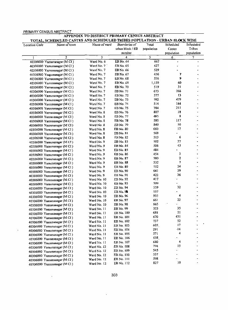
PRIMARY CENSUS ABSTRACT APPENDIX TO DISTRICT PRIMARY CENSUS ABSTRACT
TOTAL, SCHEDULED CASTES AND SCHEDULED TRIBES POPULATION - URBAN BLOCK WISE Location Code Name of town Name of ward Boundaries of Total Scheduled Scheduled
urban block / EB population Castes Tribes number population population
2 3 4 5 6 7
40306000 Yamunanagar (M CI) Ward No. 6 EBNo.64 667
40306000 Yamunanagar (M Cf ) Ward No. 7' EBNo.65 427
40306000 Yamunanagar (M CI) Ward No.7 EBNo.66 529
40306000 YaP,lunanagar (M Cf ) Ward No. 7 EBNo.67 456 7
40306000 Yamunanagar (M CI ) Ward No. 7 EBNo.68 536 9 40306000 Yarnunanagar (M Cf) Ward No. 7 EBNo.69 1,159 60
40306000 Yarnunanagar (M CI ) Ward NO.7 EBNo.70 519 31
40306000 Yarnunanagar (M CI) Ward No. 7 EBNo.71 673 266
40306000 Yamunanagar (M CI ) Ward No. 7 EBNo.72 577 13
40306000 Yamunanagar (M CI) Ward No. 7 EBNo.73 592 479
40306000 Yamunanagar(M CI) Ward No. 7 EBNo.74 514 144
40306000 Yamunanagar(M CI) Ward No. 7 EBNo.75 384 21 t
40306000 Yamunanagar (M CI ) Ward No. 8 EBNo.76 807 18
40306000 Yamunanagar (M CI) Ward No. 8 EBNo.77 ~5 8
40306000 Yamunanagar (M CI) Ward No. 8 EBNo.78 585 117
40306000 Yamunanagar (M CI) Ward No. 8 EBNo.79 840 10
40306000 Yamunanagar (M CI ) Ward No. 8 EBNo.80 660 17
40306000 Yamunanagar (M CI ) Ward No. 8 EB No. 81 569
40306000 Yamunanagar (M CI) Ward No. 8 EBNo.82 513 6
40306000 Yamunanagar (M Cf ) Ward No. 9 EBNo.83 502 27
40306000 Yamunanagar (M CI ) Ward No, 9 EBNo.84 506 43
40306000 Yamunanagar (M Cf) Ward No. 9 EBNo.85 484
40306000 Yamunanagar (M CI ) Ward No. 9 EBNo.86 454 3
40306000 Yamunanagar (M CI) Ward No. 9 EBNo.87 580 2
40306000 Yamunanagar (M CI ) Ward No. 9 EBNo.88 532 7
40306000 Yamunanagar (M CI ) Ward No. 9 EBNo.89 552 24
40306000 Yamunanagar (M CI ) Ward No. 9 EBNo.90 641 29
40306000 Yamunanagar (M Cf) Ward No. 9 EB No. 91 422 36
40306000 Yamunanagar (M CI ) Ward No. 10 EBNo.92 417
40306000 Yamunanagar(M CI) Ward No. 10 EBNo.93 509
40306000 Yamunanagar (M CI) Ward No. 10 EBNo.94 559 32
40306000 Yamunanagar (M Cf) Ward No. 10 EBNo.9' 537
40306000 Yamunanagar (M Cf) Ward No. 10 EBNo.96 935 4
40306000 Yamunanagar (M CI) Ward No. 10 EBNo.97 661 22
40306000 Yamunanagar (M CI) Ward No. 10 EBNo.98 665
40306000 Yamunanagar (M CI ) Ward No. II EBNo.99 323 35
40306000 Yamunanagar (M CI) Ward No. II EBNo.IOO 681 21
40306000 Yamunanagar (M CI ) Ward No. II EBNo.101 670 431
40306000 Yamunanagar (M CI ) Ward No. 11 EBNo.102 737 52
40306000 Yamunanagar (M Cl ) Ward No. 11 EBNo.103 605 17
40306000 Yamunanagar (M CI ) Ward No. II EB No. 104 291 ·14
40306000 Yamunanagar (M Cf ) Ward No. II EB No. 105 571 4
40306000 Yamunanagar (M CI) Ward No. II EB No. 106 638
40306000 Yamunanagar (M CI) Ward No. II EB No. 107 680 4
40306000 Yamunanagar (M Cf ) Ward No. 12 EB No. 108 794 15
40306000 Yamunanagar (M CI) Ward No. 12 EBNo.109 545
40306000 Yamunanagar (M CI) Ward No. 12 EB No. 110 537
40306000 Yamunanagar (M CI) Ward No. 12 EB No. 11 J 598
40306000 Yamunanagar (M CI) Ward No. 12 EB No. 112 827 10
303
DISTRICT CENSUS HAND BOOK: YAMUNANAGAR APPENDIX TO DISTRICT PRIMARY CENSUS ABSTRACT
TOTAL, SCHEDULED CASTES AND SCHEDULED TRIBES POPULATION - URBAN BLOCK WISE Location Code Name of town Name of ward Boundaries of Total Scheduled Scheduled
urban block I EB population Castes Tribes number population population
2 3 4 5 6 7 40306000 Yamunanagar (M CI) Ward No. 12 EB No. 113 349 75 40306000 Yamunanagar (M CI) Ward No. 12 EB No.1 14 621 196 40306000 Yamunanagar (M CI ) Ward No. 12 EBNo.115 386 45 40306000 Yamunanagar (M CI ) Ward No. 13 EBNo.116 497 40306000 Yamunanagar (M CI ) Ward No. 13 -BB No.1 17 713 40306000 Yamunanagar (M CI ) Ward No. 13 EBNo.1I8 448 40306000 Yamunanagar (M Cl) Ward No. 13 EB No. 119 399 86 40306000 Yamunanagar (M CI) Ward No. 13 EB No. 120 7)) 40306000 Yamunanagar (M CI) Ward No. 13 EBNo.121 496 40306000 Yamunanagar (M Cl ) Ward No. 13 EB No. 122 489 4 40306000 Yamunanagar (M CI ) Ward No. 13 EBNo.123 640 3 40306000 Yamunanagar (M Cl ) Ward No. 14 EB No. 124 656 40306000 Yamunanagar (M Cl) Ward No. 14 EBNo.125 574 3 40306000 Yamunanagar (M CI ) Ward No. 14 EB No. 126 578 40306000 Yamunanagar (M CI) Ward No. 14 EB No. 127 581 5 40306000 Yamunanagar (M CI ) Ward No. 14 EB No. 128 732 40306000 Yamunanagar (M CI ) Ward No. 14 EB No. 129 590 1 40306000 Yamunanagar (M CI ) Ward No. 14 EB No. 130 512 6 40306000 Yamunanagar (M CI ) Ward No. 14 EB No. 131 540 14 40306000 Yamunanagar (M CI) Ward No. 15 EB No. 132 416 17 40306000 Yamunanagar (M CI) Ward No. 15 EB No. 133 627 40306000 Yamunanagar (M CI ) Ward No. 15 EB No. 134 641 20 40306000 Yamunanagar (M CI) Ward No. 15 EB No. 135 576 22 40306000 Yamunanagar (M CI ) Ward No. 15 EB No. 136 435 30 40306000 Yamunanagar (M CI) Ward No. 15 EB No. 137 640 40306000 Yamunanagar (M CI ) Ward No. IS EB No. 138 598 13 40306000 Yarnunanagar (M CI ) Ward No. 15 EB No. 139 4&4 40306000 Yamunanagar (M CI ) Ward No. 15 EB No. 140 561 40306000 Yamunanagar (M CI ) Ward No. 15 EB No. 141 620 55 40306000 Yamunanagar (M CI ) Ward No. 15 EB No. 142 418 40306000 Yamunanagar (M CI ) Ward No. IS EBNo.143 636 40306000 Yamunanagar (M CI) Ward No. 15 EB No. 144 652 40306000 Yamunanagar (M CI ) Ward No. 15 EBNo.145 565 40306000 Yamunanagar (M CI ) Ward No. 15 EB No. 146 694 31 40306000 Yamunanagar (M CI ) Ward No. 16 EB No. 147 420 19 40306000 Yamunanagar (M CI ) Ward No. 16 BBNo.148 467 2 40306000 Yarnunanagar (M CI ) Ward No. 16 EB No. 149 475 5 40306000 Yamunanagar (M CI) Ward No. 16 EB No. 150 441 40306000 Yamunanagar (M CI) Ward No. 16 EB No. lSI 477 88 40306000 Yamunanagar (M CI) Ward No. 16 EB No. 152 539 73 40306000 Yamunanagar (M CI ) Ward No. 16 EB No. 153 608 52 40306000 Yamunanagar (M CI ) Ward No. l6 EB No. 154 658 34 40306000 Yamunanagar (M Cl) Ward No. 16 EB No. 155 751 59 40306000 Yamunanagar (M C[ ) Ward No. 16 EB No. 156 546 37 40306000 Yamunanagar (M CI) Ward No. 16 EBNo.157 512 40306000 Yamunanagar (M C[ ) Ward No. 16 EB No. 158 393 12 40306000 Yamunanagar (M C[) Ward No. 16 EB No. 159 836 34 40306000 Yamunanagar (M CI) Ward No. 16 EB No. 160 497 2{ 40306000 Yamunanagar (M CI) Ward No. 16 EBNo.161 578 22
304

PRIMARY CENSUS ABSTRACT APPENDIX TO DISTRICT PRIMARY CENSUS ABSTRACT
TOTAL, SCHEDULED CASTES AND SCHEDULED TRIBES POPULATION - URBAN BLOCK WISE Location Code Name of town Name of ward Boundaries of Total Scheduled Scheduled
urban block / EB population Castes Tribes number population population
2 3 4 5 6 7 40306000 Yamunanagar (M CI) Ward No. 16 EBNo.162 766 46 40306000 Yamunanagar (M CI) Ward No. 17' EB.No.163 434 40306000 Yamunanagar (M CI ) Ward No. 17 EB No. 164 566 40306000 Y lYJ1unanagar (M CI ) Ward No. 17 EB No. 165 448
40306000 Yamunanagar (M CI) Ward No. 17 EB No. 166 755 40306000 Yamunanagar (M CI) Ward No. 17 EB No. 167 450 22 40306000 Yamunanagar (M CI) Ward No. 17 EB No. 168 683 17 40306000 Yamunanagar (M CI) Ward No. 17 EB No. 169 635 40306000 Yamunanagar (M CI ) Ward No. 17 EB No. 170 485 40306000 Yamunanagar (M CI) Ward No. 17 EB No. 171 741
40306000 Yamunanagar (M CI) Ward No. 18 EB No. 172 556 18 40306000 Yamunanagar (M CI ) Ward No. 18 EB No. 173 573 10
40306000 Yamunanagar (M CI) Ward No. 18 EB No. 174 592 49
40306000 Yamunanagar (M CI ) Ward No. 18 EB No. 175 627 13
40306000 Yamunanagar (M CI) Ward No. 18 EB No. 176 617 10 40306000 Yamunanagar (M C1 ) Ward No. 18 EB No. 177 466 10 40306000 Yamunanagar (M CI ) Ward No. 18 EB No. 178 499 18 40306000 Yamunanagar (M Cl) Ward No. 18 EB No. 179 561 15 40306000 Yamunanagar (M CI) Ward No. 18 EB No. 180 595 3 40306000 Yamunanagar (M CI) Ward No. 18 EB No. 181 624 5 40306000 Yamunanagar (M CI ) Ward No. 18 EB No. 182 604 15 40306000 Yamunanagar (M Cl ) Ward No. 18 EBNo.183 573 19 40306000 Yamunanagar (M CI ) Ward No. 18 EB No. 184 506 60
40306000 Yamunanagar (M CI ) Ward No. 18 EB No. 185 790 66
40306000 Yamunanagar (M CI ) Ward No. 19 EB No. 186 537 34
40306000 Yamunanagar (M CI ) Ward No. 19 EB No. 187 701 181
40306000 Yamunanagar (M Cl ) Ward No. 19 EBNo.188 408
40306000 Yamunanagar (M CI ) Ward No. 19 EBNo.189 541 106
40306000 YamunanagaT (M CI ) Ward No. \9 EBNo.190 431 203
40306000 Yamunanagar (M CI ) Ward No: 19 EB No. 191 476 146 '-
40306000 Yamunanagar (M CI ) Ward No. 19 EB No. 192 480 45
40306000 Yamunanagar (M CI ) Ward No. 19 EB No. 193 678 173
40306000 Yamunanagar (M CI ) Ward No. 19 EB No. 194 634 55
40306000 Yamunanagar (M CI ) Ward No. 19 EBNo.195 564 17
40306000 Yamunanagar (M CI ) Ward No. 20 EB No. 196 418 164
40306000 Yamunanagar eM Cl) Ward No. 20 EB No. 197 737 151
40306000 Yamunanagar (M CI ) Ward No. 20 EBNo.198 946 52
40306000 Yamunanagar (M Cl) Ward No. 20 EB No. 199 822 39
40306000 Yamunanagar (M CI ) Ward No. 20 EB No. 200 589 80
40306000 Yamunanagar (M CI) Ward No. 20 EB No. 201 589 246
40306000 Yamunanagar (M CI ) Ward No. 20 EB No. 202 633 29
40306000 Yamunanagar (M CI ) Ward No. 20 EBNo.203 582 15
40306000 Yamunanagar (M CI ) Ward No. 20 EBNo.204 640 4
40306000 Yamunanagar (M CI ) Ward No. 20 EB No. 205 749 13
40306000 Yarnunanagar (M Cl) Ward No. 21 EB No. 206 589 57
40306000 Yamunanagar (M Cl ) Ward No. 21 EB No. 207 530 39
40306000 Yarnunanagar (M CI) Ward No. 21 EBNo.208 770 176
40306000 Yamunanagar (M Cl ) Ward No. 21 EB No. 209 614 96
40306000 Yamunanagar (M CI ) Ward No. 21 EB No. 210 769 89
305
DISTRICT CENSUS HAND BOOK: YAMUNANAGAR
APPENDIX TO DISTRICT PRIMARY CENSUS ABSTRACT TOTAL, SCHEDULED CASTES AND SCHEDULED TRIBES POPULATION - URBAN BLOCK WISE
Location Code Name of town Name of ward Boundaries of Total Scheduled Scheduled urban block I EB population Castes Tribes
number population popUlation 2 3 4 5 6 7
40306000 Yamunanagar (M Cl ) Ward No. 21 EBNo.211 690 71 40306000 Yamunanagar (M Cl ) Ward No. 21 EB No. 212 455 13
40306000 Yamunanagar (M CI ) Ward No. 21 EB No. 213 484 78 40306000 Yamunanagar (M CI ) Ward No. 21 EB No. 214 469 53
40306000 Yamunanagar (M CI ), Ward No. 21 EB No. 215 424 II 40306000 Yamunanagar (M CI ) Ward No. 22 EB No. 216 391 119 40306000 Yamunanagar (M CI ) Ward No. 22 EB No. 217 451 ,66 40306000 Yamunanagar (M CI ) Ward No. 22 EB No. 218 658 65 40306000 Yamunanagar (M CI ) Ward No. 22 EB No. 219 658 75 40306000 Yamunanagar (M CI ) Ward No. 22 EBNo.220 712 58 40306000 Yamunanagar (M CI ) Ward No. 22 EB No. 221 821 236 40306000 Yamunanagar (M CI ) Ward No. 22 EB No. 222 429 40306000 Yamunanagar (M Cl ) Ward No. 22 EB No. 223 456 11 40306000 Yamunanagar (M CI) Ward No. 22 EBNo.224 373 63 40306000 Yamunanagar (M Cl) Ward No. 22 EB No. 225 622 223 40306000 Yamunanagar (M Cl) Ward No. 22 EB No. 226 515 40306000 Yamunanagar (M Cl ) Ward No. 22 EBNo.227 591 40306000 Yamunanagar (M CI ) Ward No. 22 EB No. 228 828 95 40306000 Yamunanagar (M C1 ) Ward No. 22 EB No. 229 738 46 40306000 Yamunanagar (M CI ) Ward No. 23 EBNo.230 1,278 46 40306000 Yamunanagar eM CI) Ward No. 23 EB No. 231 735 118 40306000 Yamunanagar (M Cl) Ward No. 23 EBNo.232 752 16 40306000 Yamunanagar (M Cl ) Ward No. 23 EB No. 233 546 541 40306000 Yamunanagar (M CI) Ward No. 23 EBNo.234 657 158 40306000 Yamunanagar (M CI ) Ward No. 23 EBNo.235 730 718 40306000 Yamunanagar (M CI ) Ward No. 23 EBNo.236 537 50 40306000 Yamunanagar eM CI) Ward No. 23 EB No. 237 690 98 40306000 Yamunanagar eM C1) Ward No. 24 EB No. 238 508 29 40306000 Yamunanagar (M CI ) Ward No. 24 EB No. 239 589 20 40306000 Yamunanagar eM C1) Ward No. 24 EB No. 240 478 14 40306000 Yamunanagar (M CI) Ward No. 24 EB No. 241 418 II 40306000 Yamunanagar (M CI ) Ward No. 24 EB No. 242 600 48 40J06000 Yamunanagar (M CI ) Ward No. 24 EB No. 243 605 8
4d306000 Yamunanagar (M CI ) Ward No. 24 EB No. 244 646 17 0306000 Yamunanagar (M CI ) Ward No. 24 EB No. 245 707 117
.'0306000 Yamunanagar (M CI ) Ward No. 24 EBNo.246 662 48 40306000 Yamunanagar (M CI) Ward No. 24 EBNo.247 765 19 40306000 Yamunanagar (M CI ) Ward No: 25 EBNo.248 800 61 40306000 Yamunanagar eM CI) Ward No. 25 EBNo.249 565 37 ~0306000 Yamunanagar (M CI) Ward No. 25 EB No. 250 1,491 89 40306000 Yamunanagar (M CI ) Ward No. 25 EB No. 251 620 204 1P306000 Yamunanagar (M CI) Ward No. 25 EBNo.252 652 265 , ~306000 Yamunanagar (M CI ) Ward No. 25 EB No. 253 519 16
~06000 Yamunanagar (M CI) Ward No. 25 EB No. 254 501 40306000 Yamunanagar (M CI ) Ward No. 25 EB No. 255 546 158 40306000 Yamunanagar (M CI) Ward No. 25 EB No. 256 704 20g 40306000 Yamunanagar (M CI) Ward No. 25 EB No. 257 446 43 40306000 Yamunanagar (M CI) Ward No. 26 EB No. 258 528 17 40306000 Yamunanagar (M CI) Ward No. 26 EB No. 259 452 31
306
PRIMARY CENSUS ABSTRACT APPENDIX TO DISTRICT PRIMARY CENSUS ABSTRACT
TOTAL, SCHEDULED CASTES AND SCHEDULED TRIBES POPULATION - URBAN BLOCK WISE Location Code Name of town Name of ward Boundaries of Total Scheduled Scheduled
urban block / EB population Castes Tribes number population population
2 3 4 5 6 7 40306000 Yamunanagar (M CI) Ward "No. 26 EBNo.260 558 40306000 Yamunanagar (M CI) Ward No. 26 EB No. 261 458 23 40306000 Yamunanagar (M CI ) Ward No. 26' EB No. 262 6J5 411 40306000 Yamunanagar (M CI) Ward No. 26 EB No. 263 616 186 40306000 Yamtlnanagar (M CI) Ward No. 26 EB No. 264 456 99 40306000 Yamunanagar (M CI) Ward No. 26 EB No. 265 645 325 40306000 Yamunanagar (M Cl ) Ward No. 26 EB No. 266 595 204 40306000 Yamunanagar (M CI ) Ward No. 26 EB No. 267 579 55 40306000 Yamunanagar (M Cl) Ward No. 26 EB No. 268 712 26 40306000 Yamunanagar (M Cl ) Ward No. 27 EB No. 269 486 61 40306000 Yamunanagar (M CI) Ward No. 27 EB No. 270 2,832 93 40306000 Yamunanagar (M CI ) Ward No. 27 EBNo.271 833 14 40306000 Yamunanagar (M Cl ) Ward No. 27 EBNo.272 680 40 40306000 Yamunanagar (M CI) Ward No. 27 EB No. 273 397 40306000 Y amunan~ar (M CI ) Ward No. 27 EB&lo.274 505 109 40306000 Yamunanagar (M CI) Ward No. 27 EBNo.275 661 36 40306000 Yamunanagar (M CI ) Ward No. 27 EB No. 276 623 6 40306000 Yamunanagar (M CI) Ward No. 27 EB No. 277 524 27 40306000 Yamunanagar (M CI ) Ward No. 28 EB No. 278 653 40306000 Yamunanagar (M CI ) Ward No. 28 EBNo.279 527 5 40306000 Yamunanagar (M CI ) Ward No. 28 EB No. 280 598 6 40306000 Yamunanagar (M CI ) Ward No. 28 EB No. 281 514
40306000 Yamunanagar (M CI) Ward No. 28 EBNo.282 651 51 40306000 Yamunanagar (M CI) Ward No. 28 EBNo.283 550 44 40306000 Yamunanagar (M CI ) Ward No. 28 EBNo.284 404 116 40306000 Yamunanagar (M CI) Ward No. 29 EBNo.285 718 52 40306000 Yamunanagar eM CI ) Ward No. 29 EB No. 286 751 7
40306000 Yamunanagar eM CI) Ward No. 29 EB No. 287 796 7
40306000 Yamunanagar(M CI) Ward No. 29 EBNo.288 940 33
,40306000 Yamunanagar (M CI) Ward No. 29 EBNo.289 647
40306000 Yamunanagar (M CI) Ward No. 29 EBNo.290 628 71
40306000 Yamunanagar (M CI) Ward No. 29 EBNo.291 637 10
40306000 Yamunanagar (M CI ) Ward~.o. 29 EBNo.292 448 8
40306000 Yamunanagar (M CI) Ward No. 29 EBNo.293 694 14
40306000 Yamunanagar (M CI ) Ward No. 29 EBNo.294 657 26
40306000 Yamunanagar (M CI ) Ward No. 29 EBNo.295 727 72
40306000 Yamunanagar (M CI) Ward No. 30 EBNo.296 443 136
40306000 Yamunanagar (M CI) Ward No. 30 EBNo.297 725 367
40306000 Yamunanagar (M Cl) Ward No. 30 EBNo.298 482
40306000 Yamunanagar (M CI ) Ward No. 30 EB No. 299 594 26
40306000 Yamunanagar (M CI ) Ward No. 30 EB No. 300 381
40306000 Yamunanagar (M Cl ) Ward No. 30 EB No. 301 704 3
40306000 Yamunanagar (M CI ) Ward No. 30 EB No. 302 871 30
40306000 Yamunanagar (M CI ) Ward No. 30 EB No. 303 628 48
40306000 Yamunanagar (M CI ) Ward No. 30 EB No. 304 646 23
40306000 Yamunanagar (M CI) Ward No. 31 EB No. 305 588 232
40306000 Yamunanagar (M CI ) Ward No. 31 EB No. 306 528 66
40306000 Yamunanagar (M CI ) Ward No. 31 EBNo.307 465 89
40306000 Yamunanagar (M CI ) Ward No. 31 EB No. 308 514 100
307
DISTRICT CENSUS HAND BOOK: YAMUNANAGAR APPENDIX TO DISTRICT PRIMARY CENSUS ABSTRACT
TOTAL, SCHEDuLED CASTES AND SCHEDULED TRIBES POPULATION - URBAN BLOCK WISE Location Code Name of town Name of ward Boundaries of Total Scheduled Scheduled
urban block I EB population Castes Tribes number population population
2 3 4 5 6 7 40306000 Yamunanagar(M CI) Ward No. 31 EB No. 309 560 37 40306000 Yamunanagar (M CI) Ward No. 31 EB No. 310 460 46
40306000 Yamunanagar(M CI) Ward No. 3·1 EB No. 31 I 603 19
40306000 Yamunanagar (M C1) Ward No. 31 EB No. 312 700 30
40306000 Yamunanagar(M CI) Ward No. 31 EB No. 313 542 4
40306000 Yamunanagar (M CI ) Ward No. 31 EBNo.314 432 12
40306000 Yamunanagar (M CI ) Ward No. 31 EB No. 315 564 494 40306000 Yamunanagar(M Cl) Ward No. 31 EB No. 316 872 60 40306000 Yamunanagar(M CI ) Ward No. 31 EBNo.317 915 130 40307000 Jagadhri (M CI ) Ward No. I EB No. } 456 291 40307000 Jagadhri (M CI ) Ward No. I EB No.2 547 409 40307000 Jagadhri (M CI ) Ward No. I EB No.3 739 266
40307000 Jagadhri (M Cl ) Ward No.1 EBNo.4 487 148
40307000 Jagadhri (M Cl ) Ward No.1 EB No.5 764 105 40307000 Jagadhri (M CI ) Ward No. I EB No. 6 682 649 40307000 Jagadhri (M CI ) Ward No. 1 EB No.7 561 457 40307000 Jagadhri (M CI ) Ward No.2 EB No.8 581 3 40307000 Jagadhri (M CI ) Ward No.2 EB No. 9 707 40307000 Jagadhri (M CI ) Ward No. 2 EB No. 10 465 40307000 Jagadhri (M CI ) Ward No.2 EBNo.11 354 40307000 Jagadhri (M CI ) Ward No.2 EB No. 12 629 40307000 J agadhri (M Cl ) Ward No.2 EB No. 13 762 40307000 Jagadhri (M Cl) Ward No. 2 EB No. 14 431 25 40307000 Jagadhri (M CI) Ward No.2 EB No. 15 233 40307000 Jagadhri (M CI ) Ward No.3 EB No. 16 483 40307000 Jagadhri (M CI) Ward No. 3 EBNo.n 444 40307000 Jagadhri (M CI ) Ward No.3 EB No. 18 633 40307000 Jagadhri (M CI) Ward No. 3 EB No. 19 490 40307000 Jagadhri (M CI ) Ward No.3 EBNo.20 441 II 40307000 Jagadhri (M Cl ) Ward No. 3 EB No. 21 645 18 40307000 Jagadhri (M Cl ) Ward No.3 EB No. 22 677 98 40307000 Jagadhri (M CI ) Ward No. 3 EBNo.23 190 25 40307000 Jagadhri (M CI ) Ward No. 3 EB No. 24 422 25 4~307000 Jagadhri (M CI ) Ward No.3 EBNo.25 481 25 40,307000 Jagadhri (M CI ) Ward No. 4 EB No. 26 243 ~07000 Jagadhri (M CI) Ward No. 4 EB No. 27 364 40307000 Jagadhri (M CI) Ward No. 4 EB No. 28 713 9 40307000 Jagadhri (M CI ) Ward No: 4 EB No. 29 636 10 40307000 Jagadhri (M CI) Ward No.4 EB No. 30 562 52 40307000 Jagadhri (M Cl ) Ward No. 4 EB No. 31 439 6 40307000 Jagadhri (M CI ) Ward No. 5 EB No. 32 599 40307000 Jagadhri (M Cl) Ward No. 5 EB No. 33 642 40307000 Jagadhri (M CI) Ward No.5 EB No. 34 600 40j'07000 Jagadhri (M CI ) Ward No. 5 EB No. 35 255 40307000 Jagadhri (M Cl ) Ward No. 5 EB No. 36 508 40307000 Jagadhri (M Cl ) Ward No. 6 EB No. 37 820 40307000 Jagadhri (M CI ) Ward No. 6 EBNo.38 688 40307000 Jagadhri (M Cl ) Wal"dNo.6 EB No. 39 845 4 40307000 Jagadhri (M CI ) Ward No. 6, EB No. 40 711
308
PRIMARY CENSUS ABSTRACT APPENDIX TO DISTRICT PRIMARY CENSUS ABSTRACT
TOTAL, SCHEDULED CASTES AND SCHEDULED TRIBES POPULATION - URBAN BLOCK WISE Location Code Name of town Name of ward Boundaries of Total Scheduled Scheduled
urban block / EB population Castes Tribes number population population
2 3 4 5 6 7
40307000 Jagadhri (M CI ) Ward No. 7 EB No. 41 628
40307000 Jagadhri (M CI ) Ward No. 7 EBNo.42 756
40307000 Jagadhri (M CI ) Ward No. 7 EBNo.43 551
40307000 Jagadhri (M CI ) Ward No. 7 EB No. 44 580
40307000 Jaga~ri (M CI ) Ward No. 7 EB No. 45 761 88
40307000 Jagadhri (M CI ) Ward No. 8 EBNo.46 543
40307000 Jagadhri (M CI ) Ward No. 8 EB No. 47 613
40307000 Jagadhri (M CI ) Ward No. 8 EB No. 48 501 36
40307000 Jagadhri (M CI ) Ward No. 8 EB No. 49 587
40307000 Jagadhri (M CI ) Ward No. 8 EB No. 50 496
40307000 Jagadhri (M CI ) Ward No. 9 EB No. 51 524
40307000 Jagadhri (M CI ) Ward No. 9 EB No. 52 510
40307000 Jagadhri (M CI ) Ward No. 9 EB No. 53 402
40307000 Jagadhri (M CI ) Ward No. 9 EB No. 54 502
40307000 Jagadhri (M CI ) Ward No. 9 EBNo.55 342 6
40307000 Jagadhri (M CI ) Ward No. 9 EBNo.56 656 14
40307000 Jagadhri (M CI) Ward No. 10 EB No. 57 286
40307000 Jagadhri (M CI ) Ward No. 10 EBNo.58 456
40307000 Jagadhri (M CI ) Ward No. 10 EBNo.59 662
40307000 Jagadhri (M CI ) Ward No. 10 EB No. 60 372
40307000 Jagadhri (M CI ) Ward No. 10 EB No. 61 424
40307000 Jagadhri (M CI ) Ward No. 10 EBNo.62 682 3
40307000 Jagadhri (M CI ) Ward No. 11 EBNo.63 813 23
40307000 Jagadhri (M CI ) Ward No. 11 EBNo.64 496
40307000 Jagadhri (M CI) Ward No. 11 EBNo.65 678 12
40307000 Jagadhri (M CI ) Ward No. 11 EBNo.66 891
40307000 Jagadhri (M CI ) Ward No. 11 EBNo.67 356 II
40307000 Jagadhri (M CI ) Ward No. 12 EBNo.68 555 57
40307000 Jagadhri (M CI ) Ward No. 12 EBNo.69 426 14
40307000 Jagadhri (M CI ) Ward No. 12 EB No. 70 754
40307000 Jagadhri (M CI ) Ward No. 12 EB No. 71 601 8
40307000 Jagadhri (M CI ) Ward No. 12 EB No. 72 580 4
40307000 Jagadhri (M CI ) Ward No. 12 EB No. 73 689 23
40307000 Jagadhri (M CI ) Ward No. 12 EBNo.74 357 10
40307000 Jagadhri (M CI ) Ward No. 13 EBNo.75 238 147
40307000 Jagadhri (M CI ) Ward No. 13 EBNo.76 315 315
40307000 Jagadhri (M CI ) Ward No. 13 EBNo.77 754 404
40307000 Jagadhri (M CI) Ward No. 13 EB No. 78 718 697
40307000 Jagadhri (M CI ) Ward No. 13 EB No. 79 303 221
40307000 Jagadhri (M Cl ) Ward No. 13 EBNo.80 701 688
40307000 Jagadhri (M CI ) Ward No. 13 EBNo.81· °611 7
403070oo'Jagadhri (M CI) Ward No. 14 EBNo.82 596
40307000 Jagadhri (M CI ) Ward No. 14 EBNo.83 468
40307000 Jagadhri (M CI ) Ward No. 14 EBNo.84 622 175
40307000 Jagadhri (M CI ) Ward No. 14 EB No. 85 729 3
40307000 Jagadhri (M CI ) Ward No. 14 EB No. 86 399
40307000 Jagadhri (M CI ) Ward No. 14 EB No. 87 551 2
40307000 Jagadhri (M CI ) Ward No. 14 EB No. 88 755
40307000 Jagadhri (M CI ) Ward No. 15 EB No. 89 1,122 107
309
DISTRICT CENSUS HAND BOOK: YAMUNANAGAR APPENDIX TO DISTRICT PRIMARY CENSUS ABSTRACT
TOTAL, SCHEDULED CASTES AND SCHEDULED TRIBES POPULATION - URBAN BLOCK WISE Location Code Name of town Name of ward Boundaries of Total Scheduled Scheduled
urban block I EB population Castes Tribes number population population
2 3 4 5 6 7 40307000 Jagadhri (M CI ) Ward No. 15 EB No. 90 789 40307000 Jagadhri (M Cl ) Ward No. 15 EB No. 91 321 69 40307000 Jagadhri (M CI ) Ward No. 15 EB No. 92 699 25 40307000 Jagadhri (M CI ) Ward No. 15 EB No. 93 l,lt4 57 40307000 Jagadhri (M CI ) Ward No. 15 • EB No. 94 660 22 40307000 Jagadhri (M CI ) Ward No. IS EB No. 95 1,541 48 40307000 Jagadhri (M CI ) Ward No. 15 EB No. 96 466 30 40307000 Jagadhri (M Cl ) Ward No. 15 EB No. 178 1,018 21 40307000 Jagadhri (M CI ) Ward No. 16 EBNo.97 908 66 40307000 Jagadhri (M CI ) Ward No. 16 EBNo.98 699 493 40307000 Jagadhri (M CI ) Ward No. 16 EB No. 99 865 40307000 Jagadhri (M Cl ) Ward No. 16 EB No. 100 554 32 40307000 Jagadhri (M Cl ) Ward No. 16 EB No. 101 806 36 40307000 Jagadhri (M CI ) Ward No. 16 EB No. 102 453 6 40307000 Jagadhri (M Cl ) Ward No. 16 EB No. 103 557 71 40307000 Jagadhri (M CI ) Ward No. 16 EBNo.104 399 40307000 Jagadhri (M CI ) Ward No. 16 EB No. 105 1,022 40307000 Jagadhri (M CI ) Ward No. 16 EB No. 106 574 251 40307000 Jagadhri (M CI ) Ward No. 17 EBNo.107 501 83 40307000 Jagadhri (M CI ) Ward No. 17 EB No. 108 337 32 40307000 Jagadhri (M CI ) Ward No. 17 EB No. 109 636 41 40307000 Jagadhri (M CI ) Ward No. 17 EB No. 110 261 40307000 Jagadhri (M CI ) Ward No. 17 EBNo.111 621 61 I 40307000 Jagadhri (M CI ) Ward No. 17 EBNo.112 760 50 40307000 Jagadhri (M CI ) Ward No. 17 EB No. 113 359 10 40307000 Jagadhri (M CI ) Ward No. 17 EBNo.114 624 40307000 Jagadhri (M CI ) Ward No. 17 EBNo.115 896 18 40307000 Jagadhri (M Cl ) Ward No. 18 EB No. 116 708 56 40307000 Jagadhri (M CI ) Ward No. 18 EBNo.117 502 13 40307000 Jagadhri (M CI ) Ward No. 18 EB No. 118 568 5 40307000 Jagadhri (M CI) Ward No. 18 EBNo.119 565 2 40307000 Jagadhri (M Cl ) Ward No. 18 EBNo.120 445 40307000 Jagadhri (M CI ) Ward No. 18 EB No. 121 402 4 40~07000 Jagadhri (M CI ) Ward No. 18 EBNo.122 460 18 40~07oo0 Jagadhri (M CI ) Ward No. 18 EB No. 123 456 22 4~07000 Jagadhri (M CI ) Ward No. 18 EB No. 124 243 40j07000 Jagadhri (M CI ) Ward No. 18 EBNo.125 400 40307000 Jagadhri (M CI ) Ward No. 18 EB No. 126 134 28 4030700Q Jagadhri (M CI ) Ward No. 19 EB No. 127 803 40307000 Jagadhri (M CI ) Ward No. 19 EB No. 128 406 17 40307000 Jagadhri (M Cl ) Ward NO.·19 EB No. 129 754 155 403,07000 Jagadhri (M CI ) Ward No. 19 EBNo.130 693 271
.40J:q7000 Jagadhri (M CI ) ~ardNo. 19 EB No. 131 527 123 40iOJOOO Jagadhri (M C[ ) Ward No. 19 EB No. 132 3J3 11 40307000 Jagadhri (M CI ) Ward No. 19 EB No. 133 242 40307000 Jagadhri (M Cl ) Ward No. 19 EB No. 134 422 [43 _4
40307000 Jagadhri (M CI ) Ward No. 19 EB No. 135 5[9 509 40307000 Jagadhri (M Cl ) Ward No. 19 EB No. 136 211 15, . 40307000 Jagadhri (M CI ) Ward No. 20 EB No. 137 551 77
310
PRIMARY CENSUS ABSTRACT APPENDIX TO DISTRICT PRIMARY CENSUS ABSTRACT
TOTAL, SCHEDULED CASTES AND SCHEDULED TRIBES POPULATION - URBAN BLOCK WISE Location Code Name of town Name of ward Boundaries of Total Scheduled Scheduled
urban block I EB population Castes Tribes number population population
2 3 4 5 6 7 40307000 Jagadhri (M Cl ) Ward No. 20 EB No. 138 482 108 40307000 Jagadhri (M CI ) Ward No. 20" EBNo.139 615 40307000 Jagadhri (M C1 ) Ward No. 20 EBNo.140 209 40307000 Ja~dhri (M CI ) Ward No. 20 EB No. 141 427 40307000 Jagadhri (M CI ) Ward No. 20 EB No. 142 277 69 40307000 Jagadhri (M CI ) Ward No. 20 EBNo.143 354 61 40307000 Jagadhri (M CI ) Ward No. 20 EB No. 144 797 289 40307000 Jagadhri (M CI ) Ward No. 20 EB No. 145 1,264 54
40307000 Jagadhri (M CI ) Ward No. 20 EBNo.146 405 109
40307000 Jagadhri (M CI ) Ward No. 20 EB No. 147 324
40307000 Jagadhri (M Cl ) Ward No. 21 EB No. 148 624 40
40307000 Jagadhri (M CI ) Ward No. 21 EB No. 149 718
40307000 Jagadhri (M CI) Ward No. 21 EBNo.150 432 54
40307000 Jagadhri (M CI ) Ward No. 21 EB No. 151 723 44 40307000 Jagadhri (M Cl ) Ward No. 21 EB No. 152 745 53
40307000 Jagadhri (M CI ) Ward No. 21 EBNo.153 631 58
40307000 Jagadhri (M Cl ) Ward No. 21 EB No. IS4 424 268
40307000 Jagadhri (M Cl ) Ward No. 21 EB No. 155 340 2
40307000 Jagadhri (M CI ) Ward No. 21 EB No. 156 380 18
40307000 Jagadhri (M CI ) Ward No. 21 EB No. 157 461 23
40307000 Jagadhri (M CI ) Ward No. 21 EB No.IS8 412 II
40307000 Jagadhri (M CI ) Ward No. 21 EBNo.159 459 18
40307000 Jagadhri (M CI ) Ward No. 21 EB No. 160 886 4
40307000 Jagadhri (M Cl ) Ward No. 21 EB No. 161 548 15
40307000 Jagadhri (M CI ) Ward No. zl EBNo.162 325 22
40307000 Jagadhri (M CI ) Ward No. 21 EB No. 163 755 11
40307000 Jagadhri (M CI) Ward No. 22 EBNo.l64 547 12
40307000 Jagadhri (M CI ) Ward No. 22 EB No. 165 710 51
40307000 Jagadhri (M CI ) Ward No. 22 EBNo.166 671 19
40307000 Jagadhri (M CI ) Ward No. 22 EB No. 167 906 16
40307000 Jagadhri (M Cl ) Ward No. 22 EBNo.168 4JR
40307000 Jagadhri (M Cl ) Ward No. 22 EB No. 169 306
40307000 Jagadhri (M CI ) Ward No. 23 EB No. 170 554 19
40307000 Jagadhri (M CI ) Ward No. 23 EB No. 171 434 18
40307000 Jagadhri (M CI ) Ward No. 23 EB No. 172 966 6
40307000 Jagadhri (M CI ) Ward No. 23 EBNo.l73 963 121
40307000 Jagadhri (M CI ) Ward No. 23 EB No. 174 830 81
40307000 Jagadhri (M CI ) Ward No. 23 EB No. 175 338 146
40307000 Jagadhri (M CI ) Ward No. 23 EB No. 176 558 157
40307000 Jagadhri (M Cl ) Ward No. 23 EB No. 177 467 431
40308000 Sasauli (CT) Ward No. I EBNo.1 759' 419
40308000 Sasauli (CT) Ward No.1 EBNo.2 799 47
40308000 Sasauli (CT) Ward No. 1 EB No.3 844 100
40308000 Sasauli (CT) Ward No, I EB No.4 801 340
40308000 Sasauli (CT) Ward No. I EBNo.5 547 178
40308000 Sasauli (CT) Ward No, 2 EBNo.6 698 164
40308000 Sasauli (CT) Ward No.2 EB No.7 676 178
40308000 Sasauli (CT) Ward No.2 EB No.8 643 29
40308000 Sasauli (CT) Ward No.2 EBNo.9 673 106
311
DISTRICT CENSUS HAND BOOK: YAMUNANAGAR APPENDIX TO DISTRICT PRIMARY CENSUS ABSTRACT
TOTAL, SCHEDULED CASTES AND SCHEDULED TRIBES POPULATION - URBAN BLOCK WISE Location Code Name of town Name of ward Boundaries of Total Scheduled Scheduled
urban block I EB population Castes Tribes number population population
2 3 4 5 6 7 40308000 Sasauli (CT) Ward No.2 EB No. 10 872 68 40308000 Sasauli (CT) Ward No. 3 EB No. 11 631 155 40308000 Sasauli (CT) Ward No. 3' EB No. 12 735 140 40308000 Sasauli (CT) Ward No. 3 EBNo.13 680 127 40308000 Sasauli (CT) Ward No. 3 EB No. 14 739 387 40308000 Sasauli (CT) Ward No. 3 EB No. IS 618 109 40308000 Sasauli (CT) Ward No. 3 EB No. 16 576 92 40308000 Sasauli (CT) Ward No. 3 EB No. 17 564 143 40308000 Sasauli (CT) Ward No. 4 EB No. 18 595 56 40308000 Sasauli (CT) Ward No. 4 EB No. 19 590 151 40308000 Sasauli (CT) Ward No. 4 EBNo.20 686 137 40308000 Sasauli (CT) Ward No.4 EB No. 21 756 154 40308000 Sasauli (CT) Ward No. ,,: EBNo.22 594 132 40308000 SasauJi(CT) Ward No. 4 EBNo.23 678 236 40309000 Kanscpur (CT) Ward No. I EBNo.1 769 628 40309000 Kanscpur(CT) Ward No. I EBNo.2 1,098 284 40309000 Kansepur (CT) Ward No. I EBNo.3 770 152 40309000 Kansepur(CT) Ward No. I EB No.4 1,021 50 40309000 Kansepur(CT) Ward No. I EBNo.5 1,095 30 40309000 Kansepur (CT) Ward No. I EB No.6 697 80 40309000 Kansepur(CT) Ward No. 2 EBNo.7 681 22 40309000 K~r(CT) Ward No. 2 EBNo.8 755 291 40309000 Kansepur(CT) Ward No. 2 EBNo.9 1,004 277 40309000 Kansepur (CT) Ward No. 2 EBNo.1O 999 324 40309000 Kanscpur(CT) Ward No.2 EBNo. II 623 90 40309000 Kansepur(CT) Ward No. 2 EBNo.12 774 140 40309000 Kansepur (CT) Ward No. 3 EBNo.13 1,003 158 40309000 Kanscpur (CT) Ward No. 3 EB No. 14 819 208 40309000 Kansepur (CT) Ward No.3 EB No. 15 730 140 40309000 Kansepur (CT) Ward No. 3 EB No. 16 1,028 193 40309000 Kansepur (CT) Ward No. 3 EB No. 17 1,086 239 40310000 Buria(MC) Ward No. I EBNo.1 983 240 40310000 Buria (MC) Ward No.2 EB No.2 667 40310000 Buria (MC) Ward No. 2 EBNo.3 600 12 40310000 Buria (MC) Ward No.3 EB No.4 878 1-
40310000 Buria(MC) Ward NO.4 EB No.5 826 183 40310000 Buria (MC) Ward No.5 EB No.6 686 40310000 Buria (MC) Ward NO: 6 EB No.7 545 40310000 Buria (MC) Ward No.7 EB No.8 691 40310000 Buria (MC) Ward No.8 EB No.9 792 8 40310000 Buria (MC) Ward No. 8 EB No. 10 772 278 40310000 Buria (MC) Ward No. 9 EBNo.11 590 40310000 Buria (MC) Ward No. 10 EB No. 12 867 40310000 Buria(MC) Ward No. II EB No. 13 ,933 40311000 Chhachhrauli (MC) Ward No. I EBNo. I 711 465 40311000 Chhachhrauli (MC) Ward No. 1 EB No.2 506 10 40311000 Chhachhrauli (MC) Ward No. 1 EBNo.3 527 9 4031 1000 Chhachhrauli (MC) Ward No. 2 EB No.4 452 8 4031 1000 Chhachhrauli (MC) Ward No. 3 EBNo.5 670 286
312
PRIMARY CENSUS ABSTRACT APPENDIX TO DISTRICT PRIMARY CENSUS ABSTRACT
TOTAL, SCHEDULED CASTES AND SCHEDULED TRIBES POPULATION - URBAN BLOCK WISE Location Code Name of town Name of ward Boundaries of Total Scheduled Scheduled
urban block / EB population Castes Tribes number population population
2 3 4 5 6 7 4031 1000 Chhachhrauli (MC) Ward No. 3 EBNo.6 544 18 40311000 Chhachhrauli (MC) Ward No. 4 EBNo.7 772 646 40311000 Chhachhrauli (MC) Ward No. 5 EBNo.8 511 291 40311000 Chhkchhrauli (MC) Ward No. 5 EBNo.9 642 35 40311000 Chhachhrauli (MC) Ward No. 6 EBNo.10 531 II 40311000 Chhachhrauli (MC) Ward No. 7 EB No. 11 480 40311000 Chhachhrauli (MC) Ward No.8 EB No. 12 804 63 40311000 Chhachhrauli (MC) Ward No.9 EB No. 13 535 40311000 Chhachhrauli (MC) Ward No. 10 EB No. 14 539 4 40311000 Chhachhrauli (MC) Ward No. II EB No. 15 941 122 40311000 Chhachhrauli (MC) Ward No. 11 EB No. 16 545 56
313
DISTRICT CENSUS HANDBOOK: YAMUNANAGAR
Number or Primary Census Abstract
Location District! CD Block! Town TotaV
code Rural/ households Total population (including Population in the
number Urban with at least institutional and houseless age-group 0-6 one population)
Scheduled
Caste Persons Males Females Persons Males Females
2 3 4 5 6 7 8 9 10
03 Yamunanagar Total 46,624 255,550 136,696 118,854 41,103 22,110 18,993 Rural 37,014 204,137 109,095 95,042 33,361 17,884 15,477 Urban 9,610 51,413 27,601 23,812 7,742 4,226 3,516
0001 Sadaura Total 2,574 13,963 7,470 6,493 2,337 1,240 1,097 Rural 2,574 13,963 7,470 6,493 2,337 1,240 1,097 Urban
0002 Bilaspur Total 6,752 36,733 19,713 17,020 6,200 3,363 2,837 Rural 6,215 33,796 18,142 15,654 5,678 3,066 2,612 Urban 537 2,937 1,571 1,366 522 297 225
40302000 Bilaspur (Cl) Urban 537 2,937 1,571 1,366 522 297 225 0003 Mustafabad Total 6,813 38,912 20,649 18,263 6,092 3,218 2,874
Rural 6,411 36,765 19,524 17,241 5,765 3,040 2,725 Urban 402 2,147 1,125 1,022 327 178 149
40303000 Mustafabad (CT) Urban 402 2,147 1,125 1,022 327 178 149 0004 Radaur Total 4,907 27,083 14,374 12,709 4,509 2,379 2,130
Rural 4,907 27,083 14,374 12,709 4,509 2,379 2,130 Urban
0005 Jagadhri Total 10,841 59,815 31,964 27,851 9,261 5,080 4,181 Rural 9,087 50,356 26,875 23,481 8,015 4,388 3,627 Urban 1,754 9,459 5,089 4,370 1,246 692 554 Urban 1,754 9,459 5,089 4,370 1,246 692 554
40305000 Farakhpur (CT) Urban 461 2,505 1,344 1,161 352 201 151 40308000 Sasauli (Cl) Urban 691 3,648 1,966 1,682 426 238 188 40309000 Kansepur (Cl) Urban 602 3,306 1,779 1,527 468 253 215 0006 Chhachhrauli Total 7,820 42,174 22,710 19,464 7,057 3,771 3,286
Rural 7,820 42,174 22,710 19,464 7,057 3,771 3,286 Urban
URBAN 40301000 Sadaura (MC) Urban 458 2,569 1,365 1,204 406 224 182 40302000 Bilaspur (Cl) Urban 537 2,937 1,571 1,366 522 297 225 40303000 Mustafabad (Cl) Urban 402 2,147 1,125 1,022 327 178 149 40304000 Radaur(MC) Urban 329 1,728 915 813 279 153 126 40305000 Farakhpur (CT) Urban 461 2,505 1,344 1,161 352 201 151 40306000 Yamunanagar (M CI ) Urban 3,414 18,166 9,736 8,430 2,813 1,526 1,287 40307000 Jagadhri (M CI ) Urban 2,206 11,662 6,390 5;1.72 1,670 915 755 40308000 Sasauli (CT) Urban 691 3,648 1,966 1,682 426 238 188 40309000 Kansepur (CT) Urban 602 3,306 1,779 1,527 468 253 215 40310000 Buria(MC) Urban 132 721 363 35& 143 64 7<J 40311000 Chhachhrauli (MC) Urban 378 2,024 1,047 977 336 177 159
314
PRIMARY CENSUS ABSTRACT
For Scheduled Castes Total! District! CD Block! Town Rural!
Literates Illiterates Total workers Urban
Persons Males Females Persons Males Females Persons Males Females
II 12 13 14 15 16 17 18 19 3 2
134,847 82,716 52,131 120,703 53,980 66,723 84,634 66,364 18,270 Total Yamunanagar 106,189 65,338 40,851 97,948 43,757 54,191 69,712 53,343 16,369 Rural 28,658 17,378 11,280 22,755 10,223 12,532 14,922 l3,021 1,901 Urban
7,324 ~497 2,827 6,639 2,973 3,666 4,547 3,583 964 Total Sadaura 7,324 4,497 2,827 6,639 2,973 3,666 4,547 3,583 964 Rural
Urban 18,573 11,382 7,191 18,160 8,331 9,829 12,986 9,729 3,257 Total Bilaspur 17,303 10,627 6,676 16,493 7,515 8,978 12,119 8,977 3,142 Rural 1,270 755 515 1,667 816 851 867 752 115 Urban 1,270 755 515 1,667 816 851 867 752 115 Urban Bilaspur (CT)
21,463 13,137 8,326 17,449 7,512 9,937 12,349 9,768 2,581 Total Mustafabad 20,220 12,400 7,820 16,545 7,124 9,421 11,693 9,222 2,471 Rural
1,243 737 506 904 388 516 656 546 110 Urban 1,243 737 ,506 904 388 516 656 546 110 Urban Mustafabad (CT)
13,732 8,409 5,323 [3,351 5,965 7,386 10,261 7,308 2,953 Total Radaur 13,732 8,409 5,323 13,351 5,965 7,386 10,261 7,308 2,953 Rural
Urban 33,229 20,404 12,825 26,586 11,560 15,026 18,578 15,186 3,392 Total Jagadhri 27,049 16,672 10,377 23,307 10,203 13,104 16,232 12,997 3,235 Rural
6,180 3,732 2,448 3,279 1.357 1,922 2,346 2,189 157 Urban 6,180 3,732 2,448 3,279 1,357 1,922 2,346 2,189 157 Urban 1,(i62 1,000 662 843 344 499 619 577 42 Urban Farakhpur (CT) 2,594 1,573 1,021 1,054 393 66i 892 837 55 Urban Sasauli (CT) 1,924 1,159 765 1,382 620 762 835 775 60 Urban Kansepur (CT)
20,561 12,733 7,828 21,613 9,977 11,636 14,860 11,256 3,604 Total Chhachhrauli 20,561 12,733 7,828 21,613 9,977 11,636 14,860 11,256 3,604 Rural
Urban URBAN
1,282 772 510 1,287 593 694 908 646 262 Urban Sadaura (MC) 1,270 755 515 1,667 816 851 867 752 115 Urban Bilaspur (CT) 1,243 737 506 904 388 516 656 546 liD Urban Mustafabad (CT)
934 572 362 794 343 451 589 442 147 Urban Radaur(MC) 1,662 1,000 662 843 344 499 619 577 42 Urban Farakhpur(CT) 9,942 6,011 3,931 8,224 3,725 4,499 5,321 4,607 714 Urban Yarnunanagar (M CI) 6,425 3,979 2,446 5,237 2,411 2,826 3,452 3,155 297 Urban Jagadhri (M CI) 2,594 1,573 1,021 1,054 393 661 892 837 55 Urban Sasauli (CT) 1,924 1,159 765 1,382 620 762 835 775 60 Urban Kansepur (CT)
337 195 142 384 168 216 208 182 26 Urban Buria(MC) 1,045 625 420 979 422 557 575 502 73 Urban Chhachhrauli (MC)
315
DISTRICT CENSUS HANDBOOK: YAMUNANAGAR
Primary Census Abstract Location District! CD Block! Town Total! . Industrial category
code Rural! number Urban Main workers
Cultivators Agricultural labourers
Persons Males Females Persons Males Females Persons Males Females
2 3 20 21 22 23 24 25 26 27 28
03 Yamunanagar Total 62,926 53,268 9,658 3,138 2,970 168 19,900 18,542 1,358 Rural 50,484 42,086 . 8,398 3,060 2,897 163 19,285 17:J31 1,328 Urban 12,442 11,182 1,260 78 73 5 615 585 30
0001 Sadaura Total 3,025 2,574 451 323 295 28 998 939 59 Rural 3,025 2,574 451 323 295 28 998 939 59 Urban
0002 Bilaspur Total 9,339 7,572 1,767 671 643 28 3,201 3,102 99 Rural 8,546 6,863 1,683 669 641 28 3,031 2,941 90 Urban 793 709 84 2 2 170 161 9
40302000 Bilaspur (CT) Urban 793 709 84 2 2 170 161 9 0003 Mustafabad Total 9,390 7,616 1,774 525 499 26 3,803 3,608 195
Rural 8,828 7,126 1,702 514 488 26 3,671 3,479 192 Urban 562 490 72 II II 132 129 3
40303000 Mustafabad (CT) Urban 562 490 72 II II 132 129 3 0004 Radaur Total 7,153 5,775 1,378 451 438 13 3,540 '3,241 299
Rural 7,153 5,775 1,378 451 438 13 3,540 3,241 299 Urban
0005 Jagadhri Total 14,404 12,719 1,685 580 548 32 3,877 3,433 444 Rural 12,336 10,777 1,559 573 541 32 3,867 3,423 444 Urban 2,068 1,942 126 7 7 10 10 Urban 2,068 1,942 126 7 7 10 10
40305000 Farakhpur (CT) Urban 512 483 29 3 3 3 3 40308000 Sasauli (CT) Urban 843 795 48 3 3 40309000 Kansepur (CT) Urban 713 664 49 4 4 4 4 0006 ChhachhrauIi Total 10,596 8,971 1,625 530 494 36 4,178 3,934 244
Rural 10,596 8,971 1,625 530 494 36 4,178 3,934 244 Urban
URBAN 40301000 Sadaura (MC) Urban 613 489 124 62 50 12 40302000 Bilaspur (CT) Urban 793 709 84 2 2 170 161 9 40303000 Mustafabad (CT) Urban 562 490 72 II II 132 129 3 40304000 Radaur(MC) Urban 400 330 70 6 5 28 27 40305000 Farakhpur (CT) Urban 512 483 29 3 3 3 3 40306000 Yamunanagar (M CI ) Urban 4,505 3,973 532 9 6 3 20 17 3 40307000 Jagadhri (M CI), Urban 2,822 2,644 178 32 31 63 61 2 40308000 Sasauli (CT) Urban 843 795 48 3 3 40309000 Kansepur (CI) Urban 713 664 49 4 4 4 4 40310000 Buria(MC) Urban 206 180 26 9 9 105 105 40311000 Chhachhrauli (MC) Urban 473 425 48 2 2 25 25
316
PRIMARY CENSUS ABSTRACT
For Scheduled Castes of main workers . Total! District! CD Block! Town
Rural!
Household industry workers Other workers Marginal workers Urban
Persons· Males Females Persons Males Females Persons Males Females
29 30 31 32 33 34 35 36 37 3 2
1,987 1,179 808 37,901 30,577 7,324 21,708 13,096 8,612 Total Yamunanagar 1,762 1,009 753 26,377 20,223 '6,154 19,228 11,257 7,971 Rural
225 170 55 11,524 10,354 1,170 2,480 1,839 64] Urban
413 '!18 195 1,291 1,122 169 1,522 1,009 513 Total Sadaura 413 218 195 1,291 1,122 169 1,522 1,009 513 Rural
Urban 474 287 187 4,993 3,540 1,453 3,647 2,157 1,490 Total Bilaspur 445 258 187 4,401 3,023 1,378 3,573 2,114 1,459 Rural 29 29 592 517 75 74 43 31 Urban 29 29 592 517 75 74 43 31 Urban Bilaspur (CT) 88 62 26 4,974 3,447 1,527 2,959 2,152 807 Total Mustafabad
84 59 25 4,559 3,100 1,459 2,865 2,096 769 Rural 4 3 415 347 68 94 56 38 Urban
4 3 415 347 68 94 56 38 Urban Mustafabad (Cl) III 61 50 3,051 2,035 1,016 3,108 1,533 1,575 Total Radaur III 61 50 3,051 2,035 1,016 3,108 1,533 1,575 Rural
Urban 379 240 139 9,568 8,498 1,070 4,174 2,467 1,707 Total Jagadhri 362 225 137 7,534 6,588 946 3,896 2,220 1,676 Rural
17 IS 2 2,034 1,910 124 278 247 31 Urban
J7 15 2 2,034 1,910 124 278 247 31 Urban
8 6 2 498 471 27 107 94 13 Urban Farakhpur (CT)
6 6 834 786 48 49 42 7 Urban Sasauli (CT) 3 3 702 653 49 122 III II Urban Kansepur (CT)
347 188 159 5,541 4,355 1,186 4,264 2.285 1,979 Total Chhachhrauli 347 188 159 5,541 4,355 1.186 4,264 2.285 1,979 Rural
Urban URBAN
25 9 16 526 430 96 295 157 138 Urban Sadaura (Me) 29 29 592 517 75 74 43 31 Urban Bilaspur (CT) 4 3 415 347 68 94 56 38 Urban Mustafabad (CT) I I 365 298 67 189 112 77 Urban Radaur(MC) 8 6 2 498 471 27 107 94 13 Urban Farakhpur (CT)
109 79 30 4,367 3,871 4% 816 634 182 Urban Yamunanagar (M CI )
33 28 5 2,694 2,524 170 630 511 119 Urban Jagadhri (M CI )
6 6 834 786 48 49 42 7 Urban Sasauli (Cl)
3 3 702 653 49 122 III II Urban Kansepur (CT) 92 66 26 2 2 Urban Buria(MC)
7 7 439 391 48 102 77 25 Urban Chhachhrauli (Me)
317
DISTRICT CENSUS HANDBOOK: YAMUNANAGAR
Primary Census Abstract Location District! CD Block! Town Total! Industrial category of marginal workers
code Rural/
number Urban Cultivators Agricultural labourers Household industry
workers
Persons Males Females Persons Males Females Persons Males Females
2 3 38 39 40 41 42 43 44 45 46
03 Yamunanagar Total 336 168 168 9,829 6,624 3,205 980 253 727 Rural 319 162 157 9,579 6,447 3,132 897 233 664 Urban 17 6 11 250 177 73 83 20 63
0001 Sadaura Total 52 24 28 783 498 285 165 61 104 Rural 52 24 28 783 498 285 165 61 104 Urban
0002 Bilaspur Total 53 36 17 1,545 1,288 257 246 65 181 Rural 53 36 17 1,539 1,282 257 234 64 170 Urban 6 6 12 II
40302000 Bilaspur (CT) Urban 6 6 12 II 0003 Mustafubad Total 37 26 II 1,486 1,186 290 60 26 34
Rural 36 26 10 1,436 1,159 277 58 26 32 Urban 50 27 23 2 2
40303000 Mustafabad (CT) Urban 50 27 23 2 2 0004 Radaur Total 59 24 35 1,934 1,054 880 39 10 29
Rural 59 24 35 1,934 1,054 880 39 10 29 Urban
0005 Jagadhri Total 33 16 17 1,631 1,101 530 204 28 176 Rural 33 16 17 1,628 1,098 530 196 24 172 Urban 3 3 8 4 4 Urban 3 3 8 4 4
40305000 Farakhpur (CT) Urban 5 4 40308000 Sasauli (CT) Urban 40309000 Kansepur (Cn Urban 3 3 3 3 0006 Chhachhrauli Total 86 36 50 2,259 1,356 903 205 48 157
Rural 86 36 50 2,259 1,356 903 205 48 157 Urban
URBAN 40301000 Sadaura(MC) Urban 7 3 4 40 30 10 3 2 I 40302000 Bilaspur (CT) Urban 6 6 12 11 40303000 Mustafabad (CT) Urban 50 27 23 2 2 40304000 Radaur(MC) Urban 8 3 5 22 10 12 40305000 Farakhpur (CT) Urban 5 4 4~06000 Yamunanagar (M CI) Urban 18 16 2 39 10 29 4~ .. 07000 Jagadhri (M CI ) Urban 94 80 14 17 3 14 40308000 Sasauli (CT) Urban 40"io9000 Kansepur (Cn Urban 3 3 3 3 40310000 Buria(MC) Urban I I 40311000 Chhachhrauli (MC) Urban 16 4 12 2 2
318
PRIMARY CENSUS ABSTRACT
For Scheduled Castes Total! District! CD Block! Town Locaticn Rural/ code:
Non-workers Urban number Other workers
Persons Males Females Persons Males Females
47 48 49 50 51 52 3 2
10,563 6,051 4.512 170,916 70,332 100,584 Total Yamunanagar 03 8,433 4,415 4,018 134,425 55,752 78,673 Rural 2,130 1,636 494 36,491 14,580 21,911 Urban
522 42G,. 96 9,416 3,887 5,529 Total Sadaura 0001 522 426 96 9,416 3,887 5,529 Rural
Urban 1,803 768 1,035 23,747 9,984 13,763 Total Bilaspur 0002 1,747 732' 1,015 21,677 9,165 12,512 Rural
56 36 20 2,070 819 1,251 Urban 56 36 20 2,070 819 1,251 Urban Bilaspur (CT) 40302000
1,376 914 462 26,563 10,881 15,682 Total Mustafabad 0003 1.335 885 450 25,072 10,302 14,770 Rural
41 29 12 1,491 579 912 Urban 41 29 12 1,491 579 912 Urban Mustafabad (CT) 40303000
1,076 445 631 16,822 7,066 9,756 Total Radaur 0004 1,076 445 631 16,822 7,066 9,756 Rural
Urban 2,306 1,322 984 41,237 16,778 24,459 Total Jagadhri 0005 2,039 1,082 957 34,124 13,878 20,246 Rural
267 240 27 7,113 2,900 4,213 Urban 267 240 27 7,113 2,900 4,213 Urban 102 93 9 1,886 767 1,119 Urban Farakhpur (CT) 40305000 49 42 7 2,756 1,129 1,627 Urban Sasau1i (CT) 40308000
116 105 II 2,471 1,004 1,467 Urban Kansepur (CT) 40309000 1,714 845 869 27,314 11,454 15,860 Total Chhachhrauli 0006 1,714 845 869 27,314 11,454 15,860 Rural
Urban URBAN
245 122 123 1,661 719 942 Urban Sadaura (MC) 40301000
56 36 20 2,070 819 1,251 Urban Bilaspur (CT) 40302000
41 29 12 1,491 579 912 Urban Mustafabad (CT) 40303000
159 99 60 1,139 473 666 Urban Radaur(MC) 40304000
102 93 9 1,886 767 1,119 Urban Farakhpur (CT) 40305000
759 608 151 12,845 5,129 7,716 Urban Yamunanagar eM CI) 40306000
518 428 90 8.210 3,235 4,975 Urban Jagadhri (M CI ) 40307000
49 42 7 2,756 1,129 1,627 Urban Sasauli (CT) 40308000
116 105 II 2,471 1,004 1,467 Urban Kansepur (CT) 40309000
I 513 181 332 Urban Buria(MC) 40310000
84 73 11 1,449 545 904 Urban Chhachhrau1i (MC) 40311000
319
Location code number
Name ofVilJage
2
0001 0001 0001
Sadaura (Total) Sadaura (Rural) Sadaura (Urban)
00073000 Galawari (334) 00073100 Udamgarh (329) 00073200 Asgarpur (330) 00073300 lhanda (189) 00073400 Salahpur (188) 00073500 Thaska (187) 00073600 Mahamadpur (140) 00073700 Milak J'habalian (139) 00073800 Rasulpur (138) 00073900 Haveli (141) 00074000 Bakala (142) 00074100 Nazampur(331) 00074200 Rajpur (333) 00074300 Rathali (332) 00074400 Laharpur (328) 00074500 Domanwala (327) 00074600 Rampur Ranyan (144) 00074700 Ferozepur Ranyan (143) 00074800 Tibri (146) 00074900 Paharipur (145) 00075000 Saidupur (148) 00075100 Majri (149), 00075200 Tunda Bag (147) 00075300 Ranyan Wala (134) 00075400 Saranwa (133) 00075500 Kanipla(150) ,00075600 Pandon (151) Q0075700 Rajpur (152) 00075800 Sabhri(153) 00075900 Sabhapur(154) 00076000 Buraj lamunawala(164) 00076100 Shampur (163) 00076200 Sadaura (Rural)(Part)(! 55)
00076300 Sadaura Nadipar (155) 00076400 Sadiqpur (157) 00076500 Chak Majudat (156) 00076600 Sultanpur (158) 00076700 Ismailpur (159) 00076800 Salempur (160) 00076900 Fazilpur(161) 00077000 Naushahra (162) 00077100 lIdarngarh (165)
00077200 Parbholi (166) 00077300 Rattu Wala(167) 00077400 Ratauli (168) 00077500 Kalyanpur Atari( 170) 00077600 Garhi Virau (169) 00077700 Bana Bahadurpur (186) 00077800 Islamnagar (17!) 00077900 Mirzapur (172) 00078000 Kolla (174) 00078100 lewar (173) 00078200 Gulapur (181) 00078300 Jafarpur Jafri (185)
Area of Village/
C,D,B. in
hectares 3
14,001 14,001
185 171 228 431 534 839 244 74
311 385 256 209
59 173 645 154 165 174 181 189 259
88 31
137 947 278 257 287
45 102 96
194
14
483 530
13 73
315 157 248 227 144 147 350 153 276 134 288 102 292 179 79
123 142
Number of households
4
7,896 7,896
146 20 46
114 128 227 430 64
311 275 160 59 56
147 343 47
115 144 21
146 104 77
55 741 173 137 194
16 106 106 211 134
87 391
66 151 125 122 199 42 59
155 183 148
8 30
103 132 84 60 41 53
DISTRICT CENSUS HANDBOOK: YAMUNANAGAR Village Primary
CD BLOCK-Total population (including institutional and houseless
population)
Population in the age-group 0-6
Persons Males Females Persons
5 6 7 8
46,785 46,785
893 159 319 744 859
1,473 2,577
385 1,684 1,382
918 464 343 846
2,191 279 618 869 132 783 589 405
315 4,047 1,1l5
833 1,114
108 737 678
1,250 705
395 2,175
351 917 633 739
1,191 286 363 961
1,104 933
320
44 183 542 830 457 388 245 384
24,989 24,989
470 91
185 398 454 797
1,353 206 890 727 501 247 191 424
1,199 139 339 458
74 438 318 212
21,796 21,796
413 68
134 346 405 676
1,224 179 794 655 417 217 152 422 992 140 279 411
58 345 271 193
7,385 7,385
lJ2 16 39
126 117 210 360
57 246 201 164 83 34
162 291
49 98
123 24
129 84 67
----Un-inhabited-----------169 146 42
2,'116 1,931 620 627 488 168 441 638
58 406 355 665 393
216 1,155
392 476
50 331 323 585 312
179 1,020
137 152
12 86
147 181 108
70 343
-----------Un-inhabited-------------185 166 50 491 426 183 322 311 115 387 621 146 193 520 584 478 26 93
286 441 239 198 134 190
352 570 140 170 441 520 455
18 90
256 389 218 190 III 194
148 182 40
'52 149 186 181
10, 29
101 149 85 82 40 56
Males
9
4,055 4,055
76 12 27 67 69
110 201 32
135 107 93 54 18 79
176 26 55 67 16 86 45 29
20 351
97 80 89 7
51 82
102 58
42 195
28 97 57 79
106 19 31 80 95
101 4
13 45 75 43 38 20 22
Females
10
3,330 3,330
56 4
12 59 48
100 159 25
111 94 71 29 16 83
115 23 43 56 8
43 39 38
22 269
71 57 63
5 35 65 79 50
28 148
22 86 58 69 76 21 21 69 91 86
6 16 56 74 42 44 20 34
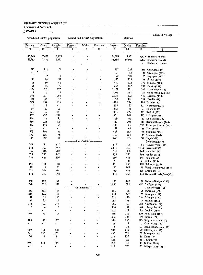
PRIMARY CENSUS ABSTRACT Census Abstract SADAURA
Name of Village Scheduled Castes popuation Scheduled Tribes population Literates
Persons Males Females Persons Males Females Persons Males Females
II 12 I3 14 15 16 17 18 19 2
13,963 7,470 6,493 24,384 14,951 9.433 Sadaura (Total) 13,963 7.470 6,493 24,384 14,951 9,433 Sadaura (Rural)
Sadaura (Urban)
212 III 101 567 329 238 Galawari (334) ... 101 53 48 UdalTlgarh (329) 3 2 I 172 109 63 Asgarpllr (330)
J90 99 91 367 229 138 lhanda (189) Itl 39 42 449 272 177 Salahpur (188)
164 85 79 664 427 237 Thaska (187) 1,375 703 672 1,477 881 596 Mahamadpur (140)
9 5 4 206 117 89 Milak lhabalian (139) 565 297 268 1,067 622 445 Rasulpur (138) 1&2 105 77 837 484 353 Haveli (141) 429 234 195 483 294 189 Bakala (142)
1 I 288 167 121 Nazampur (331) 54 29 25 202 131 71 Rf\jpur (333)
321 157 164 394 229 165 Rathali (332) 447 236 211 1,351 809 542 Laharpur (328) 164 77 87 129 66 63 Domanwala (327) 414 224 190 313 202 III Rampur Ranyan (144) 362 194 168 539 321 218 Ferozepur Ranyan (143)
61 40 21 Tibri (146) 303 166 137 481 283 198 Paharipur (145) 370 196 174 350 204 146 Saidupur ( 148) 303 162 141 246 155 91 Majri (149)
----------Un-inhabited------ Tunda Bag (147) 242 131 III 175 109 66 Ranyan Wala (134) 954 507 447 2,411 1,377 1,034 Saranwa (l33) 450 248 202 631 386 245 KanipJa (150) 529 287 242 435 255 180 Pan don (J 51) 710 404 306 656 411 245 Rajpur (152)
61 40 21 Sabhri (153) 191 III 80 431 263 168 Sabhapur (154) 19 6 13 185 144 41 Buraj Jamunawala (I 64)
675 361 314 739 443 296 Sham pur (163) 570 312 258 394 250 144 Sadaura (Rural)(Part)(155)
348 192 156 196 122 74 Sadaura Nadipar (155) 778 422 356 1,096 683 413 Sadiqpur (157)
----·------Un-inhabited----------- Chak Majudat (156) 289 155 134 159 95 64 Sultanpur (158) 238 126 112 453 277 176 Ismailpur (159) 191 95 96 321 170 lSI Salempur (160) 34 23 II 263 176 87 Fazilpur (161)
341 192 149 686 403 283 Naushahra (162) 6 4 2 160 91 69 Udamgarh (165)
205 112 93 Parbholi (166) 163 90 73 456 286 170 Rattu Wala (167)
404 305 99 Ratauli (168) 183 96 87 346 233 113 Kalyanpur Atari( 170)
18 15 3 Garhi Viran (169) 75 52 23 Sana Bahadurpur (186)
289 151 138 230 140 90 Islamnagar (171) 281 150 131 435 275 160 Minapur (172)
36 19 17 218 137 81 Kotla (174) 123 92 31 Tewar (173)
245 134 III 12t 73 48 Gulapur (181) 183 107 76 Jafarpur Jafri (185)
321
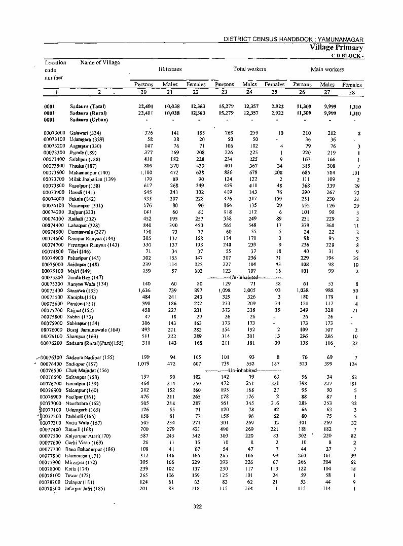
Location code number
Name of Vi "age
2
0001 0001 0001
Sadaura (Total) Sadaura (Rural) Sada_ra (Urban)
00073000 Galawari (334) 00073100 Udamgarh (329) 00073200 Asgarpur (330) 00073300 Jhanda (189) 00073400 Salahpur (188) 00073500 Thaska (187) 00073600 Mahamadpur (140) 00073700 Milak Jhabalian (139) 00073800 Rasulpur (138) 00073900 Haveli (141) 00074000 Bakala (142) 00074100 Nazampur(331) 00074200 Rajpur (333) 00074300 Rathali (332) 00074400 Laharpur (328) 00074500 Domanwala (327) 00074600 Rampur Ranyan (144) 00074700 Ferozepur Ranyan (143) 00074800 Tibri (146) 00074900 Paharipur (145) 00075000 Saidupur (148) 00075100 Majri (149) 00075200 TundaBag(147) 00075300 Ranyan Wala (134) 00075400 Saranwa (133) 00075500 Kanipla {I 50) 00075600 PandoR (15 I) 00075700 Rajpur (152) 00075800 Sabhri (153) 00075900 Sabhapur(154) 00076000 Buraj Jamunawala (164) 00076100 Shampur(l63) 00076200 Sadaura (Rural)(Part)( 155)
.,00076300 Sadaura Nadipar (155) • 00076400 Sadiqpur (157)
00076500 Chak Majudat (156) 00076600 Sultanpur (158) 00076700 Ismailpur (159) 00076800 Salempur (160) 00076900 Fazilpur(161) P0077000 Naushahra (162) jJ0077 I 00 Udamgarh ( 165)
',SOO77200 Parbholi (166) 00077300 Rattll Wala (167) 00077400 Ratallii (168) 00077500 Kalyanpur Atari(170) 00077600 Garhi Viran (169) 00077700 Bana Bahadurpur (186) 00077800 Islamnagar (171) 00077900 Mirzapur (172) 00078000 KOlla (174) 00078100 Tewar (173) 00078200 Gulapur (181) 00078300 Jafarpur Jafri (185)
Persons 20
22,401 22,401
326 58
147 377 410 809
1,100 179 617 545 435 176 141 452 840 150 305 330
71 302 239 159
140 1,636
484 398 458
47 306 493 511 311
199 1,079
192 464 312 476 505 126 158 505 700 587 26
108 312 395 239 265 124 201
Illiterates
Males 21
10,038 10,038
141 38 76
169 182 370 472
89 268 243 207
80 60
195 390
73 137 137 34
155 114 57
60 739 241 186 227
18 143 211 222 143
94 472
90 214 152 211 218
55 81
234 279 245
II 41
146 166 102 106 61 83
DISTRICT CENSUS HANDBOOK: YAMUNANAGAR
Females 22
12,363 12;363
185 20 71
208 228 439 628 90
349 302 228 96 81
257 450
77 168 193 37
147 125 102
80 897 243 212 231
29 163 282 289 168
105 607
Total workers
Persons 23
15,279 15.279
269 50
106 226 234 401 886 124 459 419 476 164 118 338 565
60 174 248
55 307 227 123
Males 24
12,357 12,357
259 50
102 225 225 367 678 122 411 343 317 135 112 249 548 55
171 239
37 236 184 107
Females 25
2,922 2,922
10
4 I 9
34 208
2 48 76
159 29
6 89 17 5 3 9
18 71 43 16
---------Un-inhabited-----------129 71 58
1,098 1,005 93 329 326 3 233 373
209 338
26 26 173 173 154 314 211
101 739
152 301 181
93 552
24 35
2 13 30
8 187
------------Un-inhabited--------------102 250 160 265 287
71 77
271 421 342
15 t7
166 229 137 159 63
118
322
142 79 63 472 251 221 195 168 27 178 176 2 561 345 216 120 158 301 490 303
10 54
265 293 230 125 83
115
78 96
269 269 220
8 47
166 226 117 101 62
114
42 62 32
221 83 2 7
99 67
113 24 21
Village Primary CDBLOCK-
Main workers
Persons 26
11,309 11,309
210 36 79
220 167 315 685 111 368 290 251 155 101 231 379
24 98
236 40
229 108 101
61 1,038
180 121 349
26 173 109 296 138
76 523
96 398
95 88
28S 66 80
301 189 302 •
10 44
260 266 122 59 53
115
Males 27
9,999 9,999
202 36 76
219 166 308 584 109 339 267 230 126 98
229 368 22 95
228 31
194 98 99
53 988 179 117 328
26 173 107 286 116
69 399
34 217
90 87
253 63 75
269 182 220
8 3.7
161 204 104 58 44
114
Females 28
1,310 1,310
8
3
7 101
2 29 23 21 29 3 2
t\ 2 3 8 9
35 10 2
8 50
4 21
2 10 22
7 124
62 181
5 I
32 3 5
32 7
82 2 7
99 62 18
9
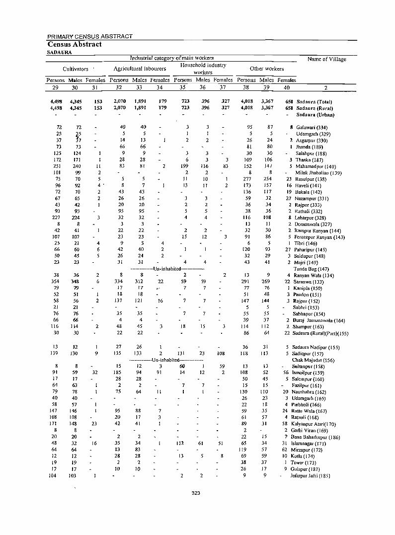
PRIMARY CENSUS ABSTRACT Census Abstract SADAURA
Industrial category of main workers
Cultivators Agricultural labourers Household industry
workers
Name of Village
Other workers
Persons Males Females Persons Males Females Persons Males Females Persons Males Females 29 30 31 32 33 34 35 36 37 38 39 40 2
4,498 4,498
72 25 37 73
125 172 251 101 75 96 72 67 43 93
227 8
42 107 25 66 50 23
38 354 79 52 58 21 76 66
116 30
13 139
8 91 17 64 79 40 58
147 108 171
8 20 48 64 12 19 17
104
4,345 4,345
n
t~ 73
124 171 240 99 70 92 70 65 42 93
224 8
41 107 21 60 45 23
36 348
79 51 56 21 76 66
114 30
12 130
8 59 17 63 78 40 57
146 108 148
8 20 32 64 12 19 17
103
153 153
II 2 5 4 . 2 2
3
4 6 5
2 6
I 2
2
I 9
32
23
16
2,070 2,070
40 5
14 66
9 28 83
5 8
43 26 20 95 32
3 22 23
9 42 26 31
8 334
17
18 137
35 4
48 22
27 135
15 185 28
2 75
95 20 42
2 35 83 28
2 10
1,891 1,89]
40 5
13 66
9 28 81
5 7
43 26 20 95 32 3
22 23
5 40 24 31
179 179
2
4 2 2
723 723
3
2
3 6
199 2
11 J3
3 2 5 4
2 15
4
396 396
3 1 2
3 3
116 2
10 II
3 2
5 4
2 12
4
···-·····--Un-inhabited---------8 2
312 17
18 121
35 4
45 22
26 133
22 :--"
16
3
2
59 7
7
7
18
131
S9 7
7
7
15
23 -------------Un-inhabited------------
12 3 60 I 94 91 14 12 28
2 64 II
88 7 17 3 41
2 34 83 28
2 10
7 7
112 61
13 5
2 2
323
327 327
3 83
I 2
3
2
3
108
59 2
51
8
4,0]8 4,0]8
95 5
26 81 30
109 152
8 277 173 136 59 36 38
116 13 32 91
6 120 32 43
13 291
77 51
147 5
55 39
114
86
36 118
13 108 50 15
130 26 22 59 61 89 2
22 65
119 69 38 26
9
3,367 3,367
87 5
24 80 30
106 147
8 254 157 117 32 34 36
108 II 30 86 5
93 29 41
9 269
76 48
144 5
55 37
112 64
31 113
13 52 45 15
110 23 18 35 57 31
15 34 57 59 37 17 9
651 Sadaura (Total) 651 Sadaura (Rural)
Sadaura (Urban)
8 Galawari (334) Udamgarh (329)
2 Asgarpur (330) lhanda (189) Salahpur (188)
3 Thaska (187) .5 Mahamadpur (140)
Milak Jhabalian (139) 23 Rasulpur (138) 16 Haveli (141) 19 Bakala (142) 27 Nazampur (331)
2 Rajpur (333) 2 Rathali (332) 8 Laharpur (328) 2 Domanwa[a (327) 2 Rampur Ranyan (144) 5 Ferozepur Ranyan (143)
Tibri (146) 27 Paharipur (145)
3 Saidupur (148) 2 Majri (J 49)
Tunda Bag (147) 4 Ranyan Wala (134)
22 Saranwa (\33) I Kanipla (150) 3 Pandon (151) 3 Rajpur (152)
Sabhri (153) Sabhapur (154)
2 Bur<\i Jamunawala (164) 2 Shampur (163)
22 Sadaura (Ruraf)(Part)(l55)
5 Sadaura Nadipar (155) 5 Sadiqpur (157)
Chak. M.uuda\ (156) Sultan pur (158)
56 Ismailpur (159) 5 Salempur (160)
Fazilpur (161) 20 Naushahra (162) 3 Udamgarh (165) 4 Parbholi (166)
24 Rattu Wala (167) 4. Ratauli (168)
58 Kalyanpur Atari( 170) 2 Garhi Viran (169) .7 Bana Bahadurpur (186)
31 Islamnagar ( 17 I) 62 Mirzapur (172) 10 Kotla (174)
I Tewar (173) 9 Gulapur (181)
Jafarpur Jafri (185)
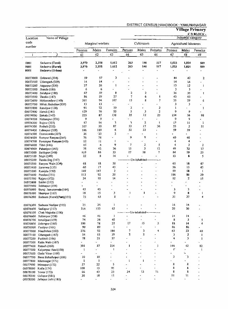
Location
code
number
Name of Village
2
0001 0001 0001
Sadaura (Total) Sadaura (Rural) Sadaura (Urbaa)
00073000 Galawari (334) 00073100 Udamgarh (329) 00073200 Asgarpur (330) 00073300 Jhanda (189) 00073400 Salahpur (188) 00073500 Thaska (187) 00073600 Mahamadpur (14(» 00073700 Milak Jhabalian (139) 00073800 Rasulpur (138) 00073900 Haveli (141) 00074000 Bakala (142) 00074100 Nazampur (331) 00074200 Rajpur (333) 00074300 Rathali (332) 00074400 taharpur (328) 00074500 Domnnwala (327) 00074600 Rampur Ranyan (144) 00074700 Ferozepur Ranyan (143) 00074800 Tibri (146) 00074900 Paharipur (145) 00075000 Saidupur(148) 00075100 Majri (149) 00075200 Tunda Bag (147) 00075300 Ranyan Wala (134) 00075400 Saranwa (133) 00075500 Kanipla (150) 00075600 Pandon (151) 00075700 Rajpur (I 52) 00075800 Sabhri (153) 00075900 Sabhapur(154) 00076000 Buraj Jamunawala (164) 00076100 Shampur (163) 00076200 Sadaura (Rural)(Part)(155)
00076300 Sadaura Nadipar (155) 00076400 Sadiqpllr (157) 00076500 Chak Majudat (156) 00076600 Sultanpur (158) 00076700 Ismailpur (159) 00076800 Salempur (160) 00076900 Fazilpur (161) 00077000 Naushahra (162) 00077100 Udamgarh(165) 00077200 Parbholi (166) 00077300 Rattll Wala (167) 00077400 Ratauli (168) 00077500 Kalyanpur Atari(170) 00077600 Garhi Virall (169) 00077700 Bana Bahadurpur (186) 00077800 Islamnagar (171) 00077900 Mirzapur (172) 00078000 Kotla (174) 00078100 Tewar (173) 00078200 Gulapur (181) 00078300 Jatarpur Jafri (185)
Marginal workers
Persons
41
3,970 3,97G
59 14 27
6 67 86
201 13 91
129 225
9 17
107 186 36 76 12 15 78
119 22
68 60
149 112 24
45 18 73
25 216
46 74
100 90
276 54 78
301
10 5
27 108 66 30
Males
42
2,358 2,358
57 14 26
6 59 59 94 13 72 76 87 9
14 20
180 ·33 76 II 6
42 86
8
18 17
147 92 10
45 15 65
24 [53
45 34 78 89 92 15 21
87
10 5
22 13 43 18
Females
43
1,612 1,612
2
8 27
107
19 53
138
3 87
6 3
I 9
36 33 14
50 43
2 20 14
3 8
I 63
I 40 22
184 39 57
214 I
5 95 23 12
324
DISTRICT CENSUS HANDBOOK: YAMUNANAGAR
Persons
44
263 263
2 7
15
2 5
35
3 53
Culti vators
Males
45
146 146
2 6 8
3 12
2 17
32 32
9 9
7 15 17
2 3
10
Females
46
117 117
7
2 2
23
1
36
5 12 7
------Un-inhabited-------------
-------Un-inhabited--------------
17 15 2
7 3 4 2 2
24 13 11
Village Primary CDBLOCK-
Industrial category
Agricultural labourers
Persons
47
1,533 1,533
44 14 13 3
36 43 35
3 1 9
154 9
12 53 59
40 4 4
49 84 13
65 56 59
106 12
3 9
31
14 20
14
8 18 86 63
3 4
144 I'
3
8 8 8
II
Males
48
1,024 1,024
1-
42 14 12 3
35 43 29
3
9 56
9 11
2 59
40 4 2
32 59 8
IS 13 58 86 2
3 8
27
14 20
14 3
14 86 23 2 3
62
3
8 8 8
11
Females
509 509
2
6
98
I 51
2 17 25
5
47 43
20 to
4
5 4
40
82
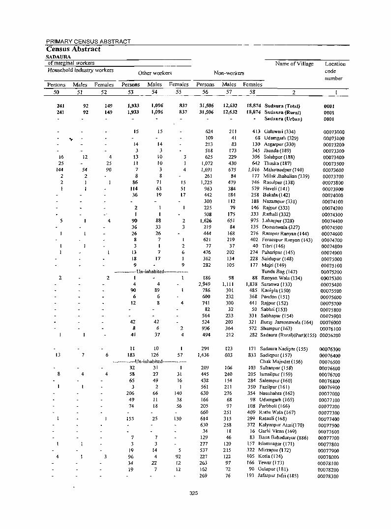
PRIMARY CENSUS ABSTRACT Census Abstract SADAURA of marginal workers Household industry workers
Persons 50
241 241
16 25
144 2 2
5
2
13
Males 51
92 92
12
54 2
7
Females 52
149 149
4 25 90
4
2
6
Other workers
Persons 53
1,933 1,933
Males 54
1,096 1,096
15 15
14 14 3 3
13 11 7 8
86 114 36
2 I
90 36 26 8 3
13 18 9
10 10 3 8
71 63 19
88 33 26
7
7 17
Females
55
837 837
3
4
15 51 17
2 3
2 6 I 9
------Un-inhabited-----------I 1 4
90 6
12
42 8
41
4 89 6 8
42 6
37
11 10 183 126
4
2 4
57 --------Un-inhabited-----------
8 4 4
4 3
32 31 I 58 27 31 65 49 16 3 2
206 49 74
155
66 II 18
25
7 7 3 3
19 96 34 19
14 4
22 7
140 38 56
130
5 92 12 12
Name of Village
Non-workers
Persons
325
56
31,506 31,506
624 109 213 518 625
1,072 1,691
261 1,225
963 442 300 225 508
1,626 219 444 621
77 476 362 282
L86 2,949
786 600 741
82 564 524 936 494
294 1,436
209 445 438 561 630 166 205 660 614 630 34
129 277 537 227 263 162 269
Males Females 57 58 2
12,632 12,632
211 41 83
173 229 430 675 84
479 384 184 112 79
175 651 84
168 219 37
202 134 lOS
98 1,111
301 232 300 32
233 203 364 212
123 603
106 240 154 211 276
68 97
251 315 258
18 46
120 215 122 97 72 76
18,874 Sadaura (Total) 18,874 Sadaura (Rural)
Sadaura (Urban)
413 Galawari (334) 68 Udamgarh (329)
130 Asgarpur (330) 345 Jhanda (189) 396 Salahpur (188) 642 Thaska (187)
1,016 Mahamadpur(l40) 177 Milak Jhabalian (139) 746 Rasulpur (138) 579 Haveli (141) 258 Bakala (142) 188 Nazampur (331) 146 Rajpur (333) 333 Rathali (332) 975 Laharpur (328) 135 Domanwala (327) 276 Rampur Ranyan (144) 402 Ferozepur Ranyan (143)
40 Tibri (146) 274 Paharipur (I 45) 228 Saidupur (I 48) 177 Majri (149)
Tunda Bag (147) 88 Ranyan Wala(134)
1,838 Saranwa (133) 485 Kanipia (150) 368 Pandon (151) 441 Rajpur (152)
50 Sabhri (153) 331 Sabhapur (154) 321 Bura) Jamunawala (164) 572 Shampur (I 63) 282 Sadaura (Rural)(Part)(155)
171 Sadaura Nadipar (155) 833 Sadiqpur (157)
Chak Majudat (I 56) 103 Sultanpur (158) 205 Ismailpur (159) 284 Salem pur (160) 350 Fazilpllr(161) 354 Nallshahra (162)
98 Udamgarh (165) 108 Parbholi (166) 409 Rattll Wala (167) 299 Ratauli (168) 372 Kalyanpllr Atari(l70)
16 Garhi Viran (169) 83 Bana Bahadurpur (186)
157 Islamnagar (171) 322 Mirzapllr (172) 105 Kotla (174) 166 Tewar (173) 90 GlIlaplir (181)
193 Jafarpur Jafri (185)
Location code number
0001 0001 0001
00073000 00073100 00073200 00073300 00073400 00073500 00073600 00073700 00073800 00073900 00074000 00074100 00074200 00074300 00074400 00074500 00074600 00074700 00074800 00074900 00075000 00075100 00075200 00075300 00075400 00075500 00075600 00075700 00075800 00075900 00076000 00076100 00076200
00076300 00076400 00076500 00076600 00076700 00076800 00076900 00077000 00077100 00077200 00077300 00077400 00077500 00077600 00077700 00077800 00077900 00078000 00078100 00078200 00078300
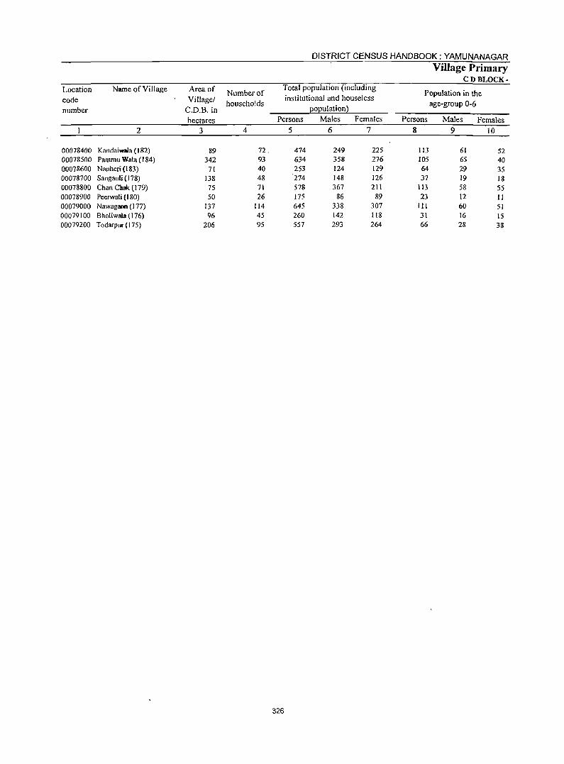
DISTRICT CENSUS HANDBOOK: YAMUNANAGAR
Village Primary CDBI"OCK-
Location Name of Vi IIage Area of Number of Total population (including
Population in the code Village/ households
institutional and houseless age-group 0-6
number C.D.B. in EOEulation)
hectares Persons Males Females Persons Males Females
2 3 4 5 6 7 8 9 10
00078400 Kandaiwala (182) 89 72. 474 249 225 113 61 52 00078500 Pammu Wala (184) 342 93 634 358 276 105 65 40 00078600 Nanheri (t83) 71 40 253 124 129 64 29 35 00078700 Sangauli (178) 138 48 274 148 126 37 19 18 00078800 Chan COOk (179) 75 71 578 367 211 113 58 55 00078900 Peerwali (180) 50 26 175 86 89 23 12 II 00079000 Nawagaon (177) 137 114 645 338 307 III 60 51 00079100 Bholiwala (176) 96 45 260 142 118 31 16 15 00079200 Todarpur (175) 206 95 557 293 264 66 28 38
326
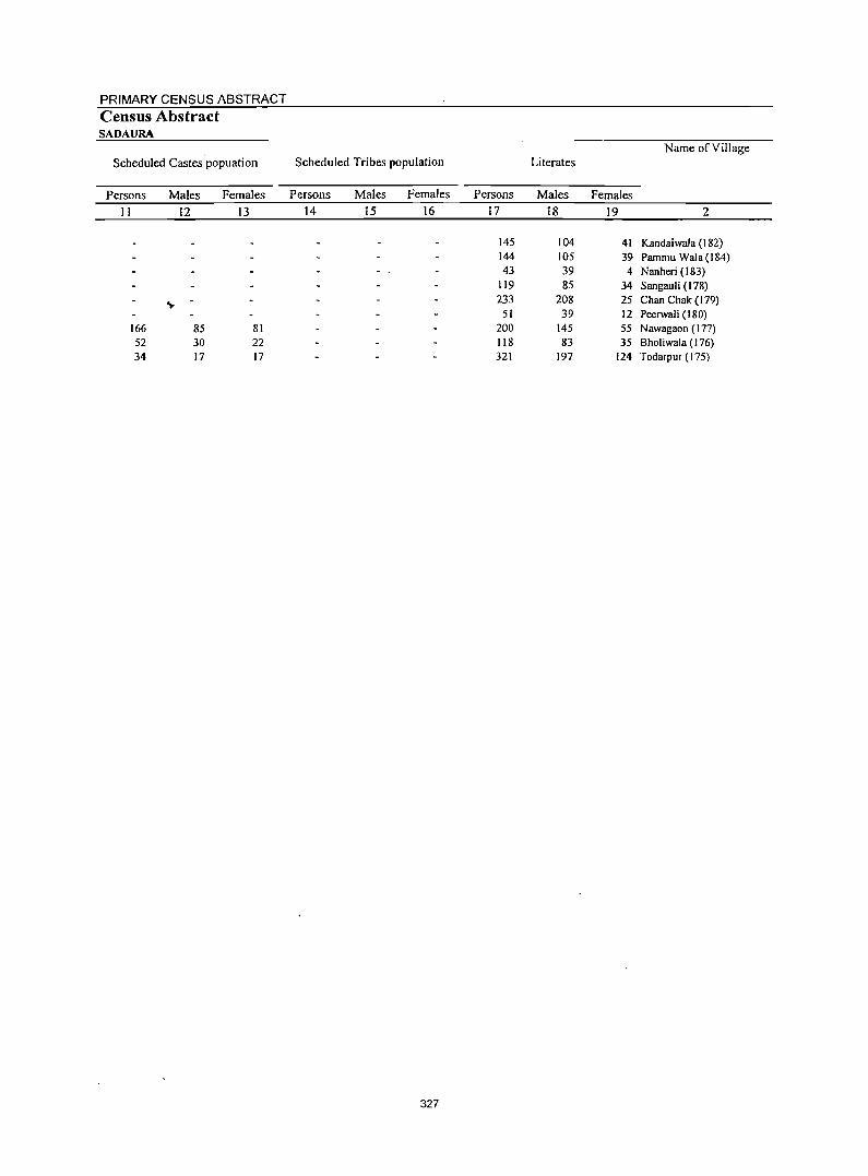
PRIMARY CENSUS ABSTRACT Census Abstract SADAURA
Scheduled Castes'popuation Name of Village
Scheduled Tribes population Literates
Persons Males Females Persons Males Females Persons Males Females
11 12 13 14 15 16 17 18 19 2
145 104 41 Kandaiwala (182) 144 105 39 Pammu Wala (184) 43 39 4 Nanheri (183)
119 85 34 Sangaul i (I 78)
... 233 208 25 Chan Chak (I 79) 51 39 12 Peerwali (180)
166 85 81 200 145 55 Nawagaon (177) 52 30 22 118 83 35 Bholiwala (176) 34 17 17 321 197 124 Todarpur (175)
327
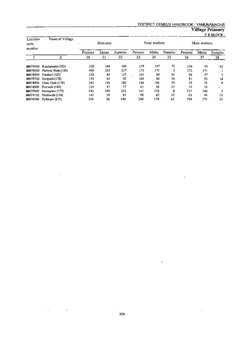
328
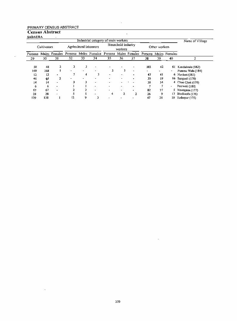
PRIMARY CENSUS ABSTRACT Census Abstract SADAURA
Industrial cate~0!2: of main workers Name of Village
Cultivators Agricultural labourers Household industry
Other workers workers
Persons Males Females Persons Males Females Persons Males Females Persons Males Females
29 30 31 32 33 34 35 36 37 38 39 40 2
50 48 2 3 3 103 42 61 Kandaiwala (182) 169 168 3 3 Pammu Wala (184)
12 12 7 4 3 47 41 6 Nanheri (183) 46 ~4 2 35 19 16 Sangauli (178) 14 14 3 3 38 34 4 Chan Chak (179) 6 6 I 7 7 Peerwali (180)
67 67 2 2 82 77 5 N awagaon (177) 28 28 5 5 4 2 2 26 9 17 Bholiwala (176)
139 138 12 9 3 47 28 19 Todarpur (175)
329
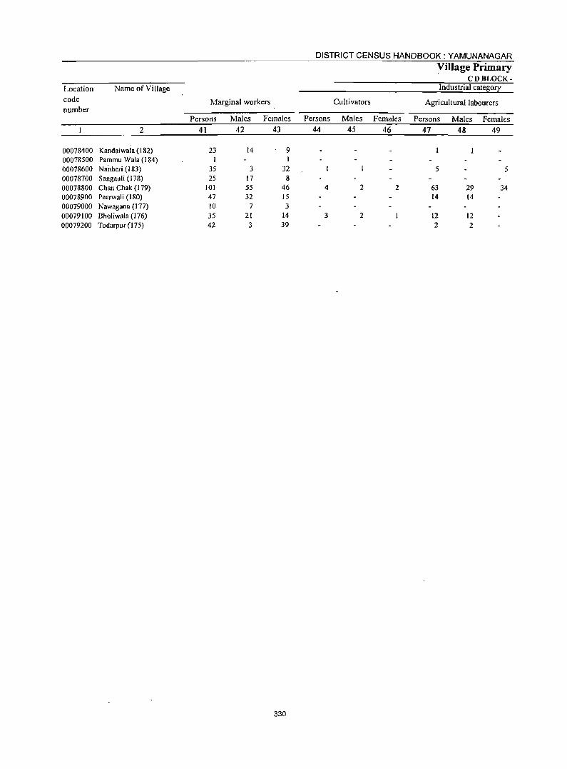
DISTRICT CENSUS HANDBOOK: YAMUNANAGAR
yillage Primary CDBLOCK-
Location Name of Village Industrial cate~0!X
code number
Marginal workers Cultivators Agricultural labourers
Persons Males Females Persons Males Females Persons Males Females 2 41 42 43 44 45 46 47 48 49
00078400 Kandaiwala (182) 23 14 9 00078500 Pammu Wala (I 84) 1 00078600 Na"nheri (183) 35 3 32 5 5 00078700 Sangauli (178) 25 17 8 00078800 Chan Chak (179) 101 55 46 4 2 2 63 29 34 00078900 Peerwal i (I 80) 47 32 15 14 14 00079000 Nawagaon (177) 10 7 3 00079100 Bholiwala (176) 35 21 14 3 2 12 12 00079200 Todarpur (175) 42 3 39 2 2
330
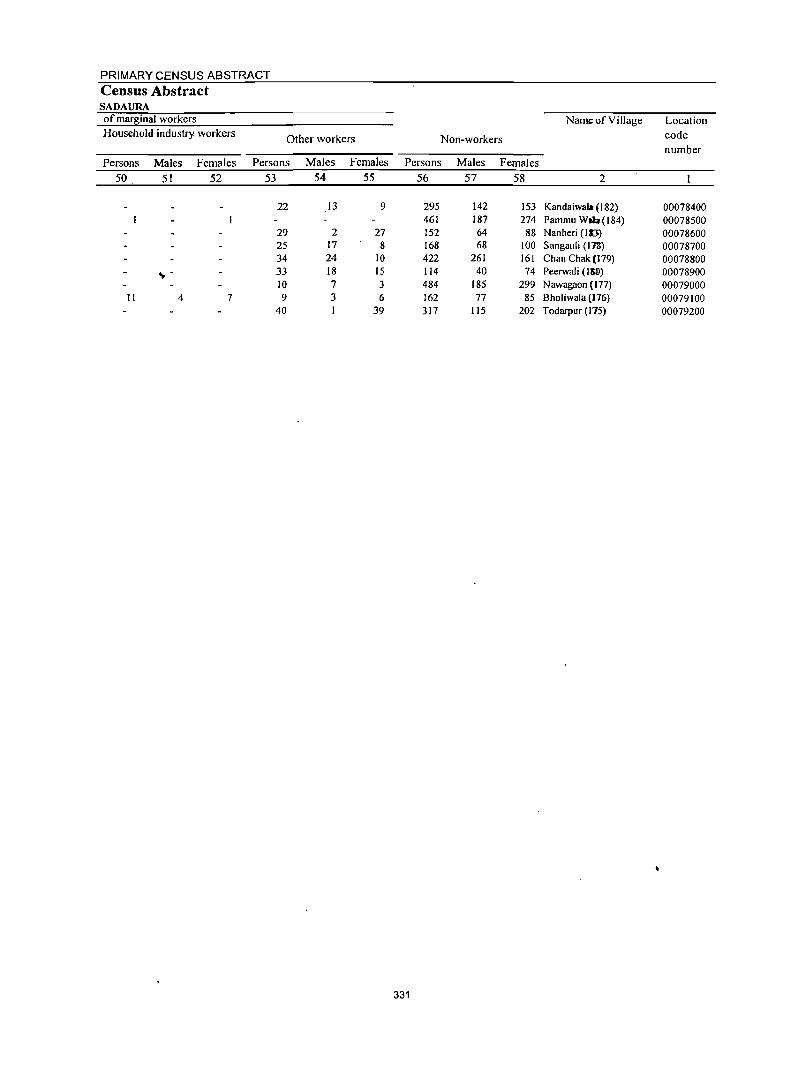
PRIMARY CENSUS ABSTRACT Census Abstract SADAURA of mar~inal workers Name of Village Location Household industry. workers Other workers Non-workers eode
number Persons Males Females Persons Males Females Persons Males Females
50 51 52 53 54 55 56 57 58 2
22 I3 9 295 142 153 Kandaiwala (182) 00078400 461 187 274 Pammu Wlb(184) 00078500
29 2 27 152 64 88 Nanheri (113) 00078600 25 17 8 168 68 100 Sangauli (17&) 00078700 34 24 10 422 261 161 Chan Chak (t79) 00078800
.,. - 33 18 IS 114 40 74 Peerwali (150) 00078900 10 7 3 484 185 299 Nawagaon (In) 00079000
II 4 7 9 3 6 162 77 85 Bholiwala (176) 00079100 40 39 317 115 202 Todarpur (175) 00079200
331
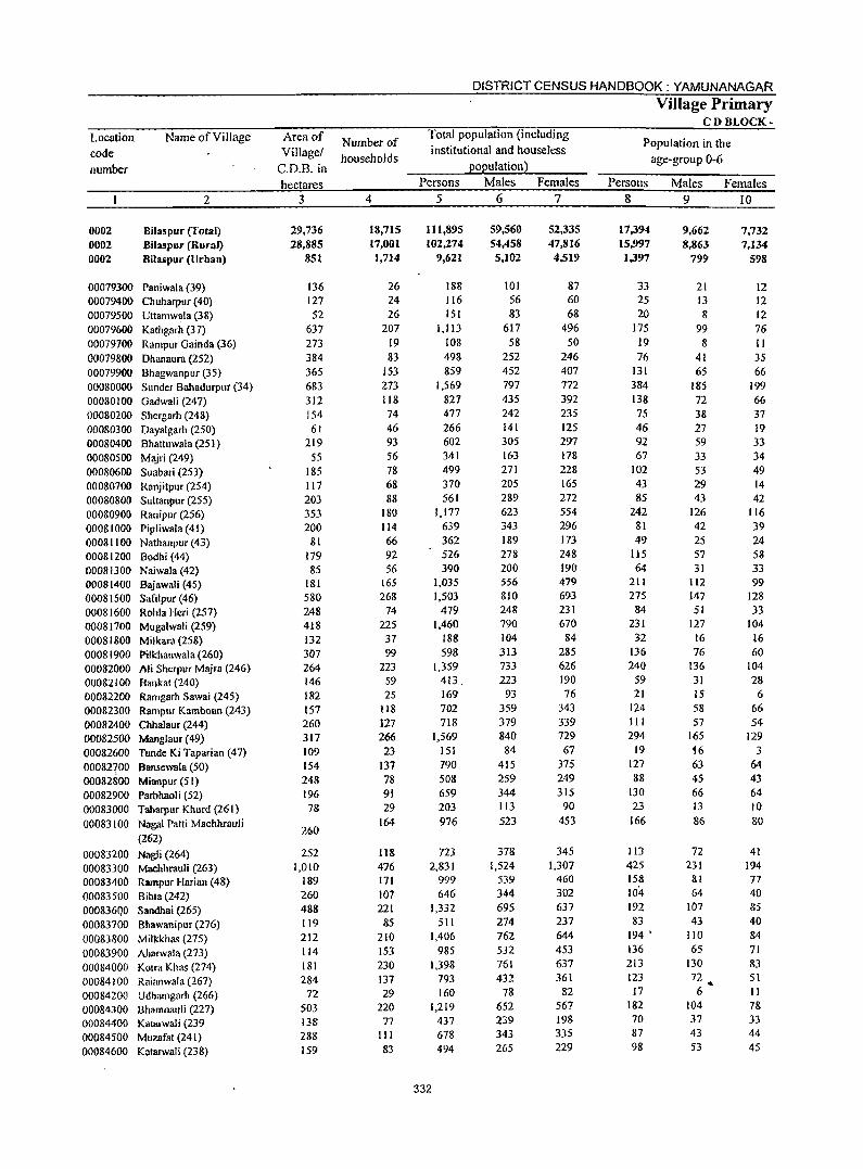
Location code number
0002 0002 0002
Name ofVilJage
2
BilasplIT (Total) BiJaspuT (Rural) Bilaspllr (Urban)
00079300 Paniwala (39) 00079400 Ch uharpur (40) 00079500 Uttamwala (38) 00079600 Kathgarh (37) 00079700 Rampur Gainda (36) 00079800 Dhanaura (252) 00079900 Bhagwanpur (35) 00080000 Sunder Bahadurpur (34) 00080100 Gadwali (247) 00080200 Shergarh (248) 00080300 Dayalgarh (250) 00080400 Bhattuwala (25 I) 00080500 Majri (249) 00080600 Suabari (253) 00080700 Ranjitpur (254) 00080800 Sultanpur (255) 00080900 Ranipur (256) 00081000 Pipliwala (41) 00081100 Nathanpur (43) 00081200 Bodhi (44) 00081300 Naiwala (42) 00081400 Bajawali (45) 00081500 Safilpur (46) 00081600 Rohla Heri (257) 00081700 Mugalwali (259) 00081800 Milkara (258) 00081900 Pilkhanwala (260) 00082000 Ali Sherpur Majra (246) 00082100 Bankat (240) 00082200 Ramgarh Sawai (245) 00082300 Rampur Kamboan (243) 00082400 Cbhalaur (244) 00082500 MangJaur (49) 00082600 Tunde Ki Taparian (47) 00082700 Bansewala (50) 00082&00 Mianpur (51) 00082900 Parbhaoli (52) 00083000 Taharpur Khurd (261) 00083100 NagaI Patti Machhrauli
00083200 00083300 00083400 00083500 000836QO 00083700 00083800 00083900 00084000 00084100 00084200 00084300 00084400 00084500 00084600
(262)
Nagli (264) Machhrauli (263) Rampur Harian (48) BiMa (242) Sandhai (265) Bhawanipur (276) Milkkhas (275) Aharwala (273) Kolra Khas (274) Raianwala (267) Udhamgarh (266) Bhamn3uli (227) Katarwali (239 Muzafat (241) Katarwali (238)
Area of Village/
C.D.B. in hectares
3
29,736 28,885
851
136 127 52
637 273 384 365 683 312 154 61
219 55
185 117 203 353 200
81 179 85
181 580 248 418 132 307 264 146 182 157 260 317 109 154 248 196
78
260
252 1,010
189 260 488 119 212 114 181 284
72 503 138 288 159
Number of households
4
18,715 17,001
1,714
26 24 26
207 19 83
153 273 118 74 46 93 56 78 68 88
180 114 66 92 56
165 268
74 225 37 99
223 59 25
118 127 266 23
131 78 91 29
164
lIB 476 171 107 221
85 210 153 230 137 29
220 77
111 83
DISTRICT CENSUS HANDBOOK: YAMUNANAGAR
Total population (including institutional and houseless
population) Persons Males Females
5 6 7
111,895 102,274
9,621
188 116 151
1,113 108 498 859
1,569 827 477 266 602 341 499 370 561
1,177 639 362 526 390
1,035 1,503
479 1,460
188 598
1,359 413. 169 702 718
1,569 151 790 508 659 203 976
723 2,831
999 646
l,332 511
1.406 985
1,398 793 160
1,219 437 678 494
332
59,560 54,458 5,102
101 56 83
617 58
252 452 797 435 242 141 305 163 271 205 289 623 343 189 278 200 556 810 248 790 104 313 733 223
93 359 379 840 84
415 259 344 113 523
378 1,524
539 344 695 274 762 532 761 432
78 652 239 343 265
52,335 47,816 4,519
87 60 68
496 50
246 407 772 392 235 125 297 178 228 165 272 554 296 173 248 190 479 693 231 670
84 285 626 190 76
343 339 729 67
375 249 315
90 453
345 1,307
460 302 637 237 644 453 637 361
82 567 198 335 229
Village Primary CDBLOCK-
Population in the age-group 0-6
Persons 8
17,394 15,997 1,397
33 25 20
175 19 76
131 384 138 75 46 92 67
102 43 85
242 81 49
115 64
211 275
84 231
32 136 240 59 21
124 III 294
19 127 88
130 23
166
113 425 158 104-192 83
194 •
136 213 123 17
182 70 87 98
Males 9
9,662 8,863
799
21 13 8
99 8
41 65
185 72 38 27 59 33 53 29 43
126 42 25 57 31
112 147 51
127 16 76
136 31 15 58 57
165 '16 63 45 66 13 86
72 231
81 64
107 43
110 65
130 72
6 104 37 43 53
..
Females 10
7.732 7,134
598
12 12 12 76 II 35 66
199 66 37 19 33 34 49 14 42
116 39 24 58 33 99
128 33
104 16 60
104 28 6
66 54
129 3
64 43 64 10 80
41 194 77 40 85 40 84 71 83 51 II 78 33 44 45
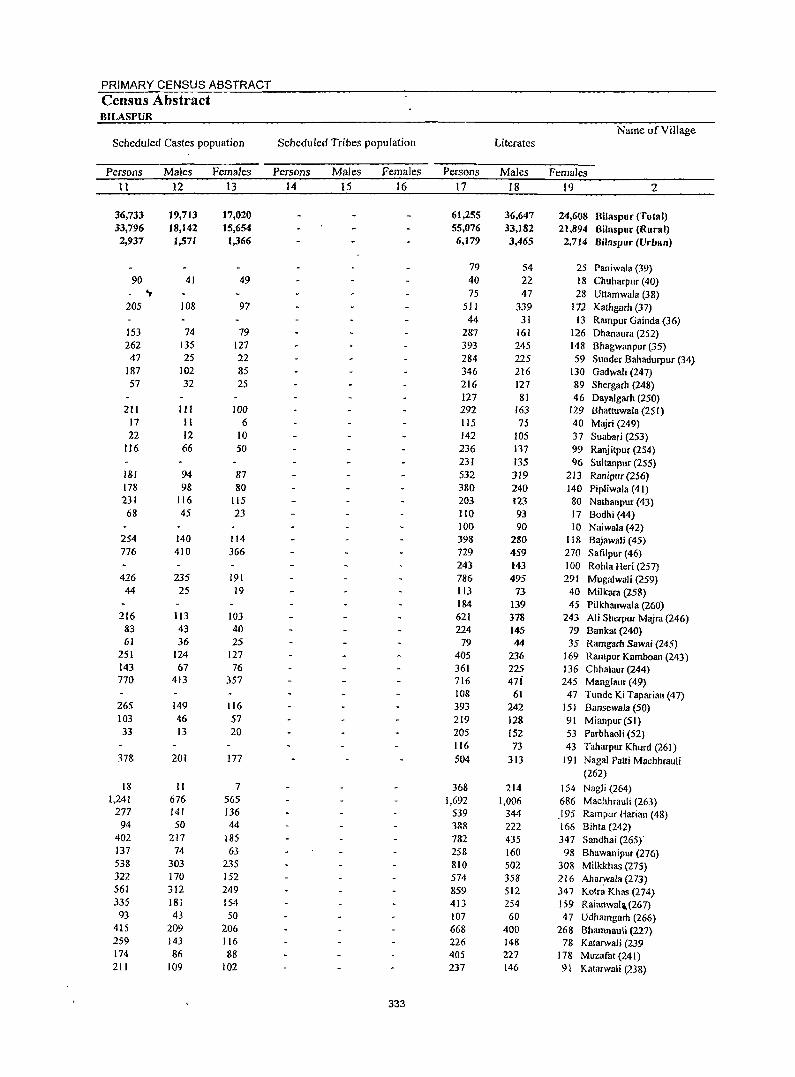
PRIMARY CENSUS ABSTRACT
Census Abstract BILASPUR
Name of Village Scheduled Castes popuation Scheduled Tribes population Literates
Persons Males Females Persons Males Females Persons Males Females
11 12 13 14 15 16 17 18 19 2
36,733 19,713 17,020 61,255 36,647 24,608 Bilaspur (Total) 33,796 18,142 15,654 55,076 33,182 21,894 Bilnspur (Rural) 2,937 1,571 1,366 6,179 3,465 2,714 Billispur (Urban)
79 S4 25 Paniwala (39) 90 41 49 40 22 18 Chuharpur (40)
'I- 75 47 28 Ultamwala (38) 205 108 97 511 339 172 Kathgarh (37)
44 31 13 Rampur Gainda (36) 153 74 79 287 161 126 Dhanaura (252) 262 135 127 393 245 148 Bhagwanpur (35)
47 25 22 284 225 59 Sunder Bahadurpur (34) 187 102 85 346 216 130 Gadwali (247) 57 32 25 216 127 89 Shergarh (248)
127 81 46 Dayalgarh (250) 211 III 100 292 163 129 Bhat(uwala (251)
17 II 6 115 75 40 Majri (249) 22 12 10 142 105 37 Suabari (253)
116 66 50 236 137 99 Ranj itpur (254) 231 135 96 Sultanpur (255)
181 94 87 532 319 213 Ranipu( (256) 178 98 80 380 240 140 Pipliwala (41) 231 116 115 203 123 80 Nathanpur (43)
68 45 23 110 93 17 Bodhi (44) 100 90 10 Naiwala (42)
254 140 114 398 280 118 Bajawali (45) 776 410 366 729 459 270 Safilpur (46)
243 143 100 Rohla Heri (257) 426 235 191 786 495 291 Mugalwali (259)
44 25 19 113 73 40 Milkara (258) 184 139 45 Pilkhanwala (260)
216 113 103 621 378 243 Ali Sherpur Majra (246) 83 43 40 224 145 79 Bankat (240) 61 36 25 79 44 35 Ramgarh Sawai (245)
251 124 127 405 236 169 Rampur Kamboan (243) 143 67 76 361 225 136 Chhalaur (244) 770 413 357 716 47i 245 Manglaur (49)
10& 61 47 Tunde Ki Taparian (47) 265 149 116 393 242 151 Bansewala (50) 103 46 57 219 128 91 Mianpur(51) 33 13 20 205 152 53 Parbhaoli (52)
116 73 43 Tahatpur Khurd (261) 37& 201 177 504 313 191 Nagai Patti Machhrauli
(262) 18 II 7 368 214 154 Nagli (264)
1,241 676 56S 1,692 1,006 686 Machhrauli (263) 277 J41 136 539 344 [95 Rampur Harian (48)
94 50 44 38& 222 166 Bihta (242) 402 217 185 782 435 347 Sandhai (265)" 137 74 63 258 160 98 Bhawanipur (276) 53& 303 235 810 502 308 Milkkhas (275) 322 170 152 574 358 216 Aharwala (273) 561 312 249 859 512 347 Kotra Khas (274) 335 181 154 413 254 [59 Raianwal, (26 7) 93 43 50 107 60 47 Udhamgarh (266)
415 209 206 668 400 268 Bhamnauli (227) 259 143 116 226 148 78 Katarwali (239 174 86 88 405 227 178 Muufat (241) 21 I 109 102 237 146 91 Katarwali (238)
333
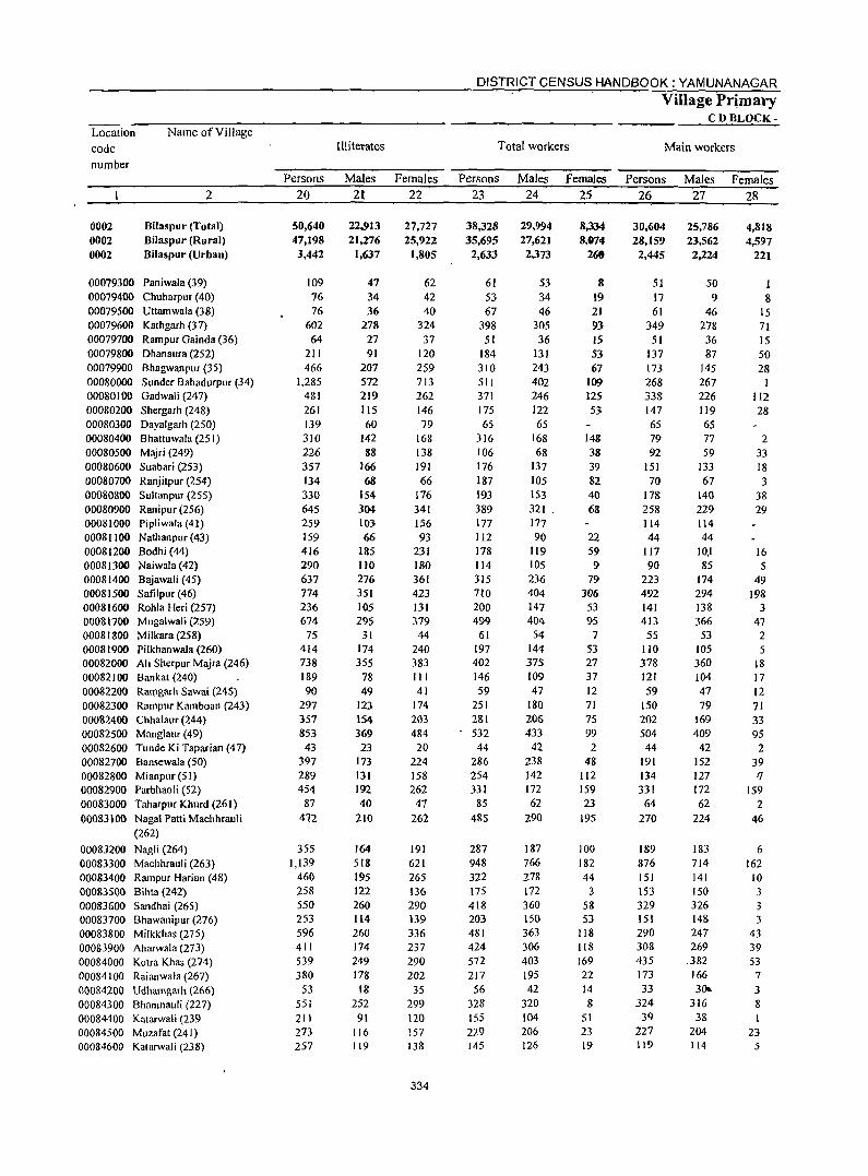
Location
code
number
Name of Village
2
0002 0002 0002
Bilaspur (Total) Bilaspur (Rural) Bilaspur (Urban)
00079300 Paniwala (39) 00079400 Chuharpur (40) 00079500 Uttamwala (38) 00079600 Kathgarh (37) 00079700 Rampur Gainda (36) 00079800 Dhanaura (252) 00079900 Bhagwanpllr (35) 00080000 Sunder Bahadurpllr (34) 00080100 Gadwali (247) 00080200 Shergarh (248) 00080300 Dayalgarh (250) 00080400 Bhattuwala (251) 00080500 Majri (249) 00080600 Suabari (253) 00080700 Ranjitpur (254) 00080800 Sultanpur (255) 00080900 Ranipur (256) 00081000 Pip1iwala (41) 00081100 Nathanpur(43) 00081200 Sodhi (44) 00081300 Naiwa1a (42) 00081400 Bajawali (45) 00081500 Safilpur(46) 00081600 Rohla Heri (257) 00081700 Mugalwali (259) 00081800 Milkara (258) 00081900 Pilkhanwala (260) 00082000 Ali Sherpur Majra (246) 00082100 Bankat(240) 00082200 Ran~garh Sawai (245) 00082300 Rampur Kamboan (243) 00082400 Chhalaur (244) 00082500 Mang1aur (49) 00082600 Tunde Ki Taparian (47) 00082700 Bansewala (50) 00082800 Mianpur (51) 00082900 Parbhaoli (52) 00083000 Taharpur Khurd (261) 00083100 NagaI Patti Machhrauli
(262)
00083200 NagJi (264) 00083300 Machhrauli (263) 00083400 Rampur Harian (48) 00083S0() Billta (242) 00083600 Sandhai (265) 0008370() Bhawanipuf (276) 00083800 Milkkhas (275) 00083900 Aharwala (273) 00084000 Kotra Khas (274) 00084100 Raianwala (267) 000&4200 Udhamgarh (266) 00084300 Bhamnauli (227) 00084400 Katarwali (239 00084500 Muzafat (241) 00084600 Katarwali (238)
Persons
20
50,640 47,198 3,442
109 76 76
602 64
211 466
1,285 481 261 139 310 226 357 134 330 645 259 159 416 290 637 774 236 674
75 414 738 189 90
297 357 853 43
397 289 454
87 412
355 1,139
460 258 550 253 596 411 539 380
53 551 211 273 257
III iterates
Males
21
22,913 21,276
1,637
47 34 36
278 27 91
207 572 219 115 60
142 88
166 68
154 304 1(}3 66
185 IIO 276 351 105 295
31 174 355
78 49
123 1S4 369 23
173 131 192 40
210
164 518 195 122 260 114 260 174 249 178
18 252
91 116 lJ9
Females
22
27,727 25,922
1,805
62 42 40
324 37
120 259 713 262 146 79
168 138 191 66
176 341 156 93
231 180 361 423 131 379 44
240 383 III 41
174 203 484 20
224 158 262 47
262
191 621 265 136 290 139 336 237 290 202
35 299 120 157 138
334
DISTRICT CENSUS HANDBOOK: YAMUNANAGAR
Total workers
Persons
23
38,328 35,695
2,633
61 53 67
398 51
184 310 51! 371 175 65
316 106 176 187 193 389 177 112 178 114 315 710 200 499
61 197 402 146 59
251 281 532 44
286 254 331
85 485
2&7 948 322 175 418 203 481 424 572 217
56 328 155 229 145
Males
24
29,994 27,621 2,373
53 34 46
305 36
131 243 402 246 122 65
168 68
137 105 153 321 . 177 90
119 105 236 404 147 404
54 144 315 109 47
180 206 433
42 238 142 172 62
290
187 766 278 172 360 150 363 306 403 195 42
320 104 206 126
Females
25
8,334 8,074
260
8 19 21 93 15 53 67
109 125 53
148 38 39 82 40 68
22 59 9
79 306
53 95
7 53 27 37 12 71 75 99
2 48
112 159 23
195
100 182 44
3 58 53
118 118 169 22 14 8
51 23 19
Village Primary CDBLOCK-
Main workers
Persons
26
30,604 28,159 2,445
51 17 61
349 51
137 173 268 338 147 65 79 92
151 70
178 258 114 44
117 90
223 492 141 413 55
110 378 121 59
150 202 504 44
191 134 331
64 270
189 876 151 153 329 lSI 290 308 435 173 33
324 39
227 119
Males
27
25,186 23,562 2,224
50 9
46 278 36 87
145 267 226 119 65 77 59
133 61
140 229 114 44
10,1 85
174 294 138 366
53 105 360 104 47 19
169 409
42 152 127 172 62
224
183 714 141 150 326 14& 247 269
.382 166 3()o.
316 38
204 114
Females
28
4,818 4,597
221
8 15 71 15 50 28
I 112 28
2 33 18 3
38 29
16 5
49 198
3 47 2 5
18 17 12 71 33 95
2 39
" 159 2
46
6 162
10 3 3 3
43 39 53
7
3 8 I
23 5
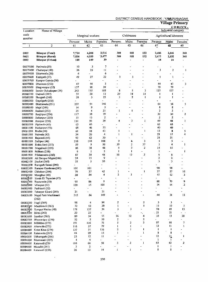
Location code number
Name of Village
2
0002 0002 0002
Bilaspur (Total) Bilaspur (Rural) Bilaspur (LJrban)
00079300 Paniwala (39) 00079400 Chuharpur (40) 00079500 Uttamwala (38) 00079600 Kafugarh (37) 00079700 Rampur Gainda (36) 00079800 Dhanaura (252) 00079900 Bhagwanpur (35) 00080000 Sunder Bahadurpur (34) 00080100 Gadwali (247) 00080200 Shergarh (248) 00080300 Dayalgarh (250) 00080400 Bhattuwala (251) 00080500 Majri (249) 00080600 Suabari (253) 00080700 Ranjitpur (254) 00080800 Sultanpur (255) 00080900 Ranipur (256) 00081000 Pipliwala (41) 00081 I 00 Nathanpur (43) 00081200 Bodhi (44) 00081300 Naiwala(42) 00081400 Bajawali (45) 00081500 Safilpur (46) 00081600 Rohla Heri (257) 00081700 Mugalwali (259) 00081800 Milkara (258) 00081900 Pilkhanwala (260) 00082000 Ali Sherpur Majra (246) 00082100 Bankat (240) 00082200 Ramgarh Sawai (245) 00082300 Rampur Kamboan (243) 00082400 Chhalaur (244) 0008,:l500 Manglaur (49) 0008{600 Tunde Ki Taparian (47) 00082700 Bansewala (50) 0008:lg00 Mianpur (51) 00082900 Parbhaoli (52) 00083000 Taharpur Khurd (261) 00083100 Nagai Patti Machhrauli
(262)
00083200 Nagli (264) 00083\00 Machhrauli (263) 0008j~£0 Rampur Harian (48) 00081500 Bihla (242) 00083600 Sandhai(265) 00083700 Bhawanipur (276) 00083800 Milkkhas (275) 00083900 Aharwala (273) 00084000 Kotra Khas (274) 00084100 Raianwala (267) 00084200 Udhamgarh (266) 00084300 Bhamnauli (227) 00084400 Katarwali (239 00084500 Muzafat (241) 00084600 Katarwali (238)
Marginal workers
Persons
41
7,724 7,536
188
10 36 6
49
47 137 243
33 28
237 14 25
117 15
131 63 68 61 24 92
218 59 86
6 87 24 25
101 79 28
95 120
21 215
98 72
171
22 89 52
191 116 137 44 23
4 116
2 26
Males
42
4,208 4,059
149
3 25
27
44 98
135 20
3
91 9 4
38 13 92 63 46 18 20 62
110 9
38
39 15 5
101 37 24
86 15
66
4 52
137 22 34
2 116 37 21 29 12 4
66 2
12
Females 43
3,516 '3,477
39
7 II 6
22
3 39
108 13 25
146 5
21 79 2
39
22 43 4
30 108 50 48 5
48 9
20
42 4
9 105
21 149
94 20 34
5S 50 75 79
116 15 II
50
14
336
DISTRICT CENSUS HANDBOOK: YAMUNANAGAR
Persons
44
300 300
3
8 29
3
4
9 39
5
16
2
2 I 3
16 2 5 I 2
3
Village Primary CD BLOCK-
Industrial category
Cultivators Agricultural labourers
Males 45
168 168
3
5 18 2
3
6 2 3
13
2
3
12
2
2
Females 46
132 132
3 11
I
3 37
2
3
2
4 2 3
Persons
47
2,486 2,472
14
3
44 79
127
61 8 2
32 2
49 63 40 13 21 21
5 5
15 I 6 2 3
90 37 15
88 16
44
3 II 98
,21 33
'17 12
I 8
12 I
65 I 8
Males 48
2,146 2,132
14
2
41 79
127
56 8 2
30 2
48 63 40 8
I7 21 5 4
15
6 2 3
90 27 l2
79 14
31
3 10 85 21 13
90 II
I 8
Il-l
63 I 8
Females 49
340 340
3
5
2
5 4
10 3
9 2
13
I 13
20
7
2
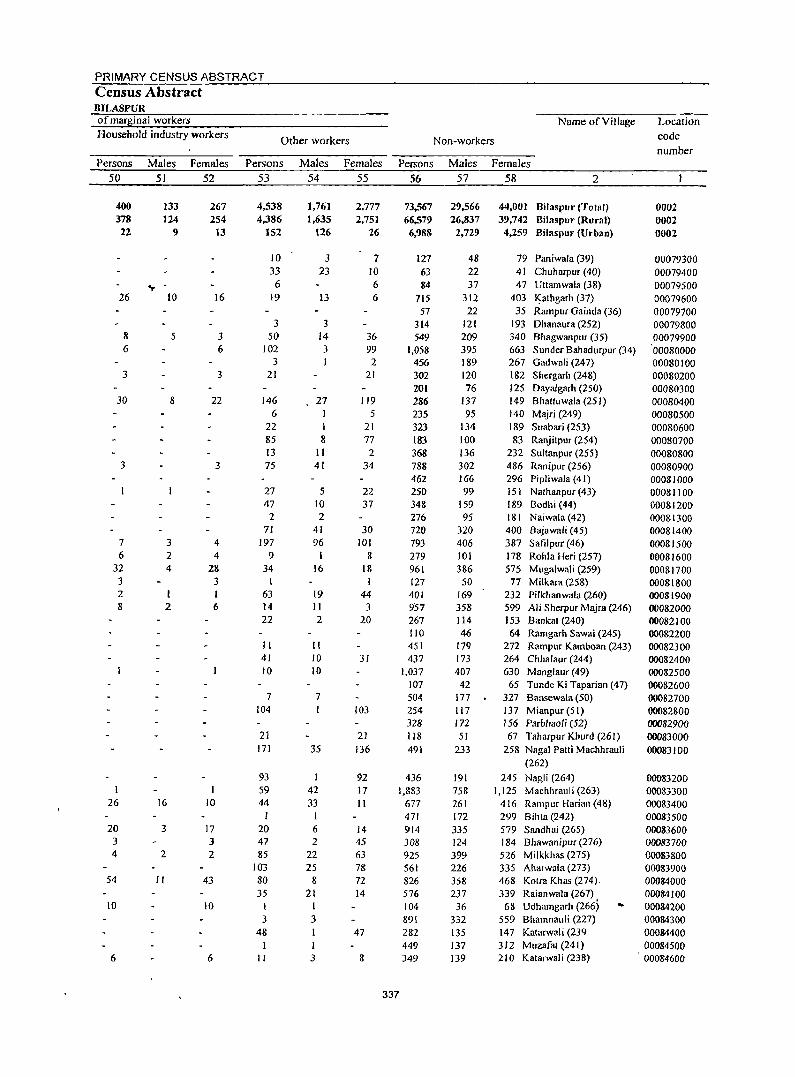
PRIMARY CENSUS ABSTRACT Census Abstract BILASPUR of marginal workers Household industry workers
Persons 50
400 378 22
26
8 6
3
30
3
7 6
32 3 2 8
1
26
20 3 4
54
10
6
Males 51
133 124
9
., -10
5
8
3 2 4
I 2
16
3
2
11
Females 52
267 254
13
16
3 6
3
22
3
4 4
28 3 I 6
10
17 J 2
43
10
6
Other workers
Persons 53
4,538 4,386
152
10 33 6
19
3 50
102 3
21
146 6
22 85 13 75
27 47 2
71 197
9 34
63 14 22
II 41 10
7 104
21 171
93 59 44
I 20 47 85
103 80 35
I 3
48
)1
Males 54
1,761 1,635
126
3 23
13
3 14 3 I
27 1 I 8
II 41
5 10 2
41 96
16
19 II 2
II 10 10
7
35
42 33
I 6 2
22 25
8 21
I 3 I
3
Females 55
2,777 2,751
26
7 10 6 6
36 99 2
21
119 5
21 77 2
34
22 37
30 101
8 18
44 3
20
31
to3
21 136
92 17 II
14 45 63 78 72 14
47
8
Name of Village
Non-workers
Persons Males Females 56
73,567 66,579 6,988
127 63 84
115 57
314 549
1,058 456 302 201 286 235 323 183 368 788 462 250 348 276 720 793 279 961 127 401 957 267 110 451 437
1,037 107 504 254 328 118 491
436 I,B83
677 471 914 308 925 561 826 576 104 891 282 449 349
337
57
29.566 26,837
2,729
48 22 37
312 22
121 209 395 189 120 76
137 95
134 100 136 302 166 99
159 95
320 406 101 386
50 169 358 114 46
179 173 407
42 177 117 172 51
233
191 758 261 172 335 124 399 226 358 237 36
332 135 137 139
58 2
44,001 BiJaspur (Total) 39,742 Bilaspur (Rural)
4,259 Bilaspur (Urban)
79 Paniwala (39) 41 Chuharpur (40) 47 Uttamwala (38)
403 ~athgarh (37) 35 Rampur Gainda (36)
193 Dhanaura (252) 340 Bhagwanpur (35) 663 Sunder Bahadurpur (34) 267 Gadwali (247) 182 Shergarh (248) 125 Dayalgarh (250) 149 Shattuwala (251) 140 Majri (249) 189 Suabari (253) 83 Ranjitpur (254)
232 Sultanpur (255) 486 Ranipur (256) 296 Pipliwala (41) 151 Nathanpur (43) 189 Sodhi (44) 181 Naiwala (42) 400 Sajawali (45) 387 SafiJpur (46) 178 Rohla Heri (257) 575 Mugalwali (259)
77 Milkara (258) 232 Pilkhanwala (260) 599 Ali Sherpur Majra (246) 153 Bankat (240) 64 Ramgarh Sawai (245)
272 Rampur Kamboan (243) 264 Chhalaur (244) 630 Manglaur (49)
65 Tunde Ki Taparian (47) 327 Bansewala (SO) 137 Mianpur(51) 156 Parbhaoli (52) 67 Taharpur Khurd (261)
258 NagaI Patti Machhrauli (262)
245 Nagli (264) 1,125 Machhrauli (263)
416 Rampur Harian (48) 299 Bihta (242) 579 Sandhai (265) 184 Bhawanipur (276) 526 Milkkhas (275) 335 Aharwala (273) 468 Kotra Khas (274) 339 Raianwala (267)
68 Udhamgarh (266) .. 559 Bhamnauli (227) 147 Katarwali (239 312 Muzafat (241) 210 Katarwali (238)
Location code number
0002 0002 0002
00079300 00079400 00079500 00079600 00079700 00079800 00079900
'00080000 00080100 00080200 00080300 00080400 00080500 00080600 00080700 00080800 00080900 00081000 00081100 00081200 000SI300 00081400 00081500 00081600 00081700 00081800 oo0819{)0 00082000 00082100 00082200 00082300 00082400 00082500 00082600 00082700 00082800 00082900 00083000 00083100
00083200 00083300 00083400 00083500 00083600 00083700 00083800 00083900 00084000 00084100 00084200 00084300 00084400 00084500 00084600
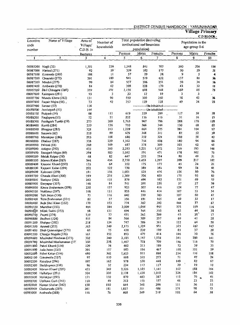
DISTRICT CENSUS HANDBOOK: YAMUNANAGAR
Village Primary CD BLOCK-
Location Name of Village Area of Number of Total population (including
Population in the code Village! households
institutional and bouse!ess age-group 0-6
number C.D.B.in EOEulationl
hectares Persons Males Females Persons Males Females 2 3 4 5 6 7 8 9 I'O
00085200 Nagli (32) 1,301 236 1,548 841 707 360 206 15<f 00087000 Hartaul (271) 92 59· 359 182 177 50 29 21 00087100 Kurewala (269) 108 11 57 29 28 9 5 4 00087200 Chaurahi (272) 201 189 941 519 422 137 81 56 00087300 Mauhri (277) 99 84 557 306 251 50 34 16
00087400 Ambwala (278) 84 62 398 228 170 43 32 II 00087500 Bhil Chhappar (280) 359 191 1,156 608 548 160 85 75 00087600 Kaimpura (281 ) 93 3 22 12 10 3 3 00087700 Munda Khera (2&2) 131 90 550 300 250 78 42 36 00087800 Faquir Majra (56) • 73 42 257 129 128 49 24 25 00087900 Sanaur (57) 116 -------------Un-inhabited--------------00088000 Jamiatgarh (55) 144 -----------Un-inhabited-----------00088100 Butgarh (54) 98 III 619 320 299 117 59 511 00088200 Singhpura (53) 72 51 252 136 116 31 16 IS 00088300 Fatehgarh Tumbi (59) 273 269 1,763 967 796 2&& 170 III 00088400 Kurali (284) 259 136 710 366 344 130 68 62 00088500 Bhogpur (2&5) 321 213 1,239 664 575 201 104 91 00088600 Sarawin (62) 233 89 679 368 311 82 52 30 00088700 Manakpur (286) 203 108 680 359 321 100 58 42 00088800 Dhalaur (287) 338 229 1,362 754 608 180 94 86 00088900 Painsal (61) 280 109 687 378 309 103 62 41 00089000 Azizpur (292) 433 350 2,293 1,221 1,072 339 193 146 00089100 Rarngarh Majra (60) 294 183 1,062 591 471 178 102 76 00089200 Malak Raipul (58) 68 82 447 233 214 80 49 31 00089300 Marwa Kalan (283) 344 456 2,750 1,453 1,297 399 217 182 00089400 Kapoori Khurd (293) 133 64 352 175 177 45 24 21 00089500 Kapoori Kalan (294) 222 122 730 389 341 99 58 41 00089600 Kakrauni (299) 181 156 1,001 525 476 156 80 76 00089700 Chanda Kheri (300) 219 235 1,309 706 603 175 93 82 00089800 Shahpur (302) 243 135 879 496 383 121 69 52 000&9900 Daryapur (303) 14& 84 541 291 250 57 27 30 00090000 Khera Brahmanan (29&) 230 157 923 507 416 124 77 47 00090100 Makhaur (297) 19& 133 855 441 414 107 53 54 00090200 Tehi latan (330) 73 116 642 339 303 107 60 47 00090300 Teha Brahmanan (331) 82 57 356 191 165 49 32 17 00090400 luda Shei Khan (332) 170 153 774 382 392 144 77 67 000905PO Mandhar (333) 414 384 2,009 [,054 955 275 159 [16 00090~~0 Milak Sukhi (373) 98 131 694 344 350 82 44 38 00090700 Paonti (374) 139 77 471 262 209 45 2S' 17 00090800 Budheri (324) 151 84 566 309 257 69 41 28 00091200 Shahpur (382) 218 124 747 386 361 122 64 58 00091300 Arnauli (323) 363 340 2.175 1,224 951 325 182 143 00091400 Shah Quamaispur (375) 60 75 438 239 199 65 37 28 00091500 Chhaiju Nagala (376) 161 152 S93 479 414 146 70 76 00091600 Musimbal Hindwan (371) 332 340 2,1&5 1,147 1,038 341 200 141 00091700 Musimbal Muslamanan (37: 350 278 1,467 758 709 186 116 70 0009180d Pabni Khurd (334) 129 76 402 213 189 72 39 33 0009[900 Juda Jalan (335} 20( 157 983 516 467 160, 101 59 ooo92ooh Pabni Kalan (336) 480 302 1,823 935 888 254 136 1I8
00092100 Oianawala (337) 97 110 60S 335 273 71 47 24 00092200 R8sulpur (296) 197 162 978 530 44& 149 82 67 00092300 Shekhupura (338) 96 32 234 117 117 29 19 10 00092400 Marwa Khurd (295) 453 349 2,326 1,185 1,141 352 188 164 00092500 Huibatpur (29 1 ) 504 330 2,138 1,128 1,010 326 184 142 00092600 Malakpllr (290) 171 150 870 483 387 115 70 .. 4S 00092700 Uddham Oarh (341) 110 49 312 155 157 46 23 23 00092800 Nawan Shahar (342) 138 110 644 348 296 111 56 55 00092900 Chah;trwala (289) 261 181 1,037 551 486 171 98 73
00093000 Ambwala (288) 116 76 !t68 249 219 102 64 38
338
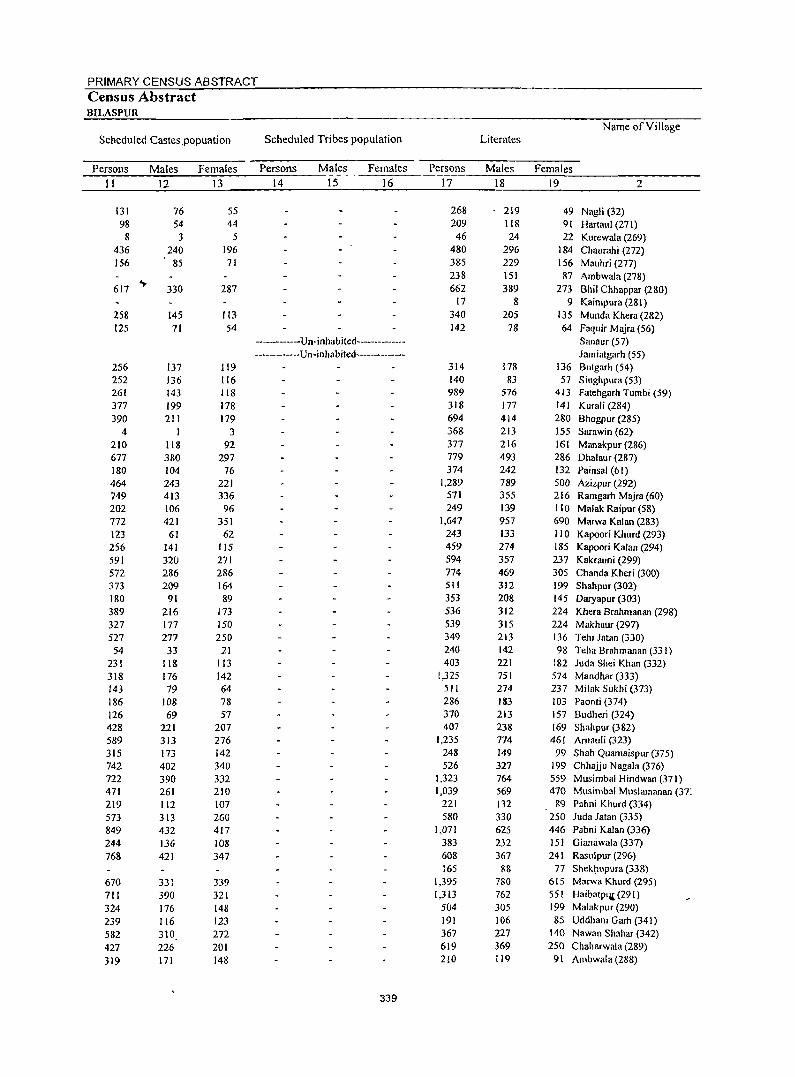
PRIMARY CENSUS ABSTRACT Census Abstract BILASPUR
Name of Village Scheduled Castes.popuation Scheduled Tribes population Literates
Persons Males Females Persons' Males Females Persons Males Females
11 12 13 14 15 16 17 18 19 2
131 76 55 268 219 49 Nagli (32) 98 54 44 209 118 91 Hartaul (271) 8 3 5 46 24 22 Kurewala (269)
436 240 196 480 296 184 Chaurahi (272) 156 85 71 385 229 156 Mauhri (277)
238 151 87 Ambwala (278) 617
.,. 330 287 662 389 273 Bhil Chhappar (280)
17 8 9 Kaimpura (281 ) 258 145 113 340 205 135 Munda Khera (282) 125 71 54 142 78 64 Faquir Majra (56)
---------Un-inhabited-------------- Sanaur (57) ----------Un-inhabited-------------- Jamiatgarh (55)
256 137 119 314 178 136 Butgarh (54) 252 136 116 140 83 57 Singhpura (53) 261 143 118 989 576 413 Fatehgarh Tumbi (59) 377 199 178 318 177 141 Kurali (284) 390 211 179 694 414 280 Bhogpur (285)
4 I 3 368 213 155 Sarawin (62) 210 118 92 377 216 161 Manakpur (286) 677 380 297 779 493 286 Dhalaur (287) 180 104 76 374 242 132 Painsal (61) 464 243 221 1,289 789 500 Azizpur (292) 749 413 336 571 355 216 Ramgarh Majra (60) 202 106 96 249 139 110 Malak Raipur (58) 772 421 351 1,647 957 690 Marwa Kalan (283) 123 61 62 243 133 110 Kapoori Khurd (293) 256 141 115 459 274 185 Kapoori Kalan (294) 591 320 271 594 357 237 Kakrauni (299) 572 286 286 774 469 305 Chanda Kheri (300) 373 209 164 511 312 199 Shahpur (302) 180 91 89 353 208 145 Daryapur (303) 389 216 173 536 312 224 Khera Brahmanan (298) 327 177 150 539 315 224 Makhaur (297) 527 277 250 349 213 136 Tehi Jatan (330) 54 33 21 240 142 98 Teha Brahmanan (331)
231 118 113 403 221 182 Juda Shei Khan (332) 318 176 142 1,325 751 574 Mandhar (333) 143 79 64 511 274 237 Milak Sukhi (373) 186 108 78 286 183 103 Paonti (374) 126 69 57 370 213 157 Budheri (324) 428 221 207 407 238 169 Shahpur (382) 589 313 276 1,235 774 46J Arnauli (323) 315 173 142 248 149 99 Shah Quarnaispur (375) 742 402 340 526 327 199 Chhajju Nagala (376) 722 390 332 1,323 764 559 Musimbal Hindwan (371) 471 261 210 1,039 569 470 Musimbal Muslamanan (37: 219 112 107 221 132 89 Pabni Khurd (334) 573 313 260 580 330 250 Juda Jatan (335) 849 432 417 1,071 625 446 Pabni Kalan (336) 244 136 108 383 232 151 Giamiwala (337) 768 421 347 608 367 241 Rasulpur (296)
165 88 77 Shekhupura (338) 670 331 339 1,395 780 615 Marwa Khurd (295) 711 390 321 1,313 762 55! HaibatpLI( (291) 324 176 148 504 305 199 MalakpLlr (290) 239 116 123 191 106 85 Uddham Garh (341) 582 310 272 367 227 140 Nawan ShahaT (342) 427 226 201 619 369 250 Chaharwala (289) 319 171 148 210 119 91 Ambwala (288)
339
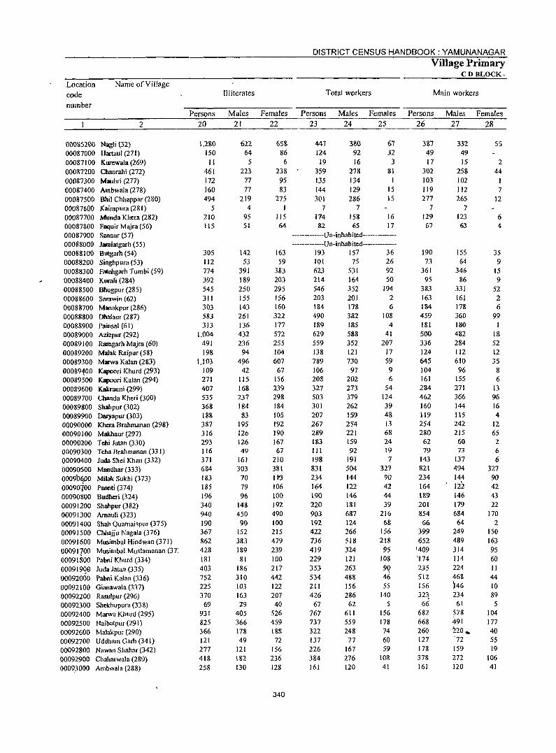
Location code number
Name ofViffage
2
nOOS5200 Nagli (32) 00087000 Hartanl (271) 00087100 Kurewala (269) 00087200 Cbaurahi (272) 00087300 Mauhri (277) 00087400 Ambwala (278) 00087500 Bhil Chhappar (280) 00087600 Kaimpura (281) 00087700 Munda Khera (282) 00087800 Faquir Majra (56) 00087900 Sanaur (57) 00088000 Jamiatgarh (55) 00088100 Butgarh (54) 00088200 Singhpura (53) 00088300 Fatehgarh Tumbi (59) 00088400 Kurali (284) 00088500 Bhogpur(285) 00088600 Sarawin (62) 00088700 Manakpur (286) 00088800 Dhalaur (287) 00088900 Painsal (61) 00089000 Azizpur (292) 00089100 Ramgarh Majra (60) 00089200 Malak Raipur (58) 00089300 Marwa Kalan (283) 00089400 Kapoori Khurd (293) 00089500 Kapoori Kalan (294) 00089600 Kakrauni (299) 00089700 Chanda Kheri (300) 00089800 Shahpur (302) 00089900 Daryapur (303) 00090000 Khcra Brahmanan (298) 00090 I 00 Makhaur (297) 00090200 Tebi Jatan (330) 00090300 Teba Brahmanan (331) 00090400 Juda Shei Khan (332) 00090500 Mandhar (333) 0009b6J)0 Milak Sukhi (373) 00090ioo Paouti (374) 00090800 Budheri (324) 00091200 Shahpur (382) 00091300 Arnauli (323) 00091400 Shah Quamaispur (375) 00091500 Chhajju Nagala (376) 00091600 Musimbal Hindwan (371) 00091100 Musimbal Muslamanan (37: 00091800 Pabni Khurd (334) 000919QO luda Jatan (335) 00092000 Pabni Kalan (336) 00092100 Gianawala (337) 00092200 Rasulpur (296) 00092300 Shekhupura (338) 00092400 Marwa Khurd (295) 00092500 Haibatpur (291) 00092600 Malakpur (290) 00092700 Uddham Oarh (341) 00092800 Nawan Shahar (342) 00092900 Chaharwala (289) 00093000 Ambwala (288)
Persons 20
1,280 150 II
461 172 160 494
5 210 115
305 112 774 392 545 311 303 583 313
1,004 491 198
1,103 109 271 407 535 368 188 387 316 293 116 371 684 183 185 196 340 940 190 367 862 428 181 403 752 225 370
69 931 825 366 121 277 418 258
Illiterates
Males 21
622 64 5
223 77 77
219 4
95 51
142 53
391 189 250 155 143 261 136 432 236
94 496
42 115 168 237 184 83
195 126 126 49
161 303
70 79 96
148 450 90
152 383 189 81
186 310 103 163 29
405 366 17& 49
121 182 130
Females 22
658 86 6
238 95 83
275 I
115 64
163 59
383 203 295 156 160 322 177 572 255 104 607
67 156 239 298 184 105 192 190 167 67
210 381 II~
106 100 192 490 100 215 479 239 100 217 442 122 207 40
526 459 188 72
156 236 128
340
DISTRICT CENSUS HANDBOOK: YAMUNANAGAR
Total workers
Persons 23
447 124 19
359 135 144 301
Males 24
380 92 16
278 134 129 286
7 7 174 82
158 65
Females 25
67 32
3 81
15 15
16 17
------------Un-inhabited--------------------------Un-inhabited------------
193 157 36 101 623 214 546 203 184 490 189 629 559 138 789 106 208 327 503 301 207 267 289 183 III
198 831 234 164
190 220 903 192 422 736 419 229 353 534 211 426
67 767 737 322 137 226 384 161
75 531 164 352 201 178 382 185 588 352 121 730
97 202 273 379 262 159 254 221 159 92
191
504 144 122 146 181 687 124 266 518 324 121 263 488 156 286 62
611 559 248
77 167 276 120
26 92 50
194 2 6
108 4
41 207
17 59 9 6
54 124 39 48 13 68 24 19 7
327 90 42 44 39
216 68
156 218
95 108
9Q 46 55
140 5
156 178 74 60 59
108 41
Village Primary CD BLOCK-
Main workers
Persons 26
387 49 17
302 103 119 277
7 129 67
190 73
361 9S
383 163 184 459 181 500 336 124 645 104 161 284 462 160 119 254 280
62 79
143 821 234 164 189 201 854 66
399 652
1409 '174 2J5 512 156 32~ 66
682 668 260 127 178 378 161
Males 27
332 49 15
258 102 112 265
7 123 63
155 64
346 86
331 161 178 360 180 482 284 112 610 96
155 271 366 144 115 242 215 60 73
137 494 144 122 146 179 684 64
249 489 314 114 224 468 )46 234
61 578 491 220 .. '72
159 272 120
Females 28
5S
2 44
I 7
12
6 4
35 9
15 9
52 2 6
99
18 52 12 35 8 6
13 96 16 4
12 65 2 6 6
327 90 42 43 22
170 2
150 163 95 60 II 44 10 89
5 104 177 40 55 19
106 41
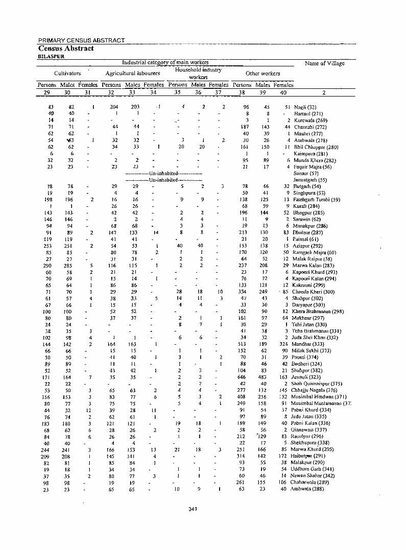
PRIMARY CENSUS ABSTRACT Census Abstract BILASPUR
Cultivators
Industrial category of main workers
Agricultural labourers Household industry
workers Persons Males Females Persons Males Females Persons Males Females
29 30 31 32 33 34 35 36 37
83 40 14 71 62 54 62 6
32 23
78 19
198 I
143 146 94 91
119 253 85 27
290 60 70 65 71 61 67
100 80 24 38
102 144 66 50 89 52
171 22 53
156 80 44 76
183 68 84 40
244 209
82 19 37 98 23
82 40 14 71 62
,,3 62 6
32 23
78 19
196
143 146 94 89
119 251 85 27
285 58 69 64 70 57 66
100 80 24 35 98
142 66 50 89 52
164 22 50
153 77 32 74
180 62 78 40
241 208
81 18 35 98 23
2
2
2
5 2
4
3 4 2
7
3 3 3
12 2 3 6 6
3
I 2
204
44 I
32 34
2 23
29 4
16 26 41
2
68 147 41 54 80 31
116 21 [5 86 29 38 [5 52 37
I
164 15 41 II 43 35
65 83 75 39 62
121 28 26
4 166 145
85 34 80 19 65
203 I
44
32 33
2
,I 4
3 20
2
I 20
23 -------------Un-inhabited--------------------------Un-i nh ab ited--------------
29 5 2 4
16 26 42
2 68
133 41 53 78 31
115 21 14
86 29 33 [5 52 37
I 163
15 40 II 42 35
63 77 75
14
I 2
5
2 6
28 II 61
121 26 26
4
153
2
13 141 4 84 34 77 3 19 65
9
2 4 3 8
40
2 2
28 14 4
2 8
6
I 3 I 2 2 2 4 5 5
19 2
21
10
9
2 4 3 8
40
2 2
18 11 4
7
6
2 2 2 4 3 4
18 2
18
9
341
2
2
3
10
3
2
2
3
Name ofYillage
Other workers
Persons Males Females 38 39 40 2
96 8 3
187 40 30
161 I
95 21
78 50
138 68
196 II 19
213 21
153 170 64
237 23 76
133
334 47 33
102
161 30 41 34
513 152 70 88
104 646 42
277 408 249
91 97
189 58
212 22
251 314
93 73 60
261 63
45 8
143 39 26
150 1
89 17
46 41
125 59
144 9
I3 130 20
138 120 52
208 17 72
121 249 43 30 90 97 29 38 32
189 62 31 46 83
483 40
132 256 158 54 89
149 56
'129 17
166 142 55 19 46
155 23
51 Nagli (32) Hartaul (271)
2 Kurewala (269) 44 Chaurahi (272)
Mauhri (277)
4 Arnbwala (278) I I Bhil Chhappar (280)
Kairnpura (281) 6 Munda Khera (282) 4 Faquir Majra (56)
Sanaur (57) Jarniatgarh (55)
32 Blltgarh (54) 9 Singhpura (53)
13 Fatehgarh Tumbi (59) 9 Kurali (284)
52 Bhogpllr (285) 2 Sarawin (62) 6 Manakpur (286)
83 Dhalallr (287) I Painsal (61)
15 Azizpur (292) 50 Ramgarh Majra (60) 12 Malak Raiplir (58)
29 Marwa Kalan (283} 6 Kapoori Khurd (293) 4 Kapoori Kalan (294)
12 Kakrallni (299) , 85 Chanda Kheri (300)
4 Shahpur (302) 3 Daryapur (303)
12 Khera Brahmanan (298) 64 Makhaur (297)
I Tehi Jatan (330) 3 Teha Brahmanan (33 I) 2 Juda Shei Khan (332)
324 Mandhar (333) 90 Milak Sukhi (373) 39 Paonti (374) 42 Budheri (324) 21 Shahpur (382)
163 Arnallii (323) 2 Shah Quamaispur (375)
145 Chhajju Nagala (376) 152 Musirnbal Hindwan (371) 91 Musimbal Muslamanan (37: 37 Pabni Khurd (334)
8 Juda Jatan (335) 40 Pabni Kalan (336)
2 Gianawala (337) 83 RasulplIT (296) 5 Shekhupllra (338)
85 Marwa Khurd (295) 172 Haibatpttr (291) 38 Malakpur (290) 54 Uddham Garh (341) 14 Nawan Shahar (342)
106 Chaharwala (289) 40 Ambwala (288)
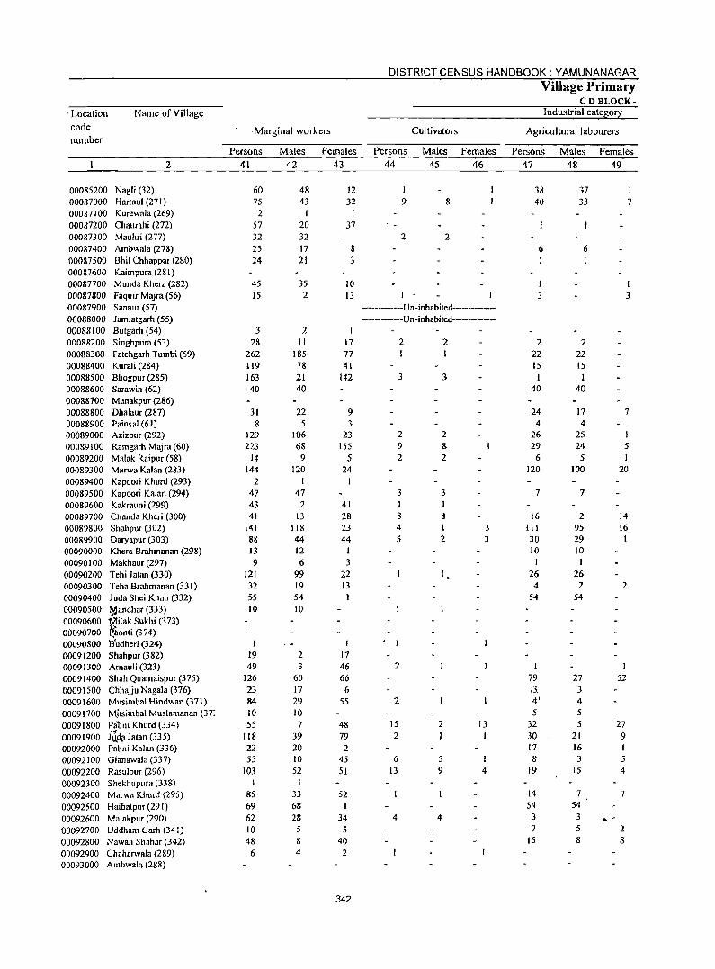
DISTRICT CENSUS HANDBOOK: YAMUNANAGAR
Village Primary CD BLOCK-
. Location Name ofVilJage Industrial categ0!l:
code . Marginal workers Cultivators Agricultural labourers number
Persons Males Females Persons Males Females Persons Males Females
2 41 42 43 44 45 46 47 48 49
00085200 Nagli (32) 60 48 12 I 38 37 00087000 Hartaul (271) 75 43 32 9 8 40 33 7 00087100 Kurewala (269) 2 I 1 00087200 Chaurahi (272) 57 20 37 00087300 Mauhri (277) 32 32 2 2 00087400 Ambwala (278) 25 17 8 6 6 00087500 Bhil Chhappar (280) 24 21 3 00087600 Kaimpura (281 ) 00087700 Munda Khera (282) 45 35 10 1 00087800 Faquir Majra (56) 15 2 13 3 3 00087900 Sanaur (57) -----------Un-inhabited-----------00088000 Jamiatgarh (55) -----------Un-inhabited---------00088100 Butgarh (54) 3 2 1 00088200 Singhpura (53) 28 II 17 2 2 2 2 00088300 Fatehgarh Tumbi (59) 262 185 77 22 22 00088400 Kurali (284) 119 78 41 15 15 00088500 Bhogpur (285) 163 21 142 3 3 1 00088600 Sarawin (62) 40 40 40 40 00088700 Manakpur (286) 00088800 Dhalaur (287) 31 22 9 24 17 7 00088900 Painsal (61) 8 5 3 4 4 00089000 Azizpur (292) 129 106 23 2 2 26 25 00089100 Ramgarh Majra (60) 223 68 155 9 8 29 24 5 00089200 Malak Raipur (58) 14 9 5 2 2 6 5 00089300 Marwa Kalan (283) 144 120 24 120 100 20 00089400 Kapoori Khurd (293) 2 I I 00089500 Kapoori Kalan (294) 47 47 3 3 7 7 00089600 Kakrauni (299) 43 2 41 I 00089700 Chanda Kheri (300) 41 13 28 8 8 16 2 14 00089800 Shahpur (302) 141 118 23 4 3 III 95 16 00089900 Daryapur (303) 88 44 44 5 2 3 30 29 00090000 Khera Brahmanan (298) 13 12 1 10 10 00090100 Makhaur (297) 9 6 3 1 00090200 Tehi Jatan (330) 121 99 22 26 26 00090300 Teha Brahmanan (331) 32 19 13 4 2 2 00090400 Juda Shei Khan (332) 55 54 54 54 00090500 l,lQandhar (333) 10 10 00090600 Milak Sukhi (373) 00090700 ~aonti (374) 00090800 liudheri (324) I I 00091200 Shahpur (382) 19 2 17 00091300 Arnauli (323) 49 3 46 2 I
00091400 Shah Quamaispur (375) 126 60 66 79 27 52 00091500 Chhaliu Nagala (376) 23 17 6 ,3. 3 00091600 Musimbal Hindwan (371) 84 29 S5 2 4' 4
00091700 M_usimbal Muslamanan (37: 10 10 S 5
00091800 Plibni Khurd (334) 55 7 48 15 2 13 32 5 27
00091900 . .;
118 39 79 2 I I 30 21 Jt.~d~ Jatan (335) 9 00092000 Pabni Kalan (336) 22 20 2 17 16
00092100 Gianawala (337) 55 10 45 6 5 8 3 5
00092200 Rasulpur (296) 103 52 51 13 9 4 19 15 4
00092300 Shekhupllra (338) I
00092400 Marwa Khurd (295) 85 33 52 14 7 7
00092500 Haibatpur (291) 69 68 I 54 54
00092600 Malakpur (290) 62 28 34 4 4 3 3 ~ -00092700 Uddham Garh (341) 10 5 5 7 5 2
00092800 Nawan Shahar (342) 48 8 40 16 8 8
00092900 Challarwala (289) 6 4 2 00093000 Ambwala (288)
342
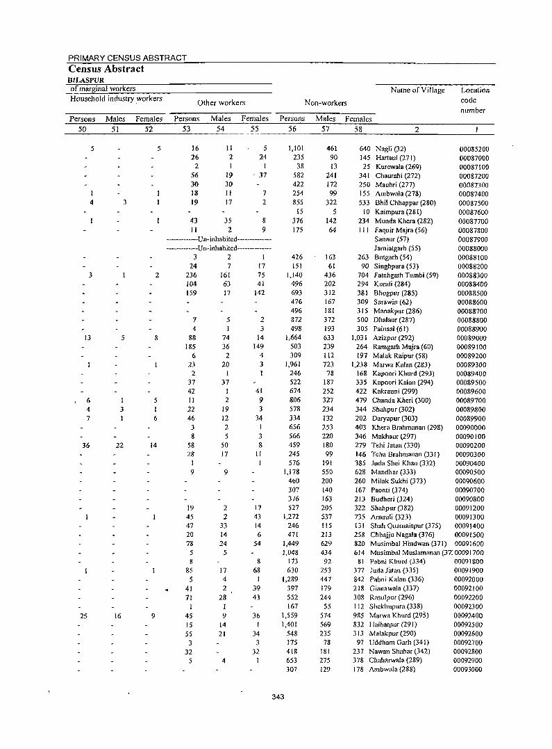
PRIMARY CENSUS ABSTRACT Census Abstract BILASPVR of marginal workers Household industry .workers
Persons 50
5
I 4
3
13
6 4 7
36
25
Males 51
3
5
3
22
16
Females 52
5
2
8
5 I 6
14
9
Other workers
Persons 53
16 26
2 56 30 18 19
43 II
Males 54
II 2 I
19 30 II 17
35 2
Females 55
5 24
I . 37
7
2
8 9
----------Un-inhabited-------------------------u n-inhab ited--------------
321 24
236 104 159
7 4
88 185
6 23
2 37 42 II 22 46
3 8
58 28
I 9
19 45 47 20 78
7 161 63 17
5
74 36 2
20 I
37 I 2
19 12 2 5
50 17
9
2 2
33 14 24
5 5 8
85 5
41 71
45 15 55
3 32
5
17 4 2
28 1
9 14 21
4
17 75 41
142
2 3
14 149
4 3
41 9 3
34 I 3 8
II
17 43 14 6
54
8 68
39 43
36 I
34 3
32 I
Name of Village
Non-workers
Location code number
Persons Males Females 56
1,101 235 38
582 422 254 855
15 376 175
426 151
1,140 496 693 476 496 872 498
1,664 503 309
1,961 246 522 674 806 578 334 656 566 459 245 576
1,178 460 307 3/6 527
1,272 246 471
1,449 1,048
113 630
1,289 397 552 167
1,559 1,401
548 175 418 653 307
343
57
461 90 13
241 172 99
322 5
142 64
163 61
436 202 312 167 181 372 193 633 239 112 723 78
187 252 327 234 132 253 220 180 99
191 550 200 140 163 205 537 115 213 629 434 92
253 447 179 244
55 574 569 235
78 181 275 129
58 2
640 Nagli (32) 00085200 145 Hartaul (271) 00087000 25 Klirewala (269) 00087100
341 Chaurahi (272) 00087200 250 Mauhri (277) 00087300 155 Ambwala (278) 00087400 533 Bhil Chhappar (280) 00087500
10 Kaimpura (281) 00087600 234 Munda Khera (282) 00087700 III Faquir Majra (56) 00087800
Sanaur (57) 00087900 Jamiatgarh (55) 00088000
263 Blltgarh (54) 00088100 90 Singhpura (53) 00088200
704 Fatehgarh Tumbi (59) 00088300 294 Kurali (284) 00088400 381 Bhogpllr (285) 00088500 309 Sarawin (62) 00088600 315 Manakpur (286) 00088700 500 Dhalallf (287) 00088800 305 Painsal (61) 00088900
1,031 Azizpnr (292) 00089000 264 Ramgarh Majra (60) 00089100 197 Malak Raipur (58) 00089200
1,238 Marwa Kalan (283) 00089300 168 Kapoori Khurd (293) 00089400 335 Kapoori Kalan (294) 00089500 422 Kakrallni (299) 00089600 479 Chanda Kheri (300) 00089700 344 Shahpur (302) 00089800 202 Daryapur (303) 00089900 403 Khera Brahmanan (298) 00090000 346 Makhaur (297) 00090100 279 Tehi Jatan (330) 00090200 146 Teha Brahmanan (33 I) 00090300 385 Juda Shei Khan (332) 00090400 628 Mandhar (333) 00090500 260 Milak Sukhi (373) 00090600 167 Paonti (374) 00090700 213 Budheri (324) 00090800 322 Shahpur (382) 00091200 735 Arnauli (323) 00091300 131 Shah Quamaispur (375) 00091400 258 Chhajju Nagala (376) 00091500 820 Musimbal Hindwan (371) 00091600 614 Musimbal Muslamanan (37: 00091700
81 Pabni Khurd (334) 00091800 377 Juda Jatan (335) 00091900 842 Pabni Kalan (336) 00092000 218 Gianawala (337) 00092100 308 Raslilpur (296) 00092200 112 Shekhuplira (338) 00092300 985 Marwa Khllrd (295) 00092400 832 Haibatpur (291) 00092500 313 Malakpur (290) 00092600 97 Uddham Garh (341) 00092700
237 Nawan Shahar (342) 00092800 378 Chaharwala (289) 00092900 f 78 Ambwala (288) 00093000
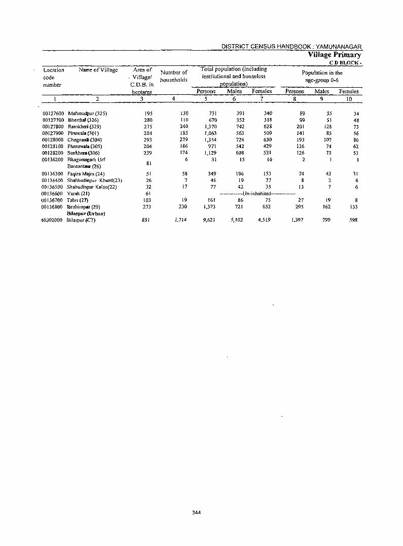
DISTRICT CENSUS HANDBOOK: YAMUNANAGAR
Village Primary CD BLOCK-
Location Name of Village Area of Number of Total population (inCluding
Population in the code . Villager households
institutional and houseless age-group 0-6
number C.D.B.in ~o~ulation2
hectares Persons Males Females Persons MaJes Females
2 3 4 5 6 7 g 9 10
00127600 Mahmudpur (325) 195 130 731 391 340 89 55 34 00127700 BherthaJ (326) 280 110 670 352 318 99 51 48 00127800 Ramkheri (329) 275 240 1,370 742 628 201 128 73 00127900 Piruwala (30 I ) 204 185 1,063 563 500 141 85 56 00128000 Chagnauli (304) 293 229 1,354 724 630 193 107 86 00128100 Pheruwala (305) 204 186 971 542 429 136 74 62 00128200 Sankhera (306) 239 174 1,129 608 521 126 73 53 00136200 Bhagwangarh Urf 6 31 15 16 2
Bansantaur (26) 81
00136300 Faqira Majra (24) 51 58 349 196 153 74 43 31 00136400 Shahbudinpur Khurd(23) 26 7 46 19 27 g 2 6 00136500 Shabudinpur Kalan(22) 32 17 77 42 35 13 7 6 00136600 Yarah (21) 61 ----------Un-inhabited-------------00136700 Tahri (l7) 103 19 161 86 75 27 19 8 00136800 Ibrahimpur (29) 273 230 1.373 721 652 295 162 133
Bilaspur (Urban) 40302000 Bilaspur{CT) 851 1.714 9,621 5,102 4,519 1,397 799 598
344
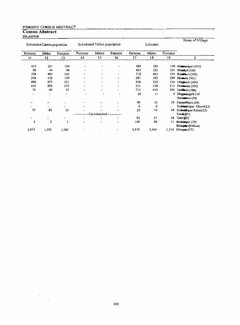
PRIMARY CENSUS ABSTRACT Census Abstract BILASPUR
Name ofVilJage
Scheduled Castes. pOl?uation Scheduled Tribes population Literates
Persons Males Females Persons Males Females Persons Males Females
Jl 12 13 14 15 16 17 18 19 2
415 221 194 484 285 199 Mallmldpur (325) 90 44 46 453 262 191 B~I(326)
738 403 335 718 443 275 R3fIIUaeri (329) 258 138 120 681 392 289 Pi~la(301) 498 277 221 856 522 334 Chll!'JWllli (304) 526 294 232 551 338 213 Phaw.ala (305)
75 40 35 712 4]8 294 Sankkra (306) 20 11 9 Bhag_ngarh Urf
Bansacaur (26)
99 73 26 Faqilll Majra (24) 6 6 Shablllllllinpur Khurd(23)
77 42 35 29 19 10 ShabdiJpur Kalan(22) ------------Un-inhabited---------- Yarall (21)
91 53 38 Tabri(.l7) 3 2 109 98 11 Ibrahilqrur (29)
Bilas'_' (Urban) 2,937 1,57J 1,366 6,179 3,465 2,714 Bilaspw(CT)
345
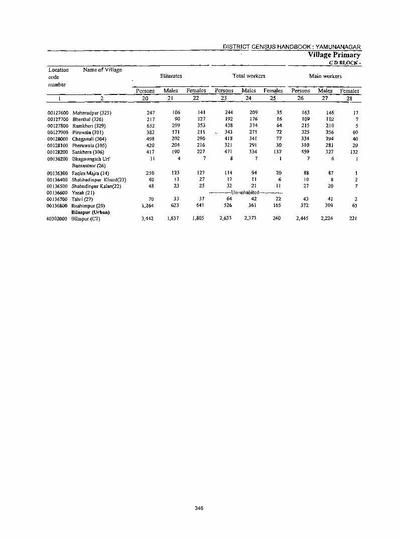
346
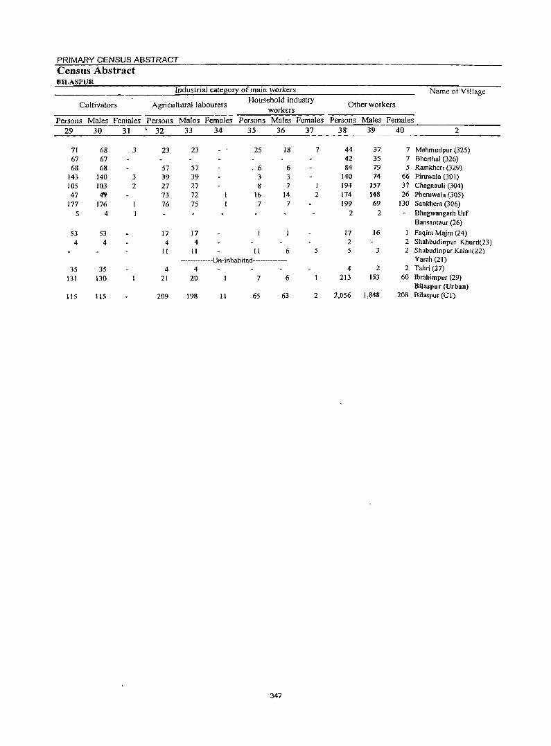
PRIMARY CENSUS ABSTRACT Census Abstract BILASPUR
Industrial catetii0ry of main workers Name of Village
Cultivators Agricultural labourers Household industry
Other workers workers
Persons Males Females Persons Males Females Persons Males Females Persons Males Females
29 30 31 I 32 33 34 35 36 37 38 39 40 2
71 68 3 23 23 25 18 7 44 37 7 Mahmudpur (325) 67 67 42 35 7 Bhenhal (326) 68 68 57 57 . 6 6 84 79 5 Ramkheri (329)
143 140 3 39 39 3 3 140 74 66 Piruwala (301) 105 103 2 27 27 8 7 194 157 37 Chagnauli (304) 47 Iff 73 72 16 14 2 174 148 26 Pheruwala (305)
177 176 76 75 7 7 199 69 130 Sankhera (306)
5 4 2 2 Bhagwangarh Urf Bansantaur (26)
53 53 17 17 17 16 I Faqira Majra (24)
4 4 4 4 2 2 Shahbudinpur Khurd(23) II II II 6 5 5 3 2 ShablldinplIr Kalan(22)
-------------Un-inhabited------------- Yarah (21)
35 35 4 4 4 2 2 Tahri (27)
131 130 21 20 7 6 213 IS3 60 Ibrahimpur (29) BiJaspur (Urban)
115 115 209 198 11 65 63 2 2,056 1,848 208 Bilaspur (CT)
347
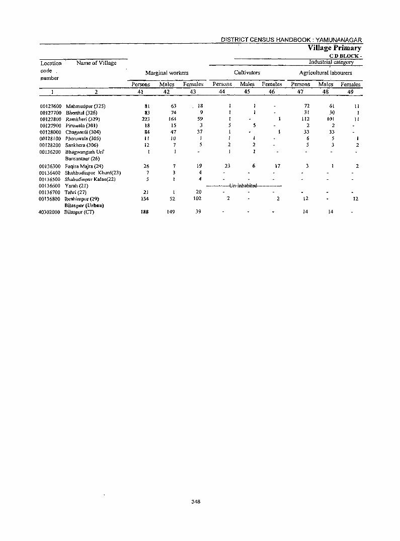
DISTRICT CENSUS HANDBOOK: YAMUNANAGAR Village Primary
CD BLOCK-
Location Name of Village Industri~l cate&or~
code. Marginal workers Cultivators Agricultural labourers number
Persons Males Females Persons Males Females Persons Males Females
2 41 42 43 44 45 46 47 48 49
00127600 Mahmudpur (325) 81 63 18 72 61 11 00127700 Bherthal (326) 83 74 9 31 30 00127800 Ramkheri (329) 223 164 59 I 112 101 II 00127900 Piruwala (301) 18 15 3 5 5 2 2 00128000 Chagnauli (304) 84 47 37 33 33 00128100 Pheruwala (305) II 10 I I I 6 5 I 00128200 Sankhera (306) 12 7 5 2 2 5 3 2 00136200 Bhagwangarh urr 1
Bansantaur (26)
00136300 Faqira Majra (24) 26 7 19 23 6 17 3 2 00136400 Shahbudinpur Khurd(23) 7 3 4 00136500 Shabudinpur Kalan(22) S 4
00136600 Yarah (21) ------------Un-inhabited---------
00136700 Tahri (27) 21 1 20
00136800 lbrahimpur (29) 154 52 102 2 2 12 12 Bilaspur (Urban)
40302000 Bilaspur (CT) 188 149 39 14 14
348
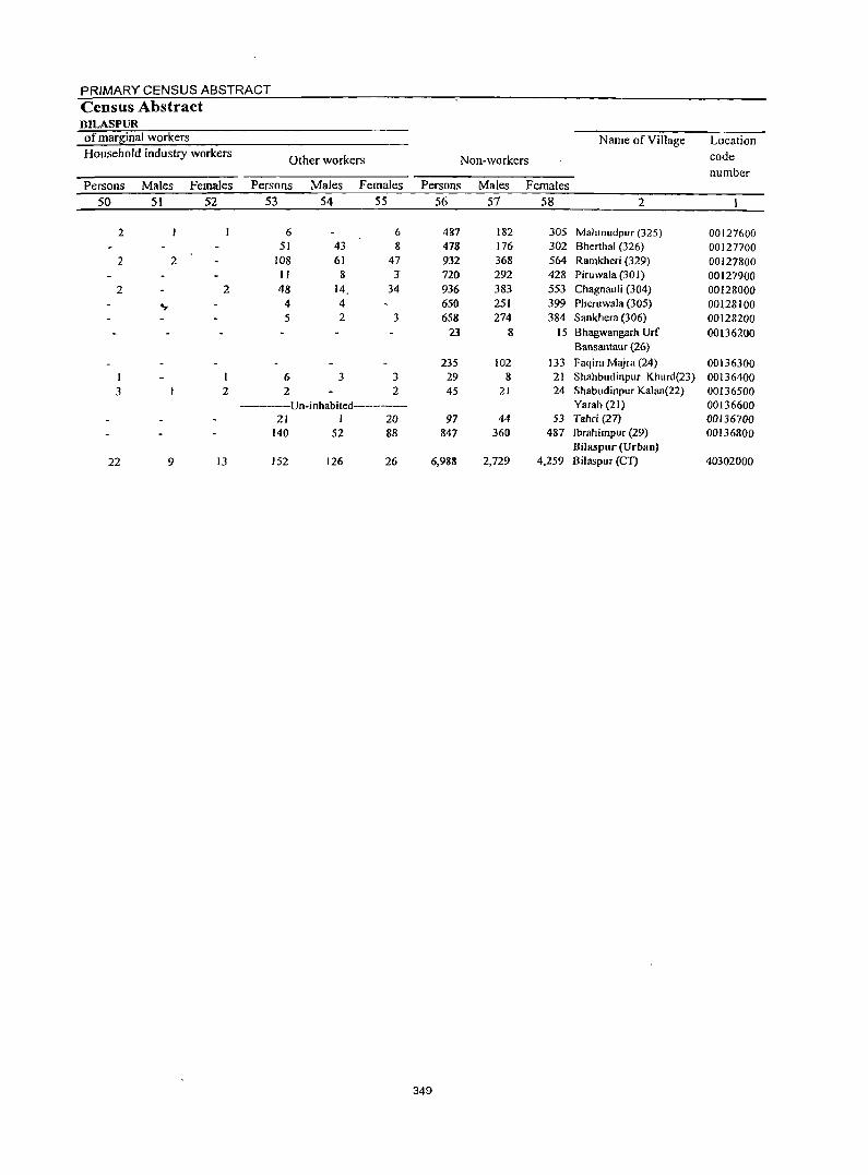
PRIMARY CENSUS ABSTRACT Census Abstract BILASPUR of marB;inal workers Name ofViJlage Location Household industry workers
Other workers Non-workers code
number Persons Males Females Persons Males Females Persons Males Females
50 51 52 53 54 55 56 57 58 2
2 6 6 487 182 305 Mahmudpur (325) 00127600 51 43 8 478 176 302 Bherthal (326) 00127700
2 2 108 61 47 932 368 564 Ramkheri (329) 00127800 II 8 J 720 292 428 Piruwala (301) 00127900
2 2 48 14 34 936 383 553 Chagnauli (304) 00128000
.... 4 4 650 251 399 Pheruwala (305) 00128100 5 2 3 658 274 384 Sankhera (306) 00128200
23 8 15 Bhagwangarh Urf 00136200 Bansantaur (26)
235 102 133 Faqira Majra (24) 00136300 I 6 3 3 29 8 21 Shahbudinpur Khurd(23) 00136400 3 2 2 2 45 21 24 Shabudinpur Ka1an(22) 00136500
---------Un-inhabited------------ Yarah (21) 00136600 21 1 20 97 44 53 Tahri (27) 00136700
140 52 88 847 360 487 Ibrahimpur (29) 00136800 Bilaspur (Urban)
22 9 13 152 126 26 6,988 2,729 4,259 Bilaspur (CT) 40302000
349
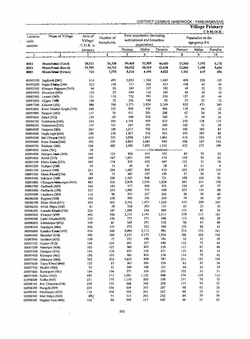
DISTRICT CENSUS HANDBOOK: YAMUNANAGAR
Village Primary CDBLOCK-
Location Name of Village Arcaof Number of Total population (including
Population in the code Villagel institutional and houseless
households age-group 0-6 number .C.D.B. in EOEulation~
hectares Persons Males Females Persons Males Females
2 3 4 5 6 7 8 9 10
0003 Mustafabad (Total) 20,511 16,330 99,468 52,808 46,660 13,965 7.795 6.170 0003 Mustafabad (Rural) 19,795 14,752 90,952 48.314 42,638 12,864 7,180 5,684
0003 Mustafabad (Urban) 716 1,578 8,516 4,494 4.022 1.101 615 486
00093100 Jagdhauli (343) 614 493 3,053 1,588 1,465 420 228 192 00093200 Nagla Khalsa (344) 223 108 717 392 325 108 62 46 00093300 Khanpur Rajputan (345) 94 62 389 197 192 44 22 22 00093400 Muradpur (346) 123 29 240 136 104 42 30 12 00093500 Lawani (347) 131 118 752 393 359 107 63 44
00093600 Ajijpur (348) 108 32 201 109 92 33 21 12 00093700 Kalawar (351) 984 796 5,373 2,854 2,519 822 473 349
00093800 Kheri Darshan Singh (354) 248 142 898 456 442 118 66 52
00093900 Panjauri (353) 117 74 471 263 208 62 36 26 00094000 Satad (352) 159 63 440 236 204 75 39 36 00094100 Kulchandu (340) 314 294 1,791 959 832 250 138 112 00094200 Maheswari (339) 157 101 645 345 300 102 52 50 00094300 Panjaura (363) 267 189 1,317 702 615 185 103 82 00094400 Nagla Jagir(364) 339 258 1,457 752 705 195 107 88 00094500 Bal Chhapar (365) 619 535 3,098 1,634 1,464 414 235 179 00094600 Kotar Khana (366) 492 329 2,025 1,085 940 308 167 141
00094700 Talakaur (362) 538 482 3,200 1,695 1,505 472 273 199 00094800 Daira (361) 29 ---------Un-inhabited-----------00094900 Sabilpur Jatan (360) 191 125 826 444 382 82 50 32
00095000 Ambli (357) 249 147 1,021 549 472 156 93 63
00095100 Khera Kalan (355) 207 154 859 452 407 125 71 54
00095200 Shahpur (350) 39 13 69 41 28 15 II 4 00095300 Lawana (349) 261 266 1,687 868 819 243 130 113 00095400 Khera Khurd (356) 98 71 387 197 190 57 26 31 00095500 Sabalpur (358) 288 269 1,567 846 721 198 106 92 000956()O Chhapper~ansurpur(443) 493 426 2,678 1,442 1,236 361 211 150 00095700 Gadhauli (437) 166 161 917 486 431 124 67 57
00095800 Gadhaula (359) 327 254 1,445 757 688 207 119 88
00095900 Landaura (367) 116 96 593 327 266 98 56 42
00096000 Rajpura (369) 193 128 595 305 290 79 50 29
00096100 Bham Sholi (435) 494 463 2,742 1,477 1,265 473 259 214
00096200 Milak Majra (368) 81 58 358 203 ISS 65 35 30
00096300 Kanarhi Khurd (436) 224 187 1,248 644 604 155 81 74 00096400 Kh anpur (439) 442 346 2.155 1,141 1,014 378 215 163
00096500 Garhj Gosain (438) 133 126 717 371 346 113 63, 50
00096600 Sukhdaspur (442) 119 81 569 291 278 96 47 49
00096700 Gandapra (441) 216 137 972 523 449 123 80 43
00096800 Kanahri Kalan (440) 414 344 2.096 1,115 981 314 173 141
00096900 Bhambol (434) 399 380 2,233 1,175 1,058 306 166 140
00097000 Jalldhera (433) 159 77 375 190 185 52 23 29
00097100 Goglon (432) 186 124 967 527 440 119 73 46 00097200 Hasanpur (430) 103 127 760 422 338 113 67 46
00097300 Darajpur (431) 154 158 957 536 421 139 85 54
00097400 Kalanpur (4(1) 198 132 760 426 334 114 72 42
00097500 Akbarpur (463) 302 252 1,655 868 787 231 127 104
00097600 Topra Khurd (464) 123 87 563 304 259 83 47 36
00097700 Modhli (480) 93 47 269 14& 121 44 2S 19
00097800 Badanpuri (481) 164 104 571 306 265 102 SI 51
00097900 Gohlni (462) 495 312 1,981 1,133 848 274 158 116
00098000 Sialba (460) 331 170 1,150 600 550 lSI 7~ 73
00098100 Jhar Chan dna (458) 258 122 668 348 320 113 56 57
00098200 Hangoli (459) 225 106 634 347 287 68 42 26
00098300 Namdarpur (455) 114 108 524 261 263 64 33 31
00098400 Mali Majra (454) 8~ 95 515 263 252 84 3'4 50
00098500 Maghar Pura (446) 143" 64 399 217 182 46 21 25
:?50
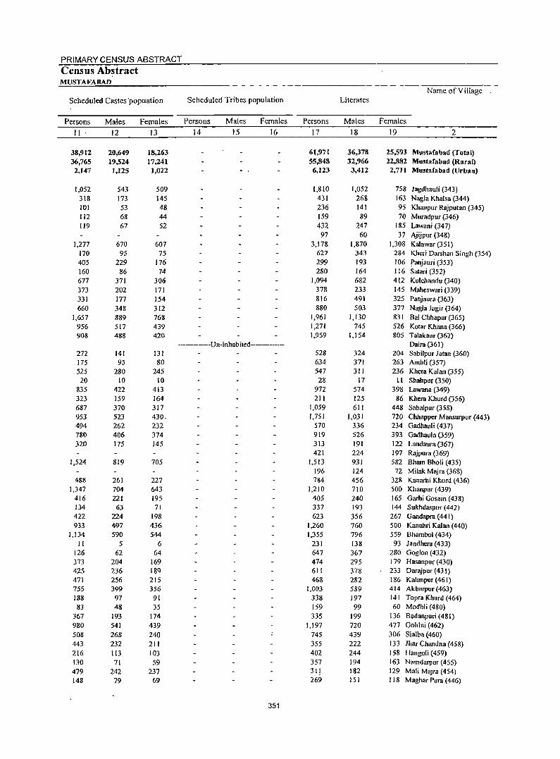
PRIMARY CENSUS ABSTRACT
Census Abstract MUSTA FA BAD
Name of Viltage Scheduled Castes 'popuation Scheduled Tribes population Literates
Persons Males Females Persons Males Females Persons Males Females
II· 12 13 14 15 16 17 ]8 19 2
38,912 20,649 18,263 61,971 36,378 25,593 Mustafabad (Total) 36,765 19,524 17,241 55,848 32,966 22,882 Mustafabad (Rural) 2,147 1,125 1,022 6,123 3,4]2 2,7] I Mustafabad (Urban)
1,052 543 509 1,810 1,052 758 Jagdhauli (343) 318 173 145 431 268 163 Nagla Khalsa (344) 101 53 48 236 141 95 Khanpur Rajputan (345) 112 68 44 159 89 70 Muradpur (346) 119 67 52 432 247 185 Lawani (347)
97 60 37 Ajijpur (348) 1,277 670 607 3,178 1,870 1,308 Kalawar (35 I)
170 95 75 627 343 284 Kheri Darshan Singh (354) 405 229 176 299 193 106 Panjauri (353) 160 86 74 280 164 116 Satari (352) 677 371 306 1,094 682 412 Kulchandu (340) 373 202 171 378 233 145 MalJeswari (339) 331 177 154 816 491 325 Panjaura (363) 660 348 312 880 503 377 Nagla Jagir (364)
1,657 889 768 1,961 1,130 831 Bal Chhapar (365) 956 517 439 1,27'( 745 526 Kotar Khana (366) 908 488 420 1,.959 1,154 805 Talakaur (362)
------------Vn-inhabited-------- Daira (361) 272 141 131 528 324 204 Sabilpur Jatan (360) 175 95 80 634 371 263 Ambli (357) 525 280 245 547 31 I 236 Khera Kalan (355) 20 10 10 28 17 1I Shahpur (350)
835 422 413 972 574 398 Lawana (349) 323 159 164 211 125 86 Kllera Kllurd (356) 687 370 317 1,059 611 448 Sabalpur (358) 953 523 430. 1,751 1,031 720 Chhapper Mansurpur (443) 494 262 232 570 336 234 Gadhauli (437) 780 406 374 919 526 393 Gadhaula (359) 320 175 145 313 191 122 Landaura (367)
421 224 197 Rajpura (369) 1,524 819 705 1,513 931 582 Bham Bholi (435)
196 124 72 Milak Majra (368) 488 261 227 784 456 328 Kanarhi Khllrd (436)
1,347 704 643 1,210 710 500 Khanpur (439) 416 221 195 405 240 165 Garhi Gosain (438) 134 63 71 337 193 144 Sukhdaspur (442) 422 224 198 623 356 267 Gandapra (441) 933 497 436 1,260 760 500 Kanahri Kalan (440)
1,134 590 544 1,355 796 559 Bhambol (434) II 5 6 231 138 93 Jandhera (433)
126 62 64 647 367 280 Goglon (432) 373 204 169 474 295 179 Hasanpur (430) 425 236 189 611 378 233 Dar~pur (431) 471 256 215 468 282 186 Kalanpur (461) 755 399 356 1,003 589 414 Akbarpur (463) 188 97 91 338 197 141 Topra Khurd (464) 83 48 35 159 99 60 Modhli (480)
367 193 174 335 199 136 Badanpuri (481) 980 541 439 1,197 720 477 Gohlni (462) 508 268 240 745 439 306 Sialba (460) 443 232 211 355 222 133 Jhar Chandna (458) 216 113 103 402 244 158 Hangoli (459) 130 71 59 357 194 163 Narndarpur (455) 479 242 237 311 182 129 Mali Majra (454) 148 79 69 269 151 118 Maghar Pura (446)
351
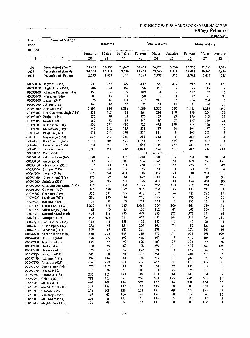
Location code number
0003 0003 0003
Name of Village
2
Mustafabad (Totlll) Mustafabad (Rural) Mustafabad (Urban)
00093100 Jagdhauli (343) 00093200 Nagla Khalsa (344) 00093300 Khanpur Rajputan (345) 00093400 Muradpur (346) 00093500 Lawani (341) 00093600 Ajijpur (348) 00093700 Kalawar (35 I) 00093800 Kheri Darshan Singh (354) 00093900 Panjauri (353) 00094000 Salari (352) 00094100 Kulchandu (340) 00094200 Maheswari (339) 00094300 Panjaura (363)
.00094400 Nagla Jagir (364) 00094500 Bal Chhapar (365) 00094600 Kolar Khana (366) 00094700 Talakaur (362) 00094800 Oaira (361) 00094900 Sabilpur Jalan (360) 00095000 Ambli (357) 00095100 Khera Kalan (355) 00095200 Shahpur (350) 00095300 Lawana (349) 00095400 Khera Khurd (356) 00095500 Sabalpur (358) 00095600 Chhapper Mansurpur (443) 00095700 Gadhauli (437) 00095800 Gadhaula (359) 00095900 Landaura (367) 00096000 Rajpura (369) 00096100 Bham Bholi (435) 00096200 Milak Majra (368) 0009<U00 Kanarhi Khurd (436) 00096100 Khanpur(439) 00091i?00 Garhi Gosain (438) 00096'i:OO Sukhdaspur (442) 00096700 Gandapra (441) 00096800 Kanahri Kalan (440) 00096900 Bhambol (434) 00097000 Jandhera (433) 00097100 Goglon (432) 00097200 Hasanpur (430) 000973'0/1 Darajpur (431) 00097400 Kalanpur (461) 00097500 Akbarpur (463) 00097600 Topra Khurd (464) 00097700 Modhli (480) 00097&00 Badanpuri (481) 00097900 Gohlni (462) 00098000 Sialba (460) 00098100 JharChandna (458) 00098200 Hangoli (459) 00098300 Namdarpur (455) 00098400 Mali Majra (454) 00098500 Maghar Pura (446)
Persons 20
37,497 35,104
2,393
1,243 286 153
81 320 104
2,195 271 172 160 697 267 501 577
1,137 754
1,241
298 387 312
41 715 176 508 927 347 526 280 174
1,229 162 464 945 312 232 349 836 878 144 320 286 346 292 652 225 110 236 784 405 313 232 167 204 130
Illiterates
Males Females 21 22
16,430 15,348 1,082
536 124 56 47
146 49
984 113 70 72
277 112 211 249 504 340 541
120 178 141 24
294 72
235 411 150 231 136
81 546 79
188 °431 131 98
167 355 379
52 160 127 158 144 279 107 49
107 413 161 126 103 67 81 66
21,067 19,756
1,311
707 162 97 34
174 55
1,211 IS8 102 88
420 155 290 328 633 414 700
178 209 171
17 421 104 273 516 197 295 144 93
683 83
276 514 181 134 182 481 499 92
160 159 188 148 373 118 61
129 371 244 187 129 100 123 64
352
DISTRICT CENSUS HANDBOOK: YAMUNANAGAR
Total workers
Village Primary C D'BLOCK-
Main workers
Persons Males Females Persons Males Females 23 24 25 26 27 28
32,Q57 29,474
2,583
1,017 196 109 90
217 82
1,909 364 176 147 622 251 354 388
1,153 655
1,044
26,021 23,763 2,258
800 189 94 59
215 51
1,399 224 143 119 463 187 351 382 777 485 832
6,036 5,711
325
217 7
IS 31 2
31 510 140 33 28
159 64
3 6
376 170 212
-----Un-inhahited--------218 201 17 416 265 151 278 225 53 25 21 4
506 377 129 147 530
1,036 256 418 270 137
1,064 150 447 677 198 220 291 686 548 176 428 199 269 274 517 195 95
182 755 375 189 224 146 121 120
102 417 756 230 332 175 135 764 102 325 491 187 146 278 572 540 100 294 194 263 219 457 163 80
158 600 299 179 175 128 118 III
45 113 280
26 86 95
2 300
48 122 186 II 74 13
114 8
76 134
5 6
55 60 32 IS 24
155 76 10 49 18 3 9
26,780 24,438 2,342
947 195 107 72
216 71
1,625 359 176 147 545 194 206 258 493 600 885
214 409 265 24
348 131 494 982 214 382 176 133 664 147 375 515 40
180 271 678 406 120
I 406 186 240 ~48 402 1.42 75
143 645 330 187 220 112 23
107
22,396 20,309 2,087
774 189 92 41
214 40
1,284 224 143 119 390 157 203 255 409 435 742
200 258 216 20
234 97
404 706 211 298 166 131 510 100 291 334 ~6
138 261 569 404
44 281 182 235 193 372 134 70
134 I ;;35
° 254 179 171 96 21
100
4,384 4,129
255
173 6
15 31 2
31 341 135 33 28
155 37 3 3
84 165 143
14 151 49 4
114 34 90
276 3
84 10 2
154 47 84
181 4
42 10
109 2
76 125
4
5 55 30
8 5 9
110 76 8
49 16 2 7
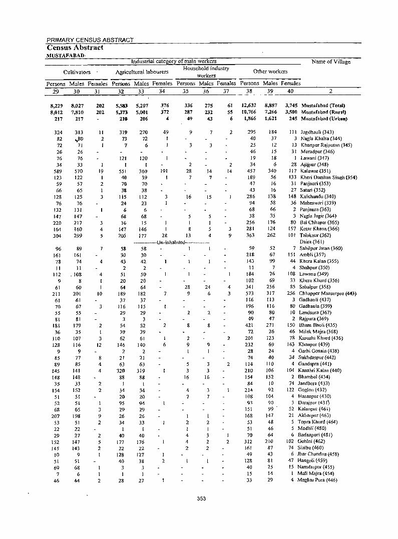
PRIMARY CENSUS ABSTRACT Census Abstract MUSTAFABAD·
Industrial category of main workers
Cultivators Agricultural labourers Household industry
workers
Name ofViJlage
Other workers
Persons Males Females Persons Males Females Persons Males Females Persons Males Females 29 30 31 32 33 34 35 36 37 38 39 40 2
8,22? 8,012
217
324 82 72 26 76 34
589 123 S9 66
128 76
132 147 220 164 304
96 161 78 11
112 9
61 211
61 70 55 81
181 36
110 128
9 85 89
145 148 35
154 51 52 68
207 53 22 29
152 145
10 51 69
7 46
8,027 7,810
217
313 ..,80
71 26 76 33
S70 122 57 6S
125 76
131 147 217 160 299
89 161 74 11
.108 8
60 201
61 67 55 81
179 3S
107 116
9 77 85
141 148 33
152 51 51 65
198 51 22 27
147 143
9 51 68
6 44
202 202
11 2 I
19 I 2 1 3
3 4 5
7
4
4
10
3
2 I 3
12
8 4 4
2 2
I
3 9 2
2 5 2
2
5,583 5,373
210
319 73
7
121 I
551 40 70 38
115 24
6 68 16
147 205
58 30 43
2 51 20 64
189 37
116 29
3 54 39 62
146 2
21 63
320 88
1 34 20 95 29 26 34
I 40
177 22
128 40 3 I
28
5,207 5,001
206
270 72
6
120 1
360 39 70 38
112 23
6 68 15
146 177
376 372
4
49 I
191 I
3
I 28
336 287 49
9
3
2 28
7
16
5 I 8
13
275 232 43
7
3
14 7
IS
5 I 5 4
---------Un-inhablted----------58 1 1 30 42
2 50 20 64
182 37
lIS 29
3 52 39 61
140 2
21 63
319 88
1 34 20 94 29 26 33
I 40
176 22
7
2
I
6
127 1 38 2
3
27
28 9
2
8
2 9
5 3
16
4 7
I 2
4 4 2
24 6
2
8
9
I
3 3
16
353
3 7
2 I 3 2 2
61 55 6
2
2 14
3 9
4 3
2
2
I 2
12,632 10,766
1,866
295 40 25 46 19 34
457 189 47 43
286 94 68 38
256 281 363
59 218 143
11 184 102 341 573 116 196 90 49
421 72
201 232
28 74
114 210 154 84
214 108 93
lSI 168 53 51 70
312 161 49
128 40 15 33
8,887 7,266 1,621
184 37 12 15 18 6
340 56 16 16
13& 58 66 35
176 124 262
52 67 99
7 76 69
256 317 113 116 80 47
271 26
123 69 24 40
110 106 152
10 92
104 90 99
147 48 46 64
210 87 43 81 25 14 29
3,745 Mustafabad (Total) 3,500 Mustafabad (Rural)
245 Mustafabad (Urban)
III JagdhauJi (343) 3 Nagla Khalsa (344)
13 Khanpur R<uputan (345) 31 Muradpur (346)
I Lawani (347) 28 Ajijpur (348)
117 Kalawar (351) 133 Kheri Darshan Singh (354) 3 I Panjauri (353) 27 Satari (352)
148 Kulchandll (340) 36 Maheswari (339)
2 Panjallra (363) 3 Nagla lagir (364)
80 Bal Chhapar (365) 157 Kotar Khana (366) 10 1 Talakaur (362)
Daira (361) 7 Sabilpur latan (360)
151 Ambli (357) 44 Khera Kalan (35S)
4 Shahpur (350) 108 Lawana (349) 33 Khera Khurd (356) 85 Sabalpur (358)
256 Chhapper Mansurpur (443-) 3 Gadhauli (437)
80 Gadhaula (359) 10 Landaura (367) 2 Rajpura (369)
150 Bham Bholi (435) 46 Milak Majra (368) 78 Kanarhi Khurd (436)
163 Khanpur (439) 4 Garhi Gosain (438)
34 $ukhdaspur (442) 4 Gandapra (441)
104 Kanahri Kalan (440) 2 Bhambol (434)
74 landhera (433) 122 Goglon (432)
4 Hasanpur (430) 3 Darajpm (43 Ij
52 Kalanpur (461) 21 Akbarptlr (463)
5 Topra Khurd (464) 5 Modhli (480) 6 Badanpuri (481)
102 Gohlni (462) 74 Sialba (460)
6 Jhar Chandna (458) 47 Hangoli (459) 15 Namdarpur (455)
Mali Majra (454) 4 Maghar PlIra (446)
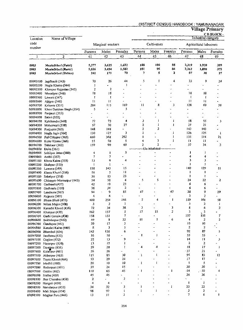
DISTRICT CENSUS HANDBOOK: YAMUNANAGAR
Village Primary CD BLOCK-
Location Name of Village Industrial cate~or~ code Marginal workers Cultivators Agricultural labourers number
Persons Males Females Persons Males Females Persons Males Females
2 41 42 43 44 45 46 47 48 49
0003 Mustafabad (Total) 5,277 3,625 .1,652 188 100 88 2,319 1,920 399 0003 Mustafabad (Rural) 5,036 3,454 1.582 181 95 86 2,262 1,890 372 0003 Mustafabad (Urban) 241 171 70 7 5 2 57 30 27
00093100 Jagdhauli (343) 70 26 44 5 4 33 9 24 00093200 Nagla Khalsa (344) 00093300 Khanpur Rajputan (345) 2 2 00093400 Muradpur (346) 18 18 18 18 00093500 Lawani (347) I I 00093600 Ajijpur (348) II II " II 00093700 Kalawar (351) 284 115 169 II 8 3 128 69 59 00093800 Kheri Darshan Singh (354) 5 5
00093900 Panjauri (353) 00094000 Satari (352) 00094100 Kulchandu (340) 77 73 4 2 58 55 3 00094200 Maheswari (339) 57 30 27 2 I 21 21
00094300 Panjaura (363) 148 148 2 2 143 143
00094400 Nagla Jagir (364) 130 127 3 126 125 1 00094500 Bal Chhapar (365) 660 368 292 I 135 114 21 00094600 Kotar Khana (366) 55 50 5 4 3 II II 00094700 Talakaur (362) 159 90 69 2 2 37 34 ~
~
00094800 Oaira(361) -----Un-inhabited-----------
00094900 Sabilpur Jatan (360) 4 3
00095000 Ambli (357) 7 7 4 4
00095100 Khera Kalan (355) 13 9 4 3 3 00095200 Shahpur (350) I I I
00095300 Lawana (349) 158 143 15 140 129 II 00095400 Khera Khurd (356) 16 5 II
00095500 Sabalpur (358) 36 13 23
00095600 Chhapper Mansurpur (443) 54 50 4 5 5 24 22 2 00095700 Gadhauli (437) 42 19 23 6 6
00095800 Gadhaula (359) 36 34 2 6 6 00095900 Landaura (367) 94 9 85 47 47 38 9 29 00096000 Rajpura (369) 4 4 2 2
00096100 Bham Bholi (435) 400 254 146 5 4 159 )01 58 00096200 Milak Majra (36&) 3 2 I 3 2 I
00096300 Kanarhi Khurd (436) 72 34 38 3 3 8 6 Z 00096400 Khanpur (439) 162 157 5 17 15 2 3 , 3 00096500 Garhi Gosain (43&) 158 151 7 157 150 7 00096600 Sukhdaspur (442) 40 8 32 II 5 6 4 2 2 00096700 Gandapra (441 ) 20 17 3 10 10
00096800 Kanahri Kalan (440) 8 3 5 2 2
00096900 Bhambol (434) 142 136 6 92 87 5 00097000 Jandhera (433) 56 56 55 55
00097100 Goglon (432) 22 13 9 14 11 3 00097200 Hasanpur (430) 13 12 2 2
00097300 Oaraiur (431) 29 28 4 4 18 17
00097400 Kalanpur (461) 26 26 -21 21
00097500 Akbarpur (463) 115 85 30 95 83 12
00097600 Topra Khurd (464) 53 29 24 17 17
00097700 Modhli (480) 20 10 10 5 5 00097800 Badanpuri (481) 39 24 15 20 20
00097900 Gohlni (462) 110 65 45 54 . - 50 4
00098000 Sialba (460) 45 45 26 26
00098100 Jhar Chandna (458) 2 2
00098200 Hangol i (459) 4 4 I
00098300 Namdarpur (455) 34 32 2 22 22
00098400 Mali Majra (454) 98 97 I 2 2
00Q98500 Maghar Pura (446) 13 II 2 7 6
354
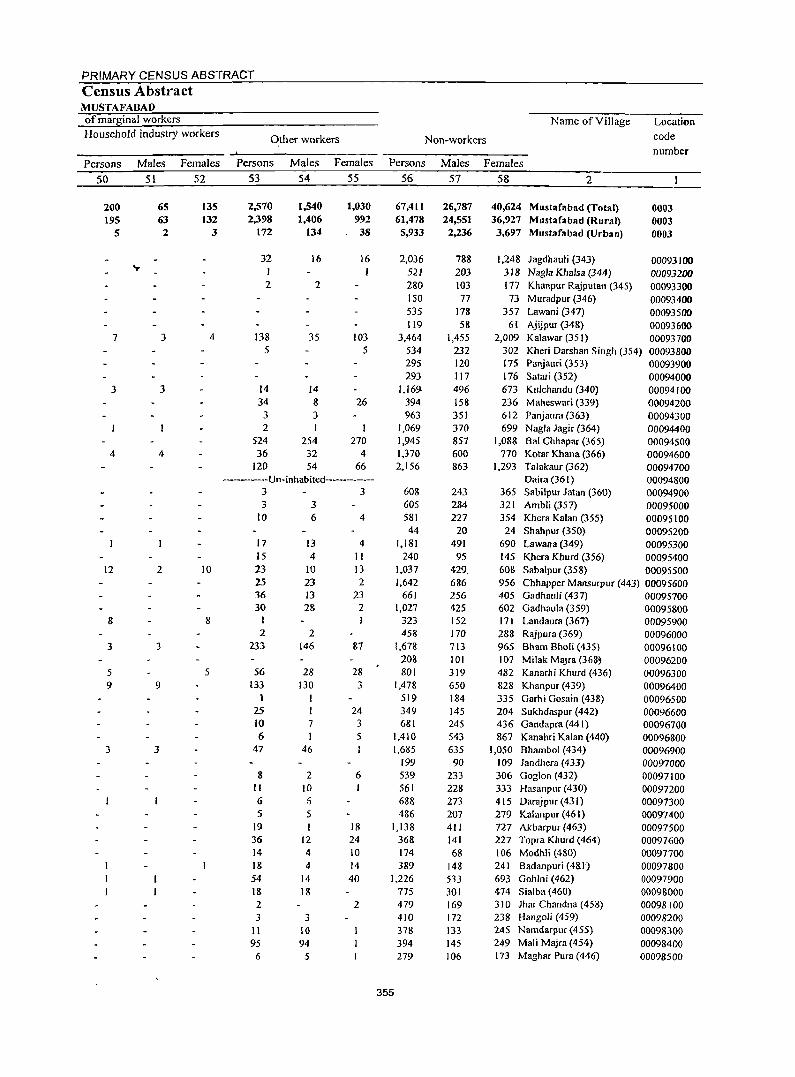
PRIMARY CENSUS ABSTRACT Census Abstract MUSTAFABAD of marginal workers Name of Village Location Household industry workers
Other workers Non-workers code
numbe,. Persons Males Females PeTSons Males Females Persons Males Females
50 51 52 53 54 55 56 57 58 2
200 65 135 2,570 1,540 1,030 67,4 II 26,787 40,624 Mustafabad (Total) 0003 J95 63 132 2,398 1,406 992 61,478 24,551 36,927 Mustafabad (Rural) 0003
5 2 3 172 134 38 5,933 2,236 3,697 Mustafabad (Urban) 0003
32 16 16 2,036 788 1,248 Jagdhauli (343) 00093100 ... I 521 203 318 Nagla Khalsa (344) 00093200 2 2 280 103 177 Khanpur Rajputan (345) 00093300
150 77 73 Muradpur (346) 00093400 535 178 357 Lawani (347) 00093500 119 58 61 Ajijpur (348) 00093600
7 3 4 138 35 103 3,464 1,455 2,009 Kalawar (35 I) 00093700 5 5 534 232 302 Kheri Darshan Singh (354) 00093800
295 120 175 Panjauri (353) 00093900 293 117 176 Satari (352) 00094000
3 3 14 14 1,169 496 673 Kulchandu (340) 00094100 34 8 26 394 158 236 Maheswari (339) 00094200 3 3 963 351 612 PanjauTa (363) 00094300 2 1,069 370 699 Nagla Jagir (364) 00094400
524 254 270 1,945 857 1,088 Bal Chhapar (365) 00094500 4 4 36 32 4 1,370 600 770 Kotar Khana (366) 00094600
120 54 66 2,156 863 1.293 Talakaur (362) 00094700 -----Un-inhabited------------ Daira (361) 00094800
3 3 60S 243 365 Sabilpur Jatan (360) 00094900 3 3 605 284 321 Ambli (357) 00095000
10 6 4 581 227 354 Khera Kalan (355) 00095100 44 20 24 Shahpur (350) 00095200
17 13 4 1,181 491 690 Lawana (349) 00095300 15 4 II 240 95 145 Khera Khurd (356) 00095400
12 2 10 23 10 13 1,037 429, 608 Sabalpur (358) 00095500 25 23 2 1,642 686 956 Chhapper Mansurpur (443) 00095600 36 J3 23 661 256 405 Gadhauli (437) 00095700 30 28 2 1,027 425 602 Gadhaula (359) 00095800
8 8 I 323 152 171 Landaura (367) 00095900 2 2 458 170 288 Rajpura (369) 00096000
3 3 233 146 87 1,678 713 965 Bham Bholi (435) 00096100 208 101 107 Milak MaJra (368~ 00096200
5 5 56 28 28 801 319 482 Kanarhi Khurd (436) 00096300 9 9 133 130 3 1,478 650 828 Khanpur (439) 00096400
1 I 519 184 335 Garhi Gosain (438) 00096500 25 24 349 145 204 Sukhdaspur (442) 00096600 10 7 3 681 245 436 Gandapm (441) 00096700 6 I 5 1,410 543 867 Kanahri Kalan (440) 00096800
3 3 47 46 1,685 635 1,050 Shambol (434) 00096900 199 90 109 landhera (433) 00097000
8 2 6 539 233 306 Goglon (432) 00097100 II 10 561 228 333 Hasanpllf (430) 00097200 6 :5 688 273 415 Darajpur (431) 00097300 5 5 486 207 279 Kalanpur (461) 00097400
19 18 1.138 411 727 Akbarpllf (463) 00097500 36 12 24 368 141 227 Topra Khurd (464) 00097600 14 4 10 174 68 106 Modhli (480) 00097700 18 4 14 389 148 241 Badanpuri (4& l) 00097800 54 14 40 1,226 533 693 Gohlni (462) 00097900 IS 18 775 301 474 Sialba (460) 00098000 2 2 479 169 310 Jhar Chandna (458) 00098100 3 3 410 172 238 Hangoli (459) 00098200
II 10 378 133 245 Namdarpur (455) 00098300 95 94 394 145 249 Mali Majra (454) 00098400 6 5 279 106 173 Maghar Pura (446) 00098500
355
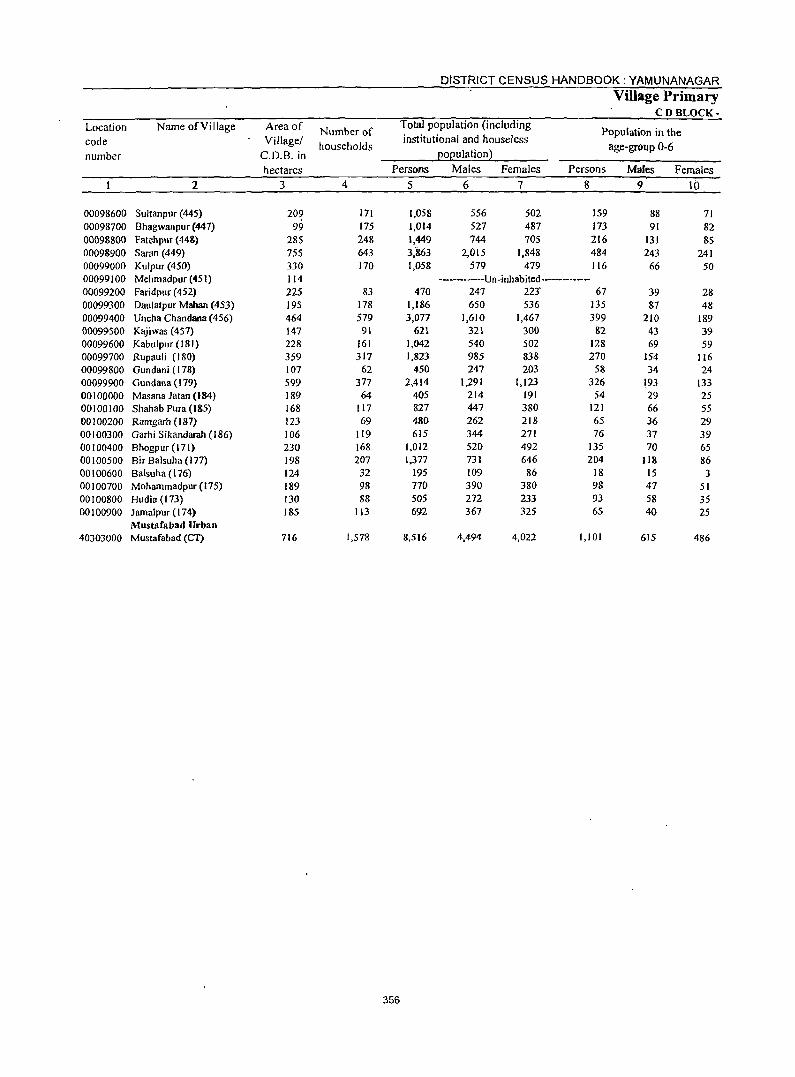
DISTRICT CENSUS HANDBOOK: YAMUNANAGAR
Village Primary CDBLOCK-
Location Name of Village Area of Number of Total population (including
Population in the code Village/ households
institutional and houseless age-group 0-6
number C.D.B. in EOEulation}
hectares Persons Males Females Persons Males Females
2 3 4 5 6 7 8 9 10
00098600 Sultanpur (445) 209 171 1,058 556 502 159 88 71 00098700 Bhagwanpur (447) 99 175 1,014 527 487 173 91 82 00098800 Fatehpur (448) 285 248 1,449 744 70S 216 131 85 00098900 Saran (449) 755 643 3:863 2,015 1,848 484 243 241 00099000 Kulpur (450) 330 170 1,058 579 479 116 66 50 00099100 Mehmadpur (451) 114 ------------Un-inhabited------------00099200 Faridpuf (452) 225 &3 470 247 223· 67 39 28 00099300 Daulatpur Mahan (453) 195 178 1,186 650 536 135 87 48 00099400 Uncha Chandana (456) 464 579 3,077 1,610 1,467 399 210 189 00099500 Kajiwas (457) 147 91 621 321 300 82 43 39 00099600 Kabulpur (181) 228 161 1,042 540 502 128 69 59 00099700 Rup:1U1i (180) 359 317 1,823 985 838 270 154 116 00099800 Gundani (178) 107 62 450 247 203 58 34 24 00099900 Gundana (179) 599 377 2,414 1,291 1,123 326 193 133 00100000 Masana Jatan (184) 189 64 405 214 191 54 29 25 00100100 Shahab Pura (J 85) 168 117 827 447 380 121 66 55 00100200 Ramgarh (187) 123 69 480 262 218 65 36 29 00100300 Garhi Sikandarah (186) 106 119 615 344 271 76 37 39 00100400 Bhogpur (171) 230 168 1,012 520 492 135 70 65 00100500 Bir Balsuha (177) 198 207 1,377 731 646 204 118 86 00100600 Balsuha (176) 124 32 195 109 86 18 15 3 00100700 Mohammadpur(175) 189 98 770 390 380 98 47 51 00100800 Hudia (173) 130 88 505 272 233 93 58 35 00100900 Jamalpur (174) 185 113 692 367 325 65 40 25
Mustllfabad Urban 40303000 Mustafabad (Cl) 716 1,578 8,516 4,494 4,022 1,101 615 486
356
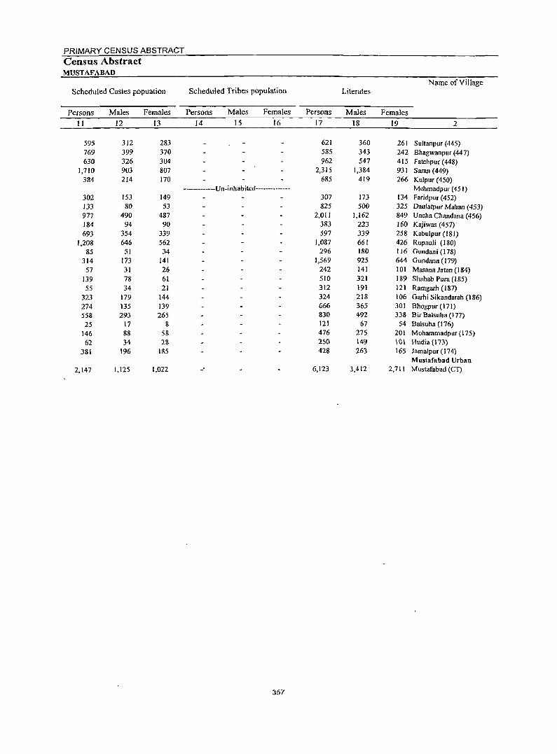
PRIMARY CENSUS ABSTRACT Census Abstract MUSTAFABAD
Name of Village Scheduled Castes popuation Scheduled Tribes population Literates
Persons Males Females Persons Males Females Persons Males Females
II 12 13 14 15 16 17 18 19 2
595 312 283 621 360 261 Sultanpur (445) 769 399 370 585 343 242 Bhagwanpur (447) 630 326 304 962 547 415 Fatehpur (448)
1,710 903 807 2,315 1,384 931 Saran (449) 384 214 170 685 419 266 Kulpur (450)
----------Un-inhabited-------------- Mehmadpur (451) 302 153 149 307 173 134 Faridpur (452) 133 80 53 825 500 325 Daulatpur Mahan (453) 977 490 487 2,011 1,162 849 Uncha Chandana (456) 184 94 90 383 223 160 Kajiwas (457) 693 354 339 597 339 258 Kabulpur (181)
1,208 646 562 1,087 661 426 Rupauli (180) 85 51 34 296 180 116 Gundani (I 78)
314 173 141 1,569 925 644 Gundana (179) 57 31 26 242 141 101 Masana Jatan (184)
139 78 61 510 321 189 Shahab Pura (185) 55 34 21 312 191 121 Ramgarh (187)
323 179 144 324 218 106 Garhi Sikandarah (186) 274 135 139 666 365 301 Bhogpur (171) 558 293 265 830 492 338 Bir Balsuha (177) 25 17 8 121 67 54 Balsuha (176)
146 88 58 476 275 201 Mohammadpur (175) 62 34 28 2S0 149 \0\ H\ldia (1'73)
381 196 185 428 263 165 Jamalpur (174) Mustafabad Urban
2,147 1,125 1,022 -' 6,123 3,412 2,711 Mustafabad (CT)
357
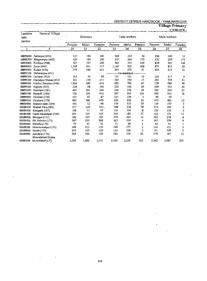
358
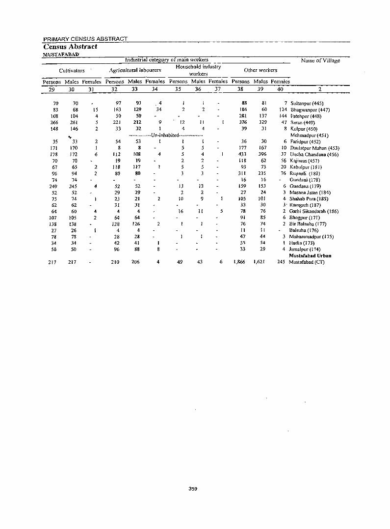
359
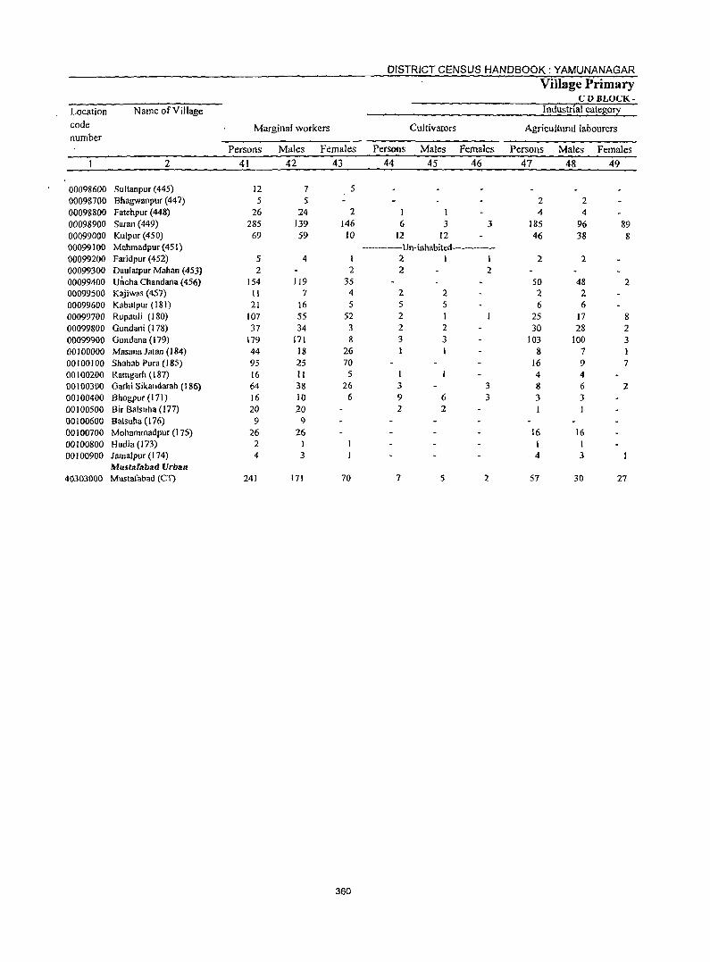
DISTRICT CENSUS HANDBOOK: YAMUNANAGAR
Village Primary CDBLOCK-
Location Name of Village Industrial categorl
code
number Marginal workers Cultivators Agricultural labourers
Persons Males Females Persons Males Females Persons Males Females
2 41 42 43 44 45 46 47 48 49
00098600 Sultanpur (445) 12 7 5
00098700 Bhagwanpur (447) 5 5 2 2 00098800 Fatehpur (448) 26 24 2 I I 4 4 00098900 Saran (449) 285 139 146 6 3 3 185 96 89 00099000 Kulpur (450) 69 59 10 12 12 46 38 8 00099100 ~ehrnadpur(451) -------Un-inhabited---------00099200 Faridpur (452) 5 4 I 2 I I 2 2 00099300 Daulatpuf Mahan (453) 2 2 2 2 00099400 Uncha Chandana (456) 154 119 35 50 48 2 00099500 Kajiwas (457) 11 7 4 2 2 2 2 00099600 Kabulpur (181) 21 16 5 5 5 6 6 00099700 Rupauli (180) 107 55 52 2 25 17 8 00099800 Gundani (I 78) 37 34 3 2 2 30 28 2 00099900 Gundana (179) 179 171 & 3 3 103 100 3 00100000 Masana Jatan (J 84) 44 18 26 8 7 00100100 Shahab Pura (185) 95 25 70 16 9 7 00100200 Rarngarh (187) 16 II 5 4 4 00100300 Oarhi Sikandarah (186) 64 38 26 3 3 8 6 2 00100400 Bhogpur (I 71) 16 10 6 9 6 3 3 3 00100500 Bir Balsuha (177) 20 20 2 2 00100600 Balsuha (176) 9 9 00100700 ~ohamrnadpur (175) 26 26 16 16 00100800 Hudia(173) 2 I I 00100900 Jamalpur (I 74) 4 3 4 3
Must:lfllbad Vrban 40303000 ~ustafabad (Cl) 241 171 70 7 5 2 57 30 27
360
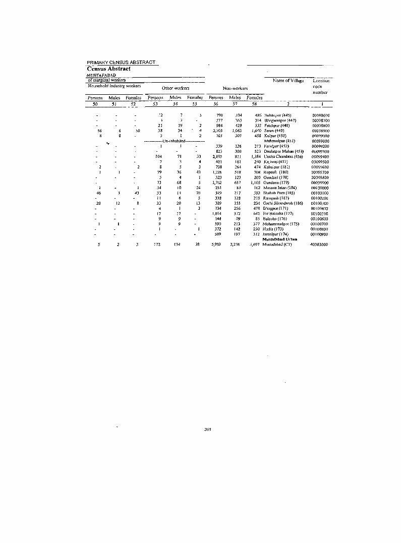
PRIMARY CENSUS ABSTRACT
Census Abstract MUSTAFADAD of marllinal workers Name of Village Location Household industfY. workers Other workers Non-workers code
number Persons Males Females Persons .Males Females Persons Males Females
50 51 52 53 54 55 56 57 58
12 7 790 304 486 Sultanpur (445) 00098600 3 577 263 314 Bhagwanpur (447) 00098700
21 19 2 984 429 555 Fatehpur (448) 00098800 56 6 50 38 34 4 2,703 1,063 1,640 Saran (449) 00098900
8 8 3 1 2 765 307 458 Kulpur (450) 00099000
... ----------Un-inhabited--------- Mehmadpur(451) 00099100 1 I 339 126 213 Faridpur (452) 00099200
823 300 523 Daulatpur Mahan (453) 00099300 104 71 33 2,195 811 1,384 Uncha Chandana (456) 00099400
7 3 4 401 161 240 Kajiwas (457) 00099500 2 2 8 5 3 738 264 474 Kabulpur (181) 00099600
79 36 43 1,226 518 708 Rupauli (180) 00099700 5 4 I 323 123 200 Gundani (178) 00099800
73 68 5 1,762 657 1,105 Gundano (179) 00099900 34 10 24 251 89 162 Masana latan (184) 00100000
46 43 33 13 20 519 217 302 Shahab Pura (185) 00100100
" 6 5 338 128 210 Ramgarh (187) 00100200 20 12 33 20 13 389 155 234 Garhi Sikandarah (186) 00100300
4 I 3 734 256 478 Bhogpur (171) 00100400 17 17 1,014 372 642 Bir Balsuha (177) 0010050D 9 9 144 59 85 Balsuha (176) 00100600 9 9 590 213 377 Mohammadpur (175) 00100700
372 142 230 Hudia (173) 00100800 509 197 3J2 Jamalpur (1 74) 00100900
Musmfabad Urban 2 3 172 134 38 5,933 2,236 3,697 Mustafabad (eT) 40303000
361
Location code number
Name of Village
2
0004 0004 0004
Radaur (Total) Radaur (Rural) Radaur (Urban)
00101000 Ihinwarheri (In) 00101100 Harlan (168) 00101200 Sikandera (170) 00101300 Atawa(189) 00101400 Bhago Majra (188) 00 I 0 1500 Kheri Lakha Singh (190) 00101600 Sagri (192) 00101700 Masana Ranghran (183) 00101800 Sadgoli (182) 00101900 Topra(193) 00 I 02000 Ismailpur (194) 00 102100 Ihaguri (195) 00102200 NaglaSadhan(191) 00102300 Chhari (199) 00 I 02400 Basantpur (200) 00102500 Mansurpur (201) 00102600 Dohli (203) 00 I 02700 Kalesra (204) 00 I 02800 Daulatpur (205) 00102900 Majri (169) 00103000 Haran Chhappar (167) 00103100 Ghalaur (159) 00103200 Sili Khurd (206) 00 I 03300 Dhanupura (208) 00 I 03400 Khirki Brahmanan (21 0) 00103500 8apa (55) 00 I 03600 Sili Kalan (207) 00103700 Amloha (209) 00103800 Chamrori (54) 00 I 03900 Nagai (202) 00104000 Palakha (198) 00104100 Khajuri (197) 00104200 Baindi (196) 00 I 04300 lubal (41) 00104400 Bakana(40) 00 I 04500 Chhota Bass (43) 00104600 Radauri (44) 00104700 Bubka (53) 00104800 Sadhaura (51) 00104900 Alipur (49) 00 I 05000 Bapauli (52) 00105100 Radaur (Rural)(45) 00105200 Ghispur(46) 00 I 05300 Dhaulra (47) 00 I 05400 Sangipur (48) 00105500 KllUrdban (17) 00105600 Potli (16) 00105700 Bhagwanpur (12) 00105800 Rapri (13) 001 05900 Bhagwangarh (11) 00106000 Nachraon (9) 00 I 061 00 Rattangarh (10) 001 06200 Palewala (7) 00106300 Kanjnon (42) 00 I 06400 Kartarpur (6)
Area of Vill~ge/
C.D.B. in hectares
3
24,108 24,108
351 310 210 306 203 139 225 188 196 435 184 419 165 204 154 158 148 144 214 147 161 890 107 170 135 424 233 133 261 172 178 354 373 415 542 278 279 364 191 208 217 470 258 329 199 547 321
88 193 84
547 178 520 512 190
Number of households
4
15,094 15,094
149 211 118 258 134 54
159 196
81 330
94 172 90
193 108 119 104 83
129 78
122 543
60 67
108 404 153 69
200 133 124 207 269 392 449 319 225 235 138 138 152 96
115 254 205 353 212
36 59 60
403 87
158 257
70
DISTRICT CENSUS HANDBOOK: YAMUNANAGAR
Total population (including institutional and houseless
population) Persons Males Females
5 6 7
92,602 92,602
861 1,315
790 1,655
795 366
1,011 1,082
457 2,061
547 1,205
588 1,198
666 817 656 463 790 470 738
3,058 430 407 666
2,553 999 492
1,246 787 677
1,196 1,678 2,168 2,618 1,733 1,378 1,627
834 862 888 437 741
1,581 1,130 2,084 1,352
180 382 369
2,561 536
1,120 1,~83
462
362
49,622 49,622
461 714 407 890 427 195 554 601 262
1,112 292 622 314 644 354 437 360 246 429 258 408
1,607 228 222 351
1,324 566 268 684 416 347 637 877
1,148 1,428
934 735 896 448 455 465 258 430 875 581
1,134 735
95 214 187
1,392 284 577 839 252
42,980 42,980
400 601 383 765 368 171 457 481 195 949 255 583 274 554 312 380 296 217 361 212 330
1,451 202 185 315
1,229 433 224 562 371 330 559 801
1,020 1,190
799 643 731 386 407 423 179 311 706 549 950 617
85 168 182
1,169 252 543 744 210
Village Primary CDBLOCK-
Population in the age-group 0-6
Persons
8
13,690 13,690
III 202 103 242 112 44
125 170 64
327 70
180 96
191 89
132 89 66
106 68
105 448
49 59 97
453 112 76
165 127 97
191 236 338 393 301 194 195 124 129 127 47 86
238 226 323 196 32 41 73
403 75
168 214
64
Males
9
7,649 7.649
60 118 58
140 67 25 72 96 36
181 33 95 52
105 53 64 50 31 55 38 61
234 27 41 51
253 64 47 95 66 50
106 141 189 218 160 106 117 68 79 64 32 57
130 119 187 118
12 26 42
234 37 90
102 38
Females
10
6,041 6,041
51 84 45
102 45 19 53 74 28
146 37 85 44 86 36 68 39 35 51 30 44
214 22 18 46
200 48 29 70 61 47 85 95
149 175 141 88 78 56 50 63 15 29
108 107 136 78 20 15 31
169 38 78
112 26
PRIMARY CENSUS ABSTRACT Census Abstract RADAUR
Name of Village Scheduled Castes p.opuation Scheduled Tribes population Literates
Persons Males Females Persons Males Females Persons Males Females
11 12 13 14 15 16 17 18 19 2
27,083 14,374 12,709 54,306 32,398 21,908 Radaur (Total) 27,083 14,374 12,709 54,306 32,398 21,908 Radaur (Rural)
Radaur (Urban)
408 210 198 536 325 211 lhinwarheri (172) 546 ~301 245 740 446 294 Hartan (168)
155 77 78 433 252 181 Sikandera (170)
487 268 219 943 559 384 Atawa(189)
386 202 184 509 303 206 Bhago Majra (188) 141 73 68 230 136 94 Kheri Lakha Singh (190) 189 103 86 616 369 247 Sagri (192)
691 380 311 596 362 234 Masana Ranghran (183) 268 142 126 255 159 96 Sadgoli (182)
608 332 276 1,179 729 450 Topra (193) 315 165 150 315 179 136 Ismail pur (194) 545 285 260 741 433 308 lhaguri (195) 310 161 149 295 176 119 Nagla Sadhan (191) 736 391 345 648 392 256 Chhari (199) 320 167 153 403 235 168 Basantpur (200) 447 241 206 505 306 199 Mansurpur (20 I) 153 84 69 430 251 179 Dohli (203) 143 76 67 273 161 112 Kalesra (204) 426 230 196 477 283 194 Dau latpur (205) 204 106 98 265 162 103 Majri (169)
377 211 166 424 271 153 Haran Chhappar (167) 1,005 536 469 1,727 1,033 694 Ghalaur(159)
4 4 301 176 125 Sili Khurd (206) 54 26 28 278 160 118 Dhanupura (208) 17 10 7 428 255 173 Khirki Brahmanan (210)
830 429 401 1,385 788 597 Bapa (55)
179 91 88 651 402 249 Sili Kalan (207)
47 29 18 294 173 121 Amloha (209) 290 160 130 809 493 316 Chamrori (54) 345 194 151 483 285 198 NagaI (202) 175 91 84 404 237 167 Palakha (198) 156 78 78 694 425 269 Khajuri (197)
586 297 289 986 550 436 Baindi (196)
214 108 106 1,160 701 459 Jubal (41)
557 283 274 1,575 958 617 Bakana (40)
835 436 399 692 422 270 Chhota Bass (43) 463 243 220 809 488 321 Radauri (44)
313 159 154 1,116 688 428 Bubka (53)
232 130 102 528 321 207 Sadhaura (51)
179 92 87 522 306 216 Alipur (49)
379 201 178 583 349 234 Bapaul i (52)
107 65 42 250 154 96 Radaur (Rural)( 45)
297 165 132 429 263 166 Ghispur (46)
603 307 296 917 573 344 Dhaulra (47)
266 138 128 582 337 245 Sangipur (48)
748 398 350 1,126 671 455 Khurdban (17)
541 301 240 726 428 298 Potli (16)
150 76 74 103 67 36 Bhagwanpur (12)
169 96 73 220 139 81 .Rapri (13)
76 40 36 208 117 91 )3hagwangarh (I I)
480 258 222 1,488 922 566 Nachraon (9)
110 62 48 332 204 128 Rattangarh (I 0)
220 109 III 706 398 308 Palewala (7)
237 1)8 109 964 586 378 Kanjnon (42)
26 11 15 258 158 100 Kartarpur (6)
363
DISTRICT CENSUS HANDBOOK: YAMUNANAGAR Village Primary
CD BLOCK· Location Name of Village code Illiterates Total workers Main workers
number Persons Males Females Persons Males Females Persons Males· females
2 20 21 22 23 24 25 26 27 28
0004 Radaur {Total} 38,296 17,224 21,072 35,328 25,875 9,453 27,066 22,188 4,878 0004 Radaur (Rural) 38,296 17,224 21,072 35,328 25,875 9,453 2M66 22,188 4,878 0004 ~ur(Urban)
00101000 Jhinwarheri (172) 325 136 189 269 245 24 181 175 6 00101100 Hanan (168) 575 268 307 343 326 17 126 I1A 1-00101200 Sibndera (170) 357 155 202 208 195 13 179 178 I 00101300 Atawa (189) 712 331 3S1 534 457 71 532 456 76 00101400 Bhago Majra (188) 286 124 162 349 241 108 343 238 105 00101500 Kbcri Lakha Singh (190) 136 59 71 121 94 27 119 94 25 00101600 Sagri (192) 395 185 210 550 350 200 473 307 166 00101700 Masana Ranghran (IS3) 486 239 247 355 307 48 276 266 10 00101800 Sadgoli (182) 202 103 99 149 149 146 146 00101900 Topra (193) 882 383 499 726 550 176 632 477 155 00102000 Ismailpur (194) 232 113 119 253 169 84 193 139 54 00102100 Jhagpri (195) 464 189 275 478 323 155 319 314 5 00102200 Nagta Sadhan (191) 293 138 155 204 168 36 155 153 2 00102300 Chhari (199) 550 252 298 501 344 157 244 211 33 00102400 Sasantpur (200) 263 119 144 291 193 98 188 153 35 00102500 Manrorpur (201) 312 131 181 272 218 54 143 122 21 00102600 Doh!i (203) 226 109 117 232 209 23 190 173 17 00102700 Kalesra (204) 190 85 105 215 138 77 135 123 12 00102800 Daulatpur (205) 313 146 167 498 299 199 273 242 31 00102900 Ml!iri (169) 205 96 109 129 126 3 63 62 I 00103000 Haran Chhappar (167) 314 137 177 179 173 6 171 166 5 00103100 Ghalaur (159) 1,331 574 757 1,155 830 325 688 654 34 00103200 Sili Khurd (206) 129 52 77 196 140 56 126 122 4 00103300 Dbanupura (208) 129 62 67 257 141 116 215 109 106 00103400 Khirki Brahmanan (210) 238 96 142 271 205 66 176 169 7 00103500 Bapa(55) 1,168 536 632 883 613 270 562 485 77 00103600 Sili Kalan (207) 348 164 184 539 327 212 307 230 71 00103700 AmJoha (209) 198 95 103 279 144 135 146 143 3 00103800 Chamrorj (54) 437 191 246 711 431 280 352 321 31 00103900 Nagat (202) 304 131 173 232 213 19 232 213 19 00104000 PalaJdJa (198) 273 ! 10 163 267 190 77 182 165 17 00 104100' Khajuri (197) 502 212 290 465 367 98 348 308 40 0't~04200 BaiDdi (196) 692 327 365 713 475 238 435 430 5 001J)4300 Jubal (41) 1,008 447 561 830 642 188 497 44l 56 001;.04400 Bakana (40) 1,043 470 573 1,060 692 368 602 528 74 00104500 Chltota Bass (43) 1,041 512 529 672 490 182 463 370 93 00 I 04600 Radllllfi (44) 569 247 322 496 368 128 477 351 126 00104700 Bubb (53) 511 208 303 636 440 196 575 405 170 00104800 Sadhaura(51) 306 127 179 288 251 37 286 249 37 00104900 Alipur(49) 340 149 191 237 229 8 166 160 6 00105000 Bapauri (52) 305 116 189 285 231 54 249 214 35 00l~5100 Radaur (Rural)(45) 187 104 83 164 116 48 139 115 24 OO~FOO Ghispur (46) 312 167 145 194 182 12 169 157 12 00 l,9,5300 Dhau!ra (47) 664 302 J62 480 454 26 206 191 15 00105400 Sangipur (48) 548 244 304 462 300 162 364 283 76 00105500 Khurdban ( 17) 958 463 495 922 628 294 508 456 52 00105600 Potti (16) 626 307 319 498 384 114 385 317 8 00105700 Bhagwanpuf (l2) 17 28 49 91 55 36 51 48 3
00105800 Rapri (13) 162 75 &7 228 t24 104 104 90 14 00105900 Bhagwangarh (II) 161 70 91 102 73 29 9S 68 27 00106000 Nachraon (9) t,073 470 603 1,08t 686 395 1,064 677 387 00J06100 Rattangllrh (10) 204 80 124 216 145 71 204 136 68 00106200 Palewa!a (7) 414 179 235 392 282 110 390 2&0 110 00106300 Kanjnon (42) 619 253 366 632 438 194 535 401 134 00106400 Kartarpur (6) 204 94 110 192 129 63 178 124 54
364

PRIMARY CENSUS ABSTRACT Census Abstract RADAUR
Industrial category of main workers
Cultivators Agricultural labourers Household industry
workers
Name of Village
Other workers
Persons Males Females Persons Males Females Persons Males Females Persons Males Females
29 30 31 32 33 34 35 36 37 38 39 40 2
9,001 9,001
96 60 99
103 132 50
117 33 42
177 75
134 23 79 55 44 93 38 61 49 39
245 62 48 85
168 151 78
160 63 51
133 143 234 224
10 116 211
93 126 75 13 45 76 63 98
168 10 56 29
302 50
157 239
72
8,580 8,580
9c.... 60 99
103 130 49
116 31 42
168 74
133. 23 78 54 44 91 36 57 49 38
240 62 48 85
165 144 78
146 63 49
128 141 230 222
to 113 204
91 124 69 J3 45 74 61 91
166 10 54 28
301 48
152 210
68
421 421
2
2
9
2 2 4
I 5
3 7
14
2
5 2 4 2
3 7 2 2 6
2 2 7 2
2
2 5
29 4
6,814 6,814
31 4
43 97 71 11 94
163 98
165 28
127 89 50 38
9 24 52
110 2
89 247
12 13 40
126 II 40 24 74 57 80
160 61 43 50 61 16 86 4
72 36 66 26
168 243 150
15 17 19
285 20 68
171 52
6,205 6,205
31 4
43 97 67 11 93
162 98
164 28
126 87 50 38
9 21 49
103 2
89 238
12 12 35
124 11 40 24 68 52 69
160 57 43 47 59 11 85
4 64 24 65 26
148 210 146
15 16 19
252 17 59
105 46
609 609
4
I 2
3 3 7
9
I 5 2
6 5
II
4
3 2 5
8 12
20 33
4
33 3 9
66 6
468 468
4
3
2
71
12
6
7
6
2
10 2 6
20 7
24
15 3
7 I 3
15 8 6
3 7
343 343
3 1 3
2
16
12
4
6
6
2
8 2 6
18 7
12
13 3
4 1 3
II
365
7
5
2
125 125
55
2 1
2
2
12
2
3
4
7
10,783 10,783
53 58 36
329 140 56
262 79
5 219
90 58 31
115 95 89 73 45 96 11 43
189 51
154 45
268 143 28
158 93 68
115 125 201 334 379 300 333 104 36 95 89 55 89
125 161 66 26 31 47
476 134 162 118 53
7,060 7,060
47 57 35
25> 41 32 98 72
5 129 37 55 31 83 61 68 61 38 78 11 39
170 47 49 43
196 73 25
143 80 58 93
122 153 262 301 179 177 70 32 77 77 44 80 72
150 64 23 20 21
123 71 67 86 9
3,723 Radaur (Total) 3,723 Radaur (Rural)
Radaur (Urban)
6 Jhinwarheri (172) Hartan (168) Sikandera (170)
76 Alawa (189) 99 Bhago Majra (188) 24 Kheri Lakha Singh (190)
164 Sagri (192) 7 Masana Ranghran (183)
Sadgoli (182) 9{} Topra (193) S3 Ismailpur (194) 3 Jhaguri (195)
Nagla Sadhan (191) 32 Chhari (199) 34 Basantpur (200) 21 MansurpuI (101) 12 Dohli (203) 7 Kalesra (204)
18 Daulatpur (205) Majri (169)
4 Haran Chhappar (167) 19 Ghalaur (159) 4 Si1i Khurd (206)
105 Dhanupura (208) 2 Khirki Brahmanan (210)
72 Bapa (55) 70 Sili Kalan (207) 3 Amloha (209)
15 Chamrori (54) 13 NagaI (202) 10 Palakha (198) 22 Khajuri (197) 3 Baindi (196)
48 Jubal (41) n Bakana (40) 78 Chhota Bass (43)
121 Radauri (44) 156 Bubka (53) 34 Sadhaura (51)
4 Alipur (49) 18 Bapauli (52) 12 Radaur (Rural)(45) I I Ghispur (46) 9 Dhaulra (47)
53 Sangipur (48) II Khurdban (I 7) 2 Potli (16) 3 . Bhagwanpur (12)
II Rapri{l3) 26 Bhagwangarh (II)
353 Nachraon (9) 63 Rattangarh (10) 95 Palewala (7) 32 Kanjnon (42) 44 Kartarpur (6)
Location
code
number
Name of Village
2
0004 Radaur (Total) 0004 Radaur (Rural) 0004 Radaur (Urban)
00101000 Jhinwarheri (172) 00 I 0 II 00 Hartan (168) 00101200 Sikandera (170) 00101300 Atawa(189) 00101400 Bhago Majra (188) 00101500 Kheri Lakha Singh (190) 00101600 Sagri (192) 00101700 Masana Ranghran (183) 00101800 Sadgoli (182) 00101900 Topra (193) 00 I 02000 Ismailpur (194) 00102100 Jhaguri (195) 00]02200 Nagla Sadhan (191) 00 102300 Chhari (199) 00 I 02400 Basantpur (200) 00102500 ManSlIrpur (201) 00102600 Dohli (203) 00102700 Kalesra (204) 00102800 Daulatpur (205) 00102900 M'\iri (169) 00103000 Haran Chhappar (167) 00103lO0 Ghalaur (159) 00103200 Sili Khurd (206) 00 103300 Dhanupura (208) 00103400 Khirki Brahmanan (2JO) 00103500 Bapa (55) 00103600 Sili Kalan (207) 00 103700 Amloha (209) 00 I 03800 Chamrori (54) 00103900 NagaI (202) 00 I 04000 Palakha (198) 00104100 Khajuri (197) 001042Q0 Baindi (196) 001043'00 Jubal (41) 00104ipo Bakana(40) 00104500 Chhota Bass (43) 00104600 Radauri(44) 00104700 Bubka (53) 00104800 Sadhaura (51) 00104900 Alipur (49) OOIOSOOO Bapauli (52) 00105~0 Rad~ur (Rural)(45) 001052~ Ghispur (46) 00105300 Dhaulra (47) 00 I 05400 Sangipur (48) 00 I 05500 Khurdban (17) 00105600 PotH (16) 00105700 Bhagwanpur (12) 00105800 Rapri(13) 00105900 Bhagwangarh (II) 00 I 06000 Nachraon (9) 00 I 061 00 Rattangarh (10) 00106200 Palewala (7) 00106300 Kanjnon (42) 00 I 06400 Kartarpur (6)
Marginal workers
Persons
41
8,262 8,262
88 217
29 2 6 2
77 79 3
94 60
159 49
257 103 129 42 80
225 66
8 467
70 42 95
321 232 133 359
85 117
278 333 458 209
19 61 2
71 36 25 25
274 98
414 113 40
124 7
17 12 2
97 14
Males
42
3,687 3,687
70 202
17 1
3
43 41
3 73 30 9
15 133 40 96 36 15 57 64
7 176
18 32 36
128 97
I 110
2·5 59 45
201 164 120 17 35 2
69 17
I 25
263 12
172 7 7
34 5 9 9 2
37 5
Females
43
.4,575 4,575
18 15 12 I 3 2
34 38
21 30
150 34
124 63 33
6 65
168 2
291 52 10 59
193 135 132 249
60 58
233 132 294
89 2
26
2 19 24
II 86
242 106 33 90 2 8 3
60 9
366
DISTRICT CENSUS HANDBOOK: YAMUHANAGAR
Persons
44
639 639
27
3
2 3
19 3
8 17
9 28 3
34 4
14
16
13 32 28 4 9
3
2
4
4 56 22
5
2 I 1 2
5
Cultivators
Males
45
342 342
23
1 2
2 I
16 3
3 II
5 7 2
14 4
10
14
10 24 14 3 4
2
2
3 I
28
4
2 I
4
Females
46
297 297
4
2 3
5 6
4 21
I 20
4
2
3 8
14 I 5
I
3 28 21
2
Village Primary CDBLOCK.
Industrial category
Agriculturallaflourers
Persons
47
3,460 3,460
175 14 2 3
20 58
33 25 2
27 87 27 81 3
42 116 64 7
333 10
43 135 77
I 45
36 62
226 2
203 15 9
9
,61 14 .23
9 ·124 3~
284 90
6 22
I 8
28 5
Males
48
1,932 l,,)l!
17. 14 I ;
14
25
31 z.J
7 74 22 73 J 9
3() 63 6
150 3
19 93 64
1 37
12 27
21 I
96 8 8
6
61 7
9 120
7 122
6 3
17
5
6
Females
49
1,528 1,528
6 33
2 I 2
20 13 5 3
33 86
I 183
2
24 42 13
8
24 35
205 I
107 7 1 3
7 23
4 28
162 ,84
3 5 1 3
22 4
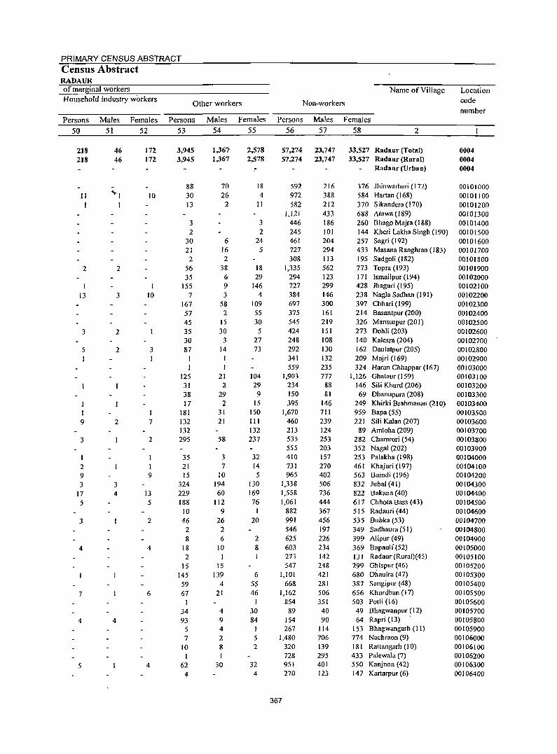
PRIMARY CENSUS ABSTRACT Census Abstract RADAUR of marginal workers Household industry workers
Persons 50
218 218
11
2
13
3
5
I 9
3
2 9 3
17 5
3
4
7
4
5
Males 51
46 46
<PI I
2
3
2
2
2
3 4
4
Females 52
172 172
10
I 10
3
7
2
I 9
J3 5
2
4
6
4
Other workers
Persons 53
3,945 3,945
88 30 13
3 2
30 21
2 56 35
155 7
167 57 45 35 30 87
I
125 31 38 17
181 132 132 295
35 21 15
324 229 188 10 46
2 8
18 2
15 145 S9 67
I 34 93
5 7
10 I
62 4
Males 54
1,361 1,367
70 26
2
6 16 2
38 6 9 3
58 2
15 30
3 14
21 2
29 2
31 21
58
3 7
10 194 60
112 9
26 2 6
IO
\5 139
4 21
4 9 4 2 8 I
30
Females 55
2,578 2,578
18 4
II
3 2
24 5
18 29
146 4
109 55 30 5
27 73
104 29
9 15
150 III 132 237
32 14 5
130 169 76
20
2 8
6 55 46
I 30 84
I 5 2
32 4
Name of Village
Non-workers
Persons
56
57,274 57,274
592 972 582
1,121 446 245 461 727 308
1,335 294 727 384 697 375 545 424 248 292 341 559
1,903 234 150 395
1,670 460 213 535 555 410 73 I 965
1,338 1,558 1,061
882 991 546 625 603 273 547
1,101 668
1,162 854
89 154 267
1,480 320 728 95f 270
367
Males Females 57 58 2
23,747 23,747
216 388 212 433 186 101 204 294 113 562 123 299 146 300 161 219 lSI 108 130 132 235 777
88 81
146 711 239 124 253 203 157 270 402 506 736 444 367 456 197 226 234 142 248 421 281 506 351
40 90
114 706 139 295 401 123
33,527 Radaur (Total) 33,527 Radaur (Rural)
Radaur (Urban)
376 Jhinwarheri (172) 584 Hartan (168) 370 Sikandera (170) 688 Atawa (189) 260 BhagoMajra(188) 144 Kheri Lakha Singh (190) 257 Sagri (I 92) 433 Masana Ranghran (183) 195 Sadgoli (182) 773 Topra (193) 171 Ismailpur (194) 428 Jhaguri (195) 238 Nagla Sad han (191) 397 Chhari (199) 214 Basantpur (200) 326 ManslIrpur (20 I) 273 Dohli (203) 140 Kalesra (204) 162 Daulatpllr (205) 209 M ajri (169) 324 Haran Chhappar(167)
1,126 Ghalaur (159) 146 Sili Khurd (206) 69 Dhanupura (208)
249 Khirki Brahmanan (210) 959 Bapa (55) 221 Sili Kalan (207)
89 Amloha (209) 282 Chamrori (54) 352 NagaI (202) 253 Palakha (198) 461 Khajuri (197) 563 Baindi (196) 832 Jubal (41) 822 Bakana (40) 617 Chhota Bass (43) 515 Radauri (44) 535 Bubka (53) 349 Sadhaura (51) 399 Alipur (49) 369 Bapaull (52) 131 Radaur (Rural)(45) 299 Ghispur (46) 680 Dhaulra (47) 387 Sangipur (48) 656 Khurdban (17) 503 Potli (16) 49 Bhagwanpur (12) 64 Rapri (13) .
153 Bhagwangarh (II) 774 Nachraon (9) 181 Rattangarh (10) 433 Palewala (7) 550 Kanjnon (42) 147 Kartarpur (6)
Location code nllmber
0004 0004 0004
00101000 00101100 00101200 00101300 00101400 00101500 00101600 00101700 00101800 00101900 00102000 00102100 00102200 00102300 00102400 00102500 00102600 00102700 00102800 00102900 OOIOJOOO 00103100 00103200 00103300 00103400 00103500 00103600 00103700 00103800 00103900 00104000 00104100 00104200 00104300 00104400 00104500 00104600 00104700 00104800 00104900 00105000 00105100 00105200 00105300 00105400 00105500 00105600 00105700 00105800 00105900 00106000 00106100 00106200 00106300 00106400
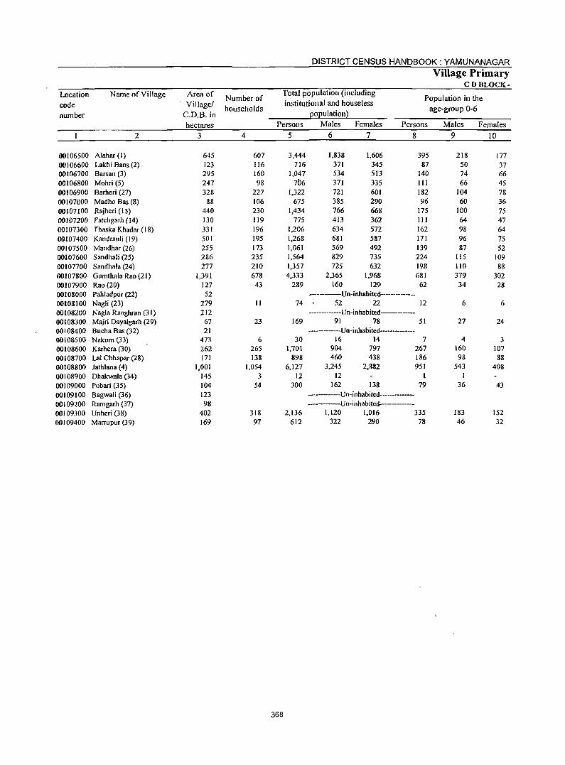
DISTRICT CENSUS HANDBOOK: YAMUNANAGAR
Village Primary CD BLOCK-
Location Name of Village Area of Number of
Total population (including Population in the
code Village! households
institutional and houseless age-group 0-6
number C.O.B. in EOEulation~
hectares Persons Males Females Persons Males Females
2 3 4 5 6 7 8 9 10
00106500 Alahar (I) 645 607 3,444 1,838 1,606 395 218 177 00106600 Lakhi Bans (2) 123 116 716 371 345 87 50 37 00106700 Barsan (3) 295 160 1,047 534 513 140 74 66 00106800 Mohri (5) 247 98 706 371 335 III 66 45 00106900 Barheri (27) 328 227 1,322 721 601 182 104 78 00107000 Madho Bas (8) 88 106 675 385 290 96 60 36 00107100 Rajheri (15) 440 230 1,434 766 668 175 100 75 OOlO7200 Fatehgarh (J4) 130 119 775 413 362 III 64 47 00107300 Thaska Khadar (18) 331 196 1,206 634 572 162 98 64 00107400 Kandrauli (19) 501 195 1,268 681 587 171 96 75 00107500 Mandhar (26) 255 173 1,061 569 492 139 87 52 00107600 Sandhali (25) 286 235 1,564 829 735 224 115 109 00107700 Sandhala (24) 277 210 1,357 725 632 198 110 88 00107800 Gumthala Rao (21) 1,391 678 4,333 2,365 1,968 681 379 302 00107900 Rao (20) 127 43 289 160 129 62 34 28 00108000 Pahladpur (22) 52 --------Un-inhabited------------00108100 Nagli (23) 279 II 74 52 22 12 6 6 00108200 Nagla Ranghran (31) 212 ------·-----Un-inhabited----------00108300 Majri Dayalgarh (29) 67 23 169 91 78 51 27 24 00108400 Bucha Bas (32) 21 ------------Un-inhabited-------00108500 Nakum (33) 473 6 30 16 14 7 4 3 00108600 Karhera (30) 262 265 1,701 904 797 267 160 107 00108700 Lal Chhapar (28) 171 138 898 460 438 186 98 88 00108800 Jathlana (4) 1,001 1,054 6,127 3,245 2,882 951 543 408 00108900 Dhakwala (34) 145 3 12 12 1 1 00109000 Pobari (35) 104 54 300 162 138 79 36 43 00109100 Bagwali (36) 123 ----------Un-inhabitcd-----00109200 Ramgarh (37) 98 ------------Un-inhabited-----------00109300 Unheri (38) 402 318 2,136 1,120 1,016 335 183 152 00109400 Marrupur (39) 169 97 612 322 290 78 46 32
368
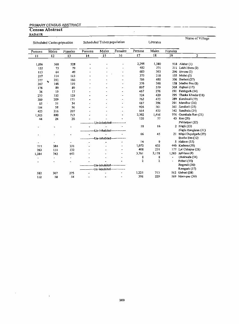
PRIMARY CENSUS ABSTRACT Census Abstract RADAUR
Name ofYillage
Scheduled Castes popuation Scheduled Tribes population Literates
Persons Males Females Persons Males Females Persons Males Females
11 12 13 14 15 16 17 18 19 2
1,096 568 528 2,298 1,380 918 Alahar (1)
152 73 79 482 271 211 Lakhi Bans (2)
113 64 49 683 393 290 Barsan (3)
227 114 113 373 218 155 Mohri (5)
377 ... 211 166 786 480 306 Barheri (27)
261 148 119 376 248 128 Madho Bas (8)
178 89 89 897 529 368 Rajheri (15)
36 19 17 461 276 191 Fatehgarh (14)
271 152 125 724 429 295 Thaska Khadar (18)
380 209 171 762 473 289 Kandrauli (19)
85 51 34 687 396 291 Mandhar (26)
114 58 56 926 561 365 Sandhali (25)
423 216 207 814 472 342 Sandhala (24)
1,513 800 713 2,392 1,416 976 Gumthala Rao (21 )
44 24 20 120 77 43 Rao(20)
------------U n-i nhabited---------- Pahladpur (22) 18 16 2 Nagli (23)
----------Un-inhabited----------- Nagla Ranghran (31) 66 45 21 Majri Dayalgarh (29)
------------Un-inhabited----------- Bucha Bas (32) 14 9 5 Nakum (33)
715 384 331 1,072 632 440 Karhera (30)
263 131 132 408 231 177 Lal Chhapar (28)
1,384 742 642 3,761 2,178 1,583 Jathlana (4) 8 8 Dhakwala (34) 2 2 Pobari (35)
------------Un-inhabited----- Bagwali (36)
---------Un -inhabited----------- Ramgarh (37)
582 307 275 1,225 713 512 Unheri (38)
112 58 54 398 229 169 Marrupur (39)
369
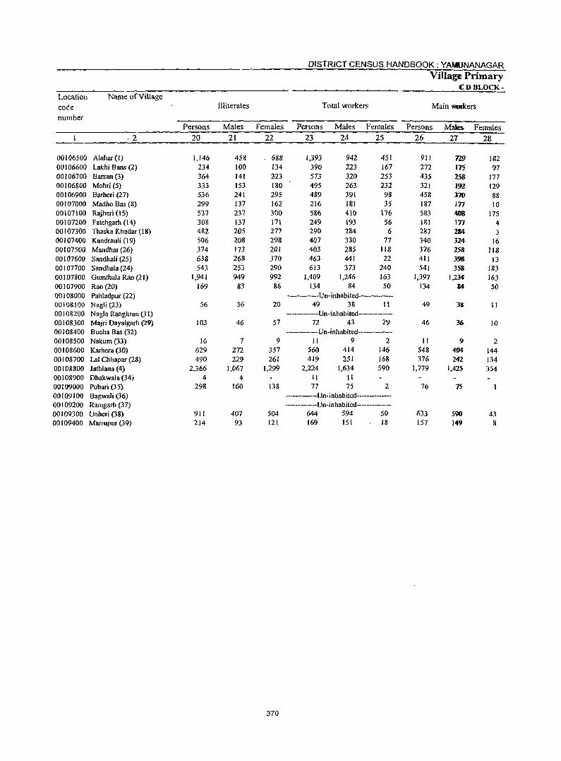
370
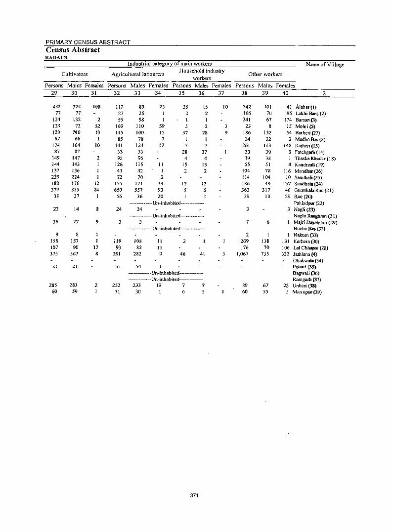
PRIMARY CENSUS ABSTRACT
Census Abstract RADAUR
Industrial cate~0!1 of main workers Name of Village
Cultivators Agricultural labourers Household industry
Other workers workers
Persons Males Females Persons Males Females Persons Males Females Persons Males Females
29 30 31 32 33 34 35 36 37 38 39 40 2
432 324 108 112 89 23 25 15 10 342 301 41 Alahar(l) 77 77 27 26 2 2 166 70 96 Lakhi Bans (2)
134 132 2 59 58 241 67 174 Barsan(3) 124 72 52 169 110 59 5 2 3 23 8 15 Mohri (5) 120 NO 10 115 100 15 37 28 9 186 132 54 Barheri (27) 67 66 1 85 78 7 34 32 2 Madho Bas (8)
174 164 10 141 124 17 7 7 261 113 148 Rajheri (15) 87 87 33 33 28 27 33 30 3 Fatehgarh (14)
149 147 2 95 95 4 4 39 38 Thaska lOtadar (18) 144 143 126 115 II 15 15 55 51 4 Kandraulj (19) 137 136 43 42 I 2 2 194 78 116 Mandh.(26) 225 224 72 70 2 114 104 10 Sandhali (25) 188 176 12 155 121 34 12 12 186 49 137 Sandhala (24) 379 355 24 650 557 93 5 5 363 317 46 Gumthala Rao (21) 38 37 I 56 36 20 39 10 29 Rao (20)
------------Un-inhabited----------- PahladplII" (22) 22 14 8 24 24 3 3 Nagli (23)
-------Un-inhabited-------- Nagla Ranghran (31) 36 27 9 3 3 7 6 Majri Dayalgarh (29)
------------Un-inhabited----------- Bucha Bz (32) 9 8 2 I Nakum(33)
IS8 157 119 108 11 2 269 138 131 Karhera (30) 107 90 17 93 82 11 176 70 106 Lal Chhapar (28) 375 367 8 291 282 9 46 41 5 1,067 735 332 lathlana (4}
Dhakwala (34) 21 21 55 54 Pobari (35)
---------Un-inhabited---------- BagwaJi (36) -----------Un-inhabited-------- Ramgarh (37)
285 283 2 252 233 19 7 7 89 67 22 Unheri (38) 60 59 1 31 30 I 6 5 60 55 5 Marrupuc (39)
371
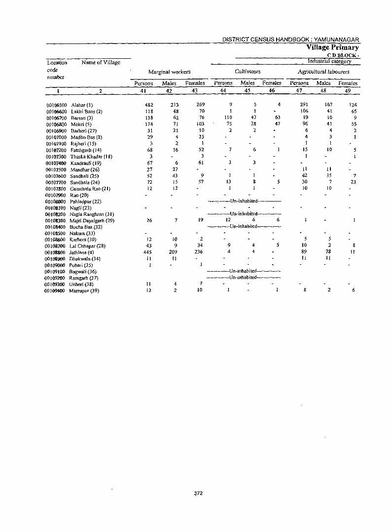
DISTRICT CENSUS HANDBOOK: YAMUNANAGAR
Village Primary CD BLOCK-
Location Name of Village Industrial catel:\0!2:
code Marginal workers Cultivators Agricultural labourers number
Persons Males Females Persons Males Females Persons Males Females
2 41 42 43 44 45 46 47 48 49
00106500 Alahar (I) 482 213 269 9 5 4 291 167 124
00106600 Lakhi Bans (2) 118 48 70 106 41 65
00106700 Barsan (3) 138 62 76 110 47 63 19 10 9 00106800 Mohri (5) 174 71 103 75 28 47 96 41 55
00106900 Barheri (27) 31 21 10 2 2 6 4 2
00107000 Madho Bas (8) 29 4 25 4 3 1 00107100 Rajheri (15) 3 2 I I I oOlOnoo F atehgarh (14) 68 16 52 7 6 15 10 5
00107300 Thaska Khadar (18) 3 3 00107400 Kandrauli (19) 67 6 61 3 3
00107500 Mandhar (26) 27 27 II II
00107600 Sandhali (25) 52 43 9 I I 42 35 7
00 I onoo Sandhala (24) 72 IS 57 13 8 5 30 7 23
00107800 Gumthala Rao (21) 12 12 I 10 10
00107900 Rao (20) 00108000 Pahladpur (22) -----.-----Un-inhabited--------
00108100 Nagli (23) 00108200 Nagla Ranghran (31) -------------Un-inhabited-------
00108300 Majri Dayalgarh (29) 26 7 19 12 6 6
00108400 Sucha Bas (32) -----------Un-inhabited-------
00108500 Nakum (33) 00108600 Karhera (3D) 12 10 2 5 5 00108700 Lal Chhapllr (28) 43 9 34 9 4 5 10 2 8
00108800 lathlana (4) 445 209 236 4 4 89 78 II
00108900 Dhakwala (34) II II II II
00109000 Pobari OS) I 00109100 Bagwali (36) ---------Un-inhabited------
00109200 Ramgarh (37) ----------Un-inhabited---------
00109300 Unheri (38) II 4 7
00109400 Marrupur (39) 12 2 10 8 2 6
372
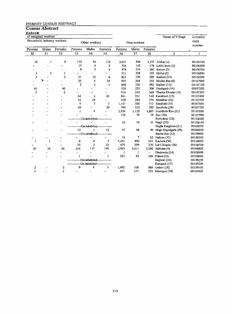
PRIMARY CENSUS ABSTRACT Census Abstract RADAUR of marginal workers Name of Village Location Household industry workers
Other workers Non-workers code number
Persons Males Females Persons Males Females Persons Males Females
50 5\ 52 53 54 55 56 57 58 2
10 9 172 40 132 2,051 896 1,155 Alahar (I) 00106500 II 6 5 326 148 178 Lakhi Bans (2) 00106600 9 5 4 474 214 260 Barsan (3) 00106700
3 2 I 211 108 103 Mohri (5) 00106800 2 2 21 15 6 833 330 503 Barheri (27) 00106900 ... - 25 24 459 204 255 Madho Bas (8) 00107000
2 848 356 492 Rajheri (15) 00107100 46 46 526 220 306 Fatehgarh (14) 00107200 2 2 916 350 566 Thaska Khadar (18) 00107300
64 3 61 861 351 510 Kandrauli (19) 00107400 16 16 658 284 374 Mandhar (26) 00107500 9 7 2 1,101 388 713 Sandhali (25) 00107600
29 29 744 352 392 Sandhala (24) 00107700 2,924 1,119 1,805 Gumthala Rao (21) 00107800
155 76 79 Rao (20) 00107900 ----------Un-tnhabited-------------- Pahladpur (22) 00108000
25 14 II Nagli (23) 00108100 ------------Un-inhabited------------ Nagla Ranghran (31) 00108200
13 1 12 97 48 49 Majri Dayalgarh (29) 00108300 ------------Un-inhabited-------------- Bucha Bas (32) 00108400
19 7 12 Nakum (33) 00108500 6 4 2 1,141 490 651 Karhera (30) 00108600
24 3 21 479 209 270 Lal Chhapar (28) 00108700 36 10 26 316 117 199 3,903 1,611 2,292 Jathlana (4) 00108800
1 1 Dhakwala (34) 00108900 223 87 136 Pobari (35) 00109000
-------Un-inbabited------- Bagwali (36) 00109100 ------Un-inhabited--------- Ramgarh (37) 00109200
2 2 9 4 5 1,492 526 966 Unheri (38) 00109300 3 3 443 171 212 Marrupur (39) 00109400
373
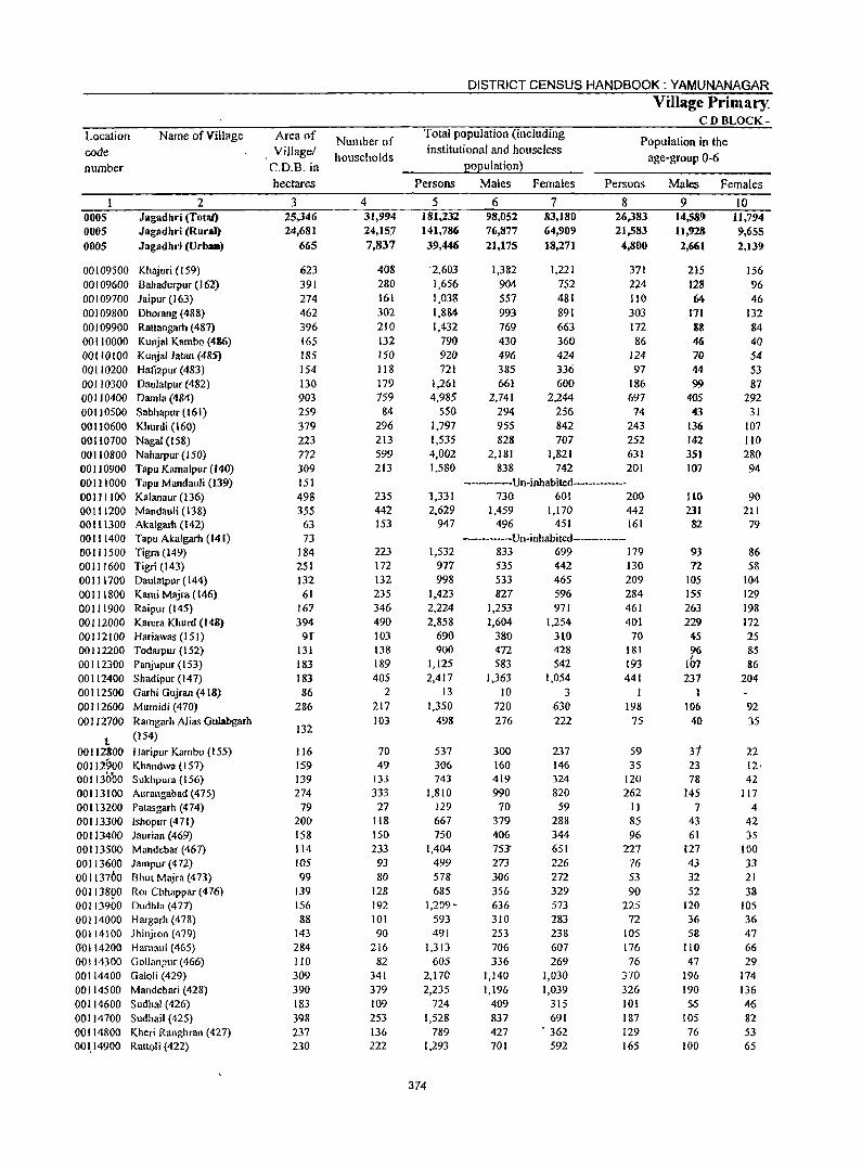
Location code number
ooos OOOS 0005
00109500 00109600 00109700 00109800 00109900 00110000 00110100 00110200 00110300 00110400 00110500 00110600 00110700 00110800 00110900 00111000 00111100 00111200 001 t 1300 00111400 00111500 001 11600 00111700 00111800 00111900 00112000 00112100 00112200 00112300 00112400 00112500 00112600 00112700
t 00112800 00112900 001130'00 00113100 00113200 00113300 00113400 00113500 00113600 00113700 001138g0 00113900 00114000 00114100 00114200 OO! 14300 00114400 00114500 00114600 00114700 00114800 001.14900
Name of Village
2 Jagadhri (Total) Jagadhri (Rural) Jagadhri (UrbaB)
Khajuri (159) Bahadurpur (J 62) Jaipur (163) Dhorang (488) Rattangarh (487) Kunjal Kambo (486) Kunjal Jatan (485) Hafizpur (483) Daulalpur (482) Damla (484) Sabhapur (161) Khurdi (160) NagaI (158) Naharpur (150) Tapu Kamalpur (140) Tapu Mandauli (139) Kalanaur (136) Mandauli (138) Akalgarh (142) Tapu Akalgarh (141) Tigra ()49) Tigri (143) Daulatpur (144) Kami Majra (146) Raipur (145) Karera Khurd (148) Hariawas (15 I) Todarpur (152) Panjupur (153) Shadipur (147) Garhi Gujran (4 [8) Mumidi (470) Ramgarh Alias Gulabgarh (154)
Haripur Kambo (155) Khandwa (IS7) Sukhpura (156) Aurangabad (475) Patasgarh (474) Ishopur (471) laurian (469) Mandebar (467) Jampur (472) Bhut Majra (473) Ror Chhappar (476) Dudhla (477) Hargarh (478) Jhinjron (479) Hamaul (465) (iollanpur (466) Galoli (429) Mandebari (428) SudhaJ (426) Sudhail (425) Kheri Ranghran (427) Rattoli (422)
Area of Village!
C.D.B. in hectares
3 25,346 24,681
665
623 391 274 462 396 165 185 154 130 903 259 379 223 772 309 lSI 498 355
63 73
184 251 132 61
167 394
91' 131 183 183 86
286
132
116 159 139 274
79 200 158 114 105 99
139 156 88
143 284 110 309 390 183 398 237 230
Number of households
4 31,994 24,157 7,837
408 280 161 302 210 132 150 118 179 759
84 296 213 599 213
235 442 153
223 172 132 235 346 490 103 138 189 405
2 217 103
70 49
133 333 27
118 150 233 93 80
128 192 101 90
216 82
341 379 109 253 136 222
DISTRICT CENSUS HANDBOOK: YAMUNANAGAR
Village Primary CD BLOCK-
Total population (including institutional and houseless
population)
Population in the age-group 0-6
Persons
5 181,232 141,786 39,44()
'2,603 1,656 1,038 1,884 1,432
790 920 721
1,261 4,985
550 1,797 1,535 4,002 1,580
1,331 2,629
947
1,532 977 998
1,423 2,224 2,858
690 900
1,125 2,417
13 1,350
498
537 306 743
1,810 129 667 750
1,404 499 578 685
1,209-593 491
1.313 605
2,170 2,235
724 1,528
789 1,293
374
Males Females
6 98,052 76,877
21,175
1,382 904 557 993 769 430 496 385 661
2,741 294 955 828
2,181 838
7 83,180 64,909 18,271
1,221 752 481 891 663 360 424 336 600
2,244 256 842 707
1,821 742
Persons
8 26,383 21,583
4,800
371 224 110 303 172 86
124 97
186 697
74 243 252 631 201
------Un-inhabited---------730 601 200
[,459 1,[ 70 442 496 451 161
-------Un-inhabited-------------833 699 179 535 442 130 533 465 209 827 596 284
1,253 971 461 1,604 1,254 401
380 3~0 70 472 428 1&1 583 542 193
1,363 1,054 441 10 3 I
720 630 198 276
300 160 419 990
70 379 406 75~
273 306 356 636 310 253 706 336
1,140 1,196
409 837 427 701
222
237 146 324 820
59 288 344 651 226 272 329 573 283 238 607 269
1,030 1,039
315 691
. 362
592
75
59 35
120 262
II 85 96
227 76 53 90
225 72
lOS 176 76
370 326 101 187 129 165
Males Females
9 14,589 11,928 2,661
215 128 64
171 88 46 70 44 99
405 43
136 142 351 107
110 231 82
93 n
105 155 263 229
4S %
107 237
106 40
31 23 78
145 7
43 61
127 43 32 52
120 36 58
110 47
196 190 55
105 76
100
10 lJ,794 9,655 2,139
156 96 46
132 84 40 54 53 87
292 31
107 lID 280 94
90 2I[
79
86 58
104 129 198 172 25 85 86
204
92 35
22 12, 42
117 4
42 35
100 33 21 38
105 36 47 66 29
174 136 46 82 53 65
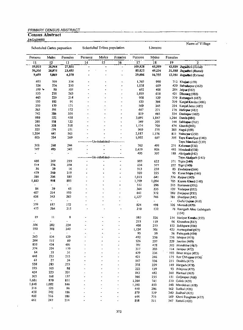
PRIMARY CENSUS ABSTRACT Census Abstract JAGADHRI
Name of Village Scheduled Castes popuation Scheduled Tribes population Literates
Persons Males Females Persons Males Females Persons Males Females
II 12 13 14 15 16 17 18 19 2 59,815 31.')64 27,851 109,828 65,989 43,839 Jagllcthri (Total) 50,356 26Jj75 23,481 80,822 49,234 31,588 Jaglld.ri (Rural)
9,459 5,089 4,370 29,006 16.755 12,251 Jagadl\ri (Urban)
693 359 334 1,702 990 712 Khajuri (159) 526 276 250 1,038 609 429 8ahadurpur (162) 199 ... 98 101 692 408 284 Jaipuc(l63) 533 270 263 1,039 618 421 Dhorang (488) 443 229 214 908 529 379 Rattangllrh (487) 193 102 91 523 304 219 KUsUai Kambo (486) 350 179 171 569 345 224 Kunjal Jatan (485) 363 191 172 447 271 176 Hatizpur (483) 742 386 356 819 485 334 Daulatpur (482) 980 522 458 3,091 1,847 1,244 Damla(484) 280 IS8 122 349 205 144 Sabhapur- (161) 656 338 3J8 1,174 700 474 Khurdi (160) 325 174 151 960 575 385 Nagal (158)
1,204 641 563 2,187 1,376 811 N aharpur (150) 603 334 269 1,002 607 395 Tapu Kamalpur (I40)
------------Un-inhabited------ Tapu Mandauli (139) 512 268 244 762 491 271 Kalanaur-(136) 747 405 342 1,419 926 493 Mandauli (l38)
495 307 188 Akalgam(142) ------------Un-inhabited------ Tapu AJcalgarh (141)
486 267 219 993 622 371 Tigra(l49) 514 276 238 634 377 257 Tigri (143) 36 20 16 313 230 83 DaulatpUl" (144)
479 260 219 320 225 95 Kami Majra (146) 386 206 180 1,015 641 374 Raipur(145)
1,883 998 885 1,799 1,094 705 Karera Khurd (148) 511 296 215 Hariawas (151)
84 39 45 364 235 129 Todarpur (IS2) 407 214 193 641 372 269 Panjupur (153) 626 343 283 1,127 746 381 Shadipur (147)
Garhi Gujran (418) 359 187 172 824 498 326 Mumidi (47()') 475 264 211 210 132 78 Ramgarh Alias Gulabgarh
(154) 19 II 8 -38U 226 154 Haripur Kamllo (155)
215 119 96 Khandwa (157) 506 282 224 408 255 153 Sukhpura (156) 550 308 242 1,124 701 423 Aurangabad (475)
95 59 36 Patasgarh (474) 263 134 129 412 256 156 Ishopur (471) 204 115 89 526 297 229 Jaurian (469) 835 434 401 781 478 303 Mandebar (467) 374 204 170 317 203 114 Jampur (472)
64 33 31 429 236 . 193 Bhut Majra (473) 448 233 215 421 246 175 Ror Chhappar (476)
,
61 27 34 547 336 211 Dudhla (477) 558 285 273 378 229 149 Hargarh (478) 193 105 88 222 129 93 lhinjron (479) 424 223 201 843 482 361 Hamaul (465) 305 168 137 386 235 151 Gollanpur (466)
1,681 870 811 1,264 745 519 Galoli (429) 1,848 1,002 846 1,390 850 540 Mandebari (428)
216 120 96 448 286 162 Sudhal (426) 428 242 186 879 539 34() Sudhail (425) 402 216 186 444 275 169 Kheri Ranghran (427) 461 247 214 858 511 347 Rattoli (422)
375
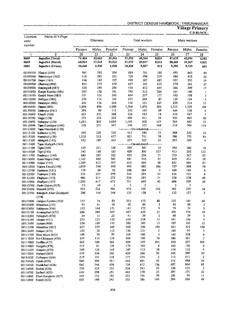
Location code
number
0005 0005 0005
Name ofViJIage
2 Jagadhri (Total) Jagadhri (Runtl)
Jagadhri (Urban)
00 I 09500 Khajuri (J 59) 00109600 Bahadurpur(161J 00 109700 Jaipur (163) DO I 09800 Ohorang (488) 00109900 Rattangarh (487) 00 II 0000 Kunjal Karnbo (486) 00110100 Kunja! Jatan (485) 00110200 Hafizpur(483) 00110300 Daulatpur (482) 00110400 Dmnla (484) 00110500 Sabbapur (161 ) 00110600 Khurdi (160) 00110700 Nagai (158) 00 II 0800 Nabarpur (150) 00 I 10900 Tapu Kamalpur (I40) 00111000 Tapu Mandauli (139) 00 I III 00 Kalanaur (136) 00111200 Mandauli (138) 00111300 Akalgarh (142) 00111400 TapuAklllgarh (141) 00111500 Tigr.l(149) 00111600 Tigri (143) DO I I 1700 Daulatpuf (144) 00111800 Kami Majra (146) 00111900 Raipuf (145) 00112000 Karera Khurd (148) 00112100 Hariawas (151) 00112200 Todarpur(152) 00112300 Panjupur (153) 00112400 Shadipur (141) 00112500 Garbi Gujran (418) 00112600 Mwnidi (470) 00112700 Ramgarh Alias Gulabgarh
(154) 00112800 Haripur Kambo (155) 00112900 Khandwa (157) 00113000 Sukhpufa (156) 00113100 Aurangabad(475) 00113200 Patasgarh (474) 00 I 13300 Ishopur (471 ) 00113400 Jaurian (469) 00 I 13500 Mandebar (467) 00 113600 Jalllpur (472) 00113700 Bhut MW3 (473) 00113800 Ror Chhappar (476) 00113900 DudHla (477) 00 114000 Hargarh (478) 00114100 Jhinjron (479) 00114200 Hamaul (465) 00114300 Gollanpur (466) 00114400, Galoli (429) 00114500 Mandebari (428) 00114600 Sudhal (426) 00114700 Sudhail (425) 00114800 Khc:ri Ranghran (427) 00114900 Rattoli(422)
III iterates
DISTRICT CENSUS HANDBOOK: YAMUNANAGAR
Total workers
Village Primary CD BLOCK-
Main workers
Persons Males Females Persons Males Females Persons Males Females
20 71,404 60,964 10,440
901 618 346 845 524 267 351 274 442
1,894 201 623 575
1.815 578
569 1.210
452
539 343 685
1.103 1,209 1,059
179 536 484
1.290 13
526 288
157 91
335 686 34
255 224 623 182 149 264 662 215 269 470 219 906 845 276 649 345 435
21 32,063 27,643 4,420
392 295 149 375 240 126 151 114 176 894 89
255 253 805 231
239 533 189
211 158 303 602 612 510
84 237 211 617
10 222 144
74 41
164 289 II
123 109 275
70 70
110 300
81 124 224 101 395 346 123 298 152 190
22 39,341 33,321
6,020
509 323 197 470 284 141 200 160 266
1.000 112 368 322
1,010 347
330 677 263
328 185 382 SOl 597 549
95 299 273 673
3 304 144
83 50
171 397 23
132 115 348 112 79
154 362 134 145 246 118 511 499 153 351 193 245
376
23 57,393 47,073 10,320
881 729 490 627 516 592 434 327 514
1,760 232 526 445
1,105 540
24 48,564 39,057
9,507
701 490 305 505 412 312 257 244 331
1,476 163 512 411 958 372
25 8,829 8,016
813
180 239 185 122 104 280 177 83
183 284
69 14 34
147 168
-------------Un-inhabited-----------413 340 73 821 751 70 257 225 32
-----------Un-inhabited---------399 387 12 428 301 127 295 224 11 481 454 27 652 604 48 991 885 106 188 184 4 214 354 731
3 472 135
253 92
181 447
41 230 202 460 136 164 266 584 170 140 439 177 643 738 238 403 233 552
201 283 689
·3 356 128
173 89
172 426 39
218 189 356
.131 160 190 339 162 112 346 174 601 612 213 378 194 386
13 71 42
116 7
80 3 9
21 2
12 13
104 5 4
76 245
8 28 93 3
42 126 25 25 39
166
26 47,678 38,288
9,390
692 484 307 274 366 161 193 129 229
1,553 164 454 433 765 518
348 780 207
392 413 279 470 651 757 169 136 338 604
3 363 132
225 91 79
392 40
141 197 421 100 162 186 330 162 114 366 113 516 687 128 397 105 384
27 42,996 34,267 8,729
643 458 293 261 349 160 188 124 214
1.359 158 447 403 692 364
332 735 203
382 292 217 451 604 698 165 132 278 568
3 329 127
165 88 74
374 39
J36 185 321
97 158 181 227 156 110 30V 1ft 488 604' 125, 375
94 336
28 4,682 4,021
661
49 26 14 J3 17 I 5 5
15 194
6 7
30 73
154
16 45 4
10 121 62 19 47 59 4 4
60 36
34 5
60 3 5
18
5 12
100 3 4 5
103 6 4
59 2
28 83
3 22 II 48
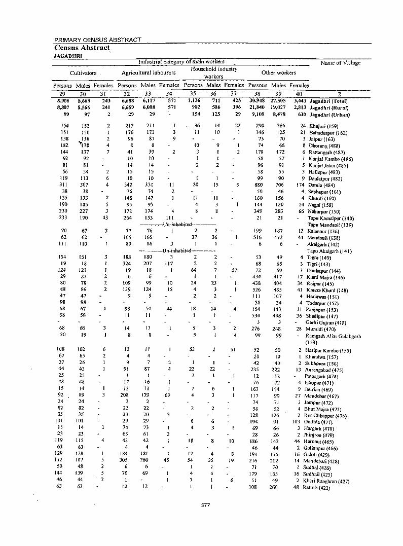
PRIMARY CENSUS ABSTRACT Census Abstract JAGADHRI
Industrial category of main workers
Agricultural labourers workers
Cultivators. Household industry
Name of Village
Other workers
Persons Males Females Persons Males Females Persons Males Females Persons Males Females
29 8,906 8,807
99
154 151 138 182 144 92
81 56
119 311 38
135 190 230 233
70 62
III
154 19
124 29 80 88 47 98 68 58
68 20
108 67 27 44 25 48 15 92 14 82 35
101 15 23
119 63
129 112 50
144
46 63
30 8,663 8,566
1)7
152 150 136
~!78 137 92 81 54
113 307
38 133 185 217 190
67 62
110
151 18
123 27 78 86 47 98 67 58
65 19
102 65 26 43 25 48 14 89 24 82 35
101 14 23
115 63
128 107 48
139 44 63
31 243 241
2
2
2 4 7
2 6 4
2 5 3
43
3
3
I 2 2 2
3
6 2
3
4
I 5 2 5 2
32 6,688 6,659
29
212 176 96
8 41 10 14 15 10
342 16
148 95
178 264
77 165 89
183 324
19 6
109 139
9
98 II
14 8
12 4 I)
91
17 12
208 2
22 23 29 74 63 43
4 184 305
6 70
I 12
33 6,117 6,088
29
211 173 87 8
39 10 14 15 10
331 74
147 95
174 153
34 571 571
I 3 9
2
II 2 I
4 III
35 1,136
982 154
36 II
10 3
2
I 20
II 4 8
36 711 586 125
14 10
9
2
15
II 3 8
--------Un-inhabited------76 I 2 2
165 37 36 86 3 I
-------U n-inhabited---------180 3 2 2 207 117 2 2
18 64 7 6 I
99 10 24 23 124 15 4 3 922
54 II
13 8
II 4 7
87
16 II
139 2
22 20 29 73 61 42 4
181 260
6 69
12
44
2
4
I 69
3
I 2
3 45
18
5 5
53
I
22 2
7 4
2
6 4
18
12 54
4 7
14
3
2
1 22
6 3
2
6 3
8
4 35
4
?,77
37 425 396
29
22
1 2
5
57
4
2 4
51
10
8 19
6
38 39 30,948 27,505 21,840 ] 9,027 9,108 8,478
290 146 73 74
178 58 96 58 99
880 50
160 144 349
21
199 516
6
53 68 72
434 438 526 III 38
154 534
3 276
99
266 125 70 66
172 57 91 55 90
706 46
156 110 283
21
187 472
6
49 65 69
417 404 485 107 34
143 498
3 248
99
52 50 20 19 42 40
235 222 12 12 16 72
163 154 117 90 74 71 56 52
128 126 194 91 69 66 28 26
186 142 46 44
!9! !75 216 202
71 70 179 163 51 49
308 260
40 2 3,443 Jagadbri (Total) 2,8]3 Jaglldhri (Rural)
630 Jagadhri (Urban)
24 Khajuri (159) 21 Bahadurpur (162) 3 Jaipur (163) 8 Dhorang (4gS} 6 Rattangarh (487) I Kunjal Kambo (486) 5 KunjalJatan (485) 3 Hafizpur (483) 9 Daulatpur (482)
114 Damla (484) 4. Sabhapur(161) 4 Khurd; (160)
24 NagaI (158) 66 Nabarpur (150)
Tapu Kamalpur (140) Tapu Mandauli (139)
12 Kalanaur (136) 44 Mandauli (138)
AkaJgarh (142) Tapu Akalgarh (141)
4 Tigra (149) 3 Tigri (143) 3 Daulatpur {I 44)
17 Kami Majra (146) 34 Raipur (145) 41 Kama Khurd (148) 4 Hariawas (151) 4 Todarpur (152)
II Panjupur(153) 36 Shadipur (147)
Garhi Gujran (418) 28 Mumidi (410) - Ramgarh Alias Gulabgarh
(154)
2 Haripur Kambo (ISS) Khandwa (151)
2 Sukhpura (156) 13 Aurangabad (475)
Patasgarh (474) 4 Ishopur (471) 9 laurian (469)
27 Mandef)ar (461) J Jampur (472) 4 Bhut Majra (473) 2 ROf Chhappar (476)
103 Dudhla (477) 3 Hargarh (478) 2 Jhinjron (479)
44 Hamaul (465) 2 GoiJanpuT (466)
16 Galoli (429) 14 Mandebari (428)
I Sudhal (426) 16 Sudhail (425) 2 Kheri Ranghran (427)
48 Rattoli (422)
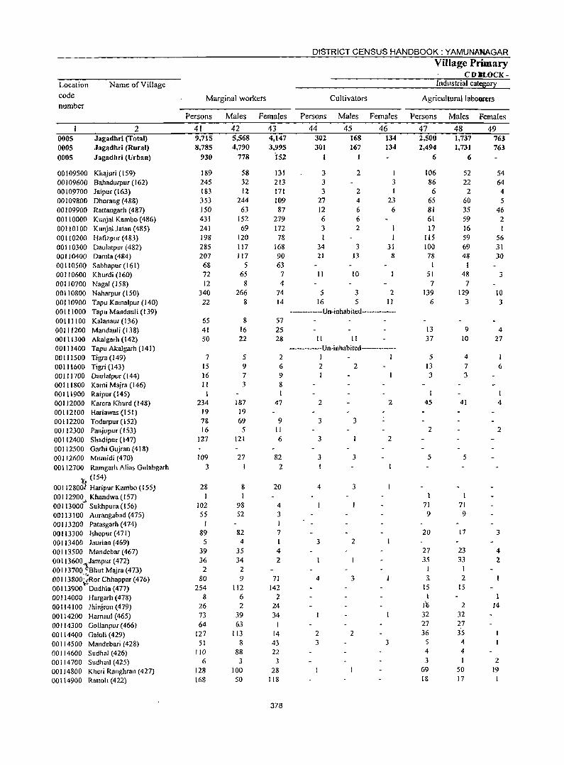
Location code number
0005 0005 0005
Name of Village
2 Jagadhri (Total) Jagadhri (Rural) Jagadhri (Urban)
00 I 09500 Kh,yuri (159) 00 I 09600 Bahadurpur (162) 00109700 Jaipur (163) 00109800 Dhorang (488) 00109900 Rattangarh (487) 00110000 KUl1jal Kambo (486) 00110100 Kunjal Jatan (485) 00 II 0200 Hatlzpur (483) 00110300 Daulatpur (482) 00110400 Damla (484) 00 II 0500 Sabhapur (161) 00110600 Khurdi (160) 00110700 Nagai (158) 00110800 N aharpur (150) 00110900 Tapu KamaJpur (140) 00111000 Tapu Mandauli (139) 00111100 Kalanaur(136) 00111200 Mandauli (138) 00111300 Akalgarh (142) 0011 )400 Tapu Akalgarh (141) 00111500 Tigra (149) 00111600 Tigri (143) 00111700 Daulatpur (144) 00111800 Kami Majea (146) 00111900 Raipur (145) 00112000 Karera Khurd (148) 00112100 Hariawas(t5l) 00112200 Todarpur (152) 00 I 12300 Panj upur (153) 00112400 Shadipue (147) 00112500 Garhi Gujran (418) 00112600 Mumidi (470) 00112700 Ramgarh Alias Gulabgarh
. (154)
001 128031 Haripur Kambo (155) OOI1290~~ Khandwa(157) 00113000 Sukhpura (156) 00113100 Aurangabad(475) 00113200 Patasgarh (474) 00113300 Ishopur (471) 00113400 laurian (469) 00113500 Mandebar (467) 001 I 3600.'iJampur (472) 00113700. "Bhut Majra (473) 001 13800~~Ror Chhappar (476) 00113900 Dudhla (477) 00114000 Hargarh (478) 00114100 Jhinjron (479) 00114200 Harnaul (465) 00114300 Gollanpur (466) 00114400 Galoli (429) 00114500 Mandebari (428) 00114600 Sudhal (426) 00114700 Sudhail (425) 00114800 Kheri Ranghran (427) 00114900 Rattoh (422)
Marginal workers
DISTRICT CENSUS HANDBOOK: YAMUNANAGAR
Cultivators
Village Primary CD.LOCK-
Industrial category
Agricultural labourers
Persons Males Females Persons Males Females Persons Males Females
41 9,715 8,785
930
189 245 183 353 150 431 241 198 285 207 68 72 12
340 22
65 41 50
7 15 16 II
234 19 78 16
127
109 3
28
102 55
I 89
5 39 36 2
80 254
8 26 73 64
127 51
110 6
128 168
42 5,568 4,790
778
58 32 12
244 63
152 69
120 117 117
5 65
8 266
8
8 16 22
5 9 7 3
187 19 69 5
121
27
8
98 52
82 4
35 34 2 9
112 6 2
39 63
113 8
88 3
100 50
43 4,147 3,995
i52
131 213 171 J09 87
279 172 78
168 90 63
7 4
74 14
57 25 28
2 6 9 8
47
9 II 6
82 2
20
4 3 1
7
4 2
71 142
2 24 34
14 43 22
3 28
118
378
44 302 301
1
3 3 3
27 12
45 168 167
2
2 4 6
6 6 3 2
34 21
3 13
II 10
5 16
3 5
46 134 134
I 3 I
23 6
31 8
2 II
-----------Un-inhabited----------
II II ----------Un-inhabited-------------
I I 2 2
2 2
3 3
3 2
3 3
4 3
3 2
4 3
2 2 3 3
47 2,500 2,494
6
106 86 6
65 81 61 17
115 100 78
51 7
139 6
13 37
5 13 3
45
2
5
I 71 9
20
27 35
l 15
I I~ 32 27 36
5 4 3
69 18
48 1,737 1,73)
6
52 22
2 60 35 59 16 59 69 48
I 48 7
129 3
9 10
4 7 3
41
5
71 9
17
23 33
2 15
2 32 27 35
4 4 1
50 17
49 763 763
54 64
4 5
46 2 I
56 31 30
3
10 3
4 27
I 6
4
2
3
4 2
I 14
2 19
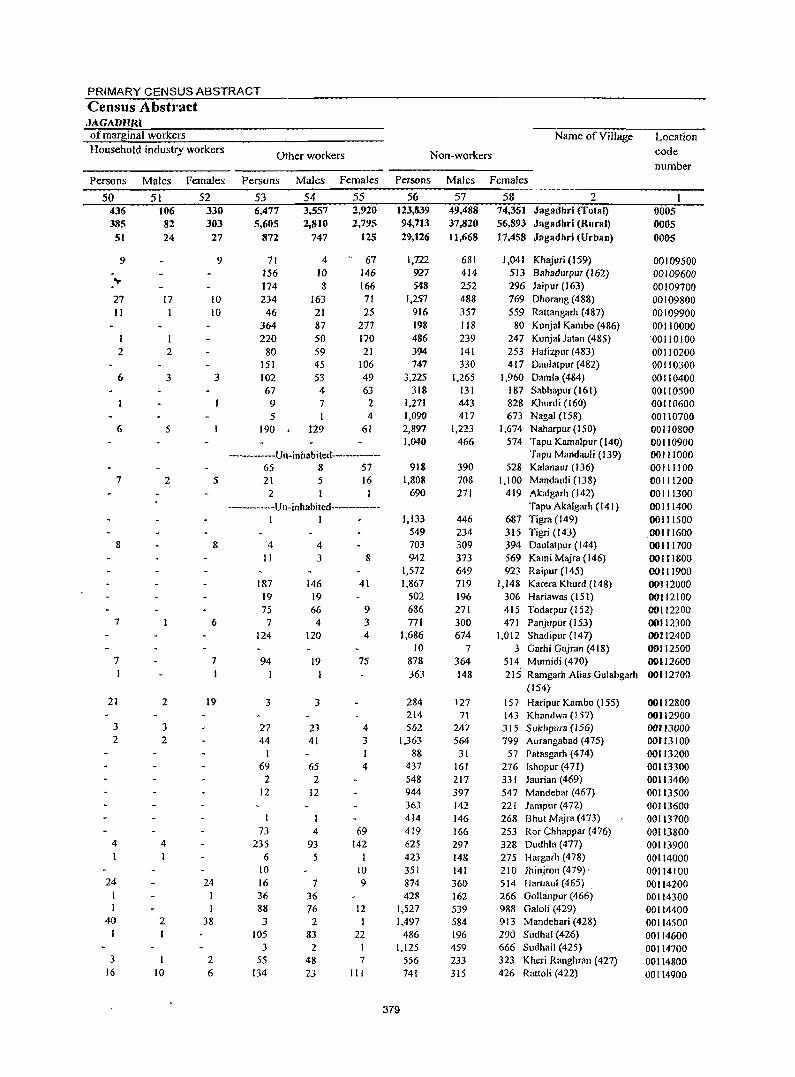
PRIMARY CENSUS ABSTRACT
Census Abstract JAGADHRI of marginal workers Household industry workers
Name of Village
Other workers Non-workers
Persons Males Females Persons Males Females Persons Males Females
50 436 385
51
9
27 II
I 2
6
6
7
8
7
7
21
3 2
4 I
24
40 I
3 16
51 106 82 24
17 1
2
3
5
2
2
3 2
4
2
10
52 330 303
27
9
10 10
3
5
8
6
7
19
24
38
2 6
53 6,477 5,605
872
54 3,557 2,810
747
55 2,920 2,795
125
71 4 67 156 ID 146 174 8 166 234 163 71
46 21 25 364 87 277 220 50 170
80 59 21 151 45 106 102 53 49 67 4 63 972 5 I 4
190. 129 61
----------Un-inhabited------------65 8 57 21
2 5 16
I ------------u n-inhabited------------
I I
4 II
187 19 75
7 124
94
3
27 44
I 69 2
12
I 73
235 6
10 16 36 88 3
105 3
55 134
4 3
146 19 66 4
120
19
3
23 41
65 2
12
4 93 5
7 36 76 2
83 2
48 23
8
41
9 3 4
75
4 3
4
69 142
10 9
12 I
22 I 7
III
56 123,839 94,713 29,126
I,m CJ27 548
1,257 916 198 486 394 747
3.225 318
1,271 1,090 2,897 1,040
918 1,808
690
1,133 549 703 942
1,572 1,867
502 686 771
1,686 10
878 363
284 214 562
1,363 88
437 548 944 363 414 419 625 423 351 874 428
1,527 1,497
486 1,125
556 741
379
57 49.488 37,820 II,668
681 414 252 488 357 118 239 141 330
1,265 131 443 417
1,223 466
390 708 271
446 234 309 373 649 719 196 271 300 674
7 364 148
127 71
247 564
31 161 217 397 142 146 166 297 148 141 360 162 539 584 196 459 233 315
58 2 74,351 Jagadhri (Total) 56,893 Jagadhri (Rural)
17,458 Jagadhri (Urban)
1,041 Khajuri (159) 513 Bahadurpur (162) 296 Jaipur (163) 769 Dhorang (488) 559 Rattangarh (487)
80 Kunjal Kambo (486) 247 Kunjal latan (485) 253 Hafizpur (483) 417 Daulatpur (482)
1,960 Damla (484) 187 Sabhapur (161) 828 Khurdi (160) 673 Nagai (I 58)
1,674 Naharpur (150) 574 Tapu Kamalpur (140)
Tapu Mandauli (139) 528 Kalanaur (136)
1,100 Mandauli (138) 419 Akalgarh (142)
Tapu Akalgarh (l41) 687 Tigra (149) 315 Tigri (143) 394 Daulatpur (144) 569 Kami M~ra (146) 923 Raipur (145)
1,148 Karera Khurd (148) 306 Hariawas (IS!) 415 Todarpur (152) 471 Panjupur (153)
1,012 Shadipur (147) 3 Garhi Gujran (418)
514 Mumidi (470} 215 Ramgarh Alias Gulabgarh
(154)
157 Haripur Kambo (155) 143 Khandwa (IS7)
J 15 S ukhpu13 (156) 799 Aurangabad (475)
57 Palasgarh (474) 276 lshopur (471) 331 Jaurian (469) 547 Mandebar (467) 221 Jampur (472) 268 Bhut Majra (473) 253 Ror Chhappar (476) 328 Dudhla (477) 275 Hargarh (478) 210 lhinjron (479), 514 Harnaul (465) . 266 Gollanpur (466) 988 Galoli (429) 913 Mandebari (428) 290 Sudhal (426) 666 Sudhail (425) 323 Kheri Ranghran (427) 426 Ratloli (422)
Location code number
0005 0005
0005
00109500 00109600 00109700 00109800 00109900 00110000
'00110100 00110200 00110300 00110400 00110500 00110600 00110700 00110800 00110900 00111000 00111100 00111200 00111300 00111400 00111500
.001tl600 00111700 OOH 1800 00111900 00112000 00112100 00112200 00112300 00112400 00112500 00112600 00112700
00112800 00112900 00113000 00113100 001 f3200 001 f3300 00113400 00113500 00113600 00113700 00113800 00113900 00114000 00114100 00114200 00114300 00114400 00114500 00114600 00114700 00114800 00114900
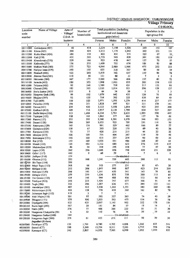
Location code number
Name of Village
2 00115000 Gobindpura (407) 00115100 Khera(423) 00115200 Ruhla Kheri (424) 00115300 Kail (378) 00115400 Khundewala (370) 00115500 Kathwala (377) 00115600 Mahlan Wali (380) 00115700 Haripur Jatan (379) 00 II 5&00 Bhatauli (405) 00115900 Jhinwar Heri (381) 00116000 Haluwala (384) 00116100 Jarauda (403) 00116200 Telipura (402) 00116300 Chaneti (399) 00116400 Buria Sarkar (393) 00116500 Bhagwan Gam (398) 00116600 Bhojpur (397) 00116700 Tejli (409) 00116800 Parwalon (410) 00116900 Darwa (411) 00117000 Gadhauli(412) 00117100 BadhiMajra(126) 00117200 Tajakpur (125) 00117300 Pansra (127) 00117400 Dasani (128) 00117500 Ratanpura (129) 00117600 Qaimpura (124) 00 I 17700 Rampura (130) 00117800 Isharpur(I37) 00117900 Bahrampur(131) 00118000 Kat (132) 00118100 Mandi (133) 00118200 Mahmudpur (135) 00118300 Lapra (134) 00118400 Odhri (117) 00 I 18500 Jodhpur (116) 00118600 Ghoron (115) 001l~700 Bir Tapu (114) 0011}!800 Majri Tapu (I 13)
.001 r~900 Bibipur(118) 00119000 Bakarpur(120) 00119100 Sabapur (121) 00119200 Nai Gawan (122) 00119300 Fetehpur (123) 00119400 Sugh (396) 00119500 Amadalpur (395) 00119600 Mukarimpur (119) 00119100 Jairampur Jagir (I 12) 00119800 Mali Majra (110) 00119900 Bhogpur (III) 00120000 Diyalgarh (394) 00120100 Buria Jagir (392) 00120200 Nabh (389) 00120300 Naugawan Chakpahla (391 00120400 Naugawan Sarkar (108) 00120500 Naugawan Jagir (390)
Jagadhri (Urban) 40305000 Farakhpur (CT) 40308000 Sasauli (CT) 40309000 Kansepur (q)
Area of Village!
C.D.B. in
hectares
3 18
506 181 431 259 136 575 190 123 110 167 180 92
183 155 99 92
100 198 239 189 113 128 255 296 160 130 73
106 116 153 136 86
262 410 174 252 299 368 252 206 259 134 240 353 407 103 119 201 270 132 167 276
6 164 271
135 288 242
Number of households
4 418 424 135 305 166 235 723 105 240
56 177 353 246 303
8 192 120 522 351 430 716
1,484 163 595 269 156 67 77
109 100 169 193 54
256 9
168
68 266 195 270 146 233 206 412 128
3 97
190 425
30 77 32
61
1,761 3,269 2,807
DISTRICT CENSUS HANDBOOK: YAMUNANAGAR
Village Pr~mary CD BLOCK-
Total population (including institutional and houseless
population)
Population in the age-group 0-6
Persons Males Females Persons
5 2,224 2,213
822 1,773
925 1,409 4,044
625 1,419
121 1,060 1,868 1,389 1,935
64 1,079
714 2,971 1,828 2,122 3,937 6,334 1,042 2,580 1,655
991 395 426 751 611
1,035 1,312
354 1,646
68
1,341
503 1,847 1,161 1,636
944 1,424 1,207 2,556
770 7
592 1,033 2,097
141 488 150
6 1,198 1,171
451 945 478 735
2,080 318 762 88
566 1,013
758 1,014
34 642 392
1,595 997
1,108 2,139 3,701
577 1,501
925 529 . 220 211 404 337 551 680 196 856
59
7 1,026 1,042
371 828 447 674
1,964 307 657 33
494 855 631 921 30
437 322
1,376 831
1,014 1,798 2,633
465 1,079
730 462 175 215 347 274 484 632 158 790
9
8 260 262 122 301 127 181 475
89 159
7 157 283 217 296
5 120 130 414 311 423 634
1,095 137 346 211 166 69 44
119 90
168 276
77 459
7 -----------Un-inhabited-------
739 602 206 -------------Un-inhabited-------------
272 231 85 960 887 423 620 878 488 747 636
1,365 410
7 327 563
1,145 84
266 76
541 758 456 677 571
1,[91 360
265 470 952
57 222
74
143 200 113 166 244 443 16l
74 134 332
19 81 29
-------------U n-inhabi ted--------------423 212 211 50
8,740 15,754 14,952
380
4,702 8,511 7,962
4,038 7,243 6,990
1,166 1,732 1,902
Males Females
9 153 131 67
182 70 93
252 50 &9 2
85 158 122 159
2 70 81
237 170 215 337 598
76 193 116 89 43 22 70 60 87
139 47
231 6
115
47, 214
78 115 66 91
133 260
82
45 76
178 14 51 19
20
655 956
1,050
10 107 131 55.
119 57 88
223 39 70
5 72
125 95
137 3
50 49
177 141 208 297 497
61 153 95 77 26 22 49 30 81
137 30
228
91
38 209
65 85 47 75
III 183 79
29 58
154 5
30 10
30
511 776 852
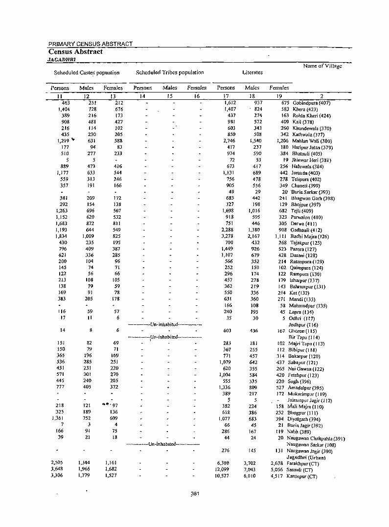
PRIMARY CENSUS ABSTRACT
Census Abstract JAGADHRJ
Name of Village Scheduled Caste~ popuation Scheduled Tribes population Literates
Persons Males Females Persons Males Females Persons Males Females
II 12 13 14 15 16 17 18 19 2 463 251 212 1,612 937 675 Gobindpura (407)
1,404 728 676 1,407 824 583 Khera (423) 389 216 173 437 274 163 Ruhla Kheri (424) 908 481 427 981 572 409 Kail (378) 216 114 102 603 343 260 Khundewala (370) 435 230 205 850 508 342 Kathwala (377)
1,219 .... 631 588 2,746 1,540 1,206 Mahlan Wali (380) 177 94 83 417 237 180 Haripur Jalan (379) 510 277 233 974 590 384 Bhatauli (405)
5 5 72 53 19 )hinwar Heri (381) 889 473 416 673 417 256 Haluwala (384)
1,177 633 544 1,131 689 442 Jarauda (403) 559 313 246 756 478 278 Telipura (402) 357 191 166 905 556 349 Chaneti (399)
49 29 20 Buria Sarkar (393) 381 209 172 683 442 241 Bhagwan Garh (398) 292 154 138 327 198 129 Bhojpur (397)
1,263 696 567 1,698 1,016 682 Tejli (409) 1,152 620 532 918 595 323 Parwalon (410) 1,683 872 811 751 446 305 Darwa (41 I) 1,193 644 549 2,288 1,380 908 Gadhauli (412) 1,834 1,009 825 3,278 2,167 I,ll 1 Badhi Majra (126)
430 235 195 700 432 268 Tajakpur (125) 796 409 387 1,449 926 523 Pansra (127) 621 336 285 1,107 679 428 Dasani (128) 200 104 96 566 352 214 Ratanpura (129) 145 74 71 252 150 102 Qaimpura (124) 122 56 66 296 174 122 Rampura (130) 213 108 105 457 278 179 Isharpur (137) 138 79 59 362 219 143 Bahrampur (131) 169 91 78 550 336 214 Kat (132) 383 205 178 631 360 271 Mandi (133)
166 108 58 Mahmudpur (135) 116 59 57 240 195 45 Lapra (134)
17 II 6 35 30 5 Odhri (117) -----Un-inhabited-------- Jodhpur (116)
14 8 6 603 436 167 Ohoron (115) -----Un-inhabited------------- BirTapu (I 14) ,
lSI 82 69 283 181 102 Majri Tapu (I 13) ISO 79 71 367 255 112 Bibipur(118) 365 196 169 771 457 314 Bakarpur (120) 536 285 251 1,079 642 437 Sabapur (121) 451 231 220 620 355 265 Nai Gawan (122) 571 301 270 1,004 584 420 F etehpur (123) 445 240 205 555 335 220 Sugh (396) 777 405 372 1,336 809 527 AmadalplIr (395)
389 217 172 Mukarimpur (I 19) 5 5 Jairampllr Jagir (112)
218 121 .... '97 382 224 158 Mali Majra (110) 325 189 136 61& 386 232 Bhogpur (III)
1,361 752 609 1,077 683 394 Diyalgarh (394) 7 3 4 66 45 21 Buria Jagir (392)
[66 9[ 75 286 167 ! 19 Nab" (389) 39 21 18 44 24 20 Naugawan Chakpahla (391)
------------Un-inhabited-------------- Naugawan Sarkar (108) 276 145 131 Naugawan Jagir (390)
Jagadl1ri (Urban) 2,505 1,344 1,161 6,380 3,702 2,678 Farakhpur (CT) 3,648 1,966 1,682 12,099 7,043 5,056 Sasauli (CT) 3,306 1,779 1,527 10,527 6,010 4,517 Kansepur CCT)
,381
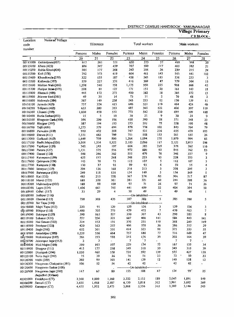
Location code number
Name of Village
2 Oobindpura (407) Khera (423) Ruhla Kheri (424) Kail (378) Khundewal;a (370) Kathwala (371) Mahlan Wali (380) Haripl.lr Jatan (379) Bhatal.lli (405) Jhinwar Heri (381) Haluwala (3&4)
Jarauda (403) Telipura (402) Chaneti (399) Buria Sarkar(393) Bhagwan Garb (398) Bhojpur (391) Tejli (409) Parwalon (410) Darwa(411) Gadhauli (412) Badhi Majra (126) Tajakpur (125) Pansra (127) Dasani (128) Ratanpura (129) Qaimpura (124) Rampura (130) Isharpur (137) Bahrampur (131) Kat (132) Mandi (133) Mahmudpur (135) Lapra (134) Odhri (117) Jodhpur (1 16) Ohoron (I 15) Bir Tapu (I 14) Majri Tapu (113) Bibipur (118) Bakarpur (120) Sabapur (121) Nai Gawan (122) Fetehpur ( 123)
00115000 00115100 00115200 00115300 00115400 00115500 00115600 00115700 00115800 00115900 00116000 00116100 00116200 00116300 00116400 00116500 00116600 00116700 00116800 00116900 00117000 00117100 00117200 00117300 00117400 00117500 00117600 00117700 00117800 00117900 00118000 00118100 00118200 00118300 00118400 00118500 00118600 60118700 00118800 OQI18900 00119000 00119100 00119200 00119300 00119400
~~~ ::~~~ 00:[19700 OOt't9800 00119900 00120000
Sugh (396) Amadalpur (395) Mukarimpur (119) Jairampur Jagir (112) Mali Majra(IlO) Bhogpur (111) Diyalgarh (394)
00120 I 00 Buria Jagir (392) 00120200 Nabh (389) 00120300 Naugawan Chakpahla (391) 00120400 Naugawall Sarkar (108) 00120500 Naugawall Jagir (390)
Jagadhri (Urban) 40305000 Farakbpur CCl) 40308000 Sasauli {Cn 40309000 Kansepur (CT)
DISTRICT CENSUS HANDBOOK: YAMUNANAGAR
Village Primary . CDBLOCK-
III iterates Total workers Main workers
Persons Males Females Persons Males Females Persons Males Females
20 612 806 385 792 322 559
1,298 208 445
49 387 737 633
1,030 15
396 387
1,273 910
1,371 1,649 3,056
342 1,131
548 425 143 130 294 249 485 681 188
IA06 33
738
220 1.480
390 557 324 420 652
1,220 3S1
2 210 415
1,020 75
202 106
147
2,360 3,655 4,425
21 261 347 177 373 135 227 540
81 172 35
149 324 280 458
5 200 194 579 402 662 759
1,534 }45 575 246 177 70 37
126 118 215 320
88 661 29
303
91 705 163 236 133 163 301 556 193
2 103 177 462
39 99 52
67
1,000 1,468 1,952
22 351 459 208 419 187 332 75S 127 273
14 238 413 353 572
10 196 193 694 508 709 890
1,522 197 556 302 248
73 93
168 131 270 361 100 745
4
23 630 707 242 604 428 416
1,175 171 400
73 245 640 487 772 30
418 273 878 747 711
1,264 2.183
604 972 555 348 112 99
216 154 367 381
97 441
50
24 573 590 216 461 243 369 950 151 382
71 233 521 365 542
21 390 201 776 531 558
1,094 2,066
385 880 479 253 107 93
213 149 274 321
71 409 49
25 57
117 26
143 185 47
225 20 18 2
12 119 122 230
9 28 72
102 216 153 170 117 219
92 76 95
5 6 3 5
.93 60 26 32
--------Un-inhabited-------------435 387 382 5
--------Un-inhabited-------------129 129 126 3 775 479 472 7 227 350 307 43 321 607 466 141 191 257 351 664 1S8
107 238 558 36
103 54
370 406 414 757 21S
7 229 349 731
74 141 42
251 370 323 680 176
7 154 310 592
51 129 42
119 36 91 77 39
75 39
139 23 12
-----------Un-inhabited--------------80 155 108 47
1,360 2,187 2,473
382
2,322 4,130 3,868
2,133 3,818 3,556
189 312 312
26 418 403 239 543 236 379 908 161 385
70 150 464 426 697
30 371 258 843 655 561
1,079 2,121
378 845 346 228 112 59
208 154 304 244
97 404 49
385
129 470 290 584 368 386 :m 716 203
7 167 349 555
73 140 42
124
2,040 3,961 3,389
27 398 382 215 441 233 364 866 143 372
68 139 424 307 509
2.1 348 190 764 470 535 994
2,015 262 762 337 225 107 55
205 149 217 208
71 394
48
380
126 463 282 443 249 357 320 669 164
7 133 310 427
50 128 42
99'
1,891 3,692 3,146
28 20 21 24
102 3
15 42 18 13 2
II 40
119 188
9 23 68 79
185 26 85
106 116 83 9 3 5 4 3 5
87 36 26 10
5
3 7 8
141 119 29 55 47 39
34 39
128 23 12
25
149 269 243
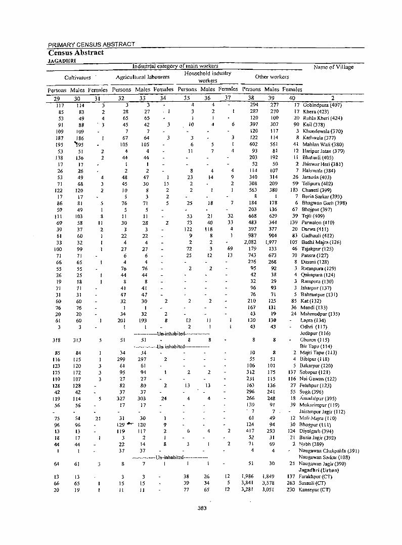
PRIMARY CENSUS ABSTRACT Census Abstract JAGADHRI
Industrial category of main workers
Cultivators Agricultural labourers Household industry
workers
Name of Village
Other workers
Persons Males Females Persons Males Females Persons Males Females Persons Males Females
29 117 85 53 91
109 187 195 53
138 17 26 53 71
122 17 86 50
III 69 39 61 33
100 71 66 55 26 19 71 31 60 76 20 61
3
318
85 116 123 175 110 128 42
119 56
75 96 13 18 44
64
13 66 20
30 114 83 49 88
109 186
'95 51
136 17 26 49 68
120 17 81 49
103 58 37 60 32 99 71 65 55 25 18 71 31 60 76 20 60
3
313
84 115 120 172 107 128 42
114 56
54 96 D 17 44
61
13 65 19
31 3 2 4 3
2 2
4 3 2
5 I 8
II 2 I
5
3 3 3
5
21
3
32 3
28 65 45
7 67
105 4
44 I 2
48 45 10 5
76
33 3
27 65 42
7 64
105 4
44
2 47 30
8 3
71 5 5
II 30
3 22
4 27 6
II 28
3 22
4 27
6 4 4
76 44
8
76 44
8 41 41 47 47 32
I 34
201 I
30 I
32 193
34
. I
3
3
I 15 2 2 5
2
2
2 8
35 4
3 I
10
3 6
II
8 23 2 2
25
53 73
122 9 2
72 25
2
2
12 2
36 4 2 I
4
5 7
4 14
18
21 40
118 8 2 3
12
2
2
II
----------Un-inhabited-------------51 51 8 8
-------------Un-inhabited-------------34 34
299 297 2 61 95
61 94
27 27 82 37
327
80 37
303 17 17
31 30 129'- 120 119 117
J 2 22 14 37 37
2
24
I 9 2 I 8
2 2
13 13
4 4
6 4
3
-------------Un-inhabited--------------8 7 1 I I
3 15 II
3 15 11
38 39 77
26 34 65
383
37
6
3 I 4
4 9 2 I
7
32 33
4
69 13
2
2
12 5
12
38 294 287 120 397 120 122 602
93 203
52 114 340 308 563
8 184 203 668 483 397 987
2,082 179 743 276
95 42 32 96 76
210 167 43
130 43
8
10 55
106 312 231 163 296 266 130 . 7
61 124 417 52 71 4
51
1,986 3,841 3,281
39 277 270 100 307 117 114 561
81 192 50
107 314 209 380
I 178 136 629 344 377 904
1,977 133 673 268
92 38 29 93 71
125 131
19 130 43
8
8 51
101 175 115 136 241 248
91 7
49 94
293 31 69
4
30
1,849 3,578 3,051
40 2 17 Gobindpura (407) 17 Khera(423) 20 Ruhla Kheri (424) 90 Kail (378)
3 Khundewala (370) 8 Kathwala (377)
41 Mahlan Wali (380) 12 Haripllr Jatan (379) II Bhatauli (405) 2 Jhinwar Heri (381) 7 Haillwala (384)
26 Jarauda (403) 99 TeJipura (402)
183 Chaneti (399) 7 Buria Sarkar (393) 6 Bhagwan Garh (398)
67 Bhojpur (397) 39 Tejli (409)
139 Parwalon (410) 20 Darwa (411) 83 Gadhauli (412)
105 Badhi Majra (126) 46 Tajakpur (125) 70 Pansra (127)
8 Dasani (128) 3 Ratanpura ( 129) 4 Qaimpura ([24) 3 Rampllra (130) 3 !sharpur(137) 5 Bahrampur (131)
85 Kat (132) 36 Mandi (133) 24 Mahmudpur (135)
Lapra (134) Odhri (117) Jodhpur (116) Ghoron (I 15) Bir Tapu (114)
2 Majri Tapu (113) 4 Bibipur (118) 5 Bakarpur (120)
137 Sabapur (121) 116 Nai Gawan (122) 27 Fetehpur (123) 55 Sugh (396) 18 Amadalpllr (395) 39 Mukarimpur (119)
Jairampur Jagir (112) 12 Mali Majra (110) 30 Bhogpur (III)
124 Diyalgarh (394) 21 Buria Jagir (392) 2 Nabh (389)
Naugawan Chakpahla (39 I) Naugawan Sarkar (l08)
21 Naugawan Jagir (390) Jagadhri (Urban)
137 Farakhpur (CT) 263 Sasauli (en 230 Kansepur (CT)
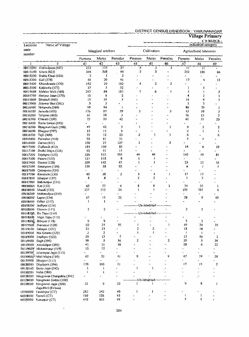
DISTRICT CENSUS HANDBOOK: YAMUNANAGAR Village Primary
CD BLOCK-Location Name of Village Industrial cate~or:t
code Marginal workers Cultivators Agricultural labourers number
Persons Males Females Persons Males Females Persons Males Females
2 41 42 43 44 45 46 47 48 49 00115000 Gobindpura (407) 212 175 37 6 3 3 II II OO1l5100 Khera (423) 304 208 96 2 2 252 186 66 00115200 Ruhla Kheri (424) 3 2 00115300 Kait (378) 61 20 41 17 4 13 00115400 Khundewala (370) 192 10 182 4 2 2 00115500 Kathwala (377) 37 5 32 I 00115600 Mahlan Wali (380) 267 84 183 7 6 3 I 2 0011 57()0 Haripur Jatan (379) 10 8 2 4 3 I 00115800 Bhatauli (405) 15 10 5 14 9 5 00115900 Jhinwar Heri (38l) 3 3 3 3 00116000 Haluwala (384) 95 94 I 80 79 1 00116100 Jarauda (403) 176 97 79 5 5 13 10 3 00116200 Telipura (402) 61 58 3 16 JJ 3 00116300 Chaneti (399) 75 33 42 41 21 20 00116400 Buria Sarkar (393) 00116500 Bhagwan Garh (398) 47 42 5 4 2 2 00116600 Bhojpur (397) 15 II 4 2 1 I 00116700 Tejli (409) 35 12 23 2 6 6 00116800 Parwalon (410) 92 61 31 5 5 00116900 Darwa (411) 150 23 127 3 3 00117000 Gadhauli (412) 185 100 85 14 4 10 00117100 Badhi Majra (126) 62 51 II 00117200 Tajakpur (12S) 226 123 103 44 44 140 59 81 00117300 Pansra (127) 127 118 9 I 00117400 Dasani (128) 209 142 67 I 23 13 10 00117500 Ratanpura (129) 120 28 92 6 5 00117600 Qairnpura (124) 001 InDO Rampura (130) 40 38 2 5 4 17 17 00117800 fsharpur (137) 8 8 2 2 J 3 00117900 Bahrampur (131) 00118000 Kat (l32) 63 57 6 8 6 2 34 33 00118100 Mandi (133) 137 113 24 I 105 101 4 00118200 MahmudpuT (135) 00118300 Lapra (134) 37 15 22 28 9 19 00118400 Odhri (117) I 00118500 Jodhpur (116) -------------Un-inhabited---------00118600 Gharon (lIS) 2 2 2 2 ooIl87~O. Bir Tapu (114) -----------Un-inhabited---------001)88ot> Majri Tapu (113) 001l890~f Bibipur (118) 9 9 3 3 00" 9000 Bakarpllr 020} 60 25 35 1 49 24 25 00119100 Sabapur (121 ) 23 23 2 2 18 18 00119200 Nai Gawall (122) 2 2 I I I 00119300 Fetehpur (123) 20 13 7 13 10 3 00119400 Sugh (396) 39 3 36 2 2 29 3 26 00119500 Amadalpur (395) 41 II 30 28 6 22 0011%00: Mukarimpur (119) 12 12 00119700 Jairampur Jagir (l12) 00 I I 980fj:· Mali Majra (I 10) 62 21 41 9 9 47 19 28 00119900 8hogpur (111) 00120000 Diyalgarh (394) 176 165 II 17 15 2 00120100 Buria Jagir (392) 00120200 Nabh (3a9) 00120300 Naugawan Chakpahla (391) 00120400 Naugawan Sarkar (108) ------------Vn-inhabited-------------00120500 Naugawan Jagir (390) 31 9 22 1 I 9 8
Jagadhri (Urban) 40305000 Farakhpur (CT) 282 242 40 40308000 Sasauli (eT) 169 126 43 40309000 KansepllT lCT) 479 410 69 S 5
384
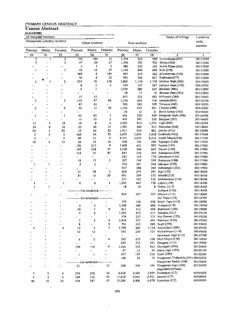
PRIMARY CENSUS ABSTRACT Census Abstract JAGADHRI of marg_inal workers Name of Village Location Household industry workers
Other workers Non-workers code number
Persons Males Females Persons Males Females Persons Males Females
50 51 52 53 54 55 56 57 58 2 3 2 192 160 32 1,594 625 969 GobindplJJll (407) 00115000 3 3 47 20 27 1,506 581 925 Khera (423) 00115100
3 I 2 580 235 345 Ruhla Kheri (424) 00115200 43 16 27 1,169 484 685 Kail (378) 00115300
188 8 180 497 235 262 Khundewala (370) 00115400 36 4 32 993 366 627 Kathwala (377) 00115500
10-2 254 76 17& 2,869 1,130 1,739 Mahlan Wali (3&0) 3 00115600
6 5 1 454 167 287 Haripur Jatan (379) 00115700 1,019 380 639 Bhatauli (405) 00115800
48 17 31 Jhinwar Heri (381) 00115900 15 15 815 333 482 Haluwala (384) 00116000
3 3 155 87 68 1,228 492 736 Jarauda (403) 00116100 45 45 902 393 509 Telipura (402) 00116200
2 2 32 12 20 1,163 472 691 Chaneti (399) 00116300 34 13 21 Buria Sarkar (393) 00116400
41 40 661 252 409 Bhagwan Garh (398) 00116500 13 10 3 441 191 250 Bhojpur (397) 00116600
13 3 10 14 8 6 2,093 819 1,274 Tejli (409) 00116700 24 8 16 63 48 15 1,081 466 615 Parwalon (41() 00116800 95 3 92 52 20 32 1,411 550 861 Darwa (411) 00116900
5 2 3 166 94 72 2,673 1,045 1,628 Glldhauli (412) 00117000 2 2 60 51 9 4,151 1,635 2,516 Badhi Majra (126) 00117100
16 4 12 26 16 10 438 192 246 Tajakpur (125) 00117200 126 117 9 1,608 621 987 Pansra (127) 00117300 185 128 57 1,100 446 654 Dasani (128) 00117400 114 27 87 643 276 367 Ratanpura (129) 00117500
283 113 170 Qaimpura (124) 00117600 18 17 327 118 209 Rampura (130) 00117700 2 2 535 191 344 Isharpur (137) 00117800
457 188 269 Bahrampur (131) 00117900 21 18 3 668 277 391 Kat (132) 00118000 31 II 20 931 359 572 Mandi (133) 00118100
257 125 132 Mllhmudpur (135) 00118200 8 6 2 1,205 447 758 Lapra (134) 00118300
18 10 8 Odhri (117) 00118400 ------------Un-inhabited-------------- Jodhpur (116) 00118500
954 357 597 Ghoron (I 15) 00118600 ------------Un-inhabited------------- Bir Tapu (114) 00118700
374 14.6 228 Majri Tapu (113) 00118800 6 6 1,368 488 880 Bibipur (lIS) 00118900
10 I 9 811 313 498 Bakarpur (I 20) 00119000 3 3 1,029 412 617 Sabapur (121) 00119100
574 237 337 Nai Gawan (122) 00119200 7 3 4 1,018 377 641 Fetehpur (123) 00119300 8 8 793 313 480 Sligh (396) 00119400
12 5 7 1,799 685 1.114 Amadalpur (395) 00119500 12 12 555 234 321 Mukarimpur (119) 00119600
Jairampur Jagir (I 12) 00119700 6 2 4 363 173 190 Mali Majra (liD) 00119800
684 253 431 Bhogpur (III) 00119900 159 150 9 1,366 553 813 Diyalgarh (394) 00120000'
67 33 34 Buria J agir (392) 00120100 347 137 2tO Nabh (389) 00120200 108 34 74 Naugawan Chakpahla (391) 00120300
-----------Un-inhablted------------- Naugawan Sarkar (108) 00120400 21 21 268 104 164 Naugawan Jagir (390) 00120500
Jagadhri (Urban)
7 3 4 274 238 36 6,418 2,569 3,849 Farakhpur (Cn 40305000
4 3 I 164 122 42 11,624 4,693 6,931 Sasauli (CT) 40308000
40 18 22 434 387 47 11,084 4,406 6,678 Kansepur (CT) 40309000
385
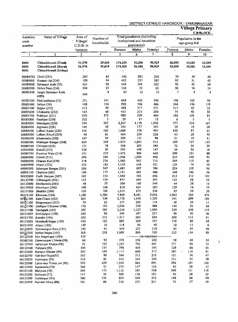
Location code number
0006 0006 0006
00084700 00084800 00084900 00085000 00085100
00085300 00085400 00085500 00085600 00085700 00085800 00085900 00086000 00086100 00086200 00086300 00086400 00086500 00086600 00086700 00086800 00086900 00090900 00091000 00091100 00120600 00120700 00120800 00120900 00121000 00121100 Od~1200 00i~1300 00tjl400 00121500 00121600 00121700 00121800 00121900 00172000 00lJ.2100 00122200 001~,z300 00122400 00122500 00122600 00122700 00122800 00122900 00123000 00123100 00123200 00123300 00123400
Name of Village
2
Chhachhrauli (Total) Cbbacbbrauli (Rural) Chhachhrauli (Urban)
Choli (237) Rampur Jat (234) Salempur Kohi (33) Gohra Bani (236) Jangle Salempur Kohi (489)
Mahiyudinpur (31) Jaitpur (30) Rajpur (235) Chabutron (232) Prithipur (231) Fatehpur (230) Manakpur (229) )ogiwara (228) Lalhari Kalan (226) Lalhari Khurd (224) Khanuwala (nO) Malakpur Bangar (268) Chintpur (225) Rukali (217) Bisation Wala (216) Chholi (215) Oharam Kot (270) Mamli (322) Salempur Bangar (321) Chahron (383) Garhi Banjara (387) Udhamgarh (401) Modhuwala (385) Manakpur (386) Bhukhri (388) Kharwan (314) Bala Chaur (312) Bhagwanpllr (313) Dadupur Chhawni (106) Fatehgarh (107) Shahzadpllr (109) Kanalsi (104) Mandauli Gagar (103) Alipur (102) Dammunpur Barll (101) Mehar Majra (105) Mir Mayeinpur (100) Dammunpur Chhota (99) Jairampur Khalsa (98) Telipura (96) Rampur Khadar (94) Hal-dari Gujar(95) Nawazpur (93) Lakar-mai Pratap pur (92) Kaniawala (74) Bhilpura (76) Bichpari (77) Nathanpur (91) Hal-daTi Maru (88)
Area of Village/
C.D.B.in hectares
3
51,970 51,970
207 189 161 194
144
331 198 113 163 259 212 324 144 141 49
147 624 121 234 521 396 318 233 206 199 165 132 48
190 159
1,168 861
79 176 305 240 385 420 118 142 268 120 66 91
195 503 262 318 593 268 365 117 206 101
Number of households
4
29,018 29,018
83 94 96 23
4
141 156 80 66
171 3
365 58
182 81 39
349 78 50
259 302 276 183 267 177 254 159 57
148 199
1,380 530
65 193 365 96
213 122 16 61
238
92 192 137 158 90 85
239 51
173 54
131 86
DISTRICT CENSUS HANDBOOK: YAMUNANAGAR Village Primary
CDBLOCK-Total population (including institutional and houseless
population)
Population in the age-group 0-6
Persons
5
174,209 174,209
543 612 644 134
22
848 992 588 415 989 29
2,207 344
1,069 464 209
1,955 504 295
1,473 1,898 1,560 1,139 1,687 1,131 1,460
857 304 818
1,214 7,839 2,778
377 1,036 2,136
544 1,317
695 114 439
1,609
Males
6
93,280 93,280
287 327 341
72 12
462 506 317 215 529
17 1,178
177 578 238 111
1,043 262 148 804
1,006 845 618 907 645 764 460 160 431 675
4,181 1,458
203 548
1,127 287 683 368
66 221 889
Females
7
80,929 80,929
256 285 303
62 10
386 486 271 200 460
12 1,029
167 491 226 98
912 242 147 669 892 715 521 780 486-696 397 144 387 539
3,658 1,320
174 488
1,009 257 634 327
48 218 720
Persons
8
28,890 28,890
79 93 92 30
7
198 244 117 74
188 6
377 39
148 63 21
269 72 36
209 235 204 124 224 160 213 123 44
129 95
1,063 391
40 146 249
96 203 156
I,? 85
222 ---------Un-inhabited------------
478 1,323
798 1,117
564 652
1,554 273
1,112 360 803 516
386
256 222 78' 722 601 171 405 393 129 600 517 207 313 354 863 147 584 179 450 275
251 298 691 126 528 181 353 241
121 151 286
4S 249
S4 148 71
Males Females 9 )0
15,681 15,681
39 51 42 16 4
105 126 65 42
103 5
210 19 87 28 10
137 36 20
121 140 119 74
128 106 112 68 28 74 59
589 209
29 82
139 50
112 88 13 45
134
48 98 68
116 74 73
184 28
131 24 88 37
13,209 13,209
40 42 50 14
3
93 118 52 32 85
I 167 20 61 35 II
132 36 16 88 95 85 50 96 54
101 55 16 55 36
474 182 II 64
110 46 91 68 6
40 88
30 73 61 91 47 78
102 17
118 30 60 34

PRIMARY CENSUS ABSTRACT
Census Abstract CHHACHHRAULI.
Name ofYillage Scheduled Castes popuation Scheduled Tribes population Literates
Persons Males Females Persons Males Females Persons Males Females
II 12 13 14 15 16 17 18 19 2
42,174 22,710 19,464 87,787 53,852 33,935 Chhachhrauli (Total) 42,174 22,710 19,464 87,787 53,852 33,935 Chhachhrauli (Runal)
Chhachhrauli (Urnn)
100 57 43 312 188 124 Choli (237) 225 124 101 352 208 144 Rampur Jat (234)
43 ~ 25 18 336 215 121 Salempur Koh; (33) 7 4 3 32 23 9 Gohra Bani (236)
4 3 Jangle Salempur Kohi (489)
5 3 2 155 110 45 Mahiyudinpur (31) 61 45 16 Jairpur (30)
31 17 14 157 134 23 Rajpur (23 5) 167 91 76 227 120 107 Chabutron (232) 408 224 184 454 283 171 Pfithipur (231)
16 9 7 Fatehpur (230) 292 155 137 1,020 620 400 Manakpur (229)
24 II 13 231 131 100 Jogiwara (228) 540 293 247 655 389 266 Lalhari Kalan (226) 142 69 73 268 157 III Lalhari Khurd (224)
3 3 149 77 72 Khanuwala (220) 379 198 181 1,162 709 453 Malakpur 83ngar (268)
70 36 34 321 187 134 Chintpur (225) 152 78 74 Rukali (217)
568 302 266 842 506 336 Bisation Wala(216) 608 325 283 1,184 706 478 Chholi (215) 487 268 219 938 546 392 Dharam Kot (270) 290 170 120 724 436 288 Mamli (322) 469 248 221 1,050 640 410 Salempur Bangar (321) 349 190 159 714 433 281 Chahron (383) 934 484 450 761 464 297 Garhi Banjara (387) 412 228 184 573 357 216 Udhamgarh (401) 277 148 129 172 98 74 Modhuwala (385) 305 160 145 427 259 168 Manakpur (386) 193 110 83 861 518 343 Bhukhri (388)
3,062 1,662 1,400 5,049 2,954 2,095 Kharwan (3 14) 1,556 828 728 1,662 975 687 Bala Chaur (312)
18 9 9 259 146 113 Bhagwanpur (313) 413 220 193 695 408 287 Dadupur Chhawni (106) 828 437 391 1,326 770 556 Fatehgarh (107) 456 234 222 262 161 101 Shahzadpur (109) 622 336 286 756 432 324 Kanalsi (104)
23 12 II 255 157 98 Mandauli Gagar (103) 67 43 24 AI ipur (102)
55 26 29 176 99 77 Dammunpur Bara (101) 328 176 152 986 633 353 Mehar Majra ( I 05)
-------------Un-lnhabited----------- Mir Mayeinpur(IOO) 217 118 99 230 141 89 Dammunpur Chhota (99) 354 195 159 770 474 296 Jairampllf Khalsa (98) 243 135 108 454 260 194 Telipura (96) 245 132 113 577 342 235 Rampur I).hadar (9.4) 20 12 8 192 130 62 Hal-dari Glljar(95) lZ 8 4 " 291 191 ,1,1)0 Nawazpur (93)
327 178 149 663 408 255 Lakar-mai Pratap pur (92) 61 39 22 113 64 49 Kaniawala (74)
327 172 155 439 277 162 Bhilpura (76) 175 109 66 Bichpari (77)
11 7 4 370 234 136 Nathanpllr (91) 295 172 123 Hal-dari Maru (88)
387
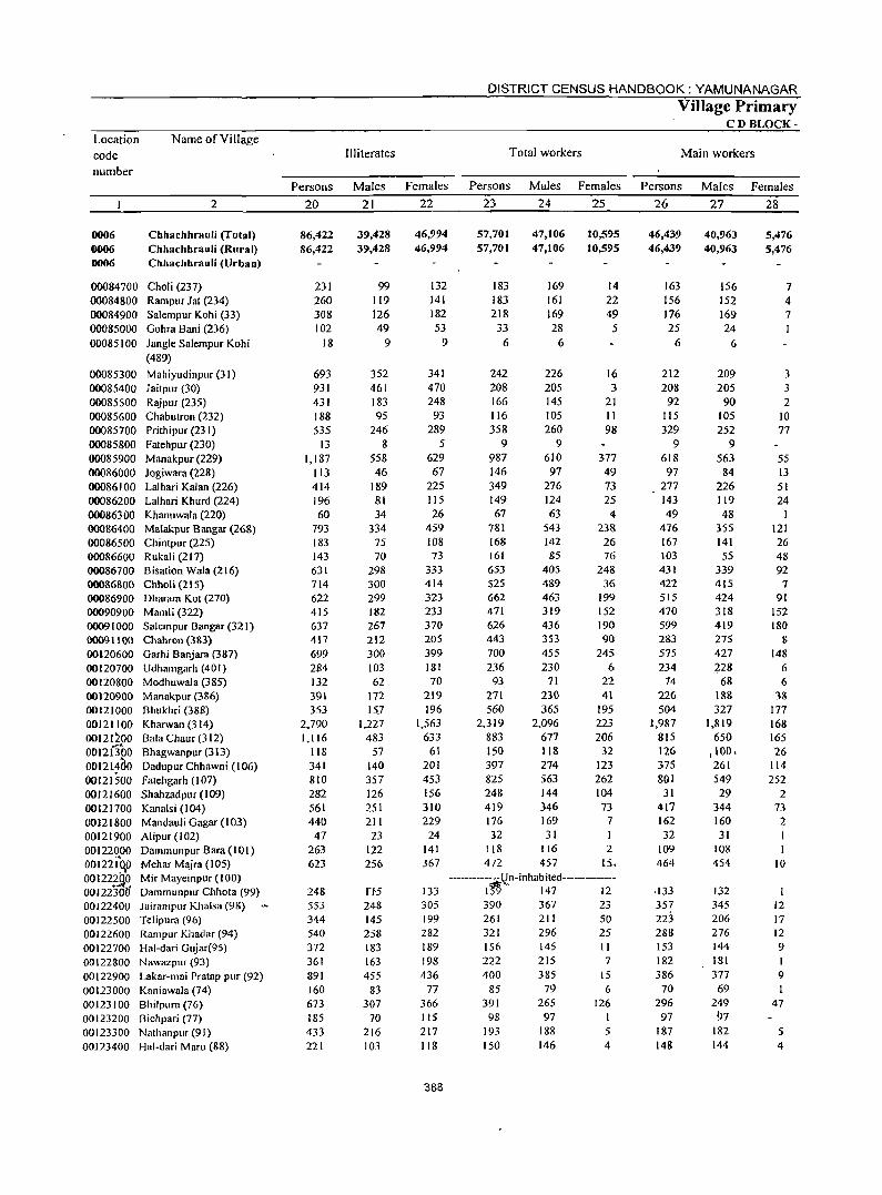
Location code number
Name of Village
2
0006 Chhachhrauli (Total) 0006 Chhachhrauli (Rural) 0006 Chhachhrauli (Urban)
00084700 Choli (237) 00084800 Rampur lat (234) 00084900 Salempur Kohi (33) 00085000 Gohra Bani (236) 00085100 Jangle Salempur Kohi
00085300 00085400 00085500 00085600 00085700 00085800 00085900 00086000 00086100 00086200 00086300 00086400 00086500 00086600 00086700 00086800 00086900 00090900 00091000 00091100 00120600 00120700 00120800 00120900 00121000 00121100 00121200 00126'00 00121460 00121500 00121600 00121700 00121800 00121900 00122000 00122 to,O 001221Jl~ 00 I 2230{J
(489)
Mahiyudinpur (31) Jaitpur (30) Rajpur (235) Chabutron (232) Prithipur (231) Fatehpur (230) Manakpur (229) Jogiwara (228) Lalhari Kalan (226) Lalhari Khurd (224) Khanuwala (220) Malakpur Bangar (268) Chintpur (225) Rukali (217) Bisation Wala (216) Chholi(215) Dharam Kot (270) Mamli (322) Salempur Bangar (321) Chahrol1 (383) Garhi Banjara (387) Udhamgarh (401) Modhuwala (385) Manakpur (386) Bhukhri (388) Kharwan (314) Bala Chaur (312) Bhagwanpur (313) Dadupur Chhawni (106) fatehgarh (107) Shahzadpur (109) Kanals i (I 04) Mandauli Gagar (103) Alipur (102) Dammunpur Bara (10 I) Mehar Majra (105) Mir Mayeinpur (100) Dammunpur Chhota (99)
00122400 JairamplIr Khalsa (9&) 00122500 Telipura (96) 00122600 Rampllr Khadar (94) 00122700 Hal-dari Gujar(95) 00122800 Nawazpllr (93) 00122900 Lakar-mai Pratap pur (92) 00123000 Kaniawala (74) 00123100 Bhilpura(76) 00123200 Bichpari (77) 00123300 Nathanpur (91) 00J23400 Hal-dari Maw (88)
Illiterates
DISTRICT CENSUS HANDBOOK: YAMUNANAGAR
Total workers
Village Primary CD BLOCK-
Main workers
Persons Males Females Persons Males Females Persons Males Females
20
86,422 86,422
231 260 308 102
18
693 931 431 188 535
13 1,187
113 414 196 60
793 183 143 631 714 622 415 637 417 699 284 132 391 353
2,790 1,116
118 341 810 282 561 440
47 263 623
248 553 344 540 372 361 891 160 673 185 433 221
21
39,428 39,428
99 119 126 49
9
352 461 183 95
246 8
558 46
189 81 34
334 75 70
298 300 299 182 267 212 300 103 62
172 15_7
1,227 483
57 140 357 126 251 211
23 122 256
rt5 248 145 258 183 163 455
83 307
70 216 103
22
46,994 46,994
132 141 182 53
9
341 470 248 93
289 5
629 67
225 115 26
459 108 73
333 414 323 233 370 205 399 181 70
219 196
1,563 633
61 201 453 156 310 229 24
141 367
133 305 199 282 189
198 436
77 366 115 217 118
388
23
57,701 57,701
183 183 218
33 6
242 208 166 116 358
9 987 146 349 149 67
781 168 161 653 525 662 471 626 443 700 236 93
271 560
2,319 883 150 397 825 248 419 176
24
47,106 47,106
169 161 169 28
6
226 205 145 105 260
9 610 97
276 124 63
543 142 85
405 489 463 319 436 353 455 230
71 230 365
2,096 677 118 274 563 144 346 169
32 31 118
472 116 457
25
10,595 10,595
14 22 49 5
16 3
21 II 98
377 49 73 2S 4
238 26 76
248 36
199 152 190 90
245 6
22 41
195 223 206
32 123 262 104 73
7
2 IS.
-------------Un-inhabited------------I~" 147 12 390 367 23 261 211 50 321 296 25 156 222 400
85 391
98 193 150
145 215 385
79 265
97 188 146
11
7 15 6
126 I 5 4
26
46,439 46,439
163 156 176 25
6
212 208
92 115 329
9 618
97 277 143 49
476 167 103 431 422 515 470 599 283 575 234
74 226 504
1,987 815 126 375 801
31 417 162 32
109 464
·133 357 22:3 288 153 182 386
70 296 97
187 148
27
40,963 40,963
156 152 169 24
6
209 205
90 105 252
9 563
84 226 119 48
355 141 55
339 415 424 318 419 275 427 228
68 188 327
1,819 650
,100, 261 549 29
344
160 31
108 454
132 345 206 276 144 181 377
69 249 97
182 144
28
5,476 5,476
7 4 7
3 3 2
10 77
55 13 51 24
121 26 48 92
7 91
152 180
8 148
6 6
38 177 168 165 26
114
252 2
73 2
10
12 17 12 9 1 9
47
5 4
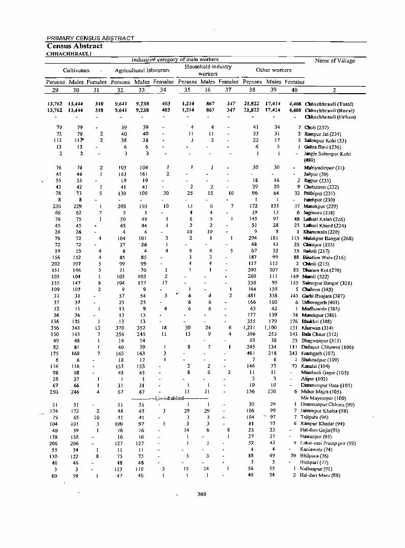
PRIMARY CENSUS ABSTRACT
Census Abstract CHHACHHRAULI
Industrial category of main workers Name of Village
Cultivators Agricultural labourers Household industry
Other workers workers
Persons Males Females Persons Males Females Persons Males Females Persons Males Females
29 30 31 32 33 34 35 36 37 38 39 40 2
13,762 13,444 13,762 13,444
79 72
113 13
2
76 45 55 43 78
8 230 69 76 45 26 76 72 19
156 202 151 105 155 109 31 37 12 36
136 356 150 49 82
175 6
116
98 28 67
250
51 174 75
104 40
138 206
55 130 46
3 60
79 70
II'" 13
2
74 44 55 42 73 8
229 62 75 45 26 72 72 15
152 197 146 104 147 107 31 37 II 36
135 343 143 48 81
168 6
116
98 27 66
246
51 172
65 IOf
39 138 206
54 122
46 3
59
318 318
2 2
2
I 5
7
4
4 4 5 5
8 2
13 7
7
4
2 10 3
8
9.641 9.641
39 40 38
6 3
105 163
19 41
130
203 5
50 45
4 104 27
8 85 99 71
105 194
9 57 25 13 13 13
370 256
14 40
165 18
153 45
31 67
51 48 41
100 76 16
127 II 75 48
113 47
9,238 9,238
39 40 38
6 3
403 403
104 J 161 2
19 41
100
193 5
49 44
4 101 26
4 85 99 70
30
10
3
4
103 2 177
9 54 25 9
13 13
352 245
14 39
163 17
153 45
I 31 67
17
3
4
18 II
I 2
_.
1,214 1.214
4 II 3
2 25
13 4
6 2
10 2
9 3 4 1
1 6 6 6
30 13
8
2 8
II
867 867
4 II 3
2 15
6 4 5 2
10
4 3 4
4 6
6
24 9
7
2 6
I II
-------------Un-inhabited---------51 I I 45 3 29 29 41 97 76 16
127 II 75 48
110
46
3
3
3 3
14 I
3
15 I
3 3 6
3
14
389
347 21.822 17.414 347 21,822 17.414
10
7
5
2
6 4
2
8
41 33 22 6
30
18 29 96
172
19 145 51
9 294 68 67
187 117 292 260 250 164 481 166 43
177 355
1,231 396
63 245 461
7 146 II 3
10 136
30 106 104 81 23 27 52 4
88 3
56 40
34 31 17 5
30
16 20 64
135 13 97 28
8 181 43 32 99
115 207 III 95
159 338 160 42
139 179
1,100 253
38 134 218
6 73 II 3
10 130
29 99
- 97
75 23 27 43
4
49 3
55 38
4,408 C1thachhrauli (Total) 4,408 C1thachhrauli (Rural)
Clthachhrauli (Urban)
7 CIroIi (237) 2 Rampur Jat (234) 5 Salempur Kohi (33)
Gohra Bani (236) - Jangle Salempur Kohi
(489)
Mahiyudinpur (31) Jaitpur (30)
2 R<!iPur (235) 9 Chabutron (232)
32 Prilhipur (231) Fatehpur (230)
37 Manakpur (229) 6 Jogiwara (228)
48 Lalhari Kalan (226) 23 Lalhari Khurd (224)
KlJanuwala (220) 113 Malakpur Bangar (268) 25 OJintpur (225) 35 Rukali (217) 88 Bisation Wafa (216) 2 amoli (215)
85 Dharam Kot (270) 149 Mamli (322) 155 Salempur Bangar (321)
5 OIahron (383) 143 Garfti Banjara (387)
6 Uclhamgarh (401) Modhuwala (385)
38 Manakpur (386) 176 Bbukhri (388) 131 Kbarwan (314) 143 BaJaChaur(312) 25 Bhagwanpur(313)
III Dadupur Chhawni (106) 243 Farehgarh (107)
Shahzadpur (l09) 73 KanaIsi (104)
Mandauli Gagar (1 03) Alipur (102) Dammunpur Bara (10 I)
6 Mehar Majra (105) Mir Mayeinpur (100)
I Dammunpur Chhota (99) 7 Jairampur Khalsa (98) 7 Teliputa (96) 6 Rampur Khadar (94)
Hat-dari Gujar(95) Nawazpur (93)
9 Lakar-rnai Pralap pur (92) Kaniawala (74)
39 Bhilpura (76) Bichpari (77)
I Nathanpur (91) 2 Hal-dari Maru (88)
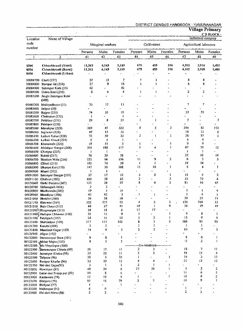
Location code number
0006 0006 0006
Name of Village
2
Chbllchhrauli (Total) Chhac:hhrauli (Rural) Cbhschhrauli (Urban)
00084700 Choli (237) 00084800 Rampur Jat (234) 00084900 Salempur Kohi (33) 00085000 Gohra Bani (236) 00085100 Jangle Salempur Kohi
(489)
00085300 Mahiyudinpur(31) 00085400 Jaitpur (30) 00085500 Rajpur (235) 00085600 Chabutron (232) 00085700 Prithipur (231) 00085800 Fatehpur (230) 00085900 Manakpur (229) 00086000 Jogiwara (228) 00086100 Lalllari Kalan (226) 00086200 lalhari Khurd (224) 00086300 Khanuwala (220) 00086400 Malakpur Bangar (268) 00086500 Chintpur (225) 00086600 RukaJi (217) 00086700 Bisation Wala (216) 00086800 Olholi (215) 00086900 Dharam Kot (270) 00090900 Mamli (322) 00091000 Salempur Bangar (321) 00091100 Chahron (383) 00120600 Garhi Balljara (387) 00120700 Udhamgarh (401) 00120$00 Modhuwala (385) 00120900 Manakpur(386) 00121000 Bhukhri (388) 00121100 lCharwan (314) 00121200 Bala Chaur (312) 0012130(F!,Bhagwallpur (313) OOl21400jDadupurChhawni (106) 00121500 Fatehgarh (107) 00121600 Shahzadpur (109) 00121700 Kanalsi (104) 00121800 Mandauli Gagar (103) 00121900 Aripur (102) 00122000 Dammunpuf Bara (101) 00122100 Jt,Mehar Majra (105) 00122200. 'Mir Mayeinpuf (100) 00122300 :bammunpur Chhota (99) 00122400 Jairampur Khalsa (9g) 00122500 Telipura (96) 00122600 Rampur Khadar(94) 00122700 Hal-dari Gujar(95) 00122800 Nawazpur (93) 00122900 Lakar-mai Pratap pur (92) 00123000 Kaniawala (74) 00123 I 00 Bhilpura (76) 00 I 23200 Bichpari (77) 00123300 Nathanpur (91) 00123400 Hal-dari Maru (88)
Marginal workers
Persons
41
11,262 11,262
20 27 42
8
30
74 1
29
369 49 72 6
18 305
1 58
222 103 147
I 27
160 125
2 19 45 56
332 68 24 22 24
217 2
14
9 8
26 33 38 33
3 40 14 15 9S
6 2
Males
42
6,143 6,143
13 9
4
17
55
8
47 13 50
5 IS
188 I
30 66 74 39
I 17 78 28 2 3
42 38
277 27 18 13 14
115 2 9
& 3
15 22
5 20
I 34
8 10 16
6 2
Females
43
5,119 5,119
7 18 42
4
13
19 1
21
322 36 22
I
3 117
28 156 29
108
10 82 97
16 3
18 S5 41 6 9
10 102
5
5
II II 33 13 2
6 6 5
79
390
DISTRICT CENSUS HANDBOOK: YAMUNANAGAR
Persons
44
675 675
8
2
I
Cultivators
Males
45
459 459
5
5 4
\1 9 I I
II 10
3 2 8
4 10 17
I 3 8
2
6
2 I
17
2 5 I
2 2
Females
46
216 216
3
2
1 2 2
2 9
I 3
-----------u l\-i nhabi ted----------2 2 2 2 I 4 4 2 I
27 26
2 2
Village Primary CD BLOCK-
Industrial category
Agricultural labourers
Persons
47
4,315 4,315
8 8
2
7
55
7
204 18 38 4 9
87 1
32 6
54 5
11 25 81
5 5
39 129 38
9 13
188
10
18· 19 19 25
5 II 10 10
I
2
Males
48
2,910 2,910
8 8
2
7
55
32 12 37
4
9 75
I 18 3
54 4
9 19 16
4 25
116 19
8 9
95 1 7
& 2
7 IS,
:2 13
I 2
Females
49
1,405 1,405
7
172 6
12
14 3
2 6
65
4
14
13 19
1 4
93
3
II 4
17 12
2 5 2
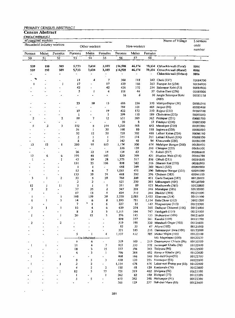
PRIMARY CENSUS ABSTRACT Census Abstract CHHACHHRAUU of mal"ginal workers Name ofYiJlage Location Household industry workers
Other workers Non-workers code
number Persons Males Females Persons Males Females Persons Males Females
50 51 52 53 54 55 56 57 58 2
539 150 389 5,733 2,624 3,109 116,508 46,174 70,334 Chhachhrauli (Total) 0006 539 ISO 389 5,733 2,624 3,109 116,508 46,174 70,334 Chhachhrauli (Rural) 0006
Chhachhrauli (Urban) 0006 .,.
II 4 7 360 118 242 Chali (237) 000847()O 17 17 429 166 263 Rampur lat (234) 00084800 42 42 426 172 254 Salem pur Kohi (33) 00084900
5 4 101 44 57 Gohra Bani (236) 00085000 16 6 10 Jangle Salempur Kohi 00085100
(489)
23 10 13 606 236 370 Mahiyudinpur (31) 00085300 784 301 483 Jaitpur (30) 00085400
19 19 422 172 250 Rajpur (235) 00085500 I I 299 110 189 Chabutron (232) 00085600
2 2 19 7 12 631 269 362 Prithipur (231) 00085700 20 8 12 Fatehpur (230) 00085800
5 2 3 152 8 144 1,220 568 652 Manakpur (229) 00085900 31 30 198 80 liS Jogiwara (228) 00086000 32 12 20 720 302 418 Lalhari Kalan (226) 00086100
2 I 315 J14 201 Lalhari Khurd (224) 00086200 8 6 2 142 48 94 Khanuwala (220) 00086300
13 12 200 97 103 1,174 500 674 Malakpur 8angar (268) 00086400 336 120 216 ChintplIr (225) 00086500
26 12 14 134 63 71 Rukali (217) 00086600 12 6 6 193 4& 145 820 399 421 8isation Wala (216) 0008670() r 1 47 19 28 1,373 517 856 Chholi (2 I 5) 00086800
131 25 106 898 382 516 Dharam Kot (270) 00086900 1 668 299 369 Mamli (322) 00090900
13 6 7 1,061 471 590 Salempur Bangar (321) 00091000 133 59 74 688 292 396 Cbahron (383) 00091100
3 2 33 5 28 760 309 451 Ga~hi Banjara (387) 00120600 2 2 621 230 391 Udhamgarh (401) 00120700
12 1 11 2 I 211 89 122 Modhl.lwala (385) 00120800 2 2 37 35 2 547 201 346 Manakpur (386) 00120900
17 13 4 654 310 344 Bhukhri (388) 00121000 I I 198 159 39 5,520 2,085 3,435 Kharwan (314)_ 00121100 6 5 14 6 8 1,895 781 1,114 Bala Challr (3 12) 00121200
7 I 6 227 85 142 Bhagwanpuf (313) 00121300 2 10 4 6 639 274 365 Dadupur Chhawni (106) 00121400
8 ] 5 1,311 564 747 Fatehgarh (107) 00121500 20 15 5 296 143 153 Shahzadpur (109) 00121600
89& 337 561 Kanalsi ( 104) 00121700 2 2 519 199 320 Mandauli Gagar (103) 00121&00
82 35 47 Alipur (102) 00121900 321 105 216 Dammunpur Bara ( lOt) 00122000
5 4 1,137 432 705 Mehar Majra (105) 00122100 -----------Un-inhabited----------- Mir Mayeinpur (100) 00122200
6 6 319 109 210 Dammunpur Chhota (99) 00122300 11 4 7 933 355 578 Jalrampllr Khalsa (98) 00[22400 18 3 15 537 194 343 Telipura (96) 00122500 4 3 796 3D4 492 Rampur Khadar (94) 00122600
408 168 24() Hal-dari Gujar(95) 00122700 8 5 3 430 139 291 Nawazpur(9J) 00122800 2 2 1,154 47& 676 Lakar-mai Pralap pur (92) 00]22900 4 2 2 188 68 120 Kaniawala (74) 00123000
82 5 77 721 319 402 Bhilpura (76) 00123100 I I 262 82 180 Bichpari (77) 00123200 5 5 610 262 348 Nathanpur (91) 00123300
366 129 237 lIal-dari Maru (88) 00123400
391
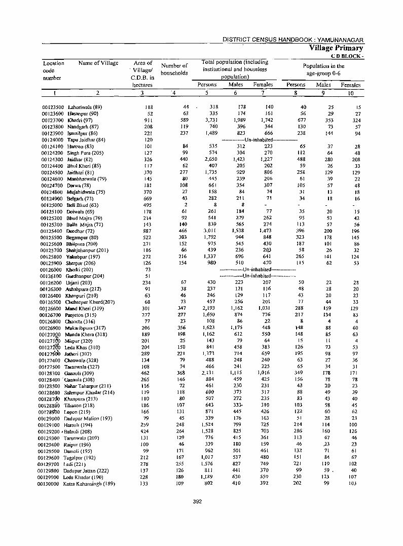
Location code number
Name of Village
2
00123500 Lahoriwala (89) 00123600 Hasanpur(90) 00123700 Khadri (97) 00123800 Nandgarh (87) 00123900 Ismailpur (86) 00124000 Tapu laidhar (84) 00124100 Harewa (83) 00124200 Singh Pura (205) 00124300 Jaidhar (82) 00124400 Bhul Kheri (85) 00124500 laidhari (81) 00124600 Manbharwala (79) 00124700 Darwa (78) 00124800 Mujahidwala (75) 00124900 Belgarh (73) 00125000 Beli Bhud (63) 00125100 Doiwala (69) 00125200 Bbud Majra (70) 00125300 Balla Majra (71) 00125400 Deodhar (72) 00125500 Begampur (80) 00125600 Bhilpura (200) 00125700 Sbahjahanpur(201) 00125800 Yakubpur(197) 00125900 Sherpur (206) 00126000 Kherki (202) 00126100 Gurdhanpur(204) 00126200 Urjani (203) 00126300 Ashabpura (212) 00126400 Khanpuri (210) 00126500 Clluharpur Khurd(207) 00126600 Mand Kheri (319) 00126700 Panjeton (315) 00126800 Cllaneta (316) 00126900 Mukaribpura -(3 17) 00127000 Munda Khera (318) 001271~o Mirpur (320) 001271b'b leda Khas (310) , , 00121300 Jatheri (307) 00127400 Cbaowala (328) 00127500 Taranwala (327) 00128300 Ganauli (309) 00128400 'Ganaula (308) 00128500 Nahar Taharpur (211) 00128600 SaJempur Khadar (214) 001287<10 Khanpura (213) 00128800 Tibanon (218) 001289'00 Lopan (219) 00129000 Dadupur Malion (193) 00129100 Harauli (194) 00129200 , Balauli (208) 00129300 Tarunwala (209) 00129400 Raiplir (196) 00129500 Damoli (195) 00129600 Tugalpur (192) 00129700 Ledi (221) 00129800 Dadupllr )attan (222) 00129900 Leda Khadar(190) 00130000 Kotra Kahansingh (189)
Area of , Village/ C.D.B. in hectares
3
118 52
911 208 221 120 101 127 326 117 370 145 181 370 669 495 178 214 143 887 522 271 116 272 126 73 51
234 91 63 68
301 277
77 206 189 201 204 289 134 108 462 265 116 lt9 110 186 166 79
259 424 131 100 99
212 278 137 228 133
Number of households
'4
44 63
589 119 237
84 99
440 62
277 80
108 27 43 2
61 92
140 466 303 152 66
216 154
67 38 46 73
347 277 23
356 198 25
ISO 221
79 74
368 146 72
118 80
107 131 45
248 264 129 46
171 167 255 126 180 109
DISTRICT CENSUS HANDBOOK: YAMUNANAGAR
Village Primary CD BLOCK-
Total population (including institutional and houseless
population)
Population in the age-group 0-6
Persons Males Females Persons
5
318 335
3,73,1 740
1,489
535 574
2,650 407
1,735 445 661 158 282
8 261 541 839
3,01 I 1,792
975 439
1,337 980
430 237 246 457
2,193 1,650
108 1,623 1,162
143 841
1,373 488 466
2,131 884 461 690 507 643 871 339
U24 1,528
776 339 962
1,017 1,576
811 1,189
802
392
6
178 [74
1,989 396 823
7
140 161
[,742 344 666
8
40 56
677 130 238
-------------Un-inhabited---------312 223 65 304 270 [12
1,423 205 929 239 354
84 211
8 184 279 565
1,538 944 545 236 696 510
1,227 202 806 206 307
74 71
77 262 274
1,473 848 430 2Q3 641 470
488 59
258 61
105 31 34
35 95
113 396 323 187 58
265 115
-----------Un-inhabited--------------Un-inhabited---------
223 207 50 121 116 48 129 256
1,162 874 86
1,175 612
79 458 714 248 241
1,115 459 230 373 272 333-445 176 799 825 415 180 501 537 827 441 630 410
117 20t
1,031 776 22
448 550
64 383 659 240 225
1,016 425 231 317 235 310 426 163 725 703 361 159 461 480 749 370 559 392
43 77
288 217
8 148 148
15 126 195 63 65
349 156 43 88 83
103 122 51
214 286 113 46
132 151 221 99
230 202
Males Females
9
25 29
353 73
144
37 64
280 26
129 39 57 13 18
20 53 57
200 178 101 26
141 62
22 28 20 44
159 134
4 88 85 II 73 98 27 34
178 78 20 49 43 58 60 28
114 160 67 .23 71 84
119 59 .
123 99
10
15 27
324 57 94
28 48
208 33
129 22 48 18 16
15 42 56
196 145 86 32
124 53
28 20 23 33
129 83
4 60 63 4
53 97 36 31
171 78 23 39 40 45 62 23
100 126 46 23 61 67
102 40
107 103
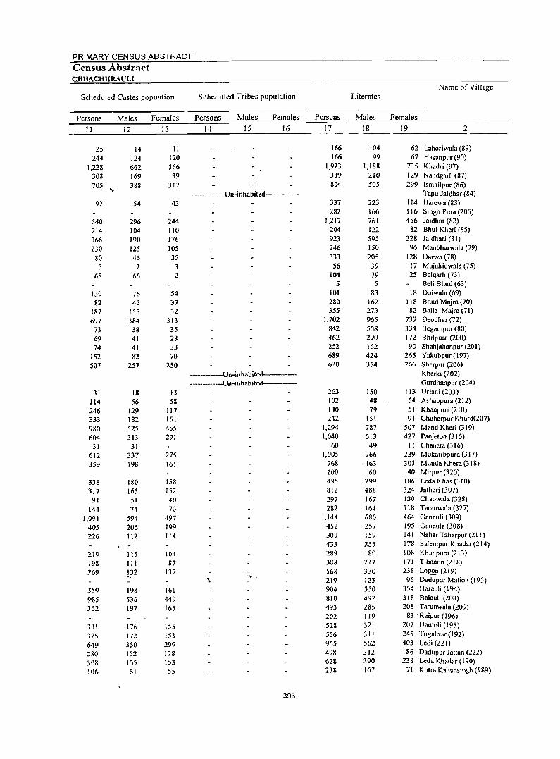
PRIMARY CENSUS ABSTRACT Census Abstract CHHACHHRAULI
Name of Village
Scheduled Castes popuation Scheduled Tribes population Literates
Persons Males Females Persons Males Females Persons Males Females
II 12 13 14 15' 16 17 18 19 2
25 14 II 166 104 62 Lahoriwala (89)
244 124 120 166 99 67 Hasanpur (90)
1,228 662 566 1,923 1,188 735 Khadri (97)
308 169 139 339 210 129 N andgarh (87)
705 388 317 804 505 299 Ismailpur (86) 'Or
-------------Un-inhabited------------- Tapu Jaidhar (84)
97 54 43 337 223 114 Harewa (83) 282 166 116 Singh Pura (205)
540 296 244 1,217 761 456 laidhar (82)
214 104 110 204 122 82 Bhul Kheri (85)
366 190 176 923 595 328 laidhari (81)
230 125 105 246 150 96 Manbharwala (79)
80 45 35 333 205 128 Darwa (78)
5 2 3 56 39 17 Mujahidwala (75)
68 66 2 104 79 25 Belgarh (73) 5 5 Beli Bhud (63)
130 76 54 101 83 18 Doiwala (69)
82 45 37 280 162 118 Bhud Majra (70)
187 155 32 355 273 82 Balla Majra (71)
697 384 313 1,702 965 737 Deodhar (72)
73 38 35 842 508 334 Begampur (80)
69 41 28 462 290 172 Bhilpura (200)
74 41 33 252 162 90 Shahjahanpur (201)
152 82 70 689 424 265 Yakubpur (197)
507 257 250 620 354 266 Sherpur (206)
----Un-inhabited------- Kherki (202)
-------------Un-inhabited----------- Gurdhanpur (204)
31 18 13 263 150 113 Urjani (203)
114 56 58 102 48 54 Ashabpura (212)
246 129 117 130 79 51 Khanpuri (210)
333 182 151 242 IS! 91 Chuharpur Khurd(207)
980 525 455 1,294 787 507 Mand Kheri (319)
604 313 291 1,040 613 427 Panjeton (315)
31 31 60 49 II Chaneta (316)
612 337 275 1,005 766 239 Mukaribpura (317)
359 198 161 768 463 305 Munda Khera (318) 100 60 40 Mirpur (320)
338 180 158 435 299 186 Leda Khas (310)
317 165 152 812 488 324 Jatheri (307)
91 51 40 297 167 130 Chaowala (328)
144 74 70 282 164 118 Taranwala (327)
1,091 594 497 1,144 680 464 Ganauli (309)
405 206 199 452 257 195 Ganaula (308)
226 112 114 300 159 141 Nahar Taharpur (2 I I)
433 255 178 Salempur Khadar (214)
219 I IS 104 288 180 103 Khanpura (213)
198 III 87 388 217 171 Tihanon (21 8)
269 132 137 568 330 238 Lop"~ (219) ''\_ 219 123 96 Dadupur Malion (193)
359 198 161 904 550 354 Harauli (194)
985 536 449 810 492 318 Balauli (208)
362 197 165 493 285 208 Tarunwala (209)
202 119 83 'Raipur {I 96)
331 176 155 528 321 207 Damoli (195)
325 172 153 556 311 245 Tugaiplir (192)
649 350 299 965 562 403 Ledi (221)
280 152 128 498 312 186 Dadupur Jattan (222)
308 155 153 628 390 238 Leda Khadar (190)
106 51 SS 238 167 71 Kotra Kahansingh (189)
393
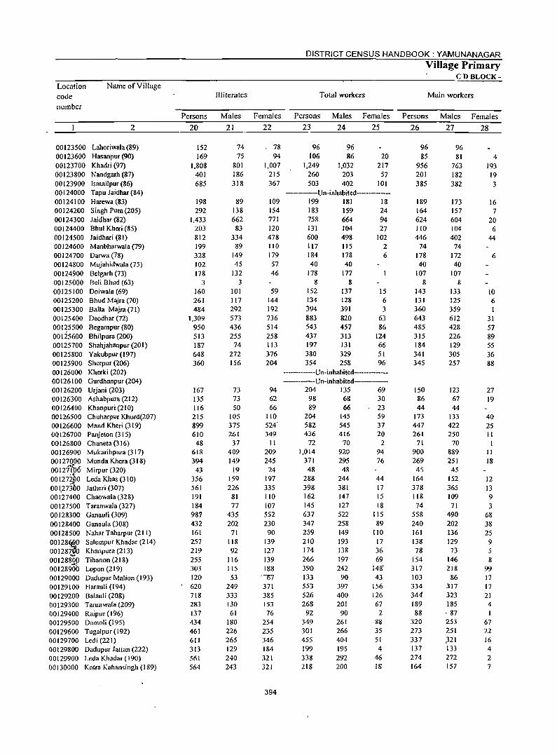
Location code number
Name of Village
2
00123500 Lahoriwala (89) 00123600 Hasanpur (90) 00123700 Khadri (97) 00123800 Nandgarh (87) 00123900 Ismailpur (86) 00124000 Tapu Jaidhar (84) 00124100 Harewa (83) 00124200 Singh Pura(205) 00124300 Jaidhar (82) 00124400 Bhul Kheri (85) 00124500 Jaidhari (81) 00124600 Manbharwala (79) 00124700 Darwa(78) 00124800 Mujahidwala (75) 00124900 Belgarh (73) 00125000 Beli Bhud (63) 00125100 Doiwala (69) 00125200 Bhud Majra (70) 00125300 Balla Majra (71) 00125400 Deodhar (72) 00125500 Begampur (80) 00125600 Bhilpura (200) 00125700 Shahjahanpur(201) 00125800 Yakubpur(197) 00125900 Sherpur (206) 00126000 Kherki (202) 00126100 Gurdhanpur (204) 00126200 Urjalli (203) 00126300 Ashabpura (212) 00126400 Khanpuri (210) 00126500 Chuharpur Khurd(207) 00126600 Mand Kheri (319) 00126700 Panjeton (315) 00126800 Chaneta (316) 00126900 Mukaribpura (317) 00127000 Munda Khera (318) 0012f{b6 Mirpur (320) 00127ibo Leda Khas (310) oOlp3bo Jatheri (307) 00127400 Chaowala (328) 00127500 Taranwala (327) 00128300 Ganauli (309) 00128400 Ganaula (308) 00128500 Nahar Taharpur (211) 001286{)0 Salempur Khadar (214) 00128~0 Khanpura (213) 00128&OP Tihanon (218) 00128900 Lopon (219) 00129000 Dadupur Malion (193) 00129100 Harauli (194) 00129200 Balauli (208) 00129300 Tarunwala (209) 00129400 Raipur (196) 00129500 Damoli (195) 00129600 Tugalpur (192) 00129700 Ledi(221) 00129800 Dadupur Jattan (222) 00129900 Leda Khadar (190) 00130000 Kotra Kahansingh (189)
Persons
20
152 169
1,808 401 685
198 292
1,433 203 812 199 328 102 178
3 160 261 484
1,309 950 513 187 648 360
167 135 116 215 899 610
48 618 394
43 356 561 191 184 987 432 161 257 219 255 303 120 620 718 283 137 434 461 611 313 561 564
Illiterates
Males Females
21 22
74 75
801 186 318
89 138 662
83 334
89 149 45
132 3
101 117 292 573 436 255
74 272 156
73 73 50
105 375 261 37
409 149
19 159 226
81 77
435 202
71 118 92
116 115 53
249 333 130 61
180 226 265 129 240 243
" 78 94
1,007 215 367
109 154 771 120 478 110 179 57 46
59 144 192 736 514 258 113 376 204
94 62 66
110 524" 349
11 209 245 24
197 335 110 107 552 230 90
139 127 139 188
"07 371 385 153 76
254 235 346 184 321 321
394
DISTRICT CENSUS HANDBOOK: YAMUNANAGAR
Village Primary CD BLOCK-
Total workers Main workers
Persons Males Females Persons Males Females
23 24 25 26 27 28
96 106
1,249 260 503
96 86
1,032 203 402
20 217
57 101
----------Un-inhabited----------199 181 18 183 159 24 758 131 600 117 184
664 104 498 115 178
40 40
178 177 8 8
152 134 394 883 543 437 197 380 354
137 128 391 820 457 313 131 329 258
94 27
102 2
6
15 6 3
63 86
124 66 51 96
-----------Un-inhabited-------------------Un-inhabited-------
204 135 69 98 89
204 582 436
72 1,014
371 48
288 398 162 145 637 347 259 210 174 266 390 133 553 526 268
92 349 301 455 199 338 218
68 66
145 545 416
70 920 295 48
244 381 147 127 522 258 149 193 138 197 242
90 397 400 201
90 261 266 404 195 292 200
30 23 59 37 20 2
94 76
44 17 15 18
liS 89
110 17 36 69
148'
43 156 126 67
2 88 35 51 4
46 18
96 85
956 201 385
189 164 624 110 446
74 178 40
107 8
143 131 360 643 485 315 184 341 345
150 86 44
173 447 261
71 900 269 45
164 378 118 74
558 240 161 138 78
154 317 103 334 344 189 88
320 273 337 137 274 164
96 81
763 182 382
173 157 604 104 402
74 172 40
107 8
133 125 359 612 428 226 129 305 257
123 67 44
133 422 250
70 889 251
45 152 365 109
71 490 202 136 129 73
146 218
86 317 323 185
" 87 1253 251 ;321 133 272 157
4 193 19 3
16 7
20 6
44
6
10 6
31 57 89 55 36 88
27 19
40 25 11 I
11 18
12 13 9 3
68 38 25
9 5 8
99 17 17 21
4 I
67 22 16 4 2 7
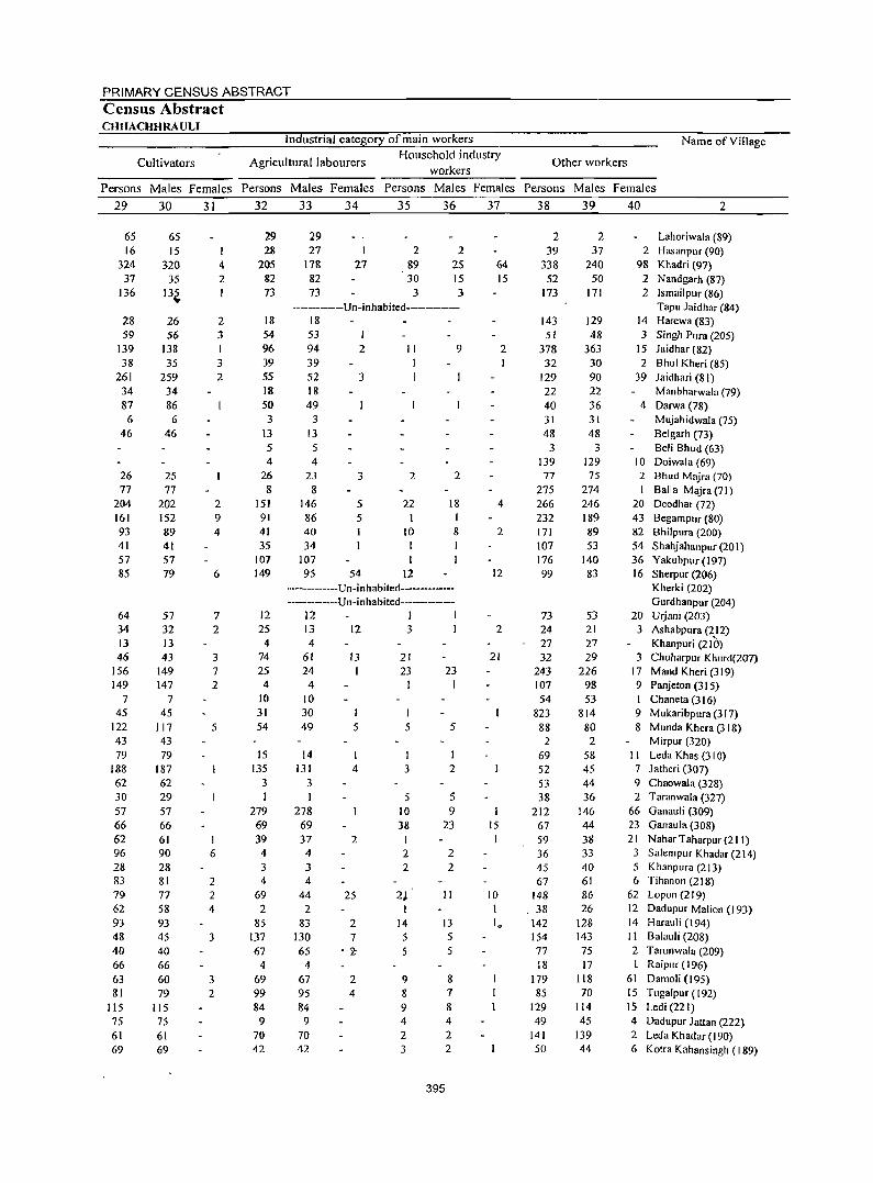
PRIMARY CENSUS ABSTRACT Census Abstract CHHACHHRAULI
Industrial category of main workers
Agricultural labourers workers
Cultivators Household industry
Name ofYillage
Other workers
Persons Males Females Persons Males Females Persons Males Females Persons Males Females
29 30 31 32 33 34 35 36 37 38 39 40 2
65 16
324 37
136
28 59
139 38
261 34 87 6
46
26 77
204 161 93 41 57 85
64 34 13 46
156 149
7 45
122 43 79
188 62 30 57 66 62 96 28 83 79 62 93 48 40 66 63 81
115 75 61 69
65 IS
320 35
13~
26 56
138 35
259 34 86 6
46
25 77
202 152 89 41 57 79
57 32 13 43
149 147
7 45
117 43 79
187 62 29 57 66 61 90 28 81 77 58 93 45 40 66 60 79
115 75 61 69
I 4 2 1
2 3
3 2
2 9 4
6
7 2
3 7 2
5
I 6
2 2 4
3
3 2
29 28
205 82 73
18 54 96 39 55 18 50 3
13 5 4
26 8
151 91 41 35
107 149
12 25
4 74 25
4 10 31 54
15 135
3 I
279 69 39
4 3 4
69 2
85 137 67
4 69 99 84
9 70 42
29 27
178 82 73
I
27 2
89 30
3
2 2S 15 3
-------------Un-inhabited------------18 53 94 39
1 2
52 3 18 49
3 13 5 4
23 8
146 86 40 34
107 95
3
5 5
54
II
2
22
to I 1
12
9
2
18 1 8
-------------Un-inhabited------------------------Un-inhabited--------------
12 1 1 13 12 3 4
61 24 4
10 30 49
14 131
3 I
278 69
l3
5
4
37 2 4 3 4
44 2
83 130 65
4 67 95 84
9 70 42
25
2 7
'-2;
2 4
21 23
I
I 5
1 3
5 10 38
2 2
2~ I
14 5 5
9 8 9 4 2 3
23 I
5
I 2
5 9
23
2
2
II
13 5 5
395
8 7 8 4 2 2
64 15
2
4
2
12
2
21
15
10
2 39
338 52
173
143 51
378 32
129 22 40 31 48
J 139 77
275 266 232 171 107 176 99
73 24 27 32
243 107 54
823 88
2 69 52 53 38
212 67 59 36 45 67
148 . 38 142 154 77 18
179 85
129 49
141 50
2 37
240 50
171
129 48
363 30 90 22 36 31 48
3 129 75
274 246 189 89 53
140 83
53 21 27 29
226 98 53
814 80 2
58 45 44 36
146 44 38 33 40 61 86 26
128 143 75 17
118 70
114 45
139 44
Lahoriwala (89) 2 Hasanpur (90)
98 Khadri (97) 2 N andgarh (87) 2 Ismail pur (86)
Tapu Jaidhar (84) 14 Harewa (83) 3 Singh Pura (205)
15 laidhar (82) 2 Bhul Kheri (85)
39 laidhari (81) Manbharwala (79)
4 Darwa (78) Mujahidwala (75) Belgarh (73) Beli Bhud (63)
10 Doiwala (69) 2 Bhud Mqira (70) I Balla Majra (71)
20 Deodhar (72) 43 Begampur (80) 82 Bhilpura (200) 54 Shahjahanpur (20 I) 36 Yakubpur(197) 16 Sherpur (206)
Kherki (202) Gurdhanpur (204)
20 Urjani (203) 3 Ashabpura (212)
Khanpuri (2Ie)) 3 Chuharpur Khurd(107)
17 Mand Kheri (319) 9 Panjeton (315) I Chaneta (316) 9 Mukaribpura (317) 8 Munda Khera (318)
MirpLlr (320) I I Leda Khas (310) 7 latheri (307) 9 Chaowala (328) 2 Taranwala (327)
66 Ganauli (309) 23 Ganaula (308) 21 Nahar Taharpur (211) 3 SalempLlr Khadar (214) 5 Khanpura (213) 6 Tih:mon (218)
62 Lopon (219) 12 Dadupur Malion (193) 14 Harauli (194) II Balauli (208) 2 Tarunwala (209)
Raipur (196) 61 Damoli (195) 15 Tugalpur (192) 15 Ledi (221) 4 Dadupur Jattan (222) 2 Leda Khadar (190) 6 Kotra Kahansingh (189)
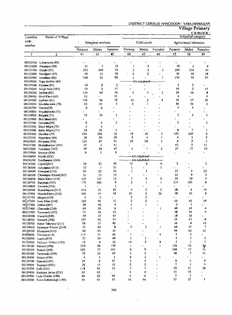
Location code number
Name of Village
2
00123500 Lahoriwala (89) 00123 (i00 Hasanpur (90) 00123700 Khadri (97) 00123800 Nandgarh (87) 00123900 Ismailpur (86) 00124000 Tapu Jaidhar (84) 00124100 Harewa (83) 00124200 Singh Pura (205) 00124300 Jaidhar(82) 00124400 Shul Kheri (85) 00124500 Jaidhari (81) 00124600 Manbharwala (79) 00124700 Darwa(78) 00124800 Mujahidwala (75) 00124900 Belgarb (73) 00125000 BeliBhud(63) 00125100 Doiwala(69) 00125200 Bhud Majra (70) 00125300 Balla Majra (71) 00125400 Deodhar (72) 00125500 Begampur(80) 00125600 Bhilpura (200) 00125700 Shahjahanpur (201) 00125800 Yakubpur(197) 00125900 Sherpur (206) 00126000 Kherki (202) 00126100 Gurdhanpur (204) 00126200 Urjani (203) 00126300 Ashabpura (212) 00126400 Khanpuri (210) 00126500 Chuharpur Khurd(207) 00126600 Mand Kheri (319) 00126700 Panjeton (315) 00126800 Chaneta (3 16) 00126900 Mukaribpura (31 7) 00127000 Munda Khera (318) 00127100 Mirpur(320) 00127200 LedaKhas(310) 00 tz7300 Jatheri (307) 00127400 Chaowala (328) 00127500 Taranwala (327) 00128300 Ganauli (309) 00128400 Ganaula (308) 00128500 Nahar Taharpur (211) 00128600 Salempur Khadar (214) 00 q8700 Khanpura (213) OM,28800 Tihanon (218) 00 t28900 Lopon (219) 00129000 DadupurMnlion (193) 00129100 Harauli(194) 00129200 Balauli (208) 00129300 Tarunwala (209) 00129400 Raipur (196) 00129500 Damoli (195) 00129600 Tugalpur (192) 00129700 Ledi (221) 00129800 Dadupur Jattan (222) 00129900 Leda Khadar (190) 00130000 Kotra Kahansingh (189)
Marginal workers
DISTRICT CENSUS HANDBOOK: YAMUNANAGAR
Cultivators
Village Primary CD BLOCK-
Industrial category
Agricultural labourers
Persons Males Females Persons Males Females Persons Males Females
41
21 293
59 118
10 19
134 21
154 43
6
71
9 3
34 240
58 122
13 39
9
54 12 45 31
135 175
I
114 102
3 124 20 44 71 79
107 98 72
96 112
73 30
219 182 79 4
29 28
118 62 64 54
42
5 269
21 20
8 2
60
96 41
6
70
4 3
32 208 29 87
2 24
12 I
22 12
123 166
31 44
3 92 16 38 56 32 56 13 64 65 51 24
4 80 77 16 3 8
15 83 62 20 43
43
16 24 38 98
2 17 74 21 58 2
5
2 32 29 35 II 15 8
42 11 23 19 12 9 I
83 58
32 4 6
15 47 51 85
8 31 61 49 26
139 105 63
21 13 35
44 II
396
44 45 46
1 3 2 2 2
-------------Un-inhabited--------------
5 3 2
10 2 8
19 16 3 2 I
29 28
3 2
------------Un-inhabited---------------------------Un-inhabited---------
15 6 9
7 2
4 25
2
4 I
2 2 2
2 2 I
3 2
10 1
2
9 9 2 2 4 3 3 3 2 2 7 7 4 4 6 6
16 16
3
2 23
&
47
10 249 56
116
2 19 24
4 76 36
4
3
3
8 175
4 8
I3 27
2
27 13 75
III
61 3
40 58 18 21 16 64 96 5 5 2
136 108 58
6 7
59 55
5 23
48
2 234
18 19
2 2
16
37 34
4
2
7 169
2 3 2
17
5 9
70 105
9 10
42 3
36 49 18 I3 4
57 65
5 3 I
52 , 37
7
2 3
31 55
5 22
49
8 15 38 97
17 8 4
39 2
3
I 6 2 5
II 10
2
22 4 5 6
19 8
19
4 9
8 12 7
31
2 I
&.,4. 71 51
4 4
28
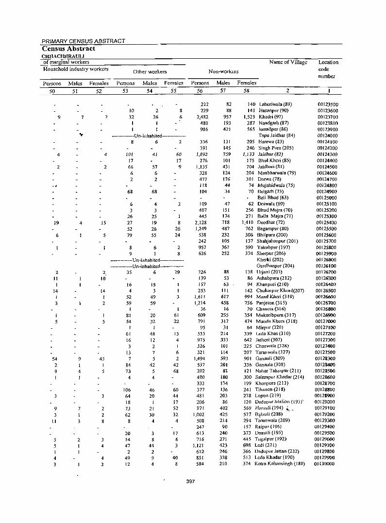
PRIMARY CENSUS ABSTRACT Census Abstract CHHACHHRAULI of marginal workers
Household industry workers
Name of Village
Other workers Non-workers
Persons Males Females Persons Males Females Persons Males Females
50
9
4
2
-,
19
6
2 II I
14 I
3
5
54 2 9
3
9 3
II
5 5 I 4 3
51
7
4
9
4 I
7
I 3
2
I
52
2
4
2
15
5
2
10
14 I 2
5
45 I 5
3
2 2 8
3 4
4 2
53
10 32
1
54
2 26
55
8 6
-----------Un-inhabited--------------862
101 17 66 6
41
57 6
2 2
68 68
6 3
26 27 52 79
8 9
4 3
25 19 26 55
6
60 17 9
2
I 8
26 24
2 8
--------Un-inhabited----------------------Un-inhabited------------
35 6 29
16 15 4 3
52 59
I 81 54
I 61 16 3
13 7
84 73
49 59
20 32
48 12 2 7 5
42 5
4 4
106 64 18 73 62
8
20 14 47
2 49 12
46 20
I 21 30
4
3 8
44 2
9 4
3
I 61 22
13 4 I
6 2
42 68
60 44 17 52 32
4
17 6
3
40 S
56
222 229
2,482 480 986
336 391
1,892 276
1,135 328 477 118 104
109 407 445
2,128 1,249
538 242 957 626
226 139 157 253
1,611 1,214
36 609 791 95
553 975 326 321
1,494 537 202 480 333 377 481 206 971
1,002 508 247 613 716
1,121 612 851 584
397
57
82 88
957 193 421
131 145 759 101 431 124 176 44 34
47 151 174 718 487 232 105 367 252
88 53 63
III 617 458
16 255 317
31 214 333 101 114 593 201
81 180 134 136 203
86 402 425 214
90 240 271 423 246 338 210
58 2
140 Lahoriwala (89) 141 Hasanpur (90)
1,525 Khadri (97) 287 Nandgarh (87) 565 Ismailpur (86)
Tapu Jaidhar (84) 205 Harewa (83) 246 Singh Pura (205)
1,133 laidhar (82) 175 Bhul Kheri (85) 704 laidhari (81) 204 Manbharwala (79) 301 Darwa (78)
74 Mujahidwala (75) 70 Belgarh (73)
Beli Bhud (63) 62 Doiwala (69)
256 Bhud Majra (70) 271 Balla Majra(71)
1,410 Deodhar (72) 762 Begampur (80) 306 Bhilpura (200) 137 Shahjahanpur (201) 590 Yakubpur (197) 374 Sherpur (206)
Kherki (202) Gurdhanpur (204)
138 Urjani (203) 86 Ashabpura (212) 94 Khanpuri (210)
142 Chuharpur Khurd(207) 994 Mand Kheri (3 19) 756 Panjeton (315)
20 Chancta (3 16) 354 Mukaribpura (31 7) 474 MundaKhera(3IS)
64 MirpllT (320) 339 Leda Khas (3 I 0) 642 Jatheri (307) 225 Chaowala (328) 207 Taranwala (327) 90 I Ganauli (309) 336 Ganaula (308) 121 Nahar Taharpur (211) 300 SalempuT Khadar (214) 199 Khanpura (213) 24 I Tihanon (218) 278 Lopon (219) 120 Dadupur Malion (193)' 569 Hamuli (194) 4; _ S77 B~lauli (208) 294 Tarunwala (209) 157 Raipllr (196) . 373 Damoli (195) 445 TugaJpur (192) 698 Ledi (221) 366 Dadupur lattan (222) 513 Leda Khadar (190) 374 Kotra Kahansingh (189)
Location
code
number
00123500 00123600 00123700 00123800 00123900 00124000 00124100 00124200 00124300 00124400 00124500 00124600 00124700 00124800 00124900 00125000 00125100 00125200 00125300 00125400 00125500 00125600 00125700 00125800 00125900 00126000 00126100 00126200 00126300 00126400 00126500 00 1 266()O
00126100 00126800 00126900 00127000 00127100 00127200 00127300 00127400 00127500 00128300 00128400 00128500 00128600 00128700 00128800 00128900 00129000 00129100 00129200 00129300 00129400 00129500 00129600 00129700 00129800 00129900 00130000
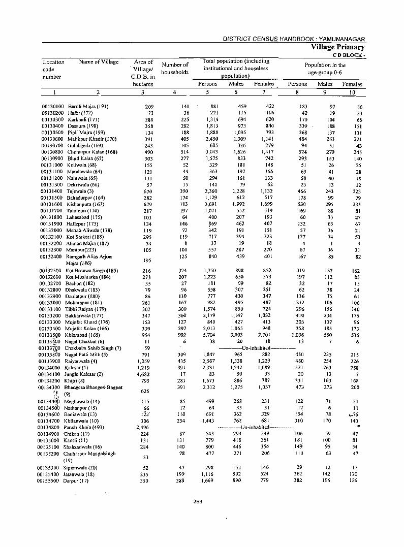
Location code number
Name of Village
2
00130100 Baroli Majra (191) 00130200 Hafti (172) 00130300 Karkauli (171) 00130400 Oasaura (198) 00130500 Pipli Majra (199) 00130600 Malikpur Khadir (170) 00130700 Gulabgarh (169) 00130800 Chuharpur Kalan (J 68) 00130900 Bhud Kalan (67) 00131000 Koliwala (68) 00131100 Mandewala(64) 00131200 Nainwala (65) 00131300 Dekriwala (66) 00131400 Tajewala (3) 00131500 Bahadurpur(164) 00131600 Kishanpura (167) 00131700 Tahimun (174) 00131800 Lahasabad (175) 00131900 Hafizpur(173) 00132000 Mahab Aliwala (178) 00132100 Kot Sarkari (188) 00132200 Ahmad Majra (187) 00132300 Manipur(223) 00132400 Ramgarh Alias Arjun
Majm (186)
00i32500 Kot Basawa Singh (185) 00132600 Kat Mushtarka (184) 00132700 Bachon (182) 00132800 Ohakwala (183) 00132900 Oaulatpur(180) 00133000 Mukarapur(J81) 00133100 Tibbi Raiyan (179) 00133200 Bakkarwala (177) 00133300 Mujafat Khurd (176) 00133400 Mujafat Kalan (166) 00I3J5{l0 Khizrabad (165) 00133"6.90 Nagai Chakbat (6) 00133120 Chakbaba Sahib Singh (7) 00133800 Nagai Patti Milk (5) 00133900 Raiyanwala (4) 00134000 Kalesar ( I ) 00134100 Jungle Kalesar (2) 00134200 Khijri (8) 00134300 Bhangera Bhangeri Bagpat
;( (9)
001344lW Meghuwala (14) 00134500 Nathanpur (15) 00134600 Baniawala (13) 00134700 Khilanwala (10) 00134800 Panch Khola (493) 00134900 Chikan (12) 00135000 Kansli (11) 00135100 Shahzadwala (16) 00135200 Chuharpur Mangalsingh
(19)
00135300 Sipianwala (20) 00135400 Jatanwala (18) 001:35500 Oarpur (17)
Area of Vi II age/
C.D.B. in hectares
3
209 73
288 358 134 391 243 490 303 155 121 131 57
670 282 679 217 103 134 119 295
54 105
195
216 273
35 79 86
261 307 347 153 339 954 II 59
791 1,059 1,219 4,682
795
626
LIS 66
122' 306
2,496 224 131 284
53
52 235 350
Number of households
4
141 36
225 282 188 405 105 514 277 52 44 50 15
390 174 713 197 64
146 72
119 8
100 125
324 207
27 96
130 167 300 360 127 297 992
6
309 435 391
17 281 391
85 12
110 254
87 131 140 78
47 199 288
DISTRICT CENSUS HANDBOOK: YAMUNANAGAR
Village Primary CD BLOCK-
Total population (including institutional and houseless
population)
Population in the age-group 0-6
Persons
5
881 221
1,31.4 1,813 1,888 2,450
605 3,043 1,575
329 363 294 141
2,360 1,129 3,691 1,071
400
~69 342 717 37
557 840
1,750 1,223
181 558 777 982
1,574 2,179
840 2,013 5,704
38
1,847 2,567 2,331
83 1,673 2,312
499 64
691 1,443
Males
6
459 115 694 973
1,095 1,309
326 1,626
833 181 197 161 79
1,228 612
1,992 552 207 462 191 394
19 287 439
898 650 99
307 430 495 850
1,147 427
1,065 3,003
20
Females
7
422 106 620 840 793
1,141 279
1,417 742 148 166 133 62
1,132 517
1,699 519 193 407 151 323
18 270 401
852 573
82 251 347 487 724
1,032 413 948
2,701 18
Persons
8
183 42
170 339 268 484
94 524 293
51 69 58 25
466 178 530 169 60
132 57
127 4
67 167
319 197 32 62
136 212 296 410 203 358
1,096 13
----Un-inhabited------------965 882 450
1,338 1,229 480 1,242 1,089 521
50 33 20 886 787 331
1,275
268 33
362 762
1,037
231 31
329 681
473
122 17
154 310
-------------u n -inhab ited-------------543 779 800 477
298 1,116 1,669
398
294 249 106 418 361 181 446 354 149' 271
152 592 890
206
146 524 779
110
29 262 382
Males Females
9
97 19
104 188 137 263
51 279 153 26 41 40 13
243 99
295 88 33 65 36 74
1 36 85
157 112
17 38 75
106 156 234 107 185 560
7
235 254 263
13 163 273
71 6
78 170
59 100 95 63
12 142 196
10
86 23 66
151 131 221 43
245 140 25 28 18 12
223 79
235 81 27 67 21 53 3
31 82
162 85 15 24 61
106 140 176 96
173 536
6
215 226 258
7 168 200
51 II
.".76 140 ... 47 81 54 47
17 120 186
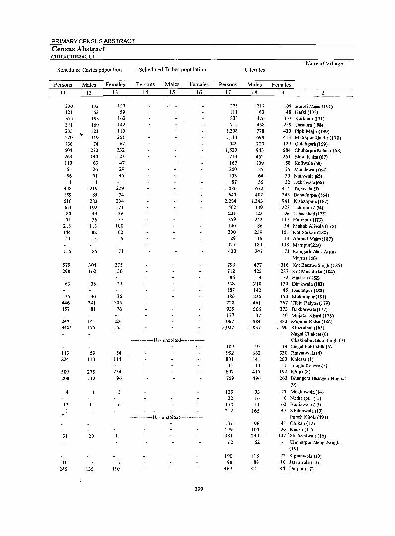
PRIMARY CENSUS ABSTRACT
Census Abstract CHHACHHRAULI
Name of Village Scheduled Castes popuation Scheduled Tribes population Literates
Persons Males Females Persons Males Females Persons Males Females
11 12 13 14 15 16 17 18 19 2
330 173 157 325 217 108 Baroli Majlll (191) 121 62 59 111 63 48 Hafzi (172) 355 193 162 833 476 357 Karkauli (171) 311 169 142 717 458 259 Dasaura (193) 233 ... 123 110 1,208 778 430 Pipli Majra(199) 570 319 251 1,111 698 413 Malikpur Khadir (170) 136 74 62 349 220 129 Gulabgarh (169) 504 272 232 1,527 943 584 Chuharpur Kalan (168) 263 140 123 713 452 261 Bhud Kalan (67) 110 63 47 167 109 58 Koliwala (68) 55 26 29 200 125 75 Mandewala (64) 96 51 45 103 64 39 Nainwala (65)
87 55 32 Dekriwala (66) 448 219 229 1,086 672 414 Tajewala (3) 159 85 74 645 402 243 Bahadurpur(164) 516 282 234 2,284 1,343 941 Kishanpura(167) 363 192 171 562 339 223 Tahimun (174)
80 44 36 221 125 96 Lahasabad (175) 71 36 35 359 242 117 Hafizpur (173)
218 118 100 140 86 54 Mahab Aliwala (178) 144 82 62 390 239 lSI Kot Sarkari (188) II 5 6 29 16 13 Ahmad Majra(187)
327 189 138 Manipur(22J) 156 85 71 420 247 173 Ramgarh Alias Arjun
Majra (186)
579 304 275 793 477 316 Kot BasawaSingh (185) 298 162 136 712 425 287 Kot Mushtarb (184)
86 54 32 Bachon (182) 63 36 27 348 218 130 Dhakwala (183)
187 142 45 Daulatpur (180) 76 40 36 386 236 150 Mukarapur(J81)
446 241 205 728 461 267 Tibbi Raiyan (I 79) 157 81 76 939 566 373 Bakkarwala (177)
177 137 40 Mujafat Khoot <! 76) 267 141 126 967 584 383 Mujafat KabUl (166) 340' 175 165 3,027 1,837 1,190 Khizrabad (165)
Nagai Chakbal (6) ------------Un-inhabited------------- Chakbaba Sahib Singh (7)
109 95 14 NagaI Patti Milk (5) 113 59 54 992 662 330 Raiyanwala (4) 224 110 114 801 541 260 Kalesar (I)
IS 14 Jungle Kalesar (2) 509 275 234 607 415 192 Khijri (8) 208 112 96 759 496 263 Bhangera Bhangeri Bagpat
(9)
4 3 120 93 27 Meghuwala (14) 22 16 6 Nathanpllr (15)
17 II 6 174 III 63 Baniawala (13) I I 212 165 47 Khilanwala (10)
-----------Un-inhabited-------------- Panch Khola (493) 137 96 41 Chikan (12) 139 103 36 Kansli (II)
31 20 II 38t 244 137 . Shahzadwala (16) 62 62 ChuharplIr Mangalsingh
(19)
190 118 72 Sipianwala (20) 10 5 5 98 88 10 Jatanwala (18)
245 135 110 469 325 144 Darpur (17)
399
Location code number
Name of Village
2
00130100 Baroli Majra (191) 00130200 Hafzi (172) 00130300 Karkauli (171) 00130400 Dasaura (198) 00130500 PipliMajra(199) 00130600 Malikpur Khadir (170) 00130700 Gulabgarh (169) 00130800 Chuharpur Kalan (1.68) 00130900 Bhud Kalan (67) 00131000 Koliwala (68) 00131100 Mandewala (64) 00131200 Nainwala (65) 00131300 Dekriwala (66) 00131400 Tajewala (3) 00131500 Bahadurpur(I64) 00131600 Kishanpura (167) 00131700 Tahimun (174) 00131800 Lahasabad (175) 001~1900 Hafizpur(173) 00132000 Mahab Aliwala (178) 00132100 Kot Sarkari (188) 00132200 Ahmad Majra (187) 00132300 Manipur(223) 00132400 Ramgarh Alias Aljun
Majra (186)
00132500 Kot Basawa Singh (185) 00132600 Kot Mushtarka (184) 00132700 Bachon (182) 00132800 Dhakwala (183) 00132900 Daulatpur (180) 00133000 Mukarapur (181) 00133100 Tibbi Raiyan (179) 00133200 Bakkarwala (177) 00133300 Mujafat Khurd (176) 00133400 Mujafat Kalan (166) 00q~5oo Khizrabad (165) 00 13~600 NagaI Chakbat (6) 0013'3700 Chakbaba Sahib Singh (7) 00133800 NagaI Patti Milk (5) 00133900 Raiyanwala (4) 00134000 Kalesar (I) 00134100 Jungle Kalesar (2) 00134200 Khijri (8) 00134300 Bhangera Bhangeri Bagpat
1. (9)
00134400 Meghuwala (14) 0013~$90 Nathanpur (15) 00134600 Baniawala (13) 00134700 Khilallwala (l0) 00134800 Panch Khola (493) 00134900 Chikan (12) 00135000 Kansli (I I) 00135100 Shahzadwala (16) 00135200 Chuharpur Mangalsingh
(19)
00135300 Sipianwala (20) 00135400 Jatanwala (18) 00135500 Darpur (17)
Persons
20
556 110 481
1,096 680
1,339 256
1,516 862 162 163 191 54
1,274 484
1,407 509 179 SID 202 327
8 230 420
957 511
95 210 590 596 846
1,240 663
1,046 2,677
38
1,738 1,575 1,530
68 1,066 1,553
379 42
517 1,231
406 640 419 415
108 1,018 1,200
Illiterates
Males Females
21 22
242 52
218 515 317 611 106 683 381
72 72 97 24
556 210 649 213
82 220 105 155
3 98
192
421 225
45 89
288 259 389 581 290 481
1,166 20
870 676 701 36
471 779
175 17
251 597
198 315 202 209
34 504 565
3·14 58
263 581 363 728 150 833 481
90 91 94 30
718 274 758 296
97 290
97 172
5 132 228
536 286 50
121 302 337 457 659 373 565
1.511 18
868 899 829 32
595 774
204 25
266 634
208 325 217 206
74 514 635
400
DISTRICT CENSUS HANDBOOK: YAMUNANAGAR
Total workers
Village Primary CDBLOCK-
Main workers
Persons Males Females Persons Males Females
23 24 25 26 27 28
422 240 182 66 66
404 359 45 539 481 58 325 270 55 834 645 189 180 171 9 961 821 140 569 427 142 166 95 71 119 105 14 88 83 5 40 40
667 520 147 393 337 56
1,034 956 78 309 297 12 193 122 71 255 237 18 102 91 II 212 170 42
21 16 5 159 152 7 291 237 54
535 422 113 354 297 57
58 58 184 157 27 312 209 103 407 233 174 541 438 103 851 587 264 214 211 3 630 576 54
1,672 1,461 211 15 II 4
----------Un-inhabited-------------450 395 55 913 684
34 505 933
122 19
195 560
641 580 24
416 739
118 16
180 423
272 104
10 89
194
4 3
15 137
-------------Un-inhabited------------137 136 1 183 208 163
108 318 468
166 206 136
99 281 409
17 2
27
9 37 59
203 64
385 477 249 805 174 814 503 134 113 80 31
343 361 923 301 176 221
74 89 15
159 244
423 225
58 147 188 302 458 815 203 586
1,582 9
401 518 606 30
313 585
120 19
178 305
133 92
197 123
86 187 419
196 64
354 466 220 626 169 756 398
83 99 78 31
318 321 867 294 106 219
74 85 15
152 229
386 210
58 144 181 198 383 571 201 562
1,412 9
367 417 545
22
307 531
116 16
170 246
132 79
196 123
84 186 362
7
31 II 29
179 5
58 105 51 14 2
25 40 56
7 70 2
4
7 15
37 15
3 7
104 75
244 2
24 170
34 101 61
g
6 54
4 3 8
59
I 13
2 I
57
PRIMARY CENSUS ABSTRACT Census Abstract CHHACHHRAUU
Industrial category of main workers
Cultivators Agricultural labourers Household industry
workers
Name of Village
Other workers
Persons Males Females Persons Males Females Persons Males Females Persons Males Females
29
64 24
134 184 34
138 37
127 118 41 78 31 25 71 83
150 94 58 62 16 57
5 37 III
61 35 42 99 94 88 36
149 • 84
233 212
91 183 160
11 45
302
35 9
78 101
47 34
124
77
59 54
141
30
63 24
132 181 ~
138 34
126 117 41 78 31 25 68 82
146 93 57 62 16 57
5 37
104
59 35 42 97 93 83 35
146 84
232 209
90 160 147
10 45
299
34 9
77 95
46 32
124
77
59 54
140
31
2 3
3 I
3 I 4 I
7
2
2 I 5 I 3
I 3
23 13
3
I 6
2
32
82 32
131 96 28 53 65
197 51 13 28 10 2 5
100 44 80 25
110 39 10
I
60 33
148 22 13 20 52 53 88
174 76
135 365
9
21 32 10
80 95
65
21 18
57
32 30
2 113
SO
33
81 32
115 96 25 51 65
195 49 13 14 10 2 5
99 40 78 18
108 39 10
I
60 32
147 22 13 20 52 45 88
174 76
135 346
9
34
16
3 2
2 2
14
4 2 7 2
8
19
35
3
·11 7
28 10
3 2
14 13 II
I 3
18
35 26
6 3 8
12 9 5
16 82
36
3
II 7
26 5
3
14 12 10 I
3
15
29 25
5 3 7 5 6 5
14 78
---------U n-i nhabited--------------21 31 8 7 10
79 92
65
20 18
I
3
17
12 12
4
14
9 12
2
-----------U n-i nhab i ted--------------57
31 30
2 113
SO
5 2
6
I 6
94
6
I
6 48
401
37
2 5
3
6 I
I 7 3
2 4
3
3
2
3
46
38
54 8
109 190 187 614
72 462 324
80 4
37 4
253 165 718 126 93 4& 18 19 8
62 82
179 142
3 22 39
153 322 483
38 202 923
282 295 419
19 176 176
20 9
75 186
29 53 41 10
24 14
134
39
49 8
96 182 162 437
70 409 n7
29 4
36 4
231 128 671 122 31 48 18 15 8
55 78
151 128
3 22 33 63
255 245
36 181 779
256 219 374
12 174 128
17 6
71 133
29 45 41 10
22 13
124
40 2
5 Baroli Majra (191) Hafzl (172)
13 Karkauli (171) 8 Dasaura (198)
25 Pipli Majra (199) 177 Malikpur Khadir (170)
2 Gulabgarh (169) 53 Chuharpur Kalan (168) 97 Bhud Kalan (67) 51 Koliwala (68)
Mandewala (64) Nainwala (65) Dekriwala (66)
22 Tajewala (3) 37 Bahadurpur (164) 47 Kishanpura (167)
4 Tahimun (174) 62 Lahasabad (175)
Hafizpur (173) Mahab Aliwala (178)
4 Kot Sarkari (188) Ahmad Majra (187)
7 Manipur(223) 4 Ramgarh Alias Arjun
Majra (186)
28 Kot Basawa Singh (185) 14 KotMushtarka(184)
Bachon (182) Dhakwala (183)
6 Daulatpur (180) 90 Mukarapur (181) 67 Tibbi Raiyan (179)
238 Bakkarwala (177) 2 Mujafat Khurd (176)
21 Mujafat Kalan (166) 144 Khizrabad (165)
Nagai Chakbat (6) Chakbaba Sahib Singh (7)
33 Nagai Patti Milk (5) 76 Raiyanwala (4) 45 Kalesar (I)
7 Jungle Kalesar (2) 2 Khijri (8)
48 Bhangera Bhangeri Bagpat (9)
3 Meghuwala (14) 3 Nathanpur(IS) 4 Baniawala (13)
53 Khilanwala (10) Panch Khola (493) Chikan (12)
8 Kansli (II) Shahzadwala (16) Chuharpur Mangalsingh (19)
2 Sipianwala (20) latanwala (18)
10 Darpur(17)
. Location code number
Name of Village
2
00130100 Baroli Majra'(l91) 00130200 Hafzi (172) 00130300 Karkauli (171) 00130400 Dasaura (198) 00130500 Pipli Majra (199) 00130600 Malikpur Khadir (170) 00130700 Gulabgarh (169) 00 130800 Chuharpur Kalan (168) 00130900 Bhud Kalan (67) 00131000 Koliwala(68) 00131100 Mandewala(64) 00131200 Nainwala (65) 00131300 Dekriwala(66) 00131400 Tajewala (3) 00131500 Bahadurpur (164) 00131600 Kishanpura (167) 00131700 Tahimun(174) 00131800 Lahasabad (175) 00131900 Hafizpur(173) 00132000 Mahab Aliwala (178) 00132100 Kot Sarkari (188) 00132200 Ahmad Majra (187) 00132300 Manipur(223) 00132400 Ramgarh Alias Arjun
Majra (186)
00132500 Kot Basawa Singh (185) 00132600 Kot Mushtarka (184) 00132700 Bachon(182) 00132800 Dhakwala(183) 00132QOO Daulatpur (180) 00133000 Mukarapur (181) 00133100 Tibbi Raiyan (I 79) 00133200 Bakkarwala (177) 00133300 Mujafat Khurd (176) 00133400 Mujafat Kalan (166) 00133500 Khizrabad (165) 001):3600 NagaI Chakbat (6) 00 r.f~700 Chakbaba Sahib Singh (7) 001,33800 Nagai Patti Milk (5) 00133900 Raiyanwala (4) 00 134000 Ka[esar (I) 00134 I 00 Jungle Kalesar (2) 00134200 Khijri (8) 00134300 Bhangera Bhangeri Bagpat
t~/
00134400 00134500 0013"4'600 00134700 00134800 00134900 00135000 00135100 00135200
(9)
Meghuwala (14) Nathanpur (IS) Baniawa[a (13) Khilanwala (l0) Panch Khola (493) Chikan (12) Kansli (II) Shahzadwala (16) Chuharpuf Mangalsingh (19)
00135300 Sipianwala (20) 00135400 Jatanwala (18) 00135500 Darpur (17)
Marginal workers
DISTRICT CENSUS HANDBOOK: YAMUNANAGAR
CuJtivators
Village Primary CDBLOCK-
Industrial category
Agricultural labourers
Persons Males Females Persons Males Females Persons Males Females
41 42 43 44 45 46 47 48 49
219 2
19 62 76 29
6 [47 66 32
6 8 9
324 32
III 8
17 34 28
123 6
47
112 129
37 124 105 83 36 II
44 90
6
49 395
78 4
192 348
2
17 255
4 91 II
40
22 131 49
44 2 5
15 50 19 2
65 29 12 6 5 9
202 16 89 3
16 18 17 85
I
8
36 87
13 28 35 55 16 10 14 49 2
28 224 35
2 109
208
2
10 177
4
87 10 13
15 95 47
17?
14 47 26 10 4
82 37 20
3
122 16 22
5 1
16 II 38
5
39
76 42
24 96 70 28 20
I
30 41
4
21 171 43
2 83
140
7 78
4 I
27
7 36
2
402
5
14 I
10 3 2
6 14 3 2 I
12 2
10
7
5
6
8 3
6 5 3
12
10
5 4 9 8
7 5
8
2
9
7
2
I I 4 3
2 2 4 3
-------------Un-inhabited--------------
17 15
1 16 15
12 5 I 3
14
3 2 36 32
5 10
13 I
4 -------------Un-inhabited-------------
2 2
28
20 2 4
2
IJ I 4
26
7
28
2 12
21
22 23 8
5 3
36 3 7
16 5
90
32
24 54
J3 15 35 13 6 9
5 50
6
4 144
I
84
2 80 10 12
2 76
9
22
3 20
19
17 8
4 3
29 2 5
II 5
63
6
13 53
10 II 23 13 4 8 4
23 2
4 141
I
48 33
11
2 80 9·
II
2 74 9
6
9
3 6
7
2
5
27
26
II I
3 4
12
2
27 4
3
45 10
13
2
PRIMARY CENSUS ABSTRACT Census Abstract CHHACHHRAULI of marginal workers Household industry workers Other workers Non-workers
Name of Village Location
code
number Persons Males Females Persons Males Females Persons Males Females
50 51
2
2
8
24 10 5 2
13 2 I
I 18 7 15 4
6
17 49
28 3
II 2
13 3
2 4
2
26 4
6 15
8
3 3
52
2
2
7 I I
14 3
II 1
I II II
6
II 34
28 3
10 2
5
3
2
4
2
23
53
184
16 34 54 27
5 107 39 21
5 3
250 21 89 6 4
15 5 8 6
2
66 17
24 101 42 66 26
2 26 34
54
17
3 6
29 17 I
37 9 3 5
158 9
81 3 3 6 5 8 I
2
J3 II
3 12 12 42 II 2 7
23
55
167
13 28 25 10 4
70 30 18
2
92 12 8 3 I 9
5
53 6
21 89 30 24 15
19 II
------------Un-inhabited--------------45 24 21
221 59
3 81
286
14 135
63 29
1 58
161
8 74
158 30
2 23 125
6
61 -------------Un-inhabited----------
9
27 32
7 I
17 31
2
10 I
56
459 155 910
1,274 1,563 1,616
425 2,082 1,006
163 244 206 101
1,693 736
2,657 762 207 614 240 505
16 398 549
1,215 869 123 374 465 575
1,033 1,328
626 1,383 4,032
23
1,397 1,654 1,647
49 1,168 1,379
377 45
496 883
406 596 592 314
190 798
1,201
403
57
219 49
335 492 825 664 155 805 406
86 92 78 39
708 275
1,036 255 85
225 100 224
3 135 202
476 353 41
150 221 261 412 560 216 489
1,542 9
570 697 662 26
470 536
ISO 17
182 339
158 252 240 135
53 31\ 481
58 2
240 Barali Majra (191) 106 Hatii (172) 575 Karkallii (171) 782 Dasllura (198) 738 Pipli Majra (199) 952 Malikpur Khadir (170) 270 Gulabgarh (169)
1,277 Chuharpur Kalan (168) 600 Bhud Kalan (67)
77 Koliwala (68) 152 Mandewala (64) 128 Nainwala (65) 62 Dekriwala (66)
985 T*wala (3) 461 Bahadurpur (164)
1,621 Kishanpura (167) 507 Tahimun(174) 122 Lahasabad (I 75) 389 Hafizpur (173) 140 Mahab Aliwala (178) 281 Kot Sarkari (188)
13 Ahmad Majra (187) 263 Manipur(223) 347 Ramgarh Alias Arjun
Majra (186)
739 Kot Basawa Singh (185) 516 Kot Mllshtarka (184)
82 Bachon (182) 224 Dhakwala (183) 244 Dalllatpur (180) 313 Mukarapur (181) 621 Tibbi Raiyan (179) 768 Bakkarwala (177) 410 Mlljafat Khurd (176) 894 Mujafat Kalan (166)
2,490 Khizrabad (165) 14 Nagai Chakbat (6)
Chakbaba Sahib Singh (7) 827 Nagai Patti Milk (5) 957 Raiyanwala (4) 985 Kalesar ( I) 23 Jungle Kalesar (2)
698 Khijri (8)
00130100 00130200 00130300 00130400 00130500 00130600 00130700 00130800 00130900 00131000 00131100 00131200 00131300 00131400 00131500 00131600 00131700 00131800 00131900 00132000 00132100 00132200 00132300 00132400
00132500 00132600 00132700 00132800 00132900 00133000 00133100 00133200 00133300 00133400 00133500 00133600 00133700 00133800 00133900 00134000 00134100 00134200
843 Bhangera Bhangeri Bagpat 00134300 (9)
227 Meghuwala(14) 28 Nathanpur (15)
314 Baniawala (13) 544 KhiJanwala (10)
Panch Khola (493) 248 Chikan (12) 344 Kansli (I I) 352 Shahzadwal~{16)
00134400 00134500 00134600 00134700 00134800 00134900 00135000 00135100
179 Chuharpur Mangalsingh 00135200 (19)
137 Sipianwala (20) 487 Jatanwala (l8) 720 Darpur (17)
00135300 00135400 00135500
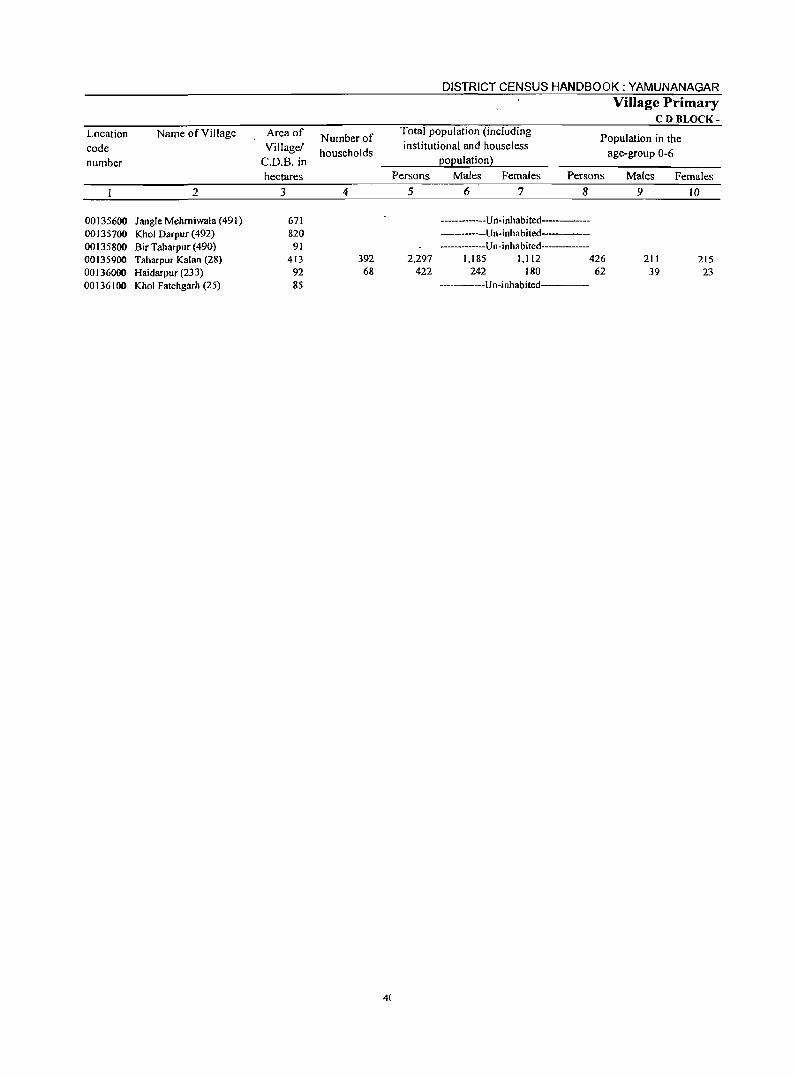
Location Name of Village Area of code Village! number C.D.B. in
hectares 2 3
00135600 Jangle Mehmiwala (491) 671 00135700 Khol Darpur (492) 820 00135800 Bir Taharpur (490) 91 00135900 Taharpur Kalan (28) 413 00136000 Haidarpur (233) 92 00136100 Khol Fatehgarh (25) 85
Number of households
4
392 68
4(
DISTRICT CENSUS HANDBOOK: YAMUNANAGAR Village Primary
CD BLOCK-Total population (including institutional and houseless
population)
Population in the age-group 0-6
Persons Males Females Persons
5 6 7 8
----------Un-inhabited------------------Un-inhabited-------------------Un-inhabited-------
2,297 1,185 1,112 426 422 242 180 62
-------------Un-inhabited-----
Males
9
211 39
Females
10
215 23
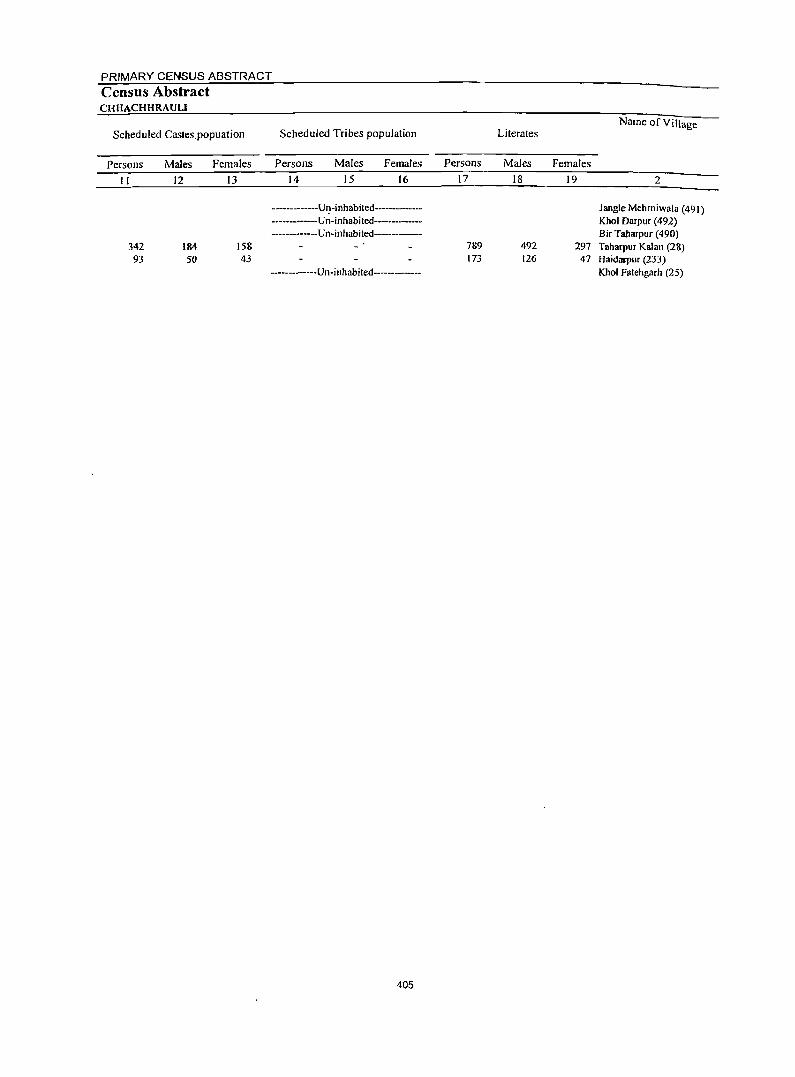
PRIMARY CENSUS ABSTRACT
Census Abstract CHHACHHRAULI
Scheduled Castes.popuation
Persons
11
342 93
MaJes
12
184 50
Females
13
158 43
Scheduled Tribes population
Persons Males Females
14 15 16
-------------Un-inhabited-----------------------Un-inhabited----------------------Un-inhabited---------
-------------Un-inhabited-----------
405
Literates Name of Village
Persons Males Females
17 18 19 2
Jangle Mehrniwala (491) Khol Darpur (492) Bir Taharpur (490)
789 492 297 Taharpur Kalan (28) 173 126 47 Haidarpur (233)
Khol Fatehgarh (25)
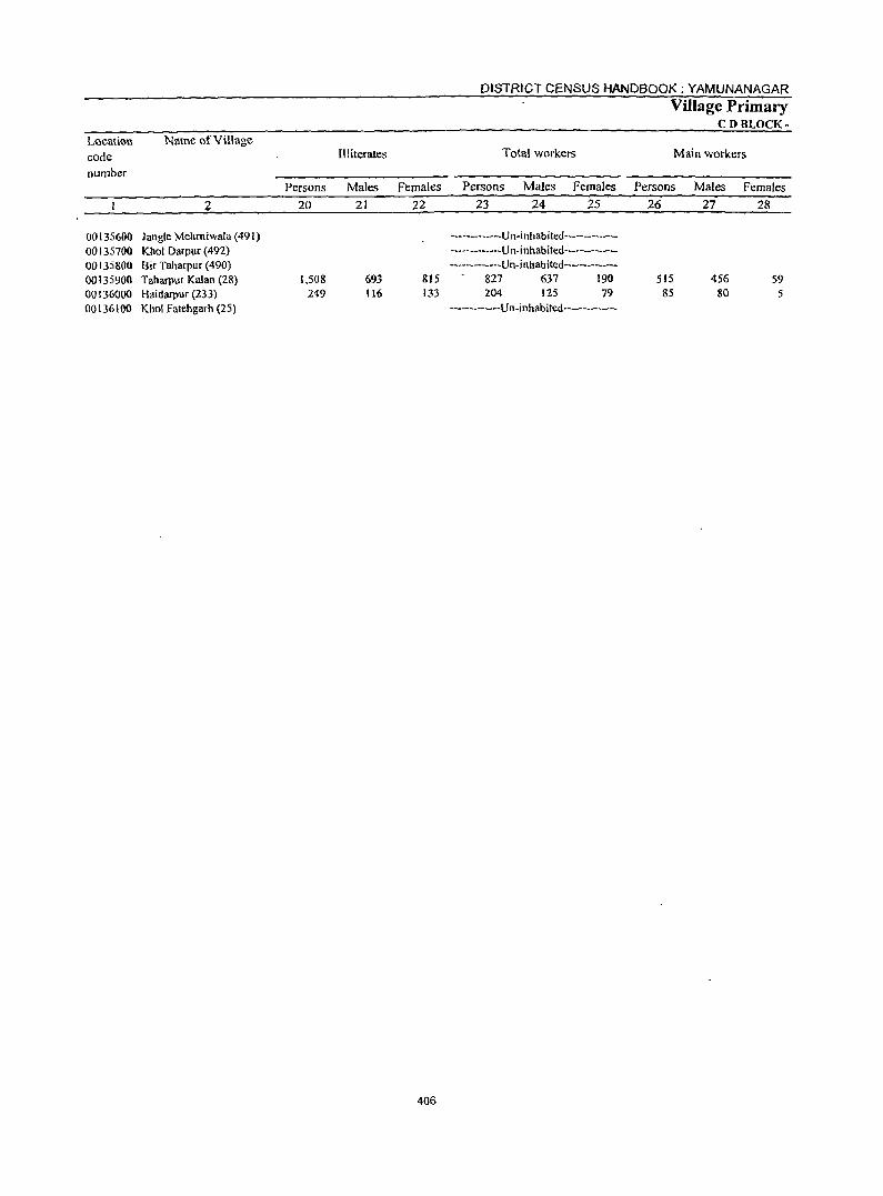
L()cation
code number
Name ()fVillage
00135600 Jangle Mehmiwala (491) 00135700 Khol Darpur (492) 00135800 Bir Taharpur (490) 00135900 Taharpur Kalan (28) 00136000 Haidarpur (233) 00136100 Khol Fatehgarh (25)
Persons
20
1,508 249
III iterates
Males Females
21 22
693 815 116 133
406
DISTRICT CENSUS HANDBOOK: YAMUNANAGAR
Total workers
Persons Males Females
23 24 25
-------------Un-inhabited------------------------Un-inhabited------------------------Un-inhabited------------
827 637 190 204 125 79
-------------Un-inhabited-----------
Village Primary CD BLOCK-
Main workers
Persons Males Females 26 27 28
515 456 S9 85 80 5
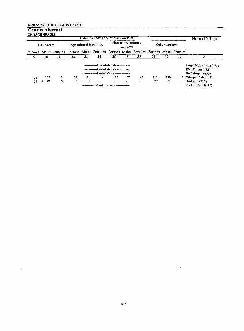
PRIMARY CENSUS ABSTRACT Census Ab~tract CHHACHHRAULI
Cultivators
Industrial category of main workers
Agricultural labourers Household industry
workers
Persons Males Females Persons Males Females Persons Males Females
29 30 31 32 33 34 35 36 37
159 157 52 'Ir 47
2 5
-------------Uil-inhabited-----------------------Un-inhabited-----------------------Un-illhabited----------
22 20 2 72 29 43 6 6
-------------Un-inhabited--------
407
Name of Village
Other workers
Persons Males Females
38
262 27
39
250 27
40 2
Jangle Mehrniwala (491) KhoI Darpur (492) ail- Taharpur (490)
12 Taharpur Kalan (28) Haidarpur (233) Kbol Fatehgarh (25)
Location code number
Name of Village
2
00135600 Jangle Mehrniwala (491) 00135700 Khol Oarpur (492) 00135800 Bir Taharpur (490) 00135900 Taharpur Kalan (28) 00136000 Haidarpur (233) 00136100 Khol Fatehgarh (25)
Marginal workers
Persons Males Females 41 42 43
312 181 131 119 45 74
408
DISTRICT CENSUS HANDBOOK: YAMUNANAGAR
Cultivators
Village Primary CDBLOCK-
Industrial category
Agricultural labourers
Persons Males Females Persons Males Females
44 45 46 47 48 49
-------------Un-inhabited--------------------------Un-inhabited----------------------Un-inhabited--------------
37 35 2 8 8 3 I 2 12 9 3
------------Un-inhabited--------------
PRIMARY CENSUS ABSTRACT
Census Abstract CHHACHHRAULJ of marginal workers Household industry workers
Persons Males Females 50 51 52
13 12 5 5
...
Other workers
Persons Males Females 53 54 55
-------------Un-inhabited---------------------------Un-inhabited--------------
254 126 128 99 35 64
-------------U n- i nhabi ted -------------
Non-workers
Persons Males Females 56 57 58
1,470 548 922 218 117 101
409
Name of Village
2
Khol Darpur (492) Bir Taharpur (490) Taharpur Kalan (28) Haidarpur (233) Khol Fatehgarh (25)
Location code number
00135700 00135800 00135900 00136000 00136100
Location Name of Townl Ward code
number
2
40301000 Sadaura (MC) 0001 Ward No. I 0002 Ward No.2 0003 Ward No.3 0004 Ward No.4 0005 Ward No.5 0006 Ward No.6 0007 Ward No.7 0008 Ward No.8 0009 Ward No.9 0010 Ward No. 10 001 I Ward No. 11 0012 0013
Ward No. 12 Ward No. 13
40302000 Bilaspur (Cf) 0001 Ward No. I 0002 Ward No.2
40303000 Mustarabad (CT) 0001 Ward No. I 0002 Ward No.2
40304000 Radaur (MC) 0001 Ward No. I 0002 Ward No.2 0003 Ward No.3 0004 Ward No.4 0005 Ward No.5 0006 Ward No.6 0007 Ward No.7 0008 Ward No.8 0009 Ward No.9 0010 0011 0012 0013
Ward No. 10 Ward No. II Ward No. 12 Ward No. 13
40305000 Farakhpur (CT) 0001 Ward No. I 0002 Ward No.2
40306000 Yamunanagar (M CI ) 0001 WardNo. I 0002 Ward No.2 0003 Ward No.3 0004 Ward No.4 0005 Ward No.5 0006 Ward No.6 0007 Ward No.7 0008 Ward No.8 0009 Ward No.9 0010 Ward No. 10 0011 Ward No. II 0012 Ward No. 12 0013 Ward No. 13 0014 Ward No. 14 0015 Ward No. 15 0016 Ward No. 16
Area of Town in square
Kilometre
3
6.75
851
7.16
2.59
1.35
16.32
Number of households
4
2,398 173 171 176 151 226 268 151 133 170 180 157 156 286
1,714 916 798
1,578 767 811
2,155 174 145 163 121 145 215 105 133 178 175 180 130 291
1,761 968 793
36,652 1,509
987 1,242 1,364
822 1,090 1,172
851 958 813
1,034 936 882 961
1,721 1,735
410
DISTRICT CENSUS HANDBOOK: YAMUNANAGAR
Total population (including institutional and houseless
population)
Persons
.5
13,176 854 877 941 921
1,199 1,390
881 736 947
1,028 877 911
1,614
9,621 5,169 4,452
8,516 4,274 4,242
11,737 922 831 919 763 805
1,099 641 720 891 907 951 741
1,547
8,740 4,422 4,318
189,696 7,685 5,106 6,757 6,919 4.132 5,979 6,366 4,429 4,673 4,283 5,196 4,657 4,393 4.763 8.563 8,964
Males Females
6
6,936 449 442 493 477 648 733 454 406 480 547 462 484 861
5,102 2,777 2,325
4,494 2,254 2,240
6,170 488 447 495 396 428 578 339 355 483 456 489 393 823
4,702 2,364 2,338
10],782 4,068 2,649 3,591 3,765 2,158 3,061 3,396 2,447 2,475 2,241 2,945 2,502 2,285 2,422 4,499 4,719
7
6,240 405 435 448 444 551 657 427 330 467 481 415 427 753
4,519 2,392 2,127
4,022 2,020 2,002
5,567 434 384 424 367 317 521 302 365 408 451 462 348 724
4,038 2,058 1,980
87,914 3,617 2,457 3,161fr 3,154 1,974 2,918 2,970 1,982 2,198 2,042 2,251 2,155 2,108 2,341 4,064 4,245
Urban Primary
Population in the age-group 0-6
Persons Males Females
8
1,590 79
100 99
122 141 170 82 89
110 120 93
III 274
1,397 796 601
1,101 534 567
1,514 119 90
127 114 86
'150 75 98
134 113 148 95
165
1,166 561 605
23,663 867 538 854 992 528 687
, 878 470 486 466 712 480 370 415 819
1,048
9
91l 4S 51 50 73 87 94 39 57 62 63 59 72
159
799 452 347
615 297 318
877 63 60 73 64 50 89 55 53 78 65 71 57 99
655 321 334
13,271 508 332 480 544 309 384 478 278 264 261 408 259 213 254 486 600
10
679 34 49 49 49 54 76 43 32 48 57 34 39
115
598 344 254
486 237 249
637 56 30 54 50 36 61 20 45 56 48 77 38 66
50 240 271
]0,392 359 206 374 448 219 303 400 192 222 205 304 221 157 161 333 448
PRIMARY CENSUS ABSTRACT
Census Abstract
Name ofTownl Ward
Scheduled Castes popuLation Scheduled Tribes population Literates
Persons Males Females Persons Males Females Persons Males Females
11 12 13 ]4 15 16 17 18 ]9 2
2,569 1,365 1,204 9,132 5,105 4,027 Sadaura(MC) 4 2 2 692 382 310 Ward No. I 9 4 5 722 373 349 Ward No.,z
763 423 340 Ward No. 3 170 ~ 89 81 630 345 285 Ward No. 4 278 155 123 855 480 375 Ward No. 5 606 311 295 847 500 347 Ward No. 6
665 363 302 Ward No. 7 21 12 9 455 272 183 Ward No. 8 9 6 3 723 396 327 Ward No. 9
201 110 91 728 424 304 Ward No. 10 72 40 32 661 364 297 Ward No. JI
256 129 127 626 347 279 Ward No. 12 943 507 436 765 436 329 Ward No. J3
2,937 J,571 1,366 6,179 3,465 2,714 Bilaspur (Cf)
2,708 1,455 1,253 2,841 1,638 1,203 Ward No. I 229 116 113 3,33& 1,821 1,511 Ward No. 2
2,147 t,125 1,022 6,123 3,412 2,711 Mustafabad (Cf)
774 390 3&4 3,144 1,745 1,399 Ward No. I 1.373 735 638 2,979 1.667 1,312 WardNo.2
1,728 915 813 8,318 4.633 3,685 Radaur(MC) 622 359 263 Ward No. I
52 26 26 603 342 261 Ward No. 2 39 24 15 579 343 236 Ward No. 3
588 317 271 Ward No. 4 665 368 291 Ward No. 5
383 209 174 735 411 324 Ward No. 6 461 243 218 Ward No. 7 578 290 28& Ward No. g
341 185 156 506 297 209 Ward No. 9 10 6 4 111 373 338 Ward No. 10
838 428 410 534 326 208 Ward No. II
9 5 4 557 309 248 Ward No. 12 56 32 24 1,179 655 524 Ward No. 13
2,505 1,344 1,161 6,380 3,702 2,678 Farakhpur (Cf)
172 412 360 3,295 1,884 IAIl Ward No. 1 1,733 932 801 3,085 1,818 1,261 Ward No.2
18,166 9,736 8,430 137,671 77,138 60,533 Yamunanagar(M CI)
243 150 93 6,234 3,325 2,909 Ward No. I 44 21 23 4.357 2,262 2,095 Ward No. 2
2,425 1,253 1,172 4,714 2,610 2,044 Ward NO.3
421 217 204 4,702 2,731 ·1,971 Ward No. 4
311 156 155 3,198 1,716 1,482 Ward NO.5
119 57 62 4,771 2,502 2,269 Ward No_ 6
1,220 626 594 4,079 2,216 1,803 Ward NO.7
176 97 79 3,219 1,821 1,398 Ward No. &
171 92 79 3,763 2,047 1,716 W.ard No.9
58 2S 33 3,431 1,835 1,596 Ward No. 10
578 299 279 3,296 1,977 1,319 Ward No. II
341 190 lSI 3,597 2,067 1,530 Ward No. 12
93 53 40 3,742 1,984 1.758 Ward No. 13
29 16 13 4,187 2,111 2,070 Ward No. 14
188 106 82 7,261 3,837 3,424 Ward No. 15
510 264 246 6,810 3,735 3,075 Ward No. 16
411
Location
code
number
Name of Town! Ward
2
40301000 Sadaura (MC) 0001 Ward No. I 0002 Ward No.2 0003 Ward No.3 0004 Ward No.4 0005 Ward No.5 0006 Ward No.6 0007 0008 0009 0010 0011 0012 0013
Ward No. 7 Ward No. 8 Ward No. 9 Ward No. 10 Ward No. 11 Ward No. 12 Ward No. 13
40302000 Bi1aspur (CT) 0001 Ward No. I 0002 Ward No.2
40303000 Mustafabad (CD 0001 Ward No.1 0002 Ward No.2
40304000 Radanr (MC) 0001 Ward No.1 0002 Ward No.2 0003 Ward No.3 0004 Ward NO.4 0005 Ward No.5 0006 Ward No.6 0007 Ward No.7 0008 Ward No.8 0009 Ward No.9 0010 Ward No. ID 0011 Ward No. 11 0012
oot~ ".'
Ward No. 12 Ward No. 13
40305000 Farakhpur(C11 0001 Ward No. I 0002 Ward No.2
40306000 Yamunanagar (M CI) 0001 Ward No. I 0002 Ward No.2 0003' Ward NO.3
" 0004. Ward No.4 OOO~ Ward No.5 0006 Ward No.6 0007 Ward NO.7 0008 Ward No.8 0009 Ward No.9 ODIO Ward No. 10 0011 Ward No II 0012 Ward No. 12 0013 Ward No. 13 0014 Ward No. 14 0015 Ward No. 15 0016 Ward No. 16
DISTRICT CENSUS HANDBOOK :YAMUNANAGAR
Urban Primary
Illiterates Total workers Main workers
Persons Males Females Persons Males Females Persons Males Females
20
4,044 162 155 178 291 344 543 216 281 224 300 216 285 849
3,442 2,328 1,114
2,393 1,13D 1,263
3,419 300 228
340 175 140 364 180 142 385 196 417 184 368
2,360 1,127 1,233
52,025 1,451
749 2,043 2,217
934 1,208 2,287 1,210
910 852
1,900 1,060
651 576
1,302 2,154
21
1,83] 67 69 70
132 168 233
91 134 84
123 98
137 425
1,637 1,139
498
1,082 509 573
1,537 129 IDS 152 79 60
167 96 65
186 83
163 84
168
1,000 480 520
24,644 743 387 921
1,034 442 559
1,120 626 428 406 968 435 301 305 662 984
22
2,213 95 86
108 159 176 310 125 147 140 177 118 148 424
1,805 1,189
616
1,311 621 690
1,882 171 123 188 96 80
197 84 77
199 113 254 100 200
1,360 647 713
27,381 708 362
1,122 1,183
492 649
1,167 584 482 446 932 625 350 271 640,
1,170
412
23
3,981 233 259 257 220 385 585 238 202 246 351 257 244 504
2,633 1,458 1,175
2,583 1,226 1,357
3,585 ,277 256 313 237 276 32& 162 189 262 257 386 196 446
2,322 1,195 1,127
55,082 2,196 1,484 1,979 1,977 1,192 1,672 1,966 1,449 1,388 1,260 1,749 1,351 1,312 1,437 2,472 2,512
24
3,328 204 234 232 2D4 311 376 227 184 223 273 227 227 406
2,373 1,297 1,076
2,258 1,114 1,144
3,034 243 213 259 212 232 264 156 164 217 221 273 182 398
2,133 1,097 1,036
49,600 1,942 1,284 1,723 1,816 1,053 1,510 1,680 1,310 1,268 1,162 1,592 1,238 1,108 1,210 2,112 2,200
25
653 29 25 25 16 74
209 11 18 23 78 30 17 98
260 161 99
325 112 213
551 34 43 54 25 44 64
6 25 45 36
113 14 48
189 98 91
5,482 254 200 256 l(il
139 162 286 139 120 98
157 113 204 227 360 312
26
3,218 190 248 229 191 318 333 235 169 228 222 206 201 448
2,445 1,363 1,082
2,342 1,098 1,244
3,010 244 226 236 218 256 234 133 164 181 239 280 191 408
2,040 1,159
881
~0.452 2,037 '1,421 1,859 1,845 1,098
1,'17 1,627 1,195 1,32i 1,163 1,653 1,263 1,256 1,406 2,393 2,377
27
2,860 173 223 206 180 251 284 224 154 209 196 190 191 379
2,224 1,235
989
2,087 1,009 1,078
2,685 223 199 219 196 228 203 131 143 167 210 216 181 369
1,891 1,072
819
45,837 1,8DS 1,248 1,633 1,722
999 1,427 1,430 1,112 1,218 1,086 1,~04
1,169 1,064 1,187 2,056 2,103
28
358 17 25 23 II 67 49 11 15 19 26 16 10 69
221 128 93
255 89
166
325 21 27 17 22 28 31 2
21 14 29 64 10 39
149 87 62
4,615 229 173 226 123 99
120 197 83
104 77
149 94
192 219 337 274
PRIMARY CENSUS ABSTRACT
Census Abstract
Cultivators
Industrial category of main workers
Agricultural labourers Household industry
workers
r.fame ofTownl Ward Other workers
Persons Males Females Persons Males Females Persons Males Females Persons Males Females
29 3D 31 32 33 34 35 36 37 38 39 40 2
293 20
7 2
23 19 7
14 3
72 20 91 15
115 37 78
2J7 122 95
204 26 37 22
7 20 2
27 5
22 13 12
II
13 5 8
274 7 4 5 4
22 4 I 4 9 4 3 I 6
15 34 29
290 20
6 2
23 1"'9 7
13 3
72 19 91 15
US 37 78
217 122 95
200 26 36 21
7 20
2 27
5 21 13 11
11
13 5 8
247 7 4 4 4
22 4
I 2 8 3 3 I 5
15 32 26
3
4
27
2
2 3
164 I
10 2
14 4 4
14 46
4 5
60
209 179 30
210 14
196
147 30 12 43
I 10
2 7
17 19 5
3
3
277 I
5 3
16 :>
4
2 :>
II 6 8
149
10
14 4 4
14 46
3 5
48
198 168 30
206 II
195
138 27 9
42
I 10
2 7
16 19 4
3
3
258
4 3
16 :>
2
2
8 6 7
15
2
12
11 11
4 3
9
3 3
19
2
2 I 3
119 10 10
36 I 4 I 5
18 8
26
65 45 20
49 27 22
97
23 12 4
12
13 6
II
6 9
38 19 19
1.425 66 83 32 27 63 49 38 42 53 28 31 40 30 20 59
106
74 10 10
3 I 3
3
18 8
18
63 44 19
43 23 20
78
22 10 3 3
II 4 9
6 9
26 14 12
1,199 57 76 23 24 60 43 29 39 50 25 28 34 28 16 53 89
413
45
33
2
8
2
6 4 2
19
2 I 9
2 2 2
12 5 7
226 9 7 9 3 3 6 9 3 3 3 3 6 2 4 6
17
2,642 2,347 159 142 221 197 225 154 259 321 217 108 220 146 163 102 347
2,056 1,102
954
1,866 935 931
204 143 225 272 207
95 203 121 148 92
298
1,848 986 862
1,621 853 768
2,562 2,269 188 170 177 154 148 134 198 178 231 204 210 188 105 103 144 125 146 135 215 188 251 189 166 156 383 345
1,986 1,135
851
48,476 1,963 1,334 1,817 1,811
997 1,491 1,588 1,145 1,260 1,130 1,617 1,219 1,219 1,360 2,294 2,234
1,849 1,053
796
44,133 1,743 1,168 1,602 1,691
901 1,377 1.400 1,069 1,160 1,057 1,471 1,133 1,031 1,148 1,965 1,981
295 Sadlllfra (MC) 17 WaillNo. I 24 WanliNo. 2 21 WaJlNo.3 \ I WanlNo.4 34 WanlNo.5 49 WarlNo.6 10 WanlNo.7 13 WdNo.8 17 WanlNo.9 25 WanlNo.10 15 WanllNo. II 10 WarclNo. 12 49 WarflNo. 13
208 Bilasplr (CI) 116 War4No.l 92 Ward No. 2
245 Mustllabad (CI) 82 Ward No. I
163 Ward No. 2
293 Rad_ (MC) 18 Ward&. I 23 Ward No. 2 14 Ward No. 3 20 Ward No. 4 27 Ward No. 5 22 Ward tea. 6
2 WardNo. 7 19 Ward No. 8 II WardNo. 9 27 Ward No. 10 62 Ward No. 11 \0 Ward Nc.. 12 38 Ward No. 13
137 Fara~r (CI) 82 WardNo. I 55 Ward No. 2
4,343 Yamuunagar (M CI ) 220 Ward No. I 166 Ward No. 2 215 Ward No. 3 120 Ward No.4 96 Ward No. 5
114 Ward No.6 188 Ward No_ 7 76 Ward No. 8
100 Ward No.9 73 Ward No. 10
146 Ward No. 11 86 Ward No. 12
188 Ward No. 13 212 Ward No. 14 329 Ward No. 15 253 Ward No. 16
DISTRICT CENSUS HANDBOOK: YAMUNANAGAR
Urban Primary Industrial catego!!
Location Name ofTownl Ward code Marginal workers Cultivators Agricultural labourers
number
Persons Males Females Persons Males Females Persons Males Females
2 41 42 43 44 45 46 47 48 49
40301000 Sadaura (Me) 763 468 '295 39 9 30 86 53 33 0001 Ward No. I 43 31 12 0002 Ward No.2 II II 0003 Ward No. 3 28 26 2 0004 Ward No. 4 29 24 5 0005 Ward No. 5 67 60 7 3 2 0006 Ward No. 6 252 92 160 12 12 0007 WacdNo.7 3 3 0008 Ward No. 8 33 30 3 5 5 3 3 0009 Ward No. 9 18 14 4 0010 Ward No. 10 [29 77 52 19 18 26 3 23 0011 Ward No. II 51 37 14 13 12 4 4 0012 Ward No. 12 43 36 7 29 28 I 0013 Ward No. 13 56 27 29 8 I 7
40302000 Bilaspur (Cf) 188 149 39 14 14 0001 WardNo. I 95 62 33 2 2 0002 Ward No. 2 93 87 6 12 12
40303000 Mustafabad (CT) 241 171 70 7 5 2 57 30 27 0001 Ward No. I 128 105 23 4 3 3 3 0002 Ward No. 2 113 66 47 3 2 54 27 27
40304000 Radaur(MC) 575 349 226 10 4 6 73 38 35 0001 Ward No. 1 33 20 J3 J 9 3 6 0002 Ward No. 2 30 14 16 4 3 I 0003 Ward No. 3 77 40 37 22 II II 0004 Ward No. 4 19 16 3 2 2 0005 Ward No. 5 20 4 16 0006 WanlNo.6 94 61 33 13 8 5 0007 Ward No. 7 29 25 4 0008 Ward No. 8 25 21 4 0009 Ward No. 9 81 50 31 8 6 2 0010 Ward No. 10 18 11 7 0011 Ward No. 11 106 57 49 8 3 13 4 9
.... 0012 Ward No. 12 5 4 2 I .~0013 WaniNo. I3 38 29 9
<40305000 Farakhpur (CT) 282 242 40 0001 Ward No. I 36 25 II 0002 WacdNo.2 246 217 29
40306000 Yamuna nagar (M CI ) 4,630 3,763 867 11 8 3 90 85 5 0001 WardNo. I 159 134 25
A.0002 WaniNo.2 63 36 27 6003 Ward No. 3 120 90 30 0004 Ward No. 4 132 94 38 0005 Ward No. 5 94 54 40 '..
0006 Ward No. 6 125 83 42 0007 Ward No. 7 339 250 89 0008 Ward No. 8 254 198 56 ~3 12 0009 Ward No. 9 66 50 16 0010 Ward No. 10 97 7& 21 2 2 0011 Ward No. II' 96 88 8 0012 Ward No. 12 88 69 19 0013 Ward No. 13 56 44 12 0014 Ward No. 14 31 23 8 1 0015 Ward No. 15 79 56 23 2 0016 Ward No. 16 135 97 38 3 3
414
PRIMARY CENSUS ABSTRACT
Census Abstract of marginal workers
Household industry
workers Other workers
Persons Males Females Persons
50 51 52 53
22 13
2 2
I 2 6 6 2 2 7 2
22 16 6
5 1
4
52
2 19 2
3
5 3 7
II
7 2 5
296 10 I 6 8
12 22 66 II 12 6
8
2
2 10
9 5 4
2
21
5
3
2
10
3 2
126
3
10
40 5 7 2
3
9
I 2
5
13 II 2
3
3
31
2 14
I
3
2 3 5
4
4
170 10
I
3 8
12 12 26
6 5 4
7 1
2 I 7
616 43
8 28 29 62
239 3
24 16 78 32 6
48
152 77 75
172 120 52
440 23 24 36 14 20 78 29 20 70 II 85 3
27
274 33
241
4,233 149 62
113 124 82
103 272 230
54 89 96 79 55 28 74
122
Males Females
54 55
393 31
8 26 24 57 80 3
22 14 67 30 5
26
126 55 71
134 98 36
286 16 1I 24 13 4
53 25 18 44
9 50
19
238 22
216
3,544 134 36 86 94 54 73
210 18! 43 72 88 67 44 22 53 91
223 12
2 5 5
159
2 2
It 2 I
22
26 22
4
38 22 16
154 7
13 12 I
16 2S 4 2
26 2
35 3 8
36 II 25
689 15 26 27 30 28 30 62 49 II 17 8
12 11 6
21 31
Name ofTownl Ward Non-workers
Persons Males Females
56 57 58 2
9,195 621 618 684 701 814 805 643 534 701 677 620 667
1,110
6,988 3,711 3,277
5,933 3,048 2,885
8,152 645 575 606 526 529 771 479 531 629 650 565 545
1,101
.6,418 3,227 3,191
134,614 5,489 3,622 4,778 4,942 2,940 4,307 4,400 2,980 3,285 3,023 3,447 3,306 3,081 3,326 6,091 6,452
415
3,608 245 208 261 273 337 357 227 222 257 274 235 257 455
2,729 1,480 1,249
2,236 1,140 1,096
3,136 245 234 236 184 196 314 183 191 266 235 216 211 425
2,569 1,267 1,302
52,182 2,126 1,365 1.868 1,949 1,105 1,551 1,716 1.137 1,2.07 1,079 1,353 1.264 1,177 1,212 2,387 2,519
5,587 Sadaura (Me) 376 Ward No. I 410 Ward No. 2 423 Ward NO.3 428 Ward No.4 477 Ward No.5 448 Ward No.6 416 Ward No.7 312 Ward No.8 444 Ward No.9 403 Ward No. 10 385 Ward No. II 410 Ward No. 12 655 Ward No. 13
4,259 Bilaspur (CT) 2,231 Ward No. I 2,028 Ward No.2
3,697 Mustafabad (CT) 1,908 Ward No. I 1,789 Ward No.2
5,016 Radaur (Me) 400 Ward No. I 341 Ward No.2 370 Ward No.3 342 Ward- No.4 333 Ward NO.5 457 Ward No.6 296 Ward No.7 340 Ward No.8 363 Ward No.9 415 WardNo.IQ 349 Ward No. II 334 Ward No. 12 676 Ward No. 13
3,849 Farakhpur (Cf)
1,960 Ward No. I 1,889 Ward No.2
82,432 Yamunanagar (M CI ) 3,363 Ward No. I 2,257 Ward No.2 2,9!O Ward No 3 2,9~ Ward No.4 1,835 Ward No.5 2,756 Ward No 6 2,684 Ward No.7 1,843 Ward No.8 2,078 Ward No 9 1,944 Ward No. 10 2,094 Ward No. 11 2,042 Ward No. 12 1,904 Ward No. 13 2.114 Ward No. 14 3,704 Ward No. 15 3,933 Ward No. 16
Location
code
number
40301000 0001 0002 0003 0004 0005 0006 0007 0008 0009 0010 0011 0012 0013
40302000 0001 0002
40303000 0001 0002
40304000 0001 0002 0003 0004 0005 0006 0007 0008 0009 0010 0011 0012 0013
40305000 0001 0002
40306000 0001 0002 0003 0004 0005 0006 0007 0008 0009 0010 0011 0012 0013 0014 0015 0016
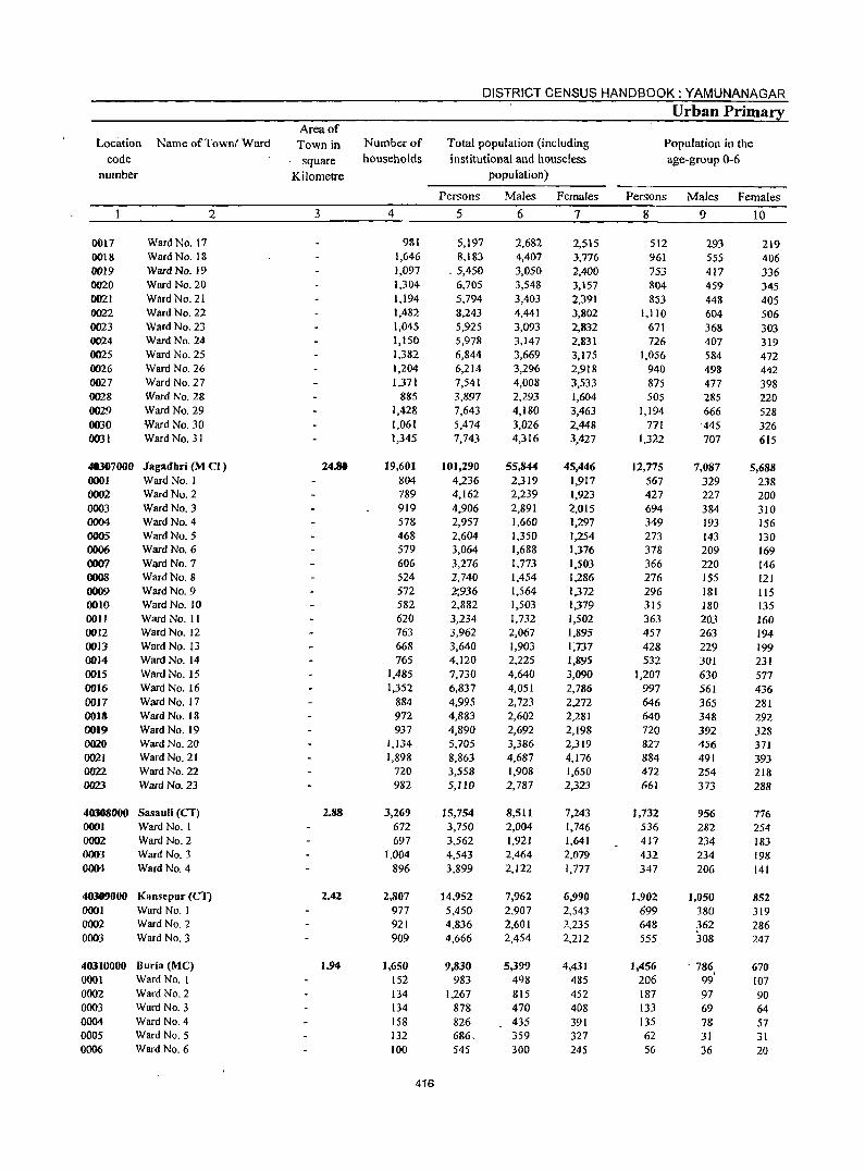
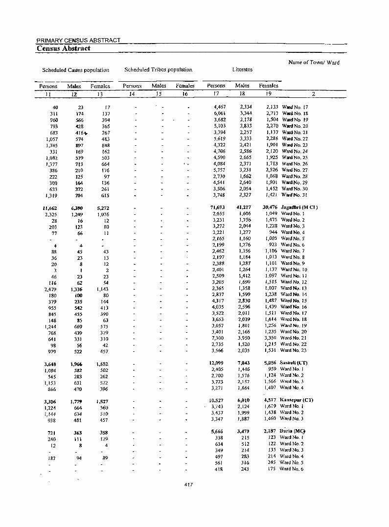
PRIMARY CENSUS ABSTRACT
Census Abstract
Name ofTownl Ward
Scheduled Castes population Scheduled Tribes population Literates
Persons Males Females Persons Males Females Persons Males Females
II 12 I3 14 15 16 17 18 19 2
40 23 17 4,467 2,334 2,133 Ward No. 17 311 174 137 6,061 3,344 2.717 WarclNo.18 960 566 394 3,682 2,178 1,504 WardNo 19 793 428 365 5,103 2,833 2,270 Ward No. 20 683 4r6~ 267 3,394 2,257 1,137 WanlNo.21
1,057 574 483 5,619 3,333 2,286 Ward No. 22 1,745 897 848 4,322 2,421 1,901 Ward No. 23
331 169 162 4,706 2,586 2,120 Ward No. 24 1,082 579 503 4,590 2,665 1,925 Ward No. 25 1,377 713 664 4,084 2,371 1,713 Ward No. 26
386 210 176 5,757 3,231 2,526 Ward No. 27 222 125 97 2,730 1,662 1,068 Ward No. 28 300 164 136 4,541 2,640 1,901 Ward No. 29 633 312 261 3,506 2,054 1,452 Ward No. 30
1,319 704 615 3,748 2,327 1,421 Ward No. 31
H,662 6,3?O 5,272 71,693 41,217 30,476 Jaglldllri (M CI)
2,325 1,249 1,076 2,655 1,606 1,049 Ward No. 1
28 16 12 3,231 1,756 1,475 Ward No. 2
203 123 80 3,272 2,044 1,228 Ward No. 3
77 66 11 2,221 1,277 944 Ward No. 4 2,165 1,160 1,005 Ward No. 5
4 4 2,199 1,276 923 Ward No. 6
88 45 43 2,462 1,356 1,106 Ward No. 7
36 23 13 2,197 1,184 1,013 Ward No. 8
20 8 12 2,388 1,287 1,101 Ward No. 9
3 I 2 2,401 1,264 1,137 Ward No. 10
46 23 23 2,509 1,412 1,097 WardNo. II
116 62 54 3,205 1,690 1,515 Ward No. 12
2,479 1,336 1.143 2,365 1,358 1,007 Ward No. 13
180 )()() 80 2,837 1,599 1,238 Ward No. 14
379 235 144 4,317 2,830 1.487 Ward No. 15
955 542 413 4,035 2,596 1,439 Ward No. 16
845 455 390 3,522 2,011 1,511 Ward No. 17
148 85 63 3,653 2,039 1,614 Ward No. 1&
1.244 669 575 3,057 1,801 1,256 Ward No. 19
768 439 329 3,401 2,166 1,235 Ward No. 20
641 331 310 7,300 3,950 3,350 Ward No. 21
98 56 42 2,735 1,520 1,215 Ward No. 22
979 522 457 3,566 2,035 1,531 Ward No. 23
3,648 1,966 1,682 12,099 7,043 5,056 Sasauli (CT)
1,084 582 502 2,405 1,446 959 Ward No. I
545 283 262 2,700 1,576 1,124 Ward No. 2
1,153 631 522 3,723 2,157 1,566 Ward No.3
866 470 396 3,271 1,864 1,407 Ward No. 4
3,306 1.779 1.527 10,527 6,010 4,517 Kansepur (CI)
1,224 664 560 3,743 2,124 1,619 Ward No. 1
1,144 634 510 3,437 1,999 1,438 Ward No. 2
938 481 457 3,347 1,887 1,460 Ward No. 3
721 363 358 5,666 3,479 2,187 Buria (Mq
240 III 129 338 215 123 Ward No. I
12 8 4 634 512 122 Ward No. 2 349 214 135 Ward No. 3
183 94 89 497 283 214 Ward No. 4 561 316 245 Ward No. 5 418 243 175 Ward NO.6
417
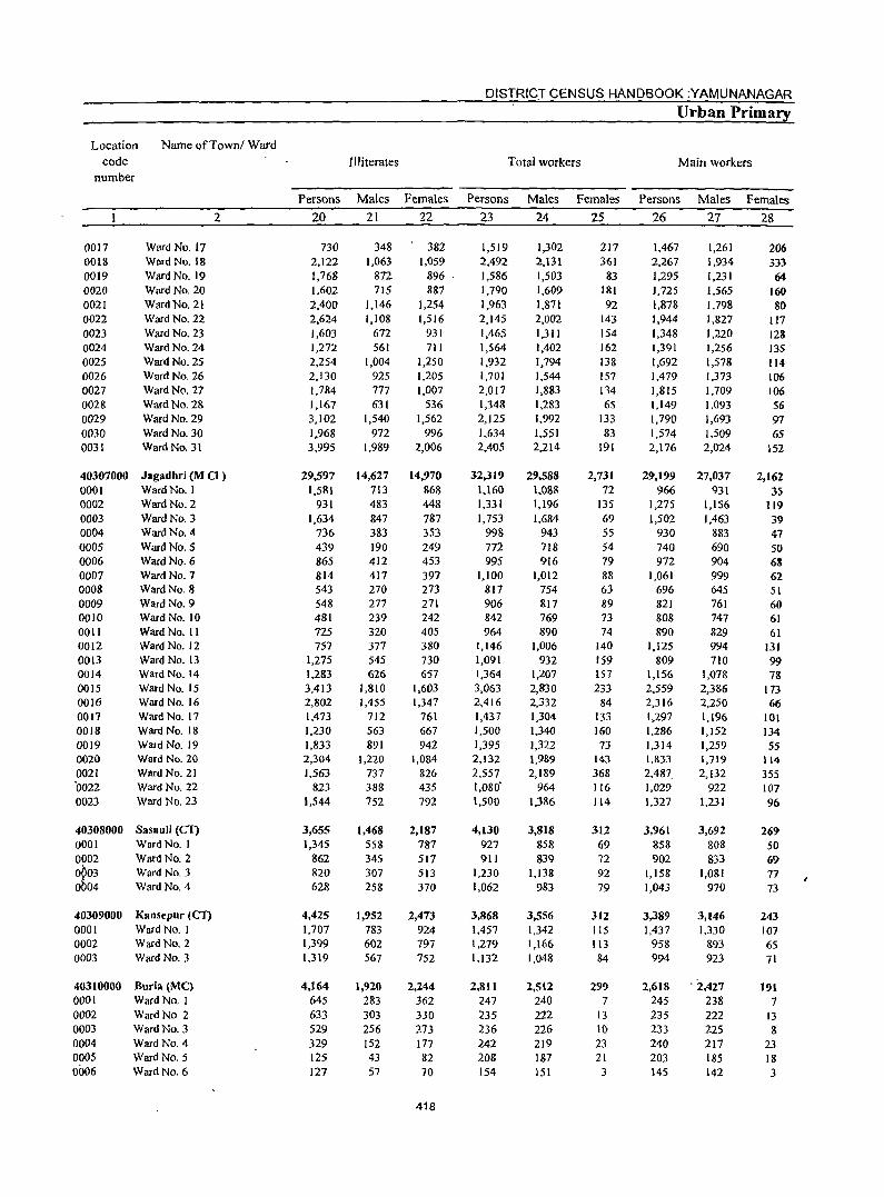
DISTRICT CENSUS HANDBOOK :YAMUNANAGAR
Urban Primary
Location Name ofTowni Ward
code Illiterates Total workers Main workers number
Persons Males Females Persons Males Females Persons Males Females
2 20 21 22 23 24 25 26 27 28
0017 Ward No. 17 730 348 382 1,519 1,302 217 1,467 1,261 206 0018 Ward No. 18 2,122 1,063 1,059 2,492 2,131 361 2,267 1,934 333 0019 Ward No. 19 1,768 872 896 1,586 1,503 83 1,295 1,231 64 0020 Ward No. 20 1,602 715 887 1,790 1,609 181 1,725 1,565 160 0021 Ward No. 21 2,400 1,146 1,254 1,963 1,871 92 1,878 1,798 8() 0022 Ward No. 22 2,624 1,108 1,516 2,145 2,002 143 1,944 1,827 117 0023 Ward No. 23 1,603 672 931 1,465 1,311 154 1,348 1,220 123 0024 Ward No. 24 1,272 561 711 1,564 1,402 162 1,391 1,256 135 0025 Ward No. 25 2,254 1,004 1,250 1,932 1,794 138 1,692 1,578 114 0026 Ward No. 26 2,130 925 1,205 1,701 1,544 157 1,479 1,373 106 0027 Ward No. 27 1,784 777 1,007 2,017 1,883 134 1,815 1,709 106 0028 Ward No. 2& 1,167 631 536 1,348 1,283 65 1,149 1,093 56 0029 Ward No. 29 3,102 1,540 1,562 2,125 1,992 133 1,790 1,693 97 0030 Ward No. 30 1,968 972 996 1,634 1,551 83 1,574 1,509 65 0031 Ward No. 31 3,995 1,9&9 2,006 2,405 2.214 191 2,176 2,024 152
40307000 Jagadhri (M CI ) 29,597 14,627 14,970 32,319 29,588 2,731 29,199 27,037 2,162 0001 Ward No. I 1,581 713 868 1,160 1.088 72 966 931 35 0002 Ward No. 2 931 483 448 1,331 1,196 135 1,275 1,156 119 0003 Ward No. 3 1,634 847 787 1,753 1.684 69 1,502 1,463 39 0004 Ward No. 4 736 383 353 998 943 55 930 883 47 0005 Ward No. 5 439 190 249 772 718 54 740 690 50 0006 Ward No. 6 865 412 453 995 916 79 972 904 68 0007 Ward No. 7 814 417 397 1,100 1,012 88 1,061 999 62 0008 Ward No. 8 543 270 273 817 754 63 696 645 51 0009 Ward No. 9 548 277 271 906 817 89 821 761 60 0010 Ward No. 10 481 239 242 842 769 73 808 747 61 0011 Ward No. II U5 320 405 964 890 74 890 829 61 0012 Ward No. 12 757 377 380 1,146 1,006 140 1,125 994 131 0013 Ward No. 13 1,275 545 730 1,091 932 159 809 710 99 0014 Ward No. 14 1,283 626 657 1,364 1,207 157 1,156 1,078 78 0015 Ward No. 15 3,413 1,810 1,603 3,063 2,830 233 2,559 2,386 173 0016 Ward No. 16 2,802 1,455 1,347 2,416 2,332 84 2,316 2,250 66 0017 Ward No. 17 1,473 712 761 1,437 1,304 133 1,297 1,196 101 0018 Ward No. 18 1,230 563 667 1,500 1,340 160 1,286 1,152 134 0019 Ward No. 19 1,833 891 942 1,395 1,322 73 1,314 1,259 55 0020 Ward No. 20 2,304 1,220 1,084 2,132 1,989 143 1,833 1,719 114 0021 Ward No. 21 1,563 737 826 2,557 2,189 368 2,487 2,132 355 0022 Ward No. 22 823 388 435 1,080' 964 116 1,029 922 107 0023 Ward No. 23 1,544 752 792 1,500 1,386 114 1,327 1,231 96
40308000 SasauJi (CF) 3,655 },468 2,187 4,130 3,818 312 3,961 3,692 269 0001 Ward No. I 1,345 558 787 927 858 69 858 808 50 0002 Ward No. 2 862 345 517 911 839 72 902 833 69
~03 Ward No. 3 820 307 513 1,230 1,138 92 1,158 1,081 77 04 Ward No. 4 628 258 370 1,062 983 79 1,043 970 73
40309000 Kansepur (CT) 4,425 1,952 2,473 3,868 3,556 312 3,389 3,146 243 0001 Ward No. I 1,707 783 924 1,457 1.342 115 1,437 1,330 107 0002 Ward No. 2 1,399 602 797 1,279 1,166 113 958 893 65 0003 Ward No. 3 1,319 567 752 1.132 1,048 84 994 923 71
40310000 Buria (Me} 4,164 1,920 2,244 2,811 2,512 299 2,618 . 2,427 191 0001 Ward No. I 645 283 362 247 240 7 245 238 7 0002 Ward No 2 633 303 330 235 222 13 235 222 13 0003 Ward No. 3 529 256 273 236 226 10 233 225 8 0004 Ward No. 4 329 152 177 242 219 23 240 217 23 0005 Ward No. 5 125 43 82 :W8 187 21 203 185 18 0006 Ward No. 6 127 57 70 154 151 3 145 142 3
418
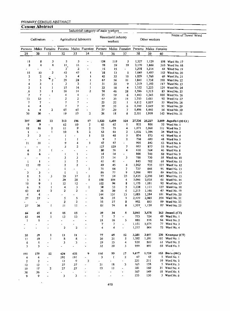
PRIMARY CENSUS ABSTRACT
Census Abstract Industrial category of main workers
Cultivators Agricultural labourers Household industry
workers Other workers
Name ofTownl Ward
Persons Males Females Persons Males Females Persons Males Females Persons Males Females
29
11 8
15 2 7 4 2 6 7
13 7 4
6 30
217 9
18 I 2
II
6 6
I 12
3 8 3
10 6
63 4
27
27
66 65
20 II 6 3
191 4 2
12 19 36
9
30
8 4
13 2 5 3
5 7
13 7 4 4
30
285 9
r6
2
II
5 6
12
3 5 3 9 5
61 4
27
26
65 64
19 10 6 3
179 4 2
12 17 36
9
31
3 4
2
... . 2 I
2
12
2
3
I 2
12
2
32
5 11 2
43 5
29 3
15 16 4 2 7 7
45 19
213 62 11 10
I
9 2
I 3 5 2
I 39 29 12 4 2
5 2
II
15 13
2
11 8 3
434 191
12 37 27
3
33
5 II 2
42 4
28 2
14 14 4 2
7 7
45 17
196 60
9 &
4 2
I 3 5 2
37 28 12 3 2
5 2
II
15 13
2
II 8 3
425 191
9 37 27
3
34
I 2
2
17 2 2 2
5
2
9
3
35
124 78 15 18 42 67 31 22 74 25 47 23 39 21 26
1,533 63 75 63 53 9
47 127 80 14 17 41 49 71 86 77
188 102 38 36
144 36 35 82
39 7
21 7 4
77 26 19 32
116 3
21 13
36
119 59 15 13 32 56 22 18 46 19 33 22 33
.20 18
1,409 62 71 61 48
7 47
120 76 14 14 41 45 64 77 54
184 94 33 30
131 35 27 74
34 7
16 7 4
65 21 15 29
99
18 13
419
37
5 19
5 10 II 9 4
28 6
14 I 6 7 8
124 I 4 2 5 2
7
4
3
4 7 9
23 4 8 5 6
13 1 8 8
5
5
12 5 4 3
17 2
3
38
1,327 2,170 1,278 1,649 1,829 1,841 1,310 1,352 1,596 1,443 1,753 1,112 1,740 1,496 2,101
27,236 832
1,171 1,42li
874 730 905 932 610 800 788 843
1,062 737
1,066 2,435 2,096 1,173 1.238 1,213 1,685 2,419
992
39
1,129 1,860 1,214 1,497 1,760 1,'738 1,193 1,223 1,513 1,343 1,661 1,057 1,649 1,440 1,959
25,227 800
1,060 1,394
833 682 842 817 564 740 130 782 935 646 997
2,290 2,035 1,081 1,111 1,166 1.584 2,065
893 1,207 1,120
3,841 3,578 773 724 880 816
1,151 1,074 1.037 964
3.281 1.392
930 959
3,051 1,291
869 891
1.877 1,724 47 42
221 211 163 158 181 160 167 149 133 130
40
198 Ward No. 17 310 Ward No. 18
64 Ward No. 19 152 Ward No. 20 69 Ward No. 21
103 Ward No. 22 117 Ward No. 23 129 Ward No. 24 83 Ward No. 25
100 Ward No. 26 92 WardNo 27 55 Ward No. 28 91 Ward No. 29 56 Ward No. 30
142 WardNO.31
2
2,009 Jagadhri (M CI ) 32 Ward No. I
III WardNo.2 34 WardNo.3 41 Ward NO.4 48 Ward No. 5 63 Ward No. 6 55 Ward No. 7 46 Ward No. 8 60 Ward No. 9 58 Ward No. 10 61 Ward No. II
127 Ward No. 12 91 Ward No. 13 69 Ward No. 14
145 Ward No. 15 61 Ward No. 16 92 Ward No. 17
127 Ward No. 18 47 Ward No. 19
101 Ward No. 20 354 Ward No. 21 99 Ward No. 22 87 Ward No. 23
263 Sasauli (eT) 49 Ward No. I 64 Ward No.2 77 Ward No.3 73 Ward No. 4
230 Kansepur (en 101 Ward No. I 61 Ward No.2 68 Ward No.3
153 Buria (Me) 5 Ward No. I
10 WardNO.2 5 Ward No. 3
21 Ward No.4 18 Ward No. 5 3 Ward No. 6
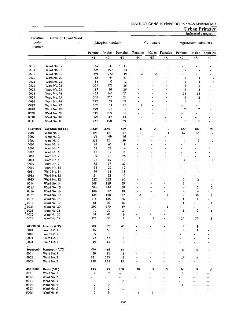
DISTRICT CENSUS HANDBOOK: YAMUNANAGAR
Urban Prim~ry Industrial cate!;lo!1
Location Name of Townl Ward code . Marginal workers Cultivators Agricultural labourers
number
Persons Males Females Persons Males Females Persons Males Females.
2 41 42 43 44 45 46 47 48 49
0017 Ward No. 17 52 41 II 0018 Ward No. 18 225 197 28 2 2 0019 Ward No. 19 291 272 19 2 2 0020 Ward No. 20 65 44 21 2 0021 Ward No. 21 85 73 12 2 I 0022 Ward No. 22 201 175 26 2 2 0023 Ward No. 23 117 91 26 5 5 0024 Ward No. 24 173 146 27 38 38 0025 Ward No. 25 240 216 24 3 2 0026 Ward No. 26 222 171 51 0027 Ward No. 27 202 174 28 0028 Ward No. 28 199 190 9 7 7 0029 Ward No. 29 335 299 36 0030 Ward No. 30 60 42 18 0031 Ward No. 31 229 190 39 9 9
40307000 Jagadhri (M CI) 3.120 2,551 569 6 3 3 127 107 20 0001 Ward No. I 194 157 37 62 55 7 0002 Ward No.2 56 40 16 0003 Ward No.3 251 221 30 4 2 2 0004 Ward No. 4 68 60 8 0005 Ward No.5 32 28 4 0006 Ward No. 6 23 12 11 0007 Ward NO.7 39 13 26 0008 Ward No.8 121 109 12 0009 Ward No.9 85 56 29 0010 Ward No. 10 34 22 12 0011 Ward No. II 74 61 13 0012 Ward No. 12 21 12 9 0013 Ward No. 13 282 222 60 3 2 0014 Ward No. 14 208 129 79 I 0015 Ward No. 15 504 444 60 4 2 2 0016 Ward No. 16 100 82 18 4 4 0017 Ward No. 17 140 108 32 2 17 16 0018 Ward No. 18 214 188 26 1
,.0019 Ward No. 19 81 63 18
k0020 Ward No. 20 299 270 29 \ 0021 Ward No. 21 70 57 13 3 2
0022 Ward No. 22 51 42 9 0023 Ward No. 23 173 155 18 2 2 25 22 3
40308000 Sasauli (Cl) 169 126 43 0001 Ward No. I 69 50 19 0002 Ward No. 2 9 6 3
.0003 Ward No. 3 72 57 15 ,,0004 Ward No. 4 19 13 6 , 40309000 I<ansepur (Cl") 479 410 69 5 5 0001 Ward No. I 20 12 8 0002 Ward No. 2 321 273 48 ,5 5 0003 Ward No.3 138 125 13
40310000 8uria (MC) 193 85 108 20 5 15 14 9" 5 0001 Ward No.1 2 2 I 0002 Ward No. 2 0003 Ward No.3 3 1 2 0004 Ward No. 4 2 2 0005 Ward No. 5 5 2 3 0006 Ward No. 6· 9 9
420
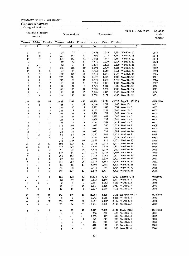
PRIMARY CENSUS ABSTRACT
Census Abstract of marginal workers
Household industryworkers
Persons
50
17 17 14 3 1
14 15 5 2 4 6 3 9 3 6
139 3 4 6 7
16 2 3 2 5 6
15 23
5 2 9
II 5 I 6 6
4
3
40 II 28
8
Males Females
51 52
14 8 7
~I
7 2 3
1 3 2 4
49 2
I 4
5 1
2
2 6 3
4 5 3
4 4
3
2
18 6
II
2
3 9 7 3
7 13 2 I 3 3 I 5 3 5
90 I 4 5 3
II I 2 2 3 6
13 17 2 2 5 6 2 1 2 2
22 5
17
6
Other workers
Persons
53
35 205 275
60 82
185 97
130 235 217 195 189 326
56 214
2,848 128 52
241 61 31 23 23
118 82 32 68 IS
278 192 477
91 119 204
69 293 66 45
140
164 68
8 72 16
434 9
288 137
151
3 I
5 8
Males Females
54 55
27 187 263
43 71
166 84
105 213 169 171 181 295
41 180
2,392 100 40
218 56 27 12 8
108 55 22 58 12
219 127 436
75 91
183 58
267 55 38
127
122 49
5 57 II
387 6
257 124
69
I
2 8
8 18 12 17 II 19 13 25 22 48 24 8
3}
15 34
456 28 12 23
5 4
11 15 10 27 10 10 3
59 65 41 16 28 21 II 26 II 7
13
42 19 3
IS 5
47 3
31 13
82
2
3
Name of Townl Ward Non-workers
Persons
56
3,678 5,691 3,864 4,915 3,831 6,09& 4,460 4,414 4,912 4,513 5,524 2,549 5,518 3,840 5,338
68,971 3,076 2,831 3,153 1,959 1,832 2,069 2,176 1,923 2,030 2,040 2,270 2,816 2,549 2,756 4,667 4,421 3,558 3,383 3,495 3,573 6,306 2,478 3,610
11,624 2,823 2,651 3,313 2,837
1l,084 3,993 3,557 3,534
7,019 736
1,032 642 584 478 391
421
Males Females
57 58 2
1,380 2,276 1,547 1,939 1,532 2,439 1,782 1,745 1,875 1,752 2,125 1,010 2,188 1,475 2,102
26,256 1,231 1,043 1,207
717 632 772 761 700 747 734 842
1,061 971
1,018 1,810 1,719 1,419 1,262 1,370 1,397 2,498
944 1,401
4,693 1,146 1,082 1,~6
1,139
4,406 1,565 1,435' 1,406
2,887 258 593 244 216 172 149
2,298 Ward No. 17 3,415 Ward No. 18 2,317 Ward No. 19 2,976 Ward No. 20 2,299 Ward No. 21 3,659 Ward No. 22 2,678 Ward No. 23 2,669 Ward No. 24 3,037 Ward No. 25 2,761 Ward No. 26 3,399 Ward No. 27 1,539 Ward No. 28 3,330 Ward No. 29 2,365 Ward No. 30 3,236 Ward NO.3)
42,715 Jagadhri (M CI ) 1,845 Ward No. I 1,7&8 Ward No.2 1,946 Ward No.3 1,242 Ward No 4 1,200 Ward No.5 1,297 W3Id No.6 1,415 Ward No. 7 1,223 Ward No.8 1,283 Ward No.9 1,306 Ward No. 10 1,428 Ward No. II 1,755 Ward No. 12 1,578 Ward No. 13 1,738 Ward No. 14 2,857 Ward No. 15 2,702 Ward No. 16 2,139 Ward No. 17 2,121 Ward No. 18 2,125 Ward No 19 2, i 76 Ward No. 20 3,808 Ward No. 21 1,534 Ward No. 22 2,209 Ward No. 23
6,931 Sasauli (eT) 1,677 Ward No I 1,569 Ward No.2 1,987 Ward No.3 1,698 Ward No.4
6,678 Kansepur (CI') 2,428 Ward No. I 2,122 Ward No.2 2,128 Ward NO.3
4,132 Buria (MC) 478 WardNo I 439 Ward No.2 398 Ward NO.3 368 Ward NO.4 306 Ward NO.5 242 Ward NO.6
Location code
number
0017 0018 0019 0020 0021 0022 0023 0024 0025 0026 0027 0028 0029 0030 0031
40307000 0001 0002 0003 0004 0005 0006 0007 0008 0009 0010 0011 0012 0013 0014 0015 0016 0017 0018 0019 0020 0021 0022 0023
40308000 0001 0002 0003 0004
40309000 0001 0002 0003
40310000 0001 0002 0003 0004 0005 0006
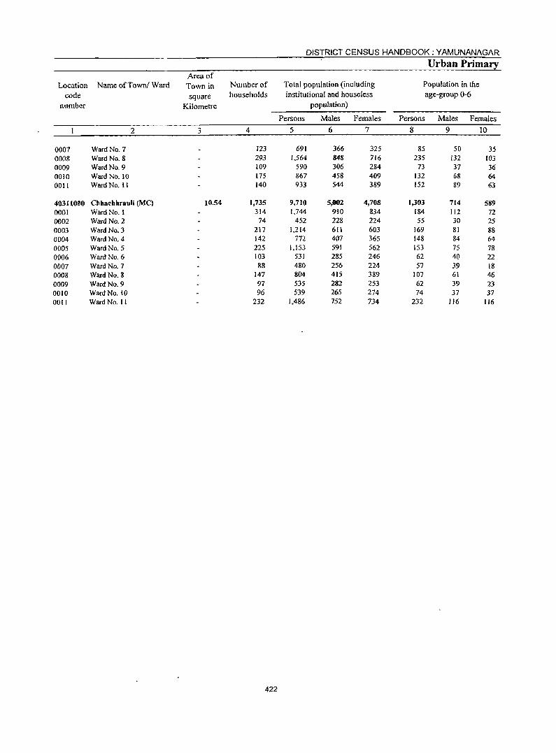
DISTRICT CENSUS HANDBOOK: YAMUNANAGAR
Urban Primary Area of
Location Name ofTowni Ward Town in Number of Total population (including Population in the
code square households institutional and houseless age-group 0-6
number Kilometre population)
Persons Males Females Persons Males Females
2 3 4 5 6 7 8 9 10
0007 Ward No. 7 l23 691 366 325 85 50 35 OOOS Ward No. 8 293 1.564 848 716 235 132 10] 0009 Ward No. 9 109 590 306 284 73 37 36 0010 Ward No. 10 175 867 458 409 132 68 64 0011 Ward No. II 140 933 S44 389 152 89 63
40311000 Chhachhrauli (Me) 10.54 1,735 9,710 5,002 4,708 1,303 714 589 0001 Ward No. I 314 1.744 910 834 184 112 72 0002 Ward No.2 74 452 228 224 55 30 25 0003 Ward No.3 217 1,214 611 603 169 81 88 0004 Ward No. 4 142 772 407 365 148 84 64 0005 Ward No. 5 225 1,153 591 562 153 75 78 0006 Ward No. 6 103 531 285 246 62 40 22 0007 Ward No. 7 88 480 256 224 57 39 18 0008 Ward No. 8 147 804 415 389 107 61 46 0009 Ward No. 9 97 535 282 253 62 39 23 0010 Ward No. 10 96 539 265 274 74 37 37 DOli Ward No. II 232 1,486 752 734 232 116 116
422
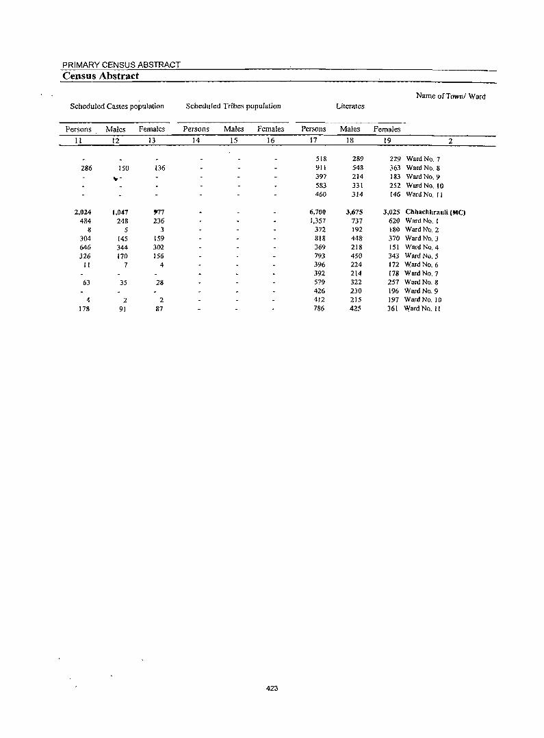
PRIMARY CENSUS ABSTRACT
Census Abstract
Name ofTownl Ward Scheduled Castes population Scheduled Tribes population Literates
Persons Males Females Persons Males Females Persons Males Females
11 12 13 14 15 16 17 18 19 2
518 289 229 Ward NO.7 286 150 136 911 548 363 Ward No.8
._,- 397 214 183 Ward No. 9 583 331 252 Ward No. 10 460 314 146 Ward No. II
2,024 1,047 ')77 6,700 3,675 3,025 Chhachhrauli (MC) 484 248 236 1,357 737 620 Ward No. I
8 5 3 372 192 180 Ward No. 2 304 145 159 818 448 370 Ward No. 3 646 344 302 369 218 151 Ward No. 4 326 170 156 793 450 343 Ward No. 5
11 7 4 396 224 172 Ward No. 6 392 214 178 Ward No. 7
63 35 28 579 322 257 Ward No. 8 426 230 196 Ward No. 9
4 2 2 412 215 197 Ward No. 10 178 91 87 786 425 361 \Yard No. II
423

DISTRICT CENSUS HANDBOOK :YAMUNANAGAR
Urban Primary
Location Name ofTownl Ward code IIlitemtes Total workers Main workers
number
Persons Males Females Persons Males Females Persons Males Females
2 20 21 22 23 24 25 26 27 28
0007 Ward No. 7 173 77 96 207 185 22 202 181 21 0008 Ward No. 8 653 300 353 493 436 57 490 435 S5 0009 Ward No. 9 193 92 101· 189 169 20 14S 136 9 0010 Ward No. 10 284 127 157 338 253 85 254 226 28 0011 Ward No. II 473 230 243 262 224 38 226 220 6
40311000 Chhachhrauli (Me) 3,010 1,327 1,683 2,669 2,310 359 2,355 2.088 267 0001 Ward No. I 387 173 214 453 415 38 436 402 34 0002 Ward No. 2 80 36 44 140 122 18 138 120 18 0003 Ward No.3 396 163 233 344 299 45 334 293 41 0004 Ward No.4 403 189 214 215 193 22 153 135 18 0005 Ward NO.5 360 141 219 377 294 83 309 273 36 0006 Ward NO.6 135 61 74 149 135 14 140 126 14 0007 Ward No. 7 88 42 46 133 119 14 118 108 10 0008 Ward No. 8 225 93 132 191 166 25 166 144 22 0009 Ward No.9 109 52 57 151 135 16 106 100 6 0010 Ward No. 10 127 SO 77 139 122 17 114 102 12 0011 Ward No. 11 700 327 373 377 310 67 341 285 56
424
PRIMARY CENSUS ABSTRACT
Census Abstract Industrial category of main workers
Household industry Name ofTownl Ward
Cultivators Agricultural labourers workers
Other workers
Persons Males Females Persons Males Females Persons Males Females Persons Males Females
29 30 31 32 33 34 35 36 37 38 39 40 2
2 2 2 17 15 2 181 163 18 Ward No. 7 20 20 61 57 4 28 18 10 381 340 41 Ward No. 8 4 4 5 5 12 12 124 115 9 Ward No. 9
63 54.r 9 22 21 7 7 162 144 18 Ward No. 10 20 19 74 74 15 15 117 112 5 Ward No. II
'n 93 4 60 57 3 116 96 20 2,082 1,842 240 Chhachhrauli (MC)
2 2 6 6 28 24 4 400 370 30 Ward No. I
3 3 135 117 18 Ward No.2 12 12 II 11 310 269 41 Ward No.3
I I 152 134 18 Ward No.4 21 19 2 6 5 15 10 5 267 239 28 Ward No.5
5 5 5 5 130 116 14 Ward No. 6 117 108 9 Ward No. 7
2 2 5 5 159 137 22 Ward No.8 2 2 104 98 6 Ward No. 9
2 2 6 6 106 94 12 Ward No. 10 48 46 2 35 34 56 45 11 202 160 42 Ward No. 11
425
DISTRICT CENSUS HANDBOOK: YAMUNANAGAR
Urban Primary Industrial cate~orl
Location Name of Townl Ward code Marginal workers Cultivators Agricultural labourers
. number
Persons Males Females Persons . Males Females Persons Males Females
2 41 42 43 44 45 46 47 48 49
0007 Ward No.7 5 4 0008 Ward No.8 3 1 2 0009 Ward No.9 44 33 II 4 4 0010 Ward No. 10 84 27 57 19 4 15 7 2 5 0011 Ward No. II 36 4 32 I
40311000 Chhachhrauli (MC) 314 222 92 5 2 3 37 23 14 0001 Ward No. I 17 13 4
0002 Ward No. 2 2 2 0003 Ward No. 3 10 6 4 1 0004 Ward No. 4 62 58 4 2 0005 Ward No. 5 68 21 47 II II 0006 Ward No. 6 9 9 I 0007 Ward No. 7 15 11 4 0008 Ward No. 8 25 22 3 7 7 0009 Ward No. 9 45 35 10 4 4 0010 Ward No. 10 25 20 5 0011 Ward No. 11 36 25 11 5 2 3 11 9 2
426
PRIMARY CENSUS ABSTRACT
Census Abstract of mar~inal workers
Household industry' Name of Town! Ward Location
Other workers Non-workers code workers
number
Persons Males Females Persons Males Females Persons Males Females
50 51 52 53 54 55 56 57 58 2
5 4 484 181 303 Ward No.7 0007 2 1 1,071 412 659 Ward No. 8 0008
39 28 II 401 137 264 Ward No.9 0009 I 57 20 37 529 205 324 Ward No. 10 0010 5 5 30 3 27 671 320 351 Ward No. II OOll
17 3 14 255 194 61 7,041 2,692 4,349 Chhacbhrauli (MC) 40311000 1 16 12 4 1,291 495 796 Ward No. 1 0001
2 2 312 106 206 Ward No. 2 0002 9 5 4 870 312 558 Ward No. 3 0003
60 57 3 557 214 343 Ward No.4 0004 11 10 46 20 26 776 297 479 Ward No. 5 0005
8 8 382 150 232 Ward No. 6 0006 15 11 4 347 137 210 Ward No. 7 0007 17 14 3 6[3 249 364 Ward No. 8 0008 4[ 31 10 384 147 237 Ward No. 9 0009 25 20 5 400 143 257 Ward No. 10 0010
4 4 16 14 2 1,109 442 667 Ward No. 11 DOlI
427

ANNEXURES
Annexures

430
ANNEXURES
Annexure I Number of villages under each Gram Panchayat
This annexure is not given.
Annexure II
Fertility and Mortality, 1991 Census
Fertility is a major component of population growth. It is a measure of the rate at which population is added to itself by births and assessed by relating the number of births in some section of the population and number of married couples or number of women in child bearing age.
Q.No.23 of the Household Schedule canvassed at the Census 2001 pertained to fertility particulars of the ever married women. It had 3 sub parts; part (i) and (ii) related to ever married women and part (iii) pertained to only currently married women. The ever married refers to the women ever married even though their present status may be married or widowed or divorced or separated, while the currently married women refer to those who are presently in the married state irrespective of their age. The sub part (i) aimed to obtain the number of surviving children borne to the women, while total number of children born to the women was ascertained through part (ii) of this question. This helps in understanding the total fertility rate of the ever married women. Part (iii) refers to the number of children born to the currently married women during the last one year and reflects current fertility rate. There were two
431
additional features added to this question canvassed, viz; (i) the number of children born during the last one year were recorded by sex; and (i i) as a part of gender sensitization, and also to avoid any ommission of the girl child, the column relating to the daughter preceded that of the son to further reduce, if any, the omission of the girl child.
Undisputedly, fertility is an important and vital component of population growth and thus, the study of fertility levels and trends in fertility has remained to be of great interest to the user agencies. As the finalisation and release of data on fertility levels based on Census 2001 is likeJy to take time it is considered desirable t~ briefly describe here the fertility levels and trends based on previous census.
Total Fertility Rate (TFR) :
Total Fertility Rate in Hruyana (4.3) is higher than that of the country (3.6) as such. Among the major States Uttar Pradesh (5.1), Madhya Pradesh and Rajasthan (4.6 each), and Bihar (4.4) reveal TFR higher than that of Haryana. However, the redeeming feature is that TFR in Haryana State has shown significant decline over the period.
DISTRICT CENSUS HANDBOOK: YAMUNANAGAR
TABLE II (a) AGE SPECIFIC FERTILITY RATES, 1981 AND 1991
Age Group
]5-19
20-24 25-29
30-34
35-39
40-44
45-49
Total
1991
2 15.7
164.1
163.7
91.3 47.4
17.0
15.7
Yamunanagar District
Rural
1991
3 17.6
174.1
170.7
100.3
47.0
19.4
19.0
Urban
1991 1981
4 5 10.9 59.6
144.0 246.0 151.7 251.0 75.9 173.0 48.0 104.1 12.9 50.0 10.0 22.0
Haryana State
Total Rural Urban
1991 198] ]99] 1981 1991
6 7 8 9 10 41.6 65.6 48.4 39.6 21.5
184.7 265.7 198.9 192.0 143.7 155.4 266.7 165.1 207.6 127.8 91.1 189.8 100.1 121.0 67.9 52.6 117.7 585 62.1 37.7 29.6 58.6 34.0 22.3 17.5 19.7 25.7 21.5 9.6 14.3
TABLEU(b) AGE SPECIFIC MARITAL Fm.TILITYRATES, 1981 AND 1991
Age Group
]5-19
20-24
25-29
30-34
35-39
40-44 45-49
Yamunanagar District --------------~---------------
Total Rural Urban
1991 199] 1991
2 3 4
112.1 1]2.6 110.2
209.1 207.7 212.5
]69.6 174.8 160.3
92.4 102.4 77.9
48.6 48.2 49.2
18.0 20.2 13.9
16.7 20.1 10.8
In comparison to the rural, the fertility levels are lower in urban areas in the State fdr age groups 15-19,20-24,25-29,30-34,35-39,40-44 and 45-49 in 1981. The same is true for the marital fertility rates except for age group 15-19 where it is observed that the fertility levels are comparatively lower in urban areas as compared to urban areas in 1981. Age Specific Marital Fertility Rates (ASMFR) in the State have gone down for all age groups in 1991 when compared with 1981. The same is true for rural and urban areas of the State, except in age group 45-49 in urban areas where it has gone
Haryana State
Total Rural Urban
1981 199] 1981 1991 1981 1991
5 6 7 8 9 10 ]25.7 120.1 121.1 120.8 153.2 115.3 276.7 209.4 281.0 215.1 256.6 189.] 257.5 158.9 270.0 168.8 217.7 132.6 ]77.5 93.1 194.2 102.3 124.1 69.6 108.8 54.3 121.2 60.4 65.5 38.9 54.1 31.3 62.2 36.0 24.1 18.4 24.1 21.3 28.6 23.1 10.2 15.7
up from 10.2 of 1981 to 15.7 in 1991.
Yamunanagar district has lower ASMFR than the
State except age-group 25-29 in ] 991. But ASMFR
for age group 15-19 in the district was 112.1 as against
120.1 in the State and the corresponding figures for
different age groups were, 209.1 and 209.4 (20-24),
169.6 and 158.9 (25-29), 92.4 and 93.1 (30-34),48.6
and 54.3 (35-39), 18.0 and 31.3 (40-44) and 16.7 and
21.3 (45-49).
Other fertility measures can be seen in the following table:
TABLEII(c) FERTILITY RATES
State/District Year CBR TFR TMFR GFR GMFR
2 3 4 5 6 7 Haryana 1981 37.5 5.4 6.1 170 204
1991 31.7 4.3 5.3 14~ 172 Yamunanagar 1981 36.1 5.0 6.3 156 209
1991 32.5 4.3 6.0 141 187
Source: Occasional Paper No.1 of 1997, RGI '\
432
ANNEXURES
Crude Birth Rate, Total Fertility Rate, Total Marital Fertility rate, General Fertility Rate and General Marital Fertility Rate are presented separately for Haryana State and Yamunanagar district for 1981 and 1991. When we compare these values we find decrease in 1991 for all the above-mentiqned rates
in Yamunanagar district and similar trend is observed
for the State also. While comparing the district level data with the State level data, it is observed that CBR, TMFR and GMFR are higher at the district level during 1991 Census as compared with State figures while GFR is lower.
TABLEII(d) SELECTED INDICATORS ON FFMALENUPTIALITY, 1991
StateID istrict TIRJU
2
Haryana State T
R
U Yamunanagar District T
R
U
Mean age at marriage of currently married women
Total Who married during 1981-86 1986-91
3 4 5 17.9 18.2 18.6
17.6 17.8 18.2
18.8 19.3 20.0
18.9 19.4 20.0
18.7 19.1 19.6
19.4 20.0 20.8
Soorce : District Profile, 1991, RGI
Percent of currently married women with age at marriage below 18
Total Who married during 1981-86 1986-91
6 7 8 52.6 49.3 43.0 56.9 55.5 49.2 39.3 31.9 23.2 35.4 29.6 20.8 37.7 34.0 24.3 30.7 21.8 13.2
Different fertility measures indicate that fertility same trend is observed when district figures are levels are higher in the district in 1991 as compared to compared with corresponding State figures. Mean age 1981. Similar trend is observed at the State level also. at marriage of the currently married women has Comparatively higher fertility rates at the district level increased from 19.4 in 1981-86 period to 20.0 during than the State level are duly supported by the higher 1986-91 period in Yamunanagar district whereas in age at marriage of females in the district compared to Haryana State corresponding figures have also moved the State as is evident in the table given above. from 18.2 to 18.6. Presently, the statutory minimum
Table lIed) presents the mean age at marriage of marriage age for females is 18 years. It is worthwhile currently married women or in other words age at to note in the light of above that proportion of currently marriage of all those women who are living with their married females whose age at marriage was below 18 husbands. Some of them might be recently married years during 1981-86 and 1986-91 is continous ly and some of them decades ago meaning the situation decreasing. It is observed from the table lI( d) that this is for the population as a whole. proportion has gone down from 29.6 percent during
Table reveals that mean age at marriage of 1981-86 to 20.8 percent during 1986-91 in the district. currently married women in the district is 18.9 in 199 J, Corresponding figures for the State were 49.3 and 43.0 which is higher than the corresponding figure of 17.9 which are quite higher than the district figures. Same at the State level. In rural and urban areas also,' the trend is observed for rural and urban areas also.
TABLE II (e) IMPORTANT INDICES OFFFRTILITY, 1991
Fertility lndices Yamunana~ District Haryana State
Total Rural Urban Total Rural Urban
2 3 4 5 6 7 Number of Children ever born per ever married woman in the age group 45-49 4.4 4.7 4.0 4.9 5.1 4.2
Couples per thousand population 159 158 161 169 168 173
Child-woman ratio (0-4 years) 529 557 476 588 624 492
433
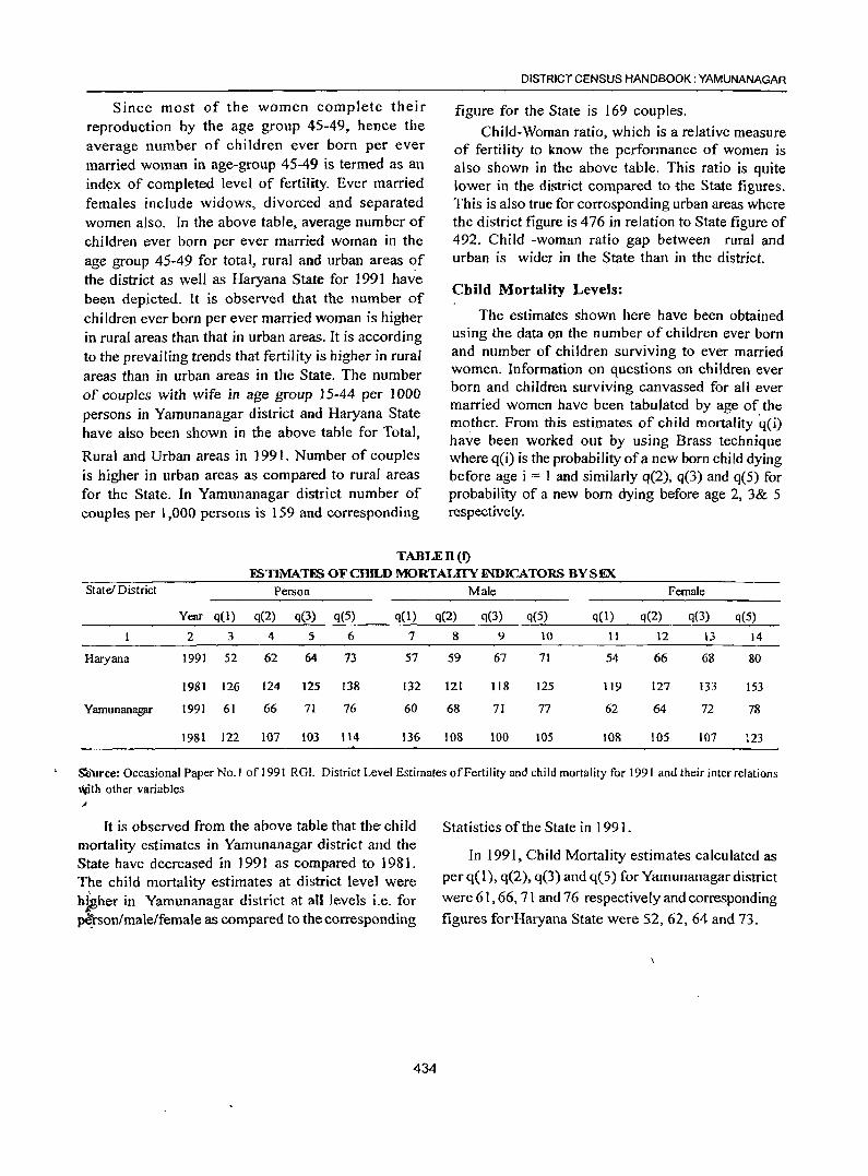
Since most of the women complete their reproduction by the age group 45-49, hence the average number of children ever born per ever married woman in age-group 45-49 is termed as an ind~x of completed level of fertility. Ever married females include widows, divorced and separated women also. In the above table, average number of children ever born per ever married woman in the age group 45-49 for total, rural and urban areas of the district as well as Haryana State for 1991 have been depicted. It is observed that the number of children ever born per ever married woman is higher in rural areas than that in urban areas. It is according to the prevailing trends that fertility is higher in rural areas than in urban areas in the State. The number of couples with wife in age group 15-44 per 1000 persons in Yamunanagar district and Haryana State have also been shown in the above table for Total,
Rural and Urban areas in 1991. Number of couples is higher in urban areas as compared to rural areas for the State. In Yamunanagar district number of couples per 1,000 persons is 159 and corresponding
DISTRICT CENSUS HANDBOOK: YAMUNA NAGAR
figure for the State is 169 couples.
Child-Woman ratio, which is a relative measure of fertility to know the performance of women is also shown in the above table. This ratio is quite lower in the district compared to the State figures. This is also true for corrosponding urban areas where the district figure is 476 in relation to State figure of 492. Child -woman ratio gap between rural and urban is wider in the State than in the district.
Child Mortality Levels:
The estimates shown here have been obtained using the data on the number of children ever horn and number of children surviving to ever married women. Information on questions on children ever born and children surviving canvassed for all ever married women have been tabulated by age of the mother. From this estimates of child mortality q(i) have been worked out by using Brass technique where q(i) is the probability of a new born child dying before age i === 1 and similarly q(2), q(3) and q(5) for probability of a new born dying before age 2, 3& 5 respective ly.
TABLEll(t) ESTIMATtS OF CHILD MORTALITY INDICATORS BY SEX
State! District Person Male Female
Year q(l) q(2) q(3) q(5) q(l) q(2) q(3) q(5) q(l) q(2) q(3) q(5)
2 3 4 5 6 7 8 9 10 11 12 13 14
Haryana 1991 52 62 64 73 57 59 67 71 54 66 68 80
1981 126 124 125 138 132 121 118 125 119 127 133 153
Yamunanagar 1991 61 66 71 76 60 68 71 77 62 64 72 78
1981 122 107 103 114 136 108 100 105 108 105 107 123
S'ci'Urce: Occasional Paper No.1 of 1991 RGI. District Level Estimates of Fertility and child mortality for 1991 and their inter relations Vlith other variables ,I'
It is observed from the above table that the-child mortality estimates in Yamunanagar district and the State have decreased in 1991 as compared to 1981. The child mortality estimates at district level were hfgher in Yamunanagar district at all levels i.e. for ~rson/male/female as compared to the corresponding
434
Statistics of the State in 1991.
In 1991, Child Mortality estimates calculated as per q( 1), q(2), q(3) and q(5) for Yamunanagar district
were 61,66, 71 and 76 respectively and corresponding
figures for'Haryana State were 52, 62, 64 and 73.
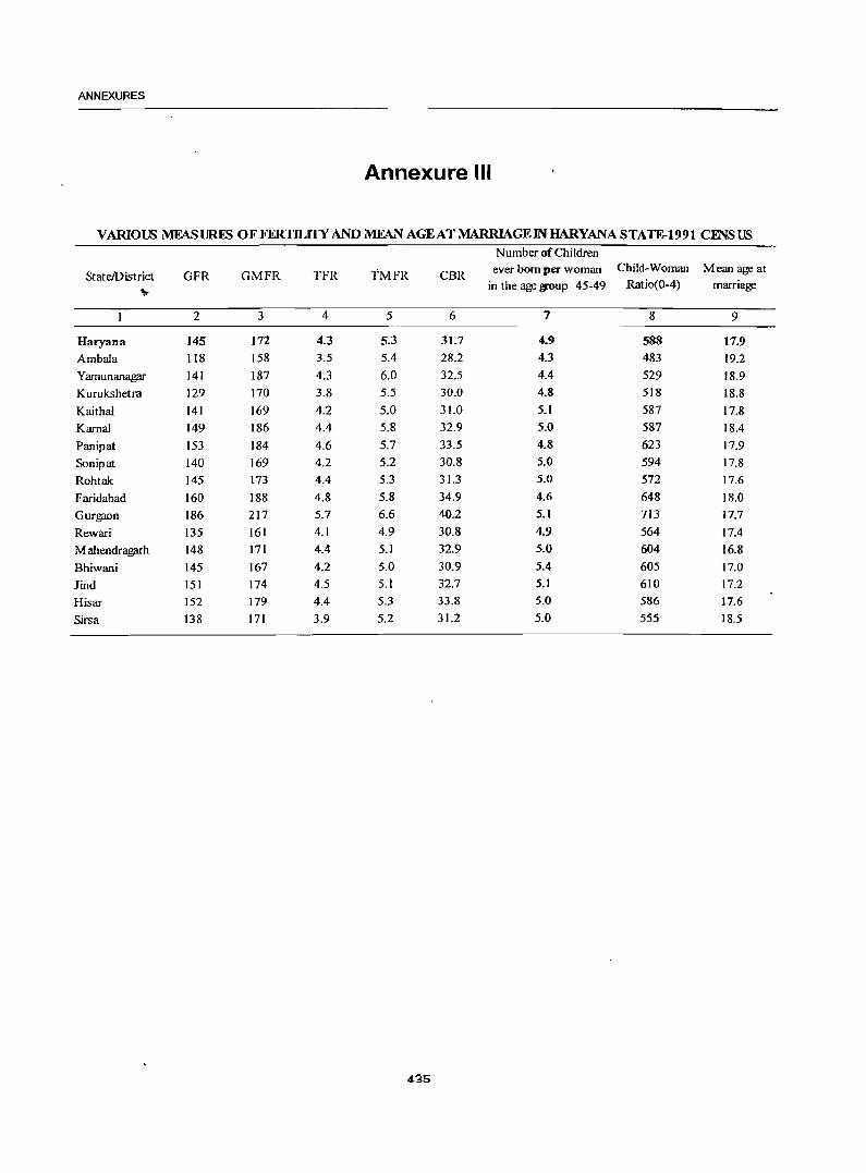
ANNEXURES
Annexure III
VARIOUS MFASURES OF FERTILITY ANDMFAN AGEATMARRIAGEINHARYANASTATE-1991 CENSUS N umber of Children
StateIDistrict GFR GMFR TFR TMFR CBR ever bom per woman Child-Woman Mean age at
" in the age woup 45-49 Ratio{O-4) marriage
2 3 4 5 6 7 8 9
Haryana 145 172 4.3 5.3 31.7 4.9 588 17.9 Ambala 118 158 3.5 5.4 28.2 43 483 19.2
Yamunanagar 141 187 4.3 6.0 32.5 4.4 529 18.9
Kurukshetra 129 170 3.8 5.5 30.0 4.8 518 18.8
Kaitha1 141 169 4.2 5.0 31.0 5.1 587 17.8
KarnaJ 149 186 4.4 5.8 32.9 5.0 587 18.4
Panipat 153 184 4.6 5.7 33.5 4.8 623 17.9
Sonipat 140 169 4.2 5.2 30.8 5.0 594 17.8
Rohtak 145 173 4.4 5.3 31.3 5.0 572 17.6
Faridabad 160 188 4.8 5.8 34.9 4.6 648 18.0
Gurgaon 186 217 5.7 6.6 40.2 5.1 713 17.7
Rewari 135 161 4.1 4.9 30.8 4.9 564 17.4
Mahendragarh 148 171 4.4 5.1 32.9 5.0 604 16.8
Bhiwani 145 167 4.2 5.0 30.9 5.4 605 17.0
lind 151 174 4.5 5.1 32.7 5.1 610 17.2
Hisar 152 179 4.4 5.3 33.8 5.0 586 17.6
Sirsa 138 171 3.9 5.2 31.2 5.0 555 18.5
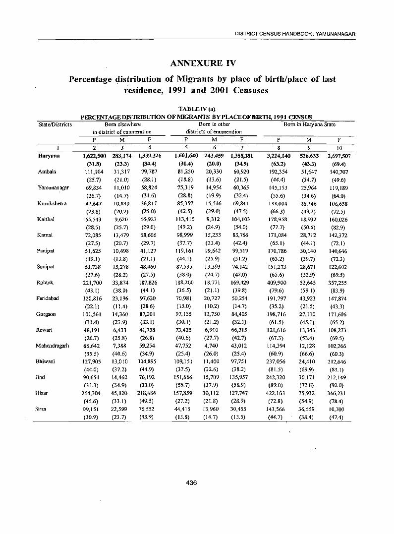
DISTRICT CENSUS HANDBOOK: YAMUNANAGAR
ANNEXURE IV
Percentage ~istrjbution of Migrants by place of birth/place of last residence, 1991 and 2001 Censuses
TABLE IV (a)
PERCENTAGEDIS1RIBUfION OF MIGRANTS BYPLACEOFBIR1lI, 1991 CFNSUS StateiDistricts Born elsewhere Born in other Born in Haryana State
in district of enumeration districts of enumeration p M F P M F P M F 2 3 4 5 6 7 8 9 10
Haryana 1,622,500 283,174 1,339,326 1,601,640 243,459 1,358,181 3,224,140 526,633 2,697,507
(31.8) (23.3) (34.4) (31.4) (20.0) (34.9) (63.2) (43.3) (69.4) Ambala 111,104 31,317 79,787 81,250 20,330 60,920 192,354 51,647 140,707
(25.7) (21.0) (28.1) (18.8) (13.6) (21.5) (44.4) (34.7) (49.6) Yamunanagpr 69,834 11,010 58,824 75,319 14,954 60,365 145,153 25,964 119,189
(26.7) (14.7) (31.6) (28.8) (19.9) (32.4) (55.6) (34.6) (64.0) Kurukshetra 47,647 10,830 36,817 85,357 15,516 69,841 133,004 26,346 106,658
(23.8) (20.2) (25.0) (42.5) (29.0) (47.5) (66.3) (49.2) (72.5) Kaithal 65,543 9,620 55,923 113,415 9,312 104,103 178,958 18,932 160,026
(28.5) (25.1) (29.0) (49.2) (24.9) (54.0) (17.1) (50.6) (82.9) Kamal 72,085 13,479 58,606 98,999 15,233 83,166 111,084 28,112 142,372
(27.5) (20.7) (29.7) (37.7) (23.4) (42.4) (65.1) (44.1) (72.1) Panipat 51,625 10,498 41,127 119,161 19,642 99,519 170,786 30,140 140,646
(19.1) (13.8) (21.1 ) (44.1) (25.9) (51.2) (63.2) (39.7) (72.3)
Sonipat 63,738 15,218 48,460 87,535 13,393 74,142 151,213 28,671 122,602
(27.6) (28.2) (27.5) (38.0) (24.7) (42.0) (65.6) (52.9) (69.5) Rohtak 221,100 33,874 187,826 188,200 18,771 169,429 409,900 52,645 357,255
(43.1) (38.0) (44.1) (36.5) (21.1) (39.8) (79.6) (59.1) (83.9) Faridabad 120,816 23,196 97,620 70,981 20,727 50,254 191,797 43.923 147,874
(22.1) (11.4) (28.6) (13.0) (10.2) (14.7) (35.2) (21.5) (43.3) Gurgflon 101,561 14,360 87,201 97,155 12,750 84,405 198,716 27,110 171,606
(31.4) (23.9) (33.1) (30. ]) (21.2) (32.1) (61.5) (45.1) (65.2) Rewari 48,191 6,433 41,758 73,425 6,910 66,515 121,616 13,343 108,273
(26.7) (25.8) (26.8) (40.6) (27.7) (42.7) (67.3) (53.4) (69.5) Mahendragprh 66,642 7,388 59,254 47,752 4,740 43,012 114,394 12,128 102,266
(35.5) (40.6) (34.9) (25.4) (26.0) (25.4) (60.9) (66.6) (60.3) Bhiwani 127,905 13,010 114,895 109,151 1],400 97,751 237,056 24,410 212,646
(44.0) (37.2) (44.9) (37.5) (32.6) (38.2) (81.5) (69.9) (83.1) lind 90,654 14,462 76,192 151,666 15,709 135,957 242,320 30,171 212,149
(33.3) (34.9) (33.0) (55.7) (37.9) (58.9) (89.0) (72.8) (92.0)
Hisar 264,304 45,820 218,484 157,859 30,1I2 127,747 422,163 75,932 346,231
(45.6) (33.1) (49.5) (27.2) (21.8) (28.9) (72.8) (54.9) (78.4) Sirs a 99,151 22,599 76,552 44,415 13,960 30,455 143,566 36,559 10,700
(30.9) (23.7) (33.9) (13.8) (14.7) (13.5) (44.7) (38.4) (47.4)
436
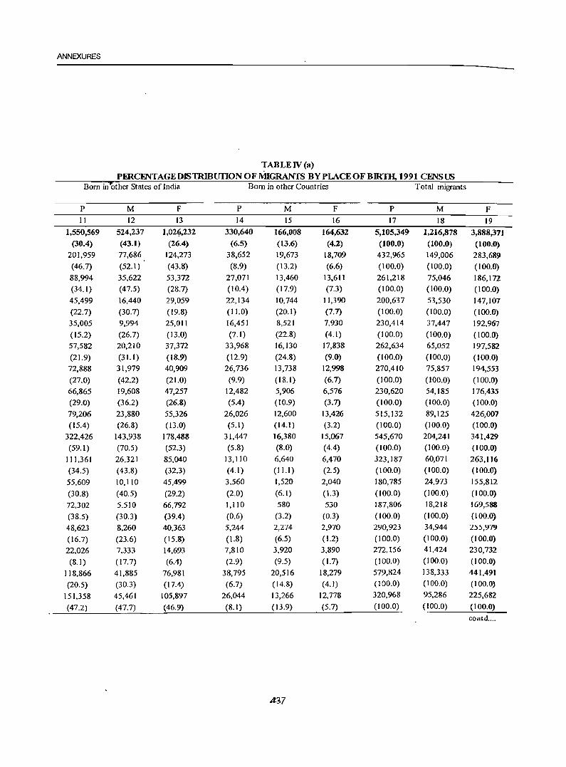
ANNEXURES
TABLE IV (a) PERCmTAGEDlSTRIBUnONOFMIGRANTS BYPLACEOFBIRlH, 1991 cmsus
Born in other States of India Born in other Countries Total migrants
p M F P M F P M F 11 12 13 14 15 16 17 18 19
1,550,569 524,237 1,02~,232 330,640 166,008 164,632 5,105,349 1,216,878 3,888,371 (30.4) (43.1) (26.4) (6.5) (13.6) (4.2) (100.0) (100.0) (100.0)
201,959 77,686 124,273 38,652 19,673 18,709 432,965 149,006 283,689 (46.7) (52.1) (43.8) (8.9) (13.2) (6.6) (100.0) (100.0) (100.0)
88,994 35,622 53,372 27,071 13,460 13,611 261,218 75,046 186,172 (34.1) (47.5) (28.7) (1004) (17.9) (7.3) (100.0) (100.0) (100.0)
45,499 16,440 29,059 22,134 10,744 11,390 200,637 53,530 147,107
(22.7) (30.7) (19.8) (11.0) (20.1) (7.7) (100.0) (100.0) (100.0) 35,005 9,994 25,011 16,451 8,521 7,930 230,414 37,447 192,967
(15.2) (26.7) (13.0) (7.1) (22.8) (4.1) (100.0) (100.0) (100.0)
57,582 20,210 37,372 33,968 16,130 17,838 262,634 65,052 197,582
(21.9) (3L!) (18.9) (12.9) (24.8) (9.0) (100.0) (100.0) (100.0)
72,888 31,979 40,909 26,736 13,738 12,998 270,410 75,857 194,553
(27.0) (42.2) (21.0) (9.9) (18.1 ) (6.7) (100.0) (100.0) (100.0)
66,865 19,608 47,257 12,482 5,906 6,576 230,620 54,185 176,435
(29.0) (36.2) (26.8) (SA) (10.9) (3.7) (100.0) (100.0) (100.0)
79,206 23,880 55,326 26,026 12,600 13,426 515,132 89,125 426,007
(1504) (26.8) (13.0) (5.1) (14.1) (3.2) (100.0) (100.0) (100.0)
322,426 143,938 178,488 31,447 16,380 15,067 545,670 204,241 341,429
(59.1 ) (70.5) (52.3) (5.8) (8.0) (4.4) (100.0) (100.0) (100.0)
111,361 26,321 85,040 13,110 6,640 6,470 323,187 60,071 263,116
(34.5) (43.8) (32.3) (4.1) (11.1) (2.5) (100.0) (100.0) (100.0)
55,609 10.110 45,499 3,560 1,520 2,040 180,785 24,973 155,812
(30.8) (40.5) (29.2) (2.0) (6.1) (1.3) ( 100.0) (100.0) (IOO.D)
72,302 5,510 66,792 1,110 580 530 187,806 18,218 169,588
(38.5) (30.3) (39.4) (0.6) (3.2) (0.3) (100.0) (100.0) (100.0)
48,623 8,260 40,363 5,244 2,274 2,970 290,923 34,944 255,979
(16.7) (23.6) (15.8) (1.8) (6.5) (1.2) (100.0) (100.0) (100.0)
22,026 7,333 14,693 7,810 3,920 3,890 272.156 41,424 230,732
(8.1) (17.7) (6.4) (2.9) (9.5) (1.7) (100.0) (100.0) (100.0)
118,866 41,885 76,981 38,795 20,516 18,279 579,824 138,333 441,491
(20.5) (30.3) (17.4) (6.7) (14.8) (4.1) (100.0) (100.0) (100.0)
151,358 45,461 105,897 26,044 13,266 12,778 320,968 95,286 225,682
(47.2) (47.7) (46.9) (8.1) (13.9) (5.7) (100.0) (100.0) (100.0)
contd ....
.4.37
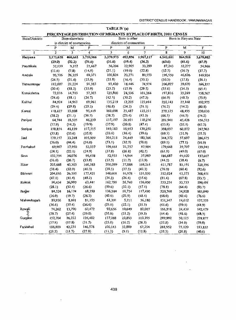
DISTRICT CENSUS HANDBOOK: YAMUNANAGAR
TABLE IV (a)
PERCENTAGEDlSTRIBUfION OF MIGRANTS BY PLACE OF BlRTIJ, 200) CINSUS State/Districts Born elsewhere Born in other Born in Haryana State
in district of enumeration districts of enumeration
P M F P M F P M F 2 3 4 5 6 7 8 9 10
Haryana 2,171,628 460,662 1,710,966 2,370,973 403,856 1,967,117 4,542,601 864,518 3,678,083 (29.0) (22.2) (31.6) (31.6) (19.4) (36.3) (60.6) (41.6) (67.9)
Panchkula 31,039 9,372 21,667 56,204 22,905 33,299 87,243 32,277 54,966 (11.6) (7.8) (14.9) (21.1) (19.0) (22.8) (32.7) (26.7) (37.7)
Ambala 95,726 26,355 69,371 100,824 20,271 80,553 196,550 46,626 149,924 (24.5) (21.4) (25.9) (25.8) .(16.4) (30.1) (50.3) (37.8) (56.1)
Yarnunanagar 112,607 21,224 91,383 93,420 18,446 74,974 206,027 39,670 166,357 (30.4) (18.3) (35.9) (25.2) (15.9) (29.5) (55.6) (34.3) (65.4)
Kurukshetra 72,016 14,713 57,303 125,800 24,536 101,264 197,816 39,249 158,567 (24.4) (IS.l) (26.7) (42.5) (30.2) (47.2) (66.9) (4S.3) (73.9)
Kaithal 84,924 14,963 69,961 135,219 12,205 123,014 220,143 27,168 192,975 (29.4) (29.S) (29.3) (46.8) (24.3) (51.5) (76.2) (54.2) (80.8)
Kamal 118,427 23,OOS 95,419 160,698 25,487 135,211 279,125 48,495 230,630 (2S.2) (21.1) (30.7) (38.3) (23.4) (43.5) (66.5) (44.5) (74.2)
Panipat 64,744 18,505 46,239 137,197 26,921 110,276 201,941 45,426 156,515 (17.9) (14.3) (19;9) (37.9) (20.S) (47.4) (55.S) (35.1) (67.3)
Sonipat 158,854 41,139 117,715 149,183 18,933 130,250 308,037 60,072 247,965 (35.8) (35.6) (35.8) (33.6) (16.4) (3%) (69.3) (51.9) (75.5)
lind 139,157 33,248 105,909 205,215 24,449 180,766 344,372 57,697 286,675 (36.0) (44.4) (34.0) (53.1 ) (32.7) (58.0) (89.1) (77.1) (91.9)
Fatehabad 69,987 17,950 52,037 109,661 21,757 87,904 179,648 39,707 139,941 (24.1) (22.1) (24.9) (37.8) (26.8) (42.1) (61.9) (49.0) (67.0)
Sirsa 133,754 34,076 99,678 52,933 14,944 37,989 186,687 49,020 137,667 (31.6) (26.7) (33.8) (12.5) (11.7) (12.9) (44.2) (38.4) (6.1)
Hisar 205,688 45,303 160,385 206,099 37,888 168,211 411,787 83,191 328,596 (38.4) (32.9) (40.3) (38.5) (27.5) (42.3) (76.9) (60.4) (82.6)
Bhiwani 204,016 26,595 177,421 148,008 16,978 . 131,030 352,024 43,573 308,451 (47.1) (41.4) (48.2) (34.2) (26.4) (35.6) (81.4) (67.8) (83.7) ,
Rohtak 90,434 26,993 63,441 162,790 26,740 136,050 253,224 53,733 199.491 (28.1) (32.4) (26.6) (50.6) (32.1) (57.1) (78.8) (64.6) (83.7)
Jhaiiar 84,524 16,174 68,350 136,244 18,754 117,490 220,768 34,928 185,840 (26.0) (19.7) (28.2) (42.0) (22.9) (48.4) (68.0) (42.6) (76.6)
M ahendragarh 89,956 8,801 81,155 61,391 5,211 56,180 151,347 14,012 137,335 (36.6) (37.4) (36.6) (25.0) (22.1) (25.3) (61.6) (59.5) (61.9)
Rewari 74,262 13.790 60,472 92,656 10,649 82,007 166,918 24,439 142,479 '\~ (28.7) (27.4) (29.0) (35.8) (21.2) (39.3) (64.4) (48.6) (68.3) ~.
Gurgatm 152,704 26,222 126,482 137,288 23,893 113,395 289,992 50,115 239,877 (27.8) (17.8) (31.5) (25.0) (16.2) (28.3) (52.8) (34.0) (59.8)
Faridabad 188,809 42,231 146,578 100,143 32,889 67,254 288,952 75,120 213,832 (21.2) (11.7) (27.8) (11.3) (9.1) (12.8) (32.5) (20.8) (40.6)
438
ANNEXURES
TABLEN(a)
PERCFNTAGEDlSTRmurloNOFMIGRANTS BY PLACE OF BIRTH, 2001 CENSUS Born in other States ofIndia Born in other Countries Total migrants
p M F P M F P M F 11 12 13 14 15 16 17 18 19
2,672,929 1,069,169 1,603,760 278,823 145,770 133,053 7,494,361 2,079,461 5,414,900 /
(35.7) (51.4) (29.6) (3.7) (7.0) (2.5) (100.0) (100.0) (100.0) 169,247 82,404 86,843 10,260 6,183 4,077 266.750 120,864 145,886 (63.4) (68.2) (59.5) (3.8) (5.1) (2.8) (100.0) (100.0) (100.0) 168,124 63,.l.I4 104,810 25,953 13,304 12,649 390,627 123,244 267,383 (43.0) (51.4) (39.2) (6.6) (10.8) (4.7) (100.0) (100.0) (100.0) 143,190 65,016 78,174 21,015 10,992 10,023 370,232 115,678 254,554 (38.7) (56.2) (30.7) (5.7) (9.5) (3.9) (100.0) (100.0) (100.0)
78,213 31,473 46,740 19,715 10,478 9,237 295,744 81,200 214,544 (26.4) (38.8) (21.8) (6.7) (12.9) (4.3) (100.0) (100.0) (100.0)
57,101 16,917 40,184 11,719 6,054 5,665 288,963 50,139 238,824
(19.8) (33.7) (16.8) (4.1) (12.1) (2.4) (100.0) (100.0) (100.0) 110,133 44,851 65,282 30,391 ]5,615 14,776 419,649 108,961 310,688 (26.2) (41.2) (21.0) (7.2) (14.3) (4.8) (100.0) . (100.0) (100.0)
143,540 75,453 68,087 16,618 8,605 8,013 362,099 129,484 232,615
(39.6) (58.3) (29.3) (4.6) (6.6) (3.4) (100.0) (100.0) (100.0)
125,063 49,939 75,124 11,097 5,634 5,463 444,197 115,645 328,552
(28.2) (43.2) (22.9) (2.5) (4.9) (1.7) (100.0) (100.0) (100.0)
36,514 14,033 22,481 5,811 3,126 2,685 386,697 74,856 311,841
(9.4) (18.7) (7.2) (1.5) (4.2) (0.9) (100.0) (100.0) (100.0)
93,030 32,447 ~0,583 17,359 8,929 8,430 290,037 81,083 208,954
(32. I) (40.0) (29.0) (6.0) (11.0) (4.0) (100.0) (100.0) (100.0)
214,235 67,406 146,829 21,757 11,353 10,404 422,679 127,779 294,900
(50.7) (52.8) (49.8) (5.1) (8.9) (3.5) (100.0) (100.0) (100.0)
107,742 46,533 61,209 15,953 8,117 7,836 535,482 137,841 397,641
(20.1) (33.8) (15.4) (3.0) (5.9) (2.0) (100.0) (100.0) (100.0)
76,068 18,486 57,582 4,632 2,238 2,394 432,724 64,297 368,427
(17.6) (28.8) (15.6) (1.1) (3.5) (0.6) (100.0) (100.0) (100.0)
52,533 21,691 30,842 15,708 7,812 7,896 321,465 83,236 238,229
(16.3) (26.1) (12.9) (4.9) (9.4) (3.3) (100.0) (100.0) (100.0)
101,266 45,670 55,596 2,486 1,340 1,146 324,520 81,938 . '242,582
(31.2) (55.7) (22.9) (0.8) (1.6) (0.5) ( 100.0) (100.0) (100.0)
93,462 9,100 84,362 746 422 324 245,555 23,534 222,021
(38.1) (38.7) (38.0) (0.3) (1.8) (0.1) (100.0) (100.0) (100.0)
89,342 24,460 64,882 2,776 1,417 1,359 259,036 50,316 208,720
(34.5) (48.6) (31.1) (1.1 ) (2.8) (0.7) (100.0) (100.0) (100.0)
244,745 89,665 155,080 14,002 7,667 6,335 548,744 147,449 401,295
(44.6) (60.8) (38.6) (2.6) (5.2) (1.6) (100.0) (100.0) ( 100.0)
569,38) 270,311 299,070 30,825 16,484 14,341 889,161 361,917 527,244
(64.0) (74.7) (56.7) (3.5) (4.6) (2.7) (100.0) (100.0) ( 100.0)
439
DISTRICT CENSUS HANDBOOK: YAMUNANAGAR
TABLE IV (b) DlSTRmunoNOFMIGRANTS BYPLACEOFLASTRESIDINCF., 1991 ClNSUS
StatelDistrict Place of last residence elsewhere Place of last residence in other Place of last residence
in the district of enumeration districts of enumeration in Haryana State
P ·M F P M F P M F 2 3 4 5 6 7 8 9 10
Haryana 1,694,573 366,454 1,388,119 1,639,071 256,696 1,382,375 3,333,644 563,150 2,770,494 (32.8) (24.9) (35.2) (31.7) (20.9) (35.1) (64.5) (45.8) (70.3)
Ambala 123,784 37,577 86,207 80,430 19,710 60,720 204,214 57,287 146,927 (28.1) (24.6) (30.0) (18.3) (12.9) (21.2) (46.4) (37.5) (51.2)
Yamunanagar 72,162 11,870, 60,292 79,499 16,764 92,735 151,661 28,634 123,027 (27.5) (I 5.8) (32.2) (30.3) (22.3) (33.5) (57.8) (38.0) (65.7)
Kurukshetra 51,017 12,130 38,887 88,067 16,386 71,681 139,084 28,516 110,568 (25.3) (22.5) (26.3) (43.6) (30.4) (48.4) (68.9) (52.9) (74.7)
Kaithal 68,353 10,600 57,753 114,795 10,162 104,633 183,148 20,762 162,386 (29.5) (28.1) (29.8) (49.5) (26.9) (53.9) (79.0) (55.0) (83.7)
Karnal 76,215 14,779 61,436 102,689 16,533 86,156 178,904 31,312 147,592 (28.7) (22.4) (30.8) (38.7) (25.1 ) (43.3) (67.5) (47.5) (74.1)
Panipat 54,805 11,528 43,277 122,963 21,254 101,709 177,768 32,782 144,986 (20.0) (15.1) (22.0) (45.0) (27.8) (51.6) (65.0) (42.8) (73.6)
Sonipat 66,090 15,738 50,352 88,803 14,023 74,780 154,893 29,761 125,132 (28.4) (28.9) (28.3) (38.2) (25.7) (42.0) (66.6) (54.6) (70.3)
Rohtak 227,521 34,894 192,627 191,564 19,526 172,038 419,085 54,420 364,665 (43.6) (38.8) (44.6) (36.7) (21.7) (39.8) (80.3) (605) (84.4)
Faridabad 124,156 24,166 99,990 74,361 22,027 52,334 198,517 46,193 152,324 (22.6) (11.8) (29.0) (13.5) (10.7) (15.2) (36.1) (22.5) (44.2)
Gurgaon 104,360 14,930 89,430 98,365 13,200 85,165 202,725 28,130 174,595 (31.9) (24.7) (33.6) (30.1) (21.8) (32.0) (62.0) (46.5) (65.5)
Rewari 49,631 6,793 42,838 74,742 7,210 67,532 124,373 14,003 110,370 (26.9) (26.2) (27.1) (40.6) (27.8) (42.7) (67.5) (53.9) (69.7)
Mahendragarh 69,322 7,878 61,444 48,842 4,870 43,972 118,164 12,748 105,416 (35.9) (40.9) (35.3) (25.3) (25.3) (25.3) (61.1) «66.23) (60.6)
Bhiwani 131,765 13,530 118,235 111,331 11,640 99,691 243,096 25,170 2p,926 (44.2) (38.0) (45.1) (37.4) (32.7) (38.0) (81.6) (70.6) (83.1)
lind 92,704 14,942 77,762 153,856 16,069 137,787 246,560 31,011 215,549 (33.7) (35.7) (33.3) (55.9) (38.4) (59.0) (895) (74.2) (92.2)
Hisar 275,567 49,100 226,467 161,809 31,932 129,877 437,376 81,032 356,344 (46.9) (35.3) (50.5) (275) (22.9) (29.0) (745) (58.2) (79.5)
Sirsa 107,121 25,999 81,122 46,955 15,390 31,565 154,076 41,389 112,687
.~ (33.0) (27.0) (35.5) (14.5) (16.0) (13.8) (47.4) (43.0) (49.3)
440
ANNEXURES
TABLE IV (b) DISTRlBUnONOFMIGRANTS BYPLACEOFLAST~IDF.NCE, 1991 CENSUS
Place of last residence Place of last residence Total migrants
in other states of India in other countries
P M F P M F P M F
II 12 13 14 15 16 17 18 19
15,79,052 537,703 1,041,349 251,470 127,470 124,000 5,169,440 1,230,443 3,938,997
(30.6) (43.7) (26.4) (4.9) (10.4) (3.2) (100.0) (100.0) (100.0)
206,084 80,239 125,845 28,617 14,820 13,797 439,795 152,646 287,149
(46.9) (52.6) (43.8) (6.5) (9.7) (4.8) (100.0) (100.0) (100.0)
90,794 ~36,472 54,322 19,753 10,120 9,633 262,478 75,306 187,172
(34.6) (48.4) (29.0) (7.5) (13.4) (5.2) (100.0) (100.0) (100.0)
47,161 17,440 29,721 15,322 1,804 7,518 201,881 53,880 148,007
(23.4) (32.4) (20.1) (7.6) (14.5) (5.1) (100.0) (100.0) (100.0)
36,875 10,994 25,881 11,441 5,891 5,550 231,828 37,737 194,091
(15.9) (29.1) ( 13.3) (4.9) (15.6) (2.9) (100.0) (100.0) (100.0)
58,652 20,800 37,852 26,768 13,160 13,608 265,174 65,972 199,202
(22.1) (31.5) (19.0) (10.1) (20.0) (6.8) (100.0) (100.0) (100.0)
73,688 32,329 41,359 21,864 11,306 10,558 273,580 76,537 197,043
(26.9) (42.2) (21.0) (8.0) (14.8) (5.4) (100.0) (100.0) (100.0)
66,897 19,628 47,269 10,582 5,086 5,496 232,492 54,545 177,947
(28.8) (36.0) (26.6) (4.6) (9.3) (3.1) (100.0) (100.0) (100.0)
79,726 24,140 55,586 23,116 11,380 11,736 522,107 89,950 432,151
( 15.3) (26.8) (12.9) (4.4) (12.7) (2.7) (100.0) (100.0) (100.0)
321,816 146,658 181,158 22,907 12,000 10,907 549,610 205,031 344,579
(59.7) (71.5) (52.6) (4.2) (5.9) (3.2) (J 00.0) (100.0) (100.0)
113,342 26,851 86,491 10,710 5,470 5,240 326,977 60,501 266,476
(34.7) (44.4) (32.5) (3.3) (9.0) (2.0) (100.0) (100.0) (100.0)
56,639 10,600 46,039 3,100 1,350 1,150 184,222 25,963 158,259
(30.7) (40.8) (29.1) (1.7) (5.2) (1.1) (100.0) (100.0) (100.0)
74,042 5,960 68,082 970 490 480 193,306 19,248 174,058
(38.3) (31.0) (39.1) (0.5) (2.6) (0.3) (100.0) (100.0) (100.0)
50,113 8,510 41,603 4,574 1,914 2,660 297,943 35,644 262,299
(16.8) (23.9) (15.9) (1.5) (5.4) (1.0) (100.0) (100.0) (100.0)
22,216 7,443 14,773 6,420 3,290 3,130 275,486 41,804 233,682
(8.1) (17.8) (6.3) (2.3) (7.9) (1.3) (l00.0) (100.0) (100.0)
120,563 4~952 77,611 29,118 15,189 13,929 587,467 139,303 448,164
(20.5) (30.8) (17.3) (5.0) (10.9) (3.1) (100.0) (100.0) (100.0)
154,444 46,687 107,757 16,208 8,200 8,008 325,088 96,376 228,712
(47.5) (48.4) (47.1) (5.0) (8.5) (3.5) (100.0) (100.0) (100.0) contd .....
441
DISTRICT CENSUS HANDBOOK: YAMUNA NAGAR
TABLE IV (b)
DISTRIBUI'ION OF MIGRANTS BYPLACEOFLASTruBIDENCE_2001 CFNSUS State/District Place of last residence elsewhere Place oflast residence in other Place of last residence
in the district of enumeration districts of enumeration in Haryana State
P M F P M F P M F 2 3 4 5 6 7 8 9 10
Haryana 2,323,677 507,640 1,816,037 2,370,801 414,122 1.956,679 4,694,478 921,762 3,772,716 (30.7) (24.1) (33.2) (31.3) (19.7) (35.8) (62.0) (43.8) (69.0)
Panchkula 37,717 12,743 24,974 51,266 20,050 31,216 88,983 32,793 56,190 (14.1) (10.5) (17.0) (19.1) (16.5) (21.3) (33.2) (27.0) (38.3)
Ambala 106,092 30,533 75,559 101,565 21,308 80,257 207,657 51,841 155,816 (26.9) (24.4) (28.0) (25.7)
'. (17.1) (29.7) (52.6) (41.5) (57.8)
Yamunanagar 118,680 23,557 95,123 96,267 19,967 76,300 214,947 43,524 171,423 (31.8) (20.2) (37.1) (25.8) (17.1) (29.7) (57.6) (37.3) (66.8)
Kurukshetra 77,806 16,793 61,013 128,130 25,677 102,453 205,936 42,470 163,466 (26.1) (20.5) (28.2) (43.0) (31.4) (47.4) (69.1) (51.9) (75.7)
Kaithal 90,516 16,181 74,335 135,064 12,840 122,224 225,580 29,021 196,559 (31.0) (3] .9) (30.9) (46.3) (25.3) (50.7) (77.4) (57.2) (81.6)
Kamal 126,731 25,423 101,308 163,611 27,287 136,324 290,342 52,710 237,632 (29.9) (23.1) (32.3) (38.6) (24.7) (43.4) (68.5) (47.8) (75.7)
Panipat 70,898 20,709 50,189 137,932 27,762 110,170 208,830 48,471 160,359 (19.4) (15.9) (21.4) (37.8) (21.3) (46.9) (57.2) (37.1) (68.3)
Sonipat 168,572 42,932 125,640 147,527 19,466 128,061 316,099 62,398 253,701 (37.6) (36.7) (37.9) (32.9) (16.6) (38.6) (70.4) (53.4) (76.4)
lind 149,630 34,922 114,708 201,559 25,108 176,451 351,189 60,030 291,159 (38.3) (45.9) (36.4) (51.5) (33.0) (56.0) (89.8) (78.8) (92.5)
Fatehabad 78,312 21,355 56,957 111,023 22,261 88,762 189,335 43,616 145,719 (26.7) (26.0) (26.9) (37.8) (27.1) (41.9) (64.4) (53.1) (68.8)
Sirsa 146,102 39,245 106,857 54,014 15,509 38,505 200,116 54,754 145,362 (34.2) (30.4) (35.9) (12.6) (12.0) (12.9) (46.8) (42.4) (48.8)
Hisar 219,121 48,878 170,243 205,988 39,195 166,793 425,109 88,073 337,036 (40.3) (34.8) (42.3) (37.9) (27.9) (41.4) (78.2) (62.6) (83.7)
Bhiwani 213,547 28,368 185,179 146,046 17,298 128,748 359,593 45,666 313,927 (48.7) (43.0) (49.7) (33.3) (26.2) (34.5) (81.9) (69.2) (84.2)
Rohtak 98,200 28,940 69,260 163,708 28,130 135,578 261,908 57,070 204,838 (30.0) (33.9) (28.1) (50.1) (32.9) (56.1) (80.1) (66.8) (84.8)
Jhqijar 92,200 17,565 74,635 132,992 18,517 114,475 225,192 36,082 189,110 (28.2) (21.2) (30.5) (40.6) (22.4) (46.8) (68.8) ( 43.6) (77.4)
M ahendragarh 92,779 9,435 83,344 61,421 5,248 56,173 154,200 14,683 139,517 (37.4) (39.2) (37.3) (24.8) (21.8) (25.1) (62.2) (61.0) (6;2.4)
Rewar\ 77,830 14,954 62,876 92,608 10,575 82,033 170,438 25,529 ,
144,909 J,. (29.6) (28.8) (29.8) (35.3) (20.3) (38.9) (64.9) (49.1) (68.8)
Gurgaon 160,278 29,148 131,130 136,911 23,574 113,337 297,189 52,722 244,467 (28.9) (19.6) (32.4) (24.7) (15.8) (28.0) (53.7) (35.4) (60.4)
Faridabad 198,666 45,959 152,107 103,169 34,350 68,819 301,835 80,309 221,526 (22.1) (12.6) (28.7) (11.5) (9.4) (12.9) (33.6) (22.0) (41.6)
442
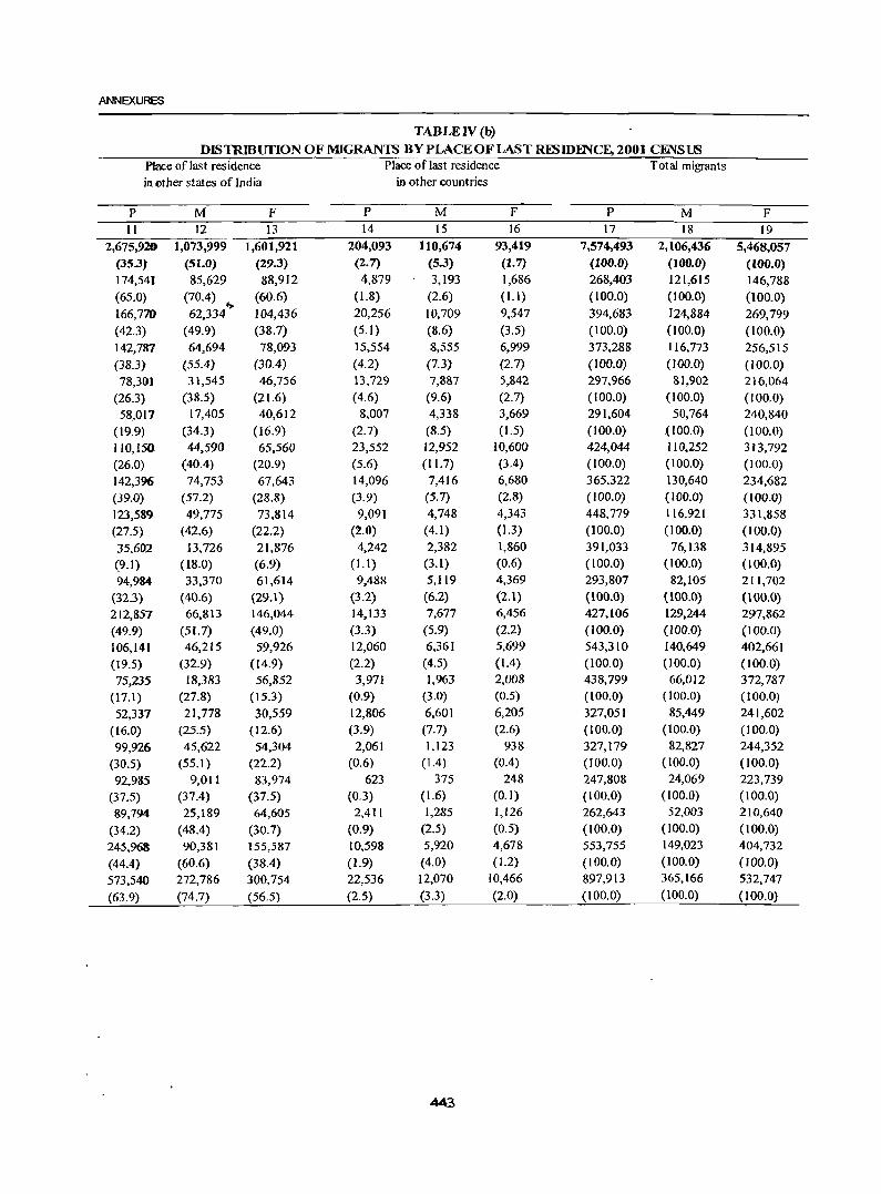
ANNEXURES
TABLE IV (b)
DISTRmurIoN OF MIGRANTS BY PLACE OF LAST R~lDmCF.,2001 CENSUS Place of last residence Place of last residence Total migrants in ether states of India in other countries
p M F P M F P M F 11 12 13 14 15 16 17 18 19
2,675,920 1,073,999 1,601,921 204,093 110,674 93,419 7,574,493 2,106,436 5,468,057 (35.3) (51.0) (29.3) (2.7) (5.3) (1.7) (100.0) (100.0) (100.0) 174,541 85,629 88,912 4,879 3,193 1,686 268,403 121,615 146,788 (65.0) (70.4) (60.6) (1.8) (2.6) (1.1) (100.0) (l00.0) (100.0) 166,770 62,334"> 104,436 20,256 10,709 9,547 394,683 124,884 269,799 (42.3) (49.9) (38.7) (5.1) (8.6) (3.5) (100.0) (100.0) (100.0) 142,787 64,694 78,093 15,554 8,555 6,999 373,288 116,773 256,515 (38.3) (55.4) (30.4) (4.2) (7.3) (2.7) (100.0) (100.0) (100.0) 78,30) 31,545 46,756 13,729 7,887 5,842 297,966 81,902 216,064
(26.3) (38.5) (21.6) (4.6) (9.6) (2.7) ( 100.0) (100.0) (100.0)
58,017 17,405 40,612 8,007 4,338 3,669 291,604 50,764 240,840
(19.9) (34.3) (16.9) (2.7) (8.5) (1.5) (100.0) (100.0) (100.0)
110,150 44,590 65,560 23,552 12,952 10,600 424,044 1l0,252 313,792 (26.0) (40.4) (20.9) (5.6) (11.7) (3.4) (100.0) (100.0) (100.0) 142,396 74,753 67,643 14,096 7,416 6,680 365,322 130,640 234,682
(39.0) (57.2) (28.8) (3.9) (5.7) (2.8) (100.0) (100.0) (100.0)
123,589 49,775 73,814 9,091 4,748 4,343 448,779 116,921 331,858 (27.5) (42.6) (22.2) (2.0) (4.1) (1.3) (100.0) (100.0) (100.0)
35,602 13,726 21,876 4,242 2,382 1,860 391,033 76,138 314,895
(9.1) (18.0) (6.9) (l.l) (3.1) (0.6) (100.0) (100.0) (100.0)
94,984 33,370 61,614 9,488 5,1l9 4,369 293,807 82,105 211,702
(32.3) (40.6) (29.1) (3.2) (6.2) (2.1) (100.0) (100.0) (lOO.O) 212,857 66,813 146,044 14,133 7,677 6,456 427,106 129,244 297,862
(49.9) (51. 7) (49.0) (3.3) (5.9) (2.2) (100.0) (100.0) (100.0) 106,141 46,215 59,926 12,060 6,361 5,699 543,310 140,649 402,661
(19.5) (32.9) (14.9) (2.2) (4.5) (1.4) (100.0) (100-0) (100.0) 75,235 18,383 56,852 3,971 1,963 2,008 438,799 66,012 372,787
(17.1) (27.8) ( 15.3) (0.9) (3.0) (0.5) (100.0) (100.0) (100.0)
52,337 21,778 30,559 12,806 6,601 6,205 327,051 85,449 241,602
(16.0) (25.5) (12.6) (3.9) (7.7) (2.6) (100.0) (100.0) (I0Q.O)
99,926 45,622 54,304 2,061 1,123 938 327,179 82,827 244,352
(30.5) (55.1 ) (22.2) (0.6) (1.4) (0.4) (roO.O) (100.0) (100.0)
92,985 9,011 83,974 623 375 248 247,808 24,069 223,739
(37.5) (37.4) (37.5) (0.3) (1.6) (0.1) (100.0) (100.0) (100.0)
89,794 25,189 64,605 2,411 1,285 1,126 262,643 52,003 210,640
(34.2) (48.4) (30.7) (0.9) (2.5) (0.5) (100.0) (100.0) (100.0)
245,968 90,381 155,587 10,598 5,920 4,678 553,755 149,023 404,732
(44.4) (60.6) (38.4) (1.9) (4.0) (1.2) (100.0) (100.0) (100.0)
573,540 272,786 300,754 22,536 12,070 10,466 897,913 365,166 532,747
(63.9) (74.7) (56.5) (2.5) (3.3) (2.0) (100.0) (100.0) (100.0)
443
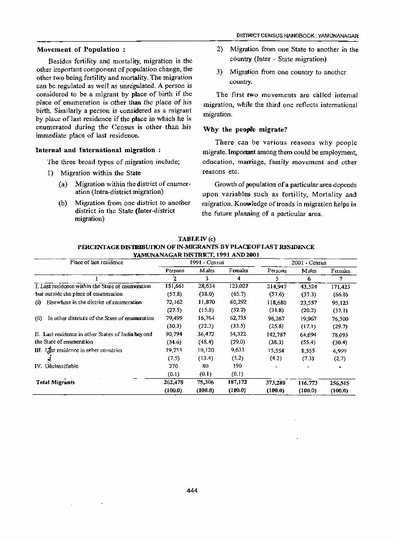
Movement of Population :
Besides fertility and mortality, migration is the other important component of population change, the other two being fertility and ~ortality. The migration can be regulated as well as unregulated. A person is considered to be a migrant by place of birth if the place of enumeration is other than the place of his birth. Similarly a person is considered as a migrant by place of last residence if the place in which he is enumerated during the Census is other than his immediate place of last residence.
Internal and International migration
The three broad types of migration include;
1) Migration within the State
(a) Migration within the district of enumeration (Intra-district migration)
(b) Migration from one district to another district in the State (Inter-district migration)
DISTRICT CENSUS HANDBOOK: YAMUNANAGAR
2) Migration from one State to another in the country (Inter - State migration)
3) Migration from one country to another country.
The first two movements are called internal
migration, while the third one reflects international migration.
Why the people migrate?
There can be various reasons why people
migrate. Important among them could be employment, education, marriage, family movement and other reasons etc.
Growth of population of a particular area depends upon variables such as fertility, Mortality and migration. Knowledge of trends in migration helps in
the future planning of a particular area.
TABLE IV (c) PERCENTAGE DIS1RIBUI10N OF IN-MIGRANTS BY PLACE OF LAST ruNIDFNCE
YAMUNANAGAR DISTRICT, 1991 AND 2001 Place of last residence 1991 - Census 200 I - Census
Persons Males Females Persons Males Females
2 3 4 5 6 7 I. Last residence within the State of enumeration 151,661 28,634 123,027 214,947 43,524 171,423 but outside the place of enumeration (57.8) (38.0) (65.7) (57.6) (37.3) (66.8) (i) Elsewhere in the district of enumeration 72,162 11,870 60,292 118,680 23,557 95,123
(27.5) (15.8) (32.2) (31.8) (20.2) (37.1) (ii) In other districts of the State of enumeration 79,499 16,764 62,735 96,267 19,967 76,300
(30.3) (22.3) (33.5) (25.8) (17.1) (29.7) II. Last residence in other States of India beyond 90,794 36,472 54,322 142,787 64,694 78,093 the State of enumeration (34.6) (48.4) (29.0) (38.3) (55.4) (30.4) III. L1st residence in other countries 19,753 10,120 9,633 15,554 8,5~5 6,999 ..-,
(7.5) (13.4) (5.2) (4.2) (7.3) (2.7) ~ IV. On classifiable 270 80 190
(0.1) (0.1) (0.1)
Total Migrants 262,478 75,306 187,172 373;288 116,773 256,515 (100.0) (100.0) (100.0) (100.0) (100.0) (100.0)
444
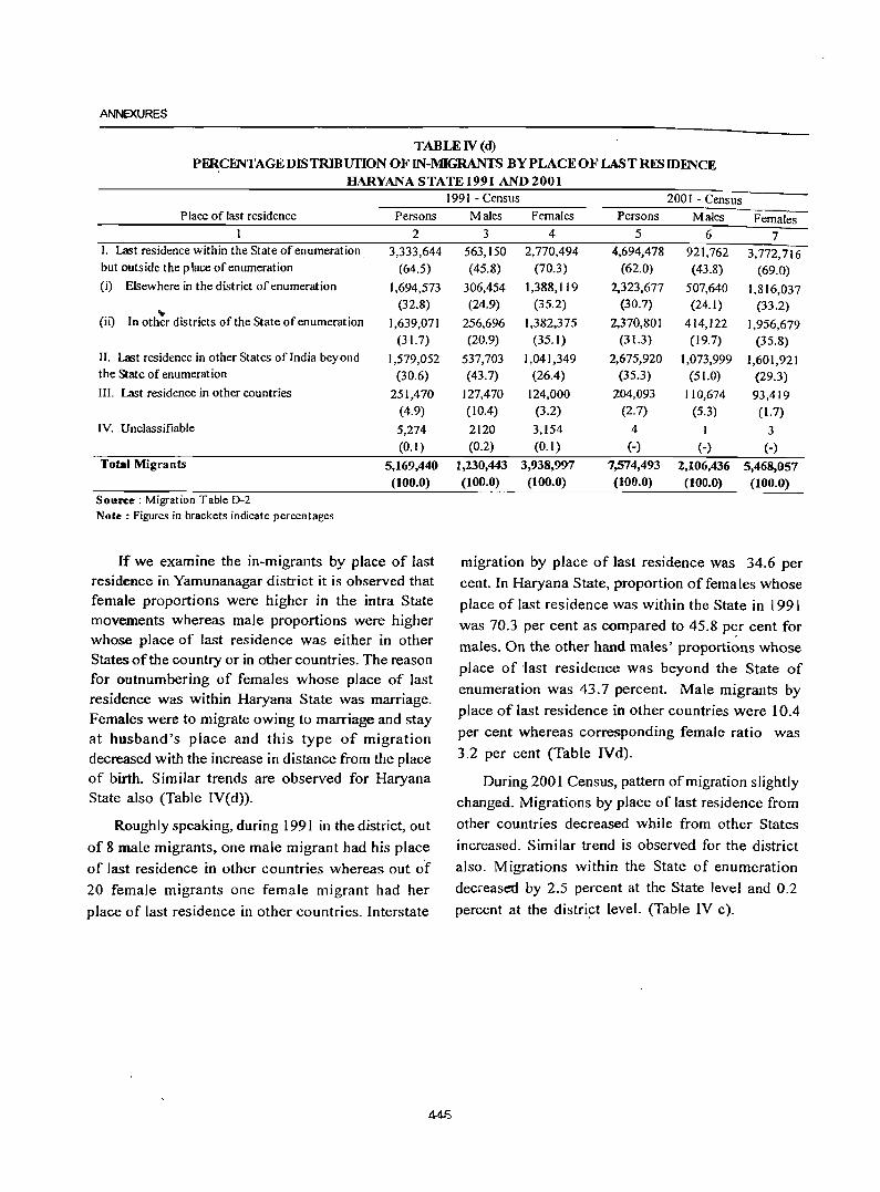
ANNEXURES
TABLEIV(d)
PFRCENTAGE DIS TRlBUfION OF IN-MIGRANTS BY PLACE OF LAST RESIDENCE HARYANA STATE 1991 AND 2001
Place of last residence Persons
2 I. Last residence within the State of enumeration 3,333,644 but outside the place of enumeration (64.5) (i) Elsewhere in the district of enumeration 1,694,573
(32.8) (ii) In oth~r districts of the State of enumeration 1,639,071
(31.7) II. Last residence in other States of India beyond 1,579,052 the State of enumeration (30.6) III. Last residence in other countries 251,470
(4.9) IV. Unclassifiable 5,274
(0.1) Total Migrants 5,169,440
(100.0) Source; Migration Table D-2 Note: Figures in brackets indicate percentages
If we examine the in-migrants by place of last residence in Yamunanagar district it is observed that female proportions were higher in the intra State movements whereas male proportions were higher whose place of last residence was either in other States of the country or in other countries. The reason for outnumbering of females whose place of last residence was within Haryana State was marriage. Females were to migrate owing to marriage and stay at husband's place and this type of migration decreased with the increase in distance from the place of birth. Similar trends are observed for Haryana State also (Table IV(d».
Roughly speaking, during 1991 in the district, out
of 8 male migrants, one male migrant had his place
of last residence in other countries whereas out ot 20 female migrants one female migrant had her
place of last residence in other countries. Interstate
1991 - Census 2001 - Census Males Females Persons Males Females
3 4 5 6 7 563,150 2,770,494 4,694,478 921,762 3,772,716 (45.8) (70.3) (62.0) (43.8) (69.0)
306,454 1,388,119 2,323,677 507,640 1,816,037 (24.9) (35.2) (30.7) (24.1) (33.2)
256,696 1,382,375 2,370,801 414,122 1,956,679 (20.9) (35.1) (31.3) (19.7) (35.8)
537,703 1,041,349 2,675,920 1,073,999 1,601,921 (43.7) (26.4) (35.3) (51.0) (29.3)
127,470 124,000 204,093 110,674 93,419 (10.4) (3.2) (2.7) (5.3) (1.7)
2120 3,154 4 1 3 (0.2) (0.1) (-) (-) (-)
1,230,443 3,938,997 7,574,493 2,106,436 5,468,057 (100.0) (100.0) (100.0) (100.0) (100.0)
migration by place of last residence was 34.6 per cent. In Haryana State, proportion offemales whose
place of last residence was within the State in 1991
was 70.3 per cent as compared to 45.8 p~r cent for
males. On the other hand males' proportions whose place of 'last residence was beyond the State of
enumeration was 43.7 percent. Male migrants by
place of last residence in other countries were 10.4
per cent whereas corresponding female ratio was
3.2 per cent (Table IYd).
During 2001 Census, pattern of migration slightly changed. Migrations by place of last residence from
other countries decreased while from other States
increased. Similar trend is observed for the district
also. Migrations within the State of enumeration
decreased by 2.5 percent at the State level and 0.2
percent at the district level. (Table IV c).
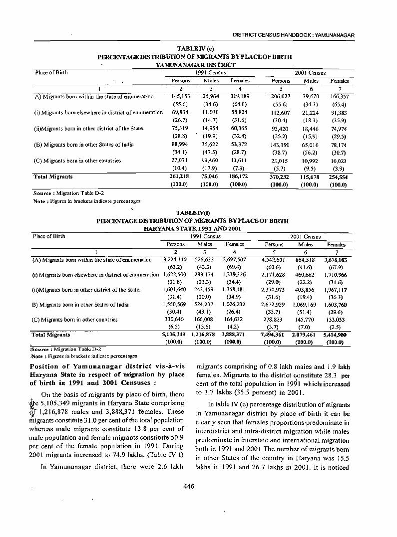
DISTRICT CENSUS HANDBOOK: YAMUNANAGAR
TABLE IV (e)
PERCENTAGEDIS1RmurloN OF MIGRANTS BY PLACE OF BIRTH YAMUNANAGAR DISTRICT
Place of Birth 1991 Census 2001 Census Persons Males Females Persons Males Females
2 3 4 5 6 7 A) Migrants born within the state of enumeration 145,153 25,964 119,189 206,027 39,670 166,357
(55.6) (34.6) (64.0) (55.6) (34.3) (65.4)
(i) Migrants born elsewhere in district of enumeration 69,834 11,010 58,824 112,607 21,224 91,383 (26.7) (14.7) (31.6) (30.4) (18.3) (35.9)
(ii)M igrants born in other district of the State. 75,319 14,954 60,365 93,420 18,446 74,974 (28.8) (19.9) (32.4) (25.2) ( 15.9) (29.5)
(B) Migrants born in other States oflndia 88,994 35,622 53,372 143,190 65,016 78,174 (34.1) (47.5) (28.7) (38.7) (56.2) (30.7)
(C) Migrants born in other countries 27,071 13,460 13,611 21,015 10,992 10,023 (lOA) (17.9) (7.3) (5.7) (9.5) (3.9)
Total Migrants 261,218 75,046 186,172 370,232 115,678 254,554 (100.0) (100.0) (100.0) (100.0) (100.0) (100.0)
Source: Migration Table D·2
Note; Figures in brackets indicate percentages
TABLEIV(f)
PERCENI'AGEDIS TRIBUfION OF MIGRANTS BYPLACEOFBlRlH HARYANA STATE, 1991 AND 2001
Place of Birth
Persons
2 (A) Migrants born within the state of enumeration 3,224,140
(63.2)
(i) Migrants born elsewhere in district ofenumeration 1,622,500 (31.8)
(ii)Migrants born in other district of the State. 1,601,640 (31.4)
B) Migrants born in other States ofIndia 1,550,569 (30.4)
(C) Migrants born in other countries 330,640 (6.5)
Total Migrants 5,105,349 (100.0)
\'Source: Migration Table D·2 .'Note : Figures in brackets indicate percentages
Position of Yamunanagar district vis-a-vis Haryana State in respect of migration by place of birth in 1991 and 2001 Censuses:
On the basis of migrants by place of birth, there .~e 5,105,349 migrants in Haryana State comprising ~ 1,216,878 males and 3,888,371 females. These migrants constitute 31.0 per cent of the total population whereas male migrants constitute 13.8 per cent of male population and female migrants constitute 50.9 per cent of the female population in 1991. During 2001 migrants increased to 74.9 lakhs. (Table IV t)
In Yamunanagar district, there were 2.6 lakh
1991 Census 2001 Census Males Females Persons Males Females
3 4 5 6 7 526,633 2,697,507 4,542,601 864,518 3,678,083 (43.3) (69.4) (60.6) (41.6) (67.9)
283,174 1,339,326 2,171,628 460,662 1,710,966 (23.3) (34.4) (29.0) (22.2) (31.6)
243,459 1,358,181 2,370,973 403,856 1,967,117 (20.0) (34.9) (31.6) (19.4) (36.3)
524,237 1,026,232 2,672,929 1,069,169 1,603,760 (43.1) (26.4) (35.7) (51.4) (29.6)
166,008 164,632 278,823 145,770 133,053 (13.6) (4.2) (3.7) (7.0) (2.5)
1,216,878 3,888,371 7,494,361 2,079,461 5;414.,900 (100.0) (100.0) (100.0) (100.0) (tOO.O)
migrants comprising of 0.8 lakh males and 1.9 lakh females. Migrants to the district constitute 28.3 per
I cent of the total population in 1991 which! increased to 3.7 lakhs (35.5 percent) in 2001.
In table IV (e) percentage distribution of migrants in Yamunanagar district by place of birth it can be clearly seen that females proportions'predominate in interdistrict and intra-district migration while males predominate in interstate and international migration both in 1991 and 2001.The number of migrants born in other States of the country in Haryana was 15.5 lakhs in 1991 and 26.7 lakhs in 2001. It is noticed
446
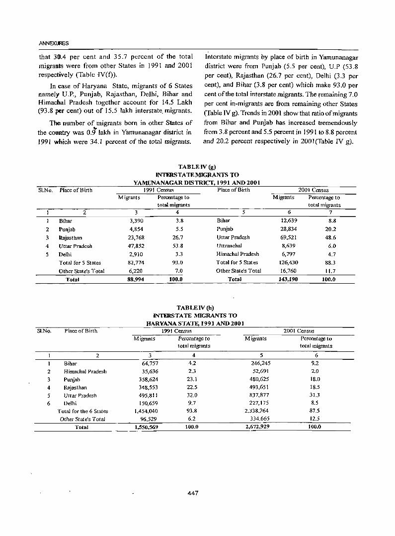
ANNEXmES
that 3004 per cent and 35.7 percent of the total migrants were from other States in 1991 and 200 1 respectively (Table -IV(f).
In case of Haryana State, migrants of 6 States namely D.P., Punjab, Rajasthan, Delhi, Bihar and Himachal Pradesh together account for 14.5 Lakh (93.8 per cent) out of 15.5 lakh interstate. migrants.
The number of migrants born in other States of
the country was 0.91akh in Yamunanagar district in 1991 which were 34.1 percent of the total migrants.
Interstate migrants by place of bil1h in Yamunanagar district were from Punjab (5.5 per cent), U.P (53.8 per cent), Rajasthan (26.7 per cent), Delhi (3.3 per cent), and Bihar (3.8 per cent) which make 93.0 per cent of the total interstate migrants. The remaining 7.0
per cent in-migrants are from remaining other States (Table IV g). Trends in 2001 show that ratio of migrants from Bihar and Punjab has increased tremendously from 3.8 percent and 5.5 percent in 1991 to 8.8 percent and 20.2 percent respectively in 2001(Table IV g).
TABLE IV (g)
~TERSTATENUGRANTSTO
YAMUNANAGARDlSTRICT, 1991 AND 2001 Sl.No. Place of Birth 1991 Census Place of Birth 2001 Census
Migrants Percentage to Migrants Percentage to total migrants total migrants
2 3 4 5 6 7 ) Bihar 3,390 3.8 Bihar )2,639 8.8
2 Punjab 4,854 5.5 Punjab 28,834 20.2
3 Rajasthan 23,768 26.7 Uttar Pradesh 69,521 48.6
4 Uttar Pradesh 47,852 53.8 Uttranchal 8,639 6.0
5 Delhi 2,910 3.3 Himachal Pradesh 6,797 4.7
Total for 5 States 82,774 93.0 Total for 5 States 126,430 88.3
Other State's Total 6,220 7.0 Other State's Total 16,760 11.7
Total 88,994 100.0 Total 143,190 100.0
TABLE IV (h) INTmSTATE MIGRANTS TO
HARYANASTATE, 1991 AND 2001 SI.No. Place of Birth 1991 Census 2001 Census
Migrants Percentage to Migrants Percentage to total migrants total migrants
2 3 4 5 6
Bihar 64.757 4.2 246,245 9.2
2 Himachal Pradesh 35,636 2.3 52,691 2.0
3 Punjab 358,624 23.1 480,625 18.0
4 Rajasthan 348,553 22.5 493,651 18.5
5 Uttar Pradesh 495,811 32.0 837.877 31.3
6 Delhi 150,659 9.7 227,175 8.5
Total for the 6 States 1,454.040 93.8 2,338,264 87.5
Other State's Total 96,529 6.2 334,665 12.5
Total 1,550,569 100.0 2,672,929 100.0
447
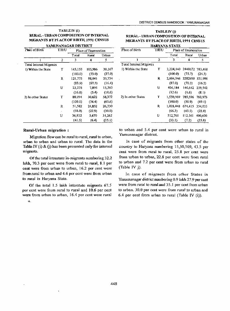
TABLE IV (i) RURAL- URBAN COMPOSITION OFINTFRNAL MIGRANTS BY PLACE OF BIRlH, 1991 CENSUS
YAMUNANAGAR DISTRICT Place of Birth TIR/U Place of Enumeration
Total Rural Urban
2 3 4 5
Total Internal Migrants
I) Within the State T 145,153 105,986 39,167
(100.0) (73.0) (27.0)
R 121,775 98,041 23,734
(83.9) (67.5) (16.4)
U 23,278 7,895 15.383
(16.0) (5.4) (10.6)
2) In other States T 88,994 30,622 58,372
(100.0) (34.4) (65.6)
R 51,582 24,852 26,730
(58.0) (27.9) (30.0)
U 36,932 5,670 31.262
(41.5) (6.4) (35.1)
Rural-Urban migration :
Migration flow can be rural to rural, rural to urban, urban to urban and urban to rural. The data in the Table IV (i) & G) has been presented only for internal migrants.
Of the total intrastate in-migrants numbering 32.2 lakh, 70.3 per cent were from rural to rural, 8.1 per cent were from urban to urban, 16.2 per cent were from rural to urban and 4.6 per cent were from urban to rural in Haryana State.
Of the total 1.5 lakh interstate migrants 67.5 per cent were from rural to rural and 10.6 per cent were from urban to urban, 16.4 per cent were rural
448
DISTRICT CENSUS HANDBOOK: YAMUNANAGAR
TABLEIV(j) RURAL - URBAN COMPOSITION OF INTERNAL MIGRANTS BY PLACE OF BIR1lI, 1991 CENSUS
HARYANA STATE Place of Birth TIRJU Place of Enumeration
Total Rural Urban
2 3 4 5 Total Internal Migrants
I) Within the State T 3,224,140 2440672 783,468
(100.0) (75.7) (24.3)
R 2.804,946 2282950 521,996
(87.0) (70.3) (16.2)
U 406,184 146,642 259,542
(12.6) (4.6) (8. I) 2) In other States T 1,550,569 789,596 760,973
(100.0) (50.9) (49. J) R 1,028,448 674,415 354,033
(66.3) (43.5) (22.8)
U 512,761 112,161 400,600
(33.1) (7.2) (25.8)
to urban and 5.4 per cent were urban to rural in Yamunanagar district.
In case of migrants from other states of the country to Haryana numbering 15,50,569, 43.5 per cent were from rural to rural, 25.8 per cent were from urban to urban, 22.8 per cent were from rural to urban and 7.2 per cent were from urban to rural (Table IV j).
In case -of migrants from other States in Yamunanagar district numbering 0.9 lakh 27.9 per cent were from rural to rural and 35.1 per cent from urban to urban. 30.0 per cent were from rural to urban and 6.4 per cent from urban to rural (Table IV (i».
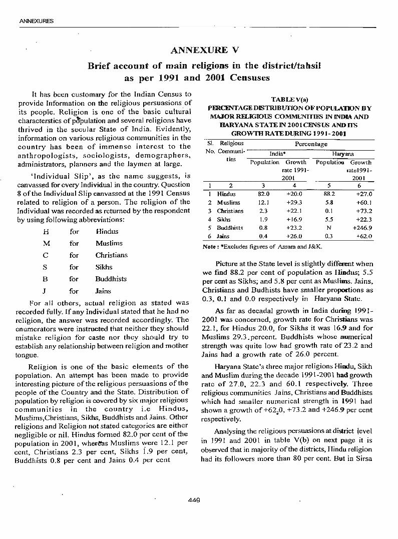
ANNEXURES
ANNEXURE V
Brief account of main religions in the district/tahsil as per 1991 and 2001 Censuses
It has been customary for the Indian Census to provide Information on the religious persuasions of its people. Religion is one of the basic cultural characterstics ofp~pulation and several religions have thrived in the secular State of India. Evidently, information on various religious communities in the country has been of immense interest to the anthropologists, sociologists, demographers, administrators, planners and the laymen at large.
'Individual Slip', as the name suggests, is canvassed for every Individual in the country. Question 8 of the Individual Slip canvassed at the 1991 Census related to religion of a person. The religion of the Individual was recorded as returned by the respondent by using following abbreviations:
H for Hindus
M for Muslims
C for Christians
S for Sikhs
B for Buddhists
J for Jains
For all others, actual religion as stated was recorded fully. If any Individual stated that he had no religion, the answer was recorded accordingly. The enumerators were instructed that neither they should mistake religion for caste nor they sho(Jld try to establish any relationship between religion and mother tongue.
Religion is one of the basic elements of the population. An attempt has been made to provide interesting picture of the religious persuasions of the people of the Country and the State. Distribution of population by religion is covered by six major religious communities in the country i.e Hindus, Muslims,Christians, Sikhs, Buddhists and Jains. Other religions and Religion not stated categories are either negligible or nil. Hindus formed 82.0 per cent of the population in 2001, wher~s Muslims "Yere 12.1 per cent, Christians 2.3 per cent, Sikhs 1.9 per cent, Buddhists 0.8 per cent and lains 0.4 per cent
449
TABLEV(a) PERCINTAGEDISTRlBUI'ION OF POPULATION BY MAJOR RFLIGIOUS COMMUNITIliS IN INDIA AND
IlARYANASTATEIN 2001CI'NSUS ANDHS GROwm RA TEDUlUNG 1991- 2001
SI. Religious Percentage No. Communi- -----;;--;-:-:;:--------:-::------India* Haryana
ties Population Growth Population Growth rate 1991- mte1991-2001 2001
I 2 3 4 5 6
1 Hindus 82.0 +20.0 88.2 +27.0
2 Muslims 12.1 +29.3 5.8 +60.1
3 Christians 2.3 +22.1 0.1 +73.2
4 Sikhs 1.9 +16.9 5.5 +22.3
5 Buddhists 0.8 +23.2 N +246.9
6 Jains 0.4 +26.0 0.3 +62.0
Note: ·Excludes figures of Assam and J&K.
Picture at the State level is slightly different when we fmd 88.2 per cent of population as Hindus; 5.5 per cent as Sikhs; and 5.8 per cent as Muslims. lains, Christians and Budhists have smaller proportions as 0.3, 0.1 and 0.0 respectively in Haryana State.
As far as decadal growth in India during 1991-2001 was concerned, growth rate for Christians was 22.1, for Hindus 20.0, for Sikhs it was 16_9 and for Muslims 29.3.percent. Buddhists whose numerical strength was quite low had growth rate of 23.2 and Jains had a growth rate of 26.0 percent.
Haryana State's three major religions Hindu, Sikh and Muslim during the decade 1991-2001 had growth rate of 27.0, 22.3 and 60.1 respectively. Three religious communities lains, Christians and Buddhists which had smaller numerical strength in 1991 had shown a growth of +62 . .0, +73.2 and +246.9 per cent respectively.
Analysing the religious persuasions at district level in 1991 and 2001 in table V(b) on next page it is observed that in majority of the districts, Hindu religion had its followers more than 80 per cent. But in Sirsa
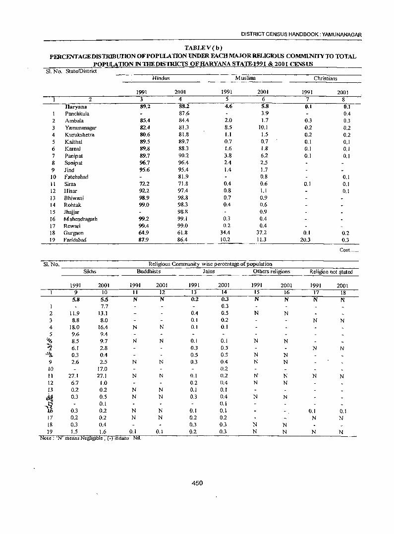
DISTRICT CENSUS HANDBOOK: YAMUNANAGAR
TABLEV(b) PFRCENTAGEDISTRlBUfION OF POPULATION UNDFR FACH MAJOR RFLIGIOUS COMMUNI1YTO TOTAL
POPULATION IN THEDISTRICfS OFHARYANA STATE-1991 & 2001 CENSm SI. No. StateIDistrict
Hindus Muslims Christians
1991 2001 1991 2001 1991 2001 2 3 4 5 6 7 8
Haryana 89.2 88.2 4.6 5.8 0.1 0.1 Panchkula 87.~ 3.9 0.4
2 Ambala 85.4 84.4 2.0 1.7 0.3 0.3 3 Yamunanagar 82.4 81.3 8.5 to. I 0.2 0.2 4 Kurukshetra 80.6 81.8 l.l 1.5 0.2 0.2 5 Kaithal 89.5 89.7 0.7 0.7 0.1 0.1 6 Kamal 89.8 88.3 1.6 1.8 0.1 0.1 7 Panipat 89.7 90.2 3.8 6.2 0.1 0.1 8 Sonipat 96.7 96.4 2.4 2.5 9 Jind 95.6 95.4 1.4 1.7 ]0 Fatehabad 81.9 0.8 0.1 11 Sirsa 72.2 71.8 0.4 0.6 0.1 0.1 12 Hisar 92.2 97.4 0.8 1.1 0.1 13 Bhiwani 98.9 98.8 0.7 0.9 14 Rohtak 99.0 98.3 0.4 0.6 15 Jh1\ijar 98.8 0.9 16 M ahendragarh 99.2 99.1 0.3 0.4 17 Rewari 99.4 99.0 0.2 0.4 18 Gurgaon 64.9 61.8 34.4 37.2 0.1 0.2 19 Faridabad 87.9 86.4 10.2 11.3 20.3 0.3
ConL ....
Sl.No. Religious Community wise percentage of population
Sikhs Buddhists Jains Others religions Religion not ~tated
1991 2001 1991 2001 1991 2001 1991 2001 1991 2001 9 10 11 12 13 14 15 16 17 18
5.8 5.5 N N 0.2 0.3 N N N N 1 7.7 0.3 2 11.9 13.1 0.4 0.5 N N 3 8.8 8.0 0.1 0.2 N N 4 18.0 16.4 N N 0.1 0.1 5 9.6 9.4
.... {) 8.5 9.7 N N 0.1 0.1 N N ~ 6.1 2.8 0.3 0.5 N N T;~;& 0.3 0.4 0.5 0.5 N N
9 2.6 2.5 N N 0.3 0.4 N N to 17.0 0.2 11 27.1 27.1 N N 0.1 0.2 N N N N 12 6.7 1.0 0.2 0.4 N N 13 0.2 0.2 N N 0.1 0.1
,.1i 0.3 0.5 N N 0.3 0.4 N N
0.1 0.1 0.3 0.2 N N 0.1 0.1 0.1 0.1
17 0.2 0.2 N N 0.2 0.2 N N 18 0.3 0.4 0.3 0.3 N N 19 1.5 1.6 0.] 0.1 0.2 0.3 N N N N
Note: 'N' means Negligible, ( -) means NIl.
450
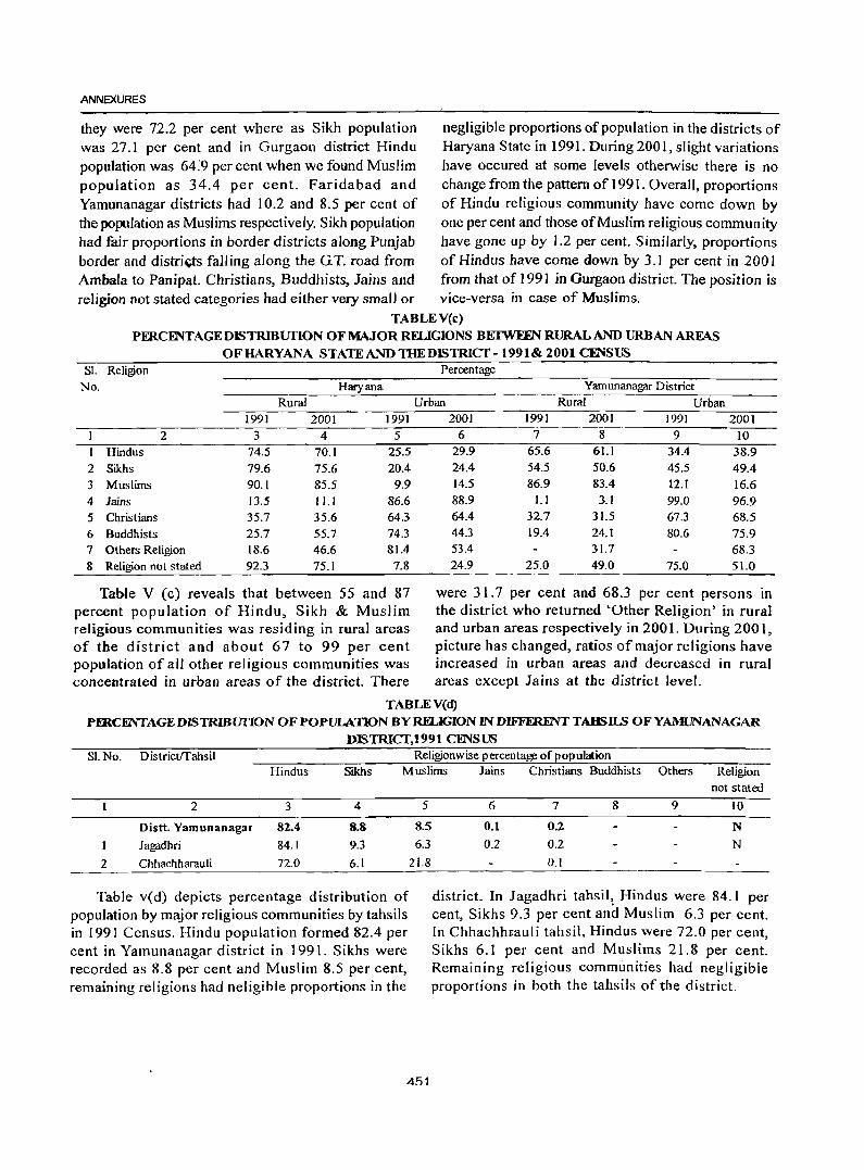
ANNEXURES
they were 72.2 per cent where as Sikh population negligible proportions of population in the districts of was 27.1 per cent and in Gurgaon district Hindu Haryana State in 1991. During 2001, slight variations population was 64:9 per cent when we found Muslim have occured at some levels otherwise there is no population as 34.4 per cent. Faridabad and change from the pattern of 1991. Overall, proportions Yamunanagar districts had 10.2 and 8.5 per cent of of Hindu religious community have come down by the population as Muslims respectively. Sikh population one per cent and those of Muslim religious commun ity had fair proportions in border districts along Punjab have gone up by 1.2 per cent. Similarly, proportions border and distri~s fall ing along the G. T. road from of Hindus have come down by 3.1 per cent in 200 I Ambala to Panipat. Christians, Buddhists, Jains and from that of 1991 in Gurgaon district. The position is religion not stated categories had either very small or vice-versa in case of Muslims.
TABLEV(c) PERCmTAGEDISTRlBUI10N OF MAJOR RELIGIONS BEIWEFN RURAL AND URBAN AREAS
OFHARYANA STATEANDTHEDISTRICT-1991& 2001 C'FNSUS Sl. Religion Percentage
No. Haryana Yamunanagar District
Rural Urban Rural Urban 199] 2001 1991
2 3 4 5 1 Hindus 74.5 70.1 25.5 2 Sikhs 79.6 75.6 20.4 3 Muslims 90.1 85.5 9.9
4 Jains 13.5 11.1 86.6 5 Christians 35.7 35.6 64.3 6 Buddhists 25.7 55.7 74.3 7 Others Religion 18.6 46.6 81.4 8 Religion not stated 92.3 75.1 7.8
Table V (c) reveals that between 55 and 87 percent population of Hindu, Sikh & Muslim religious communities was residing in rural areas of the district and about 67 to 99 per cent population of all other religious communities was concentrated in urban areas of the district. There
2001 ]991 2001 1991 2001 6 7 8 9 10
29.9 65.6 61.1 34.4 38.9 24.4 54.5 50.6 45.5 49.4 14.5 86.9 83.4 12.1 16.6 88.9 1.1 3.1 99.0 96.9 64.4 32.7 31.5 67.3 68.5 44.3 19.4 24.1 80.6 75.9 53.4 31.7 68.3 24.9 25.0 49.0 75.0 51.0
were 31.7 per cent and 68.3 per cent persons in the district who returned 'Other Religion' in rural and urban areas respectively in 2001. During 2001, picture has changed, ratios of major religions have increased in urban areas and decreased in rural areas except Jains at the district level.
TABLEV(d) PI'XCENTAGEDISTRlBUIlONOF POPULATlON BY RELIGION JNDIFFmFNTTAmII.S OFYAMUNANAGAR
DISTRICT,1991 CENSUS SI.No. DistrictITahsii Religionwise percentage of eopulation
Hindus Sikhs Muslims Jains Christians Buddhists Others Religion
2 3 4 5
Distt. Yamunanagar 82.4 8.8 8.5
I Jagadhri 84.1 9.3 6.3
2 Chhachharauli 72.0 6.1 21.8
Table v(d) depicts percentage distribution of population by major religious communities by tahsils in 1991 Census. Hindu population formed 82.4 per cent in Yamunanagar district in 1991. Sikhs were recorded as 8.8 per cent and Muslim 8.5 per cent, remaining religions had neligible proportions in the
4~1
not stated
6 7 8 9 10
0.1 0.2 N
0.2 0.2 N
0.1
district. In Jagadhri tahsil, Hindus were 84.1 per cent, Sikhs 9.3 per cent and Muslim 6.3 per cent. In ChhachhFauli tahsil, Hindus were 72.0 per cent, Sikhs 6.1 per cent and Muslims 2l.8 per cent. Remaining religious communities had negligible proportions in both the tahsils of tile district.
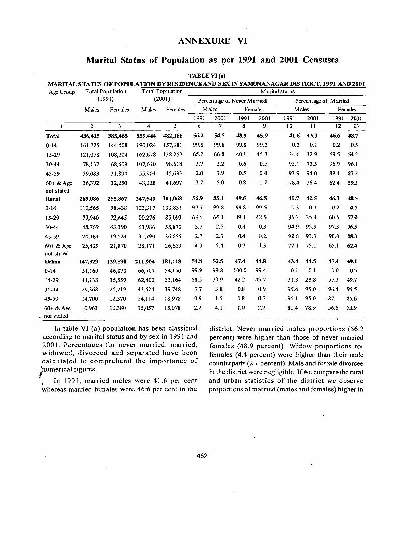
ANNEXURE VI
Marital Status of Population as per 1991 and 2001 Censuses
TABLE VI (a)
MARITAL STATUS OF POPULATION BY RES IDFNCE AND SEX IN YAMUNANAGAR DISTRICT, 1991 AND2001 Age Group Total Population Total Population M arita! stat us
(1991) (2001) Percentage of Never Married Percentage of Married
Males Females Males Females Males Females Males Females
1991 2001 1991 2001 1991 2001 1991 2001 2 3 4 5 6 7 8 9 10 II 12 13
Total 436,415 385,465 559,444 482,186 56.2 54.5 48.9 45.9 41.6 43.3 46.6 4&.7
0-14 161,725 144,508 190,024 157,981 99.8 99.8 99.8 99.5 0.2 0.1 0.2 0.5
15-29 121,078 108,204 162,678 138,257 65.2 66.8 40.1 45.3 34.6 32.9 59.5 54.2
30-44 78,137 68,609 107,610 98,618 3.7 3.2 0.6 0.5 95.1 95.5 96.9 96.1
45-59 39,083 31,894 55,904 45,633 2.0 1.9 0.5 0.4 93.9 94.0 89.4 87.2
60+ & Age 36,392 32,250 43,228 41,697 3.7 5.0 0.8 1.7 78.4 76.4 62.4 593 not stated
Rural 289,086 255,867 347,540 301,068 56.9 55.1 49.6 46.5 40.7 42.5 46.3 4&.5
0-14 110,565 98,438 123,317 103,831 99.7 99.8 99.8 99.5 0.3 0.1 0.2 0.5
15-29 79,940 72,645 100,276 85,093 63.5 64.3 39.1 42.5 36.3 35.4 60.5 57.0
30-44 48,769 43,390 63,986 58,870 3.7 2.7 0.4 0.3 94.9 95.9 97.3 96.5
45-59 24,383 19,524 31,790 26,655 2.7 2.3 0.4 0.2 92.6 93.3 90.8 883
60+ & Age 25,429 21,870 28,171 26,619 4.3 5.4 0.1 1.3 77.1 75.1 65.1 624 not stated
Urban 147,329 129,598 211,904 181,118 54.8 53.S 47.4 44.8 43.4 44.5 47.4 49 ••
0-14 51,160 46,070 66,707 54,150 99.9 99.8 100.0 99.4 0.1 0.1 0.0 05
15-29 41,138 35,559 62,402 53,164 68.5 70.9 42.2 49.7 31.3 28.8 57.3 49.7
30-44 29,368 25,219 43,624 39,748 3.7 3.8 0.8 0.9 95.4 95.0 96.4 95.5
45-59 14,700 12,370 24,114 18,978 0.9 1.5 0.8 0.7 96.1 95.0 87.1 85.6
60+& Age 10,963 10,380 15,057 15,078 2.2 4.1 1.0 2.2 81.4 78.9 56.6 53.9
~ not stated
In table VI (a) popUlation has been classified district. Never married males proportions (56.2 according to marital status and by sex in 1991 and percent) were higher than those of never married 2001. Percentages for never married, married, females (48.9 percent). Widow proportions for widowed, divorced and separated have been females (4.4 percent) were higher than their male calculated to comprehend the importance of counterparts (2.1 percent). Male and female divorcee 'numerical figures. in the district were negligible. If We compar6'the rural ~, • In 1991, married males were 41.6 per cent and urban statistics of the .district we observe whereas married females were 46:6 per'cent in the proportions ofmarried (males and females) higher in
452
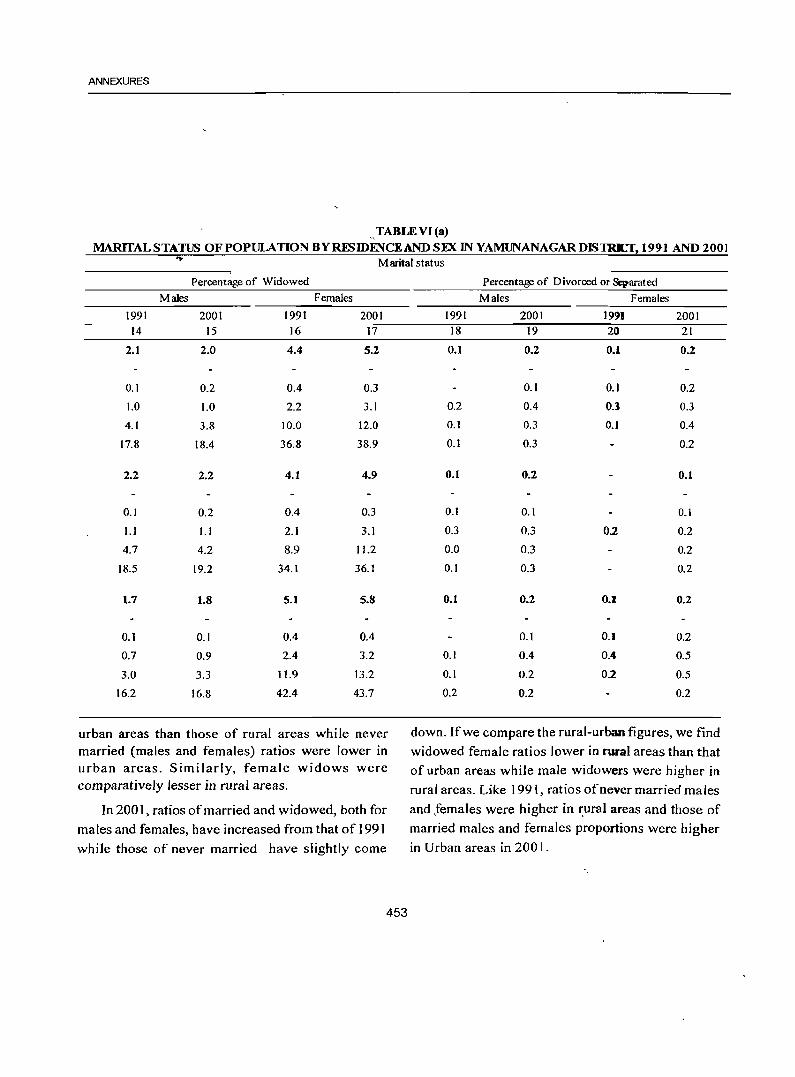
ANNEXURES
.. ,TABLE VI (a) MARITAL STATUS OF POPULATION BYRESIDFNCEAND SEX IN YAMUNANAGARDISTRrf, 1991 AND 2001
Marital status
Percentage of Widowed
Males Females
1991 2001 1991 2001 14 15 16 17
2.1 2.0 4.4 5.2
0.1 0.2 0.4 0.3
1.0 1.0 2.2 3.1
4.1 3.8 10.0 12.0
17.8 18.4 36.8 38.9
2.2 2.2 4.1 4.9
0.1 0.2 0.4 0.3
1.1 1.1 2.1 3.1
4.7 4.2 8.9 11.2
18.5 19.2 34.1 36.1
1.7 1.8 5.1 5.8
0.1 0.1 0.4 0.4
0.7 0.9 2.4 3.2
3.0 3.3 11.9 13.2
16.2 16.8 42.4 43.7
urban areas than those of rural areas while never married (males and females) ratios were lower in urban areas. Similarly, female widows were comparatively lesser in rural areas.
In 2001, ratios of married and widowed, both for
males and females, have increased from that of 1991
while those of never married have slightly come
453
Percentage of Divorced or Separated
Males Females
1991 2001 1991 2001 18 19 20 21
0.1 0.2 0.1 0.2
0.1 0.1 0.2
0.2 0.4 0.1 0.3
0.1 0.3 0.1 0.4
0.1 0.3 0.2
0.1 0.2 0.1
0.1 0.1 0.1
0.3 0.3 0.2 0.2
0.0 0.3 0.2
0.1 0.3 0.2
0.1 0.2 0.1 0.2
0.1 0.1 0.2
0.1 0.4 0.4 0.5
0.1 0.2 0.2 0.5
0.2 0.2 0.2
down. If we compare the rural-urban figures, we find
widowed female ratios lower in rural areas than that of urban areas while male widowers were higher in
rural areas. Like 1991, ratios of never married males
and females were higber in ~ural areas and those of married males and females proportions were higher
in Urban areas in 2001.
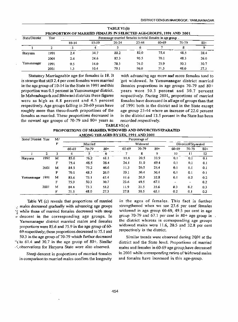
DISTRICT CENSUS HANDBOOK: YAMUNANAGAR
TABLEVl(b)
PROPORTION OF MARRIID FEMALES IN SELECTED AGE-GROUPS, 1991 AND 2001 StatelDistrict Year Percentage married females to total females in age l?Toup .
10-14 15-19 20-24 25-44 60-69 70-79 80+
2 ·3 4 5 6 7 8 9
Haryana 1991 2.4 34.7 88.2 82.0 75.4 48.5 28A
2001 2A 24.6 82.3 95.5 70.1 48.3 26.0 Yamunanag;u- 1991 0.5 14.0 78.5 74.0 75.9 SO.3 30.7
2001 1.3 lOA 70.1 96.0 71.5 48.0 27.3
Statutory Marriageable age for females is 18. It with advancing age more and more females tend to is strange that still 2.4 per cent females were married 'get widowed. In Yamunanagar district married in the age group of 1 0-14 in the State in 1991 and this females proportions in age groups 70-79 and 80+ proportion was 0.5 percent in Yamunanagar district. years were 50.3 percent and 30.7 percent In Mahendragarh and Bhiwani districts these figures respectively. During 200 I, proportions of married were as high as 4.8 percent and 4.5 percent females have decreased in all age of groups than that respectively. Age groups falling in 20-69 years have of 1991 both in the district and in the State except roughly more than three-fourth proportions of the age group 25-44 where an increase of 22.0 percent females as married. These proportions decreased in in the district and 13.5 percent in the State has been the onward age groups of 70-79 and 80+ years as recorded respectively.
TABLEVI(c)
PROPORTIONS OFMARRIID, WIDOWED AND DIVORCFD/SEPARATID AMONG THE AGED BY SEX, 1991 AND 2001
State! District Year MI F Married
60-69 70-79 80+
2 3 4 5 6 Haryana 1991 M 85.6 76.2 61.1
F 75.4 48.5 28.4
2001 M 84.5 75.2 46.6
F 70.1 48.3 26.0
Yarnunanagar 1991 M 85.6 75.1 61.4 F 75.9 50.3 30.7
2001 M 84.4 73.3 53.2 F 71.5 48.0 27.3
Table VI (c) reveals that proportions of married .: males decreased gradually with advancing age groups
<·t while those of married females decreased with steep >!
q descent in the corresponding age groups. In Yamunanagar district married males and females proportions were 85.6 and 75.9 in the age group of60-69 respectively; these proportions decreased to 75.1 and 50.3 in the age group of 70-79 which further decreased
"".,'to 61.4 and 30.7 in the age group of 80+. Similar ,,,:. observations for Haryana State were also observed.
Steep descent in proportions of married females in comparison to married males confirm the longevity
454
Percentage of
Widowed Divorced/Separated
60-69 70-79 80+ 60-69 70-79 80+ 7 8 9 10 II 12
11.4 20.5 33.9 0.1 0.1 0.1 24.1 51.0 69.4 0.1 0.1 0.1 11.3 20.5 25.4 0.1 0.1 0.1 29.1 50.4 50A 0.1 0.1 0.1 11.6 20.5 32.8 O. I 0.2 0.2 23.6 49.5 67.1 0.2
11.9 21.5 35.6 0.3 0.2 0.3 27.8 50.5 65.1 0.2 0.1 0.2
in the ages of females. This fact is further strengthened when we see 23.6 per cent' females widowed in age group 60-69, 49.5 per cent in age group 70-79 and 67.1 per cent in 80+ ag(( group in the district whereas in corresponding age groups widowed males were 11.6, 20.5 and 32.8 per cent respectively in the district. \
Similar trends were observed during 2QOI at the district and the State level. Proportions ofl married males and females in 60-69 age grouPlhave decreased in 200 I while corresponding ratios of widowed males and females have increased in this age-group.
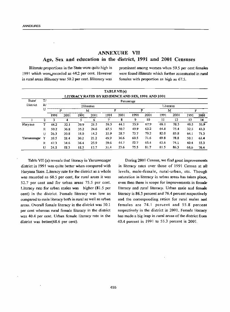
ANNEXURES
ANNEXURE VII Age, Sex and education in the district, 1991 and 2001 Censuses
Illiterate proportions in the State were quite high in
1991 which were""recorded as 44.2 per cent. However
in rural areas illiteracy was 50.2 per cent. Illiteracy was
prominant among women when 59.5 per cent females
were found illiterate which further accentuated in rural
females with proportion as high as 67.5.
TABLE VII (a)
LITFRACYRATES BYRESIDENCEAND SEX, 1991 AND 2001 State! TI
District RI Illiterates U P M
1991 2001 1991 2001 1991
2 3 4 5 6 7 Haryana T 44.2 32.1 39.9 21.5 59.5
R 50.2 36.8 35.2 24.6 67.5
U 26.3 20.8 18.0 14.2 35.9 Yamunanagpr T 39.5 28.4 30.2 21.2 49.9
R 47.3 34.6 36.4 25.9 59.6
U 24.5 18.3 18.5 13.7 31.4
Table VII (a) reveals that literacy in Yamunanagar
district in 1991 was quite better when compared with
Haryana State. Literacy rate for the district as a whole
was recorded as 60.5 per cent, for rural areas it was
52.7 per cent and for urban areas 75.5 per cent.
Literacy rate for urban males was higher (81.5 per
cent) in the district. Female literacy was low as
compared to male literacy both in rural as well as urban
areas. Overall female literacy in the district was 50.1
per cent whereas rural female literacy in the district
was 40.4 per cent. Urban female literacy rate in the
district was better(68.6 per cent).
F
455
Percentage
Literates P M F
2001 1991 2001 1991 2001 1991 2001 8 9 10 11 12 13 14
44.1 55.9 67.9 69.1 78.5 40.5 55.9 50.7 49.9 63.2 64.8 75.4 32.5 43.3 28.7 73.7 79.2 82.0 85.8 64.1 71.3 36.6 60.5 71.6 69.8 78.8 50.1 63.4 44.7 52.7 65.4 63.6 74.1 40.4 55.3 23.6 75.5 81.7 81.5 86.3 68.6 76.4
During 2001 Census, we find great improvements
in literacy rates over those of 1991 Census at all
levels, male-female, rural-urban, etc. Though
saturation in literacy in urban areas has taken place,
even then there is scope for improvements in female
literacy and rural literacy. Urban male and female
literacy is 86.3 percent and 76.4 percent respectively
and the corresponding ratios for rural males and
females are 74.1 percent and 55.8 percent
respectively in the district in 2001. Female literacy
has made a big leap in rural areas of the district from
40.4 percent in 1991 to 55.3 percent in 2001.
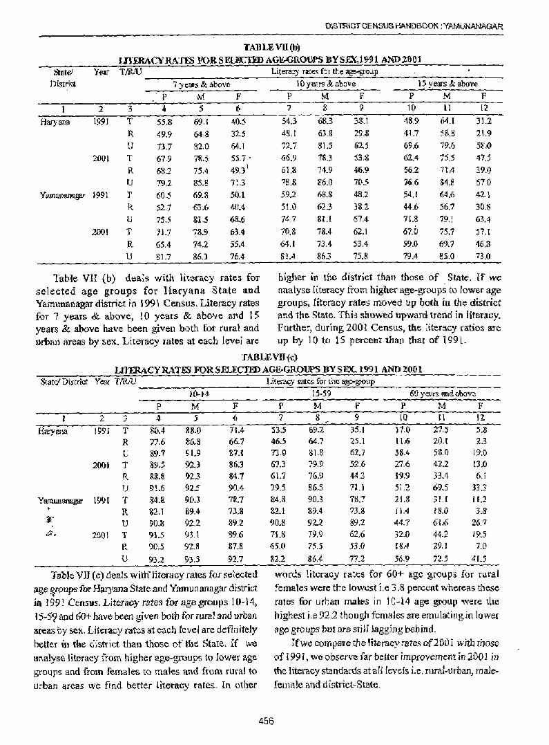
DISTRICT CENSUS HANDBOOK :YAMUNANAGAR
TAllLEVll(b)
mERACYRATfS FORSE£B:::TlID AGE-GROUPS BYSEX,19-91 AND2001 Stllfe/ Year TJRJU Literacy r;t1;es fOI the ~Q'.Lp
Diwict 7 years & abo'ie lOye.ars &abo"e 15 years & above ~ p M F P M f P M F
2 3 4 .5 6 '} :8 9 10 II 12
Haryana 1991 T 55.8 69.\ 40.:5 54.3- 68.3- 38,] 48,9 64.1 31.2
R 49.9 64.8 32.5 48.1 63,& 29.S 41.7 58.8 21.9
U 73.7 82,0 64.1 72.7 315 62.5 69.6 79.5 S!LO 200) T 67,9 7&.5 55.7 . ~6.9 18.3 53,8 62.4 75.5 47.5
R 68.2 75.4 49,3\ 61.8 74.9 46,9 56,2 71.4 39.0
U 79.2- 85.8 713 78 . .& &6.0 705 76,6 SU 67,0
Yamummagar 3991 T 60.5 69.8 50.1 59.2 68.8 48.2 54.1 64.6 42.1
R 52.1 -63.6 40.4 51.0 u23 3&.2 44.6- 56.1 30.8
lJ 75.5 81.5 68..6 747 au 67.4- 71.8 19.1 63.4
2001 T It7 78.9 63.4 7('1.8 iil.4 62.1 67.0 75.7 n.t R 65.4 74.2 55.4 64.1 73.4 53.4 59.0 69.7 46.8
U 81.7 86.3 76.4 8"1.4 863 75.8 79.4 85.0 73.0
Table VII (b) dears with literacy rates for bigher in tbe district than those of State. If we selected age groups for Haryana State and analyse literacy from higher age~groups to lower age Yarnunanagar district in i 991 Census. LittI1tcy rates groups, iiteracy rates moved up both in the district fOT 7 years & above, ! 0 years & above and 15 and the State. This showed upward trend in literacy. years & above have been given both for rural and Further, during 2001 Census, the titeracy ratios are urban areas by sex. Literacy rates at each levei are up by 10 to IS percent than that of i 991.
TABLE VII {c)
LITmACYRATES FORSELECl'EJ)AGE-GROVPS BY SEX.,. 1991 AND200t St;lrd District Year T1RAJ
10 .. 14 p M F
2 .... 4 5 (} ,)
Haryana 1991 T SQA 88.0 71.4
R 77.6 ~6_8 66.7
U 89.7 SL9 '&7.1 2001 T 895 ~.3 8ri.3
R &&.8 1}2.3 34.1 U 9!.6 925 90A
YrunWlanaga' 1991 T 84.R 90.3 ?R.7 R S2.1 89.4- n,&
~. U 90.8 92,Z 89.Z
~.~ 20QI T 91.5 93.1 8"},6
R 90.5 92.8 87.S
U 93.2 9).S 92.7
Table Vll (c) deals with" literacy rates f{lf selected
age ~oups: for Haryana State and Yamu [1 an agar district in 199! Census. Literacy rates for age groups 10-14, 15-59 and 60+ have been given both for rural and urban areas by sex. Literacy rates at each level are defin iteJy better in the d~sttict than those of the State. If 'oNe
analyse literacy from higher age-groups to lower age groups and from females. to males and from rural to urba.n areas we fmd better literacy rates. In other
Lit~ rntes fort he ag>g\'Qup
15 .. 59 6U years and above
P M F P M F 7 8 9 IQ ~ 11 11
53-.5 69.2 35.1 l7.0 21.5 5.8 46.5 64.7 2.5.1 11.6 20.1 2.3 7].0 8l.S 6'1..7 38.4 5~.O 19.0 51.3 79,9 52.6 27.6 42.2 tJ.O 61.7 76.9 <\4.3 19.9 33.4 6.r ')95 86.S 7U 512 695 333 &4.8 903 78.1 21.3 31.1 11.1 &2.1 89".4 73.8 f 1.4 tS.O 3.S 90Jl 92..2 89.2 44.7 61.6 26,7
11.S 79.9 62,6 32.0 44.2 19.5 65,0 75.5 53.0 [SA 29.1 7.0
82.2 86.4 77.2 56.9 72.5 41.5
words literacy rates for 60+ age grQups for rural females were the lowest i.e 3.8 percent whereas these
rates for urban males in 10-14 age group "'ere the highest r.e 92.2 though fema I r;;s are emu lating in lower age groups but are stjJJ Jaggjng bebjnd.
456
rfwe compare tbe lite-racy rates of200 i whh rhose of 1991, we observe far better improvement in 20D 1 in the literacy standards at ali levers i.e. rural-urban, male ..
female and d lstrict-State.
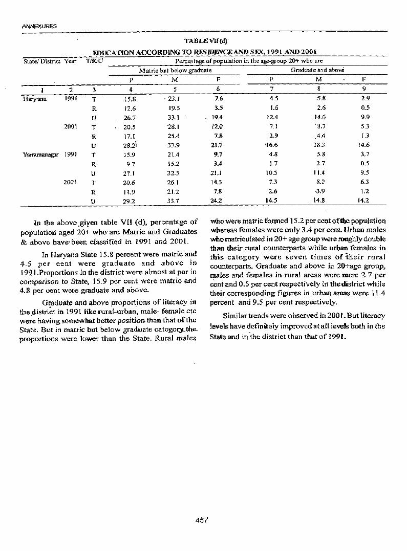
ANNEXURES
TABLEVU(d):
IDUC::A nON ACCORDING TO RESIDmCE AND SEX, 1991 AND 2001 State! District Year TtRIV Percentage of population in the age-group 20+ who are
Matdc but below graduate Graduate and above p M
2 3 4 5
Haryana 1991 T 15.8 . 23.1
R 12.6 19.5
U 26.7 33.1
2001 T 20.5 28.'
R 17. t 25.4
U 28.2\ 33.9
Y:amunan~ 1991 l' 15.9 21.4
R 9.7 15.2
U 27.1 32.5
2001 T 20.6 26. J
R 14.9 21.2
U 29.2 33.7
In the above.giyen table VB (d), percentage of populatiort aged 20+ who' are Matrie and Graduates & above have' been classified in 1991 and 200 L
In Hacyana State 15.8 percent were matric and 4.5 per cent were graduate and above in 1921.Proportions in the district were almost at par in comparison to State, 15.9 per cent were matrie and 4.8 per cent were graduate and above.
Graduate and above proportions of literacy in the.distri~t in 1991 lik.e rurar-urban~ male- female etc were having somewhat better position than that of the State. But in matric but below graduate categocy..the.. proportions were lower than the State. Rural males
457
F P M F
6 7 8 9
1.6 4.5 5.8 2.9
35 1.6 2.6 0.5
19.4 12.4 14.6 9.9 [2.0 'J .J ' 8.7 5.3
7.& 2.9 4.4 U
21.7 '16.6 18.3 14.6
9.1 4.-8 5.8 3.7
3.4 J.7 2.7 0.5
2).1 10.5 11.4 9.5
143 7.3 8.2 6.3
7.8 2.6 ·3.9 1.2
24.2 14.5 14,S 14.2
who were matric formed 15.2 per cent of1he population whereas females were only 3.4 per cent. Urban males who matriculated in 20+ age group were roughly double than their rural counterparts while urban females in this category were seven times of tneir rural counterparts. Graduate and above in 2o-t-age group, ~ales and females in rural areas were mere 2.7 per cent and 0.5 per cent respectively in the district while their corresponding figures ~n urban areas were 11.4 percent and 9.5 per cent respectively.
Similar trends were observed in 200l.But literacy levels have definiteiy improved at aillevds both in the
State and in the district than that of 1991.
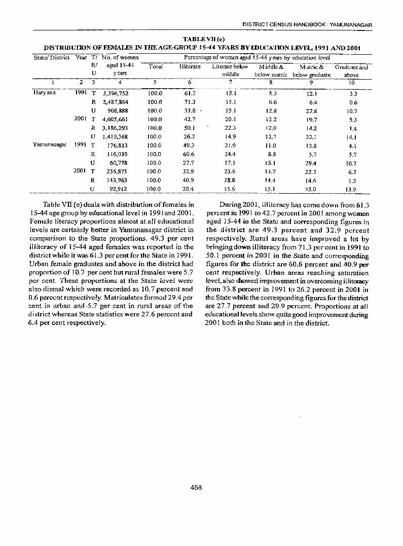
DISTRICT CENSUS HANDBOOK: YAMUNANAGAR
TABLEVD(e) DISTRJBUTION OF FEMALES IN THE AGE-GROUP 15-44 YEARS BYIDUCATION LEVEL, 1991 AND2001
State! District Year TI No. of women Percentage of women aged 15-44 years by education level R/ aged 15-44 Total Illiterate U years
2 3 4 5 6
Haryana '1991 T 3,396,752 100.0 61.3
R 2,487,864 100.0 71.3
U 908,888 100.0 33.8 2001 T 4,605,661 100.0 42.7
R 3,186,293 100.0 50.1
U 1,419,368 100.0 26.2 Yamunanagar 1991 T 176,813 100.0 49.3
R 116,035 100.0 60.6
U 60,778 100.0 27.7 2001 T 236,875 100.0 32.9
R 143,963 100.0 40.9
V 92,912 100.0 20.4
Table vn (e) deals with distribution offemales in 15-44 age group by educational level in 1991 and 200 I. Female literacy proportions almost at alI educational levels are certainly better in Yamunanagar district in comparison to the State proportions. 49.3 per cent ill iteracy of 15-44 aged females was reported in the district while it was 61.3 per cent for the State in 1991. Urban female graduates and above in the district had proportion of 10.7 per cent but rural females were 5.7 per cent. These proportions at the State level were also dismal which were recorded as 10.7 percent and 0.6 percent respectively. Matriculates formed 29.4 per cent in urban and ·5.7 p,er cent in rural areas of the district whereas State statistics were 27.6 percent and 6.4 per cent respectively.
458
Literate below Middle & Matric& Graduate and middle below matric below graduate above
7 8 9 10
15.1 8.3 12.1 3.3 15.1 6.6 6.4 0.6 15.1 12.8 27.6 10.7 20.1 12.2 19.7 5.3 22.3 12.0 14.2 1.4 14.9 12.7 32.1 14.1
21.9 J 1.0 13.8 4.1 24.4 8.8 5.7 5.7 17.1 15.1 29.4 10.7 23.6 14.7 22.5 6.3
28.8 14.4 14.6 1.3 15.6 15.1 35.0 13.9
During 200 I, illiteracy has comedown from 61.3 percent in 1991 to 42.7 percent in 2001 among women aged 15-44 in the State and corresponding figures in the district are 49.3 percent and 32.9 percent respectively. Rural areas have improved a lot by bringing down illiteracy from 71.3 per cent in 1991 to 50.1 percent in 2001 in the State and corresponding figures for the district are 60.6 pex:cent and 40.9 per cent respectively. Urban areas reaching saturation level, also showed improvement in overcoming illiteracy from 33.8 percent in ]991 to 26.2 percent in 2001 in the State while the corresponding figures for the district are 27.7 percent and 20.9 percent. Proportions at all educational levels show quite good improvement during 2001 both in the State and in the district.
ANNEXURES
Annexure VIII
Distribution of different mother tongues returned in 1991' and 2001 Censuses
Language is a critical attribute of India's popUlation which is marked with a pluri-lingual and pI uri-cultural society. Language in itself is a group of mother tongues. It was on the basis of language that the country was reorganized into States in 1956.
It is custnl'l'. dry for "the Indi3n Census to colJect ~"
data on m other tongue of every person at every
Census. M o"ther longue is defined as the language
spoken .in childhood by the pers::m's m other to the
person. If the mother d.ied in infancy, the language
m a.inl¥ spoken m "the pers:m '8 hom e m chilihood .is to
be recorded as the m other longue. In case of infants
and deaf mutes "the Janguage usualo/ spoken by "the
mother isrecorded . The mslructions 10 the enum erators
fur recoming the nam e of "the Janguage returned by
the respondent as m other longue are sum m ar:ized as
under:
1, Record "the nam e of the language returned
by the respondent as m other longue.in full,
w ha1ever is the nam e of the language and
do not usa abbtevi3tions.
2, Do not try 10 determ ine if the language
returned by a person .is a di3Jectof ano"ther
language.
3. Do not try to establish any relationshjp
beween religion and m other tongue.
4. Record the language as returned fur each
person and do not enter into any argum ent.
Do not try to reeoed any language other than
w hat .is returned by- the responden t.
Question 11 a.im ed to ascertain if the person
know s any other language(s). and en tries up to tw 0 '-..
459
languages, in order of proficiency were to be recorded under this question. In this regard the person need not necessarily be able to read and write the language (s). It is enough if the person has a working knowledge and is able to converse with understanding.
There has not been any perceptible change in the definition of 'mother tongue' adopted by the Indian Census for the earlier censuses. A brief analysis has been made on the basis of 1991 and 200 I Censuses.
Data on languages and Mother tongues based on 1991 Census is presented in Table C-7 in Parts A(i), A(ii), B(i) and B(ii) for Haryana StatelDistricts/ Tahsils/Towns in 1991 showing distribution of languages/mother tongues which returned 10,000 or more speakers each at all India level (inclusive of mother tongues grouped under each). The unclassified mother tongues and the mother tongues having less than 10,000 speakers had been relegated to 'Other' mother tongue category.
According to 1991 Census there are 18 Scheduled and 96 Non-Scheduled- taifguages in fndia. Thirteen ofthese eighteen i~~'guages namely; Assamese, Bengali, Gujarati, -l:Iilldi ~Kashmiri, Konkani, Marathi, Nepali, Oriya, Punjabi, Sanskrit, Sindhi and Urdu belong to the Indo-Aryan branch. Four of them n'amely; Kannada, Mahlyalam, Tamil and Telgu belong to Dravidian family, while Manipuri belongs to Tibeto-Burmese. fimily. English, the quite commonly used as a link language belongs to Indo-European Languages. ~he drstribution' of speakers of Scheduled Languages.in the State and for the district as per Census 1991 i-s portrayed in Table VIII (a).
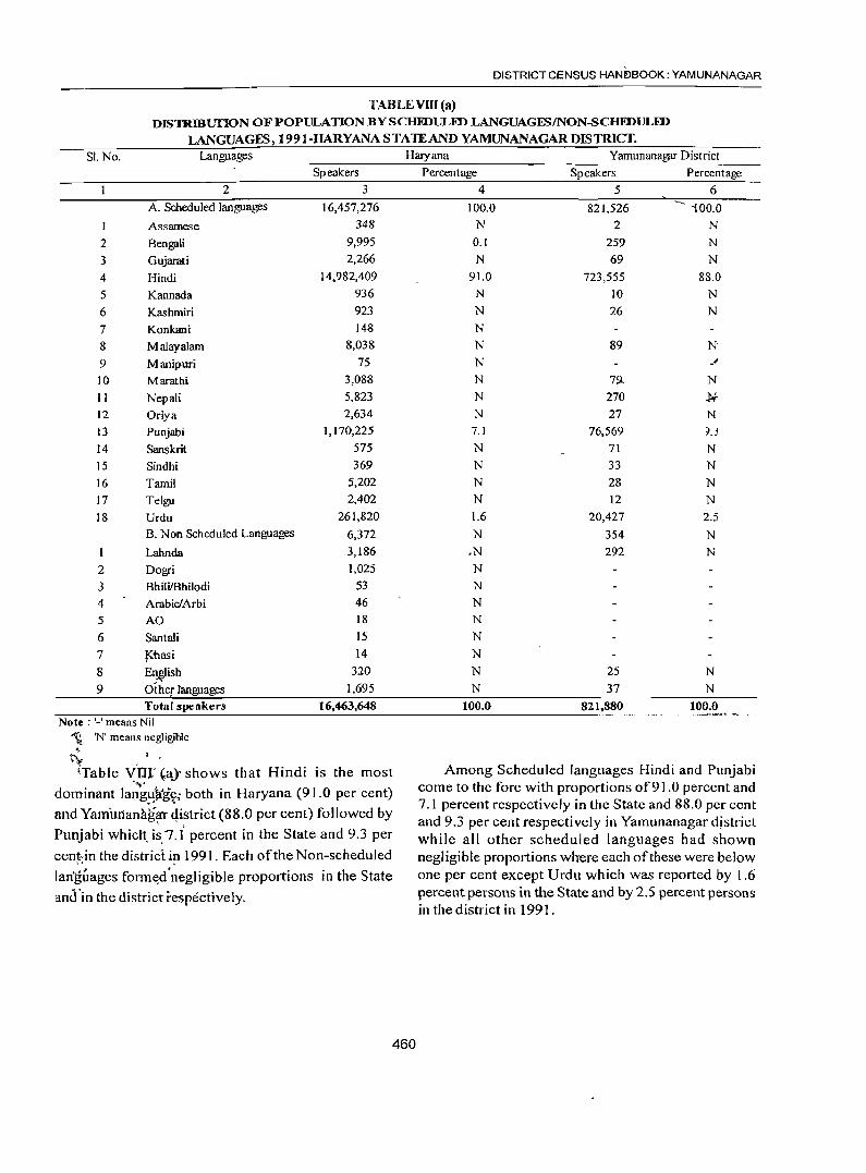
DISTRICT CENSUS HANDBOOK: YAMUNANAGAR
TABLEVnI(a) DISTRmunoN OF POPULATION BY SCHIDULFD LANGUAGES/NON-SCHFDULFD
LANGUAGES,1991-HARYANASTAlEANDYAMUNANAGARDISTRICf. SI. No. Languages Haryana Yamunanagar District
Speakers Percentage Speakers Percentage
2 3 4 5 6
A. Scheduled languages 16,457,276 100.0 821,526 -- iOO.O
I Assamese 348 N 2 N
2 Bengali 9,995 0.1 259 N
3 Gujarati 2,266 N 69 N
4 Hindi 14,982,409 91.0 723,555 88.0
5 Kannada 936 N 10 N
6 Kashmiri 923 N 26 N
7 Konkani 148 N
8 Malayalam 8,038 N 89 N
9 Manipuri 75 N _" 10 Marathi 3,088 N 79- N
11 Nepali 5,823 N 270 J.;-
12 Oriya 2,634 N 27 N
13 Punjabi 1,170,225 7.1 76,569 ~.j
14 Sanskrit 575 N 71 N
15 Sindhi 369 N 33 N
16 Tamil 5,202 N 28 N
17 Telgu 2,402 N 12 N
18 Urdu 261,820 1.6 20,427 2.5 B. Non Scheduled Languages 6,372 N 354 N
Labnda 3,186 .N 292 N
2 Dogri 1,025 N
3 BhiliIBhilodi 53 N
4 ArabiclArbi 46 N
5 AO 18 N
6 Santali 15 N
7 J<i1asi 14 N
8 En~ish 320 N 25 N
9 Oiher languages 1,695 N 37 N
Total speakers 16,463,648 100.0 821,880 100.0 Note: '_' means Nil
~ 'N' means negligible ~
tv (Table v'nr ~a)' shows that Hindi is the most Among Scheduled languages Hindi and PlInjabi
'",- come to the fore with proportions of91.0 percent and dominant langl{j(g~; both in Haryana (91.0 per cent) . , 7.1 percent respectively in the State and 88.0 per cent and Yamurlana.li~l" qistrict (88.0 per cent) followed by and 9.3 per cent respectively in Yamllnanagar district Punjabi which. is.7.i percent in the State and 9.3 per while all other scheduled languages had shown cent.in the district in 1991. Each of the Non-scheduled
" . negligible proportions where each of these were below lan'guages form~lnegligible proportions in the State one per cent except Urdu which was reported by 1.6
and'in the district respectively. percent persons in the State and by 2.5 percent persons in the district in 1991.
460
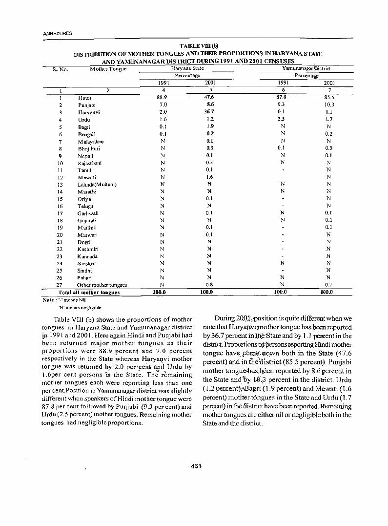
ANNEXURES
TABLEVDI(b)
DISTRIBUTION OF MOTHER TONGUES AND THEIR PROPORTIONS IN HARYANA STATE
AND YAMUNANAGAR DISTRICT DURING 1991 AND 2001 CENSUSFS SI.No. Mother· Tongue Haryana State Yamunanagar District
Percentage Percentar,e.
1991 2001 1991 2001 2 4 5 6 7
Hindi 88.9 47.6 87.8 85.5
2 Punjabi 7."0 8.6 9.3 10.3
3 Haryanvi 2.0 36.7 0.1 1.1
4 Urdu 1.6 1.2 2.5 1.7
5 Bagri 0.1 1.9 N N
6 Bengali 0.1 0.2 N 0.2
7 Malayalam N 0.1 N N
8 Bhoj Puri N 0.3 0.1 0.5
9 Nepali N 0.1 N 0.1
JO Rajasthani N 0.3 N N
11 Tamil N 0.1 N 12 Mewati N 1.6 N
13 Lahnda(M ultani) N N N N
14 Marathi N N N N
15 Oriya N 0.1 N
16 Telugu N N N
17 Garhwali N 0.1 N 0.1
18 Gujarati N N N 0.1
19 Maithili N 0.1 0.1 20 Marwari N 0.1 N
21 Dogri N N N
22 Kashmiri N N N
23 Kannada N N N
24 Sanskrit N N N N
25 Sindhi N N N
26 Pahari N N N N
27 Other motbei- tongues N 0.8 N 0.2
Total all mother tongues 100.0 100.0 100.0 100.0 Note: '_' means Nil
'N' means negligible
Table VIII (b) shows the proportions of mother tongues in Haryana State and Yamunanagar district Ln 1991 and 2001. Here again Hindi and Punjabi had been returned major mother tongues as their proportions were 88_9 percent and 7.0 percent respectively in the State whereas H;uyal;lvi mother tongue was returned by 2.0 per·ceni and Urdu by 1.6per cent persons in the Stat~. Th~ remaining mother tongues each were reporting less than one per cent.Position in Yamunanagar district was slightly different when speakers of Hindi mother tongue were 87.8 per cent followed by PunJabi (9.3 per cent) and Urdu (2.5 percent) mother tongues. Remaining mother tongues had negligible proportions.
461-
During 20Q):, 'Pflsition is quite different when we note that Haryattvl mother tongue has been reported by 36.7 percent 111 :the; S'tate and by 1.1 percent in the district. Propor:tiOtlsbt:persons reporting Hindi mother tongue have. F<ml't;', r.1~Mln both in the State (47.6 percent) and in.thei11strict (85.5 percentJ. Punjabi mother tongue~-Qeen reported by 8.6 percent in the State and.b)': l;fi) percent in the district. Urdu (1.2 per'centj;;B'a:"l~n (1.9 percent) and Mewati (1.6 percent) motIrer.tongues in the State and Urdu (1.7 per~nt) in the Gistrict have been reported. Remaining mother tongues are either nil or negligible both in the State and th~ district. .


